china in print 2013 & more! -
TRANSCRIPT

OLDIMPRINTS.COM - Vintage Maps & Prints, Ephemera, Illustrated Books & Magazines –
[email protected] 2732 S.E. Woodward Street, Portland OR 97202 USA – 1.503.234.3538 - Member ABAA, ILAB
Page 1
China in Print 2013 - A Hong Kong Antiquarian Book Event & Sale Friday November 22, 2013 - Sunday November 24, 2013 Renaissance Harbour View Hotel, Wanchai, Hong Kong
Greetings!
Please browse our “virtual booth” below, filled with some of the items that will be on display at the November “China in Print” event at the Renaissance Harbour View Hotel in Hong Kong. We will, of course, be bringing other non-Chinese themed material to Hong Kong; these items can be
viewed, together with the material below, on Old Imprints website: www.oldimprints.com/cat.php?id=359
I hope to see you in Hong Kong!
Elisabeth
_______________________________________________________________________________________________
ASIA – IMAGINARY TRAVELS) Arbo, Hal G. (map
illus) Jack Armstrong's Chart Game. Adventures
with the Dragon Talisman. Color pictographic / pictorial map, sheet size 20 x 27
inches (47x64cm), folding as issued to 10 x 6 3/4
inches. Some light creasing No date. [1936}.
Pictorial map of Asia with Rules and Directions for the
game in the lower margin. Form letter from "Jack
Armstrong" on verso. Jack Armstrong was a popular
radio adventure show sponsored by the breakfast cereal
Wheaties for which this was a promotional item. The
Talisman, spinner and player markers are not present.
[Stock #50984] US$ 245.00 (approx. HK$1935.50)
CHINA
AMERICAN PROTESTANT MISSIONS) Map of China
ABCFM. Black and white map, lithographed on cloth, 71 1/2 inches x 55 1/2
inches. Small metal grommets along upper and lower edges, small
safety pin at upper left corner, two inch tear in fabric at upper right
corner (outside map area), one other small tear and two tiny holes
(just below Canton) in blank area of map, a few light soiled spots, a
couple of red "x" marks, light soiling on verso on exposed panel.
Overall in good to very good condition. A.B.C.F.M. Congregational
House. Boston. 1898.
Oversized wall map of China with latitude and longitude lines
marked, published by the American Board of Commissioners for
Foreign Missions which was America's first foreign mission society,
established in Massachusetts in 1810. This is an extremely scarce
map, one of a series that were published by the American Board of

OLDIMPRINTS.COM - Vintage Maps & Prints, Ephemera, Illustrated Books & Magazines –
[email protected] 2732 S.E. Woodward Street, Portland OR 97202 USA – 1.503.234.3538 - Member ABAA, ILAB
Page 2
Commissioners for Foreign Missions. The only references to this particular map that we have located are in the
Rumsey Map Reference where it is listed under "American Board Christian Foreign Missions" and in an
advertisement for ABCFM maps in "The Missionary Herald" (Volume 94, September 1898) listing "CHINA Size
5 ft 5 In x 4 ft 6 In Paper 75 cents cloth $1.25 New edition ready soon." OCLC locates a smaller series of maps
published by the ABCFM but there is no record for this map which is printed on a finer woven fabric on two
sheets sewn together horizontally at the centre. This huge wall map presumably was displayed to bring the
Board's missionary activities to the attention of church-goers back home. The lithographer, B. Meisel, printed a
number of maps of the New England area at the end of the 19th century. [Stock #50490] US$ 3250.00 (approx.
HK$25675.00)
BEIJING - RESTAURANT) Pei-Ching, Lao. Pocket Guide to Peiping's Chinese Restaurants.
68pp, 6 x 4 inches, paper wrappers (softbound). Covers worn and lightly soiled with previous owner's name in
ink, paper loss to spine; interior good with soft corner bumps throughout and light foxing to a couple of pages. Yu
Lien Press. Peiping. 1935.
A concise guide to make "lunching and dining out interesting and pleasurable" for those in Peiping. There are 3
1/2 pages of names of Peiping restaurants, with most of the text devoted to listings of menu items in Chinese
characters, Wades Giles romanisation and in English translation. [Stock #49040] US$ 225.00 (approx.
HK$1777.50)
BEIJING) Peiping. N.Y.K. Line. (Japan Mail).
Brochure, 9 x 4 inches unfolding to 9 x 19 1/2 inches, black and white photo illustrations, small color map. Light
soiling and wear to covers; good condition. N.Y.K. Line. Tokyo. 09- 1935.
Information on "Peiping" and places of interest including numerous temples. Two panel map of Peiping on verso.
[Stock #49998] US$ 145.00 (approx. HK$1145.50)
BEIJING) Map & Guide of Peking.
Color street map, sheet size 21 x 15 1/4 inches, folding as issued to pamphlet 7 3/4 x 3 1/2 inches, text on verso,
color lithographic cover illustration. A few ink check marks on verso, ink notation to right lower edge (outside
map area) and back cover, some short tear; good condition. Japan Tourist Bureau. Tokyo. Ca. 1920.
The brochure opens to a detailed map of Peking with places named in English and Japanese; at lower left is an
inset map "Legation Quarter and Japan Tourist Bureau." The verso is packed with information (text in English)
under the headings a Guide to Peking, Places of Interest and Three Days' Sightseeing. [Stock #50677] US$ 435.00
(approx. HK$3436.50)
BEIJING) Peking.
Color street map, 12 3/4 x 12 inches on sheet size 13 3/4 x 12 3/4 inches, folding as issued. Very good, clean
condition; 1/4 inch tear to mid right edge at fold, a few corner creases.
A detailed street map likely from a guide. Scale 1:36,000. Numbered Reference to 20 locations found on map.
[Stock #51033] US$ 95.00 (approx. HK$750.50)
BEIJING) Temple of Heaven. Altar of Heaven. PAIR OF HANDCOLORED
PHOTOGRAPHS. Pair of black and white photographs with hand color, protective tissue guard adhered
to upper edge, approximately 11 3/4 x 15 1/2 inches. Light wear to left and right
edges; very good condition. Peking. No date. Ca. 1930s?
Hand colored photographs of the Temple of Heaven, located in the southeastern part of
central Beijing, China. The first image, an exterior panoramic view, has "Mei Li
Photograph Nan Chi Tze Peking" stamped on verso. Second photograph shows an
interior view. [Stock #50686] US$ 285.00 (approx. HK$2251.50)

OLDIMPRINTS.COM - Vintage Maps & Prints, Ephemera, Illustrated Books & Magazines –
[email protected] 2732 S.E. Woodward Street, Portland OR 97202 USA – 1.503.234.3538 - Member ABAA, ILAB
Page 3
BEIJING) 1930 Guide to Peking.
Thick booklet or paperback, full page and in-text black and white photo illustrations throughout, advertisements,
black and white folding map inside front cover, 68 pp, 7 1/2 x 5 1/4 inches, pictorial wrappers (softbound).
Previous owner's name in ink on lower front cover, light soiling to front cover, 1 inch tear to tail of spine; very
good, interior clean. "The Leader". Peiping. 1930.
Published by the Peking Leader newspaper in the last year of its existence, the guide offers a local's view of life in
the city. The introduction states: "this is the most thorough guide book ever published for the city of Peiping,
inasmuch as it combines points of interest with an explanation of the varied customs and requirements which
confront and baffle the average tourist and potential resident." There are many full page black and white ads for
businesses and a diagrammatic foldout map (two panels) inside the front cover: "An Easy Map of Peiping". [Stock
#50675] US$ 165.00 (approx. HK$1303.50)
BEIJING) Peking. Grand Hotel de Pekin. Peiping (Peking) China. (Map title: Map of Peking. Showing a
few of the many places of interest). Pamphlet, 9 1/2 x 4 inches, unfolding to sheet with 2 color maps, 20 x 9 1/2 inches (51 x 24 cm), black and white
photo illustrations and color cover illustration on verso. Pencil marks to lower front cover, map in good, clean
condition with small chip to upper left corner and mid right edge, 3/4 inch tear to mid lower edge. No date. Ca.
1932.
Map shows Peking and "Environs of Peking". Verso includes images of the Grand Hotel and popular tourist
destinations such as the Great Wall. [Stock #38803] US$ 175.00 (approx. HK$1382.50)
SIGNED BY THE AUTHOR
BEIJING) Catleen, Ellen. Schiff, F.H. (illus).
Peking Studies. Full page color pictorial map, black and white
photograph illustrations, black and white and color
sketches throughout, folio, cloth covered boards.
Inscription on verso of front free endpaper, signed
by the author. Covers are soiled with wear to
extremities. Foxing to endpapers and scattered
foxing to some pages, text block starting to split at a
couple of spots. Still overall good condition. Kelly
& Walsh. Shanghai. 1934.
Ellen Catleen, wife of the Dutch ambassador to
China in the 1930s, introduces 1930s Peking
through the imagined characters of Mr Wu, the small stout Chinese gentleman, and Mr. Pim, the lanky European
visitor, humorously portrayed by illustrator Freidrich Schiff. The many photographs "taken by the Rolleiflex
camera" depict all aspects of the Chinese capital and its inhabitants. There is an inscription signed by the author
Ellen Catleen "In Hamburg 1923, Who would have thought that this book would be given to my dear friends
Hemelsdorff (?) in Shanghai, so that they have something to occasionally remember." This is a scarce book that
evocatively captures the cosmopolitan China of the inter-war era. [Stock #47534] US$ 1150.00 (approx.
HK$9085.00)
CHINESE IMMIGRATION INTO AMERICA) Harte, F. Bret Hull, Joseph (illus). The Heathen Chinee.
9 loose black and white lithographs, 7 1/4 x 5 1/2 inches, with original decorative envelope (7 3/4 x 6 inches).
Light soiling, edge tears and wear to envelope, plus previous owner's name and date (July 3 1871) in ink and
pencil to front cover. Toning to first sheet, otherwise very clean and bright. The lithographic printing of this set is
particularly strong. A superior example of this unusual set. The Western News Company. Chicago. 1870.
This is the first printing of the first independent (pirated) issue of Harte's poem, which first appeared as "Plain
Language from Truthful James" in the September 1870 issue of the Overland Monthly( which Harte edited). Harte
evidently wrote the poem as a space-filler and a satire on the anti-Chinese immigration sentiments of the Irish
OLDIMPRINTS.COM - Vintage Maps & Prints, Ephemera, Illustrated Books & Magazines –
[email protected] 2732 S.E. Woodward Street, Portland OR 97202 USA – 1.503.234.3538 - Member ABAA, ILAB
Page 4
immigrant community, as expressed by the card sharp Bill Nye on sheet 6, "we are ruined by chinese cheap
labor." In fact it was to have the opposite from desired effect (see the excellent article by Gary Scharnhorst "Ways
That Are Dark": Appropriations of Bret Harte's "Plain Language from Truthful James" in Nineteenth-Century
Literature, Volume 51, No. 3 December 1996.) Hull's illustrations added fuel to the popular racist reading of the
poem, embellishing the poem with a scene of mob violence. [Stock #47984] US$ 650.00 (approx. HK$5135.00)
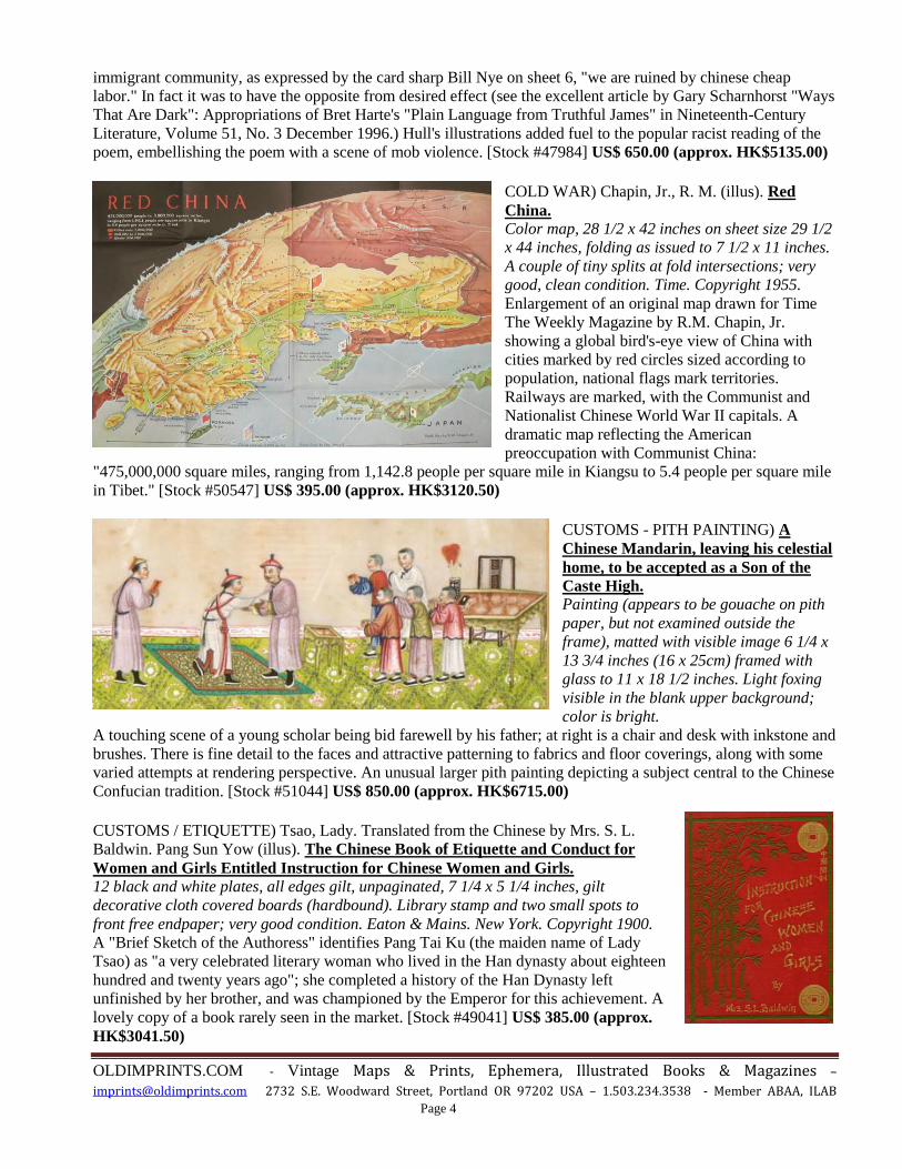
COLD WAR) Chapin, Jr., R. M. (illus). Red
China. Color map, 28 1/2 x 42 inches on sheet size 29 1/2
x 44 inches, folding as issued to 7 1/2 x 11 inches.
A couple of tiny splits at fold intersections; very
good, clean condition. Time. Copyright 1955.
Enlargement of an original map drawn for Time
The Weekly Magazine by R.M. Chapin, Jr.
showing a global bird's-eye view of China with
cities marked by red circles sized according to
population, national flags mark territories.
Railways are marked, with the Communist and
Nationalist Chinese World War II capitals. A
dramatic map reflecting the American
preoccupation with Communist China:
"475,000,000 square miles, ranging from 1,142.8 people per square mile in Kiangsu to 5.4 people per square mile
in Tibet." [Stock #50547] US$ 395.00 (approx. HK$3120.50)
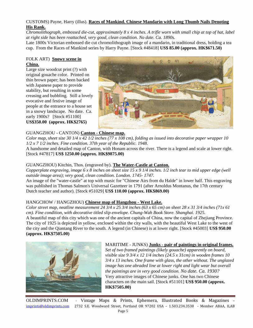
CUSTOMS - PITH PAINTING) A
Chinese Mandarin, leaving his celestial
home, to be accepted as a Son of the
Caste High. Painting (appears to be gouache on pith
paper, but not examined outside the
frame), matted with visible image 6 1/4 x
13 3/4 inches (16 x 25cm) framed with
glass to 11 x 18 1/2 inches. Light foxing
visible in the blank upper background;
color is bright.
A touching scene of a young scholar being bid farewell by his father; at right is a chair and desk with inkstone and
brushes. There is fine detail to the faces and attractive patterning to fabrics and floor coverings, along with some
varied attempts at rendering perspective. An unusual larger pith painting depicting a subject central to the Chinese
Confucian tradition. [Stock #51044] US$ 850.00 (approx. HK$6715.00)
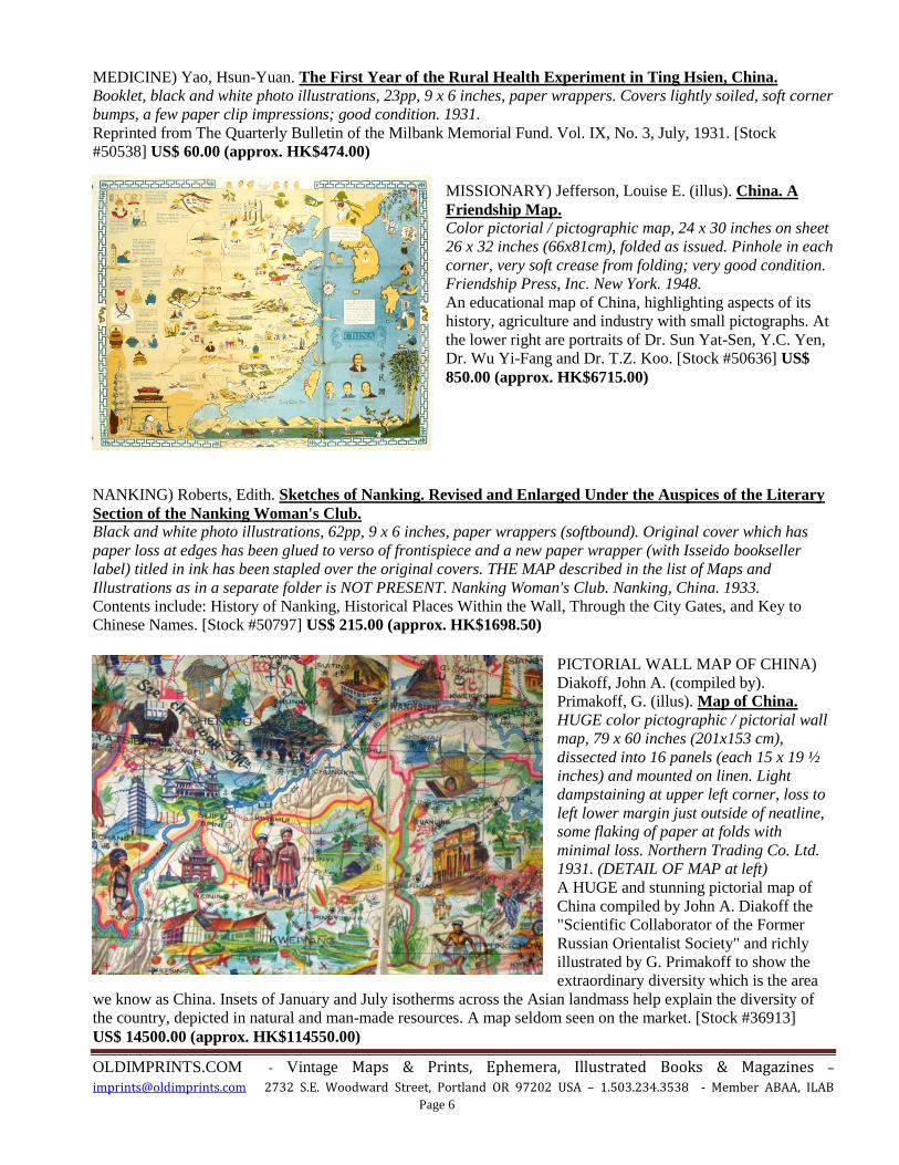
CUSTOMS / ETIQUETTE) Tsao, Lady. Translated from the Chinese by Mrs. S. L.
Baldwin. Pang Sun Yow (illus). The Chinese Book of Etiquette and Conduct for
Women and Girls Entitled Instruction for Chinese Women and Girls. 12 black and white plates, all edges gilt, unpaginated, 7 1/4 x 5 1/4 inches, gilt
decorative cloth covered boards (hardbound). Library stamp and two small spots to
front free endpaper; very good condition. Eaton & Mains. New York. Copyright 1900.
A "Brief Sketch of the Authoress" identifies Pang Tai Ku (the maiden name of Lady
Tsao) as "a very celebrated literary woman who lived in the Han dynasty about eighteen
hundred and twenty years ago"; she completed a history of the Han Dynasty left
unfinished by her brother, and was championed by the Emperor for this achievement. A
lovely copy of a book rarely seen in the market. [Stock #49041] US$ 385.00 (approx.
HK$3041.50)
OLDIMPRINTS.COM - Vintage Maps & Prints, Ephemera, Illustrated Books & Magazines –
[email protected] 2732 S.E. Woodward Street, Portland OR 97202 USA – 1.503.234.3538 - Member ABAA, ILAB
Page 5
CUSTOMS) Payne, Harry (illus). Races of Mankind. Chinese Mandarin with Long Thumb Nails Denoting
His Rank. Chromolithograph, embossed die-cut, approximately 8 x 4 inches. A trifle worn with small chip at top of hat, label
at right side has been reattached, very good, clean condition. No date. Ca. 1890s.
Late 1800s Victorian embossed die cut chromolithograph image of a mandarin, in traditional dress, holding a tea
cup. From the Races of Mankind series by Harry Payne. [Stock #48418] US$ 85.00 (approx. HK$671.50)
FOLK ART) Snowy scene in
China. Large size woodcut print (?) with
original gouache color. Printed on
thin brown paper; has been backed
with Japanese paper to provide
stability, but resulting in some
creasing and bubbling. Still a lovely
evocative and festive image of
people at the entrance to a house set
in a snowy landscape. No date. Ca.
early 1900s? [Stock #51100]
US$350.00 (approx. HK$2765)
GUANGZHOU - CANTON) Canton - Chinese map.
Color map, sheet size 30 1/4 x 42 1/2 inches (77 x 108 cm), folding as issued into decorative paper wrapper 10
1/2 x 7 1/2 inches. Fine condition. 37th year of the Republic. 1948.
A handsome and detailed map of Canton, with Honam across the river. There is a legend and scale at lower right.
[Stock #47817] US$ 1250.00 (approx. HK$9875.00)
GUANGZHOU) Kitchin, Thos. (engraved by). The Water-Castle at Canton.
Copperplate engraving, image 6 x 8 inches on sheet size 15 x 9 1/4 inches. 1/2 inch tear to mid upper edge (well
outside image area); very good, clean condition. London. 1745- 1747.
An image of the "water-castle" at top with music for "Chinese Airs from du Halde" in lower half. This engraving
was published in Thomas Salmon's Universal Gazetteer in 1791 (after Arnoldus Montanus, the 17th century
Dutch teacher and author). [Stock #51029] US$ 110.00 (approx. HK$869.00)
HANGCHOW / HANGZHOU) Chinese map of Hangzhou - West Lake.
Color street map, neatline measurement 24 3/4 x 25 3/4 inches (63 x 65 cm) on sheet 28 x 31 3/4 inches (71x 61
cm). Fine condition, with decorative titled slip envelope. Chung-Wah Book Store. Shanghai. 1925.
A beautiful map of this city which was one of the ancient capitals of China, now the capital of Zhejiang Province.
The city of 1925 is depicted in yellow, enclosed within the city walls, with the beautiful West Lake to the west of
the city and the Qiantang River to the south. A legend (in Chinese) is at lower right. [Stock #45003] US$ 950.00
(approx. HK$7505.00)
MARITIME - JUNKS) Junks - pair of paintings in original frames.
Set of two framed paintings (likely gouache) apparently on board,
visible size 9 3/4 x 12 1/4 inches (24.5 x 31cm) in wooden frames 10
3/4 x 13 inches. One frame with glass, the other without. The unglazed
image has one abraded line at lower right and light wear but overall
the paintings are in very good condition. No date. Ca. 1930? Very attractive images of Chinese junks. One has two Chinese
characters on the main sail. [Stock #51101] US$ 950.00 (approx.
HK$7505.00)
OLDIMPRINTS.COM - Vintage Maps & Prints, Ephemera, Illustrated Books & Magazines –
[email protected] 2732 S.E. Woodward Street, Portland OR 97202 USA – 1.503.234.3538 - Member ABAA, ILAB
Page 6
MEDICINE) Yao, Hsun-Yuan. The First Year of the Rural Health Experiment in Ting Hsien, China.
Booklet, black and white photo illustrations, 23pp, 9 x 6 inches, paper wrappers. Covers lightly soiled, soft corner
bumps, a few paper clip impressions; good condition. 1931.
Reprinted from The Quarterly Bulletin of the Milbank Memorial Fund. Vol. IX, No. 3, July, 1931. [Stock
#50538] US$ 60.00 (approx. HK$474.00)
MISSIONARY) Jefferson, Louise E. (illus). China. A
Friendship Map. Color pictorial / pictographic map, 24 x 30 inches on sheet
26 x 32 inches (66x81cm), folded as issued. Pinhole in each
corner, very soft crease from folding; very good condition.
Friendship Press, Inc. New York. 1948.
An educational map of China, highlighting aspects of its
history, agriculture and industry with small pictographs. At
the lower right are portraits of Dr. Sun Yat-Sen, Y.C. Yen,
Dr. Wu Yi-Fang and Dr. T.Z. Koo. [Stock #50636] US$
850.00 (approx. HK$6715.00)
NANKING) Roberts, Edith. Sketches of Nanking. Revised and Enlarged Under the Auspices of the Literary
Section of the Nanking Woman's Club. Black and white photo illustrations, 62pp, 9 x 6 inches, paper wrappers (softbound). Original cover which has
paper loss at edges has been glued to verso of frontispiece and a new paper wrapper (with Isseido bookseller
label) titled in ink has been stapled over the original covers. THE MAP described in the list of Maps and
Illustrations as in a separate folder is NOT PRESENT. Nanking Woman's Club. Nanking, China. 1933.
Contents include: History of Nanking, Historical Places Within the Wall, Through the City Gates, and Key to
Chinese Names. [Stock #50797] US$ 215.00 (approx. HK$1698.50)
PICTORIAL WALL MAP OF CHINA)
Diakoff, John A. (compiled by).
Primakoff, G. (illus). Map of China.
HUGE color pictographic / pictorial wall
map, 79 x 60 inches (201x153 cm),
dissected into 16 panels (each 15 x 19 ½
inches) and mounted on linen. Light
dampstaining at upper left corner, loss to
left lower margin just outside of neatline,
some flaking of paper at folds with
minimal loss. Northern Trading Co. Ltd.
1931. (DETAIL OF MAP at left)
A HUGE and stunning pictorial map of
China compiled by John A. Diakoff the
"Scientific Collaborator of the Former
Russian Orientalist Society" and richly
illustrated by G. Primakoff to show the
extraordinary diversity which is the area
we know as China. Insets of January and July isotherms across the Asian landmass help explain the diversity of
the country, depicted in natural and man-made resources. A map seldom seen on the market. [Stock #36913]
US$ 14500.00 (approx. HK$114550.00)

OLDIMPRINTS.COM - Vintage Maps & Prints, Ephemera, Illustrated Books & Magazines –
[email protected] 2732 S.E. Woodward Street, Portland OR 97202 USA – 1.503.234.3538 - Member ABAA, ILAB
Page 7
QING DYNASTY - PU YI CORONATION) PAIR OF
SCROLLS: Portrait of the Qing Imperial Household.
TOGETHER WITH: Portrait of the Five Great
Oligarchs of the Great Qing Dynasty. Two scrolls each a color lithograph 15 x 19 1/2 inches
(38 x 49 cm) mounted on decorative paper sheet size
approximately 18 x 20 3/4 inches, upper and lower edge
adhered to wooden rods for rolling like a scroll. A few
soft creases from rolling, both in very good clean
condition. Tokyo. Meiji 41. 1908. Meiji 42 (1909)
These two scrolls were published in Japan at the time of
the coronation of the last Emperor of the Qing dynasty,
Pu Yi. The image portraying the Imperial Household
identifies the persons surrounding the boy Emperor
under the image (in Chinese characters). The second scroll depicts the oligarchs of the Qing government: the five
statesmen are named under the image (in Chinese characters). The faces are obviously from photographs, the rest
of the images an artist's rendition (with what appear to be the artist's initials at the right edge of the image of the
oligarchs). Publication information is in Japanese at the edges of both scrolls. Scarce historical documentation, the
accuracy of the images being secondary to questions of scholarly interest raised by the fact of a Japanese imprint.
[Stock #43165] US$ 2850.00 (approx. HK$22515.00) (May not be on view at “China in Print” event)
QING DYNASTY - PU YI CORONATION)
Coronation ceremony of the Chinese
Emperor Pu Yi. (True Picture of Crowning
Ceremony of the Emperor of The Great Qing
Empire.) Color lithograph 15 x 19 1/2 inches (38 x 49
cm) mounted on decorative paper sheet size
approximately 18 x 20 1/2 inches, upper and
lower edge adhered to wooden rods. A few soft
creases from rolling, excellent condition.
Publication information in Japanese below and
to the right of the image. Meiji 43. 1910. A stunning, richly colored, image of the
Coronation ceremony. [Stock #43269] US$ 2450.00 (approx.
HK$19355.00)
RELIGION) Confucianism and Taoism. (Non-Christian Religious Systems).
Color folding map, 287+8pp, 6 3/4 x 4 3/4 inches (16mo), pictorial gilt embossed cloth-covered boards
(hardbound). Light fading to spine, light foxing to prelims (including map), overall very good condition. Society
for Promoting Christian Knowledge. London and New York. 1895.
An exceptionally bright copy of this very attractive decorative binding which features the gilt cover image of a
shrine. [Stock #47931] US$ 125.00 (approx. HK$987.50)
SHANGHAI - CUSTOMS) Lyman, Verner G. A Trip to China with Glimpses of the Flowery Kingdom.
Booklet, 44pp, 7 1/4 x 5 1/2 inches (19 x 14 cm), decorative paper wrappers. Scattered foxing to covers, light
wear to extremities. interior in very good condition. Democrat Print. Osceola, Nebraska. 1895.
A most interesting glimpse into the life of foreigners in Shanghai at the end of the 19th century. The booklet is
composed of twelve letters sent by Verner G. Lyman, working in Shanghai at the American Bible Society for
China, to his parents, and subsequently published by his father W.H. Lyman. We are unable to locate any copies
of this virtually self-published document in OCLC. [Stock #51097] US$ 450.00 (approx. HK$3555.00)
OLDIMPRINTS.COM - Vintage Maps & Prints, Ephemera, Illustrated Books & Magazines –
[email protected] 2732 S.E. Woodward Street, Portland OR 97202 USA – 1.503.234.3538 - Member ABAA, ILAB
Page 8
SHANGHAI) Foreign Traveller's Guide Map of Shanghai. Map title: Map of Shanghai.
Color street map, 19 3/4 x 29 inches on sheet size 20 3/4 x 30 1/4 inches, folding as issued into 7 1/2 x 5 1/2 inch
paper wrappers. Map: 1/2 inch abrasion to upper right map (portion now adhered to verso of map); overall very
good, clean condition. Short tears to cover edges. Oriental Publishing House. Shanghai. Ca. 1947.
Brightly colored (with different colors for the foreign concessions) vintage map of Shanghai with Road Index at
right corner. There is much interesting detail in the map relating to business concerns. Businesses and wharves are
named all along the Whangpoo river front; other businesses are named in the outskirts along with schools, country
clubs etc. [Stock #50678] US$ 425.00 (approx. HK$3357.50)
SHANGHAI) Shanghai Conducted Tours.
Pamphlet, 11 1/2 x 4 1/2 inches unfolding to 11 1/2 x 18 inches, a couple of black and white photo illustrations,
two-color pictorial cover. Soft creases, very good. The Shanghai Guide Association. Hong Kong. No date. Ca.
1930?
Includes itineraries for four tours in and around Shanghai. [Stock #49028] US$ 65.00 (approx. HK$513.50)
SHANGHAI) Ke Lang (edited by). Shao Cheng (illus). New Map of Shanghai. Pocket Edition. 1945.
Large color folding map, 19 1/4 x 28 on sheet 21 x 29 1/2 inches, folding into silver lettered green cloth covered
boards with red cloth spine. 1 inch of spine cover has been damaged resulting in paper loss to map along central
vertical fold, short splits at fold edges and intersections. Overall the map is clean and bright. Asia Geographical
Institute. Shanghai. 1945. 1st edition.
There are four inset maps: "Shanghai Central of Municipal District" (3 3/4 x 3 inches); "Native City" (6 x 4 1/2
inches); "Central District" (7 3/4 x 9 inches); "Western District Extension" (3 3/4 x 4 1/2 inches). The map is on a
scale of 1:24000. Railways, tramways, bus routes are marked and the wharves along the river are named. Major
firms, banks etc. are named on the map of the central district. An attractive and detailed map of this cosmopolitan
city. "Issued by Ya Kwang Geographical Institute". Marked "1st Edition July 1940" at lower left of the map, but
folded into covers marked "Pocket Edition 1945." Publisher is stated as the Asia Geographical Institute on the
map, and the East Asia Geographical Institute on the cover. Price is stated as '$250.00'. [Stock #50679] US$
350.00 (approx. HK$2765.00)
SHANGHAI) Yates, Helen Eva. Shopping in Shanghai.
Brochure, 6 x 3 1/2 inches, unfolding to 6 x 13 1/2 inches (3 panels), single color illustrations. Very good, clean
condition. American Mail Line. No date. Ca. 1920s.
Helen Eva Yates gives an outline of a three day tour encompassing the best parts of Shanghai for the traveler.
[Stock #49030] US$ 65.00 (approx. HK$513.50)
SOUTHEAST COAST) China Southeast Coast.
Poster, color map, sheet 35 x 47 inches (89x120cm), folded to approximately 9 x 12 inches. Very good condition,
crisp and clean. Army Information Branch. New York. 1944.
Large color map "China Southeast Coast" from Shanghai to French Indochina, with the islands of Formosa and
Hainan. At right edge are inset maps of the vicinities of Shanghai, Wenchow, Foochow, Swatow, Canton, and
Hong Kong. Scale of the main map is 7 inches to 200 miles. While this is identified as a Newsmap (Volume III,
No. 51B), there is no informational text on the verso, as they were usually issued. [Stock #39974] US$ 225.00
(approx. HK$1777.50)
STATESMEN) Nicholson, William (illus). His Excellency Chun Lan Pin, First Chinese Ambassador to the
United States, and His Suite. Wood engraving, black and white, single page from Harper's Weekly August 31, 1878, image size 9 1/8 x 13 1/2
inches on sheet 11 3/4 x 16 1/2 inches. Light soiling and blind stamps to right margin (one stamp just entering
image); good condition. Harper's Weekly. New York. 08-31- 1878.
A portrait of the influential Chinese Ambassador and the numerous members of his suite. Brief text article on
verso "The Chinese Embassy." [Stock #49036] US$ 65.00 (approx. HK$513.50)
OLDIMPRINTS.COM - Vintage Maps & Prints, Ephemera, Illustrated Books & Magazines –
[email protected] 2732 S.E. Woodward Street, Portland OR 97202 USA – 1.503.234.3538 - Member ABAA, ILAB
Page 9
STEREOTYPES) Plum Blossom.
Color illustrated die-cut book, unpaginated, 8 1/2 x 3 1/4 inches, color pictorial stiff card wrappers (softbound).
Covers lightly worn with soft creases; light foxing to first and last page, otherwise interior very good. No date.
Ca. 1920s?
Book die-cut in the shape of Plum Blossom, a young Chinese maiden. Back cover marked "950" at lower edge. 12
pages of verse with pictures printed in shades of red and blue, purporting to give a view of the life of a young
Chinese girl. Descriptions include: "What funny things she likes to eat, chop-suey in a bowl, li-chee and ginger-
syrup sweet, and sharks' fins roasted whole." [Stock #46613] US$ 55.00 (approx. HK$434.50)
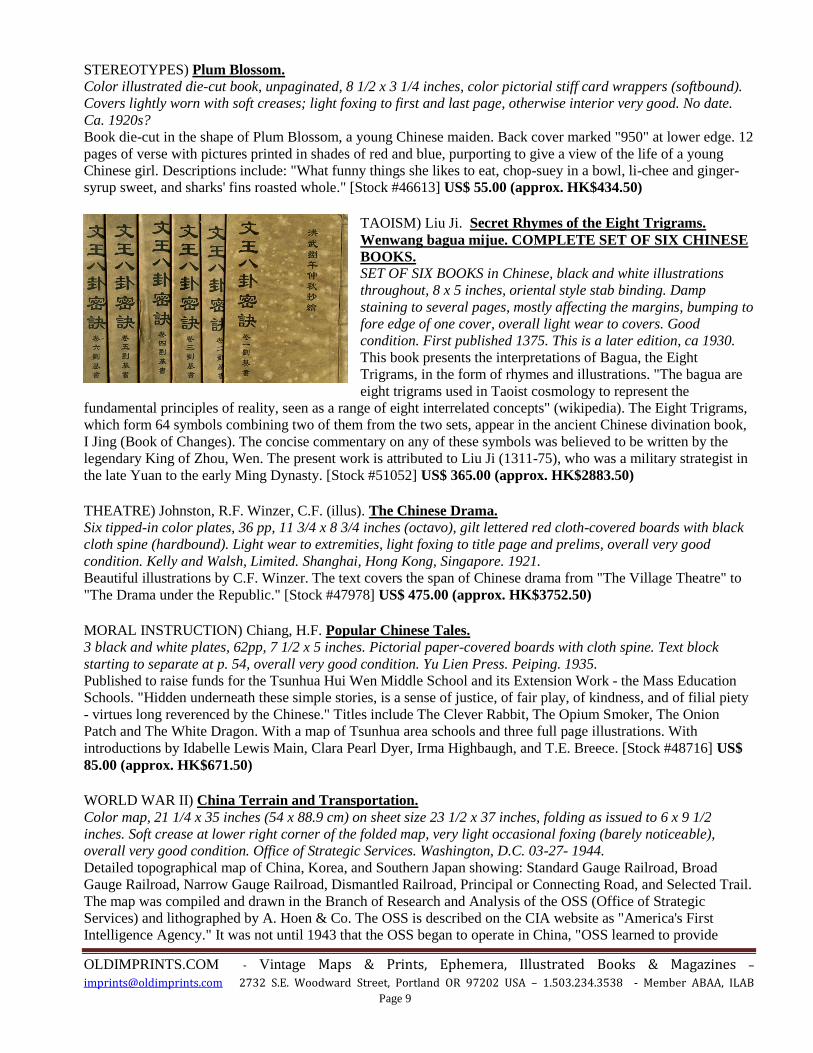
TAOISM) Liu Ji. Secret Rhymes of the Eight Trigrams.
Wenwang bagua mijue. COMPLETE SET OF SIX CHINESE
BOOKS. SET OF SIX BOOKS in Chinese, black and white illustrations
throughout, 8 x 5 inches, oriental style stab binding. Damp
staining to several pages, mostly affecting the margins, bumping to
fore edge of one cover, overall light wear to covers. Good
condition. First published 1375. This is a later edition, ca 1930.
This book presents the interpretations of Bagua, the Eight
Trigrams, in the form of rhymes and illustrations. "The bagua are
eight trigrams used in Taoist cosmology to represent the
fundamental principles of reality, seen as a range of eight interrelated concepts" (wikipedia). The Eight Trigrams,
which form 64 symbols combining two of them from the two sets, appear in the ancient Chinese divination book,
I Jing (Book of Changes). The concise commentary on any of these symbols was believed to be written by the
legendary King of Zhou, Wen. The present work is attributed to Liu Ji (1311-75), who was a military strategist in
the late Yuan to the early Ming Dynasty. [Stock #51052] US$ 365.00 (approx. HK$2883.50)
THEATRE) Johnston, R.F. Winzer, C.F. (illus). The Chinese Drama.
Six tipped-in color plates, 36 pp, 11 3/4 x 8 3/4 inches (octavo), gilt lettered red cloth-covered boards with black
cloth spine (hardbound). Light wear to extremities, light foxing to title page and prelims, overall very good
condition. Kelly and Walsh, Limited. Shanghai, Hong Kong, Singapore. 1921.
Beautiful illustrations by C.F. Winzer. The text covers the span of Chinese drama from "The Village Theatre" to
"The Drama under the Republic." [Stock #47978] US$ 475.00 (approx. HK$3752.50)
MORAL INSTRUCTION) Chiang, H.F. Popular Chinese Tales.
3 black and white plates, 62pp, 7 1/2 x 5 inches. Pictorial paper-covered boards with cloth spine. Text block
starting to separate at p. 54, overall very good condition. Yu Lien Press. Peiping. 1935.
Published to raise funds for the Tsunhua Hui Wen Middle School and its Extension Work - the Mass Education
Schools. "Hidden underneath these simple stories, is a sense of justice, of fair play, of kindness, and of filial piety
- virtues long reverenced by the Chinese." Titles include The Clever Rabbit, The Opium Smoker, The Onion
Patch and The White Dragon. With a map of Tsunhua area schools and three full page illustrations. With
introductions by Idabelle Lewis Main, Clara Pearl Dyer, Irma Highbaugh, and T.E. Breece. [Stock #48716] US$
85.00 (approx. HK$671.50)
WORLD WAR II) China Terrain and Transportation.
Color map, 21 1/4 x 35 inches (54 x 88.9 cm) on sheet size 23 1/2 x 37 inches, folding as issued to 6 x 9 1/2
inches. Soft crease at lower right corner of the folded map, very light occasional foxing (barely noticeable),
overall very good condition. Office of Strategic Services. Washington, D.C. 03-27- 1944.
Detailed topographical map of China, Korea, and Southern Japan showing: Standard Gauge Railroad, Broad
Gauge Railroad, Narrow Gauge Railroad, Dismantled Railroad, Principal or Connecting Road, and Selected Trail.
The map was compiled and drawn in the Branch of Research and Analysis of the OSS (Office of Strategic
Services) and lithographed by A. Hoen & Co. The OSS is described on the CIA website as "America's First
Intelligence Agency." It was not until 1943 that the OSS began to operate in China, "OSS learned to provide
OLDIMPRINTS.COM - Vintage Maps & Prints, Ephemera, Illustrated Books & Magazines –
[email protected] 2732 S.E. Woodward Street, Portland OR 97202 USA – 1.503.234.3538 - Member ABAA, ILAB
Page 10
services to American commanders that neither the Chinese nor other US organizations could match. Access and
authorization followed in due course as OSS analysts and operatives proved that their methods materially assisted
combat operations against the Japanese." This map gives a powerful and immediate impression of the physical
terrain of this country at war and the principal routes of transportation. The map is dated in the lower left corner
"No. 2495, supersedes No. 2194" 27 March 1944. In the upper left corner is marked "Provisional Edition." There
are 3 "free" stamps in the upper right corner over the marking "Restricted," presumably stamped when the excess
stock was liquidated after the restricted period. [Stock #45666] US$ 285.00 (approx. HK$2251.50)
ZHEJIANG / CHEKIANG) A Comprehensive Map of Chekiang Province (Chinese language).
Color map, 24 1/2 x 37 1/2 inches, 62 x 95 cm, folding into paper wrapper 12 1/2 x 7 inches. Soft crease in left
margin, otherwise map in very good to mint condition; light wear to wrapper. Shanghai. 12th Year of the
Revolution. 1923.
An imposing map with inset map at lower right locating the area in China - on the central eastern seaboard just
south of Shanghai municipality. There are four other inset maps of urban areas. [Stock #47818] US$ 475.00
(approx. HK$3752.50)
TRADE CARDS) EIGHTEEN French Trade Cards. Edite par le Chocolat Pupier.
Two sheets of chromolithographic French trade cards (nine per sheet), text on verso, approximately 2 x 2 3/4
inches each (sheet size 12 1/4 x 9 1/4 inches). Light wear and a few small soiled areas at edges; very good
condition. Chocolat Pupier. No date. Ca. 1930s.
Text in French. Cards placed on sheet with descriptive text below (no doubt from a booklet provided by the
chocolate company). Images include a map, Chinese costumes, soldiers and generals, a market place, pagoda,
ships, etc. The image of Chang-Kai Shek is described as all powerful over most of China since 1928. [Stock
#51034] US$ 145.00 (approx. HK$1145.50)
Young, William Curling. The English in China.
Engraved folding map with outline handcolor, xii+147pp plus ads, 7 x 4 1/2 inches, embossed cloth covered
boards (hardbound). Covers lightly rubbed, previous owner's name in ink on title page, small Edinburgh
bookseller's label on back endpaper, possibly recased in original boards, clean and tight. Smith, Elder & Co.
London. 1840.
A fascinating discussion of British relations with China, past and future, published at the time of the first Opium
War (1839-42). The introduction states that "the plan here suggested for extending and improving our China
trade, was first submitted to the public by the Colonial Gazette, and the following pages contain, with some
additions, the substance of a series of letters published in that Journal…. It is proposed to remove our trade
altogether from Canton, and to occupy certain islands in the Eastern and Yellow Seas as entrepots for British
commerce in Eastern Asia. The principle on which this proposal is founded, and which the writer has
endeavoured to keep in view throughout his argument, is the impolicy of giving a political character to our future
relations with China." The Appendix includes a section "Whampoa Port-charges." The folding map "The Chinese
Empire and Japan" was drawn and engraved by W. Hughes. Chapters include: Races, Treaties, The Past, The
Future, Facts, Opinions, War or Peace. The book was reviewed at great length in "The Chinese Repository"
Volume XII January 1843 no. 1. [Stock #50647] US$ 645.00 (approx. HK$5095.50)
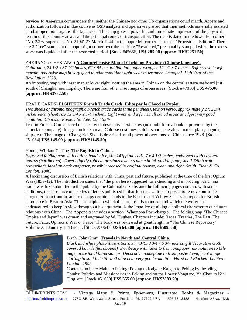
Birch, John Grant. Travels in North and Central China.
Black and white photo illustrations, xvi+379, 8 3/4 x 5 3/4 inches, gilt decorative cloth
covered boards (hardbound). Ex-library with label to front endpaper, ink notation to title
page, occasional blind stamps. Decorative nameplate to front paste-down, front hinge
starting to split but still well attached; very good condition. Hurst and Blackett, Limited.
London. 1902.
Contents include: Malta to Peking; Peking to Kalgan; Kalgan to Peking by the Ming
Tombs; Politics and Missionaries in Peking and on the Lower Yangtsze, Ya-Chau to Kia-
Ting, etc. [Stock #51069] US$ 365.00 (approx. HK$2883.50)
OLDIMPRINTS.COM - Vintage Maps & Prints, Ephemera, Illustrated Books & Magazines –
[email protected] 2732 S.E. Woodward Street, Portland OR 97202 USA – 1.503.234.3538 - Member ABAA, ILAB
Page 11
HONG KONG
CLOTHING MANUFACTURER’S CATALOGUE) Strength Co., Ltd. Car Coats & Rain Coats
Manufacturers. Booklet, black and white illustrations, color fabric samples (spaces for 18 with 3 not present), unpaginated, 6 1/2
x 3 3/4 inches. Soft crease to front cover, very good condition. Strength Co., Ltd. Hong Kong. No date. Ca. 1950s.
Includes: Men's and Ladies' Car Coats, Golf Jackets, Rain Coats, Ski Jackets, Children's Snow Suit, Sleeping Bag,
etc. Folded order form at rear of booklet along with fabric color samples on the inside back cover. The company
was located on Cameron Road in Kowloon and shipped to the United Kingdom, Australia, New Zealand and the
United States. [Stock #51053] US$ 125.00 (approx. HK$987.50)
Chong. He Come from Hong Kong. Complete sheet music, 11 x 8 inches, color pictorial cover. Light scattered foxing, a few creases. Leo Feist, Inc.
New York. 1919.
Words and Music by Harold Weeks. [Stock #48016] US$ 55.00 (approx. HK$434.50)
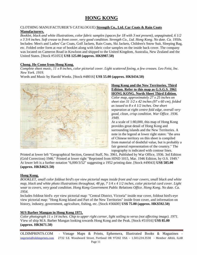
Hong Kong and the New Territories. Third
Edition. Refer to this map as G.S.G.S. 3961
HONG KONG. North Sheet Third Edition. Color map, approximately 27 x 25 inches on
sheet size 31 1/2 x 42 inches (97 x 60 cm), folded
as issued to 8 x 4 1/2 inches. One short
separation at right centre fold edge, overall very
good, clean, crisp condition. War Office. 1936.
1949.
At a scale of 1:80,000, this map of Hong Kong
provides great detail of Hong Kong and
surrounding islands and the New Territories. A
note in the legend at lower right states: "the area
of Chinese territory on this sheet is compiled
from material of doubtful value, but is probably a
fair general representation of the country." The
topography is indicated with contour lines.
Printed at lower left "Geographical Section, General Staff, No. 3961, Published by War Office, 1936. 3rd Edition
(Grid Correction) 1946." Printed at lower right "Reprinted from HIND 1015, Mar. 1946 Edition, by O.S. 1949."
At lower left is a further notation "6,000/3/52" suggesting a 1952 printing date. [Stock #49043] US$ 585.00
(approx. HK$4621.50)
Hong Kong. BOOKLET, small color foldout bird's eye view pictorial maps inside front and rear covers, small black and white
map, black and white photo illustrations throughout, 48 pp, 7 1/4 x 4 1/2 inches, color pictorial card cover. Light
wear to covers, very good condition. Hong Kong Government Public Relations Office. Hong Kong. No date. Ca.
1954.
Includes foldout bird's- eye view pictorial map: "Central District, Victoria" inside rear cover, foldout bird's-eye
view pictorial map: "Hong Kong Island and Part of the New Territories" inside front cover, and information on
history, industry, government, agriculture, fishing, etc. [Stock #36600] US$ 75.00 (approx. HK$592.50)
M/S Barber Mangan in Hong Kong 1971. Color photograph 11 x 14 inches. Chip to upper right corner, light soiling to verso (not affecting image). 1971.
View of ship M.S. Barber Mangan looking towards Hong Kong and the Peak. [Stock #51016] US$ 85.00
(approx. HK$671.50)

OLDIMPRINTS.COM - Vintage Maps & Prints, Ephemera, Illustrated Books & Magazines –
[email protected] 2732 S.E. Woodward Street, Portland OR 97202 USA – 1.503.234.3538 - Member ABAA, ILAB
Page 12
Kingman Dong (cover illus). Time The Weekly Newsmagazine. 1960 - 11 - 21.
Complete November 21, 1960 issue of Time magazine, 11 x 8 1/4 inches, color wrappers as
issued. Covers lightly worn; interior good. Time. New York. 11-21 1960.
"Hong Kong" cover illustration of a colorful city and bay by Dong Kingman. The magazine
also includes many news articles and advertisements. [Stock #50648] US$ 65.00 (approx.
HK$513.50)
Peplow, S. H. and M. Barker. Hongkong, Around and About.
Two-color folding map, 196pp, index, 8 1/2 x 5 1/2 inches, paper covered boards with cloth
spine (hardbound). Light wear to covers, chipping to head of spine, previous owner's name
on front free endpaper, ink notations to rear fly, light soiling to a few pages; otherwise very
good clean condition. Ye Olde Printerie, Ltd. Hong Kong. 1931.
Chapters include: Hong Kong, Kowloon, and the New Territories; The Administration of
the New Territories and of the City; Some Characteristics and Customs of the Chinese;
Domestic and Village Life; The Rites and Ceremonials of Family Life; Some Beliefs &
Gods of South China; Some Chinese Festivals; Some Legends, Charms & Superstitions;
Pirates, Typhoons and disturbances; Appendix. Some Place Names and Their Meanings.
The folding map "Hong Kong and the New Territory" shows roads and the Kowloon-
Canton Railway. [Stock #43595] US$ 345.00 (approx. HK$2725.50)
-------------------------------------------------
END OF HONG KONG LISTINGS
___________________________________
Thank you for browsing our list! We will be bringing other non-Chinese themed material to Hong Kong. This can be viewed, together with all the items above, on our website:
http://www.oldimprints.com/cat.php?id=359
Themes include: S.E. Asia, Philippines, Korea, cruise lines, botanical prints. We will also be exhibiting items relating to England. Please visit our website at www.oldimprints.com to view the diversity of graphic
historical material that we offer.