charcoal kiln sites, associated landscape attributes and historic
TRANSCRIPT

Schmidt et al. Forest Ecosystems (2016) 3:8 DOI 10.1186/s40663-016-0067-6
RESEARCH Open Access
Charcoal kiln sites, associated landscapeattributes and historic forest conditions:DTM-based investigations in Hesse (Germany)
Marcus Schmidt1, Andreas Mölder1* , Egbert Schönfelder1, Falko Engel1 and Werner Fortmann-Valtink2Abstract
Background: An examination of the distribution of ancient charcoal kiln sites in the forest landscape seems to beworthwhile, since general trends in the selection of suitable kiln site locations in the past might become obvious. Inthis way forest landscape elements with a more intense usage by charcoal burning can be identified. By doing this, wecan expect to gain information on the former condition and tree species composition of woodland. Investigations onthe spatial distribution of charcoal kiln sites in relation to landscape attributes are sparse, however, probably due to thehigh on-site mapping effort. The outstanding suitability of LiDAR-derived digital terrain models (DTMs) for the detectionof charcoal kiln sites has been recently proved. Hence, DTM-based surveys of charcoal kiln sites represent a promisingattempt to fill this research gap.
Methods: Based on DTM-based surveys, we analyzed the spatial distribution of charcoal kiln sites in two forestlandscapes in the German federal state of Hesse: Reinhardswald and Kellerwald-Edersee National Park. In doing so, weconsidered the landscape attibutes "tree species composition", “water supply status”, “nutrient supply status”, “soilcomplex classes”, “altitude”, “exposition”, and “inclination”.
Results: We found that charcoal kiln sites were established preferably on hillside locations that provided optimalgrowing and regeneration conditions for European beech (Fagus sylvatica) due to their acidic brown soils and sufficientwater supply. These results are in line with instructions for the selection of appropriate kiln site locations, found inliterature from the 18th to the 19th century.
Conclusions: We conclude that there were well-stocked, beech-dominated deciduous forest stands in northern Hessebefore 1800, particularly at poorly accessible hillside locations. These large stocks of beech wood were utilized bythe governments of the different Hessian territories through the establishment of ironworks and hammer mills.Our argumentation is well in line with findings which underline that not all Hessian forests were overexploited in the18th century. Frequently repeated complaints about “wood shortage” seemed to be more a political instrument thanreality, not only in Hesse, but all over Europe. Consequently, a differentiated assessment of woodland conditions inproto-industrial times is strictly advised, even if contemporary sources draw a dark picture of the historic situation.
Keywords: Airborne laser scanning, Charcoal production, Cultural remains, Digital terrain model, Fagus sylvatica, Foresthistory, Historical ecology, Landscape history, Industrial history, Metallurgy
* Correspondence: [email protected] German Forest Research Institute, Department A (Forest Growth),Grätzelstraße 2, D-37079 Göttingen, GermanyFull list of author information is available at the end of the article
© 2016 Schmidt et al. Open Access This article is distributed under the terms of the Creative Commons Attribution 4.0International License (http://creativecommons.org/licenses/by/4.0/), which permits unrestricted use, distribution, andreproduction in any medium, provided you give appropriate credit to the original author(s) and the source, provide a link tothe Creative Commons license, and indicate if changes were made.

Schmidt et al. Forest Ecosystems (2016) 3:8 Page 2 of 16
BackgroundUntil the use of coal-derived coke became widespreadfrom the late 18th century onwards, the only suitablefuel for ore smelting or forging was charcoal (Reuter1833; Hammersley 1973; Collin and Wetzel 2004). Inmost parts of Europe, the production of charcoal wasmainly conducted on-site in the forest, where the use oftemporary kilns was common (Schwappach 1886; Rösleret al. 2012; Deforce et al. 2013; Risbøl et al. 2013).Charcoal kilns consist of a carefully stacked wood pilewhich is covered by a gas-tight layer of soil, turf andmoss (Cancrinus 1767; Klein 1836; von Berg 1860;Armstrong 1978; Bonhôte et al. 2002). Since thefoundation of charcoal kilns is typically horizontal andof circular shape, the remains of these charcoal produc-tion sites can be detected quite easily, not only on-site inthe forest or in open land (Hillebrecht 1982; Bonhôteet al. 2002; Prus 2005; Ludemann 2010), but also ondigital terrain models (DTMs) (Gertloff 2011; Ludemann2012; Deforce et al. 2013; Hesse 2013; Risbøl et al. 2013;Raab et al. 2015).The outstanding suitability of DTMs for the detection
of charcoal kiln sites has been shown by several recentstudies. Risbøl et al. (2013) who evaluated the detectionsuccess rates for cultural remains that were locatedmanually based on the interpretation of DTMs, foundthat charcoal kiln sites could be classified correctly witha high hit rate in Norwegian forests. Even in northernBelgium, a region with a very flat topography, DTMswere shown to be a very suitable tool for locating an-cient charcoal production sites (Deforce et al. 2013).Ludemann (2012) stated that the results of DTM inter-pretation rapidly quadrupled the number of alreadyknown kiln sites in parts of the Black Forest (southwestGermany), which have been mapped in approximately20 years of field studies. The high kiln site density in thisregion, which was also emphasized by Bofinger andHesse (2011) and Hesse (2013), now amounts to morethan 100 objects per 100 ha (Ludemann 2012). Unex-pectedly high kiln site densities were also reported byRaab et al. (2015), who conducted DTM-based surveysin Lower Lusatia (eastern Germany) and concluded thatcharcoal production sites are an underestimated featurein modern landscapes of the north German lowlands.Anthracological studies of charcoal kiln sites have been
conducted in many regions in recent decades (Krause1972; Hillebrecht 1982; Bonhôte et al. 2002; Ludemann2003; Klemm et al. 2005; Nölken 2005; Knapp et al. 2013;Samojlik et al. 2013). However, investigations on thespatial distribution of charcoal kiln sites in relation tolandscape attributes such as exposition, inclination or soilconditions are sparse (Bonhôte et al. 2002; Ludemann2003; Bofinger and Hesse 2011; Samojlik et al. 2013),probably due to the high mapping effort. DTM-based
surveys of charcoal kiln sites represent a promisingattempt to fill this research gap.A closer examination of the distribution of charcoal kiln
sites in the forest landscape seems to be worthwhile, sincegeneral trends in the selection of suitable kiln site loca-tions in the past might become obvious. In this way forestlandscape elements with a more intense usage by charcoalburning can be identified. By doing this, we can expect togain information on the former condition (i.e., the silvicul-tural and ecological state) and tree species composition ofwoodland, since charcoal makers and consumers neededparticular types of wood and a constant wood supply (vonBerg 1860; Hammersley 1973; Reinhardt 1999). Thelocation of charcoal kiln sites can also be discussed inrelation to the situation of charcoal consumers, especiallyironworks (Bofinger and Hesse 2011). Finally, the detailedinstructions for the selection of appropriate kiln sitelocations, found in the literature from the 18th and 19thcentury (von Carlowitz 1732; Klein 1836; von Berg 1860),can be compared with the actual situation in the forest interms of DTM-derived information on the location ofcharcoal kiln sites.In line with these considerations, we analyze the
spatial distribution of charcoal kiln sites in two forestlandscapes in the German federal state of Hesse, in themiddle-German highlands. These two forest landscapes,namely the Reinhardswald and the Kellerwald-EderseeNational Park, are very suitable study areas due to awealth of data on landscape attributes, forest stands, siteconditions, and early industrial history. High-resolutionDTMs are available for these areas and both forest land-scapes border historic ironworks for which we have goodwritten information on production history and charcoalconsumption.This study aims at answering the following questions:
� Are there relationships between the distribution ofcharcoal kiln sites and particular landscapeattributes?
� What are the relationships between the distributionof charcoal kiln sites and the main charcoalconsumers?
� What conclusions can be drawn with regard towoodland conditions and tree species compositionat the time of charcoal production?
MethodsRegional setting of the study areasGeographical and historical settingThe two study areas, the Reinhardswald and theKellerwald-Edersee National Park, are about 60 km apartfrom one another. They are located in the northern partof Hesse, a German federal state characterized by lowmountain landscapes and a high proportion (42 %) of

Schmidt et al. Forest Ecosystems (2016) 3:8 Page 3 of 16
woodland cover (Fig. 1). The climate can be character-ized as subatlantic with low subcontinental influence. Inboth study areas, natural woodlands would be domi-nated by European beech (Fagus sylvatica), with someexceptions at moist, wet or extremely dry sites and steep,rocky slopes, which are characterized by black alder(Alnus glutinosa) and birches (Betula spp.) or oaks(Quercus robur and Q. petraea), respectively (BfN 2010).The Reinhardswald is bordered by the rivers Fulda,
Weser and Diemel and represents the northernmost con-nected forest area of Hesse. The study area is 20,600 ha insize. The underlying bedrock is predominantly sandstonefrom the Buntsandstein, a lithostratigraphic unit of theLower Triassic series (Rapp 2002).The Kellerwald-Edersee National Park is located south
of the river Eder, whose deeply incised valley has beenflooded by a 27-km long artificial lake (Edersee) since1914, when the Eder was dammed. The national park is5700 ha in size and was established in 2004 with the aimof protecting large, unfragmented areas of semi-naturalacidophilous beech forests and other deciduous foresttypes. The underlying bedrock is mainly composed ofCarboniferous clay shale and greywacke. Since 2011, about1500 ha of the Kellerwald-Edersee National Park are partof the UNESCO World Heritage Site “Primeval BeechForests of the Carpathians and the Ancient Beech
Fig. 1 The location of the study areas discussed in this paper. Rw: Reinhard
Forests of Germany” (Succow et al. 2012; Vološčuk2014; Menzler and Sawitzky 2015).According to forest site survey data, the site conditions
are dominated by acidic soils with mesotrophic nutrientstatus in both study areas. The western parts of theReinhardswald are characterized by flat or gently slopingplateaus, where seasonally moist soils predominate. Whilefresh (moderately fresh, fresh or markedly fresh) soils arelargely missing on these flatter areas, they are much moreabundant on the slopes of the eastern parts of theReinhardswald (Bonnemann 1984; Rapp 2002). In theKellerwald-Edersee National Park, moderately dry, moder-ately fresh and fresh sites prevail and almost no seasonallymoist or moist soils occur (Menzler and Sawitzky 2015).In high medieval times (ca. AD 1100 to 1300), large
parts of both study areas were not covered by forest,but used as agricultural land. Relicts of ancient fieldsand lynchets (i.e., banks of earth that build up on thedownslope of a field ploughed over a long period oftime), which are visible in the field as well as inDTMs (Fig. 2), provide strong evidence for the formeragricultural land use. From the early 14th century on-wards, the associated settlements and their fields wereabandoned due to a complex of causes, particularlyclimate deterioration and epidemic plagues. Forestspread out quite quickly, and already in the mid-15th
swald, Kw: Kellerwald-Edersee National Park
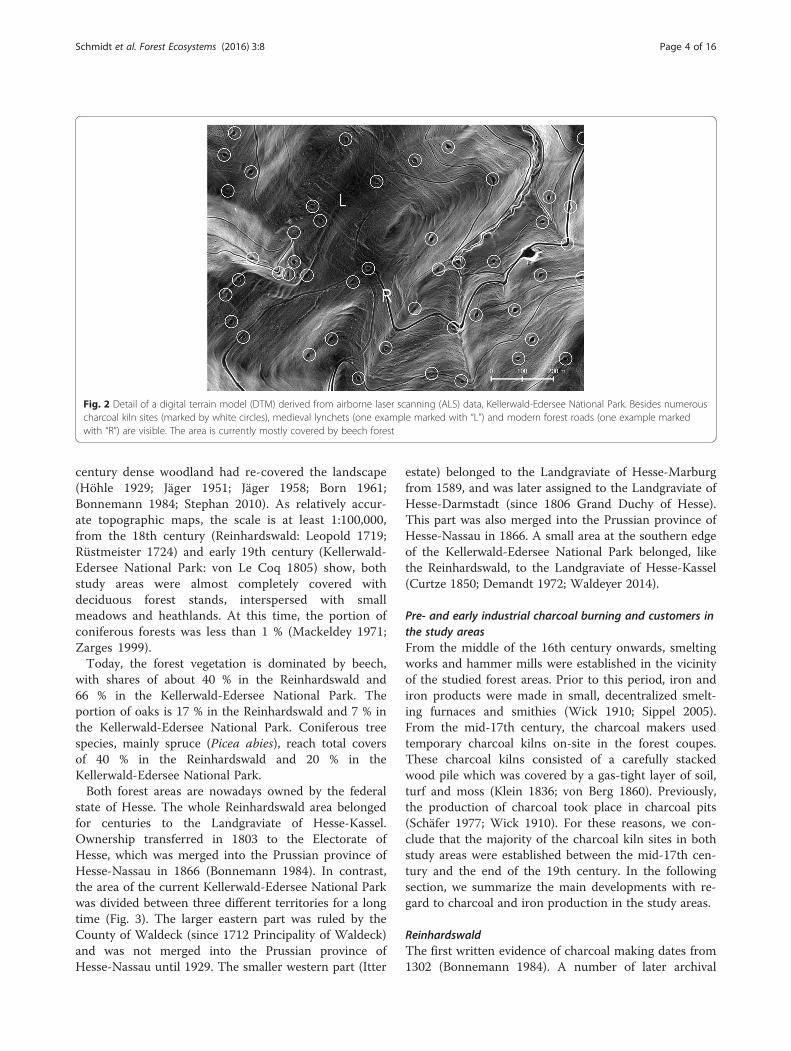
Fig. 2 Detail of a digital terrain model (DTM) derived from airborne laser scanning (ALS) data, Kellerwald-Edersee National Park. Besides numerouscharcoal kiln sites (marked by white circles), medieval lynchets (one example marked with “L”) and modern forest roads (one example markedwith “R”) are visible. The area is currently mostly covered by beech forest
Schmidt et al. Forest Ecosystems (2016) 3:8 Page 4 of 16
century dense woodland had re-covered the landscape(Höhle 1929; Jäger 1951; Jäger 1958; Born 1961;Bonnemann 1984; Stephan 2010). As relatively accur-ate topographic maps, the scale is at least 1:100,000,from the 18th century (Reinhardswald: Leopold 1719;Rüstmeister 1724) and early 19th century (Kellerwald-Edersee National Park: von Le Coq 1805) show, bothstudy areas were almost completely covered withdeciduous forest stands, interspersed with smallmeadows and heathlands. At this time, the portion ofconiferous forests was less than 1 % (Mackeldey 1971;Zarges 1999).Today, the forest vegetation is dominated by beech,
with shares of about 40 % in the Reinhardswald and66 % in the Kellerwald-Edersee National Park. Theportion of oaks is 17 % in the Reinhardswald and 7 % inthe Kellerwald-Edersee National Park. Coniferous treespecies, mainly spruce (Picea abies), reach total coversof 40 % in the Reinhardswald and 20 % in theKellerwald-Edersee National Park.Both forest areas are nowadays owned by the federal
state of Hesse. The whole Reinhardswald area belongedfor centuries to the Landgraviate of Hesse-Kassel.Ownership transferred in 1803 to the Electorate ofHesse, which was merged into the Prussian province ofHesse-Nassau in 1866 (Bonnemann 1984). In contrast,the area of the current Kellerwald-Edersee National Parkwas divided between three different territories for a longtime (Fig. 3). The larger eastern part was ruled by theCounty of Waldeck (since 1712 Principality of Waldeck)and was not merged into the Prussian province ofHesse-Nassau until 1929. The smaller western part (Itter
estate) belonged to the Landgraviate of Hesse-Marburgfrom 1589, and was later assigned to the Landgraviate ofHesse-Darmstadt (since 1806 Grand Duchy of Hesse).This part was also merged into the Prussian province ofHesse-Nassau in 1866. A small area at the southern edgeof the Kellerwald-Edersee National Park belonged, likethe Reinhardswald, to the Landgraviate of Hesse-Kassel(Curtze 1850; Demandt 1972; Waldeyer 2014).
Pre- and early industrial charcoal burning and customers inthe study areasFrom the middle of the 16th century onwards, smeltingworks and hammer mills were established in the vicinityof the studied forest areas. Prior to this period, iron andiron products were made in small, decentralized smelt-ing furnaces and smithies (Wick 1910; Sippel 2005).From the mid-17th century, the charcoal makers usedtemporary charcoal kilns on-site in the forest coupes.These charcoal kilns consisted of a carefully stackedwood pile which was covered by a gas-tight layer of soil,turf and moss (Klein 1836; von Berg 1860). Previously,the production of charcoal took place in charcoal pits(Schäfer 1977; Wick 1910). For these reasons, we con-clude that the majority of the charcoal kiln sites in bothstudy areas were established between the mid-17th cen-tury and the end of the 19th century. In the followingsection, we summarize the main developments with re-gard to charcoal and iron production in the study areas.
ReinhardswaldThe first written evidence of charcoal making dates from1302 (Bonnemann 1984). A number of later archival

Fig. 3 The study area Kellerwald-Edersee National Park with the location of the mapped charcoal kiln sites, historical industrial sites, and historicalstate boundaries. The different ironworks and hammer mills of the Haina Hospital are not illustrated, since they obtained no charcoal or fuelwoodfrom the study area. a: Thalitter, b: Bericher Faktorei, c: Vornhagen, d: Kleinern, e: Gellershausen, f: Frankenau
Schmidt et al. Forest Ecosystems (2016) 3:8 Page 5 of 16
documents indicate that secondary woodland, which haddeveloped after the abandonment of farmland inmedieval times, was cleared for agriculture in the 16thcentury. The harvested wood was used for glass andcharcoal production (Jäger 1951). Forest decrees is-sued by the Landgraviate of Hesse-Kassel in 1593,1629 and 1683 highlight that there was a hugeamount of lying wood (originating from windthrow,for example) which should be used for charcoalproduction. But also regularly harvested wood wasotherwise carbonized. Trees that were suitable fortimber production or technical purposes must not beallocated to the charcoal makers (Landgraf zu Hessen1593; Landgraf zu Hessen 1629; Landgraf zu Hessen1683).The main customers of charcoal were the initially
privately operated hammer mills and ironworks atLippoldsberg (1555–1873, since 1583 state-owned) andHeisebeck (1555–ca. 1564), and the state-owned iron-works at Vaake (1581–1583), Knickhagen (1591–1666),and Veckerhagen (1666–1903). From about 1700 to1730, a copperworks existed at the Olbetal nearVeckerhagen (Fig. 4). Following a forest description from1774, an annual wood volume of ca. 1200 m3 could besustainably harvested in the ca. 120-ha forest compart-ment “Stickelhalbe” to provide charcoal for the hammermill at Lippoldsberg (Henne 1997). By 1767, the
Veckerhagen ironworks needed ca. 4800 m3 and by1802 ca. 5500 m3 of wood per year (Cancrinus 1767;Laurop 1802). The ironworks purchased the wood fromneighboring state forests and coordinated the charcoalmakers. The iron ore was mostly obtained from theHohenkirchen mining district, which is situated 18 kmsouthwest of Veckerhagen (Fig. 1). From the early 19thcentury onwards, the importance of charcoal for ironsmelting decreased, since coal-derived coke was increas-ingly available (Cancrinus 1767; Laurop 1802; Wick1910; Lotze 1997).
Kellerwald-Edersee National ParkThe importance of charcoal making in the area of thecurrent Kellerwald-Edersee National Park is highlighted bya forest decree issued by the Prince of Waldeck in 1741(Fürst von Waldeck-Pyrmont 1741). This decree empha-sizes the increasing demand from mines, smelting worksand hammer mills for charcoal, fuelwood, and constructiontimber, and provides detailed instructions for protectingthe forest resources from depletion. In particular, the forestadministration was instructed to supervise the cutting ofwood for charcoal making very strictly. Trees that weresuitable for timber production or technical purposes had tobe excluded from charcoal production. Besides charcoal,also wood ash was made in the area, the relics of ashproduction sites can be found in the forest (Sippel 2009).

Fig. 4 The study area Reinhardswald with the location of the mapped charcoal kiln sites and historical industrial sites. a: Lippoldsberg, b: Heisebeck,c: Olbetal, d: Veckerhagen, e: Vaake, f: Knickhagen
Schmidt et al. Forest Ecosystems (2016) 3:8 Page 6 of 16
In Waldeck, the early industrial iron production had itsheyday between the 16th and 18th century. During thistime, a multitude of mostly small ironworks and hammermills (e.g. Vornhagen 1540–1710, Kleinern 1657–1870,Gellershausen 1658–1664) were in operation in thevicinity of the current Kellerwald-Edersee National Park(Fig. 3) (Mannel 1908; Schäfer 1977). The most important
complex of ironworks and associated hammer mills waslocated in the valleys of the rivers Eder and Werbe, ca.2 km north of the Kellerwald-Edersee National Park. Thefirst written record of this proto-industrial area is from1623. The central ironworks was the Bericher Faktorei(smelting works and associated hammer mills), which hadits peak period in the early 18th century. The iron ore was

Schmidt et al. Forest Ecosystems (2016) 3:8 Page 7 of 16
purchased from the Adorf mining district, which is situ-ated 35 km northwest of the ironworks (Fig. 1). Charcoaland fuelwood were mostly obtained from the adjacentstate-owned forests. Between the 17th and 19th centurythe charcoal and fuel wood supply of the Bericher Faktoreihad been strictly regulated by the governmental forest ad-ministration. Various measures were aimed at preventingboth forest over-exploitation and the wasting of wood.The price of the wood was regulated, and wood deliveryto the ironworks and their charcoal makers was madedependent on the available felling volume. There werecertain situations in which the ironwork in Berich had tocease its operations due to fuel shortage, or was compelledto purchase charcoal from other regions (Curtze 1850;Mannel 1908; Schäfer 1977). Between 1750 and 1806, theannual wood consumption of the Bericher Faktoreiamounted to a mean of 7500 m3. This factory had fadedin significance by 1833 and subsequently closed down in1875 (Mannel 1908).In the territory of the former Landgraviate of Hesse-
Kassel next to the village of Frankenau, 2 km south of theKellerwald-Edersee National Park, an ironworks operatedfrom 1576 to 1663. Charcoal and fuelwood were, however,presumably obtained from the Itter estate (Boucsein2009). The ironworks and hammer mills of the HainaHospital, ca. 12 km southeast of the Kellerwald-EderseeNational Park, had been operating between the early 16thand the 19th century and were able to gain the charcoaland fuelwood supply from the surrounding woods (Wick1910; Friedrich 1990; Zarges 1999; Boucsein 2009). In thevillage of Thalitter in the Itter estate, 8 km northwest ofthe Kellerwald-Edersee National Park, a copperworks wasin operation from 1712 to 1868. This factory alsoconsumed large quantities of charcoal and fuelwood(Cancrinus 1767; Tasche 1849; Paul 1939). In those partsof the Kellerwald-Edersee National Park which belongedto the Itter estate, charcoal making had its peak in the19th century (Zarges 1999).
Charcoal kiln site distributionDigital terrain model (DTM) and landscape attributesFor the systematic mapping of charcoal kiln sites, weused a digital terrain model (DTM), which was derivedfrom state-wide airborne laser scanning (ALS) data bythe Hessian State Office of Land Management andGeoinformation (HVBG). The ALS data were recordedbetween 2009 and 2012 and the applied DTM provideda spatial resolution of 1 m2 (Doneus et al. 2008; Gertloff2011; Risbøl et al. 2013; HVBG 2015). Two differenthillshade images were produced from the DTM, whichvaried with regard to the lighting conditions. Thisenabled us to visually identify charcoal kiln sites withgreat accuracy (Fig. 2).
For each kiln site data point, we determined the pa-rameter values of four landscape attributes from digitalforest inventory maps (“tree species composition”), forestsite survey maps (“water supply status”, “nutrient supplystatus”), and soil maps (“soil complex classes”). Soilcomplex classes have been mapped at a scale of1:50,000 (HNUG 2002), the scale of forest inventorymaps was 1:50,000 and that of the site survey maps was1:25,000 (HMULF 2002). The three landscape attributes“altitude”, “exposition” and “inclination” were derivedfrom the DTM. Since the foundations of charcoal kilnsare always small plateaus, the parameter values of theattributes “exposition” and “inclination” were calculatedas mean values of 15-m-wide rings around 15-m-widebuffer circles at the kiln site data points. The landscapeattributes mentioned above were also determined for thetotal areas of each studied forest landscape. All geospa-tial analyses were performed using GRASS GIS 7(GRASS Development Team 2015) and QGIS 2.11software (QGIS Development Team 2015).
Comparison of DTM-based surveys and field inventories ofcharcoal kiln sitesGeoreferenced data from field inventories of charcoalkiln sites in the northern Reinhardswald (Koch 1990;Stephan 2010) enabled us to compare DTM-derived in-formation on charcoal kiln sites with data collected inthe traditional way and without the use of GPS(Ludemann 2012). Within an area of 847 ha, we identi-fied 414 charcoal kiln sites by interpreting the DTM,while merely 328 of these (79 %) were located during thefield surveys. Apart from the greater effort of field inven-tories, the positional accuracy of the DTM-derived pointdata was much higher. Divergences of more than 50 mwere not unusual between the field survey points andthe actual kiln site locations.
Statistical analysisAll statistical analyses were performed by using the R soft-ware version 3.2.2 (R Development Core Team 2015) withthe “vegan” package (Oksanen et al. 2012) and the “cluster”package (Maechler et al. 2015). Significance of statisticaltests was noted as follows: *** = p ≤ 0.001; ** = p ≤ 0.01;* = p ≤ 0.05; n.s. = p > 0.05.
Univariate analysisUsing a chi-square test, we checked whether the fre-quency distributions of charcoal kiln sites with respectto the levels of the various landscape attributes wereproportional to the distribution of these landscape attri-butes in the total study areas. We applied the likelihoodratio test (cf. Gould et al. 2006):

Schmidt et al. Forest Ecosystems (2016) 3:8 Page 8 of 16
G2 ¼ 2Xc
1ni log ni=μ̂lð Þ with i ¼ 1 1ð Þc ð1Þ
G2 is χ2-distributed with c-1 degrees of of freedom, wheren is the total number of charcoal kiln sites, ni the observedcharcoal kiln sites in the i-th factor level, and μ̂l ¼ pi � nthe theoretical values of the total area in this level.
Multivariate and cluster analysisIn order to better specify the multivariate structure inthe data of the charcoal kiln sites, we conducted aprincipal component analysis (PCA; cf. Venables andRipley 2002). For this purpose, the nominal variables“water supply status”, “nutrient supply status”, “soilcomplex classes”, “exposition”, and “main tree species”were transformed into dichotomous variables with re-gard to the respective factor levels. Only dichotomousvariables were used for further analysis. In order to fitthe dichotomous variables of both studied forest areasonto the PCA plot, we used the function “envfit” pro-vided by the “vegan” package in R (Oksanen et al. 2012).A biplot was created, which allowed for the analysis ofthe correlation between the different variables and bothforest areas.
Fig. 5 PCA/biplot of the charcoal kiln sites data. Matrix: 3934 charcoal kilnPark (Kw): 1308 kiln sites. Axis 1: eigenvalue = 1.67, axis 2: eigenvalue = 1.51
ResultsCharcoal kiln site distributionGeneral features of charcoal kiln site distributionIn the Reinhardswald, we registered a total number of2626 charcoal kiln sites, which equates to a frequency ofone charcoal kiln site per 7.7 ha. For the Kellerwald-Edersee National Park we found 1308 charcoal kiln sites,with a slightly higher frequency of one charcoal kiln siteper 4.3 ha. In both study areas, the number of charcoalkiln sites per hectare ranges between 0 and 4. Generally,the spatial distribution of the charcoal kiln sites isirregular and different between both forest areas. In theReinhardswald, there is a concentration in the north andthe middle of the eastern part of the area, while in thewestern part charcoal kiln sites are completely absent inmany places (Fig. 4). In the Kellerwald-Edersee NationalPark, the distribution of charcoal kiln sites is much moreeven. Only few parts of the National Park exhibit noevidence of charcoal kiln sites (Fig. 3).
Patterns of charcoal kiln sites distribution in the study areasTo determine possible differences in the distribution ofcharcoal kiln sites between both study areas and theirdependence on particular landscape attributes, a PCAwas conducted. The PCA (Fig. 5) clearly showed that the
sites. Reinhardswald (Rw): 2626 kiln sites, Kellerwald-Edersee National, combined R2 of axes 1 and 2 = 0.19
Schmidt et al. Forest Ecosystems (2016) 3:8 Page 9 of 16
majority of the charcoal kiln sites were located on theright side of axis 1. The crucial landscape attributes werethe occurrence of beech, steeper slopes, and mesotro-phic site conditions. Of minor importance were theabundance of oaks and spruce, as well as periodicallywet and eutrophic site conditions. Only a few charcoalkiln sites in the total data set featured these landscapeattributes. On axis 2 of the ordination, a separationoccurred according to the area-specific characteristics ofthe charcoal kiln sites in both studied regions. Withregard to the Kellerwald-Edersee National Park (Kw),the charcoal kiln sites tended to occur in higher eleva-tions and on moderately fresh as well as moderately drysites. The occurrence of charcoal kiln sites on acidicbrown soils was less pronounced. When looking at theReinhardswald (Rw), the charcoal kiln sites showed atendency to occur on sites with markedly fresh condi-tions, but they can also be found on pseudogley soils,which are of minor significance in the Kellerwald-Edersee National Park.
Landscape attributes: whole study areas vs. charcoal kilnsitesIn the following section, we contrast the landscape attri-butes found throughout the whole of the two study areaswith the landscape attributes which were to be foundonly at the charcoal kiln sites. For this purpose, classesand levels were compiled and the respective percentagesfor the total areas and the kiln sites were compared(Table 1). This comparison shows that the percentagedistribution of the charcoal kiln sites with respect to alltested landscape attributes is statistically significantlydifferent from the distribution of landscape attributesthroughout the whole of the study areas.Firstly, the forest site survey data were evaluated in
order to compare the average water and nutrient supplystatus of the whole study areas with the water and nutri-ent supply status at the charcoal kiln sites. Concerningthe water supply status, we found significant differenceswhen conducting these comparisons. In the Reinhards-wald, most of the charcoal kiln sites are located both onfresh (57 %) and markedly fresh (26 %) soils, while fresh(49 %) and markedly fresh (14 %) soils are much lesscommon throughout the whole Reinhardswald area. Onthe contrary, periodically moist soils, which occupy 23 %of the whole Reinhardswald area, are significantly under-represented at charcoal kiln sites with a portion of 6 %.Comparable patterns were found in the Kellerwald-Edersee National Park, where fresh (30 %) and particu-larly fresh (13 %) soils are significantly over-representedat charcoal kiln sites. Throughout the whole NationalPark area, these water supply statuses account for 18and 6 %, respectively. Moderately fresh (42 %) and mod-erately dry (11 %) soils are also relatively common at
charcoal kiln sites. However, compared to the whole areaof the National Park, where these water supply statusesaccount for 47 and 25 %, they are under-represented atcharcoal kiln sites.There are also significant differences in the nutrient
supply status. These differences are, however, small inrelation to the differences found in the other landscapeattributes and are not stressed here. Both in theReinhardswald and in the Kellerwald-Edersee NationalPark, 93 % of the forest sites are classified as mesotro-phic. These portions are very close to the values foundat the charcoal kiln sites, which amount to 96 % in theReinhardswald and 93 % in the Kellerwald-EderseeNational Park.In the Reinhardswald, we found a significant difference
regarding the distribution of soil complex classes whencomparing the whole study area and the charcoal kilnsites. The majority (52 %) of charcoal kiln sites are to befound on acidic brown soils, while this soil complexclass covers merely 34 % of the whole study area.Pseudogleys, however, predominate on 55 % of theReinhardswald area, while they are under-represented atthe charcoal kiln sites (38 %). In the Kellerwald-EderseeNational Park, most charcoal kiln sites are also linked toacidic brown soils (79 %) and pseudogleys (13 %). Thispattern, however, corresponds more closely to the distri-bution of these two soil complex classes in the wholestudy area (88 and 7 %).With regard to the landscape attribute altitude, we
found differences in frequency when comparing thewhole study areas with the charcoal kiln sites. While inthe Reinhardswald charcoal kiln sites frequently occurbelow 300 m a.s.l., in the Kellerwald-Edersee NationalPark they can be found disproportionately frequentlyabove 500 m a.s.l.Concerning the exposition in both forests areas there
are differences between the distribution at the charcoal kilnsites and in the whole study area. In the Reinhardswald NE,E and SE exposure is over-represented. In the Kellerwald-Edersee National Park N, NE and E aspect is over-represented.Significant differences could also be detected concerning
the landscape attribute inclination in the Reinhardswald.In this study area, the majority of charcoal kiln sites aresituated on slopes with an inclination of 10°– < 20° (40 %)or 20°– < 30° (9 %), while such inclinations occur only on19 % (10°– < 20°) and 5 % (20°– < 30°) of the wholeReinhardswald area. Nearly flat terrain with an inclinationof less than 5° reaches a proportion of 40 % in the wholestudy area, but is distinctly under-represented at charcoalkiln sites (15 %). In the Kellerwald-Edersee National Park,however, the differences in inclination between the wholestudy area and the charcoal kiln sites are less significant.Here, it can be seen that charcoal kiln sites are most

Table 1 Characteristics of the landscape attributes in the Reinhardswald and the Kellerwald-Edersee National Park, given for thewhole study areas and the charcoal kiln sites, respectively
Reinhardswald Kellerwald-Edersee National Park
Total area Kiln sites Total area Kiln sites
Water supply status n = 2576 n = 1297
Dry 0.1 0 1.8 0 %
Moderately dry 0.6 0.4 24.6 11.5 %
Moderately fresh 9.9 8.9 47.4 42.3 %
Fresh 48.7 56.8 18.4 29.8 %
Markedly fresh 14.2 25.7 5.7 12.9 %
Periodically moist 22.7 6.4 0.1 0.2 %
Moist 1.0 1.2 1.7 3.2 %
Moderately wet 0.2 0.2 0.3 0.2 %
Wet 2.4 0.3 0 0 %
p < 0.001*** p < 0.001***
Nutrient supply status n = 2602 n = 1297
Oligotrophic 1.7 0.2 0.2 0 %
Slightly mesotrophic 3.6 1.2 0.1 0 %
Mesotrophic 93.1 96.3 93.1 93.1 %
Distinctly mesotrophic 0.7 0.8 4.5 3.6 %
Slightly eutrophic 0.1 0 0.3 0.2 %
Eutrophic 0.8 1.5 1.9 3.1 %
p < 0.001*** p < 0.01**
Soil complex classes n = 2626 n = 1308
Colluvial soils 3.1 6.1 0 0 %
Acidic brown soils 34.1 51.6 87.6 79.4 %
Pseudogleys 54.7 38.1 7.4 12.8 %
Stagnogleys and fen soils 4.7 1.2 0 0 %
Gleys 3.3 2.9 5.0 7.9 %
p < 0.001*** p < 0.001***
Altitude n = 2626 n = 1308
< 200 m 9.6 14.8 0 0 %
< 300 m 42.4 47.1 5.9 3.7 %
< 400 m 41.0 35.8 32.1 27.2 %
< 500 m 7.0 2.2 47.0 49.3 %
> 500 m 0 0 15.1 19.8 %
p < 0.001*** p < 0.01**
Exposition n = 2626 n = 1308
E 12.3 17.1 13.5 15.6 %
NE 13.6 20.1 13.4 17.5 %
N 12.4 12.0 13.4 17.1 %
NW 11.6 7.1 15.3 15.5 %
W 15.1 8.4 11.6 9.1 %
SW 15.1 12.5 8.6 5.5 %
S 10.0 10.1 10.5 7.8 %
SE 9.8 12.7 13.3 11.9 %
Schmidt et al. Forest Ecosystems (2016) 3:8 Page 10 of 16

Table 1 Characteristics of the landscape attributes in the Reinhardswald and the Kellerwald-Edersee National Park, given for thewhole study areas and the charcoal kiln sites, respectively (Continued)
Reinhardswald Kellerwald-Edersee National Park
Total area Kiln sites Total area Kiln sites
p < 0.001*** p < 0.001***
Inclination n = 2626 n = 1308
< 5° 40.5 14.7 11.1 9.2 %
< 10° 33.2 34.7 20.2 22.6 %
< 20° 19.3 40.4 37.5 48.5 %
< 30° 5.4 8.6 24.6 17.2 %
< 40° 1.5 1.4 6.0 2.4 %
< 50° 0.3 0.2 0.6 0.2 %
≥ 50° 0 0 0.1 0 %
p < 0.001*** p < 0.001***
Tree species composition n = 2607 n = 1186
Fagus sylvatica 39.7 73.2 66.1 79.1 %
Picea abies 34.4 11.2 13.2 14.0 %
Quercus spp. 17.0 9.7 6.8 3.7 %
Larix decidua 4.2 2.8 1.9 1.3 %
Pinus sylvestris 0.9 0.9 4.2 0.3 %
Pseudotsuga menziesii 0.7 0.4 1.3 0.2 %
other tree species and open land 2.9 1.8 6.4 1.5 %
p < 0.001*** p < 0.001***
Schmidt et al. Forest Ecosystems (2016) 3:8 Page 11 of 16
frequently situated on slopes with an inclination of5°– < 10° (23 %) or 10°– < 20° (48 %), while such inclina-tions occur only on 20 % (5°– < 10°) and 38 % (10°– < 20°)of the whole Kellerwald-Edersee National Park area.With regard to the current tree species composition,
both in the Reinhardswald and in the Kellerwald-EderseeNational Park, beech is by far the most important treespecies at the charcoal kiln sites and reaches portions of73 and 79 %, respectively. In the Reinhardswald, beech isclearly over-represented at the charcoal kiln sites, whilespruce (Picea abies) occurs less frequently at the kiln sitescompared to the whole study area. There is less differencein the composition of tree species between the charcoalkiln sites and the entire study area in the Kellerwald-Edersee National Park. Nevertheless, in this study area thepercentage of beech on charcoal kiln sites (79 %) is stillhigher than that in the whole forest area (66 %).
DiscussionRelationships between the distribution of charcoal kilnsites and landscape attributesBy contrasting the landscape attributes of the two wholestudy areas with the landscape attributes which were to befound at the charcoal kiln sites, we were able to draw several
conclusions about the conditions that had to be met for theconstruction of charcoal kiln sites in the forest.The underlying bedrocks provide, both in the
Reinhardswald (sandstone) and in the National ParkKellerwald-Edersee (clay shale and greywacke), favorableconditions for the establishment of charcoal kilns, sincethey enable a constant underground air flow to the kiln dueto their physical properties (von Berg 1860). Differences inthe spatial distribution of charcoal kiln sites, however, arecorrelated with the occurrence of certain soil types. It canbe seen that the majority of charcoal kiln sites (91 % in theReinhardswald and 85 % in the Kellerwald-Edersee Na-tional Park) were constructed on fresh soils (fresh, moder-ately fresh, markedly fresh), although this proportion doesnot match the expected value in both study areas. In con-trast, periodically moist soils in the Reinhardswald andmoderately dry soils in the Kellerwald-Edersee NationalPark (covering about a quarter of the respective studyareas) are under-represented at the charcoal kiln sites inboth forest landscapes. The correlation of charcoal kiln sitedistribution and water supply status is reflected in the dis-tribution of soil complex classes. In both study areas, themajority of the charcoal kiln sites are located on acidicbrown soils, which are characterized by fresh conditions.Furthermore, there is a concentration of charcoal kiln sites

Schmidt et al. Forest Ecosystems (2016) 3:8 Page 12 of 16
at slightly inclined to moderately inclined slopes (5°– < 30°),on which 88 % of the charcoal kiln sites in the Reinhards-wald and 84 % of the kiln sites in the Kellerwald-EderseeNational Park were constructed.From these distribution patterns, it appears that the
forest officers preferentially allocated those forest standsto the wood-colliers, which were located on hillsideswith fresh site conditions, good drainage, and acidicbrown soils. This corresponds almost exactly to thedescriptions given in the older literature regarding thepreferred location of charcoal kiln sites. Alreadyvon Carlowitz (1732) pointed out that wet and swampyareas should be avoided. This view is also represented byKlein (1836), Dietrich (1847) and von Berg (1860). Ac-cording to von Berg (1860), clay soils with an admixtureof top soil represent the best ground for charcoal kilns.Acidic brown soils have these characteristics. To facilitatethe delivery of wood and the transportation of charcoal,and to prevent extensive earthworks, the labor-intensiveconstruction of charcoal kiln sites on very steep slopesshould be avoided (Klein 1836; von Berg 1860).The fresh and mesotrophic hillside locations, on which
charcoal kiln sites in the Reinhardswald and theKellerwald-Edersee National Park are concentrated, offeroptimal growing conditions for beech (Ellenberg andLeuschner 2010), the preferred wood for charcoal makingin both study areas (see the third section of the discussion).On these soils, the growth performance and regenerationcapacity of beech is significantly better than on periodicallymoist or moderately dry soils (Leuschner 1997). There isevidence that stands at periodically moist soils on the plat-eau of the Reinhardswald were widely cleared and sparselystocked in the second half of the 18th century (Laurop1802; Chwalczyk 1988). This can be attributed to the factthat the wood was easy to reach and to remove. In addition,these plateau areas were densely covered with grass due towoodland pasture. Along with browsing by cattle and deer,a dense grass cover is an obstacle to tree regeneration(Laurop 1802; Mitchell and Kirby 1990; Coll et al. 2003).On the moderately dry soils in the Kellerwald-Edersee
National Park, the growth performance of beech is alsolimited. Due, in particular, to repeated harvesting at sun-exposed southern slopes, oaks and hornbeam (Carpinusbetulus) were promoted here, while beech dominates onmoderately fresh and fresh soils and usually forms purestands (cf. Ellenberg and Leuschner 2010). A similar an-thropogenic influenced, site-specific forest developmentis described by Speier (1994) for the more westerly situ-ated Rothaargebirge mountain range.
Relationships between the distribution of charcoal kilnsites and the main charcoal consumersBetween the 16th and 18th century (and even before),the establishment of copper- and iron-works was closely
related to the supply of wood types suitable for charcoalmaking and, to a lesser extent, on the occurrence of orebearing rock, which often had to be transported overlong distances to the works (Curtze 1850; Seidensticker1896; Wick 1910; Rippel 1958; Schäfer 1977; Boucsein2009). Schott (1997) emphasizes that proto-industrial ironsmelting, which was based on the utilization of fuelwoodor charcoal, inevitably had to be decentrally organized, itsdevelopment being dependent on the availability offuelwood supply. This point of view is supported by Oelke(1974), who investigated the development of the iron in-dustry in the eastern Harz Mountains (Central Germany).For these reasons, ore smelting always took place in thevicinity of large forest areas. It can therefore be assumedthat, at the time of the smelting works’ establishment, thedecision-makers estimated that there was sufficientavailability of wood resources in the surrounding area inthe medium- to long-term. Moreover, charcoal burnerscould utilize forest stands at poorly accessible hillsidelocations, since it is easier to transport charcoal than wood(Jacobi 1912; Bonnemann 1984; Zarges 1999).With regard to the Reinhardswald, the late-16th and
17th century forest decrees explicitly point out thatthere was a huge amount of lying wood. However, areport from 1617 mentions an overexploitation of theReinhardswald due to charcoal making (Wick 1910).This contradiction can be solved by a spatial differen-tiation into easily accessible, heavily used stands onthe one hand and poorly accessible, well conservedstands on slopes on the other (cf. Laurop 1802). Forthe 16th and early 17th century it has been frequentlyreported that charcoal burners were advised to car-bonize lying wood that was hardly applicable forother purposes due to the steepness of the terrain(Wick 1910; Höfer 1947). In accordance with this, thefirst state-owned ironworks in the Landgraviate ofHesse-Kassel was established in the village of Vaakein 1581 to utilize a large amount of unused wood inthe surrounding forests (Wick 1910).As argued in the following section, the results provide
strong evidence that there have been well-stocked forestsin both studied woodland landscapes between the 17th and19th century. This is especially true for those sites that wereunsuitable for wood exploitation and pasture due to pooraccessibility, a lack of paths, and pronounced steepness ofthe terrain (cf. Jacobi 1912). It is precisely these areas thatprovided optimal growing and regeneration conditions forbeech due to their acidic brown soils and balanced waterbudget. In the Reinhardswald, such sites are most fre-quently located on slopes of the Weser valley at altitudesbelow 300 m a.s.l. In the Kellerwald-Edersee National Parkthey are concentrated at altitudes greater than 400 m a.s.l.Here, charcoal production was able to occupy a niche thatcould not be filled by other types of forest use. This created

Schmidt et al. Forest Ecosystems (2016) 3:8 Page 13 of 16
the conditions for the establishment of smelting works andhammer mills that were desired by the sovereign.In the area of the Kellerwald-Edersee National Park, the
Bericher Faktorei was established in the 17th century,since the forests in the wider surroundings were well-stocked. Different measures were aimed at preventingboth forest over-exploitation and the wasting of wood (seethe above section on the regional setting of the studyareas). As Mannel (1908) states, the fuel supply of theironworks enjoyed special attention, “since people had theforest every day before their eyes, they saw with their owneyes, how it was reduced at increased operating pressure,while the decrease of ironstone was withdrawn from ob-servation.” Additionally, and this is a very important pointraised by Hammersley (1973), most of the proto-industrialironmasters wanted to protect their investment and main-tain their profits, and that needed fuel security for the fu-ture as well as the present.
Woodland conditions and tree species composition at thetime of charcoal productionOn those types of sites where charcoal kilns had beenprimarily constructed, beech is today the main tree spe-cies, with cover of over 70 % in both study areas. It canbe assumed that beech was also the dominant tree spe-cies at the time of the charcoal kilns’ construction. Thisassumption is supported by historical forest inventorymaps, such as the “Master Map of the Reinhardswald”from 1827 (Marburg State Archive, Map P II 2079).Since a charcoal kiln had to be set up with wood typesof comparable consistency, hard beech wood was notallowed to be carbonized in combination with soft coni-fer, birch or willow wood (von Berg 1860). In both studyareas, conifers (especially spruce) did not reach signifi-cant proportions until ca. 1850, and have been increas-ingly cultivated on degraded land since then (Mackeldey1971; Zarges 1999). Conifer wood, therefore, played norole for charcoal making in both the studied forest land-scapes. Although it is documented that tree species likeoaks, hornbeam, alder or birches have been used for char-coal production (Wick 1910; Schwedes 1983), it is evidentthat beech was preferred in both the Reinhardswald andthe area of the Kellerwald-Edersee National Park (Fürstvon Waldeck-Pyrmont 1741; Wick 1910).As von Berg (1860) emphasizes, charcoal made from
beech can be used advantageously for all technicalindustries and most metallurgical processes, particularlyfor the production of crude steel. The obvious prefer-ence for beech wood for charcoal making in both stud-ied forest landscapes agrees well with anthracologicalfindings from the Solling mountain range directly northof the Reinhardswald (Hillebrecht 1982). In other forestlandscapes, though, the conditions were different. Sprucewas, for instance, the main tree species for charcoal
making in the Harz Mountains (Hillebrecht 1982; Knappet al. 2015), while in the Rothaargebirge mountain rangemainly beech, oaks and birches had been carbonized(Jung 1779; Speier 1994). In the Westerwald mountainrange, hornbeam and beech were the target species(Heuser-Hildebrandt 2002), and in the Black Forestspruce, silver fir (Abies alba) and beech dominated thespectrum of utilized tree species (Ludemann 2010).From the findings obtained in this study, we conclude
that there have been well-stocked and beech-dominateddeciduous forest stands in northern Hesse before 1800,particularly at poorly accessible hillside locations instate-owned forests. However, these stands were in manyplaces accompanied by areas of overexploited woodland.With regard to the Reinhardswald, Chwalczyk (2000)stated that the local stands were better stocked thanother Hessian forest areas, despite the century-longtradition of wood pasture and of a partial forest devasta-tion in the Seven Years’ War (1756–1763). This was trueparticularly for hillside locations. Through an evaluationof archival material from the 18th century, Jäger (1951)argues convincingly for the existence of well-stockedbeech stands on the poorly accessible slopes of theWeser valley. There was so much wood, that not onlythe fuelwood depot in the capital city of Kassel could besupplied, but also the foreign market. This assessment isnot only supported by Schenk (1996) and the results ofthe present study, but also by contemporary forestdescriptions made by Laurop (1802).For the area of the Kellerwald-Edersee National Park,
the small-scale map “Waldeck Comitatus” (Blaeu 1635)shows a forest symbol only for higher elevations, where,according to our results, charcoal kiln sites occur withgreater densities. Although we do not expect that theremaining lower areas were actually unwooded, we seethis as an indication of closed and connected woodlandat the higher elevations. These considerations are in linewith Jung (1779), who described well-stocked, beech-dominated 18th century forests in the Rothaargebirge, amountain range west of our study areas, which was alsoa center of charcoal production.For the governments of the different Hessian territories,
utilizing the large stocks of beech wood through the estab-lishment of ironworks and hammer mills was an obviousstep. However, with the introduction of coal-derived cokefrom the early 19th century onwards, both woodland areaslost their outstanding importance as fuel suppliers and theiron industry was relocated to the flourishing coal fields,particularly to the Rhineland and to Westphalia (Mannel1908; Wick 1910).
ConclusionsWe found that charcoal kiln sites were preferably estab-lished on hillside locations that, due to their acidic brown

Schmidt et al. Forest Ecosystems (2016) 3:8 Page 14 of 16
soils and sufficient water supply, provided optimal growingand regeneration conditions for beech. These resultsare in line with instructions for the selection of ap-propriate kiln site locations found in literature fromthe 18th to the 19th century. From our findings, weconclude that there have been well-stocked, beech-dominated deciduous forest stands in northern Hessebefore 1800, particularly at poorly accessible hillsidelocations. The governments of the different Hessianterritories utilized the large stocks of beech woodthrough the establishment of ironworks and hammermills.Our argumentation is in line with Schenk (1996) and
Radkau (2006), who underlined that Hessian forestswere not overexploited in all areas in the 18th century.Frequently repeated complaints about “wood shortage”seem to be more a political instrument than reality, sincethey were first and foremost aimed at enforcing thefinancial, administrative, and political goals of thegovernment (Schenk 1996). This insight was not onlyobtained in Hesse (Schenk 1996; Reinhardt 1999;Radkau 2006), but all over Europe (von Berg 1844;Warde 2006). Consequently, a differentiated assessmentof woodland conditions in proto-industrial times isstrictly advised, even if contemporary sources draw adark picture of the historic situation.
Competing interestsThe authors declare that they have no competing interests.
Authors’ contributionsMS and AM planned and conducted the study and wrote the majority of themanuscript. ES and FE executed the GIS and statistical analyses. WF hascontributed knowledge about the Kellerwald-Edersee National Park. All authorsread and approved the final manuscript.
AcknowledgementsWe thank Achim Frede (Kellerwald-Edersee National Park, Bad Wildungen), PeterMeyer (Northwest German Forest Research Institute, Göttingen), Hermann-JosefRapp (retired forester in the Reinhardswald, Reinhardshagen), and Klaus Sippel(Hessian State Conservation Office, Marburg) for helpful discussions and theircomments on an earlier version of the manuscript. We are grateful to RobertLarkin for proofreading. The authors are also indebted to two anonymousreviewers for suggestions that have greatly improved the paper.
Author details1Northwest German Forest Research Institute, Department A (Forest Growth),Grätzelstraße 2, D-37079 Göttingen, Germany. 2Kellerwald-Edersee NationalPark, Laustraße 8, D-34537 Bad Wildungen, Germany.
Received: 7 January 2016 Accepted: 7 March 2016
ReferencesArmstrong L (1978) Woodcolliers and charcoal burning. Coach Publishing House,
HorshamBfN (2010) Karte der Potentiellen Natürlichen Vegetation Deutschlands.
Bundesamt für Naturschutz (BfN), BonnBlaeu W (1635) Waldeck Comitatus. Willem Blaeu, AmsterdamBofinger J, Hesse R (2011) As far as the laser can reach… Laminar analysis of
LiDAR detected structures as a powerful instrument for archaeologicalheritage management in Baden-Württemberg, Germany. In: Cowley DC (ed)
Remote sensing for archaeological heritage management. EuropaeArchaeologia Consilium (EAC), Bruxelles, pp 161–171
Bonhôte J, Davasse B, Dubois C, Izard V, Métailié J-P (2002) Charcoal kilns andenvironmental history in the eastern Pyrenees (France). A methodologicalapproach. In: BAR International Series 1063. Archaeopress, Oxford pp 219–228
Bonnemann A (1984) Der Reinhardswald. Verlag der Weserbuchhandlung, Hann.Münden
Born M (1961) Frühgeschichtliche Flurrelikte in den deutschen Mittelgebirgen.Geogr Ann 43:17–25. doi:10.2307/520229
Boucsein H (2009) Geschichte der Wälder und Forsten in Oberhessen: Eineintegrierte Kulturgeschichte des hessischen Forstwesens. Burgwald-Verlag,Cölbe-Schönstadt
Cancrinus FL (1767) Beschreibung der vorzüglichsten Bergwerke in Hessen, in demWaldekkischen, an dem Haarz, in dem Mansfeldischen, in Chursachsen, und indem Saalfeldischen. Andreäische Buchhandlung, Frankfurth an dem Main.
Chwalczyk C (1988) Der Reinhardswald. In: Hessische Landesforstverwaltung (ed)Wald in Hessen. Gestern, heute und morgen. HessischeLandesforstverwaltung, Wiesbaden, pp 1–218
Chwalczyk C (2000) Merkwürdigkeiten zum Reinhardswald. In: HessischeLandesforstverwaltung (ed) Werden und Wandel – Hessens Forstwirtschaftauf dem Weg in das 3. Jahrtausend. Hessische Landesforstverwaltung,Wiesbaden, pp 69–82
Coll L, Balandier P, Picon-Cochard C, Prévosto B, Curt T (2003) Competition forwater between beech seedlings and surrounding vegetation in differentlight and vegetation composition conditions. Ann For Sci 60:593-600.doi:10.1051/forest:2003051
Collin G, Wetzel W (2004) Zur Geschichte der Eisengewinnung mit Holzkohle undSteinkohlenkoks. NTM NS 12:65–79. doi:10.1007/s00048-004-0189-8
Curtze L (1850) Geschichte und Beschreibung des Fürstenthums Waldeck.Speyer’sche Buchhandlung, Arolsen
Deforce K, Boeren I, Adriaenssens S, Bastiaens J, De Keersmaeker L, Haneca K, TysD, Vandekerkhove K (2013) Selective woodland exploitation for charcoalproduction. A detailed analysis of charcoal kiln remains (ca. 1300–1900 AD)from Zoersel (northern Belgium). J Archaeol Sci 40:681–689. doi:10.1016/j.jas.2012.07.009
Demandt KE (1972) Geschichte des Landes Hessen, 2nd edn. Bärenreiter, KasselDietrich V (1847) Das Ganze der Verkohlung in stehenden Meilern oder die
sogenannte italienische Köhlerei. Verlag von Jos. A. Kienreich, GrazDoneus M, Briese C, Fera M, Janner M (2008) Archaeological prospection of
forested areas using full-waveform airborne laser scanning. J Archaeol Sci 35:882–893. doi:10.1016/j.jas.2007.06.013
Ellenberg H, Leuschner C (2010) Vegetation Mitteleuropas mit den Alpen inökologischer, dynamischer und historischer Sicht, 6th edn. Ulmer, Stuttgart
Friedrich A (1990) Das Berg- und Hüttenwesen des Hospitals Haina vom 16. bis19. Jahrhundert. Geschbl f Waldeck 78:25–39
Fürst von Waldeck-Pyrmont CAF (1741) Fürstlich-Waldeckische Forst- und Jagd-oder Weidewercks-Ordnung. Christoph Konert, Mengeringhausen
Gertloff K-H (2011) Detektion von Bodendenkmälern im Wald mit einemhochauflösenden Geländemodell aus Laserscannerdaten. zfv 136:86–92
Gould W, Pitblado J, Sribney W (2006) Maximum likelihood estimation with Stata,3rd edn. Stata press, College Station
GRASS Development Team (2015) Geographic Resources Analysis SupportSystem (GRASS). Open Source Geospatial Foundation Project, https://grass.osgeo.org/grass7/. Accessed 15 Mar 2016
Hammersley G (1973) The charcoal iron industry and its fuel, 1540-1750. EconHist Rev 26:593–613. doi:10.2307/2593700
Henne R (1997) Die Gemarkungen von Gewissenruh und Gottstreu – Flurorteund angrenzende Waldorte. In: Gemeinde Oberweser (ed) WaldenserdörferGottstreu und Gewissenruh: Beiträge zur Orts- und Heimatgeschichte undzum Dorfleben 1722-1997. Gemeindevorstand der Gemeinde Oberweser,Oberweser, pp 199–252
Hesse R (2013) The changing picture of archaeological landscapes: lidarprospection over very large areas as part of a cultural heritage strategy. In:Opitz RS, Cowley DC (eds) Interpreting archaeological topography. 3D data,visualisation and observation. Oxbow Books, Oxford, pp 171–183
Heuser-Hildebrandt B (2002) Untersuchungen zur Kulturlandschaftsentwicklunganhand von Holzkohlenspektren historischer Meilerplätze. Archiv fürhessische Geschichte 60:307–332
Hillebrecht M-L (1982) Die Relikte der Holzkohlewirtschaft als Indikatoren fürWaldnutzung und Waldentwicklung: Untersuchungen an Beispielen ausSüdniedersachsen. Gött Geogr Abh 79:1–157

Schmidt et al. Forest Ecosystems (2016) 3:8 Page 15 of 16
HMULF (2002) Hessische Anweisung für Forsteinrichtungsarbeiten (HAFEA).Hessisches Ministerium für Umwelt, Landwirtschaft und Forsten (HMULF),Wiesbaden
HNUG (2002) Erläuterungen zur Bodenkarte von Hessen 1:50.000. HessischesLandesamt für Umwelt und Geologie (HNUG), Wiesbaden
Höfer R (1947) Reviergeschichte des Forstamtes Gahrenberg im Reinhardswald:insbesondere seit 1750. Georg-August-Universität Göttingen, Göttingen
Höhle H (1929) Die untergegangenen Ortschaften oder Die Wüstungen inWaldeck. Wilh. Bings Buchdruckerei, Corbach
HLBG (2015) Produktkatalog, Heft 4, Digitale Geobasisdaten. HessischesLandesamt für Bodenmanagement und Geoinformation (HLBG), Wiesbaden
Jacobi HB (1912) Die Verdrängung der Laubwälder durch die Nadelwälder inDeutschland. Verlag der H. Laupp’schen Buchhandlung, Tübingen
Jäger H (1951) Die Entwicklung der Kulturlandschaft im Kreise Hofgeismar. GöttGeogr Abh 8:1–114
Jäger H (1958) Entwicklungsperioden agrarer Siedlungsgebiete im mittlerenWestdeutschland seit dem frühen 13. Jahrhundert. Würzb Geogr Arb 6:1–136
Jung JH (1779) Beschreibung der Nassau-Siegenschen Methode Kohlen zubrennen mit physikalischen Anmerkungen begleitet. Bemerkungen derkurpfälzischen physikalisch-ökonomischen Gesellschaft, Lautern, pp 257–371
Klein F (1836) Über Verkohlung des Holzes in stehenden Meilern. Hennings undHopf, Gotha
Klemm S, Nelle O, Grabner M, Geihofer D, Schnepp E (2005) InterdisziplinäreUntersuchungen von Kohlstätten aus Mittelalter und Neuzeit in derEisenerzer Ramsau, Steiermark. Archaeologia Austriaca 89:269–329
Knapp H, Robin V, Kirleis W, Nelle O (2013) Woodland history in the upper HarzMountains revealed by kiln site, soil sediment and peat charcoal analyses.Quat Int 289:88–100. doi:10.1016/j.quaint.2012.03.040
Knapp H, Nelle O, Kirleis W (2015) Charcoal usage in medieval and modern timesin the Harz Mountains Area, Central Germany: Wood selection and fastoverexploitation of the woodlands. Quat Int 366:51–69. doi:10.1016/j.quaint.2015.01.053
Krause A (1972) Bestimmung von Meilerkohlen aus dem Hunsrück und ihrevegetationskundliche Aussage. Decheniana 125:249–253
Landgraf zu Hessen M (1593) Holtzordnung des Niedern Fürstenthumbs Hessen.Moritz Landgraf zu Hessen, Cassel.
Landgraf zu Hessen W (1629) Renovirte Holtzordnung des NiedernFürstenthumbs Hessen. Wilhelm Landgraf zu Hessen, Cassel.
Landgraf zu Hessen C (1683) Erneuerte Forst- und Holtz Ordnung/desFürstenthumbs Hessen Casselischen Theils. Salomon Kürßner, Cassel.
Laurop CP (1802) Briefe eines in Deutschland reisenden Forstmannes. Ein Beitragzur Geschichte der gegenwärtigen Forstverfassung und Forstwirthschaft inDeutschland. Arntzen und Hartier, Kopenhagen
Leopold HC (1719) Abris vom Hochfürstl. Hessen-Cassel, CasselLeuschner C (1997) Das Konzept der potentiellen natürlichen Vegetation (PNV):
Schwachstellen und Entwicklungsperspektiven. Flora 192:379–391Lotze S (1997) Veckerhagen in sieben Jahrhunderten: Beiträge zur Sozial-,
Wirtschafts-, und Kunstgeschichte eines Oberweserdorfes. Die Geschichteunserer Heimat 26:11–264
Ludemann T (2003) Large-scale reconstruction of ancient forest vegetation byanthracology – a contribution from the Black Forest. Phytocoenologia 33:645–666. doi:10.1127/0340-269X/2003/0033-0645
Ludemann T (2010) Past fuel wood exploitation and natural forest vegetation inthe Black Forest, the Vosges and neighbouring regions in western CentralEurope. Palaeogeogr Palaeoclimatol Palaeoecol 291:154–165.doi:10.1016/j.palaeo.2009.09.013
Ludemann T (2012) Airborne laser scanning of historical wood charcoalproduction sites – a new tool of kiln site anthracology at the landscape level.SAGVNTVM EXTRA 13:247–252
Mackeldey W (1971) 150 Jahre Forstwirtschaft im Reinhardswald. JahrbuchLandkreis Kassel, Kassel, pp 42–47
Maechler M, Rousseeuw P, Struyf A, Hubert M, Hornik K, Studer M, Roudier P(2015) “Finding groups in data”: Cluster analysis extended. https://cran.r-project.org/web/packages/cluster/index.html. Accessed 15 Mar 2016
Mannel G (1908) Die Eisenhütten und Hämmer des Fürstentums Waldeck. EinBeitrag zur Wirtschaftsgeschichte der deutschen Eisenindustrie. Weigel’scheBuchdruckerei, Mengeringhausen
Menzler K, Sawitzky H (2015) Biotopausstattung und Naturnähe im NationalparkKellerwald-Edersee. Forschungsberichte des Nationalparks Kellerwald-Edersee2:1–184
Mitchell FJG, Kirby KJ (1990) The impact of large herbivores on the conservationof semi-natural woods in the British uplands. Forestry 63:333–353.doi:10.1093/forestry/63.4.333
Nölken W (2005) Holzkohleanalytische Untersuchungen zur Waldgeschichte derVogesen. Dissertation an der Albert-Ludwigs-Universität, Freiburg (Breisgau)
Oelke E (1974) Die regionale Entwicklung der Eisenindustrie im östlichen Harz(bis zum Jahre 1945). Jahrbuch für Wirtschaftsgeschichte 15:319–326
Oksanen J, Blanchet FG, Kindt R, Legendre P, Minchin PR, O’Hara RB, Simpson GL,Solymos P, Stevens MHH, Wagner H (2012) vegan: Community Ecology Package.https://cran.r-project.org/web/packages/vegan/index.html. Accessed 15 Mar 2016.
Paul C (1939) Die Geschichte des Itterschen Kupfer-Bergwerks. Bing, KorbachPrus J (2005) Charcoal production in woodland around the blast furnace at
Darwell, East Sussex. Bull Wealden Iron Res Group 25:25–37QGIS Development Team (2015) QGIS Geographic Information System. Open Source
Geospatial Foundation Project, http://qgis.osgeo.org. Accessed 15 Mar 2016R Development Core Team (2015) R: A language and environment for statistical
computing. R Foundation for Statistical Computing, Vienna, www.R-project.org. Accessed 15 Mar 2016.
Raab A, Takla M, Raab T, Nicolay A, Schneider A, Rösler H, Heußner K-U, Bönisch E(2015) Pre-industrial charcoal production in Lower Lusatia (Brandenburg,Germany): Detection and evaluation of a large charcoal-burning field bycombining archaeological studies, GIS-based analyses of shaded-relief mapsand dendrochronological age determination. Quat Int 367:111–122.doi:10.1016/j.quaint.2014.09.041
Radkau J (2006) Der Wald als Lebenswelt und Konfliktfeld der alten Zeit. Szenenaus hessischen Archivalien in mikro- und makroskopischer Sicht. In: HedwigA (ed) “Weil das Holz eine köstliche Ware…”. Wald und Forst zwischenMittelalter und Moderne. Verein für Hessische Geschichte und Landeskunde,Marburg, pp 75–103
Rapp H-J (2002) Reinhardswald – eine Kulturgeschichte. Euregio-Verlag, KasselReinhardt R (1999) Strukturwandel in der Eisenindustrie des Lahn-Dill-Gebietes,
1840-1914: Von der Eisenerzeugung zur reinen Eisenweiterverarbeitung inGießereien. Inauguraldissertation an der Johann-Wolfgang-Goethe-Universität, Frankfurt (Main)
Reuter AP (1833) Die Verhältnisse der Koaks und Torfkohlen zu den Holzkohlen.Allg Forst- Jagdztg 2:146–151, 153–156; 159–160
Rippel JK (1958) Die Entwicklung der Kulturlandschaft am nordwestlichenHarzrand. Niedersächsisches Amt für Landesplanung und Statistik, Hannover
Risbøl O, Bollandsås OM, Nesbakken A, Ørka HO, Næsset E, Gobakken T (2013)Interpreting cultural remains in airborne laser scanning generated digitalterrain models: effects of size and shape on detection success rates.J Archaeol Sci 40:4688–4700. doi:10.1016/j.jas.2013.07.002
Rösler H, Bönisch E, Schopper F, Raab T, Raab A (2012) Pre-industrial charcoalproduction in southern Brandenburg and its impact on the environment. In:Kluiving SJ, Guttmann-Bond EB (eds) Landscape archaeology between artand science: From a multi- to an interdisciplinary approach. AmsterdamUniversity Press, Amsterdam, pp 167–178
Rüstmeister H (1724) Abriss vom Hochfürstl. Hessischen Rheinhartswald mitdenen darumb liegenten Situationes, wie auch die neuen angelegten Aleenund Schneisen. Landgrafschaft Hessen-Cassel, Cassel
Samojlik T, Jędrzejewska B, Michniewicz M, Krasnodębski D, Dulinicz M, Olczak H,Karczewski A, Rotherham ID (2013) Tree species used for low-intensity productionof charcoal and wood-tar in the 18th-century Białowieża Primeval Forest, Poland.Phytocoenologia 43:1–12. doi:10.1127/0340-269X/2013/0043-0511
Schäfer K (1977) Die Geschichte der Eisenindustrie in der ehemaligen GrafschaftWaldeck im 16. und 17. Jahrhundert. Selbstverlag des Verfassers, Korbach
Schenk W (1996) Waldnutzung, Waldzustand und regionale Entwicklung invorindustrieller Zeit im mittleren Deutschland – Historisch-geographischeBeiträge zur Erforschung von Kulturlandschaften in Mainfranken undNordhessen. Erdkundliches Wissen 117:1–325
Schott D (1997) Einführung: Energie und Stadt in Europa. Von dervorindustriellen “Holznot” bis zur Ölkrise der 1970er Jahre. In: Schott D (ed)Energie und Stadt in Europa. Von der vorindustriellen “Holznot” bis zurÖlkrise der 1970er Jahre, Steiner, Stuttgart, pp 7–42
Schwappach A (1886) Handbuch der Forst- und Jagdgeschichte Deutschlands.Julius Springer, Berlin
Schwedes PL (1983) Lebenserinnerungen eines Sababurger Rentmeisters undBurggrafen. Jahrbuch Landkreis Kassel, Kassel, pp 62–69
Seidensticker A (1896) Rechts- und Wirthschafts-Geschichte norddeutscherForsten besonders im Lande Hannover. Zweiter Band: Geschichte derForsten. Dieterich’sche Universitäts-Buchhandlung, Göttingen

Schmidt et al. Forest Ecosystems (2016) 3:8 Page 16 of 16
Sippel K (2005) Wirtschaftsarchäologische Geländeforschungen zummittelalterlichen und neuzeitlichen Bergbau und Hüttenwesen inNordhessen. Zeitschrift für Archäologie des Mittelalters 33:103–122
Sippel K (2009) Aschenbrennereien – eine neue Gattung von Bodendenkmälernim Wald. Arbeitsstätten der Neuzeit bei Edertal-Gellershausen und BadWildungen-Frebershausen, Landkreis Waldeck-Frankenberg, sowie Sontra-Blankenbach, Werra-Meißner-Kreis. In: Archäologische und PaläontologischeDenkmalpflege des Landesamtes für Denkmalpflege Hessen (ed) Hessen-Archäologie 2008 – Jahrbuch für Archäologie und Paläontologie. Konrad-Theiss-Verlag, Stuttgart, pp 159–162
Speier M (1994) Vegetationskundliche und paläoökologische Untersuchungen zurRekonstruktion prähistorischer und historischer Landnutzungen im südlichenRothaargebirge. Abhandlungen aus dem Westfälischen Museum fürNaturkunde 56:1–174
Stephan H-G (2010) Der Solling im Mittelalter. Archaeotopos-Verlag, DormagenSuccow M, Knapp HD, Jeschke L (2012) Naturschutz in Deutschland: Rückblicke -
Einblicke - Ausblicke. Christoph Links Verlag, BerlinTasche H (1849) Geschichte des Thalitterer Kupfer-Werks. Zweiter Bericht der
Oberhessischen Gesellschaft für Natur- und Heilkunde, Giessen, pp 1–12Venables WN, Ripley BD (2002) Modern applied statistics with S, 4th edn.
Springer, New YorkVološčuk I (2014) Joint Slovak-Ukraine-Germany beech ecosystems as the World
Natural Heritage. Ekologia 33:286–300. doi:10.2478/eko-2014-0027von Berg CHE (1844) Das Verdrängen der Laubwälder im nördlichen
Deutschlande durch die Fichte und die Kiefer. C. W. Leske, Darmstadtvon Berg CHE (1860) Anleitung zum Verkohlen des Holzes. Ein Handbuch für
Forstmänner, Hüttenbeamte, Technologen und Cameralisten, 2nd edn.Eduard Zernin, Darmstadt
von Carlowitz HC (1732) Sylvicultura oeconomica oder Haußwirthliche Nachrichtund Naturmäßige Anweisung zur Wilden Baum-Zucht, 2nd edn. JohannFriedrich Brauns, Leipzig
von Le Coq CL (1805) Topographische Karte in XXII Blaettern den grösten Theilvon Westphalen enthaltend […], Section XX: Karte des südlichen Theils vomFürstenthum Waldeck, so wie des angrenzenden Landes bis Cassel. HeinrichBrose, Berlin
Waldeyer K (2014) Die historischen Landesgrenzsteine Waldecks. WaldeckischeForschungen 20:1–300
Warde P (2006) Fear of wood shortage and the reality of the woodland inEurope, c. 1450-1850. Hist Workshop J 62:28–57
Wick W (1910) Die landesherrlichen Eisenhütten und Hämmer des ehemaligenKurhessen bis zum Ende des XVII. Jahrhunderts. Mit einem Rückblick auf dieältere Eisengewinnung. Schönhoven, Kassel
Zarges W (1999) Das Hochgewälde am Edersee: Die Geschichte von Forst, Wildund Jagd in der ehemaligen Herrschaft Itter. Frankenberger Hefte 7:1–88
Submit your manuscript to a journal and benefi t from:
7 Convenient online submission
7 Rigorous peer review
7 Immediate publication on acceptance
7 Open access: articles freely available online
7 High visibility within the fi eld
7 Retaining the copyright to your article
Submit your next manuscript at 7 springeropen.com