characterization of shallow sub-surface sediments of the
TRANSCRIPT

CHARACTERIZATION OF SHALLOW SUB-SURFACE
SEDIMENTS OF THE SALTON SEA
PREPARED BY
AGRARIAN RESEARCH 162 East Line Street Suite E
Bishop, CA 93514 (760) 873-0011 (760) 873-0099 FAX
November 4, 2003
SUBMITTED TO
SALTON SEA SCIENCE OFFICE 78-401 Highway 111 Suite R
La Quinta, CA 92253

Project Information
Author and Project Team
The project was administered and managed by Carla Scheidlinger. Field work including all sampling was performed by James Kulpa and Dr. Stephen Crooks. Jesus Montano collected selected shoreline samples. Laboratory analysis of the soil samples was performed by the Soil Laboratory at Brigham Young University in Provo, Utah under the direction of Dr. Bruce Webb. Data management and spatial analyses were done by John Chesnut. The report was prepared by Stephen Crooks, Carla Scheidlinger, and John Chesnut. Logistic and overall managerial support was handled by Frank Stradling.
Acknowledgements
We appreciate the support of the Salton Sea Authority and the Salton Sea Science Office throughout this project. We also appreciate the careful review of Dr. Grace Holde, Mr Duano Ono, and Mr. Ted Schade of the Great Basin Unified Air Pollution Control District.
1

TABLE OF CONTENTS
Project Information.........................................................................................1
Executive Summary…………………………………………………………… 4
Introduction.....................................................................................................4
Project background................................................................................... 5
Previous studies ....................................................................................... 5
Project Goal .............................................................................................. 5
Methods and materials ..................................................................................6
Approach .................................................................................................. 6
Field procedures....................................................................................... 7
Surface sediment sampling ...................................................................... 7
Sub-surface sediment sampling ............................................................... 7
Acoustic textural mapping ........................................................................ 8
Laboratory analysis .................................................................................. 9
Grain size analysis ................................................................................... 9
Organic Carbon Content........................................................................... 9
Data analysis ............................................................................................ 9
Results and discussion...............................................................................15
Surveying the sediments of the Salton Sea ........................................... 15
Identification of morpho-sedimentary districts ........................................ 16
Distribution of sediments and organic matter ......................................... 21
Likely response in lake-bed sedimentation to falling water levels.......... 26
Comparison with Owens Lake................................................................ 27
Recommended further work ................................................................... 30
References.....................................................................................................32
2

List of Figures
Figure 1 Area map of the Salton Sea………………………………. after pg. 5
Figure 2 Location of transects (north) …………………………….. after pg. 6
Figure 3 Location of transects (south) …………………………….. after pg. 6
Figure 4 Location of grab samples (north) …………………………after pg. 7
Figure 5 Location of grab samples (south) ……………………….. after pg. 7
Figure 6 Locations of core samples ………………………………. after pg. 8
Figure 7 Correlation of LFR and Agrarian data …………………... after pg. 11
Figure 8 Sediment class distributions in the sampled area………… after pg. 16
Figure 9 Morpho-sedimentary districts …………………………… after pg. 17
Figure 10 Sediment districts shown as 40 acre blocks …………….. after pg. 18
Figure 11 Classification of grab samples ………………………….. after pg. 18
Figure 12 Depth and sediment profiles for Niland ………………… on pg. 24
Figure 13 Depth and sediment profiles for New River ……………. on pg. 25
Figure 14 Sediments and soils map ……………………………….. after pg. 25
Figure 15 Sediments and Land Sat map (north)...…………………... after pg. 26
Figure 16 Sediments and Land Sat map (south)……………………. after pg. 26
Figure 17 Locations of shell samples and null samples …………… after pg. 26
3

Executive Summary
TThhee SSaallttoonn SSeeaa wwaass ssuurrvveeyyeedd ffoorr tthhee nnaattuurree ooff sseeddiimmeennttss tthhaatt wwoouulldd bbee eexxppoosseedd iiff tthhee lleevveell ooff tthhee SSeeaa wweerree ttoo ddrroopp bbyy aapppprrooxxiimmaatteellyy 2255 ffeeeett.. TThhee ssuurrvveeyy ccoonnssiisstteedd ooff ggrraabb ssaammpplleess aanndd ccoorree ssaammpplleess,, aanndd aa ggeenneerraallllyy uunnffrruuiittffuull aaccoouussttiicc ssuurrvveeyy.. TThhee ssaammpplleess wweerree aannaallyysseedd ffoorr ppaarrttiiccllee ssiizzee aanndd ffoorr oorrggaanniicc ccoonntteenntt,, aanndd tthhee rreessuullttss wweerree mmaappppeedd oonnttoo SSaallttoonn SSeeaa bbaassee mmaappss iinn aa GGIISS ffoorrmmaatt.. NNiinnee mmoorrpphhoo--sseeddiimmeennttaarryy ddiissttrriiccttss wweerree rreeccooggnniisseedd iinn tthhee SSaallttoonn SSeeaa ccoovveerriinngg aann aarreeaa ooff 6688,,330044 aaccrreess.. TThheessee iinncclluuddee ooppeenn sshhoorree ddiissttrriiccttss ((EEaasstt SShhoorree,, BBoommbbaayy,, TTeesstt BBaassee aanndd SSaannddyy PPooiinntt)),, ttrraannssiittiioonnaall ddiissttrriiccttss ((NNoorrtthh SShhoorree,, NNiillaanndd aanndd DDeesseerrtt SShhoorreess)) aanndd ddeellttaaiicc ddiissttrriiccttss ((WWhhiitteewwaatteerr aanndd DDeellttaa)).. OOppeenn sshhoorree ddiissttrriiccttss aarree ssuubbjjeecctt ttoo hhiigghh wwaavvee eenneerrggyy ccrreeaattiinngg ssaannddyy ((oorr bbaarrnnaaccllee rriicchh)) bbeeaacchheess aanndd ttrraannssppoorrttiinngg ffiinnee mmuuddss ttoo qquuiieesscceenntt ooffffsshhoorree aarreeaass.. DDeellttaaiicc sseeqquueenncceess aarree ssuubbjjeecctt ttoo hhiigghh sseeddiimmeenntt llooaaddiinngg ffrroomm rriivveerr ppooiinntt ssoouurrcceess aanndd sshhooww eevviiddeennccee ooff lliimmiitteedd rreewwoorrkkiinngg bbyy ssttoorrmm wwaavveess.. TTrraannssiittiioonnaall ddiissttrriiccttss rreefflleecctt ooppeenn sshhoorree ddeeppoossiittss ssuubbjjeecctt ttoo sseeddiimmeennttaattiioonn ffrroomm pprrooxxiimmaall ddeellttaa oouuttffllooww.. DDeellttaaiicc sseeqquueenncceess ttyyppiiccaallllyy ccoonnssiisstt ooff mmuuddddyy ssaanndd cchhaannnneell ddeeppoossiittss ffllaannkkeedd bbyy oorrggaanniicc--rriicchh ssaannddyy-- aanndd ssiillttyy mmuuddss bbaacckk--ddeellttaa ddeeppoossiittss.. DDiissttrriiccttss ttoo tthhee ssoouutthheerrnn rreeggiioonn ooff tthhee llaakkee aarree uunnddeerrllaaiinn bbyy aa ppllaattffoorrmm ooff ffiirrmm ffoorrmmeerr ddeesseerrtt ssooiillss..
TThhee bbeedd ooff tthhee SSaallttoonn SSeeaa ccoonnssiissttss ooff aa rraannggee ooff sseeddiimmeenntt ttyyppeess ffrroomm bbaarrnnaaccllee bbeeddss,, aanndd cclleeaann ssaannddss tthhrroouugghh ttoo ffiinnee ssiillttss aanndd mmuuddss.. TThhee bbuullkk ooff tthhee sseeddiimmeenntt ffaallllss wwiitthhiinn tthhee ccllaayy llooaamm,, ssaannddyy ccllaayy llooaamm,, aanndd ccllaayy,, aass ddeeffiinneedd bbyy NNRRCCSS ssooiill ccllaassssiiffiiccaattiioonn.. AAccrroossss tthhee ssttuuddyy rreeggiioonn aavveerraaggee ssaanndd,, ssiilltt,, ccllaayy ccoonnttrriibbuuttiioonnss aarree 4477..99%%,, 2233..99%% aanndd 2277..22%% bbyy wweeiigghhtt,, rreessppeeccttiivveellyy.. TThhee ddiissttrriibbuuttiioonn ooff tthheessee sseeddiimmeennttss iiss vveerryy mmuucchh ddeeppeennddaanntt uuppoonn aa bbaallaannccee bbeettwweeeenn ssuuppppllyy ffrroomm aaddjjaacceenntt ssoouurrcceess aanndd rreewwoorrkkiinngg aaccttiioonn bbyy wwaavveess aanndd ccuurrrreennttss wwiitthh sseeddiimmeennttss bbeeccoommiinngg ffiinneerr ggrraaiinneedd wwiitthh iinnccrreeaassiinngg wwaatteerr ddeepptthh..
BBaarrnnaaccllee bbeeddss bbllaannkkeettiinngg ssuurrffaaccee sseeddiimmeennttss wweerree aa ssiiggnniiffiiccaanntt ffeeaattuurree aaccrroossss mmaannyy ppaarrttss ooff tthhee LLaakkee--bbeedd.. TThheessee bbeeddss mmaayy ffoorrmm aann ‘‘aarrmmoouurriinngg’’ ttoo ccoovveerreedd sseeddiimmeennttss ppoossssiibbllyy pprrootteeccttiinngg tthheemm ffrroomm eerroossiioonn sshhoouulldd llaakkee lleevveellss ffaallll.. TThhee ddiissttrriibbuuttiioonn aanndd iinntteeggrriittyy ooff bbaarrnnaaccllee bbeeddss iiss nnoott cclleeaarr bbuutt wweerree ccoommmmoonnllyy ffoouunndd oonn ‘‘ssaannddyy’’ uunniittss aalloonngg tthhee eeaasstteerrnn aanndd wweesstteerrnn sshhoorree aanndd ttoo aa lleesssseerr eexxtteenndd oonn tthhee ‘‘mmuuddddyy’’ ssoouutthheerrnn sshhoorree ooff tthhee llaakkee..
Calculations were made for the amount of area that would be exposed in each of nine morpho-sedimentary districts around the Sea, and for the nature of the sediment that would be exposed at each of five elevational increments. A decline in Sea level of three feet from an elevation of –227 feet to –230 feet would expose 11,252 acres of sediment, most of it characterized as sandy loams, with a sand fraction of 53.3 percent, silt of 21.1 percent, and clay of 21.7 percent. Shells make up 3.9 percent of the exposed sediment at this level. A further decline of five feet, to -235 feet or eight feet down, would expose an additional 6,501 acres, most of it continuing to be sandy loams, with a sand fraction of 53.7 percent, silt of 21.9 percent, and clay of 22.7 percent. Shells make up 1.7 percent. A decline of an additional five feet, to the –240 foot level or 13 feet down, would expose an additional 14,626 acres of sediment, which would be predominately sandy clay and sandy clay loam. Composition of this increment is 46.9 percent sand, 25.0 percent silt, and 28.1 percent
4

clay, with no shell composition. A decline to the –245 foot level, or 18 feet down, would result in an additional 18,941 exposed acres, consisting largely of sandy clay loam with a composition of 42.0 percent sand, 26.0 percent silt, and 32.0 percent clay. A final decline to the –250 foot level, or 23 feet down, would produce an additional 16,984 exposed acres, primarily consisting of sandy clay loam with 42.5 percent sand, 25.5 percent silt, and 32.0 percent clay. A total of 68,304 acres would thus be exposed with a decline of 23 feet from the current Sea level.
The amount and nature of the surface exposed at each of the nine districts is highly heterogeneous spatially due to sediment depositional patterns and wave re-working. The Salton Sea is an energetic system and the current sediment mosaic reflects the distribution of that energy. Falling water levels are expected to result in a reworking of lower shore sediments in open shore and transitional districts. As water levels recede sediments will be suspended by waves with a proportion of the fines transported further off shore leaving a ‘lag’ deposit of coarser material. Deltaic sequences are less subject to wave attack and so these muddy sediments are less likely to be reworked as water levels fall leaving expansive areas of dried mud.
These sediments bear some resemblance to the exposed sediments at the Owens Lake playa, which have been a source of severe PM10 emissions. The information suggest, however, that sediment data are necessary, but insufficient alone, for air quality specialists to predict the severity of a dust problem that may be caused by these exposed sediments at the Salton Sea.
Introduction
Project background
TThhee SSaallttoonn SSeeaa iiss tthhee llaarrggeesstt bbooddyy ooff wwaatteerr iinn CCaalliiffoorrnniiaa,, eennccoommppaassssiinngg 337766 ssqquuaarree mmiilleess ((224400,,664400 aaccrreess)) wwiitthh aa mmaaxxiimmuumm ddeepptthh ooff 5511 ffeeeett ((FFiigguurree 11)).. IItt iiss aa hhyyppeerrssaalliinnee llaakkee llooccaatteedd iinn aa cclloosseedd ddeesseerrtt bbaassiinn eeaasstt ooff LLooss AAnnggeelleess aanndd SSaann DDiieeggoo.. TThhee SSeeaa wwaass iinniittiiaallllyy ffoorrmmeedd iinn 11990055--11990077 bbyy ffllooooddiinngg oonn tthhee CCoolloorraaddoo RRiivveerr,, wwhhiicchh bbrreeaacchheedd aann iirrrriiggaattiioonn ccoonnttrrooll ssttrruuccttuurree aalllloowwiinngg vviirrttuuaallllyy tthhee ffuullll ffllooww ooff tthhee rriivveerr iinnttoo tthhee SSaallttoonn BBaassiinn.. TThhee SSeeaa iiss nnooww ssuussttaaiinneedd pprriimmaarriillyy tthhrroouugghh iirrrriiggaattiioonn rreettuurrnn fflloowwss ffrroomm tthhee IImmppeerriiaall,, CCooaacchheellllaa,, aanndd MMeexxiiccaallii VVaalllleeyyss.. RRaaiinnffaallll aanndd ssmmaallll vvoolluummeess ooff mmuunniicciippaall eefffflluueenntt aanndd ssttoorrmm wwaatteerr rruunnooffff hheellpp ssuupppplleemmeenntt tthhee aaggrriiccuullttuurraall ddrraaiinnaaggee..
TThhee pprrooppoosseedd ttrraannssffeerr ooff CCoolloorraaddoo RRiivveerr wwaatteerr ffrroomm tthhee ffaarrmmllaannddss ooff tthhee IImmppeerriiaall IIrrrriiggaattiioonn DDiissttrriicctt ((IIIIDD)) ttoo tthhee uurrbbaann aarreeaass ooff ccooaassttaall CCaalliiffoorrnniiaa wwiillll aallmmoosstt cceerrttaaiinnllyy rreessuulltt iinn lloowweerriinngg wwaatteerr ooff tthhee SSaallttoonn SSeeaa.. AAss tthhee llaakkee wwaatteerr lleevveell ffaallllss,, ssuubbssuurrffaaccee sseeddiimmeennttss wwiillll bbeeccoommee eexxppoosseedd,, ppootteennttiiaallllyy ccaauussiinngg wwiinndd eerroossiioonn aanndd dduusstt eemmiissssiioonn tthhaatt wwoouulldd tthhrreeaatteenn hheeaalltthh aanndd ttrriiggggeerr vviioollaattiioonnss ooff aaiirr qquuaalliittyy ssttaannddaarrddss.. TThhiiss pprroojjeecctt iiss ddeessiiggnneedd ttoo iiddeennttiiffyy aanndd ddeessccrriibbee tthhee nnaattuurree ooff tthhee mmaatteerriiaall tthhaatt wwoouulldd bbee eexxppoosseedd bbyy ddeecclliinniinngg llaakkee lleevveellss.. TThheessee ddaattaa wwiillll pprroovviiddee aa ccrriittiiccaall ttooooll ffoorr tthhee ffuuttuurree eevvaalluuaattiioonn ooff tthhee ppootteennttiiaall ffoorr dduusstt eemmiissssiioonnss ffrroomm tthhee eexxppoosseedd ppllaayyaa ssuurrffaaccee.. TThhee ddaattaa wwiillll aallssoo ssuuggggeesstt llooggiiccaall mmeeaassuurreess ffoorr dduusstt mmiittiiggaattiioonn aanndd tthhee ppllaacceemmeenntt ooff tthheessee ccoonnttrrooll mmeeaassuurreess oonn tthhee eexxppoosseedd ssuurrffaacceess.. WWhheerree sseeddiimmeennttss wwoouulldd pprroovviiddee
5

ssuuiittaabbllee ssuubbssttrraattee ffoorr ssuurrffaaccee rreessttoorraattiioonn,, tthheessee ddaattaa wwiillll ssuuggggeesstt tthhee ooppttiimmaall llooccaattiioonnss ffoorr ssuucchh rreessttoorraattiioonn aaccttiivviittiieess..
Previous studies
AA nnuummbbeerr ooff pprreevviioouuss ssttuuddiieess hhaavvee bbeeeenn uunnddeerrttaakkeenn ttoo ddeessccrriibbee tthhee pphhyyssiiccaall,, ggeeoocchheemmiiccaall aanndd bbiioollooggiiccaall pprroocceesssseess wwiitthhiinn tthhee SSaallttoonn SSeeaa ((sseeee ssyymmppoossiiuumm pprroocceeeeddiinnggss:: BBaarrnnuumm eett aall.. 22000022)).. SSppeecciiffiiccaallllyy rreellaatteedd ttoo tthhiiss pprroojjeecctt iiss aa pprreelliimmiinnaarryy sseeddiimmeennttoollooggiiccaall ssttuuddyy iinnvvoollvviinngg tthhee ccoolllleeccttiioonn ooff ssaammpplleess ffoorr ggeeoocchheemmiiccaall aanndd tteexxttuurraall aannaallyyssiiss ffrroomm 7733 llooccaattiioonnss aaccrroossss tthhee llaakkee ((VVooggll aanndd HHeennrryy,, 22000022)).. OOnnllyy 1122 ooff tthheessee ssaammpplleess ffaallll wwiitthhiinn tthhee ssuurrvveeyy aarreeaa ooff tthhiiss ccuurrrreenntt ssttuuddyy..
Project Goal
TThhee pprroojjeecctt wwaass iinniittiiaallllyy ffuunnddeedd ttoo mmaapp tthhee llaakkee--bbeedd ssuurrffaaccee sseeddiimmeennttoollooggyy ddoowwnn ttoo aa ddeepptthh ooff tthhee 1155 fftt ccoonnttoouurr ttoo ddeetteerrmmiinnee tthhee ssuurrffaaccee nnaattuurree ooff tthhee aarreeaa tthhaatt wwoouulldd bbee aatt rriisskk ffrroomm aattmmoosspphheerriicc eexxppoossuurree sshhoouulldd wwaatteerr lleevveellss ffaallllss.. TThhee pprroojjeecctt wwaass eexxppaannddeedd ttoo ccoovveerr tthhee aarreeaa ttoo aa ddeepptthh ooff aabboouutt 2255 ffeeeett,, aalltthhoouugghh nnoo pphhyyssiiccaall sseeddiimmeenntt ssaammpplliinngg wwaass ttoo bbee ddoonnee ppaasstt tthhee ddeepptthh ooff 1155 ffeeeett.. TThhiiss eexxppoosseedd aarreeaa ccoouulldd rriivvaall tthhee eexxppoosseedd ppllaayyaa ssuurrffaaccee ooff tthhee OOwweennss LLaakkee,, wwhhiicchh iiss ccuurrrreennttllyy tthhee llaarrggeesstt ssoouurrccee ooff PPMM--1100 ((ppaarrttiiccuullaattee mmaatttteerr lleessss tthhaann 1100 mmiiccrroonnss iinn ddiiaammeetteerr)) iinn tthhee UUnniitteedd SSttaatteess.. EEvveerryy wwaatteerr bbooddyy iiss uunniiqquuee,, hhoowweevveerr,, ssoo SSaallttoonn SSeeaa sseeddiimmeennttss aarree nnoott eexxppeecctteedd ttoo ccoonnffoorrmm iinn aannyy ssiiggnniiffiiccaanntt wwaayy ttoo tthhee sseeddiimmeenntt ssuurrffaacceess ooff ootthheerr eexxppoosseedd ppllaayyaass..
SSppeecciiffiicc rreeqquuiirreemmeennttss ooff tthhiiss pprroojjeecctt aarree::
11.. AA ccllaassssiiffiiccaattiioonn ooff ttyyppeess ooff bboottttoomm sseeddiimmeenntt eexxiissttiinngg iinn tthhee SSeeaa;;
22.. MMaappppiinngg ooff tthhee sseeddiimmeenntt ttyyppeess;; aanndd
33.. AAnn eessttiimmaattee ooff tthhee eexxtteenntt ooff eeaacchh sseeddiimmeenntt ttyyppeess..
TThhee rreessuullttiinngg ddaattaa mmuusstt bbee ooff qquuaalliittyy tthhaatt iitt ccaann bbee uusseedd ffoorr ddeevveellooppiinngg aa pprreeddiiccttiivvee mmooddeell ffoorr ddeetteerrmmiinniinngg iiff tthhee aaiirr qquuaalliittyy wwiillll wwoorrsseenn aass aa rreessuulltt ooff rreecceeddiinngg wwaatteerr lleevveell aanndd tthhee ddeeggrreeee ttoo wwhhiicchh tthhiiss wwiillll ooccccuurr..
Methods and materials
Approach
TThhee aapppprrooaacchh aaddoopptteedd wwaass ttoo uunnddeerrttaakkee,, wwhheerree ppoossssiibbllee,, ddiirreecctt ggrraabbss ssaammpplliinngg ooff llaakkee--bbeedd ssuurrffaaccee sseeddiimmeennttss aatt 00,, 55,, 1100 aanndd 1155 fftt ddeepptthh iinntteerrvvaallss aalloonngg sshhoorree nnoorrmmaall ttrraannsseeccttss aarroouunndd tthhee cciirrccuummffeerreennccee ooff tthhee SSaallttoonn SSeeaa,, aatt 11 kkmm ssppaacciinngg ((FFiigguurreess 22 aanndd 33)).. TThhiiss ssuurrffaaccee iinnffoorrmmaattiioonn wwaass ssuupppplleemmeenntteedd wwiitthh aa sseerriieess ooff sshhoorrtt ccoorreess ccoolllleecctteedd aatt 22 kkmm sstteeppppeedd iinntteerrvvaallss aalloonngg 55 aanndd 1155 fftt ccoonnttoouurrss uussiinngg aa SSpplliitt SSiiddee RRuussssiiaann PPeeaatt CCoorreerr ((mmaaxx ssaammppllee lleennggtthh 2200 iinncchheess)) ttoo iinnvveessttiiggaattee nneeaarr--ssuubbssuurrffaaccee sseeddiimmeennttoollooggyy.. TThhiiss aannaallyyssiiss wwaass ccrruucciiaall iinn hheellppiinngg ttoo ppllaaccee tthhee ccoolllleecctteedd ssuurrffaaccee ssaammpplleess iinnttoo aa ggeeoommoorrpphhiicc ccoonntteexxtt bbaasseedd uuppoonn aann iinnccrreeaasseedd tthhee uunnddeerrssttaannddiinngg ooff tthhee ddyynnaammiicc nnaattuurree ooff tthhee SSaallttoonn SSeeaa aanndd iitt iinntteerraaccttiioonnss wwiitthh tthhee llaakkee--bbeedd sseeddiimmeennttss.. AAddddiittiioonnaallllyy,, aa ggeeoopphhyyssiiccaall tteexxttuurraall mmaappppiinngg ssyysstteemm ((QQTTCC IImmppaacctt VV)) wwaass ddeeppllooyyeedd aass aa ttrriiaall iinn aann
6

eeffffoorrtt ttoo aassssiisstt iinn tthhee iinntteerrpprreettaattiioonn ooff sseeddiimmeennttoollooggyy bbeettwweeeenn ssaammppllee llooccaattiioonnss aanndd ttoo wwaatteerr ddeepptthhss ooff 2255 fftt..
TThhee ddiiggiittaall mmaappss pprroodduucceedd ooff sseeddiimmeenntt ggrraaiinn ssiizzee aanndd oorrggaanniicc ccoonntteenntt aarree iinntteennddeedd ttoo pprroovviiddee iinnffoorrmmaattiioonn ttoo aaiirr qquuaalliittyy eexxppeerrttss ffoorr tthhee eevvaalluuaattiioonn ooff tthhee eexxtteenntt ooff ppoossssiibbllee aaiirr qquuaalliittyy pprroobblleemmss sshhoouulldd tthhee llaakkee--lleevveell ddrroopp ttoo aass mmuucchh aass 2233 ffeeeett bbeellooww ccuurrrreenntt lleevveellss..
Field procedures
FFoorr tthhee ppuurrppoossee ooff tthhiiss ssttuuddyy ““ssuurrffaaccee sseeddiimmeennttss”” aarree ccoonnssiiddeerreedd ttoo rraannggee ffrroomm 00 ttoo 66 iinncchheess iinn ddeepptthh wwiitthh ““ssuubbssuurrffaaccee sseeddiimmeenntt”” ffoouunndd bbeellooww tthhiiss ddeepptthh iinntteerrvvaall.. CCoolllleeccttiioonn ooff ssuurrffaaccee sseeddiimmeennttss wwaass uunnddeerrttaakkeenn ddiirreeccttllyy bbyy GGrraabb SSaammpplleerr aass wweellll aass tthhee uuppppeerr ppoorrttiioonn ooff aa sshhaallllooww ccoorree ccoolllleecctteedd uussiinngg aa RRuussssiiaann SSpplliitt--SSiiddee PPeeaatt CCoorreerr.. GGrraabb ssaammpplleess wweerree ccoolllleecctteedd aatt 00,, 55,, 1100 aanndd 1155 fftt ccoonnttoouurrss ((ddeetteerrmmiinneedd bbyy aa ccaalliibbrraatteedd oonnbbooaarrdd ddeepptthh ffiinnddeerr)) aalloonngg sshhoorree nnoorrmmaall ttrraannsseeccttss ssppaacceedd 11 kkmm aappaarrtt.. AAllll eeqquuiippmmeenntt wwaass cclleeaanneedd bbeeffoorree ggooiinngg iinnttoo tthhee ffiieelldd aass wweellll aass bbeettwweeeenn ssaammppllee ssiitteess ttoo pprreevveenntt ccoonnttaammiinnaattiioonn ooff rreettrriieevveedd sseeddiimmeennttss.. PPrroocceedduurreess ffoolllloowweedd tthhee gguuiiddeelliinneess ooff tthhee QQuuaalliittyy AAssssuurraannccee PPrrootteeccttiioonn PPllaann ((QQAAPPPP)) tthhaatt hhaadd bbeeeenn pprreeppaarreedd ffoorr tthhiiss pprroojjeecctt pprriioorr ttoo tthhee iinniittiiaattiioonn ooff ffiieelldd wwoorrkk.. LLooccaattiioonnss ooff tthhee ssaammpplleess ccoolllleecctteedd wweerree rreeccoorrddeedd oonn aa GGaarrmmiinn 7766ss DDGGPPSS ((WWAAAASS)) wwiitthh hhoorriizzoonnttaall rreessoolluuttiioonn ooff lleessss tthhaann 1100 fftt..
Surface sediment sampling
SSaammpplliinngg ooff ssuurrffaaccee sseeddiimmeennttss wwaass uunnddeerrttaakkeenn uussiinngg aa PPoonnaarr--ttyyppee GGrraabb SSaammpplleerr ((66"" xx 66"" ssttaaiinnlleessss sstteeeell jjaawwss wwiitthh aa ssaammpplliinngg aarreeaa ooff 3366 ssqquuaarree iinncchheess)).. TThhee jjaawwss aarree ttrriiggggeerreedd wwhheenn tthhee ssaammpplleerr iimmppaaccttss tthhee llaakkeebbeedd,, rreessuullttiinngg iinn sseeddiimmeenntt ccoolllleeccttiioonn uuppoonn rreettrriieevvaall ooff tthhee iinnssttrruummeenntt.. GGrraabb ssaammpplliinngg aatt aannyy ggiivveenn llooccaattiioonn wwaass rreeppeeaatteedd uunnttiill 00..55 ttoo 11..55 kkgg ooff sseeddiimmeenntt wwaass ccoolllleecctteedd.. TThhee sseeddiimmeenntt wwaass ppllaacceedd iinn tthhee mmiixxiinngg ccoonnttaaiinneerr aanndd mmaannuuaallllyy hhoommooggeenniisseedd ffoorr 22 mmiinnuutteess.. AApppprrooxxiimmaatteellyy 220000--330000 ggrraammss ooff sseeddiimmeenntt wwaass tthheenn ssuubb--ssaammpplleedd aanndd ppllaacceedd wwiitthhiinn aa llaabbeelllleedd aaiirrttiigghhtt ssaammppllee bbaagg aanndd ssttoorreedd wwiitthhiinn aa ccoooolleerr.. AA nnuullll ssaammppllee wwaass rreeccoorrddeedd aatt ssiitteess wwhheerree aafftteerr 1100 ssuubbsseeqquueenntt aatttteemmppttss eeiitthheerr zzeerroo oorr iinnssuuffffiicciieenntt sseeddiimmeenntt wwaass rreettrriieevveedd.. LLooccaattiioonn aanndd cchhaarraacctteerriissttiiccss ooff ggrraabb ssaammpplleess aarree iinn FFiigguurreess 44 aanndd 55..
Sub-surface sediment sampling
IItt iiss nnoott uunnccoommmmoonn ffoorr tthhee tteexxttuurree ooff llaakkee aanndd mmaarriinnee ssuurrffaaccee sseeddiimmeennttss ttoo rreefflleecctt rreecceenntt ddeeppoossiittiioonnaall pprroocceesssseess,, bbuutt ffoorr tthhee mmaaiinn bbuullkk ooff sseeddiimmeenntt jjuusstt aa ffeeww cceennttiimmeettrreess bbeellooww tthhee ssuurrffaaccee ttoo bbee tteexxttuurraallllyy ddiiffffeerreenntt..
SShhoorrtt ccoorreess ((mmaaxxiimmuumm lleennggtthh 2200 iinncchheess)) wweerree ccoolllleecctteedd uussiinngg RRuussssiiaann SSpplliitt--SSiiddee PPeeaatt ccoorreerr.. UUnnlliikkee eenndd--ffiilllliinngg ccoorreerrss tthhiiss ssiiddee--ffiilllliinngg ssaammpplleerr ccoolllleeccttss uunnccoommpprreesssseedd ssaammpplleess ffrroomm wweettllaannddss aanndd sshhaallllooww llaakkee aanndd sseeaa bbeeddss.. TThhee ccoorreerr wwiitthh eexxtteennssiioonn rrooddss wwaass ddeeppllooyyeedd iinn uupp ttoo 1155 fftt wwaatteerr ddeepptthh.. OOnnccee tthhee ssuurrffaaccee wwaass ppeenneettrraatteedd tthhee ccoorreerr wwaass rroottaatteedd cclloocckkwwiissee 118800 ddeeggrreeeess ssoo tthhaatt tthhee sshhaarrppeenneedd eeddggee ooff tthhee cchhaammbbeerr ccuuttss aa sseeddiimmeenntt ccoorree,, wwhhiicchh iiss ccoonnttaaiinneedd bbyy tthhee ccoovveerr ppllaattee.. DDuurriinngg rreettrriieevvaall,, tthhee ccoovveerr ppllaattee''ss ccoouunntteerr--cclloocckkwwiissee rroottaattiioonn eexxttrruuddeess tthhee uunnddiissttuurrbbeedd
7

ssaammppllee.. TThhee ccoorreerr mmeeaassuurreess 55 ccmm iinn ddiiaammeetteerr aanndd 5555 ccmm iinn lleennggtthh wwiitthh aa ssaammppllee vvoolluummee ooff 1100 mmll//ccmm..
EEaacchh ccoorree wwaass llooggggeedd iinn aann uunnddiissttuurrbbeedd ssttaattee nnoottiinngg ffeeaattuurreess iinncclluuddiinngg lliitthhoollooggyy,, tteexxttuurree,, llaammiinnaattiioonn ssttrruuccttuurree,, ccoonnssiisstteennccyy aanndd ccoolloouurr ((wwiitthh rreeffeerreennccee ttoo aa ssttaannddaarrdd ssooiill ccoolloorr cchhaarrtt)) bbeeffoorree bbeeiinngg ddiivviiddeedd iinnttoo ssuubbssaammpplleess (( ttoopp 00””--66””,, mmiiddddllee 66””--1122”” aanndd bboottttoomm 1122--1188”” ddeepptthh iinntteerrvvaallss)).. CCoorree llooccaattiioonnss aanndd cchhaarraacctteerriissttiiccss aarree iinn FFiigguurree 66.. CCoorree llooggss aanndd ccoorree tteexxttuurree ddaattaa aarree ffoouunndd iinn AAppppeennddiixx 11..
Acoustic textural mapping
AAccoouussttiicc tteexxttuurraall mmaappppiinngg wwaass uunnddeerrttaakkeenn uussiinngg aa QQuueesstteerr TTaannggeenntt CCoorrppoorraattiioonn ((QQTTCC)) VViieeww 55 ssyysstteemm ((ccoonnssttiittuueenntt hhaarrddwwaarree:: EEcchhoossoouunnddeerr ccoommpplleettee wwiitthh ttrraannssdduucceerr ((5500kkHHzz)),, QQTTCC SSoouunnddeerr IInntteerrffaaccee MMoodduullee ((SSIIMM)),, LLaappttoopp ccoommppuutteerr wwiitthh ddoocckkiinngg ssttaattiioonn aanndd GGPPSS ssyysstteemm)).. RRaaww ddaattaa oouuttppuuttss wweerree ddoowwnnllooaaddeedd ddaaiillyy dduurriinngg ssaammpplliinngg eevveennttss,, aanndd wweerree aannaallyysseedd uussiinngg QQTTCC IIMMPPAACCTT ssooffttwwaarree bbeeffoorree ddeeppiiccttiioonn wwiitthhiinn aa GGIISS ssyysstteemm.. TThhee tthheeoorryy ooff hhooww aaccoouussttiicc ssaammpplliinngg iiss aaccccoommpplliisshheedd iiss ddeessccrriibbeedd bbeellooww..
The amplitude and shape of an acoustic signal reflected from the sea floor is
determined by the sea bottom roughness, the contrast in acoustic impedance between water and sea floor, and perturbations caused by non-homogeneities in the substrate’s volume. Remote seabed classification requires an acoustic data acquisition system, an algorithm set to analyze the data, an implementation method to determine the seabed type, and ground truth to relate the acoustic classification to seabed features.
The QTC VIEWTM seabed classification system typically uses the signal from a normal incidence, single-frequency echo sounder (Collins et al., 2002). The system is connected in parallel with the echo sounder transducer and digitally extracts the echo trace. Pre-processing involves identification of the sea floor in the echo trace and filtering to suppress noise.
Echo description is accomplished using several algorithms to extract 166 echo shape features, known as full feature vectors (FFVs), from each trace. Multivariate statistical analysis then identifies the best feature combinations to distinguish groups of echoes representing different seabeds. The feature combinations are reduced to three primary values, known as Q-values.
CCllaassssiiffiiccaattiioonn iiss aaccccoommpplliisshheedd uussiinngg tthhee tthhrreeee QQ--vvaalluueess;; iitt iiss aassssuummeedd tthhee aaccoouussttiicc rreessppoonnssee ffrroomm lliikkee sseeaabbeeddss wwiillll bbee ssiimmiillaarr.. WWhheenn tthhee pprriinncciippaall ccoommppoonneennttss oorriiggiinnaattiinngg ffrroomm eeaacchh eecchhoo aarree ppllootttteedd iinn QQssppaaccee,, sseeaabbeeddss wwiitthh ssiimmiillaarr aaccoouussttiicc rreessppoonnsseess wwiillll ffoorrmm cclluusstteerrss.. AAnn eecchhoo iiss ccllaassssiiffiieedd uussiinngg iittss ppoossiittiioonn iinn QQ--ssppaaccee wwiitthh rreessppeecctt ttoo tthhee cclluusstteerrss ggeenneerraatteedd ffrroomm ccaalliibbrraattiioonn ddaattaa;; tthhee eecchhoo bbeeiinngg ccllaasssseedd tthhee ssaammee aass tthhee cclloosseesstt cclluusstteerr.. IInnffoorrmmaattiioonn oonn tthhee ffeeaattuurreess uusseedd aanndd tthhee cclluusstteerrss iiddeennttiiffiieedd aass ssuuiittaabbllee ffoorr tthhee ccllaassssiiffiiccaattiioonn sscchheemmee aarree ssttoorreedd iinn aa ccaattaalloogguuee.. NNeeww eecchhooeess aarree ccaappttuurreedd aanndd aannaallyyzzeedd bbyy tthhee ccaattaalloogguuee aanndd aa ccllaassss iiss ddeetteerrmmiinneedd..
8

Laboratory analysis
SSeeddiimmeennttss wweerree aannaallyysseedd ttoo ddeetteerrmmiinnee ssaanndd,, ssiilltt aanndd ccllaayy rraattiiooss aanndd oorrggaanniicc ccoonntteenntt bbyy ssttaannddaarrdd llaabboorraattoorryy tteecchhnniiqquueess..
Grain size analysis
TThhee ggrraaiinn ssiizzee aannaallyyssiiss aanndd oorrggaanniicc ccoonntteenntt aannaallyyssiiss wweerree ppeerrffoorrmmeedd iinn tthhee SSooiillss LLaabboorraattoorryy aatt BBrriigghhaamm YYoouunngg UUnniivveerrssiittyy,, ddiirreecctteedd bbyy DDrr.. BBrruuccee WWeebbbb.. SSaallttoonn SSeeaa ssaammpplleess wweerree wwaasshheedd bbeeffoorree aannaallyyssiiss ttoo rreemmoovvee ssaallttss tthhaatt iinndduuccee ffllooccccuullaattiioonn ooff ccllaayy ppaarrttiicclleess iinn ssuussppeennssiioonn.. IInn tthhee wwaasshhiinngg,, 4400 ggrraammss ooff ssooiill wwaass mmiixxeedd wwiitthh 225500 mmll ooff ddiissttiilllleedd wwaatteerr.. TThhee ssaammpplleess wweerree tthheenn sshhaakkeenn ffoorr 55 mmiinnuutteess aanndd cceennttrriiffuuggeedd.. TThhee cclleeaarr lliiqquuiidd wwaass ppoouurreedd ooffff aanndd nneeww wwaatteerr wwaass aaddddeedd.. TThhee pprroocceessss wwaass rreeppeeaatteedd eeiigghhtt ttiimmeess oorr uunnttiill tthhee ssooiill wwoouulldd nnoott cceennttrriiffuuggee oouutt..
GGrraaiinn ssiizzee aannaallyyssiiss ffoolllloowweedd tthhee eessttaabblliisshheedd pprroocceedduurree oouuttlliinneedd iinn BBllaacckk ((eedd)) ((11996655)) iinnvvoollvviinngg 4400 ggrraammss ooff sseeddiimmeenntt mmiixxeedd wwiitthh ddeeffllooccccuullaanntt ((ccaallggoonn:: ssooddiiuumm hheexxaammeettaapphhoosspphhaattee)) aanndd ssttiirrrreedd.. TThhee sslluurrrryy iiss ttrraannssffeerrrreedd ttoo aa lliittrree ccyylliinnddeerr,, hhoommooggeenniisseedd aanndd tthheenn tthhee ppaarrttiicclleess aarree aalllloowweedd ttoo sseettttllee.. MMeeaassuurreemmeennttss wweerree mmaaddee bbyy hhyyddrroommeetteerr aatt 4400 sseeccoonnddss aanndd 88 hhoouurrss ttoo ddeetteerrmmiinnee ssaanndd ((22mmmm--6622..55µµmm)),, ssiilltt ((6622..55µµmm--22µµmm)) aanndd ccllaayy ((<<22µµmm)) wweeiigghhtt rraattiiooss..
Organic Carbon Content
OOrrggaanniicc ccaarrbboonn ccoonntteenntt wwaass ddeetteerrmmiinneedd bbyy tthhee ssttaannddaarrdd WWaallkklleeyy--BBllaacckk ddiicchhrroommaattee ooxxiiddaattiioonn tteecchhnniiqquuee ((WWaallkkeenn aanndd BBllaacckk,, 11993344))..
Data analysis GIS documentation and methods 1. GIS documentation and methods
The Salton Sediment GIS layers were created using ArcView 3.3, ArcMap 8, and GRASS 5.0.2. Paper maps are Acrobat .pdf files exported from ArcMap 8.
The base map for the GIS is adapted from the Salton Sea Digital Atlas (beta 0.91) [SSDA]. The SSDA base map is projected into UTM Zone 11N using the NAD 1927 datum. This projection and datum has been maintained in new sediment layer files. Several files from the SSDA were essential including the "l_bath5F" shape file. This file has 5 foot interval bathymetry in mean sea level (MSL) elevation in feet. The SSDA "l_shohi" shape file (detailed shoreline) was used as a basis for the creation of a Sea shoreline for this project.
The location of grab and core samples were recorded at the time of collection using a Garmin 76s DGPS (WAAS) model GPS in a WGS 1984 Latitude and Longitude coordinate system. Locations were given a unique waypoint ID (1 to 714), as well as a descriptive transect name and depth position. Analysis data of samples
9

were cross referenced to the location data using the recorded waypoint or transect information. The 1984 WGS location data were transformed to the UTM Zone 11N NAD 1927 projection using the WGS84_NAD27_V6 transformation matrix available in ArcToolbox 8. This matrix is the ArcMap implementation of the “CONUS, western US” transformation. Throughout the report, GIS data are reported in UTM Zone11N, NAD 1927 projection and datum.
The QTC track data was recorded similarly in WGS 1984 Latitude and Longitude coordinates using the DGPS unit networked to the data acquisition computer. The classified QTC track was also transformed to UTM NAD 1927 projection using the WGS84_NAD_V6 transformation matrix. The 1999 LFR sediment data were received as a digital shape file from the SSDB office in Redlands. The LFR data set consists of 71 locations with sediment fraction data.
Location data were verified using a BLM cadastral control point file downloaded from the USGS data site. The high detail shoreline shape file “l_shohi” in the Salton Sea Digital Atlas (beta 0.9) has severe topology problems that caused system freezes in both ArcView and ArcMap. We used the GRASS command “v.prune thresh=1” to eliminate redundant points within a 1 meter tolerance. This "pruning" produced a much more stable shoreline file. The shoreline and -250 foot contour line from the l_bath5f shape file were used to create a binary mask file containing the donut shoreward of the main -250 foot contour.
Two grab sample collections were missing waypoints: SCS 10/15 and SCN 23/ 10. The position of these samples were interpolated along their transect lines. Three samples were duplicated as replicates for QA/QC purposes.
The data set consists of 3 master database files that are related by unique waypoint and lab control number keys. The data set is summarized in Table 1 below.
1) MasterSedimentAnalysis has 621 lab results. This database is keyed by the unique lab control number (“Lab_num”) given individual lab samples. It is cross referenced to waypoint, and for cores samples, to the core segment sequence. The top core segment is given sequence number 1. 2) Master_Sediment_location has 586 valid waypoints. Lab control numbers have been keyed to this table, and the lab analysis associated with each waypoint is appended to this table. Waypoints are coded by type (C = core, G = Grab, Shore Grab = G1). The top core sequence analysis were assigned core waypoints, so these values could be used in surface interpolation. 3) Core_data reports 68 Core locations. Separate columns are maintained for each core segment, keyed by the lab analysis control number. No sample recovery locations are included in the database records. These
records must be filtered prior to analysis, as null values are reported as 0 (zero). The Grab data set consists of the analysis of grab samples taken at approximately
1 km intervals along shore normal transects at the depth of 0, 5, 10, and 15 feet. There were 142 transects required to complete the lake periphery. The Core samples were taken at depths of 5 and 15 feet in an alternating pattern midway between grab transects.
The Grab sample data were combined with the top segment of the Core sample data to generate a sediment analysis database with 586 locations. There were 85 locations that were scored as null samples, with bottom class of Shell (barnacle beds),
10

concrete, or rip-rap, or are missing from the laboratory data for unexplained reasons (1 sample).
A. Valid waypoints TYPE
DEPTH Core Grab ZeroGrand Total
0 103 103 5 32 143 175
10 138 138 15 33 137 170
Grand Total 65 418 103 586
B. Null data, No Sediment Recovery, or lab results with organic fraction only
TYPE
DEPTH Core Grab ZeroGrand Total
0 16 16 5 3 29 32 10 16 16 15 5 16 21
Grand Total 8 61 16 85
C. Valid lab numbers
Depth Core Grab ZeroGrand Total
0 105 105 5 59 126 185 10 132 132 15 71 128 199
Grand Total 130 386 105 621
Table 1. Summary of Data set by depth, type, and recovery
2. Interpolation of sediment surfaces It was observed that the Null sample recovery zones were frequently
associated with high sand areas. Packed clays, and submerged constructions were also responsible for “no sample recovery”. Null locations were excluded from the interpolation of surface data. An edited database, (Seds_noNull.dbf), of 501 samples with valid analysis was used for interpolation.
It was hoped the 1999 sediment data collection made by LFR in the Vogl and Henry (2002) study could be used in conjunction with the current data to extend the interpolated surface over the whole of the lake. Comparison of 12 points where 2003 sediment data and 1999 LFR data were recovered within a 200 meter radius revealed that incomparable methods were being used for the Sand-Silt-Clay estimation. Clay fraction was a linear function with LFR= 0.46 * 2003 data. Silt fraction was high in the LFR data set without a discernable linear pattern, and sand showed scatter. (Figure 7). The LFR data set was not used in combination with the 2003 data, the data sets re not comparable.
11

Three interpolation techniques were tested: 1) Inverse Distance Weight (IDW) 2) Regularized Spline with Tension (RST) 3) a three dimensional RST interpolation (Grass module: s.vol.rst ) using depth as the third spatial variable (Mitas, 1999). Interpolations were performed using the ArcView 8 Spatial Analyst extension and GRASS site modules.
Interpolation of sediment surfaces was limited to the lakebed zone between the shoreline and the –250 foot MSL bathymetric contour. The -250 foot contour is approximately 23 feet below the lake surface at the time of the survey. This contour represents an extrapolation beyond the set of 15 foot depth data points in the sample database.
A grid cell size of 25 m x 25 m was selected to provide reasonable resolution to the interpolation. The extent of the interpolation was 1955 x 1866 cells, yielding a grid with 3.668,556 pixels.
Individual sample results can strongly affect the interpolation due to the relatively sparse distribution of samples. Fortunately, virtually all samples showed predictable and continuous pattern of variation in comparison to other nearby points. Variation between points was highest in the diverse delta environment. No editing or selective removal of unusual values was attempted. Inspection of the dataset strongly indicates that depth of water was the strongest local variable.
IDW interpolation was done using the default conditions of power=2 and neighborhood of points=12. Results appeared generally consistent with expectations. Shorelines showed scalloping due to increasing influence of offshore data between the transect lines.
Regularized Spline with Tension interpolate surfaces as a continuous flexible plate. The surface’s fidelity to the sample point data and the flexibilty of the plate are controlled by the smoothing and tension parameters. RST interpolations were parameterized interactively to produce a smooth and non-negative surface. However, the RST interpolations tended to produce irrational negative fractional composition in between sample areas unless the tension was greatly increased from default values (Grass default tension=40, smoothing=0.1). Increasing tension and smoothing to avoid negative proportions produced a map that was essentially identical to the IDW interpolation by making the “plate” surface stiff and responsive to local sample values.
The 3d RST interpolation method (s.vol.rst in GRASS) included a third spatial component to account for variation produced by the depth of water. A digital elevation model (DEM) representing bathymetric contour of the lake is introduced as the source of this third variable. The GRASS module transforms the 2d cell representation into a 3d "voxel" representation of the volume and calculates a RST surface for the three dimensions. The z depth dimension of the lake was represented in 2-foot increments, producing a voxel dimension of approximately 90 million cells. The specific command set in GRASS was:
g.region rast = bathymap #sets region and cell size to bathymap raster s.vol.rst Site_pts cellinp=bathymap cellout=SAND_RST field=2 \ zmult=41.0104987 maskmap=MASK # z dimension multiplier of 41 is used to scale the #2foot depth increments with the 25 meter x and y dimension
12

#Maskmap is -250 contour "donut" binary map to restrict interpolation to region of interest. The 3d RST interpolation were run using default parameters of tension=40 and
smoothing=0.1. The 3d RST interpolation successfully reduced the scalloping effect on shoreline data, and the erroneous offshore influence of the 5 foot core samples. The 3d RST interpolated maps were adopted as the master interpolated surfaces. There are four maps showing the interpolations conducted for sand, silt, clay, organic content, and a clay-silt ratio presented in Appendix 2.
Error in interpolation was be tested by comparing the actual sample data to the coincident cell value of the interpolated surface (Table 2, below). This analysis was performed for the sand fraction data. Total mean error in sand fraction was 0.04 % (a low value is expected, since the heart of the RST process is to minimize total error). Comparison by depth and region indicate that, the interpolated surface in comparison to the actual data underestimated the sand fraction at the 5-foot depth by 5% and overestimated the sand fraction at the 10 and 15-foot depths by 3 and 2 % respectively. This indicates that the beach effect (sand along the shoreline) is actually stronger than the interpolated surface indicates. Error was greatest along the steeply sloping East shore division. Error was reverse in the Delta division, where the sand gradient is actually reversed in profile.
Sand Sample Less Sand Interpolation (Error) Average of error (percent) DEPTH of sample Division 5 foot 10 foot 15 foot MeanBombay 4.9 1.5 0.1 2.3
Delta -0.9-
0.6 0.9 -0.3
DesertShores 9.2-
2.3 -0.7 2.0
EastShore 12.4-
9.7 -7.4 -1.2
Niland 1.0-
4.5 -1.4 -1.4NorthShore 2.8 3.6 -1.3 1.2 SandyPoint 2.2 2.3 0.9 1.8
TestBase 4.8-
1.7 -1.4 0.5
Whitewater -
-1.0-2.82.53.0
Mean 5.0-
3.1 -2.1 0.0
Table 2. Summary of mean error (Sample less local interpolation cell value)
The three surfaces (sand, silt, clay) were interpolated independently; alternatively, one surface could be derived by subtraction of the other two from 100. Error in addition of the surfaces was concentrated in the nearshore region where the interpolated sand estimate was low.
No error-free DEM for bathymetry exists of the lake. The bathymetric shape files include a -225 foot contour inside the -227 foot shoreline contour, an impossible condition. Alternatively, the QTC track was used to interpolate mid-depth (-235 to -260) regions, but QTC data are missing in nearshore. A triangulated network (TIN)
13

was obtained from the SSDB office, but the nearshore overrun was present in this source file. For creation of the raster DEM "bathymap" used for the 3d RST interpolation, we deleted the -225 foot contour from the bathymetric shape file, and recreated a DEM using the other contours and the GRASS module v.surf.rst, which interpolates a surface from vector contour lines.
No effort was undertaken to populate un-sampled regions with mean data, or to increase the density of shoreline sediment samples with representative data. Shoreline samples immediately east of the Alamo River indicate that the location of the shore in the " l_shorhi" basefile may be incorrect in this region.
The interpolated surface was divided into larger 40 acre (402.336 meter square blocks). These larger pixels (actually individual polygons) were sampled for mean cell characteristics of the 256 25 m pixels that make them up. The 40 acre blocks were placed on UTM baselines, and do not correspond to State Plane township and range grid. In order to assign sediment and soil class membership to points or regions, data were projected onto the NRCS Sand-Silt-Clay ternary diagram, and points were assigned membership by polygon overlap on the ternary diagram using ArcMap intersect and union commands. Data was placed on the equilateral ternary diagram by transforming the x-axis to x = 100-(clay% + sand/2). Thus, the silt interpolation value was not used for classification, but only the sand and clay interpolations. The three surfaces (sand, silt, clay) were interpolated independently; alternatively, one surface could be derived by subtraction of the other two from 100. Error in addition of the surfaces was concentrated in the nearshore region where the interpolated sand estimate was low compared to the sampled data value.
Bathymetric areas of the lake divisions were calculated using bathymetry derived from the SSDA “l_bath5f” shape file (stripped of the –225 contour) and the ArcView X-Tools extension. Data collected by this study indicates some error exists in the contours, especially in the delta nearshore zone. The published –250 contour and an interpolated contour derived by RST using the QTC data set are essentially identical lakewide.
Lake divisions were prepared after surface interpolation. Surfaces were displayed in a classified pattern, and boundaries were hand digitized by tracing pattern edges. Divisions were created for a variety of sedimentary, morphological, and administrative reasons
Major lake divisions (identified in the text as morpho-sedimentary districts) were further subdivided into smaller sub-units using the same technique of hand digitizing along class boundaries. Delta sediments which overlay other sediments were separated (eg. San Felipe Delta in the SW and Salt Creek Delta on the East Shore). The Alamo and New River delta were separated into sandy and muddy (nearshore) units. North and South halves of the lake were divided along the presumed, proposed drill corridor, even though sediment type is continuous across this division. The proposed drill points were obtained as a Lat-Long shape file from URS, and a line hand digitized through these points.
Data are sorted in this report and accompanying databases clockwise from Bombay. This starting point was chosen because 1) sediments shift abruptly at this boundary, and 2) it is roughly coincident with the proposed lake division placing data from the north and south halves of the lake together.
14

Profiles were generated by hand digitizing a presumed transect line running near data points from the shoreline to the –250 contour. Actual points had been field located using magnetic bearings and GPS coordinates. Several transects (notably BBS 22 to 26) have several alternative placements, a single transect was selected to avoid redundancy. Distance along the digitized transects were calculated using a cosine transform of the location data to find the perpendicular intersection along the transect line for points not exactly collinear. Transects are not mathematically perpendicular to the local bathymetry, so gradient slope and distance is approximate rather than exact. Transects at the Alamo delta start on the seaward extension of the delta rather than at the backwater shore (i.e. near Red Hill Marina).
Results and discussion
Evaluation of Survey Methods
Based upon 521 surface grab samples and 65 core samples (core samples providing 130 surface and subsurface samples) the distribution of sand, silt, clay and organic matter has been mapped in detail.
It had been intended that acoustic textural mapping would provide a means to increase the degree of certainty between direct sediment sample locations and to extend the data in to 15-25 ft depth range. This extended acoustic mapping proved unfruitful within this large and complex lake for a number of reasons:
1. The technique involves correlation of direct sample textural data with the remotely sensed acoustic signature of the sediment as the boat passes over the location. In part of the lake, particularly in the southern districts, a firm basement topography underlies shallow sediments of various thickness. In places this basement material was recognised by the sonar system and incorporated within acoustic signature. This inclusion of a mixed surface/subsurface signature reduced the correlation with directly collected surface sediment samples.
2. Algal and zooplankton blooms within shallow water regions interfered with the systems ability to differentiate (‘pick’) the true sediment surface from the clay- and sand-sized plankton in the water column.
3. Post-storm season sedimentation of algae and fine muds produced a ‘patchy’ thin blanket across surface sediments that was locally detected by the sonar system so reducing the correlation between acoustic signature and bulk sediment analysis.
For these reasons, we have elected not to present the acoustic data, as we were not satisfied with its accuracy. The analysis following was performed with the mapping techniques described above, and is based solely on the physical data. The bulk of the survey involving direct grab and core sampling is more than sufficient
15

to provide a detailed map of the sedimentology within the 0-15 ft contour range, and to provide the ability to extrapolate down to the 25 ft depth contour.
Grab samples and core results
TThhee llooccaattiioonn ooff tthhee ggrraabb ssaammpplleess,, aanndd aa vviissuuaall ssuummmmaarryy ooff tthhee tteexxttuurreess iinn tthheemm,, aarree iinn FFiigguurreess 44 aanndd 55.. TThheessee ffiigguurreess sshhooww ffoorr eeaacchh ssaammpplleedd ppooiinntt tthhee vvoolluummee ppeerrcceenntt ooff ccllaayy,, ssiilltt,, aanndd ssaanndd iinn tthhaatt ssaammppllee.. DDaarrkkeerr ppeennttaaggoonnss iinnddiiccaattee aa ssmmaalllleerr aammoouunntt ooff ssaanndd;; ddaarrkkeerr ssqquuaarreess aanndd ttrriiaanngglleess iinnddiiccaattee hhiigghheerr ppeerrcceennttaaggeess ooff ssiilltt aanndd ccllaayy.. TThheessee ffiigguurreess cclleeaarrllyy sshhooww tthhee ““bbeeaacchh eeffffeecctt””,, ooff hhiigghheerr ssaanndd ccoonntteenntt cclloossee ttoo tthhee sshhoorreelliinnee.. TThhee pprreesseennccee ooff aa hhiigghh ppeerrcceennttaaggee ooff ssaanndd nneeaarr tthhee sshhoorree ddooeess nnoott pprreeddiicctt tthhee nnaattuurree ooff tthhee sseeddiimmeennttss ffuurrtthheerr oouutt aalloonngg tthhee ssaammpplleedd ttrraannsseecctt.. TThhee llooccaattiioonn ooff ssaammpplleess tthhaatt ccoonnttaaiinneedd qquuaannttiittiieess ooff bbaarrnnaaccllee sshheellllss iiss aallssoo sshhoowwnn iinn tthheessee ffiigguurreess.. MMoosstt ooff tthhee bbaarrnnaacclleess wweerree ffoouunndd aalloonngg tthhee wweesstt sshhoorree ooff tthhee SSeeaa,, aalltthhoouugghh ssiiggnniiffiiccaanntt ccoovveerraaggee wwaass ffoouunndd oonn tthhee eeaasstteerrnn sshhoorree aanndd ttoo aa lleesssseerr eexxtteenntt oonn tthhee ssoouutthheerrnn llaakkee mmaarrggiinn.. AAnn iinntteerraaccttiivvee ddaattaa bbaassee tthhaatt cchhaarrttss tthhee ggrraabb ssaammpplleess ffoorr aallll aarreeaass iiss pprroovviiddeedd eelleeccttrroonniiccaallllyy aass AAppppeennddiixx 33..
TThhee llooccaattiioonn ooff tthhee ccoorree ssaammpplleess,, aanndd ssoommee ddeessccrriippttiivvee iinnffoorrmmaattiioonn rreeggaarrddiinngg tthhee ddiiffffeerreenncceess ffoouunndd iinn ddeepptthh iinnccrreemmeennttss,, iiss iinn FFiigguurree 66.. TThhee mmaapp sshhoowwss tthhee tteexxttuurree ooff tthhee sseeddiimmeennttss,, eexxpprreesssseedd iinn ffrraaccttiioonn ooff ssaanndd,, aatt eeaacchh ddeepptthh iinntteerrvvaall ooff tthhee ccoorree.. IItt ccaann bbee sseeeenn tthhaatt ssoommee ooff tthhee ccoorreess wweerree tteexxttuurraallllyy hhoommooggeenneeoouuss ((ee..gg..,, hhaadd tthhee ssaammee ssaanndd ffrraaccttiioonn aatt ddeepptthhss ooff tthhee ccoorree)),, ootthheerrss wweerree hhiigghhllyy hheetteerrooggeenneeoouuss ((ee..gg.. iinntteerrbbeeddddeedd ssaannddss aanndd mmuuddss ooff vvaarryyiinngg tthhiicckknneesssseess)).. TThhee ddeeggrreeee ooff hheetteerrooggeenneeiittyy wwaass ssppaattiiaallllyy vvaarriiaabbllee ((sseeee nneexxtt sseeccttiioonn)) bbuutt tthhiiss ffiinnddiinngg iinnddiiccaatteess tthhaatt tthhee sseeddiimmeennttss ffoouunndd iinn tthhee ttoopp sseevveerraall iinncchheess ooff aann eexxppoosseedd aarreeaa mmaayy nnoott aaccccuurraatteellyy rreefflleecctt wwhhaatt mmiigghhtt bbee uunnddeerrnneeaatthh..
Identification and description (quantitative and qualitative) of morpho-sedimentary districts
AA ddiivveerrssee rraannggee ooff sseeddiimmeenntt tteexxttuurreess iiss ffoouunndd aarroouunndd tthhee sshhaallllooww mmaarrggiinnss ooff tthhee SSaallttoonn SSeeaa.. AAfftteerr eexxaammiinniinngg sseevveerraall ccllaassssiiffiiccaattiioonn sscchheemmeess,, iinncclluuddiinngg tthhee FFoollkk ((FFoollkk 11995544)) aanndd tthhee OOcceeaann DDrriilllliinngg PPrrooggrraamm ((OODDPP)) ((MMaazzuulllloo eett aall.. 11998888)),, wwee hhaavvee aaddoopptteedd ffoorr uussee iinn tthhiiss rreeppoorrtt tthhee NNRRCCSS ssooiill ccllaassssiiffiiccaattiioonn ((NNRRCCSS 11999999)),, aass iitt iiss tthhee mmoosstt ccoommmmoonnllyy uusseedd aanndd uunnddeerrssttoooodd ssyysstteemm ffoorr mmoosstt tteerrrreessttrriiaall pprraaccttiittiioonneerrss.. WWee aarree aawwaarree tthhaatt,, ssttrriiccttllyy ssppeeaakkiinngg,, tthheessee sseeddiimmeennttss aarree nnoott ““ssooiillss””,, bbuutt aass iitt iiss aannttiicciippaatteedd tthhaatt tthheeyy wwiillll bbee eexxppoosseedd aanndd ppootteennttiiaallllyy mmaayy bbee tthhee ssiittee ooff ppllaanntt ggrroowwtthh ffoorr dduusstt ccoonnttrrooll,, wwee aarree pprreesseennttiinngg tthhee ddaattaa wwiitthh tthhee NNRRCCSS ccllaassssiiffiiccaattiioonn..
TThhee bbuullkk ooff tthhee sseeddiimmeenntt lliieess wwiitthhiinn tthhee ccllaayy llooaamm,, ssaannddyy ccllaayy llooaamm,, aanndd ccllaayy ttyyppeess ((FFiigguurree 88)).. AAss wweellll aass tthheessee mmiinneerraall sseeddiimmeennttss,, bbaarrnnaaccllee sshheellllss aanndd sshheellll ffrraaggmmeennttss aarree llooccaallllyy pprreesseenntt.. TThhee ssuurrffaaccee sseeddiimmeenntt aanndd ssuubb--ssuurrffaaccee ssttrraattiiggrraapphhiicc ddaattaa ttooggeetthheerr wwiitthh ttooppooggrraapphhiicc ddaattaa ssuuggggeesstteedd aa ddiivviissiioonn ooff tthhee bbeedd ooff tthhee SSaallttoonn SSeeaa iinnttoo nniinnee mmoorrpphhoo--sseeddiimmeennttaarryy ddiissttrriiccttss,, tthhaatt aarree ddeeffiinneedd ggeeooggrraapphhiiccaallllyy.. TThheessee iinncclluuddee ooppeenn sshhoorree ddiissttrriiccttss ((EEaasstt SShhoorree,, BBoommbbaayy,, TTeesstt BBaassee aanndd SSaannddyy PPooiinntt)),, ttrraannssiittiioonnaall ddiissttrriiccttss ((NNoorrtthh SShhoorree,, NNiillaanndd aanndd DDeesseerrtt SShhoorreess)) aanndd ddeellttaaiicc ddiissttrriiccttss ((WWhhiitteewwaatteerr
16
aanndd DDeellttaa)).. OOppeenn sshhoorree ddiissttrriiccttss aarree ssuubbjjeecctt ttoo hhiigghh wwaavvee eenneerrggyy ccrreeaattiinngg ssaannddyy ((oorr bbaarrnnaaccllee rriicchh)) bbeeaacchheess aanndd ttrraannssppoorrttiinngg ffiinnee mmuuddss ttoo qquuiieesscceenntt ooffffsshhoorree aarreeaass.. DDeellttaaiicc sseeqquueenncceess aarree ssuubbjjeecctt ttoo hhiigghh sseeddiimmeenntt llooaaddiinngg ffrroomm rriivveerr ppooiinntt ssoouurrcceess aanndd sshhooww eevviiddeennccee ooff lliimmiitteedd rreewwoorrkkiinngg bbyy ssttoorrmm wwaavveess.. TTrraannssiittiioonnaall ddiissttrriiccttss rreefflleecctt ooppeenn sshhoorree ddeeppoossiittss ssuubbjjeecctt ttoo sseeddiimmeennttaattiioonn ffrroomm pprrooxxiimmaall ddeellttaa oouuttffllooww.. DDeellttaaiicc sseeqquueenncceess ttyyppiiccaallllyy ccoonnssiisstt ooff mmuuddddyy ssaanndd cchhaannnneell ddeeppoossiittss ffllaannkkeedd bbyy oorrggaanniicc--rriicchh ssaannddyy-- aanndd ssiillttyy mmuuddss bbaacckk--ddeellttaa ddeeppoossiittss.. DDiissttrriiccttss ttoo tthhee ssoouutthheerrnn rreeggiioonn ooff tthhee llaakkee aarree uunnddeerrllaaiinn bbyy aa ppllaattffoorrmm ooff ffiirrmm ffoorrmmeerr ddeesseerrtt ssooiillss..
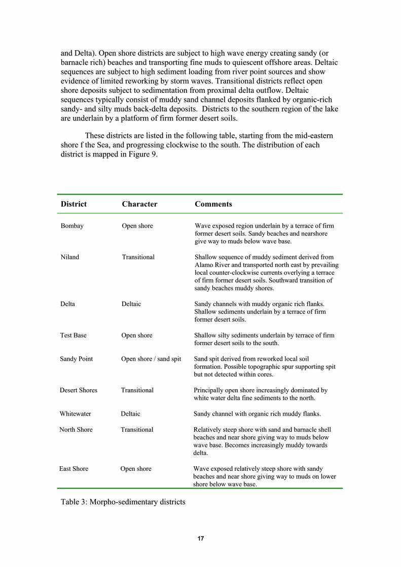
TThheessee ddiissttrriiccttss aarree lliisstteedd iinn tthhee ffoolllloowwiinngg ttaabbllee,, ssttaarrttiinngg ffrroomm tthhee mmiidd--eeaasstteerrnn sshhoorree ff tthhee SSeeaa,, aanndd pprrooggrreessssiinngg cclloocckkwwiissee ttoo tthhee ssoouutthh.. TThhee ddiissttrriibbuuttiioonn ooff eeaacchh ddiissttrriicctt iiss mmaappppeedd iinn FFiigguurree 99..
District Character Comments
BBoommbbaayy OOppeenn sshhoorree WWaavvee eexxppoosseedd rreeggiioonn uunnddeerrllaaiinn bbyy aa tteerrrraaccee ooff ffiirrmm ffoorrmmeerr ddeesseerrtt ssooiillss.. SSaannddyy bbeeaacchheess aanndd nneeaarrsshhoorree ggiivvee wwaayy ttoo mmuuddss bbeellooww wwaavvee bbaassee..
NNiillaanndd TTrraannssiittiioonnaall SShhaallllooww sseeqquueennccee ooff mmuuddddyy sseeddiimmeenntt ddeerriivveedd ffrroomm AAllaammoo RRiivveerr aanndd ttrraannssppoorrtteedd nnoorrtthh eeaasstt bbyy pprreevvaaiilliinngg llooccaall ccoouunntteerr--cclloocckkwwiissee ccuurrrreennttss oovveerrllyyiinngg aa tteerrrraaccee ooff ffiirrmm ffoorrmmeerr ddeesseerrtt ssooiillss.. SSoouutthhwwaarrdd ttrraannssiittiioonn ooff ssaannddyy bbeeaacchheess mmuuddddyy sshhoorreess..
DDeellttaa DDeellttaaiicc SSaannddyy cchhaannnneellss wwiitthh mmuuddddyy oorrggaanniicc rriicchh ffllaannkkss.. SShhaallllooww sseeddiimmeennttss uunnddeerrllaaiinn bbyy aa tteerrrraaccee ooff ffiirrmm ffoorrmmeerr ddeesseerrtt ssooiillss..
TTeesstt BBaassee OOppeenn sshhoorree SShhaallllooww ssiillttyy sseeddiimmeennttss uunnddeerrllaaiinn bbyy tteerrrraaccee ooff ffiirrmm ffoorrmmeerr ddeesseerrtt ssooiillss ttoo tthhee ssoouutthh..
SSaannddyy PPooiinntt OOppeenn sshhoorree // ssaanndd ssppiitt SSaanndd ssppiitt ddeerriivveedd ffrroomm rreewwoorrkkeedd llooccaall ssooiill ffoorrmmaattiioonn.. PPoossssiibbllee ttooppooggrraapphhiicc ssppuurr ssuuppppoorrttiinngg ssppiitt bbuutt nnoott ddeetteecctteedd wwiitthhiinn ccoorreess..
DDeesseerrtt SShhoorreess TTrraannssiittiioonnaall PPrriinncciippaallllyy ooppeenn sshhoorree iinnccrreeaassiinnggllyy ddoommiinnaatteedd bbyy wwhhiittee wwaatteerr ddeellttaa ffiinnee sseeddiimmeennttss ttoo tthhee nnoorrtthh..
WWhhiitteewwaatteerr DDeellttaaiicc SSaannddyy cchhaannnneell wwiitthh oorrggaanniicc rriicchh mmuuddddyy ffllaannkkss..
NNoorrtthh SShhoorree TTrraannssiittiioonnaall RReellaattiivveellyy sstteeeepp sshhoorree wwiitthh ssaanndd aanndd bbaarrnnaaccllee sshheellll bbeeaacchheess aanndd nneeaarr sshhoorree ggiivviinngg wwaayy ttoo mmuuddss bbeellooww wwaavvee bbaassee.. BBeeccoommeess iinnccrreeaassiinnggllyy mmuuddddyy ttoowwaarrddss ddeellttaa..
EEaasstt SShhoorree OOppeenn sshhoorree WWaavvee eexxppoosseedd rreellaattiivveellyy sstteeeepp sshhoorree wwiitthh ssaannddyy bbeeaacchheess aanndd nneeaarr sshhoorree ggiivviinngg wwaayy ttoo mmuuddss oonn lloowweerr sshhoorree bbeellooww wwaavvee bbaassee..
TTaabbllee 33:: MMoorrpphhoo--sseeddiimmeennttaarryy ddiissttrriiccttss
17

FFiigguurree 1100 sshhoowwss aa sslliigghhttllyy ddiiffffeerreenntt pprreesseennttaattiioonn ooff tthhee ddaattaa ffrroomm FFiigguurree 88,, iinncclluuddiinngg tthhee ddiivviissiioonn ooff tthhee ssaammpplleedd aarreeaa iinnttoo ddiissttrriiccttss.. FFiigguurree 1100 hhaass ddiivviiddeedd tthhee ssaammpplleedd aarreeaa iinn ttoo 4400 aaccrree bblloocckkss ffoorr eeaassee ooff ddeetteerrmmiinniinngg aarreeaass.. TThhee tteerrnnaarryy ddiiaaggrraamm iiss aaggaaiinn sshhoowwnn,, iinnddiiccaattiinngg wwhheerree sseeddiimmeennttss ooff eeaacchh ccllaassssiiffiiccaattiioonn wweerree eennccoouunntteerreedd.. FFiigguurree 1111 iiss pprreesseenntteedd ttoo sshhooww tthhee llooccaattiioonn ooff eeaacchh ggrraabb ssaammppllee oonn wwhhiicchh tthhee mmaappss wweerree bbaasseedd,, aanndd iittss ccllaassssiiffiiccaattiioonn.. TThhiiss ffiigguurree aallssoo iinncclluuddeess tthhee ddaattaa ffoorr sshheellllss,, wwhhiicchh wweerree eennccoouunntteerreedd ffrreeqquueennttllyy oonn tthhee wweesstt rreeggiioonnss ((DDeesseerrtt SShhoorreess aanndd SSaannddyy PPooiinntt)),, aass wweellll aass oonn tthhee eeaasstteerrnn aarreeaa ooff BBoommbbaayy..
WWee aallssoo pprreesseenntt qquuaannttiittaattiivvee ddaattaa ttoo ddeessccrriibbee tthhee ddiissttrriibbuuttiioonn ooff sseeddiimmeenntt ttyyppeess iinn TTaabblleess 44--99.. EEaacchh ttaabbllee iiss ddeerriivveedd ffrroomm aa GGIISS ddaattaabbaassee bbaasseedd uuppoonn eexxiissttiinngg bbaatthhyymmeettrriicc ddaattaa ssoouurrccee wwiitthh ssuurrffaaccee ooff tthhee llaakkee rreepprreesseenntteedd bbyy tthhee --222277 ffoooott ccoonnttoouurr.. TTaabbllee 44 sshhoowwss eeaacchh ddiissttrriicctt,, ddiivviiddeedd iinnttoo 55 ccoonnttoouurr iinntteerrvvaallss eexxtteennddiinngg ddoowwnn ttoo tthhee --225500 ffoooott ccoonnttoouurr,, wwhhiicchh iiss ttoo aa ddeepptthh ooff aabboouutt 2244 ffeeeett.. EExxaammiinnaattiioonn ooff tthheessee ttaabblleess sshhoowwss tthhee ddiissttrriibbuuttiioonn ooff tthhee vvaarriioouuss sseeddiimmeenntt ttyyppeess bbootthh iinn rreeggiioonn aanndd iinn ddeepptthh,, wwiitthh tthhee mmeeaann tteexxttuurraall ffrraaccttiioonn sshhoowwnn.. FFoorr eeaacchh ddiissttrriicctt aanndd eeaacchh ccoonnttoouurr,, TTaabbllee 44 iinnddiiccaatteess tthhee ppeerrcceenntt ooff eeaacchh ooff tthhrreeee mmiinneerraall ttyyppeess:: ssaanndd,, ssiilltt,, aanndd ccllaayy.. TThhee ttaabbllee iiss ccoolloorr ccooddeedd ffoorr tthhee mmaajjoorr ssooiill ddiivviissiioonnss.. TThhuuss,, iinn tthhee aarreeaa bbeettwweeeenn ––223300 aanndd ––223355 ffeeeett iinn tthhee BBoommbbaayy ddiissttrriicctt ((uuppppeerr lliimmiitt ––223300 ffeeeett)),, tthhee sseeddiimmeenntt iiss 6677%% ssaanndd,, 1111 %% ssiilltt aanndd 1199 %% ccllaayy.. TThhee rreemmaaiinniinngg ffrraaccttiioonn iiss sshheellll.. TThhee ssooiill ttyyppee iiss aa ssaannddyy llooaamm..
Depth MSL Class KeyDivision fraction -227 -230 -235 -240 -245 MeanBombay Sand
SiltClay
661318
671119
621127
541532
511832
601425
Niland SandSiltClay
413126
383428
273836
213744
283241
313435
Delta SandSiltClay
383131
363033
372835
422532
462428
402832
TestBase SandSiltClay
471829
471831
422236
392337
402336
432134
SandyPoint SandSiltClay
581419
621518
631618
581623
521827
581621
DesertShores SandSiltClay
572218
552320
512623
472628
472529
512424
WhiteWater SandSiltClay
433323
383824
304131
263936
343334
343629
NorthShore SandSiltClay
612018
592118
572221
502723
482925
552421
EastShore SandSiltClay
691014
651418
552127
452734
382837
552026
Lake Mean 53 54 47 43 43 48
NRCS Soil ClassSandy Loam
Sandy Clay Loam
Loam
Sandy Clay
Clay
TTaabbllee 44.. SSaanndd,, ssiilltt,, aanndd ccllaayy ffrraaccttiioonnss aatt tthhee ddiiffffeerreenntt ddiissttrriiccttss aatt tthhee ddeepptthh ccoonnttoouurrss eexxaammiinneedd.. SSooiillss aarree iiddeennttiiffiieedd aass NNRRCCSS ccllaasssseess..
18

TTaabbllee 55 pprroovviiddeess aaddddiittiioonnaall qquuaannttiittaattiivvee iinnffoorrmmaattiioonn bbaasseedd oonn ddiissttrriicctt aanndd ddeepptthh.. TThhee uuppppeerr ttaabbllee sshhoowwss tthhee nnuummbbeerr ooff aaccrreess ccoonnttaaiinneedd iinn eeaacchh ddiissttrriicctt aatt eeaacchh ddeepptthh iinntteerrvvaall.. AAtt NNiillaanndd,, ffoorr eexxaammppllee,, bbeettwweeeenn tthhee ––223355 aanndd ––224400 ffoooott ddeepptthh ((uuppppeerr lliimmiitt ––223355 ffeeeett)),, tthheerree aarree 22,,664466 aaccrreess tthhaatt wwoouulldd bbee eexxppoosseedd,, ccoonnssiissttiinngg ooff ssaannddyy ccllaayy.. IIff tthhee lleevveell ooff tthhee SSeeaa wweerree ttoo ffaallll ttoo ––225500 ffeeeett,, tthheerree wwoouulldd bbee aa ttoottaall ooff 88,,998822 aaccrreess ooff sseeddiimmeenntt eexxppoosseedd,, iinn tthhrreeee ddiiffffeerreenntt ccllaasssseess..
Area In each division (Acres) Upper Limit 5 foot contour Class Key
NRCS Soil ClassDivision -227 -230 -235 -240 -245 Grand TotalBombay 402 290 528 533 695 2,449 Sandy LoamNiland 915 827 2,646 2,183 2,411 8,982 Sandy Clay LoamDelta 4,180 1,907 5,566 8,845 6,407 26,906 LoamTestBase 1,165 1,053 1,960 2,326 2,276 8,780 Sandy Clay SandyPoint 714 414 852 1,136 1,158 4,274 ClayDesertShores 1,022 610 771 1,056 1,132 4,592WhiteWater 1,745 606 1,122 1,300 1,173 5,946NorthShore 445 326 517 667 760 2,715EastShore 664 467 666 895 971 3,662Grand Total 11,252 6,501 14,626 18, 941 16,984 68,304
TTaabbllee 55.. AAccrree ccaallccuullaattiioonnss ffoorr aarreeaa eexxppoosseedd aatt eeaacchh ddeepptthh iinntteerrvvaall iinn eeaacchh ddiissttrriicctt.. AArreeaa iiss ccooddeedd ffoorr sseeddiimmeenntt ccllaassss eexxppoosseedd..
TTaabbllee 66 sshhoowwss tthhee ssaammee iinnffoorrmmaattiioonn ffoorr oorrggaanniicc ccoonntteenntt ooff sseeddiimmeennttss eexxppoosseedd.. HHiigghh oorrggaanniicc ccoonntteenntt iiss ffoouunndd aatt aallll lleevveellss aatt WWhhiitteewwaatteerr,, aanndd iiss ccoonncceennttrraatteedd aatt ddeeeeppeerr lleevveellss aatt tthhee TTeesstt BBaassee aanndd tthhee NNoorrtthh SShhoorree.. OOrrggaanniiccss aarree hhiigghheerr nneeaarr tthhee sshhoorree aatt DDeellttaa..
Upper Limit 5 foot contourDepth MSLMean Organic Percent
Division -227 -230 -235 -240 -245 rand TotaBombayNiland
1.11.8
1.21.9
1.42.3
2.02.9
2.12.9
1.62.4
Delta 5.2 3.3 2.6 2.2 1.9 3.0TestBase 2.6 2.9 2.9 2.9 3.1 2.9SandyPointDesertShores
1.92.5
1.52.7
1.33.1
1.63.4
1.93.4
1.63.0
WhiteWater 5.6 5.3 6.0 5.9 5.7 5.7NorthShore 2.2 2.4 2.8 3.7 3.7 3.0EastShore 1.6 1.7 2.0 2.5 2.8 2.1Grand Total 2.7 2.4 2.7 3.0 3.1 2.8
G l
organic
> 3%
TTaabbllee 66.. OOrrggaanniicc ccoonntteennttss aatt ddeepptthh ccoonnttoouurrss ffoorr tthhee ddiiffffeerreenntt ddiissttrriiccttss..
FFiinnaallllyy,, wwee pprreesseenntt aann oovveerraallll vviieeww ooff tthhee sseeddiimmeenntt ccllaassssiiffiiccaattiioonnss aatt ddeepptthhss aanndd ddiissttrriiccttss iinn TTaabblleess 77.. CCllaayyss aarree ffoouunndd oonnllyy aatt ddeeeeppeerr lleevveell aatt NNiillaanndd,, aanndd ssaanndd
19

aarreeaass aarree ccoonncceennttrraatteedd aatt sshhaalllloowweerr lleevveellss iinn aallll llooccaattiioonnss eexxcceepptt NNiillaanndd,, DDeellttaa,, aanndd WWhhiitteewwaatteerr..
Division -227 -230 -235 -240 -245
BombaySandy Loam Sandy Loam Sandy Clay
LoamSandy Clay
LoamSandy Clay
Loam
Niland Loam Clay Loam Clay Loam Clay Clay
DeltaClay Loam Clay Loam Clay Loam Clay Loam Sandy Clay
Loam
SandyPointSandy Loam Sandy Loam Sandy Loam Sandy Clay
LoamSandy Clay
Loam
TestBaseSandy Clay
LoamSandy Clay
Loam Clay Loam Clay Loam Clay Loam
DesertShoresSandy Loam Sandy Loam Sandy Clay
LoamSandy Clay
LoamSandy Clay
Loam
WhiteWater Loam Loam Clay Loam Clay Loam Clay Loam
NorthShoreSandy Loam Sandy Loam Sandy Clay
LoamSandy Clay
LoamSandy Clay
Loam
EastShoreSandy Loam Sandy Loam Sandy Clay
LoamSandy Clay
Loam Clay Loam
TTaabbllee 77.. SSeeddiimmeenntt ccllaassssiiffiiccaattiioonnss ooff ddiissttrriiccttss aatt tthhee ccoonnttoouurrss eexxaammiinneedd..
TTaabblleess 88 aanndd 99 pprroovviiddee ddaattaa iiddeennttiiccaall ttoo tthhaatt iinn TTaabblleess 44 aanndd 55,, bbuutt ffoorr mmoorree ffiinneellyy ddiivviiddeedd aarreeaass wwiitthhiinn eeaacchh ddiissttrriicctt..
Contour Interval (upper limit)-227 -230 -235 -240 -245 Average
SUBDIV Sand Silt Clay Sand Silt Clay Sand Silt Clay Sand Silt Clay Sand Silt Clay Sand Silt ClayBombayNilandShore
SCS Soil Class66 13 18 67 11 19 62 11 27 54 15 32 51 18 32 60 14 25 Sandy Loam49 24 24 47 25 27 44 22 35 32 22 46 41 22 37 43 23 35 Sandy Clay Loam
Niland 29 43 28 27 45 29 23 41 37 20 37 44 27 32 41 26 43 32 LoamAlamoDeltaSh 39 34 27 34 41 25 30 39 31 35 32 32 45 26 27 36 35 28 Clay LoamAlamoDelta 50 24 21 59 19 19 50 24 24 53 22 21 50 23 25 52 23 22 ClaySouthShore 42 34 24 41 34 24 42 32 25 46 29 24 46 26 25 44 31 24OldRiverShor 34 41 25 33 43 25 33 42 26 41 38 22 46 39 15 37 40 23NewRiverDelt 41 28 31 42 27 29 51 20 26 48 19 30 46 24 29 45 24 29NewRiverMud 33 27 40 29 28 43 28 26 46 31 25 45 39 25 35 32 26 43SWshore 51 18 28 52 16 29 47 20 32 44 22 33 43 23 33 47 20 31SanFelipeDel 43 21 34 42 21 36 35 24 41 32 25 43 31 26 44 36 23 40TestBase 46 15 23 47 18 29 43 21 35 39 22 39 42 21 35 43 19 31SandyPointS 57 13 20 66 13 17 65 16 15 61 15 19 57 15 23 62 14 19SandyPointN 63 12 16 66 13 16 65 15 17 62 14 21 55 17 25 62 14 19SaltonCity 42 25 25 41 26 30 37 27 35 33 27 40 33 26 41 39 26 31WestShore 60 18 18 57 21 19 50 26 25 44 26 31 42 24 35 52 23 25DesertShoreS 54 25 19 52 26 20 50 27 22 44 30 26 51 24 25 50 27 23Oasis 59 20 18 57 22 19 51 27 23 47 27 27 45 26 29 51 25 24Whitewater 43 33 23 38 38 24 30 41 30 26 39 36 34 33 34 42 33 24NorthShore 58 22 18 56 24 19 54 25 21 47 30 23 45 31 24 49 27 24Canal_Overfl 64 17 18 64 16 18 63 16 20 60 18 23 55 21 25 48 14 16StatePark 68 10 17 64 14 20 58 22 25 51 29 29 44 31 30 57 21 24EastShore_No 60 11 20 54 18 24 47 27 30 38 35 35 31 37 35 46 25 29SaltCreekDel 76 6 10 71 11 14 61 20 24 49 25 32 42 27 35 57 20 26EastShore 68 11 15 63 14 20 54 21 29 43 25 37 37 26 41 53 20 28EastShoreSou 70 9 14 62 16 19 50 25 29 39 31 36 34 30 38 51 22 27Average 45 30 22 49 26 23 46 25 29 45 27 30 44 26 31 45 28 25
TTaabbllee 88.. SSaanndd,, ssiilltt,, aanndd ccllaayy iinn tthhee ssuubb--ddiissttrriiccttss aatt tthhee ccoonnttoouurrss eexxaammiinneedd..
20
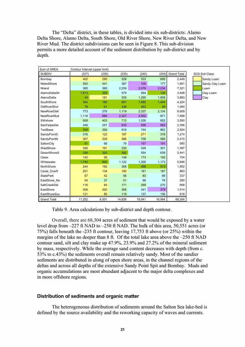
TThhee ““DDeellttaa”” ddiissttrriicctt,, iinn tthheessee ttaabblleess,, iiss ddiivviiddeedd iinnttoo ssiixx ssuubb--ddiissttrriiccttss:: AAllaammoo DDeellttaa SShhoorree,, AAllaammoo DDeellttaa,, SSoouutthh SShhoorree,, OOlldd RRiivveerr SShhoorree,, NNeeww RRiivveerr DDeellttaa,, aanndd NNeeww RRiivveerr MMuudd.. TThhee ddiissttrriicctt ssuubbddiivviissiioonnss ccaann bbee sseeeenn iinn FFiigguurree 88.. TThhiiss ssuubb--ddiivviissiioonn ppeerrmmiittss aa mmoorree ddeettaaiilleedd aaccccoouunntt ooff tthhee sseeddiimmeenntt ddiissttrriibbuuttiioonn bbyy ssuubb--ddiissttrriicctt aanndd bbyy ddeepptthh..
Sum of AREA Contour Interval (upper limit)SUBDIV (227) (230) (235) (240) (245) Grand Total
Bombay 402 290 528 533 105 2,078
695 177 2,234 124 1,858
2,449 1,661 7,321 3,408 3,883 4,224 1,084 6,609 7,698 3,500 2,356 2,924 1,274 2,415 585 1,397 2,441 754 5,946 1,852 863 337 285 908 1,514 618
NilandShore 550 441 387 Niland 365 385 2,259 AlamoDeltaSh 1,813 329 579 564 AlamoDelta 43 181 505 1,295 SouthShoreOldRiverShor
354 79
180 61
601 436
1,685 463
1,404 46
NewRiverDelt 773 276 880 403
1,119 2,327 712 632 616 187 586
2,337 2,502 1,026 556 744 271 708 157 329 554 173 1,300 486 181 83 66 269
2,104 871 852 563 862 378 589 191 301 639 192 1,173 573 187 89 78 270 379 156
NewRiverMud 1,118 SWshore 508 SanFelipeDel 348 257 TestBase 309
316 307
392 122 226
SandyPointSSandyPointNSaltonCity 91 66 79 WestShore 345
536 142 1,745
191 320 99 606
230 392 148 1,122
DesertShoreSOasisWhitewaterNorthShore 244 192 356 Canal_OverflStateParkEastShore_NoSaltCreekDel
201 67 54 116
134 42 37 83
160 56 51 171
EastShore 306 220 268 341 EastShoreSou 121 85 119 137
Grand Total 11,252 6,501 14,626 18,941 16,984 68,304
SCS Soil Class
Sandy LoamSandy Clay LoamLoamClay LoamClay
TTaabbllee 99.. AArreeaa ccaallccuullaattiioonnss bbyy ssuubb--ddiissttrriicctt aanndd ddeepptthh ccoonnttoouurr..
Overall, there are 68,304 aaccrreess ooff sseeddiimmeenntt tthhaatt wwoouulldd bbee eexxppoosseedd bbyy aa wwaatteerr lleevveell ddrroopp ffrroomm ––222277 fftt NNAADD ttoo ––225500 fftt NNAADD.. TThhee bbuullkk ooff tthhiiss aarreeaa,, 5500,,555511 aaccrreess ((oorr 7755%%)) ffaallllss bbeenneeaatthh tthhee --223355 fftt ccoonnttoouurr,, lleeaavviinngg 1177,,775533 fftt aabboovvee ((oorr 2255%%)) wwiitthhiinn tthhee mmaarrggiinnss ooff tthhee llaakkee nnoo ddeeeeppeerr tthhaann 88 fftt.. OOff tthhee ttoottaall llaakkee aarreeaa aabboovvee tthhee ––225500 fftt NNAADD ccoonnttoouurr ssaanndd,, ssiilltt aanndd ccllaayy mmaakkee uupp 4477..99%%,, 2233..99%% aanndd 2277..22%% ooff tthhee mmiinneerraall sseeddiimmeenntt bbyy mmaassss,, rreessppeeccttiivveellyy.. WWhhiillee tthhee aavveerraaggee ssaanndd ccoonntteenntt ddeeccrreeaasseess wwiitthh ddeepptthh ((ffrroomm cc.. 5533%% ttoo cc..4433%%)) tthhee sseeddiimmeennttss oovveerraallll rreemmaaiinn rreellaattiivveellyy ssaannddyy.. MMoosstt ooff tthhee ssaannddiieerr sseeddiimmeennttss aarree ddiissttrriibbuutteedd iinn aalloonngg ooff ooppeenn sshhoorree aarreeaass,, iinn tthhee cchhaannnneell rreeggiioonnss ooff tthhee ddeellttaass aanndd aaccrroossss aallll ddeepptthhss ooff tthhee eexxtteennssiivvee SSaannddyy PPooiinntt SSppiitt aanndd BBoommbbaayy.. MMuuddss aanndd oorrggaanniicc aaccccuummuullaattiioonnss aarree mmoosstt aabbuunnddaanntt aaddjjaacceenntt ttoo tthhee mmaajjoorr ddeellttaa ccoommpplleexxeess aanndd iinn mmoorree ooffffsshhoorree rreeggiioonnss..
Distribution of sediments and organic matter
TThhee hheetteerrooggeenneeoouuss ddiissttrriibbuuttiioonn ooff sseeddiimmeennttss aarroouunndd tthhee SSaallttoonn SSeeaa llaakkee--bbeedd iiss ddeeffiinneedd bbyy tthhee ssoouurrccee aavvaaiillaabbiilliittyy aanndd tthhee rreewwoorrkkiinngg ccaappaacciittyy ooff wwaavveess aanndd ccuurrrreennttss..
21

TThheerree aarree aa nnuummbbeerr ooff sseeddiimmeenntt ssoouurrcceess:: pprriinncciippllee aammoonngg wwhhiicchh aarree ppooiinntt ssoouurrcceess ooff tthhee AAllaammoo RRiivveerr,, tthhee NNeeww RRiivveerr,, tthhee WWhhiitteewwaatteerr RRiivveerr aanndd SSaann FFeelliippee CCrreeeekk.. MMoorree ddiiffffuussee ssoouurrcceess aarree ddeerriivveedd ffrroomm rreewwoorrkkiinngg ooff tthhee llaakkeebbeedd aass tthhee wwaatteerr lleevveellss hhaavvee rriissee oovveerr ppaasstt ddeeccaaddeess aanndd tthhee eerroossiioonn aatt tthhee llaakkee mmaarrggiinnss ooff tthhee ssooiillss uunniittss ooff tthhee ffoorrmmeerr LLaakkee CCaahhuuiillllaa BBeeddss aass wweellll aass aaiirrbboorrnnee dduusstt ffrroomm tthhee ddeesseerrtt hhiinntteerrllaanndd..
TThhee SSaallttoonn SSeeaa iiss aann eenneerrggeettiicc rraatthheerr tthhaann qquuiieesscceenntt llaakkee ssyysstteemm,, eexxppeerriieenncciinngg wwiinnddss ffrroomm aallll ddiirreeccttiioonnss ooccccaassiioonnaallllyy wwiitthh ssppeeeeddss eexxcceeeeddiinngg 5500 mmiilleess ppeerr hhoouurr.. SSuucchh ssttrroonngg gguussttss hhaavvee tthhee ccaappaacciittyy ttoo ccrreeaattee wwaavveess uupp ttoo 55--66 fftt hheeiigghhtt iinn ddoowwnn--ffeettcchh rreeggiioonnss ooff tthhee llaakkee,, wwiitthh aa ccoommppeetteennccee ttoo rreegguullaarrllyy rreeddiissttrriibbuuttee iinnsshhoorree sseeddiimmeenntt.. IItt iiss tthhiiss wwaavvee aaccttiioonn,, ccrreeaattiinngg ssaannddyy sshhoorreess aanndd ttrraannssppoorrttiinngg ffiinnee--ggrraaiinneedd mmaatteerriiaall ooffff sshhoorree ttoo bbee ddeeppoossiitteedd bbeellooww wwaavvee bbaassee,, wwhhiicchh ddeeffiinneess tthhee ddiissttrriibbuuttiioonn ooff sshhoorreelliinnee sseeddiimmeenntt aarroouunndd SSaallttoonn CCiittyy aanndd BBoommbbaayy BBeeaacchh nnoorrtthhwwaarrddss.. TThhee ssaannddyy sshhoorreelliinneess aarree ssuuppppoorrtteedd llooccaallllyy bbee tthhee eerroossiioonn ooff tthhee CCaarriissiittaass--MMyyoommaa--CCaarrrriizzoo ssooiill ffoorrmmaattiioonn iinn tthhee nnoorrtthheeaasstt rreeggiioonn ooff tthhee llaakkee aanndd tthhee MMeelloollaanndd--VViinntt--IInnddiioo ssooiill ffoorrmmaattiioonn ssoouutthh ooff SSaallttoonn CCiittyy ccrreeaattiinngg aann eexxtteennssiivvee ssaannddyy ssppiitt kknnooww aass ‘‘SSaannddyy PPooiinntt’’.. EEvviiddeennccee ffrroomm sshhoorrtt ccoorreess ooff iirrrreegguullaarrllyy iinntteerrbbeeddddeedd ssaannddss aanndd mmuuddss ooff vvaarryyiinngg tthhiicckknneesssseess wwiitthh ooccccaassiioonnaall ssttoorrmm llaagg ddeeppoossiittss ooff ffrraaggmmeennttss bbaarrnnaaccllee sshheellllss tteessttiiffyy ttoo tthhee eenneerrggeettiicc nnaattuurree ooff tthheessee nneeaarrsshhoorree sseeddiimmeenntt..
DDeellttaaiicc sseeqquueenncceess ccoonnssiissttiinngg ooff ssaannddyy cchhaannnneellss wwiitthh mmuuddddyy ffllaannkkss aarroouunndd tthhee iinnfflloowwss ooff tthhee AAllaammoo RRiivveerr,, NNeeww rriivveerr WWhhiitteewwaatteerr RRiivveerr aanndd ttoo aa mmuucchh lleesssseerr eexxtteenntt tthhee SSaann FFeelliippee ccrreeeekk,, aarree ssuuppeerriimmppoosseedd uuppoonn tthhiiss ggeenneerraalliisseedd wwaavvee--ddoommiinnaatteedd llaakkee mmaarrggiinn mmoorrpphhoollooggyy.. TThhee rraappiidd rraattee ooff sseeddiimmeenntt ssuuppppllyy ffrroomm tthhee rriivveerrss eexxcceeeeddss tthhee rraattee ooff rreemmoovvaall bbyy wwaavveess eennaabblliinngg tthhee ddeellttaa ffrroonnttss ttoo aaddvvaannccee eeaacchh yyeeaarr aass ssiillttyy sseeddiimmeennttss aaccccuummuullaattee.. TThhee DDeellttaa ooff tthhee WWhhiitteewwaatteerr RRiivveerr ssttaannddss aalloonnee aass aa ddiissccrreettee ddeellttaa sseeqquueennccee sspprreeaaddiinngg aaccrroossss ssiilltt//ssaannddyy nneeaarrsshhoorree ssaannddss.. TToo tthhee ssoouutthh ccoommbbiinneedd iinnfflloowwss ffrroomm tthhee AAllaammoo aanndd NNeeww rriivveerrss ooff ssiillttyy sseeddiimmeennttss eerrooddeedd ffrroomm IImmppeerriiaall--GGlleennbbaarr--GGiillmmaann ssooiill ffoorrmmaattiioonn bbllaannkkeett tthhee nneeaarrsshhoorree.. TThheessee ffiinnee sseeddiimmeennttss mmeerrggee wwiitthh ssaannddss ttoo tthhee wweesstt bbuutt aarree ffiinneerr ttoo eeaasstt bbeettwweeeenn RReedd HHiillllss MMaarriinnaa aanndd BBoommbbaayy BBeeaacchh,, rreefflleeccttiinngg aa pplluummee ooff mmuuddddyy sseeddiimmeenntt ttrraannssppoorrtteedd bbyy aann aannttiicclloocckkwwiissee cciirrccuullaattiinngg llaakkee ccuurrrreenntt.. AAppppaarreenntt sseeaassoonnaall bbaannddiinngg ((mmiilllliimmeettrree ssccaallee oorrggaanniicc rriicchh hhoorriizzoonnss rreegguullaarrllyy iinntteerrbbeeddddeedd wwiitthh cceennttiimmeettrree ssccaallee ffiinnee ssiillttss)) ssuuggggeesstt tthhaatt tthheessee nneeaarrsshhoorree sseeddiimmeennttss aarree nnoott ffrreeqquueennttllyy rreewwoorrkkeedd bbyy wwaavveess aanndd hhaavvee aa hhiigghh pprreesseerrvvaattiioonn ppootteennttiiaall.. CCoorriinngg iinn tthhee rreeggiioonn ttoo tthhee nnoorrtthh eeaasstt ooff RReedd HHiillll MMaarriinnee aanndd eeaasstt ooff tthhee NNeeww RRiivveerr DDeellttaa ffoouunndd eevviiddeennccee tthhaatt ooff aa ffiirrmm ppllaattffoorrmm ooff ffoorrmmeerr ddeesseerrtt ssooiillss llooccaallllyy eexxppoosseedd bbyy ggeenneerraallllyy bbllaannkkeetteedd bbeenneeaatthh aa tthhiinn vveenneeeerr ooff ssoofftt ssiillttyy mmuuddss..
EExxtteennssiivvee aarreeaass ooff bbeeddss ooff bbaarrnnaaccllee sshheellllss aanndd sshheellll ffrraaggmmeennttss ((cc..22”” iinn tthhiicckknneessss aanndd oofftteenn ddiiffffiiccuulltt ttoo ddrriivvee aa ccoorreerr tthhrroouugghh,, ssuuggggeessttiinngg ppoossssiibbllee cceemmeennttaattiioonn)) bbllaannkkeetteedd rreeggiioonnss ooff tthhee llaakkee.. TThhee ttrruuee eexxtteenntt ooff tthhiiss ‘‘bbaarrnnaaccllee aarrmmoouurr’’ bbeettwweeeenn ccoorree aanndd ggrraabb ssaammppllee llooccaattiioonnss iiss uunncclleeaarr aatt pprreesseenntt bbuutt wwaass ccoommmmoonnllyy ffoouunndd oonn ssaannddyy rreeggiioonnss oonn bbootthh tthhee eeaasstteerrnn aanndd wweesstteerrnn sshhoorreess ooff tthhee llaakkee aanndd lleessss ccoommmmoonnllyy oonn tthhee mmuuddddyy ffllaannkkss ooff tthhee ssoouutthheerrnn ddeellttaaiicc sshhoorree.. TThheessee bbeeddss mmaayy aacctt aass aa pprrootteeccttiivvee llaayyeerr llooccaallllyy rreedduucciinngg sseeddiimmeenntt rreemmoobbiilliissaattiioonn ffrroomm tthhee llaakkee--bbeedd sshhoouulldd wwaatteerr lleevveellss ffaallll..
TThhee ddiissttrriibbuuttiioonn ooff ccaarrbboonn iiss vveerryy mmuucchh rreellaatteedd ttoo ppooiinntt ssoouurrccee iinnppuuttss ffrroomm tthhee mmaaiinn rriivveerrss,, ppaarrttiiccuullaarrllyy tthhee WWhhiittee WWaatteerr aanndd ttoo aa lleesssseerr eexxtteenntt ffrroomm ssmmaallll aaggrriiccuullttuurraall ddrraaiinnaaggee cchhaannnneellss oonn tthhee wweesstteerrnn sshhoorree.. OOvveerraallll tthheerree iiss aa nneeggaattiivvee ccoorrrreellaattiioonn bbeettwweeeenn oorrggaanniiccss aanndd ssaanndd ccoonntteenntt wwiitthh hhiigghheesstt oorrggaanniicc lleevveellss bbeeiinngg ffoouunndd oonn tthhee
22

mmuuddddyy ffllaannkkss ooff tthhee tthhrreeee mmaaiinn DDeellttaass.. CClloossee eexxaammiinnaattiioonn ooff sseeddiimmeenntt ssttrruuccttuurree wwiitthhiinn ccoorreess ffiinnddss tthhee mmuuddddyy ffllaannkkss ooff tthhee ddeellttaass ttoo eexxhhiibbiitt ffiinnee llaammiinnaattiioonnss ooff ddaarrkk oorrggaanniicc mmaatttteerr rreegguullaarrllyy bbaannddeedd wwiitthh tthhiicckkeerr llaayyeerrss ooff mmoorree mmiinneerraall sseeddiimmeennttss.. TThhiiss ssuuggggeessttss aa ppuullssiinngg ooff oorrggaanniiccss iinn ttoo tthhee ssyysstteemm,, ppeerrhhaappss sseeaassoonnaall..
The organic sediments on the flanks of the deltas appear to be ‘varves’. Varve is a Swedish word for “cycle”, and varve sequences are most commonly associated with seasonal ice cover with reduced sedimentation the summer melt and increased sedimentation. These deltaic sediments appear to reflect a layer of sediment deposited in a lake over a year. Each layer consists of two parts. During the winter, river flows carry particles in to the sea, some of the fines from which settle on the delta flank margins (1-3 cm in thickness). Over the summer, particulate organic matter (plankton) settles to the bed leaving a layer of dark matter (1-3mm thickness). Oxidation of some of this organic matter strips the oxygen from the immediate sediments below causing a change in coloration from olive to grey. So what appears to be an annual cycle in sedimentation here is reflected in couplets of dark organic laminate over clay material ( the color of which is divided by redox conditions)
Finding these sediments suggests several years worth of sediment accumulation.
In a complete sequence each annual varve can be counted and so the age of the sediments deduced. The importance here is that they indicate that even in such a storm prone lake there are areas which are not reworked. Not finding these sediments in other places indicates that the sediments are often reworked by the storm waves. These varves have formed an important component of our dividing the districts in to Deltaic, transitional and open shore sequences.
Globally, lakes are important sinks for the storage of organic carbon, perhaps 50 times more effective than ocean sediments (Eisele et al, 2001). In many lakes the preservation factor of the organic particles reaching the lakebed sediments has been estimated at about 10-15% (e.g. Kelts, 1988) but in modern marine sediments only an average of 0.1-0.2% of the primary production is preserved below the zone of bethic degradation (e.g. Hedges et al. 1997).
Organic and inorganic carbon that is not buried within the lake sediments may
leave the water through dissolution then degassing of CO2 (or in open lakes through outflow). Bioturbation often increases the availability of oxygen to the sediments increasing rates of organic breakdown. In principle, saline lakes can produce considerable amounts of organic matter. However, preservation or particulate organic carbon in sediments may be (c. 5% or primary production) as a result of high sulfate availability stimulating sulfate reduction, which accompanies oxidation of organic matter. Thus, in saline sediments such as those of Mono Lake organic carbon levels of only 1.1% have commonly been found (Domagalski et al 1989).
Here at the Salton Sea the organic carbon contents of the lake sediments are
relatively low (district averages: 1-6%) in comparison with recorded global averages (10-15%) (Einsele et al. 2001), but comparable with other saline lakes. Carbon contents are highest on the fine-grained flanks of the major Delta regions (c. 6%) and locally at the outflows of significant drainage channels, and lowest on the distal sandy shores (c.1-3%). This reflects not only organic sedimentation proximal to the river inflows but suitable conditions for organic accumulation in the anoxic undisturbed
23

muds of the delta flanks. Across the wave-exposed open shore districts oxygen bearing porewaters are free to circulate through the sandy sediment but more so these sediments are frequently reworked during storms providing conditions for enhanced dissolution of the particulate carbon.
An interactive data base for profiles of the sampled transects is presented electronically as one of the appendices to this report (Appendix 3). We show here two representative profiles from this data base: one for Niland, and one for the New River. At Niland (Figure 12 below), it can be seen that sand content of the sediments drops precipitously with distance from shore. Silt content remains relatively constant, and clay percent increases. The organic content increases generally with depth as well, although the total percent content remains low. The depth profile shows a regular but rather steep slope, attaining a depth of 23 feet in less than 3000 meters .
Sand profile
0
20
40
60
80
100
0 500 1000 1500 2000 2500 3000
profile Meters
Perc
ent
Depth profile
0
5
10
15
20
25
0 500 1000 1500 2000 2500 3000
Dep
th F
eet
Silt profile
0
20
40
60
80
100
0 500 1000 1500 2000 2500 3000
profile Meters
Perc
ent
Clay profile
0
20
40
60
80
100
0 500 1000 1500 2000 2500 3000
profile Meters
Perc
ent
Organic Matter profile
00.5
11.5
22.5
33.5
44.5
0 500 1000 1500 2000 2500 3000
profile Meters
Perc
ent
BBS 9
BBS 10
BBS 11
BBS 12
BBS 13
BBS 14
BBS 15
BBS 16
Figure 12. Sand, silt, clay, organic matter, and depth profiles for the transects sampled at Niland.
At the New River (Figure 13, below) in contrast, the profiles show that sand
content tends to increase with depth, with silt being variable, and clay percent tending to decrease. Organic content tends to decrease with depth at this location. The depth
24

profiles are variable in this district, with a slope in some transects showing attainment of 23 feet in less than 4,000 meters, and other extending to over 8,000 meters. Transects of the remaining districts can be found in Appendix 4.
Sand profile
0
20
40
60
80
100
0 2000 4000 6000 8000 10000
profile Meters
Perc
ent
Depth profile
0
5
10
15
20
25
0 2000 4000 6000 8000 10000
Dep
th F
eet
Silt profile
0
20
40
60
80
100
0 2000 4000 6000 8000 10000
profile Meters
Perc
ent
Clay profile
0
20
40
60
80
100
0 2000 4000 6000 8000 10000
profile Meters
Perc
ent
Organic Matter profile
0
2
4
6
8
10
0 2000 4000 6000 8000 10000
profile Meters
Perc
ent
RED 6
RED 7
RED 8
RED 9
RED 10
RED 11
SCS 36
SCS 35
Figure 13. Sand, silt, clay, organic content, and depth profiles for the transects sampled at the New River.
WWee ccoonndduucctteedd ssoommee aaddddiittiioonnaall aannaallyysseess aaiimmeedd aatt ddeetteerrmmiinniinngg tthhee eexxtteenntt ttoo wwhhiicchh sseeddiimmeenntt ttyyppee ccaann bbee pprreeddiicctteedd ffrroomm eexxiissttiinngg ssooiillss aanndd llaanndd uussee ddaattaa aaddjjaacceenntt ttoo tthhee SSaallttoonn SSeeaa.. FFiigguurree 1144 sshhoowwss aann oovveerrllaayy ooff aa ssooiillss mmaapp,, wwhheerree ddaattaa aarree aavvaaiillaabbllee,, oonn tthhee sseeddiimmeenntt ddaattaa aass ddeetteerrmmiinneedd ffrroomm tthhee ggrraabb ssaammpplleess.. TThhee ddaattaa sshhooww tthhee sseeddiimmeenntt ddiissttrriicctt wwiitthh tthheeiirr ccllaassssiiffiiccaattiioonn,, aanndd tthhee ssooiill sseerriieess mmaappppeedd bbyy tthhee NNRRCCSS.. TThhee mmaapp sshhoowwss tthhaatt tthhee sseeddiimmeenntt zzoonneess aarree cclloosseellyy ccoorrrreellaatteedd wwiitthh ssooiill ccllaassssiiffiiccaattiioonnss iinn tthhee ssooiillss aaddjjaacceenntt ttoo tthhee ssaammpplleedd aarreeaa ooff tthhee SSeeaa.. TThhee ddiivviissiioonn bbeettwweeeenn tthhee ccllaayy llooaammss aanndd tthhee llooaammss aatt tthhee ssoouutthh ppaarrtt ooff tthhee SSeeaa,, ffoorr eexxaammppllee,, cclloosseellyy mmiirrrroorrss tthhee cchhaannggee ffrroomm tthhee ccllaayy llooaammss ooff tthhee IImmppeerriiaall GGlleennbbaarr ssooiillss ttoo tthhee ssaannddyy llaaoommss ooff tthhee MMeelloollaanndd--VViinntt--IInnddiioo ssooiillss.. TThhee ssaannddiieerr aarreeaass ttoo tthhee nnoorrtthh aanndd nnoorrtthheeaasstt ooff tthhee SSeeaa,, sshhoowwnn iinn tthhee sseeddiimmeennttss aass ssaannddyy llooaammss,, aarree aassssoocciiaatteedd wwiitthh tthhee CCaarrssiittaa--MMyyoommaa--CCaarrrriizzoo aanndd GGiillmmaann--IInnddoo--CCooaacchheellllaa ssooiillss,, wwhhiicchh aarree ggeenneerraallllyy ffiinnee ssaannddss.. TThhiiss ffiinnddiinngg ssuuggggeessttss tthhaatt tthhee nnaattuurree aanndd ppootteennttiiaall eemmiissssiivviittyy ooff sseeddiimmeennttss tthhaatt mmiigghhtt bbee eexxppoosseedd
25

bbyy ddeecclliinnee iinn SSeeaa lleevveell ccoouulldd rreeaassoonnaabbllyy bbee iinnvveessttiiggaatteedd uussiinngg aaddjjaacceenntt ssooiillss tthhaatt aarree ccuurrrreennttllyy eexxppoosseedd..
TThheerree aarree,, ooff ccoouurrssee,, ssoommee ddiiffffeerreennccee bbeettwweeeenn rreecceennttllyy eexxppoosseedd sseeddiimmeennttss aanndd ssooiillss oorriiggiinnaattiinngg ffrroomm sseeddiimmeennttss tthhaatt hhaavvee bbeeeenn ssuubbjjeecctteedd ttoo wweeaatthheerriinngg.. TThhee eexxppoosseedd ddeesseerrtt ssooiillss wwiillll hhaavvee bbeeeenn ‘‘aaggeedd’’ ttoo ssoommee eexxtteenntt,, aass eevviiddeenncceedd bbyy tthhee aarrmmoorriinngg wwiitthh rroocckk ffrraaggmmeennttss oonn tthhee ssuurrffaaccee.. HHeerree tthhee eeaassiillyy mmoobbiilliisseedd mmaatteerriiaall hhaass aallrreeaaddyy lleefftt tthhee ssuurrffaaccee lleeaavviinngg aa llaagg ddeeppoossiitt ooff ccoobbbblleess wwhhiicchh pprrootteeccttss tthhee uunnddeerrllyyiinngg mmaatteerriiaall ffrroomm tthhee wwiinndd.. DDiissttuurrbbaannccee ooff tthhiiss llaagg ccaann iinnccrreeaassee tthhee aammoouunntt ooff sseeddiimmeenntt rreelleeaasseedd.. TThheerree wwiillll bbee ootthheerr ddiiffffeerreenncceess aass iinn tteerrmmss ooff sseeddiimmeenntt ffaabbrriicc oorr ssttrruuccttuurree,, aass wweellll aass iinn tthhee effect that the chemistry will have on the behaviour of the sediments. There will be precipitation of minerals as the lake dries. Carbonates may accumulate in near surface sediments (perhaps aided by the abundance of barnacle shell carbonate source material) as will fine grained sulfate and halite mineral. The lake bed also probably contains more carbon that the adjacent desert soils. However, this material derived form plankton is unlikely to be resistant to oxidation once exposed and is likely to be lost very quickly. That said, carefully chosen soils nearby, and similar sediments from other playas, will provide a preliminary indication of possible emission potential.We also plotted the sediment data on a LandSat image of the Salton Sea to determine if sediment class and land use were related. Figures 15 and 16 show this image, in the north and south portions of the Sea, respectively. Soils that are currently used for agriculture are not associated with sediment types of clay or medium sand; rather, these cropped areas appear related to sediments classed as various types of loam (soils of mixed sediment grade). This association may provide some guidance as to which areas of the exposed sediments may be most appropriately designated as areas for vegetation for the promotion of wetland habitat or vegetative cover for dust control.
FFiinnaallllyy,, wwee pprreesseenntt aa mmaapp tthhaatt iinnddiiccaatteess wwhheerree nnoo ssaammpplleess ccoouulldd bbee rreeccoovveerreedd,, pprriinncciippaallllyy bbeeccaauussee ooff aa hhiigghh sshheellll ccoonntteenntt.. TThheessee ssiitteess wweerree mmoosstt pprreevvaalleenntt iinn tthhee SSeeaa ((FFiigguurree 1177)).. TThhee llaarrggeesstt sshheellll ffrraaccttiioonnss wweerree eennccoouunntteerrdd aalloonngg tthhee wweesstt sshhoorree,, tthhee nnoorrtthheeaasstt sshhoorree,, aanndd iinn tthhee vviicciinniittyy ooff BBoommbbaayy..
Likely response in lake-bed sedimentation to falling water levels
SSoo ffaarr wwee hhaavvee ddeessccrriibbeedd tthhee ddiissttrriibbuuttiioonn ooff sseeddiimmeennttss aarroouunndd tthhee llaakkee mmaarrggiinn aass tthheeyy aarree ffoouunndd ttooddaayy,, bbuutt wwiillll tthhiiss ddiissttrriibbuuttiioonn ssttiillll eexxiisstt iiff tthhee llaakkee wwaatteerr lleevveell ffaallllss?? TThhiiss iiss ddiiffffiiccuulltt ttoo ssaayy ffoorr cceerrttaaiinn bbuutt tthheerree aarree ssoommee ggeenneerraall lliinneess ooff eevviiddeennccee tthhaatt ccaann bbee ddiissccuusssseedd.. WWaavvee eenneerrggyy iiss tthhee mmaaiinn ddrriivviinngg ffoorrccee aass ttoo wwhheetthheerr sseeddiimmeennttss wwiillll bbee lleefftt iinn ppllaaccee oorr rreeddiissttrriibbuutteedd aass wwaatteerr lleevveellss ffaallll.. TThhee ddeeggrreeee ttoo wwhhiicchh wwaavvee aaccttiioonn wwiillll rreewwoorrkk tthhee sseeddiimmeennttss iiss lliikkeellyy ttoo bbee mmuucchh ggrreeaatteerr ffoorr ooppeenn sshhoorree aanndd ttrraannssiittiioonnaall ddiissttrriiccttss tthhaann ffoorr tthhee mmoorree qquuiieesscceenntt ddeellttaa ddiissttrriiccttss.. TThhee sseeddiimmeennttss ooff tthhee ooppeenn sshhoorree aanndd,, ttoo aa lleesssseerr ddeeggrreeee,, tthhee ttrraannssiittiioonnaall uunniittss aarree ssuubbjjeecctt ttoo ffrreeqquueenntt rreewwoorrkkiinngg bbyy wwaavveess.. TThhiiss wwaavvee rreewwoorrkkiinngg iiss rreessppoonnssiibbllee ffoorr tthhee sshhooaalliinngg ooff ssaannddyy bbeeaacchheess aanndd nneeaarrsshhoorree sseeddiimmeennttss aanndd rreemmoovvaall ooff ffiinnee--ggrraaiinneedd ssiillttss aanndd ccllaayyss tthhaatt aarree lliifftteedd iinn ttoo ssuussppeennssiioonn ttoo eevveennttuuaallllyy aaccccuummuullaattee aatt ggrreeaatteerr wwaatteerr ddeepptthhss..
IItt iiss eessttiimmaatteedd tthhaatt sshhoouulldd aallll wwaatteerr ffllooww iinnttoo tthhee llaakkee cceeaassee,, tthheenn tthhee llaakkee lleevveell ccoouulldd ffaallll bbyy uupp ttoo 66..44 ffeeeett ppeerr yyeeaarr,, bbaasseedd oonn tthhee eevvaappoorraattiioonn rraattee ffoorr SSaallttoonn SSeeaa wwaatteerr ((AAggrraarriiaann RReesseeaarrcchh 22000033)).. EEvveenn uunnddeerr tthhiiss eexxttrreemmee ccaassee,, aa ppoorrttiioonn ooff tthhee ttiimmee
26

tthhaatt tthhee wwaatteerr lleevveell iiss ffaalllliinngg tthhee ooppeenn sshhoorree aanndd ttrraannssiittiioonnaall ddiissttrriiccttss wwiillll bbee ssuubbjjeecctt ttoo ssttoorrmm ggeenneerraatteedd wwaavvee aaccttiioonn.. TThhuuss tthhee sseeddiimmeennttss,, wwhhiicchh wweerree oonnccee iinn ‘‘eeqquuiilliibbrriiuumm’’ wwiitthh wwaavvee eenneerrggyy wwiillll nnooww bbee ssuubbjjeecctt ttoo rreewwoorrkkiinngg.. IInn eesssseennccee,, iitt iiss lliikkeellyy tthhaatt aass wwaatteerr lleevveell ffaallllss wwaavveess wwiillll aacctt ttoo rreesshhaappee tthhee sshhoorree,, ccaarrrryyiinngg ffiinneess oouutt ttoo ddeeeeppeerr wwaatteerr aanndd lleeaavviinngg ccooaarrsseerr mmaatteerriiaall bbeehhiinndd.. TThhee mmoorree sslloowwllyy tthhee llaakkee lleevveellss ffaallll tthheenn tthhee ggrreeaatteerr tthhee ddeeggrreeee ttoo wwhhiicchh ttrraannssiittiioonnaall ssaannddiieerr bbeeaacchh uunniittss wwiillll ddeevveelloopp aanndd ffiinneess wwiillll bbee rreeddiissttrriibbuutteedd ttoowwaarrddss tthhee cceennttrree ooff tthhee llaakkee..
TThhee ddeellttaa ddiissttrriiccttss aarree eexxppeecctteedd ttoo bbeehhaavvee ddiiffffeerreennttllyy aass wwaatteerr lleevveellss rreecceeddee.. HHeerree,, tthhee ccoorree ddaattaa ssuuggggeessttss eevviiddeennccee tthhaatt tthhee ddeellttaa ffllaannkkss aarree nnoott rreewwoorrkkeedd ssoo ffrreeqquueennttllyy dduurriinngg tthhee ssttoorrmm sseeaassoonn.. BBeeccaauussee ooff tthhiiss,, ffiinnee--ggrraaiinneedd oorrggaanniicc rriicchh sseeddiimmeennttss wwiillll bbee lleefftt ssttrraannddeedd aabboovvee tthhee lleevveell ooff tthhee rreecceeddiinngg wwaatteerrss.. IItt sshhoouulldd bbee bboorrnnee iinn mmiinndd tthhaatt tthhee ssoofftt mmuuddss tthheemmsseellvveess aarree ccoonnssttiittuutteedd pprriinncciippaallllyy ooff iinntteerrssttiittiiaall wwaatteerr,, aanndd ssoo ddee--wwaatteerriinngg ooff tthhee sseeddiimmeennttss wwiillll rreessuulltt iinn ccoonnssoolliiddaattiioonn ooff tthhee ffiinnee sseeddiimmeennttss,, ppoossssiibbllee ssuubbssiiddeennccee aanndd//oorr iirrrreevveerrssiibbllee ccrraacckkiinngg,, aanndd rreesshhaappiinngg ooff tthhee ttooppooggrraapphhyy.. DDeeppeennddiinngg uuppoonn tthhee rraattee ooff wwaatteerr lleevveell ffaallll,, ssoommee ffoorrmm ooff ttrraannssggrreessssiivvee ddeellttaa mmaayy aappppeeaarr aass mmuuddss sspprreeaadd aalloonngg tthhee rreecceeddiinngg sshhoorreelliinnee.. AA nneeww ddeellttaa wwiillll rree--eessttaabblliisshh oonnccee wwaatteerr lleevveellss rree--ssttaabbiilliissee..
Comparison with Owens Lake
The area mapped during this study (67,530 acres) is almost three times as large as the total area of sediment that was exposed at Owens Lake, which has 22,505 acres identified in 1998 as being emissive of dust (GBUAPCD 1998). The Owens Lake playa is the largest single source of PM10 dust (aerosol particles smaller than 10 microns in aerodynamic diameter) in the United States; current estimates show that 83,000 metric tons are lofted per year (GBUAPCD 2003). Comparisons of the Owens Lake to the Salton Sea are almost inevitable. In their work on Owens (Dry) Lake, south-eastern California, Gill (1996), Niemeyer et al. (1999) and Reheis (1997) have demonstrated that gross changes in the hydrology of a playa (in this case human induced) can lead to extreme changes in regional dust emissions. Reheis and Kihl (1995) have also shown that changes in the frequency and extent of natural inundation occurring on large playa systems may lead to significant fluctuations in regional dust loadings. A very brief survey or what is known about the surface of the Owens Lake and its emissions is therefore in order here.
The Owens playa consists of a variety of soil types that were mapped in 2000
by Soil and Water West (SWWI 2000 and 2002). The areas identified as “clay” occupy the largest portion of the playa, encompassing 8,412 acres. The areas identified as “sand” are the next most prevalent, occupying 4,296 acres. Sand/clay occupies an additional 2,007 acres. The remaining areas, totalling 7,790 acres, are various forms of loams with variable textures. We note that the most highly emissive areas of the Owens playa are in the north and south, which are heavily dominated by sands; and the southeast, which has large bodies of heavy clays. The Salton Sea sediments, in contrast, have less area consisting of “sand”, and minimal areas classified as “clay”. The Salton Sea sediments, then, are somewhat more heterogeneous than are the Owens playa soils.
27

TThhee eexxtteennssiivvee wwoorrkk bbyy tthhee GGrreeaatt BBaassiinn UUnniiffiieedd AAiirr PPoolllluuttiioonn CCoonnttrrooll DDiissttrriicctt ((GGBBUUAAPPCCDD)) hhaass rreevveeaalleedd,, hhoowweevveerr,, tthhaatt sseeddiimmeenntt oorr ssooiill ccllaassssiiffiiccaattiioonn iiss bbyy iittsseellff aa ppoooorr pprreeddiiccttoorr ooff qquuaannttiittyy oorr ffrreeqquueennccyy ooff dduusstt eemmiissssiioonnss.. FFoorr tthhee eemmiissssiioonn iinnvveennttoorryy ccoonndduucctteedd bbyy GGBBUUAAPPCCDD,, tthhee eemmiissssiivvee aarreeaass wweerree ddeetteerrmmiinneedd eemmppiirriiccaallllyy bbyy ffiieelldd mmaappppiinngg ooff eerrooddeedd aarreeaass aafftteerr ssttoorrmmss uussiinngg aa GGPPSS ssyysstteemm.. IInn aaddddiittiioonn,, vvaarriioouuss aarreeaass ooff tthhee ppllaayyaa wweerree tteesstteedd wwiitthh ppoorrttaabbllee wwiinndd ttuunnnneellss ttoo ddeetteerrmmiinnee tthhee eemmiissssiivvee qquuaalliittyy ooff tthhee ssuurrffaacceess.. TThheessee tteessttss sshhoowweedd tthhaatt aalltthhoouugghh tthheerree aarree oobbvviioouuss ssuurrffaaccee ddiiffffeerreenncceess aaccrroossss tthhee ppllaayyaa,, tthhee wwiinndd ttuunnnneell--ggeenneerraatteedd PPMM10 eemmiissssiioonn ddaattaa sshhoowweedd tthhaatt tthhee hhiigghheesstt eemmiissssiioonn rraatteess iinn eeaacchh aarreeaa wweerree ssiimmiillaarr ffoorr aa ggiivveenn sseeaassoonn.. TThhee sseeaassoonnaall ddiiffffeerreenncceess aarree pprriinncciippaallllyy ccaauusseedd bbyy ccoolldd wweeaatthheerr bbrriinnggiinngg ssaallttss ttoo tthhee ssuurrffaaccee,, wwhhiicchh iinn aa ddeeccaahhyyddrraatteedd ccoonnddiittiioonn,, ccrreeaattee aa vveerryy eerrooddiibbllee ssuurrffaaccee ((GGBBUUAAPPCCDD 11999988))..
10
SSoommee ooff tthhee mmeecchhaanniissmmss ffoorr pprroodduuccttiioonn ooff PPMM10 aarree wweellll uunnddeerrssttoooodd.. SSaanndd,, oorr ssaanndd--ssiizzeedd ppaarrttiicclleess,, ccaann bbee mmoovveedd bbyy wwiinndd ssoo tthhaatt tthheeyy bbeeggiinn ttoo bboouunnccee oorr ““ssaallttaattee”” aaccrroossss tthhee ssuurrffaaccee ooff tthhee ggrroouunndd.. TThhee tthhrreesshhoolldd wwiinndd vveelloocciittyy ffoorr dduusstt eemmiissssiioonnss hhaass bbeeeenn iiddeennttiiffiieedd aass 1177 mmpphh,, mmeeaassuurreedd oonn aann aanneemmoommeetteerr aatt 1100 mm hheeiigghhtt.. OOnn ddaayyss wwhheenn aaiirr qquuaalliittyy tthhrreesshhoollddss hhaavvee bbeeeenn eexxcceeeeddeedd,, tthhee rreeppoorrtteedd ddaaiillyy aavveerraaggee wwiinndd ssppeeeeddss hhaavvee rraannggeedd bbeettwweeeenn 55 aanndd 3333 mmpphh.. ((GGBBUUAAPPCCDD 11999988)).. TThheessee wwiinndd ssppeeeeddss aarree eexxcceeeeddeedd aatt tthhee SSaallttoonn SSeeaa oonn aabboouutt 8800 ddaayyss aa yyeeaarr,, aass mmeeaassuurreedd aatt tthhee ssoollaarr ppoonndd ssiittee ((AAggrraarriiaann RReesseeaarrcchh 22000033)).. AAss tthhee mmoovviinngg ppaarrttiicclleess iimmppaacctt tthhee ggrroouunndd rreeppeeaatteeddllyy,, tthheeyy ccaann ddiissllooddggee ssmmaalllleerr ppaarrttiicclleess tthhaatt aarree lloofftteedd iinnttoo tthhee aaiirr aanndd ccrreeaattee dduusstt ssttoorrmmss.. AAlltthhoouugghh ttrruuee mmiinneerraall ssaanndd iittsseellff ddooeess nnoott pprroodduuccee PPMM10,, iinn ccoonncceerrtt wwiitthh ssooiillss tthhaatt hhaavvee aa ssiilltt aanndd ccllaayy ccoonntteenntt,, ssaanndd iiss iinnssttrruummeennttaall iinn ggeenneerraattiinngg PPMM10.. TThhee ootthheerr ffaaccttoorrss,, ssuucchh aass tthhoossee ddeessccrriibbeedd aabboovvee,, iinntteerraacctt ttoo ccrreeaattee aa ssiittuuaattiioonn wwhheerree PPMM10 iiss ggeenneerraatteedd.. AArreeaass wwiitthh sshhaallllooww ssaalliinnee wwaatteerr ttaabblleess ccaann pprroommoottee dduusstt eemmiissssiioonn,, aass ccaann aarreeaass wwiitthh tthhee kkiinnddss ooff ssaallttss tthhaatt ddeevveelloopp hhyyddrraatteedd pphhaasseess iinn ccoolldd aanndd wweett wweeaatthheerr..
10
10
10
10
OOtthheerr ffaaccttoorrss ccoonnttrriibbuuttiinngg ttoo eemmiissssiivviittyy iinncclluuddee tthhee pprrooxxiimmiittyy ttoo tthhee ssuurrffaaccee ooff aa ssaalliinnee sshhaallllooww wwaatteerr ttaabbllee.. TThhee iinncclluussiioonn ooff ssaallttss ssttrraannddeedd iinn tthhee ssuurrffaaccee ssooiillss dduuee ttoo eevvaappoorraattiioonn,, oorr mmoobbiilliizzeedd ffrroomm pprreecciippiittaattiioonn,, ccrreeaatteess aa ssiittuuaattiioonn wwhheerree ssooiill ppaarrttiicclleess,, eessppeecciiaallllyy ssiillttss aanndd ccllaayyss,, aarree bboonnddeedd iinn aa ffllooccccuullaatteedd ccoonnddiittiioonn.. WWhheenn ddrryyiinngg ooccccuurrss,, tthhee ssaallttyy ssooiillss ddeeffllooccccuullaattee,, ccrreeaattiinngg aa ssooiill ssuurrffaaccee wwiitthh eexxttrreemmeellyy ffiinnee,, nnoonn--cceemmeenntteedd ppaarrttiicclleess tthhaatt aarree hhiigghhllyy ssuubbjjeecctt ttoo wwiinndd eerroossiioonn..
IInn ggeenneerraall,, hhoowweevveerr,, iitt hhaass bbeeeenn eexxttrreemmeellyy ddiiffffiiccuulltt ttoo pprreeddiicctt wwhhiicchh aarreeaass ooff tthhee ppllaayyaa wwiillll bbee eemmiissssiivvee aatt aannyy ggiivveenn ttiimmee,, aalltthhoouugghh iitt iiss wwiiddeellyy ffeelltt tthhaatt mmoosstt eexxppoosseedd,, ddrryy ssuurrffaacceess wwiillll bbeeccoommee aatt lleeaasstt ssoommeewwhhaatt eemmiissssiivvee aatt ssoommee ttiimmee ((DDuuaannoo OOnnoo,, ppeerrss.. ccoommmm..)).. IInnffoorrmmeedd ooppiinniioonn ffrroomm aaiirr qquuaalliittyy eexxppeerrttss iiss tthhaatt tthhee llooccaattiioonn aanndd ssiizzee ooff dduusstt ssoouurrccee aarreeaass oonn ccllaayy ddoommiinnaatteedd aarreeaass ooff tthhee OOwweennss ppllaayyaa aarree ddeeppeennddeenntt oonn tthhee aannnnuuaall wweeaatthheerr ppaatttteerrnnss,, iinncclluuddiinngg ttiimmiinngg ooff pprreecciippiittaattiioonn eevveennttss ((wwhhiicchh aarree mmoorree ffrreeqquueenntt aanndd mmoorree iinntteennssee iinn tthhee OOwweennss VVaalllleeyy tthhaann aatt tthhee SSaallttoonn SSeeaa)),, hhiigghh wwiinndd ssppeeeeddss,, aanndd ddiiuurrnnaall tteemmppeerraattuurreess ((wwhhiicchh aarree ccoollddeerr tthhaann aatt tthhee SSaallttoonn SSeeaa)).. TThhee ssaanndd aarreeaass,, hhoowweevveerr,, aarree mmoorree pprreeddiiccttaabbllee,, aass tthhee ssaallttaattiioonn aaccttiioonn ooff tthhee ssaanndd iiss mmoorree cceerrttaaiinn ttoo ggeenneerraattee dduusstt eevveennttss.. OOvveerraallll,, tthhee ooppiinniioonn iiss tthhaatt ssaalltt cchheemmiissttrryy aanndd cclliimmaattee aarree llaarrggee ddeetteerrmmiinnaannttss ooff eerroossiioonn ppootteennttiiaall,, wwiitthh aaccttuuaall ssooiill ttyyppee ttaakkiinngg aa sseeccoonnddaarryy rroollee ((CCooxx aanndd HHoollddeerr,, 11999977))..
SSaalltt cchheemmiissttrryy iinn ppaarrttiiccuullaarr ddiissttiinngguuiisshheess tthhee SSaallttoonn SSeeaa aanndd tthhee OOwweennss LLaakkee ssuurrffaaccee eennvviirroonnmmeennttss.. TThhee ffoolllloowwiinngg ddiissccuussssiioonn,, aalltthhoouugghh nnoott ssttrriiccttllyy ssppeeaakkiinngg rreellaatteedd ttoo sseeddiimmeennttss,, iiss iinncclluuddeedd hheerree ffoorr ffuurrtthheerr iinnssiigghhtt iinnttoo tthhee eemmiissssiioonn ppootteennttiiaall ffoorr tthhee SSaallttoonn SSeeaa..
28

Marked differences between Owens Lake and the Salton Sea exist in the salts
that would form on the surface of exposed sediments. Owens Lake is a sodic environment. Sediment pore water at Owens Lake is saturated in sodium carbonate/bicarbonate and sodium sulfate (Mirabillite) at wintertime temperatures. Calcium and magnesium ions are virtually absent from the system, as an excess of carbonate has previously precipitated all available calcium and magnesium. Sodium carbonate and sodium sulfate form decahydrate crystals at very dilute brine concentrations when temperatures drop below the phase limit near 60 degrees F. Recurrent winter low temperatures induce the formation of efflorescent decahydrates salts on the surface of the sediment from pore water brines, which were under-saturated at higher temperatures. Surface crusts formed by capillary evaporation of groundwater spontaneously convert to decahydrated forms when exposed to elevated wintertime moisture and relative humidity. These decahydrate salts form fragile needle-like crystals and are easily dislodged by high winds and/or blowing sand.
The Salton Sea is similar to saline marine brine in composition, rather than to
a sodic brine lake. It is at or very near saturation for calcium carbonate, so excess calcium and magnesium are abundant. The excess calcium and magnesium encourages the early formation of very stable calcium carbonates and dolomites (CaMgCO3). No excess carbonate exists to crystallize with the sodium present. Excess calcium ions will also form sulfates (anhydrite and the dihydrate gypsum). Gypsum may dehydrate and erode from the surface of the exposed sediments.
Mirabillite (sodium sulfate decahydrate) will form from Salton Sea brine or
pore water when temperatures fall below 60 F, just as it does at Owens Lake. The warmer wintertime temperatures and lower total available sulfate concentration in the Salton Sea brine, however, mean that this crystal will form less abundantly than at Owens Lake.
Halite (sodium chloride) forms from evaporation of both Owens and Salton
Sea brine. At Owens Lake, halite forms in conjunction with trona. Trona has the much greater volume due to its lower density, and dominates the physical characteristics of the combined salts. In comparison, halite will form the predominate volume of all salt forming from Salton Sea brine, just as it does in typical marine systems. Salt formation on exposed Salton Sea sediments should resemble marine or saline playa evaporation. Northern Baja’s Laguna Salada, due to its similar chemistry, may provide a better model of exposed Salton Sea sediments than does the Owens Lake, although the presence of sand in the Laguna Salada sediments would be crucial for any meaningful air quality extrapolations.
The current study provides a solid basis for understanding the potential for
dust emission from Salton Sea sediments, but cannot by itself reliably predict the amount of emission that could result from the exposed sediments. It does, however, indicate clearly that a problem could exist, and that proactive planning is indicated. We suggest further studies in the sections below.
29

Recommended further work
11.. EExxtteenndd ggrraabb ssaammpplliinngg ttoo 2200 aanndd 2255 fftt ccoonnttoouurrss.. WWiitthh wwaatteerr lleevveellss aannttiicciippaatteedd ttoo ffaallll bbeellooww tthhee 1155 fftt ccoonnttoouurr iitt wwoouulldd bbee bbeenneeffiicciiaall ttoo iinnccrreeaassee tthhee sseeddiimmeennttoollooggiiccaall ddaattaa ddoowwnn ttoo tthhee 2255 fftt ccoonnttoouurr.. TTrriiaallss wwiitthh tthhee aaccoouussttiicc mmaappppiinngg ssyysstteemm wweerree nnoott ssuucccceessssffuull iinn eexxtteennddiinngg tthhee ggrraabb ssaammpplleess ssuurrvveeyy rreessuullttss ttoo tthhiiss ggrreeaatteerr ddeepptthh..
22.. DDeevveelloopp aa sseett ooff ssttaannddaarrdd ooppeerraattiinngg pprroocceedduurreess ffoorr tthhee ffuuttuurree ccoolllleeccttiioonn aanndd pprroocceessssiinngg ooff sseeddiimmeenntt ssaammpplleess ffoorr tteexxttuurree aanndd oorrggaanniicc ccoonntteenntt.. TThhiiss wwiillll eennaabbllee aallll ffuuttuurree ddaattaa sseettss ttoo bbee uusseedd wwiitthh eeaacchh ootthheerr,, ddrraammaattiiccaallllyy iimmpprroovviinngg tthhee qquuaalliittyy aanndd vvaalluuee ooff tthhee ddaattaa..
33.. IInniittiiaattee aa pprrooggrraamm ooff tteessttiinngg eexxppoosseedd aarreeaass ffoorr tthhee ppootteennttiiaall ttoo ssuuppppoorrtt vveeggeettaattiioonn aass aann eemmiissssiioonnss ccoonnttrrooll mmeeaassuurree.. PPrriioorr eexxppeerriieennccee iinnddiiccaatteess tthhaatt nnoott aallll aarreeaass aarree eeqquuaallllyy ssuuiitteedd ffoorr tthhee iinnttrroodduuccttiioonn ooff ppllaannttss ffoorr ssuurrffaaccee ssttaabbiilliizzaattiioonn.. AAnn eeaarrllyy pprrooggrraamm ooff ppiilloott pprroojjeeccttss oonn eexxppoosseedd ssooiillss cclloossee ttoo tthhee ccuurrrreenntt SSeeaa mmaarrggiinn wwoouulldd ppuutt aa mmiittiiggaattiioonn pprrooggrraamm
44.. IInniittiiaattee aa pprrooggrraamm ooff tteessttiinngg sseeddiimmeennttss ffoorr ppootteennttiiaall ffoorr eemmiissssiioonn ooff PPMM1100.. TThhiiss ccaann bbee ddoonnee rreeaaddiillyy wwiitthh ppoorrttaabbllee wwiinndd ttuunnnneellss oonn ssooiill aarreeaass tthhaatt aarree aallrreeaaddyy eexxppoosseedd.. SSeelleeccttiioonn ooff tteessttiinngg ssiitteess sshhoouulldd bbee ddoonnee iinn cclloossee ccoollllaabboorraattiioonn ooff sseeddiimmeenntt,, ssooiillss,, aanndd aaiirr qquuaalliittyy eexxppeerrttss.. OOnn--ssiittee ffiieelldd tteessttiinngg ffoorr eemmiissssiioonn hhaass bbeeeenn ccoonndduucctteedd aatt tthhee OOwweennss LLaakkee,, aanndd tthhiiss eexxppeerriieennccee hhaass pprroovveedd vveerryy vvaalluuaabbllee iinn aaiirr qquuaalliittyy mmooddeelllliinngg..
55.. IInnvveessttiiggaattee hhooww sseeddiimmeennttss wwoouulldd rreessppoonndd ttoo ddrraaiinnaaggee.. SSaalliinnee ssooiillss wwiitthh ssoommee ssooddiicciittyy aarree pprroonnee ttoo sseeaalliinngg wwhheenn iirrrriiggaatteedd wwiitthh ffrreesshh wwaatteerr iinn tthhee pphhrreeaattiicc zzoonnee ffoorr vveeggeettaattiioonn eessttaabblliisshhmmeenntt.. EExxaammiinnaattiioonn ooff ssuucchh cchhaannggeess iinn ootthheerr ppllaayyaa eennvviirroonnmmeennttss ssuucchh aass LLaagguunnaa SSaallaaddaa wwoouulldd rreevveeaall ssoommee iissssuueess ssuurrrroouunnddiinngg ““nnaattuurraall”” ppllaayyaa rreeccllaammaattiioonn..
66.. CChhaarrtt bbaarrnnaaccllee bbeedd ddiissttrriibbuuttiioonn.. TThhiicckk bbeeddss ooff eennccrruusstteedd // cceemmeenntteedd bbaarrnnaacclleess sshheellllss bbllaannkkeett aarreeaass ooff tthhee sshhaallllooww llaakkee--bbeedd.. TThheessee bbeeddss mmaayy pprrootteecctt uunnddeerrllyyiinngg sseeddiimmeennttss ffrroomm wwiinndd eerroossiioonn sshhoouulldd llaakkee--wwaatteerr lleevveellss ffaallll.. IItt wwoouulldd bbee aaddvvaannttaaggeeoouuss ttoo hhaavvee aa cclleeaarreerr uunnddeerrssttaannddiinngg ooff tthhee ddiissttrriibbuuttiioonn aanndd iinntteeggrriittyy ooff tthheessee bbaarrnnaaccllee bbeeddss..
77.. Sediment grain size. Further grain size analysis should be done at ½ phi intervals. This would give us a much clearer picture, and a better statistical representation, of the particles present, including the amount of PM10 for instance, and would increase the precision ooff eemmiissssiioonn mmooddeellss.. TThhee aannaallyyssiiss wwoouulldd nnoott rreeqquuiirree aa cchhaannggee iinn tthhee ffiieelldd pprroocceedduurree,, aalltthhoouugghh iitt wwoouulldd iinnvvoollvvee aa mmoorree ttiimmee ccoonnssuummiinngg llaabb aannaallyyssiiss..
88.. FFuurrtthheerr rreesseeaarrcchh oonn hhooww tthhee sseeddiimmeennttss wwoouulldd bbee rree--wwoorrkkeedd bbyy wwaavvee aaccttiioonn.. TThheerree aarree sseevveerraall wwaayyss tthhaatt tthhiiss eevvaalluuaattiioonn ccoouulldd bbee ddoonnee.. OOnnee iiss ttoo llooookk aatt aa ttiimmee sseerriieess ooff eelleevvaattiioonn cchhaannggee oonn tthhee nneeaarrsshhoorree llaakkee--bbeedd bbeeffoorree,, dduurriinngg aanndd aafftteerr tthhee ssttoorrmm sseeaassoonn.. SSuurrvveeyyiinngg aalloonngg ttrraannsseeccttss wwiillll ggiivvee tthhiiss
30

eelleevvaattiioonn cchhaannggee aanndd tthhee mmoonniittoorriinngg sshhoouulldd bbee ddoonnee bbeeffoorree ssttoorrmmss aanndd iimmmmeeddiiaatteellyy aafftteerr.. TThhiiss ssuurrvveeyy sshhoouulldd bbee ccoommpplliimmeenntteedd wwiitthh mmeeaassuurreemmeennttss ooff tthhee wwaavvee cchhaarraacctteerriissttiiccss ((rreellaatteedd ttoo ddeepptthh)),, mmeeaassuurreemmeennttss ooff tthhee llaakkeebbeedd sseeddiimmeennttss,, aanndd mmeeaassuurreemmeennttss ooff sseeddiimmeenntt iinn ssuussppeennssiioonn.. TTrraannsseeccttss sshhoouulldd bbee ppllaacceedd ttoo rreefflleecctt tthhee vvaarriieettyy ooff ddiissttrriiccttss aanndd sshhoouulldd eennccoommppaassss aarreeaass ooff ooppeenn sshhoorree,, ttrraannssiittiioonnaall rreeggiioonnss aanndd ddeellttaa ffllaannkkss.. MMeeaassuurreemmeennttss ooff tthhee wwaavvee cchhaarraacctteerriissttiiccss ccoouulldd bbee ssuupppplleemmeenntteedd wwiitthh lloonngg--tteerrmm ddaattaa mmoonniittoorriinngg ffrroomm aa bbuuooyy ssyysstteemm ttoo hheellpp ppllaaccee tthhee iinnddiivviidduuaall ssttoorrmm eevveennttss iinn ttoo cclliimmaattee ccoonntteexxtt..
31

References
AAggrraarriiaann RReesseeaarrcchh,, 22000033.. FFiinnaall RReeppoorrtt SSaallttoonn SSeeaa SSoollaarr PPiilloott PPoonndd PPrroojjeecctt.. SSuubbmmiitttteedd ttoo tthhee SSaallttoonn SSeeaa AAuutthhoorriittyy,, JJuullyy 22000033.. Barnum, D. A, et al (eds.) 2002. Proceedings of the Salton Sea Symposium, held in Desert Hot Springs, California 13-14 January 2000. Developments In Hydrobiology 161. Reprinted from Hydrobiologia.
CCooxx,, BBiillll,, aanndd GGrraaccee HHoollddeerr.. 11999977.. OOwweennss LLaakkee AAeeoolliiaann RReeppoorrtt.. UUnnppuubbll.. DDooccuummeenntt,, ffoorr GGBBUUAAPPCCDD,, BBiisshhoopp,, CCAA..
DDaayy PP..RR.. 11996655.. PPaarrttiiccllee ffrraaccttiioonnaattiioonn aanndd ppaarrttiiccllee--ssiizzee aannaallyyssiiss.. pppp.. 556622--556666.. IInn:: CC..AA.. BBllaacckk ((eedd..)),, MMeetthhooddss ooff SSooiill AAnnaallyyssiiss PPaarrtt 11.. AAmmeerriiccaann SSoocciieettyy ooff AAggrroonnoommyy,, MMaaddiissoonn,, WWII.. Domagalski, J.L., Orem, W.H., Eugster, H.P., (1989). Organic geochemistry and brine composition in Great Salt, Mono, and Walker lakes. Geochim. Cosmocim. Acta 53, 2857–2872.
Einsele, G. Yan, J. and Hinderer, M. (2001) Atmospheric carbon burial in modern lake basins and its significance for global carbon budgets. Global and Planetary Change 30:167-195
FFoollkk,, RR..LL..,, 11995544.. TThhee ddiissttiinnccttiioonn bbeettwweeeenn ggrraaiinn ssiizzee aanndd mmiinneerraall ccoommppoossiittiioonn iinn sseeddiimmeennttaarryy rroocckk nnoommeennccllaattuurree.. JJoouurrnnaall ooff GGeeoollooggyy,, 6622((44)):: 334444--335599..
Gill, T. E. 1996. Eolian sediments generated by anthropogenic disturbance of playas: human impacts on the geomorphic system and geomorphic impacts on the human system Geomorphology 17 207–28.
GGiillll,, TT.. EE..,, aanndd DD.. AA.. GGiilllleettttee,, 11999911.. OOwweennss LLaakkee:: AA nnaattuurraall llaabboorraattoorryy ffoorr aarriiddiiffiiccaattiioonn,, ppllaayyaa ddeessiiccccaattiioonn aanndd ddeesseerrtt dduusstt:: GGeeoollooggiiccaall SSoocciieettyy ooff AAmmeerriiccaa AAbbssttrraaccttss wwiitthh PPrrooggrraammss,, 2233((55)):: 446622..
GGBBUUAAPPCCDD.. 11999988.. OOwweennss VVaalllleeyy PPMM10 PPllaannnniinngg AArreeaa DDeemmoonnssttrraattiioonn ooff AAttttaaiinnmmeenntt SSttaattee IImmpplleemmeennttaattiioonn PPllaann.. NNoovveemmbbeerr 1166,, 11999988..
10
GGBBUUAAPPCCDD.. 22000033.. OOwweennss VVaalllleeyy PPMM10 PPllaannnniinngg AArreeaa DDeemmoonnssttrraattiioonn ooff AAttttaaiinnmmeenntt SSttaattee IImmpplleemmeennttaattiioonn PPllaann.. DDrraafftt ffoorr rreevviieeww NNoovveemmbbeerr 1133,, 22000033..
10
Hedges, J.L., Keil, R.G., Benner, R., 1997. What happens to terrestrial organic matter in the ocean? Org. Geochem. 27, 195–212.
32

Kelts, K., 1988. Environments of deposition of lacustrine petroleum source rocks: an introduction. In: Fleet, A.J., Talbot, M.R. Eds. , Lacustrine Petroleum Source Rocks. Geol. Soc. Spec. Publ., vol. 40, pp. 3–26. Mazzullo, J.M., Meyer, A., and Kidd, R.B., 1988. New sediment classification scheme for the Ocean Drilling Program. In Mazzullo, J., and Graham, A.G. (Eds.), Handbook for Shipboard Sedimentologists. ODP Tech. Note, 8:45-67. National Resources Conservation Service, 1999. Soil Taxonomy, A Basic System of Soil Classification for Making and Interpreting Soil Surveys. Agriculture Dept., Natural Resources Conservation Service. 869 pp. Niemeyer T C, Gillette D A, Deluisi J J, Kim Y J, Niemeyer W F, Ley T, Gill T E and Ono D 1999 Optical depth, size distribution and flux of dust from Owens Lake, California Earth Surface Processes and Landforms 24 463–79
RReehheeiiss MM CC aanndd KKiihhll RR 11999955 DDuusstt ddeeppoossiittiioonn iinn ssoouutthheerrnn NNeevvaaddaa aanndd CCaalliiffoorrnniiaa,, 11998844––11998899:: rreellaattiioonnss ttoo cclliimmaattee,, ssoouurrccee aarreeaa,, aanndd ssoouurrccee lliitthhoollooggyy JJoouurrnnaall ooff GGeeoopphhyyssiiccaall RReesseeaarrcchh--AAttmmoosspphheerreess 110000 88889933––991188 Reheis M C 1997 Dust deposition downwind of Owens (dry) Lake, 1991–1994: preliminary findings Journal of Geophysical Research-Atmospheres 102 25999–6008
RReehheeiiss,, MM.. CC.. 11999977.. OOwweennss ((DDrryy)) LLaakkee,, CCaalliiffoorrnniiaa:: AA HHuummaann--IInndduucceedd DDuusstt PPrroobblleemm.. http://geochange.er.usgs.gov/sw/impacts/geology/owens/ http://geochange.er.usgs.gov/sw/impacts/geology/owens/ Soil and Water West INC, 2000, Owens Lake Bed Soil Survey, prepared for Great Basin Unified Air Pollution Control District, May 2000. Revised 2002. Vogl, R.A., R.N. Henry. 2002. Characteristics and contaminants of the Salton Sea Sediments, Developments in Hydrobiology, The Salton Sea. Kluwer Academic Publishers, pages 47-54.
WWaallkklleeyy,, AA..,, aanndd II..AA.. BBllaacckk.. 11993344.. AAnn eexxaammiinnaattiioonn ooff tthhee DDeeggttjjaarreeffff mmeetthhoodd ffoorr ddeetteerrmmiinniinngg ssooiill oorrggaanniicc mmaatttteerr aanndd aa pprrooppoosseedd mmooddiiffiiccaattiioonn ooff tthhee cchhrroommiicc aacciidd ttiittrraattiioonn mmeetthhoodd.. SSooiill SScciieennccee,, 3377::2299--3388..
33

AAPPPPEENNDDIIXX 11
CCOORREE LLOOGGSS
CCOORREE DDIIAAGGRRAAMMSS
34

Core Descriptions
WP 37, 5 ft: No penetration (submerged parking lot).
WP 38, 10 ft: Top 2” barnacles some sand. No sample.
WP 39, 15 ft, 12”: Greyish olive [5Y 5/2]Muddy sand with odour of H2S. No indication of lamination. (0-6; 6-12).
WP 40, 5 ft, 12”: 6” of dark olive [5Y 4/3] coarse sand overlying thinly-thickly laminated muds and fine sands . Isolated barnacles at 6” (0-6; 6-12).
WP 41, 15ft, 9”: 8” of dark olive [7.5Y 4/3] sand/ muddy sand over becoming gray [7.5Y 5/1]. Minimal lamination (0-6; 6-9).
WP 42, 5ft, 20”: Two very different sedimentological units: Grey [5Y 5/1] laminated sands (1-9”) overlying olive black [5Y 3/2] mud (9-20). Sharp contact between sand and mud. WP 43, 15ft, 10”: Muddy sand, mostly dark olive [5Y 4/3] becoming grey with depth [5Y 5/1]. No lamination. (0-6; 6-10).
WP 44, 5ft, 8”: Poor penetration in to dense sand with some barnacles at surface. Colour transitions from dark olive [5Y 4/3] to grey [5Y 5/1] (0-6; 6-8).
WP 48, 15ft, 20”: Finely-thickly laminated olive black [10Y 4/2] with dark gray and black soft very soft muds, no sand laminations (06; 6-12; 12-20).
WP 52, 5ft, 7”: Dark olive {5Y 4/3] coarse sand with storm layer or barnacle fragments at 5”. No other apparent lamination (0-6; 6-7).
WP 59, 15ft, 20”: Thickly (c.5 mm) laminated olive grey [7.5Y 4/2] and grey [7.5Y 4/1] soft muds (0-6; 6-12; 12-20).
WP 66, 5 ft, 6”: Compact coarse sand no lamination but shell fragments in top 1”. Bulk sediment is greyish olive [7.5Y 4/2] though lighter top 1” grey [7.5Y 4/1] (0-6).
WP 73, 15ft, 18”: Laminated silty muds. Top 2” greyish olive [5Y 4/2] grading grey [5Y 5/1] with depth. Very thin bed of greyish olive [5Y 4/2] at 7 “ (0-6; 6-12; 12-18).
WP 80, 5ft, 10”: Top coarse granular sands with abundant spell fragments (c. 3mm dia.). No colour change: greyish olive [5Y5/2] (0-6, 6-10).
35

WP 87, 15ft, 18”: Soft mud: greyish olive [7.5 Y 5/2] to 8”, very thin bed (c.10 mm) of greyish olive at 10.5” [7.5Y 4/2] with grey [7.5Y 5/1] sediment to base of core.
WP 95, 5ft, 6”: Olive black [5Y 3/2] coarse sand, no lamination (0-6). WP 102, 15ft, 14”: Laminated silty mud, greyish olive [7.5Y 5/2] with grey [7.5 Y 5/1] thin-thick laminations (3-4 mm) every centimetre or so. (0-6; 6-12; 12-14). WP 109, 5ft, 13”: Top 6” grey [5Y 4/1] coarse sand no obvious lamination overlying grey [5Y 4/1] muds thinly laminated with sands becoming yellowish grey [2.5Y 5/1] at base (0-6; 6-12; 12-13). WP 116, 15 ft, 18”: Mud becoming increasingly firm with depth. Colours leaching from apparent (not chart recorded) olive brown at surface to great . Occasionally thinly laminated. (0-6; 6-12; 12-18). WP 124, 5ft, 15”: Thinly banded grey [7.5Y 6/1] and greyish olive [5Y 4/2] muddy sand capped at surface with a thin layer of dark grey mud. Colours do not appear to reflect changes in grain size but more likely periodic influxes of organic material and oxidation changes in porewaters. (0-6; 6-12; 12-15) WP 131, 15 ft, 18”: Soft mud becoming slightly firmer with depth – surface is capped with 2” of very soft mud of recent deposition. Thinly banded hues of greyish olive [5Y 5/1] and [5Y 5/2]. (0-6; 6-12; 12-18). WP 138, 5 ft, 16”: Strongly differentiated sedimentological beds separated by a sharp erosional contact. Top 9” consisting of upper 2” of black [5Y 2/1] muddy sands over grey muddy sands [5Y 4/1] with fishbones giving way at contact to colour banded grey [5Y 5/1] greyish olive [7.5Y 5/2] muds. Sediment surface is capped with a 3 mm thick deposit of olive [5Y 6/6] organic rich material. (0-9; 9-16). WP 145, 15 ft, 10”: 6” of greyish olive [7.5Y 5/2] soft muds laminated with shell fragments overlying a unit of greyish brown [5YR 5/2] very firm basement clay (0-6; 6-10).
WP 152, 5ft, 11”: Greyish brown [5YR 5/1] unlaminated sand (0-6; 6-11).
WP 159, 15 ft, 17”: A spectacular very thinly banded sequence of greyish olive [7.5Y 4/2] (3mm thick) and grey [5Y 5/1](5 mm thick) muds. Top of many of the grey layers marked by a thin (1mm) thick black horizon of likely organic rich material. Interpret the sequence to reflect continued sedimentation with regular periodic influx of organic material leading to redox reduction in below sediments.(0-6; 6-12; 12-17).
WP 166, 5 ft, 12”: Thinly bedded muds and sands (0-6”) over a short sequence of bedded muds (6-10”) and basement clay (10-12”).
36

WP 173, 15 ft, 17”: Very soft mud. Olive black [10Y 3/1] at surface (top 2”) becoming increasingly grey [10Y 5/1] with depth. Below 9” regular banding with greyish olive [7.5Y 5/2]. (0-6; 6-12; 12-17). WP 180, 5ft, 12”: Olive Black [7.5Y 3/1] laminated sand (0-4”) over olive black [7.5 3/1] and grey [7.5Y 4/1] banded silty clays (4-9”) and greyish red [2YR 5/2] basement clay material. WP 187, 15ft, 15”: Grey [10y 4/1] muds becoming slightly lighter and greyish olive [7.5 4/2] with depth and banded every 2 cm with dark olive [5Y 4/3]. Surface capped by 2” of olive black soft mud [10y 3/1]. (0-6; 6-12; 12-15). WP 194, 5ft, 12”: Grey [5y 5/1] silty mud overlying firm basement at 9” depth. (0-6; 6-9; 9-12). WP 201, 15ft, 13”: Complex colouration in solft mud. Dull orange [7.5 YR 6/4] surface layer of algae or brine shrimp (2-3mm thick) over brownish black [2.5Y 3/2] and below 4” depth becoming grey [7.5Y 5/1]. (0-6; 6-12)
WP 212 5ft, 20”: Regular strongly banded soft mud: olive black [5Y 3/1] and grey [7/5Y 4/1] each 2 –3 cm in thickness. (0-6; 6-12; 12-18).
WP 481, 5ft, 13”: Complex banding of coloured muddy sands. Top 1” greyish olive [5Y 4/2] sandy muds over black [5Y 2/1] sandy silt (1-4”) with isolated barnacle over olive black sands [5Y 3/2]. (0-6; 6-12).
WP 482, 15ft, 12”: Very colourful core of sandy silts over silty sands. 0-6” of yellowish grey silty sand over 6-12” of grey [7.5 5/1] silty sand. (0-6; 6-12).
WP 483 5ft, 11”: Silty sands banded (1-2cm thickness) in colour greyish olive [7.5Y 5/2] with grey [7.5Y 5/1] with barnacle fragments at 4”.(0-6; 6-11).
WP 484 5ft, 16”: Soft bedded muds colour banded at the cm scale greyish olive [5Y 4/2] at the top becoming increasingly grey with depth [5Y 5/1]. (0-6; 6-12; 12-16).
WP 485, 5ft, 12”: Gray [5Y 5/1] sands over sands barnacle fragments and shell lag at base. (0-6; 6-12).
WP 490, 5ft, 13”: Dark olive [7.5 4/3] soft silty muds 0-8” over olive grey [10Y 5/2] firmer muds. Barnacle fragments in top 2”. (0-6; 6-12).
WP 491; 5 ft, 18”: Dark olive [7.5Y 4/3] soft sandy silt over lying grey [7.5 4/1] sandy slit at 16” depth. (0-6, 6-12; 12-18).
WP 529; 15ft, 9”: Grey [7.5Y 4/3] muddy sands with occasional barnacle fragments. (0-6, 6-8).
WP 531, 5ft, 16”: Black [10Y 2/1] sands overlying grey [10 4/1] thickly laminated sands and muds below 6” depth. (0-6; 6-12; 12-16)
37

WP 532, 15ft, 18”: 2” of very soft dark olive grey mud [2.5GY 3/1] overlying soft dark greenish grey [10GY 3/1] mud (0-6; 6-12; 12-18).
WP 533, 15ft, 18”: 2” of very soft dark olive grey mud [2.5 GY 3/1] overlying soft brownish black muds [2.5Y 3/2] At 11” there is a sharp transition to multiple thinly laminated grey [2.5GY 5/1]. (0-6; 6-12; 12-18).
WP 534, 15ft, 16”: All soft mud. Uniform grey mud (0-6”) overlying thinly laminated olive grey mud which then gives way to thin beds of olive black and grey mud.
WP 535 15ft, 14”: Very soft black mud (0-2”) over uniform grey [5Y 6/1] becoming firm with barnacle fragments and small concretions at 12” depth. (0-6; 6-12).
WP 536, 15ft, 11”: Shallow (10”) of soft mud over grey firm base [5Y 4/1]. Top 2” dark greenish grey [5GY 4/1] transitioning sharply to olive grey [5GY 6/1].
WP 537, 5ft, 19”: Sandy dark olive grey [5 GY 3/1] unit with small concretions towards base of sequence. (0-6, 6-12; 12-18).
WP 539, 15ft, 8”: Top 1” black [10Y 2/1] sandy silt with barnacle fragments over firm grey [5Y 4/1] sandy clay. Barnacles at base. (0-6; 6-8)
WP 540, 5ft, 16”: 4” of very soft black mud [7.5GY 2/1] over soft dark grey [2.5GY 3/1] mud which becomes dark greenish grey [7.5GY 4/1] with depth.
WP 571, 5ft, 16”: 8” of dark olive grey [5GY 4/3] sandy silt overlying dark bluish grey [5BG 3/1] muddy sand (0-8; 8-16)
WP 572, 15ft, 19”: 3” of very soft black [10Y 3/2] mud overlying soft greyish olive [10Y 4/2] sandy clay with slight indication of lamination below 14” depth. (0-6; 6-12; 12-18).
WP 574 15ft, 15”: 7.5” of black [N2/1] soft sandy mud sharply transitioning to underlying grey [10y 5/1] muddy sands. (0-7.5)
WP 576, 15ft, 1.5”: Poor penetration into compact muddy sand with possible barnacle armoring.(0-1.5).
WP 578, 15ft, 8”: Brownish black [10YR 3/2] sand becoming dark olive grey below 6” depth. (0-8)
WP 579, 5ft, 19”: Top 1” barnacle covering overlying muds mixed with barnacle fragments. Firm dark olive grey [2.5GY 3/1] muds below 7.5”
WP 580, 15ft, 12”: Soft muds, black [7.5 YR 5/2] in upper 6.5” transitioning sharply to dark grey green [5GY 3/1] slightly firmer muds. (0-6; 6-12).
38

WP 591, 15ft, 6”: Barnacles at surface. Dark grey mud over red basement clay (no colour chart).
WP 596, 5ft, 14”: 2” layer of barnacles at surface. Grey uniform soft mud (no colour chart) (2-6; 6-12).
WP 601, 5ft, 3”: Very firm red basement clay (no colour chart) (0-3)
WP 602, 5ft, 2”: Compact black sand (no colour chart) (0-2)
Mis- numbered core
WP 535, 5ft, 19”: Mud differentiated only by colour. Top 6” brownish grey [10 Y 4/1] over a 4” thick dark layer of brownish black [7.5Y 3/1] becoming light dark olive grey with depth [2.5 GY 4/1]. (0-6; 6-12; 12-18).
39

Core depth
0
5
10
15
20
Waypoint 66 Block SPS Transect 5 depth: 5
0% 20% 40% 60% 80% 100%
Top
Middle
Bottom
Sand
Core depth
0
5
10
15
20
Waypoint 73 Block SPS Transect 7 depth: 15
0% 20% 40% 60% 80% 100%
Top
Middle
Bottom
Sand
Core depth
0
5
10
15
20
Waypoint 80 Block SPS Transect 9 depth: 5
0% 20% 40% 60% 80% 100%
Top
Middle
Bottom
Sand
Core depth
0
5
10
15
20
Waypoint 87 Block SPS Transect 11 depth: 15
0% 20% 40% 60% 80% 100%
Top
Middle
Bottom
Sand
Organic
0.0 10.0
Organic
0.0 10.0
Organic
0.0 10.0
Organic0.0 10.0
Silt ClaySilt Clay
Silt ClaySilt Clay
FFiivvee ffoooott ccoorreess FFiifftteeeenn ffoooott ccoorreess
40

Five Foot Cores Fifteen foot cores
Core depth
0
5
10
15
20
Waypoint 95 Block SPS Transect 13 depth: 5
0% 20% 40% 60% 80% 100%
Top
Middle
Bottom
Sand
Core depth
0
5
10
15
20
Waypoint 102 Block SPS Transect 15 depth: 15
0% 20% 40% 60% 80% 100%
Top
Middle
Bottom
Sand
Core depth
0
5
10
15
20
Waypoint 109 Block SPS Transect 17 depth: 5
0% 20% 40% 60% 80% 100%
Top
Middle
Bottom
Sand
Core depth
0
5
10
15
20
Waypoint 116 Block SPS Transect 19 depth: 15
0% 20% 40% 60% 80% 100%
Top
Middle
Bottom
Sand
Organic
0.0 10.0
Organic
0.0 10.0
Organic
0.0 10.0
Organic
0.0 10.0
Silt Clay Silt Clay
Silt ClaySilt Clay
Silt ClaySilt Clay
Five Foot Cores Fifteen foot cores
Waypoint 124 Block SPS Transect 21 depth: 5
0% 20% 40% 60% 80% 100%
Top
Middle
Bottom
Sand
Organic
0.0 10.0
Core depth
0
5
10
15
20
Core depth
0
5
10
15
20
Waypoint 131 Block SPS Transect 23 depth: 15
0% 20% 40% 60% 80% 100%
Top
Middle
Bottom
Sand
Organic
0.0 10.0
41

Core depth
0
5
10
15
20
Waypoint 138 Block BBS Transect 1 depth: 5
0% 20% 40% 60% 80% 100%
Top
Middle
Bottom
Sand
Core depth
0
5
10
15
20
Waypoint 145 Block BBS Transect 3 depth: 15
0% 20% 40% 60% 80% 100%
Top
Middle
Bottom
Sand
Core depth
0
5
10
15
20
Waypoint 152 Block BBS Transect 5 depth: 5
0% 20% 40% 60% 80% 100%
Top
Middle
Bottom
Sand
Core depth
0
5
10
15
20
Waypoint 159 Block BBS Transect 7 depth: 15
0% 20% 40% 60% 80% 100%
Top
Middle
Bottom
Sand
Organic
0.0 10.0
Organic
0.0 10.0
Organic
0.0 10.0
Organic
0.0 10.0
Silt claySilt clay
Silt claySilt Clay
FFiivvee ffoooott ccoorreess FFiifftteeeenn ffoooott ccoorreess
42

Five Foot Cores Fifteen foot cores
Core depth
0
5
10
15
20
Waypoint 601 Block delta Transect 2 depth: 5
0% 20% 40% 60% 80% 100%
Top
Middle
Bottom
Sand
Core depth
0
5
10
15
20
Waypoint 597 Block delta Transect 6 depth: 15
0.00% 0.20% 0.40% 0.60% 0.80% 1.00%
Top
Middle
Bottom
Sand
Core depth
0
5
10
15
20
Waypoint 602 Block delta Transect 7 depth: 15
0% 20% 40% 60% 80% 100%
Top
Middle
Bottom
Sand
Core depth
0
5
10
15
20
Waypoint 591 Block delta Transect 11 depth: 15
0% 50% 100%
Top
Middle
Bottom
Sand
Organic
0.0 10.0
Organic
0.0 10.0
Organic
0.0 10.0
Organic
0.0 10.0
Silt clay Silt "Clay"
Silt ClaySilt Clay
43
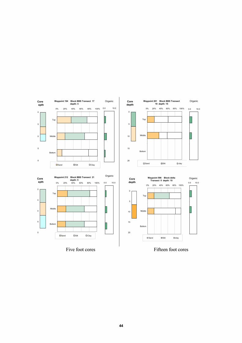
FFiivvee ffoooott ccoorreess FFiifftteeeenn ffoooott ccoorreess
Core epth
0
5
0
5
0
Waypoint 194 Block BBS Transect 17 depth: 5
0% 20% 40% 60% 80% 100%
Top
Middle
Bottom
Sand
Core depth
0
5
10
15
20
Waypoint 201 Block BBS Transect 19 depth: 15
0% 20% 40% 60% 80% 100%
Top
Middle
Bottom
Sand
Core epth
0
5
0
5
0
Waypoint 212 Block BBS Transect 21 depth: 5
0% 20% 40% 60% 80% 100%
Top
Middle
Bottom
Sand
Core depth
0
5
10
15
20
Waypoint 596 Block delta Transect 0 depth: 15
0% 20% 40% 60% 80% 100%
Top
Middle
Bottom
Sand
Organic
0.0 10.0
Organic
0.0 10.0
Organic
0.0 10.0
Organic
0.0 10.0
Silt ClaySilt clay
Silt ClaySilt clay
44

Five Foot Cores Fifteen foot cores
Core depth
0
5
10
15
20
Waypoint 166 Block BBS Transect 9 depth: 5
0% 20% 40% 60% 80% 100%
Top
Middle
Bottom
Sand
Core depth
0
5
10
15
20
Waypoint 173 Block BBS Transect 11 depth: 15
0% 20% 40% 60% 80% 100%
Top
Middle
Bottom
Sand
Core depth
0
5
10
15
20
Waypoint 180 Block BBS Transect 13 depth: 5
0% 20% 40% 60% 80% 100%
Top
Middle
Bottom
Sand
Core depth
0
5
10
15
20
Waypoint 187 Block BBS Transect 15 depth: 150% 20% 40% 60% 80% 100%
Top
Middle
Bottom
Sand
Organic
0.0 10.0
Organic
0.0 10.0
Organic
0.0 10.0Organic
0.0 10.0
Silt Clay Silt Clay
Silt claySilt Clay
45

Core depth
0
5
10
15
20
Waypoint Block miss Transect 36 depth: miss
0.00% 0.20% 0.40% 0.60% 0.80% 1.00%
Top
Middle
Bottom
Sand
Core depth
0
5
10
15
20
Waypoint 606 Block delta Transect 36 depth: 15
0% 20% 40% 60% 80% 100%
Top
Middle
Bottom
Sand
Core depth
0
5
10
15
20
Waypoint 610 Block delta Transect 34 depth: 5
0% 20% 40% 60% 80% 100%
Top
Middle
Bottom
Sand
Core depth
0
5
10
15
20
missing
0.00% 0.20% 0.40% 0.60% 0.80% 1.00%
Top
Middle
Bottom
Sand
Organic
0.0 10.0
Organic
0.0 10.0
Organic
0.0 10.0
Organic
0.0 10.0
Silt "Clay"Silt Clay
Silt ClaySilt "Clay"
FFiivvee ffoooott ccoorreess FFiifftteeeenn ffoooott ccoorreess
46

Five Foot Cores Fifteen foot cores
Core depth
0
5
10
15
20
Waypoint 540 Block SCS Transect 28 depth: 5
0% 20% 40% 60% 80% 100%
Top
Middle
Bottom
Sand
Core depth
0
5
10
15
20
Waypoint 539 Block SCS Transect 26 depth: 15
0% 20% 40% 60% 80% 100%
Top
Middle
Bottom
Sand
Core depth
0
5
10
15
20
Waypoint 537 Block SCS Transect 24 depth: 5
0% 20% 40% 60% 80% 100%
Top
Middle
Bottom
Sand
Core depth
0
5
10
15
20
Waypoint 536 Block SCS Transect 22 depth: 15
0% 20% 40% 60% 80% 100%
Top
Middle
Bottom
Sand
Organic
0.0 10.0
Organic
0.0 10.0
Organic
0.0 10.0
Organic
0.0 10.0
Silt clay Silt Clay
Silt claySilt Clay
47

Five Foot Cores Fifteen foot cores
Core depth
0
5
10
15
20
Waypoint 484 Block SCS Transect 12.5 depth: 5
0% 20% 40% 60% 80% 100%
Top
Middle
Bottom
Sand
Core depth
0
5
10
15
20
Waypoint 532 Block SCS Transect 10 depth: 15
0% 20% 40% 60% 80% 100%
Top
Middle
Bottom
Sand
Core depth
0
5
10
15
20
Waypoint 531 Block SCS Transect 8 depth: 5
0% 20% 40% 60% 80% 100%
Top
Middle
Bottom
Sand
Core depth
0
5
10
15
20
Waypoint Block miss Transect depth:
0.00% 0.20% 0.40% 0.60% 0.80% 1.00%
Top
Middle
Bottom
Sand
Organic
0.0 10.0
Organic
0.0 10.0
Organic
0.0 10.0
Organic
0.0 10.0
Silt Clay Silt Clay
Silt claySilt Clay
48

FFiivvee ffoooott ccoorreess FFiifftteeeenn ffoooott ccoorreess
Core epth
0
5
0
5
0
Waypoint 483 Block SCS Transect 8.2 depth: 5
0% 20% 40% 60% 80% 100%
Top
Middle
Bottom
Sand
Core depth
0
5
10
15
20
Waypoint 529 Block SCS Transect 6 depth: 15
0% 20% 40% 60% 80% 100%
Top
Middle
Bottom
Sand
Core epth
0
5
0
5
0
Waypoint 482 Block SCS Transect 4 depth: 5
0% 20% 40% 60% 80% 100%
Top
Middle
Bottom
Sand
Core depth
0
5
10
15
20
Waypoint 571 Block SCS Transect 4 depth: 5
0% 20% 40% 60% 80% 100%
Top
Middle
Bottom
Sand
Organic
0.0 10.0
Organic
0.0 10.0
Organic
0.0 10.0
Organic
0.0 10.0
Silt ClaySilt Clay
Silt ClaySilt Clay
49

Five Foot Cores Fifteen foot cores
Core depth
0
5
10
15
20
Waypoint 481 Block SCS Transect 0.5 depth: 5
0% 20% 40% 60% 80% 100%
Top
Middle
Bottom
Sand
Core depth
0
5
10
15
20
Waypoint 572 Block SCS Transect 2 depth: 15
0% 20% 40% 60% 80% 100%
Top
Middle
Bottom
Sand
Core depth
0
5
10
15
20
Waypoint 573 Block SCN Transect 1 depth: 5
0.00% 0.20% 0.40% 0.60% 0.80% 1.00%
Top
Middle
Bottom
Sand
Core depth
0
5
10
15
20
Waypoint 574 Block SCN Transect 3 depth: 15
0% 20% 40% 60% 80% 100%
Top
Middle
Bottom
Sand
Organic
0.0 10.0
Organic
0.0 10.0
Organic
0.0 10.0
Organic
0.0 10.0
Silt Clay Silt Clay
Silt "clay"Silt Clay
50

Core depth
0
5
10
15
20
Waypoint 575 Block SCN Transect 5 depth: 5
0.00% 0.20% 0.40% 0.60% 0.80% 1.00%
Top
Middle
Bottom
Sand
Core depth
0
5
10
15
20
Waypoint 576 Block SCN Transect 7 depth: 15
0% 20% 40% 60% 80% 100%
Top
Middle
Bottom
Sand
Core depth
0
5
10
15
20
Waypoint 577 Block SCN Transect 9 depth: 15
0.00% 0.20% 0.40% 0.60% 0.80% 1.00%
Top
Middle
Bottom
Sand
Core depth
0
5
10
15
20
Waypoint 578 Block SCN Transect 11 depth: 15
0% 20% 40% 60% 80% 100%
Top
Middle
Bottom
Sand
Organic
0.0 10.0
Organic
0.0 10.0
Organic
0.0 10.0
Organic
0.0 10.0
Silt "Clay"Silt Clay
Silt "clay"Silt Clay
FFiivvee ffoooott ccoorreess FFiifftteeeenn ffoooott ccoorreess
51

Five Foot Cores Fifteen foot cores
Core depth
0
5
10
15
20
Waypoint 579 Block SCN Transect 13 depth: 5
0% 20% 40% 60% 80% 100%
Top
Middle
Bottom
Sand
Core depth
0
5
10
15
20
Waypoint 580 Block SCN Transect 15 depth: 15
0% 20% 40% 60% 80% 100%
Top
Middle
Bottom
Sand
Core depth
0
5
10
15
20
Waypoint 491 Block SCN Transect 16.5 depth: 5
0% 20% 40% 60% 80% 100%
Top
Middle
Bottom
Sand
Core depth
0
5
10
15
20
Waypoint 48 Block NAN Transect 12 depth: 15
0% 20% 40% 60% 80% 100%
Top
Middle
Bottom
Sand
Organic
0.0 10.0
Organic
0.0 10.0
Organic
0.0 10.0
Organic
0.0 10.0
Silt Clay Silt Clay
Silt ClaySilt Clay
52

Core depth
0
5
10
15
20
Waypoint 44 Block NAN Transect 10 depth: 5
0% 20% 40% 60% 80% 100%
Top
Middle
Bottom
Sand
Core depth
0
5
10
15
20
Waypoint 43 Block NAN Transect 8 depth: 15
0% 20% 40% 60% 80% 100%
Top
Middle
Bottom
Sand
Core depth
0
5
10
15
20
Waypoint 42 Block NAN Transect 6 depth: 5
0% 20% 40% 60% 80% 100%
Top
Middle
Bottom
Sand
Core depth
0
5
10
15
20
Waypoint 41 Block NAN Transect 4 depth: 15
0% 20% 40% 60% 80% 100%
Top
Middle
Bottom
Sand
Organic
0.0 10.0
Organic
0.0 10.0
Organic
0.0 10.0
Organic
0.0 10.0
Silt ClaySilt Clay
Silt ClaySilt Clay
FFiivvee ffoooott ccoorreess FFiifftteeeenn ffoooott ccoorreess
53

Five Foot Cores Fifteen foot cores
Core depth
0
5
10
15
20
Waypoint 40 Block NAN Transect 2 depth: 5
0% 20% 40% 60% 80% 100%
Top
Middle
Bottom
Sand
Core depth
0
5
10
15
20
Waypoint 39 Block NAN Transect 0 depth: 15
0% 20% 40% 60% 80% 100%
Top
Middle
Bottom
Sand
Core depth
0
5
10
15
20
Waypoint 52 Block SPS Transect 1 depth: 5
0% 20% 40% 60% 80% 100%
Top
Middle
Bottom
Sand
Core depth
0
5
10
15
20
Waypoint 59 Block SPS Transect 3 depth: 15
0% 20% 40% 60% 80% 100%
Top
Middle
Bottom
Sand
Organic
0.0 10.0
Organic
0.0 10.0
Organic
0.0 10.0
Organic
0.0 10.0
Silt Clay
Silt Clay
Silt ClaySilt Clay
54

AAPPPPEENNDDIIXX 22
IINNTTEERRPPOOLLAATTIIOONN MMAAPPSS:: SSAANNDD:: RRSSTT 33DD MMEETTHHOODD
SSIILLTT:: RRSSTT 33DD MMEETTHHOODD
CCLLAAYY:: RRSSTT 33DD MMEETTHHOODD
OORRGGAANNIICC:: IIDDWW MMEETTHHOODD
CCLLAAYY::SSIILLTT RRAATTIIOO:: RRSSTT 33DD MMEETTHHOODD
55

56

57

58

59

60