characterization of radioactively contaminated sites for ... · highlights the need to identify...
TRANSCRIPT

IAEA-TECDOC-1017
Characterization ofradioactively contaminated sites
for remediation purposes
INTERNATIONAL ATOMIC ENERGY AGENCY

The IAEA does not normally maintain stocks of reports in this series.However, microfiche copies of these reports can be obtained from
IN IS ClearinghouseInternational Atomic Energy AgencyWagramerstrasse 5P.O. Box 100A-1400 Vienna, Austria
Orders should be accompanied by prepayment of Austrian Schillings 100,in the form of a cheque or in the form of IAEA microfiche service couponswhich may be ordered separately from the IMS Clearinghouse.

The originating Section of this publication in the IAEA was:
Waste Technology SectionInternational Atomic Energy Agency
Wagramer Strasse 5P.O. Box 100
A-1400 Vienna, Austria
CHARACTERIZATION OF RADIOACTIVELY CONTAMINATEDSITES FOR REMEDIATION PURPOSES
IAEA, VIENNA, 1998IAEA-TECDOC-1017
ISSN 1011^289
© IAEA, 1998
Printed by the IAEA in AustriaMay 1998

FOREWORD
Radioactive contamination of the environment, including soils and waters, has occurred inmany parts of the world as a by-product (sometimes accidental) of nuclear activities such asdefence related operations, power production, research, medical and industrial applications.
Characterization of the contaminated site is essential before embarking on a programme forits remediation and ultimate restoration. Reliable and suitable data must be obtained regardingthe distribution and physical, chemical and nuclear properties of all radioactive contaminants.Characterization data is necessary for assessing the associated radiation risks and is used insupport of the required engineering design and project planning for the environmental restoration.In addition, continuing characterization can provide information regarding efficiency of thecleanup methods and influence possible redirection of work efforts. Similarly, at the end of theremediation phase, characterization and ongoing monitoring can be used to demonstratecompletion and success of the cleanup process.
Other technical aspects of environmental restoration are also being addressed by the IAEA.This report is complementary to others dealing with the technology available for environmentalrestoration, development of strategies for environmental restoration, and character-ization/monitoring of contaminated sites following cleanup.
The suggested methodology represents a contribution attempting to solve the issue of pre-remediation characterization in a general manner. However, a number of difficulties might makethis methodology unsuitable for general application across the diverse social, environmental andpolitical systems in the IAEA Member States. This TECDOC covers the methodologies used tocharacterize radioactively contaminated sites for the purpose of remediating the potential sourcesof radiation exposure and assessing the hazards to human health and the environment.
The initial draft of this report was prepared at a consultants meeting held in Vienna inOctober 1995. D.E. Clark of the IAEA served as Scientific Secretary at this and subsequentmeetings. An advisory group meeting was held in May 1996 to provide national contributions tothe draft report. Finally, a consultants meeting reviewed and revised the text. The report receivedan internal review in the Waste Technology Section of the Division of Nuclear Fuel Cycle andWaste Technology, and was finalized for publication by Z. Dlouhy of the IAEA.

EDITORIAL NOTE
In preparing this publication for press, staff of the IAEA have made up the pages from theoriginal manuscript(s). The views expressed do not necessarily reflect those of the IAEA, thegovernments of the nominating Member States or the nominating organizations.
Throughout the text names of Member States are retained as they were when the text wascompiled.
The use of particular designations of countries or territories does not imply any judgement bythe publisher, the IA EA, as to the legal status of such countries or territories, of their authorities andinstitutions or of the delimitation of their boundaries.
The mention of names of specific companies or products (whether or not indicated as registered)does not imply any intention to infringe proprietary rights, nor should it be construed as anendorsement or recommendation on the part of the IAEA.

CONTENTS
1. INTRODUCTION . . . . . . . . . . . . . . . . . . . . . . . . . . . . . . . . . . . . . . . . . . . . . . . . . . . . . . . . . . . 1
1.1. Background . . . . . . . . . . . . . . . . . . . . . . . . . . . . . . . . . . . . . . . . . . . . . . . . . . . . . . . . . . . . 11.2. Objectives and scope . . . . . . . . . . . . . . . . . . . . . . . . . . . . . . . . . . . . . . . . . . . . . . . . . . . . . 11.3. Structure . . . . . . . . . . . . . . . . . . . . . . . . . . . . . . . . . . . . . . . . . . . . . . . . . . . . . . . . . . . . . . 2
2. RADIOACTTVELY CONTAMINATED SITES AND SOURCES OFCONTAMINATION . . . . . . . . . . . . . . . . . . . . . . . . . . . . . . . . . . . . . . . . . . . . . . . . . . . . . . . . . 2
2.1. Sources of contamination . . . . . . . . . . . . . . . . . . . . . . . . . . . . . . . . . . . . . . . . . . . . . . . . . 32.2. Identification of problem . . . . . . . . . . . . . . . . . . . . . . . . . . . . . . . . . . . . . . . . . . . . . . . . . . 42.3. Major factors in site characterization . . . . . . . . . . . . . . . . . . . . . . . . . . . . . . . . . . . . . . . . 6
3. THE ROLE OF CHARACTERIZATION IN REMEDIATION . . . . . . . . . . . . . . . . . . . . . . . . 6
3.1. The need for characterization studies . . . . . . . . . . . . . . . . . . . . . . . . . . . . . . . . . . . . . . . . 63.2. Characterization to support evaluations and assessments . . . . . . . . . . . . . . . . . . . . . . . . . 8
3.2.1. Evaluation of contamination levels, radiation doses,and the need to remediate . . . . . . . . . . . . . . . . . . . . . . . . . . . . . . . . . . . . . . . . . . . 8
3.2.2. Evaluation of remediation alternatives . . . . . . . . . . . . . . . . . . . . . . . . . . . . . . . . . 93.2.3. Design of remediation approaches . . . . . . . . . . . . . . . . . . . . . . . . . . . . . . . . . . . . 123.2.4. Implementation of remediation activities . . . . . . . . . . . . . . . . . . . . . . . . . . . . . . 123.2.5. Verification and monitoring of remediation performance . . . . . . . . . . . . . . . . . . 13
4. APPROACHES TO CHARACTERIZATION . . . . . . . . . . . . . . . . . . . . . . . . . . . . . . . . . . . . 13
4.1. Defining the objectives and strategies for characterization . . . . . . . . . . . . . . . . . . . . . . 134.1.1. Quality and quantity of data . . . . . . . . . . . . . . . . . . . . . . . . . . . . . . . . . . . . . . . . . 144.1.2. Phasing of site characterization . . . . . . . . . . . . . . . . . . . . . . . . . . . . . . . . . . . . . . 16
4.2. Planning the characterization . . . . . . . . . . . . . . . . . . . . . . . . . . . . . . . . . . . . . . . . . . . . . 164.2.1. Sampling and analysis plan . . . . . . . . . . . . . . . . . . . . . . . . . . . . . . . . . . . . . . . . . 174.2.2. Quality assurance plan . . . . . . . . . . . . . . . . . . . . . . . . . . . . . . . . . . . . . . . . . . . . . 184.2.3. Data management plan . . . . . . . . . . . . . . . . . . . . . . . . . . . . . . . . . . . . . . . . . . . . . 184.2.4. Health and safety plan . . . . . . . . . . . . . . . . . . . . . . . . . . . . . . . . . . . . . . . . . . . . . 194.2.5. Project management plan (cost and schedule) . . . . . . . . . . . . . . . . . . . . . . . . . . . 19
4.3. Characterization tasks . . . . . . . . . . . . . . . . . . . . . . . . . . . . . . . . . . . . . . . . . . . . . . . . . . . 194.3.1. Site description . . . . . . . . . . . . . . . . . . . . . . . . . . . . . . . . . . . . . . . . . . . . . . . . . . . 194.3.2. Identification of radioactive contamination . . . . . . . . . . . . . . . . . . . . . . . . . . . . . 20
4.4. Reporting . . . . . . . . . . . . . . . . . . . . . . . . . . . . . . . . . . . . . . . . . . . . . . . . . . . . . . . . . . . . . 21
5. CHARACTERIZATION METHODOLOGIES AND TECHNIQUES . . . . . . . . . . . . . . . . . 22
5.1. Introduction . . . . . . . . . . . . . . . . . . . . . . . . . . . . . . . . . . . . . . . . . . . . . . . . . . . . . . . . . . . . 225.2. Characterizing radioactive contamination . . . . . . . . . . . . . . . . . . . . . . . . . . . . . . . . . . . . 22
5.2.1. Field measurements . . . . . . . . . . . . . . . . . . . . . . . . . . . . . . . . . . . . . . . . . . . . . . . 235.2.2. Sampling procedures . . . . . . . . . . . . . . . . . . . . . . . . . . . . . . . . . . . . . . . . . . . . . . 305.2.3. Laboratory measurements . . . . . . . . . . . . . . . . . . . . . . . . . . . . . . . . . . . . . . . . . . 335.2.4. Instrumentation . . . . . . . . . . . . . . . . . . . . . . . . . . . . . . . . . . . . . . . . . . . . . . . . . . 37
5.3. Errors and uncertainties in results . . . . . . . . . . . . . . . . . . . . . . . . . . . . . . . . . . . . . . . . . . 425.3.1. Counting statistics . . . . . . . . . . . . . . . . . . . . . . . . . . . . . . . . . . . . . . . . . . . . . . . . 425.3.2. Other sources of uncertainty . . . . . . . . . . . . . . . . . . . . . . . . . . . . . . . . . . . . . . . . 42

6.
5.4. Additional aspects to be considered . . . . . . . . . . . . . . . . . . . . . . . . . . . . . . . . . . . . . . . . 435.4.1. Hazardous materials . . . . . . . . . . . . . . . . . . . . . . . . . . . . . . . . . . . . . . . . . . . . . . . 435.4.2. Safety of workers . . . . . . . . . . . . . . . . . . . . . . . . . . . . . . . . . . . . . . . . . . . . . . . . . . 435.4.3. Waste characterization and assay . . . . . . . . . . . . . . . . . . . . . . . . . . . . . . . . . . . . . 43
5.5. Summary of methodologies and techniques for characterization . . . . . . . . . . . . . . . . . . 43
SUMMARY AND CONCLUSIONS . . . . . . . . . . . . . . . . . . . . . . . . . . . . . . . . . . . . . . . . . . . 44
REFERENCES
APPENDIX I:
APPENDIX II:
ANNEXES:
47
SELECTED METHODOLOGIES FOR REDUCING SITECHARACTERIZATION COSTS . . . . . . . . . . . . . . . . . . . . . . . . . . . . . . . . . . . . 51
CONSIDERATION OF RADIONUCLIDEENVIRONMENTAL TRANSPORT . . . . . . . . . . . . . . . . . . . . . . . . . . . . . . . . . . 54
CASE HISTORIES OF NATIONAL EXPERIENCE . . . . . . . . . . . . . . . . . . . . . 63
ANNEXA: CASE HISTORY — AUSTRALIA . . . . . . . . . . . . . . . . . . . . . . . 65The former British atomic weapons test site at Maralinga onmainland Australia
ANNEXE: CASE HISTORY — BELGIUM . . . . . . . . . . . . . . . . . . . . . . . . . . 72Radium contamination from a radium production plant inan urban setting in Belgium
ANNEX C: CASE HISTORY — BRAZIL . . . . . . . . . . . . . . . . . . . . . . . . . . . 79Radioactive contamination in Brazil: The Interlagosmill site for the processing of monazite
ANNEXD: CASE HISTORY — CANADA . . . . . . . . . . . . . . . . . . . . . . . . . . 82Uranium ore contamination of a railhead in northern Canada
ANNEXE: CASEHISTORY — CROATIA . . . . . . . . . . . . . . . . . . . . . . . . . . 86
ANNEXF: CASE HISTORY — SLOVAKIA . . . . . . . . . . . . . . . . . . . . . . . . 91l37Cs contaminated river banks from nuclear power plant (NPP)effluent at the Bohunice site in Slovakia
ANNEX G: CASE HISTORY — UNITED KINGDOM . . . . . . . . . . . . . . . . . 95Product fission contamination of railway land byrainwater runoff from fuel transportation flasks
ANNEX H: CASE HISTORY — UNITED STATES OF AMERICA . . . . . . . 97Adaptive sampling and analysis programmes for soilscontaminated with radionuclides in theUS Department of Energy Formerly Utilized SitesRemedial Action Program (FUSRAP):The Painesville site, Painesville, Ohio
CONTRIBUTORS TO DRAFTING AND REVIEW . . . . . . . . . . . . . . . . . . . . . . . . . . . . . . . . . . . . 103

1. INTRODUCTION
1.1. BACKGROUND
In recent years, it has become widely recognized that there are a large number of sites incountries around the world which have become radioactively contaminated as a result of nuclearfuel cycle activities; nuclear weapons programmes; the use of radioisotopes in medicine, research,industry; accidents; and so on. For some sites, fairly localized contamination has occurred as aresult of specific industrial processes or operations as, for example, contamination arising fromradium luminescence plant operations or the burial or disposal of radioactive materials. Forothers, widespread contamination with radioactive materials has occurred following plannedactivities such as nuclear weapons testing or from accidental releases of radioactive materials (e.g.the Chernobyl reactor accident of April 1986). The presence of such radioactivity, be it naturalman-enhanced or anthropogenic, may pose hazards to human health or the environment.Therefore, proper characterization and remediation may be a mandatory requirement in order toreduce the radiological hazards to acceptable levels.
This TECDOC provides general information on the characterization of radioactivelycontaminated sites for remediation purposes. Thus, it presents technical approaches (e.g.strategies, planning, sampling, radiation measurements, laboratory testing, etc.) used to determinethe extent of contamination and its chemical/physical form, nuclear properties, distribution, etc.,primarily to support the remediation (cleanup) of radioactive contamination. It may be consideredas a complementary or companion publication to other IAEA publications in the field ofenvironmental restoration. The pertinent activities in this field currently include development ofenvironmental restoration strategy [1], technology for environmental restoration [2], technicaloptions for groundwater remediation [3], and characterization/monitoring to assess theeffectiveness of remediation [4].
Past IAEA efforts with respect to environmental restoration have largely focused onaccident responses (including cleanup of large areas as a result of a nuclear accident) [5-10]. Anumber of other publications have been issued which discuss broad aspects of the characterizationof radioactively contaminated sites; existing remediation technologies, as well as those underdevelopment; and associated environmental restoration activities [11-19].
1.2. OBJECTIVES AND SCOPE
This publication is to serve as a source of information on characterization methodologiesand techniques that are generally applicable for determining the characteristics of radioactivelycontaminated sites, including the specific radionuclides, their chemical and physical forms, siteproperties, geological features, and migration pathways. The publication should give guidanceon characterizations that are needed for different stages of the evaluation process and alsosuggests methodologies to carrying out the particular characterizations required. It providesguidance on structured approaches to be taken during site characterization studies. The suggestedmethodologies and approaches represent a contribution attempting to solve the issue of pre-remediation characterization in a general manner. However, a number of difficulties might makesome of these methodologies and approaches unsuitable for general application across the diversesocial, environmental and political systems in the IAEA Member States.
The main goal of this publication is to facilitate the planning and execution of thecharacterization phases of a possible remediation. By giving advice and by alerting the reader to
1

the wide variety of methods available, some of them not widely used, it is hoped that thepublication can assist in allowing an efficient and appropriate characterization to be carried out.
This TECDOC does not provide guidance on dose/risk assessment methodologies, butdiscusses some likely characterization techniques which could provide information for that andother purpose. Furthermore, it does not seek to specify the levels of radioactivity, or dose or riskreduction that a remediation ought to achieve. Interim guidance on relevant radiation protectionprinciples is given in a recent IAEA publication [20]. Reference to this subject is also to be foundin the Safety Series publications of the IAEA being prepared under the RADWASS programme.In addition, such factors as economic, political, cultural, and other scientific information can allinfluence these matters.
1.3. STRUCTURE
Following the Introduction, Section 2 describes typical examples of sites encounteredthroughout the world and the main reasons for characterization. It briefly discusses the types ofrisk or problems associated with the various types of site which may be encountered andhighlights the need to identify correctly the problems which remediation must address and givessome general advice and warnings.
Section 3 focuses on the role of characterization in remediation; it enlarges on the reasonswhy a site characterization may be undertaken, and on the factors which will influence what maybe required of such a study.
Section 4 deals with the approaches (e.g. organizational structures and planning objectives)which may be useful or even required in a site characterization. It describes the various modelsfor planning and the characterization tasks that are likely to be needed.
Section 5 deals with the range of characterization methodologies and techniques which maybe used in a characterization. The application of each technique, its advantages and disadvantagesare discussed in a general way.
Section 6 provides a short summary of the report and the principal conclusions drawn.
This publication is supplemented by a list of references and by two Appendices providinginformation on characterization costs and environmental transport of radionuclides. In theAnnexes, examples of various national experience in characterization of contaminated sites aregiven.
2. RADIOACTIVELY CONTAMINATED SITES ANDSOURCES OF CONTAMINATION
The use of radioactive materials for a variety of purposes has resulted in contamination ofsites (i.e. land areas, including structures, soils, rocks, biota, surface and groundwaters, etc.)throughout the world. The radionuclides involved may have been produced for a variety ofreasons, including scientific research, industry, medicine or warfare. Another possibility is thatthey are simply an unnatural concentration of the naturally occurring radioactive elements. Theaffected sites can range from small localized areas in urban environments to larger areasencompassing many tens or hundreds of square kilometers.

The source of the radioactive contamination may be from a known activity at the site andthe radionuclides involved may be known. Records may give information about the radionuclidesinvolved and their likely disposition and chemical state. Alternatively, a chance discovery mayhave revealed the presence of contamination and no other information is available. It might bethat the site is populated and immediate steps must be taken to ensure no harm is done, or it couldbe that people are easily excluded and there is adequate time to undertake investigations.
These and other differences mean that each site must be treated as a unique situation takinginto account its own particular circumstances. In general, all potentially contaminated sites willneed an evaluation (characterization) based on the principles given herein. In minor cases ofcontamination, many steps can be treated summarily, but usually all will still have to be dealtwith. This publication is intended to provide the reader with general insight on how to decide themost appropriate procedures and also to be alerted about potential problems.
2.1. SOURCES OF CONTAMINATION
Some examples of contamination that might be encountered are given below. The list is notexhaustive but is intended to show the wide range of problems that might be found; they can varyin extent from large land areas to relatively small areas such as a manufacturing facility.
(a) Nuclear power production and nuclear fuel cycle activities
The various stages of the nuclear fuel cycle and the operation and decommissioning ofnuclear reactors all have the potential to create contaminated sites. The contamination mayinclude mill tailings; spillage of ore end product at the mine and in transport; waste fromenrichment and fuel fabrication operations; fission product and actinide waste streams fromreprocessing of fuel elements; radioactive effluents from normal operations of nuclear powerplants; wastes produced during decommissioning of reactors; and major releases under accidentconditions. Annexes D (Canada) and H (United States of America) give examples ofcontamination from uranium ore and yellowcake handling. Annex F (Slovakia) gives an exampleof 137Cs contamination of river banks following accidents at a nuclear power plant. Annex G(United Kingdom) describes contamination problems occurring on railway property due to rainrunoff of fission product contaminants from fuel transportation containers.
(b) Production and use of radioactive substances for medical, research or industrial purposes
Radioactive materials have been used widely since their discovery for a variety of scientific,medical and industrial uses. In some cases, either through ignorance, carelessness, or accident(see (e) below), sites have been left contaminated with residues of the operations. Such sitesinclude factories where radium was used in luminescent paint and thorium was used in thorium-coated gas mantles. Other locations where radionuclides have been handled have the potential forleaving contamination. Annex B (Belgium) discusses the widespread dispersal of radiumcontamination in the surrounds of a former radium extraction plant.
(c) Mining and chemical processing associated with U and Th impurities
Because uranium and thorium are present in many ores containing other useful minerals,the mining of these ores and the processing to recover materials such as copper, gold, niobium,coal and monazite will generally produce waste streams containing significant amounts ofradioactivity. These have the potential to result in unacceptably contaminated sites. Annex C

(Brazil) discusses contamination from the processing of monazite ores. Annex E (Croatia)describes contamination issues arising from naturally occurring radioactive materials (NORM)found in coal slag piles, as by-products of the fertilizer industry, and in other forms.
(d) Military activities and the production, testing and use of nuclear weapons
The manufacture of nuclear weapons involves the handling, transport and storage of largequantities of radioactive materials. The testing of weapons may involve nuclear yield and therelease of fission products and activation products, or may involve the deliberate dispersal ofradioactive materials in the environment. Some military use is made of depleted uranium whichmay contain fission products if obtained from reprocessed fuel. All of these activities have, in thepast, resulted in contaminated sites, many of very large areas. Annex A (Australia) discusses thewidespread plutonium contamination resulting from the experimentation with nuclear weaponsdevelopment.
(e) Major incidents
In the course of nuclear weapons production and transport, there have been several severeaccidents resulting in considerable contamination [17, 20]. These include: Windscale Pile 1(1957), Kyshtym (1957), Palomares (1966) and Thule (1968). The spread of contamination byaccident or by human ignorance are illustrated by the cases of the Chernobyl reactor (1986) andGoiania (1987).
Table I presents examples of typical radioactively contaminated sites found worldwide andprovides details of expected radionuclide contaminants.
2.2. IDENTIFICATION OF PROBLEM
A contaminated site may pose a cause for concern for various reasons. In many cases, it isa proposed change of land use that triggers an evaluation of the radioactivity present. In theoriginal context the radioactivity may have been considered un-noteworthy and subject toadequate controls but a change in circumstance, such as a factory becoming a residence orhousing a child-care facility, may cause a drastic re-evaluation of what is considered anacceptable level of contamination. This example serves to show that it may not only be themathematical risk of injury that is relevant in deciding what to do; the public perception of whatis acceptable must also be taken into account.
When a long term problem is being addressed, full historical information may sometimesallow a very well planned characterization with no surprises. Alternatively, a sudden publicoutcry about an unknown site may demand immediate, independent measurements to achievecredible demonstration of acceptability.
The solution of the problem will generally be either in producing a credible demonstrationthat the present situation is acceptable, or in a remediation of some form that reduces the risk, ina documented way, to an acceptable level.
The proposed r mediation must solve the problem in its widest sense. That is, it mustaddress concerns of. xi-technical nature as well as scientifically-based risks. The associatedcharacterization must •;• j tailored for the intended purpose and suit the needs of the final solution.For examples in meeting a regulatory limit the required quality assurance (QA) practices must

be followed or the characterization may not be acceptable. Thus, regulatory authorities should beinvolved in the planning from an early stage. In addressing public concerns, the formal orinformal (but recorded) approval of proposed actions and end-points should be obtained.
TABLE I. TYPICAL RADIOACTIVELY CONTAMINATED SITES FOUNDWORLDWIDE
Radium luminizing works Radium-226 + Daughters.Radon (Rn-222) (+D) emanation from the underlying ground could present asignificant inhalation hazard. This hazard would need to be assessed andengineered solutions adopted. Radium compounds may be soluble in water andif so, the ground water pathway could be significant.
Thorium gas mantelworks
Thorium-232 + Daughters.Thoron (Rn-220) (+D) emanation from the underlying ground could present asignificant inhalation hazard. This hazard would need to be assessed andengineered solutions adopted.
Phosphate fertilizerproduction
U-238 + Daughters are most significant contaminants, Th-232 + progeny
Nuclear weapons test site Contaminants are mainly long-lived fission products and original fissilecomponents of test weapons. Many species are only significant in the first yearor so after the creation of mis type of contamination. Some radionuclides haveshort lived daughters in secular equilibrium.
Coal ash/slagfrom coal-fired power
stations
Levels typically low compared with U mining or nuclear accidents. Volumesmay be very large. Radon emissions may be significant. Present containmentsmay be rudimentary or non-existent.See Annex E for details.
Nuclear power plant sitesand environs
Levels may vary from generally low but widespread to locally high specificactivity. Off-site releases may be through gaseous , liquid or particulate routes.In most circumstances, fission or steel activation product, and tritium, wouldbe expected to be the most significant isotopes. _______
Mining, milling andprocessing of copper (and
other) ores having highU/Th impurities
Radionuclides of the U decay series may be found: for instance, in waste rockpiles and slags. Sites may be contaminated especially by Pb/Po-210 particulate.Ores include copper, tin, silver, gold, niobium and monazite.
Nuclear weapon and fuelfabrication plant
(uranium enrichment andlithium production)
also fuel reprocessingplants
Contaminants are mainly from uranium and plutonium fuel and fissionproducts (generally with half lives of at least 1 year).

2.3. MAJOR FACTORS IN SITE CHARACTERIZATION
Major factors in site characterization, to be taken into account, include:
(a) Characterization can be a large consumer of project resources. Mistakenly, its practicalimportance to solving the problem may not always be understood or appreciated. In someinstances, the characterizations may be the "last word" measurements (e.g. for peripheralareas) and, as such, their credibility is vital.
(b) The amount of characterization should be proportionate to the extent of the likelyremediation effort. Over-characterization can result in a disproportionate fraction of thebudget being spent on measurements, leaving insufficient means to carry out acceptableremediation.
(c) Characterization should be adequate to allow a properly designed remediation; one thatdoes not involve excessive amounts of unnecessary effort or environmental damage.
(d) Characterization efforts should be sufficient to demonstrate the existence of clean areas andto provide credible assurances that unremediated areas are safe.
(e) Characterizations should have a sufficiently broad focus that any other unknowncontaminants are detected at a stage when they can be dealt with efficiently.
(f) The characterization, in the first instance, and the subsequent remediation should not makethings worse by ill-advised first attempts that magnify or spread the problem. A guidingprinciple can be "first, do no harm".
Section 3 gives more details of these considerations and shows the relationship between thecharacterization and remediation activities.
3. THE ROLE OF CHARACTERIZATION IN REMEDIATION
3.1. THE NEED FOR CHARACTERIZATION STUDIES
Once the concern about a potentially contaminated site has reached some threshold level,a process of evaluation and assessment should be undertaken. The process nominally followedis indicated in Fig. 1 and may lead to a remediation of the site or to a "no further action"remediation. A central feature of the process is characterization. In this context, characterizationrefers to those investigations, specifically including measurements, undertaken to provideinformation and data about the contamination and affected site environment.
As shown in Fig. 1, the steps usually taken include:
- evaluation of the severity of the problem in terms of radionuclide concentration or doselevels to determine whether there is a need to remediate;evaluation of the remediation alternatives including the feasibility, cost, and risk reduction;design of the selected remediation option;
- implementation of the remediation option; andverification and/or monitoring of the remediation performance.

Is there a problem?
NofurtheractionRemedy ^
1r *^Assessment ofDose/Compliance Values& Need to remediate
^fEvaluation ofRemediation alternatives
VDesign &Remedialjon
-——info Supply
Available data
^ junaractenzationinfo Need
frl Characterization
^ ^CharacterizationV
Implemerof Remed
tationy ^ ^Characterizationf
Verification/monitoringof Remedy Performance ^ ^Characterization
F/G. 7. Schematic diagram of the remediation process for radioactively contaminated sitesindicating the role of characterization.
Characterization is a necessary prerequisite to provide critical information and data for eachassessment/evaluation step in this process. Multiple characterization activities are common, witheach characterization activity focused on gathering the information essential for the particulartype of assessment or evaluation being conducted as indicated in the example in Table II.
While the general process of dealing with a potentially contaminated site shown in Fig. 1 isapplicable to most problems, it may result in a range of characterization activities that vary widelyin terms of scope, cost, and schedule. For example, a small "hot spot" of radioactivelycontaminated soil resulting from a recent small spill may be surveyed, hand shoveled up into asmall container for proper disposal elsewhere, and the soil replaced with clean soil in a few hours.The steps in Fig. 1 would have been completed rapidly without much paperwork or calculation.The related characterization activities would have amounted to field survey instrumentmeasurements of radiation prior to and after the hand shoveling.
Alternatively, the source of contamination may have been a leak of radioactive material thatcontaminated not only the surface soil in the immediate vicinity of the leak but also thesubsurface soils and groundwater. Migration of the contaminant might now threaten theenvironment and population away from the leaking source. In this instance, the components ofthe assessment/evaluation process may be more complex and, consequently, the characterizationactivities may be more in number, more elaborate, and require months or years to complete.

TABLE H. ILLUSTRATIVE EXAMPLE OF SUCCESSIVE STEPSIN CHARACTERIZATION
STEP ACTIONS TAKEN
Discovery of contamination A routine radiological check of a disused site shows high levels of radioactivity insome areas. At this stage, results usually include only some count-rates from aradiation detector at several locations.
Confirmation and initialdetermination of scope
A grid survey using properly calibrated equipment is carried out. The propertyboundaries and exits of the natural drainage system are given special attention.This survey shows that dose limits for members of the public might be exceededunder some circumstances within the boundaries of the site. No evidence is foundthat contamination has moved off-site. The level of protection necessary forworkers undertaking further characterizations is determined.
Primary characterization If a significant problem exists, the primary site characterization survey isundertaken. The aim is to determine the exact spatial extent of the problem,including depth profiles, and to gather sufficient information to allow a full doseassessment for potential site occupiers and off-site populations. Any radiologicalthreats to the environment from the existing situation or from possibleremediation actions would be identified in such an assessment.
Secondary characterizations If consideration of die results of the primary characterization led to a decision toundertake remediation, then a detailed characterization would be necessary toallow decisions to be made about the exact remediation method, and then ondetails of that action. At this stage, some characterizations will be needed to allowthe full engineering design of the remediation. In addition, characterization of anywaste stream may be necessary before the transport and disposal options for thewaste are approved-
Remediation monitoringand quality control
As removal, treatment or fixation of the contamination proceeds, furthermonitoring and characterization continues to update remediation plans and toprovide quality control information.
Verification and end-pointdose assessment
Following the completion of remediation, a survey should be carried out todocument the radiological status of the site and to allow a site for any future use.
3.2. CHARACTERIZATION TO SUPPORT EVALUATIONS AND ASSESSMENTS
3.2.1. Evaluation of contamination levels, radiation doses, and the need to remediate
The conceptual framework of radiological protection is stipulated in the IAEA Basic SafetyStandards [21]. It recognizes two distinct situations: practices, which add radiation exposures, andintervention, which subtracts radiation exposures. Remedial actions taken to reduce actual orpotential radiation exposures would constitute interventions.
The system of protection for intervention comprises two important principles:
(1) The proposed intervention should do more good than harm, i.e. the reduction in detrimentresulting from the reduction in dose should be sufficient to justify the harm and costs ofintervention.

(2) The form, scale and duration of the intervention should be optimized so that the net benefitof the reduction in dose, i.e. the benefit of the reduction in radiation detriment less thandetriment associated with the intervention, should be maximized.
These measures may provide the basis for determining whether the contaminated siterequires remediation.
Characterization actions may have to be taken in order to demonstrate compliance with aspecified value of concentration in the contaminated media, corresponding in many cases to doselimit to a hypothetical group. Characterization results that indicate radioactivity levels wellbelow regulatory limits may eliminate public concern and respond to political demands. See Ref.[20] for an example of criteria to be complied with.
In many cases, however, there may not exist specific regulatory levels for radionuclides inthe media of interest or there are public and political concerns for human health and theenvironment not addressed directly by such compliance levels. In those cases, the assessment ofradiation doses is undertaken.
The general types of information needed for the assessment include:
nature and concentration of the contamination;potentially exposed population (workers, residents, etc.); and
exposure pathways for radionuclides to reach the potential human receptors (e.g. exposureby inhalation, ingestion, external dose; the ingestion pathways may include exposurethrough drinking water or food chains).
There are several mathematical models to provide an estimate of the radiation risk to anindividual or to the population [8, 22-26]. Such modelling may require comprehensivecharacterization of the contaminated site, including such parameters as the radionuclides present,their spatial distributions, and the expected site use and occupancy.
3.2.2. Evaluation of remediation alternatives
Evaluation of alternative remediation approaches, which involve consideration of thefeasibility, cost, and potential dose reduction associated to each alternative, provides the basis fora decision about the remediation to be implemented. This decision, of course, may involve social,political, and institutional considerations as well as strictly technical matters. A brief discussionfollows to indicate what types of information and data from the characterization studies may berequired.
Although this report does not deal with site remediation per se, certain considerationsrelative to the remediation process should be noted here. As part of the characterization studies,possible options for remediation (if contemplated) will need to be considered so that appropriateinformation may be gathered.
3.2.2.1. A ims ofremediations
Remediation strategies can cover a wide range of activities from characterization sufficientto demonstrate compliance with established criteria to complete removal of all contamination

down to some readily accepted endpoint. The potentially more expensive the remediation, themore characterization it is worth performing in order to allow the optimization of the remediation.Care will need to be exercised that the probability of finding any contamination is statisticallyquantifiable, appropriate and acceptable to interested parties.
It is important to identify the motivation behind the remediation. Once that is identified,appropriate characterizations can be carried out to allow the choice of a satisfactory or optimumremediation technique. Broad classes of possible remediation methods are discussed below withgeneral guidelines as to the types of problem for which each would be appropriate and the likelycharacterizations needed.
3.2.2.2. Remediation options
Remediation options are generally identified in the early planning stages of a programme.A semiformal selection process may be followed by the decision makers in their approach toenvironmental remediation for a particular site. Newer results from the ongoing sitecharacterization studies may be useful in evaluating options and in considering changes in thestrategy for remediation.
Remediation by characterization: demonstration of "no problem"
In many circumstances, the problem will be a public perception, or a scientifically-basedsuspicion, that a site is contaminated and poses a risk to potential occupants or neighbors. A well-planned characterization of the site may be able to demonstrate, to the satisfaction of the publicor authorities, that any risk is well within acceptable limits. It will be worthwhile consideringexactly who needs to be convinced by the report before carrying out the measurements.
If the site was known to have been used for handling radioactive materials and the problemis one of public perception, then a survey would be necessary which has a reasonable probabilityof detecting significant contamination. "Significant contamination," in this context, would be thatwhich, if discovered, would pose an unacceptable risk or one which would require furtherinvestigation. A knowledge of the process originally carried out at the site may help decidewhether to look for wide-spread low levels of contamination or isolated hot-spots. It is likely, inthis case, that the radionuclides used would be known.
The problem may have arisen from the discovery of some contamination at a site where nocontamination was suspected. In this case, the survey will need to look for various possibleradionuclides and may need to combine a detailed search for hot spots with a wide-area search.
Where public perception of risk is the issue, provision for public comment on and publiceducation about the survey may be appropriate. Alternatively, regulatory authorities may needto be consulted to ensure that the survey meets their requirements.
Exclusion: avoidance of the problem
There are circumstances where the best remediation is to simply exclude the potentiallyexposed population from the site of the contamination. This is particularly true when the costsof remediation are too large, such as in the case of nuclear test sites. In cases where radionuclidesinvolved are short-lived, temporary containment combined with exclusion may be a solution.
10

Costs associated with this strategy include the direct costs of fencing or surveillance toachieve the exclusion, and the indirect costs, represented by the restricted use of site or loss ofvalue of affected land.
Containment: covering or fixation in situ
The contamination may sometimes be attached to valuable equipment or facilities andremoval may be very difficult. If external exposure is not significant, for example in the case ofa pure beta-emitter, fixing the contamination by paint or other substance may allow continued useof the equipment for its normal working life. It may be necessary to ensure that records of thecontamination are kept to avoid exposures during eventual disposal of the equipment. Warninglabels or engraving may be worthwhile. This form of treatment may be particularly appropriatewhen the potentially exposed population is limited and perhaps includes only specially trainedpersonnel. An example would be surface contamination in a scientific laboratory.
Where contamination is expected to lead to significant external exposure, it may still bepossible to render it safe by sufficient covering with strongly absorbing material, such as earthor concrete. Such treatment may have indirect costs associated with the changes in the site dueto the covering.
Characterization would need to identify the radionuclides and show that containment wouldlast sufficiently long to contain the contamination for the life-time of the radionuclide. Activitylevels would need to be low enough so that the risk of containment failure was acceptable. Whenvery long half-lives are involved, considerations of what is a reasonable period of institutionalcontrol must be dealt with.
Treatment: concentration or extraction
There are far too many possible treatments to be discussed in detail here. Whatever methodsare being considered, it is likely that particular characterizations will be required to allow themethod to be properly designed and carried out. This will require determination of the extent ofcontamination and may involve chemical, physical and other investigations.
Removal: bulk removal of contamination and medium
This form of remediation is, in some ways, the simplest, and may be the most effective, butit may be the most expensive. It will probably involve significant environmental impact at thesite, the generation of a waste stream with environmental consequences elsewhere, and thetransport of a hazardous material. Characterizations will address the extent of contamination andbe needed to plan each of these aspects. Considerations of waste disposal will also be relevant inother contamination scenarios.
The presence of non-radioactive hazardous materials may affect the remediation alternativesselected for evaluation: the presence of organic or biological materials, or of chemicallyhazardous material, may preclude certain options for treatment and/or disposal or may dictateparticular handling precautions or methodologies for radioassay.
In summary, remediation alternative evaluations will typically focus on remediationperformance designed to:
11

(I) Satisfy an end point criteria. Actions have to be taken in order to allow a residualradioactivity leading to acceptable radiation risk for a specific endpoint scenario to releasethe site for restricted or unrestricted use.
(ii) Optimize the dose reduction. Actions are taken to obtain the greatest dose reduction foracceptable costs or to achieve a given dose reduction for the least possible cost.
(iii) Avoid the spreading of contamination from the site. In case of early intervention, actionsare taken in order to prevent the transport of radioactive material inter and intra ecosystems,by several environmental mechanisms, such as resuspension, soil or groundwater migrationand biological uptake.
(iv) Avoid an unnecessary risk, either now or in the future. Actions are taken to minimize oreven eliminate the actual radiation risks and potential future risks when it is cost-effectiveto do so at the present time.
In all of the above evaluations, a cost-benefit analysis may be required to determine theoptimum balance between expenditure and risk. Assessment will be required of the long-termbenefit of remediation weighed against the short term risk associated with the remediationprocess, both in terms of exposure of workers and public and in the cost of non-nuclear risks (e.g.industrial accidents during soil removal and transport).
3.2.3. Design of remediation approaches
When a decision has been made among remediation alternatives, a detailed design of thatalternative may be needed to achieve the expected performance of the remediation. Typically, thelevel of evaluation of the chosen remediation approach that occurred during the earlierevaluations of several approaches will not have been detailed enough to produce an engineeringdesign. The activity of designing the remediation, whether it is a relatively simple excavation ofsoil for disposal elsewhere or a complex in situ soil treatment, usually will require additionalinformation and data to support the design activities.
It is difficult to generalize what the data requirements for this characterization are becausethey will depend from the selected remediation technology and from site-specific conditions.However, in addition to more detailed information about the contamination nature, extent, andpotential migration pathways, other information related to engineering and construction mattersmay be required.
3.2.4. Implementation of remediation activities
Characterization studies in support of the implementation of a remediation may be verylimited, or they may be extensive and critical to the implementation process.
In cases where the contamination is easily detected in the field, the detailed delineation ofsoil contaminated at or above a specified cleanup level may be left (for cost purposes) until actualexcavation is underway. (In other cases, it may be done in advance as part of the design process.)When delineation occurs concurrently with excavation, this characterization needs to be plannedcarefully to support the ongoing remediation as construction delays can prove costly.
12

Another characterization activity that may be required to support the implementation of aremediation is the assay of materials generated as waste during the remediation. Regulations ondisposal of waste may dictate such characterization support as a critical component of thecleanup.
3.2.5. Verification and monitoring of remediation performance
An important part on any remediation is verifying that the desired performance of theremediation has been achieved. Such verification activities can range from simple radiationsurveys to assure the source material has been removed to complex, long-term monitoring ofgroundwater to detect any plume movement. In any case, this activity usually contains manycharacterization elements and, almost certainly, its design depends on earlier characterization ofthe contamination and site environment [4].
4. APPROACHES TO CHARACTERIZATION
The general approach to characterization in support of remediation is to:
- define the objectives and strategies for the characterization;
- plan specific characterization investigative tasks including important associated activities
such as quality assurance, data management, and health and safety;
- conduct the characterization;- analyse and interpret the data; and- report the results.
As the first step in the process, developing a good characterization strategy to meet theobjectives of the programme is essential (as indicated in Section 2). Once initial planning isconducted, the office, field, and laboratory investigations can be undertaken to collect thenecessary information to meet your study objectives. Upon completion of the investigation tasks,the collected data are reduced and integrated to develop a site conceptual model. A descriptionof the investigation and its results are then typically documented in a report. This Sectiondiscusses all aspects of the approach. The methodologies and techniques required to perform theinvestigation tasks are discussed in Section 5.
4.1. DEFINING THE OBJECTIVES AND STRATEGIES FOR CHARACTERIZATION
There is great variability in the details of characterization approaches appropriate to specificproblems and sites. Differences among sites due to the heterogeneous character of the naturalenvironment and to the nature and history of contamination are enough to require differentapproaches. However, the variety of other important influences on the remediation problemdefinitely require that a characterization approach be designed to address all such issues. Theguidance here focuses on the important elements that any strategy developed for characterizationof a specific site should consider. It also addresses the value of flexibility and phasing of studycomponents to allow revision of the strategy as new information becomes available.
13

Characterization data are an important element in making effective remediation decisions.Clear specifications of the objectives and strategies for the characterization are important. Oftencharacterization activities are begun with only vague notions of these objectives and strategies,and the problems that have commonly resulted include:
- wrong variables were measured;
- some variables that were needed were not measured;
- wrong set of samples was taken;
- data are compromised by interfering factors;
- funds were wasted on unnecessarily sophisticated instrumentation and analyticaltechniques;
realized accuracy and precision are inadequate;
- more samples were collected and analyzed than needed, and/or there are too few samplescollected to answer the question; and
methods were not approved by regulators.
Successful characterization activities typically are found where the strategy is consistentwith the characterization objectives. This subsection discusses how these approaches can assistin determining the quality and quantity of data to be acquired and in establishing the phasing andtiming of the characterization activities.
4.1.1. Quality and quantity of data
Several methods currently being implemented (under many names and variations) to avoidinadequate or insufficient characterization are systematic planning tools based on technicallysound approaches. They focus the designers of characterization strategies and plans ondetermining the type, quantity, and quality of data that will be sufficient and appropriate for thedata's intended use. Such methods have been shown to improve the effectiveness, efficiency, anddefensibility of decisions in a resource-effective manner. The process is amenable to operationsthat are iterative and interactive. This provides important flexibility as remediation operations anddetailed measurements will often reveal problems areas not foreseen in the originalcharacterization design. A stepwise summary of elements common to this type of process isoutlined below.
(1) Identify the problem that the characterization is to address. Decision makers,regulators, and other interested parties address the principal problems and identify relatedissues. During this step, the parties also gather and review any existing information aboutthe contaminated site that might help address the problems and issues, narrow their focus,or raise new issues.
(2) Determine the decision to be made. Having identified the problem, decision makers,regulators, and other interested parties must determine the decision to be made to help solve
14

that problem. Characterization efforts typically are directed at a specific decision —forexample, deciding whether the levels of contamination at the site exceed regulatorystandards or deciding whether remediation of contaminated soil is better accomplished byin situ treatment or by excavation and removal.
(3) Identify inputs to the decision. This step is typically critical to defining the objectives ofthe characterization because often much of the information required as input to the decisionprocess is unavailable and is sought through characterization studies. For example, thehorizontal extent of the contamination at the ground surface may be known, but itssubsurface extent may not be.
(4) Define the study boundaries. The boundaries include the spatial and temporal limitationsneeded to be considered when making a decision using the characterization data. Theboundaries can have a profound effect on the characterization strategy. For example,specifying whether individual environmental pathways are to be included or excluded inthe characterization may affect the scope of the study.
(5) Develop a decision rule. Outputs from the previous steps are integrated into a series ofsingle statements describing the logical basis for choosing among alternatives during thecharacterization. For example, a characterization aimed at delineating the spatial extent ofa particular radionuclide in soil by a combination of surface soil surveying and subsurfacesampling might have the following decision rule: "if the value of surface surveymeasurements exceeds a given threshold, then subsurface samples will be collected at 1 and2 meter depths". By developing such explicit "if..., then..." decision rules, characterizationdecisions can be made consistently by all of those assisting in the characterization.
(6) Specify limits on decision errors. Limits on the decision errors are developed by thosewho will make the decision. This permits the establishment of appropriate limits ofuncertainty for the data that are obtained.
(7) Optimize data design. Finally, the information from the previous steps and knowledge ofthe uncertainties associated with measurement techniques and instruments are used togetherwith statistical techniques to create alternative data gathering (e.g. sampling and analysis)designs. The design designates the quantity and quality of the sampling necessary. For acharacterization, the "optimum" design provides the best balance among the expected cost,ability to satisfy uncertainly objectives, the feasibility of the study, and less tangible factors.
Related data quality issues that are reviewed in the establishment of a measurement designinclude the following:
- Precision: a measure of the reproducibility of measurements.
- Accuracy: a measure of the bias in the result.
- Representativeness: a reference to the high degree to which a particular measurement orsample reflects the typical condition.
- Completeness: the percentage of measurements that are judged to be valid.
- Comparability: the confidence with which one set of data can be compared to another.
15

4.1.2. Phasing of site characterization
The timing of characterization activities is driven in many ways by the requirements of theassessments and evaluations supporting remediation. In most instances, several characterizationstudies will be conducted during the course of remediation. In some cases, individualcharacterization studies will be carried out in several phases.
Typically, characterization activities are phased by beginning with reconnaissance effortsto evaluate the potential of a problem and by advancing to more complex measurement designsto support detailed assessments. The measurements undertaken usually progress from themethods that are non-invasive to those that are invasive. In general, non-invasive technologiesare relatively less expensive, reduce the potential of worker exposure to the contamination, reducethe quantity of secondary waste, are regulated under less stringent regulatory permit requirements,and tend to be quicker. Historically, the most overlooked types of non-invasive site investigationare geophysical methods which in some instances can provide very high quality information tosupport the development of a conceptual model of the subsurface geologic environment. Herenon-invasive is defined as a surface method or remote sensing method, minimally invasivemethods include direct push methods and use of existing wells, while invasive technologiesrequire additional soil boring and well drilling water. An example of changes in measurementdesigns in phased characterization activities is presented in the following text.
Phase I: Phase I is a preliminary investigation consisting of a formal desk study and a sitereconnaissance. This investigation provides the information needed to decide site-specificinvestigation objectives and procedures for the subsequent on-site investigation. Determining thehealth and safety and environmental protection requirements for on-site work is an important taskof preliminary investigation.
Phase II: The goal of a Phase n non-intrusive exploratory investigation is to use existing datain conjunction with surface field techniques to synthesize a general conceptual model that willallow for further refinement of the site characterization programme, such as optimal placementand spacing of sampling points during the following characterization phases.
Phase III: The conceptual model developed as a result of Phase n should be verified and refinedusing minimally intrusive and/or intrusive tests. An example of this type of approach would bethe use of the cone penetrometer, which can be configured with a variety of sensors to collectgroundwater, soil gas or sediment samples, to measure in situ contaminant concentrations usingspectroscopic methods, to make geophysical measurements, as well as measure traditionalgeotechnical parameters to determine lithologic properties of the subsurface.
Phase IV: In many cases, access to the subsurface for sample collection or monitoring wellinstallation can only be obtained by drilling and/coring. Since drilling and management of drillcuttings at hazardous, mixed waste, and radioactive waste sites can be prohibitively expensive,the bulk of monitoring well installation should be completed after non-intrusive and minimallyintrusive studies have been used to prepare a conceptual model that can be verified and refinedby strategic placement of monitoring wells.
4.2. PLANNING THE CHARACTERIZATION
The planning of the characterization is based on the previous definition of the objectivesand strategies. How detailed the planning is, will depend on the size of the project. In general
16

there may be a sampling and analysis plan for the surveys of the site. However, other aspects suchas quality assurance, data management, health and safety aspects and the project management willneed careful attention and should result in a specific plan.
4.2.1. Sampling and analysis plan
Based on the definition of the objectives and strategies for characterization, a Sampling andAnalysis Plan is developed which provides the implementor of the characterization with thenecessary detail to conduct the characterization investigations in the field and in the laboratory.This includes what surveys will be done, what samples will be taken, and how they will becollected and measured (e.g. sampling point, time of collection, depth of sampling, and othervariables necessary to tie a measurement of a specific sampling location in time and space). Inthe case of accelerated or expedited characterization, the plan will emphasize the process bywhich specific sampling activities will be driven on the basis of results. Planning documentationshould also define analytical procedures for field and laboratory measurements to determinedetection limits, precision, and accuracy.
Sampling points should be located where the contamination is most expected to occur, andonly a limited number of constituents should be analyzed. The sampling plan may include thepossibility of taking decisions on extending or limiting the survey on the spot, depending on theresults of the measurements in the field. A limited number of samples may be defined in thebeginning, to verify correlation between survey data and sampling analysis, increasing thenumber of samples if the correlation is not as good as expected. For complex cases, mathematicaltechniques may be used to define a statistical distribution of sampling points to give the wantedprecision of the distribution of contamination. If pursuing the identification and location of"hotspots" of contamination, field screening should be used to help initially locate the areas ofcontamination and the boundaries of contamination. Later phases of investigation will be requiredto refine the configuration of the contaminant boundaries. Attempting to prove that a site is cleancan be difficult and invariably requires very extensive investigation. In this latter case, samplingshould always be systematic, and testing for a wide range of contaminants may be involved.
In the development of a sampling and analysis plan, due consideration should be given tothe potential spreading of contamination, accessibility of the site and sampling locations, and thepre-sampling approvals that may be required prior to the performance of field work. Theseconsiderations are briefly discussed below.
Spreading contamination. Characterization practices should be designed in such way asnot to contribute to the further spread of contamination at the site, or off site. This is of particularconcern when dealing with radioactive contamination. For example, contamination can be spreadthrough uncontaminated aquifers as a result of poor drilling and well completion practices. Careshould be exercised so that onsite workers do not inadvertently carry radioactive contaminationoff the site through inadequate decontamination processes.
Accessibility. During the planning process it is necessary to consider access logistics,including the ability to physically gain entry to the site, especially for any equipment that isbrought in (e.g. drilling rigs, cone penetrometer trucks). It should also be considered whetherthere are any overhead or underground utilities which may impact the investigation. It may benecessary to limit access to a contaminated area to only specially trained site workers and to allowfor a decontamination zone for equipment and personnel.
17

Jurisdictional concerns. Before initiating field work, it is essential to obtain any approvalsnecessary to access the area to be characterized. Authorization may be required fromgovernmental or private parties. In addition, it may be necessary to obtain certain permits fordigging, drilling, or installing any groundwater wells. A check list of requirements should beprepared to ensure preparedness.
4.2.2. Quality assurance plan
A quality assurance plan (QAP) defines how the integral quality of the environmental datacollection process is controlled. The quality objectives are to achieve technically sufficientinvestigation work, at the right time and at the right price. The QAP will include the descriptionof all relevant responsibilities/functions and a named person for each function. It will also includeprocedures and working instructions on all operations that may be involved in the final qualityof the results. Site operations which should be subject to quality assurance and quality controlprocedures include monitoring, sample collection and handling and, where appropriate, drillingworks and waste disposal. Environmental protection and health and safety aspects should begiven highest priority.
For laboratory investigations, the quality assurance plan should define the acceptance limitsof measured data in terms of sensitivity, reproducibility, detection limits and accuracy. Qualityassurance/quality control protocols are employed to demonstrate the reliability and sampleanalysis data and compliance with documented sample handling, storage, preparation and testmethods.
The quality assurance plan should guarantee that the results are accurate, precise,reproducible, reliable and timely.
4.2.3. Data management plan
As an integral part of the overall characterization plan, the data management plan shoulddefine the amount and nature of data to be collected. There will be a strong relation between thequality assurance plan and the data management programme because both aim at the end-productof the characterization data as input for assessment and decisions.
The definition of the databases that will be used in the characterization tasks is also a partof the data management plan. New data will have to be incorporated in the databases as soon aspossible to allow quick interpretation and subsequent steering of the characterizations to be done.Determination of working formats facilitates this action. There can be a different form for eachtask, but a number of items will be common to all forms.
The further handling of the samples can be documented in the same way. A chain ofcustody record may be important in many cases. Data collection procedures and working methodsshould be standardized as much as appropriate for data evaluation and for future use of the data.The choice of archiving methods for data and samples should be made taking into considerationthe future availability of relevant items (storage media, references for mapping coordinates,computer data format and backup system). Good practice in data management includes theidentification of a person responsible for data collection. A quick evaluation of incoming data,can avoid long-term gathering of nonrelevant or faulty data. All changes to procedures should beapproved by a responsible person and be logged for traceability.
18

4.2.4. Health and safety plan
The investigation of contaminated sites will involve site workers to close, and possibleprolonged, contact with potentially hazardous materials. Therefore, health and safety should bea fundamental consideration in the design and the selection of investigation methods (e.g. use ofminimally invasive techniques). Site characterization personnel should be suitably trained andequipped. Planning should prescribe detailed working procedures, including monitoring anddosimetric equipment, protection clothing, identification of access, etc.
4.2.5. Project management plan (cost and schedule)
Once the elements of the characterization planning have been completed, it is necessary tomake cost estimates and construct a site characterization time schedule. Estimating costs and timeschedules may require revisions in the site characterization strategy. Cost estimates shouldconsider cost of materials, labour, travel, accommodations, and any subcontracting support. Thescheduling should anticipate contingencies and decision points. A project manager should beassigned to ensure compliance with the characterization budget and schedule. Selectedmethodologies to reduce characterization costs are illustrated in Appendix I.
4.3. CHARACTERIZATION TASKS
4.3.1. Site description
It is necessary to have a sufficiently clear description of the site to allow for good planningand use of resources in developing a remediation strategy. The site description is normallyconstructed by making use of existing data and information, as well as conducting investigations,as needed and appropriate.
4.3.1.1. Historical investigation
The historical investigation is a part of the planning stage and is essential to obtain initialinformation on the nature and extent of the contamination. It should include gatheringinformation on the site layout, operational characteristics, materials handled, measurement results,accidents, etc. Since previous data may be of different quality and reliability, verification ofhistorical information is usually necessary.
In certain locations, it may be necessary to consider the concerns of native inhabitants,where sampling may occur within ancestral, or sacred grounds, before conducting digging,drilling operations, or other intrusive activities. Destruction of cultural or archeological resourcesshould be avoided.
Example of sources for historical investigation may include:
- site and company records (drawings, production logs, disposal records, etc.);- interviews (personnel, residents);- maps;- photographs (i.e. of operations, facilities);- scientific and technical literature; and- reports on former characterizations or remediations.
19
4.3.1.2. Present situation at the site
The description of the present situation of the site will give the information necessary todelineate the suspected area. It will give the opportunity to define a grid/coordinate system thatcan be used as a reference for the location of all subsequent surveys, measurements, and samples.
As an example, the description may include:
- maps in a scale with sufficient detail to have all relevant information, usually 1/10000 fordetailed characterization, other scale for a larger area;
- plans for structures (factories, houses, sewers, roads, etc.);
- a photographic survey of the site and its surroundings; and
data on the relevant authorities: police, local community, government agencies, wastemanagement agency, and so on.
4.3.1.3. Flora and fauna investigation
Investigations of flora and fauna at, and in the vicinity of the site, are important not onlyfor assessing any potential existing or future inherent damage, but also in assessing their potentialimpacts on humans through the food chain. In addition, both flora and fauna can be used to helpdelineate the nature and distribution of the contamination. Distressed vegetation often providesclues to contamination. Further, certain flora may be uptaking contamination, providing cluespertinent to bioremediation techniques (i.e. agricultural remediation techniques).
4.3.2. Identification of radioactive contamination
The goal of the radioactive contamination investigation is to provide identification of theradionuclides involved, to assess how much radioactivity is present, and to determine thehorizontal and vertical (depth) distribution is in order to evaluate the radiation doses for allpotential recipients.
As a first step, the exact location of the source, its present or past release rates and types ofreleased substances, should be determined. Contamination may result from buried leaking drums,leaking underground piping, or leaking waste dumps. It is recommended to remove the sourceof the contamination before proceeding with any remediation of surrounding media.
The investigation of the radioactive contamination of the site has to provide the initial datato circumscribe the extent of a possible problem and to decide on any necessity of immediateremediation. Depending on the goals of the characterization, the limitations of time, budget,available staff and available laboratories and equipment, a choice of relevant items to beinvestigated initially has to be made.
Measurement of the background radiation is necessary as a reference for thecharacterization of the site. This can be done in some cases by measuring background radiationoff-site, i.e. by choosing a site with similar characteristics as the one being investigated. In othercases, spectrometry may differentiate between natural activity and the investigated contamination.
20

In many cases, characterization planning will represent a phased process of an iterativecharacter. At first there may be a coarse radiation measurement survey, in situ and not intrusive,with appropriate survey meters or passive dosimeters or activated charcoal detectors for radon,to define the boundary of the suspected site. Depending on the findings, subsequentmeasurements may include in situ gamma spectrometry, alpha and beta measurements andcontinuous radon monitoring or the placement of alpha-track radon detectors for a longer period,hi the case of large contaminated areas, mobile or aerial gamma surveys may provide valuableinformation.
If decided so in the planning, a number of samples of different media (soil, water, air, biota,structures) will be taken for calibration of the surveys and for direct characterization of theradioactive contamination (activity, specific activity, isotopic composition). The number ofsamples of different kinds has to be determined in such a way that the needed information iscovered.
The investigation of the horizontal- and depth- distribution of the contamination can givevaluable information for the determination of the possible volumes of waste to be expected atcleanup, while spectrometry and sample measurements contribute to the knowledge of thecharacteristics of this radioactive waste.
Some possible types of radioactive contamination to be investigated are:
- contamination in a waste dump;- soil contamination;- water contamination;- contamination of biota;- contamination of structures (buildings, roads, pipes, etc.); and- air contamination (aerosol, radon, and others).
4.3.2.3. Non-radioactive contaminants
Although the characterization of non-radioactive contamination is not included in the scopeof this publication, it may be necessary to investigate some hazardous materials in the site to becharacterized. Processes used in the past (or still continuing) may have led to disposal of heavymetals together with radioactive substances. Organics, toxic or corrosive chemicals may havebeen used in processes together with radioactive material. These hazardous materials are ofconsideration for disposal of waste after cleanup. Organic complexing agents may change themigration behaviour of the radioactive contamination. The presence of hazardous matters mayaffect the design of remediation actions and clearly need to be included in health and safetyconsiderations for the characterization.
4.4. REPORTING
Comprehensive and accurate reporting of site characterization work is fundamentallyimportant. Reports should describe the findings of the investigation and document the decisionsmade and actions taken at all stages of the investigation. Site investigation reports may berequired for different purposes and to serve the needs of a number of different parties. Thosereports should be mindful that they may be viewed by many different people, only a few of whommay have detailed technical knowledge. It is vital, therefore, that a high standard of presentationis achieved and that the results and their assessment are presented with clarity and precision.
21

5. CHARACTERIZATION METHODOLOGIES AND TECHNIQUES
5.1. INTRODUCTION
A sensible phased approach should be adhered to resulting in a number of characterizationtasks being set up and followed. The objective of Section 5 is to provide information andreferences on a variety of techniques, instruments and methods which may be of use during acharacterization study.
Selection of the appropriate measurement instrumentation and protocols for their use is avery important component of any characterization project. Not all methods or instruments,however, will be used in any single study, and indeed many smaller characterizations may becompleted using only one or two items from this section. It must be emphasized that most siteremediations are unique, and that an organization embarking upon a characterization will needto exercise careful thought as to the methods which best meet their objectives.
A wide range of site characterization techniques exist, some of which will require changesin methodology depending on the particular site and contaminant [27]. Direct on-sitemeasurements of radiation levels may be a good default option when gamma emitters arecontaminating the site and are present at the ground surface. When external gamma dose is ofconcern or when hot spots have to be identified, the series of techniques related to gammaradiation measurement are of major interest. Sample collection will be the prerequisite to mostmeasurements of alpha and beta emitters. With few exceptions, sampling and laboratory analyseswill be required for the determination of radioactive isotopes whose concentration in theenvironment may not be amenable to direct field measurement.
Sometimes, laboratory measurements may provide results with large variations betweenindividual samples of the same population while in situ measurements may give morerepresentative results. However, regulators may prescribe that the concentration of a givenpollutant be obtained from laboratory measurements of samples.
The knowledge of radionuclide behaviour on site, however, may require studies ofpathways involving a wide range of disciplines such as hydrogeology, chemistry and biology.Consideration regarding these studies is presented in Appendix n.
5.2. CHARACTERIZING RADIOACTIVE CONTAMINATION
The nature and amount of radionuclides present will probably need to address the full threedimensional distribution of radioactive contamination. There are many possible contaminationscenarios, including:
- a superficial distribution of deposited activity;
- activity which has been deposited on the ground surface and which has migrated into theground;
activity which has been buried or covered (e.g. by ploughing or building operations);
activity which is to a greater or lesser extent distributed through a substantial depth of soil(e.g. waste tips);
22

- activity which is deeply buried (e.g. due to leakage from underground storage tanks orpipelines which have carried active material);
- activity distributed as hot particles which are individually hazardous;
- activity which is uniform over large areas or volumes; and
localized hot-spots.
Sometimes there may be a priori reasons to believe that the distribution is known, or canbe established with little effort. In other cases, determination of the distribution will be a majorpart of the characterization. Gamma emitting nuclides found near to the surface may be amenableto measurement by non-invasive means, whereas deeply buried material will usually require morecomplex and costly methods.
The identity of the radionuclides present may be obvious from the history of the site, ormay require detailed measurement. Even where the identity of the contaminating radionuclidesis known, care may need to be taken that radioactive decay products may be present which arenot in equilibrium with the parent.
Non-intrusive in situ techniques have a number of advantages over conventional soilsample collection and analysis. In situ measurements gather data in real-time that can be analyzedimmediately for decision making purposes, while conducting the characterization survey, andmay offer a substantial cost savings over conventional sampling and analysis. In addition, the areaobserved by the in situ detector may in fact give a more representative picture of the extent ofcontamination than conventional sampling and analysis. However, an advantage with taking soilsamples is that there is the possibility of doing additional measurement (e.g. depthcharacterization of radionuclides, radiochemical analysis for alpha and beta emitters, anddetermination of physical or chemical form of the contaminant).
A combination of remote readings and collection of samples is often the preferred approach.It is generally cost effective to focus primarily on remote readings and collect sufficient samplesto verify that the remote readings are providing the required information. A phased approach tocharacterization that optimizes data quality objectives versus the cost of acquisition and analysisshould be considered. It is often practical to obtain an initial picture of the contamination withan in situ screening survey, and then to follow up with a boundary definition survey and a moredetailed characterization of the site.
5.2.1. Field measurements
5.2.1.1. Techniques for determining measurement location
It is important to know the exact location whenever measurements are made in situ orsamples are taken. This allows the data collected to be properly coordinated and analyzed.Reproducible knowledge of the coordinates of measurements may negate the need to repeat workin the future and may provide a standard of quality assurance which is more readily accepted byregulators. Consideration should be given to whether a locally defined frame of reference isacceptable (for instance measuring locations relative to buildings or roads) or whether (perhapsif extensive site demolition is envisaged) a more permanent frame of reference (e.g. latitude andlongitude) will be required.
23

The positioning techniques vary in both sophistication and performance and have differentfields of application. Traditional surveying techniques require trained personnel and can be slow.Modem technology has provided methods which can assist considerably in the characterizationprocess.
Traditional survey techniques
Traditional survey methods can generally provide the accuracy required for sitecharacterization methods and can give good standards of quality assurance provided that they canbe linked to a series of well-defined and permanent reference objects. However, suchmeasurements may be time consuming and labour intensive and may limit the speed at whichmeasurements can be made in the field. Good measurements may be possible using only limitedequipment (tape measures, surveyors wheels, etc.) but will require that personnel have adequatetraining.
Global positioning system (GPS)
The United States Department of Defense operates a satellite-based system of absolutepositioning (known as the global positioning system, GPS) which allows a low-cost hand-helddevice to give locations anywhere in the world to an absolute accuracy of about 100 m. Thesignals from the satellite are usually deliberately perturbed to improve the accuracy. By obtainingcorrection signals from one or more base-stations at known locations, positioning over a largearea, such as a city or even continent, to an accuracy down to as little as 1 m is possible, withaccuracy relative to a local datum of as little as 1 cm. Measurements may be taken from movingvehicles, and the equipment can be used to navigate to a series of waypoints or along apredetermined path. Such a system, called Differential GPS (DGPS) can be operated entirely bythe user, either in real time or by post-processed corrections. Alternatively, correction signals areprovided by commercial organization for a fee. The corrections can be broadcast over a localradio network, multiplexed with other signals or transmitted over satellite links. The overall resultis a portable system that can be carried by a person or fitted to a vehicle and can provide accuratelocations. GPS or DGPS requires, however, a clear view of the sky and cannot be used insidebuildings or under dense tree cover, and may suffer from inaccuracies caused by reflections whenused close to buildings. Positional data obtained from these measurements will be repeatable toan absolute frame of reference and so are of special value where major site engineering operationswhich would otherwise destroy reference objects are likely to take place.
Microwave ranging systems
Various techniques are available for providing relative positions over distances of tens ofkilometers using microwaves. By measuring the time delays for a transmitted signal to bereturned from two or more transponders, locations accurate to a few meters can be obtained. Suchtechniques have been used, in the past, for aerial radiometric surveys. In many cases, DGPSwould now be the preferred technique because it is absolute and does not require the accurateplacing of transponders and a clear signal path to them.
Ultrasound ranging systems
For relatively small sites, such as a disused factory, inside or outside, and where goodspatial resolution is required, positioning systems based on ultrasound time-of-flightmeasurements are available. Such systems can provide locations to better than 1 m over distances
24

of the order of 100 m. It is necessary to place and accurately locate several ultrasound transducersaround the area to be surveyed.
Advanced surveying techniques: laser ranging
Modern surveying equipment includes fully automatic total stations which use a laserdevice to measure the range and angle from a base station to a prism located at a mobile surveypoint. The accuracy of this equipment is typically in the mm range over distances of up to severalkm. The laser ranging equipment will track the prism and so is of use in moving vehiclesprovided that a line of sight between base and prism survey point can be maintained. Theequipment needs two or more reference objects to be available to establish the position of thestation but otherwise can give results comparable to DGPS. Single-handed operation is oftenfeasible and the equipment could be used for surveying large indoor areas as well as outdoor areasin the vicinity of buildings where DGPS may be unusable.
5.2.1.2. Gamma radiation measurement in the field
Field radiation measurements may include dose rate measurements using hand-heldradiometers, gross measurements of beta or gamma activity or energy specific measurements ofgamma radiation. The latter is of use if identification of the isotopes present is a requirement. Itmay help if measurements of a specific isotope are required against a background, possiblyvarying with time or position, of another radionuclide (such as naturally occurring radium or "^K).Although simple instruments may be valuable in locating or delineating areas of high activity,at levels near to the natural background they must be used with care if statistical counting effectsor local variations in background are not to be misinterpreted as variation in contaminant. It maybe the case that integration times of simple instruments have to be set sufficiently long thatspectrometric methods could give a more accurate result in less time. It must be emphasized thatbackground radiation levels can vary rapidly, not only spatially but also with time due to changesin solar radiation or due to radon releases from the ground changing with atmospheric pressure.
Screening surveys are designed to delineate the areas of major concern. In situationsinvolving widespread contamination with sufficient gamma radiation emissions, aerial surveyscan be a cost effective method for rapidly delineating and quantifying such areas. Helicopters areused for low-level work where maximum sensitivity is required. Positioning is generallyaccomplished with commercial navigation systems (e.g. GPS) which feed indicators to guide thepilot accurately along preselected routes. Gamma radiation, flight path, altitude andmeteorological data are fed into an inboard data acquisition system for real time or post-flightanalysis. Gamma radiation data including spectral data overlaid on aerial photographs indicatethe location of the contamination very accurately. For smaller scale work where aerial surveysare not practical, surveying data can be acquired with vehicle mounted detectors, manuallypushed carts, backpack carried detectors, and manually held detectors. Vehicle mounted systemscan be used for more precise delineation of large areas, provided that access is feasible. Sincevehicle-borne systems can easily monitor at one spot for as long as required, traverse slowly andget close to the contamination, such systems generally provide good detection sensitivities andresolution of changing contamination.
hi addition to air and vehicle borne gamma survey systems, systems can be mounted on aportable cart or placed in a backpack. This approach provides a low-cost means of gathering largeamounts of data. If limited laboratory data are gathered to correlate gross gamma radiation datawith concentrations of the contaminant, total count gamma radiation data may be sufficient for
25

characterization. If it is possible to analyze data in real time, an adaptive approach may befeasible so that the most appropriate areas are covered in most detail. As discussed in Section 4,this approach will require careful pre-planning of the objectives of the survey and adequatetraining and instruction of the staff carrying out the survey.
As an example, if there is a known area of contamination on a site, staff may be instructednot to survey in detail the area of most concentrated contamination, but to explore the outer limitsof contamination so as to be able to delineate the extent of the contaminated area.
Figure 2 shows a typical in situ gamma spectrometry measurement with the detector placedat 1 meter above the soil surface. At this height, 85-90% of the gamma radiation detected isoriginating from a circle with radius of 10 meter from the detector. The typical in situ gammaspectrometer will, at a height of 1 meter, effectively detect radionuclides to a depth of up to15-30 cm. The effective area observed by this detector (> ~300 m2) may, in fact, give a morerepresentative picture of contamination than conventional sampling and analysis.
>IOm-l5%
FIG. 2. Area observed by an in situ gamma ray spectrometer at 1 m above the ground.Depicted is the percent contribution to total 662 keV primary flux for a typical Cs-137 source
distribution from past atmospheric weapons testing fallout.
26

As mentioned previously, in situ measurements usually cannot fully replace sample collectionand analysis, but it may be used in conjunction with sampling and to reduce costs associated withcharacterization surveys. Figure 3 shows an estimated correlation between the various sitecharacterization methodologies [28]. As can be seen, there is a significant unit cost difference inprice between in situ spectrometry and laboratory soil sample analysis. This difference is mainlydue to the additional time and effort required for soil sample processing and measurement. Thereis some variability in this cost estimate, which is dependent on the radionuclide measured and thelocal factors such as cost of labour and analysis.
10000 xA
§ K«O
100 xA
10 xA0001
ed m«a«ur*ment«
earn plea -lab analyala
in «ltu »p«otrom«try
»urv<»y
0.01 0.1 10 100 1000
FIG. 3. General pattern of measurement methods and their costs as a function of level ofradiation/radioactivity being measured. Unit cost A is equivalent to US $1.
5.2.1.3. Considerations for in situ spectrometry measurements
It should be mentioned first that there are limitations in using in situ spectrometry. Due tothe nature of radionuclide transport through matter (soil and air) and to the attenuation of ionizingradiation, in situ spectrometry is, for the most part, limited to the measurement of gamma raysand some X ray emitters.
Regardless of which detector type is used, appropriate methods have been developed toobtain radionuclide soil concentrations levels using in situ gamma ray spectrometry [29, 30]. Theideal site for collecting a gamma spectrum is a large (20 m diameter or more) fiat, open area withlittle or no natural or man-made obstruction. For standard measurements, the height of thedetector above the ground is an important parameter. One meter is often chosen for reasons ofconvenience; the higher the detector the greater the area which contributes to the measurement(and the faster an area may be surveyed, although this is at the expense of lateral resolution). Anexample of an appropriate survey location is depicted below in Fig. 4. This photograph wasobtained near ground zero at the Semipalatinsk nuclear test site during a site characterizationinvestigation in July 1994 [31]. As shown in Fig. 4, a HPGe detector was used to obtain thegamma ray spectrum (the detector was mounted on the tripod which is furthest to the left of thesurvey personnel), and a Small Pressurized Ion Chamber for Environmental Radiation (SPICER)(which was mounted on the tripod just to the left of the survey personnel) was used to determinethe total in-air dose rate from both cosmic and terrestrial gamma ray radiation [32].
27

FIG. 4. Photograph of in situ characterization survey near ground zero at the former SovietUnion's Semipalatinsk Nuclear Test Site.
For undisturbed soils, the actual depth profile of the radionuclide of interest is highlydependent on whether it is present as a naturally occurring gamma ray emitter or it was releasedinto the environment from anthropogenic sources and, if so, the time of the release, the mobilityof the radionuclide in that specific environment, and the position of release (deposited on thesurface, released from a buried pipe, etc.). Usually, naturally occurring emitters (e.g. <°K, 238U,232Th) are distributed approximately uniformly throughout the soil. Those that are present as theresult of nuclear weapons testing fallout (e.g. 137Cs) tend to be distributed with the activitydecreasing exponentially with depth [33]. In the case of a very recent accidental airborne releases,the radionuclide probably would be distributed only on the soil surface.
hi some cases, in situ spectrometry has been used to determine soil depth profiles directlyusing differential attenuation for those nuclides which emit two (or more) gamma rays, analysisof the scattered component of the radiation, or (with a lead shield) measurements of the angularincidence of the radiation [34, 35]. Demonstration of this technique was conducted at a formerU.S. weapons production facility using a p-type germanium closed-end coaxial detector todetermine the surface soil concentration of uranium [36]. The depth profile of 238U was obtained
28
to a depth of 5-10 cm by observing the attenuation of 63 keV line with respect to the 93 keV line.Multi-line isotopes such as 134Cs can be used to determine an approximate depth profile by virtueof the differential attenuation of gamma rays of different energies. This approach is limited bythe small number of radioisotopes having the suitable spectra and which also are commonlyfound on contaminated sites.
5.2.1.4. Alpha and beta measurements in the field
Due to their properties, in situ detection of alpha and beta emitters is very difficult and oftenonly qualitative.
In fact, very few portable detection systems exist for either of these type of emitters andthey are often extremely radionuclide specific. One device that has been used extensively toassess plutonium concentration levels is the field investigation device using low energy radiation(FIDLER) detector [37]. In normal usage, the FEDLER does not detect plutonium, but rather the60 keV X ray that is emitted from the decay of 241Am, the progeny of 241Pu, using a thin, largearea, scintillation detector.
A system that has been recently developed and marketed enables the in situ detection of thebeta ray emitter 90Sr via its higher-energy beta ray emitting progeny1 Y [39]. The detectorconsists of a series of stacked plastic scintillation fibres and has a minimal detectable activity(MDA) of 0.19 Bq/g (5 pCi/g). It also allows for the measurement of total gamma ray flux.
Portable, sealed large-area proportional counters also have been developed to assesstransuranic elements via x ray emission [39]. Other systems currently under development includea optical technique for the gross detection of uranium by laser-induced fluorescence (LIF) [18]and a portable in situ Long-Range Alpha Detector (LRAD) for gross surface analysis of alphaparticle emitters [40]. The LRAD system is based on detection of secondary ionization of air bythe decay of alpha emitters.
5.2.1.5. Application of passive detectors
External dose can be assessed by using passive devices, which integrate the gammaradiation over the measurement period, such as thermoluminescence dosimeters (TLDs), the filmbadge and track etch. A device that possesses both active and passive qualities is the electronicdosimeter.
A typical TLD can detect radiation level approximately at 0.005 uGy/h but, at least onemonth exposure time is necessary. If all infrastructure for performing TLD measurements exist,it is an inexpensive methodology since the detector itself is of low cost (and re-useable). Itsdisadvantage is the long period of exposure required and special care is needed so as not to losethe TLD during the exposure time in an unguarded area. Film badges have similar properties butare more sensitive to the environment in which they are deployed (temperature, humidity) andrequire greater care and a larger facility for preparation and analysis.
For radon measurements, an in situ technique which has been widely used is exposure ofa passive plastic detector to gas. After exposure for an extended period (usually weeks ormonths), the plastic is etched to reveal the tracks of alpha particles from the radon and daughters.Interpretation of the results into radon concentration and hence potential dose is notstraightforward. These devices have been commonly used in some countries for measurement of
29

radon in domestic premises. They have the advantage of being cheap to manufacture and process,but there is a long interval between placing of the devices and being able to analyze them. Theyare thus not suitable for situations where rapid results are required or where conditions arechanging on a short time scale.
5.2.2. Sampling procedures
Consideration must be given to the different sampling or measurement requirements of thedifferent media present on a site. Radioactive contamination may be restricted to the soil layer;it may also behave differently in the vadose and saturated layers. Rock or clay layers may beimpenetrable to activity or may bind activity. Where rocky inclusions are found in soil, they maybe essentially free of activity. As an example, this may cause apparent discrepancies if soilsample measurements are compared with external gamma ray measurements on groundcontaining substantial amounts of rock. In this case, a soil sample would be unrepresentative ofthe average near-surface material.
If surface water is present it may contain activity; if activity is likely to have reached thesaturated zone, it may also be relevant to sample groundwater. Sediments in lakes, rivers,estuaries and coastal sites may concentrate or fix activity.
Measurements in "secondary" media, i.e. other than those containing the main contaminant,may give useful information on the distribution or presence of activity. Biota which concentrateactivity may help in detecting the presence of radionuclides which are otherwise buried or at lowconcentrations. Emanation of gases (radon, tritium) from buried sources can help determine thepresence of activity. Most of these measurements should be regarded as qualitative rather thanquantitative, but they prove valuable in early stages of characterization to identify areas forfurther investigation.
5.2.2.1. Sampling of gaseous products
Elements and compounds to be considered include radon, tritium, (possibly as watervapour), 14C and other volatile compounds associated with radioactive materials. It has beenshown that gas monitoring can be used to locate waste in the ground. Radon itself is a componentthat needs to be considered because it is of health concern in case it is present in buildingmaterials or in populated areas. The presence of above background concentrations of radon in airdirectly indicates that there is a source nearby of radium or its parent isotopes.
Methods commonly used for the sampling and analysis of radon include tracketch devices(mentioned in an earlier section), and air sampling through filter papers or charcoal packsfollowed by gross beta or gamma counting to detect radon and its radioactive decay products.
5.2.2.2. Sampling of flora and fauna
Some species of flora and fauna have the ability to concentrate naturally occurring orartificial radionuclides. Iodine, for example, is known to concentrate in certain algae andshellfish, while caesium can exhibit an enhanced uptake in plants like lichens, heather, fir andspruce, as well as mushrooms. It should be noted that in general, radionuclides have stable sisterisotopes which are common in nature and are taken up to varying degrees by biota. Naturalprocesses of plant or animal uptake have evolved which ought not to be affected by the nuclear
30

properties of the element. This results in a broad and mainly still uninvestigated field ofpromising use as bioindicators and, moreover, for bioremediation.
Some bioindicators have been identified, as shown in Table HI, which does not claim to beexhaustive.
TABLE HI. EXAMPLE BIOINDICATORS FOR SOME KEY RADIOELEMENTS
BIOINDICATOR
Algae, shellfish, peat deposits
Heather
Snail shell, fish bone
Mushrooms, fir, spruce
Mycorhiza plants
Thyme
Lichen
Honey
Milk
Seaweed
Sheep droppings
RADIOELEMENT
Iodine
Caesium
Strontium
Caesium
Caesium
Caesium in Mediterranean regions
Caesium in boreal ecosystems
Caesium
Caesium, strontium and iodine
Ruthenium, technicium
Caesium
5.2.2.3. Sampling of soil and subsurface access technologies
Where measurements of the activity distribution with depth are required, it will benecessary to provide subsurface access for instruments or sampling. At the simplest, this couldinvolve digging a hole to carefully remove samples at different depths. More sophisticatedapproaches would use auger, penetrometer, or borehole technology to provide access to deeperstrata.
Soil sampling, both above and below ground level, can provide essential informationtowards determining the accumulated amounts of contaminants which have been deposited onthe ground. It is very important to ensure that the samples taken are seen to provide a realisticrepresentation of both the perceived problem and the area (laterally and/or vertically) over whichthe contamination is anticipated to exist. For example, the depth at which a radionuclide haspenetrated down into the soil is dependant on the age of the release and the mobility of theradionuclide in that particular environment.
Practical methodologies for soil sampling and criteria for methodology selection to assessradioactivity contamination have been compiled [41,42]. Several of the more commonly used
31

sampling methods like coring, trenching, and core penetrometer testing (CPT) technology aredescribed below.
Coring
While investigating contaminated areas one of the main objectives will be to ensure theacquisition of an undisturbed sample, preferably with a 100% recovery rate. When samples maybe taken using coring equipment, caution must be taken that cross contamination of samplesbelow more active strata does not take place. This can occur if activity is carried on the coringbit or if cutting fluids are used during the operation. The influence of cross-contamination onindividual samples can be reduced if the outer layer of the core sample is carefully removedbefore analysis takes place.
Once a core has been recovered it is important to carefully cut open the liner and exposethe undisturbed core on a work bench. This should then be photographed, logged and sampledat a constant frequency (0.5 m may suffice in short length cores, although it may be appropriateto analyze at closer intervals if, say, the contamination is believed to have leached downwardsfrom the surface and is concentrated near to the top layer of soil) and, in addition, at anyparticular features of interest. It is often advisable to confirm the size of the required sample withthe laboratory and ensure that a duplicate sample is taken.
Trenching
Trial pits and trenches are often used as a relatively cheap yet quick method of viewing andsampling the subsurface strata. Stratigraphic and structural changes can be seen more clearly thanin cored material and samples are easy to obtain. The approximate maximum depth of 4 m is oneof the disadvantages of trenching. Sample points at one-half meter intervals are normallysufficient for contaminant analysis, and once the sample has been obtained the procedures priorto laboratory analysis are similar to that for cores. When done with care, trenching can be usedto obtain subsurface samples free of cross-contamination, but it is labour intensive and may beunacceptable for environmental or safety reasons. Trenching may generate unacceptablequantities of waste and may expose workers to both physical hazards from unstable groundformations as well as high levels of radiation from the exposed surface.
Cone Penetrometer or Direct-Push Technology
Cone penetrometer testing (CPT) or, more generally, direct-push technology provides anopportunity for subsurface measurement without coring or boring. It depends on hydraulicallypushing a small-diameter instrumented probe from the ground surface downward. Depending onthe soil conditions and size of the pushing device, the depth of penetration can reach tens ofmeters.
CPT probes include a variety of sensors to identify different contaminants. They are oftenused to screen contaminated areas for later placement of monitoring wells. Sensors forradioactivity are presently under development and in testing.
The primary advantages of direct push technology over boring are small disturbances,relatively rapid sampling, low cost, and no creation of waste. The limitations are requirementsfor site access for the truck-mounted device, resistance of some lithologies to penetration, andsemi-quantitative nature of the measurements from present sensors.
32

5.2.2.4. Sampling of water and sediments
Water and sediments sampling is often a necessary prerequisite in the determination ofradionuclide migration. Contaminants could be transported by water in solution on suspendedparticulates and sorbed into sediments. Lateral movement could be highlighted by analysingsurface water and bottom sediment samples. Downward radionuclide migration through thevertical soil profile can be determined in core samples and groundwater samples. Samplingapproaches are outlined, for example, in Ref. [42].
5.2.3. Laboratory measurements
Certain radionuclides cannot be effectively measured directly in the field, and in addition,samples are often required to confirm depth profiles. For such situations, samples must becollected and analyzed back at the laboratory. Typical environmental samples include soil (bothsurface samples and core samples), sediment, water, vegetation (and other biota) and air filtersamples. The collected samples are sent to a laboratory and processed prior to analysis. Theextent of processing is dependent on the radionuclides of interest and its concentration level inthe sample. Some simple processing may be feasible in the field, and there have been a numberof instances where mobile laboratories have been set up on site so as to reduce the delay betweensample acquisition and results being known. This enhances the feasibility of an adaptive approachbeing taken to the characterization study.
Laboratory measurements may have the advantage of being conducted in a controlledenvironment with a full range of support services, but may it take longer before results areavailable due to the need to transport samples from site and to collate field and laboratory resultsin one place.
Increasingly, the difference between field and laboratory measurements is being eroded asequipment which formerly could only be used in a laboratory becomes available in morecompact, transportable or rugged forms. Some organizations have set up mobile laboratoriesusing a lorry trailer or transport container. These can be quite sophisticated, or may be areaswhere preliminary sample preparation and screening takes place.
A whole range of configurations exists. A simple solution with the benefit of high mobilitycould include a van with sampling equipment, limited sample preparation facility and a gamma-spectrometry system. A very sophisticated "transportable" solution could include a series ofinterconnected laboratory-containers, fully equipped for sampling, complete sample preparation,all appropriate measuring equipment comparable to the ones used in fixed laboratories,meteorologic instrumentation, a ventilation system with high efficiency filters, air conditioningand a decontamination facility. Anything in between these two options is also possible. Thechoice will depend on the characteristics of the site and on the type and size of the contamination,on the duration of the project, on available resources (staff and money), on the possibility toreplace some sampling and laboratory measurements by in situ measurements and on thepossibility of access to fixed laboratories.
The location of the mobile laboratory may be such that the contamination risk is minimized(upwind, not too close to removable contamination). If there is a risk of contamination of thelaboratory, all normal procedures in radiation control are of application at the entrance. Peopleand materials have to be measured on external contamination, a physical barrier (bench) will be
33

installed to put on overshoes, material for decontamination of people and surfaces will beavailable.
Direct communication between the mobile laboratory and the headquarters of thecharacterization/remediation project is essential. This can be done by radio, cellular telephone,or standard telephone and fax if a connection is available. Data communications (e.g. by Internet)can aid in the rapid collation of results from different locations.
Mobile laboratories exist in many countries in the context of nuclear emergencypreparedness. These can be very useful in a characterization project, but they may need someadaptation for the specific problems of the site under investigation (special sampling andmeasuring equipment).
As an example, a typical mobile laboratory includes the following equipment:
- Electricity supply: generator 5 kVA and external connection possibilityWater supply: container 100 L, collector for 250 L of waste water
- Refrigerator (60 L)Telescopic meteotower (6 m): wind speed and direction, temperature and precipitationsensorsFixed environmental gamma dose rate meterPortable alpha, beta, gamma and X ray measuring instrumentsPortable telescopic gamma detector for high dose rates
- Electronic personal dosimeters- Thermoluminescent personal dosimeters
High resolution gamma spectrometer- Sampling equipment (air sampling, plastic containers, spade, scissors to cut grass, etc.)- Protective clothing (masks)- Decontamination box (soap, shampoo, complexant solution, nailbrush, scissors, safety
razor, etc.)- Personal computer (reporting, recording and transmission of data).
5.2.3.1. Direct radiation measurement
Many of the methods and instruments used in the laboratory are similar to those used in thefield: dose meters or other detection instruments may be used, but the more controlledenvironment of the laboratory and the ability to precisely characterize background radiation mayimprove the accuracy of results.
Gamma spectrometers will usually be screened against background radiation to improvethe minimum detectable activity of measurements. (The level of radon daughters inside a shieldcan be reduced further by allowing the liquid nitrogen Dewar usually used to cool high resolutiongamma spectrometers to vent into the shield thereby purging room air and replacing it with cleangas.)
Techniques not readily usable in the field include measurement of alpha and beta radiation(usually involving some chemical preparation) by alpha spectrometry or liquid scintillationcounting (LSC) [43].
34

5.2.3.2. Radiochemical analysis
When samples contain radioisotopes other than pure gamma emitters, some radiochemicalpreparation will usually be required [44-46]. This may be a simple distillation to separate tritiumor a long and complex assay to separate actinides or strontium. For environmental samples, evenif gamma emitters are being quantified, there may be advantages in terms of improved sensitivityand reduction of counting time if sample preparation can concentrate the radioactivity. The ashingof biological samples, for instance, will reduce the volume enabling a more sensitive countinggeometry to be used. For complex preparations, the addition of yield tracers may be useful toquantify how much nuclide has been lost in the procedure.
Radiochemistry will generally be useful when it is necessary to separate a "hard to measure"radionuclide for analysis by alpha spectrometry or LSC, when an isotope is present at such lowlevels that it needs to be concentrated before counting is possible, or when it is necessary toseparate an interfering radionuclide or one which overwhelms assay of another radionuclide ofinterest.
"Fingerprinting" techniques are often useful in reducing the number of samples whichrequire complex chemical separations. "Fingerprinting" involves using measurements of easy tomeasure radionuclides (usually gamma emitters) to quantify harder to measure nuclides. Thiscould involve measurements of 241Am to determine actinide inventories, or use of measurementsof 137Cs to indicate ^Sr levels.
Americum-241 is formed as a decay product of 241Pu. Plutonium-241 itself (and otherplutonium isotopes) is difficult to measure, but 241Am is a low energy (59.5 keV) gamma emitter.Americium and plutonium (as well as other actinides) often behave in a similar manner in theenvironment (perhaps as insoluble particulates). Thus, if the ratio of 241Am to other actinides canbe established, a measurement of americium will serve to quantify the other actinides.
At least one measurement of the hard-to-measure radionuclide will usually be required, andit may be necessary to invest considerably more effort in order to establish the validity of thefingerprint.
Fingerprints may be used in several ways. First, a firm correlation based on readilyjustifiable scientific grounds may be established between the easy to measure radionuclide andthe hard to measure isotopes (such as may be the case in the relationship between 24lAm and241Pu, or between 137Cs and 135Cs). Second, an empirical correlation may be made between twoisotopes which may not be necessarily expected to behave in an identical manner: for instance,it may be established that ^Sr levels can be linked to 137Cs levels. Third, it may be possible toestablish a bounding relationship between two isotopes. As a hypothetical example, if acorrelation between ^Sr and 137Cs can be found at the surface of a site, and it can be shown that137Cs is less mobile than '"Sr, measurements of 137Cs in core samples could give an indication ofthe amount of'"Sr in the subsoil.
5.2.3.3. Autoradiography
Autoradiography can provide information about the nature of the contamination, e.g.whether it is homogenous or particulate, or both. Moreover, the combination of differenttechniques has the potential for identifying the particulate contamination as being that of uranium,plutonium, or fission products. If the detected particles are sufficiently large in size (>20 \i),
35

further investigations can be made to elucidate the physical/chemical and isotopic characteristicsof the particles.
Autoradiography is based on the simple blackening of a sensitive film. After the exposureto radiation, the film is developed and shows a blackening where it has been exposed.Commercially available X ray film (e.g. Kodak AG7) is suitable for the detection of fissionproducts in samples obtained from different soil layers, ashed biota, air filters, etc. The limit ofdetection for a point source for film exposed overnight is typically equal to about 0.1 Bq of 137Cs.
5.2.3.4. Activation analysis
Another method which can provide valuable information on samples taken from acontaminated site is based on activation by neutrons. The nuclear track detection techniques fordetection of U and Pu particles are Neutron Induced Fission Track Analysis and Alpha TrackAnalysis. Both methods are commonly used and are well documented in the literature.
In Neutron Induced Fission Track Analysis, a subsample of soil, ashed biota or air filter isbrought onto a sticky plastic layer spread until all the material has covered the sticking layer.Then the sample is covered with mica film an tightly attached to the Fission Track Detector. Thedetector is a polycarbonate foil. In this technique, the sample is irradiated with neutrons. Atypical integrated flux of 109 n/s/cm2 may be reached during the neutron irradiation; fissileisotopes, such as 235U, 238Pu, 239Pu,240Pu, etc., will absorb neutrons and thereby generate twofission-product nuclides with a shared kinetic energy of ca. 100 MeV. In the case where thefission product atom penetrates the detector, it will cause radiation damage along its path. In orderto make the track visible, the detector is etched (this results in an increased diameter of the trackhole. In the detector materials that are used mainly for Neutron Induced Fission Track Analysis,alpha particles will not create tracks. After the detector has been developed, the distribution offissile isotopes can be studied with a light microscope. The presence of particulate fissile-produced isotopes is observed in a cluster of tracks. With standardization of the method, anestimation can be made of the particle size and the mass of fissile isotopes which are present inthe particle. For the instrumented readout of the detectors, automated microscopic systems withan image analyzer are being used.
For the detection of alpha-emitting particles, the use of a material for registering the alpharadiation is required. Such materials are commercially available and the processing of thedetectors is comparable to the above described procedure for fission track analysis. With alphatrack detection, plutonium is much more effectively detected (on a mass basis) than uraniumbecause of the large differences in specific activities between them. Comparing the number ofalpha tracks and fission tracks for a single particle can give an initial indication of the elementalcomposition of the particle.
5.2.3.5. Other measurements techniques
In cases where sites are contaminated with high concentrations of radioactive materials,gross alpha, beta and gamma measurements are able to produce a rough picture about the totalinventory of contaminants and the extent of the contamination. If more detailed, qualitative and/orquantitative information is required, radiochemical methods will need to be applied. Due to thenature of radiochemical techniques, they allow only one or a small group of isotopes to bedetermined simultaneously. Depending on the method and detection system used, radiochemicalmethods may provide limited information about the elemental composition, especially in case of
36

uranium and the actinides. For radionuclides with half lives longer than about 200 years,nonradiometric techniques can be more sensitive than their radiometric counterparts.
Nonradiometric techniques to be considered are:
Glow discharge mass spectrometry [47] is a technique that does not require dissolution ofthe sample and can measure in a described configuration a considerable number of elementsin the periodic system with one measurement. The sensitivity reaches the parts per billion(ppb) level.
- Real time aerosol mass spectrometry [48] performs qualitative elemental and isotopiccharacterization from aerosols in air with sizes below 1 micrometer.
- Inductively coupled plasma mass spectrometry (ICPMS) [49, 50] can be used to detecttrace levels of stable or long-lived radionuclides. In this context, it is particularly useful forassay of isotopes such as 36C1,129I and actinides.
- High performance ion liquid chromatography on-line with inductively coupled plasma massspectrometry for qualitative and quantitative characterization of all uranium and actinideisotopes of interest in sample materials. In cases where only qualitative information isrequired, the uranium, plutonium and americium isotopic compositions can be determinedin a single sample run.
Many other standard chemical techniques may be found useful, particularly those aimedat determination of trace elements.
- X ray fluorescence [51] has been used for determination of many materials includinguranium and plutonium, as well as for nonradioactive elements such as lead.
Nonradiometric techniques are not described in detail, but their possible application shouldbe considered when it is necessary to determine a very long-lived radionuclide.
5.2.4. Instrumentation
5.2.4.1. Simple counting instruments
In case of a contamination involving gamma-emitting radionuclides, dose rate orcontamination measurements may be suitable as a preliminary characterization or screeningsurvey in the quantification or qualitative evaluation of contaminated areas. Dose rate meters willalso, of course, be an adequate means of evaluating the external exposure. However, thistechnique does not allow identification of the radionuclide composition of the source.
Instruments that directly read out the radiation levels during the measurement are oftenreferred to as active detectors or survey meters. Typical examples of active external dose rate orsurvey devices include the pressurized ionization chamber, the Geiger-Muller survey meter,portable proportional counters, and portable scintillators.
The active devices mentioned above can detect radiation levels down to about 1 uR/h (0.01uGy/h) depending on measurement time or device time constant used. The sensitivity of each typeof survey instrument (counts per second per Bq/kg) may differ considerably depending on the
37

detector size, the density of the detecting medium (gas, scintillator, etc.), and the nature of theradiation emitted by the radioisotope.
An important parameter to be considered in the choice of a detector is the time constant,i.e. the measurement time of the detector. The sensitivity of the detector should be matched to theradiation level and the required duration of measurement. When a short measurement time is thepreferred option (e.g. in the monitoring of a remediation process), more heavy but sensitiveequipment, such as scintillation detectors or large-area plastic scintillators that can be used in agross counting mode, may be chosen.
For aerial or mobile surveys, the detector time constant is an important parameter thatdetermines resolution of incremental changes in the radioactive contamination in a given landarea. Typical time constants as used for survey measurements are 1,10 and 100 seconds.
5.2.4.2. Gamma spectrometers
Gamma ray spectrometry is usually carried out with either scintillation detectors (usuallythallium-activated sodium iodide crystals [Nal(Tl)] coupled to a photomultiplier tube] or highresolution germanium detectors. The Nal(Tl) detector has the advantage of being low priced,available in large sizes (giving good detector efficiencies), and operating at room temperature.Its main disadvantages are that it is low resolution (typically 80 keV FWHM at 1 MeV) and thephotomultiplier is sensitive to temperature change, as well as to stray magnetic fields.
Measurements of various gamma ray emitting radionuclides can be accomplished usingportable scintillation (e.g. Nal(Tl), ZnS(Ag)) or solid-state (e.g. HPGe) spectrometers. Theselection of one type of detector over another generally depends on the spectral resolutionrequired, the expertise and experience of the personnel conducting the survey, and the availabilityof resources for equipment purchase and maintenance. For instance, Nal(Tl) equipment costsapproximately half as much as a HPGe solid state instrument. In addition, they are generally morerobust than HPGe detectors and do not require cooling. However, the peak resolution issignificantly inferior compared to these solid state detectors, and they are prone to energy driftor uncertainties due to temperature changes, instability in the high voltage supply, and theinfluence of external magnetic fields.
High purity germanium semiconductor detectors (HPGe) offer the advantage of having avery high resolution (less than 2 keV FWHM at 1 MeV) and being essentially unaffected bychanges in ambient temperature or magnetic field. Their disadvantages are a relatively high price,a lower maximum efficiency than Nal(Tl) detectors, and the need to be maintained at a lowtemperature. Usually, HPGe detectors are cooled using liquid nitrogen supplies, but it is possibleto used an electrically powered cryogenic cooler in place of the usual Dewar.
Both types of detector are somewhat fragile. More rugged scintillation spectrometers havebeen constructed using photodiodes as the light-sensing device, but these are currently restrictedto the smaller sizes of detector. CdTe semiconductor spectrometers are available in small sizes,but they have significantly poorer resolution than HPGe detectors and are only available in smallsizes. However, they offer the advantage over a HPGe detector of having a greater stoppingpower for equal-sized crystals and of operating at room temperature.
The assessment of measured spectra entails determining calibration factors for eachobserved total-absorption peak of interest. A proper calibration is used to convert the total
38
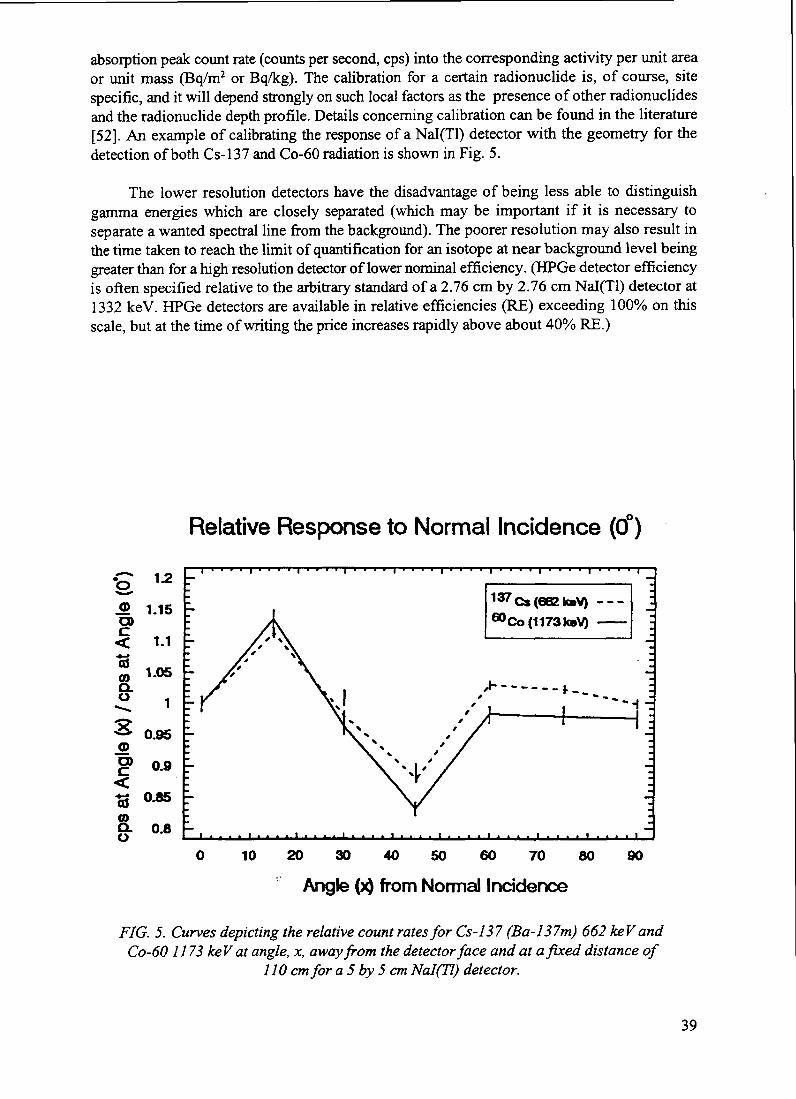
absorption peak count rate (counts per second, cps) into the corresponding activity per unit areaor unit mass (Bq/m2 or Bq/kg). The calibration for a certain radionuclide is, of course, sitespecific, and it will depend strongly on such local factors as the presence of other radionuclidesand the radionuclide depth profile. Details concerning calibration can be found in the literature[52]. An example of calibrating the response of a Nal(Tl) detector with the geometry for thedetection of both Cs-137 and Co-60 radiation is shown in Fig. 5.
The lower resolution detectors have the disadvantage of being less able to distinguishgamma energies which are closely separated (which may be important if it is necessary toseparate a wanted spectral line from the background). The poorer resolution may also result inthe time taken to reach the limit of quantification for an isotope at near background level beinggreater than for a high resolution detector of lower nominal efficiency. (HPGe detector efficiencyis often specified relative to the arbitrary standard of a 2.76 cm by 2.76 cm Nal(Tl) detector at1332 keV. HPGe detectors are available in relative efficiencies (RE) exceeding 100% on thisscale, but at the time of writing the price increases rapidly above about 40% RE.)
Relative Response to Normal Incidence (0°)
.® 1.15CD
1-1CO
8.u1.05
1
0.95
0.9
O0.8 -
137Cs(662k»V) ---
0 1 0 2 0 3 0 4 0 5 0 6 0 7 0 8 0 9 0
Angle ( from Normal Incidence
FIG. 5. Curves depicting the relative count rates for Cs-137 (Ba-137m) 662 keV andCo-60 1173 keV at angle, x, away from the detector face and at a fixed distance of
110 cm for a 5 by 5cm Nal(Tl) detector.
39

Plastic scintillators have also been used for counting applications, either coupled to aphotodiode or to a photomultiplier tube. These detectors have the advantage of being relativelyinexpensive and rugged, and they are available in almost any (arbitrary) size and shape. However,their energy resolution is very poor, and they should really be considered as contaminationmeters, rather than as spectrometers. Thin, large-area, plastic scintillators have been effectivelyused in the field screening of samples where the detector-to-sample geometry can be optimizedto give rapid results.
Both the Nal(Tl) and HPGe detectors must be connected to pulse-characteristic processingelectronics and data handling equipment. Nowadays, this will frequently comprise either discretenuclear interface modules (NIM) or a dedicated computer module, with a computer being usedfor data storage and analysis. For details of using a gamma ray spectrometer, the reader is referredto one of the standard texts on the subject, such as Refs [29, 53-55].
It is necessary to calibrate the detector for its efficiency for the range of energies over whichit is required to carry out measurements, as well as for the geometries which are to be used.
In those cases where in situ gamma spectrometry is contemplated as a measurement tool,it will be necessary to decide whether or not collimation is to be used. The relative advantagesof using an unshielded (uncollimated) or a collimated detector are summarized in Table IV.
TABLE IV. ADVANTAGES OF USING COLLIMATION WITH GAMMA SPECTROMETRY
Uncollimated detector Advantages
Disadvantages
Lighter, more portable, measurements on a flat site willcollect information from a larger area
Interpretation of data is more complex.Background radiation from nearby radioactive facilitiesmay give interferences. The distribution of activity maybe non-uniform — this may lead to a single hot spot inview of the detector, dominating the gamma ray fluxand yet not being properly quantified.
Collimated detector Advantages
Disadvantages
The area under examination by the detector can be well-defined. The interpretation of the data acquired may besimplified. The calibration procedure for the detectormay be simpler — it may be possible to approximate thegamma ray flux seen by the detector as beingunidirectional or even approximating that from a pointsource. Any calculations required to account forshielding and source distributions (e.g. depthdistributions in soil) may be more amenable tomathematical manipulation.
Heavier. Less portable. May need to account forshadowing effects in directions only partly screenedfrom the detector by the collimator.Care needs to be taken that the degree of shielding fromhot spots outside the field of view of the collimator isevaluated and sufficient. Care needs to be taken that thedetector can be inserted into the collimator in areproducible manner.
40

Whether or not a collimator is used, it is necessary to make an assumption about thedistribution of the radioactivity. Often, the assumption will be that the activity is uniformlydistributed across a surface (or is homogenous on the scale of length "seen" by the detector), witha known depth profile (usually determined separately by coring). The source distribution is oftenapproximated as being distributed as an exponentially decreasing level of activity with depth, asa surface source, or as a uniform distribution. The assumption of a uniform distribution may beparticularly useful if an approximate estimation of the specific activity (Bq/g or Bq/m3) of anextended source is required. Care must be taken if the assumption is of a surface source, since thetheoretical gamma flux from an infinite planar source would be limited only by the shieldingafforded by passage through air. In practice, mixing of the source with the surface of the site orsmall undulations in the surface will greatly reduce the flux measured by the detector incomparison with a theoretical estimate.
A typical collimator used for these purposes would be a hollow lead cylinder of wallthickness 5-10 cm, which fits over the detector end-cap, extending forwards sufficiently to definethe required angle of view and backwards sufficiently to shield the rear of the active detectorvolume.
hi some circumstances, it might be useful to measure the radiation reaching the detector insitu by other than directly through the collimator aperture in order to evaluate how much of thedetected radiation may be coming from the ground beneath the detector. This can be done byacquiring a spectrum with a plugged collimator (e.g. with a substantial lead plug inserted intothe front of the collimator).
5.2.4.3. Alpha spectrometers
Alpha spectrometry is usually performed in the laboratory using a semiconductor charged-particle detector which is situated in a vacuum chamber. The inherent resolution of the alphadetector is likely to be of the order of 50 keV, but this is frequently limited in practice by energyloss in the source. Alpha particles have very high linear energy transfer (LET) values and so willlose a large fraction of their energy in traversing a few \i of sample matrix or a few mm of air.Sample preparation is critical for alpha spectrometry [56], and it often involves an elementalseparation followed by electroplating onto a sample carrier.
5.2.4.4. Beta spectrometers
Beta spectrometry is usually carried out in the laboratory using a liquid scintillation counter(LSC) [57]. This method involves the dissolution or dispersal of a prepared aliquot of sample ina liquid scintillation "cocktail" which is then counted on a dedicated photomultiplier, usuallyincorporating a system for counting a series of samples on a carousel or similar device. The poorresolution of this system, coupled with the continuum nature of beta energies emitted byradionuclides, means that it is common to separate each element radiochemically beforeattempting to count it. LSC devices can also be used for alpha counting even in the presence ofbeta emitters, since the alpha emitter will be emitting particles at discrete energies in the 6-7MeV range, well above the highest energy of the beta emitters in the sample.
41

5.3. ERRORS AND UNCERTAINTIES IN RESULTS
A detailed consideration of the treatment of errors and uncertainties is beyond the scope ofthis publication . However, when radiometric measurements are made, it is always important tomaintain an awareness of uncertainties in the data and to take appropriate precautions so that thedata which are obtained are adequate for their intended purpose. In this regard, pre-measurementconsideration of the data quality objectives may be especially important.
5.3.1. Counting statistics
When counting samples, three limits of uncertainty are commonly quoted [58]. There ismuch confusion as to the meaning of these limits. The limit of confidence (also known as limitof decision) is defined as the amount of a radionuclide that would be need to be detected by ameasurement in order to be confident that the identification is genuine. The limit of detection isthe amount of radionuclide that one can be confident would be detected by a measurement. Thelimit of quantification (also known as limit of determination, and often referred to as minimumdetectable activity (MDA)) is the amount of radionuclide that will have to be present in order tobe confident that a measurement is adequate. Whenever quoting results and uncertainties ofcounting measurements on low-activity samples, it is important to assure that one has specifiedand adhered to a consistent standard of reporting.
Before making a radiometric determination, it will be necessary to decide what sensitivity(limit of detection or limit of quantification) is required and to design the measurement such thatthis can be achieved. Failure to do so may result hi having to repeat the measurement or indrawing an unwarranted conclusion that a particular isotope is not present.
If a given radioisotope is present in sufficient quantity, it may be possible to terminate themeasurement early once the results have reached the desired statistical accuracy. An adaptiveapproach here can save much effort and time. Care should be taken that an overly conservativemeasurement (i.e. with an overly low level of uncertainty) is not required. In many cases, theoverall uncertainty in a radiation measurement result will be dominated by factors other thancounting statistics (in particular, there is the large variability which is inherent in sampling).
5.3.2. Other sources of uncertainty
Counting errors are often not the limiting factor in the repeatability or accuracy of results.Whenever samples are taken from a heterogenous medium such as soil, there will usually be alarge sample to sample variation. In general, the larger the sample size taken, the morestatistically valid will be the result. Where gamma spectrometry is being undertaken, the use ofa Marinelli beaker which surrounds the sensitive volume of the detector will give an optimumgeometry in terms of sensitivity and in terms of maximizing the sample size. If this approach istaken, care should be taken that: 1) true coincidence summing does not adversely affect the resultsat a significant level and 2) the range of gamma rays in the sample medium is not much less thanthe thickness of the sample (otherwise, the detector will be sensitive to a much smaller volumeof sample than might have been believed). The latter effect will be compensated adequately if thecalibration standard used is similar in density to the sample density.
42

5.4. ADDITIONAL ASPECTS TO BE CONSIDERED
There are a number of aspects which impact on site operations during characterization orremediation which may need to be considered. Most of these fall outside the scope of thispublication but are worthy of mention.
5.4.1. Hazardous materials
When measuring samples there should be an awareness that there may be non-radiologicalcontaminants present. Samples gathered for radiological purposes may also be suitable for assayof non-radioactive hazardous materials, in which case there may be special requirements forsample handling and storage. Conversely, samples gathered for non-radiological purposes maybe suitable for radiometric investigations; even if the sample is required to be maintained intact,a non-destructive gamma spectrometry measurement may be possible.
Hazardous materials may also impact on how samples gathered for radiometric purposesare handled. There may be health and safety implications, if the material is hazardous, and caremay be necessary to ensure that radiochemical assays are not affected..
There may also be waste and regulatory considerations if hazardous materials are present.Mixed hazardous wastes may be considerably harder or more expensive to dispose of than wastescontaining only radiological or common chemical contaminants.
5.4.2. Safety of workers
Although beyond the scope of this publication, there should be an awareness of health andsafety considerations for workers during characterization (or remediation) operations. Issues tobe addressed involve safety of workers, control of contamination and control of radiationexposure. A balance should be reached between the risk of injury to workers during siteengineering operations and the overall risk of the hazard being treated.
5.4.3. Waste characterization and assay
Where waste is being generated, there is likely to be a requirement to characterize it andassay it. It is likely that measurements made for site characterization purposes will be relevantto waste characterization, if only in determining the isotopes that are present. During the sitecharacterization process, it may be worth considering whether a small extension to theprogramme can prevent duplication of effort in the waste characterization programme. What isnecessary for waste characterization and assay will depend on the regulatory regime and furtherconsiderations in this publication are inappropriate.
5.5. SUMMARY OF METHODOLOGIES AND TECHNIQUES FORCHARACTERIZATION
The foregoing subsections have mentioned a number of techniques which may be of useduring a site characterization. The methods and instruments actually deployed will depend notonly on the nature of the site, but also on other constraints of availability of trained staff andbudgetary restrictions. If time or effort restrictions are not a problem, then the most appropriatemethods may be to use relatively simple instrumentation or to carry out a large number of sample
43

analyses. On the other hand, in situations where trained staff are expensive to deploy, a moreautomated solution may be more appropriate if it enables the job to be completed moreeconomically.
Many field monitoring tasks can be carried out using simple hand-held instruments. Thedifficulty with use of these instruments is often that a long integration time is necessary in orderto establish an accurate reading when measurements are required at environmental levels. It isoften quicker to utilize an energy specific instrument such as a high resolution spectrometer.However, if time and effort are available, acceptable results may be achievable using a simpledose rate meter. Determination of the position of the measurement may equally well be achievedby use of an expensive GPS receiver, enabling the spectrometer operator to operate single-handedly in the field, or a more labour intensive traditional survey method may be used to giveequally valid results.
The methods used in characterization of sites contaminated by radioactive materials arerapidly developing. The future is likely to see the development of more rugged spectrometerswith higher efficiencies, and the availability of integrated counting and positioning equipment.There is much scope for the improvement of room temperature semiconductor detectors.
Techniques for invasive sampling and probing are likely to improve with the developmentof guidable drilling and coring equipment. There is much further work to be done on non-invasivegeophysical techniques for the visualization of below ground structures.
In the field of environmental chemistry, there is still much to learn about the binding andmigrational behaviour of radionuclides which will help greatly in assessment of the consequencesof soil, rock, and groundwater contamination. The use of bioindicators is still at a very earlystage, and there is also much potential for development of bioremediation technologies.
6. SUMMARY AND CONCLUSIONS
Sites contaminated with radioactive material occur in many places on a scale ranging fromthe very small (e.g. localized; individual building or structure) to national or multinationalproportions. Some of these sites may be straightforward to deal with, but often a complex set ofinterrelated factors will need to be addressed including technical, economic, social, political,legal, and ethical issues.
Characterization methodologies will be required at more than one stage when a remediationis being undertaken. At each stage of remediation, from pre-remedial evaluation through to post-remedial verification, some characterization work is likely to be required.
If the costs of characterization are to be kept under control, it is strongly recommended thata planned approach be taken with clear objectives in mind, as well as consideration being givento whether the immediate objectives can be tailored to assist with the likely requirements of futurestages of the overall project. In this context, costs may be regarded in the broadest sense ofincluding such items as future use of the site plus human and environmental impacts.
It is equally important in controlling the costs of a project that a flexible approach be takenso that the programme of measurements can be modified in response to results as they areobtained.
44

The methodologies which may be deployed during a characterization study may utilize notonly the obvious radiological methods but also a wide range of technologies from the fields ofearth science, biology and chemistry. In many cases, the technologies used are identical to thoseused in conventional pollution and contaminated site studies, where there is a large body ofexpertise to be consulted.
The methods adopted during any study will depend not only on the technical nature of theproblem but also on the constraints of cost and availability of trained staff. In many cases, as gooda result will be possible using relatively simple equipment in an appropriate but labour-intensivemanner, as may be obtained through a technologically sophisticated approach which may enableeconomies in labour costs.
There are many techniques, instruments, and methods being developed which will affectthe way in which characterization work is carried out in the future. These trends anddevelopments include:
- Improved methods for measurement of alpha and beta emitters;
More rapid methods for radiochemical analysis;
Improved detector technology, including more efficient detectors, more rugged detectors,the development of room temperature semiconductors;
Use of bioindicators;
- Improved access technology, such as guideable sampling and boring equipment;
More use of field measurements through miniaturization of equipment formerly consideredas laboratory based, providing rapid availability of results enabling flexibility in planningof work.
There is a need for greater awareness, adoption of new or improved techniques andmethodologies, and training in characterization issues. Also needed is a more effective transferof technologies and training to developing countries and a propagation of methods to reduce thecosts of characterization.
NEXT PAGE(S) Ileft BLANK I
i n i . i i l l 4 5

REFERENCES
[ 1 ] INTERNATIONAL ATOMIC ENERGY AGENCY, Important Factors to Be Consideredin Formulating a Strategy for Environmental Restoration, IAEA, Vienna (in preparation).
[2] INTERNATIONAL ATOMIC ENERGY Agency, Technologies for Remediation ofRadioactively Contaminated Sites, IAEA, Vienna (in preparation).
[3] INTERNATIONAL ATOMIC ENERGY AGENCY, Technical Options for the Cleanupof Radioactively Contaminated Groundwater, IAEA, Vienna (in preparation).
[4] INTERNATIONAL ATOMIC ENERGY AGENCY, Post-remediation Monitoring ofDecommissioned Sites to Ensure Compliance with Clean-up Criteria, IAEA, Vienna (inpreparation).
[5] INTERNATIONAL ATOMIC ENERGY AGENCY, Cleanup of Large AreasContaminated as a Result of a Nuclear Accident, Technical Reports Series No. 300, IAEA,Vienna (1989).
[6] INTERNATIONAL ATOMIC ENERGY AGENCY, Planning for Cleanup of LargeAreas Contaminated as a Result of a Nuclear Accident, Technical Reports Series No. 327,IAEA, Vienna (1991).
[7] INTERNATIONAL ATOMIC ENERGY AGENCY, Disposal of Waste from the Cleanupof Large Areas Contaminated as a Result of a Nuclear Accident, Technical Reports SeriesNo. 330, IAEA, Vienna (1992).
[8] INTERNATIONAL ATOMIC ENERGY AGENCY, Derived Intervention Levels forApplication in Controlling Radiation Doses to the Public in the Event of a NuclearAccident or Radiological Emergency: Principles, Procedures and Data, Safety Series No.81, IAEA, Vienna (1986).
[9] INTERNATIONAL ATOMIC ENERGY AGENCY, Principles and Techniques for Post-accident Assessment and Recovery in a Contaminated Environment of a Nuclear Facility,Safety Series No. 97, IAEA, Vienna (1989).
[ 10] INTERNATIONAL ATOMIC ENERGY AGENCY, Response to a Radioactive MaterialsRelease Having a Transboundary Impact, Safety Series No. 94, IAEA, Vienna (1989).
[11] INTERNATIONAL ATOMIC ENERGY AGENCY, Recovery Operations in the Event ofa Nuclear Accident or Radiological Emergency, Proceedings Series, IAEA, Vienna (1990).
[ 12] INTERNATIONAL ATOMIC ENERGY AGENCY, Techniques and Decision Making inthe Assessment of Off-Site Consequences of an Accident in a Nuclear Facility, SafetySeries No. 86, IAEA, Vienna (1987).
[13] EUROPEAN COMMISSION, Remediation and restoration of radioactive-contaminatedsites in Europe, (Proc. International Symp. Antwerp, 11-15 October 1993), Doc. XI-5027/94, European Commission (1994).
[14] INTERNATIONAL ATOMIC ENERGY AGENCY, Planning for EnvironmentalRestoration of Radioactively Contaminated Sites in Central and Eastern Europe, IAEA-TECDOC-865, Volumes 1-3, IAEA, Vienna (1996).
[15] EUROPEAN COMMISSION, Deposition of Radionuclides, Their Subsequent Relocationin the Environment and Resulting Implications, EUR 16604 EN, Luxembourg (1995).
[16] ROED, J., et al., Decontamination in a Russian settlement, Rep. Riso-R-870 (EN), RisoNational Laboratory, Roskilde (1996).
[ 17] NORDIC COUNCIL OF Ministers, Cleanup of Large Radioactive-contaminated Areas andDisposal of Generated Wastes, Final Report of the KAN2 Project, TemaNord 1994:567,NCM, Copenhagen (1994).
47

[18] UNITED STATES DEPARTMENT OF ENERGY, Characterization, Monitoring andSensor Technology Crosscutting Program, Technology Summary, USDOE Rep. DOE/EM-0298, Washington, DC (1996).
[19] INTERNATIONAL COMMISSION ON RADIOLOGICAL PROTECTION, 1990Recommendation of the International Commission on Radiological Protection, ICRPPublication 60, Vol. 21, No. 1-3, Annals of the ICRP, Pergamon Press, Oxford (1990).
[20] INTERNATIONAL ATOMIC ENERGY AGENCY, Application of radiation protectionprinciples to the cleanup of contaminated sites (hi preparation).
[21 ] INTERNATIONAL ATOMIC ENERGY AGENCY, International Basic Safety Standardsfor Protection Against Ionizing Radiation and for the Safety of Radiation Sources, SafetySeries No. 115, IAEA, Vienna (1982).
[22] INTERNATIONAL ATOMIC ENERGY AGENCY, Application of Exemption Principlesto the Recycle and Reuse of Materials from Nuclear Facilities, Safety Series No. 111-P-l. 1,IAEA, Vienna (1992).
[23] INTERNATIONAL ATOMIC ENERGY AGENCY, Generic Models and Parameters forAssessing the Environmental Transfer of Radionuclides from Routine Releases: Exposuresof Critical Groups, Safety Series No.57, IAEA, Vienna (1982).
[24] SMMONDS, J.R., LAWSON, G, MAYALL, A., Radiation Protection: Methodology forAssessing the Radiological Consequences of Routine Releases of Radionuclides to theEnvironment, European Commission (1995).
[25] INTERNATIONAL ATOMIC ENERGY AGENCY, Handbook of Parameter Values forthe Prediction of Radionuclide Transfer in Temperate Environments, Technical ReportsSeries No.364, IAEA, Vienna (1994).
[26] INTERNATIONAL ATOMIC ENERGY AGENCY, Evaluation the Reliability ofPredictions Made Using Environmental Transfer Models, Safety Series No. 100, IAEA,Vienna (1989).
[27] INTERNATIONAL ATOMIC ENERGY AGENCY, Planning for EnvironmentalRestoration of Radioactively Contaminated Sites in Central and Eastern Europe, Vol. 1:Identification and Characterization of Contaminated Sites, IAEA-TECDOC-865, Vienna(1996).
[28] UNITED STATES NUCLEAR REGULATORY COMMISSION, a NonparametricStatistical Methodology for the Design and Analysis of Final Status DecommissioningSurveys: Draft Report for Comment, Rep. NUREG-1505, Washington, DC (1995).
[29] MILLER, K.M., SHEBELL, P., In Situ Gamma-ray Spectrometry — a Tutorial forEnvironmental Radiation Scientists, Rep. EML-557, US Department of EnergyEnvironmental Measurements Laboratory, New York, NY (1993).
[30] BECK, H.J., DECAMPO, J., GOGOLAK, in Situ Ge(li) and Nai(tl) Gamma-raySpectrometry, Rep. HASL-195, US Health and Safety Laboratory, NY (1972).
[31] SHEBELL, P., HUTTER, A.R., Environmental Radiation Measurements at the FormerSoviet Union's Semipalatinsk Nuclear Test Site and Surrounding Villages, Rep.KAZ/9/002-02 to the mission leader, IAEA, Vienna (1995).
[32] LATNER, N., et al.s SPICER: a sensitive radiation survey instrument, Health Phys. 58(1983) 133-142.
[33] BECK, H.L., Environmental gamma radiation from deposited fission products, 1960-1964,Health Phys. 58 (1966) 313-322.
[34] KORUN, M., et al., In-situ measurement of Cs distribution in soil, Nucl. Instr. MethodsPhys. Res. B93 (1994) 485^91.
48

[35] MACDONALD, J., et al, A theoretical comparison of methods of quantification ofradioactive contamination in soil using in situ gamma spectrometry, J. Radiol. Prot. 17 1(1997)3-15.
[36] MILLER, K.M., SHEBELL, P., KLEMIC, G.A., In situ gamma-ray spectrometry for themeasurement of uranium in surface soil, Health Phys. 67 (1994) 140-150.
[37] REIMAN, R.T., Mobile in situ gamma-ray spectroscopy system, Trans. Am. Nucl. Soc.70:47(1994).
[38] SCHILK, A.J., et al., Real-time in situ detection of Sr-90 and U-235 in soils viascintillation fiber technology, Nucl. Instr. Methods A 353 (1994) 477-481.
[39] MILLER, K.M., Large area proportional counter for in situ transuranic measurements,Trans. Am. Nucl. Soc. 70 (1994) 47^8.
[40] UNITED STATES DEPARTMENT OF ENERGY, Contaminant Plumes Containment andRemediation Focus Area, Technol. Summary, US DOE/EM-0248, Washington, DC (1995).
[41] BECK, H.J., KREY, P.W., Cesium-137 Inventories in Undisturbed Utah Soils — InterimReport on Radionuclides in Soils of Populated Areas, US DOE Rep. EML-375 (1980).
[42] CfflECO, N.A., (Ed.), EML Procedures Manual, Rep. HASL-300,27th ed., US Departmentof Energy Environmental Measurements Laboratory, New York, NY (1992).
[43] BUDNITZ, R.J., et al., Instrumentation for Environmental Monitoring; Volume 1,Radiation, J. Wiley & Sons, New York, New York (1983).
[44] GEARY, W., Radiochemical Methods, J. Wiley & Sons, New York, NY (1986).[45] INTERNATIONAL ATOMIC ENERGY AGENCY, Measurement of Radionuclides in
Food and the Environment: A Guidebook, Technical Reports Series No. 295, IAEA,Vienna (1989).
[46] INTERNATIONAL ATOMIC ENERGY Agency, Reference Methods for MarineRadioactivity Studies, Technical Reports Series No. 118, IAEA, Vienna (1970).
[47] JIANG, S.J., HOUK, R.S., Elemental and isotopic analysis of powders by inductivelycoupled mass spectrometry with arc nebulisation, Spectrochimica Acta 42B (1987)93-100.
[48] WILLIAMS, J.G., et al., Feasibility of Solid Sample introduction by slurry nebulisation forinductively coupled plasma mass spectrometry, J. Anal. At. Spectrom. 2 (1987) 469-472.
[49] THOMPSON, M, WALSH, J.N., Handbook of Inductively Coupled Plasma Spectrometry,Blackie & Sons Ltd. (1989).
[50] DATE, A.R., GRAY, A.L., Applications of Inductively Coupled Plasma MassSpectrometry, Blackie & Sons Ltd. (1989).
[51] JENKTNS, R.. Practical X-ray Spectrometry, MacMillan, London and New York (1970).[52] INTERNATIONAL COMMISSION ON RADIATION UNITS AND MEASUREMENTS,
Gamma-ray Spectrometry in the Environment, Rep. ICRU-53, ICRU, Maryland (1995).[53] GILMORE, G., HEMINGWAY, J., Practical Gamma Ray Spectrometry, Wiley, New
York (1995).[54] DEBERTIN, K., HELMER, R., Gamma and X-ray Spectrometry with Semiconductor
Detectors, North-Holland, Amsterdam (1988).[55] KNOLL, G.F., Radiation Detection and Measurement, Wiley, New York (1989).[56] MOSS, W.D., GAUTIER, M.A., Bioassay alpha spectrometry: energy resolution as a
function of sample source preparation and counting geometry, Health Phys. 56 1 (1989)71-77 .
[57] PASSO, C.J., COOK, G.T., Handbook of environmental liquid scintillation spectrometry,Canberra Packard.
[58] CURRY, L.A., Limits for qualitative detection and quantitative determination: applicationto radiochemistry, Anal. Chem. 40 3 (1968) 586.
I &EXT P . ._fl ieft PLANK I 49

Appendix I
SELECTED METHODOLOGIES FOR REDUCINGSITE CHARACTERIZATION COSTS
Several methodologies are being employed to reduce the costs of site characterizationWhile differing in details, these methodologies have some common features:
Decision making processes that affect sampling are determined before going to the field,but actual sampling decisions of "where" and "how many" are made in the field in "realtime" by experts on the basis of evolving sampling results (such sampling and analysisplans are known as "dynamic" or "flexible" sampling plans).
- Regulator approval for the "science-based" approach over the traditional step-by-stepapproach in which regulators approve each phase of sampling before it is undertaken.
- Use of a suite of non-invasive and minimally-invasive technologies and field screeningsupported, when possible, by high quality on-site sample analysis with smaller amounts ofverification sample analysis in off-site laboratories.
- Technology for efficient management, visualization, and interpretation of data to facilitateon-site, "real time" decision making.
Summaries of the individual methodologies are given below.
A. Observational approach
The observational approach draws on tenets of geotechnical engineering in which it isaccepted that the subsurface environment can never be reasonably sampled enough to create aconceptual model that contains no uncertainty. Geotechnical engineering deals with thisuncertainty by designing subsurface building structures based on the "nominal" conditions andpreparing contingency plans to handle the uncertainties should they be encountered inconstruction.
The application of this approach to remediation of contaminated site stresses acceleratingcharacterization to determine only the nominal conditions needed for design of a specificremediation system and providing remedial contingency designs to be employed should nominalconditions not pertain. Applications of the observational approach have been made to bothradiological and non-radiological contamination problems [1.1-1.3].
B. Streamlined approach for environmental restoration (SAFER)
The US Department of Energy created the so-called SAFER approach (streamlinedapproach for environmental restoration) which combined the bias for implementing remediationwith accelerated characterization that relies heavily on the Data Quality Objective (DQO)approach. The results of applications [1.4,1.5] have been faster and less costly characterization(and potentially smaller total remediation costs).
51

C. Expedited site characterization (ESC)
Expedited site characterization (ESC) stresses taking a multi-disciplinary team of technicalexperts to the field to minimize the number of phases of characterization. The team members arevery well versed in the site history, have an initial conceptual model of the site environment, areequipped with a suite of non-invasive and invasive technologies, and are prepared to carry outa dynamic sampling effort that may be adjusted daily as sampling results become available.
ESC has been particularly effective in accelerating and improving the characterization ofthe subsurface environment in cases of groundwater contamination. An appropriate combinationof geological, geophysical, hydrogeological, and geochemical investigations is bought to bearconcurrently as the study identifies and focuses on critical parameters [I.6-I.10].
D. Adaptive sampling and analysis
Adaptive sampling and analysis (or, as sometimes referred to as ASAP, for "adaptivesampling and analysis programme") exploits the opportunity for in- the-field decision makingwhen field analytical and screening instrumentation can provide rapid results regardingcontamination levels. The decision-making regarding sample location and number is facilitatedby a decision support system [I.I 1] that uses the results of radiological or chemical analyses andother site information to estimate the extent of contamination. It also calculates the level ofuncertainty associated with the estimate of extent. The system provides visualization of the data,contamination extent, and uncertainty. Just as important, it indicates where the next samplingshould occur to have the greatest impact on reducing the uncertainty in the estimate of the extentof contamination. The system successively updates the prediction of new sampling locations aftereach set of new data is gathered and the estimate of contamination is refined.
In several cases of soil contamination, rapid rounds of iterative sampling guided by theadaptive sampling and analysis system have resulted in delineation of contamination with costsas low as 25-40% of the originally predicted sampling and analysis costs for a traditionaluniform-grid sampling programme [1.12-1.16].
REFERENCES TO APPENDIX I
[I.I] WALLACE, W.A., LINCOLN, D.R., "How scientists make decisions about ground waterand soil remediation," in Proc. National Research Council Water Science and TechnologyBoard Colloquium, Washington, DC, April 20-21 1989 (151-165).
[1.2] SMYTH, J.D., AMAYA, J.P., PEFFERS, M., Observational approach implementationat DOE facilities, Federal Facilities Environmental Journal 3 (Autumn) (1992) 345-355.
[1.3] BELCHER, D.M., SICHELSTffiL, K.D., Case study: the observation approach and fast-track remediation at NSB Kings Bay, Federal Facilities Environmental Journal 6(Summer) (1995) 77-90.
[1.4] GIANTI, S., et al., The streamlined approach for environmental restoration", WasteManagement '93 (Proc. Conf. Tucson, 1993), 585-587.
[1.5] BOTTRELL, D.W., DAILEY, R.L., BITNER, K.A., Implementing DOE's streamlinedapproach for environmental restoration (SAFER), Federal Facilities EnvironmentalJournal 6 (Spring) (1995) 67-77.
52

[1.6] BURTON, J.C., "Prioritization to limit sampling and drilling in site investigations" (Proc.Federal Environmental Restoration Conf. & Exhibition, Vienna, VA, 1994) 242-251.
[1.7] BURTON, J.C., "Expedited site characterization for remedial investigations at federalfacilities," (Proc. Federal Environmental Restoration Conf. & Exhibition, Vienna, VA,1994).
[1.8] AGGARWAL, P.K., BURTON, J.C., ROSE, C.M., "Characterization of aquiferrelationships by using geochemical techniques for plume delineation" (Proc. FederalEnvironmental Restoration Conf. & Exhibition, Vienna, VA, 1994).
[1.9] BURTON, J.C., et al., "Expedited site characterization: a rapid, cost-effective process forpreremedial site characterization" (Proc. SUPERFUND XIV Conf. & Exhibition), Vol.II, Hazardous Materials Control Resources Institute, Rockville, MD (1994) 809-826.
[1.10] BURTON, J.C., et al., "Argonne's expedited site characterization: an integrated approachto cost- and time-effective remedial investigation" (Proc. Air and Waste ManagementAssociation 88th Ann. Mtg San Antonio) (1995).
[1.11] JOHNSON, R.L. "A Bayesian approach to contaminant plume delineation" (Proc 1993Ground Water Modeling Conf. 1993), Colorado School of Mines, Golden, CO (1993)P-87-P-95.
[1.12] JOHNSON, R.L., "Adaptive sampling program support for expedited sitecharacterization", Meeting the Challenge (Proc. ER '93 Environmental RemediationConf. Augusta, GA, 1993) 781-787.
[1.13] JOHNSON, R.L., Adaptive Sampling Strategy Support for the Unlined Chromic Acid Pit,Chemical Waste Landfill, Sandia National Laboratories, Albuquerque, New Mexico,Argonne National Laboratory Rep. ANL/EAD/TM-2 (1993).
[1.14] JOHNSON, R.L., Extent of Chromium Contamination Beneath the 60s Pits in theChemical Waste Landfill at Sandia National Laboratories, Albuquerque, New Mexico,Argonne National Laboratory Rep. ANL/EAD/TM-19 (1994).
[1.15] ROBBAT, A. Jr., JOHNSON, R., Adaptive Sampling and Analysis Programs for SoilsContaminated with Explosives, Case Study: Joliet Army Ammunition Plant, US ArmyEnvironmental Center, Environmental Technology Division (1996).
[1.16] JOHNSON, R.L., a Bayesian/geostatistical Approach to the Design of Adaptive SamplingPrograms, Geostatistics for Environmental and Geotechnical Applications, Rep. ASTMSTP 1283 (SRTVASTAVA, R. MOHAN, et al., Eds), American Society for Testing andMaterials, Philadelphia (1996).
53

Appendix II
CONSIDERATION OF RADIONUCLIDE ENVIRONMENTAL TRANSPORT
For a more detailed understanding of the behaviour of radioactive contamination in thenature, it is necessary to have good knowledge of the various environmental conditionsinfluencing the fate of radionuclides in the biosphere, as well as of processes governing theradionuclide transport in the environment. In addition, information on human population as apotential receptor of radioactive contamination should also be known. This Appendix providesthe relevant information in this context.
ILL ADDITIONAL INVESTIGATIONS TO SUPPORT SITE CHARACTERIZATION
Geomorphology/topography
The geomorphologic investigation is conducted to develop an understanding of surficialfeatures which influence the terrain stability and consequentially the integrity of the contaminatedsite itself. Namely, a series of slope processes like erosion (including landsliding, colluvial, andproluvial processes) may seriously threaten the contaminated site and promote the spread ofcontamination from the site into the environment.
Most of the data will be included in the site description. Information on the naturaltopography and man-made changes can be useful in this context.
Climatology/meteorology
Both the climate at a site and the particular weather conditions at the time of a release ofradioactivity can be important determinants for the movement of radioactivity.
Meteorological parameters may determine air concentrations and deposition of airbornecontamination on the ground and influence the soil-water balance. Statistical data on the climatewill give information on likelihood of flooding, resuspension by wind erosion, risk of fire, andprobability of relocation of contamination by melting snow.
In the case of airborne contamination, exact information, or even informed estimates aboutwind directions and speeds, at various heights at the time can assist greatly in finding the resultingcontamination plumes. Depending on the settling time of the material released, the weatherpatterns on a local, regional or global scale may be important. Precipitation can greatly alter thepattern of deposition of airborne contamination. Other meteorological parameters, such as thepresence of temperature inversions or turbulence, can affect the vertical mixing of the radioactivedispersion or cloud.
The longer term climate of a contaminated area will influence the movement ofradioactivity into and across the ground. Maximum wind speeds will determine re-suspension ofdusts and will therefore affect off-site migration and become a factor in dose assessment. Theprevailing wind direction will affect which populations are exposed. The rainfall patterns willaffect likely future land use and influence off-site migration. Extreme weather conditions mayalso affect their choice of characterization techniques that can be used.
54
The climate can influence the choice of measuring instruments (watertightnessrequirements; exposure to low or high temperatures; etc.), and the humidity and air pressure mayinfluence some measurements. Parameters generally included are: temperature, precipitation,wind speed and direction, atmospheric stability, humidity conditions, and air (atmospheric)pressure.
Geology/geophysics
The geologic investigation is conducted to develop an understanding of the subsurfaceenvironment in which the radionuclides may be present. The geology may strongly control thebehaviour of the radionuclides, and hence risk assessment and remediation design. Informationgenerally to be collected during a geologic investigation are sought from the following areas, suchas stratigraphy, lithology, mineralogy, geotechnics and geochemistry, and tectonics andseismicity.
Near surface sediments and features can be further characterized through the utilization ofintrusive and non intrusive geophysical techniques. The acquisition of geophysical data can helpto build up a stratigraphic and structural picture of the underlying strata, and therefore tie ininformation between known geological control points.
Because geophysical techniques are often able to access difficult terrain and can producedata values relatively quickly, such techniques provide a relatively inexpensive way of acquiringdata.
Geophysical surveys need to be very carefully planned, with the correct technique andassociated methodology selected for the very specific problems of a given site. It will often beimportant to combine a number of techniques in order to build up an accurate picture of theunderlying problem or feature. Examples of the effectiveness of multiple approaches isdemonstrated in Ref. [II. 1].
A detailed discussion of the various geophysical techniques is beyond the scope of thispublication, but examples of their application and limitation are highlighted in Table ELI.
Hydrogeology
Hydrogeological data are important because they describe conditions above (the vadosezone) and below the water table (the saturated zone). They can also be used to predict futureconcentrations and movement of the contaminants. Long-term monitoring of the contaminationprofile and groundwater conditions may be needed for a full understanding of the hydrogeologicalregime and its likely relevance to, and influence on, any remediation strategy. Parameters whichmay collected during such an investigation encompass: hydraulic head, flow direction andvelocity, recharge/discharge points, hydraulic conductivity, hydrostratigraphy(aquifers/aquitards), and aquifer age and water properties (e.g. pH, conductivity, temperature).
Measurements of these parameters could prove to be expensive tasks. This is because therewill often be requirements for involving drilling, placement of piezometers, pumping tests, andtracer tests. However, such studies may be necessary to understand local transport pathways.Long-term monitoring of groundwater flow and contaminant transport and model development
55
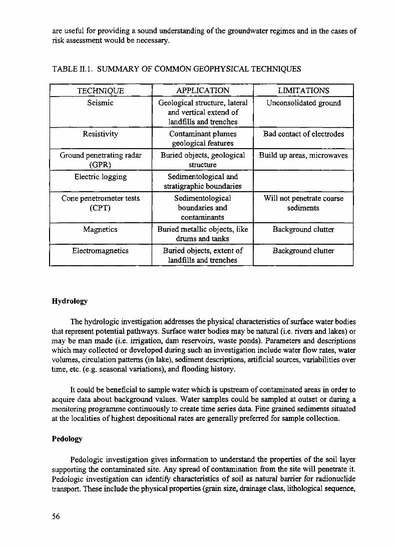
are useful for providing a sound understanding of the groundwater regimes and in the cases ofrisk assessment would be necessary.
TABLE II. 1. SUMMARY OF COMMON GEOPHYSICAL TECHNIQUES
TECHNIQUESeismic
Resistivity
Ground penetrating radar(GPR)
Electric logging
Cone penetrometer tests(CPT)
Magnetics
Electromagnetics
APPLICATIONGeological structure, lateral
and vertical extend oflandfills and trenchesContaminant plumesgeological features
Buried objects, geologicalstructure
Sedimentological andstratigraphic boundaries
Sedimentologicalboundaries andcontaminants
Buried metallic objects, likedrums and tanks
Buried objects, extent oflandfills and trenches
LIMITATIONSUnconsolidated ground
Bad contact of electrodes
Build up areas, microwaves
Will not penetrate coarsesediments
Background clutter
Background clutter
Hydrology
The hydrologic investigation addresses the physical characteristics of surface water bodiesthat represent potential pathways. Surface water bodies may be natural (i.e. rivers and lakes) ormay be man made (i.e. irrigation, dam reservoirs, waste ponds). Parameters and descriptionswhich may collected or developed during such an investigation include water flow rates, watervolumes, circulation patterns (in lake), sediment descriptions, artificial sources, variabilities overtime, etc. (e.g. seasonal variations), and flooding history.
It could be beneficial to sample water which is upstream of contaminated areas in order toacquire data about background values. Water samples could be sampled at outset or during amonitoring programme continuously to create time series data. Fine grained sediments situatedat the localities of highest depositional rates are generally preferred for sample collection.
Pedology
Pedologic investigation gives information to understand the properties of the soil layersupporting the contaminated site. Any spread of contamination from the site will penetrate it.Pedologic investigation can identify characteristics of soil as natural barrier for radionuclidetransport. These include the physical properties (grain size, drainage class, lithological sequence,
56

permeability, porosity, density, water content); and geochemical properties (leachability, leachatequality, elemental composition of the soil, pH, Kj).
II.2. POPULATION PARAMETERS
Demographic investigation
One of the objectives of the characterization is to give the inputs for dose assessment andto enable choices of remediation for dose reduction to people. The demographic investigation willalso be used in the determination of a critical group. In order to pursue these objectives, it isuseful to know the geographical distribution of people living in the vicinity of the suspected sitenow, and perhaps in the future. In addition, it is recommended to collect the followinginformation:
geographical distribution of settlements;population density; and
- habits (e.g. consumption, leisure, spatial mobility, workplace routine).
Land use investigation
The use of the land is of consideration for dose assessment and for cleanup levels. Thepresent land use and decisions on the future destination of the land may influence the degree ofdetail needed in the characterization.
In the future, the land may be used for agricultural, industrial, residential or recreationalpurposes. It may be decided that no detailed characterization would be required if the present orplanned land use imposes no unacceptable risk for the population. However one should keep inmind that it is very difficult to be sure that the land-use will not change in the future. Forexample, sediments lying on the riverbanks may not represent an immediate danger, but couldbe used in the future as fertilizer, spreading the contamination. The economical aspects of the useof the land are an element in the evaluation of remediation strategies.
Water use investigation
The purpose of this investigation is to identify the use of water which may be impacted bythe potentially contaminated site. It should be determined whether certain water quality may beimpacted by a contaminated site, and therefore, certain institutional constraints should be placedon its use (i.e. use of bottled water for drinking). The inventory should include location ofgroundwater drinking wells, location of seeps and springs; and nature of water use at present andin the future (i.e. agricultural, industrial, drinking, recreational, medicinal, etc.).
Intrusion hazard
In some cases where the contamination is well-contained and the option of no action isconsidered, an investigation of the intrusion hazard may be undertaken. This investigation intothe future intrusion into the contamination may include description of natural barriers, descriptionof man-made barriers, and possibility to add barriers (e.g. geological stability of the site).
57

II.3. CHARACTERIZING RADIONUCLIDE TRANSPORT AND MIGRATION
Once the presence of radioactivity and contamination is known, it may be necessary todiscover how much of the radioactivity is moving to other sites and how far and how fast it ismoving [H.2-II.4]. In many cases, the radionuclide will be attached or strongly associated withsome medium, such as a soil, so the migration can only occur either through the bulk movementof this medium or through movement of the radionuclide into another medium, such asgroundwater. Sometimes the decay product of the primary radionuclide is itself radioactive andperhaps more mobile. A commonly encountered example is the noble gas radon, 222Rn, comingfrom the decay of 226Ra. The migration of the radionuclide may occur through movement of thesubstrate to which the radioactive species is attached or even through movement of the pureradioactive isotope.
In addition to migration of the primary medium containing the contamination, the chemicalspecies containing the radionuclide may be subject to physico-chemical processes that transferthe radioactivity to a more mobile medium, such as water. The overall migration of theradioactivity will then be governed by the process of transfer, perhaps solubility, as well as themovement of the new medium. The disciplines of hydrogeology, geochemistry, etc. can play alarge part in characterizing this behaviour.
The role of water in transporting radionuclides from the primary medium at a contaminatedsite is often extremely important and the movement of this water, on the surface and underground,may need to be studied in detail in order to carry out a dose assessment [5]. This part of thecharacterization may be most difficult and most important part. Geophysical techniques may beused to allow the underground structures which control the flow of water to be understood.
Transport of radioactivity
There are many ways in which radioactive material can be transported from sites into thebroader environment where they may impact on human health either by external exposure,ingestion or inhalation [II.6]. The routes which usually give most concern are transport asairborne particulates (especially in dry climatic conditions) or by water. A number of othertransport mechanisms are mentioned in the following subsections.
(a) Transport by airborne particulates
Where the contaminant is present in surface layers of dry soil, the raising of dust, throughwind or by human or animal activities, may be an important part of an exposure pathway. Thedust may be directly inhaled, or it may redeposit onto plants or other area where human contactis possible. Evaluation of this process will require, in general, knowledge of the meteorologicalconditions, the soil type, and the types of soil where disturbing activities are likely to occur.
The details as to where the contamination is located within the substrate and how it isdistributed can effect its migration, its contribution to an exposure pathway, and its measurement.For example, an alpha-emitter attached to large soil particles may be impossible to inhale,difficult to resuspend, and difficult to measure in situ. Alternatively, the same radionuclidepresent attached to fine dust particles may be easy to measure and readily inhalable.
58

The amount of a radionuclide present in the range of dust particles that are respirable candiffer markedly from its concentration in the bulk medium. The concentration per unit mass ofrespirable dust can greatly exceed that in the soil as a whole. Its distribution amongst varioussizes of dust particles can effect the resuspension of the radionuclide as well as the rate ofresettling.
Resuspension and deposition processes play an important role in the dissemination of theradioactive material from a primary contaminated site. These mechanisms are influenced by thetype of the contaminated surface, time period after contamination and local meteorologicalconditions, among others. Although these processes have shown to be more important as a localprocess than a long-range process, this will depend on whether the environment is an open fieldor a complex environment structure such as a forest or an urban area. In addition, depending onthe radionuclide and the size of the associated particulate, the inhalation pathway could be animportant contributor (even the most important, such as the case of alpha emitters) to the dose.Therefore, air sampling would have to be taken in order to 1) estimate the inhalation dose, and2) to estimate the potential long distance transport and further deposition onto other surfaces.
Total air sampling can be performed, both at the site and downwind from it, in order toestimate the radioactivity in the air. However, impactor (or similar) measurements may berequired for a definitive characterization, since the activity concentration can be measured as afunction of the particle size. It is important to characterize inhalable and respirable fractionavoiding unnecessary remedial action. An outline of important considerations follows:
- Setups for air sampling.
- Locations considered for air sampling.
- Air sampling devices.• filtering systems• impactors• cyclones• centrifuges
- Ways to analyze the obtained samples.• analysis of the entire (total) sample• analysis of single particles.
(b) Transport by liquid flow
Hydrogeological data are important because they can provide information about groundwater including aquifers and contaminant migration pathways. The sorption/desorption processes,strongly controlled by soil and sediment vadose zone characteristics, could result in contaminantretardation in that unsaturated zone, or alternately downward contaminant migration to the watertable.
Water samples are usually taken from boreholes or monitoring wells. Multi-level wellcompletions within the same borehole, or even borehole clusters, can be used to target thedifferent strata within the geological sequence if so required. A discussion of groundwater
59

sampling is beyond the scope of this report. However, techniques and methodologies can befound in several sources such as Refs [H7, 0.8].
(c) Transport due to extreme events (fire, flood, storm, earthquake, volcanic eruptions)
Extreme geological and meteorological events have the capacity for massive relocation ofa contaminant. While the probability of such events is usually small, when multiplied by thepotential exposure to population, the effective dose, or potential dose, may require consideration.
(d) Transport by other transfer agents
The activities of humans and animals may, deliberately or unconsciously, assist in themovement of the radionuclide. Contamination may adhere to animals feet, dust may be raised bythe passage of animals, or, as a worst-case, contaminated objects may be deliberately collectedfor various purposes.
(e) Gaseous transport (radon, tritium)
Where 226Ra is the contaminant, inhalation of the highly mobile radon decay product, ^fcn,may be an important exposure pathway. Tritium is rather rapidly incorporated in water moleculesand will tend to move with water vapor.
II.4. CHARACTERIZATION OF PHYSICO-CHEMICAL FORM OF ACTIVITY
Various characteristics of the contamination can affect its migration rate and its ability toenter exposure pathways. Its physical and chemical form can have very large effects on theresulting exposure. The dose assessment may require many physical and chemical aspects to bemeasured.
(a) Food chain (uptake by crops and animals)
The dose assessment process will often require consideration of ingestion of theradionuclide through food intake. The uptake will depend on many factors and may requireextensive investigation of the soil type, its nutrient content and the growing conditions of theplant. Direct ingestion of the plant by animals used for meat may also be important.
Biogeography may be an important element of a site characterization methodology whenlarge areas with various soil occupation are contaminated, such as in the case of a nuclearaccident. The vegetation cover is a determining element of the various landscapes which can becontaminated, i.e. pastures, forest, cultivated fields. These landscapes will have to be consideredin different ways for remediation purpose. For instance, forest which usually can occupy up to50% of a given contaminated territory and may also have a significant contribution to the risk forcritical groups of population must be considered separately. The quantity of produced biomasswhich may be required to be classed as waste or treated as contaminated material may vary inlarge proportions as function of tree species, the age of the stand and the soil type. This kind ofinformation can be obtained using the methodologies applied in the field of the biogeographywhich includes plant associations and plant succession concepts. These concepts will provide
60

insights on the stability of the ecosystem if it would be subjected to decontamination and on thefluxes of radionuclides within the ecosystem.
(b) Chemistry
Solubility of radioactive materials can affect migration in aqueous media and also alter theresulting exposure. The chemical form of the radionuclide can effect its uptake by plants and itsexposure it enters the body.
Various methodologies could be used to characterize the interactions of the chemicalspecies present in the soil solution including very common measurements such as pH,electroconductivity, the concentration of various major elements in the soil such as K, Ca, Mgand specific ions competing with selected radionuclides, such as NH4
+ which has a high affinityfor caesium binding sites on clay. Techniques such as atomic absorption spectrometry,colorimetry may allow one to carry out a relatively large range of determinations. They may, ofcourse, be completed by such more sophisticated techniques as mass spectrometry or neutronactivation which are quite expensive and not always widely available.
The competitive ion exchange from the soil matrix to the soil solution is very importantparameter for understanding the mobility of radionuclides in the environment. The affinity ofvarious soil types or minerals for a given radionuclide may vary greatly for different naturalconditions. The distribution coefficient, K^ which is the ratio of the activity in the soil to that inthe solution which is in contact with the soil under fixed conditions, does not describe the numberof chemical interactions driving the measured equilibrium. However, this coefficient has a largeapplication in most of radioecological models and is a very commonly used parameter. Variousmethods of Kj measurements have been described in the literature [n.9], and new methods arebeing issued as more research and experience applying sorption and physico-chemical conceptsto complex natural systems is accrued. The choice of a method will depend of the natural modelwhich is intended to be examined. Both methods for water-saturated and non-saturated soilconditions are available.
REFERENCES TO APPENDIX II
[II. 1 ] BURTON, J.C., "Prioritization to limit sampling and drilling in site investigations," (Proc.Federal Environmental Restoration Conf. & Exhibition, Vienna, Virginia, 1994) 242-251.
[II.2] INTERNATIONAL ATOMIC ENERGY AGENCY, Environmental Behaviour ofRadionuclides Released in the Nuclear Industry, IAEA, Vienna (1973).
[II.3] INTERNATIONAL ATOMIC ENERGY AGENCY, Environmental Migration of Long-Lived Radionuclides, Proceedings Series, IAEA, Vienna (1982).
[H.4] INTERNATIONAL ATOMIC ENERGY AGENCY, Behaviour of Tritium in theEnvironment, IAEA, Vienna (1979).
[H.5] FREEZE, R.A., CHERRY, J.A., Groundwater, Prentice-Hall, Englewood Cliffs, NJ(1979).
[II.6] SIMMONDS, J.R., LAWSON, G., MAYALL, A., Radiation Protection: Methodology forAssessing the Radiological Consequences of Routine Releases of Radionuclides to theEnvironment, European Commission (1995).
61

[II.7] UNITED STATES ENVIRONMENTAL PROTECTION Agency, Data QualityObjectives Process for Superfund, Interim Final Rep. EPA-540-G-93-071, EPA,Washington, DC (1993).
[II.8] UNITED STATES NUCLEAR REGULATORY COMMISSION/UNITED STATESENVIRONMENTAL PROTECTION AGENCY, Multi-agency Radiation Survey and SiteInvestigation Manual (MARSSM), Rep. NUREG-1575/EPA 402-R-96-018, NRC/EPA,Washington, DC (1996).
[II.9] AMERICAN SOCIETY FOR TESTING AND MATERIALS, Determination ofdistribution coefficient, ASTM Standard Method, Philadelphia, PA (1997).
62

Annexes
CASE HISTORIES OF NATIONAL EXPERIENCE
A total of eight annexes are included in this publication to illustrate some of the experienceswhich have been gained in the characterization of radioactively contaminated sites forremediation purposes. The applicable case histories of national experience are as follows:
ANNEX A. CASE HISTORY — AUSTRALIA
ANNEX B. CASE HISTORY — BELGIUM
ANNEX C. CASE HISTORY — BRAZIL
ANNEX D. CASE HISTORY — CANADA
ANNEX E. CASE HISTORY — CROATIA
ANNEX F. CASE HISTORY — SLOVAKIA
ANNEX G. CASE HISTORY — UNITED KINGDOM
ANNEX H. CASE HISTORY — UNITED STATES OF AMERICA
&JEXT PAGE(S) . „left BLANK ' 63
Annex A
CASE HISTORY — AUSTRALIA
THE FORMER BRITISH ATOMIC WEAPONSTEST SITE AT MARALINGA ON MAINLAND AUSTRALIA
A-l. INTRODUCTION
Between 1952 and 1963, several sites in Australia were used by the United Kingdom to testnuclear weapons [A-l]. At Maralinga, which is located in the remote outback of South Australia,about 200 km inland and roughly halfway across the Australian continent, seven atomic deviceswere exploded with yields ranging from 1 to 27 kilotons. The resulting radioactivity from thoseexplosions was widely dispersed at the time, and that remaining on site has largely decayed andno longer presents any significant health risk. However, several hundred minor trials, involvingthe explosive dispersal of uranium, plutonium and other radionuclides, were also conducted atMaralinga and have resulted in contamination of large areas. In spite of a major cleanup exerciseby the U.K. in 1967 [A-2], a significant quantity of plutonium remains on the ground today andconstitutes a potential hazard to future inhabitants [A-3].
The most highly contaminated area, Taranaki, was the site of the highest yield mainlandmajor trial (27 kiloton), but it was left relatively uncontaminated from that test because of thespecialized site-preparation and because the device was exploded at a height of 300 m. Taranakiwas therefore able to be used for the Vixen B series of minor trials which were conducted in1960,1961 and 1963 involving, in all, about 22 kg of plutonium in 12 single-point safety trialsor hydronuclear experiments. These trials involved essentially no fission yield but producedvertical jets of molten or burning plutonium, extending hundreds of metres into the air, whichwere then dispersed by the wind. The plutonium fell to the ground at varying rates formingplumes of contamination to the west, north-west, north and north-east.
In 1964, a major decontamination exercise was carried out with the intention of leaving thesite in a condition where only ongoing care and maintenance would be needed. Following afurther cleanup in 1967, the site was formally closed and the whole area, encompassing the majorand minor test sites, has been under varying degrees of surveillance and subject to entryrestrictions since then. The presence of plutonium, both in burial pits and dispersed over largeareas was known at the time and steps were taken in the two cleanups to reduce surfaceconcentrations of plutonium by mixing the soil to depths of several centimetres in extreme cases,,and by covering with clean soil. In 1984, when comprehensive surveys were made in preparationfor release of the land to its traditional owners, the true extent and significance of the plutoniumcontamination from the "minor" trials became apparent. The levels of plutonium in the soilexceeded, by approximately an order of magnitude, the values expected from the British surveysmade at the time of the experiments and during the subsequent cleanups. In contrast, the residualfallout and neutron activation radioactivity from the major trials was of little significance.
Following these discoveries, it was necessary to re-evaluate the real risk posed to potentialoccupants of the area, and a Technical Assessment Group (TAG) was formed by the AustralianGovernment in 1986 to supervise the gathering of, and to report on, the scientific information
65

required [A-4]. The Australian Radiation Laboratory (ARL) has been conducting field work atMaralinga, together with associated laboratory investigations, since the closing of the range in1967, and has performed the inhalation hazard assessment [A-3] as part of the TAG programmeof studies.
Control of the Maralinga site and responsibility for planning and carrying out itsremediation lies with the Commonwealth Department of Primary Industries and Energy.Following the TAG studies and agreements between the UK and Australian governmentsregarding financial issues, a rehabilitation exercise has been planned and is expected to becompleted during the years 1995-1999. The intention is to allow unrestricted access by theMaralinga Tjarutja people to most of the site, but with a restricted area, of several tens of squarekilometres, in which camping and full-time occupancy would not be permitted. To accomplishthis, the contaminated soil from approximately 2 km2 will need to be removed and buried intrenches several metres below ground level. The largely unknown amounts of plutonium placedin burial pits during earlier decontamination will be further treated to make it very much moresecure than it is today.
A-2. CHARACTERIZATION OF CONTAMINATED AREAS
Location and extent of contamination
The presence of the y ray emitting 241Am has allowed the surveying of contamination byhand-held scintillation detectors, ground-based high-resolution y ray spectroscopy and byheli copter-based aerial survey making use of a large array of sodium-iodide detectors [A-4]. Thelatter provided a comprehensive survey of the area and shows activity levels down to about 1.5kBq/m2 of 241Am. However, this type of survey suffers from poor spatial resolution, and, in areasnear major trial sites, has difficulty distinguishing 241Am from other radionuclides.
To obtain the fine detail necessary for guiding remediation, ground-based, in situmeasurements using a high-resolution germanium detector have been made These measurementswill be quite accurate in areas where the soil has not been disturbed, but, in areas where the soilhas been mixed, the attenuation of the 60 keV y ray in soil (half-value-layer is ~2 cm) will causethe level of contamination to be underestimated. Nevertheless, the measured value provides avery good indicator of the inhalation dose, because inhaled dust will come primarily from thesame surface layer as do the observed y rays. As mixing to greater depths is encountered, theexpected inhalation dose per unit count-rate gradually fall, in spite of the increase in total activityper unit area.
There are two main requirements for defining the soil removal area. The quantity of 241 Amper unit area in the surface soil must be measured and the number and activity of particles andfragments must be estimated. In situ y ray spectroscopy is the main tool for measuring the overalllevel of contamination. As explained above, the inhalation hazard may be estimated from theapparent concentration of241 Am as determined by the y rays that escape the surface, together withthe enhancement factor and plutonium-to-americium ratio.
A 20% relative efficiency closed-end coaxial detector has been mounted on a boom carriedby a four wheel drive light truck. This permits measurements to be made at a nominal height of
66

about 4 metres over a wide range of terrain. Measurements of 100-200 seconds duration areadequate for the 30-50 kBq/m2 levels of 241Am which are involved.
The depth profile of the plutonium has been measured by layered soil sampling andlaboratory analysis. At Taranaki, in areas where no previous attempt at rehabilitation hasoccurred, the plutonium lies at the surface of the predominantly sandy soil, with typically 85%of the activity being found in the top 10 mm. It lies along plumes starting near the site of eachtrial and extending for tens or even hundreds of kilometres in the direction of the wind at the time.The plumes are well-defined but often contain plutonium of different compositions from differenttrials. Discrete particles containing plutonium have been found along the plumes more than 100km from the test site.
In other areas, the previous cleanup operation has involved mixing of the surface layerswith deeper layers of soil, and the plutonium is now distributed through the top 100-200 mm ofsoil. In highly contaminated areas, clean soil was introduced as a top cover which furthercomplicates any survey work.
In total, several square kilometres of land are contaminated to levels exceeding 300 kBq/m2
of 239Pu, and plutonium is readily detectable over more than 100 km2. Localized areas are 10 or100 times more contaminated.
Radionuclide composition
The plutonium contamination, as determined largely by gamma ray analysis of soil samplesand particles, contains the following isotopes: 23*Pu (88 a), 239Pu (24 110 a), 240Pu (6600 a) and241Pu (14 a). The minor trials involved negligible fission yield, so that the isotopic compositionof the source material was unaffected by the explosion, however, radioactive decay hassubstantially removed the 24lPu and has replaced it with 24IAm (433 a). In practice, the 59.5 keVy ray from 241 Am serves as the most useful indicator of plutonium in soil once the ratio ofplutonium to americium has been determined experimentally. This ratio and the isotopiccomposition of the plutonium varies from site to site, and even from one trial to another at thesame site [A-5]. At present, the americium content is slowly increasing as the remaining 241Pudecays. The 239Pu typically contributes about 80% to the total y activity, and 241 Am between 4%and 10%. Because the y emitting nuclides all have similar dose intake conversion factors forinhalation, the exact isotopic composition is relatively unimportant. Other radionuclides wereused in various trials but, apart from B5U, these were largely short-lived and have since decayedaway.
Physical form
Plutonium contamination is present in three forms:
fragments plutonium contaminated debris C pieces of steel, plastic, wires, lead, etc., visuallyidentifiable when lying on the surface.
particles sub-millimetre pieces of soil and other material incorporating plutonium oxide;indistinguishable from soil on casual inspection.
67

dust very finely divided, and potentially inhalable, grains of plutonium oxide orcontaminated soil.
The fragments and particles have been observed with activities of plutonium ranging froma few kBq to many MBq. In addition to the widely dispersed contamination, there are numerousburial pits containing large pieces of debris and equipment contaminated with largely unknownamounts of plutonium. It is fine dust which constitutes the main hazard through the inhalationpathway. However, some of the particles have been found to be very friable and could producefine dust if disturbed.
Chemical properties
The particles show very low solubility in simulated lung fluid and quite variable solubilityin 0.16M hydrochloric acid. The fact that the plutonium has remained very near the surface for30 years after deposition highlights its lack of solubility in rainwater [A-6].
Biological properties
Inhalable fractions of dust samples were tested on guinea pigs and rats at the UK NationalRadiological Protection Board (NRPB) [A-7, A-8]. It was found that test with americium andplutonium gave similar results. Both nuclides had transfer rates lying between Class Y and ClassW. An appropriate and conservative classification for plutonium from the minor trial sites was75% Class Y and 25% Class W. Gut transfer factors and uptakes from contaminated wounds werealso measured, and this allowed assessment of the less significant ingestion and woundcontamination pathways.
Dust properties
The important distribution properties of dust for dose assessment purposes are theaerodynamic diameter of the inhalable fraction, which determines the behaviour of the dust insidethe respiratory tract, and the activity of the various radionuclides within that fraction. Dependingon the source of the contamination, its activity (concentration) within the inhalable fraction of thedust may be quite different from the activity (concentration) in the total dust sample and moredifferent, still, from that in a bulk soil sample. Soils from several sites at Taranaki were sievedto determine mass and activity distributions. The 0-45 um fraction had a much larger proportionof activity than its mass would suggest.
Artificial resuspension experiments were undertaken to determine the activity medianaerodynamic diameter (AMAD) as well as the relationship between the radionuclideconcentration in inhalable dust and that in the soil from which it came. A cascade impactor wasused to separate fractions to allow their mass and activity to be measured and the AMAD to beestimated. Observed values of about 6 urn from artificially raised dust were found, falling to 4.8um after several minutes settling time. Consequently, an AMAD of 5 um was used in the doseassessment.
The enhancement factor, defined as the ratio of activity concentration in the inhalablefraction to that in the bulk parent soil, was found to vary from 3.7 to 32.5 in soils from sites atTaranaki. An average of 6 was used for the outlying "plume" areas and higher values may be
68

appropriate for the inner, more contaminated, areas [A-3]. Total activities for naturallyresuspended dust collected with high- and low-volume air samplers were also measured.
A-3. DOSE AND RISK ASSESSMENT
Annual doses were calculated for different locations from dust loadings, radionuclidecontent (including enhancement factors), dose intake conversion factors and breathing ratesappropriate for the two regimes. Calculations show that doses well in excess of 100 mSv per yearare possible if continuous occupancy were to occur in some localized regions. While very fewareas represented a significant hazard to the casual visitor, doses in excess of 1 mSv per yearwould be possible over a very large area; where the 'Am concentration might exceed about 0.6kBq/m3. Because of the narrow plume structure of the contamination, 100% occupancy ofcontaminated areas by the very mobile Aboriginal people is extremely unlikely. It is only in thecase of very specific (and probably intentional) behaviours that doses near the threshold fordeterministic effects, say 500 mSv could be incurred. However, the presence of plutonium invisually identifiable pieces of debris in MBq quantities means that deliberate collection of suchobjects is possible, and malicious misuse must be considered as a possibility.
A-4. REMEDIATION AND FUTURE USE
After considering the different options and taking into account the importance to thepotential occupants of damage to the environment, the planned intervention is as follows.
It has been decided to remove entirely, the contaminated soil along with contaminateddebris. Soil will be removed from areas in which:
the average level of 241Am over a hectare exceeds 40 kBq/m2;
- particles and fragments exceeding 100 kBq 241Am are present; or
particles of 20 kBq241 Am exceed a surface density of 0.1 /m2.
The contaminated soil and debris will be buried in trenches excavated close to the site andcovered with a minimum of 5 m of clean fill. By limiting the activity of the remaining soil tobelow 40 kBq/m2 of241 Am, and by limiting the occupancy factors to those typical of huntingactivities in a particular location, worst-case annual doses of less than 5 mSv could be confidentlyexpected.
Finally, the large or unknown amounts of contaminated debris in pits are to be renderedpractically inaccessible by an in situ vitrification treatment.
The cleanup criteria were guided by conservative principles and estimation of doses forrealistic scenarios. These included the possibility of an Aboriginal group living for an entire yearon the edge of the non-residential area in regions of the highest activity permitted outside it(approximately 3 kBq/m2 of241 Am). This could lead to an annual dose of 5 mSv. If, morerealistically, the group spent its time randomly dispersed over the Maralinga lands outside therestricted area, or even randomly around its perimeter, the average activity levels (and hence thedoses) would be confidently expected to fall by at least an order of magnitude.
69

While arguments about occupancy levels and consequent doses are subject to a certainamount of arbitrariness, the rehabilitation will remove three of the possibilities for very highdoses:
- The production of large amounts of dust in locations of very high plutonium concentrationcould certainly lead to doses exceeding permitted occupational limits. In these areas, soilwill be removed.
- The deliberate collection of contaminated fragments and particle could allow a person toamass considerable, and dangerous, quantities of plutonium. While the likelihood of thisleading to significant exposure to many people is small, even the threat of such exposurewould have widespread consequences. Areas containing highly active particles or largenumbers of particles will be cleaned.
- The potentially large amounts of plutonium in the burial pits will be rendered practicallyinaccessible both to deliberate seekers and to environmental factors, by in situ vitrificationor other treatment.
A-5. LESSONS LEARNED
In the immediate post-firing period, the extent of the plutonium contamination wasmeasured by alpha-particle monitoring a few days after deposition. It was known in the USA, andought to have been known to those carrying out the survey, that, even on a clean concrete surface,measurements made after only 3 days underestimated the amount of plutonium by a factor ofabout 10. For measurements over soil, a further factor of 2 or 3 could be expected.
During the various subsequent monitoring exercises, much reliance was placed on soilsampling and laboratory analyses. Unfortunately, while much of the plutonium is dispersed asa fine dust and is readily observed in soil samples, a large proportion occurs in tiny (<1 mm),highly active, particles of recondensed device materials spread over distances of many kilometres.Apart from the occasional "anomalously high" sample, the laboratory analysis of even onekilogram soil samples shows little evidence of this activity. There are, in addition, many visuallyobservable, larger fragments and pieces of debris contaminated with up to grams of plutonium.Survey methods, including soil sampling and grid measurements, made with every care andattention to detail, had little chance of finding these. It was only when hand-held gamma raydetectors, adjusted to detect the 60 keV gamma ray from Am-241 accompanying the decay ofplutonium, were used to scan the area continuously that the full extent of the contamination wasfound. The presence of an audible indicator on the instruments greatly aided the process ofdiscovery.
At various stages, attempts were made to estimate the potential doses arising from theinhalation of plutonium from the site. Unfortunately, simplifying assumptions which werebelieved to give worst-case results led to an underestimation of the likely dose by a factor of atleast 6. It was assumed that the concentration of plutonium in the inhaled dust would be, at worst,the same as that in the bulk soil samples. In fact, experiments by ARL during the TAG studiesshowed that, depending on the site, the average plutonium concentration in the inhalable fraction
70

of dust varies from about the same as in the bulk soil to as much as 20 times higher (defined asthe enhancement factor) [A-3].
Finally, the mixing of soil and the introduction of clean soil, which was performed priorto the closing of the range have made the present cleanup more difficult than it otherwise wouldhave been. In untreated areas, despite the passage of more than 30 years, most of the plutoniumand associated americium resides within a few millimetres of the surface. This enables thecontamination to be detected and allows it to be removed with a minimum cut (scraping up) ofthe soil.
An incomplete characterization of the site, the use of inappropriate monitoring techniques,and the military levels of security surrounding this contaminated site, all contributed to theunderestimation of the problem.
REFERENCES TO ANNEX A
[ A-1 ] S YMONDS, J.L., a History of British Atomic Tests in Australia, Australian GovernmentPublishing Service, Canberra (1985).
[A-2] PEARCE, N., Final Report on Residual Radioactive Contamination of the MaralingaRange and the Emu Site, AWRE Rep. No. 0-16/68, Aldermaston (1968).
[A-3] JOHNSTON, P.N., LOKAN, K.H., WILLIAMS, G.A., Inhalation doses for AboriginalPeople reoccupying former nuclear weapons testing ranges in South Australia, HealthPhys., 63 (1992) 631-640.
[A-4] CHURCH, B.W., DAVY, D.R., DEVERELL, D., LOKAN, K.H., SMITH, H.,Rehabilitation of Former Nuclear Test Sites in Australia, Report by the TechnicalAssessment Group, Australian Government Publishing Service, Canberra (1990).
[A-5] BURNS, P.A., COOPER, M.B., JOHNSTON, P.N., MARTIN, L.J., WILLIAMS, G.A.,Determination of the ratios of 239Pu and 240Pu to 241Am for nuclear weapons test sites inAustralia, Health Phys. 67 (1994) 226-232.
[A-6] WILLIAMS, G.A., (Ed.), Inhalation Hazard Assessment at Maralinga and Emu,Australian Radiation Laboratory Rep. No. ARL/TR087 (1990) 98-99.
[ A-7] STRADLING, G.N., et al., Radiological implications of inhaled 239Pu and 241 Am in dustsat the former nuclear test site in Maralinga, Health Phys. 63 (1992) 641-650.
[A-8] STRADLING, G.N., et al., Biokinetics of inhaled plutonium-239 and americium-241present in contaminated dusts at Muralinga, Ann. Occupy. Hyg. 38 (1994) 257-263.
[A-9] HAYWOOD, S.M., SMITH, J.G., Assessment of potential doses at the Maralinga andEmu test sites, Health Phys. 63 (1992) 624-630.
[A-10] JARVIS, N.S., BIRCHALL, A., LUDEP 1.0: A Microcomputer Program for CalculatingDose to the Respiratory Tract and to Other Organs of the Body Using the NewRespiratory Tract Model of the ICRP, National Radiological Protection Board, Chilton(1993).
[A-ll] INTERNATIOAL COMMISSION ON RADIOLOGICAL PROTECTION, 1990Recommendations of the International Commission on Radiological Protection, ICRPPublication 60, Pergamon Press, Oxford (1990).
[A-12] INTERNATIOAL COMMISSION ON RADIOLOGICAL PROTECTION, An improvedmodel for deposition of radionuclides in the respiratory tract, ICRP Publication 66,Pergamon Press, Oxford (1994).
71

Annex B
CASE HISTORY — BELGIUM
RADIUM CONTAMINATION FROM A RADIUMPRODUCTION PLANT IN AN URBAN SETTING IN BELGIUM
B-l. INTRODUCTION
A case history is provided in this Annex of the Olen radium extraction site in Belgium andthe contamination due to the radionuclides 226Ra and222Rn. A factory producing copper andcobalt(not radioactive) is located in Olen. From the beginning of the 1920s and up to the 1960s,this factory also produced radium from the same ores. The company contributed to a large partof the world production of radium. Five dumping grounds in the vicinity of the factory were usedfor the dumping of radioactive and other waste. Occasionally, some waste material was also usedas a layer on a limited number of roads. Liquid effluents were released in a brook (called"Bankloop") since 1922. The brook flows through the village, crosses a canal (Kempisch Kanaal)and flows into the Kleine Nete and finally into the river Nete.
At the end of the 1950s, measurements in the frame of a study to obtain the necessarylicences for the start of the Belgian Nuclear Research Center, made it clear that the water and thesediments of the Kleine Nete and of the Bankloop were contaminated with radioisotopes. Thebanks of the Bankloop brook were also contaminated because the brook was cleaned regularlyand the removed sediments were placed on the banks. The Bankloop regularly flooded the landlocated just before its confluence with the Kleine Nete as a result of heavy rain, contaminatingthe boggy soil. Because an agricultural organization wanted to make this land available forfarming, it had acquired the property and had taken some measures to change the watermanagement of the area. A road (Roerdompstraat) was constructed to gain access to the area. Thepart of the Bankloop between this road and the Kleine Nete was moved approximately 100 m tothe west, leaving the "Old" Bankloop as standing water. A drainage of the land between the roadand the Kleine Nete was constructed, reversing the normal east to west flow.
This was the situation in 1960, when a first study on the biological cycle of radium, appliedto Olen site, was undertaken from 1961 to 1967, with a follow up through 1977. This studyincluded aerial radiological survey, gamma survey at ground level, sampling of water, fish,vegetables, agricultural products, etc. The results were reported by Kirchman [B-l]. As a resultof the study, a number of actions were recommended. Some of these actions were carried out,while others were not. The actions taken included the filling up of "Old" Bankloop and theapplication of deep ploughing to make pastures for dairy cows.
In 1989 and 1990, the population living near the dumping grounds became anxious as aresult of reports in the media of observations of very high (localized) contamination in some partsof the village. The existing old data were mostly for the land near the Kleine Nete, and data werenot sufficient in the context of a more stringent radiation protection approach. As a result, thefederal ministry of public health and environment (DBIS/SPRI) decided that a more detailedassessment of the scattered contamination should be done by a mobile survey and a survey onfoot of the most contaminated parts, including the dumping grounds and the Bankloop. Theassessment programme also included an evaluation of the radon exposure in the dwellings of StJozef Olen, the village near to the factory, and in open air above the dumping grounds, as well
72

as an evaluation of radium concentration in airborne dust, surface water, ground water, the foodchain and in children's teeth.
B-2. RADIOLOGICAL CHARACTERIZATION OF CONTAMINATED AREAS
The programme was executed by SCK-CEN and the Institute for Hygiene andEpidemiology, with a follow up by DBIS/SPRI. The results of the study were published in 1993[B-2].
B-2.1. Radon in dwellings
To evaluate the presence of radium under houses, radon measurements were made. Aniterative approach was used. Measurements were performed in all of the 846 neighboringdwellings with a short term measuring technique: an activated charcoal collector was placed inthe cellar or in a unventilated room. The dwellings with radon concentrations above 150 Bq/m3
were investigated with charcoal collectors in the living areas. Then, alpha track detectors wereinstalled and operated for several months in those which were still above 150 Bq/m3. In one ofthe living areas, the average radon concentration in 6 dwellings was above 150 Bq/m3 Thenumber of dwellings exceeding the investigation level is in agreement with the radon distributionof the region [B-3]. The dwellings were also inspected with portable gamma detectors.
B-2.2. Mobile survey
All the roads in the neighboring village (Sint-Jozef-Olen) and in some of the othersuspected areas were monitored with a van equipped with two 4"x4" Nal detectors for the lowdose rates and two 2"x2" Nal detectors for the high dose rates. The exact position of the van wascontinuously determined with a gyrocompass and sensors on the wheels. The data wereautomatically stored in a computer system. The results are shown in Fig. B-l.
B-2.3. Survey on foot
Radiation measurements were made for areas above the investigative level of 200 nSv/hfor the mobile survey (that is, at 2 to 3 times normal background) with use of four automatichand-carts which were especially designed for this purpose. Three carts were used to determinethe nodal points of a grid. At every 5 m, the dose rate was measured in the middle of the road andat fixed distance both left and right of the middle. The fourth cart and a portable gamma detectorwere used to locate local maxima. Samples were taken regularly, mostly at a local maximum dosepoint, to determine the corresponding a6Ra concentration.
Considering surface areas of 5 m by 2 m at each nodal point and taking the isolated pointsinto account resulted in 5800 m2 of roads having dose rates above 200 nSv/h and of those 1950m2 above 400 nSv/h.
B-2.4. Dl dumping ground
The dumping ground Dl has a surface of about 100 000 m2. Despite the sometimes densevegetation a grid was established with a nodal point at every 25 m. The dose rates at the nodalpoints and at some local maxima were measured with portable gamma detectors. For 153 out of
73

a total 197 nodal points, the dose rates were above 200 nSv/h. The observed maximum value andthe mean value are 150 000 nSv/h and 2800 nSv/h, respectively. A local maximum of 106 nSv/hwas found.
SUB •• »nD •• HDD
i lBEDDD ilBSSDD ilBEQDD i lBGSOD ' IB3DDD MB75DD ilBBDDD ilBBSDD
FIG. B-L Dose rates recorded by mobile survey in the village of Sint-Jozef-Olen.
B-2.5. Bankloop brook
The liquid effluents of the former radium extraction plant were released into the brookBankloop. The contamination was mapped out from the fence of the plant to the mouth into theriver the Kleine Nete. The dose rates were measured along every 10 m in the middle of theBankloop, at the shoreline and every 2 m along both banks, until the background value wasattained. The Bankloop is 1,800 m long from the fence to its mouth. The first 600 m to the canalare a residential area and it then flows through an agricultural area. Thirty years ago, as a resultof soil reclamation work, the last 420 m before the mouth was displaced. The pastures on theplace of the former bed to the new bed were measured according to a grid with a nodal pointevery 10m. The contaminated strip along the Bankloop is limited to about 10 m. It is mainlyresult of the dredged sediment disposed on the banks. In 47 sections, dose of 2000 nSv/h wasmeasured, and in 17 sections doses of at least 5000 nSv/h were observed. The highest dose rateof a nodal point is 50 000 nSv/h registered at the crossing of the Bankloop with the canal. Nearbya local maximum of 100 000 nSv/h was found. The contaminated surface along the Bankloop is
74

estimated at 7000 m2. The maximum value of the226 Ra concentrations in 32 samples, mostlytaken at a local maximum was 960 Bq/g
B-2.6.226Ra in airborne dust, surface water and ground water
The resuspension of radium by dust blown from the uncovered soils was investigated bypumping air through a filter and measuring the collected dust. Two sampling stations were set up.The first was placed at 300 m from the Dl dumping ground in the prevailing wind direction. Thesecond was set up along the Bankloop at the backside of the municipal school. The stationsfunctioned trouble-free during the six month measuring period. The filters were changed everyweek and measured by means of the Lucas technique [B-2-B-4]. The dose measured rangedbetween 0.09 and 1.66 //Bq/m3. They are comparable to the UNSCEAR [B-5] reference value of0.5 /iBq/m3 for normal areas.
The migration of 226Ra was investigated by taking samples of surface water close to the Dldumping ground and samples of ground water from boreholes on the Dl dumping ground. The226Ra concentration was measured with the Lucas technique [B-4]. The22 6Ra concentration ofthe surface water ranged between 17 and 56 mBq/L and that of the ground water was between 5and 18 mBq/L. These values are within the range of values for normal areas [B-6]. In conclusion,the radiation exposure of the population to airborne dust, surface water and ground water appearsto be negligible.
B-2.7. 226Ra in the food chain
The22 6Ra concentrations of a number of biological samples from contaminated areas weremeasured with the intention of determining the exposure of the food chain. The samples wereanalyzed by means of the Lucas technique [B-4]. Among other things 12 milk samples, 5 maizesamples, 4 samples of chicken's eggs and 2 grass samples were taken.
The milk samples were taken from two farms with pastures and fields situated partly ongrounds with an enhanced radium concentration. These grounds constitute less than 20% of thesurface area of the farms. The average M6Ra concentration of the milk, assuming a milkconsumption of 120 L per year, corresponds to an intake of only 1.2 Bq. UNSCEAR [B-5] givethe acceptable annual intake of 'Ra at 22 Bq. The a<Ra concentration of the milk is in agreementwith the 226Ra concentration of the silo maize [B-2] with the food-milk transfer factor of Halbertet al. [B-7].
According to the International Union of Radioecologists (IUR) database [B-8], the soil-to-plant concentration factor for grass on sandy soil is an order of magnitude greater than thecorresponding value for corn. Thus, in contaminated areas, corn-feed is a preferable vegetationto grass-feed.
Along the Bankloop at areas with the highest dose rate (100 000 nSv/h), two grass sampleswere taken with a time difference of 4 months. These had 226Ra concentrations of 103 and10.6 Bq/g dry weigh, respectively. The radium concentration of the top soil is 230 Bq/g,confirming that the soil-to-plant transfer factor for grass on sandy soil is about 0.13 [B-8].
75

During the field investigation, no crops for direct human consumption were found oncontaminated grounds. It is, however, not improbable that this could change in the future.According to the soil-to-plant transfer factors of the IUR [B-8], a concentration of 10 Bq/g in theroot zone results in a concentration in the com of 0.086 Bq/g (dry weight); in legumes, 0.046Bq/g; in root crop, 0.051 Bq/g; in potatoes, 0.01 Bq/g; and in vegetables, 0.43 Bq/g. Assumingan annual consumption of corn of 60 kg dry weight results in an exposure of 1,140 /iSv, 5 kglegumes, in 51 /zSv; 5 kg root crops, in 56 /^Sv; 20 kg potatoes, in 44 /xSv; and 5 kg vegetables,in 470 uSv. The production and consumption of suspect vegetables can be avoided. In modernsociety it is unlikely that someone lives purely or locally cultivated foodstuffs. Therefore, thedose to the critical groups will probably be below 1000 /^Sv per year.
B-2.8. Depth distribution in the Dl dumping ground
The Dl dumping ground is a landfill which is suspected to contain most of thecontamination. The factory owner, who also owns these grounds, ordered a study to determinethe depth distribution of the contamination in the Dl dumping ground for the evaluation ofpossible remediation scenarios. Drillings were performed to a depth of 3 m (the maximum depthof the original surface). An instrument to log the depth profile of the dose rate was developed. Awatertight 2" x 2" Nal detector was used, together with a battery-operated rate meter and datalogger (Fig. B-2). The detector was moved down in the bore-hole by means of a battery-operatedmotor. The depth position of the detector and the dose rate were measured by the data logger.Retrieval of the data was done off-line for further analysis and reporting. The results showed avery heterogeneous distribution in horizontal as well as in vertical directions.
FIG. B-2. The field instrument used to log the depth profile of the dose rate in a borehole.
76

B-3. EVALUATION AND REMEDIATION
Government, factory, research institute (SCK), local government, NERAS (federal nuclearwaste agency), OVAM (regional non nuclear waste agency) and a number of other authorities areworking together to define possible remediation strategies taking into account all relevant aspects(radiological evaluation, chemical and lexicological hazards, cost, public acceptance, publicconcerns, etc.). Because the largest volume and the highest activities are found on the Dldumping ground, a "final" solution is being studied for this area by evaluation of a number ofremediation and waste handling and storage scenarios. This scenarios include the "do nothing"option, several intermediate options and the "dig it all up and send it to the responsible authoritiesfor handling". In the mean time it was decided to clean up the roads, during normal maintenanceworks, with health physics supervision, and to store the produced waste temporarily on the Dldumping ground. Two roads were cleaned in this way down to a maximum dose rate of 200nSv/h.
B-4. LESSONS LEARNED
- A remediation is linked to the context of its time. The remediation approach which wasdecided upon in the 1960s, was judged to deal with the situation. However, due to achanged perception of "danger" and to changed criteria, a new remedial effort becamenecessary in the 1990s.
Not all of the recommendations of the 1960s were followed, e.g. planting trees on the mostcontaminated part of the region near the Kleine Nete. This demonstrates that a follow-upand checking of all remediation aspects is necessary.
- It is important to involve all of the relevant parties early in the decision process, in orderto have a consensus between the major parties, even if this causes the decision making tobe more difficult.
- Even if it can be proved that there is no real problem today, future developments, includinghuman intrusion must be included in the evolution scenarios; responding to publicperception may lead to the cleaning up to a lower level than necessary for doseconsiderations, etc.
- The phased approach to the characterization is generally very well suited to the resolutionof contamination problems.
REFERENCES TO ANNEX B
[B-1 ] KIRCHMANN, R., LAFONTAINE, A., CANTILLON, G., BOULENGER, R., Etudedu Cycle Biologique Par La Radioactivity, SCK-CEN, BLG477, Mol (1973).
[B-2] DBIS Onderzoek Naar De Verspreiding Van Radium-226 in Met Leefmilieu Te Sint-jozef-olen En Omgeving En De Daaruit Voortvloeiende Dosisbelasting Voor DeBevolking, Federal Ministry of Public Health and Environment, DBIS/SPRI, Brussels(1993).
[B-3] POFFDN, A., CHARLET, J.M., COTTENS, E., HALLEZ, S., VANMARCKE, H.,WOUTERS, P., "Radon in Belgium : the current situation and plans for the future,"
77
(Proc. 1991 Int. Symp. On Radon and Radon Reduction Technology), US EPA,Philadelphia (1991).
[B-4] LUCAS, H.F. Improved low-level alpha-scintillation counter for radon, Rev. Sci.Insrrum., 28 (1957) 680-683.
[B-5] UNSCEAR, Sources, Effects and Risks of Ionizing Radiation, Report to the GeneralAssembly (with Annexes), United Nations, New York (1988).
[B-6] IYENGAR, M.A.R. "The natural distribution of radium," The Environmental Behaviourof Radium, Technical Reports Series No. 310, Vol. 1, IAEA, Vienna (1990).
[B-7] HALBERT, B.E., CHAMBERS, D.B., CASSADAY, V.J., HOFFMAN, P.O.,"Environmental assessment modeling," The Environmental Behaviour of Radium,Technical Reports Series No. 310, Vol. 2, IAEA, Vienna (1990).
[B-8] IUR DATABASE, Vlth report of the meeting of the IUR working group on soil to planttransfer factors, (FRISSEL, M., Ed.), Bilthoven, Netherlands (1989).
78

AnnexC
CASE HISTORY — BRAZIL
RADIOACTIVE CONTAMINATION IN BRAZIL:THE INTERLAGOS MILL SITE FOR THE PROCESSING OF MONAZITE fC-lJ
C-l. INTRODUCTION
The Interlagos Mill (USIN) site is located on an industrial area near the downtown of thelargest Brazilian city, Sao Paulo. Sao Paulo has around ten million inhabitants. The USIN siteencompasses 60 000 m2 in which there are three buildings. One of the three buildings, which wasused for the operation of a lanthanides separation plant, was closed in 1991. The other two veryrundown buildings were used for storing different monazite processing wastes. There were norecords about what was deposited or removed from the site. Through characterization of the site,it was found that there was a radioactively contaminated area of ca. 4700 m2, with an averagedepth of contamination of 60 cm and an estimated volume of contamination of 2500 m3. Thecontaminated soil contained an average concentration of 4 Bq/g of 223Ra and 3 Bq/g 226Ra. Thecontaminated water contained an average concentration of 77 Bq/L 223Ra and 18 Bq/L 226Ra.
The characterization of the site began due to a complaint received by the Public Ministrythat the site was being utilized as a radioactive deposit by the monazite processing plant [B-2].Consequently, it was requested that the Brazilian National Commission of Nuclear Energy shouldsurvey the area. The Brazilian National Commission of Nuclear Energy was responsible for thecharacterization and for developing response plans for the environmental restoration.
C-2. STRATEGY UTILIZED FOR THE CHARACTERIZATION
The strategy which was utilized for the characterization of this site was to perform athorough field and laboratory radioanalysis, as follows:.
Gamma Survey: The gamma radiation levels were measured using a scintillation detectorpositioned one meter above the ground surface on a 10 meter grid.
Surface and subsurface soil collection: Surface soil samples to a depth of three centimeters werecollected at locations where an elevated level of gamma radiation was observed. Based on thesurface soil results, points for collecting samples for a soil profile were chosen. These profilesamples were collected with a 10 centimeter diameter boring ring to a depth of 4 meters. Thesamples were taken in 1-meter deep layers, mixed and then analysed (leading to a total of 30 soilprofiles to be carried out). Additional 1-meter deep soil profiles were taken where the previousprofile had shown 223Ra concentrations higher than 200 Bq/kg on the 1 meter deep layer. Theywere then cut into 10 centimeter slices to be analysed.
Surface water and shallow groundwater sampling: Water samples from the creek located in frontof the USIN site, as well as shallow groundwater samples, were collected and analysed. Thesurface water from a river into which the creek flows was also sampled and analysed.
79
Leaching tests: In order to characterize the nature of the contaminants in the soil, including theirbioavailability, leaching tests with ammonium acetate were performed.
Laboratory methods were used for determining the radionuclides present in the collected samples,as follows:
Soil: 226Ra and228 Ra concentrations were determined by gamma spectrometry, using highresolution intrinsic germanium detectors. 238U concentrations were determined by low-energygamma spectrometry; and, in some of the samples, 232Th (as thorium) was determined byspectrophotometry with Arsenazo HI indicator.
Liquid samples: 226Ra and 228Ra were determined, following co-precipitation with barium sulfate,by alpha and beta counting.
C-3. DOSE AND RISK ASSESSMENT
The methodology for the dose and risk assessment calculations was the one described byTill and Moore [C-3]. The model is based on a scenario/exposure-pathway analysis in compliancewith an annual dose limit. An allowable dose limit of 0.3 milliSievert/year was adopted, basedon the Brazilian Radiological Protection Guide. Three different scenarios were used, taking intoaccount several types of reutilization or future uses for the site.
Industrial use: For a continued industrial use of the site, the allowable residual levels of Th and226Ra were calculated to be 1,500 Bq/kg, and the estimated volume of soil to be removed of thesite would be ca. of 1,300 m3.
Intruder family scenario: The most conservative scenario would involve the unrestricted use ofthe site. For such scenario, the allowable residual levels of Th and Ra were calculated to be ca.200 Bq/kg. The estimated volume of soil to be removed from the site would be 2500 m3.
Temporary repository or onsite storage of radioactive materials: For this scenario, in which thecontaminated soil would remain at the site, albeit in a controlled mode, the allowable residuallevel would be ca. 60 000 Bq/kg, considering the dose limit for workers to be 10 mSv/a.
C-4. PLANNING OF REMEDIATION WORKS
The private company responsible for the USIN site was compelled by the authorities toclose another one of its installations which is located in a very populous residential area of SaoPaulo. At that site, there was a considerable quantity of cake n, mesothorium cake and other by-products which had resulted from the chemical processing of monazite stored at this closedinstallation. Due to absence of a repository the State of Sao Paulo, and to the political difficultyof removing and relocating it in another state, the best option was deemed to be that of convertingthe USIN site to serve as a temporary repository of radioactive materials, that is, making it acontrolled site.
80

REFERENCES TO ANNEX C
[1] LAURIA, D.C., REIS, V.R, NOUAILHETAS, Y., GODOY, J.M., AGUDO, E.G.,"Characterization of a site contaminated by waste from a monazite ore processing plant,"(Proc.1993 Int. Conf. on Nuclear Waste Management and Environmental Remediation,Prague, 1993), Vol 2, pp. 135-145,.
[2] NOUAILHETAS, Y., LAURIA, D.C., GODOY, J.M., REIS, V.R., ZENARO R.,Radiological questions concerning the monazite sand cycle wastes in Brazil, RadiationProtection in Australia 114 (1993).
[3] TILL, I.E., MOORE, R.E., A pathway analysis approach for determining acceptable levelsof contamination of radionuclides in soil, Heath Phys. 55 (1988) 541.
81

Annex D
CASE HISTORY — CANADA
URANIUM ORE CONTAMINATION OF A RAILHEAD IN NORTHERN CANADA
D-l. INTRODUCTION
This Annex presents a case history of the characterization and cleanup of soils which hadbeen contaminated by the spillage of uranium ore and concentrates at a railhead in northernAlberta, Canada. The contamination was discontinuous and spread over some 45 hectares ofindustrial land. This paper describes the elements of this cleanup, with emphasis on characterizingthe discontinuous contamination.
For much of this century until the 1960s Fort McMurray, Alberta was the northern limit ofthe railroad in northern Canada. Cargo heading north was transferred from rail to barge in FortMcMurray and, likewise, products from the north heading south were transferred from barge torail. One such cargo was uranium ore from the Port Radium Mine at Great Bear Lake, NorthwestTerritories, which was transferred from barge to rail at one site in Fort McMurray in the 1930sand 1940s, and then at a second site from the 1940s to the 1960s. In 1992, soils contaminatedwith uranium ores and uranium concentrates were discovered on these industrial lands [D-l]. Thediscovery was made during an investigation of the historic water transportation route from GreatBear Lake to Fort McMurray.
The investigation was sponsored by the Low-Level Radioactive Waste Management Office(LLRWMO). The LLRWMO was established by the Canadian federal government in 1982 toresolve historic waste problems (those for which the original producer can no longer reasonablybe held responsible and which are managed in a manner no longer considered acceptable) that area federal responsibility, to ensure that a user-pay service is established for the disposal of low-level radioactive waste (LLRW) produced on an on-going basis, and to address publicinformation needs concerning LLRW. hi Canada, LLRW is defined as all radioactive wasteexcept nuclear fuel waste and uranium mill tailings.
D-2. CHARACTERIZATION OF CONTAMINATED AREAS
It quickly became apparent during work to characterize the extent of contamination at thevarious sites, that a relatively small volume of original ores and concentrates had been spreadthrough a much larger volume of native soils. In addition to the naturally radioactive elementsuranium, radium and their radioactive decay products, the ores also contained other elements suchas arsenic. A key element of the cleanup plan was then to segregate materials as follows:
- Category A material exceeded a uranium concentration of 500 ppm. It required a licenceto possess under Atomic Energy Control Board (AECB) regulations.
- Category B material had a uranium concentration of less than 500 ppm but exceeded oneor more of the cleanup criteria for uranium (30 ppm), arsenic (30 ppm) or Ra-226(0.1 Bq/g). This was mainly contaminated soil, and was defined as and treated as industrialwaste.
82

Category C material, on average, did not exceed any of the cleanup criteria for uranium orradium, but may contain rocks with elevated amounts of one or more of these elements.
Preliminary investigations began by gathering information, reviewing records andcontacting individuals with knowledge. An initial survey was then conducted. Gamma radiationreadings and soil samples were taken at the surface and at a few selected test pits. Such surveyscontinued until the entire area affected by contamination had been defined. Leach tests wereconducted on selected samples of contaminated soils to demonstrate their classification asindustrial waste.
Preliminary investigations in Fort McMurray determined that some 45 ha of industrial landcontained some amount of uranium ore contamination. The object was to establish the arearequiring cleanup and to verify both that the cleanup was successful in the areas where cleanupwas conducted and that no cleanup was required elsewhere on the properties. As part of thecharacterization of suspect properties in Fort McMurray, a representative 10% of the surfaceareas was surveyed using a large area gamma survey (LAGS) system [D-4, D-5]. The LAGSsystem (Fig. D-l), which consists of commercially available hardware and custom software, wasdeveloped by the LLRWMO to survey several hectare large tracts of land in a reproduciblemanner. Part of this LAGS analysis was conducted in trenches that were excavated in lifts thatextended to the depth of disturbance. Data were analysed for discrete particles of uranium ore andareas identified by this method were investigated with an intensive hand-held instrument scan.This permitted characterization of the detailed nature of contaminating particles (volume, mass,composition) and their spatial density (number of contaminated particles per 100 m2). Identifiedsources were removed and characterized for uranium content to determine whether the cleanupcriteria for the project were exceeded.
D-3. REMEDIATION OF CONTAMINATED AREAS
The regulatory agency responsible for ensuring that the cleanup project was done properlywas the Northern Lights Regional Health Authority. Alberta Health provided assistance andadvice to the local organization and assisted with liaison with other provincial departments,including Alberta Environment which was responsible for confirming the waste classifications.In addition to these approvals, the project was subject to the requirements of the AECB, thenuclear regulatory agency in Canada and, since the LLRWMO is a federal organization, therequirements of the federal Environmental Assessment and Review process (EARP) [D-3].Cleanup criteria were specifically established for radium, arsenic and uranium as follows [D-2]:
- The radium criterion was cleanup to levels within the normal background range for soilsin Fort McMurray (up to 0.1 Bq/g). A study was carried out to measure the range ofconcentrations of radium, arsenic, and uranium which occur naturally in Fort McMurray.
- The arsenic criterion was cleanup to the "residential land use" level (30 ppm) as establishedby the Canadian Council of Ministers of the Environment (CCME). This is also thecriterion for park land.
The uranium criterion is the same level (30 ppm) as for arsenic. This is a conservativeapproach when the potential hazards of each element to human health and the environmentare compared.
83

FIG. D-l. Large Area Gamma Survey (LAGS) System.
These cleanup criteria were developed for unrestricted land use in the future. They allowthe land to be used for residential housing or parks, and are more stringent than the criteriarequired for industrial or commercial use of the land.
Following cleanup a comprehensive verification programme was carried out. Theprogramme consisted of 100% surface LAGS survey both in areas which had been excavated aswell as areas where no excavation had taken place. In areas where no excavation had taken place,test pits were excavated on a 20 m grid, the depth of disturbance limit identified, and a singlesample taken of the disturbed material. Trenches were excavated in areas where an analysis ofsurface and test pit data indicated the likelihood of additional buried contaminated material. Inexcavated areas, soil samples were taken and portable gamma spectrometer readings were made.
As of 1995, approximately 30 hectares of industrial land in Fort McMurray had undergonecharacterization, cleanup and verification activities. Following successful completion of theverification programme, no restrictions on land use were required. Approximately 31 000 m3 ofcontaminated material has been removed from the properties. The area requiring cleanup was
84

5.3 hectares. The cost of verification in Fort McMurray is approximately $13 000 per hectare orapproximately $12/m3 of cleaned up material, and is roughly equal for verifying that a cleanupis successful or verifying that no cleanup is required. The cost of cleanup, restoration andmanagement of waste for this project is approximately $80/m3. Since about 80% of the30 hectares affected did not require cleanup, the savings compared to cleaning up the entire areaaffected by distributed waste may be $10 to $12 million.
D-4. CONCLUSIONS
A cleanup of soils contaminated with uranium ores and concentrates has been conductedin Fort McMurray, Alberta. Unnecessary cleanup work has been avoided and restrictions on landuse due to possible radioactive contamination are not required on some 30 hectares of industrialland due to the selection and application of waste characterization techniques designed for widespread, distributed contamination.
REFERENCES TO ANNEX D
[D-l] SENES CONSULTANTS LIMITED, Phase I, n and in Investigations of the HistoricNorthern Uranium Transportation Network in the Northwest Territories and NorthernAlberta, Report, September 1994.
[D-2] SENES CONSULTANTS Limited, Examination of Cleanup Criteria for HistoricalWastes Sites at Fort McMurray, Alberta (Rev. 2), Report, March 1993.
P-3] POLLOCK, R.W., FEDORAK, B., SCOTTEN, R., MACKENZIE, A., "A cooperativeapproach to conducting an environmental cleanup project — experience of the WorkingGroup for the Fort McMurray Historic Uranium Cleanup Project", paper presented at theFourth International Conference on Safe Communities, Fort McMurray, Canada (1995).
[D-4] CLEMENT, C. H., HUFFMAN, D.M., CASE, G.G., STAGER, R.H., "Development andapplications of a computer assisted surface gamma radiation survey system," paperpresented at Spectrum '94, Atlanta, Georgia (1994).
[D-5] CLEMENT, C. H., STAGER, R.H., "Development and application of statisticaltechniques for the detection and delineation of contaminated materials at low-levelradioactive waste sites in Canada," paper presented at Waste Management '95, Tucson,Arizona (1995).
85

Annex E
CASE HISTORY — CROATIA
E-l. INTRODUCTION
Radioactively contaminated sites in Croatia are generally not related to accident-generatedcontamination or to the uranium mining and milling industry, but rather they have resulted mainlyfrom the dumping practices for naturally occurring radioactive materials (NORM) such as coalslag and ash, or phospho-gypsum residues/by-products in the phosphate fertilizer industry. Wastedumps of concern represent mostly a back-end of regular industrial production and cannot easilybe shut down if the operation of respective facilities is expected to go on. Major waste dumps,presumed to be radioactively contaminated, have been controlled by authorized bodies andinstitutions in Croatia, but some uncertainties concerning final remediation actions still remained.The initiative taken by the IAEA in inaugurating a Technical Co-operation Project onEnvironmental Restoration in Central and Eastern Europe (RER/9/022) provided an impetus forthe current efforts in Croatia to perform remediation at most of the contaminated sites.Unfortunately, there have been some aggravating factors (above all, a lack of finances and theneed for reference facilities to maintain a continuous operation) which have retarded the fullimplementation of the programme.
The preliminary screening in Croatia has identified four NORM groups as follows: (1)dumps containing contaminated coal slag and ash; (2) dumps containing contaminated phosphatesand phospho-gypsum from the fertilizer industry; (3) geothermal springs and gas/oil wells; and(4) sites containing natural radioactive "raw materials" (e.g. brickyards, ceramic factories, cementindustry, etc.).
Facilities to which groups (1) and (2) usually refer are plants producing plastic materials(e.g. PVC), light-metal factories, iron works, cement factories, fertilizer plants, oil refineries,coking plants and coal-fired thermal power plants, but also old railway slag and ash-piles shouldbe considered.
The programme performance co-ordination function has been assigned to the APO, theHazardous Waste Management Agency, which serves as the national agency responsible formanagement of radioactive waste and other radioactive materials in Croatia. The mainco-operating institutions are the Institute "Ruder Boskovic" and the "Institute for MedicalResearch and Occupational Health." Both of these institutes have radwaste storage facilities,where the wastes collected from nuclear applications in medicine, industry, agriculture andscientific researches can be temporarily held. The company EKOTEH, which is authorized tohandle and transport radioactive materials, also participates in the programme. The regulatoryframework for the programme performance is controlled by the Ministry of Health, the Ministryof Economy (Department of Energy) and the State Administration for Environmental Protection.
E-2. CHARACTERIZATION OF CONTAMINATED SITES
The sites of interest are being evaluated in accordance with the criteria indicated below. Theevaluation is underway and will be used as basis for formulating proposals on further NORMdumping practices.
86

site geology: lithology, hydrogeology and tectonics;
site seismicity;
- meteorological features of the site: temperature, precipitation, winds, etc.;
- hydrology and water supply;
demography: population density and distribution of settlements; occupational exposure ofthe on-site personnel;
- land use features of the areas neighboring to NORM dumps;
- NORM dumps characteristics: history of accumulation, quantities and radioactivity levelsof dumped NORM; and
- transportation routes of NORM from sites of its origin to dump sites.
Descriptions are provided below for the highly prioritized sites which have resulted fromthe characterization phase.
E-2.1. The INA-VINIL plant in Kastel Sucurac
There are two coal slag and ash dumps with elevated radioactivity levels at the operatingPVC factory INA-VINIL in Kastel Sucurac, located some 5 km north of the city of Split(population 230 000). The waste dumps are situated extremely close to the coastline of Kastelabay, so that contaminated material has been occasionally dumped even into the coastal waters.The site geology is characterized by Eocene flysch surrounded by carbonate lithology (limestone,dolomite). The original coal was transported to the site by the sea from the Rasa coal mine inIstria and from the bay of Boka Kotorska, as well as by railway from the adjacent northDalmatian coal mines of Siritovci and Dubravice.
Slag and ash have remained after combustion of coal in the plant's energy-producing facility(fireroom) during past 40 years. One pile, with dimensions l O O m x l O O m x l m (i.e. 10 000 m3)is closed off, having been covered by soil and PVC sheet. The other, smaller dump pile, whichis presently in operation, contains up to 1000 m3 of slag and ash, and is subjected to continuousmonitoring by the Institute of Medical Research and Occupational Health. According to pastmeasurements of radioactivity, concentrations of 18 600 Bq/kg of 238U and 6200 Bq/kg ^"Ra havebeen identified at the older, now closed coal-slag and ash dump.
In order to obtain most recent, accurate and reliable data on actual radioactivecontamination at the site, it is planned to carry out a sampling programme (usinggamma-spectrometry, etc.) on both dump sites in a grid measuring 20 x 20 metres.Thermoluminescent dosimeters (TLDs) and Geiger-Mueller (GM) probes will also be set up atthe site, and the radioactivities will be measured over a period of some 6 months.
87

A final decision on the possible need for, and the type and extent of, cleanup actions willbe made after completion of the measurements plus other activities proposed in the projectperformance structure. Among the possible remediation methods being considered for applicationto the closed dump are (1) emplacement of a concrete Asaracophagus® surrounding the NORM,and (2) displacement or removal of the dumped NORM.
E-2.2. Coal-fired power plant PLOMIN
A coal-slag/ash dump is located near to the coal-fired power plant PLOMIN site. The dumpitself is situated in a dry valley, on Eocene flysch sediments surrounded by Cretaceous limestonesand dolomites, approximately 1 km from the coast of the Plomin bay. There are about 15 000inhabitants living within a 10 km radius around the dump. Covering approximately 120 000square metres, some 700 000 cubic metres of slag and ash are estimated to be accumulated on thesite so far. Slag and ash is accumulating continuously due to regular operation of the power plant(the average annual quantities of slag and ash may reach some 40 000 tonnes). The dump ispartially covered by 1-2 m thick soil layer, is equipped with a drainage system (leading to acollecting tank), and, along with the power plant, is surrounded by the fence. Coal used foroperation of the plant originates from nearby Tupljak, Ripenda and Koromacno mines. Ashremoved from electro-filters in the power plant contains radioactivity levels of about 2600 Bq/kg238U and 2500 Bq/kg226 Ra. Determinations of radioactivity in the dumped slag and ash haveyielded values of about 1600 Bq/kg 238U and 1000 Bq/kg 226Ra.
hi order to identify the possible spread of radioactive pollution, the following sampling andmeasurements are being planned:
- gamma-spectrometry and radiochemical analysis of coal, slag and ash samples from thepiles at the power plant;
measurements of natural radionuclide concentrations (air-sampling) within the 20 kmradius around the power plant;
- measurements of natural radionuclide concentrations in soil samples taken within the 2 kmradius around the power plant; and
- measurements of radionuclide concentrations in pedological horizons at few verticalprofiles (3—5 samples per profile) in order to determine the vertical migration ofradionuclides (especially uranium), which could be caused by acid rains or runoff.
A radiological risk assessment of this NORM dump is currently under way. Among thepossible remediation methods being considered are (1) covering up the entire dump with a layerof soil, (2) closing the dump, and (3) displacing or moving the dumped NORM material.
E-2.3."INA- PETROKEMIJA" phosphate fertilizer plant in Kutina
There are nearly 20 000 inhabitants living inside a 10 km radius around the INA-PETROKEMIJA plant. Essentially, there are two sites belonging to the industrial zone, whereincreased radiation levels are expected: (1) the in-door plant area itself (referring to phosphatesas the raw material, and phosphate acids and fertilizers as the final products), and (2)
88

phospho-gypsum landfills lying ca. 5 km southward from the plant on the floodplain of Savariver. In fact, there are four pools having a total capacity of 20 million cubic metres, situated inalluvial sediments (gravel, sand, mud); some 3.5 million cubic metres of phospho-gypsum havebeen disposed of up to this time. Phospho-gypsum is transported in a water slurry from the plantto the 5 km distant storage pools through a special pipeline. Since the current practice ofaccumulating the phospho-gypsum mixed with water does not seem to be environmentallyacceptable, the plan is, inter alia, to modify this technology to achieve a dry sedimentation ofphospho-gypsum in the dump area. Additional modifications of the phospho-gypsum dumpingpractice, or the possible isolation or even removal of the dumps, will be evaluated in the future.
Albeit small, but increased levels of radiation could be also identified on agricultural landswhere the fertilizers are being used. The basic difference in the perceived nature of contaminationat these sites derives from the fact that 238U is determined as a basic radioactive pollutant in thephosphate acids, mono-ammonium phosphate, and the final fertilizer product, while the 226Raremains in the phospho-gypsum. Thus, it was discovered through gamma-spectrometry that thespecific activity of 226Ra in both of the "Boucra" and "Morocco" phosphates, which are used inthe plant, ranges up to about 1100-1500 Bq/kg. On the other hand, the specific activity of 238Uin the phosphate acids is about 1700 Bq/kg; in monoammonium phosphate, it is ca. 1800 Bq/kg;and in fertilizers it ranges up to about 800 Bq/kg. The observed peak values for phospho-gypsumsamples taken from the dump sites are about 1200 Bq/kg 226Ra.
Transportation routes for the imported phosphates (raw materials) from Adriatic ports ofSibenik and Rijeka are precisely known, and no significant contamination incidents along theseroutes have occurred.
The possible remediation actions under consideration include (1) on-site accumulation ofdry phospo-gypsum, (2) use of concrete barriers surrounding the pools, (3) discontinuing thedumping practices, and (4) displacement or removal of the existing dumps.
E-3. PLANNING OF REMEDIATION WORKS
The general remediation programme structure consists of eight steps as they are presentedbelow:
1. Sites suspected to be contaminated (~35 sites)(a) sites containing coal/ash piles — 15 sites;(b) sites containing phosphates and phospho-gypsum remaining from the phosphate
fertilizer industry — 2 sites;(c) geothermal springs, oil and gas wells — 8 sites; and(d) sites containing naturally contaminated materials (cement, ceramics, bricks, etc.) —
10 sites.
2. Collection of available data on suspected sites(a) quantities of contaminated material;(b) composition of radionuclides contained in the material;(c) history of the contamination;(d) type and operational status of facilities generating contaminated materials;(e) lithology, hydrogeology, and seismo-tectonics of sites;
89

(f) vicinity to major urban or other densely populated areas; and(g) identification of transportation routes of the material.
3. Identification and ranking of priorities:
Prioritization is based on measured (identified) NORM radioactivity. It was done with dueregard to the following:(a) protection measures applied at the NORM dump sites;(b) vicinity to densely populated areas;(c) land use practices in territories adjacent to NORM dumps;(d) transportation routes of contaminated material; and(e) geological and similar site characteristics.
4. Highly prioritized sites (3)(a) INA-VTNIL PVC plant in Kastel Sucurac.(b) PLOMIN Coal-Fired Power Plant.(c) INA-PETROKEMUA Phosphate Fertilizer Plant in Kutina.
5. On-site inspection, detailed sampling and measurements(a) radiochemical analyses;(b) gama-spectrometry;(c) identification of exposure doses (by TLDs);(d) determination of Working Levels; and(e) measurements of radon concentrations, etc.
6. Radiological risk assessment
7. Cost-benefit analysis for possible clean-up options
8. Decision making on physical cleanup options
E-4. CONCLUSIONS
As the ultimate goal of the remediation programme is a reasonable reduction of thecurrently existing radioactive contamination in the country and consequent reduction of possibleharmful effects of contaminated sites to the environment and human health, it is reasonable toexpect a considerably improved situation in Croatia. It remains clear that goals of the remediationprogramme cannot be realized in the short term, but through the programme = s efficient conductand professionally performed actions, a successful conclusion should be attainable within a fewyears. Through this remediation programme of radioactively contaminated sites, not only is itexpected that contaminated material can be efficiently "extracted" or isolated from the generalenvironment, but there also will be an improvement in some processing techniques in industriesor energy production. Thus, the associated generation of unreasonably high quantities ofradioactively contaminated material is expected to be reduced. These results would represent areal benefit for the environment, and this should justify the efforts and expenses necessary for theprogramme realization.
90

Annex F
CASE HISTORY — SLOVAKIA
137CS CONTAMINATED RIVER BANKS FROM NUCLEAR POWER PLANT (NPP)EFFLUENT AT THE BOHUNICE SITE IN SLOVAKIA
F-l. INTRODUCTION
The 18 km long river banks which represent a waste discharge route for the Bohunice NPPsite, were contaminated by l37Cs as a result of two incidents that occurred at the NPP-A1 in 1976and 1977. In total, contamination exceeding 1 Bq/g of 137Cs encompassed over 55 000 m2 of landadjacent to the river. This Annex describes planning for restoration of these banks, with emphasison characterization of the contaminated site.
The contamination of banks was identified in 1991 in connection with a flood controlproject in the nearby area. Soon afterwards, proper restoration action was requested by thecompetent hygienic authority from the operator of the Bohunice NPP, who was responsible forthe bank contamination. A cleanup level given for this purpose by the authority was set up ad hocon a very low level of 1 Bq/g of 137Cs and a restoration project, including site characterization ofthe concerned part of the river, initiated by the NPP. The project included removal of 5000 m3
of soil, and its disposal within the NPP site, into a subsurface concrete structure.
However, for various reasons it was necessary to postpone implementation of therestoration project. First, the extent of contamination was larger than expected previously.Secondly, the cleanup level set up by the authority appeared to be unacceptably low, consideringthe limited disposal capacity within the NPP site. Thus, a new restoration project has beendeveloped which would issue from the latest site characterization studies and take into accountall safety, social and political aspects of the site specific conditions.
F-2. SITE CHARACTERIZATION
Gamma radiation readings and soil samples for laboratory analysis were taken from theaffected areas. The laboratory analysis has shown that 137Cs is the dominant contaminant.Negligible amounts of other radionuclides, such as * Co, I34Cs, 239Pu, were found in the samplesas well. Concentration of r in soil, determined in 20 samples, was found to be from 50 to 100times lower than that of 137Cs. Nevertheless, its contribution to effective dose showed to besignificant. Accessible areas close to the outer side of banks, were continuously scanned usingthe Vehicle Mounted Gamma Survey system (VMGS) [F-l]. The VMGS, which consists of alarge shielded scintillation detector (Nal(Tl), 100 x 100 mm), commercially available nuclearinstrument module (NIM) electronics, microcomputer and custom software, was developed in theVUJE research institute to survey the outer accessible side of the 18 km long affected banks andseveral hectares of the nearby land-fields and flood plain area. Contamination spread over 2000m2 alongside the Dudvah bank and a limited flood plain area of the Vah River and the formerDudvah River were discovered and evaluated by this method.
Consequently, the VMGS was mounted on the hydraulic arm of a tractor and tested alsofor hard-to-access steep Manivier channel banks. Inside the levees, hand held, slightly shielded,gamma survey meter with a large plastic scmtillator (75 x 75 mm) was used for point
91

measurements within a 20 m line grid. Measuring time constant, J = 10 s, was applied to reachsufficient sensibility of the detector. In critical places with the highest activities, a line grid with10m measuring step was used achieving about 15% covering of the surveyed bank surfaces. Theshielding of the detector was important to achieve sufficiently close correlation between theactivity concentration and the detector response above the contaminated bank strip with variablewidth. For the canal sections with contaminated spots, in addition to mentioned line grid survey,continual scanning with J = 1 s to search for the most intense contaminated spots had beenapplied as well. Some of discovered spots were investigated in detail by scanning and soilsampling to determine its shape, size, specific activity and depth distribution of 137Cs. No tightcorrelation was found between the detector response and specific activity of the spots. This wascaused by its irregular shape and variable size, which in most cases were smaller than the circlearea seen by the used detector (Rdw = 70 cm).
Finally, three groups of spots were selected according to typical average activities obtainedby sample laboratory analysis. Sizes and linear densities of these contaminated spots wereroughly estimated on the basis of obtained device reading. These data were then applied to makea conservative assessment of average bank strip contamination. More accurate evaluation of thesediscontinuities in bank contamination requires application of a more sophisticated measuringtechnique with demand for further development.
The detailed and comprehensive survey done between 1991 and 1994 shows that the topsoil contamination on the banks widely varies from background level to 20 Bq/g for the DudvahRiver and reaches 250 Bq/g of 137Cs for spotted section on the channel banks. The contaminationis spread over about 0.5 to 3 m wide strip on the lower part of the banks (on average, over 2.2 m)and the average level of 137Cs in the top 10 cm soil layer reaches 6.3 Bq/g. Large spots ofcontamination with activities up to 10 Bq/g in a subsurface 5 to 20 cm layer of sediments werefound in the Vah river flood plains in the places where the Dudvah River flew in the past beforeits reconstruction. A thick grid survey together with frequent sediment sampling and assumptionof the ratio between the surface and more contaminated subsurface sediment layer were necessaryto evaluate this type of contamination. The underlying gravel bed and the ground water weresampled and measured, too, but no significant contamination has been found.
Thus, the overall contaminated area with the activity level exceeding IBq/g of 137Cs, isapproximately 67 000 m2 and the total volume of soil which has to be removed according to thefirst cleanup limit exceeds 13 000 m3. However, volume distribution investigation of thecontaminated soil has shown that removing only the mostly contaminated soil would result in asignificant improvement in remediation of the contaminated site.
F-3. DOSE ASSESSMENTS
To determine plant/soil concentration ratios for 137Cs and Sr, a variety of grass sampleswere analyzed. Selected scenarios with authorized parameters (residential, agricultural use ofland) were applied in the site assessment studies, as well as for development of proper acceptanceand cleanup limits. Ingestion pathways using transfer factors for goats milk and meat and loamysoil according to [F-2] was also part of dose estimates. The calculated effective dose for a long-term exposure at the contaminated site does not exceed 0.35 mSv/a, whereas the use ofcontaminated soil may result in doses ranging from 2 to 3 mSv/a.
92
F-4. PLANNING OF REMEDIATION WORKS
Acceptance criteria and cleanup limits for the contaminated banks were derived on the basisof authorized principles and the most critical soil use scenario dose factors [F-3]. According tothe accepted approach of the International Committee on Radiation Protection (ICRP), both thepotential and the actual individual risk from the contaminated banks must not exceed an effectivedose level of 1 mSv/a.
To meet this requirement, average 137Cs activity levels are as follows:
- AL2oo =6.0 Bq/g in 200 m3 of soil, or over 300 m of the bank, or
AL50 = 8.0 Bq/g in 50 m3 of soil, or over 80 m of the bank.
In addition, specific 137Cs activities are stipulated as follows:
- AL 3 = 25 Bq/g for isolated small spots on the canal banks, and
Alws= 4 Bq/g over 1 km of bank which, together with the first two concentration limits,were proposed as cleanup criteria for the contaminated banks.
To be in compliance with these criteria, it is necessary to remediate about 11 000 m2 ofcontaminated area on the Dudvah River banks and 8000 m2 on the Manivier canal banks. Asengineered flat terraces prevail on the Dudvah River banks, according to the authorizedprinciples, clean soil cover should be applied over 9500 m2 of contaminated flat area [F-4]. Asa result, the volume of soil to be removed and safely disposed of is about 1100 m3.
For a comprehensive remediation of the entire contaminated site, VUJE research institutehas been involved since 1993. One feature has been a lack of clear legislation or regulations inthis field. Consequently, there is a basic need to develop some principles for evaluating thecontaminated site and to justify the remedial measures, including the establishment of appropriatecleanup. This demand was realized by the VUJE Institute working in close co-operation with theInstitute of Preventive and Clinical Medicine in Bratislava. The submitted proposals of thecomprehensive remediation project was approved by the State Health Institute in Bratislava inearly 1995. The proposed restoration project is planned to be implemented by the Bohunice NPPin 1996/1997.
F-5. CONCLUSIONS
Re-evaluation of a 137Cs contaminated bank restoration project has been conducted for NPPBohunice site on the basis of comprehensive and detailed site characterization. As there is noclear legislation in this subject area in Slovakia, principles for contaminated bank evaluation hadto be defined and approved by the competent authorities. Site-specific cleanup criteria have beendeveloped depending on the size of contaminated area, which are 6 or 8 Bq 137Cs/g in soil. Dueto the application of a consistent site characterization techniques and dose assessment method,in the new restoration project disposal of slightly contaminated can be avoided.
93

REFERENCES TO ANNEX F
[F-l] SLAVIK, O., MORAVEK, J., "Identification and radiological characterization ofcontaminated sites in the Slovak Republic", Planning for Environmental Restoration inCentral in Eastern Europe, IAEA-TECDOC-865, Vol. 1 (1996).
[F-2] INTERNATIONAL ATOMIC ENERGY AGENCY, Handbook of Parameter Values forthe Prediction of Radionuclide Transfer in Temperate Environment, Vienna (1993).
[F-3] SLAVIK, O., MORAVEK, J., VLADAR, M., "Principles and criteria for environmentalrestoration of contaminated banks near NPP Bohunice", Nuclear Energy in Central Europe(Proc. 2nd Reg. ENS mtg Portoroz, Slovenia, 1995).
[F-4] SLAVIK, O., MORAVEK, J., VLADAR, M., "Technologies for environmentalrestoration in Slovakia", Planning for Environmental Restoration in Central in EasternEurope, IAEA-TECDOC-865, Vol. 1 (1996).
94
Annex G
CASE HISTORY — UNITED KINGDOM
PRODUCT FISSION CONTAMINA TION OF RAIL WA YLANDBYRAINWA TER RUNOFF FROM FUEL TRANSPORTA TION FLASKS
G-l. INTRODUCTION
This Annex presents a site characterization and remediation study for contaminationoccurring at loading areas for nuclear fuel transport containers. A number of sites where irradiatedfuel transport containers (flasks) had been loaded onto rail transport wagons were believed tohave been contaminated by low levels of radioactivity. It is most likely that the activity had beenwashed from external contamination on the paint and bodies of the flasks. Most of the activitywas very old in origin, coming from the early days of operation of civil nuclear power.
G-2. CHARACTERIZATION METHOD OF CHOICE
A staged approach was taken to the problem. The aim of the exercise was declared to beto remediate the site so that residual contamination arising from operations was below theexemption limit where authorization is required to dispose of radioactive waste under UK law.For the fission products of concern, this level is set as 0.4 Bq/g (see Ref. [G-l]). The approachtaken for characterizing the site was to determine the extent of gamma emitting contaminationby survey, whilst the hard-to-measure isotopes (Sr-90, etc.) by correlation with Cs-137determined from a restricted number of samples from the site. The possible presence ofnon-gamma emitting nuclides meant that the easy to measure Cs-137 had to be quantified tolevels considerably below 0.4 Bq/g to give a reasonable standard of assurance that allradioactivity present as a result of fuel transport operations had been removed to below theexemption limit.
The use of simple hand-held health physics instrumentation was rejected for determiningthe extent of the contamination as the low quantification limit required meant that discriminationagainst the naturally occurring background radiation from radium and K-40 would require longcounting times and a very well characterized background. Variations in the background wouldlead to uncertainties in the results.
In situ gamma spectrometry using an uncollimated high purity germanium detector of about30% relative efficiency, mounted 1 m above the ground on a tripod, was therefore used todetermine the extent of the contamination. Initial results showed that the extent of contaminationwas essentially confined to a small area between the tracks close to where the flask loadingoperations had taken place or where wagons carrying flasks had stood while awaiting departure.
Recording the location of the detector was simple on these sites as positions could bedetermined relative to the rail tracks and sleepers. On each site, several hundred gamma spectrawere acquired and analysed in real time for Cs-137.
A small number of samples dug from the site gave the variation of activity with depth. Insome places, the usual decreasing profile of activity with depth was confused by movements of
95

track ballast during past maintenance operations. With some knowledge of the extent of thecontamination and with the aid of simple shielding calculations, it became possible to quantifythe amount of Cs-137 in the area under examination and so (with the aid of the fingerprint data)to determine the volume of material to be removed.
G-3. REMEDIATION OF CONTAMINATED SITE
After the initial survey, material was excavated to the depth which it had been calculatedwould enable clearance of the site to below the exemption limit. The material excavated wastransferred to drums or half-height ISO containers (a standard freight transport container ofapproximately 6.1 x 2.4 x 1.3 m) for consignment as potential low level waste (LLW). As a checkof the techniques used, assay of the waste material using a LLW drum monitor gave excellentagreement with assessments of the quantity of activity predicted by the in situ measurements.Following the remediation operations, a further survey using in situ gamma spectrometryconfirmed that the objectives of the cleanup had been met.
G-4. CONCLUSIONS
The methods used demonstrated that in-situ gamma spectrometry is an effective tool forassessing in a short time large areas of land where contamination was expected to be near thesurface. The counting times at each survey point were short due to the large volume of material"seen" by the detector. The effort involved was significantly less than would have been requiredto have achieved similar results from sampling and laboratory analysis. The methods usedenabled us to determine the extent, vertically and laterally, of the material to be removed and sominimized the cost of consignment of material as low level waste.
REFERENCE TO ANNEX G
[1] The Radioactive Substances (Substances of Low Activity) Exemption Order 1986,Statutory Instrument 1986, No. 1002 (United Kingdom).
96

Annex H
CASE HISTORY — UNITED STATES OF AMERICA
ADAPTIVE SAMPLING AND ANALYSIS PROGRAMMES FOR SOILSCONTAMINA TED WITHRADIONUCLIDES IN THE US DEPARTMENT OF ENERGY
FORMERLY UTILIZED SITES REMEDIAL ACTION PROGRAM (FUSRAP): THEPAINESVILLE SITE, PAINESVILLE, OHIO
H-l. INTRODUCTION
During the 1940s, 1950s, and 1960s, work was performed at sites throughout the UnitedStates as part of the nation's early atomic energy programme. Some sites' activities can be tracedback as far as World War II and the Manhattan Engineer District (MED); other sites wereinvolved in peacetime activities under the Atomic Energy Commission (AEC). Both MED andAEC were predecessors of the current Department of Energy (DOE). Most sites that becamecontaminated during the early atomic energy programme were cleaned up under the guidelinesin effect at the time. Because in most cases those cleanup guidelines were not as strict as today's,trace amounts of radioactive materials remained at some of the sites. Over the years,contamination was spread to other locations, either by demolition of buildings, intentionalmovement of materials, or by natural processes.
DOE began Formerly Utilized Site Remedial Action Programme (FUSRAP) in 1974 tostudy these sites and take appropriate cleanup action. When a site is thought to be contaminated,old records are reviewed and the site is surveyed. If contamination is found that is connected toMED or AEC activities, cleanup is authorized under FUSRAP. Some sites with industrialcontamination similar to that produced by MED or AEC activities have also been added toFUSRAP by the United States Congress. Since starting FUSRAP, DOE has examined records orperformed surveys on more than 400 sites. Most were not contaminated, but 46 sites in 14 stateshave been found to be contaminated with radioactivity that exceeds current cleanup guidelines.Limited cleanup began at some sites in 1979, and major remedial action has been underway since1981. Cleanup has been completed at 23 of the sites; 19 others have been partially cleaned up.To date more than 175 vicinity properties, including homes, parks, and streams, have beencleaned.
This case study describes how various FUSRAP methodologies and technologies wereapplied to the Painesville, Ohio site.
The Painesville site is a hazardous waste site in Painesville, Ohio, that is being restored bythe Department of Energy's FUSRAP programme. In the early 1940s, the Defense PlantCorporation constructed a magnesium production facility on property owned by the DiamondMagnesium Company. In 1952 and 1953, Diamond Magnesium received approximately 1450tons of radioactively contaminated scrap steel from the Lake Ontario Storage Area. Steel wasused to control chlorine emissions during the magnesium production process. At the time of themagnesium production work, about a third of the site's approximately 150 acres was covered bylarge buildings and rail lines. At present, some of the same buildings are in use; others have beenremoved and/or replaced with other buildings, storage tanks, overhead pipe-rack systems, andspill-retention areas. In the early 1960s, the General Services Administration sold the Diamond
97

Magnesium facility as commercial property to private concerns. Portions of the facility are stillin operation. Regulatory oversight is being provided by the Ohio Environmental ProtectionAgency (OEPA).
H-2. SITE CHARACTERIZATION
At Painesville, DOE through FUSRAP was responsible for characterizing and remediatingany radionuclide contamination present that was a likely result of MED or AEC supportedactivities. In addition, DOE was responsible for any chemical contamination commingled withthe radionuclide contamination irrespective of the source of the chemical contamination. In thecase of Painesville, a team consisting of FUSRAP staff, Science Applications InternationalCorporation (SAIC), Bechtel National, Inc. (BNI) and Argonne National Laboratory (ANL) wastasked with the responsibility for planning and executing a site characterization programme.
In 1988, a preliminary site evaluation was performed by the Oak Ridge NationalLaboratory. This evaluation entailed performing a gamma walkover survey over selected portionsof the site and collecting soil samples for radiological analysis. The radiological survey resultshave indicated radionuclide concentrations in excess of federal guidelines in both surface andsubsurface soils. The primary contaminants of concern (COCS) were 238U, 230Th, and 226Ra. Theradionuclide contamination encountered was confined to soils. Insufficient information wascollected during the preliminary site evaluation to determine whether ground water beneath thesite was also affected. Soil activity levels up to 76 pCi/g, 310 pCi/g and 1500 pCi/g for ™*U, 2y)Thand 226Ra, respectively, were encountered.
hi addition, because of the commercial operation of the site as a chemical production plant,elevated levels of metals, volatile organic compounds (VOCs), and semi-volatile organiccompounds (SVOCS) potentially existed in the areas containing soils contaminated withradionuclides. The metals and chlorinated solvents which may have been used historically at thesite were of particular concern since they have the potential for creating a Resource ConservationRecovery Act (RCRA) waste or mixed waste. The OEPA Emergency Response Online Systemhad listed several spills or releases of VOCs and SVOCs at the site. Disposal costs for mixedwaste contamination in the United States can range into the thousands of dollars per cubic meter.
The characterization activities at Painesville incorporated several innovativemethodologies/technologies to expedite the characterization/remedial action process. Theseincluded:
- DOE's SAFER approach to hazardous waste remediation decision-making;
- Adaptive Sampling and Analysis Programme (ASAP) techniques;
- Field screening and field analytical methods for rapid data generation;
- World Wide Web technologies for data transmission, organization, and communication;
Site specific risk assessments; and
- An Engineering Evaluation/Cost Assessment approach to regulatory requirements.
98

The characterization activities at the Painesville site were based on DOE's SAFER approachto environmental remediation. SAFER expedites characterization by explicitly stating theproblem to be addressed, identifying the decisions that need to be made, identifying the types ofdata required to make those decisions, defining the spatial boundaries for data collection,developing decision rules based on the data to be collected, specifying the uncertainty that willbe tolerated when making those decisions, and then optimizing sampling programme design tomeet those decisions. Through these steps, SAFER keeps data collection focused on the decisionto be made.
An adaptive sampling and analysis programme (ASAP) relies on field analytical methodsand in-field decision-making to guide data collection. ASAP takes its name from the fact that datacollection adapts, or changes, to reflect the information that is being collected. A key componentto ASAP are dynamic sampling and analysis plans. Rather than specifying the numbers andlocations of samples to be collected, dynamic sampling and analysis plans include the decision-making logic that will be used to determine where samples should be collected as the samplingprogramme progresses and when sampling can stop. The use of ASAPs can provide significantcharacterization costs savings by reducing analytical costs, limiting the number of samples thatare collected, and bringing characterization to closure within one data collection programme.
ASAP programmes require field screening and field analytical methods to be effective. Inthe case of Painesville, a variety of technologies were used to expedite the availability of data.These included gamma sensors typically used during site walkovers combined with geographicpositioning systems, on-site gamma spectroscopy capabilities for discrete sample analyses, down-hole gamma detectors, and quick-tum-around contracting with off-site laboratories for alphaspectroscopy, metals and VOC analyses.
For ASAP programmes to be effective, the proper decision-making support must be madeavailable to technical staff in the field. In the case of sites such as Painesville where there aremultiple stake-holders and potential decision-makers, it often becomes logistically impossible tohave these key people at the site at all times. This is particularly true when key decision-makersare involved with multiple, concurrent projects that may not require their total attention all of thetime, but do demand immediate attention at unpredictable points in the programme. ForPainesville, World Wide Web techniques were used to move the site to the desktop of decision-makers, where ever they might be.
The generic DOE guidance for the cleanup of soils contaminated with radionuclides isbased on what is known as the "5/15" rule — the allowable level of contamination abovebackground for surface soils is 5 pCi/g, and for subsurface soils 15 pCi/g. In practice this can leadto remedial actions that are more conservative than warranted by a site specific risk assessment.In the case of Painesville, the "5/15" rule was used to determine whether contamination existedabove DOE's generic guidelines, but the evaluation of alternative remedial actions in the EE/CAwere based on a site specific risk assessment based on the contaminants observed.
The ultimate product of this characterization was an engineering evaluation/cost assessment(EE/CA) that specifies and evaluates the remedial action alternatives based on the contaminationencountered. Within the United States regulatory context, the EE/CA process provided anaccelerated path towards site cleanup and closure, with the total elapsed time between initiationof characterization and completion of the selected remedial action remedy for Painesville
99

expected to be less than 12 months. This can be compared to the more traditional remedialinvestigation/feasibility study approach which can take years to simply select the best remedialaction.
The dynamic sampling and analysis plan developed for Painesville two principal questionsthat had to be addressed: (1) whether the contaminants of concern (COCs) in the various mediaat the Painesville site posed a significant risk to human health and the environment; and (2) whatremedial action alternatives would cost effectively minimize or eliminate public exposure to thesite COCs. To address these two questions, the sampling and analysis plan specified a datacollection programme that contained two distinct phases.
The first phase included these stages:
Stage 1: Review historical records, aerial photographs and drawings to gather information onhistorical operations, types and quantities of chemicals used, volumes of processwaste generated, waste disposal practices, detailed process information and currentsite information such as ecological receptors present at the site.
Stage 2: Collect ambient air samples from selected areas of the site where contamination isthought most likely. This stage verified that there were no immediate health andsafety risks for on-site workers.
Stage 3: Collect external gamma exposure rate measurements at selected locations across thesite, including inside buildings focusing on areas where contamination is thought mostlikely. This stage verified that there were no immediate health and safety risks for on-site workers.
Stage 4: Conduct gamma walk-over surveys with bicron and fidler instruments using globalpositioning systems to map readings as the walk-overs proceed. Conduct buildingradiological surveys. This stage identified "hot spots" and was used to assist indefining the lateral extent of surficial contamination.
Stage 5: Perform an ecological receptor evaluation for the site, including a habitat survey anda pathway analysis to identify mechanisms by which COCs might affect flora orfauna.
Stage 6: Conduct surface geophysical surveying to identify potential fill areas that mightcontain buried wastes.
Stage 7: Collect surface water and sediment samples from drainages leaving the site toevaluate the migration of COCs off-site via these pathways.
Stage 8: Perform shallow soil sampling to define the depth and areal extent of shallow soilcontamination based on the results from the walk-over surveys.
Stage 9: Complete any discretionary activities to resolve issues raised during the datacollection efforts of the first eight stages.
100

Phase II activities included:
Stage 1: Conduct deep soil sampling in areas where shallow soil sampling failed to encounterthe vertical limits of contamination.
Stage 2: Conduct direct push ground water sampling to determine if ground water has beenaffected by activities at the site, and if so the nature and extent of that contamination.
Stage 3: Install permanent ground water monitoring wells if the results from the direct pushground water sampling indicate significant ground water contamination.
Both Phase I and Phase n activities were completed with one characterization programmethat took place between July and November 1996. Field trailers were established at the site thatincluded ISDN connections for personal computers housed in the trailers. Via both these ISDNconnections and standard modems, staff on site were able to directly upload, download and querydata stored in an SQL (structured query language) database at Oak Ridge, Tennessee.
A Web home page was established for the characterization programme that included digitalphotographs taken at the site as work progressed, computer generated graphics that showed theprogress and results from the radiological walk-over surveys as they progressed, data tablesdownloaded from the SQL database that showed sample analytical results for samples taken fromsoil bores installed at the site, an anonymous ftp site where data files could be placed andaccessed by project personnel, and an E-mail list server that allowed home page users to mailquestions and/or concerns about project data and progress to key project personnel. This homepage was accessible both to technical staff at the site and to anyone else with access to a WorldWide Web browser. The Web page and associated ftp site became the principal means for datatransfer and communication as the project progressed.
The combined gamma sensor/GPS system was able to survey at the rate of approximately1.5 hectares per day, generating approximately 3000 data points per acre. An on-site gammaspectroscopy laboratory provided 24 hour turn-around for soil samples collected at the site. Off-site laboratories provided 7 day turnaround for alpha spectroscopy (required for 230Th) and metalsNOC analyses. The walk-over survey provided 100% coverage for the site and successfullyidentified nine distinct areas with elevated radionuclide levels. These areas ranged from isolated"hot-spots" to approximately 0.4 hectares in size. Using discrete sample results along with thegamma walk-over data, the gamma walk-over data was converted into a probability map for thesite, mapping the probability of exceeding DOE surface soil standards based on the gamma walk-over data. This probability map was updated with the discrete sampling results using combinedBayesian/geostatistical techniques. From the combined gamma walk-over data and discretesample results, estimates of total area! extent could be derived.
The interiors of each of the areas with elevated radionuclide levels were sampled randomlyto both support a site specific risk assessment and to determine whether chemical contaminantswere also present. No significant chemical contamination was encountered that was concurrentwith radionuclide contamination. The results from the site specific risk assessment, along withthe volumetric contamination estimates derived from the gamma walk-over surveys and discrete
101

samples, were used to identify and evaluate various remedial action alternatives for the site as partof the EE/CA process.
H-3. LESSONS LEARNED
The Painesville site was the first FUSRAP site that attempted to integrate several innovativecharacterization methodologies and technologies to expedite the remedial action process. Severallessons can be learned from FUSRAP's experience at Painesville:
(1) The ASAP programme deployed at Painesville was successful in delineating contaminationextent and in providing the data necessary to support the site specific risk assessment.Despite a fairly significant amount of logistical planning before the start of data collection,the rapid pace of characterization and the large amounts of data generated placed a heavystrain on the data management and analysis plan that was in place.
(2) The use of the World Wide Web site proved to be an excellent means for assembling,communicating and disseminating information generated throughout the course of theprogramme to key decision makers and affected parties.
(3) Site specific risk assessments provided DOE with a broader range of remedial actionalternatives than would have been available if the generic radionuclide guidelines for soilshad been strictly applied. Because the current and expected future use of the Painesville siteis heavy industry, less restrictive cleanup goals derived from the site specific riskassessment could be applied.
(4) The EE/CA process provided a regulatory "fast track" option for characterizing andremediating the site. While an EE/CA is not always an appropriate path forward, in the caseof Painesville, combined with the ASAP used for characterization, it reduced the remedialaction time frame from years to months.
102

CONTRIBUTORS TO DRAFTING AND REVIEW
Amaral, E.C.
Amundsen, I.
Barisi, D.
Booth, P.
Clark, D.E.
Ditmars, J.
Dlouhy, Z.
Drury, N.
Gehrcke, K.
Gnugnoli, G.
Hagood, M.
Jouve, A.
McCallum, B.
Lagerwaard, A.
Loos, M.
Martin, L.
Phillips, M.
Schaller, A.
Slávik, O.
Stevenson, K.
Comissão Nacional de Energia Nuclear, Brazil
Norwegian Radiation Protection Authority, Norway
Institut Rudjer Boškovi, Croatia
British Nuclear Fuels pic, United Kingdom
International Atomic Energy Agency
Argonne National Laboratory, United States of America
International Atomic Energy Agency
Atkins Consultans, United Kingdom
Bundesamt fur Strahlenschutz (BfS), Germany
International Atomic Energy Agency
Consultant, United States of America
CEA Cadarache, France
AECL, Canada
European Commission
SCK-CEN, Belgium
Australian Radiation Laboratory, Australia
Magnox Electric, United Kingdom
Hazardous Waste Management Agency, Croatia
Nuclear Power Plants Research Institute, Slovakia
Department of Energy, United States of America
Consultants Meeting
Vienna, Austria: 9-13 October 1995, 7-11 October 1996
Advisory Group Meeting
Vienna, Austria: 20-24 May 1996
103