chapter xxxv criss - .:centro de desarrollo …biblio.uabcs.mx/html/libros/pdf/14/35.pdfvolunteered...
TRANSCRIPT

720
Chapter XXXVCRISS:
A Collaborative Route Information Sharing System for Visually Impaired Travelers
John NicholsonComputer Science Assistive Technology Laboratory, Utah State University, USA
Vladimir KulyukinComputer Science Assistive Technology Laboratory, Utah State University, USA
Copyright © 2009, IGI Global, distributing in print or electronic forms without written permission of IGI Global is prohibited.
AbstrAct
Limited sensory information about a new environment often requires people with a visual impairment to rely on sighted guides for showing or describing routes around the environment. However, route descriptions provided by other blind independent navigators, (e.g., over a cell phone), can also be used to guide a traveler along a previously unknown route. A visually impaired guide can often describe a route as well or better than a sighted person since the guide is familiar with the issues of blind naviga-tion. This chapter introduces a Collaborative Route Information Sharing System (CRISS). CRISS is a collaborative online environment where visually impaired and sighted people will be able to share and manage route descriptions for indoor and outdoor environments. It then describes the system’s Route Analysis Engine module which takes advantage of information extraction techniques to find landmarks in natural language route descriptions written by independent blind navigators.
1. IntroductIon
For a person who has a visual impairment, having the ability to be mobile without the aid of another person is a sign of personal independence. It is important enough that a lack of mobile indepen-dence can affect an individual’s mental health.
Someone just beginning to adjust to a new visual impairment may find a decrease in the ability to travel independently, which can lead to depres-sion (Blasch, Wiener, & Welsh, 1992). The ability to travel independently is also a quality of life issue. A 1991 survey in Britain of almost six hundred adults with visual impairments found

721
CRISS
that only 51% of those surveyed under the age of 60 had left their house alone and on foot in the week prior to the interview (Bruce, Mckennell, & Walker, 1991).
In order to address the need for indoor and outdoor navigation assistance in unfamiliar environments, both commercial and research systems have been developed using various technologies such as GPS (Ran, Helal, & Moore 2004; Sendero, 2008), Wi-Fi-based localization (LaMarca, et al, 2005), and infrared beacons (Crandall, Bentzen, Myers, & Brabyn, 2001). Unfortunately, the adoption rate for these devices in the blind community remains low. There are multiple reasons for this lack of adoption. First, the commercial devices tend to be expensive. For example, the software and GPS-based guidance system Sendero GPS (Sendero, 2008), intended to be used by an individual, costs $1,495, a price which does not include the mobile computer on which to run the software. Other navigation systems do not achieve localization accuracies which would be useful for a blind person in many situations. Place Lab (LaMarca, et al, 2005), for example, achieves a median location error of 15 to 20 meters. Other systems (Crandall, Bentzen, Myers, & Brabyn, 2001; Talking Lights, 2008; Priyantha, Chakraborty, & Balakrishnan, 2000) require a device or sensor to be installed in the environment. The problems are that each device must often have a power source, or the systems must be calibrated and maintained. These systems do not scale to large-scale environments, such as college campuses, where navigational assistance would be needed over a large area. A final issue is that most systems only address either indoor or outdoor navigation, but not both. A navigational assistance device should ideally address both environments.
Almost all navigation devices take the “trust me - you are here” approach. In general, they take a reading from their sensor set, compute a location on a map, and, based on the user’s des-tination, instruct the user where to move next.
Unfortunately, due to noise in the environment, signals can be noisy or missing resulting in in-correct location computation. Garmin (2008), for example, reports that its GPS units are accurate to within 15 meters. This amount of error may be acceptable for a sighted person who can make a visual distinction between where the device says he is standing and where he is actually standing. For a person who is visually impaired, especially those who have complete vision loss, an error of this amount reduces the usefulness of the device. If a person who is visually impaired is continu-ally given an inaccurate location, they may at best simply stop using the navigation device or at worst become disoriented and lost.
One sensor that previous systems have not taken into account is the navigator himself. Many people who have a visual impairment receive ex-tensive orientation and mobility (O&M) training. During training, individuals learn valuable skills which enable them to safely and successfully navigate many environments independently, both indoors and outdoors (Blasch, Wiener, & Welsh, 1997). They learn, for example, to perform actions such as following sidewalks, detecting obstacles and landmarks, and crossing streets. They also learn techniques for remaining oriented as they move around inside buildings or outside on sidewalks and streets. Experienced travelers can even handle some unfamiliar environments when given sufficient verbal assistance. There is some research evidence (Gaunet & Briffault, 2005; Kulyukin, Nicholson, Ross, Marston, & Gaunet, 2008) that people with visual impairments share route descriptions and can verbally guide each other over cell phones. In these situations, only verbal route descriptions are used to guide the traveler from one location to another location; the only technology used is the cell phone which simply maintains an audio connection between the two individuals.
Inspired by the possibility of the navigator being an active part of the navigation system, we developed ShopTalk, a wearable device for helping

722
CRISS
the visually impaired shop for shelved items in a modern grocery store (Kulyukin, Nicholson, & Coster, 2008a; Kulyukin, Nicholson, & Coster, 2008b; Nicholson & Kulyukin, 2007). When guiding shoppers who are visually through large-scale areas of the grocery store – store entrance to aisle, aisle to aisle, aisle to the checkout lane – ShopTalk uses no external sensors. Instead, it makes the assumption that a shopper who is visu-ally impaired and can travel independently has the sufficient navigation skills to follow verbal instructions which describe routes through the store. In two experiments, a single participant pilot study (Nicholson & Kulyukin, 2007) and larger ten participant study (Kulyukin, Nicholson, & Coster, 2008a; Kulyukin, Nicholson, & Coster, 2008b), participants successfully navigated the store despite the lack of a “you are here” sensor in the system.
Encouraged by the success with ShopTalk ex-periments, we have begun asking how far can the verbal route description only approach be taken. Can it only work indoors, or can it work outdoors as well? Is there some sort of limit to the size and structure of an environment for this type of approach to be feasible? What is a “good” route description? In looking at these and other related questions, we are also taking into consideration research (Passini & Proulx, 1988) which shows that people who have visual impairments prepare more for travel, make more decisions, and use more information than sighted travelers. Instead of designing another “you are here” type of route guidance system, we are designing a new system which takes a different approach.
The Community Route Information Sharing System (CRISS) is a system currently in develop-ment which is intended provide more detailed and user appropriate levels of information to enable independent blind navigators to follow routes in unfamiliar indoor and outdoor environments with the need for external sensors such as those based around GPS, RFID, infrared, etc. The reason that CRISS is able to present route descriptions with a
level of detail specifically targeted towards blind navigators is that the route descriptions are written by other members of the CRISS community who also have visual impairments and are familiar with the routes. Because the users themselves all have visual impairments and many are familiar with the geographic area, and have traveled the routes themselves many times, the users can de-scribe routes with a level detail appropriate for other blind navigators. Our conjecture is that if a route is described with sufficient and appropriate amount of detail, a visually impaired person who is unfamiliar with the route can use his or her everyday navigation skills and abilities to suc-cessfully follow the route. As CRISS becomes operational and is used to gather real-world route descriptions, we will be able to formally define, test, and evaluate this conjecture in large-scale indoor and outdoor settings.
The remainder of the chapter is organized as follows. In Section 2, CRISS is introduced and its basic data structures are described. Section 3 describes the Route Analysis Engine module of CRISS that uses information extraction tech-niques to find landmarks mentioned in natural language route descriptions and generates new route descriptions via a process known as path inference. In Section 4, related work is presented in order to ground our work in a broader research context.
2. crIss: A vgI websIte for the bLInd
Volunteered geographic information (VGI), as discussed in Goodchild (2007), consists of user and community generated geographic informa-tion system (GIS) tools, data, and Websites. VGI Websites and communities encourage interested volunteers, rather than GIS professionals, to provide the data used to build maps or other GIS services. For example, OpenStreetMap (http://www.openstreetmap.com) allows users to upload

723
CRISS
GPS data, gradually resulting in an accurate street level map which covers entire cities and large parts of some countries. Another example is Wikimapia (http://wikimapia.org) where users annotate maps from Google Maps (http://maps.google.com) with information such as building names, descriptions and photos. While these Web-sites are useful, people with visual impairments are unable to use the sites because the presented information is primarily visual.
A person with a visual impairment, when he or she is familiar with a given geographic area, often has a wealth of spatial information about that area, particular the routes. Consider a student who has spent four years attending a university and navigating its campus. The student has learned and traveled multiple routes around and across the campus - classroom to classroom, building to building, from home to campus and back. If the experienced student could document and share descriptions of the routes with which he is familiar and could make the descriptions available to new students who are also visually impaired, the new students would have an easier time learning the new routes around the campus. With this in mind, we are designing CRISS as a VGI Website for people with visual impairments. Unlike the other current VGI services that rely on visual data, the intention of CRISS is to allow users to collaboratively create a map consisting of natural language route descriptions.
CRISS will allow communities of inde-pendent blind navigators to come together and work collaboratively, learning and sharing route descriptions for large geographic areas such as college campuses or even towns and cities. The spirit of the Website is similar to community-based Websites such as Wikipedia (http://www.wikipedia.org) which allows users to add, create, and edit data, resulting in a large and dynamic user-managed collection of knowledge. In CRISS, the community-managed knowledge consists of a large collection of route descriptions, pieces of natural language text that describe how to get from
location to location. The route descriptions can cover routes which are entirely indoors, entirely outdoors, or a mixture of both. As the collec-tion of route descriptions for a geographic area grows, the user community will end up creating a route-based map for use by independent visually impaired travelers who are unfamiliar with the area and the route they wish to take. The travel-ers, instead of relying solely on sighted guides to introduce them to the new area or to assist them in learning an unfamiliar route, will be able to download user created and approved routes from CRISS. Using their everyday navigation skills and abilities, they will be able to travel the un-known route independently. Another advantage of CRISS is that special purpose hardware will not be required. Since route descriptions are text-based, exported routes will be available in simple, standard formats such as plain text, computer generated text-to-speech mp3, and the DAISY Standard for Digital Talking Books (Daisy Consortium, 2008) allowing users to use their everyday technology tools such as smartphones, mp3 players as route guidance tools.
CRISS is intended to become a full-scale VGI service where the community-managed map is not visual and based on vectors and shape data, but on route descriptions. Route descriptions are written by knowledgeable users. However, any user can view and download them. If a route description is found to be inadequate, e.g., insufficiently detailed or unsafe for some people, other users will be able to edit it or replace it with an updated description. Traditional GIS data, such as GPS and compass fixes, may be incorporated in the future, but cur-rently the system is designed to use only natural language route descriptions.
In order to model the environment as a set of route descriptions, CRISS has two main data structures. The first data structure is a hierarchi-cal set of landmarks. A landmark is defined as any useful location or object in the environment that a person who is visually impaired may men-tion in a route description and which a person

724
CRISS
can detect using whatever sensory information available to them. Landmarks obviously include both the starting locations and the ending loca-tions of routes. Indoor examples of landmarks include rooms, doors, and hallway intersections. Outdoor landmark examples include entire build-ings, sidewalks, and streets. Landmarks can be detected by various human senses and may include landmarks not typically mentioned by sighted travelers in their route descriptions, e.g., “when you smell bread baking” or “where you feel the carpet change to tile.”
The landmark hierarchy is a tree representing part-of relationships. Larger and more general landmarks are stored higher up in the hierarchy, and more specific landmarks are stored lower in the hierarchy. The larger landmarks contain the more specific landmarks creating the part-of relationship. As shown in the example hierarchy in Figure 1, as one moves down the hierarchy,
the landmarks move from large areas, such as the entire university, down to a landmark marking the equivalent of a specific location, e.g. a water fountain on a specific floor of a specific building. The concept of hierarchical landmarks in CRISS is related to regions in the topological level of the spatial semantic hierarchy (SSH) (Kuipers, 2000). Regions in the SSH are areas that can contain smaller regions or be part of larger regions, while landmarks in CRISS can have sets of landmarks as children or be a child of a larger landmark. In other words, part-of is the only relationship in the hierarchy.
Landmarks have a unique id allowing CRISS to differentiate between multiple landmarks with the same name, e.g., having multiple landmarks named SECOND FLOOR as part of any building with two or more floors. Landmarks may also have a list of zero or more alternative names (strings). This allows a landmark to be referred to in mul-
Figure 1. A partial landmark hierarchy for Utah State University.
Utah State University Taggart Student Center Building
First Floor Dining Area Post Office
Second Floor Registrar Office
Old Main Building First Floor
Elevator door Fourth Floor
Main Hall CSATL Lab Water Fountain Computer Science Front Office
Back Hall Room 401E Room 401D
Elevator Door

725
CRISS
tiple ways. For example, the landmark ROOM 414 representing room 414 in the Old Main building could have the alternative names COMPUTER SCIENCE FRONT OFFICE, CS FRONT OF-FICE, and CS DEPARTMENT HEAD’S OFFICE. Finally, a landmark has a free text description which allows users to describe the landmark. The description allows knowledgeable users to provide information about the landmark that they feel people who are unfamiliar with the landmark may want to know.
Although the landmark hierarchy can be preloaded with an initial set of landmarks - building names, department names, key rooms and offices, etc - the majority of the landmarks are edited and maintained over time by the user community. When a new landmark is mentioned in a route description, users have the capability to add it to the landmark hierarchy if it has not been previously added. Users can also remove unnecessary landmarks if the landmark is de-termined not to be needed. If a landmark is not needed for a route description or is never deemed a starting or ending location for any route, then the user community is free to never include it in the hierarchy. Users also have the capability of changing a landmark’s position in the landmark hierarchy, ensuring the landmarks are arranged in the most appropriate order.
CRISS’s second data structure used to model the environment is a set of user-provided free text route descriptions. A route description is the description of how to travel from one location to another location. Users describe routes using free text as this is a natural way for people to think about routes. It also allows a user to describe routes in terms that are appropriate for other visu-ally impaired travelers. When users download a route description, they receive a natural language description in a form which is exactly the same as if they had received the route description from a friend via email or if they used an audio recorder to save a friend’s verbal route description given over the telephone.
A route description has three properties: a starting location, an ending location, and a natu-ral language description which guides a person from the starting location to the ending location. In CRISS, the starting and ending locations reference landmarks in the landmark hierarchy. The natural language description is stored as a list of route statements. A route statement is an individual sentence from the user created route description. Route descriptions are broken into route statements in order to associate landmarks mentioned in the descriptions with the normalized set of landmarks in the landmark hierarchy.
A landmark from the landmark hierarchy as-sociated with a route statement is considered a type of tag, or metadata. Tags are data that give meaning to other pieces of data (Mathes, 2004) and are in widespread use today. Flickr (http://www.flickr.com) and YouTube (http://www.you-tube.com), for example, have user-created tags which describe the content of the images and videos respectively. One of the advantages of tags is that they allow users on these sites to find related content easily, e.g., find all images which have the associated tag “museum”.
One problem with Flickr and YouTube’s tag-ging systems is that there is no consistent naming structure and the namespaces are flat (Mathes, 2004) which results in little semantic meaning associated with the tags. The tag “doors,” for example, could be associated with a picture con-taining multiple wooden doors in a hall as well as a photo of the members of the classic rock band The Doors. In the Semantic Web, the goal is to provide well-defined meaning which both computers and humans can use (Berners-Lee, Hendler, Lassila, 2001). In line with this goal, CRISS only allows users to tag individual route statements with landmarks from the landmark hierarchy.
The advantage of this type of tagging is that a normalized uniform landmark set is associated with the data, in this case, a route statement. As a result, the system ensures that multiple route state-

726
CRISS
ments containing phrases with different names or abbreviations for one landmark, e.g., “Computer Science”, “CS Dept”, “cs department”, would all be tagged with a single,standard landmark tag, e.g., COMPUTER SCIENCE DEPARTMENT. Users can also tag a route statement with landmarks not explicitly mentioned in the route statement. For example, one user may add a route description with the following route statement: “Turn right when you detect the intersection with the main hall.” Another user may choose to tag this route statement with the tag WATER FOUNTAIN since that user has found that performing the action in the route statement causes them to pass by a water fountain located at that particular hall intersection.
Tagging route statements with landmarks serves several purposes. First, a traveler, when exporting a route, can optionally choose to export the landmark tags along with the natural language route description. For users who have little knowledge of the area through which the route description will guide them, the extra description provided by the landmark tags will give a better idea of what to expect. Second, tags provide a uniform way of marking landmarks in natural language statements. Multiple landmarks, even those not explicitly mentioned, can be associated with a route. Another benefit is that computer algorithms can be developed to process the routes in terms of landmarks rather than in terms of natural language.
One example of route processing in terms of landmarks is path inference. Path inference is the process of inferring a new route description from existing route descriptions by determining where existing routes intersect. For example, suppose there is a route from A to B and another route from C to D. If the two routes share a common landmark E in the middle, then it may be pos-sible to infer a new route from A to D by way of E. There are two reasons to add this support to CRISS. First, it will reduce the amount of data entry for users. If parts of route descriptions can
be reused due to a path inference process, the amount of time users spend entering routes will be reduced. Second, new routes of which no user is yet aware may be discovered. According to Golledge’s survey of how the disabled deal the geography (Golledge, 1993), the visually impaired understand the world in terms of routes but some-times miss relationships between routes. CRISS, with path inference functionality, is intended to assist users in discovering the spatial relationships among routes.
3. route AnALysIs engIne
Although users will be able to manually tag a route description with landmarks, we have been developing the Route Analysis Engine (RAE) to automate much of the tagging process. This process, called autotagging, uses information extraction techniques (IE) to process free text route descriptions written by users, first breaking each description into a list of route statements and then extracting landmarks explicitly mentioned in each route statement. RAE is intended to provide functionality to automate path inference. RAE is the intelligence behind CRISS with the overall goal of simplifying CRISS’s user interface and reduc-ing the amount of data user’s need to enter.
Information extraction and Landmark Autotagging
The route descriptions created by users are natural language texts. Although this is the preferred for-mat for humans, natural language, or unstructured free text, is not handled efficiently by computers. Computers work better when data is presented in a structured format. One set of techniques which is used to extract information from unstructured text into structured formats is Information Extraction (IE) (Cowie & Lehnert, 1996). IE is one solution for automating the annotation of text and docu-ments for use in the Semantic Web (Ciravegna

727
CRISS
& Wilk, 2003; Popov, Kiryakov, Manov, Kirilov, Ognyanoff, & Goranov, 2003). Over time, IE techniques have been subdivided and classified into five subtasks of techniques as listed in Cun-ningham (2005):
• Named entity recognition (NE): Finds and classifies entities such as names, places, etc.
• Co-reference resolution (CO): Identifies identity relations between entities.
• Template element construction (TE): Adds descriptive information to NE results using CO.
• Template relation construction (TR): Finds relations between TE entities.
• Scenario template production (ST): Fits TE and TR results into specified event sce-narios.
Because IE and its subtasks have been researched for over a decade, it is no longer necessary for the researcher or practitioner to implement the general techniques from scratch. There are now tools available that provide IE frameworks allowing developers and researchers to concentrate on developing IE tools for specific domains. One such framework is the General Ar-chitecture for Text Engineering (GATE) system from the University of Sheffield (Cunningham, Maynard, Bontcheva, & Tablan, 2002). GATE is a Java-based, general purpose natural language processing (NLP) system and includes various components for different types of NLP tasks. GATE contains an IE component called ANNIE (A Nearly-New IE system). In order to perform many of its tasks, ANNIE uses the pattern matching language Java Annotations Pattern Engine (JAPE) (Cunningham, et al., 2007) that allows an IE developer to write patterns, which, when run against natural language text, allow matching information to be extracted. JAPE is a written using Java and is based on the Common Pattern Specification Language (CPSL) (Appelt
& Onyshkevyc, 1996), a language whose purpose was to replace structures like regular expressions or system-specific formalisms for performing IE with a common formalism capable of being used in many systems. A brief overview of ANNIE and JAPE is provided here. An interested reader should refer to Cunningham, et al. (2007) for complete details of GATE, ANNIE, and JAPE.
ANNIE consists of several processing re-sources (PR). Each PR is responsible for a specific IE task and typical ANNIE usage will chain the PRs together so that the output of one PR is fed into the next PR in the chain. The default AN-NIE PRs are:
1. Tokenizer2. Gazetteer3. Sentence splitter4. Part-of-speech (POS) tagger5. NE Transducer6. Orthomatcher
The tokenizer splits a natural language text into basic tokens such as numbers, words, and punctuation. After the tokenizer, the text is passed to the gazetteer. The gazetteer is used to find entities which are well-known and capable of being listed, for example, the names of all the employees in a company. After the gazetteer, the text is passed to the sentence splitter. As its name implies, the sentence splitter marks where sentences begin and end. Once the sentences are located, the text is passed to the POS tagger. The tagger assigns a part of speech to each token. Parts of speech include nouns, verbs, etc. Most parts of speech have been subdivided into more specific types for greater control. For example, a noun could be classified as a singular noun, a plural noun, a singular proper noun, or a plural proper noun. The text is then passed to the NE Transducer which is responsible for running JAPE rules which identify entities in the text. Finally, the text is passed to the orthomatcher which finds references in the text which refer to one another.

728
CRISS
For example, if a piece of text includes the strings “George Bush” and “President Bush”, these two strings should be marked as coreferences since they both refer to the same person.
One of RAE’s primary responsibilities is to extract landmarks. Landmarks can be thought of as a type of entity that fall into two basic categories: known entities and unknown entities. Known entities consist of landmarks such as building names. Known entities that are not landmarks can be used to identify landmarks in the text. For example, if Vladimir Kulyukin is a professor at the university, then his name can be used to identify a landmark such as a room with phrases such as “Kulyukin’s office.” Unknown landmarks are landmarks which are not previously known and cannot be derived from a simple list.
Finding known entities is straightforward and maps directly into ANNIE’s gazetteer task. A file is created listing each possible entity for a given type. When the IE task is run the text is annotated with the type of match. For example, if one gazetteer list contains building names and another lists employee names, then the sentence “Kulyukin’s office is on the fourth floor of Old Main” is annotated with employee:Kulyukin and building:Old Main.
Extracting unknown entities requires more processing. ANNIE’s NE Transducer is used to find and annotate more complex landmarks and unknown landmarks in the natural language route instructions. The transducer relies on rules written in the JAPE language. An interested reader is referred to Cunningham, et al. (2007) for complete details.
JAPE is a pattern matching language that uses regular expressions to match patterns found in natural language text. A JAPE rule consists of a left hand side (LHS) and a right hand side (RHS) separated by an arrow “-->” . The LHS consists of patterns to look for in the text and the RHS consists of statements which manipulate and create annotations. An annotation describes what a piece of extracted text represents, e.g.,
a building name or an employee’s name. The LHS of a JAPE rule uses the regular expression operators to provide regular expression pattern mapping. These operators include an asterisk ( * ) for 0 or more matches, the plus sign ( + ) for 1 or more matches, a question mark ( ? ) for 0 or 1 match, and the pipe symbol ( | ) representing an OR. Matches can be performed three ways by specifying a specific string of text, a previously assigned annotation, or a test on an annotation’s attributes. JAPE also includes the ability to define macros which allow for common patterns to be used in multiple rules. The RHS of a JAPE rule is used to create annotations and manipulate the annotation’s attributes. This can be done one of two ways. The simple method involves creat-ing an annotation and then setting the available attributes and each attribute’s value. Although sufficient in many cases, the JAPE syntax cannot handle complex annotation manipulations. For more complex manipulations, Java code may be used on the RHS.
Here we provide an example of JAPE rules used for landmark extraction. One type of indoor landmark that has been identified in a set of route descriptions collected from blind individuals is rooms. Rooms serve as starting locations and end-ing locations of routes as well as landmarks to be noticed while traveling routes. Therefore, rooms are a desirable landmark to extract from route directions. One pattern for identifying rooms that regularly appear in the texts we collected is the string “room” followed by a number, e.g., “room 405”. In our department, we also have rooms in the form of a number, then a dash, and then a letter, e.g., “room 401-E”. To extract this we first want to identify the string “room.” A macro is a convenient way to do this:
Macro: ROOM
(
{Token.string == “Room”} |
{Token.string == “room”}
)

729
CRISS
This a macro named ROOM which matches a Token with the string attribute equal to “room” or “Room”. This macro can then used in a rule such as:
Rule: NumberedRoom
(
ROOM
{Token.kind == number}
(
{Token.string == “-”}
{Token.orth == upperInitial,
Token.length == “1”}
)?
):numberedroom
-->
:numberedroom.Room =
{rule=”NumberedRoom”, kind=room,
type=numbered}
This will match the string “room” or “Room,” as defined in the macro ROOM, followed by a num-ber. It will also match an optional dash followed by a upper case letter string of length one. Any text that matches this rule will cause an annota-tion named Room to be created with the attributes rule, kind, and type. The attribute names are not predefined by JAPE, but instead are defined and set by a knowledge engineer, allowing for domain dependent annotations and attributes.
Of course, there are other types of rooms in buildings. For example, the pattern of a person’s name followed by the string “office” is common as in “Vladimir Kulyukin’s office”. The follow-ing JAPE rule can be used to detect this type of natural language pattern:
Rule: OfficeRoom
Priority: 10
(
{Person}
{Token.category == POS}
{Token.string == “office”}
):officeroom
-->
:officeroom.Room = {rule=”OfficeRoom”,
kind=room,
type=office}
This rule matches any Person, found by a previously defined rule or gazetteer entry for matching a person’s name. The person annotation must be followed by a token with the category POS, which identifies the possessive string “‘s”. Finally, the pattern ends with the string “office.” When matched, a Room annotation is created with attributes rule, kind, and type. Although there are two annotation rules for Room, the annotation’s attributes can be used to determine which rule caused which annotation to be created.
When run against the following natural lan-guage text:
Room 402 is to your right and room 401-F is to your left. Dr Kulyukin’s office is next to room 402.
The previous JAPE rules would find and create the following four annotations:
• Room {kind=room, rule=NumberedRoom, type=numbered} for the text “Room 402”
• Room {kind=room, rule=NumberedRoom, type=numbered} for the text “room 401-F”
• Room {kind=room, rule=OfficeRoom, type=office} for the text “Dr Kulyukin’s office”
• Room {kind=room, rule=NumberedRoom, type=numbered} for the text “room 402”
Although it is possible to automate rule de-velopment and entity extraction using machine learning techniques (Li, Bontcheva, & Cunning-ham, 2005), successful training requires a large training corpus. Currently, we have a small corpus of route directions (65 indoor route descriptions and 65 outdoor route descriptions). Thus, JAPE rules have been developed manually with the hope
730
CRISS
that, over time, as our corpus grows we may be able to investigate machine learning techniques for rule creation.
Landmark extraction and annotation via AN-NIE’s processes and the custom NE JAPE rules is the first step in RAE’s landmark autotagging process. Once a route description’s landmarks have been marked, RAE runs the second phase of the process that maps extracted landmarks to landmarks in CRISS’s landmark hierarchy. The goal of the second phase is to match extracted landmarks to landmarks in the landmark hierarchy or to insert new landmarks into the hierarchy.
Some landmarks found in the route description are already present in the landmark hierarchy. There are two cases that RAE must handle when a landmark already exists in the hierarchy. In the
first case, there is exactly one landmark in the landmark hierarchy that matches the extracted landmark. In this case, the appropriate route statement is simply tagged with the reference to the landmark in the landmark hierarchy. The second case arises when an extracted landmark matches multiple landmarks in the hierarchy. For example, most buildings have a FIRST FLOOR. In this case, RAE attempts to reduce heuristically the set of matches to find the most likely matching landmark. RAE accomplishes this by looking at the route description’s starting landmark, ending landmark, and other landmarks extracted from the route description. If the starting landmarks and ending landmarks are limited to one building, for example, then RAE can make a reasonable
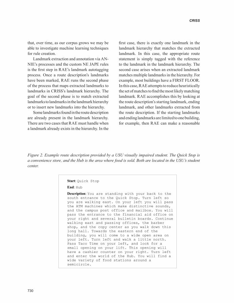
Figure 2. Example route description provided by a USU visually impaired student. The Quick Stop is a convenience store, and the Hub is the area where food is sold. Both are located in the USU’s student center.
Start: Quick Stop
End: Hub
Description: You are standing with your back to the south entrance to the Quick Stop. Turn left so you are walking east. On your left you will pass the ATM machines which make distinctive sounds, and the campus post office and mailbox. You will pass the entrance to the financial aid office on your right and several bulletin boards. Continue walking east and passing offices, the barber shop, and the copy center as you walk down this long hall. Towards the eastern end of the building, you will come to a wide open area on your left. Turn left and walk a little north. Pass Taco Time on your left, and look for a small opening on your lift. This opening will have a cashier counter on your right. Turn left and enter the world of the Hub. You will find a wide variety of food stations around a semicircle.

731
CRISS
assumption to limit its search in the hierarchy for landmarks within that same building. If the locations are limited to the same floor, the search is further constrained. Landmarks that are un-known and for which no exact matches can be found in the landmark hierarchy are inserted into the hierarchy at the most appropriate level possible. The insertion level heuristically deter-mined using logic similar to the logic used for resolving multiple matches of known landmarks described above.
When the landmark hierarchy is sparse, landmark extraction is likely to be error prone: landmarks may be matched incorrectly and new landmarks may be inserted at incorrect positions in the landmark hierarchy. From the system’s point of view, this is not a major issue since CRISS’s users can resolve these problems by manual ed-iting. After RAE’s autotagging process is run, the user who submitted the route description is always given the opportunity to update or delete the landmark tags created by RAE as well as adding any extra landmark tags they may deem necessary. The result will be that over time the number of landmarks in the landmark hierarchy will grow causing RAE’s performance for match-ing and inserting landmarks to improve.
As mentioned above, a route description is stored as a list of route statements. A route state-ment maps directly to the sentences created by ANNIE’s sentence splitter. When the autotag-ging process is complete, each route statement is tagged with landmarks found during the extraction process. Since some route statements may not contain a landmark, a route statement can have zero or more tags. As an example of the input and output of the autotagging process, Figure 2 shows a natural language route description contributed by a visually impaired USU student, and Figure 3 shows a portion of the structure created when the description is run through RAE’s autotagging process.
Path Inference
As more routes are entered, RAE continues to extract landmarks and tag route statements while users continue to refine route descriptions and the landmark hierarchy. Eventually, routes which in-tersect increasingly appear in the system. Because all route statements are tagged with the appropriate landmarks from the landmark hierarchy, RAE is able to use the structured metadata to perform path inference. Path inference, as mentioned ear-lier, is the process of determining that two route descriptions describe routes which intersect at a common landmark and then using this informa-tion to infer a third route description consisting of the first part of one route description and the second part of the other route description.
For example, suppose one user enters the fol-lowing route description, route A, which describes how to get from the entrance of the Old Main building to the Library entrance:
Exit Old Main walking east. When you detect the grass, turn left facing north. Walk north for a few steps until you detect a sidewalk intersection on your right. Turn right, walking east. You will walk through the Quad, passing the intersection. Keep walking straight until you run into grass. Turn left, walking north. Walk until you detect the bike racks on your right and then turn right. Walk east until you find the library doors.
In the above description, the Quad refers to a large grassy area on the USU campus with two sidewalks, one running north/south and the other - east/west. The two sidewalks intersect in the middle of the Quad.
At a later date, another user enters a new route description, call it route B, that describes how to get from the entrance of the Animal Science building to the entrance of the Ray B. West building:
Exit the Animal Science building doors on the south side. Walk straight until you find the sidewalk entrance to the Quad’s sidewalk. Walk

732
CRISS
Figure 3. Partial example of a tagged route statement
<route> <route-id>R-35</route-id> <start> <landmark> <id>L-500</id><name>QUICK STOP</name> </landmark> </start> <end> <landmark> <id>L-789</id><name>HUB</name> </landmark> </end> <statements> <statement> <id>S-1</id> <description> You are standing with your back to the south entrance to the Quick Stop. </description> <tags> <landmark> <id>L-501</id> <name>SOUTH ENTRANCE</name> </landmark> </tags> </statement> <statement> <id>S-2</id> <description> Turn left so you are walking east. </description> </statement> <statement> <id>S-3</id> <description> On your left you will pass the ATM machines which make distinctive sounds, and the campus post office and mailbox. </description> <tags> <landmark> <id>L-550</id><name>ATM</name> </landmark> <landmark> <id>L-551</id><name>POST OFFICE</name> </landmark>

733
CRISS
south until you detect a road. Carefully cross the street. Continue to walk south until you find the doors to the Ray B. West building.
As can be seen in the map in Figure 4, routes A and B intersect. These two routes are next broken into route statements and autotagged by RAE. Let us assume, for the sake of simplicity, that the tagged route descriptions have been ap-proved and modified as necessary by the users who entered the route descriptions.
Route A contains the route statement You will walk through the Quad, passing the intersection. This statement is tagged with the landmark QUAD SIDEWALK INTERSECTION. Route B contains the route statement Walk south until you detect a road. This statement is tagged with the landmark QUAD SIDEWALK INTERSECTION because, even though it is not explicitly mentioned, per-forming the action in this route statement causes a traveler to pass though the sidewalk intersec-tion. Because both routes A and B contain route statements sharing a common landmark, a new route description is inferred to guide the user from the entrance of the Old Main building to the
entrance of the Ray B. West building. The new route description contains route statements from the first part of route A, taking the traveler from the entrance of Old Main to the center of the quad. The second half of the route description consists of the route statements from route B which take the traveler along the southbound sidewalk of the quad to Ray B. West. The new route description built by RAE would be:
Exit Old Main walking east. When you detect the grass, turn left facing north. Walk north for a few steps until you detect a sidewalk intersection on your right. Turn right, walking east. You will walk through the Quad, passing the intersec-tion.
Walk south until you detect a road. Carefully cross the street. Continue to walk south until you find the doors to the Ray B. West building.
CRISS makes no guarantees as to the un-derstandability of the new route description. As explained below, it performs a digraph-based inference algorithm to build the new route de-scription. Before the new route description is available to all users, it must be admitted into
Figure 4. A map showing the intersection of two route descriptions

734
CRISS
the system, i.e., checked by a user familiar with the area to ensure that the description is both understandable and can be used to safely guide a person. In this case, the user, for example, may delete the “passing the intersection” phrase and add a turn directive to ensure that someone who is following the route would make the necessary turn at the sidewalk intersection:
Exit Old Main walking east. When you detect the grass, turn left facing north. Walk north for a few steps until you detect a sidewalk intersection on your right. Turn right, walking east. You will walk through the Quad.
Turn south when you detect the sidewalk in-tersection in the middle of the quad.
Walk south until you detect a road. Carefully cross the street. Continue to walk south until you find the doors to the Ray B. West building.
The landmark tags associated with the old routes will continue to be used in the route state-ments in the new route description. This preserves both the landmark tags created thorough RAE’s autotagging process as well as user created land-mark tags.
In more formal terms, the path inference pro-cess is accomplished through a transformation of the tagged route statements into a single, directed graph. The digraph consists of two types of nodes,
statement nodes and landmark nodes, and all edges are directed edges. During the transformation, every route description in CRISS’s collection is added to the digraph through a process which maps every route statement and its associated landmark tags to nodes and edges of the digraph. The graph is a directed graph because there is no guarantee that the same landmarks and statements would be used when describing a route from A to B as when describing a route from B to A.
Each route statement is represented by a state-ment node. A route statement that does not have a landmark tag associated with it is connected by an edge to the next statement node in the graph. This connection represents a precedence relationship between the two route statements signifying that the action in a route statement cannot be performed before the actions in the preceding route statements are performed. If a route statement has been associated with one or more landmarks, each landmark is represented in the digraph by a landmark node. The statement node and its landmark nodes are connected by edges representing an association relationship signifying that the route statement was tagged with the landmarks. A precedence edge from the landmark node then connects the landmark node to the next statement node in the description. This
Figure 5. The partial result of converting the tagged route in Figure 3 into a digraph

735
CRISS
connection continues to signify the ordering of the route statements in a route description even when route statements have been tagged. Figure 5 shows the example autotagged route from Figure 3 converted into a digraph.
Route intersections are defined in terms of graph algorithms with route description inter-secting at the landmark nodes of the digraphs. Figure 6 shows two route descriptions, R-1 and R-2, intersecting and explains how another route descriptions can be inferred from this intersec-tion. When a new route is found in the digraph representation, it must be transformed back into the route structure. To build the new route de-scription, the route statements nodes along the new path will be collected into the new natural language description. This is the level of func-tionality which RAE provides when inferring a new route description. As mentioned before, the new route description will need to be vetted by users to ensure the route description’s clarity and that the new route can be followed safely.
Because many paths may be found between two nodes when inferring a new route, RAE applies
heuristics during its search in order to score each route description according to its expected useful-ness. Examples of potential heuristics include:
• Preferring new route descriptions that merge fewer older route descriptions. For example, a route description built from two exiting descriptions would be preferred over a route that was built from four existing descrip-tions.
• Preferring new routes with fewer statements. More statements may signal more compli-cated routes. Since routes with more seg-ments or actions are harder for the visually impaired to follow and remember (Golledge, 1993), shorter and simpler route descriptions would be preferred.
• Preferring new routes with landmarks that share common parent landmarks in the land-mark hierarchy. For example, if the starting and ending landmarks are within the same building, new routes which stay inside the building would be preferred over those which leave the building and then return.
Figure 6. Two route descriptions intersecting. Route description R-1 starts at landmark L-1 and ends at L-2. Route description R-2 starts at L-3 and ends at L-4. The statements S-1 and S-3 are both associated with landmark L-99. Because of this common landmark, a new route description can be inferred starting at L-3 and ending at L-2. The new route description would consist of statements S-3 and S-2.

736
CRISS
The advantage of the path inference process is that new routes will be added to CRISS at a faster rate. Users will be able to quickly combine exist-ing routes without having to rewrite and re-(NE) common segments of routes. The other advantage of this process is that new routes which no user is currently aware may be discovered, enriching every traveler’s spatial knowledge of the area.
4. reLAted worK
Many navigation aids using various technolo-gies have been and continue to be developed for people who are visually impaired. Technologies are typically divided between indoor and out-door applications. For outdoors navigation, GPS is the most common technology used due to its ubiquitousness; its primary disadvantage is that it cannot work indoors. Sendero GPS (Sendero, 2008) and Trekker (HumanWare, 2008) are both commercial GPS products specifically designed for independent navigators with visual impair-ments. Drishti (Ran, Helal, & Moore 2004), an indoor and outdoor navigation system for the blind, uses GPS for its outdoor navigation guidance.
For indoor wayfinding, the selection of tech-nologies is much greater. For indoor environments, Drishti integrated an ultrasonic localization system from the Australian company Hexamite (http://www.hexamite.com). Talking Lights (2008) works with existing light fixtures, modulating lights at different frequencies to enable data transmission, has been used to encode route descriptions to aid in wayfinding within buildings (Leeb, et al., 2000). Talking Signs (Crandall, Bentzen, Myers, & Brabyn, 2001) places infrared transmitters in the environment and then the user carries a receiver. The RadioVirgilio / SesamoNet (D’Atri, Medaglia, Serbanati, & Ceipidor, 2007) places a matrix of small, cheap, passive RFID tags in a carpet and then a user carries a cane with an RFID reader em-bedded in the tip. Wi-Fi has been used in systems such as the one mentioned in Hub, Diepstraten, and
Ertl (2005) in which the received signal strength from standard Wi-Fi access points is measured and then used to localize the user to a point inside a building. Coughlan, Manduchi, and Shen (2006) attach simple, colorful signs with large barcodes to indoor locations and then use computer vision applications running on a cell phone to locate the signs and guide the navigator.
Some navigation tools provide mechanisms which allow users to share navigation and lo-calization data. For example, Loadstone GPS (Loadstone GPS, 2008) is a GPS-based, open source, navigation tool for cell phones. The developers also maintain the Website Loadstone PointShare ( http://www.csy.ca/~shane/gps ) which allows users to upload the name, latitude, and longitude of new points of interest, as well as download data previously uploaded by other users. Wayfinder Access (Wayfinder, 2008) is a commercial GPS cellphone product which pro-vides text-to-speech navigation for the visually impaired. An extra feature of Wayfinder Access is that it provides access to the website MyWayfinder (http://eu.mywayfinder.com/index.us.php) which allows users to download and share trips, routes, and destinations. Sendero GPS (Sendero, 2008) also allows users to share waypoints through the Sendero website.
Research methods for extracting and evaluat-ing landmarks mentioned in texts has taken various approaches. Loos and Biemann (2007) extract address information for places like restaurants, cinemas and shops from Google query result sets. Instead, of building IE patterns by hand, they use a manually tagged set of sample pages to train their system using a Conditional Random Field algorithm. Another group (Tokuda, et al., 1999) extracted Japanese style addresses from Web pages. They created a dictionary of terms related to addresses from the Japanese Ministry of Postal Services. Addresses from Web pages were extracted when chunks in Web pages contained terms in the dictionary and matched address pattern expressions. Winter and Tomko (2006)

737
CRISS
extract information about Australian addresses from Web pages and then use this information to find more detailed information about each address from another layer of Web searches, extracting information such as place names, location de-scriptions. Manov, et al. (2003) bootstrap the IE task of extracting geographic locations using a knowledge base of location data. The InfoXtract system (Li, Srihari, Niu, & Li, 2003) addresses resolving ambiguity in city names found during information extraction, addressing such situation as where there are 23 cities in the United States with the name Buffalo. Silva, Martinsa, Chavesa, Afonsoa, and Cardosoa (2006) developed a NE system specifically addressing multilingual geo-graphic extraction Webpages. The system also includes a disambiguation step which attempts to resolve possible conflicts. In all cases, these systems focus on extracting much larger land-marks than those that RAE extracts.
Other systems have also developed methods for autotagging various pieces of text. AutoTag (Mishne, 2006) suggest tags for blog posts based on tags found in similar blog postings. Fujimura, Fujimura, and Okuda (2007) describe a k-nearest neighbor approach to recommending tags for blog entries. Brooks and Montanez (2006) extract the three words with the top TDIDF (term frequency, inverse document frequency) score in blog entries; the top three words become the document’s auto-tags. Although extracted automatically, the tags generated by these system are similar to Flickr and YouTube type tags in that no structure is imposed on the tags. The lack of structure in the tag names would not meet CRISS’s needs.
5. concLusIon
We hope that CRISS will be a useful tool for assisting independent visually impaired navi-gators in learning unfamiliar areas and routes within those areas. It will encourage groups of experienced travelers to document their spatial
knowledge by building large, route-based maps. Because the people writing the route descriptions will be members of the target user group, the route descriptions will be written in a manner which is appropriate for other travelers with the same visual impairments.
In order to both simplify the user interface and give additional route analysis capability to the system, CRISS contains the intelligent component RAE which takes advantage of information extraction technologies that have been developed over the last decade. As a result, RAE is able to perform the tasks of autotagging of route descriptions, automatically extracting important navigation landmarks from natural language route descriptions. Users can provide additional tags as well further enhancing the data available in the descriptions. The tags provide additional information to users about landmarks, in particular consistent names and descriptions. The landmark tags also enable RAE to automati-cally locate and create new route descriptions via the path inference process.
One advantage of CRISS is that it does not replace existing navigation and wayfinding tools, but complements them. CRISS is designed to not only guide travelers and build maps targeted towards people who have visual impairments but also to help provide a better understanding of the types of route directions used and needed by travelers with visual impairments. With a better understanding of route descriptions produced by the people with visual impairments, all navigation assistance tools will be improved.
AcKnowLedgment
The authors would like to acknowledge that this research has been supported, in part, through NEI/NIH grant 1 R41 EY017516-01A1, NSF grant IIS-0346880, and several Community University Research Initiative (CURI) grants from the State of Utah.

738
CRISS
references
Appelt, D. E., & Onyshkevyc, B. (1996). The common pattern specification language. In Pro-ceedings of a workshop on held at Baltimore, Maryland (pp. 23-30). Morristown, NJ: Associa-tion for Computational Linguistics.
Berners-Lee, T., Hendler, J., & Lassila, O. (2001)/ The Semantic Web. Scientific American Magazine, 284(5), 34-43.
Blasch, B., Wiener, W., & Welsh, R. (Eds.). (1997). Foundations of orientation and mobility (2nd ed.). American Foundation for the Blind (AFB) Press.
Brooks, C., & Montanez, N. (2006). Improved annotation of the blogosphere via autotagging and hierarchical clustering. In Proceedings of the 15th international conference on World Wide Web (pp. 625-632). New York: ACM.
Bruce, I., Mckennell, A., & Walker, E. (1991). Blind and partially sighted adults in Britain: The RNIB survey. Royal National Institute for the Blind.
Ciravegna, F., & Wilk, Y. (2003). Designing adap-tive information extraction for the Semantic Web in amilcare. In S. Handschuh & S. Staab (Eds.), Annotation for the Semantic Web, frontiers in artificial intelligence and applications. Amster-dam: IOS Press.
Crandall, W., Bentzen, B. L., Myers, L., & Brabyn, J. (2001). New orientation and accessibility option for persons with visual impairments: Transpor-tation applications for remote infrared audible signage. Clinical and Experimental Optometry, 84(3), 120-131.
Coughlan, J., Manduchi, R., & Shen, H. (2006). Cell phone-based wayfinding for the visually impaired. In Proceedings of the 1st International Workshop on Mobile Vision.
Cowie, J., & Lehnert, W. (1996) Information extraction. Communications of the ACM, 39(1), 80-91.
Cunnigham, H. (2005). Information extraction, automatic. In K. Brown (Ed.), Encyclopedia of language and linguistics (2nd ed.). Elsevier.
Cunningham, H., Maynard, D., Bontcheva, K., & Tablan, V. (2002). A framework and graphi-cal development environment for robust NLP tools and applications. In Proceedings of the 40th Anniversary Meeting of the Association for Computational Linguistics (pp. 168-175).
Cunningham, H., Maynard, D., Bontcheva, K., Tablan, V., Ursu, C., Dimitrov, M., Dowman, M., Aswani, N., Roberts, I., Li, Y., Shafirin, A., & Funk, A. (2007). The GATE user guide. Retrieved May 1, 2008, from http://gate.ac.uk/sale/tao
D’Atri, E., Medaglia, C. M., Serbanati, A., & Ceipidor, U. B. (2007). A system to aid blind people in the mobility: A usability test and its results. In Proceeding of the ICONS ‘07, Second International Conference on Systems.
Daisy Consortium. (2008). DAISY/NISO standard. Retrieved September 20, 2008, from http://www.daisy.org/z3986
Fujimura, S., Fujimura, K., & Okuda, H. (2007). Blogosonomy: Autotagging any text using blog-gers’ knowledge. In Proceedings of the IEEE/WIC/ACM International Conference on Web In-telligence (pp. 205-212). Washington, DC: IEEE Computer Society.
Garmin. (2008). About GPS. Retrieved April 10, 2008, from http://www.garmin.com/aboutGPS
Gaunet, F., & Briffault, X. (2005). Exploring the functional specifications of a localized wayfind-ing verbal aid for blind pedestrians: Simple and structured urban areas. Human-Computer Inter-action, 20(3), 267-314.

739
CRISS
Golledge, R. G. (1993). Geography and the dis-abled: A survey with special reference to vision impaired and blind populations. Transactions of the Institute of British Geographers, 18(1), 63-85.
Goodchild, M. F. (2007). Citizens as sensors: The world of volunteered geography. GeoJournal, 69(4), 211-221.
Hub, A., Diepstraten, J., & Ertl, T. (2005) Aug-mented indoor modeling for navigation support for the blind. In Proceedings of the 2005 International Conference on Computers for People with Special Needs, Las Vegas, Nevada (pp 54-59).
HumanWare. (2008). Trekker. Retrieved June 1, 2008, from http://www.humanware.com/en-usa/products/gps/trekker/_details/id_88/trekker.html
Kuipers, B. (2000). The spatial semantic hierarchy. Artificial Intelligence, 119(1-2), 191-233.
Kulyukin, V., Nicholson, J., & Coster, D. (2008a). ShopTalk: Toward independent shopping by people with visual impairments. In Proceedings of the 8th ACM Conference on Computers and Accessiblity (ASSETS 2008). New York: ACM.
Kulyukin, V., Nicholson, J., & Coster, D. (2008b). ShopTalk: Toward independent shopping by people with visual impairments (Tech. Rep. USU-CSATL-1-04-08). Computer Science Assistive Technology Laboratory, Department of Computer Science, Utah State University.
Kulyukin, V., Nicholson, J., Ross, D., Marston, J., & Gaunet, F. (2008). The blind leading the blind: Toward collaborative online route information management by individuals with visual impair-ments. In Proceedings from the 2008 AAAI Spring Symposium. AAAI Press.
LaMarca, A., Chawathe, Y., Consolvo, S., Hight-ower, J., Smith, I., Scott, J., Sohn, T., Howard, J., Hughes, J., Potter, F., Tabert, J., Powledge, P., Bor-riello, G., & Schilit, B. (2005). Place lab: Device
positioning using radio beacons in the wild. In Proceedings of the Third International Conference on Pervasive Computing. Springer-Verlag.
Leeb, S., Hovorka, G., Lupton, E., Hinman, R., Bentzen, B., Easton, R., & Lashell, L. (2000). Assistive communication systems for disabled individuals using visible lighting. In Proceedings of the 15th International Technology and Persons with Disabilities Conference, Northridge, CA.
Li, Y., Bontcheva, K., & Cunningham, H. (2005). SVM based learning system for information ex-traction. In M. Winkler & N. Lawerence (Eds.), Deterministic and statistical methods in machine learning (LNAI 3635, pp. 319-339). Springer Verlag.
Li, H., Srihari, R., Niu, C., & Li, W. (2003). InfoXtract location normalization: A hybrid ap-proach to geographic references in information extraction. In Proceedings of the HLT-NAACL 2003 workshop on Analysis of geographic refer-ences - Volume 1 (pp. 39-44).
Loadstone GPS. (2008). Loadstone GPS - satellite navigation for blind mobile phone user. Retrieved September 27, 2008, from http://www.loadstone-gps.com
Loos, B., & Biemann, C. (2007). Supporting web-based address extraction with unsupervised tagging. In Proceedings of the 31st Annual Con-ference of the German Classification Society GfKl 2007.
Manov, D., Kiryakov, A., Popov, B., Bontcheva, K., Maynard, D., & Cunningham, H. (2003). Experi-ments with geographic knowledge for information extraction. In Proceedings of the HLT-NAACL 2003 workshop on analysis of geographic refer-ences - Volume 1 (pp. 1-9).
Mathes, A. (2004). Folksonomies - cooperative classification and communication through shared metadata (Computer mediated communication, LIS590CMC, Doctoral seminar). Graduate School

740
CRISS
of Library and Information Science, University of Illinois Urbana-Champaign.
Mishne, G. (2006). AutoTag: A collaborative ap-proach to automated tag assignment for weblog posts. In Proceedings of the 15th international conference on World Wide Web (pp. 953-954).
Nicholson, J., & Kulyukin, V. (2007). ShopTalk: Independent blind shopping = verbal route di-rections + barcode scans. In Proceedings of the 30th Annual Conference of the Rehabilitation Engineering and Assistive Technology Society of North America (RESNA 2007).
Passini, R., & Proulx, G. (1988). Wayfinding without vision: An experiment with congenitally totally blind people. Environment and Behavior, 20(2), 227-252.
Popov, B., Kiryakov, A., Manov, D., Kirilov, A., Ognyanoff, D., & Goranov, M. (2003). Towards Semantic Web information extraction. In Pro-ceedings of the 2nd International Semantic Web Conference, Sanibel Island, Florida.
Priyantha, N., Chakraborty, A., & Balakrishnan, H. (2000). The cricket location-support system. In Proceedings of the MobiCom ‘00: The 6th annual international conference on Mobile computing and networking (pp. 32-43). New York: Associa-tion for Computing Machinery.
Ran, L., Helal, S., & Moore, S. (2004). Drishti: An integrated indoor/outdoor blind navigation system and service. In Proceedings of the PERCOM ‘04: The Second {IEEE} International Conference on Pervasive Computing and Communications (Per-Com’04) (pp. 23-30). IEEE Computer Society.
Sendero Group LLC. (2008). Sendero GPS. Retrieved April 10, 2008, from http://www.sen-derogroup.com/shopgps.htm
Silva, M., Martinsa, B., Chavesa, M., Afonsoa, A. P., & Cardosoa, N. (2006). Adding geographic
scopes to Web resources. Computers, Environment and Urban Systems, 30(4), 378-399.
Talking Lights LLC. (2008). Talking lights sys-tems. Retrieved April 10, 2008, from http://www.talking-lights.com
Tokuda, T., Tazaki, K., Yamada, T., Mizuno, H., & Kitazawa, S. (1999). On extraction of WWW pages with spatial information for mediating their distribution. In Proceedings of the 1999 IEEE International Conference on Systems, Man, and Cybernetics (pp. 74-79).
Wayfinder. (2008). Wayfinder North America - wayfinder access - voice controlled access to your destinations and surroundings. Retrieved September 27, 2008, from http://www.wayfinder.com/?id=3784&lang=en-US
Winter, S., & Tomko, M. (2006). Translating the Web semantics of georeferences. In D. Taniar & J. W. Rahayu (Eds.), Web semantics and ontology (pp. 297-333). Hershey, PA: IGI Publishing.
Key terms And defInItIons
Autotagging: The process of using a computer to automatically determine which tags should be associated with a piece of data.
Information Extraction (IE): A technol-ogy for extracting structured information from unstructured and natural language text.
Java Annotation Patterns Engine (JAPE): A pattern matching language in which regular expression-type patterns are used to process natural language text, allow matching information to be extracted and then used in more structured formats.
Named Entity (NE) Recognition: A subtask of information extraction which is focused on
741
CRISS
finding and classifying entities such as names and addresses.
Path Inference: The process of building a new and valid, yet previously unknown, route descrip-tion from two or more known route descriptions that intersect when followed. The new route description begins at a landmark in one of the known route descriptions and ends at a landmark in another route description.
Route Description: A natural language description of how to follow a route including
details such as decision points and landmark descriptions.
Spatial Semantic Hierarchy (SSH): A model of knowledge of large-scale space inspired by the human cognitive map.
Tag: A piece of metadata associated with a larger piece of data.
Volunteered Geographic Information (VGI): Spatial data, tools, and Websites provided by volunteers rather than geographic information system companies and professionals.