chapter 8 ecology and nature conservation · environmental statement – ecology and nature...
TRANSCRIPT

CHAPTER 8
ECOLOGY AND NATURE
CONSERVATION
Environmental Statement – Ecology and Nature Conservation
8-1
8.0 ECOLOGY AND NATURE CONSERVATION
Introduction
8.1 This chapter considers the likely significant effects on ecology and biodiversity associated with
the construction and operation of the proposed development. The specific objectives of the
chapter are to:
• Describe the ecological baseline;
• Describe the assessment methodology and significance criteria used in completing the
impact assessment;
• Describe the potential effects, including direct, indirect and cumulative effects;
• Describe the mitigation measures proposed to address likely significant effects;
• Assess the residual effects remaining following the implementation of mitigation.
8.2 Information is also included to allow Cardiff Council (CC) to assess the proposals against their
Section 6 duty under the Environment (Wales) Act 2016. This duty requires public authorities to
seek to maintain and enhance biodiversity so far as consistent with the proper exercise of their
functions and in so doing promote the resilience of ecosystems.
8.3 The assessment has been carried out by Caroline O’Rourke ACIEEM and James Gillespie MCIEEM,
of BSG Ecology.
8.4 The chapter is supported by summary information on the following:
• Consultation and scoping correspondence (Appendix 1 of this chapter)
• Information on SINCs within 2 km (Appendix 2 of this chapter)
• Relevant key planning policy and legislation (Appendix 3 of this chapter)
8.5 In addition, this chapter is supported by several technical appendices:
• Extended Phase 1 habitat survey (Technical Appendix 8.1)
• Botanical survey (Technical Appendix 8.2)
• Hedgerow survey (Technical Appendix 8.3)
• Bat survey (Technical Appendix 8.4)
• Breeding bird survey (Technical Appendix 8.5)
• Dormouse survey (Technical Appendix 8.6)
• Great crested newt survey (Technical Appendix 8.7)
• Badger, otter and water vole survey (Technical Appendix 8.8)
Regulatory and Policy Context
8.6 There are a number of national, regional and local policies and guidance documents that relate to
nature conservation and ecology within the planning process that are relevant to the
Environmental Statement – Ecology and Nature Conservation
8-2
Development. Reference to these provides an indication of the likely requirements and
expectations of statutory authorities and others in relation to planning applications and nature
conservation and ecology within a given area. There are also legislative requirements of new
development. Relevant key national, regional and local planning policies, as well as relevant legal
statutes, are listed below.
• Planning Policy Wales (Edition 10, December 2018).
• Technical Advice Note (TAN) 5 Nature Conservation and Planning (2009).
• Cardiff Local Development Plan 2006-2026 including:
i. Key Policy KP2 (D & E): North of Junction 33 on M4 and South of Creigiau
ii. Key Policy KP16: Green Infrastructure
iii. Policy EN5: Designated Sites
iv. Policy EN6: Ecological Networks and Features of Importance for Biodiversity
v. Policy EN7: Priority Habitats and Species
vi. Policy EN8: Trees, Woodlands and Hedgerows
• The Environment (Wales) Act (2016).
• The Conservation of Habitats and Species Regulations 2017.
• The Wildlife and Countryside Act (1981) as amended.
8.7 This chapter is based on relevant parts of the 2018 Guidelines for Ecological Impact Assessment
in the United Kingdom developed by the Chartered Institute of Ecology and Environmental
Management (CIEEM, September 2018).
Scope
8.8 The methods for ecological survey of the site, results and evaluation of receptors are provided in
this assessment. The assessment considers potential effects on habitats and protected species at
the construction and operational phases of the proposed development.
8.9 The following ecological study has informed this assessment:
• Desk study
• Extended Phase 1 Habitat survey
• Hedgerow survey
• Phase 2 botanical survey of areas of higher quality habitat
• Bat activity survey (seasonal walked transect and automated detector deployment)
• Ground level assessment of trees for their bat roosting potential
• Breeding bird survey
• Dormouse survey
• Great crested newt survey (Habitat Suitability Index survey and eDNA sampling)
• Badger, otter and water vole survey
8.10 The scope of study was agreed with Cardiff Council’s Ecologist (see correspondence in Appendix
1).
Environmental Statement – Ecology and Nature Conservation
8-3
Methodology
Baseline Characterisation
Study Area
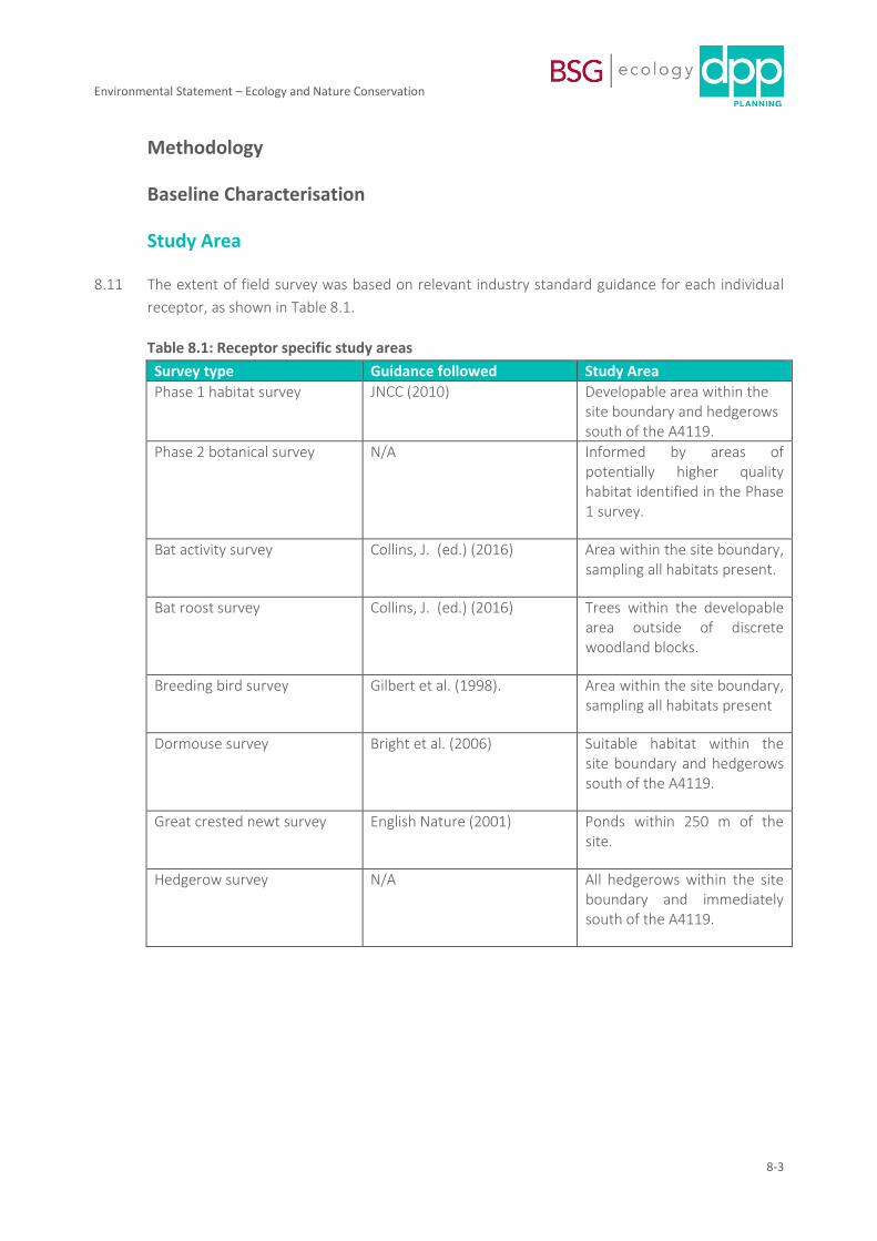
8.11 The extent of field survey was based on relevant industry standard guidance for each individual
receptor, as shown in Table 8.1.
Table 8.1: Receptor specific study areas
Survey type Guidance followed Study Area
Phase 1 habitat survey JNCC (2010) Developable area within the site boundary and hedgerows south of the A4119.
Phase 2 botanical survey N/A Informed by areas of potentially higher quality habitat identified in the Phase 1 survey.
Bat activity survey Collins, J. (ed.) (2016) Area within the site boundary, sampling all habitats present.
Bat roost survey Collins, J. (ed.) (2016) Trees within the developable area outside of discrete woodland blocks.
Breeding bird survey Gilbert et al. (1998). Area within the site boundary, sampling all habitats present
Dormouse survey Bright et al. (2006) Suitable habitat within the site boundary and hedgerows south of the A4119.
Great crested newt survey English Nature (2001) Ponds within 250 m of the site.
Hedgerow survey N/A All hedgerows within the site boundary and immediately south of the A4119.
Environmental Statement – Ecology and Nature Conservation
8-4
Baseline data collection
8.12 All baseline data collection was carried out by BSG Ecology between February and October 2018.
Full methods and results of the baseline data collection are presented in Technical Appendices
8.1-8.8.
Desk Study
8.13 The presence of statutory designated sites of nature conservation interest within 2 km of the Site
boundary was established using the Magic website (http://magic.defra.gov.uk/, accessed March
2018). The search distance was extended to 5 km for sites designated for bat species.
8.14 The South East Wales Biodiversity Records Centre (SEWBReC) was asked to provide records of
non-statutory designated sites and records of protected/notable species within 2 km of the Site
boundary in March 2018. Detailed information from SEWBReC can be provided on request.
8.15 Aerial photographs and mapping (Bing Maps, accessed March 2018) of the Site and its
surroundings were also reviewed to identify ponds within 250 m and assess the landscape
context of the Site.
8.16 Background information on the site and wider ecological context was also collected. This
included a review of survey reports produced by Wildwood Ecology in 2013 covering the western
half of the site and ecological information associated with the nearby Junction 33 development
freely available via the Cardiff Council planning portal.
Consultation
8.17 Several meetings with council officers and specifically with the council’s ecologist have been
attended by BSG Ecology. These are as follows:
i) 07 June 2018 pre-application meeting with Cardiff Council, attended by the Council’s
ecologist.
ii) 13 July meeting on site with Cardiff Council’s ecologist. The scope of survey work was
discussed at this meeting and agreed with the Council (see email correspondence in
Appendix 1.
iii) 19 July 2018 pre-application meeting with Cardiff Council, including the council’s ecologist.
iv) 21 March 2019 pre-application meeting with Cardiff Council, attended by the council’s
ecologist.
8.18 In addition, the council provided a formal pre-application response. This included
correspondence from Natural Resources Wales. A copy of this correspondence is at Appendix 1.
Environmental Statement – Ecology and Nature Conservation
8-5
Extended Phase 1 Habitat Survey
8.19 An extended Phase 1 Habitat survey of the site was completed over between March and June
2018 over several visits as the spring / summer season progressed. All habitats present were
mapped using standard methods (JNCC, 2010), and any signs of protected or rare species, or
suitable habitats for such species, was identified.
Botanical Survey
8.20 National Vegetation Classification (NVC) survey was conducted on 29 May (woodland), 11 June
(neutral grassland) and 18 September (marshy grassland) 2018.
8.21 A series of quadrats were marked out in typical stands of vegetation in each habitat. All vascular
plant species present were identified and their percentage cover estimated using the Domin scale
(Rodwell, 1991a). For the marshy and neutral grassland, vegetation outside of the quadrats was
also inspected and any additional SINC indicator species recorded (these are species used
collectively to indicate whether a site or area of land would qualify as a Site of Importance for
Nature Conservation (SINC)).
8.22 Habitats were classified with reference to the published vegetation communities described in
Rodwell (1991 a&b, 1992 and 1995) as follows:
• The vegetation community identification keys in Rodwell et al (1991 a&b, 1992 and 1995)
were used to identify plant communities, based on the data in the floristic tables.
• The floristic tables were compared with those of the published NVC communities.
• Where five quadrats were taken the data were entered into the Modular Analysis of
Vegetation Information System (MAVIS) software (CEH, 2016). Quadrats for each
homogenous stand of vegetation were subject to a combined group analysis to
determine similarity with published NVC datasets.
8.23 The conservation value of each vegetation community was evaluated with reference to the
following:
• BRIG (2011) UK Biodiversity Action Plan Priority Habitat Descriptions, JNCC. This was used
to identify Habitats of Principal Importance in Wales, designated under Section 7 of the
Environment (Wales) Act 2016.
• Gwent Wildlife Trust (2004). Guidelines for the selection of Local Wildlife Sites in South
Wales. South Wales Wildlife Sites Partnership.
Hedgerow survey
8.24 Hedgerows within the site boundary and bordering the A4119 were surveyed on 29 May 2018
following best practice guidance as detailed by The Hedgerow Survey Handbook (Defra, 2007).
Each hedgerow was assessed against the criteria for ‘important’ hedgerows set out in the
Hedgerows Regulations (1997).
Environmental Statement – Ecology and Nature Conservation
8-6
Bat activity survey (walked transects)
8.25 The walked transect survey followed the Bat Conservation Trust (2016) guidelines for a site of
moderate suitability for bats. The site was assessed as being of moderate suitability for the
following reasons: the majority of the site is made up of open and mostly improved agricultural
grassland that is relatively species poor and uniform, the site supports watercourses / ditches but
these are generally in a poor state, and while the site is connected to the wider landscape to the
south and west it is not well connected to the north and east due to urban settlement. The
woodland in the centre of the site is a feature which in its own right is likely to be of at least
moderate roost and feeding potential for bats. However, this feature will not be significantly
affected by the proposed development.
8.26 One walked transect survey was completed per month from April to October inclusive. A total of
eight surveys were completed including seven dusk transects and an additional dawn transect in
May.
8.27 Two surveyors walked a predetermined transect route through the Site recording all bat
echolocation calls using Anabat (SD1 and 2), Bat Box Duet, and Echo Meter (EM3) bat detectors.
All bat activity heard or seen was recorded on standardised recording forms. Ten stop points
(each three minutes duration) were included on each transect. Transects were selected to
sample representative habitat types across the Site.
8.28 Surveys were carried under suitable weather conditions and took a minimum of 2 hours to
complete. Dusk surveys were timed to cover the peak bat emergence period (from sunset to 1
hour after sunset) and the period of most intense foraging activity (2 hours after sunset). The
dawn survey covered the peak bat re-entry period.
8.29 The start point and direction of travel was altered between successive surveys to ensure that
different parts of the Site were surveyed at different times of the night. This approach aimed to
reduce potential bias in sampling.
Bat activity survey (automated detector deployment)
8.30 The method for automated detector survey followed Bat Conservation Trust (2016) guidelines for
a site of moderate suitability for bats. Three detectors were deployed for a period of five nights
per month from April to October 2018 inclusive. From August a fourth detector was deployed
within Castell-y-mynach Wood following consultation with Natural Resources Wales (NRW). As
the Castell-y-mynach Wood is being retained, and no habitats within will be significantly
impacted, this is not considered to be a significant constraint.
8.31 Song Meter 2 (SM2+) bat detectors with external microphones were deployed at each location.
Detectors were configured to record above the level of ambient noise using an adaptive trigger
set to 6 decibels (dB). They were set to define a bat pass as a call note of >2 milliseconds (ms)
separated from another by more than one second. Each bat detector was housed in a waterproof
Environmental Statement – Ecology and Nature Conservation
8-7
Peli-case. An external microphone was connected via a cable to the logger, and attached to a
suitable tree approximately 2 m above ground level.
8.32 The static detectors were set to record for a minimum of five night periods from half an hour
before sunset to half an hour after sunrise, the period during which bats are usually active away
from their roosts. The duration of recording per night varied throughout the survey period
according to day/night length. Deployment dates and duration of recording periods for each
detector is provided in Table 2 in Technical Appendix 8.4.
Bat call identification
8.33 Recorded bat calls were analysed using Analook software. Where possible, the bat was identified
to species level. Species of the genus Myotis were grouped together as overlapping call
parameters make species identification problematic (Collins, 2016).
Calculation of relative levels of bat activity
8.34 AnalookW software was used for all analysis of bat calls. The software enables analysis of the
relative activity (referred to as ‘activity’ in the text below) of different species of bats by counting
the number of bat passes (P) recorded within a unit of time – hour (h) was used. More than one
pass of the same species was counted within a sound file if multiple bats were recorded calling
simultaneously.
Ground-level tree assessment
8.35 Trees with the potential to be removed as a result the proposed development, i.e. those outside
of discrete woodland blocks that will be retained, were subject to a ground level roost
assessment on 29 May 2019. For each tree assessed as having potential to support roosting bats,
the tree species and a description of any Potential Roost Features (PRF) were recorded.
8.36 All trees were then categorised based on their potential to support roosting bats, in accordance
with BCT Guidelines (Collins, 2016).
Breeding bird survey
8.37 A breeding bird survey was completed at the Site in spring 2018. Four breeding bird transects
were undertaken. These were on 20 April, 11 May, 23 May and 5 June between sunrise and
10:00. British Trust for Ornithology (BTO) species codes and symbology were used for recording
data in the field. The resulting maps were then considered in combination to determine if (and
where) individual species are likely to have bred on the site.
Dormouse survey
8.38 The dormouse survey was based on best practice guidance as set out by Bright et al (2006). A
total of 65 nest tubes and 10 nest boxes were placed in suitable habitat around the site in April
Environmental Statement – Ecology and Nature Conservation
8-8
2018. The boxes and tubes were then inspected for evidence of dormice by a licenced surveyor
in June, August and October.
8.39 An additional 75 nest tubes were installed in suitable habitat to the south of the A4119 in June to
account for potential highways improvement works associated with the proposed development.
These were checked for evidence of dormice in August and October. A search for
characteristically gnawed hazelnuts was undertaken in October.
8.40 The location of nest tubes/boxes and nut search quadrats are shown on Figure 8.11.
Great Crested Newt Survey
8.41 A Habitat Suitability Index (HSI) assessment of one pond and two ditches within the Site and one
off-site pond within 250 m of the Site boundary at ST07778120 was completed on 12 April 2018
following Oldham et al (2000).
8.42 The off-site pond was subsequently surveyed using an eDNA sampling technique in accordance
with the published methods (Williams, 2013) presented in DEFRA’s Technical Advice Note
WC1067 (Biggs et al 2014) on 3 May 2018.
Badger, otter and water vole survey
8.43 Habitats within the Site boundary were assessed for their potential to support badger, otter and
water vole during a series of Site visits between February and June 2018. Suitable habitat was
subsequently inspected for field signs of badger, otter and water vole on 29 May, 11 June, 26
June, 13 August and 22 October as follows.
Badger
8.44 Suitable habitat within the Site was searched for evidence of badger such as setts, latrines,
scrapes, tracks, footprints, hairs and other signs as described by Harris et al. (1989).
Otter
8.45 Watercourses within the Site were searched for evidence of otter including holts, couches,
footprints, latrines and feeding remains as described by Gov.uk (2014).
Water vole
8.46 Ditches within the Site were inspected for feeding stations, footprints, latrines, burrows and
‘lawns’ as described by Dean et al. (2016) and Gov.uk (2015).
Environmental Statement – Ecology and Nature Conservation
8-9
EIA Assessment Process
8.47 The evaluation and assessment within this chapter has been undertaken with reference to the
current Guidelines for Ecological Impact Assessment in the United Kingdom developed by the
Chartered Institute of Ecology and Environmental Management (CIEEM, 2018). Although this is
recognised as the industry standard for ecological assessment, the guidance is not prescriptive;
rather, it aims to “provide guidance to practitioners for refining their own methodologies”.
Important Ecological Features
8.48 A first step in EcIA is determination of which ecological features (habitats, species, ecosystems
and their functions/processes) are important. Important features should then be subject to
detailed assessment if they are likely to be affected by a proposed development. It is not
necessary to carry out detailed assessment of features that are sufficiently widespread,
unthreatened and resilient to effects of the proposal, such that there is no risk to their viability.
8.49 Ecological features can be important for a variety of reasons and the rationale used to identify
these is explained below. Importance may relate, for example, to the quality or extent of
designated sites or habitats, to habitat/species rarity, to the extent to which they are threatened
throughout their range, or to their rate of decline.
Evaluation: Determining Importance
8.50 The importance of an ecological feature is considered within a defined geographical context. The
following frame of reference has been used in this case:
• International and European
• National (UK)
• National (Wales)
• Regional (South Wales)
• County (Cardiff)
• Local (Creigiau village and immediate surrounds)
• Site (and immediate surrounds)
8.51 In certain circumstances particular receptors may be valued below the Site level. In these
instances they are described as being of Negligible importance.
Characterising and Quantifying Effects and Assessing their Significance
8.52 The CIEEM (2018) guidelines state that ecological effects or impacts should be characterised in
terms of ecosystem structure and function and reference should be made where relevant to:
beneficial, adverse or neutral effects; extent; magnitude; duration; reversibility; timing and
frequency; and cumulative effects. The guidelines provide a list of "aspects of ecological
structure and function to consider when predicting impacts and effects". The terms impact and
Environmental Statement – Ecology and Nature Conservation
8-10
effect are used within this chapter in accordance with the following definitions (as provided by
the guidelines):
8.53 Impact: Actions resulting in changes to an ecological feature. For example, the construction
activities of a development removing a hedgerow.
8.54 Effect: Outcome to an ecological feature from an impact. For example, the effects on a
dormouse population from loss of a hedgerow.
8.55 Following the characterisation of effects, an assessment of the ecological significance of those
effects is made. The guidelines promote a transparent approach in which a beneficial or adverse
effect is determined to be significant or not, in ecological terms, in relation to the integrity of the
defined site or ecosystem(s) and/or the conservation status of habitats or species within a given
geographical area, which relates to the level at which it has been valued. The decision about
whether an effect is significant or not, is independent of the value of the ecological feature; the
value of any feature that will be significantly affected is then used to determine the implications,
in terms of legislation and / or policy.
8.56 Significance is a concept related to the weight that should be attached to effects when decisions
are made. For the purpose of this assessment, 'significant effect' is an effect that either supports
or undermines biodiversity conservation objectives for 'important ecological features'. A
significant effect is simply an effect that is sufficiently important to require assessment and
reporting so that the decision maker is adequately informed of the environmental consequences
of permitting a project. The EcIA guidelines state that "A significant effect does not necessarily
equate to an effect so severe that consent for the project should be refused planning permission.
For example, many projects with significant adverse ecological effects can be lawfully permitted
following EIA procedures".
8.57 Industry-standard CIEEM guidelines encourage the expression of significance of ecological effects
with reference to a geographic frame of reference, as described above. However, other
disciplines within this Environmental Statement use criteria based on an expression of severity of
significance to describe the significance of environmental effects. Table 8.2 provides a means of
relating the two approaches and is provided in order to allow the ecological impact assessment
to be integrated into the wider EIA without compromising the CIEEM approach.
Table 8.2: Relationship between EcIA and EIA assessments of significance.
Significant effect CIEEM criteria
Major
Residual ecological effects assessed as being significant at the Regional scale or above and that have triggered a response in development control terms will be considered to represent effects that overall within the ES are of major significance.
Moderate
Residual ecological effects assessed as being significant at the County scale and that have triggered a response in development control terms will be considered to represent effects that overall within

Environmental Statement – Ecology and Nature Conservation
8-11
the ES are of moderate significance.
Minor
Residual ecological effects that have been assessed as being significant at the Site to Local scale and are unlikely to trigger a response in development control terms will be considered to represent effects that overall within the ES are of minor significance.
Negligible
Residual ecological effects that are considered to be not significant at any geographical level and are unlikely to trigger a response in development control terms will be considered to represent effects that overall within the ES are of no / negligible significance.
Baseline Conditions and Evaluation
8.58 This section sets out the findings of the consultation, baseline ecological survey work and desk
study. It then goes on to assess the interest of the identified ecological resources. Ecological
receptors are considered in the following order:
• Protected sites – both statutory (e.g. SSSI) and non-statutory (e.g. SINC).
• Habitats
• Species
8.59 Several species and habitats have been scoped out of the assessment on the basis that they are
unlikely to be significantly affected by virtue of the design or operation of the development; or
because they are very commonplace and/or of very low conservation value (unless there are
other reasons to consider them further (for example, they may be legally protected or require
special care and therefore require particular precautionary measures to be adopted).
8.60 Where it has been possible to scope out a particular ecological feature, the rationale for doing so
is provided in the text below.
Statutory Designated Sites
8.61 There is one statutory designated site within 2 km of the application site. This is Brofiscin Quarry
Site of Special Scientific Interest (SSSI) approximately 780 m to the west. This SSSI is notified for
geological rather than nature conservation interest and significant effects on its interest are not
likely to arise. It is therefore scoped out and not considered further in this assessment.
8.62 There are no statutory sites designated for bat species within 5 km.
Sites of Importance for Nature Conservation (SINCs)
8.63 There are 36 local authority designated Sites of Importance for Nature Conservation (SINCs)
within 2 km of the Site: 26 within the administrative area of Cardiff County Council (CCC) and 10
Environmental Statement – Ecology and Nature Conservation
8-12
in the Vale of Glamorgan (VoG). The SINCs within 2 km of the site are listed in Appendix 2 of this
chapter.
8.64 The SINC sites form a network of woodlands, wet grasslands, streams and meadows throughout
the local landscape.
8.65 Adverse effects on SINC habitats as a result of the proposed Development are likely to occur
where there is a risk of direct impacts, such as habitat loss or modification; or indirect impacts
such as disturbance through trampling of vegetation in the SINCs on or easily accessible from the
Site; pollution of watercourses and wetland habitats (affecting SINCs that are hydrologically
connected to the Site or located within or directly adjacent to the Site); or dust deposition on
vegetation of SINCs within the Site. These may include:
i. Castell-y-mynach Wood (wholly within the Site boundary)
ii. Cadoxton & Trehafod Branch Line (partially within the Site boundary)
iii. Nant Henstaff (partially within the Site boundary)
8.66 Of the other nearby SINCs, the Nant Coslech SINC is approximately 40 m from the western
boundary hydrological effects are unlikely given the drainage strategy. The Groes Faen Fen
Meadow and Groes Faen Wood SINCs are hydrologically linked to the Nant Coslech and are
similarly considered unlikely to be adversely affected by the development. Significant trampling
effects are not considered likely to arise as there are no obvious rights of way into these SINCs
from the Site, and dust deposition effects during construction are unlikely given the distance of
the SINCs from the Site and the normal dust suppression measures that will be put in place
through commitment to good practice measures. These SINCs and all the remaining SINCs lying
further afield are scoped out of further consideration.
8.67 All SINCs are considered to be of County importance.
8.68 The Nant Henstaff SINC as whole is of county importance. The part of the Nant Henstaff SINC
within the site is extremely silted and species-poor, and in part has been re-profiled. It lacks any
aquatic or marginal vegetation. At the current time this part of the Nant Henstaff SINC is not of
SINC quality.
8.69 Within the Cadoxton and Trehafod Branch Line SINC, apart from small patches of neutral
grassland, none of the habitats or species for which the SINC was designated were recorded
during this study on the railway line or embankment. Notwithstanding this, the SINC as a whole
extends for over a kilometre to the north of the Site and over a kilometre to the south of the Site,
and the section within the Site is clearly an important connecting part of this linear SINC. As such
it is assessed as being of importance at the County level.
Habitats
8.70 The habitats present within the Site are described below. The Site is dominated by improved and
semi-improved grassland, which is where the majority of the development will be located. Full
Environmental Statement – Ecology and Nature Conservation
8-13
habitat descriptions can be found in Technical Appendices 8.1, 8.2 and 8.3. The Phase 1 habitat,
NVC and hedgerow survey maps are presented in Figures 8.1, 8.2, and 8.3 respectively.
Improved and poor semi-improved grassland
8.71 Improved and poor-semi improved grassland occupies the majority of habitat across the Site. The
habitat is species-poor and subject to heavy grazing pressure, with perennial rye-grass Lolium
perenne and Yorkshire fog Holcus lanatus making up the bulk of the sward. Herbs are infrequent
and limited to a few weed species tolerant of high nutrient conditions including broad-leaved
dock Rumex obtusifolius, creeping thistle Cirsium arvensis and dandelion Taraxacum officinalis
agg. The poor-semi-improved grassland is marginally less agriculturally improved and includes
some common bent Agrostis capillaris and crested dog’s tail Cynosurus cristatus, and a few
additional herb species including meadow buttercup Ranunculus acris, common sorrel Rumex
acetosa and ribwort plantain Plantago lanceolata.
8.72 Improved and poor semi-improved grassland are highly-managed habitats of low ecological value
and are widely represented in lowland farmland both locally and nationally. The importance of
these habitats is negligible and they are therefore scoped out and not considered further in this
assessment.
Semi-improved neutral grassland
8.73 The two westernmost fields are used for hay production and support semi-improved neutral
grassland dominated by Yorkshire fog, perennial rye-grass, common bent Agrostis capillaris,
crested dog’s tail, sweet vernal grass Anthoxanthum odoratum, and meadow foxtail Alopecurus
pratensis.
8.74 The majority of the fields are of low botanical diversity with large areas having only a few
common herb species such as meadow buttercup, ribwort plantain, creeping buttercup and
common mouse-ear Cerastium fontanum, all occurring at low frequency. The majority of the
fields support grassland that is common locally and of importance at the level of the Site.
8.75 Small areas of higher diversity occur around the margins of fields, particularly at the western
boundary of the northernmost field. This area was determined by the NVC survey to be a fair
match to the MG6b Lolium perenne-Cynosurus cristatus grassland community (sweet vernal grass
subcommunity). MG6 does not correspond to the Section 7 definition for lowland meadows
which is limited to the MG4, MG5 and MG8 grassland communities (BRIG, 2011).
8.76 The MG6b does not meet the South Wales SINC criteria for neutral grassland (Gwent Wildlife
Trust, 2004). To qualify, MG6 grassland must be ‘relatively species rich’, defined as including eight
or more of a published set of indicator species; only four of these species were recorded.
8.77 MG6 is a common and widespread grassland community in the lowlands of Wales with a resource
of 291 ha of semi-improved neutral grassland stated in the Cardiff LBAP. While MG6b is the
richest sub-community of this grassland type, and a small population of common spotted orchid
Dactylorhiza fuchsii and yellow rattle Rhinanthus minor are present (these are species
Environmental Statement – Ecology and Nature Conservation
8-14
characteristic of old hay meadows), it nonetheless lacks several species that would qualify it as
being of SINC / County level importance. It is therefore considered to be of Local importance.
Marshy grassland (west of disused railway corridor)
8.78 Marshy grassland west of the disused railway line is variable with the majority dominated by soft
rush and/or sharp flowered rush Juncus effusus/acutiflorus and damper areas indicated by stands
of greater pond sedge Carex riparia. The NVC survey identified the marshy grassland habitat as a
mixture of M23a Juncus effusus/acutiflorus-Galium palustre rush pasture (sharp-flowered rush
sub-community) and S6 Carex riparia swamp communities. However, the areas of S6 sampled
during the NVC survey were not considered to provide a good fit to the published NVC dataset
due to modification, primarily through agricultural improvement of the surrounding area for
livestock grazing, and historical drainage by a shallow grip running across the field.
8.79 The M23a conforms to the Section 7 (Environment (Wales) Act 2016) definition for Purple Moor
Grass and Rush Pastures and the marshy grassland as a whole (M23a and S6) meets the SINC
criteria for South Wales (Gwent Wildlife Trust, 2004) for the same habitat category. To qualify,
M23 must be ‘relatively species rich’, defined as including 12 or more of a published set of
indicator species. A total of 15 indicator species were recorded. However, the heavily modified,
very short and mown / overgrazed state and limited extent of this marshy grassland should be
recognised and while it would be possible to restore the marshy grassland to a more important
patch of habitat, its importance is assessed at this time as being lower than the County level
because of its heavily modified and intensively grazed condition. The M23a and S6 are considered
to be of importance at the Local level.
Marshy grassland (north of Castell-y-mynach Wood)
8.80 Marshy grassland to the north and north-west of Castell-y-mynach Wood is species poor,
dominated either by soft rush or greater pond sedge with a low number of associated species.
The grassland is also subject to intensive sheep grazing.
8.81 This area was identified by the NVC survey as containing areas of MG10 Holcus lanatus-Juncus
effusus rush pasture, M23a rush pasture (soft rush subcommunity) and S6 Carex riparia swamp
communities. This area of habitat does not conform to the definition of the Section 7 definition
of purple moor-grass and rush pasture because of the low cover of both soft rush and purple
moor-grass. The vegetation does not meet the SINC criteria for the same habitat category (12 or
more indicators) with nine indicator species recorded across the three communities as a whole.
8.82 As a result of this lack of diversity and indicator species, this area of marshy grassland (M23a.
MG10 & S6) is of importance at the Site level.
Tall ruderal vegetation
8.83 Ruderal vegetation is rare at the Site due to the heavy grazing pressure and is limited to a small
stand of hogweed Heracleum sphondylium and willowherbs Epilobium spp. on the northern
boundary. Tall ruderal vegetation is a common and widespread habitat and given its limited

Environmental Statement – Ecology and Nature Conservation
8-15
extent at the Site its importance is negligible and the habitat is scoped out and not considered
further in this assessment.
Semi-natural broadleaved woodland
8.84 Woodland within the Castell-y-mynach Wood SINC includes Ancient Semi-Natural Woodland
(ASNW) and secondary woodland to the south-west. The NVC survey identified both the ASNW
and younger woodland as W8 Fraxinus excelsior-Acer campestre-Mercurialis perennis woodland.
Both areas conform to the Section 7 definition of Lowland Mixed Deciduous Woodland, which
includes examples of W8, as set out in BRIG (2011). In this respect they are considered to be
Section 7 species of principal importance for the purpose of maintaining and enhancing
biodiversity in relation to Wales (Environment (Wales) Act, 2016).
8.85 The woodland also meets the SINC criteria for woodland on the basis that it contains woodland
recorded in the Ancient Woodland Inventory and is semi-natural woodland supporting an
assemblage of published ancient woodland indicator species (for which there is no minimum
threshold set in the Guidelines).
8.86 Outside of the ASNW/SINC boundaries, the woodland is younger and occurs on damper ground.
This is reflected in a change in the dominant canopy species to alder Alnus glutinosa with
occasional ash and a patchy shrub layer of grey willow Salix cinerea with bramble Rubus
fruticosus agg. in drier areas. The ground flora is also influenced by the damp conditions,
dominated by mixtures of rough-stalked meadow-grass Poa trivialis, creeping buttercup
Ranunculus repens and remote sedge Carex remota.
8.87 The NVC survey identified this area as W6 Alnus glutinosa-Urtica dioica woodland, although it
was not considered to be a good fit to published NVC datasets for alder-dominated woodlands
due to the low frequency or lack of some of the community constants. The W6 woodland is likely
to be included in the Section 7 definition of wet woodland which includes the W5-W7 alder
woodland communities (BRIG, 2011). It also meets the SINC criteria for woodlands which includes
all examples of wet woodland with semi-natural ground flora or other areas of interest such as
ditches, pools and marshy areas.
8.88 All the semi-natural broadleaved woodland within Castell-y-mynach Wood meets Section 7 and
SINC criteria and functions as a continuous block of habitat, the woodland as a whole is assessed
as being of County importance.
8.89 A linear belt of semi-natural broadleaved woodland is present along the disused railway line. Ash
is the dominant species on the embankment with occasional oak Quercus robur and an
understorey of hazel Corylus avellana and hawthorn Crataegus monogyna. Damper ground to
the south and west (which follows the Nant Henstaff where it separates from the embankment)
grades into a narrow strip of alder woodland with occasional oak and hazel.
8.90 Part of the woodland falls within the boundary of the Cadoxton & Trehafod Branch Line SINC. All
SINCs are considered to be of County importance, but this SINC is designated for neutral
Environmental Statement – Ecology and Nature Conservation
8-16
grassland, calcareous grassland, post-industrial land and vascular plants (including common
cudweed Filago vulgaris). None of these were recorded during the 2018 surveys, apart from small
patches of species-poor neutral grassland.
8.91 The woodland is likely to qualify as a Section 7 habitat (Lowland Mixed Deciduous Woodland)
which encompasses most semi-natural woodland in lowland Wales. However, its comparatively
young age and limited woodland ground flora limit its value to below that of the county and this
area of habitat is assessed as being of importance at the Local level.
Broadleaved plantation
8.92 Shelterbelts of broadleaved plantation (of around 15-20 m width) follow the southern and
eastern Site boundaries with smaller sections bordering some internal field boundaries. These are
c.20 years old with a dense, regimented structure, and comprise a mix of native species including
oak, ash, hazel, wild cherry Prunus avium and hawthorn with occasional larch Larix decidua. The
ground flora primarily consists of ruderal vegetation with occasional more shaded areas
dominated by ivy Hedera helix and scattered bramble.
8.93 The age and structure of these woodlands limit their interest as habitats in their own right.
However, as they contribute to habitat connectivity around the site and are likely to offer
opportunities for nesting birds and foraging resources for a range of mammals. They are
considered to be of importance at the Site level.
Hedgerows
8.94 The Site supports a network of native hedgerows of which three (H4a, H4b and H8 – see Figure
8.3 in Technical Appendix 8.3) qualify as Important under the Hedgerow Regulations (1997) on
the basis of their species richness, connections to woodland/other hedgerows and additional
features including the presence of banks and/or lack of gaps. Hedgerow H4a qualifies as
important due to its age, species richness, connections, and the presence of a bank. However, it
is in poor condition, having been subject to intensive management and has frequent gaps at the
base resulting from sheep grazing.
8.95 The remaining hedgerows are species-rich and generally intact but have frequent gaps at the
base as a result of sheep grazing and are subject to intensive management by flailing.
8.96 All native hedgerows on Site meet the Section 7 (Environment (Wales) Act 2016) hedgerow
definition. However, hedgerows are a typical feature of the county, being the principal boundary
feature of the surrounding landscape, and their importance is limited by their modified condition.
As part of the local network of hedges, the hedgerows within the site are of assessed as being
important at the Local level.
Scrub
8.97 Scrub occurs infrequently across the Site, primarily as scattered patches of bramble where
grazing pressure is reduced in a few places along the northern Site boundary. Bramble scrub is a

Environmental Statement – Ecology and Nature Conservation
8-17
common and widespread habitat and given its limited extent at the Site its importance is
negligible and it is scoped out and not considered further in this assessment.
Watercourses
8.98 The Nant Henstaff SINC is considered above.
8.99 A small flowing stream / drainage ditch associated with existing housing to the north runs
through Castell-y-mynach Wood to join the Nant Henstaff south of the A4119. Marginal
vegetation is limited to a short section c.50 m north of the wood. This vegetation primarily
consists of fool’s water cress Apium nodiflorum, yellow flag iris Iris pseudacorus and great
willowherb Epilobium hirsutum with occasional small sweet-grass Glyceria declinata and lesser
spearwort Ranunculus flammula. Within the wood the stream becomes heavily shaded and
sparsely vegetated within the channel, with small patches of remote sedge and creeping
buttercup. The relatively natural course of the stream within the woodland is likely to qualify it as
priority habitat (Section 7, Environment (Wales Act, 2016). It is only a short length of
watercourse and although it is a minor tributary of the Nant Henstaff that contributes to the
surface water ecological resource of the locality, it is considered likely to be of ecological interest
in a Local context.
Drainage ditches
8.100 Several hedgerows at the Site are bordered by drainage ditches. The majority are either dry or
temporarily held <5cm of water during part of the survey period with vegetation including
bramble, great willowherb and meadowsweet Filipendula ulmaria indicating that they are rarely
wet for long periods. Drainage ditches throughout the Site are heavily modified, lack cover of
vegetation, and are heavily managed to ensure rapid transmission of water. They are likely to
provide some shelter and contribute to habitat connectivity around the site for species such as
amphibians and small mammals, but as a habitat they are considered to be of negligible
importance and they scoped out and not considered further.
Pond
8.101 A small, irregularly shaped pond (approx. 10 x 15 m) is located in the south-east corner of Castell-
y-mynach Wood. The pond is heavily shaded, choked with leaf litter and held less than 2 cm of
water throughout the survey period. Aquatic/marginal vegetation is limited to patches of marsh
marigold Caltha palustris and remote sedge and mats of filamentous algae.
8.102 Ponds qualify as an Environment (Wales) Act 2016 Section 7 habitat when they meet one or more
of the following criteria: they support species of high conservation importance; they support
exceptional assemblages of key biotic groups; they are of high ecological quality; or they
represent individual ponds or groups of ponds with a limited geographic distribution recognised
as important because of their age, rarity of type or landscape context. The pond does not meet
these criteria. Given this, and its lack of water, the pond is considered to be important at the
level of the Site only.
Environmental Statement – Ecology and Nature Conservation
8-18
Bats
8.103 Ten trees were assessed for bat roosting potential, of which one has high suitability to support
roosting bats and three have low suitability. All other trees assessed have negligible suitability to
support roosting bats.
8.104 A minimum of ten bat species were recorded during the static and transect surveys: common
pipistrelle Pipistrellus pipistrellus, soprano pipistrelle P.pygmaeus, Nathusius’ pipistrelle P.
nathusii, Myotis species, long-eared bat Plecotus species, noctule Nyctalus noctula, Leisler’s bat
Nyctalus Leisleri, serotine Eptesicus serontinus, greater horseshoe bat Rhinolophus
ferrumequinum, and lesser horseshoe bat R. hipposideros.
8.105 Pipistrelle species accounted for the majority of all bats recorded during both the static detector
surveys (93.3 %) and transect surveys (96.1 %). Common pipistrelle was the most frequently
recorded species, followed by soprano pipistrelle. Relatively low levels of activity were recorded
for all other species.
8.106 Activity levels for all species peaked in June during static detector surveys. The lowest activity
levels were recorded in September. Activity at static detector D2 (see Figure 8.5 in Technical
Appendix 8.4) was the highest; this location is associated with semi-mature broadleaved
woodland and marshy grassland. The lowest level of activity occurred at D4, located within
Castell-y-mynach Wood.
8.107 Activity peaked in July during transect surveys, along the majority of the transect route. The
highest activity level was associated with the edges of Castell-y-mynach Wood, the disused
railway corridor and the marshy grassland areas.
8.108 The timings of activity peaks for common pipistrelle, soprano pipistrelle and Myotis species
suggest that there may be roosts for these species within the Site or nearby (although none were
detected). The timings and activity levels of long-eared bat species and noctule passes suggest
that there are unlikely to be any significant roosts for these species within the Site; however it is
possible that a small number of bats may be roosting nearby. The timings and activity levels of
Nathusius’ pipistrelle, Leisler’s bat, serotine, greater horseshoe bat and lesser horseshoe bat
suggest that there is unlikely to be any significant roosts within the Site or nearby.
8.109 While it is difficult to directly compare the 2018 findings with the data gathered during the desk
study, the range of species recorded during 2018 is largely consistent with species that have been
recorded in the surrounding area. Pipistrelle species of bat accounted for over 93% of bat passes
recorded, and rates of recording of bat passes for all other species was low to very low (down to
a single pass of a greater horseshoe bat).
8.110 The dominance of pipistrelle species and the low encounter rates for other species suggest that
the Site is typical of the bat interest of the locality, and the Site is considered likely to be of Local
importance for bats.
Environmental Statement – Ecology and Nature Conservation
8-19
Birds
8.111 The breeding bird survey recorded twenty-three bird species holding territories and / or breeding
on or in close proximity to the Site. The highest density of territories recorded was in Castell-y-
mynach Wood, and along the wooded former railway line. All territorial birds were located in
woodland, field boundary hedgerows, and adjacent (off-Site) gardens. No species of open field
habitats/farmland were recorded.
8.112 All breeding species recorded are relatively widespread and/or common in Wales, although five
are on the Welsh Birds of Conservation Concern Amber List, and two on the Welsh Birds of
Conservation Concern Red List. The bird population is considered to be of value at the Site level.
Dormouse
8.113 Records of dormouse date from 2013 and relate to a nest found at Junction 33 of the M4, 1 km
south of the Site. A six-figure grid reference was provided in the desk study return, which shows
the nest was found to the south of the M4, a major barrier to dormouse dispersal, with no
habitat connectivity to the Site.
8.114 An additional four dormouse records within 2 and 3 km of the Site are attributed to Miskin
Manor and St Brides Super-Ely respectively. Both sets of records are separated from the Site by
A-roads which represent a partial barrier to dormouse dispersal and given the distance are of
limited relevance to the Site.
8.115 The Environmental Statement for the M4 J33 development refers to two records of hazelnuts
opened by dormice in the northern area of the site (exact location not identified). The records
are attributed to a 2007 dormouse survey report produced by ELMAW Consulting, associated
with a withdrawn planning application for a business park (planning reference: 06/02504/W)
north of Junction 33 of the M4. The report was not available via the planning portal at the time
of writing and no further details of these dormouse records could be obtained.
8.116 No evidence of dormice was recorded during the current survey, and none were recorded during
the survey carried out in the western half of the Site by Wildwood Ecology in 2013. None were
found during dormouse surveys undertaken to inform the ES for the M4 J33 development
(Persimmon Homes, 2013 & 2016), which is immediately south of the Site. It is therefore
considered very unlikely that the Site supports dormice.
8.117 Given the above, adverse effects on dormice are not anticipated as a result of the development.
Dormice are therefore scoped out and not considered further in this assessment.
Great Crested Newt
8.118 Results from the desk study indicate that GCN are likely to be absent from the Site. The closest
record is from 2003, of two adults approximately 370 m (in a straight line) from the Site. No
records for GCN were returned by SEWBReC from within the Site boundary or from within a 250
Environmental Statement – Ecology and Nature Conservation
8-20
m radius around the Site. Wildwood Ecology detected no evidence of GCN in any waterbodies on
Site in 2013.
8.119 Fieldwork carried out by BSG Ecology in 2018, including eDNA testing, found no evidence of GCN,
supporting the conclusion drawn from the desk study that this species is likely to be absent from
the site.
8.120 GCN are therefore very unlikely to be affected and the species is scoped out and not considered
further in this assessment.
Invertebrates
8.121 Invertebrate survey was scoped out with Cardiff Council (see Appendix 1 of this chapter). From
desk study of previous survey work, an invertebrate survey of the marshy grassland and wet
woodland habitats north of Castell-y-mynach Wood was undertaken in 2013 (Wildwood, 2013).
The survey recorded 1 Nationally scarce species, reedling beetle Donacia thalassina, 1 ‘Primary’
species, slender groundhopper Tetrix subulata, and four Lepidoptera (Heterocera) LBAP species.
The resulting report states that on this basis the area “could” meet SINC criteria (pending more
detailed survey) and the marshy grassland and wet woodland was determined to be of between
Local and County level importance for invertebrates.
8.122 Marshy grassland to the west of the disused railway corridor is similar in composition to that
north of Castell-y-mynach Wood. It is therefore considered that this area could also be of
between Local and County level importance for invertebrates.
Otter
8.123 There are four records of otter within 2 km of the Site. These include three road mortality records
at Junctions 33 and 34 of the M4 and near Pentyrch. The closest record is 1.2 km from the Site. A
historic record (1977) of potential otter feeding remains is attributed to St y-Nyll Ponds 1.6 km
south of the Site. Survey work undertaken to inform the ES for the M4 J33 development
recorded no evidence of otter (Persimmon Homes, 2013 & 2016).
8.124 No evidence of the presence of otter such as holts, spraint, footprints or feeding remains was
recorded on the Site through all the survey visits. It is therefore unlikely that otters use the site
on more than an occasional basis, if at all.
8.125 Given that no evidence of otter was found on the site, it is very unlikely that this species will be
affected, or that an offence under the Habitats Regulations (2017) would occur as a result of the
development. Otters are not considered further in this assessment. Notwithstanding this, otters
are highly mobile and Nant Henstaff is suitable for otter to commute on an occasional basis. It will
therefore be subject to a pre-construction check for evidence of otter use. This will be prescribed
in the Construction Environment Management Plan (CEMP) for the proposed Development.
Environmental Statement – Ecology and Nature Conservation
8-21
Reptiles
8.126 No reptiles were recorded in the western half of the site by Wildwood Ecology in 2013, and the
closest reptile record, for common lizard, is approximately 0.5 km west of the Site.
8.127 All native reptiles are listed as priority species under Section 7 of the Environment (Wales) Act
2016. However, the Local Biodiversity Action Plan for Cardiff (LBAP) states that slow worm
Anguis fragilis, common lizard Zootoca vivipara and grass snake Natrix natrix are considered to be
widespread but under recorded in the county with Adder Vipera berus considered likely to be
restricted to the north.
8.128 On the basis that suitable reptile habitat is very limited due to intensive grazing, the Site is
considered unlikely to support more than very low numbers of common reptile species. Reptiles
are therefore considered to be of importance at the level of the Site (although this is a
precautionary assessment only).
8.129 As agreed with Cardiff Council’s Ecologist (see Appendix 1 of this chapter) a precautionary
method of working will be adopted in the limited areas of suitable habitat to avoid any risk to
reptiles, if present, and habitat to accommodate any displaced animals provided in advance of
site clearance. An assessment of site conditions would be undertaken at Reserved Matters stage
to ensure this approach remains appropriate.
Badger
8.130 No evidence of the presence of badger, such as setts, latrines, or trails, was recorded on the Site
through all the survey visits, and it is unlikely that badgers use the site on more than an
occasional basis. A possible disused badger sett recorded on the western boundary of Castell-y-
mynach Wood by Wildwood Ecology in 2013 is no longer visible and is assumed to have been
abandoned.
8.131 Given that no setts or evidence of badger were found on the site, it is very unlikely that badgers
will be affected. Badgers are scoped out and not considered further in this assessment.
Notwithstanding this, badgers are highly mobile and habitats within the developable area
considered to be suitable for sett excavation (particularly the railway embankment) will be
subject to a pre-construction check for evidence of badger use and the presence of setts. This
will be prescribed in the Construction Environment Management Plan (CEMP) for the proposed
Development.
Water Vole
8.132 Suitable habitat for water vole is limited to a short (<50m) section of watercourse north of
Castelly-mynach Wood. No evidence of the presence of water vole, such as burrows, latrines, or
feeding stations, was recorded through all the survey visits, and it is considered very unlikely that
the species is present on the Site.
Environmental Statement – Ecology and Nature Conservation
8-22
8.133 Given the above, water voles are scoped out and not considered further in this assessment.
Designed-in Avoidance, Mitigation, Compensation and Enhancement
Measures
8.134 An outline planning application for residential development will be submitted for the site. At this
stage it is not possible to state whether the site will be developed by a single developer or sold in
parcels to multiple developers. The phasing of development is currently unknown.
8.135 Throughout the evolution of the Development design, there has been direct ecological input from
the Ecological Consultant (BSG Ecology) and, through a series of pre-application meetings and
correspondence, the Cardiff Council Ecologist. In addition, the views of NRW have been taken
into account. This input has enabled a range of ‘designed-in’ primary ecological design measures
to be incorporated into the layout of the Development.
8.136 This approach demonstrates that the ecology mitigation hierarchy proposed by CIEEM (CIEEM,
2016) has been employed in the scheme from inception. Such design measures are an integral
part of the Development and have been viewed as such in the following assessment of likely
significant effects. Where likely significant effects have been avoided, mitigated or compensated
for during the design process, this is stated in the following assessment.
8.137 Detail of site work necessary to retain, create and manage those features necessary to mitigate
development effects and enhance the biodiversity interest of the Site during and after
construction will be provided in an overarching Construction Environmental Management Plan
(CEMP) and Management Plan for the Development. It is recommended that production of these
documents and their approval by Cardiff Council is made the subject of a planning condition.
• Effects on the Nant Henstaff are offset within the design of the Development. The
drainage scheme incorporates features that diversify and naturalise the course of the
Nant Henstaff stream, particularly where it flows alongside the abandoned railway line.
The design also allows the stream to run through a wider buffer of terrestrial habitat.
• Creation of an ecotone around the west, north and eastern boundaries of Castell-y-
mynach Wood SINC and alongside the Trehafod and Cadoxton Branch Line SINC will
increase the cover of woodland and associated scrub / rough grassland habitat, as well as
buffer the woodland habitats from noise, and light disturbance during the operational
phase of the development.
• Effects of uncontrolled access within the Castell-y-mynach Wood in the middle of the site
will be minimised by retention of an appropriate ecotone around the woods and
provision of controlled access to the interior of the woods. Access around and through
the wood will be micro-routed to avoid sensitive habitats. Access will be clearly defined
and appropriately surfaced where necessary, and is intended to be attractive and act as
an attractant that will minimise people creating their own “desire lines” through more
sensitive habitat.
Environmental Statement – Ecology and Nature Conservation
8-23
• Loss of plantation woodland around the boundary of parts of the site is offset within the
design of the scheme by diversification of the structure of the boundary planting to
improve its nature conservation interest in the long-term.
• Surface water attenuation features are intended to be planted with marshy grassland,
wetland and scrub habitat , thereby offsetting the loss of these habitats. There is scope
within the design to plant the tops of many of the surface water attenuation features
with scrub and/or hedgerows to offset the loss of hedgerows arising from the
Development.
8.138 In addition to the measures set out above, the section on assessment of effects (below) identifies
further measures required to maintain and enhance ecological interest.
Assessment of Effects, Mitigation, Compensation and Enhancement
8.139 This assessment of effects takes into account the designed-in mitigation described above. It is
noted that this is an outline application which has not yet been worked up in detail.
Green Infrastructure Management Strategy (GIMS)
8.140 A Strategic Green Infrastructure Management Strategy (SGIMS) should be made a condition of
the outline planning permission for the Site. As well as considering wider green infrastructure
objectives, the SGIMS will identify the means by which long-term management and monitoring of
the mitigation, compensation and enhancement measures outlined in this chapter will be
achieved. This will provide the management framework for the developed Site.
8.141 As each reserved matters application comes forward, it will be supported by a Detailed Green
Infrastructure Management Strategy (DGIMS). This will include a detailed management plan for
the maintenance of ecological interests; it will identify management responsibilities; and it will
reflect the management framework set out in the SGIMS.
Sites of Importance for Nature Conservation
Construction Phase Effects in the Absence of Mitigation
8.142 Part of the Cadoxton & Trehafod Branch Line SINC lies within the site. It will be retained within the
development design, and the former track bed developed as a strategic pedestrian / cycleway
with low-level / controlled lighting. The SINC overall is of interest for its neutral grassland,
calcareous grassland, post-industrial habitats and vascular plants including common cudweed.
None of these were recorded in 2018, apart from small patches of neutral grassland.
8.143 Depending on the surfacing material used, it is likely that neutral and/or calcareous grassland will
develop over time, and if clearance of trees is required to make space for pedestrian access and a
cycleway, this will provide an opportunity to create more grassland habitat.

Environmental Statement – Ecology and Nature Conservation
8-24
8.144 In the absence of mitigation, night-time work is likely to give rise to light-spill into the woodland.
which is likely to have an adverse / deterrent effect on light-sensitive species of bats. Some loss
of young woodland on the top of the embankment may also take place. However, it is not likely
that the interest for which the SINC is designated will be adversely affected. In the absence of
mitigation the significance of construction-phase effects are likely to be adverse and temporary,
and significant at the level of the Site.
8.145 Castell-y-mynach Wood SINC lies wholly within the site. It is designated for the presence of
ancient semi-natural woodland, with a rich ground flora. The SINC will be retained. As part of
designed-in mitigation, a minimum buffer of 15 m from development will be maintained around
the woodland in which habitat will be allowed to develop as an ecotone grading from grassland
through scrub to woodland.
8.146 It is proposed to develop a headwall at the point that the stream running north-south through
Castell-y-mynach Wood SINC passes under the Llantrisant Road. Its purpose is to control the rate
of surface water run-off by using the natural depression within which the stream lies to act as a
temporary water storage facility at time of high rainfall (further details can be found in the
chapter on drainage effects). Because of the predicted infrequent nature of the flooding it is not
certain that an adverse effect will arise; however if an increased level of wetness does arise in the
soils alongside the stream, then the woodland vegetation would be expected to move towards a
greater frequency of alder (a potential increase in the extent of vegetation community W6).
While this would represent a modification in the dominant vegetation locally within the
woodland, the overall interest of the SINC is considered unlikely to diminish.
8.147 Other direct effects of the construction phase such as significant disturbance or habitat loss are
not anticipated, although the creation of carefully routed walkways on appropriate surfaces
through the wood may require the removal of some young woody vegetation and will generate
some noise. There is a risk that during construction, site traffic could stray within the 15 m stand-
off from the woodland and cause damage to the tree root system. The significance of this effect
is very difficult to objectively quantify and with normal good site management it is unlikely to
happen.
8.148 Disturbance impacts on the Castell-y-mynach SINC during the construction phase will have a
temporary adverse effect and, depending on the precise timing / methods employed, have either
negligible significance or be significant at the level of the Site.
8.149 Part of the Nant Henstaff SINC lies within the site. The SINC is described as “an unimproved
tributary with diverse riparian habitat including a quality in-line pond and adjacent wet woodland
and mires with a large population of Monk's-hood”. However, within the site, the watercourse is
highly modified and the opportunity has been taken to provide a diversified and naturalised
watercourse as designed-in mitigation, as part of the drainage scheme.
8.150 The Nant Henstaff SINC will be realigned and re-profiled to improve this section of the stream as
part of the drainage scheme. It will flow in part within drainage features that are multi-tiered to
provide opportunities for the creation of multiple habitat types, including marshy areas and
Environmental Statement – Ecology and Nature Conservation
8-25
marshy grassland. Check dams will be introduced along the watercourse and these will create
riffles and pools along its length and diversify the range of stream habitats. This will give rise to a
long-term beneficial effect that is significant at the Local level.
8.151 Adverse effects could arise from construction-phase spillage of pollutants such as diesel, or from
increased levels of siltation. The significance of this effect is very difficult to objectively quantify
and with normal good site management it is unlikely to happen.
Proposed Construction Phase Mitigation
8.152 Further mitigation measures are proposed. These include general methods common to all parts
of the Site, with restrictions on night-time working and good practice measures to control light
and noise pollution, as well as to protect watercourses from siltation and other pollution during
the construction phase.
8.153 Along the edge of the Cadoxton & Trehafod Branch Line SINC the boundary of the ecotone should
be clearly identified in-situ. Normal good practice measures to control light spill and excessive
noise should be put in place.
8.154 Measures to protect the root zone of the Castell-y-mynach Wood SINC should be incorporated
into the CEMP for the site, and the boundary of the ecotone around the wood should be clearly
identified in-situ. Normal good practice measures to control light spill and excessive noise should
be put in place.
8.155 Normal pollution and access control measures to protect the Nant Henstaff SINC and all other
watercourses throughout the construction phase should be incorporated into the CEMP for the
site.
Operational Phase Effects in the absence of Mitigation
8.156 The Cadoxton & Trehafod Branch Line SINC is intended at this time to be used as a cycleway /
pedestrian walkway. There is some scope for trampling of grassland vegetation that might
develop along the edges of the surfacing material, as well as trampling of vegetation if people
venture onto the wooded slopes of the embankments. However, these are generally quite steep
and this is only likely to occur on less-steep sloping areas. Any effects will be localised.
8.157 The detail of lighting has not been agreed yet. However, it is intended to develop a sensitive
lighting strategy to ensure minimal adverse effects on light-sensitive species that might commute
or feed along the embankment, and at the same time permit lighting to an appropriate standard.
8.158 The operational phase effects of the development are assessed as being negligible.
8.159 Castell-y-mynach Wood: the designed-in measure of creating a 15 m ecotone of woodland
grading to rough grassland will control the amount of uncontrolled public access to the
broadleaved woodland. However, the habitat is likely to be affected by an increase in the local
population. Without some means of control or guided use of the woods, uncontrolled access is
Environmental Statement – Ecology and Nature Conservation
8-26
likely to give rise to excessive trampling and disturbance of woodland ground flora. There is an
associated risk of fire damage and potentially damaging deposition of litter. The significance of
this is difficult to assess accurately, but it is possible in the absence of further mitigation that the
SINC interest of the woods could diminish over time, and result in an effect that in the long-term
is adverse at the County level.
8.160 The Nant Henstaff is likely to be affected by an increase in the local population. Without some
means of control or guided access to and along the stream, excessive trampling and disturbance
of stream vegetation could give rise to an adverse effect. There is an associated risk of potentially
damaging deposition of litter within the stream. The significance of this is difficult to assess
accurately, but it is possible that effects on the Nant Henstaff would be adverse in the long-term.
It is not possible to judge the significance of this, particularly as the section of the SINC within the
Site is currently substantially below SINC-standard. A precautionary assessment is that the
significance of the effect, in the absence of any mitigation, could be adverse at the Local level.
Proposed Operational Phase Mitigation
8.161 No further operational measures are proposed for the Cadoxton & Trehafod Branch Line SINC.
8.162 In respect of Castell-y-mynach Wood SINC, the provision of information about the sensitivity of
woodland habitats and the importance of not wandering freely throughout the woodland will
form part of a package of engagement with the local residents, the local authority and other key
stakeholders, with the aim of encouraging minimisation of uncontrolled access. This will be
supported by the design and implementation of a woodland access and management scheme.
The mechanism for securing this in the long term should be made the subject of an appropriately
worded planning condition.
8.163 The woodland ground flora is currently impoverished in places and the structure of the
woodlands is fairly poor in some locations, where it lacks any shrub layer. The implementation of
a long-term management plan, as part of the green infrastructure of the Site, will take place. This
will prescribe re-introduction of a long-term coppice management programme to improve the
structure of the wood and improve the ground flora, and increase the wood’s ecological
importance. A programme of community engagement will aim to encourage a natural tendency
to stay to paths and avoid sensitive vegetation, and encourage a degree of local policing of
responsible behaviour in the woods. With these measures in place, the long-term effects on
Castell-y-mynach SINC should be beneficial and of significance at the level of the Site.
8.164 The Nant Henstaff SINC will be managed as part of the green infrastructure of the Site, including
promotion to the local residents of the interest of the stream as a local walkway and adoption of
the stream as a local resource for walking and the enjoyment of nature. Although the stream
would be expected, to a certain extent, to develop vegetation naturally, a carefully designed and
attractive planting and maintenance plan should be developed, which will help to create an
impression of the Nant Henstaff being managed and cared for. The effect of this will be
increased by making the stream look as natural as possible.
Environmental Statement – Ecology and Nature Conservation
8-27
8.165 Management of the Nant Henstaff will include active promotion of responsible use and
enjoyment of the watercourse (including use of paths and avoidance of sensitive vegetation).
Encouraging adoption of the river corridor (along with other green spaces) as a local amenity, and
promoting responsible behaviour by residents, will help to ensure that the long-term effects on
the Nant Henstaff SINC should be beneficial and of significance at the level of the Site.
Proposed Enhancement
8.166 Each of the SINCs should be subject to a long-term management plan for biodiversity and green
infrastructure that should be drawn up in consultation with Cardiff Council, and have provision
for regular review and engagement with the local residents. Over time, as the effects of
management are understood and realised, there will be scope for further enhancement.
Residual Impacts
8.167 Residual effects on the Cadoxton & Trehafod Branch Line SINC are assessed as being neligible. In
the case of the Nant Henstaff SINC and the Castell-y-mynach Wood SINC, it is likely that the long-
term effects will be beneficial and of significance at the Site or potentially the Local level.
Habitats
Semi-Natural Broadleaved Woodland
8.168 This is considered above under the assessment for Castell-y-mynach Wood SINC. The significance
of residual effects is assessed as being beneficial at the level of the Site.
Broadleaved Plantation
Construction Phase Effects in the Absence of Mitigation
8.169 Broadleaved plantation woodland that forms the landscape planting along Llantrisant Road and
Cardiff Road will undergo partial removal and some thinning and underplanting as part of the
design of the development. This will provide space for incorporation of swales, as well as
improving the structure of the plantation. Some of the planting will be lost where access for road
traffic and to open up views into the site takes place.
8.170 The loss of parts of the plantation will be adverse at the level of the Site and will break up the
local connecting habitat that is formed by the plantation along Cardiff and Llantrisant Roads.
However, in the long-term the effect of thinning, underplanting and active management to
maintain a diversified woodland structure is assessed as beneficial and significant at the level of
the Site.
Proposed Construction Phase Mitigation
8.171 No further mitigation is planned in respect of the plantation woodland, but the planting and
management will be the subject of a long-term management plan.
Environmental Statement – Ecology and Nature Conservation
8-28
Operational Phase Effects in the absence of Mitigation
8.172 Localised use of the plantation by local residents for play and recreational activities would be
expected to take place. However, the effect of this is not considered likely to be significant given
the state of ground flora which is species-poor and dominated by ivy and bramble. Significant
effects on the biodiversity interest of the plantation are not anticipated during the operational
phase of the development. Access to the plantation woodland will be considered further in a
long-term management plan for biodiversity and green infrastructure.
Proposed Operational Phase Mitigation
8.173 No further mitigation is planned in respect of the plantation woodland, but the planting and
management will be the subject of a long-term management plan.
Proposed Enhancement
8.174 Structural enhancement will arise through thinning and underplanting as part of the process of
incorporating swales and opening up the habitat. The plantation woodland will be subject to a
long-term management plan that should be drawn up in consultation with Cardiff Council, and
have provision for regular review and engagement with local residents. Over time, as the effects
of management are understood and realised, there will be scope for further enhancement.
Residual Impacts
8.175 Residual impacts on plantation woodland will arise from on-going use by local residents.
However, as the plantation matures and is actively managed to maintain and enhance its
structure and diversity, the significance of the long term effects are likely to be beneficial at the
level of the Site.
Hedgerows
Construction Phase Effects in the Absence of Mitigation
8.176 Several hedges within the main body of the site will be lost, along with some scrub. Hedges to be
lost include Hedges H3, H5, H6, H7, and part of H12 (not assessed as Important under the
Hedgerow Regulations) and part of H4A (Important under the Hedgerow Regulations but in poor
condition) (see Figure 8.3 in Technical Appendix 8.3).
8.177 The hedgerows within the site are of assessed as being important at the Local level, and form
part of the local network of hedges. The hedges that will be lost are mainly “stubs” that are not
key parts of the hedgerow network in terms of their individual connectivity and the loss of these
is assessed as adverse and significant at the level of the Site.
Proposed Construction Phase Mitigation

Environmental Statement – Ecology and Nature Conservation
8-29
8.178 During construction, the hedges that remain will be protected from damage by establishing
clearly fenced stand-off zones. The details of this will be set out in the CEMP. Replanting of
hedges and lengths of scrub habitat will take place on the tops of the drainage features wherever
possible, and new hedge lines will be incorporated into the ecotone provision around woodland
habitat. These new hedges will be managed to ensure they develop a good structure in the long-
term. Hedges will not be planted between houses or in other areas where they are unlikely to be
managed, or where they are likely to be neglected or vandalised. Where hedges are in a
condition that permits it, they will be cut to close to ground level before being translocated to
form replacement hedges. Where this is not possible, native stock will be planted.
8.179 The loss of hedges will be offset by the translocation and/or replanting of hedges and scrub,
resulting in no net loss of these habitats. All hedges will be managed according to a management
plan for biodiversity and green infrastructure.
Operational Phase Effects in the absence of Mitigation
8.180 On-going management of hedges throughout the Site will be aimed at developing and
maintaining a good structure and no significant adverse operational effects on hedges is
anticipated.
Proposed Operational Phase Mitigation
8.181 No further operational phase mitigation is proposed.
Proposed Enhancement
8.182 Management will be aimed at improving the structure and condition of hedges throughout and
around the site, which will enhance them.
Residual Impacts
8.183 By offsetting the loss of hedges with replacement hedges and managing them for their nature
conservation interest, there should be a negligible residual effect.
Semi-Improved Neutral Grassland
Construction Phase Effects in the Absence of Mitigation
8.184 Semi-improved grassland is of Site-level importance on the whole, with patches of MG6b
grassland of Local importance. Most grassland will be lost and the effect of this will be adverse
and of Site to Local significance.
Proposed Construction Phase Mitigation
8.185 It will not be possible to offset the effects of grassland loss to any significant extent, although
within areas set aside for drainage and as part of the ecotones around wooded features,
Environmental Statement – Ecology and Nature Conservation
8-30
unimproved neutral grassland will be allowed to develop. This will offset the loss of semi-
improved neutral grassland in part.
Operational Phase Effects in the absence of Mitigation
8.186 Operational phase effects will be limited to trampling in popular locations, but the extent and
significance of this is difficult to predict with any accuracy at this stage.
Proposed Operational Phase Mitigation
8.187 No specific mitigation is proposed.
Proposed Enhancement
8.188 Where appropriate, long-term management should be low intensity to encourage structural and
species diversity. The extent to which this will be achieved is difficult to predict at this stage.
Residual Impacts
8.189 The overall effect on semi-improved neutral grassland will be a loss, with some retention / re-
creation and, where appropriate, low intensity management. The residual effect will be adverse,
and of significance at the Site level.
Marshy Grassland
Construction Phase Effects in the Absence of Mitigation
8.190 Marshy grassland on the Site has been assessed as being important at the Local to County level.
Small patches of marshy grassland will be lost, or are likely to be affected by localised
groundworks that will lead to drainage and drying of the habitat. The marshy grassland to the
north of Castell-y-mynach Wood (assessed as important at the Site level) will be retained in part.
8.191 In the absence of mitigation, the loss of marshy grassland interest is assessed as an adverse effect
of significance at the Local level.
Proposed Construction Phase Mitigation
8.192 During construction the retained marshy grassland to the north of Castell-y-mynach Wood will be
identified and marked out to minimise loss / damage arising from construction activity. Once the
drainage features and associated green spaces are formed, a wet / marshy grassland seed mix
will be sown in areas that are likely to be damp for part of the year in order to create
replacement marshy grassland in the long term. This will be managed as part of a management
plan for biodiversity / green infrastructure to ensure it develops appropriately.
Operational Phase Effects in the absence of Mitigation
8.193 No significant operational effects are likely to arise.
Environmental Statement – Ecology and Nature Conservation
8-31
Proposed Operational Phase Mitigation
8.194 No specific mitigation measures are proposed. Management of retained and created marshy
grassland habitats will continue.
Proposed Enhancement
8.195 The marshy grassland is a habitat that will require relatively low levels of active management. It
will be subject to a long-term management plan that should be drawn up in consultation with
Cardiff Council, and have provision for regular review and engagement with local residents. Over
time, as the effects of management are understood and realised, there will be scope for further
enhancement.
Residual Impacts
8.196 The extent of land that will be available to re-create the habitat is not currently known. Long-
term management will favour the re-created marshy grassland in places, and there will be a re-
created area of marshy grassland that is comparable with that being lost. It is possible that the
long-term residual effect will be negligible. However, a degree of uncertainty remains over what
the ultimate quality of the marshy grassland will be and therefore a precautionary assessment is
that the residual effect will be adverse, at the level of the Site.
Watercourses
Construction Phase Effects in the Absence of Mitigation
8.197 Watercourses are important in a Local context. The Nant Henstaff watercourse is assessed as
being of Local importance, but is part of a wider SINC of County importance. Effects on the Nant
Henstaff SINC are considered under the assessment of effects on SINCs.
8.198 The small stream / drainage ditch associated with existing housing to the north and which flows
through Castell-y-mynach Wood to join the Nant Henstaff south of the A4119, is considered likely
to be of ecological interest in a Local context. A short length of the watercourse (immediately
north of Castell-y-mynach Wood) may be diverted but the rest of the watercourse the wood will
not be significantly affected. In the absence of mitigation, the effect on this stretch of
watercourse will be adverse and of significance at the level of the Site. Adverse effects could arise
from construction-phase spillage of pollutants such as diesel, or from increased levels of siltation.
The significance of this effect is very difficult to objectively quantify and with normal good site
management it is unlikely to happen.
Proposed Construction Phase Mitigation
8.199 Further mitigation is proposed. Measures include general methods common to all parts of the
Site, with restrictions on night-time working and good practice measures to control light and
noise pollution, as well as to protect watercourses from siltation and other pollution during the
construction phase.

Environmental Statement – Ecology and Nature Conservation
8-32
8.200 Where the watercourse is diverted, provision will be made to create a well-structured length of
watercourse with a range of in-stream and bank-side features, and opportunities for
development of marginal and aquatic vegetation. During the construction phase, the diverted
watercourse will be fenced to prevent inadvertent damage from construction activities. With
mitigation in place, effects on this watercourse will be negligible.
Operational Phase Effects in the absence of Mitigation
8.201 Without some means of control or guided access to and along the stream, trampling and
disturbance of stream vegetation could give rise to an adverse effect. There is an associated risk
of potentially damaging deposition of litter within the stream. The significance of this is difficult
to assess accurately, but it is possible that effects on the stream would be adverse in the long-
term. A precautionary assessment is that the significance of the effect, in the absence of any
mitigation, is that the effect could be adverse at the Site level.
Proposed Operational Phase Mitigation
8.202 The watercourse will be managed as part of the green infrastructure of the Site, including
promotion to the local residents of the interest of the stream as a local amenity and adoption of
the stream as a local resource for the enjoyment of nature. Although the stream would be
expected, to a certain extent, to develop vegetation naturally, a carefully designed and attractive
planting and maintenance plan will be developed, which will help to create an impression of the
watercourse being managed and cared for. The effect of this will be increased by making the
stream look as natural as possible.
8.203 Management of the stream will include active promotion of responsible use and enjoyment of
the watercourse (including use of paths and avoidance of sensitive vegetation). Encouraging
adoption of the river corridor (along with other green spaces) as a local amenity, and promoting
responsible behaviour by residents, will help to ensure that the long-term effects on the
watercourse will be negligible.
Proposed Enhancement
8.204 The watercourse will be subject to a long-term management plan that should be drawn up in
consultation with Cardiff Council, and have provision for regular review and engagement with
local residents. Over time, as the effects of management are understood and realised, there will
be scope for further enhancement.
Residual Impacts
8.205 Residual effects are likely to be of negligible significance.
Ponds
Construction Phase Effects in the Absence of Mitigation
Environmental Statement – Ecology and Nature Conservation
8-33
8.206 A small, irregularly shaped pond (approx. 10 x 15 m) is located in the south-east corner of Castell-
y-mynach Wood and is assessed as importance at the Site level. It is heavily shaded, choked with
leaf litter and held less than 2 cm of water throughout the survey period. Aquatic/marginal
vegetation is limited to patches of marsh marigold Caltha palustris and remote sedge and mats of
filamentous algae.
8.207 The pond will not be adversely affected during the construction Phase.
Proposed Construction Phase Mitigation
8.208 No construction phase mitigation is proposed.
Operational Phase Effects in the absence of Mitigation
8.209 Trampling and disturbance of the pond could arise. However as part of the designed-in mitigation
a management strategy for the Castell-y-Mynach Wood will be developed and implemented, and
this will include protection and enhancement of the pond as well as engagement with local
residents over the aims of pond enhancement and management. With the management strategy
in place, no significant adverse effects on the pond are likely to arise.
Proposed Operational Phase Mitigation
8.210 No further mitigation is proposed.
Proposed Enhancement
8.211 As part of the management of the Castell-y-mynach Wood, provision will be made for de-silting
and improving the structure of the pond, and for increasing the amount of light reaching the
pond, in order to encourage marginal and aquatic plant growth.
Residual Impacts
8.212 Residual effects are will be beneficial at the Site level.
Bats
Construction Phase Effects in the Absence of Mitigation
8.213 The recorded population is assessed as being important at the Local level.
8.214 All of the habitats on the Site are considered suitable to a greater or lesser extent for foraging
and commuting by the assemblage of bats as a whole, although the short-sward improved and
semi-improved grassland habitat is not considered to be particularly valuable as a foraging
resource and is widely available in the local area. The reduction in this habitat is unlikely to have a
significant adverse effect on the local bat population. The removal of hedges will alter how some
bats use the site and will give rise to a loss of local foraging / commuting habitat for horseshoe
bats and long-eared bats in particular, but the frequency of encounter during survey of these

Environmental Statement – Ecology and Nature Conservation
8-34
species was very low and in most cases there are alternative commuting habitat options nearby.
A precautionary assessment is that the effect of hedgerow loss will be adverse and significant at
the level of the Site.
8.215 Uncontrolled construction-phase lighting, if it affects the woodland habitats in particular, could
give rise to disruption of feeding and commuting by bats. From the timing of bat calls recorded,
the likelihood of a roost on the Site is low and lighting effects on roosting bats is unlikely to occur.
8.216 No trees with greater than low bat roosting potential will be affected.
Proposed Construction Phase Mitigation
8.217 In order to avoid a significant adverse effect on the local population of lesser and greater
horseshoe bats as well as the bat population as a whole, measures have been incorporated into
the design to ensure continued connectivity and feeding opportunities across the local landscape
for commuting and feeding bats. The primary measures are (a) low lighting levels along the
railway corridor, (b) avoidance of light spill into Castell-y-mynach Wood, and (c) diversification of
the Nant Henstaff river corridor which will increase its value as a commuting and feeding
resource. In addition, swales and other drainage features will be created throughout the Site and
these will provide a further source of invertebrates. The designed-in measure of creating
woodland / scrub buffer vegetation (ecotone) along the edge of Castell-y-mynach Wood and, to a
lesser extent, besides the disused railway embankment, will create more foraging opportunities
for the woodland bats in particular.
8.218 With these measures, the effect on the Site’s interest for bats is likely to be negligible and may be
positive, at the level of the Site.
Operational Phase Effects in the absence of Mitigation
8.219 There is potential for indirect effects of disturbance during the operational phase. This could arise
primarily from light pollution from housing and street lighting.
8.220 The hedgerows, watercourses and woodland are of value as a commuting and foraging resource
for certain bats (such as horseshoe species) as they tend to commute along physical features.
Increased levels of lighting are likely to have a deter light-sensitive species, such as lesser and
greater horseshoe bats, from commuting and foraging across some parts of the site.
8.221 In the absence of any mitigation, the expected effect on the local bat population as a whole
would be a lowering of the range of species using more brightly lit parts of the Site. This would be
significant at the level of the Site.
Proposed Operational Phase Mitigation
8.222 A sensitive lighting strategy will be designed and implemented, particularly along boundary
features such as hedgerows and the disused railway line, and along the Nant Henstaff corridor
where possible, to reduce adverse effects on bats (as well as on birds and other light-sensitive
Environmental Statement – Ecology and Nature Conservation
8-35
wildlife). Control of lighting in this way will give rise to a long-term operational effect on bats that
is negligible.
Proposed Enhancement
8.223 No further measures are proposed.
Residual Impacts
8.224 There will be a general increase in habitat diversity through the creation of gardens, the
improvement of the Nant Henstaff corridor, the creation of swales and other drainage features,
and the planting of ecotone habitats around wooded areas. In addition, the higher quality
habitats for bats are being retained and buffered. There will be an increase in lighting across the
Site, but this will be managed according to a sensitive lighting scheme and key wooded habitats
such as Castell-y-mynach Wood and the Cadoxton & Trehafod Branch Line will be protected from
excessive light spill. The net effect of this in terms of the bat population as a whole is difficult to
predict with certainty. Some bat species may use the Site less frequently, while other more light-
tolerant species are likely to frequent the Site to forage more often. Overall there is unlikely to be
a significant adverse or beneficial impact on the local bat population and therefore the
significance of the effect of the development is assessed as Negligible.
Birds
Construction Phase Effects in the Absence of Mitigation
8.225 The bird assemblage is assessed as being important at the level of the Site. In the absence of
mitigation, the loss of hedgerows, as well as indirect effects of noise and light pollution, will
adversely affect the assemblage.
8.226 The removal of hedges will lead to a reduction in nesting habitat opportunities for birds within
the Site. The Site’s short-sward grassland may support occasional ground nesting species
(although none were recorded during any survey visits), and this will be lost. In addition, the
extension of the urban edge of Creigiau to the south would be expected to discourage use by
birds more generally associated with farmland (although no farmland specialist birds have been
recorded).
8.227 The key adverse effect on nesting birds will be loss of hedges and disturbance from development
activities. Development within the breeding season could also result in the loss of active nests,
resulting in an offence being committed. In the absence of mitigation, these impacts would give
rise to an adverse effect, significant at the level of the Site.
Proposed Construction Phase Mitigation
8.228 The timing of removal of vegetation will be planned to avoid the bird breeding season in respect
of hedgerows, scrub and other habitat suitable for passerine bird nesting, unless a check
beforehand confirms that no nesting activity is taking place in vegetated locations.
Environmental Statement – Ecology and Nature Conservation
8-36
Operational Phase Effects in the absence of Mitigation
8.229 The designed-in measure of creating woodland / scrub buffer vegetation (ecotone) along the
edge of Castell-y-mynach Wood and, to a lesser extent, besides the disused railway embankment
as well as planting along the top of drainage features will create a net increase in nesting and
foraging opportunities across the Site.
8.230 The primary features of interest (the woodland habitats) will be retained in the long-term. The
development will replace improved and semi-improved grassland that has no recorded ground-
nesting bird interest with suburban gardens, swales, scrub lines, marshy grassland and
broadleaved plantation woodland with an improved structure. As the garden and public green
space vegetation develops in structure, it is anticipated the character of the avifauna would
change, and that the passerine bird population will increase in diversity and numbers. The effect
of this is assessed as likely to be beneficial at the level of the Site.
Proposed Operational Phase Mitigation
8.231 No further mitigation is proposed.
Proposed Enhancement
8.232 Reasonable measures to encourage nesting birds will be adopted in appropriate locations. This
would include built-in swift boxes
Residual Impacts
8.233 Overall, the residual effect on the local bird population is likely to be beneficial at the level of the
Site.
Reptiles
Construction Phase Effects in the Absence of Mitigation
8.234 Reptiles are considered likely to be of importance at the level of the Site, if present. Effects on
reptiles, if present, could arise from loss of habitat such as scrub, tall grassland and ruderal
habitat, and associated more open areas of habitat. There is also a risk of killing / injury of
individual reptiles (if present) if work in these habitats is undertaken without a reasonable degree
of care.
Proposed Construction Phase Mitigation
8.235 Good practice measures will be put in place (including a watching brief by an ecologist) to avoid
the risk of killing / injuring individual animals (if any are present) when the central hedgerow and
the derelict building are removed. In addition, the extent of hedgerow and scrub / woodland
planting, which will create an increase in marginal opportunities for any reptiles that might be
present, will increase the potential of the Site for reptiles.

Environmental Statement – Ecology and Nature Conservation
8-37
Operational Phase Effects in the absence of Mitigation
8.236 No significant operational phase effects are considered likely to arise.
Proposed Enhancement
8.237 The built-in measures of creating ecotones around the woodland, as well as increasing the
resource of hedgerows and scrub throughout the Site, will increase opportunities for reptiles.
Residual Impacts
8.238 Negligible, possibly beneficial, at the level of the Site.
Invertebrates
Construction Phase Effects in the Absence of Mitigation
8.239 The invertebrate assemblage is assessed as being likely to be of importance at the Local to
County level. The principal effects on the invertebrate assemblage will be general loss of habitat
during the construction phase, and in particular the loss of marshy grassland. This would be
assessed as significant at the Local to County level.
Proposed Construction Phase Mitigation
8.240 During construction the retained marshy grassland to the north of Castell-y-mynach Wood will be
identified and marked out to prevent damage arising from construction activity. Once the
drainage features and associated green spaces are formed, a wet / marshy grassland seed mix
will be sown in areas that are likely to be damp for part of the year in order to create
replacement marshy grassland in the long term. This will be managed as part of a plan to ensure
it develops appropriately to maximise its invertebrate interest.
Operational Phase Effects in the absence of Mitigation
8.241 No significant operational effects are likely to arise.
Proposed Operational Phase Mitigation
8.242 No specific mitigation measures are proposed. Management of retained and created marshy
grassland habitats will continue.
Proposed Enhancement
8.243 The marshy grassland is a habitat that will require appropriate management and will be subject
to a long-term management plan that should be drawn up in consultation with Cardiff Council,
and have provision for regular review and engagement with local residents. In addition, the
management of other habitats will be devised to maximise their invertebrate interest (for
instance, through sensitive retention of standing and fallen dead wood, identification of areas
Environmental Statement – Ecology and Nature Conservation
8-38
grassland that can be subject to minimal intervention, in order to maximise their structural
diversity, and incorporation of a wide range of features into the stream corridor. Over time, as
the effects of management are understood and realised, there will be scope for further
enhancement.
8.244 In addition diversification of habitats will take place through creation of drainage features,
planting of scrub and hedges along bank tops, structural and species diversification of the
boundary landscape planting, and creation of ecotone habitats around woodland. These are likely
to give rise to an increased invertebrate fauna. The introduction of gardens into the site will also
increase the range of habitats available to the local invertebrate fauna.
Residual Impacts
8.245 It is not possible to predict whether any of the rarer species of invertebrate species will be
retained in the long term. However, with the range of habitats that will be introduced, it is likely
that the assemblage of invertebrates will increase and that overall the effect on the invertebrates
assemblage will be negligible at worst and, on a precautionary basis, may be positive at the level of
the Site.
Badgers
8.246 Badgers are a mobile species, known to be present in the surrounding land, and a further check
for badgers prior to development will be undertaken to ensure they are safeguarded in the long-
term. Measures to protect badgers appropriately will be put in place if required.
8.247 No significant effects are predicted.
Otters
8.248 No evidence of otter was found on the site, and it is very unlikely that this species will be
affected, or that an offence under the Habitats Regulations (2017) would occur as a result of the
development. While effects on otters have not been assessed, it is recognised that Nant Henstaff
is suitable for otter to commute on an occasional basis and a pre-construction check for evidence
of otter use will be undertaken. This will be prescribed in the Construction Environment
Management Plan (CEMP) for the proposed Development.
Summary of Residual Effects
8.249 The following species and habitats were scoped out of detailed impact assessment because they
have not been recorded on the Site, are not likely to be affected, or of low conservation
importance (either inherently or by virtue of their extent within the Site):
i. Dormouse
ii. Great crested newt
iii. Otter
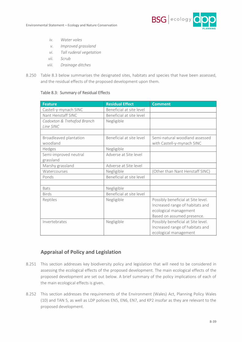
Environmental Statement – Ecology and Nature Conservation
8-39
iv. Water voles
v. Improved grassland
vi. Tall ruderal vegetation
vii. Scrub
viii. Drainage ditches
8.250 Table 8.3 below summarises the designated sites, habitats and species that have been assessed,
and the residual effects of the proposed development upon them.
Table 8.3: Summary of Residual Effects
Feature Residual Effect Comment
Castell-y-mynach SINC Beneficial at site level
Nant Henstaff SINC Beneficial at site level
Cadoxton & Trehafod Branch Line SINC
Negligible
Broadleaved plantation woodland
Beneficial at site level Semi-natural woodland assessed with Castell-y-mynach SINC
Hedges Negligible
Semi-improved neutral grassland
Adverse at Site level
Marshy grassland Adverse at Site level
Watercourses Negligible (Other than Nant Henstaff SINC)
Ponds Beneficial at site level
Bats Negligible
Birds Beneficial at site level
Reptiles Negligible Possibly beneficial at Site level. Increased range of habitats and ecological management Based on assumed presence.
Invertebrates Negligible Possibly beneficial at Site level. Increased range of habitats and ecological management
Appraisal of Policy and Legislation
8.251 This section addresses key biodiversity policy and legislation that will need to be considered in
assessing the ecological effects of the proposed development. The main ecological effects of the
proposed development are set out below. A brief summary of the policy implications of each of
the main ecological effects is given.
8.252 This section addresses the requirements of the Environment (Wales) Act, Planning Policy Wales
(10) and TAN 5, as well as LDP policies EN5, EN6, EN7, and KP2 insofar as they are relevant to the
proposed development.
Environmental Statement – Ecology and Nature Conservation
8-40
8.253 Effects on statutory designated sites. No significant effect on statutory designated sites are
predicted.
8.254 Effects on non-statutory designated sites. Long-term management, controlled access and
community engagement in respect of Castell-y-mynach Wood, as well as monitoring of the
effects of management and access, will be implemented. Provision will be put in place to allow
modification of management can be made as appropriate. Effects of uncontrolled access into and
within the Castell-y-mynach Wood will be minimised by retention of an appropriate ecotone and
limitation of formal access points.
8.255 Effects on the SINC interest of the Cadoxton and Trehafod Branch Line SINC, or on the woodland
that has colonised the embankment, will not be significant. There is an opportunity to create
calcareous and neutral grassland along the top of the embankment.
8.256 The stretch of the Nant Henstaff SINC within the Site will be diversified in terms of its structure
and habitats, and will be improved for biodiversity.
8.257 Residual effects on SINC sites are in line with the requirements of PPW 10 and TAN 5, as well as
LDP policies EN5, EN6, and relevant parts of KP2.
8.258 Effects on protected species. It is concluded that no significant adverse effects on bats are likely
to arise. The key measures for ensuring this are the retention of the woodland habitat of Castell-
y-mynach Wood and the railway embankment, and the control of excessive light spill in order to
ensure the long-term provision of dark habitat continuity throughout and along these features.
Provision within the Site of re-created marshy grassland along the drainage features, planting of
scrub and hedges along bank tops, and structural and species diversification of the boundary
landscape planting, are likely to give rise to an increased invertebrate fauna for feeding bats. It is
concluded that their favourable conservation status will be maintained. Precautionary measures
will be put in place to ensure the safeguarding of reptiles and badgers (and nesting birds) should
they be present. Pre-construction checks for otter will take place. Dormice and great crested
newts have not been recorded and will not be adversely affected.
8.259 Residual effects on protected and important species are in line with the requirements of TAN 5, as
well as the requirements of LDP Policies EN6, EN7, and relevant parts of KP2.
8.260 Effects on habitats and species / ecosystem assessment. There will be a loss of agricultural
grassland and some hedges. Planting / management of woodland / scrub and rough grassland will
provide a buffer to existing woodland habitat. The Nant Henstaff corridor will be improved in
structure and biodiversity interest. Woodland and scrub connectivity across the local landscape
will be maintained through and around the Site. Marshy grassland will be re-created throughout
the drainage system. Hedge and scrub provision as part of the drainage system and as part of the
woodland ecotone provision will offset hedgerow loss. Provision for the long-term beneficial
management of these habitats will be made, to ensure provision for commuting and foraging
fauna and maintenance of the ecological habitat structure and function of the local landscape. In
some instances it will be enhanced.
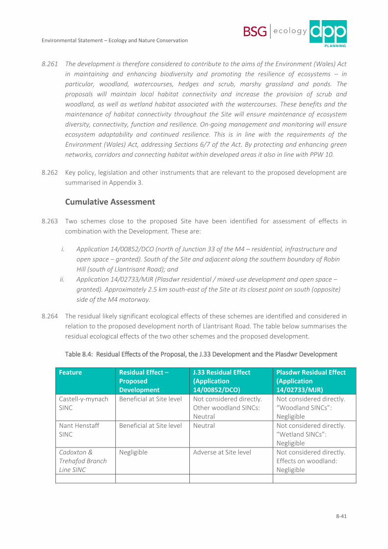
Environmental Statement – Ecology and Nature Conservation
8-41
8.261 The development is therefore considered to contribute to the aims of the Environment (Wales) Act
in maintaining and enhancing biodiversity and promoting the resilience of ecosystems – in
particular, woodland, watercourses, hedges and scrub, marshy grassland and ponds. The
proposals will maintain local habitat connectivity and increase the provision of scrub and
woodland, as well as wetland habitat associated with the watercourses. These benefits and the
maintenance of habitat connectivity throughout the Site will ensure maintenance of ecosystem
diversity, connectivity, function and resilience. On-going management and monitoring will ensure
ecosystem adaptability and continued resilience. This is in line with the requirements of the
Environment (Wales) Act, addressing Sections 6/7 of the Act. By protecting and enhancing green
networks, corridors and connecting habitat within developed areas it also in line with PPW 10.
8.262 Key policy, legislation and other instruments that are relevant to the proposed development are
summarised in Appendix 3.
Cumulative Assessment
8.263 Two schemes close to the proposed Site have been identified for assessment of effects in
combination with the Development. These are:
i. Application 14/00852/DCO (north of Junction 33 of the M4 – residential, infrastructure and
open space – granted). South of the Site and adjacent along the southern boundary of Robin
Hill (south of Llantrisant Road); and
ii. Application 14/02733/MJR (Plasdwr residential / mixed-use development and open space –
granted). Approximately 2.5 km south-east of the Site at its closest point on south (opposite)
side of the M4 motorway.
8.264 The residual likely significant ecological effects of these schemes are identified and considered in
relation to the proposed development north of Llantrisant Road. The table below summarises the
residual ecological effects of the two other schemes and the proposed development.
Table 8.4: Residual Effects of the Proposal, the J.33 Development and the Plasdwr Development
Feature Residual Effect – Proposed Development
J.33 Residual Effect (Application 14/00852/DCO)
Plasdwr Residual Effect (Application 14/02733/MJR)
Castell-y-mynach SINC
Beneficial at Site level Not considered directly. Other woodland SINCs: Neutral
Not considered directly. “Woodland SINCs”: Negligible
Nant Henstaff SINC
Beneficial at Site level Neutral Not considered directly. “Wetland SINCs”: Negligible
Cadoxton & Trehafod Branch Line SINC
Negligible Adverse at Site level Not considered directly. Effects on woodland: Negligible
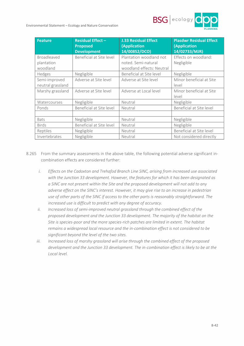
Environmental Statement – Ecology and Nature Conservation
8-42
Feature Residual Effect – Proposed Development
J.33 Residual Effect (Application 14/00852/DCO)
Plasdwr Residual Effect (Application 14/02733/MJR)
Broadleaved plantation woodland
Beneficial at Site level Plantation woodland not noted. Semi-natural woodland effects: Neutral
Effects on woodland: Negligible
Hedges Negligible Beneficial at Site level Negligible
Semi-improved neutral grassland
Adverse at Site level Adverse at Site level Minor beneficial at Site level
Marshy grassland Adverse at Site level Adverse at Local level Minor beneficial at Site level
Watercourses Negligible Neutral Negligible
Ponds Beneficial at Site level Neutral Beneficial at Site level
Bats Negligible Neutral Negligible
Birds Beneficial at Site level Neutral Negligible
Reptiles Negligible Neutral Beneficial at Site level
Invertebrates Negligible Neutral Not considered directly
8.265 From the summary assessments in the above table, the following potential adverse significant in-
combination effects are considered further:
i. Effects on the Cadoxton and Trehafod Branch Line SINC, arising from increased use associated
with the Junction 33 development. However, the features for which it has been designated as
a SINC are not present within the Site and the proposed development will not add to any
adverse effect on the SINC’s interest. However, it may give rise to an increase in pedestrian
use of other parts of the SINC if access to the other parts is reasonably straightforward. The
increased use is difficult to predict with any degree of accuracy.
ii. Increased loss of semi-improved neutral grassland through the combined effect of the
proposed development and the Junction 33 development. The majority of the habitat on the
Site is species-poor and the more species-rich patches are limited in extent. The habitat
remains a widespread local resource and the in-combination effect is not considered to be
significant beyond the level of the two sites.
iii. Increased loss of marshy grassland will arise through the combined effect of the proposed
development and the Junction 33 development. The in-combination effect is likely to be at the
Local level.
Environmental Statement – Ecology and Nature Conservation
8-43
Summary and Conclusion
8.266 The Site is dominated by improved and semi-improved grassland, which is where the majority of
the development will be located. Other habitats include plantation and semi-natural woodland
(including ancient woodland), marshy grassland, watercourses and drains, a pond, hedges, scrub
and tall ruderal vegetation. Three SINCs, of county-level ecological importance, are present
within or partially within the Site.
8.267 The site supports, or has the potential to support, fauna that could be significantly affected by
the proposals. These include bats, birds, reptiles, and invertebrates. Surveys suggest that otter,
water vole, dormouse, great crested newt and badger are unlikely to be affected by the proposed
development.
8.268 Ecological features have been evaluated and the likely effects of the proposed development on
them has been assessed in line with current best practice guidance for ecology.
8.269 No bat roosts are likely to be affected, and the effect on commuting / foraging bats is assessed as
negligible – habitat diversity will increase with gardens, improvement of the Nant Henstaff
corridor, creation of swales and other drainage features, and the planting of ecotone habitats
around wooded areas. Higher quality habitats for bats are retained and buffered. An increase in
lighting across the Site will be managed according to a sensitive lighting scheme and key wooded
habitats will be protected from excessive light spill.
8.270 The primary features of interest for birds are the woodland habitats. These are retained and
enhanced, and semi-improved grassland will be replaced with suburban gardens, swales, scrub
lines, marshy grassland and broadleaved plantation woodland with an enhanced structure. As the
garden and public green space vegetation develops in structure, the bird assemblage is likely to
change, but is likely to increase in diversity and numbers. The effect on the bird assemblage is
assessed as beneficial at the level of the Site.
8.271 Precautionary measures in respect of the protection of reptiles are identified, and pre-works
checks for more mobile protected species (badger and otter) will take place.
8.272 The length of Nant Henstaff SINC within the Site will be re-profiled, diversified and incorporated
into a wider drainage strategy for the Site. This will give rise to enhancement of a relatively
degraded length of stream. With mitigation measures in place during construction the Castell-y-
mynach SINC and the Cadoxton & Trehafod Branch Line SINC are unlikely to be adversely
affected and, with the adoption of long-term protection, enhancement and management
measures, the development proposal should give rise to beneficial effects of significance at the
level of the Site in respect of Nant Henstaff and Castell-y-mynach SINCs. Long-term effects on the
Cadoxton & Trehafod Branch Line SINC are likely to be negligible.
8.273 A range of mitigation and enhancement measures have been designed into the development
proposals. These include improvement of the Nant Henstaff corridor, ecotone creation around
Castell-y-mynach Wood and alongside the Trehafod and Cadoxton Branch Line, clearly defined
Environmental Statement – Ecology and Nature Conservation
8-44
access through Castell-y-mynach wood to protect sensitive habitat, diversification of the
structure and interest of boundary plantation woodland, and incorporation of replacement
marshy grassland, wetland and scrub into the drainage system. Scrub and hedgerow planting and
incorporation of hedge lines into the ecotone habitat provision around woodland will offset the
loss of hedges.
8.274 Additional measures will ensure minimisation of effects during construction and occupation; and
a Strategic Green Infrastructure Strategy will identify long-term management and monitoring
provision for mitigation, compensation and enhancement measures outlined in this chapter.
8.275 The measures proposed will minimise the effects of the development on ecological features of
importance and ensure legal compliance in respect of protected species. The development is
consistent with relevant biodiversity planning policy, and is considered to contribute to the aims
of the Environment (Wales) Act in maintaining and enhancing biodiversity and promoting the
resilience of ecosystems – in particular, woodland, watercourses, hedges and scrub, marshy
grassland and ponds. Local habitat connectivity will be maintained and there will be an increase
in scrub, woodland and wetland habitat.
Environmental Statement – Ecology and Nature Conservation
8-45
Reference List
Biggs J, Ewald N, Valentini A, Gaboriaud C, Griffiths RA, Foster J, Wilkinson J, Arnett A, Williams P and
Dunn F (2014). Analytical and methodological development for improved surveillance of the Great
Crested Newt. Defra Project WC1067. Freshwater Habitats Trust: Oxford.
BRIG (2011) UK Biodiversity Action Plan Priority Habitat Descriptions. JNCC.
http://jncc.defra.gov.uk/PDF/UKBAP_PriorityHabitatDesc-Rev2011.pdf [accessed 24/10/18].
Bright, P.W, Morris, P.A. and Mitchell-Jones, T. (2006). The Dormouse Conservation Handbook Second
Edition. English Nature, Peterborough.
CIEEM (2018) EcIA Guidelines.
Collins J (2016). Bat surveys for professional ecologists: good practice guidelines, 3rd Edition. Bat
Conservation Trust.
Dean, M., Strachan, R., Gow, D. and Andrews, R. (2016). The Water Vole Mitigation Handbook. The
Mammal Society, London.
DEFRA (2007). Hedgerow Survey Handbook. A standard procedure for local surveys in the UK. DEFRA,
London.
English Nature (2001). Great Crested Newt Mitigation Guidelines. Peterborough, English Nature.
Gilbert, G., Gibbons, D. W. & Evans, J. (1998). ‘Common Birds Census (CBC)’ in Bird Monitoring Methods:
a manual of techniques for key UK species. RSPB.
Gov.uk (2015) https://www.gov.uk/guidance/water-voles-protection-surveys-and-licences
Gov.uk (2019) https://www.gov.uk/guidance/otters-protection-surveys-and-licences#survey-methods
Gwent Wildlife Trust (2004). Guidelines for the selection of Local Wildlife Sites in South Wales. South
Wales Wildlife Sites Partnership. (CEH, 2016) Modular Analysis of Vegetation Information System (MAVIS)
software
Harris, S., Cresswell, P. and Jeffries, D. (1989).
Surveying Badgers. Occasional publication of Mammal Society, number 9. Mammal Society.
JNCC (2010) Handbook for Phase 1 habitat survey - a technique for environmental audit. Joint Nature
Conservation Committee, Peterborough.
Environmental Statement – Ecology and Nature Conservation
8-46
Oldham, R. S., J. Keeble, M. J. S. Swan & M. Jeffcote, 2000. Evaluating the suitability of habitat for the
great crested newt (Triturus cristatus). Herpetological Journal 10: 143–155.
Persimmon Homes (2013) Land North of Junction 33, Cardiff Environmental Statement. [Online] Available
from: https://planningonline.cardiff.gov.uk/online-
applications/files/9AFAF6943E5B40284FD6597DE2E05296/pdf/14_00852_DCO-EIA_Vol_1_CHAPTER_7_-
_ECOLOGY_AND_NATURE_CONSERVATION-1558861.pdf [Accessed March 2018].
Persimmon Homes (2016) Land North of Junction 33, Cardiff – Environmental Statement Addendum.
[Online] Available from: https://planningonline.cardiff.gov.uk/online-
applications/files/61044D219E9F5069A2EE383DB9E6DEAD/pdf/14_00852_DCO-
ENVIRONMENTAL_STATEMENT_ADDENDUM_AUGUST_2016-1821064.pdf [Accessed March 2018].
Rodwell J. S. et al (1991a) British plant communities: Volume 1: Woodlands and scrub. Cambridge
University Press.
Rodwell J. S. et al (1991b) British plant communities: Volume 2: Mires and heaths. Cambridge University
Press.
Rodwell J. S. et al (1992) British plant communities: Volume 3: Grasslands and montane communities.
Cambridge University Press.
Rodwell J. S. et al (1995) British plant communities: Volume 4: Aquatic communities, swamps and tall-herb
fens. Cambridge University Press.
Wildwood Ecology (2013) Land to the south of Creigiau, Cardiff – Dormouse survey and report. Report
ref: WWE103101/DOR/01