12 ecology and nature conservation - transport scotland · a9 dualling – crubenmore to kincraig...
TRANSCRIPT

A9 Dualling – Crubenmore to Kincraig DMRB Stage 3 Environmental Impact Assessment
Chapter 12: Ecology and Nature Conservation Page 12-1
12 Ecology and Nature Conservation
12.1 Introduction 12.1.1 This chapter presents the Ecological Impact Assessment (EcIA) of the proposed Project 9 -
Crubenmore to Kincraig (Central Section) A9 Dualling Scheme (‘the Proposed Scheme’). The Proposed Scheme under assessment is described in Chapter 5, Volume 1.
12.1.2 The Design Manual for Roads and Bridges (DMRB) defines ecology as “the scientific study of living organisms, and their relationship both with each other and their environment (e.g. soils, climate, topography). Nature conservation is concerned with maintaining a viable population of the country’s characteristic fauna and flora and the communities they comprise. The objectives of nature conservation are:
•• maintenance of the diversity and character of the countryside, including its wildlife communities and important geological and physical features
•• maintenance of viable populations of wildlife species, throughout their traditional ranges, and the improvement of the status of rare and vulnerable species”.
12.1.3 Therefore, the aims of this EcIA are to:
•• identify the presence and status of ecological features of conservation significance within the study area
•• assign a conservation value to ecological features
•• identify potential impacts upon ecological features
•• present potential mitigation measures to alleviate predicted impacts
•• assess the residual impacts following the application of mitigation.
12.2 Approach and Methods
Legislation and Policy Context
12.2.1 The conservation significance of ecological features is highlighted through relevant legislation or planning policy. For the purpose of this assessment, the relevant legal framework comprises:
•• European Council Directive 2009/147/EC on the conservation of wild birds (otherwise known as the Birds Directive)
•• European Council Directive 92/43/EEC on the conservation of natural habitats and of wild fauna and flora (otherwise known as the Habitats Directive)
•• European Council Directive 2000/60/EC (otherwise known as the Water Framework Directive, or WFD)
•• Conservation (Natural Habitats, &c.) Regulations 1994 (as amended in Scotland)
•• Nature Conservation (Scotland) Act 2004 (as amended in Scotland)
•• Water Environment and Water Services (Scotland) Act (WEWS) 2003
•• Wildlife and Countryside Act 1981 (as amended in Scotland)
•• Protection of Badgers Act 1992

A9 Dualling – Crubenmore to Kincraig DMRB Stage 3 Environmental Impact Assessment
Chapter 12: Ecology and Nature Conservation Page 12-2
12.2.2 An assessment of compliance against relevant biodiversity planning policy is present within Chapter 19, Volume 1.
Scope and Guidance
12.2.3 This EcIA was undertaken in accordance with the following guidance:
•• CIEEM (2016) ‘Guidelines for Ecological Impact Assessment in the UK and Ireland, Terrestrial, Freshwater and Coastal’. Chartered Institute of Ecology and Environmental Management
•• DMRB. (1993) Ecology and Nature Conservation. DMRB Volume 11, Section 3, Part 4. Department for Transport (DfT)
•• The Highways Agency et al., (2010) ‘Ecology and Nature Conservation: Criteria for Impact Assessment’. Interim Advice Note (IAN) 130/10; hereafter referred to as IAN 130/10
•• SNH (2013) ‘A handbook on environmental impact assessment. Guidance for Competent Authorities, Consultees and others involved in the Environmental Impact Assessment process in Scotland’. 4th Ed. Scottish Natural Heritage.
Study Area
12.2.4 The study areas for each ecological feature that could be significantly affected by the Proposed Scheme are as follows:
•• Designated sites within or hydrologically/ ecologically linked to the Proposed Scheme
•• Phase 1 habitat survey: 150m either side of the existing A9
•• National Vegetation Classification (NVC): 250m either side of the existing A9
•• Breeding birds (including scarce breeding birds): 500m either side of the existing A9
•• Breeding bird vantage point: 500m east and west of the River Spey crossing at Kingussie
•• Non-breeding bird vantage point: 1km east and 500m west of the River Spey crossing at Kingussie
•• Badger: within and up to 100m from the design earthworks extent
•• Otter: 100m1 upstream and downstream of watercourses crossed by the existing A9
•• Water vole: 100m upstream and downstream of watercourses and drainage ditches crossed by the existing A9
•• Red squirrel, pine marten and bats: within and up to 50m from the design earthworks extent
•• Wood ant: within and up to 50m from the design earthworks extents
•• European wildcat: encompassed in each of the above study areas
•• Atlantic salmon, sea lamprey and Arctic charr: major watercourses crossed by the existing A9
•• Freshwater pearl mussel (FWPM): major watercourses crossed by existing A9 road 1 Locally extended to 250m where valuable habitat features are identified.

A9 Dualling – Crubenmore to Kincraig DMRB Stage 3 Environmental Impact Assessment
Chapter 12: Ecology and Nature Conservation Page 12-3
12.2.5 The study area was developed in line with current professional standards for ecological impact assessment and ecological surveys; and was agreed with the relevant statutory environmental bodies through the EIA consultation process (see Chapter 7, Volume 1).
Desktop Study
12.2.6 A desktop study was carried out to identify the potential presence, or absence, of important ecological features within the study area. In the first instance, this information has informed the design development via avoidance of designated nature conservation sites where possible.
12.2.7 Baseline information was initially sourced from the ‘A9 Dualling Programme Strategic Environmental Assessment’ (Transport Scotland 2013). Subsequent consultations were also carried out to acquire records for notable habitats and species from:
•• British Trust for Ornithology (BTO)
•• Cairngorms National Park Authority (CNPA)
•• Highland Biological Recording Group (HBRG)
•• National Biodiversity Network (NBN) Gateway
•• North East Scotland Biological Records Centre (NESBReC)
•• Royal Society for the Protection of Birds (RSPB)
•• Scottish Badgers
•• Scottish Environment Protection Agency (SEPA)
•• Scottish Raptor Study Group
•• Scottish Natural Heritage (SNH)
•• SNHi Information Services (e.g. SiteLink, iMap and Natural Spaces)
•• Spey Fishery Board (SFB)
Field Surveys
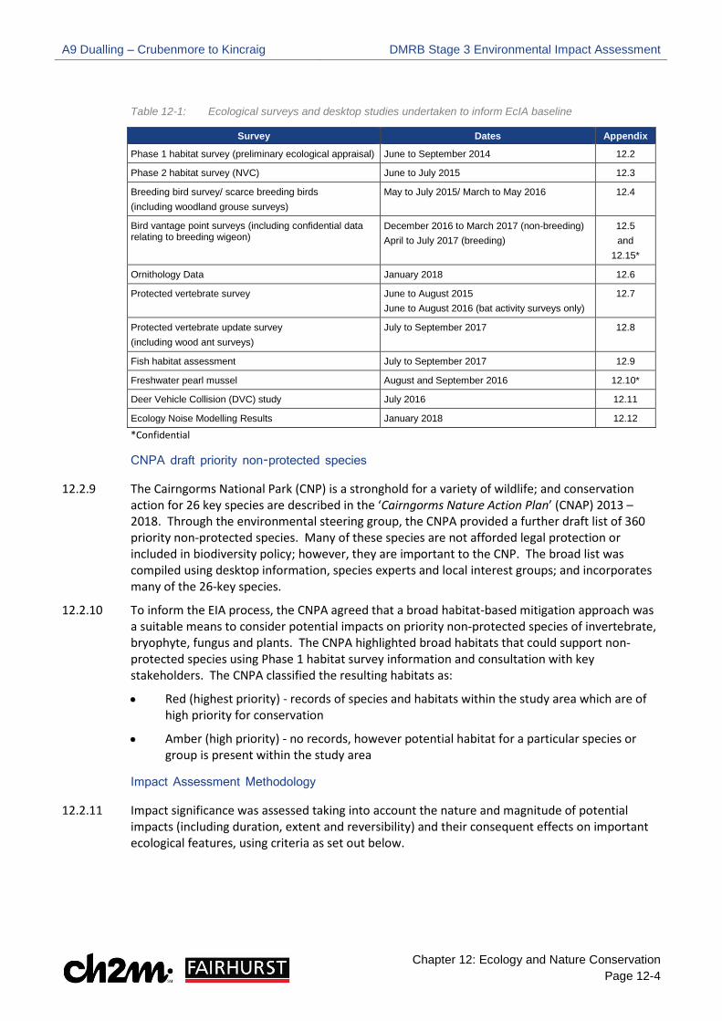
12.2.8 In line with current professional standards, ecological surveys have been completed within the study area to establish the baseline of the EcIA (see Table 12-1). Survey methodologies were agreed with the relevant statutory environmental bodies through the EIA consultation process.
A9 Dualling – Crubenmore to Kincraig DMRB Stage 3 Environmental Impact Assessment
Chapter 12: Ecology and Nature Conservation Page 12-4
Table 12-1: Ecological surveys and desktop studies undertaken to inform EcIA baseline
Survey Dates Appendix
Phase 1 habitat survey (preliminary ecological appraisal) June to September 2014 12.2
Phase 2 habitat survey (NVC) June to July 2015 12.3
Breeding bird survey/ scarce breeding birds (including woodland grouse surveys)
May to July 2015/ March to May 2016 12.4
Bird vantage point surveys (including confidential data relating to breeding wigeon)
December 2016 to March 2017 (non-breeding) April to July 2017 (breeding)
12.5 and
12.15*
Ornithology Data January 2018 12.6
Protected vertebrate survey June to August 2015 June to August 2016 (bat activity surveys only)
12.7
Protected vertebrate update survey (including wood ant surveys)
July to September 2017 12.8
Fish habitat assessment July to September 2017 12.9
Freshwater pearl mussel August and September 2016 12.10*
Deer Vehicle Collision (DVC) study July 2016 12.11
Ecology Noise Modelling Results January 2018 12.12
*Confidential
CNPA draft priority non-protected species
12.2.9 The Cairngorms National Park (CNP) is a stronghold for a variety of wildlife; and conservation action for 26 key species are described in the ‘Cairngorms Nature Action Plan’ (CNAP) 2013 – 2018. Through the environmental steering group, the CNPA provided a further draft list of 360 priority non-protected species. Many of these species are not afforded legal protection or included in biodiversity policy; however, they are important to the CNP. The broad list was compiled using desktop information, species experts and local interest groups; and incorporates many of the 26-key species.
12.2.10 To inform the EIA process, the CNPA agreed that a broad habitat-based mitigation approach was a suitable means to consider potential impacts on priority non-protected species of invertebrate, bryophyte, fungus and plants. The CNPA highlighted broad habitats that could support non-protected species using Phase 1 habitat survey information and consultation with key stakeholders. The CNPA classified the resulting habitats as:
•• Red (highest priority) - records of species and habitats within the study area which are of high priority for conservation
•• Amber (high priority) - no records, however potential habitat for a particular species or group is present within the study area
Impact Assessment Methodology
12.2.11 Impact significance was assessed taking into account the nature and magnitude of potential impacts (including duration, extent and reversibility) and their consequent effects on important ecological features, using criteria as set out below.

A9 Dualling – Crubenmore to Kincraig DMRB Stage 3 Environmental Impact Assessment
Chapter 12: Ecology and Nature Conservation Page 12-5
Importance
12.2.12 The general approach to defining the importance of ecological features follows that of CIEEM (2016). The approach is also in line with advice given in DMRB IAN 130/10 ‘Ecology and Nature Conservation: Criteria for Impact Assessment’ (Department for Transport, 2010).
12.2.13 Ecosystems, habitats and species are assigned levels of importance for nature conservation based on the criteria set out in Table 12-2.
12.2.14 The following factors are considered when determining the importance of an ecological feature: rarity, ability to resist or recover from environmental change, uniqueness, function/ role within an ecosystem and level of legal protection or designation afforded to a given ecological feature.
12.2.15 Only important ecological features are subject to impact assessment. Therefore, features that do not meet the criteria for at least local importance are not considered in detail in this assessment.
12.2.16 In accordance with IAN 130/10, deer are scoped out from ecological evaluation due to their lack of conservation status; therefore, are not discussed further in that context. However, deer are discussed in this chapter in the context of potential for vehicle collisions during the operational phase of the Proposed Scheme, which could have implications regarding human safety and animal welfare.

A9 Dualling – Crubenmore to Kincraig DMRB Stage 3 Environmental Impact Assessment
Chapter 12: Ecology and Nature Conservation Page 12-6
Table 12-2: Importance criteria for ecological features
Importance Criteria International Ecosystems and Habitats
Ecosystems or habitats essential for the maintenance of:
• internationally designated areas or undesignated areas that meet the criteria for designation; and/ or • viable populations of species of international conservation concern Species Species whose presence contributes to:
• the maintenance of qualifying habitats, communities and assemblages that occur within internationally designated sites or within undesignated areas that meet the criteria for such designation
National Ecosystems and Habitats Ecosystems or habitats essential for the maintenance of:
• qualifying communities and assemblages that occur within nationally designated sites or within undesignated areas that meet the criteria for such designation; and/ or
• viable populations of species of national conservation concern Species Species whose presence contributes to:
• the maintenance of qualifying habitats, communities and assemblages that occur within nationally designated sites or within undesignated areas that meet the criteria for such designation; or
• the maintenance and restoration of biodiversity and ecosystems at a national level, as defined in the Scottish Biodiversity Strategy (SBS) (Scottish Government, 2013, 2015)
Regional Ecosystems and Habitats Ecosystems or habitats essential for the maintenance of:
• communities and assemblages that occur within regionally important sites or localities listed as being of conservation importance in the Tayside Biodiversity Action Plan (BAP) or Cairngorms Nature Action Plan (CNAP) (including Local Nature Reserves) or within undesignated areas that meet the criteria for such designation; and/ or
• viable populations of species of regional conservation concern Species Species whose presence contributes to:
• the maintenance and restoration of biodiversity and ecosystems at a regional level, as defined in the Tayside BAP or CNAP
Authority Area Ecosystems and Habitats Ecosystems or habitats essential for the maintenance of:
• populations of species of conservation concern within the authority area Species Species whose presence contributes to:
• the maintenance and restoration of biodiversity and ecosystems within a relevant area such as Perth and Kinross within the Tayside BAP, or Aviemore in the CNAP
Local Ecosystems and Habitats Ecosystems or habitats essential for the maintenance of:
• populations of species of conservation concern within the local area (for example a Local Nature Reserve (LNR))
Species
Species whose presence contributes to:
• the maintenance and restoration of biodiversity and ecosystems at a local level
Less than Local Ecosystems and Habitats • Ecosystems or habitats that do not meet the above criteria, i.e., supporting at least populations of
species of conservation concern within the local area
Species • features that are considered to be absent or do not meet any of the above criteria

A9 Dualling – Crubenmore to Kincraig DMRB Stage 3 Environmental Impact Assessment
Chapter 12: Ecology and Nature Conservation Page 12-7
Impact Characterisation
12.2.17 For the purposes of this assessment, the impact descriptors in Table 12-3 are taken to summarise the overall characterisation of adverse or beneficial impacts in accordance with CIEEM (2016), including:
•• impact extent/ scale (e.g. entire habitat loss, partial habitat loss or indication over specific area affected)
•• direct or indirect impact (e.g. direct mortality of individuals from vehicle collisions, or indirect mortality of individuals from reduced prey resources due to pollution of watercourses)
•• reversibility of impact (reversible or irreversible)
•• frequency of impact (single event, recurring or constant)
•• duration of impact (short-term, medium-term, long-term or permanent)
•• likelihood of occurrence (certain/near certain, probable, unlikely or extremely unlikely)
12.2.18 Impact descriptors are identified as High, Medium, Low or Negligible, following the impact characterisation approach.
Table 12-3: Impact magnitude and character for ecological features
Impact Descriptor Impact Characterisation
High
An impact resulting in a permanent effect on the distribution and/ or abundance of a habitat, species assemblage/ community or population, in such a way as to alter the integrity of the feature and its conservation status. If adverse, this type of effect would reduce the integrity of the feature and its conservation status. If beneficial, it would result in an improvement to the conservation status of the feature.
Medium
An impact resulting in a long-term but reversible effect on the distribution and/ or abundance of a habitat, species assemblage/ community or population. If adverse, this type of effect would have neutral long-term implications for the integrity of the feature or its conservation status. If beneficial, it would not alter the long-term conservation status of the feature.
Low An impact resulting in a short-term reversible effect on the distribution and/or abundance of a habitat, species assemblage/ community or population.
Negligible No discernible impact on the distribution and/or abundance of a habitat, species assemblage/ community or population.
Impact Significance
12.2.19 Each feature’s importance and the potential impacts upon it have been determined through the above described collection of data and consultation, and from prior project experience. This has provided a robust basis for making a professional decision on the appropriate focus of the impact assessment. The assessment is then focused on those impacts that result in potentially significant effects on important ecological features.
12.2.20 CIEEM (2016) notes that impacts that are likely to be relevant in an assessment are those that are predicted to lead to significant effects (adverse or beneficial) on important ecological features. Significant effects are those that are sufficiently important to support or undermine the

A9 Dualling – Crubenmore to Kincraig DMRB Stage 3 Environmental Impact Assessment
Chapter 12: Ecology and Nature Conservation Page 12-8
conservation status2 of important ecological features. Knowledge and assessment of construction methods and operational activities, together with the ecological knowledge of CFJV ecologists with experience of similar large-scale infrastructure projects, has been used to identify the potential impacts of the Proposed Scheme on ecological features.
12.2.21 Following the above approach, the assessment aims to characterise ecological impacts rather than placing a reliance only on magnitude. The character of an impact is used to inform the determination of whether or not the identified impact on the feature in question is significant.
12.2.22 Where impacts on internationally, nationally or regionally important ecological features are characterised as ‘Medium’ or ‘High’, they are considered to be potentially significant under the terms of the Environmental Impact Assessment (EIA) Regulations.
12.2.23 Impacts on internationally important features characterised as ‘Low’, and ‘High’ impacts on features of authority area importance, can also be potentially significant. There may in addition, be a number of impacts on a feature that, whilst not of a character to be significant in themselves, may cumulatively result in a significant effect on that feature.
12.2.24 Under the terms of the EIA Regulations, where significant impacts are identified, mitigation has been developed to reduce impacts where feasible.
12.2.25 Embedded mitigation measures described within the EcIA (paragraphs 12.4.5 to 12.4.7) have been incorporated into the design and taken into account within the assessment of the significance of effects. The mitigation aims to avoid or negate impacts on ecological features in accordance with best practice guidance and UK, Scottish and local government environmental impact, planning and sustainability policies.
12.2.26 Impacts that are not significant (including those where compliance with regulation is required) would be expected to be avoided or reduced through the implementation and application of an Environmental Management System (EMS) including a Construction Environmental Management Plan (CEMP) and best working practice (e.g. mitigation of potential pollution impacts through adherence to standard best practice and guidelines). Significant ecological impacts are expected to be mitigated through a combination of best practice/ typical mitigation methods and mitigation targeted to specific locations.
12.2.27 Mitigation is also designed to aim to result in a net gain for biodiversity where practicable in line with policy and guidelines (CIEEM, 2016).
12.2.28 Residual impacts have been assessed after mitigation is applied, using the same methodology for assessing impacts pre-mitigation.
Assigning Mitigation
12.2.29 Potential additional mitigation measures to address identified impacts have been considered as part of this assessment and are discussed in Section 12.5. Residual impacts are discussed in Section 12.6 with significant impacts determined post-mitigation using the criteria previously outlined.
2 Conservation status for habitats is determined by the sum of the influences acting on the habitat and its typical species that may affect its long-term distribution, structure and function as well as the long-term distribution and abundance of its population within a given geographical area. Conservation status for species is determined by the sum of influences acting on the species concerned that may affect the long-term distribution and abundance of its population within a given geographical area.
A9 Dualling – Crubenmore to Kincraig DMRB Stage 3 Environmental Impact Assessment
Chapter 12: Ecology and Nature Conservation Page 12-9
Limitations to Assessment
12.2.30 Baseline information from key stakeholders generally provides a catalogue of likely species occurring in the area. The reliability of this information cannot be verified due to unknowns such as recorder expertise, accurate species identification and accuracy of location. Records do not provide a comprehensive list of all species present, and a lack of records does not necessarily indicate the absence of a species; the area may simply be under-recorded. This is not a constraint to the EcIA baseline as species accounts have been reviewed against potential habitat features to determine their likely presence using professional judgement.
12.2.31 Ecological surveys were carried out in all reasonably accessible areas where relevant permissions with landowners could be agreed in advance. Inaccessible areas, for example Network Rail land, were subject to visual assessment from adjoining fields. As far as practicable, surveys were carried out during optimal survey conditions for target species.
12.2.32 Surveys present a snapshot of the current ecological baseline in terms of vegetation communities and species distribution within the study area. The extent, structure and function of habitats within the local geographic context, as well as abundance and distribution of species, will fluctuate in response to natural processes, prevailing land management pressures and climate. Given the high altitude, high latitude location of the study area, this is not considered to be a constraint to the EcIA baseline due to the likely timescales required, particularly for habitats, to change significantly from baseline conditions.

A9 Dualling – Crubenmore to Kincraig DMRB Stage 3 Environmental Impact Assessment
Chapter 12: Ecology and Nature Conservation Page 12-10
12.3 Baseline Conditions 12.3.1 The ecological baseline for the Proposed Scheme is presented below, including the determination
of importance for ecological features. Further detail of the determination of importance for each ecological feature is provided in Appendix 12.1, Volume 2.
Statutory Designated Sites
12.3.2 Seven statutory designated sites have been identified within the study area. Table 12-4 provides the interest features of each designated site and importance of these features.
Table 12-4: Summary of statutory designated sites within the study area
Name Interest Features Importance
River Spey – Insh Marshes Ramsar
Large, high altitude slow-flowing river (River Spey) Mesotrophic loch Flood-plain mire
Assemblage of nationally rare and scarce aquatic plants Assemblage of nationally rare and scarce invertebrates
Otter Breeding bird assemblage
Whooper swan Cygnus cygnus, non-breeding
International
River Spey – Insh Marshes Special Protection Area
(SPA)
Osprey Pandion haliaetus, breeding and foraging Wigeon Anas penelope, breeding
Wood sandpiper Tringa glareola, breeding Spotted crake Prozana porzana, breeding Hen harrier Circus cyaneus, non-breeding
Whooper swan, non-breeding
International
River Spey Special Area of Conservation
(SAC)
Sea lamprey Petromyzon marinus Atlantic salmon Salmo salar
Otter Lutra lutra Freshwater pearl mussel (FWPM) Margaritifera margaritifera
International
Insh Marshes SAC Transition Mires and quaking bogs Oligotrophic to mesotrophic standing water
Alluvial forests Otter
International
River Spey – Insh Marshes Site of Special Scientific
Interest (SSSI)
Osprey, breeding Whooper swan, non-breeding
Breeding bird assemblage Otter
Arctic charr Salvelinus alpinus Flood-plain fen
Mesotrophic loch Vascular plant assemblage Invertebrate assemblage
National
River Spey SSSI Sea lamprey Atlantic salmon
Otter Freshwater pearl mussel
National
National Nature Reserve (NNR)
Refer to River Spey-Insh Marshes SSSI qualifying features National

A9 Dualling – Crubenmore to Kincraig DMRB Stage 3 Environmental Impact Assessment
Chapter 12: Ecology and Nature Conservation Page 12-11
River Spey – Insh Marshes Ramsar
12.3.3 The River Spey – Insh Marshes Ramsar site boundary begins west of the existing A9, crossing to the east at the River Spey. The location of the Ramsar in relation to the existing A9 is presented on Drawings 12.1 to 12.7, Volume 3. Ramsar sites are notified through the Convention on Wetlands of International Importance especially as waterfowl habitat; therefore, are of international importance.
12.3.4 Interest features of Ramsar sites in Scotland are afforded protection by the equivalent qualifying features of Natura 2000 sites (SPA or SAC) or notified features of SSSIs. Table 12-5 was provided by SNH and shows the equivalent SPA, SAC or SSSI interest feature for each interest feature of the Ramsar site.
12.3.5 Potential impacts of the Proposed Scheme on the Ramsar’s interest features will be considered under the equivalent SPA, SAC or SSSI interest feature; therefore, the Ramsar will not be discussed separately within this EcIA.
Table 12-5: Relationship between Ramsar site and equivalent SPA, SAC or SSSI.
Ramsar Interest Feature Equivalent SPA, SAC or SSSI name
Equivalent SPA, SAC or SSSI interest Feature
Breeding bird assemblage Whooper swan (non-
breeding)
River Spey – Insh Marshes SPA Osprey Pandion haliaetus, breeding and foraging Wigeon Anas penelope, breeding
Wood sandpiper Tringa glareola, breeding Spotted crake Prozana porzana, breeding Hen harrier Circus cyaneus, non-breeding
Whooper swan, non-breeding
Large, high-altitude, slow flowing river
River Spey SAC Sea lamprey Atlantic salmon
Otter Freshwater pearl mussel
Mesotrophic Loch Insh Marshes SAC Oligotrophic to mesotrophic standing water
Floodplain mire Insh Marshes SAC Very wet mire often identified by an unstable quaking surface
Assemblage of nationally rare and scarce aquatic plants
River Spey- Insh Marshes SSSI Vascular plant assemblage
Assemblage of nationally rare and scarce invertebrates
River Spey- Insh Marshes SSSI Invertebrate assemblage
Otter River Spey SAC Insh Marshes SAC
Otter
River Spey – Insh Marshes SPA
12.3.6 The River Spey – Insh Marshes SPA boundary begins west of the existing A9, crossing to the east at the A9 River Spey crossing at Kingussie. The location of the SPA in relation to the existing A9 is presented on Drawings 12.1 to 12.7, Volume 3. SPAs are notified through the Birds Directive (79/409/EEC) and are included within the Natura 2000 network; therefore, are of international importance.
12.3.7 The baseline conditions for each SPA qualifying feature (See Table 12-4) is discussed in the following paragraphs and has been assessed using a combination of desk-based information and field surveys. All SPA qualifying features are of international importance.
A9 Dualling – Crubenmore to Kincraig DMRB Stage 3 Environmental Impact Assessment
Chapter 12: Ecology and Nature Conservation Page 12-12
Breeding/ foraging osprey 12.3.8 The River Spey and areas of woodland within and outside the River Spey - Insh Marshes SPA,
provides potential foraging and nesting habitat for osprey. The River Spey is present within the study area where the river meanders close to the existing A9 and where the road crosses the River Spey at Kingussie. Loch Insh is located beyond the study area to the north and provides a key foraging resource for osprey.
12.3.9 Consultation with RSPB highlighted an inactive nest site, which has been vacant for approximately 10 years, within the study area within River Spey - Insh Marshes SPA.
12.3.10 During CFJV breeding bird surveys undertaken in 2015 and scarce breeding bird surveys undertaken in 2016, a breeding pair of osprey was confirmed beyond the study area (approximately 900m from the existing A9). Flights, likely associated with the nest site identified during breeding bird surveys, were recorded within the study area, however no hunting behaviour was observed. The full breeding bird survey report is provided in Appendix 12.4, Volume 2.
12.3.11 A single osprey flight at height (>100m) across the existing A9 and through the SPA was noted during breeding bird vantage point surveys (2017) undertaken around the A9 River Spey crossing. A full account of vantage point observation surveys is presented in Appendix 12.5.
Breeding wigeon 12.3.12 A review of British Trust Ornithology (BTO) tetrads (2km x 2km recording units) which overlap
with, or are directly adjacent to, the study area highlighted records of breeding wigeon.
12.3.13 The number of breeding wigeon within Insh Marshes between 2006 and 2015 varies between 11 and 35 as reported by the Scottish Ornithologist’s Club (SOC) 2017.
12.3.14 RSPB Scotland (hereafter referred to as RSPB) breeding bird data (2015 to 2017) highlights wigeon are widely distributed within Insh Marshes, with most records over 200m from the existing A9. Details of wigeon distribution across RSPB Insh Marshes survey compartments are provided in Table 12-1-2 in Appendix 12.1, Volume 2.
12.3.15 Breeding bird vantage point surveys around the A9 River Spey crossing at Kingussie were undertaken to examine functional use of habitats surrounding the crossing. A likely breeding pair of wigeon were noted within the study area and a group of males were observed in the same location. The location of breeding wigeon within the study area is presented on Drawing 12.5.1, Confidential Appendix 12.15, Volume 2. The full breeding bird vantage point survey report is provided in Appendix 12.5, Volume 2. No records of breeding wigeon were identified outside the SPA within the study area.
Breeding spotted crake 12.3.16 RSPB breeding bird data (2015) shows two individual spotted crakes located between 400m and
500m from the existing A9, within the SPA. No records of breeding spotted crake were identified outside the SPA within the study area.
Breeding wood sandpiper 12.3.17 RSPB breeding bird data (2015) shows two individual wood sandpipers within the SPA beyond the
study area. A possible record of feeding wood sandpiper was noted within the study area during breeding bird vantage point surveys (2017) around the A9 River Spey crossing. The possible wood sandpiper was recorded approximately 330m east of the existing A9 within the SPA. Whilst no wood sandpiper nest sites were identified, the species is potentially foraging within the study

A9 Dualling – Crubenmore to Kincraig DMRB Stage 3 Environmental Impact Assessment
Chapter 12: Ecology and Nature Conservation Page 12-13
area. No records of breeding wood sandpiper were identified outside the SPA within the study area.
Non-breeding whooper swan 12.3.18 Whooper swan are a regular overwintering species within Insh Marshes. Whooper swan typically
begin to arrive at Insh Marshes in October and depart for Icelandic breeding grounds in March or April.
12.3.19 A review of BTO tetrads (2km x 2km recording units) which overlap with, or are directly adjacent to the study area, highlighted records of non-breeding whooper swan.
12.3.20 BTO WeBS (Wetland Bird Survey) data collected by RSPB for Insh Marshes is presented in Table 12-6 according to their distribution within RSPB winter survey compartments. The location of these survey compartments within Insh Marshes is presented on Drawing 12.40, Volume 3.
12.3.21 RSPB provided specific data illustrating the location of whooper swan during flood conditions between 2015 and 2018. This indicate that during flood conditions the species is recorded within Ruthven compartment of the NNR in small numbers. (See Drawing 12.48, Volume 3).
Table 12-6: Overview of annual peak whooper swan counts for each RSPB winter survey compartment
Compartment 2014 - 2015 2015-2016 2016-2017
Ruthven 4 - 6
Gordonhall 56 32 10
Invertromie Fen 21 33 9
Lynchat 29 7 37
Dell of Killiehuntly 32 12 -
Balavil 25 26 24
Dunachton 38 13 24
Insh Fen 17 28 5
Coull Fen 40 26 31
Loch Insh 28 59 12
12.3.22 Non-breeding bird vantage point surveys (see Appendix 12.5, Volume 2) around the River Spey crossing identified whooper swan within the study area. An overview of the number present within 1000m and 500m of the River Spey crossing during seven survey visits is presented in Table 12-7. Where many groups are present during a single visit, the closest group to the crossing was recorded. Specific distances from the crossing have been provided for whooper swan recorded within 500m. All records were located to the east of the existing A9.
Table 12-7: Number of whooper swan within 500m/ 1000m of River Spey crossing (winter 2016 – 2017)
Section Visit 1 Visit 2 Visit 3 Visit 4 Visit 5 Visit 6 Visit 7
0-500m 0 0 2 - 150m 4 - 350m 3 - 450m
15 - 470m 8 - 450m 0 25 – 450m
500m – 1000m 3 3 18 19 0 0 1
12.3.23 Most whooper swan activity recorded during vantage point surveys was identified >450m from the River Spey crossing within fen habitats beyond the Burn of Ruthven (RSPB Gordonhall survey compartment). A single record of two adult birds was reported on the River Spey approximately 150m from the crossing. The distribution of whooper swan within the study area is illustrated on

A9 Dualling – Crubenmore to Kincraig DMRB Stage 3 Environmental Impact Assessment
Chapter 12: Ecology and Nature Conservation Page 12-14
Drawings 12.48, Volume 3. No records of non-breeding whooper swan were identified outwith the SPA within the study area.
Non-breeding hen harrier 12.3.24 A review of BTO tetrads (2km x 2km recording units) which overlap with, or are directly adjacent
to, the study area highlighted records of non-breeding hen harrier.
12.3.25 Hen harrier form communal roosts during winter which comprise roosting platforms of around 1m x 1m. These structures typically occur within rank ground vegetation in lowland marshes or mosses, or on heather moors (Hardey et al 2013). Based on desk study information, no established roost locations are reported within 500m of the existing A9. However, suitable roosting habitat is present within the study area.
12.3.26 RSPB satellite data from a single juvenile hen harrier tagged in 2017 indicates, based on the data timings, that roosting behaviour may occur within the 500m study area. The exact location of roosting behaviour cannot be determined as the resolution of the data is ranges between 250m and 750m. Given the presence of suitable habitat and timings of hen harrier data provided by RSPB there is potential for hen harrier to utilise habitats within the study area for roosting.
12.3.27 Limited flight activity was recorded around the A9 River Spey crossing during vantage point observations between 2016 – 2017 (See Drawing 12.49, Volume 3). No evidence of roosting behaviour was detected within the study area.
River Spey SAC
12.3.28 The River Spey SAC is located west of the existing A9, crossing to the east at the A9 River Spey crossing at Kingussie. The location of the SAC in relation to the existing A9 is presented on Drawings 12.1 to 12.7, Volume 3. SACs are included within the Natura 2000 network and are notified through the Habitats Directive (92/43/EEC); therefore, are of international importance.
12.3.29 The baseline conditions for the SAC qualifying features (see Table 12-4), discussed in the following paragraphs, have been assessed using a combination of desk-based information and field surveys. All SAC qualifying features are of international importance.
Otter 12.3.30 Three Highland Biological Recording Group (HBRG) records were identified within the study area
at the following locations:
•• Otter road casualty near the River Spey crossing at Kingussie (2010)
•• Otter road casualty on the B9152 east of the existing A9 (2013)
•• Otter spraint recorded west of the existing A9 near Meadowside House (2006) 12.3.31 Evidence of otter activity was recorded on the River Spey during protected vertebrate surveys in
2015. No natal or non-breeding holts were identified however, three couches and one hover (i.e. resting sites) were recorded at the following locations:
•• Two couches located along the River Spey adjacent to Newtonmore Golf Course (approximately 110m from A9).
•• Hover and couch recorded underneath the River Spey crossing at Kingussie. 12.3.32 Spraints were also recorded along the Allt Eoghainn and Allt Cealgach, however all deposits were
old.

A9 Dualling – Crubenmore to Kincraig DMRB Stage 3 Environmental Impact Assessment
Chapter 12: Ecology and Nature Conservation Page 12-15
12.3.33 During the 2017 protected vertebrate update survey no otter resting sites were identified however, spraints were noted along the Burn of Inverton, Raitts Burn, underneath the River Spey crossing and along the mainstem of the River Spey (adjacent to Newtonmore Golf Course).
12.3.34 Otter activity recorded during protected vertebrate surveys is shown on Drawings 12.53 to 12.60, Volume 3. The protected vertebrate survey reports are provided in Appendix 12.7 (2015) and 12.8 (2017), Volume 2.
12.3.35 In addition, otters were sighted feeding and resting around the River Spey crossing during ground investigation works in October and November 2017.
Atlantic salmon 12.3.36 The River Truim and the River Spey provide optimal Atlantic salmon habitat due to their good
water quality and natural substrates. Consultation with SNH, SEPA and the SFB has identified the River Truim, at the southern extent of the study area, as a key area for spawning Atlantic salmon within the upper Spey catchment. The River Spey is renowned for supporting Atlantic salmon and has one of the largest populations in Scotland.
12.3.37 A fish habitat assessment was completed where the existing A9 road crosses over major watercourses (see Appendix 12.9, Volume 2), defined as those included on 1: 50,000 scale OS mapping. In summary, suitable Atlantic salmon spawning and juvenile habitat was noted in the Burn of Inverton and Raitts burn. Whilst the River Spey crossing was unsuitable for spawning, it provides suitable habitats for juvenile fish as they were noted during the assessment.
Sea lamprey 12.3.38 Habitat suitability data provided by SNH highlights three historical sea lamprey records in the
River Spey, slightly upstream of the B970 Ruthven Road bridge. The data also indicates suitable sea lamprey spawning habitat along the stretch of River Spey between Ruthven Road bridge and the A9 River Spey crossing at Kingussie.
12.3.39 APEM (2004) noted that Insh Marshes offers areas of optimal sea lamprey habitat; however, upstream of Kingussie, a series of transect points noted the majority of habitat as sub-optimal.
12.3.40 A fish habitat assessment was completed where the existing A9 road crosses over major watercourses (see Appendix 12.9, Volume 2). In summary, suitable sea lamprey spawning and juvenile habitat was noted in the Burn of Inverton and Raitts Burn. Whilst the River Spey crossing was considered unsuitable for spawning, it provides suitable habitat for juvenile sea lamprey.
Freshwater pearl mussel (FWPM) 12.3.41 The presence of Atlantic salmon (FWPM host species) in the River Truim, mainstem of the River
Spey and its notable tributaries, in addition to good water quality and natural substrates, provides suitable FWPM habitat within the study area. Data provided by SNH highlights one record of FWPM within the mainstem of the River Spey.
12.3.42 FWPM deep water and shallow water surveys undertaken in 2016 identified two small populations of FWPM within the study area (see Confidential Appendix 12.10, Volume 2).
Insh Marshes SAC
12.3.43 The Insh Marshes SAC boundary begins west of the existing A9, crossing to the east at the A9 River Spey crossing at Kingussie. The location of the SAC in relation to the existing A9 is presented on Drawings 12.1 to 12.7, Volume 3. SACs are included within the Natura 2000 network and are notified through the Habitats Directive (92/43/EEC); therefore, are of international importance.

A9 Dualling – Crubenmore to Kincraig DMRB Stage 3 Environmental Impact Assessment
Chapter 12: Ecology and Nature Conservation Page 12-16
12.3.44 Otter is a qualifying feature of the Insh Marshes SAC however, baseline information for otter is previously discussed in paragraphs 12.3.30 to 12.3.35 under the River Spey SAC.
12.3.45 The following Annex 1 habitats are considered Insh Marshes SAC qualifying habitat where they are present within the study area and within the SAC boundary: alluvial forests, transition mires and quaking bogs and oligotrophic to mesotrophic standing water. All Insh Marshes SAC qualifying habitats are of international importance.
12.3.46 The baseline conditions for Annex 1 habitats been assessed using National Vegetation Classification (NVC) communities identified during the Phase 2 habitat survey (see Appendix 12.3, Volume 2). NVC communities identified within the study area were correlated with Annex 1 habitats using the dominant NVC community where habitat mosaics were encountered.
12.3.47 The NVC communities which correlate to SAC qualifying habitats are shown in Table 12-8 and are further described in the following paragraphs.
Alluvial forests (Annex 1 habitat 91E0) 12.3.48 Three stands of alluvial forests which are SAC qualifying habitat were identified within the study
area within the SAC boundary (see Drawings 12.3, 12.5 and 12.6, Volume 3). These stands were characterised by NVC woodland communities W5 Alnus glutinosa – Carex paniculata, W6 Alnus glutinosa – Urtica dioica and W7 Alnus glutinosa – Fraxinus excelsior – Lysimachia nemorum, and were recorded in the following locations:
•• One small patch of W5 east of the HML railway at the fringes of Insh Marshes near Chapelpark
•• One stand of W6, abutting the River Spey near the existing A9 crossing at Kingussie
•• Stand of W7 just north of Ralia Lodge (east of the existing A9).
12.3.49 The area of SAC qualifying habitat alluvial forests within the study area is presented in Table 12-8.
12.3.50 Stands of Annex 1 habitat alluvial forests outwith the SAC boundary are discussed under Notable Habitats.
Transition mires and quaking bogs (Annex 1 habitat 7140) 12.3.51 No areas of SAC qualifying habitat transition mires and quaking bogs were identified within the
study area within the SAC boundary. Areas of Annex 1 habitat transition mires and quaking bogs out with the SAC boundary are discussed under Notable Habitats.
Oligotrophic to mesotrophic standing water (Annex 1 habitat 3130) 12.3.52 This SAC feature relates to Loch Insh and a number of smaller lochans within the Insh Marshes
floodplain mire. Loch Insh is located approximately 600m beyond the northern extent of Project 9; therefore, is out with the study area. However, as the River Spey flows into Loch Insh, the study area is hydrologically connected to the loch.
12.3.53 During the NVC survey in 2015 one standing waterbody was recorded within the Insh Marshes SAC boundary located east of the existing A9 between the road and the HML railway line (see Drawing 12.7, Volume 3). The area of the single waterbody is presented in Table 12-8.
A9 Dualling – Crubenmore to Kincraig DMRB Stage 3 Environmental Impact Assessment
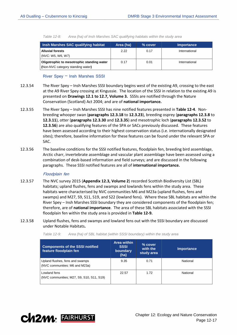
Chapter 12: Ecology and Nature Conservation Page 12-17
Table 12-8: Area (ha) of Insh Marshes SAC qualifying habitats within the study area
Insh Marshes SAC qualifying habitat Area (ha) % cover Importance Alluvial forests (NVC: W5, W6, W7)
2.22 0.17 International
Oligotrophic to mesotrophic standing water (Non-NVC category standing water)
0.17 0.01 International
River Spey – Insh Marshes SSSI
12.3.54 The River Spey – Insh Marshes SSSI boundary begins west of the existing A9, crossing to the east at the A9 River Spey crossing at Kingussie. The location of the SSSI in relation to the existing A9 is presented on Drawings 12.1 to 12.7, Volume 3. SSSIs are notified through the Nature Conservation (Scotland) Act 2004; and are of national importance.
12.3.55 The River Spey – Insh Marshes SSSI has nine notified features presented in Table 12-4. Non- breeding whooper swan (paragraphs 12.3.18 to 12.3.23), breeding osprey (paragraphs 12.3.8 to 12.3.11), otter (paragraphs 12.3.30 and 12.3.35) and mesotrophic loch (paragraphs 12.3.52 to 12.3.56) are also qualifying features of the SPA or SACs previously discussed. These features have been assessed according to their highest conservation status (i.e. internationally designated sites); therefore, baseline information for these features can be found under the relevant SPA or SAC.
12.3.56 The baseline conditions for the SSSI notified features, floodplain fen, breeding bird assemblage, Arctic charr, invertebrate assemblage and vascular plant assemblage have been assessed using a combination of desk-based information and field surveys; and are discussed in the following paragraphs. These SSSI notified features are all of international importance.
Floodplain fen 12.3.57 The NVC survey 2015 (Appendix 12.3, Volume 2) recorded Scottish Biodiversity List (SBL)
habitats; upland flushes, fens and swamps and lowlands fens within the study area. These habitats were characterised by NVC communities M6 and M23a (upland flushes, fens and swamps) and M27, S9, S11, S19, and S22 (lowland fens). Where these SBL habitats are within the River Spey – Insh Marshes SSSI boundary they are considered components of the floodplain fen; therefore, are of national importance. The area of these SBL habitats associated with the SSSI floodplain fen within the study area is provided in Table 12-9.
12.3.58 Upland flushes, fens and swamps and lowland fens out with the SSSI boundary are discussed under Notable Habitats.
Table 12-9: Area (ha) of SBL habitat (within SSSI boundary) within the study area
Components of the SSSI notified feature floodplain fen
Area within SSSI
boundary (ha)
% cover with the
study area Importance
Upland flushes, fens and swamps (NVC communities: M6 and M23a)
9.35 0.71 National
Lowland fens (NVC communities; M27, S9, S10, S11, S19)
22.57 1.72 National

A9 Dualling – Crubenmore to Kincraig DMRB Stage 3 Environmental Impact Assessment
Chapter 12: Ecology and Nature Conservation Page 12-18
Breeding bird assemblage 12.3.59 The River Spey – Insh Marshes SSSI breeding bird assemblage includes osprey, rare ducks
(including wigeon, shoveler Anas clypeata and goldeneye Bucephala clangula) and an important concentration of waders (including common snipe Gallinago, curlew Numenius arquata and redshank Tringa totanus).
12.3.60 Osprey and wigeon are qualifying features of the River Spey – Insh Marshes SPA previously considered in paragraphs 12.3.8 to 12.3.15; therefore, the following discussion will focus on shoveler, goldeneye, curlew, redshank and snipe.
12.3.61 A review of BTO tetrads (2km x 2km recording units) which overlap with, or are directly adjacent to the study area, highlighted records of breeding curlew, redshank, snipe and shoveler.
12.3.62 RSPB breeding bird data (2015 - 2017) highlights the presence of these species throughout the Insh Marshes RSPB summer survey compartments. The location of each RSPB survey compartment used for monitoring breeding birds is shown in Drawing 12.40, Volume 3. The number of curlew, redshank, snipe, goldeneye and shoveler pairs within each survey compartment during the 2015, 2016 and 2017 breeding seasons are summarised in Table 12-10. Where the cell is populated with a dash (-), no breeding bird data has been received for that compartment on that year. The distribution of these species in survey compartments which overlap with the study area is shown on Drawings 12.41 and 12.42, Volume 3.
Table 12-10: Number of SSSI breeding bird pairs within Insh Marshes NNR 2015 - 2017
Compartment
Species Curlew Redshank Snipe Goldeneye Shoveler
2015
2016
2017
2015
2016
2017
2015
2016
2017
2015
2016
2017
2015
2016
2017
Ruthven 3 4 2 11 11 6 14 10 3 0 1 1 0 0 0
Pitmain 2 - - 2 - - 4 - - 0 - - 0 - 0
Gordonhall 11 9 7 22 23 7 11 27 20 0 0 0 0 0 0
Invertromie 9 8 9 10 8 6 22 10 13 0 0 2 0 0 0
Cemetery marsh 5 5 1 7 5 3 9 11 6 0 0 0 0 0 0
Balavil (North) 4 9 16 18 12 11 20 21 21 0 0 0 0 0 0
Balavil (South) 2 4 4 10 9 9 12 22 20 0 0 0 0 0 0
Lynchat 4 5 6 10 - 1 19 4 11 0 4 0 0 0 0
Dunachton 3 - - 1 - - 9 - - 0 - 0 0 - 0
Eilean Vean 0 0 0 0 0 0 4 4 3 3 2 0 0 0 0
Loch Insh - 0 0 - 0 0 - 0 0 - 2 1 - 0 0
Insh (Insh Fen N) - - 23 - - - - - - - - 3 - - 1
Coull (Insh Fen S) - - 11 - - - - - - - - 1 - - 0
12.3.63 Breeding bird vantage point surveys regularly recorded goldeneye, snipe, redshank and curlew feeding in small pools and grassland areas surrounding the River Spey crossing (see Drawing 12.47, Volume 3).
12.3.64 Curlew, redshank, snipe, goldeneye and shoveler are components of the River Spey – Insh Marshes SSSI breeding bird assemblage; therefore, are of national importance where they occur within the River Spey – Insh Marshes SSSI and adjacent habitats. This includes breeding territories in land designated as Insh Marshes NNR immediately adjacent to the SSSI boundary as
A9 Dualling – Crubenmore to Kincraig DMRB Stage 3 Environmental Impact Assessment
Chapter 12: Ecology and Nature Conservation Page 12-19
in many cases territories of birds using nest locations out with the SSSI boundary are associated with the SSSI breeding bird assemblage.
12.3.65 Where the above species are present out with the SSSI and NNR they are considered under other relevant criteria, such as the Strathspey breeding wader assemblage, and are described under Ornithology – Breeding Birds.
Arctic charr 12.3.66 In Scotland, Arctic charr typically spawn in still water. Spawning in running water does occur but
it is considered rare. Loch Insh, beyond the study area, supports a population of Arctic charr which are known to migrate approximately 15km upstream to spawn in the River Spey around Kingussie and Netwonmore (Walker, 2006).
12.3.67 The fish habitat assessment (see Appendix 12.9, Volume 2) concluded that Arctic charr habitat, within major watercourses crossed by the existing A9, is restricted to the River Spey crossing. At this location the slow flow, deep water and gravel sediment provide optimal spawning and juvenile habitat for the species. Smaller tributaries such as the Burn of Inverton and Raitts Burn do have areas of slower flowing water however, the size and depth of these watercourses provide sub-optimal habitat for the species.
Invertebrate assemblage 12.3.68 The extensive botanically rich habitats of the SSSI support Scotland’s best site for rare wetland
invertebrates. Invertebrates associated with this rare wetland assemblage include 12 species, comprising true flies (Dipteria), a beetle (Coleoptera), moths (Lepidoptera) and a spider (Araneae).
12.3.69 A desktop review of NVC survey data (2015) has been undertaken to highlight potential habitat within the study area which may support invertebrate species listed on the SSSI citation. The study area comprises all NVC communities within 250m either side of the existing A9 that overlap the SSSI boundary.
12.3.70 In summary, the desktop review indicates that habitats within the study area could support all 12 of the invertebrate species listed as part of the SSSI assemblage. This included a variety of swamp, mire, woodland and aquatic habitats. Details of the desktop review are provided in Appendix 12.1, Volume 2.
12.3.71 As a habitat-based approach has been applied to the invertebrate assemblage, the potential impacts of the Proposed Scheme on this feature will be addressed through the assessment of notable habitats. As such, required mitigation for the invertebrate assemblage will be provided in the Outline Habitat Management Plan (Appendix 12.13, Volume 2).
Vascular plant assemblage 12.3.72 The SSSI citation highlights the vascular plant assemblage as vegetation which consists mainly of
sedge dominated ‘poor’ fen communities but reed bed, herb-rich swamp and willow carr wetland habitats are well represented. Insh Marshes supports an extraordinary quantity of water sedge Carex aquatilis, which is a northern species, found locally in abundance. It is also the main UK stronghold for string sedge Carex chordorrhiza. Other rare plants include the least water-lily Nuphar pumila, awlwort Subularia aquatica, cowbane Cicuta virosa and the shady horsetail Equisetum pratense.
12.3.73 A desktop review of NVC survey data (2015) has been undertaken to highlight NVC communities within the study area which correlate to habitats listed as part of the SSSI vascular plant assemblage.

A9 Dualling – Crubenmore to Kincraig DMRB Stage 3 Environmental Impact Assessment
Chapter 12: Ecology and Nature Conservation Page 12-20
12.3.74 In summary, all components of the SSSI vascular plant assemblage, with the exception of S27 Carex rostrata-Potentilla palustris, are present within the study area. Details of the desktop review are provided in Appendix 12.1, Volume 2.
12.3.75 As a habitat-based approach has been applied to the vascular plant assemblage, the potential impacts of the Proposed Scheme on this feature will be addressed through the assessment of notable habitats. As such, required mitigation for the vascular plant assemblage will be provided in the Outline Habitat Management Plan (Appendix 12.3, Volume 2).
River Spey SSSI
12.3.76 The River Spey SSSI is located west of the study area from the beginning of Project 9 to where the HML railway crosses the River Spey and the SSSI site boundary ends. At its closest point, the SSSI boundary is 320m from the existing A9. The location of the SSSI in relation to the existing A9 is presented on Drawings 12.1 to 12.3, Volume 3
12.3.77 As the River Spey SSSI underlies the River Spey SAC, both sites are designated for the same features (See Table 12-4). The River Spey SAC has the highest conservation status (i.e. international); therefore, Atlantic salmon, freshwater pearl mussel, sea lamprey and otter are considered under the River Spey SAC. The River Spey SSSI is not discussed any further in this EcIA.
Insh Marshes NNR
12.3.78 The Insh Marshes NNR site boundary begins where the existing A9 crosses Ruthven Road near Kingussie. The NNR is located to the east and west of the existing A9 up to the River Spey crossing at Kingussie. Beyond the crossing, the NNR is located to the east of the A9. The location of the NNR in relation to the existing A9 is presented on Drawings 12.1 to 12.7, Volume 3. NNRs are notified through the Nationals Parks and Access to the Countryside Act 1949; and are of national importance.
12.3.79 Important species and habitats within the Insh Marshes NNR overlap with many of the notified features of the of the River Spey – Insh Marshes SSSI previously discussed in paragraphs 12.3.54 to 12.3.75. The NNR is also managed to allow people to enjoy them, further information on this can be found within Chapter 8.
Notable Habitats
12.3.80 Notable habitats are identified as a conservation priority though relevant legislation or planning policy. For the purpose of the assessment, this includes:
•• internationally important habitat types identified in Annex 1 of Council Directive
92/43/EEC (the Habitats Directive)
•• nationally important woodland areas identified in the Ancient Woodland Inventory (AWI)
•• nationally important habitat types identified in the Scottish Biodiversity List (SBL)
•• regionally important habitat types identified in the Cairngorms Nature Action Plan (CNAP).
Phase 1 Habitat Survey
12.3.81 Broad habitat types identified during the Phase 1 habitat survey are detailed in the accompanying Preliminary Ecological Appraisal (see Appendix 12.2, Volume 2), and shown in Drawings 12.8 to 12.14, Volume 3.

A9 Dualling – Crubenmore to Kincraig DMRB Stage 3 Environmental Impact Assessment
Chapter 12: Ecology and Nature Conservation Page 12-21
12.3.82 The southern extent of the study area comprises habitats typical of upland moorland. Dry dwarf shrub heath is abundant, with extensive areas east of the existing A9. Discrete areas of mire are also present, typically interspersed with dry dwarf shrub heath.
12.3.83 In the northern extent of the study area the land is predominantly managed for agricultural purposes with Insh Marshes to the east of the existing A9. As a result, broad habitats mainly comprise improved, semi- improved and marshy grasslands.
12.3.84 Woodland is present in isolated patches and thin strips throughout the study area and is most extensive in the northern extent, notably between the existing A9 and the B9152 road.
12.3.85 Major watercourses, defined as those included on 1: 50,000 scale OS mapping, that are crossed by the existing A9 occur at the following locations:
• Allt Eoghainn (Hydro ID 154_1)
• Unnamed watercourse (Hydro ID 145_3)
• Burn of Inverton (Hydro ID 147_1)
• River Spey (Hydro ID 152)
• Unnamed watercourse (Hydro ID 155)
• Allt Cealgach (Hydro ID 157)
• Raitts Burn (Hydro ID 162)
• Unnamed watercourse (Hydro ID 167)
• Unnamed watercourse (Hydro ID 170)
Phase 2 Habitat Survey (NVC)
12.3.86 Further detailed botanical surveys were completed to confirm the presence, extent and importance of notable habitats within the study area. NVC communities identified within the study area are detailed in Appendix 12.3, Volume 2; and shown in Drawings 12.15 to 12.27, Volume 3.
12.3.87 NVC communities recorded within the study area were correlated with notable habitat using the dominant NVC community where mosaics were encountered. All notable habitats and associated NVC communities are presented in Table 12-11.
Annex 1 habitats
12.3.88 The distribution of Annex 1 habitats within the study area are described in the following paragraphs and shown on Drawings 12.28 to 12.39, Volume 3.
12.3.89 European dry heath is the most abundant Annex 1 habitat within the study area. It is particularly widespread and extensive in the southern extent, on the steep slopes east of the existing A9. Sub-community H12a Calluna vulgaris was the most commonly identified heath vegetation within the study area.
12.3.90 Northern Atlantic wet heath is most extensive in the southern extent, where it occurs east and west of the existing A9. It is typically characterised by areas of sub-community M15b, with a sward of variable amounts of the main characteristic species: Calluna vulgaris, Molinia caerulea, Trichophorum germanicum and Erica tetralix. Wet heaths within the study area have been impacted by burning, grazing and drainage, with many areas suffering from encroachment by abundant young Betula spp.

A9 Dualling – Crubenmore to Kincraig DMRB Stage 3 Environmental Impact Assessment
Chapter 12: Ecology and Nature Conservation Page 12-22
12.3.91 Blanket bogs are primarily located in the southern extent, where they occur in small patches next to extensive areas of wet and dry heath. These areas are mostly characterised by sub-communities M17a Drosera rotundifolia-Sphagnum spp. and M25a Erica tetralix.
12.3.92 European dry heaths, northern Atlantic wet heaths and blanket bogs are qualifying features of the Drumochter Hills SAC and Cairngorms SAC, located approximately 10km and 6km, respectively, from the study area. It is unlikely these habitats within the study area are functionally linked to these sites due to distance, topography and hydrogeology; therefore, on this basis they are of authority area importance.
12.3.93 One discrete area of alkaline fen was identified within the study area, east of the existing A9 between the Burn of Inverton and Knappoch. This area was characterised by sub-community M10a Carex demissa-Juncus bulbosus/kochii. Whilst only a small area of alkaline fen was identified within the study area, this habitat has reduced significantly in the UK and typically exists in small and fragmented patches; therefore, alkaline fens are of authority area importance.
12.3.94 Six stands of alluvial forests were identified within the study area (out with Insh Marshes SAC) and were characterised by NVC woodland community W7 Alnus glutinosa – Fraxinus excelsior – Lysimachia nemoreum. These stands are located around the existing Kingussie junction, adjacent to Ruthven Road (east of the existing A9) and alongside the Burn of Inverton. Alluvial forests, which are out with Insh Marshes SAC, are of authority area importance.
12.3.95 A single area of transition mires and quaking bogs was identified within the study area (out with Insh Marshes SAC) and was characterised by NVC mire community M4 Carex rostrata - Sphagnum recurvum. This discrete area is located alongside the burn of Inverton (west of the existing A9). This habitat is widespread but local within the UK and comprises only 0.03 ha; therefore, is of local importance.
12.3.96 There are a few small and isolated stands of juniper formations in the northern extent of the study area. These stands were characterised by NVC community W19 Juniperus communis spp. communis – Oxalis acetosell and sub-community W19a Vaccinium vitis-idaea – Deschampsia flexuosa sub-community. The Joint Nature Conservation Committee website notes the Cairngorms has the third-largest extent of juniper formations in the UK: therefore, this habitat is of regional importance.
Scottish Biodiversity List (SBL) habitats
12.3.97 The distribution of SBL habitats within the study area is described in the following paragraphs and are shown on Drawings 12.28 to 12.39, Volume 3.
12.3.98 Upland birchwoods are scattered throughout the study area but are most extensive at the northern extent. Areas of upland birchwoods are characterised by NVC woodland communities W4 Betula pubescens – Molinia caerulea, W11 Quercus petraea – Betula pubescens – Oxalis acetosella, W16 Quercus spp. – Betula spp. – Deschampsia flexuosa and W17 Quercus petraea – Betula pubescens – Dicranum majus.
12.3.99 Lowland deciduous woodland is restricted to the northern extent of the study area and is most extensive around Kerrow. Elsewhere in the study area, this habitat is present in small and isolated patches. Areas of lowland deciduous woodland are characterised by NVC woodland communities W8 Fraxinus excelsior – Acer campestre – Mercurialis perennis and W10 Quercus robur – Pteridium aquilinum - Rubus fruticosus.
12.3.100 Wet woodlands are scattered throughout the study area, typically in small and isolated patches. However, an extensive strip of wet woodland is present between the HML Railway and the B9152

A9 Dualling – Crubenmore to Kincraig DMRB Stage 3 Environmental Impact Assessment
Chapter 12: Ecology and Nature Conservation Page 12-23
road at the northern extent of the study area. These areas are mostly characterised by NVC community W3 Salix pentandra – Carex rostrata. A number of wet woodland stands are characterised by NVC communities W5, W6 and W7 where they did not qualify as Annex 1 habitat alluvial forests.
12.3.101 Areas of upland birchwoods, lowland deciduous woodland and wet woodland which overlap with the Ancient Woodland Inventory (AWI) are considered under Ancient Woodland (paragraphs 12.3.110 to 12.3.113). The remaining areas of these SBL woodlands have been assigned importance according to their association with ancient woodland. SBL woodlands that are connected to ancient woodland are of national importance however, SBL woodlands which are not connected to ancient woodland are of local importance.
12.3.102 Areas of upland flushes, fens and swamps are characterised by NVC mire communities M6 Carex echinata - Sphagnum fallax/denticulatum and M23a Juncus acutiflorus. M6 is widespread throughout the study area in both upland and lowland settings, mostly as small flushes, runnels or soakways, and along and within occluding ditches and minor watercourses. M23a is scattered throughout the study area and is mostly associated with surface water movement. Upland flushes, fens and swamps, which are out with the River Spey – Insh Marshes SSSI, are of local importance.
12.3.103 Areas of lowland fens are characterised by mire and swamp communities S9 Carex rostrata and S10 Equisetum fluviatile. This habitat was recorded in small isolated pockets dispersed throughout the study area. Lowland fens, which are out with the River Spey – Insh Marshes SSSI, are of local importance.
12.3.104 A few stands of reedbeds were recorded within the study area along the fringes of Insh Marshes. These areas are characterised by sub community S4a Phragmites australis. Reedbeds are limited with the Cairngorms; therefore, are of regional importance.
Cairngorms Nature Action Plan (CNPA) priority habitats
12.3.105 Small patches of wet grassland are scattered throughout the study area. An extensive area surrounds the Burn of Ruthven which flows across Insh Marshes into the River Spey. These areas are characterised by NVC communities MG9 Holcus lanatus – Deschampsia cespitosa grassland and MG10 Holcus lanatus – Juncus effusus rush-pasture, along with NVC sub-communities MG11a Lolium perenne grassland and M23b Juncus effusus rush-pasture. These habitats are dominated by common grass species which are ubiquitous and easily re-creatable; therefore, wet grasslands are of local importance.
Non-Priority Habitats
12.3.106 Non-priority grasslands dominate the study area, particularly in the northern extent where the land is primarily used for livestock grazing. These grasslands have limited botanical interest and have no policy or legal status; therefore, are of less than local importance.
12.3.107 Non-priority vegetation of open habitats has limited botanical interest and no policy or legal status; therefore, are of less than local importance.
12.3.108 Non-priority woodlands were recorded in isolated patches throughout the study area. These areas have limited policy or legal status. However, some areas of non-priority woodland within the study area overlap with the Ancient Woodland Inventory (AWI) and will be considered under Ancient Woodland. The remaining areas of non- priority woodland have been assigned importance according to their association with ancient woodland. Non-priority woodlands which are connected to ancient woodland are of local importance and non-priority woodlands which
A9 Dualling – Crubenmore to Kincraig DMRB Stage 3 Environmental Impact Assessment
Chapter 12: Ecology and Nature Conservation Page 12-24
are not connected to ancient woodland are of less than local importance. However, non-priority woodland considered of less than local importance will still be considered within Section 12.5 in line with the Scottish Government’s Policy on Control of Woodland Removal.
Non – NVC features
12.3.109 Features that do not correspond with an NVC community are either limited in scale or provide little or no botanical interest (e.g. plantation woodland). However, some areas of plantation woodland within the study area overlap with the Ancient Woodland Inventory (AWI) and will be considered under Ancient Woodland. The remaining areas of plantation woodland have been assigned importance according to their association with ancient woodland. Plantation woodlands which are connected to ancient woodland are of local importance however, plantation woodlands which are not connected to ancient woodland are of less than local importance given their limited botanical interest. Areas of plantation woodland which are of less than local importance will still be considered within Section 12.5 in line with the Scottish Government’s Policy on Control of Woodland Removal.
Table 12-11: Summary of notable habitats recorded within the study area
Notable Habitat Conservation Status
Area (ha)
% of the study area
Importance
European dry heaths (NVC: H10, H12, H18) Annex 1 198.15 15.08 Authority Area
Northern Atlantic wet heaths (NVC: M15) Annex 1 49.20 3.74 Authority Area
Blanket bogs (NVC: M3, M17, M19, M20, M25) Annex 1 25.77 1.96 Authority Area
Alkaline fens (NVC: M10) Annex 1 0.25 0.02 Authority Area
Alluvial forests (out with Insh Marshes SAC) (NVC: W7) Annex 1 3.28 0.25 Authority Area
Transition mires and quaking bogs (out with Insh Marshes SAC) (NVC: M4)
Annex 1 0.03 <0.01 Local
Juniper formations on heaths (NVC: W19, W19a) Annex 1 1.07 0.08 Regional
Upland birchwoods – connected to ancient woodland (W4,
W11, W16, W17) SBL 60.04 4.57 National
Upland birchwoods - not connected to ancient woodland (W4, W11, W16, W17)
SBL 67.77 5.16 Local
Lowland mixed deciduous woodland – connected to ancient woodland (NVC: W8, W10)
SBL 13.89 1.06 National
Lowland mixed deciduous woodland – not connected to ancient woodland (NVC: W8, W10)
SBL 5.70 0.43 Local
Wet woodlands – connected to ancient woodland (NVC: W3,
W4b, W6, W7) SBL 3.31 0.25 National
Wet woodlands – not connected to ancient woodland (NVC:
W3, W4b, W6, W7) SBL 11.07 0.84 Local
Upland flushes, fens and swamps (out with River Spey - Insh Marshes SSSI) (NVC: M6, M23a)
SBL 26.66 2.03 Local
A9 Dualling – Crubenmore to Kincraig DMRB Stage 3 Environmental Impact Assessment
Chapter 12: Ecology and Nature Conservation Page 12-25
Notable Habitat Conservation Status
Area (ha)
% of the study area
Importance
Lowland fens (out with River Spey Insh Marshes SSSI) (NVC: S9, S10, M27)
SBL 3.49 0.27 Local
Reedbeds (NVC: S4a) SBL 2.80 0.21 Regional
Wet grasslands (NVC: MG9. MG10, MG11a, M23b) CNPA 31.09 2.37 Local
Non-priority grasslands (NVC: U1, U2, U4, U5, U20, MG1,
MG6, MG7) None 403.44 30.7 Less than local
Non-priority woodlands – connected to ancient woodland (NVC: W9, W18, W23)
Limited 1.38 0.11 Local
Non-priority woodlands – not connected to ancient woodland (NVC: W9, W18, W23
Limited 12.12 0.92 Less than local
Non-priority vegetation of open habitats (NVC: OV24, OV25,
OV27, OV28) None 3.08 0.23 Less than local
Non – NVC features (excluding plantation woodland) Limited 149.55 11.39 Less than local
Plantation woodland – connected to ancient woodland (Non-NVC)
Limited 30.89 2.35 Local
Plantation woodland – not connected to ancient woodland (Non-NVC)
Limited 31.67 2.41 Less than local
Ancient Woodland Inventory (AWI)
12.3.110 In consultation with SNH, for the purposes of the assessment, CFJV have refined the SNH Ancient Woodland Inventory (AWI) using aerial imagery and the National Forest Inventory (NFI) to produce a verified dataset showing the existing areas of ancient woodland within the study area.
12.3.111 This highlights AWI categories 1a, 1b, 2a and 2b are within the study area:
• Categories 1a and 2a are interpreted as semi-natural woodland from maps of 1750 (1a) or 1860 (2a) and continuously wooded to the present day. If planted with non-native species during the 20th century they are referred to as Plantations on Ancient Woodland Sites (PAWS).
• Categories 1b and 2b are interpreted as plantation from maps of 1750 (1b) or 1860 (2b) and continuously wooded since. Many of these sites have developed semi-natural characteristics, especially the oldest ones.
12.3.112 The 2015 NVC survey highlights existing AWI sites within the study area are typically characterised by woodland communities W3, W4, W7, W9, W10, W11 and W17, with some areas overlapping with conifer plantation (a non-NVC community). The area of each AWI category within the study area is provided in Table 12-12. The location of ancient woodland within the study area is shown on Drawings 12.28 to 12.39, Volume 3.
12.3.113 Ancient woodland is one of Scotland’s richest wildlife assets and once destroyed it cannot be replaced therefore; ancient woodland is of national importance.
A9 Dualling – Crubenmore to Kincraig DMRB Stage 3 Environmental Impact Assessment
Chapter 12: Ecology and Nature Conservation Page 12-26
Table 12-12: Overview of existing AWI sites within the study area
Notable Habitat Conservation Status
Area (ha) % cover with the study area (1313 ha)
Importance
SNH ancient woodland Inventory (AWI)
Scottish Government Policy: Control of
Woodland Removal
AWI 1a - 62.37 AWI 1b - 0.98
AWI 2a - 42.20 AWI 2b - 38.56 Total – 144.11
AWI 1a - 4.75 AWI 1b - 0.07 AWI 2a - 3.21 AWI 2b - 2.93 Total – 10.97
National
Invasive non-native species
12.3.114 Invasive non-native species (INNS) that predate, outcompete or spread disease can have negative impacts on native species populations. Within the study area, potential INNS include American mink Neovison vison, Japanese knotweed Fallopia japonica, Himalayan balsam Impatiens glandulifera, giant hogweed Heracleum mantegazzianum and rhododendron Rhododendron ponticum & hybrids.
12.3.115 No records of the above species were identified during the desktop study. Rhododendron was recorded along the edge of woodland during the Phase 1 Habitat survey (2014) Appendix 12.2, Volume 2 and protected vertebrate update survey (2017) Appendix, 12.8 Volume 2 at four locations within the study area:
• Ralia Café
• East of the existing A9 (opposite Ralia Lodge)
• East Lodge (northern extent)
• Along the track leading to Croftcarnoch (northern extent) 12.3.116 Rhododendron is present within the study area. No other INNS were recorded during walkover
surveys. Information on the control and management of rhododendron will be provided in the Construction Environmental Management Plan (CEMP).
Groundwater Dependent Terrestrial Ecosystems (GWDTE)
12.3.117 Groundwater dependent terrestrial ecosystems (GWDTE) are wetlands that depend directly on the water level in, or flow of water from, a groundwater body, and potentially the nutrient inputs from the groundwater body, to be maintained in a favourable ecological condition. These wetlands receive protection from significant damage or deterioration, under European Council Directive 2000/60/EC (otherwise known as the Water Framework Directive, or WFD), which is transposed into Scottish Law through the Water Environment and Water Services (Scotland) Act (WEWS) 2003.
12.3.118 SEPA (2014) has classified a number of NVC communities as being dependent on groundwater. Many of these NVC communities are very common habitat types across Scotland and some are of otherwise low ecological value. Furthermore, some of these NVC communities may be dependent on groundwater only in certain hydrogeological settings.
12.3.119 Potential GWDTE vegetation types are detailed in Appendix 12.3, Volume 2 and presented in Table 12-13. A separate assessment of these has been carried out to further assess their ‘likely’ groundwater dependence based on their topographical, geological and hydro-ecological context. This is presented in Chapter 10, Volume 1 and considers the presence of GWDTE vegetation types in each habitat area, including where these comprise sub-dominant cover of these. Therefore, GWDTE are not considered any further in this assessment.

A9 Dualling – Crubenmore to Kincraig DMRB Stage 3 Environmental Impact Assessment
Chapter 12: Ecology and Nature Conservation Page 12-27
Table 12-13: Potential GWDTE
NVC Code NVC Community Name
Moderately groundwater dependent:
W3 Salix pentandra – Carex rostrata woodland
W5 Alnus glutinosa – Carex paniculata woodland
W6 Alnus glutinosa – Urtica dioica woodland
M15 Trichophorum germanicum – Erica tetralix wet heath
M25 Molinia caerulea – Potentilla erecta mire
M27 Filipendula ulmaria – Angelica sylvestris mire
MG9 Holcus lanatus – Deschampsia cespitosa grassland
MG10 Holcus lanatus – Juncus effusus rush pasture
MG11 Festuca rubra – Agrostis stolonifera – Potentilla anserina grassland
Highly groundwater dependent:
W4 Betula pubescens – Molinia caerulea woodland
W7 Alnus glutinosa – Fraxinus excelsior – Lysimachia nemoreum woodland
M5 Carex rostrata – Sphagnum squarrosum mire
M6 Carex echinata – Sphagnum fallax/denticulatum mire
M10 Carex dioica - Pinguicula vulgaris mire
M23 Juncus effusus/acutiflorus – Galium palustre rush pasture
CG10 Festuca ovina – Agrostis capillaris – Thymus polytrichus grassland
S11 Carex vesicaria swamp
Ornithology
12.3.120 Notable species of bird are important features identified as a conservation priority though relevant legislation or planning policy. For the purpose of the assessment, this includes:
•• internationally important resident or regularly occurring migratory species identified on Annex 1 of the Birds Directive
•• nationally important species identified on Schedule 1 of the Wildlife and Countryside Act 1981 (as amended)
•• regionally important species identified on the Cairngorms Nature Action Plan
•• regionally important red and amber listed Birds of Conservation Concern (BoCC)
•• regionally important species associated with the Strathspey breeding bird assemblage
•• Any other locally important species identified as an integral part of the local bird assemblages which is of wider conservation importance.
12.3.121 Birds which are interest features of statutory designated sites have been previously discussed under the relevant designated site in paragraphs 12.3.6 to 12.3.27 (River Spey – Insh Marshes SPA) and paragraphs 12.3.59 to 12.3.65 (River Spey – Insh Marshes SSSI).
12.3.122 It is noted that BoCC Red and Amber list species are recognised as being important at a national scale. However, unless particularly scarce species are recorded within the study area, it is appropriate given the geographic scale of the study area to assign a value of regional.

A9 Dualling – Crubenmore to Kincraig DMRB Stage 3 Environmental Impact Assessment
Chapter 12: Ecology and Nature Conservation Page 12-28
12.3.123 An overview of the abundance and distribution of breeding and non-breeding birds within the study area is discussed in the following paragraphs. A detailed account of the ornithological baseline is provided in Appendix 12.4 (Breeding Bird Survey) Appendix 12.5 (Bird Vantage Point Survey) and Appendix 12.6 (RSPB Ornithology Data), contained in Volume 2.
Breeding Birds 12.3.124 An overview of notable species within BTO tetrads (2x2km recording units) which overlap with, or
are directly adjacent to, the study area is summarised in Appendix 12.6, Volume 2.
12.3.125 The Highland Raptor Study Group was contacted to acquire data on birds of prey, and their breeding productivity, within the study area. No data has been received to date.
12.3.126 The following paragraphs discuss notable species recorded within the study area according to their highest conservation status.
Annex 1 Species 12.3.127 Four Annex 1 species were recorded within the study area during 2015/ 2016 scarce breeding
bird surveys (including woodland grouse surveys): golden eagle Aquila chrysaetos, white-tailed eagle Haliaeetus albicilla, marsh harrier Circus aeruginosus and black grouse Tetrao tetrix.
12.3.128 Golden eagle, white-tailed eagle and marsh harrier were recorded in flight within the study area, however no evidence of breeding was noted. A female marsh harrier was observed hunting within Insh Marshes near to Ruthven Barracks.
12.3.129 Whilst no evidence of breeding was identified within the study area, a single golden eagle represents >5% of the regional population; therefore, the species is of regional importance.
12.3.130 White-tailed eagle and marsh harrier are scarce raptor species and the presence of an individual would represent > 1% of the Scottish population; therefore, both species are of national importance.
12.3.131 Two black grouse lek sites (a communal display area) were identified during woodland grouse surveys (2016). These sites were located approximately 250m from the existing A9 and had a total of 31 lekking males. The location of black grouse lek sites is presented in Drawing 12.46, Volume 3.
12.3.132 The Highland Bird Report (2015) reported a total of 147 lek sites within Strathspey comprising a total of 694 lekking males. Breeding males within the study area are likely to contribute to around 4.5% of the Strathspey population of black grouse; therefore, are of regional importance.
12.3.133 Capercaillie is a woodland grouse species and is known to breed in the Cairngorms and Speyside areas. There are no current or historic records of capercaillie within the study area and there is a lack of extensive and adjoining suitable habitat within the study area, therefore are of less than local importance.
Schedule 1 Species 12.3.134 Crossbill was the only schedule 1 species recorded during scarce breeding bird surveys (2015/
2016). It is possible that common crossbill breeds within suitable habitat (i.e. coniferous woodland) within the study area, however it was only recorded in woodland beyond the study area during 2015 and 2016. Common crossbill is a common and widespread breeding species in Scotland with a highly variable population noted as between 5,000 and 50,000 (Forester and Andrews, 2007). Whilst crossbill was not recorded breeding within the study area, as the species is present within adjacent habitat, and could breed in suitable habitat within the study area, it is of local importance.

A9 Dualling – Crubenmore to Kincraig DMRB Stage 3 Environmental Impact Assessment
Chapter 12: Ecology and Nature Conservation Page 12-29
Strathspey breeding wader assemblage 12.3.135 The following wader species are considered components of the Strathspey breeding wader
assemblage: redshank, snipe, curlew, oystercatcher and lapwing.
12.3.136 Redshank, snipe and curlew are also components of the River Spey - Insh Marshes SSSI breeding bird assemblage. Where RSPB breeding bird data (2015/ 2016) highlights the presence of these species within the SSSI boundary or adjacent habitats with Insh Marshes NNR they are of national importance and are discussed under the River Spey - Insh Marshes SSSI in paragraphs 12.3.59 to 12.3.65.
12.3.137 However, where redshank, snipe and curlew occur outwith the SSSI and NNR they are discussed in the following paragraphs under the Strathspey breeding wader assemblage along with lapwing and oystercatcher.
12.3.138 The CFJV breeding bird survey 2015 recorded curlew and snipe within the study area in the agricultural grasslands surrounding the existing A9 near Nuide Farm. Approximately three pairs of snipe and a single pair of curlew were recorded in this area. Grasslands surrounding Nuide Farm are particularly good for breeding lapwing with 23 territories recorded during the survey.
12.3.139 RSPB breeding bird data (2015 to 2017) shows a high concentration of lapwing and oystercatcher in grasslands surrounding the River Spey crossing, where the NNR site boundary surrounds the existing A9. Within Ruthven compartment of the NNR, there were 17 breeding pairs of lapwing in 2017 and seven of oystercatcher. Breeding bird data are presented in full in Appendix 12.6, Volume 2.
12.3.140 The number of curlew, snipe and redshank pairs recorded within the study area (out with Insh Marshes NNR) is presented in Table 12-14, along with the number of oystercatcher and lapwing pairs recorded throughout the study area. The population of each species within the study area is shown in relation to the estimated national, regional and Strathspey population. The distribution of species within the study area is shown on Drawings 12.43 to 12.45, Volume 3.
12.3.141 With the exception of redshank, the number of breeding pairs of all other species within the study area contribute to over 1% of the Strathspey population: therefore, the Strathspey breeding bird assemblage is of regional importance.
Table 12-14: Population estimates for Strathspey breeding waders (excluding SSSI notified features)
Species Study area
(pairs)
Scotland Regional Strathspey
Population Estimate
Proportion in study area (%)
Population Estimate
Proportion in study area (%)
Population Estimate
Proportion in study area (%)
Lapwing 53* 71,500 – 105,600 <1 Unknown N/A 761 7
Oystercatcher 19* 84,500 – 116,500 <1 Unknown N/A 571 3.3
Curlew 5 58,800 <1 2,133 <1 332 0.6
Redshank 0 11,700 – 17,500 <1 Unknown N/A 223 0
Snipe 5 34,000 – 40,000 <1 2,304 <1 542 0.9
*Estimate using CFJV data from outwith Insh Marshes (2015) and RSPB Data from within Insh Marshes NNR (2017).
BoCC red and amber species 12.3.142 BoCC red and amber species recorded in the study area during the 2015 breeding bird survey and
their estimated populations are presented in full in Appendix 12.4, Volume 2.
12.3.143 With the exception of woodcock, which was recorded flying within the study area, all BoCC red listed species recorded were passerines, typically observed in areas of woodland.

A9 Dualling – Crubenmore to Kincraig DMRB Stage 3 Environmental Impact Assessment
Chapter 12: Ecology and Nature Conservation Page 12-30
12.3.144 Red list species included the following: song thrush (11), mistle thrush (5), spotted flycatcher (11), lesser redpoll (24), linnet (1), tree pipit (5), starling (2), grasshopper warbler (1) and grey wagtail (2).
12.3.145 Amber list species included the following: common gull (1), black headed gull (20), common sandpiper (7), kestrel (1-2), little grebe (1), mallard (10), red grouse (1) and tawny (1) owl (1-2).
12.3.146 These species are generally present in low numbers within the study areas in habitats such as woodland, scrub, grassland, riparian areas and heathland. The assemblage of BoCC red and amber list species is of authority area importance.
Non-Breeding Birds 12.3.147 Baseline conditions for non-breeding birds have been developed using BTO Atlas data, Insh
Marshes BTO WeBS (provided by RSPB) and vantage point survey data collected by CFJV around the existing A9 crossing of the River Spey (2016-2017). Given the availability of data, the baseline conditions are focussed on non-breeding birds associated with the wetlands of Insh Marshes.
12.3.148 Non-breeding whooper swan and hen harrier are qualifying features of the River Spey – Insh Marshes SPA; therefore, are discussed under the SPA in paragraphs 12.3.18 to 12.3.27.
12.3.149 An overview of notable non-breeding species within BTO tetrads (2x2km recording units) which overlap with, or are directly adjacent to, the study area; and Insh Marshes BTO WeBS data, are provided in Appendix 12.6, Volume 2.
12.3.150 Non-breeding vantage point surveys around the A9 River Spey crossing were undertaken to collect additional data on the distribution of whooper swan within Insh Marshes during the winter period. During vantage point observations, data was also collected for other overwintering raptors, wildfowl and waders during the survey (see Table 12-15 and Drawing 12.50, Volume 3). Full details of the survey results are presented in Appendix 12.5, Volume 2.
Annex 1 Species 12.3.151 During the winter vantage point surveys merlin, peregrine falcon and golden eagle flights were
recorded within the 500m study area on a single date. Flight lines are presented on Drawing 12.49, Volume 3. Taking into account national population data presented by Forrester and Andrews (2007) these species are of regional importance.
12.3.152 RSPB WeBS data for the Insh Marshes includes occasional records of small numbers of barnacle goose Branta leucopsis and white fronted goose Anser albifrons within the reserve. Whilst the specific location of these records is not available, the reserve compartments in which they are reported lie mostly outside the study area: therefore, these species are of less than local importance.
BoCC red and amber list species 12.3.153 A range of notable species included on the BoCC red and amber lists, are present within the study
area during the winter period. An overview of peak counts of notable species recorded within Insh Marshes during non-breeding vantage surveys and BTO WeBS data is presented in Table 12-15, along with each species’ national population estimates.
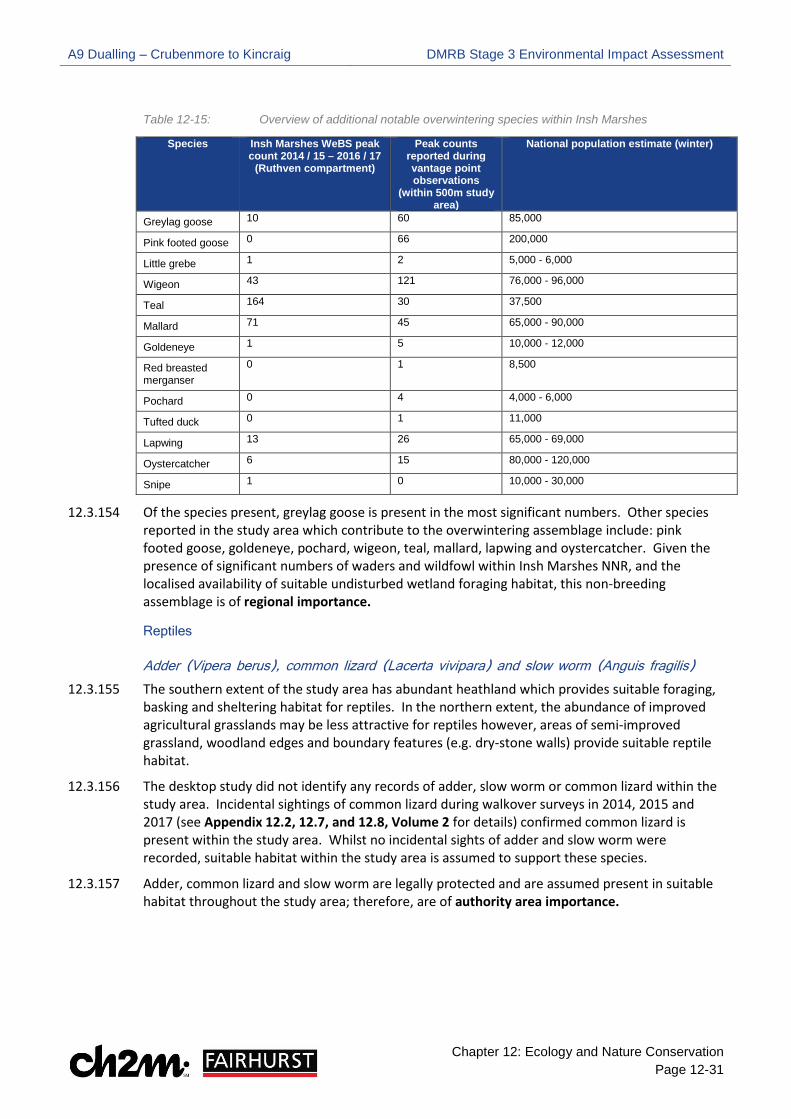
A9 Dualling – Crubenmore to Kincraig DMRB Stage 3 Environmental Impact Assessment
Chapter 12: Ecology and Nature Conservation Page 12-31
Table 12-15: Overview of additional notable overwintering species within Insh Marshes
Species Insh Marshes WeBS peak count 2014 / 15 – 2016 / 17
(Ruthven compartment)
Peak counts reported during vantage point observations
(within 500m study area)
National population estimate (winter)
Greylag goose 10 60 85,000
Pink footed goose 0 66 200,000
Little grebe 1 2 5,000 - 6,000
Wigeon 43 121 76,000 - 96,000
Teal 164 30 37,500
Mallard 71 45 65,000 - 90,000
Goldeneye 1 5 10,000 - 12,000
Red breasted merganser
0 1 8,500
Pochard 0 4 4,000 - 6,000
Tufted duck 0 1 11,000
Lapwing 13 26 65,000 - 69,000
Oystercatcher 6 15 80,000 - 120,000
Snipe 1 0 10,000 - 30,000
12.3.154 Of the species present, greylag goose is present in the most significant numbers. Other species reported in the study area which contribute to the overwintering assemblage include: pink footed goose, goldeneye, pochard, wigeon, teal, mallard, lapwing and oystercatcher. Given the presence of significant numbers of waders and wildfowl within Insh Marshes NNR, and the localised availability of suitable undisturbed wetland foraging habitat, this non-breeding assemblage is of regional importance.
Reptiles
Adder (Vipera berus), common lizard (Lacerta vivipara) and slow worm (Anguis fragilis) 12.3.155 The southern extent of the study area has abundant heathland which provides suitable foraging,
basking and sheltering habitat for reptiles. In the northern extent, the abundance of improved agricultural grasslands may be less attractive for reptiles however, areas of semi-improved grassland, woodland edges and boundary features (e.g. dry-stone walls) provide suitable reptile habitat.
12.3.156 The desktop study did not identify any records of adder, slow worm or common lizard within the study area. Incidental sightings of common lizard during walkover surveys in 2014, 2015 and 2017 (see Appendix 12.2, 12.7, and 12.8, Volume 2 for details) confirmed common lizard is present within the study area. Whilst no incidental sights of adder and slow worm were recorded, suitable habitat within the study area is assumed to support these species.
12.3.157 Adder, common lizard and slow worm are legally protected and are assumed present in suitable habitat throughout the study area; therefore, are of authority area importance.
A9 Dualling – Crubenmore to Kincraig DMRB Stage 3 Environmental Impact Assessment
Chapter 12: Ecology and Nature Conservation Page 12-32
Amphibians
Great Crested Newt (GCN) (Triturus cristatus)
12.3.158 A Habitat Suitability Index (HSI) assessment (Oldham et al. 2000) was carried out at 19 standing waterbodies identified within 250m of the existing A9 to determine their suitability for breeding GCN. The location of each pond is shown on Drawings 12.61 to 12.64, Volume 3. Primarily due to geographic location and presence of waterfowl, all 19 ponds were considered to offer ‘poor’ or ‘below average’ breeding habitat for GCN (see Appendix 12.8, Volume 2). Therefore, GCN are considered absent from the study area and are of less than local importance.
Common toad (Bufo bufo)
12.3.159 Waterbodies throughout the study area provide potential breeding habitat for common toad, with the grassland and woodland habitat surrounding many of these waterbodies providing good terrestrial habitat.
12.3.160 No desktop records or incidental sightings of common toad were recorded during walkover surveys in 2014, 2015 and 2017. Whilst common toad is likely present in suitable habitat within the study area, they are a common and widespread species in Scotland; therefore, are of less than local importance.
Protected Vertebrates
Bats
12.3.161 The desktop study identified five historic North-East Scotland Biological Records Centre (NESBReC) records of Pipistrellus species within the study area.
12.3.162 Areas of woodland are present throughout the study area, mostly in small isolated patches or thin strips alongside the A9. Woodland, particularly broadleaved, is most extensive in the northern extent of the study area. This habitat offers potential commuting, foraging and roosting opportunities for bats. Man-made structures such as houses and farm buildings within the study area also provide potential roosting sites.
Preliminary Bat Roost Potential (BRP) assessment 2015
12.3.163 The preliminary Bat Roost Potential (BRP) assessment, undertaken as part of the protected vertebrate survey 2015 (see Appendix 12.7, Volume 2) identified features with potential to support roosting bats within the study area. The features identified were predominantly man-made structures (e.g. farm steadings) however, numerous individual trees and areas of woodland were also highlighted as having BRP.
Bat activity surveys 2016 (individual trees and woodland areas)
12.3.164 A variety of bat activity surveys were undertaken in 2016 (see Appendix 12.7, Volume 2) to determine if the individual trees and woodland areas with BRP support roosting bats. During these surveys, common pipistrelle Pipistrellus pipistrellus and soprano pipistrelle Pipistrellus pygmaeus calls were frequently recorded throughout the study area. Other species recorded included: brown long-eared bats Plecotus auritus, Daubenton’s bats Myotis daubentonii and Natterer’s bats Myotis nattereri, however these species were rarely encountered and only a low number of calls were recorded.
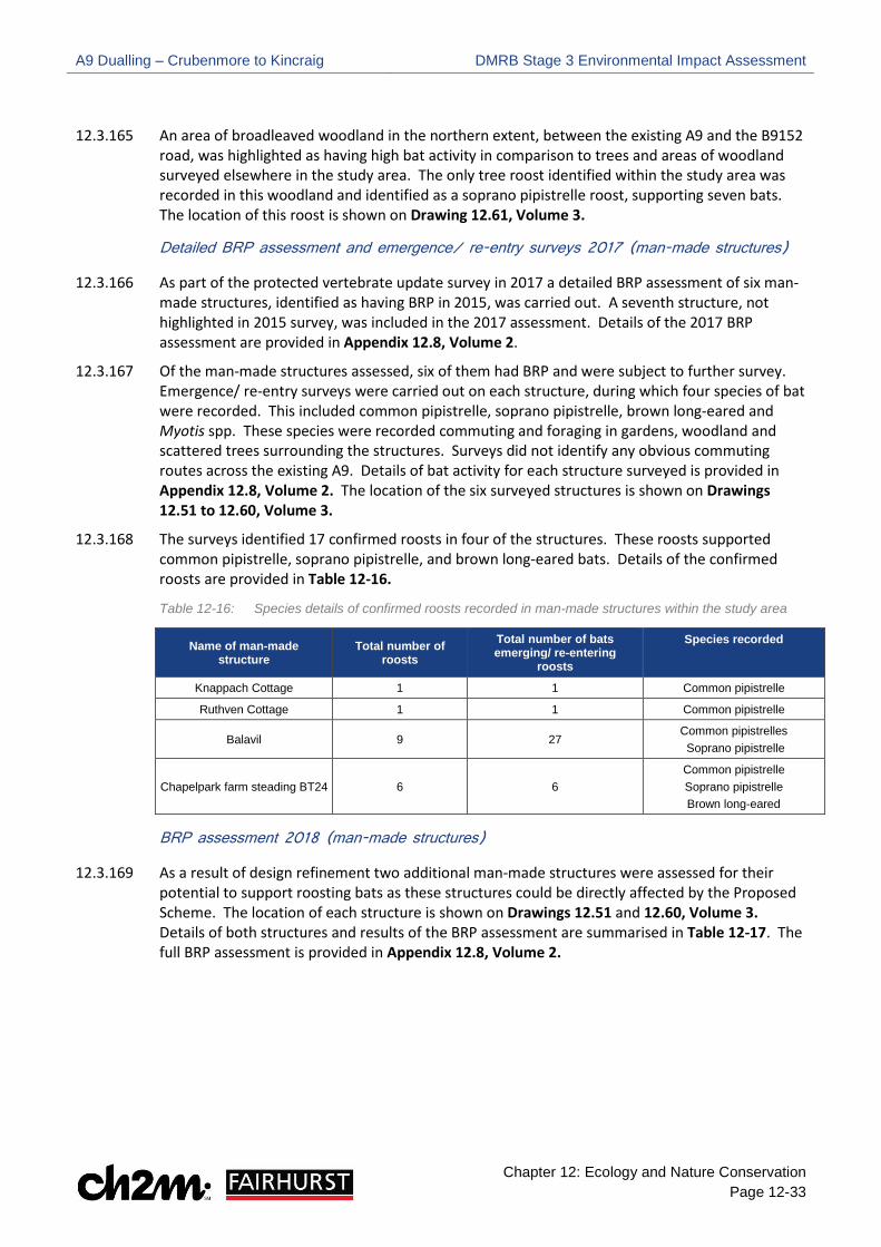
A9 Dualling – Crubenmore to Kincraig DMRB Stage 3 Environmental Impact Assessment
Chapter 12: Ecology and Nature Conservation Page 12-33
12.3.165 An area of broadleaved woodland in the northern extent, between the existing A9 and the B9152 road, was highlighted as having high bat activity in comparison to trees and areas of woodland surveyed elsewhere in the study area. The only tree roost identified within the study area was recorded in this woodland and identified as a soprano pipistrelle roost, supporting seven bats. The location of this roost is shown on Drawing 12.61, Volume 3.
Detailed BRP assessment and emergence/ re-entry surveys 2017 (man-made structures)
12.3.166 As part of the protected vertebrate update survey in 2017 a detailed BRP assessment of six man-made structures, identified as having BRP in 2015, was carried out. A seventh structure, not highlighted in 2015 survey, was included in the 2017 assessment. Details of the 2017 BRP assessment are provided in Appendix 12.8, Volume 2.
12.3.167 Of the man-made structures assessed, six of them had BRP and were subject to further survey. Emergence/ re-entry surveys were carried out on each structure, during which four species of bat were recorded. This included common pipistrelle, soprano pipistrelle, brown long-eared and Myotis spp. These species were recorded commuting and foraging in gardens, woodland and scattered trees surrounding the structures. Surveys did not identify any obvious commuting routes across the existing A9. Details of bat activity for each structure surveyed is provided in Appendix 12.8, Volume 2. The location of the six surveyed structures is shown on Drawings 12.51 to 12.60, Volume 3.
12.3.168 The surveys identified 17 confirmed roosts in four of the structures. These roosts supported common pipistrelle, soprano pipistrelle, and brown long-eared bats. Details of the confirmed roosts are provided in Table 12-16.
Table 12-16: Species details of confirmed roosts recorded in man-made structures within the study area
Name of man-made structure
Total number of roosts
Total number of bats emerging/ re-entering
roosts
Species recorded
Knappach Cottage 1 1 Common pipistrelle
Ruthven Cottage 1 1 Common pipistrelle
Balavil 9 27 Common pipistrelles Soprano pipistrelle
Chapelpark farm steading BT24 6 6 Common pipistrelle Soprano pipistrelle Brown long-eared
BRP assessment 2018 (man-made structures)
12.3.169 As a result of design refinement two additional man-made structures were assessed for their potential to support roosting bats as these structures could be directly affected by the Proposed Scheme. The location of each structure is shown on Drawings 12.51 and 12.60, Volume 3. Details of both structures and results of the BRP assessment are summarised in Table 12-17. The full BRP assessment is provided in Appendix 12.8, Volume 2.

A9 Dualling – Crubenmore to Kincraig DMRB Stage 3 Environmental Impact Assessment
Chapter 12: Ecology and Nature Conservation Page 12-34
Table 12-17: Summary of BRP assessment 2018
Name of man-made structure
Location of man – made structure
Suitability for roosting bats Comments
Glentruim railway bridge
Southern extent, west of the existing A9
Moderate
Stonework of railway bridge in good condition with no gaps in mortar. Underneath the bridge
was not assessed due to limited access; therefore, potential for bats could not be ruled
out
Coulintyre Cottage
Adjacent to entrance of Highland Wildlife Park, east
of the existing A9 Moderate
Evidence of bats (droppings) recorded in gap between the guttering and fascia board.
Roosting opportunities were limited elsewhere on structure.
12.3.170 As both structures had moderate suitability for roosting bats further emergence/ re-entry surveys were undertaken in June 2018. These surveys identified two confirmed roosts at Coulintyre Cottage and a single roost at Glentruim railway bridge. Details of the confirmed roosts are provided in Appendix 12.8, Volume 2 and summarised in Table 12-18. Table 12-18: Details of confirmed roosts at Coulintyre cottage and Glentruim railway bridge
Name of man-made structure
Total number of roosts
Total number of bats emerging/ re-entering
roosts
Species recorded
Coulintyre Cottage 2 7 Soprano pipistrelle
Glentruim railway bridge 1 1 Soprano pipistrelle
Common pipistrelle, soprano pipistrelle and brown long-eared bat
12.3.171 Whilst these species were recorded roosting and foraging within the study area, the number of bats within each roost is very low in comparison to the estimated UK population for each species (see Appendix 12.1, Volume 2 for details), therefore these species are of local importance.
Natterer’s bat and Daubenton’s bat
12.3.172 No roosts were identified within the study area for these species. They were recorded foraging and commuting during activity surveys 2016/ 2017; however, the number of calls recorded were very low, therefore these species are of local importance.
Other bat species
12.3.173 The Scottish Highlands is outwith the known range of whiskered bat Myotis mystacinus, Noctule Nyctalus noctule, Leisler’s bat Nyctalus leisleri and Nathusius’ pipistrelle Pipistrellus nathusius: therefore, these species are of less than local importance.
Badger (Meles meles)
12.3.174 The extensive heathland and limited woodland within the southern extent suggests badger are unlikely to be present. However, in the northern extent the combination of woodland (sett building habitat) and agricultural grasslands (foraging habitat) provides good conditions for badger.
12.3.175 Scottish Badgers provided three records of badger road casualties within the study area. The locations of these records are shown in Drawings 12.55, 12.57 and 12.60, Volume 3.
12.3.176 Suitable habitat is present within the study area however, no evidence of badger was recorded during protected vertebrate walkover surveys in 2014, 2015 and 2017. Whilst there are badger
A9 Dualling – Crubenmore to Kincraig DMRB Stage 3 Environmental Impact Assessment
Chapter 12: Ecology and Nature Conservation Page 12-35
road kill records, they are a mobile species and are likely from badger setts beyond the study area. On this basis, badger is of less than local importance.
Pine marten (Martes martes)
12.3.177 Pine marten require extensive areas of woodland within their territory and generally avoid open ground. Woodland within the study area is present in small isolated blocks or thin strips alongside the existing A9. These areas are considered unsuitable for pine marten dens given their isolated nature and high level of disturbance from the existing road. However, they may forage or commute through these areas of woodland, particularly in the northern extent, where they are connected to more extensive woodland beyond the study area (e.g. Craigbui wood).
12.3.178 No evidence of pine marten was recorded during the desktop study or walkover surveys (2014, 2015 and 2017) and habitat within the study area is considered sub-optimal for the species; therefore, pine marten is likely to be absent from the study area and is of less than local importance.
Red squirrel (Sciurus vulgaris)
12.3.179 The desktop study identified one HBRG and five National Biodiversity Network (NBN) records of red squirrel scattered throughout the study area.
12.3.180 Protected species walkover survey carried out in 2015 and 2017 recorded a high level of red squirrel activity (e.g. dreys, feeding remains and sightings) within the study area. Areas of particularly high squirrel activity was noted in coniferous woodland surrounding Ralia Lodge and Croftcarnoch. Details of red squirrel activity recorded during the 2015 and 2017 surveys is provided in Appendix 12.7 and Appendix 12.8, Volume 2, with locations of activity shown on Drawings 12.51 to 12.60, Volume 3.
12.3.181 Red squirrel activity was high within the study area, with numerous nest sites (i.e. dreys) recorded; therefore, the species is of regional importance.
European wildcat (Felis silvestris)
12.3.182 Areas of woodland within the study area are present in isolated patches or thin strips parallel to the existing A9. These stands of woodland are unlikely to support wildcat dens due to their isolated nature and high levels of disturbance from the existing road. However, wildcat may commute through these areas to reach more extensive woodland in the wider landscape. Heathland in the southern extent and areas of rough grassland throughout the study area may provide potential foraging habitat.
12.3.183 Three records of wildcat were identified around the Highland Wildlife Park at the northern extent of the study area. This included two camera trap records provided by the CNPA (2010) and an NBN record (100m2 grid square) (2005). The location of the camera trap records is shown on Drawing 12.60, Volume 3. During protected vertebrate walkover surveys 2014, 2015 and 2017, no incidental signs of wildcat were recorded.
12.3.184 Whilst wildcat is unlikely to den within the study area, they may forage and commute within suitable habitat, particularly at the northern extent given records were provided. As the species is an EPS and Scotland’s most threatened mammal, wildcat is of national importance.

A9 Dualling – Crubenmore to Kincraig DMRB Stage 3 Environmental Impact Assessment
Chapter 12: Ecology and Nature Conservation Page 12-36
Water vole (Arvicola amphibius)
12.3.185 Tributaries of the River Spey within the study area provide potential habitat for water vole where there is sufficient riparian vegetation, along with ponds, small lochans and agriculture ditches. RSPB highlighted a sighting of water vole under the River Spey crossing (2015).
12.3.186 During 2015 and 2017 protected vertebrate surveys, water vole activity was very low within the study area, with only two areas of water vole activity identified. One of these areas was recorded around a small waterbody near the Alt Torr an Daimh (west of the existing A9) in 2015. Field signs included runs and latrines however, no above ground nest or burrows were recorded.
12.3.187 In 2017, evidence of water vole was noted along a drainage ditch to east of the existing A9 and consisted of a single burrow, latrines and feedings remains. The location of water vole activity within the study area is shown on Drawings 12.52 and 12.57, Volume 3, with the full protected vertebrate survey reports provided in Appendix 12.7 (2015) and Appendix 12.8 (2017) in Volume 2.
12.3.188 Water vole is present within the study area; however, activity was low during walkover surveys. On this basis, water vole is of authority area importance.
Mountain hare (Lepus timidus) and brown hare (Lepus europeas)
12.3.189 Heathland and rough grassland within the study area provide potential habitat for hare species. The desktop study identified one HBRG record of brown hare east of the existing A9 near Netwonmore (2013). Incidental sightings of brown hare were also noted within the study area during the Phase 1 Habitat survey (2014) and protected vertebrate survey (2015). No desktop records or incidental sightings were provided for mountain hare.
12.3.190 Whilst mountain hare and brown hare are SBL species, they are common and widespread in Scotland; therefore, they are of less than local importance.
Wood Ant
12.3.191 Four wood ant species are specified in the CNAP, including: Scottish wood ant Formica aquilonia, hairy wood ant Formica lugubris, narrow-headed wood ant Formica exsecta and the shining guest ant Formicoxenus nitidulus. Forestry Commission Scotland notes that Scottish wood ant and hairy wood ant are ‘true’ mound-building wood ants, with the narrow-headed wooded ant a closely related species which is included on the SBL and International Union for Conservation of Nature (IUCN) Red List as endangered. Therefore, this assessment will focus on the three Formica species.
12.3.192 Whilst the three Formica species are broadly associated with woodland habitats, there are differences in habitat preference. As described by Forestry Commission (2007), nests belonging to Scottish wood ant and hairy wood ant tend to be located within the woodland edge of mature Caledonian pine forests. Furthermore, Scottish wood ant tend to be more tolerant of established pine forests containing more mature trees and dense understorey, with hairy wood ant seeking a more open woodland structure. Nests belonging to narrow-headed wood ant are generally found in habitats beyond the woodland edge that contain native shrubs and naturally regenerating trees.
12.3.193 Areas of broadleaved and coniferous woodland present throughout the study area could support wood ant nest building habitat. Walkover surveys carried out in 2017 did not record any wood ant nests within the study area; therefore, wood ant is considered absent from the study area and are of less than local importance.
A9 Dualling – Crubenmore to Kincraig DMRB Stage 3 Environmental Impact Assessment
Chapter 12: Ecology and Nature Conservation Page 12-37
Features scoped out of the assessment
12.3.194 In order to focus the assessment on impacts that are likely to be significant, features that are of less than local importance (i.e. considered absent from the study area or do not meet any of the criteria for determining importance) have been scoped out from further assessment. This includes the following features:
•• Barnacle goose and white fronted goose
•• Capercaillie
•• Non – priority habitats (excluding non-priority woodland which is connected to ancient woodland)
•• Non – NVC features (excluding plantation woodland which is connected to ancient woodland)
•• Rhododendron (invasive non-native species)
•• GCN
•• Common toad
•• Whiskered bat, noctule, Leisler’s bat and Nathusius’ pipistrelle
•• Badger
•• Pine marten
•• Hare species
•• Wood ant
12.3.195 Whilst pine marten, badger and wood ant are likely to be absent from the study area at present and are consequently scoped out of the assessment, suitable habitat is present within the study area; therefore, these species will be included in the Outline Species Protection Plan (OSSP) (Appendix 12.14, Volume 2) to ensure they are included in the pre-construction survey scope. Also, whilst common toad and hare species did not meet the importance criteria for detailed impact assessment, they are included in the OSSP to safeguard these SBL species during construction.
Additional Baseline Information
CNPA draft priority non-protected species
12.3.196 The CNPA desktop review highlighted 54 red (highest priority) and 57 amber (high priority) areas within the study area. Details of these priority areas (i.e. broad habitat type, specific habitat features and location) and associated interest group (interest groups consist of various fungi, bryophyte, invertebrate and plant species) are provided in Table 12-1-18 in Appendix 12.1, Volume 2.
12.3.197 As a habitat-based approach has been applied to the CNPA draft priority non-protected species, the potential impacts of the Proposed Scheme on this feature will be addressed through the assessment of Notable Habitats. As such, mitigation for the these CNPA species will be provided in the Outline Habitat Management Plan (OHMP).

A9 Dualling – Crubenmore to Kincraig DMRB Stage 3 Environmental Impact Assessment
Chapter 12: Ecology and Nature Conservation Page 12-38
Ecological Permeability
12.3.198 Road widening schemes can create barrier effects to mobile species, which can result in death and injury to wildlife from collisions with vehicles. It is likely that the current A9 presents a barrier to protected species and wider biodiversity. Therefore, the design process has considered potential opportunities to utilise road drainage features, pedestrian subways and bridges to improve ecological permeability.
12.3.199 A visual assessment of existing assets was carried out and this data has been used in conjunction with wider baseline information to identify locations where safe crossing points could be incorporated into the Proposed Scheme as embedded mitigation (paragraphs 12.4.5 to 12.4.7).
Deer Vehicle Collision (DVC) Desk Study
12.3.200 The full DVC report is provided in Appendix 12.11, Volume 2. DVC hotspots are in three locations within the study area:
•• Newtonmore junction (closely abutted by woodland to north)
•• 1.5 km stretch from Milton of Nuide to Inverton
•• 1 km stretch north from existing A9 crossing of River Spey at Kingussie.

A9 Dualling – Crubenmore to Kincraig DMRB Stage 3 Environmental Impact Assessment
Chapter 12: Ecology and Nature Conservation Page 12-39
12.4 Potential Impacts Introduction
12.4.1 The Proposed Scheme has the potential to result in both beneficial and adverse impacts on ecology and nature conservation. Potential beneficial effects may be associated with the removal of existing barriers to species’ movement, as well as the provision of SuDS features to enhance the aquatic environment. Adverse effects would generally be related to:
•• Direct mortality
•• Direct loss of habitat
•• Fragmentation and isolation of habitats through severance
•• Disturbance of habitats and the water environment, including pollution and sedimentation
•• Disturbance of species
Construction Phase
12.4.2 Temporary impacts will typically occur during the construction phase through the creation of temporary tracks and SuDS, along with vehicle tracking and excavation of compensatory flood storage areas (CFSA). Impacts during the construction phase are generally short-term and reversible. However, it is noted some permanent impacts could occur during the construction phase, particularly in relation to tree felling, as woodland removed to create temporary access tracks and SuDS would result in permanent habitat loss. Construction phase impacts are associated with the red, green and purple assessment boundaries displayed on the accompanying Chapter 12 Drawings in Volume 3. Construction Phase impacts do not consider the impacts associated with the Proposed Scheme Details and Drainage as these are considered under the operational phase.
Operational Phase
12.4.3 Permanent impacts will generally occur during the operational phase of the Proposed Scheme and includes the creation of permanent infrastructure and landforms (e.g. the new carriageway, earthworks, permanent SuDS and structures). Impacts during the operational phase are typically permanent and irreversible. Operational phase impacts associated the Proposed Scheme Details and Drainage are displayed on the accompanying Chapter 12 Drawings in Volume 3.
12.4.4 Where a significant impact is identified within the assessment, this is an adverse impact unless stated otherwise.
Embedded Mitigation 12.4.5 Throughout the DMRB Stage 3 iterative design process, a number of environmentally led
workshops considered each aspect of the developing design and made recommendations for certain features to be modified. These aspects have been defined as ‘embedded mitigation’ and, where they are included in the Proposed Scheme, they are considered within the context of the impact assessment as providing mitigation to avoid or reduce environmental impacts, and in some cases, provide environmental benefits and a net gain for biodiversity. The impact assessment therefore assesses the Proposed Scheme design, which includes embedded mitigation.
12.4.6 With respect to ecological features, the relevant aspects of embedded mitigation include:
A9 Dualling – Crubenmore to Kincraig DMRB Stage 3 Environmental Impact Assessment
Chapter 12: Ecology and Nature Conservation Page 12-40
•• Ecological permeability which has been incorporated into watercourse crossings and structures (e.g. bridges). This includes provision of mammal ledges above the 1 in 50 year flood level. These crossings are designed for medium sized mammals such as otter, badger, wildcat and pine marten. Locations of mammal ledges were identified following a review of exiting crossings and observations of animal road mortalities (e.g. Scottish Badgers). Permeability provisions including existing and embedded mitigation have been identified and can be found in Table 12-19.
•• A review of national deer vehicle collision (DVC) data (see Appendix 12.9, Volume 2), identification of safe deer crossing opportunities and inclusion of deer provision into crossing designs has been incorporated where possible.
•• Incorporating, where practicable, natural bed material into the design of watercourse crossings to create suitable habitat for aquatic species such as Atlantic salmon.
•• Minimising the earthworks extent within designated sites and/ or notable habitats to reduce encroachment into these features.
12.4.7 The Proposed Scheme drainage incorporates where possible, at least two levels of SuDS treatment (a minimum requirement in line with planning policy and published SEPA guidance), with some places incorporating further enhanced treatment via micro-pools and swales (see Chapter 11, Volume 1). A vortex separator has been located adjacent to the Ruthven Road underpass and a tank sewer with flow control is included within the road drainage network to attenuate discharge.

A9 Dualling – Crubenmore to Kincraig DMRB Stage 3 Environmental Impact Assessment
Chapter 12: Ecology and Nature Conservation Page 12-41
Table 12-19: Project-wide permeability
Chainage Hydro ID Watercourse/ structure Structure height/ clearance (m)
Culvert Dimensions (mm)
Distance to nearest adjacent crossing (m)
ch 40,760 136 Culvert with mammal ledge provided. Suitable for medium sized mammals.
- 1500 x 1250 540
ch 41,300 Phonies Underpass
Dry underpass. Suitable for large mammals.
3.3 - 2100
ch 43,400 Newtonmore Junction
Dry underpass. Suitable for large mammals.
5.7 - 135
ch 43,535 140 Culvert with mammal ledge provided. Suitable for medium sized mammals.
- 1500 x 1250 2565
ch 46,100 Nuide Cattle Creep
Sheep creep. Suitable for medium sized mammals.
3.3 - 1200
ch 47,300 Inverton Underbridge
Dry underpass. Suitable for large mammals.
1.9 - 1060
ch 48,360 149 Culvert with mammal ledge provided. Suitable for medium sized mammals.
- 1375 x 1000 440
ch 48,800 Knappach Underpass
Dry underpass. Suitable for large mammals.
5.8 - 500
ch 49,300 Ruthven Road Underbridge
Dry underpass. Suitable for large mammals.
5.7 - 800
ch 50,100 Spey Crossing
Large bridge suitable for aquatic species passage.
- - 600
ch 50,700 Kerrow Underbridge
Dry underpass. Suitable for large mammals
5.7 - 1010
ch 51,710 157 Culvert with mammal ledge provided. Suitable for medium sized mammals.
- 2400 x 1500 1090
ch 52,800 Chapelpark Underpass
Dry underpass. Suitable for large mammals.
3.3 - 1595
ch 54,395 165 Culvert with mammal ledge provided. Suitable for medium sized mammals.
- 1200 x 1200 1805
ch 56,200 Wildlife Park Underbridge
Dry underpass. Suitable for large mammals.
5.3 -
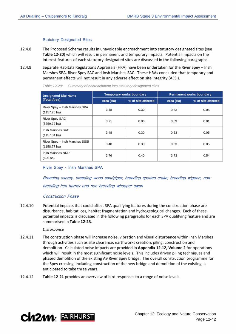
A9 Dualling – Crubenmore to Kincraig DMRB Stage 3 Environmental Impact Assessment
Chapter 12: Ecology and Nature Conservation Page 12-42
Statutory Designated Sites
12.4.8 The Proposed Scheme results in unavoidable encroachment into statutory designated sites (see Table 12-20) which will result in permanent and temporary impacts. Potential impacts on the interest features of each statutory designated sites are discussed in the following paragraphs.
12.4.9 Separate Habitats Regulations Appraisals (HRA) have been undertaken for the River Spey – Insh Marshes SPA, River Spey SAC and Insh Marshes SAC. These HRAs concluded that temporary and permanent effects will not result in any adverse effect on site integrity (AESI).
Table 12-20: Summary of encroachment into statutory designated sites
Designated Site Name (Total Area)
Temporary works boundary Permanent works boundary
Area (Ha) % of site affected Area (Ha) % of site affected
River Spey – Insh Marshes SPA (1157.26 ha)
3.48 0.30 0.63 0.05
River Spey SAC (5759.72 ha)
3.71 0.06 0.69 0.01
Insh Marshes SAC (1157.04 ha)
3.48 0.30 0.63 0.05
River Spey – Insh Marshes SSSI (1158.77 ha)
3.48 0.30 0.63 0.05
Insh Marshes NNR (695 ha)
2.76 0.40 3.73 0.54
River Spey - Insh Marshes SPA
Breeding osprey, breeding wood sandpiper, breeding spotted crake, breeding wigeon, non-
breeding hen harrier and non-breeding whooper swan
Construction Phase
12.4.10 Potential impacts that could affect SPA qualifying features during the construction phase are disturbance, habitat loss, habitat fragmentation and hydrogeological changes. Each of these potential impacts is discussed in the following paragraphs for each SPA qualifying feature and are summarised in Table 12-23.
Disturbance
12.4.11 The construction phase will increase noise, vibration and visual disturbance within Insh Marshes through activities such as site clearance, earthworks creation, piling, construction and demolition. Calculated noise impacts are provided in Appendix 12.12, Volume 2 for operations which will result in the most significant noise levels. This includes driven piling techniques and phased demolition of the existing A9 River Spey bridge. The overall construction programme for the Spey crossing, including construction of the new bridge and demolition of the existing, is anticipated to take three years.
12.4.12 Table 12-21 provides an overview of bird responses to a range of noise levels.
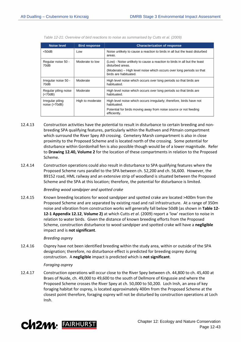
A9 Dualling – Crubenmore to Kincraig DMRB Stage 3 Environmental Impact Assessment
Chapter 12: Ecology and Nature Conservation Page 12-43
Table 12-21: Overview of bird reactions to noise as summarised by Cutts et al. (2009)
Noise level Bird response Characterization of response
<50dB Low Noise unlikely to cause a reaction to birds in all but the least disturbed areas.
Regular noise 50 -70dB
Moderate to low (Low) - Noise unlikely to cause a reaction to birds in all but the least disturbed areas. (Moderate) – High level noise which occurs over long periods so that birds are habituated.
Irregular noise 50 -70dB
Moderate High level noise which occurs over long periods so that birds are habituated.
Regular piling noise (<70dB)
Moderate High level noise which occurs over long periods so that birds are habituated.
Irregular piling noise (>70dB)
High to moderate High level noise which occurs irregularly; therefore, birds have not habituated. Potential for birds moving away from noise source or not feeding efficiently.
12.4.13 Construction activities have the potential to result in disturbance to certain breeding and non-
breeding SPA qualifying features, particularly within the Ruthven and Pitmain compartment which surround the River Spey A9 crossing. Cemetery Marsh compartment is also in close proximity to the Proposed Scheme and is located north of the crossing. Some potential for disturbance within Gordonhall fen is also possible though would be of a lower magnitude. Refer to Drawing 12.40, Volume 2 for the location of these compartments in relation to the Proposed Scheme.
12.4.14 Construction operations could also result in disturbance to SPA qualifying features where the Proposed Scheme runs parallel to the SPA between ch. 52,200 and ch. 56,600. However, the B9152 road, HML railway and an extensive strip of woodland is situated between the Proposed Scheme and the SPA at this location; therefore, the potential for disturbance is limited.
Breeding wood sandpiper and spotted crake
12.4.15 Known breeding locations for wood sandpiper and spotted crake are located >400m from the Proposed Scheme and are separated by existing road and rail infrastructure. At a range of 350m noise and vibration from construction works will generally fall below 50dB (as shown in Table 12-12-1 Appendix 12.12, Volume 2) at which Cutts et al. (2009) report a ‘low’ reaction to noise in relation to water birds. Given the distance of known breeding efforts from the Proposed Scheme, construction disturbance to wood sandpiper and spotted crake will have a negligible impact and is not significant.
Breeding osprey
12.4.16 Osprey have not been identified breeding within the study area, within or outside of the SPA designation; therefore, no disturbance effect is predicted for breeding osprey during construction. A negligible impact is predicted which is not significant.
Foraging osprey
12.4.17 Construction operations will occur close to the River Spey between ch. 44,800 to ch. 45,400 at Braes of Nuide, ch. 49,000 to 49,600 to the south of Dellmore of Kingussie and where the Proposed Scheme crosses the River Spey at ch. 50,000 to 50,200. Loch Insh, an area of key foraging habitat for osprey, is located approximately 400m from the Proposed Scheme at the closest point therefore, foraging osprey will not be disturbed by construction operations at Loch Insh.

A9 Dualling – Crubenmore to Kincraig DMRB Stage 3 Environmental Impact Assessment
Chapter 12: Ecology and Nature Conservation Page 12-44
12.4.18 At Braes of Nuide and opposite the Dellmore of Kingussie the River Spey is separated from the Proposed Scheme by sections of steep wooded banks which are likely to screen construction (and blasting) works from foraging habitat; therefore, will limit the likelihood of disturbance. Construction operations at the River Spey crossing will be highly visible. However, breeding vantage point surveys have not identified any osprey foraging in this area. While the risk of some temporary displacement from foraging areas during construction cannot be ruled out, this would occur as a very localised scale and would be short-term in duration.
12.4.19 The potential for increased sedimentation during construction could result in temporary increases in turbidity within the River Spey. This may in turn inhibit the ability of osprey to forage for fish and cause the species to commute further to alternative feeding areas. As Loch Insh, the key foraging resource for osprey, is located beyond the Proposed Scheme it is unlikely to be affected by changes in water quality. On this basis, disturbance to foraging osprey is considered a negligible impact which is not significant.
Breeding wigeon
12.4.20 Wigeon currently breed within the study area and RSPB breeding data for 2015 to 2017 shows breeding registrations (taken to be approximate nest locations) within 150m of the Proposed Scheme. Breeding wigeon could be affected by the Proposed Scheme where they are present within the Cemetery Marsh compartment, Lynchat compartment and areas surrounding the A9 River Spey crossing (i.e. Pitmain and Ruthven compartment).
Cemetery Marsh compartment
12.4.21 Construction activities in proximity to Cemetery Marsh compartment comprises the creation of the new carriageway and associated earthworks. Breeding wigeon registrations within Cemetery Marsh are clustered in discrete locations approximately 300m from the Proposed Scheme. At 200m, all construction operations fall below noise levels of 60dB LAeq T (as presented in Table 12-12-1 Appendix 12.12, Volume 2), with most activities falling below 55dB. At 300m, it is likely that for most activities noise levels will fall below 50dB at which point Cutts et al. (2009) reports a low response from birds (see Table 12-21). On this basis, it is considered unlikely that any significant disturbance to breeding wigeon will occur within Cemetery Marsh during construction.
Lynchat compartment
12.4.22 An area of 0.09 ha is located east of the existing A9 around ch. 52,850 and extends beyond the HML railway into the SPA site boundary and NNR Lynchat compartment.
12.4.23 RSPB breeding bird data (2015/ 2016) highlights records of wigeon within the Lynchat compartment, approximately 120m from the additional area previously described. Whilst investigations at this location will be short-term in duration, the high level of visual disturbance from machinery and site personnel could potentially disturb wigeon if undertaken during the breeding bird season.
A9 River Spey crossing
12.4.24 Construction activities in proximity to Ruthven and Pitmain compartment includes construction of the new A9 River Spey crossing and associated embankments; and demolition of the existing single carriageway bridge. The full timescale for works around the A9 River Spey crossing is estimated at three years; therefore, construction activities at this location could affect three breeding bird seasons.
12.4.25 The most significant disturbance to breeding wigeon around the River Spey Crossing may arise from construction operations which result in sudden noise or high levels of visual disturbance. This includes piling and mechanical concrete breaking works associated with the A9 River Spey

A9 Dualling – Crubenmore to Kincraig DMRB Stage 3 Environmental Impact Assessment
Chapter 12: Ecology and Nature Conservation Page 12-45
crossing; and excavation works associated with a drainage outfall pipe east of the existing A9 at ch. 50,500. Whilst these activities would be short-term in duration, the high level of visual and noise disturbance produced from these operations have the potential to result in reduced foraging, nest abandonment and reduced productivity if undertaken during the breeding bird season. Where construction works are ongoing at the start of the wigeon breeding season (late April / early May) they may influence the distribution of nesting attempts within the Ruthven and Pitmain compartment.
12.4.26 The estimated number of wigeon pairs potentially affected by construction phase disturbance in the Ruthven and Pitmain compartment is provided in Table 12-22. This information is based on the peak number of pairs recorded by RSPB during the 2015 to 2017 breeding bird season. The estimated number of wigeon pairs for each individual breeding season is provided in Table 12.6.1 in Appendix 12.6, Volume 2. Table 12-22 also presents the number of wigeon pairs within each compartment as a percentage of the SPA population (JNCC, 2005). Table 12-22: Estimated number of wigeon pairs affected by construction phase disturbance
SPA qualifying feature
Peak population -
Ruthven (2015 to 2017)
Peak population – Pitmain (2015
to 2017)
SPA population
% of SPA population in
Ruthven
% of SPA population in
Pitmain
Wigeon 2 2 37 5.41 5.41
12.4.27 Given the high levels of noise and visual disturbance anticipated around the A9 River Spey
crossing during certain operations, and the duration of the overall construction programme at this location (i.e. three years), construction disturbance is considered a medium adverse impact which would be significant.
Non-breeding hen harrier
12.4.28 Hen harrier foraging activity is likely to extend to wider parts of the SPA but could include habitats within the study area. In a review of disturbance distances to birds Ruddock and Whitfield (2007) present evidence from studies where Northern harrier (North American sub-species) continued foraging undisturbed during military operations (missile and bomb use). On this basis, the risk of construction stage disturbance to foraging hen harrier is low.
12.4.29 Established features/ areas which are known to be used by non-breeding hen harrier are outwith the study area and at a significant distance from the Proposed Scheme. However, RSPB satellite data from a single tagged bird in 2017 indicates potential roosting behaviour within the study area.
12.4.30 Hen harrier typically select overwintering areas with low levels of ambient disturbance which would include the existing A9 (O’Donoghue 2010). Given the preference for using roost sites away from sources of ambient disturbance, the risk of construction disturbance is considered low. However, given the presence of suitable roosting habitat within the study area, satellite data indicating roosting activity, and the high mobility of the species, there is a risk of hen harrier occupying roosts within the study area at a range which may be affected by disturbance. Hen harrier will be at highest risk of disturbance during hours of darkness while occupying roosts. Night time works will generally be limited but may be required for works associated with the HML railway A9 crossing. Given the potential disturbance risk to roosting hen harrier, a medium adverse impact is predicted which would be significant.
A9 Dualling – Crubenmore to Kincraig DMRB Stage 3 Environmental Impact Assessment
Chapter 12: Ecology and Nature Conservation Page 12-46
Non-breeding whooper swan
12.4.31 Most whooper swan activity recorded during vantage point surveys around the A9 River Spey crossing was identified over 400m from the existing A9, within fen habitats in the Gordonhall compartment (see Drawing 12.48, Volume 2 for whooper swan distribution). A single record of two adult birds was reported on the River Spey c.150m from the crossing. However, habitats surrounding the River Spey crossing are considered sub-optimal for whooper swan.
12.4.32 The most significant disturbance to whooper swan may arise from construction operations which result in sudden noise. This includes piling and mechanical concrete breaking works associated with the A9 River Spey crossing. Noise levels for most construction operations at 350m, and therefore areas typically favoured by whooper swan in the vicinity of the River Spey crossing, will generally be below 50dB (as presented in Table 12-12-1 Appendix 12.12, Volume 2) at which point Cutts et al. (2009) reports a low response from birds (see Table 12-21). Whooper swan monitoring was undertaken by an Ecological Clerk of Works (ECoW) during ground investigation works at the River Spey crossing during winter 2017. Whooper swan were present approximately 400m from ground investigations in Gordonhall compartment however, the ECoW did not observe any reaction to the works.
12.4.33 Mitchell et al. (2007) presents evidence that under flood conditions, large numbers of whooper swan can be displaced to the edge of the marsh where shallower water allows continued foraging. Notably the study by Mitchell reported a large group in areas in close proximity to Ruthven Barracks which supports sedge dominated swamp vegetation, the preferred foraging resource of whooper swan within Insh Marshes. Similarly, RSPB data between 2015 and 2018 indicates whooper swan use Ruthven compartment during flood conditions where counts of between one and six birds were reported. Such displacement during flood conditions is likely to expose whooper swan to a greater risk of disturbance during construction.
12.4.34 The JNCC SPA description indicates Insh Marshes has supported up to 200 whooper swans in past years, while current annual average numbers are closer to 100 individuals. As such, under normal conditions the wider Insh Marshes will be able to absorb any localised displacement in terms of available foraging resources or roosting areas. However, displacement from areas within and outside the SPA site boundary may occur where flood events take place during construction works. On this basis, disturbance to whooper swan is a low adverse impact and will be significant.
Habitat loss
12.4.35 A total of 3.48 ha (see Table 12-20) of SPA habitat will be required on a temporary basis (three years) to facilitate construction of the new A9 River Spey crossing and demolition of the existing crossing. These habitats comprise acid grassland and marshy grassland which are generally sub-optimal habitat types for SPA qualifying features. Field observations indicate that areas subject to temporary habitat loss are not regularly used by SPA qualifying features for nesting or foraging; therefore, no increased pressure is predicted on the remaining SPA habitat. On this basis, the effect of temporary encroachment into the SPA is negligible and is not significant.
Habitat fragmentation
12.4.36 Desk study information and field survey data provided in Appendix 12.5 and 12.6, Volume 2 highlights that SPA qualifying features are restricted to the more extensive areas of SPA habitat to the east of the existing A9 River Spey crossing. Habitat fragmentation during construction is therefore considered to be a negligible impact and not significant with respect to SPA qualifying features.

A9 Dualling – Crubenmore to Kincraig DMRB Stage 3 Environmental Impact Assessment
Chapter 12: Ecology and Nature Conservation Page 12-47
Hydrogeological changes
12.4.37 Earthworks and piling during construction have the potential to intercept groundwater and may disrupt local groundwater and hydrological regimes. Aquatic and terrestrial habitats within the SPA that support qualifying features may be sensitive to localised changes in groundwater.
12.4.38 Construction works could affect groundwater levels and flows throughout the scheme extents. Most excavations involve the widening of existing embankments and cuttings, although, due to the nature of the adjoining topography and the underlying superficial deposits, the extent of disruption from earthworks is considered limited. Pre-earthworks drainage is included within the Proposed Scheme as embedded mitigation to minimise disruption to adjoining habitats; and, given the prevailing climate and topography, local alterations in groundwater level and flow in these areas are not predicted to outweigh precipitation, surface water and runoff supplies in the long-term.
12.4.39 Piling works are required to secure pier footings for the new crossing of the River Spey at Kingussie. During piling, groundwater interception would be limited and the wider downgradient groundwater flow into the Insh Marshes will be retained. Therefore, localised disruption is not expected to have any lasting discernible effect on habitats beyond the extent of earthworks and piles at the River Spey crossing.
12.4.40 Impacts on SPA qualifying features as a result of hydrogeological changes which may occur during construction are considered to be negligible and not significant.
Operational Phase
12.4.41 Potential impacts that could affect SPA qualifying features during the operational phase are disturbance, habitat loss, habitat fragmentation, displacement and increased collision risk. Each of these potential impacts is discussed in the following paragraphs for each SPA qualifying feature and are summarised in Table 12-23.
Disturbance due to operational noise
12.4.42 A review of noise contour mapping (Chapter 17 Noise and Vibration Drawings) illustrates predicted short-term change in noise levels in 2026 Do Something scenario (i.e. building the Proposed Scheme) are minor and increases of 2 dB or less are shown throughout most of the Proposed Scheme. However, at the A9 River Spey crossing the Proposed Scheme moves east into the NNR Ruthven compartment and SPA. At this location operational noise level contours illustrate increases in noise between 2-4 dB beyond the earthwork extent.
12.4.43 Within the Ruthven and Pitmain compartment, contour mapping predicts actual noise levels of between 55-60 dB for the Do scenario in 2026 (i.e. not constructing the Proposed Scheme) within approximately 150m east of the A9 River Spey crossing. Noise levels of 50-55 dB are predicted a further 150m east of the existing scheme, falling to 45- 50dB within Gordonhall compartment. These predictions will be similar to current noise levels which indicates noise levels of >50 dB are present throughout most of Ruthven and Pitmain compartment, decreasing to <50dB within Gordonhall compartment. Contour maps showing the actual noise levels surrounding the River Spey crossing are provided in Appendix 12.12, Volume 2.
12.4.44 Breeding locations of wood sandpiper and osprey are located outwith the study area (500m). Spotted crake breeding locations and established sensitive locations for non-breeding hen harrier and whooper swan are at distances which are not vulnerable to increases in operational disturbance from road traffic. On this basis, operational disturbance is assessed as a negligible impact and not significant for these SPA qualifying features.
A9 Dualling – Crubenmore to Kincraig DMRB Stage 3 Environmental Impact Assessment
Chapter 12: Ecology and Nature Conservation Page 12-48
12.4.45 Wigeon are known to breed within areas of the Pitmain compartment, with possible breeding indicated by RSPB data within Ruthven compartment. These are predicted to experience minor increases in noise during the operational phase. A report by Hockin et al. (1991) concludes that breeding birds can tolerate or habituate to routine low-level disturbance such as passing trains or road traffic. Based on breeding survey data, wigeon are known to currently utilise areas exposed to operational noise in the range of 50-55 dB during the breeding season. This suggests they have habituated to predictable disturbance. In addition, RSPB breeding bird data highlights wigeon records within 80-100m south of the HML railway and the B9152. Given that wigeon currently tolerate noise generated by existing road and rail infrastructure, increases in operational noise within the Ruthven and Pitmain compartments are assessed as a negligible impact which is not significant.
Habitat loss
12.4.46 Permanent habitat loss within the SPA is primarily restricted to areas affected by the installation of the new A9 River Spey crossing. Affected areas will be shaded by the bridge deck however, permanent infrastructure will be restricted to pier footings on the banks of the River Spey (approximately 0.06ha). Very minor permanent habitat loss within the SPA also occurs just north of the River Spey crossing which is associated with a drainage outfall location. The total area of habitat loss due to shading under the new A9 River Spey crossing, pier footings and the drainage outfall is 0.60 ha (see Table 12-20).
12.4.47 Survey data shows that areas within the SPA, which will be subject to permanent habitat loss, are not utilised by SPA qualifying features for nesting, roosting or foraging. Therefore, no increased pressure is predicted on the remaining SPA habitat. On this basis, permanent habitat loss is assessed as a negligible impact and not significant.
Habitat fragmentation
12.4.48 Desk study information and field survey data presented in Appendix 12.5 and 12.6, Volume 2 highlights that breeding wood sandpiper, spotted crake, wigeon and non-breeding whooper swan are restricted to the more extensive areas of SPA habitat to the east of the Proposed Scheme. Osprey currently breed out with the 500m study area. Non-breeding hen harrier are a highly mobile species that utilise Insh Marshes for roosting and foraging; therefore, the Proposed Scheme is unlikely to fragment hen harrier habitat. Given the linear nature of the existing A9 will be maintained and the current distribution of SPA qualifying features, habitat fragmentation during the operational phase is a negligible impact and is not significant for any of the SPA qualifying features.
Displacement due to new structures and landforms
12.4.49 Wood sandpiper, osprey and spotted crake are not considered to be breeding in areas where displacement from the presence of new structures or landforms is possible. Similarly, no evidence of osprey foraging in areas in close proximity to proposed structures is reported form vantage point surveys. Displacement to these species during the operational phase is considered to be a negligible impact and not significant.
12.4.50 Wigeon currently breed within the study area and RSPB breeding data for 2015 to 2017 shows breeding registrations (taken to be approximate nest locations) within 150m of the Proposed Scheme. RSPB breeding bird data for Insh Marshes shows wigeon records within 80m of existing rail embankments. Similarly, CFJV vantage point data reported likely breeding close to the base of existing natural slopes adjacent to the existing A9. Given that nesting wigeon select concealed locations and can utilise woodland nest sites (Snow and Perrins 1998), the presence of

A9 Dualling – Crubenmore to Kincraig DMRB Stage 3 Environmental Impact Assessment
Chapter 12: Ecology and Nature Conservation Page 12-49
embankments and bridge structures are not predicted to result in a permanent displacement effect. Therefore, a negligible impact is predicted which is not significant.
12.4.51 Hen harrier currently show avoidance of existing sources of ambient disturbance in their selection of roosting areas. While there is a risk of hen harrier utilising suitable habitats within the study area, the new River Spey crossing, and associated embankments, is not predicted to result in any permanent displacement to non-breeding hen harrier; therefore, a negligible impact is predicted which is not significant.
12.4.52 Areas in which whooper swan have been noted foraging during flood events include areas near to Ruthven Barracks. The presence of this structure and surrounding landform does not discourage whooper swan from foraging in nearby habitat. On this basis, the new River Spey bridge and associated embankments, approximately 100m from areas of foraging habitat surrounding Ruthven Barracks, are not considered to result in displacement of whooper swan; therefore, a negligible impact is predicted which is not significant.
Collision risk
12.4.53 The construction of a wider bridge structure across Insh Marshes introduces potentially increased collision risk between birds and road traffic. Increases in both volume and speed of road traffic are predicted as a result of the Proposed Scheme. The proposed replacement Spey bridge structure retains a similar profile and vertical alignment to the existing bridge with no above deck structures.
12.4.54 The replacement River Spey bridge at Kingussie is unlikely to increase collision risk to spotted crake or wood sandpiper as these species do not utilise habitats surrounding the crossing. On this basis, a negligible impact is anticipated which is not significant.
12.4.55 Areas favoured by breeding wigeon are all located to the east of the existing (and proposed) River Spey crossing: therefore, flights across the bridge structure are likely to be minimal. Breeding vantage point surveys (2016) carried out at the crossing identified only one wigeon flight over the existing structure at a height >10m. Given the distribution of breeding wigeon (all to the east of the crossing), low number of wigeon flights reported during surveys and design of the replacement bridge (similar design and vertical profile to existing), increased collision risk during the operational phase is assessed as negligible and is not significant.
12.4.56 Breeding vantage point surveys (2016) at the River Spey crossing recorded a single osprey flight over the existing structure at a height >50m. At this height, osprey would not be vulnerable to risk of collision with vehicles as a result of increased volume or speed of traffic. Given the bridge design and available flight information for osprey, collision risk during the operational phase is assessed as negligible and is not significant.
12.4.57 Non-breeding vantage point surveys (2016/ 2017) indicated that, at the location of the River Spey crossing, whooper swan habitat is restricted to areas located to the east of the existing A9. A single flight of whooper swan was observed during surveys, arriving into the study area at a height of 40-50m from the west. Given the distribution of whooper swan, limited number of flight paths across the A9 and flight height of whooper swan over the road, collision risk during the operational phase is assessed as negligible and not significant.
12.4.58 Established hen harrier roost sites are outside the study area and are typically located to the east of the existing A9. Non-breeding vantage point surveys (2016/ 2017) did not identify any hen harrier movements across the existing A9. Flights recorded were located at the outer limit of the study area to the east of the structure. It is recognized that hen harrier is a highly mobile species and may cross the existing and Proposed Scheme occasionally. However, given the bridge design and available flight information for hen harrier, no increase in the risk of collision risk during the

A9 Dualling – Crubenmore to Kincraig DMRB Stage 3 Environmental Impact Assessment
Chapter 12: Ecology and Nature Conservation Page 12-50
operational phase is predicted; therefore, a negligible impact is identified which is not significant.
Table 12-23: Summary of potential impacts for SPA qualifying features
Feature Importance Potential impacts during construction phase
(Temporary) Potential impacts during operational phase (Permanent)
Breeding wigeon
International Disturbance - medium adverse and significant Habitat loss - negligible and not significant Habitat fragmentation - negligible and not significant Hydrogeological changes – negligible and not significant.
Disturbance - negligible and not significant Habitat loss - negligible and not significant Habitat fragmentation - negligible and not significant Displacement - negligible and not significant Collision risk - negligible and not significant.
Breeding wood
sandpiper
International Disturbance - negligible and not significant Habitat loss - negligible and not significant Habitat fragmentation - negligible and not significant Hydrogeological changes – negligible and not significant.
Breeding spotted crake
International Disturbance - negligible and not significant Habitat loss - negligible and not significant Habitat fragmentation - negligible and not significant Hydrogeological changes – negligible and not significant.
Breeding/ foraging osprey
International Disturbance - negligible and not significant Habitat loss - negligible and not significant. Habitat fragmentation - negligible and not significant Hydrogeological changes – negligible and not significant.
Non – breeding whooper
swan
International Disturbance - low adverse and significant Habitat loss - negligible and not significant Habitat fragmentation - negligible and not significant Hydrogeological changes – negligible and not significant.
Non – breeding
hen harrier
International Disturbance - medium adverse and significant Habitat loss - negligible and not significant Habitat fragmentation - negligible and not significant Hydrogeological changes – negligible and not significant.
River Spey SAC
Otter
Construction Phase
12.4.59 Potential impacts that could affect otter during the construction phase include direct mortality, habitat fragmentation, habitat loss, disturbance and pollution. Each of these potential impacts are discussed in the following paragraphs.
Direct mortality
12.4.60 Otter could be injured or killed if they become trapped in deep excavations, particularly where construction works are carried out in proximity to watercourses containing otter foraging and commuting habitat (e.g. Burn of Inverton, River Spey and Raitts Burn). In addition, demolition and construction of new bridges and culverts may prevent otter crossing under the existing A9 and force them to cross over the carriageway, leading to increased road traffic accidents (RTA). The risk of death or injury is higher at night, when otter is generally more active. Direct mortality is a permanent and irreversible impact which could have a long-term effect on the otter population; therefore, is assessed as medium adverse impact which is significant.
A9 Dualling – Crubenmore to Kincraig DMRB Stage 3 Environmental Impact Assessment
Chapter 12: Ecology and Nature Conservation Page 12-51
Habitat fragmentation
12.4.61 Demolition and construction of new bridges and culverts could result in loss of crossing opportunities under the road network, particularly where the A9 crosses the Burn of Inverton, the River Spey and Raitts Burn. This could fragment otter from habitats in their wider territory. Construction phase habitat fragmentation is a short-term and reversible impact; therefore, is a low adverse impact which is significant.
Habitat loss
12.4.62 A total of 3.71 ha of River Spey SAC habitat will be required on a temporary basis during construction (see Table 12-20). Encroachment into the SAC primarily occurs at the crossing of the Burn of Inverton, River Spey and Raitts Burn. Site clearance required to facilitate demolition and construction of bridges and culverts will temporarily affect riparian vegetation around existing watercourse crossings. This could affect otter movement, particularly along the more notable watercourses. Given the very localised and temporary nature of works, and abundance of suitable otter habitat in the wider landscape, the temporary loss of riparian vegetation is a negligible impact which is not significant.
Disturbance
12.4.63 Construction activities in proximity to watercourses, particularly the Burn of Inverton, the River Spey and Raitts Burn, may cause disturbance to otter due to increased levels of noise, vibration, lighting and human presence. No otter holts were identified within the Proposed Scheme however, disturbance from works could restrict otter movement and discourage them from using established foraging and commuting habitat along watercourses. Construction phase disturbance is a short-term and reversible impact; therefore, is a low adverse impact which is significant.
Pollution
12.4.64 Construction activities within, or in proximity to watercourses could result in pollution to the water environment through fuel spillages or increased sedimentation, particularly during heavy rainfall. This could result in the mortality of freshwater fish, and other aquatic species, which could have a long-term effect on the abundance of otter prey; as well as the distribution of otter themselves. Pollution events during construction is assessed as a medium adverse impact which is significant.
Operational Phase
12.4.65 Potential impacts that could affect otter during the operational phase include direct mortality/ fragmentation, habitat loss, disturbance and pollution. Each of these potential impacts are discussed in the following paragraphs.
Direct mortality/ habitat fragmentation
12.4.66 Mammal ledges have been incorporated within bridges and culverts, along with the provision of dry underpasses (see Table 12-19). This embedded mitigation aims to provide regular crossing opportunities for otter to reduce the risk of injury and direct mortality from RTA; as well as reduce potential fragmentation. Mammal ledges and dry underpasses are designed above the 1 in 50-year flood level to provide dry passage during heavy rainfall. This potential impact is assessed as low beneficial which is significant (beneficial).
A9 Dualling – Crubenmore to Kincraig DMRB Stage 3 Environmental Impact Assessment
Chapter 12: Ecology and Nature Conservation Page 12-52
Habitat loss
12.4.67 Land-take for permanent infrastructure within the River Spey SAC totals 0.63 ha (see Table 12-20). Permanent encroachment into the SAC is primarily associated with the new wider crossings at the Burn of Inverton, River Spey and Raitts Burn which will result in the permanent loss of riparian habitat underneath the new crossings. Given the very localised scale of habitat loss and abundance of suitable otter habitat in the wider landscape, a negligible impact is predicted which is not significant.
Disturbance
12.4.68 Given a road currently exists and the linear nature of the A9 will be maintained, additional disturbance from the operational road will have negligible impact on otter which is not significant.
Pollution
12.4.69 SuDS features have been incorporated into the road drainage design as embedded mitigation, to intercept routine road run-off, including accidental spillages. A minimum of two levels of SuDS provides sufficient treatment to avoid lasting deterioration of water quality at each outfall; as well as no cumulative downstream deterioration in water quality. Currently no treatment is provided for road runoff; therefore, otter prey and otter themselves will likely benefit from long-term improvements to water quality. This potential impact is assessed as low beneficial and is significant (beneficial).
Freshwater Pearl Mussel (FWPM)
Construction Phase
12.4.70 Potential impacts that could affect FWPM during the construction phase include direct mortality/ pollution, habitat alteration and habitat fragmentation. Each of these potential impacts are discussed in the following paragraphs.
Direct mortality/ pollution
12.4.71 The construction and/ or demolition of structures (e.g. culverts and bridges), outfalls and watercourse realignments may require in-channel working which could result in FWPM being damaged or killed by machinery. Information on the locations of the FWPM can be found in Confidential Appendix 12.10, Volume 2. In addition, works within, or in proximity to, watercourses could result in pollution to the water environment through fuel spillages or increased sedimentation, particularly during high rainfall. FWPM are particularly sensitive to changes in water quality; therefore, pollution events could lead to FWPM mortality (e.g. increased sedimentation could suffocate FWPM).
12.4.72 Given FWPM are critically endangered and have difficulties with recruitment in existing populations throughout Scotland, direct mortality and pollution events during construction could alter the conservation status of FWPM and have the potential to result in a high adverse impact which is significant.
Habitat alteration
12.4.73 The clearance of riparian vegetation along watercourses to aid the construction or demolition of structures (e.g. culverts and bridges) may reduce shade and result in less suitable conditions for FWPM. Given the localised scale of this impact and temporary nature of works, a low adverse impact is predicted which is significant.

A9 Dualling – Crubenmore to Kincraig DMRB Stage 3 Environmental Impact Assessment
Chapter 12: Ecology and Nature Conservation Page 12-53
Habitat fragmentation
12.4.74 In-channel works could prevent Atlantic salmon (FWPM host species) from accessing upstream spawning habitat which could have implications for FWPM recruitment. The localised and temporary nature of fragmentation during construction will have a short-term effect on Atlantic salmon migration and, therefore, FWPM recruitment. In addition, the River Spey Catchment Management Plan 2016 notes that FWPM recruitment within the upper Spey catchment is poor; therefore, a negligible impact is predicted which is not significant.
Operational Phase
12.4.75 Potential impacts that could affect FWPM during the operational phase are limited to pollution.
Pollution
12.4.76 The provision of SuDS features, with incorporated spillage containment as embedded mitigation will avoid any long-term adverse effects on water quality. Further embedded mitigation in the form of scour protection for bridge abutments and culvert outlets along with low flows at outfalls to reduce scour risk will reduce the risk of damage to FWPM. Currently no treatment is provided for road runoff; therefore, FWPM will likely benefit from long-term improvements to water quality. Pollution during the operational phase is a low beneficial impact which is significant (beneficial).
Sea lamprey; Atlantic salmon
12.4.77 Potential impacts that could affect sea lamprey and Atlantic salmon during the construction phase include pollution, habitat loss and disturbance/ habitat fragmentation. Each potential impact is discussed in the following paragraphs.
Construction Phase
Pollution
12.4.78 Construction activities within, or in proximity to, watercourses could result in pollution to the water environment through fuel spillages or increased sedimentation, particularly where hydroblasting techniques are employed to demolish the piers of the existing A9 River Spey crossing. Deterioration of water quality could result in fish mortality, a permanent and irreversible impact, which could have a long-term effect on the sea lamprey and Atlantic salmon population; therefore, pollution events during construction is assessed as a medium adverse impact which is significant.
Habitat loss
12.4.79 In-channel works required for activities such as the demolition and construction of bridges and culverts, could destroy suitable spawning habitat for sea lamprey and Atlantic salmon. This potential impact is restricted to watercourse crossings with suitable spawning habitat (i.e. the Burn of Inverton and Raitts burn). Given the very localised scale and temporary nature of works, the loss of suitable spawning habitat is assessed as a low adverse impact which is significant.
Disturbance/ habitat fragmentation
12.4.80 Works within watercourses, or in close proximity, could deter Atlantic salmon and sea lamprey from accessing upstream and downstream habitat due to noise, vibration and light disturbance. This impact is restricted to the Burn of Inverton and Raitts Burn, which provides suitable spawning and juvenile habitat; and the River Spey crossing, which provides suitable juvenile habitat.
A9 Dualling – Crubenmore to Kincraig DMRB Stage 3 Environmental Impact Assessment
Chapter 12: Ecology and Nature Conservation Page 12-54
Construction of new A9 River Spey Bridge
12.4.81 The construction of the new River Spey bridge will involve piling works which have the potential to generate noise and vibrations which could transfer into the River Spey. This could result in injury to salmon and sea lamprey or may cause them to avoid the area. As the foundations of the new crossing are approximately 6m from the bank at the north end of the bridge and 15m from south end, and not within the river channel, vibrations generated during piling are unlikely to injure sea lamprey or Atlantic salmon; or cause avoidance behaviour, see Appendix 12.12, Volume 2 for further details. This is due to the poor transition of noise and vibration between ground and water. In addition, Atlantic salmon and sea lamprey are not considered to have sensitive hearing in comparison to other fish species. No in-channel works will be required during the construction of the new crossing; therefore, works will not form a temporary barrier to sea lamprey or Atlantic salmon during the migration period.
Demolition of existing A9 River Spey crossing
12.4.82 In-channel works, required to remove the existing piers from the river channel, could result in a temporary barrier effect to migratory salmon and sea lamprey if undertaken during the migration period.
Works at Burn of Inverton and Raitts Burn
12.4.83 No piling works will be required for the new crossings at the Burn of Inverton and Raitts burn however, in-channel works during the migration period could form a temporary barrier and prevent Atlantic salmon and sea lamprey accessing upstream spawning habitat.
12.4.84 In addition to noise disturbance, light spill from works undertaken at times of darkness in proximity to the above watercourses could prevent the downstream migration of juvenile salmon which occurs in Spring.
12.4.85 Whilst works within, or in proximity, to the River Spey, Burn of Inverton and Raitts Burn could form a direct or indirect (e.g. light spill) barrier to salmon and sea lamprey if undertaken during the migration period, given the localised scale and temporary nature of works, a low adverse impact is predicted which is significant.
Operational Phase
12.4.86 Potential impacts that could affect Atlantic salmon and sea lamprey during the operational phase are limited to pollution.
Pollution
12.4.87 The provision of SuDS features, with incorporated spillage containment, as embedded mitigation will avoid any long-term adverse effects on water quality. Currently, no treatment is provided for road runoff; therefore, sea lamprey and Atlantic salmon will likely benefit from long-term improvements to water quality. Pollution during the operational phase is a low beneficial impact which is significant (beneficial).
Insh Marshes SAC
12.4.88 Otter is a qualifying feature of Insh Marshes SAC however, potential impacts on this species are assessed under the River Spey SAC in paragraphs 12.4.59 to 12.4.69.
12.4.89 The following paragraphs will focus on the potential impacts to SAC qualifying habitats: alluvial forests and oligotrophic to mesotrophic standing water.

A9 Dualling – Crubenmore to Kincraig DMRB Stage 3 Environmental Impact Assessment
Chapter 12: Ecology and Nature Conservation Page 12-55
12.4.90 An area, 0.09 ha in size is located east of the existing A9 around ch. 52,850 and extends beyond the HML railway into the SAC site boundary. This area has a <0.01 ha overlap with a stretch of SAC qualifying habitat transition mires and quaking bogs.
12.4.91 Given the extent of encroachment into this habitat and the nature of investigation works (i.e. temporary) this is assessed as a negligible impact which is not significant. However, mitigation measures to reduce any potential impacts on this habitat is provided in Section 12.5.
Alluvial forests (Annex 1 habitat 91E0); Oligotrophic to mesotrophic standing water (Annex 1
habitat 3130)
Construction Phase
Habitat loss
12.4.92 Construction activities will temporarily affect 3.48 ha of Insh Marshes SAC (see Table 12-20). However, this temporary encroachment will not affect any areas of the SAC qualifying habitats alluvial forests or oligotrophic to mesotrophic standing water, as they are not present where the Proposed Scheme encroaches into the SAC boundary; therefore, no impact is predicted.
Air pollution (Annex 1 habitat 91E0 only)
12.4.93 Vegetation communities are sensitive to air pollution. Whilst no areas of SAC qualifying habitat alluvial forest are present where the Proposed Scheme encroaches into the SAC boundary, dust during construction could affect alluvial forests up to 50m beyond the Proposed Scheme extent. An assessment has been carried out to determine potential effects on notable habitats from temporary elevations in dust and particulates (PM10) during construction (see Chapter 16, Volume 1). Considering the prevailing climatic conditions in the area (e.g. open landscape with high annual precipitation levels), temporary deposition of construction dust and particulates will be extremely localised and small in scale; therefore, air pollution during construction is assessed as low adverse, which is significant.
Water pollution (Annex 1 habitat 3130 only)
12.4.94 Whilst the single standing water body identified within the study area at the northern extent will not be directly affected during construction, it could be subject to pollution from accidental spillages, uncontrolled runoff and increased sedimentation during the construction phase. In addition, Loch Insh is hydrologically connected to the Proposed Scheme via the River Spey; therefore, pollution to watercourses within the study area could affect the water quality of Loch Insh. Pollution events could have a long-term effect on these waterbodies; therefore, is assessed as a medium adverse impact which is significant.
Operational Phase
Habitat loss
12.4.95 The Proposed Scheme will result in the permanent loss of 0.63 ha from Insh Marshes SAC (see Table 12-20). However, this permanent loss of land will not affect any areas of SAC qualifying habitat alluvial forests or oligotrophic to mesotrophic standing water, as these habitats are not present within the permanent infrastructure footprint; therefore, no impact is predicted.
Air pollution
12.4.96 An assessment has been carried out to determine long-term increases in nitrogen oxide (NOx) deposition (see Chapter 16, Volume 1). Critical loads for notable habitats have been assessed

A9 Dualling – Crubenmore to Kincraig DMRB Stage 3 Environmental Impact Assessment
Chapter 12: Ecology and Nature Conservation Page 12-56
using pre-determined NOx threshold values for habitats associated with Natura 2000 sites and SSSIs (e.g. 30 μg/mᶟ) which will not be exceeded; therefore, air pollution during the operational phase is assessed as negligible for notable habitats which is not significant.
Water pollution (Annex 1 habitat 3130 only)
12.4.97 SuDS features have been incorporated into the road drainage design as embedded mitigation to intercept routine road run-off, including accidental spillages. A minimum of two levels of SuDS provides sufficient treatment to avoid lasting deterioration of water quality at each outfall; as well as no cumulative downstream deterioration in water quality. On the existing A9, no treatment is provided for road runoff and consequently, Loch Insh (beyond the Proposed Scheme) will likely benefit from long-term improvements to water quality; therefore, pollution is low beneficial impact and is significant (beneficial).
River Spey – Insh Marshes SSSI
Floodplain fen
Construction Phase
Habitat loss
12.4.98 Construction activities will affect 3.48 ha of the River Spey – Insh Marshes SSSI on a temporary basis (see Table 12-20). This temporary encroachment will not affect the SBL habitat lowland fens (component of the SSSI floodplain fen where it’s within the SSSI boundary). However, 0.09 ha of SBL habitat upland flushes, fens and swamps (component of the SSSI flood plain where it’s within the SSSI boundary) will be lost during construction. Given the extent of upland, flushes and fens affected during construction is extremely localised, a low adverse impact is predicted which is not significant.
Air pollution
12.4.99 Some vegetation communities are sensitive to air pollution. Therefore, an assessment has been carried out to determine potential effects on notable habitats from temporary elevations in dust and particulates (PM10) during construction (see Chapter 16, Volume 1). Considering the prevailing climatic conditions in the area (e.g. open landscape with high annual precipitation levels), temporary deposition of construction dust and particulates will be extremely localised and small in scale; therefore, air pollution during construction is assessed as low adverse which is not significant.
Operational Phase
Habitat loss
12.4.100 The Proposed Scheme will result in the permanent loss of 0.63 ha from the River Spey – Insh Marshes SSSI (see Table 12-20). However, permanent land take will not affect any areas of SBL habitat upland flushes, fens and swamps or lowland fens (components of the floodplain fen where they are within the SSSI boundary). These habitats are not present where the permanent infrastructure footprint encroaches into the SSSI boundary; therefore, no impact is predicted.
Air pollution
12.4.101 An assessment has been carried out to determine long-term increases in nitrogen oxide (NOx) deposition (see Chapter 16, Volume 1). Critical loads for notable habitats have been assessed using pre-determined NOx threshold values for habitats associated with Natura 2000 sites and
A9 Dualling – Crubenmore to Kincraig DMRB Stage 3 Environmental Impact Assessment
Chapter 12: Ecology and Nature Conservation Page 12-57
SSSIs (e.g. 30 μg/mᶟ) which will not be exceeded; therefore, air pollution during the operational phase is assessed as negligible for all notable habitats which is not significant.
Arctic Charr
Construction Phase
12.4.102 Potential impacts that could affect Arctic charr during the construction phase include pollution, habitat loss and disturbance/ habitat fragmentation. Each potential impact is discussed in the following paragraphs.
Pollution
12.4.103 Construction activities within or in proximity to watercourses could result in pollution to the water environment through fuel spillages or increased sedimentation, particularly where hydroblasting techniques are employed to demolish the piers of the existing A9 River Spey crossing. Deterioration of water quality could result in fish mortality, a permanent and irreversible impact, which could have a long-term effect on the Arctic charr population; therefore, pollution events are assessed as a medium adverse impact which is significant.
Habitat loss
12.4.104 In-channel works required for the demolition of the existing piers of A9 road bridge over the River Spey could affect suitable Arctic charr spawning habitat. Given the very localised scale and temporary nature of works, a low adverse impact is anticipated which is not significant.
Disturbance/ habitat fragmentation
12.4.105 The construction of the new River Spey crossing will involve piling works which has the potential to generate noise and vibration which could transfer into the River Spey and result in injury to Arctic charr or may cause them to avoid the area. As the foundations of the new crossing are approximately 6m from the bank at the north end of the bridge and 15m from south end, and not within the river channel, the vibrations generated during piling are unlikely to injure Arctic charr; or cause avoidance behaviour. This is due to the poor transition of noise and vibration between ground and water. No in-channel works will be required during the construction of the new crossing; therefore, works will not form a temporary barrier to Artic charr migrating to spawning habitat upstream of the River Spey crossing.
12.4.106 In-channel works, required to remove the existing piers, could form a temporary barrier to Artic charr migrating to spawning habitat upstream of the River Spey crossing. Given the localised scale and temporary nature of this potential barrier, a low adverse impact is predicted which is not significant.
Operational Phase
12.4.107 Potential impacts that could affect Arctic charr during the operational phase is limited to pollution.
A9 Dualling – Crubenmore to Kincraig DMRB Stage 3 Environmental Impact Assessment
Chapter 12: Ecology and Nature Conservation Page 12-58
Pollution
12.4.108 The provision of SuDS features, with incorporated spillage containment as embedded mitigation will avoid any long-term adverse effects on water quality. Currently no treatment is provided for road runoff; therefore, Arctic charr will benefit from long-term improvements to water quality. Pollution during the operational phase is a low beneficial impact which is not significant.
Breeding bird assemblage
Construction Phase
12.4.109 Potential impacts that could affect the breeding bird assemblage (i.e. redshank, snipe, curlew, goldeneye and shoveler) during the construction phase include disturbance/ displacement, habitat loss, direct mortality and habitat fragmentation. These potential impacts are discussed in the following paragraphs and summarised in Table 12-28.
12.4.110 Ornithological interest features of the SSSI utilise habitats within and adjacent to the SSSI boundary. Adjacent habitats are associated with Insh Marshes NNR; therefore, impacts on the SSSI breeding bird assemblage will consider potential impacts on birds within the SSSI and the NNR.
Disturbance/ displacement
12.4.111 A general description of construction phase noise in relation to the Insh Marshes is provided in paragraphs 12.4.11 to 12.4.12. These paragraphs also refer to Table 12-21 which provides an overview of bird responses to a range of noise levels.
12.4.112 Grant et al. (2000) reports visible disturbance of breeding curlew on approach of people at 100-200m. Pearce-Higgins et al. (2007) report disturbance of ground nesting wading birds at distances of up to 200m. Disturbance to goldeneye will be variable depending on the exact location of the nest site. However, unlike the wader species which breed in open habitats, disturbance on approach by people, which leads to flushing from nest sites, is unlikely to occur at ranges of <10m (Ruddock and Whitfield 2007).
12.4.113 Construction activities have the potential to result in noise, vibration and visual disturbance to the SSSI breeding bird assemblage at the following locations:
•• The A9 River Spey crossing between ch. 49,300 and ch. 50,600 (Ruthven / Pitmain / Gordonhall compartments)
•• East of the A9 between ch. 51,200 and ch. 52,200 (Cemetery Marsh compartment).
•• East of the A9 around ch. 52,850 beyond the HML railway (Lynchat compartment). 12.4.114 Refer to Drawing 12.40, Volume 2 for the location of these compartments in relation to the
Proposed Scheme.
12.4.115 Construction operations could also result in disturbance to the SSSI breeding bird assemblage where the Proposed Scheme runs parallel to the SSSI between ch. 52,200 and ch. 56,600. However, as an extensive strip of woodland, the B9152 road and HML railway is situated between the Proposed Scheme and the SSSI at this location, the potential for disturbance is limited.
Cemetery Marsh compartment
12.4.116 Construction activities in proximity to the Cemetery Marsh compartment comprises the creation of the new carriageway and associated earthworks. Construction works around Cemetery Marsh could affect one to two breeding seasons. The majority of SSSI breeding wader registrations

A9 Dualling – Crubenmore to Kincraig DMRB Stage 3 Environmental Impact Assessment
Chapter 12: Ecology and Nature Conservation Page 12-59
within Cemetery Marsh are clustered in areas over 100m from the Proposed Scheme (see Drawing 12.41, Volume 3). At 100m from the Proposed Scheme construction noise will be between 51dB and 64dB LAeq T (as presented in Table 12-12-1 Appendix 12.12, Volume 2) at which point Cutts et al. (2009) reports a low to moderate response from birds (see Table 12-21). However, excavation works associated with a proposed drainage outfall east of the existing A9 at ch. 52,000 will be in close proximity to breeding waders within Cemetery Marsh. The high level of visual disturbance from site personnel and machinery present during excavation and installation could cause significant disturbance to breeding waders if undertaken during the breeding season.
Lynchat compartment
12.4.117 An area 0.09 ha in size is located east of the existing A9 around ch. 52,850 and extends beyond the HML railway into the SSSI site boundary and NNR Lynchat compartment.
12.4.118 RSPB breeding bird data (2015/ 2016) highlights records of redshank, curlew and snipe within the Lynchat compartment, in close proximity to the additional area previously described (see Drawing 12.41, Volume). Whilst investigations at this location will be short-term in duration, the high level of visual disturbance from machinery and site personnel could disturb or locally displace these species if undertaken during the breeding bird season.
A9 River Spey crossing
12.4.119 Works around the A9 River Spey crossing include construction of the new A9 River Spey crossing and associated embankments; and demolition of the existing single carriageway bridge. The full timescale for works around the crossing is estimated at three years; therefore, construction activities at this location could affect three breeding bird seasons.
12.4.120 The most significant disturbance to SSSI bird species around the A9 River Spey crossing (primarily within the Ruthven compartment) may arise from construction operations which result in sudden noise or high levels of visual disturbance. This includes piling and mechanical concrete breaking works associated with the A9 River Spey crossing. Whilst these activities would be short-term in duration the high level of visual and noise disturbance; and the percussive nature of the noise produced from these operations, have the potential to result in reduced foraging, nest abandonment and reduced productivity if undertaken during the breeding bird season.
12.4.121 It is anticipated that SSSI bird species utilising habitats around the A9 River Spey crossing, particularly within the Ruthven compartment, could be subject to construction disturbance, however the level of disturbance will depend on the distance of nest sites, brood areas and foraging areas from the Proposed Scheme.
12.4.122 The estimated number of pairs for each SSSI bird species affected by construction phase disturbance in the Ruthven compartment (closest to the A9 River Spey crossing) is provided in Table 12-24. This information is based on the peak number of pairs for each species recorded by RSPB during the 2015 to 2017 breeding bird season. The estimated number of pairs for each individual breeding season is provided in Table 12.6.1 in Appendix 12.6, Volume 2. Table 12-24 also presents the estimated numbers of pairs as a percentage of the entire Insh Marshes NNR population during the 2015 breeding bird season (Highland Bird Report, 2015).
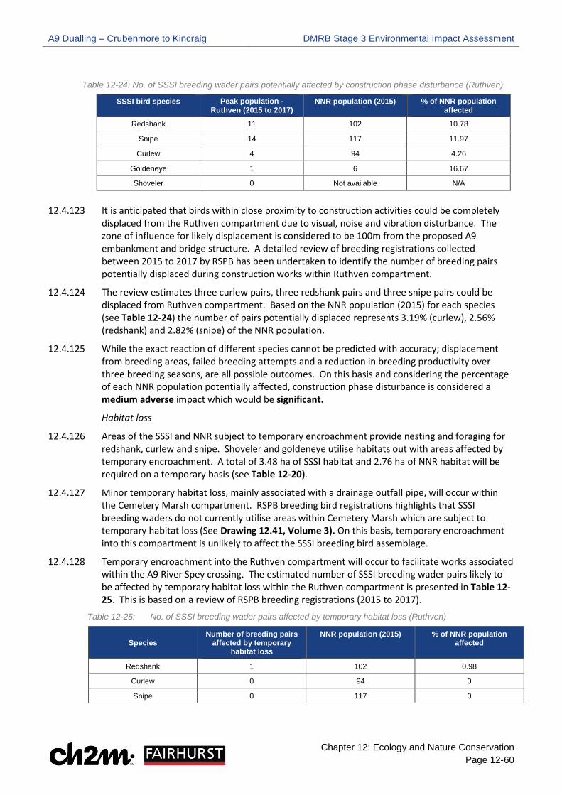
A9 Dualling – Crubenmore to Kincraig DMRB Stage 3 Environmental Impact Assessment
Chapter 12: Ecology and Nature Conservation Page 12-60
Table 12-24: No. of SSSI breeding wader pairs potentially affected by construction phase disturbance (Ruthven)
SSSI bird species Peak population - Ruthven (2015 to 2017)
NNR population (2015) % of NNR population affected
Redshank 11 102 10.78
Snipe 14 117 11.97
Curlew 4 94 4.26
Goldeneye 1 6 16.67
Shoveler 0 Not available N/A
12.4.123 It is anticipated that birds within close proximity to construction activities could be completely displaced from the Ruthven compartment due to visual, noise and vibration disturbance. The zone of influence for likely displacement is considered to be 100m from the proposed A9 embankment and bridge structure. A detailed review of breeding registrations collected between 2015 to 2017 by RSPB has been undertaken to identify the number of breeding pairs potentially displaced during construction works within Ruthven compartment.
12.4.124 The review estimates three curlew pairs, three redshank pairs and three snipe pairs could be displaced from Ruthven compartment. Based on the NNR population (2015) for each species (see Table 12-24) the number of pairs potentially displaced represents 3.19% (curlew), 2.56% (redshank) and 2.82% (snipe) of the NNR population.
12.4.125 While the exact reaction of different species cannot be predicted with accuracy; displacement from breeding areas, failed breeding attempts and a reduction in breeding productivity over three breeding seasons, are all possible outcomes. On this basis and considering the percentage of each NNR population potentially affected, construction phase disturbance is considered a medium adverse impact which would be significant.
Habitat loss
12.4.126 Areas of the SSSI and NNR subject to temporary encroachment provide nesting and foraging for redshank, curlew and snipe. Shoveler and goldeneye utilise habitats out with areas affected by temporary encroachment. A total of 3.48 ha of SSSI habitat and 2.76 ha of NNR habitat will be required on a temporary basis (see Table 12-20).
12.4.127 Minor temporary habitat loss, mainly associated with a drainage outfall pipe, will occur within the Cemetery Marsh compartment. RSPB breeding bird registrations highlights that SSSI breeding waders do not currently utilise areas within Cemetery Marsh which are subject to temporary habitat loss (See Drawing 12.41, Volume 3). On this basis, temporary encroachment into this compartment is unlikely to affect the SSSI breeding bird assemblage.
12.4.128 Temporary encroachment into the Ruthven compartment will occur to facilitate works associated within the A9 River Spey crossing. The estimated number of SSSI breeding wader pairs likely to be affected by temporary habitat loss within the Ruthven compartment is presented in Table 12- 25. This is based on a review of RSPB breeding registrations (2015 to 2017).
Table 12-25: No. of SSSI breeding wader pairs affected by temporary habitat loss (Ruthven)
Species Number of breeding pairs
affected by temporary habitat loss
NNR population (2015) % of NNR population affected
Redshank 1 102 0.98
Curlew 0 94 0
Snipe 0 117 0

A9 Dualling – Crubenmore to Kincraig DMRB Stage 3 Environmental Impact Assessment
Chapter 12: Ecology and Nature Conservation Page 12-61
12.4.129 Temporary habitat loss is likely to affect one redshank pair which represents 1% of the NNR population. Given temporary habitat loss within the Ruthven compartment will occur over three breeding seasons, it is assessed as a medium adverse impact which is significant.
Direct mortality
12.4.130 As components of the breeding bird assemblage hatch precocial (mobile) young, chicks may stray into construction areas where breeding areas are near the Proposed Scheme. Where this occurs, they may be vulnerable to direct mortality due to construction operations and plant movement. The extent of this impact will be localised and unlikely given predicted levels of disturbance (i.e. birds will generally avoid breeding in close proximity to construction works). However, as direct mortality could have a long-term effect on the SSSI breeding bird assemblage, this impact is considered a medium adverse impact and would be significant.
Habitat fragmentation
12.4.131 Where components of the breeding bird assemblage persist near construction activities, there is potential for temporary fragmentation as works may limit utilisation of habitats. While there is some potential for this within the Ruthven compartment, the impact is predicted to be negligible and not significant due to the existing effect of construction disturbance described above. This is predicted to displace birds utilising habitats within 100m of the Proposed Scheme in the Ruthven compartment.
Operational Phase
12.4.132 Potential impacts that could affect the breeding bird assemblage during the operational phase include disturbance/ displacement due to operational noise, habitat loss, displacement due to new landforms, habitat fragmentation and collision risk. These potential impacts are discussed in the following paragraphs and summarised in Table 12-28.
Disturbance/ displacement due to operational noise
12.4.133 A review of the noise contour mapping (Chapter 17 Noise and Vibration Drawings) illustrates predicted short-term change in noise levels in 2026 Do Something scenario (i.e. after construction of the Proposed Scheme) are minor and increases of 2 dB or less are shown throughout most of the Proposed Scheme. However, at the A9 River Spey crossing the Proposed Scheme moves east into the NNR Ruthven compartment and SSSI. At this location operational noise level contours illustrate increases in noise between 2-4 dB beyond earthwork extents. Some reduction in operational noise will occur to the west of the existing crossing due to the new road alignment.
12.4.134 RSPB breeding bird data highlights several registrations of redshank, curlew and snipe in close proximity to the existing A9 River Spey embankment within the Ruthven compartment (see Drawing 12.41, Volume 3). At this location, contour mapping predicts actual noise levels (see Figure 1 Appendix 12.12, Volume 2) of 60-65 dB around the embankment for the Do Minimum scenario in 2026 (i.e. with the Proposed Scheme not constructed). Noise levels of 55-60 dB are predicted within approximately 150m east of the existing A9. These predictions are likely to be similar to current noise levels around the crossing however, it is worth noting that noise levels may be slightly higher due to progressive increases in traffic volumes over time. These predictions indicate that redshank, curlew and snipe are utilising habitats east of the existing A9 which are currently exposed to high levels of predictable disturbance (i.e. road traffic).

A9 Dualling – Crubenmore to Kincraig DMRB Stage 3 Environmental Impact Assessment
Chapter 12: Ecology and Nature Conservation Page 12-62
12.4.135 Studies have shown that the presence of road and rail can result in a reduction in the density of breeding meadow birds (including waders). Reijenen et al. (1996) reported a noise threshold level of 47dB above which reductions in density were reported. As described in paragraph 12.4.134, it is recognised that SSSI breeding bird species are currently utilising habitats which are exposed to noise levels above this threshold due to the presence of the existing A9. This has been considered when assessing potential reductions in breeding density due to increases in operational noise, estimated as 2-4 dB.
12.4.136 It is predicted that 50% of breeding pairs within 100m of the Proposed Scheme could be permanently displaced due to increases in operational noise, with 10% of breeding pairs potentially displaced within 500m. However, given the presence of the existing road the primary reduction in breeding pairs is likely to occur up to 100m from the road. These estimates are broadly in line with figures predicted by Reijenen (1996). The paper presents the estimated reduction in breeding birds for roads with traffic movements of 5,000 vehicles per day and roads with 50,000 vehicles per day.
12.4.137 The predicted traffic flows for the Proposed Scheme in the opening year is 12,774 vehicles per day, increasing to 13,275 by 2041. On this basis, reductions in breeding density are predicted to most closely reflect Reijenen et al estimates for road traffic movements of 5,000. Given the context of the Proposed Scheme and existing exposure to noise, predicted reductions in breeding density around the A9 River Spey crossing are considered to be applied on a precautionary basis.
12.4.138 On this basis, the number of curlew, redshank and snipe pairs potentially displaced from habitats surrounding the A9 River Spey crossing is provided in Table 12-26. Estimates are based on a review of RSPB breeding registrations (2015 to 2017) within 500m east of the A9 River Spey crossing. The table also presents the estimated reduction of pairs as a percentage of the Insh Marshes NNR population during the 2015 breeding bird season (Highland Bird Report, 2015).
Table 12-26: No. of SSSI breeding wader pairs potentially displaced due to operational noise (Spey crossing)
Species
Estimated number of breeding pairs within 100m
Estimated reduction in breeding pairs within 100m (50%)
Estimated number of breeding pairs within 500m
Estimated reduction in breeding pairs within 500m (10%)
Total reduction in breeding pairs
NNR population (2015)
% of NNR population affected
Curlew 3 1.5 (2) 13 1.3 (1) 3 94 2.82
Redshank 3 1.5 (2) 13 1.2 (1) 3 102 2.94
Snipe 3 1.5 (2) 14 1.4 (1) 3 117 2.56
12.4.139 It is estimated that increases in operational noise could permanently displace around 3% of the Insh Marshes NNR redshank, curlew and snipe population from habitats east of the A9 crossing. As increases in operational noise disturbance could permanently affect the distribution of the SSSI breeding bird assemblage, it is considered a high adverse impact which would be significant.
Habitat loss
12.4.140 The Proposed Scheme will result in 0.60 ha of permanent land take from the SSSI and 3.73 ha of permanent land take from the NNR (see Table 12-20) to new infrastructure and associated embankments.
12.4.141 Minor permanent habitat loss, associated with mainline earthworks, will occur within the Cemetery Marsh compartment. RSPB Breeding bird registrations highlights that SSSI breeding waders do not currently utilise areas within Cemetery Marsh which are subject to permanent habitat loss (See Drawing 12.41, Volume 3). On this basis, minor permanent habitat loss within the compartment is unlikely to affect the SSSI breeding bird assemblage.

A9 Dualling – Crubenmore to Kincraig DMRB Stage 3 Environmental Impact Assessment
Chapter 12: Ecology and Nature Conservation Page 12-63
12.4.142 Areas affected by permanent habitat loss around the A9 River Spey crossing are currently utilised to some extent by breeding redshank, curlew, and snipe during the breeding season (See Drawing 12.41, Volume 3). While nest site locations are not defined, this shows that components of the SSSI breeding bird assemblage may be directly affected by permanent habitat loss within the NNR Ruthven compartment. The estimated number of SSSI breeding wader pairs likely to be affected by permanent habitat loss within the Ruthven compartment is presented in Table 12-27. This is based on a review of RSPB breeding registrations (2015 to 2017).
Table 12-27: No. of SSSI breeding wader pairs affected by permanent habitat loss (Ruthven)
Species Number of breeding pairs
affected by permanent habitat loss
NNR population (2015) Proportion of NNR population affected (%)
Redshank 2 102 1.96
Curlew 1 94 1.06
Snipe 1 117 0.85
12.4.143 It is estimated that permanent habitat loss could affect around 1-2% of the NNR redshank, curlew and snipe population. Habitat loss due to new infrastructure and embankments could permanently affect the distribution of the SSSI breeding bird assemblage within the Ruthven compartment. On this basis, permanent habitat loss is considered a high adverse impact which would be significant.
Displacement due to new structures and landforms
12.4.144 Katzenberger (2014) present empirical data illustrating that breeding wader species including snipe, redshank and curlew, show a negative reaction to the presence of both trees and man-made structures. They also reported an increased probability of wader use of habitats >100m from trees. Similar reactions are reported by Katzenberger (2014) for boundary features such as hedgerows.
12.4.145 The presence of an existing embankment possibly exerts an influence on the current distribution of SSSI breeding bird species within the Ruthven compartment. The extent of this influence is unclear as other factors relating to habitat quality (e.g. the presence of areas of standing water or ditches) can also influence breeding wader (and wildfowl) distribution. However, it is anticipated that some permanent displacement may occur within 100m of the proposed River Spey crossing and associated embankments. The effect of displacement is likely to overlap or interact to some degree with the effect of operational noise described previously in paragraphs 12.4.133 to 12.4.139. Where birds are not physically displaced they may be at increased risk of predation from either mammalian or avian predators where they are in closer proximity to boundary features however, the extent of any increased predation risk cannot be quantified with a high degree of accuracy. Displacement due to new landforms and structures is likely limited to 100m, unlike displacement due to road traffic noise which is considered for breeding birds up to 500m from the Proposed Scheme. On this basis, displacement due to the new A9 River Spey crossing and associated embankment is a medium adverse impact which is significant.
Habitat fragmentation
12.4.146 Vantage point observations reported in Appendix 12.6, Volume 2 indicate breeding snipe and redshank currently utilise grassland on both sides of the existing A9 River Spey crossing. Given the mobility of snipe and redshank, the presence of a wider route is not anticipated to prohibit utilisation of habitats on either side of the Proposed Scheme. The effect of fragmentation during operation is predicted to be low adverse and not significant.

A9 Dualling – Crubenmore to Kincraig DMRB Stage 3 Environmental Impact Assessment
Chapter 12: Ecology and Nature Conservation Page 12-64
Collision risk
12.4.147 The construction of a new bridge structure across the Insh Marshes introduces potential increased collision risk between birds and road traffic. Increases in both volume and speed of road traffic are predicted as a result of the Proposed Scheme. The proposed replacement of the Spey crossing structure retains a similar profile and vertical alignment to the existing bridge structure with no above deck structures.
12.4.148 The distribution of SSSI breeding bird species within Insh Marshes is primarily to the east of the existing A9 River Spey crossing. Some movement of redshank, snipe and curlew was reported during vantage point surveys in 2017 (Appendix 12.5, Volume 2). Redshank flights were reported at heights of between 5-10m. Curlew flights recorded were typically above 20m. Snipe were only recorded crossing the existing A9 on a single visit with flight height estimated to be >50m. While a wider road will increase transit time for birds crossing the Proposed Scheme, the low number of bird flights recorded across the existing road suggests there is limited potential for an increase in collision risk. In addition, the increased bridge length and reduced embankment may allow increased movement of some species below the bridge either in flight or by walking (where young are present).
12.4.149 Breeding waders raise precocial young which are quickly mobile and leave nest sites after hatching and prior to fledging. There is an existing and potential risk that young waders or wildfowl could access the operational road via the embankment of the River Spey crossing and be exposed to collision with vehicles. The risk of this is considered to be low given these species favour wet grassland for foraging. Vegetation on the embankment during the operational phase is likely to be dry and unsuitable for feeding. Increased collision risk is assessed as a low adverse impact which will not be significant. Table 12-28: Summary of potential impacts for the SSSI breeding bird assemblage
Feature Importance Potential impacts during construction phase (temporary)
Potential impacts during operational phase (permanent)
SSSI - Breeding bird assemblage
National Habitat loss - medium adverse and significant Disturbance/ displacement - medium adverse and significant Direct mortality - medium adverse and significant Habitat fragmentation - negligible impact and not significant.
Disturbance/ displacement due to operational noise - high adverse and significant Habitat loss – high adverse and significant Displacement due to new structures and landforms - medium adverse and significant Habitat fragmentation - low adverse and not significant Collision risk – low adverse and not significant.
Insh Marshes NNR
12.4.150 As many important habitats and species of Insh Marshes NNR overlap with the River Spey – Insh Marshes SSSI, potential impacts on the NNR at the construction and operational phase have been considered under each notified feature of the SSSI.
Notable Habitats
12.4.151 Construction phase activities could affect habitats through creation of temporary access tracks and SuDS, vehicle tracking and excavation of compensatory flood storage areas within the red, green and purple assessment boundary (see Chapter 12 Ecology Drawings, Volume 3). Potential impacts during the construction phase are generally considered to be temporary. Habitats will

A9 Dualling – Crubenmore to Kincraig DMRB Stage 3 Environmental Impact Assessment
Chapter 12: Ecology and Nature Conservation Page 12-65
recover in the short or long-term depending on factors such as sensitivity of affected habitats and nature of construction activities. It is noted that, whilst impacts during construction would generally be temporary, habitats could be altered or damaged to such an extent during construction that the impact would be permanent (e.g. clearance of woodland to facilitate works will result in permanent habitat loss).
12.4.152 The operational phase will result in permanent and irreversible habitat loss through new infrastructure including the new carriageway, earthworks, permanent SuDS and structures (i.e. the detailed design and drainage shown on Chapter 12 Ecology Drawings, Volume 3).
12.4.153 The area of each notable habitat lost during construction is presented in Table 12-29. The area of each notable habitat permanently lost to new infrastructure is presented in Table 12-30.
12.4.154 As well as direct loss, new and extended earthworks cuttings may intercept groundwater and affect local hydrogeological regimes. Pre-earthworks drainage is included within the Proposed Scheme to minimise potential disruption to groundwater; however, short-term and long-term habitat deterioration may occur leading to habitat change or loss beyond the Proposed Scheme boundaries. Therefore, an assessment of potential GWDTE has been carried out to determine potential effects from short-term construction activities and long-term changes to groundwater regimes which could affect GWDTE (see Appendix 10.2, Volume 2).
Construction Phase
12.4.155 The following paragraphs describe the estimated habitat loss from each notable habitat during the construction phase (see paragraph 12.4.151).
Annex 1 habitats
12.4.156 Construction activities will result in the loss of 13.86 hectares (ha) of European dry heaths which accounts for 6.99% of the total dry heath resource within the study area. Areas affected will generally be limited to the southern extent of the scheme, notably to the east of the existing A9 between ch. 41,200 and ch. 42,600. Dry heath is sensitive to disturbance but recovers more easily than habitats dependent on groundwater and surface hydrology (e.g. blanket bog). Areas affected are characterised by NVC heath communities H10 and H12 which are widespread within the wider landscape and throughout the Scottish Highlands. The extent of dry heath lost during construction is localised and likely reversible in the short-term; therefore, a low adverse impact is predicted which is not significant.
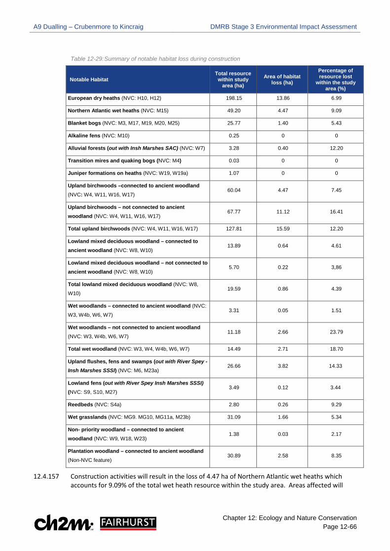
A9 Dualling – Crubenmore to Kincraig DMRB Stage 3 Environmental Impact Assessment
Chapter 12: Ecology and Nature Conservation Page 12-66
Table 12-29: Summary of notable habitat loss during construction
Notable Habitat Total resource within study
area (ha) Area of habitat
loss (ha)
Percentage of resource lost
within the study area (%)
European dry heaths (NVC: H10, H12) 198.15 13.86 6.99
Northern Atlantic wet heaths (NVC: M15) 49.20 4.47 9.09
Blanket bogs (NVC: M3, M17, M19, M20, M25) 25.77 1.40 5.43
Alkaline fens (NVC: M10) 0.25 0 0
Alluvial forests (out with Insh Marshes SAC) (NVC: W7) 3.28 0.40 12.20
Transition mires and quaking bogs (NVC: M4) 0.03 0 0
Juniper formations on heaths (NVC: W19, W19a) 1.07 0 0
Upland birchwoods –connected to ancient woodland (NVC: W4, W11, W16, W17)
60.04 4.47 7.45
Upland birchwoods – not connected to ancient woodland (NVC: W4, W11, W16, W17)
67.77 11.12 16.41
Total upland birchwoods (NVC: W4, W11, W16, W17) 127.81 15.59 12.20
Lowland mixed deciduous woodland – connected to ancient woodland (NVC: W8, W10)
13.89 0.64 4.61
Lowland mixed deciduous woodland – not connected to ancient woodland (NVC: W8, W10)
5.70 0.22 3,86
Total lowland mixed deciduous woodland (NVC: W8,
W10) 19.59 0.86 4.39
Wet woodlands – connected to ancient woodland (NVC:
W3, W4b, W6, W7) 3.31 0.05 1.51
Wet woodlands – not connected to ancient woodland (NVC: W3, W4b, W6, W7)
11.18 2.66 23.79
Total wet woodland (NVC: W3, W4, W4b, W6, W7) 14.49 2.71 18.70
Upland flushes, fens and swamps (out with River Spey - Insh Marshes SSSI) (NVC: M6, M23a)
26.66 3.82 14.33
Lowland fens (out with River Spey Insh Marshes SSSI) (NVC: S9, S10, M27)
3.49 0.12 3.44
Reedbeds (NVC: S4a) 2.80 0.26 9.29
Wet grasslands (NVC: MG9. MG10, MG11a, M23b) 31.09 1.66 5.34
Non- priority woodland – connected to ancient woodland (NVC: W9, W18, W23)
1.38 0.03 2.17
Plantation woodland – connected to ancient woodland (Non-NVC feature)
30.89 2.58 8.35
12.4.157 Construction activities will result in the loss of 4.47 ha of Northern Atlantic wet heaths which accounts for 9.09% of the total wet heath resource within the study area. Areas affected will
A9 Dualling – Crubenmore to Kincraig DMRB Stage 3 Environmental Impact Assessment
Chapter 12: Ecology and Nature Conservation Page 12-67
generally be limited to the southern extent, notably to the east of the existing A9 between ch. 43,000 and ch. 43,350. Wet heaths are sensitive to disturbance, particularly where surface vegetation is damaged or removed, as typical species that characterise wet heath communities may not recover in the short-term. Wet heaths within the study area have been impacted by burning, grazing, drainage issues and encroachment of young Betula spp. Given the localised scale and generally poor condition of wet heaths within the Proposed Scheme, habitat loss during construction is a low adverse impact is predicted which is not significant.
12.4.158 Construction activities will result in the loss of 1.40 ha of blanket bog which accounts for 5.43% of the total blanket bog resource within the study area. Areas affected will generally be restricted to discrete areas within the southern extent, most notably around the Proposed Newtonmore Junction, east of the existing A9. Blanket bogs are very sensitive to temporary disturbance, particularly where surface vegetation is damaged or removed, as typical species that characterise blanket bog communities may not recover. Whilst works could have a long-term effect on this habitat, the extent of blanket bog lost during construction is localised; therefore, a low adverse impact is predicted which is not significant.
12.4.159 Construction activities will result in the loss of 0.40 ha of alluvial forests which accounts for 12.20% of the total alluvial forests resource within the study area. Areas affected are restricted to three discrete areas of alluvial forests located alongside the Burn of Inverton, adjacent to Ruthven Road (east of existing A9) and around the proposed Kingussie Junction. Clearance of alluvial forests during construction will result in permanent habitat loss. Whilst the extent of this habitat affected is very localised, alluvial forests have declined significantly in the UK and typically exist in fragmented strips; therefore, the permanent loss of alluvial forests to facilitate construction could alter the integrity of this habitat. A medium adverse impact is predicted which is not significant.
12.4.160 Construction activities will not result in the loss of any areas of alkaline fens, juniper formations on heaths and transition mires and quaking bogs as they are not present within the Proposed Scheme; therefore, no impact is predicted.
Scottish Biodiversity List (SBL) habitats
12.4.161 Construction activities will result in the loss of 15.59 ha of upland birchwoods which accounts for 12.20% of the total birchwood resource within the study area. Areas affected are scattered throughout the Proposed Scheme, with notable areas occurring east and west of the existing A9 between ch. 40,000 and ch. 43,000 (southern extent) and ch. 54,800 and ch. 56,600 (northern extent). Clearance of birchwoods to facilitate construction will result in permanent habitat loss however, the localised scale will not affect the integrity of this habitat; therefore, a medium adverse impact is predicted. This impact is significant for birchwoods which are connected to ancient woodland. However, this impact is not significant for birchwoods which are not connected to ancient woodland.
12.4.162 Construction activities will result in the loss of 0.86 ha of lowland mixed deciduous woodland which accounts for 4.39 % of the total deciduous woodland resource within the study area. Areas affected are restricted to the northern extent, occurring in discrete areas west of the existing A9 between ch. 51,700 and ch. 53,000.
12.4.163 Construction activities will result in the loss of 14.49 ha of wet woodland which accounts for 18.70% of the total wet woodland resource within the study area. Areas affected are scattered throughout the Proposed Scheme, with a notable area located east of the existing A9 between ch. 49,150 and ch. 50,100.
A9 Dualling – Crubenmore to Kincraig DMRB Stage 3 Environmental Impact Assessment
Chapter 12: Ecology and Nature Conservation Page 12-68
12.4.164 Whilst the loss of SBL woodlands, lowland mixed deciduous woodland and wet woodland, during construction will be permanent and irreversible, the scale is very localised; therefore, a low adverse impact is predicted which is not significant for both these SBL woodlands, even where they are connected to ancient woodland.
12.4.165 Construction activities will result in the loss of 3.82 ha of upland flushes, fens and swamps which accounts for 14.33% of the total resource within the study area. Areas affected occur in small and discrete areas scattered throughout the Proposed Scheme. Construction activities could alter groundwater and surface hydrology which may have a long-term impact on this habitat; therefore, a medium adverse impact is predicted which is not significant.
12.4.166 Construction activities will result in the loss of 3.49 ha of lowland fens which accounts for 0.12% of the total lowland fen resource within the study area. Areas affected occur in very small and discrete areas scattered throughout the Proposed Scheme. Construction activities could alter groundwater and surface hydrology, leading to a long-term impact on this habitat. However, given the extremely localised scale, a low adverse impact is predicted which is not significant.
12.4.167 Construction activities will result in the loss of 2.80 ha of reedbeds. This impact is restricted to a single area east of the existing A9 around ch. 56,400. Reedbeds are limited within the Cairngorms however, as the extent of reedbeds lost during construction is extremely localised, a low adverse impact is predicted which is not significant.
Cairngorms Nature Action Plan (CNPA) priority habitats
12.4.168 Construction activities will result in the loss of 1.66 ha of wet grasslands which accounts for 5.34% of the total wet grassland resource within the study area. Construction activities could alter groundwater and surface hydrology which may have a long-term impact on this habitat. However, given the localised scale, a low adverse impact is predicted which is not significant.
Non – Priority Woodland (connected to ancient woodland)
12.4.169 Construction activities will result in the loss of 0.03 ha of non-priority woodland which is connected to AWI. This impact is restricted to the northern extent, west of the existing A9 around ch. 54,400. Clearance of non-priority woodland to facilitate construction will result in permanent habitat loss. Whilst the areas of non-priority woodland lost are connected to ancient woodland, due to the extremely localised scale, a low adverse impact is predicted which is not significant.
Plantation Woodland (connected to ancient woodland)
12.4.170 Construction activities will result in the loss of 2.58 ha of plantation woodland which is connected to AWI. Areas affected are scattered throughout the Proposed Scheme. Clearance of plantation woodland to facilitate construction will result in permanent habitat loss. As these areas are connected to ancient woodland a medium adverse impact is predicted which is not significant.
Operational Phase
12.4.171 The following paragraphs describe the estimated habitat loss from each notable habitat during the operational phase (i.e. habitat loss due to permanent infrastructure) (see paragraph 12.4.152).

A9 Dualling – Crubenmore to Kincraig DMRB Stage 3 Environmental Impact Assessment
Chapter 12: Ecology and Nature Conservation Page 12-69
Annex 1 habitats
12.4.172 The Proposed Scheme will result in the loss of 15.58 ha of European dry heath to new infrastructure, which accounts for 7.86% of the total dry heath resource within the study area. Habitat loss is generally restricted to the southern extent, notably along the dry slopes east of the existing A9. Areas of habitat loss are characterised by NVC heath communities H10 and H12 which are widespread within the wider landscape and throughout the Scottish Highlands. The loss of dry heaths to new infrastructure will be permanent and irreversible however, the localised scale of habitat loss will not alter the integrity of this habitat; therefore, a medium adverse impact is predicted which is not significant.
12.4.173 The Proposed Scheme will result in the loss of 0.81 ha of Northern Atlantic wet heaths to new infrastructure which accounts for 1.65% of the total Northern Atlantic wet heath resource within the study area. Habitat loss is restricted to small and discrete areas within the southern extent which have been subjected to burning, grazing, drainage issues and encroachment of young Betula spp. Whilst the loss of wet heaths to new infrastructure will be permanent and irreversible, wet heaths are generally in poor condition and the scale of habitat loss is extremely localised; therefore, the permanent loss of wet heaths is a low adverse impact which is not significant.
12.4.174 The Proposed Scheme will result in the loss of 0.88 ha of blanket bogs to new infrastructure which accounts for 3.41% of the total blanket bog resource within the study area. Habitat loss is generally restricted to small and discrete areas within the southern extent. Whilst the loss of blanket bogs to new infrastructure will be permanent and irreversible, the scale of habitat loss is extremely localised; therefore, permanent loss of blanket bogs is a low adverse impact and is not significant.
12.4.175 The Proposed Scheme will result in the loss of 0.38 ha of alluvial forests to new infrastructure which accounts for 11.59% of the total alluvial forest resource within the study area. Habitat loss is restricted to three discrete areas of alluvial forests located alongside the burn of Inverton, adjacent to Ruthven Road (east of existing A9) and around the proposed Kingussie Junction. The loss of alluvial forests to new infrastructure will be permanent and irreversible. Whilst the extent permanent habitat loss is very localised, alluvial forests have declined significantly in the UK and typically exist in fragmented strips; therefore, the permanent loss of alluvial forests to new infrastructure could alter the integrity of this habitat. A medium adverse impact is predicted which is not significant.
12.4.176 The Proposed Scheme will not result in the permanent loss of alkaline fens, transition mires and quaking bogs or juniper formations on heaths as these habitats are not present within the permanent infrastructure footprint; therefore, no impact is predicted.
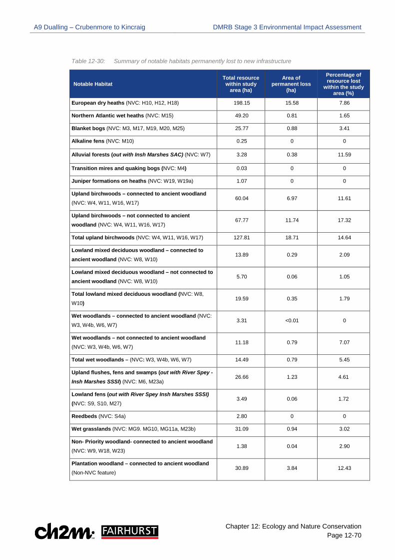
A9 Dualling – Crubenmore to Kincraig DMRB Stage 3 Environmental Impact Assessment
Chapter 12: Ecology and Nature Conservation Page 12-70
Table 12-30: Summary of notable habitats permanently lost to new infrastructure
Notable Habitat Total resource within study
area (ha)
Area of permanent loss
(ha)
Percentage of resource lost
within the study area (%)
European dry heaths (NVC: H10, H12, H18) 198.15 15.58 7.86
Northern Atlantic wet heaths (NVC: M15) 49.20 0.81 1.65
Blanket bogs (NVC: M3, M17, M19, M20, M25) 25.77 0.88 3.41
Alkaline fens (NVC: M10) 0.25 0 0
Alluvial forests (out with Insh Marshes SAC) (NVC: W7) 3.28 0.38 11.59
Transition mires and quaking bogs (NVC: M4) 0.03 0 0
Juniper formations on heaths (NVC: W19, W19a) 1.07 0 0
Upland birchwoods – connected to ancient woodland (NVC: W4, W11, W16, W17)
60.04 6.97 11.61
Upland birchwoods – not connected to ancient woodland (NVC: W4, W11, W16, W17)
67.77 11.74 17.32
Total upland birchwoods (NVC: W4, W11, W16, W17) 127.81 18.71 14.64
Lowland mixed deciduous woodland – connected to ancient woodland (NVC: W8, W10)
13.89 0.29 2.09
Lowland mixed deciduous woodland – not connected to ancient woodland (NVC: W8, W10)
5.70 0.06 1.05
Total lowland mixed deciduous woodland (NVC: W8,
W10) 19.59 0.35 1.79
Wet woodlands – connected to ancient woodland (NVC:
W3, W4b, W6, W7) 3.31 <0.01 0
Wet woodlands – not connected to ancient woodland (NVC: W3, W4b, W6, W7)
11.18 0.79 7.07
Total wet woodlands – (NVC: W3, W4b, W6, W7) 14.49 0.79 5.45
Upland flushes, fens and swamps (out with River Spey - Insh Marshes SSSI) (NVC: M6, M23a)
26.66 1.23 4.61
Lowland fens (out with River Spey Insh Marshes SSSI) (NVC: S9, S10, M27)
3.49 0.06 1.72
Reedbeds (NVC: S4a) 2.80 0 0
Wet grasslands (NVC: MG9. MG10, MG11a, M23b) 31.09 0.94 3.02
Non- Priority woodland- connected to ancient woodland (NVC: W9, W18, W23)
1.38 0.04 2.90
Plantation woodland – connected to ancient woodland (Non-NVC feature)
30.89 3.84 12.43

A9 Dualling – Crubenmore to Kincraig DMRB Stage 3 Environmental Impact Assessment
Chapter 12: Ecology and Nature Conservation Page 12-71
Scottish Biodiversity List (SBL) habitats
12.4.177 The Proposed Scheme will result in the loss of 18.71 ha of upland birchwoods to new infrastructure which accounts for 14.64% of the total birchwood resource within the study area. Areas of habitat loss are scattered throughout the Proposed Scheme, with notable areas occurring east and west of the existing A9 between ch. 40,000 and ch. 43,000 (southern extent) and ch. 54,800 and ch. 56,600 (northern extent). The loss of upland birchwoods will be permanent and irreversible, however the scale of habitat loss is localised and will not affect the integrity of this habitat. On this basis, a medium adverse impact is predicted which is significant for those areas of upland birchwoods which are connected to ancient woodland. However, this impact is not significant for upland birchwoods which are not connected to ancient woodland.
12.4.178 The Proposed Scheme will result in the loss of 0.35 ha of lowland mixed deciduous woodland to new infrastructure which accounts for 1.79% of the total deciduous woodland resource within the study area. Areas of habitat loss are restricted to the northern extent, occurring in discrete areas west of the existing A9 between ch. 51,700 and ch. 53,000.
12.4.179 The Proposed Scheme will result in the loss of 0.79ha of wet woodland to new infrastructure. Areas of habitat loss occur in small and discrete areas scattered throughout the Proposed Scheme.
12.4.180 Whilst the loss of SBL woodlands, lowland mixed deciduous woodland and wet woodland, will be permanent and irreversible, the scale is extremely localised; therefore, a low adverse impact is predicted which is not significant for both of these SBL woodlands, even where they are connected to ancient woodland.
12.4.181 The Proposed Scheme will result in the loss of 1.23 ha of upland flushes, fens and swamps to new infrastructure which accounts for 4.61% of the total resource of this habitat within the study area. Areas of habitat loss occur in small and discrete areas scattered throughout the Proposed Scheme. The loss upland flushes, fens and swamps to new infrastructure will be irreversible and permanent. However, the scale of habitat loss will not alter the integrity of this habitat; therefore, a medium adverse impact is predicted which is not significant.
12.4.182 The Proposed Scheme will not result in the loss of lowland fens or reedbeds as these habitats are not present within the permanent infrastructure footprint; therefore, no impact is predicted.
Cairngorms Nature Action Plan (CNPA) priority habitats 12.4.183 The Proposed Scheme will result in the loss of 0.94 ha of wet grasslands to new infrastructure
which accounts for 3.02% of the total wet grassland resource within the study area. Areas of habitat loss occur in small and discrete areas scattered throughout the Proposed Scheme. The loss of wet grassland to new infrastructure will be permanent and irreversible. However, the scale of habitat loss will not alter the integrity of wet grasslands; therefore, a medium adverse impact is predicted which is not significant.
Non-priority woodland (connected to ancient woodland) 12.4.184 The Proposed Scheme will result in the loss of 0.04 ha of non-priority woodland (connected to
AWI) to new infrastructure. Areas of habitat loss is restricted to the northern extent, west of the existing A9 around ch. 54,400. The loss of non-priority woodland to new infrastructure will be permanent and irreversible. Whilst the areas of non-priority woodland lost are connected to ancient woodland, due to the extremely localised scale, a low adverse impact is predicted which is not significant.
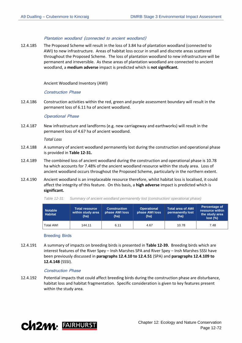
A9 Dualling – Crubenmore to Kincraig DMRB Stage 3 Environmental Impact Assessment
Chapter 12: Ecology and Nature Conservation Page 12-72
Plantation woodland (connected to ancient woodland) 12.4.185 The Proposed Scheme will result in the loss of 3.84 ha of plantation woodland (connected to
AWI) to new infrastructure. Areas of habitat loss occur in small and discrete areas scattered throughout the Proposed Scheme. The loss of plantation woodland to new infrastructure will be permanent and irreversible. As these areas of plantation woodland are connected to ancient woodland, a medium adverse impact is predicted which is not significant.
Ancient Woodland Inventory (AWI)
Construction Phase
12.4.186 Construction activities within the red, green and purple assessment boundary will result in the permanent loss of 6.11 ha of ancient woodland.
Operational Phase
12.4.187 New infrastructure and landforms (e.g. new carriageway and earthworks) will result in the permanent loss of 4.67 ha of ancient woodland.
Total Loss
12.4.188 A summary of ancient woodland permanently lost during the construction and operational phase is provided in Table 12-31.
12.4.189 The combined loss of ancient woodland during the construction and operational phase is 10.78 ha which accounts for 7.48% of the ancient woodland resource within the study area. Loss of ancient woodland occurs throughout the Proposed Scheme, particularly in the northern extent.
12.4.190 Ancient woodland is an irreplaceable resource therefore, whilst habitat loss is localised, it could affect the integrity of this feature. On this basis, a high adverse impact is predicted which is significant.
Table 12-31: Summary of ancient woodland permanently lost (construction/ operational phase)
Notable Habitat
Total resource within study area
(ha)
Construction phase AWI loss
(ha)
Operational phase AWI loss
(ha)
Total area of AWI permanently lost
(ha)
Percentage of resource within the study area
lost (%)
Total AWI 144.11 6.11 4.67 10.78 7.48
Breeding Birds
12.4.191 A summary of impacts on breeding birds is presented in Table 12-39. Breeding birds which are interest features of the River Spey – Insh Marshes SPA and River Spey – Insh Marshes SSSI have been previously discussed in paragraphs 12.4.10 to 12.4.51 (SPA) and paragraphs 12.4.109 to 12.4.148 (SSSI).
Construction Phase 12.4.192 Potential impacts that could affect breeding birds during the construction phase are disturbance,
habitat loss and habitat fragmentation. Specific consideration is given to key features present within the study area.

A9 Dualling – Crubenmore to Kincraig DMRB Stage 3 Environmental Impact Assessment
Chapter 12: Ecology and Nature Conservation Page 12-73
Annex 1 Species 12.4.193 Two black grouse lek sites are within 250m of the Proposed Scheme; therefore, they may be
vulnerable to disturbance during construction. They are likely to be most vulnerable to construction phase disturbance (via noise) before and around dawn and dusk. The impact of disturbance at construction stage could affect one to two breeding seasons; therefore, construction phase disturbance is medium adverse and is significant. No other potential impacts during construction are considered for black grouse.
12.4.194 Golden eagle, white-tailed eagle, and marsh harrier were all reported in flight with no evidence of breeding identified within the study area. Given the extent of available foraging habitat in the wider area and absence of breeding evidence, no impacts are predicted for these raptor species.
Schedule 1 Species 12.4.195 Crossbill (considered to be common crossbill) were reported out with the study area; however,
surveyors noted they could utilise suitable habitat within the study area to breed (e.g. coniferous woodland); therefore, there is the potential for habitat loss and disturbance during construction. Given the extent of available breeding habitat in the wider area, the impact of disturbance or temporary habitat loss will be low adverse and not significant.
Strathspey Breeding Wader Assemblage 12.4.196 Notable populations of Strathspey breeding waders were recorded within the study area and
could be impacted by Proposed Scheme at the following locations:
•• Nuide Farm, where wader habitat is present both east and west of the Proposed Scheme between ch. 44,800 and ch. 47,400
•• The A9 River Spey crossing between ch. 49,300 and ch. 50,600 (Ruthven / Pitmain / Gordonhall compartments)
•• East of existing A9 between ch. 51,200 and ch. 52,200 (Cemetery Marsh compartment).
•• East of existing A9 around 52,850 beyond HML railway (Lynchat compartment) 12.4.197 The location of the above compartments in relation to the Proposed Scheme are provided in
Drawing 12.40, Volume 3.
12.4.198 The following wader species are considered components of the Strathspey breeding wader assemblage: redshank, snipe, curlew, oystercatcher and lapwing. Redshank, snipe and curlew are also components of the River Spey - Insh Marshes SSSI breeding bird assemblage. Where RSPB breeding bird data (2015 to 2017) highlights the presence of these species within the SSSI boundary or adjacent habitats (i.e. Insh Marshes NNR), they are considered components of the SSSI breeding bird assemblage and have been discussed in paragraphs 12.4.109 to 12.4.146.
12.4.199 Where these species have been recorded outwith the SSSI and NNR, in grassland habitat surrounding Nuide Farm, redshank, curlew and snipe are discussed along with oystercatcher and lapwing under the Strathspey breeding waders in the following paragraphs.
Disturbance/ displacement
Nuide Farm
12.4.200 Construction activities in proximity to Nuide Farm comprises the creation of the new carriageway (extended to the southbound side) and associated earthworks; and improvements to the farm’s access track. Works around Nuide Farm could affect one to two breeding seasons.

A9 Dualling – Crubenmore to Kincraig DMRB Stage 3 Environmental Impact Assessment
Chapter 12: Ecology and Nature Conservation Page 12-74
12.4.201 A number of lapwing and oystercatcher utilise grassland habitat surrounding Nuide Farm (CFJV breeding registrations are illustrated on Drawing 12.45, Volume 3). Small numbers of breeding snipe and curlew could also be affected around Nuide Farm. Noise and visual disturbance from construction operations could affect the local distribution of breeding birds within 100m of the Proposed Scheme. The estimated number of Strathspey breeding wader pairs predicted to be locally displaced during construction is provided in Table 12-32. This information is based on a review of the CFJV 2015 breeding bird data. Table 12-32: No. of Strathspey breeding wader pairs potentially displaced from Nuide Farm
Strathspey breeding bird species
Number of pairs locally displaced during construction
(Southbound side)
Number of pairs locally displaced during construction (Northbound Side)
Lapwing 3 4
Oystercatcher 3 3
Snipe 1 0
Curlew 0 0
12.4.202 Two compensatory flood storage areas (CFSA) and two SuDS features are proposed around Nuide Farm which could result in significant disturbance to Strathspey breeding waders if excavation works are undertaken during the breeding bird season. The high level of visual disturbance from site personal and machinery could cause significant disturbance to breeding waders if undertaken during the breeding season. There is also the potential for damage to ground nests.
Cemetery Marsh compartment
12.4.203 Construction activities in proximity to the Cemetery Marsh compartment comprises the creation of the new carriageway and associated earthworks. Works around Cemetery Marsh could affect one to two breeding seasons. Oystercatcher and lapwing utilise habitats within Cemetery Marsh however, compared with the Ruthven compartment, the number of registrations is far less (see Drawing 12.43, Volume 2). All lapwing and oystercatcher breeding registrations within Cemetery Marsh are located over 100m from the Proposed Scheme. At 100m noise from construction operations will be between 51dB and 64dB LAeq T (as presented in Table 12-12-1 Appendix 12.12, Volume 2) at which point Cutts et al. (2009) reports a low to moderate response from birds (see Table 12-21). However, excavation works associated with a proposed drainage outfall east of the existing A9 at ch. 52,000 will be in close proximity to breeding waders within Cemetery Marsh. The high level of visual disturbance from site personnel and machinery could cause significant disturbance to breeding waders if undertaken during the breeding season.
Lynchat compartment
12.4.204 An area 0.09 in size is located east of the existing A9 around ch. 52,850 and extends beyond the HML railway into the NNR Lynchat compartment.
12.4.205 RSPB breeding bird data (2015/ 2016) highlights records of lapwing and oystercatcher within the Lynchat compartment, in close proximity to the additional area previously described (see Drawing 12.43, Volume). Whilst investigations at this location will be short-term in duration, the high level of visual disturbance from machinery and site personnel could disturb or locally displace these species if undertaken during the breeding bird season.
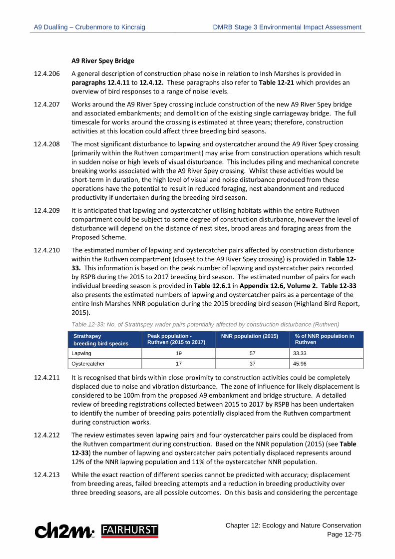
A9 Dualling – Crubenmore to Kincraig DMRB Stage 3 Environmental Impact Assessment
Chapter 12: Ecology and Nature Conservation Page 12-75
A9 River Spey Bridge
12.4.206 A general description of construction phase noise in relation to Insh Marshes is provided in paragraphs 12.4.11 to 12.4.12. These paragraphs also refer to Table 12-21 which provides an overview of bird responses to a range of noise levels.
12.4.207 Works around the A9 River Spey crossing include construction of the new A9 River Spey bridge and associated embankments; and demolition of the existing single carriageway bridge. The full timescale for works around the crossing is estimated at three years; therefore, construction activities at this location could affect three breeding bird seasons.
12.4.208 The most significant disturbance to lapwing and oystercatcher around the A9 River Spey crossing (primarily within the Ruthven compartment) may arise from construction operations which result in sudden noise or high levels of visual disturbance. This includes piling and mechanical concrete breaking works associated with the A9 River Spey crossing. Whilst these activities would be short-term in duration, the high level of visual and noise disturbance produced from these operations have the potential to result in reduced foraging, nest abandonment and reduced productivity if undertaken during the breeding bird season.
12.4.209 It is anticipated that lapwing and oystercatcher utilising habitats within the entire Ruthven compartment could be subject to some degree of construction disturbance, however the level of disturbance will depend on the distance of nest sites, brood areas and foraging areas from the Proposed Scheme.
12.4.210 The estimated number of lapwing and oystercatcher pairs affected by construction disturbance within the Ruthven compartment (closest to the A9 River Spey crossing) is provided in Table 12-33. This information is based on the peak number of lapwing and oystercatcher pairs recorded by RSPB during the 2015 to 2017 breeding bird season. The estimated number of pairs for each individual breeding season is provided in Table 12.6.1 in Appendix 12.6, Volume 2. Table 12-33 also presents the estimated numbers of lapwing and oystercatcher pairs as a percentage of the entire Insh Marshes NNR population during the 2015 breeding bird season (Highland Bird Report, 2015).
Table 12-33: No. of Strathspey wader pairs potentially affected by construction disturbance (Ruthven)
Strathspey breeding bird species
Peak population - Ruthven (2015 to 2017)
NNR population (2015) % of NNR population in Ruthven
Lapwing 19 57 33.33
Oystercatcher 17 37 45.96
12.4.211 It is recognised that birds within close proximity to construction activities could be completely displaced due to noise and vibration disturbance. The zone of influence for likely displacement is considered to be 100m from the proposed A9 embankment and bridge structure. A detailed review of breeding registrations collected between 2015 to 2017 by RSPB has been undertaken to identify the number of breeding pairs potentially displaced from the Ruthven compartment during construction works.
12.4.212 The review estimates seven lapwing pairs and four oystercatcher pairs could be displaced from the Ruthven compartment during construction. Based on the NNR population (2015) (see Table 12-33) the number of lapwing and oystercatcher pairs potentially displaced represents around 12% of the NNR lapwing population and 11% of the oystercatcher NNR population.
12.4.213 While the exact reaction of different species cannot be predicted with accuracy; displacement from breeding areas, failed breeding attempts and a reduction in breeding productivity over three breeding seasons, are all possible outcomes. On this basis and considering the percentage
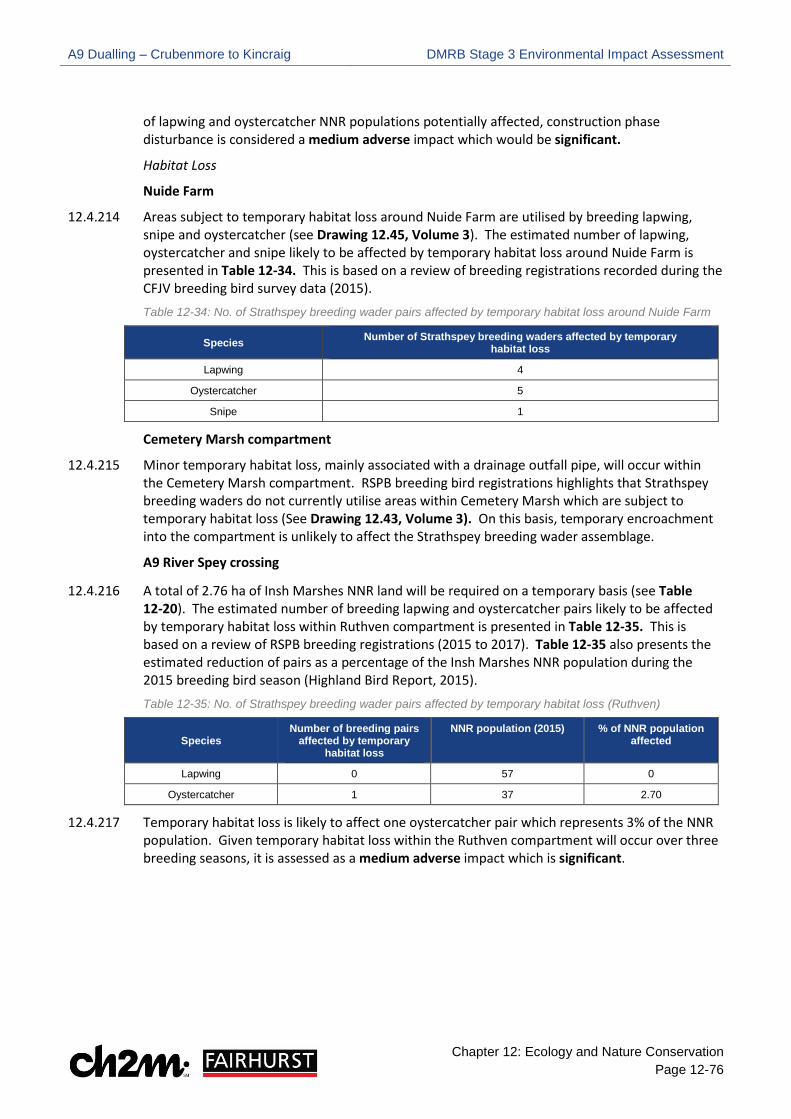
A9 Dualling – Crubenmore to Kincraig DMRB Stage 3 Environmental Impact Assessment
Chapter 12: Ecology and Nature Conservation Page 12-76
of lapwing and oystercatcher NNR populations potentially affected, construction phase disturbance is considered a medium adverse impact which would be significant.
Habitat Loss
Nuide Farm
12.4.214 Areas subject to temporary habitat loss around Nuide Farm are utilised by breeding lapwing, snipe and oystercatcher (see Drawing 12.45, Volume 3). The estimated number of lapwing, oystercatcher and snipe likely to be affected by temporary habitat loss around Nuide Farm is presented in Table 12-34. This is based on a review of breeding registrations recorded during the CFJV breeding bird survey data (2015). Table 12-34: No. of Strathspey breeding wader pairs affected by temporary habitat loss around Nuide Farm
Species Number of Strathspey breeding waders affected by temporary habitat loss
Lapwing 4
Oystercatcher 5
Snipe 1
Cemetery Marsh compartment
12.4.215 Minor temporary habitat loss, mainly associated with a drainage outfall pipe, will occur within the Cemetery Marsh compartment. RSPB breeding bird registrations highlights that Strathspey breeding waders do not currently utilise areas within Cemetery Marsh which are subject to temporary habitat loss (See Drawing 12.43, Volume 3). On this basis, temporary encroachment into the compartment is unlikely to affect the Strathspey breeding wader assemblage.
A9 River Spey crossing
12.4.216 A total of 2.76 ha of Insh Marshes NNR land will be required on a temporary basis (see Table 12-20). The estimated number of breeding lapwing and oystercatcher pairs likely to be affected by temporary habitat loss within Ruthven compartment is presented in Table 12-35. This is based on a review of RSPB breeding registrations (2015 to 2017). Table 12-35 also presents the estimated reduction of pairs as a percentage of the Insh Marshes NNR population during the 2015 breeding bird season (Highland Bird Report, 2015). Table 12-35: No. of Strathspey breeding wader pairs affected by temporary habitat loss (Ruthven)
Species Number of breeding pairs
affected by temporary habitat loss
NNR population (2015) % of NNR population affected
Lapwing 0 57 0
Oystercatcher 1 37 2.70
12.4.217 Temporary habitat loss is likely to affect one oystercatcher pair which represents 3% of the NNR population. Given temporary habitat loss within the Ruthven compartment will occur over three breeding seasons, it is assessed as a medium adverse impact which is significant.

A9 Dualling – Crubenmore to Kincraig DMRB Stage 3 Environmental Impact Assessment
Chapter 12: Ecology and Nature Conservation Page 12-77
Habitat fragmentation
12.4.218 Where Strathspey breeding waders persist nearby construction activities, there is potential for temporary fragmentation as works will limit utilisation of habitats. While there is some potential for this, the impact is predicted to be negligible and not significant due to the existing effect of construction disturbance described above. This is predicted to displace birds utilising habitats within 100m of the Proposed Scheme in Ruthven compartment.
Direct mortality
12.4.219 As components of the Strathspey breeding wader assemblage hatch precocial (mobile) young, chicks may stray into construction areas where breeding areas are near the Proposed Scheme. Where this occurs, they may be vulnerable to direct mortality due to construction operations and plant movement. The extent of this impact will be localised and unlikely given predicted levels of disturbance (i.e. birds will generally avoid breeding in close proximity to construction works). The areas where CFSAs and SuDS are proposed around Nuide Farm provide suitable breeding habitat for the Strathspey breeding waders. If excavation works are undertaken during the breeding bird season, this could result in damage or destruction of ground nests which could result in direct mortality of young. As direct mortality could have a long-term effect on the Strathspey breeding wader assemblage, this impact is considered a medium adverse impact and would be significant.
BoCC Red and Amber Species 12.4.220 Construction activities could result in the loss of nesting and foraging habitat used by BoCC red
and amber listed species. Disturbance could occur where these species are within and adjacent to areas affected by works causing birds to be temporarily displaced from breeding and foraging habitat. Where these species persist nearby construction activities, there is potential for temporary fragmentation as works will limit utilisation of habitats; however, due to construction disturbance birds are likely to avoid the area. Given the short-term and temporary nature of construction activities, and availability of suitable habitat in the wider area, habitat loss, disturbance and habitat fragmentation are assessed as low adverse and not significant.
Operational Phase 12.4.221 Potential impacts that could affect breeding birds during the operational phase are disturbance,
habitat loss and fragmentation. Specific consideration is given to key features present within the study area.
Annex 1 Species 12.4.222 No increased noise, vibration or visual disturbance of black grouse is expected given the distance
of the lekking sites from the Proposed Scheme. On this basis, disturbance to black grouse as a result of the operational road is a negligible impact and is not significant. No other potential impacts are likely to affect black grouse during the operational phase.
12.4.223 Given the extent of available foraging habitat of golden eagle, white-tailed eagle, and marsh harrier in the wider area and absence of breeding evidence, no impacts are predicted.
Schedule 1 Species 12.4.224 Suitable crossbill habitat could be permanently lost to new infrastructure. However, given the
extent of available breeding habitat in the wider area the impact of permanent habitat loss will be low adverse and not significant. No other potential impacts are likely to affect crossbill during the operational phase.

A9 Dualling – Crubenmore to Kincraig DMRB Stage 3 Environmental Impact Assessment
Chapter 12: Ecology and Nature Conservation Page 12-78
Strathspey Breeding Wader Assemblage Disturbance/ displacement due to operational noise
Nuide Farm/ Cemetery Marsh compartment
12.4.225 A review of noise contour mapping around these areas (Chapter 17 Noise and Vibration Drawings) illustrates predicted short-term changes in noise levels in 2026 Do Something scenario (i.e. building the Proposed Scheme) are minor and increases of 2 dB or less are shown in areas used by breeding waders at Cemetery Marsh. Whilst most areas around Nuide Farm will be subject to changes of less than 2 dB, there is one small area between ch. 44,600 and ch. 44, 800 (west of the existing A9) which shows localised increases in operational noise possibly associated with topographical features. This area is likely to support a single breeding lapwing territory. On this basis, increases in operational noise levels around Nuide Farm and Cemetery Marsh is assessed as low adverse which is not significant.
A9 River Spey crossing
12.4.226 At the A9 River Spey crossing the Proposed Scheme moves east into the NNR Ruthven compartment. At this location operational noise level contours illustrate increases in noise between 2-4 dB beyond the extent of the earthworks. Some reduction in operational noise will occur to the west of the Proposed Scheme due to the change in road alignment.
12.4.227 RSPB breeding bird data highlights several registrations of lapwing and oystercatcher in close proximity to the existing A9 River Spey embankment within the Ruthven compartment (see Drawing 12.41, Volume 3). At this location, contour mapping predicts actual noise levels (see Figure 1 Appendix 12.12, Volume 2) of 60-65 dB around the embankment for the Do Minimum scenario in 2026 (i.e. not constructing the Proposed Scheme). Noise levels of 55-60 dB are predicted within approximately 150m east of the existing A9. These predictions will be similar to current noise levels around the crossing however, it is worth noting that noise levels may be slightly higher due to progressive increases in traffic volumes over time. These predictions indicate that oystercatcher and lapwing are utilising habitats east of the existing A9 which are currently exposed to high levels of predictable disturbance (i.e. road traffic).
12.4.228 Studies have shown that the presence of road and rail can result in a reduction in the density of breeding meadow birds (including waders). Reijenen et al. (1996) reported a noise threshold level of 47dB above reductions in density were reported. As described in paragraph 12.4.227, it is recognised that lapwing and oystercatcher are currently utilising habitats exposed to noise levels above this threshold due to the existing A9. This has been considered when assessing potential reductions in breeding density from Insh Marshes NNR due to increases in operational noise, estimated as 2-4 dB.
12.4.229 It is predicted that 50% of breeding pairs within 100m of the Proposed Scheme could be permanently displaced due to operational noise with 10% of breeding pairs potentially displaced within 500m. Given the presence of the existing road the primary effect is likely to occur up to 100m from the road. These estimates are broadly in line with figures predicted by Reijenen (1996). The paper presents the estimated reduction in breeding birds for roads with traffic movements of 5,000 vehicles per day and roads with 50,000 vehicles per day.
12.4.230 The predicted traffic flows for the Proposed Scheme on the opening year is 12,774 vehicles per day, increasing to 13,275 by 2041. On this basis, reductions in breeding density are predicted to most closely reflect Reijenen et al estimates for road traffic movements of 5,000. Given the context of the Proposed Scheme and existing exposure to noise, predicted reductions in breeding density are considered to be applied on a precautionary basis.
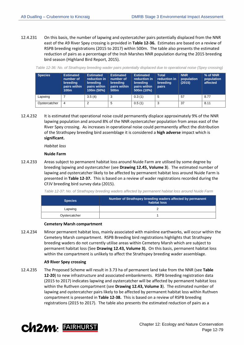
A9 Dualling – Crubenmore to Kincraig DMRB Stage 3 Environmental Impact Assessment
Chapter 12: Ecology and Nature Conservation Page 12-79
12.4.231 On this basis, the number of lapwing and oystercatcher pairs potentially displaced from the NNR east of the A9 River Spey crossing is provided in Table 12-36. Estimates are based on a review of RSPB breeding registrations (2015 to 2017) within 500m. The table also presents the estimated reduction of pairs as a percentage of the Insh Marshes NNR population during the 2015 breeding bird season (Highland Bird Report, 2015).
Table 12-36: No. of Strathspey breeding wader pairs potentially displaced due to operational noise (Spey crossing)
Species Estimated number of breeding pairs within 100m
Estimated reduction in breeding pairs within 100m (50%)
Estimated number of breeding pairs within 500m
Estimated reduction in breeding pairs within 500m (10%)
Total reduction in breeding pairs
NNR population (2015)
% of NNR population affected
Lapwing 7 3.5 (4) 3 0.3 (1) 5 57 8.77
Oystercatcher 4 2 5 0.5 (1) 3 37 8.11
12.4.232 It is estimated that operational noise could permanently displace approximately 9% of the NNR
lapwing population and around 8% of the NNR oystercatcher population from areas east of the River Spey crossing. As increases in operational noise could permanently affect the distribution of the Strathspey breeding bird assemblage it is considered a high adverse impact which is significant.
Habitat loss
Nuide Farm
12.4.233 Areas subject to permanent habitat loss around Nuide Farm are utilised by some degree by breeding lapwing and oystercatcher (see Drawing 12.45, Volume 3). The estimated number of lapwing and oystercatcher likely to be affected by permanent habitat loss around Nuide Farm is presented in Table 12-37. This is based on a review of wader registrations recorded during the CFJV breeding bird survey data (2015). Table 12-37: No. of Strathspey breeding waders affected by permanent habitat loss around Nuide Farm
Species Number of Strathspey breeding waders affected by permanent habitat loss
Lapwing 2
Oystercatcher 1
Cemetery Marsh compartment
12.4.234 Minor permanent habitat loss, mainly associated with mainline earthworks, will occur within the Cemetery Marsh compartment. RSPB Breeding bird registrations highlights that Strathspey breeding waders do not currently utilise areas within Cemetery Marsh which are subject to permanent habitat loss (See Drawing 12.43, Volume 3). On this basis, permanent habitat loss within the compartment is unlikely to affect the Strathspey breeding wader assemblage.
A9 River Spey crossing
12.4.235 The Proposed Scheme will result in 3.73 ha of permanent land take from the NNR (see Table 12-20) to new infrastructure and associated embankments. RSPB breeding registration data (2015 to 2017) indicates lapwing and oystercatcher will be affected by permanent habitat loss within the Ruthven compartment (see Drawing 12.43, Volume 3). The estimated number of lapwing and oystercatcher pairs likely to be affected by permanent habitat loss within Ruthven compartment is presented in Table 12-38. This is based on a review of RSPB breeding registrations (2015 to 2017). The table also presents the estimated reduction of pairs as a

A9 Dualling – Crubenmore to Kincraig DMRB Stage 3 Environmental Impact Assessment
Chapter 12: Ecology and Nature Conservation Page 12-80
percentage of the Insh Marshes NNR population during the 2015 breeding bird season (Highland Bird Report, 2015).
Table 12-38: No. of Strathspey breeding wader pairs affected by permanent habitat loss (Ruthven)
Species Number of breeding pairs
affected by permanent habitat loss
NNR population (2015) % of NNR population affected
Lapwing 5 57 8.77
Oystercatcher 2 37 5.41
12.4.236 It is estimated that permanent habitat loss could affect around 9% of the NNR lapwing population and 5% of the oystercatcher population. Habitat loss due to new infrastructure and embankments could permanently affect the distribution of these wader species within the Ruthven compartment. On this basis, permanent habitat loss is considered a high adverse impact which would be significant.
Displacement due to new structures and landforms
12.4.237 Katzenberger (2014) present empirical data illustrating that breeding wader species show a negative reaction to the presence of both trees and man-made structures. They also reported an increased probability of wader use of habitats >100m from trees. Similar reactions are reported by Katzenberger (2014) for boundary features such as hedgerows.
12.4.238 Displacement may be expected within 100m of the Proposed Scheme, where infrastructure is located on embankments in areas of importance to the Strathspey breeding wader assemblage. This potential impact may occur where the alignment of the Proposed Scheme encroaches into the NNR Ruthven compartment to the east of the existing A9 between ch. 49,200 and ch. 50,200. The presence of an existing embankment possibly exerts an influence on the current distribution of breeding lapwing and oystercatcher within the Ruthven compartment. The extent of this influence is unclear as other factors relating to habitat quality (e.g. the presence of areas of standing water or ditches) can also influence breeding wader (and wildfowl) distribution. However, it is anticipated that some permanent displacement may occur within 100m of the proposed River Spey crossing and associated embankments.
12.4.239 The effect of displacement is likely to overlap or interact to some degree with the effect of operational noise described previously in paragraphs 12.4.225 to 12.4.232. Where birds are not physically displaced they may be at increased risk of predation from either mammalian or avian predators where they are in closer proximity to boundary features however, the extent of any increased predation risk cannot be quantified with a high degree of accuracy. Displacement due to new landforms and structures is likely limited to 100m, unlike displacement due to road traffic noise which may affect breeding birds up to 500m from the Proposed Scheme. On this basis, displacement due to the new A9 River Spey crossing and associated embankment is a medium adverse impact which is significant.
Habitat fragmentation
12.4.240 The Proposed Scheme will comprise a wider route which will potentially increase the existing impact of fragmentation associated with the existing A9. Vantage point observations reported in Appendix 12.6, Volume 2 at the existing A9 River Spey crossing indicate breeding oystercatcher and lapwing currently utilise grassland on both sides of the existing A9. Given the presence of the existing A9 and mobility of the species, the presence of a wider route is not anticipated to prohibit utilisation of habitats on either side of the Proposed Scheme. The impact of fragmentation during operation is predicted to be low adverse and not significant.

A9 Dualling – Crubenmore to Kincraig DMRB Stage 3 Environmental Impact Assessment
Chapter 12: Ecology and Nature Conservation Page 12-81
Collision risk
12.4.241 The construction of a new bridge structure across the Insh Marshes introduces potential increased collision risk between birds and road traffic. Increases in both volume and speed of road traffic are predicted as a result of the Proposed Scheme. The proposed replacement River Spey crossing structure retains a similar profile and vertical alignment to the existing bridge structure with no above deck structures.
12.4.242 Observations recorded during vantage point surveys undertaken in 2017 (see Appendix 12.6 Volume 2) indicated that both lapwing and oystercatcher routinely cross the existing A9 where it crosses Insh Marshes. Occasional flight lines across the scheme at 5m above road level were reported for both species, at which level birds may be exposed to collision risk with larger vehicles. However, typical lapwing and oystercatcher flights were around 10m above road level. The vertical alignment of both the bridge and embankment will remain the same as existing therefore, the potential for an increased collision risk is limited. In addition, the increased bridge length and reduced embankment may allow increased movement of some species below the bridge either in flight or by walking (where young are present).
12.4.243 Breeding waders raise precocial young which are quickly mobile and leave nest sites after hatching and prior to fledging. There is an existing and potential risk that young waders or wildfowl could access the operational road and be exposed to collision with vehicles. The risk of this is considered to be low given these species favour wet grassland for foraging. Vegetation on the embankment is likely to be dry and unsuitable for feeding. Increased collision risk is assessed as low adverse which will not be significant.
BoCC Red and Amber Species 12.4.244 The Proposed Scheme will result in the permanent loss of habitats used by BoCC red and amber
species for foraging and nesting (e.g. woodland). However, as suitable habitat is available directly adjacent to the Proposed Scheme and wider landscape, it is expected that affected birds can remain in the locality with no detectible impacts on their populations. As a carriageway currently exists and the linear nature of the existing A9 will be maintained, no increases in fragmentation or disturbance from road traffic is expected to affect these species. The impact of habitat loss, disturbance and habitat fragmentation is assessed as low adverse and not significant.

A9 Dualling – Crubenmore to Kincraig DMRB Stage 3 Environmental Impact Assessment
Chapter 12: Ecology and Nature Conservation Page 12-82
Table 12-39: Summary of potential impacts on breeding birds
Feature Importance Potential impacts during construction phase (temporary)
Potential impacts during operational phase (permanent)
Annex 1 Species
Golden eagle, white tailed
eagle, marsh harrier.
Regional As no breeding was detected during surveys no impacts are predicted.
As no breeding was detected during surveys no impacts are predicted.
Annex 1 Species
Black Grouse
Regional Disturbance - medium adverse and significant.
Disturbance - negligible and not significant.
Schedule 1 Common crossbill
Local Disturbance and habitat loss - low adverse and not significant.
Habitat loss - low adverse and not significant.
Strathspey Breeding Waders
Regional Habitat loss, disturbance and direct mortality - medium adverse and significant Habitat fragmentation - negligible and not significant.
Disturbance/ displacement due to operational noise – high adverse and significant Habitat loss – high adverse and significant Displacement due to new landforms and structures- medium adverse and significant Habitat fragmentation - low adverse and not significant Collision risk – low adverse and not significant.
BoCC Red / Amber list species
Authority Area Habitat loss, disturbance and habitat fragmentation - low adverse and not significant.
Habitat loss, disturbance and habitat fragmentation - low adverse and not significant.
Non-Breeding Birds
Construction Phase 12.4.245 Potential impacts which could affect non-breeding birds during construction are disturbance,
habitat loss and temporary fragmentation. Each of these impacts are discussed in the following paragraphs.
Disturbance
12.4.246 In addition to the non-breeding interest features of the River Spey – Insh Marshes SPA (i.e. non-breeding whooper swan and hen harrier) previously discussed, a range of wildfowl and wader species utilise Insh Marshes throughout the winter period. A proportion of these species utilise habitats within proximity to the Proposed Scheme where it crosses/ runs parallel to Insh Marshes NNR (See Drawing 12.50, Volume 3). In this location, wildfowl may be vulnerable to construction phase disturbance over three winter seasons.
12.4.247 WeBS data summarised in Appendix 12.6, Volume 2 show that the Ruthven compartment supports significant numbers of teal, mallard, wigeon, pink footed goose and greylag goose. Cutts et al (2009) describe general construction activities at 50-70 dB as having a ‘moderate’ disturbance effect on overwintering wildfowl (which is generally defined as affecting behaviours such as distraction from feeding, and localised movement away from noise sources), while irregular noise such as piling (>70dB) can have a ‘high effect’ where birds are displaced from the area completely.
12.4.248 Vantage point surveys undertaken around the A9 River Spey crossing (Appendix 12.5, Volume 2) identified notable areas for non-breeding wildfowl around the downstream meander of the A9

A9 Dualling – Crubenmore to Kincraig DMRB Stage 3 Environmental Impact Assessment
Chapter 12: Ecology and Nature Conservation Page 12-83
River Spey crossing and at the confluence of the River Spey and the Burn of Ruthven (>100m from the Proposed Scheme). At these locations, noise calculations during construction/ demolition predict that operations may reach noise levels of up to 68 dB.
12.4.249 WeBS data presented in Appendix 12.6, Volume 2 also indicates variability in the distribution of wildfowl throughout the winter period, indicating that the wider Insh Marshes may have capacity to support those disturbed or displaced form the vicinity of works. The impact will be temporary and for most species; and will be very localised where they utilise habitats in close proximity to the Proposed Scheme; therefore, a low adverse impact is predicted for the non- breeding bird assemblage which is not significant.
12.4.250 Merlin, peregrine falcon and golden eagle were all reported on a single occasion during winter vantage point surveys. While potential disturbance to foraging birds is possible the effect of this will be negligible and not significant. No other impacts are considered for these raptor species.
Habitat loss
12.4.251 Detailed information on overwintering bird species distribution is only available for those areas of the Insh Marshes NNR surrounding the existing A9 River Spey crossing. In these areas, only low levels of use are reported in areas identified for temporary works. The effect of temporary habitat loss on the non- breeding bird assemblage is negligible and not significant.
Habitat fragmentation
12.4.252 During construction, there is potential for temporary fragmentation as works could limit utilisation of aquatic and terrestrial habitats surrounding works by non-breeding wildfowl and waders which persist in areas surrounding works. Whilst there is some potential for this, given the localised and temporary natures of works the impact is predicted to be low adverse and not significant.
Operational Phase 12.4.253 Potential impacts which could affect non-breeding birds during the operational phase are
disturbance and permanent habitat loss. Each of these potential impacts are discussed in the following paragraphs.
Disturbance
12.4.254 A review of the noise contour mapping (Chapter 17 Noise and Vibration Drawings) illustrates predicted short-term change in noise levels in 2026 Do Something scenario (i.e. constructing the Proposed Scheme) are minor and increases of 2 dB or less are shown throughout most of the Proposed Scheme. However, at the A9 River Spey crossing the Proposed Scheme moves east into the NNR Ruthven compartment. At this location operational noise level contours illustrate increases in noise between 2-4 dB beyond the extent of the earthworks. Some reduction in operational noise will occur to the west of the Proposed Scheme due to the change in road alignment. To the east of the existing A9 River Spey crossing, regular presence of a range of wildfowl utilising aquatic habitats indicates that non-breeding wildfowl can tolerate operational road noise (see Drawing 12.50, Volume 3). Given a carriageway currently exists and wildfowl species appear to tolerate traffic noise, operational disturbance will be a negligible impact and not significant.
Habitat loss
12.4.255 Winter vantage point surveys reported in Appendix 12.5, Volume 2 and illustrated on Drawing 12.50, Volume 3 indicates that areas subject to permanent habitat loss are not utilised by waders and wildfowl during winter. Most species favour areas of open water or areas of grazing in close
A9 Dualling – Crubenmore to Kincraig DMRB Stage 3 Environmental Impact Assessment
Chapter 12: Ecology and Nature Conservation Page 12-84
proximity to the River Spey; therefore, permanent habitat loss will be negligible and not significant.
12.4.256 No potential impacts are predicted for non-breeding merlin, peregrine falcon, and golden eagle during the operational phase.
Reptiles – Adder, Common Lizard and Slow-Worm
Construction Phase 12.4.257 Potential impacts that could affect reptiles during the construction phase include direct
mortality, habitat loss, disturbance and habitat fragmentation. Each of these impacts is discussed in the following paragraphs.
Direct mortality
12.4.258 Construction activities within suitable reptile habitat (i.e. heathland, rough grassland and woodland edges) could result in injury or mortality to reptiles through clearance of vegetation or other sheltering features (e.g. rock/ log piles and stone walls). Reptiles could also become trapped in excavations or site machinery. They are particularly susceptible to injury or mortality during the hibernation and breeding season. Given the abundance of suitable habitat within the Proposed Scheme, it is assumed a large reptile population is present. Whilst mortality during construction would be permanent and irreversible, as these reptile species are common and widespread throughout the Scottish Highlands, a low adverse impact is predicted which is not significant.
Habitat loss/ disturbance / habitat fragmentation
12.4.259 Temporary loss of suitable reptile habitat may occur through construction activities such as creation of temporary access tracks and SuDS. In addition, works may cause disturbance to reptiles due to increased levels of noise, vibration, lighting and human presence. Disturbance could deter reptiles from residing in habitats in proximity to construction activities. They could also be disturbed whilst removing rock and log piles which would be particularly detrimental if undertaken during the breeding or hibernation season. Given the temporary nature of works and abundance of suitable habitat in the wider landscape, a low adverse impact is predicted which is not significant.
Operational Phase 12.4.260 Potential impacts that could affect reptiles during the operational phase is limited to habitat loss.
Given a carriageway currently exists, and the linear nature of the A9 will be retained, no other impacts are predicted.
Habitat loss
12.4.261 Land-take to facilitate new infrastructure will result in the permanent loss of suitable reptile habitat. Given the abundance of suitable habitat in the wider landscape, a low adverse impact is predicted which is not significant.
Bats – Common pipistrelle; soprano pipistrelle; brown long-eared and Myotis spp.
Construction Phase Temporary impacts that could affect bats during the construction phase include direct mortality, habitat loss, disturbance and habitat fragmentation. Each of these impacts are discussed in the following paragraphs.

A9 Dualling – Crubenmore to Kincraig DMRB Stage 3 Environmental Impact Assessment
Chapter 12: Ecology and Nature Conservation Page 12-85
Direct mortality
12.4.262 There is a risk of mortality or injury to bats roosting in man-made structures or trees which are to be demolished or felled during construction. The extent of this potential impact is restricted to Glentruim railway bridge and Coulintyre Cottage, as these structures will be directly affected by the Proposed Scheme. Glentruim railway bridge will be demolished with a new bridge built as a replacement and Coulintyre Cottage will be demolished to accommodate drainage. All other structures, and the single tree with confirmed bat roosts are out with the Proposed Scheme boundary. Direct mortality is a permanent and irreversible impact however, due to the extremely localised scale and small number of bats affected, a low adverse impact is predicted which is not significant.
Habitat loss
12.4.263 Bat roosts within trees or man-made structures which are felled or demolished during construction will be permanently lost. The extent of this potential impact is restricted to Coulintyre Cottage and Glentruim railway bridge. In addition, the removal of trees, hedgerows or scrub to facilitate construction, particularly around man-made structures with confirmed bat roosts (e.g. Chapelpark), would result in the loss of bat commuting and foraging habitat. Given the localised scale of habitat loss and abundance of suitable habitat in the wider landscape, a low adverse impact is predicted which is not significant.
12.4.264 Whilst direct mortality and habitat loss during construction are not considered to have a significant impact on the conservation status of bats, they are a protected species; therefore, works associated with Glentruim railway bridge and Coulintyre Cottage will require an SNH licence.
Disturbance
12.4.265 Construction activities undertaken between dusk and dawn may cause temporary disturbance to commuting and foraging bats due to increased levels of noise, vibration, lighting and human presence. This will occur particularly where operations are in proximity to confirmed roosts or the strip of broadleaved woodland east of the existing A9 between ch. 54,850 and ch. 56,630 where high levels of bat activity was recorded. Given the localised scale and temporary nature of works a low adverse impact is predicted which is not significant.
Habitat fragmentation
12.4.266 Linear features are used for navigation by bats; therefore, the loss or severance of features, such as hedgerows and tree lines, in proximity to confirmed roosts could prevent bats from commuting to key foraging habitat. This potential impact is restricted to bats roosting in one of the farm steadings at Chapelpark as the majority of woodland surrounding this building could be felled during construction. Encroachment into woodland surrounding the other confirmed roosts is limited and unlikely to affect commuting corridors. Given the limited number of bats roosting within the farm steadings at Chapelpark this impact is assessed as a low adverse impact which is not significant.
Operational Phase 12.4.267 Potential impacts that could affect bats during the operational phase are limited to habitat loss.
Given a carriageway currently exists and the linear nature of the A9 will be retained, no other impacts are predicted.
A9 Dualling – Crubenmore to Kincraig DMRB Stage 3 Environmental Impact Assessment
Chapter 12: Ecology and Nature Conservation Page 12-86
Habitat loss
12.4.268 The permanent loss of roosts (Glentruim railway bridge and Coulintyre Cottage) within the Proposed scheme is discussed in paragraphs 12.4.262 and 12.4.263. In addition to these roosts, potential foraging habitat (e.g. woodland) will be permanently lost to new infrastructure. Whilst the loss of woodland habitat is permanent and irreversible, it will occur at a localised scale in areas alongside the existing carriageway which is currently subject to disturbance from traffic. In addition, suitable foraging habitat is abundant in the wider landscape; therefore; permanent habitat is a low adverse impact and is not significant.
Water Vole
Construction Phase 12.4.269 Potential impacts that could affect water vole during the construction phase include direct
mortality, habitat loss, disturbance and pollution. Each of these potential impacts are discussed in the following paragraphs.
Direct mortality
12.4.270 Water vole could be injured or killed if they become trapped in deep excavations. This potential impact is restricted to works carried out in proximity to the waterbody at ch. 41,800 (west of the existing A9) and the drainage ditch at ch. 51,200 (east of the existing A9) where evidence of water vole was recorded (Drawing 12.52 and 12.57, Volume 3). Whilst direct mortality would be permanent and irreversible, given the very localised scale and small number of water voles potentially affected, a low adverse impact is predicted which is not significant.
Habitat loss/ disturbance
12.4.271 Site clearance to facilitate construction activities around the drainage ditch at ch. 51,200 will likely result in the loss of water vole burrows and disturbance to water vole themselves through burrow loss, direct mortality and displacement due to increased noise. Riparian vegetation alongside the ditch, which provides commuting/ foraging habitat for water vole, will also be temporarily affected. The waterbody at ch. 41,800 is out with the Proposed Scheme boundary; therefore, will not be subject to habitat loss or disturbance during construction. Given the localised scale of habitat loss/ disturbance a low adverse impact is predicted which is not significant.
12.4.272 Whilst direct mortality and habitat loss during construction are not considered a significant impact on the conservation status of water vole, they are a protected species therefore, construction works which directly affect water vole burrows will require an SNH licence.
Pollution
12.4.273 Pollution events such as fuel spills and increased sedimentation in proximity to the drainage ditch and waterbody could result in long-term damage to water vole habitat; as well as the distribution of water vole themselves. Given the localised scale, a low adverse impact is predicted which is not significant.
Operational Phase 12.4.274 Potential impacts that could occur during the operational phase is limited to habitat loss. Given a
carriageway currently exists and the linear nature of the A9 will be retained, no other impacts are predicted.
12.4.275 Land-take for new infrastructure will result in the loss of water vole sheltering, foraging and commuting habitat along the drainage ditch at ch. 51,200. Whilst the loss of water vole habitat

A9 Dualling – Crubenmore to Kincraig DMRB Stage 3 Environmental Impact Assessment
Chapter 12: Ecology and Nature Conservation Page 12-87
will be permanent and irreversible, it will occur at a very localised scale; therefore, a low adverse impact is predicted which is not significant.
Red Squirrel
Construction Phase 12.4.276 Potential impacts that could affect red squirrel during the construction phase include direct
mortality, habitat loss, habitat fragmentation and disturbance. Each of these potential impacts are discussed in the following paragraphs.
Direct mortality
12.4.277 Site clearance required to facilitate construction (e.g. temporary access tracks and SuDS) may involve tree felling in areas of red squirrel activity which could result in injury or mortality, particularly during the breeding season. This could occur in areas of woodland, mostly conifer plantation, throughout the Proposed Scheme boundary. However, conifer plantation is most extensive surrounding the proposed Newtonmore Junction. Given the high level of red squirrel activity within the Proposed Scheme and the nature of this potential impact (i.e. permanent and irreversible), direct mortality is a medium adverse impact which is significant.
Habitat loss
12.4.278 Site clearance to facilitate construction will likely involve tree felling in areas of red squirrel activity which would result in the permanent loss of sheltering/ breeding (i.e. dreys) and foraging habitat. This could occur in areas of woodland, generally conifer plantation, throughout the Proposed Scheme. However, possible habitat loss is most extensive in areas of conifer plantation surrounding the proposed Newtonmore Junction. Whilst tree felling will generally occur in woodland alongside the existing A9, many of these areas support red squirrel; therefore, habitat loss during construction is a medium adverse impact which is significant.
Habitat fragmentation
12.4.279 Inappropriate siting of construction compounds and storage areas could result in fragmentation of red squirrel habitat due to areas of open ground and disturbance. This could restrict red squirrel movement and deter them from accessing woodland in the wider area. Given the localised scale and temporary nature of construction activities, habitat fragmentation during construction is a low adverse impact which is not significant.
Disturbance
12.4.280 Construction operations in proximity to areas of red squirrel activity may cause disturbance to the species due to increased noise, vibration, lighting and human presence, particularly where activities are nearby dreys. This could occur in areas of woodland, generally conifer plantation, throughout the Proposed Scheme. Noise generated from rock blasting around ch. 43,800, nearby Ralia Lodge, could be particularly detrimental if undertaken during the breeding season as dreys in the surrounding woodland could be abandoned. Rock blasting requires closure of the existing A9; therefore, will be undertaken over a short period of time. Given the localised scale and temporary nature of works, construction disturbance is a low adverse impact which is not significant.
Operational Phase 12.4.281 Potential impacts that could affect red squirrel during the operational phase is limited to habitat
loss. Given a carriageway currently exists and the linear nature of the A9 will be retained, no other impacts are predicted.

A9 Dualling – Crubenmore to Kincraig DMRB Stage 3 Environmental Impact Assessment
Chapter 12: Ecology and Nature Conservation Page 12-88
Habitat loss
12.4.282 Land-take to facilitate new infrastructure will result in the permanent loss of red squirrel sheltering, breeding and foraging habitat. Habitat loss will occur in patches of woodland, generally conifer plantation, throughout the Proposed Scheme. However, the most notable area of habitat loss is associated with the proposed Netwonmore Junction. Whilst habitat loss will generally occur in woodland alongside the existing A9, many of these areas support red squirrel; therefore, permanent habitat loss to is a medium adverse impact and is significant.
European Wildcat
Construction Phase 12.4.283 Potential impacts that could affect wildcat during the construction phase include direct mortality,
habitat loss and habitat fragmentation/ disturbance. Each of these potential impacts is discussed in the following paragraphs.
Direct mortality
12.4.284 Construction activities could result in injury and mortality if wildcat become trapped in deep excavations. In addition, demolition and construction of new bridges and culverts could result in temporary loss of crossing points under the existing A9 and may cause wildcat to cross over the A9, increasing the risk of RTA. The risk of injury and direct mortality occurring is higher at dusk and dawn when wildcat is generally more active. Given the elusive nature of wildcat, direct mortality is unlikely to occur however, if it did, the impact would be permanent and irreversible. As Scotland’s most threatened mammal, the loss of one or two wildcats during construction could affect their conservation status therefore; direct mortality is a high adverse impact and is significant.
Habitat loss
12.4.285 Site clearance to facilitate construction could impact potential wildcat foraging and commuting habitat (e.g. woodland, heathland and rough grassland) within the Proposed Scheme. Site clearance will generally occur in habitats alongside the existing A9 which are sub-optimal for wildcat due to the high level of disturbance from the current road. In addition, suitable habitat is available in the wider landscape; therefore, temporary habitat loss during construction is a low adverse impact which is not significant.
Habitat fragmentation/ disturbance
12.4.286 Increased noise, vibration, light and human presence from construction activities could result in temporary habitat fragmentation. Disturbance in proximity to potential wildcat crossings points and foraging/commuting habitat could prevent wildcat from accessing habitats within their territory. Given the localised scale and temporary nature of works a low adverse impact is predicted which is not significant.
Operational Phase 12.4.287 Potential impacts that could affect wildcat during the operational phase are direct mortality/
habitat fragmentation and habitat loss. Each of these potential impacts are discussed in the following paragraphs.
Mortality/ habitat fragmentation
12.4.288 Mammal ledges have been incorporated within bridges and culverts, along with the provision of dry tunnels, as embedded mitigation (see Table 12-19) to provide regular crossing opportunities for wildcat to reduce the risk of injury and direct mortality from RTA; as well as reduce potential

A9 Dualling – Crubenmore to Kincraig DMRB Stage 3 Environmental Impact Assessment
Chapter 12: Ecology and Nature Conservation Page 12-89
fragmentation. Mammal ledges and dry tunnels are designed above the 1 in 50-year flood level to provide dry passage during high rainfall events. This potential impact is assessed as low beneficial which is not significant.
Habitat loss
12.4.289 Land-take to facilitate new infrastructure will result in the permanent loss of potential wildcat foraging and commuting habitat. Habitat loss will generally occur alongside the existing A9 which provides sub-optimal conditions for wildcat due to the high level of disturbance from the current road. In addition, suitable habitat is available in the wider landscape; therefore, permanent habitat loss is a low adverse impact which is not significant.
Overview of Potential Impacts 12.4.290 The findings of this evaluation are summarised in Table 12-40 which shows an overview of the
importance of ecological features and significance of impacts as a result of the Proposed Scheme during the construction and operational phases before any mitigation is applied, although embedded mitigation has been considered.

A9 Dualling – Crubenmore to Kincraig DMRB Stage 3 Environmental Impact Assessment
Chapter 12: Ecology and Nature Conservation Page 12-90
Table 12-40: Potential impacts for each ecological feature before mitigation
Feature Importance Potential impact during construction phase Impact descriptor Significance Potential impact during
operational phase Impact descriptor Significance
River Spey – Insh Marshes SPA Qualifying Features
Osprey, breeding/ foraging International Disturbance, habitat loss, habitat fragmentation Negligible Not significant
Disturbance, habitat loss, habitat fragmentation,
displacement, collision risk, hydrogeological changes
Negligible Not significant
Wigeon, breeding International
Disturbance Medium adverse Significant
Habitat loss, habitat fragmentation Negligible Not significant
Spotted crake, breeding International Disturbance, habitat loss, habitat fragmentation Negligible Not significant
Wood sandpiper, breeding International Disturbance, habitat loss, habitat fragmentation Negligible Not significant
Hen harrier, non - breeding International
Disturbance Medium adverse Significant
Habitat loss, habitat fragmentation Negligible Not significant
Whooper swan, non-breeding International
Disturbance Low adverse Significant
Habitat loss, habitat fragmentation Negligible Not significant
River Spey SAC Qualifying Features
Otter International
Direct mortality Medium adverse Significant Direct mortality/ habitat
fragmentation Low beneficial Significant (beneficial)
Habitat fragmentation Low adverse Significant
Habitat loss Negligible Not significant Habitat loss Negligible Not significant
Disturbance Low adverse Significant Disturbance Negligible Not significant
Pollution Medium adverse Significant Pollution Low beneficial Significant (beneficial)
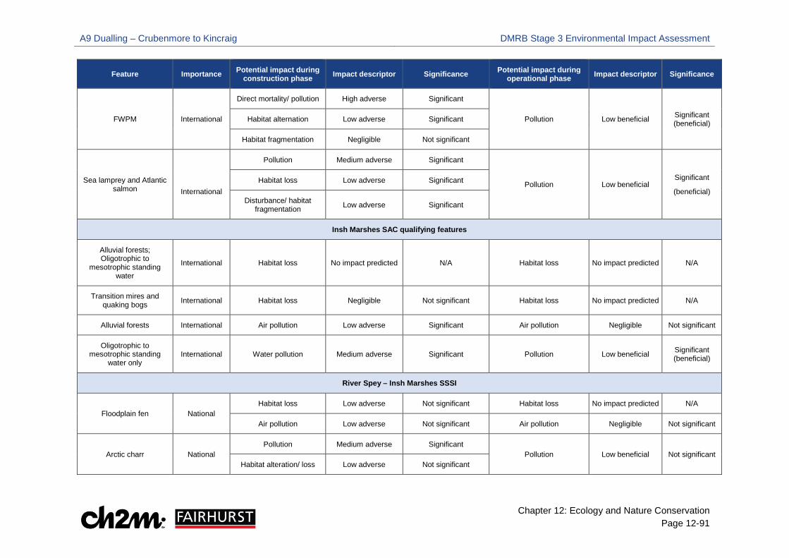
A9 Dualling – Crubenmore to Kincraig DMRB Stage 3 Environmental Impact Assessment
Chapter 12: Ecology and Nature Conservation Page 12-91
Feature Importance Potential impact during construction phase Impact descriptor Significance Potential impact during
operational phase Impact descriptor Significance
FWPM International
Direct mortality/ pollution High adverse Significant
Pollution Low beneficial Significant (beneficial) Habitat alternation Low adverse Significant
Habitat fragmentation Negligible Not significant
Sea lamprey and Atlantic salmon
International
Pollution Medium adverse Significant
Pollution Low beneficial Significant
(beneficial) Habitat loss Low adverse Significant
Disturbance/ habitat fragmentation Low adverse Significant
Insh Marshes SAC qualifying features
Alluvial forests; Oligotrophic to
mesotrophic standing water
International Habitat loss No impact predicted N/A Habitat loss No impact predicted N/A
Transition mires and quaking bogs International Habitat loss Negligible Not significant Habitat loss No impact predicted N/A
Alluvial forests International Air pollution Low adverse Significant Air pollution Negligible Not significant
Oligotrophic to mesotrophic standing
water only International Water pollution Medium adverse Significant Pollution Low beneficial Significant
(beneficial)
River Spey – Insh Marshes SSSI
Floodplain fen National Habitat loss Low adverse Not significant Habitat loss No impact predicted N/A
Air pollution Low adverse Not significant Air pollution Negligible Not significant
Arctic charr National Pollution Medium adverse Significant
Pollution Low beneficial Not significant Habitat alteration/ loss Low adverse Not significant
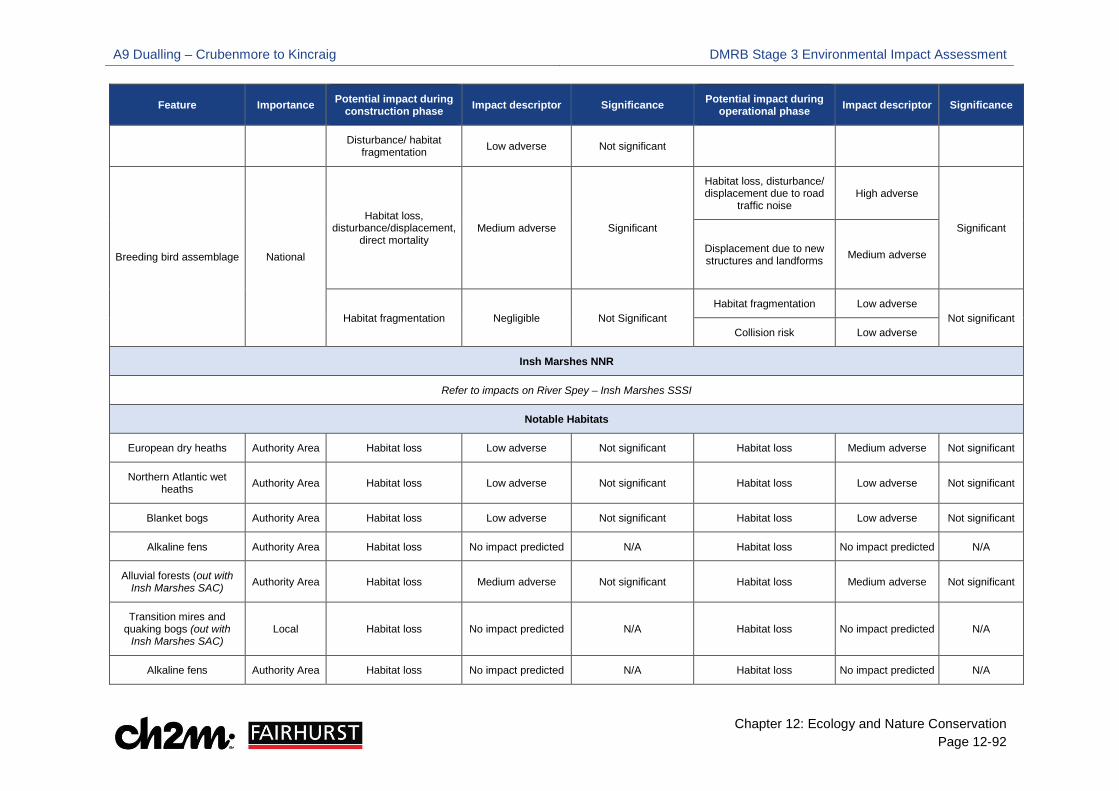
A9 Dualling – Crubenmore to Kincraig DMRB Stage 3 Environmental Impact Assessment
Chapter 12: Ecology and Nature Conservation Page 12-92
Feature Importance Potential impact during construction phase Impact descriptor Significance Potential impact during
operational phase Impact descriptor Significance
Disturbance/ habitat fragmentation Low adverse Not significant
Breeding bird assemblage National
Habitat loss, disturbance/displacement,
direct mortality Medium adverse Significant
Habitat loss, disturbance/ displacement due to road
traffic noise High adverse
Significant
Displacement due to new structures and landforms
Medium adverse
Habitat fragmentation Negligible Not Significant Habitat fragmentation Low adverse
Not significant Collision risk Low adverse
Insh Marshes NNR
Refer to impacts on River Spey – Insh Marshes SSSI
Notable Habitats
European dry heaths Authority Area Habitat loss Low adverse Not significant Habitat loss Medium adverse Not significant
Northern Atlantic wet heaths Authority Area Habitat loss Low adverse Not significant Habitat loss Low adverse Not significant
Blanket bogs Authority Area Habitat loss Low adverse Not significant Habitat loss Low adverse Not significant
Alkaline fens Authority Area Habitat loss No impact predicted N/A Habitat loss No impact predicted N/A
Alluvial forests (out with Insh Marshes SAC) Authority Area Habitat loss Medium adverse Not significant Habitat loss Medium adverse Not significant
Transition mires and quaking bogs (out with
Insh Marshes SAC) Local Habitat loss No impact predicted N/A Habitat loss No impact predicted N/A
Alkaline fens Authority Area Habitat loss No impact predicted N/A Habitat loss No impact predicted N/A

A9 Dualling – Crubenmore to Kincraig DMRB Stage 3 Environmental Impact Assessment
Chapter 12: Ecology and Nature Conservation Page 12-93
Feature Importance Potential impact during construction phase Impact descriptor Significance Potential impact during
operational phase Impact descriptor Significance
Juniper formations on heaths Regional Habitat loss No impact predicted N/A Habitat loss No impact predicted N/A
Reedbeds Regional Habitat loss Low adverse Not significant Habitat loss No impact predicted N/A
Upland birchwoods
Local (not connected to
AWI) Habitat loss Medium adverse
Not significant
Habitat loss Medium adverse
Not significant
National (connected to
AWI) Significant Significant
Lowland mixed deciduous woodland
Local (not connected to
ancient woodland)
Habitat loss Low adverse
Not significant
Habitat loss low adverse
Not significant
National (connected to
ancient woodland)
Not significant Not significant
Wet woodlands
Local (not connected to
ancient woodland)
Habitat loss Low adverse
Not significant
Habitat loss Low adverse
Not significant
National (connected to
ancient woodland)
Not significant Not significant
Upland flushes, fens and swamps (out with SSSI) Local Habitat loss Medium adverse Not significant Habitat loss Medium adverse Not significant
Lowland fens (out with SSSI) Local Habitat loss Low adverse Not significant Habitat loss No impact predicted Not significant
Wet grasslands Local Habitat loss Low adverse Not significant Habitat loss Medium adverse Not significant

A9 Dualling – Crubenmore to Kincraig DMRB Stage 3 Environmental Impact Assessment
Chapter 12: Ecology and Nature Conservation Page 12-94
Feature Importance Potential impact during construction phase Impact descriptor Significance Potential impact during
operational phase Impact descriptor Significance
Non- priority woodland–connected to ancient
woodland Local Habitat Loss Low adverse Not significant Habitat Loss Low adverse Not significant
Plantation woodland –connected to ancient
woodland Local Habitat Loss Medium adverse Not significant Habitat Loss Medium adverse Not significant
Ancient Woodland Inventory (AWI) National Habitat Loss High adverse Significant Habitat Loss High adverse Significant
Breeding Birds
Annex 1 species
Golden eagle, white tailed eagle, marsh harrier
Regional No impacts predicted N/A N/A No impacts predicted N/A N/A
Annex 1 species
Black grouse Regional Disturbance Medium adverse Significant Disturbance Negligible Not significant
Schedule 1
Crossbill Local Habitat loss, disturbance Low adverse Not significant Permanent habitat loss Negligible Not significant
Strathspey breeding wader assemblage Regional
Habitat loss, disturbance Medium adverse Significant
Habitat loss, disturbance/ displacement due to road
traffic noise High adverse Significant
Displacement due to new structures and landforms
Medium adverse
Significant
Habitat fragmentation Negligible Not significant Habitat fragmentation Low adverse Not significant
Collision risk Low adverse Not significant
BoCC Red and Amber list species Authority area Habitat loss, disturbance,
habitat fragmentation Low adverse Not significant Habitat loss, disturbance, habitat fragmentation Low adverse Not significant
Non – Breeding Birds
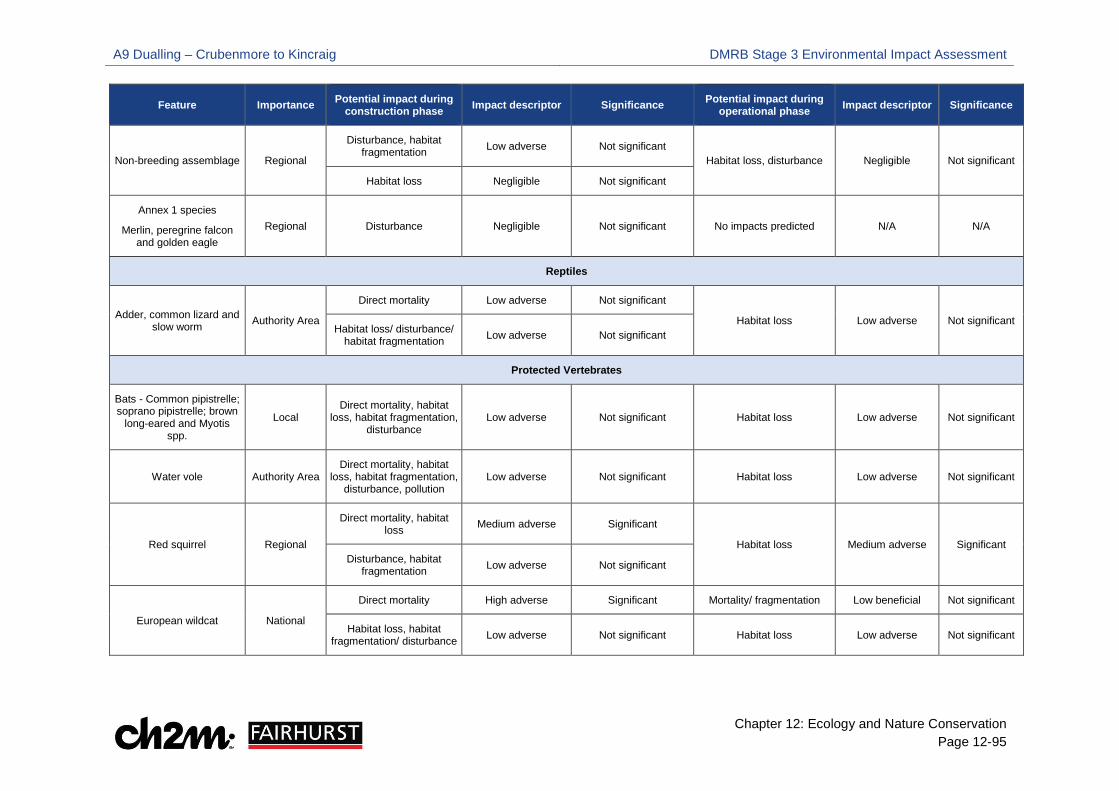
A9 Dualling – Crubenmore to Kincraig DMRB Stage 3 Environmental Impact Assessment
Chapter 12: Ecology and Nature Conservation Page 12-95
Feature Importance Potential impact during construction phase Impact descriptor Significance Potential impact during
operational phase Impact descriptor Significance
Non-breeding assemblage Regional
Disturbance, habitat fragmentation Low adverse Not significant
Habitat loss, disturbance Negligible Not significant
Habitat loss Negligible Not significant
Annex 1 species
Merlin, peregrine falcon and golden eagle
Regional Disturbance Negligible Not significant No impacts predicted N/A N/A
Reptiles
Adder, common lizard and slow worm Authority Area
Direct mortality Low adverse Not significant
Habitat loss Low adverse Not significant Habitat loss/ disturbance/
habitat fragmentation Low adverse Not significant
Protected Vertebrates
Bats - Common pipistrelle; soprano pipistrelle; brown
long-eared and Myotis spp.
Local Direct mortality, habitat
loss, habitat fragmentation, disturbance
Low adverse Not significant Habitat loss Low adverse Not significant
Water vole Authority Area Direct mortality, habitat
loss, habitat fragmentation, disturbance, pollution
Low adverse Not significant Habitat loss Low adverse Not significant
Red squirrel Regional
Direct mortality, habitat loss Medium adverse Significant
Habitat loss Medium adverse Significant Disturbance, habitat
fragmentation Low adverse Not significant
European wildcat National
Direct mortality High adverse Significant Mortality/ fragmentation Low beneficial Not significant
Habitat loss, habitat fragmentation/ disturbance Low adverse Not significant Habitat loss Low adverse Not significant
A9 Dualling – Crubenmore to Kincraig DMRB Stage 3 Environmental Impact Assessment
Chapter 12: Ecology and Nature Conservation Page 12-96
12.5 Mitigation
Standard A9 Mitigation
12.5.2 Programme wide standard mitigation measures are proposed that will avoid or minimise potential impacts on statutory designated sites, notable habitats and species. These standard measures apply to all A9 Dualling Projects and are presented in Table 12-41.
Embedded Mitigation
12.5.3 Embedded mitigation has been incorporated into the Proposed Scheme and was considered when identifying potential impacts for relevant ecological features. Table 12-19 details the locations of culverts and dry tunnels which are included within the DMRB Stage 3 design as embedded mitigation to aid safe mammal passage throughout the Proposed Scheme.
Project Specific Mitigation
12.5.4 Following the impact assessment for the Proposed Scheme, specific mitigation has been identified to further minimise or compensate for potentially significant impacts. These measures are presented in Table 12-41.
River Spey Insh Marshes SSSI invertebrate and vascular plant assemblage; CNPA draft
priority non-protected species, 12.5.5 The Proposed Scheme will affect habitats which could support species of invertebrates and plants
associated with the SSSI invertebrate and vascular plant assemblage; and the CNPA draft priority non-protected species. Mitigation for these features have been considered in the outline habitat management plan, Appendix 12.13, Volume 2.
Monitoring Requirements
12.5.6 During the operational phase, on-going monitoring of mitigation will be undertaken to assess and verify the accuracy of the predicted impact and determine the effectiveness of mitigation measures. This monitoring will be undertaken by a suitable qualified ecologist on behalf of the Trunk Road Operating Company.
Summary of Mitigation Requirements
12.5.7 Table 12-41 collates and numbers the mitigation requirements, which have also been incorporated into the Schedule of Environmental Commitments, presented in Chapter 21, Volume 1.

A9 Dualling – Crubenmore to Kincraig DMRB Stage 3 Environmental Impact Assessment
Chapter 12: Ecology and Nature Conservation Page 12-97
Table 12-41: Summary of Mitigation Requirements
Item Ref. Approximate Chainage/ Location
Timing of Measure Description Mitigation Purpose/ Objective
Specific Consultation or
Approval Required
Standard A9 Mitigation SMC-E1 Throughout Proposed
Scheme Pre-Construction
Pre-construction surveys will be undertaken to verify and, where required, update the baseline ecological conditions set out in the ES. The scope of the pre-construction surveys will be confirmed with SNH prior to them being undertaken.
To update the baseline ecological conditions set out in the ES
SNH
SMC-E2 Throughout Proposed Scheme
Pre-Construction and Construction
Prior to construction a suitably qualified (or team of suitably qualified) Ecological Clerk of Works (ECoW) will be appointed by the Contractor and will be responsible for implementation of the Ecological Management Plan. The ECoW will:
• Provide ecological advice over the entire construction programme • Undertake or oversee pre-construction surveys for protected species in the
areas affected by the proposed scheme; and ensure mitigation measures are implemented to avoid and reduce impacts on ecological features
• Monitor the implementation of the mitigation measures during the construction phase to ensure compliance with protected species legislation and commitments within the ES.
The ECoW will be a member of the Chartered Institute of Ecology and Environmental Management (CIEEM) and will have previous experience in similar ECoW roles. All ECoWs will be approved by Transport Scotland and be appropriately qualified for the role and compliance will be monitored by the Employer’s ecologist. The ECoW will be appointed in advance of the main construction programme commencing to ensure pre-construction surveys are undertaken and any advance mitigation measures required are implemented.
To ensure the implementation of the Ecological Management Plan.
Approval from TS required
SMC-E3 At watercourses throughout Proposed Scheme
Construction Noise and vibration will be reduced by working back from the river bank where possible or working within a dry area to avoid implications to fish, such as avoidance behaviour and hearing damage. In addition, soft-start techniques will be applied to piling work procedures to enable sensitive species to evacuate the area.
To protect fish species from noise and vibration.
Consultation with the relevant fisheries board
SMC-E4 At watercourses throughout Proposed Scheme
Construction Where watercourses require temporary dewatering to permit construction activities, fish will be removed by means of electrofishing and relocated prior to dewatering (SFCC, 2007).
To protect fish species during de-watering of watercourse sections.
CAR Licence approved by SEPA
SMC-E5 At watercourses throughout Proposed Scheme
Construction Water flow/passage will be sufficiently maintained to permit movement of all fish species past areas of dewatering and/or significant alteration of water movement during any construction works within the watercourses. Suitable temporary channels or gravity fed flumes/pipes may be implemented so that movement between areas of habitat can be maintained. Where any over-pumping is required, screens will be used to prevent fish from entering pumps.
To protect fish species during in-channel works.
CAR Licence approved by SEPA
SMC-E6 Throughout Proposed Scheme
Pre-Construction
The Contractor will obtain and comply with the requirements of any protected species derogation licences in respect of works necessary to construct the proposed scheme that are likely to breach all applicable conservation legislation. Licensing may be for the UK and/or European protected species.
To comply with conservation legislation.
SNH
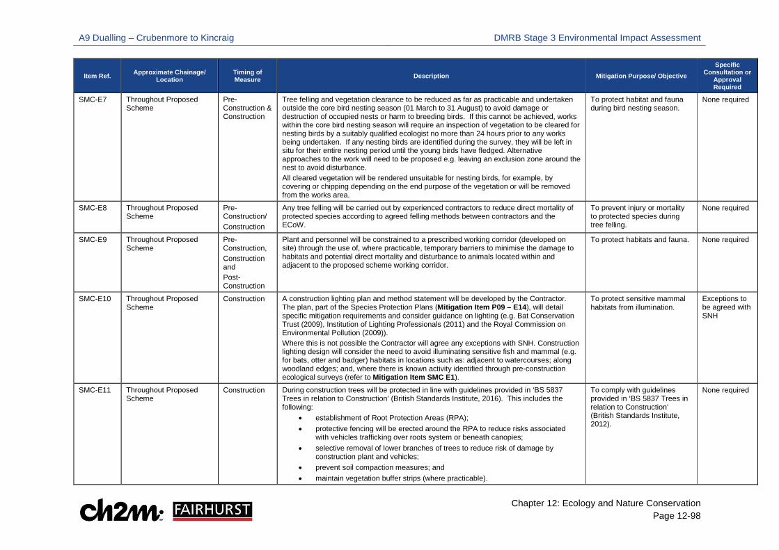
A9 Dualling – Crubenmore to Kincraig DMRB Stage 3 Environmental Impact Assessment
Chapter 12: Ecology and Nature Conservation Page 12-98
Item Ref. Approximate Chainage/ Location
Timing of Measure Description Mitigation Purpose/ Objective
Specific Consultation or
Approval Required
SMC-E7 Throughout Proposed Scheme
Pre-Construction & Construction
Tree felling and vegetation clearance to be reduced as far as practicable and undertaken outside the core bird nesting season (01 March to 31 August) to avoid damage or destruction of occupied nests or harm to breeding birds. If this cannot be achieved, works within the core bird nesting season will require an inspection of vegetation to be cleared for nesting birds by a suitably qualified ecologist no more than 24 hours prior to any works being undertaken. If any nesting birds are identified during the survey, they will be left in situ for their entire nesting period until the young birds have fledged. Alternative approaches to the work will need to be proposed e.g. leaving an exclusion zone around the nest to avoid disturbance. All cleared vegetation will be rendered unsuitable for nesting birds, for example, by covering or chipping depending on the end purpose of the vegetation or will be removed from the works area.
To protect habitat and fauna during bird nesting season.
None required
SMC-E8 Throughout Proposed Scheme
Pre-Construction/ Construction
Any tree felling will be carried out by experienced contractors to reduce direct mortality of protected species according to agreed felling methods between contractors and the ECoW.
To prevent injury or mortality to protected species during tree felling.
None required
SMC-E9 Throughout Proposed Scheme
Pre-Construction, Construction and Post-Construction
Plant and personnel will be constrained to a prescribed working corridor (developed on site) through the use of, where practicable, temporary barriers to minimise the damage to habitats and potential direct mortality and disturbance to animals located within and adjacent to the proposed scheme working corridor.
To protect habitats and fauna. None required
SMC-E10 Throughout Proposed Scheme
Construction A construction lighting plan and method statement will be developed by the Contractor. The plan, part of the Species Protection Plans (Mitigation Item P09 – E14), will detail specific mitigation requirements and consider guidance on lighting (e.g. Bat Conservation Trust (2009), Institution of Lighting Professionals (2011) and the Royal Commission on Environmental Pollution (2009)). Where this is not possible the Contractor will agree any exceptions with SNH. Construction lighting design will consider the need to avoid illuminating sensitive fish and mammal (e.g. for bats, otter and badger) habitats in locations such as: adjacent to watercourses; along woodland edges; and, where there is known activity identified through pre-construction ecological surveys (refer to Mitigation Item SMC E1).
To protect sensitive mammal habitats from illumination.
Exceptions to be agreed with SNH
SMC-E11 Throughout Proposed Scheme
Construction During construction trees will be protected in line with guidelines provided in ‘BS 5837 Trees in relation to Construction’ (British Standards Institute, 2016). This includes the following:
• establishment of Root Protection Areas (RPA); • protective fencing will be erected around the RPA to reduce risks associated
with vehicles trafficking over roots system or beneath canopies; • selective removal of lower branches of trees to reduce risk of damage by
construction plant and vehicles; • prevent soil compaction measures; and • maintain vegetation buffer strips (where practicable).
To comply with guidelines provided in ‘BS 5837 Trees in relation to Construction’ (British Standards Institute, 2012).
None required
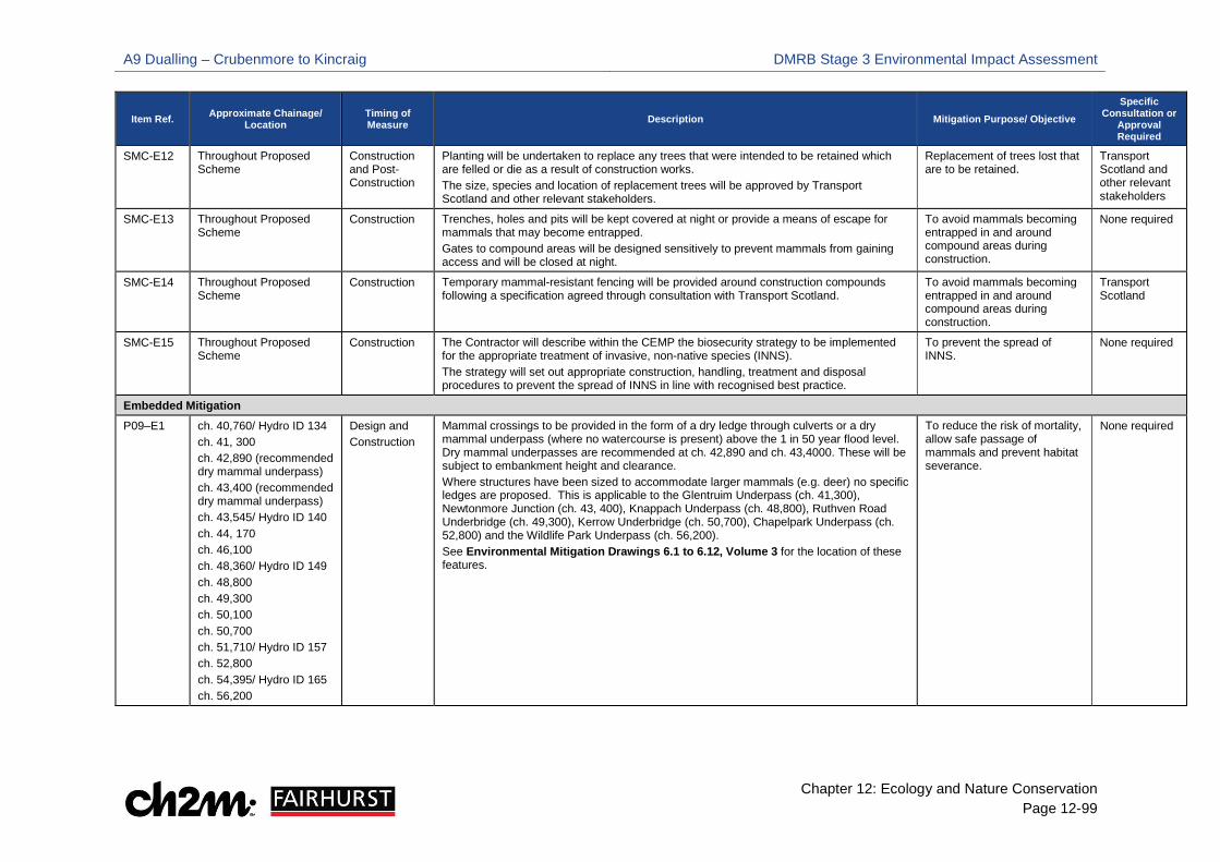
A9 Dualling – Crubenmore to Kincraig DMRB Stage 3 Environmental Impact Assessment
Chapter 12: Ecology and Nature Conservation Page 12-99
Item Ref. Approximate Chainage/ Location
Timing of Measure Description Mitigation Purpose/ Objective
Specific Consultation or
Approval Required
SMC-E12 Throughout Proposed Scheme
Construction and Post-Construction
Planting will be undertaken to replace any trees that were intended to be retained which are felled or die as a result of construction works. The size, species and location of replacement trees will be approved by Transport Scotland and other relevant stakeholders.
Replacement of trees lost that are to be retained.
Transport Scotland and other relevant stakeholders
SMC-E13 Throughout Proposed Scheme
Construction Trenches, holes and pits will be kept covered at night or provide a means of escape for mammals that may become entrapped. Gates to compound areas will be designed sensitively to prevent mammals from gaining access and will be closed at night.
To avoid mammals becoming entrapped in and around compound areas during construction.
None required
SMC-E14 Throughout Proposed Scheme
Construction Temporary mammal-resistant fencing will be provided around construction compounds following a specification agreed through consultation with Transport Scotland.
To avoid mammals becoming entrapped in and around compound areas during construction.
Transport Scotland
SMC-E15 Throughout Proposed Scheme
Construction The Contractor will describe within the CEMP the biosecurity strategy to be implemented for the appropriate treatment of invasive, non-native species (INNS). The strategy will set out appropriate construction, handling, treatment and disposal procedures to prevent the spread of INNS in line with recognised best practice.
To prevent the spread of INNS.
None required
Embedded Mitigation P09–E1 ch. 40,760/ Hydro ID 134
ch. 41, 300 ch. 42,890 (recommended dry mammal underpass) ch. 43,400 (recommended dry mammal underpass) ch. 43,545/ Hydro ID 140 ch. 44, 170 ch. 46,100 ch. 48,360/ Hydro ID 149 ch. 48,800 ch. 49,300 ch. 50,100 ch. 50,700 ch. 51,710/ Hydro ID 157 ch. 52,800 ch. 54,395/ Hydro ID 165 ch. 56,200
Design and Construction
Mammal crossings to be provided in the form of a dry ledge through culverts or a dry mammal underpass (where no watercourse is present) above the 1 in 50 year flood level. Dry mammal underpasses are recommended at ch. 42,890 and ch. 43,4000. These will be subject to embankment height and clearance. Where structures have been sized to accommodate larger mammals (e.g. deer) no specific ledges are proposed. This is applicable to the Glentruim Underpass (ch. 41,300), Newtonmore Junction (ch. 43, 400), Knappach Underpass (ch. 48,800), Ruthven Road Underbridge (ch. 49,300), Kerrow Underbridge (ch. 50,700), Chapelpark Underpass (ch. 52,800) and the Wildlife Park Underpass (ch. 56,200). See Environmental Mitigation Drawings 6.1 to 6.12, Volume 3 for the location of these features.
To reduce the risk of mortality, allow safe passage of mammals and prevent habitat severance.
None required
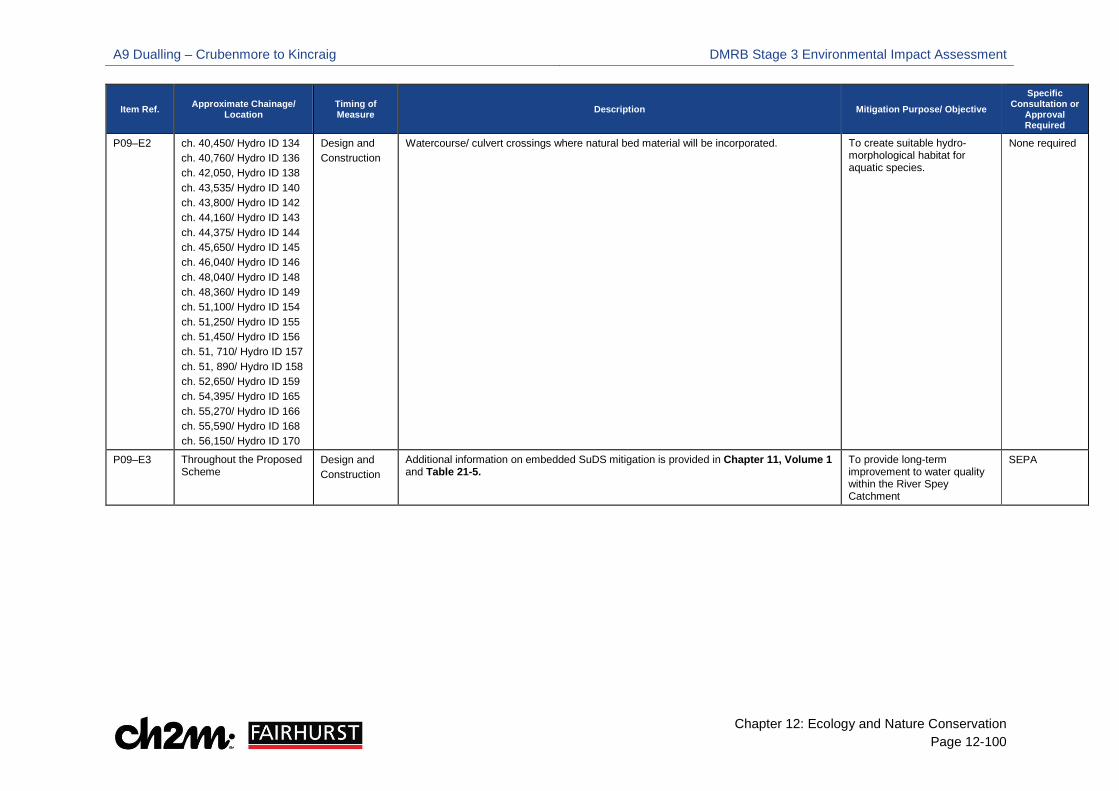
A9 Dualling – Crubenmore to Kincraig DMRB Stage 3 Environmental Impact Assessment
Chapter 12: Ecology and Nature Conservation Page 12-100
Item Ref. Approximate Chainage/ Location
Timing of Measure Description Mitigation Purpose/ Objective
Specific Consultation or
Approval Required
P09–E2 ch. 40,450/ Hydro ID 134 ch. 40,760/ Hydro ID 136 ch. 42,050, Hydro ID 138 ch. 43,535/ Hydro ID 140 ch. 43,800/ Hydro ID 142 ch. 44,160/ Hydro ID 143 ch. 44,375/ Hydro ID 144 ch. 45,650/ Hydro ID 145 ch. 46,040/ Hydro ID 146 ch. 48,040/ Hydro ID 148 ch. 48,360/ Hydro ID 149 ch. 51,100/ Hydro ID 154 ch. 51,250/ Hydro ID 155 ch. 51,450/ Hydro ID 156 ch. 51, 710/ Hydro ID 157 ch. 51, 890/ Hydro ID 158 ch. 52,650/ Hydro ID 159 ch. 54,395/ Hydro ID 165 ch. 55,270/ Hydro ID 166 ch. 55,590/ Hydro ID 168 ch. 56,150/ Hydro ID 170
Design and Construction
Watercourse/ culvert crossings where natural bed material will be incorporated. To create suitable hydro-morphological habitat for aquatic species.
None required
P09–E3 Throughout the Proposed Scheme
Design and Construction
Additional information on embedded SuDS mitigation is provided in Chapter 11, Volume 1 and Table 21-5.
To provide long-term improvement to water quality within the River Spey Catchment
SEPA
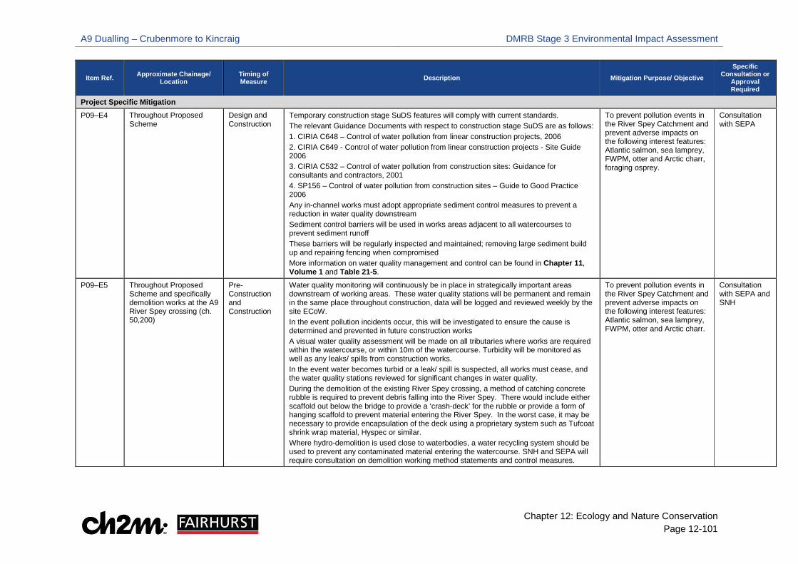
A9 Dualling – Crubenmore to Kincraig DMRB Stage 3 Environmental Impact Assessment
Chapter 12: Ecology and Nature Conservation Page 12-101
Item Ref. Approximate Chainage/ Location
Timing of Measure Description Mitigation Purpose/ Objective
Specific Consultation or
Approval Required
Project Specific Mitigation P09–E4 Throughout Proposed
Scheme Design and Construction
Temporary construction stage SuDS features will comply with current standards. The relevant Guidance Documents with respect to construction stage SuDS are as follows: 1. CIRIA C648 – Control of water pollution from linear construction projects, 2006 2. CIRIA C649 - Control of water pollution from linear construction projects - Site Guide 2006 3. CIRIA C532 – Control of water pollution from construction sites: Guidance for consultants and contractors, 2001 4. SP156 – Control of water pollution from construction sites – Guide to Good Practice 2006 Any in-channel works must adopt appropriate sediment control measures to prevent a reduction in water quality downstream Sediment control barriers will be used in works areas adjacent to all watercourses to prevent sediment runoff These barriers will be regularly inspected and maintained; removing large sediment build up and repairing fencing when compromised More information on water quality management and control can be found in Chapter 11, Volume 1 and Table 21-5.
To prevent pollution events in the River Spey Catchment and prevent adverse impacts on the following interest features: Atlantic salmon, sea lamprey, FWPM, otter and Arctic charr, foraging osprey.
Consultation with SEPA
P09–E5 Throughout Proposed Scheme and specifically demolition works at the A9 River Spey crossing (ch. 50,200)
Pre-Construction and Construction
Water quality monitoring will continuously be in place in strategically important areas downstream of working areas. These water quality stations will be permanent and remain in the same place throughout construction, data will be logged and reviewed weekly by the site ECoW. In the event pollution incidents occur, this will be investigated to ensure the cause is determined and prevented in future construction works A visual water quality assessment will be made on all tributaries where works are required within the watercourse, or within 10m of the watercourse. Turbidity will be monitored as well as any leaks/ spills from construction works. In the event water becomes turbid or a leak/ spill is suspected, all works must cease, and the water quality stations reviewed for significant changes in water quality. During the demolition of the existing River Spey crossing, a method of catching concrete rubble is required to prevent debris falling into the River Spey. There would include either scaffold out below the bridge to provide a ‘crash-deck’ for the rubble or provide a form of hanging scaffold to prevent material entering the River Spey. In the worst case, it may be necessary to provide encapsulation of the deck using a proprietary system such as Tufcoat shrink wrap material, Hyspec or similar. Where hydro-demolition is used close to waterbodies, a water recycling system should be used to prevent any contaminated material entering the watercourse. SNH and SEPA will require consultation on demolition working method statements and control measures.
To prevent pollution events in the River Spey Catchment and prevent adverse impacts on the following interest features: Atlantic salmon, sea lamprey, FWPM, otter and Arctic charr.
Consultation with SEPA and SNH
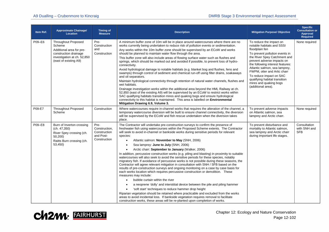
A9 Dualling – Crubenmore to Kincraig DMRB Stage 3 Environmental Impact Assessment
Chapter 12: Ecology and Nature Conservation Page 12-102
Item Ref. Approximate Chainage/ Location
Timing of Measure Description Mitigation Purpose/ Objective
Specific Consultation or
Approval Required
P09–E6 Throughout Proposed Scheme Additional area for pre-construction drainage investigation at ch. 52,850 (east of existing A9)
Pre-Construction and Construction
A minimum buffer zone of 10m will be in place around watercourses where there are no works currently being undertaken to reduce risk of pollution events or sedimentation. Any works within the 10m buffer zone should be supervised by an ECoW and works should be planned to maintain water flow through the area. This buffer zone will also include areas of flowing surface water such as flushes and springs, which should be marked out and avoided if possible, to prevent loss of hydro-connectivity. Avoid hydrological damage to notable habitats (e.g. blanket bog and flushes, fens and swamps) through control of sediment and chemical run-off using filter drains, soakaways and oil separators. Maintain hydrological connectivity through retention of natural water channels, flushes and wet habitats. Drainage investigation works within the additional area beyond the HML Railway at ch. 52,850 (east of the existing A9) will be supervised by an ECoW to restrict works within SAC qualifying habitats transition mires and quaking bogs and ensure hydrological connectivity to this habitat is maintained. This area is labelled on Environmental Mitigation Drawing 6.9, Volume 3.
To reduce the impact on notable habitats and SSSI floodplain fen To prevent pollution events in the River Spey Catchment and prevent adverse impacts on the following interest features: Atlantic salmon, sea lamprey, FWPM, otter and Artic charr To reduce impact on SAC qualifying habitat transition mires and quaking bogs (additional area).
None required
P09-E7 Throughout Proposed Scheme
Construction Where watercourses require in-channel works that requires the alteration of the channel, a temporary watercourse diversion will be built to ensure channel connectivity, the diversion will be supervised by the ECoW and fish rescue undertaken when the diversion takes place.
To prevent adverse impacts on Atlantic salmon, sea lamprey and Arctic charr.
None required
P09–E8 Burn of Inverton crossing (ch. 47,350) River Spey crossing (ch. 50,200) Raitts Burn crossing (ch. 53,450)
Pre-Construction, Construction and Post-Construction
The Contractor will undertake pre-construction surveys to confirm the presence of freshwater fish using watercourses within the Proposed Scheme extents. The Contractor will seek to avoid in-channel or bankside works during sensitive periods for relevant species:
• Atlantic salmon: November to May (SNH, 2006) • Sea lamprey: June to July (SNH, 2006) • Arctic charr: September to January (Walker, 2006)
In addition, percussive construction works (e.g. piling and blasting) in proximity to suitable watercourses will also seek to avoid the sensitive periods for these species, notably migratory fish. If avoidance of percussive works is not possible during these seasons, the Contractor will agree relevant mitigation in consultation with SNH / SFB based on the results of pre-construction surveys and ongoing monitoring on a case by case basis for each works location which requires percussive construction or demolition. These measures may include:
• bubble curtain within the river • a neoprene ‘dolly’ and interstitial device between the pile and piling hammer • ‘soft start’ techniques to reduce hammer drop height
Riparian vegetation should be retained where practicable and excluded from the works areas to avoid incidental loss. If bankside vegetation requires removal to facilitate construction works, these areas will be re-planted upon completion of works.
To prevent disturbance and mortality to Atlantic salmon, sea lamprey and Arctic charr during important life stages.
Consultation with SNH and SFB

A9 Dualling – Crubenmore to Kincraig DMRB Stage 3 Environmental Impact Assessment
Chapter 12: Ecology and Nature Conservation Page 12-103
Item Ref. Approximate Chainage/ Location
Timing of Measure Description Mitigation Purpose/ Objective
Specific Consultation or
Approval Required
P09–E9 Confidential (Refer to Appendix 12.10, Volume 2)
Pre-Construction, Construction and Post-Construction
If pre-construction surveys identify a population of FWPM that could be directly impacted by in-channel working, the Contractor will liaise with SNH to obtain a licence to translocate the FWPMs to a suitable pre-determined receptor site beyond disturbance from the construction works. Riparian habitat along watercourses which support FWPM should be retained where practicable. If riparian vegetation is cleared it should be reinstated post construction.
To prevent damage or mortality to FWPM; and reduce habitat alteration
Consultation with SNH to obtain a licence
P09–E10 Throughout Proposed Scheme
Pre-Construction, Construction and Post-Construction
Where possible, the Contractor will seek to limit the extent and duration of works to minimise habitat disturbance. The Contractor’s ECoW will review areas identified for compounds, storage areas, working areas and accesses; and will advise the Contractor on their suitability to avoid disturbance to sensitive habitats. Habitats disturbed or damaged during construction will be reinstated to baseline conditions as shown on Environmental Mitigation Drawings 6.1 to 6.12, Volume 3. In these areas, the Contractor’s ECoW will seek to identify new benefit opportunities for biodiversity and advise on how these will be achieved. Specific measures to ameliorate habitats damaged during the construction period will be incorporated into the Contractor’s Habitat Management Plan (see Mitigation Item P09-E11 in Table 21-6). Areas of trees and woodland felled during construction will be re-planted in-situ using native species of local provenance. However, specific areas have been identified to mitigate impacts on ancient woodland sites felled during construction (see Mitigation Item P09-E12). Dust emissions from earthworks, material storage and concrete batching will be minimised according to standard construction mitigation provided in detail in Mitigation Item SMC-AQ1 in Table 21-9.
To reduce adverse impacts on SSSI floodplain fen, Insh Marshes SAC qualifying habitat alluvial forest (dust emissions only) and other notable habitats during construction.
Consultation with SNH and CNPA (where habitat falls outside of designated areas)
P09–E11 Throughout Proposed Scheme
Pre-Construction, Construction and Post-Construction
The Contractor will develop and comply with information presented in the Outline Habitat Management Plan (see Appendix 12.13, Volume 2) including update surveys, detailed working methods, control measures and monitoring requirements for the restoration of notable habitats damaged during the construction phase.
To reduce adverse impacts on notable habitats (particularly woodland and dry heath) and to reduce adverse impacts on other features (breeding waders and invertebrates) through habitat management.
Consultation with SNH and CNPA
P09–E12 Throughout Proposed Scheme
Pre-Construction, Construction and Post-Construction
Proposed European dry heath and ancient woodland mitigation areas are detailed in the Outline Habitat Management Plan, Appendix 12.13, Volume 2 and illustrated on Drawings 6.1 to 6.12, Volume 3. Details of native woodland and shrub planting are provided within the Landscape Chapter (see Chapter 13, Volume 1) and shown on Environmental Mitigation Drawings 6.1 to 6.12, Volume 3.
To mitigate permanent loss of woodland (including ancient woodland) and dry heath.
Consultation with SNH and CNPA
P09–E13 Throughout Proposed Scheme
Pre-Construction, Construction and Post-Construction
The Contractor will develop and comply with information presented in the Outline Peat Management Plan (see Appendix 10.6, Volume 2), including an update from pre-construction surveys/ activities, to detail the process and control measures for peat excavation, storage and re-use.
To allow the successful reinstatement of peat habitats such as blanket bog and heath habitats.
Consultation with SNH, SEPA and CNPA

A9 Dualling – Crubenmore to Kincraig DMRB Stage 3 Environmental Impact Assessment
Chapter 12: Ecology and Nature Conservation Page 12-104
Item Ref. Approximate Chainage/ Location
Timing of Measure Description Mitigation Purpose/ Objective
Specific Consultation or
Approval Required
P09–E14 Throughout Proposed Scheme
Pre-Construction, Construction and Post-Construction
The Contractor will develop and comply with information presented in the Outline Species Protection Plan (see Appendix 12.14, Volume 2) including: update surveys, detailed working methods, control measures and monitoring requirements for works affecting protected species and their habitats.
To avoid damage or destruction of structures used for shelter by protected species; and avoid mortality of, or disturbance to, protected species.
Consultation with SNH to obtain a licence
P09–E15 Drainage ditch east of the existing A9 (ch. 51,250)
Pre- Construction and Construction
The Contractor will undertake pre-construction surveys to confirm the population of water vole and extent of burrows within the works area. The Contractor will liaise with SNH to acquire a protected species licence in advance of any construction activity, which will specify working methods to limit damage or disturbance to water vole and their burrows during the construction period. This will detail any specific mitigation/ compensation for any loss of burrows including location of receptor sites and methods for translocating affected water vole.
To prevent destruction of water vole burrows; and avoid mortality or injury to water vole.
Consultation with SNH to obtain a licence
P09-E16 Chapelpark east of the existing A9 (ch. 52,800 to ch. 53,000)
Construction and Post – Construction
The Contractor will seek to minimise woodland loss around the Chapelpark area. Woodland/ scrub affected during the construction period will be re-planted in areas surrounding Chapelpark upon the completion of works (see label on Environmental Mitigation Drawing 6.9, Volume 3).
To reduce the impact of habitat loss (commuting corridors) on bats roosting in the farm steading at Chapelpark.
None required
P09–E17 East of the existing A9 between ch. 54,800 and ch. 55,800 Glentruim railway bridge (ch.40,600) and Coulintyre Cottage (ch. 56,200)
Pre- Construction and Construction
Lighting required for construction will avoid illuminating woodland habitat present to the east of the existing A9 between ch. 54,800 and ch. 55,800 where high bat activity was recorded. Pre-construction surveys will be undertaken to confirm the number of bats roosting within Glentruim railway bridge and Coulintyre Cottage. If bats are present, the Contractor will liaise with SNH to acquire a European protected species licence in advance of any construction activity which will specify working methods and detail specific mitigation.
To prevent light disturbance to foraging bats. To prevent destruction of bat roosts and avoid mortality or injury to bats.
Consultation with SNH to obtain a European Protected Species licence
P09–E18 Throughout Proposed Scheme
Pre- Construction and Construction
The Contractor will undertake pre-construction surveys to confirm the presence and extent of red squirrel within the Proposed Scheme extents. The Contractor will seek to minimise loss of woodland containing red squirrel dreys. Where loss of woodland is unavoidable, the Contractor will obtain a licence from SNH in advance of any tree-felling works. The SNH licence will detail pre-construction survey findings, relevant working methods and control measures. Where works are undertaken during the red squirrel breeding season (February – September) a 50m exclusion zone should be provided around any breeding dreys. If monitoring confirms dreys in proximity to works are not used for breeding a smaller protection zone will be required. Blasting works to the east of the existing A9 between ch. 43,700 to ch. 43,900 and ch. 44,600 to ch.45,000 should avoid the red squirrel breeding season. If avoidance is not possible, a 100m exclusion zone should be provided around any breeding dreys identified during pre-construction surveys. If monitoring confirms any dreys in proximity to blasting are not used for breeding an alternative buffer zone can be agreed through consultation with SNH.
To prevent destruction or damage of dreys; and avoid mortality and disturbance to red squirrel.
Consultation with SNH to obtain a licence and agree appropriate exclusion zones
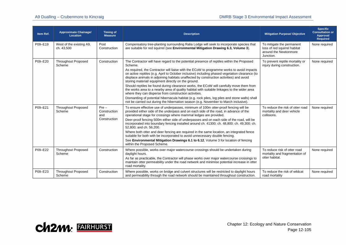
A9 Dualling – Crubenmore to Kincraig DMRB Stage 3 Environmental Impact Assessment
Chapter 12: Ecology and Nature Conservation Page 12-105
Item Ref. Approximate Chainage/ Location
Timing of Measure Description Mitigation Purpose/ Objective
Specific Consultation or
Approval Required
P09–E19 West of the existing A9, ch. 43,500
Post Construction
Compensatory tree-planting surrounding Ralia Lodge will seek to incorporate species that are suitable for red squirrel (see Environmental Mitigation Drawing 6.3, Volume 3).
To mitigate the permanent loss of red squirrel habitat around the Newtonmore Junction.
None required
P09–E20 Throughout Proposed Scheme
Construction The Contractor will have regard to the potential presence of reptiles within the Proposed Scheme. As required, the Contractor will liaise with the ECoW to programme works to avoid impacts on active reptiles (e.g. April to October inclusive) including phased vegetation clearance (to displace animals in adjoining habitats unaffected by construction activities) and avoid storing material/ equipment directly on the ground. Should reptiles be found during clearance works, the ECoW will carefully move them from the works area to a nearby area of quality habitat with suitable linkages to the wider area where they can disperse from construction activities. Dismantling of potential hibernacula habitat (e.g. rock piles, log piles and stone walls) shall not be carried out during the hibernation season (e.g. November to March inclusive).
To prevent reptile mortality or injury during construction.
None required
P09–E21 Throughout Proposed Scheme
Pre – Construction and Construction
To ensure effective use of underpasses, minimum of 100m otter-proof fencing will be provided either side of the underpass and on each side of the road, in advance of the operational stage for crossings where mammal ledges are provided. Deer-proof fencing 500m either side of underpasses and on each side of the road, will be incorporated into boundary fencing installed around ch. 41300; ch. 48,800; ch. 49,300; ch. 52,800; and ch. 56,200. Where both otter and deer fencing are required in the same location, an integrated fence suitable for both with be incorporated to avoid unnecessary double fencing. See Environmental Mitigation Drawings 6.1 to 6.12, Volume 3 for location of fencing within the Proposed Scheme.
To reduce the risk of otter road mortality and deer vehicle collisions.
None required
P09–E22 Throughout Proposed Scheme
Construction Where possible, works over major watercourse crossings should be undertaken during daylight hours. As far as practicable, the Contractor will phase works over major watercourse crossings to maintain otter permeability under the road network and minimise potential increase in otter road mortality.
To reduce risk of otter road mortality and fragmentation of otter habitat.
None required
P09–E23 Throughout Proposed Scheme
Construction Where possible, works on bridge and culvert structures will be restricted to daylight hours and permeability through the road network should be maintained throughout construction.
To reduce the risk of wildcat road mortality
None required
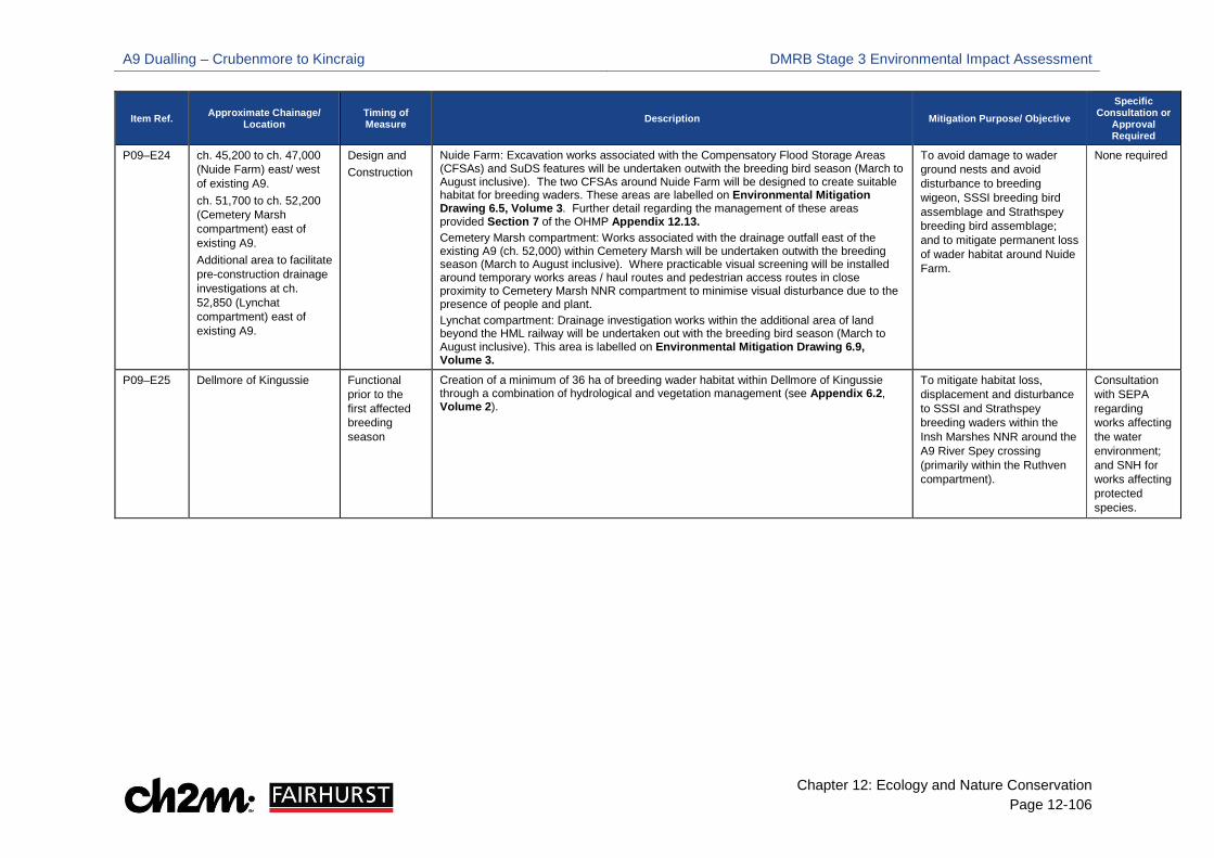
A9 Dualling – Crubenmore to Kincraig DMRB Stage 3 Environmental Impact Assessment
Chapter 12: Ecology and Nature Conservation Page 12-106
Item Ref. Approximate Chainage/ Location
Timing of Measure Description Mitigation Purpose/ Objective
Specific Consultation or
Approval Required
P09–E24 ch. 45,200 to ch. 47,000 (Nuide Farm) east/ west of existing A9. ch. 51,700 to ch. 52,200 (Cemetery Marsh compartment) east of existing A9. Additional area to facilitate pre-construction drainage investigations at ch. 52,850 (Lynchat compartment) east of existing A9.
Design and Construction
Nuide Farm: Excavation works associated with the Compensatory Flood Storage Areas (CFSAs) and SuDS features will be undertaken outwith the breeding bird season (March to August inclusive). The two CFSAs around Nuide Farm will be designed to create suitable habitat for breeding waders. These areas are labelled on Environmental Mitigation Drawing 6.5, Volume 3. Further detail regarding the management of these areas provided Section 7 of the OHMP Appendix 12.13. Cemetery Marsh compartment: Works associated with the drainage outfall east of the existing A9 (ch. 52,000) within Cemetery Marsh will be undertaken outwith the breeding season (March to August inclusive). Where practicable visual screening will be installed around temporary works areas / haul routes and pedestrian access routes in close proximity to Cemetery Marsh NNR compartment to minimise visual disturbance due to the presence of people and plant. Lynchat compartment: Drainage investigation works within the additional area of land beyond the HML railway will be undertaken out with the breeding bird season (March to August inclusive). This area is labelled on Environmental Mitigation Drawing 6.9, Volume 3.
To avoid damage to wader ground nests and avoid disturbance to breeding wigeon, SSSI breeding bird assemblage and Strathspey breeding bird assemblage; and to mitigate permanent loss of wader habitat around Nuide Farm.
None required
P09–E25 Dellmore of Kingussie Functional prior to the first affected breeding season
Creation of a minimum of 36 ha of breeding wader habitat within Dellmore of Kingussie through a combination of hydrological and vegetation management (see Appendix 6.2, Volume 2).
To mitigate habitat loss, displacement and disturbance to SSSI and Strathspey breeding waders within the Insh Marshes NNR around the A9 River Spey crossing (primarily within the Ruthven compartment).
Consultation with SEPA regarding works affecting the water environment; and SNH for works affecting protected species.
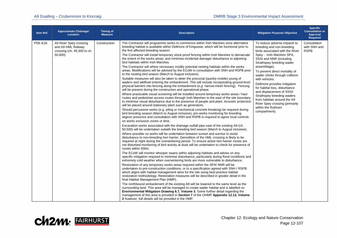
A9 Dualling – Crubenmore to Kincraig DMRB Stage 3 Environmental Impact Assessment
Chapter 12: Ecology and Nature Conservation Page 12-107
Item Ref. Approximate Chainage/ Location
Timing of Measure Description Mitigation Purpose/ Objective
Specific Consultation or
Approval Required
P09–E26 A9 River Spey crossing and A9 HML Railway crossing (ch. 49,300 to ch. 50,600)
Construction The Contractor will programme works to commence within Insh Marshes once alternative breeding habitat is available within Dellmore of Kingussie, which will be functional prior to the first affected breeding season. The Contractor will install temporary stock-proof fencing within Insh Marshes to demarcate the extent of the works areas; and minimise incidental damage/ disturbance to adjoining bird habitats within Insh Marshes. The Contractor will where necessary modify potential nesting habitats within the works areas. Modifications will be advised by the ECoW in consultation with SNH and RSPB prior to the nesting bird season (March to August inclusive). Suitable measures will also be taken to deter the precocial (quickly mobile) young of waders and wildfowl entering the embankment. This will include incorporating ground-level physical barriers into fencing along the embankment (e.g. narrow-mesh fencing). Fencing will be present during the construction and operational phase. Where practicable visual screening will be installed around temporary works areas / haul routes and pedestrian access routes through Insh Marshes to the east of the site boundary to minimise visual disturbance due to the presence of people and plant. Acoustic protection will be placed around stationary plant such as generators. Should percussive works (e.g. piling or mechanical concrete breaking) be required during bird breeding season (March to August inclusive), pre-works monitoring for breeding wigeon presence and consultation with SNH and RSPB is required to agree local controls on works exclusion zones or time. Excavation works associated with the drainage outfall pipe east of the existing A9 (ch. 50,500) will be undertaken outwith the breeding bird season (March to August inclusive). Where possible no works will be undertaken between sunset and sunrise to avoid disturbance to non-breeding hen harrier. Demolition of the HML crossing is likely to be required at night during the overwintering period. To ensure active hen harrier roosts are not disturbed monitoring of bird activity at dusk will be undertaken to check for presence of roosts within 500m. The ECoW will monitor whooper swans within adjoining habitats and advise on any specific mitigation required to minimise disturbance, particularly during flood conditions and extremely cold weather when overwintering birds are more vulnerable to disturbance. Restoration of any temporary works areas required within the SPA/ NNR will be undertaken to pre-construction conditions, or to a specification agreed with SNH / RSPB which aligns with habitat management aims for the site using best practice habitat restoration methodology. Restoration measures will be described in greater detail in the final Habitat Management Plan (HMP). The northbound embankment of the existing A9 will be lowered to the same level as the surrounding land. This area will be managed to create wader habitat and is labelled on Environmental Mitigation Drawing 6.7, Volume 3. Some further detail regarding the management of this area is provided in Section 7 of the OHMP Appendix 12.13, Volume 2 however, full details will be provided in the HMP.
To reduce adverse impacts to breeding and non-breeding birds associated with the River Spey - Insh Marshes SPA, SSSI and NNR (including Strathspey breeding wader assemblage). To prevent direct mortality of wader chicks through collision with vehicles. Dellmore provides mitigation for habitat loss, disturbance and displacement of SSSI/ Strathspey breeding waders from habitats around the A9 River Spey crossing (primarily within the Ruthven compartment).
Consultation with SNH and RSPB
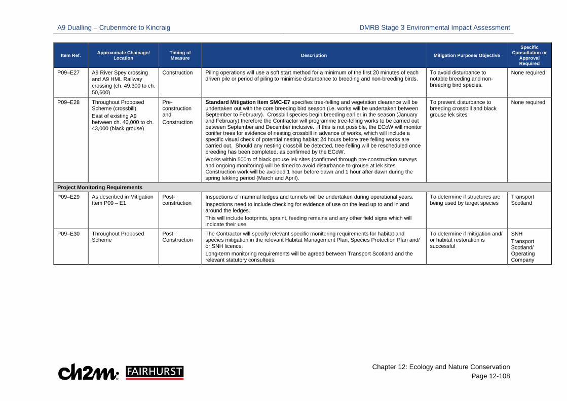
A9 Dualling – Crubenmore to Kincraig DMRB Stage 3 Environmental Impact Assessment
Chapter 12: Ecology and Nature Conservation Page 12-108
Item Ref. Approximate Chainage/ Location
Timing of Measure Description Mitigation Purpose/ Objective
Specific Consultation or
Approval Required
P09–E27 A9 River Spey crossing and A9 HML Railway crossing (ch. 49,300 to ch. 50,600)
Construction Piling operations will use a soft start method for a minimum of the first 20 minutes of each driven pile or period of piling to minimise disturbance to breeding and non-breeding birds.
To avoid disturbance to notable breeding and non-breeding bird species.
None required
P09–E28 Throughout Proposed Scheme (crossbill) East of existing A9 between ch. 40,000 to ch. 43,000 (black grouse)
Pre-construction and Construction
Standard Mitigation Item SMC-E7 specifies tree-felling and vegetation clearance will be undertaken out with the core breeding bird season (i.e. works will be undertaken between September to February). Crossbill species begin breeding earlier in the season (January and February) therefore the Contractor will programme tree-felling works to be carried out between September and December inclusive. If this is not possible, the ECoW will monitor conifer trees for evidence of nesting crossbill in advance of works, which will include a specific visual check of potential nesting habitat 24 hours before tree felling works are carried out. Should any nesting crossbill be detected, tree-felling will be rescheduled once breeding has been completed, as confirmed by the ECoW. Works within 500m of black grouse lek sites (confirmed through pre-construction surveys and ongoing monitoring) will be timed to avoid disturbance to grouse at lek sites. Construction work will be avoided 1 hour before dawn and 1 hour after dawn during the spring lekking period (March and April).
To prevent disturbance to breeding crossbill and black grouse lek sites
None required
Project Monitoring Requirements
P09–E29 As described in Mitigation Item P09 – E1
Post-construction
Inspections of mammal ledges and tunnels will be undertaken during operational years. Inspections need to include checking for evidence of use on the lead up to and in and around the ledges. This will include footprints, spraint, feeding remains and any other field signs which will indicate their use.
To determine if structures are being used by target species
Transport Scotland
P09–E30 Throughout Proposed Scheme
Post-Construction
The Contractor will specify relevant specific monitoring requirements for habitat and species mitigation in the relevant Habitat Management Plan, Species Protection Plan and/ or SNH licence. Long-term monitoring requirements will be agreed between Transport Scotland and the relevant statutory consultees.
To determine if mitigation and/ or habitat restoration is successful
SNH Transport Scotland/ Operating Company
A9 Dualling – Crubenmore to Kincraig DMRB Stage 3 Environmental Impact Assessment
Chapter 12: Ecology and Nature Conservation Page 12-109
12.6 Residual Impacts 12.6.1 The standard, embedded and project specific mitigation items referred to throughout this section
are provided in Table 12-41. An overview of residual impacts on ecological features during the construction and operational phase are provided Table 12-42 and Table 12-43.
River Spey - Insh Marshes SPA
Construction Phase/ Operational Phase
Osprey, wood sandpiper and spotted crake – breeding 12.6.2 Based on the current distribution of osprey, wood sandpiper and spotted crake no specific
mitigation measures have been applied as no significant impacts are predicted during construction. Application of standard mitigation items SMC-E1 will ensure that any changes in the distribution are identified and mitigation item SMC-E2 will enable the onsite ECoW to confirm any relevant mitigation. On this basis, no significant adverse residual impacts will occur for these species.
Wigeon - breeding
12.6.3 Application of standard mitigation item SMC-E1 will ensure that any changes in the distribution of wigeon are identified and mitigation item SMC-E2 will enable the onsite ECoW to refine relevant mitigation. As described by mitigation item P09-E26 the Contractor will minimise disturbance to adjoining habitats that may contain breeding wigeon during construction and the ECoW will monitor wigeon during the construction period. On this basis, no significant adverse residual impacts will occur for wigeon.
Whooper swan – non-breeding
12.6.4 Application of standard mitigation item SMC-E1 will ensure that any changes in the distribution of whooper swan are identified and mitigation item SMC-E2 will enable the onsite ECoW to refine relevant mitigation. As described by mitigation item P09-E26, the Contractor will minimise disturbance to adjoining habitats that may contain wintering whooper swan during construction and the ECoW will monitor whooper swan during the construction period. On this basis, no significant adverse residual impacts will occur for whooper swan.
Hen harrier – non-breeding
12.6.5 Application of standard mitigation items SMC-E1 will ensure that any changes in the distribution of hen harrier are identified and mitigation item SMC-E2 will enable the onsite ECoW to refine relevant mitigation. As described by mitigation item P09-E26, the Contractor will minimise disturbance to adjoining habitats that may contain hen harrier during construction and the ECoW will monitor hen harrier during the construction period. On this basis, no significant adverse residual impacts will occur for hen harrier.
River Spey SAC
Otter
Construction Phase/ Operational Phase 12.6.6 Application of standard mitigation items SMC-E1 will ensure that any changes in the distribution
of otter are identified and mitigation item SMC-E2 will enable the onsite ECoW to advise the

A9 Dualling – Crubenmore to Kincraig DMRB Stage 3 Environmental Impact Assessment
Chapter 12: Ecology and Nature Conservation Page 12-110
Contractor of any refined/ additional mitigation. As described by mitigation item SMC-E6, the Contractor will liaise with SNH to acquire a derogation licence for works affecting any structure used by otter for shelter or temporary protection, including temporary disturbance to otter. Furthermore, items SMC-E10, SMC-E13, SMC-E14, P09-E4, P09-E5, P09-E6 and P09-E22 will reduce fragmentation of otter habitat and prevent deterioration of the water environment. These mitigation measures will also minimise disturbance to otter and decrease the likelihood of direct mortality during construction.
12.6.7 Embedded mitigation item P09-E1 will provide regular opportunities above the 1 in 50-year flood level, which will reduce the potential risk of otter road mortality in the long-term. In addition, P09-E3 will provide permanent treatment of routine road run-off and spillage containment, which will avoid deterioration of the water environment and potential foraging resources. Therefore, no significant adverse residual impacts will occur for otter.
Freshwater Pearl Mussel
Construction Phase/ Operational Phase 12.6.8 With the implementation of pre-construction and construction stage mitigation items SMC-E1;
SMC-2; SMC-E6; P09-E4; P09-E5; P09-E6 and P09-E9, there will be no significant residual impact on FWPM during construction.
12.6.9 In addition, embedded mitigation item P09-E2 will incorporate natural bed material into watercourse crossings to create suitable hydromorphological habitat for Atlantic salmon, host species to FWPM glochidia, and potentially future recruiting FWPM populations. P09-E3 will provide permanent treatment of routine road run-off and spillage containment, which will avoid deterioration of the water environmental and downstream FWPM populations.
Atlantic salmon; sea lamprey
Construction Phase/ Operational Phase 12.6.10 With the implementation of construction stage mitigation items SMC-E3; SMC-E4, SMC-E5, SMC-
E10, P09-E4, P09-E5, P09-E6, P09-E7 and P09-E8, there will be no significant residual impacts on Atlantic salmon and sea lamprey during construction.
12.6.11 In addition, embedded mitigation item P09-E2 will incorporate natural bed material into watercourse crossings to create suitable hydromorphological habitat for Atlantic salmon, and other freshwater fish species. P09-E3 will provide permanent treatment of routine road run-off and spillage containment, which will avoid deterioration of the water environmental and aquatic habitats for freshwater fish species.
Insh Marshes SAC
Alluvial forests
Construction Phase/ Operational Phase 12.6.12 With the implementation of construction stage mitigation item P09-10 which includes measure
to minimise dust emissions during works, there will be no significant adverse residual impacts on SAC qualifying habitat alluvial forests.

A9 Dualling – Crubenmore to Kincraig DMRB Stage 3 Environmental Impact Assessment
Chapter 12: Ecology and Nature Conservation Page 12-111
Oligotrophic to mesotrophic standing water
Construction Phase/ Operational Phase 12.6.13 With the implementation of construction stage mitigation items P09-E4; P09-E5 and P09-E6,
there will be no significant adverse residual impacts on SAC qualifying habitat oligotrophic to mesotrophic standing water.
12.6.14 In addition, P09-E3 will provide permanent treatment of routine road run-off and spillage containment, which will avoid deterioration of the water environment.
River Spey – Insh Marshes SSSI
Breeding bird assemblage
Construction Phase/ Operational Phase 12.6.15 Application of standard mitigation items SMC-E1 will ensure that any changes in the distribution
of breeding birds are identified and mitigation item SMC-E2 will enable the onsite ECoW to refine relevant mitigation. Mitigation item P09-E25 includes provision of alternative nesting habitat within Dellmore of Kingussie. This area will mitigate the temporary and permanent loss of breeding wader habitat within the NNR Ruthven compartment. It will also provide alternative habitat for birds displaced from the compartment due to temporary construction disturbance and permanent disturbance from the operational road.
12.6.16 As described by mitigation item P09-E26, the Contractor will time works to minimise disturbance to adjoining habitats that may contain breeding birds during construction and the ECoW will monitor nesting activity during the construction period. On this basis, no significant adverse residual impacts will occur for the SSSI breeding bird assemblage.
Floodplain fen
Construction Phase/ Operational Phase 12.6.17 Mitigation items P09-E6 and P09-E10 will be implemented to reduce impacts on this feature
during the construction phase. On this basis, no significant adverse residual impacts will occur.
Arctic Charr
Construction Phase/ Operational Phase 12.6.18 As described for Atlantic salmon and sea lamprey. No significant adverse residual impacts will
occur.
Insh Marshes NNR 12.6.19 Standard and specific mitigation has been incorporated within overlapping designations, notable
habitats and species. On this basis, no significant residual adverse impacts will occur.
Notable Habitats
Construction Phase/ Operational Phase 12.6.20 Construction activities will result in unavoidable disturbance or loss of notable habitats through
works such as, vegetation clearance, tree felling and disruption to groundwater regimes, with some of this disturbance carrying on to the operational phase due the permanent losses. Mitigation items SMC-E9; SMC-E11; SMC-E12; P09-E6; P09-E10 seek to reduce adverse impacts on all notable habitats.

A9 Dualling – Crubenmore to Kincraig DMRB Stage 3 Environmental Impact Assessment
Chapter 12: Ecology and Nature Conservation Page 12-112
12.6.21 Mitigation items P09-E11; P09-E12 and P09-30 seek to reduce the extent of disturbance or loss of woodland, including ancient woodland, and European dry heath during construction. They also identify areas to mitigate the permanent loss of these habitats which includes creation of dry heath on earthwork slopes and tree planting within proposed ancient woodland mitigation areas. On this basis, for the majority of notable habitats there will be no significant residual impacts. With regards to ancient woodland, even with the noted mitigation in place, there will still be a permanent loss of an irreplaceable resource. On this basis, there will be a significant residual impact for ancient woodland.
Breeding birds
Construction Phase/ Operational Phase
Strathspey Breeding Wader Assemblage 12.6.22 Application of standard mitigation items SMC-E1 will ensure that any changes in the distribution
of breeding waders are identified and mitigation item SMC-E2 will enable the onsite ECoW to refine relevant mitigation. Mitigation item P09-E25 includes provision of alternative nesting habitat within Dellmore of Kingussie. This area will mitigate the temporary and permanent loss of breeding wader habitat within the NNR Ruthven compartment. It will also provide alternative habitat for birds displaced from the compartment due to temporary construction disturbance and permanent disturbance from the operational road.
12.6.23 As described by mitigation item P09-E26 and P09-E24, the Contractor will time works to minimise disturbance to adjoining habitats that may contain breeding waders during construction and the ECoW will monitor nesting activity during the construction period. Item P09-E24 will also ensure compensatory flood storage areas within breeding wader habitat is designed to improve suitability for wader species after excavation. On this basis, no significant adverse residual impacts will occur for the Strathspey breeding wader assemblage.
Annex 1 species: Black grouse
12.6.24 Application of standard mitigation items SMC-E1 will ensure that any changes in the distribution of black grouse are identified and mitigation item SMC-E2 will enable the onsite ECoW to refine relevant mitigation. Mitigation item P09-E28 will minimise disturbance to lek sites during construction operations. Therefore, no significant adverse residual impacts will occur for black grouse.
Schedule 1 species: Breeding Crossbill
12.6.25 Whilst no adverse significant impacts were identified for this feature mitigation items SMC-E1, SMC-E2, SMC-E7, SMC-E8 will be implemented and the Contractor will have regard to potential presence of crossbill that may nest in conifer plantations (see P09-E28).
BoCC Red and Amber list species
12.6.26 Whilst no adverse significant impacts were identified for these species standard mitigation items SMC-E1 will ensure that any changes in the distribution of breeding birds are identified and mitigation item SMC-E2 will enable the onsite ECoW to refine relevant mitigation. Mitigation items SMC-E7 and SMC-E8 will minimise disturbance from site clearance operations. The ECoW will monitor any prescribed buffer zones around nest sites during the construction period and advise the Contractor of any additional mitigation.

A9 Dualling – Crubenmore to Kincraig DMRB Stage 3 Environmental Impact Assessment
Chapter 12: Ecology and Nature Conservation Page 12-113
Non-Breeding Birds
Construction Phase/ Operational Phase 12.6.27 Refer to whooper swan. No significant residual impacts will occur.
Reptiles
Construction Phase/ Operational Phase 12.6.28 Whilst no adverse significant impacts were identified for this feature, the Contractor is obliged to
implement mitigation items P09-E14 and P09-E20 to comply with relevant wildlife legislation relating to reptiles.
Bats
Construction Phase/ Operational Phase 12.6.29 Whilst no significant adverse impacts were identified for this feature standard mitigation item
SMC-E1 will ensure that any changes in the distribution of roosting bats are identified and mitigation item SMC-E2 will enable the onsite ECoW to refine relevant mitigation. The Contractor is obliged to implement mitigation items P09-E14 to comply with relevant wildlife legislation relating to bats. In addition, temporary lighting will be minimised around sensitive bat habitats (see P09-E17) and replacement tree planting will be carried out in proximity to Chapelpark to minimise potential severance of bat commuting habitats (see P09-E16).
Water Vole
Construction Phase/ Operational Phase 12.6.30 Whilst no significant adverse impacts were identified for this feature, standard mitigation items
SMC-E1 will ensure that any changes in the distribution of water vole is identified and mitigation item SMC-E2 will enable the onsite ECoW to refine relevant mitigation. The Contractor is obliged to implement mitigation items P09-E14 and P09-E15 to comply with relevant wildlife legislation relating to water voles.
Red Squirrel
Construction Phase/ Operational Phase 12.6.31 Application of standard mitigation items SMC-E1 will ensure that any changes in the distribution
of red squirrel is identified and mitigation item SMC-E2 will enable the onsite ECoW to refine relevant mitigation. In addition, the Contractor will implement mitigation items P09-E14 and P09-E18.
12.6.32 The Proposed Scheme will result in the permanent loss of red squirrel habitat to new infrastructure, with the implementation of mitigation item P09-E19. On this basis, there will be no significant residual impact to red squirrel.
Wildcat
Construction Phase/ Operational Phase 12.6.33 With the implementation of mitigation items SMC-E1, SMC-E13, SMC-E14, P09-E1 and P09-E23,
there will be no significant adverse residual impacts to wildcat.
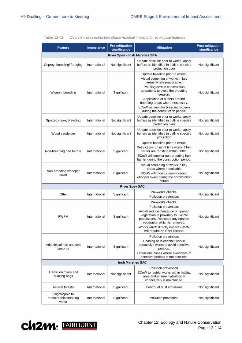
A9 Dualling – Crubenmore to Kincraig DMRB Stage 3 Environmental Impact Assessment
Chapter 12: Ecology and Nature Conservation Page 12-114
Table 12-42: Overview of construction phase residual impacts for ecological features
Feature Importance Pre-mitigation significance Mitigation Post-mitigation
significance
River Spey – Insh Marshes SPA
Osprey, breeding/ foraging International Not significant Update baseline prior to works, apply buffers as identified in outline species
protection plan Not significant
Wigeon, breeding International Significant
Update baseline prior to works. Visual screening of works in key
areas where practicable. Phasing certain construction
operations to avoid the breeding season.
Application of buffers around breeding areas where necessary.
ECoW will monitor breeding wigeon during the construction period.
Not significant
Spotted crake, breeding International Not significant Update baseline prior to works, apply buffers as identified in outline species
protection plan Not significant
Wood sandpiper International Not significant Update baseline prior to works, apply buffers as identified in outline species
protection Not significant
Non-breeding hen harrier International Significant
Update baseline prior to works. Restrictions on night time works if hen
harrier are roosting within 500m. ECoW will monitor non-breeding hen harrier during the construction period.
Not significant
Non-breeding whooper swan International Significant
Visual screening of works in key areas where practicable
ECoW will monitor non-breeding whooper swan during the construction
period
Not significant
River Spey SAC
Otter International Significant Pre-works checks.
Pollution prevention. Not significant
FWPM International Significant
Pre-works checks. Pollution prevention.
Avoid/ reduce clearance of riparian vegetation in proximity to FWPM
populations. Reinstate any riparian vegetation which is removed.
Works which directly impact FWPM will require an SNH licence.
Not significant
Atlantic salmon and sea lamprey International Significant
Pollution prevention. Phasing of in-channel works/
percussive works to avoid sensitive periods.
Exclusions zones where avoidance of sensitive periods is not possible.
Not significant
Insh Marshes SAC
Transition mires and quaking bogs International Not significant
Pollution prevention. ECoW to restrict works within habitat
area and ensure hydrological connectivity is maintained.
Not significant
Alluvial forests International Significant Control of dust emissions Not significant
Oligotrophic to mesotrophic standing
water International Significant Pollution prevention Not significant

A9 Dualling – Crubenmore to Kincraig DMRB Stage 3 Environmental Impact Assessment
Chapter 12: Ecology and Nature Conservation Page 12-115
Feature Importance Pre-mitigation significance Mitigation Post-mitigation
significance River Spey - Insh Marshes SSSI
Breeding Bird Assemblage National Significant
Update baseline prior to works. Provision of alternative breeding habitat at Dellmore of Kingussie. Visual Screening of works in key
areas. Prevent juvenile birds accessing
works areas. Phasing certain construction /
demolition operations to avoid the breeding season.
Not significant
Floodplain fen National Significant
Pollution prevention. Minimise disturbance/ loss of this
habitat through careful siting of site compounds, storage areas,
temporary access tracks and SuDS.
Not significant
Arctic charr National Significant
Pollution prevention. Phasing of in-channel works/
percussive works to avoid sensitive periods.
Exclusions zones where avoidance of sensitive periods is not possible.
Not significant
Insh Marshes NNR
Refer to River Spey – Insh Marshes SSSI
Notable Habitats
European Dry heath Authority Area Not significant
Minimise disturbance/ loss of these habitats through careful siting of site
compounds, storage areas, temporary access tracks and SuDS.
Notable habitats disturbed or damaged during construction will be reinstated to their original condition
post construction. Woodland cleared to facilitate
construction will be re-planted in situ using a species mix of local
provenance (this is not applicable to ancient woodland).
Ancient woodland lost during the construction phase will be mitigated
for through proposed ancient woodland mitigation areas.
Not significant
Northern Atlantic wet heaths
Authority Areas Not significant
Blanket bogs Authority Areas Not significant
Alluvial forests (outwith Insh Marshes SAC)
Authority Area Not significant
Transition mires and quaking bogs (outwith Insh
Marshes SAC) Local Not significant
Juniper formations on heaths Regional Not significant
Reedbeds Regional Not significant
Upland Birchwood’s (connected to ancient
woodland) National Significant
Upland Birchwoods (not connected to ancient
woodland) Local Not significant
Lowland deciduous woodland (connected to
ancient woodland) National Not significant
Lowland deciduous woodland (not connected
to ancient woodland) Local Not significant
Wet woodland (connected to ancient woodland) National Not significant
Wet woodland (not connected to ancient
woodland) Local Not significant

A9 Dualling – Crubenmore to Kincraig DMRB Stage 3 Environmental Impact Assessment
Chapter 12: Ecology and Nature Conservation Page 12-116
Feature Importance Pre-mitigation significance Mitigation Post-mitigation
significance Upland flushes, fens and
swamps (outwith the SSSI)
Local Not significant
Lowland fens (outwith the SSSI) Local Not significant
Wet grasslands Local Not significant
Non-priority woodland (connected to ancient
woodland) Local Not significant
Plantation woodland (connected to ancient
woodland) Local Not significant
Ancient Woodland Inventory (AWI) National Significant Significant
Breeding Birds
Strathspey breeding wader assemblage
Authority Area Significant
Update baseline prior to works. Provision of alternative breeding habitat at Dellmore of Kingussie. Visual Screening of works in key
areas. Prevent juvenile birds accessing
works areas. Phasing certain construction /
demolition operations to avoid the breeding season.
Not significant
Annex 1 species Golden eagle, white tailed
eagle, marsh harrier Regional No impacts
predicted N/A N/A
Annex 1 species Black grouse
Regional Significant Phasing works to avoid disturbance to lekking sites. Not significant
Schedule 1 species Crossbill
Local Not significant Phasing of tree-felling to avoid the
crossbill breeding season. Monitoring and pre-works checks.
Not significant
BoCC red and amber list species
Authority Area Not significant
Avoid vegetation clearance and tree felling during the breeding bird
season. Pre-works checks.
Not significant
Non-Breeding Birds
Non-breeding bird assemblage Regional Not significant
Apply screening. Apply soft start techniques to piling
operations. Not significant
Annex 1 species Merlin, peregrine falcon,
golden eagle Regional Not significant None specified Not significant
Reptiles
Common lizard; adder; slow worm
Authority Area Not significant
Avoid sensitive seasons. Watching brief.
Not significant
Protected Vertebrates
Bats Common pipistrelle;
soprano pipistrelle; brown long-eared and Myotis
spp.
Local Not significant
Pre-works checks. Construction lighting will avoid
illuminating specified high-quality bat foraging habitat.
Works which directly impact roosting bats will require an SNH licence.
Not significant

A9 Dualling – Crubenmore to Kincraig DMRB Stage 3 Environmental Impact Assessment
Chapter 12: Ecology and Nature Conservation Page 12-117
Feature Importance Pre-mitigation significance Mitigation Post-mitigation
significance
Water vole Authority Area Not significant
Pre-works checks. Works which directly impact water vole burrows will require an SNH
licence.
Not significant
Red squirrel Regional Significant
Pre-works checks. Works, particularly blasting works,
should avoid the red squirrel breeding season. If this is not possible, suitable
exclusion zones to be agreed with SNH.
Works which directly impact red squirrel dreys will require an SNH
licence.
Not significant
Wildcat National Significant
Works on bridge and culvert structures should be restricted to
daylight hours and permeability under the road network should be
maintained throughout construction.
Not significant

A9 Dualling – Crubenmore to Kincraig DMRB Stage 3 Environmental Impact Assessment
Chapter 12: Ecology and Nature Conservation Page 12-118
Table 12-43: Overview of operational phase residual impacts on ecological features
Feature Importance Pre-mitigation significance Mitigation Post-mitigation
significance
River Spey-Insh Marshes SPA
Osprey, breeding/ foraging International Not significant None specified Not significant
Wigeon, breeding International Not significant None specified Not significant
Spotted crake, breeding International Not significant None specified Not significant
Wood sandpiper, breeding International Not significant None specified Not significant
Non-breeding hen harrier International Not significant None specified Not significant
Non-Breeding whooper swan International Not significant None specified Not significant
River Spey SAC
Otter International Significant (beneficial)
Mammal ledges and SuDS features (embedded mitigation)
Significant (beneficial)
FWPM International Significant (beneficial)
SuDS features and provision of natural bed material in watercourse
crossings (embedded mitigation)
Significant (beneficial)
Atlantic salmon and sea lamprey International Significant
(beneficial)
SuDS features and provision of natural bed material in watercourse
crossings (embedded mitigation)
Significant (beneficial)
Insh Marshes SAC
Transition mires and quaking bogs International No impacts
predicted N/A N/A
Alluvial forests International Not significant None specified Not significant
Oligotrophic to mesotrophic standing
water International Significant SuDS features (embedded mitigation) Significant
(beneficial)
River Spey - Insh Marshes SSSI
Breeding bird assemblage National Significant Provision of alternative breeding
habitat at Dellmore of Kingussie Not significant
Floodplain fen National Not significant None specified Not significant
Arctic charr National Not significant SuDS features (embedded mitigation) Significant (beneficial)
Insh Marshes NNR
Refer to River Spey -Insh Marshes SSSI
Notable Habitats
European dry heath Authority Area Not significant Proposed European dry heath and
ancient woodland mitigation areas identified to mitigate permanent loss
of these habitats.
Landscape tree planting throughout Proposed Scheme to mitigate
permanent loss of woodland (not including ancient woodland).
Habitats will be monitored to assess compliance with the management
Not significant Alluvial forests Authority
Area Not significant
Ancient Woodland Inventory (AWI) National Significant Significant
Upland birchwoods (connected to ancient
woodland) National Significant Not significant

A9 Dualling – Crubenmore to Kincraig DMRB Stage 3 Environmental Impact Assessment
Chapter 12: Ecology and Nature Conservation Page 12-119
Feature Importance Pre-mitigation significance Mitigation Post-mitigation
significance
Upland birchwoods (not connected to ancient
woodland) Local Not significant
objectives set out in the Outline Habitat Management Plan.
Lowland deciduous woodland (connected to
ancient woodland) National Not significant
Lowland deciduous woodland (not connected
to ancient woodland Local Not significant
Wet woodland (connected to ancient
woodland) National Not significant
Wet woodland (not connected to ancient
woodland) Local Not significant
Non-priority woodland (connected to ancient
woodland) Local Not significant
Plantation woodland (connected to ancient
woodland) Local Not significant
Juniper formations on heaths Local Not significant
Juniper will be incorporated, proposed mitigation areas identified
for European dry heath and tree planting
Not significant
Northern Atlantic wet heaths
Authority Area Not significant None specified Not significant
Blanket bogs Authority Area Not significant None specified Not significant
Alkaline fens Authority Area Not significant None specified Not significant
Reedbeds Regional Not significant None specified Not significant
Upland flushes, fens and swamps (out with SSSI) Local Not significant None specified Not significant
Lowland fens (out with SSSI) Local Not significant None specified Not significant
Wet grasslands Local Not significant None specified Not significant
Breeding Birds
Strathspey breeding wader assemblage Regional Significant
Provision of alternative breeding habitat at Dellmore of Kingussie.
Enhancement of compensatory flood storage areas.
Not significant
Annex 1 species
Black grouse Regional Not significant None specified Not significant
Annex 1 species
Golden eagle, white tailed eagle, marsh harrier
Regional No impacts predicted N/A N/A
Schedule 1 species
Crossbill Local Not significant None specified Not significant
BoCC red and amber species Local Not significant None specified Not significant
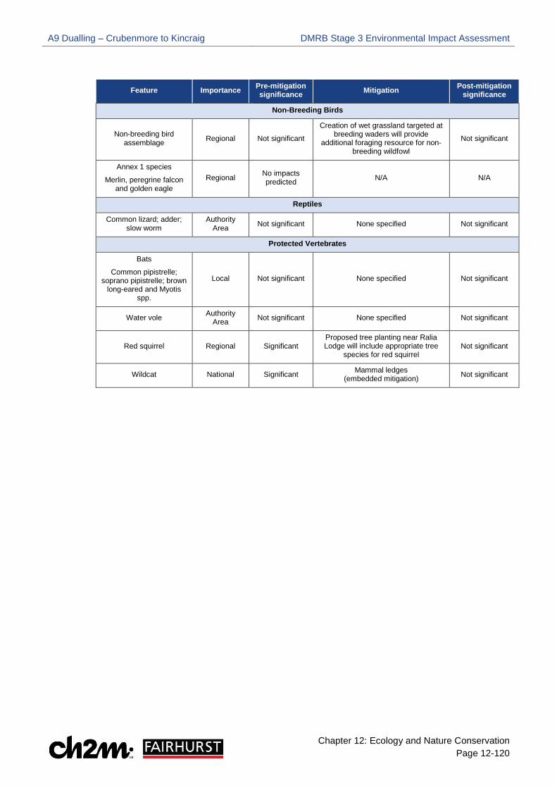
A9 Dualling – Crubenmore to Kincraig DMRB Stage 3 Environmental Impact Assessment
Chapter 12: Ecology and Nature Conservation Page 12-120
Feature Importance Pre-mitigation significance Mitigation Post-mitigation
significance
Non-Breeding Birds
Non-breeding bird assemblage Regional Not significant
Creation of wet grassland targeted at breeding waders will provide
additional foraging resource for non-breeding wildfowl
Not significant
Annex 1 species
Merlin, peregrine falcon and golden eagle
Regional No impacts predicted N/A N/A
Reptiles
Common lizard; adder; slow worm
Authority Area Not significant None specified Not significant
Protected Vertebrates
Bats
Common pipistrelle; soprano pipistrelle; brown
long-eared and Myotis spp.
Local Not significant None specified Not significant
Water vole Authority Area Not significant None specified Not significant
Red squirrel Regional Significant Proposed tree planting near Ralia Lodge will include appropriate tree
species for red squirrel Not significant
Wildcat National Significant Mammal ledges (embedded mitigation) Not significant
A9 Dualling – Crubenmore to Kincraig DMRB Stage 3 Environmental Impact Assessment
Chapter 12: Ecology and Nature Conservation Page 12-121
12.7 References
APEM (2004). Assessment of sea lamprey distribution and abundance in the River Spey: Phase II. Scottish Natural Heritage Commissioned Report No. 027 Bat Conservation Trust (2009), Bats and Lighting in the UK. [Online]. Available at: http://www.bats.org.uk/data/files/bats_and_lighting_in_the_uk__final_version_version_3_may_09.pdf (Accessed March 2017)
Beason, R. (2004) ‘What can birds hear?’ USDA National Wildlife Research Center - Staff Publications. 78.
British Standards Institute, (2016) BS 5489-2 :2016 Code of practice for the design of road lighting. Lighting of tunnels.
CNPA. (2013) Cairngorms Nature Action Plan [online]. Cairngorms National Park Authority. Available at: <http://cairngorms.co.uk> (Accessed March 2017).
CIEEM (2016) ‘Guidelines for Ecological Impact Assessment in the UK and Ireland, Terrestrial, Freshwater and Coastal’. Chartered Institute of Ecology and Environmental Management
Council Directive 92/43/EEC of the European Parliament and of the Council of 21 of May 1992 on the conservation of natural habitats and of wild fauna and flora. [Online]. Available at: http://ec.europa.eu/environment/nature/legislation/habitatsdirective/index_en.htm (Accessed September 16).
Currie F. and Elliot D.G. (1997). Forests and Birds. A guide to Managing Forests for Rare Birds. RSPB Sandy.
Cutts, N., Phelps, A., and Burdon D. (2009). Construction and Waterfowl: Defining Sensitivity, Response, Impacts and Guidance. A Report to Humber INCA.
Dean, M., Strachan, R., Gow, D., & Andrews, R. (2016). The Water Vole Mitigation Handbook. (The Mammal Society Mitigation Guidance Series). Eds Fiona Mathews and Paul Chanin. The Mammal Society, London.
Directive 2000/60/EC of the European Parliament and of the Council establishing a framework for the Community action in the field of water policy. [Online]. Available at: http://ec.europa.eu/environment/water/water-framework/index_en.html (Accessed September 2017)
Directive 2009/147/EC of the European Parliament and of the Council of 30 November 2009 on the conservation of wild birds. Available at: http://ec.europa.eu/environment/nature/legislation/birdsdirective/index_en.htm (Accessed September 2016).
DMRB. (1993) Ecology and Nature conservation. DMRB Volume 11, Section 3, Part 4. Department for Transport (DfT) Dooling, R. and Popper, A. (2016) ‘Some lessons from the effects of highway noise on birds.’ Proceedings of Meetings on Acoustics ‘The Effects of Noise on Aquatic Life’. Held 10-16 July 2016 at Davenport Hotel, Dublin. Acoustical Society of America. Forrester R.F. and Andrews I. (2007). The Birds of Scotland. Scottish Ornithologists Club. Aberlady
A9 Dualling – Crubenmore to Kincraig DMRB Stage 3 Environmental Impact Assessment
Chapter 12: Ecology and Nature Conservation Page 12-122
Grant, M., Lodge, C., Moore, N., Easton, J., Orsman, C. and Smith, M. (2000). Estimating the abundance and hatching success of breeding CurlewNumenius arquatausing survey data. Bird Study, 47(1), pp.41-51.
Hardy, J. Crick, H. Wernham, C. Riley, H. Etheridge, B and Thompson, D. (2013). Raptors: A Field Guide for Surveys and Monitoring. The Stationary Office, Edinburgh.
Hockin, D., Ounsted, M., Gormant, M., Hillt, D., Kellert, V and Barker M, A. (1991). Examination of the Effects of Disturbance on Birds with Reference to its Importance in Ecological Assessments. Journal of Environmental Management, 36, 253-286.
Hughes, J., & Broome, A. (2007). Forests and Wood Ants in Scotland. Information Note. Forestry Commission Scotland, Edinburgh.
Institution of Lighting Professionals (2011) GN 01 Guidance notes for the reduction of obtrusive light
Joint Nature Conservation Committee (2005). SPA description [online]. Available from: http://jncc.defra.gov.uk/page-1909-theme=default
Katzenberger J. (2014). Habitat Parameters Affecting the Distribution of Breeding Meadow Birds in Grasslands of Bremen. BSc Thesis. Hohschule Bremen – University of Applied Sciences.
Mitchell C, Vines J, Moore P, Wilkinson G, Rotheray E. (2007). Distribution and abundance of Whooper Swan Cygnus Cygnus at RSPB Insh Marshes 2005/ 06 and 2006 / 07.
Muller G & Mosser M. (2013). Handbook of Engineering Acoustics. Springer.
O'Donoghue, B. G. (2010). The Ecology and Conservation of Hen Harriers (Circus cyaneus) in Ireland. PhD Thesis submitted to University College Cork.
Oldham, R. S., Keeble, J., Swan, M. J. S. & Jeffcote, M. (2000). Evaluating the suitability of habitat for the Great Crested Newt (Triturus cristatus). Herpetological Journal 10 (4), 143-155.
Pearce-Higgins J.W, Finney S.K, Yalden. D.W, & Langston R.H.W, (2007). Testing the Effects of Recreational Disturbance on Two Upland Breeding Waders. Ibis 149. 45-55.
Rees, Eileen & H. Bruce, Jennifer & T. White, George. (2005). Factors affecting the behavioural responses of whooper swans (Cygnus c. cygnus) to various human activities. Biological Conservation. 121. 369–382. 10.1016/j.biocon.2004.05.009.
Reijenen. R, Foppen R. & Meeuwsen H (1996). The Effects of Traffic on the Density of Breeding Birds in Dutch Agricultural Grasslands. Biological Conservation 75. 225-260.
Royal Commission on Environmental Pollution (2009) Artificial light in the environment. The Stationery Office Limited: UK.
Ruddock M. and Whitfield D.P, (2007). A Review of Disturbance Distances in Selected Bird Scottish Government. (2013) Scottish Biodiversity List [online]. Available at: <http://www.scotland.gov.uk/Topics/Environment/Wildlife-Habitats/16118/Biodiversitylist/SBL> (Accessed September 2016).
Scottish Government. (2013) Scottish Biodiversity List [online]. Available from <http://www.scotland.gov.uk/Topics/Environment/Wildlife-Habitats/16118/Biodiversitylist/SBL> (Accessed September 2016).
Scottish Government. (2014) Scottish Planning Policy [online]. Available at: <http://www.gov.scot/Resource/0045/00453827.pdf> (Accessed September 2016).
A9 Dualling – Crubenmore to Kincraig DMRB Stage 3 Environmental Impact Assessment
Chapter 12: Ecology and Nature Conservation Page 12-123
Scottish Natural Heritage (2006). Guidance for Competent Authorities when dealing with proposals affecting SAC freshwater sites.
Scottish Ornithologists’ Club (2017). Highland Bird Report 2015.
Scottish Fisheries Co-ordination Centre (SFCC) (2007). Habitat Surveys Traingin Course Manual. [Online]. Available at: http://www.sfcc.co.uk/assets/files/SFCC%20Habitat%20Training%20Manual.pdf (Accessed June 2016).
Spey Fishery Board (2016) Spey Catchment Initiative. River Spey Catchment Management Plan. Available at: https://www.speyfisheryboard.com/wp-content/uploads/2016/12/SCI-2016-Catchment-Management-Plan.pdf (Accessed June 16)
The Highways Agency et al., (2010) ‘Ecology and Nature Conservation: Criteria for Impact Assessment’. Interim Advice Note (IAN) 130/10; hereafter referred to as IAN 130/10
Transport Scotland. 2013. A9 Dualling Programme-level Strategic Environmental Assessment (SEA) Environmental Report. Prepared by Halcrow.
Walker, A. F (2006). Stream spawning of Arctic charr in Scotland, Ecology of Freshwater Fish 2007: 16: 47–53
Waterman. E, Tulp.I, Reiinen. R, Krijgsveld. K and ter Braak (2016) Disturbance of Meadow birds by Railway Noise in The Netherlands. Study commission by Prorail.
Whitfield D.P, Green. M, & Fielding A.H, (2010) Are Breeding Eurasian Curlew Numenius arquata displaced by wind energy developments? Natural Research Projects Lt d, Banchory, Scotland.
Wildlife and Countryside Act. (1981). Chapter 69. [Online]. Available at: http://jncc.defra.gov.uk/pdf/waca1981_schedule1.pdf. (Accessed Spetember 2016).

A9 Dualling – Crubenmore to Kincraig DMRB Stage 3 Environmental Impact Assessment