chapter 6.general development standards
TRANSCRIPT
CHAPTER 6: General Development Standards Section 6.1. Measurements, Computations, and Exceptions
HAMILTON TOWNSHIP ZONING CODE SEPTEMBER 2014
CHAPTER 6 . GENERAL DEVELOPMENT STANDARDS 6.1. MEASUREMENTS, COMPUTATIONS, AND EXCEPTIONS
6.1.1. General Provisions
A. Percentages and Fractions When a calculation or ratio established in this chapter results in a fractional number or percentage, any fraction of ½ or less shall be rounded down to the next lower whole number and any fraction of more than ½ shall be rounded up to the next higher whole number, unless otherwise expressly stated.
B. Distance Measurements Unless otherwise expressly stated, distances specified in this code are to be measured as the length of an imaginary straight line joining those points.
6.1.2. Lot Area
A. Lot Area Measurements The area of a lot is the horizontal area contained within the lot lines. Right-of-way is not included in the lot area measurements. Right-of-way easement where the front property boundary extends into a right-of-way easement is included in the lot area measurements.
B. Reductions in Lot Area Prohibited
(1) No existing lot of record shall be reduced in area so that lot area, lot width, yards, or other requirements of this code are not maintained, except where such reduction has been brought about by the expansion or acquiring of public rights-of-way or is approved through a PUD District.
(2) If, however, by some means (for example, misinterpretation of law, erroneous lot descriptions, and the like) the lot area of a lot of record is reduced below the minimum required lot area as specified herein for the zoning district, all of the uses and structures contained on the remaining portion of the area shall be subject to compliance with all other provisions of this code.
(3) In the event that the uses and structures cannot comply in such circumstances, the property owner shall seek relief from the BZA, as provided for in Section 3.8 Appeals, Variances, and Conditional Uses.
6.1.3. Setbacks and Yards
A. Measurements
(1) Setbacks refer to the unobstructed, unoccupied open area between the furthermost projection of a structure and the property line of the lot on which the structure is located.

CHAPTER 6: General Development Standards Section 6.1. Measurements, Computations, and Exceptions
HAMILTON TOWNSHIP ZONING CODE SEPTEMBER 2014 6.2
(2) Setbacks shall be unobstructed by any portion of the building or any protuberances, structural (e.g. chimneys, bay windows, etc.) or mechanical (e.g. air conditioners, above ground fuel tanks, etc., but excluding utility metering devices), attached to the building from the ground upward, except eaves and cantilevered balconies at least eight feet above grade.
B. Yards Required for Buildings A yard or other open space required for a building shall not be included as part of a yard or other open space for another building.
Figure 6-1: Typical Setback Measurements on an Interior Lot
C. Front Yard Setback
(1) The yard fronting a street shall be considered to be a front yard and shall meet the minimum front yard setback. See Figure 6-1.
(2) In determining the front yards for a lot fronting on more than one street, the frontage on all streets shall be considered as front yards.
(3) The front yard setback shall extend the full width of the lot and shall be measured from the property line.
(4) In cases where the front property boundary extends into a right-of-way easement, the front yard setback shall be measured from the nearest edge of pavement to the building or closest protuberance.
D. Side Yard Setback The side yard setback shall extend from the front yard to the rear yard and shall be measured from the side lot line. See Figure 6-1.

CHAPTER 6: General Development Standards Section 6.1. Measurements, Computations, and Exceptions
HAMILTON TOWNSHIP ZONING CODE SEPTEMBER 2014 6.3
E. Rear Yard Setback The rear yard setback shall extend the full width of the lot and shall be measured from the rear lot line. See Figure 6-1.
F. Front Yard within an Established Block in Residential Districts No front yard in a residential district shall be required to exceed the average of the minimum depths of the existing front yards on the lots adjacent on each side, if each of such lots are within the same block and within 100 feet of a building. See Figure 6-2.
Figure 6-2: Illustration of the Averaging of Front Yard Setbacks
G. Corner Lots
(1) Where a lot is considered a corner lot, the required minimum front yard setback shall be provided on each street or section thereof. See Figure 6-3.
(2) All yards not fronting on a street shall provide a setback equal to the minimum side yard setback of the district.
Figure 6-3: Yard Locations on a Corner Lot
CHAPTER 6: General Development Standards Section 6.1. Measurements, Computations, and Exceptions
HAMILTON TOWNSHIP ZONING CODE SEPTEMBER 2014 6.4
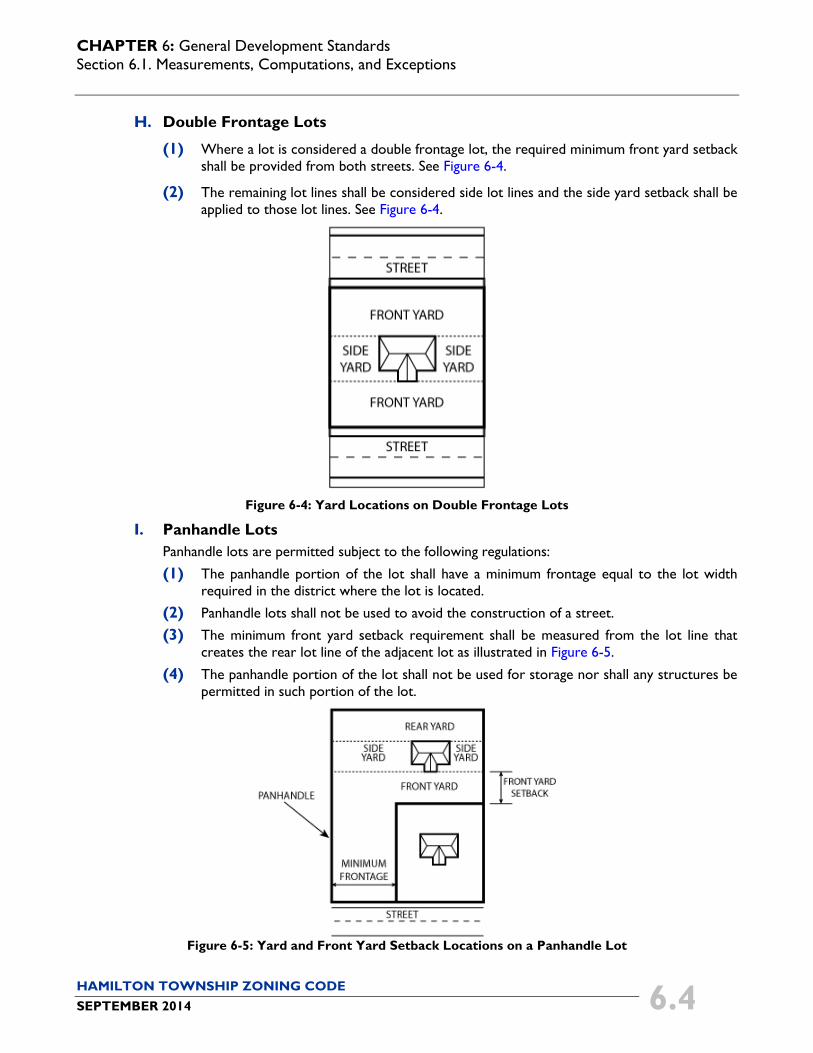
H. Double Frontage Lots
(1) Where a lot is considered a double frontage lot, the required minimum front yard setback shall be provided from both streets. See Figure 6-4.
(2) The remaining lot lines shall be considered side lot lines and the side yard setback shall be applied to those lot lines. See Figure 6-4.
Figure 6-4: Yard Locations on Double Frontage Lots
I. Panhandle Lots Panhandle lots are permitted subject to the following regulations:
(1) The panhandle portion of the lot shall have a minimum frontage equal to the lot width required in the district where the lot is located.
(2) Panhandle lots shall not be used to avoid the construction of a street.
(3) The minimum front yard setback requirement shall be measured from the lot line that creates the rear lot line of the adjacent lot as illustrated in Figure 6-5.
(4) The panhandle portion of the lot shall not be used for storage nor shall any structures be permitted in such portion of the lot.
Figure 6-5: Yard and Front Yard Setback Locations on a Panhandle Lot

CHAPTER 6: General Development Standards Section 6.1. Measurements, Computations, and Exceptions
HAMILTON TOWNSHIP ZONING CODE SEPTEMBER 2014 6.5
J. Cul-de-Sac or Curved-Street Lot For a cul-de-sac lot or a lot abutting a curved street, the front yard setback shall be measured parallel to the curve of the street. See Figure 6-6.
Figure 6-6: Setback Line of a Lot with Frontage on a Curved Street or Cul-de-sac
K. Other Lot Types For any type of irregular lot not addressed in this section, the zoning inspector shall determine the location of the front, side, and rear yard taking into consideration the effect on adjoining properties.
6.1.4. Lot Width
Lot width is the distance between the side lot lines measured at the point of the front setback line. See Figure 6-7.
Figure 6-7: Measurement Location of Lot Width and Street Frontage
6.1.5. Street Frontage
The street frontage is the distance between the side lot lines measured at the point of the street right-of-way. See Figure 6-7.
CHAPTER 6: General Development Standards Section 6.2. Site Development Standards
HAMILTON TOWNSHIP ZONING CODE SEPTEMBER 2014 6.6
6.1.6. Minimum Dwelling Size
The minimum size of a dwelling shall be the sum of the horizontal area of each floor of the dwelling measured from the exterior walls, or the center of party walls, exclusive of porches, garages, and cellars.
6.1.7. Height Measurement and Exceptions
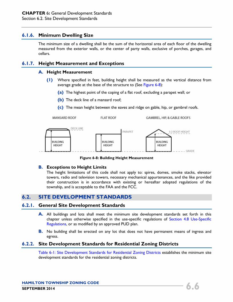
A. Height Measurement
(1) Where specified in feet, building height shall be measured as the vertical distance from average grade at the base of the structure to (See Figure 6-8):
(a) The highest point of the coping of a flat roof, excluding a parapet wall; or
(b) The deck line of a mansard roof;
(c) The mean height between the eaves and ridge on gable, hip, or gambrel roofs.
Figure 6-8: Building Height Measurement
B. Exceptions to Height Limits The height limitations of this code shall not apply to: spires, domes, smoke stacks, elevator towers, radio and television towers, necessary mechanical appurtenances, and the like provided their construction is in accordance with existing or hereafter adopted regulations of the township, and is acceptable to the FAA and the FCC.
6.2. SITE DEVELOPMENT STANDARDS 6.2.1. General Site Development Standards
A. All buildings and lots shall meet the minimum site development standards set forth in this chapter unless otherwise specified in the use-specific regulations of Section 4.8 Use-Specific Regulations, or as modified by an approved PUD plan.
B. No building shall be erected on any lot that does not have permanent means of ingress and egress.
6.2.2. Site Development Standards for Residential Zoning Districts
Table 6-1: Site Development Standards for Residential Zoning Districts establishes the minimum site development standards for the residential zoning districts.
CHAPTER 6: General Development Standards Section 6.2. Site Development Standards
HAMILTON TOWNSHIP ZONING CODE SEPTEMBER 2014 6.7
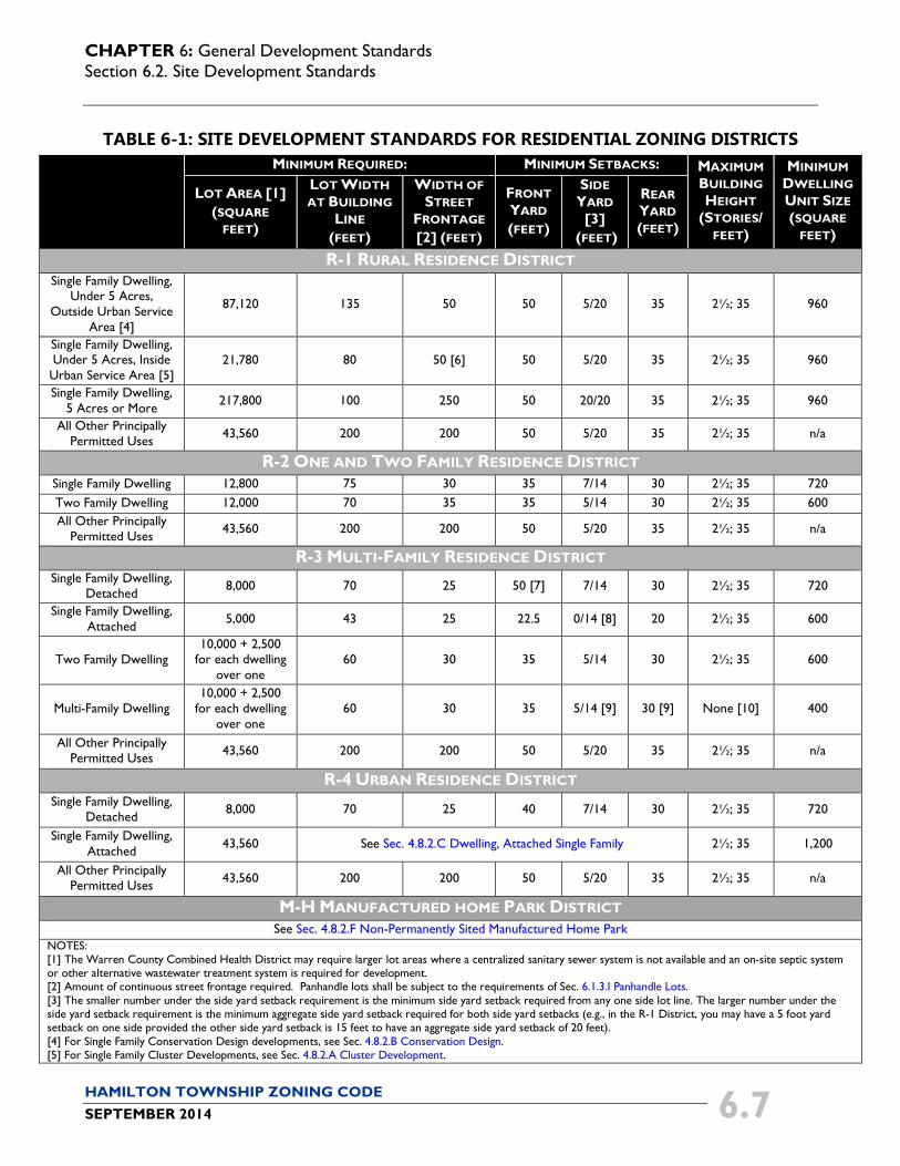
TABLE 6-1: SITE DEVELOPMENT STANDARDS FOR RESIDENTIAL ZONING DISTRICTS
MINIMUM REQUIRED: MINIMUM SETBACKS: MAXIMUM BUILDING HEIGHT
(STORIES/ FEET)
MINIMUM DWELLING UNIT SIZE (SQUARE
FEET)
LOT AREA [1] (SQUARE
FEET)
LOT WIDTH AT BUILDING
LINE (FEET)
WIDTH OF STREET
FRONTAGE [2] (FEET)
FRONT YARD (FEET)
SIDE YARD [3]
(FEET)
REAR YARD (FEET)
R-1 RURAL RESIDENCE DISTRICT Single Family Dwelling,
Under 5 Acres, Outside Urban Service
Area [4]
87,120 135 50 50 5/20 35 2½; 35 960
Single Family Dwelling, Under 5 Acres, Inside
Urban Service Area [5] 21,780 80 50 [6] 50 5/20 35 2½; 35 960
Single Family Dwelling, 5 Acres or More 217,800 100 250 50 20/20 35 2½; 35 960
All Other Principally Permitted Uses 43,560 200 200 50 5/20 35 2½; 35 n/a
R-2 ONE AND TWO FAMILY RESIDENCE DISTRICT Single Family Dwelling 12,800 75 30 35 7/14 30 2½; 35 720 Two Family Dwelling 12,000 70 35 35 5/14 30 2½; 35 600 All Other Principally
Permitted Uses 43,560 200 200 50 5/20 35 2½; 35 n/a
R-3 MULTI-FAMILY RESIDENCE DISTRICT Single Family Dwelling,
Detached 8,000 70 25 50 [7] 7/14 30 2½; 35 720
Single Family Dwelling, Attached 5,000 43 25 22.5 0/14 [8] 20 2½; 35 600
Two Family Dwelling 10,000 + 2,500
for each dwelling over one
60 30 35 5/14 30 2½; 35 600
Multi-Family Dwelling 10,000 + 2,500
for each dwelling over one
60 30 35 5/14 [9] 30 [9] None [10] 400
All Other Principally Permitted Uses 43,560 200 200 50 5/20 35 2½; 35 n/a
R-4 URBAN RESIDENCE DISTRICT Single Family Dwelling,
Detached 8,000 70 25 40 7/14 30 2½; 35 720
Single Family Dwelling, Attached 43,560 See Sec. 4.8.2.C Dwelling, Attached Single Family 2½; 35 1,200
All Other Principally Permitted Uses 43,560 200 200 50 5/20 35 2½; 35 n/a
M-H MANUFACTURED HOME PARK DISTRICT See Sec. 4.8.2.F Non-Permanently Sited Manufactured Home Park
NOTES: [1] The Warren County Combined Health District may require larger lot areas where a centralized sanitary sewer system is not available and an on-site septic system or other alternative wastewater treatment system is required for development. [2] Amount of continuous street frontage required. Panhandle lots shall be subject to the requirements of Sec. 6.1.3.I Panhandle Lots. [3] The smaller number under the side yard setback requirement is the minimum side yard setback required from any one side lot line. The larger number under the side yard setback requirement is the minimum aggregate side yard setback required for both side yard setbacks (e.g., in the R-1 District, you may have a 5 foot yard setback on one side provided the other side yard setback is 15 feet to have an aggregate side yard setback of 20 feet). [4] For Single Family Conservation Design developments, see Sec. 4.8.2.B Conservation Design. [5] For Single Family Cluster Developments, see Sec. 4.8.2.A Cluster Development.

CHAPTER 6: General Development Standards Section 6.2. Site Development Standards
HAMILTON TOWNSHIP ZONING CODE SEPTEMBER 2014 6.8
MINIMUM REQUIRED: MINIMUM SETBACKS: MAXIMUM BUILDING HEIGHT
(STORIES/ FEET)
MINIMUM DWELLING UNIT SIZE (SQUARE
FEET)
LOT AREA [1] (SQUARE
FEET)
LOT WIDTH AT BUILDING
LINE (FEET)
WIDTH OF STREET
FRONTAGE [2] (FEET)
FRONT YARD (FEET)
SIDE YARD [3]
(FEET)
REAR YARD (FEET)
[6] Lots located on the end of a cul-de-sac street may reduce the required continuous frontage from 50 feet to 35 feet. [7] The front yard within established residential blocks per Sec. 6.1.3.F shall not be required to exceed 50 feet regardless if the average front yards of adjacent lots is a greater distance. [8] No side yard is required if dwellings have adjoining common walls. [9] Multi-family buildings that are 3 stories shall have side yards a minimum of 10 feet; and rear yards a minimum of 40 feet. [10] The height of multi-family dwellings shall be unlimited, except that for each foot over 45 feet, the minimum front, side and rear yards shall be increased by 1 foot.
6.2.3. Site Development Standards for Nonresidential Zoning Districts
Table 6-2: Site Development Standards for Nonresidential Zoning Districts establishes the minimum site development standards for nonresidential zoning districts.
TABLE 6-2: SITE DEVELOPMENT STANDARDS FOR NONRESIDENTIAL ZONING DISTRICTS
DISTRICT
MINIMUM REQUIRED: MINIMUM SETBACKS: MAXIMUM BUILDING HEIGHT
(STORIES/ FEET)
LOT AREA
(SQUARE FEET)
LOT WIDTH AT BUILDING
LINE (FEET)
WIDTH OF STREET
FRONTAGE (FEET)
FRONT YARD (FEET)
MINIMUM SIDE YARD SETBACK (FEET)
MINIMUM REAR YARD SETBACK (FEET)
ADJACENT TO A NONRESIDENTIAL
DISTRICT
ADJACENT TO A RESIDENTIAL DISTRICT [1]
ADJACENT TO A NONRESIDENTIAL
DISTRICT
ADJACENT TO A RESIDENTIAL DISTRICT [1]
B-1 Neighborhood
Business District
43,560 100 50 50 0 50/20 10 50/20 2½; 35
B-2 General Business District
43,560 100 50 50 0 50/20 0 50/20 None [2]
M-1 Light Industry District
43,560 100 50 50 0 50/20 0 50/20 None [2]
M-2 Heavy Industry
District Uses Permitted In
Other Districts
43,560 100 50 50 0 50/20 0 50/20 None [2]
M-2 Heavy Industry
District Uses Only
Permitted In M-2 District
217,800 100 50 [3] 50 400/100 35 100/50 None [2]
T-C Travel Trailer Camp
District See Sec. 4.8.3.M Travel Trailer Camp and Sec. 4.8.3.N Travel Trailer Overnight Port.
NOTES: [1] The first number listed is the setback for structures, and the second number listed is the setback for parking areas and driveways, and to graveled surfaces for uses only permitted in the M-2 District. [2] The height of buildings shall be unlimited, except that for each foot over 45 feet, the minimum front, side and rear yards shall be increased by 1 foot. There shall be adequate fire extinguishing facilities as approved by Hamilton Township Fire and Rescue. [3] The setbacks are based on the functional street classification of the street frontage of the property, as follows:
• Primary and Secondary Arterial Streets – 400 feet. • Collector Streets – 200 feet. • Local Streets – 100 feet. These setbacks shall apply to structures, parking areas, and paved or gravel surfaces used exclusively for access to the property from the right-of-way. The front yard setback for structures may be reduced by 50 percent if the heavy industry use provides a 10 foot high buffer consisting of a solid wall, solid wood fence, earth mound or combination thereof along the entire frontage.

CHAPTER 6: General Development Standards Section 6.3. Outdoor Lighting
HAMILTON TOWNSHIP ZONING CODE SEPTEMBER 2014 6.9
6.3. OUTDOOR LIGHTING
6.3.1. Purpose
A. The purpose of this section is to regulate the placement, orientation, distribution patterns, and fixture types of outdoor lighting in order to preserve, protect and enhance the character of the township and the lawful nighttime use and enjoyment of property located within the township. Outdoor lighting should positively enhance the visual impact of a building or development on surrounding properties and uses, and should be designed and installed in a consistent and coordinated fashion. Outdoor lighting should be used to accentuate key architectural elements of the building or development, and highlight or otherwise emphasize landscape features.
B. All outdoor lighting fixtures located on the applicable site (including lighting for signs and on buildings) shall be arranged so as to:
(1) Provide safety, utility and security;
(2) Control light trespass, visual nuisance, obtrusive light, and glare on adjacent properties and public roadways; and
(3) Reduce atmospheric light pollution.
6.3.2. Applicability
A. The regulations of this section shall apply to all uses except for agricultural uses, single family, two family, and multi-family dwellings.
B. Lighting plans shall be submitted for approval with all applications for zoning certificates in the nonresidential districts and for all nonresidential uses in residential districts unless specifically exempted below.
C. The following shall be exempt from the regulations of this section:
(1) Public utility street lighting.
(2) Decorative outdoor lighting fixtures with bulbs that do not exceed 25 watts, installed seasonally.
(3) Temporary construction or emergency lighting. Such lighting shall be discontinued immediately upon completion of the construction work or abatement of the emergency necessitating such lighting.
(4) All outdoor lighting fixtures existing and legally installed prior to the effective date of this code.
(a) When existing lighting fixtures become inoperative, their replacements are subject to the provisions of this subsection.
(b) When 50 percent or more of any component (e.g., luminaires, poles) of the outdoor lighting system at a building or development is upgraded, changed, or replaced, but not including regular maintenance, such component for the remainder of the outdoor lighting shall be brought into substantial compliance with the requirements of this section.
(5) Lighting required by the FAA or any other federal regulatory authority.
CHAPTER 6: General Development Standards Section 6.3. Outdoor Lighting
HAMILTON TOWNSHIP ZONING CODE SEPTEMBER 2014 6.10
6.3.3. General Lighting Standards
A. Outdoor Lighting Plan (1) An outdoor lighting plan shall be submitted with a zoning certificate application.
(2) The lighting plan shall be prepared by a licensed professional engineer, who shall certify that the exterior lighting plan complies with this section.
(3) The photometric plan shall be prepared in a scale that is easily legible.
(4) The lighting plan shall include the following information:
(a) A photometric plan for the site of the building or development;
(b) Product details, and cut sheets for proposed poles, fixtures, and lamps;
(c) Descriptions of lenses; and
(d) Data tables providing details required by this section. B. Lighting Intensities
Lighting intensities for buildings, developments, or other uses not specifically regulated by this section (e.g., athletic fields, courts, and swimming pools) shall be designed as recommended by the IESNA. However, all such uses shall comply with these regulations for control of glare and light level at the property line.
C. Footcandle Intensities Footcandle intensities specified in this section shall be maintained values calculated using a maintenance factor, also referred to as “m.f.”, not lower than 0.72.
D. Light Fixture and Types (1) All light fixtures, including security lighting, shall be cutoff fixtures.
(2) All light fixtures shall be incorporated as an integral design element that complements the design of the building or development through style, material or color.
(3) Luminaires shall not be tilted.
(4) Lighting of or on buildings shall be limited to wall washer type fixtures or up-lights, which do not produce spill light or glare.
(5) A cutoff fixture shall not have more than one percent of lamp lumens above horizontal. Sag lenses, convex lenses, and drop lenses shall be prohibited.
(6) Lighting at a building or development shall not be comprised in whole or part of any floodlights, except floodlights may be permitted with a noncommercial industrial use, provided the floodlights are shielded to meet cutoff standards.
E. Illumination Levels
(1) Light originating on a site shall not trespass beyond the site to exceed the values in Table 6-3: Illumination Levels at Property Line when measured at the property line for the following adjacent property types:
TABLE 6-3: ILLUMINATION LEVELS AT PROPERTY LINE ADJACENT LAND USE ILLUMINATION LEVEL
Residential 0.2 Footcandles Nonresidential 1.0 Footcandles
CHAPTER 6: General Development Standards Section 6.3. Outdoor Lighting
HAMILTON TOWNSHIP ZONING CODE SEPTEMBER 2014 6.11
(2) Illumination shall be installed with house side shields and reflectors when necessary to avoid glare or spill light from encroaching onto adjacent properties, and shall be maintained in such a manner as to confine light rays to the premises of the building or development.
F. Time Controls Lighting for nonresidential uses shall be installed with time controls so that light levels are reduced not later than one hour after the close of operations to the minimum levels needed under the IESNA to ensure safety and security (approximately a 50 percent reduction).
G. Height Except as otherwise required in this section, the height of an outdoor lighting fixture, inclusive of the pole and light source/luminaire, shall be a maximum of 25 feet within a parking lot, and a maximum of 15 feet within a non-vehicular pedestrian area. Height shall be measured from the finished grade to the top of the light fixture.
H. Shielding
(1) All outdoor lighting for nonresidential uses shall be located, screened, or shielded so that adjacent lots located in residential districts are not directly illuminated.
(2) Wall-mounted lights shall be screened by the building’s architectural features, or contain a cutoff shield to direct lighting onto the building and not into adjacent residential lots.
I. Color and Glare
(1) No outdoor lighting shall be of such an intensity or color distortion as to cause glare or to impair the vision of drivers or pedestrians.
(2) Uniform lighting shall be provided to prevent various non-uniform footcandle levels and/or color variance intensities of lighting throughout the parking area.
J. Other Standards
(1) The placement of light poles within raised curb planter areas or landscaped islands is encouraged, but conflicts with parking lot trees that can obscure the lighting shall be avoided through alternative lighting locations.
(2) For statues, monuments, fountains, flags, or other objects for which it may not be possible to reliably and consistently illuminate with full cutoff lighting, upward lighting may be used only in the form of spotlights which confine the illumination to the object of interest.
(3) The use of laser lighting or lights that pulse, flash, rotate or simulate motion for advertising or promotions is prohibited.
6.3.4. Specific Lighting Standards
A. Parking Areas Parking area lighting shall be coordinated with the required parking area landscape plans to avoid conflict in layout. The following lighting requirements shall apply to a parking area:
(1) The lamp source shall be metal halide, LED, or compact fluorescent, or a light source that produces a Color Rendering Index (CRI) of 65 or higher. Wattage shall not exceed 400 watts per bulb.
CHAPTER 6: General Development Standards Section 6.3. Outdoor Lighting
HAMILTON TOWNSHIP ZONING CODE SEPTEMBER 2014 6.12
(2) Illumination levels outside the radius of any light pole shall range between a minimum of 0.6 footcandles and a maximum of 3.6 footcandles. The radius of a light pole equals the height of the pole, not to exceed 30 feet, but no less than 20 feet. The 30 foot or lesser radius shall be shown on the photometric plan.
(3) The spacing between poles shall be no closer than 2 1/2 times the pole height. However, overflow lighting in a transition zone around a canopied area shall be permissible in the parking area surrounding the canopied area. (See Section 6.3.4.C Canopied Areas regarding canopied areas.)
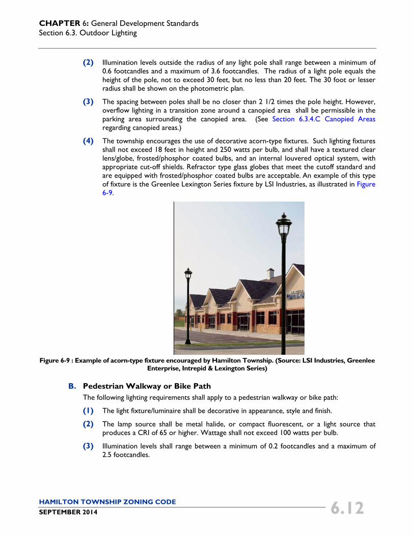
(4) The township encourages the use of decorative acorn-type fixtures. Such lighting fixtures shall not exceed 18 feet in height and 250 watts per bulb, and shall have a textured clear lens/globe, frosted/phosphor coated bulbs, and an internal louvered optical system, with appropriate cut-off shields. Refractor type glass globes that meet the cutoff standard and are equipped with frosted/phosphor coated bulbs are acceptable. An example of this type of fixture is the Greenlee Lexington Series fixture by LSI Industries, as illustrated in Figure 6-9.
Figure 6-9 : Example of acorn-type fixture encouraged by Hamilton Township. (Source: LSI Industries, Greenlee
Enterprise, Intrepid & Lexington Series)
B. Pedestrian Walkway or Bike Path The following lighting requirements shall apply to a pedestrian walkway or bike path:
(1) The light fixture/luminaire shall be decorative in appearance, style and finish.
(2) The lamp source shall be metal halide, or compact fluorescent, or a light source that produces a CRI of 65 or higher. Wattage shall not exceed 100 watts per bulb.
(3) Illumination levels shall range between a minimum of 0.2 footcandles and a maximum of 2.5 footcandles.
CHAPTER 6: General Development Standards Section 6.3. Outdoor Lighting
HAMILTON TOWNSHIP ZONING CODE SEPTEMBER 2014 6.13
C. Canopied Areas The following lighting requirements shall apply to a canopied area, including but not limited to drive-through facilities, service stations, convenience centers, and car-washes, lighting under the canopy, awning, or porte-cochere:
(1) Light fixtures shall be either recessed or cutoff fixtures.
(2) The lamp source shall be either metal halide, with wattage not to exceed 250 watts per bulb, or compact fluorescent, or a light source that produces a CRI of 65 or higher.
(3) The maximum average maintained illumination level shall be 20 footcandles, with a maximum to minimum ratio of 2:1.
D. Dealerships The following lighting requirements shall apply to dealerships for new and used products, including, but not limited to, automobiles, truck, trailer, farm implement, recreational vehicles, motorcycles, boats, and other equipment displayed outside:
(1) The maximum illumination level shall be 24 footcandles for any row or tier of display that is adjacent to an external road or street (public or private), and a maximum level of 10 footcandles for all other rows or tiers of display. However, overflow lighting in a transition zone around a row or tier of display that is adjacent to an external road or street shall be permissible between such row or tier and the adjoining row or tier.
(2) Entrances and exits to and from the dealership shall not exceed 10 footcandles.
(3) All other areas (parking and storage) shall comply with the applicable requirements of this section.
E. Fire Lanes and Driveways Lighting at fire lanes or driveways may exceed allowable standards of intensity for safety purposes upon demonstration that compliance with these lighting criteria would otherwise create a safety hazard. However, light levels shall not exceed 5.0 footcandles at any point.
F. Automatic Teller Machines (ATMs) Lighting intensities at ATM machines shall be governed by any applicable state regulations. However, lighting at freestanding ATMs shall not exceed 20 footcandles within a five foot radius from the ATM or 5.0 footcandles within a 30 foot radius.
G. Building Ornamentation and Accentuation Utilization of neon lighting to accentuate key architectural elements of a building or development is permitted.
(1) In no case shall such lighting flash or blink intermittently.
(2) Any such lighting source located on the side of a building that faces an adjoining residential use or zoning district shall be effectively screened from view of the residential use or zoning district.
H. Searchlights for Purpose of Special Events or Attractions One or more lights of such type and for such purpose shall be permitted for a period not to exceed three days within a calendar year, provided the location and operation does not interfere with traffic movement, endanger public safety and is not operated past midnight on each day so allowed.
CHAPTER 6: General Development Standards Section 6.4. Architectural Design Guidelines and Standards
HAMILTON TOWNSHIP ZONING CODE SEPTEMBER 2014 6.14
6.3.5. Measurement
A. Light levels shall be measured in footcandles with a direct reading, portable light meter. Readings shall be taken only after the cell has been exposed long enough to take a constant reading.
B. Measurements shall be taken at the property line, along a horizontal plane at a height of 3.5 feet above the ground.
6.3.6. Technical Deviations
A. Any zoning certificate application which includes technical deviations from these lighting standards shall demonstrate the unique aesthetic and/or engineering design that meets or is within the spirit of these regulations. Such presentation shall include appropriate calculations and drawings or illustrations as necessary to explain the request or as may be required by the township.
B. The zoning inspector shall make a determination whether to accept such proposed technical deviation after consulting with a mutually acceptable licensed professional engineer. The cost of making such determination shall be borne by the party requesting the technical deviation.
C. Any decision by the zoning inspector in regards to this section, including proposed technical deviations, may be appealed to the BZA.
6.3.7. Certificate of Compliance Required
The zoning inspector shall not issue approval of a zoning compliance inspection until a licensed professional engineer delivers a certificate of compliance stating that the outdoor lighting at the building and site complies with this section. However, where a development is of such a small scale that in the determination of the zoning inspector the lighting layout is considered an incidental engineering service, a certificate of compliance may be issued by the licensed professional rendering the incidental service.
6.4. ARCHITECTURAL DESIGN GUIDELINES AND STANDARDS
6.4.1. Purpose
The purpose of the architectural design guidelines and standards is to ensure new construction and additions to existing buildings are well designed, detailed, and crafted to embody high standards of architectural design, and to ensure the long-term viability of nonresidential and mixed use structures in the township. The architectural design of nonresidential development determines much of the character and attractiveness along the major thoroughfares in the township. These standards require a basic level of architectural variety, compatible scale and mass to surrounding development, and mitigation of negative impacts.
6.4.2. Architectural Review Authority
For the purposes of this section, the zoning inspector shall be authorized to review and make decisions on architectural standards as provided for in ORC Section 519.171.
CHAPTER 6: General Development Standards Section 6.4. Architectural Design Guidelines and Standards
HAMILTON TOWNSHIP ZONING CODE SEPTEMBER 2014 6.15
6.4.3. Applicability
The development standards of this section shall apply to new property development and any collective substantial expansion of existing structures in the B-1, B-2, M-1 and M-2 Districts within the urban service area, including PUDs in these districts, except industrial and warehouse uses as classified in Table 4-2: Permitted Use Table. The standards in this section do not apply to individual single family, two family and multi-family dwellings. Substantial expansion of existing structures shall be defined based on the criteria established below in Table 6-4: Substantial Expansion:
TABLE 6-4: SUBSTANTIAL EXPANSION WHEN EXISTING STRUCTURE IS.... A SUBSTANTIAL EXPANSION IS...
0 - 1,000 Square Feet 50% or Greater 1,001 – 10,000 Square Feet 40% or Greater 10,001 – 25,000 Square Feet 30% or Greater 25,001 – 50,000 Square Feet 20% or Greater 50,001 Square Feet or larger 10% or Greater
6.4.4. Architectural Guidelines
The following design guidelines generally address site design issues.
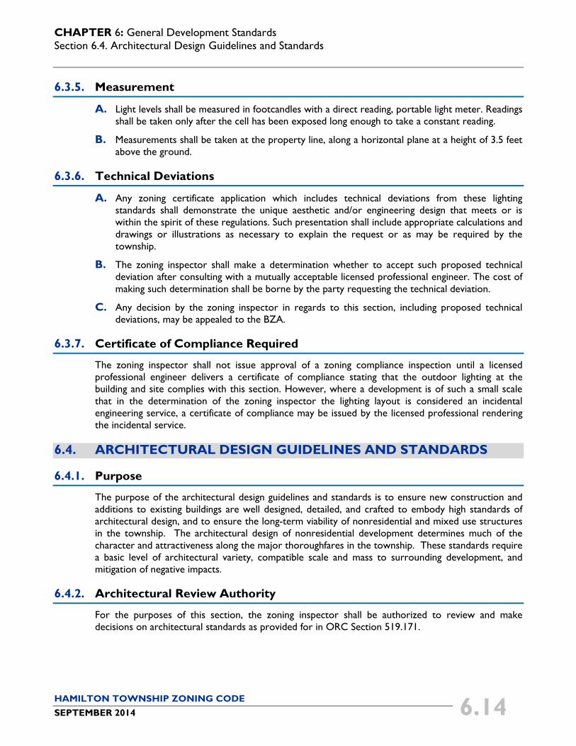
A. Unified Theme (1) The architectural design of buildings within a development, including freestanding
outparcel structures, should be organized around a consistent architectural theme in terms of the architectural style, materials, texture, color, and scale of buildings.
(2) Themed restaurants, retail chains, and other franchise-style structures should adjust some aspects of their standard architectural model to be consistent with the development’s architectural theme as identified in this section. See Figure 6-10.
Figure 6-10: This image shows how franchise architecture can be modified.
CHAPTER 6: General Development Standards Section 6.4. Architectural Design Guidelines and Standards
HAMILTON TOWNSHIP ZONING CODE SEPTEMBER 2014 6.16
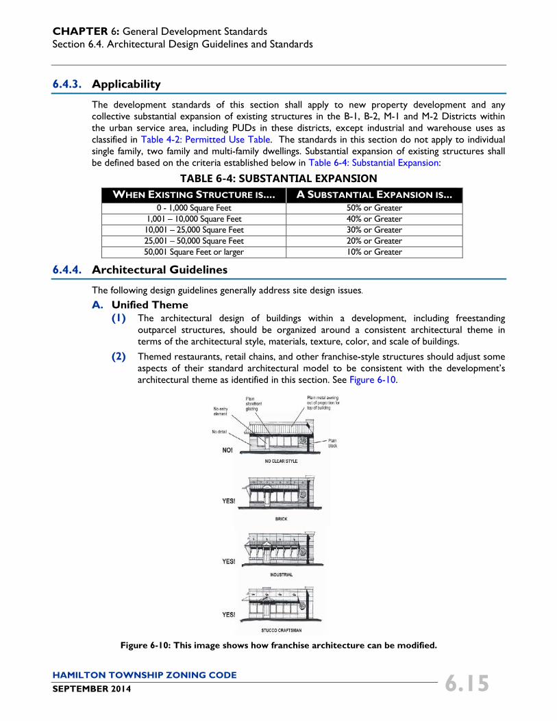
B. Building Relationship
Buildings within a multi-building development should be arranged and grouped so that their primary orientation complements one another and adjacent, existing development. See Figure 6-11. Buildings should:
(1) Frame the corner of an adjacent street intersection or entry point to the development;
(2) Frame a "main street" pedestrian and/or vehicle access corridor within the development site;
(3) Frame at least three sides of parking areas, public spaces, or other site amenities; or
(4) Frame outdoor dining or gathering spaces for pedestrians between buildings.
Figure 6-11: This diagram demonstrates how multi-building retail/commercial developments can be
organized to address the building relationship guidelines.
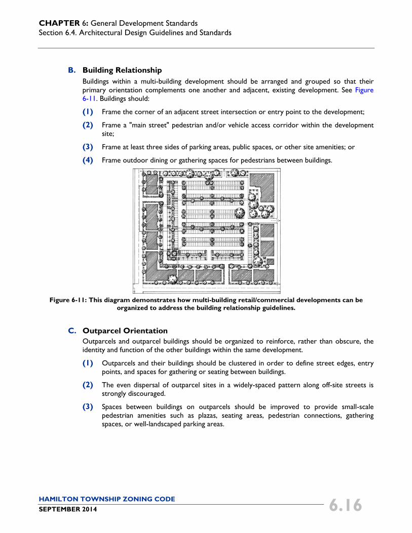
C. Outparcel Orientation Outparcels and outparcel buildings should be organized to reinforce, rather than obscure, the identity and function of the other buildings within the same development.
(1) Outparcels and their buildings should be clustered in order to define street edges, entry points, and spaces for gathering or seating between buildings.
(2) The even dispersal of outparcel sites in a widely-spaced pattern along off-site streets is strongly discouraged.
(3) Spaces between buildings on outparcels should be improved to provide small-scale pedestrian amenities such as plazas, seating areas, pedestrian connections, gathering spaces, or well-landscaped parking areas.
CHAPTER 6: General Development Standards Section 6.4. Architectural Design Guidelines and Standards
HAMILTON TOWNSHIP ZONING CODE SEPTEMBER 2014 6.17
Figure 6-12: This image demonstrates how outparcels and outparcel structures (located along the side and
bottom of the image) can be configured in relation to the guidelines.
D. Building Transparency Building transparency provided by storefront windows, entrances, and other openings is a key element to establish a pedestrian-oriented context, and should be provided by retail and commercial development in the following amounts:
(1) Strip shopping centers or other multi-tenant commercial buildings should dedicate a minimum of 40 percent of the length of the front façade, of each tenant space, to windows or transparent entrances.
(2) Buildings or tenant spaces that occupy 40,000 square feet or more of gross floor area should dedicate a minimum of 25 percent of the length of the front façade to windows or transparent entrances.
(3) Outparcel structures should dedicate a minimum of 35 percent of the length of the front façade to windows or transparent entrances.
(4) Offices and other noncommercial structures should dedicate a minimum of 25 percent of the length of the front façade to windows or transparent entrances.
(5) The township may approve the use of opaque, spandrel or fake windows when it is determined that transparent windows are not appropriate, suitable or compatible with the proposed building or floor plan configuration.
6.4.5. Architectural Standards
The following design standards shall apply to new property development and any collective substantial expansion of existing structures as described in Section 6.4.3 Applicability. A. Building Orientation
(1) Single-building developments shall be oriented so that the primary façade treatment faces the street from which the building derives its street address.
(a) For lots that face two non-intersecting streets, the primary façade shall face the street with the higher vehicle capacity.
(b) For corner lots, the building orientation may face the street intersection.

CHAPTER 6: General Development Standards Section 6.4. Architectural Design Guidelines and Standards
HAMILTON TOWNSHIP ZONING CODE SEPTEMBER 2014 6.18
(2) Larger multi-building developments should be configured in a manner that breaks the site into a series of smaller “blocks” defined by on-site streets, vehicle access ways, pedestrian walkways, or other circulation routes.
B. Building Design and Mass
(1) All architectural elevations of principal buildings shall consist of a base, a body, and a cap (See Figure 6-13).
Figure 6-13: Image of a building with a clear base, body, and cap.
(a) The base shall occupy the lowest portion of the elevation, and shall have a height no less than eight percent of the average wall height.
(b) The body shall occupy the middle portion of the elevation, and shall have a height no less than 60 percent of the average wall height.
(c) The cap shall occupy the highest portion of the elevation, excluding the roof, and shall have a height no less than eight percent of the average wall height, not to exceed the height of the base.
(d) The cap shall consist of at least one of the following architectural features:
(i) A cornice;
(ii) A parapet;
(iii) An awning;
(iv) A canopy; or
(v) Eaves.
(e) The base and cap shall be clearly distinguishable from the body through changes in color, material, pattern, profile, or texture.
(2) Architectural elevations for all new or modified buildings shall include design, massing, materials, shape, and scale that creates a unified design on the premises that is visually compatible with the surrounding buildings.
CHAPTER 6: General Development Standards Section 6.4. Architectural Design Guidelines and Standards
HAMILTON TOWNSHIP ZONING CODE SEPTEMBER 2014 6.19
C. Façade Massing
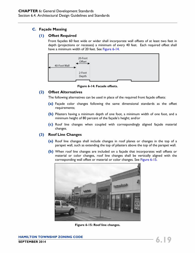
(1) Offset Required Front façades 60 feet wide or wider shall incorporate wall offsets of at least two feet in depth (projections or recesses) a minimum of every 40 feet. Each required offset shall have a minimum width of 20 feet. See Figure 6-14.
Figure 6-14: Facade offsets.
(2) Offset Alternatives The following alternatives can be used in place of the required front façade offsets:
(a) Façade color changes following the same dimensional standards as the offset requirements;
(b) Pilasters having a minimum depth of one foot, a minimum width of one foot, and a minimum height of 80 percent of the façade’s height; and/or
(c) Roof line changes when coupled with correspondingly aligned façade material changes.
(3) Roof Line Changes
(a) Roof line changes shall include changes in roof planes or changes in the top of a parapet wall, such as extending the top of pilasters above the top of the parapet wall.
(b) When roof line changes are included on a façade that incorporates wall offsets or material or color changes, roof line changes shall be vertically aligned with the corresponding wall offset or material or color changes. See Figure 6-15.
Figure 6-15: Roof line changes.
CHAPTER 6: General Development Standards Section 6.4. Architectural Design Guidelines and Standards
HAMILTON TOWNSHIP ZONING CODE SEPTEMBER 2014 6.20
D. Building Facades
(1) Blank building walls facing public streets are prohibited.
(2) These requirements shall not apply to those walls that are not visible from a street and only visible from an alley, the rear yard of another nonresidential or mixed use site, or hidden due to topography or preserved natural features.
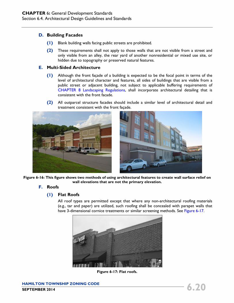
E. Multi-Sided Architecture
(1) Although the front façade of a building is expected to be the focal point in terms of the level of architectural character and features, all sides of buildings that are visible from a public street or adjacent building, not subject to applicable buffering requirements of CHAPTER 8 Landscaping Regulations, shall incorporate architectural detailing that is consistent with the front facade.
(2) All outparcel structure facades should include a similar level of architectural detail and treatment consistent with the front façade.
Figure 6-16: This figure shows two methods of using architectural features to create wall surface relief on
wall elevations that are not the primary elevation. F. Roofs
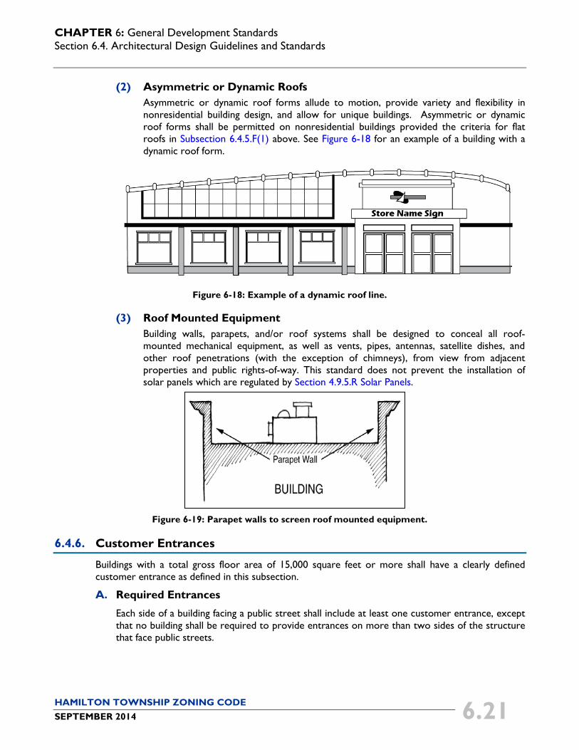
(1) Flat Roofs All roof types are permitted except that where any non-architectural roofing materials (e.g., tar and paper) are utilized, such roofing shall be concealed with parapet walls that have 3-dimensional cornice treatments or similar screening methods. See Figure 6-17.
Figure 6-17: Flat roofs.
CHAPTER 6: General Development Standards Section 6.4. Architectural Design Guidelines and Standards
HAMILTON TOWNSHIP ZONING CODE SEPTEMBER 2014 6.21
(2) Asymmetric or Dynamic Roofs Asymmetric or dynamic roof forms allude to motion, provide variety and flexibility in nonresidential building design, and allow for unique buildings. Asymmetric or dynamic roof forms shall be permitted on nonresidential buildings provided the criteria for flat roofs in Subsection 6.4.5.F(1) above. See Figure 6-18 for an example of a building with a dynamic roof form.
Figure 6-18: Example of a dynamic roof line.
(3) Roof Mounted Equipment Building walls, parapets, and/or roof systems shall be designed to conceal all roof-mounted mechanical equipment, as well as vents, pipes, antennas, satellite dishes, and other roof penetrations (with the exception of chimneys), from view from adjacent properties and public rights-of-way. This standard does not prevent the installation of solar panels which are regulated by Section 4.9.5.R Solar Panels.
Figure 6-19: Parapet walls to screen roof mounted equipment.
6.4.6. Customer Entrances
Buildings with a total gross floor area of 15,000 square feet or more shall have a clearly defined customer entrance as defined in this subsection.
A. Required Entrances
Each side of a building facing a public street shall include at least one customer entrance, except that no building shall be required to provide entrances on more than two sides of the structure that face public streets.

CHAPTER 6: General Development Standards Section 6.4. Architectural Design Guidelines and Standards
HAMILTON TOWNSHIP ZONING CODE SEPTEMBER 2014 6.22
B. Entrance Design
Buildings shall have clearly defined, highly visible customer entrances that include no less than three of the following design features (See Figure 6-20):
(1) Canopies/porticos above the entrance;
(2) Roof overhangs above the entrance;
(3) Entry recesses/projections;
(4) Arcades that are physically integrated with the entrance;
(5) Raised corniced parapets above the entrance;
(6) Gabled roof forms or arches above the entrance;
(7) Outdoor plaza adjacent to the entrance having seating and a minimum depth of 20 feet;
(8) Display windows that are directly adjacent to the entrance;
(9) Architectural details, such as tile work and moldings, that are integrated into the building structure and design and are above and/or directly adjacent to the entrance; or
(10) Integral planters or wing walls that incorporate landscaped areas or seating areas. A wing wall is a wall secondary in scale projecting from a primary wall and not having a roof.
Figure 6-20: Customer Entrances.
6.4.7. Enforcement of Standards
The zoning inspector shall be responsible for reviewing and enforcing the provisions of this section during the review of a zoning certificate application.
6.4.8. Approval of Alternate Standards
A. An applicant may submit a variance application to propose an alternative to the above architectural guidelines or standards. In doing so, the following standards must be met:
(1) Proposals shall, at a minimum, include site plans, building elevations, and perspective drawings or photo overlays. These shall illustrate the improvement in relation to the neighboring facilities including, but not limited to: building shapes and sizes, colors, shade and shadow, signage, entrance treatment, edge treatments and appurtenances.
CHAPTER 6: General Development Standards Section 6.5. Outdoor Sales, Display and Storage
HAMILTON TOWNSHIP ZONING CODE SEPTEMBER 2014 6.23
Construction material type and quality shall be noted. Treatment of mechanical equipment and service operations shall also be illustrated.
(2) Visual appeal shall be considered from all pedestrian and vehicular accessible viewpoints surrounding the site.
(3) Additional presentation tools such as material samples, models or electronic visualizations are encouraged.
B. In making its determination, the BZA must find that:
(1) The proposed alternative achieves the intent of the subject guideline or design standard to the same or better degree than the subject standard;
(2) The proposed alternative achieves the goals and purpose of this code to the same or better degree than the subject standard; and
(3) The proposed alternative results in benefits to the community that is equivalent to or better than compliance with the subject design standard.
C. The township may consult with a design professional to assist with the review and evaluation of the standards in this section. Such design professional may make recommendations to the township on appropriate alternate standards based on specific applications.
6.5. OUTDOOR SALES, DISPLAY AND STORAGE
6.5.1. Purpose
The purpose of this section is to ensure the proper use of land for outdoor displays, sales, and storage so as to minimize impacts on surrounding property owners and uses.
6.5.2. Applicability
The provisions of this section shall apply to all uses except agriculture, single family, two family, and multi-family dwellings, and roadside stands as permitted in Section 4.9.5 Use-Specific Standards.
6.5.3. Exemptions
The following uses, where the outdoor display, storage or sales are the principal use of the lots, shall be exempt from the regulations of this section:
A. Automotive sales and rental;
B. Building material sales;
C. Commercial greenhouses;
D. Garden or landscape supply store;
E. Truck, trailer, or farm implement sales and services; and
F. Similar uses as determined by the zoning inspector.

CHAPTER 6: General Development Standards Section 6.6. Flood Plain Regulations
HAMILTON TOWNSHIP ZONING CODE SEPTEMBER 2014 6.24
6.5.4. Outdoor Sales and Displays
Temporary and permanent facilities for outdoor sales and displays (e.g., garden supply sales, news and flower stands, and similar uses) may be permitted upon compliance with the following standards:
A. Outdoor sale and display areas are prohibited on vacant lots with the exception of temporary seasonal agricultural sales (See Section 4.10.3.E Seasonal Agricultural Sales.).
B. Outdoor sale and display areas may be permitted provided that the merchandise is displayed along the sidewalk, the walkway adjacent to the building, or in the side yard, and as permitted in Section 6.5.4.E below.
C. The placement of the merchandise shall not interfere with customer movement on any sidewalk or walkway. A minimum of five feet of the sidewalk or walkway shall be clear of merchandise to allow for safe pedestrian movement.
D. The outdoor display and sale of bulk or large products that exceed 20 pounds, including, but not limited to, mulch (bag or bulk), concrete, salt, or other similar products that cannot be easily carried into the store for purchase, shall be required to meet the requirements of Section 6.5.5.
E. Temporary outdoor sales and display areas may be authorized in a parking lot under the following provisions:
(1) The maximum time the temporary outdoor sales and display areas shall be authorized is for 90 days per year; and
(2) In no case shall the outdoor sales or display area reduce the amount of off-street parking spaces to a number below the minimum number of required spaces.
6.5.5. Outdoor Storage
Outdoor storage areas may be permitted where such storage areas comply with the following standards:
A. Outdoor storage of goods shall be prohibited on vacant lots.
B. Outdoor storage shall comply with all applicable state and federal regulations.
C. Outdoor storage areas are located in the side or rear yard. In no cases shall the outdoor storage of goods be permitted between a principal building and a street.
D. Storage of any goods or materials shall not exceed six feet in height unless the storage is fully screened by a six-foot high fence or wall that is architecturally compatible with the principal structure in material type and color.
6.6. FLOOD PLAIN REGULATIONS
6.6.1. Purpose
The flood hazard areas of Hamilton Township are subject to periodic inundation which results in the loss of life, property, health and safety hazards, disruption of commerce and governmental services, extraordinary public expenditures for flood protection and relief, and impairment of the tax base, all of which adversely affect the public health, safety and welfare. These flood losses are the result of the cumulative effect of obstructions in flood hazard areas which cause increases in flood heights and velocities, and when inadequately anchored, damage uses in other areas. Uses that are inadequately

CHAPTER 6: General Development Standards Section 6.6. Flood Plain Regulations
HAMILTON TOWNSHIP ZONING CODE SEPTEMBER 2014 6.25
flood-proofed, elevated or otherwise protected from flood damage also contribute to flood loss. The purpose of the flood plain regulations is the promotion of the public health, safety and general welfare and the minimization of the public and private losses due to flood conditions in specific areas. This is accomplished by:
A. Regulating uses, activities and development which, acting alone or in combination with other existing or future uses, activities, and developments, will cause unacceptable increases in flood heights, velocities, and frequencies.
B. Restricting or prohibiting certain uses, activities and developments from locating within areas subject to flooding.
C. Requiring all those uses, activities and developments that do occur in flood prone areas to be protected and/or flood-proofed against flooding and flood damage.
D. Protecting individuals from buying lands and structures which are unsuited from intended purposes because of flood hazards.
6.6.2. Applicability
The regulations set forth in this section are the zoning regulations for the flood plain areas and shall apply to all lands within the jurisdiction of the Hamilton Township Zoning Code.
6.6.3. Warning and Disclaimer of Liability
The degree of flood protection sought by the provisions of this section is considered reasonable for regulatory purposes and is based on acceptable engineering methods of study. Larger floods may occur on rare occasions. Flood heights may be increased by man-made or natural causes, such as ice jams and bridge openings restricted by debris. This section does not imply that areas outside the flood plain areas, or that land uses permitted within such areas, will be free from flooding or flood damages. This section shall not create liability on the part of Hamilton Township or any officer or employee thereof for any flood damages that result from reliance on this code or any administrative decision lawfully made thereupon.
6.6.4. Basis of Flood Plain Areas
A. The flood plain shall include all areas subject to inundation by waters of the 100 year flood. The flood plain is comprised of two parts, the floodway and the floodway fringe. The basis for the delineation shall be the engineering report entitled Flood Insurance Study, County of Warren, Ohio, Unincorporated Areas dated October 15, 1980 and effective April 15, 1981 prepared by the Federal Emergency Management Agency, Federal Insurance Administration, the most recent version of this study. This study, with the accompanying maps and any revisions thereto, is hereby adopted by reference and declared to be part of the zoning code. The Flood Insurance Study is to be on file in the Hamilton Township Planning and Zoning Department.
B. For that area denoted on the Flood Insurance Study maps as "Approximate One Hundred (100) Year Flood Boundary" areas for which no detailed flood profiles or elevations are provided other sources of data may be used such as:
(1) U.S. Army Corps of Engineers - Flood Plain Information Reports.
(2) U.S. Geological Survey - Flood Prone Quadrangles.

CHAPTER 6: General Development Standards Section 6.6. Flood Plain Regulations
HAMILTON TOWNSHIP ZONING CODE SEPTEMBER 2014 6.26
(3) U.S. Department of Agriculture, Soil Conservation Service - Soil Survey of Warren County, Ohio and Flood Hazard Analysis Studies.
(4) Ohio Department of Natural Resources - Flood Hazard Reports and Flood Profile Charts.
(5) Known high water marks from past floods.
(6) Other Sources.
C. Where the 100 year flood elevation cannot be determined for this area using other sources of data, the applicant for the proposed use, development, and/or activity shall, if requested to do so by the zoning inspector, determine the 100 year flood elevation in accordance with hydrologic and hydraulic analysis engineering techniques. Hydrologic and hydraulic analyses shall be undertaken only by registered professional engineers who shall demonstrate that the technical methods used correctly reflect current accepted technical concepts. Studies, analysis, computations, etc., shall be submitted in sufficient detail to allow a thorough technical review by the township.
6.6.5. Flood Hazard Area Provisions
A. All uses, activities and development occurring within any flood plain shall be undertaken only in strict compliance with the provisions of this code, and with all other applicable codes and regulations of Hamilton Township and Warren County, Ohio.
B. Prior to any proposed alteration or relocation of a watercourse, notification of the proposal shall be given to all affected adjacent communities. Copies of such notifications shall be forwarded to both the Federal Emergency Management Agency; the Flood Insurance Coordinator, Ohio Department of Natural Resources; the Warren County Soil and Water Conservation District; and the U.S. Army Corps of Engineers, Louisville District.
6.6.6. Permitted Uses
A. Uses in the Floodway
(1) No use, activity or any other development shall be permitted in the floodway except the following uses provided the property is zoned properly for the intended use and the use is not prohibited by any other regulations of this section:
(a) Agricultural uses with the exception of any building or structure.
(b) Public or private recreational areas and activities such as parks, day camps, picnic grounds, golf courses, boat launching and swimming areas, hiking and horseback riding trails, wildlife and nature preserves, trap and skeet ranges, and hunting and fishing areas with the exception of any building or structure.
(c) Utilities and public facility improvements such as railroads, streets, bridges, transmission lines, pipe lines and other similar or related uses with the exception of any buildings.
B. Uses in the Floodway Fringe
(1) No development, use or activity, including but not limited to fill, grading and/or substantial improvements to structures, shall be permitted in the floodway fringe unless the applicant for the proposed development, use or activity has demonstrated that the proposed undertaking, when combined with all other existing and anticipated development, uses
CHAPTER 6: General Development Standards Section 6.7. Clear Visibility Triangle
HAMILTON TOWNSHIP ZONING CODE SEPTEMBER 2014 6.27
and activities, will not increase the water surface elevation of the 100 year flood more than one foot at any point. The engineering principal “equal reduction of conveyance” shall be used to make the determination of increases in flood heights.
(2) The following uses and activities having a low flood damage potential and not obstructing flood flows are permitted in the floodway fringe provided the property is zoned properly for the intended use and the use is not prohibited by any other regulations or paragraph or section of this chapter; and further that no building or structure shall be erected, constructed, reconstructed, altered, or moved into the premises unless it is elevated to a level which is one and one-half feet above the 100 year flood level; or approved as a PUD subject to the procedures in CHAPTER 5 Planned Unit Development Regulations:
(a) Agricultural uses.
(b) Public or private recreational areas and activities such as parks, day camps, picnic grounds, golf courses, boat launching and swimming areas, hiking and horseback riding trails, wildlife and nature preserves, game farms, fish hatcheries, trap and skeet ranges, and hunting and fishing areas.
(c) Summer camps, cabins and trailer camps which provide central management and control to assure seasonal or temporary occupancy only.
(d) Yards for residential uses and accessory residential uses such as gardens, play areas, and pervious parking areas.
(e) Yards for industrial and commercial uses and accessory industrial and commercial uses such pervious parking and loading areas.
(f) Utilities and public facilities improvements such as railroads, streets, bridges, transmission lines, pipe lines, water and sewer treatment plants and other similar or related uses.
(g) Extraction of sand, gravel, and other materials.
(h) Temporary uses such as circuses, carnivals, and similar activities.
(i) Storage of materials and equipment provided that they are not subject to major damage by flooding, and provided that such material and equipment is firmly anchored to prevent flotation or movement and/or can be readily removed from the area within the time available after a flood warning.
(j) Other similar uses and activities provided they do not cause more than the maximum allowable increase in flood heights and/or velocities. All uses, activities and structural developments shall be undertaken in strict compliance with the flood protection provisions contained in all other applicable codes and regulations.
6.7. CLEAR VISIBILITY TRIANGLE Development proposed adjacent to any driveway, public or private street, or alley intersection, in every district shall be designed to provide a clear visibility area for pedestrian and vehicular traffic safety.
6.7.1. There shall be a triangular area of clear vision free of any obstructions where any driveways, alleys and/or streets intersect in order to provide a clear view to the motorist from the motorist's eye at 3.75 feet above the ground level.
CHAPTER 6: General Development Standards Section 6.7. Clear Visibility Triangle
HAMILTON TOWNSHIP ZONING CODE SEPTEMBER 2014 6.28
6.7.2. Nothing shall be erected, placed, planted or allowed to grow in such a manner as to impede vision between a height of three feet and 10 feet above the grade of the driveway, alley and/or street on any portion of a site that lies within the clear visibility triangle area.
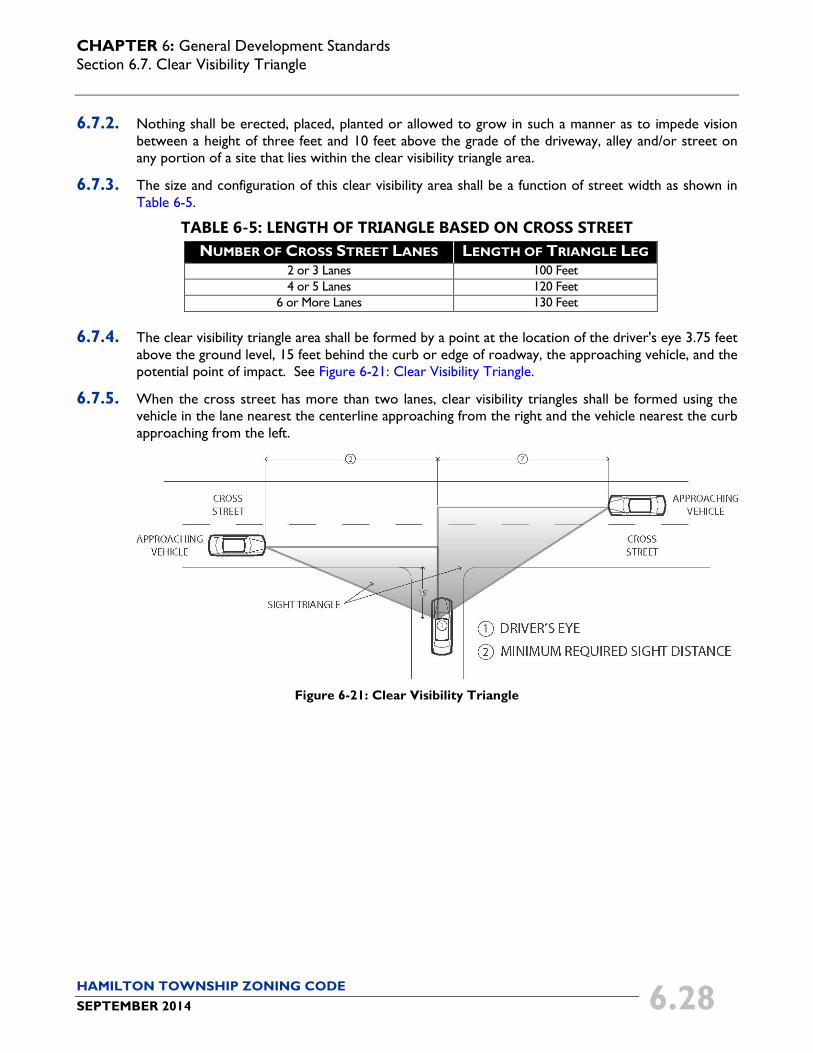
6.7.3. The size and configuration of this clear visibility area shall be a function of street width as shown in Table 6-5.
TABLE 6-5: LENGTH OF TRIANGLE BASED ON CROSS STREET NUMBER OF CROSS STREET LANES LENGTH OF TRIANGLE LEG
2 or 3 Lanes 100 Feet 4 or 5 Lanes 120 Feet
6 or More Lanes 130 Feet
6.7.4. The clear visibility triangle area shall be formed by a point at the location of the driver's eye 3.75 feet above the ground level, 15 feet behind the curb or edge of roadway, the approaching vehicle, and the potential point of impact. See Figure 6-21: Clear Visibility Triangle.
6.7.5. When the cross street has more than two lanes, clear visibility triangles shall be formed using the vehicle in the lane nearest the centerline approaching from the right and the vehicle nearest the curb approaching from the left.
Figure 6-21: Clear Visibility Triangle