chapter 6 — vegetated buffers - elizabethton ... tennessee water quality bmp manual chapter 6:...
TRANSCRIPT

Northeast Tennessee Water Quality BMP Manual
Page 6-i
Table of Contents
CHAPTER 6 — VEGETATED BUFFERS 6.1 Introduction ................................................................................................ 6-1 6.2 Minimum Requirements ............................................................................. 6-1 6.2.1 General ...................................................................................................6-1 6.2.2 Applicability ...............................................................................................6-2 6.2.3 Width ....................................................................................................6-3 6.2.4 Vegetation .................................................................................................6-4 6.2.4.1 Minimum Requirements ....................................................... 6-4 6.2.4.2 Vegetation Restoration ...............................................................6-5 6.2.4.3 Vegetation Maintenance and Buffer Disturbances .....................6-7 6.2.4.4 Additional Guidance on Buffer Vegetation and Restoration .......6-8 6.2.5 Buffer Use Restrictions..............................................................................6-8 6.2.5.1 Prohibited Uses ..........................................................................6-8 6.2.5.2 Allowed Uses ..............................................................................6-9 6.2.6 Protection of Vegetated Buffers...............................................................6-10 6.2.6.1 During Construction..................................................................6-10 6.2.6.2 After Construction .....................................................................6-11 6.2.6.3 Signage.....................................................................................6-11 6.2.7 Percent TSS Removal .............................................................................6-11 6.3 Level Spreaders....................................................................................... 6-11 6.3.1 Description...............................................................................................6-11 6.3.2 Design Standards ....................................................................................6-13 6.4 Considerations for Buffer Areas............................................................... 6-14 6.5 References .............................................................................................. 6-16
Chapter 6 – List of Figures FIGURE # TITLE Page #Figure 6-1a Example Buffer Width Measurement – Top-of-Bank .................................6-3 Figure 6-1b Example Buffer Width Measurement – Stream Centerline .......................6-4 Figure 6-2 Example Buffer Width Measurement – Normal Pool Elevation .................6-4 Figure 6-3 Example of a Streamside Vegetated Buffer ..............................................6-6 Figure 6-4 Level Spreader ........................................................................................6-12
Chapter 6 – List of Tables TABLE # TITLE Page #Table 6-1 Level Flow Spreader Dimensions............................................................6-13
Chapter 6: Vegetated BuffersFebruary 2008

Northeast Tennessee Water Quality BMP Manual
Page 6-ii
This page left intentionally blank
Chapter 6: Vegetated BuffersFebruary 2008

..CHAPTER..
6
Chapter 6: Vegetated Buffers Page 6-1 February 2008
VEGETATED BUFFERS
6.1 Introduction The purpose of this section is to define requirements for vegetated buffers and to enable cities that use this manual to comply with the requirements of the State of Tennessee’s NPDES MS4 permit. In this manual, a vegetated buffer is defined as:
A use-restricted vegetated area of existing vegetation, or enhanced or restored vegetation, that is located along the perimeter of streams, ponds, lakes or wetlands, containing natural vegetation and grasses.
The intent of the vegetated buffers required by this manual is to provide a vegetation anchor for streambanks, pond and lake shorelines and wetland boundaries, thus decreasing sediment loads that originate from eroding banks, and to provide canopy to shade streams, protecting them from thermal impacts. Buffers that are wider than the minimum width required by this manual are able to provide other, greater benefits to streams and other waterbodies such as protection from pollutants carried in stormwater runoff, providing habitat for wildlife, providing areas for runoff control and flood storage. Therefore, incentives to expand buffer widths and vegetation schemes in order to increase the functions provided by the buffers and heighten the overall water quality and flood benefits are provided in this chapter and in Chapter 5.
The policies that are stated in sections 6.2 and 6.3 shall be considered the minimum requirements to comply with the local ordinance that contains the vegetated buffer requirement.
6.2 Minimum Requirements 6.2.1 General The following requirements shall apply to all vegetated buffers.
1. The local jurisdiction may invoke more stringent requirements for vegetated buffers than the minimum standards stated in this chapter for streams designated by the State of Tennessee as impaired or high quality waters, to comply with a State or Federal permit or a Total Maximum Daily Load (TMDL), in areas identified by the local jurisdiction as “hotspot areas”, or if the land adjacent to the buffer includes any of the uses or activities listed below:
b) Drainfields from on-site sewage disposal and treatment system (i.e., a septic system), subsurface discharges from a wastewater treatment plant, or land application of biosolids or animal waste.
c) The storage of hazardous substances or petroleum facilities.
d) Raised septic systems or animal feedlot operations.
e) Solid waste landfills, junkyards, or other areas identified by the local jurisdiction as pollutant hotspots.
2. The vegetated buffer shall be managed and maintained to protect the intended functions of the buffer as stated in this chapter.
3. Stormwater runoff that is intended for discharge to the vegetated buffer shall be discharged as

Northeast Tennessee Water Quality BMP Manual
Chapter 6: Vegetated Buffers Page 6-2 February 2008
sheet flow. In order to claim the stream and vegetated buffers WQv reduction, a level spreader must be used to distribute all channelized flow that enters the buffer into sheet flow prior to discharging into the buffer area. The level spreader must be effective for the 1-year 24-hour water quality design storm; flows from storms larger than this value can bypass the level spreader in channels or pipes. Water that has already been treated to meet the 80% TSS removal standard can bypass the buffer in a pipe or channel. The local jurisdiction will provide guidance on design of outlets that will remain stable and not cause channel erosion. More information on level spreaders can be found in section 6.3.
4. A vegetated buffer area shall be placed into a permanent water quality easement that is recorded with the deed to the parcel and held by the local jurisdiction where the buffer is located.
5. Vegetated buffer areas shall be maintained through the declaration of a protective covenant, which must be approved and shall be enforceable by the local jurisdiction where the buffer is located. The covenant shall be recorded with the deed and shall run with the land and continue in perpetuity.
6. The vegetated buffer shall be use- and disturbance-restricted, and kept free from clearing, grading, filling, waste dumping, paving and building activities of nearby site development in accordance with the requirements stated in this chapter.
7. All areas of the vegetated buffer, including streambanks, shall be left in a stabilized condition upon completion of construction, restoration, enhancement or maintenance activities. No actively eroding, bare or unstable areas shall remain, unless approved by the local jurisdiction. No actively eroding, bare, or unstable vertical stream banks shall remain unless the Tennessee Department of Environment and Conservation (TDEC) has determined there is no better alternative. Placement of riprap and other hard armor is only allowed when it has been shown by the property owner that vegetative alternatives, such as bioengineered stabilization, are not feasible.
8. The property owner is responsible for obtaining all required State and Federal permits prior to performing work in and around Waters of the State.
9. Permanent boundary markers, in the form of signage approved or provided by the local jurisdiction where the buffer is located may be required to mark the limits of the vegetated buffer. The developer or property owner should contact the local jurisdiction to determine if boundary markers are required. If so, such markers shall be installed prior to recording of the final plat, and the issuance of a Certificate of Occupancy. Permanent boundary markers that have been removed or destroyed must be replaced.
10. The property owner is responsible for the maintenance and perpetual protection of the buffer area.
11. The State of Tennessee requires vegetated buffers during construction activities via provisions contained in the Tennessee Construction General Permit (CGP) or other regulatory permits and processes. The State’s requirements may, or may not, align with the policies stated in this chapter. The developer or property owner should check with the local jurisdiction to determine if there are conflicts with any State or Federal buffer requirements.
6.2.2 Applicability Vegetated buffers are required for all new developments and redevelopments that must submit a Water Quality Management Plan. In general, buffers are not required:
• around the perimeter of ponds that have no known connection to streams, other ponds, lakes or wetlands; or,

Northeast Tennessee Water Quality BMP Manual
Chapter 6: Vegetated Buffers Page 6-3 February 2008
• for BMPs that are designed, constructed and maintained for the purposes of stormwater quality and/or quantity control, unless expressly required by the design standards and criteria for the facility that are provided in this manual. However, designed vegetated filter strips that are constructed per the requirements stated in Chapter 4 of this manual can be considered as a pre-treatment measure for stormwater runoff entering such facilities.
6.2.3 Width Vegetated buffers shall have a minimum width of twenty-five (25) feet. The local jurisdiction may require a wider width for buffers in accordance with policy #1 listed in section 6.1 of this chapter. Properly designed and managed buffers of fifty-feet (50) feet or greater width may qualify for a WQv reduction and TSS removal of 80%. The stream and vegetated buffer reduction is discussed in Section 5.2.5.
The width of the vegetated buffer shall be measured in the following manner:
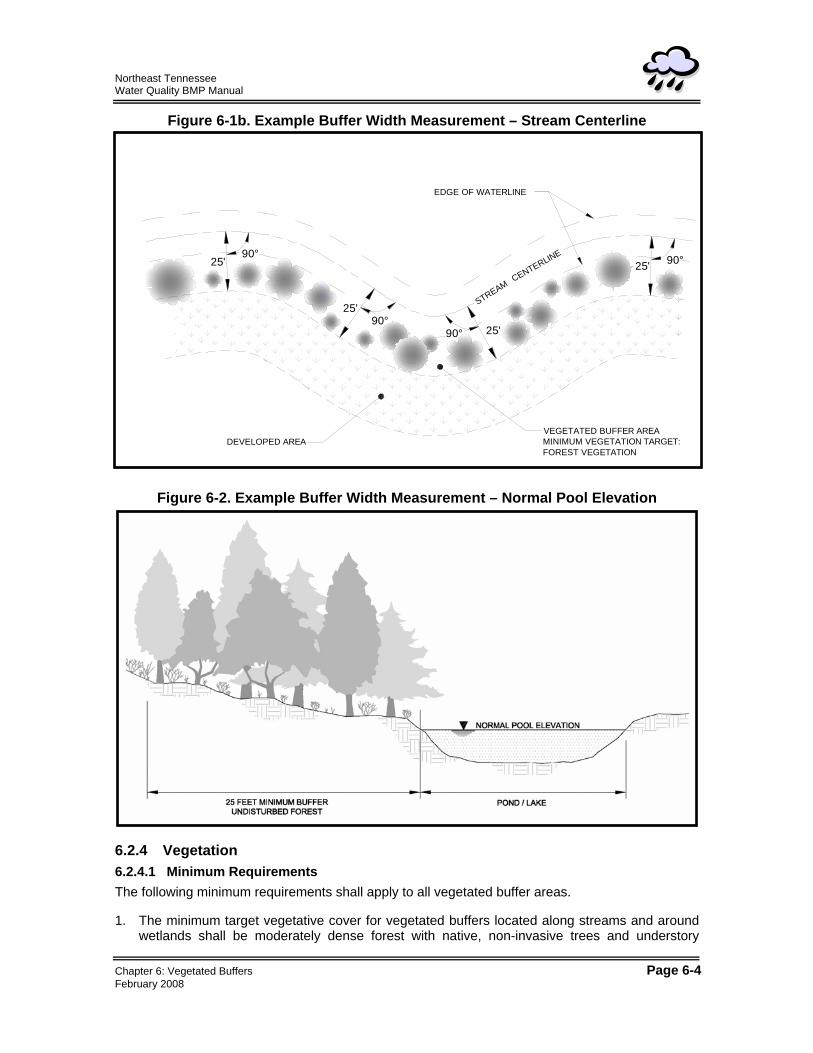
• For streams, the buffer shall be measured perpendicular from the top-of-bank of the active channel. For those streams that do not have a clearly defined top-of-bank, the buffer shall be measured perpendicular from the centerline of the stream. Examples of these measurements are shown in Figures 6-1a and 6-1b.
• For wetlands, the buffer shall be as measured from the outermost edge of the wetland as determined by USACE, NRCS, or TDEC.
• For ponds and lakes, the buffer shall be measured perpendicular landward from the topographic contour that defines the normal pool elevation, as shown in Figure 6-2.
Figure 6-1a. Example Buffer Width Measurement – Top-of-Bank
STREAM
TOP OF STREAM BANK
VEGETATED BUFFER AREA25' MINIMUM WIDTH
MINIMUM VEGETATED TARGET:FOREST VEGETATION
90°
90°
90°
90°
90°25'
25' 25'
25'
25'
STREAM
DEVELOPED AREA
Northeast Tennessee Water Quality BMP Manual
Chapter 6: Vegetated Buffers Page 6-4 February 2008
Figure 6-1b. Example Buffer Width Measurement – Stream Centerline
STREAMCENTERLINE90°
25'
90°25'
90° 25'
90°25'
VEGETATED BUFFER AREAMINIMUM VEGETATION TARGET:FOREST VEGETATION
EDGE OF WATERLINE
DEVELOPED AREA
Figure 6-2. Example Buffer Width Measurement – Normal Pool Elevation
6.2.4 Vegetation 6.2.4.1 Minimum Requirements The following minimum requirements shall apply to all vegetated buffer areas.
1. The minimum target vegetative cover for vegetated buffers located along streams and around wetlands shall be moderately dense forest with native, non-invasive trees and understory

Northeast Tennessee Water Quality BMP Manual
Chapter 6: Vegetated Buffers Page 6-5 February 2008
vegetation that provides ground coverage over one-hundred percent (100%) of the buffer area. Understory vegetation must consist of native woody shrubs or dense grasses or a grass/shrub combination. Along streams, trees and other woody vegetation must exist at a density suitable to provide shade for the stream and stabilize stream banks. If the vegetated buffer area can be characterized as an early successional forest at the time of development, consisting of a combination of grasses, vines, shrubs, trees or tree saplings that has the potential to meet the vegetative target upon maturation, vegetative restoration or enhancement of the buffer area (see #6 below) will not be required provided that the vegetation appears healthy, provides adequate ground coverage, and consists largely of native and non-invasive species.
2. The minimum target vegetative cover for buffers located around ponds and lakes shall be dense, native grasses that provide vegetative cover for one-hundred percent (100%) of the buffer area.
3. Increased use of trees, shrubs and understory vegetation beyond the minimum requirements stated in this section is strongly encouraged to promote infiltration and filtration of stormwater runoff. For maximum benefit to the buffered waterbody, the vegetated buffer area should remain undisturbed and be planted entirely with native vegetation, which will minimize or eliminate the need for vegetative maintenance. Additional information on water quality benefits and incentives to go beyond these minimum requirements is provided in section 6.4.
4. Bare spots, areas of erosion, or landscaped areas that contain mulch, rock, or other landscaping materials are prohibited within the vegetated buffer area.
5. Impervious materials are prohibited within the vegetated buffer area, except those associated with the approved uses defined in section 6.2.5 below.
6. Vegetative restoration or enhancement of the buffer area may be required if:
a) construction or significant vegetation maintenance is planned in the vegetated buffer area;
b) streambank instability or erosion is evident in the area of the buffer;
c) the vegetation that exists in the buffer area at the time of development or redevelopment of the property does not conform to the vegetative requirements stated in this section, or does not meet the intent of the buffer (i.e., to stabilize streambanks or provide shade) but could reasonably provide these benefits if restoration occurred;
d) the buffer area has significant populations of non-native and/or invasive plan species; or,
e) the buffer area has significant areas of unhealthy, damaged, diseased or dead vegetation.
Figure 6-3 presents an example of meeting a vegetative target for a buffer located on a stream.
6.2.4.2 Vegetation Restoration Vegetative restoration or enhancement of a buffer area that is initiated by the property owner or developer may require prior approval by the local jurisdiction. Alternately, the local jurisdiction may require the property owner to enhance or restore an existing buffer if the buffer area does not meet, or will not meet through natural vegetative succession, the standards necessary for the intended use of the buffer (e.g., provide stream canopy, provide stormwater filtration). All enhancement and restoration efforts shall conform to the following requirements.
1. Restoration activities must be performed in accordance with any and all applicable Federal, State and local permits.

Northeast Tennessee Water Quality BMP Manual
Chapter 6: Vegetated Buffers Page 6-6 February 2008
Figure 6-3. Example of a Streamside Vegetated Buffer
2. Newly planted vegetation shall be native, riparian species.
3. All areas of the buffer being restored must be planted with vegetation that is appropriate to achieve the vegetative targets stated in section 6.2.4.1 above.
4. All areas of the buffer being restored must be stabilized against erosion.
5. Areas that will consist largely of grasses after restoration must be seeded at a rate sufficient to provide healthy, dense, permanent vegetative cover for 100% of the area within one growing season. Mulch, pebbles, wood chips and other non-vegetative ground cover is not acceptable for buffer restoration.
6. Where the removal of vegetation would cause a reduction in the amount of stream canopy by 50% or more, revegetation with native plants is required to provide the cover of the previous canopy at a minimum. For areas where such vegetation removal would cause a reduction in the amount of streambank vegetation, revegetation with native plants is required to return the amount of vegetative cover to its previous state, at a minimum. To reduce the potential for streambank erosion, revegetation measures along streambanks must include sufficient erosion control measures, such as turf reinforcement mats, erosion control blankets, straw wattles, to stabilize the area in the short and long term.
7. To increase the chances for the health of the vegetation in the buffer area, the plant species, density, placement, and diversity of the vegetation to be placed in the buffer must be appropriate for stream, wetland, and pond/lake buffers to achieve the vegetative target that is defined for the buffer in section 6.2.4.1 above, either as restored or through natural succession. Planting and long-term maintenance practices must also be appropriate and properly performed.
8. When enhancement or restoration is required by the local jurisdiction, a Buffer Restoration Plan must be prepared and submitted with the Water Quality Management Plan. The Buffer Restoration Plan shall contain the following contents, at a minimum.
b) Basic application information, including:
i) a description of the need for the buffer restoration;

Northeast Tennessee Water Quality BMP Manual
Chapter 6: Vegetated Buffers Page 6-7 February 2008
ii) the dates of the development of the buffer enhancement plan and date of any revisions;
iii) location map showing the property in relation to adjacent properties, streets, and nearby watercourses;
iv) name, address, email address, and phone number of property owner; v) name, address, email address, and phone number of the applicant, if different from
the property owner. c) If the Buffer Restoration Plan is submitted as a component of a Water Quality
Management plan, a the plan should show the location of the buffer(s) in relation to the existing or planned development and to any streams, wetlands, lakes or ponds. The plan should display the area proposed for restoration, showing the limits of disturbance, grubbing, and grading (if permitted).
d) Best management practices for erosion prevention and sediment control during the vegetation restoration or enhancement.
e) Any existing or proposed stream crossings or buffer encroachments. Copies of state and/or federal permits allowing the crossing or encroachment, if applicable.
f) Description and/or drawings indicating the species and density of proposed vegetation, in accordance with the vegetation requirements stated in this chapter. Vegetation mortality must be accounted for all planting densities that are proposed.
g) Descriptions and/or drawings indicating the planting practices that will be employed.
h) Maintenance and monitoring plan for one full growing season, including specification of proposed watering plans and schedule.
i) An implementation schedule for buffer restoration activities. This schedule should be presented in relation to other site grading/construction activities, if such other activities will occur during buffer restoration.
j) One (1) year after completion of the restoration or enhancement activity, the portion of the construction bond that is covered under the Buffer Restoration Plan can be released provided that the enhancement area has been restored or enhanced as required, that soils within the buffer area are stable, and that buffer vegetation is healthy.
6.2.4.3 Vegetation Maintenance and Buffer Disturbances Maintenance of the vegetation located in a buffer area can be performed without prior approval by the local jurisdiction. Management and maintenance of the vegetated buffer includes specific limitations on the alteration of vegetated conditions. The following vegetation management activities are allowed, provided that soil disturbance is minimized and the intended functions of the vegetated buffer area are preserved:
1. The removal or planting of individual trees or vegetation as needed to maintain the overall health and function of vegetation in the buffer area. The removal of non-native, nuisance vegetation, or the removal of individual trees that are in danger of falling and causing damage to dwellings or other structures, are dead or diseased, or have been heavily damaged by storms. Root wads or stumps should be left in place, where feasible, to maintain soil stability.
2. The limited pruning of trees and woody vegetation provided that the health and function of the vegetated buffer area are not compromised.
3. Minor landscaping to repair erosion, bare spots, or sparsely-vegetated areas.

Northeast Tennessee Water Quality BMP Manual
Chapter 6: Vegetated Buffers Page 6-8 February 2008
4. Infrequent ground cover maintenance activities such as weed-eating. Such activities should be minimized and must not result in the removal (either temporary or permanent) of ground cover vegetation.
5. Disturbances necessary for the construction of allowable uses, as defined in section 6.2.5. Approval of a Buffer Restoration Plan by the local jurisdiction is required prior to any construction activity in a vegetated buffer area.
6. Disturbances as required to establish and/or restore buffer areas in accordance with section 6.2.4.2.
7. Grubbing, clearing, bush-hogging, and other mass vegetation removal activities are prohibited without prior approval of a Buffer Restoration Plan. When the removal of vegetation would cause a reduction in the amount of stream canopy by fifty percent (50%) or more, re-vegetation with native plants is required for the entire area where the canopy was removed. For areas where such vegetation removal would cause a reduction in the amount of stream bank vegetation, re-vegetation with native plants is required to meet the previous coverage.
8. The application of herbicides, pesticides, and fertilizers in a buffer area is prohibited. 6.2.4.4 Additional Guidance on Buffer Vegetation and Restoration More detailed guidance and information on streambank and buffer restoration techniques, plants and planting guidelines and native plant species can be found from the following sources:
• Tennessee Valley Authority’s Riparian Restoration webpage, located at www.tva.com/river/landandshore/stabilization/index.htm
• Tennessee Valley Authority’s Native Plant Finder webpage, located at www.tva.com/river/landandshore/stabilization/plantsearch.htm;
• Banks and Buffers: A guide to selecting native plants for streambanks and shorelines. Contact information to obtain this publication is provided at www.tva.com/river/landandshore/stabilization/websites.htm;
• Knoxville-Knox County Tree Conservation & Planting Plan, published by MPC and available at www.knoxmpc.org
• the Tennessee Exotic Plant Pest Council website, located at www.tneppc.org; and
• the Natural Resource Conservation Service (NRCS). The introduction or propagation of plants considered as nuisance, non-native (also termed “exotic”) and/or invasive plant species, such as honeysuckle, privet, ivy and kudzu is strongly discouraged near the buffer area. In addition, such plants are prohibited from being planted in a buffer area, as part of restoration or maintenance. Guidance on non-native species in Tennessee can be found at the Tennessee Exotic Plant Pest Council website, located at www.tneppc.org.
6.2.5 Buffer Use Restrictions 6.2.5.1 Prohibited Uses The following uses or activities are prohibited within vegetated buffers:
1. Spraying, filling, dumping, and animal grazing;
2. Use, storage, or application of pesticides, herbicides, fertilizers, or household or commercially-generated wastes;
3. Concentrated animal lots or kennels;

Northeast Tennessee Water Quality BMP Manual
Chapter 6: Vegetated Buffers Page 6-9 February 2008
4. The storage of motorized vehicles, except for temporary parking associated with maintenance of the buffer or allowed use areas, or emergency use;
5. Creation of impervious surfaces, except for those included in approved stream crossings or other approved uses
6. Other uses as deemed by the local jurisdiction to have the potential to generate higher-than-normal pollutant loadings.
6.2.5.2 Allowed Uses The following structures or uses are allowed in the vegetated buffer area, subject to the prior approval of the local jurisdiction and the specific design or maintenance features listed for each approved use.
1. Stream crossings, water access structures (i.e., docks), and utilities/utility access areas. The following requirements shall apply to such areas:
a) An analysis must be conducted to show that there is no economically-feasible alternative to the proposed use.
b) The right-of-way or access area width and length must be the minimum needed to allow maintenance access and installation.
c) The angle of a buffer crossing shall be within 15 degrees of perpendicular to the stream or buffer in order to minimize clearing requirements. A deviation from perpendicular up to 15 degrees may be allowed through administrative approval from the local jurisdiction if it is determined that there is no other viable alternative.
d) The number of buffer crossings shall be minimized within each development, and no more than one (1) crossing is allowed for every 1,500 feet linear feet of vegetated buffer. Additional crossings may be approved by the local jurisdiction if justified by traffic, safety, or access issues. Where possible, the design of roadways and lots within a development should be arranged so that all streams are either to the rear or side of individual lots, and never along the front of lots.
2. Trails, greenways or bike paths. The following requirements shall apply to such areas:
a) Tree canopy must be preserved;
b) The maximum width of the path must not exceed 10’;
c) The minimum distance between the top of the streambank and the trail or path is 10’.
3. Stream restoration projects, facilities and activities;
4. Conservation uses, wildlife sanctuaries, nature preserves, forest preserves, fishing areas, and passive use areas such as parks, picnic areas, and yards as long as they do not have impervious surfaces. Passive use areas are defined as private or public use areas that do not require hardened, impervious surfaces to be constructed. Passive recreation areas do not include golf courses, ball fields that require the construction of impervious surfaces or the maintenance of open soil areas (such as baseball infields), picnic shelters or parking. The following requirements shall apply to all conservation and passive use areas:
a) The removal of trees and woody understory vegetation shall be minimized and shall under no circumstances affect the ability of the buffer to function as intended.
b) Asphalt, concrete, packed gravel, and other impervious paving surfaces are prohibited. Note, a variance to this requirement may be granted for trails, greenways or bike paths

Northeast Tennessee Water Quality BMP Manual
Chapter 6: Vegetated Buffers Page 6-10 February 2008
that are being linked to public use trails, greenways or bike paths or are included as part of redevelopment of previously developed land. Such variance shall be subject to the following requirements:
i. Any impervious surface must be used solely for pedestrian or bicycle access/use, no car traffic is allowed.
ii. There must be no reduction of tree canopy of the buffer area. Trees and vegetation destroyed for purposes of the pathway must be replanted within the buffer area.
iii. The maximum width of the impervious surface shall be 10-feet. The use of gravel, other semi-permeable materials, or pervious pavement for the trail or bike path are encouraged.
iv. The minimum distance of the streamside edge of the pathway to the top of bank or edge of the stream (or other waterbody) is one-half the width of the buffer. For example, for a buffer having a width of 25 feet, the pathway could be located no closer than 12.5 feet from the top bank or edge of the stream.
c) Picnic facilities shall be limited to picnic benches and trash receptacles. Roofed enclosures, paved or landscaped picnic pads, and grills/fire pits are prohibited.
d) Educational signs about the buffer area, vegetation, or function are encouraged in picnic areas and pathways that are placed in vegetated buffers located in common areas or on public lands. The local jurisdiction may assist property owners with such signage (see section 6.2.6.3 for more information).
e) Where traffic safety or access to allowed use areas as defined above would be negatively affected by the presence of trees and wood vegetation required by this chapter, areas immediately-surrounding allowed use areas shall be vegetated with dense, native grasses.
6.2.6 Protection of Vegetated Buffers Buffers must be protected prior to, during, and perpetually after construction in order to prevent stream bank erosion and protect the stream from thermal impacts. Buffer areas must remain protected from land disturbance, vegetation removal, construction of impervious surfaces, and discharges of sediment and other construction-related wastes during development activities. 6.2.6.1 During Construction The following requirements shall be applied during clearing, grading and construction of the new development or redevelopment: 1. Unless otherwise provided herein, all areas that are required to be designated as vegetated
buffers after construction has been completed shall remain protected from land disturbance, vegetation removal, construction of impervious surfaces, and discharges of sediment and other construction-related wastes during development activities.
2. Vegetated buffers shall be clearly identified on all construction drawings, and marked with the statement “Vegetated Buffer Area. Do not disturb.”
3. During construction vegetated buffers must be cordoned-off with a highly visible barrier, such as orange construction fencing, and cannot be encroached upon or disturbed unless they are being established, restored, or enhanced. Encroachments and disturbances caused by buffer enhancement and restoration efforts shall be minimized to the maximum degree possible.

Northeast Tennessee Water Quality BMP Manual
Chapter 6: Vegetated Buffers Page 6-11 February 2008
4. Where the requirements of this chapter and another regulation, such as the State of Tennessee General NPDES Permit for Discharges of Stormwater Associated with Construction Activities, conflict or overlap, the regulation that is more restrictive or imposes higher standards or requirements shall prevail.
6.2.6.2 After Construction Once construction has ceased on a project, the vegetated buffer must be maintained in accordance with the recorded Covenants for Maintenance of Stormwater Facilities and Best Management Practices. In order to provide for long-term protection and maintenance, it is required that the vegetated buffer be protected in perpetuity by placing the buffer in a permanent water quality or other easement that is recorded with the property’s deed. The property owner is responsible for the maintenance and protection of the buffer area.
6.2.6.3 Signage Permanent boundary marker signs may be required by the local jurisdiction prior to recording the final plat or issuance of a Certificate of Occupancy to ensure that adjacent property owners are aware of the buffer. Further, replacement of such boundary markers that have been removed or destroyed may be required by the local jurisdiction. The following general policies shall apply to buffer boundary markers:
1. Generally, buffer boundary markers must be located on the lot lines at the intersection of the landward edge of the buffer, and at other locations which will approximately delineate the buffer boundary. For single lot site developments, markers, if required, shall be posted every 100 feet along the buffer boundary. For subdivisions where multiple lots are located along the buffer, it is recommended that a buffer boundary marker be located at the intersection of every other lot line with the landward edge of the buffer.
2. Buffer boundary markers shall include the statement “Vegetated Buffer Area. Do not disturb.”
3. Where possible, the markers should be mounted on a tree larger than three (3) inches in diameter. Where it is not possible to mount the marker to a tree, a treated wood, metal, or plastic signpost must be used. The post must extend below the ground surface at least twenty-four (24) inches.
4. The boundary markers must be mounted between four (4) and six (6) feet above the ground surface.
6.2.7 Percent TSS Removal Vegetated buffers that have been established, restored, and/or preserved in accordance with the requirements of this Chapter can be used towards the required, calculated percent TSS removal of stormwater runoff that discharges through the buffer as sheet flow. Policies and guidance associated with the calculation of percent TSS removal are contained in Chapter 3 of this manual. Per Chapter 5, section 5.2.6, of this manual, sheet flow to vegetated buffers that meet the minimum requirements can receive an 80% TSS removal calculated value. Stormwater that has already been treated to the 80% TSS removal standard can bypass the buffer in a pipe or channel. The local jurisdiction will provide guidance on design of outlets that will remain stable and not cause channel erosion.
6.3 Level Spreaders 6.3.1 Description Level spreaders are structures that are designed to dissipate energy of concentrated, potentially erosive, flow and distribute it as low velocity sheet flow uniformly over a stabilized, typically vegetated, area. The resultant sheet flow has a high surface contact area and therefore enhances

Northeast Tennessee Water Quality BMP Manual
Chapter 6: Vegetated Buffers Page 6-12 February 2008
infiltration and pollutant filtration and reduces the potential for soil erosion. This process of transitioning concentrated flows of stormwater runoff into sheet flow is essential for maintaining the function and effectiveness of vegetated buffers. Engineering detail of a typical level spreader is shown in Figure 6-4.
Figure 6-4. Level Spreader (Source: City of Knoxville Land Development Manual, January 2001)
VEGETATION
JUTE NET OR EXCELSIOR MAT STAPLED IN PLACE AND
ANCHORED 6" INTO GROUND
ENTRANCE WIDTH
6' MINIMUM WIDTH
2:1 (H:V) OR FLATTER
LEVEL SPREADER - VEGETATED LIP
MINIMUM DEPTH
MAXIMUM10% SLOPE
LEVEL LIP FOR SPREADER(SEE NOTE 1)
FLOW
SECURE WIRE MESH OR GABION TO RIGID LIP MATERIAL
COARSE AGGREGATE IN GALVANIZIED WIRE
BASKET OR GABION
SECURE WIRE BASKET OR GABION TO GROUND
WITH STAKES
ENTRANCE WIDTH
6' MINIMUM WIDTH
MINIMUM DEPTH
RIGID LIP MATERIAL(TYPICALLY LANDSCAPE TIMBERS)
#4 REBARS AT REGULAR INTERVALS TO ANCHOR LANDSCAPE TIMBERS
LEVEL SPREADER - RIGID LIP
2:1 (H:V) OR FLATTER
MAXIMUM10% SLOPE
END WIDTHGEOTEXTILE
FILTER CLOTH
ENTRANCEWIDTH
LENGTH =10' TO 30'
SEE NOTE 2
TYPICAL LAYOUTNOT TO SCALE
NOTES:
1. VEGETATED LIP FOR LEVEL SPREADER SHOULD NOT BE CONSTRUCTED FROM FILL MATERIAL. DO NOT ALLOW ANY TRAFFIC (EVEN RIDING MOWERS) ONTO VEGETATED LIP.
2. THE LAST 20' OF APPROACH CHANNEL SHOULD HAVE A GRADE LESS THAN 1%.
Level spreader primary applications: • to disperse shallow concentrated or channelized stormwater runoff from impervious areas or
upstream stormwater outfalls to a water quality BMP, such as a filter strip, water quality or other buffer, or other vegetated area; or,

Northeast Tennessee Water Quality BMP Manual
Chapter 6: Vegetated Buffers Page 6-13 February 2008
• for land draining to vegetated buffers that has more than a three percent (3%) slope: or, • for outlet diversion (i.e., the release of small volumes of concentrated flow from diversions
when conditions are suitable).
Level spreader design elements: • A pipe, ditch, or swale through which concentrated flow enters the spreader; • An energy dissipator that slows the water; • A level lip provided by the construction of a berm, concrete chute, or other permanent material
or a shallow linear trench. The purpose of this component is to distribute runoff perpendicularly over the lip or through the trench at the same depth for the entire length of the spreader.
6.3.2 Design Standards Level spreaders are difficult to construct properly, and therefore a high degree of care must be taken to construct the spreader lip completely level. A spreader lip that slopes to one side or has notches or depressions along its length will result in concentrated flow discharging over the lip, defeating the purpose of the spreader. Improperly designed level spreaders can reduce the effectiveness of filter strips and buffer areas to remove pollutants by filtering of runoff, and can increase the potential for erosion in vegetated areas to which the level spreader discharges.
All level spreaders shall conform to the design standards listed below.
For impervious surface runoff applications: • The capacity for the level spreader is determined in the design of the structural BMP or
vegetated buffer to which it discharges. Design guidance for structural BMPs is presented in Chapter 4.
• The spreader shall run linearly along the entire length of the BMP to which it discharges or along the stream/wetland/pond. In most cases, the spreader will be the same width as the contributing impervious surface. The ends of the spreader shall be tied into higher ground to prevent flow around the spreader.
For all level spreader applications: • The capacity of the level spreader shall be determined using the peak flow from the 1-year,
24-hour storm. The drainage area shall be restricted so that maximum flows into the spreader will not exceed 30 cfs.
• The minimum depth shall be 6-inches and the minimum width shall be 6 feet for the lower side slope.
• Side slopes shall be 2:1 (horizontal to vertical) or flatter. • The grade of the spreader shall be 0%. • The appropriate length, width, and depth of spreader should be selected from Table 6-1.
Table 6-1. Level Flow Spreader Dimensions (Source: City of Raleigh, 2002)
Design Flow (cfs)
Minimum Entrance Width
(ft) Minimum Depth
(ft) Minimum End
Width (ft) Minimum
Length (ft)
0-10 10 0.5 3 10 10-20 16 0.6 3 20 20-30 24 0.7 3 30

Northeast Tennessee Water Quality BMP Manual
Chapter 6: Vegetated Buffers Page 6-14 February 2008
• It will be necessary to construct a 20 foot transition section in the diversion channel (formed by the diversion berms) so the width of the channel will smoothly meet the width of the spreader to ensure uniform outflow.
• The last 20 feet of the diversion channel shall provide a smooth transition from the channel grade to the level spreader and where possible, shall be less than or equal to 1%.
• The receiving area below the level spreader shall be protected from harm during construction. Minor disturbed areas shall be stabilized with vegetative measures. A temporary stormwater diversion may be necessary until the vegetation on the level spreader has fully stabilized.
• Level spreaders must blend smoothly into the downstream receiving area without any sharp drops or irregularities, to avoid channelization, turbulence and hydraulic “jumps.”
• Level spreaders shall be constructed on undisturbed soil where possible. If fill is used, it shall be constructed of material compacted to 95% of standard proctor test levels for that area not considered the seedbed.
• Immediately after level spreader construction, seed and mulch the entire disturbed area of the spreader.
• The level spreader lip shall be protected with erosion resistant material to prevent erosion and allow vegetation to be established.
6.4 Considerations for Buffer Areas The minimum requirements for vegetated buffers that are presented in section 6.2 are intended to establish, restore and/or protect buffers for the purposes of streambank stabilization and stream canopy. However, going beyond the minimum requirements should be considered by site developers. Wide, forested buffer areas can provide a multitude of benefits to local stream water quality and are one of a number of best management practices (BMPs) that are available to site developers for incorporation into development plans to meet water quality goals.
When properly vegetated and preserved, buffers provide a tool for the improvement of stream water quality and habitat. Research has shown that buffers having significant width (e.g., 50 feet and greater) and appropriate dense vegetation (e.g., forest, woody shrubs and dense grasses) will slow and spread-out stormwater runoff from upstream impervious areas, and will filter sediment and the chemicals and pollutants that attach to sediment particles via the trees, shrubs, and grasses that make up the buffer area (Desbonnet et al. 1994). Further, the trees and other vegetation in a buffer provide shade for the stream and buffer area, allowing stormwater runoff that has been heated on roofed and paved areas to cool before reaching the stream and shading the stream to
protect it from direct sunlight that heats the stream. The temperature of the stream is important for the protection of the organisms that live in the stream. At higher temperatures, water retains less
PURPOSES OF A STREAM BUFFER: • Reduce erosion and stabilize stream banks. • Assist with infiltration of stormwater runoff. • Control sedimentation. • Reduce the effects of flood and drought. • Provide shade to streams. • Provide and protect habitat for aquatic species
and other wildlife. • Offer scenic value and recreational
opportunities. • Restore and maintain the chemical, physical and
biological integrity of water resources. • Minimize public investment in waterway
restoration, stormwater management, and other public water resource endeavors.
Shueler, WPT Summer, 1995
Vegetated Riparian Buffers and Buffer Ordinances, SCDEC

Northeast Tennessee Water Quality BMP Manual
Chapter 6: Vegetated Buffers Page 6-15 February 2008
dissolved oxygen, decreasing the amount available to the aquatic life and resulting in physical stress or death.
Vegetated buffers can also act as a flood and erosion management tool. Buffers slow runoff velocities, increase baseflows, counter channelization of runoff inflows, and reduce inflow volumes through infiltration into the soil and capture in vegetation. These effects can reduce the potential for downstream flooding, and the potential for streambank instability and erosion, both in the buffered area and downstream. Because development in buffered areas is limited, buffers can be helpful for floodplain management, preventing development along the stream edge and, in some cases, the floodplain.
Site developers and design engineers are encouraged to go beyond the minimum requirements stated in this section to protect stream water quality or other environmentally sensitive areas, promote infiltration and filtration of stormwater runoff and provide wildlife habitat. A WQv reduction, called the Vegetated Buffer Reduction, is offered to provide an incentive for wider (50’ or greater), more heavily vegetated buffers that can provide additional water quality benefits. The use of this reduction can decrease the WQv that is required for treatment. Chapter 5 of this manual provides more information on the Vegetated Buffer Reduction.

Northeast Tennessee Water Quality BMP Manual
Chapter 6: Vegetated Buffers Page 6-16 February 2008
6.5 References City of Knoxville. Land Development Manual. City of Knoxville Engineering Department, Stormwater
Division, June 2006. Desbonnet, et al. 1994. Vegetated Buffers in the Coastal Zone. A Summary Review and
Bibliography. Coastal Resources Center, University of Rhode Island. Knox County, Tennessee. Knox County Stormwater Management Manual Volume 2, Chapter 6
Water Quality Buffers. November 2007. Shueler, T. Vegetated Riparian Buffers and Buffer Ordinances. SCDEC, Summer, 1995.