chapter 6 groundwater assessment€¦ · web viewreliance on groundwater is also highly variable...
TRANSCRIPT
CHAPTER 6. GROUNDWATER PROTECTION PROGRAMS/ASSESSMENT
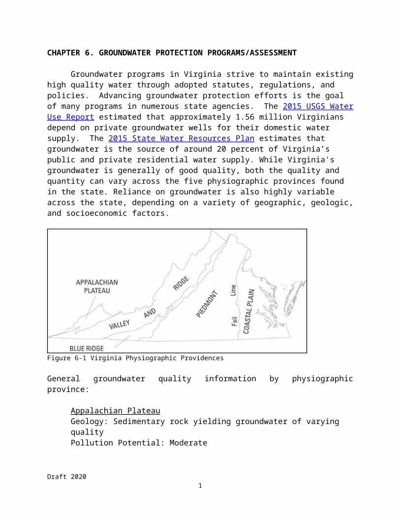
Groundwater programs in Virginia strive to maintain existing high quality water through adopted statutes, regulations, and policies. Advancing groundwater protection efforts is the goal of many programs in numerous state agencies. The 2015 USGS Water Use Report estimated that approximately 1.56 million Virginians depend on private groundwater wells for their domestic water supply. The 2015 State Water Resources Plan estimates that groundwater is the source of around 20 percent of Virginia’s public and private residential water supply. While Virginia's groundwater is generally of good quality, both the quality and quantity can vary across the five physiographic provinces found in the state. Reliance on groundwater is also highly variable across the state, depending on a variety of geographic, geologic, and socioeconomic factors.
Figure 6-1 Virginia Physiographic Providences
General groundwater quality information by physiographic province:
Appalachian PlateauGeology: Sedimentary rock yielding groundwater of varying qualityPollution Potential: ModerateManagement Efforts: documentation and some monitoring of quantity and quality of springs, some limited ambient groundwater quality sampling
Valley & RidgeGeology: Sedimentary rocks including limestone, dolomite, and shalePollution Potential: High in limestone areas where groundwater moves rapidlyManagement Efforts: documentation and some monitoring of quantity and quality of springs, some limited ambient groundwater quality sampling
Blue RidgeGeology: Sedimentary, igneous, and metamorphic rock; well yields are lowPollution Potential: High, because of rapid movement of water in fractures, joints, and bedding planes
Draft 20201
Management Efforts: documentation and some monitoring of quantity and quality of springs, some limited ambient groundwater quality sampling
PiedmontGeology: Diverse geology with a wide range of groundwater quality and availabilityPollution Potential: Low to moderateManagement Efforts: documentation and some monitoring of quantity and quality of springs, some limited ambient groundwater quality sampling
Coastal PlainGeology: Unconsolidated sand, clay, marl, and shell strata; groundwater is abundant and use is highPollution Potential: High, due to geology and population densityManagement Efforts: monitoring of water quality parameters by permittees, limited documentation and monitoring of quantity and quality of springs, some ambient groundwater quality sampling, chloride monitoring strategy
The organizational objective of DEQ’s Groundwater Characterization Program (GWCP) is to protect Virginia’s environment and promote the health and well-being of its citizens by collecting, evaluating, and interpreting technical information necessary to manage groundwater resources of the commonwealth. The commonwealth is divided into three regions to include the Coastal Plain, Piedmont-Blue Ridge, and Valley-Plateau. Each region has a staff geologist assigned to it. Staff assures that necessary information is available to support resource management decisions, water supply planning activities, groundwater availability, drought monitoring, and support the expansion or creation of groundwater management areas. Staff in this program are responsible for monitoring and maintaining the 256 wells in the State Observation Well Network. Staff actively participate in outreach and educational opportunities in order to increase public awareness of the wide range of issues affecting Virginia’s water resources.
Operational objectives of the Groundwater Characterization Program focus on the collection of hydrogeologic and groundwater geochemical data for groundwater resource management needs. When possible, data are collected and published collaboratively with other State and Federal agencies in order to maximize efficiencies and capital. Long-range goals include expansion of the State Observation Well Network, and publication of county and regional groundwater resources reports.
The following paragraphs briefly describe groundwater protection and assessment activities in the commonwealth. Information provided in Tables 6-1, 6-2, 6-3, 6-4 and 6-5 is presented for the commonwealth as a whole.
Regional Groundwater Reports
State Water Control Board (SWCB) geologists compiled 18 groundwater resources reports to document the availability, utilization rates, and water quality of groundwater resources within selected counties and political sub-regions of Virginia. These reports continue to be the
Draft 20202

only readily available source of information pertaining to the occurrence, movement, and availability of groundwater for a large number of the areas initially investigated. Although the majority of these historical reports are out of print, the reports are available upon request.
Recent reporting efforts have focused on groundwater use and availability in the Valley and Ridge, the occurrence of groundwater in the Blue Ridge, further refinement of the Coastal Plain Hydrogeologic framework in the Eastern Shore and the Piney Point Aquifer, and development of a methodology for continuous chloride monitoring in the Coastal Plain. More recently published reports are available electronically on the Virginia DEQ website: https://www.deq.virginia.gov/Programs/Water/WaterSupplyWaterQuantity/GroundwaterCharacterization/ReportsPublications.aspx. Reports published collaboratively with the United States Geological Survey (USGS) are available for download from the USGS website:https://www.usgs.gov/science/regions/northeast/virginia?qt-states_l2_landing_page_tabs=4#qt-states_l2_landing_page_tabs.
Database Integration
In 2015 DEQ’s Office of Water Supply initiated the development of VA Hydro, a web-based platform for water supply planning and analysis in Virginia. VA Hydro is an integrated platform designed to link multiple planning modules pertaining to water resources, such as water withdrawal permitting, water supply planning, water withdrawal reporting, groundwater well registration, and drought monitoring/modeling of both surface water and groundwater. To date, water withdrawal reporting, water withdrawal permit data, private well registration and well construction data, and local water supply planning data, have been migrated to this new system. Modeling components will continue to be migrated into 2020. The databases described below are relevant legacy data sets that have been migrated.
Statewide Well Construction Database
One of DEQ’s goals is to merge the various sources of historical and new well information into one statewide database that can be used for regional analysis of groundwater aquifer systems. Major challenges to this goal include managing data duplication and disparities among multiple data sets and quantifying location accuracy. Efforts to sort and merge this data were completed in 2010. Since 2010, the database has grown from about 35,000 wells to nearly 63,000 wells. Additional wells have originated from a number of data sources including digitized data from water well drillers, the VDH VENIS and SDWIS databases, county specific well databases, and project specific data collected and entered into the database. Despite this database being the largest of its kind in Virginia, it is representative of a fraction of the millions of wells that have been drilled throughout the State. Most wells in Virginia have been and continue to be documented by a paper well completion report, and are unavailable electronically. Currently, the established system for documenting private well construction data outside of the Groundwater Management Areas does not facilitate incorporation into a georeferenced database that could be utilized to better understand local hydrogeologic conditions. For this reason, DEQ continues to encourage the development of a streamlined process for accurately reporting the location and construction details of newly completed wells in a digital format.
Draft 20203

In 2015, the General Assembly amended the Ground Water Management Act of 1992 to require that all new private wells constructed in a Groundwater Management Area must be registered with DEQ. This requirement became effective on July 1, 2016. A number of improvements have occurred with this legislation. DEQ and VDH have worked together on a common set of well construction information to be collected from well drillers and have linked their database tools. DEQ also established an on-line well registration program that allows well drillers to enter the agreed upon information into the on-line database. In addition to these new wells in the Coastal Plain some well drillers are also entering their legacy well construction data and data for wells from outside the GWMA. This allows location and construction information to be collected and ultimately used to better understand the hydrogeology in the commonwealth. As of July 2019, over 6,374 water well completion reports have been submitted online in VA Hydro.
Statewide Legacy Geochemical Database
Staff compiled a master database of legacy ambient water quality data of waters from wells and springs throughout the commonwealth in 2010. In 2014 the database was revised to describe additional geochemical and field collected parameters and to accept recently acquired groundwater sampling data from ambient groundwater monitoring efforts. Ambient water quality data comprising this database includes major ion geochemistry, trace elements, nutrients, radiologicals, and field parameters. Nearly 17,000 samples taken from approximately 8,500 geo-referenced wells and springs are currently in the data set. When combined with location data, ambient water quality samples from wells and springs provide valuable information about the background concentrations of naturally occurring ionic constituents and field parameters of groundwater flow systems. In addition to their value in describing the geochemical conditions within natural groundwater flow systems it is anticipated that these data will be used by municipalities, consultants, and state and federal agencies for a wide variety of applications such as determining the extent and magnitude of elevated ionic concentrations (above background levels) due to groundwater contamination from anthropogenic sources, for predicting chemical and biological interactions due to the contamination of groundwater, and for optimizing well placement to insure high quality drinking water for private residences and municipalities.
State Observation Well (SOW) Program
The DEQ collects data on groundwater levels at 256 wells and the USGS collects data on groundwater levels at 80 wells in the USGS/DEQ Groundwater Level Monitoring Network. One hundred thirty six of the wells in the DEQ/USGS observation well network have been converted to real time monitoring with levels measurements stored once every 15 minutes and uploaded hourly to the USGS server using satellite telemetry technology. Data from the wells in the DEQ/USGS observation well network are published in the Annual Water Data Report. Currently, DEQ/USGS water level data are available on a USGS interactive map browser at http://groundwaterwatch.usgs.gov/statemap.asp?sc=51&sa=VA. This network of wells provides real-time groundwater level data from multiple locations throughout the state. These data are becoming an increasingly important metric for regional water supply planning efforts and drought monitoring forecasts. The information provided by these wells is important for monitoring drought conditions, determining when groundwater recharge actually occurs, and
Draft 20204

monitoring the effects of groundwater withdrawal. Additionally, the groundwater level data collected cooperatively by DEQ and USGS contributes to the calibration of several groundwater flow models developed for management of the resource including the VAHydro-GW (coastal Plain aquifer system), VAHydro-GWES (Eastern Shore), and several small regional scale models built in the western part of the state.
Since 2010, 43 wells have been added to the state observation well network. Most of the additions during this time have occurred in the Coastal Plain for the purpose of monitoring hydraulic heads in the multi-aquifer Coastal Plain groundwater system.
Statewide Spring Database
Since the last IR, staff created a comprehensive statewide spring database that is continually maintained and updated. The database contains basic site information and spring morphology, field measurements and laboratory water quality results necessary to characterize watershed- and regional-scale groundwater flow systems in complex fractured bedrock terrains of western Virginia. As discrete points of groundwater aquifer discharge to surface streams, the data have value to the public, industry and other programs in DEQ that deal with subsurface contaminant transport such as Pollution Response, Petroleum Storage Tanks, and TMDL programs. Working agreements, standardized forms and definitions have been developed by staff that have been used by field personnel in sister agencies such as DCR and DMMR in order to increase the rate of compilation of new springs into this central database containing spring locations, morphology, discharge, and basic geochemistry. As of September 2019, there are almost 1600 springs in the database connected to over 3500 spring visit entries (documenting spring flow rates and/or basic water quality measurements made in the field), and 863 laboratory water quality results.
Geochemical Sampling Program Development
In 2013, staff developed the Ambient Groundwater Quality Monitoring Strategy to serve as a plan for characterizing groundwater geochemical conditions throughout the Commonwealth. This lead to the formation of the Ambient Groundwater Quality Monitoring Program in 2014, which is implemented by a staff member funded through EPA section 106 funding. The strategy document describes the extent of currently available groundwater chemistry data, provides a rationale and methodology for a scientifically defensible distribution of sampling resources, and provides a cost analysis for the full implementation of the sampling strategy. The Ambient Groundwater Quality Monitoring Strategy was finalized in November 2013 after review and input from a variety of federal, state and private organizations and institutions. Additionally, an annual implementation plan is developed detailing the portions of the sampling strategy in each geologic terrain that will be accomplished with respect to that fiscal year’s budgetary considerations. Information about Groundwater Characterization Program documents, including the strategy and FY2019 implementation plan, is available at https://www.deq.virginia.gov/Programs/Water/WaterSupplyWaterQuantity/GroundwaterCharacterization/ReportsPublications.aspx.
Development of the strategy included testing and modification of sampling equipment and
Draft 20205
methodology in order to attain the highest sampling quality control possible in the range of geologic, hydrologic, and well construction conditions encountered throughout the state. Groundwater samples have been collected under this program at selected wells and springs in Virginia since the 2013 calendar year. In that time, over 160 samples have been collected from nearly 100 discrete locations in 32 different cities and counties across the commonwealth. In fiscal year 2020, the Ambient Groundwater Quality Monitoring Program will show this progress by creating an updated sampling density map once proper sample quality control is complete.
In 2019, the Ambient Groundwater Quality Program continued to focus on the collection of groundwater samples from trend wells. Trend wells were selected for sampling on a quarterly basis to monitor for salt water “upconing,” the transient upwelling of salty groundwater that can occur in response to the local removal of non-saline groundwater by supply wells in the Coastal Plain aquifer system. Trend wells were also sampled on a quarterly basis to document chloride concentrations in portions of the Coastal Plain aquifer system that may be vulnerable to upward migration of the fresh water/salt water interface, or the more regional phenomena known as salt water intrusion. Spot sampling occurred in the coastal plain at locations near proposed injection sites in the Potomac Aquifer and at State Observation Wells in the Piney Point aquifer. Other spot sampling focused on the southern Piedmont, around an area of the lowest density sample coverage in the commonwealth.
EPA/DEQ/USGS Cooperative Studies
DEQ continues to cooperate with the USGS on a continuous effort to update and revise the hydrogeologic framework to better manage the groundwater resources of the Virginia Coastal Plain. Since the last IR, GWCP staff has been involved in cooperative efforts with the USGS to characterize the hydrogeology of Virginia’s Eastern Shore. An improved understanding of the hydrogeology of the Eastern Shore is currently required to refine groundwater management strategies associated with sustainable extraction rates as well as regional contaminant fate and transport predictions (including saltwater intrusion). A large component of the research associated with describing the hydrogeology of the Eastern shore is associated with the delineation and hydrologic description of ancient paleochannels (remnants of ancient river beds) that transect the subsurface of the Eastern Shore. These paleochannels are important because they are thought to significantly influence storage and movement within the regional groundwater system. Well cuttings description and interpretation and geophysical borehole log interpretation in the study area helped to delineate the regional hydrostratigraphy. The final published report of this work will also serve as the basis for revising the hydrostratigraphy in the Eastern Shore groundwater flow model. The Eastern Shore report “Hydrogeologic Framework of the Virginia Eastern Shore” was published on December 5, 2019 as USGS Scientific Investigations Report 2019-5093.
DEQ Groundwater Characterization Staff are also involved in the collection and analysis of hydrogeologic data in Fauquier County as part of an ongoing study being conducted by the USGS to characterize the groundwater resources in the County. Fauquier County is completely dependent on groundwater to meet current and future water demands and is experiencing development pressure owing to its proximity to Interstate 66 and the Metro DC area. A better understanding of groundwater storage and availability within the County is needed to sustainably manage the resource and to help ensure water availability for a growing population.
DEQ Office of Water Supply staff have continued working in cooperation with the United States
Draft 20206

Geological Survey (USGS) and the Virginia Tech Department of Biological Systems Engineering on several cooperative science projects. The primary focus of the past two years has centered on developing an instream flow framework for widely available hydrologic and ecological monitoring data. DEQ has taken an approach that combines state planning and reporting databases, multiple river and habitat models, and biometric assessment of fish and benthic monitoring data to develop a more geo-spatially specific understanding of the relative risk to aquatic life resulting from surface water withdrawals in Virginia. Two professional manuscripts outlining project methods, results and potential management implications have been submitted and accepted for publication.
Groundwater Withdrawal Permitting Program
The Virginia General Assembly adopted the Ground Water Act of 1992 (Act) and repealed the Ground Water Act of 1973. The Act establishes criteria for the creation of groundwater management areas and requires entities that withdraw more than 300,000 gallons of groundwater in any month to obtain a permit. The Act also requires previously exempted agricultural groundwater withdrawals to obtain groundwater withdrawal permits. The DEQ adopted the Groundwater Withdrawal Regulations to implement the Act effective September 23, 1993 and amended those regulations January 1, 1999. This regulation added specific requirements for agricultural groundwater withdrawal permits and required DEQ to perform technical evaluations of those proposed withdrawals.
Between 2009-2013, growing concerns over increased water use by new and expanding withdrawals, overlapping cones of depression, and declining water levels in the Coastal Plain aquifers compelled the Board to expand the Eastern Virginia GWMA to include all of the Coastal Plain east of I-95 in order to ensure comprehensive management of the aquifer system. Accompanying modifications to the Groundwater Withdrawal Regulations, which became effective on January 1, 2014, codified the criteria for the declaration of GWMAs and for the issuance of groundwater withdrawal permits to withdrawers of groundwater in excess of 300,000 gallons per month in a declared GWMA. In total, 122 Existing User (EU) permit applications were received during 2014 as a result of the Eastern Virginia GWMA expansion. By the end of 2019, DEQ had issued 104 permits to existing users, while 12 of the original 122 were determined to not need a permit. Six permit applications from existing users (including four New and Expanded Groundwater Permit applications reflecting increased withdrawals) remain to be processed and are expected to be completed in 2020.
Groundwater Withdrawal Permit applications for new or expanded (increase to existing withdrawal) withdrawals in a GWMA are evaluated to determine impacts of the proposed permit on the groundwater resource. The evaluation determines the area of impact, the potential for a proposed withdrawal to cause saltwater intrusion, and weighs the combined impacts from all existing lawful withdrawals. VAHydro-GW is used as the modeling tool for technical evaluations. This model evolved over time originating from the Regional Aquifer-System Analysis (RASA) Groundwater Flow Model (1988) and the Virginia Coastal Plain Model (VCPM). Every proposed withdrawal is modeled to estimate its potential impact on the aquifer into the future, as well as to determine the area of impact (AOI), evaluate the 80 percent drawdown criteria (wherein a withdrawal is evaluated to determine if it will cause water levels to
Draft 20207

drop below the critical surface, or 80 percent of the distance from land surface to the top of the aquifer in use), and assess potential water quality changes associated with the withdrawal. This collaborative effort enables program staff to provide technical support to applicants and directly supports permit development. Each year DEQ works with many new groundwater users to evaluate and permit proposed withdrawals where the technical criteria are met.
Beginning in 2014, the Virginia Coastal Plain Groundwater Initiative (VCPGWI) was developed to address a pre-existing over allocation of groundwater in the Coastal Plain confined aquifer system. The over allocation has resulted in long-term decline of groundwater levels and growing concerns about land subsidence and saltwater intrusion. In order to begin reversing these trends, DEQ worked with a cohort of the top permitted groundwater users in the Eastern Groundwater Management Area to negotiate reductions to their permitted limits. Under their original permitted limits, these users combined represented approximately 87 percent of all permitted groundwater withdrawals within the GWMA. DEQ issued new permits with reduced limits to the majority of these users in 2016. In 2017, DEQ completed the issuance of permits with reduced limits for the remaining facilities, resulting in a reduction in the total permitted withdrawals from the Coastal Plain of more than 76 million gallons per day (mgd), accomplished through a 52 percent reduction in permit limits among the largest groundwater users in the Coastal Plain. Subsequent modeling scenarios have indicated that the permit reductions associated with the VCPGWI will likely dramatically reduce the head loss within the major aquifers in the Coastal Plain and thereby reduce the extent of areas where water levels have dropped below the critical surface. DEQ is continuing to work with permitted facilities to decrease net withdrawals, to identify alternate sources of water, and to investigate other innovative ways to increase supplies in order to maintain groundwater productivity and availability over the next 50 years.
In 2015, the Virginia General Assembly enacted a bill creating the Eastern Virginia Groundwater Management Advisory Committee (EVGMAC). This committee was charged with advising DEQ, the Governor, and the General Assembly on steps that could be taken to maintain the long term availability and productivity of the Coastal Plain aquifer system. The Committee’s report was submitted in November 2017 and is available here:https://www.deq.virginia.gov/Portals/0/DEQ/Water/WaterSupplyPlanning/EVGWAC/FinalReport/GWAC_FinalReport_10.27.17.pdf.
The passage of House Bill 358 (2018 Va. Acts Ch. 427) partially addressed one recommendation of the EVGMAC by requiring subdivisions with 30 or more plots with individual wells to apply for a technical evaluation and to either adhere to well construction and source recommendations made by DEQ or record a mitigation plan in the subdivision plat. In 2019, DEQ developed the application and guidance documents required to implement the requirements of the bill. Beginning in 2020, DEQ expects to begin outreach to localities and planning districts within Groundwater Management Areas to raise awareness of the new requirements and associated guidance and documents.
Finally, efforts in 2017 to engage groundwater users who were unpermitted but may have required a permit identified a large number of unpermitted groundwater withdrawals associated with poultry farming operations on the Eastern Shore. In 2018, a Consent Special Order (CSO) was executed for 56 poultry facilities. After DEQ review, two facilities demonstrated that they
Draft 20208

did not use more than 300,000 gallons per month, and did not require a groundwater withdrawal permit. On April 30, 2019, 54 poultry facilities received draft groundwater permits, but only 48 chose to continue with the application process. Forty-five permits were recommended for approval, and the State Water Control Board authorized DEQ to issue permits to 45 poultry facilities in December 2019.
While more work remains to ensure long-term sustainability of our groundwater, the ongoing initiatives discussed above are a major step in ensuring conservation of one of Virginia’s most important natural resources. In the years to come, DEQ will continue building upon this success incrementally through continued outreach and permitting efforts.
Storage Tank Compliance Program
The Registration Program tracks ownership and technical information for some 80,000 active and closed Underground Storage Tanks (USTs) and some 16,000 active and closed Aboveground Storage Tanks (ASTs) in the commonwealth. As of 2018 there are some 5,900 active UST facilities and some 3,900 active AST facilities in the state. Each year the program receives over 600 registrations that report new tanks, tank closures, and amendments to existing tank information, such as changes of ownership. DEQ and the public use the registration information to determine the identity of persons responsible for pollution prevention measures and cleanup of releases.
The AST Compliance Program regulates ASTs greater than 660 gallons that store oil. AST facilities of 25,000 gallons or greater that store oil are required to have an Oil Discharge Contingency Plan (ODCP) and are subject to pollution prevention requirements. Nearly 1.4 billion gallons of oil are stored in the active regulated AST facilities across the commonwealth. Through facility inspections, the program seeks to ensure that Virginia’s AST facilities have measures in place to prevent releases and to respond quickly and effectively if releases occur.
The UST Compliance Program regulates USTs larger than 110 gallons that contain regulated substances, which include most petroleum products. Over 169 million gallons of regulated substances are stored in the 18,000 active USTs across the commonwealth. Through tank inspections, the program seeks to ensure that USTs in the commonwealth have measures in place to prevent releases and to have immediate notice of actual releases.
On August 8, 2005, President Bush signed H.R. 6, the Domenici-Barton Energy Policy Act of 2005. In Title 15 of the Act are amendments to Subtitle I of the Solid Waste Disposal Act addressing the regulation of underground storage tanks (primarily petroleum). Based upon EPA guidelines, DEQ revised its regulations on September 15, 2010 to incorporate UST secondary containment, delivery prohibition and operator training requirements. In 2015 EPA updated the federal UST regulation and Virginia’s UST regulation including the federal amendments became effective on January 1, 2018 with some requirements effective immediately and other requirements effective by January 1, 2021.
The existing State Water Control Law (§62.1-44.34:9(2) & (8)) requires DEQ to carry out its powers and duties with regard to underground storage tanks in accordance with applicable
Draft 20209

federal laws and regulations.
Storage Tank Remediation Program
The Remediation Program directs the investigation and cleanup of petroleum-contaminated sites managed by responsible parties. The DEQ ensures that appropriate emergency response, initial abatement measures, site investigation and site remediation are performed by the responsible party. The DEQ also authorizes activities eligible for reimbursement from the Virginia Petroleum Storage Tank Fund.
The DEQ will conduct investigation and cleanup of high-priority petroleum contaminated sites in instances where the responsible party is unknown or financially unable to undertake the required work. Through a number of contractors, the DEQ conducts emergency response, initial abatement measures, site investigation and site remediation.
The DEQ also provides immediate, interim, and permanent relief to individuals whose drinking water wells have been rendered unusable by petroleum contamination. Through a DEQ contractor, carbon filtration units (CFUs) are installed and maintained on contaminated wells until a permanent solution is implemented. Permanent solutions typically include extension of an existing public water supply or installation of a new well free from petroleum contamination.
More than 9,200 site cleanups were completed from January 2013 through December 2018. Average cleanup time and average cleanup costs per site are among the lowest in the nation. From the inception of the program through December 2018 DEQ has overseen over 43,000 cleanups.
Office of Financial Responsibility and Waste Programs
The DEQ’s Office of Financial Responsibility and Waste Programs implements the requirements for groundwater monitoring and corrective action as originally defined under Subtitle D of the Resource Conservation and Recovery Act (RCRA). Funding for the program comes from the commonwealth’s General Revenue augmented by permit fees. All groundwater data are collected by the solid waste facilities and their consultants and reviewed by DEQ staff for adherence to regulatory requirements under 9 VSWMR 20-81-250 and 260.
Information provided in Table 6-4 Solid Waste Landfill Corrective Action category was derived for the sites in Virginia’s Solid Waste Corrective Action universe, as reported through December 2016. More than 100 sites have been identified as having the potential for impacts on human health and the environment by exceeding one or more of their groundwater protection standards. In cases where groundwater monitoring detects exceedances above groundwater protection standards (such as EPA’s Maximum Contaminant Levels for drinking water), facilities are required to implement clean-up measures under a process called groundwater Corrective Action. As shown in Table 6-4, the number of sites which are implementing groundwater Corrective Action across the commonwealth is 52. To date, 11 solid waste landfill sites have met their groundwater clean-up goals by various mechanisms and have been allowed to terminate corrective action.
Draft 202010

Office of Remediation Programs
Included in Table 6-4 are groundwater contamination statistics from the DEQ's Office of Remediation Programs (ORP). ORP consists of the Federal Facilities Restoration Program, Superfund Program, Voluntary Remediation Program, Site Assessment Program, and the Brownfields Program. The Federal Facilities Restoration (FFR) Program includes 44 Army, Navy, Marine Corps, Air Force, Defense Logistics Agency, Federal Aviation Administration, and NASA installations and 12 Formerly Used Defense Sites (FUDs). Currently 12 Federal Facilities and 1 FUDs site are listed on the National Priority List (NPL). The mission is to clean up contaminated sites at military installations through a partnering team process. The Department of Defense, NASA, and the EPA support the program. To date, three Federal Facilities have achieved the basewide construction completion milestone – all remedies are in place and functioning as intended. The Superfund Program, funded with both Federal and State dollars, carries out investigation and cleanup activities required by law or legal agreements at 23 NPL sites. Four of these sites have now been cleaned up and delisted. The Voluntary Remediation Program (VRP) provides a mechanism for eligible participants to voluntarily clean up properties not mandated for remediation under existing environmental laws. This program serves as a mechanism for cleanup of brownfields sites. There are over 146 sites undergoing active remediation and over 332 sites which have completed cleanup and reached closure. A combination of program enrollment fees (user fees) and EPA grant funding supports the Voluntary Remediation Program. The Site Assessment Program (SAP), supported by EPA, is designed to assess potential CERCLA sites for inclusion on the NPL. The DEQ's Brownfields Program, also supported by a combination of state funds and EPA grant funding, provides incentives to owners and/or developers of potential brownfield sites to promote the redevelopment and reuse of these underutilized properties. The Brownfields program has assisted with the redevelopment and reuse of over 120 sites in Virginia in the last three years. None of these five programs currently collect groundwater quality data; however, they do receive and review data collected by outside sources.
Hazardous Waste Groundwater Activities
Throughout the reporting period from Jan 1, 2011 – Dec 31, 2016, the DEQ implemented the requirements for groundwater monitoring and corrective action as specified by the Resource Conservation and Recovery Act (RCRA). Funding for the program activities comes from an EPA grant covering hazardous waste management activities such as permitting, closure and corrective action, as well as compliance and enforcement. The grant does not cover data collection, with the exception of quality control samples. All groundwater data are collected by the hazardous waste facilities and their consultants, and are reviewed by DEQ staff for adherence to regulatory requirements.
Under RCRA, groundwater quality is evaluated at both permitted and un-permitted facilities that have regulated units for the treatment, storage and disposal of hazardous waste. Permitted sites have to meet strict operational requirements to eliminate or minimize the risk of impacts on human health and the environment. Permits include contingency requirements mandating clean-up in case of a release of hazardous waste from a regulated unit or as identified during the site-
Draft 202011

wide RCRA Corrective Action process. Un-permitted sites are sites where operation has ceased and the facility is in the process of removing and/or decontaminating contaminated media (closure), sites where a permit is about to be issued, or sites where RCRA Corrective Action is being undertaken under an Order or agreement with EPA or DEQ. The information in the RCRA Corrective Action category in Table 6-4 has been combined into one reporting metric including both permitted and un-permitted sites.
Information provided in the Table 6-4 RCRA Corrective Action category was derived for all the sites in Virginia’s 2020 Corrective Action universe, as identified by EPA. These sites, currently numbering 121, have been previously identified as exhibiting or having the potential for impacts on human health and the environment. The number of future additions to the Corrective Action universe is expected to be small.
Most facilities have more than one waste management unit, and all units need to be evaluated for potential impacts and conduct risk mitigation and/or remediation if necessary. All sites are currently in various stages of evaluation, site clean-up, or have met performance standards. To date, groundwater impacts continue to be identified at 51 sites. For an additional 70 sites, it was determined that groundwater has not been impacted or performance standards have been met through the cleanup process.
At the 51 sites where groundwater monitoring has detected exceedances above applicable groundwater protection standards (such as EPA’s Maximum Contaminant Levels for drinking water), facilities are required to implement appropriate mitigation and clean-up measures. Corrective action plans for interim and/or final measures to address impacted groundwater have been developed and continue to be implemented for 48 sites. More detailed information for each site as well as an interactive map of Virginia facilities in the RCRA Corrective Action program can be found on DEQ’s web site at:https://www.deq.virginia.gov/Programs/LandProtectionRevitalization/RemediationProgram/RCRACorrectiveAction.aspx or on EPA’s Corrective Action page athttps://www.epa.gov/hwcorrectiveactionsites/corrective-action-programs-around-nation.
Source Water and Wellhead Protection Efforts
The commonwealth and its localities work together to manage and protect water resources to meet long-term human and environmental needs. Protecting the quality of drinking water sources by preventing and reducing contamination is one of the best approaches to ensuring drinking water supply sustainability. The Virginia Department of Environmental Quality (DEQ) and the Virginia Department of Health-Office of Drinking Water (VDH-ODW) have a long history of cooperating on programs to develop and implement source water protection in the commonwealth. In 2013, VDH-ODW worked with a firm to create a customized reporting tool into ArcGIS which organizes and manages source water data, which allows effective collaboration with waterworks to improve Source Water Assessment data. To further the agencies’ goal of source water protection, a number of programs are available to assist in these efforts.
The Source Water Protection Plan Development and Implementation Assistance is available for
Draft 202012

community waterworks that serve less than 50,000 people and process water directly from a drinking water supply source. DEQ is a partner with VDH-ODW in procuring contractors to develop these plans. VDH-ODW offers direct technical assistance to waterworks not already working with one of the source water protection contractors in the form of GIS maps and reports, source water protection plan templates, and other resources. Since 2005, VDH-ODW has been collaborating with DEQ to offer Wellhead Protection Implementation Project Grants for local wellhead protection implementation projects. This funding is available to localities or service authorities who own or operate a community waterworks, process drinking water directly from a groundwater supply source, have a protection strategy in place, and have an active source water protection committee. Additional information can be found at: https://www.vdh.virginia.gov/drinking-water/source-water-programs/.
Total Number of Public Water Supply (PWS) systems 2,812
Total Number of GW-Dependent PWS Systems 2,722
Total Number of Community Water Supply Systems 1,099
Total Number of GW-Dependent Community Water Supply Systems 786
Total Population Relying on Community Water Supply Systems 7,031,193
Total Population Relying on GW-Dependent Community Water Supply Systems
503,450
Total Number of GW-Dependent Non-Transient Non-Community PWS Systems
1,702
Total Number of GW-Dependent Transient Non-Community PWS Systems 1,199
Table 6-1 Public Water Supply Systems and Population Served from Virginia’s Source Water Assessment and Protection Reporting (September 24, 2019)
Pesticide Collection Program
The Virginia Department of Agriculture and Consumer Services (VDACS) have conducted a highly popular and successful Pesticide Disposal Program since 1990. Since the Program’s inception, more than 1.5 million pounds of unwanted pesticides have been collected from agricultural producers, licensed pesticide dealers and commercial pest control firms, homeowners and golf courses. There is no cost to participants.
To administer the Program, Virginia is subdivided into five regions. A pesticide disposal program is conducted annually in localities within one of the regions. Once all five regions have been served, the program starts another cycle. The Pesticide Disposal Program requires participants to transport their unwanted agricultural and commercial pesticides to a central collection site where the hazardous waste disposal contractor packages the pesticides for eventual disposal. If a participant cannot safely containerize the unwanted pesticides for transport, the disposal contractor will make such arrangements.
Draft 202013

The pesticide disposal program has benefited from a high level of interagency cooperation among the VDACS, DEQ, DCR, DCLS, and Virginia Cooperative Extension. Initial funding to support this program was pooled from the Federal Insecticide, Fungicide, and Rodenticide Act (FIFRA) and Clean Water Act (Sections 319 Nonpoint Source and 106 Groundwater Protection) grants as well as the Office of Pesticide Services (OPS) program fees. Currently, the program is supported entirely by OPS program fees. Additional information may be found at: https://www.vdacs.virginia.gov/pesticide-collection.shtml.
Plastic Pesticide Container Recycling Program
The Virginia Department of Agriculture and Consumer Services (VDACS) and Virginia Cooperative Extension (VCE) conduct an annual plastic pesticide container recycling program. Since its inception, the program has collected and granulated over 1.9 million plastic pesticide containers. This equates to nearly two million pounds of plastic collected for refabrication.
The Plastic Pesticide Container Recycling Program addresses a challenge for agricultural producers and custom applicators. Typically, pesticide applicators dispose of their empty, clean plastic pesticide containers by hauling them to the local sanitary landfill. Recycling is an environmentally responsible alternative for the disposal of properly rinsed plastic pesticide containers. Granulated chips are transported to recycling facilities and fabricated into items such as pallets, fence posts, field drain tiles and parking stops thus keeping them out of landfills and reducing the potential for contamination from improperly rinsed containers which have either been landfilled or disposed of improperly.
To participate in the Program, a locality must make application to VDACS and agree to collect, inspect and store the properly rinsed containers until granulation. VDACS provides up to $1,875 per locality annually in reimbursement costs to participating localities to offset the cost of the program. This program is funded through OPS program fees. Additional information may be found at: http://www.vdacs.virginia.gov/pesticide-container-recycling.shtml.
Groundwater Protection Programs - Conclusion
Groundwater programs in Virginia strive to maintain the existing high water quality. Groundwater protection activities in the commonwealth are as varied as the funding sources that support them. The following tables provide additional information.
Draft 202014

Contaminant Source Ten Highest-PrioritySources()
Factors Considered in Selecting a Contaminant Source
Contaminants
Agricultural ActivitiesAgricultural chemical facilitiesAnimal feedlotsDrainage wellsFertilizer applications State GW Protection
Strategy(E)
Irrigation practicesPesticide applications State GW Protection
Strategy(A,B)
Storage and Treatment ActivitiesLand application State GW Protection
Strategy(E)
Material stockpilesStorage tank (above ground)Storage tank (underground)
State GW Protection Strategy
(D)
Surface impoundments State GW Protection Strategy
(E)
Waste pilesDisposal ActivitiesLandfills State GW Protection
Strategy(M) 40 CFR-App IX
Septic systems State GW Protection Strategy
(J)
Hazardous waste generatorsHazardous waste sitesIndustrial facilitiesMaterial transfer operationsOther ActivitiesMining and mine drainage
State GW Protection Strategy
(M) Acid Leachate
Pipeline and sewer linesSalt water intrusion State GW Protection (G)
Draft 202015
Contaminant Source Ten Highest-PrioritySources()
Factors Considered in Selecting a Contaminant Source
Contaminants
StrategyUrban runoff State GW Protection
Strategy(M) NPS pollutants such as fertilizers & heavy metals
Table 6- 2 Primary Sources of Groundwater ContaminationA-Inorganic Pesticides H-MetalsB-Organic Pesticides I-RadionuclidesC-Halogenated Solvents J-BacteriaD-Petroleum Compounds K-ProtozoaE-Nitrite L-VirusesF-Fluoride M-OtherG-Salinity/Brine
Draft 202016

Programs or Activities Check())
ImplementationStatus
ResponsibleState Agency
Active SARA Title III Program fully-estab. DEQ Ambient groundwater monitoring system
Initiated program
DEQ
Aquifer vulnerability assessmentAquifer mappingAquifer characterization cont. efforts DEQComprehensive data management system
cont. efforts DEQ
EPA-endorsed Core Comprehensive State Groundwater Protection Program (CSGWPP)Groundwater discharge permits (VPA) fully-estab. DEQGroundwater Best Management PracticesGroundwater legislation (Quantity) fully-estab. DEQGroundwater classificationGroundwater quality standards1 fully-estab. DEQInteragency coordination for groundwater protection initiatives
fully-estab. DEQ/VDH/ VDACS
Nonpoint source controls cont. efforts DCR/DEQPesticide State Management Plan (Generic)
fully estab. VDACS
Pollution Prevention ProgramResource Conservation and Recovery Act (RCRA) Primacy
fully-estab. DEQ
Source Water Assessment Program fully-estab. VDHState Superfund EPA primacyState RCRA Program incorporating more stringent requirements than RCRA PrimacyState septic system regulations fully-estab. VDHUnderground storage tank installation requirements
fully-estab. DEQ
Underground Storage Tank Remediation Fund
fully-estab. DEQ
Underground Storage Tank Permit Program
fully-estab. DEQ
1 https://law.lis.virginia.gov/admincode/title9/agency25/chapter280/section70/
Draft 202017

Programs or Activities Check())
ImplementationStatus
ResponsibleState Agency
Underground Injection Control Program
EPA primacy
Well abandonment regulations fully-estab. VDHWell installation regulations fully estab. VDH/DEQ
Table 6-3 Summary of State Groundwater Protection Program
Draft 202018

Source Type Present in reportingarea
Number of sites in area
Number of sites that are listed and/or have confirmed releases
Number with confirmed groundwater contamination
Contaminants Number of site investigations (optional)
Number of sites that have been stabilized or have had the source removed (optional)
Number of sites with corrective action plans (optional)
Number of Sites with active remediation (optional)
Number of sites with cleanup completed (optional)
NPL 23 23 16(A), (B), others 23 17 20 20 4
CERCLIS(non-NPL) 200+ < 150 < 80
PAHs, VOCs SVOCs, metals
Voluntary Remediation 734 734 650+ (A) & (B), others
350+ 332
Federal Facilities Restoration (NPL) 13 13 13
(A), (B), others 13 13 13
Federal Facilities Restoration (nonNPL) 31 18 18
(A), (B), others
18 18 18Leaking UST & AST as of Dec 2014 43,141 43,141 petroleum
hydrocarbons 1,345 41,796
RCRACorrectiveAction
PERMITTED (includes state and federal permits) and UNPERMITTED (closing, permit to be issued, or remediating under alternate mechanism
121 121 51 (A), (B), others 121 116 47 70
Draft 202019

Solid Waste Landfills
Permitted and unpermitted (monitoring under enforcement action)
204 (total)196 permitted8 unpermitted
Not Applicable 81 VOCs, SOCs,
metals 81 Not Applicable 59 10 19
State Sites
Nonpoint Sources
Other (specify)Table 6-4 Groundwater Contamination SummaryAquifer Description Commonwealth of Virginia Data Reporting Period January 1, 2013 - December 31, 2018
Source Type AbbreviationsNPL - National Priority List (DEQ staff: B. Fisher)CERCLIS (non-NPL) - Comprehensive Environmental Response, Compensation, & Liability Information System (DEQ staff: D.Harris)Voluntary Remediation (DEQ staff: M. Anderson)Federal Facilities (DEQ staff: B. Fisher)UST & AST- Underground Storage Tanks & Above ground Storage Tanks (DEQ staff: B.Lamp)RCRA - Resource Conservation & Recovery Act (DEQ staff: T. Mason)Solid Waste Landfills (DEQ staff: L. Beckwith)Contaminant Type(A) listed and characteristic hazardous waste(B) metals, halogenated organics, POL, PCB, Pesticides
Draft 202020

Hydrogeologic Setting (1) Commonwealth of Virginia
Spatial Description (optional) (2) NA
Map Available (optional) (3) NA
Data Reporting Period (4) January 1, 2013 - December 31, 2018
Table 6-5 Aquifer Monitoring Data
Draft 202021
Monitoring Data Type
Total No. of Wells Used in
the Assessment
(5)
Parameter Groups
No detection of parameters above MDLs or background levels
ND (6)
Number of wells in sensitive or vulnerable areas (optional) (7)
Nitrate concentrations range from background levels to less than or equal to 5 mg/l
No detection of parameters other than nitrate above MDLs or background levels and/or located in areas that are sensitive or vulnerable
Nitrate ≤5mg/l
VOC, SOC, and other parameters not detected (8)
Number of wells in sensitive or vulnerable areas (optional) (9)
Nitrate ranges from greater than 5 to less than or equal to 10 mg/l
Other parameters are detected at concentrations exceeding the MDL but are less than or equal to the MCLs (10)
Parameters are detected at concentrations exceeding the MCLs (11)
Number of wells removed from service (12)
Number of wells requiring special treatment (13)
Background parameters exceed MCLs(14)
Finished Water Quality Data from Public Water Supply Wells
3,097
Number of Wells
VOC
SOC (15)
NO3
Other (16)
7,178527
3,754
8,742 669
These numbers are provided by the Virginia Department of Health, Office of Drinking Water (J.Vivas). Data is given for wells associated with mixed systems (surface and groundwater) and groundwater based systems. SOC data is limited due to waiver programs and no detections in systems that were monitored. VOC and SOC data may be incomplete due to optional data entry requirements in VDH field offices. MCL exceedence information required additional work that VDH staff limitations prevented. Software modernization efforts underway at EPA may make providing this information in future reports an easier task.
Column 5: Total number of wells (3,097) is a subset of sample results for VOC, SOC, and NO. There may be multiple sample results for a single well. Column 6: No detections for NO3 analysis (8,797) is a combined total of sample results for contaminants 1038 and 1040.