chapter 5.1 - ute indian tribe of th uintah and ouray ... · 5.1-2 ute indian tribe of the uintah...
TRANSCRIPT

Chapter 5 – Assessment of Current Tribal Water Use and Projected Future Water Development
December 2018 Ute Indian Tribe of the Uintah and Ouray Reservation 5.1-1 See the Disclaimer and Introduction to Chapter 5.0.
5.1 Ute Indian Tribe of the Uintah and Ouray Reservation (Ute Indian Tribe)
5.1.1 Introduction The Ute Indian Tribe is located on the Uintah and Ouray Reservation (Reservation) in northeastern Utah, approximately 150 miles east of Salt Lake City, Utah. The Reservation lies within the drainage of the Upper Colorado River Basin. The Ute Indian Tribe consists of three bands: Uintah, White River, and Uncompahgre. They once lived in an area from the Wasatch Front all the way to the Colorado Front Range – from present-day Salt Lake City to Denver.
The Uintah Band is indigenous to what is now known as the State of Utah and has lived in the area since time immemorial. Under the early federal government policy of removing Indian tribes from their homelands for white settlements, the original 2,080,000-acre Uintah Valley Reservation was established for the Uintah Band by President Abraham Lincoln by Executive Order of October 3, 1861, and ratified by the United States Congress in 1864.
The Uncompahgre Reservation was approved by the United States Congress by the Act of June 15, 1880, and was set apart as a reservation by President Chester A. Arthur’s Executive Order of January 5, 1882. Commissioner of Indian Affairs Eugene E. White characterized the Uncompahgre Reservation as a desert, with the exception of small areas of farmland on the White River and Willow Creek. The White River and the Uncompahgre Bands were moved by the federal government from what is now Colorado to the Uintah Valley and Uncompahgre Reservations, respectively. In 1934, the three Bands organized pursuant to the provisions of the Indian Reorganization Act of June 18, 1934 (48 Stat. 984, as amended), and formed the Ute Indian Tribe of the Uintah and Ouray Reservation.
Federal policy shifted to assimilating the Indian tribes into the mainstream culture with the Indian General Allotment Act of February 8, 1887. The Act promoted the breakup of Indian reservations into individual allotments (that is, Indian homesteads) on which Congress expected the Indians to farm and become self-sufficient. Following the distribution of allotments to members of the Indian bands, the Commissioner of Indian Affairs described the conditions on the reservations in his annual report for 1905:
The future of these Indians depends upon a successful irrigation scheme, for without water their lands are valueless, and starvation or extermination will be their fate.
Life on the Uintah Valley Reservation, circa 1874 Used by permission, Utah State Historical Society

Colorado River Basin Ten Tribes Partnership Tribal Water Study
5.1-2 Ute Indian Tribe of the Uintah and Ouray Reservation December 2018 See the Disclaimer and Introduction to Chapter 5.0.
Today, the Reservation is the second largest Indian reservation in the United States, covering more than 4.5 million acres. The Ute Indian Tribe has a tribal membership of almost 4,000 individuals, a majority of whom live within the exterior boundaries of the Reservation. The Act of Jun 7, 1897, first opened the Uncompahgre Reservation for location and entry to non-tribal settlement on April 1, 1898. In 1905, the federal government opened the Uintah Valley Reservation to non-tribal settlement. Land ownership within the boundaries of the Reservation, therefore, is complicated due to both the checkerboard surface land ownership and differing sub-surface ownership (for example, mineral rights).
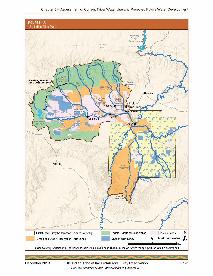
Figure 5.1-A presents a general location map with Reservation boundaries, communities, and other important features.
Chapter 5 – Assessment of Current Tribal Water Use and Projected Future Water Development
December 2018 Ute Indian Tribe of the Uintah and Ouray Reservation 5.1-3 See the Disclaimer and Introduction to Chapter 5.0.
FIGURE 5.1-A Ute Indian Tribe Map

Colorado River Basin Ten Tribes Partnership Tribal Water Study
5.1-4 Ute Indian Tribe of the Uintah and Ouray Reservation December 2018 See the Disclaimer and Introduction to Chapter 5.0.
5.1.2 Physical Setting The Uintah Valley portion of the Reservation lies within the Uinta Basin, a bowl-shaped basin framed by the Uinta Mountains to the north and the Wasatch Range to the west. The Uncompahgre portion of the Reservation also lies within the Uinta Basin and the Green River drainage, extending south and east from the Uinta Valley to the Utah-Colorado border. The terrain of the Reservation varies from high alpine forest in the north and west to fertile agricultural land between about 5,000 and 6,500 feet in the center to remote semi-arid desert hills and canyons in the south. The elevation of the Reservation varies from 4,400 feet at the southern tip to over 13,000 feet in the northern mountains.
Tribally-owned lands on the Reservation encompass a variety of geographic regions, as shown in the photographs on this page. These include the lower alpine forests of the Uinta Mountains, fertile floodplains of the Duchesne River and its tributaries, arid highlands south of the Strawberry River, and desert canyons and drainages stretching east along the White River and south along the Green River.
5.1.2.1 Watersheds
The northwestern area of the Reservation consists of five major river drainages with seven contributing rivers that generally flow southeast and east into the Green River. The Duchesne River system to the west drains from the Wasatch and Uinta Mountains through major tributaries that include Rock Creek, the Strawberry River, the Lake Fork River (with its major tributary the Yellowstone River), and the Uinta River (with its major tributary, the Whiterocks River). The White River and other desert tributaries, including Willow Creek and Bitter Creek, drain the southeastern area of the Reservation into the Green River.
Agricultural lowlands below the Uinta Mountains. Source: Ute Indian Tribe
Desert valleys in the south of the Reservation near the Green River. Source: Ute Indian Tribe
The Uinta River flowing in a glacial valley of the Uinta Mountains. Source: Ute Indian Tribe

Chapter 5 – Assessment of Current Tribal Water Use and Projected Future Water Development
December 2018 Ute Indian Tribe of the Uintah and Ouray Reservation 5.1-5 See the Disclaimer and Introduction to Chapter 5.0.
5.1.2.2 Hydrogeology
The shallowest aquifers in the Uinta Basin are the alluvial aquifers. Much of the alluvium in the stream valleys is too thin, narrow, and discontinuous to be considered a major aquifer; however, some of the larger alluvial deposits in the Uinta Basin are locally important sources of water, providing an estimated safe yield of approximately 32,000 acre-feet per year (AFY). The quality of water in the alluvial aquifers is generally better than the other aquifers in the region because of its primary origin as snowmelt and relatively short residence time in the aquifer.
In addition to alluvial aquifers, three principal aquifer systems of regional extent are present in the Uinta Basin: the Uinta-Animas Aquifer, the Mesaverde Aquifer, and the Dakota-Glen Canyon Aquifer system (Table 5.1-A). Safe yield from the Uinta-Animas Aquifer is estimated to be about 207,062 AFY. Groundwater in the aquifer generally contains high levels of salinity, ranging from 500 to over 6,000 milligrams per liter (mg/L), and reaching 10,000 mg/L in some of the deeper areas. Yield and storage in the Mesaverde Aquifer has yet to be quantified. Water quality in the aquifer is extremely variable, with dissolved solids ranging from about 1,000 mg/L in narrow basin-margin areas of the aquifer that are recharged by infiltration from surface-water sources to more than 35,000 mg/L in the central part of the Uinta Basin.
The State of Utah performed a water balance for the Uinta Basin and estimated approximately 630,000 AFY of groundwater recharge, with roughly 21,060 AFY being withdrawn from wells and springs.
TABLE 5.1-A Groundwater Basins in the Uinta Basin
Basin Name Useable Capacity
(AF) Safe Yield (AFY)
Alluvial Aquifers 200,000 (est.) 32,000 (est.)
Uinta-Animas Aquifer Not Quantified 207,062 (est.)
Mesaverde Aquifer Not Quantified Not Quantified
Dakota-Glen Canyon Aquifer Not Quantified Not Quantified
5.1.2.3 Climate
The climate on the Reservation varies geographically. Average annual precipitation varies from less than 10 inches in the central and southeastern parts of the Reservation to upwards of 30 inches in the high mountains of the northwestern part of the Reservation. Temperature varies similarly, with average annual highs ranging from 52 °F near Moon Lake to 64 °F in Ouray and average annual lows ranging from 24 °F near Moon Lake to 34 °F near Bonanza. Extreme temperatures vary from a low of -43 °F, measured at Ouray in January 1979, to a high of 108 °F, measured at Ouray in July 2001.

Colorado River Basin Ten Tribes Partnership Tribal Water Study
5.1-6 Ute Indian Tribe of the Uintah and Ouray Reservation December 2018 See the Disclaimer and Introduction to Chapter 5.0.
Drought has been a common occurrence on the Reservation throughout history, and the future impacts of climate change present concerns for the future livelihood and health of the region. Tribal lands suffer during frequent drought cycles that reduce available water supplies, especially since tribal water storage has not been developed. Due to current and expected future water shortages, significant changes in water storage and use practices will become critical, as increased regional temperatures would raise crop irrigation requirements and alter precipitation cycles.
5.1.3 Historical Use and Cultural Importance of Water
5.1.3.1 Early Tribal Water Use (to 1906)
Prior to the Reservation’s establishment, the Ute Indian Tribe’s ancestors utilized water for all purposes necessary to sustain their nomadic hunting and gathering-based lives. In particular, they valued wildlife habitat areas as hunting and fishing grounds, and natural flowing streams and springs played a part in religious and cultural practices.
Irrigation has been practiced by the Ute Indians for many years since the Uintah Valley and Uncompahgre Reservations were established. Because the United States government, acting through Indian agents, had the expectation that the members of the Ute Indian Tribe would cultivate crops and farm Reservation lands, several small irrigation ditches and farmlands totaling close to 6,000 acres of land were cultivated and irrigated on the Uintah Valley Reservation in the Lake Fork River and Uinta River Basins as part of the “old irrigation project” around 1890. In 1899, the United States Congress directed the Secretary to secure a quantity of water necessary for the present and prospective wants of the Indians on the Uintah Valley Reservation and to protect their Indian reserved water rights and interests. The much more extensive Uintah Indian Irrigation Project (UIIP or Project), a system constructed to serve 78,950 acres of allotted lands, was authorized under the 1906 Congressional Indian Department Appropriation Act (34 Stat. 375). Construction continued through about 1922, at which time it was essentially completed, with the exception of storage facilities. There was also some early irrigation outside the UIIP, but with little oversight and development. In the early 1900s, various private irrigation companies formed, constructed canals and storage, and started to utilize the rivers of the Uinta Basin for irrigation.
The Uinta River flowing in a glacial valley of the Uinta Mountains. Source: Ute Indian Tribe
A Ute farmer, date unknown. Used by permission, Utah State Historical Society

Chapter 5 – Assessment of Current Tribal Water Use and Projected Future Water Development
December 2018 Ute Indian Tribe of the Uintah and Ouray Reservation 5.1-7 See the Disclaimer and Introduction to Chapter 5.0.
Irrigation on the Uncompahgre Reservation has occurred with very little assistance in the construction of irrigation works. Early irrigation activities were authorized for individual allotments in 1897, principally on Willow Creek, Hill Creek, Meadow Creek, Bitter Creek, and White River, where small ditches were dug with headings and small structures to irrigate strips of land bordering the streams. It was recommended at that time that the Indian reserved water rights to these water sources on the Uncompahgre Reservation be established to ensure a sufficient water source for the Indians’ irrigation efforts, but this did not occur.
5.1.3.2 First Tribal Water Rights Decrees (1905 to 1923)
The United States, through the United States Indian Irrigation Service, made application on behalf of the Ute Indian Tribe to the Utah State Engineer in 1905 to appropriate water within the Reservation for the UIIP. Utah issued water right certificates for the Project to the United States as trustee for the Ute Indian Tribe. Other water rights were also approved by the Utah State Engineer between 1906 and 1915, and by 1916 there were increasing conflicts between the Ute Indians and their neighbors over the water allocations in the Lake Fork, Yellowstone, Whiterocks, and Uinta Rivers, which provided water for the UIIP. The United States initiated litigation in federal court in 1916 to protect the Ute Indian Tribe’s reserved water rights and enjoin various private irrigation companies from interfering with the Indians’ use of these waters. See United States v. Dry Gulch Irrigation Company, No. 4418, slip op. (D. Utah 1923); United States v. Cedarview Irrigation Company, No. 4427, slip op. (D. Utah 1923).
In its Bill of Complaint, the United States attested to the court that [t]he water supply of said Uinta River, except when said river is at stages of high flow, is and at all times has been insufficient to supply the needs of the United States and said Indians for the irrigation of the irrigated lands . . . with the consequence that the waters of said river, unless conserved by storage, will become progressively less able to supply the needs of the United States and of said Indians. . . .
In 1923, the federal district court issued two decrees awarding the Ute Indian Tribe reserved water rights and recognizing the federal Indian water rights as reserved or “Winters” water rights under the 1908 United States Supreme Court decision, Winters v. United States, 207 U.S. 564 (1908), with a priority date that predates October 3, 1861, the date of the establishment of the Uintah Valley Reservation. The Winters Indian reserved water rights are federally created and are based on the federal government’s reservation of lands for Indian tribes, with a primary purpose in many cases of requiring the Indians to become productive farmers, a government policy intended to promote Indian self-sufficiency. Therefore, the 1923 federal decrees established senior Indian reserved water rights for the Ute Indian Tribe, with the United States as the trustee of the Indian reserved water rights and the Ute Indian Tribe as the beneficial owner.
Wheat farming on the UIIP Deep Creek Canal, circa 1919. Source: Library of Congress

Colorado River Basin Ten Tribes Partnership Tribal Water Study
5.1-8 Ute Indian Tribe of the Uintah and Ouray Reservation December 2018 See the Disclaimer and Introduction to Chapter 5.0.
The Lake Fork River Decree provided reserved water rights for 25,071 acres and the Uinta River Decree provided reserved water rights for 34,700 acres, for a total irrigated acreage of 59,771 acres of lands. The decrees also established a direct diversion limit of one cubic foot per second (cfs) per 70 acres and an annual diversion limit of three acre-feet (AF) per acre in these basins, amounting to a total reserved water right of 179,315 AFY: 75,215 AFY in the Lake Fork River Basin and 104,100 AFY in the Uinta River Basin. In addition, the court awarded the Ute Indian Tribe the reserved right to divert water for domestic, culinary, and stock-watering purposes throughout the entire year.
5.1.3.3 Federal Non-Tribal Water Projects and Tribal Water Rights Studies (1900 to 1965)
Between the early 1900s and the 1950s, several non-tribal water projects were planned and constructed by Reclamation and other water users to utilize the water resources of the Uinta Basin. In 1906 the Strawberry Valley Project, including Strawberry Reservoir at the west end of the Reservation, was developed to divert water out of the Uinta Basin west to the Wasatch Front for irrigation along the Spanish Fork River. Planning for the Moon Lake Project began by 1918, with the purpose of relieving severe water shortages on private lands along the Lake Fork River by diverting surplus water from the Duchesne River to Indian lands, designated to receive Lake Fork River reserved water rights. This made it possible for the Moon Lake Project’s State water users to divert a like quantity of Indian reserved water in the Lake Fork River by exchange with the Moon Lake Project water users. The Moon Lake Project facilities include the
Moon Lake storage reservoir on the Lake Fork River, the trans-basin Yellowstone Feeder Canal that diverts water from the Yellowstone River east to the Uinta River Basin, and the Midview Reservoir to store water from the Duchesne River for use in the lower Lake Fork Basin on the Indian reserved water rights lands. The Provo River Project was constructed in 1938 to divert water from the North Fork of the Duchesne River and convey it west through the Duchesne Tunnel to the Provo River on the Wasatch Front for irrigation and municipal uses.
A much larger project aimed at transferring water out of the Colorado River Basin, including the Uinta Basin, to the Bonneville Basin and Wasatch Front was developed by Reclamation and the State of Utah, known as the Central Utah Project (CUP). In 1956, the Colorado River Storage Project Act (70 Stat. 105) was passed by Congress and authorized the Bonneville, Upalco, Vernal, and Jensen Units (Initial Phase) of the CUP, see Figure 5.1-B. In 1968, Congress passed the Colorado River Basin Project Act, authorizing the Uintah Unit as a part of the Initial Phase of the CUP, and directing that a feasibility study be conducted for the Ute Indian Unit. These units were to have provided storage benefits to the Ute Indian Tribe and the UIIP. The Vernal and Jensen Units provide supplemental water outside the Reservation and were completed in 1962 and 1980, respectively. The Bonneville Unit was the largest and most extensive of the CUP units, diverting flows from Rock Creek and eight other Duchesne River tributaries within the
A drop structure on the UIIP Dry Gulch Canal, circa 1930. Source: Library of Congress

Chapter 5 – Assessment of Current Tribal Water Use and Projected Future Water Development
December 2018 Ute Indian Tribe of the Uintah and Ouray Reservation 5.1-9 See the Disclaimer and Introduction to Chapter 5.0.
Reservation into an enlarged Strawberry Reservoir and west to the Wasatch Front. Starvation Reservoir on the lower Strawberry River serves as a supplemental reservoir to preserve the water supply for irrigation water users on the Duchesne River, including the Ute Indian Tribe. Construction on the Bonneville Unit started in 1968 and is nearing completion with some of the final features now under construction. The Upalco Unit was intended to provide storage on the Lake Fork and Yellowstone Rivers for both tribal and other water users, and the Uintah Unit was intended to do the same on the Uinta and Whiterocks Rivers. The Ute Indian Unit was supposed to bring water from the Green River west to the Reservation to make up for the water the CUP diverted to the Wasatch Front. However, due to the CUP’s complex history, including escalating costs, new environmental requirements, and Congressional intervention to contain the costs of the CUP, the projects that would have benefited the Ute Indian Tribe were never constructed and benefits to the Tribe never materialized.
FIGURE 5.1-B Conceptual Map of Central Utah Project Development
The planned CUP presented significant concerns related to the Ute Indian Tribe’s Indian water rights claims as to whether sufficient water supplies existed to satisfy both the federal trust responsibility to the Tribe and the CUP’s demands. The Ute Indian Tribe hired engineering consultant E.L. Decker to represent its interests in resolving the Tribe’s water rights claims. In 1960, Decker produced a report quantifying the Ute Indian Tribe’s historically irrigated and practicably irrigable acres (PIA) on the Reservation (with some subsequent revisions/corrections). The Decker Report, including the reserved water rights recognized in the 1923 federal decrees and water rights claims in the Green and White River Basins, established the Ute Indian Tribe’s practicably irrigable lands totaling 129,331 acres, providing the basis for the Tribe’s reserved water rights.

Colorado River Basin Ten Tribes Partnership Tribal Water Study
5.1-10 Ute Indian Tribe of the Uintah and Ouray Reservation December 2018 See the Disclaimer and Introduction to Chapter 5.0.
The Decker Report divided the irrigable lands into seven groups, with Group 1 lands comprised of the Ute Indian Tribe’s decreed reserved water rights in the Lake Fork and Uinta River basins. In a data collection effort for the CUP, the Duchesne River Area Study Committee (Committee) published a 1962 report that concluded, among other items, “…that successful operation of the Bonneville and Duchesne segments of the CUP’s initial phase will depend upon an agreement by the Indians to limit the irrigation of Indian owned and Indian water right land of about 20,700 acres.” The Bonneville Unit could not have been constructed without the participation and support from the Ute Indian Tribe. E.L. Decker was a member of the Committee and recommended that the Ute Indian Tribe enter into an agreement with the federal government, represented by the BIA and Reclamation, and the Central Utah Water Conservancy District (CUWCD) to defer the development of 15,242 acres of Tribal irrigable land (a portion of the Group 5 lands in Decker’s report). The formal agreement is commonly known as the 1965 Deferral Agreement. As a measure of good will and with certain conditions that would benefit the Ute Indian Tribe, the Tribe signed the 1965 Deferral Agreement.
Under the 1965 Deferral Agreement, the Ute Indian Tribe agreed to defer its use of Tribal reserved water rights on 15,242 acres of land so that the federal government could certify to the United States Congress that it had an uncontested Indian reserved water right to support the request for funding of the Bonneville Unit of the CUP. In exchange, the United States promised future development of the Ute Indian Tribe’s Indian reserved water rights under the CUP. The Ute Indian Tribe agreed to the Deferral Agreement with the understanding that all phases of the CUP would be diligently pursued in good faith to include satisfaction of the water development requirements of Groups 1-5 lands with Indian reserved water rights at the earliest possible date. In addition, the parties to the 1965 Deferral Agreement, subsequently approved by the State of Utah legislature, acknowledged, recognized, and confirmed the Ute Indian Tribe’s Indian reserved water rights as described in the Decker Report, that is, for 129,331 acres.
5.1.3.4 Tribal Water Compact Efforts (1965 to Present)
The period after the Deferral Agreement can be characterized as featuring continued extensive development of non-tribal, State-based water uses through the CUP, while little progress was made on projects benefiting the Ute Indian Tribe. Definite plan reports and environmental impact statements were not issued for the Upalco and Uintah Units until 1979, and the projects continued to languish amid repeated financial analyses by Reclamation challenging their viability and poor dam site findings. Exploratory efforts continued on the Tribal CUP elements in the 1980s, but, ultimately, Reclamation determined that the Upalco Unit was unfeasible and it was reformulated. The Ute Indian Unit was de-authorized in 1992.
The State of Utah, the Ute Indian Tribe, and the United States entered into discussions in the late 1970s to complete the settlement of the Tribe’s water rights claims through a Ute Indian Water Compact. Although a Ute Indian Water Compact was approved by the State Legislature in 1980 and by the Tribal membership in 1988, it never obtained the required Congressional approval and ratification.
In 1992, the Reclamation Projects Authorization and Adjustment Act (P.L. 102-575) was passed, which included the Central Utah Project Completion Act (CUPCA), of which Title V, the Ute Indian Rights Settlement, was included. Congress revised the proposed 1980 Ute Indian Water Compact and created the “Revised Ute Indian Compact of 1990” for the purpose of, notably,

Chapter 5 – Assessment of Current Tribal Water Use and Projected Future Water Development
December 2018 Ute Indian Tribe of the Uintah and Ouray Reservation 5.1-11 See the Disclaimer and Introduction to Chapter 5.0.
transferring 113,378 AF of annual diversion of reserved water rights, most of the designated practicably irrigable lands, out of the Uinta Basin to the Green River. Also, notably, with this change, Congress required re-ratification of the Ute Indian Water Compact by both the Ute Indian Tribe and the State of Utah. To date, a final agreement of the Ute Indian Tribe’s Indian reserved water rights and completion of comprehensive water rights settlement through a Ute Indian Water Compact has not occurred, and the parties have had continued negotiations on the terms of such a Compact.
Today, the State of Utah has, by its own policy, fully appropriated its water rights in the Uinta Basin. The Ute Indian Tribe continues to put its available, federally-decreed natural flow water rights to use alongside the developed water infrastructure of State-based water users. The BIA regulates, enforces, manages, and supervises the distribution of the Tribal Indian reserved water rights under the UIIP. Non-UIIP irrigators have developed numerous off-stream storage facilities to impound seasonal flows, small-scale irrigation improvement projects have increased water carriage and application efficiency, and complex water exchange agreements have been put in place to allow users to share water throughout the Uinta Basin. Groundwater usage has become increasingly common, and industrial activities, such as oil and gas extraction, have increased regional water usage. The CUWCD and other local agencies still plan to utilize State water rights originating from the CUP to develop local water projects. Through all of this, the Ute Indian Tribe strives to assert its Indian reserved water rights and play a larger role in the administration of the resources of its homeland to ensure a better future for its members.
5.1.4 Ute Indian Tribe Water Supply The Ute Indian Tribe uses surface water, groundwater, and other water supplies for irrigation, stock watering, domestic and industrial purposes.
5.1.4.1 Surface Water Supply
Although the Ute Indian Tribe has been negotiating a final Ute Indian Water Compact and is preparing a proposed Tribal Water Resources Ordinance, the Tribe continues to use a large portion of its reserved water rights for irrigation under the UIIP and smaller volumes for domestic and municipal purposes served from the Tribal Water System. Stock watering from various springs and creeks is also important. Under the 1965 Deferral Agreement, the Ute Indian Tribe has recognized water rights claims for 129,331 acres. This equates to an annual reserved water right by diversion of 549,685 AFY, of which 179,315 AFY were adjudicated in 1923. In addition, as part of the proposed Revised Ute Indian Compact of 1990, the Ute Indian Tribe would have 10,000 AFY of diversion/depletion water rights for domestic, municipal, commercial, and industrial uses. Priorities for these rights are dated 1861 for all historically and practicably irrigable lands of the Uintah Valley portion of the Reservation, including M&I water rights, and 1882 for all lands of the Uncompahgre portion of the Reservation.
The Ute Indian Tribe owns the highest priority water right to natural flows from all rivers within the exterior boundaries of the Reservation. However, the Ute Indian Tribe has very limited storage capacity. As such, water availability is primarily dependent on climate factors, and flows vary considerably from year-to-year and month-to-month. Abundant water is available in the spring, but in later months, when snowpack has melted and crops continue to require significant irrigation water, natural flow has diminished. During late summer, when natural flows diminish, Tribal water availability similarly diminishes. Non-tribal irrigators have developed water storage

Colorado River Basin Ten Tribes Partnership Tribal Water Study
5.1-12 Ute Indian Tribe of the Uintah and Ouray Reservation December 2018 See the Disclaimer and Introduction to Chapter 5.0.
facilities to supplement their junior Utah State water rights during low flow periods. Direct diversion shortages to Tribal reserved water rights are common in late season, and shortages can be calculated for the UIIP relative to either Tribal reserved water rights or to crop water requirements on Tribal lands.
5.1.4.2 Groundwater Supply
Groundwater has not been extensively developed in the Uinta Basin. Groundwater wells on non-tribal lands within the exterior boundary of the Reservation have been developed under Utah State water rights to supply local municipalities, small-scale domestic water systems, and industrial uses. Groundwater supplies consist generally of alluvial aquifers and several deep aquifer systems. The great depth to the Dakota-Glen Canyon Aquifer (exceeding 12,000 feet in much of the Uinta Basin) and poor water quality makes this aquifer system unsuitable for development in much of the area.
The Tribal M&I reserved water right can be sourced from groundwater, though few groundwater sources have been developed. Some Tribal members live in rural areas and are served by domestic wells, but very little data is currently available for these water users.
5.1.4.3 Other Water Supplies
In an effort to mitigate some of the late season shortages, the BIA, responsible for the UIIP, has informal agreements with irrigators holding Utah State water rights for exchanges of water with irrigators under the UIIP using Tribal reserved water rights. These informal agreements allow State-based water right users to obtain water earlier in the season, such as for diversion to their storage facilities, and Tribal reserved water right irrigators to obtain water later in the season from the private storage facilities when natural flows have decreased. For the most part, however, these are informal agreements for which no known records exist and, therefore, are not legally binding.
Flood irrigation is widely practiced among the Ute Indian Tribal water users on the Reservation. Many other farmers have shifted to sprinkler irrigation, reducing the amount of discharge from agricultural operations. Current drainage discharge is neither monitored nor measured, and is, therefore, difficult to quantify.
5.1.5 Current Water Use and Operations Almost all the Ute Indian Tribe’s current water use is for the irrigation of agricultural lands and stock watering on the Reservation, although a small percentage is used for domestic, commercial, municipal, and industrial (DCMI) purposes.
5.1.5.1 Irrigated Agriculture and Livestock Water Use Category
The BIA-operated UIIP serves the vast majority of Tribal agricultural operations on the Reservation, with water sourced from the Duchesne, Lake Fork, and Uinta River systems. A maximum diversion rate of one cfs to 70 acres was established for direct natural flow diversions, with an annual allocation of three AF per acre in the Lake Fork and Uinta Basins (under the 1923 federally-decreed reserved water rights); four AF per acre in the Duchesne River, Bitter, Sweet Water, Willow, and Hill Creeks Basins; 4.8 AF per acre in the White River Basin, and 4.5 AF per acre in the Green River Basin. These flows are distributed according to a set diversion

Chapter 5 – Assessment of Current Tribal Water Use and Projected Future Water Development
December 2018 Ute Indian Tribe of the Uintah and Ouray Reservation 5.1-13 See the Disclaimer and Introduction to Chapter 5.0.
schedule that was originally intended to match anticipated crop water requirements, but ultimately causes crop water supply shortages. An additional 0.4 AFY per acre is available for tribal storage in the Lake Fork and Uinta Basins as part of the supplemental irrigation promised in the 1965 Deferral Agreement, and storage facilities to support this requirement are under negotiation.
Irrigation water is delivered to Tribal land primarily through canals and laterals within the UIIP. Some of the river diversion structures are automated to allow real-time control of the system. The vast majority of the irrigated land held in trust on the Reservation is pasture or hay (both grass and alfalfa), with other crops making up only about three percent of the irrigated agriculture. The predominant irrigation type within the UIIP is flood irrigation, with sprinklers increasing in use. Sections of open channel within the UIIP are gradually being replaced by pipeline to reduce seepage, but the majority of the system remains unlined open channel.
There is small-scale irrigation of Tribal lands outside the UIIP via private ditch systems that are operated and maintained by local water users. Small-scale projects on the Uintah portion of the Reservation are supplied by the Duchesne River System and those on the Uncompahgre portion of the Reservation are supplied by the Green River System, which includes the White River and Willow, Bitter, Sweet Water, and Hill Creeks. Very little information is available about carriage systems, irrigation practices, and land uses in these non-UIIP areas.
There are several other significant private irrigation companies within the exterior boundaries of the Reservation, including Moon Lake Water Users Association, Dry Gulch Irrigation Company, Ouray Park Irrigation Company, and Whiterocks Irrigation Company. Although these companies supply irrigation water to a small area of Tribal land through exchange agreements with the BIA, they are operated by and for the benefit of other State-based water rights users.
Table 5.1-B presents the annual UIIP agricultural water use in the Lake Fork, Uinta, and Duchesne River Basins for the period from 2009 through 2013 based on River Commissioner Reports. The current average agricultural water use is 211,042 AFY. Table 5.1-C presents crop irrigation information for the 2012 irrigation season.
The UIIP U.S. Lake Fork Canal in the Lake Fork River Basin. Source: Ute Indian Tribe
A lateral of the UIIP Uintah Canal in the Uinta River Basin. Source: Ute Indian Tribe

Colorado River Basin Ten Tribes Partnership Tribal Water Study
5.1-14 Ute Indian Tribe of the Uintah and Ouray Reservation December 2018 See the Disclaimer and Introduction to Chapter 5.0.
TABLE 5.1-B UIIP Agricultural Water Use (2009 – 2013)
Water Source Year
2009 2010 2011 2012 2013
Surface Water (AF) 223,542 215,977 235,143 187,273 193,273
Groundwater (AF) minor minor minor minor minor
Total Irrigated Area in acres (appx.1) 61,330 60,561 60,945 60,748 60,804 1 River Commissioner Reports did not report irrigation acreages for the UIIP, so these acreages were estimated
using known water duties. This assumption does not account for water shortages in any given water year, so these estimates are likely underestimates of the actual UIIP acreage served.
TABLE 5.1-C UIIP Agricultural Crop Data for 2012
Crop Total Acreage
(appx)1
Average Water Delivery Rate,
AF/acre2
Percent of Acres
Flood Sprinkler
Field Crops 1,993 3.3 41% 59%
Irrigated Pasture 37,018 3.2 89% 11%
Alfalfa 12,150 3.3 31% 69%
Grass Hay 9,587 3.1 84% 16% 1 Based on crop mix reported by CropScape in 2012 (Cropland Data Layer from the USDA NASS). 2 Based on a 3.0 AFY duty per acre in the Lake Fork/Uinta Basins, and 4.0 AF per acre in the Duchesne Basin (the
crop acreage from basins with larger allocations is negligible).
The Ute Indian Tribe also diverts water for livestock water use in the form of irrigated pastures, livestock feedlots, and grazing rangelands. Pastures are irrigated by the canals and laterals of the UIIP and, as permitted by the 1923 federal district court decrees in the Lake Fork and Uinta River systems, these canals also carry stock water year-round. Stock water diversion rights are not specified for the UIIP canals in the Duchesne River Basin, though several State-based water rights owned by the Ute Indian Tribe or by the United States in trust for the Tribe allow point-to-point stock watering on several tributary creeks and waterways of the Reservation. The BIA’s Uintah and Ouray Agency also manages a rangeland permitting program for Tribal lands and permitted federal lands within the exterior boundaries of the Reservation. It is estimated that the Ute Indian Tribe currently diverts and depletes approximately 650 AFY of water for livestock use. The Ute Indian Tribe’s total current average irrigated agricultural and livestock water use is 211,692 AFY.
5.1.5.2 Domestic, Commercial, Municipal, and Industrial Water Use Category
The Ute Indian Tribe provides water and sewer services for several communities for the benefit of Tribal members, as well as for Reservation industries, such as cattle raising and extraction of oil and natural gas. The Ute Indian Tribe also operates several businesses, including the Ute Plaza supermarket, two gas stations, Kapeeh Kah-ahn Coffee House, the Ute Crossing Grill and Bowling Alley, a Tribal feedlot, Ute Tribal Enterprises LLC, and the Ute Tribal Water System.

Chapter 5 – Assessment of Current Tribal Water Use and Projected Future Water Development
December 2018 Ute Indian Tribe of the Uintah and Ouray Reservation 5.1-15 See the Disclaimer and Introduction to Chapter 5.0.
Domestic water is supplied to Tribal residences and commercial ventures by the Ute Tribal Water System, other public community water systems, and domestic or industrial groundwater wells in rural areas. The Tribal Water System provides DCMI water to Tribal members and to other water users in a service area that extends from Whiterocks to Ouray along the Uinta and Duchesne Rivers. Water delivered by the Tribal Water System is sourced from the Whiterocks and Uriah Heap Springs located north of Fort Duchesne, Utah. Intermittent data for the Tribal Water System has been collected by the State of Utah Division of Water Resources. Based on the available data, the Ute Tribal Water System is used primarily for residential indoor and outdoor use. Water is also used by commercial businesses and public institutions, but there is no water for industrial use supplied through the system. Data from 1995, 2003, and 2005 indicate that the Tribal Water System supplied an average 255 gallons per capita per day to an average population of 3,167 people. With additional commercial uses, the Ute Indian Tribe’s average DCMI water use is 872 AFY (Table 5.1-D).
TABLE 5.1-D Domestic, Municipal, Commercial, and Industrial Uses Supplied by the Ute Tribal Water System (1995, 2003, and 2005)
DCMI Use Year (AF)
1995 2003 2005
Residential Indoor 392 265 270
Residential Outdoor 502 180 230
Commercial 6 385 385
Total 900 830 885
Additional public municipal water systems, water improvement districts, and user-operated systems supply domestic, municipal, commercial, and light industrial water to Tribal members and other residents throughout the Reservation area. These include: Duchesne County Upper Country Water Improvement District, East Duchesne Culinary Water Improvement District, South Duchesne Improvement District, Duchesne City Water System, Cedarview/Montwell Special Service District, Neola Water and Sewer District, Roosevelt Municipal Water System, Myton Municipal Water System, Johnson Water District, Ballard Water Improvement District, and Tridell-LaPoint Water Improvement District. Several additional municipal water systems exist on the Reservation, but their service areas do not extend to Tribal land.
The Ute Tribal Water System, Whiterocks Spring collection system. Source: Ute Indian Tribe

Colorado River Basin Ten Tribes Partnership Tribal Water Study
5.1-16 Ute Indian Tribe of the Uintah and Ouray Reservation December 2018 See the Disclaimer and Introduction to Chapter 5.0.
5.1.5.3 Environmental, Recreational, and Cultural Water Use Category
Previous agreements or statutory obligations regarding the use of water for environmental purposes include the federal and State of Utah governments’ obligations to provide minimum instream flow requirements in Rock Creek (a tributary to the Duchesne River) to mitigate the impact of the CUP on this Reservation water source; water rights to maintain a productive cold water fishery in Bottle Hollow Reservoir (an obligation of the federal government under CUPCA, Title V, and currently under negotiations); and the establishment of various Tribal fish ponds. The instream flow requirement in Rock Creek is equal to 29 cfs during summer months and 23 cfs during winter months. These flow rates result in a volumetric water requirement of about 19,000 AFY, though this is an instream flow requirement at a single point in the river and cannot be construed as a consumptive use. Furthermore, Rock Creek instream flows are required to be provided by the CUWCD from Upper Stillwater Reservoir as part of the State’s mitigation requirements; these are State-based water rights and are not part of the Tribal reserved water right. Water demands associated with Bottle Hollow Reservoir and other fishing areas have not been quantified, and additional environmental water demands in the Reservation creeks and rivers have also not been quantified. Of particular note are minimum flow requirements for endangered fish species in the Green River and (through connection) in the Duchesne River and its tributaries.
The Ute Tribal Water System Uriah Heap Springs treatment building. Source: Ute Indian Tribe

Chapter 5 – Assessment of Current Tribal Water Use and Projected Future Water Development
December 2018 Ute Indian Tribe of the Uintah and Ouray Reservation 5.1-17 See the Disclaimer and Introduction to Chapter 5.0.
Five reservoirs are regulated by the Ute Indian Tribe for recreational purposes. Bottle Hollow Reservoir is used for recreation, including fishing, boating, and camping. Additional storage uses are being studied. Cedarview Reservoir was also designed for both recreation and irrigation, but is used primarily for recreation and wildlife habitat. Towave and Weaver Reservoirs are also intended for irrigation and recreational uses, but are largely used only for recreation. Midview Reservoir is operated by the BIA for the Ute Indian Tribe primarily for irrigation supply, but is regulated by the Tribe for recreational uses such as boating and fishing. Several small fishing ponds are also operated on Tribal lands with negligible water uses.
Recreational water use rates are equivalent to annual evaporation rates and have been calculated for the five recreational reservoirs. On an annual basis, recreational water use is 976 acre-feet for Bottle Hollow, 346 acre-feet for Cedarview Reservoir, 892 acre-feet for Midview Reservoir, 129 acre-feet for Towave Reservoir, and 53 acre-feet for Weaver Reservoir, resulting in a total annual recreational water use of 2,396 AFY.
Tribal fishing permits, available to the general public, allow access to all Tribal waters on the Reservation. The Uinta, Whiterocks, Lake Fork, and Yellowstone Rivers, as well as Rock Creek and the Strawberry River, are all popular fishing destinations.
Bottle Hollow Reservoir near Fort Duchesne, Utah. Source: Ute Indian Tribe
Ute woman gathering water from a river, date unknown. Source: Ute Indian Tribe

Colorado River Basin Ten Tribes Partnership Tribal Water Study
5.1-18 Ute Indian Tribe of the Uintah and Ouray Reservation December 2018 See the Disclaimer and Introduction to Chapter 5.0.
The Ute Indian Tribe values all of the water on the Reservation for cultural and ceremonial uses. The Ute Indian Tribe does not wish to disclose the specific nature of any cultural activities or locations of sacred areas in order to protect and preserve their present conditions. The Ute Tribal Cultural Rights Protection Department and Tribal Water Commission advocate for the cultural rights and water uses of the Ute Indian Tribe’s members and is involved as often as possible with development projects on the Reservation in order to protect Tribal cultural resources.
Generally, the Ute Indian Tribe values undeveloped water sources flowing in natural channels for cultural uses, such as undammed river streams and natural springs that discharge from the Uinta Mountains and the canyons of the Hill Creek Extension. Cultural practices that are indirectly related to water use include plant gathering and prayer offerings. The Ute Indian Tribe has conducted confidential inventories of springs and other water sources on Tribal lands and protects their future uses for cultural purposes. The Ute Indian Tribe believes in maintaining sufficient natural flow for instream cultural and wildlife habitat purposes, and plans to support and monitor the instream flows within the exterior boundary of the Reservation through cooperative river management plans.
5.1.5.4 Transfers, Leases, and Exchanges Water Use Category
The Ute Indian Tribe is involved with one water exchange program, known as the Midview Exchange Agreement. In 1967, the federal government, through Reclamation and the BIA, the Ute Indian Tribe, and the Moon Lake Water Users Association signed the Midview Exchange Agreement to exchange water between the Lake Fork and Duchesne Rivers. Under the terms of the Midview Exchange Agreement, Tribal reserved water rights on the Lake Fork River, decreed in 1923 in Federal District Court with a priority date of 1861, are used by the Moon Lake Water
Users Association; in exchange, State-based water rights from the Duchesne River are used on lands under the UIIP. The exchange involves up to 10,000 acres of irrigated lands. This benefits the State-based water irrigators, members of the Moon Lake Water Users Association, by providing more natural flow on the Lake Fork River, ensuring an adequate water supply from this river source. The Duchesne River water, diverted as an alternate water supply for the Ute Indian Tribe’s use
Ute Tribal members at a Bear Dance celebration, circa 2012. Source: Ute Indian Tribe
Midview Reservoir near Myton, Utah. Source: Ute Indian Tribe

Chapter 5 – Assessment of Current Tribal Water Use and Projected Future Water Development
December 2018 Ute Indian Tribe of the Uintah and Ouray Reservation 5.1-19 See the Disclaimer and Introduction to Chapter 5.0.
on UIIP lands, is stored in the Midview Reservoir, a 5,800 AF reservoir, which provides 11,570 AFY of storage water rights from the Duchesne River (with two fills per season). If the natural flows of the Duchesne River are insufficient to fill Midview Reservoir, the Ute Indian Tribe has additional water rights to 11,600 AF of storage in Starvation Reservoir, owned by Reclamation, on the Strawberry River that can be used to supplement the storage in Midview Reservoir. This exchange does not result in increased diversions or divert from outside the Reservation and, therefore, is considered part of the Ute Indian Tribe’s total reserved water rights diversion.
5.1.5.5 Reservoirs
In total, the Ute Indian Tribe owns, or is a beneficiary of, seven reservoirs on the Reservation (Table 5.1-E). Though these reservoirs provide benefits to the Ute Indian Tribe, due to their locations they are largely insufficient to supply the majority of the Tribe’s water demands (largely agricultural) that are described above. Bottle Hollow Reservoir, on the Uinta River, has a maximum capacity of 11,800 AF. Towave and Weaver Reservoirs, located in the Hill Creek Basin, have a combined maximum storage of 550 AF. Cedarview Reservoir, in the Cottonwood Creek drainage of the Uinta River Basin, has a maximum capacity of about 2,500 AF. The Ute Indian Tribe holds a Utah State water right for irrigation water from Cedarview Reservoir, so its operation is not considered a Tribal reserved water right use. Burton Reservoir, off-stream of Deep Creek (a tributary to the Uinta River), has an estimated capacity of 34 AF and is used for irrigation under a Utah State water right.
Under the Midview Exchange Agreement, Midview Reservoir was transferred to BIA and is to be held in trust for the benefit of the Ute Indian Tribe as part of the UIIP. The 5,800 AF reservoir is used for irrigation and recreation, and the Ute Indian Tribe has a right to fill the reservoir twice per year. The Ute Indian Tribe also has some direct flow water rights in the Duchesne River as part of the Midview Exchange Agreement. If the natural flow of the river is insufficient to fill Midview Reservoir twice in a season, up to 11,600 AF of storage water may be substituted from Starvation Reservoir, located on the Strawberry River upstream of the confluence of the Strawberry and Duchesne Rivers near Duchesne, Utah. Starvation Reservoir is owned by Reclamation and is used for other irrigation, recreation, municipal and industrial water requirements, and flood control uses.
Towave Reservoir in the south of the Ute Indian Tribe Reservation. Source: Ute Indian Tribe

Colorado River Basin Ten Tribes Partnership Tribal Water Study
5.1-20 Ute Indian Tribe of the Uintah and Ouray Reservation December 2018 See the Disclaimer and Introduction to Chapter 5.0.
TABLE 5.1-E Ute Indian Tribe Reservoirs
Reservoir Reservoir Capacity (AF) Midview 5,8001
Bottle Hollow 11,800
Towave 350
Weaver 200
Cedarview 2,500
Burton 34
Total 20,684 1 Under the Midview Exchange Agreement, Starvation Reservoir storage may
be used to ensure that Midview Reservoir can be filled twice per season.
Private irrigation companies have built numerous storage reservoirs along the Uinta and Lake Fork Rivers and other waterways of the Reservation. Many of these reservoirs are enlargements of natural high mountain lakes, but some larger reservoirs (for example, Moon Lake Reservoir, Big Sand Wash Reservoir, and Upper Stillwater Reservoir) have been built by Reclamation and benefit non-tribal water rights users. Total high mountain storage within the Lake Fork and Uinta River Basins is more than 21,000 AF. Total non-tribal storage on or near the Reservation, excluding Flaming Gorge Dam, is about 1.6 million acre-feet.
5.1.5.6 Water Use Efficiency and Conservation
The condition of the UIIP’s canals and structures is extremely poor due to deferred maintenance over a long period of time, resulting in substantial water losses due to seepage in canals and laterals. Furthermore, the poor condition of distribution structures presents difficulties in the management and distribution of water to users in the UIIP. The UIIP’s Operation and Maintenance Company, a private, non-profit corporation chartered under the
laws of the Ute Indian Tribe with a Board of Directors who are landowners and water users under the UIIP, prioritizes necessary system repairs based on user feedback, but the overall deteriorating condition of the Project has resulted in a backlog of maintenance that will require comprehensive rehabilitation to resolve. The Ute Indian Tribe has undertaken several studies to demonstrate the poor condition of UIIP infrastructure, prioritize areas for betterment, and quantify potential water savings to Tribal water deliveries from UIIP improvements. A lateral and structure of the UIIP Uintah Canal in poor
condition. Source: Ute Indian Tribe

Chapter 5 – Assessment of Current Tribal Water Use and Projected Future Water Development
December 2018 Ute Indian Tribe of the Uintah and Ouray Reservation 5.1-21 See the Disclaimer and Introduction to Chapter 5.0.
River diversion structures by the UIIP are operated primarily via remote technology, allowing river commissioners to easily adjust canal diversions. Irrigators throughout the Basin are gradually transitioning to sprinkler systems, increasing irrigation efficiency by minimizing runoff and deep percolation. Additionally, open channel canals in the Basin are periodically being replaced with pipeline, often with funding support from federal programs. Most recently, Reclamation funded the replacement of 5.2 miles of the non-tribal Ouray Park open irrigation canal with pipeline to reduce seepage and system evaporation. The Ute Indian Tribe has begun seeking funding for similar projects within the UIIP.
5.1.5.7 Summary of Current Water Use
Figure 5.1-B depicts, and Table 5.1-F summarizes, the Ute Indian Tribe’s current water use of 212,564 AFY by diversion and 128,788 AFY by depletion, out of the Tribe’s total diversion water rights, including unresolved claims, of 549,685 AFY. The Ute Indian Tribe’s total average agricultural water diversion from 2009-2013 was 211,042 AFY and is organized below by river basin. Irrigation diversion records do not always separate out tribal and other water use. Therefore, tribal water irrigation diversions and depletions were estimated based on diversion records from the Duchesne, Lake Fork, Yellowstone, Uinta, and Whiterocks Rivers, where the majority of tribal irrigation water use presently occurs. The Ute Indian Tribe’s total average livestock water diversion is 650 AFY. Total estimated irrigated agricultural and livestock water use by diversion is 211,692 AFY. Tribal DCMI diversions, approximately 872 AFY, are diverted by the Tribal Water System. Although the Tribal Water System diverts from the Whiterocks River and Uriah Heap Springs, the DCMI diversions were assigned to the Whiterocks River as these springs are hydrologically connected to the river. Table 5.1-F organizes the Ute Indian Tribe’s current average annual water use by Basin, with the exception of livestock water use, which could not be disaggregated by river system. Figure 5.1-B depicts the Ute Indian Tribe’s current water use of 212,564 AFY by diversion and 128,788 AFY by depletion.
Sprinkler irrigation on Tribal lands in the UIIP. Source: Ute Indian Tribe

Colorado River Basin Ten Tribes Partnership Tribal Water Study
5.1-22 Ute Indian Tribe of the Uintah and Ouray Reservation December 2018 See the Disclaimer and Introduction to Chapter 5.0.
0
100,000
200,000
300,000
400,000
500,000
600,000
Volu
me
(Acr
e-Fe
et)
FIGURE 5.1-B Ute Indian Tribe’s Current Average Annual Water Use (in Utah)
TABLE 5.1-F Ute Indian Tribe Current Average Annual Water Use by Basin (in Utah)1,2
Source Water Use Category Current Diversion (AFY)
Estimated Current Depletion (AFY)
Duchesne AG 75,568 37,784
Lake Fork AG 41,686 27,791
Yellowstone AG 1,345 672
Uinta AG 54,489 37,234
Whiterocks AG 37,954 23,785
DCMI 872 872
Green River System All Uses - -
Subtotals AG 211,692 127,916
DCMI 872 872
Total 212,564 128,788 AG – Irrigated Agriculture and Livestock DCMI – Domestic, Commercial, Municipal, and Industrial 1 Because stock watering use was not available by Source, only the subtotals for both AG current diversion and
current depletion include the estimated 650 AFY of livestock water use. Non-consumptive cultural water uses are not included in the Table.
2 The Ute Indian Tribe holds senior reserved water rights in the Green River System. These water rights are presently being used to irrigate small-scale irrigation projects. Attempts to quantify these irrigated acres have been unsuccessful due to a lack of water use records, so diversion and depletion AFY were not included.

Chapter 5 – Assessment of Current Tribal Water Use and Projected Future Water Development
December 2018 Ute Indian Tribe of the Uintah and Ouray Reservation 5.1-23 See the Disclaimer and Introduction to Chapter 5.0.
5.1.6 Tribal Water Use Challenges Presently, the chief challenge to the use and development of the Ute Indian Tribe’s water is the unresolved state of the Tribe’s Indian water rights claims, including finalization of the Ute Indian Water Compact with the State of Utah and the Federal government. Though federal court decrees in 1923 (adjudicating a portion of the Ute Indian Tribe’s reserved water rights) and additional formal agreements between the parties over the past decades have firmly established the Ute Indian Tribe’s senior reserved water rights in the Uinta Basin, today the Tribe remains unable to fully utilize, administer, develop, and enforce its water resources as a sovereign nation. By resolving the Ute Indian Tribe’s full Indian water rights claims, either through litigation or a Ute Indian Water Compact with United States Congressional approval that recognizes the Ute Indian Tribe’s regulatory authority over its Tribal reserved water rights and provides for the best administrative water management practices based on the recognized and established quantifications, the Tribe believes that it can assert its governmental authority to develop its full Indian reserved water rights. This will bring certainty with regard to water rights to all water users within the exterior boundary of the Reservation and enforcement authority for the Ute Indian Tribe. The Ute Indian Tribe has initiated the development of a Tribal Water Resources Ordinance that will govern water planning, record keeping, managing, permitting, regulating, and enforcing the Tribe’s water rights.
Though the Ute Indian Tribe holds senior reserved water rights to the natural flows of several rivers in the Uinta Basin, seasonal flow variations frequently do not correspond with crop water demands. Often the Ute Indian Tribe’s and allottee’s crops are left dry while non-UIIP irrigators utilize storage facilities for supplemental water. It is estimated that tribal lands receive an insufficient water supply (based on Reclamation standards) in seven out of ten years. Many of the storage facilities on the Reservation were developed as part of federal projects, like the Colorado River Storage Project Act establishing the CUP,
but others were established by private water user organizations, such as the Moon Lake Water Users Association. The development of water facilities to satisfy only the needs of non-tribal irrigators in the Uinta Basin throughout the twentieth century, with the later effort to develop the Tribal reserved water rights and use, creates uncertainty for junior water rights holders of State-based water rights who divert water despite the Ute Indian Tribe’s undeveloped, but higher priority, reserved water rights.
By conducting its own resources studies and improvement plans, the Ute Indian Tribe plans to develop water projects that can improve water deliveries to Tribal and allottee lands and improve the Reservation livelihood for its Tribal members without substantial conflict with existing State water uses. Furthermore, the Ute Indian Tribe believes that sufficient environmental flows in many of the Reservations waterways, particularly the Lake Fork and Uinta Rivers, are sorely lacking. Under the existing system of competing water rights, it is
Cedarview Reservoir with a low water level near Neola, Utah. Source: Ute Indian Tribe

Colorado River Basin Ten Tribes Partnership Tribal Water Study
5.1-24 Ute Indian Tribe of the Uintah and Ouray Reservation December 2018 See the Disclaimer and Introduction to Chapter 5.0.
nearly impossible to allow these flows to bypass diversions. With improved water management abilities and supplemental storage facilities, the Ute Indian Tribe is interested in establishing environmental flows that will protect the health and viability of the Reservations’ streams, and provide supplemental irrigation water to the UIIP to reduce water shortages.
Under the proposed Revised Ute Indian Compact of 1990, the Indian water rights claims for 27,080 acres of the Ute Indian Tribe’s practicably irrigable acreage from what is known as Group 5 lands were moved to the Green River Basin. These unresolved claims total 113,378 AFY of diversion, which are presently identified only as “paper water rights” that cannot be reasonably put to use by the Ute Indian Tribe on these lands. The promised Ute Indian Unit, that was to be a part of the CUP, was never constructed to bring Green River water to the Lake Fork and Uinta River Basins, and the Green River flows through a portion of the Reservation in the deep Desolation Canyon. The Ute Indian Tribe is actively exploring ways to put these water rights claims to use as “wet water rights,” and securing conditions that will allow this to take place.
Although the Ute Tribal Water System presently serves the majority of Tribal members living on the Reservation, there are Tribal members on the western portion of the Reservation who lack access to the Tribal Water System and are supplied with DCMI water by other public community water systems or domestic water wells. The Ute Indian Tribe is interested in extending its Tribal Water System, but securing funding for such infrastructure will present additional challenges. The public water sources may also face water rights, supply, and quality challenges common to public water systems.
Finally, given the above challenges, the Ute Indian Tribe requires funding and increased regulatory flexibility to put its full Indian reserved water rights to use so that it may establish the permanent homeland promised with the establishment of its Reservation and recognized in the Winters doctrine and decrease the poverty of its Tribal members through economic development of its water that results in improved standards of living for its members.
5.1.7 Projected Future Water Development The Ute Indian Tribe’s future water development was assessed by first examining the location, quantity and type of current water use and, then, by applying the Tribal Water Study’s scenario planning process, envisioning a range of future water development. The Ute Indian Tribe’s total reserved water rights, based on the 1965 Deferral Agreement, is 549,685 AFY by diversion. The current water use is 212,564 AFY.
The scenarios and associated themes are listed below. Detailed descriptions of these scenarios (storylines) were created to consider a wide range of possible water development outcomes. For
The West Fork of the Uinta River. Source: Ute Indian Tribe

Chapter 5 – Assessment of Current Tribal Water Use and Projected Future Water Development
December 2018 Ute Indian Tribe of the Uintah and Ouray Reservation 5.1-25 See the Disclaimer and Introduction to Chapter 5.0.
additional information, including the scenario storylines, see Chapter 4 – Methodology for Assessing Current Tribal Water Use and Projected Future Water Development.
• Current Water Development Trends (Scenario A): Current trends in on-reservation water development, governance, funding, and resolution of tribal claims remain the same.
• Slow Water Development Trends (Scenario B): Decreased flexibility in governance of tribal water, levels of funding, and resolution of tribal claims slow tribal economic development. This results in a decline in the standard of living and delays resolution of tribal claims.
• Rapid Water Development Trends (Scenarios C1 and C2): Increased flexibility in governance of tribal water allows innovative water development opportunities and increased funding availability leads to tribal economic development. This results in an increase in the standard of living, thereby contributing to the fulfilment of the purpose of the reservation as a homeland and supporting the future needs of tribal communities. Scenario C1 considers partial resolution of claims and/or implementation of decreed or settled rights; and Scenario C2 considers complete resolution of claims and implementation of decreed or settled rights.
The Ute Indian Tribe contemplated its future water development through 2060 by reviewing its current water use estimates and reflecting upon how these might change under the four scenarios. During this process, the Ute Indian Tribe considered such elements as the scenario conditions described in the storylines, current or future planned projects, anticipated changes in water use by category, and the extent and condition of existing water infrastructure and the need, as well as the cost, for new infrastructure to support water development. The Ute Indian Tribe contemplated future development in the four water use categories: Irrigated Agricultural and Livestock Water Use (AG); Domestic, Commercial, Municipal, and Industrial Water Use (DCMI); Environmental, Cultural, and Recreational Water Use (ENV); and Transfers, Leases, and Exchanges Water Use (TRAN).
From this examination, the Ute Indian Tribe extrapolated likely future use if current trends (Scenario A) continued through 2060 and prepared a quantified water development schedule. The Ute Indian Tribe used this same approach to prepare future water development schedules reflective of how the other scenario storylines (Scenarios B, C1, and C2) could affect its future water development. The documentation for each development schedule is presented in the following sections.
5.1.7.1 Future Water Development Schedules
The assumptions for each schedule are described below and the schedules presented graphically in Figure 5.1-C and numerically in Table 5.1-G.
Current Water Development Trends (Scenario A)
If current trends in on-reservation water development continue and governance, funding, and resolution of tribal claims remain the same, the Ute Indian Tribe’s water diversions will increase 159 percent to a full reserved water rights entitlement of 549,685 AFY by 2040. AG, including livestock, water use diversions will increase from 211,692 AFY by approximately 73 percent to 365,414 AFY, including development on the Green River, White River, and the Bitter, Sweet Water, Hill, and Willow creeks. DCMI water use would increase 1,192 percent on the

Colorado River Basin Ten Tribes Partnership Tribal Water Study
5.1-26 Ute Indian Tribe of the Uintah and Ouray Reservation December 2018 See the Disclaimer and Introduction to Chapter 5.0.
Reservation to a total diversion of 11,264 AFY. The Scenario A water development schedule assumes that reserved water rights, totaling 173,007 AFY are used for TRAN by 2040. Water used for ENV purposes is not included in the development schedule as it is non-consumptively used to aid instream flows.
Slow Water Development Trends (Scenario B)
Decreases in flexibility in governance of tribal water, levels of funding, and the resolution of tribal claims could slow tribal economic development in Scenario B. Under this scenario, Ute Indian Tribe water diversions will increase to the full use of its water right by 2055. The Ute Indian Tribe assumed that AG, DCMI, and Green River entitlements used for TRAN will be fully developed by 2055. This represents a fifteen-year delay in comparison to the modeled results under Scenario A. Water used for ENV purposes is not included in the development schedule as it is non-consumptively used to aid instream flows. Rapid Water Development Trends, Partial Settlement Resolution/Implementation (Scenario C1)
Under Scenario C1, a partial resolution of the claims and/or implementation of decreed or settled rights leads to increased flexibility in governance of tribal water allowing innovative water development opportunities, and increased funding availability leads to tribal economic development. The Ute Indian Tribe assumed that the Ute Indian Tribal water diversions will increase to the full use of its water rights entitlement of 549,685 AFY by 2035 with the same water uses (AG, DCMI, and TRAN) as described in Scenario A.
Rapid Water Development Trends, Complete Settlement Resolution/Implementation (Scenario C2)
Scenario C2 builds on scenario C1 by considering a complete resolution of claims and implementation of decreed or settled rights, which further increases water development opportunities. The Ute Indian Tribe’s water use and development rate for Scenario C2 is the same as Scenario C1 and follows the same assumptions.

Chapter 5 – Assessment of Current Tribal Water Use and Projected Future Water Development
December 2018 Ute Indian Tribe of the Uintah and Ouray Reservation 5.1-27 See the Disclaimer and Introduction to Chapter 5.0.
-
100,000
200,000
300,000
400,000
500,000
600,000
Wat
er U
se (A
cre-
Feet
)Current Water Development Trends (Scenario A)
-
100,000
200,000
300,000
400,000
500,000
600,000
Wat
er U
se (A
cre-
Feet
)
Rapid Water Development Trends, Complete Settlement Resolution/Implementation (Scenario C2)
-
100,000
200,000
300,000
400,000
500,000
600,000
Wat
er U
se (A
cre-
Feet
)
Slow Water Development Trends (Scenario B)
-
100,000
200,000
300,000
400,000
500,000
600,000
Wat
er U
se (A
cre-
Feet
)
Rapid Water Development Trends, Partial Settlement Resolution/Implementation (Scenario C1)
FIGURE 5.1-C Ute Indian Tribe Projected Future Water Development (in Utah) (Scenarios A, B, C1, and C2)
1 Ute Indian Tribe’s total reserved water rights by diversion, including unresolved claims, is 549,685 AFY.
1

Colorado River Basin Ten Tribes Partnership Tribal Water Study
5.1-28 Ute Indian Tribe of the Uintah and Ouray Reservation December 2018 See the Disclaimer and Introduction to Chapter 5.0.
5.1.7.2 Summary of Projected Future Water Development
The Ute Indian Tribe’s current water use and projected future water development under the Tribal Water Study’s water development scenarios, and modeled for analysis purposes, is presented in Table 5.1-G.
TABLE 5.1-G Summary of Ute Indian Tribe Current Water Use and Projected Future Water Development (in Utah)1
Water Use Timeframe and Category
Scenario A (AFY) Scenario B (AFY) Scenario C1 (AFY) Scenario C2 (AFY)
Diversion Depletion Diversion Depletion Diversion Depletion Diversion Depletion
Current Use
AG 211,692 127,916 211,692 127,916 211,692 127,916 211,692 127,916 DCMI 872 872 872 872 872 872 872 872 ENV 0 0 0 0 0 0 0 0
TRAN 0 0 0 0 0 0 0 0 Total 212,564 128,788 212,564 128,788 212,564 128,788 212,564 128,788
Use at 2040
AG 365,414 182,376 304,735 152,166 365,414 182,376 365,414 182,376 DCMI 11,264 10,669 7,161 6,783 11,264 10,669 11,264 10,669 ENV 0 0 0 0 0 0 0 0
TRAN 173,007 87,731 104,715 53,101 173,007 87,731 173,007 87,731 Total 549,685 280,776 416,611 212,050 549,685 280,776 549,685 280,776
Use at 2060
AG 365,414 182,376 365,414 182,376 365,414 182,376 365,414 182,376 DCMI 11,264 10,669 11,264 10,669 11,264 10,669 11,264 10,669 ENV 0 0 0 0 0 0 0 0
TRAN 173,007 87,731 173,007 87,731 173,007 87,731 173,007 87,731 Total 549,685 280,776 549,685 280,776 549,685 280,776 549,685 280,776
1 Ute Indian Tribe’s total reserved water rights by diversion, including unresolved claims, is 549,685 AFY.