uintah county, utah resource assessment
TRANSCRIPT

Uintah County, Utah Resource Assessment August 2005
This resource assessment is designed to gather and display information specific to Uintah County, Utah. This report will highlight the natural and social resources present in the county, detail specific concerns, and be used to aid in resource planning and target conservation assistance needs. This document is dynamic and will be updated as additional information is available through a multi-agency partnership effort. The general observations and summaries are listed first, followed by the specific resource inventories.
Contents Observations and Summary Resource Concerns - Air, Plants, Animals
Land Use Resource Concerns - Social and Economic
Resource Concerns - Soils Survey Results
Resource Concerns - Water Footnotes/Bibliography
Intro Uintah northersoutherthe latetar sanThe Gr The doconsist Averag
Equal Oppo
1duction
County is located in the central portion of the Uinta Basin, which extends sixty miles into western Colorado. The n rim of the basin is formed by the Uinta Mountains, the western rim by the Wasatch Mountains, and the n rim by the Roan and Book cliffs. The basin is the geological remains of prehistoric Uinta Lake, formed during Tertiary period, the same period when sediment was deposited in the lake bottom to form gilsonite, oil shale, ds, and oil. Ashley and White Creek and the Uinta and Green rivers are major water resources in the county. een, the largest of the four, slices through the central portion of the county.
minant industries in Uintah County are cattle, hay and alfalfa, lumber, mining, oil and gas. Uintah County s of 4,487 square miles of land and 62% of the land is shrub/rangeland.
e low winter temperatures: 16ºF; average high summer temperatures: 72ºF; average precipitation: 10 inches.
rtunity Providers and Employers.

Uintah County, Utah Resource Assessment August 2005
2
Back to Contents General Land Use Observations Grass / Pasture / Hay Lands
Complications related to overgrazing include poor pasture condition, soil compaction and water quality issues. Flood irrigation in salt-loaded soils contributes to high salinity levels in the Colorado River. Control of noxious and invasive plants is an ever increasing problem. The small, part-time farms are less likely to adopt conservation due to cost and low farm income.
Row & Perennial (orchards / vineyards / nurseries) Crops Residue, nutrient and pest management are needed to control erosion and to protect water quality. The small, part-time farms are less likely to adopt conservation due to cost and low farm income.
Forest On private, non-industrial forest there are issues with erosion, water quality and forest productivity.
Resource Assessment Summary
CategoriesConcern
high, medium, or low
Description and Specific Location (quantify where possible)
Soil High High salt content due to geologic nature of area. Some soil types also are very erodable. (Duchesne and Ashley River Drainages)
Water Quantity Medium Uintah County must plan for growing population and water needs. More water storage areas are needed. (Vernal City area)
Water Quality Ground Water High Deep percolation from flood irrigation washes salts into Colorado River.
(Farming ground in the Vernal area)Water Quality Surface Water Medium Over irrigation produces high sediment load and salt runoff into surface
waters. (Irrigated crop and pastureland in Vernal area)
Air Quality Medium Population boom will possibly bring in more construction and vehicle pollutants. Could affect quality of life if not accounted for. (Vernal area)
Plant Suitability Low
Plant Condition Medium Water and nutrient management affects plant condition, therefore affecting crop production and sustainability. (All farming ground in Uintah County)
Fish and Wildlife Medium Water quality and urban sprawl affect the livelihood of both fish and wildlife.
Domestic Animals Low
Social and Economic Medium
As a result of Oil and Gas mining boom, many are concerned that planning will not keep up with growth. Therefore, lifestyle may be adversely affected. However, the boom is also increasing the economic growth of Uintah Couny substantially.

Uintah County, Utah Resource Assessment August 2005
3
Back to Contents Land Use/Land Cover
Acres %Forest 756,171 26.23%Grain Crops 5,726 0.20%Conservation Reserve Program *a 2,005 0.07%Grass/Pasture/Haylands 301,816 10.47%Orchards/Vineyards 31 0.00%Row Crops 2,982 0.10%Shrub/Rangelands 1,783,391 61.87%Water 8,433 0.29%Wetlands 6,417 0.22%Developed 15,364 0.53%Uintah County Totals *b 2,882,347 100.00%
*a : Estimate from Farm Service Agency records and include CRP/CREP. *b : Totals may not add due to rounding
and small unknown acreages.
Land Cover/Land Use

Uintah County, Utah Resource Assessment August 2005
4
Back to Contents Land Ownership Special Considerations for Uintah County:
• As of December 2004, 0 acres of CREP have been applied (FSA). • There are only 4 farms with 31 acres of land in orchards and nurseries in Uintah County. • Orchards/Nurseries include other perennial crops such as nursery stock, hybrid poplars, fruit trees, and
evergreen trees. • Grass/Pasture/Hay includes approximately:
o 1 farm with minimal acres produces grass seed (USDA, 2002 Census of Agriculture) o 33,330 acres of pasture (USDA, 2002 Census of Agriculture) o 30,431 acres of hay (USDA, 2002 Census of Agriculture) o Leaving 240,060 acres of miscellaneous grasslands within Uintah County.
• Row crops mainly consist of corn silage used for livestock feed. • There are approximately 396 acres of grain grown in the County (USDA, 2002 Census of Agriculture) • Shrub/rangelands consist of sagebrush, pinyon/juniper, oak stands, and other open areas of
brush/trees. • 15,364 acres of the county is developed land for both residential and commercial use.

Uintah County, Utah Resource Assessment August 2005
5
Back to Contents
Prime & Unique Farm Land
Prime farmland
Land that has the best combination of physical and chemical characteristics for producing food, feed, fiber, forage, oilseed, and other agricultural crops with minimum inputs of fuel, fertilizer, pesticides, and labor, and without intolerable soil erosion.
Uintah County, Utah Resource Assessment August 2005
6
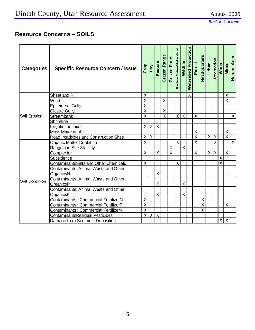
Back to Contents Resource Concerns – SOILS
Categories Specific Resource Concern / Issue
Cro
pH
ayPa
stur
eG
raze
d R
ange
Gra
zed
Fore
stPa
stur
e N
ativ
e/N
atur
aliz
ed
Wild
life
Wat
ersh
ed P
rote
ctio
nFo
rest
Hea
dqua
rter
sU
rban
Rec
reat
ion
Wat
erM
ined
Nat
ural
Are
a
Sheet and Rill X XWind X X XEphemeral Gully XClassic Gully X XStreambank X X X X XShorelineIrrigation-induced X X XMass Movement X XRoad, roadsides and Construction Sites
X
X
X X X X X XOrganic Matter Depletion X X X XRangeland Site Stability X XCompaction X X X X X X XSubsidence XContaminantsSalts and Other Chemicals X X XContaminants: Animal Waste and Other OrganicsN XContaminants: Animal Waste and Other OrganicsP X XContaminants: Animal Waste and Other OrganicsK X XContaminants : Commercial FertilizerN X XContaminants : Commercial FertilizerP X XContaminants : Commercial FertilizerK X XContaminantsResidual Pesticides X X XDamage from Sediment Deposition
X
X
X X
Soil Erosion
Soil Condition

Uintah County, Utah Resource Assessment August 2005
7
Back to ContentsLand Capability Class on Cropland and Pastureland Acres Percentage
I - slight limitations 0 0.0% II - moderate limitations 95,431 30.5% III - severe limitations 113,124 36.2% IV - very severe limitations 47,377 15.2% V - no erosion hazard, but other limitations 0 0.0% VI - severe limitations, unsuited for cultivation, limited to pasture, range, forest 20,399 6.5% VII - very severe limitations, unsuited for cultivation, limited to grazing, forest, wildlife 2,927 0.9%
Land Capability Class (Irrigated Cropland &
Pastureland Only)
VIII - misc areas have limitations, limited to recreation, wildlife, and water supply 0 0.0%

Uintah County, Utah Resource Assessment August 2005
8
Back to Contents Soil Erosion
Uintah County Soil Erosion
1.149 1.192
0.703
0.16
0.008 0.005 0.009 0.010
0.2
0.4
0.6
0.8
1
1.2
1982 1987 1992 1997
Years
tons
/acr
e
Soil Loss in WindSoil Loss in Water
Sheet and rill erosion by water on the sub-basin croplands and pasturelands have been reduced by more than 50 thousand tons of soil per year from 1982 to 1997.
Controlling erosion not only sustains the long-term productivity of the land, but also affects the amount of
soil, pesticides, fertilizer, and other substances that move into the nation’s waters.
Through NRCS programs many farmers and ranchers have applied conservation practices to reduce the effects of erosion by water. As a result, erosion rates on croplands and pasturelands fell 40 percent from 1.6 to 0.9 tons/acre/year from 1982 to 1997.
Uintah County, Utah Resource Assessment August 2005
9
Back to Contents Resource Concerns – WATER
Categories Specific Resource Concern / Issue
Cro
pH
ayPa
stur
eG
raze
d R
ange
Gra
zed
Fore
stPa
stur
e N
ativ
e/N
atur
aliz
ed
Wild
life
Wat
ersh
ed P
rote
ctio
nFo
rest
Hea
dqua
rter
sU
rban
Rec
reat
ion
Wat
erM
ined
Nat
ural
Are
a
Water Quantity – Rangeland Hydrologic Cycle X XExcessive Seepage X X XExcessive Runoff, Flooding, or Ponding X X X X XExcessive Subsurface Water X XDrifted SnowInadequate OutletsInefficient Water Use on Irrigated Land X X XInefficient Water Use on Non-irrigated Land XReduced Capacity of Conveyances by Sediment Deposition
X X XReduced Storage of Water Bodies by Sediment Accumulation
XAquifer Overdraft XInsufficient Flows in Watercourses XHarmful Levels of Pesticides in Groundwater X X X XExcessive Nutrients and Organics in Groundwater X X XExcessive Salinity in Groundwater X X XHarmful Levels of Heavy Metals in Groundwater XHarmful Levels of Pathogens in Groundwater XHarmful Levels of Petroleum in Groundwater XHarmful Levels of Pesticides in Surface Water XExcessive Nutrients and Organics in Surface WaterExcessive Suspended Sediment and Turbidity in Surface Water
X X XExcessive Salinity in Surface Water X X X X XWater Quality – Colorado River Excessive SalinityHarmful Levels of Heavy Metals in Surface WaterHarmful Temperatures of Surface Water Harmful Levels of Pathogens in Surface Water XHarmful Levels of Petroleum in Surface Water X
Water Quantity
Water Quality, Groundwater
Water Quality, Surface

Uintah County, Utah Resource Assessment August 2005
10
Back to Contents Precipitation and Streams
Uintah CountyInches per Year
7
9
11
13
15
17
19
21
23
25
27
29
31
33
35
37Perennial Streams
ACRES ACRE-FEET Surface N/A N/A Well N/A N/A
Irrigated Adjudicated Water Rights
Total Irrigated Adjudicated Water Rights N/A N/A Total Avg. Yield 30,188
Stream Flow Data USGS 09261700 Big Brush Creek Abv Red Fleet, Nr Vernal, UT May - Sept.
Yield 21,420 MILES PERCENT
Total Miles - Major (100K Hydro GIS Layer) 8,692.7 n/a Stream Data 303d (DEQ Water Quality Limited Streams) 3,995.2 46%
Irrigation Efficiency: <40% 40 - 60% >60%
Cropland 5% 5% 90%Pastureland 2% 6% 92%
Percentage of Total Acreage
Uintah County, Utah Resource Assessment August 2005
11
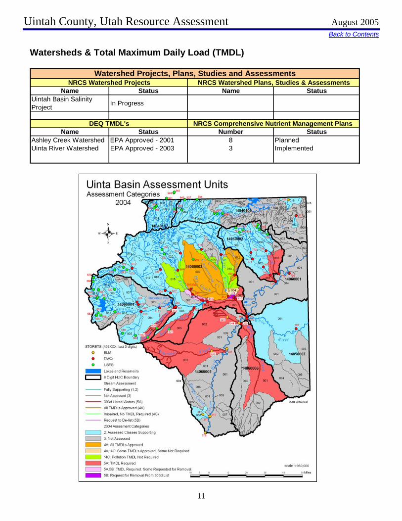
Back to Contents Watersheds & Total Maximum Daily Load (TMDL)
Name Status Name StatusUintah Basin Salinity Project In Progress
Name Status Number StatusAshley Creek Watershed EPA Approved - 2001 8 PlannedUinta River Watershed EPA Approved - 2003 3 Implemented
Watershed Projects, Plans, Studies and AssessmentsNRCS Watershed Projects NRCS Watershed Plans, Studies & Assessments
DEQ TMDL's NRCS Comprehensive Nutrient Management Plans

Uintah County, Utah Resource Assessment August 2005
12
Back to Contents AFO/CAFO Animal Feeding Operations (AFO)Animal Type Dairy Feed Lot
(Cattle) Poultry Swine Mink Other
No. of Farms 28 1 5No. of Animals 11895 300 1500
Potential Confined Animal Feeding Operations (PCAFO)Animal Type Dairy Feed Lot
(Cattle) Poultry Swine Mink Other
No. of Farms 7 1No. of Animals 3498 300
Confined Animal Feeding Operations - Utah CAFO PermitAnimal Type Dairy Feed Lot
(Cattle) Poultry Swine Other
No. of Permitted FarmsNo. of Permitted Animals
County < 100 Feet
100 to 500 Feet
500 to 1000 Feet
1000 to 2000 Feet
2000 to 5000 Feet
>5000 Feet
Grand Total
Uintah 1 1 1 2 5 10
Number of AFO's and Distance to Water

Uintah County, Utah Resource Assessment August 2005
13
Back to Contents Resource Concerns – AIR, PLANTS, ANIMALS
Categories Specific Resource Concern / Issue
Cro
pH
ayPa
stur
eG
raze
d R
ange
Gra
zed
Fore
stPa
stur
e N
ativ
e/N
atur
aliz
ed
Wild
life
Wat
ersh
ed P
rote
ctio
nFo
rest
Hea
dqua
rter
sU
rban
Rec
reat
ion
Wat
erM
ined
Nat
ural
Are
a
Particulate matter less than 10 micrometers in diameter (PM 10) Particulate matter less than 2.5 micrometers in diameter (PM 2.5)Excessive Ozone Excessive Greenhouse Gas: CO2 (carbon dioxide) XExcessive Greenhouse Gas: N2O (nitrous oxide)Excessive Greenhouse Gas: CH4 (methane)Ammonia (NH3)Chemical DriftObjectionable Odors X XReduced Visibility XUndesirable Air MovementAdverse Air Temperature
Plant Suitability
Plants not adapted or suited
Plant Condition – Productivity, Health and Vigor X X
Threatened or Endangered Plant Species: Plant Species Listed or Proposed for Listing under the Endangered Species Act X XThreatened or Endangered Plant Species: Declining Species, Species of Concern XNoxious and Invasive Plants X X X XForage Quality and Palatability XPlant Condition – Wildfire Hazard X X X XInadequate FoodInadequate Cover/ShelterInadequate WaterInadequate SpaceHabitat Fragmentation Imbalance Among and Within PopulationsThreatened and Endangered Species: Species Listed or Proposed for Listing under the Endangered Species ActInadequate Quantities and Quality of Feed and Forage XInadequate ShelterInadequate Stock Water XStress and Mortality
Air Quality
Plant Condition
Fish and Wildlife
Domestic Animals

Uintah County, Utah Resource Assessment August 2005
14
Back to Contents Noxious Weeds
Utah Noxious Weed List
The following weeds are officially designated and published as noxious for the State of Utah, as per the authority vested in the Commissioner of Agriculture under Section 4-17-3, Utah Noxious Weed Act:
• Bermudagrass** (cynodon dactylon) • Canada thistle (cirsium arvense) • Diffuse knapweed (centaurea diffusa) • Dyers woad (isatis tinctoria L) • Field bindweed (Wild Morning Glory) (convolvulus arvensis) • Hoary cress (cardaria drabe) • Johnsongrass (sorghum halepense) • Leafy spurge (euphorbia esula) • Medusahead (taeniatherum caput-medusae) • Musk thistle (carduus mutans) • Perennial pepperweed (lepidium latifolium) • Perennial sorghum (sorghum halepense L & sorghum almum) • Purple loosestrife (lythrum salicaria L.) • Quackgrass (agropyron repens) • Russian knapweed (centaurea repens) • Scotch thistle (onopordum acanthium) • Spotted knapweed (centaurea maculosa) • Squarrose knapweed (centaurea squarrosa) • Yellow starthistle (centaurea solstitialis)
Additional noxious weeds declared by Uintah County (2003): Russian Olive, Salt Cedar

Uintah County, Utah Resource Assessment August 2005
15
Back to Contents Wildlife
Common Name Group Primary Habitat Secondary HabitatFEDERALLY-LISTED
Black-footed Ferret (experimental) Mammal Grassland High Desert ScrubGray Wolf (extirpated) Mammal Mountain Shrub Mixed ConiferBonytail Fish Water - LoticColorado Pikeminnow Fish Water - LoticHumpback Chub Fish Water - LoticRazorback Sucker Fish Water - LoticBrown (Grizzly) Bear (extirpated) Mammal Mixed Conifer Mountain ShrubCanada Lynx Mammal Sub-Alpine Conifer Lodgepole PineMexican Spotted Owl Bird Cliff Lowland RiparianBald Eagle (breeding) Bird Lowland Riparian Agriculture
Candidate: Yellow-billed Cuckoo Bird Lowland Riparian AgricultureProposed: (None)
STATE SENSITIVENorthern Goshawk Bird Mixed Conifer AspenColorado River Cutthroat Trout Fish Water - Lotic Mountain RiparianBluehead Sucker Fish Water - Lotic Mountain RiparianRoundtail Chub Fish Water - LoticFlannelmouth Sucker Fish Water - LoticAmerican White Pelican Bird Water - Lentic WetlandBig Free-tailed Bat Mammal Lowland Riparian CliffBlack Swift Bird Lowland Riparian CliffBurrowing Owl Bird High Desert Scrub GrasslandCornsnake Reptile Lowland Riparian Pinyon-JuniperFerruginous Hawk Bird Pinyon-Juniper ShrubsteppeFringed Myotis Mammal Northern Oak Pinyon-JuniperGreater Sage-grouse Bird ShrubsteppeKit Fox Mammal High Desert ScrubLewis’s Woodpecker Bird Ponderosa Pine Lowland RiparianLong-billed Curlew Bird Grassland AgricultureShort-eared Owl Bird Wetland GrasslandSmooth Greensnake Reptile Mountain Riparian Wet MeadowSpotted Bat Mammal Low Desert Scrub CliffThree-toed Woodpecker Bird Sub-Alpine Conifer Lodgepole PineTownsend’s Big-eared Bat Mammal Pinyon-Juniper Mountain ShrubWhite-tailed Prairie-dog Mammal Grassland High Desert Scrub
*Definitions of habitat categories can be found in the Utah Comprehensive Wildlife Conservation Strategy.
Threatened:
Conservation Agreement
Species:
Species of Concern:
AT-RISK SPECIES
Endangered:

Uintah County, Utah Resource Assessment August 2005
16
Back to Contents
Resource Concerns – SOCIAL AND ECONOMIC
Categories Specific Resource Concern / Issue
Cro
pH
ayPa
stur
eG
raze
d R
ange
Gra
zed
Fore
stPa
stur
e N
ativ
e/N
atur
aliz
ed
Wild
life
Wat
ersh
ed P
rote
ctio
nFo
rest
Hea
dqua
rter
sU
rban
Rec
reat
ion
Wat
erM
ined
Nat
ural
Are
a
Non-Traditional Landowners and Tenants
Urban Encroachment on Agricultural Land X X XMarketing of Resource ProductsInnovation Needs X X XNon-Traditional Land UsesPopulation Demographics, Changes and Trends XSpecial Considerations for Land Mangement (High State and Federal Percentage)Active Resource Groups (CRMs, etc)Full Time vs Part Time Agricultural CommunitiesSize of Operating UnitsLand Removed from Production through Easments X XLand Removed from Production through USDA Programs X X
Other
Social and Economic
Census and Social Data
Uintah County Population Growth 1900 - 2003
0
5,000
10,000
15,000
20,000
25,000
30,000
1900 1910 1920 1930 1940 1950 1960 1970 1980 1990 2000 2003est.

Uintah County, Utah Resource Assessment August 2005
17
Back to Contents
0
50
100
150
200
250
300
350
400
1-9 10-49 50-179 180-499 500-999 1000+
Size of Farms in 2002 (Acres)
Number of Farms: 908 Number of Operators:
Full-Time Operators: 386 Part-Time Operators: 522
Public Survey/Questionnaire Results:
Air Quality Biological DiversityEnergy Conservation Food Production Cultural ResourcesRangeland Health Groundwater LandslidesFish and Wildlife Habitat/Population Rural Land Use Manure ManagementFlooding Surface Water Mined Land ReclamationForest Health Urban Land Use Threatened/Endangered SpeciesGrazing Lands Waste DisposalInvasive Species Nutrient ManagementLoss of Ag. Land Pesticide ManagementOpen Space Small-acreage ManagementWeeds Soil ErosionIrrigation Water Management Soil QualityPublic Land Management Timber ProductionRiparian Corridors Urban Water PollutionWater Conservation and Supply WetlandsWater Quality WildfireLand Conservation
The following concerns are if minor importance:
Agricultural sustainability
Total # of respondents: 18
A majority of respondants felt:
The following concerns that should be addressed immediatley are:
The following concerns that will need future attention are:

Uintah County, Utah Resource Assessment August 2005
18
Back to ContentsFootnotes / Bibliography 1. General information about Uintah County obtained from the official Uintah County website: http://utahreach.org/uintah/visitor/about.htm 2. Location and land ownership maps made using GIS shapefiles from the Automated Geographical Reference Center (AGRC), a Utah State Division of Information Technology. Website: http://agrc.utah.gov/ 3. Land Use/Land Cover layer developed by the Utah Department of Water Resources. A polygon coverage containing water-related land-use for all 2003 agricultural areas of the state of Utah. Compiled from initial USGS 7.5 minute Digital Raster Graphic waterbodies, individual farming fields and associated areas are digitized from Digital Orthophotos, then surveyed for their land use, crop type, irrigation method, and associated attributes. 4. Prime and Unique farmlands derived from SURGO Soils Survey UT607 and Soil Data Viewer. Definitions of Prime and Unique farmlands from U.S. Geological Survey, http://water.usgs.gov/eap/env_guide/farmland.html#HDR5 5. Land Capability Classes derived from SURGO Soils Survey UT607 and Soil Data Viewer. 6. Tons of Soil Loss by Water Erosion data gathered from National Resource Inventory (NRI) data. Estimates from the 1997 NRI Database (revised December 2000) replace all previous reports and estimates. Comparisons made using data published for the 1982, 1987, or 1992 NRI may produce erroneous results. This is due to changes in statistical estimation protocols, and because all data collected prior to 1997 were simultaneously reviewed (edited) as 1997 NRI data were collected. In addition, this December 2000 revision of the 1997 NRI data updates information released in December 1999 and corrects a computer error discovered in March 2000. For more information: http://www.nrcs.usda.gov/technical/NRI/ 7. Precipitation data was developed by the Oregon Climate Service at Oregon State University using average monthly or annual precipitation from 1960 to 1990. Publication date: 1998. Data was downloaded from the Resource Data Gateway, http://dgateway-wb01.lighthouse.itc.nrcs.usda.gov/lighthouse 8. Irrigated Adjudicated Water Rights obtained from the Utah Division of Water Rights. 9. Stream Flow data from http://waterdata.usgs.gov/ut/nwis/uv?09261700 10. Stream length data calculated using ArcMap and 100k stream data from AGRC and 303d waters from the Utah Department of Environmental Quality. 11. Watershed information from http://oaspub.epa.gov/pls/tmdl/ 12. The 2003 noxious weed list was obtained from the State of Utah Department of Food and Agriculture. For more information contact Steve Burningham, 801-538-7181 or visit their website at http://ag.utah.gov/plantind/noxious_weeds.html

Uintah County, Utah Resource Assessment August 2005
19
13. Wildlife information derived from the Utah Division of Wildlife Resources' Comprehensive Wildlife Conservation Strategy (CWCS) ( http://wildlife.utah.gov/cwcs/ ) and from the Utah Conservation Data Center ( http://dwrcdc.nr.utah.gov/ucdc/ ). 14. County population data from the U.S. Census Bureau, Utah Quick Facts, http://quickfacts.census.gov/qfd/states/49000.html 15. Farm information obtained from the National Agricultural Statistics Service, 2002 Census of Agriculture. http://www.nass.usda.gov/census/census02/volume1/index2.htm