chapter 4 general sar policiestrlmo.com/cgaux8wr/word/chap4_cim_16130_2e_09oct09.pdfcomdtinst...
TRANSCRIPT

COMDTINST M16130.2E
CHAPTER 4 GENERAL SAR POLICIES (Responsible Office – CG-5341; 202.372.2080)
4.1 Maritime SAR Assistance Policy (MSAP) ....................................................................................... 4-3 4.1.1 Preamble .............................................................................................................................................. 4-3 4.1.2 Definitions ........................................................................................................................................... 4-3 4.1.3 Background ......................................................................................................................................... 4-3 4.1.4 Discussion ........................................................................................................................................... 4-4 4.1.5 Policy .................................................................................................................................................. 4-4 4.1.6 Procedures ........................................................................................................................................... 4-6 4.1.7 SAR Coordinator and SMC Responsibilities ...................................................................................... 4-10 4.1.8 Marine Assistance Request Broadcast Format for Radiotelephone Transmission .............................. 4-11
4.2 Forcible Evacuation of Vessels ......................................................................................................... 4-15 4.2.1 Authority ............................................................................................................................................. 4-15 4.2.2 Voluntary Evacuation a Preferred Alternative .................................................................................... 4-15 4.2.3 Risk Considerations............................................................................................................................. 4-15 4.2.4 Decision Authority .............................................................................................................................. 4-15 4.2.5 Use of Force Constraints ..................................................................................................................... 4-15 4.2.6 Distressed Vessel Master’s Authority Limitation in Regards to Crew Evacuation ............................. 4-15 4.2.7 Documentation .................................................................................................................................... 4-15
4.3 General Salvage Policy (Other than Towing).................................................................................. 4-17 4.3.1 General ................................................................................................................................................ 4-17 4.3.2 Small Craft .......................................................................................................................................... 4-17 4.3.3 Operator Insistence .............................................................................................................................. 4-17
4.4 Firefighting Activities Policy ............................................................................................................ 4-19 4.4.1 Overview ............................................................................................................................................. 4-19 4.4.2 Operations ........................................................................................................................................... 4-19
4.5 Direction and Navigational Assistance for Mariners ..................................................................... 4-21 4.5.1 General ................................................................................................................................................ 4-21 4.5.2 Lost/Disoriented Mariner .................................................................................................................... 4-21 4.5.3 Hazardous Bars and Inlets ................................................................................................................... 4-22 4.5.4 Weather Information ........................................................................................................................... 4-23
4.6 SAR Cost Recovery and Reimbursement ........................................................................................ 4-25 4.6.1 SAR Cost Recovery ............................................................................................................................ 4-25 4.6.2 SAR Cost Reimbursement ................................................................................................................... 4-25 4.6.3 MEDEVAC at Sea .............................................................................................................................. 4-25 4.6.4 MEDEVAC vs. Medical Transport/Air Transportation between Medical Facilities ........................... 4-25
4.7 Emergency Medical Assistance ........................................................................................................ 4-27 4.7.1 MEDICO ............................................................................................................................................. 4-27 4.7.2 MEDEVAC ......................................................................................................................................... 4-27 4.7.3 District Procedures .............................................................................................................................. 4-28 4.7.4 Medical Resources .............................................................................................................................. 4-28 4.7.5 MEDEVAC Procedures for Merchant Vessels.................................................................................... 4-28 4.7.6 Transport of Next of Kin (NOK) with MEDEVAC Patients ............................................................... 4-29 4.7.7 Protocols When Encountering Infectious Diseases ............................................................................. 4-30 4.7.8 Cardiopulmonary Resuscitation .......................................................................................................... 4-30
4.8 Non-Maritime EMS Response .......................................................................................................... 4-33 4.8.1 Types of Non-Emergency Medical Service Incidents ......................................................................... 4-33 4.8.2 Statutory Background .......................................................................................................................... 4-33 4.8.3 EMS Agreements ................................................................................................................................ 4-33
4 - 1

COMDTINST M16130.2E
4.8.4 Air Transportation Between Medical Facilities (Medical Transport) ..................................................4-34 4.8.5 Transport of Medical Supplies, Equipment, Blood, and Human Organs for Transplant .....................4-34 4.8.6 Escort of MEDEVAC/Medical Transport Aircraft by Emergency Fire Equipment ............................4-34
4.9 Ice Rescues .........................................................................................................................................4-35 4.9.1 Ice Rescue Operations .........................................................................................................................4-35 4.9.2 Ice Development and Characteristics ..................................................................................................4-36 4.9.3 Ice Rescue Planning ............................................................................................................................4-36 4.9.4 Risks to Crews .....................................................................................................................................4-37 4.9.5 Ice Rescue Resources and Utilization .................................................................................................4-37
4.10 Float Plans ..........................................................................................................................................4-39 4.10.1 General ................................................................................................................................................4-39 4.10.2 Receiving a Float Plan .........................................................................................................................4-39 4.10.3 Action Taken After Receiving a Float Plan .........................................................................................4-39 4.10.4 Float Plan Form ...................................................................................................................................4-39 4.10.5 Float Plan Services ..............................................................................................................................4-39
4.11 Self-Locating Datum Marker Buoys ................................................................................................4-41 4.11.1 The SLDMB System ...........................................................................................................................4-41 4.11.2 SAR Mission Coordinator Actions ......................................................................................................4-42 4.11.3 Failed SLDMBs ...................................................................................................................................4-46 4.11.4 Requests for SLDMB deployments by other agencies or nations ........................................................4-46 4.11.5 SLDMBs and use of Standard RDF/DMBs .........................................................................................4-46 4.11.6 SLDMB Deployment by Search and Rescue Units .............................................................................4-47 4.11.7 Using SLDMBs to mark Abandoned Vessels and Other Objects ........................................................4-48 4.11.8 Operating Parameters ..........................................................................................................................4-48 4.11.9 Disposition of Recovered SLDMBs ....................................................................................................4-48 4.11.10 Data Available Outside the Coast Guard .............................................................................................4-49 4.11.11 Logistics ..............................................................................................................................................4-49
4.12 SAR and Security Concerns .............................................................................................................4-51 4.12.1 Non-Immigrant Security Concerns ......................................................................................................4-51
4.13 Maritime Law Enforcement and Vessel Safety ...............................................................................4-53 4.13.1 Vessel Safety Law Enforcement ..........................................................................................................4-53 4.13.2 Safe Operation Founded in Law ..........................................................................................................4-53 4.13.3 Manifestly Unsafe Voyage ..................................................................................................................4-53 4.13.4 Termination .........................................................................................................................................4-53
4.14 Places of Refuge .................................................................................................................................4-55 4.14.1 General ................................................................................................................................................4-55 4.14.2 Definitions ...........................................................................................................................................4-55 4.14.3 Discussion ...........................................................................................................................................4-55 4.14.4 Relevance to Search and Rescue .........................................................................................................4-55 4.14.5 Priorities ..............................................................................................................................................4-55 4.14.6 Responsibility for Places of Refuge and Maritime Assistance Service ...............................................4-55
4.15 Persons Falling or Jumping from Bridges .......................................................................................4-57 4.15.1 Appropriate Response .........................................................................................................................4-57 4.15.2 Duration of Search ...............................................................................................................................4-57 4.15.3 Local Liaison .......................................................................................................................................4-57
4.16 Rescuing Pets and Other Animals ....................................................................................................4-59 4.16.1 Overview .............................................................................................................................................4-59 4.16.2 Rescuing Pets during SAR Operations ................................................................................................4-59 4.16.3 Rescuing Animals from the Water ......................................................................................................4-59
4 - 2
COMDTINST M16130.2E
Section 4.1 Maritime SAR Assistance Policy (MSAP) This section sets forth policy and procedures for handling requests for any type of Search and Rescue (SAR) assistance from the Coast Guard and defines Coast Guard relationships with other possible sources of assistance. It establishes internal Coast Guard policy guidance only and is not intended to confer any right or benefit nor create any obligation or duty to the general public. 4.1.1 Preamble
The MSAP is the result of an effort enacted by Congress in 1982. It directed the Commandant to “review Coast Guard policies and procedures for towing and salvage of disabled vessels in order to further minimize the possibility of Coast Guard competition or interference with...commercial enterprise.” The review was directed because of congressional concern that Coast Guard resources were being used unnecessarily to provide non-emergency assistance to disabled vessels that could be adequately performed by the private sector.
The MSAP represents more than a decade of development of relationships among the Coast Guard, Congress, the commercial towing industry, and the Coast Guard Auxiliary. Each iterative revision of the MSAP has received close scrutiny. It has been a give-and-take process culminating in a policy that is equitable to all stakeholders.
Problems have often arisen when individuals or groups have interpreted the MSAP to fit their own particular situation or personal agenda. This contradicts the aim of the policy and creates unnecessary conflict amongst those for whom it was intended to serve. The key is to follow the policy as it is intended, to seek clarification where necessary, and to collectively ensure that the disabled and/or endangered mariner gets fair, reasonable, and consistent service throughout the United States. However, in order to clarify some of the more often misinterpreted aspects of the MSAP, notes have been added.
4.1.2 Definitions 4.1.2.1 Coast Guard Resources: Includes active duty personnel; reserve personnel when serving under any form of
active or inactive duty orders; auxiliary personnel when serving under orders; cutters; boats; aircraft; and equipment of active duty, reserve, and auxiliary Coast Guard units.
4.1.2.2 Emergency Phase: Classification made by the SAR Mission Coordinator (SMC) upon receiving a request for
assistance. The three emergency phases; i.e., UNCERTAINTY, ALERT, and DISTRESS, are described in reference (a). A shortened definition of each is:
(a) An UNCERTAINTY phase exists when there is knowledge of a situation that may need to be monitored, or to have more information gathered, but that does not require moving resources.
(b) An ALERT phase exists when a craft or person is experiencing some difficulty and may need assistance, but is not in immediate danger or in need of immediate response. Apprehension is usually associated with the ALERT phase.
(c) The DISTRESS phase exists when grave or imminent danger requiring immediate response to the distress scene threatens a craft or person.
4.1.2.3 On Scene: When the assisting resource has completed any necessary transit to the vessel requiring assistance. 4.1.2.4 Safe Haven: A Safe Haven is considered a place that can accommodate and will accept the safe mooring of the
vessel, and has available a means of communication, normally a telephone. 4.1.3 Background 4.1.3.1 Coast Guard Mission. The Coast Guard promotes safety on, over, and under the high seas and navigable waters
subject to the jurisdiction of the United States. The Coast Guard is authorized by law to develop, establish, maintain, and operate search and rescue facilities. The Coast Guard is authorized to perform any and all acts
4 - 3

COMDTINST M16130.2E
necessary to rescue and aid persons; and to protect and save property at any time and at any place where its facilities and personnel are available and can be effectively used. However, there is no legal obligation for the Coast Guard to undertake any particular rescue mission.
4.1.3.2 Coast Guard Auxiliary Mission. The Coast Guard Auxiliary is a volunteer, non-military organization of
civilians under the direction and administration of the Coast Guard. The functions of the Auxiliary include promoting safety and effecting rescues on the high seas and U.S. navigable waters. Auxiliary operational facilities are excellent resources that can, within their capabilities, enhance the Coast Guard's ability to respond to maritime emergencies. The Auxiliary has a proud tradition of support to the Coast Guard and help to mariners who need assistance on the water.
4.1.3.3 Other Assistance Available. The Coast Guard has often been the only source of readily available assistance to
recreational boaters. However, commercial and additional volunteer sources of assistance exist and are capable and willing to provide various services to mariners. Additionally, other federal agencies and many state, county, and local governments have resources which may be capable and willing to assist the Coast Guard or otherwise provide assistance to mariners.
4.1.3.4 Commercial Operator's License Required. 46 U.S.C. § 8904 requires the operator of any vessel that tows a
disabled vessel for compensation to have a valid license to operate that type of vessel in that particular geographic area.
4.1.4 Discussion 4.1.4.1 Prevention. The Coast Guard emphasizes that the best deterrent to needing assistance is a prepared and
knowledgeable mariner. Before departing, the prepared operator ensures that all safety equipment, sufficient fuel, and necessary charts are onboard; the vessel is in good operating condition; the radio is operating properly; and someone knows the sailing plan of the operator, and will notify the Coast Guard if the vessel fails to return when expected.
4.1.4.2 Primary Concern. The Coast Guard's primary concern in a search and rescue situation is to provide timely and
effective assistance. 4.1.4.3 Responsibility for Action. In search and rescue, the SMC is usually in the best position to assess the
circumstances of a particular case, and to take whatever steps are necessary to promote the safety of life and property.
4.1.4.4 Safety Concerns When Disabled. Inherent danger is associated with being disabled on the water. Although a
specific situation may not be classified as DISTRESS emergency phase by the SMC, there may still be a real concern for safety either in the mind of the SMC or the mariner, i.e., the incident is in the ALERT emergency phase. The SMC must be sensitive to the level of apprehension caused in the mind of the mariner when having a problem in a small recreational vessel, particularly when concern is specifically expressed. The policy herein permits more expeditious response in those cases where the mariner expresses apprehension for the near-term safety of vessel’s occupants.
4.1.5 Policy 4.1.5.1 Distress. Immediate response shall be initiated, if feasible, to any known situation in which the mariner is in
imminent danger. This response may be provided by regular Coast Guard; Coast Guard Auxiliary; or other federal, private, state, local, or commercial entity resources. The SMC may use all sources of assistance in a distress situation without concern for conflict with private enterprise.
4.1.5.2 No Conflict Concern--Any Situation. Private organizations (non-commercial), state and local organizations, and
Good Samaritans are acceptable sources of SAR assistance. When volunteered or available, their help can be used without any concern for conflict with commercial providers. However, if their expertise is unknown, the SMC shall more closely monitor the assistance provided. This is especially true in the case of Good Samaritans.
4 - 4

COMDTINST M16130.2E
4.1.5.3 Guiding Principles in Non-Distress Cases. When specifically requested assistance, such as a commercial firm, marina, or friend, is not available, a request for assistance will be broadcasted. If a commercial provider is available and can be on scene within a reasonable time (usually one hour or less) or an offer to assist is made by a responder listed in the previous paragraph, no further action by the Coast Guard, beyond monitoring the incident, will be taken. Otherwise, a Coast Guard Auxiliary facility, if available, or a Coast Guard resource may be used.
NOTE: “Monitoring” of a non-distress incident need not necessarily constitute a radio communications schedule. Three principles that guide assistance to vessels not in distress are: (a) The first responder on scene with the vessel requesting assistance normally will provide assistance,
(b) If a Coast Guard resource or Auxiliary facility takes a disabled vessel in tow, the tow will normally terminate at the nearest safe haven, and
(c) Once undertaken, there is no requirement to break the tow except as described below in paragraph 4.1.6.6, “Relief of Tow”.
NOTE: General procedures and instructions for towing are contained in the Boat Crew Seamanship Manual, COMDTINST M16114.4 (series) (ref. (e)).
4.1.5.4 Non-Distress Use of Coast Guard. The Coast Guard supports and encourages efforts of private enterprise and
volunteerism to assist mariners. Coast Guard resources will not unnecessarily interfere with private enterprise. Coast Guard resources normally do not provide immediate assistance in non-distress cases if alternative assistance is available. A Coast Guard resource may assist in a non-distress situation when no higher priority missions exist and no other capable resource is reasonably available.
NOTE: “Reasonably available” means that the resources should be able to respond before the situation deteriorates.
4.1.5.5 Acceptable Auxiliary Employment. When on routine safety patrol under orders, Auxiliary operational facilities
may be deployed to minimize response time to requests for assistance. Every effort shall be made to provide maximum SAR coverage in the assigned area of responsibility by using all available resources effectively. Auxiliary facilities may also be available for callout when not on routine patrol. Auxiliary facilities will be used to the extent of their capabilities and availability.
4.1.5.6 Inspection of Alternate Resources Not Required. There is no requirement for the operational commander to
inspect, certify, or otherwise categorize the capabilities of commercial providers or any organization that responds to requests for assistance by mariners. Accepting or rejecting an offer of assistance is a function of the vessel operator. However, the operational commander should be familiar with the availability, capabilities, and operating practices of these alternate assistance providers, as they may form a significant element in the overall assistance network.
4.1.5.7 Conflict of Interest for Coast Guard and Auxiliary Personnel. Because of the possibility of conflict of
interest, active duty Coast Guard personnel, Reservists under active duty or inactive duty orders, and Auxiliarists under orders are prohibited from engaging in commercial assistance activity of any sort. Likewise, Reserve and Auxiliary personnel are not to be used in any capacity that might give rise to the perception of a conflict of interest. Vessels and aircraft used for commercial assistance activities shall not be accepted as an Auxiliary facility. A designated Auxiliary operational facility shall not be used as part of commercial assistance activities at any time.
NOTE: An Auxiliary facility remains so designated even when not under orders as long as the person(s) is/are a member of the Auxiliary.
4.1.5.8 Assistance to Auxiliary Facilities. Coast Guard resources or Auxiliary facilities may be used to help Auxiliary
facilities in need of assistance at any time.
4 - 5

COMDTINST M16130.2E
4.1.5.9 Use of Government Frequencies. Government frequencies are reserved for authorized use by government
agencies. Commercial enterprise must use designated commercial frequencies. Commercial enterprise shall NOT interfere with the Coast Guard's gathering of information or communicating with a vessel requesting assistance. They may, upon hearing of a request for assistance on a government channel, hail the vessel desiring assistance on an authorized calling frequency and switch them to a commercial channel to conduct business when Coast Guard communications are completed. They may also proceed to the location of the vessel requesting assistance, based on information overheard on the government channels. As net control, the Coast Guard MAY permit nongovernmental entities to conduct short business transactions on a government channel on a not-to-interfere basis, but any unit so doing must continue to monitor the communications.
NOTE: There is no requirement that the commercial channel be a frequency normally monitored by the Coast Guard.
4.1.6 Procedures 4.1.6.1 Obtain Information and Classify Case. When the Coast Guard receives a call for assistance, the SMC shall
evaluate the circumstances to determine the severity of the case using information obtained from the mariner. It is the initial determination that will govern how a case is to be initially treated. Later developments may cause the SMC to reclassify the case and modify the response. If there is any question as to the degree of danger to persons or property, the case should be classified as being in the DISTRESS phase. A SAR event is dynamic. Information must be obtained and evaluated as the case progresses. The SMC shall take action appropriate to the situation. In determining the appropriate emergency phase, the SMC may consider a variety of factors, such as, but not limited to, the following:
(a) Nature of the situation;
(b) Position or lack of known location;
(c) Type, size, reported condition of vessel, food, water, emergency signaling devices, and survival/life saving equipment onboard;
(d) Visibility, including daylight or darkness conditions;
NOTE: A lack of visibility, in-and-of-itself, does not necessarily constitute a distress situation. Other factors, such as equipment limitations, proximity to shipping lanes, etc., must be considered prior to case classification.
(e) Tide and current conditions, and the ability of the vessel to anchor;
(f) Present and forecasted weather including wind and sea conditions, air and sea temperature;
(g) Special considerations such as number of personnel onboard, age, health, and special medical problems;
NOTE: “Special medical problem” requires use of common sense, e.g. an otherwise healthy person, who simply has a limb in a cast, does not necessarily constitute a special medical problem.
(h) Ability of the vessel to maintain reliable communications with a source of assistance. CB radio communications should be considered only under ideal conditions. They are not authorized on Coast Guard vessels for communication and Coast Guard shore units have no requirement to have CB capability;
4 - 6
COMDTINST M16130.2E
NOTE: Another on scene vessel can act as the communications platform for a disabled boater. Although the Coast Guard discourages boaters from using cellular telephones for emergency purposes, they may be considered a reliable form of communication. If the cellular telephone connection is good, and there is no danger of losing the connection, then, in the absence of any other factors listed that would raise SMC’s level of apprehension, the case should be classified as non-distress and treated as such. In such cases, the Command Center should act as a communications intermediary and should closely monitor the case to ensure the disabled boater does, in fact, receive the assistance required. It is acceptable for the SMC to dispatch a resource while broadcasting a MARB, but it is the intent of the policy to allow commercial providers the opportunity to respond.
(i) Degree of concern of the mariner for the safety of the occupants of the vessel - ask the questions, "Do you have safety concerns?” and if so, "What are they?"; and
(j) The potential for the situation to deteriorate after evaluating the relevant factors,.
4.1.6.2 Distress. For cases determined to be in the DISTRESS emergency phase:
(a) Respond Immediately If Able. Immediate response may be by either Coast Guard or Coast Guard Auxiliary resources. The SMC might be aware that other resources, such as private, local/state-operated vessels, or commercial providers, might be responding. That fact, however, normally should not delay or preclude a Coast Guard response. If Coast Guard resources cannot or are not responding, the caller should be notified.
NOTE: As mentioned in 4.1.6.1, if a case is classified as distress, the Coast Guard shall respond immediately if able, to include broadcasting a UMIB and dispatching appropriate resources.
(b) First On Scene Assists. The first assisting resource on scene capable of stabilizing and handling the situation, whether Coast Guard or other resource, should render appropriate assistance and complete the case if it desires. If a Coast Guard resource arrives on scene and another responder has the situation under control, the SMC should determine whether or not the other responder is able to fully execute the case. If it appears that it can, the Coast Guard resource may be withdrawn.
NOTES: If a Coast Guard resource arrives on scene first in a distress situation and renders the situation non-distress, it may elect to complete the case, i.e., it may tow the disabled boat to the nearest safe haven if there is no higher need for the resource.
(c) Intervene If Required. If a Coast Guard resource finds another responder on scene whose assistance is not adequate, the Coast Guard resource should immediately attempt to stabilize the emergency. Once the situation is stabilized, the Coast Guard resource may be withdrawn if the first responder appears capable and is willing to conclude the case. The Coast Guard resource should not normally be withdrawn if continued stability of the situation is dependent on Coast Guard equipment or expertise.
NOTE: The Coast Guard may direct a responding resource to drop tow or cease operations if it is determined that the resource or equipment is not adequate to perform the job at hand, e.g., a 23' boat cannot be expected to adequately tow a 70 ton fishing vessel.
(d) Treat As Non-Distress If Appropriate. If the Coast Guard responds to a request for assistance and, once on scene, determines that there is no emergency, the case will be handled as a non-distress, following the procedures outlined below.
4.1.6.3 Non-Distress. For cases determined NOT to be in the DISTRESS emergency phase:
(a) Advise and Seek Desires. The requester should be advised that: (1) It appears there is no imminent danger;
(2) It is Coast Guard policy to defer to an alternate responder; and
4 - 7

COMDTINST M16130.2E
(3) The Coast Guard will assist in contacting any specifically requested alternate assistance, such as a commercial provider or friend.
NOTE: The issue of what constitutes a “specific request for alternate assistance” has led to confusion. Clearly, if a requester names a specific individual, company, or network, that is a specific request. In the case of generic requests for a specific network organization, contact general dispatch at the parent organization. However, if the mariner is unable to clearly articulate the name of the desired source of assistance, the SMC should ask for clarification. If unable to get clarification, a MARB should be issued.
(b) Offer a Marine Assistance Request Broadcast (MARB). When specific alternate assistance is not requested or available, mariners will be informed that a broadcast can be made to determine if someone in the area can come to their assistance.
(1) If the mariner requesting assistance states that a MARB is not desired or specifically requests that a Coast Guard resource or an Auxiliary facility be dispatched, outline the policy again. Notify the mariner that unless a specific request is made for alternate assistance, the mariner must accept either the alternative of letting the Coast Guard make a MARB, or the mariner can arrange for assistance.
(2) If a MARB is declined, the SMC may monitor the condition, but need take no further action unless requested or the situation deteriorates.
NOTE: If MARBs are declined in a non-distress situation, the Coast Guard has no further obligation to monitor or respond unless boaters change their mind or the situation deteriorates. The burden lies solely with boaters.
(3) When a MARB is requested, proceed as described below.
(c) Make a MARB. A MARB will be made to solicit the voluntary response of anyone who can assist the mariner, and the MARB will include a general location of the vessel. (See sample MARB at the end of this section). The MARB must be worded carefully in order not to create an obligation by the vessel operator to accept or pay for the services of any and all responders. It is used to invite persons, such as commercial providers or Good Samaritans, interested in responding to do so if they desire. If no intent to respond to the MARB is heard within a reasonable period of time, Coast Guard resources or Auxiliary vessels may be directed to respond. A guideline of 10 minutes is recommended for the SMC to await an answer to a MARB before the SMC directs Coast Guard or Auxiliary resources to respond. Once the MARB is answered, the SMC will determine what a reasonable period of time is for a response time on scene, based on the SMC’s experience with responders in the area and the circumstances of the case. Coast Guard resources or Auxiliary vessels may also be directed to respond if no alternate responder can do so within a reasonable period of elapsed time. Factors governing the elapse of a reasonable period of time for assistance to arrive on scene are discussed below, but such a period should not normally exceed one hour from first awareness of the case.
(d) Monitor Response. As part of the MARB, any resource that is responding should be requested to notify the Coast Guard of the estimated time of arrival (ETA) on scene. This notifies the Coast Guard of the responder’s actions. It also notifies the vessel requesting assistance of the ETA of the assisting resource. Moreover, it notifies other potential responders of the need for further assistance or whether they should proceed with any expectation that they will arrive on scene first. The SMC may repeat the identity and ETA of potential responders so that the mariner requesting assistance and others will know who has responded.
NOTE: Although it is encouraged that the MARB include Coast Guard notification of ETAs, it is not mandated. Neither is it mandated that the SMC repeat the identity and ETA of responders. It is, however, advised.
(e) Maintain Communications. A communications schedule between the Coast Guard and the requestor should be established until direct communication is achieved between the requester and responder to ensure that the situation does not deteriorate and that assistance has arrived.
(f) Reasonable Time Determination. Following the initial MARB, the SMC may wait a reasonable period of time before taking further action, during which additional MARBs may be made if desired by the SMC. The "reasonable period of time" decision must be made by the SMC based upon the information collected at
4 - 8
COMDTINST M16130.2E
the outset of the communication with the mariner requesting assistance (see listing in paragraph 4.B.6.a. above), as updated by subsequent communications checks. Loss of or lack of effective direct communications may increase the level of apprehension. The definition of the ALERT emergency phase is again referred to, with its key word "apprehension." It should be considered that the situation may be causing apprehension in the mind of the mariner, especially if the mariner so indicates. Any action to alleviate that stress may be instrumental in preventing the situation from deteriorating. The greater the level of apprehension, the shorter the "reasonable period of time."
(g) Simultaneous Arrival. To minimize conflict, if an Auxiliary facility under orders or a Coast Guard resource arrives on scene nearly simultaneously with a commercial provider, it shall report to the SMC, remain on scene until it is confirmed the provider is capable of providing the required assistance and safely completing the case, then clear the area, and take no further part in the incident.
(h) Mariner May Decline Offered Assistance. To a limited extent, the mariner requesting assistance has the option to refuse offered assistance. If the requester refuses offers of assistance from a Good Samaritan or an Auxiliarist, another MARB may be issued or the SMC may decide to intervene and dispatch a different Auxiliary facility or a Coast Guard resource. The mariner may also elect to contact a commercial provider on a commercial channel.
(i) Commercial Assistance Declined. A more difficult situation may arise if the mariner requesting assistance rejects the first arriving commercial assistance. Coast Guard Auxiliary or Coast Guard units should not assist in these cases so long as the situation remains classified below the DISTRESS phase. Nevertheless, the mariner may be assisted in finding alternatives. Upon notification that the mariner does not desire the assistance offered by the commercial provider, the Coast Guard may, upon the mariner's request, broadcast one additional MARB. The Coast Guard may also provide the telephone numbers of other commercial providers in the area so that the mariner can call them through the Marine Operator. If this is successful, it is the responsibility of the mariner, not the Coast Guard, to negotiate who provides the service. If unsuccessful, and so long as the original commercial provider is on scene, the SMC may maintain a listening watch for the vessel, but must make it clear that neither Coast Guard nor Auxiliary units will be dispatched. Should the commercial provider abandon the case, the SMC may dispatch a Coast Guard or Auxiliary unit or issue an additional MARB, as appropriate. The principle that governs further action by the SMC is that once a responder has arrived on scene, the level of apprehension regarding the case is probably significantly reduced. Further dealings between the requester and the responder are not Coast Guard responsibility. Additional services provided to the mariner requesting assistance would be provided only on a not-to-interfere basis so long as the level of apprehension remains low.
(j) If Situation Deteriorates. The SMC should normally dispatch Coast Guard resources at any time the circumstances in a case threaten to deteriorate into a DISTRESS situation that exceeds the capability of the assisting resource.
4.1.6.4 Cases Discovered By Auxiliary Facility. When an Auxiliary vessel on routine safety patrol or otherwise on orders discovers a vessel requesting assistance, but not in radio contact with the Coast Guard, the Auxiliarist will relay the request for assistance to the Coast Guard operational commander and may undertake to provide assistance, if capable. If a tow is undertaken, the Auxiliary vessel is required to notify the operational commander of the identity of the vessel, the location of the vessel, and the destination to which the vessel is being towed. No Auxiliary vessel may undertake the tow of another vessel unless the Auxiliarist is reasonably assured of the safety of both vessels and the persons onboard. If the Auxiliary vessel cannot safely tow a disabled vessel that is standing into danger, it may endeavor to remove the persons from the threatened vessel and stand by until a more capable resource arrives on scene.
4 - 9

COMDTINST M16130.2E
NOTE: Cases discovered by the Auxiliary are a particularly sensitive section of the policy. How the situation is dealt with is the end product of sustained negotiations and compromise effort on the part of all concerned parties. It intends that the Auxiliarist, not the SMC, will make the judgment as to whether the Auxiliarist can safely assist. When Auxiliarists notify the SMC that they intend to assist the vessel, they are not “asking for permission”. They have already determined they can safely provide assistance. The notification to the SMC is a courtesy. This policy does not reduce the operational commander's authority and responsibility to exercise command and control over all assigned forces, including Auxiliary vessels on ordered patrols. The operational commander may override the Auxiliarist’s decision if warranted by an evaluation of the circumstances. However, unless there is a specific reason to do so, such as an indication of unusual risk or hazard, or an operational need to assign the Auxiliary vessel to a higher priority mission, the decision to assist should be left to the Auxiliarist.
4.1.6.5 Safe Haven Considerations. In cases involving towing by the Coast Guard or Coast Guard Auxiliary, the vessel
being assisted will normally be taken to the nearest safe haven. Coast Guard or Auxiliary resources should not tow the vessel beyond the nearest safe haven when there are commercial resources that could perform this function. Exceptions to this policy may be made in specific cases if, in the judgment of the SMC, they are warranted by humanitarian or other concerns. When determining the suitability of a potential safe haven, the SMC should be sensitive to the reluctance of some private firms and yacht clubs to accept a disabled or damaged vessel and the attendant potential liability.
4.1.6.6 Relief of Tow. In cases involving towing by the Coast Guard or Coast Guard Auxiliary where no emergency
exists, the assisted vessel may be released to another provider who appears capable, provided that:
(a) The SMC and coxswain of the assisting vessel determine that a hand-off can be carried out safely; and either
(b) Alternative assistance is desired and arranged by the operator of the vessel being assisted; or
(c) The operational commander has a higher need for the Coast Guard resource or Auxiliary facility.
4.1.6.7 Alternative to MARB. When no response to a MARB is evident, such as late at night or during an off-peak period, the SMC may dispatch Coast Guard resources or Auxiliary vessels. As an alternative, the SMC may pursue by telephone or other communication means any other SAR resource that can provide expeditious response, and ask if the resource desires to respond. Again, unless the responder is an Auxiliary facility that will be under orders, the offer should be made in terms of an invitation to provide assistance rather than in terms of "request you proceed and assist." An estimated time of arrival should be obtained and passed to the mariner requesting assistance. Continue to monitor the situation. Direct contact with the vessel requesting assistance as soon as possible should be encouraged.
4.1.6.8 Communications Interference. If someone interferes with government communications, issue the command
"SEELONCE MAYDAY." If interference continues, then follow with “SEELONCE MAYDAY, this is (unit name), cease transmission or silence on this frequency, out.” If there is still further transmissions then document the incident and process as an FCC violation. For further details regarding how to initiate a violation, refer to title, Radio Frequency Plan, COMDTINST M2400.1 (series) (ref (o)).
4.1.7 SAR Coordinator and SMC Responsibilities 4.1.7.1 Responsibilities
(a) SAR Coordinators shall direct SMCs within their region to follow the policy and procedures established in this section of the Coast Guard Addendum to the National SAR Plan insofar as practicable. SAR Coordinators are authorized to vary procedures where local conditions require it in order to achieve the overall intent discussed. Variances should be documented.
(b) SMCs must remain familiar with all SAR assistance resources within the SMC's unit’s AOR, including those of the Auxiliary, and shall direct those resources that the SMC believes are needed to the scene of a vessel in distress.
4 - 10

COMDTINST M16130.2E
(c) Operational commanders are urged to work with all who can provide assistance to mariners requesting assistance, including volunteers, state and local organizations, the Auxiliary, and commercial providers, to promote the most effective use of all resources available to the SAR system.
(d) Sector and Group commands shall conduct regional public meetings with commercial assistance providers in their AOR no less than semi-annually, preferably prior to and at the conclusion of the local recreational boating season.
(1) At a minimum, one of the semi-annual meetings shall be held collectively for the Sector’s entire AOR. Alternatively, one meeting may be held at each of the Sector’s stations for commercial assistance providers within each station’s AOR in lieu of the second collective semi-annual meeting.
(2) Sector and Group Commanders and Deputies should attend the meetings when possible. At a minimum the Sector Chief of Response and the Command Center Chief shall attend each collective meeting.
(3) At a minimum either the Sector Chief of Response or the Command Center Chief shall attend each station level meeting if held in lieu of one of the semi-annual Sector meetings.
(4) If meetings at the station AOR level are held in addition to the semi-annual meetings, a Sector representative should be invited to attend. Attendance is recommended but not mandatory.
(5) In addition to the commercial assistance providers, local agency responders from fire/rescue, law enforcement, CG Auxiliary and other members of the maritime response community shall be invited to participate in the meetings.
(6) Meetings should cover the full range of maritime response topics of interest to the attendees, including at a minimum the following topics:
a. Review of CG operational response policies and procedures, and any changes;
b. Review of each invited participant’s (commercial, local, volunteer, etc.) response capabilities and operational areas;
c. Review and discussion of several relevant cases involving multiple segments of the response community; and,
d. Open forum discussion.
(e) Sectors, Groups and Stations will also maintain regular liaison with all known commercial assistance providers in their AOR in order to discuss policies, build cooperation, and air any Coast Guard or industry concerns. Within each command a specific person should be designated as liaison officer and primary point of contact for commercial assistance providers.
(f) It is highly recommended that commercial providers be invited to participate in training and exercises held
with other (state, local, volunteer organization) SAR assistance providers.
4.1.7.2 Maritime Assistance Decision Flow Chart. The Maritime Assistance Decision Flow Chart, figure 4-1, is provided to assist the SMC on MSAP decision-making. The flow chart is a tool to implement the policy, not the policy itself.
4.1.8 Marine Assistance Request Broadcast Format for Radiotelephone Transmission 4.1.8.1 Format
(a) Channel 16 (156.8MHz)
(b) HELLO ALL STATIONS (3 times) THIS IS (unit identification) RELAYING A MARINE ASSISTANCE REQUEST BROADCAST FOR (type of vessel) (nature of problem) IN THE VICINITY OF (location). LISTEN CHANNEL 22A, OUT.
(c) Channel 22A (157.1MHz)
4 - 11
COMDTINST M16130.2E
(d) HELLO ALL STATIONS (3 times) THIS IS (unit identification) RELAYING A MARINE ASSISTANCE REQUEST BROADCAST (text) OUT.
4.1.8.2 Example of Text
(a) Channel 16 (156.8MHz)
HELLO ALL STATIONS. HELLO ALL STATIONS. HELLO ALL STATIONS. THIS IS COAST GUARD SECTOR HAMPTON ROADS RELAYING A MARINE ASSISTANCE REQUEST BROADCAST FOR A DISABLED PLEASURE CRAFT IN THE VICINITY OF THE FOURTH ISLAND OF THE CHESAPEAKE BAY BRIDGE TUNNEL, LISTEN CHANNEL 22A, OUT.
(b) Channel 22A (157.1MHz)
HELLO ALL STATIONS. HELLO ALL STATIONS. HELLO ALL STATIONS. THIS IS COAST GUARD SECTOR HAMPTON ROADS RELAYING A MARINE ASSISTANCE REQUEST BROADCAST FOR PLEASURE CRAFT MOONSHINE WYT5138. PLEASURE CRAFT MOONSHINE IS A SEVENTEEN-FOOT FIBERGLASS OUTBOARD DISABLED DUE TO LACK OF FUEL IN VICINITY OF THE FOURTH ISLAND OF THE CHESAPEAKE BAY BRIDGE TUNNEL LATITUDE 37-03N LONGITUDE 76-04W. ANY VESSEL DESIRING TO ASSIST THE MOONSHINE IS INVITED TO PROCEED TO THAT LOCATION OR CONTACT HIM BY RADIO. PLEASURE CRAFT MOONSHINE IS STANDING BY CHANNEL (an appropriate intership frequency). IF YOU ARE OFFERING TO ASSIST THE MOONSHINE, PLEASE RESPOND AND PROVIDE AN ESTIMATED TIME OF ARRIVAL. OUT.
(c) Channel 22A (optional acknowledgment of replies)
VESSEL SEA DOG RESPONDING, ETA 15 MINUTES--ROGER, OUT. VESSEL HELPER RESPONDING, ETA 35 MINUTES--ROGER, OUT.
4 - 12

COMDTINST M16130.2E
Figure 4-1 USCG SAR Mission Coordinator (SMC) Maritime Assistance Decision Flow Chart
4 - 13

COMDTINST M16130.2E
Section 4.2 Forcible Evacuation of Vessels 4.2.1 Authority
The Coast Guard is authorized to perform any and all acts to rescue and aid persons and protect and save property at any time and any place where its facilities and personnel are available and can be effectively used. This includes the authority to force or compel mariners to abandon their vessels when a life-threatening emergency exists, and there is an immediate need for assistance or aid.
4.2.2 Voluntary Evacuation a Preferred Alternative
Although the Coast Guard does have the authority to compel a mariner to abandon their vessel in a life threatening situation, it is always preferable that a mariner voluntarily evacuate when necessary. Coast Guard personnel should endeavor to use all means, including powers of persuasion, to encourage a mariner to evacuate, when appropriate. Forcible and/or compelled evacuations should only be conducted when a life-threatening emergency exists, and there is an immediate need for assistance or aid.
4.2.3 Risk Considerations
The decision to order a compelled or forcible evacuation for the purpose of saving lives will be based on the myriad of factors that combine to make each SAR mission unique. Therefore, when considering whether or not to take this action, the factors that are considered in Operational Risk Management for SAR planning should serve as a model for evaluating the risk to the civilian mariner and the necessity for ordering such a compelled evacuation. These factors include the on scene environmental conditions, the presence of a hazardous bar, shoals or other hazardous obstruction, the condition of the mariner’s vessel, available Coast Guard resources, the fitness and experience of the Coast Guard personnel on scene and the expertise of the authority ordering the evacuation.
4.2.4 Decision Authority The decision to force or compel mariners to abandon their vessels should normally be made by the cognizant SAR Coordinator (SC). If time does not permit consultation with the SMC and cognizant SC, and if in the On Scene Coordinator’s (OSC) objective judgment a life-threatening emergency exists affecting the subject vessel, and there is an immediate need for assistance or aid, the OSC may authorize this action. In this case, the SMC and SC shall be notified immediately.
4.2.5 Use of Force Considerations Properly trained, qualified, and supervised Coast Guard law enforcement personnel may use force in accordance with the Coast Guard Use of Force policy found in reference (l), when necessary, to compel compliance with an evacuation order issued under the aforementioned conditions.
4.2.6 Distressed Vessel Master’s Authority Limitation in Regards to Crew Evacuation Once the Coast Guard issues an evacuation order, masters of vessels have no authority to prevent their crews from complying with evacuation instructions. Any use or attempted use of force by the master to prevent a crew from complying with evacuation instructions may constitute a criminal offense.
4.2.7 Documentation All forced evacuations and circumstances leading to such an order shall be fully documented in unit logs by all involved units and reported in Situation Reports to Commandant (CG-5341) and Commandant (CG-0941) via the chain of command. Use of force required to compel compliance with an ordered evacuation shall be reported in accordance with Appendix E of reference (l). The responsible Flag Officer shall initiate a claims investigation, and, where appropriate, an administrative investigation in all forcible evacuation cases.
4 - 15

COMDTINST M16130.2E
Section 4.3 General Salvage Policy (Other than Towing) The MSAP and General Salvage Policies were developed separately and remain distinct from one another. 4.3.1 General
When commercial salvors are on scene performing salvage, Coast Guard units may assist them within the unit’s capabilities, if the salvor requests. When no commercial salvage facilities are on scene, Coast Guard units should only engage in salvage other than towing when limited salvage operations (e.g., ungrounding, pumping, damage control measures, etc.) can prevent a worsening situation or complete loss of the vessel. Any salvage operations shall be performed at the discretion of the unit CO/OINC.
NOTE: Coast Guard units and personnel shall not be unduly hazarded in performing salvage. 4.3.2 Small Craft
4.3.2.1 This policy applies to small craft that need salvage other than towing. However, when no commercial salvage
companies are available within a reasonable time or distance, the District commander may modify the policy to provide for refloating a grounded boat which is not in peril of further damage or loss if:
(a) the Coast Guard units are capable of rendering the assistance,
(b) the owner requests the assistance and agrees to the specific effort to be made, and
(c) Coast Guard units and personnel are not unduly hazarded by the operation.
4.3.2.2 Prudent actions include:
(a) Allowing the next tide to refloat the vessel,
(b) Helping the mariner set anchors,
(c) Evacuating the passengers,
(d) Helping the mariner determine the vessel’s seaworthiness.
4.3.3 Operator Insistence
Occasionally an operator will insist that the Coast Guard take action, such as pulling a vessel from a reef, which Coast Guard personnel on scene consider unwise. The Coast Guard is under no obligation to agree to any such request or demand. If a decision to comply with such a request is made, it should be made clear that the operator is assuming the risk of the operation. The fact that the action is undertaken at operator’s request, and is against Coast Guard advice, should be logged.
4 - 17 COMDTINST M16130.2E


COMDTINST M16130.2E
Section 4.4 Firefighting Activities Policy The Ports and Waterways Safety Act of 1972 (PWSA) (33 U.S.C. 1221 et seq.) acknowledges that increased supervision of port operations is necessary to prevent damage to structures in, on, or adjacent to the navigable waters of the United States, and to reduce the possibility of vessel or cargo loss, or damage to life, property and the marine environment. This statute, along with the traditional functions and powers of the Coast Guard to render aid and save property (14 U.S.C. 88(b)), is the basis for Coast Guard firefighting activities. 4.4.1 Overview
Traditionally, the Coast Guard has provided firefighting equipment and training to protect its vessels and property. Occasionally, the Coast Guard is called upon to provide assistance at major fires onboard other vessels and waterfront facilities. Although the Coast Guard clearly has an interest in fighting fires involving vessels or waterfront facilities, primary responsibility for maintaining necessary firefighting capabilities in U.S. ports and harbors lies with local authorities. The Coast Guard renders assistance as available, based on the level of personnel training and the adequacy of equipment. Coast Guard units do not normally have advanced firefighting capabilities. Firefighting requires technical expertise and a long-term training program to be done safely. Maritime firefighting is particularly hazardous on vessels due to closed compartments, HAZMAT, etc. The Commandant intends to maintain this traditional “assistance as available” posture without conveying the impression that the Coast Guard is prepared to relieve local fire departments of their responsibilities. Paramount in preparing for vessel or waterfront fires is the need to integrate the Coast Guard planning and training efforts with those of other responsible agencies, particularly local fire departments and port authorities.
4.4.2 Operations 4.4.2.1 Responsibilities and guidance. In accordance with reference (v), primary responsibility for coordinating
firefighting activities involving commercial vessels or waterfront facilities within their AOR rests with COTPs. Reference (v) provides SRU crews with guidance on firefighting equipment, extinguishing agents and procedures.
NOTE: The SMC has coordination and planning responsibilities for fires involving recreational vessels.
Reference (v) provides detailed guidance on responsibilities for coordination, contingency planning, training, and how to do firefighting involving commercial vessels or waterfront facilities. In developing a Coast Guard unit’s assistance posture, the following needs to be considered:
(a) threat level of fire;
(b) the jurisdictions involved;
(c) the capabilities of local fire departments;
(d) the availability of Coast Guard equipment;
(e) level of Coast Guard training.
4.4.2.2 Operations. Coast Guard personnel shall be prepared for and respond to fires onboard Coast Guard vessels. For all other marine firefighting situations, Commanding Officers of Coast Guard units shall adopt a conservative response posture. They shall focus their actions on those traditional Coast Guard activities not requiring unit personnel to enter into a hazardous environment.
(a) Independent firefighting. Coast Guard personnel shall not engage in independent firefighting operations, except to save a life or in the early stages of a fire to avert a significant threat without undue risk.
(b) Commercial vessels and waterfront facilities. Coast Guard personnel shall not actively engage in firefighting except in support of a regular firefighting agency under the supervision of a qualified fire officer.
4 - 19 COMDTINST M16130.2E

COMDTINST M16130.2E
NOTE: This term means a person who has been trained and certified, under National Fire Protection Association (NFPA) guidelines to take command of firefighting operations.
The Commandant recognizes the significance of the cautious approach the Coast Guard has adopted for marine firefighting situations. High training, equipment, and staffing thresholds will limit the response capability of many units, and in some areas, sources of support will not be readily available. Consequently, there will be occasions when a unit will be unable to mount a complete response to an incident. This circumstance is preferred to attempting a complex and potentially hazardous job without the necessary staffing, training and equipment.
4.4.2.3 Firefighting in an ICS response structure. If the Incident Command System (ICS) structure is used in responding to incidents involving fires on vessels or at waterfront facilities, a Firefighting Group should be established to coordinate local authorities responsible for fighting the fires. This should be coordinated prior to an incident.
COMDTINST M16130.2E 4 - 20

COMDTINST M16130.2E
Section 4.5 Direction and Navigation Assistance to Mariners 4.5.1 General
The responsibility for the safety and navigation of a vessel rests with the vessel’s operator, not the Coast Guard. Units may pass any printed information, including navigational in nature that comes from a recognized source. This includes any information from current/updated NOAA or NIMA nautical charts, Local Notice to Mariners, Light Lists Coast Pilot, etc. In all situations, the standard to follow is to make sure any information passed is prudent, based on fact, and never based on opinion or conjecture. The Coast Guard shall not provide courses to steer except as permitted in Note to 4.5.2.4 below. Additionally, any information passed to a mariner requesting assistance should be reflected in the appropriate communications log. Regardless, passing information should not interfere with more urgent operations. If there is any doubt for the safety of the individuals requesting assistance, this shall be treated as a SAR case and an appropriate response developed.
4.5.1.1 Stated current standard navigational information that may be passed includes: (a) Characteristics of lights; (b) Magnetic or true bearings between charted objects; (c) Charted range bearings; (d) Charted traffic separation scheme bearings; (e) Charted depth of water; (f) Charted hazards; (g) Radio beacon frequencies; (h) Charted buoy positions; (i) Lat/Long of charted objects. If information is provided, the following language is recommended:
“Captain, based on your request, the following information from (chart #, light list #, NTM, etc.) is provided to assist you with your responsibility to safely navigate your vessel.” Pass relevant information from the list above.
NOTE: The Coast Guard will not assume responsibility for navigating a vessel, but it may provide the master of a vessel certain navigation information if available as charted or published by a reputable source. In the field there is a perception that passing navigational information to mariners is discouraged because of the potential for liability. However, certain types of navigational information may be passed if it is accurate and reliable. Another consideration is that, while a mariner may only be requesting information and has not declared a distress, the vessel situation may dictate a more active involvement by the SMC as a precautionary measure.
4.5.2 Lost/Disoriented Mariner
Most requests for navigational information come from lost or disoriented mariners.
4.5.2.1 When contacted by a lost or disoriented mariner, the watchstander should ask the mariner questions regarding: (a) Any nearby landmarks; (b) Aids to navigation; (c) Presence of commercial traffic (i.e., ferries, harbor tour boats, merchant vessels, etc.); (d) Depth and color of water; (e) Point of departure and destination; (f) Description of vessel’s trackline from departure to present, etc.
4.5.2.2 If the Sector Command Center is equipped with direction finding (DF) equipment, it may also be used within
4 - 21 COMDTINST M16130.2E

COMDTINST M16130.2E
its stated accuracy, and if the DF fix or bearing is deemed reliable, to determine or verify the approximate position.
4.5.2.3 If the mariner’s approximate position can be ascertained, the following response is appropriate:
“Based on the information you have provided (and/or the approximate position determined by our direction finding equipment), your vessel appears to be located in the vicinity of _____________. Please be advised that this is an approximate position and should be used with other navigational information to assist you with your responsibility of safely navigating your vessel. We strongly recommend you study the chart for that area or consult with a passing vessel before proceeding further.”
4.5.2.4 Passing courses to Steer. Watchstanders shall not pass courses to steer. However, in situations involving
navigational safety, bearings between charted objects may be provided from a corrected chart in either degrees true or magnetic, provided you can determine the boater’s position with reasonable certainty. Units should exercise caution because there are numerous geographical reference points with the same name and numerous buoys with the same numbers and characteristics (e.g., M1A). When passing a bearing between charted objects the watchstander should state whether the bearing is either true or magnetic and ensure that the mariner understands the difference. When a bearing using charted buoys is provided, the mariner shall be advised that this bearing was obtained from the buoy’s charted position, which could differ from the actual location. It should also be pointed out to the mariner that this “bearing” is not a course to steer. Compass courses shall never be given because of the unique aspects of deviation, wind and current. If a compass course to steer is specifically requested, the following statement shall be passed to the mariner:
“Captain, we understand your request for steering directions, but because we do not know the affects of winds and seas on your vessel or any error you may have on your compass, we cannot calculate a safe course for you to steer to ____________.”
Note: If a Coast Guard unit is escorting a vessel, courses to steer may be provided by the escort unit if by not doing so, the escorted vessel would be put in imminent danger.
4.5.2.5 Unable to Determine Position. If the mariner’s general position cannot be determined, particularly in reduced
visibility, the best course of action may be to suggest that the lost/disoriented mariner anchor the vessel if it is not in or near a major shipping channel, and the on scene conditions safely permit. If anchoring is not an option, the mariner should attempt to stay in the same position if deemed to be in safe water. If warranted, a communications schedule should be established with the vessel.
4.5.2.6 If the situation escalates from the uncertainty phase to the alert phase due to apprehension for the safety of the mariner, then dispatching a Coast Guard asset to locate and assist the lost/disoriented boat before a distress situation evolves may be the most prudent course of action. Important considerations include deteriorating weather, time of day, mariner’s navigational competence, age and health of those on board, and size of vessel.
4.5.3 Hazardous Bars and Inlets
The Coast Guard may receive a request for advice on whether to enter an inlet or breaking bar during hazardous weather conditions. If a unit receives such a request, its first response shall be to advise the mariner to have all personnel aboard put on their PFDs. Generally, if the vessel is presently not in danger, it may be prudent to tell the vessel’s operator not to attempt entering (or leaving) port until the weather moderates. “When in doubt, stay out” is good advice. If the mariner elects not to heed the advice and decides to put the vessel in a potentially hazardous situation, then consideration should be given to maintaining a communications schedule with the vessel until it is out of harm’s way. Additionally, this may be treated as a potential distress case; the SMC should evaluate the possibility of dispatching a Coast Guard resource to stand by or provide a precautionary vessel escort. The following text is recommended as a standard reply:
“Captain, we recommend each person on board put on a life jacket immediately. Because we do not know the capabilities of your vessel or the exact on scene conditions, we cannot advise you to attempt crossing the bar/inlet. If you have doubt about your vessel’s ability to safely cross the bar/inlet then you should not attempt the crossing.”
4.5.4 Weather Information
COMDTINST M16130.2E 4 - 22

COMDTINST M16130.2E
If mariners request weather forecast information, they should be advised of the local VHF-FM frequency or channel where they can find continuous National Weather Service (NWS) broadcasts. If the mariner is unable to receive the NWS broadcasts, the latest NWS weather warnings for the local area may be read over the radio, operations and time permitting. If this is done, ensure that the entire text is read exactly as written, including the period and geographic area for which the forecast is valid. Actual observed conditions of wind direction/velocity, visibility, cloud cover and sea height may be also relayed. Observations made with a calibrated weather instrument may be reported as is while all other observations should be reported as “observed”. Whenever weather conditions are reported, the date, time and location of the observation should also be included.
4.5.4.1 Coastal Warning Displays (Weather Flags) at Coast Guard Units. The requirement to maintain coastal
warning displays (weather flags during the day and light signals at night) was eliminated by Commandant Directive in the late 1980’s. In 2007 a program was put in place to have one boat station per sector again display the flags. These mandatory units are to be designated by the Sector Commander. Additional units have on their own kept or reinstated the tradition of displaying the flags as a service to their communities. This section provides service-wide policy and direction for daytime coastal warning displays (weather flags) for these locations where district commanders deem it appropriate to do so. Nighttime light displays are not authorized. Weather flags shall not be displayed by Coast Guard units except as provided in this section.
(a) Units that display weather flags must do so in accordance with the warnings in force for their location as established by the National Weather Service and the scheme published in the United States Coast Pilot. Units that display weather flags must:
(1) Not rely upon ready crews to raise and lower flags.
(2) Display flags as required from an hour before sunrise to an hour after sunset. For units with lighted flag poles that display the national ensign 24 hours a day, these flags will also be displayed 24 hours a day.
(3) Have a unit instruction in force that establishes and articulates the method used to promptly notify and direct the appropriate watchstander to raise and lower flags when National Weather Service advisories change.
(4) Ensure sufficient guidance and training is in place such that watchstanders and other personnel understand and are able to promptly display the correct signals.
(5) Have an established method of displaying the flags such that they can be seen from a navigable waterway (no construction projects should be undertaken for the sole purpose of displaying weather flags).
(6) Record in the unit log which flags are displayed and the time and date when they were raised and lowered.
(7) Have two complete sets of weather flags and a reliable source of supply for replacements.
(b) For units that now display weather flags, District Commanders shall ensure:
(1) Submission of a change to the unit’s entry in the U.S. Coast Pilot indicating:
a. that the flags will be displayed at the unit;
b. the hours of the day during which they will be displayed (normally from an hour before sunrise to an hour after sunset);
c. and from what location on the unit grounds the flags will be flown.
(2) That NOS charts and marine weather service charts (published by the National Weather Service) are updated with the correct symbols and comments reflecting the daytime display of weather flags at the unit.
(c) All U.S. Coast Pilot entries should also include the following language at their conclusion:
“Weather flags are flown only at select Coast Guard stations to supplement other weather notification sources. Light signals corresponding to these flags are not displayed at night. In all cases mariners should
4 - 23 COMDTINST M16130.2E
COMDTINST M16130.2E
COMDTINST M16130.2E 4 - 24
rely upon National Weather Service broadcasts as their primary source of government provided weather information.”
(d) For units wishing to discontinue display of the weather flags: Districts Commanders shall ensure appropriate changes are made to the U.S. Coast Pilot, NOS charts and marine weather service charts. After these changes are in effect, issue a notice to mariners to advise of the change 90 days before display is discontinued and keep it in effect for 120 days after the change has taken place.
(e) For units wishing to begin display of the weather flags: District Commanders shall ensure the provisions of section 4.5.4.1(a) are met and ensure that changes to the U.S. Coast Pilot, NOS charts and marine weather service charts are made as per section 4.5.4.1(b) and that a Notice to Mariners advising of the change is issued as of the date of the change and remain in effect for 120 days after.

COMDTINST M16130.2E
Section 4.6 SAR Cost Recovery and Reimbursement This section outlines the Coast Guard’s position in regard to cost recovery and reimbursement in light of services provided, statutory direction, international obligations and the impact on SAR system effectiveness.
Issues of cost recovery and reimbursement may surface from both foreign and domestic entities assisting in SAR operations as well as the public in general. While we must be mindful to employ a cost-effective response to an incident, response to distress itself must not be delayed or limited by the misplaced concern of “who is to pay the bill”. NOTE: 14 U.S.C. § 88(c) makes it a federal felony for anyone to knowingly and willfully communicate a false distress message to the Coast Guard or cause the Coast Guard to attempt to save lives and property when no help is needed. Penalties include up to 6 years in prison, $250,000 fine, $5,000 civil penalty, and the liability for all resulting costs incurred by the Coast Guard. 4.6.1 SAR Cost Recovery
The Coast Guard as a matter of both law and policy does not seek to recover the costs associated with SAR from the recipients of those services. There are currently two situations where the Coast Guard may seek to recover costs: (a) 14 U.S.C. §654 authorizes the Coast Guard, under limited circumstances to sell fuel and supplies to furnish
services to public and commercial vessels and other watercraft. Coast Guard policy clarification and procedures for cost recovery under this statute are found in reference (mm).
(b) 14 U.S.C. §88 (c) authorizes the Coast Guard to collect all costs the Coast Guard incurs as the result of an individual who knowingly and willfully communicates a false distress message to the Coast Guard, or causes the Coast Guard to attempt to save lives and property when no help is needed. See section 3.4.10.4.
4.6.2 SAR Cost Reimbursement
The Coast Guard does not reimburse other agencies or individuals for costs associated with SAR. Per the National SAR Plan, federal agencies may assist or request assistance in conducting SAR operations, and state and local agencies are encouraged, but not required to assist in SAR operations. Since there is no obligation for any agency to assist the Coast Guard, they do so on a not-to-interfere non-reimbursable basis.
4.6.3 MEDEVAC at Sea
A MEDEVAC at sea is considered SAR. The Coast Guard does not charge or accept charges for SAR.
4.6.4 MEDEVAC vs. Medical Transport/Air Transportation between Medical Facilities
A MEDEVAC from land is also SAR. A Medical Transport, air transportation between medical facilities, is essentially an air ambulance service and should be done only on a not-to-interfere basis with other missions or commercial providers. (See section 4.8.3)
4 - 25

COMDTINST M16130.2E
Section 4.7 Emergency Medical Assistance The Coast Guard is routinely involved in requests for emergency medical assistance, both traditional maritime response and non-maritime emergency medical service incidents. Medical advice transmitted by Coast Guard facilities must come from qualified medical officers. Also, replies to requests for medical advice should be done on a not-to-interfere basis with commercial providers. Two policy sections address how emergency medical assistance will be provided and the criteria for action under various medical situations for maritime and non-maritime medical response.
Areas, Districts and Sectors/Groups are to have procedures in place for responding to a request for medical advice at sea (MEDICO) or for medical evacuation (MEDEVAC).
MEDICOs and MEDEVACs are part of the traditional Coast Guard SAR mission. Some shipping companies and vessel owners, however, have contractual arrangements with hospitals or commercial medical advisory companies to provide medical advice.
Often calls for emergency medical assistance cannot be immediately classified as a MEDICO or MEDEVAC. Knowledgeable operational medical advice is required to make this determination. The possibility of a MEDICO developing into a MEDEVAC is always present. 4.7.1 MEDICO 4.7.1.1 MEDICO, discussed in references (a) and (b), is an international term normally meaning the passing of medical
information by radio. Medical advice is available through many sources that include Coast Guard and DOD medical providers, medical firms and hospitals contracted by shipping companies and international service organizations such as the International Radio-Medical Center (CIRM).
4.7.1.2 The Coast Guard shall cooperate to the extent possible to identify appropriate medical resources to relay
medical assistance messages or assist in establishing communication between the vessel and their contracted services if commercial channels of communication are not available.
4.7.2 MEDEVAC
4.7.2.1 MEDEVAC can be extremely hazardous to both patient and crew because of severe environmental conditions frequently encountered at sea, and from dangers inherent in transferring a patient from vessel to vessel or from vessel to helicopter.
4.7.2.2 When deciding whether a case is sufficiently urgent to justify the risks involved with a MEDEVAC, the SMC should obtain advice from medical personnel, preferably Coast Guard or Department of Defense medical personnel, familiar with:
(a) SAR operations.
(b) Emergency medical capabilities of Coast Guard crews.
(c) Operating characteristics of Coast Guard SRUs.
4.7.2.3 In all MEDEVAC operations, the risks of the mission must be weighed against the risks to the patient and the responding resource. Factors to consider include:
(a) The patient's clinical status.
(b) The patient's probable clinical course if MEDEVAC is delayed or not performed. A delayed MEDEVAC which does not have a negative impact on the patient’s probable clinical course may:
(1) Provide for adequate planning;
(2) Allow the rescue unit to stay within its range limits;
(3) Enable a daylight evacuation;
4 - 27

COMDTINST M16130.2E
(4) Allow the vessel to enter port; or
(5) Allow for the weather to moderate.
(c) Medical capabilities of responding Coast Guard personnel and equipment. Some Coast Guard operating units have Emergency Medical Technicians (EMTs); a few units have a Health Services Technician attached. Helicopter rescue swimmers are all EMT trained. All qualified boat crews have taken basic first aid training.
(d) Prevailing weather, sea, and other environmental conditions.
(e) Contractual arrangements between vessels and hospitals or commercial medical advisory services.
4.7.2.4 The final decision to conduct a MEDEVAC rests with the aircraft commander, cutter commanding officer, or coxswain on scene.
4.7.2.5 Guidance for filling out the required MEDEVAC Report is provided in Chapter 1 of this Addendum. 4.7.3 District Procedures 4.7.3.1 To help ensure timely response for MEDEVACs and prompt relay of MEDICO advice through Coast Guard
channels of communication, each District should maintain a list of:
(a) Medical personnel available and qualified to recommend MEDEVACs and advise on MEDICOs. The medical personnel should be knowledgeable in Coast Guard helicopter and vessel SAR operations and in the capabilities of Coast Guard crews, helicopter rescue swimmers, Emergency Medical Technicians (EMTs), and Health Services Technicians (HSs).
(b) Primary sources of emergency medical advice include:
(1) Coast Guard or Department of Defense flight surgeons.
(2) Coast Guard or Department of Defense aviation medical officers.
(3) Coast Guard or Department of Defense general medical officers.
(4) Civilian physicians. 4.7.3.2 District Commanders should, if possible, indoctrinate personnel likely to make operational medical
recommendations. The indoctrination may include aircraft familiarization, helicopter hoisting, and aircraft and boat operations.
4.7.4 Medical Resources
The primary sources of emergency medical advice should be contacted by telephone or the most rapid means available, as soon as possible after a call for emergency medical assistance is received. If none of these sources are immediately available within the District, similar resources in other Districts may be contacted. If contacting a qualified medical advisor is unavoidably delayed, the SMC may take action prior to receiving medical advice, but should continue to seek medical recommendations.
4.7.5 MEDEVAC Procedures for Merchant Vessels
The United States has developed a recommended checklist for merchant vessels to use in medical emergency cases. Most of the information parallels that found on the MEDEVAC/MEDICO Checklist in Appendix G. The information requested to be on the merchant vessel checklist should be incorporated in procedures for MEDEVAC.
4 - 28

COMDTINST M16130.2E
4.7.5.1 Recommended checklist content for use by vessels and the controllers is as follows:
“When requesting medical assistance for an ill or injured person, additional relative information as indicated below should be furnished. Other information may also be necessary in certain cases. Codes from Chapter 3 of the International Code of Signals may be used if necessary to help overcome language barriers. If medical evacuations are being considered, the benefits of an evacuation must be weighed against the inherent dangers of such operations to both the person needing assistance and to rescue personnel. (a) Patient's name, age, gender and nationality;
(b) Patient's respiration, pulse rate, temperature and blood pressure;
(c) Location of pain;
(d) Nature of illness or injury, including apparent cause and related history;
(e) Symptoms;
(f) Type, time and amounts of medications given;
(g) Time of last food consumption;
(h) Ability of patient to eat, drink, walk or be moved;
(i) Whether the vessel has a medical chest, and whether a physician or other medically trained person is aboard;
(j) Whether a suitable clear area is available for helicopter hoist operations or landing;
(k) Name, address and phone number of vessel’s agent;
(l) Last port of call, next port of call, and ETA of next port of call; and
(m) Additional pertinent remarks.”
4.7.5.2 Action upon receipt of a request for emergency medical assistance, either MEDICO or MEDEVAC, in general, is to:
(a) Contact qualified medical resources to obtain operational medical advice.
(b) Alert SAR forces when a MEDEVAC is likely.
(c) If an immediate MEDEVAC is not required, determine whether the vessel has a contractual arrangement with a commercial medical advisory service or hospital, and assist them as practicable.
SAR Coordinators may delegate this responsibility.
4.7.6 Transport of Next of Kin (NOK) with MEDEVAC Patients
Transporting NOK decisions are made by the SMC. These decisions should be made in consultation with the cutter commanding officers, boat coxswains and aircraft commanders directed to respond to the incident. The following paragraphs provide guidance for transport decisions for the possible situations that may arise. Final decisions to transport NOK for safety of operations are made by cutter commanding officers, boat coxswains and aircraft commanders. Normally, in those situations where the decision is made to transport NOK with a patient, only one person would be permitted.
4.7.6.1 Hoisting of NOK. Due to the inherent dangers of hoisting, NOK will not normally be hoisted along with MEDEVAC patients except in cases where the patient is a minor child. For minor children one parent (or legal guardian) may accompany the child. Other situations, which may call for hoisting NOK, are:
(a) Patient being hoisted is the only parent present of a minor child (NOK);
(b) Hoisting of patient(s) from a vessel would leave the vessel and remaining person(s) in danger due to inability to safely operate the vessel in conjunction with current weather, location, delay in other help arriving; or
4 - 29

COMDTINST M16130.2E
(c) There is severe emotional trauma to either the patient or NOK and on recommendation of the flight surgeon or other MEDEVAC advice source, it would be medically beneficial for the NOK to accompany the patient.
4.7.6.2 Transporting NOK by aircraft not involving hoisting. In MEDEVAC situations where a patient is to be transported by aircraft but hoisting is not involved, NOK to accompany the patient may be allowed after evaluation of the risks and capabilities of the on scene resource.
4.7.6.3 Transporting NOK by surface craft. In MEDEVAC situations where a patient is to be taken off a vessel or
other location by cutter or boat, the risks involved are generally lower then those with hoisting. Transporting the NOK by surface craft may be permitted after evaluation of risks and capabilities of the on scene resource. The SMC must consider the following in evaluating the risk involved when making a decision to transport NOK by surface craft:
(a) Dangers in transferring between vessels given relative sizes of vessels;
(b) Current on scene conditions (seas, winds, weather, daylight/dark); and
(c) Physical ability of the NOK to negotiate the move across to the Coast Guard vessel.
4.7.7 Protocols When Encountering Infectious Diseases.
Commandant (CG-112) is responsible for establishing appropriate protocols for medical response and protection of Coast Guard rescue personnel from infectious diseases they may encounter in the performance of their duties. Protocols may be found via their web site: http://www.uscg.mil/hq/cg1/cg112/cg1121/default.asp.
4.7.7.1 Blood-borne Pathogens
(a) Blood-borne pathogens are microorganisms that are passed via exposure to human blood or other infectious materials that could result in disease or death. Hepatitis B virus and Human Immunodeficiency Syndrome Virus (HIV) are most commonly associated with blood-borne pathogen diseases. Other infectious materials could include semen, vaginal secretions, cerebrospinal fluid, synovial fluid, pleural fluid, pericardial fluid, peritoneal fluid, amniotic fluid, saliva in dental procedures, any body fluid visibly contaminated with blood and all body fluids in situations where it is difficult or impossible to differentiate between body fluids, as well as any unfixed tissue or organs other than intact skin from a human (living or dead). Personnel shall take precautions whenever the potential of exposure to blood-borne pathogens exists. To reduce possible exposure, properly fitting latex or vinyl gloves shall be worn whenever the hands of personnel may come in to contact with blood or other potential infectious material. Eye protection, facemasks, or face shields shall be worn whenever splashes, spray, spatter or droplets of blood could contaminate the month, nose, or eyes. The use of pocket masks and resuscitation bags shall be used when emergency mouth-to-mouth resuscitation is performed.
(b) Personnel shall refer to reference (oo) for further guidance to minimize the inadvertent exposure and disposal of contaminated materials due to blood-borne pathogens. This instruction provides detailed instructions on the use of protective equipment and proper disposal and clean up of contaminated materials
4.7.7.2 Respiratory Diseases such as the Severe Acute Respiratory Syndrome (SARS) and various strains of influenza
are serious health concerns for rescue personnel and may be encountered in the course of rescue as well as other Coast Guard missions requiring interaction with vessel crews and passengers. Appropriate safeguards should be put in place to protect rescue personnel from possible infection. Protocols and updates may be found via the CG-112 web site.
4.7.8 Cardiopulmonary Resuscitation
During SAR missions or MEDEVACs, Coast Guard SAR responders often recover victims of injury or medical emergencies who are in cardiopulmonary arrest (not breathing and do not have a pulse). The Coast Guard has an established cardiopulmonary resuscitation protocol to address these situations. This protocol may be found in appendix D of this addendum and at: http://www.uscg.mil/hq/cg1/cg112/cg1121/default.asp. All persons who may be designated as SMC and EMS responders should become familiar with this protocol.
4 - 30

COMDTINST M16130.2E
4.7.8.1 Withholding CPR. Recent medical research on emergency cardiac resuscitation has resulted in new
recommendations on “Do Not Start CPR” and “Stop CPR” guidelines. The Coast Guard protocol addresses these aspects of response to cardiopulmonary arrest incidents. The protocol is posted on the Office of Operational Medicine’s web site (http://www.uscg.mil/hq/cg1/cg112/cg1121/default.asp) and provided in Appendix D for quick reference.
4.7.8.2 Stopping CPR to conduct a hoist or transferring a patient. Stopping CPR may turn sometimes a near futile
effort into a virtually certain futile effort to save a life. Accordingly, the decision to stop CPR for a hoist is made by the flight surgeon, if available. If the flight surgeon is not available, the CPR protocol should be consulted and followed assuming the start time for CPR is on completion of the hoist. A multitude of factors impact this decision, among them:
(a) Time elapsed since the patient went into cardiopulmonary arrest, (b) Proximity to advanced medical care, (c) Expected duration of hoist (patient and rescue personnel if sufficient personnel are not available on board the
helicopter to continue CPR without on deck rescue personnel), (d) On scene conditions and risk in conducting the hoist in regards to medical condition, and (e) Other medical factors (injuries, chronic illness, etc.).
4 - 31


COMDTINST M16130.2E
Section 4.8 Non-Maritime EMS Response 4.8.1 Types of Non-maritime Emergency Medical Service Incidents. 4.8.1.1 Coast Guard SAR resources may, and often do, become involved in the following types of non-maritime
emergency medical service (EMS) incidents, MEDEVAC and Medical Transport missions, even though they are not required to do so:
(a) Emergency evacuation of injured from highways. (b) Transfer of critically injured or ill persons from isolated locations to medical care facilities. (c) Evacuation of non-critically injured or ill persons from remote or inaccessible areas where surface
transportation is not practicable. (d) Transfer of critically injured or ill persons from a medical care facility to another more capable of treating the
case. (e) Emergency deliveries of medical supplies, equipment, blood, and human organs for transplant. What distinguishes medical transportation as a MEDEVAC, is the transportation takes the persons from a distress situation to a medical care facility.
4.8.2 Statutory Background 4.8.2.1 Reference (w) requires states to develop a highway safety program following Department of Transportation
guidelines. Standard 11, “Emergency Medical Services (EMS),” of reference (w) is the basis for many state EMS systems. This standard is being supplanted by national voluntary standards developed by the American Society for Testing Materials (ASTM) F30 Committee on Emergency Medical Services. These standards provide for growth and quality assurance of future prehospital care.
4.8.2.2 Research has shown that helicopters are used effectively in civilian EMS systems. The Military Assistance to Safety and Traffic (MAST) program evolved as a cooperative effort of the Departments of Transportation, Defense, and Health and Human Services. The National Highway Traffic and Safety Administration of the Department of Transportation administers the program.
4.8.3 EMS Agreements 4.8.3.1 District Commanders are authorized and encouraged to enter into agreements for mutual cooperation and
coordination of emergency medical services, with state, county, or local officials. General guidance on establishing agreements is provided in Chapter 1 of this Addendum. EMS agreements should include provisions such as the following: (a) Coast Guard facilities should respond to requests only when operations permit. Their primary missions in the
maritime areas take precedence. (b) Agencies or officials should limit requests for Coast Guard assistance to serious cases in which response by
non-Coast Guard resources would apparently be ineffective or not timely. Competition with private ambulance services, including air ambulances, shall be avoided. As required by reference (w), all inland cases shall be reported to, and coordinated with, the U.S. Air Force RCC (AFRCC).
(c) The pilot of an aircraft responding to an emergency medical request is the final judge of whether a mission can be accomplished safely, and may discontinue the mission.
(d) Agreements should be entitled “Emergency Medical Service Agreements” rather than “SAR Agreements.”
4.8.3.2 Operational commanders may include other requirements in agreements, and must forward copies of all agreements to Commandant (CG-5341), (CG-711), (CG-1121) and (CG-01).
4.8.3.3 A sample EMS Agreement is contained within Appendix E.
4 - 33
COMDTINST M16130.2E
4.8.4 Air Transportation between Medical Facilities (Medical Transport)
4.8.4.1 This section is intended to reflect the paramount concern for patient care in light of emergency conditions while conserving scarce Coast Guard resources by placing the burden of providing trained health care personnel and any special medical equipment needed to affect the transfer on the supported hospitals and/or medical facilities. However, shifting the burden to the supported hospitals and medical facilities is not always possible or practicable, and some units have reported encountering the need to undertake emergency transport without Hospital provided health care personnel or equipment.
4.8.4.2 Nothing in this section should be understood to limit the discretion of an Air Station Commanding Officer (CO) to undertake emergency transfers of critically ill or injured patients to/or between hospitals or other medical facilities when and under such circumstance deemed necessary by the CO, as advised by the cognizant flight surgeon. The use of medical equipment should be coordinated between the consulting flight surgeon and the sending or receiving hospital, as appropriate.
4.8.4.3 Criteria listed below are to be used as a guide for Coast Guard aircraft making emergency transfers of critically ill or injured patients to/between hospitals or other medical facilities: (a) Non-competition with available, suitable commercial air ambulance services;
(b) Suitability and availability of aircraft;
(c) Non-interference with Coast Guard primary missions and training;
(d) Case is designated as an emergency involving actual lifesaving or reduction of disability;
(e) Documented medical need for the movement;
(f) Appropriately trained health care personnel shall be provided by the requesting medical facility in accordance with needs and circumstances to support the care of transported patient. (This training shall not only be that necessary to meet the needs of the patient during the transfer, but also in accordance with guidelines established by the Air Station CO to safely function in Coast Guard aircraft. It is highly recommended that COs performing frequent Medical Transport missions have an ongoing training program established to train personnel at the supported medical facility to provide care safely aboard CG aircraft.);
(g) The transferring medical facility shall supply any special medical equipment (i.e. pumps, ventilators, etc.) needed to effect the transfer. (Such equipment shall be of the type authorized by Commandant (CG-711) based upon an airworthiness determination by Commandant (CG-41). Non-approved equipment shall not be used. This will require prior coordination by the COs with frequently supported facilities.);
(h) Return transportation for attending medical personnel is NOT provided by, nor the responsibility of, the Coast Guard.
4.8.5 Transportation of Medical Supplies, Equipment, Blood, and Human Organs for Transplant
Emergency medical transportation requests may include the movement of medical supplies, equipment, blood, and human organs for transplant. The criteria for transportation of patients in 4.8.4 above shall be applied to non-patient medical cargo. Key to the decision is the medical necessity and urgency that cannot be met by other transportation.
4.8.6 Escort of MEDEVAC/Medical Transport Aircraft by Emergency Fire Equipment
MEDEVAC/Medical Transport aircraft should request an escort, when available, by emergency fire equipment during landing and taxi operations. This precaution allows for rapid evacuation of non-ambulatory patients from the aircraft in the event of a ground emergency.
4 - 34

COMDTINST M16130.2E
Section 4.9 Ice Rescues 4.9.1 Ice Rescue Operations
Several domestic SAR Regions contain a variety of lakes, rivers, and tributaries that are extensively used by the public during the winter for recreational purposes. In some areas “ice bridges” are used to travel from mainland to islands and across frozen streams. Recreational and transit use of the ice, however, is hazardous and often results in the Coast Guard being called upon to perform search and rescue missions. This section discusses responsibilities, procedures, training, and equipment necessary to ensure the safety of Coast Guard personnel tasked with performing search and rescue operations on the ice. These operations, perhaps more than any other category of SAR, depend upon an interactive network of response agencies; each having specific capabilities and limitations. Maintaining close working relationships at the local level is essential to providing, safe, effective response to ice emergencies. Sectors will incorporate this information into their MOUs as appropriate.
4.9.1.1 Sector Responsibilities
(a) Designate those units that are required to maintain an ice rescue capability. This designation should be based on factors such as historical SAR data, and availability of non-Coast Guard ice rescue resources. Designations should be made in SOP or applicable instructions.
(b) Ensure that designated units are properly equipped and personnel trained.
4.9.1.2 Air Station Responsibilities. Air Stations should develop operational procedures specifically adapted for ice rescue situations, and identify training and equipment shortfalls to the applicable District (drm).
4.9.1.3 Cutter Responsibilities
(a) Cutters should identify potential ice emergency situations such as man overboard situations, whether from the cutter itself or vessels in the vicinity. Emergency bills should provide an adequate framework to respond to such situations. Ensure full use of risk assessment procedures for any response.
(b) Cutters should identify any training and equipment shortfalls and notify their applicable OPCON.
4.9.1.4 Station Responsibilities
(a) Stations designated to maintain an ice rescue capability shall follow the guidelines contained in this chapter. These guidelines are open to comment, and should be continuously evaluated and updated as necessary.
(b) ALL Stations shall maintain close working relationships with local agencies that conduct ice rescue operations. This will ensure that the Coast Guard is able to notify the appropriate resources under any circumstances.
(1) Since multi-agency resources are not uncommon, the conduct of joint training exercises and the development of local working agreements are encouraged as they are essential elements of pre-planning for an ice emergency.
(2) Mixed agency crews are permissible, but should be organized with care. Jurisdictional issues and conflicting policy guidance often limit the scope of operations for such “teams”.
(c) Designated ice rescue stations shall develop and publish an ice rescue bill, instruction, or standing order. Each station’s instruction will vary due to the presence of various rescue agencies or other local conditions.
(d) Ice Rescue Courses. There are various ice-rescue training courses available in the private sector. The curriculum of these courses varies, depending upon the type of ice rescue most prevalent in a particular region. Note: the Coast Guard does not endorse these courses.
4 - 35
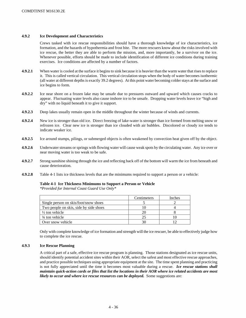
COMDTINST M16130.2E
4.9.2 Ice Development and Characteristics
Crews tasked with ice rescue responsibilities should have a thorough knowledge of ice characteristics, ice formation, and the hazards of hypothermia and frost bite. The more rescuers know about the risks involved with ice rescue, the better they are able to perform the mission, and, more importantly, be a survivor on the ice. Whenever possible, efforts should be made to include identification of different ice conditions during training exercises. Ice conditions are affected by a number of factors.
4.9.2.1 When water is cooled at the surface it begins to sink because it is heavier than the warm water that rises to replace it. This is called vertical circulation. This vertical circulation stops when the body of water becomes isothermic (all water at different depths is exactly 39.2 degrees). At this point water becoming colder stays at the surface and ice begins to form.
4.9.2.2 Ice near shore on a frozen lake may be unsafe due to pressures outward and upward which causes cracks to appear. Fluctuating water levels also cause inshore ice to be unsafe. Dropping water levels leave ice “high and dry” with no liquid beneath it to give it support.
4.9.2.3 Deep lakes usually remain open in the middle throughout the winter because of winds and currents.
4.9.2.4 New ice is stronger than old ice. Direct freezing of lake-water is stronger than ice formed from melting snow or refrozen ice. Clear new ice is stronger than ice clouded with air bubbles. Discolored or cloudy ice tends to indicate weaker ice.
4.9.2.5 Ice around stumps, pilings, or submerged objects is often weakened by convection heat given off by the object.
4.9.2.6 Underwater streams or springs with flowing water will cause weak spots by the circulating water. Any ice over or near moving water is too weak to be safe.
4.9.2.7 Strong sunshine shining through the ice and reflecting back off of the bottom will warm the ice from beneath and cause deterioration.
4.9.2.8 Table 4-1 lists ice thickness levels that are the minimums required to support a person or a vehicle:
Table 4-1 Ice Thickness Minimums to Support a Person or Vehicle *Provided for Internal Coast Guard Use Only*
Centimeters Inches Single person on skis/foot/snow shoes 5 2 Two people on skis, side by side shoes 10 4 ½ ton vehicle 20 8 ¾ ton vehicle 25 10 Over snow vehicle 30 12
Only with complete knowledge of ice formation and strength will the ice rescuer, be able to effectively judge how to complete the ice rescue.
4.9.3 Ice Rescue Planning
A critical part of a safe, effective ice rescue program is planning. Those stations designated as ice rescue units, should identify potential accident sites within their AOR, select the safest and most effective rescue approaches, and practice possible techniques using appropriate equipment at the site. The time spent planning and practicing is not fully appreciated until the time it becomes most valuable during a rescue. Ice rescue stations shall maintain quick-action cards or files that list the locations in their AOR where ice related accidents are most likely to occur and where ice rescue resources can be deployed. Some suggestions are:
4 - 36

COMDTINST M16130.2E
(a) Survey all potential accident sites within the unit’s AOR before winter freezes. Record the size of the area,
water depth and any structures within the water at the site.
(b) Examine those sites to locate natural and man-made hazards, especially those with a history of accidents.
(c) Include the location of access sites and direct routes to them. Pay particular attention to areas that are relatively inaccessible or dangerous such as canyons, marshlands, etc.
(d) Survey all potential accident sites during periods of initial freeze, again recording characteristics of the location.
(e) Hold training exercises at potential accident sites when suitable ice forms. Staying within the limitations of the rescue team will help avoid unnecessary dangers.
(f) Organize and participate in multi-agency ice rescue drills to develop a greater understanding of capabilities, resources, and policies of various contributing agencies.
4.9.4 Risks to Crews 4.9.4.1 Hypothermia is primarily a function of temperature, body conditions, and weight, combined with exposure to the
elements with inadequate protective clothing. COs/OinCs shall ensure personnel are in top physical condition, and are provided with proper cold weather gear, prior to being sent out on the ice.
4.9.4.2 Frostbite is the effect of excessive exposure to extreme cold. To minimize this risk, ice skiff crews shall be provided with adequate protective clothing, including foam padded ski masks, to minimize exposed skin. A wind-chill factor of –54 degrees Fahrenheit will cause frostbite in 10 minutes on exposed skin. At a wind-chill factor of –20 degrees Fahrenheit, frostbite will result on exposed skin in one hour.
4.9.5 Ice Rescue Resources and Utilization 4.9.5.1 Helicopters. Helicopters are the primary SAR resource for Ice Rescues. Sector Command Center’s shall
determine when to request a helicopter, considering such factors as distance offshore, air temperature, ice conditions, urgency, and distance to the nearest air station. If any doubt exists, units should request a helicopter. The applicable Command Center is the approving authority for using helicopters.
4.9.5.2 Ice Skiffs
(a) Ice skiffs will normally be launched only in case of a known emergency with reliable position information, and will launch as close as possible to the actual emergency site. Ice skiffs should not be used to search for overdues, or investigate flare sightings.
(b) Untethered crewmembers should not normally go on to the ice without the skiff, or an equivalent platform to provide support in the event of breaking through the ice en route to the victim. In those rare instances where personnel must transit the ice without a skiff, they shall be tethered or closely observed.
(c) Ice skiffs should not be launched when wave height is above two feet, or when a combination of air temperature and wind velocity exceeds a wind-chill factor of –54 degrees (F). The Sector may waive these requirements on a case-by-case basis, but must notify the applicable Command Center.
(d) A minimum of four persons should be dispatched with the ice skiff and government vehicle when responding to a case. The coxswain and two crewmen should conduct the rescue while the fourth person should stay with the vehicle and maintain communications with the skiff and the Station.
(e) Handheld GPS receivers should be used on all deployments to provide reliable position information.
(f) Ice Skiff (and ATV) operations carry an inherent risk to personnel. The SMC shall be notified prior to deployment of personnel on an ice skiff.
4 - 37

COMDTINST M16130.2E
4.9.5.3 Small Boat Use
(a) Except for bona fide emergencies involving immediate danger to life, boats should not be operated when wind and temperature conditions are such that accumulations of topside ice in excess of one inch may reasonably be expected.
(b) COs/OinCs needing to operate a boat in the ice shall carefully consider the situation, ice conditions, and alternative methods of achieving objectives. Coast Guard small boats are not designed to break ice. Sector and District Command Center’s shall also be kept advised.
(c) Observation of instability due to topside icing on any class of boat shall be immediately reported to the Command Center.
4.9.5.4 Other Equipment. New equipment that offers enhanced performance for our missions is constantly being
developed. Units are encouraged to share information and experiences with such equipment with other units, other agencies, District (drm), and Commandant (CG-5341).
4.9.5.5 Ice Rescue Dive Teams. Many local agencies have ice rescue dive teams that can provide assistance to the CG if
requested. Whenever the case involves a person slipping below the surface of the water/ice, diving operations must be considered. All stations shall maintain a file of those agencies in their AOR that have ice rescue dive teams.
4.9.5.6 Animal Rescues. Rescue attempts for animals stranded on the ice should only be conducted under ideal
conditions after proper RISK ASSESSMENT. The chance of the animal being wild or rabid must be considered when evaluating the potential for injuries to crewmembers.
4 - 38

COMDTINST M16130.2E
4 - 39
Section 4.10 Float Plans 4.10.1 General
The Coast Guard has neither the responsibility nor the facilities to follow the voyages of vessels to their destinations and does not generally accept float plans. Mariners should be encouraged to pass information regarding proposed voyages to other responsible parties such as relatives, friends, yacht clubs, marinas or other facilities willing to perform that function.
4.10.2 Receiving a Float Plan
If a mariner insists on providing a Coast Guard unit with information regarding a proposed voyage, all pertinent information should be recorded on an Overdue Check Off Sheet, including estimated times of arrival and departure at way points. The following disclaimer should also be presented or read:
“The Coast Guard will keep this information on file and use it in the event your vessel is reported overdue. However, the Coast Guard does not have the responsibility or the facilities to follow the voyages of vessels. The Coast Guard strongly recommends that you keep a responsible party informed of the movements of your vessel. Keep that party specifically advised of your expected and actual arrivals. You should instruct them that in the event your vessel does not arrive as planned, they should contact the nearest Coast Guard station.”
4.10.3 Action Taken After Receiving a Float Plan
A copy of all float plans should be retained for a minimum of one month beyond the provided final expected arrival date. Retaining the float plan longer may be appropriate when the length of the voyage itself is of a long duration (e.g. trans-oceanic or around-the-world) or where the type of vessel lends uncertainty to duration of the voyage (e.g. sail vs. power vessels). On receipt of overdue vessel reports, Coast Guard units should check float plan files as a part of PRECOM checks.
4.10.4 Float Plan Form
When informed of the Coast Guard’s policy many mariners will request a float plan form to fill out and provide to an alternative responsible party. Float Plan forms are available in some boating safety brochures produced by the Coast Guard and have in the past been printed individually. These may be provided directly to mariners. A sample Float Plan form that may be copied and used if other sources are not readily available is provided as Figure 4-2.
4.10.5 Float Plan Services
Some commercial and private organizations provide float plan services for members or subscribers. The methods of tracking voyages or reporting overdue vessels by these services vary. Some services offer SAR authorities access to all voyage and vessel data on the report of an overdue. Coast Guard units with personnel that may be designated as SMC should maintain a listing and access instructions for all float plan services that serve their area of responsibility.
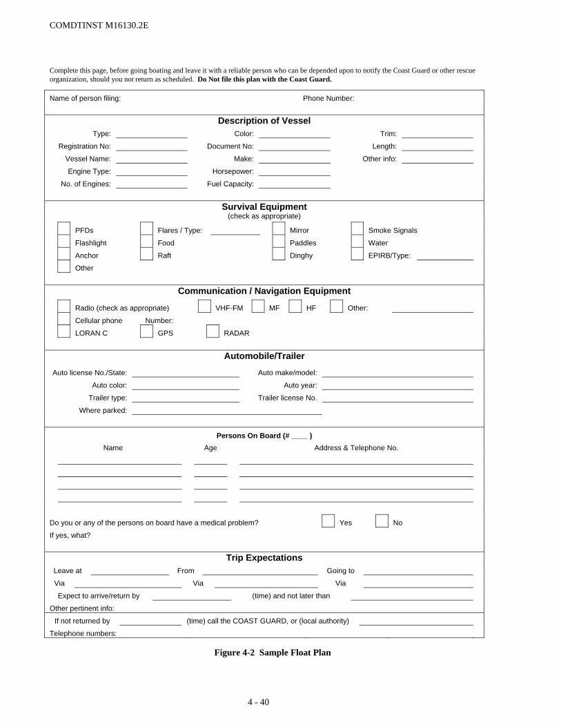
COMDTINST M16130.2E
Complete this page, before going boating and leave it with a reliable person who can be depended upon to notify the Coast Guard or other rescue organization, should you not return as scheduled. Do Not file this plan with the Coast Guard.
Name of person filing: Phone Number:
Description of Vessel Type: Color: Trim:
Registration No: Document No: Length:
Vessel Name: Make: Other info:
Engine Type: Horsepower:
No. of Engines: Fuel Capacity:
Survival Equipment
(check as appropriate)
PFDs Flares / Type: Mirror Smoke Signals
Flashlight Food Paddles Water
Anchor Raft Dinghy EPIRB/Type:
Other
Communication / Navigation Equipment
Radio (check as appropriate) VHF-FM MF HF Other:
Cellular phone Number:
LORAN C GPS RADAR
Automobile/Trailer
Auto license No./State: Auto make/model:
Auto color: Auto year:
Trailer type: Trailer license No.
Where parked:
Persons On Board (# ____ ) Name Age Address & Telephone No.
Do you or any of the persons on board have a medical problem? Yes No
If yes, what?
Trip Expectations Leave at From Going to
Via Via Via
Expect to arrive/return by (time) and not later than
Other pertinent info:
If not returned by (time) call the COAST GUARD, or (local authority)
Telephone numbers:
Figure 4-2 Sample Float Plan
4 - 40

COMDTINST M16130.2E
Section 4.11 Self-Locating Datum Marker Buoys Self-Locating Datum Marker Buoys (SLDMB) utilize satellite-based technology to determine buoy position. SLDMBs provide frequent, high-resolution position information independent of the search unit (search unit does not have to relocate the SLDMB). The SLDMBs drift with the water mass, providing high quality current information. The use of satellite technology greatly reduces the cost of a position determination in comparison to the cost associated with the RDF/DMB.
Current information provided by SLDMBs may be used directly in search planning tools in conjunction with leeway data to estimate the direction and distance of drift for a search object. The information provided also is highly valuable in comparison to EDS current sources to determine reliability and choosing the best current data source for that evolution.
Although fielded to support the SAR mission, SLDMBs may be used to support other missions as well. Possible applications exist for fisheries (high-seas drift nets tracking), law enforcement (floating contraband; bales of narcotics), maritime environmental response (oil spill tracking), and general maritime safety (marking of vessels or other objects adrift). Available stocks and funding will determine the resource commitment outside the SAR mission. 4.11.1 The SLDMB System
There are three major components to the SLDMB System: the buoys, the satellite system and the data system. 4.11.1.1 Self-Locating Datum Marker Buoy (SLDMB). A 7/10th Coastal Ocean Dynamics (CODE)/Davis-style
oceanographic surface drifter with drogue vanes between 12 and 37 inches deep. The onboard electronics provide Global Positioning System (GPS) positioning and sensor data (buoy ID, position, and sea temperature).
(a) GPS positions are acquired at 15-minute intervals for the first two hours and at 30-minute intervals thereafter.
Up to 13 half-hour data sets can be stored if necessary before transmission to a satellite. (b) SLDMBs are air- or ship-deployable, and buoys are operational for 14 to 30 days after deployment.
Figure 4-3 Deployed SLDMB (METOCEAN)
4 - 41

COMDTINST M16130.2E
4.11.1.2 Service Argos Inc. Argos is the satellite data system that receives and forwards the information transmitted from the SLDMB to the Coast Guard using National Oceanographic and Atmospheric Administration (NOAA) polar-orbiting n-series satellites.
(a) SLDMB data will be transmitted within 30 – 90 minutes of deployment/activation. Depending on the
deployment location, time of day, and position of the Argos satellites, there may be as much as a five-hour gap in satellite coverage (satellite footprint). SLDMBs retain up to 13 data reports, which will be uploaded to the Argos network when a satellite comes in view. Drift data requires a minimum of two positions (at least 30 minutes), but additional positions will ensure the electronics on board the SLDMB are operating properly. Waiting for the first hour’s data (four 15-minute interval positions) is recommended.
(b) Sources for satellite pass data are available via the Internet. A recommended list is available via the SAR Program’s Intranet web site.
4.11.1.3 USCG SLDMB Web Site. The SLDMB web site is hosted at the Coast Guard’s Operations Systems Center and
is accessed via the intranet at the web address: http://sldmb.osc.uscg.mil/DataRequest/Welcome.aspx. The site provides operational data, logistics support, system documentation, and administrative functions.
(a) Operational SLDMB position (drift) data is made available via data requests and may be viewed or
downloaded as a data table or requested via SAROPS for visual display.
(b) Logistics functions are used to track the ordering, shipping and deployment of SLDMBs. In addition, the system tracks the buoy shelf life, performance and failures. Reports on various logistics aspects can be generated for system management.
(c) System documentation provides a user’s guide, tutorial, frequently asked questions, user forum, comments and new features listing. This on-line documentation provides the line-by-line user information needed to fully use the web site application. Brief descriptions are provided as needed in this Addendum.
(d) Administration functions include user accounts and contacts for the system.
4.11.2 SAR Mission Coordinator Actions
The SMC provides direction to SAR units for the deployment of SLDMBs, enters the deployed status in the SLDMB web site, and retrieves the data produced by the SLDMBs for use in SAR mission planning.
4.11.2.1 Deployment Considerations. The purpose of deploying SLDMBs is to measure the surface currents within SAROPS’s Area of Interest (AOI) during the period of interest. The period of interest begins with the distress incident, which often occurs before an SLDMB can be deployed simply because it takes time to respond and travel to the distress location after notification. The amount of time that passes between the distress incident and the deployment of SLDMBs affects the size and location of the area where they should be deployed. The nature and complexity of the situation, e.g., number of possible scenarios, accuracy of the distress location(s), also has an impact. The presence or absence of significant ocean current features that have large horizontal variations or rapidly change with time (e.g., the north wall of the Gulf Stream is example of current with strong horizontal current variation and tidal and wind currents exhibit rapid temporal changes) are also important factors. The proximity to shore will also affect how and where SLDMBs should be deployed, since currents tend to have shorter time and space scales near shore. Significant ocean current features are often easy to see in EDS surface current products. A single SLDMB deployed at a datum position (or between two divergent datum positions) soon after the distress incident will provide valuable information. However, when any of the survivors still remain unlocated for any significant period after arrival on scene, it will be necessary to deploy several SLDMBs to get a true picture of the surface currents in the area of interest. The following guidance will help the SMC make decisions as to using SLDMBs as a tool in SAR efforts.
(a) Type of case. SLDMBs should be used in all cases where current data is not available from the EDS or the
current data available from the EDS is suspect or low quality. SLDMBs should also be used during all significant searches.
(1) For cases where EDS data is lacking or shown to be inaccurate, the SLDMB data should be used directly.
4 - 42

COMDTINST M16130.2E
(2) Where EDS data is present and shown to be accurate, the EDS data should be used. In these instances, the SLDMB data should be monitored to check the continued accuracy of the EDS products and to highlight where anomalies in the currents may be present and not shown by the EDS. These anomalies should be considered in search planning.
(3) SLDMBs may also be used during all searches for contraband and provide solid information for use when legal prosecution may be required.
(b) When to deploy. One or more SLDMBs should be deployed as soon as it is apparent that the case will not be quickly resolved. It is far better to drop SLDMBs on a case that turns out to quickly resolve than to hold back dropping SLDMBs on a case that will absolutely require sea current information to plan a search. If you think you might need to deploy SLDMBs, then you should deploy SLDMBs. SLDMBs should be dropped as early as possible, since the goal is to provide estimates of the drift of the SAR objects from the time of incident up until the end of the next search period. The earlier an SLDMB is dropped, the more useful the data will be to the case. SLDMBs can also be pre-deployed during peak SAR season, in anticipation of weekend SAR cases, opening of fishing seasons or tournaments, and seasonal refugee migrations. Regardless of why or when they are deployed, SLDMBs provide valuable oceanographic data.
(c) Number of SLDMBs to deploy. SAROPs’s Currents Sketch Toolbox can import SLDMB tracks directly into SAROPS and compute surface current fields from the trajectories of several SLDMBs in reasonably close proximity and cached for use by SAROPS’s simulator. The number of SLDMBs that should be deployed will depend on the size of the area of interest (SAROPS AOI) and the nature of oceanographic features in the area. Larger areas and/or more complex currents will often require deployment of multiple SLDMBs. At the start of a case most SRUs arriving on scene will not be carrying multiple SLDMBs unless directed by the SMC to do so before launch; a single SLDMB may be all that is available initially.
(1) A single SLDMB may be all that is needed if the currents across the region are essentially the same or if the area of interest (SAROPS AOI) is fairly small.
(2) Multiple SLDMBs may be needed when the area of interest includes known or suspected varying currents such as in or near the boundary of the Gulf Stream or other major current feature, around or between island chains, in the vicinity of major river outflows, or in the vicinity of inlets with significant tidal influence. The size of the region may also determine the number of SLDMBs needed. As the size of the region increases so will the number of SLDMBs required to accurately represent the current flow field.
(d) Where to deploy. SLDMBs should be deployed in the vicinity of the last known position (LKP) when the time lag between the distress incident and deployment is reasonably short (a few hours at most). Otherwise, they should be deployed in the vicinity of the computed datum(s) or high probability region(s).
(1) Single SLDMB. Where a single SLDMB is to be used, it should be deployed at the last known position (LKP), or in the center of the region that is most likely to contain the search object (which is not necessarily the single highest probability cell on a probability map if that cell happens to be isolated from the main body of the distribution).
(2) Deployment Patterns for Multiple SLDMBs. There are three basic geometric patterns for multiple SLDMB deployments—corners of a polygon, in a line, or as an “X”. However, other patterns and deployment dispositions may be used if the SMC has reason to believe they will provide better data for search planning purposes, as discussed under “generalized patterns” below.
a. Corners of a Polygon. Three or more SLDMBs may be deployed at corner points of a not-too-large polygon containing the datums(s) or high-probability region(s) that have been estimated for the expected deployment time or possibly a somewhat later time. The SMC may wish to consider using a somewhat later time for computational purposes, especially in high leeway situations, so as to keep the SLDMBs and search objects in closer proximity for a longer period by placing the SLDMBs somewhat ahead of where the high probability regions are expected to be at the time of deployment. When determining the deployment polygon, the idea is not to contain the entire distribution of possible search object locations but to place the SLDMBs in the midst of the distribution near the high-probability regions in some sensible pattern. The number of corner points will be determined by the number of SLDMBs readily available, and the shape and disposition of the high probability region(s). This type of pattern is best used offshore in the open ocean away
4 - 43
COMDTINST M16130.2E
from prominent surface current features.
b. In a Line (Transect or Along Track Line). In areas where specific current features are known or suspected to exist, the best deployment is often along a line perpendicular to the axis of the feature in or near the high-probability region(s). This is called a transect and it is particularly useful for strong currents like the Gulf Stream that exhibit a considerable range of speeds across their width. Eddies and counter-currents may also exist just outside the main flow and a transect would usually discover these as well if extended far enough. Another reason for a linear deployment would be to accommodate a missing craft’s intended track. However, unless the track line is short or the missing craft’s pre-distress speed is large (as with an aircraft, for example), the times involved may dictate deployment along a path (possibly curved or even crooked) to accommodate where the search object may have drifted from various points along the intended track up to the time of SLDMB deployment.
c. “X” Pattern. In situations where it is unclear whether the major surface current influence is parallel or perpendicular to a given feature, such as the shoreline, it may be appropriate to deploy SLDMBs in an “X” pattern so that transects along the two perpendicular axis are obtained.
d. Generalized Pattern. In areas where surface currents are expected to exhibit considerable complexity due to a complex shoreline, complex bottom topography, river outflows, and/or tidal influences, a less geometrically regular deployment pattern than those given above may be appropriate. In such cases, detailed local knowledge from reliable sources can be an invaluable aid for determining the best placement of SLDMBs.
e. Multiple Scenarios. The deployment strategy for cases with multiple scenarios should be to cover all the scenarios using the patterns suggested above.
(3) Spacing. Spacing between multiple SLDMBs is dependent upon the situation. The optimal spacing ranges from 3 nm for near-shore cases with strong tidal currents to 6 nm for offshore cases in regions that lack significant open ocean currents. However, the number of SLDMBs that can be made available in combination with the size of the area of interest may dictate larger spacing. For larger spacing, more care is needed to determine the best deployment locations. During the latter stages of a multi-day case, additional SLDMBs should be deployed to fill the gaps between the existing SLDMBs and to seed the area down-drift.
(4) Other Sources. Most surface current data for search planning comes from either models that are updated with observations from a variety of sources (which may or may not have direct observational data for the region and time of SAR interest), or from climatological databases or atlases. In both cases it is generally necessary to deploy SLDMBs to get better data for the area of interest. In the (presently rare) event that reliable direct observations are available from other sources in some parts of the region of interest, it may be more beneficial to deploy SLDMBs elsewhere rather than duplicate the efforts of these other sources. As the ability to assimilate SLDMB data into oceanographic models in a timely fashion improves, it will be possible to realize the benefits of both direct observation and modeling with minimal or no impact on the search planner beyond directing the deployment of the SLDMBs as needed. However, for the present time SLDMB-based surface current data will generally take precedence in the vicinity of the SLDMBs over data from other sources.
(e) Incidents in remote areas present additional difficulties. Deployment of an SLDMB in an initial sortie is particularly critical due to the likely delay in additional sorties and the need to maximize searching during those sorties. Delaying until a later sortie to deploy an SLDMB can add hours to the delay in receiving critical sea current data. Dropping more then one in case of failure should also be considered for very remote area insertions.
(f) Approaching nightfall or significant weather may impact when an SLDMB should be deployed.
(g) Time of year or climate. In northern climes where water temperatures are colder, as in all response actions, deploying an SLDMB early may be prudent. Warmer climates make for longer survival of persons in the water, requiring longer searches, which will benefit more from the long-term availability of sea current information.
(h) SLDMBs from previous cases may still be in the area of a new incident, or have drifted into that area. A quick check of the data system may yield immediately available total water current information for the vicinity and time of the new incident.
4 - 44
COMDTINST M16130.2E
(i) Combining USCG and Canadian SLDMB data. Assume the USCG SLDMBs have zero leeway but assume the Canadian SLDMBs have a leeway of approximately 1% of the (standard 10-meter) wind in the downwind direction.
4.11.2.2 SMC Deployment Actions. SMCs are the primary authority for directing the deployment of SLDMBs and will
most times make the decision to deploy an SLDMB. However, SRUs arriving on scene often will not immediately find the search object. Prior direction to SRUs by the SMC can be given that would task the SRU to deploy SLDMBs in these situations giving consideration to time spent initially searching the area, nature of the incident, and remaining sortie time.
(a) Direction to SRU’s. SMCs should provide SRUs with the location(s) for deploying SLDMBs. If multiple
SLDMBs are needed, the SMC should direct the SRU to take additional SLDMBs on board. SRUs arriving on scene may not immediately find the search object. Prior direction should be given that would task the SRU to deploy SLDMBs with consideration to time spent initially searching the area, nature of the incident, and remaining sortie time. SRUs should be directed to pass location, time and Argos ID to the SMC immediately after deployment.
(b) Marking SLDMBs as deployed. SMCs will receive deployed location, time and Argos ID from SRUs. To mark the SLDMB as deployed within the data system, the SLDMB Web Site (http://sldmb.osc.uscg.mil/) is accessed and SMC’s select the appropriate District from the dropdown menu. Scroll to the SRU’s home unit and click the “arrow” to the SLDMB, scroll to the bottom of the page enter desired output parameters and click “Submit.” The SMC will be asked to input the MISLE case number, the buoy deployment data passed from the SRU, SMC (command/initials) in the “Enter Comment” block and then click “Submit,” to begin receiving data. ONLY SMCs should be entering this data and marking SLDMBs as deployed. If the wrong Argos ID is used inadvertently, the SMC must immediately contact the OSC help desk (304-264-2500) to have the status reset on that Argos ID.
(c) Checking SLDMB Operation. To ensure the SLDMB has deployed and begun operating, the SMC should check to see if data is being transmitted as soon as data would reasonably be available. Timing for this check is dependent on satellite pass (para. 4.10.1.2(b)).
4.11.2.3 Direct Data Retrieval and Output. SMCs and other persons interested in the drift data provided by SLDMBs
access that data via the SLDMB Web Site (http://sldmb.osc.uscg.mil/DataRequest/Welcome.aspx) Data Request Page. Select the District that the buoy was deployed in from the main menu and scroll to the SRU that deployed the buoy. Click the box to the left of the buoy number and scroll to the bottom of the page and select your data output parameters. For Advanced Search parameters click on the “Advanced Search” button at the top left of the page once you have selected your District. Within the Advanced Search page buoy data can be selected using tailored time frames and entering geographical regions. Data output is available as a screen display table that can be exported to a spreadsheet. Step-by-step direction is available in the on-line user’s guide. Note: The number of buoys, size of geographical region, and time frame requested all impact the size of the data record returned. It is recommended that a data record count of no more than 1500 be returned to avoid protracted delays when downloading data. A table of data parameters and number of records is available via the SAR Program’s Internet web site.
4.11.2.4 SAROPS Data Use Guidance
(a) SAROPS SLDMB Wizard can be used to locate and display SLDMB tracks from a user defined AOI and time period. Each SLMDB active in the AOI is color coded in the ArcMap table of contents. The SAROPS time slider can be used to view the track of the SLDMBs and be displayed over surface currents obtained from the Environmental Data Sever (EDS).
(b) Once displayed, a comparison with the EDS surface currents can aid in determining how well the EDS currents appear in comparison to the SLDMB. And when multiple EDS surface current sources are available for the AOI, help in selection of the best for use during that time period.
(c) Where comparison of SLDMB to EDS shows the EDS products to be suspect, SAR planners should check with oceanographic points of contact to discuss the issue. Where EDS problems are confirmed or suspected it may be appropriate to use the SLDMB data directly.
4 - 45

COMDTINST M16130.2E
(d) The SAROPS Currents and Winds Sketch tool can be accessed under Tools / Extensions / Currents Toolbox. Within the Currents Tools, create a ‘Hydrodynamic Grid’ by double clicking. A grid should be created matching the AOI and time period required by the SAROPS run. Land/Water cells can be switch by using the ‘Toggle Land/Water Cells’. Next double click ‘Import SLDMB’; after successful import, double click ‘Spread Vectors’, entering ‘Yes’ to ‘Apply to all time steps?’. If SLDMBs were not active or available for the first portion of the time period; ‘Sketch Currents’ can be used to add vectors for the time step prior to availability of SLDMBs currents. Extrapolate backward in time from the available SLDMBs to estimate these sketched currents. After Sketching Currents, repeat the Spread and Smooth currents, then ‘Save’. The file will now be available as a cached file in the SAROPS Surface Currents GUI for use by SAROPS to drift the particles.
(e) SLDMBs that drift longer than 4 days are used by oceanographers to evaluate the Environmental Data Sever surface currents products.
4.11.3 Failed SLDMBs
Occasionally SLDMBs will fail to operate properly. The failure may be a result of a bad part within the buoy itself, damage in shipping and handling, or damage incurred during deployment. Failure indicators are most often receiving no data or corrupt data. Occasionally units deploying an SLDMB may observe a failure. If there is a suspected buoy failure after deployment, the OSC Customer Service line should be contacted at (304) 264-2500 to verify failure. The possibility exists that a buoy with a different ID than reported was actually deployed; in this instance, no buoy failure would have occurred; the unavailability of data would be due to human error. If a buoy is found to have failed or is damaged prior to deployment, the Engineering Logistics Center’s (ELC) should be contacted at (410) 762-6236.
4.11.3.1 No data received (Confirmed buoy ID). When no GPS or Argos data is received from a buoy within ninety
minutes, it is likely the buoy has failed, or the wrong buoy ID has been marked deployed. Once the SMC has confirmed the correct buoy ID has been deployed (and that no other buoy was erroneously marked deployed in its place), the SMC should determine whether a satellite pass for the SLDMB has occurred (see subparagraph 4.10.1.2(b)). If so, the buoy is considered inoperative. The SMC should then deploy another SLDMB as soon as possible and notify the OSC (a POC is listed on the SLDMB web site).
4.11.3.2 Corrupt data received. When the data being received appears erratic (widely spaced positions resulting in
widely varying speeds/directions, initial position far from the deployed position, very sporadic data, etc.), it is likely the SLDMB has sustained damage or has a failure in the electronics package. The SMC should call the OSC help desk to verify the SLDMB web site and transmissions from Argos are not experiencing problems. If the SLDMB appears to be the source of the corrupt data, OSC help desk personnel should notify the Duty Analyst to terminate the SLDMB. The comments should include the reason for termination as corrupt data. The SMC should deploy another SLDMB as soon as possible.
4.11.4 Requests for SLDMBs deployments by other agencies or nations
The Coast Guard cooperates and lends support to a multitude of other agencies and nations in the conduct of SAR operations. SLDMBs, as with other SAR support, may be deployed on request of non-Coast Guard SMCs subject to the availability of resources. The same level of review should be applied as is for deploying search assets in support of non-CG search efforts.
4.11.5 SLDMBs and use of Standard RDF/DMBs
SLDMBs provide superior current information for the SAR planner’s use in search planning. The standard RDF/DMB may still be useful in some roles, such as marking a debris field that searchers wish to relocate (homing function) over a short period of time, or in restricted waters to get a quick idea of drift for the first search effort. Standard DMBs may be used until no longer available.
4.11.6 SLDMB Deployment by Search and Rescue Units 4.11.6.1 Deployment from Aircraft. SLDMBs are deployable from Coast Guard HC-130, HU-25, HH-60 and HH-65
aircraft. Specific deployment procedures for individual aircraft types are provided in each aircraft flight manual.
4 - 46

COMDTINST M16130.2E
The General fixed and rotary-wing deployment guidance is available at the SLDMB web site. Coast Guard testing found for the HH-60 and HH-65 aircraft that 300 foot altitude and 70 knot airspeed was optimal. For situations using the drogue parachute, Coast Guard testing found the launch altitude should be no lower than 200 feet as it appeared to be the minimum altitude which allowed the parachute to open fully and be effective in directing the entry of the SLDMB into the water. For all deployments, the Drop Master must remove the tag that contains the SLDMB Argos ID 5-digit number. The Aircraft Commander should then report the time, location, altitude, air speed, sea conditions, drop observation and ID for each drop to the SMC.
(a) Fixed-wing aircraft deployment. The SLDMB uses a 15-foot (4.5 m) static line to ensure that the parachute
is correctly deployed from the buoy. The static line has loops at 10 feet and 15 feet for various aircraft. No tools are required for this deployment. The buoy must be removed from its protective wrapper, then the static line is hooked on and the buoy ejected from the aircraft.
(b) Rotary-wing aircraft deployment. For deployment from rotary-wing aircraft, the deployment method depends on the altitude of the aircraft at time of deployment.
(1) When the deployment height is less than 25 feet, (8 meters), and the aircraft is hovering, the buoy is
removed from its protective wrapper, and both static line and parachute are removed. No tools are required for this. The buoy can then be launched directly from the aircraft.
(2) When the launch height is greater than 25 feet (8 meters) or if the aircraft has any significant forward speed (10 knots or more), the buoy is removed from its protective wrapper, the static line and parachute cap then must be removed from the launch container. The parachute is then extracted from the top of the launch container, hand deployed from its parachute bag, but not detached from the buoy. The buoy is then launched from the aircraft. CAUTION: The shroud lines on the parachute present a tangle hazard to personnel deploying the SLDMB; care must be taken to avoid shrouds snagging on aircrew hands, arms, and/or flight gear before deployment. Note that no other parts need be removed and that the buoy will not deploy any other parts during launch or descent.
4.11.6.2 Deployment from Cutters and Boats. The design of the SLDMB with the removable parachute assembly makes
it suitable for surface deployment from cutters and boats. Cutters and boats can be underway when deploying the SLDMB, with speed reduced to under 10knots to avoid causing damage during deployment. The SLDMB should be deployed with the bottom (end away from parachute shroud snap hook) of the launch container entering the water first if possible. For all deployments, the deploying personnel must remove the tag that contains the SLDMB Argos ID 5-digit number. The Commanding Officer or Coxswain should then report the time, location, vessel speed, sea conditions and ID for each deployed SLDMB to the SMC. Procedures for preparing the SLDMB for surface deployment may be found at the SAR Program’s Internet site.
4.11.6.3 SLDMB Self-deployment. SLDMBs are designed for fully automatic deployment after impact with the water. After impact with the water, the tape holding the launch container dissolves. This allows the launch container to be released and also frees the arms to deploy the drogue panels and removes the magnet, starting the electronics. A few minutes after the arms are deployed, the tape holding the antenna mast down dissolves. This frees the spring-loaded mast to extend, which also detaches the parachute. All parts are ballasted to sink or are biodegradable. At this point the buoy is fully deployed and operational. The self-deployment process takes between 4 and 11 minutes.
4.11.6.4 Deployment Cautions
(a) Proper deployment of the SLDMB is best achieved by leaving the SLDMB in the launch container, and allowing the SLDMB to self deploy. In opening the launch container, damage may inadvertently be done to the SLDMB.
(b) Drogue Arm deployment. All SLDMBs are packaged with folded arms. These arms are under tension with shock cord. Excessive stretching may break the shock cord and could cause injury.
(c) Mast Extension. The mast is spring-loaded and will extend about 16.5 inches. If the buoy is disassembled beyond simple removal of the parachute, care must be taken to retain the mast in its down position. Care must be taken if the mast is extended manually. Once extended, the mast cannot be retracted without major buoy repairs. CAUTION: SLDMBs should not be lifted by the antenna mast; lifting by the mast may damage
4 - 47
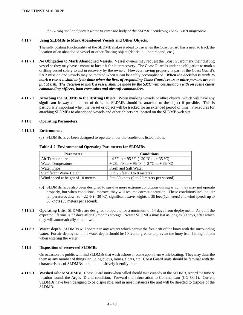
COMDTINST M16130.2E
the O-ring seal and permit water to enter the body of the SLDMB; rendering the SLDMB inoperable. 4.11.7 Using SLDMBs to Mark Abandoned Vessels and Other Objects.
The self-locating functionality of the SLDMB makes it ideal to use when the Coast Guard has a need to track the location of an abandoned vessel or other floating object (debris, oil, contraband, etc.).
4.11.7.1 No Obligation to Mark Abandoned Vessels. Vessel owners may request the Coast Guard mark their drifting
vessel so they may have a means to locate it for later recovery. The Coast Guard is under no obligation to mark a drifting vessel solely to aid in recovery by the owner. However, saving property is part of the Coast Guard’s SAR mission and vessels may be marked when it can be safely accomplished. When the decision is made to mark a vessel it shall only be done when the lives of responding Coast Guard crews or other persons are not put at risk. The decision to mark a vessel shall be made by the SMC with consultation with on scene cutter commanding officers, boat coxswains and aircraft commanders.
4.11.7.2 Attaching the SLDMB to the Drifting Object. When marking vessels or other objects, which will have any
significant leeway component of drift, the SLDMB should be attached to the object if possible. This is particularly important when the vessel or object will be tracked for an extended period of time. Procedures for attaching SLDMBs to abandoned vessels and other objects are located on the SLDMB web site.
4.11.8 Operating Parameters 4.11.8.1 Environment
(a) SLDMBs have been designed to operate under the conditions listed below.
Table 4-2 Environmental Operating Parameters for SLDMBs
Parameter Conditions Air Temperature - 4 °F to + 95 °F (- 20 °C to + 35 °C) Water Temperature + 28.4 °F to + 95 °F (- 2 °C to + 35 °C) Water Type Fresh and Salt Water Significant Wave Height 0 to 26 feet (0 to 8 meters) Wind speed at height of 10 meters 0 to 39 knots (0 to 20 meters per second)
(b) SLDMBs have also been designed to survive more extreme conditions during which they may not operate
properly, but when conditions improve, they will resume correct operation. These conditions include: air temperatures down to – 22 °F (– 30 °C), significant wave heights to 39 feet (12 meters) and wind speeds up to 68 knots (35 meters per second).
4.11.8.2 Operating Life. SLDMBs are designed to operate for a minimum of 14 days from deployment. As built the
expected lifetime is 22 days after 18 months storage. Newer SLDMBs may last as long as 30 days, after which they will automatically shut down.
4.11.8.3 Water depth. SLDMBs will operate in any waters which permit the free drift of the buoy with the surrounding
water. For air-deployment, the water depth should be 10 feet or greater to prevent the buoy from hitting bottom when entering the water.
4.11.9 Disposition of recovered SLDMBs
On occasion the public will find SLDMBs that wash ashore or come upon them while boating. They may describe them as any number of things including buoys, mines, floats, etc. Coast Guard units should be familiar with the characteristics of SLDMBs to help to positively identify them.
4.11.9.1 Washed ashore SLDMBs. Coast Guard units when called should take custody of the SLDMB, record the time &
location found, the Argos ID and condition. Forward the information to Commandant (CG-5341). Current SLDMBs have been designed to be disposable, and in most instances the unit will be directed to dispose of the SLDMB.
4 - 48

COMDTINST M16130.2E
4.11.9.2 Afloat SLDMBs. Afloat SLDMBs should be left floating whenever possible. On occasion it may be necessary to
remove a floating SLDMB due to the specific location (hazard to navigation, etc.). If an afloat SLDMB may need to be removed, Coast Guard units should first ascertain that the SLDMB is not active by passing the Argos ID to their sector or district command center. The ID is on a plate near the base of the SLDMB’s body; to see the number the SLDMB must be carefully removed from the water. CAUTION: SLDMBs should not be lifted by the antenna assembly; this may cause the O-ring to fail, allowing water into the body of the SLDMB, which will render it inoperable. If the command center does not know immediately the status of the SLDMB (in use for an ongoing case; or used in a recent case), the command center should enter the SLDMB web site and use the Argos ID to run a Buoy History. If the report shows the buoy status as deployed (active), a data request should be run entering a Time Frame of “Last 1 day” and Geographical Region – Select by Buoy Number entering the Argos ID. If no data is present, the SLDMB is no longer active awaiting automatic termination in the system. If data is still present, the SLDMB should be left in the water.
4.11.9.3 Deactivation and Disposal. On the occasion where a SLDMB is recovered it is necessary to deactivate the
buoy before disposal. Deactivation is done by cutting the two wire leads running to the top of the antenna which are accessed by removing four screws under the base of the white antenna cover. Detailed deactivation instructions can be found at the SLDMB web site. Once deactivated, a SLDMB is safe to be disposed of with standard garbage.
4.11.10 Data Availability Outside the Coast Guard
SLDMB drift data is useful to many other persons and agencies outside the Coast Guard; in particular it is valuable to the oceanographic community (government and academia). At present there is not a direct access capability for persons or agencies outside the Coast Guard to the data produced by Coast Guard deployed SLDMBs. There is no restriction on providing this data upon request. Requests for data should be forwarded to Commandant (CG-5341).
4.11.11 Logistics
Logistics for the SLDMB are covered primarily within the Equipment Integrated Logistics Support Plan (EILSP) and the logistics section of the SLDMB web site with its associated user’s guide. The EILSP along with additional information on distribution, ordering, tracking and stowage of SLDMBs is available via the SAR Program’s cgweb site at: http://cgweb.comdt.uscg.mil/g-opr/g-opr.htm.
4 - 49

COMDTINST M16130.2E
Section 4.12 SAR and Security Concerns 4.12.1 Non-Immigrant Security Concerns
In carrying out our SAR mission we routinely MEDEVAC persons from vessels to the US for emergency medical treatment and bring other SAR incident survivors into the US. In such cases where the individual(s) are not believed to be US citizens or US permanent resident aliens, the SMC shall notify immigration enforcement officials immediately to coordinate any law enforcement issues.
4 - 51


COMDTINST M16130.2E
Section 4.13 Maritime Law Enforcement and Vessel Safety
4.13.1 Vessel Safety Law Enforcement
Vessel safety law enforcement supports the overall goal of promoting the safety of life and property at sea and protecting the marine environment. In carrying out this mission, the Coast Guard’s role primarily consists of ensuring compliance with laws and regulations through enforcement action and educating members of the maritime industry and the boating public. Specific guidance regarding vessel safety law enforcement, including terminating voyages is contained in reference (l).
4.13.2 Safe Operation founded in Law
Titles 33 and 46 of the United States Code and other U.S. laws, international laws, and treaties promote the safe operation of commercial and recreational vessels. The Safety of Life At Sea Convention (SOLAS) and associated Protocols establish international standards for seaworthiness and carriage of life saving equipment.
4.13.3 Manifestly Unsafe Voyage
Pursuant to authority contained in 33 CFR 177.04, the District Commander may declare a U.S. recreational or uninspected passenger vessel to be engaged in a Manifestly Unsafe Voyage.
4.13.4 Termination
Violations of law and treaties that create an especially hazardous condition may subject U.S. recreational and uninspected passenger vessels to voyage termination under 33 CFR Part 177. Termination is authorized when one or more specifically defined unsafe conditions exist, they cannot be corrected on the spot, and continued operation of the vessel constitutes an especially hazardous condition. Procedures regarding voyage termination, including authority to terminate the voyage of an uninspected commercial fishing vessel, are discussed in reference (l).
4.13.4.1 Termination order and additional considerations. The goal of termination is to protect the safety of the
persons onboard the vessel and the maritime public. Once the decision to terminate a voyage has been made, Boarding Officers may need to consider additional actions necessary to alleviate the especially hazardous condition (e.g., removing passengers and/or cargo from the vessel, escorting or towing the vessel to port). An intoxicated operator shall not be directed or permitted to operate the vessel.
4.13.4.1 Termination and the Commercial Fishing Industry Vessel Safety Act (CFIVSA), 46 USC 4501-4508.
(a) The CFIVSA establishes a national program to reduce commercial fishing vessel losses and fatalities. Pursuant to, regulations prescribing equipment and operational requirements for U.S. fishing, fish processing and fish tender vessels have been promulgated in 46 CFR Part 28. It is beyond the scope of this Manual to describe elements and enforcement policy associated with each of these regulations. The most significant regulatory requirements are contained in reference (nn).
(b) Violations of the CFIVSA that create an especially hazardous condition may subject the boarded vessel to voyage termination under 46 CFR Part 28.
4.13.4.2 Termination and SAR considerations. Based on the situation, our response to a vessel termination should be
assigned the appropriate SAR phase.
4 - 53


COMDTINST M16130.2E
Section 4.14 Places of Refuge 4.14.1 General
Ships in need of assistance may request national authorities to make available a place of refuge. Authorities may provide such assistance, while exercising the prerogatives and rights of sovereignty, including border control, coastal zone protection and national self-defense. The International Maritime Organization (IMO) has established guidelines on places of refuge (Assembly Resolution A.949(23)). A ship may be involved in an incident or marine casualty (e.g., fire, engine or other casualty that affects the seaworthiness of the vessel) and may need assistance (e.g., sheltered area where cargo can be lightered or repairs can be performed, etc.), but not be in a distress situation that requires rescue of those on board; or may be in distress, but those on board have already been rescued, with the possible exception of those who have remained or been placed on board to deal with the ship’s situation. IMO recommends that nations establish a maritime assistance service (MAS) to serve as a national point of contact in such situations, and has developed relevant guidelines (Assembly Resolution A.950(23)). Both of these Resolutions are available on the internet web site of Commandant (CG-5341).
4.14.2 Definitions
4.14.2.1 Ship in need of assistance: a ship in a situation, apart from one requiring rescue of persons on board, that could give rise to loss of the ship or to an environmental or navigation hazard.
4.14.2.2 Place of refuge: location where actions can be taken for a ship in need of assistance to stabilize its condition, reduce hazards to navigation, and protect human life and the environment.
4.14.2.3 Maritime Assistance Service (MAS): a contact between a ship master or company and national authorities on matters relating to a place of refuge.
4.14.3 Discussion
Places of refuge are for ships needing assistance, and are distinct from places of safety to which persons are delivered once they are recovered from a distress situation. Although a claim of force majeure under international law may give rise to a request for a place of refuge, technically, the two concepts are distinct. Place of refuge decisions typically involve complex technical, legal and political considerations beyond the realm of SAR. A MAS provides communication services similar to those provided by an RCC; in most countries, including the U.S., RCCs perform the MAS function since shipmasters naturally contact them when dealing with dangerous situations.
4.14.4 Relevance to Search and Rescue
Assistance to ships and other craft in distress is not considered to be a SAR effort unless it also entails assisting persons in distress (see the definition of “rescue”). A national point of contact that serves as the MAS often is, as in the U.S., an RCC; however, other authorities may serve as MAS in some countries. A shipmaster or shipping company dealing with a ship needing assistance can be expected to contact a Coast Guard RCC. Some scenarios may actually or eventually involve persons in distress as well as a ship in distress.
4.14.5 Priorities
Granting of a place where a ship needing assistance can come may be a difficult decision because overall risks to the ship, safety, security or the environment may be greater if the ship remains in the open sea, or greater if the ship is taken to a place of refuge. The concerns need to be balanced and considered on a case-by-case basis by experts, and might involve a political decision. If the situation ever evolves to where a person or persons on board the ship are in distress, concerns for lifesaving shall take priority over other concerns, and SAR authorities become responsible for assisting the persons in distress.
4.14.6 Responsibility for Places of Refuge and Maritime Assistance Service
Within the Coast Guard, Captains of the Port (COTPs) have the primary responsibility for decisions made on place of refuge requests, and should incorporate the relevant IMO guidelines into their contingency planning and response activities. RCC staff should understand the distinctions between place of refuge and SAR cases. They
4 - 55

COMDTINST M16130.2E
should be prepared to function as MAS should the need arise, and have plans of operation in place to ensure close cooperation with the appropriate COTP in such cases. RCCs should be prepared to immediately relay any request for a place of refuge to the COTP, have cooperative arrangements in place with the COTP to monitor such cases if potential exists for persons in distress, and as appropriate, facilitate communications between the COTP and the shipmaster or other company representative who made the request.
4 - 56
COMDTINST M16130.2E
Section 4.15 Persons Falling or Jumping from Bridges 4.15.1 Appropriate Response
Whenever a Coast Guard facility receives a report of a person falling or jumping from a bridge into the water and any doubt about the person’s safety exists, the report shall be treated as a distress call with a corresponding appropriate response. Appropriate local authorities shall be notified immediately. They should be requested to investigate the incident and, if they have appropriate resources, to assist in the search. If the report is received from local authorities with a request to provide Coast Guard assistance, standard policy for providing assistance to local authorities applies (see section 1.5.4 of this Addendum and section 15-3-1 of reference (pp)).
4.15.2 Duration of Search 4.15.2.1 The duration of Coast Guard participation in a search for someone who has fallen or jumped from a bridge may be
based on the following factors:
(a) Chances of surviving the fall. The primary factor is height of the bridge above the water at the point from which the person fell or jumped. Water depth at the point of impact is another consideration.
(b) Chances of continued survival in the water. Primary factors include likelihood of injuries from the fall, water temperature, and nature of the currents.
(c) Will to live. Some who jump from bridges are attempting suicide, but this does not necessarily correspond to a lack of the will to live.
(d) Availability of adequate resources on scene from local agencies. (e) Nature of the searching being done by the responsible local agencies. If in body recovery mode, the SAR
aspects of the incident may be considered ended. Further Coast Guard participation may take place at the discretion of the local unit or higher authority, but only as providing non-SAR assistance to local agencies.
(f) Knowledge of distress location narrowing the initial search area. (g) Cessation of search activities by the responsible local agencies.
4.15.2.2 After searching the specific area around the water entry point (with consideration for drift), when deemed by the
SMC that the chance of survival is negligible, search efforts may be suspended. An additional consideration is survivors are most often found soon after rescuers arrive on scene.
4.15.3 Local Liaison
Units with bridges in their areas of responsibility should liaise with the appropriate local authorities and develop joint plans and agreements on responses to incidents involving persons falling or jumping from bridges.
4 - 57


COMDTINST M16130.2E
Section 4.16 Rescuing Pets and Other Animals 4.16.1 Overview
Occasionally, the Coast Guard is called upon to provide assistance to family pets aboard vessels or in other situations where persons are in distress. Coast Guard units are also called to rescue animals other then pets stranded due to natural causes.
4.16.2 Rescuing Pets during SAR Operations
When feasible, Coast Guard units should conduct pet rescues when their owners are rescued. 4.16.2.1 Authority. The person in charge of the rescue unit (pilot in command, boat coxswain, and cutter commanding
officer) has the final decision authority to rescue the animal or not. The decision to rescue the animal should take into consideration:
(a) The space on the vessel or aircraft available to accommodate the animal;
(b) Rescue unit crew’s ability to safely transfer the animal;
(c) Risk to the crew/victims to stay on scene and render aid;
(d) Risk to the crew/victims if the animal is brought on board;
(e) Ability of the animal to survive on the vessel until other rescuers can arrive to perform the animal recovery.
4.16.2.2 The SAR unit should not be placed at increased risk solely for the purpose of pet rescue.
(a) Typically, when a vessel is in distress, the weather conditions in which a vessel is in distress are not ideal.
(b) The transport of animals in SAR facilities can pose a problem based on size, health and temperament of the animal being rescued.
4.16.2.3 Animal preparation. Animals are under a lot of stress and may bite or attack strangers out of fear. If there is time vessel owners should be directed to prepare the animal for rescue. For example, request that the animal be muzzled, kenneled, leashed, etc. This will not only assist the rescue but will make the rescue safer for the crew.
4.16.2.4 If pets cannot be rescued then their location shall be provided to animal rescue services for possible separate
recovery of the pets. 4.16.3 Rescuing Animals from the Water
There may be times when a call for assistance is made to rescue an animal from the water, e.g. on floating debris, adrift vessels, ice floes, weak ice, or caught in a rip tide when swimming.
4.16.3.1 SMC’s shall work with local authorities to render assistance. The marine police, DNR, animal services, etc.
may be better equipped and in a better position to rescue the animal. 4.16.3.2 Coast Guard units should only assist when requested by local authorities, on a not to interfere with primary
mission basis. This assistance will normally be limited to providing a platform from which the local authorities (animal services) can perform the rescue.
4 - 59
