chapter 3 land management policies for each management...
TRANSCRIPT

Chapter 3LAND MANAGEMENT POLICIESFOR EACH MANAGEMENT UNIT
Introduction . . . . . . . . . . . . . . . . . . . . . . . . . . . . . . . . . . . . . . . . . . . . . . . . . . . . . . . . 1
Surface and Subsurface Land Use Designations . . . . . . . . . . . . . . . . . . . . . . . . . . . . . 2
General Use Areas . . . . . . . . . . . . . . . . . . . . . . . . . . . . . . . . . . . . . . . . . . . . . . . . . . . 2
Resource Information . . . . . . . . . . . . . . . . . . . . . . . . . . . . . . . . . . . . . . . . . . . . . . . . . 3
University Land and Mental Health Land Settlements . . . . . . . . . . . . . . . . . . . . . . . . . 3
Management Guidelines. . . . . . . . . . . . . . . . . . . . . . . . . . . . . . . . . . . . . . . . . . . . . . . 3
Flexibility of the Plan. . . . . . . . . . . . . . . . . . . . . . . . . . . . . . . . . . . . . . . . . . . . . . . . . . 3
Definitions . . . . . . . . . . . . . . . . . . . . . . . . . . . . . . . . . . . . . . . . . . . . . . . . . . . . . . . . . 4
Designations on Management Unit Maps . . . . . . . . . . . . . . . . . . . . . . . . . . . . . . . . . . 4
Unit 1 - Salmon Bay . . . . . . . . . . . . . . . . . . . . . . . . . . . . . . . . . . . . . . . . . . . . . . . . . . 7Subunit 1a - Salmon Bay. . . . . . . . . . . . . . . . . . . . . . . . . . . . . . . . . . . . . . . . . . 8Subunit 1b- Exchange Cove. . . . . . . . . . . . . . . . . . . . . . . . . . . . . . . . . . . . . . . 12
Unit 2 - Protection/Baker. . . . . . . . . . . . . . . . . . . . . . . . . . . . . . . . . . . . . . . . . . . . . . 19Subunit 2a - Labouchere Bay . . . . . . . . . . . . . . . . . . . . . . . . . . . . . . . . . . . . . 20Subunit 2b - Protection/Baker . . . . . . . . . . . . . . . . . . . . . . . . . . . . . . . . . . . . . 23Subunit 2c - Red Bay . . . . . . . . . . . . . . . . . . . . . . . . . . . . . . . . . . . . . . . . . . . 29
Unit 3 - Shakan . . . . . . . . . . . . . . . . . . . . . . . . . . . . . . . . . . . . . . . . . . . . . . . . . . . . 37Subunit 3a - Shakan Bay. . . . . . . . . . . . . . . . . . . . . . . . . . . . . . . . . . . . . . . . . 38Subunit 3b - Shipley Bay . . . . . . . . . . . . . . . . . . . . . . . . . . . . . . . . . . . . . . . . . 42
Unit 4 - El Capitan . . . . . . . . . . . . . . . . . . . . . . . . . . . . . . . . . . . . . . . . . . . . . . . . . . 49Subunit 4a - El Cap North . . . . . . . . . . . . . . . . . . . . . . . . . . . . . . . . . . . . . . . . 50Subunit 4b - El Cap South . . . . . . . . . . . . . . . . . . . . . . . . . . . . . . . . . . . . . . . . 56
Unit 5 - Whale Pass . . . . . . . . . . . . . . . . . . . . . . . . . . . . . . . . . . . . . . . . . . . . . . . . . 67Subunit 5a - Whale Pass . . . . . . . . . . . . . . . . . . . . . . . . . . . . . . . . . . . . . . . . . 68Subunit 5b - Neck Lake/Thorne Island . . . . . . . . . . . . . . . . . . . . . . . . . . . . . . . 73
Unit 6 - Coffman Cove . . . . . . . . . . . . . . . . . . . . . . . . . . . . . . . . . . . . . . . . . . . . . . . 81Subunit 6a - Coffman Cove . . . . . . . . . . . . . . . . . . . . . . . . . . . . . . . . . . . . . . . 82Subunit 6b - Sweetwater Lake . . . . . . . . . . . . . . . . . . . . . . . . . . . . . . . . . . . . . 87Subunit 6c - Ratz Harbor. . . . . . . . . . . . . . . . . . . . . . . . . . . . . . . . . . . . . . . . . 91
Unit 7 - Sea Otter Sound . . . . . . . . . . . . . . . . . . . . . . . . . . . . . . . . . . . . . . . . . . . . 101Subunit 7a - Marble/Orr . . . . . . . . . . . . . . . . . . . . . . . . . . . . . . . . . . . . . . . . 102Subunit 7b - Tuxekan . . . . . . . . . . . . . . . . . . . . . . . . . . . . . . . . . . . . . . . . . . 107Subunit 7c - Naukati . . . . . . . . . . . . . . . . . . . . . . . . . . . . . . . . . . . . . . . . . . . 122
Prince of Wales Island Area Plan

Chapter 3LAND MANAGEMENT POLICIESFOR EACH MANAGEMENT UNIT
Unit 8 - Edna Bay . . . . . . . . . . . . . . . . . . . . . . . . . . . . . . . . . . . . . . . . . . . . . . . . . . 125Subunit 8a - Cape Pole . . . . . . . . . . . . . . . . . . . . . . . . . . . . . . . . . . . . . . . . . 126Subunit 8b - Edna Bay . . . . . . . . . . . . . . . . . . . . . . . . . . . . . . . . . . . . . . . . . 129
Unit 9 - Coronation. . . . . . . . . . . . . . . . . . . . . . . . . . . . . . . . . . . . . . . . . . . . . . . . . 139
Unit 10 - Shaheen . . . . . . . . . . . . . . . . . . . . . . . . . . . . . . . . . . . . . . . . . . . . . . . . . 147Subunit 10a - Heceta Island . . . . . . . . . . . . . . . . . . . . . . . . . . . . . . . . . . . . . 148Subunit 10b - Tonowek Bay . . . . . . . . . . . . . . . . . . . . . . . . . . . . . . . . . . . . . 154
Unit 11 - Thorne Bay . . . . . . . . . . . . . . . . . . . . . . . . . . . . . . . . . . . . . . . . . . . . . . . 163Subunit 11a - Control Lake . . . . . . . . . . . . . . . . . . . . . . . . . . . . . . . . . . . . . . 164Subunit 11b - Karta Bay . . . . . . . . . . . . . . . . . . . . . . . . . . . . . . . . . . . . . . . . 169Subunit 11c - Thorne Bay . . . . . . . . . . . . . . . . . . . . . . . . . . . . . . . . . . . . . . . 173
Unit 12 - Kasaan Bay . . . . . . . . . . . . . . . . . . . . . . . . . . . . . . . . . . . . . . . . . . . . . . . 191Subunit 12a - Upper Twelvemile Arm . . . . . . . . . . . . . . . . . . . . . . . . . . . . . . 192Subunit 12b - Hollis . . . . . . . . . . . . . . . . . . . . . . . . . . . . . . . . . . . . . . . . . . . 195Subunit 12c - Kasaan Bay . . . . . . . . . . . . . . . . . . . . . . . . . . . . . . . . . . . . . . . 202Subunit 12d - Lower Twelvemile Arm. . . . . . . . . . . . . . . . . . . . . . . . . . . . . . . 207Subunit 12e - Polk Inlet. . . . . . . . . . . . . . . . . . . . . . . . . . . . . . . . . . . . . . . . . 210Subunit 12f - Skowl Arm . . . . . . . . . . . . . . . . . . . . . . . . . . . . . . . . . . . . . . . . 213
Unit 13 - Cholmondeley . . . . . . . . . . . . . . . . . . . . . . . . . . . . . . . . . . . . . . . . . . . . . 229Subunit 13a - West Cholmondeley. . . . . . . . . . . . . . . . . . . . . . . . . . . . . . . . . 230Subunit 13b - East Cholmondeley . . . . . . . . . . . . . . . . . . . . . . . . . . . . . . . . . 234
Unit 14 - Moira. . . . . . . . . . . . . . . . . . . . . . . . . . . . . . . . . . . . . . . . . . . . . . . . . . . . 245Subunit 14a - Dickman Bay. . . . . . . . . . . . . . . . . . . . . . . . . . . . . . . . . . . . . . 246Subunit 14b - Moira Sound . . . . . . . . . . . . . . . . . . . . . . . . . . . . . . . . . . . . . . 249Subunit 14c - Ingraham Bay . . . . . . . . . . . . . . . . . . . . . . . . . . . . . . . . . . . . . 254
Unit 15 - Kendrick . . . . . . . . . . . . . . . . . . . . . . . . . . . . . . . . . . . . . . . . . . . . . . . . . 263Subunit 15a - Kendrick Bay . . . . . . . . . . . . . . . . . . . . . . . . . . . . . . . . . . . . . . 264Subunit 15b - Cape Chacon . . . . . . . . . . . . . . . . . . . . . . . . . . . . . . . . . . . . . 267
Prince of Wales Island Area Plan

Chapter 3LAND MANAGEMENT POLICIESFOR EACH MANAGEMENT UNIT
Introduction
This chapter presents specific land management policy for each of fifteen management units.The planning area is further divided into subunits to aid in describing specific management intents.Management units and subunits are generally homogeneous in resources and topography. Largebay systems or related islands are usually grouped together.
The land management information presented for each management unit includes the following:
Unit Background - A description of the location, physical characteristics, access, land ownershippattern, and land uses introduces each unit. Lands to be selected from the Tongass National Forestare described. Previously selected areas that will be relinquished are also discussed.
Subunit Background - Detailed information on communities, major activities, and access aredescribed for each subunit.
Subunit Management Intent and Guidelines - A summary of the management objectives and themethods to achieve the objectives is provided for each subunit.
Because of the complexity of the resources and activities in the planning area, additional informationis organized by resource or use. Applicable resource information, management intent, and specificsubunit guidelines are listed under each resource or use. Specific sections of Chapter 2 Guidelinesmost likely to apply to activities in the subunit are listed under appropriate resource guidelines.
Land-use Designation Maps - Maps of each subunit show land ownership and designated uses.Land use designations provide a picture of intended uses and values within a subunit but they mustbe used with the statements of management intent and guidelines for the complete explanation ofmanagement policy.
Designations reflect detailed resource information collected in the background reports called ResourceElements. Additional information for each designation area is available in the Resource Elements. Forinstance, maps in the Fish and Wildlife Element portray specific habitat and harvest values.
Management intent statements for each unit refer only to management of state land. While thesestatements accommodate certain proposed uses on tidelands and submerged lands, there is noguarantee other regulatory agencies will issue permits necessary for the proposed use. It is assumedall proposed development uses referenced in the management intent statements will employ bestmanagement practices in siting and operating the proposed use. Finally, it must be emphasizedthat state tideland use designations do not give the public access rights to adjacent private uplands.
Prince of Wales Island Area Plan Chapter 3 - Page 1
Introduction

Surface and Subsurface Land Use Designations
The land use designation maps display primary uses and, where appropriate, secondary uses onstate lands. A primary use is one that is of major importance for a particular area. The designatedarea will be managed to encourage this use and its conservation or development. If a proposed useis designated in a given area, existing information indicates that activities meeting provisions of theplan will be permitted by the Department of Natural Resources somewhere within the area desig-nated. Exactly where and how a designated use will occur within the designated area will beresolved through existing review procedures using the management intent, guidelines of the plan,and information gathered as part of the site-specific review of the proposed project.
Secondary uses are permitted within a management unit or subunit when their occurrence will notadversely affect achieving the objectives for the primary uses. A secondary use may be the mainuse for a portion of the management unit. Floathomes are designated a secondary use near a fewcommunities in the Prince of Wales Island Area Plan.
In some cases, specific uses are discouraged in the management intent. Discouraged uses may beallowed if the use does not conflict with the management intent, designated uses, and the man-agement guidelines. Discouraged uses include activities that should not be authorized or will not beallowed if there are feasible and prudent alternatives. If the discouraged use is determined to be inconflict with the management intent or designated uses, and cannot be made compatible by fol-lowing the management guidelines, it may be allowed only through a plan amendment.
The plan also identifies prohibited uses within each unit. These are uses that have significant con-flicts with other uses or resources and will not be permitted without a plan amendment. There arevery few prohibited uses.
Subsurface resource designations such as “Minerals” or “Oil and Gas” are not applied as land usedesignations. The problems in locating and measuring subsurface resources make it difficult andpotentially misleading to apply primary and secondary designations in the same way they areapplied to surface resources such as timber. A surface designation for primary use “Mining” ismade on tidelands and submerged lands in most cases where resource information indicatesaccess for mineral exploration or development is likely to be needed.
Most state land in the planning area is open to mineral location. For areas open to mineral entry, the surfacedesignation of habitat will not be construed to prevent mineral development. Limited areas are closed to min-eral entry where significant conflicts occur between mining and settlement, recreation, or crucial habitat.
DNR will provide access to the upland owner across state tidelands. Upland access across state tide-lands, including developed access facilities, may be allowed within all land use designations whereDNR determines the proposed facilities are consistent with the management intent and applicableguidelines of the plan. An explanation of the Public Trust Doctrine is located in Chapter 1.
General Use Areas
The designation “General Use” is used where resource information is insufficient to warrant a spe-cific designation, development is unlikely during the 20-year life of the plan, where developmentneeds are not clearly evident and flexibility is required in land management, or where a number ofgeneral uses can be accommodated in a tract. Use of the General Use designation indicates thatthe land will be retained in public ownership until the plan is revised or until new roads, new informa-tion, or development proposals make it necessary to review the designation. Until the General Usedesignation is re-viewed at the time of plan revision, the land will be managed for existing andplanned public use and development consistent with the management intent and areawide plan-ning guidelines of the plan. Changes in designation are amendments to the plan.
Prince of Wales Island Area PlanChapter 3 - Page 2
Introduction

Resource Information
Management unit maps in this chapter reflect certain resource and use information.The subunitnarrative gives additional information under the appropriate resource section.For example, themanagement unit maps show Crucial and Prime fish and wildlife habitat and harvest areas. A tablein the Fish and Wildlife section of the appropriate subunit indicates the specific habitat and harvestvalues for each area. Management guidelines for resources and uses are also found in Chapter 2.
Resource information is shown only for state lands. While important resources exist on private andfederal lands, state management prescriptions do not apply to these areas. More complete infor-mation on each resource is given in the background elements (resource reports) of the plan.
University Land and Mental Health Land Settlements
The Statehood Act granted certain lands in Alaska to the state in trust for the University of Alaskaand the Mental Health Trust. Both University and Mental Health Trust land parcels were trans-ferred out of state ownership, and subsequent litigation required the state to compensate bothtrusts for the amount of trust land conveyed out of state ownership.
Some state lands in this planning area, mostly near Edna Bay and Coffman Cove, were transferredto the University as part of a court settlement. More recently, in 1994, state land on Prince ofWales Island was also transferred, primarily at Thorne Bay but in other communities as well, as partof the legislation that settled the mental health litigation. University and Mental Health Trust landsare not subject to the designations and guidelines of this plan, nor the resulting land classifications.The larger land holdings of these entities are identified in the management maps of the units, forinformation purposes.
Management Guidelines
Most state lands will be managed for multiple use. Exceptions are lands that will be offered for pri-vate lease or ownership, and recreation sites that are less than 640 acres. For this reason, the planestablishes management guidelines that allow various uses to occur without serious conflicts. Man-agement guidelines can direct the timing, amount, or specific location of different activities tomake the permitted uses compatible. For example, land disposals near anadromous fish streamswill be designed to protect habitat and harvest values in the stream corridors.
Flexibility of the Plan
The land use designations shown on the maps in this chapter are intended to be flexible. Uses notshown may be permitted on an individual basis if DNR determines they are consistent with thestatement of management intent for the management unit in question and consistent with applica-ble management guidelines.
Boundaries of land use designations shown on the following maps are approximate and may bemodified through on-the-ground implementation activities, such as site planning or disposal, aslong as modifications adhere to the intent of the plan. Uses not originally designated may be per-mitted if they are consistent with the intent for a particular management unit.
This plan should not be construed to preclude site decisions that comply with the managementintent and guidelines. This plan will not provide direct answers to many of the site-specific issuesfrequently encountered by state land managers. The plan can, however, clarify the general man-agement objectives for the area and thereby provide the basis for a more informed decision.
Prince of Wales Island Area Plan Chapter 3 - Page 3
Introduction

Definitions
Definitions of terms used frequently in this chapter are found in the Glossary, Appendix A.
Designations on Management Subunit Maps
The following describes the land-use designations on the Management Subunit maps.
B - Floathome area. Areas where one or more residential floathomes may be located.
B2 - Floathome area (secondary use). Areas where residential floathomes may be allowed con-sistent with primary designations.
C - Cultural resources. Areas containing important archaeological or historical resources.
D - Shoreline development (industrial). Tidelands and submerged lands where commercial orindustrial facilities may be located.
d - Shoreline development (personal use). Tidelands and submerged lands where small docks orfloats for personal use and access to the uplands may be located.
F - Forestry development. On tidelands and submerged lands, provides for all timber harvest sup-port facilities, including log transfer, log storage, or floatcamps. Does not specifically refer toA-frame harvest use. On uplands, allows commercial timber harvest.
f - Forestry (personal use). Suitable for gathering firewood or logs to meet personal needs.
GU - General Use. Lands which may have a number of important resources but for which a spe-cific resource allocation decision is not possible because of inadequate economic, resource orother information; or is presently inaccessible and remote and development is not likely tooccur within the next 20 years; or contains one or more resource values, none of which is ofsufficiently high value to merit designation as a primary use. A number of different types ofuses, including forest harvest, may be appropriate in portions of areas designated General Use.All state lands without other designations are designated General Use (POWIAP).
Ha - Crucial habitat. Areas that meet the criteria listed for crucial habitat in the Glossary.
Ha (Cl, Cy, Sf) - Crucial habitat/intensive harvest. Areas that meet crucial habitat criteria andhave intensive commercial (Cl), community (Cy), or sport (Sf) harvest use.
Hb - Prime habitat areas. Areas that meet the criteria listed for prime habitat in the Glossary.)
Hb (Cl, Cy, Sf) - Prime habitat/intensive harvest. Areas that meet the prime habitat criteria eithera) because of the harvest uses, or b) meet both the prime habitat criteria and have intensiveharvest use.
m - Mining access. Provides for access for mining exploration or development, but does not allowfor siting development facilities or activities unless determined compatible through review pro-cedures.
P - Public facilities. Areas reserved for public facilities.
Ra - Recreation (anchorages). Locations commonly used by recreation or commercial vessels foranchoring.
Rc - Recreation (commercial). Areas where commercial recreation facilities may be located.
Rd - Public recreation (developed). Areas where public recreation facilities have been or may bedeveloped; or state lands that serve as access to these areas.
Ru - Public recreation (undeveloped). Areas identified as having public recreation values, butwhere no facilities have been developed or are planned for development; or state lands thatserve as access to these areas.
r - Dispersed recreation. Provides for dispersed recreation uses which require no developed facilitiesand are not necessarily concentrated at a specific site, such as wildlife viewing or berry picking.
S - Settlement. Areas suitable for development to meet settlement needs.
Sc - Settlement (commercial/industrial). Areas suitable for commercial or industrial developmentwhere residential land disposal is not planned.
W - Water resources. Areas of important water sources, or watersheds.
Prince of Wales Island Area PlanChapter 3 - Page 4
Introduction

Introduction
Prince of Wales Island Area Plan Chapter 3 - Page 5
NORTH
Southwest Prince of WalesIsland Area Plan boundary
WhalePassage
1
5
CoffmanCove
6
EtolinIsland
KashevarofIslands
Strait
Clarence
Prince of Wales
Island Area
Plan Boundary
PortProtection
LabouchereBay
Pt. Baker
2
StraitSum
ner
KosciuskoIsland
ShakanBay
3
ElC
apitan
Pass
4
CoronationIsland
WarrenIsland
EdnaBay
CapePole
9
8
Dav
idso
nIn
let
7
HecetaIsland
TuxekanIsland
.
.
.
.
.
PortAlice
10
PRINCE
OF
WALES
11
ISLAND
ClevelandPeninsula
KasaanBay
Skowl Arm
12
13
CapeChacon
MoiraSound
CholmondeleySound
ThorneBay
15
14
.
.
.
.
.
.
.
.
DallIsland
SukkwanIsland
SuemezIsland
NoyesIsland
SanFernando
Island
Cordova
Bay
Bucare
li Bay
San
Alberto
Bay
Hydaburg
Craig
Waterfall
Klawock
ThorneBay
Salt Chuck
HollisKasaan
Gulf ofEsquibel
Sea Otter
Sound
Tlevak
Strait
Map 3-1.
Prince of Wales Island Area Plan - Management Unit Index
a
a
a
a
aa
aa
a
a
aa
aa
b
b
b
b
b
b
bb
b
b
b
b
b c
b c
c
c
d
e
f
c
Unit 1. Salmon Bay
Unit 2. Baker/Protection
Unit 3. Shakan
Unit 4. El Capitan
Unit 5. Whale Pass
Unit 6. Coffman Cove
Unit 7. Sea Otter Sound
Unit 8. Edna Bay
Unit 9. Coronation
Unit 10. Shaheen
Unit 11. Thorne Bay
Unit 12. Kasaan Bay
Unit 13. Cholmondeley
Unit 14. Moira
Unit 15. Kendrick

UNIT 1 - SALMON BAY
Unit Background
Description
This unit, located in the most northeastern part of the planning area, is characterized by gently roll-ing hills and a moderately rugged coastline with few coves or bays. Sumner Strait to the north andClarence Strait to the east are the major marine waterways that border the unit. Sumner Strait is animportant inlet into southeastern Alaska. Sumner Strait meets Clarence Strait offshore at the north-east corner of this management unit. Clarence Strait, a broad channel approximately 100 mileslong, is the major inside route from Canadian waters across Dixon Entrance. Kashevarof Passage atthe head of Clarence Strait separates the unit from the northern islands of the Kashevarof Islandgroup, just east of the planning area boundary.
Salmon Bay and Exchange Cove are the major marine water bodies within the unit. Salmon BayLake is the unit’s only major lake.
Some commercial grade timber is located within the unit, and the U.S. Forest Service has developedroads in the southern part for timber harvest activities. One road leads to salt water at ExchangeCove. No communities are located in the unit.
Land Ownership
Except for a few patented mining claims at California Bay and a native allotment at Salmon Bay, alluplands are currently managed by the U.S. Forest Service. The state has an existing selection at SalmonBay. The state own all tidelands and submerged lands in the unit, and the uplands at Exchange Cove.
State Land Status
Location Subunit Acreage
Uplands - Tentative Approval & PatentExchange Cove (NFCG 338) 1b 500
Uplands — SelectionSalmon Bay (NFCG 151) 1a 170
Land Uses
The unit is used by waterfowl hunters and deer hunters from Prince of Wales Island. The biologicallydiverse Salmon Bay Lake system is popular to recreation enthusiasts and hunters from southernsoutheast Alaska. The Salmon Bay Lake system is also an important migratory waterfowl area.Kashevarof Passage is used extensively by small boats. Camping and picnicking take place atExchange Cove.
The U.S. Forest Service periodically harvests timber in the unit. Aquatic farming occurs near LavaBay. The mining industry has expressed interest in the rare earth mineral deposits located in theunit, but no active development is underway.
Prince of Wales Island Area Plan Chapter 3 - Page 7
Unit 1 - Salmon Bay
Subunits in this Management Unit
• Subunit 1a - Salmon Bay
• Subunit 1b - Exchange Cove
Subunit 1a - Salmon Bay
BACKGROUND
This subunit covers the northern part of the management unit, including California Bay, SalmonBay, Rapids, Tide Island, and the Rookery Islands. Access to most of the subunit is mainly by boator float plane. Parts of the south end of the subunit can be accessed by road.
MANAGEMENT INTENT AND GUIDELINES
State tidelands and submerged lands will be managed for multiple use. Management emphasis willbe on the important recreation and fish and wildlife habitat and harvest values in the subunit.
The state upland and adjacent tidelands and submerged lands at Salmon Bay will be managed toretain existing levels of recreation and anchorage use, and to minimize impacts to recreation andhabitat values. Because of the high recreation values, the tract may be suitable for inclusion in thestate park system (see Chapter 4). The tract will remain in public ownership. No land disposals areproposed.
There is some potential for development of mineral resources in this subunit. State tidelands andsubmerged lands at Bay Point and in the Rapids area are managed to provide options for access tothe mineral resources. No mineral development access designation is made at Salmon Baybecause of proximity of the island road system and concern for impacts on recreation and habitatresources. If road access is not feasible and prudent, mining access facilities on state tidelands andsubmerged lands may be considered under existing permitting procedures. With the exception ofthe tract at Salmon Bay, all state lands in this subunit will remain open to mineral entry.
Aquatic Farming
Resource Information:
Aquatic farming has occurred in Lava Bay (Section 1).
Management Intent:
Authorized activities should not preclude the continued use of authorized aquatic farming opera-tions. Aquatic farming should not preclude upland uses or access. Aquatic farming is encouragedto locate in a place and in a manner that will have minimum impacts on primary designated uses.
Guidelines:
• Aquatic farming will not be allowed within the designated anchorage area at Salmon Bay.This is to protect existing use of the anchorage that is heavily used and of limited size.
• Refer especially to the following Chapter 2 Guidelines:
Aquatic FarmingCoordination and Public NoticeFish and Wildlife Habitat and Harvest AreasFloating FacilitiesTrail and Public Access Management
Prince of Wales Island Area PlanChapter 3 - Page 8
Subunit 1a - Salmon Bay

Cultural Resources
Resource Information:
Cultural sites are not shown on the plan unit maps. The following chart lists the cultural resourcesite identified in the subunit. This site is mapped in the Cultural Resources Element.
Cultural Site Number Name and Description
PET 038 Salmon Bay Village
Guidelines:
• Development activities should avoid the identified cultural site to protect the resource and toretain the integrity of the site.
• Refer especially to the following Chapter 2 Guidelines:
Cultural ResourcesRecreation, Tourism, and Scenic Resources
Fish and Wildlife
Resource Information:
The Salmon Bay Lake system has the largest sockeye salmon-producing stream on north Princeof Wales Island. Trumpeter swans overwinter in the area. The bay has strong tidal currents.Rapids has very productive fish and wildlife habitat.
Crucial habitat for salmon rearing and schooling extends to a depth of 40 feet at mean lower lowwater at the mouths of anadromous fish streams unless otherwise indicated.
Type of Habitat or Harvest Place Habitat or Harvest Values
Crucial Habitat (Ha) Salmon Bay, Lava Bay, Seasonal black bear concentrations,Rapids, Salmon Bay Lake waterfowl concentrations, crab rearing, trout
overwintering, salmon rearing and schooling
14 anadromous fish streams Salmon rearing and schooling
Prime Habitat (Hb) Tide Island, Rookery Islands Harbor seal high-density use
Intensive CommercialHarvest (Cl) California Bay, Salmon Bay Gillnet salmon fishing
Intensive CommunityUse (Cy) by Point Baker, Salmon Bay to Lava Bay, Fish, black bear, dear, waterfowl, and trappingPort Protection, Whale Pass Rapids
Intensive Sport Harvest (Sf) Salmon Bay Lake & Creek Steelhead, Dolly Varden, cutthroat, rainbowtrout, salmon (sockeye, pink, chum, coho)
Salmon Bay to Rapids Salmon, hunting
Management Intent:
Lands designated for fish and wildlife habitat and harvest will be managed to avoid significantimpacts to habitats and traditional harvest activities. Impacts on non-designated community harvestareas should be considered when authorizing activities (see Map 1-1).
Guidelines:
• Refer especially to the following Chapter 2 Guideline:
Fish and Wildlife Habitat and Harvest Areas
Prince of Wales Island Area Plan Chapter 3 - Page 9
Subunit 1a - Salmon Bay

Floathomes
Management Intent:
Residential floathomes should not impact designated resources or uses. Other floating facilitiesshould have minimum impact on designated resources or uses. A floating structure operated byADF&G, or another governmental entity, related to management of the fishery will be allowed atthe mouth of Salmon Creek.
Guidelines:
• Floating residential facilities other than those used for public purposes will not be authorizedin Salmon Bay because of conflicts with crucial habitat and the anchorage. The anchorage isheavily used and limited in size.
• Refer especially to the following Chapter 2 Guidelines:
Coordination and Public NoticeFish and Wildlife Habitat and Harvest AreasFloating FacilitiesTrail and Public Access Management
Forestry
Resource Information:
Ketchikan Pulp Company has temporary log raft holding areas in the east side of California Bay(Site 1.02 LS) and near the mouth of Lava Creek (Site 1.01 LS). These sites are used forshort-term storage of rafts when poor weather prevents towing them across Clarence Strait.
Management Intent:
State tidelands and submerged lands designated “F” (Forestry) will be managed to support tim-ber harvest activities consistent with other co-primary designations.
Guidelines:
• Lava Creek - Site 1.01 LS and California Bay - Site 1.02 LS: Access to existing fish and wild-life harvest areas will not be precluded by log storage activities.
• Refer especially to the following Chapter 2 Guidelines:
Fish and Wildlife Habitat and Harvest AreasFloating FacilitiesForestryShorelines and Stream Corridors
Minerals
Resource Information:
The mineral industry has shown an interest in the uranium-rare earth element deposits on thenortheast shore of Prince of Wales Island. Mineral deposits may extend into state tidelands andsubmerged lands.
Management Intent:
State tidelands and submerged lands at Bay Point and near Rapids designated “m” (MineralAccess) will be managed for access to upland mineral resources consistent with other co-primarydesignations.
State uplands at Salmon Bay will be closed to mineral entry because of conflict with public recre-ation values. All other state lands are open to mineral entry.
Prince of Wales Island Area PlanChapter 3 - Page 10
Subunit 1a - Salmon Bay

Guidelines:
• Salmon Bay: DNR will authorize mineral access or transfer facilities across state tidelandsand submerged lands only if the applicant demonstrates to the satisfaction of the depart-ment that there is no feasible and prudent road alternative. This is necessary to protectimportant habitats. Mining access will not preclude recreational and subsistence uses.
• Salmon Bay: No permanently moored floating facilities will be authorized in the designatedanchorage area because of limited anchorage capacity. Refer also to Recreation guidelinefor Salmon Bay.
• Rapids: DNR will authorize mineral access or transfer facilities across state tidelands andsubmerged lands only if the applicant demonstrates to the satisfaction of the departmentthat there is no feasible and prudent road alternative. This is necessary to protect importanthabitats. Mining access will not preclude recreational, subsistence, or aquatic farming uses.
• Refer especially to the following Chapter 2 Guidelines:
Fish and Wildlife Habitat and Harvest AreasShorelines and Stream CorridorsSubsurface ResourcesTrail and Public Access Management
Recreation
Resource Information:
The heavily used anchorage in the north entrance to Salmon Bay is limited in size.
The trail to Salmon Bay Lake is reached by hiking from the head of Salmon Bay across extensivegrass flats to the outlet of Salmon Bay Creek. The U.S. Forest Service maintains a public recre-ation cabin at Salmon Bay Lake.
Location Resource or Use Designation
California Bay Anchorage Ra
Salmon Bay Anchorage (small, high use) RaCommunity recreation Ru (uplands)
Salmon Bay Lake USFS cabin RdTrail (Salmon Bay toSalmon Lake) Rd (tide/submerged)
Lava Creek Potential campground, Rd (tide/submerged)attractive features*
*Attractive features include beaches, waterfalls, geologic features and others.
Management Intent:
Uplands adjacent to the anchorage at Salmon Bay will be managed for community recreation.Because of the limited size of the anchorage, floating commercial recreation facilities will not beallowed. Community recreation development will be limited to a day-use area or a small camp-ground. This area is recommended for legislative designation as a unit of the state park system.Until Salmon Bay is made part of the state park system, it is recommended that the day-to-dayadministration of this subunit be transferred from the Division of Mining, Land and Water to theDivision of Parks and Outdoor Recreation, to be managed consistent with the guidelines of thisplan soon after the land is conveyed to the state.
State tidelands and submerged lands that are access points for upland recreation activities orfacilities are designated for recreation. State tidelands and submerged lands designated for rec-reation will be managed to preserve or improve the identified recreational activities and values.
Prince of Wales Island Area Plan Chapter 3 - Page 11
Subunit 1a - Salmon Bay

Guidelines:
• Salmon Bay is a small anchorage, heavily used by commercial fishermen and recreationalboaters. Therefore, aquatic farming or other facilities or activities that may block access orreduce existing use of the anchorage will not be allowed within the designated anchoragearea in Salmon Bay.
• Refer especially to the following Chapter 2 Guidelines:
Coordination and Public NoticeRecreation, Tourism, and Scenic ResourcesTrail and Public Access Management
Settlement
Resource Information:
Land in this subunit has low suitability for settlement because of poor access and conflicts withother resources and uses.
Management Intent:
State uplands, tidelands, and submerged lands at Salmon Bay will be managed to preserve orimprove community recreation opportunities for local residents. The state selection will remain inpublic ownership. Public recreation improvements, such as development of a day-use area orcampground, may be allowed. More intensive recreation developments, commercial activities, oraquaculture can be considered through development of a management plan that includes publicparticipation. See also Minerals and Recreation above.
Guidelines:
• Commercial or industrial activities will not be allowed at Salmon Bay until a managementplan that includes public participation is completed. The primary purpose of the manage-ment plan is to consider how public recreation and habitats will be protected at Salmon Bay.The management plan may also determine compatibility of other activities.
• Refer especially to the following Chapter 2 Guidelines:
Recreation, Tourism, and Scenic ResourcesTrail and Public Access Management
Subunit 1b - Exchange Cove
BACKGROUND
This subunit, located in the northeast part of Prince of Wales Island, is the southern part of themanagement unit. Exchange Cove and Echo, Exchange, and Fire Islands are within the subunit.The subunit also includes the southern half of Salmon Bay Lake. Although there are no communi-ties within the subunit, Exchange Cove is only a short drive from the community of Whale Pass.Access is by boat, road, or float plane.
MANAGEMENT INTENT AND GUIDELINES
State uplands tidelands and submerged lands will be managed for multiple use. Managementemphasis for state tidelands and submerged lands at Exchange Cove is for important habitat values,especially near the head of the cove.
State uplands will be managed for multiple uses, including settlement, recreation, and forest harvest.Uplands adjacent to the coast (within 400 feet of the coast) will be managed for waterfront devel-
Prince of Wales Island Area PlanChapter 3 - Page 12
Subunit 1b - Exchange Cove

opment of water-dependent or water-related activities, with other activities encouraged to locatefirst at Whale Pass, and second, if Whale Pass is not feasible, above the road at Exchange Cove.The intention for this management is to minimize impacts on the high habitat values of the coveand to reduce demand for new services that may already exist at Whale Pass. No residential landdisposals are planned at Exchange Cove.
State uplands, tidelands, and submerged lands in this subunit will also be managed to protect themost important recreation and fish and wildlife habitat and harvest areas. All state lands in thissubunit will remain open to mineral entry. Lands proposed for disposal during future planningefforts are closed to mineral entry prior to sale.
Aquatic Farming
Management Intent:
Aquatic farming should not preclude upland uses, including access or planned disposal of land.Aquatic farming is encouraged to locate in a place and in a manner that will have minimumimpacts on primary designated uses. Aquatic farming may be allowed at Exchange Cove if thereare no feasible and prudent alternatives and if significant impacts to crucial habitats are avoided.
Guidelines:
• Refer especially to the following Chapter 2 Guidelines:
Aquatic FarmingCoordination and Public NoticeFish and Wildlife Habitat and Harvest AreasFloating FacilitiesTrail and Public Access Management
Cultural Resources
Resource Information:
Cultural sites are not shown on the plan unit maps. The following chart lists the cultural resourcesite identified in the subunit. This site is mapped in the Cultural Resources Element.
Cultural Site Number Name and Description
C-1, Coffman Cove Exchange Island petroglyphs (south end)
Guidelines:
• Development activities should avoid the identified cultural site to protect the resource and toretain the integrity of the site.
• Refer especially to the following Chapter 2 Guidelines:
Cultural ResourcesRecreation, Tourism, and Scenic Resources
Fish and Wildlife
Resource Information:
Exchange Cove has high value habitat for a variety of waterfowl and aquatic species. The veryshallow, muddy grass flats at Exchange Cove are excellent habitat for geese and ducks. Trum-peter swans overwinter in the area.
Prince of Wales Island Area Plan Chapter 3 - Page 13
Subunit 1b - Exchange Cove

Crucial habitat for salmon rearing and schooling extends to a depth of 40 feet at mean lower lowwater at the mouths of anadromous fish streams unless otherwise indicated.
Type of Habitat or Harvest Place Habitat or Harvest Values
Crucial Habitat (Ha) Exchange Cove, Seasonal black bear concentrations,Salmon Bay Lake seasonal waterfowl concentrations, trout
overwintering, crab rearing, salmon rearingand schooling
6 anadromous fish streams Salmon rearing and schooling
Prime Habitat (Hb) Echo Island High density harbor seal use area
IntensiveCommercial Harvest (Cl) Kashevarof Passage Shrimp, halibut
Exchange Cove Crab
Intensive Community Exchange Cove Crab, waterfowl, deer, black bearUse (Cy) by Whale Pass,Thorne Bay, Klawock
Management Intent:
Lands designated for fish and wildlife habitat and harvest will be managed to avoid significantimpacts to habitats and traditional harvest activities. Impacts on non-designated community harvestareas should be considered when authorizing activities (see Map 1-1).
Guidelines:
• Refer especially to the following Chapter 2 Guidelines:
Fish and Wildlife Habitat and Harvest Areas
Floathomes
Management Intent:
Residential activities should be located at Whale Pass to protect important habitats nearExchange Cove (see also Settlement below). Residential float-homes should not impact desig-nated resources or uses.
Guidelines:
• Floating residential facilities will not be allowed in Exchange Cove because upland alterna-tives are available and the crucial habitat values need to be protected.
• Refer especially to the following Chapter 2 Guidelines:
Coordination and Public NoticeFish and Wildlife Habitat and Harvest AreasFloating FacilitiesTrail and Public Access Management
Forestry
Resource Information:
Areas with commercial grade forest occur throughout the tract. Large portions of the tract somedistance from the coast have been previously harvested.
Management Intent:
Timber harvest may occur in portions of this tract subject to the standards of Chapter 2 and anystipulations that may be imposed as a result of the Forest Land Use Plan planning process. Timber
Prince of Wales Island Area PlanChapter 3 - Page 14
Subunit 1b - Exchange Cove

harvest operations should ensure protection of the coastal fringe and should coordinate with anyplanned industrial or commercial use.
Guidelines:
• Refer especially to the following Chapter 2 Guidelines
Fish and Wildfire Habitat and Harvest AreasForestryShorelines and Stream Corridors
Minerals
Management Intent:
All state lands in the subunit are open to mineral entry.
Guidelines:
• Refer especially to the following Chapter 2 Guidelines:
Fish and Wildlife Habitat and Harvest AreasShorelines and Stream CorridorsSubsurface ResourcesTrail and Public Access Management
Recreation
Resource Information:
Anchorages are located near Exchange Island and in Exchange Cove.
Location Resource or Use Designation
Exchange Cove USFS campsite, Rd (uplands)community recreation
Anchorage Rd (tide/submerged)
Exchange Island Anchorage, 2 potential Ra, Rd (tide/submerged)campsite areas Rd (uplands)
Management Intent:
The areas near the identified anchorages within the proposed selection may be appropriate forpublic recreation development such as a boat ramp and day-use area or campground.Developed recreation is a co-primary use for state uplands below the road at Exchange Cove.State tidelands and submerged lands that are access points for upland recreation activities orfacilities are designated for recreation. State tidelands and submerged lands designated for rec-reation will be managed to preserve or improve the identified recreational activities and values.
Guidelines:
• Refer especially to the following Chapter 2 Guidelines:
Coordination and Public NoticeRecreation, Tourism, and Scenic ResourcesTrail and Public Access Management
Prince of Wales Island Area Plan Chapter 3 - Page 15
Subunit 1b - Exchange Cove

Settlement
Resource Information:
State land at Exchange Cove has road access and is suitable for eventual community develop-ment and expansion. At this time, demand for land in the area is limited to the potential for anorth island transfer site (such as docks, ramps, or floats) for commercial and industrial activities.Eventually, community expansion for Whale Pass is expected to occur at Exchange Cove. This isbecause of access and demand for a land-to-water transfer site.
Management Intent:
The Exchange Cove tract will be managed as a regional water-related commercial area dependenton Whale Pass for support services. The tract be used for upland warehousing, commercial sortyard, or other support facilities for water-related activities. Timber harvest is considered an appro-priate activity if coordinated with commercial or industrial development. Other areas adjacent tothe coast may also be appropriate for timber harvest.
The isolated parcel south of Exchange Island in Section 32 may be an appropriate alternative forthe above-mentioned facilities. This parcel should be managed for public recreation if the primaryselection area is suitable for the intended commercial uses.
Residential development associated with commercial activities at Exchange Cove should locate atWhale Pass. No land disposals are planned during the life of the plan but may be reconsideredat the time of plan revision. Timber harvest is considered an appropriate activity within areas des-ignated “Gu” (General Use) particularly within previously harvested areas or other areas whereharvest operations are designed to not affect the ability to construct commercial-industrial devel-opments along the coast. Only water dependent uses are allowed along the coast.
Guidelines:
• Applicants for non-water dependent uses must demonstrate to the satisfaction of the depart-ment that the activity cannot practically be located in Whale Pass. If the department determinesthat a non-water dependent activity may locate at Exchange Cove, the activity will be locatedabove the road and away from the water, to minimize impacts on crucial habitats and to pre-serve recreation opportunities and values.
• Refer especially to the following Chapter 2 Guidelines:
SettlementShorelines and Stream CorridorsTrail and Public Access Management
Prince of Wales Island Area PlanChapter 3 - Page 16
Subunit 1b - Exchange Cove

Unit 1 map - Salmon Bay
Page 17

Unit 2 - Baker/Protection
Unit Background
Description
This unit is located in the northwestern part of the planning area. Most of the northern coastline ofPrince of Wales Island, bordered by Sumner Strait, is within the unit. Red Bay, Port Protection,Labouchere Bay, and Hole-in-the-Wall are major marine water-bodies.
The unit includes two of the island’s older communities, Point Baker and Port Protection. A loggingcamp at Labouchere Bay has been active since the 1970s. Point Baker and Port Protection residentsrely heavily on commercial fishing activities for income. People in both communities also dependon personal use fishing and hunting to supplement their incomes.
The north end of the island road system terminates at Labouchere Bay. Some residents fromnearby Point Baker and Port Protection use the Labouchere Bay area as an access point to theroad system, traveling by skiff from their communities. The majority of residents from these twocommunities are opposed to extending the road system to their communities. Other access in thesubunit is by boat or float plane.
Land Ownership
Point Baker and Port Protection each have private lots, many developed with single family resi-dences. Other lands near these two communities are under state management. The state owns alltidelands and submerged lands in the unit and portions of the uplands. The U.S. Forest Servicemanages the remaining uplands in the unit.
State Land Status
Land Status Subunit Acres
Uplands:
Port Protection (NFCG 145) 2b 1,240Hole-in-the-Wall (NFCG 339) 2a 675Port Protection Addition (NFCG 375) 2b 40Merrifield Bay (NFCG 340) 2b 420
Tidelands & Submerged Lands All
Land Uses
The offshore waters are heavily traveled routes for commercial fishing boats and freight vessels.The entrance to Hole-in-the-Wall is a very narrow passage between high bluffs. Small boats passthrough the entrance only at half tide or higher water. The uplands are important timber and fishand wildlife harvest areas for local residents.
Joe Mace Island is a State Marine Park and is managed by the Division of Parks and Outdoor Recreation.
Labouchere Bay provides sheltered anchorage for small vessels.
Prince of Wales Island Area Plan Chapter 3 - Page 19
Unit 2 - Baker/Protection
Subunits in this Management Unit
• Subunit 2a - Labouchere Bay
• Subunit 2b - Protection/Baker
• Subunit 2c - Red Bay
Subunit 2a - Labouchere Bay
BACKGROUND
This subunit includes all the coastline of this management unit southwest of Port Protection, includ-ing Protection Head, Labouchere Bay, and Hole-in-the-Wall. Access within the subunit is by road,boat, or float plane. Hole-in-the-Wall is a scenic recreation and fish and wildlife harvest area. It isalso an important anchorage during foul weather.
MANAGEMENT INTENT AND GUIDELINES
State uplands, tidelands and submerged lands will be managed for multiple use. Management willprotect the most important recreation and fish and wildlife habitat and harvest areas. LabouchereBay will continue to be used for log transfer, log storage, and other timber harvest support activities,pending completion and acceptance of clean-up activities required of Ketchikan Pulp Company.
State lands such as Hole-in-the-Wall will be managed for recreation purposes and fish and wildlifeharvest values.
All state lands will remain open to new mineral entry.
Aquatic Farming
Resource Information:
Hole-in-the-Wall has physical characteristics, such as upwelling, that may make it favorable foraquatic farming. However, this small bay has three anadromous fish streams, and herring andcrab that are important for community recreation and fish and wildlife harvest for local communi-ties. The bay is also an important commercial and recreation anchorage during foul weather.
Management Intent:
Aquatic farming will not be allowed at Hole-in-the-Wall because of limited space and the poten-tial for significant conflicts with existing resources and uses.
Aquatic farming at other locations in the subunit should not preclude upland uses or access.Aquatic farming is encouraged to locate in a place and in a manner that will have minimumimpacts on primary designated uses.
Guidelines:
• Aquatic farming, including support facilities, will not be permitted at Hole-in-the-Wallbecause of conflicts with existing uses and values.
• Refer especially to the following Chapter 2 Guidelines:
Aquatic FarmingCoordination and Public NoticeFish and Wildlife Habitat and Harvest AreasFloating FacilitiesTrail and Public Access Management
Prince of Wales Island Area PlanChapter 3 - Page 20
Subunit 2a - Labouchere Bay

Cultural Resources
No cultural sites are identified in this subunit.
Fish and Wildlife
Resource Information:
Hole-in-the-Wall has extensive tidal flats and rich habitat for crab, salmon, and intertidal life.Crucial habitat for salmon rearing and schooling extends to a depth of 40 feet at mean lower lowwater at the mouths of anadromous fish streams unless otherwise indicated.
Type of Habitat or Harvest Place Habitat or Harvest Values
Crucial Habitat (Ha) Labouchere Bay Herring spawning
Protection Head Seabird breeding
Hole-in-the-Wall Salmon rearing and schooling
3 anadromous fish streams Salmon rearing and schooling
IntensiveCommercial Harvest (Cl) South of Hole-in-the-Wall Geoducks
Intensive Community Use(Cy) by Lab Bay, Point Labouchere Bay, Crab, clams, black bear andBaker, Port Protection Hole-in-the-Wall deer hunting
The following harvest activities are not designated because they do not meet the criteria forintensive community harvest. Trapping of fur bearers and hunting of deer, bear, and waterfowloccur along the beaches of Prince of Wales Island.
Management Intent:
Lands designated for fish and wildlife habitat and harvest will be managed to avoid significantimpacts to habitats and traditional harvest activities. Impacts on general community harvestareas not designated (see Map 1-1) should be considered when authorizing activities.
Guidelines:
• Refer especially to the following Chapter 2 Guidelines:
Fish and Wildlife Habitat and Harvest Areas
Floathomes
Management Intent:
Residential floathomes should not impact designated resources or uses. Other floating residentialfacilities should have minimum impact on designated resources or uses.
Guidelines:
• Floating residential facilities will not be authorized at Hole-in-the-Wall because of conflictswith existing resources and uses.
• Refer especially to the following Chapter 2 Guidelines:
Coordination and Public NoticeFish and Wildlife Habitat and Harvest AreasFloating FacilitiesTrail and Public Access Management
Prince of Wales Island Area Plan Chapter 3 - Page 21
Subunit 2a - Labouchere Bay

Forestry
Resource Information:
Labouchere Bay is the northernmost log transfer site on Prince of Wales Island, and will continueto be used by the Forest Service for log transfer, log storage, and other timber harvest supportactivities, pending completion and acceptance of clean-up activities required of the KetchikanPulp Company. There are two log storage areas within the bay, one near the head and onealong the southwest shore. The use of the LTF A-frame is being discontinued, and the bulkheadhas already been removed.
Management Intent:
State tidelands and submerged lands designated “F” (Forestry) will be managed to support timberharvest activities consistent with other co-primary designations.
Guidelines:
• Refer especially to the following Chapter 2 Guidelines:
Fish and Wildlife Habitat and Harvest AreasForestryShorelines and Stream Corridors
Minerals
All state lands in the subunit are open to mineral entry.
Guidelines:
• Refer especially to the following Chapter 2 Guidelines:
Fish and Wildlife Habitat and Harvest AreasShorelines and Stream CorridorsSubsurface ResourcesTrail and Public Access Management
Recreation
Resource Information:
Hole-in-the-Wall is an important anchorage with high recreation values. Hole-in-the-Wall wasselected for community recreation purposes. The area, which has unique physical features, isused by local communities for recreation, anchorage, and fish and wildlife harvest.
Mt. Calder is a significant feature of this unit. Although it is not located on state lands, themountain, with its sharp domed peak projecting above dark timbered slopes, is an outstandinglandmark visible from Sumner Strait in clear weather.
Location Resource or Use Designation
Labouchere Bay Anchorages Ra
Potential day-use area,attractive features* Rd
Hole-in-the-Wall Community recreation Ru (uplands)
Anchorage Ra
*Attractive features include beaches, waterfalls, geologic features, and others.
Prince of Wales Island Area PlanChapter 3 - Page 22
Subunit 2a - Labouchere Bay

Management Intent:
State tidelands and submerged lands that are access points for upland recreation activities orfacilities are designated for recreation. State tidelands and submerged lands designated for rec-reation will be managed to preserve or improve the identified recreational activities and values.
State lands at Hole-in-the Wall will remain in public ownership and will be managed to maintainunique recreation values. Continued public access and existing use patterns in Hole-in-the-Wallwill be assured when authorizing new activities. A state marine park designation would be consis-tent with the recreation emphasis of the Hole-in-the-Wale tract.
State management decisions should consider impacts on views of Mt. Calder.
Guidelines:
• Refer especially to the following Chapter 2 Guidelines:
Coordination and Public NoticeRecreation, Tourism, and Scenic ResourcesTrail and Public Access Management
Settlement
No settlement activities are proposed for the subunit. See Settlement in Subunit 2b for settlementactivities within Unit 2.
Guidelines:
• Refer especially to the following Chapter 2 Guidelines:
Recreation, Tourism, and Scenic ResourcesSettlementShorelines and Stream CorridorsTrail and Public Access Management
Subunit 2b - Baker/Protection
BACKGROUND
This subunit includes the communities of Point Baker and Port Protection. Joe Mace Island,Merrifield Bay, and several miles of the northern shoreline of Prince of Wales Island along SumnerStrait are within the subunit. The community of Port Protection is located at Wooden Wheel Cove.The small cove is surrounded by several private lots and crowded with boats and docks.
About 2.2 miles of water separate Point Baker and Port Protection. The two communities share acommon post office, Fish and Game Advisory Committee, and similar economies and lifestyles. Thecommunity of Point Baker was founded approximately 50 years ago. Port Protection was founded atleast 30 years ago. The presence of safe anchorages for commercial fishing boats attracted settlers.In 1950, residents petitioned the U.S. Forest Service for homesites along the shore of Port Protection.In 1955, the townsite of Point Baker was withdrawn from the Tongass National Forest.
Point Baker and Port Protection each have a small grocery store. Point Baker has a post office andfire station in a community building that is a floating facility. A school is located in Port Protection.
The Port Protection and Point Baker economies are seasonal in nature, peaking in the summerthrough fall fishing season. Employment opportunities outside the fishing industry are limited, andresidents of both communities depend on harvest of renewable resources to supplement theirincomes.
Prince of Wales Island Area Plan Chapter 3 - Page 23
Subunit 2b - Baker/Protection

The state has patent or tentative approval to 1,532 acres in the subunit. State uplands near the twocommunities are managed to support community development activities and eventual communityexpansion, and to provide for community recreation opportunities. Approximately 50 lots at PointBaker and 35 lots at Port Protection have been transferred to private ownership.
Access in the subunit is by boat or float plane. The end of the island road system is nearLabouchere Bay, a short skiff ride from Port Protection.
MANAGEMENT INTENT AND GUIDELINES
State uplands at Port Protection and Point Baker will be managed to support community expansion,recreation, and firewood and fish and wildlife harvest.
A 35 acre parcel at the end of the island road system west of Port Protection will be managed forparking and other community access needs. This site is not intended to accommodate a landing orterminal for the State Marine Highway System. The state land in Section 5 at Merrifield Bay willremain in public ownership and will be managed for community recreation uses.
All state-owned tidelands and submerged lands will be managed for multiple use. They will also bemanaged to protect the most important recreation and fish and wildlife habitat and harvest areas.Management of Back Bay (at the head of Port Protection) emphasizes fish and wildlife habitat andharvest values. Residential floathomes are designated a secondary use near Point Baker and PortProtection.
Forty-acre sites at the mouths of Alder Creek and a stream draining into the east side of Back Bayare closed to new mineral entry to protect anadromous fish habitat.
State lands within the Port Protection Addition are closed to mineral entry because of conflicts withproposed community-support development. Joe Mace Island, which is a State Marine Park, isclosed to new mineral entry. Lands for residential uses and community expansion at Point Bakerand Port Protection are closed to mineral entry. All other state lands are open to mineral entry.
Aquatic Farming
Management Intent:
Aquatic farming will be managed in this subunit to minimize impacts to existing lifestyles. To pro-tect existing uses, aquatic farming will not be allowed at Back Bay. Aquatic farming may alsopresent significant conflicts with recreation and fish and wildlife harvest values at Merrifield Bay.
Aquatic farming operations should not be authorized adjacent to Joe Mace Island State MarinePark because of the potential for conflict with identified high recreation values. In other areas,aquatic farming may be allowed on an individual basis.
There are fewer options for private land ownership in the Point Baker and Port Protection areasthan for siting aquatic farming operations. Aquatic farming sites may be allowed adjacent toexisting or proposed land sale areas in this subunit if they are consistent with land sale design,and if they will not:
1) block access to trails, beaches, or land reserved for public use or private ownership;
2) significantly detract from the view from waterfront lots; or
3) require upland owners to meet significantly higher sewage treatment constraints.
Aquatic farming should not preclude upland uses, including access or planned disposal of land.Aquatic farming is encouraged to locate in a place and in a manner that would have minimumimpacts on primary designated uses.
Prince of Wales Island Area PlanChapter 3 - Page 24
Subunit 2b - Baker/Protection

Guidelines:
• Aquatic farming, including support facilities, will not be permitted at Back Bay because ofconflicts with existing uses and values.
• Refer especially to the following Chapter 2 Guidelines:
Aquatic FarmingCoordination and Public NoticeFish and Wildlife Habitat and Harvest AreasFloating FacilitiesTrail and Public Access Management
Cultural Resources
Resource Information:
No cultural sites are identified in this subunit.
Fish and Wildlife
Resource Information:
The area known as the Back Bay has been recognized by the Board of Fisheries as an importantcommunity crab harvest area. Back Bay is closed to commercial crabbing because the level ofnon-commercial harvest has reached the maximum for the resource. The Back Bay is the onlyplace in the planning area that is designated Crucial Habitat because of important communityharvest values (see definition for Crucial Habitat in Appendix A).
State uplands at Port Protection and Point Baker are important harvest areas for deer, bear, andpersonal-use timber.
Crucial habitat for salmon rearing and schooling extends to a depth of 40 feet at mean lower lowwater at the mouths of anadromous fish streams, unless otherwise indicated.
Type of Habitat Place Habitat or Harvest Values
Crucial Habitat (Ha) Back Bay Localized traditional crab harvest5 anadromous fish streams Salmon rearing and schooling
IntensiveCommercial Harvest (Cl) Point Baker to Red Bay Gillnet fishing
Intensive Community Use(Cy) by Port Protectionand Point Baker Back Bay Crab, clams, black bear and deer hunting
Merrifield Bay Crab, clams, black bear and deer hunting
Management Intent:
Activities authorized by the department should not diminish the existing level of fish and wildlifeharvest at Back Bay. Activities on state uplands should not significantly impact traditional fishand wildlife harvest by local communities. This is because the lifestyle and economies of thePoint Baker and Port Protection residents rely heavily on fish and wildlife harvest for personal use.
Lands designated for fish and wildlife habitat and harvest will be managed to avoid significantimpacts to habitats and traditional harvest activities. Impacts on general community harvestareas not designated (see Map 1-1) should be considered when authorizing activities.
Prince of Wales Island Area Plan Chapter 3 - Page 25
Subunit 2b - Baker/Protection

Guidelines:
• Except for private residential floathomes, activities will not be authorized within the recog-nized community crab harvest area in Back Bay, unless the applicant can demonstrate to thesatisfaction of the department that no feasible and prudent alternative location exists outsidethe crab harvest area and that the benefits outweigh the impacts to existing uses (seeFloathomes below).
• Refer especially to the following Chapter 2 Guideline:
Fish and Wildlife Habitat and Harvest Areas
Floathomes
Resource Information:
Residential floathomes are designated a secondary use (B2) near the communities of Point Bakerand Port Protection. Demand for a place to site floathomes near the communities is moderate tohigh because of the relatively high cost of land compared with the cost of maintaining a floathome.
The U.S. Forest Service manages some of the uplands adjacent to the floathome designationareas. U.S. Forest Service policy usually does not allow private residential uses, including shoreties,on uplands. Therefore, floathomes in these areas should use a method of anchoring that is notdependent on adjacent uplands.
Management Intent:
Floathomes may be permitted on an individual basis within areas designated for floathomes as asecondary use, consistent with the intent and guidelines of the plan. The intent of secondary des-ignations is to allow a limited number of private residential floathomes to locate where they willhave minimum impacts on other identified values.
Except for private residential floathomes, residential activities such as work camps, caretakerfacilities, or lodges should locate on the uplands. Refer especially in Chapter 2 to RecreationGuideline C for commercial recreation facilities.
Guidelines:
• Floating residential facilities should not be authorized within Wooden Wheel Cove because oflimited space and intense use of the area by the community.
• Floating residential facilities will generally not be authorized in Back Bay except in shelteredareas that will provide adequate flotation during low tide.
• Refer especially to the following Chapter 2 Guidelines:
Coordination and Public NoticeFish and Wildlife Habitat and Harvest AreasFloating FacilitiesTrail and Public Access Management
Forestry
Resource Information:
Residents of the communities in this subunit rely heavily on obtaining firewood and wood forother personal uses, from nearby beaches and uplands.
Management Intent:
Cutting and gathering any dead or down wood on state lands is a generally permitted activityand no permit is required. Wood gathered for this purpose is for personal use only and may notbe used for commercial purposes, nor can it be bartered or sold. Cutting any live timber is gener-ally not permitted on state lands unless approved by the Department of Natural Resources.
Prince of Wales Island Area PlanChapter 3 - Page 26
Subunit 2b - Baker/Protection

Guidelines:
• Refer especially to the following Chapter 2 Guidelines:
Fish and Wildlife Habitat and Harvest AreasForestry
Minerals
Management Intent:
Two lots at Point Baker and two lots at Port Protection closed to mineral entry. State uplandswithin Section 18 near Port Protection that will serve as a future expansion area for Port Protectionare closed to mineral entry to facilitate any future land disposal. Lands within Section 6 nearPoint Baker are also closed to new mineral entry.
One anadromous fish stream mouth on the east side of Back Bay and the mouth of Alder Creekon the north shore of Prince of Wales Island are closed to new mineral entry. Joe Mace Island,which has been withdrawn from the public domain as a State Marine Park, is closed to mineralentry. Lands suitable for future land disposal near Point Baker and Port Protection are also closedto new mineral entry. To protect options for community and commercial centers at Port Protection,state uplands previously closed to new mineral entry will remain closed. All other state lands willremain open to new mineral entry.
Guidelines:
• Refer especially to the following Chapter 2 Guidelines:
Fish and Wildlife Habitat and Harvest AreasShorelines and Stream CorridorsSubsurface ResourcesTrail and Public Access Management
Recreation
Resource Information:
Joe Mace Island is a legislatively designated Alaska Marine Park managed by the Division ofParks and Outdoor Recreation.
Uplands between the communities of Point Baker and Port Protection are suitable for recreation.The waterway between Point Baker and Port Protection is heavily traveled. The narrow channeleast of Joe Mace Island is particularly scenic.
State boat floats are located in Wooden Wheel Cove at Port Protection and at Point Baker. Otheranchorages are located along the northern shore of Prince of Wales Island at Merrifield Bay, andat a small bight just east of Merrifield Bay. Memorial Beach Picnic Area, used by residents of thetwo nearby communities, is located east of Point Baker.
Location Resource or Use Designation
Joe Mace Island State Marine Park Ru (uplands, tide/submerged)
Baker-Protection area Scenic/dispersed recreation Ru (uplands)
Baker Anchorage Anchorage, commercialor developed recreation Ra, Rc, Rd
Wooden Wheel Cove Anchorage, commercialor developed recreation Ra, Rc, Rd
Back Bay Anchorage Ra
Merrifield Bay Anchorage Ra
Memorial Beach Picnic area Rd
Prince of Wales Island Area Plan Chapter 3 - Page 27
Subunit 2b - Baker/Protection

Management Intent:
Joe Mace Island and adjacent tidelands and submerged lands will be managed for communityand area-wide recreation values.
State uplands between the communities of Point Baker and Port Protection will be managed forrecreation and scenic values. State tidelands and submerged lands that are access points forupland recreation activities or facilities are designated for recreation. State tidelands and sub-merged lands designated for recreation will be managed to preserve or improve the identifiedrecreational activities and values.
Guidelines:
• Refer especially to the following Chapter 2 Guidelines:
Coordination and Public NoticeRecreation, Tourism, and Scenic ResourcesTrail and Public Access Management
Settlement
Resource Information:
State land disposals occurred at Point Baker in 1980 and at Port Protection in 1981. The long-termuse of these areas for community purposes reflects high suitability for settlement because of theprotected anchorages near commercial fishing grounds. However, there is limited suitable landfor settlement remaining near the communities. In addition, residents of Point Baker and PortProtection are generally opposed to community expansion because of the limited resources avail-able to support a larger population.
Demand for land in the northwest corner of Prince of Wales Island is relatively high because ofdesirable location, terrain, and lifestyle. Occasionally, undeveloped lots become available for saleon the private market. These lots are not always affordable for the people who would like land inthe area.
Management Intent:
Management of state uplands at Port Protection and Point Baker will accommodate the needs ofthe local communities consistent with management intent and guidelines of the plan. Thedepartment will work with the local communities to address specific concerns when authorizingnew activities and land disposals. Primary objectives in planning for activities include:
1) Retain options for future land disposal. No land disposals are planned until support for one isexpressed by the local communities. An area south of the Port Protection subdivision in Section18 will be managed for eventual residential land disposal. The next land disposal in Port Pro-tection may be phased to minimize impacts on local communities from increased population.
Lots 1 and 6 of U.S. Survey 3854 near Point Baker are designated settlement and public recre-ation. Any residential expansion for Point Baker should occur in these areas. No land disposalsare planned at Point Baker during the life of the plan unless demand from local communitieswarrants reconsideration. Any land disposal should be relatively small to minimize impacts ofan increasing population on the lifestyle and resources of the local communities.
2) Allow access to firewood and land disposal areas. When planning for the next land disposal,an easement, buffer, or right-of-way should be retained along the south side of existing lots atPort Protection to aid in obtaining access.
A site suitable for a community boat haulout or grid should be identified prior to additionalland disposals. This site should be retained in public ownership.
Prince of Wales Island Area PlanChapter 3 - Page 28
Subunit 2b - Baker/Protection

3) Reserve land for public facilities. Lot 43 in Point Baker is reserved for an undetermined publicfacility. Lot 17 is reserved for public facilities. The department will work with the community todetermine appropriate public uses for the sites.
Lots 1 and 7 in Port Protection will be managed for public facilities. Lot 1 is reserved for publicwater-related use. Lot 7 is leased to the Port Protection Community Association for the com-munity building with a sublease to Southeast Island School District for a school for a portion ofthe lot. The department will work with the community to determine additional appropriate publicuses for the sites. Additional lots may be reserved for community purposes in future land disposals.
4) Limit road access. State lands at Port Protection and Point Baker will not be managed forconnection to the island road system unless a proposal is submitted by the recognized commu-nity organization. This is to protect the water-oriented nature of the local communities.
5) Manage Merrifield Bay for community recreation. State land at Merrifield Bay will be retainedin public ownership and managed for undeveloped community recreation.
6) Manage the Port Protection Addition for limited public facilities. The Port Protection Additionwill be managed for long-term public facility needs of local communities, such as school access,emergency helicopter landing pad, or boat dock.
Guidelines:
• Residential land disposal at the Port Protection Addition selection is prohibited. This isbecause there are opportunities for private land ownership at Point Baker and Port Protec-tion. The prohibition is intended to assure that another permanent community will notdevelop that may create competition for scarce resources.
• A ferry terminal at the Port Protection Addition will not be authorized because of adverseimpacts it would cause on the lifestyle of local communities.
• Commercial activities, including lodges, will not be allowed at the Port Protection Addition.This is because of impacts on local lifestyles and lack of demand for commercial services inthe area.
• Refer especially to the following Chapter 2 Guidelines:
Recreation, Tourism, and Scenic ResourcesSettlementShorelines and Stream CorridorsTrail and Public Access Management
Subunit 2c - Red Bay
BACKGROUND
This subunit includes Buster Bay, Red Bay, and Red Lake. Approximately eight miles of the north-ern coastline of Prince of Wales Island bordering Sumner Strait are within the subunit.
The state manages all tidelands and submerged lands, and the lake bed of Red Lake. There are nostate uplands in the subunit.
Red Bay is a popular anchorage, recreation, and fish and wildlife harvest area for local communities.The outer portion of Red Bay is exposed to north winds. There are navigation hazards and shallowwaters near the entrance that require entering the bay at high tides for all but small boats. Theuplands surrounding Red Bay have had considerable timber harvest activity.
Access is by road, boat, or float plane. The island road system extends to the head of Red Bay.
Prince of Wales Island Area Plan Chapter 3 - Page 29
Subunit 2c - Red Bay

MANAGEMENT INTENT AND GUIDELINES
State tidelands and submerged lands will be managed for multiple use, with an emphasis on recre-ation and fish and wildlife habitat and harvest values. The lake bed of Red Lake is also managedfor recreation and fish and wildlife habitat and harvest values.
With the exception of 13 anadromous fish stream mouths, all state lands retained in public owner-ship will remain open to new mineral entry.
Aquatic Farming
Management Intent:
Aquatic farming will be restricted from Red Bay because of conflicts with habitat, harvest, andrecreation values of the area. In other areas within the subunit, aquatic farming should not pre-clude upland uses or access. Aquatic farming is encouraged to locate in a place and in a mannerthat would have minimum impacts on primary designated uses.
Guidelines:
• Aquatic farming, including support facilities, will not be permitted at Red Bay because ofconflicts with existing uses and values.
• Refer especially to the following Chapter 2 Guidelines:
Aquatic FarmingCoordination and Public NoticeFish and Wildlife Habitat and Harvest AreasFloating FacilitiesTrail and Public Access Management
Cultural Resources
Resource Information:
Cultural sites have been identified primarily along the eastern shore and at the head of Red Bay.
Cultural sites are not shown on the plan unit maps. The following chart lists cultural resourcesites identified in the subunit. These sites are mapped in the Cultural Resources Element.
Cultural Site Number Name and Description
PET 125 Prehistoric site
PET 126 Prehistoric site
PET 127 Historic site
PET 128 Prehistoric site
PET 129 Historic site
Guidelines:
• Development activities should avoid the identified cultural sites in Red Bay to protect theresource and retain the integrity of the sites.
• Refer especially to the following Chapter 2 Guidelines:
Cultural ResourcesRecreation, Tourism, and Scenic Resources
Prince of Wales Island Area PlanChapter 3 - Page 30
Subunit 2c - Red Bay
Fish and Wildlife
Resource Information:
Red Bay is a highly productive area for fish and wildlife. Crucial habitat for salmon rearing andschooling extends to a depth of 40 feet at mean lower low water at the mouths of anadromousfish streams unless otherwise indicated.
Type of Habitat or Harvest Place Habitat or Harvest Values
Crucial Habitat (Ha) Red Bay, Red Bay Lake Seasonal black bear concentrations,seasonal waterfowl concentrations, troutoverwintering, salmon rearing and schooling
Buster Bay Salmon rearing and schooling
18 anadromous fish streams Salmon rearing and schooling
IntensiveCommercial Harvest (Cl) Buster Bay to Red Bay Gillnet fishing
Intensive Community Use Red Bay Crab, clams, fish, waterfowl, deer(Cy) by Point Baker, Port Buster Bay Crab, clamsProtection, Lab Bay,Whale Pass
Intensive Sport Harvest (Sf) Red Lake Fish
Management Intent:
Lands designated for fish and wildlife habitat and harvest will be managed to avoid significantimpacts to habitats and traditional harvest activities. Impacts on general community harvestareas not designated (see Map 1-1) should be considered when authorizing activities.
Guidelines:
• Refer especially to the following Chapter 2 Guidelines:
Fish and Wildlife Habitat and Harvest Areas
Floathomes
Management Intent:
Floating residential facilities will not be authorized in Red Bay because of impacts to crucial habitatsand community use areas. In other areas, residential floathomes should not impact designatedresources or uses. Other floating residential facilities should have minimum impact on designatedresources or uses.
Guidelines:
• Refer especially to the following Chapter 2 Guidelines:
Coordination and Public NoticeFish and Wildlife Habitat and Harvest AreasFloating FacilitiesTrail and Public Access Management
Prince of Wales Island Area Plan Chapter 3 - Page 31
Subunit 2c - Red Bay

Minerals
Management Intent:
Thirteen 40-acre sites at anadromous fish stream mouths are closed to new mineral entry to pro-tect anadromous fish habitat. These streams include Buster, Strait, Big, Little, and Duck creeks;the Red Lake system, and seven unnamed creeks that flow into Red Bay. All other state tidelandsand submerged lands are open to mineral entry.
Guidelines:
• Refer especially to the following Chapter 2 Guidelines:
Fish and Wildlife Habitat and Harvest AreasShorelines and Stream CorridorsSubsurface ResourcesTrail and Public Access Management
Recreation
Resource Information:
Red Bay is an important anchorage for the commercial fishing fleet and other boaters, primarilyfrom the communities of Point Baker, Port Protection, and Wrangell.
A 1.3-mile trail leads from saltwater at the head of Red Bay to Red Lake, where the U.S. ForestService maintains a public recreation cabin.
Location Resource or Use Designation
Buster Bay Anchorages Ra
Sandy Bight Anchorage Ra
Danger I. Anchorage (2) Ra
Red Bay Anchorages (3) Ra
Red Bay Potential day use area,trail to Red Lake Rd
Red Lake USFS cabin Rd (shorelands)
Management Intent:
State tidelands and submerged lands that are the access points for upland recreation activities orfacilities are designated for recreation. State tidelands and submerged lands at the trailhead aredesignated recreation and will be managed to support access to the trail. The submerged landsat Red Lake are designated recreation. State tidelands and submerged lands and shorelandsdesignated for recreation will be managed to preserve or improve the identified recreationalactivities and values.
Guidelines:
• Refer especially to the following Chapter 2 Guidelines:
Coordination and Public NoticeRecreation, Tourism, and Scenic ResourcesTrail and Public Access Management
Subunit 2c - Red Bay
Prince of Wales Island Area PlanChapter 3 - Page 32

Unit 2 map - Baker/Protection
Page 33

subunit 2a Map - Point Baker/Port Protection Subdivisions
page 35

UNIT 3 - SHAKAN
Unit Background
Description
This unit, located in the northwest part of the planning area, includes parts of Prince of Wales andKosciusko Islands. Prince of Wales Island’s western coastline to just north of the Barrier Islands iswithin the unit. Shakan Bay, Shipley Bay, and Dry Pass at the west end of El Capitan Passage aremajor marine water bodies. Major islands in the subunit are the Barrier Islands, Middle Island,Divide Island, Hamilton Island in Shakan Bay, and Bluff Island at the entrance to Shipley Bay.
There are no communities in the unit. Roads to logging areas and mineral claims within the unitconnect to the Prince of Wales Island and Kosciusko Island road systems.
Land Ownership
Four groups of patented mining claims are located in the vicinity of the entrance to Dry Pass. ANative allotment is located on the southwestern shore of Shakan Bay. The U.S. Forest Service man-ages the remaining uplands in the unit. No uplands are managed by the state nor are state selectionsor relinquishments proposed. The state owns all tidelands and submerged lands in the unit, and thelake bed (shorelands) of Shipley Lake.
State Land Status
Land Status Acres
Uplands None
Tidelands and Submerged Lands All
State Selections or Relinquishments
No selections or relinquishments are proposed for this subunit.
Land Uses
The unit is used primarily for resource development activities such as mining, logging, and com-mercial fishing. Dry Pass and Shakan Strait are important marine shipping routes.
Regional recreation and community fish and wildlife harvest are important activities in Calder Bayand Shipley Bay. A U.S. Forest Service public recreation cabin is located near the mouth of theShipley Lake drainage. The aquatic farming industry has indicated interest in the Shakan Bay area.Settlement activities are mostly associated with resource developments.
Subunits in this Management Unit
• Subunit 3a - Shakan Bay
• Subunit 3b - Shipley Bay
Prince of Wales Island Area Plan Chapter 3 - Page 37
Unit 3 - Shakan

Subunit 3a - Shakan Bay
BACKGROUND
The Barrier Islands lie offshore of Prince of Wales Island, just north of Shakan Bay. Calder Bayextends about two miles north off Shakan Bay. Shakan Bay, including Shakan Strait, is generallycircular in shape. Middle, Divide, and Hamilton Islands almost fill the center of the bay.
At its eastern extremity, Shakan Bay connects with El Capitan Passage through Dry Pass. ShakanStrait, which runs along the northwest shoreline of Kosciusko Island, is the principal route into DryPass. Dry Pass is a restricted waterway frequently used by commercial and recreational boaters. It isalso a strategic route for log raft towing. Sealaska Corporation has developed a limestone mine onprivate land at Calder with loading facilities on state tidelands.
Residents of Edna Bay, Whale Pass, Port Protection, and Point Baker use the area, especially CalderBay, for recreation and fish and wildlife harvest. Timber harvest also occurs. Access into the area isby boat or floatplane. Some of the roads that access U.S. Forest Service cutting areas cross privateproperty to connect with the island road system.
MANAGEMENT INTENT AND GUIDELINES
Management of state tidelands and submerged lands within this subunit emphasizes multiple use.Areas are managed for support facilities for upland resource development.
Management also emphasizes protecting the most valuable fish and wildlife habitat and harvestareas on state tidelands and submerged lands. Management decisions will consider the importantfish and wildlife habitat and the high level of fish and wildlife harvest activities by residents ofnearby communities. Appropriate measures will be taken to mitigate impacts to these values.
Traditional navigation routes through Shakan Strait and Dry Pass into El Capitan Passage will beprotected.
With the exception of three anadromous fish stream mouths, all state lands in this subunit willremain open to mineral entry.
Access areas for development of upland mineral resources are designated near the mineral claimsin the eastern part of Shakan Bay.
Aquatic Farming
Resource Information:
Calder Bay may have potential as a site for aquatic farming operations. The aquatic farmingindustry has expressed interest in locating in the area.
Management Intent:
Any aquatic farming activity will not preclude traditional navigation uses through Dry Pass.
Aquatic farming should not preclude upland residential uses, including access or planned disposalof land. Aquatic farming is encouraged to locate in a place and in a manner that will have minimumimpacts on primary designated uses.
Prince of Wales Island Area PlanChapter 3 - Page 38
Subunit 3a - Shakan Bay

Guidelines:
• Refer especially to the following Chapter 2 Guidelines:
Aquatic FarmingCoordination and Public NoticeFish and Wildlife Habitat and Harvest AreasFloating FacilitiesTrail and Public Access Management
Cultural Resources
Resource Information:
Cultural sites are identified in the east end of Shakan Bay, mainly on private properties bothnorth and south of the entrance to Dry Pass.
Cultural Site Number Name and Description
PET 003 Calder, historic site, quarry
PET 008 Shakan Strait burial
PET 017 Sutter Creek petroglyph
PET 028 Shakan Village
PET 112 Dead Pit burial
Guidelines:
• Development activities should avoid identified cultural sites to protect the resource and toretain the integrity of the sites.
• Refer especially to the following Chapter 2 Guidelines:
Cultural ResourcesRecreation, Tourism, and Scenic Resources
Fish and Wildlife
Resource Information:
Calder Bay has rich fish and wildlife habitat. It is also an important community and commercialharvest area. Crucial habitat for salmon rearing and schooling extends to a depth of 40 feet atmean lower low water at the mouths of anadromous fish streams unless otherwise indicated.
Type of Habitat or Harvest Place Habitat or Harvest Values
Crucial Habitat (Ha) Calder Bay Seasonal black bear concentrations, seasonalwaterfowl concentrations, salmon rearingand schooling
Shakan Strait, north of Crab rearingDivide Island
Dry Pass entrance High density waterfowl use
9 anadromous fish streams Salmon rearing and schooling
Prime Habitat (Hb) Barrier Islands High density seal use
Intensive CommercialHarvest (Cl) Southeast Shakan Strait Salmon purse seine fishing
Calder Bay Crab harvest
Intensive Community Use(Cy) by Port Protection,Point Baker Calder Bay Clams, crab
Prince of Wales Island Area Plan Chapter 3 - Page 39
Subunit 3a - Shakan Bay

Management Intent:
Lands designated for fish and wildlife habitat and harvest will be managed to avoid significantimpacts to habitats and traditional harvest activities. Impacts on non-designated community harvestareas should be considered when authorizing activities (see Map 1-1).
Guidelines:
• Refer especially to the following Chapter 2 Guidelines:
Fish and Wildlife Habitat and Harvest Areas
Floathomes
Management Intent:
Residential floathomes should not impact designated resources or uses. Other floating residentialfacilities should have minimum impact on designated resources or uses.
Guidelines:
• Refer especially to the following Chapter 2 Guidelines:
Coordination and Public NoticeFish and Wildlife Habitat and Harvest AreasFloating FacilitiesTrail and Public Access Management
Forestry
Resource Information:
The U.S. Forest Service expects to continue to use a log transfer site in the Calder area. Futuretransfer sites are anticipated for timber harvest on Middle Island and Hamilton Island, near SutterCreek, and on the south shore of Shakan Strait. Many sites are within the proposed Calder-Holbrookwildlife corridor that Point Baker and Port Protection residents use for subsistence, commercial fishing,and recreation activities.
Management Intent:
State tidelands and submerged lands designated “F” (Forestry) will be managed to support timberharvest activities consistent with other co-primary designations.
Guidelines:
• Middle Island - Site 3.03 LT: Access to existing fish and wildlife harvest areas will not be pre-cluded by the Middle Island transfer facility.
• Shakan Creek - Site 3.10 LS: This storage area is used to reassemble log rafts that havebeen broken up to tow through Dry Pass. The need for a site in this area for this purpose isrecognized. However, this site is in crucial habitat, near an anadromous fish stream, and atan important anchorage. The adjacent uplands are privately owned and slated for develop-ment as remote private recreation lots.
Before a permit for this site will be re-authorized, the applicant must demonstrate to the depart-ment’s satisfaction that there is no feasible and prudent alternative site, or that continued use ofthe present site will cause less overall negative impact than relocating the log storage. Relocationto other sites in the vicinity that are in use or likely to be in use for similar activities during theterm of the authorization will be considered in the evaluation. The log storage area at Site 3.14LS and log transfer sites 3.01 LT and 3.02 LT will be considered. The upland owner’s develop-ment plans at each site will also be considered. To the extent feasible, crucial habitat will beavoided in siting the storage area.
Prince of Wales Island Area PlanChapter 3 - Page 40
Subunit 3a - Shakan Bay

• Refer especially to the following Chapter 2 Guidelines:
Fish and Wildlife Habitat and Harvest AreasFloating FacilitiesForestryShorelines and Stream Corridors
Minerals
Resource Information:
The Shakan-Dry Pass-Calder area was traditionally a center of the marble quarry industry, activeuntil the onset of World War II. Sealaska Corporation purchased some of the claims and is pro-ceeding with limestone development. The mineral industry is also interested in relatively highquality molybdenum deposits, with significant proven reserves. Access points will probably be atCalder or Shakan, although road access to the Calder area is another possibility.
Management Intent:
Consistent with other co-primary designations, state tidelands and submerged lands designated“m” (Mineral Access) will be managed for access to upland mineral resources.
Forty-acre sites at the mouths of Shakan Creek, Sutter Creek, and Marble Creek are closed tonew mineral entry to protect anadromous fish habitat.
All other state lands are open to mineral entry.
Guidelines:
• Refer especially to the following Chapter 2 Guidelines:
Fish and Wildlife Habitat and Harvest AreasShorelines and Stream CorridorsSubsurface ResourcesTrail and Public Access Management
Recreation
Resource Information:
The entire subunit receives high recreational use by residents of Point Baker and Port Protection.
Location Resource or Use Designation
Barrier Islands Potential campsite Rd
Outer coast SE of Potential campsites (2), RdBarrier Is. Anchorage Ra
Calder Bay Attractive features*, potential Ra, Rdday use area, anchorage
East of Calder Bay Anchorages (2) Ra
Dry Pass entrance Anchorages (2) Ra
Dry Pass Anchorage Ra
Middle Island Anchorage Ra
Hamilton Island Potential campsites (3) Rd
Entrance to Shakan Strait(S. of Light Station I.) Anchorage Ra
*Attractive features include beaches, waterfalls, geologic features, and others.
Prince of Wales Island Area Plan Chapter 3 - Page 41
Subunit 3a - Shakan Bay

Management Intent:
Management of state tidelands and submerged lands will support continued use of anchoragesin the area. Management decisions should minimize impacts on recreational uses of the subunit.State tidelands and submerged lands that are access points for upland recreation activities orfacilities are designated for recreation. State tidelands and submerged lands designated for rec-reation will be managed to preserve or improve the identified recreational activities and values.
Guidelines:
• Refer especially to the following Chapter 2 Guidelines:
Coordination and Public NoticeRecreation, Tourism, and Scenic ResourcesTrail and Public Access Management
Settlement
No settlement activities are proposed for the subunit.
Subunit 3b - Shipley Bay
BACKGROUND
Shipley Bay is located on the remote northwest end of Kosciusko Island. Access is by boat or float-plane. There is a network of logging roads on Kosciusko Island, but no connection to the mainroad system on Prince of Wales Island. The Shipley Lake drainage is an important Sockeye salmonharvest area for local residents.
MANAGEMENT INTENT AND GUIDELINES
State lands in this subunit are managed primarily for recreation and for fish and wildlife habitat andharvest values. Timber harvest support facilities are accommodated on the southeast shore of ShipleyBay. The lake bed of Shipley Lake is managed for recreation and fish and wildlife harvest values.
With the exception of three anadromous fish stream mouths, all state lands in this subunit willremain open to mineral entry.
Additional information for each resource or use is located in resource reports (elements) preparedseparately. Detailed maps in the reports locate and identify each resource or use more specificallythan the plan unit maps.
Aquatic Farming
Management Intent:
Aquatic farming should not preclude upland uses, including access or planned disposal of land.Aquatic farming is encouraged to locate in a place and in a manner that will have minimumimpacts on primary designated uses. Aquatic farming will not be allowed in the Shipley Bay cabinaccess area. See Recreation.
Guidelines:
• Refer especially to the following Chapter 2 Guidelines:
Aquatic FarmingCoordination and Public Notice
Prince of Wales Island Area PlanChapter 3 - Page 42
Subunit 3b - Shipley Bay

Fish and Wildlife Habitat and Harvest AreasFloating FacilitiesTrail and Public Access Management
Cultural Resources
Resource Information:
Cultural resources are identified near Ruins Point and in the vicinity of east Shipley Bay andShipley Lake. Care must be taken when approving activities in these areas because exact locationsof the sites are uncertain.
Cultural Site Number Name and Description
PET 026 Ruins Point petroglyph
PET 029 Shipley Bay pictographs
Guidelines:
• Development activities should avoid the identified cultural sites to protect the resource and toretain the integrity of the sites.
• Refer especially to the following Chapter 2 Guidelines:
Cultural ResourcesRecreation, Tourism, and Scenic Resources
Fish and Wildlife
Resource Information:
Crucial habitat for salmon rearing and schooling extends to a depth of 40 feet at mean lower lowwater at the mouths of anadromous fish streams unless otherwise indicated.
Type of Habitat or Harvest Place Habitat or Harvest Values
Crucial Habitat (Ha) Bluff Island Seabird breeding
Shipley Lake Trout overwintering, salmon rearing
7 anadromous fish streams Salmon rearing and schooling
Prime Habitat (Hb) Bluff Island Seal concentration
Intensive Community Use(Cy) by Port Protection, Mouth of Shipley LakePoint Baker drainage, south Shipley Bay Sockeye salmon, clams, crab
Intensive Sport Harvest (Sf) Mouth of Shipley Lake Sockeye salmon, deer
Management Intent:
Lands designated for fish and wildlife habitat and harvest will be managed to avoid significantimpacts to habitats and traditional harvest activities. Impacts on non-designated community harvestareas should be considered when authorizing activities (see Map 1-1).
Guidelines:
• Refer especially to the following Chapter 2 Guideline:
Fish and Wildlife Habitat and Harvest Areas
Prince of Wales Island Area Plan Chapter 3 - Page 43
Subunit 3b - Shipley Bay

Floathomes
Management Intent:
Floating residential facilities should not impact recreation values at the mouth of Shipley Lakedrainage. Residential floathomes should not impact designated resources or uses. Other floatingresidential facilities should have minimum impact on designated resources or uses.
Guidelines:
• Floating residential facilities will not be authorized at the mouth of the Shipley Lake drainagewithin the area designated for recreation (Ra, Rd). This is because of potential conflicts withthe recreation values.
• Refer especially to the following Chapter 2 Guidelines:
Coordination and Public NoticeFish and Wildlife Habitat and Harvest AreasFloating FacilitiesTrail and Public Access Management
Forestry
Resource Information:
One site is proposed for log transfer within this subunit. The site is located on the southeasternshoreline of Shipley Bay and is separated from the associated log storage area by nearly a mile.Because no transfer site is designated at Edna Bay (Subunit 8b), the Shipley Bay site may have tohandle a larger volume of timber from Kosciusko Island. Limited transfer of timber may also takeplace at Cape Pole (Subunit 8a). However, because of adverse road haul situations and theunprotected raft towing route along the outer coast, the Cape Pole site cannot substitute entirelyfor the transfer site at Shipley Bay.
Management Intent:
State tidelands and submerged lands designated “F” (Forestry) will be managed to support timberharvest activities consistent with other co-primary designations.
Guidelines:
• Shipley Bay - sites 3.08 LT and 3.08 LS: Use of these sites for anchorage and access to exist-ing fish and wildlife harvest areas will not be precluded by the log transfer and storage sites.
• Refer especially to the following Chapter 2 Guidelines:
Fish and Wildlife Habitat and Harvest AreasFloating FacilitiesForestryShorelines and Stream Corridors
Minerals
Management Intent:
Forty-acre sites at the mouths of two unnamed creeks running into Davidson Inlet and ShipleyBay, and a site at the creek originating at Shipley Lake, are closed to mineral entry to protectanadromous fish habitat. All other state lands are open to mineral entry.
Guidelines:
• Refer especially to the following Chapter 2 Guidelines:
Prince of Wales Island Area PlanChapter 3 - Page 44
Subunit 3b - Shipley Bay

Fish and Wildlife Habitat and Harvest AreasShorelines and Stream CorridorsSubsurface ResourcesTrail and Public Access Management
Recreation
Resource Information:
Two potential campsite areas are located along the north shore of Shipley Bay. A third potentialcampsite is located on the southern shore in Section 12. There are three designated anchorageswithin Shipley Bay.
The U.S. Forest Service maintains a public recreation cabin on a low bluff between Shipley Bayand Shipley Lake. A foot trail runs between Shipley Bay and Shipley Lake. Shipley Creek andShipley Lake have good cutthroat, rainbow, Dolly Varden, and steelhead fishing. Pink, chum,and red salmon are also present. The area is hunted for bear, deer, geese, and ducks.
Location Resource or Use Designation
Shipley Bay N. shore Potential campsites (2) Rd
Shipley Bay S. shore Potential campsite, anchorages (3) Rd, Ra
Shipley Creek mouth Anchorage, trailhead Ra, Rd
Shipley Lake Intensive recreation use Ru(USFS cabin near)
Management Intent:
The designation for developed public recreation at the mouth of Shipley Bay is associated withthe trail access and the USFS public cabin. No further developed recreation facilities are plannedwithin the designated area. State tidelands and submerged lands that are access points forupland recreation activities or facilities are designated for recreation. State tidelands and sub-merged lands designated for recreation will be managed to preserve or improve the identifiedrecreational activities and values.
Guidelines:
• State tidelands and submerged lands at the access point for the trail to Shipley Lake will bemanaged for continued trail access. Only recreation facilities directly associated with accessto the trail, such as a mooring buoy or small access float, will be allowed within the crucialhabitat.
• Effects on community harvest activities, especially on sockeye salmon fishing, will be consideredwhen reviewing applications for any developed recreation facilities in Shipley Bay.
• Refer especially to the following Chapter 2 Guidelines:
Coordination and Public NoticeRecreation, Tourism, and Scenic ResourcesTrail and Public Access Management
Settlement
No settlement activities are proposed for the subunit.
Prince of Wales Island Area Plan Chapter 3 - Page 45
Subunit 3b - Shipley Bay

unit 3 map - Shakan
page 47
UNIT 4 - EL CAPITAN
Unit Background
Description
This unit includes the length of El Capitan Passage (also known as El Cap Pass), and lands alongits shores. Twin Island Lake and the surrounding lands are also within this unit. Devilfish Bay islocated in the northern half of the unit; Kosciusko Bay, Clam Cove, and Sarkar Cove are in thesouthern part. Spanberg and El Capitan are the unit’s major islands.
El Capitan Passage is a major marine transportation route from Sea Otter Sound to Shakan Bayand the outer coast. The route is heavily traveled by recreational boats, commercial fishing vessels,and tugs towing log rafts.
The major north-south road on Prince of Wales Island parallels the eastern side of El Capitan Passage.From the junction at the north end of El Capitan Passage, the main road continues north to RedBay and then west along the northern end of Prince of Wales Island, terminating near LabouchereBay. A branch of the main road leads west past Calder Bay. Another branch runs east past TwinIsland Lake to Whale Pass, then loops along the south shore of Neck Lake and reconnects to themain road. The roads are not maintained in the winter.
There are no communities in the unit.
Land Ownership
Private patented mining claims are located at the north end of El Capitan Passage and aroundSarkar Cove in the southern part of the unit. The state owns land at El Capitan Passage and on ElCapitan Island.
The U.S. Forest Service manages all other uplands in the unit. The state manages the tidelandsand submerged lands, the lake bed shorelands of Twin Island Lake, and the beds of the large lakesin the Sarkar Lake system (a navigability determination by BLM has not been made).
State Land Status
Land Status Subunit Acres
Uplands:
El Capitan Passage (NFCG 341/345) 4a 2,140(includes Twin Island Lake)
El Capitan Island (NFCG 342) 4b 865
Tidelands and Submerged Lands: All
Land Uses
Development activities in the northern part of the unit have focused on resource development.Large blocks of mining claims are located northwest of El Capitan Passage, near Dry Pass.
Prince of Wales Island Area Plan Chapter 3 - Page 49
Unit 4 - El Capitan

The U.S. Forest Service maintains a seasonal field camp at the north end of El Capitan Passage toprovide housing for crews working in the area. A log transfer site exists near the field camp. Theseforestry support facilities are located west of the state land.
In the southern part of the unit, recreation, hunting and fishing uses are more prevalent. A formercannery on El Capitan Island now operates as a supply and service site for commercial fishing boats,Sea Otter Sound residents, and recreational users of the area. A commercial recreation lodge existson private lands at Sarkar Cove.
Subunits in this Management Unit
• Subunit 4a - El Cap North
• Subunit 4b - El Cap South
Subunit 4a - El Cap North
BACKGROUND
This subunit includes most of El Capitan Passage, which is a major navigation route leading fromSea Otter Sound, through Dry Pass and Shakan Bay to Sumner Strait. The passage is heavily usedby commercial and recreational boats. The waterway, which is relatively narrow, has important aes-thetic and recreational values.
Prince of Wales Island is very narrow at the north end of El Capitan Passage with less than tenmiles separating saltwater on the west side (El Capitan Passage) from saltwater on the east side(Whale Passage). A second saltwater access point on the east side is located at Exchange Cove, afew miles north of Whale Pass.
MANAGEMENT INTENT AND GUIDELINES
State tidelands and submerged lands are managed for multiple use. Some areas are designated forresource development support facilities, such as log transfer and storage areas and mining access sites.
Management for the subunit emphasizes the important recreation and aesthetic values and the use ofcommercial forest resources of El Capitan Passage. Negative impacts on the recreation and aestheticvalues of El Capitan Passage should be mitigated when siting and designing development activities.
Tidelands and submerged lands are also managed to protect the most important fish and wildlifehabitat and harvest areas.
State lands will emphasize the importance of this area as the most northerly major road junction onPrince of Wales Island. Primary management considerations for the subunit are to retain options forsiting future public, private, and commercial recreation developments and saltwater access facili-ties. Low density residential uses may also be developed. However, most community services, suchas a school or post office, should be located in Whale Pass. Areas designated “Gu” (General Use)and “S” (Settlement) that are 400 feet or more from the coast are appropriate for timber harvest.
Three anadromous fish stream mouths will be closed to mineral entry. Two streams drain into thewestern arm of El Passage and one stream flows into Devilfish Bay. All other state lands in thissubunit will remain open to mineral entry.
Prince of Wales Island Area PlanChapter 3 - Page 50
Subunit 4a - El Cap North

Aquatic Farming
Management Intent:
Aquatic farming should not preclude upland uses, including access or planned disposal of land.Aquatic farming is encouraged to locate in a place and in a manner that will have minimumimpacts on primary designated uses. Aquatic farming should not adversely impact navigationthrough El Cap Pass and its aesthetic and recreation qualities.
Guidelines:
• Refer especially to the following Chapter 2 Guidelines:
Aquatic FarmingCoordination and Public NoticeFish and Wildlife Habitat and Harvest AreasFloating FacilitiesTrail and Public Access Management
Cultural Resources
Resource Information:
No cultural sites are identified in this subunit.
Fish and Wildlife
Resource Information:
Crucial habitat for salmon rearing and schooling extends to a depth of 40 feet at mean lower lowwater at the mouths of anadromous fish streams unless otherwise indicated.
Type of Habitat or Harvest Place Habitat or Harvest Values
Crucial Habitat (Ha) West of 4.07 LT Seasonal black bear concentrations,salmon rearing and schooling
12 anadromous fish streams Salmon rearing and schooling
Intensive Commercial Northeast corner ofHarvest (Cl) El Capitan Passage Crab
Intensive CommunityUse (Cy) by Whale Pass North El Capitan Pass Clams
(Section 11)
Trapping and deer hunting occur throughout the subunit but are not designated because they donot meet the criteria for intensive community harvest.
Management Intent:
Lands designated for fish and wildlife habitat and harvest will be managed to avoid significantimpacts to habitats and traditional harvest activities. Impacts on non-designated community harvestareas should be considered when authorizing activities (see Map 1-1).
Guidelines:
• Refer especially to the following Chapter 2 Guideline:
Fish and Wildlife Habitat and Harvest Areas
Prince of Wales Island Area Plan Chapter 3 - Page 51
Subunit 4a - El Cap North

Floathomes
Management Intent:
Residential floathomes should not impact designated resources or uses. Other floating residentialfacilities should have minimum impact on designated resources or uses.
Guidelines:
• Refer especially to the following Chapter 2 Guidelines:
Coordination and Public NoticeFish and Wildlife Habitat and Harvest AreasFloating FacilitiesTrail and Public Access Management
Forestry
Resource Information:
There are significant stands of commercial grade timber in portions of the subunit. Some of theareas within the subunit, especially adjacent to Twin Island Lake have experienced timber harvest.Extensive areas of timber harvest also occurred to the north and south of Twin Lake within theTongass National Forest.
Management Intent:
State uplands, tidelands and submerged lands designated “F” (Forestry) will be managed to supporttimber harvest activities consistent with other co-primary designations. Timber harvest is consideredto be an appropriate use in areas designated “Gu” (General Use) and those areas designated forsettlement (“S”) consistent with the requirements of Chapter 2. Future timber harvest operationsshould, in the preparation of the Forest Land Use Plan, provide a buffer separation from TwinIsland Lake to protect viewsheds, between harvest and proposed disposal areas, and at anadro-mous streams and other significant habitat areas. The access and road requirements of potentialsettlement and commercial areas should be considered in the design of timber harvest roads.
Guidelines:
• Refer especially to the following Chapter 2 Guidelines:
Fish and Wildlife Habitat and Harvest AreasFloating FacilitiesForestryShorelines and Stream Corridors
El Cap - Site 4.07 LT
Resource Information:
The U.S. Forest Service intends to continue using the log transfer (Site 4.07 LT) and field campat the head of El Capitan Passage, just east of Dry Pass.
Management Intent:
These areas will be maintained for long-term Forest Service use.
Prince of Wales Island Area PlanChapter 3 - Page 52
Subunit 4a - El Cap North

North Kosciusko - Site 4.06 LS
Site Guidelines:
The following two stipulations will apply to future log storage permits at this site:
1) Avoid anadromous streams.
2) Logs should not ground at any tidal stage.
North Kosciusko - Site 4.08 LT & Northeast Kosciusko - Site 4.09 LT
Management Intent:
These sites are alternatives for each other. A log transfer facility may be authorized at either sitebut not at both sites. Development of one site will preclude future use of the other unless theapplicant demonstrates to the satisfaction of the department that less adverse impacts will becaused by development of the second site than by use of the first site.
Site Guideline:
Development and operation of a facility at either site will not preclude access to existing fish andwildlife harvest areas.
East Devilfish - Site 4.01 LT
Resource Information:
East Devilfish (Site 4.01 LT) was previously used for log transfer. If timber in this area can be har-vested by floating A-frame, a land-based transfer site will not be necessary.
Site Guidelines:
• During the permitting process, all feasible and prudent means will be used to site and operatethe log transfer facility to minimize impacts on the co-primary crucial habitat. Ha is forsalmon rearing and schooling.
• Use of East Devilfish Bay for access to existing fish and wildlife harvest will not be precludedby the log transfer facility.
• Use of East Devilfish Bay as an anchorage will not be precluded by the log transfer and storagefacilities.
Minerals
Resource Information:
The mineral industry recently has shown interest in the molybdenum deposit on the southwestside of Devilfish Bay.
Management Intent:
State tidelands and submerged lands designated “m” (Mineral Access) will be managed foraccess to upland mineral resources consistent with other co-primary designations.
Forty-acre sites at three anadromous fish stream mouths are closed to new mineral entry to pro-tect anadromous fish habitat. All other state lands in the subunit are open to mineral entry.
Guidelines:
• Before the West Devilfish site will be authorized for access to mineral resources, the applicantmust demonstrate to the satisfaction of the department that there is no feasible and prudentalternative for road connection to another access site.
Prince of Wales Island Area Plan Chapter 3 - Page 53
Subunit 4a - El Cap North

• If access for mineral exploration or development is necessary through west Devilfish Bay, asite other than West Devilfish (Site 4.02 LT) will be authorized only if the applicant demon-strates to the department’s satisfaction that it is not feasible and prudent to use the WestDevilfish site for both mineral and log transfer needs. The intention is to minimize adverseimpacts by consolidating sites.
• Refer especially to the following Chapter 2 Guidelines:
Fish and Wildlife Habitat and Harvest AreasShorelines and Stream CorridorsSubsurface ResourcesTrail and Public Access Management
Recreation
Resource Information:
El Capitan Passage is a scenic, protected, heavily used waterway. There are many anchorages inthe bights and inlets that indent the shores of the passage. The U.S. Forest Service may develop acampground and water access point at the north end of El Capitan Passage near the road junction.
Twin Island Lake is used for community recreation by Whale Pass residents.
Devilfish Bay is a scenic, protected bay.
Location Resource or Use Designation
West El Cap Pass Anchorage, potential campsite Ra, Rd
North El Cap Pass Potential campground - Rc, Rdwater access - commercial recreation
Twin Island Lake Potential pub. rec. developed - Rc, Rdcommercial recreation
Devilfish Bay Anchorages (2) Ra
Sarheen Cove Anchorage, potential campsite Ra, Rd
Southwest El Cap Pass Potential campsites (2) Rd
El Cap Pass (all) Dispersed recreation r
Management Intent:
State lands in El Capitan Passage will be managed for public recreation and private recreationalservices appropriate to the road junction location and for potential water access on the west sideof the island. Other appropriate uses can take place, including settlement and timber harvestunder appropriate site and design considerations. Options for siting a boat launch, dock, andcampground will be preserved when authorizing other activities.
State tidelands and submerged lands that are access points for upland recreation activities orfacilities are designated for recreation. State tidelands, submerged lands, and the shorelands ofTwin Island Lake that are designated for recreation will be managed to preserve or improve theidentified recreational activities and values.
Guidelines:
• Refer especially to the following Chapter 2 Guidelines:
Coordination and Public NoticeRecreation, Tourism, and Scenic ResourcesTrail and Public Access Management
Prince of Wales Island Area PlanChapter 3 - Page 54
Subunit 4a - El Cap North
Settlement
Resource Information:
The strategic location, access, terrain, vegetation, and views of the unique protected waterwaymake the El Capitan Passage area highly suitable for controlled settlement and community recre-ation. Demand for private residential land is currently low. However, commercial recreation busi-nesses have expressed interest in locating a water-to-land transfer site in the area. Demand forland at Twin Island Lake is currently low, and the community of Whale Pass is generally opposedto a residential land sale.
This area is expected to provide a water access point for northern El Capitan Passage. However,El Capitan Passage periodically ices up in the winter. The probable transfer point on the west sideof Prince of Wales Island (in Section 12) is approximately ten road-miles from the community ofWhale Pass.
Management Intent:
State land at El Capitan Passage designated “S” (Settlement) will be managed to provide oppor-tunities for community and commercial development at easily accessible locations and recreationwith access to saltwater on the west side of the island, limited residential development, and com-munity and commercial recreation. There are no planned residential land disposals, and suchdisposals should only be considered if further development at Whale Pass is not feasible.
Public or commercial services (especially those oriented toward recreation) appropriate to thelocation near the strategic road junction or near Twin Island Lake may be allowed. However,Whale Pass should be the primary center for most public facilities and settlement activities. Thisis to minimize duplication of services and minimize the tendency to create an independent com-munity at El Capitan Passage. Timber harvest in the areas designated “S” (Settlement) is appro-priate, although the design of timber harvest areas and their roads should consider bufferseparations from potential subdivisions and other design measures intended to minimize impactsto residential uses. Primary objectives when planning for activities will include:
1) Protect aesthetic qualities. Settlement activities should result in minimal visual impacts whenviewed from the water, especially at Twin Island Lake and near the northeast “corner” of ElCapitan Passage (Sections 11, 12, and 13) where the shoreline can be viewed for some dis-tance from boats. A public or commercial docking facility should be allowed within Section 12.However, staging and support activities should be located away from the waterfront andscreened from view. Activities that do not require location on the waterfront should be sitedwhere road access is feasible, and should result in minimum visibility from the water. This is toprotect aesthetic qualities and recreation values of the area by minimizing development on thewaterfront.
2) Control development on Twin Island Lake. State land at Twin Island Lake will be managed forroad-based commercial recreation and small recreation land disposals. Developments on thelake should be limited to water-dependent activities, such as a public dock. Commercial andcommunity development activities that do not provide recreational opportunities on the lakeare encouraged to locate in the community of Whale Pass (Subunit 5a) or near the road junc-tion at El Cap. Development plans will reflect Chapter 2 Recreation Guidelines.
3) Provide for public recreation facilities. Appropriate road-accessible areas should be reservednear the “corner” of El Capitan Passage for public recreation facilities, such as a boat launch,parking, campground, and community park. The Division of Parks and Outdoor Recreationshould be consulted when identifying areas to be reserved.
4) Plan for land disposals. No residential land disposal is planned within the El Capitan Passagearea within the next 20 years because of current low demand for land relative to other areas
Prince of Wales Island Area Plan Chapter 3 - Page 55
Subunit 4a - El Cap North

and opportunities for private land ownership at Whale Pass. Larger land disposals should belocated at Whale Pass (refer to Subunit 5a). When considered, land disposal designs at ElCapitan Passage should be directed toward dispersed recreation lots and meeting needs forlimited, appropriate commercial services and facilities. However, land disposals should avoidcreating an independent community. This might be accomplished through the size, location,or number of lots in the subdivision. Consideration should be given to reserving a few lots forpublic facilities and commercial activities that cannot appropriately be located at Whale Pass.Residential activities should also have a minimal impact on the viewshed at El Capitan Passage.
At Twin Island Lake, land disposal design should minimize impacts on visual quality andimpacts on public recreation. Although residential waterfront lots are allowed, access by roadshould be feasible. See guidelines below for more specific management of land disposals.
Guidelines:
• Only water-dependent activities, such as a public dock, should be allowed on the waterfrontat Twin Island Lake and the “corner” of El Capitan Passage. Siting and design stipulationsshould be used to minimize visual impacts.
• Residential activities in Sections 11 and 12 will be located above the road, away from thewater to minimize visual impacts and to provide space for water-oriented public and com-mercial facilities.
• Refer especially to the following Chapter 2 Guidelines:
Recreation, Tourism, and Scenic ResourcesSettlementShorelines and Stream CorridorsTrail and Public Access Management
Subunit 4b - El Cap South
BACKGROUND
This subunit includes the eastern ends of Tenass Pass and Brockman Pass, Clam Cove and SarkarCove, and the islands in the northeastern part of Sea Otter Sound, including El Capitan andSpanberg. The Sarkar Lake system, which has important recreation and habitat values, is alsolocated within this subunit.
There are no incorporated communities within the subunit. Archaeological evidence indicates thatpeople have lived in the area for at least 9,000 years. A saltery existed at Deweyville around 1887.Currently, a fish buying station exists at New Tokeen on El Capitan Island.
Access is by road, boat, or floatplane.
MANAGEMENT INTENT AND GUIDELINES
State tidelands and submerged lands will be managed for multiple use, emphasizing the importantrecreation and fish and wildlife habitat and harvest values, and providing areas on the east side ofEl Capitan Island to support upland timber harvest activities. Consistent with U.S. Forest Servicemanagement proposals for adjacent uplands, the state tidelands and submerged lands in theTenass Pass and Brockman Pass areas will be managed with primary emphasis on primitive recre-ation. The important recreation values of Sarkar Cove and the Sarkar Lakes are also recognizedand state tidelands and submerged lands will be managed for those values.
Management of state lands on El Capitan Island will be for commercial and industrial developmentsand limited residential uses to support the island development activities.
Prince of Wales Island Area PlanChapter 3 - Page 56
Subunit 4a - El Cap North
All state lands in this subunit will remain open to mineral entry.
Aquatic Farming
Resource Information:
Aquatic farming has occurred in Kosciusko Bay. The aquatic farming industry has focused atten-tion on the Sea Otter Sound area because of favorable characteristics of the marine waters.Local residents are concerned that traditional uses may be displaced by uncontrolled develop-ment of the new aquatic farming industry. Generally, area residents would prefer that aquaticfarming develop in larger bays with protected waters for floating facilities rather than in isolatedsmall coves that are popular for anchorage, recreation, or personal-use harvest. Aquatic farmingmay significantly conflict with existing recreation and community harvest uses in Skookumchuck,Tenass Pass, Brockman Pass, and Sarkar Cove.
Management Intent:
Authorized activities should not preclude continued use of Kosciusko Bay for aquatic farming.Aquatic farming is encouraged to locate in a place and in a manner that will have minimumimpacts on primary designated uses. Where feasible and prudent, aquatic farming should locatein open waters or in larger bays rather than in small isolated coves.
Aquatic farming should not preclude private residential uses, including access, anchorage, andplanned disposal of land. Aquatic farming support facilities may be located on state uplands at ElCapitan Island.
The department will periodically assess the cumulative impacts of aquatic farming on other useswithin the subunit. This is because substantial development of the aquatic farming industry hasthe potential to significantly impact existing uses. At a minimum, the following four factors will beconsidered:
1) the level and intensity of public comment;
2) the number of intensive harvest areas (Ha and Hb - Cl, Cy, Sf) and recreation areas (Ra, Rc,Rd, Ru, and r) impacted;
3) the number and significance of activities already displaced by aquatic farming;
4) the management intent and guidelines of this or subsequent plans for the area.
If warranted by this review, the department will take appropriate actions. These actions mayinclude denial of future applications in the subunit, or adding appropriate stipulations to authori-zations to mitigate adverse impacts.
Guidelines:
• Aquatic farming will not be permitted in Skookumchuck, Tenass Pass, Brockman Pass, orSarkar Cove because of conflicts with existing uses and values.
• Refer especially to the following Chapter 2 Guidelines:
Aquatic FarmingCoordination and Public NoticeFish and Wildlife Habitat and Harvest AreasFloating FacilitiesTrail and Public Access Management
Prince of Wales Island Area Plan Chapter 3 - Page 57
Subunit 4b - El Cap South

Cultural Resources
Resource Information:
A cultural site has been identified on the northwest shore of El Capitan Island. Cultural sites arenot shown on the plan unit maps. The following chart lists the cultural resource site identified inthe subunit. This site is mapped in the Cultural Resources Element.
Cultural Site Number Name and Description
CRG 071 North El Capitan Island
Guidelines:
• Development activities should avoid the identified cultural site to protect the resource and toretain the integrity of the site.
• Refer especially to the following Chapter 2 Guidelines:
Cultural ResourcesRecreation, Tourism, and Scenic Resources
Fish and Wildlife
Resource Information:
Sarkar Cove has a large sockeye salmon run that is important for community, subsistence, andsport harvest.
Crucial habitat for salmon rearing and schooling extends to a depth of 40 feet at mean lower lowwater at the mouths of anadromous fish streams unless otherwise indicated.
Type of Habitat or Harvest Place Habitat or Harvest Values
Crucial Habitat (Ha) Brockman Island, Herring spawningRocky Cove
Tenass Pass Herring spawning, salmon rearing andschooling
Sarkar Cove to Tunga Inlet Seasonal black bear concentrations,seasonal waterfowl concentrations,salmon rearing and schooling
Sarkar Lake system Trout overwintering, salmon rearing
17 anadromous fish streams Salmon rearing and schooling
IntensiveCommercial Use (Cl) Sarkar Cove, Clam Cove Salmon
Intensive Community Use(Cy) by Craig, Edna Bay,Naukati Sarkar Cove to Tunga Inlet Salmon, clams, crab
Clam Cove Salmon, clams, crab
Intensive Sport Harvest (Sf) Sarkar Cove and Lake Salmonsystem, Tunga Inlet
The following harvest activities are not designated because they do not meet the criteria for inten-sive community harvest. The uplands around Tenass Pass are used by subsistence trappers. EdnaBay residents hunt deer on the north shore of Spanberg Island near Brockman Pass.
Prince of Wales Island Area PlanChapter 3 - Page 58
Subunit 4b - El Cap South
Guidelines:
• Refer especially to the following Chapter 2 Guidelines:
Fish and Wildlife Habitat and Harvest Areas
Floathomes
Guidelines:
• Floating residential facilities will not be authorized in Sarkar Cove because of conflicts withexisting recreation, habitat, and harvest uses and values.
• Refer especially to the following Chapter 2 Guidelines:
Coordination and Public NoticeFish and Wildlife Habitat and Harvest AreasFloating FacilitiesTrail and Public Access Management
Forestry
Resource Information:
The U.S. Forest Service expects to locate one low-volume log transfer site on the southeast shoreof El Capitan Island (Site 4.04 LT). Log storage associated with this facility is proposed to belocated along the west shore of nearby Sangao Island (Site 4.04 LS).
Management Intent:
State tidelands and submerged lands designated “F” (Forestry) will be managed to support timberharvest activities consistent with other co-primary designations. Timber harvest is an appropriateactivity in areas designated “Sc” (Settlement-Commercial) if coordinated with the development ofany commercial or industrial use, subject to the other requirements of Chapter 3.
Guidelines:
• Refer especially to the following Chapter 2 Guidelines:
Fish and Wildlife Habitat and Harvest AreasFloating FacilitiesForestryShorelines and Stream Corridors
Minerals
Management Intent:
All state lands are open to mineral entry.
Guidelines:
• Refer especially to the following Chapter 2 Guidelines:
Fish and Wildlife Habitat and Harvest AreasShorelines and Stream CorridorsSubsurface ResourcesTrail and Public Access Management
Prince of Wales Island Area Plan Chapter 3 - Page 59
Subunit 4b - El Cap South

Recreation
Resource Information:
Lower El Capitan Passage, Tenass Pass, and Brockman Pass are protected, scenic waterways.Tenass Pass is very narrow at some points. The U.S. Forest Service manages the area aroundTenass Pass for semi-primitive non-motorized recreation activities. The Forest Service has identi-fied several potential campsite areas along the shoreline of the waterways, and has tentativeplans to build a shelter in Tenass Pass.
The anchorage in Sarkar Cove at the outlet of the Sarkar Lakes system receives heavy commer-cial, sport, and subsistence fishing use. The cove is an access point into the Sarkar Lakes system.A commercial lodge exists on private uplands in Sarkar Cove.
Kosciusko Bay is a popular dispersed recreation use area.
Location Resource or Use Designation
East El Cap Pass Potential campsite Rd
Kosciusko Bay Anchorage Ra
Tenass Pass Anchorage, dispersed recreation Ra, r
Brockman Pass Anchorage, dispersed recreation Ra, r
Clam Cove Potential campground Rd
North Island Potential campsite Rd
El Capitan Island Anchorages, potential campsite, Ra, Rd, Rccommercial recreation
Sarkar Cove Anchorage, potential day Ra, Rc, Rduse area, trail to Sarkar Lakes
Sarkar Lakes USFS public cabin Rd, Ru
Management Intent:
State tidelands and submerged lands in Sarkar Cove will be managed primarily for recreation valuesand recreation activities. New activities in Sarkar Cove should maintain traditional uses at least atexisting levels. Public and commercial recreation facilities that are not water-dependent shouldbe sited only on uplands. This is to protect the aesthetic nature of Sarkar Cove and use of theCove for boat anchoring, fishing, and other recreation. Pedestrian access along the shoreline willbe maintained when siting and operating any water-dependent facility in Sarkar Cove.
State waters in the Sarkar Lake system designated for recreation will be managed to preserve orimprove the identified recreational activities and values.
New activities in Kosciusko Bay should mitigate impacts on recreation uses and values.
State tidelands and submerged lands throughout the subunit will be managed primarily for theirrecreation and navigation values. New activities should minimize impacts on these primary values.State tidelands and submerged lands that are access points for upland recreation activities orfacilities are designated for recreation.
Guidelines:
• Refer especially to the following Chapter 2 Guidelines:
Coordination and Public NoticeRecreation, Tourism, and Scenic ResourcesTrail and Public Access Management
Prince of Wales Island Area PlanChapter 3 - Page 60
Subunit 4b - El Cap South

Settlement
Resource Information:
El Capitan Island is strategically located in the protected waters of Sea Otter Sound. A store andboat fuel facility are located in New Tokeen within the El Capitan Island tract. This tract has suit-able land for proposed settlement activities.
Sea Otter Sound has high recreation values; therefore, commercial recreation is expected toincrease. Naukati and Edna Bay are the primary settlements associated with Sea Otter Sound.Timber harvest activities and aquatic farming provide dispersed settlement throughout the Sound.Demand for land for support services in Sea Otter Sound is moderate to high.
Management Intent:
During the life of the plan, the state land at El Capitan Island will be managed for commercialand industrial activities, such as support facilities for commercial fishing, recreation, and aquaticfarming. Residential uses will be allowed to support authorized activities. The small bight on thesouth end of El Capitan Island may be suitable for limited commercial recreation because of theterrain and the aesthetic quality and isolated nature of the area.
If the land manager determines it appropriate, a survey and land disposal for commercial andindustrial activities may occur. Because there are opportunities for private ownership at Naukatiand Edna Bay and because there has been public opposition to remote land disposals in thearea, no residential land disposals are planned during the life of the plan. However, because ofdesirable location and intended development of an economic base, community development atEl Capitan Island is expected to eventually occur. The decision to not have land disposals may bereconsidered during plan updates.
Guidelines:
• Public use of the anchorage at New Tokeen will be preserved.
• Refer especially to the following Chapter 2 Guidelines:
Recreation, Tourism, and Scenic ResourcesSettlementShorelines and Stream CorridorsTrail and Public Access Management
Prince of Wales Island Area Plan Chapter 3 - Page 61
Subunit 4b - El Cap South

subunit 4a map - El Capitan Passage
page 63

subunit 4b map - El Capitan Island
page 65

UNIT 5 - WHALE PASS
Unit Background
Description
This unit, located in the northeastern part of the planning area, is bordered on the east byKashevarof Passage. The major water bodies in the unit are Whale Passage and Neck Lake. Thenorth end of Whale Passage, which is shallow, has extensive tidal flats. Thorne Island and severalsmaller islands are located within the unit.
The community of Whale Pass is connected to the Prince of Wales Island road system. The localeconomy was originally based on the logging industry. Logging still plays a part, but some residentsnow receive their incomes from commercial recreation activities or commercial fishing. Subsistencefishing and hunting activities supplement many family incomes.
Land Ownership
There are state lands, private lands from a state land disposal, and a 92-acre U.S. Forest Serviceadministrative site at the community of Whale Pass. The U.S. Forest Service manages the remain-ing uplands in the unit. The state owns all tidelands and submerged lands and the shorelands ofNeck Lake and Twin Island Lake.
State Land Status
Land Status Subunit Acres
Uplands:
Whale Pass (NFCG 148) 5a 2,190
Whale Pass Addition (NFCG 229) 5a 905
Exchange Cove Road (NFCG 343) 5a 380
Twin Island Road (NFCG 344) 5a 160
Tidelands & Submerged Lands: 5a All
Land Uses
Commercial logging on U.S. Forest Service lands and activities associated with a developing com-munity are the primary land uses within the unit. Uses on state lands include fish, wildlife, and timberharvest for personal use. Private lands are primarily being developed for residential uses. Some privatelands are also used for small commercial businesses. Commercial recreation and sport harvest offish and wildlife by tourists are growing activities.
Subunits in this Management Unit
• Subunit 5a - Whale Pass
• Subunit 5b - Neck Lake/Thorne Island
Prince of Wales Island Area Plan Chapter 3 - Page 67
Unit 5 - Whale Pass
Subunit 5a - Whale Pass
BACKGROUND
This subunit includes the community of Whale Pass and the northern and western waters of WhalePassage. Whale Pass was originally established as a logging camp in 1962. The state first selectedlands in the Whale Pass area in 1977, and an additional selection (Whale Pass Addition) was madein 1981. A state land disposal in 1983 created a small, permanent community.
The economy of Whale Pass is based on commercial recreation, commercial fishing, timber harvest,aquatic farming, and traditional subsistence activities. A commercial recreation lodge operates onthe northeast side of Whale Pass.
Whale Pass is the site of a U.S. Forest Service log transfer facility. Access is by road, boat, orfloatplane.
MANAGEMENT INTENT AND GUIDELINES
State lands will be managed for multiple use, with an emphasis on meeting the needs of the devel-oping community, providing a timber supply base, and protecting the most valuable recreation andfish and wildlife habitat and harvest areas. Use of the log transfer site on the west side of WhalePass is expected to continue. Future industrial activities are encouraged to locate on state landssouth of the log transfer site.
An area for community facilities is proposed for the east side of Whale Pass.
Important recreation and habitat values at the head of Whale Passage are recognized and statelands will be managed for those values. With the exception of areas identified for settlement andpublic facilities at Whale Pass, all state lands will remain open to mineral entry.
Aquatic Farming
Management Intent:
Aquatic farming near existing communities should locate in a place and in a manner that willhave minimum impacts on primary designated uses.
There are fewer options for private land ownership in the Whale Pass area than for siting aquaticfarming operations. Aquatic farming sites may be allowed adjacent to existing or proposed landsale areas in Whale Pass if they are consistent with land sale design, and if they will not:
1) block access to trails, beaches, or land reserved for public use or private ownership;
2) significantly detract from the view from waterfront lots; or
3) require upland owners to meet significantly higher sewage treatment standards.
If aquatic farming is proposed before a land sale is designed, the land manager may permitaquatic farming provided the adjacent uplands are:
1) not likely to be used for residential settlement (because of capability or other reasons);
2) not likely to be reserved for public use; or
3) the aquatic farming facility can be mobile and can accept a short term permit or lease.
Prince of Wales Island Area PlanChapter 3 - Page 68
Subunit 5a - Whale Pass

If appropriate, the land manager may reserve a portion of the uplands for caretaker or otherfacilities necessary to support aquatic farming. Aquatic farming caretaker facilities should be con-centrated in one or possibly two upland locations.
Guidelines:
• Aquatic farming will not preclude floathome use in the designated floathome area nearThorne Island.
• Refer especially to the following Chapter 2 Guidelines:
Aquatic FarmingCoordination and Public NoticeFish and Wildlife Habitat and Harvest AreasFloating FacilitiesTrail and Public Access Management
Cultural Resources
Resource Information:
Identified cultural sites are clustered in the northeast part of Whale Pass, in and near areas previ-ously developed for state land disposals or for timber harvest support facilities.
Cultural sites are not shown on the plan unit maps. The following chart lists cultural resourcesites identified in the subunit. These sites are mapped in the Cultural Resources Element.
Cultural Site Number Name and Description
PET 072 Prehistoric site, midden
PET 107 Prehistoric, petroglyph
PET 121 Prehistoric site, midden
Guidelines:
• Development activities should avoid the identified cultural sites to protect the resource andretain the integrity of the sites.
• Refer especially to the following Chapter 2 Guidelines:
Cultural ResourcesRecreation, Tourism, and Scenic Resources
Fish and Wildlife
Resource Information:
The Southern Southeast Regional Aquaculture Association has leased state land to develop a cohosalmon enhancement recovery project sited at the outlet of Neck Lake. Crucial habitat for salmonrearing and schooling extends to a depth of 40 feet at mean lower low water at the mouths of anad-romous fish streams unless otherwise indicated.
Prince of Wales Island Area Plan Chapter 3 - Page 69
Subunit 5a - Whale Pass

Type of Habitat or Harvest Place Habitat or Harvest Values
Crucial Habitat (Ha) Whale Pass Seasonal black bear concentrations,seasonal waterfowl concentrations, troutoverwintering, salmon rearing and schooling
West Whale Pass Herring spawning
4 anadromous fish streams Salmon rearing and schooling
Intensive Community Use(Cy) by Whale Pass Whale Pass, 108 Creek Pink, coho, chum salmon, crab, waterfowl, deer
Management Intent:
Lands designated for fish and wildlife habitat and harvest are to be retained in state ownershipwill be managed to avoid significant impacts to habitats and traditional harvest activities. Impactson non-designated community harvest areas should be considered when authorizing activities(see Map 1-1).
Guidelines:
• Refer especially to the following Chapter 2 Guidelines:
Fish and Wildlife Habitat and Harvest Areas
Floathomes
Resource Information:
An area on the west side of Thorne Island is designated for floathomes associated with the com-munity of Whale Pass (refer to Floathomes in Subunit 5b).
Management Intent:
Floating residential facilities should not impact designated resources or uses. Therefore, residentialactivities are encouraged to locate on the uplands. The intention is to: 1) accommodate habitatconcerns and community sentiment regarding floating residential facilities near the community;2) encourage residential activities to locate where there are upland alternatives; and 3) encouragefloating residential facilities to locate in the designated floathome area adjacent to Thorne Islandin Subunit 5b.
Guidelines:
• Floating residential facilities will not be allowed within Subunit 5a.
• Refer especially to the following Chapter 2 Guidelines:
Coordination and Public NoticeFish and Wildlife Habitat and Harvest AreasFloating Facilities
Forestry
Management Intent:
Timber harvest is considered an appropriate use in areas designated “Gu” (General Use) or “S”(Settlement) subject to the requirements of this plan (Chapter 2) and the results of the Forest LandUse Plan planning process. Harvest siting and design must consider the need for use separationbuffers, important habitat and wildlife areas, and the protection of viewsheds important to thecommunity in the development of the Forest Land Use Plan. All harvest operations must providea buffer that separates the existing and any planned subdivision areas with areas of timber harvest.
Prince of Wales Island Area PlanChapter 3 - Page 70
Subunit 5a - Whale Pass

State tidelands and submerged lands designated “F” (Forestry) will be managed to support timberharvest activities consistent with other co-primary designations. Log transfer operations are toconcentrate at the Whale Pass West - Site 5.03 LT.
State tidelands and submerged lands will be designated and managed for timber harvest supportactivities at the West site.
Guidelines:
• Whale Pass West - Site 5.03 LT: Location of stored log rafts will not preclude public accessto the cove.
• Refer especially to the following Chapter 2 Guidelines:
Fish and Wildlife Habitat and Harvest AreasFloating FacilitiesForestryShorelines and Stream Corridors
Minerals
Management Intent:
State uplands previously closed to mineral entry will remain closed to protect options for commu-nity and commercial centers in the Whale Pass area. State lands on the east and west sides ofthe bay that will be managed for community and industrial center purposes are closed to newmineral entry. All other state lands are open to mineral entry.
Guidelines:
• Refer especially to the following Chapter 2 Guidelines:
Fish and Wildlife Habitat and Harvest AreasShorelines and Stream CorridorsSubsurface ResourcesTrail and Public Access Management
Recreation
Resource Information:
108 Creek is an important community recreation area for fishing and picnicking.
Location Resource or Use Designation
108 Creek Community recreation Ru
Neck Lake (mouth) Community recreation Ru
East Whale Passage Anchorage Ra
West Whale Passage Anchorage Ra
Uplands along shoreline surroundingupper Whale Passage Community recreation Ru
SE Whale Pass, Tract A Community recreation Ru
Management Intent:
State tidelands and submerged lands that are the access points for upland recreation activities orfacilities are designated for recreation. State tidelands, submerged lands designated for recreationwill be managed to preserve or improve the identified recreational activities and values. Statelands designated Public Recreation - Undeveloped adjacent to the shoreline of Whale Passage
Prince of Wales Island Area Plan Chapter 3 - Page 71
Subunit 5a - Whale Pass
are to be retained in state ownership. The area designated Public Recreation - Undeveloped atthe mouth of Neck Lake Creek in Section 35 is also to be retained in state ownership.
Guidelines:
• Refer especially to the following Chapter 2 Guidelines:
Coordination and Public NoticeRecreation, Tourism, and Scenic ResourcesTrail and Public Access Management
Settlement
Resource Information:
Favorable terrain and access contribute to the desirability of state lands and proposed selectionsfor settlement. A state subdivision land disposal in 1983 resulted in the establishment of a smallcommunity. However, a need exists for suitable lands to be made available for a community center.The community center would include commercial activities and public facilities, such as a postoffice, and a community hall and fire hall. These facilities may need to be split into two or moreareas because no single area has enough suitable land for a community center at Whale Pass.
Management Intent:
State lands will be managed to support the developing communities at Whale Pass. The depart-ment will work with the community of Whale Pass to determine the location of land sales and toidentify needs and locations for public facilities. Primary objectives in planning for activities willinclude:
1) Plan for land disposal for commercial and public uses. The next land disposal should includean industrial area near the U.S. Forest Service administrative site on the west side, an area forpublic facilities (fire hall, community buildings, etc.) and several small lots for commercialdevelopment on the east side of Whale Pass near the seaplane float and school.
The area designated for industrial purposes should be designed and located so future optionsfor residential development to the south, or commercial development along the main accessroad, are protected. The intention is to provide an appropriate area for activities that may notbe compatible with a residential subdivision or commercial area because of use impacts, suchas noise, traffic, and the like. If the USFS administrative site is conveyed to the state, the desig-nation for this area will be Settlement-Commercial.
2) Plan for residential land disposal. Planning for the next land disposal should consider theaddition of residential lots on the west side of the road in Section 35 and areas on the north anwest side of the road directly north of Blocks 5 and 6 of Whale Pass Subdivision.
3) Reserve buffers at 108 Creek and Snoose Creek. Buffers (300 feet in width) should beretained in state ownership along 108 and Snoose creeks to protect valuable fish habitat andpublic recreation uses. Only uses that are compatible with the maintenance of habitat and rec-reation use may be authorized within the buffer.
Guidelines:
• Only water-related activities will be allowed on the waterfront in Subunit 5a. This is to minimizeimpacts on crucial habitats, recreational values, and the limited waterfront land base withinWhale Pass.
• Refer especially to the following Chapter 2 Guidelines:
SettlementShorelines and Stream CorridorsTrail and Public Access Management
Prince of Wales Island Area PlanChapter 3 - Page 72
Subunit 5a - Whale Pass

Subunit 5b - Neck Lake / Thorne Island
BACKGROUND
This subunit includes U.S. Forest Service lands surrounding state lands at Whale Pass. Parts ofWhale Passage and Kashevarof Passage are the major marine water bodies. The subunit has richhabitat for herring, salmon, waterfowl, and black bear. Northeastern Whale Passage adjoiningKashevarof Passage is an important salmon trolling area for the Whale Pass community. The areais used by residents for personal use harvest and by clients of the commercial recreation lodgelocated at Whale Pass. Finger Cove is a popular recreation and crabbing area for local residents.Neck Lake and Thorne Island are other major features. Access to Neck Lake, which is a popularrecreation area, is by road. Other access in the subunit is by boat or floatplane.
MANAGEMENT INTENT AND GUIDELINES
State tidelands and submerged lands will be managed for multiple use. A site is designated to sup-port timber harvest activities on Thorne Island. Management also emphasizes protecting the mostvaluable recreation and fish and wildlife habitat and harvest values. The lakebed (shorelands) ofNeck Lake will be managed for its recreation and fish and wildlife habitat and harvest values.
All state lands in this subunit will remain open to mineral entry.
Aquatic Farming
Management Intent:
Aquatic farming should locate in a place and in a manner that will have minimum impacts on primarydesignated uses and will not preclude upland uses, including access or planned disposal of land.
Guidelines:
• Aquatic farming will not preclude floathome use in the designated floathome area (B) on thewest side of Thorne Island. The designated floathome area is the only place that private resi-dential floathomes are specifically allowed in Unit 5.
• Refer especially to the following Chapter 2 Guidelines:
Aquatic FarmingCoordination and Public NoticeFish and Wildlife Habitat and Harvest AreasFloating FacilitiesTrail and Public Access Management
Cultural Resources
Resource Information:
No cultural sites have been identified in this subunit.
Fish and Wildlife
Resource Information:
Crucial habitat for salmon rearing and schooling extends to a depth of 40 feet at mean lower lowwater at the mouths of anadromous fish streams unless otherwise indicated.
Prince of Wales Island Area Plan Chapter 3 - Page 73
Subunit 5b - Neck Lake/Thorne Island

Type of Habitat or Harvest Place Habitat or Harvest Values
Crucial Habitat (Ha) Mabel Island Herring spawning
Ragged Cove, Finger Cove Seasonal black bear concentrations,seasonal waterfowl concentrations,salmon rearing and schooling
Southeast corner of Unit 5b Herring spawning, seasonal waterfowlconcentrations, salmon rearing and schooling
Neck Lake Trout overwintering, salmon rearing
9 anadromous fish streams Salmon rearing and schooling
Intensive CommercialHarvest (Cl) Kashevarof Passage Shrimp, gillnet salmon
Intensive CommunityUse (Cy) by Whale Pass Neck Lake, 108 Creek, Salmon, sport fish, deer hunting
northwest Thorne Island
Finger Cove Crab
Intensive SportHarvest (Sf) Southeast corner of Unit 5b Fishing
Deer hunting occurs near the island road system and on Thorne Island but is not designatedbecause it does not meet the criteria for intensive harvest.
Management Intent:
Lands designated for fish and wildlife habitat and harvest will be managed to avoid significantimpacts to habitats and traditional harvest activities. Impacts on non-designated community harvestareas should be considered when authorizing activities (see Map 1-1).
Guidelines:
• Refer especially to the following Chapter 2 Guidelines:
Fish and Wildlife Habitat and Harvest Areas
Floathomes
Resource Information:
An area is designated for floathomes adjacent to the west side of Thorne Island. This area pres-ents the least conflict for locating floathomes in the unit. The U.S. Forest Service manages theadjacent uplands, which are used by area hunters. U.S. Forest Service policy usually does notallow private residential uses on their uplands, including the use of shoreties. Therefore, float-homes should use a method of anchoring that is not dependent on the adjacent uplands for support.
Guidelines:
• Floating residential facilities in the Thorne Island floathome designation area (B) will not pre-clude access for area hunters.
• Floating residential facilities will not be authorized in Finger Cove because of conflicts withexisting uses.
• Refer especially to the following Chapter 2 Guidelines:
Coordination and Public NoticeFish and Wildlife Habitat and Harvest AreasFloating FacilitiesTrail and Public Access Management
Prince of Wales Island Area PlanChapter 3 - Page 74
Subunit 5b - Neck lake/Thorne Island

Forestry
Resource Information:
The U.S. Forest Service may locate a log transfer facility (Thorne Island - Site 5.01 LT) on thenortheast end of Thorne Island.
Management Intent:
State tidelands and submerged lands designated “F” (Forestry) will be managed to support timberharvest activities.
Guidelines:
• Refer especially to the following Chapter 2 Guidelines:
Fish and Wildlife Habitat and Harvest AreasFloating FacilitiesForestryShorelines and Stream Corridors
Minerals
Management Intent:
All state lands are open to mineral entry.
Guidelines:
• Refer especially to the following Chapter 2 Guidelines:
Fish and Wildlife Habitat and Harvest AreasShorelines and Stream CorridorsSubsurface ResourcesTrail and Public Access Management
Recreation
Resource Information:
Views of Neck Lake from the road and recreation uses of Neck Lake are the primary recreationconsiderations in this subunit. The U.S. Forest Service identified a potential day-use site at theeast end of Neck Lake.
Location Resource or Use Designation
Neck Lake (east end) Potential day use area Rd
Neck Lake (except e. end) Community recreation, attractive features* Ru
Neck Lake road Scenic vistas along lake None
Cove east of Squaw Cr. Anchorage Ra
Finger Cove Anchorage Ra
Thorne Island (south end) Anchorage Ra
*Attractive features include beaches, waterfalls, geologic features, and others.
Management Intent:
State tidelands, submerged lands, and the waters of Neck Lake that are designated for recre-ation will be managed to preserve or improve the identified recreational activities and values.
Prince of Wales Island Area Plan Chapter 3 - Page 75
Subunit 5b - Neck Lake/Thorne Island

State waters that are the access points for upland recreation activities or facilities are designatedfor recreation.
Guidelines:
• Refer especially to the following Chapter 2 Guidelines:
Coordination and Public NoticeRecreation, Tourism, and Scenic ResourcesTrail and Public Access Management
Settlement
Except for an area designated for floathomes, no settlement activities are proposed for the subunit.Also see Settlement in Subunit 5a.
Prince of Wales Island Area PlanChapter 3 - Page 76
Subunit 5b - Neck Lake/Thorne Island

Unit 5 map - Whale Pass
page 77

subunit 5a inset map - Whale Passage
page 79

UNIT 6 - COFFMAN COVE
Unit Background
Description
Located on the northeastern coast of Prince of Wales Island, this unit is bordered on the east byKashevarof Passage and Clarence Strait. Stevenson Island, Lake Bay, Barnes Lake, Sweetwater Lake,Luck Lake and the community of Coffman Cove are all within the unit. The unit extends south toinclude Ratz Harbor and Little Ratz Harbor, and west to include Luck Creek and Hatchery Creek.
Most of the unit, including Sweetwater Lake, Luck Lake, and the community of Coffman Cove, may beaccessed by the island road system. The economy of Coffman Cove is primarily dependent on timber harvest.
Land Ownership
The state selected lands around Coffman Cove and DNR subdivided land there in the mid-1980’s.Lots in the Coffman Cove Subdivision have since been conveyed to the public, the University, andthe Mental Health Trust. In addition, 1,170 acres of other state land in the unit have been con-veyed to the University of Alaska as part of a legal settlement. University and Mental Health Trustlands are treated as private lands in this plan. Most tidelands and submerged lands are managedby the state, although some are managed by the City of Coffman Cove.
State Land Status
Land Status Subunit Acres
Uplands:
Coffman Cove (NFCG 230) 6a 3,839
Coffman Cove Addition NFCG 345) 6a 2,200
Coffman Cove (NFCG 386) 6a 920
Tidelands & Submerged Lands: All
Land Uses
The community of Coffman Cove was originally established as a logging camp. The U.S. ForestService maintains a seasonal field camp at Coffman Cove to house crews working in the area, butthis facility is being closed.
Recreation activities, including sport fishing, are popular throughout the area. Island residents harvestabundant populations of fish and wildlife near Barnes Lake, Sweetwater Lake, and Luck Lake.Some aquatic farming activity occurs within the unit.
Subunits in this Management Unit
• Subunit 6a - Coffman Cove
• Subunit 6b - Sweetwater Lake
• Subunit 6c - Ratz Harbor
Prince of Wales Island Area Plan Chapter 3 - Page 81
Unit 6 - Coffman Cove

Subunit 6a - Coffman Cove
BACKGROUND
This subunit includes eastern Lake Bay, the community of Coffman Cove, and the lands immediatelyadjacent to the community. Coffman Cove was established about 1965 as a logging camp. Thecommunity was incorporated as a second class city in 1989.
Many people continue to work in the logging industry or on road building projects. Some smallcommercial businesses operate in the community, including a general store, a restaurant, and afuel service. Residents supplement their income by fishing, hunting, and by taking part in other sub-sistence activities.
The Prince of Wales Island road system connects Coffman Cove to most of the other major com-munities on the island. Alaska Marine Highway ferry service is available at Hollis, about a three-hour drive south of Coffman Cove. The subunit can also be reached by boat and by floatplane. Asmall boat and floatplane dock is located in Coffman Cove.
MANAGEMENT INTENT AND GUIDELINES
State lands in this subunit will be managed for multiple use, with an emphasis on meeting theneeds of the developing community of Coffman Cove for community expansion and to support theeconomic base of this community through use of the commercial forest resources. Tidelands andsubmerged lands will be managed to continue to support the commercial timber harvest by provid-ing sites for log transfer and storage activities. A small area of tidelands and submerged lands isdesignated for floathomes.
Tidelands and submerged lands will also be managed to protect the most important recreation andfish and wildlife habitat and harvest areas. State uplands at Coffman Cove are closed to mineralentry because of conflicts with land disposals. With the exception of areas proposed for settlementactivities, all state lands are open to mineral entry.
Aquatic Farming
Management Intent:
Aquatic farming should locate in a place and in a manner that will have minimum impacts on primarydesignated uses and will not preclude upland uses, including access or planned disposal of land.
State uplands adjacent to Lake Bay and in Sections 27 and 33 northwest of Coffman Cove willbe managed to allow aquatic farming support facilities, consistent with the management intentand guidelines of the plan. One or two upland locations may be reserved for this use.
There are fewer options for private land ownership in the Coffman Cove area than for sitingaquatic farming operations. Therefore, aquatic farming sites may be allowed adjacent to existingor proposed land sale areas in Coffman Cove if they are consistent with land sale design, and ifthey will not:
1) block access to trails, beaches, or land reserved for public use or private ownership;
2) significantly detract from the view from waterfront lots; or
3) require upland owners to meet significantly higher sewage treatment standards.
Prince of Wales Island Area PlanChapter 3 - Page 82
Subunit 6a - Coffman Cove

If aquatic farming is proposed before a land sale is designed, the land manager may permitaquatic farming provided the adjacent uplands are:
1) not likely to be used for residential settlement (because of capability or other reasons);
2) not likely to be reserved for public use; or
3) the aquatic farming facility can be mobile and can accept a short-term permit or lease.
Guidelines:
• Floating caretaker facilities will be located only within the area designated for residentialfloathomes and only if private residential floathomes are not displaced.
• A farming will not preclude floathome use in the designated floathome area.
• Refer especially to the following Chapter 2 Guidelines:
Aquatic FarmingCoordination and Public NoticeFish and Wildlife Habitat and Harvest AreasFloating FacilitiesTrail and Public Access Management
Cultural Resources
Resource Information:
An important archaeological site is identified at Coffman Cove. Unfortunately, logging campdevelopments were placed within the site. Portions of this site have been conveyed to the City ofCoffman Cove, and the state has retained the southern part.
Cultural sites are not usually shown on the plan unit maps. However, the Coffman Cove site isdesignated Cultural Resources (C) to emphasize the need for protection against additional damage.
Cultural Site Number Name and Description
PET 067 Prehistoric, midden
Guidelines:
• Future development activities should avoid the identified cultural site until DPOR has com-pleted work to protect the resource and to avoid further damage to the site.
• Refer especially to the following Chapter 2 Guidelines:
Cultural ResourcesRecreation, Tourism, and Scenic Resources
Fish and Wildlife
Resource Information:
Crucial habitat for salmon rearing and schooling extends to a depth of 40 feet at mean lower lowwater at the mouths of anadromous fish streams unless otherwise indicated.
Prince of Wales Island Area Plan Chapter 3 - Page 83
Subunit 6a - Coffman Cove

Type of Habitat or Harvest Place Habitat or Harvest Values
Crucial Habitat (Ha) Coffman Cove Herring spawning, seasonal waterfowlconcentrations, salmon rearing andschooling
5 anadromous fish streams Salmon rearing and schooling
Intensive Commercial Luck Point South to north ShrimpHarvest (Cl) of Triplets
Coffman Cove to Gillnet fishingLuck Point South
Intensive Community Use Luck Point North to Salmon, clams, deer(Cy) by Coffman Cove Grassy Lake
Intensive Sport East Coffman Island to Luck SalmonHarvest (Sf) Point North, Grassy Lake area
The uplands adjacent to the main roads are used for deer hunting, but are not designated becausethey do not meet the criteria for intensive community harvest.
Management Intent:
The anadromous fish stream adjacent to the designated floathome area is recommended for aninstream flow reservation study. This is because an adequate water supply must be maintainedfor fish habitat.
Lands designated for fish and wildlife habitat and harvest will be managed to avoid significantimpacts to habitats and traditional harvest activities. Impacts on non-designated community harvestareas should be considered when authorizing activities (see Map 1-1).
Guidelines:
• The area occupied by the estuary to Coffman Cove is designated Habitat (Ha) and is to beretained in state ownership and managed to protect the resources values of this site. Alldevelopment must set back 100 feet from the estuary.
• Refer especially to the following Chapter 2 Guidelines:
Fish and Wildlife Habitat and Harvest Areas
Floathomes
Resource Information:
Floathomes are not a current use at Coffman Cove and local community sentiment towardfloathomes is neutral or negative.
Management Intent:
The siting of floathomes at Coffman Cove is considered inappropriate since upland residentialalternatives exist and their siting would create conflicts with other uses and activities.
Guidelines:
• Floathomes will not be allowed within Subunit 6a.
Prince of Wales Island Area PlanChapter 3 - Page 84
Subunit 6a - Coffman Cove

Forestry
Resource Information:
The US Forest Service does not intend to use portions of its Administrative Site in the future, includingits log transfer facility, although the area abutting the eastern shoreline may be retained for aninterpretative center or another use. Their double A-frame will be removed. A separate log storagearea, Lake Bay - Site 6.07 LS, is located west of Coffman Cove in Section 34.
Management Intent:
Because there are upland alternatives, floating camps are prohibited within Subunit 6a. Statetidelands and submerged lands designated “F” (Forestry) will be managed to support timber harvestactivities consistent with other co-primary designations. State uplands designated “Gu” (GeneralUse) are considered appropriate for timber harvest, subject to design buffer separations betweenareas of timber harvest and areas designated for residential development, the requirements ofChapter 2, and viewshed considerations. Uplands designated “S” (Settlement) may also beappropriate for timber harvest subject to the requirements of this plan (Chapter 2) and must becoordinated with adjacent land use development.
Guidelines:
• Refer especially to the following Chapter 2 Guidelines:
Fish and Wildlife Habitat and Harvest AreasFloating FacilitiesForestryShorelines and Stream Corridors
Minerals
Management Intent:
To protect options for community and commercial centers in the Coffman Cove area, state uplandspreviously closed to mineral entry in an earlier mineral closing order will remain closed. In addition,because of conflicts with future land disposals, lands in the proposed Coffman Cove Addition areclosed to mineral entry. The proposed mineral opening order (see Appendix B) will open areas previ-ously designated settlement, now designated General Use, south of the community of Coffman Cove.
Guidelines:
• Refer especially to the following Chapter 2 Guidelines:
Fish and Wildlife Habitat and Harvest AreasShorelines and Stream CorridorsSubsurface ResourcesTrail and Public Access Management
Recreation
Resource Information:
There is a state-maintained boat and seaplane float in Cove. The U.S. Forest Service has identi-fied the waterway between Coffman Cove and Lake Bay as a potential canoe/kayak route.Uplands near Grassy Lake may be suitable for commercial recreation facilities. Some lots andtracts within the existing subdivision are retained in state ownership because of recreation andhabitat values.
Prince of Wales Island Area Plan Chapter 3 - Page 85
Subunit 6a - Coffman Cove

Location Resource or Use Designation
Barnes Lake, Lake Bay/ Potential canoe/ Ru, rCoffman Cove kayak route
Grassy Lake Potential commercial Rc (uplands)recreation
Coffman Cove shoreline Public recreation Ru (uplands)
Coffman Cove Dispersed recreation r (tide/submerged)
Management Intent:
State tidelands and submerged lands that are access points for upland recreation activities orfacilities are designated recreation. State tidelands and submerged lands designated recreationwill be managed to preserve or improve the identified recreational activities and values.
Guidelines:
• Refer especially to the following Chapter 2 Guidelines:
Coordination and Public NoticeRecreation, Tourism, and Scenic ResourcesTrail and Public Access Management
Settlement
Management Intent:
State lands will be managed to support the developing community at Coffman Cove. Portions ofSections 1 and 2, depicted on Map 6a, are designated Settlement-Commercial. Future commer-cial-industrial development is intended to occur at this site. If the U.S. Forest Service AdministrativeSite, or portions of the site, are conveyed to the state, this area is designated Settlement- Commer-cial. The department will work with the community of Coffman Cove when planning land disposalsand authorizing settlement activities. Primary objectives in planning for activities will include:
1) Protect and mitigate the archaeological site. The City selected portion of the archaeologicalsite should be a high priority for mitigation by the City of Coffman Cove and the Division ofParks and Outdoor Recreation.
2) Limit waterfront development. The waterfront areas in Sections 27 and 33 will be managedprimarily for remote, low-density development, such as commercial recreation lodges oraquatic farming. Coffman Island will be managed primarily for future land sales, public recre-ation, and public access.
3) Plan for residential land disposal. No state residential land disposals are identified for theCoffman Cove area during the planning period. However, when developed, they should bedesigned and located to maintain the remote qualities of the waterfront. Primary access shouldbe by road rather than water.
Guidelines:
• When authorizing settlement activities, a protective buffer should be retained in state owner-ship along Coffman Creek to protect fish habitat.
• Refer especially to the following Chapter 2 Guidelines:
Public and Private AccessSettlementShorelines and Stream Corridors
Prince of Wales Island Area PlanChapter 3 - Page 86
Subunit 6a - Coffman Cove

Subunit 6b - Sweetwater Lake
BACKGROUND
Stevenson Island, Barnes Lake, western Lake Bay, Gold and Galligan Lagoon, Sweetwater Lake,and Luck Lake are the main features of this subunit. The subunit also includes a small stretch ofthe eastern coast of Prince of Wales Island south of Coffman Cove. The uplands are managed bythe U.S. Forest Service, and the state manages the tidelands and submerged lands. There are nocommunities within the subunit.
Recreation values are very high in Sweetwater Lake and the connected waterways of Gold andGalligan Lagoon, Indian Creek, and Barnes Lake. The U.S. Forest Service maintains public recre-ation cabins at Barnes Lake and Sweetwater Lake, and has recently improved access to Luck Lake.Luck Lake is heavily used for sport fishing.
Luck Lake and Sweetwater Lake can be accessed by road. Floatplanes and boats provide access toother parts of the subunit.
MANAGEMENT INTENT AND GUIDELINES
State tidelands and submerged lands will be managed for multiple use. Management will emphasizeretaining or improving the important scenic, recreation, and fish and wildlife habitat and harvestvalues in the subunit.
Future timber harvest activities on Stevenson Island will be supported, but adverse impacts on theresources and uses described above and in the following resource narratives should be mitigated.
All state lands in the subunit are open to mineral entry.
Aquatic Farming
Resource Information:
Aquatic farming occurs near the mouth of Lake Bay Creek.
Management Intent:
Activities should not preclude continued operation of the existing aquatic farming facility. Aquaticfarming should locate in a place and in a manner that will have minimum impacts on primarydesignated uses and will not preclude upland uses or access.
Guidelines:
• Aquatic farming activities will not block access to Barnes Lake, Lake Bay, or Indian Creek.This is to protect intensive use of the area for recreation activities and for fish and wildlifeharvest.
• R especially to the following Chapter 2 Guidelines:
Aquatic FarmingCoordination and Public NoticeFish and Wildlife Habitat and Harvest AreasFloating Residential FacilitiesTrail and Public Access Management
Prince of Wales Island Area Plan Chapter 3 - Page 87
Subunit 6b - Sweetwater Lake

Cultural Resources
Resource Information:
The identified cultural sites in this unit are located along the interconnected waterways of LakeBay Creek, Gold and Galligan Lagoon, and Sweetwater Lake. Cultural sites are not shown on theplan unit maps. The following chart lists cultural resource sites identified in the subunit. Thesesites are mapped in the Cultural Resources Element.
Cultural Site Number Name and Description
PET 009 Lake Bay historic, fishing
CRG 154 Lake Bay Copper mine, historic
C-2 Coffman Cove Memorial
C-3 Coffman Cove Homestead
C-4 Coffman Cove Fish Trap
Guidelines:
• Development activities should avoid the identified cultural sites to protect the resource and toretain the integrity of the sites.
• R especially to the following Chapter 2 Guidelines:
Cultural ResourcesRecreation, Tourism, and Scenic Resources
Fish and Wildlife
Resource Information:
This subunit is a valuable fish and wildlife habitat and harvest area. Crucial habitat for salmonrearing and schooling extends to a depth of 40 feet at mean lower low water at the mouths ofanadromous fish streams unless otherwise indicated.
Type of Habitat or Harvest Place Habitat or Harvest Values
Crucial Habitat (Ha) Lake Bay, Indian Creek Herring spawning, seasonal waterfowl con-Barnes Lake centrations, salmon rearing and schooling
Sweetwater Lake, Seasonal black bear concentrations, troutGold and Galligan Lagoon overwintering, seasonal waterfowl concentra-
tions, salmon rearing and schooling
Mabel Lake Trout overwintering
Luck Lake, Eagle Creek Seasonal black bear concentrations, troutoverwintering, salmon rearing and schooling
22 anadromous fish streams Salmon rearing and schooling
Intensive Community Use Sweetwater Lake, Gold and Black bear and deer hunting, salmon(Cy) by Coffman Cove Galligan Lagoon, Eagle Creek,
Luck Lake
Barnes Lake, Lake Bay Salmon, waterfowl and bear hunting
Indian Creek (also by SalmonWhale Pass)
Intensive Sport Indian Creek, Barnes Lake Salmon and trout fishing, huntingHarvest (Sf) Bay, Luck Lake, Eagle Creek,
Logjam Creek, Hatchery Creek
Prince of Wales Island Area PlanChapter 3 - Page 88
Subunit 6b - Sweetwater Lake

Most of the uplands are used for deer hunting but are not designated because they do not meetthe criteria for intensive community harvest.
Management Intent:
Lands designated for fish and wildlife habitat and harvest will be managed to avoid significantimpacts to habitats and traditional harvest activities. Impacts on non-designated community harvestareas should be considered when authorizing activities (see Map 1-1).
Guidelines:
• Refer especially to the following Chapter 2 Guidelines:
Fish and Wildlife Habitat and Harvest Areas
Floathomes
Guidelines:
• Floating residential facilities will not be authorized in Barnes Lake or Sweetwater Lake to pro-tect high habitat and recreation values.
• Refer especially to the following Chapter 2 Guidelines:
Coordination and Public NoticeFish and Wildlife Habitat and Harvest AreasFloating FacilitiesTrail and Public Access Management
Forestry
Resource Information:
The U.S. Forest Service will require one log transfer site on Stevenson Island to harvest approxi-mately 25 MMBF of timber.
The Alaska Department of Fish and Game objects to the designation at Stevenson Island East(Site 6.02 LT) because of possible adverse impacts on the Barnes Lake system.
Management Intent:
Although two sites are designated on Stevenson Island for a log transfer facility, only one of thesites will be authorized. Stevenson Island (Site 6.03 LT) is the preferred site because it is likely tocreate fewer adverse impacts on the Lake Bay - Barnes Lake system. State tidelands and sub-merged lands designated “F” (Forestry) will be managed to support timber harvest activities con-sistent with other co-primary designations.
Guidelines:
• Stevenson Island - Site 6.03 LT: This site is preferred over 6.02 LT. If this site is authorized, thetransfer facility should be located to avoid crucial herring, waterfowl, and personal use harvest areas.
• Stevenson Island East - Site 6.02 LT: Before this site is authorized, the applicant must demon-strate to the satisfaction of the department that it is not feasible and prudent to use Site 6.03 LT.The log transfer facility will be located to avoid crucial waterfowl, herring, and community or sportharvest areas. If a floatcamp is required, it will not be located in the Barnes Lake system.
• Refer especially to the following Chapter 2 Guidelines:
Fish and Wildlife Habitat and Harvest AreasFloating FacilitiesForestryShorelines and Stream Corridors
Prince of Wales Island Area Plan Chapter 3 - Page 89
Subunit 6b - Sweetwater Lake

Minerals
Management Intent:
All state lands are open to mineral entry.
Guidelines:
• Refer especially to the following Chapter 2 Guidelines:
Fish and Wildlife Habitat and Harvest AreasShorelines and Stream CorridorsSubsurface Resources
Recreation
Resource Information:
The U.S. Forest Service maintains a public recreation cabin on the west shore of Barnes Lakethat is used primarily by hunters and fishermen. Barnes Lake is a part of an interconnectedwaterway that includes Lake Bay, Lake Bay Creek, Indian Creek, Gold and Galligan Lagoon, andSweetwater Lake. This scenic area has high recreational values.
A second public use cabin is maintained by the U.S. Forest Service at Sweetwater Lake. Thecabin is heavily used by fishermen and hunters. All of Sweetwater Lake has high habitat and rec-reational values.
Luck Lake is heavily used for sport fishing by Coffman Cove residents. The U.S. Forest Servicehas recently improved road access to the north end of the lake.
The U.S. Forest Service identified a site with attractive features on the shoreline area at themouth of Eagle Creek as suitable for a day-use area.
Location Resource or Use Designation
Barnes Lake USFS cabin Rd (tide/submerged)
Indian Cr., Gold & Gallian Canoe/kayak route Ru, Rd (tide/submerged)Lagoon, Sweetwater Lake
Sweetwater Lake USFS cabin, potential camp-ground, potential day-use Rdarea & water access
Luck Lake Trail, water access, day-use area Rd
Eagle Creek Beach, attractive features* Ru (tide/submerged)
Outer coast south of Potential campground Rd (tide/submerged)Eagle Creek
*Attractive features include beaches, waterfalls, geologic features, and others.
Management Intent:
Management of state lands, including tidelands, submerged lands, and the waters of the majorlakes in the subunit will recognize the habitat and recreation values of the area. State tidelandsand submerged lands that are access points for upland recreation activities or facilities are desig-nated for recreation. State tidelands and submerged lands designated for recreation will be man-aged to preserve or improve the identified recreational activities and values.
Guidelines:
• Refer especially to the following Chapter 2 Guidelines:
Prince of Wales Island Area PlanChapter 3 - Page 90
Subunit 6b - Sweetwater Lake

Coordination and Public NoticeRecreation, Tourism, and Scenic ResourcesTrail and Public Access Management
Settlement
No settlement activities are proposed for the subunit.
Subunit 6c - Ratz Harbor
BACKGROUND
Ratz Harbor is an important foul-weather anchorage for commercial and recreational boats. Lografts are stored in Ratz Harbor during stormy weather. Access within the subunit is by road.
MANAGEMENT INTENT AND GUIDELINES
State tidelands and submerged lands will be managed for multiple use with emphasis on recreationand fish and wildlife habitat and harvest areas. All state lands in this subunit will remain open tomineral entry.
Aquatic Farming
Management Intent:
Aquatic farming should locate in a place and in a manner that will have minimum impacts onprimary designated uses and will not preclude upland uses or access.
Guidelines:
• Refer especially to the following Chapter 2 Guidelines:
Aquatic FarmingCoordination and Public NoticeFish and Wildlife Habitat and Harvest AreasFloating FacilitiesTrail and Public Access Management
Cultural Resources
Resource Information:
No cultural sites are identified in this subunit.
Fish and Wildlife
Resource Information:
Crucial habitat for salmon rearing and schooling extends to a depth of 40 feet at mean lower lowwater at the mouths of anadromous fish streams unless otherwise indicated.
Prince of Wales Island Area Plan Chapter 3 - Page 91
Subunit 6c - Ratz Harbor
Type of Habitat or Harvest Place Habitat or Harvest Values
Crucial Habitat (Ha) Ratz Harbor, Seasonal black bear concentrations,Little Ratz Harbor seasonal waterfowl concentrations,
herring spawning, salmon rearingand schooling
Big Lake, Trumpeter Lake, Trout overwintering, seasonal blackHatchery Creek lakes bear concentrations, seasonal
waterfowl concentrations
4 anadromous fish streams Salmon rearing and schooling
Intensive Commercial Little Ratz Harbor to Purse seine fishingHarvest (Cl) north of Ratz Harbor
Intensive Community Use Ratz Harbor Fishing, crab(Cy) by Coffman Cove
Intensive Sport Harvest (Sf) Ratz Creek, Big Lake Steelhead, silver salmon
Management Intent:
Lands designated for fish and wildlife habitat and harvest will be managed to avoid significantimpacts to habitats and traditional harvest activities. Impacts on non-designated community harvestareas should be considered when authorizing activities (see Map 1-1).
Guidelines:
• Refer especially to the following Chapter 2 Guidelines:
Fish and Wildlife Habitat and Harvest Areas
Floathomes
Guidelines:
• Refer especially to the following Chapter 2 Guidelines:
Coordination and Public NoticeFish and Wildlife Habitat and Harvest AreasFloating FacilitiesTrail and Public Access Management
Forestry
Resource Information:
Habitat values at Ratz Harbor are high. Three anadromous streams flow into the harbor. Theharbor also has crucial herring, waterfowl, and spring bear habitat areas. Ratz Harbor is used asan anchorage and for intensive sport fishing activities. State tidelands and submerged lands thatare designated habitat, recreation, and forestry will be managed for these activities and values.Ketchikan Pulp Company has used Ratz Harbor as a temporary log storage area during inclem-ent weather. This use, covered by the forestry designation, is expected to continue.
Management Intent
State tidelands and submerged lands designated “F” (Forestry) will be managed to support timberharvest activities consistent with other co-primary designations.
Guidelines:
• Ratz Harbor - 6.01 LT: Before a log transfer facility will be authorized at this site, the appli-cant will demonstrate to the satisfaction of the department that it is not feasible and prudentto haul logs by road to the Coffman Cove or Thorne Bay transfer sites. The department will
Prince of Wales Island Area PlanChapter 3 - Page 92
Subunit 6c - Ratz Harbor

authorize a log transfer site at Ratz Harbor only if it is determined that there is no feasibleand prudent alternative. (See guideline below.)
• Ratz Harbor - Site 6.06 LS: Log storage will be for short-term raft holding only during periodsof inclement weather when towing is unsafe. The area used will be as small as possible andthe duration of storage at the site will be only so long as weather conditions require.
• Ratz Harbor - Site 6.01 LT and Site 6.06 LS:1) Log transfer and storage activities at Ratz Harbor will not preclude access to existing fish
and wildlife harvest (intensive sport fishing).2) Crucial herring spawning areas, and waterfowl and spring bear habitat will be avoided
when siting and operating log transfer and storage facilities.3) Log transfer or storage activities at Ratz Harbor will not preclude continued public use of
the boat anchorage.
• Refer especially to the following Chapter 2 Guidelines:
Fish and Wildlife Habitat and Harvest AreasFloating FacilitiesForestryShorelines and Stream Corridors
Minerals
Management Intent:
All state lands are open to mineral entry.
Guidelines:
• Refer especially to the following Chapter 2 Guidelines:
Fish and Wildlife Habitat and Harvest AreasShorelines and Stream CorridorsSubsurface ResourcesTrail and Public Access Management
Recreation
Resource Information:
The U.S. Forest Service manages the Honker Divide area from the Hatchery Creek bridge toThorne Bay as a canoe route.
Two areas with attractive features on the outer coast near Ratz Harbor are identified by the U.S.Forest Service as suitable for a campground or day-use area.
Location Resource or Use Designation
Hatchery Creek Potential water access, potential Noneday-use area, potential canoe route
Outer coast, near Ratz Potential day-use area, attractive RdHarbor & Little Ratz Harbor features*
Ratz Harbor Anchorage Ra
Honker Divide (lakes) Canoe route Ru
*Attractive features include beaches, waterfalls, geologic features, and others.
Prince of Wales Island Area Plan Chapter 3 - Page 93
Subunit 6c - Ratz Harbor

Management Intent:
Beds of major lakes managed by the state are designated and will be managed for their recre-ational and habitat values. State management decisions will support and encourage recreationdevelopment and use of the Honker Divide canoe route. State tidelands and submerged landsthat are access points for upland recreation activities or facilities are designated recreation. Statetidelands and submerged lands designated recreation will be managed to preserve or improvethe identified recreational activities and values.
Guidelines:
• The use of Ratz Harbor as an emergency boat anchorage will not be precluded.
• Refer especially to the following Chapter 2 Guidelines:
Coordination and Public NoticeRecreation, Tourism, and Scenic ResourcesTrail and Public Access Management
Settlement
No settlement activities are proposed for the subunit.
Prince of Wales Island Area PlanChapter 3 - Page 94
Subunit 6c - Ratz Harbor

subunits 6a & 6b map - Coffman Cove/Sweetwater Lake
page 95

subunit 6c map - Ratz Harbor
page 97

subunit 6a inset map - Coffman Cove
page 99

UNIT 7 - SEA OTTER SOUND
Unit Background
Description
This management unit contains the islands and protected waterways of northern Sea Otter Sound,Davidson Inlet, and Tuxekan Passage, including part of Prince of Wales Island east of TuxekanPassage. Major islands in the unit are Marble, Orr, and Tuxekan. Waterways include DavidsonInlet, Tokeen Bay, Marble Pass, Tenass Pass, southern El Capitan Passage, and Tuxekan Passage.
The unit has small to medium-sized islands, protected passages and coves, and gently rolling hills.Isolated road systems for timber harvest activities have been developed on several islands. ThePrince of Wales Island road system extends to Naukati. Timber harvest and timber managementare the primary economic activities in the unit. Commercial fishing, commercial recreation, andaquatic farming may increase because of favorable access, location, aesthetic qualities, and theavailability of private land at Naukati.
Land Ownership
Private patented mining claims are located on the northwest corner of Marble Island. The stateowns land at Naukati, and has subdivided portions of the subunit. The U.S. Forest Service man-ages the remaining uplands. The state owns all tidelands and submerged lands in the unit.
State Land Status
Land Status Subunit Acres
Uplands:
Naukati (NFCG 234) 7c 3,127
Jinhi Bay (NFCG 346) 7b 893
North Naukati Addition (NFCG 347) 7c 1,837
Naukati East (NFCG 348) 7c 555
Tidelands and Submerged Lands: All
Land Uses
Archaeological investigations indicate that Native people inhabited the area prior to 1000 B.C. SeaOtter Sound is important for fish and wildlife harvest for local residents and the communities ofEdna Bay, Port Protection, and Point Baker. Commercial fishing and crabbing occur within the unit.The protected waters of Sea Otter Sound are popular for community and commercial recreation.Marble Passage, Tenass Pass, and Brockman Pass are used for recreational boating. The U.S. ForestService cabin at Staney Creek is popular with southern southeast residents for fish and wildlife harvest.Cyrus Cove is the first protected anchorage for commercial fishing boats from the outside waterswest of Sea Otter Sound.
Prince of Wales Island Area Plan Chapter 3 - Page 101
Unit 7 - Sea Otter Sound

The primary development activity in the unit is timber harvest on several islands in Sea Otter Soundand on Prince of Wales Island. Workers often live in floating camps that move between timber harvestlocations.
Mineral extraction has occurred on Marble Island. Part of a patented mining claim has recentlybeen subdivided and sold as private recreation lots. The aquatic farming industry is interested inlocating in the rich and protected waters of Sea Otter Sound.
Subunits in this Management Unit
• Subunit 7a - Marble/Orr
• Subunit 7b - Tuxekan
• Subunit 7c - Naukati
Subunit 7a - Marble/Orr
BACKGROUND
Bordered on the north by Kosciusko Island, this subunit encompasses northern Sea Otter Sound.Marble Island, Orr Island, and several small islands, including White Cliff, Eagle, Owl, Hoot, Singa,and San Islands are within the subunit. Major water bodies include Davidson Inlet, Tokeen Bay, thesouthern end of El Capitan Passage, Marble Passage, and the western ends of Tenass Pass andBrockman Pass. Access in the subunit is by boat or floatplane. There are limited road systemsdeveloped for timber harvest on some of the larger islands.
MANAGEMENT INTENT AND GUIDELINES
State tidelands and submerged lands will be managed for multiple use. Marble Passage, TenassPass, and Brockman Pass will be managed consistent with the U.S. Forest Service semi-primitiverecreation management of the adjacent uplands. Fifteen areas are managed for support facilitiesfor timber harvest.
Cyrus Cove will be managed to protect anchorage use at existing levels or better. Most of the coveshould be available for anchorage use because, depending on wind direction, different locationswithin the cove are used for anchorage.
Tidelands and submerged lands will be managed to protect important recreation and fish and wildlifehabitat and harvest areas. Measures should be taken to mitigate adverse impacts to these values.
With the exception of the mouths of four anadromous fish streams, all state lands in this subunitare open to mineral entry.
Aquatic Farming
Resource Information:
Aquatic farming has occurred in south Tokeen Bay. The Sea Otter Sound marine waters havecharacteristics favorable for aquatic farming. Local residents are concerned that traditional usesmay be displaced by uncontrolled development of this new industry. Local residents prefer thataquatic farming develop in larger bays with protected waters, rather than in isolated small covespopular for anchorage, recreation, or personal-use harvest.
Prince of Wales Island Area PlanChapter 3 - Page 102
Subunit 7a - Marble/Orr

Aquatic farming may significantly conflict with existing recreation and community harvest uses inMarble Passage, Tenass Pass, Brockman Pass, Old Tokeen, the extreme north end of Tokeen Bay,the bay south of Tokeen Cove on Marble Island (near forestry Site 7.21 LT), and Cyrus Cove.
Management Intent:
Authorized activities should not preclude use of Tokeen Bay for aquatic farming. Aquatic farmingis allowed but should locate in a place and in a manner that will have minimum impacts on pri-mary designated uses. Where feasible and prudent, aquatic farming should locate in open wateror in larger bays rather than in small isolated coves.
In addition, aquatic farming should not preclude residential uses, including access, anchorage,or planned disposal of land. Aquatic farming support facilities may be located on state uplandsat El Capitan Island (see Subunit 4b) or Jinhi Bay (see Subunit 7b).
Guidelines:
• Aquatic farming will not be permitted in Marble Passage, Tenass Pass, Brockman Pass, OldTokeen, the extreme north end of Tokeen Bay, the bay south of Tokeen Cove on MarbleIsland, and Cyrus Cove, because of conflicts with existing uses and values.
• Refer especially to the following Chapter 2 Guidelines:
Aquatic FarmingCoordination and Public NoticeFish and Wildlife Habitat and Harvest AreasFloating FacilitiesTrail and Public Access Management
Cultural Resources
Resource Information:
Many historic and prehistoric cultural sites have been identified. Several sites are clustered in thesoutheast part of Tokeen Bay; the remainder are scattered throughout the subunit. Cultural sitesare not shown on the plan unit maps. The following chart lists known cultural resource sites.They are mapped in the Cultural Resources Element.
Cultural Site Number Name and Description
PET 002 Holbrook fishing station
PET 036 Tokeen Bay burial
PET 123 Historic site
PET 124 Historic site
CRG 047 Tokeen (Old Tokeen)
CRG 067 Marble Pass Village
CRG 074 Prehistoric site
CRG 079 Prehistoric site
CRG 161 Historic site
C-5, Sea Otter Sound Cove
C-8, Sea Otter Sound Village
Prince of Wales Island Area Plan Chapter 3 - Page 103
Subunit 7a - Marble/Orr

Guidelines:
• Development activities should avoid the identified cultural sites to protect the resource and toretain the integrity of the sites.
• Refer especially to the following Chapter 2 Guidelines:
Cultural ResourcesRecreation, Tourism, and Scenic Resources
Fish and Wildlife
Resource Information:
Crucial habitat for salmon rearing and schooling extends to a depth of 40 feet at mean lower lowwater at the mouths of anadromous fish streams unless otherwise indicated.
Type of Habitat or Harvest Place Habitat or Harvest Values
Crucial Habitat (Ha) North Tokeen Bay Seasonal waterfowl concentrations,salmon rearing and schooling
West Marble Island Herring spawning, salmon rearingand schooling
Marble Pass, Tenass Pass Crab rearing, herring spawning,salmon rearing and schooling
Unnamed lake north of Trout overwinteringTenass Pass
19 anadromous fish streams Salmon rearing and schooling
Prime Habitat (Hb) West of Cyrus Cove, Estuarine habitateast Tokeen Bay
Intensive Commercial Hoot Island, Singa Island, Purse seine salmonHarvest (Cl) southwest Davidson Inlet
Intensive Community Use(Cy) by Sea Otter Sound,Edna Bay, Klawock Northwest Marble Island Intertidal gathering
Cyrus Cove, Davidson Inlet Clams, crabnorth Tokeen Bay
White Cliff, Eagle, Owl, AbaloneHoot Islands
The following general harvest activities are not designated because they do not meet the criteria forintensive harvest designation (see Map 1-1): trapping on the uplands adjacent to Tokeen Bay,Davidson Inlet, and north Tenass Pass; deer hunting near the eastern shore of Edna Bay toDavidson Inlet and Tokeen Bay, including Old Tokeen, the northern shore of Orr Island just southof Scott Island, the southern part of Orr Island near Cyrus Cove; berry picking on all of the smallislands in Sea Otter Sound; fish and wildlife and plant harvesting on Eagle Island, White Island, andCliff Island, and the area around Cyrus Cove; and commercial crabbing within the subunit’s waters.
Management Intent:
Lands designated for fish and wildlife habitat and harvest will be managed to avoid significantimpacts to habitats and traditional harvest activities. Impacts on non-designated community harvestareas should be considered when authorizing activities (see Map 1-1).
Guidelines:
• Refer especially to the following Chapter 2 Guideline:
Fish and Wildlife Habitat and Harvest Areas
Prince of Wales Island Area PlanChapter 3 - Page 104
Subunit 7a - Marble/Orr

Floathomes
Guidelines:
• Floating residential facilities will not be authorized in Cyrus Cove because of conflicts withexisting anchorage and community harvest uses.
• Floating residential facilities will not be authorized in Marble Passage, Tenass Pass, or Brock-man Pass because of conflicts with existing community recreation values and adjacentupland management.
• Refer especially to the following Chapter 2 Guidelines:
Coordination and Public NoticeFish and Wildlife Habitat and Harvest AreasFloating FacilitiesTrail and Public Access Management
Forestry
Resource Information:
The U.S. Forest Service may require log transfer and storage sites in the subunit. Area residentsuse beach logs from Van Sant Cove, Davidson Inlet, Tokeen Bay, and Cyrus Cove.
Management Intent:
Fifteen areas on state tidelands and submerged lands will be managed to support timber harveston National Forest uplands. Existing log transfer and storage sites will continue to be used inTokeen Bay and on Marble Island. Sites designated on the four smaller islands in the southern partof the subunit will be used to transfer small volumes of timber (approximately 5 MMBF or less) fromthinning operations. Log storage associated with the Eagle Island transfer (Site 7.12 LT) will bewithin the area designated on the southeast side of the island.
State tidelands and submerged lands designated “F” (Forestry) will be managed to support timberharvest activities consistent with other co-primary designations.
Guidelines:
• Refer especially to the following Chapter 2 Guidelines:
Fish and Wildlife Habitat and Harvest AreasFloating FacilitiesForestryShorelines and Stream Corridors
Marble West - Site 7.03 LT and Marble North 2 - Site 7.21 LT
Management Intent:
These sites are alternatives to each other. An easement has been issued for Site 7.03 LT. A logtransfer site may be authorized at one, but not both, of these sites to consolidate facilities.
Site Guideline:
Development of one of the two sites will preclude future use of the other site unless the applicantdemonstrates to the satisfaction of the department that fewer adverse impacts will be caused bydevelopment of both sites. The easement for log transfer at Site 7.03 LT will be revoked if Site7.21 LT is authorized.
Prince of Wales Island Area Plan Chapter 3 - Page 105
Subunit 7a - Marble/Orr

South Orr Island - Site 7.10 LT and Marble Pass East - Site 7.16 LT
Management Intent:
No designation is made for a log transfer site in Marble Passage on the west shore of Orr Island(Site 7.16 LT). During the next 10-15 years, the U.S. Forest Service will apply for use of that siteonly under short-term authorizations whenever the site is needed to transfer salvage timber. MarblePassage is a constricted area with high habitat and recreation values. Therefore, when timberharvest begins on the southern part of Orr Island, a log transfer will be developed at South OrrIsland (Site 7.10 LT), and the site in Marble Passage will no longer be used.
South Orr Island - Site 7.10 LT
Site Guideline:
When this site is developed, the temporary log transfer (Site 7.16 LT) in Marble Passage will beclosed. The closure will reduce adverse impacts to the fish and wildlife habitat and recreation valuesand will consolidate facilities.
Minerals
Resource Information:
Two separate limestone quarries on Marble Island were mined from the turn of the century untilthe onset of World War II. No plans for reactivating these quarries are known, but these high-quality industrial mineral sites may be reactivated. The quarries near Old Tokeen on northwestMarble Island extend to tidewater and are located on existing mining claims surrounded by U.S.Forest Service land.
Management Intent:
Forty-acre sites at the mouths of three unnamed streams that flow into Tokeen Bay and oneunnamed stream that flows into Davidson Bay are closed to mineral entry because of conflictwith anadromous fish habitat. All other state lands are open to mineral entry.
Consistent with other co-primary designations, state tidelands and submerged lands designated“m” (Mineral Access) will be managed for access to upland mineral resources. If access to min-eralized areas is needed on northwest Marble Island, the log transfer sites listed in the guidelinebelow should be evaluated to meet these needs before a new site is authorized. The intent is toconsolidate facilities and to minimize adverse impacts on identified values. (See also ForestrySection.)
The quarry on the east side of Marble Island is near an existing log transfer (Site 7.04 LT), whichshould be considered for any access needs that develop.
Guidelines:
• Before a separate access site is authorized for mineral developments on northwest Marble Island,the applicant will demonstrate to the satisfaction of the department that it is not feasible and pru-dent to use an existing log transfer (Marble North - Site 7.02 LT, Marble West - Site 7.03 LT, orMarble North 2 - Site 7.21 LT) to consolidate resource support facilities in one area.
• Refer especially to the following Chapter 2 Guidelines:
Fish and Wildlife Habitat and Harvest AreasShorelines and Stream CorridorsSubsurface ResourcesTrail and Public Access Management
Prince of Wales Island Area PlanChapter 3 - Page 106
Subunit 7a - Marble/Orr

Recreation
Resource Information:
This subunit receives dispersed recreation use by residents of Sea Otter Sound and by boatersaccessing the Sound through Naukati from the Prince of Wales Island road system. Tenass Pass,Marble Passage, and Upper Tokeen Bay are particularly important recreation areas. Anchoragesare located in bays and coves throughout the subunit.
Cyrus Cove is the most protected anchorage near open waters outside Sea Otter Sound. Theanchorage is heavily used by the commercial fishing fleet, recreation enthusiasts, and fish andwildlife harvesters.
Location Resource or Use Designation
Upper Davidson Inlet Anchorage, Rapotential campsite
Tokeen Bay Anchorages (3), Rapotential campsites (4)
Marble Island Anchorages (4) Ra
Marble Passage Potential campsite r
Cyrus Cove (Orr I.) Anchorages (2) Ra
Outer Cyrus Cove Potential campsite Rd
Management Intent:
The important traditional uses of Cyrus Cove should be maintained at existing levels or better.
State tidelands and submerged lands that are access points for upland recreation activities orfacilities are designated recreation. State tidelands and submerged lands designated recreationwill be managed to preserve or improve the recreational activities and values.
Guidelines:
• Refer especially to the following Chapter 2 Guidelines:
Coordination and Public NoticeRecreation, Tourism, and Scenic ResourcesTrail and Public Access Management
Settlement
No settlement activities are proposed for the subunit.
Subunit 7b - Tuxekan
BACKGROUND
This subunit includes the southwest part of Sea Otter Sound, including Tuxekan Island, TuxekanPassage, and a section of Prince of Wales Island just north of Naukati to Ahtun Point. The Naukatiarea is in Subunit 7c.
Tuxekan Island has an isolated road system for timber harvest. Access is primarily by boat orfloatplane.
Prince of Wales Island Area Plan Chapter 3 - Page 107
Subunit 7b - Tuxekan

MANAGEMENT INTENT AND GUIDELINES
State tidelands and submerged lands will be managed for multiple use. Logging, centered onTuxekan Island, is the primary economic activity. State tidelands and submerged lands will be man-aged to support this activity.
Tidelands and submerged lands will also be managed to protect the most important recreation andfish and wildlife habitat and harvest areas. Staney Creek and its estuary, which drains into TuxekanPassage, are very popular with area residents and island visitors for fishing and waterfowl hunting.Other popular recreation areas include Surku Cove, Scott Lagoon, and the narrow passage knownas Skookumchuck between El Capitan Island and Tuxekan Island. Management of these state tide-lands and submerged lands will emphasize the recreation values.
Jinhi Bay has protected waters that can be assessed from the Tuxekan road system. This subunitwill be managed for multiple uses. Water dependent commercial or industrial activities are bothconsidered appropriate at Jinhi Bay, and there is limited usable waterfront land for water-relatedcommercial or industrial activities at Naukati. Inland areas can support a variety of uses, includinglimited timber harvest.
All state lands in this subunit are open to mineral entry.
Aquatic Farming
Resource Information:
The Sea Otter Sound marine waters have characteristics favorable for aquatic farming. Localresidents are concerned that traditional uses may be displaced by uncontrolled development of thisnew industry. Local residents prefer that aquatic farming develop in larger bays with protectedwaters, rather than in isolated small coves popular for anchorage, recreation, or personal-useharvest.
Aquatic farming may significantly conflict with existing recreation and community harvest uses inScott Lagoon, Skookumchuck, Surku Cove, and the Staney Creek estuary.
Management Intent:
Aquatic farming is allowed but should locate in a place and in a manner that will have minimumimpacts on primary designated uses. Where feasible and prudent, aquatic farming should locatein open water or in larger bays rather than in small isolated coves.
Aquatic farming should not preclude residential uses, including access, anchorage, and planneddisposal of land. Aquatic farming support facilities may be located on state uplands at Jinhi Bay.
Guidelines:
• Aquatic farming will not be permitted in Scott Lagoon, Skookumchuck, Surku Cove, and theStaney Creek estuary because of conflicts with existing uses and values.
• Refer especially to the following Chapter 2 Guidelines:
Aquatic FarmingCoordination and Public NoticeFish and Wildlife Habitat and Harvest AreasFloating FacilitiesTrail and Public Access Management
Prince of Wales Island Area PlanChapter 3 - Page 108
Subunit 7b - Tuxekan

Cultural Resources
Resource Information:
Most identified cultural sites are clustered along the southeastern shore of Naukati Bay. Otherssites are located on northwest Tuxekan Island and near Staney Creek.
Cultural sites are not shown on the plan unit maps. The following chart lists known culturalresource sites. They are mapped in the Cultural Resources Element.
Cultural Site Number Name and Description
CRG 040 Staney Creek burials
CRG 072 Historic site
CRG 083 Prehistoric site
CRG 136 Tuxekan I. village & Skookumchuck burial
CRG 139 Staney Creek Village
CRG 165 Historic site
CRG 226 Historic site
C-15, Naukati Scott Lagoon gardens
Guidelines:
• Development activities should avoid the identified cultural sites to protect the resource and toretain the integrity of the sites.
• Refer especially to the following Chapter 2 Guidelines:
Cultural ResourcesRecreation, Tourism, and Scenic Resources
Fish and Wildlife
Resource Information:
Crucial habitat for salmon rearing and schooling extends to a depth of 40 feet at mean lower lowwater at the mouths of anadromous fish streams unless otherwise indicated.
Type of Habitat or Harvest Place Habitat or Harvest Values
Crucial Habitat (Ha) Karheen Cove and Lake Trout overwintering, salmon rearing andschooling
Tuxekan Passage (includes Herring spawning, seasonal black bearStaney Creek estuary) concentrations, waterfowl concentrations,
salmon rearing and schooling
11 anadromous fish streams Salmon rearing and schooling
Intensive Commercial Cap Island, Turn Point Purse seine salmonHarvest (Cl) (West Tuxekan Island)
Intensive Community Use(Cy) by Sea Otter Sound,Klawock Surku Cove Waterfowl hunting
Staney Creek Waterfowl and black bear huntingintertidal gathering, fishing
Intensive Sport Harvest (Sf) Staney Creek Fishing
Prince of Wales Island Area Plan Chapter 3 - Page 109
Subunit 7b - Tuxekan

Trapping and deer hunting on the uplands adjacent to Tuxekan Passage are not designatedbecause they do not meet the criteria for intensive harvest.
Management Intent:
Lands designated fish and wildlife habitat and harvest will be managed to avoid significantimpacts to habitats and traditional harvest activities. Impacts on non-designated community harvestareas should be considered when authorizing activities (see Map 1-1).
Guidelines:
• Refer especially to the following Chapter 2 Guideline:
Fish and Wildlife Habitat and Harvest Areas
Floathomes
Management Intent:
Floating residential facilities associated with resource development activities at Nichin Coveshould be allowed if consistent with other guidelines of the plan. Residential floathomes shouldnot impact designated resources or uses. Other floating residential facilities should have minimumimpact on designated resources or uses.
Guidelines:
• Refer especially to the following Chapter 2 Guidelines:
Coordination and Public NoticeFish and Wildlife Habitat and Harvest AreasFloating FacilitiesTrail and Public Access Management
Forestry
Resource Information:
The northwestern parcel has experienced extensive timber harvest and the forest consists ofclosed canopy stands. The southeastern parcel is only affected by timber harvest in its southernpart. Commercial forest stands occur within the interior of the southeastern parcel.
Management Intent:
Log transfer for Tuxekan Island timber will continue at the long-term site in Nichin Cove (Site7.22 LT). The U.S. Forest Service may need a log transfer on the west side of Tuxekan Island(Site 7.20 LT) for approximately 15 MMBF of timber. West Tuxekan (Site 7.20 LT) has beendesignated Forestry but road haul to Nichin Cove is preferred (see guideline below).
State tidelands and submerged lands designated “F” (Forestry) will be managed to support timberharvest activities consistent with other co-primary designations and guidelines. Upland areas des-ignated General Use may be used for timber harvest subject to the restrictions of Chapter 2 guide-lines. All harvest activity must also be compatible with future commercial/industrial uses adjacentto Jinhi Bay. The latter areas are not expected to develop significantly during this planning period,but harvest operations must be coordinated with any site development activities conducted forthis type of development. Because of the extensive past cutting, further harvest is the northwestparcel during the planning period is inappropriate. Timber harvest in the southeastern tract mustconsider habitat requirements adjacent to the coast during the FLUP planning process.
Prince of Wales Island Area PlanChapter 3 - Page 110
Subunit 7b - Tuxekan

Guidelines:
• West Tuxekan - Site 7.20 LT: Before the West Tuxekan site will be authorized, the applicantwill demonstrate to the satisfaction of the department that it is not feasible and prudent touse Nichin Cove (Site 7.22 LT). Tuxekan Island has an extensive road system. The intent isto consolidate facilities and to limit the number of log transfer sites.
• Refer especially to the following Chapter 2 Guidelines:
Fish and Wildlife Habitat and Harvest AreasFloating FacilitiesForestryShorelines and Stream Corridors
Minerals
Management Intent:
All state lands are open to mineral entry.
Guidelines:
• Refer especially to the following Chapter 2 Guidelines:
Fish and Wildlife Habitat and Harvest AreasShorelines and Stream CorridorsSubsurface ResourcesTrail and Public Access Management
Recreation
Resource Information:
The U.S. Forest Service maintains a public recreation cabin at Staney Creek used for hunting and fish-ing. The cabin is accessible by a short trail from the Prince of Wales Island road system or by boat.
Location Resource or Use Designation
Tuxekan I. (n. of Scott Potential campsite RdLagoon
Tuxekan I. (west side) Anchorages (3) Ra
Tuxekan I. (Shikat Pt.) Anchorage Ra
Tuxekan I. (Jinhi Bay) Anchorage Ra
POW I. (n. of Kinani Pt.) Anchorage Ra
Staney Cr. (mouth) USFS cabin, potential Rdcampground (3 sites)
Nundei Cove Anchorage Ra
Management Intent:
State tidelands and submerged lands that are access points for upland recreation activities orfacilities are designated recreation. State tidelands and submerged lands designated recreationwill be managed to preserve or improve the identified recreational activities and values.
Guidelines:
• Refer especially to the following Chapter 2 Guidelines:
Prince of Wales Island Area Plan Chapter 3 - Page 111
Subunit 7b - Tuxekan

Coordination and Public NoticeRecreation, Tourism, and Scenic ResourcesTrail and Public Access Management
Settlement
Resource Information:
Demand for land in the area is primarily at Naukati (see Subunit 7c). The state land at Jinhi Bayhas suitable settlement land for community expansion at Naukati.
Management Intent:
State uplands adjacent to the coast at Jinhi Bay will be managed to support water-related com-mercial and industrial activities related to the community of Naukati. This is because of the limitedsuitable waterfront for these uses at Naukati. Residential development in this subunit is onlyintended to occur when the supply of residential land at Naukati becomes limited.
No residential land disposals are planned at Jinhi Bay because of options for private land owner-ship at Naukati and because of public preference for concentrating land disposals. Residentialland disposal may be reconsidered during plan updates. Residential activities associated withauthorized activities should be allowed if it is not practical to reside in Naukati. Other activities,such as commercial recreation, should be allowed consistent with the intent and guidelines of theplan.
The Jinhi Bay area is to be managed to support long-term settlement and water-related commer-cial and industrial development, situated at appropriate locations on the coast. Activities, such asaquatic farming, should be allowed adjacent to state land if options for settlement activities areretained and if aquatic farming will not cause other settlement activities to meet significantlyhigher sewage treatment requirements. Inland areas may be used to support other compatibleuses, and may include limited timber harvest.
Guidelines:
• Refer especially to the following Chapter 2 Guidelines:
SettlementShorelines and Stream CorridorsTrail and Public Access Management
Subunit 7c - Naukati
BACKGROUND
This subunit includes state uplands, tidelands, and submerged lands in the Naukati area on Princeof Wales Island. Naukati is developing into a permanent community because it is the primary wateraccess point to Sea Otter Sound from Prince of Wales Island, is strategically located relative to theisland road system, and the area has desirable settlement values.
Naukati has been the site of a log transfer facility and logging camp for many years. Although thereare periods of relative inactivity, the area is expected to be used for these activities on a long-termbasis.
Access in the subunit is by road, boat, or floatplane.
Prince of Wales Island Area PlanChapter 3 - Page 112
Subunit 7c - Naukati

MANAGEMENT INTENT AND GUIDELINES
State uplands, tidelands and submerged lands will be managed for multiple use. State uplands willbe managed to meet the needs of a developing community, including residential, commercial, pub-lic services, and community recreational uses. The department supports continued use of theNaukati area for commercial timber harvest activities. Timber harvest is considered to be an appro-priate use in those areas designated “Gu” (General Use).
State lands will be managed to protect important cultural resources. The most important recreation,and fish and wildlife habitat and harvest areas on state lands will also be protected.
Naukati has long served as a water access point into Sea Otter Sound and the outer waters. TheU.S. Forest Service relinquished part of the administrative site at Naukati to the state for continueduse as community boat launching, docking, and associated upland parking. See Selections andRelinquishments for more information.
With the exception of uplands proposed for land disposal and for public facilities associated withthe water access site, all state lands in this subunit are open to mineral entry.
Additional information for each resource or use is located in resource reports (elements) preparedseparately. Detailed maps in the reports locate and identify each resource or use more specificallythan the plan unit maps.
Aquatic Farming
Management Intent:
There are fewer options for private land ownership in the Sea Otter Sound area than for sitingaquatic farming operations. Aquatic farming sites may be allowed adjacent to existing or pro-posed land sale areas at Naukati if they are consistent with land sale design, and if they will not:
1) block access to trails, beaches, or land reserved for public use or private ownership;
2) significantly detract from the view from waterfront lots; or
3) require upland owners to meet significantly higher sewage treatment standards.
If aquatic farming is proposed before additional land disposals at Naukati are designed, the landmanager may permit aquatic farming provided the adjacent uplands are:
1) not likely to be used for residential settlement (because of capability or other reasons);
2) not likely to be reserved for public use; or
3) the aquatic farming facility can be mobile and can accept a short term permit or lease.
If appropriate, the land manager may reserve a portion of the uplands for caretaker or otherfacilities needed to support aquatic farming. Aquatic farming caretaker facilities should be con-centrated in one or two upland locations. See also Aquatic Farming in Subunit 7b for manage-ment intent at Jinhi Bay.
Guidelines:
• Refer especially to the following Chapter 2 Guidelines:
Aquatic FarmingCoordination and Public NoticeFish and Wildlife Habitat and Harvest AreasFloating FacilitiesTrail and Public Access Management
Prince of Wales Island Area Plan Chapter 3 - Page 113
Subunit 7c - Naukati

Cultural Resources
Resource Information:
Cultural sites are concentrated around upper Naukati Bay. Evidence shows the area was inten-sively used in historic and prehistoric times. Other cultural sites are identified at the entrance toLittle Naukati Bay. Cultural sites are not shown on the plan unit maps. The following chart listsknown cultural resource sites. They are mapped in the Cultural Resources Element.
Cultural Site Number Name and Description
CRG 054 Yatuk Creek rock shelter
CRG 080 Prehistoric site
CRG 081 Prehistoric site
CRG 107 Gutchi Creek village
CRG 111 Kaikli Cove garden
CRG 123 Naukati Creek village
Management Intent:
To protect the cultural resources, future state land disposals will not be allowed along the shore-line of upper Naukati Bay. Other development activities should also avoid these sites. The Divisionof Parks and Outdoor Recreation will be consulted before any activities are authorized in theareas designated for Cultural Resources in upper Naukati Bay.
Guidelines:
• Development activities should avoid the identified cultural sites to protect the resource and toretain the integrity of the sites.
• Refer especially to the following Chapter 2 Guidelines:
Cultural ResourcesRecreation, Tourism, and Scenic Resources
Fish and Wildlife
Resource Information:
Crucial habitat for salmon rearing and schooling extends to a depth of 40 feet at mean lower lowwater at the mouths of anadromous fish streams unless otherwise indicated. Undisturbed buffersof 100 feet are to be retained on Yatuk, Gutchi, and Naukati Creeks. A management zone up to300 foot in width, intended for the protection of wildlife and habitat, also applies to these creeks.The first 100 feet of this zone is to remain undisturbed and retained in state ownership.
Type of Habitat or Harvest Place Habitat or Harvest Values
Crucial Habitat (Ha) Naukati Bay Seasonal black bear concentrations, troutoverwintering, salmon spawning and rearing
Tracts C, E, and G Bald eagle nest trees
5 anadromous fish streams Salmon rearing and schoolingincluding Yatuk, Naukati,and Gutchi Creeks
Trapping and deer hunting on the subunit’s uplands are not designated because they do not meetthe criteria for intensive harvest designation.
Prince of Wales Island Area PlanChapter 3 - Page 114
Subunit 7c - Naukati

Management Intent:
Lands designated fish and wildlife habitat and harvest will be managed to avoid significantimpacts to habitats and traditional harvest activities. Impacts on non-designated community har-vest areas should be considered when authorizing activities (see Map 1-1).
Guidelines:
• Refer especially to the following Chapter 2 Guidelines:
Fish and Wildlife Habitat and Harvest Areas
Floathomes
Resource Information:
Although floathomes have existed in this subunit for years, the ADF&G has consistently objectedto any floathomes that ground, including those within this subunit.
Management Intent:
Residential floathomes or other types of floating residential uses should be sited and designed soas to not impact designated resources or uses. Floating residential uses will be managed so theywill not have an adverse impact on important recreation or fish and wildlife harvest area andareas with cultural resources. Residential uses are encouraged to locate on uplands. Residentialfloathomes should not be sited in areas that adjoin uplands identified for residential development.
Guidelines:
• Floating residential facilities will not be allowed to locate adjacent to the state’s upland por-tion of the modified USFS Administrative Site, state retained tracts and lots, and individualsubdivision lots. Floating residential facilities will not be allowed to locate adjacent to lots 1,2, and 3, Block 6, of ASLS 85-317.
• Refer especially to the following Chapter 2 Guidelines:
Coordination and Public NoticeFish and Wildlife Habitat and Harvest AreasFloating FacilitiesTrail and Public Access Management
Forestry
Resource Information:
The Naukati log transfer (Site 7.23 LT) is authorized by an easement that expires in 2008. Inter-mittent transfer activity is expected throughout and beyond the current authorization period.Areas of commercial grade timber occur throughout the subunit, often abutting the National Forest.Many areas within this subunit have been affected by previous timber harvest operations.
Management Intent:
Developments in the Naukati area should be designed to minimize conflicts with the log transfersite and with traffic patterns required for operation of the site. Timber harvest in upland areasdesignated “Gu” (General Use) is considered appropriate subject to the restrictions of this planand any that may be imposed as a result of the Forest Land Use Plan planning process. Timberharvest is also considered appropriate in areas designated “S” (Settlement) and “Sc” (Settlement-Commercial), again subject to the aforementioned restrictions. State tidelands and submergedlands designated “F” (Forestry) will be managed to support timber harvest activities consistentwith other co-primary designations.
Prince of Wales Island Area Plan Chapter 3 - Page 115
Subunit 7c - Naukati

Guidelines:
• Refer especially to the following Chapter 2 Guidelines:
Fish and Wildlife Habitat and Harvest AreasFloating FacilitiesForestryShorelines and Stream Corridors
Minerals
Management Intent:
Because of conflicts with the next land disposal at Naukati, uplands in the state subdivision willremain closed to mineral entry. Lands for the proposed Naukati community center are also closedto mineral entry. All other state lands are open to mineral entry.
Guidelines:
• Refer especially to the following Chapter 2 Guidelines:
Fish and Wildlife Habitat and Harvest AreasShorelines and Stream CorridorsSubsurface ResourcesTrail and Public Access Management
Recreation
Resource Information:
The Naukati boat launch, on state land, is a major access point into Sea Otter Sound. LittleNaukati Bay is used for small boat anchorage.
Location Resource or Use Designation
Little Naukati Bay Anchorage Ra
Little Naukati Bay (head) Potential picnic area/campground Rd
Naukati (Tuxekan Pass.) Anchorage, boat launch Ra, Rd
Naukati Bay (head) Community recreation (undeveloped) Ru (uplands)
Naukati Bay (head) Community recreation (undeveloped) Ru (tide/submerged)
Naukati Sub. (tracts) Community recreation (undeveloped) Ru
Management Intent:
Lots and tracts in subdivisions not suitable for settlement because of terrain, drainage, or habitatfactors are to be retained by the state. These areas will be managed for public recreation.
State tidelands and submerged lands that are access points for upland recreation activities orfacilities are designated recreation. State tidelands and submerged lands designated recreationwill be managed to preserve or improve the identified recreational activities and values.
Guidelines:
• Refer especially to the following Chapter 2 Guidelines:
Coordination and Public NoticeRecreation, Tourism, and Scenic ResourcesTrail and Public Access Management
Prince of Wales Island Area PlanChapter 3 - Page 116
Subunit 7c - Naukati

Settlement
Resource Information:
The Naukati area has land highly suitable for settlement because of access, terrain, and amenitiessuch as vegetation, views, and fish and wildlife. A small community, with an economy based ontimber harvest, commercial fishing, and commercial recreation, is developing. Naukati is themain road-to-water access point from Prince of Wales Island to Sea Otter Sound, Edna Bay, andthe outer coast.
Management Intent:
Management of state uplands at Naukati will primarily be to accommodate a developing com-munity and to use available state resources, such as timber, to support a local logging and forestproducts industry. Settlement activities will be limited in some areas to protect other identifiedvalues, such as recreation at Little Naukati Bay, cultural resources in upper Naukati Bay, andhabitat resources near anadromous fish streams. The department will work with the local com-munity to address specific concerns when authorizing new activities, including timber harvest.The management intent for state lands at Naukati is based on the best available information andis intended to retain long-term options. Management may change as new information becomesavailable and the needs of the developing community become clearer.
Primary objectives in planning for activities will include:
1) Locate a Community Center and Commercial/Industrial Area. A community and commer-cial/industrial center should develop near the main road intersection in Sections 7 and 8. Stateland near the intersection will be managed to provide a land base for public, industrial, andcommercial facilities. The road junction area has good access, sufficient suitable land, andminimal conflicts with other uses. When demand warrants and funding becomes available, thisarea should be considered for land disposal and subsequent development. In addition to com-mercial and industrial uses, the disposal should be designed to provide sufficient acreage forfuture facilities intended to support the community’s further expansion, including, possibly, apost office, community buildings and a community park.
2) Reserve land for West Waterfront Site. This site, formerly part of the USFS AdministrativeSite, is the only place suited for water-related activities at Naukati. The site is the most viableboat launch and water access point to Sea Otter Sound. There are few alternative sites. Use ofthe site for water-related activities is essential. State retention of the site is necessary until fund-ing is available to plan and develop the area. Design may include limited water-related com-mercial/community activities and parking for boat access and marine development.
3) Reserve land in disposal areas. The land manager should retain subdivision lots in state own-ership for public facilities that may be better located near residential areas, such as a school,post office, or a fire hall.
In Naukati West, Tract A is reserved for a school (see map 7c, Inset Map). Lots 1, 2, and 3 inBlock 6 are reserved for public-related facilities, such as a boat launch and parking (refer toRecreation).
In the East Naukati subdivision, Tract A is reserved for undetermined public facilities (see map7c, Inset Map). Tract A is a 7.82-acre area with potential for public recreation, public facilities,or water-dependent commercial uses. It may have the best public water access for the subdivi-sion. Authorized activities should not preclude other primary designated uses from occurring.
4) Plan for land disposal. No new residential land disposals are planned within the planningperiod for the Naukati community, but should be re-evaluated during the next plan review. Ifsuch disposals are considered necessary in the future, subdivision design should be based onthe unique features of the Naukati site. Lots should be oriented for road, rather than water,
Prince of Wales Island Area Plan Chapter 3 - Page 117
Subunit 7c - Naukati

access and should be located as near as practicable to existing settlement areas. Although res-idential land disposals are probably not required for some time, it is likely that the proposedmixed use center in Sections 7 and 8 will be necessary within the next 5-15 years.
5) Protect water sources. Existing water sources and access will be protected when authorizingfuture activities. Likely community water sources and water sheds should be identified duringland disposal planning and should be managed to protect their access and long-term use.
Guidelines:
• When authorizing settlement activities, a protective buffer of at least 100 feet will be retainedin state ownership along Yatuk Creek, Gutchi Creek, and Naukati Creek to protect anadro-mous fish habitat.
• Authorized activities should provide sufficient setbacks and buffer strips in Kaikli Cove andupper Naukati Bay to protect important cultural and fish and wildlife resources.
• Appropriate guidelines or stipulations should be attached to development activities or resi-dential disposal near Little Naukati Bay to minimize impacts on the recreation and scenic valuesof the bay. If feasible, a small boat harbor may be considered if it can be made compatiblewith other uses.
• Refer especially to the following Chapter 2 Guidelines:
SettlementShorelines and Stream CorridorsTrail and Public Access Management
Prince of Wales Island Area PlanChapter 3 - Page 118
Subunit 7c - Naukati

subunit 7a map - Sea Otter Sound
page 119

subunits 7b & 7c Map - Tuxekan and Naukati
page 121

subunit 7c Inset Map - Naukati
page 123

UNIT 8 - EDNA BAY
Unit Background
Description
This unit, in the northwestern part of the planning area, covers southern Kosciusko Island. SumnerStrait lies west of the unit and Davidson Inlet borders the eastern side.
The unit has two communities: Cape Pole at Fishermans Harbor on the outer coast of KosciuskoIsland; and Edna Bay on the southeast side of Kosciusko Island. The economy of Edna Bay isbased primarily on commercial fishing. Residents also rely heavily on hunting, fishing, and othersubsistence activities.
A road network developed for timber harvest covers much of Kosciusko Island, but there is no connectionto the Prince of Wales Island road system. Floatplanes and boats provide access to Kosciusko Island.
Land Ownership
There are several private lots at Cape Pole and one USFS Special Use Permit for residential use. Alarge patented mining claim adjoins state lands at Edna Bay. Other private lands at Edna Bayinclude lands originally offered in a state land disposal.
The state received a total conveyance of nearly 6,500 acres at Edna Bay. As the result of a courtsettlement, the University of Alaska now owns approximately 1,700 acres of previous state land. Inaddition, the Mental Health Trust received numerous lots within this subunit as part of a settlementwith the state. University and Mental Health Trust lands are treated as private lands in the plan. Allother uplands are managed by the U.S. Forest Service. The tidelands and submerged lands in theunit are managed by the state.
State Land Status
Land Status Subunit Acres
Uplands - TA or Patent:
Edna Bay (NFCG 129) 8b 5,961
Edna Bay Addition (NFCG 232) 8b 160
North Edna Bay (NFCG 349) 8b 349
Uplands - Selection:Edna Bay Administrative Site (NFCG 384) 8b 35
Tidelands and Submerged Lands: All
State Selections
Edna Bay Administrative Site: The 35-acre U.S. Forest Service administrative site at Edna Bay is suitablefor community center development because of access, location, and terrain. There is limited suitableland at Edna Bay for a community center. The U.S. Forest Service intends to retain five acres at theadministrative site. The rest of the site was selected for community development purposes.
Prince of Wales Island Area Plan Chapter 3 - Page 125
Unit 8 - Edna Bay

Land Uses
Several private lots at Cape Pole are used for private residences. Fishermans Harbor and PoleAnchorage are anchorages that, although limited in size, are essential to the commercial fishingfleet. Edna Bay is a small, developing community. Residents are establishing permanent homes inthe community and working to obtain necessary community services. Commercial fishing is themain source of income for many Edna Bay residents. Kosciusko Island has had substantial timberharvest activity, and the USFS plans to continue logging operations on the island.
Subunits in this Management Unit
• Subunit 8a - Cape Pole
• Subunit 8b - Edna Bay
Subunit 8a - Cape Pole
BACKGROUND
This subunit covers southwestern Kosciusko Island, bordered by Warren Channel and SumnerStrait. Several private residences and one authorized by permit from the U.S. Forest Service arelocated at Cape Pole. During foul weather, Fishermans Harbor at Cape Pole is an importantanchorage for the commercial fishing fleet. It is also the site of one of two primary log transfer sitesfor Kosciusko Island. Access is by boat, floatplane, or the isolated Kosciusko Island road system.
MANAGEMENT INTENT AND GUIDELINES
State tidelands and submerged lands will be managed for multiple use. Emphasis will be on pro-tecting the important anchorages in the subunit, while allowing continued use of the log transferfacility at Cape Pole. The most important recreation and fish and wildlife habitat and harvest areaswill be protected.
All state lands in the subunit will remain open to mineral entry.
Aquatic Farming
Management Intent:
Aquatic farming will not be allowed at Pole Anchorage or Fishermans Harbor because of limitedsize and intensive use of the harbors. In other areas, aquatic farming should locate in a placeand in a manner that will have minimum impacts on designated uses.
Guidelines:
• Aquatic farming will not be allowed within the designated anchorage areas at Pole Anchor-age and Fishermans Harbor to protect these small, heavily used anchorages.
• Refer especially to the following Chapter 2 Guidelines:
Aquatic FarmingCoordination and Public NoticeFish and Wildlife Habitat and Harvest AreasFloating FacilitiesTrail and Public Access Management
Prince of Wales Island Area PlanChapter 3 - Page 126
Subunit 8a - Cape Pole

Cultural Resources
Resource Information:
No cultural sites are identified in this subunit.
Fish and Wildlife
Resource Information:
Crucial habitat for salmon rearing and schooling extends to a depth of 40 feet at mean lower lowwater at the mouths of anadromous fish streams unless otherwise indicated.
Type of Habitat or Harvest Place Habitat or Harvest Values
Crucial Habitat (Ha) Trout Creek Seasonal black bear concentrations,
Survey Cove Seasonal black bear concentrations, abaloneconcentrations, salmon rearing and schooling
2 anadromous fish streams Salmon rearing & schooling
Intensive Commercial Halibut Harbor, AbaloneHarvest (Cl) Survey Cove
Trapping by area residents on the uplands north of Halibut Harbor and Survey Cove is not desig-nated because it does not meet the criteria for intensive community harvest.
Management Intent:
Lands designated for fish and wildlife habitat and harvest will be managed to avoid significantimpacts to habitats and traditional harvest activities. Impacts on non-designated community harvestareas should be considered when authorizing activities (see Map 1-1).
Guidelines:
• Refer especially to the following Chapter 2 Guidelines:
Fish and Wildlife Habitat and Harvest Areas
Floathomes
Guidelines:
• Floating residential facilities will not be authorized in Pole Anchorage or Fishermans Harborbecause of conflicts with existing uses. The anchorages are heavily used and limited in size.
• Refer especially to the following Chapter 2 Guidelines:
Coordination and Public NoticeFish and Wildlife Habitat and Harvest AreasFloating FacilitiesTrail and Public Access Management
Forestry
Management Intent:
The log transfer site in Fishermans Harbor (Cape Pole - Site 8.01 LT), combined with a transferfacility at Shipley Bay (Subunit 3b), will handle a majority of the log transfer needs for the south-ern portion of Kosciusko Island. Fishermans Harbor, which is also used for anchorage and accessto upland lots, is small and congested. Therefore, the size of the log storage area in Fishermans
Prince of Wales Island Area Plan Chapter 3 - Page 127
Subunit 8a - Cape Pole

Harbor and the duration that logs are held in the harbor will be limited when necessary to protectthe anchorage and access uses. During commercial fishing periods, timing restrictions on logtransfer activities should be considered when necessary to retain adequate anchorage for thefishing fleet. The U.S. Forest Service may need to develop upland log storage areas.
Guidelines:
• Cape Pole - Site 8.01 LT: Log transfer and storage activities in Fishermans Harbor will notsignificantly diminish the use or capacity of the anchorage.
• Refer especially to the following Chapter 2 Guidelines:
Fish and Wildlife Habitat and Harvest AreasFloating Residential FacilitiesForestryShorelines and Stream Corridors
Minerals
Management Intent:
All state lands in the subunit are open to mineral entry.
Guidelines:
• Refer especially to the following Chapter 2 Guidelines:
Fish and Wildlife Habitat and Harvest AreasShorelines and Stream CorridorsSubsurface ResourcesTrail and Public Access Management
Recreation
Resource Information:
The major recreation concern in this subunit is protection of strategic anchorages.
Location Resource or Use Designation
Fishermans Harbor Anchorage Ra
Pole Anchorage Anchorage Ra
Halibut Harbor Anchorage Ra
Survey Cove Anchorage Ra
Management Intent:
Two anchorages on the outer coast, Pole Anchorage and Fishermans Harbor at Cape Pole, aresmall coves with limited anchorage capacity. These strategically located anchorages are close tothe commercial fishing grounds. They are vital to the commercial fishing fleet for refuge during foulweather.
State tidelands and submerged lands at Fishermans Harbor will be managed for continued usefor boat-seaplane float mooring and log transfer. Because the anchorage area is very limited, theharbor must be carefully managed to avoid authorizing activities that will restrict or adverselyimpact the established uses. (See also Forestry section above.)
State tidelands and submerged lands designated recreation will be managed to preserve orimprove the identified recreational activities and values.
Prince of Wales Island Area PlanChapter 3 - Page 128
Subunit 8a - Cape Pole

Guidelines:
• Refer especially to the following Chapter 2 Guidelines:
Coordination and Public NoticeRecreation, Tourism, and Scenic ResourcesTrail and Public Access Management
Settlement
No settlement activities are proposed for the subunit.
Subunit 8b - Edna Bay
BACKGROUND
Edna Bay was the site of a logging community in the early 1940s. A state land disposal in 1982created a permanent community. Currently, the community of Edna Bay has a school, an accessfloat, and a small boat harbor. Access in the subunit is by boat, floatplane, or the isolated road systemon Kosciusko Island.
MANAGEMENT INTENT AND GUIDELINES
State lands will be managed to support community development and to protect the most importantrecreation and fish and wildlife habitat and harvest areas. Specific tracts of state land will also bemanaged to support timber harvest, and to accommodate public and commercial services requiredby the residents of the community. An area of tidelands and submerged lands will be managed forfloathomes as a secondary use. As part of the settlement of the Mental Health Trust litigation, MentalHealth acquired a large number of lots throughout the Edna Bay community. Mental Health Trustland is treated as private land by DNR.
With the exception of uplands for residential and community uses adjacent to Edna Bay, all statelands in this subunit are open to mineral entry.
Aquatic Farming
Management Intent:
Aquatic farming is allowed but should not preclude intertidal gathering of shellfish within Edna Bay.
There are fewer options for private land ownership in the Edna Bay area than for siting aquaticfarming operations. Aquatic farming sites may be allowed adjacent to existing or proposed landsale areas in Edna Bay if they are consistent with land sale design, and if they will not:
1) block access to trails, beaches, or land reserved for public use or private ownership;
2) significantly detract from the view from waterfront lots; or
3) require upland owners to meet significantly higher sewage treatment standards.
If aquatic farming is proposed before a land sale is designed, the land manager may permitaquatic farming provided the adjacent uplands are:
1) not likely to be used for residential settlement (because of capability or other reasons);
2) not likely to be reserved for public use; or
3) the aquatic farming facility can be mobile and can accept a short term permit or lease.
Prince of Wales Island Area Plan Chapter 3 - Page 129
Subunit 8b - Edna Bay

If appropriate, the land manager may reserve a portion of the uplands for caretaker or otherfacilities to support aquatic farming. Aquatic farming caretaker facilities should be concentratedin one or two upland locations.
Guidelines:
• Refer especially to the following Chapter 2 Guidelines:
Aquatic FarmingCoordination and Public NoticeFish and Wildlife Habitat and Harvest AreasFloating FacilitiesTrail and Public Access Management
Cultural Resources
Resource Information:
A cultural site is located on uplands adjacent to Straw Pass. The remains of a village site and gardenshave been identified by area residents. Cultural sites are not shown on the plan unit maps. The follow-ing chart lists known cultural resource sites. They are mapped in the Cultural Resources Element.
Cultural Site Number Name and Description
C-11, Naukati Straw Pass village site, gardens
Guidelines:
• Development activities should avoid the identified cultural site to protect the resource and toretain the integrity of the site.
• Refer especially to the following Chapter 2 Guidelines:
Cultural ResourcesRecreation, Tourism, and Scenic Resources
Fish and Wildlife
Resource Information:
Crucial habitat for salmon rearing and schooling extends to a depth of 40 feet at mean lower lowwater at the mouths of anadromous fish streams unless otherwise indicated.
Type of Habitat or Harvest Place Habitat or Harvest Values
Crucial Habitat (Ha) Cosmos Pass, Whale Head Seabird breeding habitat
Survey Cove to Fake Pass Seasonal black bear concentration,abaloneconcentrations, salmon rearing and schooling
Charley Creek Seasonal black bear concentration,(uplands and tidelands) salmon rearing and schooling
Tracts G and H Bald eagle nest trees plus 330 feet
7 anadromous fish streams Salmon rearing and schooling
Prime Habitat (Hb) Cosmos Pass, Whale Head One mile radius around seabird breeding colonies
Intensive Commercial East of Limestone Point Purse seine salmonHarvest (Cl)
Intensive Community Use Edna Bay Intertidal gathering, clams, crab(Cy) by Edna Bay
Prince of Wales Island Area PlanChapter 3 - Page 130
Subunit 8b - Edna Bay

The following harvest activities are not designated because they do not meet the criteria forintensive community harvest: trapping and deer hunting on the uplands within one mile of EdnaBay; deer hunting on the beaches around Whale Head Island, the small islands around CosmosPass, and along the Kosciusko Island road system; trapping along the road system; and berrypicking on Green Island and Whale Head islands.
Management Intent:
Lands designated for fish and wildlife habitat and harvest will be managed to avoid significantimpacts to habitats and traditional harvest activities. Impacts on non-designated community harvestareas should be considered when authorizing activities (see Map 1-1).
Guidelines:
• Refer especially to the following Chapter 2 Guidelines:
Fish and Wildlife Habitat and Harvest Areas
Floathomes
Resource Information:
Residential floathomes are a designated secondary use (B2) in southwest Edna Bay.
Management Intent:
Floathomes may be permitted on an individual basis within the area designated for floathomesas a secondary use if they are consistent with the intent and guidelines of the plan. The intent ofthe secondary designation is to allow a limited number of residential floathomes where they willhave minimum impacts on other values. Other floating residential facilities should not be autho-rized in Edna Bay because of the limited available area for floathomes and because of the avail-ability of upland alternatives.
Guidelines:
• Floating residential facilities should not be authorized within the surveyed area for the publicdock in northeast Edna Bay if mitigation measures cannot resolve adverse impacts on adja-cent uplands.
• Floating residential facilities in northeast Edna Bay will not be located where they mayadversely impact use of the potential barge site, located at the former log transfer site. Thereare few alternatives, if any, for a barge site.
• Residential floathomes will not be authorized in crucial habitats unless the area has a secondaryfloathome designation.
• Refer especially to the following Chapter 2 Guidelines:
Coordination and Public NoticeFish and Wildlife Habitat and Harvest AreasFloating FacilitiesTrail and Public Access Management
Forestry
Resource Information:
Because of objections from Edna Bay residents, the U.S. Forest Service currently has no plans toreactivate the log transfer facility at Edna Bay. The Cape Pole and Shipley Bay log transfer siteswill be used instead of Edna Bay. Stands of commercial grade timber are scattered throughoutthe subunit. Many portions of the subunit have been affected by previous timber harvest activities,
Prince of Wales Island Area Plan Chapter 3 - Page 131
Subunit 8b - Edna Bay

particularly in the southwestern part in Section 2 of T69S, R76E and Section 31 through 33 inT68S, R76E. Edna Bay residents obtain firewood and wood for other personal uses from nearbybeaches and uplands.
Management Intent:
Timber harvest is considered appropriate within areas designated “Gu” (General Use), subject tothe requirements of Chapter 2 and any stipulations resulting from the FLUP planning process.Timber harvest in areas designated Settlement is also appropriate if supportive of developmentor design of the subdivision. The community has objected to the operation on a log transfer facilityat Edna Bay, resulting in its shut down by the U.S. Forest Service. The existing road system onKosciusko island was designed to transfer the majority of the island’s timber at the Edna Bayfacility.
Some state uplands north and east of Edna Bay are designated for harvest of personal use timber.Cutting and gathering any dead or down wood on state lands is a generally permitted activityand no permit is required. Wood gathered for this purpose is for personal use only and may notbe used for commercial purposes, nor can it be bartered or sold. Cutting live timber is generallynot permitted on state lands unless approved by the department.
Guidelines:
• Refer especially to the following Chapter 2 Guidelines:
Fish and Wildlife Habitat and Harvest AreasFloating FacilitiesForestryShorelines and Stream Corridors
Minerals
Resource Information:
A limestone quarry, approximately two miles northeast of Edna Bay, was mined from the earlypart of the century until the onset of World War II. There are no known plans for reactivating thisquarry, but there is potential for future mining of these high-quality industrial minerals.
Management Intent:
Consistent with other co-primary designations, state tidelands and submerged lands designated“m” (Mineral Access) will be managed for access to upland mineral resources.
To avoid conflicts with areas of existing and proposed residential, community or commercialdevelopment lands at Edna Bay previously closed to mineral entry will remain closed. Areas thatare unlikely to develop southwest of the community designated “Gu” (General Use), or are classi-fied as Mental Health Trust lands in this area are opened to mineral entry (see Mineral OpeningOrder, Appendix B).
All other state lands are open to mineral entry.
Guidelines:
• Refer especially to the following Chapter 2 Guidelines:
Fish and Wildlife Habitat and Harvest AreasShorelines and Stream CorridorsSubsurface ResourcesTrail and Public Access Management
Prince of Wales Island Area PlanChapter 3 - Page 132
Subunit 8b - Edna Bay

Recreation
Resource Information:
Location Resource or Use Designation
Straw Pass Anchorage Ra
Cosmos Pass Anchorage Ra
Whale Head Island Anchorages (2) Ra
Subdivision Tracts Undeveloped recreation Ru
Edna Bay Anchorages (3) Ra
Charlie Creek Community Recreation Ru
Management Intent:
Charley Creek is an important community recreation area. A buffer of at least 50 feet on eitherside will be managed for public recreation.
State uplands, tidelands, and submerged lands designated recreation will be managed to preserveor improve the identified recreational activities and values.
Guidelines:
• Refer especially to the following Chapter 2 Guidelines:
Coordination and Public NoticeRecreation, Tourism, and Scenic ResourcesTrail and Public Access Management
Settlement
Resource Information:
Except for access limitations, the land at Edna Bay is suitable for settlement because of terrainand existing residential uses. A state land disposal of 118 lots in 1982 created a permanent com-munity at Edna Bay. Present demand for residential land at Bay is currently moderate to low.There is demand for road-accessible inland lots because they are less expensive than waterfrontlots and would be more affordable for people with limited income.
Demand for land for public, commercial, and industrial facilities is moderately high. However,suitable land is limited. There is no community consensus on appropriate locations for theseuses. Uplands at the former log transfer site on the east side of the bay have been considered,but the site is relatively small, and subject to a U.S. Forest Service easement.
Settlement at Edna Bay has been difficult because of remoteness and marginal anchorage. Publicdocks have improved the anchorage. Access from Edna Bay to Prince of Wales Island will still beby boat or floatplane.
Management Intent:
The department will work with the community of Edna Bay to plan land disposals, authorize set-tlement activities, or to locate public facilities. Primary objectives in planning for activities willinclude:
1) Plan for land disposal. Residential land disposals are not planned during the 20-year life ofthe plan, but should be reassessed during the next plan update. Disposal of land at the site ofthe proposed community center for public or commercial purposes should be concurrent with
Prince of Wales Island Area Plan Chapter 3 - Page 133
Subunit 8b - Edna Bay

this disposal. A disposal for commercial, public, and industrial purposes should be consideredprior to a residential land disposal if the growth of the community results in a need for addi-tional areas for such uses. Commercial and industrial uses should concentrate in this area,designated Settlement-Commercial, on the east side of Edna Bay. Residential development isappropriate within those areas designated “S” (Settlement) and to a more limited extent, “Gu”(General Use), with development to occur first in the areas designated “S”.
2) Provide for a community center. The selection at the U.S. Forest Service administrative siteand existing state land south of the administrative site are tentatively identified for the EdnaBay community center. This is the largest waterfront area with developed access. This area willbe managed for a community center, unless other planning efforts that involve the communityidentify a viable alternative site. Waterfront land in this area will be managed for commercialand public water-related or water-dependent activities.
Subdivision and disposal for community center purposes should be designed to reserve sufficientacreage for commercial activities and public facilities.
3) Locate industrial activities. Consideration should be given to locating industrial activities, suchas a sawmill, in the North Edna Bay selection or in the southwest part of existing state lands(Sections 31, 32, or 33). The intention is to provide an appropriate area for industrial activitiesthat may be incompatible with residential uses because of noise, traffic, impacts on the land,and other considerations. Commercial and industrial activities that are not incompatible withadjacent residential uses are appropriate in the area designated Settlement-Commercial (Sc)near the public dock in Section 23.
4) Reserve deep water access. The anchorage in southwest Edna Bay may be suitable for futuredeep water access to Edna Bay. The tidelands and submerged lands will be managed to pre-serve this option and the uplands will be managed for long-term community development andrecreation.
Guidelines:
• A 100 foot undisturbed buffer should be maintained adjacent to Charlie Creek. A managementzone of an additional 200 feet also applies to this creek, to maintain habitat and wildlife.Both areas should be retained in state ownership.
• Refer especially to the following Chapter 2 Guidelines:
SettlementShorelines and Stream CorridorsTrail and Public Access Management
Prince of Wales Island Area PlanChapter 3 - Page 134
Subunit 8b - Edna Bay

Unit 8 map - Edna Bay
page 135

subunit 8b inset map - Edna Bay
Page 137

UNIT 9 - CORONATION
Unit Background
Description
This unit lies off the northwest coast of Prince of Wales Island at the southern entrance to SumnerStrait. Warren Island, Coronation Island, the Spanish Islands, and the Hazy Islands are within theunit. These islands are all components of the National Wilderness Preservation System.
The Warren Island Wilderness, approximately two miles west of Kosciusko Island, contains 11,353acres. The Coronation Wilderness, approximately 12 miles west of Kosciusko Island, contains19,122 acres. The Coronation Wilderness includes the Spanish Islands and Coronation Island. TheHazy Islands, ten miles west of Coronation Island and more than 30 miles seaward of the nearestcoast of Kosciusko Island, total 32 acres. The Hazy Islands are part of the Gulf of Alaska Unit ofthe Alaska Maritime National Wildlife Refuge.
Exposed to the Pacific Ocean, these islands have rugged coastlines and rich fish and wildlife habitat.There are no roads or settlement activities. Access to the unit is by boat or floatplane. Exposure towinds and surf and limited anchorages and floatplane landing sites make access difficult. WarrenIsland is the closest to boating traffic but is inaccessible for most of the year because of prevailingsoutheast winds. However, the leeward side of Warren Island offers some protected coves andbeaches.
Background
Coronation and Warren Islands. The Alaska National Interest Lands Conservation Act (ANILCA)created the Coronation and Warren Island wilderness areas. The intent of these wilderness areas isto maintain the natural condition of the area free from additional concentrations of recreation usersand significant evidence of human use. Further management direction is provided from theTongass Land Management Plan (TLMP) revision.
Hazy Islands. The Hazy Islands have been a part of the National Wildlife Refuge system since 1912.These islands are on the migration route for many species of birds that cross the Gulf of Alaska.
The Comprehensive Conservation Plan for the Alaska Maritime National Wildlife Refuge, completedin 1988, describes how the islands will be managed. Administrative activities for monitoring andresearch are allowed. Public uses, such as access, subsistence, and recreation are preserved. Fishand wildlife receive a high level of protection. The only motorized equipment allowed are chainsaws, boats, and airplanes. Boat launches and visitor facilities are not permitted. Effluent dischargeand commercial uses, including mariculture, commercial fishing, seafood processing, and geophysicalstudies, are not allowed.
Land Ownership
The U.S. Forest Service manages the Coronation Wilderness and Warren Island Wilderness. TheHazy Islands are managed by the U.S. Fish and Wildlife Service. The state owns all tidelands andsubmerged lands in the unit.
Prince of Wales Island Area Plan Chapter 3 - Page 139
Unit 9 - Coronation

State Land Status
Land Status Acres
Uplands None
Tidelands and Submerged Lands All
State Selections or Relinquishments
No selections or relinquishments are proposed for this unit.
Land Uses
Commercial fishing boats use the waters around Warren Island. These boats use several coves andbights, especially Warren Cove and False Cove, during foul weather. A fish-buying scow usuallyanchors in Warren Cove during the fishing season.
The Coronation Island area is used for commercial crabbing. The Hazy Islands are remote andrarely visited. No other commercial or settlement activities are known to occur in the unit.
Unit Management Intent and Guidelines
State tidelands and submerged lands in this unit will be managed consistent with the managementintent of the wildernesses. Activities that are incompatible with the management intent will not beauthorized unless there is an overriding state interest and there is no feasible and prudent alterna-tive. The department will consult with the wilderness managers when determining compatibility ofactivities. Tideland facilities that adversely affect fish and wildlife habitat, present significant, long-term adverse visual impact, or attract significant concentrations of commercial or non-commercialuse are initially determined to be inconsistent with the wilderness intent. Therefore, these facilitieswill not be sited adjacent to the wilderness areas. Traditional use of Warren Cove to anchor a fish-buying scow will not be precluded. All state lands are open to mineral entry.
Aquatic Farming
Management Intent:
Aquatic farming will be allowed only if it is consistent with the management intent of this unit.Only aquatic farming growing facilities that are submerged and do not impact the visual charac-teristics of the wilderness or wildlife refuge will be considered for authorization, to maintain thenatural condition of the wilderness area free from evidence of human use.
Guidelines:
• Aquatic farming support or caretaker facilities will not be authorized within the unit. This isbecause commercial and residential uses are not compatible with upland wilderness man-agement.
• Aquatic farming should not be located in this unit if there are feasible and prudent alterna-tives. This is to protect the wilderness character of the unit.
• Refer especially to the following Chapter 2 Guidelines:
Aquatic FarmingCoordination and Public NoticeFish and Wildlife Habitat and Harvest AreasFloating FacilitiesTrail and Public Access Management
Prince of Wales Island Area PlanChapter 3 - Page 140
Unit 9 - Coronation

Cultural Resources
Resource Information:
No cultural sites are identified in this unit.
Fish and Wildlife
Resource Information:
The Hazy Islands are one of the few breeding sites for Brandt’s cormorants in Alaska. The islands,strategically located on the migration route across the Gulf of Alaska, have breeding habitat forup to 10,000 birds, including black legged kittiwakes. Coronation Island, also located on themigration route, is a breeding habitat for more than 100,000 birds.
Crucial habitat for salmon rearing and schooling extends to a depth of 40 feet at mean lower lowwater at the mouths of anadromous fish streams unless otherwise indicated.
Type of Habitat or Harvest Place Habitat or Harvest Values
Crucial Habitat (Ha) Coronation Island Seabird breeding colonies greaterthan 100,000 birds
Channel Island, southwest Sea lion hauloutsSpanish Islands(Cora triangulation)
Hazy Islands Seabird colonies
2 anadromous fish streams Salmon rearing and schoolingon Warren Island
Prime Habitat (Hb) Spanish Islands, Sea otter range areasCoronation Island
Hazy Islands One mile around seabird breedingcolonies
Intensive Commercial Spanish Islands, southeast CrabHarvest (Cl) Coronation Island
Management Intent:
Lands designated for fish and wildlife habitat and harvest will be managed to avoid impacts tohabitats and traditional harvest activities.
Guidelines:
• Refer especially to the following Chapter 2 Guidelines:
Fish and Wildlife Habitat and Harvest Areas
Floathomes
Management Intent:
A seasonal fish-buying scow may be authorized at Warren Cove consistent with the managementintent and guidelines of the plan. Other floating residential activities are inconsistent with the man-agement intent of the unit.
Guidelines:
• Except for a fish-buying scow at Warren Cove, floating residential facilities will not be authorizedwithin the unit.
Prince of Wales Island Area Plan Chapter 3 - Page 141
Unit 9 - Coronation

• Refer especially to the following Chapter 2 Guidelines:
Coordination and Public NoticeFish and Wildlife Habitat and Harvest AreasFloating FacilitiesTrail and Public Access Management
Minerals
Management Intent:
A major lead, zinc, silver, and massive sulfide deposit is located between Egg Harbor and WindyBay on Coronation Island. Because Coronation Island is within a wilderness area, it is unlikelythat the minerals will be developed. Therefore, there are no designations of state tidelands andsubmerged lands for access to these resources. All state tidelands and submerged lands areopen to mineral entry.
Guidelines:
• Refer especially to the following Chapter 2 Guidelines:
Fish and Wildlife Habitat and Harvest AreasShoreline and Stream CorridorsSubsurface ResourcesTrail and Public Access Management
Recreation
Resource Information:
Location Resource or Use Designation
Coronation Island - Egg Harbor Anchorage Ra, Ru
Warren Island - False Cove, Warren Cove Anchorage Ra, Ru
Management Intent:
State tidelands and submerged lands designated recreation will be managed to preserve theidentified recreational activities and values.
Guidelines:
• Consistent with wilderness management of the uplands, no developed or commercial recre-ation facilities will be allowed on state tidelands and submerged lands. However, publicmooring buoys may be placed in anchorages to increase safety and to make more efficientuse of anchorage space.
• Refer especially to the following Chapter 2 Guidelines:
Coordination and Public NoticeRecreation, Tourism, and Scenic ResourcesTrail and Public Access Management
Settlement
Management Intent:
No settlement activities are proposed for the unit. Settlement activities, including resource devel-opment support facilities, are not consistent with the management intent of this unit and will notbe allowed except as stated under the Floathome management intent.
Prince of Wales Island Area PlanChapter 3 - Page 142
Unit 9 - Coronation

subuniit 9a map - Coronation Island
page 143

subunit 9b map - Coronation Island/Warren Island
page 145

UNIT 10 - SHAHEEN
Unit Background
Description
This unit includes Heceta Island, Tonowek Bay, and the west side of Prince of Wales Island fromWinter Harbor to south of Salt Lake Bay. Port Alice on Heceta Island and Winter Harbor on Princeof Wales Island are used intermittently as logging camps. Heceta Island has an extensive road systemdeveloped for timber harvest activities. Roads extend to the northeast part of the unit on Prince ofWales Island but not as far south as Salt Lake Bay. Other access in the unit is by boat or floatplane.
Land Ownership
Private lands are located on the northeast shore of Heceta Island. All other uplands are currentlymanaged by the U.S. Forest Service. The state manages all uplands, tidelands and submergedlands in the Heceta portion of the subunit. All other uplands are currently managed by the U.S.Forest Service.
State Land Status
Land Status Subunit Acres
Uplands:
Heceta Island (NFCG 350) 10a 3,065
Salt Lake Bay (NFCG 351) 10b 917
Land Uses
Timber harvest has been the dominant upland activity in the unit, especially on Heceta Island. Themarine waters are used for commercial fishing, sport fishing, and community harvest of fish andwildlife.
Subunits in this Management Unit
• Subunit 10a - Heceta Island
• Subunit 10b - Tonowek Bay
Prince of Wales Island Area Plan Chapter 3 - Page 147
Unit 10 - Shaheen
Subunit 10a - Heceta Island
BACKGROUND
The northern shoreline of Heceta Island forms the southern boundary of Sea Otter Sound. PortAlice, on northwest Heceta Island, has a log transfer facility and a logging camp that have beenused for many years. The U.S. Forest Service expects these uses to continue to support long-termcommercial timber harvest activities. Access to Heceta Island is by boat or floatplane, usuallythrough Warm Chuck Inlet, Port Alice, or near Camp Island.
State land at Heceta Island is suitable for community development, timber harvest, and recreationbecause of access, terrain, resource availability, and anchorage. Settlement is expected to developover the long-term because of timber harvest activity on the island and access to commercial fish-ing grounds.
MANAGEMENT INTENT AND GUIDELINES
State lands in this subunit will be managed for multiple use. State tidelands and submerged landsat Port Alice will continue to be managed for upland timber harvest support facilities. Timber harvestsupport activities will not be allowed in the area near Camp Island. Continued use of Camp Islandfor access from the water to the island’s road system will be allowed.
Uplands in this subunit will be managed for general use, including timber harvest, habitat and wild-life conservation, and eventual community development. No residential land disposals are plannedduring the life of this plan. If disposals occur in the future, residential development should avoiddamage to cultural resource sites and wildlife habitats. State lands will also be managed to protectthe most important recreation and fish and wildlife habitat and harvest areas. All state lands areopen to mineral entry.
Aquatic Farming
Management Intent:
Aquatic farming should locate in a place and in a manner that will have minimum impact ondesignated primary uses.
There are fewer options for private land ownership on Heceta Island than for siting aquatic farm-ing operations. Aquatic farming sites may be allowed adjacent to existing or proposed land saleareas at Heceta Island if they are consistent with land sale design, and if they will not:
1) block access to trails, beaches, or land reserved for public use or private ownership;
2) significantly detract from the view from waterfront lots; or
3) require upland owners to meet significantly higher sewage treatment standards.
If aquatic farming is proposed before a land sale is designed, the land manager may permitaquatic farming provided the adjacent uplands are:
1) not likely to be used for residential settlement (because of capability or other reasons);
2) not likely to be reserved for public use; or
3) the aquatic farming facility can be mobile and can accept a short term permit or lease.
Prince of Wales Island Area PlanChapter 3 - Page 148
Subunit 10a - Heceta Island

If appropriate, the land manager may reserve a portion of the uplands for caretaker or otherfacilities needed to support aquatic farming. Aquatic farming caretaker facilities should be con-centrated in one or two upland locations.
Guidelines:
• Aquatic farming will not preclude timber harvest support activities in Port Alice to protect thelong-term use for forestry.
• Aquatic farming or support facilities will not be allowed in Warm Chuck Inlet or on adjacentstate uplands designated recreation to protect the very high recreation, cultural, and fish andwildlife habitat and harvest values.
• Refer especially to the following Chapter 2 Guidelines:
Aquatic FarmingCoordination and Public NoticeFish and Wildlife Habitat and Harvest AreasFloating FacilitiesTrail and Public Access Management
Cultural Resources
Resource Information:
Seventeen cultural resource sites are identified in this subunit. Most are concentrated along thenorthern shore of Warm Chuck Inlet. Except for one site on the southeast shore of Warm ChuckInlet and one site on Balone Island, all other sites are east of Port Alice and north of WarmChuck Inlet. Archaeological studies indicate human occupation north of Warm Chuck Inlet asearly as 8,000 years ago.
Cultural sites are not shown on the plan unit maps. The following chart lists known culturalresource sites in the subunit. These sites are mapped in the Cultural Resources Element.
Cultural Site Number Name and Description
CRG 036 North Tonowek burial, prehistoric
CRG 039 Warm Chuck petroglyphs
CRG 059 Prehistoric site
CRG 075 Prehistoric site
CRG 085 Prehistoric pictograph
CRG 096 Chuck Creek village & burial
CRG 143 Tonowek burial, historic
CRG 144 Tonowek Narrows village
CRG 152 Historic site
CRG 155 Historic site
CRG 227 Historic site
CRG 234 Prehistoric site
CRG 235 Prehistoric site
CRG 236 Rosie’s Rock Shelter, prehistoric
CRG 237 Chuck Lake prehistoric site
CRG 238 Prehistoric, fish weir
C6, Sea Otter Sound Grave
Prince of Wales Island Area Plan Chapter 3 - Page 149
Subunit 10a - Heceta Island

Management Intent:
Archaeological exploration on a cultural resource site near Warm Chuck Lake is expected to con-tinue through 1991. Any updated information from ongoing research will be used when planningor authorizing activities on state lands in this subunit.
Guidelines:
• Development activities should avoid the identified cultural sites to protect the resource and toretain the integrity of the sites.
• Refer especially to the following Chapter 2 Guidelines:
Cultural ResourcesRecreation, Tourism, and Scenic Resources
Fish and Wildlife
Resource Information:
Warm Chuck Inlet has rich crab and salmon habitat. Warm Chuck Inlet is heavily used by arearesidents for fish and wildlife harvest. Chuck Creek, one of eight anadromous fish streams flowinginto the inlet, is a popular sockeye salmon stream.
Crucial habitat for salmon rearing and schooling extends to a depth of 40 feet at mean lower lowwater at the mouths of anadromous fish streams unless otherwise indicated.
Type of Habitat or Harvest Place Habitat or Harvest Values
Crucial Habitat (Ha) Warm Chuck Inlet Crab rearing, seasonal waterfowlconcentrations, salmon rearing and schooling
Gull Island Seabird breeding (greater than 100,000 birds)
Chuck Lake Trout overwintering
19 anadromous fish streams Salmon rearing and schooling
Prime Habitat (Hb) West Heceta Island High density harbor seal use, sea otter range,one mile buffer for seabird breeding
Intensive CommercialHarvest (Cl) Warm Chuck Inlet Crab
White Cliff to Silla Purse seine salmon
East of Camp Island Salmon
Intensive Community Use(Cy) by Klawock, Port Alice Chuck Creek Salmon
Upper Warm Chuck Inlet Waterfowl, deer hunting
West Warm Chuck Inlet Intertidal gathering
Northeast Warm Chuck Inlet Crab
Port Alice Clams, crab
West of Camp Island Salmon
The following harvest activities are not designated because they do not meet the criteria for inten-sive harvest: hunting deer and trapping fur bearers on the uplands adjacent to Warm Chuck Inlet,trapping along most of the Heceta Island coast, and commercial crabbing throughout the subunit.
Prince of Wales Island Area PlanChapter 3 - Page 150
Subunit 10a - Heceta Island

Management Intent:
Lands designated fish and wildlife habitat and harvest will be managed to avoid significant impactsto habitats and traditional harvest activities. Impacts on non-designated community harvest areasshould be considered when authorizing activities (see Map 1-1).
Guidelines:
• Activities that may have a negative impact on fish and wildlife habitats or harvest activitieswithin Warm Chuck Inlet will not be authorized unless the applicant demonstrates to the sat-isfaction of the department that there is no feasible and prudent alternative and the benefitsof the activity outweigh the impacts. This is to protect the important fish and wildlife habitatand harvest values of Warm Chuck Inlet.
• A corridor for wildlife movement between areas of Forest Service Lands shall be maintainedin Section 9.
• The estuarine area that occupies portions of the NW1/4 NW1/4 of Section 20 and part ofSection 19 requires protection from development activities.
• Refer especially to the following Chapter 2 Guideline:
Fish and Wildlife Habitat and Harvest Areas
Floathomes
Resource Information:
Floating residential facilities have traditionally located at Port Alice. The anchorage at CampIsland has limited capacity for floating facilities.
Management Intent:
Floating residential facilities associated with resource development activities should locate at PortAlice to retain maximum space at Camp Island for other activities, such as a public dock, and toconsolidate floating camps in one location in the subunit.
Guidelines:
• Floating residential facilities will not be authorized in Warm Chuck Inlet to protect the richhabitat and harvest values and extensive cultural resources.
• Refer especially to the following Chapter 2 Guidelines:
Coordination and Public NoticeFish and Wildlife Habitat and Harvest AreasFloating FacilitiesTrail and Public Access Management
Forestry
Resource Information:
Heceta Island has had extensive timber harvest. Other forestry activities have occurred nearCamp Island. The log transfer facility at Port Alice (Site 10.01 LT) is authorized until 2008 forcontinued timber harvest activities. Commercial forest resources occur at various sites throughoutthe subunit.
Management Intent:
Heceta Island’s developed road system enables log transfer activities to be concentrated at PortAlice. Management intent on Heceta Island is to concentrate log transfer facilities at Port Alicebecause of conflicts with community development at Camp Island and to consolidate facilities.
Prince of Wales Island Area Plan Chapter 3 - Page 151
Subunit 10a - Heceta Island

Development of additional log transfer facilities in Port Alice may be necessary to meet this man-agement intent.
A log transfer site previously used on Heceta Island near Camp Island will not be reactivated.However, the U.S. Forest Service will retain an access float adjacent to the state selection.
State tidelands and submerged lands designated “F” (Forestry) will be managed to support timberharvest activities consistent with other co-primary designations. Timber harvest is an appropriateuse in areas designated “Gu” (General Use), subject to the stipulations of this plan and anyimposed as a result of the Forest Land Use Plan planning process. Harvest cut units should besited at least 100 feet from areas designated “S” (Settlement) or “P” (Public). Timber harvestmay only occur within upland areas designated “Rd” (Public Recreation - Developed) adjacent toWarm Chuck Inlet if it can be demonstrated that such harvest activity can be made compatiblewith the identified recreation, wildlife, and fish resources. No harvest activities are intended dur-ing the planning period, except for the single sale identified in the DNR Five Year Sale Schedule,FY98-2002.
Guidelines:
• Balone Island - Site 10.04 LT: Abalone beds will be avoided when siting this facility.
• Refer especially to the following Chapter 2 Guidelines:
Fish and Wildlife Habitat and Harvest AreasFloating FacilitiesForestryShoreline and Stream Corridors
Minerals
Management Intent:
All state lands are open to mineral entry.
Guidelines:
• Refer especially to the following Chapter 2 Guidelines:
Fish and Wildlife Habitat and Harvest AreasShorelines and Stream CorridorsSubsurface ResourcesTrail and Public Access Management
Recreation
Resource Information:
Location Resource or Use Designation
Slide Reef Anchorage Ra
Cone Bay Anchorage Ra
Port Alice Anchorage Ra
Heceta I., NE shore Anchorages (3), attractive features* Ra, Ru
Balone I., north end Anchorage, attractive features* Ra, Ru
Warm Chuck Inlet Anchorages (4) Ra
*Attractive features include beaches, waterfalls, geologic features, and others.
Prince of Wales Island Area PlanChapter 3 - Page 152
Subunit 10a - Heceta Island

Management Intent:
Recreation management in this subunit focuses on important anchorages along the outer shore-line of Heceta Island and in Warm Chuck Inlet. State uplands, tidelands, and submerged landsdesignated recreation will be managed to preserve or improve the identified recreational activitiesand values.
Guidelines:
• Refer especially to the following Chapter 2 Guidelines:
Coordination and Public NoticeTrail and Public Access ManagementRecreation, Tourism, and Scenic Resources
Settlement
Resource Information:
Currently, demand for residential land at Heceta Island is low. Over the next 20 years, the com-munities at Edna Bay and Naukati are intended to meet the demand for residential land in theSea Otter Sound area. Demand for commercial and industrial land is moderate because ofdeveloped roads and timber harvest activity. The ADF&G and the public are concerned aboutcumulative impacts on local economies and fish and wildlife harvest when a residential land dis-posal occurs at Heceta Island.
Management Intent:
Management of the state land at Heceta Island is intended to reserve options for a prospectivecommunity and should allow an economic base to be established to support eventual land disposal.Lands designated “Gu” (General Use) can, at appropriate locations, accommodate residentialdevelopment at sites along the coast. However, residential development is intended to be focusedat the existing communities of Edna Bay and Naukati, and settlement at Heceta Island is notanticipated during the planning period. Residential land disposals are not planned over the next20 years, unless residential land becomes unavailable at Edna Bay and Naukati. Development iseventually expected though because of proximity to timber harvest at Port Alice, commercial fish-ing areas, and the developed road system. Commercial and industrial activities should locatewhere impacts on a future community center, on residential land disposal, and on recreation andhabitat values at Warm Chuck Inlet will be minimized. Such development should occur at specific,confined sites on the coast, with access provided from the available road system.
Primary objectives in planning for residential development or related activities include:
1) Reserve land for a community center. Sufficient land should be reserved when authorizingactivities or planning a land disposal for long-term public and community facilities. Sufficientland adjacent to protected waters should be set aside for water-dependent and water-relatedactivities.
2) Plan for road access to land disposal lots. Settlement activities, including land disposals,should be sited for road access. Water access to residential lots should be allowed if communityand public water access will not be impacted. The intention is to reserve the limited area ofprotected waters adjacent to state lands for water-related and community center activities.
3) Protect existing values at Warm Chuck Inlet. Only activities that are compatible with identifiedfish, wildlife, and recreation values at Warm Chuck Inlet may be allowed on adjacent stateuplands. A public recreation dock used to access the island road system may be allowed con-sistent with management intent and guidelines of the plan. See also the Guidelines following.
Prince of Wales Island Area Plan Chapter 3 - Page 153
Subunit 10a - Heceta Island

Guidelines:
• No commercial or residential activity will be allowed on state lands within areas designatedpublic recreation (Ra or Rd) adjacent to Warm Chuck Inlet to protect high recreation and fishand wildlife habitat and harvest values.
• Refer especially to the following Chapter 2 Guidelines:
SettlementShorelines and Stream CorridorsTrail and Public Access Management
Subunit 10b - Tonowek Bay
BACKGROUND
This subunit is located along the southern edge of Tonowek Bay on western Prince of Wales Island,from south of Salt Lake Bay to just north of Winter Harbor. There are no incorporated communities.A logging camp is periodically located at Winter Harbor.
Access in the subunit is by boat or floatplane. The island road system ends just northeast of KagukCove. Nossuk Bay and Salt Lake Bay do not have road access.
MANAGEMENT INTENT AND GUIDELINES
State tidelands and submerged lands in this subunit will be managed for multiple use. Timber harvestsupport activities at Winter Harbor will continue on state tidelands and submerged lands. Stateuplands at Salt Lake Bay will be managed for recreation purposes and to maintain, fish and wildlifehabitat.
All state lands are open to mineral entry.
Aquatic Farming
Management Intent:
Aquatic farming should locate in a place and in a manner that will have minimum impacts onprimary designated uses.
Support facilities for aquatic farming may be allowed on state uplands at Salt Lake Bay. Theseactivities should not preclude other upland uses, including access or planned disposal of land.Higher sewage treatment should not be required as a result of aquatic farming activities for othersettlement activities. See also Settlement.
Guidelines:
• Aquatic farming will not impact anchorage use at Anchorage or navigation between theHarmony Islands and Bobs Place (SWPOWI Management Unit 5). The area is heavily usedby commercial fishing and recreational boats.
• Refer especially to the following Chapter 2 Guidelines:
Aquatic FarmingCoordination and Public NoticeFish and Wildlife Habitat and Harvest AreasFloating FacilitiesTrail and Public Access Management
Prince of Wales Island Area PlanChapter 3 - Page 154
Subunit 10b - Tonowek Bay
Cultural Resources
Resource Information:
Cultural sites are located in Kaguk Cove, Nossuk Bay, and on small islands at the southern endof Tuxekan Passage. Cultural sites are not shown on the plan unit maps. The following chart listsknown cultural resource sites. These sites are mapped in the Cultural Resources Element.
Cultural Site Number Name and Description
CRG 070 Historic site
CRG 077 Petroglyph, prehistoric
CRG 078 Prehistoric site
CRG 084 Rock shelter, prehistoric
CRG 087 Nossuk prehistoric site
CRG 114 Kauda Point burial
CRG 150 Prehistoric site
CRG 163 Historic object
Guidelines:
• Development activities should avoid the identified cultural sites to protect the resource and toretain the integrity of the sites.
• Refer especially to the following Chapter 2 Guidelines:
Cultural ResourcesRecreation, Tourism, and Scenic Resources
Fish and Wildlife
Resource Information: Crucial habitat for salmon rearing and schooling extends to a depth of 40feet at mean lower low water at the mouths of anadromous fish streams unless otherwise indicated.
Type of Habitat or Harvest Place Habitat or Harvest Values
Crucial Habitat (Ha) Salt Lake Bay, Nossuk Bay Crab rearing, seasonal waterfowlconcentrations, salmon rearing and schooling
Winter Harbor Seasonal black bear concentrations,salmon rearing and schooling
13 anadromous fish streams salmon rearing and schooling
Intensive CommercialHarvest (Cl) Harmony Islands Crab
Salt Lake Bay
Culebra Islands Crab, purse seine salmon
Intensive Community Use(Cy) by Craig, Sea OtterSound, Klawock Salt Lake Bay Waterfowl hunting
Nossuk Bay Waterfowl, hunting, crab
Kaguk Cove Crab
On the subunit’s coastal uplands, deer hunting and fur bearer trapping by Craig and Klawockresidents are not designated because these activities do not meet the criteria for intensive com-munity harvest.
Prince of Wales Island Area Plan Chapter 3 - Page 155
Sununit 10b - Tonowek Bay

Management Intent:
Lands designated for fish and wildlife habitat and harvest will be managed to avoid significantimpacts to habitats and traditional harvest activities. Impacts on non-designated community harvestareas should be considered when authorizing activities (see Map 1-1).
Guidelines:
• Refer especially to the following Chapter 2 Guideline:
Fish and Wildlife Habitat and Harvest Areas
Floathomes
Guidelines:
• Refer especially to the following Chapter 2 Guidelines:
Coordination and Public NoticeFish and Wildlife Habitat and Harvest AreasFloating FacilitiesTrail and Public Access Management
Forestry
Resource Information:
Timber harvest support activities are expected to continue at Winter Harbor. Facilities include alog transfer site (Winter Harbor - Site 10.06 LT) under long-term authorization and a log storagearea (Tuxekan Pass - Site 10.05 LS) located just north of Winter Harbor in Tuxekan Passage. Afloatcamp is periodically moored at Winter Harbor.
Management Intent:
State tidelands and submerged lands designated “F” (Forestry) will be managed to support timberharvest activities consistent with other co-primary designations. Timber harvest is not consideredappropriate in this tract.
Guidelines:
• Refer especially to the following Chapter 2 Guidelines:
Fish and Wildlife Habitat and Harvest AreasFloating FacilitiesForestryShorelines and Stream Corridors
Minerals
Management Intent:
All state lands are open to mineral entry.
Guidelines:
• Refer especially to the following Chapter 2 Guidelines:
Fish and Wildlife Habitat and Harvest AreasShorelines and Stream CorridorsSubsurface ResourcesTrail and Public Access Management
Prince of Wales Island Area PlanChapter 3 - Page 156
Subunit 10b - Tonowek Bay

Recreation
Resource Information:
Location Resource or Use Designation
Salt Lake Bay Anchorage Ra
Nossuk Anchorage Anchorage Ra
Winter Harbor Anchorage Ra
Management Intent:
Because of the relative proximity of Craig and Klawock, recreational use can be expected in thistract. State tidelands and submerged lands designated recreation will be managed to preserve orimprove the identified recreational activities and values. State uplands are designated “Ru” (Rec-reation, undeveloped) and are to be retained in state ownership. A state marine park designationwould be consistent with the recreation management orientation of this tract.
Guidelines:
• Refer especially to the following Chapter 2 Guidelines:
Coordination and Public NoticeRecreation, Tourism, and Scenic ResourcesTrail and Public Access Management
Settlement
Management Intent:
Residential land disposals are not appropriate because of the management emphasis on recreationand the maintenance of habitat and fish and wildlife resources.
Prince of Wales Island Area Plan Chapter 3 - Page 157
Subunit 10b - Tonowek Bay

subunit 10a map - Heceta Island
page 159

subunit 10b - Tonowek Bay
page 161

UNIT 11 - THORNE BAY
Unit Background
Description
This unit, which includes the City of Thorne Bay, is on the central eastern coast of Prince of WalesIsland. Major marine water bodies are Clarence Strait, Thorne Bay, Tolstoi Bay, Salt Chuck, upperKasaan Bay, and Karta Bay. Honker Lake, Thorne Lake, Angel Lake, Control Lake, Karta Lake,and Salmon Lake are all within the management unit.
Large bays, several lakes, and gently rolling to moderately steep terrain characterize this unit. Hightimber values have resulted in extensive timber harvesting and road building. The local economy isprimarily based on logging.
A major road junction is located at Control Lake. One branch leads east to Thorne Bay, one leadssouth to Klawock, and the other leads north to access Coffman Cove, Whale Pass, El Capitan, andLabouchere Bay.
Land Ownership
Land management in this unit is divided among several entities. Sealaska Corporation owns mostlands south and west of Tolstoi Bay. Kavilco, Inc. owns a small parcel near Karta Bay. Five patentedmining claims near Kasaan Bay and approximately 300 lots in two state subdivisions at Thorne Bayare in private ownership.
The state and the City of Thorne Bay own land north and south of Thorne Bay. The U. S. ForestService manages the remaining uplands in the unit. In addition, state owns land to the east ofThorne Bay and at the Control Lake Junction as well as most tidelands and submerged lands. TheMental Health Trust also owns over 4,800 acres south of Thorne Bay and west of Tolstoi Bay. Thestate treats Mental Health Trust Land as private Land.
State Land Status
Land Status Subunit Acres
Uplands - Tentative Approval and Patent:
Thorne Bay (NFCG 149) 11c 6,947Control Lake Rd. Junction (NFCG 237) 11a 280Throne Bay Addition (NFCG 238) 11c 4,465Control Lake (NFCG 387) 11a 1,600North Thorne Bay (NFCG 353) 11c 2,040Goose Creek (NFCG 354) 11c 1,195South Odd Lot (NFCG 356) 11c 1,333Thorne Bay Addition (NFCG 238) 11c 2,300
Uplands - Selection:North Thorne Bay Odd Lot (NFCG 355) 11c 1,895
Tidelands & Submerged Lands 11c All
Prince of Wales Island Area Plan Chapter 3 - Page 163
Unit 11 - Thorne Bay

State Selections
North Thorne Bay Odd Lot. A U. S. Forest Service parcel of land (NFCG 355), consisting of1,895 acres west of Tolstoi Bay, has been selected for long term community expansion and rec-reation for Thorne Bay. This parcel adjoins an existing residential subdivision to the west and alarge Mental Health parcel to the west and south.
Selection Selection Short-term Long-termName Purpose Management Management Classification
South Odd Lot Community Community Community ResourceExpansion and Expansion Expansion ManagementRecreation
Land Uses
The Karta Bay-Karta Lake area and the canoe route (known as Honker Divide) from Honker Laketo the Thorne River are managed by the U.S. Forest Service primarily for recreation values. Com-mercial recreation occurs at Thorne Bay and may also locate near Karta Bay. Most of the remainingU.S. Forest Service and Native corporation lands are used for commercial timber harvest. Logtransfer facilities are located at Thorne Bay and Tolstoi Bay. Extensive timber harvest has occurredon U.S. Forest Service lands since Thorne Bay was established as a logging camp in 1962. Timberhas also been harvested from Native lands.
Kasaan Bay and Salt Chuck are sites of previous active mining operations. Currently, there is a lowlevel of mining activity in these areas.
Thorne Bay residents harvest fish and wildlife throughout the unit. Hollis and Kasaan residents harvestfish and wildlife in the southern part of the unit. Karta Bay is an important sport and communitysalmon harvest area. An oyster farm once operated in Salt Chuck in northern Kasaan Bay.
Settlement is concentrated in the City of Thorne Bay. The main community is on the north shore ofThorne Bay. A state subdivision is located on the south shore of Thorne Bay.
Subunits in this Management Unit
• Subunit 11a - Control Lake
• Subunit 11b - Karta Bay
• Subunit 11c - Thorne Bay
Subunit 11a - Control Lake
BACKGROUND
This subunit encompasses Control Lake, part of the Honker Divide canoe route, and a few miles ofthe east coast of Prince of Wales Island, including Sandy Beach, which is a popular recreation areafor Thorne Bay residents. A U.S. Forest Service public recreation cabin is located at Control Lake.The U.S. Forest Service manages a campground just east of the Control Lake state selection.
Access is primarily by road. A major junction of the island road system is located at Control Lake.Thorne Bay is approximately 18 miles east, and Klawock is 18 miles south. The road continues northfor 81 miles to Labouchere Bay. State land surrounds the road junction and a portion of ControlLake. Access to the coastal portion of the subunit is by boat and floatplane.
Prince of Wales Island Area PlanChapter 3 - Page 164
Subunit 11a - Control Lake

MANAGEMENT INTENT AND GUIDELINES
State land at Control Lake will be managed for community development, recreation, and timberharvest. State land at the road junction is intended to be developed for commercial and industrialuses and is designated “Sc” (Settlement-Commercial). Lands designated “Gu” (General Use) willbe managed for timber harvest and recreation (undeveloped). Many of these areas contain forestresources of commercial quality. Community recreation use is compatible with this activity, withproper layout design and timing of harvest operations. Settlement is an appropriate adjacent use tocommercial and industrial uses.
Land designated Settlement-Commercial at Control Lake will be managed for island-wide publicfacilities and commercial facilities related to a strategic road junction. Development of a separatecommunity at Control Lake is not intended. Only residential uses associated with authorized activitiesshould be allowed consistent with the management intent and guidelines of the plan. No residentialland disposals are proposed during the 20-year life of the plan.
State tidelands and submerged lands along Clarence Strait will be managed for multiple use, withemphasis on protecting important recreation and fish and wildlife habitat and harvest areas. Thewaters of Control Lake and the Honker Divide lakes will be managed primarily for habitat and rec-reation values.
Lands in the existing Control Lake selection are closed to mineral entry. All other state lands in thesubunit are open to mineral entry.
Aquatic Farming
Management Intent:
Aquatic farming should locate in a place and in a manner that will have minimum impacts ondesignated primary uses and will not preclude upland uses or access.
Guidelines:
• Refer especially to the following Chapter 2 Guidelines:
Aquatic FarmingCoordination and Public NoticeFish and Wildlife Habitat and Harvest AreasFloating FacilitiesTrail and Public Access Management
Cultural Resources
Resource Information:
No cultural sites are identified in this subunit.
Fish and Wildlife
Resource Information:
Crucial habitat for salmon rearing and schooling extends to a depth of 40 feet at mean lower lowwater at the mouths of anadromous fish streams unless otherwise indicated.
Prince of Wales Island Area Plan Chapter 3 - Page 165
Subunit 11a - Control Lake

Type of Habitat or Harvest Place Habitat or Harvest Values
Crucial Habitat (Ha) Honker Lake, Thorne Lake, Seasonal waterfowl concentrations, seasonalremaining unnamed lakes black bear concentrations, trout overwintering
Control Lake Seasonal black bear concentrations, troutoverwintering
5 anadromous fish streams salmon rearing and schooling
Sport fishing at Control Lake and along the Thorne Bay River is not designated because theactivity does not meet the criteria for intensive community harvest.
Management Intent:
Lands designated fish and wildlife habitat and harvest will be managed to avoid significant impactsto habitats and traditional harvest activities. Impacts on non-designated community harvest areasshould be considered when authorizing activities (see Map 1-1).
Guidelines:
• The land manager should ensure, through consultation with the Department of Environmen-tal Conservation, that adequate solid-waste disposal methods are planned before authorizingactivities at Control Lake. This is to avoid attracting bears to unnatural food sources.
• A 300 foot buffer (each side) shall be maintained on Steelhead Creek to provide for wildlifemovement between nearby tracts of National Forest Land. This land is to be retained by thestate. In addition, buffers are to be provided on all other anadromous and high value residentfish streams and slope stability standards on tributaries to anadromous streams shall beadhered to, as required under the Forest Practices Act and any changes to the Act that maybe recommended by the Board of Forestry.
• A minimum of a 300 foot corridor shall be maintained on portions of state land in Section 29west of Forest Highway 9 to provide for wildlife movement between nearby tracts of NationalForest Land. The actual width and alignment of the corridor will be determined prior to addi-tional timber harvests through the Forest Land Use Planning process or an equivalent planningprocess if timber sales are less than 10 acres in size. This land is to be retained by the state.
• Refer especially to the following Chapter 2 Guidelines:
Fish and Wildlife Habitat and Harvest Areas
Floathomes
Management Intent:
Residential floathomes should not impact designated resources or uses. Other floating residentialfacilities should have minimum impact on designated resources or uses.
Guidelines:
• Refer especially to the following Chapter 2 Guidelines:
Coordination and Public NoticeFish and Wildlife Habitat and Harvest AreasFloating FacilitiesTrail and Public Access Management
Prince of Wales Island Area PlanChapter 3 - Page 166
Subunit 11a - Control Lake

Forestry
Resource Information:
Commercial quality forest occur throughout this subunit, particularly in the area north of the roadleading west from Control Lake. Areas of previous timber harvest have occurred both within andadjacent to the subunit.
Management Intent:
Areas designated “General Use” will be managed, in part, to support timber harvest, subject tothe stipulations of this plan and any stipulations imposed through a Forest Land Use Plan. Timberharvest may also occur within areas designated “Sc” (Settlement-Commercial) if supportive ofsubdivision development and design. Timber harvest should not occur within 100 feet of the roadsystem, not including timber harvests that may be associated with residential or commercial-industrial development adjacent to the main forest roads. In addition, a 300-foot special man-agement area shall be maintained adjacent to Control Lake. Development within this areashould be limited to recreation facilities. Consideration should be given during the preparation ofthe Forest Land Use Plan, or other development activity that may be proposed adjacent to theroad, to the creation of a buffer of greater size, to protect scenic and recreation resources. Inaddition, timber harvest activities must provide for the wildlife movement corridors identified inthe Fish and Wildlife section of this subunit.
Guidelines:
• Refer especially to the following Chapter 2 Guidelines:
Fish and Wildlife Habitat and Harvest AreasForestry
Minerals
Management Intent:
Land managed for settlement in the existing Control Lake selection is closed to mineral entrybecause of conflicts with proposed land disposals for public and commercial facilities. Land sur-rounding Control Lake is closed to mineral entry because of conflicts with the public recreationcabin and other recreation values. All other state land in the subunit is open to mineral entry.
Guidelines:
• Refer especially to the following Chapter 2 Guidelines:
Fish and Wildlife Habitat and Harvest AreasShorelines and Stream CorridorsSubsurface ResourcesTrail and Public Access Management
Recreation
Resource Information:
State recreation management focuses on Control Lake, the Honker Divide lake chain, SandyBeach, and other locations along the outer coast. Honker Divide is managed as a canoe route bythe U.S. Forest Service. The canoe route potentially stretches from tidewater at Thorne Bay northto tidewater at Barnes Lake. The area adjacent to Control Lake ownership (500 feet from shore-line) is to be retained in state ownership for recreational purposes.
Prince of Wales Island Area Plan Chapter 3 - Page 167
Subunit 11a - Control Lake

Location Resource or Use Designation
Honker Divide lakes Canoe route Ru
Outer coast, Sec. 3 - north of Narrow Point Attractive features* r
Near Narrow Point, outer coast Potential day use areas (2) Rd
Sandy Beach Existing & potential day use area Rd
*Attractive features include beaches, waterfalls, geologic features, and others.
Management Intent:
State managed waters of the major lakes in Honker Divide, tidelands and submerged lands withidentified recreation values at Sandy Beach, and other sites along the outer coast will be managedfor recreation. State tidelands and submerged lands that are access points for upland recreationactivities or facilities are designated recreation. State tidelands, and submerged lands designatedrecreation will be managed to preserve or improve the identified recreational activities and values.
Guidelines:
• Refer especially to the following Chapter 2 Guidelines:
Coordination and Public NoticeRecreation, Tourism, and Scenic ResourcesTrail and Public Access Management
Settlement
Resource Information:
Control Lake is a scenic area for people traveling the road system to Thorne Bay or to one of severalcommunities further north. Current demand for residential land at Control Lake is low, but resi-dential development is likely in the long term because of its central location on the island roadsystem.
Control Lake is an important public recreation area for the communities of Thorne Bay, Klawock,and Craig because of pleasant view, sport fishing opportunities, and public recreation cabin. SeeRecreation above.
Management Intent:
The state land surrounding Control Lake will be managed for public recreation. Refer to Recre-ation for more information.
State land at the road junction, as well as areas on the road system and adjacent to the junction,will be managed for future commercial development and public facilities. The department willconsult with the communities of Thorne Bay, Craig, and Klawock to ensure that adequate land isidentified for public facilities before authorizing new activities. Public or commercial facilitiesappropriate to the location near the strategic road junction may be allowed. Other settlementactivities should locate at Thorne Bay or Klawock. This is to minimize duplication of services andto reduce the possibility of creating an independent community at Control Lake.
Primary objectives in planning for activities will include:
1) Provide for land disposal for commercial and public facilities. A survey and land disposal forcommercial activities and public facilities should be considered when demand for land in thearea warrants more than limited development.
Prince of Wales Island Area PlanChapter 3 - Page 168
Subunit 11a - Control Lake

2) Limit residential development during the 20-year life of the plan. There will be no residentialland disposals at Control Lake because land for residential purposes is available in nearbycommunities. Public opinion generally favors residential development near existing communities.Limited residential development at Control Lake will be allowed to support authorized commercialor industrial activities only if there is no feasible and prudent alternative. Residential disposalmay be reconsidered during plan updates.
Guidelines:
• Refer especially to the following Chapter 2 Guidelines:
Recreation, Tourism, and Scenic ResourcesSettlementShorelines and Stream CorridorsTrail and Public Access Management
Subunit 11b - Karta Bay
BACKGROUND
This subunit includes state tidelands and submerged lands in northwest Kasaan Bay. Karta Bay andSalt Chuck, at the head of Kasaan Bay, are unique areas with high habitat and recreation values.The Salt Chuck area also has important mineral values. Karta Bay is an important communitysockeye salmon harvest area. The Tongass Land Management Plan designates a large area as“wilderness” in adjacent upland area.
The U.S. Forest Service maintains four public recreation cabins in the Karta River Recreation System.These are some of the most popular cabins in southeast Alaska. Access to the subunit is by boat orfloatplane.
MANAGEMENT INTENT AND GUIDELINES
State tidelands and submerged lands will be managed for multiple use. In Karta Bay, managementwill emphasize protection of important cultural, recreation, and fish and wildlife habitat and harvestvalues. The waters of Karta Lake and Salmon Lake will be managed for important recreation andfish and wildlife habitat and harvest values.
In the Salt Chuck area, management will allow access to important mineral resources while protect-ing high cultural, recreation, and fish and wildlife habitat and harvest values. Lands east and southof Karta Bay will be managed for access to timber harvest on Native lands.
With the exception of forty-acre sites at the mouths of two anadromous fish stream, all state landsin this subunit are open to mineral entry.
Aquatic Farming
Resource Information:
Aquatic farming previously occurred at Salt Chuck. Aquatic farming in Karta Bay may conflictwith identified recreation and fish and wildlife harvest values.
Management Intent:
Authorized activities should not preclude use of Salt Chuck for aquatic farming. Aquatic farmingsupport facilities may be allowed on state uplands adjacent to Kasaan Bay if consistent with themanagement intent and guidelines of the plan.
Prince of Wales Island Area Plan Chapter 3 - Page 169
Subunit 11b - Karta Bay

Aquatic farming should locate in a place and in a manner that will have minimum impacts ondesignated primary uses and will not preclude upland uses and access.
Guidelines:
• Aquatic farming, including support facilities, will not be permitted at Karta Bay because ofconflicts with existing fish and wildlife habitat and harvest and recreational uses and values.
• Refer especially to the following Chapter 2 Guidelines:
Aquatic FarmingCoordination and Public NoticeFish and Wildlife Habitat and Harvest AreasFloating FacilitiesTrail and Public Access Management
Cultural Resources
Resource Information:
Many prehistoric and historic cultural sites are located on or along the shoreline of Karta Bay andSalt Chuck and may be affected by the state’s management of the tidelands and submergedlands. Cultural sites are not shown on the plan unit maps. The following chart lists known culturalresource sites. They are mapped in the Cultural Resources Element.
Cultural Site Number Name and Description
CRG 019 Salt Chuck mines
CRG 029 Karta Bay west petroglyphs
CRG 033 Salt Chuck petroglyphs
CRG 052 Mound Point fort
CRG 053 Karta River village & petroglyphs
CRG 060 Historic
CRG 061 Karta River Falls
CRG 064 Mound Point petroglyph
CRG 153 Historic
CRG 228 Historic
CRG 265 Lenderman Cove petroglyph
Guidelines:
• Development activities should avoid the identified cultural sites to protect the resource.
• Refer especially to the following Chapter 2 Guidelines:
Cultural ResourcesRecreation, Tourism, and Scenic Resources
Fish and Wildlife
Resource Information:
Karta Bay and Salt Chuck have high fish and wildlife habitat and harvest values. The Karta Riverhas a large run of sockeye salmon and steelhead. Crucial habitat for salmon rearing and school-ing extends to a depth of 40 feet at mean lower low water at the mouths of anadromous fishstreams unless otherwise indicated.
Prince of Wales Island Area PlanChapter 3 - Page 170
Subunit 11b - Karta Bay

Type of Habitat or Harvest Place Habitat or Harvest Values
Crucial Habitat (Ha) Salt Chuck, Karta Bay Seasonal black bear concentrations, seasonalwaterfowl concentrations, herring spawning,salmon rearing and schooling
Karta Lake system, Trout overwintering, seasonal black bearSalmon Lake concentrations, seasonal waterfowl concen-
trations, salmon rearing and schooling
Sandy Point Herring spawning
Lake Ellen, Lake No. 3 Trout overwintering
5 anadromous fish streams Salmon rearing and schooling
Intensive Community Use(Cy) by Kasaan, Hollis, Craig Salt Chuck Clams, crab, oysters, waterfowl, black bear
Karta Bay, Karta Lake Sockeye salmon, steelhead, crabsystem, Salmon Lake
Intensive Sport Harvest (Sf) Karta Lake system, Trout, salmon, steelheadSalmon Lake
Management Intent:
Lands designated fish and wildlife habitat and harvest will be managed to avoid significantimpacts to habitats and traditional harvest activities. Impacts on non-designated community harvestareas should be considered when authorizing activities (see Map 1-1).
Guidelines:
• Refer especially to the following Chapter 2 Guidelines:
Fish and Wildlife Habitat and Harvest Areas
Floathomes
Guidelines:
• Floating residential facilities will not be allowed in Karta Bay because of conflicts with highrecreation and fish and wildlife habitat and harvest values.
• Refer especially to the following Chapter 2 Guidelines:
Coordination and Public NoticeFish and Wildlife Habitat and Harvest AreasFloating FacilitiesTrail and Public Access Management
Forestry
Management Intent:
Kavilco, Inc. may need one low-volume log transfer site in the Sandy Point area. Two sites(Sandy Point #1 - Site 11.06 LT and Sandy Point #2 - 11.07 LT) have been identified, but onlyone site will be developed. Sandy Point #2 (Site 11.07 LT) is preferred because it is outsideKarta Bay. If Sandy Point #2 (Site 11.07 LT) is selected, Sealaska Corporation will be encouragedto use the same site for its log transfer needs south of Kavilco lands. If timber is harvested byfloating A-frame, a land-based log transfer site will not be necessary. State tidelands and sub-merged lands will be managed for either an upland transfer site or floating A-frame logging,consistent with other co-primary designations.
Prince of Wales Island Area Plan Chapter 3 - Page 171
Subunit 11b - Karta Bay

Guidelines:
• Sandy Point #1 - Site 11.06 LT and Sandy Point #2 - Site 11.07 LT: A log transfer facility ateither location will avoid the most productive herring spawning habitat within the designatedarea.
• Sandy Point #1 - Site 11.06 LT: If selected, this site will be managed to mitigate negativeimpacts on recreation uses and values in Karta Bay by, for example, locating the site as faraway from the mouth of the Karta River as possible.
• If floating A-frame is the timber harvest method, impacts to herring spawning will be avoidedthrough timing of the timber harvest or other feasible management options.
• Refer especially to the following Chapter 2 Guidelines:
Fish and Wildlife Habitat and Harvest AreasFloating FacilitiesForestryShorelines and Stream Corridors
Minerals
Resource Information:
The Salt Chuck Mine and the Rush and Brown Mine are located in this subunit. More than 300,000tons of ore were extracted from the Salt Chuck Mine with equal known reserves. Exploration pro-grams have operated at both mine sites.
Management Intent:
The Salt Chuck area is a productive tide flat and estuary. A short railroad line to Salt Chuck pro-vided access to the mines in the past, but if development resumes, a staging area in Kasaan Bayfurther from Salt Chuck might be necessary to avoid significant negative impacts to fish and wild-life habitat. To reduce negative impacts, an applicant wishing to locate a resource transfer facility(RTF) in the Salt Chuck area must demonstrate to the department’s satisfaction that it is not fea-sible and prudent to locate facilities out of the upper bay, or to use road transportation to ThorneBay, Tolstoi Bay or another location that will have fewer negative impacts.
Consistent with other co-primary designations, state tidelands and submerged lands designated“m” (Mineral Access) will be managed for access to upland mineral resources. Forty-acre sites atthe mouths of Paul Young Creek and an anadromous fish stream draining into upper Salt Chuckare closed to mineral entry because of conflicts with anadromous fish habitat. All other statelands are open to mineral entry.
Guidelines:
• Refer especially to the following Chapter 2 Guidelines:
Fish and Wildlife Habitat and Harvest AreasShorelines and Stream CorridorsSubsurface ResourcesTrail and Public Access Management
Recreation
Resource Information:
Salt Chuck is an excellent protected waterway for canoes, kayaks, and other small boats. Passageto Lake Ellen is possible for small craft on high tides. A trail head at the upper end of Salt Chuckis accessible on high tides.
Prince of Wales Island Area PlanChapter 3 - Page 172
Subunit 11b - Karta Bay

The Karta River Recreation System is the most heavily used system of cabins and trails in theKetchikan Area of the Tongass National Forest. The Karta River system is nationally known for itswinter and spring steelhead trout runs. The Karta River system is one of the most productive onPrince of Wales Island with cutthroat, rainbow trout, steelhead, Dolly Varden, and four species ofsalmon. The U.S. Forest Service manages four public recreation cabins and an eight-mile trailthat leads from saltwater at Karta Bay, along the Karta River to Karta Lake and Salmon Lake.
Location Resource or Use Designation
Salmon Lake USFS public cabin Rd
McGilvery Creek USFS public cabin Rd
Karta Lake USFS public cabin Rd
Karta River/Bay USFS public cabin Rd (tide/submerged)
Karta Bay Anchorage Ra
Karta Bay, Upper Kasaan Intensive recreation RuBay, Salt Chuck
Salt Chuck to Lake Ellen Canoe/kayak route none
Management Intent:
State tidelands and submerged lands that are access points for upland recreation activities orfacilities are designated recreation. State tidelands and submerged lands designated recreationwill be managed to preserve or improve recreational activities and values.
Guidelines:
• Refer especially to the following Chapter 2 Guidelines:
Coordination and Public NoticeTrail and Public Access ManagementRecreation, Tourism, and Scenic Resources
Settlement
No settlement activities are proposed for the subunit.
Subunit 11c - Thorne Bay
BACKGROUND
This subunit includes the City of Thorne Bay and a large parcel of Mental Health Trust Land of over4,800 acres to the south of the community. Thorne Bay, a second class city, was first established asa logging camp in 1962. The U.S. Forest Service and timber operators provide the majority ofemployment opportunities for Thorne Bay’s residents. Commercial trolling, boat charters, and othercommercial recreation activities supplement the local economy.
The state first selected lands north and south of Thorne Bay in 1977. The main community is locatedon the north side of the bay, where many logging camp residents received patent to occupied lots. Astate land disposal in 1981 provided parcels on the south side of Thorne Bay.
The City of Thorne Bay and the city of Kasaan support development of an industrial port facility atTolstoi Bay. A road links Tolstoi Bay and Kasaan to the main Prince of Wales Island road system.
Prince of Wales Island Area Plan Chapter 3 - Page 173
Subunit 11b - Karta Bay
Access to Thorne Bay is by road, boat, or floatplane. Access to the state subdivision south ofThorne Bay is by boat or road.
MANAGEMENT INTENT AND GUIDELINES
State lands will be managed for multiple use, with an emphasis on meeting the expansion needs ofthe Thorne Bay community. For example, some state tidelands and submerged lands will be managedfor public floats, docks, and other public services. The City of Thorne Bay has prepared a CoastalManagement Plan which identifies “enforceable policies” intended to manage development in thecoastal areas of this community.
At the head of Thorne Bay, state tidelands and submerged lands will be managed for multiple usewhile providing continued support for existing log transfer and storage activities. Some state tide-lands and submerged lands in Thorne Bay have been designated for residential floathomes.
State uplands north of Thorne Bay and state selected land west of Tolstoi Bay are to be managedfor a variety of uses and are designated General Use. Settlement and other associated develop-ment is not expected to occur in these areas during the 20-year life of the plan. Depending uponlocation, portions of these lands may be used for water resources, timber harvest and communityrecreation. Settlement is expected to concentrate southeast of the community in areas designated“Settlement”, primarily within Sections 34 and 35, during this planning period. Two isolated tractsof state land to the west of the community are designated “Sc” (Settlement Commercial) in orderto provide an area for expanding commercial and industrial uses.
State tidelands, and submerged lands at Tolstoi Bay will be managed to retain options for commer-cial, industrial, or public facilities including a potential state ferry terminal.
Tidelands and submerged lands will also be managed to protect the most important recreation andfish and wildlife habitat and harvest areas. The estuary and tidelands adjacent to the Thorne Riverwill be managed to emphasize protection of the important recreation and fish and wildlife habitatand harvest areas. In Kasaan Bay, state tidelands and submerged lands will be managed to protectthe most important recreation and fish and wildlife habitat and harvest areas, while providingaccess to upland mineral resources.
Lands at Goose Creek for industrial and commercial facilities are closed to mineral entry. MentalHealth Land at the head of Tolstoi Bay will be closed to mineral entry.
Lands at Thorne Bay previously closed to mineral entry and included in the developed city of ThorneBay or in residential subdivisions will remain closed. In addition, about 500 acres of land designatedSettlement, situated next to residential subdivisions, are recommended for mineral closure. Theseclosures are made to avoid significant conflicts with surface activities.
Aquatic Farming
Management Intent:
Aquatic farming is allowed throughout the subunit but will not preclude traditional non-commercialcrabbing, log transfer, or port facilities in Tolstoi Bay. Aquatic farming should locate in a place andin a manner that will have minimum impacts on primary designated uses and will not precludeupland uses, including access. Support facilities for aquatic farming may be allowed on stateuplands adjacent to Kasaan Bay if consistent with management intent and guidelines of the plan.
There are fewer options for private land ownership in the Thorne Bay area than for siting aquaticfarming operations. Aquatic farming sites may be allowed adjacent to existing or proposed landsale areas in Thorne Bay if they are consistent with land sale design, and if they will not:
Prince of Wales Island Area PlanChapter 3 - Page 174
Subunit 11c - Thorne Bay
1) block access to trails, beaches, or land reserved for public use or private ownership;
2) significantly detract from the view from waterfront lots; or
3) require upland owners to meet significantly higher sewage treatment standards.
If aquatic farming is proposed before a land sale is designed, the land manager may permitaquatic farming provided the adjacent uplands are:
1) not likely to be used for residential settlement (because of capability or other reasons);
2) not likely to be reserved for public use; or
3) the aquatic farming facility can be mobile and can accept a short-term permit or lease.
If appropriate, the land manager may reserve a portion of the uplands for caretaker or otherfacilities needed to support aquatic farming. Aquatic farming caretaker facilities should be con-centrated in one or two upland locations.
Guidelines:
• Refer especially to the following Chapter 2 Guidelines:
Aquatic FarmingCoordination and Public NoticeFish and Wildlife Habitat and Harvest AreasFloating FacilitiesTrail and Public Access Management
Cultural Resources
Resource Information:
Cultural resource sites include an historic trail between Salt Chuck and Thorne Bay, and prehis-toric sites in Thorne Bay and near Snug Anchorage. Cultural sites are not shown on the plan unitmaps. The following chart lists known cultural resource sites. They are mapped in the CulturalResources Element.
Cultural Site Number Name and Description
CRG 035 Thorne Bay petroglyphs
CRG 158 Prehistoric site
CRG 162 Historic trail
Guidelines:
• Development activities should avoid cultural sites to protect the resource and to retain theintegrity of the sites.
• Refer especially to the following Chapter 2 Guidelines:
Cultural ResourcesRecreation, Tourism, and Scenic Resources
Fish and Wildlife
Resource Information:
Crucial habitat for salmon rearing and schooling extends to a depth of 40 feet at mean lower lowwater at the mouths of anadromous fish streams unless otherwise indicated.
Prince of Wales Island Area Plan Chapter 3 - Page 175
Subunit 11c - Thorne Bay

Type of Habitat or Harvest Place Habitat or Harvest Values
Crucial Habitat (Ha) Thorne River, head of Seasonal black bear concentrations, seasonalThorne Bay waterfowl concentrations, trout overwintering,
salmon rearing and schooling
Mills Bay Herring spawning
Angel Lake Trout overwintering
22 anadromous fish streams Salmon rearing and schooling
Prime Habitat (Hb) Tolstoi Island Seal concentrations
Intensive CommercialHarvest (Cl) Windfall Harbor area Shrimp
Tolstoi Point Purse seine fishing
Mills Bay Crab
Intensive Community Use(Cy) by Thorne Bay Thorne Bay Crab, clams
Tolstoi Bay Crab
Intensive Sport Harvest (Sf) Tolstoi Point Sport fishing
Thorne Head to past Sport fishingForss Cove
Thorne River, head of Sport fishingThorne Bay
Trapping along the road system is not designated because this activity does not meet the criteriafor intensive harvest.
Management Intent:
Land designated fish and wildlife habitat and harvest will be managed to avoid significant impactsto habitats and traditional harvest activities. Impacts on non-designated community harvest areasshould be considered when authorizing activities (see Map 1-1).
Guidelines:
• Refer especially to the following Chapter 2 Guidelines:
Fish and Wildlife Habitat and Harvest Areas
Floathomes
Resource Information:
Approximately twenty residential floathomes are located in several coves and bights in theThorne Bay area.
Management Intent:
Residential floathomes are encouraged to locate in designated floathome areas or whereimpacts on existing resources or values can be minimized. Primary designations for floathomes(B) are located in outer Thorne Bay, where most of the existing floathomes are located.
Guidelines:
• Floating residential facilities will not be allowed in Snug Anchorage because of conflicts withhigh community recreation values.
Prince of Wales Island Area PlanChapter 3 - Page 176
Subunit 11c - Thorne Bay

• Refer especially to the following Chapter 2 Guidelines:
Coordination and Public NoticeFish and Wildlife Habitat and Harvest AreasFloating FacilitiesTrail and Public Access Management
Forestry
Resource Information:
The log storage, sort, and transfer site at the head of Thorne Bay is one of the major, long- termfacilities on the island. The Ketchikan Pulp Company is in the process of shutting down portionsof this facility, but intends to maintain the log transfer facility for other timber sales. Sealaska hasa log transfer facility on the east side of Tolstoi Bay for timber from the northern Kasaan Penin-sula. Ketchikan Pulp Company has a ship mooring facility in the same area, and a log holdingarea on the northwest side of Tolstoi Bay. As part of the overall Mental Health Settlement a largetract of state land south of Thorne Bay, generally surrounding the city land at Loon Lake andextending south to Mills Bay and Tolstoi Bay, was conveyed to the trust. This tract contains timberresources of commercial quality and it is likely that the trust will utilize this tract for timber harvest.The timing of this activity will be determined by market conditions and decisions by the TrustAuthority as to what will best constitute the best interest of the trust.
Management Intent:
Areas designated “Gu” (General Use), located north of the City of Thorne Bay and west ofTolstoi Bay, are considered appropriate for timber harvest subject to the requirements of this planand any stipulations that may be imposed in a Forest Land Use Plan. Areas designated Settle-ment to the south of the city along the Tolstoi Road and east of the city in Sections 34, and 35adjacent to the coast are appropriate for residential development, and it is likely that selectedtimber harvest will precede subdivision development. It will necessary to coordinate the harvestunits and logging road designs in order to be consistent with eventual residential development.Harvest activity cannot occur within 300 feet of Water Lake, the community’s water supply source.
A potential transfer site for timber from federal, state, or city lands is designated at Tolstoi Bay(Site 11.01 LT). Transportation by road to the Thorne Bay facility may provide another option forlog transfer.
Sealaska Corporation has a log transfer facility (East Tolstoi Bay - Site 11.02 LT) on the east sideof Tolstoi Bay for timber from the northern Kasaan Peninsula. The associated log storage (Site11.02 LS) on the west side of Tolstoi Bay is in the area where port development and log transferfacilities for timber from the west side of Tolstoi Bay are proposed (Site 11.01 LT). Therefore onlya tideland permit will be granted to Sealaska Corporation for the log storage facility. The permitwill be subject to port development and/or log transfer from public timber sales. If either develop-ment receives all necessary permits then the permit will be revoked if the log storage area isdetermined to be in conflict with the proposed development.
State tidelands and submerged lands designated “F” (Forestry) will be managed to support timberharvest activities consistent with management intent and other co-primary designations. A potentialtransfer site for timber from federal, state or city lands is designated at Tolstoi Bay (Site 11.01 LT).Transportation by road to the Thorne Bay facility may provide another option for log transfer.
Prince of Wales Island Area Plan Chapter 3 - Page 177
Subunit 11c - Thorne Bay
Guidelines:
• East Tolstoi Bay - Site 11.02 LT and Windfall Harbor - Site 11.05 LT: Log transfer at EastTolstoi Bay (Site 11.02 LT), with road haul from the Windfall Harbor area, is preferred overuse of both sites. Before a log transfer is authorized in Windfall Harbor (Site 11.05 LT), theapplicant will demonstrate to the satisfaction of the department that it is not feasible andprudent to use East Tolstoi Bay (Site 11.02 LT). The intent is to consolidate facilities, to pro-tect crucial habitats, and to protect the limited anchorage at Windfall Harbor.
• East Tolstoi Bay - Site 11.02 LT: Public use of the anchorage will not be precluded by logtransfer and associated facilities.
• Windfall Harbor - Site 11.05 LT: Public use of the anchorage will not be precluded by logtransfer facilities.
• Refer especially to the following Chapter 2 Guidelines:
Fish and Wildlife Habitat and Harvest AreasFloating FacilitiesForestryShorelines and Stream Corridors
Minerals
Resource Information:
The mining industry remains interested in the It and Alarm copper mines, on the north side ofKasaan Bay. If development activities resume at these mines, a logical access point is at tidewaterin Kasaan Bay. Road development from Kasaan to Tolstoi Bay may provide a viable alternative.
Management Intent:
Because of conflicts with surface activities, state-owned lands within state subdivisions (ASLS80-121 and ASLS 82-139), areas designated settlement-commercial, and municipal lands areclosed to mineral entry. To facilitate disposals, 4,274 acres for commercial, industrial, or residen-tial land disposal are closed to mineral entry. The area of Mental Health Trust land surroundingLoon Lake is re-opened to mineral entry (1,181 acres).
Consistent with other co-primary designations, state tidelands and submerged lands designated“m” (Mineral Access) will be managed for access to upland mineral resources.
Guidelines:
• Refer especially to the following Chapter 2 Guidelines:
Fish and Wildlife Habitat and Harvest AreasShorelines and Stream CorridorsSubsurface ResourcesTrail and Public Access Management
Recreation
Resource Information:
Salt Chuck is an excellent protected waterway for canoes, kayaks, and other small boats. Passageto Lake Ellen is possible for small craft on high tides. A trailhead at the upper end of Salt Chuckis accessible on high tides.
Prince of Wales Island Area PlanChapter 3 - Page 178
Subunit 11c - Thorne Bay

Location Resource or Use Designation
Forss Cove Anchorage Ra
Snug Anchorage Anchorages (2) Ra
Thorne Bay, city of Boat ramp, boat float P
Thorne River estuary Public recreation none
Thorne Bay, nw of Tolstoi Anchorage Ra
Tolstoi Bay Anchorages (2) Ra
Windfall Harbor Anchorage Ra
Subdivision Tracts Public recreation Ru
Management Intent:
Several tracts within the state subdivision south of Thorne Bay are designated public recreation.Other activities should not be authorized if they will preclude the recreation use of these tracts.Other state uplands in the Thorne Bay area do not have significant recreation values identified.The Southeast Regional Office should work with the City of Thorne Bay to ensure that commu-nity and public recreation are considered when land offerings are designed. State tidelands andsubmerged lands at Snug Anchorage will be managed for community recreation and anchorages.State uplands, tidelands, and submerged lands designated recreation will be managed to pre-serve or improve recreational activities and values.
Guidelines:
• Refer especially to the following Chapter 2 Guidelines:
Coordination and Public NoticeRecreation, Tourism, and Scenic ResourcesTrail and Public Access Management
Settlement
Management Intent:
The department will work with the City of Thorne Bay when authorizing commercial activities,locating public facilities, and planning land disposals. The plan designates the area to the south-east of the sewage treatment plant along the coast as “S” (Settlement) and residential develop-ment is expected during the planning period. This area is to be developed before other areas ofpotential settlement identified under the General Use designation. Potential long-term residentialdevelopment is considered appropriate within the General Use designation to the north of thetown, specifically adjacent to and east of Sandy Beach Road in Section 15 and adjacent to andsouth of “Boy Scout Road” in Section 21.
Primary management objectives are:
1) Plan for commercial and industrial land disposal or leasing. In addition to the Goose Creekarea, two tracts of state land are designated “Sc” (Settlement-commercial) immediately westof the community north and south of the previous landfill site should be considered for com-mercial/industrial development.
2) Plan for residential land disposal. When funding becomes available, the next residential disposalarea should be east of the present Thorne Bay townsite in Sections 34 and 35, T71S, R84E.
3) Provide for use of state retained lots. State Tract B of ASLS 80-121 will be managed to pro-vide for public facilities, community recreation, and commercial activities. Other state retainedlots or tracts will be managed primarily for their designated purposes.
Prince of Wales Island Area Plan Chapter 3 - Page 179
Subunit 11c - Thorne Bay
Guidelines:
• A buffer should be retained along the Thorne River and its estuary to protect high recreation,habitat, and harvest values. See Stream Corridors and Instream Flow Guidelines in Chapter 2.
• Activities should not impact the viewshed from Snug Anchorage to protect the high recre-ation and aesthetic values of the anchorage.
• Refer especially to the following Chapter 2 Guidelines:
SettlementShorelines and Stream CorridorsTrail and Public Access Management
Prince of Wales Island Area PlanChapter 3 - Page 180
Subunit 11c - Thorne Bay

subunit 11a map - Control Lake
page 181

subunit 11b map - Karta Bay
page 183

subunit 11c map - Thorne Bay
page 185

Subunit 11c map - Thorne Bay, Setter Lake Inset
page 187

Subunit 11c map - Thorne Bay, Security Lake Inset
page 189

UNIT 12 - KASAAN BAY
Unit Background
Description
This management unit on the eastern side of Prince of Wales Island includes the City of Kasaanand the un-incorporated community of Hollis. The unit’s major marine water bodies are KasaanBay, Twelvemile Arm, Skowl Arm, Polk Inlet, and McKenzie Inlet. Clarence Strait lies along the eastcoast of Prince of Wales Island.
Land Ownership
The state owns land surrounding the community of Hollis. State selections include Saltery Cove andthe south shore of Kasaan Bay. Sealaska Corporation owns lands near Black Bear Lake, aroundKina Cove on the south shore of Kasaan Bay, and adjacent to the northwest shore of Polk Inlet.Kavilco, Inc., Kasaan’s village corporation, owns substantial acreage on the Kasaan Peninsula andon Prince of Wales Island between Kasaan Bay and Skowl Arm.
Patented mining claims are located near Hollis and on the Kasaan Peninsula. Private lands atHollis are the result of a state land disposal. Private lands are also located at Kasaan.
The U.S. Forest Service manages the remaining uplands in the unit. The state owns all tidelandsand submerged lands except for approximately 14 acres patented to the City of Kasaan, whichwere conveyed to Kavilco, Inc.
State Land Status
Land Status Subunit Acres
Uplands - Patent or Tentative Approval:Hollis (NFCG 147) 12b 4,463Hollis Addition (NFCG 243) 12b 160Grindall Island (NFCG 152) 12c 515Hollis Community Center (NFCG 358) 12b 140North Hollis Addition (NFCG 359) 12b 515West Hollis Addition (NFCG 360) 12b 500Grindall Passage (NFCG 361) 12c 400Grindall Island (NFCG 152) 12c 515
Selections:Saltery Cove (NFCG 244) 12f 350*Saltery Cove Addition (NFCG 363) 12f 350*Kasaan Bay (NFCG 362) 12c 970
Tidelands and Submerged Lands: All
*Affected by Native corporation selection.
Selections
Kasaan Bay. The state has selected 970 acres on the south shore of Kasaan Bay. Access, terrain,and location make this selection suitable for a variety of uses, including limited settlement and timber
Prince of Wales Island Area Plan Chapter 3 - Page 191
Unit 12 - Kasaan Bay

harvest. Anchorage in Little Coal Bay is adjacent to this selection. Commercial recreation in KasaanBay is expected to grow because fish and wildlife are abundant. Eventual community developmentis also expected because of resource development and commercial recreation.
Saltery Cove and Addition. These selections are suitable for community development, communityrecreation, and other uses, including timber harvest. A small area with private residences is locatedat Saltery Cove. The Saltery Cove tract is affected by a Native corporation selection.
Relinquishments
Harris River Junction. This selection was made in 1983 for community development and recreation,and occupies a site of a major road junction approximately 10 miles from Hollis, 14 miles fromKlawock, and 20 miles from Hydaburg. Because of the proximity of the community of Hollis, this pro-posed selection is not as critical as other areas selected for conveyance to the state.
Land Uses
Hollis has served as a mining support site since the early 1900s. The island’s largest logging campwas located at Hollis from 1953 to 1962. A state land disposal in 1980 established Hollis as asmall permanent community.
The only ferry terminal on Prince of Wales Island is located at Hollis in Clark Bay. A small publicfloat and access dock for float planes and boats is located at Hollis adjacent to state uplands whichare part of the previous USFS administrative site. The USFS owns Lots 2 and 3, USS 6640. Theschool site, encompassing 3.0 acres, have been patented to the Southeast Islands School District.A small-boat repair business operates on Forest Service land near Wolf Creek, northeast of Hollis.
Fish canneries operated sporadically at Kasaan from the turn of the century until about 1953.Logging activities occur intermittently in Smith Lagoon on the north shore of Skowl Arm to supporttimber harvest on Kavilco, Inc. lands. Timber is harvested on Sealaska’s uplands between KasaanBay and Polk Inlet. Sealaska’s facilities are located in Polk Inlet. (Subunit 12e).
Subunits in this Management Unit
• Subunit 12a - Upper Twelvemile Arm
• Subunit 12b - Hollis
• Subunit 12c - Kasaan Bay
• Subunit 12d - Lower Twelvemile Arm
• Subunit 12e - Polk Inlet
• Subunit 12f - Skowl Arm
Subunit 12a - Upper Twelvemile Arm
BACKGROUND
This subunit includes upper Twelvemile Arm, excluding the Hollis area (Subunit 12b). UpperTwelvemile Arm is used by the state ferries enroute to Hollis. The subunit extends eastward toinclude the Black Bear Lake hydroelectric project. The Harris River Junction is located where theroad to Hydaburg joins the island road system.
Prince of Wales Island Area PlanChapter 3 - Page 192
Subunit 12a - Upper Twelvemile Arm

MANAGEMENT INTENT AND GUIDELINES
There are no state uplands in this subunit. The previous Black Bear selection was relinquished andthe Harris River selection is proposed to be relinquished. State tidelands and submerged lands willbe managed for multiple use. One log transfer site and an associated log storage area may belocated within the subunit. State tidelands and submerged lands will also be managed to protectthe most important recreation and fish and wildlife habitat and harvest areas.
Aquatic Farming
Aquatic farming will not preclude floathome use in secondary floathome designation areas becausethere are limited opportunities for siting floathomes in the Hollis area.
Aquatic farming should locate in a place and in a manner that will have minimum impacts on des-ignated primary uses and will not preclude upland uses, including access or planned disposal ofland. Refer to Aquatic Farming in Subunit 12b.
Guidelines:
• Refer especially to the following Chapter 2 Guidelines:
Aquatic FarmingCoordination and Public NoticeFish and Wildlife Habitat and Harvest AreasFloating FacilitiesTrail and Public Access Management
Cultural Resources
Resource Information:
No cultural sites are identified in this subunit.
Fish and Wildlife
Resource Information:
Crucial habitat for salmon rearing and schooling extends to a depth of 40 feet at mean lower lowwater at the mouths of anadromous fish streams unless otherwise indicated.
Type of Habitat or Harvest Place Habitat or Harvest Values
Crucial Habitat (Ha) 5 anadromous fish streams salmon rearing and schooling
Management Intent:
Lands designated fish and wildlife habitat and harvest will be managed to avoid significant impactsto habitats and traditional harvest activities. Impacts on non-designated community harvest areasshould be considered when authorizing activities (see Map 1-1).
Guidelines:
• Refer especially to the following Chapter 2 Guideline:
Fish and Wildlife Habitat and Harvest Areas
Prince of Wales Island Area Plan Chapter 3 - Page 193
Subunit 12a - Upper Twelvemile Arm

Floathomes
Management Intent:
Tidelands and submerged lands at forestry sites 12.07 LS and 12.07 LT on the south side ofTwelvemile Arm have secondary floathome designations. These are the only floathome designa-tions in the unit because they have the least conflict with other resources or uses. The intent ofthis designation is to allow floathomes to locate near Hollis while minimizing impacts on otherresources and values. Floathomes should not restrict log transfer or storage. Refer to Floathomesin Subunit 12b for management of floathomes in the Hollis area.
The U.S. Forest Service manages the uplands adjacent to the secondary floathome designationareas. U.S. Forest Service does not usually allow private residential uses, including shoreties, onuplands. Therefore, floathomes in these areas should use a method of anchoring that is notdependent on adjacent uplands.
Guidelines:
• Residential floathomes will not impact timber harvest support activities at sites 12.07 LT or12.07 LS. This may require temporary relocation of floathomes.
• Refer especially to the following Chapter 2 Guidelines:
Coordination and Public NoticeFish and Wildlife HabitatFloating FacilitiesTrail and Public Access Management
Forestry
Resource Information:
The U.S. Forest Service plans to locate a log transfer and log storage in Twelvemile Arm approxi-mately two miles southeast of Hollis (12-Mile Arm Site 12.07 LT and Site 12.07 LS). Approximately120 MMBF of timber is expected to be transferred at this site.
Management Intent:
State tidelands and submerged lands designated “F” (Forestry) will be managed to support timberharvest activities consistent with other co-primary designations.
Guidelines:
• 12-Mile Arm - Site 12.07 LS: Log storage will be sited to minimize impacts on the anadro-mous fish stream in T74S, R78E, CRM, Section 12.
• Refer especially to the following Chapter 2 Guidelines:
Fish and Wildlife Habitat and Harvest AreasFloating FacilitiesForestryShorelines and Stream Corridors
Minerals
Resource Information:
This subunit is within the Hollis Mining District, which includes the Dawson, Lucky Nell, and Puyallupmines. The mines were active from 1900 to 1948. The Dawson ore mine system has had recentexploration. Mineral exploration has also occurred south of the Harris River near Indian Creek. Roadaccess to the mines will enable mineral transfer activities to occur at Hollis (Subunit 12b).
Prince of Wales Island Area PlanChapter 3 - Page 194
Subunit 12a - Upper Twelvemile Arm

Management Intent:
Consistent with other co-primary designations, state tidelands and submerged lands designated“m” (Mineral Access) will be managed for access to upland mineral resources.
Guidelines:
• Refer especially to the following Chapter 2 Guidelines:
Fish and Wildlife Habitat and Harvest AreasShorelines and Stream CorridorsSubsurface ResourcesTrail and Public Access Management
Subunit 12b - Hollis
BACKGROUND
This subunit includes the community of Hollis and the surrounding areas. Cat Island and approxi-mately two miles of the Harris River are within the subunit.
Early in the century, Hollis served as the staging area for several mining developments. Hollisbecame the site of a major logging camp that had a peak population of nearly 500. A period ofrelative inactivity followed when the logging camp was moved to Thorne Bay.
Most of the major communities on the island are connected by the island road system to the ferryterminal at Hollis. Residents of Kasaan boat to Hollis to access the island roads and the ferry system.The subunit can also be reached by floatplane or boat.
Activity at Hollis centers around the ferry terminal and a small, growing, permanent community.The population is increasing as a result of construction on lots from the 1980 state land disposal.
MANAGEMENT INTENT AND GUIDELINES
State lands will be managed for multiple use with an emphasis on meeting the needs of a develop-ing community. Some state lands will be managed to provide areas for a community center, wherecommercial and public services and facilities can be developed. Other state lands that are notlocated near the community center may be utilized for a variety of purposes, including settlementand community recreation. The Mental Health Trust acquired significant holdings of state land aspart of the settlement on the mental health litigation. These included subdivision lots, an area nextto the Hollis Ferry Terminal, and portions of Cat Island.
State tidelands and submerged lands will also be managed for multiple use. Tidelands near thevicinity of the previous U.S. Forest Service administrative site will require careful management toaccommodate many uses. Of particular importance are the public boat launch and float facilitiesthat also serve as the staging area for commercial floatplane service, the secondary ferry dockingsite in Hollis Anchorage, and retaining sites for other water-dependent industrial uses.
Tidelands in the subunit will be managed to protect the most important recreation and fish andwildlife habitat and harvest areas. This is especially important along the Harris River and estuary,and at the mouths of Maybeso Creek and Halfmile Creek.
Small stretches of the stream beds of the Harris River and Maybeso Creek are closed to mineralentry. State lands within 200 feet of the Harris River and Maybeso Creek are subject to leaseholdentry only.
Prince of Wales Island Area Plan Chapter 3 - Page 195
Subunit 12b - Hollis
Forty-acre sites at the mouths of four anadromous fish streams are closed to mineral entry. Approx-imately 850 acres of uplands proposed for development near Hollis are closed to mineral entry.Approximately 600 acres of state uplands at Hollis previously closed to mineral entry will remainclosed. All other state lands are open to mineral entry.
Aquatic Farming
Management Intent:
Aquatic farming is encouraged to locate in a place and in a manner that will have minimumimpacts on primary designated uses.
There are fewer options for private land ownership in the Hollis area than for siting aquatic farm-ing operations. Aquatic farming sites may be allowed adjacent to existing or proposed land saleareas in Hollis if they are consistent with land sale design, and if they will not:
1) block access to trails, beaches, or land reserved for public use or private ownership;
2) significantly detract from the view from waterfront lots; or
3) require upland owners to meet significantly higher sewage treatment standards.
If aquatic farming is proposed before a land sale is designed, the land manager may permitaquatic farming provided the adjacent uplands are:
1) not likely to be used for residential settlement (because of capability or other reasons);
2) not likely to be reserved for public use; or
3) the aquatic farming facility can be mobile and can accept a short term permit or lease.
If appropriate, the land manager may reserve a portion of the uplands for caretaker or otherfacilities to support aquatic farming. Aquatic farming caretaker facilities should be concentratedin one or two upland locations.
Guidelines:
• Refer especially to the following Chapter 2 Guidelines:
Aquatic FarmingCoordination and Public NoticeFish and Wildlife Habitat and Harvest AreasFloating FacilitiesTrail and Public Access Management
Cultural Resources
Resource Information:
Three cultural sites are identified: two along the shoreline of Hollis Anchorage, and one west ofCat Island near the mouth of the Harris River. Cultural sites are not shown on the plan unitmaps. The following chart lists known cultural resource sites. They are mapped in the CulturalResources Element.
Prince of Wales Island Area PlanChapter 3 - Page 196
Subunit 12b - Hollis

Cultural Site Number Name and Description
CRG 011 Hollis historic site
CRG 076 Prehistoric site
C-3, Hollis Hollis graveyard
Guidelines:
• Development activities should avoid the identified cultural sites to protect the resource and toretain the integrity of the sites.
• Refer especially to the following Chapter 2 Guidelines:
Cultural ResourcesRecreation, Tourism, and Scenic Resources
Fish and Wildlife
Resource Information:
The Harris River and estuary are important for the community and regional harvest of fish andwildlife. Indian Creek, Halfmile Creek, and Maybeso Creek are important to Hollis for fish andwildlife harvest. The extensive tideflats in the subunit provide valuable habitat for fish, wildlife,and plants. Canada geese nest on the wetlands near the Harris River.
Most of the uplands adjacent to the creeks and the Harris River are important for communityhunting, trapping, and berry picking. Waterfowl, deer, and bear hunting occur along the HarrisRiver and its estuary. These activities on the uplands are not designated for intensive harvestbecause they do not meet the criteria for intensive harvest. Crucial habitat for salmon rearingand schooling extends to a depth of 40 feet at mean lower low water at the mouths of anadro-mous fish streams unless otherwise indicated.
Type of Habitat or Harvest Place Habitat or Harvest Values
Crucial Habitat (Ha) All “Ha” in Subunit, including Seasonal waterfowl concentrations, seasonalHarris River, Indian Creek, black bear concentrations,salmon spawning,Maybeso Creek, Halfmile Creek rearing and schooling
5 anadromous fish streams Salmon rearing and schooling
Intensive Community Use(Cy) by Hollis Tidelands and submerged Waterfowl, deer, and bear hunting; fish,
submerged lands clams, crab
Uplands (not designated) Waterfowl, deer and bear hunting; fish,especially near Harris River, berries, trappingIndian Creek, MaybesoCreek, Halfmile Creek
Intensive Sport Harvest (Sf) Harris River and estuary Fish, waterfowl, black bear, deer
Management Intent:
Lands designated for fish and wildlife habitat and harvest will be managed to avoid significantimpacts to habitats and traditional harvest activities. Impacts on non-designated community harvestareas should be considered when authorizing activities (see Map 1-1). Development activitiesshould have minimum impact on fish and wildlife habitat and harvest adjacent to MaybesoCreek, Halfmile Creek, Indian Creek, and the Harris River.
Prince of Wales Island Area Plan Chapter 3 - Page 197
Subunit 12b - Hollis

Guidelines:
• A buffer with a minimum width of 300 feet, measured from the ordinary high water mark oneither side of the Harris River and Indian Creek, will be retained in public ownership. Activitiesthat cause a negative impact on riparian habitat or fish and wildlife harvest will not beallowed within the buffer except to implement other provisions of this plan.
• A fish and wildlife habitat and harvest management buffer, 1,000-feet wide, on stateuplands adjacent to the Harris River estuary within Sections 8 and 17, Township 74 South,Range 84 East, CRM will be managed to protect riparian habitat. Activities with a negativeimpact on fish and wildlife habitat or harvest will not be allowed within the buffer. Refer inthis subunit to Settlement, Management Intent, number 3.
• Refer especially to the following Chapter 2 Guideline:
Fish and Wildlife Habitat and Harvest Areas
Floathomes
Resource Information:
There are no suitable sites for residential floathomes at Hollis because of need for habitat protection,water quality concerns, visual impacts, and objections from upland owners. As a result, secondaryfloathome designations were made across Twelvemile Arm from Hollis to accommodate areafloathomes. Existing floathomes in Hollis should be ended and relocated to more appropriatesites elsewhere. Refer to Floathomes in Subunit 12a.
Management Intent:
Floathomes should locate at the secondary floathome designation area in Subunit 12a. NannyBay may also be considered for floathomes if opportunities for adjacent upland development arenot significantly impacted.
Guidelines:
• Floating residential facilities will not be allowed at Clark Bay because of conflicts with adja-cent upland owners and proposed public, commercial, and industrial uses.
• Floating residential facilities should not be authorized in Subunit 12b because there areupland alternatives on private and state lands, secondary floathome designations in Subunit12a, conflicts with adjacent upland owners, water quality concerns, and conflicts with fishand wildlife habitat and recreation values.
• To protect valuable fish and wildlife habitat, floating facilities will not ground at any tidalstage near the mouths of Maybeso Creek and the Harris River.
• Refer especially to the following Chapter 2 Guidelines:
Coordination and Public NoticeFish and Wildlife Habitat and Harvest AreasFloating FacilitiesTrail and Public Access Management
Forestry
Resource Information:
Areas with commercial grade forest are located throughout the subunit. Areas of previous timberharvest occur on the uplands along the Klawock-Hollis Highway as well as near the communitycenter and school in Section 33.
Prince of Wales Island Area PlanChapter 3 - Page 198
Subunit 12b - Hollis

Management Intent:
Areas designated “Gu” (General Use) in the Indian Creek area may be appropriate for timberharvest in the future, subject to the stipulations of this plan and any stipulations derived from aForest Land Use Plan. Timber harvest in this area is not intended during the planning period.Timber harvests in areas designated “S” (Settlement) are also appropriate if in direct support ofsubdivision design and development. Timber harvest is not considered appropriate in Settlementareas under other conditions (i.e., occurring well in advance of subdivision activity).
Guidelines:
• Refer especially to the following Chapter 2 Guidelines:
Fish and Wildlife Habitat and Harvest AreasFloating FacilitiesForestryShorelines and Stream Corridors
Minerals
Resource Information:
The subunit is within the Hollis Mining District, which has a long history of mining activity.
Management Intent:
Because of conflicts with future land sales and development near Hollis, approximately 850 acresof state uplands are closed to mineral entry. Lands totaling 600 acres previously closed to mineralentry will remain closed.
Four miles of the streambed of the Harris River and less than one mile of Maybeso Creek areclosed to mineral entry because of conflicts with steelhead trout and coho, pink, and chumsalmon habitat and harvest.
A strip of state uplands 200-feet wide measured from ordinary high water mark along each sideof the Harris River and Maybeso Creek is subject to leasehold entry only because of conflicts withfish and wildlife habitat and public access to and along the water. The leasehold buffer along theHarris River will be managed to avoid conflicts with anadromous fish, waterfowl, deer, and blackbear habitat and harvest, and recreation use by visitors and local residents, including public access,camping, fishing, and hunting. The leasehold buffer along Maybeso Creek will be managed toavoid conflicts with anadromous fish, waterfowl, and black bear habitat and harvest and communityrecreation.
Forty-acre sites at the mouths of Halfmile Creek, Maybeso Creek, Harris River, and Indian Creekare closed to mineral entry to avoid conflicts with anadromous fish habitat.
All other state lands are open to mineral entry.
Consistent with other co-primary designations, state tidelands and submerged lands designated“m” (Mineral Access) will be managed for access to upland mineral resources.
Guidelines:
• Refer especially to the following Chapter 2 Guidelines:
Fish and Wildlife Habitat and Harvest AreasShorelines and Stream CorridorsSubsurface ResourcesTrail and Public Access Management
Prince of Wales Island Area Plan Chapter 3 - Page 199
Subunit 12b - Hollis

Recreation
Resource Information:
Location Resource or Use Designation
Harris River Community recreation Ru (uplands)
Indian Creek Community recreation Ru (uplands)
Hollis Anchorage Dispersed recreation r (tide/submerged)
Cat Island Community recreation Ru (uplands)
Clark Bay, islands Community recreation Ru (uplands)
Hollis Public float, anchorage P (tide/submerged)
Management Intent:
Recreation at Hollis centers around fishing, hunting, and picnicking along the Harris River and estu-ary. State lands along the Harris River and the Harris River estuary near Cat Island will be managedto provide continued public access and avoid or minimize negative impacts to recreational values.
An access corridor will be maintained from the Harris River to Indian Creek. A road will be allowedthrough parcels designated public recreation to provide access to state lands south and west ofIndian Creek, where land disposals may eventually occur.
Cat Island and the mouths of Maybeso Creek and Halfmile Creek have high community recreationvalues. State land in these areas will be managed for recreation and fish and wildlife habitat andharvest values.
State tidelands and submerged lands that are access points for upland recreation activities orfacilities are designated recreation. State uplands, tidelands, and submerged lands designatedrecreation will be managed to preserve or improve the recreational activities and values.
Guidelines:
• Refer especially to the following Chapter 2 Guidelines:
Coordination and Public NoticeTrail and Public Access ManagementRecreation, Tourism, and Scenic Resources
Settlement
Resource Information:
Demand for residential and industrial land at Hollis is moderate. Demand for land for commer-cial and community services is also moderate. Only limited suitable land exists for communityand water-related uses at Hollis. In addition, the Mental Health Trust has acquired prime waterfront property adjacent to the Hollis Ferry Terminal. This dispersed community needs land toestablish public facilities and commercial services.
Management Intent:
State lands will be managed to support the developing community at Hollis, while providing forthe use of upland state resources. The department will work with the community of Hollis todetermine the use of state land intended to support residential expansion and to identify needsand locations for public and commercial facilities. Areas designated “W” (Watershed) upslope ofexisting subdivisions are to be retained in public ownership and managed to protect the water-shed function. Development in areas designated Watershed is not to be allowed.
Prince of Wales Island Area PlanChapter 3 - Page 200
Subunit 12b - Hollis

Primary objectives in planning for activities will include:
1) Plan for land disposal. Land disposal planning should consider reserving land at appropriatelocations for public and commercial facilities.
2) Plan for industrial activities. The design and location of industrial activities should have minimumimpacts on recreation values, fish and wildlife resources, and existing or planned residential orcommunity center development. Consideration should be given to noise, traffic, and impactson the land and water. Residential and community center areas should be buffered fromindustrial activities.
Industrial activities are initially determined to be inappropriate within the West Hollis Additionbecause of drainage into Harris River, impacts on habitat resources and harvest, and proximityto residential areas. Also, land designated settlement (S) south of Indian Creek may have landsuitable for industrial activities. This area is not suitable for activities that are dependent onyear-round water access because parts of Twelvemile Arm freeze in winter. The North HollisAddition may also be suitable for industrial activities if impacts on planned residential develop-ment can be minimized.
3) Retain buffers along major streams. A buffer will be retained in public ownership on each sideof Harris River and Indian Creek. A no-development buffer will be maintained on state uplandsadjacent to the Harris River estuary. These drainages have wide floodplains, high value riparianhabitat, high recreation values, and high fish and wildlife harvest values.
In addition, a minimum 100-foot buffer along both sides of Halfmile Creek and MaybesoCreek and a 50-foot buffer along both sides of the unnamed creek east of Halfmile Creek willbe retained in public ownership.
The purposes of the buffers are to protect fish and wildlife habitat and harvest, and to retainvisual quality, water quality, and existing recreation values. Only activities that are compatiblewith the purposes of the buffers will be allowed within the buffers. Structures for commercial,industrial, or residential uses are initially determined incompatible within the buffer because ofimpacts on recreation, visual quality, and safety from hunting. Development to improve access,such as a road to state lands south of Harris River, should be allowed if significant impacts areminimized. The Alaska Department of Fish and Game will be consulted when determining themeasures necessary to protect riparian habitat.
4) Provide for residential land disposal. To minimize congestion at limited anchorage areas, resi-dential subdivisions should be designed for road access rather than water access. There are noimmediate plans for a land disposal at Hollis. But because of the potential for development atand near this subunit, additional residential land disposals should be re-evaluated at the timeof the next plan update. When appropriate, the next residential land disposal should be in theNorth Hollis Addition adjacent to the coast. The area along the coast and extending 500 feetinland is designated S (Settlement). Areas upslope from the area of subdivision are designated“Gu” (General Use). Residential development in the area designated “Gu” is not consideredappropriate during the planning period. Timber harvest in this area may only be authorized ifin direct support of subdivision design and development. The West Hollis Addition may also beconsidered for residential expansion.
Cat Island and state land south of Indian Creek are remote and lack road access. Large por-tions of the Cat Island Subdivision have been either conveyed or selected for conveyance to theMental Health Trust. Timing and subdivision design considerations will be determined by thetrust under their best interest requirement. Until the more accessible areas within the planningunit are developed, the area south of Indian Creek should not be considered for settlementduring the planning period. Other uses, including recreation, should prevail until then.
5) Provide for use of state-retained lots. Water-related public facilities, such as a boat dock andparking, or commercial and light industrial facilities, may be located on state retained lots ortracts at Clark Bay.
Prince of Wales Island Area Plan Chapter 3 - Page 201
Subunit 12b - Hollis

Several lots and tracts have been reserved in other subdivision areas for undetermined publicfacilities. The department should work with the community to identify public facility needs, soappropriate lands can be retained and others can be offered for residential or other uses.
Guidelines:
• Refer especially to the following Chapter 2 Guidelines:
Recreation, Tourism, and Scenic ResourcesSettlementShorelines and Stream CorridorsTrail and Public Access Management
Subunit 12c - Kasaan Bay
BACKGROUND
The City of Kasaan is located in this subunit. The village was originally established in 1892, when asalmon-packing plant was operating. Haida Indians from Old Kasaan, about seven miles south,moved to Kasaan’s present location. Kavilco, Inc. is the ANCSA village corporation for Kasaan.
This subunit includes Kasaan Bay, most of the Kasaan Peninsula, and a stretch of coastline aboutten miles wide along the south shore of Kasaan Bay. Kasaan Bay is the major waterway leadingwest from Clarence Strait past Kasaan, northwest into Karta Bay, and southwest to Hollis andTwelvemile Arm. The Alaska Marine Highway ferries travel this route to the terminal at Hollis. Fishingboats and tugs towing log rafts travel through Kasaan Bay. Floatplanes also provide access in thesubunit. A road connection between Kasaan and the main island road system via Tolstoi Bay exists.
MANAGEMENT INTENT AND GUIDELINES
The Kasaan Bay selection on the south shore of Kasaan Bay will be managed for multiple useincluding long-term community development. No land disposals are planned during the 20-year lifeof the plan.
Grindall Island and Grindall Passage area will be managed for community recreation. The land isrecommended for inclusion in the state park system and will remain in public ownership.
State tidelands and submerged lands will be managed for multiple use with an emphasis on pro-tecting the most important recreation and fish and wildlife habitat and harvest areas. Eleven areasare managed for support facilities for upland commercial timber harvest. Mineral potential hasbeen identified on lands on the Kasaan Peninsula. State tidelands and submerged lands are desig-nated for access to these mineralized areas.
Lyman Anchorage is a small cove important for many uses. Careful management is required toprotect the anchorage use while providing support and access for upland resource developments.
With the exception of one anadromous fish stream mouth and uplands on Grindall Island, all statelands are open to mineral entry.
Aquatic Farming
Resource Information:
A mushroom-shaped bay on the south side of Kasaan Island has physical characteristics favor-able for aquatic farming.
Prince of Wales Island Area PlanChapter 3 - Page 202
Subunit 12c - Kasaan Bay
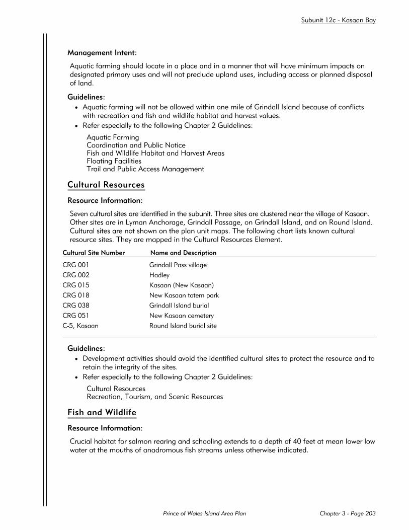
Management Intent:
Aquatic farming should locate in a place and in a manner that will have minimum impacts ondesignated primary uses and will not preclude upland uses, including access or planned disposalof land.
Guidelines:
• Aquatic farming will not be allowed within one mile of Grindall Island because of conflictswith recreation and fish and wildlife habitat and harvest values.
• Refer especially to the following Chapter 2 Guidelines:
Aquatic FarmingCoordination and Public NoticeFish and Wildlife Habitat and Harvest AreasFloating FacilitiesTrail and Public Access Management
Cultural Resources
Resource Information:
Seven cultural sites are identified in the subunit. Three sites are clustered near the village of Kasaan.Other sites are in Lyman Anchorage, Grindall Passage, on Grindall Island, and on Round Island.Cultural sites are not shown on the plan unit maps. The following chart lists known culturalresource sites. They are mapped in the Cultural Resources Element.
Cultural Site Number Name and Description
CRG 001 Grindall Pass village
CRG 002 Hadley
CRG 015 Kasaan (New Kasaan)
CRG 018 New Kasaan totem park
CRG 038 Grindall Island burial
CRG 051 New Kasaan cemetery
C-5, Kasaan Round Island burial site
Guidelines:
• Development activities should avoid the identified cultural sites to protect the resource and toretain the integrity of the sites.
• Refer especially to the following Chapter 2 Guidelines:
Cultural ResourcesRecreation, Tourism, and Scenic Resources
Fish and Wildlife
Resource Information:
Crucial habitat for salmon rearing and schooling extends to a depth of 40 feet at mean lower lowwater at the mouths of anadromous fish streams unless otherwise indicated.
Prince of Wales Island Area Plan Chapter 3 - Page 203
Subunit 12c - Kasaan Bay

Type of Habitat or Harvest Place Habitat or Harvest Values
Crucial Habitat (Ha) Uncle Same Mine to Adams Herring spawningPoint, south of Kasaan Island,west and south of Baker Point
Grindall Island Sea lion haulout
21 anadromous fish streams Salmon rearing and schooling
Prime Habitat (Hb) Streets Island, one mile High density seal usearound Kasaan Island
Intensive CommercialHarvest (Cl) Lyman Anchorage Shrimp
Intensive Community Use(Cy) by Kasaan, Klawock Grindall Island Seaweed
Intensive Sport Harvest (Sf) Grindall Island southeast Guided sport fishingKasaan Peninsula
Deer hunting on the Kasaan Peninsula is not designated because it does not meet the criteria forintensive harvest.
Management Intent:
Lands designated for fish and wildlife habitat and harvest will be managed to avoid significantimpacts to habitats and traditional harvest activities. Impacts on non-designated community harvestareas should be considered when authorizing activities (see Map 1-1).
Guidelines:
• Refer especially to the following Chapter 2 Guideline:
Fish and Wildlife Habitat and Harvest Areas
Floathomes
Guidelines:
• Floating residential facilities will not be allowed within one mile of the Grindall Island or theGrindall Passage selections because of conflicts with existing recreation, fish and wildlifehabitat and harvest values, and limited protected anchorage.
• Refer especially to the following Chapter 2 Guidelines:
Coordination and Public NoticeFish and Wildlife Habitat and Harvest AreasFloating FacilitiesTrail and Public Access Management
Forestry
Resource Information:
Sealaska Corporation and Kavilco, Inc., own uplands with commercial timber stands in the sub-unit. Sealaska’s log transfer and storage will be located in Kina Cove (Site 12.05 LS and Site12.10 LT).
Kavilco plans to locate timber harvest support facilities at Lyman Anchorage (Sites 12.02 LT,12.03 LS, and 12.15 LT), Kasaan Island (Site 12.14 LT), Kasaan Village (Site 12.01 LT), andBoggs Landing (Site 12.16 LT). Kavilco also proposes log storage areas offshore of Kasaan
Prince of Wales Island Area PlanChapter 3 - Page 204
Subunit 12c - Kasaan Bay

Island (Site 12.04 LS) and in Linney Bay (Site 12.08 LS). The log transfer facility at Kasaan Village(Site 12.01 LT) will be located partly on private patented tidelands owned by Kavilco, Inc.
Lyman Anchorage is an important anchorage of limited size. Upland timber and mineral resource devel-opment will use Lyman Anchorage for access and support activities. Management of state tidelands andsubmerged lands will allow these uses while protecting continued public use of the anchorage.
Management Intent:
State tidelands and submerged lands designated “F” (Forestry) will be managed to support timberharvest activities consistent with other co-primary designations. Areas of uplands designated “Gu”(General Use) are appropriate for timber harvest. Harvest activity is not appropriate in areas des-ignated “S” (Settlement).
Guidelines:
• Lyman Anchorage - Site 12.02 LT and Site 12.03 LS: Log transfer and log storage facilitieswill be sited and operated so that the use or capacity of the anchorage will not be significantlydiminished.
• South Kina Cove - Site 12.10 LT: Log transfer facilities will be sited and operated so that theuse or capacity of the anchorage will not be significantly diminished.
• Kasaan Island - Site 12.14 LT: Log transfer facilities will avoid herring spawning areas usingsiting or timing restrictions as necessary.
• Hadley - Site 12.15 LT and Site 12.28 LS: Log transfer and log storage facilities will be sitedand operated so that the use or capacity of the anchorage will not be significantly dimin-ished. Log transfer operation at this site should be stopped while Site 12.02 LT is being usedunless adequate anchorage can be assured.
• Refer especially to the following Chapter 2 Guidelines:
Fish and Wildlife Habitat and Harvest AreasFloating FacilitiesForestryShorelines and Stream Corridors
Minerals
Management Intent:
Copper, gold, and silver have been produced from mines located on the Kasaan Peninsula. Sig-nificant mineral reserves remain. If there is renewed mining development, access will be requiredacross state tidelands and submerged lands. Consistent with other co-primary designations, statetidelands and submerged lands designated “m” (Mineral Access) will be managed for access toupland mineral resources. Lands at Lyman Anchorage designated for mineral access will bemanaged to allow access while protecting public use of the anchorage.
Lands on Grindall Island are closed to mineral entry to avoid conflicts with recreation activitiesand sea lion haulouts. A 40-acre site at the mouth of an unnamed stream that flows into KasaanBay is closed to mineral entry to avoid conflicts with anadromous fish habitat. All other statelands are open to mineral entry.
Guidelines:
• Refer especially to the following Chapter 2 Guidelines:
Fish and Wildlife Habitat and Harvest AreasShorelines and Stream CorridorsSubsurface ResourcesTrail and Public Access Management
Prince of Wales Island Area Plan Chapter 3 - Page 205
Subunit 12c - Kasaan Bay
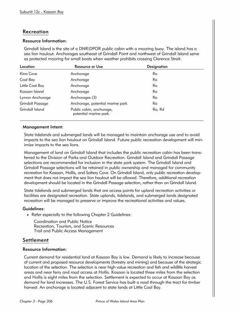
Recreation
Resource Information:
Grindall Island is the site of a DNR\DPOR public cabin with a mooring buoy. The island has asea lion haulout. Anchorages southeast of Grindall Point and northwest of Grindall Island serveas protected mooring for small boats when weather prohibits crossing Clarence Strait.
Location Resource or Use Designation
Kina Cove Anchorage Ra
Coal Bay Anchorage Ra
Little Coal Bay Anchorage Ra
Kasaan Island Anchorage Ra
Lyman Anchorage Anchorages (3) Ra
Grindall Passage Anchorage, potential marine park Ra
Grindall Island Public cabin, anchorage, Ra, Rdpotential marine park
Management Intent:
State tidelands and submerged lands will be managed to maintain anchorage use and to avoidimpacts to the sea lion haulout on Grindall Island. Future public recreation development will min-imize impacts to the sea lions.
Management of land on Grindall Island that includes the public recreation cabin has been trans-ferred to the Division of Parks and Outdoor Recreation. Grindall Island and Grindall Passageselections are recommended for inclusion in the state park system. The Grindall Island andGrindall Passage selections will be retained in public ownership and managed for communityrecreation for Kasaan, Hollis, and Saltery Cove. On Grindall Island, only public recreation develop-ment that does not impact the sea lion haulout will be allowed. Therefore, additional recreationdevelopment should be located in the Grindall Passage selection, rather than on Grindall Island.
State tidelands and submerged lands that are access points for upland recreation activities orfacilities are designated recreation. State uplands, tidelands, and submerged lands designatedrecreation will be managed to preserve or improve the recreational activities and values.
Guidelines:
• Refer especially to the following Chapter 2 Guidelines:
Coordination and Public NoticeRecreation, Tourism, and Scenic ResourcesTrail and Public Access Management
Settlement
Resource Information:
Current demand for residential land at Kasaan Bay is low. Demand is likely to increase becauseof current and proposed resource developments (forestry and mining) and because of the strategiclocation of the selection. The selection is near high value recreation and fish and wildlife harvestareas and near ferry and road access at Hollis. Kasaan is located three miles from the selectionand Hollis is eight miles from the selection. Settlement is expected to occur at Kasaan Bay asdemand for land increases. The U.S. Forest Service has built a road through the tract for timberharvest. An anchorage is located adjacent to state lands at Little Coal Bay.
Prince of Wales Island Area PlanChapter 3 - Page 206
Subunit 12c - Kasaan Bay

Management Intent:
Long-term management intent for the state selection at Kasaan Bay is for land disposal for asmall community and the use of upland resources, including timber harvest, subject to Chapter 2requirements. During the 20-year life of the plan, the selection will be managed for general useand to retain suitability for a prospective community. Residential land disposals are not plannedduring the next 20 years, although the need for such disposals should be reviewed when the planis next revised. Residential development, when it occurs, shall be sited adjacent to the coast inthe area designated “S” (Settlement). The uplands adjacent to Little Coal Bay should be retainedfor water access and community center uses. Commercial and industrial activities should beallowed consistent with the management intent and guidelines of the plan.
Guidelines:
• Refer especially to the following Chapter 2 Guidelines:
Recreation, Tourism, and Scenic ResourcesSettlementShorelines and Stream CorridorsTrail and Public Access Management
Subunit 12d - Lower Twelvemile Arm
BACKGROUND
Twelvemile Arm extends approximately eight miles southwest from Hollis. No permanent communitiesare located within the subunit. A spur road extends east from the Hydaburg road to the southernend of Twelvemile Arm. Access is by boat and float plane.
MANAGEMENT INTENT AND GUIDELINES
State lands will be managed for multiple use. Tidelands and submerged lands will be managed tosupport upland commercial timber harvest activities and to protect the most important recreationand fish and wildlife habitat and harvest areas. With the exception of the mouths of two anadro-mous fish streams, all state lands are open to mineral entry.
Aquatic Farming
Management Intent:
Aquatic farming should locate in a place and in a manner that will have minimum impacts ondesignated primary uses and will not preclude upland uses or access.
Guidelines:
• Refer especially to the following Chapter 2 Guidelines:
Aquatic FarmingCoordination and Public NoticeFish and Wildlife Habitat and Harvest AreasFloating FacilitiesTrail and Public Access Management
Cultural Resources
Resource Information:
No cultural sites are identified in this subunit.
Prince of Wales Island Area Plan Chapter 3 - Page 207
Subunit 12d - Lower Twelvemile Arm

Fish and Wildlife
Resource Information:
Crucial habitat for salmon rearing and schooling extends to a depth of 40 feet at mean lower lowwater at the mouths of anadromous fish streams unless otherwise indicated.
Type of Habitat or Harvest Place Habitat or Harvest Values
Crucial Habitat (Ha) Cave Creek, head of Seasonal black bear concentrations,Twelvemile Arm salmon rearing and schooling
6 anadromous fish streams Salmon rearing and schooling
Intensive Commercial Head of Twelvemile Arm CrabHarvest (Cl)
Intensive Community Head of Twelvemile Arm Black bear, fishUse (Cy) by Hollis
Management Intent:
Lands designated fish and wildlife habitat and harvest will be managed to avoid significantimpacts to habitats and traditional harvest activities. Impacts on non-designated community harvestareas should be considered when authorizing activities (see Map 1-1).
Guidelines:
• Refer especially to the following Chapter 2 Guidelines:
Fish and Wildlife Habitat and Harvest Areas
Floathomes
Guidelines:
• Only floating residential facilities associated with existing forestry development activities willbe allowed in the area designated for log transfer at Site 12.21 LT.
• Refer especially to the following Chapter 2 Guidelines:
Coordination and Public NoticeFish and Wildlife Habitat and Harvest AreasFloating FacilitiesTrail and Public Access Management
Forestry
Resource Information:
The U.S. Forest Service operates a log transfer (Site 12.21 LT) on the southeast shore of lowerTwelvemile Arm. This site will replace the facility at Hollis Anchorage and a log transfer formerlyproposed south of the mouth of the Harris River.
Management Intent:
Twelvemile Arm will be managed to protect navigation routes for log-raft towing from the southTwelvemile Arm site. State tidelands and submerged lands designated “F” (Forestry) will be man-aged to support timber harvest activities consistent with other co-primary designations.
Guidelines:
• Refer especially to the following Chapter 2 Guidelines:
Prince of Wales Island Area PlanChapter 3 - Page 208
Subunit 12d - Lower Twelvemile Arm

Fish and Wildlife Habitat and Harvest AreasFloating FacilitiesForestryShorelines and Stream Corridors
Minerals
Management Intent:
Forty-acre sites at the mouths of Twelvemile Creek and an unnamed creek flowing into thesouthwest end of Twelvemile Arm are closed to mineral entry to avoid conflicts with anadromousfish habitat. All other state lands are open to mineral entry.
Guidelines:
• Refer especially to the following Chapter 2 Guidelines:
Fish and Wildlife Habitat and Harvest AreasShorelines and Stream CorridorsSubsurface ResourcesTrail and Public Access Management
Recreation
Resource Information:
The subunit is used by Hollis residents for recreation. The U.S. Forest Service plans to develop acampground on the southeast shore of Twelvemile Arm. The south end of Twelvemile Arm isused for anchorage.
Location Resource or Use Designation
Twelvemile Arm (south) Anchorage Ra
Twelvemile Arm (SE) Potential campground Rd
Management Intent:
State tidelands and submerged lands that are access points for upland recreation activities orfacilities are designated recreation. State uplands, tidelands, and submerged lands designatedrecreation will be managed to preserve or improve the recreational activities and values.
Guidelines:
• Refer especially to the following Chapter 2 Guidelines:
Coordination and Public NoticeRecreation, Tourism, and Scenic ResourcesTrail and Public Access Management
Settlement
No settlement activities are proposed for the subunit.
Prince of Wales Island Area Plan Chapter 3 - Page 209
Subunit 12d - Lower Twelvemile Arm

Subunit 12e - Polk Inlet
BACKGROUND
Polk Inlet extends approximately ten miles south from the western end of Skowl Arm. Access in thesubunit is by boat, floatplane, or the spur road that extends east from the Hydaburg Road to PolkInlet. No communities are located in the subunit.
MANAGEMENT INTENT AND GUIDELINES
State tidelands and submerged lands are managed for multiple use with an emphasis on protectingthe most important recreation and fish and wildlife habitat and harvest areas. Five areas will bemanaged for support facilities for commercial timber harvest activities on Native and National Forestlands.
Fish and wildlife habitat and harvest and recreation values are especially important at Goose Bay,Little Goose Bay, and in the south end of Polk Inlet. At Goose Bay, only activities that are compatiblewith and do not have a negative impact on the high recreation, anchorage, or habitat and harvestvalues should be allowed.
All state lands are open to mineral entry.
Aquatic Farming
Management Intent:
Aquatic farming should locate in a place and in a manner that will have minimum impacts ondesignated primary uses and will not preclude upland uses or access. Aquatic farming shouldnot locate in Goose Bay because of conflicts with high recreation and habitat and harvest values.
Guidelines:
• Refer especially to the following Chapter 2 Guidelines:
Aquatic FarmingCoordination and Public NoticeFish and Wildlife Habitat and Harvest AreasFloating FacilitiesTrail and Public Access Management
Cultural Resources
Resource Information:
No cultural sites are identified in this subunit.
Fish and Wildlife
Resource Information:
Goose Bay has valuable fish and wildlife habitat and harvest values for waterfowl and shellfish.Crucial habitat for salmon rearing and schooling extends to a depth of 40 feet at mean lower lowwater at the mouths of anadromous fish streams unless otherwise indicated.
Prince of Wales Island Area PlanChapter 3 - Page 210
Subunit 12e - Polk Inlet
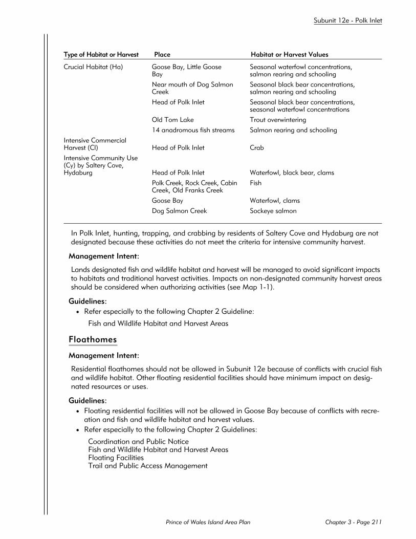
Type of Habitat or Harvest Place Habitat or Harvest Values
Crucial Habitat (Ha) Goose Bay, Little Goose Seasonal waterfowl concentrations,Bay salmon rearing and schooling
Near mouth of Dog Salmon Seasonal black bear concentrations,Creek salmon rearing and schooling
Head of Polk Inlet Seasonal black bear concentrations,seasonal waterfowl concentrations
Old Tom Lake Trout overwintering
14 anadromous fish streams Salmon rearing and schooling
Intensive CommercialHarvest (Cl) Head of Polk Inlet Crab
Intensive Community Use(Cy) by Saltery Cove,Hydaburg Head of Polk Inlet Waterfowl, black bear, clams
Polk Creek, Rock Creek, Cabin FishCreek, Old Franks Creek
Goose Bay Waterfowl, clams
Dog Salmon Creek Sockeye salmon
In Polk Inlet, hunting, trapping, and crabbing by residents of Saltery Cove and Hydaburg are notdesignated because these activities do not meet the criteria for intensive community harvest.
Management Intent:
Lands designated fish and wildlife habitat and harvest will be managed to avoid significant impactsto habitats and traditional harvest activities. Impacts on non-designated community harvest areasshould be considered when authorizing activities (see Map 1-1).
Guidelines:
• Refer especially to the following Chapter 2 Guideline:
Fish and Wildlife Habitat and Harvest Areas
Floathomes
Management Intent:
Residential floathomes should not be allowed in Subunit 12e because of conflicts with crucial fishand wildlife habitat. Other floating residential facilities should have minimum impact on desig-nated resources or uses.
Guidelines:
• Floating residential facilities will not be allowed in Goose Bay because of conflicts with recre-ation and fish and wildlife habitat and harvest values.
• Refer especially to the following Chapter 2 Guidelines:
Coordination and Public NoticeFish and Wildlife Habitat and Harvest AreasFloating FacilitiesTrail and Public Access Management
Prince of Wales Island Area Plan Chapter 3 - Page 211
Subunit 12e - Polk Inlet
Forestry
Resource Information:
Sealaska Corporation has a log transfer facility near Cabin Creek (Site 12.11 LT), with associatedlog storage on the east shore of Polk Inlet at the entrance to Little Goose Bay (Site 12.13 LS).Sealaska expects to transfer approximately 60 MMBF of timber at the Cabin Creek site. The U.S.Forest Service may use the same site to transfer approximately 20 MMBF of timber.
Kavilco, Inc., may need a log transfer site on the south shore of Skowl Arm (Site 12.09 LT)approximately two miles east of Little Goose Bay.
The U.S. Forest Service has a log transfer site in southern Polk Inlet near Dog Salmon Creek (Site12.17 LT).
Management Intent:
State tidelands and submerged lands designated “F” (Forestry) will be managed to support timberharvest activities consistent with other co-primary designations.
Guidelines:
• South Skowl Arm - Site 12.09 LT: Sealaska Corporation plans to use Little Goose Bay forlog storage. To consolidate facilities and reduce overall negative impacts, Little Goose Bay isthe preferred site for Kavilco’s log transfer facility. Before South Skowl Arm (Site 12.09 LT)will be authorized, the applicant will demonstrate to the department’s satisfaction that a) it isnot feasible and prudent to locate the transfer in Little Goose Bay or b) transfer at Site 12.09LT will create fewer overall adverse impacts than combining timber harvest support facilitiesin Little Goose Bay.
• North Polk Island - Site 12.12 LS: This site is an alternate to Little Goose Bay (Site 12.13 LS)and will not be used if Site 12.13 LS is approved.
• Little Goose Bay - Site 12.13 LS: Log transfer or storage will not significantly diminish theuse or capacity of the anchorage. (Also see guideline for Site 12.09 LT above.)
• Refer especially to the following Chapter 2 Guidelines:
Fish and Wildlife Habitat and Harvest AreasFloating FacilitiesForestryShorelines and Stream Corridors
Minerals
Management Intent:
All state lands are open to mineral entry.
Guidelines:
• Refer especially to the following Chapter 2 Guidelines:
Fish and Wildlife Habitat and Harvest AreasShorelines and Stream CorridorsSubsurface ResourcesTrail and Public Access Management
Prince of Wales Island Area PlanChapter 3 - Page 212
Subunit 12e - Polk Inlet

Recreation
Resource Information:
Goose Bay is a scenic area and an important anchorage. Little Goose Bay is also used foranchorage.
Location Resource or Use Designation
Goose Bay Anchorage, attractive features* Ra, Ru
Little Goose Bay Anchorage Ra, Ru
*Attractive features include beaches, waterfalls, geologic features, and others.
Management Intent:
State tidelands and submerged lands that are access points for upland recreation activities orfacilities are designated recreation. State tidelands and submerged lands designated recreationwill be managed to preserve or improve the identified recreational activities and values.
Guidelines:
• Refer especially to the following Chapter 2 Guidelines:
Coordination and Public NoticeRecreation, Tourism, and Scenic ResourcesTrail and Public Access Management
Settlement
No settlement activities are proposed for the subunit.
Subunit 12f - Skowl Arm
BACKGROUND
Skowl Arm is the major water body extending west from Clarence Strait to McKenzie Inlet and PolkInlet. This subunit includes a portion of the eastern shore of Prince of Wales Island bordering Clar-ence Strait. Smith Cove, north of Skowl Arm, periodically supports timber harvest activities on Kavilco,Inc., uplands. Private lands at Saltery Cove are developed for residential and recreation uses.
MANAGEMENT INTENT AND GUIDELINES
State selected uplands will be managed for general use. The Saltery Cove selections have also beenselected for conveyance to a Native corporation. The following description of state management isprovided should this conveyance not occur. In the event that this land is not conveyed to the state,only the tideland and submerged land prescriptions will apply. The management intent for theselections at Saltery Cove is long-term community expansion and development. No land disposalsare planned for at least 20 years.
State tidelands and submerged lands will be managed for multiple use with an emphasis on themost important recreation and fish and wildlife habitat and harvest areas. Seven areas will be man-aged for support facilities for commercial timber harvest on Native and National Forest uplands.
With the exception of four anadromous fish stream mouths and short lengths of two streambedsnear Saltery Cove, all state lands are open to mineral entry.
Prince of Wales Island Area Plan Chapter 3 - Page 213
Subunit 12f - Skowl Arm

Aquatic Farming
Management Intent:
Aquatic farming should locate in a place and in a manner that will have minimum impacts onprimary designated uses and will not preclude upland uses, including access or planned disposalof land.
Guidelines:
• Refer especially to the following Chapter 2 Guidelines:
Aquatic FarmingCoordination and Public NoticeFish and Wildlife Habitat and Harvest AreasFloating FacilitiesTrail and Public Access Management
Cultural Resources
Resource Information:
Two cultural sites have been identified near Smith Lagoon, and one each near Old Tom Creek inlower McKenzie Inlet and in Trollers Cove. Cultural sites are not shown on the plan unit maps.The following chart lists known cultural resource sites. They are mapped in the Cultural ResourcesElement.
Cultural Site Number Name and Description
CRG 017 Kiam (Khayyam)
CRG 020 Old Kasaan (Cha-chee-nie, Gasan, Kasian, Haade, Skowl)
CRG 091 Old Tom Creek village & fort
CRG 092 Skowl Arm I. Burial
C-4, Saltery Cove Troller’s
Guidelines:
• Development activities should avoid identified cultural sites to protect the resource and toretain the integrity of the sites.
• Refer especially to the following Chapter 2 Guidelines:
Cultural ResourcesRecreation, Tourism, and Scenic Resources
Fish and Wildlife
Resource Information:
Crucial habitat for salmon rearing and schooling extends to a depth of 40 feet at mean lower lowwater at the mouths of anadromous fish streams unless otherwise indicated.
Prince of Wales Island Area PlanChapter 3 - Page 214
Subunit 12f - Skowl Arm

Type of Habitat or Harvest Place Habitat or Harvest Values
Crucial Habitat (Ha) Head of McKenzie Inlet Seasonal black bear concentrations,salmon rearing and schooling
Monie Lake Trout overwintering, salmon rearingand schooling
20 anadromous fish streams Salmon rearing and schooling
Prime Habitat (Hb) Between Kasaan Point and High density seal use areaSmith Lagoon, nearMcKenzie Rock
Intensive Commercial Near Kuanil, near Island Purse seine salmonHarvest (Cl) Point, near Doctor Point
Intensive Community Use(Cy) by Saltery Cove Skowl Arm Shrimp, crab
Old Tom Creek, head Fishingof McKenzie Inlet
Intensive Sport Harvest (Sf) High Island, Island Point, Sportfishing (king and silver salmon,Clarence Strait halibut)
In McKenzie Inlet, hunting and trapping by Saltery Cove residents are not designated becausethese activities do not meet the criteria for intensive community harvest.
Management Intent:
Lands designated for fish and wildlife habitat and harvest will be managed to avoid significantimpacts to habitats and traditional harvest activities. Impacts on non-designated community harvestareas should be considered when authorizing activities (see Map 1-1).
Guidelines:
• Refer especially to the following Chapter 2 Guideline:
Fish and Wildlife Habitat and Harvest Areas
Floathomes
Management Intent:
Residential floathomes should not impact designated resources or uses. Other floating residentialfacilities should have minimum impact on designated resources or uses.
Guidelines:
• Refer especially to the following Chapter 2 Guidelines:
Coordination and Public NoticeFish and Wildlife Habitat and Harvest AreasFloating FacilitiesTrail and Public Access Management
Forestry
Resource Information:
The U.S. Forest Service will need up to seven log transfer sites in this subunit because topographylimits road connection options. Three sites may be required in McKenzie Inlet (Sentinel Island -Site 12.18 LT or McKenzie Inlet - Site 12.26 LT, McKenzie West - Site 12.19 LT, Peacock - Site12.20 LT), and two more sites in coves along Clarence Strait (Spiral Cove - Site 12.24 LT and
Prince of Wales Island Area Plan Chapter 3 - Page 215
Subunit 12f - Skowl Arm

Doctor Point - Site 12.25 LT). The McKenzie Inlet sites are expected to handle a combined volumeof 170 MMBF, with another 30 MMBF of timber to be transferred through the two sites alongClarence Strait.
The log storage and floatcamp associated with the log transfer near Doctor Point (Site 12.25 LT)are expected to be located in Clover Bay (Subunit 13b).
The log transfer and log storage facility in Smith Cove (Site 12.27 LT) will continue to be used fortimber from Kavilco, Inc. lands.
Management Intent:
State tidelands and submerged lands designated “F” (Forestry) will be managed to support timberharvest activities consistent with other co-primary designations. Areas designated “Gu” (GeneralUse) are considered appropriate for timber harvest, subject to the requirements of Chapter 2.
Guidelines:
• Sentinel Island - Site 12.18 LT and McKenzie Inlet - Site 12.26 LT: These sites are alterna-tives. Only one of these two sites will be developed.
• Spiral Cove - Site 12.24 LT: Log transfer facilities will be sited and operated so that the useor capacity of the anchorage will not be significantly diminished.
• Spiral Cove - Site 12.24 LT: Facilities should be sited and operated to minimize impacts onrecreational values in Spiral Cove. (Refer also to Recreation.)
• Doctor Point - Site 12.25 LT: Sea urchin concentrations and crucial salmon schooling andrearing areas will be avoided when siting this transfer facility.
• Refer especially to the following Chapter 2 Guidelines:
Fish and Wildlife Habitat and Harvest AreasFloating FacilitiesForestryShorelines and Stream Corridors
Minerals
Resource Information:
There is a potential access route to the Khayyam Mine in the south end of McKenzie Inlet nearOmar Creek.
Management Intent:
Consistent with other co-primary designations, state tidelands and submerged lands designated“m” (Mineral Access) will be managed for access to upland mineral resources.
To avoid conflicts with anadromous fish habitat, four 40-acre sites at stream mouths are closed tomineral entry. These sites include Omar Creek, one unnamed creek that drains into McKenzie Inlet,and two unnamed creeks that flow into Saltery Cove. Approximately one-half mile of the streambedsof each of these two streams in Saltery Cove is closed to mineral entry. A strip of state uplands 200feet wide from the ordinary high water mark along each side of these two streams in Saltery Covewill be open to mineral entry under leasehold only. The buffer will be managed to avoid conflictswith community recreation, fish and wildlife harvest, and crucial habitat for anadromous fish.
All other state lands are open to mineral entry.
Guidelines:
• Refer especially to the following Chapter 2 Guidelines:
Fish and Wildlife Habitat and Harvest AreasShorelines and Stream Corridors
Prince of Wales Island Area PlanChapter 3 - Page 216
Subunit 12f - Skowl Arm

Subsurface ResourcesTrail and Public Access Management
Recreation
Resource Information:
No developed recreation facilities are planned in Skowl Arm or McKenzie Inlet. Many bights andcoves are used as anchorages. An area on the northeast shoreline of McKenzie Inlet south ofKhayyam Point has attractive scenic features.
Additional anchorages are located in coves bordering Clarence Strait. Spectacular cliffs are locatedin Spiral Cove, a potential day-use area. There is good anchorage and a U.S. Forest Service publicuse cabin in Trollers Cove.
Location Resource or Use Designation
SE McKenzie Inlet Potential campsite, anchorage Rd, Ra
NE McKenzie Inlet Potential campsite, attractive features* Rd
Saltery Cove Anchorage Ra
Skowl Island Anchorage Ra
Patterson Island Anchorage Ra
Outer coast, unnamed cove Anchorage Ra
Kluanil Island Anchorage Ra
Spiral Cove Anchorage, potential campsite, Ra, Rdattractive features*
Trollers Cove USFS cabin, anchorage Rd, Ra
Island Point Anchorage Ra
*Attractive features include beaches, waterfalls, geologic features, and others.
Management Intent:
State tidelands and submerged lands that are access points for upland recreation activities orfacilities are designated recreation. State tidelands and submerged lands designated recreationwill be managed to preserve or improve the recreational activities and values.
Guidelines:
• Refer especially to the following Chapter 2 Guidelines:
Coordination and Public NoticeRecreation, Tourism, and Scenic ResourcesTrail and Public Access Management
Settlement
Resource Information:
A commercial fish saltery obtained a federal patent to uplands at Saltery Cove. After the salteryclosed, the land was subdivided into 11 lots and sold. One upland owner has developed a com-mercial lodge.
Saltery Cove has a protected anchorage and land suitable for settlement. Opportunities for privateownership of land in Skowl Arm, Polk Inlet, or McKenzie Inlet are few.
Prince of Wales Island Area Plan Chapter 3 - Page 217
Subunit 12f - Skowl Arm

Management Intent:
During the 20-year life of the plan, state land will be managed for general use. Future settlementis expected to occur because of the desirable location, but during the 20-year life of the plan, noland disposals are planned. However, land disposal may be reconsidered during future planningefforts.
Guidelines:
• Refer especially to the following Chapter 2 Guidelines:
SettlementShorelines and Stream CorridorsTrail and Public Access Management
Prince of Wales Island Area PlanChapter 3 - Page 218
Subunit 12f - Skowl Arm

subunits 12a & 12b map - Upper Twelvemile Arm/Hollis
page 219

subunit 12b inset map - Hollis
page 221

subunit 12c map - Kasaan Bay
page 223

subunit 12c map - Kasaan Bay
page 224

subunit 12d map - Lower Twelvemile Arm
page 225

subunits 12e & f map - Polk Inlet and Skowl Arm
page 227

UNIT 13 - Cholmondeley
Unit Background
Description
This unit covers Cholmondeley Sound and Port Johnson to the south and Clarence Strait to theeast. Other water bodies include West Arm, South Arm, Dora Bay, and Kitkun Bay. CholmondeleySound is a scenic, protected waterway with rich fish and wildlife habitat. Surrounding terrain variesfrom moderately rolling hills near the entrance of Cholmondeley Sound to steep slopes adjacent toWest Arm. Sulzer Portage, at the head of West Arm, is a historic route between the east and westsides of Prince of Wales Island. Timber values are moderately high. Roads are being developed forlogging operations on lands south of Cholmondeley Sound.
Land Ownership
Kootznoowoo, Inc., Angoon’s ANCSA village corporation, owns a strip of land surrounding PortJohnson and a block of land along the southern end of South Arm surrounding Dora Bay thatextends east to Kitkun Bay.
There are patented mining claims near Dolomi in the southeastern part of the unit. Small privateparcels are located on the north shore of Cholmondeley Sound at Sunny Cove. There is state landat Kitkun Bay. The remaining upland units in this subunit are managed by Native corporations andthe U.S. Forest Service. The state owns all tidelands and submerged lands.
State Land Status
Land Status Subunit Acres
Uplands — Tentative Approval or Patent:Kitkun Bay (NFCG 248) 13b 2,360
Tidelands and Submerged Lands: All
Land Uses
This unit supports a variety of land uses, such as logging, mineral extraction, commercial fishing,commercial recreation, and aquatic farming. Kootznoowoo, Inc. and the U.S. Forest Service harvesttimber from their respective lands. There is continued interest but little development in mineraldeposits at Dolomi. A small settlement is located at Sunny Cove.
The unit’s waters have rich fish and wildlife habitat. Fish and wildlife resource activities includeaquatic farming at Sunny Cove and commercial, sport, and community fishing for crab, shrimp,and salmon.
Subunits in this Management Unit
• Subunit 13a - West Chomondeley
• Subunit 13b - East Chomondeley
Prince of Wales Island Area Plan Chapter 3 - Page 229
Unit 13 - Cholmondeley

Subunit 13a - West Chomondeley
BACKGROUND
This subunit includes West Arm and South Arm. Each arm is less than a mile wide and more than eightmiles long. The inlet to Big Creek in West Arm is a scenic recreation area, popular for fish and wildlifeharvest. The subunit extends west, including approximately two miles of Sulzer Portage. Dora Bayextends approximately five miles south from Cholmondeley Sound. Access is by boat or floatplane.
An old fish cannery is located on patented land at Sunny Cove. After the cannery closed, the landwas subdivided, and about 12 lots have been sold. The land owners formed the Sunny CoveAquatic Farming Association and established an oyster farm in the cove.
MANAGEMENT INTENT AND GUIDELINES
State tidelands and submerged lands will be managed for multiple use. Some lands will be managedto support commercial timber harvest on Native and federal lands. Some tidelands will be managedfor access to identified mineral resources. Tidelands and submerged lands will be managed to pro-tect the most important recreation and fish and wildlife habitat and harvest areas. Managementwill protect the recreation and cultural values at Sulzer Portage and the scenic, recreation, and fishand wildlife values near Big Creek. With the exception of four stream mouths (two each at SulzerPortage and Sunny Cove), all state lands are open to new mineral entry.
Aquatic Farming
Resource Information:
An aquatic oyster farm is located in Sunny Cove.
Management Intent:
Authorized activities should not preclude continued use of the aquatic farm at Sunny Cove.Aquatic farming should be located in a place and in a manner that will have minimum impactson designated primary uses, and will not preclude upland uses, including access or planned dis-posal of land. Aquatic farming should not locate in areas with concentrations of marine mam-mals because of predation on domestic stocks and the potential for mammal entanglement.
Guidelines:
• Aquatic farming in the inlet to Big Creek, and west of the inlet, will not be authorizedbecause of high recreation, scenic, cultural, and fish and wildlife habitat and harvest values.
• Refer especially to the following Chapter 2 Guidelines:
Aquatic FarmingCoordination and Public NoticeFish and Wildlife Habitat and Harvest AreasFloating FacilitiesTrail and Public Access Management
Cultural Resources
Resource Information:
The Sulzer Portage trail between Portage Bay at the head of Hetta Inlet and West Arm ofCholmondeley Sound is known for its historic values. See additional discussion under Selections.
Prince of Wales Island Area PlanChapter 3 - Page 230
Subunit 13a - West Cholmondeley
One cultural site is identified on the southern shore of West Arm approximately two miles west ofSouth Arm. Cultural sites are not shown on the plan unit maps. The following chart lists knowncultural resource sites. They are mapped in the Cultural Resources Element.
Cultural Site Number Name and Description
CRG 007 Chomondeley historic site
CRG 044 Portage trail (Sulzer trail) historic site
Guidelines:
• Development activities should avoid identified cultural sites to protect the resource and toretain the integrity of the sites.
• Refer especially to the following Chapter 2 Guidelines:
Cultural ResourcesRecreation, Tourism, and Scenic Resources
Fish and Wildlife
Resource Information:
Humpback whales frequent Cholmondeley Sound. Crucial habitat for salmon rearing and school-ing extends to a depth of 40 feet at mean lower low water at the mouths of anadromous fishstreams unless otherwise indicated.
Type of Habitat or Harvest Place Habitat or Harvest Values
Crucial Habitat (Ha) West Arm Seasonal black bear concentrations,seasonal waterfowl concentrations,salmon rearing and schooling
Sunny Cove, head of Seasonal black bear concentrations,South Arm salmon rearing and schooling
Dora Lake and estuary Trout overwintering, salmonrearing and schooling
Miller Lake Trout overwintering
17 anadromous fish streams Salmon rearing and schooling
Prime Habitat (Hb) West Arm, Sunny Cove, Seal concentration areasDora Bay
Intensive Commercial South Arm, West Arm, ShrimpHarvest (Cl) Dora Bay
West Arm, northern South Arm Salmon
Babe Islands to Lancaster Cove Crab
Intensive Community Use Big Creek Inlet Black bear, waterfowl, deer hunting(Cy) by Sunny Cove,Hydaburg Sunny Creek, head of Salmon
West Arm
Sunny Cove Wildlife viewing
Intensive Sport Harvest (Sf) Chomondeley (abandoned), Shrimpnorthern South Arm
Deer harvest in the Sunny Creek drainage and at Divide Head is not designated because the activitydoes not meet the criteria for intensive community harvest.
Prince of Wales Island Area Plan Chapter 3 - Page 231
Subunit 13a - West Cholmondeley

Management Intent:
Lands designated for fish and wildlife habitat and harvest will be managed to avoid significantimpacts to habitats and traditional harvest activities. Impacts on non-designated community harvestareas should be considered when authorizing activities (see Map 1-1).
Guidelines:
• Refer especially to the following Chapter 2 Guidelines:
Fish and Wildlife Habitat and Harvest Areas
Floathomes
Guidelines:
• Floating residential facilities will not be authorized within one mile of the trailhead at SulzerPortage because of conflicts with recreation and cultural resource values.
• Floating residential facilities will not be authorized in the inlet to Big Creek because of con-flicts with high recreation, scenic, and fish and wildlife habitat and harvest values.
• Refer especially to the following Chapter 2 Guidelines:
Coordination and Public NoticeFish and Wildlife Habitat and Harvest AreasFloating FacilitiesTrail and Public Access Management
Forestry
Resource Information:
The U.S. Forest Service plans to transfer 75 MMBF of timber at West Arm #2 (Site 13.01 LT),approximately two miles from the head of West Arm, and another 45 MMBF at Old Chomondeley(Site 13.06 LT), approximately two miles west of South Arm. Klukwan, Inc. has a ship mooringand log rafting area at Dora Bay Mooring (Site 13.11 SM). Kootznoowoo, Inc. has two transfersites in Dora Bay; Divide Head (Site 13.03 LT) on the west side and Dora Bay East (Site 13.04LT), and a log storage site along the eastern shore.
Management Intent:
To consolidate facilities and reduce negative impacts on fish and wildlife habitat and harvest,including seal, shrimp, and an eagle tree, only two ship mooring facilities in Dora Bay will be allowed.
State tidelands and submerged lands designated “F” (Forestry) will be managed to support timberharvest activities consistent with other co-primary designations.
Guidelines:
• West Arm #2 - Site 13.01 LT: The log transfer facility will be sited to minimize interferencewith the major chum salmon schooling area to the west.
• Old Chomondeley - Site 13.06 LT: The log transfer facility will be sited as far as possiblefrom the Cannery Creek flat.
• Sunny Point - Site 13.07 LT: The log transfer facility will be sited to avoid interference withthe purse seine hookoff point and will be located as far as possible from Sunny Cove.
• Refer especially to the following Chapter 2 Guidelines:
Fish and Wildlife Habitat and Harvest AreasFloating FacilitiesForestryShorelines and Stream Corridors
Prince of Wales Island Area PlanChapter 3 - Page 232
Subunit 13a - West Cholmondeley

Minerals
Resource Information:
Access to Khayyam Copper Mine across state tidelands and submerged lands may take place inMcKenzie Inlet (Subunit 12f). Green Monster Mountain mining area is within this subunit, butaccess and staging sites are at Lake Josephine and Copper Harbor in Unit 18 (Hetta Inlet) of theSouthwest Prince of Wales Island Area Plan.
In the 1920s, a polymetal (zinc-lead-silver) deposit was developed on a cliff wall on the west side ofSouth Arm. Exploration in 1981-81 located a significant reserve that is subject to further evaluation.
A small, high-grade deposit of silver, lead, and zinc at the Moonshine Mine was produced from1900 to 1910. Some reserves remain. Potential access to the mine is at South Arm near olddocking facilities used for logging operations in the late 1970s.
Minerals rich in zirconium and various earth elements are found on uplands southwest of DoraBay. Currently, industry interest is high. Deposits of copper, lead, zinc, and precious metals arefound along the north side of Miller Lake. Cymru Mine produced 155,000 pounds of copper,1,500 ounces of silver, and an undisclosed amount of gold. There is active exploration of thearea, but no development plans are known. Potential access sites for mineral development inDora Bay are not designated because road systems developed for timber harvest on Native landsmay provide alternative access.
Management Intent:
There is no access designation for the polymetal deposit on the west side of South Arm becausean appropriate site has not been determined. Steep terrain may limit options. To consolidateresource transfer facilities and reduce negative impacts, designated log transfer sites on the southshore of West Arm should be used, if feasible and prudent. Consistent with other co-primary desig-nations, state tidelands and submerged lands designated “m” (Mineral Access) will be managedfor access to upland mineral resources. All other state lands are open to mineral entry.
Four 40-acre sites at stream mouths are closed to new mineral entry to avoid conflicts with anadro-mous fish habitat. These sites include Sunny Creek, two streams near Sultzer Portage, and oneunnamed creek flowing into Sunny Cove .
Guidelines:
• Access sites for mineral development near Dora Bay and Miller Lake should be consolidatedwith timber harvest support sites to reduce negative impacts to fish and wildlife habitat, iffeasible and prudent. Alternative access routes from the North Arm of Moira Sound to MillerLake should be considered.
• Refer especially to the following Chapter 2 Guidelines:
Fish and Wildlife Habitat and Harvest AreasShorelines and Stream CorridorsSubsurface ResourcesTrail and Public Access Management
Recreation
Resource Information:
The inlet to Big Creek in West Arm has high scenic and dispersed recreation values. A trail leadsfrom tidewater at the head of Dora Bay to Dora Lake.
See Selections and Community Development sections for recreation values at Sulzer Portage.
Prince of Wales Island Area Plan Chapter 3 - Page 233
Subunit 13a - West Cholmondeley

Location Resource or Use Designation
Sulzer Portage Public recreation None (no selection)
West Arm (near head) Potential campsite, anchorage Rd, Ra
Big Creek (& inlet) Dispersed recreation, attractive features* r
South Arm (Divide Head) Anchorage Ra
South Arm Dispersed recreation r
Sunny Cove Anchorage Ra
Dora Bay Dispersed recreation r
Dora Bay (head) Anchorage, trail Ra, Rd
*Attractive features include beaches, waterfalls, geologic features, and others.
Management Intent:
State tidelands and submerged lands that are access points for upland recreation activities orfacilities are designated recreation. State tidelands and submerged lands designated recreationwill be managed to preserve or improve the recreational activities and values.
Guidelines:
• Refer especially to the following Chapter 2 Guidelines:
Coordination and Public NoticeRecreation, Tourism, and Scenic ResourcesTrail and Public Access Management
Settlement
Management Intent:
No settlement activities are proposed for the subunit.
Guidelines:
• Refer especially to the following Chapter 2 Guidelines:
Recreation, Tourism, and Scenic ResourcesSettlementShorelines and Stream CorridorsTrail and Public Access Management
Subunit 13b - East Chomondeley
BACKGROUND
This subunit includes eastern Cholmondeley Sound, Kitkun Bay, and the eastern coast of Prince ofWales Island from Clover Bay to Port Johnson. There is also an LTF operated by the U.S. ForestService at Lancaster Cove, and areas have been designated for a floating logging camp and afloating Forest Service camp.
A floating commercial recreation lodge is located in Clover Bay. A logging camp and other timberharvest support facilities operate recurrently at Dolomi, which is also the site of mineral access activities.
Access is by boat or floatplane. An isolated road system is being developed in the eastern part ofthe subunit as a result of resource development activities.
Prince of Wales Island Area PlanChapter 3 - Page 234
Subunit 13b - East Cholmondeley

MANAGEMENT INTENT AND GUIDELINES
State tidelands and submerged lands will be managed for multiple use. Tidelands and submergedlands will be managed for support facilities for commercial timber harvest activities and access tomineral resources on Native and federal lands. Uplands will be managed to provide for eventualcommunity development, recreation, and timber harvest. State lands will also be managed to protectthe most important recreation and fish and wildlife habitat and harvest areas. No land disposals areproposed during the 20-year life of the plan.
All state lands are open to mineral entry.
Aquatic Farming
Management Intent:
Aquatic farming should be located in a place and in a manner that will have minimum impactson designated primary uses and will not preclude upland uses, including access or planned dis-posal of land. Aquatic farming should not locate in areas with concentrations of marine mam-mals to protect them from entanglement and to protect aquatic farm stocks from predation bymarine mammals.
Guidelines:
• Aquatic farming in Kitkun Bay will not be authorized because of high recreation, scenic, andfish and wildlife habitat and harvest values.
• Refer especially to the following Chapter 2 Guidelines:
Aquatic FarmingCoordination and Public NoticeFish and Wildlife Habitat and Harvest AreasFloating FacilitiesTrail and Public Access Management
Cultural Resources
Resource Information:
Two cultural sites are identified; one on the northeastern shore of Cholmondeley Sound andanother at Dolomi Bay. Cultural sites are not shown on the plan unit maps. The following chartlists known cultural resource sites. They are mapped in the Cultural Resources Element.
Cultural Site Number Name and Description
CRG 028 Cholmondeley Sound fort
CRG 043 Dolomi (Dolomite) historic site
Guidelines:
• Development activities should avoid the identified cultural sites to protect the resource and toretain the integrity of the sites.
• Refer especially to the following Chapter 2 Guidelines:
Cultural ResourcesRecreation, Tourism, and Scenic Resources
Prince of Wales Island Area Plan Chapter 3 - Page 235
Subunit 13b - East Cholmondeley

Fish and Wildlife
Resource Information:
Humpback whales frequent Cholmondeley Sound. Crucial habitat for salmon rearing and school-ing extends to a depth of 40 feet at mean lower low water at the mouths of anadromous fishstreams unless otherwise indicated.
Type of Habitat or Harvest Place Habitat or Harvest Values
Crucial Habitat (Ha) Kitkun Bay Seasonal black bear concentrations,seasonal waterfowl concentrations,salmon rearing and schooling
Lancaster Cove Herring spawning, salmon rearing(north and south) and schooling
Paul Lake Trout overwintering
30 anadromous fish streams Salmon rearing and schooling
Prime Habitat (Hb) Skin Island, Wedge Island Seal concentration areasClover Point to VABM 16
Intensive Commercial South side of ShrimpHarvest (Cl) Cholmondeley Sound
Babe Islands to Lancaster Cove Crab
Clover Point to northeast Purse seine salmonentrance to CholmondeleySound (including Skin Island),Hump Island, Lancaster Coveto two miles south of Windy Point
Intensive Community Use(Cy) by Sunny Cove Kitkun Bay Salmon, deer, black bear, waterfowl
Intensive Sport Harvest (Sf) Skin Island King salmon, halibut
Babe Islands Salmon, crab, deer, waterfowl
Management Intent:
Lands designated fish and wildlife habitat and harvest will be managed to avoid significant impactsto habitats and traditional harvest activities. Impacts on non-designated community harvest areasshould be considered when authorizing activities (see Map 1-1).
Guidelines:
• Refer especially to the following Chapter 2 Guideline:
Fish and Wildlife Habitat and Harvest Areas
Floathomes
Management Intent:
Floating residential facilities associated with timber harvest activities near at Kitkun Bay areencouraged to locate at Lancaster Cove to consolidate facilities and to minimize conflicts withstate upland management.
Guidelines:
• Floating residential facilities will not be allowed in Kitkun Bay, to protect fish and wildlife andrecreation values.
Prince of Wales Island Area PlanChapter 3 - Page 236
Subunit 13b - East Cholmondeley

• Refer especially to the following Chapter 2 Guidelines:
Coordination and Public NoticeFish and Wildlife Habitat and Harvest AreaFloating FacilitiesTrail and Public Access Management
Forestry
Resource Information:
The U.S. Forest Service has a log transfer site at Lancaster Cove (Site 13.05 LT). Also see CanneryCove (Site 14.01 LT) in Subunit 14b.
In Clover Bay, a log transfer for 10 MMBF is proposed after 1990. A floatcamp and log storagearea to support transfer activities at Doctor Point (Site 12.25 LT) in Subunit 12f may be located inClover Bay.
Kootznoowoo, Inc. expects recurrent use of the log transfer facility in Dolomi Bay (Site 13.13 LT)and associated log storage area in Port Johnson (Site 13.09 LS). Areas of commercial grad forestoccur throughout the Kitkun subunit. There have been extensive areas within this subunit thathave been harvested previously.
Management Intent:
State tidelands and submerged lands designated “F” (Forestry) will be managed to support timberharvest activities consistent with other co-primary designations. Upland areas designated “Gu”(General Use) are appropriate for timber harvest, consistent with the restrictions of this plan andresulting from the FLUP planning process. Timber harvest in these areas are to be coordinatedwith eventual settlement activity, recreation uses and values in adjacent areas designated “Ru”(Recreation Undeveloped), and the protection of habitat and wildlife. Timber harvest is not per-mitted in areas designated “Ru” (Recreation-undeveloped), including the area of the BabeIslands.
Guidelines:
• Clover Bay - Site 13.10 LT: Access to existing fish and wildlife harvest and use of theanchorage will not be precluded by the log transfer, log storage, or floatcamp proposed forClover Bay.
• Refer especially to the following Chapter 2 Guidelines:
Fish and Wildlife Habitat and Harvest AreasFloating FacilitiesForestryShorelines and Stream Corridors
Minerals
Resource Information:
Major deposits of gold and silver and minor deposits of zinc and copper were mined at Dolomifrom 1898 to 1920. The area has several patented mining claims, owned or selected byKootznoowoo, Inc. The industry continues to explore mining potentials in the Dolomi - Paul Lakearea. Access areas in Dolomi Bay and south of French Harbor are designated.
Prince of Wales Island Area Plan Chapter 3 - Page 237
Subunit 13b - East Cholmondeley

Management Intent:
Consistent with other co-primary designations, state tidelands and submerged lands designated“m” (Mineral Access) will be managed for access to upland mineral resources.
All state lands are open to mineral entry.
Guidelines:
• Refer especially to the following Chapter 2 Guidelines:
Fish and Wildlife Habitat and Harvest AreasShorelines and Stream CorridorsSubsurface ResourcesTrail and Public Access Management
Recreation
Resource Information:
Kitkun Bay has high recreation and scenic values because of protected waters and fish and wild-life populations.
Location Resource or Use Designation
Clover Bay Anchorages (2), Ra, Rccommercial recreation
NE Cholmondeley Sound Anchorage Ra
Sec. 14, east of Brennan Bay Attractive features* r
Sec. 12, south of Lancaster Cove Anchorage Ra
Babe Islands Public recreation Ru (uplands)
Babe Islands Dispersed recreation r (tide/submerged)
Brennan Bay/Kitkun Bay Public recreation Ru (uplands)
Brennan Bay/Kitkun Bay Dispersed recreation r (tide/submerged)
Lancaster Cove Anchorage Ra
Chasina Anchorage Anchorage Ra
South of Windy Point Attractive features* r
French Harbor Attractive features* r
Port Johnson Anchorages (2) Ra
*Attractive features include beaches, waterfalls, geologic features, and others.
Management Intent:
State tidelands and submerged lands that are access points for upland recreation activities orfacilities are designated recreation. State uplands, tidelands, and submerged lands designatedrecreation will be managed to preserve or improve the recreational activities and values. Areasdesignated recreation will be retained by the state. Only recreational activities, or facilities, areappropriate within these areas.
Guidelines:
• Refer especially to the following Chapter 2 Guidelines:
Coordination and Public NoticeRecreation, Tourism, and Scenic ResourcesTrail and Public Access Management
Prince of Wales Island Area PlanChapter 3 - Page 238
Subunit 13b - East Cholmondeley

Settlement
Resource Information:
Current demand for private ownership of land in the Kitkun Bay is low. Demand may increasebecause of abundant timber, mineral, recreation, and fish and wildlife resources. Timber harvestwill result in road development to the Kitkun area. The subunit has good access and terrain forsettlement.
Management Intent:
During the 20-year life of the plan, Kitkun Bay will be managed for multiple uses, with the intentto reserve options for eventual land disposal and development of a community consistent withrecreation and habitat and harvest values. Long-term management of this area will be for devel-opment of a prospective community in areas immediately adjacent to the coast.
No land disposals are proposed in the Kitkun Bay tract during the 20-year life of the plan becauseof low demand for land and because of plans by Kootznoowoo, Inc. to sell land in nearby DoraBay. Land disposal may be reconsidered during plan updates.
Primary objectives in planning for activities include:
1) Protect public recreation land. Settlement and timber harvest activities will not be authorizedon state uplands designated public recreation (Ru). Areas designated Public Recreation will beretained in public ownership.
2) Consolidate settlement activities. During the 20-year planning period settlement is not antici-pated, although there may be the need for some limited residential development near thecoast to support water-related commercial and industrial activities. Settlement activities, includ-ing commercial uses, should locate on state uplands designated “Gu” (General Use) east ofBrennan Bay.
3) Land Disposal Consideration. When authorizing activities or planning a land disposal, landshould be considered for long-term public and commercial community facilities. Land adjacentto protected waters should be considered for water-dependent and water-related activities.
Guidelines:
• Refer especially to the following Chapter 2 Guidelines:
Recreation, Tourism, and Scenic ResourcesSettlementShorelines and Stream CorridorsTrail and Public Access Management
Prince of Wales Island Area Plan Chapter 3 - Page 239
Subunit 13b - East Cholmondeley

subunit 13a map - Cholmondeley West
page 241

subunit 13b map - Cholmondeley East
page 243

UNIT 14 - MOIRA
Unit Background
Description
This unit centers around Moira Sound, including North Arm, Dickman Bay, West Arm, South Arm,and Johnson Cove. Ingraham Bay, south of the entrance to Moira Sound, is within the unit. ClarenceStrait forms the eastern border. The unit is characterized by deep bays and inlets rimmed by rugged,steep mountains. There are no roads or communities.
Land Ownership
State land consists of uplands at Menefee Anchorage, and tidelands and submerged lands through-out the unit. The state has selected land at the entrance to Ingraham Bay. There are no Native villageor regional corporation lands. Private patented mining claims are located at Niblack Anchorageand Dickman Bay. The U.S. Forest Service manages the remaining uplands. The state owns alltidelands and submerged lands.
State Land Status
Land Status Subunit Acres
Uplands:
Menefee Anchorage (NFCG 364) 14b 570Ingraham Bay (selection) (NFCG 365) 14c 1,345
Tidelands and Submerged Lands: All
State Selections
Ingraham Bay: The state has selected 1,345 acres at the head of Ingraham Bay for a prospectivecommunity. Ingraham Bay is suitable for community development because of good land, goodanchorage, and strategic location near a major navigation route (Clarence Strait), and proposedresource activities. It is not expected that settlement activities will occur within the 20-year planningperiod, and the uplands will be managed for multiple uses under a General Use designation exceptfor areas adjacent to the coast that are designated Settlement.
Selection Selection Short-term Long-termName Purpose Management Management Classification
Ingraham Bay Prospective General Use Prospective ResourceCommunity Community Management
Prince of Wales Island Area Plan Chapter 3 - Page 245
Unit 14 - Moira

Land Uses
The unit is used primarily for hunting, sport fishing, and recreation by visitors and residents of theKetchikan area. Commercial crabbing and fishing also occur. The unit has high mineral potential(exploration and development are underway at Niblack Anchorage). The U.S. Forest Service haslong-term plans for timber harvest throughout the unit.
Subunits in this Management Unit
• Subunit 14a - Dickman Bay
• Subunit 14b - Moira Sound
• Subunit 14c - Ingraham Bay
Subunit 14a - Dickman Bay
BACKGROUND
This subunit covers the western end of Moira Sound, including Dickman Bay, West Arm, and FrederickCove. Access is by boat or floatplane.
MANAGEMENT INTENT AND GUIDELINES
State tidelands and submerged lands will be managed for multiple use, including support areas forupland resource development. Management will protect the most important recreation and fish andwildlife habitat and harvest areas. All state lands are open to mineral entry.
Aquatic Farming
Management Intent:
Aquatic farming should locate in a place and in a manner that will have minimum impacts ondesignated primary uses and will not preclude upland uses or access.
Guidelines:
• Refer especially to the following Chapter 2 Guidelines:
Aquatic FarmingCoordination and Public NoticeFish and Wildlife Habitat and Harvest AreasFloating FacilitiesTrail and Public Access Management
Cultural Resources
Resource Information:
No cultural sites are identified in this subunit.
Fish and Wildlife
Resource Information:
Crucial habitat for salmon rearing and schooling extends to a depth of 40 feet at mean lower lowwater at the mouths of anadromous fish streams unless otherwise indicated.
Prince of Wales Island Area PlanChapter 3 - Page 246
Subunit 14a - Dickman Bay

Type of Habitat or Harvest Place Habitat or Harvest Values
Crucial Habitat (Ha) West Arm (Moira) Seasonal black bear concentrations,seasonal waterfowl concentrations,salmon rearing and schooling
Kugel Creek (near mouth) Seasonal waterfowl concentrations,salmon rearing and schooling
10 anadromous fish streams Salmon rearing and schooling
Prime Habitat (Hb) Dickman Bay Salmon schooling
Intensive Commercial West Arm (Moira) CrabHarvest (Cl)
Management Intent:
Lands designated for fish and wildlife habitat and harvest will be managed to avoid significantimpacts to habitats and traditional harvest activities.
Guidelines:
• Refer especially to the following Chapter 2 Guideline:
Fish and Wildlife Habitat and Harvest Areas
Floathomes
Guidelines:
• Refer especially to the following Chapter 2 Guidelines:
Coordination and Public NoticeFish and Wildlife Habitat and Harvest AreasFloating FacilitiesTrail and Public Access Management
Forestry
Resource Information:
The U.S. Forest Service proposes a log transfer in Frederick Cove (Site 14.04 LT) for 10 MMBF oftimber scheduled for harvest after 1995. A floatcamp will be located in West Arm (Moira)approximately two miles east of the log transfer site.
Management Intent:
State tidelands and submerged lands designated “F” (Forestry) will be managed to support timberharvest activities consistent with other co-primary designations. The West Arm floatcamp facilityshould be located to avoid interfering with commercial crab harvest.
Guidelines:
• Frederick Cove - Site 14.04 LT: Crucial bear and crucial waterfowl habitat will be avoidedwhen siting this facility.
• Refer especially to the following Chapter 2 Guidelines:
Fish and Wildlife Habitat and Harvest AreasFloating FacilitiesForestryShorelines and Stream Corridors
Prince of Wales Island Area Plan Chapter 3 - Page 247
Subunit 14a - Dickman Bay

Minerals
Management Intent:
Consistent with other co-primary designations, state tidelands and submerged lands designated“m” (Mineral Access) will be managed for access to upland mineral resources. All state lands areopen to mineral entry.
Guidelines:
• Refer especially to the following Chapter 2 Guidelines:
Fish and Wildlife Habitat and Harvest AreasShorelines and Stream CorridorsSubsurface ResourcesTrail and Public Access Management
Recreation
Resource Information:
Each of the two arms extending northwest from Dickman Bay has an important anchorage. Atrail leads from tidewater in the southern arm of Dickman Bay, west around the head of the bay,and then south to a nearby hilltop.
Location Resource or Use Designation
Dickman Bay Anchorages (2), trailhead Ra, Rd
Management Intent:
State tidelands and submerged lands that are access points for upland recreation activities orfacilities are designated recreation. State tidelands and submerged lands designated recreationwill be managed to preserve or improve the identified recreational activities and values.
State tidelands and submerged lands designated “Rd” (developed recreation) in the southernarm of Dickman Bay will be managed for access to the trail.
Guidelines:
• Only developed recreation facilities associated with the trail should be allowed in the southernarm of Dickman Bay to minimize adverse impacts on the crucial habitat. Refer to Chapter 2,Recreation Guideline D.
• Refer especially to the following Chapter 2 Guidelines:
Coordination and Public NoticeRecreation, Tourism, and Scenic ResourcesTrail and Public Access Management
Settlement
No settlement activities are proposed for the subunit.
Prince of Wales Island Area PlanChapter 3 - Page 248
Subunit 14a - Dickman Bay

Subunit 14b - Moira Sound
BACKGROUND
This subunit includes most of Moira Sound, and all of North Arm and Niblack Anchorage. Access isby boat or floatplane.
MANAGEMENT INTENT AND GUIDELINES
Tidelands and submerged lands will be managed for multiple use. In upper North Arm (Moira) andnear Kegan Cove, management will emphasize support facilities for upland commercial timberharvest. Access sites for upland mineral resources are designated in North Arm and Niblack Anchorage.Tidelands and submerged lands will be managed to protect the most important recreation and fishand wildlife habitat and harvest areas. Authorizations for resource development facilities may requirespecific stipulations to achieve the management intent.
State land and adjacent tidelands and submerged lands at Menefee Anchorage will be managedfor community recreation. This area focuses on an important anchorage and may be suitable forinclusion in the state park system (see Chapter 4). This subunit will remain in public ownership.State land disposals are not allowed.
The mouths of three streams in Niblack Anchorage are open to mineral entry by leasehold only toavoid conflicts with anadromous fish habitat. Menefee Anchorage is closed to mineral entrybecause of conflicts with recreation. All other state lands are open to mineral entry.
Aquatic Farming
Management Intent:
Aquatic farming should locate in a place and in a manner that will have minimum impacts ondesignated primary uses and will not preclude upland uses or access.
Guidelines:
• Aquatic farming will not be allowed at Menefee Anchorage because it conflicts with high rec-reation and anchorage values.
• Refer especially to the following Chapter 2 Guidelines:
Aquatic FarmingCoordination and Public NoticeFish and Wildlife Habitat and Harvest AreasFloating FacilitiesTrail and Public Access Management
Cultural Resources
Resource Information:
There is an identified cultural site on the northern shore of North Arm (Moira) near DeichmanIsland. Cultural sites are not shown on the plan unit maps. The following chart lists known culturalresource sites. They are mapped in the Cultural Resources Element.
Prince of Wales Island Area Plan Chapter 3 - Page 249
Subunit 14b - Moira Sound

Cultural Site Number Name Description
CRG 013 Baldwin Historic site
Guidelines:
• Development activities should avoid the identified cultural site to protect the resource and toretain the integrity of the site.
• Refer especially to the following Chapter 2 Guidelines:
Cultural ResourcesRecreation, Tourism, and Scenic Resources
Fish and Wildlife
Resource Information:
Crucial habitat for salmon rearing and schooling extends to a depth of 40 feet at mean lower lowwater at the mouths of anadromous fish streams unless otherwise indicated.
Type of Habitat or Harvest Place Habitat or Harvest Values
Crucial Habitat (Ha) Kegan Cove, Kegan Lake Seasonal black bear concentrations, troutoverwintering, salmon rearing and schooling
25 anadromous fish streams Salmon rearing and schooling
Prime Habitat (Hb) Moira Sound (southeastern side) High intensity harbor seal use area
Intensive Commercial North Arm, central Moira Sound CrabHarvest (Cl)
Intensive Sport Kegan Cove to Kegan Lake Sportfishing, black bear huntingHarvest (Sf)
Management Intent:
Lands designated for fish and wildlife habitat and harvest will be managed to avoid significantimpacts to habitats and traditional harvest activities.
The three streams that flow into Niblack Anchorage are recommended for instream flow studiesto determine adequate water volume and flow for anadromous fish habitat. (See Chapter 4.)
Guidelines:
• Refer especially to the following Chapter 2 Guideline:
Fish and Wildlife Habitat and Harvest Areas
Floathomes
Management Intent:
Residential floathomes should not impact designated resources or uses. Other floating residentialfacilities should have minimum impact on designated resources or uses.
Guidelines:
• Floating residential facilities will not be authorized in Menefee Anchorage because of the limitedsize of the anchorage and conflicts with the primary designated use and management intent.
• Floating residential facilities, including floathomes and floatcamps, will not preclude mineraldevelopment access or activities, or use of the anchorage at Niblack Anchorage.
• Refer especially to the following Chapter 2 Guidelines:
Prince of Wales Island Area PlanChapter 3 - Page 250
Subunit 14b - Moira Sound
Coordination and Public NoticeFish and Wildlife Habitat and Harvest AreasFloating FacilitiesTrail and Public Access Management
Forestry
Resource Information:
The U.S. Forest Service proposes two log transfer facilities in upper North Arm; one near CanneryCove and one in Nowiskay Cove. A log transfer is also proposed east of Kegan Cove. These sitesare discussed separately below.
Guidelines:
• Refer especially to the following Chapter 2 Guidelines:
Fish and Wildlife Habitat and Harvest AreasFloating FacilitiesForestryShorelines and Stream Corridors
Cannery Cove - Site 14.01 LT
Resource Information:
Site 14.01 LT will handle 15 MMBF of timber scheduled for harvest after 1999. This log transferis less than 1/4 mile northwest of Cannery Cove. The associated log storage and floatcamp willbe in Cannery Cove.
The Alaska Department of Fish and Game objects to Site 14.01 LT based on a March 1987 divesurvey at Clarno Cove and Cannery Cove. The dive found “very productive nearshore habitat, with ahigh diversity of aquatic plants and at least 30 species of marine invertebrates.” ADF&G believesthat the log transfer at Lancaster Cove (Site 13.05 LT in Subunit 13b) could be an alternative.
Management Intent:
State tidelands and submerged lands at Cannery Cove designated “F” (Forestry) will be managedto allow timber harvest support activities consistent with other co-primary designations and appli-cable guidelines. Log transfer at Lancaster Cove is preferred because of fish and wildlife habitatvalues at Cannery Cove.
Site Guideline:
Cannery Cove - Site 14.01 LT: Before a log transfer will be authorized at Cannery Cove, theapplicant must demonstrate to the satisfaction of the department that it is not feasible and prudentto use Lancaster Cove (in Subunit 13b) for log transfer and storage. Lancaster Cove is preferredbecause of potential adverse impacts to habitat at Cannery Cove.
Nowiskay Cove - Site 14.02 LT
Resource Information:
This site will handle 15 MMBF of timber to be harvested after 1995. The Alaska Department ofFish and Game objects to Site 14.02 LT because of possible adverse impacts on nearby schoolingareas for adult pink, chum, and silver salmon, and on rearing areas for outmigrating juveniles.ADF&G believes the site may also adversely impact red and silver salmon, steelhead, and DollyVarden habitat in the Miller Lake system (Subunits 13a and 13b), and the high quality recreationalfishery at the head of North Arm. The U.S. Forest Service believes transfer at Lancaster Cove
Prince of Wales Island Area Plan Chapter 3 - Page 251
Subunit 14b - Moira Sound

instead of Nowiskay Cove may be possible, but pending field verification, wishes to keep NowiskayCove as an alternative.
Management Intent:
State tidelands and submerged lands at Nowiskay Cove are designated for timber harvest supportactivities because topography may limit road connections to Lancaster Cove or another log trans-fer site.
Site Guideline:
Nowiskay Cove - Site 14.02 LT: Before log transfer will be authorized at Nowiskay Cove, theapplicant must demonstrate to the satisfaction of the department that it is not feasible and pru-dent to use Lancaster Cove (Site 13.05 LT, Subunit 13b). Lancaster Cove is preferred because ofpotential adverse impacts to fish habitat at Nowiskay Cove.
Kegan Cove - Site 14.03 LT
Resource Information:
The U.S. Forest Service plans a log transfer site east of Kegan Cove (Site 14.03 LT) for 10 MMBFof timber to be harvested after 1995.
Management Intent:
State tidelands and submerged lands designated F (Forestry) east of Kegan Cove will be managedto support upland timber harvest activities. Facilities should be sited and operated in a manner thatwill have the least adverse impacts on fish and wildlife habitat and recreation values of the area.
Site Guideline:
Floatcamp and log storage facilities associated with the Kegan Cove log transfer will not belocated near Kegan Cove nor within the crucial habitat along the north shore of Moira Sound.These facilities should be located in Johnson Cove (Subunit 14c) to consolidate facilities andavoid adverse impacts to fish and wildlife habitat and harvest and recreation values at KeganLake, Kegan Creek, and Kegan Cove.
Minerals
Resource Information:
The mineral deposits at Niblack Anchorage, mined from 1902 to 1909, produced 1,400,000pounds of copper; 1,100 ounces of gold; and 15,000 ounces of silver. The property was inactivefor many years. Recent exploration results are encouraging, and a moderate-sized undergroundmine may be developed.
Some of the ore body at Niblack Anchorage may extend offshore. The mining company operatingat Niblack advises that the ore could be accessed and mined by subsurface methods that wouldhave no effect upon the stream, estuarine, or marine surface habitat.
Management Intent:
State uplands at Menefee Anchorage are closed to mineral entry because of conflict with publicrecreation values. Most tidelands and submerged lands in Niblack Anchorage are designated (m)mining access. There are co-primary crucial habitat designations at the mouths of the three anadro-mous fish streams. To avoid conflicts with anadromous fish habitat, 40-acre sites at mouths ofthese streams Camp Creek, Myrtle Creek, and Lookout Creek are open to mineral entry onlyunder leasehold (see guidelines following).
Prince of Wales Island Area PlanChapter 3 - Page 252
Subunit 14b - Moira Sound

All other state lands are open to mineral entry.
Guidelines:
• Before mineral access or development support facilities will be authorized within crucial habi-tats, the applicant must demonstrate to the satisfaction of the department that there is nofeasible and prudent alternative.
• Mineral entry, exploration, and development in crucial habitat at the mouths of Camp Creek,Myrtle Creek, and Lookout Creek in Niblack Anchorage will be under leasehold only, with thefollowing stipulations:
a) The activities will have no adverse impact upon the stream, estuarine, or marine habitats,or upon the anadromous fish these habitats support.
b) There will be no surface disturbance within the crucial habitats.c) A project plan for work within the crucial habitat area must be approved by DNR. The
plan will be reviewed by ADF&G through the project review process with due deferencegiven to ADF&G before any work is initiated within crucial habitats.
• Refer especially to the following Chapter 2 Guidelines:
Fish and Wildlife Habitat and Harvest AreaShorelines and Stream CorridorsSubsurface ResourcesTrail and Public Access Management
Recreation
Resource Information:
A trail to Myrtle Lake begins at tidewater in Niblack Anchorage.
U.S. Forest Service public cabins, one at Kegan Cove and another two miles downstream fromKegan Lake, are heavily used for recreation. A trail leads from tidewater at Kegan Cove to thesoutheast end of Kegan Lake.
Menefee Anchorage is the first sheltered anchorage in Moira Sound for boats crossing ClarenceStrait from Ketchikan (28 miles) and Metlakatla (18 miles). State land management at MenefeeAnchorage is discussed under Settlement.
Location Resource or Use Designation
Aiken Cove Anchorage Ra
Clarno Cove Anchorage Ra
Nowiskay Cove Attractive features* r
Cannery Cove Anchorage, potential campsite Ra, Rd
Pt. Halliday Attractive features* r
Myrtle Creek Trailhead Rd
Niblack Anchorage Anchorage Ra
Black Point Attractive features* r
Kegan Lake Public cabin, public recreation Ra, Ru (shorelands)
Kegan Cove Anchorage, trail, USFS cabins (2) Ra, Rd
Menefee Anchorage Community recreation Rd (uplands)
Menefee Anchorage Anchorage Ra (tide/submerged)
Rip Point-Chichagof Bay Attractive features* r
*Attractive features include beaches, waterfalls, geologic features, and others.
Prince of Wales Island Area Plan Chapter 3 - Page 253
Subunit 14b - Moira Sound

Management Intent:
State tidelands and submerged lands that are access points for upland recreation activities orfacilities are designated recreation. State tidelands and submerged lands and shorelands designatedrecreation will be managed to preserve or improve the identified recreational activities and values.
Guidelines:
• Refer especially to the following Chapter 2 Guidelines:
Coordination and Public NoticeRecreation, Tourism, and Scenic ResourcesTrail and Public Access Management
Settlement
Resource Information:
Residents from Ketchikan, Metlakatla, Dolomi, Niblack Anchorage, and Sunny Cove useMenefee Anchorage. Residents from prospective communities at Lancaster Cove, Ingraham Bay,South Arm (Moira), and Kendrick Bay are expected to use this important anchorage. The protec-tion offered by Menefee Anchorage is heavily used by commercial fishing boats.
Management Intent:
State lands at Menefee Anchorage will remain in public ownership and be managed to preserveor improve community recreation opportunities. Public recreation improvements, such as aday-use area or campground or placement of public mooring buoys, may be allowed. It is notintended that settlement will occur in this subunit, except as may be incidental to an aquacultureor commercial recreation use permitted by the Division of Land.
Guidelines:
• No floating residential facilities will be authorized at Menefee Anchorage.
• No land disposals will be allowed at Menefee Anchorage.
• Refer especially to the following Chapter 2 Guidelines:
Recreation, Tourism, and Scenic ResourcesSettlementShorelines and Stream CorridorsTrail and Public Access Management
Subunit 14c - Ingraham Bay
BACKGROUND
This subunit covers South Arm in Moira Sound and the southeastern coast of Unit 14, includingIngraham Bay and Hidden Bay. Access is by boat or floatplane.
MANAGEMENT INTENT AND GUIDELINES
Long-term management intent is to support opportunities for community development or other settle-ment activities at Ingraham Bay while protecting the most important habitat, harvest, and recreation val-ues. Timber harvest is considered an appropriate activity in areas at least 400 feet inland from the coast.During the 20-year life of the plan, community development will be limited to allow establishment of aneconomic base and infrastructure to support the eventual development of a small community related tofishing and resource use. No land disposals are proposed but may be re-evaluated after 20 years.
Prince of Wales Island Area PlanChapter 3 - Page 254
Subunit 14b - Moira Sound

The selection at Ingraham Bay will be managed to retain its suitability for a potential community.This subunit may support development of timber, mineral, fishing, or recreation resources in themanagement unit. The management intent of this subunit will be reconsidered after 20 years.
Timber harvest on U.S. Forest Service uplands will be supported by log transfer and log storageareas on tidelands and submerged lands. The primary site for these activities is in Johnson Cove.Alternative sites are in South Arm (Moira) and Ingraham Bay. With the exception of six streammouths, all state lands in Subunit 14c are open to mineral entry.
Aquatic Farming
Management Intent: Aquatic farming should locate in a place and in a manner that will have minimumimpacts on designated primary uses and will not preclude upland uses, including access or planneddisposal of land.
Guidelines:
• Refer especially to the following Chapter 2 Guidelines:
Aquatic FarmingCoordination and Public NoticeFish and Wildlife Habitat and Harvest AreasFloating FacilitiesTrail and Public Access Management
Cultural Resources
Resource Information:
No cultural sites are identified in this subunit.
Fish and Wildlife
Resource Information:
Crucial habitat for salmon rearing and schooling extends to a depth of 40 feet at mean lower lowwater at the mouths of anadromous fish streams unless otherwise indicated.
Type of Habitat or Harvest Place Habitat or Harvest Values
Crucial Habitat (Ha) South Arm (Moira) Seasonal black bear concentrations,seasonal waterfowl concentrations,salmon rearing and schooling
Johnson Lake Trout overwintering
21 anadromous fish streams Salmon rearing and schooling
Intensive CommercialHarvest (Cl) South Arm entrance Crab
Hidden Bay to north Salmon purse seineof Scott Point
Management Intent:
Lands designated fish and wildlife habitat and harvest will be managed to avoid significantimpacts to habitats and traditional harvest activities.
Prince of Wales Island Area Plan Chapter 3 - Page 255
Subunit 14c - Ingraham Bay

Guidelines:
• Refer especially to the following Chapter 2 Guideline:
Fish and Wildlife Habitat and Harvest Areas
Floathomes
Guidelines:
• Residential floathomes are allowed within this planning unit, subject to the requirements ofChapter 2, Floating Residential Facilities.
• Refer especially to the following Chapter 2 Guidelines:
Coordination and Public NoticeFish and Wildlife Habitat and Harvest AreasFloating FacilitiesTrail and Public Access Management
Forestry
Resource Information:
This subunit contains scattered stands of commercial grade forest. Four log transfer facilities areproposed: South Arm (Site 14.06 LT); Johnson Cove (Site 14.10 LT); Ingraham Bay North (Site14.07 LT); and Ingraham Bay East (Site 14.08 LT). Approximately 80 MMBF of timber is plannedfor transfer at the South Arm site after 1990. The Johnson Cove transfer site is expected to handle60 MMBF harvested after 1995; Ingraham North transfer site, approximately 80 MMBF; andIngraham East, approximately 20 MMBF.
Management Intent:
Uplands designated “Gu” will be managed to support timber harvest activities. Harvest opera-tions must be coordinated with eventual settlement development, expected along the coast asdesignated in map 14c. Harvest is not appropriate within the settlement designation. State tide-lands and submerged lands designated “F” will be managed to support timber harvest activitiesconsistent with other co-primary designations.
If road connections are feasible, the U.S. Forest Service believes log transfer proposed for SouthArm (Site 14.06 LT) and Ingraham West (Site 14.07 LT) can be handled at Johnson Cove (Site14.10 LT). Because the department supports consolidating log transfer facilities and limiting thenumber of sites, a proposed land selection at Johnson Cove was dropped.
Guidelines:
• Before South Arm (Site 14.06 LT) or Ingraham North (Site 14.07 LT) will be authorized, theapplicant must demonstrate to the satisfaction of the department that it is not feasible andprudent to use only Johnson Cove (Site 14.10 LT) for log transfer. (This guideline does notapply to Ingraham East (Site 14.08 LT).
• Refer especially to the following Chapter 2 Guidelines:
Fish and Wildlife Habitat and Harvest AreasFloating FacilitiesForestry
Prince of Wales Island Area PlanChapter 3 - Page 256
Subunit 14c - Ingraham Bay

Minerals
Resource Information:
The uranium-thorium-rare earth element deposit on the southeast flank of Bokan Mountain isAlaska’s only commercial uranium mine. The mine was in active production between 1955 and1971, employing 50 to 100 miners. Production ended because of unfavorable market conditions,not because of depletion of the deposit. Recent work by the U.S. Bureau of Mines indicates areserve of 40 million tons of potential rare earth element ores, the largest reserve in Alaska.Access and other support activities are expected to be at the dock facility in West Arm (KendrickBay) (see Unit 15). An alternative access site has been identified near the head of South Arm(Moira).
Management Intent:
Consistent with other co-primary designations, state tidelands and submerged lands designated“m” (Mineral Access) will be managed for access to upland mineral resources.
Forty-acre sites at the mouths of Perkins Creek and five unnamed creeks near the head of SouthArm are closed to mineral entry to avoid conflicts with anadromous fish habitat.
All other state lands are open to mineral entry.
Guidelines:
• Refer especially to the following Chapter 2 Guidelines:
Fish and Wildlife Habitat and Harvest AreasShorelines and Stream CorridorsSubsurface ResourcesTrail and Public Access Management
Recreation
Resource Information:
Location Resource or Use Designation
Johnson Cove Anchorage Ra
Ingraham Bay Anchorages (2) Ra
Hidden Bay Anchorage Ra
Management Intent:
State tidelands and submerged lands that are access points for upland recreation activities orfacilities are designated recreation. State tidelands and submerged lands designated recreationwill be managed to preserve or improve the identified recreational activities and values.
Guidelines:
• Refer especially to the following Chapter 2 Guidelines:
Coordination and Public NoticeRecreation, Tourism, and Scenic ResourcesTrail and Public Access Management
Prince of Wales Island Area Plan Chapter 3 - Page 257
Subunit 14c - Ingraham Bay
Settlement
Resource Information:
Current demand for settlement land in this subunit is low. Demand may increase because timber,mineral, recreation, and fish and wildlife values are high in the nearby area.
Management Intent:
The long-term management intent for selected state land at Ingraham Bay is for eventual landdisposal and community development. Because present demand for land is low, state land atIngraham Bay will be managed during the 20-year life of the plan to allow commercial, industrial,recreation, timber harvest and fish and wildlife uses consistent with the long-term managementintent. This will aid development of a social and economic base for the potential community. Duringthe period of this plan, residential land disposals are not recommended. This policy may bereconsidered should residential demand increase significantly during this period, and must bere-evaluated at the time of the next plan revision. Because of topographic and other environmentalconditions, eventual settlement should be concentrated on the north side of Ingraham Bay insections 29 and 30 in the area designated “S” (Settlement). Certain areas along the coast andextending 400 feet inland are designated “S” (Settlement). See map.
Primary objectives in planning for activities will include :
1) Protect future land disposal and community development opportunities. When authorizingindividual activities or planning a land disposal, state land should be considered for long termpublic and community facilities. Land adjacent to protected water should be for water depend-ent and water related activities.
Sufficient lands will also be reserved for future community center and public facilities, such asschools, community buildings, public utility, health care facilities, public safety and fire protectionheadquarters, sewage treatment plants, small boat mooring and parking areas, communityparks, a post office, and commercial uses.
Guidelines:
• Refer especially to the following Chapter 2 Guidelines:
SettlementShorelines and Stream CorridorsTrail and Public Access Management
Prince of Wales Island Area PlanChapter 3 - Page 258
Subunit 14c - Ingraham Bay

unit 14 map - Moira
page 259

subunit 14b inset map - Moira, North Arm
page 261

UNIT 15 - KENDRICK
Unit Background
Description
This unit is bordered by Clarence Strait to the east and Dixon Entrance to the south. The Canadianborder in Dixon Entrance is approximately one mile south of Cape Chacon, the southern tip ofPrince of Wales Island. Kendrick Bay, McLean Arm, Nichols Bay, and Nichols Lake are the majorwater bodies. Dixon Entrance and Clarence Strait have rough, exposed waters. There is steep terrainand rugged shoreline throughout much of the unit. The U.S. Forest Service plans to develop roadsnear Kendrick Bay for timber harvest. Currently, commercial fishing and mining are the primaryeconomic activities. There are no communities.
Land Ownership
Except for private patented mining claims near McLean Arm and state lands at Kendrick Bay, theU.S. Forest Service manages the uplands. The state owns all tidelands and submerged lands in theunit.
State Land Status
Land Status Subunit Acres
UplandsKendrick Bay (NFCG 249) 15a 340Kendrick Bay Addition (NFCG 367) 15a 340
Tidelands and Submerged Lands: All
Land Uses
The waters are used for commercial fishing. Anchorages are used by boats traveling Clarence Straitand Dixon Entrance. Mining development and logging are planned.
Subunits in this Management Unit
• Subunit 15a - Kendrick Bay
• Subunit 15b - Cape Chacon
Prince of Wales Island Area Plan Chapter 3 - Page 263
Unit 15 - Kendrick

Subunit 15a - Kendrick Bay
BACKGROUND
This subunit includes Kendrick Bay and the subsidiary water bodies of West Arm, Short Arm, andSouth Arm. The Kendrick Islands lie on the north side of the entrance to Kendrick Bay. Access is byboat or floatplane.
MANAGEMENT INTENT AND GUIDELINES
During the 20-year life of the plan, the state land at Kendrick Bay will be managed for general use.Long-term management is for eventual development of a prospective community, with residentialuses occupying areas near the coast.
State tidelands and submerged lands will be managed for multiple use. Three areas are managed fortimber and mineral access and support facilities. Tidelands and submerged lands will also be managedto protect the most important recreation and fish and wildlife habitat and harvest areas. With the excep-tion of the mouths of three anadromous fish streams, all state lands are open to mineral entry.
Aquatic Farming
Management Intent:
Aquatic farming should be located in a place and manner that will have minimum impacts on des-ignated uses and will not preclude upland uses, including access and planned disposal of land.
Guidelines:
• Refer especially to the following Chapter 2 Guidelines:
Aquatic FarmingCoordination and Public NoticeFish and Wildlife Habitat and Harvest AreasFloating FacilitiesTrail and Public Access Management
Cultural Resources
Resource Information:
No cultural sites are identified in this subunit.
Fish and Wildlife
Resource Information:
Crucial habitat for salmon rearing and schooling extends to a depth of 40 feet at mean lower lowwater at the mouths of anadromous fish streams unless otherwise indicated.
Prince of Wales Island Area PlanChapter 3 - Page 264
Subunit 15a - Kendrick Bay

Type of Habitat or Harvest Place Habitat or Harvest Values
Crucial Habitat (Ha) Kendrick Bay Seasonal waterfowl concentrations,salmon rearing and schooling
6 anadromous fish streams Salmon rearing and schooling
Intensive Commercial Entrance to Kendrick Bay Purse seine salmonHarvest (Cl)
Management Intent:
Lands designated for fish and wildlife habitat and harvest will be managed to avoid significantimpacts to habitats and traditional harvest activities.
Guidelines:
• Refer especially to the following Chapter 2 Guidelines:
Fish and Wildlife Habitat and Harvest Areas
Floathomes
Guidelines:
• Refer especially to the following Chapter 2 Guidelines:
Coordination and Public NoticeFish and Wildlife Habitat and Harvest AreasFloating FacilitiesTrail and Public Access Management
Forestry
Resource Information:
Commercial forest stands occupy portions of the subunit. The U.S. Forest Service proposes twolog transfer sites in Kendrick Bay. Kendrick West Arm (Site 15.01 LT) will handle approximately25 MMBF of timber harvested after 1995. Another 25 MMBF may be transferred at the head ofWest Arm at Kendrick West (Site 15.02 LT). This facility will be located adjacent to existing dock-ing facilities which were developed for the Bokan Mountain - Ross Adams Mine.
Management Intent:
Timber harvest in areas designated “Gu” (General Use) is considered an appropriate use, subjectto the restrictions of this plan and any stipulations imposed by a Forest Land Use Plan. Harvestoperations must be at least 400 feet from the coast. Consideration shall be given in the layout oftimber harvests to the eventual settlement patterns that are likely to develop adjacent to thecoast. To consolidate log transfer facilities and reduce impacts to crucial habitat, only one logtransfer site should be used. State tidelands and submerged lands designated “F” (Forestry) willbe managed to support timber harvest activities consistent with other co-primary designationsand with the following guidelines. The management intent for this remote area should be reas-sessed when the next plan revision occurs.
Guidelines:
• Kendrick West Arm - Site 15.01 LT and Kendrick West - Site 15.02 LT: Before Site 15.02 LTwill be authorized, the applicant must demonstrate to the satisfaction of the department thatit is not feasible and prudent to use Site 15.01 LT. To consolidate facilities and reduce nega-tive impacts to crucial habitat, only one site should be used.
Prince of Wales Island Area Plan Chapter 3 - Page 265
Subunit 15a - Kendrick Bay
• Kendrick West Arm - Site 15.01 LT: Negative impacts to the seal haulout at the entrance tothe cove will be avoided in siting and operating the log transfer facility.
• Kendrick West - Site 15.02 LT: The crucial salmon habitat should be avoided when sitingthis log transfer facility.
• Refer especially to the following Chapter 2 Guidelines:
Fish and Wildlife Habitat and Harvest AreasFloating FacilitiesForestryShorelines and Stream Corridors
Minerals
Management Intent:
The existing dock and road to the Ross Adams Mine are expected to be used for future miningactivities. Consistent with other co-primary designations, state tidelands and submerged landsdesignated “m” (Mineral Access) will be managed for access to upland mineral resources.
Three 40-acre sites at stream mouths are closed to mineral entry to avoid conflicts with anadro-mous fish habitat. Two streams flow into the West Arm of Kendrick Bay and one flows into ShortArm. All other state lands are open to mineral entry.
Guidelines:
• Refer especially to the following Chapter 2 Guidelines:
Fish and Wildlife Habitat and Harvest AreasShorelines and Stream Corridors DesignSubsurface ResourcesTrail and Public Access Management
Recreation
Resource Information:
Location Resource or Use Designation
Short Arm (entrance) Anchorage Ra
State tidelands and submerged lands designated recreation will be managed to preserve orimprove the recreational activities and values.
Guidelines:
• Refer especially to the following Chapter 2 Guidelines:
Coordination and Public NoticeRecreation, Tourism, and Scenic ResourcesTrail and Public Access Management
Settlement
Resource Information:
Current demand for land at Kendrick Bay is low. Settlement is expected to occur because of highfish and wildlife harvest values and planned resource development.
Prince of Wales Island Area PlanChapter 3 - Page 266
Subunit 15a - Kendrick Bay

Management Intent:
During the 20-year life of the plan, state land at Kendrick Bay will be managed for general use,including community recreation and commercial and industrial activities intended to develop aneconomic base for an eventual community. Because of its remote location and the scant demandfor residential land, residential land disposals are not planned over the next 20 years. Certainareas along the coast and extending 400 feet inland are designated “S” (Settlement). See map.
The long-term management intent is for the eventual development of a small community. Com-munity development is expected to occur because of commercial fishing, commercial recreation,and proposed resource development. Residential development is planned for areas adjacent tothe coast designated “S” (Settlement).
Primary objectives in planning will include: protection of future Land Disposal and CommunityDevelopment opportunities when authorizing individual activities.
Guidelines:
• Refer especially to the following Chapter 2 Guidelines:
SettlementShorelines and Stream CorridorsTrail and Public Access Management
Subunit 15b - Cape Chacon
BACKGROUND
This subunit includes Cape Chacon, the southern tip of Prince of Wales Island. Nichols Bay andMcLean Arm are major bays along the eastern coast of the subunit. Smaller bays are Gardner Bay,Mallard Bay, and Stone Rock Bay. Clarence Strait to the east and Dixon Entrance to the south aremajor marine traffic routes. Access is by boat or floatplane.
MANAGEMENT INTENT AND GUIDELINES
State tidelands and submerged lands will be managed for multiple use. Two areas in McLean Armand one area in Mallard Bay are designated for support facilities for upland timber or mineralresource development. Tidelands and submerged lands will also be managed to protect the mostimportant recreation and fish and wildlife habitat and harvest areas.
With the exception of six stream mouths, all state lands are open to mineral entry.
Aquatic Farming
Management Intent:
Aquatic farming should be located in a place and manner that will not preclude upland uses oraccess and will have minimum impacts on designated uses.
Guidelines:
• Refer especially to the following Chapter 2 Guidelines:
Aquatic FarmingCoordination and Public NoticeFish and Wildlife Habitat and Harvest Areas
Prince of Wales Island Area Plan Chapter 3 - Page 267
Subunit 15b - Cape Chacon

Floating FacilitiesTrail and Public Access Management
Cultural Resources
Resource Information:
Four cultural sites are identified: one near Cape Chacon, and three in Nichols Bay. Cultural sitesare not shown on the plan unit maps. The following chart lists known cultural resource sites.They are mapped in the Cultural Resources Element.
Cultural Site Number Name and Description
DIX 008 Cape Chacon petroglyph
DIX 026 Nichols Creek wooden weir
DIX 027 Nichols Creek village
DIX 041 Nichols Bay village
Guidelines:
• Development activities should avoid the identified cultural sites to protect the resource and toretain the integrity of the sites.
• Refer especially to the following Chapter 2 Guidelines:
Cultural ResourcesRecreation, Tourism, and Scenic Resources
Fish and Wildlife
Resource Information:
Crucial habitat for salmon rearing and schooling extends to a depth of 40 feet at mean lower lowwater at the mouths of anadromous fish streams unless otherwise indicated.
Type of Habitat or Harvest Place Habitat or Harvest Values
Crucial Habitat (Ha) Nichols Bay Seasonal waterfowl concentrations,salmon rearing and schooling
Nichols Lake Trout overwintering
20 anadromous fish streams Salmon rearing and schooling
Intensive Commercial Cape Chacon to Gardner Bay Purse seine salmonHarvest (Cl)
Management Intent:
Lands designated for fish and wildlife habitat and harvest will be managed to avoid significantimpacts to habitats and traditional harvest activities. Impacts on non-designated community harvestareas should be considered when authorizing activities (see Map 1-1).
Guidelines:
• Refer especially to the following Chapter 2 Guideline:
Fish and Wildlife Habitat and Harvest Areas
Prince of Wales Island Area PlanChapter 3 - Page 268
Subunit 15b - Cape Chacon

Floathomes
Management Intent:
Residential floathomes should not impact designated resources or uses. Other floating residentialfacilities should have minimum impacts on designated resources or uses.
Guidelines:
• Refer especially to the following Chapter 2 Guidelines:
Coordination and Public NoticeFish and Wildlife Habitat and Harvest AreasFloating FacilitiesTrail and Public Access Management
Forestry
Management Intent:
The U.S. Forest Service proposes a log transfer (Site 15.03 LT) on the southern shore of McLeanArm for approximately 20 MMBF to be harvested after 1995. The same area may be used foraccess to the McLean Arm molybdenum deposits. State tidelands and submerged lands desig-nated “F” (Forestry) will be managed to support timber harvest activities consistent with otherco-primary designations.
Guidelines:
• Refer especially to the following Chapter 2 Guidelines:
Fish and Wildlife Habitat and Harvest AreasFloating FacilitiesForestryShorelines and Stream Corridors
Minerals
Resource Information:
The McLean Arm molybdenum deposit was explored by the U.S. Borax Company in the early 1970s.No development plans are known, but significant molybdenum, copper, and other metallicresources have been found.
Management Intent:
Consistent with other co-primary designations, state tidelands and submerged lands designated“m” (Mineral Access) will be managed for access to upland mineral resources.
Six 40-acre sites at stream mouths will be closed to mineral entry to avoid conflicts with anadro-mous fish habitat. Three streams flow into McLean Arm and three flow into Stone Rock Bay. Allother state lands are open to mineral entry.
Guidelines:
• Refer especially to the following Chapter 2 Guidelines:
Fish and Wildlife Habitat and Harvest AreasShorelines and Stream CorridorsSubsurface ResourcesTrail and Public Access Management
Prince of Wales Island Area Plan Chapter 3 - Page 269
Subunit 15b - Cape Chacon

Recreation
Resource Information:
Location Resource or Use Designation
McLean Arm Anchorage Ra
State tidelands and submerged lands designated recreation will be managed to preserve orimprove the identified recreational activities and values.
Guidelines:
• Refer especially to the following Chapter 2 Guidelines:
Coordination and Public NoticeRecreation, Tourism, and Scenic ResourcesTrail and Public Access Management
Settlement
No settlement activities are proposed for the subunit during the planning period. Should residentialdevelopment eventually occur, it shall be within 400 feet of the coast. See map.
Prince of Wales Island Area PlanChapter 3 - Page 270
Subunit 15b - Cape Chacon

subunit 15a map - Kendrick
page 271

subunit 15b map - Cape Cahcon
page 273