chapter 2h. general information signs · interstate, other freeway, or conventional highway...
TRANSCRIPT

California MUTCD 2014 Edition (FHWA’s MUTCD 2009 Edition, including Revisions 1 & 2, as amended for use in California)
Page 535
Chapter 2H – General Information Signs November 7, 2014 Part 2 – Signs
CHAPTER 2H. GENERAL INFORMATION SIGNS
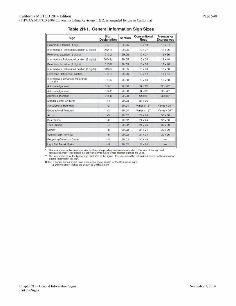
Section 2H.01 Sizes of General Information Signs
Standard: 01 Except as provided in Section 2A.11, the sizes of General Information signs that have a standardized
design shall be as shown in Table 2H-1. Support:
02 Section 2A.11 contains information regarding the applicability of the various columns in Table 2H-1. Option:
03 Signs larger than those shown in Table 2H-1 may be used (see Section 2A.11).
Section 2H.02 General Information Signs (I Series) Support:
01 Of interest to the traveler, though not directly necessary for guidance, are numerous kinds of information that can properly be conveyed by General Information signs (see Figure 2H-1 and 2H-1(CA)) or miscellaneous information signs (see Section 2H.04). They include such items as State lines, city limits, other political boundaries, time zones, stream names, elevations, landmarks, and similar items of geographical interest, and safety and transportation-related messages. Chapter 2M contains recreational and cultural interest area symbol signs that are sometimes used in combination with General Information signs. Guidance:
02 General Information signs should not be installed within a series of guide signs or at other equally critical locations, unless there are specific reasons for orienting the road user or identifying control points for activities that are clearly in the public interest. On all such signs, the designs should be simple and dignified, devoid of any advertising, and in general compliance with other guide signing. Standard:
03 Except for political boundary signs, General Information signs shall have white legends and borders on green rectangular-shaped backgrounds. Option:
04 An information symbol sign (I-5 through I-9 and SG60(CA)) may be used to identify a route leading to a transportation or general information facility, or to provide additional guidance to the facility. The symbol sign may be supplemented by an educational plaque where necessary; also, the name of the facility may be used if needed to distinguish between similar facilities.
05 The Advance Turn (M5 series) or Directional Arrow (M6 series) auxiliary signs shown in Figure 2H-1 with white arrows on green backgrounds may be used with General Information symbol signs to create a General Information Directional Assembly.
06 Guide signs for commercial service airports and non-carrier airports may be provided from the nearest Interstate, other freeway, or conventional highway intersection directly to the airport, normally not to exceed 15 miles. The Airport (I-5) symbol sign along with a supplemental plaque may be used to indicate the specific name of the airport. An Airport symbol sign, with or without a supplemental name plaque or the word AIRPORT, and an arrow may be used as a trailblazer. Standard:
07 Adequate trailblazer signs shall be in place prior to installing the airport transportation or general information facility guide signs. Support:
08 Location and placement of all airport transportation or general information facility guide signs depends upon the availability of longitudinal spacing on highways. Option:
08a The POST OFFICE SG60(CA) sign with Symbol and Arrow may be used to indicate direction to a local post office which is located off the arterial network.
09 The Recycling Collection Center (I-11) symbol sign may be used to direct road users to recycling collection centers.

California MUTCD 2014 Edition (FHWA’s MUTCD 2009 Edition, including Revisions 1 & 2, as amended for use in California)
Page 536
Chapter 2H – General Information Signs November 7, 2014 Part 2 – Signs
Guidance: 10 The Recycling Collection Center symbol sign should not be used on freeways and expressways.
Standard: 11 If used on freeways or expressways, the Recycling Collection Center symbol sign shall be considered
one of the supplemental sign destinations. 12 When a sign is used to display a safety or transportation-related message, the display format shall not
be of a type that would be considered similar to advertising displays. Messages and symbols that resemble any official traffic control device shall not be used on safety or transportation-related message signs. Option:
13 The pictograph of a political jurisdiction (such as a State, county, or municipal corporation) may be displayed on a political boundary General Information sign. Standard:
14 If used, the height of a pictograph on a political boundary General Information sign shall not exceed two times the height of the upper-case letters of the principal legend on the sign. The pictograph shall comply with the provisions of Section 2A.06.
Unincorporated Community and City Limit (G9-2(CA) and G9-5(CA)) Signs Standard:
15 The Unincorporated Community (G9-2(CA)) and City Limit (G9-5(CA)) signs shall be used to mark the limits of cities and to identify unincorporated towns. Refer to S&H Section 101.1. Guidance:
16 The G9-2(CA) signs should be placed on the right, as close as practical to the outer town limits of unincorporated towns, facing traffic entering the named town.
17 The G9-5(CA) sign should be placed on the right, as close as practical to the outer city limits of incorporated cities, facing traffic entering the named city. Option:
18 The population may be obtained from: A.
Federal census B. California Dept. of Finance C. County Board of Supervisors D. County Planning Commission 19 The elevation shown may be that of the courthouse, post office, railroad station, or benchmark in the central district of the
city. Standard:
20 See Section 101.1 of the Streets and Highways Code, which makes these changes mandatory, and Section 101.2 and 101.4, which provides that Caltrans, under certain conditions, shall replace any city limit signs. Guidance:
21 If a city or community desires to install a distinctive type city limits or "Welcome" sign on conventional highways at its city limits in place of the standard G9-5(CA) sign, the following criteria should be followed: Standard:
A.
The signs shall be installed by local authorities at no expense to the State, and an approved encroachment permit will be obtained prior to installation. They shall be maintained by the permittee to the satisfaction of the permitter.
B. Such signs shall be installed in accordance with current Caltrans practices. C. Signs shall be of reasonable size and proportional to other guide signs in the area. D. Signs shall be positioned so they do not obstruct the view of official traffic control devices. E. No moving or flashing displays or advertising of any kind will be permitted. F. No sign shall encroach over the highway.

California MUTCD 2014 Edition (FHWA’s MUTCD 2009 Edition, including Revisions 1 & 2, as amended for use in California)
Page 537
Chapter 2H – General Information Signs November 7, 2014 Part 2 – Signs
Option: G. Political jurisdiction logos may be displayed on the city limit signs, but the predominant characteristics of the sign will
be white legend on a green rectangular shaped background. Distinctive type city limit signs not conforming to the above may remain in place until normal replacement is required.
County Line (G10(CA)) Sign Guidance:
22 The County Line (G10(CA)) sign should be used at the point where the county boundary line crosses the State highway. 23 The G10(CA) sign should be placed on the right, as close as practical to the outer limits of the county, facing traffic
entering the named county. Option:
24 The County Line (G10-3(CA)) sign may be used in lieu of G10(CA) sign to include wording “WHERE WE HONOR VETERANS”. The WHERE WE HONOR VETERANS (G10-4(CA)) sign may be used below the G10(CA) sign. Refer to Streets & Highways Code, Section 1978.
Welcome to California (G10B(CA)) Sign Guidance:
25 The Welcome to California (G10B(CA)) sign should be used to indicate the California State line. The sign should be placed on the right near the State boundary facing traffic entering the State.
River Name (I-3) Sign Option:
26 The River Name (I-3) sign may be used to identify bridges or structures across rivers and creeks and provide motorist orientation that is not otherwise included in the primary signing. Guidance:
27 The I-3 sign should be used on freeways to identify major river crossings. Option:
28 The Watershed Boundary (S36(CA)) sign may be installed to identify the boundary of recognized watershed areas, by its appropriate name (before "WATERSHED"). The sign assembly may provide road user orientation with the directional information plaque, ENTERING (S36A(CA)), or LEAVING (S36B(CA)), as appropriate, included above the S36(CA) sign. Support:
29 The Watershed Boundary (S36(CA)) sign provides information for road users to be aware of the geographic boundary of the geographically-named watershed, as recognized by the United States Geological Survey, and promotes environmental stewardship of watersheds by the community. The purpose of the sign is to serve as a reminder to road users that they are traveling through a watershed, and to promote awareness that the responsibility of preserving the cleanliness of our watersheds is shared by all in the community. Standard:
30 The agency installing the Watershed Boundary (S36(CA)) sign, with or without the ENTERING (S36A(CA)) or LEAVING (S36B(CA)) supplemental plaque, shall be responsible for furnishing, installing, maintaining and replacing the signs, as needed. The agency installing the signs shall receive approval from the agency having jurisdiction of the roadway prior to installation of these signs.
Elevation (G16(CA) and G17(CA)) Signs Option:
31 The Mountain Pass Elevation (G16(CA)) sign may be used at the summit to inform the public of a mountain pass name and elevation. Guidance:
32 The G16(CA) sign should be placed facing traffic in each direction on the right. Option:
33 The Elevation (G17(CA)) sign may be used to inform motorists of changes in elevation. Feet will be shown in multiples of 1,000 feet above sea level, and multiples of 100 feet below sea level. Guidance:
34 The G17(CA) sign should be placed facing traffic in each direction on the right.
California MUTCD 2014 Edition (FHWA’s MUTCD 2009 Edition, including Revisions 1 & 2, as amended for use in California)
Page 538
Chapter 2H – General Information Signs November 7, 2014 Part 2 – Signs
Conventional Airport (G94-1(CA)) Sign Support:
35 The Conventional Airport (G94-1(CA)) sign typifies smaller conventional type aircraft. Guidance:
36 The G94-1(CA) sign should be used in lieu of the Airport (I-5) sign to direct to airports, which do not accommodate large commercial jet aircraft.
Coastal Access (SG28(CA)) Sign Option:
37 The Coastal Access (SG28(CA)) sign may be used to identify only those improved coastal access points selected by the Coastal Commission in accordance with the agreement between the California Coastal Commission and Caltrans dated April, 30, 1980.
USING RECYCLED WATER (S28(CA)) Sign Standard:
38 The USING RECYCLED WATER (S28(CA)) sign shall be placed to identify locations where recycled water is being used for irrigating landscaped areas and other maintenance operations. Refer to Caltrans’ Maintenance Manual Chapter 8, Section 8.45. See Section 1A.11 for information regarding this publication.
Section 2H.03 Traffic Signal Speed Sign (I1-1)
Option: 01 The Traffic Signal Speed (I1-1) sign (see Figure 2H-1), reading SIGNALS SET FOR XX MPH, may be used
to indicate a section of street or highway on which the traffic control signals are coordinated into a progressive system timed for a specified speed at all hours during which they are operated in a coordinated mode.
02 If different system progression speeds are set for different times of the day, a changeable message element may be used for the numerals of the Traffic Signal Speed (I1-1) sign. If the system is operated in coordinated mode only during certain times, a blank-out version of the Traffic Signal Speed (I1-1) sign may be used to display the message only during those times. Guidance:
03 If used, the sign should be mounted as near as practical to each intersection where the timed speed changes, and at intervals of several blocks throughout any section where the timed speed remains constant. Standard:
04 The Traffic Signal Speed sign shall be a minimum of 24 x 36 inches with the longer dimension vertical. It shall have a white message and border on a green background. Option:
05 The local authorities may set traffic signal timing for speeds in slight variance from the posted speed limits. Guidance:
06 The Traffic Signal Speed (I1-1) sign should not display a speed above the posted speed limit because of the enticement to exceed that posted speed limit. Refer to CVC 22401.
Section 2H.04 Miscellaneous Information Signs
Support: 01 Miscellaneous information are used to point out geographical features, such as rivers and summits, and other
jurisdictional boundaries (see Section 2H.02). Figure 2H-1 and 2H-1(CA) shows examples of miscellaneous information (I-2 and I-3) signs. Option:
02 Miscellaneous information signs may be used if they do not interfere with signing for interchanges or other critical points. Guidance:
03 Miscellaneous information signs should not be installed unless there are specific reasons for orienting the road users or identifying control points for activities that are clearly in the public interest. If Miscellaneous information signs are to be of value to the road user, they should be consistent with other guide signs in design

California MUTCD 2014 Edition (FHWA’s MUTCD 2009 Edition, including Revisions 1 & 2, as amended for use in California)
Page 539
Chapter 2H – General Information Signs November 7, 2014 Part 2 – Signs
and legibility. On all such signs, the design should be simple and dignified, devoid of any tendency toward flamboyant advertising, and in general compliance with other signing.
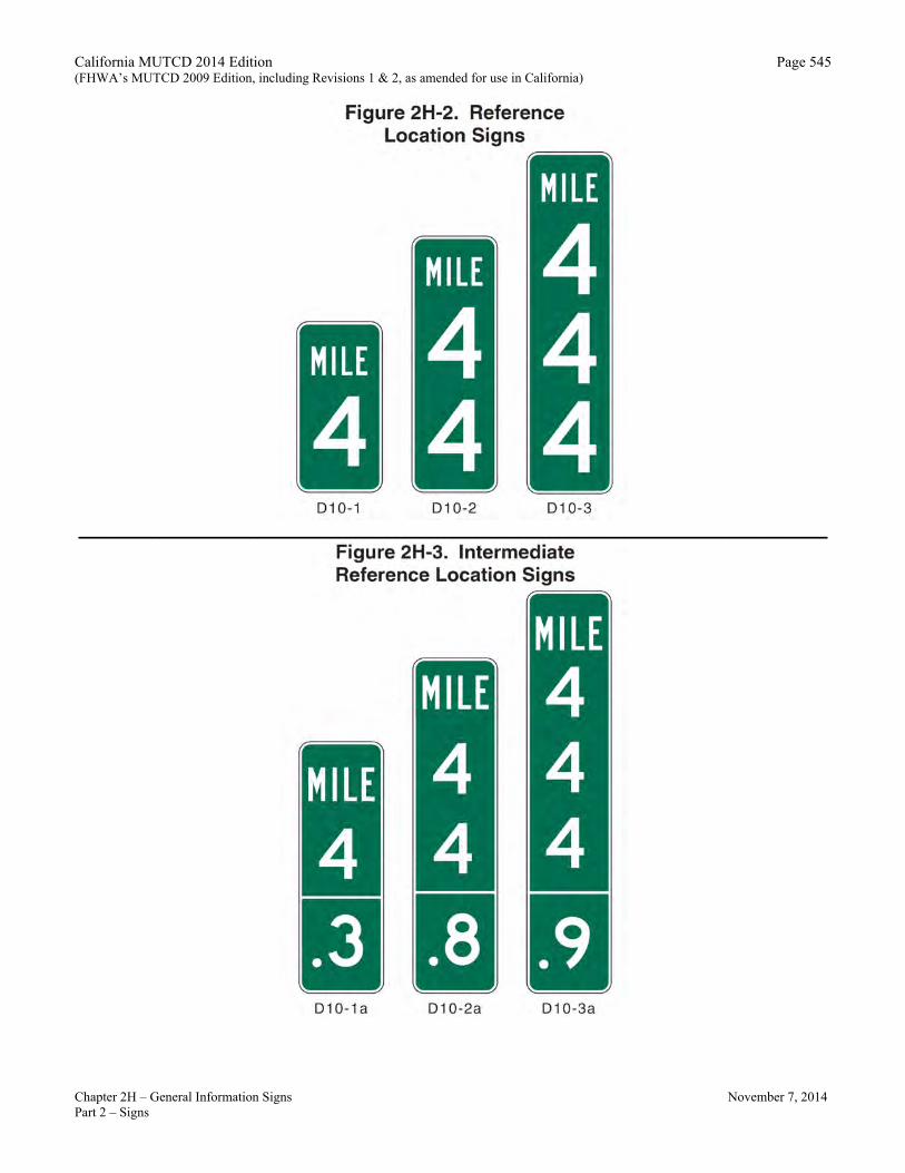
Section 2H.05 Reference Location Signs (D10-1 through D10-3) and Intermediate Reference Location Signs (D10-1a through D10-3a)
Support: 01 There are two types of reference location signs: A. Reference Location (D10-1, 2, and 3) signs show an integer distance point along a highway, and B. Intermediate Reference Location (D10-1a, 2a, and 3a) signs also show a decimal between integer distance
points along a highway. Standard: Option:
02 Except when Enhanced Reference Location signs (see Section 2H.06) are used instead, Reference Location (D10-1 through D10-3) signs shall may be placed on all expressway facilities that are located on a route where there is reference location sign continuity and on all freeway facilities to assist road users in estimating their progress, to provide a means for identifying the location of emergency incidents and traffic crashes, and to aid in highway maintenance and servicing. Option:
03 Reference Location (D10-1 to D10-3) signs (see Figure 2H-2) may be installed along any section of a highway route or ramp to assist road users in estimating their progress, to provide a means for identifying the location of emergency incidents and traffic crashes, and to aid in highway maintenance and servicing on the highway.
04 To augment the reference location sign system, Intermediate Reference Location (D10-1a to D10-3a) signs (see Figure 2H-3), which show the tenth of a mile with a decimal point, may be installed at one tenth of a mile intervals, or at some other regular spacing. Standard:
05 When Intermediate Reference Location (D10-1a to D10-3a) signs are used to augment the reference location sign system, the reference location sign at the integer mile point shall display a decimal point and a zero numeral.
06 When placed on freeways or expressways, reference location signs shall contain 10-inch white numerals on a 12-inch wide green background with a white border. The signs shall be 24, 36, or 48 inches in height for one, two, or three digits, respectively, and shall contain the word MILE in 4-inch white letters.
07 When placed on conventional roads, reference location signs shall contain 6-inch white numerals on a green background that is at least 10 inches wide with a white border. The signs shall contain the word MILE in 4-inch white letters.
08 Reference location signs shall have a minimum mounting height of 4 feet, measured vertically from the bottom of the sign to the elevation of the near edge of the roadway, and shall not be governed by the mounting height requirements prescribed in Section 2A.18.
09 The distance numbering shall be continuous for each route within a State, except where overlaps occur (see Section 2E.31). Where routes overlap, reference location sign continuity shall be established for only one of the routes. If one of the overlapping routes is an Interstate route, that route shall be selected for continuity of distance numbering. Guidance:
10 The route selected for continuity of distance numbering should also have continuity in interchange exit numbering (see Section 2E.31).
11 On a route without reference location sign continuity, the first reference location sign beyond the overlap should indicate the total distance traveled on the route so that road users will have a means of correlating their travel distance between reference location signs with that shown on their odometer. Standard:
12 For divided highways, the distance measurement shall be made on the northbound and eastbound roadways. The reference location signs for southbound or westbound roadways shall be set at locations directly opposite the reference location signs for the northbound or eastbound roadways.

California MUTCD 2014 Edition (FHWA’s MUTCD 2009 Edition, including Revisions 1 & 2, as amended for use in California)
Page 540
Chapter 2H – General Information Signs November 7, 2014 Part 2 – Signs
Guidance: 13 Zero distance should begin at the south and west State lines, or at the south and west terminus points where
routes begin within a State. Standard:
14 Except as provided in Paragraph 15, reference location signs shall be installed on the right-hand side of the roadway. Option:
15 Where conditions limit or restrict the use of reference location signs on the right-hand side of the roadway, they may be installed in the median. On two-lane conventional roadways, reference location signs may be installed on one side of the roadway only and may be installed back-to-back. Reference location signs may be placed up to 30 feet from the edge of the pavement.
16 If a reference location sign cannot be installed in the correct location, it may be moved in either direction as much as 50 feet. Guidance:
17 If a reference location sign cannot be placed within 50 feet of the correct location, it should be omitted. Standard:
18 In California, reference posts shall be mileage based. 19 Reference posts shall be mounted so that the bottom of the sign is a minimum of 2 feet above the near roadway
edge. For lateral position, see Section 2A.16, 2A.19 and Figure 2A-2(CA). 20 The placement and location of reference posts on State highways shall conform to the database maintained by
Caltrans’ Division of Traffic Operations for reference posts. This database is different from the TASAS Highway database.
Section 2H.06 Enhanced Reference Location Signs (D10-4, D10-5)
Support: 01 There are two types of enhanced reference location signs: A.
Enhanced Reference Location signs (D10-4), and
B. Intermediate Enhanced Reference Location signs (D10-5). Option:
02 Enhanced Reference Location (D10-4) signs (see Figure 2H-4), which enhance the reference location sign system by identifying the route, may be placed on freeways or expressways (instead of Reference Location signs) or on conventional roads.
03 To augment an enhanced reference location sign system, Intermediate Enhanced Reference Location (D10-5) signs (see Figure 2H-4), which show the tenth of a mile with a decimal point, may be installed along any section of a highway route or ramp at one tenth of a mile intervals, or at some other regular spacing. Standard:
04 If enhanced reference location signs are used, they shall be vertical signs having blue or green backgrounds with white numerals, letters, and borders, except for the route shield, which shall be the standard color and shape. The top line shall consist of the cardinal direction for the roadway. The second line shall consist of the applicable route shield for the roadway. The third line shall identify the mile reference for the location and the bottom line of the Intermediate Enhanced Reference Location sign shall give the tenth of a mile reference for the location. The bottom line of the Intermediate Enhanced Reference Location sign shall contain a decimal point. The height of the legend on enhanced reference location signs shall be a minimum of 6 inches. The height of the route shield on enhanced reference location signs shall be a minimum of 12 inches.
05 The background color shall be the same for all enhanced reference location signs within a jurisdiction. Support:
06 The provisions in Section 2H.05 regarding mounting height, distance numbering and measurements, sign continuity, and placement with respect to the right-hand shoulder and/or median for reference location signs also apply to enhanced reference location signs.

California MUTCD 2014 Edition (FHWA’s MUTCD 2009 Edition, including Revisions 1 & 2, as amended for use in California)
Page 541
Chapter 2H – General Information Signs November 7, 2014 Part 2 – Signs
Section 2H.07 Auto Tour Route Signs Support:
01 Auto Tour Route signs are informational signs, plaques, or shields designed to provide road users with route guidance in following an auto tour route of particular cultural, historical, or educational significance.
02 Signed auto tour routes are used in some cases to generally follow the historical route of a trail, such as the National Historic Trails administered by the National Park Service. Examples include auto tour routes that parallel the Lewis and Clark National Historic Trail, the Oregon National Historic Trail, and the Santa Fe National Historic Trail. Guidance:
03 If shields or other similar signs are used to provide route guidance in following an auto tour route, they should be designed in accordance with the sizes and other design principles for route signs, such as those described in Sections 2D.10 through 2D.12. Option:
04 Auto Tour Route signs may be installed on a highway if they have been approved by the appropriate transportation agency. Standard:
05 Auto Tour Route signs shall not be installed on freeways or expressways, except as necessary to provide continuity between discontinuous segments of conventional roadways that are designated as auto tour routes, for which the freeway or expressway provides the only connection between the segments. If installed on freeways or expressways, Auto Tour Route signs shall be installed as independent trailblazer assemblies (see Sections 2D.35 and 2E.27) and shall not be installed with other Route signs or confirmation assemblies or on guide signs. If installed on freeways or expressways, Auto Tour Route trailblazer assemblies shall be installed at less frequent intervals than route confirmation assemblies.
Section 2H.08 Acknowledgment Signs
Support: 01 Acknowledgment signs are a way of recognizing a company, business, or volunteer group an entity that
provides a highway-related service. Acknowledgment signs include sponsorship courtesy signs for Caltrans’ adopt-a-highway program. litter removal programs, maintenance of a parkway or interchange, and other highway maintenance or beautification sponsorship programs. Guidance:
02 A State or local highway agency that elects to have an acknowledgment sign program should develop an acknowledgment sign policy. The policy should require that eligible sponsoring organizations comply with State laws prohibiting discrimination based on race, religion, color, age, sex, national origin, and other applicable laws. The acknowledgment sign policy should include all of the provisions regarding sign placement and sign design that are described in this Section. Standard:
03 Because regulatory, warning, and guide signs have a higher priority, acknowledgment signs shall only be installed where adequate spacing is available between the acknowledgment sign and other higher priority signs. Acknowledgment signs shall not be installed in a position where they would obscure the road users’ view of other traffic control devices.
04 Acknowledgment signs shall not be installed at any of the following locations: A. On the front or back of, adjacent to, or around any other traffic control device, including traffic signs,
highway traffic signals, and changeable message signs; B. On the front or back of, adjacent to, or around the supports or structures of other traffic control
devices, or bridge piers; or C. At key decision points where a road user’s attention is more appropriately focused on other traffic
control devices, roadway geometry, or traffic conditions, including exit and entrance ramps, intersections, grade crossings, toll plazas, temporary traffic control zones, and areas of limited sight distance.
California MUTCD 2014 Edition (FHWA’s MUTCD 2009 Edition, including Revisions 1 & 2, as amended for use in California)
Page 542
Chapter 2H – General Information Signs November 7, 2014 Part 2 – Signs
Guidance: 05 The minimum spacing between acknowledgment signs and any other traffic control signs, except parking
regulation signs, should be: A. 150 feet on roadways with speed limits of less than 30 mph, B. 200 feet on roadways with speed limits of 30 to 45 mph, and C. 500 feet on roadways with speed limits greater than 45 mph. 06 If the placement of a newly-installed higher-priority traffic control device, such as a higher-priority sign, a
highway traffic signal, or a temporary traffic control device, conflicts with an existing acknowledgment sign, the acknowledgment sign should be relocated, covered, or removed. Option:
07 State or local highway agencies may develop their own acknowledgment sign designs and may also use their own pictograph (see definition in Section 1A.13) and/or a brief jurisdiction-wide program slogan as part of any portion of the acknowledgment sign, provided that the signs comply with the provisions for shape, color, and lettering style in this Chapter and in Chapter 2A. Guidance:
08 Acknowledgment signs should clearly indicate the type of highway services provided by the sponsor. Standard:
09 In addition to the general provisions for signs described in Chapter 2A and the sign design principles covered in the “Standard Highway Signs and Markings” book (see Section 1A.11), acknowledgment sign designs developed by State or local highway agencies shall comply with the following provisions:
A. Neither the sign design nor the sponsor acknowledgment logo shall contain any contact information, directions, slogans (other than a brief jurisdiction-wide program slogan, if used), telephone numbers, or Internet addresses, including domain names and uniform resource locators (URL);
Option: Entities that operate exclusively on the Internet and whose legal name is the same as appears in their Internet web address’ domain name, may be permitted to display their name on their recognition panel.
Standard: B. Except for the lettering, if any, on the sponsor acknowledgment logo, all of the lettering shall be in
upper-case letters or a combination of lower-case letters with initial upper-case letters as provided in the “Standard Highway Signs and Markings” book or Caltrans’ California Sign Specifications (see Section 1A.11). Combining large and small upper-case letters or displaying some letters in all uppercase and some in upper- and lowercase shall not be permitted.;
C. In order to keep the main focus on the highway-related service and not on the sponsor acknowledgment logo, the area reserved for the sponsor acknowledgment logo shall not exceed 1/3 of the total area of the sign and shall be a maximum of 8 square feet, and shall not be located at the top of the sign;
D. The entire sign display area shall not exceed 24 square feet; E. The sign shall not contain any messages, lights, symbols, or trademarks that resemble any official
traffic control devices; F. The sign shall not contain any external or internal illumination, light-emitting diodes, luminous
tubing, fiber optics, luminescent panels, or other flashing, moving, or animated features; and G. The sign shall not distract from official traffic control messages such as regulatory, warning, or
guidance messages. Support:
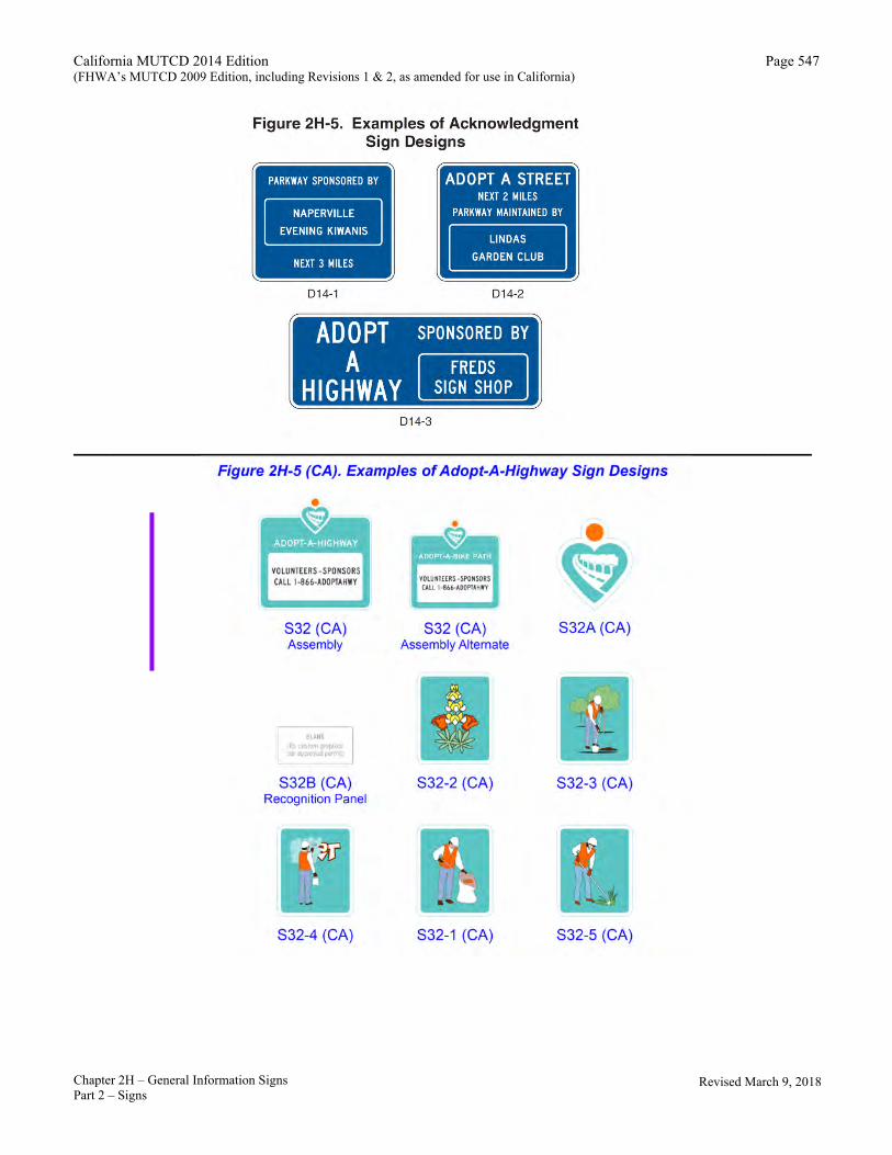
10 Examples of acknowledgment sign designs are shown in Figure 2H-5 and Adopt-A-Highway program signs are shown in Figure 2H-5(CA).
Adopt-A-Highway Program Signs (S32(CA) Series) Support:
11 Refer to Streets and Highways Code Section 91.5 and Caltrans’ Maintenance Manual. See Section 1A.11 for information regarding this publication.

California MUTCD 2014 Edition (FHWA’s MUTCD 2009 Edition, including Revisions 1 & 2, as amended for use in California)
Chapter 2H – General Information Signs November 7, 2014 Part 2 – Signs
Page 543
Option: 12a The Adopt-A-Highway (S32(CA)) sign (see Figure 2H-5(CA)) may be installed near the beginning of each section of
State highway that is being maintained under Caltrans’ Encroachment Permit (Adopt-A-Highway), form TR-0121. 12b The Adopt-A-Bike Path (S32(CA) alternate) sign (see Figure 2H-5(CA)) may be installed near the beginning of each section of Class
I (Bike Path) constructed adjacent to State Highways or other roadways that are being maintained under Caltrans’ Encroachment Permit (Adopt-A-Highway), form TR-0121 or under a similar action allowed by a local agency for bike paths that do not require a Caltrans Encroachment Permit. Standard:
13 The Adopt-A-Highway Symbol (S32A(CA)) sign shall be installed on the Adopt-A-Highway (S32(CA)) sign, and Adopt-A-Bike Path (S32(CA) alternate) signs. Support:
14 The 10 x 12 inch symbol size is used on the 36 x 30 inch size S32(CA) sign and the 15 x 18 inch symbol size is used on the 54 x 42 inch size S32(CA) sign. Bike Paths will only use the 36 x 30 inch size S32(CA) alternate sign.
15 The Adopt-A-Highway, or Adopt-A-Bike Path Recognition Panel (S32B(CA)) with a participant’s name and/or logo is placed over the information area of the S32(CA) sign when a section of State highway or Bike Path has been adopted Standard:
16 When used, the Litter Removal (S32-1(CA)), Wildflower Planting (S32-2(CA)), Tree Planting (S32-3(CA)), Graffiti Removal (S32-4(CA)) or Vegetation Control (S32-5(CA)) signs shall be placed below the S32(CA) sign.
Revised March 9, 2018

California MUTCD 2014 Edition (FHWA’s MUTCD 2009 Edition, including Revisions 1 & 2, as amended for use in California)
Chapter 2H – General Information Signs November 7, 2014 Part 2 – Signs
Page 544
____________________________________________________________________________________________
California MUTCD 2014 Edition (FHWA’s MUTCD 2009 Edition, including Revisions 1 & 2, as amended for use in California)
Page 545
Chapter 2H – General Information Signs November 7, 2014 Part 2 – Signs
____________________________________________________________________________________________

California MUTCD 2014 Edition (FHWA’s MUTCD 2009 Edition, including Revisions 1 & 2, as amended for use in California)
Page 546
Chapter 2H – General Information Signs November 7, 2014 Part 2 – Signs
Note: Use California State Route (G28-1(CA)) or US Route (G26-1(CA)) shields.
California MUTCD 2014 Edition (FHWA’s MUTCD 2009 Edition, including Revisions 1 & 2, as amended for use in California)
Page 547
____________________________________________________________________________________________
Chapter 2H – General Information Signs November 7, 2014 Part 2 – Signs
Revised March 9, 2018
California MUTCD 2014 Edition (FHWA’s MUTCD 2009 Edition, including Revisions 1 & 2, as amended for use in California)
Chapter 2H – General Information Signs November 7, 2014 Part 2 – Signs
Page 548

California MUTCD 2014 Edition Page 549 (FHWA’s MUTCD 2009 Edition, including Revisions 1 & 2, as amended for use in California)
November 7, 2014
Revised March 9, 2018 Chapter 2H – General Information Signs Part 2 – Signs
Table 2H-1(CA). California General Information Sign Sizes
Sign or Plaque Sign Designation Section Conventional
Road Freeway or Expressway
Unincorporated Community G9-2(CA) 2H.02 VAR x 18 VAR x 30 City Limit G9-5(CA) 2H.02 VAR x 24 VAR x 42 County Line G10(CA) 2H.02 VAR x 24 VAR x 36 Welcome To California G10B(CA) 2H.02 60 x 36 132 x 84 County Line G10-3(CA) 2H.02 60 x 30 90 x 42 WHERE WE HONOR VETERANS G10-4(CA) 2H.02 60 x 9 90 x 12 Mountain Pass Elevation G16(CA) 2H.02 VAR x 18 VAR x 36 Elevation G17(CA) 2H.02 36 x 18 72 x 36 Conventional Airport G94-1(CA) 2H.02 24 x 24 30 x 30 Coastal Access SG28(CA) 2H.02 30 x 30 48 x 48 POST OFFICE with Symbol and Arrow
SG60(CA) 2H.02 42 x 30 --- USING RECYCLED WATER S28(CA) 2H.02 36 x 24 54 x 36 Watershed Boundary S36(CA) 2H.02 48 x 54 48 x 54 ENTERING S36A(CA) 2H.02 48 x 12 48 x 12 LEAVING S36B(CA) 2H.02 48 x 12 48 x 12 Adopt-A-Highway S32(CA) 2H.08 36 x 30* 54 x 42* Adopt-A-Bike Path S32(CA) Alternate 2H.08 36 x 30* --- Adopt-A-Highway Symbol S32A(CA) 2H.08 10 x 12* 15 x 18* Adopt-A-Highway Recognition Panel S32B(CA) 2H.08 30 x 15* 45 x 21* Litter Removal S32-1(CA) 2H.08 15 x 18* 15 x 18* Wildflower Planting S32-2(CA) 2H.08 15 x 18* 15 x 18* Tree Planting S32-3(CA) 2H.08 15 x 18* 15 x 18* Graffiti Removal S32-4(CA) 2H.08 15 x 18* 15 x 18* Vegetation Control S32-5(CA) 2H.08 15 x 18* 15 x 18*
* The size shown is the maximum size for the corresponding roadway classification. The size of the sign and Adopt-A-Highway logo should be appropriately reduced where shorter legends are used.
