chapter 25: oceania and antarcticaimages.pcmac.org/sisfiles/schools/tx/annaisd... · the top sheet...
TRANSCRIPT

Oceania andAntarctica
Oceania andAntarctica
Chapter
2525
To learn more about the people andplaces of Oceania and Antarctica,view The World and Its PeopleChapter 28 video.
Chapter Overview Visit the Our WorldToday: People, Places, and IssuesWeb site at and click onChapter 25—Chapter Overviews to previewinformation about Oceania and Antarctica.
tx.owt.glencoe.com
658

A World of WaterThe water world of the Pacific
Ocean covers one-third of the earth.It is larger than all the world’s landareas combined. Tens of thousandsof islands lie in this remote part ofthe world. As technology shrinks theworld, many societies of this regionare struggling to maintain theircultural identities.
Huts on stilts Moorea Lagoon, Tahiti
▼
Huts on stilts Moorea Lagoon, Tahiti
▼
Summarizing Information Study Foldable Make this foldableand use it to help you summarize what you learn about Oceania and Antarctica.
Staplehere.
This makesa circularbooklet.
Oceania
Step 1 Stack foursheets of paper, oneon top of the other. Onthe top sheet of paper,trace a large circle.
Step 2 With thepapers still stacked,cut out all four circlesat the same time.
Step 3 Staple the paper circlestogether at one point around the edge.
Step 4 Label the front circleOceania and take notes onthe pages that open to theright. Turn the book upsidedown and label the backAntarctica. Take notes on thepages that open to the right.
Reading and Writing As you read the chapter, writefacts about the people and places of Oceania and Antarcticain the appropriate places of your circular foldable booklet.

Guide to Reading
Main Idea
Oceania is made upof thousands ofPacific Ocean islandsorganized intocountries andterritories.
Terms to Know
• cacao • copra • pidgin language • high island • low island • atoll • phosphate • trust territory
Reading Strategy
Create a chart likethis one. In the rightcolumn, write twofacts about eachregion.
660 CHAPTER 25
11
Oceania is a culture region that includes about 25,000 islands in thePacific Ocean. Geographers group Oceania into three main islandregions—Melanesia, Micronesia, and Polynesia.
Melanesia The islands of Melanesia lie just to the north and east of Australia.
The largest country in size is Papua New Guinea (PA•pyu•wuh nooGIH•nee). Slightly larger than California, the country’s 5 million peoplealso make it Oceania’s most populous island. Southeast of Papua NewGuinea are three other independent island countries: the SolomonIslands, the Fiji (FEE•jee) Islands, and Vanuatu (VAN•WAH•TOO).Nearthese countries is New Caledonia, a group of islands ruled by France.
Rugged mountains and dense rain forests cover Melanesia’s islands.Strips of fertile plains hug island coastlines. Most of Melanesia has atropical climate with nearly constant temperatures between 70ºF(21ºC) and 80ºF (27ºC).
Most Melanesians work on subsistence farms. Coffee, palm oil, andcacao are important exports. Cacao is a tropical tree whose seeds are
Plants and animals in coral reefs some-
times cooperate with one another.
Here a sea anemone (uh•NEH•
muh•nee) and an anemone-
fish live together
peacefully. The
anemonefish helps the
anemone by eating
debris on its ten-
tacles and by
driving predators away.
In turn, the anemone
offers the fish protection.
Most anemonefish spend
their lives inside an anemone.
Region Facts
Melanesia
Micronesia
Polynesia

TROPIC OF CAPRICORN
EQUATOR
135°W150°W165°W180°165°E150°E135°E
15°N
0°
15°S
30°S
45°S
PACIFIC OCEANKoror
PortMoresby
PalikirMajuro
Tarawa
Yaren
Honiara
Funafuti
Port-Vila Suva
Apia
Nuku‘alofa
U.S.
U.S.
U.S.
U.K.
Fr. Fr.
N.Z.
N.Z.
N.Z.
Fr.
U.S. Colored lines do notconstitute territorial
boundaries; they simplygroup islands under the
same jurisdiction.
HAWAII
GUAM
COOKISLANDS FRENCH
POLYNESIA
PITCAIRN I.
NEWCALEDONIA
NIUE
WALLIS AND FUTUNA
AMERICAN SAMOA
NORTHERNMARIANA IS.
TOKELAU
NEWZEALAND
A U S T R A L I A
PAPUA NEW GUINEA
FEDERATED STATESOF MICRONESIA
MARSHALLISLANDS
K I R I B A T I
TUVALU
NAURU
SAMOA
VANUATU
TONGAFIJI
ISLANDS
SOLOMONISLANDS
PALAU
INT
ERN
AT
ION
AL
DA
TE
LIN
E
1,500
1,5000
0
mi.
kmMiller Cylindrical projection
N
S
EW
National capital
Major researchstations
ANTARCTIC CIRCLE
60°S
80°S
0°18
0°
160°
W
140°E160°E
100°E
120°E
120°W
100°W
80°W
60°W
40°W
20°W 20°E
40°E
60°E
80°E
South Pole AUSTRALIA
unclaimed
AU
STRALIA
NORWAY
FRANCE
NEW
ZEA
LAN
D
CH
ILE
ARGEN
TIN
AU
NIT
EDKI
NGDO
M
A N T A R C T I C A
PACIFICOCEAN
ATLANTICOCEAN
INDIANOCEAN
Russia
Argentina
Chile
Argentina
Argentina
Argentina
Russia
India
Russia
Japan
France
Russia
Russia
Russia
NewZealand
Australia
Australia
Australia
U.S.
U.S.
U.K.
U.K.
U.K.U.S.
Lambert Azimuthal Equal-Area projection1,000
1,0000
0
mi.
km
Major researchstations
Applying Map Skills
1. What countries haveterritories in Oceania?
2. How many researchstations does the UnitedStates have inAntarctica?
Find NGS online map resources @www.nationalgeographic.com/maps
used to make chocolate. Sugarcane is exported as sugar and molasses.Coconut oil from copra, dried coconut meat, is used to make mar-garine, soap, and other products.
Some Melanesian islands hold rich mineral resources such as gold,oil, copper, and nickel. Several Melanesian islands export timber andfish. Melanesia is also becoming a popular tourist destination.
Melanesia’s People Most Melanesians are originally from the Pacificislands. Exceptions include the people of New Caledonia—about one-third of whom are Europeans—and the Fiji Islands—half of whom arefrom South Asia.These South Asians are descendants of workers broughtfrom British India in the late 1800s and early 1900s to work on sugarcaneplantations. Today South Asians control much of the economy of the FijiIslands. Fijians of Pacific descent own most of the land. Conflict oftenarises as the two different groups struggle for control of the government.
Oceania and Antarctica: Political
662 CHAPTER 25
Languages and religions are diverse as well. More than 700 lan-guages are spoken in Papua New Guinea alone. People here speak apidgin language formed by combining parts of several different lan-guages. People speak English in the Fiji Islands, while French is themain language of New Caledonia. Local traditional religions are prac-ticed, but Christianity is widespread. The South Asian population ismostly Hindu.
Many Melanesians live in small villages in houses made of grass orother natural materials. In recent years, people have built concretehouses to protect themselves from tropical storms. Melanesians keepstrong ties to their local group and often hold on to traditional ways.Only a small number live in cities. Many of those living in cities havejobs in business and government.
What is the largest country in Melanesia?
Micronesia The islands of Micronesia are scattered over a vast area of the
Pacific Ocean. Independent countries include the Federated States ofMicronesia, the Marshall Islands, Palau (puh•LOW), Nauru (nah•OO•roo), and Kiribati (KIHR•uh•BAH•tee). The Northern Mariana Islandsand Guam are territories of the United States.
Micronesia is made up of two types of islands—high islands andlow islands. Volcanic activity formed the mountainous high islandsmany centuries ago. Coral, or skeletons of millions of tiny sea animals,formed the low islands. Most of the low islands are atolls—low-lying, ring-shaped islands that surround lagoons.
Like Melanesia, Micronesia has a tropical climate. From July toOctober, typhoons—tropical storms with heavy winds and rains—sometimes strike the islands,causing loss of life and much destruction.
On Location
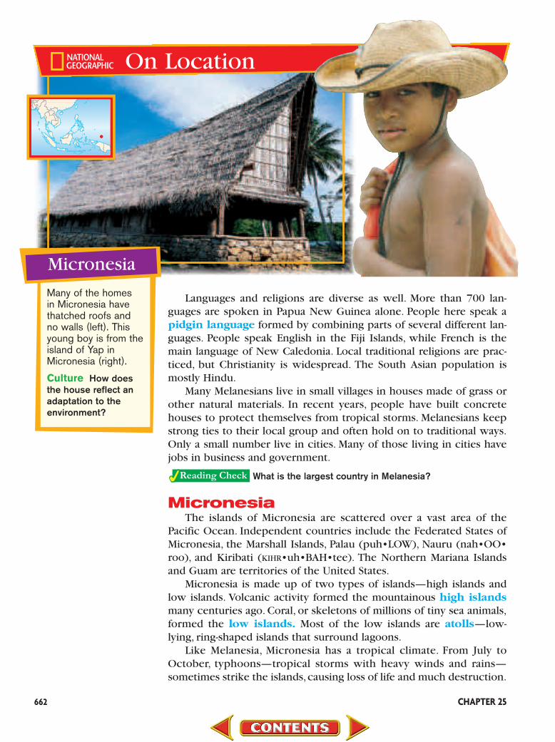
Micronesia
Many of the homes in Micronesia havethatched roofs and no walls (left). Thisyoung boy is from theisland of Yap inMicronesia (right).
Culture How doesthe house reflect anadaptation to the environment?
•
Oceania and Antarctica 663
On Micronesia’s high islands, soil is rich. Most people here engagein subsistence farming—growing cassava,sweet potatoes,bananas,andcoconuts. Some high island farmers also raise livestock. People in thelow islands obtain food from the sea.On some low islands, recent pop-ulation growth has resulted in the need to import food.
Micronesia receives financial aid from the United States, theEuropean Union,and Australia.With this money, the Micronesians havebuilt roads, ports, airfields, and small factories. Clothing is made on theNorthern Mariana Islands. Beautiful beaches draw many tourists here.
Several Micronesian islands have phosphate, a mineral salt usedto make fertilizer. Phosphate supplies are now gone on Kiribati, andthey have almost run out on Nauru.The Federated States of Micronesiaand the Marshall Islands have phosphate but lack the money to minethis resource.
Micronesia’s People Southeast Asians first settled Micronesia about4,000 years ago.Explorers,traders,and missionaries from European coun-tries came in the 1700s and early 1800s. By the early 1900s, manyEuropean countries, the United States, and Japan held colonies here.
During World War II, the United States and Japan fought a numberof bloody battles on Micronesian islands. After World War II, most ofMicronesia was turned over to the United States as trust territories.These territories were under temporary United States control. Some ofthese islands served as sites for hydrogen bomb testing. Since the1970s, most have become independent.
Many of Micronesia’s people are Pacific islanders. They speak locallanguages, although English is spoken on Nauru, the Marshall Islands,and throughout the rest of Micronesia.Christianity,brought by Westernmissionaries, is the most widely practiced religion. Micronesians gener-ally live in villages headed by local chiefs. In recent years, many youngpeople have left the villages to find jobs in towns.
In what two ways were Micronesia’s islands formed?
Polynesia Very little is known about the origins of the Polynesians.
Historians believe that their ancestors sailed from Asia hundreds ofyears before the birth of Christ. We know that the first people to set-tle the islands must have been extremely gifted navigators. Today, theinfluence of the early Polynesians in language, music, and dance canbe seen throughout the South Seas.
When the Polynesian people traveled from island to island, theycarried all the supplies they would need with them, including pigs,hens, and dogs. Young banana and breadfruit plants were put in theground as soon as the Polynesians landed.
Today, Polynesia includes three independent countries—Samoa,Tonga, and Tuvalu. Other island groups are under French rule and areknown as French Polynesia. Tahiti, Polynesia’s largest island, is part ofthis French-ruled area. American Samoa, a United States territory, is
The Fate of NauruMicronesia’s most famous
phosphate island is Nauru,
an 8-square-mile coral atoll.
The name Nauru means
“nowhere.” Over the last
90 years, Nauru’s citizens
have chosen to “consume”
their island by mining the
coral as phosphate and selling
it as fertilizer. The government
of Nauru is now working to
develop other industries such
as fishing and tourism in
preparation for the day when
the phosphate is gone.

AssessmentAssessment11Defining Terms 1. Define cacao, copra, pidgin language, high
island, low island, atoll, phosphate, trust territory.
Recalling Facts 2. Region What three regions make up Oceania?
3. Economics What two kinds of economicactivities are most important in these regions?
4. History What groups first settled the lands ofMicronesia?
Critical Thinking 5. Summarizing Information What is
copra, and what is it used for?
6. Drawing Conclusions Why do many peo-ple in Melanesia speak a pidgin language?
Graphic Organizer 7. Organizing Information Create a chart like
this one. List all the islands of Oceania undertheir specific region; then note whether theyare independent countries or territories.
Applying Social Studies Skills
8. Analyzing Maps Look at the political map onpage 661. Which two territories are colonies ofFrance?
Melanesia Micronesia Polynesia Country/Territory of ?
664
also part of this region. Most Polynesian islands are high volcanicislands, some with tall, rugged mountains. Some of the islands are ofthe low atoll type. Because Polynesia lies in the Tropics, the climateis hot and humid.
Polynesians grow crops or fish for their food. Some farmers exportcoconuts and tropical fruits. The main manufacturing activity is foodprocessing. The tuna you eat for lunch might have come fromAmerican Samoa. This island supplies about one-third of the tunabrought into the United States. Tonga exports squash and vanilla.Tourism is one of the fastest-growing industries of Polynesia. Touristscome by air or sea to the emerald green mountains and white palm-lined beaches.
Polynesia’s People Settlers came to Polynesia later than they did tothe other island regions. The first to arrive were probably Melanesiansor Micronesians who crossed the Pacific Ocean from Asia in canoes.
During the late 1800s, several European nations divided Polynesiaamong themselves. They built military bases on the islands and lateradded airfields. The islands served as excellent refueling stops for longvoyages across the Pacific. Beginning in the 1960s, several Polynesianterritories chose independence, while others remained territories.
About 600,000 people live in Polynesia. Most Polynesians live inrural villages and practice traditional crafts. An increasing number livein towns and cities.Papeete (PAH•pay•AY•tay), located on Tahiti, is thecapital of French Polynesia and the largest city in the region.
What is the largest island in Polynesia?

Oceania and Antarctica 665
Applying the Skill
• Your report should have an introduction,a body, and a conclusion summarizing andrestating your findings.
• Each paragraph should express one mainidea in a topic sentence. Additional sen-tences should support or explain themain idea by using details and facts.
Practicing the SkillRead the following paragraph, and then
answer the questions that follow.
Most of Micronesia’s low islands areatolls—low-lying, ring-shaped islands that surround lagoons. An atoll begins as a ring of coral that forms around the edge of a volcanic island. Over time, wind and watererode the volcano, wearing it down to sealevel. Eventually only the atoll remains abovethe surface. The calm, shallow seawaterinside the atoll is called a lagoon.
1. What is the main idea of this paragraph?2. What are the supporting sentences?3. What might be the topic of an additional
paragraph that follows this one?
Writing skills allow you to organize yourideas in a logical manner. The writing pro-cess involves using skills you have alreadylearned, such as taking notes, outlining, andsequencing information.
Learning the SkillUse the following guidelines to help you
apply the writing process:
• Select an interesting topic. Do preliminaryresearch to determine whether your topicis too broad or too narrow.
• Write a general statement that explainswhat you want to prove, discover, or illus-trate in your writing. This will be thefocus of your entire paper.
• Research your topic by coming up with alist of main ideas. Prepare note cards list-ing facts and source information for eachmain idea.
Writing a Report
Suppose you are writing a report onOceania. Answer the following questionsabout the writing process.
1. How could you narrow this topic?2. What are three main ideas?3. Name three possible sources of information.
An atoll in the Pacific Ocean m

Guide to Reading
Main Idea
Antarctica is a harshland of rock and ice,which the world’snations have agreedto leave open toscientific study.
Terms to Know
• crevasse• ice shelf• iceberg• krill• ozone
Reading Strategy
Create a chart likethe one below.Under each heading,fill in at least onefact about Antarctica.
666 CHAPTER 25
22
Antarctica sits on the southern end of the earth. Icy ocean watersurrounds it. Freezing ice covers it. Cold winds blow over it. The leastexplored of all the continents, this frigid mysterious land is larger thaneither Europe or Australia.
A Unique ContinentPicture Antarctica—a rich, green land covered by forests and lush
plants. Does this description match your mental image of the conti-nent? Fossils discovered here reveal that millions of years ago,Antarctica’s landscape was inhabited by dinosaurs and small mammals.
Today, however, a huge ice cap buries nearly 98 percent ofAntarctica’s land area. In some spots, this ice cap is 2 miles (3.2 km)thick—about the height of 10 tall skyscrapers stacked upon oneanother. This massive “sea” of ice holds about 70 percent of all thefreshwater in the world.
The Antarctic ice cap is heavy and strong, but it also moves. Insome areas, the ice cap forms crevasses, or cracks, that plunge morethan 100 feet (30 m). At the Antarctic coast, the ice cap spreads past
Antarctica
Land Climate
Resources People
Whee! These Emperor penguins live on
the harsh continent of Antarctica. Their
shiny “tuxedos” and waddling walk
fascinate people. Although they
cannot fly, their feathers provide
excellent insulation against
the ice, snow, and freezing
water. Emperor penguins
often travel 30 miles
(48 km) a day to bring food
to their rookeries, or nests.
Sometimes walking takes
too long, so penguins simply
slide on their bellies, which is
called tobogganing.

Oceania and Antarctica 667
the land into the ocean. This layer of ice above the water is called anice shelf. Huge chunks of ice sometimes break off, forming icebergs,which float freely in the icy waters.
Highlands, Mountains, and Valleys Beneath the ice cap,Antarctica has highlands, valleys, and mountains—the same landformsyou find on other continents. A long mountain range called theTransantarctic Mountains crosses the continent. The highest peakin Antarctica, the Vinson Massif, rises 16,864 feet (5,140 m). TheTransantarctic Mountains sweep along the Antarctic Peninsula, whichreaches within 600 miles (966 km) of South America’s Cape Horn.East of the mountains is a high, flat plateau where you find the SouthPole, the southernmost point of the earth. On an island off Antarc-tica’s coast rises Mount Erebus (EHR•uh•buhs). It is Antarctica’smost active volcano.
Climate Now that you have a mental picture of Antarctica’s ice cap,think about this: Antarctica receives so little precipitation that it is theworld’s largest, coldest desert. Inland Antarctica receives no rain andhardly any new snow each year. Antarctica has a polar ice cap climate.Imagine summer in a place where temperatures may fall as low as �30ºF (�35ºC) and climb to only 32ºF (0ºC). Antarctic summers lastfrom December through February.Winter temperatures along the coastsfall to �40ºF (�40ºC), and in inland areas to a low of �100ºF (�73ºC).
What landforms are found under Antarctica’s ice cap?
On Location
Antarctica
•
•
Elephant seals loungeon the coast of Ele-phant Island off theAntarctic Peninsula(below). Mount Ere-bus, on the oppositeside of Antarctica(left), has a lava lakethat is often studiedby scientists.
Environment Howmight an eruption ofMount Erebus affectAntarctica?

668 CHAPTER 25
Resources of AntarcticaAntarctica has a harsh environment, but it can still support life.
Most of the plants and animals that live here are small, however. Thelargest inland animal is an insect that reaches only one-tenth of an inchin length. Penguins, fish, whales, and many kinds of flying birds live inor near the rich seas surrounding Antarctica. Many eat a tiny, shrimp-like creature called krill.
Scientists believe that the ice of Antarctica hides a treasure chestof minerals. They have found major deposits of coal and smalleramounts of copper, gold, iron ore, manganese, and zinc. Petroleummight lie offshore.
These mineral resources have not yet been tapped.To do so wouldbe very difficult and costly. Also, some people feel that removing theseresources would damage Antarctica’s fragile environment. A third rea-son is that different nations would disagree over who has the right tothese resources.Forty-three nations have signed the Antarctic Treaty,which prohibits any nation from taking resources from the continent.It also bans weapons testing in Antarctica.
What is the Antarctic Treaty?
A Vast Scientific LaboratoryThe Antarctic Treaty does allow for scientific research in
Antarctica. Many countries have scientific research stations here, butno single nation controls the vast continent. In January—summer inAntarctica—about 10,000 scientists come to study the land,plants, ani-mals, and ice of this frozen land. Some 1,000 hardy scientists even stayduring the harsh polar winter.
Much of the research focuses on ozone.Ozone is a type of oxygenthat forms a layer in the atmosphere. The ozone layer protects all liv-ing things on the earth from certain harmful rays of the sun. In the1980s, scientists discovered a weakening, or “hole,” in this layer aboveAntarctica. If such weakening continues, some scientists say, climatesaround the world will get warmer. By studying this layer further, theyhope to learn more about possible changes.
This frozen world attracts more than just scientists, though. Eachyear, a few thousand tourists come to Antarctica. With such a harshenvironment, however, Antarctica is the only continent in the worldthat has no permanent population.
Why are scientists studying the ozone layer?
Living in AntarcticaHumans can adapt to life under the most difficult of conditions.
One example of this is the Villa Las Estrellas, or Village of the Stars.Located in Chile’s Antarctic Territory, the “town”has a school,hospital,supermarket, post office, bank, telephone, television, and Internet sys-tems. There is even a gym and a sauna. Village residents are mostlymembers of Chile’s Air Force and their families and scientists from
The EnduranceIn January 1915, Ernest
Shackleton and his crew in the Endurance becametrapped in Antarctica’sfreezing seawater. In lateOctober, ice crushed thewooden ship, forcing theexplorers to abandon it(below). They spent fivemore months drifting onthe ice until they reachedopen water and usedlifeboats to get away.

Oceania and Antarctica 669
various countries. In all, a total of 88 people live in Villa Las Estrellas,including 24 children under the age of 12.
Like Penguins Daily dress here means wearing thermal under-clothes, warm boots and dark sunglasses to protect against the sun’sstrong ultraviolet rays. Villagers must survive extreme tempera-tures—down to �13ºF (�25ºC) below zero with an even more bone-chilling wind factor—but they don’t stay inside all day. Adults walkfrom house to house to visit their neighbors. The children seem toenjoy the experience more than anyone else. One resident describesoutdoor playtime. “The children go crazy over the snow and enjoysledding or just tobogganing downhill on their stomachs. They looklike penguins!”
Global Village The countries of Russia,China,Korea,Brazil,Poland,Argentina, and Uruguay have military or scientific bases close to thevillage. In Antarctica, normal tensions between countries do not seemto matter. Every Wednesday afternoon the different bases send soccerteams to the Chilean gymnasium for a game of indoor soccer. Once ayear a “winter Olympics” is held in volleyball and basketball.Visitors tothe different bases mix freely with the people who live in the bases.Villa Las Estrellas may be as close to a real global village as the earthhas ever seen.
What is one way that humans have adapted to the harshAntarctic environment?
AssessmentAssessment22Defining Terms1. Define crevasse, ice shelf, iceberg, krill, ozone.
Recalling Facts2. Place What covers nearly 98 percent of
Antarctica?
3. Location Where in Antarctica would you findthe most living things?
4. Human/Environment Interaction Why doscientists come to Antarctica?
Critical Thinking5. Summarizing Information Why have
countries agreed not to use the resourcesof Antarctica?
6. Writing Questions Imagine that you areplanning a trip to Antarctica. What questionswould you ask scientists working there?
Graphic Organizer7. Organizing Information Create a chart like
the one below, and then look at the politicalmap on page 661. In your chart, list the variousnational claims made in Antarctica by theworld’s countries. Then give the number ofresearch stations for each country.
Applying Social Studies Skills
8. Analyzing Maps Look at the physical map onpage 630. What mountain range cuts acrossAntarctica?
Countries With Claims Number ofin Antarctica Research Stations
Web Activity Visit theOur World Today:People, Places, andIssues Web site at
andclick on Chapter 25—Student WebActivities to learnmore about Antarctica.
tx.owt.glencoe.com

PEOPLEPEOPLE
670 CHAPTER 25
Antarctica’s Environmental StationsFor nearly 200 years, adventurers, explor-
ers, geographers, and scientists have beendrawn to the icy wilderness of Antarctica.Scientific research is the major human activ-ity on this remarkable continent.
Polar Science
In the 1950s, countries began to talk of pre-serving Antarctica as an international laboratory forscientific research. Today a formal treaty guaranteesfree access and research rights for scientists ofmany countries. Antarctica now holds more than40 research stations.
Types of Research
Geologists, biologists, climatologists, and astro-nomers are some of the many scientists who cometo Antarctica to study. Understanding the earth’senvironment is a major focus. The Antarctic icecap contains 90 percent of the world’s ice and 70percent of its freshwater. Changes here can affectthe world’s oceans and climates.
Scientists in Antarctica were the first to dis-cover the holes in the ozone layer. Such holescan expose life on the earth to too much ultra-violet radiation.
Researchers in Antarctica also study theearth’s history. Locked in the continent’s ice crys-tals and air bubbles are clues to the earth’s past.Fossils show how landmasses existed before theformation of today’s continents.
The harsh living conditions of Antarctica pro-vide another subject for study. The National Aero-nautics and Space Administration (NASA) sendsengineers and scientists to Antarctica to learn howto survive in extreme conditions, such as thosehumans might someday encounter on visits toother planets.
Life at the Edge
Living and working in Antarctica’s polarwilderness demands special equipment, well-trained people, and a sizable dose of caution.Freeze-dried food, layers of warm, quick-dryingclothes, insulated boots, and specially designedpyramid tents keep researchers well-fed, warm,and dry. Researchers quickly learn the impor-tance of staying inside during whiteout condi-tions, when snow and fog create a total lack ofvisibility.
The Antarctic environment is a fragile one,and researchers take care to protect it. All trashand wastes are removed from the continent.Mining of mineral resources is banned, and lawsprotect native plants and animals. Such careensures that Antarctica will continue to holdexciting discoveries for years to come.
Research station at theSouth Pole #
1. What do researchers study in Antarctica?
2. What discovery did researchers make about theozone layer?
3. Summarizing Information What items doresearchers in Antarctica use to stay warm and dry?

Chapter
2525
Terms to Know cacao copra pidgin language high island low island atoll phosphate trust territory
Main Idea Oceania is made up of thousands of Pacific Ocean islands organized intocountries and territories. ✓Region Oceania is a huge area of vast open ocean and about 25,000 islands.✓Region Geographers divide Oceania into three regions: Melanesia, Micronesia,
and Polynesia.✓Place High islands were formed by volcanoes. Low islands were made from
coral.✓Place Papua New Guinea, in Melanesia, is the largest and most populous
country of Oceania.✓Economics The main economic activities are farming and tourism. Some
islands have important minerals or other resources.✓History Most people of Oceania are descendants of people who left
Southeast Asia on canoes thousands of years ago.
Section 1 OceaniaSection 1
Reading ReviewReading Review
Oceania and Antarctica 671
AntarcticaTerms to Know crevasse ice shelf iceberg krill ozone
Main Idea Antarctica is a harsh land of rock and ice, which the world’s nationshave agreed to leave open to scientific study. ✓Location Antarctica lies at the southern end of the earth.✓Place Most of the continent, which has mountain ranges and a plateau, is cov-
ered by a huge, thick ice cap.✓Place Most plants and animals that live in Antarctica are small. Larger animals
thrive in the waters off the coast.✓Economics Antarctica has many minerals, but many nations have signed a
treaty agreeing not to remove these resources.✓Culture Antarctica is a major center of scientific research, but is the only con-
tinent with no permanent human population.
Section 2Section 2
Fijian schoolgirls buy #snacks from an Indianmerchant in Suva.

Chapter
2525Assessment
and ActivitiesAssessment
and ActivitiesUsing Key Terms Match the terms in Part A with their definitions in Part B.
A.1. pidgin language 6. ozone
2. copra 7. low island
3. trust territory 8. iceberg
4. ice shelf 9. high island
5. phosphate 10. krill
B.a. mineral salt used to make fertilizer
b. tiny, shrimp-like animal
c. Pacific island formed by volcanic activity
d. combines elements of several languages
e. chunk of a glacier that floats free
f. dried coconut meat
g. layer of ice above water in Antarctica
h. area temporarily placed under control ofanother nation
i. Pacific island formed of coral
j. layer in the atmosphere that blocks certainharmful rays of the sun
Reviewing the Main Ideas Section 1 Oceania 11. History Why are there South Asians on
the Fiji Islands? 12. Human/Environment Interaction Which
is likely to have better farmland—a highisland or a low island? Why?
13. Government New Caledonia is ruled bywhat European country?
14. Economics What attracts tourists toOceania?
15. History From where did the people whofirst settled Oceania originally come?
Section 2 Antarctica 16. Place What is significant about Mount
Erebus? 17. Location What marine birds feed in the
seas near Antarctica? 18. Economics What resources have been
found in Antarctica? 19. Government What agreement bans the
use of Antarctica’s resources? 20. Human/Environment Interaction Why
do scientists study the ozone layer inAntarctica?
672
Oceania and Antarctica
Place Location ActivityOn a separate sheet of paper, matchthe letters on the map with the num-bered places listed below.
1. Antarctic Peninsula
2. South Pole
3. Vinson Massif
4. Marshall Islands
5. Papua New Guinea
6. Fiji Islands
7. FrenchPolynesia
8. Coral Sea
9. SolomonIslands
1,500
1,5000 mi.
0 kmMiller Cylindrical projection
N
S
EWC
IH
E AB
LambertAzimuthalEqual-Areaprojection1,000
1,0000 mi.
0 km
F
GD

Directions: Read the paragraph below, andthen answer the following question.
Because of the clear Pacific waters, freshfish is the primary traditional food of Oce-ania’s people. This is especially true in thelow coral islands, where there is little landsuitable for farming. The rich volcanic soilof the high islands allows pineapples, coco-nuts, bananas, and sweet potatoes to grow.In Papua New Guinea, pork is a favoritefood. Great feasts of pork, greens, and yamsare social gatherings for whole villages. Atthese feasts, pigs are cooked for about eighthours over hot stones set in an “earthoven”—or large hole in the ground.
1. Which of the following statements bestsummarizes the paragraph above? F People in the high islands are able to
grow and eat pineapples, bananas, andsweet potatoes.
G In the low islands, the coral preventsmuch farming.
H The Pacific Ocean is the source of thefish that most people eat.
J Physical geography influences the tradi-tional foods of Oceania’s people.
Test-Taking Tip: When a question usesthe word best, it means that more than oneanswer might be correct. Your job is to pickthe best answer. This question also asks fora summary of the passage. Read through allof the answer choices before choosing theone that provides a more general restate-ment of the information.
Critical Thinking 21. Making Generalizations You have read
about two areas with very different climates.Write a generalization about how climateaffects the way people live in each area.
22. Organizing Information Make a chart likethis one. Under each heading, write a factabout each of the four regions you studiedin this chapter: Melanesia, Micronesia,Polynesia, and Antarctica.
Current Events Journal23. Writing a Pamphlet Choose one island
country from Oceania. Research current topics such as the land, economy, daily life,or culture. After you have completed yourresearch, create a pamphlet about yourisland, encouraging tourists to visit there.
Mental Mapping Activity 24. Focusing on the Region Create an outline
map of Antarctica. Refer to the map on page630, and then label the following:
• Antarctic Circle • Pacific Ocean• Vinson Massif • Atlantic Ocean• Antarctic Peninsula • South Pole
Technology Skills Activity25. Building a Database Research three ani-
mals of Oceania. Create a database of theinformation you find. Include separate fieldsfor the following items: name of species,location, type of habitat, diet, natural preda-tors, and population status. Then use thedatabase information to create a map show-ing the location of each species.
673
Self-Check Quiz Visit the Our WorldToday: People, Places, and IssuesWeb site at and click onChapter 25—Self-Check Quizzes to prepare for the Chapter Test.
tx.owt.glencoe.com
Region Landforms Climate Economy or PeopleResources

HISTORYG E O G R A P H Y &
With detailed planning, Byrdlaunched a major scientific expe-dition to Antarctica in 1928. Hebrought 650 tons (590 t) of sup-plies on his ship—everythingfrom fur clothing and foldingbathtubs to 80 sled dogs and asnowmobile! He also broughtthe latest technology, includingradios, cameras, and three air-planes. His team of 53 profes-sionals set up a complete villageon the Ross Ice Shelf. Theynamed it Little America.
From this base, Byrd and hiscrew explored the continent.On short flights from LittleAmerica, they used a mappingcamera to gather data on vastareas never seen by humans. In1929 Byrd and three compan-ions were the first to fly over theSouth Pole. Such feats took great
courage. Twice during flights, theengines failed. Once the pilotwas able to restart them; oncethe plane crashed. Luckily, every-one survived. On a later expedi-tion, huddled alone in a hut formonths, Byrd almost died.
Byrd led five Antarctic expe-ditions and mapped nearly all ofthe continent. He supervised thecompletion of five Antarctic sta-tions—Little America I throughLittle America V. His work pavedthe way for future researchers.
Today the United States andmany other countries have scien-tific stations on Antarctica. Fromthese stations, scientists recordweather data, measure ozone lev-els, analyze ice and rock samples,and record animal behavior. Suchresearch may answer importantquestions about future life onthe earth.
Mapping the Continent
▼
Exploring Antarctica
`̀`̀`̀`̀`̀`̀`̀`̀`̀`̀`̀`̀`̀`̀`̀`̀`̀`̀`̀`̀`̀`̀`̀`̀`̀`̀`̀`̀`̀`
Alone in a hut in 1934, Byrd fell ill from
inhaling stove fumes.
`̀`̀`̀`̀`̀`̀`̀`̀`̀`̀`̀`̀`̀`̀`̀`̀`̀`̀`̀`̀`̀`̀`
Strange things happen inAntarctica. The sun lurks nearthe horizon for months andnever sets. Then from mid-Marchto mid-September, the dark win-ter sets in, and the sun neverrises. Antarctica is covered bythick ice and snow. Huge glaciersspill out between mountains thatrim the coast, creating shelves ofice that extend out over the sea.Sometimes chunks of ice breakoff to form huge icebergs.
In the early 1900s, little wasknown about Antarctica. A fewbrave explorers had traveled onfoot, skis, and sleds across thefrozen land. Several made it tothe South Pole. Much of thecontinent remained a mystery,however. Admiral Richard Byrdwas determined to change that.
What sound does your breath make when it freezes? On his first expedition to Antarctica, United States Navyofficer Richard E. Byrd found out. When the temperaturedropped to –64°F (–53°C), Byrd heard what sounded like Chinese firecrackers as a slight breeze crackled acrosshis frozen breath.
Beyond Imagination
“BYRD’S”-EYE VIEW:
1 What conditions did Byrdand his fellow explorersface in Antarctica?
Why is Byrd’s work stillimportant today?
QUESTIONS
2
Crunching through ice, the U.S.S. Glacier brings Admiral Byrd
back to Antarctica in 1955.674

Byrd's 1st Flight,November 1929
Little America
A N T A R C T I C A
ROSSICE
SHELF
Po l a r P l a t e a u
Ross Sea
Bay of Whales
SouthPole
ANTARCTICA
Ross Ice Shelf
Area enlarged
Lambert AzimuthalEqual-Area projection
200
2000 mi.
0 km
Byrd’s First Flight to the South Pole