chapter 2 quaternary geology of the channeled … 2 quaternary geology of the channeled scabland and...
TRANSCRIPT
Chapter 2
Quaternary Geology of the Channeled Scablandand Adjacent AreasVICTOR R. BAKERDepartment of Geological SciencesThe University of Texas at AustinAustin, Texas 78712
PRECEDING PAGE BLANK NOT FILME*
ABSTRACT
The Quaternary history of the ChanneledScabland is characterized by discrete episodes ofcatastrophic flooding and prolonged periods ofloess accumulation and soil formation. The loesssequence is correlated with Richmond's RockyMountain glacial chronology. Two pre-Bull Lake(pre-lllinoian) loess units are characterized bysiliceous petrocalcic horizons. The Bull Lakeloess (Palouse Formation) apparently accumu-lated episodically be downwind accretion, fol-lowed by periods of relative stability and soilformation. The Palouse paleosols have platycalcic horizons but do not show petrocalcic hori-zons. Pinedale (= Fraser Glaciation) loess ispaler in color than the older units; its palcosolcalcic horizons lack the platy structure of theolder loess paleosols.
At least five major catastrophic flood events oc-curred in the general vicinity of the ChanneledScabland. The earliest episode occurred prior tothe extensive deposition of the Palouse Forma-tion. Its surviving records are but fragmentary.Probable Missoula flood deposits in the Cheney-Palouse scabland tract are overlain by theyounger pre-Palouse loess and a petrocalcic soilprofile. Flood deposits in the Quincy Basin camefrom an unknown western source across BabcockRidge. The Quincy Basin flood deposits are over-lain by other flood deposits of probable Bull Lakeage (Illinoian) also derived from a westernsource. Catastrophic flooding from Lake Bonne-
ville affected the southern margin of the Chan-neled Scabland about 30,000 years B.P.
The last major episode of flooding occurredbetween about 18,000 and 13,000 years ago. Itprobably consisted of two outbursts from GlacialLake Missoula. The earlier outburst predates theVashon maximum (= Withrow Moraine of theOkanogan ice lobe). This flood aflccted MosesCoulee, the Grand Coulee (prior to its presentconfiguration), and the eastern Channeled Scab-land (Telford-Crab Creek and Cheney-Palousescabland tracts). A second flood, probably in-volving less volume than the first, coincides withthe deglacial phase of the Okanogan ice lobe. Itmainly affected the Columbia River northwest ofthe Channeled Scabland downstream from a hy-draulic constriction of the canyon at the site ofCoulee Dam. The last phase of that flood prob-ably also involved catastrophic flow down theGrand Coulee. Slackwatcr fucics of this floodcontain the Mount St. Helens set "S" ash eruptedabout 13,000 years B.P. according to D. R. Mul-lineaux and co-workers.
INTRODUCTION
The Channeled Scabland of eastern Wash-ington (Fig. 2.1) consists of a spectacular com-plex of anastomosing channels, cataracts, loess"islands," and immense gravel bars created by thecatastrophic fluvial erosion of the loess and basalt
17
Preceding page blank
https://ntrs.nasa.gov/search.jsp?R=19780019523 2018-07-17T17:00:40+00:00Z

of the Columbia Plateau (Bretz and others,1956). The erosion and deposition that producedthe scabland topography resulted from the failureof the ice dam impounding glacial Lake Mis-soula. At its maximum outflow, near the end ofthe last major Pleistocene glaciation, the lakedischarged as much as 21.3 x 10° mVsec intothe vicinity of Spokane, Washington (Baker,1973a). Recently the origin and history of theChanneled Scabland has assumed new significancebecause of morphologic similarities to outflowchannels of probable flood origin on Mars (Bakerand Milton, 1974; Sharp and Malin, 1975;Masursky and others, 1977). Despite detailedstudy since the 1920's (Bretz, 1923a, 1928c,1932b, 1959, 1969; Richmond and others 1965),the exact number and timing of major floodswhich resulted from the outpourings of LakeMissoula remains a major unresolved problem
120° 119°
in the Quaternary history of eastern Washington.This paper will summarize the general Quaternarygeology of the Channeled Scabland and presentsome new data on the number of catastrophicfloods.
PHYSIOGRAPHY, CLIMATE, AND SOILS
Freeman and others (1945) have formalizedthe physiographic divisions of the regions coveredin this report. The entire study area lies in theColumbia Basin Subprovince of the Colum-bia Intermontane Physiographic Province. TheColumbia Basin is a regional lowland surroundedby the Blue Mountains to the south, CascadeMountains to the west, the Okanogan Highlandsto the north, and the mountains of northern Idahoin the east. The region is also informally called
118°
47°
120°Figure 2.1. Map of the Channeled Scabland in easternWashington showing the distribution of channels and the
118°
general extent of loess (Palouse Formation) that was notstripped away by the last major episode of flooding.
18
OFifilNM. PAGE WOF FOUR QUALITY
the "Columbia Plateau," but intense folding inthe western part produces a series of basins withintervening ridges. The basalt bedrock of thebasin has the regional aspect of a structural basin.
The western part of the Columbia Basin,termed the "Yakima Folds," consists of a seriesof anticlinal ridges extending eastward from theCascade Mountains. Several of these ridges aretransected by the Columbia River. From northto south these are the Frenchman Hills, SaddleMountains, and Horse Heaven Hills.
The northwest portion of the Columbia Basin,the Waterville Plateau, was not appreciably dis-turbed by the Neogene folding. A major canyon,Moses Coulee, is deeply excavated into the Water-ville Plateau and extends southwestward from itscenter to the Columbia River Valley.
The far eastern part of the Columbia Basin ischaracterized by relatively undeformed basaltoverlain by as much as 75 m of Pleistocene loess.The loess has been dissected to form a rollingtopography known as the Palouse Hills. Eleva-tion of the Palouse Hills declines from about 750m on the northeastern margin to 100-120 m inthe southwest. This gradient reflects the regionaldip of the basalt toward the center of the basin.
Between the Palouse Hills and the YakimaFolds, extensive stripping occurred of the loessmantle by the catastrophic flooding of glacialLake Missoula. The maturely dissected loesspresents an abrupt contrast with the black cliffsand ragged appearance of the flood-eroded scab-land tracts. Steep scarps on the eroded channelmargins resemble wave-cut headlands rising abovea desiccated sea. Bretz (1923b) named this re-gion the Channeled Scabland.
The Columbia Plateau lies in the rain shadowof the Cascade Mountains. Precipitation in thewestern basins (elevation 180-300 m) is less than20 cm per year, but increases with elevationnortheastward, reaching nearly 50 cm per yearon the updip margins of the plateau (elevation850 m). The low precipitation results in a lackof perennial drainage through the huge ancientchannels, called "coulees." The Columbia andSpokane Rivers, which are deeply entrenchedalong the northern and western margins of theplateau, intercept most of the drainage from theareas of higher precipitation in the borderingmountains.
The precipitation pattern is paralleled by achange in Great Soil Groups to the northeast.Sierozem soils form in the dry, southwesternportions of the plateau. Toward the northeast,Brown, Chestnut, and Chernozem soils appear insuccessively wetter portions of the plateau. Thesesoils occur only on the loess and other fine-grained sediments. The eroded scabland channelsare generally devoid of these parent materials forsoil formation.
ANTEDILUVIAN EVENTS ON THECOLUMBIA PLATEAU
The Yakima Basalt comprises the bedrock inall but a few parts of the Channeled Scabland.This basalt unit is part of the extensive Neogeneeruptions of plateau basalts that cover over 250,-000 km2 in parts of Washington, Oregon, andIdaho. Most of the lava was erupted during theMiocene. The lava flows are exceptionally thick,and several can be traced over 150 km. Consid-erable structural and lithologic variation can befound in the basalt sequence, including joint-ing patterns, pillow-palagonite complexes, sedi-mentary interbeds (from lakes on the Mioceneland surface) and geochemical variation. On thenorth and east margins of the plateau, the basaltis interbedded with extensive deposits of siltstoneand shale of the Latah Formation, deposited asdrainages were blocked by the basalt outpour-ings.
Deformation of the basalt sequence was mostextensive during the Pliocene. The entire Colum-bia Plateau was regionally tilted from an eleva-tion of about 760 m in the northeast to about120 m in the southwest near Pasco, Washington.Superimposed on the regional structure are theeast-west fold ridges described earlier. The up-raised northern rim of the plateau is especiallysignificant for the flood history of the ChanneledScabland. Only a truly phenomenal quantity ofwater could fill the great canyon of the ColumbiaRiver between Spokane and Coulee Dam. Thatfilling would be necessary to have water spill overthe northern rim of the plateau and flow south-westward, carving the great scabland channels.
During the Pliocene, the great structural basinsof the western scablands accumulated a sequence
19

of partly consolidated silt, gravel, and clay knownas the Ringold Formation (Flint, 1938a; New-comb, 1958). The age of this formation waspoorly interpreted until Eric Gustafson studiedthe extensive upper Ringold vertebrate fauna fromthe White Bluffs area. Gustafson's White Bluffsfauna is early Blancan (Pliocene) in age. Thefaunal assemblage correlates best with the Hag-erninn fauna of Idaho, dated at about 3.5 x 10°years B.P.
Guslafson (1973) interprets the .Ringold For-mation as a sequence of stream-channel conglom-erate, point-bar sandstone, and overbank depositswithin a major fluvial depositional system. Thepredominance of browsing forms among the largemammals (interpreted from tooth form) in-cluding especially Bretzia, Platygonus, and Mega-lonyx, suggests that the Ringold flood plain sup-ported considerable riparian forest. Circumstan-tial evidence suggests a strongly seasonal climatewith yearly rainfall between 25 and 50 cm. Todaythe rainfall averages 20 cm, and the vegetationis xerophytic (sagebrush).
The Ringold Formation does not occur in theeastern Columbia Plateau, where late Plioceneand Pleistocene sedimentution was largely eolian,as expressed in a complex blanket of loess sheets(Fig. 2.2). The loess units provide a fairly com-plete Pleistocene chronology that was correlatedby Richmond and others (1965) to Richmond's(1965) glacial chronology of the Rocky Moun-tains.
The oldest loess units are considered to be pre-Bull Lake in age. By the revised glacial chron-
Figure 2.2. Oblique aerial photograph of a road'cutthrough "Palouse Hills" topography about 5 km west ofWashlucna, Washington. The white layers are calcicpaleosols in the loess sequence.
20
ology of Pierce and others (1976), Bull Laketime correlates to lllinoian, about 125,000 to200,000 years ago. Two pre-Bull Lake loess unitscan be recognized in the field by the well-in-durated, siliceous petrocalcic horizons that formedon them. The older of the two petrocalcic hori-zons is colored pinkish by an associated oxi-dized tuff. These petrocalcic horizons consist ofas much as 0.6 m of roughly horizontal carbonatelaminae over a calcic horizon of carbonate-plugged loess. This profile is an extremely strongsoil horizon that qualifies for the designation "Khorizon" (Gile and others, 1966), defined by thepresence of 50% or more CaCO.v Fryxell andCook (1964) describe as much as 3 m of B hori-zon associated with the pre-Bull Lake loess units.
Most of the loess on the Columbia Plateau iscorrelated to Bull Lake Glaciation (Richmondand others, 1965). This loess, which has a thick-ness of up to 75 m (Ringe, 1970), is formallydesignated the Palouse Formation (Newcomb,1961). Richmond and others (1965) recognizethree cycles of soil formation in the Palouse For-mation, but unpublished observations by the au-thor indicate that more cycles may have occurred.Each soil shows a mature profile with a well-developed textural B horizon. The underlying Ccahorizon is strongly calcareous and has a well-developed platy structure. Unlike soils on olderloess units, however, this calcic horizon is lessthoroughly cemented and does not qualify as aK horizon. Boulders derived from the Cca or Bhorizons of Palouse Formation soils are com-monly found in deposits of the late Wisconsinflooding on the Columbia Plateau.
The Bull Lake age of the Palouse Formationwas established by its relationship to glacial de-posits in the vicinity of Spokane. It is obvious,however, that the detailed stratigraphic informa-tion in this loess sequence is a better record ofmid-Pleistocene events than is the glacial sequenceto the north. The Palouse Formation should begiven detailed study, employing modern tech-niques as described by Kukla (1975) for theloess of Czechoslovakia. Paleomagnetic andtephrachronologic studies would probably yieldan important new stratigraphic interpretation forthe Palouse Formation and older loess units onthe Columbia Plateau.
A major unconformity separates the Palouse
ORIGINAL PAGE ISOF POOR

Formation from younger loess, correlated to thePinedale Glaciation by Richmond and others(1965). The Pinedale loess is much paler in colorthan the Palouse Formation. Associated soil pro-files have only weakly developed textural D hori-zons and lack the structural Cca or K horizonsof older soils. CaCO:) occurs in veins or nodulesbut not in continuous plates. In contrast, soils ofHolocene age show A-C profiles of minimal de-velopment.
The soils within a typical loess hill show pe-riods of stability during the progressive north-westerly accumulation of loess. A section througha loess hill near La Crosse (SE 14, Sec. 1, T.15N., R. 39E.) is shown in Figure 2.3. The threeBull Lake loess units have been truncated by aloess unit of a younger age (Pinedale?) whichmantles the surface of the whole hill. The entirebody of Bull Lake loess has a dull brown color(7.5YR 6/3). Color or textural B horizons werenot apparent in this section. The younger loessunits are dull yellow orange (10YR 7/3).
PRE-WISCONSIN FLOODING IN THECHANNELED SCABLAND
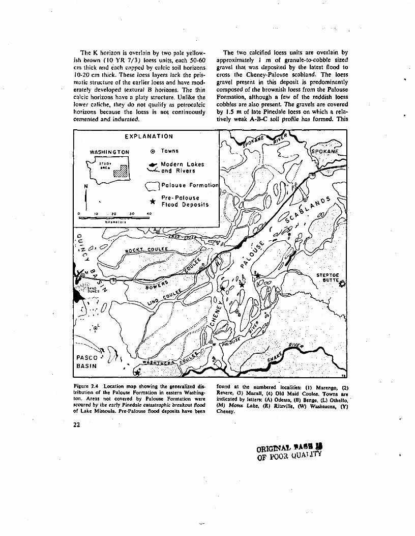
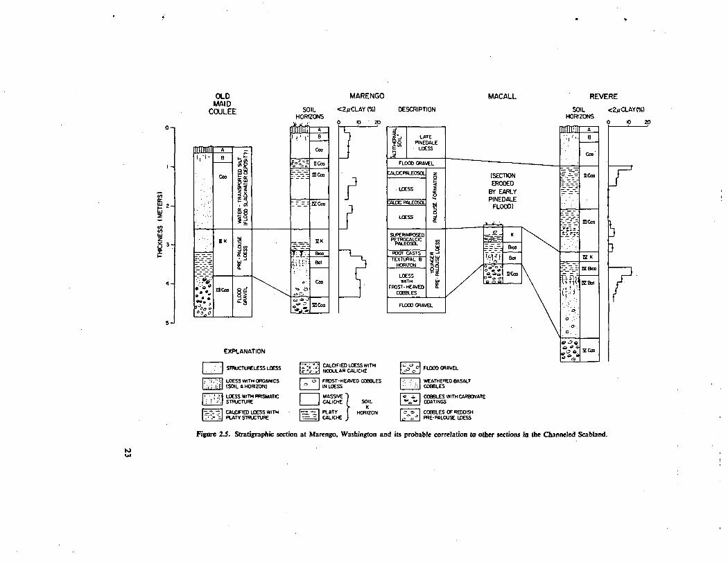
The eastern portion of the Channeled Scabland(Fig. 2.4) contains several exposures of pre-Wisconsin flood gravel. The most complete sec-tion is exposed in a railroad cut through a gravelbar on the downstream end of a residual loessisland about one kilometer west of Marengo,Washington (location 1, Fig. 2.4). The cut ex-poses a succession of two flood gravel units sep-arated by three layers of loess (Fig. 2.5). These
three loess units are each capped by a pedogeniccalcic horizon. The lower flood deposit is a poorlysorted mixture of basalt and loess pebbles andcobbles in a matrix of granule-sized basalt grains.The texture is similar to that of the extensivedeposits of the last major episode of scablandflooding. Typical of many scabland gravel de-posits is the presence of loess cobbles, implyingfluvial transport in suspension which preventeddestruction of the loess. Cobbles in this depositare dull orange (7.5 YR 7/4) in color and haveblack manganese dioxide staining on their sur-faces.
The lower flood gravel is overlain by 1 m ofdark yellowish brown (10 YR 6/6) loess whichis capped by a petrocalcic horizon 60 cm thick.There is also a. well-developed argillic horizonon this loess characterized by a pronounced pris-matic structure. Grain-size analysis indicates thatthe prismatic structure is associated with a rela-tively strong illuvial textural B horizon. Rootcasts infilled with caliche from the overlyingpetrocalcic horizon also occur in this argillic zone.The overlying petrocalcic horizon has a platystructure and completely plugs the uppermostpart of this loess unit. Although no carbonateanalysis was made on this horizon, its morphologyis nearly pure carbonate (caliche) with little loessmatrix. The horizon therefore qualifies for desig-nation as a K horizon (> 50% carbonate) asdescribed by Gile and others (1966). Thispedocal soil appears to have been superimposedon the older, pedalfer soil (textural B horizon)and then eroded to its resistant carbonate layerprior to new loess deposition.
20-
10-
-10
<nac.
-5
Ceo SOIUHORIZON
BROWN LOESS(BULL LAKE)
TELLOW-ORANCE LOESS(PINEDALE-RECENT)
10 FEET
0 10 METERS
Figure 2.3. Loess stratigraphy exposed by a road cut 2.5 km east of La Crosse, Washington.
21
The K. horizon is overlain by two pale yellow-ish brown (10 YR 7/3) loess units, each 50-60cm thick and each capped by calcic soil horizons10-20 cm thick. These loess layers lack the pris-matic structure of the earlier loess and have mod-erately developed lextural B horizons. The thincalcic horizons have a platy structure. Unlike thelower caliche, they do not qualify as petrocalcichorizons because the loess is not continuouslycemented and indurated.
The two calcified loess units are overlain byapproximately 1 m of granule-to-cobble sizedgravel that was deposited by the latest flood tocross the Cheney-Palouse scabland. The loessgravel present in this deposit is predominantlycomposed of the brownish loess from the PalouseFormation, although a few of the reddish loesscobbles are also present. The gravels are coveredby 1.5 m of late Pinedale loess on which a rela-tively weak A-B-C soil profile has formed. This
r Modern Lakes^—''-and Rivers
( I Palouse Formation
Figure 2.4 Location map showing the generalized dis-tribution of the Palouse Formation in eastern Washing-ton. Areas not covered by Palouse Formation werescoured by the early Pinedale catastrophic breakout floodof Lake Missoula. Pre-Patouse flood deposits have been
22
found at the numbered localities: (1) Marengo, (2)Revere, (3) Macall, (4) Old Maid Coulee. Towns areindicated by letters: (A) Odessa, (B) Benge, (L) Othello,(M) Moses Lake, (R) Rilzville, (W) Washtucna, (Y)Cheney.
ORIGINA1OF POOR QUAUTY
1IA!I.5CD
18Ji1s•g«II£t;!«.a•8.S£
SS
3NX
DlH
i
23
latter profile corresponds to the late Wisconsin-early Holocene soil that is common throughoutthe region on post-scabland loess deposits(Fryxell, 1965; Baker, 1973a). The uppermostgravel unit t href ore correlates with the extensivedeposits of the last major episode of scablandflooding.
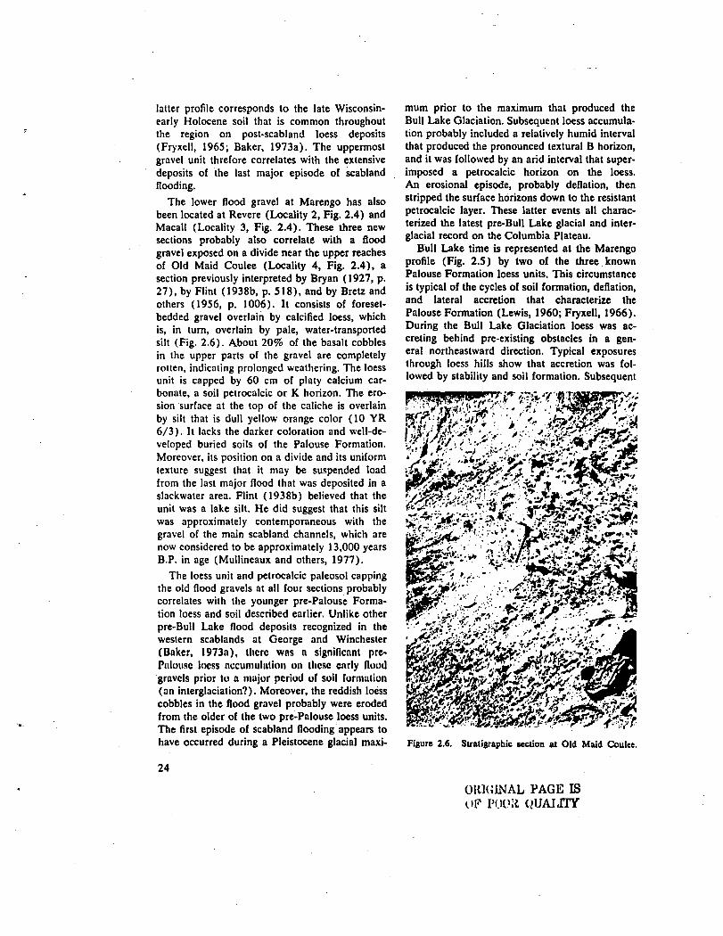
The lower flood gravel at Marengo has alsobeen located at Revere (Locality 2, Fig. 2.4) andMacall (Locality 3, Fig. 2.4). These three newsections probably also correlate with a floodgravel exposed on a divide near the upper reachesof Old Maid Coulee (Locality 4, Fig. 2.4), asection previously interpreted by Bryan (1927, p.27), by Flint (1938b, p. 518), and by Bretz andothers (1956, p. 1006). It consists of foreset-bedded gravel overlain by calcified loess, whichis, in turn, overlain by pale, water-transportedsilt (Fig. 2.6). About 20% of the basalt cobblesin the upper parts of the gravel are completelyrotten, indicating prolonged weathering. The loessunit is capped by 60 cm of platy calcium car-bonate, a soil petrocalcic or K horizon. The ero-sion surface at the top of the caliche is overlainby silt that is dull yellow orange color (10 YR6/3). It lacks the darker coloration and well-de-veloped buried soils of the Palouse Formation.Moreover, its position on a divide and its uniformtexture suggest that it may be suspended loadfrom the last major flood that was deposited in aslackwater area. Flint (1938b) believed that theunit was a lake silt. He did suggest that this siltwas approximately contemporaneous with thegravel of the main scabland channels, which arenow considered to be approximately 13,000 yearsB.P. in age (Mullineaux and others, 1977).
The loess unit and petrocalcic paleosol cappingthe old flood gravels at all four sections probablycorrelates with the younger pre-Palouse Forma-tion loess and soil described earlier. Unlike otherpre-Bull Lake flood deposits recognized in thewestern scablands at George and Winchester(Baker, 1973n), there was a significant pre-Palousc loess accumulation on these cnrly Hoodgravels prior to a major period of soil formation(an interglaciation?). Moreover, the reddish loesscobbles in the flood gravel probably were erodedfrom the older of the two pre-Palouse loess units.The first episode of scabland flooding appears tohave occurred during a Pleistocene glacial maxi-
24
mum prior to the maximum that produced theBull Lake Glaciation. Subsequent loess accumula-tion probably included a relatively humid intervalthat produced the pronounced textural B horizon,and it was followed by an arid interval that super-imposed a petrocalcic horizon on the loess.An erosional episode, probably deflation, thenstripped the surface horizons down to the resistantpetrocalcic layer. These latter events all charac-terized the latest pre-Bull Lake glacial and inter-glacial record on the Columbia Plateau.
Bull Lake time is represented at the Marengoprofile (Fig. 2.5) by two of the three knownPalouse Formation loess units. This circumstanceis typical of the cycles of soil formation, deflation,and lateral accretion that characterize thePalouse Formation (Lewis, 1960; Fryxell, 1966).During the Bull Lake Glaciation loess was ac-creting behind pre-existing obstacles in a gen-eral northeastward direction. Typical exposuresthrough loess hills show that accretion was fol-lowed by stability and soil formation. Subsequent
&'i*!4iy&jJSii•- ,• '•-..• ' •TFf'jfO'^r' -sv *W^«w^7::>^"s!\'£iJ$*r: ./'•/•/-•••.'••.>•. , -^
V&J&-M2i?£&S.3MJmt-
id&&&£^^^m^^-y' mStratigraphic section at Old Maid Coulee.
OUKJINAL PAGE ISOF POOii QUALITY

deflation would remove surficial soil horizonsdown to the resistant calcic layers. The cycle wasthen repeated as more deposition occurred up-wind of the previous deposit. This pattern oflateral accretion plus the opportunity for streamdissection of the topography make it unlikely tofind all three Palouse Formation loess units inone vertical section.
An unresolved problem is the correlation ofthe pre-Wisconsin Cheney-Palouse flood to thepre-Wisconsin flood deposits of the westernQuincy Basin (Baker, 1973a, p. 8). The sectionthere (NW VA, Sec. 31, T. 19N. R.24E) showsa typical foreset flood gravel containing bouldersas large as 1 m in diameter. The uppermost 60cm of the gravel is capped by a horizontallylaminated petrocalcic horizon (Fig. 2.7). This isunderlain by 30-60 cm of carbonate-cementedgravel. Local carbonate cementation in the coarserforesets occurs to a depth of 3 m. Carbonate coat-ings on the underside of cobbles occur to a depthof 4 m. Weathering rinds on the basalt cobblesin the upper 1.5 m of the gravel exceed 7.5 cmin thickness. Many cobbles are completely rotten.The gravel below a depth of 3 m shows no evi-dence of weathering. This weathering profile is
much more intense than that noted on the pre-Wisconsin Cheney-Palouse flood deposits. How-ever, the definitive sequence of loess units is ab-sent in the western Quincy Basin, so a precisecorrelation remains speculative.
Richmond and others (1965) also recognizea Bull Lake episode of scabland flooding fromwidely scattered deposits on the ColumbiaPlateau. The best evidence occurs at WinchesterWasteway in the Quincy Basin, where the BullLake flood deposits overlie the older pre-Wiscon-sin flood deposits seen at George (Baker, 1973a,
P' 8)' OWG1NALOF FOC*
THE BONNEV1LLE FLOOD
Malde (1968) studied the catastrophic floodproduced by the overflow and rapid lowering ofPleistocene Lake Bonneville (Fig. 2.8). He tracedthe course of this flood through the Snake RiverPlain of southern Idaho to Hells Canyon. Maldeinterpreted the age of this event to be about 30,-000 years B.P., based on a radiocarbon date formolluscan fossils associated with flood debris andon the relict soil profile developed on the floodgravel (Melon Gravel). The soil has a thick calcic
Figure 2.7. Oblique aerial photograph of a sanitary land-fill at George, Washington. The white layer is a prom-inent pelrocalcic horizon developed at the top of coarseflood gravel. The gravel was laid down by a deep cata-strophic flood that crossed the western rim of the QuincyBasin and flowed southeastward into the Quincy Basin.
Figure 2.8. View of the Snake River Canyon down-stream of Perrine Memorial Bridge in Twin Falls, Idaho.Scabland erosion of volcanic rocks, here produced bythe Bonneville Rood, is very similar to that produced byMissoula flooding of the Channeled Scabland.
25

horizon extending to depths greater than 2 m(Fig. 2.9). The soil on the Bonneville Flood de-posits is believed to have formed during andsince the mid-Wisconsin (Bull Lake-Pinedale) in-terglaciation or within the last 30,000 years.
Downstream from Hells Canyon at Lewiston,Idaho, probable Bonneville flood deposits areoverlain by slackwater surge deposits from thelast major episode of scabland flooding (Fig.2.10). Because Bonnevilfe flooding was confinedto the Snake River Canyon, it skirted to the southof the Channeled Scabland. Nevertheless, studiesin the Pasco Basin should eventually recognizeBonneville Flood deposits in association with Mis-soula flood deposits.
THE LATE PLEISTOCENE DILUVIANEVENTS
The late Pleistocene glacial record of north-western Washington and southwestern BritishColumbia is very well documented through de-tailed radiocarbon dating (Armstrong and others,1965; Fulton, 1971; Easlerbrook, 1976). Thelast major glaciation, called the Fraser Glacia-tion, extended from about 20,000 to 10,000 years
Figure 2.9. Exposure of Melon Gravel in large boulderbar at mile 161 in the Melon Valley area of the SnakeRiver Canyon, Idaho (Malde, 1968, p. 33). The relictpaleosol here is moderately strong, lacking the petro-calcic horizons of pre-Wisconsin flood gravels in theChanneled Scabland.
26
ago. This is also the time interval that producedthe last major episode of scabland flooding. Atleast one and probably two major outbursts ofLake Missoula occurred during this interval. Al-though the evidence for the floods is overwhelm-ing, the precise dating of the events in this intervalis a matter of current controversy. This sectionwill attempt to summarize the diverse arguments.
Glacial Stratigraphy
The Fraser Glaciation is precisely dated on thewestern side of the Cascade Mountains. Duringthe Evans Creek Stade large alpine glaciers ad-vanced to their maxium extent into the Pugetlowland. This was followed by an advance ofCordilleran ice into the lowland from the northsometime after 19,000 years B.P. (Easterbrook,1976). If the Pend Oreille Lobe of the Cordil-leran Ice Sheet correlated with the Puget Lobe,then Lake Missoula could not have formed untilafter 19,000 years B.P. The Puget Lobe reachedits maximum extent 14,000 to 15,000 years ago,during the Vashon Stage.
Figure 2.10. Slackwater fades of the last episode ofscabland flooding overlying probable flood gravel of theBonneville Flood at a gravel pit 5.5 km south of Lewis-ton, Idaho. The foresets and lithologies indicate that thegravel was deposited by flows coming down the SnakeRiver through Hells Canyon. The slackwater depositswere deposited by backwater flooding tip the SnakeRiver from the mouth of the Palouse River, a distanceof over 120 km. This deposit was described as TammanyBar by Bretz (1969, p. 531-532).
ORIGINAL PAGE ISOP POOR QUALITY

Between 14,000 and 13,000 years B.P. a majorrecession occurred in the Vashon glacier of thePuget lowland. The interval from 13,500 to 11,-500 years ago is characterized by relative stabilityof Cordilleran ice during the Everson Glacio-marine Interstade, which was followed by a ratherminor readvance perhaps between 11,500 and11,000 years B.P.
The glacial chronology on the ColumbiaPlateau is severely hampered by a lack of radio-carbon dating. Work on the Waterville Plateau byHanson (1970) and Easterbrook (1976) showsthat an episode of major scabland flooding oc-
curred prior to the major advance of the Okano-gan Lobe on to the Columbia Plateau. That ad-vance produced a spectacular moraine, the With-row Moraine (Waters, 1933; Flint, 1935). This isestimated to have formed about 14,000 to 15,000years B.P. (Fryxell, 1962; Waitt, 1972a; Easter-brook 1976). Relationships near Jamison Lakeshow the moraine overlying a Moses Coulee floodgravel bar (Fig. 2.11). Subsequent outwash (Fig.2.12) and dramatic ice stagnation features recorda rapid retreat of the Okanogan Lobe (Hanson,1970; Waitt I972a), perhaps contemporaneous tothe analogous phase of the Puget Lobe.
WITHROW MORAIN
Figure 2.11. Topographic map of upper Moses Coulee, Wilhrow Moraine, a pendant bar of flood gravel, and anshowing the physiographic relationships between the outwash terrace (from Easterbrook, 1976).
27

Late-Quaternary Vegetation
A pollen sequence in a mire on the Telford-Crab Creek scabland tract near Creston, Wash-ington records the vegetation changes on theColumbia Plateau that followed the scablandflooding of that region (Hansen, 1947). Mackamj-olhers (1976) have reinterpreted the pollen
^sequence at this locality using improved palyno-logical techniques. The postflood vegetation dur-ing the Glacier Peak ash fall (12,000-13,000 B.P.)and slightly earlier consisted of steppe vegetationdominated by sagebrush (Artemisia) occupyingextensive areas of stony patterned ground. Nearbyloess hills were occupied by pine forest. A warm-ing trend is indicated to have begun about 9,000years ago.
The Creston fen accumulated 60 cm of sedi-ment between 9,390 ± 480 and 6,700 years B.P.and 70-100 cm between 12,000-13,000 and 9,-390 ± 480 years B.P. (Mack and others, 1976;their Fig. 2). These accumulation rates rangefrom 1.75 to 2.6 cm per 100 years. Since themire accumulated 30-50 cm of sediment afterscour by the scabland flooding and prior toGlacier Peak ash accumulation (12,000-13,000years B.P.), that flooding must have occurred atleast 13,500-16,000 years B.P. Of course, thedepositional rates could have been different inthis interval, so this very tenuous age estimatemust be compared to other data.
• .-v- '. '•':•' >-f.?^S^^i*afes^-ssfa*^T&.'%P&2~y&k* .i.r - >M^^, /ij-!>-rr»?
"-•-fc^^:, -,i
...: - $2§?
Figure 2.12. Oblique aerial photograph of the outwashterrace that extends downstream from the WithrowMoraine in Moses Coulee.
28
Weathering and Soils
Near Vantage, Washington, wood, dated byradiocarbon at 32,700 ± 900 years B.P., wasfound in deposits of the last major flood (Fryxell,1962). The wood was probably derived from apreflood, interstadial bog on a scabland surface(Bretz, 1969). Soil-stratigraphic evidence (Baker,1973a) implies that the flooding occurred muchlater than this lower limiting date, but when?
On the Columbia Plateau, one indication of theage of the flooding is provided by the weatheringof the basalt boulders on the surfaces of scab-land flood bars. Weathering rinds on these bould-ers never exceed 3 mm in thickness. By contrast,rinds on similar basalt boulders deposited by theBonneville Flood on the Snake River Plain ofIdaho may be greater than 1.2 cm thick (Malde,1968). Since the Snake River Plain has a similarclimate to that of the Columbia Plateau, the Mis-soula Flood deposits probably considerably post-date the Bonneville Flood, which Malde (1968,p. 10) believes occurred 30,000 years ago.
The relict soils on the scabland floor gravelsare poorly developed. There are only a few centi-meters of near-surface oxidation. Buried cobblesand boulders lack weathering rinds. The Cca hori-zon dominates the soil profile, but shows onlyweak development. Calcium carbonate occurs ascoatings on the undersides of pebbles and cobblesto a depth of about 1 m. There is no platy calicheas found on the Bonneville Flood deposits (Fig.2.9), which were weathered in a similar soil-forming environment.
In the eastern Channeled Scabland the last ma-jor flood scoured channel ways through the en-tire sequence of brown loess units that comprisethe Palouse Formation (Fig. 2.13). Small chan-nels eroded into the flood deposits by postfloodstreams contain pale loess and loess-derivedalluvium. The oldest soil profiles on postfloodloess deposits show textural B horizons, with the<2u. size fraction increasing from 8% to 11%(Baker, 1973a).
Bretz' early studies concluded that the easternChanneled Scabland (Cheney-Palouse tract) wassomewhat older than the western ChanneledScabland (Grand Coulee region). The interpre-tation was developed by physiographic evidence(Bretz and others, 1956; Bretz, 1969). Everyscabland channel way entering from the east is
ORIGINAL 1'AGIC ISOF POOR OUAUTY
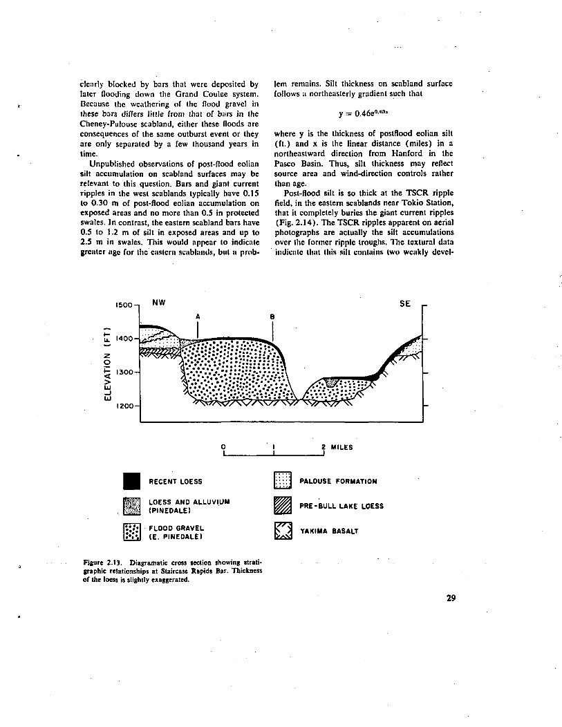
clearly blocked by bars that were deposited bylater flooding down the Grand Coulee system.Because the weathering of the flood gravel inthese bars differs litlle from that of bars in theCheney-Pulouse scabland, either these floods areconsequences of the same outburst event or theyare only separated by a few thousand years intime.
Unpublished observations of post-flood eoliansilt accumulation on scabland surfaces may berelevant to this question. Bars and giant currentripples in the west scablands typically have 0.15to 0.30 m of post-flood eolian accumulation onexposed areas and no more than 0.5 in protectedswales. In contrast, the eastern scabland bars have0.5 to 1.2 m of silt in exposed areas and up to2.5 m in swales. This would appear to indicategrcntcr ngc for the eastern scublmuls, but a prob-
lem remains. Silt thickness on scabland surfacefollows a northeasterly gradient such that
y = 0.46e°-n:"
where y is the thickness of postflood eolian silt(ft.) and x is the linear distance (miles) in anortheastward direction from Hanford in thePasco Basin. Thus, silt thickness may reflectsource area and wind-direction controls ratherthan age.
Post-flood silt is so thick at the TSCR ripplefield, in the eastern scablands near Tokio Station,that it completely buries the giant current ripples(Fig. 2.14). The TSCR ripples apparent on aerialphotographs are actually the silt accumulationsover the former ripple troughs. The tcxlural dataindicate licit this sill contains two weakly dcvcl-
1500-1 NW
UJ
2 MILES
RECENT LOESS
LOESS AND ALLUVIUM(PINEDALE)
FLOOD GRAVEL(E. PINEDALE)
:•.: :J PALOUSE FORMATION
PRE-BULL LAKE LOESS
YAKIMA BASALT
Figure 2.13. Diagramatic cross section showing strati-graphic relationships at Staircase Rapids Bar. Thicknessof the loess is slightly exaggerated.
29
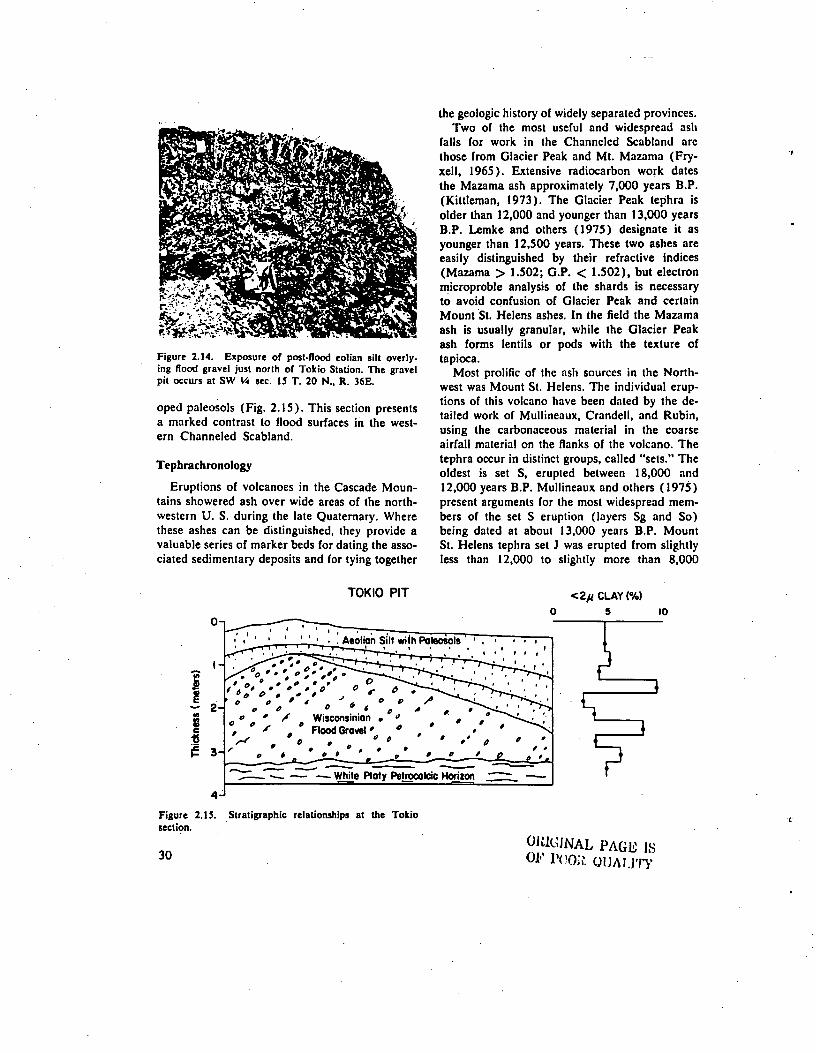
Figure 2.14. Exposure of post-flood eolian silt overly-ing flood gravel just north of Tokio Station. The gravelpit occurs at SW V> sec. 15 T. 20 N., R. 36E.
oped paleosols (Fig. 2.15). This section presentsa marked contrast to flood surfaces in the west-ern Channeled Scabland.
Tephrachronology
Eruptions of volcanoes in the Cascade Moun-tains showered ash over wide areas of the north-western U. S. during the late Quaternary. Wherethese ashes can be distinguished, they provide avaluable series of marker beds for dating the asso-ciated sedimentary deposits and for tying together
the geologic history of widely separated provinces.Two of the most useful and widespread ash
falls for work in the Channeled Scabland arcthose from Glacier Peak and Mt. Mazama (Fry-xell, 1965). Extensive radiocarbon work datesthe Mazama ash approximately 7,000 years B.P.(Kittleman, 1973). The Glacier Peak tephra isolder than 12,000 and younger than 13,000 yearsB.P. Lemke and others (1975) designate it asyounger than 12,500 years. These two ashes areeasily distinguished by their refractive indices(Mazama > 1.502; G.P. < 1.502), but electronmicroproble analysis of the shards is necessaryto avoid confusion of Glacier Peak and certainMount St. Helens ashes. In the field the Mazamaash is usually granular, while the Glacier Peakash forms lentils or pods with the texture oftapioca.
Most prolific of the nsh sources in the North-west was Mount St. Helens. The individual erup-tions of this volcano have been dated by the de-tailed work of Mullineaux, Crandell, and Rubin,using the carbonaceous material in the coarseairfall material on the flanks of the volcano. Thetephra occur in distinct groups, called "sets." Theoldest is set S, erupted between 18,000 and12,000 years B.P. Mullineaux and others (1975)present arguments for the most widespread mem-bers of the set S eruption (layers Sg and So)being dated at about 13,000 years B.P. MountSt. Helens tephra set J was erupted from slightlyless than 12,000 to slightly more than 8,000
TOKIO PIT
O-i
Lg 3-
<ZH CLAY (%)0 5 10
1 • . Aeolian Silt wiih Paleosols
O f
'sS
»r 6• ' < ' • " * » » s
e <> * « e "X Wisconsinion . *. Flood Gravel' *
** ote t t I
White Ploty Petrocalcic Horizon ^~~_ —
Figure 2.15. Stratigraphic relationships at the Tokiosection.
30OMGJNAL PAGE ISOF roo;?. oiMury
years ago. Tephra set Y was extensively dis-tributed in the Northwest between 4,000 and3,400 years ago. Set W is the most recent, datedat about 450 years B.P. All these teplira unitswere carried east of Mount St. Helens and all havenow been recognized in Quaternary sediments ofeastern Washington (Mullineaux and others,1975).
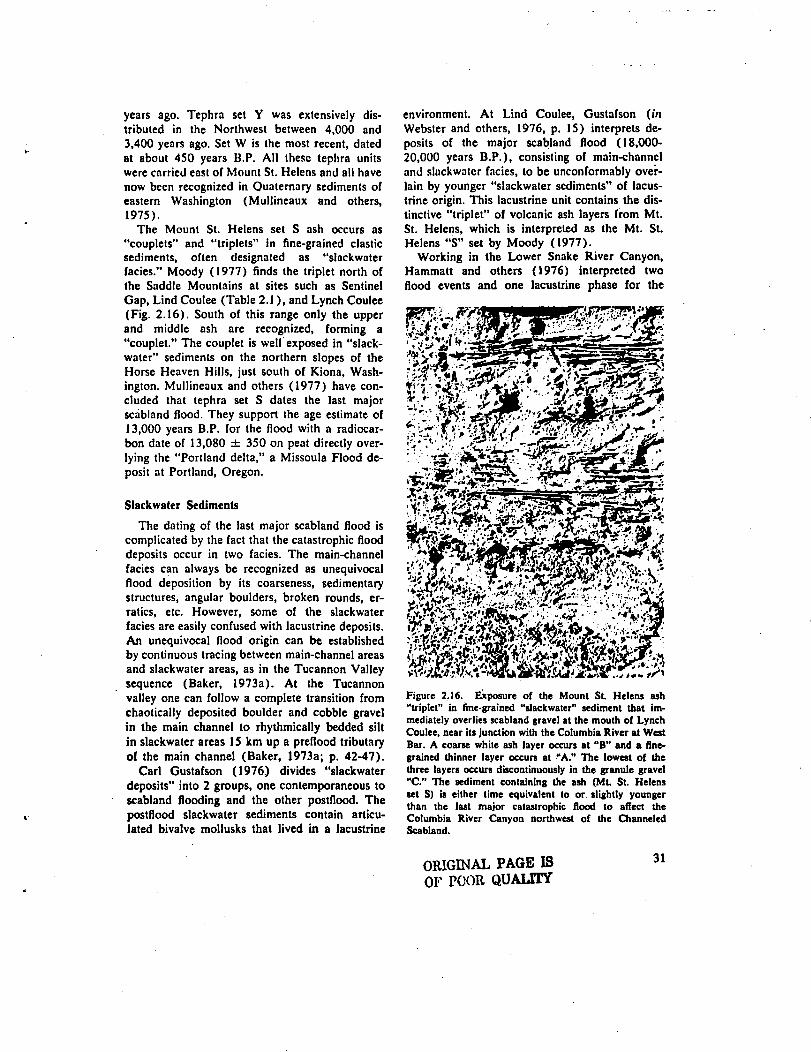
The Mount St. Helens set S ash occurs as"couplets" and "triplets" in fine-grained clasticsediments, often designated as "slackwaterfacies." Moody (1977) finds the triplet north ofthe Saddle Mountains at sites such as SentinelGap, Lind Coulee (Table 2.1), and Lynch Coulee(Fig. 2.16). South of this range only the upperand middle ash are recognized, forming a"couplet." The couplet is well exposed in "slack-water" sediments on the northern slopes of theHorse Heaven Hills, just south of Kiona, Wash-ington. Mullineaux and others (1977) have con-cluded that tephra set S dates the last majorscabland flood. They support the age estimate of13,000 years B.P. for the flood with a radiocar-bon date of 13,080 ± 350 on peat directly over-lying the "Portland delta," a Missoula Flood de-posit at Portland, Oregon.
Slackwater Sediments
The dating of the last major scabland flood iscomplicated by the fact that the catastrophic flooddeposits occur in two facies. The main-channelfacies can always be recognized as unequivocalflood deposition by its coarseness, sedimentarystructures, angular boulders, broken rounds, er-ratics, etc. However, some of the slackwaterfacies are easily confused with lacustrine deposits.An unequivocal flood origin can be establishedby continuous tracing between main-channel areasand slackwater areas, as in the Tucannon Valleysequence (Baker, 1973a). At the Tucannonvalley one can follow a complete transition fromchaotically deposited boulder and cobble gravelin the main channel to rhythmically bedded siltin slackwater areas 15 km up a preflood tributaryof the main channel (Baker, 1973a; p. 42-47).
Carl Custafson (1976.) divides "slackwaterdeposits" into 2 groups, one contemporaneous toscabland flooding and the other postflood. Thepostflood slackwater sediments contain articu-lated bivalve mollusks that lived in a lacustrine
environment. At Lind Coulee, Gustafson (inWebster and others, 1976, p. 15) interprets de-posits of the major scabland flood (18,000-20,000 years B.P.), consisting of main-channeland slackwater facies, to be unconformably over-lain by younger "slackwater sediments" of lacus-trine origin. This lacustrine unit contains the dis-tinctive "triplet" of volcanic ash layers from Mt.St. Helens, which is interpreted as the Mt. St.Helens "S" set by Moody (1977).
Working in the Lower Snake River Canyon,Hammatt and others (1976) interpreted twoflood events and one lacustrine phase for the
tilfll
Figure 2.16. Exposure of the Mount St. Helens ash"triplet" in fine-grained "slackwater" sediment that im-mediately overlies scabland gravel at the mouth of LynchCoulee, near its junction with the Columbia River at WestBar. A coarse white ash layer occurs at "B" and a fine-grained thinner layer occurs at "A." The lowest of thethree layers occurs discontinuously in the granule gravel"C." The sediment containing the ash (Mt St. Helensset S) is either time equivalent to or. slightly youngerthan the last major catastrophic flood to affect theColumbia River Canyon northwest of the ChanneledScabland.
ORIGINAL PAGE ISOF POOR QUALITY
31
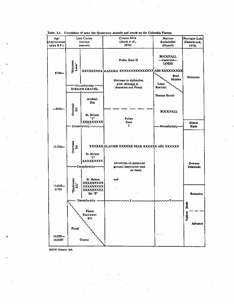
Table. 2.1. Correlation of some late-Quaternary deposits and events on (he Columbia Plateau.
AgeApproximateyears B.P.)
6700—
~9000—
12,300—
13,000—±500
14,000—18,000?
Lind Coulee(varioussources)
u
sa| 8? XXXXXXXXX
~ "Unconformity <~- «-<STREAM GRAVEL
„v i/3O
r^ Uncon
1 „
I"
Archeol.Site
St. Helens"J"
XXXXXXXXX
ormity- *~~~^
XXXXXX
St. Helens"J"
XXXXXXXXX
--~- Unconformity-— '• ^
a1 *-"o S
F3
•w^ Un
St. HelensXXXXXXXXXXXXXXXXXXXXXXXXXXX
Set "S"
nnnfrtrmitu — — —
\ Flood\ Slackwater\ Silt
\Flood X
\Gravel S
Creslon Mire(Mack el al,
1976)
Pollen Zone 11
MAZAMA XXXXXXXXXXXXXXX
(Increase in diploxylonpine; decrease in
Artemisia and Picea)
—~— ^^^_ ^— ^^^_ ~^—m— ^^^_
PollenZone
I
GLACIER XXXXXX PEAK XXXXJ
(Artemisia on patternedground; haploxylon pine
on loess)
and
MarmesRockshelter
(Fryxell)
ROCKFALL— transition —
LOESS
ASH XXXXXXXXX•v^•v Shell
^> Midden
LoessesRockfall ^u
Human Burial
ROCKFALL
^~- disconf ormity -~-
X ASH XXXXXX
_
- -
kanogan LobeEasterbrook,
1976)
Holocene
SumasStade
Everson .Interstade
Recession
§_ ^ _
a1
Advance
XXXX Volcanic Ash
early post-glacial period. Flood gravel, whichthey interpret as 20,000 years B.P., is uncon-formably overlain by thin bedded silt containingMt. St. Helens tephra. The silt, interpreted aslacustrine, is unconformably overlain by sandyfacies interpreted as a flood slackwater depositlaid down approximately 14,000 years B.P. Thisupper unit forms an undulating mantle overearlier deposits and is characterized by distinctlygraded bedding. All three units are cut by clasticdikes.
Sedimentological criteria must be establishedto distinguish slackwater facies of flood origin(Baker, 1973a) from lacustrine deposits. Workon this problem is currently in progress.
Flood Deposits Northwest of the ChanneledScabland
Waitt (1977b) presents detailed evidence forlate Pleistocene catastrophic flooding comingdown the Columbia River, through the regionthat was blocked by the Okanogan lobe untilabout 13,500 years B.P. Ice-rafted erratics andupvalley-dipping crossbeds in gravel show thatthis down-Columbia flood was as deep as 400 mat the junction with the Methow River (Waitt,1977a). These depths require water at CouleeDam to have had a surface elevation of 760 m.Waitt (1972b, 1977a) suggests that these rela-tionships require hydraulic ponding of a LakeMissoula outburst at the Columbia gorge down-stream from Coulee Dam. Because of the chrono-logy of the Okanogan lobe, this flood could onlyhave occurred about 13,500 to 13,000 years ago(Waitt, 1977b).
Flood sediment relationships at Lynch Coulee(Waitt, 1977b, p. 15) suggest that the Columbiaflood was approximately contemporaneous toflooding in the Quincy Basin (presumably de-rived from the Grand Coulee). The Columbiaflood deposits indicate transport up LynchCoulee. These are overlain by flood deposits dip-ping downcoulee (having flowed from CraterCoulee). The contact shows no weathering. AtMoses Coulee, however, the downcoulee depositscame first and even surged up the Colombia(Waitt, 1977b, p. 17). The Moses Coulee flooddeposits are overlain by Columbia flood depositsthat surged up Moses Coulee near its mouth.
Discussion
The emerging stratigraphic evidence sum-marized above has not yet completely resolvedthe number and timing of floods in the last epi-sode of scabland flooding (19,000-13,000 yearsago). The tephrachronology suggests that the lastmajor flood affected the Columbia River, north-west of the scablands, and probably the westernChanneled Scabland itself. This flood occurredjust prior to or nearly coincident with the erup-tion of Mt. St. Helens tephra set S (approximately13,000 years B.P.). This event probably coin-cided with the wastage and breakup of theOkanogan ice sheet on the Waterville Plateau.
It is also probable that another major episodeof scabland flooding preceded the Okanoganbreakout by several thousands years. This floodprobably affected Moses Coulee, the Grand Cou-lee, the Telford-Crab Creek scabland, and theCheney-Palouse. The dating of this event is lessprecise, but includes the following: (1) theWithrow Moranie overlying flood gravel in MosesCoulee (Fig. 2.11), (2) physiographic relation-ships in the Grand Coulee (Bretz, 1932a, 1969),(3) the amount of sedimentation at the Crestonmire prior to the Glacier Peak ashfall, (4) themore extensive silt deposition on the Cheney-Palouse bars, (5) the younger event (13,000years B.P.?) has bars blocking the mouths ofeastern scabland distributaries (Bretz and others,1956), and (6) stratigraphic relationships in theSnake River Canyon (Hammatt and others,1976).
A tenative scenario that has yet to be fullytested in the field is as follows. The largest out-burst of Lake Missoula occurred just prior tothe Vashon glacial maximum, but while theOkanogan lobe was advancing. This flood flowedaround the Okanogan lobe through the "Mans-field channels" (Hanson, 1970) and down MosesCoulee. This route was possible because (1) theadvancing Okanogan lobe had just recentlyblocked the Columbia gorge, and (2) the upperGrand Coulee cataract had not yet receded toCoulee Dam (Bretz, 1932a). It is likely that thisflood initiated the 250 m cataract in the upperGrand Coulee and that it receded to the Steam-boat Rock position during the course of the "earlyVashon" flooding. The same flood would alsoput water into the Telford-Crab Creek and
33
Cheney-Palouse scabland tracks. Slackwater de-posits from this flood would be the lower se-quence recognized by Hammat and others (1976)along the Snake River.
The Okanogan lobe advanced to its maximumposition, the Withrow Moraine, very shortly af-ter the above flood. Wastage of the Okanoganlobe then led to a second flood that also includeda burst from Lake Missoula. Richmond andothers (1965) refer to this as the "middle Pine-dale" final flood on the Columbia River. How-ever, that flood probably also put water over theGrand Coulee cataract head. During the courseof this flood, which was mainly influencing theColumbia River in its early phases, the upperGrand Coulee cataract broke through to theColumbia gorge at Coulee Dam. This sent a finalsurge of water down the Grand Coulee and intothe Ouincy Basin. Thus, the Lynch Coulee rela-tionships are explained by the dynamics of thelast major scabland flood. That flood affected boththe Columbia River and the western ChanneledScabland, but not the eastern scablands. MosesCoulee did not operate because the cataract re-cession of the Grand Coulee in the earlier floodhad pirated the channels that fed its upstreamend.
One variation of the above scenario is possibleby using Wain's (1972b, 1977a) hypothesis ofhydraulic ponding at Coulee Dam. This wouldallow completion of the upper Grand Coulee inthe earlier flood. Water would then be simul-taneously flowing in the Columbia Canyon (freeof the Okanogan lobe) and in the Grand Coulee.
POSTDILUVIAN STRATIGRAPHY OFTHE COLUMBIA PLATEAU
Post-flood conditions in the Channeled Scab-land region have been studied extensively byRoald Fryxell, Carl E. Gustafson, and otherworkers at the Department of Anthropology,Washington State University. Current data sug-gest that man entered the region as early as12,000 years B.P. He encountered a cold drysteppe with considerable lacustrine areas. De-ranged drainage conditions and high water tableswere the legacy of recently wasted glaciers andcatastrophic flooding.
The most intensive study of a post-flood lakein the Channeled Scabland was made by Landye
(1973). Lake Bretz, whose shoreline altitudewas 350 m (1160 ft.) occupied the closed de-pression in the lower Grand Coulee upstreamfrom the bar at Soap Lake. The lake probablylasted a few hundred years, long enough to ac-cumulate an abundant population of mollusksand fish. At the maximum extent, the lake ex-tended northward about 30 km from Soap Lake,Washington, to the head of Dry Falls, nearCoulee City.
The lake was probably maintained by highground-water levels in the basalt associated withthe recent deglaciation of the Waterville Plateau.The decline in water tables eventually resultedin the lake's demise. Its former basin is now oc-cupied by a chain of somewhat saline lakes, in-cluding Deep Lake, Fall Lake, Park Lake, BlueLake, Lake Lenore, and Soap Lake.
Fryxell (1965) recovered coarse volcanic ashfrom the sediments of Lake Bretz. This ash wasidentified as Glacier Peak ash. A radiocarbondate of 12,000 ± 30 years B. P. was obtainedon the Lake Bretz mollusk shells. This analysisprovides an upper limit to the age of the ash,and it also dates the lacustrine phase. However,new data on the Glacier Peak ash show that thiseruption may have been the oldest of several.Mehringer and others (1977) describe twoGlacier Peak ash falls in Montana dated at about11,250 years B.P. and separated by 10 to 25years.
Marines Rockshelter, located near the con-fluence of the Snake and Palouse rivers, pro-duced a long history of occupation (Fryxell andothers, 1968; Rice, 1972). Artifacts discoveredinclude bone needles, bone points, stemmed andlanceolate projectile points, and bola stones. Acomplex burial sequence was found beneath ashell midden dated by radiocarbon at 7,550 ±100 years B.P. The midden, in turn, is overlain byMazama ash (6,700 years B.P.). Carl Gustafson(1972) investigated faunal remains from the siteand found bones including those of Arctic fox,large elk, pronghorn antelope, deer, bison, ro-dents and salmonid fish. These vertebrates be-longed mainly to an early postglacial steppe faunathat characterized the region prior to 7,500 yearsB.P. Marshall (1971) analyzed nearby flood-plain sediments and interpreted precipitation andsteam run-off to have been greater than now prior
34
to 7,500 years ago. Frost polygons were foundin the overbank silt deposits in which the earlyMamies cultural material was discovered, but donot form in the area at present. Rockfall frequen-cies also showed that a cool moist climate waspresent during the time of the early occupation inthe site (Fryxell and others, 1968). Becauselacustrine sediment containing Glacier Peak ashwas found immediately beneath the cultural zone,it is likely that occupation occurred over a longphase of cool, wet conditions between 12,000 and7,500 years ago.
The Lind Coulee archeological site near War-den, Washington was the first locality in easternWashington to yield evidence of paleo-Indianhunters. The early excavation work by Dougherty(1956) was one of the first to use the radiocar-bon method, dating the earliest occupation at8,700 years B.P. A new series of excavations atthe site began in 1972. Although those studiesare not yet complete, the preliminary results andcorrelations (Table 2.1) give an excellent late-glacial and post-glacial record. C. E. Gustafson(in Webster and others, 1976) recognizes acatastrophic flood phase unconformably overlainby lacustrine(?) silt containing the St. Helens"triplet" (set S). Inset into this slackwater siltis another silt unit. An overbank unit is set intothe silts and contains two discrete ash layers in-cluding ashes from St. Helens set J and GlacierPeak (Moody, 1977). Another younger overbanksequence contains another St. Helens J ash datedat 8,700 years B.P. Mazama ash occurs in theeolian silt that blankets the overbank sequence.
CONCLUSION
Based primarily on physiographic evidence,Bretz (1969) has proposed as many as eightseparate scabland floods, of which at least fourencountered an ice-blocked Columbia River andspilled over the northern margin of the ColumbiaPlateau. Bretz' other four floods were not divertedby ice and flowed down the Columbia Rivervalley. Bretz (1969, p. 513) believed that theearliest plateau-crossing flood occurred duringthe Bull Lake Glaciation. Subsequent floods thenenlarged and altered segments of this establisheddrainage.
Baker (1973a) noted that some of the physio-graphic relationships described by Bretz (1969)could be produced during the dynamic progres-sion of a single flood. Only flood deposits recog-nized in a firm stratigraphic sequence can be con-sidered unequivocal evidence for multiple flood-ing. The best stratigraphic information to datesuggests that there certainly were Five major floodsin the general vicincity of the Channeled Scab-land and perhaps six or seven. One, possibly two,floods were pre-BulI Lake and are overlain eitherby thick caliche or by Palousc Formation.Another flood occurred during the Palouse de-position (Bull Lake Glaciation). The third floodwas the Bonneville event, restricted to the SnakeRiver. The final flood phase, 18,000-13,000years ago, seems to include two floods. One ofthese precedes the Vashon maximum, and theother occurred during or just prior to the MountSt. Helens set "S" eruptions.
35