quaternary geology and till geochemistry of the redstone … · quaternary geology and till...
TRANSCRIPT

Quaternary Geology and Till Geochemistry of the Redstone and LoomisLake Map Areas, Central British Columbia (NTS 093B/04, 05)
by T. Ferbey, K.J. Vickers, T.J.O. Hietava1 and S.C. Nicholson2
KEYWORDS: geo chem is try, surficial ge ol ogy, Qua ter naryge ol ogy, drift ex plo ra tion, till geo chem i cal sur vey
INTRODUCTION
This pa per sum ma rizes Qua ter nary ge ol ogy map pingand till geo chem is try stud ies con ducted as part of the re -gional min eral po ten tial as sess ment of the Redstone andLoomis Lake map ar eas (NTS 093B/04, 05; Fig ure 1). Thisstudy was ini ti ated to com ple ment an on go ing re gionalbed rock map ping pro gram and min eral po ten tial as sess -ment be ing con ducted in NTS 093C/01, 08 and 09 (Mihal -ynuk et al., 2008a, b), and a pre vi ous surficial map ping andtill geo chem i cal sur vey in NTS 093C/01, 08, 09 and 16(Giles and Kerr, 1993; Proudfoot, 1993; Lett et al., 2006).His toric gold and sil ver pros pects (e.g., Chili pros pect,MINFILE 093C 015; MINFILE, 2008; Clisbako pros pect,MINFILE 093C 015), as well as newly dis cov ered cop per(e.g., Punky, Orovain, Vam pire and Gumbo) and gold andsil ver show ings (e.g., Pyro, Mihalynuk et al., 2008a, b), oc -cur within Me so zoic to Eocene vol ca nic rocks ad join ingthe study area. These strata are thought to ex tend into thestudy area but an ex ten sive cover of gla cial drift makes thisspec u la tive. As a re sult, and de spite its min eral po ten tial,the study area has been over looked and con sid ered a fron -tier area by the min eral ex plo ra tion com mu nity. There areno known metallic mineral occurrences within the studyarea and there is no staked ground.
The ob jec tives of this study are to· char ac ter ize and de lin eate the Qua ter nary ma te ri als
that oc cur in NTS 093B/04 and 05 and es tab lish the re -gional ice-flow history; and
· as sess the min eral po ten tial of cov ered bed rock(subcrop) us ing a till geo chem is try survey.
The goal of this study is to pro vide the min eral ex plo ra -tion com mu nity with new, high-qual ity, re gional-scale,geo chem i cal data, which will help guide ex plo ra tion ef forts in this drift-cov ered area. In te grat ing in ter pre ta tions ofthese data with other his toric geo log i cal and geo chem i caldata col lected by the Brit ish Co lum bia Geo log i cal Sur vey(BCGS), Geo log i cal Sur vey of Can ada (GSC) andGeoscience BC pro vides a new ex plo ra tion tool. The studyarea falls within the moun tain pine bee tle in fes ta tion zone,
which has been a fo cus of pro vin cial and fed eral eco nomicdi ver si fi ca tion ini tia tives. It is hoped that data from thisstudy will con trib ute to long-term economic diversification from increased mineral exploration.
LOCATION AND PHYSIOGRAPHY
Dur ing the 2008 field sea son, de tailed sedimen -tological, gla cial his tory and till geo chem i cal stud ies werecon ducted in Redstone and Loomis Lake (NTS 093B/04,05; Fig ure 1). The area is lo cated ap prox i mately 150 kmwest of Wil liams Lake, Brit ish Co lum bia, within the Fra serPla teau, a sub di vi sion of the In te rior Pla teau phys io graphicre gion (Hol land, 1976). The area can be de scribed as flat togently roll ing with a rel a tively undissected up land (Fig -ure 2). An ex cep tion to this are the broad val leys of theChil cotin River and its larger trib u tar ies (e.g., Chilanko and Chilko rivers), which are in cised be low the pla teau sur face(Tip per, 1971). The sub dued pla teau to pog ra phy is largelyat trib uted to the subhorizontal, Late Oligocene to Pleis to -cene Chil cotin Group ba salt flows thought to un der lie it.Mantling these basalt flows is a sequence of glacial drift.
Val ley set tings have thick se quences of Qua ter nary,and lo cally pre–L ate Wisconsinan, sed i ments while the up -land or pla teau sur face is dom i nated by till. At 1377 m asl,Mount Alexis is the high est, named el e va tion in the area.North of Temapho Lake, the pla teau sur face rises to over1500 m asl in a se ries of un named peaks and ridges (Fig -ure 2). For the most part, bed rock out crop is lim ited tohigher el e va tions, melt wa ter chan nel flanks, and re cent
Geo log i cal Field work 2008, Pa per 2009-1 117
1University of Oulu, Oulu, Finland2University of Guelph, Guelph, ON
This publication is also available, free of charge, as colourdigital files in Adobe Acrobat® PDF format from the BCMinistry of Energy, Mines and Petroleum Resources website athttp://www.empr.gov.bc.ca/Mining/Geoscience/PublicationsCatalogue/Fieldwork/Pages/default.aspx.
Fig ure 1. Lo ca tion of study area, cen tral Brit ish Co lum bia.

scarps that de fine the larger Chilanko, Chil cotin and Chilko river valleys.
Home steads and cat tle ranches char ac ter ize the studyarea. Redstone (pop u la tion 500), lo cated south of PuntiLake on the north bank of Chilanko River, is the larg est es -tab lished com mu nity. The south ern por tion of the studyarea is tra versed by High way 20 and the re main der is ac ces -si ble us ing an ex ten sive net work of Forest Service roads.
BEDROCK GEOLOGY
The bed rock ge ol ogy was first de scribed by Tip per(1959). This work was com piled by Massey et al. (2005)and re cently stud ied in greater de tail lo cally by Ferri andRid dell (2006) and Rid dell and Ferri (2008) as part of an as -sess ment of oil and gas po ten tial of the Nechako Ba sin. Ad -ja cent to the study area, an on go ing re gional bed rock map -ping and min eral po ten tial as sess ment in NTS 093C/01, 08and 09 has yielded new oc cur rences of me tal lic min er al iza -tion (Mihalynuk et al., 2008a, 2009).
The main geo log i cal sub di vi sions found in the studyarea, as sum ma rized from Tip per (1959), Diakow et al.(1997) and Massey et al. (2005), are as fol lows. The study is sit u ated within the Stikine terrane, close to its east ern con -tact with the Cache Creek terrane (Mon ger et al., 1991).The old est rocks are found in the wes tern most por tion ofNTS 093B/04 and be long to the Early to Mid dle Ju ras sicHazelton Group. Lo cally, they are com posed of an de siteand ba salt with re lated tuff, brec cia and volcaniclastic de -pos its, which re sulted from subaerial and sub ma rine vol ca -nism. Sub ma rine sed i men tary rocks, as so ci ated with ac tiv -ity in an is land arc, are also lo cally pres ent. These are allover lain by a sed i men tary suc ces sion of flu vial con glom er -ate, sand stone and siltstone from the Early and Late Cre ta -ceous Skeena Group. These rocks are lo cally ex posed in the Chilko River val ley, south and southwest of Sisters Hills,and northwest of Temapho Lake.
Subduction-re lated arc vol ca nism re sumed within theStikine terrane in the Late Cre ta ceous, chang ing to a con ti -nent mar gin set ting with subaerial vol ca nism in thePaleogene. Paleogene as sem blages in clude the Ootsa Lakeand Endako groups. Eocene vol ca nic de pos its of the OotsaLake Group are wide spread at Sis ters Hills, and un der lie
top o graph i cally higher ter rain in much of the north ern por -tion of NTS 093B/05. They con sist of a di verse suc ces sion,rang ing from rhy o lite to ba salt, and were mapped in de tailto the west by Mihalynuk et al. (2008a, b). They in cludema roon-brown ba salt flows and brec cia, acicularhornblende dacite flows, ma roon and grey flow-bandedrhy o lite, and vit re ous black dacite. In NTS 093C, con glom -er ate is lo cally found ly ing at the base of the Ootsa LakeGroup, un con form ably overlying the older JurassicHazelton Group.
Within the study area, Eocene to Oligocene vol ca nicrocks of the Endako Group un con form ably over lie theOotsa Lake Group. They oc cupy higher ground in thenorth ern por tion of NTS 093B/05 and to the north east ofSis ters Hills. They con sist mainly of in clined, mas sive tocrudely strat i fied an de site to ba saltic an de site flows. Al -though the flows can in clude ve sic u lar and amyg da loid alva ri et ies, char ac ter is ti cally they are dense, black andaphanitic.
The youn gest rock unit con sists of ba salt flows and as -so ci ated volcaniclastic rocks that un con form ably over lieolder rock units and are cor re lated with the Late Oligoceneto Pleis to cene Chil cotin Group. These rocks con sists of dis -tinctly lay ered, subhorizontal, rel a tively thin flows, com -monly with col on nades as so ci ated with shield-like vol ca -nic cen tres, in ter preted to oc cur north of the study area(Mihalynuk et al., 2008a). When com pared to other ba saltwithin the study area, they dif fer and are dark brown togrey, highly vesiculated, and con tain un al tered pheno crysts of ol iv ine and feld spar. Fine-grained, less vesiculated va ri -et ies have a felted grey-brown texture.
Geo log i cal maps by Tip per (1959) and Massey et al.(2005) show that up wards of 70% of the study area is un -der lain by ba salt of the Chil cotin Group. Al though the ar ealex tent of these rocks within the Nechako Pla teau is cer -tainly sig nif i cant, re cent work by Mihalynuk et al. (2008a,b, 2009) and An drews and Rus sell (2007) dem on stratedthat this cover may not be as wide spread or thick as orig i -nally thought. This is pos i tive for min eral ex plo ra tion anddrift pros pect ing, as these re cent stud ies re port sig nif i cantthick ness vari a tions and even win dows through Chil cotinGroup flow se quences ex pos ing older more prospectivebasement units.
Mas sive gran ite oc cu pies the south west cor ner of NTS093B/04. It is in ter preted to be part of an in tru sive bodymapped by Tip per (1969) and Mihalynuk et al. (2009) tothe west. Mihalynuk et al. (2008a, b, 2009) re ported pos i -tive cor re la tion be tween in tru sive bod ies and in tru sion-hosted veins with cop per min er al iza tion. As this is the onlyin tru sive body within the study area, a higher den sity of tillsam ples was col lected down-ice, to the north east, in or derto in ves ti gate a po ten tial association with mineralization.
Mineral Occurrences
There are no known me tal lic min eral oc cur renceswithin the study area. To the west, how ever, his toric goldand sil ver pros pects are known within the east ern por tion of NTS 093C (e.g., Chili, MINFILE 093C 011; Chil cotinRiver East and West, MINFILE 093C 013 and 093C 014;Baez, MINFILE 093C 015; Clisbako, MINFILE093C 016), as well as newly dis cov ered cop per (e.g., Pun -ky, Orovain, Vam pire and Gumbo) and gold and sil vershow ings (e.g., Pyro). Lett et al. (2006) and Mihalynuk etal. (2008a) pro vided sum ma ries of these occurrences.
118 Brit ish Co lum bia Geo log i cal Sur vey
Fig ure 2. View of study area look ing south to wards Mount Alexis(cen tre of the back ground), cen tral Brit ish Co lum bia. Note the flatto gently roll ing to pog ra phy in fore ground and higher peaks andridges in back ground.
QUATERNARY GEOLOGY
The Qua ter nary ge ol ogy of the study area was first de -scribed by Tip per (1971) in a gla cial fea tures map at a1:250 000 scale. The BC Min is try of En vi ron ment, Landsand Parks (1976a, b) pro duced 1:50 000 scale soils andland forms maps for NTS 093B/04 and 05. Other Qua ter -nary geo log i cal stud ies have been con ducted in the re gionin ar eas ad ja cent to NTS 093B (Fig ure 1; e.g., Giles andKerr, 1993; Proudfoot, 1993; Levson and Giles, 1997;Mate and Levson, 1999; Mate and Levson, 2000; Plouffeand Levson, 2001). The fol low ing is a sum mary of data col -lected during the 2008 field season.
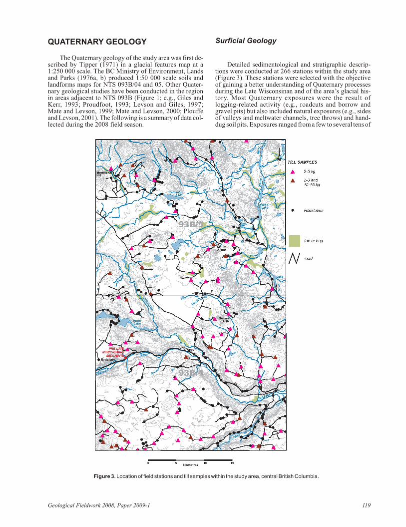
Surficial Geology
De tailed sedimentological and strati graphic de scrip -tions were con ducted at 266 sta tions within the study area(Fig ure 3). These sta tions were se lected with the ob jec tiveof gain ing a better un der stand ing of Qua ter nary pro cessesdur ing the Late Wisconsinan and of the area’s gla cial his -tory. Most Qua ter nary ex po sures were the re sult oflogging-re lated ac tiv ity (e.g., roadcuts and bor row andgravel pits) but also in cluded nat u ral ex po sures (e.g., sidesof val leys and melt wa ter chan nels, tree throws) and hand-dug soil pits. Ex po sures ranged from a few to sev eral tens of
Geo log i cal Field work 2008, Pa per 2009-1 119
Fig ure 3. Lo ca tion of field sta tions and till sam ples within the study area, cen tral Brit ish Co lum bia.

metres in height. In the case of hand-dug soil pits, depthonly occasionally exceeded 1 m below surface.
PRE-LATE WISCONSINAN
Ex posed in a 12 m ver ti cal sec tion are the old est sed i -ments to oc cur in the study area (Fig ure 3). Pre lim i nary data in di cate that this is a 6.8 m thick se quence of pre–LateWisconsinan strat i fied sand, gravel and tephra (Fig ure 4).These pre–Late Wisconsinan sed i ments are unconformably over lain by 2.2 m of basal till and 3.0 m of glaciofluvialgravel de pos ited dur ing full gla cial and retreat-phase con -di tions, re spec tively, of the Late Wisconsinan Fra ser gla ci -ation. The thick crossbedded sand and gravel suc ces sionthat oc curs in the lower por tion of the sec tion islithologically dis tinct from the gravel that over lies the LateWisconsinan basal till as the suc ces sion ap pears to be de -void of in tru sive clasts. A 30 to 50 cm thick, grey ho ri zon ofsilt-sized ma te rial of pos si ble vol ca nic or i gin sep a rates thelower sand and gravel from a 2.5 m thick unit ofinterbedded buff to white tuff and ox i dized and induratedsilt. The tuff is rhyolitic, with bi o tite and feld spar crys talsup to 1.0 mm across. The 40 to 60 cm thick indurated andox i dized silt ho ri zons that sep a rate tuff lay ers could beweakly de vel oped paleosols. This ex po sure, and an otherex po sure lo cated 5 km to the east on High way 20, is be -lieved to be the first ob ser va tion of pre–L ate Wisconsinansed i ments in the area. More detailed work is required toconfirm these interpretations.
LATE WISCONSINAN GLACIAL SEDIMENTS
The dom i nant surficial ma te rial found in the study area is diamict. Based on phys i cal char ac ter is tics such as ma trixtex ture and pro por tion, modal clast size and clast shape,and sur face ex pres sion, the sed i ments are di vided into twoge net i cally sep a rate units. The first, and likely dom i nant interms of ar eal ex tent, is a grey, sand-rich, grav elly diamict.In this diamict, char ac ter is tics such as ver ti cal joint ing,subhorizontal fissility and com pac tion or over-con sol i da -tion are lack ing. Clast shape is com monly subangular tosubrounded and modal clast size is small peb ble but rangesfrom gran ule to large peb ble. The unit is clast rich com -pared to the sec ond diamict de scribed be low and the pro -por tion of ma trix is typ i cally 55 to 75%. Near sur face (inthe up per 1 to 2 m), this ma trix can be ox i dized and clasts, in par tic u lar in tru sive rock types, can be weath ered. The
lower con tact of this diamict, ob served in only a few lo cal i -ties, is gradational down ward into a grey, silt-rich,overconsolidated diamict (de scribed be low). Min i mumthickness is ~1 m and ranges up to several metres in someareas.
The sur face ex pres sion of this sand-rich, grav ellydiamict, as ob served in ae rial pho to graphs and in the field,is dis tinc tive. The up per sur face is typ i cally un du lat ing tohummocky and com monly has peb ble to boul der-sizedclasts sit ting at sur face (Fig ure 5). The phys i cal andgeomorphological char ac ter is tics are con sis tent with till ofen gla cial or supraglacial or i gin. The trans port his tory ofthis till fa cies can be com plex and this un cer tainty pre -cluded sam pling for till geo chem is try. Win dows throughthis fa cies to an un der ly ing silt-rich, overconsolidateddiamict are oc ca sion ally found. This un der ly ing ma te rial isan ideal sam ple me dium for a till geochemical survey and isdescribed below.
The un der ly ing silt-rich, overconsolidated diamict isgrey and is the other com monly oc cur ring diamict withinthe study area. This diamict is mas sive; ver ti cal joint ing and subhorizontal fissility are lo cally well de vel oped (Fig -ure 6). Ma trix pro por tion ranges from 65 to 85%. Modalclast size is small peb ble and ranges from gran ule to largepeb ble. Clast shape is typ i cally subangular to subroundedbut lo cally, down-ice from larger river val leys, there can bea con cen tra tion of rounded, subdiscoidal to spher i cal clastsand a more sandy tex tured ma trix. These clasts are in ter -preted to have been in cor po rated by the Cordilleran IceSheet as it moved across existing valley fills.
This diamict can oc cur at sur face or un der lie the en gla -cial or supraglacial till unit de scribed above. Its sur face ex -pres sion is also dis tinc tive. The mor phol ogy of the up persur face is vari able and can be roll ing or ridged (e.g., in thecase of fluted, drumlinized or crag-and-tail ter rain) or amore sub tle vari a tion of the bed rock sur face it blan kets. Atsome sites, this basal till di rectly over lies grooved and stri -ated Chil cotin Group ba salt flows. The tex ture, pri marystruc tures and de gree of con sol i da tion of this unit are con -sis tent with those of subglacially de rived diamict(Dreimanis, 1989) and this unit is interpreted as basal till.
120 Brit ish Co lum bia Geo log i cal Sur vey
Fig ure 4. Pre-Late Wisconsinan se quence of sand, gravel andtephra, near Redstone, Brit ish Co lum bia. The over ly ing Late Wis -consinan Fra ser gla ci ation basal till is shown with an as ter isk (*).
Fig ure 5. Hummocky, en gla cial or supraglacial till, cen tral Brit ishCo lum bia.

LATE WISCONSINAN RETREAT-PHASESEDIMENTS
Late-gla c ia l ice-mar ginal and re t reat -phaseglaciofluvial sand and gravel com monly oc cur, within andad ja cent to melt wa ter chan nels, as ter race and outwash de -pos its in the larger Chilanko, Chil cotin and Chilko riverval leys. Melt wa ter chan nels can be iso lated fea tures a fewmetres across and tens of metres long, or can be com plexkilo metre-scale melt wa ter chan nel sys tems com posed ofmul ti ple trib u tary chan nels. The most prom i nent is lo catedin the east ern por tion of NTS 093B/05 and hosts the Alexisand Nazko lakes sys tem. Surficial ma te ri als in these sys -tems range from mod er ately well-sorted, silty sand to cob -ble gravel. Tip per (1971) pro posed that this melt wa terchan nel sys tem was the out let for a Late Wisconsinan gla -cial lake that oc cu pied the Chil cotin River val ley, a prod uctof damm ing of the Chil cotin River at its con flu ence with the Fra ser River by a late-gla cial re advance of ice from theCariboo Moun tains to the west across the Fra ser Pla teau.Based on the el e va tion of the drain age di vide that sep a ratesthe mod ern-day Nazko River wa ter shed from that of Chil -cotin River, a minimum upper elevation for this glacial lakeis 1047 m asl.
Glaciolacustrine sed i ment as so ci ated with this ice-dammed lake dom i nates the larger river val leys such asChilanko, Chil cotin and Chilko, and many of their trib u tar -ies (Fig ure 7). The sed i ment is typ i cally par al lel-lam i natedand bed ded silt and fine sand. Near lake mar gins, the siltand fine sand are interbedded with coarse sand, and rip plesand cross-strat i fi ca tion are com mon. They are com monlydeeply gullied and can be as so ci ated with val ley-side,mass-wast ing de pos its. The jux ta po si tion of large-scaleesker sys tems in the bot tom of Chil cotin River val ley, up -stream of the con flu ence of Chil cotin and Chilanko rivers,and in the bot tom of Chilko River val ley, up stream of thecon flu ence with Chil cotin River, against these glacio -lacustrine sed i ments is both im pres sive and a cu ri os ity asthey dem on strate a con trast in depositional en vi ron ments.These esker sys tems are com posed of sand and pebble- tocob ble-sized gravel ridges up to 50 m high and 2 km long.They are free of any fine-grained glaciolac us trine sed i -ments. Their oc cur rence sug gests that large stag nant ice
masses were sit ting at least lo cally in the Chilcotin Riverand upper Chilko valleys while they were flooded.
HOLOCENE DEPOSITS
Gla cial units are typ i cally capped on steeper val leyslopes by col lu vial de pos its. The par ent ma te rial of thesede pos its can be pre-ex ist ing gla cial sed i ment or Chil cotinGroup ba salt flows that have moved downslope from bed -rock scarps that rim larger val leys (e.g., Chilanko, Chil -cotin, Chilko val leys). His toric mass-wast ing de pos its canbe clearly seen in ae rial pho to graphs while on go ing trans -lational dis place ment of Chil cotin Group ba salt blocks canbe ob served on the ground. Ho lo cene or ganic de pos its inthe study area are typ i cally found bor der ing small lakes orfloor ing some of the larger glaciofluvial meltwaterchannels and channel systems.
Ice-Flow History
The study area was cov ered by the Cordilleran IceSheet dur ing the Late Wisconsinan Fra ser gla ci ation (Tip -per, 1971). The oc cur rence of crag-and-tail fea tures onhigher ground within the north and south east parts of NTS093B/04 (>1330 m asl) and 093B/05 (>1400 m asl), and thenorth east-ta per ing drift tail of an un named peak in thesouth west part of 093B/04 (Fig ure 8), pro vide a min i mumel e va tion for this ice of ap prox i mately 1500 m asl. The con -sis tent ori en ta tion of these landform-scale fea tures withstriations, grooves and other drum lins and flut ings at lowerel e va tion shows that ice move ment through the study areawas rel a tively un af fected by to pog ra phy dur ing the gla cialmax i mum (Fig ure 9). A mi nor de flec tion can be ob servedwhen com par ing ice-flow in di ca tors oc cur ring in the south -west to those in the north west and north, a re sult of the in -ter ac tion of north east-flow ing ice from the Coast Moun -tains with west ward-flow ing ice from the CaribooMoun tains. The con flu ence and turn ing of these two iceflows oc curred dur ing the Late Wisconsinan gla cial max i -mum to the east of this map area, near the Fraser Rivervalley (Tipper, 1971).
Both bidirectional (e.g., flute) and uni di rec tional (e.g.,drum lin, crag-and-tail) landform-scale, ice-flow in di ca -tors, in var i ous top o graphic set tings, can be ob served in ae -rial pho to graphs and on the ground. In both cases, the fea -tures (Fig ure 9) trend 035° (in the north west and north) to
Geo log i cal Field work 2008, Pa per 2009-1 121
Fig ure 7. View of glaciolacustrine se quence in Chil cotin River val -ley, cen tral Brit ish Co lum bia.
Fig ure 6. Silt-rich, overconsolidated diamict (in ter preted to bebasal till), cen tral Brit ish Co lum bia. Note well-de vel oped joint ingand subhorizontal fissility. The ma roon hue is at trib uted to the col -our of its source rock, Ootsa Lake Group vol ca nic rocks that oc curup-ice of this ex po sure.

055° (in the south west). The pres er va tion and def i ni tion ofthese fea tures can vary; ex cel lent ex am ples can be ob -served where top o graphic fea tures are ori ented per pen dic -u lar to re gional ice flow. For ex am ple, on the east side of the up per Chil cotin River val ley (up stream of its con flu encewith Chilanko River), clear, well-de fined drum lins andcrag-and-tail fea tures up to 60 m across can be ob served inthe val ley bot tom for 850 m up the val ley side onto the pla -teau sur face. Ex cel lent ex am ples of crag-and-tail fea turesoc cur on much of the higher ground in the vi cin ity of Sis ters Hills. Smaller, out crop-scale fea tures such as striations andgrooves are rare. These, and out crop-scale rochesmoutonnées, con sis tently trend 048 to 052° (Fig ure 9). Theori en ta tions of ice-flow in di ca tors ob served as part of thisstudy are in gen eral agree ment with ar eas to the west inNTS 093C (Giles and Kerr, 1993; Proudfoot, 1993; Lett etal., 2006; Mihalynuk et al., 2008a, b) and with data and in -ter pre ta tions pre sented by Tip per (1971).
The prox im ity of the study area to ac cu mu la tion cen -tres such as the Coast and Cariboo moun tains re sulted in acom plex late-gla cial and deglacial his tory. To the west, alate-gla cial re advance was iden ti fied by Tip per (1971),Giles and Kerr (1993) and Proudfoot (1993) and named theAhahim Lake ad vance. Piedmont lobes, fed by val ley gla -ciers orig i nat ing in the Coast Moun tains to the west, flowed onto the Fra ser Pla teau and fanned out to the north, east andsouth east. Based on dif fer en tial ice-flow di rec tions and theoc cur rence of pit ted and kettled ter rain, a limit of this ad -vance has been placed within the east ern por tions of NTS093C (Tip per, 1971; Giles and Kerr, 1993; Proudfoot,1993). A sim i lar re advance is thought to have oc curred eastof the study area. There, ice ad vanced west out of theCariboo Moun tains and fanned out onto the Fra ser Pla teau.Lat eral over flow chan nels and in ter sec tions of drum lin oidforms as so ci ated with this re advance, and those as so ci atedwith the north east erly flow of the Cordilleran Ice Sheet dur -ing the Late Wisconsinan gla cial max i mum, in di cate thatthis re advance crossed and ex tended up to 30 km west of the Fra ser River val ley (Tip per, 1971). It has also been pro -posed that a late-gla cial ad vance, named the KleenaKleene, oc curred down Kleena Kleene, Tatlayoko, Tatlaand Chilko val leys. Along the Tatla Lake val ley, an el e va -tion limit of approximately 1200 m asl has been suggestedfor this advance (Tipper, 1971).
Deglaciation was dom i nated by thin ning anddownwasting of ice masses (cf. Fulton, 1991). This re sulted in higher ground be ing ex posed first, leav ing val leyschoked with stag nant ice. Hummocky till, glaciofluvial de -pos its and eskers (in val ley set tings and on the pla teau sur -face) are ev i dence in sup port of this in ter pre ta tion. In thenorth ern part of the study area, these deglacial fea tures arelikely re lated to the Cordilleran Ice Sheet dur ing the wan ing stages of the Fra ser gla ci ation. In the south ern por tions ofthe study area, how ever, it is un clear whether they are re -lated to re treat of the Cordilleran Ice Sheet or to the laterKleena Kleene re advance. The oc cur rence of lat eral melt -wa ter chan nels and a rare re ces sional mo raine (Fig ure 10)sug gest that there was some mi nor com po nent of marginalretreat during deglaciation.
TILL GEOCHEMICAL SURVEYS
Till geo chem i cal sur veys have not been con ductedwithin the study area. Till sam ples were col lected, how ever, within NTS 093C/01, 08, 09 and 16 to as sess the min eral
po ten tial of these ar eas (Giles and Kerr, 1993; Proudfoot,1993; Lett et al., 2006). Plouffe and Ballantyne (1994),Plouffe (1997) and Plouffe et al. (2001) con ducted till geo -chem is try sur veys to the north and south of the study area.To the north of the study area, in the Fawnie Creek map area (093F/03), Cook et al. (1995) con ducted a com par a tivestudy on the abil ity of re gional lake sed i ment and till geo -chem is try sur veys to iden tify known min eral oc cur rences.In this study, till iden ti fied all seven known pros pects in thestudy area with >95th per cen tile el e ment con cen tra tions.Nine of eleven po ten tial new geo chem i cal pros pects pre -sented in the study were also iden ti fied with till sam ples,which had >95th percentile concentrations of multipleelements.
Sample Media
Basal till, a first de riv a tive of bed rock (Shilts, 1993), istrans ported in a rel a tively lin ear fash ion par al lel to ice-flow di rec tion, down-ice from its bed rock source. The con trastbe tween el e vated and back ground geo chem i cal val ues isclear and the area rep re sented by till sam ples with el e vatedval ues can be areally more ex ten sive than that of their bed -rock source. The geo chem i cal pat terns found in basal tillpro duce a re gional sig na ture that is in con trast to re sid ualsoils and bed rock-de rived col lu vium, which typ i cally re -flect more lo cal geo chem i cal vari a tions in bed rock(Levson, 2001). The rel a tively sim ple trans port his tory ofbasal till makes it an ef fec tive tool for trac ing el e vated geo -chem i cal val ues back to their bed rock source. In the Ca na -dian Cor dil lera, the ef fi ciency of con duct ing a till geo -chem is try sur vey, and the qual ity of geo chem i calin ter pre ta tions, are largely de pend ent on ap pro pri ate sam -ple ma te rial, access and the detail to which the region’sQuaternary and ice-flow history can be determined.
While con duct ing a till geo chem is try pro gram, it is im -per a tive that the sam ple me dium is cor rectly iden ti fied.This en sures con sis tency be tween sam ple sites and un der -stand ing of the or i gin and mode of sed i ment trans port andde po si tion (Levson, 2001). To this end, sedimentologicaldata, such as tex ture, col our, thick ness, pri mary and sec -ond ary struc tures, den sity, ma trix per cent age, clast mode,shape and pres ence of striae, were col lected at each site inor der to en sure the proper dis crim i na tion of basal till fromother sed i ment types such as col lu vium, de bris flows and
122 Brit ish Co lum bia Geo log i cal Sur vey
Fig ure 8. View of an un named peak in the south west of NTS093B/04 (look ing north-north west), cen tral Brit ish Co lum bia. Notethe drift tail of this crag-and-tail that ta pers to wards the north east.

glaciolacustrine diamict. As well, at each sam ple site, noteswere made of type of ex po sure sam pled, ter rain map unit,sam ple site geo mor phol ogy (e.g., top o graphic po si tion, as -pect, slope, drain age), stra tig ra phy, and type and thick nessof soil ho ri zons pres ent. This in for ma tion can be crit i calwhen in ter pret ing re sul tant geo chem i cal data. Clasts in tillwere ex am ined in de tail at most sites; data such as li thol ogy, an gu lar ity, size, pres ence of striae, and oc cur rence of min -er al iza tion were re corded. From these data, inferences onclast provenance were made and allow insight into local,covered bedrock units.
For this study, ma jor, mi nor and trace-el e ment geo -chem i cal anal y ses of till will be con ducted on the silt- plusclay-sized (<0.063 mm) and the clay-sized (<0.002 mm)frac tions. Tra di tion ally, the silt- plus clay-sized (<0.063 mm) frac tion is most com monly used as it can be sep a ratedquickly and cost ef fec tively (Levson, 2001). For this study,the clay-sized (<0.002 mm) frac tion in basal till will also bean a lyzed as the con trast be tween el e vated and back groundel e ment con cen tra tions can be higher. This con trast is dueto the ten dency of some base met als (more spe cif i cally,chalcophile el e ments such as cop per, zinc and lead) to con -
Geo log i cal Field work 2008, Pa per 2009-1 123
Fig ure 9. Sum mary of ice-flow in di ca tors ob served as part of this study, cen tral Brit ish Co lum bia. Ar easof hummocky till (en gla cial or supraglacial or i gin) are shown in yel low (adapted from Tip per, 1971).

cen trate in this frac tion due to the high cat ion ex change ca -pac ity of clay-sized par ti cles (Nikkarinen et al.,1984;Shilts, 1984, 1995; DiLabio, 1995).
Heavy min eral sep a ra tions are planned for themedium- to very coarse-grained sand (0.25–2.0 mm) frac -tion, while gold grain counts will be con ducted on the verycoarse-grained sand frac tion and smaller (<2.0 mm). Goldgrains in till, based on their mor phol ogy and abun dance,can pro vide in sight into trans port his tory and gen e sis.These data can also pro vide in sight into the gen e sis ofsource rocks through iden ti fi ca tion and anal y sis of heavymin eral as sem blages (Averill, 2001).
Sample Types
As part of this study, 117 basal till sam ples (2–3 kg)were col lected for ma jor, mi nor and trace-el e ment geo -chem i cal anal y ses, while 38 basal till sam ples (10–15 kg)were col lected for anal y sis of heavy min eral con cen tratesand for gold grain counts. Sam ple sites were se lected to op -ti mize spa tial cov er age, tak ing into ac count ice-flow di rec -tion and avail abil ity of ap pro pri ate sam ple ma te rial. Theav er age till sam ple den sity for the sur vey is one sam ple per15 km2. This is lower than other re gional-scale till geo -chem is try sur veys con ducted in cen tral Brit ish Co lum bia,which had sam ple den si ties of ap prox i mately one sam pleper 5 to 10 km2. The lower den sity is mainly due to the ab -sence of ap pro pri ate sam ple me dia in the study area and tolim ited ac cess (e.g., de ac ti vated For est Ser vice roads, pri -vate land or lack of roads). Till sam ples were col lectedmainly from roadcuts but also from soil pits and gul lies.Av er age sampling depth was 100 cm below surface butranged from 45 to 510 cm.
Laboratory Methods
Till sam ples col lected for ma jor, mi nor and trace-element anal y ses are be ing sieved, de canted and cen tri -fuged to pro duce a silt- plus clay-sized (<0.063 mm) andclay-sized (<0.002 mm) frac tion. This sam ple prep a ra tionis be ing con ducted at the Geo log i cal Sur vey of Can ada’sSedimentology Lab o ra tory (Ot tawa, ON), fol low ing pro -ce dures out lined by Gi rard et al. (2004). Heavy min eralsam ples have been sent to Over bur den Drill ing Man age -ment (ODM; Nepean, ON) where heavy min eral (0.25–2.0 mm) and gold grain (<2.0 mm) con cen trates are be ingpro duced us ing a com bi na tion of grav ity tabling and heavyliquid separation techniques.
For the 2–3 kg sam ples, mi nor and trace-el e ment anal -y ses (37 el e ments) will be con ducted on splits of the silt-plus clay-sized (<0.063 mm) and clay-sized (<0.002 mm)frac tions, re spec tively, by in duc tively cou pled plasmamass spec trom e try (ICP-MS), fol low ing an aqua regia di -ges tion. Ma jor el e ment anal y ses will be con ducted on asplit of the silt- plus clay-sized (<0.063 mm) frac tion only,us ing in duc tively cou pled plasma emis sion spec trom e try(ICP-ES), fol low ing a lith ium metaborate/tetraborate fu -sion and di lute ni tric acid di ges tion. This an a lyt i cal workwill be con ducted by Acme Analytical LaboratoriesLimited (Van cou ver).
Also as part of this pro ject, a split of the silt- plus clay-sized (<0.063 mm) frac tion will be an a lyzed for 35 el e -ments by in stru men tal neu tron ac ti va tion anal y sis (INAA)at Ac ti va tion Lab o ra to ries Lim ited (Ancaster, ON). Ad di -tion ally, INAA de ter mi na tions will be con ducted on bulk
heavy min eral con cen trates pro duced from the 10–15 kgsam ples. Heavy min eral pick ing, scan ning elec tron mi cros -copy (SEM) anal y ses on dif fi cult-to-iden tify heavy min -eral grains, and peb ble counts may be con ducted at a laterdate on these con cen trates. Mi nor and trace-el e ment con -cen tra tions, as well as the abun dance of heavy min er als andgold grains, will be used to assess whether the additionalanalyses are warranted.
In each block of 20 sam ples sub mit ted for ma jor, mi nor and trace-el e ment anal y ses, 16 are rou tine field sam ples.The re main ing four sam ples are qual ity con trol mea sures,uti lized in both the sam ple col lec tion and sam ple anal y siscom po nents of the study, to dif fer en ti ate true geo chem i caltrends from those that re flect ran dom and sys tem atic sam -pling or an a lyt i cal er rors. Qual ity con trol mea sures in cludethe use of field du pli cates, analytical duplicates and controlstandards.
IMPLICATIONS FOR MINERALEXPLORATION
The sin gle big gest chal lenge in as sess ing the area’smin eral po ten tial is the cover of englacially or supra -glacially de rived till, which is not a fa vour able sam ple me -dium for a till geo chem i cal sur vey. The qual ity of geo chem -i cal de ter mi na tions, and the in ter pre ta tions that fol low, areen tirely de pend ent on the qual ity of field sam ple se lec tion.Al though chal leng ing, till geo chem i cal sur veys can be suc -cess fully com pleted in ar eas with the phys io graphic andgeo log i cal char ac ter is tics en coun tered in NTS 093B/04and 05. An ini tial re view of ex ist ing surficial ge ol ogy mapdata and ae rial pho to graphs can help iden tify most likelytill oc cur rences, such as where roll ing or ridged till oc curs(e.g., fluted, drumlinized or crag-and-tail ter rain), or wherethin till con forms to an un der ly ing bed rock sur face. Melt -wa ter chan nels, even those sur rounded by glaciofluvialsed i ments or hummocky till, should be in ves ti gated as theycan ex pose un der ly ing basal till units on their flanks. Ar easwith hummocky till can of fer win dows through this ma te -rial into an underlying basal till. Investigating these areas,however, remains a secondary priority.
In ter pre ta tion of gla cial his tory can be a chal lenge inar eas with sim i lar phys io graphic and geo log i cal char ac ter -
124 Brit ish Co lum bia Geo log i cal Sur vey
Fig ure 10. North west-trending re ces sional mo raine, a gla cial fea -ture not com monly ob served on the Nechako Pla teau, cen tral Brit -ish Co lum bia. View is to wards the south east.

is tics. For this study, the stream lined landform re cord is rel -a tively well pre served and pro vides a re li able in di ca tion ofice-flow di rec tion dur ing the Fra ser gla ci ation max i mum.Smaller-scale fea tures, such as grooves, striations or rattails which pro vide in sight into lo cal vari a tion of ice flow,how ever, are rare. Al though not part of this study, till fab ricanal y ses can pro vide in sight into ice-flow his tory whenother data are lack ing. Be cause till fab ric anal y sis is timecon sum ing and may not be con clu sive, how ever, theseanalyses should be conducted as a lower priority.
It is worth con sid er ing a mul ti me dia ap proach to geo -chem i cal sam pling in ar eas where basal till is not ex ten sive. Raw geo chem i cal data from dif fer ent sam ple me dia (e.g.,till, col lu vium or bed rock) can not be com bined for in ter -pre ta tion. In te gra tion of in ter pre ta tions of dif fer ent sam pleme dia, how ever, is rec om mended. Lo cal, bed rock-de rivedcol lu vium could be sam pled, as could lo cally de rived col lu -vium whose par ent ma te rial can be con fi dently iden ti fied as basal till. Stream sediment sampling could also beconsidered.
SUMMARY AND FUTURE WORK
Dur ing the Late Wisconsinan gla cial max i mum, theCordilleran Ice Sheet moved north east across the studyarea, de pos it ing a silt-rich, overconsolidated, basal till.Fluted, drumlinized and crag-and-tail ter rain is com monwhere top o graphic fea tures such as val ley sides and peaksor ridges are ori ented per pen dic u lar to the re gional ice-flow di rec tion. There is good agree ment be tween ice-flow in di -ca tors in val ley set tings, on the pla teau sur face, and in thehigher ground in the south and east ern por tions of the studyarea, in di cat ing that ice flowed gen er ally unaffected bytopography.
The late-gla cial his tory ap pears to be com plex and re -advan ces from the Coast Moun tains, and fur ther to the eastout of the Cariboo Moun tains, have left their mark. Thedom i nant ma te rial type is an en gla cial or supraglacial till. Itis un clear whether this grav elly and hummocky till is de -rived from the stag na tion and downwasting of LateWisconsinan Cordilleran Ice Sheet or at least in part re latedto the east and north east ward late-gla cial re advance of gla -ciers from the Coast Moun tains. Hummocky glaciofluvialde pos its and eskers (lo cated in val leys and on the pla teau)pro vide ev i dence for ice-stag na tion. In con trast to this, arare re ces sional mo raine in the north west por tion of thestudy area sug gests that ice-mar ginal re treat oc curred atleast lo cally. A thick se quence of silt com monly oc curs inthe Chilanko, Chil cotin and Chilko river val leys. Thesewere de pos ited in an ice-dammed lake fol low ing a late-glacial re advance of ice from the Cariboo Moun tains westacross the Fra ser Pla teau, which dammed Chilcotin River at its confluence with Fraser River.
The dom i nance of a grav elly, en gla cial or supraglacialtill pres ents a chal lenge to till geo chem is try as sess ment andthe eval u a tion of bed rock min eral po ten tial. This till fa ciesis not ap pro pri ate for a till geo chem i cal sur vey, and as a re -sult the to tal num ber of till sam ples col lected and re sul tantsam ple den sity are less than ideal. A silt-rich, over-consolidated, jointed and fis sile basal till (the sam ple me -dium of choice) oc curs at sur face within the study area andin win dows through the grav elly till unit. Sam ples of thisfa cies were col lected for ma jor, mi nor and trace-elementanal y ses and for heavy min eral sep a ra tions and gold graincounts. At the time of writ ing, geo chem i cal de ter mi na tions
and heavy min eral sep a ra tions were in prog ress. Thesedata, and ac com pa ny ing gla cial fea tures and surficialgeology maps, are planned for release as soon as availablein 2009.
ACKNOWLEDGMENTS
The Geo log i cal Sur vey of Can ada (Nat u ral Re sourcesCan ada) is grate fully ac knowl edged for sam ple pro cess ingand anal y ses sup port through the Moun tain Pine Bee tlePro gram. Camp and field lo gis tics were shared with M.G.Mihalynuk, E.A. Orovan, T. Bachiu, J. Larocque and J.Wardel. Those col leagues are thanked for ex cel lent break -fasts and even finer com pany. This work bene fited fromdis cus sions with R.E. Lett and A. Plouffe on an a lyt i calmeth ods and tech niques. M.G. Mihalynuk, L.J. Diakowand G.T. Nixon are thanked for their com ments and in sightinto the lo cal bed rock ge ol ogy. A. and M. MacMath(Kokanee Bay Fish ing Re sort) are thanked for their hos pi -tal ity. This manu script benefited from a thorough review by P. Erdmer.
REFERENCES
An drews, G.D.M. and Rus sell, J.K. (2007): Min eral ex plo ra tionpo ten tial be neath the Chil cotin Group (NTS 092O, P; 093A,B, C, F, G, J, K), south-cen tral Brit ish Co lum bia: pre lim i -nary in sights from vol ca nic fa cies anal y sis; in Geo log i calField work 2006, BC Min is try of En ergy, Mines and Pe tro -leum Re sources, Pa per 2007-1 and Geoscience BC, Report2007-1, pages 229–238.
Averill, S.A. (2001): The ap pli ca tion of heavy in di ca tor min er al -ogy in min eral ex plo ra tion with an em pha sis on base metalin di ca tors in gla ci ated meta mor phic and plutonic ter rains; inDrift Ex plo ra tion in Gla ci ated Ter rain, McClenaghan, M.B., Bobrowsky, P.T., Hall, G.E.M. and Cook, S.J., Ed i tors, Geo -log i cal So ci ety, Spe cial Pub li ca tion Num ber 185, pages 69–81.
Brit ish Co lum bia Min is try of En vi ron ment, Lands and Parks(1976a): Soils and land forms 93B/4; BC Min is try of En vi -ron ment, Lands and Parks, Re source Anal y sis Branch,1:50 000 scale map.
Brit ish Co lum bia Min is try of En vi ron ment, Lands and Parks(1976b): Soils and land forms 93B/5; BC Min is try of En vi -ron ment, Lands and Parks, Re source Anal y sis Branch,1:50 000 scale map.
Cook, S.J., Levson, V.M., Giles, T.R. and Jackaman, W. (1995): Acom par i son of re gional lake sed i ment and till geo chem is trysur veys: a case study from the Fawnie Creek area, cen tralBrit ish Co lum bia; Ex plo ra tion Min ing Ge ol ogy, Vol ume 4,pages 93–101.
Diakow, L.J., Web ster, I.C.L, Rich ards, T.A. and Tip per, H.W.(1997): Ge ol ogy of the Fawnie and Nechako ranges, south -ern Nechako Pla teau, cen tral Brit ish Co lum bia; in In te riorPla teau Geoscience Pro ject: Sum mary of Geo log i cal, Geo -chem i cal and Geo phys i cal Stud ies, Diakow, L.J. and New -ell, J.M., Ed i tors, Geo log i cal So ci ety of Can ada, Open File3448 and BC Min is try of Em ploy ment and In vest ment, Pa per 1997-2, pages 7–30.
DiLabio, R.N.W. (1995): Res i dence sites of trace el e ments in ox i -dized till; in Drift Ex plo ra tion in the Ca na dian Cor dil lera,Bobrowsky, P.T., Sibbick, S.J., New ell, J.M. and Matysek,P., Ed i tors, BC Min is try of En ergy, Mines and Pe tro leum Re -sources, Pa per 1995-2, pages 139–148.
Dreimanis, A. (1989): Tills: their ge netic ter mi nol ogy and clas si fi -ca tion; in Ge netic Clas si fi ca tion of Glacigenic De pos its,
Geo log i cal Field work 2008, Pa per 2009-1 125

Goldthwait, R.P. and Matsch, C.L., Ed i tors, A.A. Balkema,Rot ter dam, pages 17–83.
Ferri, F. and Rid dell, J. (2006): The Nechako ba sin pro ject: new in -sights from the south ern Nechako ba sin; in Sum mary of Ac -tiv i ties 2006, BC Min is try of En ergy, Mines and Pe tro leumRe sources, pages 89–124.
Fulton, R.J. (1991): A con cep tual model for growth and de cay ofthe Cordilleran Ice Sheet; Géographie phy sique etQuaternaire, Vol ume 45, pages 333–339.
Giles, T.R. and Kerr, D.E. (1993): Surficial ge ol ogy in theChilanko Forks and Chezacut ar eas (93C/1, 8); in Geo log i -cal Field work 1992, BC Min is try of En ergy, Mines and Pe -tro leum Re sources, Pa per 1993-1, pages 483–490.
Gi rard, I., Klassen, R.A. and Laframboise, R.R. (2004):Sedimentology lab o ra tory man ual, Ter rain Sci ences Di vi -sion; Geo log i cal Sur vey of Can ada, Open File 4823,137 pages.
Hol land, S.S. (1976): Land forms of Brit ish Co lum bia: a phys io -graphic out line; BC Min is try of En ergy, Mines and Pe tro -leum Re sources, Bul le tin 48, 138 pages.
Lett, R.E., Cook, S.J. and Levson, V.M. (2006): Till geo chem is tryof the Chilanko Forks, Chezacut, Clusko River and ToilMoun tain area, Brit ish Co lum bia; BC Min is try of En ergy,Mines and Pe tro leum Re sources , GeoFile 2006-1,272 pages.
Levson, V.M. (2001): Re gional till geo chem i cal sur veys in the Ca -na dian Cor dil lera: sam ple me dia, meth ods, and anom alyeval u a tion; in Drift Ex plo ra tion in Gla ci ated Ter rain,McClenaghan, M.B., Bobrowsky, P.T., Hall, G.E.M. andCook, S.J., Ed i tors, Geo log i cal So ci ety, Spe cial Pub li ca tion, Num ber 185, pages 45–68.
Levson, V.M. and Giles, T.R. (1997): Qua ter nary ge ol ogy and tillgeo chem is try stud ies in the Nechako and Fra ser Pla teaus,cen tral Brit ish Co lum bia (NTS 93C/1, 8, 9, 10; F/2, 3, 7;L/16; M/1); in In te rior Pla teau Geoscience Pro ject: Sum -mary of Geo log i cal, Geo chem i cal and Geo phys i cal Stud ies,Diakow, L.J. and New ell, J.M., Ed i tors, Geo log i cal So ci etyof Can ada, Open File 3448 and BC Min is try of Em ploy mentand In vest ment, Pa per 1997-2, pages 121–145.
Massey, N.W.D., Mac In tyre, D.G., Desjardins, P.J. and Cooney,R.T. (2005): Dig i tal ge ol ogy map of Brit ish Co lum bia -whole prov ince; BC Min is try of En ergy, Mines and Pe tro -leum Re sources, GeoFile 2005-1, 1:250 000 scale map.
Mate, D.J. and Levson, V.M. (1999): Qua ter nary ge ol ogy of theMarilla map sheet (NTS 93F/12); in Geo log i cal Field work1998, BC Min is try of En ergy, Mines and Pe tro leum Re -sources, Pa per 1999-1, pages 25–32.
Mate, D.J. and Levson, V.M. (2000): Qua ter nary ge ol ogy of theMarilla map area (NTS 93F/12); BC Min is try of En ergy,Mines and Pe tro leum Re sources, Open File 2000-9,1:50 000 scale map.
Mihalynuk, M.G., Orovan, E.A., Larocque, J.P., Fried man, R.M.and Bachiu, T. (2009): Ge ol ogy, geo chron ol ogy and min er -al iza tion of the Chilanko Forks to south ern Clusko Riverarea, Brit ish Co lum bia (NTS 93C/01, 08, 09S); in Geo log i -cal Field work 2008, BC Min is try of En ergy, Mines and Pe -tro leum Re sources, Pa per 2009-1, pages 81–100.
Mihalynuk, M.G., Peat, C.R., Terhune, K. and Orovan, E.A.(2008a): Re gional ge ol ogy and re source po ten tial of theChezacut map area, cen tral Brit ish Co lum bia (NTS 093/08); in Geo log i cal Field work 2007, BC Min is try of En ergy,Mines and Pe tro leum Re sources, Pa per 2008-1, pages 117–134.
Mihalynuk, M.G., Peat, C.R., Orovan, E.A., Terhune, K., Ferbey,T. and McKeown, M.A. (2008b): Chezacut area ge ol ogy
(NTS 93C/08); BC Min is try of En ergy, Mines and Pe tro leum Re sources, Open File 2008-2, 1:50 000 scale map.
MINFILE (2008): MINFILE BC min eral de pos its da ta base; BCMin is try of En ergy, Mines and Pe tro leum Re sources, URL<http://www.empr.gov.bc.ca/Mining/Geoscience/MINFILE/Pages/default.aspx> [De cem ber 16, 2008].
Mon ger, J.W.H., Wheeler, J.O., Tip per, H.W., Gabrielse, H.,Harms, T., Struik, L.C., Camp bell, R.B., Dodds, C.J.,Gehrels, G.E. and O’Brien, J. (1991): Cordilleran ter ranes(Chap ter 8: Up per De vo nian to Mid dle Ju ras sic as sem -blages); in Ge ol ogy of the Cordilleran Orogen in Can ada,Gabrielse, H. and Yorath, C.J., Ed i tors, Geo log i cal Sur vey of Can ada, Ge ol ogy of Can ada Se ries Number 4, pages 281–327.
Nikkarinen, M., Kallio, E., Lestinen, P. and Äyräs, M. (1984):Mode of oc cur rence of cop per and zinc in till over three min -er al ized ar eas in Fin land; Jour nal of Geo chem i cal Ex plo ra -tion, Vol ume 21, pages 239–247.
Plouffe, A. (1997): Re con nais sance till geo chem is try on the Chil -cotin Pla teau (92O/5 and 12); in In te rior Pla teau GeosciencePro ject: Sum mary of Geo log i cal, Geo chem i cal and Geo -phys i cal Stud ies, Diakow, L.J., Metcalfe, P. and New ell, J.,Ed i tors, BC Min is try of En ergy, Mines and Pe tro leum Re -sources, Pa per 1997-2, pages 145–157.
Plouffe, A. and Ballantyne, S.B. (1994): Re gional till geo chem is -try, Mount Tatlow and Elkin Creek area, Brit ish Co lum bia(92O/5 and O/12); Geo log i cal Sur vey of Can ada, Open File2909, 62 pages.
Plouffe, A. and Levson, V.M. (2001): Late Qua ter nary gla cial andinter gla cial en vi ron ments of the Nechako River - CheslattaLake area, cen tral Brit ish Co lum bia; Ca na dian Jour nal ofEarth Sci ences, Vol ume 38, pages 719–731.
Plouffe, A., Levson, V.M. and Mate, D.J. (2001): Till geo chem is -try of the Nechako River map area (NTS 93F), cen tral Brit -ish Co lum bia; Geo log i cal Sur vey of Canada, Open File4166, 66 pages.
Proudfoot, D.N. (1993): Drift ex plo ra tion and surficial ge ol ogy ofthe Clusko River and Toil Moun tain map sheets (93C/9, 16);in Geo log i cal Field work 1992, BC Min is try of En ergy,Mines and Pe tro leum Re sources, Pa per 1993-1, pages 491–498.
Rid dell, R. and Ferri, F. (2008): Nechako Pro ject up date; inGeoscience Re port 2008, BC Min is try of En ergy, Mines andPe tro leum Re sources, pages 67–77.
Shilts, W.W. (1984): Till geo chem is try in Fin land and Can ada;Jour nal of Geochemical Exploration, Vol ume 21, pages 95–117.
Shilts, W.W. (1993): Geo log i cal Sur vey of Can ada’s con tri bu tionsto un der stand ing the com po si tion of gla cial sed i ments; Ca -na dian Jour nal of Earth Sci ences, Vol ume 30, pages 333–353.
Shilts, W.W. (1995): Geo chem i cal par ti tion ing in till; in Drift Ex -plo ra tion in the Ca na dian Cor dil lera, Bobrowsky, P.T.,Sibbick, S.J., New ell, J.M. and Matysek, P., Ed i tors, BCMin is try of En ergy, Mines and Pe tro leum Re sources, Pa per1995-2, pages 149–163.
Tip per, H.W. (1959): Ge ol ogy, Quesnel; Geo log i cal Sur vey ofCan ada, Map 12-1959, 1:253 440 scale.
Tip per, H.W. (1969): Ge ol ogy, Anahim Lake; Geo log i cal Sur veyof Can ada, Map 1202A, 1:250 000 scale.
Tip per, H.W. (1971): Gla cial geo mor phol ogy and Pleis to cene his -tory of cen tral Brit ish Co lum bia; Geo log i cal Sur vey of Can -ada, Bul le tin 196, 89 pages.
126 Brit ish Co lum bia Geo log i cal Sur vey