chapter: 16 state(s): idaho recovery unit name: clearwater river clearwater.pdf · state(s): idaho...
TRANSCRIPT

Chapter: 16
State(s): Idaho
Recovery Unit Name: Clearwater River
Region 1U.S. Fish and Wildlife Service
Portland, Oregon
ii
DISCLAIMER
Recovery plans delineate reasonable actions that are believed necessary to recoverand/or protect the species. Recovery plans are prepared by the U.S. Fish andWildlife Service and, in this case, with the assistance of recovery unit teams, Stateand Tribal agencies, and others. Objectives will be attained and any necessaryfunds made available subject to budgetary and other constraints affecting theparties involved, as well as the need to address other priorities. Recovery plans donot necessarily represent the views or the official positions or indicate theapproval of any individuals or agencies involved in the plan formulation, otherthan the U.S. Fish and Wildlife Service. Recovery plans represent the officialposition of the U.S. Fish and Wildlife Service only after they have been signed bythe Director or Regional Director as approved. Approved recovery plans aresubject to modification as dictated by new findings, changes in species status, andthe completion of recovery tasks.
Literature Citation: U.S. Fish and Wildlife Service. 2002. Chapter 16,Clearwater River Recovery Unit, Idaho. 196 p. In: U.S. Fish and Wildlife Service.Bull Trout (Salvelinus confluentus) Draft Recovery Plan. Portland, Oregon.

iii
ACKNOWLEDGMENTS
This recovery unit chapter was developed with the assistance of theClearwater River Bull Trout Recovery Unit Team, which include:
Lew Brown, Bureau of Land ManagementTim Burton, Bureau of Land ManagementChip Corsi, Idaho Department of Fish and GameTerry Cundy, Potlatch CorporationJoe Dupont, Idaho Department of LandsAl Espinosa Mike Faler, U.S. Fish and Wildlife ServiceFrank Fink, Natural Resources Conservation ServiceJerome Hansen, Idaho Department of Fish and GameBruce Hanson, Natural Resources Conservation ServiceMike Hoffman, Idaho Soil Conservation CommissionMike Jakober, U.S. Forest ServiceCraig Johnson, Bureau of Land ManagementDave Johnson, Nez Perce TribeDave Mays, U.S. Forest ServicePaul Moroz, U.S. Fish and Wildlife ServicePat Murphy, U.S. Forest ServiceBob Ries, National Marine Fisheries ServiceRalph Roseberg, U.S. Fish and Wildlife ServiceScott Russell, U.S. Forest ServiceDanielle Schiff, Idaho Department of Fish and GameGregg Servheen, Idaho Department of Fish and GameRichard Spencer, Natural Resources Conservation ServiceKathy Stangl, Bureau of Land ManagementDave Statler, Nez Perce TribeDaniel Stewart, Idaho Department of Environmental Quality

iv
Four problem assessments prepared under the Idaho Bull TroutConservation Plan by the Clearwater Basin Bull Trout Technical Advisory Team(CBBTTAT) contributed to this chapter. The four problem assessments includethe North Fork Clearwater River basin (CBBTTAT 1998a); the Lochsa River andSelway River basins, including the Middle Fork Clearwater River upstream of theconfluence with the South Fork Clearwater River (CBBTTAT 1998b); the lowerClearwater River, downstream of the confluence with the South Fork ClearwaterRiver (CBBTTAT 1998c); and the South Fork Clearwater River (CBBTTAT1998d). The Service acknowledges the technical groups for the Clearwater Riverbasin and numerous individuals who participated in various meetings anddiscussions in developing the problem assessments, who are acknowledged ineach assessment.
v
CLEARWATER RIVER RECOVERY UNIT CHAPTER OF THEBULL TROUT RECOVERY PLAN
EXECUTIVE SUMMARY
CURRENT SPECIES STATUS
The U.S. Fish and Wildlife Service issued a final rule listing the ColumbiaRiver and Klamath River populations of bull trout as threatened species on June10, 1998 (63 FR 31647). The Clearwater River Recovery Unit forms part of therange of the Columbia River distinct population segment. The Clearwater RiverRecovery Unit includes the entire Clearwater River basin upstream from theconfluence with the Snake River. Bull trout are distributed throughout most ofthe large rivers and associated tributary systems within the Clearwater RiverRecovery Unit, and they exhibit adfluvial, fluvial and resident life history patterns(CSS 2001). The Clearwater River Recovery Unit consists of 7 core areas, with atotal of 45 local populations and 27 potential local populations distributed amongthe core areas (Table 2).
HABITAT REQUIREMENTS AND LIMITING FACTORS
A detailed discussion of bull trout biology and habitat requirements isprovided in Chapter 1 of this recovery plan. The limiting factors discussed hereare specific to the Clearwater River Recovery Unit chapter. Land and watermanagement activities that depress bull trout populations and degrade habitat inthis recovery unit include operation and maintenance of dams and other diversionstructures, forest management practices, livestock grazing, agriculture,agricultural diversions, road construction and maintenance, mining, andintroduction of nonnative species. Impassable dams and diversion structuresisolate and fragment bull trout local populations. Forestry activities impact bulltrout through decreased recruitable large woody debris, increased watertemperatures from reduced shading, and lack of pools and habitat complexity. Livestock grazing degrades aquatic habitat by removing riparian vegetation,destabilizing streambanks, widening stream channels, promoting incised channelsand lowering water tables, reducing pool frequency, increasing soil erosion, and

vi
altering water quality. Agriculture practices impact bull trout through addedinputs of nutrients, pesticides, herbicides, and sediment, and reduced riparianvegetation. Introduced brook trout threaten bull trout through hybridization,competition, and possible predation.
RECOVERY GOAL AND OBJECTIVES
The goal of the bull trout recovery plan is to ensure the long-termpersistence of self-sustaining, complex, interacting groups of bull troutdistributed across the species native range, so that the species can be delisted. To accomplish this goal, the following recovery objectives addressingdistribution, abundance, habitat and genetics were identified.
C Maintain the current distribution of bull trout and restore their distributionin previously occupied areas within the Clearwater River Recovery Unit.
C Maintain stable or increasing trends in abundance of bull trout in theClearwater River Recovery Unit.
C Restore and maintain suitable habitat conditions for all bull trout lifehistory stages and strategies.
C Conserve genetic diversity and provide opportunity for genetic exchange.
RECOVERY CRITERIA
Recovery criteria for the Coeur d’Alene Recovery Unit were establishedto assess whether recovery actions result in the recovery of bull trout in the basin. The criteria developed for bull trout recovery address quantitative measurementsof bull trout distribution and population characteristics on a recovery unit basis.
1. Maintain the current distribution of bull trout in the 45 currentlyidentified local populations, restore or confirm distribution in the 18potential local populations that are essential to recovery, anddetermine the feasibility of establishing 8 additional potential local

vii
populations. Eighteen potential local populations were assigned a higherpriority and determined to be essential to bull trout recovery because theywill assist with attainment of the recovery objectives and criteria fordistribution and abundance and will improve connectivity within andbetween core areas. These potential local populations include Rock, ColdSprings, Post Office, Weir, Hungery, Fish, Indian Grave, Lake, Boulder,Old Man, Split, Marten, Mink, Gedney, O’Hara, Clear, and Mill Creeks,and American River. Eight potential local populations, although stillimportant to recovery, were assigned a lower priority because theycurrently either have degraded habitat or threats present such that supportof bull trout may not be currently possible. The second priority potentiallocal populations include Beaver, Orogrande, Deadman, Canyon,Coolwater, Fire, Pete King, Meadow, and Three Links creeks (ClearwaterRecovery Unit Team, in litt. 2000; Clearwater Recovery Unit Team, in litt.2002).
2. Achieve estimated abundance of adult bull trout of at least 21,500individuals in the Clearwater River Recovery Unit including at least500 individuals in each of the Fish Lake (North Fork ClearwaterRiver), the Fish Lake (Lochsa River), and the Lower/Middle ForkClearwater River core areas; and at least 5,000 individuals in each ofthe North Fork Clearwater River, the Lochsa River, the Selway River,and the South Fork Clearwater River core areas. Abundance of adultbull trout for the recovery unit was estimated based on professionaljudgement using surveyed fish densities, consideration of current habitatconditions and potential conditions after threats have been addressed(Clearwater Recovery Unit Team, in litt. 2000).
3. Restore adult bull trout local populations to exhibit stable orincreasing trends in abundance in the Clearwater River RecoveryUnit, based on at least 15 years of monitoring data. The intent of thiscriterion is that adult bull trout in core areas presently below theirrecovered abundance exhibit increasing trends, whereas bull trout in coreareas that may be at their recovered abundance exhibit stable trends.
viii
4. Address specific known barriers to bull trout migration in theClearwater River Recovery Unit, and identify and address additionalbarriers. Known passage barriers that must be addressed include:culvert on Forest Service Road 222 (T26N, R8E, S3) in South ForkRed River; private road culvert at confluence of East Fork AmericanRiver with American River; culvert on county road crossing in BigElk Creek approximately 0.65 miles upstream from Little Elk Creekconfluence; culvert on Forest Service Road 108 in the West ForkFishing (Squaw) Creek; culverts on Highway 12 at Badger, ColdStorage, and Noseeum creeks; culvert on Forest Service Road 223 atthe mouth of Boyd Creek. Other passage barriers that must beaddressed are those that have been identified within a general locationand need further investigation on the specific location, including:Little North Fork Clearwater River (two culverts between Butte andCuldesac creeks); Beaver Creek below Sheep Mountain sub-watershed (two culverts); North Fork Clearwater River aboveIsabella Creek sub-watershed (three culverts); Death/Fisher/Trailsub-watershed (two culverts); Cold Springs sub-watershed (oneculvert), Long/Short/Slate sub-watershed (two culverts); Moose Creeksub-watershed (one culvert); Cayuse Creek watershed (culvertbarrier in Mae Creek). Substantial gains in reconnecting fragmentedhabitat may be achieved in all core areas by restoring passage over oraround many of the barriers that are typically located on smaller streams,including road crossings, culverts, and water diversions. The priority foraddressing passage barriers and re-establishing of connectivity by corearea is the South Fork Clearwater, Lochsa, North Fork Clearwater,Lower/Middle Fork Clearwater, and Selway River core areas. Within thecore areas, priority should be placed on watersheds currently occupied bybull trout.
Known barriers are listed above and in the Recovery Measures Narrative(section 1.2) portion of this plan, but many others have not yet been identified. However, they are collectively very important to recovery. Tasks to identify andassess barriers to bull trout passage are recommended in this recovery plan. A listof all such artificial barriers should be prepared in the first five years of
ix
implementation. Surveys to identify passage barriers should be prioritized bycore area as follows: South Fork Clearwater, Lochsa, North Fork Clearwater,Lower/Middle Fork Clearwater, and Selway River core areas. Substantialprogress must be made in providing passage over the majority of these sites,consistent with the protection of upstream populations of westslope cutthroat trout(Oncorhynchus clarki) and other native fishes, to meet the bull trout recoverycriteria for connectivity.
ACTIONS NEEDED
Recovery for bull trout will entail reducing threats to the long-termpersistence of populations and their habitats, ensuring the security of multipleinteracting groups of bull trout, and providing access and habitat conditions thatallow for the expression of various life history forms. Specific tasks fallingwithin seven categories are discussed in Chapter 1. Tasks specific to thisrecovery unit are provided in this chapter.
ESTIMATED COST OF RECOVERY
Total estimated cost of bull trout recovery in this recovery unit is $10.9million spread over a 25-year recovery timeframe, or an average of $434,000 peryear. If the timeframe for recovery can be reduced, lower estimated costs wouldoccur. Total cost includes estimates of expenditures by local, Tribal, State, andFederal governments and by private business and individuals. These costs areattributed to bull trout conservation but other aquatic species will also benefit. Cost estimates are not provided for tasks which are normal agency responsibilitiesunder existing authorities Successful recovery of bull trout in the ClearwaterRiver Recovery Unit is contingent on improving habitat conditions, removingbarriers, and removal of nonnative species.
ESTIMATED DATE OF RECOVERY
Time required to achieve recovery depends on bull trout status, factorsaffecting bull trout, implementation and effectiveness of recovery tasks, andresponses to recovery tasks. A tremendous amount of work will be required to

x
restore impaired habitat, reconnect habitat, and eliminate threats from nonnativespecies. Three to five bull trout generations (15 to 25 years), or possibly longer,may be necessary before identified threats to the species can be significantlyreduced and bull trout can be considered eligible for delisting.
xi
TABLE OF CONTENTS
DISCLAIMER . . . . . . . . . . . . . . . . . . . . . . . . . . . . . . . . . . . . . . . . . . . . . . . . . . . ii
ACKNOWLEDGMENTS . . . . . . . . . . . . . . . . . . . . . . . . . . . . . . . . . . . . . . . . . . iii
EXECUTIVE SUMMARY . . . . . . . . . . . . . . . . . . . . . . . . . . . . . . . . . . . . . . . . . . v
TABLE OF CONTENTS . . . . . . . . . . . . . . . . . . . . . . . . . . . . . . . . . . . . . . . . . . . xi
LIST OF TABLES . . . . . . . . . . . . . . . . . . . . . . . . . . . . . . . . . . . . . . . . . . . . . . . xiii
LIST OF FIGURES . . . . . . . . . . . . . . . . . . . . . . . . . . . . . . . . . . . . . . . . . . . . . . xiii
INTRODUCTION . . . . . . . . . . . . . . . . . . . . . . . . . . . . . . . . . . . . . . . . . . . . . . . . . 1Recovery Unit Designation . . . . . . . . . . . . . . . . . . . . . . . . . . . . . . . . . . . . 1Geographic Description of Recovery Unit . . . . . . . . . . . . . . . . . . . . . . . . 1Description of Core Areas . . . . . . . . . . . . . . . . . . . . . . . . . . . . . . . . . . . . . 7
DISTRIBUTION AND ABUNDANCE . . . . . . . . . . . . . . . . . . . . . . . . . . . . . . . 16Current Distribution and Abundance . . . . . . . . . . . . . . . . . . . . . . . . . . . . 16
REASONS FOR DECLINE . . . . . . . . . . . . . . . . . . . . . . . . . . . . . . . . . . . . . . . . 42Dams . . . . . . . . . . . . . . . . . . . . . . . . . . . . . . . . . . . . . . . . . . . . . . . . . . . . 42Forest Management Practices . . . . . . . . . . . . . . . . . . . . . . . . . . . . . . . . . 44Livestock Grazing . . . . . . . . . . . . . . . . . . . . . . . . . . . . . . . . . . . . . . . . . . 54Transportation Networks . . . . . . . . . . . . . . . . . . . . . . . . . . . . . . . . . . . . . 57Residential Development . . . . . . . . . . . . . . . . . . . . . . . . . . . . . . . . . . . . . 64Agriculture . . . . . . . . . . . . . . . . . . . . . . . . . . . . . . . . . . . . . . . . . . . . . . . . 66Mining . . . . . . . . . . . . . . . . . . . . . . . . . . . . . . . . . . . . . . . . . . . . . . . . . . . 68Fisheries Management . . . . . . . . . . . . . . . . . . . . . . . . . . . . . . . . . . . . . . . 72Habitat Fragmentation and Isolation . . . . . . . . . . . . . . . . . . . . . . . . . . . . 78
ONGOING RECOVERY UNIT CONSERVATION MEASURES . . . . . . . . . . 83General Aquatic Conservation Measures by Multiple Agencies . . . . . . . 83
xii
State of Idaho . . . . . . . . . . . . . . . . . . . . . . . . . . . . . . . . . . . . . . . . . . . . . . 84Federal Agencies . . . . . . . . . . . . . . . . . . . . . . . . . . . . . . . . . . . . . . . . . . . 87Native American Tribal Activities . . . . . . . . . . . . . . . . . . . . . . . . . . . . . . 90
STRATEGY FOR RECOVERY . . . . . . . . . . . . . . . . . . . . . . . . . . . . . . . . . . . . . 92
RECOVERY GOALS AND OBJECTIVES . . . . . . . . . . . . . . . . . . . . . . . . . . . . 94Recovery Criteria . . . . . . . . . . . . . . . . . . . . . . . . . . . . . . . . . . . . . . . . . . . 99Monitoring Strategy . . . . . . . . . . . . . . . . . . . . . . . . . . . . . . . . . . . . . . . . . . .Research Needs Related to Bull Trout Abundance, Distribution, and
Actions Needed . . . . . . . . . . . . . . . . . . . . . . . . . . . . . . . . . . . . . 102
ACTIONS NEEDED . . . . . . . . . . . . . . . . . . . . . . . . . . . . . . . . . . . . . . . . . . . . . 107Recovery Measures Narrative . . . . . . . . . . . . . . . . . . . . . . . . . . . . . . . . 107
IMPLEMENTATION SCHEDULE . . . . . . . . . . . . . . . . . . . . . . . . . . . . . . . . . 141
REFERENCES . . . . . . . . . . . . . . . . . . . . . . . . . . . . . . . . . . . . . . . . . . . . . . . . . 157
APPENDIX A. State of Idaho’s 303(d) List for the Clearwater River RecoveryUnit. . . . . . . . . . . . . . . . . . . . . . . . . . . . . . . . . . . . . . . . . . . . . . . . . . . . . 176
APPENDIX B. Limiting Factors Defined for Bull Trout During PreviousResearch or Assessments in the Clearwater Subbasin. . . . . . . . . . . . . . 184
APPENDIX C. List of Chapters . . . . . . . . . . . . . . . . . . . . . . . . . . . . . . . . . . . . 185
xiii
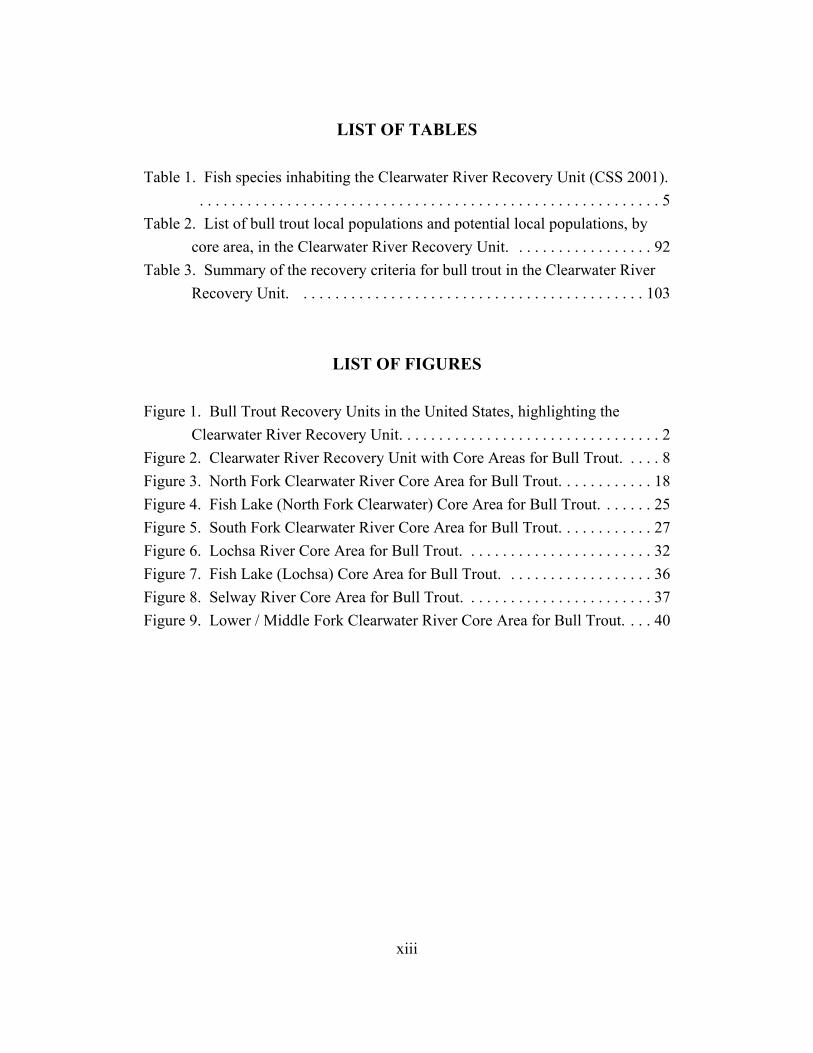
LIST OF TABLES
Table 1. Fish species inhabiting the Clearwater River Recovery Unit (CSS 2001).. . . . . . . . . . . . . . . . . . . . . . . . . . . . . . . . . . . . . . . . . . . . . . . . . . . . . . . . . . 5
Table 2. List of bull trout local populations and potential local populations, bycore area, in the Clearwater River Recovery Unit. . . . . . . . . . . . . . . . . . 92
Table 3. Summary of the recovery criteria for bull trout in the Clearwater RiverRecovery Unit. . . . . . . . . . . . . . . . . . . . . . . . . . . . . . . . . . . . . . . . . . . . 103
LIST OF FIGURES
Figure 1. Bull Trout Recovery Units in the United States, highlighting theClearwater River Recovery Unit. . . . . . . . . . . . . . . . . . . . . . . . . . . . . . . . . 2
Figure 2. Clearwater River Recovery Unit with Core Areas for Bull Trout. . . . . 8Figure 3. North Fork Clearwater River Core Area for Bull Trout. . . . . . . . . . . . 18Figure 4. Fish Lake (North Fork Clearwater) Core Area for Bull Trout. . . . . . . 25Figure 5. South Fork Clearwater River Core Area for Bull Trout. . . . . . . . . . . . 27Figure 6. Lochsa River Core Area for Bull Trout. . . . . . . . . . . . . . . . . . . . . . . . 32Figure 7. Fish Lake (Lochsa) Core Area for Bull Trout. . . . . . . . . . . . . . . . . . . 36Figure 8. Selway River Core Area for Bull Trout. . . . . . . . . . . . . . . . . . . . . . . . 37Figure 9. Lower / Middle Fork Clearwater River Core Area for Bull Trout. . . . 40
Chapter 16 - Clearwater River
1
INTRODUCTION
Recovery Unit Designation
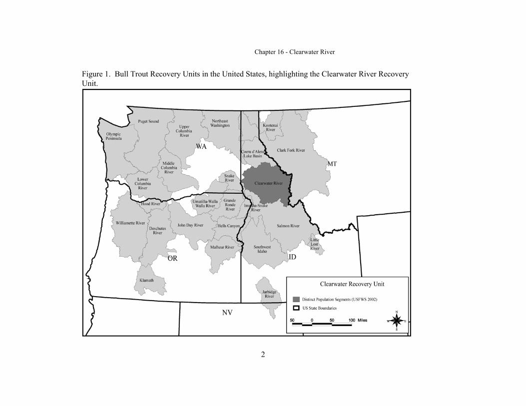
The Clearwater River Recovery Unit is one of 22 recovery unitsdesignated for bull trout in the Columbia River basin (Figure 1). The ClearwaterRiver Recovery Unit includes the entire Clearwater River basin upstream from theconfluence with the Snake River. Except for some high elevation lakes andstreams with natural barriers, bull trout were historically likely able to moveamong most areas within the recovery unit. However, Dworshak Dam nowisolates bull trout in the North Fork Clearwater River from fish in the remainderof the basin. The Clearwater River basin is included in a single recovery unitbecause it likely functioned as a unit historically. Another factor in thedesignation of the basin as a recovery unit is an administrative decision; the basinis identified in the Idaho Bull Trout Conservation Plan (Batt 1996) asencompassing 10 key watersheds where protection and/or restoration activitiesare likely to produce measurable results.
Geographic Description of Recovery Unit
The Clearwater River Recovery Unit lies in northcentral Idaho, andextends from the Idaho/Montana border near Missoula, Montana to theIdaho/Washington border at Lewiston, Idaho. Major tributaries in the recoveryunit include the Clearwater, North Fork Clearwater, Middle Fork Clearwater,South Fork Clearwater, Lochsa, and Selway Rivers. The Clearwater River drainsapproximately 2,423,761 hectares (5,989,052 acres). Elevations range from 216meters (710 feet) at the confluence of the Clearwater and Snake Rivers to over2,743 meters (9,000 feet) in the Bitterroot Mountains.
Chapter 16 - Clearwater River
2
Figure 1. Bull Trout Recovery Units in the United States, highlighting the Clearwater River RecoveryUnit.
Chapter 16 - Clearwater River
3
The Clearwater River Recovery Unit experiences a wide variety ofclimates (Clearwater Subbasin Summary (CSS) 2001). Warm, moist maritimeair masses from the Pacific strongly influence the climate across the recoveryunit, except for the eastern higher elevations and southern-most portions of therecovery unit. These areas are more similar to the northern Rocky Mountainclimatic conditions with drier and cooler climates. Annual precipitation in thearea is 762 to 2,540 millimeters (30 to 100 inches), with over 90 percentoccurring during the fall, winter, and spring. A seasonal snowpack generallycovers the area during October to June, depending on elevation. Periodic, highintensity electrical storms are common during the summer months and may ignitewildfires. Mean annual temperatures throughout the recovery unit range from 10to 13 degrees Celsius (C) (50 to 55 degrees Fahrenheit (F)) at lower elevations to-3 to 0 degrees C (25 to 32 degrees F) in the upper elevations (CSS 2001). Temperatures are generally below freezing in higher elevations of the drainageduring the winter and can be in excess of 32 degrees C (90 degrees F) in the lowerelevation canyons during the summer (Bugosh 1999; Maughan 1972).
The main geologic parent material for soils and sediment in the recoveryunit is metamorphic, granitic, and basalt rock types (CSS 2001). The Idahogranite batholith makes up much of the bedrock found in the Clearwater andBitterroot mountains in the central and eastern portions of the recovery unit. Batholithic rock erodes to sand contributing to fine sediments in streams, and BeltSeries rock often exhibits heavy stream bedload movement when associated withrecent glaciation. Contact between the two rock formations produces an unstablelayer that is often associated with frequent mass failures resulting in landslides.
The many ridges and mountains of the Clearwater and Bitterroot ranges inthe central and eastern part of the recovery unit have convex slopes ranging from20 to 25 percent (McClelland et al. 1997). Steeper slopes exist in the glacial cutvalleys in the upper elevations around the recovery unit at the head of manytributary valleys (CSS 2001). These glaciated areas are prevalent in the upperportions of the recovery unit.
The breaklands of the recovery unit refer mainly to the larger river valleyssuch as those found in the mainstem Clearwater River canyon. The lower
Chapter 16 - Clearwater River
4
Clearwater River separates the Camas and Palouse prairies through the formationof these steep river breaks (CBBTTAT 1998c). The upland prairies may rise over914 meters (3,000 feet) above the lower Clearwater River.
The mainstem Clearwater River originates in the Bitterroot Mountains atelevations ranging from 2,562 to 2,745 meters (8,400 to 9,000 feet) (CSS 2001). The Clearwater River contributes approximately one-third of the Snake Riverflow and 10 percent of the flow of the Columbia River system annually, with amean annual discharge of approximately 434 cubic meters per second (15,300cubic feet per second) near the mouth (Lipscomb 1998). The Selway and LochsaRivers originate at the Idaho/Montana border and flow in a westerly tonorthwesterly direction through the breaklands and forested canyons to theirjunction at Lowell, Idaho. The confluence of the Selway and Lochsa form theMiddle Fork of the Clearwater River, which flows in a westerly direction until itjoins the South Fork of the Clearwater River. At this point the river is locallyknown as the mainstem Clearwater River (CSS 2001) and continues its westerlyand northwesterly flow to the town of Ahsahka, where it is joined by the NorthFork of the Clearwater River. The Clearwater River then joins the Snake River atLewiston, Idaho.
Records for monthly flows indicate that peak flows generally occur in themonths of May and June (CSS 2001). Low flows most often occur in August andSeptember which corresponds with high instream temperatures and lowprecipitation in most of the recovery unit. The timing, duration, and volume ofpeak flows are driven by snowmelt and/or by seasonal rainstorms at elevationsless than 1,220 meters (4,000 feet) (CSS 2001). Rain-on-snow events can occurfrom November through March (Thomas et al. 1963), and may result inhydrograph peaks through this period (CSS 2001).
Vegetation within the Clearwater River Recovery Unit consists of canyongrasslands with steep, complex topography dominated by perennial bunchgrassand shrub communities; and forested canyons and uplands dominated by cedar-hemlock-white pine forests (CBBTTAT 1998c). Over 70 percent of the recoveryunit consists of forested communities and 12 percent is made up of shrubland andgrassland communities (CSS 2001). Cedar-hemlock-white pine communities are
Chapter 16 - Clearwater River
5
generally productive and support a variety of tree species (e.g., western red cedar(Thuja plicata), white pine (Pinus monticola), grand fir (Abies grandis), westernlarch (Larix occidentalis), and Douglas fir (Pseudotsuga menziesii)). Lodgepolepine (Pinus contorta), subalpine fir (Abies lasiocarpa), ponderosa pine (Pinusponderosa), and Engelmann spruce (Picea engelmannii) are also present atmiddle and high elevations within the recovery unit. The majority of thegrasslands occur in the foothills and breaklands as canyon bunch grasscommunities (CSS 2001).
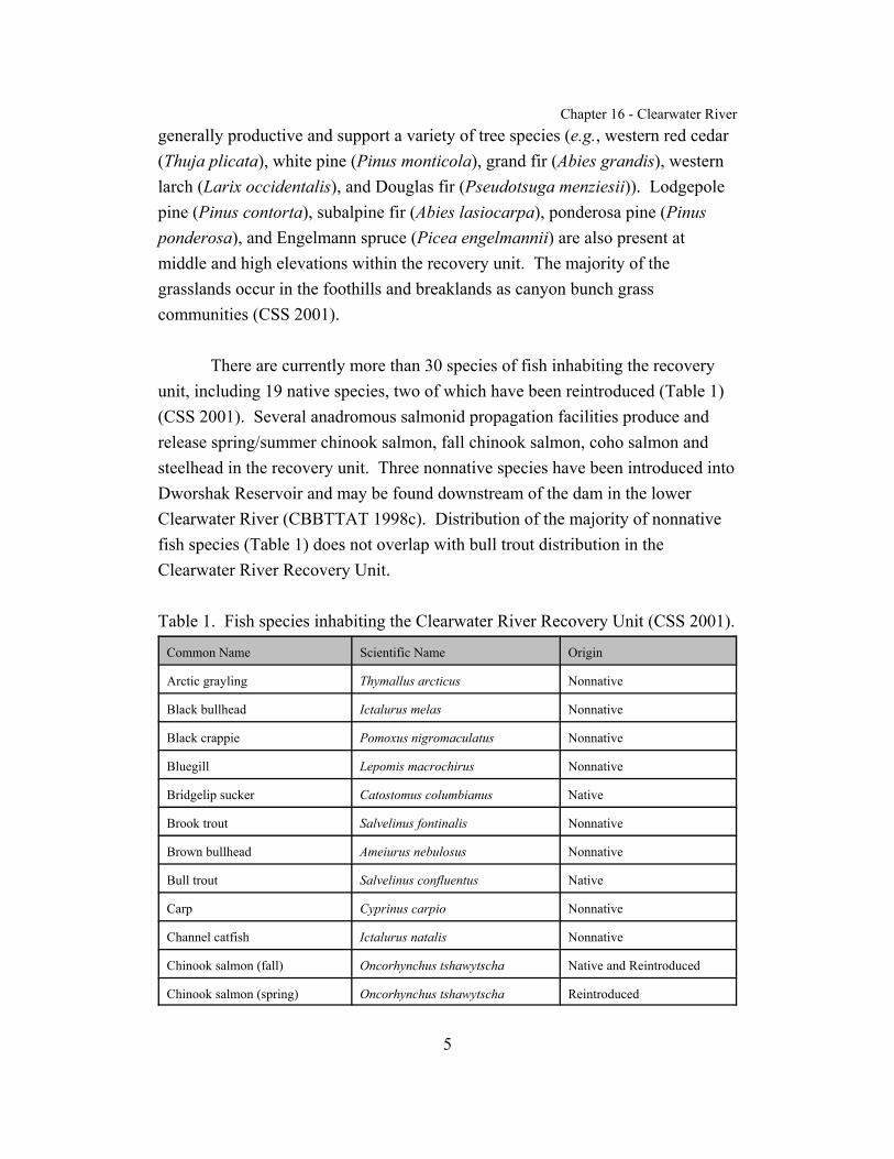
There are currently more than 30 species of fish inhabiting the recoveryunit, including 19 native species, two of which have been reintroduced (Table 1)(CSS 2001). Several anadromous salmonid propagation facilities produce andrelease spring/summer chinook salmon, fall chinook salmon, coho salmon andsteelhead in the recovery unit. Three nonnative species have been introduced intoDworshak Reservoir and may be found downstream of the dam in the lowerClearwater River (CBBTTAT 1998c). Distribution of the majority of nonnativefish species (Table 1) does not overlap with bull trout distribution in theClearwater River Recovery Unit.
Table 1. Fish species inhabiting the Clearwater River Recovery Unit (CSS 2001).
Common Name Scientific Name Origin
Arctic grayling Thymallus arcticus Nonnative
Black bullhead Ictalurus melas Nonnative
Black crappie Pomoxus nigromaculatus Nonnative
Bluegill Lepomis macrochirus Nonnative
Bridgelip sucker Catostomus columbianus Native
Brook trout Salvelinus fontinalis Nonnative
Brown bullhead Ameiurus nebulosus Nonnative
Bull trout Salvelinus confluentus Native
Carp Cyprinus carpio Nonnative
Channel catfish Ictalurus natalis Nonnative
Chinook salmon (fall) Oncorhynchus tshawytscha Native and Reintroduced
Chinook salmon (spring) Oncorhynchus tshawytscha Reintroduced
Chapter 16 - Clearwater River
Common Name Scientific Name Origin
1 Includes nonnative resident rainbow trout.
6
Chiselmouth Acrocheilus alutaceus Native
Coho salmon Oncorhynchus kisutch Reintroduced
Golden trout Oncorhynchus mykiss aquabonita Nonnative
Kokanee salmon Oncorhynchus nerka Nonnative
Largemouth bass Micropterus salmoides Nonnative
Largescale sucker Catostomus macrocheilus Native
Longnose dace Rhinichthys cataractae Native
Mottled sculpin Cottus bairdi Native
Mountain whitefish Prosopium williamsoni Native
Northern pike minnow Ptychocheilus oregonensis Native
Pacific lamprey Lampetra tridentata Native
Paiute sculpin Cottus beldingi Native
Peamouth Mylocheilus caurinus Native
Pumpkinseed Lepomis gibbosus Nonnative
Redside shiner Richardsonius balteatus Native
Sandroller Percopsis transmontana Native
Shorthead sculpin Cottus confusus Native
Smallmouth bass Micropterus dolomieui Nonnative
Speckled dace Rhinichthys osculus Native
Steelhead/rainbow/redband trout Oncorhynchus mykiss Native and Nonnative1
Tiger muskie Esox masquinongy x.E. lucius Nonnative
Torrent sculpin Cottus rhotheus Native
Westslope cutthroat trout Oncorhynchus clarki lewisi Native
Yellow perch Perca flavescens Nonnative
Description of Core Areas

Chapter 16 - Clearwater River
7
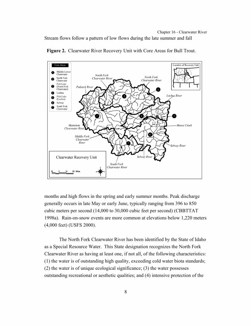
The Clearwater River Recovery Unit has been divided into seven coreareas for purposes of recovery planning. These core areas include the North ForkClearwater River, Fish Lake (an isolated basin in the North Fork Clearwater Riverwatershed), Lochsa River, Fish Lake (an isolated basin in the Lochsa Riverwatershed), Selway River, South Fork Clearwater River, and the Lower andMiddle Fork Clearwater River (Figure 2).
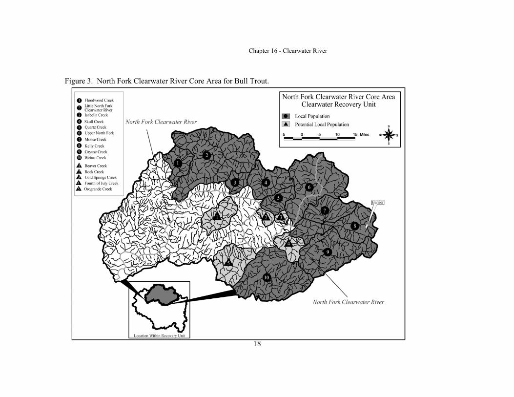
North Fork Clearwater River core area. The North Fork ClearwaterRiver core area is located in Clearwater, Idaho, and Shoshone Counties. Itincludes the North Fork Clearwater River and all its tributaries upstream ofDworshak Dam. The core area is approximately 632,360 hectares (1,562,561acres). Elevations range from 441 meters (1,445 feet) near the reservoir to 2,440meters (8,000 feet) at the headwaters (CBBTTAT 1998a). Major tributarieswithin the core area include; Elk Creek, Little North Fork Clearwater River,Beaver Creek, Quartz Creek, Skull Creek, Orogrande Creek, Weitas Creek, andKelly Creek (U.S. Forest Service (USFS) 2000).
Land managers within the core area include the Clearwater NationalForest, Idaho Panhandle National Forest, Bureau of Land Management, U.S.Army Corps of Engineers, State of Idaho, Plum Creek Timber Company, andPotlatch Corporation. The Clearwater National Forest manages 64 percent of thewatershed (USFS 2000). Idaho Department of Fish and Game and the Nez PerceTribe manage fisheries resources within this core area (CBBTTAT 1998a).
The North Fork Clearwater River flows 46 kilometers (29 miles) from itsheadwaters to the reservoir with an average annual discharge of 100 cubic metersper second (3,520 cubic feet per second) from Dworshak Dam (CBBTTAT1998a). Long-term discharge and temperature data have been recorded by theU.S. Geological Survey at Canyon Creek, just upstream of Dworshak Reservoir.
Chapter 16 - Clearwater River
8
Figure 2. Clearwater River Recovery Unit with Core Areas for Bull Trout.
Stream flows follow a pattern of low flows during the late summer and fall
months and high flows in the spring and early summer months. Peak dischargegenerally occurs in late May or early June, typically ranging from 396 to 850cubic meters per second (14,000 to 30,000 cubic feet per second) (CBBTTAT1998a). Rain-on-snow events are more common at elevations below 1,220 meters(4,000 feet) (USFS 2000).
The North Fork Clearwater River has been identified by the State of Idahoas a Special Resource Water. This State designation recognizes the North ForkClearwater River as having at least one, if not all, of the following characteristics: (1) the water is of outstanding high quality, exceeding cold water biota standards;(2) the water is of unique ecological significance; (3) the water possessesoutstanding recreational or aesthetic qualities; and (4) intensive protection of the
Chapter 16 - Clearwater River
9
quality of the water is in the paramount interest of the people of Idaho(CBBTTAT 1998a).
The State of Idaho classified five tributaries of the North Fork ClearwaterRiver as Stream Segments of Concern: Weitas, Skull, Quartz, Meadow creeks andLittle North Fork Clearwater River (CBBTTAT 1998a). These watersheds havesite-specific Best Management Practices to address the unique hazards andresources in these areas (USFS 2000). Thirty-eight stream segments and onereservoir in the North Fork Clearwater River core area are listed as Water QualityLimited under section 303(d) of the Clean Water Act (CBBTTAT 1998a) (SeeAppendix A). Most of these streams are in the Moose, Orogrande, Quartz,Beaver, and Floodwood Creek watersheds, and Dworshak Reservoir tributaries.
Fish Lake (North Fork Clearwater River) core area. The Fish Lake(North Fork Clearwater River) core area is located in Clearwater County onFederal lands managed by the Clearwater National Forest. The core area isapproximately 1,433 hectares (3,541 acres). Fish Lake is the largest mountainlake in northcentral Idaho with a surface area of approximately 47 hectares (116acres) at an elevation of 1,812 meters (5,943 feet) (Murphy and Cochnauer 1998).
Fish Lake is a large, oligotrophic mountain lake located in the Long Creekwatershed of the upper North Fork Clearwater River drainage. The lake basin ison the crest of the Bitterroot Divide which forms the Idaho-Montana border. It issituated in a glacial trough with glacial ridges on the north and east, a stronglyscoured cirque basin and headwall to the south, and the continuation of the glacialtrough bottom to the west. The lake has a maximum depth of 42 meters (138 feet)with 90 percent of the surface area greater than 3 meters (10 feet) deep (Murphyand Cochnauer 1998). There are five small inlets and one outlet. Four inletsenter on the eastern end of the lake; the largest is a spring origin inlet that is 1meter (3 feet) wide. This larger spring-fed inlet has spawning-size gravels, but nobull trout spawning activity has been observed. The fifth inlet on the north side ofthe lake is small and originates in a large seep area. There is one outlet, LakeCreek, exiting on the west side of the lake flowing 19 kilometers (12 miles) to the
Chapter 16 - Clearwater River
10
North Fork Clearwater River. The surrounding area is dominated by Engelmannspruce, Douglas fir, and associated sub-alpine understory.
South Fork Clearwater River core area. The South Fork ClearwaterRiver core area is located in Idaho County and encompasses an area ofapproximately 304,522 hectares (752,474 acres). The core area extends from theheadwaters above Elk City and Red River to the confluence with the Middle Forkof the Clearwater River at Kooskia. Included in the area are 13 major watersheds,plus numerous face drainages (streams that are very small and steep, andgenerally provide very little habitat for fish, except possible seasonal habitat neartheir mouths) that flow into the mainstem South Fork Clearwater River (USFS1999c). Major tributaries within the core area include: American River, MillCreek, Red River, Newsome Creek, Crooked River, Johns Creek, Tenmile Creek, MeadowCreek, Leggett Creek, Cougar-Peasley creeks, Silver Creek, Wing Creek, andTwentymile Creek.
The core area includes a mixture of private and public lands. The CamasPrairie contains approximately 80,595 hectares (199,000 acres) and is mostlyprivate land, with lesser amounts of Bureau Land Management, State of Idahoand Nez Perce Tribal lands (CBBTTAT 1998d). Of the remaining 223,959hectares (552,987 acres), 69 percent is in Federal ownership, primarily in the NezPerce National Forest (USFS 1999c). Approximately 10,125 hectares (25,000acres) that occur within the National Forest boundary are owned by privateinterests and 5,265 hectares (13,000 acres) are in Bureau of Land Managementownership (USFS 1999c).
Average annual stream flow is 30 cubic meters per second (1,060 cubicfeet per second) as measured at the U.S. Geological Survey stream gauge atStites, Idaho (CBBTTAT 1998d). Stream flows follow a pattern of low flowsduring the late summer and fall months and high flows in the spring and earlysummer months. Peak discharge generally occurs in late May with an average of95 cubic meters per second (3,370 cubic feet per second) (USFS 1999c).
Chapter 16 - Clearwater River
11
September is generally the lowest flow month, with an average of 7 cubic metersper second (258 cubic feet per second) discharge (USFS 1999c).
The State of Idaho has classified eleven tributaries of the South ForkClearwater as Stream Segments of Concern: American River, Red River, SouthFork Red River, Big Elk Creek, Little Elk Creek, Crooked River, NewsomeCreek, Tenmile Creek, Johns Creek, Meadow Creek, and Mill Creek (CBBTTAT1998d). Within the entire core area, there are 18 stream segments and one lakelisted as Water Quality Limited under section 303(d) of the Clean Water Act(CBBTTAT 1998d) (See Appendix A).
Lochsa River core area. The Lochsa River core area is located in IdahoCounty and encompasses an area of approximately 303,024 hectares (748,773acres). Elevations range from 2,743 meters (9,000 feet) at the crest of theBitterroots to 396 meters (1,300 feet) at Lowell, Idaho (USFS 1999a). The corearea extends from the headwaters of Colt Killed Creek and Crooked Fork Creekwhich combine to form the Lochsa River, to the confluence of the Lochsa andSelway Rivers. Major drainages in the Lochsa River core area include: BrushyFork, Colt Killed (White Sands), Crooked Fork, Walton, Shotgun, Fishing(Squaw), Legendary Bear (Papoose), Post Office, Warm Springs, Lake, Split,Stanley, Boulder, Old Man, Fish, Hungery, Deadman, and Pete King creeks.
The primary land managers within the core area are the ClearwaterNational Forest and Plum Creek Timber Company, whose ownership includes16,592 hectares (41,000 acres) in the upper Lochsa River watershed (USFS1999a). Approximately 60 percent of the core area is within designatedWilderness and Roadless areas. The main stem Lochsa River is designated as aWild and Scenic River, and as such is protected from alterations to maintain itsfree-flowing and scenic characteristics. The area influenced by the wild andscenic river designation is the water body itself and generally 0.4 kilometer (one-quarter mile) on either side of the river.
Stream flows follow a pattern of low flows during the late summer and fallmonths and high flows in the spring and early summer months (USFS 1999a).

Chapter 16 - Clearwater River
12
Peak discharge generally occurs in late May, averaging approximately 297 cubicmeters per second (10,500 cubic feet per second) in the lower Lochsa River.
Twelve stream segments within the core area are listed as Water QualityLimited under section 303(d) of the Clean Water Act (CBBTTAT 1998b) (SeeAppendix A).
Fish Lake (Lochsa River) core area. The Fish Lake (Lochsa River) corearea is located in Idaho County on Federal lands managed by the ClearwaterNational Forest. The core area encompasses the lake basin and upper outletstream and is approximately 2,132 hectares (5,267 acres). The lake has a surfacearea of approximately 22 hectares (54 acres), and is located at an elevation of1,716 meters (5,628 feet) (Bahls 1992).
Fish Lake is a large, oligotrophic mountain lake that is located within theSelway-Bitterroot Wilderness of the Clearwater National Forest. The lake islocated in the Lake Creek watershed, which drains from the south side of themiddle reaches of the Lochsa River. This large, glacial valley lake is situated in aglacial trough with prominent ridges on the south and west. The lake has amaximum depth of 12 meters (39 feet). The lake has two inlets and one outlet. Both inlets enter the lake on the western shoreline, with the outlet draining theeastern end of the lake. The outlet is the headwaters of Fish Lake Creek, whichbecomes Lake Creek at its confluence with Sponge Creek. Lake Creek meets theLochsa River approximately 21 kilometers (13 miles) downstream. There is aback-country airstrip in the meadow on the west end of the lake. The surroundinglakeshore canopy is dominated by subalpine fir.
Selway River core area. The Selway River core area is located in Idahoand Clearwater counties and includes the Selway River and all its tributariesupstream of the confluence of the Selway and the Lochsa Rivers. The core areaencompasses approximately 520,242 hectares (1,285,516 acres), the majority ofwhich occurs in the Selway-Bitterroot and Frank Church-River of No ReturnWilderness (USFS 1999d). Approximately 76 percent (395,791 hectares or978,000 acres) of the Selway River core area is within the Selway-Bitterroot

Chapter 16 - Clearwater River
13
Wilderness, and approximately 9 percent (47,365 hectares or 117,040 acres) iswithin the Frank Church-River of No Return Wilderness (USFS 2001). TheSelway River originates in the Bitterroot Mountains on the Idaho-Montana borderat an elevation of 2,778 meters (9,110 feet), and joins the Lochsa at Lowell,Idaho, at an elevation of 448 meters (1,469 feet) to form the Middle ForkClearwater River. Major tributaries to the Selway River include: Moose Creek,Bear Creek, Whitecap Creek, Running Creek, Three Links Creek, Marten Creek,Gedney Creek, O’Hara Creek, and Meadow Creek (USFS 1999d).
Virtually all (99 percent) of the Selway River core area is administered bythe U.S. Forest Service, which includes the Nez Perce, Bitterroot, and ClearwaterNational Forests (USFS 1999d). The Selway River is designated as a Wild andScenic River, and as such is protected from alterations to maintain its free-flowing and scenic characteristics. Eighty-seven kilometers (54 miles) of theSelway River between Race Creek and Paradise Guard Station are designated asWild and Scenic, and 50 kilometers (31 miles) of the Selway River betweenLowell and Race Creek and between Paradise and Magruder Guard Stations aredesignated as Recreational (USFS 2001).
The Selway River is 159 kilometers (99 miles) in length (USFS 1999d). Mean annual discharge, measured at the mouth of O’Hara Creek USGS gaugingstation, for the Selway River was estimated at 107 cubic meters per second (3,765cubic feet per second). Minimum average monthly flows have been estimated tobe 22 cubic meters per second (766 cubic feet per second) in September andmaximum average monthly flows of 383 cubic meters per second (13,540 cubicfeet per second) in May (USFS 1999d). Selway Falls, located approximately 29kilometers (18 miles) from the mouth of the Selway River, consists of a severedrop in gradient with very large boulders that disrupt the flow of the river (USFS1999d). The falls likely impedes upstream migration of bull trout under someextreme high and low flow conditions (USFS 1999d).
The State of Idaho classified three tributaries of the Selway River asWater Quality Limited Segments under section 303(d) of the Clean Water Act(CBBTTAT 1998b) (See Appendix A).
Chapter 16 - Clearwater River
14
Lower and Middle Fork Clearwater River core area. This core areaincludes the Middle Fork and mainstem Clearwater Rivers and encompassesapproximately 660,024 hectares (1,630,919 acres). The Middle Fork ClearwaterRiver is formed at the confluence of the Selway and Lochsa Rivers near Lowell,Idaho. It flows in a westerly direction for 37 kilometers (23 miles) until it joinsthe South Fork of the Clearwater River near Kooskia, Idaho. At this point theriver is locally known as the mainstem or lower Clearwater River (CSS 2001) andcontinues its westerly and northwesterly flow to the town of Ahsahka, where it isjoined by the North Fork of the Clearwater River. The Clearwater River thenjoins the Snake River at Lewiston, Idaho, 120 kilometers (75 miles) from itssource (U.S. Bureau of Land Management (BLM) 2000). Major tributaries withinthis core area include: Lapwai Creek, Potlatch River, Cottonwood Creek, BedrockCreek, Big Canyon Creek, Orofino Creek, Jim Ford Creek, Lolo Creek, LawyerCreek, Clear Creek, Maggie Creek, Big Horse Creek, and Smith Creek.
The Middle Fork Clearwater River is located in Idaho County. The lowerClearwater River is located in Nez Perce, Latah, Lewis, and Clearwater counties. The lower Clearwater River includes the lower Clearwater River and all itstributaries from the confluence of the South and Middle Fork of the ClearwaterRiver near Kooskia, downstream to its confluence with the Snake River atLewiston (CBBTTAT 1998c). Elevations along the Middle Fork range from 375meters (1,230 feet) at the mouth to 2,012 meters (6,600 feet) at the headwaters ofLolo Creek. Elevations along the lower Clearwater River range from 216 meters(710 feet) at the confluence of the Snake and Clearwater Rivers to 1,844 meters(6,050 feet) at the headwaters of Lolo Creek. The vast majority of the core arealies below 1,220 meters (4,000 feet) in elevation, making it subject to mixedwinter precipitation and the possibility of rain-on-snow events (BLM 2000). Thechange in elevation follows a change in topography from west to east, progressingfrom plateau to moderately sloped foothills, which are primarily agricultural, tohigher elevation forested mountainous terrain.
Land ownership in the Middle Fork portion of the core area consists offederally-owned lands managed by the U.S. Forest Service, interspersed withprivate holdings along the river corridor, State lands, and Nez Perce Tribal lands.

Chapter 16 - Clearwater River
15
The entire 37 kilometers (23 miles) of the Middle Fork Clearwater River isdesignated as a Recreational River segment under the National Wild and ScenicRiver System, and as such is protected from alterations to maintain its free-flowing and scenic characteristics (USFS 2001). Land ownership within thelower Clearwater River portion of the core area is mainly private ownership withland uses including: agriculture, timber harvest, livestock grazing, recreation,roads, urban development, and residences (CBBTTAT 1998c). PotlatchCorporation, a private timber company, has significant holdings in the upperPotlatch and Lolo Creek watersheds. Public lands are limited to blocks of U.S.Forest Service land in the upper Potlatch and Lolo Creek watersheds, and isolatedparcels of Bureau of Land Management land. Portions of the core area also fallwithin the boundaries of the Nez Perce Indian Reservation.
Idaho Department of Fish and Game and the Nez Perce Tribe have fisherymanagement responsibilities within the core area. The municipalities in the corearea include the cities of Lewiston, Peck, Kendrick, Julietta, Lapwai, Orofino,Kamiah, Kooskia, and Lowell. All are located directly adjacent to creeks orrivers within the core area (CBBTTAT 1998c).
Annual mean flow is 427 cubic meters per second (15,090 cubic feet persecond) as measured at the Spalding gauge near its mouth (CSS 2001). Streamflows follow a pattern of low flows during the late summer and fall months andhigh flows in late May and June. Peak discharge generally occurs in late Maywith an average maximum monthly mean of 1,432 cubic meters per second(50,570 cubic feet per second) (BLM 2000). October is generally the lowest flowmonth, with an average discharge of 45 cubic meters per second (1,577 cubic feetper second) (BLM 2000).
Thirty-eight stream segments and one lake in the Lower and Middle ForkClearwater River core area are listed as Water Quality Limited under section303(d) of the Clean Water Act (CBBTTAT 1998c) (See Appendix A).

Chapter 16 - Clearwater River
16
DISTRIBUTION AND ABUNDANCE
Status of Bull Trout at the Time of Listing
In the final listing rule, June 10, 1998, (63 FR 31647), the U.S. Fish andWildlife Service identified three bull trout subpopulations in the Clearwater Riverbasin: (1) North Fork Clearwater River, (2) upper Clearwater River, and (3)Shotgun Creek. Each subpopulation can be made up of one to several localpopulations. Although subpopulations were an appropriate unit upon which tobase the 1998 listing decision, the recovery plan has revised the biologicalterminology to better reflect the current understanding of bull trout life historyand conservation biology theory. Therefore, subpopulation terms will not be usedin this chapter.
Current Distribution and Abundance
Bull trout are distributed throughout most of the large rivers andassociated tributary systems within the Clearwater River Recovery Unit (CSS2001). Bull trout exhibit adfluvial, fluvial, and resident life history patternswithin the Clearwater River Recovery Unit. Fluvial and resident bull troutpopulations have been commonly documented throughout the current range ofbull trout in the Clearwater River Recovery Unit (USFS 1999c, 1999d). Thereare two naturally adfluvial bull trout populations within the Clearwater RiverRecovery Unit; one is associated with Fish Lake in the upper North ForkClearwater River drainage, and the other is associated with Fish Lake in theLochsa River drainage (CBBTTAT 1998a,CBBTTAT 1998b).
There are no data to confidently estimate bull trout abundance for theentire recovery unit. However, selected sites have been sampled and densityestimates made (CBBTTAT 1998a). Redd counts have also been conducted sincethe mid-1990s in Fishing (Squaw) and Legendary Bear (Papoose) creeks(CBBTTAT 1998b) and since 1999 in selected reaches of Newsome Creek andthe East Fork of American River (NPNF, in litt. 2001a). It is important to notethat current data on distribution and abundance in the Clearwater River Recovery

Chapter 16 - Clearwater River
17
Unit is limited and not representative of a consistent sampling scheme across thearea. Sources of data include historical reports, incidental bull trout countsobtained during stream habitat surveys, creel survey data, redd count data, andlimited survey data obtained through bull trout sampling methodologies. It islikely that distribution and abundance is underestimated, and that some spawningand rearing areas have not been located and thus have been omitted.
The Clearwater River Recovery Unit consists of 7 core areas, with a totalof 45 local populations distributed among the core areas. The recovery team alsoidentified 27 potential local populations for some core areas. A potential localpopulation is a local population (a group of bull trout that spawns within aparticular stream or portion of a stream system) that does not currently exist, butwhich might exist and contribute to recovery in a known or suspected unoccupiedarea, if spawning and rearing habitat or connectivity is restored in that area.
North Fork Clearwater River core area. Bull trout are currently knownto use spawning and rearing habitat in at least 11 streams or stream complexes(i.e., local populations). These local populations include Upper North ForkClearwater River, Kelly Creek, Cayuse Creek, Moose Creek, Fourth of JulyCreek, Weitas Creek, Quartz Creek, Skull Creek, Isabella Creek, Little NorthFork Clearwater River, and Floodwood Creek. Potential local populationsinclude Cold Springs Creek, Rock Creek, Orogrande Creek, and Beaver Creek(Figure 3). Density estimates for several sites throughout the North ForkClearwater River surveyed 1990 through 1997 were 0 to 6.4 bull trout per 100square meters (CBBTTAT 1998a). Redd counts during 1994 to 1997 at 5 to 7sites were 0 to 7 redds per site (Appendices A, C, D and CBBTTAT 1998a).
Dworshak Dam, near the confluence of the North Fork Clearwater Riverwith the main Clearwater River, has isolated bull trout from fish in the remainderof the Clearwater River since the dam was completed in 1971. Prior to theconstruction of the dam, bull trout likely migrated into the mainstem Clearwater
Chapter 16 - Clearwater River
18
Figure 3. North Fork Clearwater River Core Area for Bull Trout.
Chapter 16 - Clearwater River
19
River to overwinter, and mixed with other adults from the Lochsa, Selway, andSouth Fork Clearwater River core areas (USFS 2000). Although bull trout arewidely distributed throughout the North Fork Clearwater core area, bull trout arecurrently considered depressed compared to their historic distribution andabundance in most of the tributaries of the North Fork Clearwater drainage (USFS2000, CSS 2001).
Bull trout also occupy Dworshak Reservoir and use it as rearing habitatfor subadult and adult fish (CBBTTAT 1998a, CSS 2001). Idaho Department ofFish and Game has radio-tagged bull trout captured in Dworshak Reservoir anddocumented their spawning migration into headwater tributaries of the North ForkClearwater River and their return to the reservoir for overwintering (Cochnauer etal. 2001). Size of spawning bull trout in some tributaries of the North ForkClearwater River suggests that some bull trout spend extensive amounts of timefeeding in the reservoir (CSS 2001). Bull trout have also been documented usinglower Butte and lower Freeman creeks, tributaries of the reservoir (CBBTTAT1998a). Dworshak Reservoir constitutes a unique and important habitat for bulltrout since it supports significant subadult and adult rearing, and it has a majorrole in nutrient cycling in the core area.
The upper Little North Fork Clearwater River has documented spawningand rearing bull trout populations in Lund, Little Lost Lake, Lost Lake, upperLittle North Fork (Lund and Lost Lake Sub-watershed), Rutledge (Twin toDurham sub-watershed), Adair, Jungle (Adair/Rocky Run sub-watershed), andMontana (Butte to Culdesac sub-watershed) creeks (CBBTTAT 1998a). Thesepopulations, if conserved and restored, could provide stock for nearby unoccupiedstreams. Redd counts by Idaho Department of Fish and Game in Lund Creek,Little Lost Lake Creek, Lost Lake Creek, Rocket Creek, and the upper LittleNorth Fork Clearwater River (Lund and Lost Lake sub-watershed) since 1994indicate fish densities are relatively low, with 10 redds counted in 1996 and 6redds in 1997 (Appendix C in CBBTTAT 1998a).
The middle reaches of the Little North Fork Clearwater River (CrescendoCreek to Canyon Creek) are relatively unroaded and pristine. This reach includes

Chapter 16 - Clearwater River
20
the Mallard Larkins Pioneer Area. Spawning and rearing is only currently knownto occur in Butte Creek (D. Schiff, IDFG, pers. comm. 2002), however, few fishsurveys (presence/absence) have occurred and these were not intensive. Historicspawning and rearing likely occurred in Sawtooth Creek as well as CanyonCreek, and both streams provide suitable habitat to support bull trout (CBBTTAT1998a). Historic literature documents bull trout presence in Spotted Lewis, Foehl,and Cedar creeks and also indicates there is an impassable fish barrier in thelower third of Foehl Creek which would prevent migratory bull trout fromcolonizing the upper portion of the drainage (USFS 1935, CBBTTAT 1998a).Bull trout have been documented using the Little North Fork River as a migratorycorridor. Juveniles, 120 to180 millimeters (5 to 7 inches) in length, have beensampled from the main river during electrofishing surveys, suggesting the river isused for summer and overwinter rearing. Fish survey data for the mainstem LittleNorth Fork from Bear Creek to Sawtooth Creek in 1988 reported bull troutdensities of 0.06 per 100 square meters, and 0.02 per 100 square meters in 1990(CBBTTAT 1998a).
Upper Floodwood Creek is the only stream in the Breakfast Creekdrainage that has a documented spawning and rearing bull trout population. Protection of this population is essential so that successful reestablishment of bulltrout populations can occur in other tributaries within the Breakfast Creekdrainage (CBBTTAT 1998a). The upper portion of West Fork Floodwood Creekhas stream conditions similar to upper Floodwood Creek and is suspected to havea spawning and rearing population of bull trout (CBBTTAT 1998a). However,no fish surveys have been conducted in this stream reach. Subadult and adultrearing occurs in lower Floodwood, lower Breakfast, and lower Stoney creeks,and is suspected to occur in lower West Fork Floodwood Creek (CBBTTAT1998a; D. Schiff, pers. comm. 2002). Historic records indicate bull trout occurredin Isabella and Glover creeks of the Stoney Creek watershed (USFS 1935).
The mainstem portion of the North Fork Clearwater River from Dworshakreservoir slack water upstream to the confluence with Kelly Creek is importanthabitat for subadult and adult rearing and migration (CBBTTAT 1998a). Currentbull trout densities in this area are low (less than 0.5 fish per 100 square meters)
Chapter 16 - Clearwater River
21
(CBBTTAT 1998a). Bull trout use the lower reaches of many tributaries of the North Fork of the Clearwater as essential habitat for thermal refuge during highwater temperatures in summer. Current (since 1985) spawning and rearing isknown to occur in Isabella, Skull, Collins, Frost, Quartz, Weitas, Windy, Johnny,and Fourth of July creeks (CBBTTAT 1998a; D. Weigel, USBOR, pers. comm.2002; E. Key, USFS, pers. comm. 2002). Spawning and rearing is suspected inthe following streams based on available suitable habitat, but surveys have notbeen conducted to date: Fro, Johnagan, and Corral creeks in the Weitas Creekwatershed, and Shot and Bill creeks in the Fourth of July watershed (P. Murphy,USFS, pers. comm. 2002). Subadult and adult rearing occurs in the North ForkClearwater River, Isabella, Sneak (at the mouth), Quartz, lower Washington,Rock, lower Lightning, Weitas, Little Weitas, Liz, and Fourth of July creeks, asdocumented during surveys conducted by the U.S. Forest Service, IdahoDepartment of Fish and Game, and Idaho Department of Environmental Quality(CBBTTAT 1998a, Platts et al. 1993; C. Huntington, Clearwater BioStudies,pers. comm. 2002; D. Weigel, pers. comm. 2002; E. Key, pers. comm. 2002). The mainstem of Weitas Creek is considered important for subadult and adultrearing and migration. U.S. Forest Service stream surveys in 1993 documentedbull trout in Beaver Creek and subsequent surveys by Potlatch Corporation failedto locate any bull trout, however, recent research by Idaho Department of Fishand Game documented radio-tagged bull trout in the lower two miles of BeaverCreek (CBBTTAT 1998a; T. Cundy, in litt. 1998; D. Schiff, pers. comm. 2002).
Historically, bull trout are suspected to have used most tributaries of themainstem North Fork Clearwater River for spawning and rearing (CBBTTAT1998a). Early-rearing bull trout were documented in Beaver, Skull, Collins,Quartz, Isabella, Middle, and Weitas creeks (F. A. Espinosa and T. Bjornn, in litt.1981). Early-rearing bull trout were documented in Rock, Larson, Death, Trail,Fisher, Cold Spring, Little Washington, Skull, Beaver, and Weitas Creektributaries (Windy, Liz , Little Weitas, Middle, and Hemlock creeks) (F. A.Espinosa, U.S. Forest Service, pers. comm. 1998). Historic fish survey datacollected during August and September 1983, recorded bull trout densities inBeaver Creek of 0.63 per 100 square meters and 0.74 per 100 square meters, 0.72per 100 square meters in Isabella Creek, 0.24 per 100 square meters and 0.11 per

Chapter 16 - Clearwater River
22
100 square meters in Skull Creek, and 2.5 per 100 square meters in Quartz Creek(Moffitt and Bjornn, 1984).
The North Fork Clearwater River mainstem between Lake and Kellycreeks is considered an important subadult and adult rearing area (CBBTTAT1998a). Portions of Moose Creek and Kelly Creek currently support spawningand early-rearing. Subadult and adult rearing occurs in Hidden, Elizabeth, PeteOtt, Cayuse, and Kelly Creek downstream of the North Fork of Kelly Creek(CBBTTAT 1998a, Platts et al. 1993). Bull trout surveys have found adult bulltrout in the Moose Creek drainage (Osier, Little Moose, and lower Moose creeks),and early-rearing bull trout in upper Moose (upstream of Independence Creek),Little Moose, and Ruby creeks (CBBTTAT 1998a, Clearwater BioStudies 1991;D. Weigel, pers. comm. 2002). Spawning and rearing is known to occur in lowerSwamp Creek and is suspected to occur in upper Swamp and Pollock creeks dueto habitat suitability, although bull trout surveys have not been conducted in thelatter two areas (C. Huntington, pers. comm. 2002). Densities are low in theMoose Creek local population. Bull trout were present in one third of the sitessampled with densities less than 0.2 trout per 100 square meters (densities lessthan 0.5 trout per 100 square meters usually represent one fish observed).
Adult bull trout have been observed in Kelly Creek and this mainstem isused for subadult and adult rearing (CBBTTAT 1998a). Spawning and rearinghas been documented in the North and South Forks of Kelly, Kid Lake, and Bearcreeks (CBBTTAT 1998a; P. Murphy, pers. comm 2002; D. Weigel, pers. comm.2002). Densities of bull trout in the North Fork and South Fork of Kelly Creekwere 1.3 and 0.2 trout per 100 square meters, respectively (D. Weigel, in litt.1998b). Spawning and rearing is suspected to occur in Junction and Barnardcreeks due to habitat suitability (P. Murphy, pers. comm. 2002). Recent surveysfor bull trout have not been conducted in Cayuse Creek. Available data cannotdistinguish between bull trout use of Cayuse Creek for spawning and rearing orfor subadult and adult rearing. (CBBTTAT 1998a). However, based on historicoccurrence data and current habitat suitability, spawning and rearing is suspectedin upper Cayuse, Silver, Howard, Weasel, and Mink creeks (P. Murphy, pers.comm. 2002).

Chapter 16 - Clearwater River
23
Historically, subadult and adult rearing bull trout have been documentedin 0mainstem Kelly (Johnson 1977); North, South and Middle Forks of Kelly;Toboggan, Monroe, Cayuse, Gravey, and Silver and Pete Ott creeks (F. A.Espinosa, pers. comm., 1998). Kelly Creek and Cayuse Creek mainstems havebeen utilized by subadult and adult rearing bull trout (F. A. Espinosa and T.Bjornn, in litt. 1981, Johnson 1977). Juvenile and staging bull trout wereobserved in upper Cayuse and Silver creeks (F. A. Espinosa, pers. comm., 1998). The North, South, and Middle Forks of Kelly Creek, Toboggan, Monroe, Gravey,Hidden, Elizabeth, and Deception Gulch creeks are suspected to be historicspawning and rearing streams (F. A. Espinosa, pers. comm., 1998). Recentsurveys have not found bull trout in Monroe, Middle Fork of Kelly, Toboggan, orCayuse creeks (CBBTTAT 1998a).
The upper North Fork Clearwater River (Lake Creek and upstream)supports the most extensive spawning and rearing bull trout populations andhabitat in the core area (CBBTTAT 1998a). Bull trout were sampled in the upperreaches of tributary streams, with the highest densities occurring in BoundaryCreek. However, high density areas are localized, and U.S. Forest Service streamsurveys indicate that spawning and wintering habitat is limited. Redd counts inPlacer and Vanderbilt creeks in 1994 to1997 ranged from one to four redds peryear (CBBTTAT 1998a). Current (since 1985) spawning and rearing is known tooccur in the North Fork Clearwater above Meadow Creek, Graves, Vanderbilt,Chamberlain, Bostonian, Niagra, Boundary, Long, Slate, Short, Rawhide, Lake,and Goose creeks. Subadult and adult rearing occurs in the North ForkClearwater River, and Meadow Creek (CBBTTAT 1998a). Historically, theNorth Fork Clearwater headwaters (upstream of Meadow Creek), Meadow,Vanderbilt, Bostonian, Niagra, Boundary, Long, and Short creeks were known tohave supported subadult and adult rearing bull trout (F. A. Espinosa, pers. comm.,1998). These creeks are suspected to have supported historic spawning andrearing bull trout populations.
The mainstem portion of the North Fork Clearwater River from Dworshakreservoir slack water upstream to the headwaters is important habitat for subadultand adult rearing and migration (CBBTTAT 1998a). Bull trout use the lower
Chapter 16 - Clearwater River
24
reaches of multiple tributaries along the North Fork of the Clearwater River asessential habitat for thermal refuge during high water temperatures in summer.
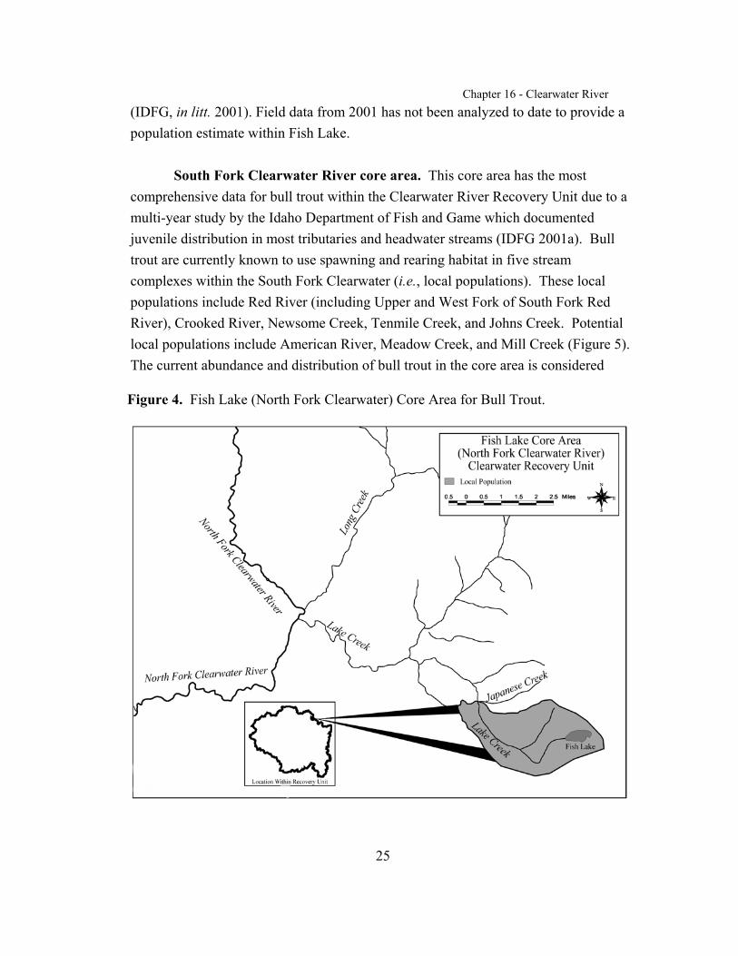
Fish Lake (North Fork Clearwater River) core area. Fish Lakecontains the only naturally adfluvial bull trout population known in the NorthFork Clearwater River basin. This core area contains one local population(Figure 4). Prior to the listing of bull trout there was limited information on thepopulation within Fish Lake. Fish Lake supported a bull trout sport harvest priorto closure in 1995. Limited annual angler creel information describingcatch-per-unit effort data dates back to 1973, but this data is restricted to theopening week or weekend only. In 1996, a four-hour gillnet survey conducted byIdaho Department of Fish and Game generated a catch-per-unit effort estimate of2.5 bull trout per hour of set gillnet. Electrofishing and snorkel surveys havefound age 1 bull trout in several tributaries of Fish Lake. Bull trout in Fish Lakeare considered healthy based on creel data (T. Cochnauer, Idaho Department ofFish and Game, pers. comm.1998), although there is no current populationestimate.
Idaho Department of Fish and Game and the Clearwater National Forestinitiated a study of the bull trout population in Fish Lake when the species was listed. Research was conducted during the summer and fall of 2000 and 2001. The objectiveswere to determine if the population is isolated, estimate the population size within thelake, and determine the impact of incidental hooking mortality. Eighty-seven bulltrout were captured and tagged. Findings indicate that Fish Lake bull trout do notappear to spawn in Lake Creek, and they likely spawn in the inlet streams. Apopulation of fluvial bull trout from the North Fork Clearwater River spawn in LakeCreek and
juveniles have been observed and captured. Due to timing of migration by fluvialbulltrout, natural barriers may prevent genetic exchange between these populationsexcept for individual bull trout that are flushed from Fish Lake. However, thesebarriers do not eliminate all resident or fluvial bull trout from migrating into Fish Lakeduring spring or high water flow events when migration barriers may be bypassed
Chapter 16 - Clearwater River
25
Figure 4. Fish Lake (North Fork Clearwater) Core Area for Bull Trout.
(IDFG, in litt. 2001). Field data from 2001 has not been analyzed to date to provide apopulation estimate within Fish Lake.
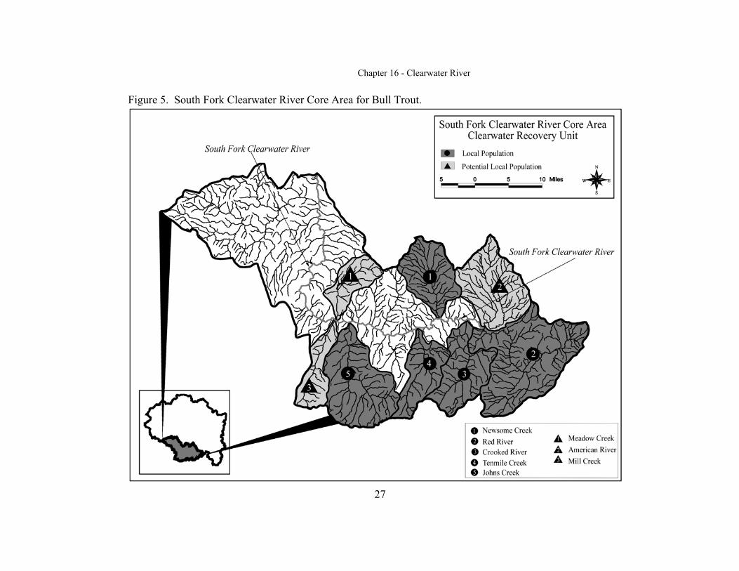
South Fork Clearwater River core area. This core area has the mostcomprehensive data for bull trout within the Clearwater River Recovery Unit due to amulti-year study by the Idaho Department of Fish and Game which documentedjuvenile distribution in most tributaries and headwater streams (IDFG 2001a). Bulltrout are currently known to use spawning and rearing habitat in five streamcomplexes within the South Fork Clearwater (i.e., local populations). These localpopulations include Red River (including Upper and West Fork of South Fork RedRiver), Crooked River, Newsome Creek, Tenmile Creek, and Johns Creek. Potentiallocal populations include American River, Meadow Creek, and Mill Creek (Figure 5). The current abundance and distribution of bull trout in the core area is considered
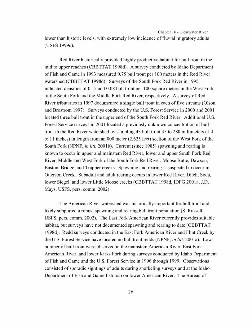
Chapter 16 - Clearwater River
26
lower than historic levels, with extremely low incidence of fluvial migratory adults(USFS 1999c).
Red River historically provided highly productive habitat for bull trout in themid to upper reaches (CBBTTAT 1998d). A survey conducted by Idaho Departmentof Fish and Game in 1993 measured 0.75 bull trout per 100 meters in the Red Riverwatershed (CBBTTAT 1998d). Surveys of the South Fork Red River in 1995indicated densities of 0.15 and 0.08 bull trout per 100 square meters in the West Forkof the South Fork and the Middle Fork Red River, respectively. A survey of RedRiver tributaries in 1997 documented a single bull trout in each of five streams (Olsonand Brostrom 1997). Surveys conducted by the U.S. Forest Service in 2000 and 2001located three bull trout in the upper end of the South Fork Red River. Additional U.S.Forest Service surveys in 2001 located a previously unknown concentration of bulltrout in the Red River watershed by sampling 43 bull trout 35 to 280 millimeters (1.4to 11 inches) in length from an 800 meter (2,625 feet) section of the West Fork of theSouth Fork (NPNF, in litt. 2001b). Current (since 1985) spawning and rearing isknown to occur in upper and mainstem Red River, lower and upper South Fork RedRiver, Middle and West Fork of the South Fork Red River, Moose Butte, Dawson,Baston, Bridge, and Trapper creeks. Spawning and rearing is suspected to occur inOtterson Creek. Subadult and adult rearing occurs in lower Red River, Ditch, Soda,lower Siegel, and lower Little Moose creeks (CBBTTAT 1998d, IDFG 2001a, J.D.Mays, USFS, pers. comm. 2002).
The American River watershed was historically important for bull trout andlikely supported a robust spawning and rearing bull trout population (S. Russell,USFS, pers. comm. 2002). The East Fork American River currently provides suitablehabitat, but surveys have not documented spawning and rearing to date (CBBTTAT1998d). Redd surveys conducted in the East Fork American River and Flint Creek bythe U.S. Forest Service have located no bull trout redds (NPNF, in litt. 2001a). Lownumber of bull trout were observed in the mainstem American River, East ForkAmerican River, and lower Kirks Fork during surveys conducted by Idaho Departmentof Fish and Game and the U.S. Forest Service in 1996 through 1999. Observationsconsisted of sporadic sightings of adults during snorkeling surveys and at the IdahoDepartment of Fish and Game fish trap on lower American River. The Bureau of
Chapter 16 - Clearwater River
27
Figure 5. South Fork Clearwater River Core Area for Bull Trout.

Chapter 16 - Clearwater River
28
Land Management surveys have also documented bull trout in the American Riverand the East Fork of the American River with first reported occurrences in 1977 andmore recent sightings (C. Johnson, Bureau of Land Management, pers. comm. 2002). Migratory bull trout are thought to be present in low abundance (CBBTTAT 1998d). Bull trout habitat potential in this watershed is rated high, with the higher orderchannels in the lower watershed constituting important subadult/adult rearing habitat(USFS 1999c). Current (since 1985) spawning and rearing by low numbers of bulltrout may occur in West and East Forks of the American River, and Lick Creek. Subadult and adult rearing by low numbers of bull trout occurs in the mainstem andlower American River and Kirks Fork (CBBTTAT 1998d).
In the Crooked River watershed, 24 bull trout were documented by surveysconducted by Idaho Department of Fish and Game in 1993, which equated to 0.89 bulltrout per 100 meters (CBBTTAT 1998d). A total of 34 adult migratory bull trout werecollected at a weir targeting chinook salmon in Crooked River during June to August1997 (Olson and Brostrom 1997). Bull trout captured at the weir in 1998 were radio-tagged and tracked over 25 miles as they migrated from the middle reach of themainstem South Fork Clearwater River to spawn in Crooked River. Recapture datafrom passive integrated transponder (PIT)-tagged juveniles shows movement withinand between tributaries in the South Fork core area (IDFG 2001a). The weirinformation in conjunction with Idaho Department of Fish and Game and U.S. ForestService observations of bull trout greater than 300 millimeters in length (12 inches)suggests that Crooked River likely harbors the greatest numbers of migratory bull troutin the South Fork Clearwater River watershed (CBBTTAT 1998d). Current (since1985) spawning and rearing is known to occur in the middle and upper Crooked River,West Fork and East Fork Crooked River, and Relief Creek. Subadult and adult rearingoccurs in lower Crooked River (CBBTTAT 1998d, IDFG 2001a, J.D. Mays, pers.comm. 2002).
In the Newsome Creek watershed, bull trout were observed during streamsurveys conducted by Idaho of Department of Fish and Game during 1993 to 1995(CBBTTAT 1998d). Thirty-four bull trout were observed in 1993, which equated to0.19 to 2.65 bull trout per 100 meters for surveys during the 3-year period. A 203millimeter (8 inch) bull trout was observed in upper Newsome Creek during a 1998
Chapter 16 - Clearwater River
29
angling survey. In 1998, the U.S. Forest Service documented a previously unknownconcentration of bull trout in a Newsome Creek tributary; 21 bull trout were sampledwithin 800 meters (2,625 feet) of stream. Bull trout in Newsome Creek appear to beprimarily resident fish and migratory bull trout are thought to be in low abundance. Redd surveys conducted by the U.S. Forest Service since 1999 have located only tworedds in upper Newsome Creek from Radcliffe Creek upstream approximately 1,500meters (4,920 feet) including two tributaries (NPNF, in litt. 2001c). Current (since1985) spawning and rearing is known to occur in upper Newsome, Pilot, and Baldycreeks, and is suspected to occur in Beaver Creek. Subadult and adult rearing occursin lower Newsome, Mule, and Bear creeks (CBBTTAT 1998d, IDFG 2001a).
In the Tenmile Creek watershed, snorkel surveys conducted by IdahoDepartment of Fish and Game for monitoring anadromous fish parr during 1986 to1997 detected 0.10 to 1.09 bull trout per 100 meters (CBBTTAT 1998d). The averagedensity of fish throughout the watershed in 1997 was 1.49 bull trout per 100 squaremeters (IDFG 1986-1997). U.S. Forest Service fall 2000 surveys of Sixmile Creek(tributary of Tenmile Creek) detected two bull trout just below a barrier falls. Thiswas the first recorded occurrence for this stream. Current (since 1985) spawning andrearing is known to occur in Tenmile and lower Wiseboy creeks (CBBTTAT 1998d,Spangler 1997). Subadult and adult rearing occurs in lower Tenmile and Sixmilecreeks (CBBTTAT 1998d). This population is thought to be primarily migratory witha less significant resident component (CBBTTAT 1998d).
In the Johns Creek watershed, bull trout were observed in six annual streamsurveys conducted by Idaho of Department of Fish and Game from 1986 to 1997(CBBTTAT 1998d). Surveys detected 0.18 to 1.14 bull trout per 100 meters atvarious sites for the six years that bull trout were observed. Moores Creek (tributaryof Johns Creek) had 0.44 to 2.38 bull trout per 100 meters during the same surveyperiod. Current (since 1985) spawning and rearing is known to occur in upper Johns,Moores, Moores Lake, Gospel, Taylor, Hagen, and Open creeks (CBBTTAT 1998d,Spangler 1997). Subadult and adult rearing occurs in middle and lower Johns Creek. Bull trout are primarily resident with migratory fish likely in low abundance(CBBTTAT 1998d).

Chapter 16 - Clearwater River
30
Adult and rearing bull trout have been documented sporadically in Meadowand Mill creeks. Habitat has been degraded in both creeks due to managementactivities. Mill and Merton creeks are used for subadult and adult rearing (CBBTTAT1998d; W. Paradis, USFS, pers. comm. 2002). Mill Creek has better habitat potentialthan Meadow Creek, and has a higher potential to support a local population of bulltrout (S. Russell, pers. comm. 2002). Meadow Creek likely never supported a strongpopulation of bull trout because of low quality bull trout habitat (S. Russell, pers.comm. 2002). Twentymile Creek is used for subadult and adult rearing (USFS1999c). The mainstem South Fork River provides subadult and adult rearing habitatand foraging, migrating, and overwintering habitat for bull trout (CBBTTAT 1998d). It is also essential for connectivity of local populations within the core area to bulltrout from other core areas within the recovery unit. Bull trout use the lower reachesof some tributaries of the South Fork of the Clearwater River as essential habitat forthermal refuge during high water temperatures in summer.
Lochsa River core area. Bull trout are currently known to use spawning andrearing habitat in 16 streams or stream complexes within the Lochsa River drainage(i.e., local populations). These local populations include Fishing (Squaw) Creek,Legendary Bear (Papoose) Creek, Boulder Creek, Fox Creek, Shotgun Creek, CrookedFork/Hopeful Creek, Rock Creek, Haskell Creek, Colt Killed (White Sands) Creek,Beaver Creek, Storm Creek, Brushy Fork Creek, Spruce Creek, Twin Creek, WaltonCreek, and Lower Warm Springs Creek. Local population streams are grouped andmapped together if they are tributary to a common watershed (Figure 6). Potentiallocal populations include Post Office, Weir, Indian Grave, Lake, Fish, Hungery,Boulder, Old Man, Split, Fire, Coolwater, Canyon, Deadman, and Pete King creeks(Figure 6). Plum Creek Timber Company has surveyed its lands for presence/absenceand the Clearwater National Forest initiated spawning and rearing surveys in the late1990's. However, intensive surveys have not been conducted throughout the core area,and additional undocumented spawning and rearing habitat likely exists (CBBTTAT1998b).
Within the Lochsa River core area, bull trout spawning and rearing has beendocumented in Legendary Bear (Papoose) Creek and tributaries, Fishing (Squaw),Upper Crooked Fork, Hopeful, Boulder, Shotgun, Fox, Rock, Haskell, Colt Killed,Storm, Beaver, lower Warm Springs, Cooperation, Fish Lake, Brushy Fork, Twin, and

Chapter 16 - Clearwater River
31
Spruce creeks (CBBTTAT 1998a; Watson and Hillman 1997; P. Murphy, pers. comm.2002). Bull trout are suspected to spawn in Walton Creek (CBBTTAT 1998b). Fluvial fish are thought to use the majority of spawning and rearing habitat except forSpruce and Shotgun creeks, which are likely resident populations due to migrationbarriers. Adult and subadult rearing is known to occur in the Lochsa River, lowerCrooked Fork, Colt Killed, Walton, Warm Springs, Fish, Hungery, Weir, Post Office,Parachute, Doe, Coolwater, Fire, and Split creeks (USFS 1999a, CBBTTAT 1998b). Bull trout presence has been documented in lower Wendover, lower Lake, lowerIndian Grave, lower Boulder, and lower Deadman creeks (Platts et al. 1993).
The most concentrated use of spawning and rearing habitat by fluvial bull trout in theLochsa River drainage occurs in Legendary Bear (Papoose) and Fishing (Squaw)creeks (CBBTTAT 1998b). Redd count surveys have been conducted in LegendaryBear (Papoose) since 1996 and in Fishing (Squaw) Creek since 1994. In LegendaryBear (Papoose) Creek, 3 redds were observed in 1996 and 1997, and 2 in 1998; reddswere also observed in the West and East Forks of Legendary Bear (Papoose) Creek(USFS 1999a). Annual surveys in Fishing (Squaw) Creek from 1994 to 1998 located9 to 13 and 0 to 8 redds in a reach between the West Fork and East Fork of Fishing(Squaw) Creek and in West Fork Fishing (Squaw) Creek, respectively. A total of 2 to10 redds were also observed in other stream reaches of the Fishing (Squaw) Creekdrainage during various years (USFS 1999a, CBBTTAT 1998b). Fishing (Squaw)Creek supports both resident and fluvial stocks of bull trout, and contains some of themost significant known bull trout habitat within the Lochsa drainage. Based on thequantity of suitable habitat in Fishing (Squaw) Creek, this population size isconsidered low to moderate (Schoen et al. 1999).
Bull trout have been documented in upper Crooked Fork, Hopeful, Boulder,Fox, Williams, Lake, Shotgun, Rock, and Haskell creeks (CBBTTAT 1998b, Watsonand Hillman 1997; P. Murphy, pers. comm. 2002). More study is required to
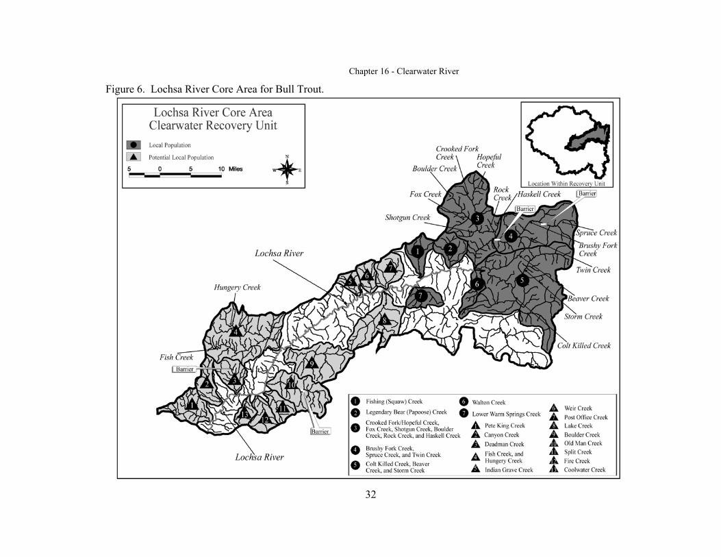
Chapter 16 - Clearwater River
32
Figure 6. Lochsa River Core Area for Bull Trout.

Chapter 16 - Clearwater River
33
determine the status and life history of these populations. Redd surveys in ShotgunCreek first occurred in 1997 and resulted in the location of two small redds and someresident-sized adult bull trout (USFS 1999a). The Shotgun population is likelyresident due to a natural barrier approximately 100 meters (300 feet) from the mouth. Surveys in Hopeful Creek found large fluvial bull trout, indicating this is a fluvialpopulation. Six bull trout redds were found in Haskell Creek in 2001 (P. Murphy,pers. comm. 2002).
Spruce and Twin creeks are tributaries of Brushy Fork Creek. In SpruceCreek, there is a bedrock migration barrier approximately 2 kilometers (1.2 miles)upstream from the mouth. Surveys in 1993 found four bull trout above the barrier:two (age 1 and 2) were found in the mainstem Spruce Creek, and two (age 1 and 2)were found in the lower reaches of the South Fork Spruce Creek (USFS 1999a). Bulltrout in upper Spruce Creek are likely resident and may be a genetically distinctpopulation due to the migration barrier. Extensive surveys in 1997 and 1998 did notlocate bull trout in Spruce Creek, indicating this population has an extremely lowdensity or has been extirpated (CBBTTAT 1998b). Twin Creek has a 12 meter (39foot) bedrock falls approximately 1 kilometer (0.6 mile) downstream from theheadwaters. Stream surveys in 1994 located a 559 millimeter (22 inch) bull trout,likely a fluvial fish staging to spawn in Twin Creek. However, redd counts in 1997located 3 resident-sized redds and several resident adult bull trout, indicating the TwinCreek population is likely resident.
Beaver, Storm, and Colt Killed creeks were surveyed in 1994 through 1997. InBeaver Creek, the first documented bull trout redd survey in 1997 located two redds. The small size of the redds and presence of gradient barriers below their locationsindicate the potential of a resident population, however, more study is needed (USFS1999a). Storm and Maud creeks also have documented spawning and rearing, and area fluvial population (Clearwater BioStudies 1996; P. Murphy, pers. comm. 2002). Upper Colt Killed and Big Flat creeks are connected with the Colt Killed Creeksystem and have documented spawning and rearing (Clearwater BioStudies 1996). There is a barrier on Big Sand Creek with no bull trout above it (P. Murphy, pers.comm. 2002).
Chapter 16 - Clearwater River
34
A fish hatchery weir at the mouth of Walton Creek routinely catches bull trout,which are released upstream in Walton Creek (USFS 1999a). A fish trap in FishCreek caught 15 bull trout in 2001. The fish were not of spawning size and wereleaving Fish Creek. In Warm Springs Creek, bull trout inhabit the lower 6 kilometers(4 miles) of the watershed below an 8 meter (26 foot) waterfall that blocks upstreamfish migration, and the presence of early rearing fish indicates that spawning isoccurring in Cooperation Creek (USFS 1999a; D. Weigel pers. comm. 2002). Adultbull trout have been found in Post Office Creek, but it is not entirely clear whetherspawning occurs as surveys have not been conducted. Fish Creek has good potentialfor spawning and early rearing, but this type of use of the stream has not beendocumented yet (P. Murphy, pers. comm. 2002). Indian Grave, Wendover, Lake,Deadman, Coolwater, Fire, and Split creeks have had bull trout sighted in them (Plattset al. 1993; P. Murphy, pers. comm 2002; IDFG 1986-1997). Coolwater and Splitcreeks were burned extensively in 1910 and historical populations were likelyextirpated, but recent bull trout sightings indicate the habitat is recovering (P. Murphy,pers. comm. 2002).
Subadult and adult bull trout have been observed in the Lochsa River. Bulltrout are suspected to use nearly all accessible areas of the core area for subadult andadult habitat (CBBTTAT 1998b). The Lochsa River provides important foraging,migrating, and overwintering habitat for the local populations within the core area, andconnectivity to bull trout populations in other core areas of the Clearwater RiverRecovery Unit. Bull trout use the lower reaches of multiple tributaries of the LochsaRiver as important habitat for thermal refuge during high water temperatures insummer.
Fish Lake (Lochsa River) core area. Fish Lake represents the only knownadfluvial bull trout population in the Lochsa River drainage, near the headwaters ofthe drainage. Fish Lake is entirely within the Selway-Bitterroot Wilderness Area. Juveniles rear in a lake inlet. This core area contains one local population (Figure 7). Little is known regarding the status of this population.
There is limited information on the fish populations of Fish Lake. In 1991, thelake was surveyed in the High Mountain Lakes Fisheries Project, a cooperative effortof the Idaho Department of Fish and Game and the Clearwater National Forest. The
Chapter 16 - Clearwater River
35
lake was surveyed by a gill net set for 12 hours which generated a catch per unit effortrelative estimate of 0.42 bull trout per gill net hour and 3.1 cutthroat per gill net hour(Murphy and Cochnauer 1998). Prior to 1995, harvest of bull trout in the lake wasallowed but the lake has since been closed to harvest.
Selway River core area. The Selway River supports a significantmetapopulation (an interacting network of local subpopulations) of fluvial bull troutthat are widely distributed through the core area in variable densities, as well as widelydistributed resident local populations in some upper tributary reaches (USFS 1999d). Local populations are well-connected within this core area. Bull trout are currentlyknown to use spawning and rearing habitat in at least 10 streams or stream complexeswithin the Selway River drainage (i.e., local populations) (CBBTTAT 1998b). Theselocal populations include Meadow Creek, Moose Creek, Little Clearwater River,Running Creek, White Cap Creek, Bear Creek, Deep Creek, Indian Creek, MagruderCreek, and Upper Selway River (Figure 8). Potential local populations include MartenCreek, Mink Creek, Gedney Creek, Three Links Creek, and O’Hara Creek (Figure 8). Bull trout may also use spawning and rearing habitat in the relatively short facedrainages along the Selway River, although this has not been documented. Bull troutappear to be distributed nonrandomly, according to the physical and bioticcharacteristics of the mainstem and tributaries (USFS 1999d). Intensive surveys havenot been conducted throughout the core area, and additional undocumented spawningand rearing areas likely exist (USFS 2001).
The Selway core area supports a strong population of bull trout in the upper ColumbiaRiver basin (ICRB 1997). Total abundance is unknown, but stream survey datacollected in 1997 suggest that fish density is relatively high (USFS 1999d). Bull troutare widely distributed throughout the Selway River drainage and abundance in theSelway River and tributaries is highly variable (CBBTTAT 1998b).
Moose and Meadow Creek watersheds support strong populations, and severalother watersheds likely support moderate to strong populations. Moose Creeksupports a significant population of fluvial and resident bull trout, and large numbersof adult fluvial bull trout have been documented within tributaries of Moose Creek
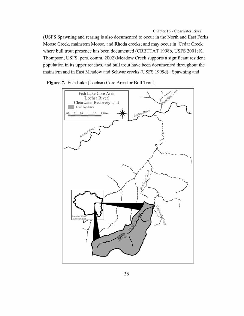
Chapter 16 - Clearwater River
36
Figure 7. Fish Lake (Lochsa) Core Area for Bull Trout.
(USFS Spawning and rearing is also documented to occur in the North and East ForksMoose Creek, mainstem Moose, and Rhoda creeks; and may occur in Cedar Creekwhere bull trout presence has been documented (CBBTTAT 1998b, USFS 2001; K.Thompson, USFS, pers. comm. 2002).Meadow Creek supports a significant residentpopulation in its upper reaches, and bull trout have been documented throughout themainstem and in East Meadow and Schwar creeks (USFS 1999d). Spawning and
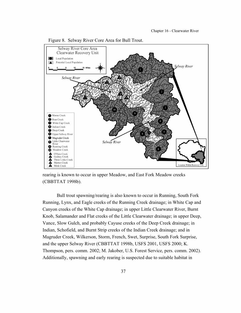
Chapter 16 - Clearwater River
37
Figure 8. Selway River Core Area for Bull Trout.
rearing is known to occur in upper Meadow, and East Fork Meadow creeks(CBBTTAT 1998b).
Bull trout spawning/rearing is also known to occur in Running, South ForkRunning, Lynx, and Eagle creeks of the Running Creek drainage; in White Cap andCanyon creeks of the White Cap drainage; in upper Little Clearwater River, BurntKnob, Salamander and Flat creeks of the Little Clearwater drainage; in upper Deep,Vance, Slow Gulch, and probably Cayuse creeks of the Deep Creek drainage; inIndian, Schofield, and Burnt Strip creeks of the Indian Creek drainage; and inMagruder Creek, Wilkerson, Storm, French, Swet, Surprise, South Fork Surprise,and the upper Selway River (CBBTTAT 1998b, USFS 2001, USFS 2000; K.Thompson, pers. comm. 2002; M. Jakober, U.S. Forest Service, pers. comm. 2002). Additionally, spawning and early rearing is suspected due to suitable habitat in

Chapter 16 - Clearwater River
38
upper Bear, upper Cub, upper Paradise, and upper Brushy Fork creeks of the BearCreek drainage (USFS 2001; S. Russell, pers. comm. 2002). Resident populationshave been documented in Meadow and Lynx (tributary of Running Creek) creeks,and the majority of other populations are fluvial (K. Thompson, pers. comm. 2002).
Incidental sightings of adult fluvial bull trout have been documentedthroughout the mainstem Selway (from mouth to headwaters) and Little ClearwaterRivers, Bear, Deep, Swet, Gedney, Marten, Three Links, and O’Hara creeks(CBBTTAT 1998b, USFS 1999d). Additionally, bull trout subadult and adult habitatis also known to exist in Gedney, Bear, Deep, Swet, and Indian creeks (CBBTTAT1998b). Due to the remote wilderness character of this core area a number ofdrainages have not been surveyed for bull trout, but likely provide habitat and maysupport (or have the potential to support) bull trout, including Marten, Mink, Otter,and Pettibone creeks (USFS 1999d). Three Links Creek likely provides lower qualityhabitat and has a lower potential to support a population (K. Thompson, pers. comm.2002).
Subadult and adult bull trout have been observed in the Selway River. Bulltrout are suspected to use nearly all accessible areas of the core area for subadult andadult habitat (CBBTTAT 1998b). Bull trout use the lower reaches of some tributariesof the Selway River as essential habitat for thermal refuge during high watertemperatures in summer. The Selway River provides important foraging, migrating,and overwintering habitat for the local populations within the core area, andconnectivity to bull trout populations in other core areas of the Clearwater RiverRecovery Unit.
Lower Clearwater and Middle Fork Clearwater core area. Bull trout usethe lower (mainstem) Clearwater River, Middle Fork Clearwater River, and theirtributaries primarily as foraging, migratory, rearing, and overwintering habitat(CBBTTAT 1998b, 1998c). No tributary streams within the core area have currentdocumentation of bull trout spawning (BLM 2000); however, Lolo Creek hasdocumented occurrence of juvenile bull trout (USFS 1999b). Lolo Creek is a localpopulation because some of the small juveniles have been found above a small falls
Chapter 16 - Clearwater River
39
that would preclude fish of their size entry from downstream areas. Clear Creek is theonly potential local population (Figure 9). Bull trout abundance is at very low levelswithin the core area. The larger tributaries may be used incidentally for subadult/adultrearing and foraging when stream conditions are suitable. Bull trout may also usesome tributaries of the Middle Fork and lower Clearwater Rivers as thermal refugehabitat during high water temperatures in summer, although many tributaries mayhave even higher temperatures than these mainstems.
Of the available habitat in tributary streams, Lolo and Clear creeks potentially providespawning and rearing habitat, although spawning and rearing has not beendocumented (CBBTTAT 1998c, 1998d). Information about bull trout distribution inboth watersheds is limited, and substantial areas remain unsurveyed (USFS 2001,CBBTTAT 1998c). In Lolo Creek, bull trout 102 to 127 millimeters (4 to 5 inches) inlength have been observed up to 10 kilometers (6 miles) above the White Creek bridgeas well as in the Nez Perce Tribe’s juvenile trapping facility (upstream of EldoradoCreek) in 1987, 1989, 1990, 1993, 1994, and 1995 (USFS 1999b). Idaho Fish andGame has observed undetermined numbers of rearing bull trout in Lolo Creek duringparr monitoring surveys in 1989, 1990, and 1994 (CBBTTAT 1998c). It is unknownwhere spawning occurs within this watershed; however, tributaries of upper Lolo andYoosa creeks provide suitable habitat. No bull trout have been documented in surveysconducted by various agencies during 1996 to 1998 (USFS 1999b). In Clear Creek,two to four bull trout are collected annually at a salmon weir during spring andreleased above the weir (CBBTTAT 1998d).
Length of captured bull trout has been 254 to 356 millimeters (10 to 14inches)(Roseberg, in litt. 2002). This stream may occasionally be used forsubadult/adult rearing. In addition to upper Clear Creek, the South and Middle Forksof Clear Creek provide the best potential habitat for spawning and rearing in thissystem (W. Paradis, pers. comm. 2002).
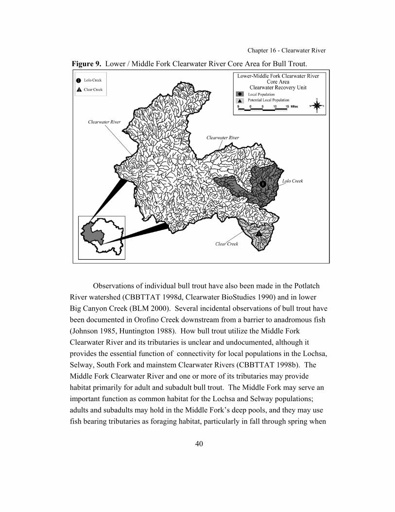
Chapter 16 - Clearwater River
40
Figure 9. Lower / Middle Fork Clearwater River Core Area for Bull Trout.
Observations of individual bull trout have also been made in the PotlatchRiver watershed (CBBTTAT 1998d, Clearwater BioStudies 1990) and in lowerBig Canyon Creek (BLM 2000). Several incidental observations of bull trout havebeen documented in Orofino Creek downstream from a barrier to anadromous fish(Johnson 1985, Huntington 1988). How bull trout utilize the Middle ForkClearwater River and its tributaries is unclear and undocumented, although itprovides the essential function of connectivity for local populations in the Lochsa,Selway, South Fork and mainstem Clearwater Rivers (CBBTTAT 1998b). TheMiddle Fork Clearwater River and one or more of its tributaries may providehabitat primarily for adult and subadult bull trout. The Middle Fork may serve animportant function as common habitat for the Lochsa and Selway populations;adults and subadults may hold in the Middle Fork’s deep pools, and they may usefish bearing tributaries as foraging habitat, particularly in fall through spring when
Chapter 16 - Clearwater River
41
water temperatures are cooler. These streams may also provide refuge habitatduring high flow events (CBBTTAT 1998b).
Dworshak Dam near the confluence of the North Fork and lower(mainstem) Clearwater has likely fragmented the local population of bull trout inthe Clearwater core area, and it is not known whether fish in the lower Clearwateroriginated from Dworshak Reservoir (Cochnauer et al. 2001). Bull trout subadultsand adults have been observed every spring in a trap at the base of the dam, andduring various years (1993, 1996, 1997, 2000, and 2001), at Dworshak NationalFish Complex near the base of the dam (Roseberg, in litt. 2002).
Bull trout observations and records in the mainstem Clearwater subbasinare sporadic. The mainstem Clearwater River provides prey species and migrationand rearing habitats for adult and subadult bull trout. It also provides connectivityamong the Grande Ronde, Salmon, Imnaha, Snake River, and the upper Clearwaterbasin local populations, although the frequency and intensity of migration betweenthese basins is unknown.

Chapter 16 - Clearwater River
42
REASONS FOR DECLINE
Bull trout distribution, abundance, and habitat quality have declined rangewide (63 FR 31647; 63 FR 31647; 64 FR 58910). Within the coterminous UnitedStates, these declines have resulted from the combined effects of: habitatdegradation and fragmentation, the blockage of migratory corridors, poor waterquality, angler harvest and associated hooking mortality, poaching, entrainment(process by which aquatic organisms are pulled through a diversion or otherdevice) into diversion channels and dams, and introduced nonnative species. Landand water management activities that depress bull trout populations and degradehabitat include operation and maintenance of dams and other diversion structures,forest management practices, livestock grazing, agriculture, agriculturaldiversions, road construction and maintenance, mining, and urban and ruraldevelopment. The reasons for decline will be discussed in detail for each corearea. Appendix B presents a summary table of limiting factors for bull trout thatwas compiled from previous research or assessments and presented in theClearwater Subbasin Summary (CSS 2001).
Dams
Overview. Restoring and maintaining connectivity between remainingpopulations of bull trout is important for the persistence of the species (Riemanand McIntyre 1993). Migration and spawning between populations increasesgenetic variability and strengthens population viability (Rieman and McIntyre1993). Barriers caused by human activities limit population interactions and mayeliminate life history forms of bull trout. Bull trout that migrate downstream ofdams without fish passage are unable to contribute to the bull trout populationupstream. In many systems controlled by dams, this loss can be significant. Research on Arrow Rock Reservoir (Boise River) found that approximately 20percent of the bull trout in the reservoir migrated past Arrow Rock Dam(CBBTTAT 1998a).

Chapter 16 - Clearwater River
43
North Fork Clearwater River core area. Dworshak Dam is the only majordam in the Clearwater River Recovery Unit and is within the North ForkClearwater core area. It is located on the North Fork Clearwater River about 1.6kilometers (1 mile) upstream from the confluence with the Clearwater River. Construction of the dam was completed in 1971 and it is operated by the U.S.Army Corps of Engineers (CBBTTAT 1998a). Dworshak Dam is 219 meters (717feet) high and, at full pool, forms a reservoir extending 87 kilometers (54 miles) upthe North Fork Clearwater River drainage. An estimated 14,800 square meters (159,307 square feet) of stream habitat in first to fourth order tributaries wasinundated by the reservoir, and an additional 962 hectares (2,377 acres) of habitatwas inundated in tributaries of the North Fork Clearwater River that were largerthan fourth order (CSS 2001). The dam inundates a total of 6,868 hectares (16,970acres) of terrestrial and riverine habitat at full pool (U.S. Army Corps of Engineers1975).
Prior to the construction of Dworshak Dam, bull trout adults from theNorth Fork Clearwater River drainage likely migrated into the mainstemClearwater River to overwinter and mix with adults from the Lochsa, Selway, andSouth Fork Clearwater River drainages (USFS 2000). Bull trout from variouspopulations probably strayed and mixed on a regular basis, which may havemitigated against lengthy population declines due to catastrophic events in any onedrainage (USFS 2000). Because no fish passage is provided at Dworshak Dam, ithas isolated bull trout inhabiting the North Fork Clearwater River drainage fromthe remainder of the recovery unit (CSS 2001). Runs of anadromous fish thathistorically spawned in the North Fork Clearwater River no longer have access tothe watershed above the dam. In addition to the biological changes due to theelimination of anadromous fish within the North Fork Clearwater River and theassociated decline in prey abundance for bull trout, the input of nutrientscontributed by the presence of anadromous fish has been disrupted (USFS 2000). This loss is considered significant to bull trout and other inland fish populations.
Dam operation includes seasonal spills and drawdowns of reservoirelevation up to 47 meters (155 feet) below full pool for flood control and also to
Chapter 16 - Clearwater River
44
supply downstream flows for anadromous fish restoration (CBBTTAT 1998a). During drawdowns, surface area of the reservoir can be reduced by as much 52percent (CSS 2001). Substantial numbers of kokanee, which have been introducedinto Dworshak Reservoir and are a forage fish for bull trout, can be entrainedbelow the dam during spills (CSS 2001). Drawdowns of Dworshak reservoir canalso entrain bull trout and carry them into the mainstem Clearwater River. Thesefish probably have low survival after entrainment (CBBTTAT 1998c). In additionto the loss of anadromous fish upstream of Dworshak Dam, fluctuations inreservoir levels influence turbidity, which affects nutrient dynamics and biologicalproduction. Low reservoir levels may also reduce bull trout access to tributariesentering the reservoir due to thermal and physical barriers (CBBTTAT 1998a).
The Idaho Department of Lands operates a small hydropower project onMeadow Creek, a tributary of the Little North Fork (CBBTTAT 1998a). Thisdam, however, does not significantly impact connectivity for bull trout betweenspawning, rearing, foraging and overwintering habitat in Dworshak Reservoir.
Lower Clearwater and Middle Fork Clearwater core area. A nearlyimpassable dam existed at Lewiston during 1927 to 1972, and reduced returns ofanadromous fish and extirpated coho salmon (CBBTTAT 1998b). The resultingreduced populations of anadromous salmonids has historically impacted bull troutthrough reduced abundance of prey, and continues to impact bull trout in theClearwater River Recovery Unit. Several anadromous salmonid propagationfacilities operated by the U.S. Fish and Wildlife Service, the State of Idaho, andthe Nez Perce Tribe produce and release spring/summer chinook salmon, fallchinook salmon, and steelhead in the recovery unit. Forest Management Practices
Overview. Forestry activities that adversely affect bull trout and its habitatare primarily timber extraction and road construction, especially where theseactivities involve riparian areas (USFWS 1998a). As noted in Chapter 1, forestmanagement practices include timber harvest and road construction and can affect
Chapter 16 - Clearwater River
45
stream habitat by altering recruitment of large woody debris, erosion andsedimentation rates, snowmelt timing, runoff patterns, the magnitude of peak andlow flows, water temperature, and annual water yield (Cacek 1989; Furniss et al.1991; Wissmar et al. 1994; Spence et al. 1996; Spencer and Schelske 1998;Swanson et al. 1998). Other impacts of timber harvesting may include decreasedslope stability. The timber harvesting treatment of clear cutting is most oftenassociated with decreased slope stability (McClelland et al. 1997).
Roads constructed for forest management are a prevalent feature onmanaged forest and rangeland landscapes. Roads constructed on steep, landslide-prone terrain often contribute to decreased slope stability (McClelland et al. 1997,Cundy and Murphy 1997, Meehan 1991). Roads have the potential to adverselyaffect several habitat features (e.g., water temperature, substrate composition andstability, sediment delivery, habitat complexity, and connectivity) and can isolatestreams from riparian areas, causing a loss in floodplain and riparian function(Baxter and McPhail 1999, Trombulak and Frissell 2000). The natural disturbanceregime in most of this recovery unit is represented by infrequent large-scaledisturbance events, particularly fires in mid to higher elevation areas, landslidestriggered by rain-on-snow, and flooding events in lower elevations. Thesesediment-producing events are followed by long periods of reduced sedimentinput. The streams in these settings often have slow resilience to sediment inputs(CBBTTAT 1998d). Historically, streams existed in a variety of graduallyimproving condition classes as affected by natural distrubances, with the fishpopulations moving between these areas. Roads, skid trails and other ground-disturbing activities associated with timber harvest can contribute sediment tothese streams on a more consistent and frequent basis. The consequence of thissediment input on streams with slow resilience has been habitat degradation (CBBTTAT 1998d). Huntington (1995) and Lee et al. (1996) found that bull troutwere relatively more abundant in unroaded than in managed (roaded) landscapes inthe Clearwater and Columbia River basins (respectively). Both the frequency ofoccurrence and the abundance of adult fish were higher in unroaded landscapes.
Chapter 16 - Clearwater River
46
Current impacts of timber harvest on bull trout have been reduced withimplementation of forest practice rules and forestry Best Management Practices onprivate and public lands. The application of Best Management Practices isvoluntary in Idaho. These regulations prohibit equipment in or near the streams,and require leaving standing trees in riparian areas (30 to 50 feet of bufferdependent on stream type), and controlling erosion from roads, trails, and landings(CBBTTAT 1998a). However, Sullivan et al. (1990) stated the current leave tree(buffer) requirement may not adequately protect stream temperature in all cases. Zaroban et al. (1996) found that forest practice rules were implemented 97 percentof the time, and when applied, they were 99 percent effective at preventingpollutants from reaching a stream. However, sediment was not monitored as a partof the study and half of the timber sales that were audited resulted in contributionsof sediment to streams, largely from inadequately maintained roads. Althoughaudits show that compliance with Best Management Practices is high in Idaho,evaluations of various States' Best Management Practices have not been conductedrelative to the protection of bull trout habitat and processes affecting water quality,such as sediment delivery, water temperature, recruitment of woody debris, andbank stability (USFWS 1998a). Even with high implementation rates, Idaho'sforestry BMPs have been shown, in some cases, to be ineffective at maintainingbeneficial uses, including cold water biota (McIntyre 1993). These findingsillustrate the need to adequately implement all applicable rules as themisapplication of one rule, out of many, can result in sediment delivery. Federallands have adopted PACFISH (USFS and BLM 1995b) and INFISH (USFS andBLM 1995a) management guidelines that exceed Idaho rules and were designed toprotect native fish populations.
Although certain forestry practices have been restricted or altered in recentyears to improve protection of aquatic habitat, the consequences of past activitiescontinue to affect bull trout and their habitat. Early logging in the ClearwaterRiver Recovery Unit generally occurred in river valley bottoms where logs couldbe easily skidded or transported by flume to the river and ultimately floateddownstream to Lewiston. These log drives occurred annually during high waterbeginning in 1928. The last log drive in Idaho occurred in 1971 on the North Fork

Chapter 16 - Clearwater River
47
Clearwater River. Prior to the establishment of the Idaho Forest Practices Act(approximately 1975), streams and riparian areas received no protection fromharvesting, roading, skidding and processing impacts. Management activities inthe 1970's also include removal of large woody debris from stream channels toprevent flooding and debris torrents. The legacy of these activities still affects fishhabitat in portions of the recovery unit through decreased large woody debris(from log skidding directly in streams and removal of woody debris), lack ofrecruitable large woody debris, increased water temperatures from harvest ofriparian forests, and lack of pools and habitat complexity. These impacts must berectified to protect fish habitat (CBBTTAT 1998a).
Fire management is another forestry practice that can impact bull trout. Fire ignition may be either natural or man-made. Man-made fire ignition may beintentional (management directed) or accidental. Recent evidence suggests thatsuccessful fire suppression since the 1930's is likely to be resulting in more intensefires in some areas, and may be having little to no impact in other areas. Presumably, bull trout have adapted to the effects of fires of a natural intensity(CBBTTAT 1998a). Rieman and McIntyre (1993) document a case where a fireextirpated bull trout from a small watershed and within two years bull troutreturned, other studies have found that bull trout remained in streams after fires. Catastrophic fire is associated with increased sediment delivery to streams,increased temperatures (due to burning of stream-side vegetation), lack of largewoody debris (in extreme cases the existing woody debris is consumed by the fire,in other cases the fire consumes trees that would contribute to woody debris in thefuture), lack of habitat complexity (due to increased sediment and reduction inwoody debris), and changes to runoff patterns and peak flows. However, wildfirecan also have a negligible to beneficial impact on aquatic ecosystems and bulltrout. Less intense fires can actually increase the complexity and diversity of theaquatic and terrestrial habitat mosaic (CBBTTAT 1998a). If the fire is not extremely hot, woody debris recruitment may increase. Woody debris in thechannel provides cover, pool habitat complexity, and sediment storage in thestream.
Chapter 16 - Clearwater River
48
North Fork Clearwater River core area. The Orogrande, Washington,Beaver, Quartz, Cold Springs, and Moose Creek watersheds have been intensivelymanaged for timber production and will probably remain an importantmanagement concern in the future (CBBTTAT 1998a, USFS 2000). Impactsassociated with these activities are significant and evident in streams. TheBreakfast Creek drainage and the lower portion of the Little North Fork isprimarily managed for timber production. Historic logging practices have reducedshade and large woody debris along much of Stony, Breakfast, Isabella, and Glovecreeks. Thermographs placed in Stony Creek showed water temperatures exceed18 degrees Celsius (64.4 degrees Fahrenheit) during summer and suggest streamshading is inadequate to maintain the cool water temperatures needed by bull trout(CBBTTAT 1998a). Water temperature above 15 degrees Celsius (59 degreesFahrenheit) is believed to limit bull trout distribution (Rieman and McIntyre1995).
Upper Floodwood Creek, in the Breakfast Creek drainage, has been lightlyharvested (less than 25 percent harvested and a road density of 1.1 miles persquare mile). Timber management is only occurring on several state-managedtributaries (Timber, Goat, and O`Donnell creeks). Little or no timber managementis occurring or anticipated on Federal land in the watershed. Floodwood Creek hasa high quality stream and a known spawning and rearing bull trout population(CBBTTAT 1998a). Idaho’s Cumulative Watershed Effects Process wasconducted in the upper Floodwood Creek drainage (IDL 2002a). The CumulativeWatershed Effects Process for stream, upland and road surveys was approved bythe Idaho Land Board in 1995 and includes modules for assessing erosion andmass failure hazards, canopy closure/stream temperature (adjusted for elevationand drought conditions), stream channel stability and hydrologic risk factors,sediment delivery from roads and skid trails, beneficial use/fine sedimentassessment, and nutrient assessment where applicable (IDL 2000). The surveyfound a functional riparian area and stable stream channel along upper FloodwoodCreek (CBBTTAT 1998a). Overall, roads in this area were identified to be ingood condition although some problem road segments were identified.
Chapter 16 - Clearwater River
49
Idaho’s Cumulative Watershed Effects Process for stream, upland and roadsurveys was conducted in the West Fork Floodwood Creek drainage (IDL 2002b). A fire (Mary Mix Fire) during 1986 and its associated suppression and salvageactivities removed most of the vegetation along the lower two miles of West ForkFloodwood Creek and greatly accelerated sediment input and transport(CBBTTAT 1998a). A thermograph in West Fork Floodwood Creek indicatedwater temperatures exceed 18 degrees C (64.4 degrees F) in the area whereriparian vegetation was burned.
The watersheds in the upper Little North Fork Clearwater River aremanaged by the Forest Service and Plum Creek Timber Company and areprimarily managed for timber production. It is anticipated that these watershedswill be managed for timber production in the future. The U.S. Fish and WildlifeService negotiated a Habitat Conservation Plan (HCP) with Plum Creek TimberCompany in December 2000, and successful implementation of the HCP isexpected to result in a higher standard for private timberland managementactivities, including reduced impacts of future actions and remediation of existingproblems to the benefit of bull trout. However, historic timber management hasdegraded several streams in this area. Loss of streamside vegetation andsignificant introductions of fine sediment has occurred in Jungle, Adair, Rutledge,and Montana creeks (CBBTTAT 1998a). Skille (1991) found that the amount ofinstream sediment exhibited a strong correlation with road densities (r2 = 0.70) andpercent watershed harvested (r2= 0.83) in tributaries of upper Little North ForkClearwater River. These relationships are expected to vary for areas with different landtypes, parent materials, road construction histories and timber harvestmethods. Where cobble embeddedness exceeded 50 percent, no cutthroat troutwere found (Skille 1991). Similar relationships can be expected to occur with bulltrout (CBBTTAT 1998a). The Bureau of Land Management managed watersheds(e.g., Little North Fork, Lost Lake, Little Lost Lake, and Lund creeks) arerelatively unroaded (less than 1 mile per square mile) and few land modifyingactions have occurred. This land is currently managed as a wilderness study areaand is expected to be managed this way in the future.
Chapter 16 - Clearwater River
50
Historic fires in the early 1900's affected large expanses (approximately 66percent) of the middle to upper North Fork core area including upper Skull, Rock,4th of July, Weitas, Kelly and Cayuse creeks and some tributaries of the upperNorth Fork Clearwater River including Vanderbilt, Bostonian, and Boundarycreeks (USFS 2000). Historic fires were generally stand replacing and haveresulted in legacy effects (impacts from historical activities that are still present) tostreams including loss of riparian habitat and stream shading, increasedtemperatures, decreased woody debris and decreased recruitment of woody debris. The areas of Isabella, Skull, Quartz, and Hidden creeks have been affected byrecent small fires (CBBTTAT 1998a). These fires generally burned at a lowerintensity and resulted in a mosaic pattern of burned and unburned vegetation, withsome portions of riparian areas burned intensely and others unburned. WeitasCreek, one of the largest tributaries in this watershed has been affected primarilyby historic fire. Thermographs in Weitas Creek and tributaries document watertemperatures as high as 23 degrees C (73.4 degrees F) in Weitas Creek mainstemand in Hemlock Creek, 17 degrees C (62.6 degrees F) in Little Weitas Creek, and18 degrees C (64.4 degrees F) in Middle Creek due to loss of riparian habitat(CBBTTAT 1998a). Other lesser impacts in this watershed include some areasthat have been affected by roads, timber harvest, and terracing.
South Fork Clearwater River core area. Timber harvest activities in theSouth Fork Clearwater core area have been extensive. The long-term adverseeffects of timber management activities are thought to be mainly associated withroad construction (CBBTTAT 1998d). The specific effects of these roads on bulltrout habitat are discussed in the overview section above.
Timber harvest has posed the greatest risk to bull trout in the Red Riverdrainage. The Clearwater Basin Bull Trout Technical Advisory Team utilized arisk scale of “low, moderate, and high” to describe the relative level of impact anactivity has had on bull trout (CBBBTTAT 1998d). The impact of timber harveston bull trout habitat was rated as high for this drainage due to the amount ofharvest, the amount of streamside harvest, and the percentage of landslide-pronearea harvested (CBTTAT 1998d). In Red River, 22 percent of the land base has
Chapter 16 - Clearwater River
51
been subject to timber harvest activities including timber harvest in 15 percent ofstreamside areas, and road encroachment into riparian areas and streams(CBBTTAT 1998d). The only areas of low development in the Red Riverdrainage are those in the upper watersheds.
In the American River, Crooked River, and Newsome Creek, 14, 10, and19 percent of the lands, respectively, have been managed for timber harvest(CBBTTAT 1998d). Timber harvest impacts on bull trout habitat were rated asmoderate for these watersheds (CBBTTAT 1998d). In the American River, roadshave encroached on riparian areas and streams, affecting riparian processes andfunction. Sediment yields are 14 percent above normal background levels(CBBTTAT 1998d). Although much of the upper Crooked River is largelyunroaded, sediment yields of 8 percent above normal background levels occur insome areas (CBBTTAT 1998d). Road #233, which was historically established formining access and has since been used for forest management and recreationactivities, runs parallel to Crooked River within a constricted canyon reach. Thishas resulted in increased sediment yields and loss of riparian vegetation andshading for Crooked River (J. D. Mays, pers. comm. 2001).
Timber harvest in Tenmile Creek and Johns Creek has been low with only1 and 3 percent of the lands, respectively, managed for harvest (CBBTTAT1998d). Much of the upper portions of these watersheds are within designatedwilderness areas. Since 1998 there have been no new proposals for managementactivities in these watersheds; only completion of harvest from timber salesapproved in the late 1980's to early 1990's. Sediment yields are 1 percent abovenatural background levels in Tenmile and Johns creeks (CBBTTAT 1998d).
Timber harvest in the middle portion of the South Fork Clearwatersubbasin has occurred mainly along the Meadow Creek tributary with 32 percentof the watershed harvested. Sediment yield is 16 percent over natural backgroundlevels. Other watersheds that have been harvested include Cougar and Peasleycreeks with approximately 23 and 22 percent harvested. Sediment yields for thesetwo watersheds are 15 and 20 percent over natural background levels. The Wing,

Chapter 16 - Clearwater River
52
Twentymile, and Mill Creek watersheds have been harvested across approximately1, 1, and 20 percent of their areas, respectively, and sediment yields are 3, 4, and 8percent over natural background levels (CBBTTAT 1998d).
Lochsa River core area. The entire Fishing (Squaw) Creek watershed ismanaged by the Forest Service, and a checkerboard ownership pattern exists in theLegendary Bear (Papoose) watershed which includes U.S. Forest Service and PlumCreek lands (CBBTTAT 1998b). Roads within these watersheds have displacedriparian vegetation, are a constant source of sediment to the streams, and havesignificantly impacted bull trout habitat. These factors likely affected bull troutpopulations in these watersheds decades ago and continue to impact them(CBBTTAT 1998d). Jammer logging systems (horizontal strip clear-cutsseparated by roads on steep hillsides) were common in these areas, which resultedin high road densities. In Fishing (Squaw) Creek, for example, during the 1996winter flood event the presence of jammer logging roads was highly associatedwith areas of debris torrents and landslides (J. Capurso, U.S. Forest Service, pers.comm. 1997). Large segments of these streams were cleared of large woodydebris in the 1970's and 1980's (CBBTTAT 1998b).
Riparian areas of important bull trout streams in the upper Lochsa drainagehave been impacted by a number of forest management practices. The quantityand quality of large instream wood in some bull trout habitat has been reduced byroad building and logging in riparian areas, and stream cleaning (large woodremoval) (USFS 1998, CBBTTAT 1998a). Replacement of this wood is importantin both spawning/rearing habitat and adult/subadult habitat. Also, some riparianareas have been impacted by fire suppression. Dense riparian vegetation resultingfrom fire suppression and overstory harvest practices has the potential of burningmore intensely than it would under natural conditions (CBBTTAT 1998a). Theseareas should be treated to reduce fuel loads, so riparian areas do not burn toointensely when fire returns. Haskell and Crooked Fork creeks were affected by afire in 2000 that created a mosaic pattern of varying burn intensities through theriparian areas.
Chapter 16 - Clearwater River
53
A checkerboard ownership pattern consisting of U.S. Forest Service andPlum Creek Timber lands exists within the upper Lochsa River drainage,particularly in the Twin and Spruce Creek watersheds, resulting in areas of highroad densities and timber harvest. Several stream reaches in the Spruce Creekwatershed are in a degraded condition due to sedimentation resulting from timberharvest and road construction, decreased shading and recruitment woody debrisfrom riparian harvest, large woody debris removal in the 1960's, and restriction ofstream channels (USFS 1999a). Relatively high cobble embeddedness values werereported for Spruce Creek. Large debris jams are present in the upper reaches, duepartially to remnant logging debris. Valley bottom roads have confined the naturalmigration of the meandering low-gradient channels, reducing form and function ofthe creeks. Stream surveys indicate relatively low frequencies of large instreamwood in the North Fork of Spruce Creek and Shoot Creek (USFS 1999a).
Lower Clearwater and Middle Fork Clearwater River core area. Timber harvesting activities occur throughout the core area on National Forest,Bureau of Land Management, State of Idaho, Nez Perce Tribe, corporate andprivately-owned lands. Private land timber harvest of the steep breaklands of themainstem Clearwater River is contributing to vegetative change and roadingimpacts (CBBTTAT 1998c). Although timber harvest using helicopter yardinghas become more common, the higher economic return to landowners of tractorlogging leads to continued road and skid trail development and increased loggingimpacts on these forested breaklands (CBBTTAT 1998c). Timber harvestactivities on private, State and Federal lands have had varying degrees of impacton aquatic habitat. Long-term effects are generally associated with roadconstruction. During high flow events, the Clearwater River has very highsediment loads from a variety of sources including timber harvest, roads, mining,and agriculture. Sediment typically flushes out of river segments and deposits inlower velocity areas associated with downriver dam impoundments and slackwater areas (BLM 2000).
Lolo Creek has sustained impacts from timber harvest and roadconstruction, and these activities present the greatest legacy and current threats to
Chapter 16 - Clearwater River
54
fisheries habitat in the watershed above the Forest Service boundary (CBBTTAT1998c). Legacy effects of riparian logging such as loss of stream cover andpotential woody debris are evident in the mid-watershed, and past and currenttimber harvest activities present the greatest threats to fisheries in the upperwatershed (CBBTTAT 1998c). Recent surveys administered by the U.S. ForestService have shown that a number of streams within the Lolo Creek drainage havemoderate to high levels of cobble embeddedness as a primary limiting factor tofish production (USFS 1999b). Low levels of woody debris and suboptimal levelsof instream cover are also limiting factors in a number of stream reaches. Approximately 20 percent of the Clear Creek drainage has been harvested fortimber, 80 percent of which was clearcut. The majority of lands in the PotlatchRiver watershed have historically been, and continue to be, managed for timberproduction.
Livestock Grazing
Overview. Occupied bull trout habitat is negatively affected by somelivestock grazing practices (USFWS 1998a). Livestock grazing can degradeaquatic habitat by removing riparian vegetation, destabilizing streambanks,widening stream channels, promoting incised channels and lowering water tables,reducing pool frequency, increasing soil erosion, and altering water quality(USFWS 1998a). These effects increase summer water temperatures, reducecover, promote formation of anchor ice in winter, and increase sediment deliveryinto bull trout spawning and rearing habitat. Livestock grazing is causing impactsto riparian vegetation and bull trout habitat in some core areas, with the greatestimpacts present in the Lower/Middle Fork Clearwater and South Fork Clearwatercore areas (CBBTTAT 1998a, 1998c).
North Fork Clearwater River core area. Grazing allotments wereestablished in the Kelly Creek and Cayuse Creek areas during the early 1900's andfollowing the wildfires of 1889, 1910, and 1919. Large numbers of sheep weregrazed until natural plant succession decreased forage, making grazing infeasible. Current grazing of pack and saddle stock by outfitters and the U.S. Forest Service
Chapter 16 - Clearwater River
55
is short-term and site specific. Presently, most domestic cattle grazing in the basinis limited to the tributaries of Dworshak Reservoir, and impacts vary from low tohigh. These tributaries have been determined to be of low priority for bull troutrecovery due to the intensity of past and current land management activities. However, historic information on spawning and rearing areas is still beingcollected and the importance of these sub-watersheds may change with newinformation (CBBTTAT 1998a). Other grazing activity is limited to short-termsheep grazing after timber harvest on State of Idaho lands. Livestock grazing isnot known to occur adjacent to documented spawning and rearing streams in thiscore area (CBBTTAT 1998a). Where grazing occurs, impacts are generally beingreduced through better management practices on public and State lands. Livestockgrazing does not represent a major threat to bull trout recovery in this core area.
South Fork Clearwater core area. The key watersheds of the South ForkClearwater River have a moderate to low capability for grazing with the exceptionof the meadow areas of Red River which are rated high capability, but with amoderate to low suitability for grazing due to potential impacts (USFS 1998a). There are grazing allotments in the Nez Perce National Forest across much of theNewsome Creek and American River watersheds, along the western portion ofJohns Creek, and along Meadow Creek. The majority of Bureau of LandManagement lands within the core area are leased for grazing. Grazing on privateland is known to occur in the American River and the Red River (three areas)drainages (CBBTTAT 1998d). Moderate to high levels of grazing have severelyaffected riparian zones on private and U.S. Forest Service land in the AmericanRiver watershed (especially Elk Creek, tributary to American River), and inmeadow reaches on private land in lower portions of the Red River drainage. TheBureau of Land Management and U.S. Forest Service have fenced problem areasfor bull trout and have virtually eliminated most grazing along American River (C.Johnson, pers. comm. 2002).
Lochsa core area. Short-term, site-specific pack stock grazing occurs inportions of this core area. Livestock grazing does not represent a major threat tobull trout recovery in this core area.

Chapter 16 - Clearwater River
56
Selway core area. Cattle grazing occurs on U.S. Forest Service land in theO’Hara Creek watershed. Short-term, site-specific pack stock grazing occurs alongthe lower Selway River and in the Selway-Bitterroot Wilderness. Livestock grazingdoes not represent a major threat to bull trout recovery in this core area.
Lower Clearwater and Middle Fork Clearwater River core area. Themajority of livestock grazing within the core area occurs on private and State lands,and is relatively light and unconcentrated within the mainstem Clearwater Rivercanyon (CBBTTAT 1998c). Most grazing is limited to small, non-commercialoperations along the river corridor, although there are some confined animal feedlotoperations that present risks based on their distance from streams, slope and soil types,and waste management and diversion structures. Most private land on the prairieabove the river canyon has been converted to agricultural land, with steeper-slopedcanyon lands used primarily for pasturing livestock. The U.S. Forest Service hasestablished grazing allotments on lands with suitable forage for livestock in the ClearCreek and Lolo Creek drainages. Nearly 32 percent of the Clear Creek watershed isprivate land and private agricultural practices and grazing have resulted in removal ofriparian vegetation and channel erosion (USFS 1999e). The Lolo Creek mid-watershed, defined as Cottonwood Flats upstream to the U.S. Forest Service boundaryis impacted in a few localized areas by grazing in the meadows and riparian areas(CBBTTAT 1998c).
The majority of Bureau of Land Management lands within the core area areleased for grazing. Bureau of Land Management lands are often intermingled withprivate lands and they are grazed together. Past timber harvests in forested areasprovide transitory range that is often grazed. Canyon grasslands that are grazed areprimarily associated with the lower Clearwater River tributaries which have dissectedthe prairie lands. In the Potlatch River watershed, stream channels and hydrologicfunction have been extensively altered by farming and grazing, in addition to othermanagement activities (CBBTTAT 1998c). Cattle are the most common livestockgrazed within the core area.

Chapter 16 - Clearwater River
57
Transportation Networks
Overview. Dunham and Rieman (1999) found that the density of roads at thelandscape level was negatively correlated to bull trout occurrence. Roads not onlyfacilitate excessive inputs of fine sediment and possible habitat degradation in streams,they also increase human access which may induce angling mortality andintroductions of nonnative fishes and increase the potential for water pollution throughaccidental spills. A widely held principle of managing for the survival and recovery ofthreatened and endangered aquatic species is that remaining stronghold areas for thespecies and associated high quality habitats be preserved and reconnected. Wilderness, unroaded areas, and large blocks of primitive lands contain most of thebest available remaining habitat for bull trout, steelhead, and salmon (Frissell 1993;Thomas et al. 1963; Henjum et al. 1994; Rhodes et al. 1994; and Quigley andArbelbide 1997). In the Interior Columbia River Basin, the lack of roads is thestrongest predictor of high aquatic ecosystem integrity, and bull trout strongholdsshow a very strong negative correlation with road densities (Quigley and Arbeldide1997). The average road density in bull trout strongholds (areas with healthy bulltrout populations) was 1.2 kilometers per square kilometer (0.5 miles per square mile),which is considerably less than the standard of 1.2 to 1.9 kilometers per squarekilometer (2 to 3 miles per square mile) reported as not adversely impactive forpopulations of anadromous salmonids. Bull trout populations classified as“depressed” occurred in areas that had an average watershed road density of 0.9kilometers per square kilometer (1.4 miles per square mile) and bull trout typicallywere absent at an average road density of 1.1 kilometers per square kilometer (1.7miles per square mile) (Quigley and Arbeldide 1997).
Road densities in the Clearwater River Recovery Unit are lower relative to therest of the Interior Columbia River Basin, however, localized areas exhibit high roaddensities. Roads are influencing bull trout habitat in all core areas, except the portionswithin the Selway-Bitterroot Wilderness and the Gospel Hump Wilderness areas andother wilderness study areas and roadless areas on National Forest lands. There are anumber of inventoried roadless areas in the Clearwater River Recovery Unit with acombined area of 2.21 million acres (CSS 2001). Road densities are the greatest in the

Chapter 16 - Clearwater River
58
central portion of the recovery unit which includes the eastern half of the North ForkClearwater, the southeastern third of the Lower/Middle Fork Clearwater, and thenorthern and eastern two-thirds of the South Fork Clearwater core areas. Loggingroads predominate in these areas, commonly exceeding 1.9 to 3.1 kilometers persquare kilometer (3 to 5 miles per square mile) (CSS 2001). See the “ForestManagement Practices - Overview” section above for a discussion of the road-associated impacts to bull trout. There is relatively little road development in theeastern part of the recovery unit, with the exception of localized areas of intensiveforest management (e.g., portions of the upper Lochsa and upper North ForkClearwater River drainages). The Selway-Bitterroot and Gospel-Hump WildernessAreas contribute to the lack of road development in some areas, as does local firehistory. The distribution of logging roads is notably tied to fire history, with mostexisting forest roads located in areas that did not burn in the major fires of 1910 and1917 (CSS 2001).
North Fork Clearwater River core area. U.S. Forest Service roads parallelor provide access to many local population mainstem and tributary streams. Impactsfrom such roads include continuous sediment input from surface runoff and potentialfor large sediment input from road failures, sedimentation and passage barriers due toroad crossing structures such as bridges and culverts, and increased fishing access tokey habitat. U.S. Forest Service Roads 247 and 250 parallel the North ForkClearwater River from the upper part of the reservoir to the top of Hoodoo Pass. Kelly, Cayuse, and Weitas creeks are accessible by a number of main U.S. ForestService roads. U.S. Forest Service roads parallel 17.7 kilometers (11 miles) of KellyCreek, the upper 8 kilometers (5 miles) of the Little North Fork Clearwater River, andmany tributary drainages of the North Fork Clearwater such as Quartz, Skull, ColdSprings, Gravey, and Moose creeks (CBBTTAT 1998a). Mass failures have occurredin the Quartz, Moose, Toboggan, and Gravey Creek watersheds.
The highest road densities occur in areas managed primarily for timberproduction (CBBTTAT 1998a), and these areas typically occur in the lower third ofthe North Fork Clearwater core area. Floods and landslides triggered by a rain-on-snow event during the 1995/1996 winter impacted many of the areas that have been

Chapter 16 - Clearwater River
59
subject to timber harvest and roading (CBBTTAT 1998a). These include massfailures in Quartz, Deception, Cold Springs, Beaver, and Orogrande Creek watersheds. Beaver, Quartz, and Skull creeks have been intensively harvested and roaded. Beaver,Quartz, Cold Springs, Orogrande, and Deception creeks have also been intensivelymanaged and show effects of sedimentation in elevated cobble embeddednessmeasurements. However, the headwaters and some tributaries of these subwatershedsare relatively undisturbed and may provide a foothold for the recolonization of bulltrout (CBBTTAT 1998a).
During 1996 flood events, significant amounts of sediment were delivered tostreams in the Breakfast Creek drainage through mass failures. Roads were associatedwith 83 percent of these failures (Cundy and Murphy 1997). Based on studies of the1996 event, Potlatch Corporation is developing a landslide hazard map for theirownership. The assessment will provide information to minimize mass failures fromfuture roads. Numerous mass failures occurred along tributaries to DworshakReservoir during the winter and spring of 1995 to 1996. Roads were associated with83 percent of the mass wasting events (Cundy and Murphy 1997).
Mainline trails used by livestock packers, off-road motorists, and backpackersfollow Kelly Creek, Cayuse Creek, Weitas Creek, and the Little North ForkClearwater River and are potential sediment sources, although their impact isrelatively minor compared to sediment from roads.
Fish Lake (North Fork Clearwater River) core area. Fish Lake is one ofthe only high elevation lakes where off-highway vehicle (OHV) access is possible andpermitted. Fish Lake is accessed by a well developed trail that has been upgraded forOHVs. Since the early 1990's local OHV clubs have worked with the U.S. ForestService to upgrade the trail and use has increased dramatically (J. Roy, USFWS, pers.comm. 2002). The increased recreation pressure has resulted in trampling of riparianvegetation along the outlet stream and along the lake shore. Fishing pressure has alsoincreased, resulting in more catch and release of bull trout and associated impacts fromhooking mortality (see Fisheries Management section).

Chapter 16 - Clearwater River
60
South Fork Clearwater River core area. In the South Fork Clearwater corearea, roads are thought to be one of the most important factors in habitat degradationdue to the long history of road construction for mining and timber management, theamount of road, the amount of streamside road, the alteration in sediment regimes, andalteration in riparian and stream processes and functions (CBBTTAT 1998d).
Red River has the highest number of kilometers of roads and the secondhighest road density in the entire core area with over 946 kilometers (588 miles) ofroad with an overall density of 3.6 miles per square mile. Of the total number of milesof road, 280 kilometers (174 miles) have been constructed near streams. Over 13kilometers (8 miles) of road have encroached into stream channels (CBBTTAT1998d). The American and Crooked Rivers, and Newsome Creek have 343, 220, and354 kilometers (213, 137, and 220 miles) of road, respectively, and road densities of1.4, 1.2, and 2.0 kilometers per square kilometer (2.3, 2.0, and 3.3 miles per squaremile). Of the total number of miles of road, 2.5, 4.3, and 3.1 kilometers (4, 7, and 5miles) have encroached into stream channels (CBBTTAT 1998d).
The threat of habitat degradation in Tenmile and Johns creeks from roads islow. Headwater portions of these streams areas lie within the Gospel HumpWilderness area. Tenmile Creek has a total of 39 kilometers (24 miles) of constructedroad while Johns Creek has a total of 97 kilometers (60 total miles) of roaddevelopment.
The mainstem of the South Fork Clearwater River has 264 kilometers (164miles) of roads (a density of 2.7 kilometers per square kilometer, 4.4 miles per squaremile) (CBBTTAT 1998d). Approximately 73 kilometers (45 miles) of road arelocated within the riparian area. There are many roads, including most of the mainhighway (Highway 14), along the river that have encroached on stream and riparianprocesses (CBBTTAT 1998d). Cougar and Peasley creeks have 77 and 89 kilometers(48 and 55 miles) of roads respectively, with sections of roads in both watershedsencroaching on stream and riparian processes. Similar effects occur in Wing,Twentymile and Mill creeks which have 16, 27, and 151 kilometers (10, 17, and 94miles) of roads, respectively. Key areas of road encroachment from high-standard,

Chapter 16 - Clearwater River
61
well-traveled roads in the upper South Fork include Forest Service Road 233 alongCrooked River from Relief Creek downstream approximately 6 kilometers (4 miles)through the “Narrows”; and various sites between Red River Hotsprings and the oldRed River Ranger Station.
Lochsa River core area. Riparian vegetation along the Lochsa River andCrooked Fork Creek have been impacted by road construction and maintenance(CBBTTAT 1998b). U.S. Highway 12 runs parallel to most of the Lochsa River andthe entire Crooked Fork Creek and is a narrow, sinuous river canyon road. U.S.Highway 12 has removed riparian vegetation resulting in decreased woody debris andreduced off-channel habitat. Other impacts include increased angler access, noxiousweed invasion of riparian areas along the Lochsa and its tributaries, and winter roadsanding that provides a persistent source of gravel and fine sediment (CBBTTAT1998b). U.S. Highway 12 is also a major transportation route between Idaho andMontana with numerous accidents, some of which result in trucks overturning into theriver. There is a high potential threat from hazardous materials spills as a result ofthese vehicular accidents.
Roads constructed for timber management occur throughout the upper LochsaRiver. Mainline roads, constructed by the U.S. Bureau of Public Roads in the 1950's,were built within the floodplains and riparian zones of the mainstem and tributaries ofFishing (Squaw) and Legendary Bear (Papoose) creeks (CBBTTAT 1998b). Theseroads have displaced riparian vegetation and are a constant source of sediment to thestream. During the 1970's and 1980's, large reaches of Fishing (Squaw) andLegendary Bear (Papoose) creeks were cleared of large woody debris to improve fishpassage and release sediment (CBBTTAT 1998b). Road densities in Shotgun andlower Boulder creeks are very high: 3.6 kilometers per square kilometer (5.8 miles persquare mile) and 2.1 miles per square mile (3.5 miles per square mile), respectivelyand are degrading spawning and rearing habitat (USFS 1999a). Road density inSpruce Creek is also high 2.1 kilometers per square kilometer (3.4 miles per squaremile), and has probably increased since this 1995 estimate due to large-scale timberharvest activities (mainly on Plum Creek lands) (USFS 1999a). Beaver Creek has arelatively high road density of 1.8 kilometers per square kilometer (2.9 miles per
Chapter 16 - Clearwater River
62
square mile) (1992 data) which contributes to its moderate cobble embeddedness(USFS 1999a).
Fish Lake (Lochsa River) core area. Two potentially significant threats tothis population are associated with habitat degradation from the Fish Lake airstrip andfrom a trail crossing at Wounded Doe Creek (Clearwater Recovery Unit Team, in litt.2000). While Fish Lake provides the only known population of adfluvial bull trout inthe Lochsa River drainage and is entirely within the Selway-Bitterroot WildernessArea, spawning and rearing habitat in the lake inlet stream has been impacted by theconstruction of the Fish Lake airstrip in the 1950's (CBBTTAT 1998b). Effects of theairstrip include channelization and straightening of a portion of the lower stream as aresult of construction, downcut stream banks, and erosion due to past channelization,current use of campsites, livestock and pack horse access to the stream, and a ford atthe Wounded Doe Trailhead. Increased access into Fish Lake afforded by the airstriphas increased fishing pressure and likely has resulted in increased catch and release ofbull trout and associated hooking mortality as discussed for the North Fork ClearwaterFish Lake adfluvial population.
Selway core area. Overall, in this core area, roads present a minor impact tobull trout, with the exception of a few localized areas that have relatively higher roaddensities. Roads in this core area reflect two substantively different development andmanagement histories (USFS 2001). The majority of roads (approximately 80 percentof the total road mileage) in the core area were developed and are used for a variety ofpurposes including community and private development, timber harvest, andrecreation. These roads are found in O'Hara and Goddard creeks, and to a lesserextent, the Lower Selway Canyon. Despite a variety of uses that drive thedevelopment of roads in these areas, existing development remains relatively modest,with road density values remaining less than 1.9 kilometers per square kilometer (3miles per square mile). The second category of roads were developed and are used primarily for limitedaccess needs, and are often located in a backcountry or wilderness recreation setting. These roads occur in the north Selway River face, Middle and Upper Selway Rivercanyon, Meadow, Running, Goat, Deep, Indian, White Cap, Gedney, and Three Links
Chapter 16 - Clearwater River
63
creeks, and the Selway River headwaters. Existing road densities remain below 0.3kilometers per square kilometer (0.5 miles per square mile), several of themsubstantially so.
Lower Clearwater and Middle Fork Clearwater core area. A welldeveloped highway and county road system is present in the core area (CBBTTAT1998c). U.S. Highway 12 and the Camas Prairie Railroad runs along the entire lengthof the Clearwater River. State and county highways encroach on the channel, riparianareas and floodplains of the Potlatch River, Big Canyon, Lapwai, and Cottonwoodcreeks. Off-channel habitat and backwater areas have been reduced or cut-off fromthe main river channel. Portions of riverbanks have been riprapped to protecthighways, bridges, and private land development (BLM 2000). The communities ofKendrick and Julieatta, Kamiah, Lapwai, and Peck all are within the floodplains of thePotlatch River, Lawyers, Lapwai, and Big Canyon creeks, respectively (CBBTTAT1998c). Roads for forest management are common. Road densities on private andState lands are expected to be over 1.9 to 2.5 kilometers per square kilometer (3 to 4miles per square mile) within the core area. During high flow events, the ClearwaterRiver has very high sediment loads due, in part, to road runoff and failures duringweather events. Sediment deposits in lower velocity areas embedding substrates.
U.S. Highway 12 runs adjacent to the mainstem Clearwater for its entire lengthin this core area, creating numerous impacts to aquatic and riparian habitat. Also,encroachment of the highway on one side and the railroad on the opposite side haveconstrained the river meanders, eddys, and hydraulic energy (CBBTTAT 1998c). Eight bridges cross the Clearwater River within the watershed. While they do notpresent significant constraints on the river, they do increase hazardous spill risk andtheir maintenance and improvements can affect river habitat and populations. There isa high potential threat from hazardous materials spills as a result of vehicularaccidents, as occurred in January 2002, when approximately 10,500 gallons of dieselfuel spilled into the Middle Fork Clearwater River near Kamiah from a tractor trailercrash on Highway 12. This spill affected the Clearwater River downstream forapproximately 113 kilometers (70 miles) (USFWS, in litt. 2002). Highway 12 has alsofacilitated the spread of noxious weeds and the resulting invasion of riparian areas

Chapter 16 - Clearwater River
64
along the Clearwater River and its tributaries. Noxious weeds compete with desirableriparian vegetation and affect aquatic habitat by altering natural ecological processes(fire, hydrology, soil development) (Olson 1999), with potential instream impacts ofincreased sedimentation and water temperatures, and decreased cover and woodydebris.
Lolo Creek and its major tributaries are roaded watersheds, with 3 kilometersper square kilometer (4.8 miles per square mile) of roads in the watershed (USFS1998b). Roads are likely the most significant impact to bull trout habitat within theLolo Creek drainage (USFS 1999b). Roads paralleling streams or within the streamfloodplain are sediment sources, reduce riparian cover, limit stream hydrologicalfunction and reduce instream cover and acting and potential woody debris inMusselshell, Yakus, Eldorado, and Lolo creeks (CBBTTAT 1998c, USFS 1999b). Roads are also a significant impact to bull trout habitat in the Clear Creek drainage. There are approximately 483 kilometers (300 miles) of roads in the watershed and aroad density of 1.9 kilometers per square kilometer (3 miles per square mile) (USFS2001). Steep breaklands and basalt geology in Clear Creek drainage make it prone tolandslides. Mass wasting failures along the Leitch Creek road have been a source ofpulses of sediment and bedload into Clear Creek and the Middle Fork ClearwaterRiver. Sediment pulses in Clear Creek are often observed during intense rain storms(USFS 1999e). Overall road density in the Potlatch River drainage is 3.5 miles persquare mile (BLM 2000).
Residential Development
Overview: Urban land uses cover only about 0.2 percent of the ClearwaterRiver Recovery Unit but the extent and impact of this land use is increasing (CSS2001). Between 1990 and 1999 the human population in the recovery unit grew byapproximately 8.7 percent (Idaho Department of Commerce 2000). Most of thispopulation growth occurred in Lewiston and other established population centers inthe Lower/Middle Fork Clearwater River core area (U.S. Census Bureau 2000). Increases in development result in habitat fragmentation, increases in roads, and lossof connectivity. Residential development also alters stream and riparian habitat
Chapter 16 - Clearwater River
65
through contaminant inputs, storm water runoff, changes in flow regimes, streambankmodification and destabilization, increased nutrient loads, and increased watertemperatures (MBTSG 1998). Because the majority of this recovery unit is Federaland State lands, residential development is currently not an issue in the North ForkClearwater, Lochsa, and Selway River, and two Fish Lake core areas.
South Fork Clearwater River core area. The lower South Fork ClearwaterRiver and its tributaries are among the most heavily impacted in the recovery unit. Residential development occurs on private land along the river corridor and in thetowns of Kooskia, Harpster, Stites, and Clearwater. The towns of Grangeville andCottonwood on the Camas Prairie above the lower South Fork River are alsodeveloping and causing indirect impacts to the river. As streams flow from the CamasPrairie via breaklands to the mainstem South Fork, erosion of channels is common dueto steeper gradients and altered riparian conditions. When the streams join the SouthFork, substantial deposition of bedload sediment occurs due to decreased gradient.
Impacts in the lower reaches of the South Fork Clearwater River attributable inpart to residential development and urbanization include: aggradation, channelization,diking, filling of wetlands, riparian vegetation removal, and encroachment bydevelopments such as roads and buildings (CBBTTAT 1998d). In unconfined reachesthe result is a channel that is wider, shallower and with fewer large pools than existedunder natural conditions. Fish habitat has been affected through reduced cover, lessdeep holding water, elevated sediment yields, and warmer summer water temperatures. In some years, much of the lower South Fork Clearwater River becomes unsuitable forbull trout and cold water salmonids due to warm water temperatures. For fish speciesthat migrate through this area, either to reach upstream spawning areas or downstreamrearing areas, migration of juveniles, the habitat in the mainstem has reducedconnectivity and rearing capability (CBBTTAT 1998d).
Lower Clearwater and Middle Fork Clearwater River core area. Residential development and urbanization is a threat along the mainstem (lower)Clearwater River corridor. This area is largely privately owned and undergoing urbanpopulation growth. Highways and railroad ownership limit development immediately

Chapter 16 - Clearwater River
66
adjacent to the river. Private residence development and fragmented land ownershipare resulting in increased road densities and human development pressures. Lewiston,Peck, Orofino, Kamiah, Greer, and Kooskia are the centers of development. Subsequently, urbanization, road development, increased housing densities, floodplaindevelopment, stream encroachment and channelization, diking, and vegetative changeswill impact bull trout habitat and populations. The communities of Kendrick andJulieatta, Kamiah, Lapwai, and Peck all are within the floodplains of the PotlatchRiver, Lawyers, Lapwai, and Big Canyon creeks, respectively (CBBTTAT 1998c). Development and zoning in these communities has and does affect channel stability,hydrology, and management of these streams (CBBTTAT 1998c). These impacts willaffect water quality, change stream hydrology, and affect potential bull trout habitatand the abundance of bull trout prey species (CBBTTAT 1998c). In lower ClearCreek, residential development in the flood plain and associated activities includingflood control measures implemented by the U.S. Army Corps of Engineers areimpacting bull trout habitat potential. Residential development along the Middle Forkis restricted to single family residences and summer homes along the river corridor,and a few small towns defined by clusters of homes and a café or motel alongHighway 12.
Agriculture
Overview. Agriculture primarily affects the western third of the recovery uniton lands below 762 meters (2,500 feet) elevation, primarily on the Camas Prairie bothsouth and north of the mainstem Clearwater and the Palouse Rivers. Additionalagriculture is found on benches along the main Clearwater River and its lowertributaries such as Lapwai, Potlatch, and Big Canyon creeks. These areas areprimarily within the Lower/Middle Fork Clearwater River core area. Agriculturalpractices, such as cultivation, irrigation, and chemical application can releasesediment, nutrients, pesticides, and herbicides into streams, and reduce riparianvegetation (USFWS 1998a). Most sediment releases from irrigation ditches or fromagricultural fields into bull trout habitat are non-point sediment releases. In recentyears programs run by Natural Resources Conservation Service have made headway inaddressing some of the worst erosion problems in the recovery unit (CSS 2001).

Chapter 16 - Clearwater River
67
Agricultural impacts are currently not an issue in the North Fork Clearwater, Lochsa,and Selway River, and two Fish Lake core areas.
South Fork Clearwater River core area. With the exception of grazingactivities, there is little agricultural production in the South Fork Clearwater core areaupriver from the Nez Perce National Forest boundary (CBBTTAT 1998d). Primaryagricultural production is associated with hay production in meadow areas of RedRiver and Big Elk Creek, a tributary to American River. However, the Camas Prairieabove the lower South Fork Clearwater River is intensively farmed. Agriculturalpractices and hydrologic effects are similar to those discussed for the Lower/MiddleFork Clearwater River core area.
Lower and Middle Fork Clearwater River core area. Agriculture practiceswithin the lower Clearwater basin are extensive and have both an ongoing and legacyeffect on fisheries and water quality in the core area (CBBTTAT 1998c). Thepredominant crops on the Palouse, Weippe, and Camas prairies comprising theuplands of the basin include winter wheat, rapeseed, peas, lentils, oats, and hay. Farming practices include the use of fertilizers, insecticides, and herbicides, and drainditches, channel straightening, and field tiling to improve drainage. Soil erosion ratesare some of the highest in the country. Changes in land cover fromgrass/herbaceous/tree to tilled cropland, combined with stream channel alterations andincreased runoff, have cumulatively changed the form and hydrologic function of allthe tributaries in the lower Clearwater basin (CBBTTAT 1998c). The timing, peak,and magnitude of flows have changed in these tributaries. The results are increasedflood frequencies and intensities, decreased water remaining in the watersheds for lateseason base flows, increased water temperatures, increased incidence of intermittentstream flows due to low water and high bedload conditions, and decreased streamcomplexity (CBBTTAT 1998c). Many of these lower elevation tributaries haveexperienced severe high flow flood scouring events which have significantly degradedfish habitat (BLM 2000). Agricultural practices and grazing have impacted a largepercentage of stream habitat on private and Federal lands in the Lolo and Clear Creekdrainages (USFS 1999b, 1999e). Agricultural activities consisting mainly of wheatfarming on the benches above the Potlatch River canyon, and to a lesser extent in the
Chapter 16 - Clearwater River
68
river valley, have impacted stream habitat and water quality in the Potlatch River (CSS2001). Bank erosion and sedimentation are two primary impacts from these activities.
Mining
Overview. Mining consists of two broad categories based on the method ofextraction. Surface (placer) mining includes dredging, sluicing, dispersed goldpanning, and pit mining while underground (lode) mining utilizes tunnels or shafts toextract minerals. Activities associated with mining include construction of roads andinfrastructure, transportation and use of hazardous chemicals and petroleum products,and water treatment and use. Mining degrades aquatic habitat used by bull trout byaltering water chemistry (e.g., pH); altering stream morphology and flow; and causingsediment, fuel, heavy metals and other toxics to enter streams (Martin and Platts 1981;Spence et al. 1996).
Placer mining such as dredging in streams and valley bottoms is the mostcommon mining activity that affects bull trout in this recovery unit. These types ofmining are associated with increased sediment load, substrate disturbances,resuspension of fine sediments, stream channelization, bank destabilization, channelincision from streambed destabilization, and removal of large woody debris. Streamsthat have been mined usually lack habitat complexity, large woody debris, and suitablespawning and wintering habitat (Nelson et al. 1991). Dredge piles may confine thestream channel and their revegetation may be slow and sparse, creating a long-termpotential for sedimentation which can degrade stream substrates and decreasedissolved oxygen levels (Levell et al. 1987, Nelson et al. 1991). Griffith (1981) foundthat entrainment of salmonid eggs and sac fry by suction dredges resulted in 35to100% mortality dependent upon developmental stage. Tailings dams, waste dumps,and diversions can provide barriers to bull trout migratory corridors and spawningsites. Mining in upland areas for sand, gravel, and aggregate are not a major threat tobull trout unless sediment delivery to streams is not controlled (CBBTTAT 1998a).
The South Fork Clearwater River core area in particular has a complex mininghistory that included periods of intense mining by varied methods including dredging,
Chapter 16 - Clearwater River
69
hydraulic, draglines, drag shovels, and hand operations (CSS 2001). Mining activitywithin the North Fork Clearwater River drainage was more dispersed and methodsused were similar to the South Fork Clearwater core area (CSS 2001). Mines aredistributed throughout the recovery unit, with the lowest number of occurrences in theSelway River core area. The majority of mines pose a low relative degree ofenvironmental risk, however there are mines with high ecological hazard ratingslocated in the South Fork Clearwater River core area and in the Orofino drainage ofthe Lower/Middle Fork Clearwater River core area (CSS 2001). Mining impacts arenot currently an issue in the in the Lochsa and Selway River, and two Fish Lake coreareas.
North Fork Clearwater River core area. Historic hard rock and placermining exploration and development activity occurred from Lake Creek downstreamto Fix Creek and from Moscow Bar on the North Fork Clearwater River downstreamto Dworshak Reservoir (CBBTTAT 1998a). Stone, sand, and gravel (aggregates) aremined for local use, primarily for road construction and surfacing. Several aggregatesources are located within the core area (CBBTTAT 1998a). Aggregate mining isgenerally located on upland areas away from streams and riparian areas.
Currently, there are approximately 50 registered recreational suction dredges inthe core area, a portion of which may operate during any given summer (CBBTTAT1998a). There are approximately six patented mining claims on private property in theMoose and Chamberlain Creek watersheds. There are also 15 unpatented placermining claims within the core area. There are approximately an additional 100 miningclaims on public land under the General Mining Act; these are administered by theBureau of Land Management, and surface resources are regulated by the U.S. ForestService. A pit mine in Moose Creek encompassing public and private land has beenproposed. Total recorded production in the North Fork Clearwater River basin in 1990was estimated to be 6.9 grams (197 ounces) of gold and 1.6 grams (44 ounces) ofsilver (U.S. Bureau of Mines et al. 1993).
Historic and active mining claims in the Moose Creek watershed and theMoose and Independence Creek drainages have affected streams and bull trout habitat.
Chapter 16 - Clearwater River
70
Tailing piles and channelization have been identified as problems in this watershed. Thirty-eight claimants work mining claims with suction dredges from July 1 toSeptember 30 in the Moose Creek drainage. Bull trout spawning is potentiallyimpacted due to the late closing date (USFS 2000). In the upper North ForkClearwater River local population area, active mining occurs in Vanderbilt, Niagra,and Meadow Creek basins. Historic mining has affected Meadow Creek, VanderbiltGulch, and the upper North Fork Clearwater River (CBBTTAT 1998a).
South Fork Clearwater River core area. Mining activities in the South ForkClearwater core area have been extensive in the Crooked, Red, and American Riversand Newsome Creek watersheds, and resulted in significant habitat degradation(CBBTTAT 1998d). Historic dredge mining of streams (particularly the mainstemsand larger tributaries) and road construction associated with mining and timbermanagement are the two predominent causes of habitat degradation in the core area. Newsome Creek and Crooked River have experienced the greatest intensity of dredgemining activity with over 40 and 23 kilometers (25 and 14 miles) respectively,historically dredge mined. The larger watersheds of Red, American, and mainstemSouth Fork Clearwater Rivers have experienced moderate levels of dredge miningactivity (CBBTTAT 1998d).
Historic dredge mining has had substantial adverse effects on fish habitatincluding severe alteration of channels and natural sinuosity, channel destabilization,reduced instream cover, increased width-to-depth ratios, poor (lower) pool to riffleratios, aggradation, headcutting, increased sediment and bedload inputs, and decreasedaquatic and riparian habitat complexity. The impact of mining in this core area issignificant based on the level of activity and the direct effects this activity has had onthe formerly high value rearing habitat in the tributary mainstems (CBBTTAT 1998d). Habitat degradation from mining was rated based on past activities and legacy effectswith the following results: the impact was rated as high in Crooked, Red, andAmerican Rivers and Newsome Creek watersheds, and low in Tenmile and Johnscreeks (CBBTTAT 1998d).

Chapter 16 - Clearwater River
71
Crooked River has been significantly affected by human activity, primarily inthe lower one-half to two-thirds of the watershed (CBBTTAT 1998d). The majority ofthe headwaters of Crooked River are in near pristine condition (J.D. Mays, pers.comm. 2002). The overall condition of this watershed is considered low; most of thisdesignation is based on the direct impacts to the channel from dredge mining in thelower two-thirds of the mainstem. The predominant legacy is the historic dredgemining along the mainstem river, which has altered stream and riparian processes. The lower reaches of the Crooked River, which historically meandered through aforested wide valley bottom, have been forced into a tortuous, symmetrical meanderpattern with large piles of dredged material placed on either side of the stream. Numerous dredge ponds also exist within the valley bottom (CBBTTAT 1998d).
In the late 1980's and early 1990's, a large restoration project was initiated toimprove these reaches of stream (CBBTTAT 1998d). Some of the large piles ofdredge tailings were trucked away leaving a flatter floodplain, and existing dredgeponds were connected to the main channel to provide additional pools and side-channel rearing habitat for anadromous fish. Pool-creating structures were also placedin the stream channel. Although the stream and channel condition were improved, theunnatural meander pattern is unchanged. The improvement project did not include theentire dredged section in the lower reaches, and the lower 6 kilometers (4 miles)remain unrestored (CBBTTAT 1998d). In the sections upstream of the canyon(“Narrows”), the Crooked River flows through another dredged section where impactsare similar to the lower dredged reaches, except that the channel has been straightenedand overwidened. Pool-creating habitat improvement structures were placed in thesereaches in mid to late 1980's, but some of these structures have since failed(CBBTTAT 1998d). A number of fish habitat improvement projects have beenconducted to restore dredge-mined areas in Newsome Creek, American, and RedRivers. These projects resulted in improvements in localized areas and did not fullyrestore stream channels.
Lower Clearwater and Middle Fork Clearwater River core area. Recreational dredge mining is open year-round on the lower (mainstem) ClearwaterRiver, and in the main tributaries from July 1 to March 15. Dredge mining on the
Chapter 16 - Clearwater River
72
mainstem is relatively light but dredging activity commonly occurs in or near themouth of Lolo Creek (CBBTTAT 1998c). Mining impacts in the Potlatch Riverwatershed include limited historical and current clay and gem mines (H. Jageman,U.S. Forest Service, pers. comm. 2002).
Fisheries Management
Overview: Introduced brook trout threaten bull trout through hybridization,competition, and possible predation (Learn et al. 1993, Thomas 1992, WDW 1992,Clancy 1993, Rieman and McIntyre 1993, MBTSG 1996). Brook trout were widelystocked in the mid 1900's, and there are currently several populations in the recoveryunit. Bull trout can hybridize with brook trout. Bull-brook trout hybrids have low eggto adult survival and are sterile in most cases. Learn et al. (1993) believe that brooktrout are always favored over bull trout because brook trout mature at a much earlierage. Hybrids may also have a competitive advantage over bull trout; Dunsmoor andBienz (L. Dunsmoor and C. Bienz, Klamath Tribe, in litt. 1997) noted that hybrids areaggressive and larger than resident bull trout. Brook trout competition andhybridization have resulted in complete displacement of bull trout in some residentlocal populations (Dambacher et al. 1992, Learn et al. 1991).
Introductions and the subsequent spread of brook trout to many areas withinthe Clearwater River Recovery Unit may threaten the status of bull trout localpopulations in areas of their coexistence (CSS 2001). Currently methods are beingtested in the Clearwater River Recovery Unit to remove brook trout from mountainlakes and small outlet streams where they are threats to bull trout (Murphy et al.2001). Idaho Department of Fish and Game has a bonus brook trout limit in theClearwater River Recovery Unit which allows an angler to keep 10 brook trout (anysize) in addition to the normal trout limit. Additional measures will be necessary toeffectively reduce brook trout in tributaries within watersheds that contain, or arelikely to contain, bull trout (CBBTTAT 1998a).
Legal harvest of bull trout was closed in 1995 by Idaho Department of Fish andGame. Nez Perce Tribal fishing harvest of bull trout occurred until May 2001, when

Chapter 16 - Clearwater River
73
the Tribe issued a fishing regulation prohibiting the take of bull trout within the cededarea (1855 Treaty Area) (D. Statler, Nez Perce Tribe, pers. comm. 2002). Harvest ofbull trout, however, continues to occur through both misidentification and deliberateillegal catch (CBBTTAT 1998a). Spawning bull trout are particularly vulnerable toharvest since the fish are easily observed during fall low flow conditions. Even whenan angler catches and releases a fish, incidental hooking mortality has beendocumented to occur (Thurow 1990, Schill and Scarpella 1997). Illegal harvest andincidental mortality associated with sport fishing (tribal and non-tribal) are threats tobull trout within the Clearwater Recovery Unit, however, the level of impact on localpopulations is currently unknown (E. Schriever, IDFG, pers. comm. 2002).
The piscivorous diet of fluvial and adfluvial bull trout makes them susceptibleto fluctuations in the densities of other fish populations. Ratliff and Howell (1992)found that abundance of bull trout in several watersheds declined as salmon declined. The North Fork, South Fork, Middle Fork, and mainstem Clearwater Rivers, and theLochsa and Selway Rivers historically sustained much larger populations ofanadromous fish than they do currently. Dworshak Dam has eliminated anadromousfish from the entire North Fork Clearwater River core area, and densities ofanadromous fish have declined dramatically in the other core areas. Bull trout reliedupon these fish as prey. There are numerous current programs and managementactions underway to recover listed anadromous salmon and steelhead. These actionswill assist with bull trout recovery by increasing prey abundance.
North Fork Clearwater River core area. Ongoing fishery managementactivities that may threaten bull trout local populations include incidental catch whilesport fishing (CBBTTAT 1998a). In 1992, people invested more time in fishing thanany other recreational pursuit in the North Fork Clearwater River basin. In 1995fishermen spent an estimated 64,542 hours in the North Fork Clearwater and caught28,457 fish (IDFG 2001b. The same report estimated 0.01 bull trout per hour, or 645bull trout, were caught by fishermen; it is possible some bull trout were caughtmultiple times (CBBTTAT 1998a). The magnitude of the impacts of incidental andillegal harvest on local populations have not been quantified.
Chapter 16 - Clearwater River
74
Illegal bull trout harvest has been documented sporadically in this area. Harvest associated with the campgrounds (Hidden and Cedars creeks and Fish Lake),mining camps, and road access (e.g., Long Creek) could be a problem (CBBTTAT1998a). Harvest in Black Canyon of the North Fork Clearwater River could affectstaging adults migrating into these tributary streams to spawn. Bull trout in the upperNorth Fork Clearwater River upstream of Long Creek are also affected by illegalharvest (USFS 2000).
Brook trout were widely stocked in the early 1900's, and there are currentlyseveral populations in the North Fork Clearwater basin. Areas to which the specieswas introduced include high mountain lakes in the Meadow Creek drainage, and in theOrogrande and Beaver Creek drainages. Brook trout are present in Isabella, Larson,Elizabeth and Meadow creeks and are abundant in Adair and Jungle creeks in theupper Little North Fork Clearwater River (CBBTTAT 1998a). Hybridization withbrook trout appears to be a localized problem in this core area. Genetic tests havedetected a hybrid in upper Isabella Creek (D. Weigel, in litt. 1998b). However, untilfurther research is conducted to determine the extent of hybridization and its effects onbull trout populations, the magnitude of the impact cannot be quantified (E. Schriever,pers. comm. 2002).
Kokanee salmon, the dominant sport fish in Dworshak Reservoir, provide bothfood for bull trout and nutrient enhancement to the watershed when they die afterspawning (Bennett 1997). In Dworshak Reservoir, introduced kokanee may partiallycompensate for losses to the bull trout’s historic anadromous salmonid prey base andfor losses of anadromous fish-related nutrient flow into the basin. Bennett (1997)indicated that an abundant kokanee population would provide food for potential bulltrout population increases.
Fish Lake (North Fork Clearwater River) core area. This lake is unique inthe North Fork Clearwater River basin in that it supports bull trout and nativewestslope cutthroat trout local populations. Westslope cutthroat trout are known toutilize the lake outlet for spawning. Eggs were collected in 1957, 1958, 1970, 1971,and 1972 to start a westslope cutthroat trout hatchery broodstock program for lake
Chapter 16 - Clearwater River
75
stocking. Westslope cutthroat trout have been stocked four times in Fish Lake: 1970,1971, 1972, and 1977. Except for the 1977 stocking, all fish that were stocked arebelieved to originate from eggs collected from Fish Lake. The 1977 stocking is fromhatchery-raised brood stock originating from Fish Lake in 1972. Since 1970, FishLake has been managed under a restricted sport-fishing season that opens August 1. Annual season closing dates have varied from September 15 to November 30. Thelate season opening has allowed for westslope cutthroat trout to spawn prior to thesport-fishing season. Fish Lake supported a bull trout sport harvest prior to closure in1995.
The primary threat identified for this population is illegal angler harvest(Clearwater Recovery Unit Team, in litt. 2000). Additionally, estimates of incidentalhooking mortality on caught and released bull trout in Fish Lake appear to be high,however, an assessment of bull trout population level effects cannot be made until atotal population estimate is available (IDFG 2001b). Idaho Department of Fish andGame conducted angler creel surveys in 2000, during the sportfishing season, todetermine the number of bull trout handled by anglers and possible injury to the fish. An estimated 227 bull trout were caught and released during August. Hookingmortality was estimated using a range of values documented in the literature from avariety of hooking studies (Wydoski 1977, Mongillo 1984). Mortality was estimatedto range between 132 (worst-case scenario of 60% mortality) to 11 (best-case scenarioof 5% mortality) (IDFG 2001). Twelve bull trout mortalities were documented duringAugust, thus the best-case scenario did not occur. It is unknown whether the 2000estimate of catch-and-release mortality exceeds harvest of bull trout that occurredprior to the no consumptive regulation changes in 1995. Additional informationregarding population size and structure is required to determine the impacts thathooking mortality is having on this bull trout local population (IDFG 2001).
South Fork Clearwater River core area. In the South Fork Clearwater corearea the loss of prey species, particularly the loss of anadromous fish numbers, hasdramatically changed the prey availability for bull trout (CBBTTAT 1998d). Although the decline of anadromous fish from historical levels has affected bull troutin all the local population areas, the decline has been the greatest in the watersheds of
Chapter 16 - Clearwater River
76
the upper South Fork core area, where the threat to bull trout from managementactivities is rated as high (CBBTTAT 1998d).
Brook trout are a threat to bull trout in the South Fork Clearwater core area,although the current distribution of brook trout is scattered (CBBTTAT 1998d). Brook trout populations in the Red and American Rivers are extensive. Individualshave been found in lower Crooked River, lower Tenmile, Santiam, and Rabbit creeks(Nez Perce National Forest, in litt. 2001d), although these are thought to representindividual migrating/rearing fish and not established populations. In the West ForkCrooked River, a population of brook trout exists in the headwaters as a result ofemigration from Rainbow Lake. In the Red River watershed brook trout comprise 44percent of the salmonids surveyed (CBBTTAT 1998d). Brook trout have been foundin Meadow Creek (one brook trout at the mouth) below McComas Meadow and inNorth Meadow Creek. No brook trout/bull trout hybrids have been documented todate.
Harvest of adult bull trout before the 1995 closure is considered to have had asignificant impact, particularly during the steelhead season, on the number of largemigratory individuals in the South Fork Clearwater River core area. Most of the largerorder streams have easy access from streamside roads, including the South ForkClearwater mainstem, Red River, portions of American River, Crooked River, andNewsome Creek. Johns and Tenmile creeks are not easily accessible from roads formost of their length, but are accessible from trail systems (CBBTTAT 1998d).
Lochsa River core area. Most angling occurs in the mainstem rivers andlarger streams. Angling mortality may be occurring in the mainstem Lochsa River andlarge tributary creeks (e.g., Crooked Fork and Colt Kill creeks). Brook trout areknown to occupy Colt Killed Creek and its tributaries, and Fish Lake, Sponge,Bimerick, Deadman, Big Sands, Stanley, Boulder, and Old Man creeks (CBBTTAT1998b). The reintroduction of chinook salmon to Colt Killed Creek has likely resultedin an increase of the prey base for bull trout (CBBTTAT 1998b).
Chapter 16 - Clearwater River
77
Fish Lake (Lochsa River) core area. This lake is unique in the Lochsa Riverbasin, and in the North-central Idaho batholith geology in that it is one of the larger,glacial lakes that have native populations of westslope cutthrout trout and bull trout. There are no stocking records for the lake. The lake is subject to the generalsport-fishing season. Prior to 1995, there was harvest of bull trout in the lake, but hassince been closed to harvest.
Illegal angler harvest of bull trout is one of the potential significant threats tothis population (Clearwater Recovery Unit Team, in litt. 2000). Research has not beenconducted to assess impacts of the sport-fishing season on the bull trout population. This lake receives moderate to heavy recreation pressure associated with thebackcountry airstrip and also with a network of trails used by horse packers andbackpackers. It is likely that incidental hooking mortality of bull trout caught andreleased during the cutthroat trout fishing season is similar to rates documented for theNorth Fork Clearwater River Fish Lake population. Such mortality could pose a threatto this population, however, further research is needed to determine relative risk to thepopulation. A strong population of brook trout occurs in Sponge Creek and couldthreaten the Fish Lake bull trout population if it expands.
Selway River core area. The three primary threats identified for this core areaare related to fisheries management: illegal angler harvest, presence of brook trout,and reduced prey base due to declining anadromous fish populations (ClearwaterRecovery Unit Team, in litt. 2000). Angling mortality to bull trout has beendocumented in the mainstem Selway River below Meadow Creek (CBBTTAT 1998b). Fishing pressure in the Selway River below Meadow Creek is heavy throughout thesummer, especially due to heavily used roads such as Forest Service Road 223 alongthe Selway River. These areas allow for fish harvest of rainbow and cutthroat trout forconsumption, whereas the rest of the Selway River above Meadow Creek is catch andrelease only. Fishing pressure within the wilderness area ranges from light to heavyuse, depending on accessibility. In the wilderness and unroaded areas, low presence oflaw enforcement personnel and assumed low risk of detection, as well as seeminglylimitless fishery resources contribute to illegal harvest of bull trout (USFS 2001). Illegal harvest of bull trout is possible but generally not prevalent in these areas.
Chapter 16 - Clearwater River
78
However, an outfitter’s camp is 15 meters (50 feet) from an important spawning reach,and has had problems with illegal harvest (USFS 1999d). Heavy fishing pressure hasbeen documented near the Moose Creek and Shearer airstrips, and illegal bull troutharvest has been documented in both areas (CBBTTAT 1998b).
Brook trout occur in Three Links, Gedney, Rhoda, Meadow, Mink, Buck Lake,East Moose, O’Hara, Pettibone, and Running creeks. The group of brook troutcausing perhaps the most adverse impacts occurs in East Moose Creek. These fishhave resulted in the extirpation of the native fish assemblage from Moose Lakedownstream seven miles (USFS 1999d).
Lower Clearwater and Middle Fork Clearwater River core area. There isa high risk of illegal or accidental bull trout harvest in the North Fork ClearwaterRiver. Brook trout were widely stocked in the early 1900’s, and there are currentlyseveral populations in the lower Clearwater basin. Brook trout occur within Orofino,Whiskey, Big Canyon, Mission, and Lolo creeks, and in the Potlatch River system(CBBTTAT 1998c). Within the Musselshell and Yoosa Creek drainages of LoloCreek, strong brook trout populations may hinder recovery of bull trout due tocompetition and potential hybridization (USFS 1999b). Brook trout also occur in KayCreek, a tributary of Clear Creek (USFS 2001).
Habitat Fragmentation and Isolation
Overview: Habitat alteration, primarily through the construction ofimpoundments, dams, and water diversions, has fragmented habitat, eliminatedmigratory corridors, and isolated bull trout in the headwaters of tributaries (Rieman etal. 1997, Dunham and Rieman 1999, Spruell et al. 1999, Rieman and Dunham 2000). Impacts to bull trout from dams were discussed above under “Dams”. Fragmentationresults from other types of passage barriers including culverts (often associated withroad crossings) that are impassable to fish, or barriers caused by degraded habitat suchas elevated water temperatures. Although fish passage barriers are often considerednegative impacts to population connectivity, in some instances they may have a
Chapter 16 - Clearwater River
79
beneficial effect by limiting the spread of exotic species such as brook trout and theassociated competition and hybridization impacts to bull trout (CSS 2001).
Increased habitat fragmentation reduces the amount of available habitat andincreases isolation from conspecifics (Saunders et al. 1991). Burkey (1989) concludedthat when species are isolated by fragmented habitat, low rates of population growthare typical in local populations and the probability of their extirpation is directlyrelated to the degree of isolation and fragmentation. Based on population genetics,there is more divergence among bull trout than among salmon (Learn and Allendorf1997), indicating less genetic exchange among bull trout populations. However,maintenance of migratory corridors for bull trout is essential to provide connectivityamong local populations, and allows the reestablishment of extirpated populations. However, the recolonization rate for bull trout is very low and reestablishment mayrequire extended periods of time, especially in light of the current degree of isolationof various bull trout populations.
Evidence suggests that landscape disturbances, such as floods and fires, haveincreased in frequency and magnitude within the range of bull trout (Henjum et al.1994; USDA and USDI 1997). Where immigration and recolonization are preventedby passage barriers and unsuitable habitat, bull trout may be extirpated by landscapedisturbances (USDA and USDI 1997). Also, isolated populations are typically small,more likely to be extirpated by local events than larger populations (Rieman andMcIntyre 1995). Small isolated populations can also suffer from loss of geneticdiversity and can exhibit negative genetic effects such as inbreeding depression.
The degree to which connectivity limits fish migration and production withinthe Clearwater River Recovery Unit is thought to be under-represented by existingdata and reports (CSS 2001). No consistent and usable data exists which accuratelydocument known or potential barriers to fish migration within the Clearwater RiverRecovery Unit. Particularly lacking are records of culvert conditions with respect tofish passage, which is thought to be a substantial issue throughout the core area (CSS2001). Culvert barriers with negative effects on bull trout should be removed ormodified to provide for fish passage. The Idaho Forest Practices Act (enforced by

Chapter 16 - Clearwater River
80
Idaho Department of Lands), the stream channel Protection Act (enforced by IDWR)and Idaho Code 36-906 (enforced by Idaho Department of Fish and Game) requirestream crossings on fish-bearing streams to provide unrestricted fish passage.
Further, any barrier blocking anadromous fish passage could have negativeimpacts on prey distribution and abundance for bull trout. Also barriers blocking thelower reaches of tributaries along the mainstem rivers could negatively impact bulltrout because these areas are used (or were historically used) as thermal refuge and asforaging areas by bull trout in the mainstem river (C. Johnson, pers. comm. 2002). Such barriers are threats to bull trout recovery and should be addressed.
North Fork Clearwater River core area. Bull trout habitat connectivitybetween the North Fork and mainstem Clearwater Rivers has been fragmented byDworshak Dam. Bull trout populations in the North Fork Clearwater River drainagehave been isolated from other populations in the Clearwater River Recovery Unit sincethe dam was constructed in 1971. See discussion in the “Dams” section above.
Within the North Fork Clearwater River core area habitat is relativelyunfragmented, with a few developed areas in need of barrier removals to restoreconnectivity. There are two culverts on the Little North Fork Clearwater Riverbetween Butte and Culdesac creeks that are passage barriers to bull trout (CBBTTAT1998a). Other identified passage barriers include two culverts in Beaver Creek belowSheep Mountain sub-watershed; three culverts in the North Fork Clearwater Riverabove the Isabella Creek sub-watershed; two culverts in the Death/Fisher/Trail sub-watershed; one culvert in the Cold Springs sub-watershed; two culverts in theLong/Short/Slate sub-watershed; one culvert in the Moose Creek sub-watershed; andone culvert barrier in Mae Creek in the Cayuse Creek watershed (Tables 2 through 11in CBBTTAT 1998a, USFS 2000).
South Fork Clearwater core area. The threat of passage barriers to bull troutin the South Fork Clearwater River core area is rated as high (CBBTTAT 1998d). Theloss of connectivity is primarily associated with habitat degradation in larger streamsand rivers that are used for foraging, migrating, and overwintering (CBBTTAT

Chapter 16 - Clearwater River
81
1998d). Habitat degradation due to loss of cover and increases in water temperature inthese larger streams is believed to have significantly reduced the ability of bull trout tomove between local population areas within the core area. Although migration andoverwintering habitat in Tenmile and Johns creeks remain largely intact, Red River,American River, Newsome Creek, and Crooked River have all experienced substantialdegradation of mainstem habitat. This habitat degradation may also be impactingconnectivity of this core area to other core areas within the recovery unit. In someyears, much of the lower South Fork Clearwater River becomes unsuitable for coldwater salmonids during the day and evening due to warm water temperatures. For fishspecies that migrate through this area, either to reach upstream spawning areas ordownstream rearing areas, the habitat in the mainstem has reduced connectivity andrearing capability (CBBTTAT 1998d).
A culvert installed on private land at the mouth of the East Fork of AmericanRiver is a partial barrier for bull trout (C. Johnson, pers. comm. 2001). There is also aculvert on Big Elk Creek that is a passage barrier to bull trout (CBBTTAT 1998d), anda partial or full barrier to bull trout at a culvert on U.S. Forest Service Road 222 in theheadwaters of the South Fork Red River.
Lochsa River core area. Culverts placed in conjunction with roadconstruction in the West Fork of Fishing (Squaw) Creek, Badger, Cold Storage, andNoseeum creeks have hindered or eliminated fish migration or prevented access toforaging habitat. It is unknown whether passage barriers exist in the majority ofwatersheds in this core area (CBBTTAT 1998b), and further surveys are needed.
Selway River core area. Within the lower Selway River watershed, passagebarriers between the Selway River and three tributaries have been identified(CBBTTAT 1998b). At the mouth of Boyd Creek a road culvert at the U.S. ForestService Road #223 crossing has been identified as a partial or complete barrier to fishmigration. Boyd Creek provides the best potential bull trout habitat of the threetributaries. Johnson Creek has a small diversion dam near the headwaters and thereservoir provides irrigation water for the U.S. Forest Service Ranger Station. Island
Chapter 16 - Clearwater River
82
Creek has a natural five-foot falls at the mouth which is likely passable only duringhigh flows.
Lower Clearwater and Middle Fork Clearwater River core area. Dworshak Dam does not permit bull trout passage between the North Fork Clearwaterand the rest of the lower Clearwater basin. Because population isolation may affectlong term survival at the bull trout local and metapopulation levels, genetic andecological studies are necessary to determine the effects of isolation due to DworshakDam. Other passage barriers (mainly culverts) also exist within this core area, buthave not been consistently documented. Surveys should be conducted to identifypassage barriers within the identified potential local population areas.
Chapter 16 - Clearwater River
83
ONGOING RECOVERY UNIT CONSERVATION MEASURES
Over the last decade planning efforts to restore and recover bull trout have beeninitiated, and many on-the-ground activities specifically designed to benefit bull troutand other native salmonids within the Clearwater River Recovery Unit have beenimplemented. Ultimately, the measure by which these efforts should be judged is thedegree to which they have produced positive response in the numbers, distribution,trend, and security of bull trout local populations. However, because most of theseefforts are relatively young and would not be expected to produce measurablepopulation responses for perhaps several bull trout generations, it is premature to judgethe success of most of these programs.
General Aquatic Conservation Measures by Multiple Agencies
Ongoing conservation efforts in the recovery unit for resident and anadromousfish species are summarized in the draft Clearwater Subbasin Summary (CSS 2001)under the section “Existing and Past Efforts,” pages 172 to 189. This document isavailable on the Columbia Basin Fish and Wildlife Authority internet website: www.cbfwf.org/files/province/mtnsnake/clearwater. Nnumerous public and privateefforts to alleviate problems with listed anadromous and resident fishes in theClearwater River basin are discussed. Past conservation efforts in the recovery unit forresident and anadromous fish species are listed in Appendix I, pages 299 to 307. Manyof these ongoing and past efforts are primarily designed to improve habitat foranadromous species, but have also benefitted bull trout habitat in mainstem rivers andimportant tributaries. Actions that support recovery of anadromous fish species are alsobenefit bull trout recovery by increasing prey abundance, and improving habitats, andconnectivity within the Clearwater Recovery Unit.
Several anadromous salmonid propagation facilities operated by the U.S. Fishand Wildlife Service, the State of Idaho, and the Nez Perce Tribe produce and releasespring/summer chinook salmon, fall chinook salmon, and steelhead in the recovery unit. A nearly impassable dam existed at Lewiston during 1927-1972, and reduced returns ofanadromous fish and extirpated coho salmon (CBBTTAT 1998b). Native (e.g., rainbow
Chapter 16 - Clearwater River
84
trout) and nonnative fish species (e.g., smallmouth and largemouth bass) have beenstocked in Dworshak Reservoir by Idaho Department of Fish and Game. Several specialangling regulations enacted by the Idaho Department of Fish and Game and the NezPerce Tribe (e.g., no harvest, gear and bag limits) apply to various areas within therecovery unit.
State of Idaho
The Idaho Department of Fish and Game, in cooperation with several Federaland State agencies, developed a management plan for bull trout in 1993 (Conley 1993),and the State of Idaho approved a plan (governor’s plan) for the conservation of bulltrout in July 1996 (Batt 1996). The governor’s plan identified an overall mission ofmaintaining or restoring interacting groups of bull trout throughout the species’ historicrange in the State, and four goals to accomplish the mission: (1) maintenance of habitatconditions in areas supporting bull trout; (2) instituting cost-effective strategies toimprove bull trout abundance and habitat; (3) establishing stable or increasing bull troutpopulations in a set of well-distributed sub-watersheds; and (4) providing for theeconomic viability of industries in Idaho (Batt 1996). The overall approach of the planwas to use existing, locally developed groups established by Idaho legislation (i.e.,Watershed Advisory Groups and Basin Advisory Groups), which were formed tostrengthen water quality protection and improve compliance with the Clean Water Act. With the assistance of technical advisory teams, Watershed Advisory Groups were todevelop problem assessments in 59 key watersheds containing bull trout and submit theproblem assessments to the Basin Advisory Groups by January 1999. The problemassessments were then to be used in developing a conservation plan for each keywatershed, with at least six conservation plans developed per year.
The Watershed Advisory Groups have drafted 21 problem assessmentsthroughout Idaho addressing all 59 key watersheds. The Watershed Advisory Groups,however, have not continued to function as was originally intended. To date, aconservation plan has been completed only for the Pend Oreille key watershed.
Chapter 16 - Clearwater River
85
Angling regulations in Idaho have become more restrictive than in the past. Several conservation actions identified in the problem assessments have been completedor are ongoing, including activities to improve bull trout access to habitat, investigationsof methods to reduce abundance of nonnative fish species in bull trout habitat, andangler education regarding bull trout identification.
The Idaho Department of Fish and Game reports annually on bull trout recoveryactivities throughout the State as a part of the Endangered Species Act Section 6Agreement with the U.S. Fish and Wildlife Service and the accompanying biologicalopinion. The Idaho Department of Fish and Game completed a mapping effort in 1998to update bull trout distribution data within the State of Idaho, including all knownoccurrences, spawning and rearing areas, and potential habitat.
The State of Idaho classified numerous tributaries of the Clearwater River asStream Segments of Concern. Mandatory site-specific Best Management Practicesdeveloped by local working committees for each of these watersheds, help minimizeimpacts that may result from timber management. These Best Management Practicesmay exceed current Forest Practices Act regulations. Although Stream Segments ofConcern and the associated local working committees no longer exist due to legislation,development of the Basin Advisory Group and Watershed Advisory Group processallows for continued involvement of local working committees. The developed BestManagement Practices are still in effect today and can be updated if a watershedanalysis indicates they are inadequate to protect water quality.
The Idaho Department of Lands took a proactive stance with regard to evaluatingthe effects of forest practices on water quality in 1991 when the Idaho Legislatureamended the Forest Practices Act to include cumulative effects. In 1995, the LandBoard accepted and approved the Cumulative Watershed Effects Process for Idaho. This process includes modules for assessing erosion and mass failure hazards, canopyclosure/stream temperature (adjusted for elevation and drought conditions), streamchannel stability and hydrologic risk factors, sediment delivery from roads and skidtrails, beneficial use/fine sediment assessment, and nutrient assessment where applicable(IDL 2000). Since 1995, the Cumulative Watershed Effects analysis has been conducted
Chapter 16 - Clearwater River
86
on many watersheds throughout the State. The data generated by this process iscurrently being used by the State Department of Environmental Quality to develop TotalMaximum Daily Loads and site specific implementation plans to alleviate identifiedwater quality threats. The Idaho Department of Lands is in the process of compilingCumulative Watershed Effects results in the form of a report for several sixth fieldhydrologic unit codes units within the Clearwater River Basin. These reports,approximately fifty from within the Clearwater River Basin, will be field verified duringthe summer of 2002 and finalized for publication by spring 2003. Information in thesereports that may be useful to bull trout recovery efforts include; forest road inventoriesand identification of management problems such as road surface-generated sedimentdelivery and the location and size of road-induced mass failures. This information couldbe utilized to identify and correct road-related problems.
Idaho Department of Lands has been actively graveling roads that closelyparallel bull trout streams, to help minimize sediment delivery (J. Dupont, IdahoDepartment of Lands, pers. comm. 1998). They also have adopted a more stringentstream shading standard to insure that timber harvest activities near streams will notincrease stream temperatures above the preferred range for bull trout and coldwatersalmonids (J. Dupont, pers. comm. 1998).
The Idaho Soil Conservation Commission and the Soil and Water ConservationDistricts in Idaho implement a wide variety of Best Management Practices aimed atcontrolling nonpoint source pollution to Idaho streams. These Best ManagementPractices are cost-shared through various State and Federal grant programs. The NaturalResources Conservation Service is the lead agency that supplies the necessary standardsand specifications used in the design of these Best Management Practices. The 1991Idaho Agricultural Pollution Abatement Plan places increased emphasis on livestockgrazing/riparian management, non-permitting livestock confinement areas, agri-chemical management, and ground water quality protection. The goal of this plan is torestore and maintain Idaho waters impacted by agricultural nonpoint sources to the pointof fully supporting identified beneficial uses

Chapter 16 - Clearwater River
87
Federal Agencies
Aside from the standard Columbia Basin land management, water management,and Endangered Species Act guidelines that apply to Federal actions (see Chapter 1),there have been several significant Federal efforts with specific implications to bull troutin the Clearwater River Recovery Unit.
The U.S. Fish and Wildlife Service has negotiated a Habitat Conservation Planwith Plum Creek Timber Company. The Habitat Conservation Plan includes bull troutand native salmonids occurring on over 688,500 hectares (1.7 million acres) of corporatelands that are primarily (over 90 percent) within the Clark Fork recovery unit andpartially in the Clearwater River Recovery Unit, upper Lochsa drainage. A FinalEnvironmental Impact Statement was published in September, 2000, and the HabitatConservation Plan was signed in December, 2000. Successful implementation of theHabitat Conservation Plan is expected to result in a higher standard for privatetimberland management activities, including reduced impacts of future actions andremediation of existing problems to the benefit of bull trout.
As a requirement of section 303(d) of the Clean Water Act, a list of impairedwaters must be prepared by each state, and approved by the U.S. EnvironmentalProtection Agency, for all waterbodies that do not fully support their beneficial uses. The majority of streams within the Clearwater River Recovery Unit have designatedbeneficial uses (e.g., recreation, primary and secondary contact recreation, salmonidspawning, domestic water supply, agricultural water supply, and cold water biota)assigned by Idaho Department of Environmental Quality. Several waterbodies fail tomeet water quality standards and have been designated as Water Quality LimitedSegments (see core area descriptions above) (CSS 2001). Pollutants identified includesediment, dissolved oxygen, flow, habitat alteration nutrients, thermal modification andpathogens. Waterbodies on the 303(d) list are reviewed through the subbasinassessment process to determine if they should remain on the list or be proposed to theEnvironmental Protection Agency for delisting. Total Daily Maximum Loads (TMDL)are required for all impaired water bodies that remain on the section 303(d) list. Thisprocess includes development of a watershed assessment, and a load allocation and
Chapter 16 - Clearwater River
88
implementation plan (CSS 2001). Five TMDLs have been developed within theClearwater River Recovery Unit and four additional TMDLs are planned for completionbetween 2001 and 2003: South Fork, Middle Fork, Lower North Fork, and mainstemClearwater Rivers (CSS 2001). However, implementation of these plans are voluntaryunder Idaho State law. These TMDLs have no statutory implementation authority bythe Environmental Protection Agency under the Clean Water Act or under Idaho StateLaw. Appendix A 3 contains the State of Idaho’s 303(d) list for the Clearwater RiverRecovery Unit.
Approximately 10 watershed biological assessments have been completed to datethat address federal land management actions in watersheds with bull trout in theClearwater River Recovery Unit (CSS 2001 and USFWS, in litt. 1995-2001). Theseassessments provide a description of baseline habitat and population conditions asrequired to assess Federal actions during Endangered Species Act Section 7consultation. These consultations have taken place in accordance with streamliningprocedures required under a Memorandum of Understanding between the U.S. Fish andWildlife Service, U.S. Forest Service, Bureau of Land Management, and NationalMarine Fisheries Service (USFS, BLM, NMFS and USFWS 1999). Of the completedformal consultations, none of the Federal actions were determined to jeopardize thecontinued existence of the Columbia River Basin distinct population segment for bulltrout, and many actions were modified to minimize the impacts to bull trout. Thecorresponding biological opinions include conservation recommendations to suggestadditional actions that the consulting agencies may take which would be beneficial tolisted species.
The U.S. Forest Service and the Bureau of Land Management are continuingefforts to rehabilitate areas where roads are contributing excess sediment to bull trouthabitat in the recovery unit. These rehabilitation activities are outlined in site-specificwatershed analyses and biological assessments for ongoing and proposed activities inwatersheds occupied by bull trout. For example, during 1998 to 2000 the U.S. ForestService removed 22.5 kilometers (14 miles) of road in the Fishing (Squaw) Creekwatershed of the Lochsa River core area (CSS 2001).

Chapter 16 - Clearwater River
89
The National Marine Fisheries Service and the U.S. Fish and Wildlife Servicereleased the Federal Columbia River Power System biological opinions on the effects tolisted species from operation of the Federal Columbia River Power System in theColumbia Basin in December 2000 (USDC 2000 and USFWS 2000). Ten federalagencies responded by crafting the Conservation of Columbia Basin Fish: Final Basin-Wide Recovery Strategy (Federal Caucus 2000) to provide the framework fordevelopment of recovery plans for individual species and for effects determinations foractions under consultation. Actions in the Strategy focus on tributary habitats, (bothFederal and non-Federal), mainstem habitat, and estuary habitat. The Clearwater Basinwould be a target for recovery efforts under this strategy. While the salmon recoveryframework has only recently been adopted, and thus the benefits of this recoveryframework have not yet been realized, the U.S. Fish and Wildlife Service envisionssignificant improvements in habitat conditions for listed salmonids as the actions of theframework are implemented. In particular, watersheds with substantial portions of non-Federal lands such as the Lower/Middle Fork Clearwater River core area are likely tobenefit more than those that are largely federally managed lands.
As part of the Pacific Northwest Electric Power Planning and Conservation Actof 1980, the Bonneville Power Administration has the responsibility to protect, mitigateand enhance fish and wildlife resources affected by operation of Federal hydroelectricprojects in the Columbia River and tributaries. The Northwest Power Planning Councildevelops and implements the Columbia River Basin Fish and Wildlife Program which isfunded by the Bonneville Power Administration and implemented by the U.S. ArmyCorps of Engineers, Bureau of Reclamation, Federal Energy Regulatory Commissionand other agencies. The Northwest Power Planning Council has identified subbasinplanning as a key means for identifying projects that will be funded to protect, mitigate,and enhance the Columbia River Basin’s fish and wildlife resources in accordance withthe Regional Act and the Columbia Basin Fish and Wildlife Program. The subbasinplanning process involves conducting subbasin assessments, developing subbasin plans,and prioritizing actions based on those plans. Once the assessments are complete, theFederal agencies will participate with State agencies, local governments, tribes andstakeholders to develop subbasin plans. Subbasin plans identify status of fish andwildlife resources, limiting factors, and recommended actions and strategies at the
Chapter 16 - Clearwater River
90
subbasin level. Subbasin plans address species listed under the Endangered SpeciesAct, and coordination between the Northwest Power Planning Council and the U.S. Fishand Wildlife Service is facilitating development of subbasin plans and U.S. Fish andWildlife Service recovery plans. The Draft Clearwater River Basin Summary (CSS2001) has been utilized in the preparation of this bull trout recovery unit chapter.
Native American Tribal Activities
The Nez Perce people have been residents in the study area for over 8,000 years. The early users of this area relied heavily upon salmon fishing for subsistence,supplemented with big game. The Nez Perce Treaty of 1855 retained the Tribe’s rightsto activities in the area, and it established a responsibility for the management of fishand wildlife resources (CBBTTAT 1998a). The Nez Perce Tribe cooperatively andindividually implements fish and wildlife restoration and mitigation activitiesthroughout the Clearwater River Recovery Unit.
Coho salmon runs were extirpated from the Clearwater River basin by 1986,likely as a result of the Lewiston Dam (Nez Perce Tribe and Idaho Fish and Game1990). The Nez Perce Tribe began a coho reintroduction program in 1995, and adultshave been returning since 1997. The Tribe continues to expand the program, but notribal or sport harvest has been initiated.
The Tribe leads and cooperates with other agencies on a number ofprojects related to bull trout recovery (D. Statler, pers. comm. 2002). They are aco-lead with the State of Idaho in the Focus Watershed Project. As such, they ledan interagency team in the preparation of the draft Clearwater Subbasin Summary(CSS 2001) that was prepared for the Northwest Power Planning Council, and arecurrently finalizing the associated Assessment for the Clearwater Subbasin. Thisassessment will specifically identify necessary habitat improvement measures forlisted species (including bull trout) such as road closures, road removal, riparianrehabilitation, and in-stream habitat improvements. The Tribe is also workingwith the Corps of Engineers, Idaho Water Resources, and National MarineFisheries Service on the operating plan for Dworshak Dam to maintain health of
Chapter 16 - Clearwater River
91
the reservoir, which has been documented by Idaho Department of Fish and Gameto provide essential foraging and overwintering habitat for bull trout. The NezPerce Tribe also participated as a member of the Clearwater Watershed AdvisoryGroup formed under the Idaho Governor’s Bull Trout Conservation Plan (Batt1996). The Watershed Advisory Group completed four Problem Assessments forBull Trout in the Clearwater basin (CBBTTAT 1998a, b, c, d).
The Fish and Wildlife Commission of the Nez Perce Tribe enacted afishery regulation on May 2, 2001, prohibiting the take of bull trout within theceded area (1855 Treaty area), which includes the majority of the ClearwaterRecovery Unit. The Tribe is collaborating with the Clearwater National Forest toaccomplish habitat improvement and research projects (D. Statler, pers. comm.2002). Habitat improvements primarily involve road removal projects, andresearch has included genetics testing of bull trout in the Lochsa and North ForkClearwater drainages to determine hybridization rates with brook trout.
Chapter 16 - Clearwater River
92
STRATEGY FOR RECOVERY
A core area represents the closest approximation of a biologicallyfunctioning unit for bull trout. The combination of core habitat (i.e., habitat thatcould supply all the necessary elements for the long-term security of bull trout,including for both spawning and rearing, as well as for foraging, migrating, andoverwintering) and a core population (i.e., bull trout inhabiting a core habitat)constitutes the basic core area upon which to gauge recovery within a recoveryunit.
Bull trout are widely distributed in the Clearwater River Recovery Unit. The Clearwater River recovery team identified local and potential localpopulations through application of a matrix exercise. The Clearwater RiverRecovery Unit consists of 7 core areas, with a total of 45 local populations and 27potential local populations distributed among the core areas (Table 2) (ClearwaterRecovery Unit Team, in litt. 2000; Clearwater Recovery Unit Team, in litt. 2002). The number of local populations includes those stream complexes for which thepresence of bull trout spawning and rearing is known or determined throughprofessional judgement as highly likely. As more fish distribution and abundanceinformation is collected, the number of local populations identified will likelyincrease. The recovery team also identified potential local populations for somecore areas. A potential local population is a known or suspected unoccupied area(due to habitat degradation or access barriers) that has the potential to providespawning and rearing habitat for bull trout, and support a local population in thefuture as bull trout are recovered and after habitat or access has been restored.
Table 2. List of bull trout local populations and potential local populations, bycore area, in the Clearwater River Recovery Unit.
Core Area Local Population Potential Local Population
North Fork Clearwater River
Kelly Creek Cold Springs Creek*
Cayuse Creek Rock Creek*
Moose Creek Orogrande Creek
Chapter 16 - Clearwater River
Core Area Local Population Potential Local Population
93
Upper North Fork Clearwater (includingBlack Canyon)
Beaver Creek
Fourth of July Creek
Weitas Creek
Quartz Creek
Skull Creek
Isabella Creek
Little North Fork Clearwater River
Floodwood Creek
Fish Lake (North ForkClearwater River)
Fish Lake
Lochsa River Fishing (Squaw) Creek Post Office Creek*
Legendary Bear (Papoose) Creek Weir Creek*
Fox Creek Indian Grave Creek*
Shotgun Creek Lake Creek*
Crooked Fork / Hopeful Creek Boulder Creek*
Boulder Creek Old Man Creek*
Haskell Creek Hungery Creek*
Rock Creek Fish Creek*
Brushy Fork Creek Split Creek*
Spruce Creek Pete King Creek
Twin Creek Canyon Creek
Colt Killed (White Sands) Creek Deadman Creek
Beaver Creek Fire Creek
Storm Creek Coolwater Creek
Lochsa River (cont’d) Walton Creek
Lower Warm Springs Creek
Fish Lake (LochsaRiver)
Fish Lake
Chapter 16 - Clearwater River
Core Area Local Population Potential Local Population
94
Selway River Upper Selway River Marten Creek*
Magruder Creek Mink Creek*
Deep Creek Gedney Creek*
Little Clearwater River O’Hara Creek*
Indian Creek Three Links Creek
White Cap Creek
Running Creek
Bear Creek
Moose Creek
Meadow Creek
South Fork ClearwaterRiver
Red River Mill Creek*
Crooked River American River*
Newsome Creek Meadow Creek
Tenmile Creek
Johns Creek
Lower and Middle Fork Clearwater River
Lolo Creek Clear Creek*
* Denotes an Essential Potential Local Population (see Recovery Criteria #1).
Recovery Goals and Objectives
The goal of the bull trout recovery plan is to ensure the long-termpersistence of self-sustaining, complex, interacting groups of bull troutdistributed across the species native range, so that the species can be delisted. To accomplish the goal, recovery objectives addressing distribution, abundance,habitat and genetics were identified.
The recovery objectives for the Clearwater River Recovery Unit are asfollows:
Chapter 16 - Clearwater River
95
C Maintain the current distribution of bull trout and restore their distributionin previously occupied areas within the Clearwater River Recovery Unit.
C Maintain stable or increasing trends in abundance of bull trout in theClearwater River Recovery Unit.
C Restore and maintain suitable habitat conditions for all bull trout lifehistory stages and strategies.
C Conserve genetic diversity and provide opportunity for genetic exchange.
Rieman and McIntyre (1993) and Rieman and Allendorf (2001) evaluatedthe bull trout population numbers and habitat thresholds necessary for long-termviability of the species. They identified four elements, and the characteristics ofthose elements, to consider when evaluating the viability of bull trout populations. These four elements are (1) number of local populations; (2) adult abundance(defined as the number of spawning fish present in a core area in a given year); (3)productivity, or the reproductive rate of the population (as measured by populationtrend and variability); and (4) connectivity (as represented by the migratory lifehistory form and functional habitat). For each element, the Clearwater RiverRecovery Unit Team classified bull trout into relative risk categories based on thebest available data and the professional judgment of the team.
The Clearwater River Recovery Unit Team also evaluated each elementunder a potential recovered condition to produce recovery criteria. Evaluation ofthese elements under a recovered condition assumed that actions identified withinthis chapter had been implemented. Recovery criteria for the Clearwater RiverRecovery Unit reflect (1) the stated objectives for the recovery unit, (2) evaluationof each population element in both current and recovered conditions, and (3)consideration of current and recovered habitat characteristics within the recoveryunit. Recovery criteria will probably be revised in the future as more detailedinformation on bull trout population dynamics becomes available. Given thelimited information on bull trout, both the level of adult abundance and the numberof local populations needed to lessen the risk of extinction should be viewed as abest estimate.

Chapter 16 - Clearwater River
96
This approach to developing recovery criteria acknowledges that the statusof populations in some core areas may remain short of ideals described byconservation biology theory. Some core areas may be limited by natural attributesor by patch size and may always remain at a relatively high risk of extinction.Because of limited data within the Clearwater River Recovery Unit, the recoveryunit team relied heavily on the professional judgment of its members.
Local Populations. Metapopulation theory is important to consider in bulltrout recovery. A metapopulation is an interacting network of local populationswith varying frequencies of migration and gene flow among them (Meffe andCarroll 1994) (see Chapter 1). Multiple local populations distributed andinterconnected throughout a watershed provide a mechanism for spreading riskfrom stochastic events. In part, distribution of local populations in such a manneris an indicator of a functioning core area. Based in part on guidance from Riemanand McIntyre (1993), bull trout core areas with fewer than 5 local populations areat increased risk, core areas with between 5 and 10 local populations are atintermediate risk, and core areas with more than 10 interconnected localpopulations are at diminished risk.
In the North Fork Clearwater River and Lochsa River core areas there arecurrently 11 and 16 known local populations, respectively. Based on the aboveguidance, bull trout in these core areas are at a diminished risk of adverse effectsfrom stochastic events. Bull trout in the Selway River Core Area are at anintermediate risk because there currently are 10 known local populations. In theSouth Fork Clearwater River Core Area there are currently five known localpopulations; these bull trout are at an increased risk from stochastic events. Thereis one known local population in each of the Fish Lake (North Fork ClearwaterRiver), Middle Fork/Lower Clearwater River, and Fish Lake (Lochsa River) coreareas. Based on the above guidance, bull trout in these core areas are at anincreased risk of adverse effects from stochastic events, and additional localpopulations are needed to reduce this risk.
Adult Abundance. The recovered abundance levels in the ClearwaterRiver Recovery Unit were determined by considering theoretical estimates ofeffective population size, historical census information, and the professional
Chapter 16 - Clearwater River
97
judgment of recovery team members. In general, effective population size is atheoretical concept that allows us to predict potential future losses of geneticvariation within a population due to small population sizes and genetic drift (seeChapter 1). For the purpose of recovery planning, effective population size is thenumber of adult bull trout that successfully spawn annually. Based onstandardized theoretical equations (Crow and Kimura 1970), guidelines have beenestablished for maintaining minimum effective population sizes for conservationpurposes. Effective population sizes of greater than 50 adults are necessary toprevent inbreeding depression and a potential decrease in viability or reproductivefitness of a population (Franklin 1980). To minimize the loss of genetic variationdue to genetic drift and to maintain constant genetic variance within a population,an effective population size of at least 500 is recommended (Franklin 1980; Soule1980; Lande 1988). Effective population sizes required to maintain long-termgenetic variation that can serve as a reservoir for future adaptations in response tonatural selection and changing environmental conditions are discussed in Chapter1 of the recovery plan.
For bull trout, Rieman and Allendorf (2001) estimated that a minimumnumber of 50 to 100 spawners per year is needed to minimize potential inbreedingeffects within local populations. In addition, a population size of between 500 and1,000 adults in a core area is needed to minimize the deleterious effects of geneticvariation from drift.
For the purposes of bull trout recovery planning, abundance levels wereconservatively evaluated at the local population and core area levels. Localpopulations containing fewer than 100 spawning adults per year were classified asat risk from inbreeding depression. Bull trout core areas containing fewer than1,000 spawning adults per year were classified as at risk from genetic drift.
Abundance estimates for the Clearwater River Recovery Unit are currentlynot available due to limited and nonrepresentative data. Similarly, detailedabundance estimates are not available at the local population scale. However, therecovery unit team was able to estimate abundance for some core areas. For theFish Lake (Lochsa River) and the Middle Fork/Lower Clearwater River core areas,there are likely less than 500 adult-sized fish present. Based on the above

Chapter 16 - Clearwater River
98
guidance, these core areas are at an increased risk of genetic drift. The recoveryunit team estimated that there are likely at least 500 adult-sized fish present in theremaining core areas: North Fork Clearwater River, Fish Lake (North ForkClearwater River), Lochsa River, Selway River, and South Fork Clearwater River. However, additional monitoring data is needed to thoroughly evaluate the risk thatgenetic drift poses to these core areas.
Productivity. A stable or increasing population is a key criterion forrecovery under the requirements of the Endangered Species Act. Measures of thetrend of a population (the tendency to increase, decrease, or remain stable) includepopulation growth rate or productivity. Estimates of population growth rate (i.e.,productivity over the entire life cycle) that indicate a population is consistentlyfailing to replace itself also indicate an increased risk of extinction. Therefore, thereproductive rate should indicate that the population is replacing itself, or growing.
Since estimates of the total population size are rarely available, theproductivity or population growth rate is usually estimated from temporal trends inindices of abundance at a particular life stage. For example, redd counts are oftenused as an index of a spawning adult population. The direction and magnitude of atrend in the index can be used as a surrogate for the growth rate of the entirepopulation. For instance, a downward trend in an abundance indicator may signalthe need for increased protection, regardless of the actual size of the population. Apopulation that is below recovered abundance levels, but that is moving towardrecovery, would be expected to exhibit an increasing trend in the indicator.
The population growth rate is an indicator of probability of extinction. This probability cannot be measured directly, but it can be estimated as theconsequence of the population growth rate and the variability in that rate. For apopulation to be considered viable, its natural productivity should be sufficient forthe population to replace itself from generation to generation. Evaluations ofpopulation status will also have to take into account uncertainty in estimates ofpopulation growth rate or productivity. For a population to contribute to recovery,its growth rate must indicate that the population is stable or increasing for a periodof time. Based on the lack of survey data in the North Fork Clearwater River,Lochsa River, Fish Lake (Lochsa River), Selway River, South Fork Clearwater
Chapter 16 - Clearwater River
99
River, and Middle Fork/Lower Clearwater River core areas, bull trout in theseareas are considered at an increased risk. In contrast, bull trout in the Fish Lake(North Fork Clearwater River) Core Area are at a diminished threat due to long-term creel data that indicates a stable population trend.
Connectivity. The presence of the migratory life history form within theClearwater River Recovery Unit was used as an indicator of the functionalconnectivity of the recovery unit. If the migratory life form was absent, or if themigratory form is present but local populations lack connectivity, the core areawas considered to be at increased risk. If the migratory life form persists in at leastsome local populations, with partial ability to connect with other local populations,the core area was judged to be at intermediate risk. Finally, if the migratory lifeform was present in all or nearly all local populations, and had the ability toconnect with other local populations, the core area was considered to be atdiminished risk.
Migratory bull trout likely persist in most local populations in the NorthFork Clearwater River, Fish Lake (North Fork Clearwater River), Lochsa River,Fish Lake (Lochsa River), and Selway River core areas; these areas are thereforeconsidered at a diminished risk. Migratory bull trout may persist in some localpopulations in the South Fork Clearwater River Core Area and thus are consideredat an intermediate risk. Migratory bull trout in the Middle Fork/Lower ClearwaterRiver Core Area are believed to be absent. Based on the above guidance, this corearea is at increased risk. The low abundance of the migratory life history strategy limits the possibility for genetic exchange and local population re-establishment.
Recovery Criteria
Recovery criteria for bull trout in the Clearwater River Recovery Unit arethe following:
1. Maintain the current distribution of bull trout in the 45 currentlyidentified local populations, restore or confirm distribution in the 18potential local populations that are necessary for recovery, and

Chapter 16 - Clearwater River
100
determine the feasibility of establishing 8 additional potential localpopulations (Table 2 and Figures 3 through 9). The Clearwater recoveryteam identified several potential local populations where there is eitherdocumented bull trout presence but no documentation of spawning andrearing, or historical presence but no current (or insufficient) survey data toindicate bull trout presence or absence. These areas currently providesuitable habitat, or did historically and could again if restored. TheClearwater recovery unit team determined that 26 potential localpopulations are important for bull trout recovery within the recovery unit. Due to varying levels/degrees of threats/degradation and fundingpracticalities (MTBTSG 1998), the recovery unit team divided these 26potential local populations to one of two groups in an effort to providemaximum recovery benefits to bull trout. Eighteen potential localpopulations were assigned a higher priority and determined to be essentialto bull trout recovery because they will assist with attainment of therecovery objectives and criteria for distribution and abundance and willimprove connectivity within and between core areas. These potential localpopulations include Rock, Cold Springs, Post Office, Weir, Hungery, Fish,Indian Grave, Lake, Boulder, Old Man, Split, Marten, Mink, Gedney,O’Hara, Clear, and Mill creeks, and American River. Most of thesestreams do not have adequate survey data and should be investigated todetermine whether local populations are currently present. Eight potentiallocal populations were assigned a lower priority because they currentlyeither have degraded habitat or threats present such that support of bulltrout may not be currently possible. The second priority potential localpopulations include Beaver, Orogrande, Deadman, Canyon, Coolwater,Fire, Pete King, Meadow, and Three Links creeks (Clearwater RecoveryUnit Team, in litt. 2000; Clearwater Recovery Unit Team, in litt. 2002). Should limited funding be available, recovery actions should first bedirected toward the higher priority 18 potential local populations.
2. Achieve estimated abundance of adult bull trout of at least 21,500individuals in the Clearwater River Recovery Unit including at least500 individuals in each of the Fish Lake (North Fork ClearwaterRiver), the Fish Lake (Lochsa River), and the Lower/Middle Fork
Chapter 16 - Clearwater River
101
Clearwater River core areas; and at least 5,000 individuals in each ofthe North Fork Clearwater River, the Lochsa River, the Selway River,and the South Fork Clearwater River core areas (Table 3). Abundanceof adult bull trout for the recovery unit was estimated based on professionaljudgement using surveyed fish densities, consideration of current habitatconditions and potential conditions after threats have been addressed(Clearwater Recovery Unit Team, in litt. 2000).
3. Restore adult bull trout local populations to exhibit stable orincreasing trends in abundance in the Clearwater River RecoveryUnit, based on at least 15 years of monitoring data. The intent of thiscriterion is that adult bull trout in core areas presently below theirrecovered abundance exhibit increasing trends, whereas bull trout in coreareas that may be at their recovered abundance exhibit stable trends. SeeMonitoring Strategy section of this chapter for further clarification.
4. Address specific known barriers to bull trout migration in theClearwater River Recovery Unit, and identify and address additionalbarriers. Known passage barriers that must be addressed include: culvert on Forest Service Road 222 (T26N, R8E, S3) in South Fork RedRiver; private road culvert at confluence of East Fork American Riverwith American River; culvert on county road crossing in Big ElkCreek approximately 0.65 miles upstream from Little Elk Creekconfluence; culvert on Forest Service Road 108 in the West ForkFishing (Squaw) Creek; culverts on Highway 12 at Badger, ColdStorage, and Noseeum creeks; culvert on Forest Service Road 223 atthe mouth of Boyd Creek. Other passage barriers that must beaddressed are those that have been identified within a general locationand need further investigation on the specific location, including: Little North Fork Clearwater River (two culverts between Butte andCuldesac creeks); Beaver Creek below Sheep Mountain sub-watershed(two culverts); North Fork Clearwater River above Isabella Creeksub-watershed (three culverts); Death/Fisher/Trail sub-watershed (twoculverts); Cold Springs sub-watershed (one culvert), Long/Short/Slatesub-watershed (two culverts); Moose Creek sub-watershed (one
Chapter 16 - Clearwater River
102
culvert); Cayuse Creek watershed (culvert barrier in Mae Creek). Substantial gains in reconnecting fragmented habitat may be achieved in allcore areas by restoring passage over or around many of the barriers that aretypically located on smaller streams, including road crossings, culverts, andwater diversions. The priority for elimination of passage barriers and re-establishment of connectivity by core area is; the South Fork Clearwater,Lochsa, North Fork Clearwater, Lower/Middle Fork Clearwater, andSelway River core areas. Within the core areas, priority should be placedon watersheds currently occupied by bull trout.
The known barriers are listed above and in the Recovery MeasuresNarrative (section 1.2) portion of this plan, but many have not yet been identified. However, they are collectively very important to recovery. Tasks to identify andassess barriers to bull trout passage are recommended in this recovery plan andappropriate actions must be implemented. A list of all such artificial barriersshould be prepared in the first five years of implementation. Surveys to identifypassage barriers should be prioritized by core area as follows: South ForkClearwater, Lochsa, North Fork Clearwater, Lower/Middle Fork Clearwater, andSelway River core areas. Substantial progress must be made in providing passageover the majority of these sites, consistent with the protection of upstreampopulations of westslope cutthroat trout and other native fishes, to meet the bulltrout recovery criteria for connectivity.
Recovery criteria for the Clearwater River Recovery Unit were establishedto assess whether recovery actions are resulting in the recovery of bull trout. TheClearwater River Recovery Unit Team expects that the recovery process will bedynamic and will be refined as more information becomes available. Whileremoval of bull trout as a species under the Endangered Species Act (i.e., delisting)can only occur for the entity that was listed (Columbia River distinct populationsegment), the criteria listed above will be used to determine when the ClearwaterRiver Recovery Unit is fully contributing to recovery of the population segment.
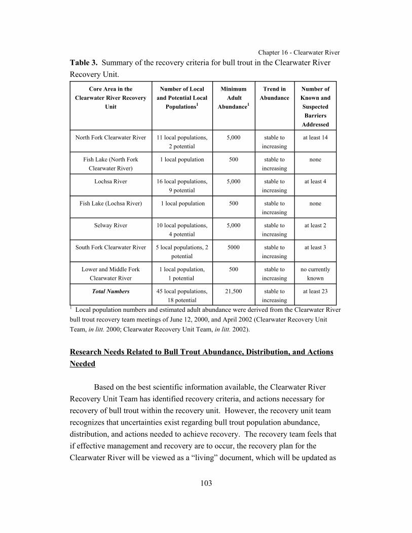
Chapter 16 - Clearwater River
103
Table 3. Summary of the recovery criteria for bull trout in the Clearwater RiverRecovery Unit.
Core Area in theClearwater River Recovery
Unit
Number of Localand Potential Local
Populations1
Minimum Adult
Abundance1
Trend inAbundance
Number ofKnown andSuspectedBarriers
Addressed
North Fork Clearwater River 11 local populations,2 potential
5,000 stable toincreasing
at least 14
Fish Lake (North ForkClearwater River)
1 local population 500 stable toincreasing
none
Lochsa River 16 local populations,9 potential
5,000 stable toincreasing
at least 4
Fish Lake (Lochsa River) 1 local population 500 stable toincreasing
none
Selway River 10 local populations,4 potential
5,000 stable toincreasing
at least 2
South Fork Clearwater River 5 local populations, 2potential
5000 stable toincreasing
at least 3
Lower and Middle ForkClearwater River
1 local population,1 potential
500 stable toincreasing
no currentlyknown
Total Numbers 45 local populations,18 potential
21,500 stable toincreasing
at least 23
1 Local population numbers and estimated adult abundance were derived from the Clearwater Riverbull trout recovery team meetings of June 12, 2000, and April 2002 (Clearwater Recovery UnitTeam, in litt. 2000; Clearwater Recovery Unit Team, in litt. 2002).
Research Needs Related to Bull Trout Abundance, Distribution, and ActionsNeeded
Based on the best scientific information available, the Clearwater RiverRecovery Unit Team has identified recovery criteria, and actions necessary forrecovery of bull trout within the recovery unit. However, the recovery unit teamrecognizes that uncertainties exist regarding bull trout population abundance,distribution, and actions needed to achieve recovery. The recovery team feels thatif effective management and recovery are to occur, the recovery plan for theClearwater River will be viewed as a “living” document, which will be updated as

Chapter 16 - Clearwater River
104
new information becomes available. The recovery unit team will rely on adaptivemanagement to guide recovery implementation. Adaptive management is acontinuing process of planning, monitoring, evaluating management actions, andresearch. Adaptive management will involve a broad spectrum of user groups andwill lay the framework for decision-making relative to recovery implementation andultimately the possible revision of recovery criteria in this recovery unit. As a partof this adaptive management approach, the recovery unit team has identifiedresearch needs which are essential within the recovery unit.
A primary research need is a complete understanding of the current, andfuture, role that the mainstem Snake River should play in the recovery of bull trout. It is likely that a portion of the fluvial bull trout in the Clearwater River basinhistorically migrated into the mainstem Snake River to overwinter and feed, resultingin intermingling with other bull trout populations. The construction of two dams forpower and irrigation in 1925 on the lower Clearwater River 5,027 and 6,764 meters(5,500 and 7,400 yards) above the mouth may have impacted connectivity of bulltrout populations from the Clearwater River Recovery Unit with other recovery units. These dams reduced fish runs in the Clearwater River basin more than any otherfactor because the lower dam (built to provide power) was built without anyprovision for fish passage until 15 years after it was constructed. For example,chinook counts over the diversion dam declined from 335 in 1928, to 103 in 1929, to7 in 1938. Legacy effects include reduced native anadromous fish populations, andmay also include reduced levels or loss of connectivity of Clearwater bull trout localpopulations with other Columbia River basin bull trout local populations.
Uncertainty as to the current use of the mainstem Snake River by fluvial bulltrout that also use the habitat in the recovery unit has led the recovery team to identifybull trout use of the Snake River as a research need. Given that bull trout haverecently been found in the Snake River in the Hells Canyon Complex anddownstream of the mouth of the Grand Ronde River, a better understanding ofmigration patterns between basins would greatly enhance the opportunities forrecovery. The recovery team believes that migrational studies for the ClearwaterRiver Recovery Unit should be coordinated with the Hells Canyon Complex, GrandeRonde, Imnaha, and Salmon River recovery units to provide a more completeunderstanding of adult bull trout habitat requirements.
Chapter 16 - Clearwater River
105
The team has identified an urgent need for the development of a standardizedmonitoring and assessment program which would more accurately describe thecurrent status of bull trout within the recovery unit, as well as identify improvementsin sampling protocols and allow for monitoring the effectiveness of recovery actions. Development and application of models that assess extinction risk relative toabundance and distribution parameters are critical in refining recovery criteria as therecovery process proceeds. In addition, the development of a scientifically basedapproach for detecting bull trout presence is essential for recovery implementation.
This recovery unit chapter is the first step in the planning process for bulltrout recovery in the Clearwater River Recovery Unit. Monitoring and evaluation ofpopulation levels and distribution will be an important component of any adaptivemanagement approach. The Service will take the lead in developing a comprehensivemonitoring approach which will provide guidance and consistency in evaluating bulltrout populations. An important component in the application of adaptivemanagement in recovery implementation will be the evaluation of the implementation of recommended actions and monitoring of their effectiveness.
The effects of Dworshak dam on bull trout populations in the ClearwaterRiver Recovery Unit have been significant and should be researched. Dworshak damdoes not permit any fish passage between the North Fork Clearwater and the rest ofthe Clearwater River basin, except downstream passage on occasion. Bull troutpopulations in the North Fork Clearwater have been isolated from the Lochsa, Selwayand South Fork populations since the dam was constructed in 1971. It is unclear towhat degree these populations interacted prior to construction of the dam. Becausepopulation isolation may affect long-term population survival at the bull troutindividual, local population, and metapopulation levels, genetic and ecologicalstudies are necessary to provide information to determine the effects of isolation dueto Dworshak Dam (CBBTTAT 1998b). Genetic comparisons between thesepopulations would help determine if there is a need to re-establish the connectionbetween these subbasins. In addition, the releases of water from Dworshak Dam havelarge affects on water flows and temperatures in the Clearwater River below the dam. Altered water temperatures may affect the spawning locations of bull trout preyspecies such as fall chinook, resulting in redd placement that is lower in theClearwater and Snake Rivers compared to historic placement. The effects of warmer

Chapter 16 - Clearwater River
106
winter water temperatures and cooler summer water temperatures, resulting from theregulation of Dworshak Dam flows, on bull trout distribution and movements in thelower Clearwater River are unknown and should be investigated (CBBTTAT 1998c). Investigations should also determine whether summer drawdowns of Dworshakreservoir create a thermal barrier at the head of the reservoir, hindering bull troutmigration and access to upstream tributaries in the North Fork core area.
Chapter 16 - Clearwater River
107
ACTIONS NEEDED
Recovery Measures Narrative
In this chapter and all other chapters of the bull trout recovery plan, therecovery measures narrative consists of a hierarchical listing of actions that follows astandard template. The first-tier entries are identical in all chapters and representgeneral recovery tasks under which specific (e.g., third-tier) tasks appear whenappropriate. Second-tier entries also represent general recovery tasks under whichspecific tasks appear. Second-tier tasks that do not include specific third-tier actionsare usually programmatic activities that are applicable across the species’ range; theyappear in italic type. These tasks may or may not have third-tier tasks associated withthem; see Chapter 1 for more explanation. Some second-tier tasks may not besufficiently developed to apply to the recovery unit at this time; they appear in ashaded italic type (as seen here). These tasks are included to preserve consistency innumbering tasks among recovery unit chapters and intended to assist in generatinginformation during the comment period for the draft recovery plan, a period whenadditional tasks may be developed. Third-tier entries are tasks specific to theClearwater River Recovery Unit. They appear in the implementation schedule thatfollows this section and are identified by three numerals separated by periods.
The Clearwater River Recovery Unit chapter should be updated or revised asrecovery tasks are accomplished, or revised as environmental conditions change, andmonitoring results or additional information become available. Revisions to theClearwater River Recovery Unit chapter will likely focus on priority streams orstream segments within core areas where restoration activities occurred, and habitator bull trout populations have shown a positive response. The Clearwater RiverRecovery Unit team should meet annually to prioritize recovery activities, reviewannual monitoring reports and summaries, and make recommendations to the U.S.Fish and Wildlife Service.
1 Protect, restore, and maintain suitable habitat conditions for bull trout.
Chapter 16 - Clearwater River
108
1.1 Maintain or improve water quality in bull trout core areas or potentialcore habitat.
1.1.1 Reduce fine sediment production. Identify and reduce finesediment sources from agriculture and forest managementpractices in watersheds of the Clearwater River Recovery Unit. Stabilize roads, road stream crossings, landslides and otherknown sources of sediment delivery. Implementrecommendations from the U.S. Forest Service and Bureau ofLand Management Watershed Analyses and other plans thatare geared to remediation of sediment production. ImplementBest Management Practices in timber sale planning tominimize sediment production associated with loggingactivities. Monitor the effectiveness of sediment reductionprojects.
Priority watersheds include those with known or potential bulltrout populations. In the North Fork Clearwater and LochsaRiver basins, several watersheds have been intensivelymanaged for timber production and are subject to elevatedsedimentation from the activities and resulting landslides (e.g.Quartz, Cold Springs, Deception, Breakfast, and Fishing(Squaw) Creek watersheds). Roads constructed for loggingand mining are a constant source of sediment in the Fishing(Squaw), Legendary Bear (Papoose), Shotgun, Spruce, Beaver,and lower Boulder Creek watersheds; Red River; Americanand Crooked Rivers; and Newsome Creek. Roads andagricultural practices are sediment sources for Lolo and Clearcreeks. Highway 12 is a source of gravel and fine sediments tothe Lochsa River, Crooked Fork Creek, Middle ForkClearwater River, and the Lower Clearwater River. In theMiddle-Lower Clearwater basin, agricultural practices havecontributed excessive sediment to the Potlatch River.
Chapter 16 - Clearwater River
109
Additional priority sediment sources may be identified in thewatershed analyses conducted in Task 1.3.1.
1.1.2 Address forest road maintenance and areas with high sedimentloading. Identify maintenance needs, exacerbated sedimentproduction areas, and surplus forest roads. Improve roads thatnegatively impact water quality by removal, access restrictions,making alternative routes, and/or upgrading roads and applyingall maintenance procedures. Emphasize maintenance ofextensive U.S. Forest Service and State lands secondary roadsystems by increased application of Best ManagementPractices, with a focus on remediation of sediment producinghotspots, and maintenance of bridges, culverts, and crossings indrainages supporting bull trout spawning and rearing. Decommission/remove surplus forest roads: especially thosethat are chronic sources of fine sediment and/or those locatedin areas of highly erodible geological formations. Removeculverts and/or bridges on closed roads that are no longermaintained. Idaho Department of Lands and U.S. ForestService have made significant efforts in this arena, but areasthat continue to require particular attention include those listedin Task 1.1.1, and any others that are identified in thewatershed analyses conducted in Task 1.3.1. Monitor theeffectiveness of forest road maintenance and sedimentreduction projects.
1.1.3 Identify areas of excess fine sediment delivery due to trail useand implement actions to reduce or eliminate fine sedimentdelivery. Although sediment production from trails is usuallyless than that from roads and landslides, the following areas arecurrently known to receive heavy recreational use, and shouldbe prioritized for surveys and management action. Mainlinetrails used by livestock packers, off-road motorists, andbackpackers follow Kelly Creek, Cayuse Creek, Weitas Creek,

Chapter 16 - Clearwater River
110
and the Little North Fork Clearwater River. Fish Lake (NorthFork Clearwater) is accessed by a well developed off-highwayvehicle (OHV) trail and is one of the only high elevation lakeswhere OHV access is permitted. Riparian areas along theoutlet creek and around the lake may be impacted by OHV use. Impacts to the Fish Lake (Lochsa) inlet stream from stream-side campsites and a ford at Wounded Doe trailhead should beaddressed by efforts to repair cut banks, restore overusedcampsites, construct trail bridges at stream crossings, andrestrict livestock access to the stream. Monitor theeffectiveness of the above sediment reduction projects.
1.1.4 Improve maintenance along transportation corridors. Themaintenance of all major roads along riparian corridors shouldbe improved to reduce impacts of fine sediment and floodplainencroachment. Whenever possible, relocate problem (highsediment-producing) road reaches out of riparian corridors. Locate all dump areas for excess road material in stable uplandareas away from stream/riverbeds. Priority areas include theHighway 12 corridor along Crooked Fork Creek and theLochsa River; the Middle Fork and lower (mainstem)Clearwater Rivers and their major tributaries; the Highway 14corridor along the South Fork Clearwater River; U.S. ForestService Road 233 along Crooked River; the Camas Prairierailroad along the mainstem Clearwater River; U.S. ForestService Roads 247 and 250 from the upper part of Dworshakreservoir to the Cedars campground near the mouths of Longand Lake creeks, and Road 250 from Long Creek to Hoodoopass on the Montana border.
1.1.5 Decrease the potential of, and improve quick responsecapability for, dealing with potential hazardous material spills. Coordinate with Idaho Department of Transportation, IdahoDepartment of Environmental Quality, Idaho Department of

Chapter 16 - Clearwater River
111
Fish and Game, and National Marine Fisheries Service toinvestigate what hazardous materials are being transported onHighway 12 (high priority) and Highway 14. Evaluate theneed to form a task force (including the above agencies andothers) to investigate ways to decrease the potential of ahazardous materials spill and to rapidly respond to such anevent.
1.1.6 Restore areas degraded by historical timber harvest. Legacyimpacts from timber harvest include lack of riparian trees andvegetation, high road densities, large areas of clearcuts, alteredhydrologic regimes including increased peak flows, and otherimpacts that have created excessive fine sediment sources forwatersheds. Potential restoration treatments include channelstabilization, riparian and upland plantings, placement ofinstream woody debris, etc. The following drainages havebeen degraded by historic timber harvest and have embeddedand de-stabilized streams: Quartz, Cold Springs, Skull,Deception, Beaver, Isabella, and Moose creeks; Fishing(Squaw), Legendary Bear (Papoose), Shotgun, Spruce, Beaver,and lower Boulder creeks; Red River, American and CrookedRivers, and Newsome Creek; and Lolo and Clear creeks. Streams in the upper Little North Fork Clearwater Riverinclude Adair, Jungle, Rutledge, and Montana creeks, wherehistoric management has removed streamside vegetation andincreased fine sediment delivery.
1.1.7 Identify problem mine sites and remediate tailings, ponds, andother associated waste. Monitor and control mining runofffrom roads, dumps, and ponds, and remove and stabilize minetailings and waste rock deposited in the stream channel andfloodplains and restore stream channel function. The SouthFork Clearwater River core area has the greatest scope andmagnitude of impacts from mining activities, and the North

Chapter 16 - Clearwater River
112
Fork Clearwater River is second. Top priority watershedswithin the South Fork core area include Newsome Creek andCrooked River, followed by Red, American and mainstemSouth Fork Clearwater Rivers. In the North Fork core area,Moose (Moose and Independence Creek drainages especially)and Chamberlain Creek watersheds are a high priority;followed by Vanderbilt, Niagra and Meadow Creek watershedsand the upper North Fork Clearwater River. Monitor erosioncontrol measures at aggregate pits in the North Fork, SouthFork, and Middle Fork/Lower Clearwater River core areas andmake improvements as necessary.
1.1.8 Assess and mitigate point and nonpoint thermal pollution. Assess and attempt to remove affects to bull trout from thermalpollution that negatively impacts receiving waters andmigratory corridors downstream. Priority watersheds includethose listed (for thermal pollution) in Appendix A 3: SouthFork Clearwater River mainstem and tributaries; Osier Creekand tributaries to Dworshak Reservoir; Lochsa River mainstemand tributaries; major tributaries to the mainstem ClearwaterRiver and their tributaries; as well as Potlatch River, LapwaiCreek, Lolo Creek, and Big Canyon Creek.
1.1.9 Reduce nutrient input. Assess and continue to address effectsof nutrient enrichment from practices associated with forestmanagement in the North Fork and South Fork Clearwater, andLochsa River core areas. Reduce nutrient delivery throughoutthe developed portions of the Lower/Middle Fork and SouthFork core areas by improving sewage disposal, agriculturalpractices, and ranching practices.
1.1.10 Eliminate or reduce the number and length of stream segmentswith impaired water quality. Eliminate or modify factorsresponsible for stream reaches listed as “water quality limited
Chapter 16 - Clearwater River
113
segments” under section 303(d) of the Clean Water Act. SeeAppendix A for a complete list of streams by core area. Moststreams appearing on the 303(d) list do not meet beneficialuses for sediment, some are listed due to temperature, andsome are listed for numerous pollutants including sediment,temperature, nutrients, biochemical contamination, and habitatalteration. Prioritize streams within identified bull trout localpopulations and essential potential local populations (Table 2and recovery criteria 1) and streams identified as providingforaging, migrating, and overwintering habitat. Priority 303(d)list streams by core area include: South Fork Clearwater Rivercore area (Dawson, Buffalo Gulch, Big Elk, Little Elk, Beaver,Nuggett, Sing Lee, and Newsome creeks, and mainstem SouthFork Clearwater River); Lochsa River core area (Storm, Fish,and Deadman creeks, and mainstem Lochsa River); North ForkClearwater River core area (China, Laundry, Osier, Sugar,Swamp, Deception, Gravey, Marten, Cold Springs, Cool,Cougar, Grizzly, Middle, Beaver, Bertha, Bingo, Sourdough,South Fork Beaver, Isabella, Dog, and Floodwood creeks, andmainstem North Fork Clearwater River below DworshakDam); and Middle Fork/Lower Clearwater River core area(Clear, Lolo, Jim Brown, Texas, Schmidt, Yakus, and Mudcreeks, andmainstem Clearwater River). There are no streams in theSelway River core area on the 303(d) list. Priority forrehabilitation of the remaining 303(d) streams should be byproximity to the streams listed above.
1.2 Identify barriers or sites of entrainment for bull trout and implementtasks to provide passage and eliminate entrainment.
1.2.1 Identify culverts and other man-made barriers inhibiting fishpassage. Identify fish passage barriers in all watersheds wherebull trout currently exist and in watersheds that bull trout could
Chapter 16 - Clearwater River
114
potentially occupy. Analyze existing culvert survey datacollected by the U.S. Forest Service, Bureau of LandManagement, State and private landowners to identify culvertsand other barriers inhibiting fish passage Where no surveydata exists, surveys should be conducted by Federal and Stateland managers to identify culverts and barriers inhibiting fishpassage. Each land manager should prepare an annual reportof identified fish passage barriers, including a plan to addresspassage barriers, and progress toward addressing barriers andother accomplishments. Priority should be placed onwatersheds currently occupied by bull trout.
Passage barriers that have been identified within a generallocation and need further investigation on the specific location include: North Fork core area - Little North Fork ClearwaterRiver (two culverts between Butte and Culdesac creeks);Beaver Creek below Sheep Mountain sub-watershed (twoculverts); North Fork Clearwater River above Isabella Creeksub-watershed (three culverts); Death/ Fisher/Trail sub-watershed (two culverts); Cold Springs sub-watershed (oneculvert); Long/Short/Slate sub-watershed (two culverts);Moose Creek sub-watershed (one culvert); Cayuse Creekwatershed (culvert barrier in Mae Creek, a tributary to GraveyCreek).
1.2.2 Eliminate known culvert and other man-made passage barriers(including those identified by task 1.2.1). Utilize data gatheredfrom task 1.2.1 and where beneficial to native fish, replace,modify, or remove existing culverts, bridges, or other man-made barriers that impede passage. Consider native fishgenetic concerns and the potential for invasion by nonnativesin all such evaluations. New culverts should beconstructed/installed to avoid inhibiting passage of all lifehistory phases of fish. New appropriately designed culverts or
Chapter 16 - Clearwater River
115
bridges are recommended at stream crossings in habitat usedby all life stages of bull trout. Monitor all projects aftercompletion to determine if fish passage is restored. Thehighest priority for eliminating passage barriers and re-establishing connectivity is the South Fork River core area,followed in priority order by the Lochsa, North ForkClearwater, Lower/Middle Fork Clearwater, and Selway Rivercore areas.
Known passage barriers that need to be addressed include:South Fork Clearwater River core area - Modify the culvert(or replace with a bridge) on U.S. Forest Service Road 222(T26N, R8E, S3) in South Fork Red River to allow upstreampassage of age one and older bull trout. Replace the privateroad culvert at confluence of East Fork American River withAmerican River to allow upstream passage of age one andolder bull trout. Modify or replace the culvert on the countyroad crossing in Big Elk Creek approximately 0.65 milesupstream from Little Elk Creek confluence. Lochsa Rivercore area - Modify or replace the culvert on U.S. ForestService Road 108 to allow bull trout passage to the West ForkFishing (Squaw) Creek. Modify or replace impassable culvertsof Highway 12 to allow bull trout passage into Badger, ColdStorage, and Noseeum creeks. Selway River core area - Modify or replace the culvert on U.S. Forest Service Road 223at the mouth of Boyd Creek to allow bull trout access to unoccupied habitat.
1.2.3 Consider providing passage around natural barriers. Evaluateremoval of natural “semi-permanent” fish passage barriers(such as debris dams) and implement if necessary. Theremoval of the barriers should be evaluated to determine theireffects and potential to increase habitat accessibility for bulltrout. Evaluate and make recommendations concerning

Chapter 16 - Clearwater River
116
potential benefits of fish passage around, or establishment ofresident bull trout populations upstream from, natural barriersas a means of conserving genetic diversity in existing bull troutpopulations. Several known barriers exist, and others wouldneed to be identified through stream surveys. Known naturalbarriers exist in: upper Brushy Fork, Pack, Warm Springs,Shotgun, and Big Sand, Crab, Old Man, and Deadman creeksin the Lochsa River core area; South Fork Kelly, Orogrande,and Foehl creeks in the North Fork Clearwater core area; andTwenty-mile Creek in the South Fork Clearwater core area.
1.3 Identify impaired stream channel and riparian areas and implementtasks to restore their appropriate functions.
1.3.1 Conduct watershed assessments in the North Fork, South Fork,and Middle/Lower Clearwater River, and Lochsa Core Areas. Watershed analysis is an assessment procedure used tounderstand the condition, trend, and interactions in awatershed. Key components of an analysis include evaluationsof the transportation system, upland and riparian vegetation,social and human uses, and the aquatic habitat and speciesstatus. These assessments provide understanding of themanagement opportunities and needs within an area, andshould facilitate project identification and prioritization forplanning. Assessments include management recommendationson road maintenance needs and road removal, fish passagebarrier removals, riparian vegetation management, and woodydebris placement or removal. Such assessments have not beendone for the majority of the key bull trout watersheds in therecovery unit. Watershed analysis should be a high priority forRed, American, and Crooked Rivers and Newsome Creek (inprogress, to be completed in 2002) (South Fork ClearwaterRiver core area); Crooked Fork and tributaries, Brushy Forkand tributaries, Colt Killed Creek and tributaries, Walton andWarm Springs creeks, Lochsa River (Loshsa River core area);
Chapter 16 - Clearwater River
117
Middle Fork Clearwater River, Clear and Lolo creeks(Middle/Lower Clearwater River core area); North and SouthForks Kelly Creek, Gravey, Long, Slate, Short, Lake, Goose,Weitas, Beaver, Isabella, and Floodwood creeks (North ForkClearwater River core area). Other priority areas includeknown or suspected spawning and rearing streams, foragingand migratory habitat, and potential spawning, rearing andforaging habitat throughout the recovery unit.
1.3.2 Revegetate denuded riparian areas. Develop site specific plansto promote revegetation of riparian areas to ensure sufficientshade and canopy, large woody debris recruitment, ripariancover, and native vegetation are present to support nativesalmonids. Highest priority is on streams with existing bulltrout populations. Revegetate riparian areas affected bylogging in: Kelly Creek drainage, particularly in the MooseCreek and Cayuse Creek watersheds (North Fork ClearwaterRiver core area); lower Red River, Crooked River along U.S.Forest Service Road #233, mainstem of upper South ForkClearwater River (South Fork Clearwater River core area); andother watersheds as identified in watershed assessments (Task1.3.1). Restore riparian vegetation removed by fire and timbersalvage along the lower 3.2 kilometers (2 miles) of West ForkFloodwood Creek. Restore riparian vegetation removed byfires in: Hidden, Isabella, Skull, Quartz creeks (North ForkClearwater River core area); and Haskell and Crooked Forkcreeks (Lochsa River core area).
1.3.3 Restore stream reaches degraded by dredge and placer mining. Restore habitat, as feasible, in stream reaches that have beenchannelized and affected by mine tailing piles in the MooseCreek watershed of the North Fork Clearwater River core area. Mining activities in the South Fork Clearwater core area havebeen extensive in the Crooked and American River, andNewsome Creek watersheds, and to a lesser degree in the Red
Chapter 16 - Clearwater River
118
River watershed. Restoration of mainstem reaches is critical toimproving connectivity for fluvial fish between localpopulations in this core area. Restoration of lower and middleCrooked River, and Newsome Creek is a high priority.
1.3.4 Improve instream habitat. Conduct stream restoration in areasimpacted by legacy and ongoing road effects, logging,agriculture, grazing, and urban development, stream cleaning,and mining. Increase or improve instream habitat by restoringrecruitment of large woody debris, pools, or other appropriatehabitat, wherever the need is identified. Priority watershedsinclude the upper North Fork Clearwater River, includingMeadow, Caledonia, Vanderbilt, and Niagara creeks (NorthFork Clearwater River core area); the upper Lochsa Riverdrainage, including North Fork Spruce, Shoot, Twin,Legendary Bear (Papoose), and Fishing (Squaw) creeks(Lochsa River core area); upper South Fork Clearwatermainstem, American, Red and Crooked Rivers and NewsomeCreek (South Fork Clearwater River core area); and Lolo andClear creeks (Middle/Lower Clearwater River core area). Improve instream habitat for other priority areas identified bywatershed assessments (Task 1.3.1).
1.3.5 Evaluate and implement actions to restore areas of Fish LakeCreek (Lochsa River) degraded by channelization andexcessive bank erosion associated with the Fish Lake airstripand campsites. Restore over-used campsites, reduce erosion onexposed banks, restrict pack animals from the stream, andconstruct trail bridges at two popular crossings (one at thetrailhead). Evaluate the potential of restoring a naturalmeander pattern in the channelized reach of the inlet stream,either on the airstrip (where it was originally), or in themeadow complex to the southeast of the airstrip.
Chapter 16 - Clearwater River
119
1.3.6 Evaluate and implement actions to restore degraded riparianhabitat at Fish Lake (North Fork core area). Fish Lake (NorthFork Clearwater) is accessed by a well developed off-highwayvehicle (OHV) trail and is one of the only high elevation lakeswhere access is permitted. Riparian areas along the outletcreek and around the lake may be impacted by OHV use.
1.3.7 Identify and restore riparian areas where livestock grazing isimpacting bull trout habitat. Identify problem areascooperatively with U.S. Fish and Wildlife Service, NaturalResource Conservation Service, and land management agencypersonnel and private landowners. Revise grazingmanagement plans to include performance standards thatmaintain stream channel condition that maintains high qualitybull trout habitat and continue to enforce those already inplace. Fence riparian areas to eliminate riparian degradationfrom grazing in problem areas. Monitor fencing effectivenessalong riparian areas on Lolo Creek and its tributaries fromCottonwood Flats to the U.S. Forest Service boundary. Otherpriority areas include private land in lower Elk Creek(American River tributary); private land in lower and middleportions of the Red River; and private land in Clear Creek.
1.3.8 Identify riparian areas threatened by nonnative plant invasion,and evaluate and implement actions to restore nativevegetation. Nonnative plant species compete with nativeriparian vegetation and affect aquatic habitat by altering naturalecological processes, with potential instream impacts ofincreased sedimentation and water temperatures, and decreasedcover and woody debris. Bull trout spawning and rearinghabitats have higher priority, particularly in such areas as theLochsa, South Fork, and North Fork Clearwater, and PotlatchRivers, and major tributaries paralleled by roads. Evaluatepotential methods to control nonnative plant invasion andimplement where necessary.
Chapter 16 - Clearwater River
120
1.3.9 Improve stream channels near transportation corridors. Improve stream conditions where current and legacy highwayand railroad encroachment, channel straightening, channelrelocation, and undersized bridges exist. Coordinate withhighway departments to minimize impacts of planned orexisting highways on bull trout habitat. Initial areas to focusefforts include: the Lochsa River Highway 12 corridor, SouthFork Clearwater Highway 14 corridor, Middle Fork/LowerClearwater River railroad, and Highway 12 corridors. Highway 12 has reduced large wood recruitment and access tooff-channel habitat in the Lochsa River, Crooked Fork Creek,and Middle Fork Clearwater River.
1.3.10 Identify areas in which secondary roads have been constructedin the floodplain and implement restoration actions. Theseroads have displaced riparian vegetation and are a constantsource of fine sediment to the streams. Appropriate remedialmeasures should be developed and implemented. Priority areasinclude those in occupied bull trout habitat: Fishing (Squaw)and Legendary Bear (Papoose), North Fork Spruce and Shootcreeks (Lochsa River core area); Red River, Crooked andAmerican Rivers, and Newsome Creek (South Fork ClearwaterRiver core area); and Kelly, Cayuse, and upper North ForkClearwater River (North Fork Clearwater core area). Includeother priority areas identified by watershed assessments (Task1.3.1).
1.3.11 Reduce campsite impacts. Identify areas of impact anddevelop methods to reduce impacts of concentrated anddispersed campsites in riparian areas. Priority areas includeoccupied bull trout habitat. Examples are mining camps in theMoose Creek drainage (North Fork Clearwater core area); andcampsites along the upper North Fork and South ForkClearwater, Lochsa, and lower Selway Rivers, and NewsomeCreek.

Chapter 16 - Clearwater River
121
1.3.12 Minimize potential stream channel degradation from floodcontrol and response actions. Identify negative effects to bulltrout from ongoing flood control activities (e.g., dredging,channel clearing, bank stabilization, bank barbs and otherstructures or actions) and address where possible. Minimizefuture negative effects to bull trout habitat from flood controlactivities by coordinating with responsible agencies indevelopment of flood control and response plans. Initial areasto focus include the South Fork and Middle/Lower ClearwaterRiver core areas.
1.3.13 Evaluate overwintering habitat in the mainstem rivers. Identifyspecific overwintering areas utilized by bull trout in themainstem rivers in the recovery unit and classify generaloverwintering habitat. Survey the habitat conditions inoverwintering habitat areas to determine if it is degraded andcould be restored. Determine if unoccupied overwinteringhabitat areas are degraded by sediment accumulation orthrough bedload movement, and would have potential to beutilized, if restored. Agricultural practices have caused heavysoil erosion, and altered the timing, peak, and magnitude offlows; resulting in high bedload, channel aggradation, andembeddedness in these mainstem rivers and their largertributaries.
1.3.14 Implement restoration of overwintering habitat in the mainstemrivers, if needed. Implement necessary restoration activities toimprove overwintering habitat, as identified by Task 1.3.13. Priority areas include the Middle Fork/Lower and South ForkClearwater Rivers.
1.4 Operate dams to minimize negative effects on bull trout in reservoirsand downstream.
Chapter 16 - Clearwater River
122
1.4.1 Evaluate direct losses of bull trout through Dworshak Dam. Drawdowns of Dworshak Reservoir can entrain bull trout andcarry them into the mainstem Clearwater. In addition tocausing a direct loss of individuals (and their genetic material)from local populations in the North Fork Clearwater River corearea, these fish probably have low survival after entrainment. The loss of individuals from the upriver core area should bequantified and then evaluated in terms of its significance tolong-term sustainability of the affected local populations.
1.4.2 Operate Dworshak Dam to reduce losses of kokanee salmon. Substantial numbers of kokanee, which have been introducedinto Dworshak Reservoir and are a forage fish for bull trout,can be entrained below the dam during spills. Methods toreduce kokanee losses should be evaluated and implemented.
1.4.3 Evaluate the impact of summer drawdowns of Dworshakreservoir on upstream migration of bull trout. Summerdrawdowns may create a thermal barrier at the head of thereservoir that may hinder bull trout migration and access toupstream tributaries in the North Fork core area. If upstreammigration is hindered, evaluate options of limiting drawdownsor trapping and transporting bull trout above the thermalbarrier.
1.5 Identify upland conditions negatively affecting bull trout habitat andimplement tasks to restore appropriate functions.
1.5.1 Monitor and mitigate fire effects, where necessary. Monitoreffects from wildfires and pursue habitat restoration actionswhere warranted. Adhere to programmatic fire suppressionBiological Assessments and concurrence letters issued by theU.S. Forest Service and Bureau of Land Management. Prioritize upland and stream restoration where recent fires haveoccurred and impacted bull trout habitat, including: Haskell
Chapter 16 - Clearwater River
123
and Crooked Fork creeks (Lochsa River core area), andHidden, Quartz, Skull, upper Isabella, and West ForkFloodwood creeks (North Fork Clearwater River core area).
1.5.2 Compensate for legacy timber harvest and associated roadingpractices. Continue to mitigate for the legacy of intensivetimber harvest and poor silvicultural and road constructionpractices in steep and highly erosive canyon breaklands. Pastclearcutting practices and high density jammer-type roadsystems have resulted in mass wasting events and continuederosion and sediment introduction into bull trout habitat. Practices such as replanting, obliterating roads, and improvingmaintenance of roads should be continued and new techniquesimplemented. Priority areas include the upper Lochsa Rivercheckerboard ownership areas (Lochsa River core area); Lake,Moose, Osier, Quartz, Skull, Orogrande, Sheep Mountain,Beaver Block, Floodwood, and Breakfast Creek drainages(North Fork Clearwater River core area); Red River, NewsomeCreek, and American River (South Fork Clearwater River corearea); Clear and Lolo creeks (Middle/Lower Clearwater Rivercore area).
2 Prevent and reduce negative effects of nonnative fishes and other nonnativetaxa on bull trout.
2.1 Develop, implement, and enforce public and private fish stockingpolicies to reduce stocking of nonnative fishes that affect bull trout.
2.2 Enforce policies for preventing illegal transport and introduction ofnonnative fishes.
2.3 Provide information to the public about ecosystem concerns of illegalintroductions of nonnative fishes.

Chapter 16 - Clearwater River
124
2.3.1 Discourage unauthorized fish introductions. Focus anintensive public outreach campaign on the Clearwater basin toreduce the potential spread of illegally introduced nonnativefish species.
2.3.2 Develop a bull trout education program. Develop a publicinformation program with an emphasis on bull trout ecologyand life history requirements and more specific focus onregionally or locally important recovery issues. Coordinatewith Idaho Department of Fish and Game and the U.S. ForestService to utilize existing programs and develop an interagencyprogram, if possible.
2.4 Evaluate biological, economic, and social effects of control ofnonnative fishes.
2.4.1 Identify overlap in bull trout and nonnative fish (brook trout)distribution in all core areas. Utilize existing stream and fishsurvey data, and conduct surveys in unsurveyed areas. Prioritize local population areas where spawning and rearinghas been documented, followed by potential local populationareas. Evaluate potential effects of control of each overlappingbrook trout population.
2.4.2 Develop protocols for suppressing nonnative fish and monitorimpacts of ongoing actions. Continue to conduct research anddevelop protocols to describe the most effective methods forsuppressing or eradicating brook trout populations from waterswhere they currently, or may in the future, negatively impactbull trout recovery in the Clearwater River system. Monitorthe impact of the bonus brook trout limit in the ClearwaterRiver Recovery Unit on reducing populations and limitingexpansion of brook trout.
2.5 Implement control of nonnative fishes where found to be feasible andappropriate.
Chapter 16 - Clearwater River
125
2.5.1 Reduce brook trout competition with bull trout where they areknown to coexist, and where brook trout numbers are relativelylow. Evaluate opportunities for selectively removing brooktrout (e.g., through liberalized angling and electrofishing) inareas where brook trout densities are relatively low and notexpanding, and where there is a potential problem ofcompetition with bull trout. Priorities include upper CrookedRiver (South Fork Clearwater River core area); Adair andJungle creeks in the upper Little North Fork Clearwater River(North Fork Clearwater River core area); and Colt KilledCreek and its tributaries (Lochsa River core area).
2.5.2 Experimentally remove established brook trout populations
from priority streams. Evaluate the feasibility of removingbrook trout and develop an appropriate program. Where brooktrout appear to be expanding in distribution in areas that offersuitable habitat for bull trout, eradication may be needed. Upper Crooked River and Fish Lake Creek (Lochsa core area)are areas where the threat from brook trout hybridization andcompetition can be reduced or forestalled by active removal ofbrook trout from the lakes and/or streams. Evaluate thepotential of removal of established brook trout populations in: Meadow Creek drainage and associated high mountain lakes inthe North Fork Clearwater core area, Elizabeth, Isabella,Larson, and Beaver creeks (North Fork Clearwater core area);Bimerick, Deadman, Stanley, Boulder, and Old Man creeks(Lochsa River core area); Yoosa and Musselshell Creekdrainages of Lolo Creek, and Kay Creek (tributary of ClearCreek) (Middle/Lower Clearwater core area).
2.5.3 Monitor brook trout expansion and prevent brook trout fromentering areas that overlap with occupied and unoccupied bulltrout habitat, wherever possible. Monitor fish speciesdistribution and trends in areas where the two species do notcurrently coexist and where the threat from brook trout appears

Chapter 16 - Clearwater River
126
to be small, to increase understanding of the threat these brooktrout represent. Known areas include Newsome Creek, andupper Crooked River where low numbers of brook trout havebeen found in the lower ends of the mainstems. Other areasinclude Orogrande Creek in the North Fork Clearwater corearea; and dependent upon wilderness use/managementconstraints, Three Links, Gedney, Rhoda, Meadow, Mink,Buck Lake, Pettibone, and Running creeks in the Selway-Bitterroot Wilderness.
2.5.4 Evaluate extent of hybridization between bull and brook troutin areas where brook trout are firmly established anderadication is not possible. In areas where brook trout arefirmly established and there is little opportunity to reduce thethreat to bull trout, the priority should be genetic evaluation ofthe extent of hybridization that has occurred, along withcontinued trend analysis of the distribution and populations ofboth species. Priority areas are Red and American Rivers(South Fork Clearwater River core area); and East MooseCreek in the Selway core area.
2.6 Develop tasks to reduce negative effects of nonnative taxa on bulltrout.
3 Establish fisheries management goals and objectives compatible with bulltrout recovery, and implement practices to achieve goals.
3.1 Develop and implement State and tribal native fish management plansintegrating adaptive research.
3.1.1 Develop a comprehensive fishery management plan for theClearwater River Recovery Unit incorporating bull troutrecovery and utilizing adaptive management. Develop andimplement native fish management plans that emphasizeintegration of research into management programs. Integrate
Chapter 16 - Clearwater River
127
bull trout recovery objectives and management plans foranadromous fish recovery; as management actions that supportrecovery of steelhead and salmon species will be beneficial forbull trout by improving prey base and habitat for coldwatersalmonids.
3.2 Evaluate and prevent harvest and incidental angling mortality of bulltrout.
3.2.1 Evaluate the amount and relative threat of illegal bull troutharvest and incidental fishing mortality. Information on thecurrent threat of illegal harvest and fishing mortality on bulltrout is very limited. An evaluation of these threats should becompleted to determine their significance to bull trout recoveryand potential management opportunities to minimize theirimpacts. The level of threat should be evaluated within anoverall Clearwater River Recovery Unit context, and alsoevaluated with respect to other mortality threats for each localpopulation (or logical combinations of local populations). Seasonal road closures should be implemented where roadsreadily access bull trout spawning areas, and illegal bull troutharvest is determined to be significant. Focus areas shouldinclude: Fish Lakes (North Fork and Lochsa core areas);Selway River below Meadow Creek and near Moose andShearer airstrips; Red and Crooked Rivers; North ForkClearwater River below Dworshak Dam; upper North ForkClearwater River in Black Canyon and above Long Creek; andCrooked Fork and Colt Killed creeks and upper Lochsa River. This evaluation should consider the need for additional publicawareness and outreach, which should be implementedwherever access to public lands is restricted.
3.2.2 Continue public outreach about fishing regulations, bull troutidentification, and proper handling/release techniques. Maintain signs that are currently posted on Federal and State

Chapter 16 - Clearwater River
128
land throughout the recovery unit. Display posters (the “BullTrout Alert” poster) annually, especially at angling accessareas and backcountry portals such as trailheads. Sign boardsand posters should be displayed at backcountry airstrips at FishLake (Lochsa River core area); Moose Creek and Shearer(Selway River core area). Produce educational materials(pamphlets, wallet cards, etc.) for anglers addressing bull troutidentification, proper handling and release techniques to reducehooking mortality, regulations, and reasons for protectiveregulations. Distribute materials using U.S. Forest Service,Idaho Department of Fish and Game, and Bureau of LandManagement personnel and offices; local businesses; andtourism centers.
3.2.4 Decrease incidental mortality of bull trout due to angling.Conduct additional patrols in sensitive areas at critical times. Consider regulation changes such as tributary closures toprotect bull trout. Patrols should focus on identified staging(June to August), spawning (September to October), andwintering (November to March) areas for bull trout. Stagingareas include larger mainstem streams below headwatertributaries, such as Black Canyon of the North Fork ClearwaterRiver. Wintering areas include large mainstem rivers at lowerelevations, such as the Middle Fork and lower ClearwaterRivers. For example, incidental mortality of wintering fluvialbull trout may be occurring during the winter and springsteelhead/salmon seasons in the Clearwater River.
3.2.5 Increase enforcement activities relating to the no bull troutharvest regulations. Specifically target known or identified(Task 3.2.1) problem areas where unauthorized harvest of bulltrout is occurring. Increase backcountry enforcement patrols inthe Selway-Bitterroot Wilderness around human concentrationareas and near spawning and rearing areas. Increaseenforcement patrols at the two Fish Lakes. Increase
Chapter 16 - Clearwater River
129
enforcement along mainstem rivers paralleled by roads,especially in areas with late winter and spring steelhead andsalmon fishing seasons. Also target known problem areas onthe lower Selway, upper North Fork Clearwater, and upperLochsa Rivers.
3.2.6 Inform the public about bull trout issues and general fisheriesbiology and management issues. Develop an outreach programto inform the general public, and key contacts such as anglersand outfitters/guides, about bull trout issues and generalfisheries biology and management issues. Evaluate thepotential of combining bull trout outreach with other fishconservation efforts. Begin efforts through the news mediaand other means to inform the public, emphasis should be onbull trout and bull trout recovery efforts being made by variousagencies and other entities. Develop a school program andpresent information at local area schools.
3.3 Evaluate potential effects of introduced fishes and associated sportfisheries on bull trout recovery and implement tasks to minimizenegative effects on bull trout.
3.3.1 Evaluate the potential for release of excess hatchery stock ofanadromous fish into occupied bull trout habitat. Evaluate thepositive and potential negative impacts of anadromous fishstocking programs currently operating in the Clearwater RiverRecovery Unit. The Lochsa, Selway and Middle Fork of theClearwater Rivers historically sustained much largerpopulations of anadromous fish, which supported largerpopulations of bull trout. Release of excess hatchery stock inareas where bull trout and anadromous fish historicallycoexisted, and where anadromous populations are currentlydepressed, may aid bull trout recovery. Such streams includeCrooked Fork and Colt Killed creeks, and the Lochsa, Selway,and South Fork Clearwater Rivers. Review annual fish
Chapter 16 - Clearwater River
130
stocking programs to assure those programs for anadromousfish are not contributing fish diseases, exotic invertebrates orother problems such as increased competition, that couldinterfere with bull trout recovery.
3.4 Evaluate effects of existing and proposed sport fishing regulations onbull trout.
3.4.1 Evaluate effects of existing and proposed angling regulationson bull trout. Evaluate the impacts of rapidly increasing anglerpressure on adequacy of angling regulations to protect bulltrout, unintentional mortality and other angler-related issuesaffecting bull trout. Target the most heavily fished waters suchas Kelly Creek, Lochsa River and main tributaries, and lowerSelway River.
3.4.2 Evaluate the impact of the sport fishing season in the two FishLake core areas on the adfluvial bull trout populations. TheNorth Fork Clearwater Fish Lake sport season for cutthroattrout opens August 1 and closes in mid-fall. The Lochsa FishLake sport season is a general season. Both lakes draw heavyrecreational pressure, and heavy fishing pressure. The impactsof these sport seasons on bull trout spawning, and illegal andhooking mortality should be investigated and appropriateactions taken if recovery of bull trout is impacted.
3.4.3 Evaluate the impact of the bonus brook trout limit in theClearwater River Recovery Unit and increase the limit, ifpossible. Investigate the result of the increased brook troutlimit on reducing populations and limiting expansion of brooktrout. Maintain these regulations and increase the limit wherenecessary to achieve objectives of removing brook troutcompetition and hybridization threats to bull trout recovery.
Chapter 16 - Clearwater River
131
4 Characterize, conserve, and monitor genetic diversity and gene flow amonglocal populations of bull trout.
4.1 Incorporate conservation of genetic and phenotypic attributes of bulltrout into recovery and management plans.
4.1.1 Conduct a genetic inventory. Collect samples for geneticanalysis to contribute to establishing a program to understandthe genetic baseline and monitor genetic changes throughoutthe range of bull trout (see Chapter 1 narrative). Collectgenetic samples from known spawning and rearing streams(local populations), with priority given to populations wherehybridization with brook trout presents the most imminentthreat. Evaluate genetic diversity and the extent ofhybridization. This information will be valuable for theconservation of the species across its range, and if localpopulations are extirpated within the Clearwater RiverRecovery Unit, this research may indicate what population maybe best for future reintroduction efforts. Incorporateinformation and recommendations into management plans.
4.1.2 Describe and monitor genetic and phenotypic characteristics ofbull trout in all core areas, and incorporate information intomanagement strategies. The interaction of bull trout geneticcomposition with particular environments results in phenotypicdiversity and perhaps local adaption. Such information forparticular groups of bull trout and their habitat should begenerated for all core areas in the Clearwater River RecoveryUnit, and incorporated into management strategies to improvetheir effectiveness. Develop a phenotypic and/ormorphometric key to separate, if possible, resident from fluvialor adfluvial bull trout.
4.2 Maintain existing opportunities for gene flow among bull troutpopulations.

Chapter 16 - Clearwater River
132
4.2.1 Investigate additional opportunities to improve passage. Utilizeinformation from task 4.1.1 to maintain current geneticinterchange between local populations and core areas. Conduct further surveys to identify passage barriers that mayinhibit genetic interchange; priority areas include the SouthFork Clearwater and Lochsa River core areas. Annuallymonitor “problem areas” where recreationists construct man-made check dams to create swimming holes (i.e., AmericanRiver and Lolo Creek-Woodland Bridge area). Theseunauthorized dams may block fish passage if not removed. Coordinate with management agencies to retain existingconnectivity as management actions are planned by preventingthe establishment of barriers (e.g., structural barriers orunsuitable habitat conditions), that may inhibit the movementof bull trout within the Clearwater River Recovery Unit.
4.3 Develop genetic management plans and guidelines for appropriate useof transplantation and artificial propagation.
4.3.1 Evaluate the need for reestablishing genetic connectivitybetween the North Fork Clearwater River and the remainder ofthe recovery unit. Based on research determinations of thedegree of genetic isolation between the North Fork Clearwaterand the Lochsa, Selway and South Fork Clearwater bull troutlocal populations and related management recommendations(Task 4.1.1), evaluate the need for re-establishing theconnection between these subbasins. If connection is needed,investigate fish passage opportunities downstream andupstream over Dworshak Dam. Evaluate the potential for atrap and transport facility at the base of the dam for upstreammigrants and at the head of the reservoir for downstreammigrants.
Chapter 16 - Clearwater River
133
5 Conduct research and monitoring to implement and evaluate bull troutrecovery activities, consistent with an adaptive management approach usingfeedback from implemented, site-specific recovery tasks.
5.1 Design and implement a standardized monitoring program to assessthe effectiveness of recovery efforts affecting bull trout and theirhabitat.
5.1.1 Develop coordination infrastructure to facilitate restoration. Restoration efforts in the Clearwater River Recovery Unit donot appear to be well coordinated among the various agenciesand publics. No forum for the exchange of restorationinformation, projects, and strategies appears to be in place. Existing work groups such as the Clearwater Basin AdvisoryGroup should consider opportunities for facilitating theestablishment of a group to coordinate the restoration in therecovery unit. Develop a GIS database to track progress onimplementation of recovery tasks, and data collected from bulltrout inventories, monitoring, and research. These would beaccessible to all participating entities and managed by a centralparty (e.g., Idaho Department of Fish and Game, ConservationData Center). Coordinate development of this database withBonneville Power Association’s Restoration TrackingProgram, currently in development.
5.1.2 Implement the population monitoring strategy identified for theClearwater River Recovery Unit. Implement the initialmonitoring strategy and revise the strategy as necessary underthe principles of adaptive management. Add a monitoringcomponent for the potential local populations that areidentified as essential for recovery.
5.2 Conduct research evaluating relationships among bull troutdistribution and abundance, bull trout habitat, and recovery tasks.
Chapter 16 - Clearwater River
134
5.2.1 Determine the abundance of fluvial, adfluvial, and resident bulltrout and habitat used in the Clearwater River Recovery Unit. Continue implementation of existing bull trout populationabundance and distribution studies, and initiate new studies. Identify and map the extent of habitat utilized by each localpopulation. For fluvial bull trout, continue to determinespawning and wintering habitat and migratory pathways. Conduct studies similar to those ongoing in the North ForkClearwater River and throughout the recovery unit. Priorityareas include local populations identified in Table 2.
5.2.2 Develop and implement protocol to estimate the mortalityfactors for local populations. Evaluate the factors comprisingtotal annual mortality for local populations and use thisinformation to refine current understanding of threat and riskfor local populations. Revise recovery management strategiesand actions for local populations to include this research,according to principles of adaptive management.
5.2.3 Map spawning habitat. Develop a comprehensive map ofprimary bull trout tributary spawning reaches in all core areaswithin the Clearwater River Recovery Unit, for focusinghabitat protection and recovery efforts.
5.2.4 Conduct presence/absence surveys in previously uninventoriedareas. Areas of the Clearwater River Recovery Unit, especiallywilderness areas, have not yet been fully inventoried. Utilizesurvey protocols that can assign confidence limits to surveyresults. Balance the need to have statistically significantsurvey results with the difficulty of accessing remote areas forthe surveys. Priority areas include the Selway-Bitterroot andGospel Hump wilderness areas and priority areas designated bylocal biologists.
Chapter 16 - Clearwater River
135
5.2.5 Evaluate water temperature as a limiting factor. Determine therange of temperature tolerances for bull trout life stages indifferent local populations and habitats within the ClearwaterRiver Recovery Unit. Evaluate the suitability of temperatureregimes in currently occupied and potential bull trout habitat. Identify potential thermal migration barriers within therecovery unit.
5.2.6 Identify suitable unoccupied habitat. Identify suitableunoccupied habitat in the Clearwater River Recovery Unit thatmight be reconnected or enhanced to increase recruitment ofbull trout to the system. Within five years complete acomprehensive list of all known passage barriers blockingaccess to suitable habitat by upstream migrating bull trout. Consider establishment of resident bull trout populationsupstream from natural barriers to provide a genetic reserve.
5.2.7 Evaluate importance of contributing waters. Evaluate theimportance and contribution to bull trout recovery of streamswith only incidental bull trout presence. Develop a management strategy for contributing waters that aredetermined to negatively impact occupied (local populations)or necessary core habitat (potential local populations). Includestrategy in overall Clearwater Recovery Unit bull troutmanagement plan (Task 3.1.1).
5.3 Conduct evaluations of the adequacy and effectiveness of current andpast best management practices in maintaining or achieving habitatconditions conducive to bull trout recovery.
5.3.1 Evaluate existing Best Management Practices to determine ifthey provide for conditions necessary for bull trout recovery. Continue and expand monitoring of compliance andeffectiveness of Idaho Best Management Practices to ensurethey are implemented as described in the Idaho Forest Practice
Chapter 16 - Clearwater River
136
Act. Recommend adjustments to and revise Best ManagementPractices to correct any documented deficiencies where thosepractices provide inadequate protection to bull trout on Stateand private lands. Priority areas include: the upper LochsaRiver core area; the South Fork Clearwater River core area; theBeaver Block, Floodwood Creek, Little North Fork River,Moose and Chamberlain creeks in the North Fork ClearwaterRiver core area; and the Lower/Middle Fork Clearwater corearea, particularly Clear and Lolo Creek drainages.
5.4 Evaluate the effects of diseases and parasites on bull trout, anddevelop and implement strategies to minimize negative effects.
5.5 Implement research and monitoring studies to improve informationconcerning the distribution and status of bull trout, as described inChapter 1.
5.5.1 Conduct migrational studies for the Clearwater River RecoveryUnit and coordinate with the Hells Canyon Complex, GrandeRonde, Imnaha, and Salmon River recovery units. Thisinformation is necessary to provide a more completeunderstanding of adult bull trout habitat requirements, and theinterrelationship of fluvial populations between the recoveryunits.
5.6 Identify evaluations needed to improve understanding of relationshipsamong genetic characteristics, phenotypic traits, and local populationsof bull trout.
5.6.1 Determine the life history requirements of resident andmigratory bull trout populations. The recovery unit has bothresident and migratory (fluvial) local populations. Anunderstanding of the life history habitat requirements andinteractions of resident and fluvial fish will assist with

Chapter 16 - Clearwater River
137
identification of recovery of bull trout in the Clearwater Riverbasin.
6 Use all available conservation programs and regulations to protect andconserve bull trout and bull trout habitat.
6.1 Use partnerships and collaborative processes to protect, maintain, andrestore functioning core areas for bull trout.
6.1.1 Provide long-term protection of perennial stream reaches. Work cooperatively with private landowners and the NaturalResource Conservation Service to provide voluntary incentivesfor long-term habitat protection. Some habitat important forbull trout recovery, especially migratory, foraging, andoverwintering habitat, occurs on private lands and may needprotection to maintain conditions conducive to bull troutrecovery. A variety of cooperative arrangements could bemade with landowners to protect and restore habitat on theirland. Where possible combine efforts for bull trout withanadromous fish recovery efforts. Initial emphasis should beplaced on identified bull trout spawning and rearing streams. Priority areas include Red and American Rivers and NewsomeCreek (South Fork Clearwater River core area); Brushy Fork,Spruce, Twin, Crooked Fork, Legendary Bear, and Colt Killedcreeks; Floodwood Creek; Beaver Creek (North ForkClearwater River core area); and Clear and Lolo creeks(Middle/Lower Clearwater River core area).
6.1.2 Work collaboratively with county and city land use planners tominimize urbanization impacts on bull trout recovery. Countyand city land use planning provides an opportunity to minimizeurbanization and development impacts and help mitigatedevelopment to sustain existing aquatic species.
Chapter 16 - Clearwater River
138
6.1.3 Identify opportunities for habitat restoration and provideassistance to landowners. Some important bull trout habitatoccurring on private land may require restoration to re-establish adequate conditions. Expand current efforts to workwith landowners to identify opportunities for restoration andprovide increased technical assistance; use existing Federal,State, and Tribal cost-share programs and Farm Bill programssuch as the Conservation Reserve Program and WetlandReserve Program to implement actions.
6.1.4 Integrate watershed restoration efforts on public and privatelands. Integrate watershed analyses and restoration activitieson public lands in the headwaters and private lands, whichoccur primarily lower in the watershed, to ensure that activitiesmaximize benefits and are complementary to bull troutrestoration (e.g., upper Lochsa River checkerboard ownershipareas, and Red, American, and Crooked Fork Rivers).
6.1.5 Encourage floodplain protection. Encourage local and Stategovernments to develop, implement, and promote floodplainand lakeshore protection regulations in Clearwater and Idahocounties to mitigate habitat loss and stream encroachment fromrural residential development throughout the Clearwater Riverdrainage. Development is of particular concern in watershedsthat support bull trout spawning and rearing as it exacerbatestemperature problems, increases nutrient loads, decreases bankstability, and alters instream and riparian habitat.
6.2 Use existing Federal authorities to conserve and restore bull trout.
6.2.1 Implement the Plum Creek Habitat Conservation Plan. Carryout compliance monitoring and U.S. Fish and Wildlife Servicecommitment to adaptive management planning under the PlumCreek Native Fish Habitat Conservation Plan; primarilyapplicable to waters of the upper Lochsa River.
Chapter 16 - Clearwater River
139
6.2.2 Coordinate bull trout recovery with listed anadromous fishspecies recovery. The Clearwater River Recovery Unit teamwill coordinate the implementation of bull trout recoveryactions with salmon and steelhead measures to avoidduplication and maximize the use of available resources. Coordination would occur initially with National MarineFisheries Service since they are responsible to salmon andsteelhead recovery. Coordination with other agenciesresponsible for implementation of recovery actions wouldfollow.
6.3 Enforce existing Federal, State, and Tribal habitat protection standardsand regulations and evaluate their effectiveness for bull troutconservation.
6.3.1 Ensure restrictions on suction dredge mining in bull trouthabitat are effective. Evaluate compliance with andeffectiveness of restrictions in protecting bull trout habitat andmodify to improve effectiveness as necessary. Priority areasinclude Moose and Chamberlain creeks, and other activesuction dredge permits that overlap occupied bull trout habitatin the North Fork and South Fork Clearwater core areas.
6.3.2 Ensure current mining regulations are effective. Evaluatecompliance with and effectiveness of regulations in protectingbull trout habitat and modify to improve effectiveness asnecessary. Priority areas include occupied bull trout habitat inthe South and North Fork Clearwater core areas.
7 Assess the implementation of bull trout recovery by recovery units, and reviserecovery unit plans based on evaluations.
7.1 Convene annual meetings of each recovery unit team to reviewprogress and generate a report on recovery plan implementation for theFish and Wildlife Service.

Chapter 16 - Clearwater River
140
7.1.1 Develop a Participation Plan. Develop a Participation Plan forall State, Federal, Tribal, industry, and private stakeholderinvolvement to support implementation in the Clearwater RiverRecovery Unit. Invite current Clearwater Watershed AdvisoryGroup (WAG) to begin initial discussions on how to develop aParticipation Plan. Expand the scope of participants andplanning process based on the Watershed Advisory Group’srecommendations.
7.2 Assess effectiveness of recovery efforts.
7.3 Revise scope of recovery as suggested by new information.
7.3.1 Periodically review progress toward recovery goals and assessrecovery task priorities. Annually review progress towardpopulation and adult abundance criteria and recommendchanges, as needed, to the Clearwater River Recovery Unitchapter. In addition, review tasks, task priorities, completedtasks, budget, time frames, particular successes, and feasibilitywithin the Clearwater River Recovery Unit.
Chapter 16 - Clearwater River
141
IMPLEMENTATION SCHEDULE
The following implementation schedule describes recovery task priorities,task numbers, task descriptions, duration of tasks, potential or participatingresponsible parties, estimated costs, and cost estimates for the next five years, ifavailable, and comments. These tasks, when accomplished, will lead to recovery ofbull trout in the Clearwater River Recovery Unit, and ultimately to recovery of bulltrout in the coterminous United States.
Parties with authority, responsibility, or expressed interest to implement aspecific recovery task are identified in the implementation schedule. Listing aresponsible party does not imply that prior approval has been given, nor does itrequire that party to participate or expend funds. However, willing participants willbenefit by demonstrating that their budget submission or funding request is for arecovery task identified in an approved recovery plan, and is therefore part of acoordinated effort to recover bull trout. In addition, section 7 (a)(1) of theEndangered Species Act directs all Federal agencies to use their authorities to furtherthe purposes of the Endangered Species Act by implementing programs for theconservation of threatened or endangered species.
Following are definitions to column headings and keys to abbreviations and acronymsused in the Implementation Schedule:
Priority Number: All priority 1 tasks are listed first, followed by priority 2 andpriority 3 tasks.
Priority 1 - All actions that must be taken to prevent extinction or to prevent thespecies from declining irreversibly in the foreseeable future.
Priority 2 - All actions that must be taken to prevent a significant decline inspecies population or habitat quality or to prevent some othersignificant negative effect short of extinction.

Chapter 16 - Clearwater River
142
Priority 3 - All other actions necessary to provide for full recovery (orreclassification) of the species.
Task Number and Task Description: Recovery tasks as numbered in the recoveryoutline. Refer to the action narrative for task descriptions.
Task Duration: Expected number of years to complete the corresponding task. Studydesigns can incorporate more than one task, which when combined can reduce thetime needed for task completion.
Responsible or Participating Parties: The following organizations are those withresponsibility or capability to fund, authorize, or carry out the corresponding task. Bold type indicates the agency or agencies that have the lead role for taskimplementation and coordination, though not necessarily sole responsibility. Additional identified agencies or parties are considered cooperators in conservationefforts. Identified parties include the following.
BOR U.S. Bureau of ReclamationBPA Bonneville Power AdministrationBLM Bureau of Land Management COE Corps of EngineersEPA Environmental Protection Agency IBODS Idaho Bureau of Disaster Service IDEQ Idaho Department of Environmental QualityIDFG Idaho Department of Fish and Game IDL Idaho Department of Lands ITD Idaho Department of TransportationIDWR Idaho Department of Water Resources ISCC Idaho Soil Conservation Commission NMFS National Marine Fisheries Service NRCS Natural Resources Conservation Service NPT Nez Perce TribePCTC Plum Creek Timber Company USDOT U.S. Department of Transportation USFWS U.S. Fish and Wildlife Service
Chapter 16 - Clearwater River
143
USFS U.S. Forest Service
Many of the tasks necessary for bull trout recovery are related to restorationof the watershed(s), and as such are currently being implemented to some degreethrough existing programs and mandates. These tasks are designated in the“comments” column as “ongoing.” However, current implementation is typicallybeing carried out at limited funding levels and/or in only a portion of the watershed,and will need to be expanded to result in measurable gains toward the bull troutrecovery goal and objectives. Most of these restoration tasks are stronglyinterrelated, and separate cost estimates in the accompanying implementationschedule represent rough approximations.
Cost Estimates: Cost estimates are rough approximations and provided only forgeneral guidance. Total costs are estimated for both the duration of the task, areitemized annually for the next five years, and includes estimates of expenditures bylocal, Tribal, State, and Federal governments and by private business and individuals.
An asterisk (*) in the total cost column indicates ongoing tasks that are currentlybeing implemented as part of normal agency responsibilities under existingauthorities. Because these tasks are not being done specifically or solely for bull troutconservation, they are not included in the cost estimates. Some of these efforts maybe occurring at reduced funding levels and/or in only a small portion of thewatershed.
Double asterisk (**) in the total cost column indicates that estimated costs for thesetasks are not determinable at this time. Input is requested to help develop reasonablecost estimates for these tasks.
Triple asterisk (***) indicates costs are combined with or embedded within otherrelated tasks.

Chapter 16 - Clearwater River
144
CLEARWATER RIVER RECOVERY UNIT - IMPLEMENTATION SCHEDULE
Taskpriority
Tasknumber
Task description Taskduration(years)
Responsible parties(Alphabetical)
Cost estimates ($1,000)Comments
Totalcost
Year1
Year2
Year3
Year4
Year5
1 1.1.1 Reduce fine sediment production 25 IDL, USFS, BLM,County, COE, IDEQ,ISCC, ITD, IDWAG,PCTC, NRCS, USFWS
*
1 1.1.2 Address forest road maintenanceand areas with high sedimentloading
25 IDL, USFS, BLM,NPT, PCTC, USFWS
*
1 1.1.1 Eliminate or reduce the numberand length of stream segmentswith impaired water quality
25 IDEQ, Counties, EPA,USFS, USFWS
*
1 1.2.1 Identify culverts and other man-made barriers inhibiting fishpassage
5 IDL, ITD, USFS,BLM, County, IDFG,PCTC, USFWS
400 80 80 80 80 80 Increase ongoingsurveys
1 1.2.2 Eliminate known culvert andother passage barriers (includingthose identified by task 1.2.1)
25 IDL, ITD, USFS,County, IDFG, PCTC,USFWS
** Cost depends onresults of Task 1.2.1
1 1.3.1 Conduct watershed assessmentsin the North Fork, South Fork,and Middle/Lower ClearwaterRiver, and Lochsa Core Areas
25 IDFG, NPT, USFS,IDL, IDEQ, NRCS,PCTC, USFWS
*
1 1.3.3 Restore stream reaches degradedby dredge and placer mining
25 USFS, IDEQ, IDL,BLM, NPT, USFWS
*
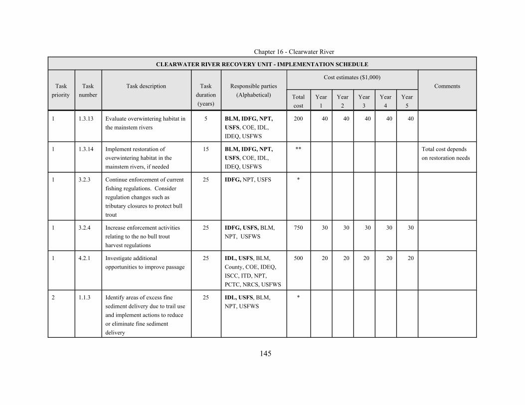
Chapter 16 - Clearwater River
CLEARWATER RIVER RECOVERY UNIT - IMPLEMENTATION SCHEDULE
Taskpriority
Tasknumber
Task description Taskduration(years)
Responsible parties(Alphabetical)
Cost estimates ($1,000)Comments
Totalcost
Year1
Year2
Year3
Year4
Year5
145
1 1.3.13 Evaluate overwintering habitat inthe mainstem rivers
5 BLM, IDFG, NPT,USFS, COE, IDL,IDEQ, USFWS
200 40 40 40 40 40
1 1.3.14 Implement restoration ofoverwintering habitat in themainstem rivers, if needed
15 BLM, IDFG, NPT,USFS, COE, IDL,IDEQ, USFWS
** Total cost dependson restoration needs
1 3.2.3 Continue enforcement of currentfishing regulations. Considerregulation changes such astributary closures to protect bulltrout
25 IDFG, NPT, USFS *
1 3.2.4 Increase enforcement activitiesrelating to the no bull troutharvest regulations
25 IDFG, USFS, BLM,NPT, USFWS
750 30 30 30 30 30
1 4.2.1 Investigate additionalopportunities to improve passage
25 IDL, USFS, BLM,County, COE, IDEQ,ISCC, ITD, NPT,PCTC, NRCS, USFWS
500 20 20 20 20 20
2 1.1.3 Identify areas of excess finesediment delivery due to trail useand implement actions to reduceor eliminate fine sedimentdelivery
25 IDL, USFS, BLM,NPT, USFWS
*
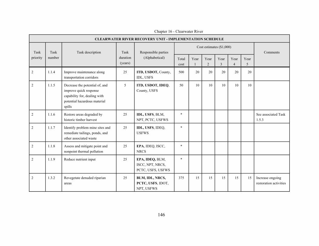
Chapter 16 - Clearwater River
CLEARWATER RIVER RECOVERY UNIT - IMPLEMENTATION SCHEDULE
Taskpriority
Tasknumber
Task description Taskduration(years)
Responsible parties(Alphabetical)
Cost estimates ($1,000)Comments
Totalcost
Year1
Year2
Year3
Year4
Year5
146
2 1.1.4 Improve maintenance alongtransportation corridors
25 ITD, USDOT, County,IDL, USFS
500 20 20 20 20 20
2 1.1.5 Decrease the potential of, andimprove quick responsecapability for, dealing withpotential hazardous materialspills
5 ITD, USDOT, IDEQ,County, USFS
50 10 10 10 10 10
2 1.1.6 Restore areas degraded byhistoric timber harvest
25 IDL, USFS, BLM,NPT, PCTC, USFWS
* See associated Task1.5.3
2 1.1.7 Identify problem mine sites andremediate tailings, ponds, andother associated waste
25 IDL, USFS, IDEQ,USFWS
*
2 1.1.8 Assess and mitigate point andnonpoint thermal pollution
25 EPA, IDEQ, ISCC,NRCS
*
2 1.1.9 Reduce nutrient input 25 EPA, IDEQ, BLM,ISCC, NPT, NRCS,PCTC, USFS, USFWS
*
2 1.3.2 Revegetate denuded riparianareas
25 BLM, IDL, NRCS,PCTC, USFS, IDOT,NPT, USFWS
375 15 15 15 15 15 Increase ongoingrestoration activities
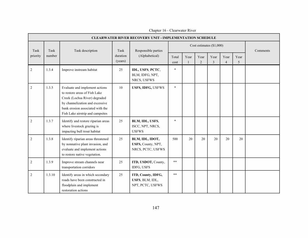
Chapter 16 - Clearwater River
CLEARWATER RIVER RECOVERY UNIT - IMPLEMENTATION SCHEDULE
Taskpriority
Tasknumber
Task description Taskduration(years)
Responsible parties(Alphabetical)
Cost estimates ($1,000)Comments
Totalcost
Year1
Year2
Year3
Year4
Year5
147
2 1.3.4 Improve instream habitat 25 IDL, USFS, PCTC,BLM, IDFG, NPT,NRCS, USFWS
*
2 1.3.5 Evaluate and implement actionsto restore areas of Fish LakeCreek (Lochsa River) degradedby channelization and excessivebank erosion associated with theFish Lake airstrip and campsites
10 USFS, IDFG, USFWS *
2 1.3.7 Identify and restore riparian areaswhere livestock grazing isimpacting bull trout habitat
25 BLM, IDL, USFS,ISCC, NPT, NRCS,USFWS
*
2 1.3.8 Identify riparian areas threatenedby nonnative plant invasion, andevaluate and implement actionsto restore native vegetation.
25 BLM, IDL, IDOT,USFS, County, NPT,NRCS, PCTC, USFWS
500 20 20 20 20 20
2 1.3.9 Improve stream channels neartransportation corridors
25 ITD, USDOT, County,IDFG, USFS
**
2 1.3.10 Identify areas in which secondaryroads have been constructed infloodplain and implementrestoration actions
25 ITD, County, IDFG,USFS, BLM, IDL,NPT, PCTC, USFWS
**
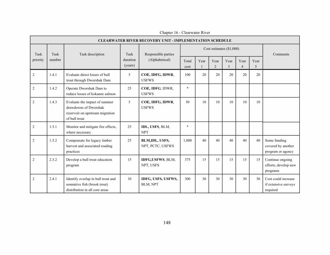
Chapter 16 - Clearwater River
CLEARWATER RIVER RECOVERY UNIT - IMPLEMENTATION SCHEDULE
Taskpriority
Tasknumber
Task description Taskduration(years)
Responsible parties(Alphabetical)
Cost estimates ($1,000)Comments
Totalcost
Year1
Year2
Year3
Year4
Year5
148
2 1.4.1 Evaluate direct losses of bulltrout through Dworshak Dam
5 COE, IDFG, IDWR,USFWS
100 20 20 20 20 20
2 1.4.2 Operate Dworshak Dam toreduce losses of kokanee salmon
25 COE, IDFG, IDWR,USFWS
*
2 1.4.3 Evaluate the impact of summerdrawdowns of Dworshakreservoir on upstream migrationof bull trout
5 COE, IDFG, IDWR,USFWS
50 10 10 10 10 10
2 1.5.1 Monitor and mitigate fire effects,where necessary
25 IDL, USFS, BLM,NPT
*
2 1.5.2 Compensate for legacy timber harvest and associated roadingpractices
25 BLM,IDL, USFS,NPT, PCTC, USFWS
1,000 40 40 40 40 40 Some fundingcovered by anotherprogram or agency
2 2.3.2 Develop a bull trout educationprogram
15 IDFG,USFWS, BLM,NPT, USFS
375 15 15 15 15 15 Continue ongoingefforts; develop newprograms
2 2.4.1 Identify overlap in bull trout andnonnative fish (brook trout)distribution in all core areas
10 IDFG, USFS, USFWS,BLM, NPT
300 30 30 30 30 30 Cost could increaseif extensive surveysrequired
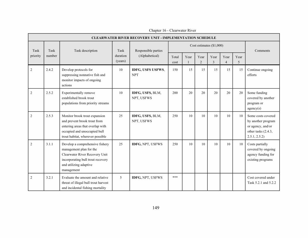
Chapter 16 - Clearwater River
CLEARWATER RIVER RECOVERY UNIT - IMPLEMENTATION SCHEDULE
Taskpriority
Tasknumber
Task description Taskduration(years)
Responsible parties(Alphabetical)
Cost estimates ($1,000)Comments
Totalcost
Year1
Year2
Year3
Year4
Year5
149
2 2.4.2 Develop protocols forsuppressing nonnative fish andmonitor impacts of ongoingactions
10 IDFG, USFS USFWS,NPT
150 15 15 15 15 15 Continue ongoingefforts
2 2.5.2 Experimentally removeestablished brook troutpopulations from priority streams
10 IDFG, USFS, BLM,NPT, USFWS
200 20 20 20 20 20 Some fundingcovered by anotherprogram oragency(s)
2 2.5.3 Monitor brook trout expansionand prevent brook trout fromentering areas that overlap withoccupied and unoccupied bulltrout habitat, wherever possible
25 IDFG, USFS, BLM,NPT, USFWS
250 10 10 10 10 10 Some costs coveredby another programor agency, and/orother tasks (2.4.3,2.5.1, 2.5.2)
2 3.1.1 Develop a comprehensive fisherymanagement plan for theClearwater River Recovery Unitincorporating bull trout recoveryand utilizing adaptivemanagement
25 IDFG, NPT, USFWS 250 10 10 10 10 10 Costs partiallycovered by ongoingagency funding forexisting programs
2 3.2.1 Evaluate the amount and relativethreat of illegal bull trout harvestand incidental fishing mortality
5 IDFG, NPT, USFWS *** Cost covered underTask 5.2.1 and 5.2.2

Chapter 16 - Clearwater River
CLEARWATER RIVER RECOVERY UNIT - IMPLEMENTATION SCHEDULE
Taskpriority
Tasknumber
Task description Taskduration(years)
Responsible parties(Alphabetical)
Cost estimates ($1,000)Comments
Totalcost
Year1
Year2
Year3
Year4
Year5
150
2 3.3.1 Evaluate the potential for releaseof excess hatchery stock ofanadromous fish into occupiedbull trout habitat
10 IDFG, NPT, USFWS 100 10 10 10 10 10 Some fundingcovered by otherprograms
2 3.4.1 Evaluate effects of existing andproposed angling regulations onbull trout
10+ IDFG, NPT 100 10 10 10 10 10 Some fundingcovered by anotherprogram or agency
2 3.4.2 Evaluate the impact of the sportfishing season in the two FishLake core areas on the adfluvialbull trout populations
5 IDFG, USFS 50 10 10 10 10 10 Ongoing in NorthFork Fish Lake
2 4.1.1 Conduct a genetic inventory 10 IDFG, NPT, USFS,USFWS
250 25 25 25 25 25 Ongoing
2 4.1.2 Describe and monitor genetic andphenotypic characteristics of bulltrout, and incorporate informationinto management strategies
25 IDFG, NPT, USFWS,USFS
375 15 15 15 15 15 Funding covered byother programs andother Tasks (see4.1.1)
2 4.3.1 Evaluate the need for re-establishing genetic connectivitybetween the North ForkClearwater River and theremainder of the recovery unit
10 IDFG, NPT, USFS,USFWS
100 10 10 10 10 10 Some fundingcovered under otherprograms and Tasks(see 4.1.1)
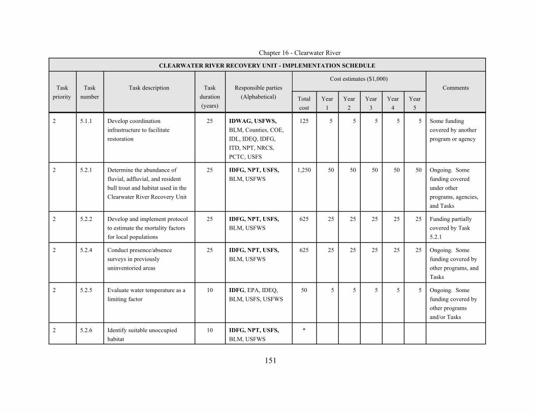
Chapter 16 - Clearwater River
CLEARWATER RIVER RECOVERY UNIT - IMPLEMENTATION SCHEDULE
Taskpriority
Tasknumber
Task description Taskduration(years)
Responsible parties(Alphabetical)
Cost estimates ($1,000)Comments
Totalcost
Year1
Year2
Year3
Year4
Year5
151
2 5.1.1 Develop coordinationinfrastructure to facilitaterestoration
25 IDWAG, USFWS,BLM, Counties, COE,IDL, IDEQ, IDFG,ITD, NPT, NRCS,PCTC, USFS
125 5 5 5 5 5 Some fundingcovered by anotherprogram or agency
2 5.2.1 Determine the abundance offluvial, adfluvial, and residentbull trout and habitat used in theClearwater River Recovery Unit
25 IDFG, NPT, USFS,BLM, USFWS
1,250 50 50 50 50 50 Ongoing. Somefunding coveredunder otherprograms, agencies,and Tasks
2 5.2.2 Develop and implement protocolto estimate the mortality factorsfor local populations
25 IDFG, NPT, USFS,BLM, USFWS
625 25 25 25 25 25 Funding partiallycovered by Task5.2.1
2 5.2.4 Conduct presence/absencesurveys in previouslyuninventoried areas
25 IDFG, NPT, USFS,BLM, USFWS
625 25 25 25 25 25 Ongoing. Somefunding covered byother programs, andTasks
2 5.2.5 Evaluate water temperature as alimiting factor
10 IDFG, EPA, IDEQ,BLM, USFS, USFWS
50 5 5 5 5 5 Ongoing. Somefunding covered byother programsand/or Tasks
2 5.2.6 Identify suitable unoccupiedhabitat
10 IDFG, NPT, USFS,BLM, USFWS
*
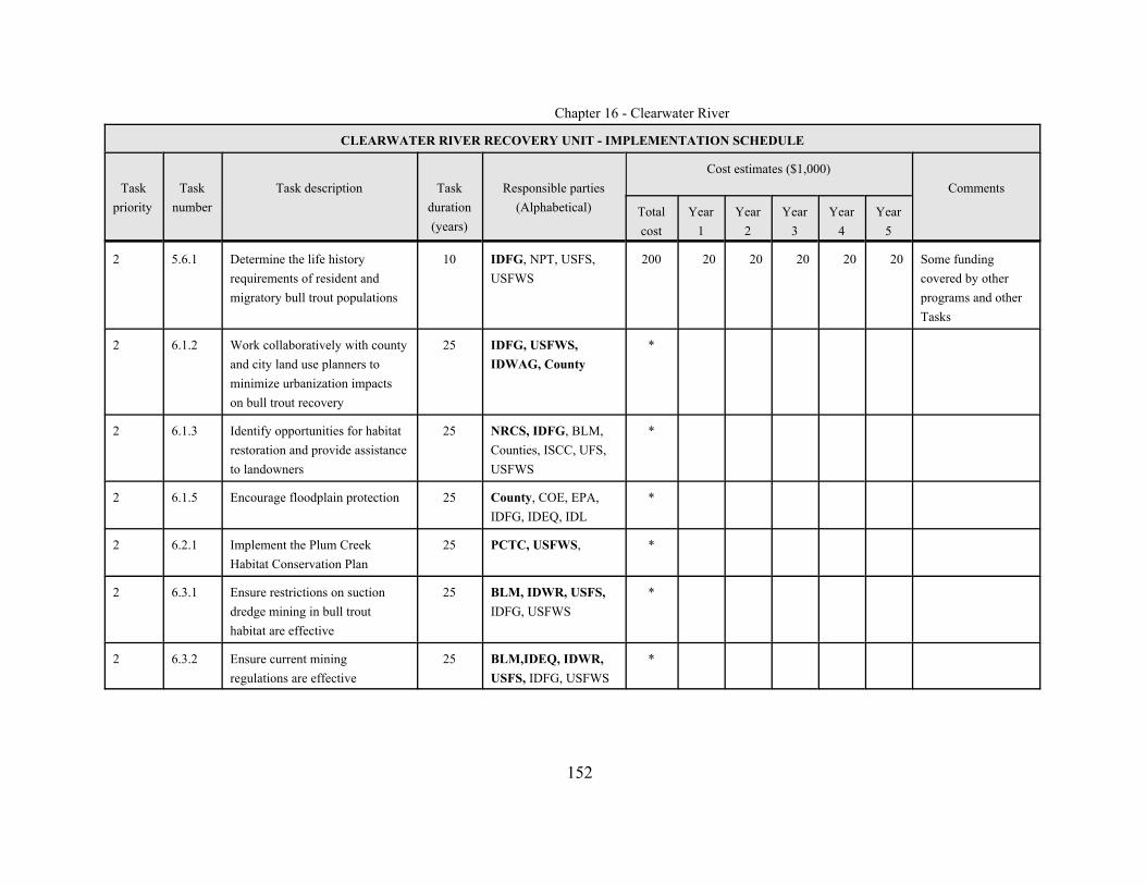
Chapter 16 - Clearwater River
CLEARWATER RIVER RECOVERY UNIT - IMPLEMENTATION SCHEDULE
Taskpriority
Tasknumber
Task description Taskduration(years)
Responsible parties(Alphabetical)
Cost estimates ($1,000)Comments
Totalcost
Year1
Year2
Year3
Year4
Year5
152
2 5.6.1 Determine the life historyrequirements of resident andmigratory bull trout populations
10 IDFG, NPT, USFS,USFWS
200 20 20 20 20 20 Some fundingcovered by otherprograms and otherTasks
2 6.1.2 Work collaboratively with countyand city land use planners tominimize urbanization impactson bull trout recovery
25 IDFG, USFWS,IDWAG, County
*
2 6.1.3 Identify opportunities for habitatrestoration and provide assistanceto landowners
25 NRCS, IDFG, BLM,Counties, ISCC, UFS,USFWS
*
2 6.1.5 Encourage floodplain protection 25 County, COE, EPA,IDFG, IDEQ, IDL
*
2 6.2.1 Implement the Plum CreekHabitat Conservation Plan
25 PCTC, USFWS, *
2 6.3.1 Ensure restrictions on suctiondredge mining in bull trouthabitat are effective
25 BLM, IDWR, USFS,IDFG, USFWS
*
2 6.3.2 Ensure current miningregulations are effective
25 BLM,IDEQ, IDWR,USFS, IDFG, USFWS
*

Chapter 16 - Clearwater River
CLEARWATER RIVER RECOVERY UNIT - IMPLEMENTATION SCHEDULE
Taskpriority
Tasknumber
Task description Taskduration(years)
Responsible parties(Alphabetical)
Cost estimates ($1,000)Comments
Totalcost
Year1
Year2
Year3
Year4
Year5
153
3 1.1.10 Minimize recreationaldevelopment in bull troutspawning and rearing habitat
25 County, IDL, USFS,IDFG, USFWS
*
3 1.2.3 Consider providing passagearound natural barriers
10 IDFG, USFWS, USFS *** See related task 1.3.1
3 1.3.6 Evaluate and implement actionsto restore degraded riparianhabitat at Fish Lake (North Forkcore area)
5 USFS, IDFG 10 2 2 2 2 2
3 1.3.11 Reduce campsite impacts 10 IDL, USFS, County,IDFG, NPT
50 5 5 5 5 5
3 1.3.12 Minimize potential streamchannel degradation from floodcontrol and response actions
25 County, IBODS, COE,IDEQ
*
3 2.5.1 Reduce brook trout competitionwith bull trout where they areknown to coexist, and wherebrook trout numbers arerelatively low
10 IDFG, USFS, BLM,NPT, USFWS
200 20 20 20 20 20 Some fundingcovered by anotherprogram oragency(s)
3 2.3.1 Discourage unauthorized fishintroductions
25 IDFG, USFWS, USFS,NPT
*** Funding coveredunder Task 2.3.2

Chapter 16 - Clearwater River
CLEARWATER RIVER RECOVERY UNIT - IMPLEMENTATION SCHEDULE
Taskpriority
Tasknumber
Task description Taskduration(years)
Responsible parties(Alphabetical)
Cost estimates ($1,000)Comments
Totalcost
Year1
Year2
Year3
Year4
Year5
154
3 2.5.4 Evaluate extent of hybridizationbetween bull and brook trout inareas where brook trout arefirmly established and eradicationis not possible.
25 IDFG, USFS, BLM,NPT , USFWS
125 5 5 5 5 5 Some costs coveredby another programor agency, and/orother tasks (2.4.3,2.5.1, 2.5.2, 2.5.3).
3 3.2.2 Continue public outreach aboutfishing regulations, bull troutidentification, and properhandling / release techniques
25 IDFG, USFWS, USFS,BLM, NPT
*
3 3.2.5 Inform the public about bull troutissues and general fisheriesbiology and management issues
10 IDFG, USFWS, USFS,NPT
*** Funding coveredunder Task 2.3.2
3 3.4.3 Evaluate the impact of the bonusbrook trout limit in theClearwater River Recovery Unitand increase the limit, if possible
10 IDFG, USFS, BLM *
3 5.1.2 Develop standardized populationmonitoring techniques andprocedures
25 IDFG, NPT, USFWS,BLM, USFS
250 10 10 10 10 10 Some fundingcovered by otherprograms and otherTasks
3 5.2.3 Map spawning habitat 5 IDFG, NPT, USFS,USFWS
25 5 5 5 5 5 Ongoing
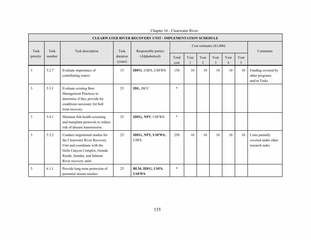
Chapter 16 - Clearwater River
CLEARWATER RIVER RECOVERY UNIT - IMPLEMENTATION SCHEDULE
Taskpriority
Tasknumber
Task description Taskduration(years)
Responsible parties(Alphabetical)
Cost estimates ($1,000)Comments
Totalcost
Year1
Year2
Year3
Year4
Year5
155
3 5.2.7 Evaluate importance ofcontributing waters
15 IDFG, USFS, USFWS 150 10 10 10 10 10 Funding covered byother programsand/or Tasks
3 5.3.1 Evaluate existing BestManagement Practices todetermine if they provide forconditions necessary for bulltrout recovery
25 IDL, ISCC *
3 5.4.1 Maintain fish health screeningand transplant protocols to reducerisk of disease transmission.
25 IDFG, NPT, USFWS *
3 5.5.2 Conduct migrational studies forthe Clearwater River RecoveryUnit and coordinate with theHells Canyon Complex, GrandeRonde, Imnaha, and SalmonRiver recovery units
25 IDFG, NPT, USFWS,USFS
250 10 10 10 10 10 Costs partiallycovered under otherresearch tasks
3 6.1.1 Provide long-term protection ofperennial stream reaches
25 BLM, IDFG, USFS,USFWS
*
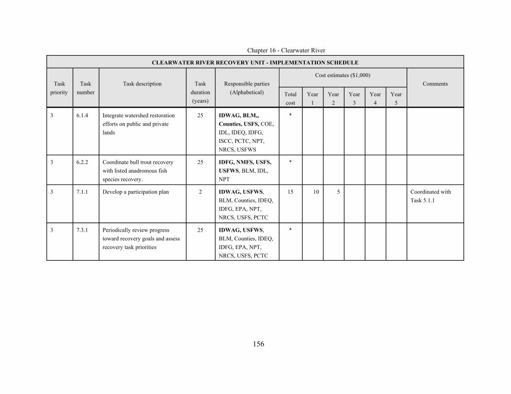
Chapter 16 - Clearwater River
CLEARWATER RIVER RECOVERY UNIT - IMPLEMENTATION SCHEDULE
Taskpriority
Tasknumber
Task description Taskduration(years)
Responsible parties(Alphabetical)
Cost estimates ($1,000)Comments
Totalcost
Year1
Year2
Year3
Year4
Year5
156
3 6.1.4 Integrate watershed restorationefforts on public and privatelands
25 IDWAG, BLM,,Counties, USFS, COE,IDL, IDEQ, IDFG,ISCC, PCTC, NPT,NRCS, USFWS
*
3 6.2.2 Coordinate bull trout recoverywith listed anadromous fishspecies recovery.
25 IDFG, NMFS, USFS,USFWS, BLM, IDL,NPT
*
3 7.1.1 Develop a participation plan 2 IDWAG, USFWS,BLM, Counties, IDEQ,IDFG, EPA, NPT,NRCS, USFS, PCTC
15 10 5 Coordinated withTask 5.1.1
3 7.3.1 Periodically review progresstoward recovery goals and assessrecovery task priorities
25 IDWAG, USFWS,BLM, Counties, IDEQ,IDFG, EPA, NPT,NRCS, USFS, PCTC
*
Chapter 16 - Clearwater River
157
REFERENCES
Bahls, P. 1992. Report of the High Lakes Fisheries Project, Clearwater NationalForest. Cooperative Project of Idaho Department of Fish and Game, Region 2and U.S. Forest Service, Clearwater National Forest, Orofino, ID.
Batt, Governor P. E. 1996. State of Idaho Bull Trout Conservation Plan. Boise, Idaho.
Baxter, J. S., and J. D. McPhail. 1999. The influence of redd site selection,groundwater upwelling, and over-winter incubation temperature on survivalof bull trout (Salvelinus confluentus) from egg to alevin. Canadian Journal ofZoology 77:1233-1239.
Bennett, D. H. 1997. Evaluation of current environmental conditions and operationsat Dworshak Reservoir, Clearwater River, Idaho, and an analysis of fisheriesmanagement mitigation alternatives. Final Report, USCOE, Walla Walla,WA.
(BLM) U.S. Bureau of Land Management. 2000. Biological assessment of ongoingand proposed Bureau of Land Management activities on fall chinook,steelhead trout, bull trout and BLM sensitive species for the Clearwater River,North Fork Clearwater River and Middle Fork Clearwater River subbasins.Cottonwood, ID.
Bugosh, N. 1999. Lochsa River Subbasin Assessment. Idaho Department ofEnvironmental Quality. Lewiston, ID.
Burkey, T. V. 1989. Extinction in nature reserves: the effect of fragmentation and theimportance of migration between reserve fragments. Oikos 55:75-81.
Cacek, C. C. 1989. The relationship of mass wasting to timber harvest activities in theLightning Creek basin, Idaho and Montana. M.S. Thesis, Eastern WashingtonUniversity, Ellensburg.

Chapter 16 - Clearwater River
158
(CBBTTAT) Clearwater Basin Bull Trout Technical Advisory Team. 1998a. NorthFork Clearwater River Basin Bull Trout Problem Assessment. Prepared forthe State of Idaho by the CBBTTAT. May 1998.
(CBBTTAT) Clearwater Basin Bull Trout Technical Advisory Team. 1998b. BullTrout Assessment of the Lochsa and Selway Subbasin (including the MiddleFork of the Clearwater upstream of the South Fork). CBBTTAT. August1998.
(CBBTTAT) Clearwater Basin Bull Trout Technical Advisory Team. 1998c. LowerClearwater River Bull Trout Problem Assessment. Prepared for the State ofIdaho. November 1998.
(CBBTTAT) Clearwater Basin Bull Trout Technical Advisory Team. 1998d. SouthFork Clearwater River Subbasin Bull Trout Problem Assessment. Prepared forthe State of Idaho. November 1998.
Clancy, C.G. 1993. Statewide fisheries investigations: Bitterroot Forest Inventory. Montana Fish, Wildlife, and Parks, Job Completion Report, Project F-46-R-4,Helena, Montana.
Clearwater BioStudies. 1996. Habitat conditions and salmonid abundance in selectedstreams within the White Sand drainage, Powell Ranger District, Summer1994 and 1995. Consultant report to the U.S. Forest Service, ClearwaterNational Forest, Orofino, Idaho.
Clearwater BioStudies. 1991. Habitat conditions and salmonid abundance in selectedstreams within the Quartz Creek drainage, North Fork Ranger District,Summer 1990. Consultant report to the U.S. Forest Service, ClearwaterNational Forest, Orofino, Idaho.
Clearwater BioStudies. 1990. Habitat conditions and salmonid abundance in selectedstreams within the upper Potlatch drainage, Palouse Ranger District,Clearwater National Forest.

Chapter 16 - Clearwater River
159
Cochnauer, T., E. Schreiver, and D. Schiff. 2001. Bull trout investigations in theNorth Fork Clearwater drainage, 2000. Federal Aid in Fish Restoration, 2000Job Performance Report Program F-73-R-22. Idaho Department of Fish andGame, Boise, Idaho.
Conley, J. M. 1993. Bull trout management plan. Idaho Department of Fish andGame, Boise (April). 11pp.
Crow, J.D. and M. Kimura. 1970. An introduction to population genetics theory. Harper and Row, New York, New York.
(CSS) Clearwater Subbasin Summary. 2001. Draft Clearwater subbasin summary.Prepared for the Northwest Power Planning Council by interagency team, ledby D. Statler, Nez Perce Tribe. May 25, 2001.
Cundy, T. W., and D. L. Murphy. 1997. Draft report on landslides and streamchanges due to flooding on Potlatch Corporation lands in 1995 and 1996.Potlatch Corporation, Lewiston, ID.
Dambacher, J. M., M. W. Buktenica, and G. L. Larson. 1992. Distribution,abundance, and habitat utilization of bull trout and brook trout in Sun Creek,Crater Lake National Park, Oregon. In: P. J. Howell, and D. V. Buchanan,(Eds.). Proceedings of the Gearhart Mountain bull trout workshop. Pages 30-36. American Fisheries Society, Oregon Chapter, Corvallis, OR.
Dunham, J. B., and B. E. Rieman. 1999. Metapopulation structure of bull trout: Influences of physical, biotic, and geometrical landscape characteristics.Ecological Applications 9:642-655.
Federal Caucus. 2000. Conservation of Columbia Basin fish: final basinwiderecovery strategy (All “H” paper).
Franklin, J.R. 1980. Evolutionary changes in small populations. Pater 135-149 inM.E. Soule and B.A. Wicox, eds., Conservation biology: An evolutionary-ecological perspective. Sinaure Associates. Sunderland, Massachusetts.

Chapter 16 - Clearwater River
160
Frissell, C. A. 1993. Topology of extinction and endangerment of native fishes in thePacific Northwest and California. Conservation Biology 7(2):342-354.
Furniss, M. J., T. D. Roelofs, and C. S. Yee. 1991. Road construction andmaintenance. American Fisheries Society Special Publication 19:297-323.
Griffith, J. S. 1981. Estimation of the age-frequency distribution of stream-dwellingtrout by underwater observation. Progressive Fish-Culturalist 43:51-53.
Henjum, M. G., J. R. Karr, D. L. Bottom, D.A. Perry, J. C. Bednarz, S. G. Wright, S.A. Beckwitt, and E. Beckwitt. 1994. Interim protection for late-successionalforests, fisheries, and watersheds. National forests east of the Cascade Crest,Oregon, and Washington. A report to the Congress and President of theUnited States Eastside Forests Scientific Society Panel. American FisheriesSociety, American Ornithologists Union Incorporated, The Ecological Societyof America, Society for Conservation Biology, The Wildlife Society. TheWildlife Society Technical Review 94-2.
Huntington, C. W. 1995. Fish habitat and salmonid abundance within managed andunroaded landscapes on the Clearwater National Forest, Idaho. Prepared forEastside Ecosystem Management Project, USDA Forest Service. Order No.43-0E00-4-9106. Walla Walla, WA.
Huntington, C. W. 1988. Orofino Creek passage project biological and engineeringfeasibility report. Clearwater BioStudies, Inc., Sherwood, Oregon, and SJOEngineers, Inc., Portland, Oregon. Prepared for U.S. Dept. of Energy,Bonneville Power Administration, Contract No. 87-112, Portland, OR.
Idaho Department of Commerce. 2000. Idaho Data Center. Website:http://www2.state.id.us/fishgame/animal.htm.
(IDFG) Idaho Department of Fish and Game. 2001. South Fork Clearwater bull troutinvestigations. Report to the Nez Perce National Forest and Bureau of LandManagement. Idaho Department of Fish and Game, Lewiston, ID.
Chapter 16 - Clearwater River
161
(IDFG) Idaho Department of Fish and Game. 2001. Federal aid in fish restoration,1995 Job Performance Report. Program F-71-R-20. Idaho Department of Fishand Game, Lewiston, ID.
(IDFG) Idaho Department of Fish and Game. 1986-1997. General Parr MonitoringDatabase, 1986-1997. Idaho Department of Fish and Game, Lewiston, ID
(IDL) Idaho Department of Lands. 2002a. Cumulative watershed effects assessmentfor the Floodwood Creek drainage (HUC #17060308-0716). Idaho Dept. ofLands, Coeur d’Alene.
(IDL) Idaho Department of Lands. 2002b. Cumulative watershed effects assessmentfor the West Fork Floodwood Creek drainage (HUC #17060308-0714). IdahoDept. of Lands, Coeur d’Alene.
(IDL) Idaho Department of Lands. 2000. Forest Practices Cumulative WatershedEffects Process for Idaho. Idaho Department of Lands. Boise, Idaho.
Interior Columbia Basin River Component Report. 1997. In: Quigley, T. M. and S. J.Arbelbide, (Eds.). An assessment of ecosystem component in the interiorColumbia River basin. USDA Forest Service. Volume III. Pacific NorthwestResearch Station. General Technical Report, PNW - GTR-405.
Johnson, D. B. 1985. A biological and physical inventory of Clear Creek, OrofinoCreek, and the Potlatch River, tributary streams of the Clearwater River,Idaho. Nez Perce Tribe, Fisheries Resource Management. Prepared for U.S.Dept. of Energy, Bonneville Power Administration, Division of Fish andWildlife, Portland, OR. 292 pp.
Johnson, T. H. 1977. Catch and release and trophy fish angling regulations in themanagement of cutthroat trout populations and fisheries in Northern Idahostreams. M.S. Thesis. University of Idaho, Moscow, ID.
Lande, R. 1988. Genetics and demography in biological conservation. Science241:1455-1460.

Chapter 16 - Clearwater River
162
Learn, R. F., and F. W. Allendorf. 1997. Genetic confirmation of sympatric bull troutand Dolly Varden in western Washington. Transactions of the AmericanFisheries Society 126:715-720.
Learn, R. F., F. W. Allendorf, and S. H. Forbes. 1993. Conservation genetics of bulltrout in the Columbia and Klamath River drainages. Conservation Biology7:856-865.
Learn, R. F., F. W. Allendorf, and S. H. Forbes. 1991. Conservation genetics of bulltrout in the Columbia and Klamath River drainages. University of Montana,Division of Biological Sciences, Wild Trout and Salmon Genetics Lab.Report. Missoula, MT. 32pp.
Lee, D. C., J. R. Seddell, B. E. Rieman, and others. 1996. Chapter 4: Broadscaleassessments of aquatic species and habitats. In: Quigley, T. M., and S. J.Arbelbide, (Eds.). 1997. An assessment of ecosystem components in theinterior Columbia Basin and portions of the Klamath and Great Basins:Volume III. U.S. Department of Agriculture, Forest Service Pacific NorthwestResearch Station. Portland, Oregon.
Levell, J. H., L. A. Petersen and G. E. Nichols. 1987. Placer mining technology andassociated environmental effects. Salisbury and Associates, Inc., Spokane,WA.
Lipscomb, S. W. 1998. Hydrologic Classification and Estimation of Basin andHydrologic Characteristics of Subbasins in Central Idaho. U.S. GeologicalSurvey. Prepared in cooperation with the Bureau of Indian Affairs.
Martin, S. B., and W. S. Platts. 1981. Influence of forest and rangeland managementon anadromous fish habitat in western North America, effects of mining. U.S.Forest Service, Intermountain Forest and Range Experiment Station, GeneralTechnical Report PNW-119.
Chapter 16 - Clearwater River
163
Maughan, O. W. 1972. Distribution and Geographic Variation of Sculpins in theClearwater Basin. Doctor of Philosophy. Department of Zoology, WashingtonState University.
McClelland, D. E., R. B. Foltz, W. D. Wilson, T. Cundy, R. Heinemann, J. Saurbier,and R. L. Schuster. 1997. Assessment of the 1995 and 1996 Floods andLandslides on the Clearwater National Forest, Part I, Landslide Assessment.A Report to the Regional Forester, Northern Region, U.S. Forest Service.
McIntyre, M. J. 1993. Water quality status report No. 108, Squaw Creek - beneficialuse assessment Gem County, Idaho 1991-1992. Division of EnvironmentalQuality.
Meehan, W. R. 1991. Influences of forest and rangeland management on salmonidfishes and their habitats. American Fisheries Society. Special Pub. 19. 749pp.
Meffe, G.K., and C.R. Carroll. 1994. Principles of conservation biology. SinauerAssociates, Sunderland, Massachusetts.
Moffitt, C. M., and T. C. Bjornn. 1984. Fish abundance upstream from DworshakDam following exclusion of steelhead trout. Technical Completion ReportProject WRIP/371404. Idaho Water and Energy Resources Research Institute.University of Idaho. Moscow, ID.
Mongillo, P. E. 1984. A summary of salmonid hooking mortality. WashingtonDepartment of Game, Fisheries Management Division, Olympia, WA.
(MBTSG) Montana Bull Trout Scientific Group. 1998. The relationship between landmanagement activities and habitat requirements of bull trout. Report preparedfor the Montana Bull Trout Restoration Team, Helena, MT.
(MBTSG) Montana Bull Trout Scientific Group. 1996. Assessment of methods forremoval or suppression of introduced fish to aid in bull trout recovery.Montana Bull Trout Restoration Team, Helena, MT.
Chapter 16 - Clearwater River
164
Murphy, P., and T. Cochnauer. 1998. Report of the high lakes fisheries project in theClearwater National Forest, 1997. Idaho Department of Fish and Game,Lewiston, ID.
Murphy, P., T. Cochnauer, and E. Schreiver. 2001. Ice Lake brook trout control: Utilization of Tiger Muskie for suppressing self-sustaining populations ofintroduced brook trout (Draft). Idaho Department of Fish and Game.Lewiston, ID.
Nelson, R. L., M. L. McHenry, and W. S. Platts. 1991. Mining. American FisheriesSociety Special Publication 19:207-296.
Nez Perce Tribe and Idaho Department of Fish and Game. 1990. Clearwater riversubbasin salmon and steelhead production plan. Funded by the NorthwestPower Planning Council; Columbia Basin Fish and Wildlife Authority.Lapwai, ID.
Olson, B. E. 1999. Impacts of noxious weeds on ecologic and economic systems. In:R. L. Sheley and J. K. Petroff, (Eds.). Biology and Management of NoxiousRangeland Weeds. Oregon State University Press, Corvallis, OR.
Olson, J., and J. Brostrom. 1997. A survey of bull trout and resident fish populationsin the Red River drainage, a tributary of the South Fork Clearwater River.Idaho Department of Fish and Game, Lewiston, ID.
Platts, W. S., M. Hill, T. Hillman, and M. D. Miller. 1993. Preliminary status reporton bull trout in California, Idaho, Montana, Nevada, Oregon, and Washington.Consultant report to the Intermountain Forest Industry Association, Coeurd'Alene, Idaho.
Quigley, T. M., and S. J. Arbelbide, technical editors. 1997. An assessment ofecosystem components in the interior Columbia Basin and portions of theKlamath and Great Basins: Volume III. U.S. Department of Agriculture,Forest Service Pacific Northwest Research Station. Portland, Oregon.

Chapter 16 - Clearwater River
165
Ratliff, D. E., and P. J. Howell. 1992. The status of bull trout populations in Oregon.In: Howell, P. J., and D.V. Buchanan, (Eds.). Proceedings of the GearhartMountain bull trout workshop, August, Gearhart Mountain, OR. OregonChapter of the American Fisheries Society, Corvallis, OR. Pp 10-17.
Rhodes, J. J., D. A. McCullough, and F. A. Espinosa, Jr. 1994. A coarse screeningprocess for potential application in ESA consultations. Columbia RiverIntertribal Fish Commission, Prepared under National Marine FisheriesService/Bureau of Indian Affairs Inter-Agency Agreement 40ABNF3.
Rieman, B.E. and F.W. Allendorf. 2001. Effective population size and geneticconservation criteria for bull trout. North American Journal of FisheriesManagement 21:756-764
Rieman, B. E., and J. B. Dunham. 2000. Metapopulations and salmonids: A synthesisof life history patterns and empirical observations. Ecology of FreshwaterFish 9:51-64.
Rieman, B. E., and J. D. McIntyre. 1995. Occurrence of bull trout in naturallyfragmented habitat patches of varied size. Transactions of the AmericanFisheries Society 124:285-296.
Rieman, B. E., and J. D. McIntyre. 1993. Demographics and habitat requirements forobservation of bull trout. General Technical Report INT-302. U.S. ForestService. Intermountain Research Station, Boise, ID.
Rieman, B. E., D. C. Lee, and R. F. Thurow. 1997. Distribution, status and likelyfuture trends of bull trout within the Columbia River and Klamath Riverbasins. North American Journal of Fisheries Management 17:1111-1125.
Saunders, D. A., R.J. Hobbs, and C. R. Margules. 1991. Biological consequences ofecosystem fragmentation: A review. Conservation Biology 5:18-32.
Chapter 16 - Clearwater River
166
Schill, D. J., and R. L. Scarpella. 1997. Barbed hook restrictions in catch and releasetrout fisheries: a social issue. N. American Journal of Fisheries Management17:873-881.
Schoen, D., R. M. Jones, and P. K. Murphy. 1999. Section 7 watershed biologicalassessment Lochsa River drainage Clearwater subbasin: Determination ofeffects of ongoing activities based on the matrix of pathways and indicators ofwatershed condition for steelhead trout, fall chinook salmon and bull trout.Clearwater National Forest, Orofino, ID.
Skille, J. 1991. In-stream sediment and fish populations in the Little North ForkClearwater River, Shoshone and Clearwater counties, Idaho, 1988-1990.Water Quality Summary Report #27. Idaho Department of EnvironmentalQuality. Coeur d’Alene, Idaho.
Soule, M.E. 1980. Thresholds for survival: maintaining fitness and evolutionarypotential. Pages 151-170 in M.E. Soule and B.A. Wicox, eds., Conservationbiology: An evolutionary-ecological perspective. Sinaure Associates. Sunderland, Massachusetts.
Spangler, R. E. 1997. Distribution, abundance, and microhabitat use of juvenile bulltrout and cutthroat trout in two small tributaries of the South Fork ClearwaterRiver, Idaho. M.S. Thesis, University of Idaho, Moscow, ID.
Spence, B. C., G. A. Lomincky, R. M. Hughes, and R. P. Novitzki. 1996. Anecosystem approach to salmonid conservation. Management TechnologiesInc., for the National Marine Fisheries Service, U.S. Fish and WildlifeService, Environmental Protection Agency. TR-4501-96-6057.
Spencer, C. N., and C. L. Schelske. 1998. Impact of timber harvest on sedimentdeposition in surface waters in Northwest Montana over the last 150 years: apaleolimnological study. In: M. K. Brewin and D. M. A. Monita, (Eds.).Forest-fish conference: land management practices affecting aquaticecosystems. Pages 187-201. Proc. Forest-Fish Conf., May 1-4, 1996, Calgary,

Chapter 16 - Clearwater River
167
Alberta. Nat. Can., Canada Forestry Service Northern Forestry Center,Edmonton, Alberta. Inf. Rep. NOR-X-356.
Spruell, P., B. E. Rieman, K. L. Knudsen, F. M. Utter, and F. W. Allendorf. 1999.Genetic population structure within streams: Microsatellite analysis of bulltrout populations. Ecology of Freshwater Fish 8:114-121.
Sullivan, K., J. Tooley, K. Doughty, J. E. Caldwell, and P. Knudsen. 1990.Evaluation of prediction models and characterization of stream temperatureregimes in Washington. Timber/Fish/Wildlife Rep. No. TFW-WQ3-90-006.Washington Dept. Nat. Resources, Olympia, Washington. 224pp.
Swanson, R. H., R. D. Wynes, and R. L. Rothwell. 1998. Estimating the cumulativelong-term effects of forest harvests on annual water yield in Alberta. In: M. K.Brewin and D. M. A. Monita, (Eds.). Forest-fish conference: landmanagement practices affecting aquatic ecosystems. Pages 83-93. Proc.Forest-Fish Conf., May 1-4, 1996, Calgary, Alberta. Nat. Can., CanadaForestry Service Northern Forestry Center, Edmonton, Alberta. Inf. Rep.NOR-X-356.
Thomas, C. A, H. C. Broom, and J. E. Cummans. 1963. Magnitude and Frequency ofFloods in the United States: Part 13. Snake River Basin. U.S. GeologicalSurvey. Washington, DC.
Thomas, G. 1992. Status of bull trout in Montana. Report prepared for MontanaDepartment of Fish, Wildlife and Parks, Helena, MT.
Thurow, R. 1990. Fishery Research Job completion report, project F-73-R-12.Subproject IV: River and stream investigations. Idaho Department of Fish andGame. Boise, ID.
Trombulak, S. C., and C. A. Frissell. 2000. Review of ecological effects of roads onterrestrial and aquatic communities. Conservation Biology 14:18-30.

Chapter 16 - Clearwater River
168
U.S. Army Corps of Engineers. 1975. Final Environmental Impact Statement -Dworshak Reservoir, Orofino, ID.
U.S. Bureau of Mines, U.S. Geological Survey, and Idaho Geographical Survey.1993. Evaluation of the Mineral Resources of the Upper North Fork of theClearwater River 1990-92.
U.S. Census Bureau. 2000. United States Census 2000. Website:http://www.census.gov/.
(USDA and USDI) U.S. Department of Agriculture and U.S. Department of Interior.1997. Interior Columbia River Basin Ecosystem Management Project, UpperColumbia River Basin Draft Environmental Impact Statement. Vol I., Vol II,Vol III. Walla Walla, WA.
U.S. Department of Commerce. 2000. Biological opinion on reinitiation ofconsultation on operation of the Federal Columbia River Power System,including the juvenile fish transportation program, and 19 Bureau ofReclamation projects in the Columbia Basin. December 21, 2000. NationalMarine Fisheries Service.
(USFWS) U.S. Fish and Wildlife Service. 2000. Biological Opinion. Effects to listedspecies from Operations of the Federal Columbia River Power System. U.S.Fish and Wildlife Service Regions 1 and 6, Portland, Oregon and Denver,Colorado.

Chapter 16 - Clearwater River
169
(USFWS) U.S. Fish and Wildlife Service. 1998. Biological Opinion for thecontinued implementation of land and resource management plans andresource management plans as amended by the interim strategy formanaging fish-producing watersheds in Eastern Oregon and Washington,Idaho, Western Montana, and portions of Nevada (INFISH) and the interimstrategy for managing anadromous fish-producing watersheds in EasternOregon and Washington, Idaho and portions of California (PACFISH).Portland, OR.
(USFWS) U. S. Fish and Wildlife Service. 1998b. Klamath River and ColumbiaRiver Bull Trout Population Segments: Status Summary and SupportingDocuments Lists. Bull Trout Listing Team. Portland, OR. 91pp.
(USFS) U.S. Forest Service. 2001. Selway and Middle Fork Clearwater RiversSubbasin Assessment (Draft). Clearwater, Nez Perce, and BitterrootNational Forests. Grangeville, ID.
(USFS) U.S. Forest Service. 1998. Squaw to Papoose Watershed Analysis, Draft.Clearwater National Forest, Orofino, ID.
(USFS) U.S. Forest Service. 1998a. South Fork Clearwater landscape assessment.Nez Perce National Forest, Grangeville, ID.
(USFS) U.S. Forest Service. 1998b. Watershed and Fisheries Monitoring Plan,Clearwater National Forest. Orofino, ID. 67 pp.
(USFS) U.S. Forest Service. 1935. Five year fish and game report, St. Joe NationalForest, 1935. St. Joe National Forest, St. Maries, Idaho.
(USFS) U. S. Forest Service, and Bureau of Land Management. 1995a. Interimstrategies for managing fish-producing watersheds in eastern Oregon andWashington, Idaho, western Montana and portions of Nevada (INFISH).
(USFS) U. S. Forest Service, and Bureau of Land Management. 1995b. DecisionNotice/Decision Record Finding of No Significant Impact, environmental

Chapter 16 - Clearwater River
170
assessment for the interim strategies for managing anadromous fish-producing watersheds in eastern Oregon and Washington, Idaho, andportions of California (PACFISH).
(USFS) U. S. Forest Service, Bureau of Land Management and National MarineFisheries Service, and U.S. Fish and Wildlife Service. 1999. Streamlinedconsultation procedures for section 7 of the Endangered Species Act,Memorandum of Understanding.
(USFS) U.S. Forest Service, Clearwater National Forest. 2000. Section 7watershed biological assessment North Fork Clearwater River drainageClearwater River subbasin - determination of effects of ongoing andproposed activities based on the matrix of pathways and indicators ofwatershed condition for bull trout. Clearwater National Forest,Supervisor’s Office, Orofino, Idaho. 316pp.
(USFS) U.S. Forest Service, Clearwater National Forest. 1999a. Section 7watershed biological assessment Lochsa River drainage Clearwatersubbasin: Determination of effects of ongoing activities based on thematrix of pathways and indicators of watershed condition for steelheadtrout, fall chinook salmon and bull trout. Clearwater National Forest,Supervisor’s Office, Orofino, Idaho. 230pp.
(USFS) U.S. Forest Service, Clearwater National Forest. 1999b. Section 7watershed biological assessment Lolo Creek drainage, mainstemClearwater River subbasin: Determination of effects of ongoing activitiesbased on the matrix of pathways and indicators of watershed condition forsteelhead trout, fall chinook salmon and bull trout. Clearwater NationalForest, Supervisor’s Office, Orofino, Idaho. 132pp.
(USFS) U.S. Forest Service, Nez Perce National Forest. 1999c. Biologicalassessment: South Fork Clearwater River. Nez Perce National Forest,Supervisor’s Office, Grangeville, Idaho. 226pp.
Chapter 16 - Clearwater River
171
(USFS) U.S. Forest Service, Nez Perce National Forest. 1999d. Biologicalassessment: lower Selway 4th code HUC fish, wildlife and plants. NezPerce National Forest, Moose Creek Ranger District, Fenn, ID. 92pp plusappendices.
(USFS) U.S. Forest Service, Nez Perce National Forest. 1999e. Biologicalassessment: Clear Creek. Nez Perce National Forest, Supervisor’s Office,Grangeville, Idaho. 109pp.
Watson, G., and T. Hillman. 1997. Factors affecting the distribution andabundance of bull trout: an investigation into hierarchical scales. N. Am.Journ. Fish. Mgmt. 17(2):237-252.
(WDW) Washington Department of Wildlife. 1992. Bull trout/Dolly Vardenmanagement and recovery plan. Washington Department Number 92-22,Fisheries Management Division, Olympia, Washington
Wissmar, R. C., J. E. Smith, B. A. McIntosh, H. W. Li, G. H. Reeves, and J. R.Sedell. 1994. A history of resource use and distribution in riverine basins ofeastern Oregon and Washington (Early 1800s-1900s). Northwest ScienceSpecial Issue 68:1-34.
Wydoski, R. S. 1977. Relation of hooking mortality and sublethal hooking stress toquality fishery management. In: R.A. Barnhart and R.D. Roelofs, (Eds.).Catch-and-release fishing as a management tool. Pages 43-87. Californiacooperative Fishery Research Unit, Humboldt State University, Arcata.
Zaroban, D. W. et al. 1996. Forest Practices Water Quality Audit. Idaho Dept. ofHealth and Welfare, 1410 N. Hilton, Boise, ID
In Litterature

Chapter 16 - Clearwater River
172
Clearwater Bull Trout Recovery Unit Team. 2002. Meeting Notes from 4/1/2002meeting at Dworshak Fish Hatchery: Results of Team review of draftClearwater Chapter of the Bull Trout Recovery Plan.
Clearwater Bull Trout Recovery Unit Team. 2000. Meeting Notes from 6/12/2000meeting at Dworshak Fish Hatchery: Results of applying the bull troutmatrix to identify local and potential local populations in the Clearwaterrecovery unit.
Cundy, T. 1998. Bull trout survey data for Beaver Creek, North Fork ClearwaterRiver.
Dunsmoor, L., and C. Bienz, Klamath Tribe. 1997. Comments on the proposedrule to list bull trout in the Klamath River and Columbia River, to RobertRuesink, U.S. Fish and Wildlife Service, Boise, Idaho. 6 pp.
Espinosa, F. A. and T. Bjornn. 1981. Bull trout survey data for North ForkClearwater tributaries. (Cited in N. Fk. Problem assessment 1998, pg 45).
(IDFG) Idaho Department of Fish and Game. 2001. Data from bull trout researchwithin Fish Lake, North Fork Clearwater River (2000-2001).
(NPNF) Nez Perce National Forest. 2001a. Bull trout redd counts from NewsomeCreek and E. Fk. American River, 1999 - 2000.
(NPNF) Nez Perce National Forest. 2001b. Bull trout surveys in Red River 2000 -2001.
(NPNF) Nez Perce National Forest. 2001c. Bull trout surveys in Newsome Creek1998-2001.
(NPNF) Nez Perce National Forest. 2001d. Brook trout surveys in Santiam andRabbit creeks.
Chapter 16 - Clearwater River
173
Roseberg, R. 2002. Data on bull trout caught at Dworshak and Kooskia Hatcheries(1993-2001).
U.S. Environmental Protection Agency. 2001. Letter from U.S. EPA to IdahoDepartment of Environmental Quality, January 25, 2001 transmitting finaladditions to Idaho DEQ’s 1998 Section 303(d) list of water quality limitedwaterbodies under Section 303 (d) of the Clean Water Act.
(USFWS) U.S. Fish and Wildlife Service. 2002. Monitoring reports of the January6, 2002 diesel fuel spill into the Clearwater River by U.S. Fish and WildlifeService personnel, Dworshak Hatchery. Includes Lewiston MorningTribune newspaper articles on the spill.
(USFWS) U.S. Fish and Wildlife Service. 1995-2001. Clearwater basinwatershed assessments. Boise, Idaho.
Weigel, D. 1998. Unpublished data from bull trout surveys in Kelly Creek, NorthFork Clearwater River drainage. Nez Perce Tribe, Lapwai, Idaho.
Personal Communications
Capurso, Jim. 1997. U. S. Forest Service, Clearwater National Forest, Powell, ID.(Currently Caribou/Targhee National Forest, Idaho Falls). FisheriesBiologist.
Cochnauer, Tim. 1998. Idaho Department of Fish and Game, Lewiston, ID.Regional Fisheries Manager (Retired).
Dupont, Joe. 1998. Idaho Department of Lands, Coeur d’Alene, ID. (CurrentlyIdaho Fish and Game, Coeur d’Alene). Fisheries Biologist.
Espinosa, F. Al. 1998. U. S. Forest Service, Clearwater National Forest (Retired).Fisheries Biologist

Chapter 16 - Clearwater River
174
Huntington, Charles. 2002. Clearwater BioStudies, Canby, OR. Biologist /Consultant.
Jageman, Harry. 2002. U.S. Forest Service, Clearwater National Forest, Potlatch,ID. Wildlife Biologist.
Jakober, Mike. 2002. U. S. Forest Service, Bitterroot National Forest. Sula, MT.Fisheries Biologist.
Johnson, Craig. 2002. Bureau of Land Management, Cottonwood, Idaho. FisheriesBiologist.
Key, Edward. 2002. U. S. Forest Service, Clearwater National Forest. Kamiah, ID.Fisheries Biologist.
Mays, J. D. 2002. U. S. Forest Service, Nez Perce National Forest, Elk City, ID.Fisheries Biologist.
Murphy, Pat. 2002. U. S. Forest Service, Clearwater National Forest. Orofino, ID.Fisheries Biologist.
Paradis, Wayne. 2002. U. S. Forest Service, Nez Perce National Forest,Grangeville, ID. Fisheries Biologist.
Russell, Scott. 2002. U. S. Forest Service, Nez Perce National Forest, Grangeville,ID. Fisheries Biologist.
Roy, Johnna. 2002. U. S. Fish and Wildlife Service, Boise, ID. Wildlife Biologist.
Schiff, Danielle. 2002. Idaho Department of Fish and Game, Lewiston, ID.Fisheries Biologist.
Schriever, Ed. 2002. Idaho Department of Fish and Game, Lewiston, ID. FisheriesBiologist.

Chapter 16 - Clearwater River
175
Statler, Dave. 2002. Nez Perce Tribe, Orofino, ID. Fisheries Biologist.
Thompson, Katherine. 2002. Nez Perce National Forest, Grangeville, ID. FisheriesBiologist.
Weigel, Dana. 2002. Currently at Bureau of Reclamation. Fisheries Biologist.(Formerly at Nez Perce Tribe, Lapwai, ID.)
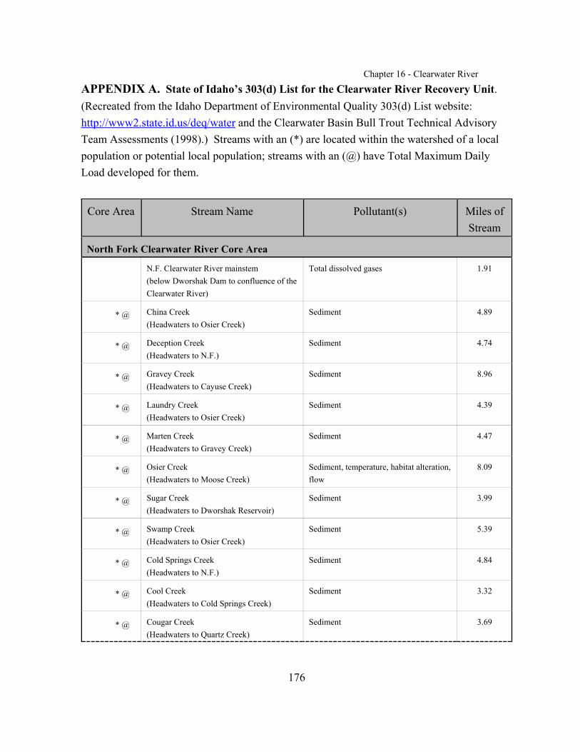
Chapter 16 - Clearwater River
176
APPENDIX A. State of Idaho’s 303(d) List for the Clearwater River Recovery Unit.(Recreated from the Idaho Department of Environmental Quality 303(d) List website:http://www2.state.id.us/deq/water and the Clearwater Basin Bull Trout Technical AdvisoryTeam Assessments (1998).) Streams with an (*) are located within the watershed of a localpopulation or potential local population; streams with an (@) have Total Maximum DailyLoad developed for them.
Core Area Stream Name Pollutant(s) Miles ofStream
North Fork Clearwater River Core Area
N.F. Clearwater River mainstem(below Dworshak Dam to confluence of theClearwater River)
Total dissolved gases 1.91
* @ China Creek(Headwaters to Osier Creek)
Sediment 4.89
* @ Deception Creek(Headwaters to N.F.)
Sediment 4.74
* @ Gravey Creek(Headwaters to Cayuse Creek)
Sediment 8.96
* @ Laundry Creek(Headwaters to Osier Creek)
Sediment 4.39
* @ Marten Creek(Headwaters to Gravey Creek)
Sediment 4.47
* @ Osier Creek(Headwaters to Moose Creek)
Sediment, temperature, habitat alteration,flow
8.09
* @ Sugar Creek(Headwaters to Dworshak Reservoir)
Sediment 3.99
* @ Swamp Creek(Headwaters to Osier Creek)
Sediment 5.39
* @ Cold Springs Creek(Headwaters to N.F.)
Sediment 4.84
* @ Cool Creek(Headwaters to Cold Springs Creek)
Sediment 3.32
* @ Cougar Creek(Headwaters to Quartz Creek)
Sediment 3.69

Chapter 16 - Clearwater River
Core Area Stream Name Pollutant(s) Miles ofStream
177
* @ Grizzly Creek(Headwaters to Quartz Creek)
Sediment 4.53
* @ Hem Creek(Headwaters to Sylvan Creek)
Sediment 4.96
* @ Middle Creek(Headwaters to Weitas Creek)
Sediment 13.32
* @ Orogrande Creek(Headwaters to N.F.)
Sediment 19.51
* @ Sylvan Creek(Headwaters to French Creek)
Sediment 4.31
* @ Tamarack Creek(Headwaters to Orogrande Creek)
Sediment 3.92
* @ Tumble Creek(Headwaters to Washington Creek)
Sediment 4.60
* Beaver Creek(Headwaters to N.F. Clearwater)
Sediment 15.97
* Bertha Creek(Headwaters to Beaver Creek)
Sediment 2.72
* Bingo Creek(Headwaters to Beaver Creek)
Sediment 2.77
* Breakfast Creek(Headwaters to Clearwater River)
Sediment, dissolved oxygen, flow,habitat alteration
8.84
Sneak Creek(Headwaters to N.F.)
Channel alteration 3.49
* S.F. Beaver Creek(Headwaters to Beaver Creek)
Sediment 4.75
Cranberry Creek(Headwaters to Dworshak Reservoir)
Sediment, flow, nutrients, temperature,habitat alteration, bacteria
6.79
* Dog Creek(Headwaters to Isabella Creek)
Sediment 3.88
Elk Creek(Headwaters to Dworshak Reservoir)
Sediment, flow, nutrients, temperature,habitat alteration, bacteria
20.85
Elk Creek Reservoir Sediment, flow, nutrients, temperature,habitat alteration, bacteria, dissolvedoxygen

Chapter 16 - Clearwater River
Core Area Stream Name Pollutant(s) Miles ofStream
178
* Floodwood Creek(Headwaters to Breakfast Creek)
Sediment, dissolved oxygen, flow,habitat alteration
13.59
* Isabella Creek(Headwaters to N.F.)
Sediment 8.54
Johnson Creek(Tributary to Elk Creek)
Sediment 3.27
Long Meadow Creek(Headwaters to Dworshak Reservoir)
Sediment, flow, nutrients, temperature,habitat alteration, bacteria
12.15
Partridge Creek(Headwaters to Elk Creek)
Sediment 4.85
Reeds Creek(Headwaters to Dworshak Reservoir)
Sediment 15.95
* Sourdough Creek(Headwaters to Beaver Creek)
Sediment 3.12
Stoney Creek(Headwaters to Breakfast Creek)
Sediment, dissolved oxygen, flow,habitat alteration
12.23
Swamp Creek(Headwaters to Swamp Creek)
Sediment, nutrients, temperature, habitatalteration, bacteria, flow
7.36
W.F. Elk Creek(Headwaters to Elk Creek)
Sediment 3.50
South Fork Clearwater River Core Area
@ S.F. Clearwater River mainstem (Red River to Clearwater River)
Habitat alteration, sediment, temperature 63.79
* @ Dawson Creek(Headwaters to Red River)
Sediment 2.29
* @ Buffalo Gulch Creek(Headwaters to American River)
Sediment 6.49
* @ Beaver Creek(Headwaters to Newsome Creek)
Sediment 4.95
* @ Nuggett Creek(Headwaters to Newsome Creek)
Sediment 2.72
* @ Sing Lee Creek(Headwaters to Newsome Creek)
Sediment 3.09
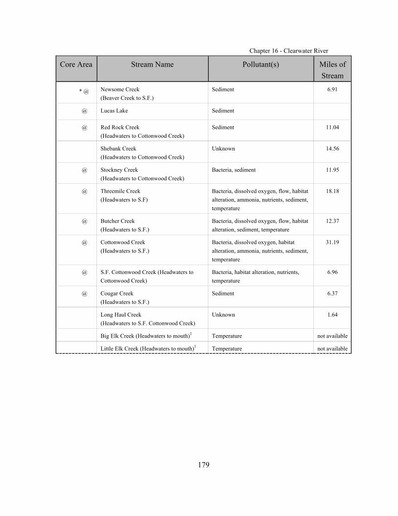
Chapter 16 - Clearwater River
Core Area Stream Name Pollutant(s) Miles ofStream
179
* @ Newsome Creek(Beaver Creek to S.F.)
Sediment 6.91
@ Lucas Lake Sediment
@ Red Rock Creek(Headwaters to Cottonwood Creek)
Sediment 11.04
Shebank Creek(Headwaters to Cottonwood Creek)
Unknown 14.56
@ Stockney Creek(Headwaters to Cottonwood Creek)
Bacteria, sediment 11.95
@ Threemile Creek(Headwaters to S.F)
Bacteria, dissolved oxygen, flow, habitatalteration, ammonia, nutrients, sediment,temperature
18.18
@ Butcher Creek(Headwaters to S.F.)
Bacteria, dissolved oxygen, flow, habitatalteration, sediment, temperature
12.37
@ Cottonwood Creek(Headwaters to S.F.)
Bacteria, dissolved oxygen, habitatalteration, ammonia, nutrients, sediment,temperature
31.19
@ S.F. Cottonwood Creek (Headwaters toCottonwood Creek)
Bacteria, habitat alteration, nutrients,temperature
6.96
@ Cougar Creek(Headwaters to S.F.)
Sediment 6.37
Long Haul Creek(Headwaters to S.F. Cottonwood Creek)
Unknown 1.64
Big Elk Creek (Headwaters to mouth)1 Temperature not available
Little Elk Creek (Headwaters to mouth)1 Temperature not available

Chapter 16 - Clearwater River
Core Area Stream Name Pollutant(s) Miles ofStream
180
Lochsa River Core Area
@ Lochsa River mainstem (CrookedFork/Walton confluence to Selway River)
Temperature 68.74
Boulder Creek (Headwaters to LochsaRiver)1
Temperature not available
Canyon Creek (Headwaters to mouth)1 Temperature not available
* Fish Creek (Headwaters to mouth)1 Temperature not available
Glade Creek (Headwaters to mouth)1 Temperature not available
Nut Creek (Headwaters to mouth)1 Temperature not available
Placer Creek (Headwaters to mouth)1 Temperature not available
Polar Creek (Headwaters to mouth)1 Temperature not available
S. F. Canyon Creek (Headwaters tomouth)1
Temperature not available
Storm Creek (Headwaters to mouth)1 Temperature not available
* W.F. Deadman Creek (Headwaters tomouth)1
Temperature not available
Walde Creek (Headwaters to mouth)1 Temperature not available
Selway River Core Area
@ Island Creek(Headwaters to Selway River)
Sediment 3.97
@ O’Hara Creek(Hamby Fork to Selway River)
Sediment 4.42
@ Slide Creek(Headwaters to Selway River
Sediment 4.17
Lower / Middle Fork Clearwater River Core Area
Clearwater River(Confluence of N.F. below the dam toWashington State line)
Total dissolved gas 40.03
W.Fk. Potlatch River(Cougar Creek to Potlatch River)
Sediment 3.07
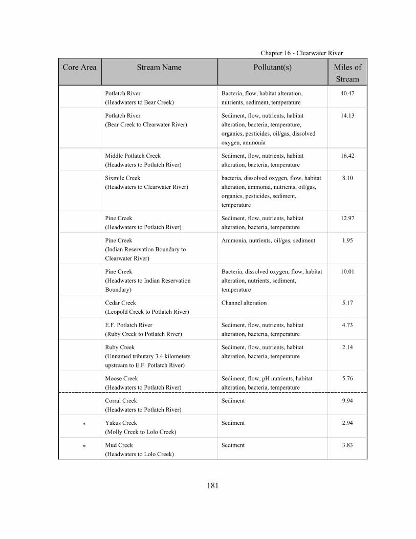
Chapter 16 - Clearwater River
Core Area Stream Name Pollutant(s) Miles ofStream
181
Potlatch River(Headwaters to Bear Creek)
Bacteria, flow, habitat alteration,nutrients, sediment, temperature
40.47
Potlatch River(Bear Creek to Clearwater River)
Sediment, flow, nutrients, habitatalteration, bacteria, temperature,organics, pesticides, oil/gas, dissolvedoxygen, ammonia
14.13
Middle Potlatch Creek(Headwaters to Potlatch River)
Sediment, flow, nutrients, habitatalteration, bacteria, temperature
16.42
Sixmile Creek(Headwaters to Clearwater River)
bacteria, dissolved oxygen, flow, habitatalteration, ammonia, nutrients, oil/gas,organics, pesticides, sediment,temperature
8.10
Pine Creek (Headwaters to Potlatch River)
Sediment, flow, nutrients, habitatalteration, bacteria, temperature
12.97
Pine Creek(Indian Reservation Boundary toClearwater River)
Ammonia, nutrients, oil/gas, sediment 1.95
Pine Creek(Headwaters to Indian ReservationBoundary)
Bacteria, dissolved oxygen, flow, habitatalteration, nutrients, sediment,temperature
10.01
Cedar Creek(Leopold Creek to Potlatch River)
Channel alteration 5.17
E.F. Potlatch River(Ruby Creek to Potlatch River)
Sediment, flow, nutrients, habitatalteration, bacteria, temperature
4.73
Ruby Creek(Unnamed tributary 3.4 kilometers upstream to E.F. Potlatch River)
Sediment, flow, nutrients, habitatalteration, bacteria, temperature
2.14
Moose Creek(Headwaters to Potlatch River)
Sediment, flow, pH nutrients, habitatalteration, bacteria, temperature
5.76
Corral Creek(Headwaters to Potlatch River)
Sediment 9.94
* Yakus Creek(Molly Creek to Lolo Creek)
Sediment 2.94
* Mud Creek(Headwaters to Lolo Creek)
Sediment 3.83

Chapter 16 - Clearwater River
Core Area Stream Name Pollutant(s) Miles ofStream
182
Long Hollow Creek(Headwaters to Little Canyon)
Sediment, nutrients, dissolved oxygen,flow, bacteria, habitat alteration
16.03
Lindsay Creek(Indian Reservation Boundary toClearwater River)
Nutrients, dissolved oxygen, flow,temperature, habitat alteration, bacteria,sediment
7.35
Hatwai Creek(Headwaters to Clearwater River)
Nutrients, temperature, habitat alteration,bacteria
7.93
Lapwai Creek(Unnamed tributary to 26.2 kilometers upstream to Clearwater River)
Nutrients, dissolved oxygen, flow,habitat alteration, bacteria, temperature,sediment
16.32
@ Winchester Lake Nutrients, flow, sediments, dissolvedoxygen, temperature, habitat alteration,bacteria, pesticides
NA
Webb Creek(Headwaters to Indian ReservationBoundary)
Nutrients, sediments, dissolved oxygen,temperature, habitat alteration, bacteria,flow
5.58
@ Jim Ford Creek(Headwaters to Clearwater River)
oil/gas, ammonia, temperature, bacteria,nutrients, sediments, dissolved oxygen,temperature, flow, habitat alteration
27
Grasshopper Creek (Headwaters to JimFord Creek)
Nutrients, sediments, temperature, flow,habitat alteration, bacteria
8.25
* Schmidt Creek(Headwaters to Lolo Creek)
unknown 4.48
* Texas Creek(Headwaters to Lolo Creek)
unknown 5.71
* Lolo Creek(Eldorado Creek to Clearwater River)
Bacteria, oil/gas, nutrients, sediments,dissolved oxygen, flow, habitatalteration, temperature
28.44
* Jim Brown Creek(Headwaters to Musselshell)
Nutrients, sediment, temperature, habitatalteration, flow, bacteria
13.33
W.F. Sweetwater Creek(Headwaters to Indian ReservationBoundary)
Nutrients, sediment, temperature, flow,habitat alteration, bacteria, pesticides, organics, dissolved oxygen
19.53
Lawyer Creek(Headwaters to Indian ReservationBoundary)
Nutrients, sediment, dissolved oxygen,temperature, flow, habitat alteration,bacteria, oil/gas, ammonia
7.30
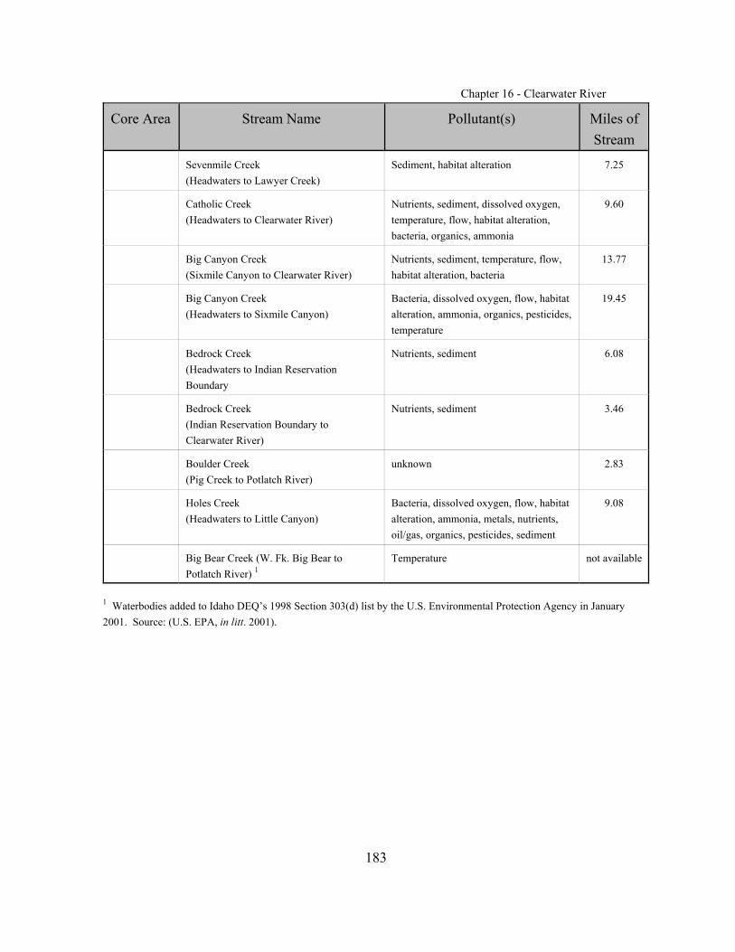
Chapter 16 - Clearwater River
Core Area Stream Name Pollutant(s) Miles ofStream
183
Sevenmile Creek(Headwaters to Lawyer Creek)
Sediment, habitat alteration 7.25
Catholic Creek(Headwaters to Clearwater River)
Nutrients, sediment, dissolved oxygen,temperature, flow, habitat alteration,bacteria, organics, ammonia
9.60
Big Canyon Creek(Sixmile Canyon to Clearwater River)
Nutrients, sediment, temperature, flow,habitat alteration, bacteria
13.77
Big Canyon Creek(Headwaters to Sixmile Canyon)
Bacteria, dissolved oxygen, flow, habitatalteration, ammonia, organics, pesticides,temperature
19.45
Bedrock Creek(Headwaters to Indian ReservationBoundary
Nutrients, sediment 6.08
Bedrock Creek(Indian Reservation Boundary toClearwater River)
Nutrients, sediment 3.46
Boulder Creek(Pig Creek to Potlatch River)
unknown 2.83
Holes Creek(Headwaters to Little Canyon)
Bacteria, dissolved oxygen, flow, habitatalteration, ammonia, metals, nutrients,oil/gas, organics, pesticides, sediment
9.08
Big Bear Creek (W. Fk. Big Bear toPotlatch River) 1
Temperature not available
1 Waterbodies added to Idaho DEQ’s 1998 Section 303(d) list by the U.S. Environmental Protection Agency in January2001. Source: (U.S. EPA, in litt. 2001).
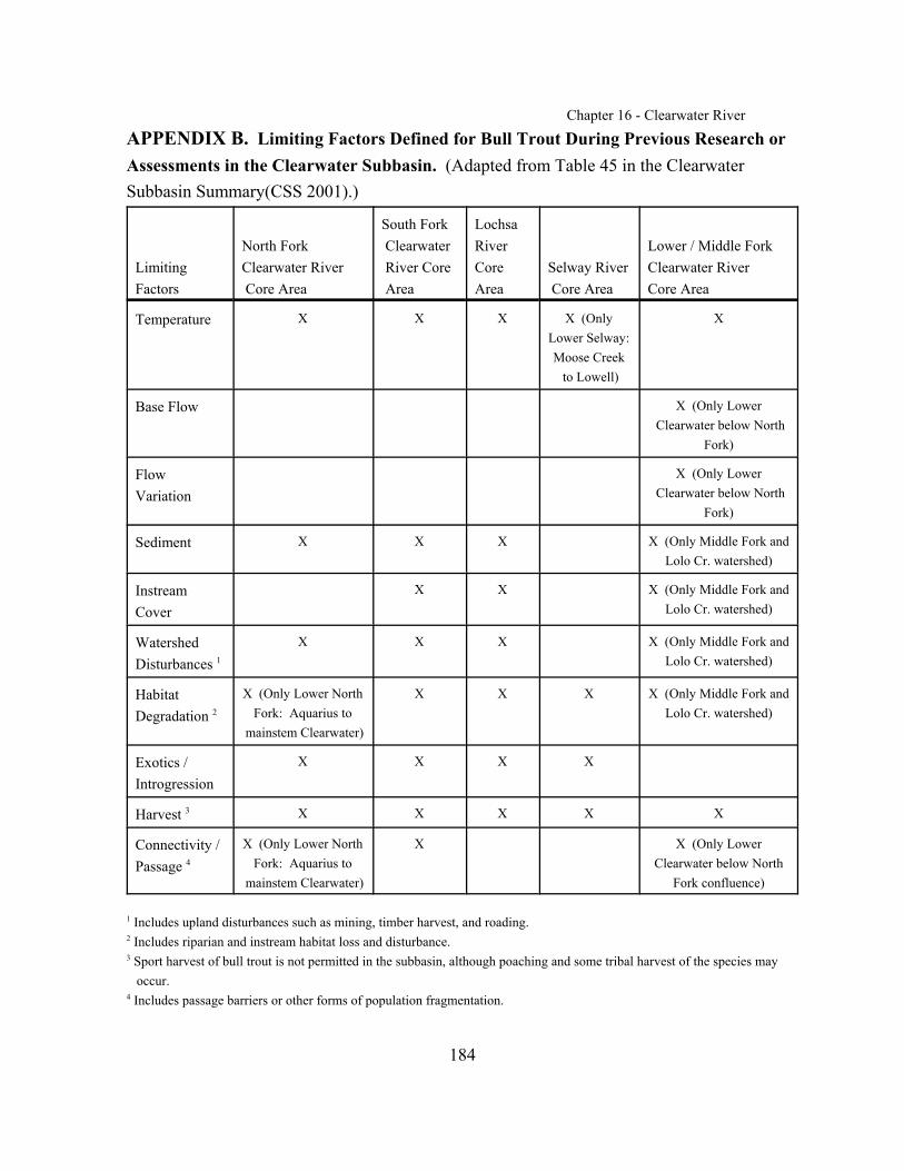
Chapter 16 - Clearwater River
184
APPENDIX B. Limiting Factors Defined for Bull Trout During Previous Research orAssessments in the Clearwater Subbasin. (Adapted from Table 45 in the ClearwaterSubbasin Summary(CSS 2001).)
Limiting Factors
North Fork Clearwater River Core Area
South Fork Clearwater River Core Area
LochsaRiverCoreArea
Selway River Core Area
Lower / Middle ForkClearwater River Core Area
Temperature X X X X (OnlyLower Selway:Moose Creek to Lowell)
X
Base Flow X (Only Lower Clearwater below North
Fork)
FlowVariation
X (Only Lower Clearwater below North
Fork)
Sediment X X X X (Only Middle Fork andLolo Cr. watershed)
InstreamCover
X X X (Only Middle Fork andLolo Cr. watershed)
WatershedDisturbances 1
X X X X (Only Middle Fork andLolo Cr. watershed)
HabitatDegradation 2
X (Only Lower NorthFork: Aquarius to
mainstem Clearwater)
X X X X (Only Middle Fork andLolo Cr. watershed)
Exotics /Introgression
X X X X
Harvest 3 X X X X X
Connectivity /Passage 4
X (Only Lower NorthFork: Aquarius to
mainstem Clearwater)
X X (Only LowerClearwater below North
Fork confluence)
1 Includes upland disturbances such as mining, timber harvest, and roading.2 Includes riparian and instream habitat loss and disturbance.3 Sport harvest of bull trout is not permitted in the subbasin, although poaching and some tribal harvest of the species may occur.4 Includes passage barriers or other forms of population fragmentation.
Chapter 16 - Clearwater River
185
APPENDIX C: List of Chapters
Chapter 1 - IntroductoryChapter 2 - Klamath River Recovery Unit, OregonChapter 3 - Clark Fork River Recovery Unit, Montana, Idaho, and WashingtonChapter 4 - Kootenai River Recovery Unit, Montana and IdahoChapter 5 - Willamette River Recovery Unit, OregonChapter 6 - Hood River Recovery Unit, OregonChapter 7 - Deschutes River Recovery Unit, OregonChapter 8 - Odell Lake Recovery Unit, OregonChapter 9 - John Day River Recovery Unit, OregonChapter 10 - Umatilla-Walla Walla Rivers Recovery Unit, Oregon and WashingtonChapter 11- Grande Ronde River Recovery Unit, OregonChapter 12 - Imnaha-Snake Rivers Recovery Unit, OregonChapter 13 - Hells Canyon Complex Recovery Unit, Oregon and IdahoChapter 14 - Malheur River Recovery Unit, OregonChapter 15 - Coeur d’Alene River Recovery Unit, IdahoChapter 16 - Clearwater River Recovery Unit, IdahoChapter 17 - Salmon River Recovery Unit, IdahoChapter 18 - Southwest Idaho Recovery Unit, IdahoChapter 19 - Little Lost River Recovery Unit, IdahoChapter 20 - Lower Columbia Recovery Unit, WashingtonChapter 21 - Middle Columbia Recovery Unit, WashingtonChapter 22 - Upper Columbia Recovery Unit, WashingtonChapter 23 - Northeast Washington Recovery Unit, WashingtonChapter 24 - Snake River Washington Recovery Unit, WashingtonChapter 25 - Saint Mary - Belly Recovery Unit, Montana