chapter 10, appendix b proposed browse to nws …
TRANSCRIPT

CHAPTER 10, APPENDIX B
PROPOSED BROWSE TO NWS PROJECT STATE ERD

STATE ERD
1. PREAMBLEThis State Environmental Review Document (ERD) is an addendum to the draft Environmental Impact Statement (EIS)/ERD for the proposed Browse to North West Shelf (NWS) Project and has been prepared to provide proposed details and assessment conclusions specific to the State components of the proposed Browse to NWS Project (Proposal). The majority of the proposed Browse to NWS Project is located outside State jurisdiction. Most notably, the Floating Production Storage and Offloading facilities (FPSOs) and the entire length of the Browse Trunkline (BTL) are located in Commonwealth waters. However, a portion of the subsea wells and gathering system for the Torosa FPSO extend into State waters.
The draft EIS/ERD provides a ‘whole of project’ assessment as per the approved EIS Guidelines/Environmental Scoping Document (EISG/ESD). This document has been prepared to further assist readers of the draft EIS/ERD to clearly identify the activities, aspects, receptors, predicted impacts and potential risks that are applicable to the assessment of the State aspects of the Proposal under the WA Environmental Protection Act 1986 only.
This State ERD focuses on State aspects of the Proposal and therefore does not repeat all information on the proposed Browse to NWS Project. This State ERD references the reader back to the draft EIS/ERD where relevant. As such, this State ERD is to be read in conjunction with the draft EIS/ERD. It should be noted that, unless stated otherwise, where content within the draft EIS/ERD is referenced within this State ERD, content in the draft EIS/ERD applies equally to State and Commonwealth jurisdictions.
2. INVITATION TO MAKE A SUBMISSION
The Western Australian (WA) Environmental Protection Authority (EPA) invites people to make a submission on the environmental review for the proposed Browse to NWS Project (Proposal).
Woodside Energy Ltd, as operator for and on behalf of the Browse Joint Venture, proposes to develop and operate the proposed Browse to NWS Project. This Environmental Review Document (ERD) has been prepared in accordance with the EPA’s Procedures Manual (Part IV Divisions 1 and 2). The ERD is the report through which the proponent describes the Proposal,
assesses and documents its likely effects on the environment.
The ERD is available for a public review period of 8 weeks from 18 December 2019, closing on 12 February 2020.
Information on the Proposal from the public may assist the EPA to prepare an assessment report in which it will make recommendations on the Proposal to the Minister for Environment.
Why write a submission? The EPA seeks information that will inform the EPA’s consideration of the likely effect of the Proposal, if implemented, on the environment. This may include relevant new information that is not in the ERD, such as alternative courses of action or approaches.
In preparing its assessment report for the Minister for Environment, the EPA will consider the information in submissions, the proponent’s responses and other relevant information.
Submissions will be treated as public documents unless provided and received in confidence, subject to the requirements of the Freedom of Information Act 1992 (WA).
Why not join a group? It may be worthwhile joining a group or other groups interested in making a submission on similar issues. Joint submissions may help to reduce the workload for an individual or group. If you form a small group (up to 10 people) please indicate all the names of the participants. If your group is larger, please indicate how many people your submission represents.
Developing a submission You may agree or disagree with, or comment on information in the ERD.
When making comments on specific elements in the ERD:
+ clearly state your point of view and give reasons for your conclusions
+ reference the source of your information, where applicable
+ suggest alternatives to improve the outcomes on the environment.
STAT
E ERD
What to include in your submission Include the following in your submission to make it easier for the EPA to consider your submission:
+ your contact details – name and address
+ date of your submission
+ whether you want your contact details to be confidential
+ summary of your submission, if your submission is long
+ list points so that issues raised are clear, preferably by environmental factor
+ refer each point to the page, section and, if possible, paragraph of the ERD
+ attach any reference material, if applicable. Make sure your information is accurate.
The closing date for public submissions is: 12 February 2020
The EPA prefers submissions to be made electronically via the EPA’s Consultation Hub at https://consultation.epa.wa.gov.au
Alternatively, submissions can be:
+ posted to: Chairman, Environmental Protection Authority, Locked Bag 10, Joondalup DC WA 6919, or
+ delivered to: The Environmental Protection Authority, 8 Division Terrace, Joondalup WA 6027.
If you have any questions on how to make a submission, please contact the EPA Services at the Department of Water and Environmental Regulation (DWER) on (08) 6364 7000.
3. SCOPING CHECKLIST Table 3-1 presents the completed scoping checklist which identifies the required work (as per the approved Environmental Scoping Document (ESD)) and reference to the location in the draft EIS/ERD and this State ERD where the requirement has been met.
Table 3-1 Scoping Checklist
Task No.
Required Work Section and Page No.
Benthic Communities and Habitats
1. Determination of predicted temporary and permanent seabed disturbance within State waters.
Section 8.3.4.2 (pg. 915);
Section 6.3.1 of the draft EIS/ERD
2. Characterise the benthic habitats in the area potentially impacted using existing survey data and literature, including the preparation of habitat maps with demonstrated ground truthing for areas where proposed infrastructure will be installed on the seabed within State waters. Woodside has a good understanding of the benthic habitats expected to be disturbed within State waters and, as such, no further studies to characterise these benthic habitats is considered required.
Section 8.3.3 (pg. 912);
Section 5.3.1 of the draft EIS/ERD
3. Where significant benthic communities are identified in areas where infrastructure will be installed on the seabed, identify an appropriate Local Assessment Unit and assess cumulative loss of benthic communities and habitats in accordance with EPA’s technical guidance.
Section 8.3.7 (pg. 922)
PROPOSED BROWSE TO NWS PROJECT – DRAFT EIS/ERD APPENDICES 873
ProP
osed
Bro
wse
to N
ws
Proj
ect s
tate
erd
10B

Task No.
Required Work Section and Page No.
4. Predict the likely fate of discharged drill cuttings using existing data and modelling and assess impact on benthic habitats. Woodside has a good understanding of the quantity and nature of the drill cuttings that are predicted to be generated and the drill fluids to be used. There is also a good understanding on the predicted fate of the discharges via drilling cuttings discharge modelling undertaken as part of the previously proposed Browse Development concepts. Drilling and completion activities required for the Proposal are expected to be broadly similar to that of the previously proposed development concepts. As such, the previous modelling is considered representative of the Proposal and sufficient for assessing the potential impacts.
Section 8.3.4.9 (pg. 917);
Section 6.3.15 of the draft EIS/ERD
5. Undertake hydrocarbon spill modelling to describe the dispersion and degradation characteristics of a range of hydrocarbon spill scenarios to inform the risk assessment and the development of mitigation measures.
Section 8.3.4.15 (pg. 920);
Section 6.3.21 of the draft EIS/ERD
Marine Environmental Quality
6. Characterise the marine environmental quality in the area potentially impacted using existing survey data and literature. Woodside has a good understanding of the marine environment in the State waters within the Browse Development Area via numerous available studies and, as such, no further studies to characterise this marine environment is considered required.
Section 8.2.3 (pg. 892);
Sections 5.2.9, 5.2.10, 5.3.1, 5.3.2, 5.3.3.3 and 5.4.2.2 of the draft EIS/ERD
7. Characterise discharge type that has the potential to impact on State waters (e.g. vessel and MODU discharges, drill cuttings and fluids, produced water, cooling water, hydrotest fluid, subsea control fluids) in terms of volume, frequency, composition and ecotoxicity.
Section 8.2.4 (pg. 892);
Sections 6.3.9, 6.3.10, 6.3.11, 6.3.12, 6.3.13, 6.3.15, 6.3.16, 6.3.17 of the draft EIS/ERD
8. Present previously undertaken modelling or revised modelling where required as described in the workplan (Section 3.8.8 of the EISG/ESD) and describe the dilution and fate of the discharges to determine the spatial extent of potential impacts and appropriate mixing zones.
Section 8.2.4 (pg. 892);
Sections 6.3.12, 6.3.13, 6.3.15, 6.3.17 of the draft EIS/ERD
9. Based on characterisation of the existing marine environment and expected discharges and modelling, develop and present spatially proposed Environmental Quality Criteria (Environmental Quality Objectives and levels of ecological protection) for State waters within the Browse Development Area.
Section 8.2.6 (pg. 906);
10. Outline a commitment to develop and implement a Marine Environmental Quality Management Plan (EQMP) for the State waters which identifies the Environmental Values to be protected and spatially defines the Environmental Quality Objectives and levels of ecological protection that Woodside aims to achieve in State waters.
Section 8.2.6 (pg.906);
11. Undertake hydrocarbon spill modelling to describe the dispersion and degradation characteristics of a range of hydrocarbon spill scenarios to inform the risk assessment and the development of mitigation measures.
Section 8.3.4.15 (pg. 920);
Section 6.3.21 of the draft EIS/ERD
PROPOSED BROWSE TO NWS PROJECT – DRAFT EIS/ERD 874
ProP
osed
Bro
wse
to N
ws
Proj
ect s
tate
erd
10B

STAT
E ERD
Task No.
Required Work Section and Page No.
Marine Fauna
12. Characterise the marine fauna in the area potentially impacted using existing survey data and literature. Woodside generally has a good understanding of marine mammals that may occur in the Browse Development Area via a large number of surveys undertaken in relation to the previously proposed Browse Development concepts which have included habitat association surveys, long-term sea noise logger deployment, aerial and vessel surveys and satellite tagging.
Section 8.4.3 (pg. 924);
Section 5.3.2 of the draft EIS/ERD
13. Characterise the predicted underwater noise emissions and potential impacts using existing and new modelling studies.
Section 8.4.4.6 (pg. 933);
Section 6.3.8 of the draft EIS/ERD
14. Characterise the predicted light emissions and potential impacts using existing modelling studies. Light modelling undertaken to support the FLNG draft EIS (EPBC 2013/7079 is considered representative of the Proposal facilities and, as such, no further modelling is considered necessary.
Section 8.4.4.2 (pg. 928);
Section 6.3.3 of the draft EIS/ERD
15. Predict the likely fate of discharged drill cuttings using existing data and modelling and assess impact on marine fauna.
Section 8.4.4.11 (pg. 935);
Section 6.3.15 of the draft EIS/ERD
16. Undertake a literature review on the impacts of electromagnetic emissions on marine fauna and utilise estimated direct electrical heating power demand to assess impacts.
Section 8.4.4.3 (pg. 931)
17. Undertake hydrocarbon spill modelling to describe the dispersion and degradation characteristics of a range of hydrocarbon spill scenarios to inform the risk assessment and the development of mitigation measures. This includes the modelling of a condensate spill which will be used to assess the risk to Scott Reef that such a spill would present.
Section 8.4.4.18 (pg. 940);
Section 6.3.21 of the draft EIS/ERD.
Air Quality
18. Woodside has sufficient understanding of the characteristics of the Browse resource and the combustion requirements to extract, process and export the gas to accurately quantify gaseous emissions. As such, no further studies are considered required.
Section 8.5 (pg. 942);
Section 6.3.5, 6.3.6 and Chapter 7 of the draft EIS/ERD.
PROPOSED BROWSE TO NWS PROJECT – DRAFT EIS/ERD APPENDICES 875
ProP
osed
Bro
wse
to N
ws
Proj
ect s
tate
erd
10B

4. INTRODUCTIONThis State ERD is an addendum to the draft EIS/ERD for the proposed Browse to NWS Project to satisfy the requirements of the:
+ Environmental Impact Assessment (Part IV Divisions 1 and 2) Administrative Procedures 2016 (EPA, 2016)
+ EPA’s Instructions on how to prepare an Environmental Review Document (EPA, 2018a).
It has been prepared to assist the reader of the draft EIS/ERD to clearly identify the activities, aspects, receptors, predicted impacts and potential risks that are applicable to the assessment of the Proposal under the WA Environmental Protection Act 1986 only.
The scope of the Proposal that is the subject of this State ERD is limited to the proposed activities within the State Proposal Area (Section 5.3.1) and vessel and helicopter movements occurring within State waters between the State Proposal Area and the potential supply chain and logistics support locations.
4.1 ProponentPlease refer to Section 2.3 of the draft EIS/ERD for proponent details.
4.2 Environmental Impact Assessment ProcessPlease refer to Section 2.9 of the draft EIS/ERD for the assessment process for the proposed Browse to NWS Project, including the Proposal.
4.3 Other Approvals and Regulation
4.3.1 TitlesThe Browse Joint Venture (BJV) holds seven petroleum retention leases. Five of the leases (WA 28 R, WA-29-R, WA-30-R, WA-31-R and WA-32-R) are located in Commonwealth waters and are governed under the Offshore Petroleum and Greenhouse Gas Storage Act 2006 (Cth) (OPGGSA). The remaining two leases (TR/5 and R2) are governed under State legislation, the Petroleum (Submerged Lands) Act 1982 (WA) (PSLA) and the Petroleum and Geothermal Energy Resources Act 1967 (WA).
4.3.2 Decision Making Authorities The decision making authorities for the Proposal are listed in Table 4-1.
Table 4-1 Decision Making Authorities
Decision Making Authority Relevant Western Australian Legislation
Minister for Mines and Petroleum Petroleum (Submerged Lands) Act 1982 and the Petroleum and Geothermal Energy Resources Act 1967 (WA)
Chief Executive Officer, Department of Water and Environmental Regulation
Environmental Protection Act 1986
Chief Dangerous Goods Officer, Department of Mines, Industry Regulation and Safety
Dangerous Goods Safety Act 2004
4.3.3 Other ApprovalsTable 4-2 summarises the other approvals and regulations that apply to the Proposal.
Table 4-2 Other Approvals
Proposed Activities Land tenure/access Type of approval Legislation regulating the activity
Subsea infrastructure development and operation
Petroleum titles Environment Plans and Oil Spill Contingency Plans
Petroleum (Submerged Lands) Act 1982 (WA) and associated regulations
PROPOSED BROWSE TO NWS PROJECT – DRAFT EIS/ERD 876
ProP
osed
Bro
wse
to N
ws
Proj
ect s
tate
erd
10B

STAT
E ERD
5. THE PROPOSAL
5.1 BackgroundThe Proposal was referred to the EPA under the Environmental Protection Act 1986 (EP Act) in October 2018. On 22 January 2019, the EPA determined the Proposal required assessment under Section 29 of the EP Act and set a Public Environmental Review (PER) level of assessment. The determination identified these EPA Environmental Factors as being relevant for the Proposal:
+ Marine Environmental Quality
+ Benthic Communities and Habitats
+ Marine Fauna
+ Air Quality.
The draft EIS/ERD conforms with the EIS Guidelines/Environmental Scoping Document (EISG/ESD) approved by the DoEE on 5 July 2019 and EPA on 4 July 2019, respectively (Chapter 10, Appendix A of the draft EIS/ERD). The EISG/ESD was made publicly available on the 8 July 2019.
The proposal is similar to the previously referred ‘Torosa Subsea Development Proposal’ that resulted in a ‘Not Assessed – Public Advice Given’ decision by the EPA in 2015 (CMS14397).
The proposed Browse to NWS Project continues to be subject to detailed design and refinement. Key modifications that have occurred since the referral of the Proposal and approval of the EISG/ESD include:
+ an increase in the number of wells within State waters from up to approximately 21 to up to approximately 24
+ a minor increase in seabed infrastructure related to the higher well count and design refinement.
Refer to Chapter 2 of the draft EIS/ERD for an overview of the proposed Browse to NWS Project and background information, including details of the assessment process (Section 2.9 of the draft EIS/ERD), the Browse resources, the proponent, the project objectives, current status and relationship with other developments.
5.2 JustificationPlease refer to Section 2.8 of the draft EIS/ERD for the development justification.
5.3 Proposal DescriptionThis section provides an overview of the State components of the Proposed Browse to NWS Project Proposal. A full description of the proposed Browse to NWS Project is provided in Chapter 3 of the draft EIS/ERD.
5.3.1 State Proposal AreaAs described in Chapter 2 of the draft EIS/ERD, the overall Project Area (encompassing both State and Commonwealth components) comprises:
+ the proposed Browse Development Area (in which the Brecknock, Calliance, and Torosa fields, the FPSO facilities and the subsea production systems, including wells, will be located) (Figure 2-1 of the draft EIS/ERD)
+ the pipeline corridor within which the proposed BTL and inter-field spur line will be located (Figure 2-2 of the draft EIS/ERD).
The State Proposal Area, which is the subject of the assessment under the EP Act, is located within the Browse Development Area and comprises all areas above the low water line (based on mean low water springs (MLWS)) and all waters within 3 nm of the low water line, as shown in Figure 5-1.
It should be noted that, as detailed in Chapter 4, the scope of this State ERD includes vessel and helicopter movements occurring within State waters outside of the State Proposal Area.
5.3.2 Overview Activities in the State Proposal Area comprise a small subset of infrastructure and activities of the proposed Browse to NWS Project. Within State jurisdiction, activities include the development of up to an estimated 24 wells and associated subsea infrastructure targeting the hydrocarbon resources within the Torosa reservoir. The remaining facilities and infrastructure will be located in Commonwealth waters and are outside the scope of this State ERD. Extracted hydrocarbons will be transferred via subsea infrastructure, including Christmas trees, manifolds and flowlines, to the Torosa FPSO facility, located in Commonwealth waters.
The highest intensity of activities within the State Proposal Area is likely to occur during the drilling and completion activities, installation activities and future decommissioning phases. During this time, a mobile offshore drilling unit (MODU) and approximately ten vessels may be present. As all permanent infrastructure within the State Proposal Area is subsea, the operation of the wells will be controlled remotely via the FPSO facilities that are located in Commonwealth waters. Outside of drilling and completion and installation periods, surface activities in the State Proposal Area will comprise periodic inspection, maintenance and repair activities involving one or two vessels and later phase well construction and decommissioning (including well plug and abandonment). Table 5-1 provides a summary of the Proposal.
PROPOSED BROWSE TO NWS PROJECT – DRAFT EIS/ERD APPENDICES 877
ProP
osed
Bro
wse
to N
ws
Proj
ect s
tate
erd
10B

Table 5-1 Summary of the Proposal
Proposal Summary
Proposal Title Proposed Browse to NWS Project (State component)
Proponent Name Woodside Energy Ltd, as Operator for and on behalf of the Browse Joint Venture
Short Description Drilling and completion, subsea installation, commissioning, operation, inspection, maintenance and repair and decommissioning of subsea wells and associated subsea infrastructure located in Western Australian State waters, to extract hydrocarbons from the Torosa reservoir, located approximately 425 km north of Broome and approximately 290 km off the Kimberley coast.
Table 5-2 Location and proposed extent of physical and operational elements of the Proposal
Element Description Proposed Authorised Extent
Physical Elements
Drilling and completion activities of up to approximately 24 wells
Installation and physical presence of infrastructure within indicative field layout as per Figure 5-1.
Approximately 0.31 km2 of direct seabed disturbance (including 25% contingency).
Associated subsea infrastructure (Christmas trees, manifolds, flowlines, and umbilicals)
Temporary mooring of MODU
Seabed preparation and flowline stabilisation
Operational Elements
Water supply (installation vessels, Inspection, Maintenance and Repair (IMR) vessels, MODUs and project vessels)
Water requirements sourced either from seawater (reverse osmosis plant) or loaded at port.
Limited water requirements to support drilling and completion activities, subsea installation activities (e.g. potential hydrotest), vessel and MODU water needs and potentially also for decommissioning activities.
Power supply (installation vessels, IMR vessels, MODUs and project vessels)
Power generated on board vessels and MODU.
As required for operations and safety.
Vessel discharges (installation vessels, IMR vessels, MODU, and project vessels).
Discharges from vessels and MODU include treated sewage, drain waters, cooling water, sullage, putrescible organic waste and desalination brine.
Limited volumes discharged in accordance with International Convention for the Prevention of Pollution from Ships MARPOL 73/78 Annex I, as applied in Australia under the Commonwealth Protection of the Sea (Prevention of Pollution from Ships) Act 1983 (Part II Prevention of pollution from oil); Marine Orders 91 (Marine pollution prevention – Oil) 2014 as applicable to vessel class; Pollution of Waters by Oil and Noxious Substance Act 1986.
Drill cuttings and fluid discharges
Drill cuttings and drilling fluids. Approximately 850 m3 of cuttings per well, with up to approximately 24 wells to be developed in the State Proposal Area.
Approximately 100-130 m3 well discharge fluid per well during well unloading.
PROPOSED BROWSE TO NWS PROJECT – DRAFT EIS/ERD 878
ProP
osed
Bro
wse
to N
ws
Proj
ect s
tate
erd
10B

STAT
E ERD
Element Description Proposed Authorised Extent
Hydrotest fluid discharges Hydrotest fluids discharged at the seabed during integrity testing of the subsea infrastructure.
Oneoff discharges of up to approximately 950 m3 of hydrotest fluid for the TRE flowline and up to approximately 250 m3 at the TRF flowline.
Produced water Low volumes of water that occurs naturally within the hydrocarbon-bearing geological formations.
Small volumes of formation water may result during well unloading activities by the MODU. These will be discharged directly from the MODU.
Subsea control fluid discharge
Control fluid discharged at the Christmas trees to maintain valve functionality.
Intermittent discharge of waterbased hydraulic control fluid when subsea valves are actuated (~0.1 L).
Maximum volume of control fluid that will be released to the marine environment per manifold is 1,900 L per year of water based fluid containing approximately ~3% active ingredient (40–68 L of control fluid additive).
Underwater noise emissions Underwater noise:
+ generated during drilling, completion and installation activities (including vessel movements using Dynamic Positioning (DP), vertical seismic profiling (VSP) and distributed acoustic sensing (DAS)
+ generated from subsea infrastructure during operations
+ from piling activities for mooring installation for the MODU (note that this is unlikely to be required)
+ from installation vessels, IMR vessels, MODUs and project vessels
+ from helicopter movements from the MODU
+ from IMR activities.
Noise related behavioural disturbance radius of up to approximately 10.5 km around drilling and installation activities.
Noise related behavioural disturbance radius of up to approximately 500 m around subsea infrastructure during operations.
Light emissions – operational lighting
Artificial light emitted by installation vessels, IMR vessels, MODUs and project vessels.
Limited to functional lighting at levels that provide a safe working environment for personnel.
Light emissions – flaring Intermittent flaring from the MODU during well unloading. This occurs only during well installation or intervention for repairs.
Air emissions – offshore activities
Air emissions resulting from power generation on project vessels and MODU.
PROPOSED BROWSE TO NWS PROJECT – DRAFT EIS/ERD APPENDICES 879
ProP
osed
Bro
wse
to N
ws
Proj
ect s
tate
erd
10B

Figure 5-1 State Proposal Area
PROPOSED BROWSE TO NWS PROJECT – DRAFT EIS/ERD 880
ProP
osed
Bro
wse
to N
ws
Proj
ect s
tate
erd
10B

STAT
E ERD
5.3.3 Project Infrastructure
Project infrastructure within the State Proposal Area is proposed to comprise the following:
+ 24 production wells
+ subsea infrastructure
+ temporary moorings for MODU anchoring.
It should be noted that the BTL, inter-field spur line and FPSO facilities will be located entirely in Commonwealth waters.
Production wellsIt is anticipated the proposed Browse to NWS Project will require drilling and completion of up to 24 production wells in State waters at the Torosa reservoir over the life of the proposed Browse to NWS Project. This includes the drilling and completion of approximately three wells at the TRA drill centre for Phase 1 Ready for Start Up (RFSU). The remaining 30 production wells of the Browse to NWS Project will be located in Commonwealth waters (including five at the Torosa reservoir and 25 at the Brecknock and Calliance reservoirs).
A wellhead will be installed at the top of each well. The wellhead will hold the production well casing and will enable installation of the Christmas tree, complete with well control facilities. Christmas trees are steel structures with various valves and are used to:
+ control production, whereby hydraulically controlled valves on the Christmas trees are used to control flow rates and provide a well shut-off mechanism
+ manage chemical injection.
Surface controlled subsurface safety valves will be installed in the wells.
To optimise the layout of the subsea infrastructure, production wells will be arranged around drill centres (a cluster of wells around a central manifold) with up to four drill centres located within the State Proposal Area. Only one drill centre (TRA) will be installed in the State Proposal Area prior to start-up of the Torosa FPSO Facility – the residual will be installed in later years. The number and location of these wells and drill centres will depend on reservoir target areas, seabed bathymetry and features to optimise reservoir recovery. A notional field layout is provided in Figure 5-1.
Subsea infrastructure The wells at each drill centre will be connected to manifolds by well jumpers (a specially-designed piece of pipe used to transport production fluid between components of the subsea infrastructure) to allow reservoir fluids to be carried from the wells to the manifolds. The manifolds will connect the wells to corrosion resistant alloy clad (or lined) flowlines that will be routed back to the FPSOs, located in Commonwealth waters. An example of subsea infrastructure for illustrative purposes is provided in Figure 3-1 of the draft EIS/ERD.
Subsea infrastructure will be powered, monitored and controlled from the FPSO facilities using a network of electro-hydraulic control umbilicals and subsea distribution units. Each drill centre will be serviced by an electro-hydraulic umbilical, which will follow a similar alignment as the infield flowlines. Some umbilicals may be integrated within the production flowline bundle. Umbilicals will also be tied back to the FPSO facilities (in Commonwealth waters) using a system of flexible risers.
Other subsea infrastructure may include pile installation and temporary mooring lines for MODU anchoring.
5.3.4 Development Activities
Development activities within the State Proposal Area will include:
+ pile installation
+ development drilling and completions
+ subsea umbilicals, risers and flowlines (SURF) installation and commissioning.
Pile installationPile installation may be required within State waters for temporary mooring of the MODUs. Data from the surveys undertaken by Woodside in 2014 has been analysed and demonstrates suction piling for moorings is feasible and will be the most likely option for pile installation.
Suction piles are installed by gently lowering the pile onto the seabed and using gravity to lower the pile into the soft substrate. Installation is completed by pumping out the entrapped water inside the pile, with the resulting differential pressure driving the pile into the seabed.
PROPOSED BROWSE TO NWS PROJECT – DRAFT EIS/ERD APPENDICES 881
ProP
osed
Bro
wse
to N
ws
Proj
ect s
tate
erd
10B

Should alternate piling methods be selected, options include drilling and cementing or impact piling, which involves the application of force to drive the pile into the seabed.
Development drilling and completionsThe proposed Browse to NWS Project will require the drilling of up to 24 production wells within State waters. It is anticipated the drilling and completion activities will be completed in multiple phases. The first phase will be drilling and completion of approximately three wells at the TRA drill centre to achieve RFSU, with subsequent phases of drilling and completion of additional wells undertaken over the life of the Proposal to optimise reservoir recovery (Figure 5-1). The drilling and completions process will not differ between wells in State and Commonwealth waters and is described in detail in Section 3.7.2 of the draft EIS/ERD.
Subsea Umbilicals, Risers and Flowlines (SURF) installation and commissioningThe process for the installation and commissioning of the SURF infrastructure, including site preparation, is described in detail in Section 3.7.3 of the draft EIS/ERD.
5.3.5 Operations
Activities within the State Proposal Area during operations will be limited to:
+ hydrocarbon extraction
+ inspection, maintenance and repair (IMR) activities.
Hydrocarbon extractionDuring operations, hydrocarbons extracted from the reservoirs will flow via the Christmas trees and manifolds through the flowlines and risers to the FPSO facilities in Commonwealth waters. The flow rate of hydrocarbons will be controlled by subsea choke valves at the Christmas trees. Subsea hydraulic control fluids will be used to operate subsea valves. Hydrocarbon extraction including the potential use of distributed acoustic sensing (DAS) surveys is described in Section 3.7.6.1 of the draft EIS/ERD. Note that processing of the gas and condensate on the FPSO facilities and subsequent condensate offload and gas export will occur in Commonwealth waters.
Inspection, maintenance and repair (IMR) The subsea infrastructure will be designed to require only minor degrees of intervention. Inspection and maintenance will be undertaken to ensure the integrity of the infrastructure and identify any problems before they present a risk of loss of containment. Intervention
may be required to repair identified problems. A detailed description of the planned IMR activities is provided in Section 3.7.7 of the draft EIS/ERD.
5.3.6 Decommissioning
At the end of the proposed Browse to NWS Project life, the infrastructure will be decommissioned in accordance with good oilfield practice and relevant legislation and practice at the time. This is likely to include well suspension, plugging and abandoning wells and removing the subsea infrastructure. All infrastructure installed above the seabed will be designed to allow removal.
Given the expected life of the project, the decommissioning of the proposed Browse to NWS Project is not likely for many years. Given the possible improvements in technology that may occur between now and the time of decommissioning, it is not possible to fully scope the decommissioning strategy that will be employed at that time however all infrastructure above the seabed has been designed to allow removal. The strategy demonstrated through activity-specific Environment Plans will be developed in consultation with the EPA and other stakeholders closer to the time (Table 4-2).
5.3.7 Support Activities and Infrastructure
5.3.7.1 Logistics support
The proposed Browse to NWS Project will require supply chain and logistics support during construction and operations, as described in Section 3.7.9 of the draft EIS/ERD.
Requirements for supply chain and logistics support for the proposed Browse to NWS Project may include:
+ port access for supply and support vessels to transfer people, equipment, materials and waste to and from the Project Area
+ airport access for fixed-wing aircraft and helicopters to transfer people and supplies to and from the Project Area
+ search and rescue capabilities
+ onshore support for receiving, storing, and distributing materials and equipment.
The proposed Browse to NWS Project is not dependent on the development of new onshore supporting infrastructure to proceed. Supply chain and logistics
PROPOSED BROWSE TO NWS PROJECT – DRAFT EIS/ERD 882
ProP
osed
Bro
wse
to N
ws
Proj
ect s
tate
erd
10B
STAT
E ERD
support locations that have existing services and infrastructure for ongoing regular support over the whole life of the proposed Browse to NWS Project are being considered, with the assessment and selection focused on using supply chain services and infrastructure within WA.
Potential supply chain and logistics support locations in Australia include:
+ Broome
+ Djarindjin
+ Dampier/Karratha
+ Exmouth
+ Perth.
Facilities in Broome include the Port of Broome, which is the main deep water port servicing the Kimberley region. The port supports livestock export, offshore oil and gas, supply vessels, pearling, fishing charter boats, cruise liners and is the main fuel and container receiving point for the Kimberley. Facilities at the port include an outer berth, two inner berths, fuel and potable water distribution facilities, a laydown area, lighting suitable for night work and a slipway. Other facilities include the Broome International Airport which is located in Broome and includes a runway for fixed wing operations and a heliport which opened in 2008. A helipad is also available on site with space for four larger helicopters and 10 additional helicopter parking positions are available near the airport.
The King Bay Supply Base is located in the Port of Dampier and is operated by Woodside (Woodside 2014). The facility is suitable for a wide range of vessels varying in size and configuration such as harbour tugs, supply vessels, crew and utility vessels and transportation/heavy lift vessels.
Facilities in Djarindjin include a fixed and rotary wing aviation base which supports existing offshore oil and gas facility crew change operations.
As the proposed Browse to NWS Project will be using existing supply and logistics services and infrastructure which are managed by third parties, such services and infrastructure are not considered further as part of this assessment. The scope of this assessment is limited to vessel and helicopter movements between the State Project Area and the potential supply chain and logistics support locations. Any activity at supply chain and logistics support locations is outside the scope of this assessment.
In addition, there may be a requirement to conduct short term, discrete logistical support activities from time to time at various port and airport locations along the coast of WA, Australia and internationally to support activities throughout the life of the proposed Browse to NWS Project. These activities are likely to be consistent with general shipping activities.
5.3.7.2 Project vessels and helicopters
The drilling and completion, subsea installation and commissioning phases will be supported by project vessels including barges, tugs, survey vessels, supply vessels and installation vessels.
During the operations phase, vessel presence in the State Proposal Area will primarily be limited to IMR activities and environmental monitoring purposes.
Personnel transfer to offshore facilities from Broome will be either via helicopter or vessel. If helicopters are used, it is anticipated that up to five personnel transfers a week per FPSO facility will be required during normal operations. Helicopters will not enter the State Proposal Ara under normal operations, however they will traverse State Waters near the mainland.
Fast crew transfer vessels (FCTVs) may be used for crew transfer. These crew transfer vessels are capable of travelling at 50 – 55 knots. It is anticipated one transfer per day will occur during normal operations, with additional transfers during shut downs and major maintenance. FCTVs will not enter the State Proposal Area around Scott Reef under normal operations. They will traverse coastal State waters near the logistical base.
Vessel requirements during the decommissioning phase are unknown at this stage as decommissioning plans have not been finalised. However, it can be expected decommissioning may use similar vessels to those engaged for installation activities.
5.4 Local and Regional ContextThe local context for the proposed Browse to NWS Project is provided in Chapter 5 of the draft EIS/ERD. Specifically, values relating to the State Proposal Area include the following:
+ the Scott Reef Nature Reserve (Section 5.3.3.3 of the draft EIS/ERD)
+ the Seringapatam Reef and Commonwealth waters in the Scott Reef Complex and the Continental Slope Demersal Fish Communities KEFs, which overlap the State Proposal Area (Section 5.3.3.1 of the draft EIS/ERD)
PROPOSED BROWSE TO NWS PROJECT – DRAFT EIS/ERD APPENDICES 883
ProP
osed
Bro
wse
to N
ws
Proj
ect s
tate
erd
10B

+ Biological Important Areas (BIAs) (green turtle, hawksbill turtle, little tern, pygmy blue whale; Section 5.3.2.2 of the draft EIS/ERD) and habitat critical to the survival of a species (green turtle; Section 5.3.2.3)
+ Environment Protection and Biodiversity Conservation Act 1999 (EPBC Act) Listed species (Section 5.3.2.1 and Section 5.3.2.4 of the draft EIS/ERD)
+ socio-economic values including commercial, traditional and recreational fishers (Sections 5.4.2.2 and Section 5.4.2.3 of the draft EIS/ERD) and scientific research (Section 5.4.2.7 of the draft EIS/ERD).
Regional context and values relevant to the proposed Browse to NWS Project, such as Commonwealth Managed Fisheries and State and Australian Marine Parks (AMPs), are also detailed in Chapter 5 of the draft EIS/ERD.
6. STAKEHOLDER ENGAGEMENT
6.1 Key StakeholdersRefer to Table 4-1 in Section 4.3 of the draft EIS/ERD for a list of the identified stakeholders in relation to the proposed Browse to NWS Project.
6.2 Stakeholder Engagement Process
Refer to Chapter 4 of the draft EIS/ERD for an overview of the stakeholder engagement process, including historical stakeholder engagement relating to the development of the Browse resource, stakeholder engagement undertaken specific to the proposed Browse to NWS Project and planned ongoing stakeholder engagement.
6.3 Stakeholder Consultation Refer to Table 4-2 in Section 4.3 of the draft EIS/ERD for an outline of engagements undertaken in relation to the proposed Browse to NWS Project following the referral of the proposed Browse to NWS Project in October 2018.
7. IDENTIFYING IMPACTS AND RISKS
The environmental impact and risk assessment process undertaken in relation to the proposed Browse to NWS Project is described in Section 6.2.3 of the draft EIS/ERD. This process included the identification of impacts and risks as well as associated receptor groups, as presented in Table 6-2, which shows the project wide aspect-receptor relationships. To inform the assessment in relation to the EPA’s environmental objectives, the aspect-receptor relationships specific to activities occurring within the State jurisdiction have been identified and are shown in Table 7-1. Within Table 7-1, aspects that present a potential impact from a planned activity are identified with an ‘I’. Where the aspect presents a risk from an unplanned event or incident they are identified with an ‘R”. Where both an impact and a risk apply, this is identified by ‘I/R’. As application of the EPA Factors inherently result in overlap between aspects some repetition is necessary. This has been minimised wherever possible by subdividing aspects between Factors and cross referencing to the draft EIS/ERD.
PROPOSED BROWSE TO NWS PROJECT – DRAFT EIS/ERD 884
ProP
osed
Bro
wse
to N
ws
Proj
ect s
tate
erd
10B

STAT
E ERD
Tabl
e 7-
1 Asp
ect-
Rece
ptor
Rel
atio
nshi
p of
the
Stat
e Pr
opos
al
Key D
etai
led
impa
ct/r
isk
asse
ssm
ent
Impa
ct/r
isk
cons
ider
ed
IIm
pact
RR
isk
Asp
ects
Impa
ct/R
isk
Sediment Quality
Water Quality
Air Quality
Ambient Light
Ambient Noise
Plankton Communities
Deepwater Benthic Communities and Habitats (>75 m depth)
Shallow Water Benthic Communities and Habitats (<75 m depth)
Coastal Habitats
Seabirds and Migratory Shorebirds
Fish
Marine Mammals
Marine Reptiles
State Marine Parks & Nature Reserves
State Managed Fisheries
EPA
Env
iron
men
tal F
acto
rs
Mar
ine
Envi
ronm
enta
l Qua
lity
üü
üü
üü
üü
üü
üü
Ben
thic
Com
mun
ities
and
Hab
itats
üü
üü
Mar
ine
Faun
aü
üü
üü
ü
Air
Qua
lity
ü
Plan
ned
Phys
ical
Pre
senc
e: S
eabe
d D
istu
rban
ceC
hang
e in
wat
er q
ualit
y
I/R
I/
RR
Cha
nge
in s
edim
ent q
ualit
y I/
R
I/R
I/R
Cha
nge
in h
abita
t
I/
RI/
R
Inju
ry o
r mor
talit
y to
faun
a
I/R
I/
RI/
R
Phys
ical
Pre
senc
e:
Dis
turb
ance
to O
ther
Use
rsC
hang
es to
the
func
tions
, int
eres
ts
or a
ctiv
ities
of o
ther
use
rs
I
Phys
ical
Pre
senc
e: L
ight
Cha
nge
in a
mbi
ent l
ight
I
Cha
nge
in fa
una
beha
viou
r
I
I
II
I
I
Inju
ry o
r mor
talit
y to
faun
a
I
Cha
nges
to th
e fu
nctio
ns, i
nter
ests
or
act
iviti
es o
f oth
er u
sers
I
Phys
ical
Pre
senc
e:
Elec
trom
agne
tic E
mis
sion
sC
hang
e in
faun
a be
havi
our
II
I
PROPOSED BROWSE TO NWS PROJECT – DRAFT EIS/ERD APPENDICES 885
ProP
osed
Bro
wse
to N
ws
Proj
ect s
tate
erd
10B

Asp
ects
Impa
ct/R
isk
Sediment Quality
Water Quality
Air Quality
Ambient Light
Ambient Noise
Plankton Communities
Deepwater Benthic Communities and Habitats (>75 m depth)
Shallow Water Benthic Communities and Habitats (<75 m depth)
Coastal Habitats
Seabirds and Migratory Shorebirds
Fish
Marine Mammals
Marine Reptiles
State Marine Parks & Nature Reserves
State Managed Fisheries
Atm
osph
eric
Em
issi
ons:
O
ffsh
ore
Act
iviti
esC
hang
e in
air
qual
ity
I
Inju
ry o
r mor
talit
y to
faun
a
I
Atm
osph
eric
Em
issi
ons:
Th
ird P
arty
Pro
cess
ing
of
Bro
wse
Gas
Cha
nge
in a
ir qu
ality
I
Atm
osph
eric
Noi
se
Emis
sion
sC
hang
e in
am
bien
t noi
se
I
Cha
nge
in fa
una
beha
viou
r
I
II
II
Und
erw
ater
Noi
se
Emis
sion
sC
hang
e in
am
bien
t noi
se
I/
R
Cha
nge
in fa
una
beha
viou
r
I/R
I/
RI/
RI/
RI/
R
Inju
ry o
r mor
talit
y to
faun
a
I/
RI/
R
I/
RI/
RI/
RI/
R
Cha
nges
to th
e fu
nctio
ns, i
nter
ests
or
act
iviti
es o
f oth
er u
sers
I/R
Mar
ine
Dis
char
ges:
Sew
age
and
Sulla
geC
hang
e in
wat
er q
ualit
y
I/R
I/R
I/R
Cha
nge
in fa
una
beha
viou
r
I/R
Inju
ry o
r mor
talit
y to
faun
a
I/
RI/
RI/
R
Cha
nges
to th
e fu
nctio
ns, i
nter
ests
or
act
iviti
es o
f oth
er u
sers
I/R
Mar
ine
Dis
char
ges:
Tr
eate
d U
tility
Wat
er,
Che
mic
al a
nd D
eck
Dra
inag
e
Cha
nge
in w
ater
qua
lity
I/
R
I/
RI/
R
Inju
ry o
r mor
talit
y to
faun
a
I/R
I/R
I/R
I/R
Cha
nges
to th
e fu
nctio
ns, i
nter
ests
or
act
iviti
es o
f oth
er u
sers
I/
R
Mar
ine
Dis
char
ges:
Pu
tres
cibl
e W
aste
Cha
nge
in w
ater
qua
lity
I
I
I
Cha
nge
in fa
una
beha
viou
r
II
II
I
Cha
nges
to th
e fu
nctio
ns, i
nter
ests
or
act
iviti
es o
f oth
er u
sers
I
PROPOSED BROWSE TO NWS PROJECT – DRAFT EIS/ERD 886
ProP
osed
Bro
wse
to N
ws
Proj
ect s
tate
erd
10B

STAT
E ERD
Asp
ects
Impa
ct/R
isk
Sediment Quality
Water Quality
Air Quality
Ambient Light
Ambient Noise
Plankton Communities
Deepwater Benthic Communities and Habitats (>75 m depth)
Shallow Water Benthic Communities and Habitats (<75 m depth)
Coastal Habitats
Seabirds and Migratory Shorebirds
Fish
Marine Mammals
Marine Reptiles
State Marine Parks & Nature Reserves
State Managed Fisheries
Mar
ine
Dis
char
ges:
Pr
oduc
ed w
ater
Cha
nge
in w
ater
qua
lity
I/R
I/R
I/
R
Cha
nge
in s
edim
ent q
ualit
y I/
R
Inju
ry o
r mor
talit
y to
faun
a
I/R
I/R
I/R
I/R
I/R
Cha
nges
to th
e fu
nctio
ns, i
nter
ests
or
act
iviti
es o
f oth
er u
sers
I/R
Mar
ine
Dis
char
ges:
C
oolin
g W
ater
Cha
nge
in w
ater
qua
lity
I/R
I/R
I/R
I/
R
Inju
ry o
r mor
talit
y to
faun
a
I/R
I/R
I/R
I/R
Cha
nges
to th
e fu
nctio
ns, i
nter
ests
or
act
iviti
es o
f oth
er u
sers
I/R
Mar
ine
Dis
char
ges:
D
rillin
g an
d co
mpl
etio
ns
disc
harg
es
Cha
nge
in w
ater
qua
lity
I/R
Cha
nge
in s
edim
ent q
ualit
y I/
R
Inju
ry o
r mor
talit
y to
faun
a
I/R
I/R
I/R
I/R
I/R
I/R
Cha
nge
in h
abita
t
I/
RI/
R
Cha
nges
to th
e fu
nctio
ns, i
nter
ests
or
act
iviti
es o
f oth
er u
sers
I/R
Mar
ine
Dis
char
ges:
Su
bsea
con
trol
flui
dsC
hang
e in
wat
er q
ualit
yI/
R
I/
RR
Cha
nge
in s
edim
ent q
ualit
y I/
R
Inju
ry o
r mor
talit
y to
faun
a
I/R
I/R
I/R
I/R
Cha
nges
to th
e fu
nctio
ns, i
nter
ests
or
act
iviti
es o
f oth
er u
sers
I/R
PROPOSED BROWSE TO NWS PROJECT – DRAFT EIS/ERD APPENDICES 887
ProP
osed
Bro
wse
to N
ws
Proj
ect s
tate
erd
10B

Asp
ects
Impa
ct/R
isk
Sediment Quality
Water Quality
Air Quality
Ambient Light
Ambient Noise
Plankton Communities
Deepwater Benthic Communities and Habitats (>75 m depth)
Shallow Water Benthic Communities and Habitats (<75 m depth)
Coastal Habitats
Seabirds and Migratory Shorebirds
Fish
Marine Mammals
Marine Reptiles
State Marine Parks & Nature Reserves
State Managed Fisheries
Mar
ine
Dis
char
ges:
H
ydro
test
Flu
idC
hang
e in
wat
er q
ualit
yI
II
Cha
nge
in s
edim
ent q
ualit
y I
I
Inju
ry o
r mor
talit
y to
faun
a
II
II
I
Cha
nges
to th
e fu
nctio
ns, i
nter
ests
or
act
iviti
es o
f oth
er u
sers
I
Prod
uctio
n A
ctiv
ities
: Se
abed
Sub
side
nce
Cha
nge
in h
abita
t
I
I
I
I
I
Mar
ine
Dis
char
ges:
H
azar
dous
and
Non
-H
azar
dous
Inor
gani
c W
aste
Cha
nge
in w
ater
qua
lity
R
R
Cha
nge
in s
edim
ent q
ualit
y R
Inju
ry o
r mor
talit
y to
faun
a
RR
R
RR
RR
Cha
nges
to th
e fu
nctio
ns, i
nter
ests
or
act
iviti
es o
f oth
er u
sers
R
Unp
lann
ed V
esse
l In
tera
ctio
ns w
ith F
auna
Inju
ry o
r mor
talit
y to
faun
a
R
RR
Phys
ical
Pre
senc
es
(Unp
lann
ed):
Inva
sive
M
arin
e Sp
ecie
s
Cha
nge
in e
cosy
stem
dyn
amic
s
R
R
R
R
Cha
nges
to th
e fu
nctio
ns, i
nter
ests
or
act
iviti
es o
f oth
er u
sers
R
Unp
lann
ed H
ydro
carb
on
Rel
ease
s C
hang
e in
wat
er q
ualit
y
R
I
I
R
Cha
nge
in s
edim
ent q
ualit
y R
RR
Inju
ry o
r mor
talit
y to
faun
a
RR
RR
RR
R
Cha
nges
to th
e fu
nctio
ns, i
nter
ests
or
act
iviti
es o
f oth
er u
sers
R
PROPOSED BROWSE TO NWS PROJECT – DRAFT EIS/ERD 888
ProP
osed
Bro
wse
to N
ws
Proj
ect s
tate
erd
10B
STAT
E ERD
8. ENVIRONMENTAL PRINCIPLES AND FACTORS
8.1 Principles Consideration of the Proposal in relation to the Environmental Protection Principles and objects of the EP Act are presented in Table 8-1.
Table 8-1: Consideration of Environmental Protection Principles
Principle Consideration
The precautionary principleWhere there are threats of serious or irreversible damage, lack of full scientific certainty should not be used as a reason for postponing measures to prevent environmental degradation.
In application of this precautionary principle, decisions should be guided by:
a. careful evaluation to avoid, where practicable, serious or irreversible damage to the environment; and
b. an assessment of the risk-weighted consequences of various options.
Credible and defensible science has been at the core of the environmental assessment of the proposed Browse to NWS Project. This science is underpinned by over 25 years of studies and research at Scott Reef in partnership with the Australian Institute of Marine Science (AIMS). This scientific knowledge has been incorporated into the selection of the concept for the proposed Browse to NWS Project, as well as into design during the concept definition phase. Scientific knowledge will continue to be a key input into the detailed engineering phase and the implementation of the environmental mitigation, management and monitoring programs.
Studies completed were determined to be adequate for the purposes of impact assessment and management planning purposes based on the lack of significantly altered regional cumulative impacts since collection, ability to extrapolate population trends using existing literature, and conservative interpretation of available data where applied. The existing baseline data will be updated by targeted monitoring programs to verify impact predictions and inform adaptive management approaches at relevant times throughout the project life cycle.
Woodside has committed to the continuation of the Scott Reef longterm monitoring program to monitor the functionality and status of the reef system throughout the full lifecycle of the proposed Browse to NWS Project.
As described in the Chapter 6 of the draft EIS/ERD, serious or irreversible damage to the environment associated with the Proposal is not predicted to occur. The ongoing integrity of all ecological and socio-economic values of the Scott Reef system is central to the considerations of the State Proposal Area. Serious or irreversible damage to the environmental value of the Scott Reef system will be avoided by locating the FPSO facilities, BTL and interfield spur line well away from Scott Reef (outside of State waters) and by locating the subsea infrastructure within the State Proposal Area in deep waters, well away from Scott Reef shallow water habitat. No activities related to petroleum recovery are planned to occur on Scott Reef (<75 m water depth).
The assessment presented here and in the draft EIS/ERD was conducted based on environmental objectives defined by Woodside, in accordance with relevant legislative requirements, corporate standards, benchmarking and industry best practice.
Where relevant, additional management and mitigation measures have been identified for implementation to reduce the level of risk associated with aspects of the Proposal. These proposed management and mitigation measures have been developed using Woodside’s adaptive management framework (Eliminate/Substitute/Prevent/Reduce/Mitigate). The adaptive management approach encompasses a range of measures to address uncertainties over environmental impacts and ensure that the EPA’s environmental objectives are met.
As such, it is considered this environmental protection principle has been and will continue to be met.
PROPOSED BROWSE TO NWS PROJECT – DRAFT EIS/ERD APPENDICES 889
ProP
osed
Bro
wse
to N
ws
Proj
ect s
tate
erd
10B

Principle Consideration
The principle of intergenerational equityThe present generation should ensure that the health, diversity, and productivity of the environment is maintained and enhanced for the benefit of future generations.
As described above, serious or irreversible damage to the environment is not predicted to occur as a result of the Proposal. In addition, environmental risks have been reduced to an acceptable level with the likelihood of impacts occurring as a result of unplanned events or incidents considered highly unlikely to remote.
It is considered maintenance of the health, diversity and productivity of the environment will not be adversely impacted by the Proposal and access to the Scott Reef natural environment for future generations will be maintained.
As such, it is considered this environmental protection principle has been and will continue to be met.
Principles relating to improved valuation, pricing, and incentive mechanisms1. Environmental factors
should be included in the valuation of assets and services.
2. The polluter pays principles – those who generate pollution and waste should bear the cost of containment, avoidance, and abatement.
3. The users of goods and services should pay prices based on the full lifecycle costs of providing goods and services, including the use of natural resources and assets and the ultimate disposal of any waste.
4. Environmental goals, having been established, should be pursued in the most cost-effective way, by establishing incentive structures, including market mechanisms, which enable those best placed to maximise benefits and/or minimise costs to develop their own solutions and responses to environmental problems.
In line with Woodside’s HSEQ Policy, Woodside has drawn from its operating experience in Australian offshore environments and its knowledge of the existing environment of the State Proposal Area to identify a range of design features and management measures to prevent or mitigate impacts to the environment. The selection of these measures for implementation included the following key aspects:
+ In line with its corporate policies and procedures, Woodside will use valuation, pricing and incentive mechanisms during procurements associated with the proposed Browse to NWS Project with the aim of balancing economic and HSE outcomes.
+ Net environmental benefits will be compared against a range of alternative measures.
+ Costs involved with the implementation of management measures at various stages of the lifecycle of the Proposal will and have been compared.
+ Key environmental objectives will be established, to maximise environmental benefits in a cost-effective way.
As such, it is considered that this environmental protection principle has been and will continue to be met.
PROPOSED BROWSE TO NWS PROJECT – DRAFT EIS/ERD 890
ProP
osed
Bro
wse
to N
ws
Proj
ect s
tate
erd
10B

STAT
E ERD
Principle Consideration
The principle of the conservation of biological diversity and ecological integrityConservation of biological diversity and ecological integrity should be a fundamental consideration.
As part of the development of the State ERD, management and mitigation measures have been identified to reduce the level of risk for each of the environmental aspects associated with the Proposal. These proposed measures have been developed using Woodside’s adaptive management framework (Eliminate/Substitute/Prevent/Reduce/Mitigate), with the overall objective to conduct activities associated with the proposed Browse to NWS Project in a manner which does not affect Ecological Sustainable Development outcomes. This includes the principles of the EP Act, including the principle of ‘biological diversity and ecological integrity’.
Woodside has developed a range of design features, as well as management and mitigation measures to avoid impacts to Scott Reef (refer to Section 8). These have been developed in consideration of the environment of Scott Reef.
In addition, Woodside has committed to the continuation of the Scott Reef long-term monitoring program to monitor the functionality and status of the reef system, throughout the full lifecycle of the proposed Browse to NWS Project.
As such, it is considered this environmental protection principle has been and will continue to be met.
The principle of waste minimisationAll reasonable and practicable measures should be taken to minimise the generation of waste and its discharge into the environment.
Woodside is committed to managing its activities to reduce the adverse effects on the environment while balancing economic and social needs of sustainable development. A key principle of Woodside’s HSEQ Policy is to use energy, water and other resources efficiently and reduce greenhouse gas (GHG) emissions and waste. This principle is reflected in the various design features and waste management measures to be implemented by Woodside. In the development of its management approach for the Proposal, Woodside has specifically focused on reduction at source and efficiency maximisation for emissions and discharges to the environment, as follows:
+ There will be no routine discharge of non-hazardous solid waste at sea.
+ Chemicals that may be operationally released or discharged to the marine environment will be subject to Woodside’s chemical selection and assessment process and approved prior to use.
+ The flowline length and subsea infrastructure installation schedule will be optimised to reduce the volume of hydrotest fluid discharged.
+ There will be no discharge of untreated sewage within three nautical miles (nm) of Scott Reef.
+ The number of wells has been, and will continue to be, optimised to meet hydrocarbon recovery objectives and operational requirements and thereby reduce unnecessary use of drilling fluids and generation of drill cuttings. Solids control equipment will be available on board the MODU to reduce the amount of residual drill fluids on cuttings prior to discharge. Drill cuttings will be tested to confirm that the average oil on cuttings for the entire well (sections using non water based fluids (NWBFs)) will not exceed 6.9% by wet weight.
+ Dry commissioning is being pursued for the BTL
+ A hybrid subsea control system has been designed to return fluids to the FPSO for reuse during normal operations.
Woodside has set performance criteria to be monitored as part of the Proposal to ensure the effective management of waste. As such, it is considered this environmental protection principle has been, and will continue to be, met.
PROPOSED BROWSE TO NWS PROJECT – DRAFT EIS/ERD APPENDICES 891
ProP
osed
Bro
wse
to N
ws
Proj
ect s
tate
erd
10B

8.2 Key Environmental Factor – Marine Environmental Quality
8.2.1 EPA ObjectiveThe EPA objective for marine environmental quality is “to maintain the quality of water, sediment and biota so that environmental values are protected” (EPA, 2016a).
The EPA Environmental Factor Guideline for Marine Environmental Quality defines the term ‘environmental quality’ as “the level of contaminants in water, sediments or biota or to changes in the physical or chemical properties of waters and sediments relative to a natural state. It does not include noise pollution, which is dealt with separately under the marine fauna factor.” (EPA, 2016a).
8.2.2 Policy and Guidance The following policy and guidance have been considered in relation to the EPA environmental factor - marine environmental quality.
+ EPA Policy and Guidance
+ Statement of Environmental Principles, Factors and Objectives (EPA, 2016b)
+ Environmental Factor Guideline – Marine Environmental Quality (EPA, 2016a)
+ Technical Guidance – Protecting the Quality of Western Australia’s Marine Environment (EPA, 2016c).
Other Policy and Guidance + Australian and New Zealand Guidelines for Fresh and
Marine Water Quality (ANZG, 2018).
8.2.3 Receiving EnvironmentThe characteristics of the marine environment of the Browse Development Area are described in detail in Chapter 5 of the draft EIS/ERD.
Water quality and seabed sediment quality in the deep waters (below the 75 m bathymetric contour) within the State Proposal Area are well aligned with that of the broader Browse Development Area and typical of a pristine tropical offshore environment reflective of the anthropogenically undisturbed waters of the region.
The findings of three surveys have been used to characterise water quality in the State Proposal Area (Brinkman et al., 2009; Gardline Marine Services Pty Ltd, 2009a; URS Australia Pty Ltd, 2007) as described in Section 5.2.9 of the draft EIS/ERD.
These studies have also been used to characterise the deepwater seabed sediments within the Browse Development Area, as described in Section 5.2.10 of the draft EIS/ERD. These surveys found no evidence of hydrocarbons within the sediment in the Browse Development Area, generally low levels of metals (majority below guideline levels), and nutrient levels well within the normal baseline values expected for carbonate-dominated sediments in remote tropical settings.
Biota associated with the deepwater seabed habitats within the Browse Development Area are described in Section 5.3.1 (ecological communities) and Section 5.3.2 (fauna) of the draft EIS/ERD. Planktonic communities within the open waters of the State Proposal Area are expected to be consistent with the remainder of the Browse Development Area. A description of the shallow water benthic habitats associated with the Scott Reef system (above the 75 m bathymetric contour) is provided in Section 8.3.3. A description of the marine fauna found in the State Proposal Area is provide in Section 8.4.3. As described in Section 6 of the draft EIS/ERD, for the purposed of this State ERD, Scott Reef is considered as the area above the 75 m bathymetric contour within the 3 nm State waters boundary.
State marine parks and nature reserves are described in Section 5.3.3.3 of the draft EIS/ERD. State managed fisheries are described in Section 5.4.2.2 of the draft EIS/ERD.
8.2.4 Potential Impacts
8.2.4.1 Summary of identified impacts and risks
Table 8-2 summarises the sources of potential impact to marine environmental quality in the State Proposal Area from the Proposal. Table 8-2 is followed by a detailed description of the potential direct, indirect and cumulative impacts. An assessment of the significance of these impacts on marine environmental quality and a conclusion on the acceptability of the impacts in relation to the EPA environmental objective is presented in Section 8.2.5. It should be noted that a discussion of the impacts from the predicted activities on marine fauna and benthic ‘biota’ as a component of marine environmental quality is presented in Sections 8.2 and Section 8.4.
PROPOSED BROWSE TO NWS PROJECT – DRAFT EIS/ERD 892
ProP
osed
Bro
wse
to N
ws
Proj
ect s
tate
erd
10B

STAT
E ERD
Table 8-2 Sources of Potential Impact to Marine Environmental Quality from the Proposal
Aspect Proposal Phase1
Source (in State jurisdiction)Dr I C O De
Planned (routine and non-routine activities)
Physical presence: light emissions ü ü ü ü ü Project vessels, installation vessels and MODU operating in the State Proposal Area
Intermittent flaring from the MODU
Physical presence: seabed disturbance and disturbance to other users
ü ü ü ü Development of the production wells
Installation of subsea infrastructure
Wet storage of infrastructure prior to installation
MODU anchors
IMR activities
Marine discharges: sewage and sullage
ü ü ü ü ü Project vessels, installation vessels and MODU operating in the State Proposal Area
Marine discharges: treated utility water, chemical and deck drainage
ü ü ü ü ü Project vessels, installation vessels and MODU operating in the State Proposal Area
Marine discharges: produced water ü MODU during well unloading activities
Marine discharges: cooling water ü ü ü ü ü Project vessels, installation vessels and MODU operating in the State Proposal Area
Marine discharges: drilling or completions discharges
ü MODU during drilling activities
Marine discharges: subsea control fluids
ü ü ü ü Subsea infrastructure
BOP during drilling
Remotely Operated Vessels (ROVs)
Marine discharges: hydrotest fluid ü ü ü ü Temporary production system on MODU
Integrity testing of subsea infrastructure
Unplanned events and incidents
Marine discharges: hazardous and non-hazardous inorganic waste
ü ü ü ü ü Project vessels, installation vessels and MODU operating in the State Proposal Area
Unplanned hydrocarbon releases ü ü ü ü ü Project vessels, installation vessels and MODU operating in the State Proposal Area
Subsea infrastructure
1 Dr = Drilling; I = Installation; C = Commissioning; O = Operation; De = Decommissioning
8.2.4.2 Physical presence: seabed disturbance
As described in Section 6.3.1.6 of the draft EIS/ERD, seabed disturbance as a result of the installation of subsea infrastructure (including pre-lay activities, placement and post lay rectification of infrastructure), wet storage (which involves temporarily placing equipment on the seabed), anchoring of the MODU and IMR activities within the State Proposal Area is expected to be approximately 4.15 km2 in area of which 0.31 km2 will constitute direct disturbance resulting in permanent impact. The 3.84 km2 balance is the result of indirect disturbance and is considered reversible. Seabed disturbance is likely to result in temporary and localised displacement of naturally-occurring sediments
for the duration of the activity (ranging in the order of minutes to a few hours) and limited to the immediate disturbance area. This is likely to result in increases in turbidity levels at the seabed that will quickly disperse in the oceanic marine environment due to prevailing hydrodynamic conditions. As such, any reduction in water quality will be temporary (ranging in the order of minutes to a few hours) and will be limited to the water column immediately surrounding the disturbance area. The sediments that may be displaced are naturally occurring and, based on baseline surveys as described in Section 5.2.10 of the draft EIS/ERD, do not contain any contaminants of concern. Due to the temporary and localised nature of changes in water quality, impacts to plankton are negligible.
PROPOSED BROWSE TO NWS PROJECT – DRAFT EIS/ERD APPENDICES 893
ProP
osed
Bro
wse
to N
ws
Proj
ect s
tate
erd
10B
Further, the small volumes of sediment mobilised, the water depth at which the seabed disturbance will occur, and the dynamic nature of the marine environment means that it is highly unlikely that any mobilised sediments will deposit on Scott Reef shallow water benthic habitats (<75 m water depth).
Given this, turbidity and associated sedimentation generated by seabed disturbances is not expected to result in any lasting change to the physical or chemical properties of water or sediments; or result in any lasting adverse impact to biota. As such minor impacts are expected to deep-water benthic communities and habitats (>75m water depth) are predicted. No impacts to Scott Reef shallow water benthic communities and habitats (<75 m water depth) located well away from the closest proposed location of the subsea infrastructure are predicted.
8.2.4.3 Physical presence: light
Potential impacts to plankton from light emissions are described in Section 6.3.3 of the draft EIS/ERD.
Zooplankton often display diurnal vertical movements (Leach and Johnsen, 2003) within the ocean, migrating to surface waters at night to feed. Artificial light has, therefore, the potential to reduce the amplitude of their migration if lighting levels are sufficiently high at night (Moore et al., 2000). Artificial light emissions can influence the migration of zooplankton from deepwater to the surface, thereby affecting the food supply of nocturnal plankton-feeders. Alternatively, as most studies have demonstrated, the illumination of marine waters at night has the effect of increasing feeding opportunities for predators due to better visualisation of prey rather than resulting in potential plankton density reduction, however, these effects are expected to be highly localised and given the high turnover rate of plankton populations (ITOF, 2011) in open oceanic water there will be no lasting impact.
It is likely that plankton in the immediate vicinity of the FPSO facilities, MODU and project vessels that are within the light spill area (within hundreds of metres) will be impacted by light, based on the light emissions modelling. Given the highly localised effects of light emissions from the FPSO facilities, MODU and vessels associated with the proposed Browse to NWS Project, the proportion of the plankton population affected and the high turnover and recovery of plankton populations, no discernible impact on plankton communities at a population level is expected.
8.2.4.4 Marine discharges: sewage and sullage
A detailed description of the planned discharge of sewage and sullage and an assessment of the potential impacts and risks associated with the discharge are provided in Section 6.3.9 of the draft EIS/ERD.
There are no planned discharges of untreated sewage or sullage within the State Proposal Area; however, discharges of treated sewage and sullage from project vessels, installation vessels and the MODU within the State Proposal Area will occur. These discharges will be primarily related to drilling activities and installation of the subsea infrastructure, with no permanent vessel presence in the State Proposal Area during operations. Under normal operating conditions, drilling and vessel activity (and associated marine discharges) will be limited to the deep waters in close proximity to the location of the proposed development wells and subsea infrastructure. Drilling activities are expected to take 2-3 months per well, with up to 24 wells in the State Proposal Area. It must be noted that all 24 wells will not be drilled in a continuous sequence. Approximately 3 wells will be installed at RFSU at the TRA drill centre, then remaining wells will in installed over subsequent years.
A review of current petroleum activities shows that vessels and MODUs typically generate around 5–15 m³ of waste water (consisting of sewage and sullage) per day (NERA, 2017). Using a rate of 0.375 m³/person/day as a guide (NERA, 2017), installation vessels may discharge approximately 22.5 m3/day, based on 60 persons aboard.
The discharge of treated sewage and sullage has the potential to result in the temporary (minutes to hours) and localised (tens of metres) reduction in water quality via eutrophication as a result of increased nutrient levels (e.g. ammonia, nitrite, nitrate and orthophosphate). This has the potential to cause adverse changes to the ecosystem, such as increased growth of primary producers (e.g. phytoplankton) which can deplete oxygen in the water column and result in changes in biological processes.
Sewage and sullage may also include some particulate matter which can cause an increase in the turbidity of the receiving waters close to the point of discharge. Discharges will disperse and dilute rapidly, with concentrations of wastes significantly dropping with distance from the discharge point. Several studies have quantified the high levels of dilution, including Loehr et al. (2006). A study by the US EPA (2002) found that discharge plumes behind cruise ships moving at between 9.1 and 17.4 knots are diluted by a factor of between 200,000:1 and 640,000:1. The discharges and level of effluent dilution in the studies did not present significant localised toxicity impacts to marine biota from any changes in water quality.
As described in Section 6.3.9 of the draft EIS/ERD, monitoring of sewage and sullage discharge during the drilling campaign for the Torosa-6 well in 2008 determined discharges were rapidly diluted in the upper (less than 10 m) water layer to 1% of their
PROPOSED BROWSE TO NWS PROJECT – DRAFT EIS/ERD 894
ProP
osed
Bro
wse
to N
ws
Proj
ect s
tate
erd
10B

STAT
E ERD
original concentration within 50 m, with no elevations above background in nutrients or metals recorded at any sampling station (ERM and SKM, 2008). As such, changes to the physical and chemical properties of the marine water will be temporary and highly localised. No change to the physical or chemical properties of sediments are expected due to the depth of the water where treated sewage and sullage would be discharged.
Although organic materials from the discharges will likely exert biological oxygen demand on the receiving waters, this is unlikely to reach levels below background ambient dissolved oxygen concentrations. Similarly, while the nutrient inputs from discharged effluent will rapidly be taken up by phytoplankton, pronounced increases in productivity as evidenced by increased chlorophyll a concentration are not expected. This is largely due to the assimilative capacity of the open ocean, with any potential additive nutrients not expected to accumulate in the vicinity of the discharge location. As such no lasting impacts to planktonic communities are expected.
Given the relatively small volume of treated sewage and sullage to be discharged, the distance from the discharge to Scott Reef and the expected rapid dilution of the discharge, the temporary and highly localised changes to water quality are not expected to have any impacts to biota or the environmental values of the Scott Reef system.
Though unlikely, discharges of sewage and sullage at levels significantly above the discharge specifications may result from human error or equipment failure. This would potentially result in a larger area being impacted (a temporary larger mixing zone), although the plume would still be expected to rapidly disperse. The subsequent temporary (i.e. limited to the duration of the unplanned discharge) and localised reduction in water quality would be unlikely to lead to subsequent impacts to deepwater receptors due to the depth of water; or to the Scott Reef system due to the distance from where the discharges would occur.
8.2.4.5 Marine discharges: treated utility water, chemical and deck drainage
A detailed description of the planned discharge of treated utility water, chemical and deck drainage and an assessment of the potential impacts and risks associated with the discharges is provided in Section 6.3.10 of the draft EIS/ERD.
Within the State Proposal Area, treated utility water, chemical and deck drainage will be limited to deck drainage, treated bilge water and desalination brine from project vessels, installation vessels and the MODU. As described in Section 6.3.10 of the draft EIS/ERD, potentially contaminated deck drainage discharges would occur from the MODU during periods of heavy rain, with potentially contaminated drainage routed
to slops tanks for treatment prior to discharge. Bilge water from within machinery spaces will be captured separately in a bilge tank for treatment.
As described in Section 6.3.10 of the draft EIS/ERD, an oil-in-water separator will be available onboard the MODU and vessels (as applicable to vessel class), which will be maintained and operated so that bilge water is treated to reduce hydrocarbon concentrations below 15 ppm in accordance with MARPOL 73/78 Annex. Under normal operating conditions, drilling and vessel activity (and associated marine discharges) will be limited to the deep waters in proximity to the location of the proposed development wells and subsea infrastructure.
Considering the composition of the drain discharges (i.e. small quantities of hydrocarbons and detergents) and assimilative capacity of the receiving environment, it is expected that drain discharges will rapidly dilute within the surrounding waters. As such, these discharges will result in temporary (lasting a few minutes) change to water quality in the immediate vicinity of the discharge. Given the water depth (>300 m) and distance to Scott Reef from where these discharges would occur, this change to water quality is not expected to have any impacts to sediment, biota or the environmental values of the Scott Reef system.
Desalination brine discharge is expected to be 20 to 50% more saline than the intake seawater (depending on the desalination process used) and therefore only a small number of dilutions will be required to achieve ambient salinity levels. Studies undertaken by the US EPA (Frick et al., 2001) determined that brine discharges from the surface dilute 40–fold approximately 4 m from the source. This modelling can be used as an indicator for predicting horizontal attenuation and diffusion of brine discharges. Given the proposed discharge volumes from the FPSO facilities (21.5 m3/hr), which is the largest source of such discharges, dilution to ambient levels is likely to be achieved within a very short distance from the discharge point (<100 m). Therefore, owing to the likely high number of dilutions achieved following discharge from the proposed sources (i.e. FPSO, vessels and MODU), elevated salinity levels (above ambient) will be highly localised at the discharge point and unlikely to have a perceptible effect on ambient salinity concentrations in the water column.
Though unlikely, unplanned discharges resulting from human error or equipment failure on project vessels or the MODU may occur. This would potentially result in a larger area being impacted (a temporary larger mixing zone), although the plume would still be expected to rapidly disperse. The subsequent temporary (i.e. limited to the duration of the unplanned discharge) and localised reduction in water quality would be unlikely to lead to subsequent impacts to deepwater receptors due to the depth of water; or to Scott Reef system due to the distance from where the discharges would occur.
PROPOSED BROWSE TO NWS PROJECT – DRAFT EIS/ERD APPENDICES 895
ProP
osed
Bro
wse
to N
ws
Proj
ect s
tate
erd
10B

8.2.4.6 Marine discharges: produced water
A detailed description of the planned discharge of produced water (PW) and an assessment of the potential impacts and risks associated with the discharge of PW is provided in Section 6.3.12 of the draft EIS/ERD.
Low levels of PW may be discharged from the MODU at the well locations, including within deep water areas of the State Proposal Area during well unloading. This PW would be condensed water generated in the hydrocarbon gas stream during well unloading and would be discharged as part of the discharge of well clean up fluids, which would include drilling fluids (addressed below). The PW component of the discharge will constitute a very small proportion of the discharge stream, with the discharge dominated by suspension fluids and associated PW generally limited to small volumes of condensed water. Well unloading is anticipated to take 1-2 days per well (i.e. the amount of time that the well is flowing). The PW component of the discharge may contain inorganic salts from geological formations, dissolved organic compounds, dissolved gases (including H2S and CO2), dissolved and dispersed hydrocarbons, metals and low levels of Naturally Occurring Radioactive Material (NORMs).
Given the PW component is a fraction of the overall discharge during well unloading, this discharge is addressed below under drill cuttings and fluids.
8.2.4.7 Marine discharges: cooling water
A detailed description of the planned discharge of cooling water and an assessment of the potential impacts and risks associated with the discharge is provided in Section 6.3.13 of the draft EIS/ERD.
Cooling water discharge from project vessels and the MODU at the well locations may impact marine environmental quality due to thermal impacts (increased water temperature) and toxicity impacts relating to the residual chlorine concentration within the cooling water discharge.
Relatively low levels of cooling water will be discharged from project vessels and the MODU (approximately 50 m3/day depending on vessel size). Under normal operating conditions, drilling and vessel activity (and associated marine discharges) will be limited to the deep waters near the location of the proposed development wells and subsea infrastructure.
To put this discharge volume in context, the FPSO facilities are expected to discharge up to approximately 720,000 m3/day (discharge to Commonwealth waters). Modelling undertaken of the FPSO facilities cooling water discharge indicated a rapid dilution would be expected (Section 6.3.13 of the draft EIS/ERD). Given the markedly smaller discharge volumes from the
vessels and MODU, these small volumes are expected to rapidly disperse and dilute (within tens of metres) with impacts expected to be a highly localised change in water quality. This reduction in water quality would be primarily limited to the construction phase, with vessel activities in the State Proposal Area during operations primarily limited to intermittent IMR activities. Due to the distance of proposed cooling water discharge to Scott Reef, the reduction in water quality is not expected to have any impacts to sediment, biota or the environmental values of the Scott Reef system.
8.2.4.8 Marine discharges: drilling or completions discharges
A detailed description of the planned discharge associated with the drilling activities and an assessment of the potential impacts and risks associated with the discharge are provided in Section 6.3.15 of the draft EIS/ERD. The impact assessment in the draft EIS/ERD focuses largely on activities in the State Proposal area however they are repeated here in order to provide a standalone assessment of impacts within State jurisdiction.
Development drilling activities within the State Proposal Area associated with the proposed Browse to NWS Project involve the drilling and completion of up to 24 wells. Drilling of production wells will generate drill cuttings, require cementing of the casing, and require the use of a range of fluids, that may be discharged to the marine environment, typically at the seabed and at or near the sea surface depending on the hole section.
During the life of the proposed Browse to NWS Project, well components will require maintenance, repair or replacement. This will require well intervention activities which generally occur within the wellbore and may include but not limited to well logging activities (slickline, wireline, coil tubing), well testing and flowback; and well workovers. Relevant discharge types generated from these activities may include subsea control fluid (control of subsea tree) (refer to Section 6.3.16 of the draft EIS/ERD), completions fluids and well annular fluids.
In addition, well abandonment activities can result in discharges to the marine environment including but not limited to installation and pressure testing of the blow out preventer (BOP), cutting/perforation of casing or production tubing; and installation of permanent reservoir and surface barrier (cementing). Relevant discharge types generated from these activities may include subsea control fluids (refer to Section 6.3.16 of the draft EIS/ERD), well annular fluids and cement.
Drilling and completion activities required for the proposed Browse to NWS Project are expected to be broadly similar to that of the previous development concepts (Section 2.7.1 of the draft EIS/ERD).
PROPOSED BROWSE TO NWS PROJECT – DRAFT EIS/ERD 896
ProP
osed
Bro
wse
to N
ws
Proj
ect s
tate
erd
10B

STAT
E ERD
Drill cuttingsDrilling generates drill cuttings due to the breakup of solid material from within the borehole. The resultant drill cuttings are basically rock particles of various shapes, with sizes typically ranging from very fine to very coarse. Cuttings generated during drilling of the top-hole sections are typically discharged to the seabed at the well site.
Once the top-hole sections are complete, installation of the riser and BOP provides a conduit back to the MODU, forming a closed circulating system. The bottom hole sections will be drilled with a marine riser in place that enables cuttings and drilling fluids to be circulated back to the MODU, where the cuttings are separated from the drilling fluids by the solids control equipment (SCE). The SCE comprises equipment such as shale shakers, cuttings dryer(s) and centrifuges. The SCE uses shale shakers to remove coarse cuttings from the drilling fluid. The recovered fluids from the cuttings may then be directed to centrifuges, which are used to remove fine solids (4.5 to 6 µm). The cuttings are usually discharged below the water line and the fluid is recirculated into the fluid system.
The drilling fluid retained on cuttings is determined by the SCE and typically, treated water based fluid (WBF) cuttings may retain 5 to 25% of the drilling fluid after passage through SCE (Neff, 2005) and treated cuttings when drilling with non water based fluid (NWBF) may retain 5 to 15% of the drilling fluid (Neff et al., 2000). The cuttings with retained NWBF will also pass through a cuttings dryer and associated SCE, to reduce the average oil on cuttings to 6.9% wt/wt or less on wet cuttings, prior to discharge.
The fate and dispersion of the cuttings once discharged into the marine environment is determined by particle size and the density of the unrecoverable fluids. The larger cuttings particles will drop out of suspension and deposit in close proximity to the well site (tens of metres) with potential for localised spreading downstream. In contrast, the finer particles will remain in suspension and be transported away from the well site, rapidly diluting and eventually depositing over a widespread area (hundreds of metres) downstream of the well site.
Drill cuttings and unrecoverable fluids are discharged at the seabed at the well site for the top-hole sections drilled riser-less (no closed loop with the MODU). This results in a localised area of sediment deposition (known as a cuttings pile) in close proximity to the well site. The spread of cuttings and associated water based fluids is expected to be up to 50-200 m downstream from the discharge location based on a review of seven studies summarised by International Association of Oil and Gas Producers (IOGP, 2016). Drill cuttings and retained NWBF (<6.9% OOC) released at or below the
surface after treatment on the MODU for the bottom-hole well sections are generally dispersed and settle within a seabed area confined to a maximum of 500 m distance of the discharge point (IOGP, 2016).
Drilling fluidsDrilling fluids (also termed drilling muds) serve many purposes including maintaining borehole stability and hydrostatic pressure, reducing friction and cleaning/cooling of the drill bit, in addition to acting as a medium to carry cuttings from the well bore and return them to the surface at seabed or on the MODU. Drilling fluids are either mixed on the MODU or received pre-mixed, then stored and maintained in a series of mud pits aboard the MODU or a suitable vessel. There are two main types of drilling fluids, including water based fluids (WBF) and non-water based fluids (NWBF).
Water based drilling fluids
The proposed Browse to NWS Project will use WBF as the preferred option. WBF consists mainly of seawater with the addition of chemical and mineral additives to aid in its function. Drilling additives typically used may include chlorides (e.g. sodium, potassium), bentonite (clay), cellulose polymers, guar gum, barite or calcium carbonate. These additives are either completely inert in the marine environment, naturally occurring benign materials, or readily biodegradable organic polymers with a very fast rate of biodegradation in the marine environment.
WBF will be discharged to the marine environment at the location of the well being drilled under the following scenarios:
+ at the seabed when drilling the top-hole (riser less) sections
+ below sea surface as fluid remaining on drill cuttings, after passing through SCE (bottom-hole sections, drilled with riser in place)
+ from the mud pits via a discharge pipe below the sea surface, If WBF cannot be re-used due to bacterial deterioration or does not meet required drilling fluid properties, it may be discharged to the marine environment using seawater flushing. WBF may not be able to be reused between drilling sections due to the drilling sequence, technical requirements of the fluid (i.e. no tolerance for deterioration of fluid during storage) and maintenance of productivity/injectivity. Unused or spent WBFs may be disposed from the MODU as a bulk discharge (defined as a discrete discharge of large quantities) at the end of each well section.
Additional products such as barite and bentonite may be discharged in bulk/single discharge at the end of the activity if they cannot be reused or taken back to shore. Use and discharge of all chemicals will be
PROPOSED BROWSE TO NWS PROJECT – DRAFT EIS/ERD APPENDICES 897
ProP
osed
Bro
wse
to N
ws
Proj
ect s
tate
erd
10B

performed in line with Woodside’s internal guidelines. Discharge may be in the form of dry bulk or as a slurry; however, discharges will not be contaminated with hydrocarbons. Planned bulk discharges at wells within the State Proposal Area will be managed as described in the Management approach - Torosa wells in the State Proposal Area section below.
Non water based drilling fluids
Non-water-based fluids (NWBF) refers to drill fluids that are hydrocarbon rather than water based fluid. NWBF may be used to manage well stability to safe levels based on the offset history, geohazards assessment and borehole stability studies. Like a WBF system, a range of standard solid and liquid additives may be added to alter specific fluid properties for each section of the well, dependent on the conditions encountered while drilling. NWBFs will be selected in accordance with Woodside’s chemical selection and assessment process on the basis of lowest health, safety and environmental risks while meeting operational requirements.
During drilling operations, the NWBF (like WBF) are pumped by high pressure pumps down the drill string and out through the drill bit, returning via the annulus between the drill string and the casing of the well bore, and back to the MODU via the riser. Discharge scenarios are much the same as that described for WBF, however NWBF will not be used for top-hole section drilling (riserless); therefore, no direct seabed discharge of NWBF will occur.
The NWBF that cannot be re-used (i.e. do not meet required drilling fluid properties or are mixed in excess of required volumes) are recovered from the mud pits and returned to the shore base for onshore processing for recycling and/or disposal. The mud pits and associated equipment/ infrastructure are cleaned when NWBF is no longer required, with wash water discharged with mud pit washings, or returned to shore for disposal if discharge criteria cannot be achieved.
There are typically a number of mud pits (tanks) on the MODU that provide a capacity to mix, maintain and store fluids required for drilling activities. The mud pits form part of the drilling fluid circulating system. The mud pits, any supply vessel storage tanks carrying WBF or NWBF, and associated equipment/infrastructure are cleaned out during and at the end of drilling and completions operations. Mud pit wash residue is operationally discharged from the MODU with less than 1% oil contamination by volume. Where the mud pit residue exceeds 1% by volume, the residue will be retained and disposed onshore.
Drilling fluids toxicity
Components of the WBF system have a low toxicity. Bentonite and guar gum are listed as ‘E’ category fluids under the OCNS and is included on the Oslo Paris
(OSPAR) Commission PLONOR (chemicals that ‘pose little or no risk to the environment’) list (OSPAR, 2019). They may, however, cause physical damage to benthic organisms by abrasion or clogging, or through changes in sediment texture that can inhibit the settlement of planktonic larvae, such as polychaete and mollusc early life stages (Swan et al., 1994). However, these impacts are not expected to be significant due to the rapid biodegradation and dispersion of WBFs (Terrens et al., 1998).
NWBF may contain a range of synthetic hydrocarbons, such as paraffins and olefins; however, such additives are designed to be low in toxicity and biodegradable, as well as not being readily bioavailable or likely to bioaccumulate amongst the deepwater benthic biota that live within the seabed (infauna) or on the seabed (epifauna). However, it is noted that microbial biodegradation can result in oxygen reduction within sediments. Nedwed et al. (2006) however, found that depth is an important factor for residual concentrations of NWBF once they reach the seabed, suggesting that loss of base fluid during settling acted to significantly reduce chemical effects from discharges. It is also noted that NWBF cuttings tend to clump and settle to the seabed rapidly adding to the cuttings pile in proximity to the well site. The Nedwed et al. (2006) study concluded that NWBF discharged in deep water caused very limited environmental impacts (from analysis of differences in benthic fauna between pre- and post-drilling samples).
Cement Once each of the top-hole sections are drilled, casing is installed in the wellbore and secured in place by pumping cement into the annular space and may involve a discharge of excess cement at the seabed (~80 m³/well). Wherever possible, the cement line flush volumes are included in the planned cement jobs. When a job is completed, the cement unit is cleaned, and the residual cement discharged overboard. The discharge volumes of residual cement products are approximately 1 m³.
At the commencement of the drilling campaign there may be a requirement to run a cement unit test to test the functionality of the cement unit and the cement bulk delivery system prior to performing an actual cement job. This test would result in a small volume of approximately 10 m3 of cement slurry being discharged at surface to sea. The slurry is usually a mix of cement and water however may sometimes contain stabilisers or chemical additives. Excess cement (dry bulk) after well operations are completed, will be held onboard and used for subsequent wells, provided to the next operator at the end of the program, or discharged to the marine environment. Planned bulk discharges at wells within the State Proposal Area will be managed as described in the Management approach - Torosa wells in the State Proposal Area section below.
PROPOSED BROWSE TO NWS PROJECT – DRAFT EIS/ERD 898
ProP
osed
Bro
wse
to N
ws
Proj
ect s
tate
erd
10B

STAT
E ERD
Completion fluidsCompletion fluids are usually brines (i.e. a mixture of seawater or formation water) with additives that can include chlorides (often sodium, potassium or calcium), bromides, hydrate inhibitor (MEG), biocide and/or oxygen scavenger. They are designed to have the proper density and flow characteristics to be compatible with the reservoir formation. Completion fluids may also include solids-free fluid, gravel pack carrier fluid and loss circulation material. Completion fluids are used during wellbore clean-up, while running completions, and may be returned to surface during well unload activities. Most of the gravel pack carrier fluid is bulk discharged.
Wellbore and casing clean-up are required at various stages of the operations to ensure the contents of the well are free of contaminants before the next stage of well construction. A chemical wellbore cleanout fluid train may be used to remove residual fluids (including NWBF, if used) from the wellbore. The wellbore cleanout fluid is usually brine (similar to completion fluid) that can include several chemicals, such as biocide and surfactant. During the wellbore clean-out process, fluids are circulated back to the MODU, and, if required, analysed before they are discharged overboard. Discharge volume would be ~400 m³ (based on the designs of the proposed production wells).
A brine of adequate density to control formation pressure may also be used during well suspension or well abandonment.
Well unloadDuring well unloading activities, all completion and reservoir fluids will be flared or discharged to the environment. The base oil column, completion fluid, some drilling fluid remnants, hydrocarbons and produced/condensed water will be measured, handled, separated, treated for overboard discharge (non-hydrocarbon) and flared/burned (hydrocarbon) through the temporary production system on the MODU.
The well test water treatment package will be used to treat produced/reservoir water before discharge. Prior to discharging, the fluids are cycled through an oilbond filtration system and gauge tank. Water filtration is standard practice for well unloading operations.
Discharges will occur during well unloading to a MODU or suitable vessel. These discharges will constitute leftover drilling fluids, completion fluids and small amounts of produced water (PW; refer to Section 8.2.4.6) Well unloading is anticipated to take 1-2 days per well, and discharge of fluids during this time has been indicatively estimated at approximately 100 m3 to 130 m3 per well.
Well annular fluidsAnnular fluids fall within the category of completion fluids and refer to the fluids that remain in the annular spaces between the casing and previous casing strings or formation. It may consist of weighted drilling fluid and cement-contaminated mud, seawater, barite, cement, polymer, and may include small amounts of hydrocarbon. For the proposed Browse to NWS Project, the reference case annular fluid is base oil with no additivities apart from a demulsifier.
If a well is underperforming, or surveillance indicates debris is contained within the well, the contents of the wellbore may be flowed to a MODU. This displaces the well fluids (i.e. suspension/completion fluids). These are discharged overboard, as potential gas content makes it too dangerous for personnel to filter or treat them.
WBF used during riserless drilling will be released to the marine environment when the well head is removed during abandonment. Upon wellhead removal, small volumes (~ 1 m³) of fluid exchange between the annular spaces and the ocean may occur. The exchange will not be instantaneous as the annular spaces are small and the fluids are typically heavier than seawater, however, as the fluids are released it is expected that they will be rapidly diluted within metres of the release location.
Overview of drill cuttings and drilling fluidsAn indicative well profile is shown in Table 8-3. During drilling of the top-hole well sections drill cuttings (~ 625 m3) and drilling fluids (~ 1,095 m3) based on a typical well profile are generated and will be released from the well directly onto the seabed. During drilling of the bottom-hole well sections, drill cuttings (~ 225 m3) and drilling fluids (~ 1,020 m3) based on a typical well profile are generated and may be discharged at or below the sea surface.
PROPOSED BROWSE TO NWS PROJECT – DRAFT EIS/ERD APPENDICES 899
ProP
osed
Bro
wse
to N
ws
Proj
ect s
tate
erd
10B

Table 8-3 Indicative cuttings volumes and fluid type for a typical Browse well
Indicative well section diameter
Indicative Drill Length (m)
Indicative Cuttings Volume (m3)
Indicative Fluids Volume (m3)
Indicative Fluid Type
42” 100 89 m3 427 Seawater with bentonite sweeps
26” 440 151 m3 1327 Seawater with bentonite sweeps
16” 2970 385 m3 965 Weighted Gel (Bentonite) WBF
12 ¼ 2799 213 m3 925 WBF or NWBF
9 ⅞ 243 12 m33 790 WBF or NWBF
Total per well 6,552 m 850 m3 4,435 m3
Contingent drilling activities include well side-track and well respud. If either of these activities are required, they will result in additional volumes of drilling discharges equal to the re-drilled sections of the well. The impacts of these unlikely scenarios are broadly covered by the base case impact assessment considerations.
It should be noted that the detailed impact evaluation with modelling is based on the primary drilling discharges (cuttings and residual fluids) due to the nature, scale and duration of the discharge compared to other sources (e.g. completion fluids). These results have been used to support impact and risk assessment and in the determination of acceptability in the context of the receiving environment and relevant receptors.
ModellingModelling of surface discharge of drill cuttings was undertaken for the previous development concepts and is presented in Section 6.3.15.3 of the draft EIS/ERD.
The modelling indicated that, at all three drill centre locations, the sea surface discharge of drill cuttings from bottom hole sections of wells resulted in incursions of sediment plumes and associated increased deposition at some parts of North and South Scott Reef including within the lagoons. As a result, Woodside has committed to manage drilling discharges (in particular bottom hole discharges) at drill centre locations in the State Proposal Area (i.e. TRA, TRD, TRE and TRF) in such a manner to avoid impacts to Scott Reef shallow water benthic communities and habitats (<75 m water depth). This management approach is further described in Section 8.2.6.
In contrast, the seabed discharge of drill cuttings from top-hole well sections may result in sediment plumes and associated deposition of sediment to the surrounding seabed and was confined to the deeper layers of the water column with no contact with deeper water or shallow water coral habitats at Scott Reef. As outlined in Section 5.2.5.7, while there is some evidence
of localised intrusions of cooler water around the western and eastern entrances to the channel between North and South Scott Reef during spring tides, there is no evidence of persistent upwelling or downwelling currents around Scott Reef (Green et al., 2019) and therefore, no transport mechanisms to mobilise drill cuttings from deep waters to the shallower waters of the reef system. As such, given the location of the drill centres in deep water, which experience strong surface and subsurface currents, drill cuttings and fluid discharge disposal at seabed would be expected to settle rapidly. Therefore, any reduction in water quality such as elevated TSS is expected to occur in a localised area around the drill centre and will be temporary in nature.
To further inform the impact assessment, for the seabed discharge of drill cuttings generated from the top-hole sections of the wells, the modelling results indicated that at the:
+ previously proposed TRE drill centre location (water depths of 360 m):
+ Sediment plume predominantly extended westward, driven by the stronger ebb tide, with some eastward extension during the flood tide (Figure 6-34 of the draft EIS/ERD).
+ Cuttings sedimentation would be limited to the deep seabed and water layers of the channel, with no sedimentation on Scott Reef shallow water benthic communities and habitats (<75 m water depth) including in the lagoons of North and deeper water coral habitat of South Scott Reef.
+ Maximum net sediment deposition over the duration of the 12-month drilling program is estimated at approximately 46 cm at the previously proposed TRE drill centre location (Figure 6-34 of the draft EIS/ERD).
PROPOSED BROWSE TO NWS PROJECT – DRAFT EIS/ERD 900
ProP
osed
Bro
wse
to N
ws
Proj
ect s
tate
erd
10B
STAT
E ERD
+ previously proposed TRD drill centre location (water depths of 400 m):
+ Sediment plume confined to the deepwater layers of the water column (Figure 6-41 of the draft EIS/ERD).
+ Modelling did not predict elevated suspended sediment concentrations or net sedimentation at Scott Reef Scott Reef shallow water benthic communities and habitats (<75 m water depth) including in the lagoons of North and deeper water coral habitat of South Scott Reef.
+ Net sediment deposition over the duration of the drilling program is approximately 35 cm at the previously proposed TRD drill centre location (Figure 6-35 of the draft EIS/ERD).
+ previously proposed TRA/TRB drill centre location (water depths of 460 m):
+ Sediment plume confined to the deep-water layers and was not expected to reach Scott Reef Scott Reef shallow water benthic communities and habitats (<75 m water depth) including in the lagoons of North and deeper water coral habitat of South Scott Reef (Figure 6-36 of the draft EIS/ERD)).
+ Sedimentation was predicted to extend eastwards of Scott Reef, influenced by the north-west south-east tidally-induced currents.
+ Net sediment deposition at seabed over the duration of the drilling program is approximately 21 cm at the previously proposed TRA/TRB drill centre location Figure 6-42 of the draft EIS/ESD).
Maximum suspended sediment concentrations in the water column in the vicinity of the release points (near the seabed) was predicted to reach 1250 mg/L at TRE, 1530 mg/L at TRD and 2500 mg/L at the previously proposed TRA/TRB drill centre location.
Management approach - Torosa wells in the State Proposal AreaModelling indicated that the sea surface discharge of drill cuttings from the bottom-hole sections generated at the previously proposed TRE and TRD drill centre locations would potentially result in incursions of sediment plumes and associated increased sedimentation to portions of North and South Scott Reef including within the lagoons.
Given the potential sensitivities of Scott Reef shallow water benthic habitat (<75 m bathymetry) to sedimentation from drilling discharges, Woodside has committed to managing the drilling discharges (in particular, bottom-hole section discharges) at drill centre locations in the State Proposal Area (i.e. TRA, TRD, TRE
and TRF) in such a manner to avoid potential impacts to Scott Reef shallow water benthic communities and habitats (<75 m water depth). This approach is as follows:
1. For each identified drill centre, drilling discharge modelling will be completed using final design data to assess the dispersion and fate of drill cuttings, residual drilling fluids on cuttings, as well as bulk discharge (collectively referred to as drilling or completions discharges). This information will be provided in the relevant Environment Plan.
a. Where modelling can demonstrate that the discharge techniques and operational parameters (e.g. depth, rate and duration) are such that no impact to Scott Reef shallow water benthic communities and habitats (<75 m water depth) are predicted, drilling will be undertaken accordingly.
b. For those scenarios where modelling suggests impact to Scott Reef shallow water benthic communities and habitats (<75 m water depth) may occur, alternative drilling discharge techniques and operational parameters (e.g. depth, rate and duration) will be assessed and selected to avoid potential impacts.
2. Where bottom-hole section drilling discharges are planned to be undertaken at the specified drill centre locations based on outcomes from the drilling discharge modelling, monitoring at discharge source will be undertaken to verify the model predictions and ensure they are appropriately conservative.
3. For those scenarios where modelling predicts impact to Scott Reef shallow water benthic communities and habitats (<75 m water depth), and no alternative discharge techniques and operational parameters are available, then the relevant drilling or completions discharges predicted to cause the impact will be transported to a suitable location (e.g. at a sufficient distance from the reef or onshore) for disposal.
4. For those scenarios where verification monitoring at the discharge point indicates a potential impact to Scott Reef shallow water benthic communities and habitats (<75 m water depth), then the management of drilling or completions discharges (as predicted to cause the impact) will be addressed by transportation to a suitable location (e.g. at a sufficient distance from Scott Reef or onshore) for disposal.
These management objectives are supported by a range of both feasible and industry proven management measures.
PROPOSED BROWSE TO NWS PROJECT – DRAFT EIS/ERD APPENDICES 901
ProP
osed
Bro
wse
to N
ws
Proj
ect s
tate
erd
10B

Assessment The impacts of drilling or completion discharges on water and sediment properties, and benthic communities are well documented. The United Kingdom Offshore Operators Association (UKOOA) sponsored an extensive initiative to assess the issue of cuttings piles in the North Sea from operations between 1970 and 2000 (Danielsson et al., 2005). More recently, the International Association of Oil and Gas Producers (IOGP) published a report which reviews scientific literature on the fate and effects of ocean discharge of drill cuttings and associated drilling fluids from offshore oil and gas operations (IOGP, 2016). Drill cuttings have been studied specifically on the NWS of Australia (Oliver and Fisher, 1999; SKM, 2007). The effects of turbidity and sediment deposition on sensitive ecological receptors such as corals have also been the subject of many peer-reviewed studies (e.g. Fabricius, 2005).
Drilling or completions discharges have the potential to impact the marine environment through:
+ temporary increase in TSS in the water column
+ attenuation of light penetration as an indirect consequence of the elevation of TSS and the rate of sedimentation
+ sediment deposition to the seabed leading to the alteration of the physio-chemical composition of sediments, and burial and potential smothering effects to sessile benthic biota
+ potential contamination and toxicity effects to benthic and in-water biota from drilling fluids.
It should be noted that the following assessment is restricted to potential impacts to deepwater habitats around Scott Reef, given Woodside’s commitment (see Section 8.2.6) to not undertake sea surface discharge from the bottom-hole sections that could potentially affect Scott Reef shallow water benthic habitats (<75 m water depth).
Change in sediment quality
Cuttings discharged at the seabed will result in localised cuttings piles on the seabed surrounding the wellhead, with a greater spread of cuttings expected to occur down current from the well site. Sediment quality can be impacted by drilling or completions discharges as the drill cuttings alter the particle size distribution and physico-chemical composition of sediments and from the introduction of contaminants (e.g. hydrocarbons and metals) from drilling fluids. This in turn can have an impact on benthic communities through sediment deposition causing burial and smothering, or toxicity effects from drilling fluids.
The modelling indicates that sediment deposition would potentially occur to a distance in the order of a couple of hundred metres from each well location (in the direction of the prevailing current). This assessment aligns with
several studies which indicate that the spread of cuttings can be expected to be up to about 150 m from the discharge location (IOGP, 2016).
Change in water quality
The discharge of drill cuttings and unrecoverable fluids is expected to increase turbidity and TSS levels in the water column. Drilling or completions discharges are generally intermittent and of short duration during the drilling of a well. Nelson et al (2016) identified <10 mg/L as no effect or sub lethal minimal effect concentration, with Boesch and Rabalais (1987) demonstrating that surface discharges are likely to be confined to within 350 m - 1,500 m downstream from the discharge location.
The modelling (Section 6.3.15.3 of the draft EIS/ERD) indicates that both seabed and surface drilling discharges would result in impacts to water quality as a result of elevations in TSS and the introduction of low toxicity contaminants. This reduction in water quality will be temporary (i.e. limited to the duration of the activity, restricted to deep water (for Torosa drill centres in the State Proposal Area) and subject to rapid dispersion and dilution by prevailing currents, due to the open oceanic waters of the State Proposal Area.
Overall, given the predicted rapid dispersion of suspended sediments within the open ocean environment of the State Proposal Area, the short period of intermittent discharge and the generally low concentration of TSS within tens of metres of the discharge, any change in water quality and sediment associated with drill cutting discharge are expected to be temporary with a slight effect and with no long-term reduction in the environmental values of the State Proposal Area. In addition, the implementation of the proposed management approach for the proposed Torosa drill centres should ensure that impacts to Scott Reef shallow water benthic habitats (<75 m depth) are avoided.
Further discussion on the potential impacts to benthic habitats from drill cuttings discharge is presented in Section 8.3.5.
8.2.4.9 Marine discharges: subsea control fluids
A detailed description of the proposed discharge of subsea control fluids and an assessment of the potential impacts associated with the discharge is provided in Section 6.3.16 of the draft EIS/ERD.
The subsea hydraulic control system will have high pressure (HP) and low pressure (LP) circuits. The HP system will operate the downhole safety valve and the LP system will operate all other subsea valves. An open loop subsea control system will be adopted for the HP control systems, whereby the control fluid is pressurised on the FPSO facilities by the hydraulic accumulators and delivered to subsea valves via umbilicals. For the LP control system, a hybrid solution will be used.
PROPOSED BROWSE TO NWS PROJECT – DRAFT EIS/ERD 902
ProP
osed
Bro
wse
to N
ws
Proj
ect s
tate
erd
10B

STAT
E ERD
The open loop HP hydraulic system will discharge a small amount (0.1 L) at the Christmas tree when testing or operating the downhole safety valve. The release will be at the wellhead subsea control module, typically at 350 m water depth or greater. The hybrid LP hydraulic system will utilise a contingency injection line in the umbilical in order to achieve a closed loop configuration. This hybrid system has no planned discharges and will only release hydraulic fluid if the system leaks or the contingency injection line is required due to failure of the primary injection line.
Control fluids are sourced from proprietary suppliers and are composed of low toxicity, water-based fluids. The specific control fluid has not yet been selected; however, such fluids are typically waterbased with additives such as monoethylene glycol (MEG) (usually about 40% of the total volume), lubricants, corrosion inhibitors, biocides and surfactants.
During drilling activities, control fluids will be discharged during function and pressure testing of the BOP control system. The maximum volume of control fluid that will be released to the marine environment per manifold is 1,900 L per year of water-based fluid containing ~3% active ingredient (40–68 L of control fluid additive).
Given the small volumes and solubility of the proposed water-based discharges, it is anticipated the fluids would be rapidly diluted (within tens of metres) in the prevailing currents adjacent to the discharge location on the seabed. Hence, the intermittent discharge of small volumes of subsea control fluid may result in a reduction in water quality that will be temporary (limited to the duration of the activity), restricted to deep water; and subject to rapid dispersion and dilution by prevailing currents due to the open oceanic waters of the State Proposal Area.
Due to the expected rapid dispersion and dilution by prevailing currents, and fact that discharged subsea fluid is not predicted to accumulate in sediments, no lasting change to sediment quality is predicted.
Given the minimum water depth at potential discharge locations (greater than 350 m), and the expected rapid dispersion and dilution by prevailing currents, exposure of plankton to the discharge is predicted to be negligible. In addition, the wide spread nature and rapid turn-over of plankton populations leading to relatively quick recovery times, ensures that any impact on local communities would be expected to recover relatively quickly (within weeks or months) (ITOPF, 2011).
Given this and the sparse nature of the deepwater benthic habitats in the State Proposal Area, no impacts to biota are predicted. Further, given the distance from the subsea infrastructure to Scott Reef and the depth of the discharge, this reduction in water quality is not expected to result in any lasting impacts to the environmental values of the State Proposal Area, including the Scott Reef system.
1 While the majority of subsea infrastructure will be flooded with hydrotest fluid post installation, some components will be pre-flooded with hydrotest fluid prior to installation.
8.2.4.10 Marine discharges: hydrotest fluid
Hydrotest fluids are used for two distinct purposes; testing of the integrity of the flowlines and for preservation of the flowlines prior to the introduction of reservoir fluids. Hydrotest fluids may consist of a combination of seawater, biocides, corrosion inhibitors, oxygen scavenger, MEG and fluorescent dye.
The period of time the hydrotest fluid is left within the infrastructure as a preservation fluid will depend on the type of fluid selected and the proposed Browse to NWS Project schedule for construction and installation activities. It may be necessary to discharge and replace the hydrotest fluid if it is not providing an effective mitigation against integrity threats.
For the SURF infrastructure, the flowline and riser hydrotest fluid will most likely be returned to the FPSO facility and then discharged to sea in Commonwealth waters. However, discharge may occur in deep water at the manifolds or riser base FLETS for rigid flowlines.
For flowlines where the manifold is in the State Proposal Area, discharge will occur at the FPSO location (either from the FPSO or from the riser base FLETS) in order to maximise distance of the discharge from Scott Reef. However, for flowlines which are terminated at both ends within the State Proposal Area (specifically for TRE and TRF manifolds only), discharge of flowline hydrotest fluid in the State Proposal Area may be unavoidable. Given that the TRE and TRF manifolds are daisy-chain connected to other manifolds in the State Proposal Area and are not part of Torosa Phase 1 RFSU equipment, future engineering will consider the viability of alternatives to flowline hydrotest fluid discharge in the State Proposal Area, which will be described in a future Environment Plans. Minor hydrotest discharges associated with smaller pieces of subsea equipment may also occur in situ.
For the SURF flowlines (including those in the State Proposal Area), hydrotest fluids may consist of chemically treated seawater or a MEG/water mixture. The combination of constituents for the SURF flowlines are dependent on the flowline material type and on the period of preservation required.1
Hydrotest fluid volumes being discharged to the marine environment will vary depending on the flowline section to be tested. Volumes are estimated to be up to approximately 950 m3 of hydrotest fluid for the TRE flowline and up to approximately 250 m3 for TRF flowline. A subsea flowline hydrotest discharge is likely to take less than a day to complete. These discharges will occur for each piece of infrastructure during pre-commissioning.
PROPOSED BROWSE TO NWS PROJECT – DRAFT EIS/ERD APPENDICES 903
ProP
osed
Bro
wse
to N
ws
Proj
ect s
tate
erd
10B

Previous modelling of SURF infrastructure
The size of the mixing zone associated with a hydrotest discharge from flowlines is dependent on the discharge characteristics (e.g. rate, volume, density etc.) and prevailing hydrodynamics. Woodside has previously performed hydrotest modelling for a range of discharge rates (4.8 m3/min, 3.7 m3/min, 1.85 m3/min and 1.5 m3/min), in water depths ranging from 130 m to 830 m on the North West Shelf, which is considered appropriate to support the impact assessment, in recognition that further hydrotest modelling will be completed to support the relevant Environment Plan.
The nearfield dispersion modelling indicated that due to the momentum of the discharges a turbulent mixing zone is created in the immediate vicinity of the discharge points. Following this initial mixing, the negatively-buoyant plumes are predicted to travel laterally in the water column and remain close to the seabed.
The far-field dispersion modelling indicated that based on an in-pipe chemical concentration of 600 ppm, the plume would achieve 600 dilutions to dilute to below 1 ppm (based on LC50 over 96 hours) in proximity to the discharge location, ranging at a distance from 50 m (130 m water depth; 1.5 m3/min; summer; 95th percentile) to 300 m (844 m water depth; 4.8 m3/min; summer; 95th percentile) downstream of the discharge point. Given the negative buoyancy of the plume, bathymetry of the location (steep reef slopes surrounding the discharge location), and lack of upwelling processes from the depth of discharge, regardless of the size of the mixing zone the zone of influence will remain restricted to depth and avoid Scott Reef shallow water benthic habitat (<75 m bathymetry).
While the modelling for the planned dewatering discharges are not directly comparable with regards to depth of discharge, the typical density and nearfield mixing profile near the seabed provides a good indication that potential impacts to benthic communities, fish or pelagic invertebrates would be limited and restricted to the deepwater location where the SURF infrastructure is located. Noting the results presented are also conservative as they assume that no processes other than dilution would reduce the source concentrations over time, and therefore can be considered as conservative outcomes.
MODUThe temporary production system on the MODU will be hydrotested for well unloading activities. This will be conducted using hydrotest fluids, whereby the temporary production system on the MODU flowlines will be pressurised with fluids and the pressure will be monitored to detect leaks, prior to discharge of the hydrotest fluids.
Contingency dischargeContingency discharge of hydrotest fluids during construction (e.g. buckling and leaking of the flowline during installation) are possible but are a contingent planned activity to be undertaken due to an unplanned event. The requirement for contingency discharge is determined by the technical design specifications and performance criteria of the subsea infrastructure. Should these be compromised (i.e. failed welding joint) various repair strategies will be assessed and a decision made should the contingency be required. The volume of hydrotest fluid that would be discharged in the event of a wet buckle depends on the location, extent and repair method. The planned hydrotest discharge would not occur at the same time as contingency discharge. As such, it is considered that the impacts relating to this contingency activity (as a worst case) are consistent with the below assessment and no cumulative impacts would occur.
Hydrotest fluid toxicityDue to the proposed chemical additives with the hydrotest fluid (i.e. biocides, corrosion inhibitors, oxygen scavenger, fluorescent dyes and MEG), the discharges have the potential to impact sensitive receptors within the discharge area of influence, primarily through toxicological effects ranging from the inhibition of key biological processes (e.g. reproduction) to mortality. In considering the potential impacts to receptors it should be noted that the activity is planned during commissioning, with no ongoing discharge of hydrotest fluids during the normal operations.
MEG, which may be used in the SURF flowlines, is commonly used as a hydrate inhibitor within oil and gas developments. The chemical itself is clear and colourless, with a low volatility and miscible with water; however, no hydrolysis of the compound is expected in surface waters (WHO, 2000). MEG is listed as ‘E’ category fluids under the Offshore Chemical Notification Scheme (OCNS) and are listed on the Oslo Paris Commission (OSPAR) PLONOR (‘pose little or no risk to the environment’) list. In addition, the compound has little or no capacity to bind to particulates and will be mobile in soil (WHO, 2000). Rapid degradation has been reported in surface waters, with a generally low toxicity to aquatic organisms. Direct toxicity testing of neat MEG, on eight, mainly tropical species, representing seven taxonomic groups, established the lowest no observable effect concentration (NOEC) for sea urchin fertilisation of 130 mg/L (Jacobs, 2019). While MEG may result in highly localised, temporary and minor change in water quality in the immediate vicinity of the discharge point, it will dilute rapidly below levels that could cause impacts to marine biota.
PROPOSED BROWSE TO NWS PROJECT – DRAFT EIS/ERD 904
ProP
osed
Bro
wse
to N
ws
Proj
ect s
tate
erd
10B

STAT
E ERD
Fluorescein dye is typically selected for use as a leak detection dye due to its low toxicity, availability, low cost, water solubility and stability, and ease of detection. In addition, rapid breakdown of fluorescein dye following exposure to sunlight suggests that concentrations likely to be encountered by organisms in the receiving environment would be low (Walthall and Stark, 1999). During discharge the dye may result in a temporary localised discoloration in the immediate vicinity of the discharge point on the seabed; however, as the dye is water soluble, it will rapidly dilute in the marine environment with no anticipated toxicity effects on marine organisms.
Due to the addition of oxygen scavengers within the hydrotest fluid, the discharge will have a lower dissolved oxygen level than the surrounding seawater. However, oxygen levels are anticipated to rapidly achieve background levels soon after discharge with any impacts on the surrounding waters expected to be temporary and highly localised. In addition, as the hydrotest fluid is planned to remain inside the pipelines and infrastructure for several months, the toxicity of residual chemicals will be markedly reduced over time, through natural decay and degradation, further reducing the potential impacts associated with the discharge.
Assessment of impactsThe presence of chemical additives in discharged hydrotest fluids is expected to result in a temporary decline in water quality around the discharge locations. For the SURF discharges, the plume is expected to travel in close proximity to the seabed which means the temporary change in water quality will be restricted to deep waters. As outlined in the draft EIS/ERD Section 5.2.5.7, while there is some evidence of localised intrusions of cooler water around the western and eastern entrances to the channel between North and South Scott Reef during spring tides, there is no evidence of persistent upwelling or downwelling currents around Scott Reef (Green et al., 2019b). Hence, the discharge would be subject to rapid dispersion and dilution by prevailing currents, due to the open oceanic waters of the Project Area. In addition, the low toxicity hydrotest fluids will degrade and decay once released. As such no lasting effect on water quality is predicted.
8.2.4.11 Unplanned marine discharges: hazardous and non-hazardous inorganic waste
A detailed assessment of the potential risks associated with the unplanned discharge of hazardous and non-hazardous inorganic wastes is provided in Section 6.3.14 of the draft EIS/ERD.
There is no planned discharge of hazardous or non-hazardous inorganic waste within the State Proposal Area and, as such, no impact to marine environmental quality is expected from such discharge. As described in Section 6.3.14 of the draft EIS/ERD, however, an unplanned loss of hazardous and non-hazardous inorganic waste during transfer, handling and storage may be caused by human error, equipment or poor
weather conditions, resulting in an accidental release of waste to the State Proposal Area.
In the event of an accidental discharge to the marine environment, discharged materials in liquid or sludge form would be subject to rapid dispersion and dilution by prevailing currents, due to the open oceanic waters of the State Proposal Area. Given the typically small volumes and temporary duration of accidental discharge events, these would result in a temporary and highly localised reduction in water quality. Under normal operating conditions, drilling and vessel activity will be limited to the deep waters in proximity to the location of the proposed development wells and subsea infrastructure so any accidental discharge to the marine environment is unlikely to impact the Scott Reef system.
8.2.4.12 Unplanned hydrocarbon releases
A detailed assessment of the potential risks associated with unplanned hydrocarbon releases is provided in Section 6.3.21 of the draft EIS/ERD. Quantitative hydrocarbon spill modelling of various worst-case hydrocarbon release scenarios is presented in Section 6.3.21.3 of the draft EIS/ERD. This included modelling of a loss of well integrity scenario at the TRA-C well (Scenario 1), which represents the worst-case scenario for activities within the State Proposal Area. The summarised result of the modelling of Scenario 1 are presented in Table 6-158 and Figure 6-51 of the draft EIS/ERD.
Based on the outcomes of quantitative spill modelling, hydrocarbon spills resulting from the proposed Browse to NWS Project have the potential to significantly impact regional water and sediment quality including within the State Proposal Area. However, the occurrence of hydrocarbon spills is considered highly unlikely and the extent of impacts would depend on the exposure concentration, duration and degree of weathering of the hydrocarbons.
8.2.4.13 Cumulative impacts
Given the distance of the State Proposal Area from other operating developments in the region, it is not considered credible that cumulative impacts from the proposed Browse to NWS Project (or the Proposal) and other developments will occur.
With respect to the Commonwealth waters component of the proposed Browse to NWS Project, other than potentially hydrotest discharges, it is not expected that planned marine discharges to Commonwealth waters will contribute to impacts on marine environmental quality within the State Proposal Area (Chapter 6 of the draft EIS/ERD). Operational discharges (i.e. PW and cooling water) from the FPSO will be managed in Commonwealth waters to ensure the defined threshold values (e.g. 99% species protection or no effect concentrations) at the State waters 3 nm boundary are met 95% of the time, based on dispersion modelling results.
PROPOSED BROWSE TO NWS PROJECT – DRAFT EIS/ERD APPENDICES 905
ProP
osed
Bro
wse
to N
ws
Proj
ect s
tate
erd
10B

While not considered the base-case, the potential discharged of hydrotest fluids from the BTL at the Torosa pipeline end terminal (Section 6.3.17 of the draft EIS/ERD) may result in a temporary reduction in water quality within the State Proposal Area. Modelling (Section 6.3.17.3 of the draft EIS/ERD) indicates this would be restricted to deep waters surrounding the pipeline end terminal (>400 m depth). Given this, and the fact this discharge would be a one-off event that would occur prior to the commencement of operations, the discharge of hydrotest fluid from the BTL at the Torosa PLET would not be expected to contribute significantly to cumulative impacts to marine environmental quality within the State Proposal Area.
8.2.5 Assessment of ImpactsReductions in water quality and sediment quality are predicted to occur in the State Proposal Area as a result of increased turbidity and the introduction of contaminants via marine discharges. These impacts are predicted to arise primarily from the discharge of drill cuttings and fluids during development drilling, with less significant impacts predicted to occur throughout the duration of the proposed Browse to NWS Project activities (e.g. through subsea discharges from the subsea infrastructure).
There is a large body of knowledge indicating a discharge of cuttings with adhered fluids dilutes rapidly. These studies have found that that within 100 m of the discharge point, a drilling cuttings and fluid plume released at the surface will have diluted by a factor of at least 10,000, while J.M. Neff (2005) stated that in well-mixed oceans waters (as is likely to be the case within the drilling area), drilling fluid was diluted by more than 100-fold within 10 m of the discharge.
The majority of planned marine discharges would be subject to rapid dispersion and dilution by prevailing currents, due to the open oceanic waters of the State Proposal Area. As such, reductions in water and sediment quality would be temporary and highly localised, with no subsequent impact to marine biota predicted. The exception to this would be the discharge of drill cuttings that would result in the smothering of benthic biota in the immediate vicinity (within a distance in the order of 200 m) of the drilling locations.
Given the proposed location of the wells and subsea infrastructure will be in deep waters (>300 m), away from Scott Reef and that under normal operating conditions the drilling and vessel activity will be limited to the immediate vicinity of the subsea infrastructure, it is considered unlikely that marine discharges will impact Scott Reef shallow water benthic communities and habitats (<75 m water depth). In accordance with the precautionary principle, however, given the potential sensitivities of Scott Reef benthic communities and habitats to sedimentation from surface drill cuttings discharges, Woodside has committed to managing the discharges of drill cuttings and fluids at TRA, TRD,
TRE and TRF drill centre locations in such a manner that impacts to Scott Reef shallow water benthic communities and habitats (<75 m water depth) are avoided. Section 8.2.6 outlines a range of proven mitigation measures capable of achieving this outcome.
In summary, given the low toxicity of the discharges, the localised scale and temporary nature of potential changes to water and sediment quality, these changes are not expected to result in any subsequent impacts to biota or the environmental values of the Scott Reef system. Impacts will be largely confined to the benign deep-water seabed between North and South Scott Reef. No long-term change in water or sediment quality or last adverse impacts to biota is expected to occur and aside from the drill cuttings accumulation in the immediate vicinity of the wells, no lasting changes to the physical or chemical properties of waters and sediments relative to a natural state are predicted.
Given no lasting impacts are expected to water quality or biota, no subsequent impact to State managed fisheries are expected. In addition, the localised and temporary nature of the predicted reduction in water and sediment quality mean that no impacts to State marine parks (the closest being over 400 km from the State Proposal Area) are anticipated to occur. As no impacts to the Scott Reef system are expected, no impacts are expected to the Scott Reef Nature Reserve.
Given the minimal extent and magnitude of changes to marine environmental quality within the State Proposal Area as a result of the proposed Browse to NWS Project (or Proposal), impacts are expected to be consistent with the EPA objective for the environmental factor - marine environmental quality.
8.2.6 Mitigation Chapter 8 of the draft EIS/ERD presents the overarching HSE management approach Woodside will implement for the proposed Browse to NWS Project.
Environmental Quality Management PlanAs recommended in the WA EPA Technical Guidance – Protecting the Quality of Western Australia’s Marine Environment (EPA, 2016c), an Environmental Quality Management Plan (EQMP) will be prepared and implemented for the Proposal. The EQMP will only apply to the State Proposal Area. The EQMP will be developed using the principles and approaches outlined in the EPA’s technical guidance.
The EPA’s technical guidance outlines the following elements within an Environmental Quality Management Framework (EPA, 2016c):
+ Environmental Values (EVs): These are values or uses of the environment that are important for a healthy ecosystem or for public benefit, welfare, safety or health and which require protection from the effects of pollution, waste discharges and deposits.
PROPOSED BROWSE TO NWS PROJECT – DRAFT EIS/ERD 906
ProP
osed
Bro
wse
to N
ws
Proj
ect s
tate
erd
10B

STAT
E ERD
+ Environmental Quality Objectives (EQOs): These are high level management objectives that describe what must be achieved to protect each EV.
+ Levels of Ecological Protection (LEPs): Four levels of ecological protection (LEPs) are provided for the EQO maintenance of ecosystem integrity so that areas identified as important for conservation and biodiversity protection can be maintained in their natural state while recognising that in other parts of the marine environment there are societal uses that may preclude a high level of ecological protection from being achieved (e.g. port operations or use of marine waters for waste disposal). LEPs are not defined by current condition but are intended to represent long-term objectives for environmental quality.
+ Environmental Quality Criteria (EQC): These represent scientifically based limits of acceptable change to a measurable environmental quality indicator that is important for the protection of the associated EV. EQC are divided into relatively simple and easy to measure environmental quality guidelines (EQGs) and more robust environmental quality standards (EQSs).
Environmental Values, EQOs and LEPs for the State Proposal Area component of the proposed Browse to NWS Project have been identified as part of the development of the draft EIS/ERD. When determining the proposed LEPs, consideration has been given to potential impacts to marine environmental quality during construction, commissioning and operations, and the planned staged development of the proposed Browse to NWS Project, where construction and commissioning activities such as drilling and completions of future drill centres may occur simultaneously with operations. As such, separate LEPs have been proposed for construction activities (including commissioning) and for operations. The following LEPs are proposed:
Construction activities + Moderate LEP – Moderate LEPs are proposed
for all areas within a 1,000 m radius of each drill centre and 500 m around all subsea infrastructure. A moderate LEP has been proposed in this area given the predicted deposition of drill cuttings above ecological thresholds for a radius in the order of a couple of hundred meters from each well, the discharge of cement for a radius of approximately 50 m from each well; the installation of the subsea infrastructure (including seabed preparation); and one-off hydrotest fluid discharge from the flowlines.
+ High LEP - A high LEP is proposed for the deep waters of the State Proposal Area where the subsea infrastructure will be located (except where designated a moderate LEP). A high LEP is also proposed along the eastern edge of the State Proposal Area where there is potential for one off hydrotest discharge from the BTL (in Commonwealth waters) to temporarily incur into the State Proposal Area. Seabed disturbance may occur from anchoring within the high LEP.
+ Maximum LEP - A maximum LEP is proposed for all other areas within the State Proposal Area. This includes all Scott Reef shallow water benthic communities and habitats (<75 m water depth).
Operations + Moderate LEP – Moderate LEPs are proposed for
all areas within a 1,000 m radius of each drill centre. A moderate LEP has been proposed in these areas given the predicted deposition of drill cuttings and cement during construction, as well as the physical presence of the wells and manifolds and subsea fluid discharge from the wells during operations.
+ High LEP - A high LEP is proposed for the deep waters of the State Proposal Area where the subsea infrastructure will be located (except where designated a moderate LEP).
+ Maximum LEP - A maximum LEP is proposed for all other areas within the State Proposal Area. This includes all Scott Reef shallow water benthic communities and habitats (<75 m water depth).
The Proposed LEPs are shown in Figure 8-1 and Figure 8-2.
PROPOSED BROWSE TO NWS PROJECT – DRAFT EIS/ERD APPENDICES 907
ProP
osed
Bro
wse
to N
ws
Proj
ect s
tate
erd
10B

The limits of acceptable change for each of the LEPs are detailed in Table 8-4.
Table 8-4 Limits of Acceptable Change to State Proposal Area Marine Environmental Quality
Key elements Limits of acceptable change Maximum LEP
High LEP
Moderate LEP
Ecosystem processes (e.g. primary production, nutrients cycles, food chains)
Ecosystem processes are maintained within the limits of natural variation (no detectable change)
ü ü
Small changes in rates, but not types of ecosystem processes
ü
Biodiversity (e.g. variety and types of naturally occurring marine life)
Biodiversity as measured on both local and regional scales remains at natural levels (no detectable change)
ü ü ü
Abundance and biomass of marine life (e.g. number or density of individual animals, the total weight of plants)
Abundances and biomasses of marine life vary within natural limits (no detectable change)
ü ü
Small changes in abundances and/or biomasses of marine life ü
The quality of water, biota and sediment (e.g. types and levels of contaminants such as heavy metals, dissolved oxygen content, water clarity)
Levels of contaminants and other measures of quality remain within limits of natural variation (no detectable changes)
ü
Small detectable changes beyond limits of natural variation but no resultant effect on biota
ü
Moderate changes beyond limits of natural variation but not to exceed specified criteria
ü
The purpose of the EQMP will be to detail how the EQO outlined in Table 8-4 will be met, including planned management, monitoring and reporting. In accordance with the EPA’s technical guidance (EPA, 2016) the EQMP will include:
+ a description of the system to be monitored
+ the pressures or threats to environmental quality
+ an objective outlining the reason for monitoring and management
+ duration of the monitoring program
+ the indicators to be measured with a rationale for their use
+ monitoring/sampling methodology and rationale (including site locations, frequency, depth, equipment, etc.)
+ analytical methods and limits of reporting for samples
+ clear, measurable and auditable EQC for each indicator and the statistical methods for interpreting monitoring data against the EQC
+ the actions triggered when an EQG is exceeded
+ management responses triggered when an EQS is exceeded
+ reporting mechanisms and timing.
Specific proposed measures to mitigate and manage unavoidable impacts from planned activities and reduce the environmental risk associated with unplanned events and incidents are presented in Chapter 6 of this draft EIS/ERD and these will be incorporated into the EQMP where relevant. Measures presented in the draft EIS/ERD will also be incorporated into activity-specific Environment Plans to be submitted for acceptance by DMIRS prior to the activity commencing within the State Proposal Area.
PROPOSED BROWSE TO NWS PROJECT – DRAFT EIS/ERD 908
ProP
osed
Bro
wse
to N
ws
Proj
ect s
tate
erd
10B

STAT
E ERD
Figure 8-1 Proposed State Proposal Area Levels of Ecological Protection (LEPs) – Construction activities
PROPOSED BROWSE TO NWS PROJECT – DRAFT EIS/ERD APPENDICES 909
ProP
osed
Bro
wse
to N
ws
Proj
ect s
tate
erd
10B

Figure 8-2 Proposed State Proposal Area Levels of Ecological Protection (LEPs) – Operations
PROPOSED BROWSE TO NWS PROJECT – DRAFT EIS/ERD 910
ProP
osed
Bro
wse
to N
ws
Proj
ect s
tate
erd
10B

STAT
E ERD
8.2.7 Predicted Outcome Impacts to marine environmental quality within the State Proposal Area have been reduced by locating the FPSO facilities, BTL and inter-field spur line outside the State Proposal Area and siting infrastructure within the State Proposal Area in deep waters off Scott Reef.
Impacts will be further reduced by implementing mitigation and management measures, the majority of which are standard maritime and offshore oil and gas industry practice. However, given the potential sensitivities of Scott Reef shallow water benthic communities and habitats to sedimentation from drilling discharges, Woodside has committed to managing the drilling discharges (in particular bottom hole discharges) at drill centre locations in the State Proposal Area (i.e. TRA, TRD, TRE and TRF) in such a manner that avoids impacts to Scott Reef shallow water benthic communities and habitats (<75 m water depth) (refer to Section 8.2.6). Implementation of this management approach will be assured through activity specific Environment Plan(s) under Petroleum Legislation.
Taking proposed mitigation and management measures into account and considering the limited scope and scale of the Proposal (with no permanent surface facility or vessel presence in the State Proposal Area) plus the overall phasing of Proposal, impacts to water quality, sediments and biota as a result of the Proposal are not predicted to result in any reduction of the environmental values of the Scott Reef shallow water benthic communities and habitats (<75m water depth).
As described in Section 8.2.6, it is expected a maximum LEP will be achieved in the majority of the State Proposal Area during construction and operations. A high LEP will be achieved for the deep waters of the State Proposal Area where subsea infrastructure will be located, except where a moderate LEP is proposed within a 1000 m radius of each drill centre during construction and operations; and 500 m around subsea infrastructure during construction. Further, an area of moderate LEP is proposed during construction where the potential discharge of hydrotest fluid from the BTL (in Commonwealth waters), may incur into the State Proposal Area. An EQMP will be prepared and implemented to achieve this outcome.
The EPA Technical Guidance for Protecting the Quality of Western Australia’s Marine Environment (EPA, 2016c) states that the objective for LEPs are:
+ A maximum level of ecological protection would require activities to be managed so that there were no changes beyond natural variation in ecosystem processes, biodiversity, abundance and biomass of marine life or in the quality of water, sediment and biota.
+ The objective for a high level of ecological protection is to allow for small measurable changes in the quality of water, sediment and biota, but not to a level that changes ecosystem processes, biodiversity or abundance and biomass of marine life beyond the limits of natural variation.
+ A moderate level of ecological protection may be applied to relatively small areas within inner ports and adjacent to heavy industrial premises where waste discharges from current and/or historical activities may have compromised a high level of ecological protection.
Given the majority of the State Proposal Area will be maintained at a maximum or high LEP and the moderate LEP portion corresponding with deep water benign seabed, it is expected that the WA EPA environmental objective “To maintain the quality of water, sediment and biota so that environmental values are protected” will be achieved for the Proposal; and the predicted impacts on marine environmental quality within the State Proposal Area are considered Acceptable.
8.3 Key Environmental Factor – Benthic Communities and Habitat
8.3.1 EPA ObjectiveThe EPA objective for benthic communities and habitat is “to protect benthic communities and habitats so that biological diversity and ecological integrity are maintained” (EPA, 2016c).
8.3.2 Policy and Guidance The following policy and guidance have been considered in relation to the EPA environmental factor - benthic communities and habitats.
EPA Policy and Guidance + Statement of Environmental Principles, Factors and
Objectives (EPA, 2016b)
+ WA EPA Environmental Factor Guideline - Benthic Communities and Habitats (EPA, 2016b)
+ WA EPA Technical Guidance - Protection of Benthic Communities and Habitats (EPA, 2016c)
+ Technical Guidance - Protecting the Quality of Western Australia’s Marine Environment (EPA, 2016c).
Other Policy and GuidanceAustralian and New Zealand Guidelines for Fresh and Marine Water Quality (ANZG 2018).
PROPOSED BROWSE TO NWS PROJECT – DRAFT EIS/ERD APPENDICES 911
ProP
osed
Bro
wse
to N
ws
Proj
ect s
tate
erd
10B

8.3.3 Receiving EnvironmentThe characteristics of the marine environment of the Browse Development Area are described in detail in Chapter 5 of the draft EIS/ERD. The benthic communities and habitats within the State Proposal Area can broadly be delineated into two areas, Scott Reef benthic communities and habitats and the deepwater benthic communities and habitats. As described in Chapter 6 of the draft EIS/ERD, for the purpose of the environmental impact and risk assessment undertaken for the proposed Browse to NWS Project, Scott Reef is considered as the area above the 75 m bathymetric contour within the 3 nm State waters boundary. The deepwater communities are defined as those communities below the 75 m bathymetric contour and make up the remainder of the State Proposal Area. It should be noted that, as shown in Figure 5-1, all proposed subsea infrastructure will be located within the deepwater habitats away from Scott Reef. As such, no direct disturbance of the Scott Reef benthic communities and habitats will occur, with disturbance limited to the deepwater habitats of the State Proposal Area.
Scott Reef habitats and communitiesThe Scott Reef system consists of two shelf atolls, North Scott Reef and South Scott Reef, separated by a deep channel. The Scott Reef system is characterised by extensive benthic primary producer habitat (i.e. corals, seagrass, macroalage and filter feeders). At least 14 distinct benthic habitat types have been defined that can broadly be grouped into shallow water habitats (<30 m), deep lagoonal habitats (between 30-70 m) and deepwater slope habitats (70-500 m) (Figure 8-3). The shallow water habitats occupy 170.5 km2 and 147.1 km2 at the South and North Scott Reef, respectively, and include reef crests, flats and slopes, patch reefs and the shallow water lagoons. These habitats support more diverse coral communities than deeper waters; however, they are more susceptible to natural impacts such as thermally induced coral bleaching and cyclone damage. The deepwater lagoonal habitats of South Reef are extensive, covering approximately 289 km2.
The Scott Reef system is largely unaffected by many of the anthropogenic stressors that affect coral reefs close to the coast, due to its isolation, distance from shore and the absence of human settlement. However, the reef and its benthic communities and habitats are not without exposure to physical disturbances and pressures including tropical cyclones, anomalous sea surface temperatures and disease.
Section 5.3.2.2 of the draft EIS/ERD provides further details on the status of the benthic communities and habitats within the Scott Reef system.
Deepwater habitats and communitiesThe deepwater benthic habitats of the State Proposal Area are consistent with the remainder of the Browse Development Area. Survey findings for the benthic communities inhabiting the predominantly soft sediments of the deep water benthic habitats where the subsea infrastructure will be installed demonstrated that these areas were characterised by fine sediments with infaunal polychaetes dominant and sparsely distributed epifauna observed (i.e. bryozoans, brittlestars, basketstars and sea anemones) (Gardline Marine Services Pty Ltd, 2009b). Section 5.3.2.1 of the draft EIS/ERD provides further details of these communities and habitats.
PROPOSED BROWSE TO NWS PROJECT – DRAFT EIS/ERD 912
ProP
osed
Bro
wse
to N
ws
Proj
ect s
tate
erd
10B

STAT
E ERD
Figure 8-3 Scott Reef Habitat Map (Smith et al., 2006)
PROPOSED BROWSE TO NWS PROJECT – DRAFT EIS/ERD APPENDICES 913
ProP
osed
Bro
wse
to N
ws
Proj
ect s
tate
erd
10B

8.3.4 Potential Impacts
8.3.4.1 Summary of Identified Impacts and Risks
Table 8-5 summarises the sources of potential impact to benthic communities and habitats arising from the Proposal. Table 8-5 is followed by a detailed description of the potential direct, indirect and cumulative impacts. An assessment of the significance of these impacts on benthic communities and habitats and a conclusion on the acceptability of the impacts in relation to the EPA environmental objective is presented in Section 8.3.5.
Table 8-5: Sources of Potential Impact to Benthic Communities and Habitats from the Proposal
Aspect Proposal Phase1
Source (in State jurisdictionDr I C O De
Planned (routine and non-routine activities)
Physical presence: light emissions ü ü ü ü ü Project vessels, installation vessels and MODU operating in the State Proposal Area
Intermittent flaring from the MODU
Physical presence: seabed disturbance and disturbance to other users
ü ü ü ü Development of the production wells
Installation of subsea infrastructure
Wet storage of infrastructure prior to installation
MODU anchors
IMR activities
Underwater noise ü ü ü ü ü Project vessels, installation vessels and MODU operating in the State Proposal Area
VSP/DAS during well development
Piling for MODU anchor installation (if required)
Seabed preparation
Helicopter movements
Marine discharges: sewage and sullage
ü ü ü ü ü Project vessels, installation vessels and MODU operating in the State Proposal Area
Marine discharges: treated utility water, chemical and deck drainage
ü ü ü ü ü Project vessels, installation vessels and MODU operating in the State Proposal Area
Marine discharges: produced water ü MODU during well unloading activities
Marine discharges: cooling water ü ü ü ü ü Project vessels, installation vessels and MODU operating in the State Proposal Area
Marine discharges: drilling and completion discharges
ü MODU during drilling activities
Marine discharges: subsea control fluids
ü ü ü ü ü Subsea infrastructure
BOP during drilling
ROVs
Marine discharges: hydrotest fluid ü ü ü ü Temporary production system on MODU
Integrity testing of subsea infrastructure
Production Activities: Seabed Subsidence
ü Extraction of reservoir fluids
Unplanned events and incidents
Marine discharges: hazardous and non-hazardous waste inorganic waste
ü ü ü ü ü Project vessels, installation vessels and MODU operating in the State Proposal Area
PROPOSED BROWSE TO NWS PROJECT – DRAFT EIS/ERD 914
ProP
osed
Bro
wse
to N
ws
Proj
ect s
tate
erd
10B
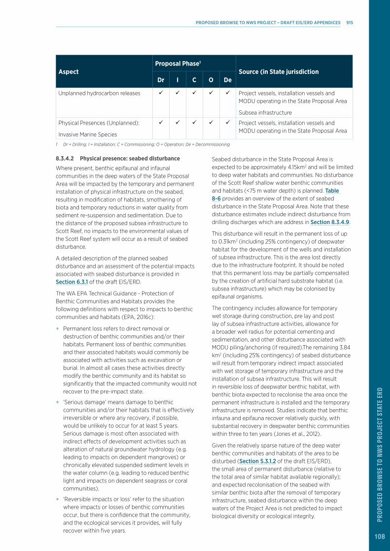
STAT
E ERD
Aspect Proposal Phase1
Source (in State jurisdictionDr I C O De
Unplanned hydrocarbon releases ü ü ü ü ü Project vessels, installation vessels and MODU operating in the State Proposal Area
Subsea infrastructure
Physical Presences (Unplanned):
Invasive Marine Species
ü ü ü ü ü Project vessels, installation vessels and MODU operating in the State Proposal Area
1 Dr = Drilling; I = Installation; C = Commissioning; O = Operation; De = Decommissioning
8.3.4.2 Physical presence: seabed disturbance
Where present, benthic epifaunal and infaunal communities in the deep waters of the State Proposal Area will be impacted by the temporary and permanent installation of physical infrastructure on the seabed, resulting in modification of habitats, smothering of biota and temporary reductions in water quality from sediment re-suspension and sedimentation. Due to the distance of the proposed subsea infrastructure to Scott Reef, no impacts to the environmental values of the Scott Reef system will occur as a result of seabed disturbance.
A detailed description of the planned seabed disturbance and an assessment of the potential impacts associated with seabed disturbance is provided in Section 6.3.1 of the draft EIS/ERD.
The WA EPA Technical Guidance - Protection of Benthic Communities and Habitats provides the following definitions with respect to impacts to benthic communities and habitats (EPA, 2016c):
+ Permanent loss refers to direct removal or destruction of benthic communities and/or their habitats. Permanent loss of benthic communities and their associated habitats would commonly be associated with activities such as excavation or burial. In almost all cases these activities directly modify the benthic community and its habitat so significantly that the impacted community would not recover to the pre-impact state.
+ ‘Serious damage’ means damage to benthic communities and/or their habitats that is effectively irreversible or where any recovery, if possible, would be unlikely to occur for at least 5 years. Serious damage is most often associated with indirect effects of development activities such as alteration of natural groundwater hydrology (e.g. leading to impacts on dependent mangroves) or chronically elevated suspended sediment levels in the water column (e.g. leading to reduced benthic light and impacts on dependent seagrass or coral communities).
+ ‘Reversible impacts or loss’ refer to the situation where impacts or losses of benthic communities occur, but there is confidence that the community, and the ecological services it provides, will fully recover within five years.
Seabed disturbance in the State Proposal Area is expected to be approximately 4.15km2 and will be limited to deep water habitats and communities. No disturbance of the Scott Reef shallow water benthic communities and habitats (<75 m water depth) is planned. Table 8-6 provides an overview of the extent of seabed disturbance in the State Proposal Area. Note that these disturbance estimates include indirect disturbance from drilling discharges which are address in Section 8.3.4.9.
This disturbance will result in the permanent loss of up to 0.31km2 (including 25% contingency) of deepwater habitat for the development of the wells and installation of subsea infrastructure. This is the area lost directly due to the infrastructure footprint. It should be noted that this permanent loss may be partially compensated by the creation of artificial hard substrate habitat (i.e. subsea infrastructure) which may be colonised by epifaunal organisms.
The contingency includes allowance for temporary wet storage during construction, pre lay and post lay of subsea infrastructure activities, allowance for a broader well radius for potential cementing and sedimentation, and other disturbance associated with MODU piling/anchoring (if required).The remaining 3.84 km2 (including 25% contingency) of seabed disturbance will result from temporary indirect impact associated with wet storage of temporary infrastructure and the installation of subsea infrastructure. This will result in reversible loss of deepwater benthic habitat, with benthic biota expected to recolonise the area once the permanent infrastructure is installed and the temporary infrastructure is removed. Studies indicate that benthic infauna and epifauna recover relatively quickly, with substantial recovery in deepwater benthic communities within three to ten years (Jones et al., 2012).
Given the relatively sparse nature of the deep water benthic communities and habitats of the area to be disturbed (Section 5.3.1.2 of the draft EIS/ERD), the small area of permanent disturbance (relative to the total area of similar habitat available regionally); and expected recolonisation of the seabed with similar benthic biota after the removal of temporary infrastructure, seabed disturbance within the deep waters of the Project Area is not predicted to impact biological diversity or ecological integrity.
PROPOSED BROWSE TO NWS PROJECT – DRAFT EIS/ERD APPENDICES 915
ProP
osed
Bro
wse
to N
ws
Proj
ect s
tate
erd
10B

Table 8-6 Indicative extent of seabed disturbance within the State Proposal Area
Description No. Direct Disturbance (km2) (Permanent Loss)
Indirect Disturbance (km2) (Reversible Loss)
Total (km2)
Drilling and Completions
Wells Torosa 24 0.19 2.83 3.02
SURF Footprint
Flowline network Torosa 1 0.06 0.24 0.30
Total Expected 0.25 3.07 3.32
Contingency (25%) 0.06 0.77 0.83
Total (including Contingency) 0.31 3.84 4.15
Basis:
1 Wells have a direct impact radius of 50 m and a total radius of 200 m.
2 Flowlines have a 2 m corridor direct impact and a 10 m corridor total impact.
This estimate includes subsea disturbance from all major infrastructure sources. The contingency includes allowance for temporary wet storage during construction, pre lay and post lay of subsea infrastructure activities, allowance for a broader well radius for potential cementing and sedimentation, and other disturbance associated with piling/anchoring (if required)
8.3.4.3 Physical presence: light
Potential impacts to shallow benthic communities and habitats (i.e. corals) from light emissions are described in Section 6.3.3 of the draft EIS/ERD. Theoretically, there is the potential for impacts to shallow water coral communities from light emissions from the MODU and vessels within the State Proposal Area, with coral colonies particularly sensitive to changes in ambient environmental conditions, with natural factors such as nocturnal moonlight cycles and daily light/dark cycles providing cues for reproduction (i.e. spawning) (Harrison and Wallace, 1990).
Light modelling results (Section 6.3.3 of the draft EIS/ERD) indicate that Scott Reef is expected to receive light emission levels of less than 0.01 Lux from the MODU operating in the channel between North Scott Reef and South Scott Reef. Such light levels are less than a comparable full moon and therefore it is not considered that light emissions from the MODU or vessels associated with the proposed activities within the State Proposal Area will be of sufficient intensity to affect coral reproduction or spawning events. In addition, no permanent surface facilities to emit light will be present in the State Proposal Area during operations.
8.3.4.4 Underwater noise
Potential impacts to shallow benthic communities and habitats (i.e. corals) from underwater noise emissions are described in Section 6.3.8 of the draft EIS/ERD. As discussed in Section 6.3.8.3 of the draft EIS/ERD, Woodside’s Maxima Study on seismic noise on Scott Reef estimated that corals would require received levels of PK-PK exceeding 260 dB re 1 µPa (SPL) to induce injury (Hastings, 2010). The modelling indicates that sound levels reaching Scott Reef from the proposed
activities do not reach these levels and as such no impact to corals from underwater noise resulting from the proposed activities is predicted to occur. Likewise modelling of the VSP activities indicates that the sound level associated with no effect (Heyward et al., 2018) was not reached. As such, no impacts to corals are expected to occur.
8.3.4.5 Marine discharges: sewage and sullage
An assessment of the potential impact on marine environmental quality from the discharge of sewage and sullage from project vessels and the MODU is presented in Section 8.2.4. This assessment concluded that changes to the physical and chemical properties of the marine water would be temporary and highly localised (discharge diluted to 1% of its original concentration with 50 m). No change to the physical or chemical properties of sediments are expected due to the depth of the water where treated sewage and sullage would be discharged.
Given the water depth at the discharge locations (>300 m), it is not predicted that the this change in water quality will affect the deepwater benthic habitats of the State Proposal Area. Given the distance from the discharge to Scott Reef and rapid dispersion predicted (refer to Section 8.2.4.4), no effect on Scott Reef benthic communities and habitats is expected to result from the discharge of treated sewage and sullage in the State Proposal Area.
PROPOSED BROWSE TO NWS PROJECT – DRAFT EIS/ERD 916
ProP
osed
Bro
wse
to N
ws
Proj
ect s
tate
erd
10B

STAT
E ERD
8.3.4.6 Marine discharges: treated utility water, chemical and deck drainage
An assessment of the potential impact on marine environmental quality from the discharge of treated utility water, chemical and deck drainage from project vessels, installation vessels and the MODU is presented in Section 8.2.4. This assessment concluded that treated utility water, chemical and deck discharges would result in temporary change in water quality in the immediate vicinity of the discharge. Given the water depth at the discharge location (>300 m) and distance to Scott Reef from where these discharges would occur, this temporary and highly localised change to water quality is not expected to have any impacts to either the deepwater benthic communities and habitats of the State Proposal Area or the benthic communities and habitats associated with Scott Reef.
8.3.4.7 Marine discharges: produced water
As detailed in Section 8.2.4, given the small percentage that the PW component makes of the overall discharge from the MODU during well unloading, this discharge is addressed as part of the assessment of discharges during drill cuttings and fluids.
8.3.4.8 Marine discharges: cooling water
An assessment of the potential impact on marine environmental quality from the discharge of cooling water from project vessels, installation vessels and the MODU is presented in Section 8.2.4. This assessment concluded that cooling water discharges would result in temporary change in water quality in the immediate vicinity of the discharge. Given the water depth at the discharge location (>300 m) and distance to Scott Reef from where these discharges would occur, this temporary and highly localised change to water quality is not expected to have any impacts to either the deepwater benthic communities and habitats of the State Proposal Area or the benthic communities and habitats associated with Scott Reef.
8.3.4.9 Marine discharges: drilling and completions discharges
A detailed description of the planned discharge of drill cuttings and fluids is provided in Section 8.2.4.8. Section 8.2.4.8 focuses largely on the water quality and sedimentation aspects of this impact whereas this section focuses largely on benthic fauna impacts associated with the aspect.
Change in water quality
The assessment of the potential impact on marine environmental quality (water quality, sediments and biota) from the discharge of drill cuttings and fluids from the MODU during drilling and completions activities presented in Section 8.2.4 concluded that change in to water quality (through elevated TSS and the introduction of contaminants) would be temporary and localised with no subsequent impacts to biota predicted.
Cement discharge
Once each of the top hole sections are drilled, casing will be inserted into the wellbore and secured in place by pumping cement into the annular space back to approximately 300 m above the casing shoe, which may involve a discharge of excess cement at the seabed (~80 m³/well). Overspill of cement will permanently alter physical sediment properties immediately adjacent to the well (within <50 m). The potential disturbance area is 0.8 ha per well; giving a total potential disturbance footprint of 0.19km2 within the State Proposal Area. This will result in the permanent loss of the benthic communities and habitats in the disturbance area.
Sediment deposition
Following the discharge of drill cuttings and fluids, the coarser fractions (sand and gravel-sized particles), will rapidly settle to the seabed. Where cuttings are discharged to the seabed, a cuttings pile will develop immediately around the well site. The nature and size of the pile will depend on a number of factors including particle size of the cuttings, tidal and current forces and water depth. Discharge of cuttings at the surface will result in a sediment plume with the dispersion and settlement of cuttings dependent on the particle sizes of cuttings, water depth, as well as the prevailing wind, tidal influence and current directions.
Potential impacts are expected to be confined to sessile biota such as sediment burrowing infauna and epifauna where present in or on the seabed in immediate proximity to the well location. Ecological impacts to such biota are predicted when sediment deposition is equal to or greater than 6.5 mm (in thickness) (IOGP, 2016). Modelling (Section 6.3.15.3 of the draft EIS/ERD) indicated that such deposition would potentially occur out from the well location to approximately 200 m (following the direction of the prevailing current). This aligns with (IOGP, 2016) review of seven studies, which indicated that the spread of drill cuttings and WBFs is expected to be up to about 150 m from the discharge location. It should also be noted that sedimentation was modelled concurrently for multiple wells at the drill centres, resulting in a likely overestimation of net sedimentation given that in reality wells will be drilled sequentially and therefore further dispersion of deposited sediments will occur in between individual well drilling activities.
This deposition may result in the reversible loss in the order of 0.12 km2 of deepwater benthic habitat per well based on an assumption of an expected spread radius of 150 m from each well (in addition to the irreversible loss of 50 m associated with cement – described above). Balcom et al., (2012) concluded that impacts associated with the discharge of cuttings and NWBFs are minimal, with impacts highly localised to the area of the discharge. Changes to benthic communities are normally not severe. Organic enrichment can occur leading to anoxic conditions in the surface sediments and a loss of
PROPOSED BROWSE TO NWS PROJECT – DRAFT EIS/ERD APPENDICES 917
ProP
osed
Bro
wse
to N
ws
Proj
ect s
tate
erd
10B

infauna species that have a low tolerance to low oxygen concentrations, and to a lesser extent chemical toxicity near the well location. These impacts are highly localised with short-term recovery that may include changes in community composition with the replacement of infauna species that are hypoxia-tolerant (IOGP et al., 2016).
Recovery of affected benthic infauna, epifauna and demersal communities is expected to occur quickly, given the short duration of sediment deposition and the widely represented benthic and demersal community composition. Jones et al., (2012) compared pre and post-drilling ROV surveys and documented physical smothering effects from WBM cuttings within 100 m of the well. Outside the area of smothering, fine sediment was visible on the seafloor up to at least 250 m from the well. After three years, there was significant removal of cuttings, particularly in the areas with relatively low initial deposition (Jones et al., 2012). The area impacted by complete cuttings cover had reduced from 90 m to 40 m from the drilling location, and faunal density within 100 m of the well had increased considerably and was no longer significantly different from conditions further away. As such, the impacts to the deepwater benthic habitats are considered reversible, with benthic biota are expected to recolonise the area rapidly on completion of the drill cuttings discharge at each well.
Based on the modelling (Section 6.3.15.2 of the draft EIS/ERD), the sedimentation footprint associated with discharge of drilling or completions discharges at the seabed, indicates that away from the immediate area around the well (i.e. 50 m radius associated with the permanent impact from well casing cement overspill), sedimentation over the course of the drilling program would be low, equating to a thin veneer of settled drilling discharges away from the immediate deposition area around the well (in the order of 200 m from the well) which will likely be naturally reworked into surficial sediment through processes including bioturbation (US EPA, 2002). Ecological impacts in these areas are not expected for mobile benthic fauna such as crabs and shrimps or pelagic and demersal fish, given their mobility (IOGP, 2016).
These impacts are considered reversible, with benthic biota expected to recolonise once the cause of the temporary disturbance is removed. Studies indicate that benthic infauna and epifauna recover relatively quickly, with substantial recovery in deep water benthic communities within three to ten years (Jones et al., 2012). IOGP (2016) found that recovery of the benthic communities generally occurred by the recruitment of new colonising organisms and migration from undisturbed sediments, with recovery beginning shortly after the completion of drilling and well underway within a year.
The assessment of the potential impact on marine environmental quality (water quality, sediments and
biota) from the discharge of drill cuttings and fluids from the MODU during drilling and completions activities presented in Section 8.2.4 concluded that change in to water quality (through elevated TSS and the introduction of contaminants) would be temporary and localised with no subsequent impacts to biota predicted.
SummaryIn summary, likely impacts to benthic communities and habitats from drill cuttings and fluids discharge and cement discharge will be restricted to the localised burial of deepwater benthic habitats and likely changes to sediment quality within the immediate vicinity each well (in the order of 200 m). However, outside this area, little to no impact to the deepwater benthic communities and habitats is expected. The proposed further modelling, assessment and selection of management measures for TRA, TRD, TRE and TRF drill centres described above will inform the drill cuttings disposal method to ensure impacts to Scott Reef benthic communities and habitats are avoided.
Overall, the localised smothering of biota associated the deepwater habitats that are well represented both in the State Proposal Area and regionally is not expected to reduce biological diversity and ecological integrity within the State Proposal Area.
8.3.4.10 Marine discharges: subsea control fluids
An assessment of the potential impact on marine environmental quality from the discharge of subsea control fluids during operation of the subsea infrastructure is presented in Section 8.2.4. This assessment concluded that the intermittent discharge of small volumes of subsea control fluid may result in a reduction in water quality that would be temporary (limited to the duration of the activity), restricted to deepwater (i.e. not affecting Scott Reef benthic communities or habitats) and subject to rapid dispersion and dilution by prevailing currents, due to the open oceanic waters of the State Proposal Area. While benthic biota associated with the deepwater habitats of the State Proposal Area may come into contact with these discharges, given that the discharges will disperse rapidly close to the discharge point and that any contact with the discharge with benthic biota will be of extremely short duration, it is not considered credible that toxic affects to benthic biota will occur as a result of the discharge of subsea fluids within the State Proposal Area.
8.3.4.11 Marine discharges: hydrotest fluid
A description and assessment of the potential impact on marine environmental quality from the discharge of hydrotest fluid during integrity testing of the subsea infrastructure and the temporary production system on the MODU is presented in Section 8.2.4. This assessment concluded that given the low volume of hydrotest fluid to be discharged, the low toxicity of the fluid, and the water depth at which the discharge will occur, hydrotest
PROPOSED BROWSE TO NWS PROJECT – DRAFT EIS/ERD 918
ProP
osed
Bro
wse
to N
ws
Proj
ect s
tate
erd
10B

STAT
E ERD
discharges within the State Proposal Area would be not expected to result in any lasting impacts to biota. As such, while modelling (Section 6.3.17 of the draft EIS/ERD) predicts that the plume would travel in close proximity to the seabed and therefore may result in localised and temporary decline in sediment quality, no lasting effect to the deepwater habitats are predicted.
As described in Section 8.2.4.10, previous modelling of hydrotest fluid discharge from SURF infrastructure has been used to inform this impact assessment. From this modelling it is concluded that given the negative buoyancy of the plume, bathymetry of the location (steep reef slopes surrounding the discharge location), and lack of upwelling processes from the depth of discharge, regardless of the size of the mixing zone the zone of influence will remain restricted to depth and avoid Scott Reef shallow water benthic habitat (<75 m bathymetry).
8.3.4.12 Production Activities: Seabed Subsidence
A detailed description of the subsea subsidence that may manifest as a result of production activities and an assessment of the potential impacts that may result is provided in Section 6.3.20 of the draft EIS/ERD. This includes peer reviewed modelling (Section 6.3.20.3 of the draft EIS/ERD) which provides a high level of confidence that any production-related subsidence at Scott Reef would be in the order of less than 10 cm over field life.
As described in Section 6.3.20 of the draft EIS/ERD, AIMS (2012) assessed the impact of net sea level rise (from subsidence and climate change induced sea level rise) and its predicted impacts on reef flat habitat (0 to 5 m depth), shallow water coral habitats (5 to 30 m), deepwater coral habitat (30 to 70 m) and Sandy Islet, for three scenarios (worse case, intermediate case and best case).
Overall, the study concluded that minor seabed subsidence over the life of the Torosa reservoir affecting a part of Scott Reef and Sandy Islet would not significantly contribute to sea level changes and associated impacts. As such, no reduction in biological diversity or ecological integrity within the State Proposal Area is predicted to occur as a result of seabed subsidence. Subsidence will be monitored throughout the life of the Project as detailed in Section 6.3.20 of the draft EIS/ERD.
8.3.4.13 Unplanned marine discharges: hazardous and non-hazardous inorganic waste
A description and assessment of the potential impact on marine environmental quality from unplanned discharge of hazardous and non-hazardous inorganic wastes is presented in Section 8.2.4. This assessment concluded that in the unlikely event of an unplanned discharge, discharged materials in liquid or sludge form would be subject to rapid dispersion and dilution by prevailing
currents, due to the open oceanic waters of the State Proposal Area. This would result in a temporary and highly localised change in water quality that would be highly unlikely to impact the deepwater benthic habitats of the State Proposal Area. Accidentally discharged non-buoyant waste would have the potential to sink to the seabed and impact epifauna, however, given the sparse nature of deepwater habitats that are well represented both in the State Proposal Area and regionally, any impacts are highly unlikely to reduce biodiversity or ecological integrity within the State Proposal Area.
Under normal operating conditions, drilling and vessel activity will be limited to the deep waters in proximity to the location of the proposed development wells and subsea infrastructure away from Scott Reef so any accidental discharge to the marine environment is highly unlikely to impact the Scott Reef benthic communities and habitats.
8.3.4.14 Physical presences (unplanned): invasive marine species (IMS)
Non-indigenous Marine Species (NIMS) are species which are translocated into a recipient environment where they are not historically found. Invasive marine species are NIMS that are translocated into a marine environment where they have the potential to establish and disrupt the natural balance of marine ecosystems.
Not all NIMS that are translocated to a receiving location will survive through to establishment and only a subset of these species that become established will impact on social/cultural, human health, economic and/or environmental values are considered IMS (Wells, 2018).
IMS can be introduced through a variety of natural and human mediated vectors. The key pathways for introduction of IMS to the State Proposal Area is within biofouling on external surfaces of vessels and within internal niche areas and systems, and through vessel’s ballast water. The vectors for translocation are via project vessels and MODU(s).
A detailed assessment of the potential risks associated with unplanned introduction of IMS is provided in Section 6.3.21 of the draft EIS/ERD. This includes an overview of the potential pathways of introduction, the process of the establishment of an IMS, an assessment of project specific pathways of IMS introduction and potential impact to ecosystem dynamics that could occur as a result of the introduction and establishment of an IMS.
The majority of the State Proposal Area consists of deep offshore open waters, away from shallow habitats, that are not conducive to the settlement and establishment of IMS, due to the lack of benthic light (required to support the photosynthetic processes required for many NIMS) or suitable hard substrates to allow attachment and growth.
PROPOSED BROWSE TO NWS PROJECT – DRAFT EIS/ERD APPENDICES 919
ProP
osed
Bro
wse
to N
ws
Proj
ect s
tate
erd
10B

The primary receptors with respect to IMS in the State Proposal Area are shallow-water marine habitats, species and ecosystem function at Scott Reef. Shallow water marine habitats, such as coral reefs, are considered susceptible to the introduction and subsequent establishment of IMS due to the availability of light and complex habitats. IMS introduced to shallow water marine habitats are, therefore, much more likely to successfully establish than those introduced to deep oceanic waters.
Shallow water benthic habitats, such as coral reefs, are considered susceptible to the introduction and subsequent establishment of IMS due to the availability of light and available substrate for establishment. IMS introduced into shallow water marine habitats are, therefore, much more likely to successfully establish than those introduced to deep oceanic waters (i.e. the deepwater habitat of the reef system).
Sites subject to existing disturbance such as Scott Reef are also considered to be more susceptible to IMS. This includes artificial structures (e.g. the two shipwrecks at Scott Reef; Section 5.4.3.2 of the draft EIS/ERD), sites effected by coral bleaching and/or extreme weather events (as described for Scott Reef in Section 5.3.1.3 of the draft EIS/ERD), and those areas impacted by tourism or fishing (e.g. tourism and Indonesian fishers at Scott Reef). The cumulative pressure of these disturbances may lead to weakened ecosystem function and reduced resilience to external pressures such as IMS. An IMS surveillance program at Scott Reef is proposed to be undertaken, with a survey completed prior to the commencement of the proposed Browse to NWS Project activities in the State Proposal Area to verify baseline condition, and periodic surveys over the life of the proposed Browse to NWS Project.
As described in Table 6-146 of the draft EIS/ERD, given this sensitivity and the regional significance of Scott Reef, the consequence of the introduction and successful establishment of an IMS has been determined to represent a consequence level of Major due to the potential for regionally significant impacts to high value habitat. However, given the legislative and Woodside management controls in place to prevent translocation and establishment of IMS in the Project Area it is considered that the likelihood that IMS would be introduced, establish a self-sustaining population and cause environmental impacts to sensitive ecological communities within the vicinity of Project Area, including the State Proposal Area (e.g. Scott Reef) is remote.
8.3.4.15 Unplanned hydrocarbon releases
A detailed assessment of the potential risks associated with unplanned hydrocarbon releases is provided in Section 6.3.21 of the draft EIS/ERD. Quantitative hydrocarbon spill modelling of various worst-case hydrocarbon release scenarios is presented in
Section 6.3.21.3 of the draft EIS/ERD. This included modelling of a loss of well integrity scenario at the TRA-C well (Scenario 1) which represents the worst case impacts to Scott Reef. The summarised result of the modelling of Scenario 1 are presented in Table 6-158 and Figure 6-51 of the draft EIS/ERD.
Based on the outcomes of quantitative spill modelling, hydrocarbon spills resulting from the Proposal have the potential to significantly impact shallow benthic communities and habitats within the State Proposal Area. However, given existing legislative and management controls the occurrence of hydrocarbon spills is considered highly unlikely.
8.3.4.16 Cumulative impacts
Given the distance of the State Proposal Area from other operating developments in the region, it is not considered credible cumulative impacts from the proposed Browse to NWS Project (or the Proposal) and other developments will occur.
With respect to the Commonwealth waters component of the proposed Browse to NWS Project, other than potentially hydrotest discharges (discussed below), it is not expected that planned marine discharges to Commonwealth waters would contribute to cumulative impacts on benthic communities and habitats within the State Proposal Area. Operational discharges (i.e. produced water and cooling water) from the FPSO facilities (in Commonwealth waters) have been designed and will be managed to ensure the defined threshold values (e.g. 99% species protection or no effect concentrations) at the State waters boundary are met (95% of the time based on dispersion modelling results).
While not considered the base-case, the potential discharge of hydrotest fluids from the BTL at the Torosa pipeline end terminal (Section 6.3.17 of the draft EIS/ERD), may result in a temporary reduction in water quality within the State Proposal Area and thus a potential impact on adjacent benthic communities and habitats. The modelling results (Section 6.3.17.3 of the draft EIS/ERD) indicate this would be restricted to deep waters surrounding the pipeline end terminal (461 m depth) and therefore impacts would be restricted to a small proportion of sparsely distributed epifauna. Given this, and the fact this discharge would be a one-off event that would occur prior to the commencement of operations, the discharge of hydrotest fluid from the BTL at the Torosa pipeline end terminal would not be expected to contribute significantly to cumulative impacts to benthic communities and habitats within the State Proposal Area.
8.3.5 Assessment of ImpactsThe assessment of the predicted impacts to benthic communities and habitats in the State Proposal Area (i.e. deepwater habitats and Scott Reef habitats) demonstrates predominately temporary and minor
PROPOSED BROWSE TO NWS PROJECT – DRAFT EIS/ERD 920
ProP
osed
Bro
wse
to N
ws
Proj
ect s
tate
erd
10B

STAT
E ERD
impacts to the deepwater habitats on a localised scale associated with some of the proposed activities. Such impacts are associated with the direct disturbance resulting from the installation of the subsea infrastructure and the discharge of drill cuttings and fluids during development drilling.
Given the proposed location of the wells and subsea infrastructure will be in deep waters (>300 m), away from Scott Reef and that under normal operating conditions the drilling and vessel activity will be limited to the immediate vicinity of the subsea infrastructure, it is considered unlikely that marine discharges will impact Scott Reef shallow water benthic communities and habitats (<75 m water depth). Given the potential sensitivities of Scott Reef benthic communities and habitats to sedimentation from surface drill cuttings discharges, Woodside has committed to managing the discharges of drill cuttings and fluids at TRA, TRD, TRE and TRF drill centre locations using established and proven techniques such that impacts to Scott Reef shallow water benthic communities and habitats (<75 m water depth) are avoided.
In summary, given the localised scale and temporary nature of potential impacts to deepwater benthic communities and habitats, and no predicted impact to Scott Reef benthic communities and habitats, there is not expected to be any reduction in diversity or ecological integrity within the State Proposal Area.
In addition, the localised and temporary nature of the predicted sediment deposition mean that no impacts to benthic communities and habitats associated with State marine parks (the closest being over 400 km from the State Proposal Area) are expected to occur.
Given the above, impacts to benthic communities and habitats within the State Proposal Area as a result of the proposed Browse to NWS Project (or the Proposal) are expected to be consistent with the EPA objective for the environmental factor – benthic communities and habitats.
8.3.6 Mitigation Level of Ecological ProtectionAs described in Section 8.2.6, and EMQP will be prepared and implemented to achieve the proposed LEPs (Figure 8-1 and Figure 8-2). With the implementation of the EMQP, it is expected a maximum LEP will be achieved in the majority of the State Proposal Area, including all Scott Reef shallow water benthic communities and habitats (<75 m water depth) during construction and operations. A high LEP will be achieved for the deep waters of the State Proposal Area where subsea infrastructure will be located, except where a moderate LEP is proposed within a 1000 m radius of each drill centre during construction and operations; and 500 m around subsea infrastructure during construction. Further, an area of moderate LEP is proposed during construction where the potential discharge of hydrotest fluid from the BTL (in Commonwealth waters), may incur into the State Proposal Area.
Specific proposed measures to mitigate and manage unavoidable impacts from planned activities and reduce the environmental risk associated with unplanned events and incidents are presented in Chapter 6 of the draft EIS/ERD and these will be incorporated into the EQMP where relevant. Measures presented in the draft EIS/ERD will also be incorporated into activity specific Environment Plans to be submitted for acceptance by DMIRS prior to the activity commencing within the State Proposal Area.
Drilling discharge managementAs detailed in Section 8.2.4.8, modelling indicated that the sea surface discharge of drill cuttings from the bottom-hole sections generated at the previously proposed TRE and TRD drill centre locations would potentially result in incursions of sediment plumes and associated increased sedimentation to portions of North and South Scott Reef including within the lagoons.
Given the potential sensitivities of Scott Reef shallow water benthic communities and habitats to sedimentation from drilling discharges, Woodside has committed to managing the drilling discharges (in particular bottom hole discharges) using established and proven techniques (e.g. disposal at alternative locations if necessary) at drill centre locations in the State Proposal Area (i.e. TRA, TRD, TRE and TRF) in such a manner that avoids impacts to Scott Reef shallow water benthic communities and habitats (<75 m water depth). This approach is outlined in Section 8.2.6.
PROPOSED BROWSE TO NWS PROJECT – DRAFT EIS/ERD APPENDICES 921
ProP
osed
Bro
wse
to N
ws
Proj
ect s
tate
erd
10B

8.3.7 Predicted Outcome Cumulative loss assessment WA EPA Technical Guidance - Protection of Benthic Communities and Habitats, requires the establishment of a local assessment units (LAUs) to establishes the spatial context for the calculation and assessment of recoverable impacts and cumulative losses (EPA, 2016c).
The following five LAU representing the broad benthic community and habitat types are proposed for the State Proposal Area.
+ Scott Reef south lagoon deepwater coral habitats
+ Scott Reef north deepwater sediment habitat
+ Scott Reef south deepwater sediment habitat
+ Scott Reef north shallow water benthic communities and habitats
+ Scott Reef south shallow water benthic communities and habitats.
As per the EPA technical guidance “Calculating cumulative losses relies on three fundamental pieces of information – 1) estimates of the areas of benthic communities and their habitats present before European habitation, 2) estimates of the extent of historic and approved losses, and 3) predictions of the additional losses associated with the current proposal (EPA, 2016c).” In this regard:
+ Original spatial extent is considered to be the entire spatial extent of the two above defined broad habitat types.
+ No historical losses have been recorded. While Woodside has drilled seven previous wells within the State Proposed Area, impacts from the associated drill cuttings discharge are considered reversable (as described in Section 8.3.4.9), with benthic biota expected to have recolonised the area once drilling is completed.
+ Proposed extent of permanent loss (0.31km2) from proposal has been estimated based on the planned seabed disturbance for the installation of subsea infrastructure.
+ Up to 3.84 km2 of reversible loss may occur as a result of indirect impact from subsea infrastructure. Reversible loss is not included in the cumulative loss estimates.
Table 8-7 summarises the cumulative benthic communities and habitat loss estimates for the State waters around Scott Reef LAU.
Table 8-7 Cumulative permanent benthic communities and habitat loss assessment for State waters around Scott Reef LAU
Benthic communities and habitat type
Original spatial extent (pre-European habitation)
Historic and approved losses
Current % remaining
Proposed extent of permanent loss from proposal
Spatial extend of cumulative loss
% remaining after proposal
Scott Reef south lagoon deepwater coral habitats
213.47 km2 0 km2 100% 0 km2 0 ha 100%
Scott Reef north deepwater sediment habitat
311.26 km2 0 km2 100% 0.31 km2 0.31 km2 99.90 %
Scott Reef south deepwater sediment habitat
379.16 km2 0 km2 100% 0 km2 0 km2 100%
Scott Reef north shallow water benthic communities and habitats
179.51 km2 0 km2 100% 0 km2 0 km2 100%
Scott Reef south shallow water benthic communities and habitats
147.14 km2 0 km2 100% 0 km2 0 km2 100%
PROPOSED BROWSE TO NWS PROJECT – DRAFT EIS/ERD 922
ProP
osed
Bro
wse
to N
ws
Proj
ect s
tate
erd
10B

STAT
E ERD
Figure 8-4 Proposed State Proposal Area Local Assessment Units
PROPOSED BROWSE TO NWS PROJECT – DRAFT EIS/ERD APPENDICES 923
ProP
osed
Bro
wse
to N
ws
Proj
ect s
tate
erd
10B

SummaryImpacts to benthic communities and habitats within the State Proposal Area have been reduced by locating the FPSO facilities, BTL and inter-field spur line outside of the State Proposal Area, and siting infrastructure within the State Proposal Area in deep waters off Scott Reef. This will result in any impacts being restricted to the deepwater benthic habitats, with no impacts to Scott Reef benthic communities or habitats.
Impacts will be further reduced by implementing mitigation and management measures, the majority of which are standard maritime and offshore oil and gas industry practice. However, given the potential sensitivities of Scott Reef shallow water benthic communities and habitats to sedimentation from drilling discharges, Woodside has committed to managing the drilling discharges (in particular bottom hole discharges) at drill centre locations in the State Proposal Area (i.e. TRA, TRD, TRE and TRF) in such a manner to avoid impacts to Scott Reef shallow water benthic communities and habitats (<75 m water depth) (refer to Section 8.2.6). Implementation of this management approach will be assured through activity specific Environment Plan(s) under Petroleum Legislation.
Given cumulative losses (historical plus proposed) of benthic communities and habitats will be limited to a small portion that are well represented both in the State Proposal Area and regionally (approximately 0.11% of Scott Reef north deepwater sediment habitat LAU with no losses in any of the other four proposed LUA), the Proposal is not predicted to result in any reduction of biological diversity and ecological integrity within the State Proposal Area.
As such, the WA EPA environmental objective “to protect benthic communities and habitats so that biological diversity and ecological integrity are maintained” will be achieved for the Proposal; and the predicted impacts on benthic communities and habitats within the State Proposal Area are considered Acceptable.
8.4 Key Environmental Factor – Marine Fauna
8.4.1 EPA ObjectiveThe EPA objective for marine fauna is “To protect marine fauna so that biological diversity and ecological integrity are maintained” (EPA, 2016b).
8.4.2 Policy and Guidance The following policy and guidance have been considered in relation to the EPA environmental factor - marine fauna:
EPA Policy and Guidance + Statement of Environmental Principles, Factors and
Objectives (EPA, 2016b)
+ Environmental Factor Guideline – Marine Fauna (EPA, 2016b).
Other Policy and Guidance + Environment Protection and Biodiversity
Conservation Act 1999 (EPBC Act) Policy Statement 2.1 – Interaction between Offshore Seismic Exploration and Whales (Department of the Environment, Water, Heritage and the Arts, 2008)
+ Conservation Management Plan for the Blue Whale - A Recovery Plan under the EPBC Act (Commonwealth of Australia, 2015a)
+ Conservation advice Anous tenuirostris melanops Australian lesser noddy (Threatened Species Scientific Committee, 2015a)
+ Approved Conservation Advice for Megaptera novaeangliae (humpback whale) (Threatened Species Scientific Committee, 2015b)
+ Recovery plan for marine turtles in Australia (Commonwealth of Australia, 2017a)
+ Conservation advice Rhincodon typus whale shark (DEWHA, 2015c).
8.4.3 Receiving EnvironmentMarine fauna that may occur within the Browse Development Area are described in detail in Chapter 5 of the draft EIS/ERD. Marine fauna that may occur in the State Proposal Area are summarised below, with cross references to specific sections of Chapter 5 of the draft EIS/ERD provided for further detail.
Seabirds and migratory shorebirdsSeabirds birds have been observed in low numbers at Scott Reef, as described in Section 5.3.2.4.1 of the draft EIS/ERD. Sandy Islet (the only permanently emergent land mass at Scott Reef) may be used by nesting seabirds and is known to provide roosting habitat for low numbers of individuals but it is not large enough to support large numbers of seabirds at any one time. Scott Reef is recognised as part of a resting Biologically Important Area (BIA) for the little tern (Sternula albifrons) (Section 5.3.2.2 of the draft EIS/ERD). This species is widely distributed within Australia and is expected to occur within the State Proposal Area.
PROPOSED BROWSE TO NWS PROJECT – DRAFT EIS/ERD 924
ProP
osed
Bro
wse
to N
ws
Proj
ect s
tate
erd
10B

STAT
E ERD
Migratory shorebirds may also use Scott Reef as a staging ground during migrations, for nesting and roosting and have occasionally been observed in very low numbers, as detailed in Section 5.3.2.4.2 of the draft EIS/ERD.
Marine mammalsMarine mammals have wide distributions that are associated primarily with seasonal feeding and migration patterns that are linked to their reproductive cycles. A number of marine mammal species have been identified as potentially occurring within the wider Project Area, as described in Section 5.3.2.5 of the draft EIS/ERD. A number of surveys have been undertaken in recent years to establish baseline data for marine mammals, primarily humpback whales and pygmy blue whales, within proximity of the Browse Development Area, including the State Proposal Area. These are summarised in Section 5.3.2.5 of the draft EIS/ERD. The species discussed below are considered likely to occur within the State Proposal Area.
+ Humpback whale - the humpback whale (Megaptera novaengliae) is listed under the EPBC Act as Vulnerable, Migratory and Marine, and as Conservation Dependant under the Biodiversity Conservation Act (BC Act). This species has a wide global distribution and displays migratory behaviours, as described in Section 5.3.2.5.1 of the draft EIS/ERD. Recent studies have indicated that this species travels less than 46 km from the coastline and within waters less than 50 m deep (RPS Environment and Planning, 2010b; 2012). Sightings have, however, been recorded around Scott Reef. There are no known BIAs for this species within the State Proposal Area and only low numbers of humpback whales are expected to be present in the area.
There are also key calving areas for the humpback whale between Broome and the northern end of Camden Sound, as described in Section 5.3.2.5 of the draft EIS/ERD. Additionally, there is a migration BIA for the species (Section 5.3.2.2 of the draft EIS/ERD) which encompasses State waters around Broome.
+ Pygmy blue whale - the pygmy blue whale (Balaenoptera musculus) subspecies is listed under the EPBC Act as Endangered, Migratory and Marine, and as Endangered under the BC Act. As described in Section 5.3.2.5.2 of the draft EIS/ERD, this migratory subspecies is widely distributed from Indonesia to the south west of Australian and east along the Great Australian Bight to the Bass Straight. Noise logger data and historic observations have recorded this species within the waters of and surrounding Scott Reef, including the channel between North and South Scott Reef (McCauley, 2011). A possible foraging area has been documented at Scott Reef (although individuals
have not been directly observed feeding) and the reef is recognised as part of a foraging BIA for this species in the Conservation Management Plan for the Blue Whale (Commonwealth of Australia, 2015b) (Section 5.3.2.2 of the draft EIS/ERD). Migration and distribution BIAs for this species also encompass the State Proposal Area (Section 5.3.2.2 of the draft EIS/ERD). The distribution BIA for the pygmy blue whale also encompasses State waters at Broome.
Given the historical observations (Blue Planet Marine, 2019) and noise logger data (McCauley, 2011), it is expected that pygmy blue whales will occur in low numbers within the Browse Development Area, particularly within and around the waters of Scott Reef. It is acknowledged that pygmy blue whales have been recorded in the channel between North and South Scott Reef and they may forage opportunistically in and around Scott Reef during their migration to and from recognised aggregation areas.
+ Bryde’s whale - the Bryde’s whale (Balaenoptera edeni) is listed under the EPBC Act as Migratory. The species is not listed under the BC Act. As described in Section 5.3.2.5 of the draft EIS/ERD, noise loggers were deployed in and around Scott Reef from 2006 to 2009 and this species was found to be present in low numbers throughout the year. Data indicated this species was typically present as individuals, with occasional calls from multiple whales.
Bryde’s whales are subsequently expected to occur in low numbers within the State Proposal Area.
+ Spinner dolphin - the spinner dolphin (Stenella longirostris) is a listed Cetacean under the EPBC Act and Priority 4 under the BC Act. This species is known from both oceanic and coastal habitats and has been recorded near Scott Reef in 2008 and 2009, as described in Section 5.3.2.5 of the draft EIS/ERD. This species is likely to be found in or within the vicinity of the State Proposal Area.
Marine turtlesMarine turtles may occur within the Project Area, as described in Section 5.3.2.6 of the draft EIS/ERD. As marine turtles are highly migratory it is possible that all six marine turtle species may occur within the State Proposal Area. The green turtle (described in Section 5.3.2.6 of the draft EIS/ERD) and hawksbill turtle (described in Section 5.3.2.6 of the draft EIS/ERD) are considered most likely to occur within the State Proposal Area as these species are known to nest at Sandy Islet. Both species are listed as Vulnerable under the EP Act and the EPBC Act. The internesting, nesting and post-nesting migratory behaviour of the green turtle at Scott Reef and surrounds has been studied in some detail and is summarised in Section 5.3.2.6 of the draft EIS/ERD.
PROPOSED BROWSE TO NWS PROJECT – DRAFT EIS/ERD APPENDICES 925
ProP
osed
Bro
wse
to N
ws
Proj
ect s
tate
erd
10B

There are nesting/internesting BIAs for the green and hawksbill turtle at Scott Reef (described in Section 5.3.2.2 of the draft EIS/ERD) due to nesting habitat on Sandy Islet. While green turtles are known to nest each season at this location in low numbers, only one hawksbill turtle has been recorded nesting at this location. Habitat Critical to the Survival of a Species has also been designated for the green turtle at Scott Reef (Section 5.3.2.3 of the draft EIS/ERD), in order to preserve the genetic stock of the nesting population associated with these locations.
Sea snakesComprehensive surveys of sea snakes were undertaken at Scott Reef in February, September and November of 2006. A number of sea snake species were identified as part of these surveys (listed in Section 5.3.2.7 of the draft EIS/ERD). Sea snakes were typically associated with complex reef habitats and survey results indicated that these individuals were likely residential to Scott Reef. Sea snakes are expected to occur within the State Proposal Area.
FishDemersal and pelagic fish communities and species that may occur within the Project Area are listed and described in Section 5.3.2.8 of the draft EIS/ERD. Surveys of shallow water fish communities were undertaken at Scott Reef in 2006. The overall composition of fish fauna at Scott Reef was found to be generally similar to oceanic reefs in the tropical Indo-west Pacific, with a stronger affinity to the islands of eastern Indonesia than to the adjacent Australian
mainland. Studies were also undertaken using Baited Remoted Underwater Video Systems (BRUVs) in the deeper waters of South Scott Reef lagoon and found herbivorous and coral feeding species to be widespread.
Species of sharks and rays identified as potentially occurring within the Project Area include the whale shark, shortfin mako, longfin mako, green sawfish and largetooth sawfish. There are no BIAs or known important habitat for these species within the State Proposal Area. The whale shark is a widely distributed migratory species and may occur within the vicinity of Scott Reef whilst undertaking migratory movements. The shortfin and longfin mako are widely oceanic species and, subsequently may occur within the vicinity of the State Proposal Area. The green and largetooth sawfish are not considered likely to occur within the State Proposal Area as they exhibit a preference for/reliance on inshore, shallow, sandy/muddy bottomed and estuarine habitats.
8.4.4 Potential Impacts
8.4.4.1 Summary of identified impacts and risks
Table 8-8 summarises the sources of potential impact to marine fauna from the Proposal. Table 8-8 is followed by a detailed description of the potential direct, indirect and cumulative impacts. An assessment of the significance of these impacts on marine environmental quality and a conclusion on the acceptability of the impacts in relation to the EPA environmental objective is presented in Section 8.4.5.
Table 8-8 Sources of Potential Impact to Marine Fauna from the Proposal
Aspect Proposal Phase1 Source (in State jurisdiction)
Dr I C O De
Planned (routine and non-routine activities)
Physical presence: light emissions ü ü ü ü ü Project vessels, installation vessels and MODU operating in the State Proposal Area
Intermittent flaring from the MODU
Physical presence: electromagnetic emissions
ü Subsea infrastructure
Atmospheric emissions: offshore activities
ü ü ü ü ü Power generation on project vessels and the MODU
Intermittent flaring from the MODU
Venting of gas from the MODU (during well kick)
PROPOSED BROWSE TO NWS PROJECT – DRAFT EIS/ERD 926
ProP
osed
Bro
wse
to N
ws
Proj
ect s
tate
erd
10B

STAT
E ERD
Aspect Proposal Phase1 Source (in State jurisdiction)
Dr I C O De
Atmospheric noise ü ü ü ü ü Project vessels, installation vessels and MODU operating in the State Proposal Area
Intermittent flaring from the MODU
Helicopters movements
Piling for MODU mooring installation (if required)
Underwater noise ü ü ü ü ü Project vessels, installation vessels and MODU operating in the State Proposal Area
VSP/DAS during well development
Piling for MODU mooring installation (if required)
Wellhead operation
Seabed preparation
Helicopter movements
Marine discharges: sewage and sullage
ü ü ü ü ü Project vessels, installation vessels and MODU operating in the State Proposal Area
Marine discharges: treated utility water, chemical and deck drainage
ü ü ü ü ü Project vessels, installation vessels and MODU operating in the State Proposal Area
Marine discharges: produced water ü MODU during well unloading activities
Marine discharges: cooling water ü ü ü ü ü Project vessels, installation vessels and MODU operating in the State Proposal Area
Marine discharges: drilling and completions discharges
ü MODU during drilling activities
Marine discharges: subsea control fluids
ü ü ü ü Subsea infrastructure during operations
BOP during drilling
ROVs
Marine discharges: hydrotest fluid ü ü ü ü Temporary production system on MODU
Integrity testing of subsea infrastructure
Production Activities: Seabed Subsidence
ü Extraction of reservoir fluids
Unplanned events and incidents
Marine discharges: hazardous and non-hazardous waste inorganic waste
ü ü ü ü ü Project vessels, installation vessels and MODU operating in the State Proposal Area
Physical Presence (unplanned): Vessel Interactions with Fauna
ü ü ü ü ü Project vessels and installation vessels operating in the State Proposal Area
Physical Presences (unplanned): Invasive Marine Species
ü ü ü ü ü Project vessels, installation vessels and MODU operating in the State Proposal Area
Unplanned hydrocarbon releases ü ü ü ü ü Project vessels, installation vessels and MODU operating the State Proposal Area Subsea infrastructure
1 Dr = Drilling; I = Installation; C = Commissioning; O = Operation; De = Decommissioning
PROPOSED BROWSE TO NWS PROJECT – DRAFT EIS/ERD APPENDICES 927
ProP
osed
Bro
wse
to N
ws
Proj
ect s
tate
erd
10B

8.4.4.2 Physical presence: light
ModellingA detailed description of the planned light emissions and an assessment of the potential impacts associated with these emissions is provided in Section 6.3.3 of the draft EIS/ERD.
Light emissions within the State Proposal Area will occur as a result of operational and navigational lighting on project vessels, installation vessels and the MODU; as well as intermittent flaring on the MODU during well unloading. Light emissions in the State Proposal Area will occur only during the construction phase, contingency drilling and completion activities and during infrequent IMR activities. There will be no regular sources of light emissions in the State Proposal Area during routine operations.
To further understand the effects of light emissions on sensitive receptors (particularly green turtles), a line of sight assessment and a light density (luminous flux density) modelling study were conducted as part of the approved Browse FLNG Development EIS developed in 2014. Although the MODU for drilling is yet to be confirmed and different MODUs are likely to be used throughout the Browse field life, light levels associated with drill rig lighting are expected to be comparable to that studied. It is considered that these studies adequately define the potential impacts from artificial light emissions associated with the proposed Browse to NWS Project. Given the similar nature of the Proposal and the previously considered Torosa Subsea Development, the modelling undertaken previously is considered appropriate to inform the impact assessment of the Proposal. The results of these studies are summarised in Section 6.3.3.3 of the draft EIS/ERD.
Due to the proximity of the TRE drill centre to Scott Reef, it was predicted direct light emitted from a drill rig at this location would be visible to some extent from all areas of Scott Reef, including Sandy Islet (approximately 7 km distant) (Figure 6-5 of the draft EIS/ERD). However, based on the light density modelling, the maximum predicted light density levels from a drill rig at TRE reaching Sandy Islet are lower than 0.01 Lux, which is comparable to light levels between a moonless clear night sky and a quarter moon.
Light emissions from project vessels were not included in the line of sight assessment and light density modelling due to the temporary and transient nature of vessel movements.
Seabirds and migratory shorebirdsAs described in Section 6.3.3 of the draft EIS/ERD, seabirds and migratory shorebirds at Scott Reef may be affected by light emissions from project vessels and the MODU operating in the State Proposal Area. It should be noted, however, that the area does not represent a significant aggregation, nesting or roosting area.
The exact mechanism for navigation of migratory birds is not clear, however, it is widely thought that they use a mixture of natural cues, including the earth’s magnetic field, solar and celestial orientation and polarised light patterns to determine their migratory pathway (Weindler and Liepa, 1999; Wiltschko and Wiltschko, 2001). Therefore, there is a risk that artificial light sources along migratory pathways may alter natural patterns, specifically in the absence of terrestrial landmarks (i.e. within offshore).
Studies have demonstrated that light from offshore facilities may attract migrating birds, with species that migrate during the night more likely to be affected (Marquenie et al., 2008; Verheijen, 1985). Birds may either be attracted by the light source itself or indirectly as lighted structures in marine environments tend to attract marine life at all trophic levels, creating food sources and shelter for seabirds. In some cases, sources of artificial light may provide enhanced capability for seabirds to forage at night (Verheijen, 1985). Studies in the North Sea indicated that migratory birds may be attracted to lights on offshore platforms when travelling within a radius of 3 to 5 km from the light source. Outside this area their migratory paths were not likely to be affected (Marquenie et al., 2008).
Additionally, artificial lighting may interfere with a bird’s internal magnetic compass. It is thought that migratory birds require light from the blue-green part of the spectrum for magnetic compass orientation (Muheim et al., 2002; Wiltschko and Wiltschko, 2001, 1995) whereas red light, the long-wavelength component of light, is more likely to disrupt magnetic compass orientation.
Light from the MODU is unlikely to attract a significant number of such seabirds or shorebirds as activities are proposed to be located a considerable distance from known key aggregation areas such as Ashmore Reef (230 km), Roebuck Bay (370 km) and Eighty Mile Beach (500 km). Given a relatively small number of transiting birds are expected to pass in the vicinity of the Proposal Area, behavioural effects such as disorientation and/or attraction are expected to be minor. Similarly, birds roosting at night on Sandy Islet are unlikely to be disturbed given the low level of artificial light (less than 0.01 Lux) that would be received at Sandy Islet from the MODU.
Red light (the long-wavelength component of light) is more likely to disrupt the magnetic compass orientation of migratory birds. The expected spectral signature of light emissions from the MODU is between 530 to 620 nm (based on measurements of the drill rig during drilling of the TS-1 pilot appraisal well), with the red part of the spectrum outside of these ranges. Therefore, it is not expected that bird species magnetic compass orientation will be disrupted.
PROPOSED BROWSE TO NWS PROJECT – DRAFT EIS/ERD 928
ProP
osed
Bro
wse
to N
ws
Proj
ect s
tate
erd
10B

STAT
E ERD
FishAs described in Section 6.3.3 of the draft EIS/ERD, the waters of the State Proposal Area host a rich diversity of fish species, including demersal and pelagic fish. The attraction of fish to artificial light is a well know phenomenon and is likely to be associated with the increased availability of planktonic prey on the surface at night (due to vertical migration of zooplankton) and the increased prey detection abilities provided by the light (Marchesan et al., 2005). The response of fish to artificial light has been shown to differ depending on species and changes in behaviour due to the light regime potentially pose an increased risk of predation through changes to natural night time distribution (Marchesan et al., 2005; Nightingale and Simenstad, 2001). Artificial light may also exclude nocturnal foragers/predators from an area, allowing diurnal species to benefit from increased access to resources. Credible impacts from light emissions from the MODU and project vessels associated with the Proposal are expected to be restricted to localised fish attraction.
The whale shark is the only threatened fish species that is likely to occur within the State Proposal Area, albeit infrequently and in low numbers (refer to Section 5.3.2.8 of the draft EIS/ERD). Impacts from light emissions are not documented for this species, although this has been identified as an area for further research within the latest conservation advice for this species (Threatened Species Scientific Committee, 2015c). Given the low numbers and infrequent nature of whale shark presence in the State Proposal Area, it is considered highly unlikely that adverse impacts will occur to the small number of individual whale sharks that may encounter elevated, localised light emissions around the MODU and vessels. Occasional and temporary behavioural changes such as utilising attractant aggregations of food sources (such as zooplankton) for opportunistic feeding is known to occur around offshore facilities and may occur for the proposed Browse to NWS Project.
Marine turtlesSpecific behavioural response to artificial light emissions by marine turtles relates to altered nocturnal behaviours (as described by Witherington and Martin (1996) and include:
+ disorientation: loss of orientation, being unable to maintain constant directional movement
+ misorientation: orientation in the wrong direction, for hatchling marine turtles on the beach, travel in any direction other than the general vicinity of the ocean.
There are many variables that influence the range and severity of potential impacts of light emissions on the behaviour of marine turtles including:
+ turtle vision
+ life stage (adult and hatchling).
Exposure of marine turtles to artificial light can result in changes to their natural behaviour, in particular with regards to nesting (Commonwealth of Australia, 2019). Sandy Islet (nesting habitat) and a 20 km interesting buffer of the surrounding waters are recognised as habitat critical to the survival of green turtles for the Scott Reef-Browse Island genetic stock in the Recovery Plan for Australian Marine Turtles 2017-2027 (Commonwealth of Australia, 2017a) (Figure 5-29 of the draft EIS/ERD). In addition, a BIA exists for internesting green and hawksbill turtles around Sandy Islet (Commonwealth of Australia, 2017a). Green turtles predominately nest at Sandy Islet between November and February and internesting turtles have been observed to aggregate primarily in an area to the south west of Sandy Islet. Only one hawksbill turtle has been recorded nesting at Sandy Islet (Section 5.3.2.5.2 of the draft EIS/ERD).
The Recovery Plan for Marine Turtles in Australia (2017-2027) identifies light pollution as a moderate risk to the Scott Reef-Browse Island green turtle genetic stock and a high risk to the WA hawksbill turtle population (Commonwealth of Australia, 2017a). The long-term recovery objective for marine turtles is to minimise anthropogenic threats to allow for the conservation status of marine turtles to improve so that they can be removed from the EPBC Act threatened species list.
The National Light Pollution Guidelines for Wildlife Including Marine Turtles, Seabirds and Migratory Shorebirds (Commonwealth of Australia, 2019) further discuss impacts and management of artificial light in relation to marine turtles.
Female adult marine turtles spend most of their lives in open ocean environments, however, female turtles return to natal beaches to nest and lay eggs, predominantly at night. There is significant evidence that indicates artificial lighting on or near nesting beaches may disrupt adult female turtle nesting behaviour (Commonwealth of Australia, 2019; Salmon, 2005; Salmon et al., 1992). Artificial lighting may affect the location that turtles emerge on the beach, the success of nest construction, whether nesting is abandoned and even the seaward return of adults (Salmon, 2005 and Salmon et al., 1992). It was found that turtles deterred from typical nesting beaches due to artificial lighting re-emerged onto alternate beaches outside of their typical range at increasingly distant and inappropriate nesting locations (Witherington and Martin, 2000, 1996). The selection of suboptimal nesting habitat may contribute to a reduction in the success of egg deposition and hatchling production (Witherington and Martin, 2000). There is no indication whether, under natural conditions, the full moon affects rates of female adults landing on a beach to nest. Nor is there any information available in the published literature that suggests adult turtles are affected by light during foraging activity (Pendoley, 2000).
PROPOSED BROWSE TO NWS PROJECT – DRAFT EIS/ERD APPENDICES 929
ProP
osed
Bro
wse
to N
ws
Proj
ect s
tate
erd
10B

Hatchlings have a strong tendency to orient themselves to the brightest light source, which under natural conditions is the seaward horizon (in natural circumstances derived from the moon for most of the month) rather than the darker silhouetted landward horizon (Limpus, 2006). The light glow created by artificial lighting may, therefore, cause hatchlings to be attracted to this light source rather than to the water (Witherington and Martin, 2000, 1996). Hatchlings which are disoriented or mis-oriented by artificial lights often do not find the sea promptly, this may lead to predation or exhaustion. Once in the ocean, little is known of the extent to which hatchlings still use vision over wave direction and the earth’s magnetic field for orientation (Lohmann, 1992). Hatchlings swimming out to sea from the beach, however, may be attracted to light emissions from offshore structures or vessels, making them more susceptible to predation or vessel strike after they enter the water (Thums et al., 2016). Wilson et al. (2018) found that light emissions disrupted the dispersal of hatchlings and hatchlings become disoriented in nearshore environments.
The wavelength at which adult and hatchling turtles can sense light is important in determining their corresponding attraction and sensitivity to light emissions. Studies suggest that marine turtles are most sensitive to short-wavelength light in the near-ultraviolet to yellow region of the visible spectrum, from approximately 340 to 700 nm (Witherington and Martin, 2000). Studies on hatchling orientation, relative to spectrally controlled light sources, indicate that although the wavelength at which hatchlings can sense light varies between species, all turtle species are more sensitive to light in the blue and ultraviolet (UV) end of the spectrum. The most disruptive wavelengths to hatchlings are in the 300 to 500 nm range (Witherington, 1997). Light spill effects are not known to vary for different turtle species, however, green turtles are known to be attracted to light of lower wavelengths (<600 nm), with a preference for blue light (400 – 450 nm). The light intensity measurements and modelling predictions accounted for the full wavelength spectrum detected by marine turtles (340 to 700 nm) (ERM and SKM, 2008).
Based on lighting data from the drill rig, approximately 60% of the total light wavelength transmission is within the sensitive wavelength range for turtle hatchlings (300 to 500 nm) (ERM, 2010), with most common artificial light sources, such as fluorescent, generating light within these wavelengths (Witherington and Martin, 2000; Witherington, 1997). Given light intensity attenuated to 0.1 Lux at distances of 1.2 km from the studied drilling rig, given the distance of the TRE drill centre location from Sandy Islet it is only in the nearfield light spill that may impact adult breeding turtles on the water.
Based on the measured attenuation of light density and wavelengths from a drill rig at Scott Reef (ERM and SKM, 2008) and the predicted light levels modelled (ERM and
SKM, 2008; Jacobs and SKM, 2014), light levels expected are below detection levels or so low (0.1 Lux) that no disturbance to nesting behaviour of adult female marine turtles is predicted at Sandy Islet. It should also be noted that drilling at TRE (the closet light source to Sandy Islet) is a temporary activity, with the MODU only likely to be in that location during the development drilling activities. Flaring from the MODU is not predicted to lead to impacts given its temporary nature (will only occur during well unloading activities and be of 1-2 days duration per well)
Impact of light spill around MODU on marine turtles
Historical studies have reported that due to turtle hatchlings’ vision being limited in water, other more dominant navigational cues take over (Amos, 2014; Lohmann and Lohmann, 1992) such as surface currents (Frick, 1976; Liew and Heng Chan, 1992; Okuyama et al., 2009; Salmon and Wyneken, 1987; Witherington, 1995). However, more recent studies (Limpus et al., 2003; Thums et al., 2016) have demonstrated that offshore lights have the ability to attract in-water dispersing hatchlings, causing them to linger around the light source at sea. Additionally, Whelan and Wyneken (2007) and Harewood and Horrocks (2008) reported that artificial lights onshore, can slow down hatchlings’ in-water dispersal. Harewood and Horrocks (2008) also demonstrated in this study, that hatchling turtles released from dark beaches, were attracted by artificial lights from neighbouring beaches that were only visible after the hatchlings were a substantial distance from shore. Perhaps more importantly, this study reported that a number of the unsuccessful hatchlings (unsuccessful, meaning hatchlings which did not correctly orientate themselves in a seaward position from the beach) stayed within 10 m of shore and travelled parallel to the shoreline, orientating towards the lighted headlands. Harewood and Horrocks (2008) concluded that artificial lights may override the effects of wave cues in low wave energy environments.
Similarly, Truscott et al. (2017) reported that artificial light sources can attract hatchlings back to shore. More recently, Wilson et al. (2018) confirmed that in the presence of artificial light, surface currents had little effect on the bearing of hatchling swimming, with 88% of individuals’ trajectories tracked, orientated towards the experimental artificial lighting. Additionally, this study showed that under ambient conditions, ocean currents affected the bearing of hatchlings as they left the shore; however, when light was present, this effect was diminished, showing that the turtles actively swam against currents in their attempts to move towards light. Hatchling behaviour onshore is not expected to be impacted given the distance of Sandy Islet to TRE and the islet’s height above sea level (maximum on west side of 5 m). Hatchling emergence and sea entry were assessed for potential impact from MODU lighting. It was concluded that hatchlings being drawn to MODU
PROPOSED BROWSE TO NWS PROJECT – DRAFT EIS/ERD 930
ProP
osed
Bro
wse
to N
ws
Proj
ect s
tate
erd
10B

STAT
E ERD
lighting thereby increasing vulnerability to predation were considered unlikely, given the distance of Sandy Islet from all drill centre locations and short travel distance to water regardless of direction.
As surface currents within the Scott Reef channel are known to be strong (averaging approximately 0.5 knots with speeds up to and exceeding two knots), it is unlikely that hatchlings will have the ability to linger and come within the light spill area in the vicinity of a MODU operating in the channel as a result of the artificial light acting as an attractant.
Therefore, artificial lighting associated with the MODU and proposed facilities, may theoretically have the potential to override and disorientate natural hatchling cues, potentially attracting individuals towards the structure. However, the results from the line of sight assessment undertaken as part of the previously proposed FLNG Development concept (ERM, 2010; Jacobs and SKM, 2014), demonstrate that the maximum predicted direct light levels reaching Sandy Islet from a MODU at the TRE drill centre (approximately 7 km away, Figure 6-5 of the draft EIS/ERD) are less than 0.1 Lux.
For context, the predicted light intensity at this level of light is comparable to the light level between a moonless clear night sky and a quarter moon. Therefore, this level of light is not expected to be of an intensity (and associated wavelength frequency) to alter hatchling behaviour (attraction or mis-orientation of hatchlings leaving nesting sites on Sandy Islet). In addition, spectral analysis of light emissions from a flare at Thevenard Island (Pendoley 2000) determined that this light source does not contain a high proportion of light wavelengths within the range that is most disruptive to turtle hatchlings (300 to 500 nm). Therefore, no adverse impacts to hatchlings from artificial light are anticipated, despite the fact that some studies have demonstrated the theoretical potential for misorientation to some individuals.
Adult turtles passing through the Project Area may temporarily alter their normal behaviour whilst attracted to the light spill from the offshore facilities. Light spill of at least 0.1 Lux (i.e. at least quarter moon light intensity levels) is likely to extend 1.2 km radially from the MODU. While the light spill area overlaps with the internesting habitat for green turtles, it is not anticipated that large number of individuals will be present within this area given the preference to internest to the southwest of Sandy Islet and, therefore, will not be subject to behavioural impacts.
In addition, given the wide migratory distribution of adult turtles outside of nesting season (i.e. several hundred kilometres) and their low-density presence within the Project Area, the zone of influence and subsequent attraction from direct lighting is expected to be relatively minor in comparison to their migratory area, resulting in only a temporary disruption to a small portion of the adult turtle population. In addition,
due to the limited range of any lighting impacts, it is not deemed that the predicted lighting impacts will adversely affect habitat critical to the survival of green turtles and is, therefore, not inconsistent with the recovery objectives outlined within the Recovery Plan for Marine Turtles in Australia (2017-2027) (Commonwealth of Australia, 2017a).
8.4.4.3 Physical presence: electromagnetic emissions
EMF will be generated within the State Proposal Area as a result of active heating of the subsea flowlines and power cables. The use of active heating technology in the design of the subsea system minimises the volume of Mono-ethylene Glycol (MEG) required to prevent hydrate formation. Active heating occurs using electricity and will be used in the infield flowlines and risers carrying the reservoir fluids from the subsea manifolds to the FPSOs. Active heating will prevent blockages in the flowlines which can occur when fluids cool causing hydrates and waxes to solidify. Active heating is not expected to be required continuously. While the flowlines are producing, active heating is not required, instead only being turned on for hydrate management when the flowline is not producing after a short period. Active heating remains on until the flowline recommences production and warms up. The other source of EMF will be the subsea power cables that distribute power generated at the FPSO to subsea infrastructure.
Further details of the potential electromagnetic emissions resulting from the proposed Browse to NWS Project is provided in Section 6.3.4 of the draft EIS/ERD.
FishIt is well established that many organisms including elasmobranchs and some bony fish, can detect both natural and anthropogenic EMFs, which many species use for directional movement, foraging and migration. However, the mechanism or mechanisms by which animals can exploit these fields is not fully understood. Some species may sense magnetic fields directly through biogenic magnetite crystals that reorient as the animal moves to maintain alignment with geomagnetic field lines (e.g., (Kirschvink et al., 2001)). Alternatively, the movement of seawater through magnetic fields (e.g. via current or tidal flow) induces localized electric fields that, although small (0.05-0.5 uV/cm), may be detectable by certain species (Kalmijn, 1982).
A wide range of studies have quantified the effects of EMFs on the behaviour and physiology of fish species (Gill et al., 2005; Normandeau et al., 2011; Walker, 2001). EMF produced from anthropogenic sources within the range of detection by electroreceptors have the potential to impact these species through alteration of their behaviour (attraction or repulsion) or disorientation, leading to interference in migration and movement patterns (Gill et al., 2005; Gill and Taylor, 2005). As electric fields diminish in strength with
PROPOSED BROWSE TO NWS PROJECT – DRAFT EIS/ERD APPENDICES 931
ProP
osed
Bro
wse
to N
ws
Proj
ect s
tate
erd
10B

increasing distance from the source, elasmobranchs are likely to be initially attracted to the electric field, but as the individual approaches and the electric field strength increases there will be a point where the animal will turn and swim away. Gill and Taylor (2005) observed the repulsion of elasmobranchs from electric fields >10 μV/cm (Gill and Taylor, 2005). Therefore, when considering the result of the modelling presented in the draft EIS/ERD it is likely that fish may be repulsed by the electric field from the DEH system within a least 75m of the source. However, such impacts are predicted to be behavioural only with no physical impacts likely as a result of the likely avoidance of the source (Walker, 2001).
Marine turtlesMarine turtles are able to detect magnetic fields and note electric fields; however, they do not appear to be as sensitive to magnetic fields as elasmobranchs (Courtillotl et al., 1997; Normandeau et al., 2011; Walker, 2001) and furthermore the potential for behavioural disturbance or displacement is considered low as they are unlikely to be in proximity to the sources of EMF given the depth of water (>400 m) that the subsea infrastructure will be installed in.
Marine mammalsMarine mammals have been observed to be affected to varying degrees by magnetic fields but not electric fields (Fisher and Slater, 2010). Whales and dolphins appear to rely on geomagnetic contours for navigation, and magnetic fields generated by cables may result in disorientation and disruption to navigation and therefore negatively affect migratory behaviour (Meißner et al., 2006). However, the magnetic field strength emitted from the active heating of the flowlines will be indistinguishable from the earth’s field beyond 1 m from the source (Table 6-28 of the draft EIS/ERD). In addition, given the depth of water (>400 m) that the majority of the EMF will be in, the significance level is predicted to be slight as it is not anticipated that marine mammals will be in close enough proximity to the source to elicit any lasting effects.
SummaryIn summary, EMF can be detected at various levels of sensitivity by a number of marine fauna, with some behaviour responses evident from studies outlined above. However, EMF associated with DEH of the flowlines and risers are predicted to attenuate rapidly from the source, with the magnetic field predicted to be below the earth’s natural geomagnetic level within 1 m and the electric field predicted to dissipate to 46 μV/cm within 75 m (Table 6-28 of the draft EIS/ERD). Given the depth of water (>400 m) that the majority of the EMF will be in and the predicted attenuation distances of the electric and magnetic fields, impacts on marine fauna are not predicted to be significant. If marine fauna are temporarily within the area of influence of EMF, effects are expected to be limited to short-term behavioural impacts.
8.4.4.4 Atmospheric emissions: offshore activities
Potential impacts relating the EPA Environmental Factor – Air Quality are addressed in Section 8.5. This assessment concluded that given the low emissions levels it is not anticipated emissions from the Proposal will result in lasting adverse impacts to air quality in the State Proposal Area.
Atmospheric emissions can cause direct impacts to fauna if they are present in the immediate vicinity of significant releases. Birds, for example, have been shown to suffer respiratory distress and illness when subjected to extended duration exposure to air pollutants (Sanderfoot and Holloway, 2017). Given that no lasting adverse impacts to air quality are predicted, it is highly unlikely that seabirds or migratory shorebirds will be exposed to air pollutants for an extended duration of time. As such, adverse impacts to seabirds or migratory shorebirds as a result of atmospheric emission are not predicted.
8.4.4.5 Atmospheric noise
Atmospheric noise emissions are expected to be generated in the State Proposal Area as a result of helicopter flyover during crew transfer, MODU flaring, pile driving and the operation of project vessels and the MODU. Predicted atmospheric noise levels and potential impacts relating to the proposed Browse to NWS Project are described in Section 6.3.7 of the draft EIS/ERD, which concluded that potential impacts to marine fauna from atmospheric noise emissions are expected to be limited to temporary behavioural responses.
Potential behavioural impacts for fauna that are present on the surface during a helicopter flyover (either in State waters near Broome during crew transfer, or in the State Proposal Area near the MODU during crew transfer) may include temporary ‘startle’ responses (e.g. diving). Such responses typically occur at relatively short ranges (tens of metres) (Hazel et al., 2007) and behavioural impacts during a typical helicopter flight are highly unlikely due to the altitude and distance between the helicopter and the potential receptor.
Atmospheric noise emissions from flaring on the MODU during well unloading will be intermittent and short in duration and are not expected to result in impacts to fauna beyond avoidance behaviour of individual fauna near the MODU at the time of flaring.
Some atmospheric noise emissions will occur during pile driving (if pile driving is required for the MODU mooring during the construction phase) and from project vessels and the MODU (particularly while on DP). The atmospheric noise emissions associated with these sources are expected to be relatively minor and are not expected to result in impacts to fauna beyond avoidance behaviour of individual fauna.
Seabirds and migratory shorebirds Seabirds and migratory shorebirds may be affected by atmospheric noise emissions from helicopters
PROPOSED BROWSE TO NWS PROJECT – DRAFT EIS/ERD 932
ProP
osed
Bro
wse
to N
ws
Proj
ect s
tate
erd
10B

STAT
E ERD
transiting between Broome Heliport and the Browse Development Area. In particular, bird species present around Roebuck Bay and Cable Beach (<1 km from the Broome Heliport) and roosting birds at Scott Reef may be affected. Anthropogenic disturbance is identified in the Wildlife Conservation Plan for Migratory Shorebirds as a threat to the conservation of migratory shorebirds (Commonwealth of Australia, 2015c).
Given the high visibility and noise levels associated with helicopter movements, bird species are expected to actively avoid interaction. Any disturbance from helicopters in transit will be of limited duration as they pass by.
Impacts to bird species in the area surrounding Broome are expected to be negligible as helicopters passing by bird aggregation areas will be at significant altitude.
Impacts to bird species at Scott Reef are also expected to be negligible given the area does not represent a significant aggregation, nesting or roosting area for seabirds and migratory shorebirds; and flight paths will actively avoid roosting areas (Sandy Islet).
Bird species along the remainder of the flight path are expected to occur in low numbers. Given the altitude the helicopters will be flying at, impacts are not considered credible.
Cetaceans, marine turtles and fish Underwater noise monitoring by McCauley (2008) at Scott Reef during a drilling program in 2008 demonstrated that noise emissions from helicopters operating from the MODU were not detectable at a noise logger set 4.6 km away (McCauley, 2008). Given this, and the typical characteristics of helicopter flights from Broome Heliport to the Project Area (i.e. duration, frequency, altitude and air speed), the predicted environmental impact of helicopter generated atmospheric levels that may result in behavioural disturbance to cetaceans, marine turtles and fish is not expected to have any lasting effect.
8.4.4.6 Underwater noise
Key underwater noise emissions that may occur within the State Proposal Area may include pile driving for mooring of the MODU, the MODU on DP, VSP and DAS and the operation of the wellhead. Other noise sources such as vessel operation, helicopter movements and seabed preparation are expected to be minor in comparison and are not considered further here. A detailed assessment of the potential impacts to marine fauna resulting from underwater noise emissions relating to the proposed Browse to NWS Project is presented in Section 6.3.8 of the draft EIS/ERD.
ModellingUnderwater noise emissions in the State Proposal Area are likely to be greatest during drilling, installation and decommissioning phases when activities such as pile
driving may be occurring and vessel activity within the State Proposal Area is at its highest. Nevertheless, given the overall scale of the Proposal and activity phasing, noise emissions during these phases are expected to be limited and of relatively short duration. The results of the underwater noise modelling undertaken for the proposed Browse to NWS Project, including simulated animal movement and exposure modelling, are presented in Section 6.3.8.3 of the draft EIS/ERD. The representative modelling undertaken for activities represent the State Proposal Area include driven piling modelling, the MODU on DP, well VSP and wellhead noise modelling. Modelling for MODU piling noise was based on results for the larger FPSO anchor piles using the IHC S-600 hammer. These estimated ranges of potential impact are considered a representative analogue for potential pile driving for mooring of the MODU, due to the expected smaller diameter and reduced loading requirements of the MODU mooring piles.
Marine mammalsThe assessment presented in Section 6.3.8 of the draft EIS/ERD concluded that predicted underwater noise emissions associated with key activities within the State Proposal Area may result in localised avoidance and/or behavioural disturbance of marine mammals within the vicinity of the proposed activities. Humpback and pygmy blue whales are known to occur within the State Proposal Area during their annual migrations, however, studies indicate these species occur in relatively low numbers within the area.
Injury/Mortality
As discussed in Section 6.3.8.3 of the draft EIS/ERD, acoustic modelling of piling activities at Torosa (which incorporates animal behaviour and exposure), indicates that with exclusion zones in place, exposures to sounds levels where permanent injury could occur for pygmy blue whales is reduced to zero. Modelling also indicates that for other activities including the MODU on DP, it is highly unlikely that marine mammals would be exposed to underwater noise levels where injury would occur and as such injury or mortality to marine fauna is not expected.
Behavioural impacts
Modelling of the FPSO anchor piling activities estimated that only 0.32 migrating individual pygmy blue whales and 0.43 foraging pygmy blue whale individuals would exposed to behavioural response per pile. These estimates are based on the larger FPSO piles and does not include industry standard pre-start observations or soft starts and, as such, the actual number of individuals for MODU piling is likely to be less. Impacts are expected to be limited to temporary avoidance behaviour for the duration of the piling.
PROPOSED BROWSE TO NWS PROJECT – DRAFT EIS/ERD APPENDICES 933
ProP
osed
Bro
wse
to N
ws
Proj
ect s
tate
erd
10B

Modelling indicates that behavioural impacts may result from the MODU DP to a distance of 10.5 km. As with the piling noise, these impacts are expected to be limited to temporary avoidance behaviour and would only occur during MODU activities (in the order of 75 days per well).
Noise levels predicted from well evaluation using VSP demonstrate that potential behaviour impacts may occur within 1.6-1.7 km from the well; however, these would be limited to a very short duration as this type of activity will only occur for up to 10 hours per well.
Underwater noise levels from subsea wellheads will likely fall below the 120 dB re 1 μPa (SPL) cetacean behavioural response threshold within approximately 500 m of the wellheads at the TRD and TRE drill centres and are not predicted to reach the top 100 m of the water column, even directly above the wellheads. Potential impacts to whales and other cetaceans from increased noise levels in the vicinity of the wellheads are therefore expected to be minor and highly localised and are not expected to deter passage through Scott Reef Channel.
Potential impacts to whales and other cetaceans from increased noise levels in the vicinity of the wellheads are, therefore, expected to be localised and are not expected to cause significant impact at a population level.
Given the above, impacts to marine mammals resulting from underwater noise emissions are expected to be limited to occasional temporary behavioural/avoidance impacts to a relatively low numbers of transient marine mammals expected to seasonally occur within the State Proposal Area.
Marine turtlesA detailed assessment of the potential impacts to marine turtles resulting from underwater noise emissions relating to the proposed Browse to NWS Project is presented in Section 6.3.8 of the draft EIS/ERD.
The underwater noise and animal exposure modelling (Section 6.3.8.3 of the draft EIS/ERD) shows when representative animal movement and behaviour for both migratory and internesting turtles is incorporated into the impact piling propagation model for piling at the Torosa location in the State Proposal Area, no individual turtles would be exposed to injury levels. Additionally, when incorporating representative migratory green turtle animal movement and behaviour, the 95th percentile exposure ranges to the recoverable auditory fatigue (TTS) threshold are approximately 1.65 km for the IHC S-600 hammer. It should be noted these results do not incorporate incorporated potential shutdowns and soft starts.
Further, the modelling shows for other key activities the turtle injury PTS threshold is either not reached, or only extends a distance in the order of 130 m. Given these results do not incorporate animal movement and behaviour is based on the assumption the marine turtle is stationary within this distance for a 24 hour period
(which is highly unlikely to occur), it is considered highly unlikely marine turtles will be exposed to underwater noise levels above the PTS threshold as a result of activities associated with the Proposal.
Modelling also indicates that the recoverable TTS threshold for marine turtles extends in the order of 50 – 160 m for other modelled activities, including the MODU on DP and VSP. It should be noted again that these results do not incorporate animal movement and behaviour and based on the assumption the marine turtle is stationary within this distance for the duration of VSP or 24 hour period for continuous sources (which is highly unlikely to occur). Given this, the planned mitigation measures (including exclusion zones and shut downs), the small exposure area, the temporary nature of the piling activities and the likely avoidance behaviour of marine turtles, it is considered that these impacts will be limited to behavioural (avoidance) impacts and would not result in any lasting effect. Given the temporary nature of the piling and drilling activities, these behavioural impacts are not expected to result in any reduction in nesting success or long terms impacts to internesting or migrating marine turtles in the State Proposal Area.
FishThe modelling indicates that for the most sensitive fish groups (fish with swim bladder involved in hearing) sounds levels from the piling activities could exceed mortality levels within 200-210 m of the noise source. For fish species, including sharks, sound levels exceeding the recoverable TTS threshold are predicted to within in the order of 9 km at Torosa, assuming fish are stationary and do not avoid the sound source. Given the mobility of fish species and the likely avoidance behaviour, it is considered unlikely that such an exposure would occur.
For the other modelled activities, including the MODU on DP and VSP activities, the modelling indicates that fish would not be exposed to sound levels that could cause permanent injury or mortality. Recoverable injury to some fish species could occur, but only if the animals were in very close proximity to the sound sources (within a planar distance of 60 m) for a 48-hour period. As discussed above, this is considered highly improbable. Temporary impairment due to TTS could occur at similar short distances if fish remain at the same point within the sound field for long periods of time (12 hours), which is also considered highly improbable.
As such, it is considered that any impacts to fish from underwater noise emissions will be limited to temporary avoidance behaviour.
Sea snakesAs discussed in Section 6.3.8 of the draft EIS/ERD, there is limited information available on hearing in sea snakes, but they are known to be capable of detecting pressure changes (Mick Guinea pers. comm.). Due to this and the fact that quantifiable distances for assessing
PROPOSED BROWSE TO NWS PROJECT – DRAFT EIS/ERD 934
ProP
osed
Bro
wse
to N
ws
Proj
ect s
tate
erd
10B

STAT
E ERD
impacts from continuous sounds only exist for fish, fish have been used as a surrogate for this assessment. As discussed, any impacts to fish from underwater noise emissions will be limited to temporary avoidance behaviour.
8.4.4.7 Marine discharges: sewage and sullage
An assessment of the potential impact on marine environmental quality from the discharge of sewage and sullage from project vessels, installation vessels and the MODU is presented in Section 8.2.4. This assessment concluded that changes to the physical and chemical properties of the marine water will be temporary and highly localised (discharge diluted to 1% of its original concentration with 50 m). Given the relatively small volume of treated sewage and sullage to be discharged and the expected rapid dilution of the discharge, the temporary and highly localised changes to water quality are not expected to have any lasting impacts to marine fauna within the State Proposal Area.
8.4.4.8 Marine discharges: treated utility water, chemical and deck drainage
An assessment of the potential impact on marine environmental quality from the discharge of treated utility water, chemical and deck drainage from project vessels, installation vessels and the MODU is presented in Section 8.2.4. This assessment concluded that treated utility water, chemical and deck discharges would result in temporary change water quality in the immediate vicinity of the discharge. Marine fauna such as fish, marine mammals and marine turtles may come into contact with these discharges. However, the discharges are expected to be rapidly diluted in the prevailing currents. Given this, the small volume of any discharge and the short, intermittent nature of these discharges, any contact with the discharge with marine fauna would be of extremely short duration. As such, it is not considered credible that toxic affects to marine fauna will occur as a result of the discharge of treated utility water, chemical and deck drainage within the State Proposal Area.
8.4.4.9 Marine discharges: produced water
As detailed in Section 8.2.4, given the small percentage that the PW component makes of the overall discharge from the MODU during well unloading, this discharge is addressed as part of the assessment of discharges during drill cuttings and fluids.
8.4.4.10 Marine discharges: cooling water
An assessment of the potential impact on marine environmental quality from the discharge of cooling water from project vessels, installation vessels and the MODU is presented in Section 8.2.4. This assessment concluded that cooling water discharges would result in temporary changes in water quality in the immediate vicinity of the discharge. While marine fauna such as fish, marine mammals and marine turtles may come into
contact with these discharges, given that the discharges will disperse rapidly close to the discharge point and that any contact with the discharge with marine fauna will be of extremely short duration, it is not considered credible that toxic affects to marine fauna will occur as a result of the discharge of cooling water within the State Proposal Area.
8.4.4.11 Marine discharges: drill cuttings and fluids
An assessment of the potential impact on marine environmental quality from the discharge of drill cuttings and fluids from the MODU during drilling activities is presented in Section 8.2.4. This assessment concluded that change in to water quality (through elevated TSS and the introduction of contaminants) would be temporary and localised with no subsequent impacts to biota predicted.
This reduction in water quality would be temporary (limited to the duration of the activity) and subject to rapid dispersion and dilution by prevailing currents, due to the open oceanic waters of the State Proposal Area. There is a large body of knowledge indicating a discharge of cuttings with adhered fluids dilutes rapidly. These studies found that that within 100 m of the discharge point, a drilling cuttings and fluid plume released at the surface diluted by a factor of at least 10,000, while J.M. Neff (2005) stated that, in well-mixed oceans waters (as is likely to be the case within the drilling area), drilling fluid was diluted by more than 100-fold within 10 m of the discharge. While marine fauna such as fish, marine mammals and marine turtles may come into contact with these discharges, given that the discharges will disperse rapidly close to the discharge point and that any contact with the discharge with mobile marine fauna will be of extremely short duration, it is not considered credible that toxic affects to marine fauna will occur as a result of changes in water quality resulting from the discharge of drilling cuttings and fluids within the State Proposal Area.
The assessment presented in Section 8.2.4 also found that impacts to benthic biota from sedimentation (discharged drill cuttings and fluids depositing on the seabed) are expected to be confined to sessile biota, such as sediment burrowing infauna and epifauna, where present in or on the seabed in immediate proximity to the well location (in the order of 200 m from each well). Away from this immediate area, sedimentation over the course of the drilling program would be low, equating to a thin veneer of settled drill cuttings which would likely be naturally reworked into surficial sediment through processes such as bioturbation (US EPA (2002). Ecological impacts are not expected for mobile benthic fauna such as crabs and shrimps or pelagic and demersal fish, given their mobility (IOGP, 2016).
As detailed in Section 8.2.4.8, modelling indicated that the sea surface discharge of drill cuttings from the bottom-hole sections generated at the previously
PROPOSED BROWSE TO NWS PROJECT – DRAFT EIS/ERD APPENDICES 935
ProP
osed
Bro
wse
to N
ws
Proj
ect s
tate
erd
10B

proposed TRE and TRD drill centre locations would potentially result in incursions of sediment plumes and associated increased sedimentation to portions of North and South Scott Reef including within the lagoons.
Given the potential sensitivities of Scott Reef shallow water benthic communities and habitats (and associated marine fauna) to sedimentation from drilling discharges, Woodside has committed to managing the drilling discharges (in particular bottom hole discharges) at drill centre locations in the State Proposal Area (i.e. TRA, TRD, TRE and TRF) in such a manner to avoid impacts to Scott Reef shallow water benthic communities and habitats (<75 m water depth). This approach is outlined in Section 8.2.6.
Given that impacts to marine fauna will be limited to highly localised smothering of biota associated the deepwater habitats that are well represented both in the State Proposal Area and regionally, is not predicted to result in any reduction of biological diversity and ecological integrity at local and regional scales will occur.
8.4.4.12 Marine discharges: subsea control fluids
An assessment of the potential impact on marine environmental quality from the discharge of subsea control fluids during operation of the subsea infrastructure is presented in Section 8.2.4. This assessment concluded that the intermittent discharge of small volumes of subsea control fluid may result in a temporary reduction in water quality (limited to the duration of the activity), restricted to deep water and subject to rapid dispersion and dilution by prevailing currents, due to the open oceanic waters of the State Proposal Area.
Given the volume of the discharges and the location (at the seabed in water depths exceeding 300 m), it is not considered credible that impacts to marine fauna will occur as a result of the discharge of subsea control fluids within the State Proposal Area.
8.4.4.13 Marine discharges: hydrotest fluid
A description and assessment of the potential impact on marine environmental quality from the discharge of hydrotest fluid during integrity testing of the subsea infrastructure and the temporary production system on the MODU is presented in Section 8.2.4. Modelling (Section 6.3.17.3 of the draft EIS/ERD) indicates that the hydrotest plume would be expected to travel in close proximity to the seabed at depths greater than 300 m. As such, fauna exposed to the discharge plume would be limited to pelagic fish and benthic biota in the deep waters of the State Proposal Area. The assessment presented in Section 8.2.4 concluded that given the low volume of hydrotest fluid to be discharged, the low toxicity of the fluid, and the water depth at which the discharge would occur, hydrotest discharges within the State Proposal Area are not expected to result in any lasting impacts to benthic biota.
Impacts to pelagic fish from the discharge of hydrotest fluid is expected to be highly localised. Highly motile fish and other marine fauna have the capacity to adapt their behaviour in response to changes in environmental conditions and can be expected to move away from the discharge if exposed. The depth of the plume will also limit the number of fish that may potentially be affected.
Given the above, it is not expected that hydrotest fluid discharge in the State Proposal Area will result in a reduction in biological diversity or ecological integrity.
8.4.4.14 Unplanned marine discharges: hazardous and non-hazardous waste inorganic waste
A description and assessment of the potential impact on marine environmental quality from unplanned discharge of hazardous and non-hazardous inorganic wastes is presented in Section 8.2.4. This assessment concluded that in the unlikely event of an unplanned discharge, discharged materials in liquid or sludge form would be subject to rapid dispersion and dilution by prevailing currents, due to the open oceanic waters of the State Proposal Area. This would result in a temporary and highly localised change in water quality. Given this, it is not considered credible marine fauna will be exposed to sufficient concentrations or durations of the discharge constituents to elicit a toxic response.
Accidentally discharged non-buoyant waste has the potential to sink to the seabed and impact epifauna, however, given the sparse nature of deepwater habitats that are well represented both in the State Proposal Area and regionally, any impacts are highly unlikely to reduce biodiversity or ecological integrity within the State Proposal Area.
8.4.4.15 Physical presence (unplanned): vessel interactions with fauna
Vessel movements during all phases of the Proposal have the potential to cause injury or mortality to marine fauna as a result of accidental collisions (Section 6.3.18 of the draft EIS/ERD). These movements include within the State Proposal Area, and within State coastal waters near the potential logistics supply bases (for example, FCTVs transiting between Broome and the FPSO facilities).
The type and number of vessels in the Project Area (and transiting to and from the Project Area) at any one time, and the duration of presence, will differ depending on the project phase. Vessel presence is expected to be greatest for short term project phases (e.g. drilling and completions, subsea installation including BTL, and commissioning), with the longer-term operational phase requiring fewer vessels.
In addition, in the instance flowlines are installed as towed bundles up to 10 km in length, the movement of these towed bundles have the potential to result in accidental collisions due to their length and limitations in
PROPOSED BROWSE TO NWS PROJECT – DRAFT EIS/ERD 936
ProP
osed
Bro
wse
to N
ws
Proj
ect s
tate
erd
10B

STAT
E ERD
manoeuvrability. Although it is noted that there will be far fewer movements of towed bundles (when compared with traditional installation techniques such as pipelay vessels) which are only required during construction. Towed bundle movements will occur at a significantly slower speed than regular vessel movements.
Vessel speed has been demonstrated as a key factor in collisions with marine fauna (Commonwealth of Australia, 2017b; Laist et al., 2001). Large (>80 m), fast moving vessels pose the highest risk, collisions are difficult to avoid as the vessels are potentially not able to slow down or evade marine fauna upon sighting (Laist et al., 2001). All project vessels will not travel at speeds greater than 12 knots with the State Proposal Area, or 6 knots in the Scott Reef channel, which will reduce the risk of accidental collisions (Laist et al., 2001).
Fast Crew Transfer Vessel (FCTV)Fast crew transfer vessels (FCTVs) may be used for crew transfer. These FCTVs are capable of travelling at 50 – 55 knots. It is anticipated that one transfer per day would occur during normal operations, with additional transfers during shut downs and major maintenance. FCTVs will not travel at speeds in excess of 12 knots in the State Proposal Area.
If a FCTV is utilised, Woodside would select a FCTV design which inherently minimises the risk of unplanned interaction with marine fauna. The vessel has no propeller, has a shallow draught (<1 m) and can rapidly slow down, for example reaching dead stop within approximately 150 m from a cruising speed of 30 knots.
Figure 6-46 of the draft EIS/ERD provides an indicative route from Broome to the Browse Development Area. Recognising that interactions are most likely to coincide with increased fauna presence particularly within BIAs, consideration has been given to control measures beyond standard practice to specifically manage the risk of vessel strike within sensitive areas at sensitive times. The Proposed Management Approach for the FCTV is outlined in detail in Section 6.3.18.2 of the draft EIS/ERD.
Fauna that are highly unlikely to co-occur with project vessels
Fish
As described in Section 6.3.18 of the draft EIS/ERD, in the context of unplanned vessel collisions with fauna, the type of fish most likely to be impacted are larger pelagic species, particularly large sharks. Whale sharks are at particular risk due to their slow swimming behaviour and propensity to spend significant portions of time at the surface. Studies have indicated that whale sharks spend approximately 25% of their time less than 2 m from the surface and greater than 40% in the upper 15 m of the water column (Gleiss et al., 2013; Wilson et al., 2006). Conservation advice for the whale shark (Threatened Species Scientific Committee, 2015f) identifies vessel
strike from large vessels as a key threat. However, based on the available information, it is expected that while whale sharks may occur within the Project Area, they are likely to occur in low numbers and as vagrant individuals (Meekan and Radford, 2010; Wilson et al., 2006). Whale sharks are not expected to occur in State waters near the potential logistic base locations. As such, it is considered highly unlikely that a vessel strike on a whale shark will occur in these areas. Given this, and the proposed vessel speed restrictions, it is considered highly unlikely that a vessel strike on a whale shark will occur.
Other fish are thought to be generally less vulnerable to vessel strike due to size, natural flee responses and preferred habitat use. Smaller fish may be at risk of mortality through being caught in vessel thrusters during station keeping operations. However, the noise emissions generated by the operation of dynamic positioning thrusters will generally deter fish from the vicinity of these operations.
Marine mammals – cetaceans (other than humpback whales)
As described in Section 6.3.18 of the draft EIS/ERD, large whales are more vulnerable to vessel collisions, particularly those species whose behaviour includes extended surface ‘milling’ time (Laist et al., 2001) and which demonstrate a lack of avoidance behaviour to approaching vessels (Nowacek et al., 2004). Cetacean calves and juveniles also have a higher risk of impact (Stevick, 1999), possibly due to less frequent and shorter dives (Szabo and Duffus, 2008).
Pygmy blue whales demonstrate limited behavioural responses to avoiding vessel collisions, with some undertaking slow shallow dives; however, active flee responses from vessels have not been observed (McKenna et al., 2015). While it is acknowledged that pygmy blue whales are vulnerable to vessel collisions, they are not expected to occur in high densities within the State Proposal Area or within State waters along the route that vessels will traverse when transiting to and from the Project Area. It is noted that the Conservation Management Plan for the Blue Whale (Commonwealth of Australia, 2015a) documents a possible foraging area within the vicinity of the Scott Reef. The plan also recognises vessel disturbance as a key threat to blue whales.
However, while studies indicate that pygmy blue whales pass through the Scott Reef area and that this area represents a potential foraging area for the species (as outlined in Conservation Management Plan for the Blue Whale (Commonwealth of Australia, 2015c)), multiple surveys, have failed to observe significant numbers of individuals present or evidence of foraging.
Therefore, co-occurrence of project vessels with pygmy blue whales is considered to be highly unlikely.
PROPOSED BROWSE TO NWS PROJECT – DRAFT EIS/ERD APPENDICES 937
ProP
osed
Bro
wse
to N
ws
Proj
ect s
tate
erd
10B

With respect to the other large cetacean species that may occur in the State Proposal Area, neither the Bryde’s whale, sei whale or fin whale are expected to occur in large numbers in the State Proposal Area or in the State waters along the route project vessels would take when transiting to and from the Project Area.
Although spinner dolphins are very agile in the water and often display positive behaviours to the presence of vessels (e.g. bow-riding), there are a significant numbers of recorded vessel collisions with dolphins across Australia (DoEE, 2017). However, it is likely that the majority of such occurrences occur within more confined coastal areas subject to high vessel-traffic, significantly increasing the chance of vessel collision. It is thought that the risk of collision within deeper offshore waters with less vessel traffic, is significantly reduced (DoEE, 2017).
Given the low likelihood of co-occurrence of vessels with these species and the proposed speed restrictions within sensitive areas at sensitive times (Table 6-139 of the draft EIS/ERD), the likelihood of vessel interaction with these species resulting in injury or mortality to fauna is considered highly unlikely, with the subsequent risk rated as low.
Fauna that may co-occur with project vessels
Humpback whales
As described in Section 6.3.18 of the draft EIS/ERD, considering the densities, distributions and migratory pathways of the key marine fauna within the Project Area, humpback whales are considered to be the main species at risk from vessel interactions related to the proposed project activities, and in particular the possible use of FCTVs to transfer personnel from Broome to the offshore facilities during operations. A comprehensive review of ship strikes on large whales by Jensen and Silber (2004) revealed that humpback whales were the second highest reported species struck (44 records).
During their annual migration, humpback whales occur in relatively high densities between the Project Area and the Western Australian coast, include State waters adjacent to the mainland, which represents a migratory BIA for the species (see Section 5.3 of the draft EIS/ERD for a detailed discussion on humpback whale distribution). Project vessels including FCTVs will traverse this BIA during transit from logistic bases (in Broome and Dampier) and the Project Area (Figure 6-46 of the draft EIS/ERD). The risk of collision is likely to be higher during the southern migration given the broader migratory corridor and the presence of cow and calf pairs travelling at slower speeds with a higher proportion of time spent at the surface (Bejder et al., 2019; Zoidis and Lomac-MacNair, 2017). Vessel disturbance and strike is identified as a threat to humpback whales within the Conservation advice
Megaptera novaeangliae, Humpback Whale (Threatened Species Scientific Committee, 2015e).
Given this risk to high value fauna, Woodside has developed a mitigation measures to reduce the likelihood and severity of potential vessel collision with humpback whales. These measures have been developed in consideration of the National Strategy for Reducing Vessel Strike on Cetaceans and other Marine Megafauna (Commonwealth of Australia, 2017b).
While research into these potential methods to reduce the risk of vessel collisions is limited in the existing scientific literature, a key action of the National Strategy for Reducing Vessel Strike is to identify and adopt best-practice mitigation measures and emerging technologies and encourage the development of new mitigation measures. It is therefore considered emerging technologies may offer an equivalent reduction in risk to speed reductions and may in future eliminate the need for speed reductions in sensitive areas at sensitive times.
The proposed management approach (outlined in Section 6.3.18 of the draft EIS/ERD) including engineering controls and speed restrictions, is considered sufficient to manage the risk of unplanned vessel interaction with humpback whales.
Dugongs
As described in Section 5.3.2.5 of the draft EIS/ERD, dugongs are known to inhabit the coastal regions of the Dampier Peninsula, with high concentrations noted at Roebuck Bay adjacent to Broome (RPS, 2010). Dugongs typically spend the majority of their time submerged, surfacing on average every 1-4 minutes (Anderson and Birtles, 1978; (De longh et al., 1997; and Cox, 2002) and typically spending less than 5% of the time resting on the surface (Hodgson, 2004). Because of their size, dugongs are susceptible to injury or mortality resulting from interaction with vessels, particularly when they rise to the surface to breathe, rest or forage in shallow waters. One of the primary responses of dugongs to approaching vessels is to move towards deeper water (Hodgson, 2004).
Similarly, dugongs are susceptible to injury or mortality resulting from interaction with vessels, particularly when they rise to the surface to breathe, rest or forage in shallow coastal waters as opposed to deeper offshore waters.
The proposed management approach (outlined in Section 6.3.18.2 of the draft EIS/ERD) including engineering controls and speed restrictions, is considered sufficient to manage the risk of unplanned vessel interaction with dugongs, particularly given the likely lower densities of individuals within the proposed FCTV route and the minimal overlap between the proposed route and dugong foraging BIA.
PROPOSED BROWSE TO NWS PROJECT – DRAFT EIS/ERD 938
ProP
osed
Bro
wse
to N
ws
Proj
ect s
tate
erd
10B

STAT
E ERD
Turtles
Turtles that are known to occur in the North West Marine Region are described in Section 5.3.2.6 of the draft EIS/ERD). The Recovery Plan for Marine Turtles in Australia (2017-2027) (Commonwealth of Australia, 2017a) recognises vessel strikes as a moderate threat to the Scott Reef – Browse Island green turtle genetic stock. It also defines the area around Scott Reef as habitat critical to the survival of green turtles, and the area around the Lacepede Islands as an important nesting location for green turtles and flatback turtles.
Turtles may be particularly vulnerable to vessel strike while surfacing to rest or breathe. However, it has been reported that turtles spend a comparatively limited amount of time (3–6%) at the surface, with dives lasting between 15 and 60 minutes in general (Milton and Lutz, 2003). Turtles have been observed to avoid approaching vessels by moving away from the vessel’s track (Hazel et al., 2007). Hazel et al. (2007) suggest that this avoidance behaviour is based primarily on visual cues (although the authors acknowledge vessel noise is within range of turtle hearing), and the success of this behaviour in avoiding a vessel strike largely depends on the speed of the approaching vessel and the prevailing water clarity. It’s also likely that the propagation characteristics of underwater noise, particularly in high-use areas, would make it difficult for turtles to determine the direction of an oncoming vessel to elicit an appropriate flee response (Hazel et al., 2007). In the event of a collision, a turtle’s carapace provides a level of protection from serious injury, although the type and severity of the injuries would depend on the force of the collision and structure and size of the vessel.
Turtles generally aggregate in shallow coastal areas adjacent to nesting beaches or in areas where sufficient food is available. Therefore, vessel interactions with turtles will be primarily restricted to coastal areas and in proximity to offshore nesting beaches (e.g. Scott Reef) where vessel movements would be limited, significantly reducing the likelihood of vessel collision.
The proposed management approach (outlined in Section 6.3.18 of the draft EIS/ERD), including engineering controls and speed restrictions, is sufficient to manage the risk of unplanned vessel interaction with marine turtles.
8.4.4.16 Production activities: seabed subsidence
A detailed description of the subsea subsidence that may manifest as a result of production activities and as an assessment of the potential impacts that may result is provided in Section 6.3.20 of the draft EIS/ERD. This includes peer reviewed modelling (Section 6.3.20.3 of the draft EIS/ERD) which estimated that the average vertical seafloor movement is a total of approximately 5.4 cm (range 2.6 – 8.9 cm) over 40 years based on modelling; this is equivalent to 0.06-0.22 cm/year.
AIMS, (2012) assessed the impact of net sea level rise (from subsidence and climate change induced sea level rise) and its predicted impacts on reef flat habitat (0 to 5 m depth), shallow water coral habitats (5 to 30 m), deepwater coral habitat (30 to 70 m) and Sandy Islet, for three scenarios (worse case, intermediate case and best case).
Overall the study concluded that minor seabed subsidence over the life of the Torosa reservoir affecting a part of Scott Reef and Sandy Islet is not predicted to significantly contribute to sea level changes and predicted associated impacts.
Seabed subsidence has the potential to impact marine fauna by reducing the available land which comprises Sandy Islet. A reduction in the area of Sandy Islet could impact marine turtles, which use the landform for nesting, by reducing available or suitable nesting locations, which could impact nesting success rates. Scott Reef and Sandy Islet have experienced considerable natural variability in sea level over different time scales. For example, the tidal regime at Scott Reef is semi-diurnal with a maximum daily range of approximately 4 m. Similarly, sea levels can temporarily vary by tens of centimetres in response to large-scale oceanographic and atmospheric processes, such as the passage of mesoscale ocean eddies and inverse barometer effects with the passing of cyclonic and anticyclonic pressure systems. During El Nino years, up to 20 to 30 cm increases in sea levels occurred from the eastern Pacific Ocean to the eastern Indian ocean. Satellite data (ToPEX/Poseidon) from 1992 to 2009 showed intra and inter-annual sea level variability in the vicinity of Scott Reef to be from 30 cm below to 40 cm above MSL (Cooper et al., 2010). Given the natural variability in sea level at Scott Reef described above, nesting turtles (primarily green turtles) demonstrate the ability to cope with variability in the sea level at Sandy Islet.
The AIMS (2012) study concluded that with worst-case net sea level rises there is potential for wave action at high tide to reduce the height of the islet. This could affect the stability of Sandy Islet due to erosional processes associated with increased wave height, and thus impact on the availability of turtle nesting habitat. These impacts would still occur in the absence of subsidence, albeit over a slightly longer time period, with the most important factor influencing the persistence of the islet being the frequency of Category five cyclones. The study concluded for the worst-case scenario, given the highly variable nature of sea level rise, cyclone occurrence and sediment dynamics, that it is not possible to reliably predict the timing or just how much earlier any major changes to Sandy Islet might occur. The AIMS (2012) study concluded impact to Sandy Islet from the intermediate and bestcase scenarios would be negligible.
PROPOSED BROWSE TO NWS PROJECT – DRAFT EIS/ERD APPENDICES 939
ProP
osed
Bro
wse
to N
ws
Proj
ect s
tate
erd
10B

Given the above, no change is predicted in terms of available turtle nesting locations or nesting success as a result of seabed subsidence.
Likewise, no material reduction in the land available for seabirds that may roost on Sandy Islet is expected.
8.4.4.17 Physical presences (unplanned): invasive marine species (IMS)
A detailed assessment of the potential risks associated with unplanned introduction of IMS is provided in Section 6.3.17 of the draft EIS/ERD.
While the primary receptors with respect to IMS within the State Proposal Area are the benthic communities and habitats of the Scott Reef system (refer to Section 8.3.4.14), once an IMS is established, it has the potential to impact on native species diversity and abundance in a variety of ways which may result in changes to ecosystem dynamics. This can occur via competition for or reduction of natural resources, predation, changes to nutrient cycling processes, habitat change and the spread of disease.
As described in Section 6.3.17 of the draft EIS/ERD, given the existing legislative and management controls in place to prevent translocation and establishment of IMS within State waters, it is considered that the likelihood of IMS being introduced, establish a self-sustaining population and subsequently cause environmental impacts to the ecological communities within Scott Reef is remote and, as such, biological diversity and ecological integrity will be maintained.
8.4.4.18 Unplanned hydrocarbon releases
A detailed assessment of the potential risks associated with unplanned hydrocarbon releases is provided in Section 6.3.19 of the draft EIS/ERD. Quantitative hydrocarbon spill modelling of various worst-case hydrocarbon release scenarios is presented in Section 6.3.21.3 of the draft EIS/ERD. This included modelling of a loss of well integrity scenario at the TRA-C well (Scenario 1) which represents the worst case impacts to Scott Reef. The results of the modelling of Scenario 1 are summarised in Table 6-158 and Figure 6-51 of the draft EIS/ERD.
Based on the outcomes of quantitative spill modelling, hydrocarbon spills resulting from the proposed Browse to NWS Project have the potential to significantly impact marine fauna within the State Proposal Area and other State waters in the region such as at Rowley Shoals and the Kimberly coastline. Potential impacts to marine fauna exposed to hydrocarbons are described in Section 6.3.21 of the draft EIS/ERD. Given the existing legislative and management controls, the occurrence of hydrocarbon spills is considered highly unlikely.
8.4.4.19 Cumulative impacts
Given the distance of the State Proposal Area from other operating developments in the region, it is not considered credible that cumulative impacts from the proposed Browse to NWS Project and other development will occur.
Cumulative impacts to marine fauna from exposure to multiple aspects resulting from the proposed Browse to NWS Project (both State and Commonwealth Waters components) are discussed in Section 9.2.2 of the draft EIS/ERD. The following provides an assessment of the potential cumulative impacts to marine fauna located in the State Proposal Area.
Seabirds and migratory shorebirdsAtmospheric noise from helicopters and flaring from the MODU, and light emissions from vessels and the MODU, may have slight and temporary behavioural impacts on seabirds and migratory shorebirds. The low magnitude of these light impacts and the infrequent nature of the noise emissions means that exposure to multiple impact sources is unlikely, with cumulative impact to seabirds and migratory shorebirds expected to be limited to slight and temporary behavioural changes.
FishWith respect to the Commonwealth waters component of the proposed Browse to NWS Project, it is not expected that planned marine discharges to Commonwealth waters will contribute to impacts on marine fauna within the State Proposal Area (Chapter 6 of the draft EIS/ERD). Operational discharges (i.e. PW and cooling water) from the FPSO will be managed in Commonwealth waters to ensure the defined threshold values (e.g. 99% species protection or no effect concentrations) at the State waters 3 nm boundary are met 95% of the time based on dispersion modelling results.
Operational discharges within the State Proposal Area from project vessels and the MODU (such as cooling water and PW) are predicted to rapidly disperse and dilute within the receiving environment and therefore impacts to fish, if any, will be limited to a localised area within the associated mixing zone. In addition, the relatively low toxicity of these discharges, and short exposure time, means that a toxic response by fish is considered unlikely.
Likewise, modelling has indicated impacts to fish (including whale sharks) from underwater noise emissions are expected to be limited to behavioural impacts.
Given no lasting impacts to fish from marine discharges are predicted and impacts from underwater noise emissions are expected to be limited to behavioural impacts, cumulative impacts on fish as a result of the Proposal are not expected.
PROPOSED BROWSE TO NWS PROJECT – DRAFT EIS/ERD 940
ProP
osed
Bro
wse
to N
ws
Proj
ect s
tate
erd
10B

STAT
E ERD
Marine mammalsThe primary source of potential impacts to marine mammals such as pygmy blue whales in the State Proposal Area is from underwater noise emissions during construction (e.g. piling, VSP and DAS, and MODU on DP) and operations (e.g. subsea infrastructure operations). As described in Section 6.3.8 of the draft EIS/ERD, modelling has indicated that although no injury or mortality to cetaceans is predicted to occur, there is potential for some degree of behavioural disturbance to cetaceans as a result of underwater noise emissions resulting from activities in the State Proposal Area. Potential impacts to whales and other cetaceans from increased noise levels in the vicinity of the wellheads are expected to be limited to behavioural/avoidance impacts to a relatively low numbers of transient marine mammals expected to seasonally occur within the State Proposal Area which is not recognised as habitat key to any life cycle stage (breeding, calving) or marked aggregations for marine mammals.
No other aspect is predicted to have any lasting effect on marine mammals and, as such, cumulative impact from multiple aspects is not expected.
Marine reptilesThe primary sources of potential impacts to marine turtles are artificial light emissions from the MODU and underwater noise emissions resulting from potential pile driving activities, drilling and the MODU DP.
As described above, it is considered that these impacts can be managed to an acceptable level through the implementation of mitigation measures. Cumulative impacts may occur as a result of simultaneous exposure to these sources. For example, nesting turtles or hatchlings attracted by light emissions from the MODU would subsequently be exposed to noise emissions from the MODU (e.g. DP noise). These cumulative impacts would be limited to behavioural responses for a small number of adult marine turtles.
Cumulative impacts to marine turtles may also occur as a result of attraction resulting from light emissions and concurrent exposure to other temporary, higher intensity noise emissions such as pile driving and VSP noise emissions. However, with the implementation of a proposed 500 m shut down zone during pile driving and VSP operations, as well as pre-start up visual observations, soft starts, operational, and shut-down procedures; cumulative impacts resulting from light and noise emission from pilling and VSP operations are not expected to occur.
Cumulative impacts could also occur as a result of non-simultaneous exposure to light and noise emissions. For example, decreased nesting success as a result of behavioural impacts from noise emissions (i.e. females avoiding nesting habitat at Sandy Islet) combined with decreased hatchling survival rates due to disorientation from light emissions would have a combined impact on the overall population success of green turtles.
However, as described above, light and noise emissions are not expected to significantly impact the breeding cycle of marine turtles at Sandy Islet (predominately green turtles) and given the temporary nature of pile driving activities and the MODU’s presence at a single location, no cumulative impacts on the nesting success or hatchling survival rates are expected as a result of the Proposal.
Potential impacts may also potentially occur to sea snakes as a result of marine discharges and underwater noise emissions resulting from the proposed Browse to NWS Project. As described in Section 8.2.4, impacts to water quality will be temporary and localised and impacts to sea snakes from noise emissions are expected to be limited to slight behavioural/avoidance impacts. As such, no cumulative impacts to sea snakes from the Proposal are predicted.
8.4.5 Assessment of ImpactsWith the implementation of management measures such as shut down zones during activities such as piling and VSP, impacts to marine fauna are predicted to be restricted to temporary and localised behavioural impacts to a small number of individual seabirds and migratory shorebird, cetaceans, fish and marine turtles, primarily resulting from underwater noise and light emissions. These emissions will potentially occur from piling activities, VSP, project vessels and the MODU operating in the State Proposal Area, primarily during the construction phase of the project. There is no proposed permanent vessel or facilities presence in the State Proposal Area.
These behavioural impacts are not expected to impact foraging or nesting success and are not expected to reduce biological diversity or ecological integrity.
There is a risk of injury or mortality to a small number of individual animals resulting from collision with project vessels, particularly FCTVs. As described above, however, an adaptive management strategy will be implemented to ensure the risk of vessel strike is not significantly increased above the risk presented by existing marine traffic.
8.4.6 Mitigation Chapter 8 of the draft EIS/ERD presents the overarching HSE management approach Woodside will implement for the proposed Browse to NWS Project.
Specific proposed measures to mitigate and manage unavoidable impacts from planned activities and reduce the environmental risk associated with unplanned events and incidents are presented in Chapter 6 of the draft EIS/ERD.
Note that the measures presented in this draft EIS/ERD will be incorporated into activity-specific Environment Plans to be submitted for acceptance by DMIRS prior to the activity commencing within the State Proposal Area.
PROPOSED BROWSE TO NWS PROJECT – DRAFT EIS/ERD APPENDICES 941
ProP
osed
Bro
wse
to N
ws
Proj
ect s
tate
erd
10B

8.4.7 Predicted Outcome Taking proposed mitigation and management measures into account; and considering the limited scope and scale of the Proposal (with no permanent facility or vessel presence) and the overall phasing of Proposal development, impacts to marine fauna within the State Proposal Area as a result of the proposed Browse to NWS Project are expected to be limited to temporary behavioural impacts to a small number of individual fauna.
Potential impacts to marine fauna that use the shallow water and emergent habitats of Scott Reef will be reduced by locating the FPSO facilities, BTL and inter-field spur line outside of the State Proposal Area and siting infrastructure within the State Proposal Area in deep waters off Scott Reef. As the State Proposal Area is not known to provide significant aggregation areas for birds or marine mammals, any impacts associated with Proposal activities on fauna are likely to be limited to transient individuals. Similarly, given the small scale of Proposal activities in the State Proposal Area, the temporary nature of the surface activities (restricted to the construction phase and intermittent IMR activities) and the distance from nesting and internesting sites for marine turtles, only a small portion of the turtle nesting population could be temporarily disturbed with no adverse impact on nesting success or hatchling survival rates predicted.
Impacts will be further reduced via the implementation of mitigation and management measures, the majority of which are standard maritime and offshore oil and gas industry practice. Implementation of these mitigation and management measures to ensure impacts are acceptable and ALARP will be assured through activity specific Environment Plans under other regulatory processes.
As such, the WA EPA environmental objective “To protect marine fauna so that biological diversity and ecological integrity are maintained” will be achieved for the proposed Browse to NWS Project; and the predicted impacts on marine fauna within the State Proposal Area are considered Acceptable.
8.5 Key Environmental Factor – Air Quality
8.5.1 EPA ObjectiveThe EPA objective for air quality is “To maintain air quality and minimise emissions so that environmental values are protected” (EPA, 2016e).
8.5.2 Policy and Guidance The following policy and guidance have been considered in relation to the EPA environmental factor - air quality.
EPA Policy and Guidance + Statement of Environmental Principles, Factors and
Objectives (EPA, 2016b)
+ Environmental Factor Guideline – Air Quality (EPA, 2016e).
The Western Australia Government released a GHG Emissions Policy for Major Projects on 28 August 2019. The Policy includes an aspirational target of net zero GHG emissions by 2050. The Minister for Environment will consider how the Policy relates to major proposals assessed under Part IV of the EP Act (Government of Western Australia, 2019).
Public consultation on the WA EPA’s draft Environmental Factor Guideline and Technical Guidance relating specifically to GHG emissions closed on 2 September 2019.
8.5.2.1 Receiving Environment
Air quality within the State Proposal Area is described in detail in Chapter 5 of the draft EIS/ERD. The State Proposal Area is located approximately 260 km the WA coastline and is thus remote from urban and/or industrial air pollutants. Given this, air quality at the State Proposal Area is expected to be of high quality. Air quality of the receiving environment in relation to the atmospheric emissions resulting from the third party processing of Browse gas are described within the ERD associated with the North West Shelf Project Extension Proposal (EPA 2186, EPBC 2018/8335).
8.5.3 Potential ImpactsSummary of identified impacts and risks Table 8-9 summarises the sources of potential impact to air quality from the Proposal. Table 8-9 is followed by a detailed description of the potential direct, indirect and cumulative impacts. An assessment of the significance of these impacts on air quality and a conclusion on the acceptability of the impacts in relation to the EPA environmental objective is presented in Section 8.5.4.
PROPOSED BROWSE TO NWS PROJECT – DRAFT EIS/ERD 942
ProP
osed
Bro
wse
to N
ws
Proj
ect s
tate
erd
10B

STAT
E ERD
Table 8-9 Sources of Potential Impact to Air Quality from the Proposal
Aspect Proposal Phase1 Source (in State jurisdiction)
Dr I C O De
Planned (routine and non-routine activities)
Atmospheric emissions: offshore activities
ü ü ü ü ü Power generation on project vessels and the MODU.
Intermittent flaring from the MODU
Venting of gas from the MODU (during well kick)
Atmospheric emissions: third party processing of Browse gas
ü ü Emissions anticipated to result from third party processing of Browse gas
1 Dr = Drilling; I = Installation; C = Commissioning; O = Operation; De = Decommissioning
Atmospheric emissions: offshore activities Atmospheric emissions will occur from activities within the State Proposal Area. Sources will include the combustion of fuel for power generation, intermittent flaring from the MODU during drilling and completions and the venting of reservoir gas in the event of a well kick (where there is an influx of gas into the wellbore while drilling). These emissions will occur mainly during the construction phase, with emissions during operations limited to vessel emissions during infrequent IMR activities. Atmospheric emissions generated may include carbon monoxide (CO), oxides of nitrogen (NOx), sulphur dioxide (SO2), particulate matter less than 10 microns (PM10), mercury and non-methane volatile organic compounds (VOCs), such as BTEX (benzene, toluene, ethylbenzene and xylenes).
A detailed description of the planned atmospheric emissions (non GHG) from the offshore activities associated with the proposed Browse to NWS Project is provided in Section 6.3.5 of the draft EIS/ERD, which concluded that no material impact to local air quality or sensitive receptors would occur. Given the majority of emissions from the proposed Browse to NWS Project will occur during operations from the FPSO facilities in Commonwealth waters, the emissions planned within the State Proposal Area represent a small portion of the planned emissions. As such, it can be concluded impacts to air quality and sensitive receptors from these emissions are likely to negligible.
GHG emissions expected to occur within State jurisdiction are described in Section 7.4.4 of the draft EIS/ERD. GHG emissions occurring within State jurisdiction associated with the proposed Browse to NWS Project relate to activities in the State Proposal Area associated with the Torosa field. Total installation emissions across the life of the proposed Browse to NWS Project occurring within the State Proposal Area
are estimated to be ~0.4 MT CO2-e (total over field life).
Atmospheric emissions: third party processing of Browse gasThe assessment of any potential impacts on the national heritage values, including aboriginal heritage values, of the listed National Heritage Place on the Dampier Archipelago that may be associated with the onshore processing of the Browse gas by the NWS JV, is addressed within the ERD associated with the North West Shelf Project Extension Proposal (EPA 2186, EPBC 2018/8335).
As described in Section 7.4.4 of the draft EIS/ERD, downstream GHG emissions have been apportioned based on the proportion of NWS processing plant capacity that Browse gas utilises, relative to the GHG footprint currently approved for the facility as per Ministerial Statement 536. Table 7-5 in Section 7.4.4 of the draft EIS/ERD details the reservoir emissions estimated to occur in each jurisdiction under the range of expected export gas specification outcomes. This is dependent on the outcome of final commercial arrangements between the Browse JV and NWS JV.
8.5.4 Assessment of ImpactsAir quality While a slight reduction in air quality on a local scale will occur for the duration of the activities, given the low emissions levels and the very low background levels of contaminants, it is not anticipated emissions from the Proposal will have a lasting impact on air quality within the State Proposal Area.
8.5.5 Mitigation Chapter 8 of the draft EIS/ERD presents the overarching HSE management approach Woodside will implement for the proposed Browse to NWS Project. Specific proposed measures to mitigate and manage air
PROPOSED BROWSE TO NWS PROJECT – DRAFT EIS/ERD APPENDICES 943
ProP
osed
Bro
wse
to N
ws
Proj
ect s
tate
erd
10B

quality impacts from planned activities and reduce the environmental risk associated with unplanned events and incidents are presented in Chapter 6 of the draft EIS/ERD. Note the measures presented in this draft EIS/ERD will be incorporated into activity-specific Environment Plans to be submitted for acceptance by DMIRS prior to the activity commencing within the State Proposal Area.
Specific measures to manage and mitigate GHG emissions are presented in Section 7.7 of the draft EIS/ERD. The proposed Browse to NWS Project has proposed a GHG Abatement Plan to continuously review mechanisms to mitigate and manage GHG emissions and compliance with NGER/SGM baseline requirements through use of offsets, at this stage anticipated to be in the form of Australian Carbon Credit Units (ACCUs).
8.5.6 Predicted Outcome Given the low emissions levels and distance of the emissions sources from the nearest sensitive environmental receptors, it is not anticipated emissions from the Proposal will have an impact on any sensitive receptors. The Proposal is expected to result in a localised, temporary and negligible reduction in air quality in the immediate vicinity of the release point with overall contributions to the atmosphere not expected to be significant. No impact to the environmental values of the State Proposal Area are expected.
As such, the WA EPA environmental objective “To maintain air quality and minimise emissions so that environmental values are protected” will be achieved for the Proposal; and the predicted impacts on air quality within the State Proposal Area around Scott Reef are considered Acceptable.
9. OTHER ENVIRONMENTAL FACTORS OR MATTERS
No other environmental factors or matters against the environmental objectives/s have been identified in the ESD and/or during stakeholder engagement.
10. MATTERS OF NATIONAL ENVIRONMENTAL SIGNIFICANCE
As detailed in Section 2.9 of the draft EIS/ERD (and Section 5.1), the proposed Browse to NWS Project was referred to the DoEE under the EPBC Act in October 2018 and subsequently determined to be a controlled action. The following Matters of National Environmental Significance (MNES) were identified as controlled action provisions for the proposed Browse to NWS Project:
+ National heritage values of a National Heritage Place
+ Listed threatened species and communities
+ Listed migratory species
+ the Commonwealth marine area, the protected matter being the environment generally.
Chapter 5 of the draft EIS/ERD summarises the specific MNES/existing environmental values identified as relevant to the proposed Browse to NWS Project. Potential impacts to these MNES (e.g. atmospheric emissions, marine discharges), and an assessment of the level of significance of these impacts to MNES are detailed in Chapter 6 and Chapter 9 of the draft EIS/ERD respectively. Proposed mitigation and management of these impacts are outlined within the respective impact and risk assessment for each aspect in Chapter 6 of the draft EIS/ERD.
WA State Legislation and policy relevant to the MNES listed above are detailed in Section 2.11.4 and Section 2.11.5 of the draft EIS/ERD, including the EP Act and BC Act.
In the event impacts to MNES cannot be avoided or mitigated to an acceptable level, an environmental offset plan will be developed, as described in Chapter 8 of the draft EIS/ERD. This excludes GHG emissions offsets, which have been considered separately in Chapter 7 of the draft EIS/ERD.
PROPOSED BROWSE TO NWS PROJECT – DRAFT EIS/ERD 944
ProP
osed
Bro
wse
to N
ws
Proj
ect s
tate
erd
10B

STAT
E ERD
11. HOLISTIC IMPACT ASSESSMENT
An assessment of the Proposal against the relevant WA EPA’s Environmental Objectives (as determined by the WA EPA) is provided in Section 9.5 of the draft EIS/ERD.
This section assesses holistically the potential impacts of the Proposal on the whole environment. In accordance with ‘Instructions on how to prepare an environmental review document’ (EPA, 2018a) this section describes the connections and interactions between the environmental factors relevant to the Proposal and discusses the predicted outcomes of the Proposal in relation to the environmental principles and the EPA’s environmental objectives.
The receiving environment relevant to the Proposal is characterised by relatively pristine offshore environment, largely unaffected by anthropogenic sources and of high marine and air quality. The Proposal’s activities have the potential to affect various elements of the environment (as defined by the EPA’s environmental factors). Where the receiving environment of environmental factors overlaps, the draft EIS/ERD has considered the receiving environment from the perspective of each relevant environmental factor.
The air quality and marine fauna environmental factors overlap in relation to potential impacts to seabirds and migratory shorebirds. However, as described in Section 8.4.4, no lasting effect on seabirds and migratory shorebirds from air emissions is predicted.
Significant overlaps exist between the other relevant factors (marine environmental quality, benthic communities and habits; and marine fauna), where impacts to components of one or more of these factors would potentially impact the other factors. For example, changes to marine environmental quality (e.g. water quality reduction) would potentially impact benthic communities and habitats (e.g. Scott Reef corals) and marine fauna (e.g. green turtles). This is one of the primary drivers in the setting of a level of ecological protection (no detectable change from natural background) for all of Scott Reef (<75 m water depth) and a high level of ecological protection (99% species protection) for the majority of the remainder of the State Proposal Area during steady state operations.
As described in Section 8.2.6, it is expected a maximum LEP will be achieved in the majority of the State Proposal Area during construction and operations. A high LEP will be achieved for the deep waters of the State Proposal Area where subsea infrastructure will be located, except where a moderate LEP is proposed within a 1000 m radius of each drill centre during construction and operations; and 500 m around subsea infrastructure during construction. Further, an area of moderate LEP is proposed during construction where the potential discharge of hydrotest fluid from the BTL (in Commonwealth waters), may incur into the State Proposal Area. An EQMP will be prepared and implemented to achieve this outcome.
No disturbance to Scott Reef shallow water benthic communities and habitats (<75 m water depth) will occur, with impacts to benthic habitats limited to the disturbance of approximately 4.15 km2 (0.31 km2 permanent and 3.84 km2 reversible loss) of deepwater habitats that are well represented both in the State Proposal Area and regionally. Feasible mitigation measures (e.g. discharge at depth and/or skip and ship) exist to achieve the stated objective of avoiding impact on Scott Reef coral habitat. Impacts to other fauna such as seabirds and migratory shorebird, fish, marine mammals and marine turtles from marine discharges, light emissions and noise emissions are expected to be restricted to temporary behavioral impacts such as avoidance or attraction.
As such, in consideration of the interconnection between these environmental factors, and the detailed environmental assessment undertaken in the draft EIS/ERD, it is expected the environmental values of the State Proposal Area including marine environmental quality, biological diversity and ecological integrity, and air quality will be maintained, and the Proposal is Acceptable.
PROPOSED BROWSE TO NWS PROJECT – DRAFT EIS/ERD APPENDICES 945
ProP
osed
Bro
wse
to N
ws
Proj
ect s
tate
erd
10B

12. REFERENCESAmos, J., 2014. Turtle Migration Driven by Hatchling Drift Experience [WWW Document]. BBC News Science & Environment. URL http://www.bbc.com/news/science-environment-27379791 (accessed 5.15.19).
Anderson, P., Birtles, A., 1978. Behaviour and ecology of dugong. Dugong dugon (Sirenia): observations in Shoalwater and Cleveland Bays, Queensland. Australia Wildlife Research.
ANZECC & ARMCANZ, 2018. Australian and New Zealand Guidelines for Fresh and Marine Water Quality. Australian and New Zealand Environment and Conservation Council and Agriculture and Resource Management Council of Australia and New Zealand., Canberra, Australian Capital Territory.
ANZG, 2018. Australian and New Zealand Guidelines for Fresh and Marine Water Quality. Australian and New Zealand Governments and Australian state and territory governments, Canberra ACT, Australia.
Australian Institute of Marine Science, 2012. AIMS Expert Opinion: Subsidence of Scott Reef. Report prepared for Woodside Pty Ltd.
Bejder, L., Videsen, S., Hermannsen, L., Simon, M., Hanf, D., Madsen, P.T., 2019. Low energy expenditure and resting behaviour of humpback whale mother-calf pairs highlights conservation importance of sheltered breeding areas. Scientific Reports 9, 771. https://doi.org/10.1038/s41598-018-36870-7
Blue Planet Marine, 2019. Australian Blue Whale Species Assessment Report (No. v2.2).
Boesch, D.F., Rabalais, N.N., 1987. Long-term environmental effects of offshore oil and gas development.
Brinkman, R., McKinnon, A., Furnas, M., Patten, N., 2009. Technical Report - Project 3.1 Understanding Water Column and Pelagic Ecosystem Processes Affecting the Lagoon of South Reef, Scott Reef. Australian Institute of Marine Science, Perth, Western Australia.
Commonwealth of Australia, 2019. National Light Pollution Guidelines for Wildlife Including Marine Turtles, Seabirds and Migratory Shorebirds.
Commonwealth of Australia, 2017a. Recovery plan for marine turtles in Australia 2017-2027. Department of the Environment and Energy, Canberra.
Commonwealth of Australia, 2017b. National Strategy for Reducing Vessel Strike on Cetaceans and other Marine Megafauna 2017.
Commonwealth of Australia, 2015a. Conservation management plan for the blue whale: A recovery plan under the Environment Protection and Biodiversity Conservation Act 1999 2015-2025. Department of the Environment, Canberra.
Commonwealth of Australia, 2015b. Conservation Management Plan for the Blue Whale.
Commonwealth of Australia, 2015c. Wildlife conservation plan for migratory shorebirds. Department of the Environment, Canberra.
Courtillotl, V., Hulot, G., Alexandrescu, M., le Mouë, J.-L., Kirschvink, J.L., 1997. Sensitivity and evolution of sea-turtle magnetoreception: observations, modelling and constraints from geomagnetic secular variation. Terra Nova 9, 203–207.
Cox, N., 2002. Observations of the Dugong Dugong dugon in Con Dao National Park, Vietnam, and recommendations for further research (Unpublished Report. 8 pp).
Danielsson, S, Hemmings, B, Inderebo, G, Shaw-Talisman, Shaw-Talisman, D, Denny, K, Borwell, M, 2005. Drill Cuttings Initiative Phase III (No. Final Report). Prepared for United Kingdom Offshore Operators Association (UKOOA).
De longh, H., Bierhuizen, H., Van Orden, B., 1997. Observations on the behavior of the dugong Dugong dugon (Müller, 1776) from waters of the Lease Islands, Eastern Indonesia,. Contributions to Zoology 67, 71–77.
Department of the Environment and Energy, 2017. National Strategy for Reducing Vessel Strike on Cetaceans and other Marine Megafauna.
Department of the Environment, Water, Heritage and the Arts, 2008. EPBC Act Policy Statement 2.1 - Interaction between offshore seismic exploration and whales.
Department of the Environment, Water, Heritage and the Arts (DEWHA), 2015c. Threatened Species Scientific Committee. Conservation Advice Rhincodon typus whale shark. Department of the Environment, Canverra.
Environmental Protection Authority (EPA), 2018. Instructions on how to prepare an Environmental Review Document.
Environmental Protection Authority (EPA), 2016. Technical Guidance – Protecting the Quality of Western Australia’s Marine Environment. EPA, Western Australia.
EPA, 2016a. Environmental Factor Guideline - Marine Environmental Quality.
EPA, 2016b. Statement of Environmental Principles, Factors and Objectives.
PROPOSED BROWSE TO NWS PROJECT – DRAFT EIS/ERD 946
ProP
osed
Bro
wse
to N
ws
Proj
ect s
tate
erd
10B

STAT
E ERD
EPA, 2016c. Technical Guidance - Protecting the Quality of Western Australia’s Marine Environment.
EPA, 2016d. Technical Guidance - Protection of Benthic Communities and Habitats.
EPA, 2016e. Environmental Factor Guideline - Air Quality.
EPA, 2016c. Environmental Factor Guideline - Benthic Communities and Habitats.
EPA, 2016b. Environmental Factor Guideline - Marine Fauna.
ERM, 2010. Browse Upstream LNG Development: Light Impact Assessment. Report produced for Woodside Energy Limited.
ERM, SKM, 2008. Torosa South-1 (TS-1) Pilot Appraisal Well, Environmental Monitoring Programme – Development of Methodologies (Part 1). Report produced for Woodside Energy Limited.
Fabricius, K.E., 2005. Effects of terrestrial runoff on the ecology of corals and coral reefs: review and synthesis. Mar. Pollut. Bull. 50, 125–146. https://doi.org/10.1016/j.marpolbul.2004.11.028
Fisher, C., Slater, M., 2010. Effects of electromagnetic fields on marine species: A literature review.
Frick, J., 1976. Orientation and behaviour of hatchling green turtles (Chelonia mydas) in the sea. Animal Behaviour 24, 849–857. https://doi.org/10.1016/S0003-3472(76)80015-2
Frick, W.E., Roberts, P.J.W., Davis, L.R., Keyes, J., Baumgartner, D.J., George, K.P., 2001. Dilution Models for Effluent Discharges. 4th Edition (Visual Plumes). U.S. EPA Environmental Standards Division.
Gardline Marine Services Pty Ltd, 2009a. Browse LNG Development Environmental Survey June to July 2009 Environmental Baseline Report, Gardline Marine Services Pty Ltd. Report to Woodside Energy Limited.
Gardline Marine Services Pty Ltd, 2009b. Browse LNG Development Environmental Survey June to July 2009 Environmental Baseline Report. Report prepared for Woodside Pty Ltd.
Gill, A.B., Gloyne-Phillips, I., Neal, K.J., Kimber, J.A., 2005. COWRIE 1.5 Electromagnetic fields review - The potential effects of electromagnetic fields generated by sub-sea power cables associated with offshore wind farm developments on electrically and magnetically sensitive marine organisms – a review.
Gill, A.B., Taylor, H., 2005. The potential effects of electromagnetic fields generated by cabling between offshore wind turbines upon Elasmobranch Fishes. CCW Science.
Gleiss, A.C., Wright, S., Liebsch, N., Wilson, R.P., Norman, B., 2013. Contrasting diel patterns in vertical movement and locomotor activity of whale sharks at Ningaloo Reef. Mar Biol 160, 2981–2992. https://doi.org/10.1007/s00227-013-2288-3
Government of Western Australia, 2019. WA GHG Emissions Policy for Major Projects.
Green, R.H., Lowe, R.J., Buckley, M.L., Foster, T., Gilmour, J.P., 2019. Physical mechanisms influencing localized patterns of temperature variability and coral bleaching within a system of reef atolls. Coral Reefs. https://doi.org/10.1007/s00338-019-01771-2
Harewood, A., Horrocks, J., 2008. Impacts of coastal development on hawksbill hatchling survival and swimming success during the initial offshore migration. Biological Conservation 141, 394–401. https://doi.org/10.1016/j.biocon.2007.10.017
Harrison, P., Wallace, C., 1990. Reproduction, Dispersal and Recruitment of Scleractinian Corals, in: Coral Reefs. Elsevier Science Publishers B.V.
Hastings, M.C., 2010. Analysis of the interaction of acoustic waves with hard and soft corals in the near field of a source. The Journal of the Acoustical Society of America 128(4).
Hazel, J., Lawler, I.R., Marsh, H., Robson, S., 2007. Vessel speed increases collision risk for the green turtle Chelonia mydas. Endangered Species Research 3, 105–113.
Heyward, A., Colquhoun, J., Cripps, E., McCorry, D., Stowar, M., Radford, B., Miller, K., Miller, I., Battershill, C., 2018. No evidence of damage to the soft tissue or skeletal integrity of mesophotic corals exposed to a 3D marine seismic survey. Marine Pollution Bulletin 129, 8–13.
Hodgson, A.J., 2004. Dugong behaviour and responses to human influences (phd). James Cook University.
International Association of Oil & Gas Producers, 2016. Environmental Fates and Effects of Ocean Discharge of Drill Cuttings and Associated Drilling Fluids from Offshore Oil and Gas Operations.
International Association of Oil and Gas Producers, 2016. Environmental fates and effects of ocean discharge of drill cutings and associated drilling fluids from offshore oil and gas operations (Report). International Association of Oil and Gas Producers, London.
International Tanker Owners Pollution Federation (ITOPF), 2011. Effects of oil pollution on the Marine Environment. Technical Information.
Jacobs, 2019. Browse to North West Shelf Project MEG Ecotoxicity Study.
Jacobs, SKM, 2014. Light Modelling Study Final Report. Report prepared for Woodside Pty Ltd.
PROPOSED BROWSE TO NWS PROJECT – DRAFT EIS/ERD APPENDICES 947
ProP
osed
Bro
wse
to N
ws
Proj
ect s
tate
erd
10B

Jensen, A., Silber, G., 2003. Large whale ship strike database (NOAA Technical Memorandum). National Marine Fisheries Service, Silver Spring.
Jones, D.O.B., Gates, A.R., Lausen, B., 2012. Recovery of deep-water megafaunal assemblages from hydrocarbon drilling disturbance in the Faroe−Shetland Channel. Marine Ecology Progress Series 71–82.
Kalmijn, A., 1982. Electric and magnetic-field detection in elasmobranch fishes, Science.
Kirschvink, J., Walker, M., Diebel, C., 2001. Magnetite-based magnetoreception. Current Opinion in Neurobiology 11, 462–467.
Laist, D.W., Knowlton, A.R., Mead, J.G., Collet, A.S., Podesta, M., 2001. Collisions between ships and whales. Marine Mammal Science 17, 35–75.
Leach, D.M., Johnsen, S., 2003. Behavioral responses–UVR avoidance and vision. UV effects in aquatic organisms and ecosystems. Royal Society of Chemistry, Cambridge 455–481.
Liew, H.C., Heng Chan, E., 1992. Radio-tracking leatherback hatchlings during their swimming frenzy. Presented at the Proceedings of the 12th Annual Workshop on Sea Turtle Biology and Conservation. NOAA Tech Mem, pp. 67–68.
Limpus, C., 2006. Marine turtle conservation and Gorgon gas development, Barrow Island, Western Australia. Report to Environmental Protection Authority and Department of Conservation and Land Management, Western Australia.
Limpus, C.J., Miller, J.D., Parmenter, C.J., Limpus, D.J., 2003. The green turtle, Chelonia mydas, population of Raine Island and the northern Great Barrier Reef: 1843-2001. Memoirs-Queensland Museum 49, 349–440.
Loehr, L.C., Beegle-Krause, C.-J., George, K., McGee, C.D., Mearns, A.J., Atkinson, M.J., 2006. The significance of dilution in evaluating possible impacts of wastewater discharges from large cruise ships. Marine Pollution Bulletin 52, 681–688. https://doi.org/10.1016/j.marpolbul.2005.10.021
Lohmann, K.J., 1992. How Sea Turtles Navigate. Scientific American 266, 100–107.
Lohmann, K.J., Lohmann, C.M.F., 1992. Orientation to oceanic waves by green turtle hatchlings. Journal of Experimental Biology 171, 1–13.
Marchesan, M., Spoto, M., Verginella, L., Ferrero, E.A., 2005. Behavioural effects of artificial light on fish species of commercial interest. Fisheries research 73, 171–185.
Marquenie, J., Donners, M., Poot, H., Steckel, W., de Wit, B., 2008. Adapting the spectral composition of artificial lighting to safeguard the environment. https://doi.org/10.1109/PCICEUROPE.2008.4563525
McCauley, R., 2008. Scott Reef Sea Noise Logger Recovery September 2008 and Analysis of Drilling Noise (CMST Report R2008-46). Report produced for Woodside Energy Limited.
McCauley, R.D., 2011. Woodside Kimberley sea noise logger program, Septemer 2006 to June 2009: whales, fish and man made noise (Report). Curtin University, Perth.
McKenna, M., Calambokidis, J., Oleson, E., Laist, D., Goldbogen, J., 2015. Simultaneous tracking of blue whales and large ships demonstrates limited behavioral responses for avoiding collision. Endangered Species Research 27. https://doi.org/10.3354/esr00666
Meekan, M., Radford, B., 2010. Migration patterns of whale sharks: A summary of 15 satellite tag tracks from 2005 to 2008. Australian Institute of Marine Science, Perth.
Meißner, K., Schabelon, H., Bellebaum, J., Sordyl, H., 2006. Impacts of submarine cables on the marine environment: A literature review. Prepared by the Institute of Applied Ecology Ltd for the Federal Agency of Nature Conservation.
Milton, S.L., Lutz, P.L., 2003. Physiological and genetic responses to environmental stress, in: Lutz, P.L., Musick, J.A., Wyneken, J. (Eds.), The Biology of Sea Turtles. CRC Press, Boca Raton, pp. 164–198.
Moore, M.V., Pierce, S.M., Walsh, H.M., Kvalvik, S.K., Lim, J.D., 2000. Urban light pollution alters the diel vertical migration of Daphnia. Internationale Vereinigung für theoretische und angewandte Limnologie: Verhandlungen 27, 779–782.
Muheim, R., Bäckman, J., Akesson, S., 2002. Magnetic compass orientation in European robins is dependent on both wavelength and intensity of light. J. Exp. Biol. 205, 3845–3856.
National Energy Resources Australia (NERA), 2017. Environmental Plan Reference Case Planned discharge of sewage, putrescible waste and grey water. Department of Industry, Innovation and Science, Australian Government.
Nedwed, T., Smith, J.P., Melton, R., 2006. Fate of nonaqueous drilling fluid cuttings discharged from a deepwater exploration well. Presented at the SPE International Health, Safety & Environment Conference, Society of Petroleum Engineers, Abu Dhabi.
Neff, Jerry M, 2005. Composition, environmental fates, and biological effects of water bsaed drilling muds and cuttings discharged to the marine environment: A sysnthesis and annotated bibliography (Prepared for:). Batelle, Duxbury.
Neff, J.M., 2005. Composition, Environmental Fates, and Biological Effect of Water based Drilling Muds and Cuttings Discharges to the Marine Environment: A Synthesis and Annotated Bibliography. Submitted to PERF.
PROPOSED BROWSE TO NWS PROJECT – DRAFT EIS/ERD 948
ProP
osed
Bro
wse
to N
ws
Proj
ect s
tate
erd
10B

STAT
E ERD
Neff, J.M., Ostazeski, S., Gardiner, W., Stejskal, I., 2000. Effects of weathering on the toxicity of three offshore Australian crude oils and a diesel fuel to marine animals. Environmental Toxicology and Chemistry 19, 1809–1821.
Nelson, D.S., McManus, J., Richmond, R., King Jr., D.B., Gailani, Joe.Z., Lackey, T.C., Bryant, D., 2016. Predicting dredging-associated effects to coral reefs in Apra Harbor, Guam - Part 2: Potential coral effects. Journal of Environmental Management 168, 111–122. https://doi.org/10.1016/j.jenvman.2015.10.025
Nightingale, B., Simenstad, C., 2001. Overwater structures: Marine Issues 181.
Normandeau, E., Tricas, T., Gill, A., 2011. Effects of EMFs from Undersea Power Cables on Elasmobranchs and Other Marine Species., OCS Study BOEMRE 2011-09. U.S. Department of the Interior, Bureau of Ocean Energy Management, Regulation, and Enforcement, Camarillo, Califor.
Nowacek, D.P., Johnson, M.P., Tyack, P.L., 2004. North Atlantic right whales (Eubalaena glacialis) ignore ships but respond to alerting stimuli. Proceedings of the Royal Society of London. Series B: Biological Sciences 271, 227–231.
Okuyama, J., Abe, O., Nishizawa, H., Kobayashi, M., Yoseda, K., Arai, N., 2009. Ontogeny of the dispersal migration of green turtle (Chelonia mydas) hatchlings. Journal of Experimental Marine Biology and Ecology 379, 43–50. https://doi.org/10.1016/j.jembe.2009.08.008
Oliver, G.A., Fisher, S.J., 1999. THE PERSISTENCE AND EFFECTS OF NON-WATER-BASED DRILLING FLUIDS ON AUSTRALIA’S NORTH WEST SHELF: PROGRESS FINDINGS FROM THREE SEABED SURVEYS. The APPEA Journal 39, 647–662. https://doi.org/10.1071/aj98044
Pendoley, K., 2000. The Influence of Gas Flares on the Orientation of Green Turtle Hatchlings at Thevenard Island, Western Australia. Presented at the Second ASEAN Symposium and Workshop on Sea Turtle Biology and Conservation, ASEAN Academic Press, Kota Kinabalu, pp. 130–142.
RPS Environment and Planning, 2010a. Humpback whale monitoring survey, North West Cape. RPS Environment and Planning Pty Ltd, Subiaco.
RPS Environment and Planning, 2010b. Dugong aerial survey: Wheatstone project. RPS Environment and Planning Pty Ltd, Perth.
RPS Environment and Planning Pty Ltd, 2012. Marine Megafauna Survey Report 2011. Report prepared for Woodside Pty Ltd.
Salmon, M., 2005. Ecological Consequences of Artificial Night Lighting, in: Protecting Sea Turtles from Artificial Night Lighting at Florida’s Oceanic Beaches. Island Press, Washington D.C., pp. 141–168.
Salmon, M., Wyneken, J., 1987. Orientation and swimming behavior of hatchling loggerhead turtles Caretta caretta L. during their offshore migration. Journal of Experimental Marine Biology and Ecology 109, 137–153. https://doi.org/10.1016/0022-0981(87)90012-8
Salmon, M., Wyneken, J., Fritz, E., Lucas, M., 1992. Seafinding by Hatchling Sea Turtles: Role of Brightness, Silhouette and Beach Slope as Orientation Cues. Behaviour 122, 56–77.
Sanderfoot, V., Holloway, T., 2017. Air Pollution impacts on avian species via inhalation exposure and associated outcomes. Environmental Research Letters 12.
Sanzone, D., Neff, J., Lewis, D., Vinhateiro, N., Blake, J., 2016. Environmental Fates and Effects of Ocean Discharge of Drill Cuttings and Associated Drilling Fluids From Offshore Oil and Gas Operations. International Association of Oil & Gas Producers (IOGP).
Sinclair Knight Merz, 2007. North West Shelf Venture Cumulative Environmental Impact Study - cumulative environmental assessment report. Sinclair Knight Merz, Perth.
Smith, L., McAllister, F., Rees, M., Colquhoun, J., Gilmour, J., 2006. Benthic Habitat Survey of Scott Reef (0-60 m), Report produced for Woodside Energy Ltd by the Australian Institute of Marine Science, Perth, Australia.
Stevick, P., 1999. Age-length relationships in humpback whales: a comparison of strandings in the western North Atlantic with commercial catches, Marine Mammal Science.
Szabo, A., Duffus, D., 2008. Mother-offspring association in the humpback whale, Megaptera novaeangliae: following behaviour in an aquatic mammal. https://doi.org/10.1016/j.anbehav.2007.08.019
Terrens, G.W., Gwyther, D., Keough, M.J., Tait, R.D., 1998. Environmental Assessment of Synthetic-Based Drilling-Mud Discharges to Bass Strait, Australia. Presented at the International Conference on Health, Safety, and Environment in Oil and Gas Exploration and Production, Society of Petroleum Engineers, Caracas, p. SPE-46622-MS. https://doi.org/10.2118/46622-MS
Threatened Species Scientific Committee, 2015a. Conservation Advice Anous tenuirostris melanops Australian lesser noddy.
Threatened Species Scientific Committee, 2015b. Conservation advice Megaptera novaeangliae humpback whale. Department of the Environment, Canberra.
Threatened Species Scientific Committee, 2015c. Conservation Advice Rhincodon typus whale shark 3.
PROPOSED BROWSE TO NWS PROJECT – DRAFT EIS/ERD APPENDICES 949
ProP
osed
Bro
wse
to N
ws
Proj
ect s
tate
erd
10B

Threatened Species Scientific Committee, 2015d. Approved Conservation Advice for Rhincodon typus (whale shark). Threat Department of Sustainability, Environment, Water, Population and Communities. Department of the Environment and Energy.
Threatened Species Scientific Committee, 2015e. Conservation Advice Megaptera novaeangliae humpback whale.
Thums, M., Whiting, S.D., Reisser, J., Pendoley, K.L., Pattiaratchi, C.B., Proietti, M., Hetzel, Y., Fisher, R., Meekan, M.G., 2016. Artificial light on water attracts turtle hatchlings during their near shore transit. Royal Society Open Science 3, 160142. https://doi.org/10.1098/rsos.160142
Truscott, Z., Booth, D.T., Limpus, C.J., 2017. The effect of on-shore light pollution on sea-turtle hatchlings commencing their off-shore swim. Wildlife research 44, 127–134.
URS Australia Pty Ltd, 2007. Scott Reef Environmental Survey 5: ROV Inspection of Deep Water Outer Reef Habitats June 2007. Report produced for Woodside Energy Limited.
US EPA, 2002. Cruise Ship Plume Tracking Survey Report.
Verheijen, F., 1985. Photopollution: Artificial light optic spatial control systems fail to cope with. Incidents, causations, remedies.
Walker, T.I., 2001. Basslink project review of impacts of high voltage direct current sea cables and electrodes on chondrichthyan fauna and other marine life. Marine and Freshwater Resources Institute Report 68.
Walthall, W.K., Stark, J.D., 1999. The acute and chronic toxicity of two xanthene dyes, fluorescein sodium salt and phloxine B, to Daphnia pulex. Environmental Pollution 104, 207–215.
Weindler, P., Liepa, V., 1999. The Influence of Premigratory Experience on the Migratory Orientation of Birds, in: BirdLife South Africa, Proceedings of the 22nd International Ornithological Congress, Durban. Johannesburg, pp. 979–987.
Wells, F., 2018. A low number of invasive marine species in the tropics: A case study from Pilbara (Western Australia), Management of Biological Invasions.
Whelan, C.L., Wyneken, J., 2007. Estimating predation levels and site-specific survival of hatchling loggerhead seaturtles (Caretta caretta) from South Florida beaches. Copeia 2007, 745–754.
Wilson, P., Thums, M., Pattiaratchi, C., Meekan, M., Pendoley, K., Fisher, R., Whiting, S., 2018. Artificial light disrupts the nearshore dispersal of neonate flatback turtles Natator depressus. Marine Ecology Progress Series 600, 179–192.
Wilson, S., Polovina, J., Stewart, B., Meekan, M., 2006. Movements of whale sharks (Rhincodon typus) tagged at Ningaloo Reef, Western Australia. Marine Biology 148, 1157–1166.
Wiltschko, R., Wiltschko, W., 2001. Clock-shift experiments with homing pigeons: a compromise between solar and magnetic information? Behavioral Ecology and Sociobiology 49, 393–400. https://doi.org/10.1007/s002650000313
Wiltschko, R., Wiltschko, W., 1995. Magnetic Orientation in Animals.
Witherington, B., 1995. Observations of Hatchling Loggerhead Turtles During the First Few Days of the Lost Year(s). Presented at the Proceedings of the 12th Annual Workshop on Sea Turtle Biology and Conservation. NOAA Tech Mem, pp. 154–157.
Witherington, B., Martin, E., 2000. Understanding, Assessing, and Resolving Light-Pollution Problems on Sea Turtle Nesting Beaches. Fl. Mar. Res. Inst. Tech. Rep. TR-2.
Witherington, B., Martin, R., 1996. Understanding, assessing, and resolving light-pollution problems on sea turtle nesting beaches (Fla Mar Res Inst Tech Rep TR–2).
Witherington, B.E., 1997. The problem of photopollution for sea turtles and other nocturnal animals. Behavioral approaches to conservation in the wild 303–328.
World Health Organisation (WHO), 2000. Air Quality Guidelines for Europe, Second Edition.
Zoidis, A.M., Lomac-MacNair, K.S., 2017. A Note on Suckling Behavior and Laterality in Nursing Humpback Whale Calves from Underwater Observations. Animals (Basel) 7. https://doi.org/10.3390/ani7070051
PROPOSED BROWSE TO NWS PROJECT – DRAFT EIS/ERD 950
ProP
osed
Bro
wse
to N
ws
Proj
ect s
tate
erd
10B