chapter 1 introduction and background - mead & hunt plan phase i/puw...determine an optimized...
TRANSCRIPT
Chapter 1 Introduction and Background
Pullman-Moscow Regional Airport Master Plan − Phase 1 1-1
Introduction
The Pullman-Moscow Regional Airport (PMRA) is undertaking a master plan study which, when completed, will ultimately define the airport’s future role as a public transportation facility. This report documents the first phase of this two-phased study. Chapter 1 introduces why the study is being conducted and how it is designed to proceed. This chapter also documents important background information, such as the airport’s physical, geographical, and aeronautical setting.
At issue is the existing airfield layout which does not meet current airport design standards established by the Federal Aviation Administration (FAA) for the types of aircraft using the airport. Prior engineering studies have concluded that the most effective means of bringing the airport into compliance is to realign PMRA’s only runway. Other options considered and dismissed as unfeasible to implement during the last airport master plan (1993) included: airport relocation and airport redevelopment using the existing runway alignment.
Airport relocation was ruled out because the only realistic locations for a new airport are to the south, closer to Lewiston – Nez Perce County Regional Airport. In this case, the community feels strongly that continued airline service at one of the two airports would cease. In addition, the general aviation market would also overlap significantly. The end result of such relocation would therefore, result in a net loss of aviation services in the location where it is most desired - the Pullman-Moscow area.
Complete redevelopment using the existing runway alignment was also ruled out for two reasons: 1) the costs of redevelopment were excessively high for the benefits to be achieved and 2) the construction effort would interrupt
service for an extended period of time, forcing operators to relocate temporarily. The lost revenue would significantly add to the net costs of implementation.
Phase 1 of this master plan study is largely investigative in nature and is designed to determine an optimized runway orientation: one which can meet both current and anticipated safety and operational requirements of the airport for the next 20 years. To determine an optimized alignment the study will evaluate local aviation market conditions and identify a design aircraft as a basis for evaluation. Key to the runway alignment evaluation is a detailed instrument approach and airspace evaluation which will involve detailed topographic surveys, instrument procedure evaluations, and computer modeling. Lastly, significant effort will also be devoted, during Phase 1, to collecting data which will later be used for determine the overall feasibility of runway realignment. The findings are critical to the type of services the airport should plan to accommodate into the long term.
Phase 2, Implementation Planning, will more closely follow the standard methodology associated with “traditional” airport master plans. Planning aspects will focus heavily on the complex arrangements required to implement Phase 1 research into an optimized runway alignment project, in addition to the other facility needs anticipated over the next 20 years.
The selection of a preferred runway alignment to be made during Phase 1 will, to a large extent, affect the continued viability of aircraft that can use the PMRA into the longer term. The user groups most affected by the runway alignment include: air charter aircraft, business/corporate aircraft, and scheduled air carrier service. These most demanding user groups are typically a significant source of airport funding (direct and

CHAPTER 1 INTRODUCTION AND BACKGROUND
1-2 Pullman-Moscow Regional Airport Master Plan − Phase 1
indirect) and contributors to the regional economy (direct and indirect).
In addition to the operating affects on the airport users, the issue of complying with airport design standards is of critical concern to the FAA. Generally, an airport must meet current and applicable design standards and be committed to resolving non-standard conditions as a prerequisite for receiving FAA funding. Among other things, this master planning process also demonstrates the airport’s commitment to resolving known deficiencies.
Given the interrelationships of all the various airport stakeholders and changes within the aviation industry, this master plan study marks a critical step in defining the future role of the PMRA. Specifically, the airport may be at a “crossroads” to determine whether it will continue to serve the air carrier and business needs of the Pullman-Moscow area or if it should refocus and concentrate future efforts on the specific needs of general aviation. Market forces beyond the airport’s ability to control will also play a vital role in the airport’s future.
Master Plan Goals - Phase 1 As described in the above Introduction, the primary objective of Phase 1 is to determine the preferred runway alignment. To achieve this primary objective, a realigned runway must optimize the balance of the following goals:
• Improve reliability during low ceilings and poor visibility, i.e., fewer departure cancellations and fewer arrival diversions to other airports. This means that the future alignment must have clear approach areas, missed-approach areas, and departure areas. Improved reliability would likely recapture some of the passenger demand primarily being lost to other nearby commercial service airports.
• Meet FAA Design Standards applicable to current and anticipated aircraft types for at least the next 20 years. Numerous non-
standard conditions must be resolved such as: runway-taxiway separation, runway-holdline separation, runway/taxiway-building separation, runway/taxiway-aircraft parking separation, and other design standards such as approach clearances, land use, grading, and drainage criteria. An assessment of the types of aircraft that will likely use PMRA into the longer term will ensure that these standards will continue to be met through the foreseeable future.
• Minimize Disruptions to adjacent on- and off-airport facilities to the maximum extent practical. This includes the existing runway/taxiway system needed to continue operating the airport through the implementation phase. It is recognized that temporary and potentially significant disruptions may be unavoidable and these impacts must be comparatively evaluated on a case-by-case basis.
• Feasible to implement. The definition of feasible is an all-encompassing term that will be defined more fully as the study progresses. Critical elements normally include: construction complexity, benefit – cost relationship, degree and length of service disruptions during construction, impacts to on- and off-airport facilities, environmental impact considerations, and political support. The issue of feasibility will initially be assessed during Phase 1 and then fully evaluated during Phase 2 when the implementation plan is developed.
Master Plan Goals – Phase 2
The master planning process has been divided into two phases, adding flexibility to an otherwise complicated planning process. In this way, adjustments can be made mid-stream, allowing the plan to adapt to new information and decisions. Phase 2 will closely follow a traditional airport master planning process (including hangar recommendations, taxiways and aprons, airfield signage marking
INTRODUCTION AND BACKGROUND CHAPTER 1
Pullman–Moscow Regional Airport Master Plan − Phase 1 1-3
improvements, and other aviation facility needs). Typical items to be documented in the Phase 2 report include:
• Airport inventory • Forecasts of Aviation Demand • Facility Requirements • Alternatives Development • Airport Layout Plan (ALP) • Airport Capital Improvement Plan (ACIP) • Public Involvement and Participation
A portion of the airport inventory and forecasts needed to assess runway alignment will be accomplished during Phase 1. Phase 2 will expand upon these items as needed to develop a long-range plan for the entire airport.
Assuming Phase 1 recommends an optimized runway alignment, Phase 2 could include the following additional items, the needs for which will be refined at the completion of Phase 1:
• Benefit-Cost Analysis (BCA) • Environmental Inventory • Airport Obstruction Surveys (FAA 405) • Construction Phasing / Implementation
Programming • Financial Implementation Planning and/or
Airport Cash-Flow Analysis
FAA formally approves three elements of a master plan study: forecasts of aviation demand (included in master plan report), ALP, and ACIP (included in master plan report). With an exception to a portion of the master plan forecasts being approved during Phase 1, the remainder is to be accomplished and approved in Phase 2.
Previous Studies
Following is a summary of previous plans and studies most relevant to this airport master planning effort:
• Airport Site Investigation Report and Instrument Runway Designation Report (June 2004) – The original focus of this study effort was to update the ALP to include
expansion of the airport’s general aviation facilities (e.g., revenue producing hangars, aprons, support services, etc.). However, the emphasis of this study shifted to runway alignment following Horizon Air’s introduction and subsequent cancellation of Q400 (C-III) service. This aircraft exceeded airfield design standards which sparked a compelling need to resolve the airport’s non-standard conditions. The report’s conclusions were drawn from an analysis of engineering feasibility. No consideration was given to instrument approach/departure constraints or improved all-weather reliability.
Despite some of the drawbacks associated with how the study evolved, many of the engineering assessments remain valid. This data will provide valuable information to be used throughout the current master plan study.
• Pullman Moscow Regional Airport Master Plan Update (1999) – This document provides the technical basis for the airport’s current ALP adopted by the Airport Board and approved by the FAA. The stated goals of the current plan are to: 1) develop the airport in a manner consistent with federal, state, and local standards, 2) investigate strategies to eliminate the modifications to standards currently in place, and 3) investigate ways to improve operational efficiency during instrument meteorological conditions.
The plan evaluated two primary methods of achieving its airside goals: runway realignment and airport relocation. Airport relocation was ultimately rejected in favor of runway realignment given the presence of two nearby air carrier airports: Lewiston – Nez Perce County and Spokane International Airport. Airspace analysis was limited to an investigation of C.F.R. 14, Part 77, Civil Airport Imaginary Surfaces, and did not consider either terminal instrument

CHAPTER 1 INTRODUCTION AND BACKGROUND
1-4 Pullman-Moscow Regional Airport Master Plan − Phase 1
procedures design or special operating procedures authorized to certain operators.
FAA approval of the recommended alternative was contingent upon the completion of an airport site selection study. As a result, the plan was essentially tabled pending a change in either of the following conditions: new critical aircraft and/or a revised position taken by the FAA, the Airport Board, or both. In the meantime, the airport began making interim safety improvements that were supported by the FAA.
Although it was not fully implemented, the 1999 master plan report contains valuable background information that is relevant to the current update. Likewise, the goals established by the 1999 plan are retained as the primary objectives to be accomplished in the future.
• Idaho Air Passenger Demand Study (2003) – accurately summarizes Pullman-Moscow Airport’s passenger market constraints.
• Geodetic Control for an Airport Obstruction Chart Survey at Pullman-Moscow Regional Airport (October 1999)– The technical report provides valuable information which will be used during Phase 1 to obtain new airport photogrammetry and for conducting field surveys and obstruction mapping.
• Site Selection Report Category I Microwave Landing System (MLS) Runway 23 (September 1993) – identifies alternative site locations for MLS equipment.
Local Policy Decisions
The importance of the PMRA is incorporated in the comprehensive plans of both the City of Pullman, Washington, and the City of Moscow, Idaho.
City of Pullman, WA
The City of Pullman Comprehensive Plan (1999) states:
“In today’s global economy, maintaining connections with the outside world is essential. Pullman is served by a regional airport which provides convenient access to major cities. It is extremely important to uphold the viability of this airport in order to maintain a strong economy in Pullman and the surrounding region….The Pullman-Moscow Regional Airport is a critical component of the local economy. Maintaining the viability of this airport, through appropriate planning and financial support, is considered to be essential for the community.”
Relevant policies include:
Policy T3.1: Support expansion of commercial air service to the Pullman region. Avoid development of incompatible uses, roadways, or other facilities adjacent to the airport.
Policy T3.2: Cooperate with the Pullman-Moscow Airport Board to take action as necessary to maintain the viability of the PMRA.
City of Moscow, ID
The City of Moscow Comprehensive Plan (1999) offers similar supporting language, but also suggests frustration with the lack of air services:
“Efficient transportation connections within Moscow, with surrounding areas, and ultimately with the rest of the world, is crucial for the vitality of our community. Long distance travel between Moscow and other points is hampered by the lack of transportation alternatives. With distances between Moscow and the southern part of the state and other major urban centers being considerable, transportation other than the motor vehicle is often sought.”
“…The limited air transportation from the Pullman-Moscow Regional Airport often fails to provide a workable transport option and has serious economic implications. For example, it limits Moscow's potential as a conference center and limits access to the university from other parts of the state and nation. Businesses that frequently use air transportation for their employees are discouraged from locating in Moscow because of the lack of direct air access to their suppliers as well as to the major marketing areas in the nation.”
INTRODUCTION AND BACKGROUND CHAPTER 1
Pullman–Moscow Regional Airport Master Plan − Phase 1 1-5
The City of Moscow’s adopted policy is: “…continue to work for improved air travel in and out of this area.”
Phase 1 Study Process and Public Participation
The Phase 1 study process is designed to assess multiple, inter-related study components needed to reach a collaborative decision as to which of the finalist runway alignment alternatives is best meets the future needs of the airport. To achieve this end, the study goals were further broken down into key decision points, or milestones that occur at roughly equal spacing through the study period. The intent is to give the consultant team an opportunity to generate materials which can be reviewed by a smaller group of representative airport stakeholders, the Technical Advisory Committee (TAC).
The FAA, as a de facto member of the TAC, also receives all materials and reports provided to the local TAC members. It is understood that FAA participation may be through any combination of in-person meetings, written comments, or via telephone conversations.
After reviews and discussions are complete, the TAC then provides feedback on how the study process should proceed to the next milestone. The decision making body, the Airport Board, is briefed on the conclusions and recommendations drawn by the TAC.
The airport master plan includes a significant public participation component. A link on the airport’s web page has been established and will be updated to include a summary of major findings, downloadable reports, and meeting announcements. In addition, the consultant team (with TAC and/or Airport Board concurrence), will release announcements to local news media to help promote public participation at upcoming meetings and/or to inform the public on key study findings or decisions. Lastly, two public information sessions will be held at key points in
the study intended to coincide closely with major decisions.
Once all TAC and public comments have been gathered and assessed, the consultant team will present its technical findings as well as the recommendations of both the TAC and the public to the airport board for a decision.
Phase 1 Documentation
It should be noted that the Phase 1 study and documentation efforts will not produce a plan requiring a formal approval. Phase 1 documentation is intended to provide a systematic and comprehensive means of communicating study information and technical findings to the various stakeholders so that an informed decision can be made about the direction the Phase 2 effort and resulting master plan should pursue. Actual plan preparation and approvals will not occur until Phase 2, although the Phase 1 documentation will be a major resource to draw information from or incorporate by reference.
As envisioned, each milestone will include the preparation and review of one or more report chapters. Because the study is meant to be adaptive, the direction can change. As a result, the final documentation will be revised to reflect decisions made at each milestone. For the present time, it is expected that the Phase 1 report chapters will consist of the following:
Chapter 1: Introduction and Background – Documents all background information relevant to the current two-phased master plan study, details the design of the study process, and explains how the process will be documented.
Chapter 2: Activity Projections and Design Aircraft Selection - The recommended airport design standards and approach requirements are largely predicated on the design requirements and operational demands of a design aircraft. The design aircraft represents the most demanding aircraft expected to use the airport on a regular basis (at least 500
CHAPTER 1 INTRODUCTION AND BACKGROUND
1-6 Pullman-Moscow Regional Airport Master Plan − Phase 1
operations annually). The forecasts focus on the three user-groups operating the most demanding aircraft types: air carriers, air charters, and business/corporate operators.
Chapter 3: Airport Design Standards and Runway Length – This chapter will establish the initial criteria to apply to the conceptual runway alignments of Chapter 4. It is expected that the issue of runway length, in particular, will be refined as additional input is received and as conceptual alignments are developed, screened, and refined.
Chapter 4: Conceptual Runway Alignments and Initial Screening – Once the airfield design standards are defined, a range of runway alternatives can be developed. Chapter 4 will document the collaborative process of developing and screening the variety of runway alignments. The chapter will also evaluate viable improvements to the existing airfield for purposes of comparative analysis.
This chapter also graphically illustrates the different alternatives.
Chapter 5: Engineering Feasibility Assessment – This chapter presents a detailed analysis of the feasibility of constructing the Alternatives 2B and 2C. Three general areas of construction feasibility are documented. They comprise constructability, construction cost, and impact to existing airfield operations.
Chapter 6: Finalist Runway Alignments Airspace Evaluation – This chapter will describe how the study team collaboratively reduced the number of runway alignment alternatives to two – Alternatives 2B and 2C. Lastly, the chapter will describe the airspace analysis conducted on the two finalist alignment options. The 9-sheet Finalist Runway Alternatives Airspace Plan set is presented at the end of this chapter.
Chapter 7: Environmental Overview – Environmental considerations potentially influencing the runway alternatives evaluation will be included in this chapter. The overview is limited to those environmental constraints previously documented in other studies and available records or that are readily observable upon a walking inspection. A more thorough environmental investigation will be conducted as required prior to construction. Future investigation will include a separate public participation process as required under the National Environmental Protection Act (NEPA).
Airport Location and Setting
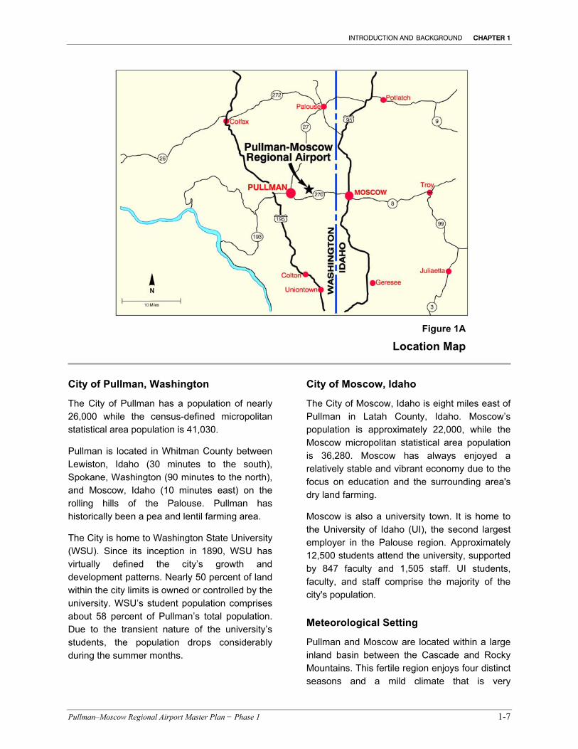
The PMRA is located in Whitman County, Washington near the Washington-Idaho border approximately 90 miles south of Spokane. It is approximately four road miles northeast of Pullman, Washington and eight miles west of Moscow, Idaho. Geographically, the airport is located at 46° 44’ 37.9” north latitude and 117° 6’ 34.5” west longitude at an elevation of 2,555 feet above mean sea level (MSL) (See Figure 1A).
The airport lies within the Palouse region (a part of the foothills of the Clearwater Mountains) which includes parts of five Washington counties and two Idaho counties. The topography is a depositional landscape characterized by a rolling silt and sand, steep rock, and channeled scablands. There are three main characteristics found in the Palouse. The rocky areas of the Palouse are on the easternmost border of the region and are forested, steep-sloped and mountainous. To the west are buttes ranging in altitude from 2,500 to 4,000 feet. Surrounding these buttes are rolling hills.
INTRODUCTION AND BACKGROUND CHAPTER 1
Pullman–Moscow Regional Airport Master Plan − Phase 1 1-7
City of Pullman, Washington
The City of Pullman has a population of nearly 26,000 while the census-defined micropolitan statistical area population is 41,030.
Pullman is located in Whitman County between Lewiston, Idaho (30 minutes to the south), Spokane, Washington (90 minutes to the north), and Moscow, Idaho (10 minutes east) on the rolling hills of the Palouse. Pullman has historically been a pea and lentil farming area.
The City is home to Washington State University (WSU). Since its inception in 1890, WSU has virtually defined the city’s growth and development patterns. Nearly 50 percent of land within the city limits is owned or controlled by the university. WSU’s student population comprises about 58 percent of Pullman’s total population. Due to the transient nature of the university’s students, the population drops considerably during the summer months.
City of Moscow, Idaho
The City of Moscow, Idaho is eight miles east of Pullman in Latah County, Idaho. Moscow’s population is approximately 22,000, while the Moscow micropolitan statistical area population is 36,280. Moscow has always enjoyed a relatively stable and vibrant economy due to the focus on education and the surrounding area's dry land farming.
Moscow is also a university town. It is home to the University of Idaho (UI), the second largest employer in the Palouse region. Approximately 12,500 students attend the university, supported by 847 faculty and 1,505 staff. UI students, faculty, and staff comprise the majority of the city's population.
Meteorological Setting
Pullman and Moscow are located within a large inland basin between the Cascade and Rocky Mountains. This fertile region enjoys four distinct seasons and a mild climate that is very
Figure 1A
Location Map
CHAPTER 1 INTRODUCTION AND BACKGROUND
1-8 Pullman-Moscow Regional Airport Master Plan − Phase 1
conducive to agriculture. In fact, it is one of the richest wheat growing regions in the world.
Annual precipitation averages about 20 inches, although higher elevations receive considerably more. Average winter-season snowfall varies from 20 to 40 inches. Snow can be expected in November and to remain on the ground for periods ranging from a few days to two months between the first of December and March. Summer sky conditions are the clearest (July). Outside of summer, cloudy skies are typical and precipitation occurs regularly.
Above the scabby surface topography, westerly winds prevail. The mean maximum temperature during the hottest month (August) is 82.0° F and the mean minimum temperature during the coldest month (January) is 34.7°.
Pullman-Moscow Regional Airport (PMRA) experiences the following weather conditions on average over a year’s period of time:
• Visual Flight Rules (VFR) weather approximately 92.9 percent
• Instrument Flight Rules (IFR) weather, Airport closed 7.1 percent of the year
Airport Setting
PMRA is situated within the city limits of Pullman, WA and is a Part 139 certified commercial service facility providing scheduled air carrier and general aviation services to the residents and visitors of Pullman, WA, Moscow, ID and other nearby communities of Whitman and Latah Counties. The airport is considered a regional facility and is operated by an Airport Board with representation from the cities of Pullman and Moscow, the Port of Whitman County, Latah County, Washington State University (WSU), and the University of Idaho.
The airport is operated pursuant to a regional agreement.
The airport has a total land area of approximately 119 acres in fee-owned by the City of Pullman and 43 acres leased from WSU.
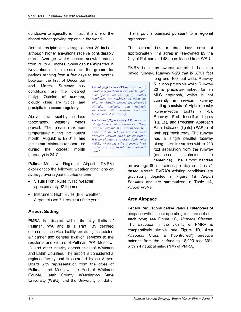
PMRA is a non-towered airport. It has one paved runway, Runway 5-23 that is 6,731 feet
long and 100 feet wide. Runway 5 is non-precision while Runway 23 is precision-marked for an MLS approach, which is not currently in service. Runway lighting consists of High Intensity Runway-edge Lights (HIRL), Runway End Identifier Lights (REILs), and Precision Approach Path Indicator [lights] (PAPIs) at both approach ends. The runway has a single parallel taxiway along its entire stretch with a 200 foot separation from the runway (measured centerline to centerline). The airport handles
an average 80 operations per day and has 71 based aircraft. PMRA’s existing conditions are graphically depicted in Figure 1B, Airport Facilities and are summarized in Table 1A, Airport Profile.
Area Airspace
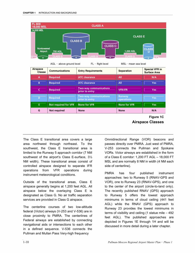
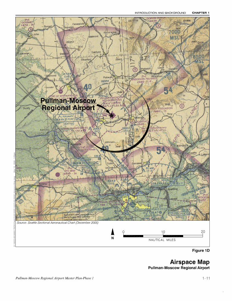
Federal regulations define various categories of airspace with distinct operating requirements for each type; see Figure 1C, Airspace Classes. The airspace in the vicinity of PMRA is comparatively simple; see Figure 1D, Area Airspace. Class E (“controlled”) airspace extends from the surface to 18,000 feet MSL within 4 nautical miles (NM) of PMRA.
Visual flight rules (VFR) are a set of aviation regulations under which a pilot may operate an aircraft, if weather conditions are sufficient to allow the pilot to visually control the aircraft's attitude, navigate, and maintain separation with obstacles such as terrain and other aircraft.
Instrument flight rules (IFR) are a set of regulations and procedures for flying aircraft without the assumption that pilots will be able to see and avoid obstacles, terrain, and other air traffic; it is an alternative to visual flight rules (VFR), where the pilot is primarily or exclusively responsible for see-and-avoid.

INTRODUCTION AND BACKGROUND CHAPTER 1
Pullman–Moscow Regional Airport Master Plan − Phase 1 1-9
Class E airspace is “generally controlled”, meaning all aircraft operating under IFR are being provided with traffic separation services. Aircraft operating under VFR may participate and receive traffic advisories, although this is not a requirement. Class E airspace has higher flight visibility requirements than Class G (“uncontrolled”) airspace.
PMRA’s Class E airspace is configured to support instrument approaches during inclement weather by extending the Class E (surface) zones to cover the approach/departure areas northeast (4 NM extension; 3½ NM wide) and southwest (3 NM extension, 3½ NM wide). Beyond the airport’s Class E airspace is a transitional area which begins 700 feet above ground level (AGL).
MAJOR FEATURES AND FACILITIES
Property • 119 acres fee-owned by the City of Pullman and 43 acres leased
from Washington State University
Airfield • Runway 05-23: 6,731 ft. long, 100 ft. wide; asphalt-grooved
- Runway 23 has a usable length of 5,951 ft. - Runway 05 has a usable length of 6,531 ft.
• Full parallel taxiway, 60 ft. wide, 200- ft. separation • Declared Distances:
- Runway 5 TORA:6730 TODA:6730 ASDA:6490 LDA:6200 - Runway 23 TORA:6730 TODA:6730 ASDA:6040 LDA:5240
Runway Approach Lighting • Runway 05: Non-precision markings • Runway 23: Precision markings
Airport Visual and Weather Aids • Beacon – white/green • Automated Surface Observation System (ASOS) • Lighted wind sock • Segmented circle • Runway End Lights (REILS): Runways 15 and 23 • Precision Approach Path Indicator (PAPI) lights:
- Runway 05: 2-box, 3-degree glidepath - Runway 23: 4-box , 4-degree glidepath
• High Intensity Runway-edge Lighting (HIRL) • Lighted runway signs • Runway Distance Remaining Signs
Building Area Located north side of runway: • Terminal and rental car agency • ARFF building • T-hangars • Private hangars • Snow-plow sand storage building • Maintenance building • FBO buildings
Source: Data compiled by Mead & Hunt, Inc. (March 2006)
Navigational Aids • Pullman VOR/DME, 6.3 NM southwest • Nez Perce VOR/DME, 23.9 NM southeast
Instrument Approaches • Runway 23 Category I Microwave Landing System (out of
service)
Fixed Base Operations Services • Aviation fuel, oxygen service, aircraft parking (ramp or tiedown),
hangars, passenger terminal and lounge, pilot school, aircraft rental
• Fuel service: 100LL and Jet A
Emergency and Security • ARFF Index A • Transportation Security Administration (TSA) officers provide
passenger screening at airline security checkpoints
ENVIRONS
Topography • Airport Elevation: 2,556 ft. MSL • Scabby close-in terrain, Palouse Mountains northeast • Terrain and obstructions in approach areas- both runway ends
Access • Access from Highway 270 to Airport Road
Jurisdiction • Pullman-Moscow Regional Airport Board, membership in
accordance with multi-jurisdictional cooperative agreement. Participating membership includes: - Mayor of the City of Pullman - Mayor of the City of Moscow - Person appointed by the City of Pullman - Person appointed by the City of Moscow - Person appointed by the Port Commissioners of the Port of
Whitman County - Person appointed by the Commissioners of Latah County - Person appointed by a majority vote of the other 6
members.
Principal Surrounding Land Uses • Agriculture • University
Table 1A
Airport Profile
CHAPTER 1 INTRODUCTION AND BACKGROUND
1-10 Pullman-Moscow Regional Airport Master Plan − Phase 1
The Class E transitional area covers a large area northwest through northeast. To the southwest, the Class E transitional area is limited to the Runway 5 approach corridor (7 NM southwest of the airport’s Class E-surface, 3½ NM width). These transitional areas consist of controlled airspace designed to separate IFR operations from VFR operations during instrument meteorological conditions.
Outside of the transitional areas, Class E airspace generally begins at 1,200 feet AGL. All airspace below the overlaying Class E is designated as Class G. No air traffic separation services are provided in Class G airspace.
The centerline courses of two low-altitude federal (Victor) airways (V-253 and V-536) are in close proximity to PMRA. The centerlines of Federal airways are established by connecting navigational aids or intersections to each other in a defined sequence. V-536 connects the Pullman and Mullan Pass Very-high frequency
Omnidirectional Range (VOR) beacons and passes directly over PMRA. Just west of PMRA, V-253 connects the Pullman and Spokane VORs. Victor airways are established in the form of a Class E corridor: 1,200 FT AGL – 18,000 FT MSL and are normally 8 NM in width (4 NM each side of centerline).
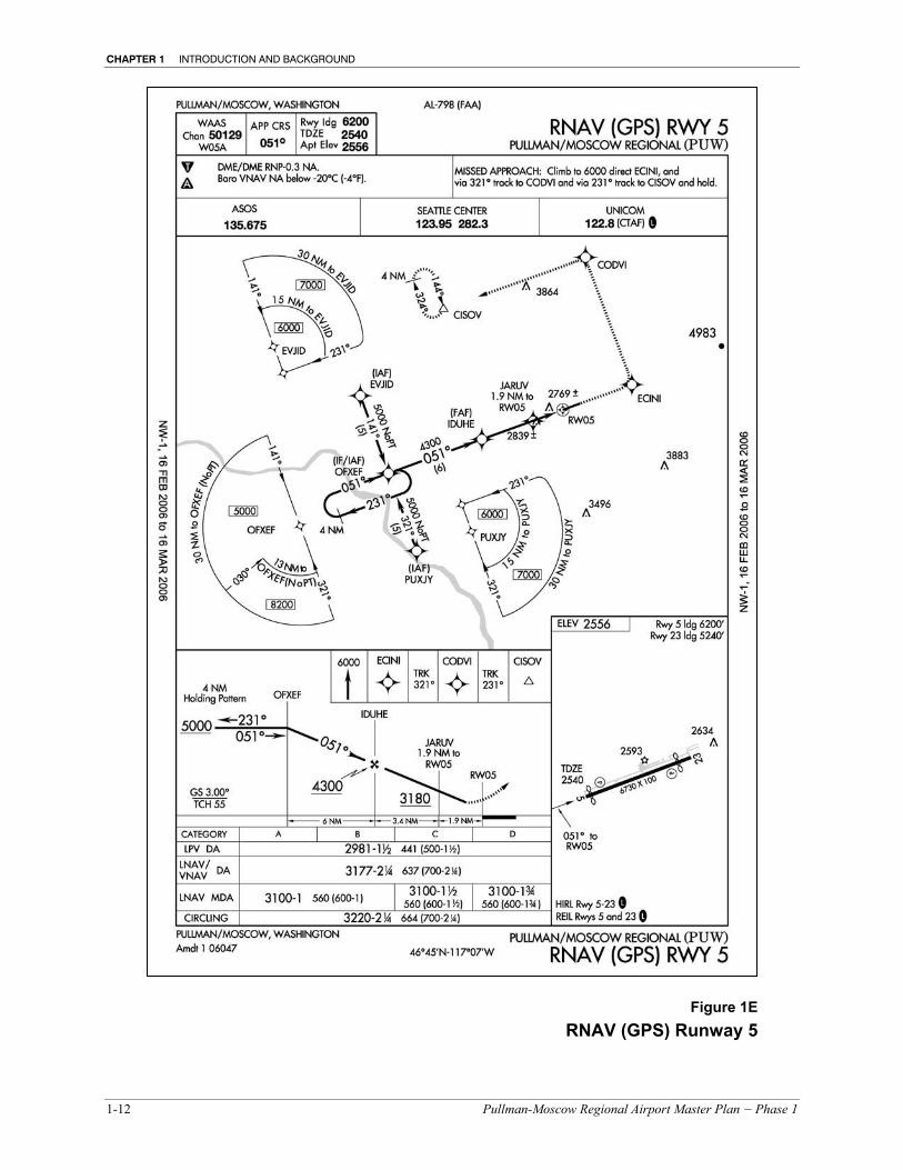
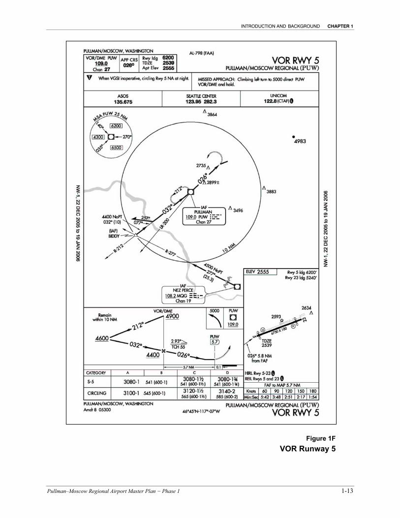
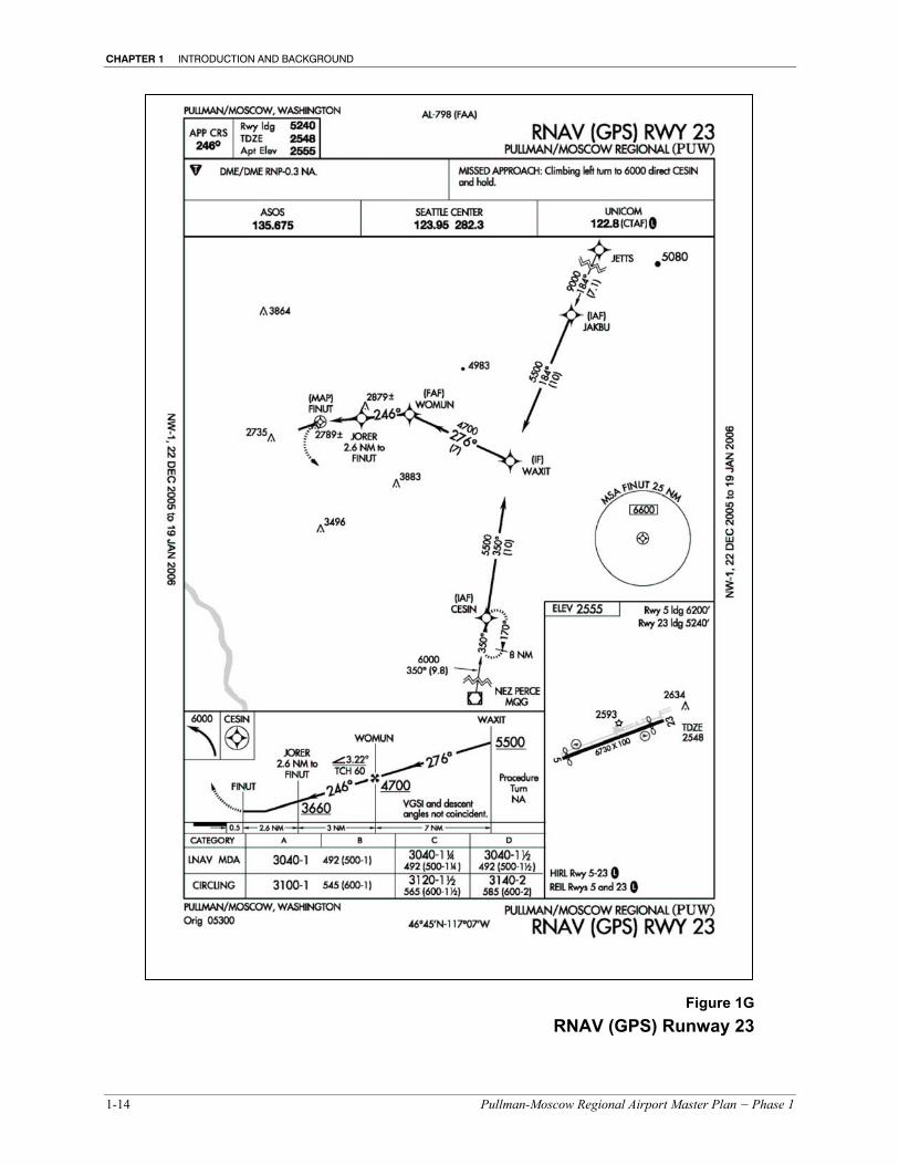
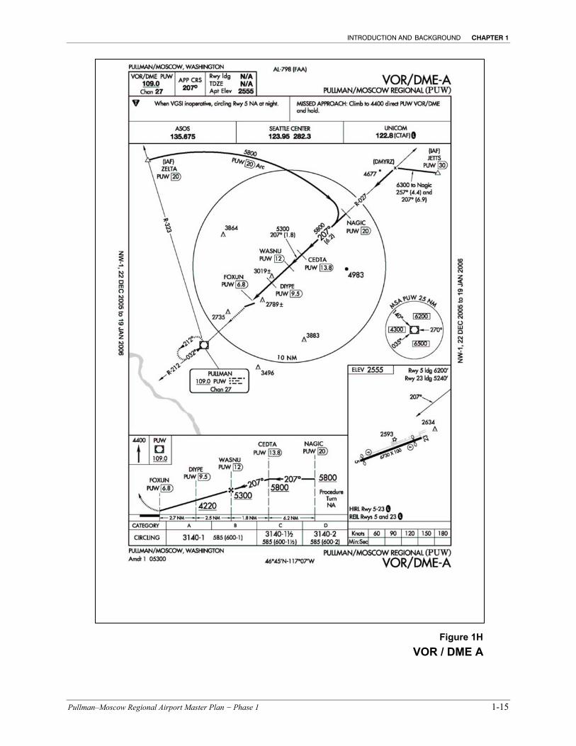
PMRA has four published instrument approaches: two to Runway 5 (RNAV-GPS and VOR), one to Runway 23 (RNAV-GPS), and one to the center of the airport (circle-to-land only). The recently published RNAV (GPS) approach to Runway 5 offers the lowest approach minimums in terms of cloud ceiling (441 feet AGL) while the RNAV (GPS) approach to Runway 23 provides the lowest minimums in terms of visibility and ceiling (1 statue mile – 492 feet AGL). The published approaches are depicted in Figures 1E through 1H and will be discussed in more detail during a later chapter.
AGL − above ground level FL − flight level MSL− mean sea level
Airspace Classe
Communications Entry Requirements Separation Special VFR in Surface Area
A Required ATC clearance All N/A
B Required ATC clearance All Yes
C Required Two-way communications prior to entry
VFR/IFR Yes
D Required Two-way communications prior to entry
Runway operations
Yes
E Not required for VFR None for VFR None for VFR Yes
G Not required None None N/A
Figure 1CAirspace Classes
CHAPTER 1 INTRODUCTION AND BACKGROUND
1-12 Pullman-Moscow Regional Airport Master Plan − Phase 1
Figure 1E RNAV (GPS) Runway 5
INTRODUCTION AND BACKGROUND CHAPTER 1
Pullman–Moscow Regional Airport Master Plan − Phase 1 1-13
Figure 1F VOR Runway 5
CHAPTER 1 INTRODUCTION AND BACKGROUND
1-14 Pullman-Moscow Regional Airport Master Plan − Phase 1
Figure 1G RNAV (GPS) Runway 23
INTRODUCTION AND BACKGROUND CHAPTER 1
Pullman–Moscow Regional Airport Master Plan − Phase 1 1-15
Figure 1H VOR / DME A
CHAPTER 1 INTRODUCTION AND BACKGROUND
1-16 Pullman-Moscow Regional Airport Master Plan − Phase 1
Location Facilities Services
Airport Name Owner C
omm
unity
/ C
ount
y
Dis
tanc
e1 / Dire
ctio
n
Bas
ed A
ircra
ft
Num
ber
of R
unw
ays
Lon
gest
Run
way
(ft.
)
Sur
face
2
Lig
hted
-Inte
nsity
3
App
roac
h V
isib
ility
4
Con
trol
Tow
er
Airl
ine
Serv
ice
AvG
as
Jet
Fue
l
Mai
nten
ance
Aut
omob
ile R
enta
ls
Foo
d
AREA AIRPORTS
Pullman-Moscow Regional Airport
Pullman-Moscow Regional Airport
Board
Pullman/ Whitman
― 71 1 6,730 ASPH H 1 ―✔
✔
✔
―✔
Air Carrier Airports
Lewiston-Nez Perce County Airport
County of Nez Perce
Lewiston/ Nez Perce
26S 144 2 6,511 ASPH H ½ ✔ ✔
― ― ―
Spokane International Airport
County of Spokane
Spokane/ Spokane
63NW 113 2 9,001 ASPH H 1 ✔ ✔ ✔
Walla Walla Regional Airport
Port of Walla Walla
Walla Walla/ Walla Walla
72SW 151 3 6,526 ASPH H ½ ✔ ✔ ✔ ✔ ✔
General Aviation (GA) Airports
Port of Whitman Business Air Center
Port of Whitman County
Colfax/ Whitman
14NW 14 1 3,209 ASPH ― ― ― ― ✔
― ― ― ―
Willard Field Airport City of Tekoa Tekoa/ Whitman
30N 10 1 2,260 ASPH M ― ― ― ✔
― ―
Rosalia Municipal Airport
Town of Rosalia Rosalia/ Whitman
32NW 8 1 2,800 ASPH M ― ― ― ✔
― ― ― ―
Orofino Municipal Airport
City of Orofino Orofino/ Clearwater
37SE 14 1 2,500 ASPH ― ― ― ― ― ― ― ―
Craigmont Municipal Airport
City of Craigmont
Craigmont/ Lewis
40SE 7 1 2,800 ASPH M ― ― ― ✔ ✔ ✔
― ―
St Maries Municipal Airport
Benewah County
St Maries/ Benewah
41NE 19 1 4,250 ASPH ― ― ― ― ― ― ―
Nez Perce Municipal Airport
City of Nez Perce
Nez Perce/ Lewis 47SE 5 1 2,400 ASPH ― ― ― ― ―✔
― ― ― ―
1 Distance limited to 120 road miles for commercial airports and 50 nautical miles for paved public-use general aviation airports. 2 ASPH=asphalt; CONC=concrete 3 L=low; M=medium; H=high 4 Statute mile
Source: Data compiled by Mead & Hunt, Inc. (March 2006)
Table 1B
Area Airports Pullman-Moscow Regional Airport Vicinity
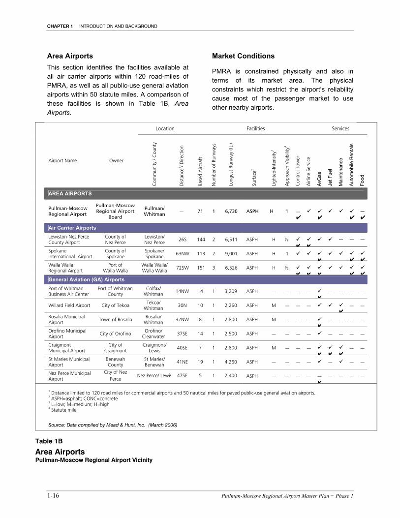
Area Airports This section identifies the facilities available at all air carrier airports within 120 road-miles of PMRA, as well as all public-use general aviation airports within 50 statute miles. A comparison of these facilities is shown in Table 1B, Area Airports.
Market Conditions
PMRA is constrained physically and also in terms of its market area. The physical constraints which restrict the airport’s reliability cause most of the passenger market to use other nearby airports.
INTRODUCTION AND BACKGROUND CHAPTER 1
Pullman–Moscow Regional Airport Master Plan − Phase 1 1-17
This same reliability issue combined with limited developable space at the airport may be causing aircraft operators to base their aircraft elsewhere or to use another airport from This same reliability issue combined with limited developable space at the airport may be causing aircraft operators to base their aircraft somewhere else or to use another airport from which to conduct business.
PMRA’s market is constrained by Spokane International Airport 85 miles north and Lewiston – Nez Perce County Airport 35 miles to the south. These two airports currently constrain the PMRA’s market to southeastern Whitman County, Washington and Latah County, Idaho. A sizeable portion of its own market share is currently lost or “leaked” due to reliability and other perceived service-related deficiencies.
Socio-economic Conditions
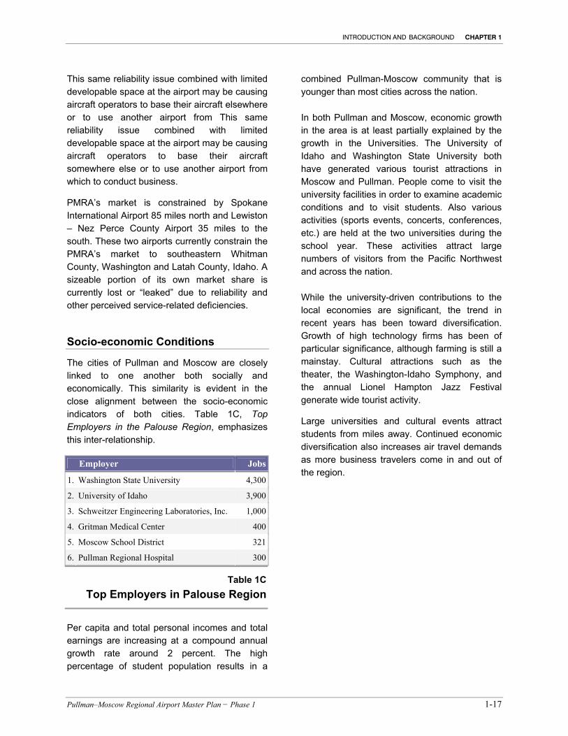
The cities of Pullman and Moscow are closely linked to one another both socially and economically. This similarity is evident in the close alignment between the socio-economic indicators of both cities. Table 1C, Top Employers in the Palouse Region, emphasizes this inter-relationship.
Employer Jobs
1. Washington State University 4,300
2. University of Idaho 3,900
3. Schweitzer Engineering Laboratories, Inc. 1,000
4. Gritman Medical Center 400
5. Moscow School District 321
6. Pullman Regional Hospital 300
Table 1CTop Employers in Palouse Region
Per capita and total personal incomes and total earnings are increasing at a compound annual growth rate around 2 percent. The high percentage of student population results in a
combined Pullman-Moscow community that is younger than most cities across the nation.
In both Pullman and Moscow, economic growth in the area is at least partially explained by the growth in the Universities. The University of Idaho and Washington State University both have generated various tourist attractions in Moscow and Pullman. People come to visit the university facilities in order to examine academic conditions and to visit students. Also various activities (sports events, concerts, conferences, etc.) are held at the two universities during the school year. These activities attract large numbers of visitors from the Pacific Northwest and across the nation.
While the university-driven contributions to the local economies are significant, the trend in recent years has been toward diversification. Growth of high technology firms has been of particular significance, although farming is still a mainstay. Cultural attractions such as the theater, the Washington-Idaho Symphony, and the annual Lionel Hampton Jazz Festival generate wide tourist activity.
Large universities and cultural events attract students from miles away. Continued economic diversification also increases air travel demands as more business travelers come in and out of the region.