chapter 1: community identity & neighborhood involvement
TRANSCRIPT

04-0
1-20
09 D
RA
FT
chap
ter 1
: com
mun
ity id
entit
y &
neig
hbor
hood
invo
lvem
ent
14
chapter 1: community identity & neighborhood involvement
The future of the Town of Bluffton depends largely on having healthy and vibrant neighborhoods. Creating a sense of community begins with resident initiative and participation. Stakeholders must be engaged in the planning and implementation process. The community must encourage cooperative efforts between the public and private entities responsible for implementing plan recommendations.
The more recent subdivisions and planned communities that surround the BIS Neighborhood have an inherent identity through their establishments as planned communities. The ancillary property owners associations and branding identity further reinforce these legally defi ned neighborhoods.
The BIS Neighborhood suffers from a lack of a visible identity. For example, the community does not have a defi ned entry with a gate house and sign. There is no public amenity or destination within the neighborhood with which it can be associated. There is no consistent architectural theme or historic period to unify the community. Finally, there is no property owners association to help unite and represent the BIS Neighborhood to the Town, County, general public, or residentsThe BIS Neighborhood would benefi t from an inclusive
Figures 19 and 20: A well-designed gateway element can help brand the BIS Neighborhood to the greater Bluffton community.
Figure 22: An example of historic signage being used to identify important features.
neighborhood organization for communication by all property owners and residents. This could start by expanding the existing Neighborhood Association.
A neighborhood organization is an offi cially recognized organization for a specifi c geographic location in which every resident and business within the neighborhood is a voting member. Neighborhood organizations work to refl ect the issues and concerns of its members. Neighborhood organizations also have the legal standing to represent the neighborhood to the Town on a variety of issues including land-use and zoning, traffi c, parks, and other issues that directly affect a neighborhood’s livability.
The Town Council is committed to ensuring that this community-based energy and interest is used productively in municipal decision-making. This is especially important in land-use planning. The Town works with the neighborhood organizations to encourage early participation in the public review process, an open dialogue between applicants and neighborhoods, and improving communications between the development community, citizens, and Town government. This forum would provide the ideal setting to ensure the BIS Neighborhood Plan is
Figure 21: Typical community policing programs that could benefi t the BIS Neighborhood.
properly implemented.
A neighborhood watch program would also help unite residents by working with law enforcement to keep a trained eye and ear on their community. The program teaches citizens how to help themselves by identifying and reporting suspicious activity in their neighborhood. The social interaction and “watching out for each other” camaraderie tends to strengthen communities and is at the heart of most successful neighborhood watch programs.
Neighborhood watches share one essential concept: bringing community members together to re-establish control of their neighborhoods, promoting an increased quality of life, and reducing the crime rate in the area. The adjacent community of Hidden Lakes recently started its own neighborhood watch program, and residents say that they feel safer, and that the program has provided a social network which has strengthened their neighborhood.

04-0
1-20
09 D
RA
FT
chapter 1: comm
unity identity & neighborhood involvem
ent 15
Figure 23: Neighborhood events help strengthen communities.
Community events add to the spirit and vitality of neighborhoods and provide an opportunity for residents to socialize. For generations, block parties have served as a way for neighbors to meet each other. Some block parties are organized around holidays such as the 4th of July or Labor Day, while others may start because of an issue affecting the neighborhood.
The neighborhood organization can help establish the fi rst Buck Island Simmonsville community event. The new middle school will make an ideal location for such an event due to its size and central location.
Due to the lack of neighborhood identity, a branding exercise that includes a name and image package is a recommendation for the Buck Island Simmonsville Neighborhood to consider. Branding is about building affi nity for a neighborhood. For a neighborhood brand to be relevant, the brand must fl ow from the neighborhood itself. The brand identity must focus on the strengths of the community and be understood by the greater Bluffton community.
Another method to help establish neighborhood identity is the creation of a neighborhood gateway. This can be done by creating an entry structure or a distinguishing sign in conjunction with other aesthetic features to emphasize the residential neighborhood. BIS residents have identifi ed the May River Road/Buck Island Road intersection as one gateway. The Bluffton Parkway intersections of Simmonsville and Buck Island roads have also been identifi ed as potential gateways into the BIS Neighborhood. A simple monument sign with appropriate landscaping would go a long way in identifying and branding the BIS Neighborhood. The gateway should be a high-quality design that refl ects the character of the residential neighborhood (based on branding initiative.) The Bluffton Parkway and Buck Island gateway is also an opportunity to coordinate with Beaufort County to properly screen the refuse facility so that the Neighborhood’s entrance is not such an unfriendly eyesore. Figure 24 shows
some examples.
These gateways might reduce cut-through traffi c, as well. Typically, motorists frustrated by congestion on major arterial and collector roadways will seek shortcuts or less congested routes. By providing these high quality gateway features on Bluffton Parkway and May River Road, some cut-through traffi c may be discouraged.
Figure 24: After a branding campaign, new street signs can help reinforce a neighborhood’s image and promote
the community’s identify.

04-0
1-20
09 D
RA
FT
chap
ter 1
: com
mun
ity id
entit
y &
neig
hbor
hood
invo
lvem
ent
16
KEY:AC-Advisory Committee; BC-Beaufort County; BCSD-Beaufort County School District; BHS-Bluffton Historical Society; EF-Eagles Field; NO-Neighborhood Organization; PO-Property Owners; SCDOT-SC Department of Transportation; TOB-Town of Bluffton
Develop working groups for each of the Plan elements AC, PO, TOB
Hold a public meeting every quarter to review and discuss plan implementation status AC, PO, TOB
Establish Buck Island Simmonsville as the Town’s fi rst offi cial Neighborhood Organization AC, PO, TOB
Coordinate with the Bluffton Historical Society to identify historic resources (land, structures, events) and promote the local history via markers BHS, PO
Through a branding process, develop an image package for Buck Island Simmonsville including logo, colors, and tag line AC, PO, TOB
Reinforce the community boundaries and branding image by installing entry signage and beautifi cation at identifi ed gateway locations AC, PO, TOB
Install new street signs with the BIS logo/image TOB, BC
Develop a template for a BIS Neighborhood website and give content control and management to the Neighborhood Organization TOB, NO
The Neighborhood Organization and the new middle school should adopt Buck Island and Simmonsville roads for regular trash pickups NO, BCSD
Establish an annual BIS event that highlights the heritage and diversity of the Neighborhood NO
Establish partnerships with Eagles Field and the middle school to positively integrate these facilities into the Neighborhood AC, PO, TOB, EF, BCSD
Screen the County refuse facility to create a more aesthetic gateway for the Neighborhood BC, TOB
Establish a neighborhood cleanup program with community association that allows residents to dispose of white goods and other hazardous household items TOB, NO
com
mu
nit
y id
enti
ty &
nei
gh
bo
rho
od
in
volv
emen
t re
com
men
dat
ion
s
Figure 25: Screen Planting Plan for County Recycling and Refuse Center from JK Tiller Associates, Inc.

04-0
1-20
09 D
RA
FT
chapter 2: natural resources 17
chapter 2: natural resources
The Town of Bluffton has a variety of forests and woodland types, and the Buck Island Simmonsville (BIS) Neighborhood is a prime example of such variety.
These natural features offer many great benefi ts to the Town and the surrounding areas. Specifi cally, the forested areas are comprised of both Pinewoods and Hardwood Bottom Wetlands. These forest types provide a wide range of habitats and many opportunities for a variety of plant and animal species, some of which may be endangered. Figure 28 identifi es the areas
of wetlands in the BIS Neighborhood.
Preserving large tracts of habitat, such as the one in the BIS Neighborhood, helps prevent species isolation and extinction. In addition to the other ecological benefi ts of the forested areas, one of the most important is providing surface water cleansing. The forests and wetlands help clean stormwater before it leaves the BIS Neighborhood. Wetlands are one of the best environments to mitigate fl ooding, clean stormwater, and provide groundwater recharging.
The BIS Neighborhood is situated in the May River and Colleton River watersheds so any trash, pollution,
Figure 27: Typical forested wetland during wet season
Figure 26: Typical forested wetland during dry season
or toxins in the BIS Neighborhood will fl ow into one of these treasured rivers (see Figure 29).
Preserving high-quality water in the area is critical to preserving shell fi shing, fi shing, recreation, and drinking water for Town residents. Without the forests and wetlands to clean the surface water, oysters, crabs, and fi sh would not only become unfi t for human consumption due to pollutants, but many species would die off. The impacts of forest and wetland losses would be devastating to the fi shing industry and the traditional way of life in the Lowcountry.
There may also be opportunities for developers to allow Town staff or non-profi t organizations to remove native plants in areas that will be cleared for development. Any plants that are removed could be used in public parks, along pathways, or other Town owned property.
Figure 28: Map of wetlands in the BIS Neighborhood.

04-0
1-20
09 D
RA
FT
chap
ter 2
: nat
ural
reso
urce
s
18
Figure 29: BIS Watershed Map.Figure 30: BIS Contour Map.

04-0
1-20
09 D
RA
FTFigure 31: Example of the abundant tree canopy in the Neighborhood.
The abundant tree canopy also offers great aesthetic value not only to the BIS Neighborhood, but also to the Town as a whole. The signifi cant tree canopy and forested portions of the BIS Neighborhood provide important plant and wildlife habitat. The trees are an asset to the community because they provide summer shade and cooling, help to slow stormwater runoff, reduce noise, and improve local air quality. Large, mature trees throughout the community also help to screen views of adjacent areas and properties, offering privacy for residential properties.
A new Tree Ordinance is currently being drafted, which will include measures to help preserve existing tree canopy in residential neighborhoods. The BIS Neighborhood is a great example of an area that needs to protect the magnifi cent tree canopy from future development and land disturbance activities.
The BIS Neighborhood is unique in that it contains a large amount of natural resources, while being located in the center of the Town. The Neighborhood has, for the most part, retained the Lowcountry character of its historic roots. However, there is a growing amount of pressure for development in the area, and many of the traditional ways of building around large trees and critical areas are being threatened. It is important to preserve the existing natural resources to maintain habitat, preserve the traditional way of life, clean water, and preserve the aesthetics of the Lowcountry.
chapter 2: natural resources 19
Figure 32: Bluffton has many beautiful waterways.
Figure 33: Mature oak trees are found throughout BIS.

04-0
1-20
09 D
RA
FT
chap
ter 2
: nat
ural
reso
urce
s
20
Many properties in the BIS Neighborhood rely on septic tanks for both homes and businesses. A recent study was done in the area and found a substantial amount of leaking septic tanks or failing septic fi elds. Raw sewage leaking out into the environment not only presents environmental hazards, but it also makes life uncomfortable for residents. There is an obvious need to connect properties to a sewer system, which is currently underway. Once the sewer system is fully installed, the environmental damage of leakage will stop, while improving the quality-of-life for those currently relying on malfunctioning septic systems.
A new drainage system will also be installed along the main roads. There are many problems with the existing stormwater drainage, as can be seen by the fl ooded ditches, yards, and roads. Improvements made to the drainage will help increase quality of life, improve safety, and help protect the environment. Standing water not only damages properties and poses safety threats, but it is also a breeding ground for mosquitoes and other disease carrying insects.
Figure 36
Figure 34: Stockpiled equipment and building supplies.
Figure 35: Failing septic tank.
Figure 37: Disposed concrete and other scrap building materials are stockpiled on this Buck
Island property.
Figure 36: Trash scattered throughout a yard.

04-0
1-20
09 D
RA
FT
The future vision for the Neighborhood will provide for an environmental setting that enhances the quality of life for local residents. Preservation of natural resources, keeping open spaces and wildlife corridors connected, and revisions to Town development standards to encourage environmentally friendly development will benefi t the long-term ecological health of the region. Some future natural resources concerns include increased development pressure, aging utilities and infrastructure, and an increase in population in the area. In order to protect the forests, wetlands, tree canopy, and other natural resources of the Neighborhood, the Town will work with future developers to preserve as much of BIS as possible. A balance must be achieved between the desire to maintain the benefi ts of a mature tree canopy, while alleviating some of the maintenance and fi nancial burden to individual property owners. Development tools such as cluster development should also be considered to preserve and protect the natural resources in the Neighborhood.
Figures 38-A-E represent plans and built projects using cluster development
principles.
Figure 38-A: Cluster development can provide very attractive housing options, while preserving critical lands and community open space.
Figure 38-B: Typical development preserves no land (as shown on the left), while cluster development can protect important natural resources (as shown on the right).
Figure 38-C: Cluster development provides
additional room for other activities. In
this example, land is preserved for organic
gardening.
Figure 38-D: Cluster development offers abundant open space for residential use.
Figure 38-E: Cluster development can have “old
town” charm.
chap
ter 2
: nat
ural
reso
urce
s
21

04-0
1-20
09 D
RA
FT
chap
ter 2
: nat
ural
reso
urce
s
22
Figure 39-A, B: Abandoned automobiles, trailers, tires, boats, waste, equipment, and building materials pose an environmental hazard to the neighborhood.

04-0
1-20
09 D
RA
FT
chapter 2: natural resources 23
Revise the Town of Bluffton Tree Ordinance to include parcels zoned General Residential (GR) to ensure signifi cant trees are preserved
TOB
Establish a Bluffton tree replacement program that provides the Town an opportunity to install new trees on private property
TOB, PO, NO
Remove the abandoned automobiles, tires, building materials, machinery, equipment, and boats from properties that pose environmental risks
PO
Revise zoning code to permit cluster development to avoid ecologically critical areas and preserve rural character
TOB
Improve the existing logging road from Wellstone to HE McCracken Circle as a nature trail/pathway and preserve the adjacent wetlands
TOB, PO, Pinecrest POA
Provide assistance to residents in preserving tree health TOB, PO
Provide septic maintenance program for those with failing septic systems
TOB
Eliminate septic systems and wells by providing upgraded utilities in the area
TOB
Improve the County’s dirt roads to prevent erosion and sedimentation
BC, PO
nat
ura
l re
sou
rces
rec
om
men
dat
ion
s
KEY:AC-Advisory Committee; BC-Beaufort County; BCSD-Beaufort County School District; NO-Neighborhood Organization;PO-Property Owners; SCDOT-SC Department of Transportation; TOB-Town of Bluffton
Figure 40: Areas that have stockpiles of refuse that may be environmentally damaging.

04-0
1-20
09 D
RA
FT
chap
ter 3
: plan
ning
, zon
ing,
& d
evelo
pmen
t
24
chapter 3: planning, zoning, & development
The term land use describes the kind of uses (residential, commercial, industrial, etc.) found on a parcel of land. The Buck Island Simmonsville Neighborhood contains a variety of land uses as dictated by previous growth and zoning patterns in place while under the jurisdiction of Beaufort County. The primary land use type in the BIS Neighborhood is a mix of low-density residential and medium-density residential. Land uses within
the community can be seen in Figure
41.
In Bluffton, Low-density residential is defi ned as a range of densities from one dwelling unit per three acres to one dwelling unit per acre. Medium-density residential can range from one to three units per acre, usually consisting of single-family homes. Multi-family homes may be permitted as long as the overall allowed density is not exceeded. According to the Town’s Comprehensive Plan, medium-density residential uses are proposed for the BIS Neighborhood. Existing medium-density residential
areas within the BIS Neighborhood include areas such as Wellstone, Windy Lakes, and Hidden Lakes.
Industrial and commercial uses are largely confi ned to the southern portion of the community, around and south of the Buck Island and Simmonsville roads intersection. A mixed-use property that is not yet developed, known as the Southeastern Development Property, lies along Simmonsville Road near the center portion of the Neighborhood. Adjacent to this property is the recently sited and approved Bluffton Middle School, a property which encompasses nearly 5% of the Neighborhood. In 1980, Beaufort County located a garbage transfer site at what is now the southwestern corner of the intersection of Simmonsville Road and Bluffton Parkway. A ball fi eld is located on the northern edge of the community, at the intersection of Buck Island Road and Bluffton Parkway.
Figure 42: In Bluffton, this scale would be considered High Density residential.
Figure 43: In Bluffton, this scale would be considered Medium Density Residential.
Figure 44: In Bluffton, this scale would be considered Low Density Residential.
Figure 41: Existing Land Use map.

04-0
1-20
09 D
RA
FT
25
avoidance of strip highway commercial development, and large regional businesses, or other land uses which might compromise the historic commercial character of the District.
planned unit development (PUD)
The purpose of this District is to encourage fl exibility in land planning that will result in improved design, character, and quality of new homogenous and mixed-use developments. Other purposes of the District are to promote the most appropriate use of land, facilitate the provision of streets and utilities, and to preserve open space and the natural and scenic features of the property.
Figure 45 is the current Zoning Map for BIS.
Zoning is a tool that allows the Town to guide development by regulating the physical form and kinds of uses on a parcel of land. These controls are based upon the need to prevent overcrowding of land, congestion on the streets, undue concentration of population, and the mixing of incompatible land uses. More importantly, zoning provides a basis for guiding and ordering the pattern of future development. The study area is primarily a residential community, thus 85% of the area is zoned residential, 10% commercial, 4% industrial, and 1% mixed-use.
There are currently four zoning districts within the Buck Island Simmonsville Neighborhood:
general residential (GR)
The General Residential District is designed to provide for a variety of low-density, residential uses, including single-family, two (2) or three (3) family, and manufactured home dwellings. The intent of the District is to provide areas primarily for residential uses, and to discourage any encroachment by uses which may be incompatible with such residential use.
light industrial (LI)
The purpose of this District is to provide a suitable environment for uses generally classifi ed as research and development, assembly, high technology production, precision manufacturing, and light industry. The LI District excludes heavy manufacturing operations which tend to be more objectionable to the community, and industries which are less clean. Industries in the LI District are required to have high performance standards with minimal hazardous waste, air and water pollution, and other off-site nuisances.
village commercial (VC)
The purpose of this District is to encourage the formation and continuance of a healthy environment for commercial uses that are located and sized so as to provide nearby residential areas with convenient shopping and service facilities. Another purpose is to promote the location of a mixture of housing types and prices and stores/offi ces/workplaces in close proximity to each other to provide a balanced mix of activities, foster a pedestrian-oriented community center, and reduce traffi c and parking congestion. Other goals include accommodation of essential public utilities and public safety services,
Figure 45: Zoning in BIS. chapter 3: planning, zoning, & developm
ent

04-0
1-20
09 D
RA
FT
chap
ter 3
: plan
ning
, zon
ing,
& d
evelo
pmen
t
26
Figure 46: Non-conforming land uses in BIS.Figure 47: Screening opportunities.
There are many parcels throughout the study area that contain commercial structures despite the fact that the parcels themselves are zoned for residential use. These structures were either in place prior to annexation into the Town and were developed under previous Beaufort County zoning designation or had made considerable progress towards development of the site under the jurisdiction of Beaufort County and hence were allowed to continue towards completion, as a vested right. It should be noted that these non-conforming parcels and the land uses currently occupying them may continue in perpetuity as non-conforming structures and uses as long these structures are not enlarged or the use is not abandoned for a time period of six months or more. The Town should ensure that non-conforming structures and uses are properly screened from adjacent residential uses to alleviate aesthetic incompatibilities. Figure 46
shows the non-conforming land uses
in the Neighborhood.
Land uses within the Neighborhood can be in confl ict with each other. A visual screen can help alleviate these confl icts by providing attractive buffers, as shown
in Figure 47.

04-0
1-20
09 D
RA
FT
Figure 49: Bluffton Station illustrative site plan.
chapter 3: planning, zoning, & developm
ent 27
Within the southwestern portion of the study area, the Vista View development is a mixture of 72 low-to-moderate income single and multi-family apartment units and related amenities. This project was phased over several years and maintains a 100% occupancy with a long waiting list. The community is an example of how well-managed, affordable housing apartments can be integrated into a neighborhood without negative impacts.
The adjacent Buckwalter PUD contains over 5,000 acres and is located to the west of the BIS Neighborhood. Pinecrest is the closest neighborhood to BIS and borders the western Neighborhood boundary. To the east of the BIS Neighborhood, commercial development within Bluffton Park has stretched towards the Simmonsville Road and Bluffton Parkway intersection.
Red Cedar Elementary, located within Bluffton Park and adjacent to the Hidden Lakes subdivision, is currently under construction and is projected to open in the fall of 2009.
Bluffton Station, a village commercial scale development, is architecturally designed to refl ect the Lowcountry character and to blend in with the surrounding neighborhood. Bluffton Stations is located on a 1.7 acre parcel at the northeast corner of Buck Island Road and SC 46. The project will consist of a market store, an eight pump gas station, a 1,336 square foot car wash and pet wash, and six buildings ranging from 900 square feet to 2,000 square feet in size to be used for planned shopping, specialty retail, and professional offi ces.
This project was well received by the BIS Neighborhood and should be used as a model for future commercial development in the BIS Neighborhood area. Figure 49 shows an illustrative site plan for Bluffton
Station.
Bluffton Middle School, a 142,000 square foot facility located on 41.84 acres in the heart of the BIS Neighborhood, has been sited with the intent of providing a centralized location
for the Town of Bluffton’s middle school students who will be attending the new school.
The school site will include recreational facilities such as a basketball court and athletic fi elds. Other site improvements will include extending Hyon Road to connect Buck Island and Simmonsville roads, providing access to the site from both thoroughfares. Sidewalks are also being installed along Hyon Road for pedestrian access to the school.
Unfortunately, the school’s budget did not allow for a more extensive sidewalk or pathway system, so it is imperative that the Town, Beaufort County School District, South Carolina Department of Transportation, and the property owners work together to improve these critical pedestrian connections.
All students attending the school will be given bus service until adequate pedestrian access is constructed. The state has developed a 1.5 mile radius for students who will no longer receive bus service after pedestrian infrastructure is in place. Figure 50 is the overall site plan
for the new Bluffton Middle School site.
recent development
Within the past few years there has been a surge of development around the Buck Island Simmonsville (BIS) Neighborhood. The three communities within the Neighborhood – Hidden Lakes, Wellstone, and Windy Lakes are all Planned Unit Developments (PUDs) consisting of land plans that are medium-density residential in nature.
PUDs are a common development model in this area, as they offer fl exibility in land planning. PUDs also encourage the developer to go above and beyond the requirements of standard zoning.
Another common component of development is a development agreement. Development agreements allow a developer to lock in existing land use regulations for an extended period of time. Many times, development agreements result in a higher level of community amenities. A commitment of funding to provide open space and public infrastructure is also a result of the development agreement process.
The neighboring community to the north, Old Carolina, is also a medium density PUD. The Old Carolina Golf Course was annexed as a part of the Buck Island Simmonsville annexation in 2005. Traditions at Old Carolina, consisting of 134 residential lots, was not annexed and remains a portion of Beaufort County. In 2006, the annexed area was rezoned from General Residential to PUD. The master plan for the annexed portion of Old Carolina allows for 199 apartment units and 55 single family dwelling units.
Figure 48: The Traditions at Old Carolina.

04-0
1-20
09 D
RA
FT
chap
ter 3
: plan
ning
, zon
ing,
& d
evelo
pmen
t
28
Figure 50: Bluffton Middle School plan Figure 51: Illustrative site plan for the Southeastern Property
Southeastern Property Development, a mixed-use project adjacent to the Bluffton Middle School site along Simmonsville Road, will have a total of 87,800 square feet of commercial, warehouse, retail, service, and offi ce space within a 6.88 acre site (see Figure 51).
The property was rezoned from Light Industrial (LI) zoning to PUD in February 2008. This project met opposition from local residents who expressed concerns over allowing commercial uses within the central portion of Simmonsville Road corridor, specifi cally citing concerns over increased traffi c on a roadway which already has been considered to be in need of improvements.

04-0
1-20
09 D
RA
FT
chapter 3: planning, zoning, & developm
ent 29
future land use
Through the planning process, the majority of the BIS stakeholders prefer that future land uses mimic the current land uses and that zoning be maintained in its current designated confi guration. Therefore, commercial, industrial, and large-scale institutional uses should be restricted from the core of the residential portion of the community. Commercial uses should be low-intensity and fi t into the context of the BIS Neighborhood’s scale with small signage and neighborhood-appropriate architecture and size.
The Future Land Use Map (FLUM), as identifi ed in the Comprehensive Plan, identifi es uses within the community as mostly residential. Larger properties within this classifi cation are frequently subject to minor subdivisions (the partitioning of a parcel into fi ve or fewer smaller parcels.) These minor subdivisions should be evaluated for the possibility of population and related municipal cost increases associated with utility and infrastructure improvements.
Figures 52 is the future land use for the BIS Neighborhood.
Figure 53, on the following page, shows what the future land use was
for the northern portion of BIS prior to an amendment in 2007.
Figure 52: Future land use for the BIS Neighborhood

04-0
1-20
09 D
RA
FT
Figure 53: The darker orange represents high-density residential in this 2007 Future Land Use Map. The offi cial map was amended in the Spring of 2007, changing the classifi cation to medium-density residential, as shown in Figure 53.
30
Figure 54: Buck Island Square (withdrawn) and Old Carolina Square locations
Areas of commercial land use have been identifi ed to be located primarily along the southern portion of Buck Island Road. Institutional and civic uses have been identifi ed as remaining on the Bluffton Middle School site and the County waste transfer site. It is important that the Town work to minimize the impact that additional civic or institutional facilities may have on the BIS Neighborhood.
Although the BIS Neighborhood is primarily residential in character, its perimeter contains commercial activity and applications for additional commercial development continue to be submitted to the Town. The application of the Buck Island Square property located at the southwestern corner of Bluffton Parkway and Buck Island Road that was requesting a rezoning, has recently been withdrawn. It appears, at this point, that the Buck Island Square property will be used as residential housing. The pending application of the Old Carolina Shopping Center property located at the northeastern corner of this same intersection proposes using a mixture of residential and commercial structures, including a gas station and grocery store. Figure 54 shows the locations of these two properties.
chap
ter 3
: plan
ning
, zon
ing,
& d
evelo
pmen
t

04-0
1-20
09 D
RA
FT
chapter 3: planning, zoning, & developm
ent 31
Figure 56: Old Carolina Shopping Center illustrative site plan
Figure 55: Alternative Buck Island Square Layout
Throughout the planning process, BIS residents continually voiced concerns over the Buck Island Square and Old Carolina projects. They cited concerns about increased traffi c on already inadequate roadways, increases in property taxes, and incompatibility with the existing neighborhood in terms of character and land use intensity. See Figures 55 and 56 for the proposed site plans. It is vital that the Town staff, Planning Commission, and Town Council carefully assess the impact of rezoning requests. A careful assessment should help ensure compatibility with the existing neighborhood, thus helping to fulfi ll the needs and objectives of the BIS Neighborhood Plan. Due to the proximity to the predominately low to medium density residential uses prevalent on adjacent properties, these properties should remain at a zoning designation of General Residential at this time.
There are numerous vacant properties throughout the Neighborhood that will eventually be fi lled with residential homes. Many of these properties are located in the interior portion of the Neighborhood, with no access to public roadways and are landlocked. Relying on the current road layout will result in every property having a curb cut or private drive off of Buck Island or Simmonsville roads. In order to avoid creating excessive curb cuts and private drives, additional connector roads may be warranted. There has been discussion about the need for a new north-south road from the Bluffton Parkway that runs parallel to Buck Island and Simmonsville roads. This road would take traffi c off of the main roads and open up these landlocked properties for development, something that may not be supported by the greater community.
Bluffton’s population continues to increase, and the population inside the BIS Neighborhood is no exception. Based on existing zoning in the Neighborhood, it is conceivable that 565 residential homes could be built. In order to limit the adverse impacts of residential buildout on the community, the current road layout may need to be improved to include additional connections. This is critical to maintaining a sustainable community.
Any future rezoning requests should be carefully reviewed by Town staff, Planning Commission, and Town Council ensure proposed development is in harmony with the intent of the Comprehensive Plan and the land use intensity and character of the Neighborhood. It should be noted, however, that some degree of commercial development within the BIS Neighborhood area could help in procuring funding for requested area improvements such as pathways, road widenings, and sewer/water line extensions.
Similarly, some properly-scaled neighborhood commercial businesses at the perimeter of the BIS Neighborhood could actually be a convenience for residents, like Bluffton Station.
If such rezonings are approved through public process, the Town should work with the respective developers to ensure that the projects are aimed at fulfi lling community needs while also fi tting into the BIS neighborhood’s character context. These developments should consist of a mix of housing styles and price points and contain neighborhood commercial that is pedestrian-oriented and limited to a village scale retail and service.
It is important that these developments also consider the need for additional community facilities to be utilized by residents of the study area, including but not limited to community centers, active and passive parks offering a variety of programming opportunities, pathways, and civic uses, all amidst a pedestrian-oriented streetscape.

04-0
1-20
09 D
RA
FT
32
Land uses around and south of the Buck Island Road and Simmonsville Road intersection should be limited to residential or village scale commercial uses. Due to current zoning designations of Village Commercial District (VCD), the nearby presence of a large employer in RSI, and the retail/service development of Bluffton Station, this intersection has the opportunity to become a true gateway node of commercial designed for the enjoyment and convenience of the entire Neighborhood.
Currently, a 7.3 acre site is for sale within the Village Commercial District. It is situated directly east of the Buck Island-Simmonsville split and could ultimately become the low-scale commercial and residential center focused specifi cally on providing employment opportunities and goods/services for the BIS Neighborhood. Figure 58 shows a conceptual design for this property.
Figure 58: Conceptual 7.3 AC Village Commercial at Buck Island Rd/ Simmonsville Rd intersection
chap
ter 3
: plan
ning
, zon
ing,
& d
evelo
pmen
t
Figure 57: This property represents a great opportunity for a neighborhood center and gateway into the
community, and is already zoned for such.
04-0
1-20
09 D
RA
FT
chapter 3: planning, zoning, & developm
ent 33
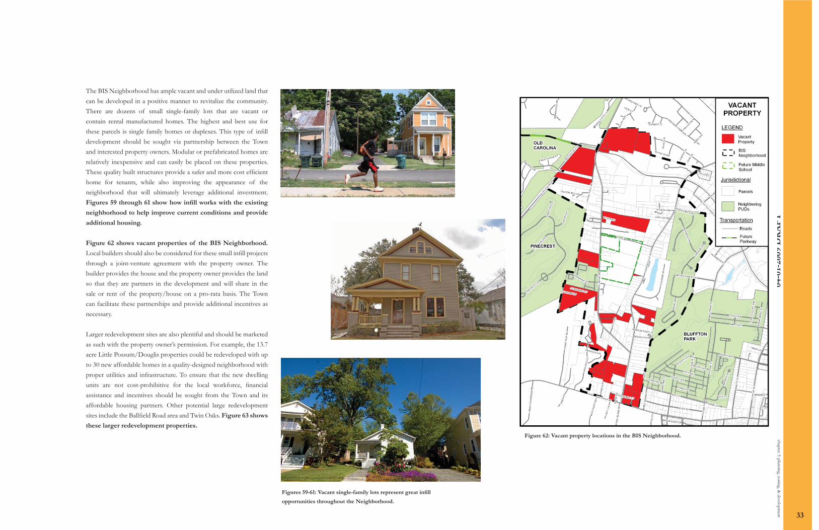
The BIS Neighborhood has ample vacant and under utilized land that can be developed in a positive manner to revitalize the community. There are dozens of small single-family lots that are vacant or contain rental manufactured homes. The highest and best use for these parcels is single family homes or duplexes. This type of infi ll development should be sought via partnership between the Town and interested property owners. Modular or prefabricated homes are relatively inexpensive and can easily be placed on these properties. These quality built structures provide a safer and more cost effi cient home for tenants, while also improving the appearance of the neighborhood that will ultimately leverage additional investment. Figures 59 through 61 show how infi ll works with the existing
neighborhood to help improve current conditions and provide
additional housing.
Figure 62 shows vacant properties of the BIS Neighborhood.
Local builders should also be considered for these small infi ll projects through a joint-venture agreement with the property owner. The builder provides the house and the property owner provides the land so that they are partners in the development and will share in the sale or rent of the property/house on a pro-rata basis. The Town can facilitate these partnerships and provide additional incentives as necessary.
Larger redevelopment sites are also plentiful and should be marketed as such with the property owner’s permission. For example, the 13.7 acre Little Possum/Douglis properties could be redeveloped with up to 30 new affordable homes in a quality-designed neighborhood with proper utilities and infrastructure. To ensure that the new dwelling units are not cost-prohibitive for the local workforce, fi nancial assistance and incentives should be sought from the Town and its affordable housing partners. Other potential large redevelopment sites include the Ballfi eld Road area and Twin Oaks. Figure 63 shows
these larger redevelopment properties.
Figure 62: Vacant property locations in the BIS Neighborhood.
Figures 59-61: Vacant single-family lots represent great infi ll
opportunities throughout the Neighborhood.

04-0
1-20
09 D
RA
FT
chap
ter 3
: plan
ning
, zon
ing,
& d
evelo
pmen
t
34
Figure 63: Areas best suited for redevelopment.
Encourage the demolition of buildings that cannot be rehabilitated at a reasonable cost
TOB, PO
Restrict new fl ag lots TOB
Review and strengthen parking standards, promoting the use of shared parking to reduce the quantity of parking lots while ensuring that adequate parking is appropriately placed and provided.
TOB
Review the ZDSO to ensure that requirements provide for adequate screening of commercial/industrial uses to adjacent residential structures.
TOB, PO
Require small-scale signage for any business within the Neighborhood Plan area.
TOB, PO
Work with the property owner and listing agent of the 7.3 acre VCD property site near the Buck Island Rd/Simmonsville Rd intersection to market appropriate redevelopment
TOB, AC, PO
Seek redevelopment opportunity for small infi ll properties TOB, PO
Restrict commercial, industrial, and large-scale multi-family development in the core of the Neighborhood
TOB
Mandate pathway contributions through easement donations or outright construction requirements (ordinance revision)
TOB, PO, NO
In partnership with the property owners and community leaders, seek redevelopment opportunities in the communities of Little Possum, Douglis Lane, Twin Oaks, and Ballfi eld Road.
TOB, PO
Assist heirs property owners to obtain clear title to their land TOB, PO
Identify parcels with adjacent confl icting land uses and develop beautifi cation/screening plans for each
TOB, PO
Review the ZDSO to ensure that adverse impacts from residential buildout will be minimized (lack of connector roads)
TOB
Ensure that Old Carolina Shopping Center is developed as residential
TOBp
lan
nin
g,
zon
ing
, &
dev
elo
pm
ent
reco
mm
end
atio
ns
KEY:AC-Advisory Committee; BC-Beaufort County; BCSD-Beaufort County School District; NO-Neighborhood Organization; PO-Property Owners; SCDOT-SC Department of Transportation; TOB-Town of Bluffton

04-0
1-20
09 D
RA
FT
chapter 4: parks & recreation 35
Recreation and open space add economic, social, environmental, and aesthetic value to neighborhoods. Well-planned spaces can promote community investment, educate citizens about the environment, contribute to a community’s unique character, and create a sense of place by linking surrounding structures.
Within BIS, the opportunity exists to provide park spaces that are accessible, attractive, and appropriately programmed via collaboration among the local schools and residents. The Town should work in partnership with Beaufort County Parks and Leisure Services (PALS) to identify areas within the Neighborhood that could accommodate a future park or recreational facility.
It may be pertinent to explore the possibility of acquiring portions of BIS’s major central wetland system for use as an interpretive park consisting of boardwalks and nature trails. This partnership could also be used to foster community summer camps and recreational programs. For example, Red Cedar Elementary School, located within Bluffton Park, is exploring the possibility of educational programs centering on interpretation of wildlife within the proposed man-made wetland park at the B-11 site, positioned south of the school along Red Cedar Street. The opportunity exists at the Bluffton Middle School site to incorporate a similar interpretative program within the open space and wetland system that lie on and adjacent to the middle school property.
When the new Bluffton Middle School opens in 2010, it can provide traditional recreational opportunities for the Neighborhood. Likewise, the new Red Cedar Elementary School in Bluffton Park is within easy walking distance to the BIS Neighborhood, as long as connecting pathways or sidewalks are developed. The Beaufort County School District allows for the utilization of recreational facilities for all schools under its jurisdiction through a recreational use policy. The Town should work with the School District and other developers to ensure pathways and sidewalks are available to access these facilities. The Town should continue working collaboratively with Beaufort County PALS,
the Beaufort County School District, and not-for-profi t organizations to provide improved access to neighborhood facilities for community services, programs, and activities.
Within the BIS Neighborhood, there is one recreational facility – the Bluffton Eagles ball fi eld. The Bluffton Eagles ball fi eld, owned by the non-profi t Bluffton Eagles Community Action Committee, hosts baseball games, community dinners, and community events. Owners of the ball fi eld have met with the Town and neighborhood residents and are committed to improving and modifying the ball fi eld for future community use. Figure 64 shows the proposed
enhancements.
chapter 4: parks & recreation
Figure 64: The proposed enhancements to the Bluffton Eagles Baseball Field.

04-0
1-20
09 D
RA
FT
Proposed improvements include enhancing the existing adult baseball fi eld by re-orienting the fi eld to allow for additional seating, concession areas, and rest rooms. The enhancements also include additional areas for barbecue pits and eating areas to better serve the community as a year-round gathering location, as well as the additions of a new little league baseball fi eld, a fi tness trail with interpretive botanical gardens, and a 4,000 square foot community center. The additional investment in this fi eld will lead to an increase in recreational programs and enhance the accessibility and capacity of an existing facility that has great potential as a community gathering space.
There are other recreational facilities and open space areas located outside of the BIS Neighborhood that are also open for public use. Buckwalter Community Park is a 103.3 acre regional park located along the Buckwalter Parkway. The park will consist of a variety of recreational opportunities including athletic fi elds, a community recreation center, three baseball fi elds, a swimming pool, tennis courts, and pathways. These pathways should be linked to pathways along Bluffton Parkway to allow for easy pedestrian access from the BIS Neighborhood to the regional park. Oscar Frazier Park and Oyster Factory Park both combine functional open space with a variety of recreational activities. Figure 65 shows
park and school locations in and around the BIS Neighborhood.
The recently constructed extension of Bluffton Parkway through the northern portion of the Neighborhood provides pathways for recreational and pedestrian use. These pathways are connected to a larger, growing system of interconnected linkages that allow for non-vehicular movement throughout the Town of Bluffton. The expansion of this pathway system along Buck Island Road and Simmonsville Road would provide for additional recreational opportunities, as well as provide pedestrian travel throughout the Neighborhood in a much safer manner than what currently exists.
chap
ter 4
: par
ks &
recr
eatio
n
36
Figure 65: School and park locations within walking distance of the BIS Neighborhood, if pathway connections were made.
Enhance Eagles Field with proposed improvements to the existing fi eld, a new little league fi eld, a community center, and other recreational features in partnership with not-for-profi t entities and ensure that the park is open to BIS residents during normal operation hours unless otherwise reserved
TOB, EF, AC, PO
Identify locations for new open space/park land TOB, PO
Identify environmentally sensitive land and ensure that it remains protected
TOB, PO
Ensure that the school site is open to the BIS community- establish a written commitment
TOB, PO, BCSD
Create interpretive wetland trails throughout the Neighborhood TOB,POpar
ks &
rec
reat
ion
rec
omm
end
atio
ns
KEY:AC-Advisory Committee; BC-Beaufort County; BCSD-Beaufort County School District; NO-Neighborhood Organization; PO-Property Owners; SCDOT-SC Department of Transportation; TOB-Town of Bluffton