century boulevard extension project - caltrans boulevard extension final... · street/tweedy...
TRANSCRIPT

Century Boulevard Extension Project
Between Grape Street and Alameda Street
LOS ANGELES COUNTY, CALIFORNIA City of Los Angeles
CML-5006(810)
Environmental Assessment with Finding of No Significant Impact
Prepared by the State of California Department of Transportation
February 2016
The environmental review, consultation, and any other action required in accordance with applicable Federal laws for this project is being, or has been, carried-out by Caltrans under its
assumption of responsibility pursuant to 23 USC 327.

This page is intentionally left blank.


This page is intentionally left blank.


This page is intentionally left blank.

Century Boulevard Extension Project SCH# 2010021007 Environmental Assessment 07-0-LA-LA Table of Contents CML-5006(810)
i
TABLE OF CONTENTS
Page
CHAPTER 1 PROPOSED PROJECT ....................................................................................1-1 1.1 Introduction ...........................................................................................1-1 1.2 Project Purpose and Need ....................................................................1-1 1.3 Project Alternatives ...............................................................................1-6 1.4 Permits and Approvals Needed .............................................................1-9
CHAPTER 2 AFFECTED ENVIRONMENT; ENVIRONMENTAL CONSEQUENCES;
AND AVOIDANCE, MINIMIZATION, AND/OR MITIGATION MEASURES .......2-1 2.1 Human Environment ..............................................................................2-5
2.1.1 Land Use ...................................................................................2-5 Existing and Future Land Use ....................................................2-5 Consistency with State, Regional, and Local Plans ....................2-8 Parks and Recreational Facilities ............................................. 2-16
2.1.2 Growth ..................................................................................... 2-18 2.1.3 Community Impacts ................................................................. 2-21
Community Character and Cohesion ....................................... 2-21 Environmental Justice .............................................................. 2-25
2.1.4 Utilities/Emergency Services .................................................... 2-27 2.1.5 Traffic and Transportation/Pedestrian and Bicycle Facilities .... 2-29 2.1.6 Cultural Resources .................................................................. 2-32
2.2 Physical Environment .......................................................................... 2-39 2.2.1 Water Quality and Storm Water Runoff .................................... 2-39 2.2.2 Geology/Soils/Seismicity/Topography ...................................... 2-46 2.2.3 Paleontology ............................................................................ 2-51 2.2.4 Hazardous Waste/Materials ..................................................... 2-53 2.2.5 Air Quality ................................................................................ 2-61 2.2.6 Noise ....................................................................................... 2-80
2.3 Biological Environment ........................................................................ 2-89 2.3.1 Invasive Species ...................................................................... 2-89
CHAPTER 3 COMMENTS AND COORDINATION ................................................................3-1 CHAPTER 4 LIST OF PREPARERS .....................................................................................4-1 CHAPTER 5 DISTRIBUTION LIST ........................................................................................5-1 APPENDICES Appendix A Section 4(f) Appendix B Title VI Policy Statement Appendix C Avoidance, Minimization, and/or Mitigation Summary Appendix D USFWS Species List Appendix E FHWA Air Conformity Concurrence Appendix F Public Hearing Transcript Appendix G Technical Studies
Century Boulevard Extension Project SCH# 2010021007 Environmental Assessment 07-0-LA-LA Table of Contents CML-5006(810)
ii
TABLE OF CONTENTS (Continued)
LIST OF FIGURES
Page
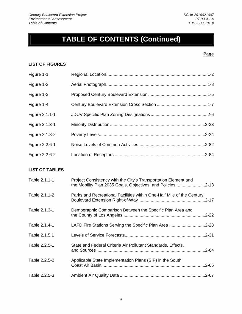
Figure 1-1 Regional Location ..................................................................................1-2 Figure 1-2 Aerial Photograph ..................................................................................1-3 Figure 1-3 Proposed Century Boulevard Extension ................................................1-5 Figure 1-4 Century Boulevard Extension Cross Section .........................................1-7 Figure 2.1.1-1 JDUV Specific Plan Zoning Designations ..............................................2-6 Figure 2.1.3-1 Minority Distribution ............................................................................. 2-23 Figure 2.1.3-2 Poverty Levels ..................................................................................... 2-24 Figure 2.2.6-1 Noise Levels of Common Activities ...................................................... 2-82 Figure 2.2.6-2 Location of Receptors.......................................................................... 2-84
LIST OF TABLES
Table 2.1.1-1 Project Consistency with the City’s Transportation Element and the Mobility Plan 2035 Goals, Objectives, and Policies ........................ 2-13
Table 2.1.1-2 Parks and Recreational Facilities within One-Half Mile of the Century
Boulevard Extension Right-of-Way ...................................................... 2-17 Table 2.1.3-1 Demographic Comparison Between the Specific Plan Area and
the County of Los Angeles .................................................................. 2-22 Table 2.1.4-1 LAFD Fire Stations Serving the Specific Plan Area ............................. 2-28 Table 2.1.5.1 Levels of Service Forecasts................................................................. 2-31 Table 2.2.5-1 State and Federal Criteria Air Pollutant Standards, Effects,
and Sources ........................................................................................ 2-64 Table 2.2.5-2 Applicable State Implementation Plans (SIP) in the South
Coast Air Basin.................................................................................... 2-66 Table 2.2.5-3 Ambient Air Quality Data ..................................................................... 2-67

Century Boulevard Extension Project SCH# 2010021007 Environmental Assessment 07-0-LA-LA Table of Contents CML-5006(810)
iii
TABLE OF CONTENTS (Continued)
LIST OF TABLES (Continued)
Page
Table 2.2.5-4 Intersection Peak Hour (PM) Traffic Lane Volumes for the CO Hot-Spot Analysis.......................................................................... 2-70
Table 2.2.5-5 Average 1-Hour Carbon Monoxide Concentrations in PPM and Traffic
Volumes at the Most Congested Intersections in Los Angeles ............. 2-72 Table 2.2.5-6 Construction Emissions ....................................................................... 2-74 Table 2.2.6-1 Noise Abatement Criteria .................................................................... 2-81 Table 2.2.6-2 Predicted Future Noise and Barrier Analysis ....................................... 2-86 Table 3-1 Summary of Questions from the Public Hearing ....................................3-3

Century Boulevard Extension Project SCH# 2010021007 Environmental Assessment 07-0-LA-LA Table of Contents CML-5006(810)
iv
This page is intentionally left blank.

Century Boulevard Extension Project SCH# 2010021007 Environmental Assessment 07-0-LA-LA Chapter 1 Proposed Project CML-5006(810)
1-1
CHAPTER 1 PROPOSED PROJECT
1.1 INTRODUCTION
The California Department of Transportation (Caltrans) as assigned by the Federal Highway Administration (FHWA), in cooperation with the City of Los Angeles Bureau of Engineering (BOE), proposes to extend Century Boulevard approximately 2,600 feet (approximately 0.5 mile) through the Jordan Downs Urban Village Specific Plan (JDUV Specific Plan) area between Grape Street and Alameda Street in the City of Los Angeles. Figures 1-1 and 1-2 show the regional location of the project site and an aerial photograph of the project site and surrounding uses. The project site primarily consists of a portion of the Jordan Downs Recreation Center property and the approximately 21-acre former industrial site that is currently undergoing remediation activities.
This project is included in the 2015 Federal Transportation Improvement Program (FTIP) and is proposed for funding from the Congestion Mitigation and Air Quality Improvement (CMAQ) Program.
1.2 PROJECT PURPOSE AND NEED
PROJECT NEED
In the City of Los Angeles, the Land Use Element of the City’s General Plan is comprised of 35 community plans. The Southeast Los Angeles Community Plan is the established plan encompassing the Specific Plan area. The Southeast Los Angeles Community Plan envisions Century Boulevard extending through the JDUV Specific Plan area as a Major Highway Class II. However, presently, there is no connecting corridor between Grape Street and Alameda Street/Tweedy Boulevard as Century Boulevard terminates at Grape Street on the western edge of the JDUV Specific Plan area.
The proposed Century Boulevard extension is a major component of the JDUV Specific Plan, which would create a mixed-use, economically-diverse transit-oriented development (TOD) for an under-served population, consisting of residents who meet the household income requirements of 30 percent to 60 percent of the Area Median Income (AMI). The redeveloped Jordan Downs would consist of up to 1,800 newly-built homes, 7.2 acres of commercial use, as well as 9 acres of public parks, open space, and community facilities in the Specific Plan area. The additional residential and commercial uses may affect the traffic patterns on the adjacent arterials surrounding the JDUV Specific Plan area, such as Century Boulevard, Grape Street, 97th Street, and 103rd Street. To relieve the burden of the additional vehicular trips associated with the implementation of the JDUV Specific Plan, the creation of the corridor connector between Grape Street and Alameda Street is one of the most effective solutions incorporating a mitigated traffic control to alleviate congestion along local streets within the Specific Plan area.
The proposed Century Boulevard extension would be designed as a neighborhood center street and, therefore, is reclassified from a Major Highway Class II to a Modified Collector in the JDUV Specific Plan. The proposed roadway extension would be similar in design to the City of Los Angeles Department of Public Works’ Standard Street design for a Non-Arterial Collector Street.

Century Boulevard Extension Project SCH# 2010021007 Environmental Assessment 07-0-LA-LA Chapter 1 Proposed Project CML-5006(810)
1-2
101ST ST101ST ST101ST ST
Environmental AssessmentCentury Boulevard Extension FIGURE 1-1
REGIONAL LOCATION
PROJECT ST
102ND ST
101ST ST
HIC
KO
RY
ST
JUN
IPE
R S
T
Proposed Century Boulevard Extension
Jordan Downs Specific Plan Area
LEGEND:
SOURCE: TAHA, 2015.

Century Boulevard Extension Project SCH# 2010021007 Environmental Assessment 07-0-LA-LA Chapter 1 Proposed Project CML-5006(810)
1-3
97TH ST97TH ST
101ST ST101ST ST
102ND ST102ND ST
103RD ST103RD ST
LO
U D
ILL
ON
AV
EL
OU
DIL
LO
N A
VE
JU
NIP
ER
ST
JU
NIP
ER
ST
WE
IGA
ND
ST
WE
IGA
ND
ST
GR
AP
E S
TG
RA
PE
ST
AL
AM
ED
A S
TA
LA
ME
DA
ST
TWEEDY BLVDTWEEDY BLVDCENTURY bLVDCENTURY BLVD
74’
74’
74’
36’
36’
TY
P
36’
22’
TYP
12’
TYP
12’
TYP
60’
TYP
18’ 18’
50’
86’
74’
37’
37’
37’
37’
37’
37’
37’
37’
12’
12’
12’
12’
12’
12’
12’
12’
12’
12’
25’
25’
25’
25’
25’
25’
25’
25’
74’
74’
74’
36’
36’
TY
P
36’
22’
TYP
12’
TYP
12’
TYP
60’
TYP
18’ 18’
50’
86’
74’
37’
37’
37’
37’
37’
37’
37’
37’
12’
12’
12’
12’
12’
12’
12’
12’
12’
12’
25’
25’
25’
25’
25’
25’
25’
25’
Environmental AssessmentCentury Boulevard Extension FIGURE 1-2
AERIAL PHOTOGRAPH
Proposed Century Boulevard Extension
Jordan Downs Specific Plan Area
LEGEND:
SOURCE: TAHA, 2015.

Century Boulevard Extension Project SCH# 2010021007 Environmental Assessment 07-0-LA-LA Chapter 1 Proposed Project CML-5006(810)
1-4
Reclassification of Century Boulevard in the JDUV Specific Plan required a General Plan Amendment and downgraded Century Boulevard from a Major Highway Class II Arterial Street to a Collector Street from Wilmington Avenue to Alameda Street and to a Modified Secondary Highway from Success Avenue to Wilmington Avenue. Although the Century Boulevard extension is now designated as a “Modified Collector,” the proposed extension is consistent with the goals and policies of the City of Los Angeles General Plan Framework, the Southeast Los Angeles Community Plan, and the Transportation Element of the City’s General Plan. The Jordan Downs Specific Plan Traffic Impact Study estimated that the proposed extension would offer capacity relief to local roadways by diverting approximately 320 peak hour trips from adjacent roadways through the proposed extension prior to the development of the Specific Plan area.
PROJECT PURPOSE
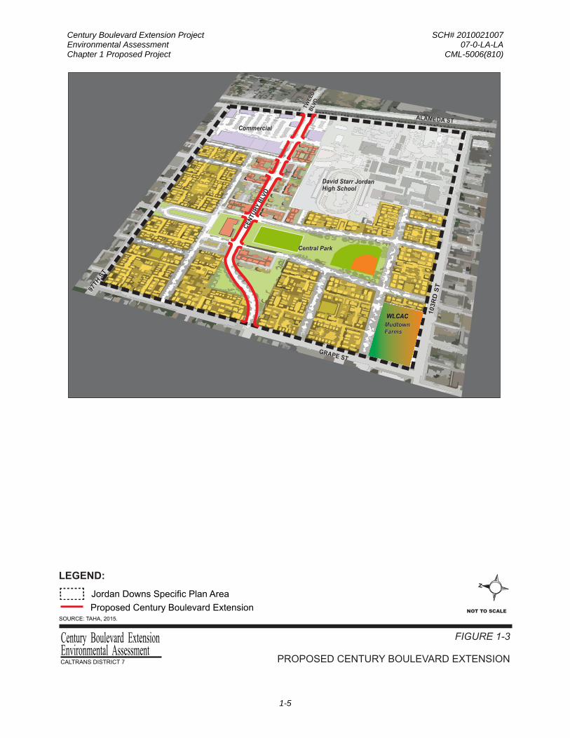
The purpose of the project is to create a multimodal roadway that extends Century Boulevard between Alameda Street and Grape Street, where currently no streets, bike lanes, sidewalks, or pedestrian enhancements exist. The approximately 0.5-mile roadway would be the spine of a 119-acre redevelopment effort to connect a mix of uses, including residential uses, open space, community facilities, and retail space, while promoting sustainability and alternatives to car ridership by providing bus access, bike lanes, sidewalks, and traffic calming features. The extended Century Boulevard would serve as the “Main Street” of the redeveloped Jordan Downs site and as the main corridor of the new urban village, as shown in Figure 1-3.
The project is important to the City of Los Angeles because it would not only advance the City’s most recently adopted policies that promote compact land use and sustainable development but would also make this easternmost Watts neighborhood more livable, walkable, economically diverse, and equitable. More specifically, implementation of the Century Boulevard extension would achieve the following primary objectives:
• Provide the main thoroughfare to the JDUV Specific Plan area;
• Fulfill the vision of the JDUV Specific Plan that calls for constructing a 74-foot to 86-foot wide roadway that would accommodate buses, bike lanes, parkways, pedestrian enhancements, traffic calming measures, and provide a missing connection to open space, a community center, and mixed-use buildings;
• Provide enhanced bus service that would connect residents to public transit, including, but not limited to, the Metro Blue Line 103rd Street Station, and David Starr Jordan High School, which serves approximately 2,500 students; and
• Expand the bicycle network serving the Watts district.
Without this roadway extension, the redevelopment effort would lack connections among the varied uses, as well as access to the broader community, including transit centers, and other local and regional destinations.
The proposed project is a stand-alone project intended to provide a direct connection of logical termini from Grape Street to Alameda Street as envisioned in the Southeast Los Angeles Community Plan. The proposed project would bridge the missing segment of Century Boulevard between Grape Street and Alameda Street; east of Alameda Street, Century Boulevard becomes Tweedy Boulevard. The proposed project is independent of other projects on Century Boulevard or in the Southeast Los Angeles Community Plan Area and will be usable even if no additional transportation improvements are made in the area.
Century Boulevard Extension Project SCH# 2010021007 Environmental Assessment 07-0-LA-LA Chapter 1 Proposed Project CML-5006(810)
1-5
David Starr Jordan High School
Central Park
Commercial
MudtownFarms
ALAMEDA ST
TW
EE
DY
B
LVD
GRAPE ST
97TH
ST
103R
D S
T
ALAMEDA ST
TW
EE
DY
B
LVD
GRAPE ST
97TH
ST
103R
D S
T
David Starr Jordan High School
Central Park
Commercial
MudtownFarms
CE
NTU
RY
BLV
D
CE
NTU
RY
BLV
D
NOT TO SCALE
Environmental AssessmentCentury Boulevard Extension FIGURE 1-3
PROPOSED CENTURY BOULEVARD EXTENSION
Proposed Century Boulevard Extension
Jordan Downs Specific Plan Area
LEGEND:
SOURCE: TAHA, 2015.
WLCACWLCAC

Century Boulevard Extension Project SCH# 2010021007 Environmental Assessment 07-0-LA-LA Chapter 1 Proposed Project CML-5006(810)
1-6
1.3 PROJECT ALTERNATIVES
This section describes the proposed Build Alternative (proposed project) and the No-Build (No-Action) Alternative. The Build Alternative was developed to meet the project purpose and need. The project is located within the JDUV Specific Plan area in the Watts Community. The purpose of the project is to serve as the “Main Street” of the redeveloped Jordan Downs site and as the main corridor of the new urban village.
PROPOSED BUILD ALTERNATIVE
Century Boulevard is proposed to be extended approximately 2,600 feet through the Specific Plan area, including intersecting streets, until it meets Alameda Street at the eastern edge of the Specific Plan area boundary. Century Boulevard would be designated as a Modified Collector Street between Grape Street and Alameda Street, as depicted in Figure 1-4. One lane of traffic in each direction with parking lanes along the street would be provided. In addition, Century Boulevard would have a dedicated bicycle lane (Class II) in each direction, landscaped parkways, and pedestrian amenities. The bicycle lane would be five feet in width and situated between the travel lane and the parking lane on both sides of Century Boulevard. The Century Boulevard extension would be designed as a neighborhood center street and generally lined with two- to four-story residential buildings on both sides.
Jordan Downs would be reconnected to the surrounding neighborhood. Century Boulevard would be extended from Grape Street eastward, curving around the new Central Park and the heart of activities for the redeveloped community, ultimately connecting at the Specific Plan area’s eastern edge with Tweedy Boulevard where it crosses the Alameda Corridor. The new roadway would be designed with asphalt concrete pavement; 6-foot sidewalks on both sides of the street with a landscaped parkway, street trees, safety lighting, and transit shelters; curb and gutter; traffic signals; drainage pipes and catch basins; sewer lines and waterlines; and green street elements. Traffic calming features would include crosswalks and bulb-outs at the five intersections along this roadway extension to slow down vehicle traffic, further establishing Century Boulevard as a pedestrian-friendly street. The project would include a new traffic signal at the Grape Street and Century Boulevard intersection and signal modifications to the Alameda Avenue and Century Boulevard intersection. The landscaped parkway would have rain garden1
At 74 feet to 86 feet wide, the street right-of-way would have adequate width to accommodate buses. Accordingly, the Los Angeles County Metropolitan Transportation Authority (Metro) would re-route a nearby existing bus line to Century Boulevard and through the Jordan Downs community to improve transit accessibility. The majority of the proposed Century Boulevard extension would be 74 feet in width; however, near its intersection with Alameda Street, the proposed extension would widen to 86 feet to accommodate traffic to and from the Specific Plan area and to create an entry monument that welcomes people to Jordan Downs.
or other runoff detention mechanisms that provide an opportunity for stormwater infiltration from adjacent impervious surfaces, with hardscape breaks every five to 10 feet to allow pedestrian access between the curb and sidewalk.
1Rain garden refers to planting areas designed to accept and detain runoff from impervious areas, such as
roofs, driveways, streets, and parking lots to be absorbed into the ground.

Century Boulevard Extension Project SCH# 2010021007 Environmental Assessment 07-0-LA-LA Chapter 1 Proposed Project CML-5006(810)
1-7
74’
6’6’ 6’6’6’ 6’8’ 8’22’
Sidewalk: 6’
Parkway: 6’
Street Parking: 8'
Bicycle Lane: 6’
Travel Lane: 11’
Environmental AssessmentCentury Boulevard Extension FIGURE 1-4
CENTURY BOULEVARD EXTENSION SAMPLE CROSS SECTION
SOURCE: City of Los Angeles Department of City Planning, Jordan Downs Urban Village Specific Plan, August 2011.

Century Boulevard Extension Project SCH# 2010021007 Environmental Assessment 07-0-LA-LA Chapter 1 Proposed Project CML-5006(810)
1-8
The property that is underlying the right-of-way for the proposed roadway extension is currently owned by the Housing Authority of the City of Los Angeles (HACLA). HACLA’s property, which includes the proposed right-of-way, has been annexed to the City by the County of Los Angeles.2
The project would include approved planting and irrigation for streetscape enhancement, as well as incorporation of “Green Street” planting elements, such as bioswales, for use in managing and treating stormwater runoff. Green Street refers to a street that is designed to infiltrate and treat stormwater by cleaning it through gravel, soil and plants. Green Streets are also designed to increase the tree canopy and to support native habitat through landscaping in the parkways. The proposed Century Boulevard extension would be subject to the streetscape provisions established by the BOE and the Los Angeles Department of Transportation (LADOT). Tree species have been selected from the City of Los Angeles Urban Forestry Division Street Tree Selection Guide for their durability, tree canopy, and minimal predicted maintenance. The tree species that have been selected include Chinese flame tree, Berkeley sedge, sand dune sedge, blue oat grass, spreading rush, torch lily, and rose.
The right-of-way would be permanently dedicated to the City of Los Angeles as a roadway right-of-way to accommodate the proposed project.
Proposed street lighting would provide a secure nighttime environment while minimizing unintentional spillover lighting. Street lighting would also support sustainability goals by being energy efficient and including products, such as solar powered fixtures and/or LED technology. Street lights on Century Boulevard would comprise of 30-foot tall, pole-mounted light fixtures.
The project proposes excavation that would involve 3,700 cubic yards (CY) of cut and 8,100 CY of fill materials. Construction of the proposed roadway extension, including staging and storage areas, would be contained within the roadway right-of-way, and, therefore, no temporary construction easements would be required. Construction duration is estimated to extend up to 12 months.
NO-BUILD (NO-ACTION) ALTERNATIVE
The No-Build (No-Action) Alternative assumes that Century Boulevard would not be extended through the Specific Plan area and that the physical conditions of the project site would remain as they are today. The Jordan Downs Recreation Center, particularly the baseball field, would remain undisturbed as this alternative would not require any additional right-of-way. In addition, the majority of the project site, which is currently undergoing soil remediation, would remain vacant and undeveloped. However, this alternative would be inconsistent with the policies of the City of Los Angeles General Plan Framework, the Southeast Los Angeles Community Plan, the Transportation Element of the City’s General Plan, and the JDUV Specific Plan as it would not fulfill their vision of creating a connection between Grape Street and Alameda Street/Tweedy Boulevard to promote a sustainable, more livable, walkable, economically diverse, and equitable community.
After the public circulation period, all comments will be were considered, and Caltrans, in cooperation with the City of Los Angeles Bureau of Engineering, will make has made the final determination of the project’s effect on the environment. If it is It has been determined that the action does not significantly impact the environment, and a Finding of No Significant Impact
2In developing the JDUV Specific Plan, the City of Los Angeles Department of City Planning included publicly- and privately-owned properties located within unincorporated Los Angeles County. Since the certification of the Final EIR for the Specific Plan, the parcels in which these properties are located within unincorporated Los Angeles have been annexed to the City by the Local Agency Formation Commission (LAFCO) for the County of Los Angeles.
Century Boulevard Extension Project SCH# 2010021007 Environmental Assessment 07-0-LA-LA Chapter 1 Proposed Project CML-5006(810)
1-9
(FONSI) in accordance with the National Environmental Policy Act (NEPA) will be has been issued.
IDENTIFICATION OF THE PREFERRED ALTERNATIVE
The Proposed Build Alternative would meet the need and purpose for the project and fulfill all the goals and objectives of the project. More specifically, implementation of the Proposed Build Alternative would provide the main thoroughfare to the JDUV Specific Plan area; fulfill the vision of the JDUV Specific Plan that calls for constructing a roadway that would accommodate buses, bike lanes, parkways, pedestrian enhancements, traffic calming measures, and provide a missing connection to open space, a community center, and mixed-use buildings; provide enhanced bus service that would connect residents to public transit; and expand the bicycle network serving the Watts district. In contrast, the No-Build (No Action) Alternative would be inconsistent with the policies of the City of Los Angeles General Plan Framework, the Southeast Los Angeles Community Plan, the Transportation Element of the City’s General Plan, and the JDUV Specific Plan as it would not fulfill their vision of creating a connection between Grape Street and Alameda Street/Tweedy Boulevard to promote a sustainable, more livable, walkable, economically diverse, and equitable community. Accordingly, the Proposed Build Alternative has been identified as the preferred alternative.
1.4 PERMITS AND APPROVALS NEEDED
The following permits, reviews, and approvals would be required for project construction:
Agency Permit/Approval Status Los Angeles Regional Water Quality Control Board
Permit approval under the General Construction Activities Stormwater Permit; Clean Water Act water quality certification
To be obtained prior to construction.
County of Los Angeles Sewer Connection Permit To be secured by BOE prior to construction.

Century Boulevard Extension Project SCH# 2010021007 Environmental Assessment 07-0-LA-LA Chapter 1 Proposed Project CML-5006(810)
1-10
This page is intentionally left blank.

Century Boulevard Extension Project SCH# 2010021007 Environmental Assessment 07-0-LA-LA Chapter 2 Affected Environment; Environmental Consequences; and CML-5006(810) Avoidance, Minimization, and/or Mitigation Measures
2-1
C HAP T E R 2 AF F E C T E D E NV IR ONME NT ; E NV IR ONME NT AL C ONS E QUE NC E S ; AND
AV OIDANC E , MINIMIZAT ION, AND/OR MIT IG AT ION ME AS UR E S
As part of the previous scoping and environmental analyses conducted for the JDUV Specific Plan project, the following environmental issues were considered for the proposed extension of Century Boulevard through the JDUV Specific Plan area, but no adverse impacts were identified. As a result, there is no further discussion regarding these issues in this document.
• Sole Source Aquifers – The Safe Drinking Water Act (SDWA) provides for a federally implemented sole source aquifer program, which prohibits federal funds from being expended on projects that may contaminate the sole or principal source of drinking water for a given area. Within the City of Los Angeles, there are no sole source aquifers. Therefore, no effects related to sole source aquifers would result from the proposed project.
• Section 6(f) – There are no Section 6(f) resources in the immediate vicinity of the project site. Accordingly, the proposed project does not have the potential to affect properties acquired or improved with Land and Water Conservation Fund Act (Section 6[f]) funds. Therefore, no effects related to Section 6(f) properties would result from the proposed project.
• Coastal Zone – The Coastal Zone Management Act (CZMA) encourages states to preserve, protect, develop, and where possible, restore or enhance valuable natural coastal resources, such as wetlands, floodplains, estuaries, beaches, dunes, barrier islands, and coral reefs, as well as the fish and wildlife using those habitats. To comply with the CZMA, a project must be consistent with California’s Coastal Zone Management Program. California’s coastal zone generally extends 1,000 yards inland from the mean high tide line. Significant coastal estuarine habitat and recreational areas extend inland to the first major ridgeline or five miles from the mean tide line, whichever is less. The project site is located approximately 12 miles east of the Pacific Ocean and is not located within a coastal zone. Therefore, no effects related to coastal zones would result from the proposed project.
• Wild and Scenic Rivers – The Wild and Scenic Rivers Act defines wild river areas as those rivers or sections of rivers that are free of impoundments and generally inaccessible except by trail, with watersheds or shorelines essentially primitive and waters unpolluted. These represent vestiges of primitive America. Similarly, the Act defines scenic river areas as those rivers or sections of rivers that are free of impoundments, with shorelines or watersheds still largely primitive and shorelines largely undeveloped but accessible in places by roads. Based on these definitions, the project site is not considered a wild river or a scenic river area. The project site is currently or has been previously developed and is surrounded by urban uses and is not located near rivers or lands designated as components of the national wild and scenic rivers system. Therefore, no effects related to wild and scenic rivers would result from the proposed project.
• Farmlands/Timberlands – The Farmland Protection Policy Act is intended to minimize the impact that federal programs have on the unnecessary and irreversible conversion of
Century Boulevard Extension Project SCH# 2010021007 Environmental Assessment 07-0-LA-LA Chapter 2 Affected Environment; Environmental Consequences; and CML-5006(810) Avoidance, Minimization, and/or Mitigation Measures
2-2
farmland to non-agricultural uses. Farmland maps compiled by the California Department of Conservation identify the project site as an “urbanized area,” and no portion of the project site is designated as Prime Farmland, Unique Farmland, or Farmland of Statewide Importance. Similarly, no portion of the project site is enrolled under a Williamson Act contract. In addition, the proposed project would not be located on federal land (e.g., Bureau of Land Management or U.S. Forest Service lands) and, as such, would not be subject to regulations and policies regarding protection of timberlands. Therefore, no effects farmlands or timberlands would result from the proposed project.
• Relocation Impacts – The proposed right-of-way, the majority of which has been annexed to the City by the County of Los Angeles, would be permanently dedicated to the City of Los Angeles as a roadway right-of-way to accommodate the proposed project. Similarly, the portion of the roadway right-of-way that traverses the Jordan Downs Recreation Center property would be permanently dedicated to the City. The proposed project would require relocation of two modular structures and playground less than 200 feet to the northwestern corner of the Jordan Downs Recreation Center property. Children’s Institute, Inc. (CII) operates a Head Start early learning program in these structures and playground for the County of Los Angeles Department of Education. There would not be any disruption of these activities as a result of the proposed project. In addition, although the proposed project would remove a softball field and open space from the Jordan Downs Recreation Center property, replacement facilities would be integrated into a larger new central park as part of the JDUV Specific Plan development. No property acquisition would be required to implement the proposed Century Boulevard extension. Accordingly, no residents or businesses would be displaced or relocated. Therefore, no adverse effects related to displacement or relocation would result from the proposed project.
• Visual/Aesthetics – The Specific Plan area is in an urbanized commercial, flat, industrial and, residential area within Los Angeles. No particularly unique visual elements, landforms, or topographic features exist on or immediately surrounding the Specific Plan area and the project site. The nearest natural feature of visual interest in the project area is the view of the San Gabriel Mountains and the downtown Los Angeles building skyline, which are considered to be scenic resources. However, views of these scenic resources are currently disrupted by existing buildings and are not protected by local policies or ordinances. The nearest locally recognized scenic resource is Broadway from just north of Century Boulevard to Imperial Highway, which has been designated as a City Scenic Highway by the City of Los Angeles. Review of the project site and project plans indicate that the proposed project would not result in substantial adverse impacts to the visual environment. The proposed project would not disrupt visual access to the scenic resources identified above. Therefore, no potential effect to any key visual or scenic resources would result from the proposed project.
• Hydrology and Floodplain – The project site is not situated within a 100-year or 500-year floodplain as designated by the Federal Emergency Management Agency (FEMA). Therefore, no effects related to floodplain management would occur as a result of the proposed project.
• Natural Communities, Plant Species, and Animal Species – Natural communities of special concern are those that support concentrations of special-status plant or wildlife species, are of relatively limited distribution, or are of particular value to wildlife. Natural communities of special concern are not afforded legal protection unless they are designated

Century Boulevard Extension Project SCH# 2010021007 Environmental Assessment 07-0-LA-LA Chapter 2 Affected Environment; Environmental Consequences; and CML-5006(810) Avoidance, Minimization, and/or Mitigation Measures
2-3
critical habitat for federally listed threatened or endangered species, support formally listed species, or are jurisdictional wetland habitats. The California Natural Diversity Database (CNDDB) was reviewed to determine if any natural communities and sensitive plant and animal species exist within the Specific Plan area. Due to the dense urban development that has occurred within the Specific Plan area and adjacent areas, there is no longer sufficient undisturbed open space for habitats that could support natural communities and designated sensitive species of plant and animals. Plant and animal species are considered sensitive if they have been listed as such by federal, State, or local agencies, or by one or more advocacy groups, such as the California Native Plant Society (CNPS). Since the majority of the Specific Plan area has been developed, paved, or landscaped with non-native plant species, no riparian habitat, blueline streams, or sensitive natural communities are located in the Specific Plan area. Accordingly, suitable habitat for sensitive mammal, reptile, amphibian, or fish species do not exist within the Specific Plan area or adjacent areas. Therefore, no effects related to natural communities and plant and animal species would result from the proposed project.
• Wetlands and Other Waters – The project site is currently developed or previously developed and surrounded by urban uses. There are no wetlands or aquatic features present within the Specific Plan area. The nearest body of water to the project site is Compton Creek, which originates at Main Street between 107th and 108th Streets, approximately 2.1 miles west of the project site. Compton Creek was channelized in 1954 and currently exists as a 42.1-square-mile drainage channel, extending from Watts to the northwest edge of the City of Long Beach. Underground tributaries and storm drains that feed into Compton Creek run under the project area. These tributaries are underground and channelized and are not considered a wetland or found to support any riparian habitat. Therefore, no effects related to wetlands or other waters would result from the proposed project.
• Threatened and Endangered Species – The Endangered Species Act provides for the conservation of endangered and threatened species and the ecosystems upon which they depend. Section 7 of the Act requires federal agencies to aid in the conservation of listed species and to ensure that the activities of federal agencies will not jeopardize the continued existence of listed species or adversely modify designated critical habitat. The CNDDB was reviewed to determine if any sensitive species exist within the Specific Plan area. The CNDDB did not identify any active rare, endangered, or threatened habitats in the Specific Plan area, including the project site, consistent with the list of threatened, endangered, and proposed species; designated critical habitat; and candidate species maintained by the U.S. Fish and Wildlife Service (see Appendix D). The majority of the project site has been developed or previously developed, paved, or landscaped and is generally not suitable habitat for sensitive mammal, reptile, amphibian, or fish species. Sufficient undisturbed open space for habitat that could support designated plant and animal species no longer exists. Wildlife species within the project site are mostly those adapted to living in an urban environment, such as birds, insects, and squirrels. Therefore, no effects related to threatened or endangered species would result from the proposed project.

Century Boulevard Extension Project SCH# 2010021007 Environmental Assessment 07-0-LA-LA Chapter 2 Affected Environment; Environmental Consequences; and CML-5006(810) Avoidance, Minimization, and/or Mitigation Measures
2-4
This page is intentionally left blank.

Century Boulevard Extension Project SCH# 2010021007 Environmental Assessment 07-0-LA-LA Chapter 2 Affected Environment; Environmental Consequences; and CML-5006(810) Avoidance, Minimization, and/or Mitigation Measures
2-5
2.1 HUMAN ENVIRONMENT
2.1.1 LAND USE
EXISTING AND FUTURE LAND USE
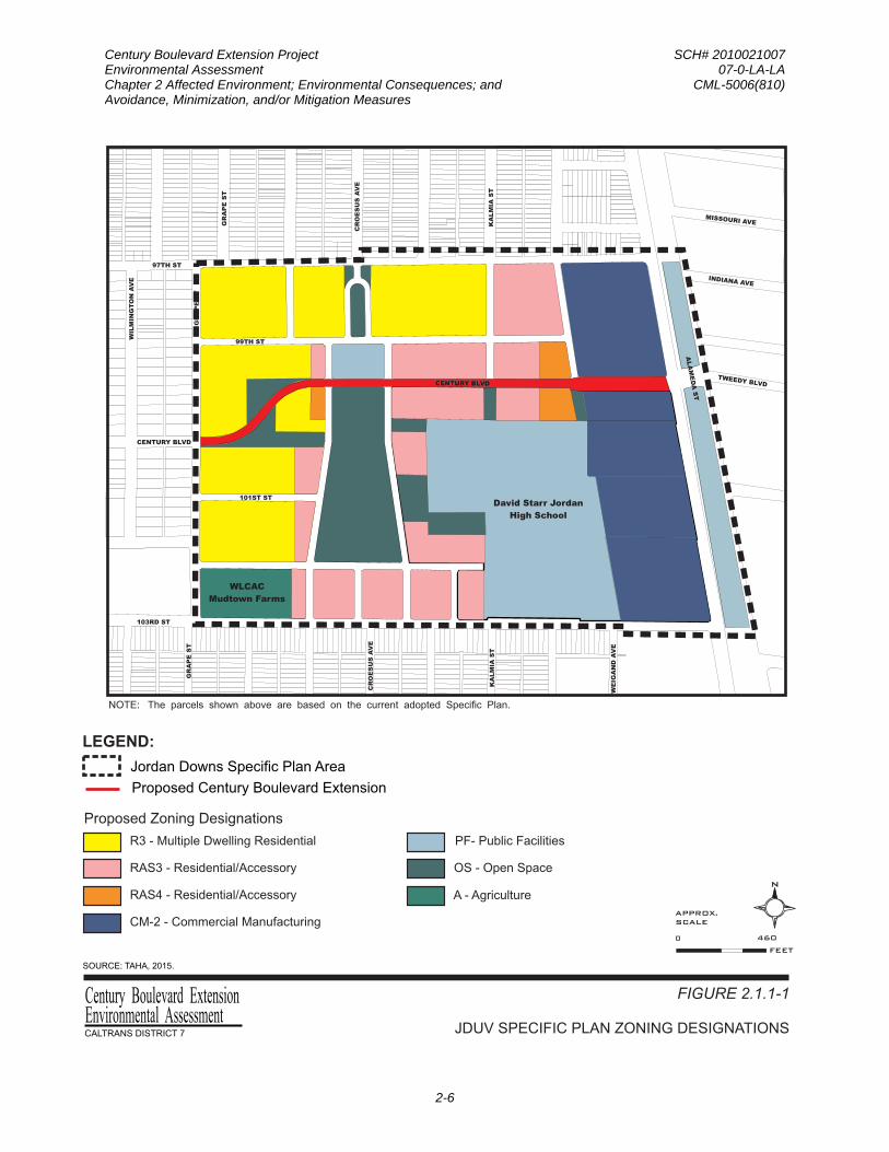
The JDUV Specific Plan addresses the existing and future land uses within the Specific Plan area. The adoption of the Specific Plan by the City of Los Angeles in April 2013 resulted in the amendment of the City’s zoning code to add the Specific Plan area, including the project site, to the zoning map and establish new zoning designations, which set limits on the allowable density and development permitted in each defined block, including limits on building heights, massing, as well as yards and setbacks. The adoption of the Specific Plan also resulted in the amendment of several elements of the City’s General Plan, including the Transportation Element and the Southeast Los Angeles Community Plan, one of the City’s 35 community plans that make up the Land Use Element. Figure 2.1.1-1 presents the adopted JDUV Specific Plan zoning designations. Specific to the proposed project, the roadway classification for Century Boulevard has been downgraded from a Major Highway Class II Arterial Street to a Modified Collector.
The Specific Plan area is located in the Watts neighborhood of Los Angeles, approximately eight miles south of downtown Los Angeles and approximately one mile north of the Glenn Anderson Freeway (I-105). The Specific Plan area, including the project site, contains approximately 118.5 acres of land area, inclusive of streets, and is generally bounded by 97th Street to the north, Alameda Street to the east, 103rd Street to the south, and Grape Street to the west.
The project site is surrounded by a residential neighborhood consisting primarily of one- or two-story single-family residences with narrow one-way streets to the north, west, and south. To the east, facing Alameda Street, is mainly industrial, and severed from the adjoining communities by the ten-mile long Alameda Corridor railroad trench that allows the frequent passage of the 40 to 50 long-distance freight trains traveling each day from the Ports of Long Beach and Los Angeles to bypass the site. Tweedy Avenue, located immediately to the east of the project site, is the nearest location for a road crossing over the railroad trench, which occurs approximately every half-mile. When Jordan Downs was platted in the 1950s, a 114-foot-wide Class II Highway right-of-way was left undeveloped for a future extension of Century Boulevard across part of the Specific Plan area. Century Boulevard only developed as a major highway with the development of Los Angeles International Airport eight miles to the west. Its extension to Alameda Street and Tweedy Avenue was never constructed and Century Boulevard (currently, the easement is not lined up with Tweedy Boulevard), was narrowed to a 60-foot wide neighborhood street two blocks before the project site, between Wilmington Avenue and Grape Street.
The street network of the Jordan Downs public housing complex does not integrate the public housing into the surrounding neighborhood. Whereas the neighborhoods to the north and south are oriented on a north-south street grid, the Jordan Downs public housing blocks are oriented with an east-west street grid, resulting in a lack of connectivity with the surrounding neighborhood. The majority of the Jordan Downs public housing complex site along 103rd and 97th Streets is also fenced, making access from the adjacent neighborhoods to the south and north difficult and uninviting.
Century Boulevard Extension Project SCH# 2010021007 Environmental Assessment 07-0-LA-LA Chapter 2 Affected Environment; Environmental Consequences; and CML-5006(810) Avoidance, Minimization, and/or Mitigation Measures
2-6
R3 - Multiple Dwelling Residential
Proposed Zoning Designations
RAS3 - Residential/Accessory RAS4 - Residential/Accessory
PF- Public Facilities
A - Agriculture
WLCAC
Mudtown Farms
David Starr Jordan
High School
CM-2 - Commercial Manufacturing
103RD ST
97TH ST
CENTURY BLVD
WIL
MIN
GT
ON
AV
E
GR
AP
E S
T
CR
OE
SU
S A
VE
KA
LM
IA S
T
WE
IGA
ND
AV
E
GR
AP
E S
T
KA
LM
IA S
T
CR
OE
SU
S A
VE
GR
AP
E S
T
99TH ST
TWEEDY BLVD
101ST ST
MISSOURI AVE
OS - Open Space
N
FEET
APPROX.SCALE
0 460
ALA
ME
DA
ST
INDIANA AVE
CENTURY BLVDCENTURY BLVD
FIGURE 2.1.1-1
JDUV SPECIFIC PLAN ZONING DESIGNATIONS
Proposed Century Boulevard Extension
Jordan Downs Specific Plan Area
LEGEND:
SOURCE: TAHA, 2015.
NOTE: The parcels shown above are based on the current adopted Specific Plan.
Environmental AssessmentCentury Boulevard Extension

Century Boulevard Extension Project SCH# 2010021007 Environmental Assessment 07-0-LA-LA Chapter 2 Affected Environment; Environmental Consequences; and CML-5006(810) Avoidance, Minimization, and/or Mitigation Measures
2-7
The portion of the Specific Plan area that is underlying the right-of-way for the proposed roadway extension is currently owned by the Housing Authority of the City of Los Angeles (HACLA). The Jordan Downs Recreation Center is located on the westernmost portion (approximately 600 feet) of the proposed roadway right-of-way; in particular, two recreation center structures, a softball field, and open space occupy the area of the proposed alignment. The majority of the proposed roadway right-of-way (approximately 2,000 feet) traverses a vacant property (a former industrial site) that is currently undergoing remediation activities.
Environmental Consequences
Proposed Build Alternative
Temporary Impacts. Construction of the Proposed Build Alternative, including staging and storage areas, would be contained within the roadway right-of-way. Accordingly, no temporary construction easements would be required, and the existing and future land uses in the Specific Plan area and the surrounding areas would remain unaffected during construction. No roadway closures would be required during construction; access to local streets and the surrounding neighborhoods would be maintained. Therefore, construction of the Proposed Build Alternative would not result in temporary effects to existing and future land uses.
Permanent Impacts. Under the Proposed Build Alternative, Century Boulevard would be extended from Grape Street eastward, curving around a new central park (new alignment from existing easement), ultimately connecting at the eastern edge of the Specific Plan area with Tweedy Boulevard where it crosses the Alameda Corridor. The proposed Century Boulevard extension would be designed as a neighborhood center street and has been reclassified as a Modified Collector with adoption of the Specific Plan in 2013. The Century Boulevard extension street right-of-way would have adequate width to accommodate buses. From Laurel Street to Alameda Street, Century Boulevard would be widened to four lanes, and improvements would be made at the intersection with Alameda Street to accommodate through traffic. Most of its length would have on-street parking along both sides. This street would be similar in design to the City of Los Angeles Department of Public Work’s Standard Street design for a Non-Arterial Collector Street. Because the Proposed Build Alternative would occur primarily within vacant land, it would not result in changes to adjacent land uses. As discussed above, the Proposed Build Alternative would require relocation of two modular structures and playground less than 200 feet to the northwestern corner of the Jordan Downs Recreation Center property. In addition, although the Proposed Build Alternative would remove a softball field and open space from the Jordan Downs Recreation Center property, replacement facilities would be integrated into a larger new central park as part of the JDUV Specific Plan development. Therefore, the Proposed Build Alternative would not result in adverse effects to existing and future land uses.
No-Build (No-Action) Alternative
The No-Build (No-Action) Alternative assumes that Century Boulevard would not be extended through the Specific Plan area. However, the No-Build (No-Action) Alternative would not preclude the implementation of the JDUV Specific Plan, which consists of up to 1,800 newly-built homes, 7.2 acres of commercial use, as well as 9 acres of public parks and open space in the Specific Plan area. Therefore, the No-Build (No-Action) Alternative would not result in adverse effects to land use.

Century Boulevard Extension Project SCH# 2010021007 Environmental Assessment 07-0-LA-LA Chapter 2 Affected Environment; Environmental Consequences; and CML-5006(810) Avoidance, Minimization, and/or Mitigation Measures
2-8
Cumulative Impacts
The Proposed Build Alternative would not require additional right-of-way or change existing adjacent land uses. Therefore, the Proposed Build Alternative is not anticipated to result in adverse impacts to existing land uses or land use patterns in the project vicinity beyond the Specific Plan area. As such, the Proposed Build Alternative is not expected to contribute to cumulative impacts to land use.
Avoidance, Minimization, and/or Mitigation Measures
No avoidance, minimization, and/or mitigation measures are required or proposed.
CONSISTENCY WITH STATE, REGIONAL, AND LOCAL PLANS
Federal Transportation Improvement Program (FTIP)
The Federal Transportation Improvement Program (FTIP) is a capital listing of all transportation projects proposed over a six-year period for the Southern California Association of Governments (SCAG) region, which encompasses six counties (Imperial, Los Angeles, Orange, Riverside, San Bernardino, and Ventura) and 191 cities within these counties. Projects included on the FTIP include, but not limited to, highway improvements, transit, rail and bus facilities, high occupancy vehicle lanes, signal synchronization, intersection improvements, and freeway ramps in the SCAG region, and a biennial FTIP update is produced on an even-year cycle. The proposed project is currently listed on the 2015 Adopted Federal Transportation Improvement Program (FTIP ID: LAF131).
City of Los Angeles Land Use/Transportation Policy
Adopted by the City Council in 1993, the City of Los Angeles and Metro initiated a cooperative planning effort to develop an integrated policy addressing land use, transportation and air quality issues related to the regional transportation system. It is a long-term strategy for integrating land use, housing, transportation, and environmental policies into the development of a city in a form or manner that complements and maximizes the utilization of the region’s transit system. The Policy calls for (1) development of higher-density, mixed-use projects within 0.25 mile of rail and major bus facilities, (2) promoting public-private partnerships, (3) promoting economic development in proximity to transit centers, (4) creating a pedestrian-oriented environment in an urban area, and (5) creating mixed-use residential/commercial development.
City of Los Angeles General Plan
The City of Los Angeles General Plan is a comprehensive, long-term declaration of purposes, policies, and programs for the development of the City of Los Angeles. It sets forth goals, objectives and programs to provide a guideline for day-to-day land use policies and to meet the existing and future needs and desires of the community, while integrating a range of State-mandated elements, including, but not limited to, Transportation, Noise, Safety, Housing, and Conservation. Specific to the Transportation Element, the following goals and policies are relevant to the proposed extension of Century Boulevard through the Specific Plan area:
GOAL A: Adequate accessibility to work opportunities and essential services, and acceptable levels of mobility for all those who live, work, travel, or move goods in Los Angeles.
Century Boulevard Extension Project SCH# 2010021007 Environmental Assessment 07-0-LA-LA Chapter 2 Affected Environment; Environmental Consequences; and CML-5006(810) Avoidance, Minimization, and/or Mitigation Measures
2-9
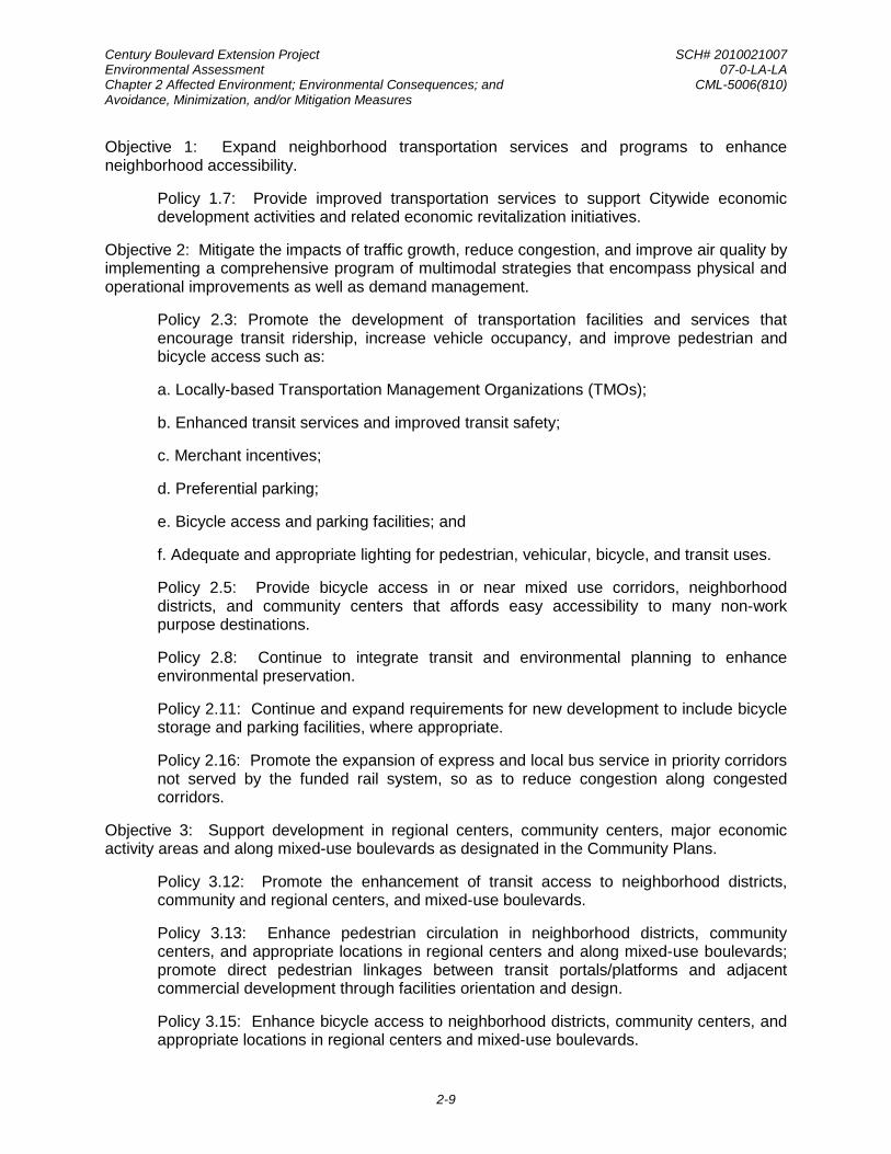
Objective 1: Expand neighborhood transportation services and programs to enhance neighborhood accessibility.
Policy 1.7: Provide improved transportation services to support Citywide economic development activities and related economic revitalization initiatives.
Objective 2: Mitigate the impacts of traffic growth, reduce congestion, and improve air quality by implementing a comprehensive program of multimodal strategies that encompass physical and operational improvements as well as demand management.
Policy 2.3: Promote the development of transportation facilities and services that encourage transit ridership, increase vehicle occupancy, and improve pedestrian and bicycle access such as:
a. Locally-based Transportation Management Organizations (TMOs);
b. Enhanced transit services and improved transit safety;
c. Merchant incentives;
d. Preferential parking;
e. Bicycle access and parking facilities; and
f. Adequate and appropriate lighting for pedestrian, vehicular, bicycle, and transit uses.
Policy 2.5: Provide bicycle access in or near mixed use corridors, neighborhood districts, and community centers that affords easy accessibility to many non-work purpose destinations.
Policy 2.8: Continue to integrate transit and environmental planning to enhance environmental preservation.
Policy 2.11: Continue and expand requirements for new development to include bicycle storage and parking facilities, where appropriate.
Policy 2.16: Promote the expansion of express and local bus service in priority corridors not served by the funded rail system, so as to reduce congestion along congested corridors.
Objective 3: Support development in regional centers, community centers, major economic activity areas and along mixed-use boulevards as designated in the Community Plans.
Policy 3.12: Promote the enhancement of transit access to neighborhood districts, community and regional centers, and mixed-use boulevards.
Policy 3.13: Enhance pedestrian circulation in neighborhood districts, community centers, and appropriate locations in regional centers and along mixed-use boulevards; promote direct pedestrian linkages between transit portals/platforms and adjacent commercial development through facilities orientation and design.
Policy 3.15: Enhance bicycle access to neighborhood districts, community centers, and appropriate locations in regional centers and mixed-use boulevards.

Century Boulevard Extension Project SCH# 2010021007 Environmental Assessment 07-0-LA-LA Chapter 2 Affected Environment; Environmental Consequences; and CML-5006(810) Avoidance, Minimization, and/or Mitigation Measures
2-10
Objective 4: Preserve the existing character of lower density residential areas and maintain pedestrian-oriented environments where appropriate.
Policy 4.2: Incorporate traffic management measures to control traffic speeds and volumes on local and collector streets within low density residential neighborhoods to assure safe and orderly traffic flow. Traffic management measures for such local streets may include partial closures and/or traffic diverters.
GOAL C: An integrated system of pedestrian priority street segments, bikeways, and scenic highways which strengthens the City's image while also providing access to employment opportunities, essential services, and open space.
Objective 10: Make the street system accessible, safe, and convenient for bicycle, pedestrian, and school child travel.
In addition, the Mobility Plan 2035 updates the Transportation Element and incorporates “complete streets” principles and lays the policy foundation for how future generations of Angelenos interact with their streets. The following policies are relevant to the proposed extension of Century Boulevard through the Specific Plan area:
Policy 1.1. Roadway User Vulnerability: Design, plan, and operate streets to prioritize the safety of the most vulnerable roadway user.
Policy 1.2. Complete Streets: Implement a balanced transportation system on all streets, tunnels, and bridges using complete streets principles to ensure the safety and mobility of all users.
Policy1.4. Design Safe Speeds: Design streets to Targeted Operating Speeds as defined in the Complete Streets Design Guide.
Policy 2.3. Pedestrian Infrastructure: Recognize walking as a component of every trip, and ensure high-quality pedestrian access in all site planning and public right-of-way modifications to provide a safe and comfortable walking environment.
Policy 2.4. Neighborhood Enhanced Network: Provide a slow speed network of locally serving streets.
Policy 2.5. Transit Network: Improve the performance and reliability of existing and future bus service.
Policy 2.6. Bicycle Networks: Provide safe, convenient, and comfortable local and regional bicycling facilities for people of all types and abilities.
Policy 2.9. Multiple Networks: Consider the role of each mode enhanced network when designing a street that includes multiple modes.
Policy 2.14. Street Design: Designate a street’s functional classification based upon its current dimensions, land use context, and role.
Policy 3.1. Access for All: Recognize all modes of travel, including pedestrian, bicycle, transit, and vehicular modes - including goods movement – as integral components of the City’s transportation system.

Century Boulevard Extension Project SCH# 2010021007 Environmental Assessment 07-0-LA-LA Chapter 2 Affected Environment; Environmental Consequences; and CML-5006(810) Avoidance, Minimization, and/or Mitigation Measures
2-11
Policy 3.2. People with Disabilities: Accommodate the needs of people with disabilities when modifying or installing infrastructure in the public right-of-way.
Policy 3.4. Transit Services: Provide all residents, workers and visitors with affordable, efficient, convenient, and attractive transit services.
Policy 3.5. Multi-Modal Features: Support “first-mile, last-mile solutions” such as multi-modal transportation services, organizations, and activities in the areas around transit stations and major bus stops (transit stops) to maximize multi-modal connectivity and access for transit riders.
Policy 3.8. Bicycle Parking: Provide bicyclists with convenient, secure and well-maintained bicycle parking facilities.
Policy 4.8. Transportation Demand Management Strategies: Encourage greater utilization of Transportation Demand Management (TDM) strategies to reduce dependence on single-occupancy vehicles.
Policy 5.5 Green Streets: Maximize opportunities to capture and infiltrate stormwater within the City’s public right-of-ways.
Southeast Los Angeles Community Plan
The Land Use Element of the City of Los Angeles General Plan uses community plans that establish policy and standards for each of the 35 geographic areas in the City. As such, the community plans are oriented toward specific geographic areas of the city, defining locally the General Plan’s more general citywide policies and programs. The Southeast Community Plan (adopted March 2000) addresses the general land use guidelines that affect the Specific Plan area and the surrounding neighborhoods. The purpose of the Community Plan is to provide an official guide to the future development within the Community Plan area. The Community Plan promotes an arrangement of land use, circulation, and services that encourage and contribute to economic, social and physical health, safety, welfare, and convenience of the community. Additionally, it guides the development, betterment, and change of the community to meet existing and anticipated needs and conditions; balance growth and stability and land development trends.
The Southeast Community Plan has the intended purpose of providing for the proper location of a range of land uses and physical development, to be carried out in a manner consistent with the designated purposes of the Community Plan. The current land use designations for the existing housing complex in the Specific Plan area under the Southeast Community Plan are Restricted Density Multiple Dwelling and Public Facilities. Specific to the proposed roadway extension, upon adoption of the JDUV Specific Plan by the City of Los Angeles, the roadway classification for Century Boulevard has been downgraded from a Major Highway Class II Arterial Street to a Modified Collector.
Jordan Downs Urban Village Specific Plan
The JDUV Specific Plan, which includes the proposed Century Boulevard extension, was adopted by the City of Los Angeles in 2013. The Specific Plan is intended to provide the land use framework for the redevelopment of the 118-acre public housing, commercial, industrial, and civic site with a mix of housing, retail, parks, schools, employment opportunities, social

Century Boulevard Extension Project SCH# 2010021007 Environmental Assessment 07-0-LA-LA Chapter 2 Affected Environment; Environmental Consequences; and CML-5006(810) Avoidance, Minimization, and/or Mitigation Measures
2-12
services and civic uses. It is the intention of the Specific Plan to accomplish the following objective specific to the proposed project:
• Define the future locations and dimensions of streets, rights-of-way or other access ways for multimodal connectivity and appropriate urban form.
The Specific Plan was established to achieve the following relevant goals:
• Improve the physical, social, and psychological well-being of the Jordan Downs Community through improvements on the built environment.
• Develop a model of urban sustainability based on a comprehensive, open space strategy and sustainable building design that will provide environmental and health benefits, as well as transform the community into a safe, thriving, desirable, and livable urban neighborhood.
• Create a safe and inviting neighborhood that promotes reduced vehicle usage through improved walk-ability and transportation efficiency.
• Create a transit oriented community that provides housing, employment, and educational land uses accessible by public transportation.
Environmental Consequences
Proposed Build Alternative
Temporary Impacts. Construction of the Proposed Build Alternative, including staging and storage areas, would be contained within the roadway right-of-way. Construction impacts would be minimized through compliance with applicable federal, State, and local regulations and implementation of avoidance, minimization, and mitigation measures identified in this document. Therefore, construction impacts would remain consistent with State, regional, and local policies and would not be considered adverse.
Permanent Impacts. The Proposed Build Alternative is a roadway extension that would serve as the “Main Street” of the redeveloped Jordan Downs site and as the main corridor of the new urban village. As discussed in the Project Purpose, the proposed roadway extension of Century Boulevard is important to the City of Los Angeles because it would not only advance the City’s most recently adopted policies that promote compact land use and sustainable development but would also make this easternmost Watts neighborhood more livable, walkable, economically diverse, and equitable. Without this roadway extension, the redevelopment effort would lack connections among the varied uses, as well as access to the broader community, including transit centers, and other local and regional destinations. Table 2.1.1-1 presents the project’s consistency analysis with the relevant goals, objectives, and policies established in the City’s Transportation Element of the General Plan and the recently adopted Mobility Plan 2035 identified above. The Proposed Build Alternative would establish Century Boulevard as a pedestrian-friendly street and improve transit accessibility consistent with the regulatory framework and policies identified above.

Century Boulevard Extension Project SCH# 2010021007 Environmental Assessment 07-0-LA-LA Chapter 2 Affected Environment; Environmental Consequences; and CML-5006(810) Avoidance, Minimization, and/or Mitigation Measures
2-13
TABLE 2.1.1-1: PROJECT CONSISTENCY WITH THE CITY’S TRANSPORTATION ELEMENT AND THE MOBILITY PLAN 2035 GOALS, OBJECTIVES, AND POLICIES
Applicable Goal/Objective/Policy Consistency Analysis TRANSPORTATION ELEMENT GOAL A: Adequate accessibility to work opportunities and essential services, and acceptable levels of mobility for all those who live, work, travel, or move goods in Los Angeles.
Consistent. The project would provide access to the community, including transit centers, and other local and regional destinations.
Objective 1: Expand neighborhood transportation services and programs to enhance neighborhood accessibility.
Consistent. The project would be designed to accommodate buses. Accordingly, Metro would re-route a nearby existing bus line to Century Boulevard through the Specific Plan area to improve transit accessibility.
Policy 1.7: Provide improved transportation services to support Citywide economic development activities and related economic revitalization initiatives.
Consistent. See discussion for Objective 1 above.
Objective 2: Mitigate the impacts of traffic growth, reduce congestion, and improve air quality by implementing a comprehensive program of multimodal strategies that encompass physical and operational improvements as well as demand management.
Consistent. The project would have a dedicated bicycle lane (Class II) in each direction, landscaped parkways, and pedestrian amenities, as well as safety lighting and transit shelters.
Policy 2.3: Promote the development of transportation facilities and services that encourage transit ridership, increase vehicle occupancy, and improve pedestrian and bicycle access such as: a. Locally-based Transportation Management Organizations (TMOs); b. Enhanced transit services and improved transit safety; c. Merchant incentives; d. Preferential parking; e. Bicycle access and parking facilities; and f. Adequate and appropriate lighting for pedestrian, vehicular, bicycle, and transit uses.
Consistent. See discussion for Objectives 1 and 2 above.
Policy 2.5: Provide bicycle access in or near mixed use corridors, neighborhood districts, and community centers that affords easy accessibility to many non-work purpose destinations.
Consistent. See discussion for Objective 2 above.
Policy 2.8: Continue to integrate transit and environmental planning to enhance environmental preservation.
Consistent. See discussion for Objective 1 above.
Policy 2.11: Continue and expand requirements for new development to include bicycle storage and parking facilities, where appropriate.
Consistent. The project would include parking lanes along the roadway extension and have a dedicated bicycle lane (Class II) in each direction.
Policy 2.16: Promote the expansion of express and local bus service in priority corridors not served by the funded rail system, so as to reduce congestion along congested corridors.
Consistent. See discussion for Objective 1 above.
Objective 3: Support development in regional centers, community centers, major economic activity areas and along mixed-use boulevards as designated in the Community Plans.
Consistent. See discussion for Policies 3.12, 3.13, and 3.15 below.
Policy 3.12: Promote the enhancement of transit access to neighborhood districts, community and regional centers, and mixed-use boulevards.
Consistent. See discussion for Objective 1 above.

Century Boulevard Extension Project SCH# 2010021007 Environmental Assessment 07-0-LA-LA Chapter 2 Affected Environment; Environmental Consequences; and CML-5006(810) Avoidance, Minimization, and/or Mitigation Measures
2-14
TABLE 2.1.1-1: PROJECT CONSISTENCY WITH THE CITY’S TRANSPORTATION ELEMENT AND THE MOBILITY PLAN 2035 GOALS, OBJECTIVES, AND POLICIES
Applicable Goal/Objective/Policy Consistency Analysis Policy 3.13: Enhance pedestrian circulation in neighborhood districts, community centers, and appropriate locations in regional centers and along mixed-use boulevards; promote direct pedestrian linkages between transit portals/platforms and adjacent commercial development through facilities orientation and design.
Consistent. The project would be designed as a neighborhood center street and generally lined with two- to four-story residential buildings on both sides. The new roadway would be designed with asphalt concrete pavement and 6-foot sidewalks on both sides of the street with a landscaped parkway, street trees, and safety lighting. Traffic calming features would include crosswalks and bulb-outs to slow down vehicle traffic, further establishing Century Boulevard as a pedestrian-friendly street.
Policy 3.15: Enhance bicycle access to neighborhood districts, community centers, and appropriate locations in regional centers and mixed-use boulevards.
Consistent. See discussion for Objective 2 above.
Objective 4: Preserve the existing character of lower density residential areas and maintain pedestrian-oriented environments where appropriate.
Consistent. See discussion for Policy 3.13 above.
Policy 4.2: Incorporate traffic management measures to control traffic speeds and volumes on local and collector streets within low density residential neighborhoods to assure safe and orderly traffic flow. Traffic management measures for such local streets may include partial closures and/or traffic diverters.
Consistent. See discussion for Policy 3.13 above.
GOAL C: An integrated system of pedestrian priority street segments, bikeways, and scenic highways which strengthens the City's image while also providing access to employment opportunities, essential services, and open space.
Consistent. See discussion for Objective 2 and Policy 3.13 above.
Objective 10: Make the street system accessible, safe, and convenient for bicycle, pedestrian, and school child travel.
Consistent. See discussion for Policy 3.13 above.
MOBILITY PLAN 2035 Policy 1.1: Roadway User Vulnerability: Design, plan, and operate streets to prioritize the safety of the most vulnerable roadway user.
Consistent. The new roadway would be designed with asphalt concrete pavement; 6-foot sidewalks on both sides of the street with a landscaped parkway, street trees, safety lighting, and transit shelters. Traffic calming features would include crosswalks and bulb-outs at the five intersections along this roadway extension to slow down vehicle traffic, further establishing Century Boulevard as a pedestrian-friendly street. The project would include a new traffic signal at the Grape Street and Century Boulevard intersection and signal modifications to the Alameda Avenue and Century Boulevard intersection.
Policy 1.2: Complete Streets: Implement a balanced transportation system on all streets, tunnels, and bridges using complete streets principles to ensure the safety and mobility of all users.
Consistent. The project would have a dedicated bicycle lane (Class II) in each direction, landscaped parkways, and pedestrian amenities, as well as safety lighting and transit shelters.
Policy1.4: Design Safe Speeds: Design streets to Targeted Operating Speeds as defined in the Complete Streets Design Guide.
Consistent. See discussion for Policy 1.1 above.

Century Boulevard Extension Project SCH# 2010021007 Environmental Assessment 07-0-LA-LA Chapter 2 Affected Environment; Environmental Consequences; and CML-5006(810) Avoidance, Minimization, and/or Mitigation Measures
2-15
TABLE 2.1.1-1: PROJECT CONSISTENCY WITH THE CITY’S TRANSPORTATION ELEMENT AND THE MOBILITY PLAN 2035 GOALS, OBJECTIVES, AND POLICIES
Applicable Goal/Objective/Policy Consistency Analysis Policy 2.3: Pedestrian Infrastructure: Recognize walking as a component of every trip, and ensure high-quality pedestrian access in all site planning and public right-of-way modifications to provide a safe and comfortable walking environment.
Consistent. See discussion for Policy 1.1 above.
Policy 2.4: Neighborhood Enhanced Network: Provide a slow speed network of locally serving streets.
Consistent. See discussion for Policy 1.1 above.
Policy 2.5: Transit Network: Improve the performance and reliability of existing and future bus service.
Consistent. The project would be designed to accommodate buses. Accordingly, Metro would re-route a nearby existing bus line to Century Boulevard through the Specific Plan area to improve transit accessibility.
Policy 2.6: Bicycle Networks: Provide safe, convenient, and comfortable local and regional bicycling facilities* for people of all types and abilities.
Consistent. The project would have a dedicated bicycle lane (Class II) in each direction.
Policy 2.9: Multiple Networks: Consider the role of each mode enhanced network when designing a street that includes multiple modes.
Consistent. See discussion for Policy 1.2 above.
Policy 2.14: Street Design: Designate a street’s functional classification based upon its current dimensions, land use context, and role.
Consistent. The project would include one travel lane and a dedicated bicycle lane in each direction, as well as parking lanes along the roadway extension. The new roadway would be designed with asphalt concrete pavement; 6-foot sidewalks on both sides of the street with a landscaped parkway, street trees, safety lighting, and transit shelters. Traffic calming features would include crosswalks and bulb-outs at the five intersections along this roadway extension to slow down vehicle traffic, further establishing Century Boulevard as a pedestrian-friendly street.
Policy 3.1: Access for All: Recognize all modes of travel, including pedestrian, bicycle, transit, and vehicular modes - including goods movement – as integral components of the City’s transportation system.
Consistent. See discussion for Policy 2.14 above.
Policy 3.2: People with Disabilities: Accommodate the needs of people with disabilities when modifying or installing infrastructure in the public right-of-way.
Consistent. The project would be designed in compliance with the requirements of the Americans with Disabilities Act.
Policy 3.4: Transit Services: Provide all residents, workers and visitors with affordable, efficient, convenient, and attractive transit services.
Consistent. See discussion for Policy 2.5 above.
Policy 3.5: Multi-Modal Features: Support “first-mile, last-mile solutions” such as multi-modal transportation services, organizations, and activities in the areas around transit stations and major bus stops (transit stops) to maximize multi-modal connectivity and access for transit riders.
Consistent. See discussion for Policy 2.14 above.
Policy 3.8: Bicycle Parking: Provide bicyclists with convenient, secure and well-maintained bicycle parking facilities.
Consistent. See discussion for Policy 2.6 above.

Century Boulevard Extension Project SCH# 2010021007 Environmental Assessment 07-0-LA-LA Chapter 2 Affected Environment; Environmental Consequences; and CML-5006(810) Avoidance, Minimization, and/or Mitigation Measures
2-16
TABLE 2.1.1-1: PROJECT CONSISTENCY WITH THE CITY’S TRANSPORTATION ELEMENT AND THE MOBILITY PLAN 2035 GOALS, OBJECTIVES, AND POLICIES
Applicable Goal/Objective/Policy Consistency Analysis Policy 4.8: Transportation Demand Management Strategies: Encourage greater utilization of Transportation Demand Management (TDM) strategies to reduce dependence on single-occupancy vehicles.
Consistent. See discussion for Policy 2.14 above.
Policy 5.5: Green Streets: Maximize opportunities to capture and infiltrate stormwater within the City’s public right-of-ways.
Consistent. The project would include approved planting and irrigation for streetscape enhancement, as well as incorporation of “Green Street” planting elements, such as bioswales, for use in managing and treating stormwater runoff.
No-Build (No-Action) Alternative
The No-Build (No-Action) Alternative assumes that Century Boulevard would not be extended through the Specific Plan area. Although the No-Build (No-Action) Alternative would not preclude the implementation of the JDUV Specific Plan, this alternative would not fulfill the regulatory framework and policies identified above as it would not allow the creation of a direct connection between Grape Street and Alameda Street/Tweedy Boulevard to promote a sustainable, more livable, walkable, economically diverse, and equitable community.
Cumulative Impacts
The Proposed Build Alternative is consistent with the regulatory framework and policies identified above and is intended to support existing and projected future land uses in the Specific Plan area and vicinity. Therefore, the Proposed Build Alternative is not expected to contribute to cumulative impacts related to plan consistencies.
Avoidance, Minimization, and/or Mitigation Measures
No avoidance, minimization, and/or mitigation measures are required or proposed.
PARKS AND RECREATIONAL FACILITIES
Affected Environment
The description of the affected environment is based on the following document:
• City of Los Angeles Department of City Planning, Jordan Downs Specific Plan Draft Environmental Impact Report, November 2010
The JDUV Specific Plan area, which includes the proposed roadway extension, is located within the Watts Community in the City of Los Angeles. The City of Los Angeles Department of Recreation and Parks (LADRP) and HACLA facilities within a half-mile radius of the Century Boulevard extension right-of-way are listed in Table 2.1.1-2. As indicated in the table, there are two neighborhood recreation facilities within a half-mile radius of the roadway right-of-way, which is considered walking distance. One of the two facilities is the Jordan Downs Recreation Center, a portion of which comprises the western segment of the roadway right-of-way. The County of Los Angeles Department of Parks and Recreation does not have any facilities within one-half mile of the project area.

Century Boulevard Extension Project SCH# 2010021007 Environmental Assessment 07-0-LA-LA Chapter 2 Affected Environment; Environmental Consequences; and CML-5006(810) Avoidance, Minimization, and/or Mitigation Measures
2-17
TABLE 2.1.1-2: PARKS AND RECREATION FACILITIES WITHIN ONE-HALF MILE OF THE CENTURY BOULEVARD EXTENSION RIGHT-OF-WAY
Facility Name Location Distance From Specific
Plan Area (miles) Size
(acres) Watts Senior Citizen Center 1657 E. Century Blvd. 0.39 1.29 Jordan Downs Recreation Center 9900 Grape St. Within 3.16 SOURCE: City of Los Angeles Department of City Planning, Jordan Downs Specific Plan Draft Environmental Impact Report, November 2010.
Environmental Consequences
Proposed Build Alternative
Temporary Impacts. Construction of the Proposed Build Alternative would not affect parks and recreation facilities located within one-half mile of the project site. Construction of the Proposed Build Alternative would not affect the recreation center building as the extension of Century Boulevard would pass immediately south of this building, and construction activities would be contained within the roadway right-of-way. Accordingly, the recreation center building would remain in operation during the construction of the Century Boulevard extension. Therefore, the Proposed Build Alternative would not result in adverse construction effects to the Jordan Downs Recreation Center.
Permanent Impacts. The Proposed Build Alternative would not impact the Watts Senior Citizen Center or the Grape Street Pocket Park, which are both located within one-half mile of the project site. However, the Proposed Build Alternative would affect a portion of the Jordan Downs Recreation Center, specifically an approximately 1.1-acre area associated with the baseball field. This open space grass area, which includes the baseball field, is not well-maintained and currently in poor condition. In addition, the baseball field does not have any planned uses, and the area contains gopher holes, patches of sporadic grass interspersed by uneven dirt, creating an increased potential for trips and falls. This poor field condition has evoked safety concerns from the local community. As a result, even though the baseball field would not be available for public use, it is currently underutilized and in need of repair/replacement. Operation of the Proposed Build Alternative would not affect the recreation center building as the extension of Century Boulevard would pass immediately south of this building. Therefore, the Proposed Build Alternative would not result in adverse effects to the Jordan Downs Recreation Center. Please refer to Appendix A for further discussion of this Section 4(f) resource and the de minimis finding.
In addition to the baseball field at the Jordan Downs Recreation Center, the Proposed Build Alternative would require relocation of two modular structures and playground on the southern portion of the Jordan Downs Recreation Center property less than 200 feet to the northwestern corner of the property. As discussed above, CII operates an early learning program in these structures and playground for the County of Los Angeles Department of Education; this area is fenced off separately from the rest of the Jordan Downs Recreation Center, is not open to the public. There would not be any disruption of these activities as a result of the Proposed Build Alternative. Similarly, the Proposed Build Alternative would not result in adverse effects to this program.
Century Boulevard Extension Project SCH# 2010021007 Environmental Assessment 07-0-LA-LA Chapter 2 Affected Environment; Environmental Consequences; and CML-5006(810) Avoidance, Minimization, and/or Mitigation Measures
2-18
No-Build (No-Action) Alternative
The No-Build (No-Action) Alternative assumes that Century Boulevard would not be extended through the Specific Plan area. Therefore, no changes to the Jordan Downs Recreation Center property would occur. However, the No-Build (No-Action) Alternative would not preclude the implementation of the JDUV Specific Plan, which would include development of 9 acres of public parks and open space within the Specific Plan area.
Cumulative Impacts
The Proposed Build Alternative would not require additional right-of-way beyond the Specific Plan area or change existing adjacent land uses, including park and recreation facilities within one-half mile of the project site. Therefore, the Proposed Build Alternative is not anticipated to result in adverse impacts to park and recreational facilities beyond the Specific Plan area. As such, the Proposed Build Alternative is not expected to contribute to cumulative impacts to parks and recreational facilities.
Avoidance, Minimization, and/or Mitigation Measures
PRF1: Two modular structures and playground on the southern portion of the Jordan Downs Recreation Center property would be relocated less than 200 feet to the northwestern corner of the property to avoid any disruption to the operation of the existing early learning program.
2.1.2 GROWTH
Regulatory Setting
The Council on Environmental Quality (CEQ) regulations, which established the steps necessary to comply with the National Environmental Policy Act (NEPA) of 1969, require evaluation of the potential environmental effects of all proposed federal activities and programs. This provision includes a requirement to examine indirect effects, which may occur in areas beyond the immediate influence of a proposed action and at some time in the future. The CEQ regulations (40 Code of Federal Regulations [CFR] 1508.8) refer to these consequences as indirect impacts. Indirect impacts may include changes in land use, economic vitality, and population density, which are all elements of growth.
Affected Environment
The population of the Specific Plan area, which encompasses the project site, is approximately 2,430 persons. In comparison, the Southeast Los Angeles Community Plan Area (CPA) has a population of approximately 280,200 persons; the City of Los Angeles Subregion has a population of approximately 4.1 million persons; the Gateway Cities Council of Governments (GCCOG) Subregion has a population of approximately 2.1 million persons; and the County of Los Angeles has a population of approximately 10.6 million persons. The population of the Specific Plan area is approximately one percent of the total Southeast Los Angeles CPA. The population growth rate in the Specific Plan area is 0.4 percent per year. This growth rate is higher than the Southeast Los Angeles CPA’s annual population growth rate, but lower than the
Century Boulevard Extension Project SCH# 2010021007 Environmental Assessment 07-0-LA-LA Chapter 2 Affected Environment; Environmental Consequences; and CML-5006(810) Avoidance, Minimization, and/or Mitigation Measures
2-19
population growth rates for the City of Los Angeles Subregion, the GCCOG Subregion, and County of Los Angeles.3
The population density of the Specific Plan area is approximately 12,784 persons per square mile. By comparison, the Southeast Los Angeles CPA has a population density of approximately 17,824 persons per square mile. These are high population densities, approximately twice the overall population density of both the City of Los Angeles and GCCOG Subregions (8,383 persons per square mile and 9,658 persons per square mile, respectively), and five to seven times the overall population density of the County of Los Angeles (2,654 persons per square mile).
4
Environmental Consequences
Proposed Build Alternative
Temporary Impacts. Construction of the Proposed Build Alternative would not have any effects on growth in the Specific Plan area or the surrounding neighborhoods. As previously discussed, construction activities would be contained within the roadway right-of-way and would not encroach upon adjacent properties or neighborhoods to hinder growth or induce growth. Therefore, no temporary impacts to growth would occur as a result of project construction.
Permanent Impacts. The potential for a project to influence growth is based on factors that include a project’s accessibility, type of facility, and project location, as well as growth pressure. To determine a project’s influence on growth, a two-phased approach was developed by Caltrans to evaluate growth-related impacts. The first phase is a first-cut screening, which estimates the likely growth-potential effect of a project and whether further analysis would be necessary. The first-cut screening analysis for the Proposed Build Alternative was conducted by answering the following key questions outlined in Caltrans’ guidance document.
• How, if at all, does the project potentially change accessibility?
Although the Proposed Build Alternative would offer capacity relief to local roadways by diverting approximately 320 peak hour trips from adjacent roadways through the proposed extension prior to the development of the Specific Plan area, it would not pose any potential for incursion into the surrounding neighborhoods to change accessibility and influence growth beyond the Specific Plan area since these surrounding neighborhoods are already built out to the appropriate/planned density. The number of vehicular trips in and around the Specific Plan area would not substantially change to affect travel speeds, travel times, levels of congestion, and levels of service of local roadways and intersections (see Section 2.1.5 below).
• How, if at all, do the project type, project location, and growth-pressure potentially influence growth?
The intent of the Proposed Build Alternative is (1) to provide a two-lane collector street that would serve as the “Main Street” of the redeveloped Jordan Downs site and as the main corridor of the new urban village by linking the missing gap of Century Boulevard between Grape Street and Alameda Street, and (2) to promote a more livable, walkable, economically diverse, and equitable community. Without this roadway extension, the redevelopment effort would lack
3City of Los Angeles Department of City Planning, Jordan Downs Specific Plan Draft Environmental Impact Report, November 2010.
4Ibid.

Century Boulevard Extension Project SCH# 2010021007 Environmental Assessment 07-0-LA-LA Chapter 2 Affected Environment; Environmental Consequences; and CML-5006(810) Avoidance, Minimization, and/or Mitigation Measures
2-20
connections among the varied uses, as well as access to the broader community, including transit centers, and other local and regional destinations. Accordingly, the roadway extension itself would not influence growth but, instead, would provide a means to connect the different uses envisioned in the JDUV Specific Plan within the Specific Plan area and to the surrounding community.
• Determine whether project-related growth is “reasonably foreseeable.”
As discussed above, the Proposed Build Alternative would not influence growth but would provide the “Main Street”/main corridor to the reasonably foreseeable implementation of the JDUV Specific Plan Project.
• If there is project-related growth, how, if at all, will that impact resources of concern?
The Proposed Build Alternative would establish Century Boulevard as a pedestrian-friendly street and improve transit accessibility consistent with the regulatory framework and policies identified above without inducing any changes in patterns of land use, population density, and growth rate beyond the Specific Plan area. As analyzed in this Environmental Assessment, the Proposed Build Alternative would not result in any adverse effects to resources of concern, including those under the human environment, physical environment, and biological environment.
Based on this first-cut screening, the Proposed Build Alternative would not affect accessibility, influence growth, or impact resources of concern; therefore, no further analysis of the project’s growth-related impact is warranted.
No-Build (No-Action) Alternative
The No-Build (No-Action) Alternative assumes that Century Boulevard would not be extended through the Specific Plan area. However, the No-Build (No-Action) Alternative would not preclude the implementation of the JDUV Specific Plan, which consists of up to 1,800 newly-built homes, 7.2 acres of commercial use, as well as 9 acres of public parks and open space in the Specific Plan area. Similar to the Proposed Build Alternative, this alternative would not induce changes in patterns of land use, population density, and growth rate beyond the Specific Plan area.
Cumulative Impacts
The Proposed Build Alternative is consistent with the regulatory framework and policies identified above and is intended to support existing and projected future land uses in the Specific Plan area and vicinity. Therefore, the Proposed Build Alternative is not expected to contribute to cumulative impacts related to growth.
Avoidance, Minimization, and/or Mitigation Measures
No avoidance, minimization, and/or mitigation measures are required or proposed.

Century Boulevard Extension Project SCH# 2010021007 Environmental Assessment 07-0-LA-LA Chapter 2 Affected Environment; Environmental Consequences; and CML-5006(810) Avoidance, Minimization, and/or Mitigation Measures
2-21
2.1.3 COMMUNITY IMPACTS
COMMUNITY CHARACTER AND COHESION
Regulatory Setting
The National Environmental Policy Act (NEPA) of 1969, as amended, established that the federal government use all practicable means to ensure for all Americans safe, healthful, productive, and aesthetically and culturally pleasing surroundings (42 United States Code [USC] 4331[b][2]). The Federal Highway Administration in its implementation of NEPA (23 USC 109[h]) directs that final decisions on projects are to be made in the best overall public interest. This requires taking into account adverse environmental impacts, such as destruction or disruption of human-made resources, community cohesion, and the availability of public facilities and services.
Affected Environment
The Specific Plan area is surrounded by a residential neighborhood, consisting primarily of one- or two-story single-family residences with narrow one-way streets to the north, west, and south. Alameda Street, which bounds the Specific Plan area to the east, is mainly industrial and severed from the adjoining communities by the ten-mile long Alameda Corridor railroad trench that allows the frequent passage of the 40 to 50 long-distance freight trains traveling each day from the Ports of Long Beach and Los Angeles to bypass the site. Tweedy Avenue, located immediately to the east of the project site, is the nearest location for a road crossing over the railroad trench, which occurs approximately every half-mile.
Currently, the residents of the Jordan Downs public housing units are isolated from the surrounding communities through the discontinuous street system, fencing along 103rd and 97th Streets, and lack of nearby goods and services for residents.
Data for the Specific Plan area and the County of Los Angeles were gathered to present a demographic profile. According to the 2013 American Community Survey, the Specific Plan area contains 721 housing units has a population of 2,714 people, with a population density of 25,000 people per square mile, as shown in Table 2.1.3-1. The County of Los Angeles contains over 3.4 million housing units, has 9.8 million people, with a population density of 2,066 people per square mile. Over 52.6 percent of households within the Specific Plan area contain 4 or more people compared to 30.9 percent Countywide. Within the Specific Plan area, there are approximately 83.9 percent of people who have lived in the same residence for more than four years compared to 72.8 percent of people who have lived in the same residence for more than four years Countywide. Approximately 50.9 percent of the population within the Specific Plan area are 19 years old or younger, and 3.6 percent of the population are 64 years or older. The County has 27 percent of its population 19 years or younger, and 11.3 percent of the population are 64 years or older.

Century Boulevard Extension Project SCH# 2010021007 Environmental Assessment 07-0-LA-LA Chapter 2 Affected Environment; Environmental Consequences; and CML-5006(810) Avoidance, Minimization, and/or Mitigation Measures
2-22
TABLE 2.1.3-1: DEMOGRAPHIC COMPARISON BETWEEN THE SPECIFIC PLAN AREA AND THE COUNTY OF LOS ANGELES
Demographic Specific Plan Area (Census Tract 2421) County of Los Angeles
Population 2,714 9,818,605 Housing Units 721 3,452,901 Population Density (per square mile) 25,603 2,066 4 or more person Households (%) 52.6 30.9 Same Residence longer than 4 years (%) 83.9 72.8 Age 19 or younger (%) 50.9 27 Age 64 or older (%) 3.6 11.3 Minority Population (%) 99.56 72.5 Hispanic (%) 29.7 47.9 Black (%) 31.4 8.1 Asian (%) 0.4 13.7 Other (%) 1.1 2.8 White (%) 0.4 27.5 Below Poverty (%) 69.2 17.8 Median Income ($) 12,075 55,909 Transit Dependent Households- 0 or 1 cars (%) 70.7 14.8 Commute Time 15 minutes or less (%) 36.8 19.6 Source: United States Census, American Community Survey 2013 5-year data.
As shown in Table 2.1.3-1 and depicted in Figure 2.1.3-1, approximately 99.56 percent of the population within Specific Plan area are identified as a minority, which is defined by the U.S. Department of Transportation (USDOT) and FHWA to comprise the following groups: Black, Hispanic or Latino, Asian American, American Indian and Alaskan Native, and Native Hawaiian or other Pacific Islander. Specifically, 29.7 percent are Hispanic, 31.4 percent are Black, 0.4 percent are Asian, 1.1 percent are classified as Other, and 0.4 percent are White. The County of Los Angeles has a minority population of 72.5 percent, 47.9 percent are Hispanic, 8.1 percent Black, 13.7 percent are Asian, 2.8 percent are classified as Other, and 27.5 percent are White. In terms of low-income population, as shown in Figure 2.1.3-2, approximately 69.2 percent of the Specific Plan area are below poverty level compared to 17.8 percent Countywide. The median income of the Specific Plan area is $12,075, while the median income of the County is $55,909. The Specific Plan area also has a high percentage of transit-dependent population (70.7 percent own 0-1 car per household) compared to the County of Los Angeles (14.8 percent). Approximately 36.8 percent of commuting times within the Specific Plan area are 15 minutes or less compared to 19.6 percent Countywide.
Environmental Consequences
Proposed Build Alternative
Temporary Impacts. Construction of the Proposed Build Alternative, including staging and storage areas, would be contained within the roadway right-of-way. No roadway closures would be required during construction; access to local streets and the surrounding neighborhoods, including schools in the area, would be maintained. Construction of the Proposed Build Alternative would not result in adverse air quality or noise impacts, as discussed in Sections 2.2.5 and 2.2.6, respectively. With implementation of construction mitigation measures, impacts related to air quality and noise are not considered adverse. Therefore, construction of the Proposed Build Alternative would not result in temporary effects to community character and cohesion.

Century Boulevard Extension Project SCH# 2010021007 Environmental Assessment 07-0-LA-LA Chapter 2 Affected Environment; Environmental Consequences; and CML-5006(810) Avoidance, Minimization, and/or Mitigation Measures
2-23
Specific Plan Area
Approx.
Scale
Minority
0 4.5 9
Miles
Specific Plan Area (Census Tract 2421)
FIGURE 2.1.3-1
MINORITY DISTRIBUTION
Above 50%
Below 50%
LEGEND:
SOURCE: TAHA, 2015.
Environmental AssessmentCentury Boulevard Extension

Century Boulevard Extension Project SCH# 2010021007 Environmental Assessment 07-0-LA-LA Chapter 2 Affected Environment; Environmental Consequences; and CML-5006(810) Avoidance, Minimization, and/or Mitigation Measures
2-24
Specific Plan Area
Population Living Under Poverty LevelSpecific Plan Area (Census Tract 2421)
Approx.
Scale
0 4.5 9
Miles
FIGURE 2.1.3-2
POVERTY LEVELS
Greater than County Percentage
Less than County Percentage
LEGEND:
SOURCE: TAHA, 2015.
Environmental AssessmentCentury Boulevard Extension

Century Boulevard Extension Project SCH# 2010021007 Environmental Assessment 07-0-LA-LA Chapter 2 Affected Environment; Environmental Consequences; and CML-5006(810) Avoidance, Minimization, and/or Mitigation Measures
2-25
Permanent Impacts. The Proposed Build Alternative involves an extension of a 2,600-foot roadway through a primarily vacant site and, thus, would not require any incursion into the surrounding neighborhoods, negatively change existing community relationships, or interfere with operation of existing public facilities in the surrounding communities. The Proposed Build Alternative would physically unite residential and commercial land uses in and around the Specific Plan area and provide enhanced circulation and access to the surrounding communities, encouraging community cohesion. Construction of the Proposed Build Alternative would not result in adverse air quality or noise impacts, as discussed in Sections 2.2.5 and 2.2.6, respectively. With implementation of construction mitigation measures, impacts related to air quality and noise are not considered adverse. Therefore, there would be no adverse impacts to the communities within and beyond the Specific Plan area.
No-Build (No-Action) Alternative
The No-Build (No-Action) Alternative assumes that Century Boulevard would not be extended through the Specific Plan area. The No-Build (No-Action) Alternative would not preclude the implementation of the JDUV Specific Plan, which consists of up to 1,800 newly-built homes, 7.2 acres of commercial use, as well as 9 acres of public parks and open space in the Specific Plan area. However, the residents of the redeveloped Jordan Downs would not be as connected to the surrounding communities as with the Proposed Build Alternative, particularly those to the west, or have improved transit service and connection. Therefore, the No-Build (No-Action) Alternative would not result in long-term benefit to community cohesion and character.
Avoidance, Minimization, and/or Mitigation Measures
See the avoidance, minimization, and/or mitigation measures identified in Sections 2.2.5 and 2.2.6.
ENVIRONMENTAL JUSTICE
Regulatory Setting
All projects involving a federal action (funding, permit, or land) must comply with Executive Order (EO) 12898, Federal Actions to Address Environmental Justice in Minority Populations and Low-Income Populations, signed by President William J. Clinton on February 11, 1994. This EO directs federal agencies to take the appropriate and necessary steps to identify and address disproportionately high and adverse effects of federal projects on the health or environment of minority and low-income populations to the greatest extent practicable and permitted by law. Low income is defined based on the Department of Health and Human Services poverty guidelines. For 2015, this was $24,250 for a family of four.
All considerations under Title VI of the Civil Rights Act of 1964 and related statutes have also been included in this project. The Caltrans’ commitment to upholding the mandates of Title VI is demonstrated by its Title VI Policy Statement, signed by the Director, which can be found in Appendix B of this document.
Affected Environment
According to the 2010 U.S. Census, approximately 99.56 percent of the Specific Plan area is characterized as minority. The majority of the minority population are comprised of Black (31.4

Century Boulevard Extension Project SCH# 2010021007 Environmental Assessment 07-0-LA-LA Chapter 2 Affected Environment; Environmental Consequences; and CML-5006(810) Avoidance, Minimization, and/or Mitigation Measures
2-26
percent) and Hispanic (29.7 percent). According to the 2013 American Community Survey (ACS), approximately 69.2 percent of the Specific Plan area is characterized as low-income. Therefore, the proposed project is subject to the provisions of EO 12898.
Environmental Consequences
Proposed Build Alternative
Temporary Impacts. Construction of the Proposed Build Alternative would result in temporary physical changes to the environment, primarily increased noise levels and the emission of air pollutants during construction activities. Construction of the proposed project would not result in adverse air quality or noise impacts, as discussed in Sections 2.2.5 and 2.2.6, respectively. With implementation of construction mitigation measures, impacts related to air quality and noise are not considered adverse. Since construction of the proposed project would not result in adverse impacts, there would be no adverse impacts to disproportionately affect the minority and low-income community within and beyond the Specific Plan area.
Permanent Impacts. As discussed above, no property acquisition would be required to implement the proposed Century Boulevard extension. Accordingly, no residents or businesses would be displaced or relocated. Therefore, no adverse effects related to displacement or relocation would result from the proposed project.
Upon completion of construction activities, the Proposed Build Alternative would not expose the minority and low-income community to hazardous environmental conditions or any environmental justice concerns, including air quality and noise impacts. The intent of the Proposed Build Alternative is (1) to provide a roadway extension that would serve as the “Main Street” of the redeveloped Jordan Downs site and as the main corridor of the new urban village, and (2) to promote a more livable, walkable, economically diverse, and equitable community. The Proposed Build Alternative would establish Century Boulevard as a pedestrian-friendly street and improve transit accessibility, which would constitute a new benefit to the minority and low-income community. Based on the above discussion and analysis, the Proposed Build Alternative would not cause disproportionately high and adverse effects on any minority or low-income populations within and beyond the Specific Plan area requiring protection under EO 12898 regarding environmental justice.
No-Build (No-Action) Alternative
The No-Build (No-Action) Alternative assumes that Century Boulevard would not be extended through the Specific Plan area. However, the No-Build (No-Action) Alternative would not preclude the implementation of the JDUV Specific Plan, which consists of up to 1,800 newly-built homes, 7.2 acres of commercial use, as well as 9 acres of public parks and open space in the Specific Plan area. The Specific Plan would include a Human Capital Plan (officially called the Family First Plan), which is intended to assist residents of Jordan Downs to increase their economic self-sufficiency and live successfully in a new mixed-income community through the provision of a range of resident needs, including General Educational Development (GED) and English as a Second Language (ESL) education training, employment and job training, childcare and early childhood education, health and wellness, and gang and violence reduction, among others. Similar to the Proposed Build Alternative, there would be no potential for disproportionately high and adverse effects on any minority or low-income populations requiring protection under EO 12898 regarding environmental justice.
Century Boulevard Extension Project SCH# 2010021007 Environmental Assessment 07-0-LA-LA Chapter 2 Affected Environment; Environmental Consequences; and CML-5006(810) Avoidance, Minimization, and/or Mitigation Measures
2-27
Cumulative Impacts
The Proposed Build Alternative would provide a direct connection between Grape Street and Alameda Street as envisioned in the Southeast Los Angeles Community Plan and the JDUV Specific Plan and establish Century Boulevard as a pedestrian-friendly street and improve transit accessibility, a new benefit to the community. Therefore, the Proposed Build Alternative would not cause unequal distribution of adverse effects or contribute to any cumulative effects on the community within the context of environmental justice.
Avoidance, Minimization, and/or Mitigation Measures
See the avoidance, minimization, and/or mitigation measures identified in Sections 2.2.4, 2.2.5, and 2.2.6.
2.1.4 UTILITIES/EMERGENCY SERVICES
Affected Environment
The description of the affected environment is based on the following documents, technical reports, and information sources:
• City of Los Angeles Department of City Planning, Jordan Downs Specific Plan Draft Environmental Impact Report, November 2010
• City of Los Angeles Department of City Planning, The Housing Authority of the City of Los Angeles, and Los Angeles County Local Agency Formation Commission, City of Los Angeles Jordan Downs Annexation Plan for Municipal Services, February 2011
• Los Angeles Police Department Website, About Southeast, available at: http://www.lapdonline.org/southeast_community_police_station/content_basic_view/1752
Utilities
The Specific Plan area is located in a highly urbanized area with paved roads and other impervious surfaces. Stormwater drainage from the Specific Plan area is provided by the City of Los Angeles Department of Public Works (LADPW) Bureau of Sanitation (BOS) and the Los Angeles County Flood Control District (LACFCD).5
The City of Los Angeles Department of Water and Power (LADWP) provides water to the Specific Plan area by using (1) a 10-inch waterline along 97th Street between Grape Street and Croesus Avenue, (2) an 8-inch water line that runs north/south along Grape Street, and (3) a 12-inch water line that changes size to an 8-inch waterline along 103rd Street and continues easterly toward Alameda Street. There are no known water service problems/deficiencies in the project area.
6
Wastewater generated from the Specific Plan area is collected and conveyed by LADPW BOS and the County Sanitation Districts of Los Angeles County (LACSD) infrastructure. The LACSD
The existing water connections serving the Specific Plan area range from one to six inches in diameter.
5City of Los Angeles Department of City Planning, Jordan Downs Specific Plan Draft Environmental Impact
Report, November 2010. 6Ibid.

Century Boulevard Extension Project SCH# 2010021007 Environmental Assessment 07-0-LA-LA Chapter 2 Affected Environment; Environmental Consequences; and CML-5006(810) Avoidance, Minimization, and/or Mitigation Measures
2-28
provides wastewater treatment services to the Specific Plan area. The Specific Plan area is within the City’s Regional Sanitary Sewer System (CLARSS). Wastewater collected by the CLARSS is treated by the LACSD Joint Water Pollution Control Plant (JWPCP). The Specific Plan area is served by eight-, 12-, and 15-inch vitrified clay sewage pipes that are owned, operated, and maintained by the City.7
Emergency Services
Fire protection and emergency service for the Specific Plan area is provided by the City of Los Angeles Fire Department (LAFD). However, through an Automatic Aid Agreement between the Los Angeles County Fire Department and the LAFD, the Los Angeles County Fire Department will dispatch one engine company to a full first-alarm incident within the Specific Plan area.8 Table 2.1.4-1 lists the LAFD fire stations serving the Specific Plan area, their locations, response route distances, and number of personnel.
TABLE 2.1.4-1: LAFD FIRE STATIONS SERVING THE SPECIFIC PLAN AREA
Fire Station Address Response Route Distance (miles) Number of Personnel
Fire Station 33 6406 Main St. 4.8 12 Fire Station 64 108 W. 108th St. 2.8 12 Fire Station 65 1801 E. Century Blvd 0.22 6 SOURCE: City of Los Angeles Department of City Planning, The Housing Authority of the City of Los Angeles, and Los Angeles County Local Agency Formation Commission, City of Los Angeles Jordan Downs Annexation Plan for Municipal Services, February 2011.
The Los Angeles Police Department (LAPD) provides police protection services to the Specific Plan area.9 The LAPD operates 18 stations that are within four bureaus: Central, South, West, and Valley. The Specific Plan area is within the boundaries of the South Bureau and is within the patrol area of the Southeast Community Police Station. The Southeast Community Police Station is located at 145 West 108th Street. The Southeast Community Police Station patrol area encompasses approximately 10.2 square miles and serves approximately 150,000 community residents. The Southeast Community Police Station serves the Specific Plan area and communities of Avalon Gardens, Gardena Boulevard, Hacienda Village, Imperial Courts, Nickerson Gardens, Parkside Manor, and Watts. The Southeast Community Police Station has over 350 sworn and civilian personnel.10
Environmental Consequences
Proposed Build Alternative
Temporary Impacts. Construction of the Proposed Build Alternative, including staging and storage areas, would be contained within the roadway right-of-way. Accordingly, no temporary construction easements would be required. Similarly, no existing utilities would be affected by
7City of Los Angeles Department of City Planning, Jordan Downs Specific Plan Draft Environmental Impact
Report, November 2010. 8City of Los Angeles Department of City Planning, The Housing Authority of the City of Los Angeles, and
Los Angeles County Local Agency Formation Commission, City of Los Angeles Jordan Downs Annexation Plan for Municipal Services, February 2011.
9Ibid. 10Los Angeles Police Department Website, About Southeast, Available at:
http://www.lapdonline.org/southeast_community_police_station/content_basic_view/1752, accessed on October 19, 2015.

Century Boulevard Extension Project SCH# 2010021007 Environmental Assessment 07-0-LA-LA Chapter 2 Affected Environment; Environmental Consequences; and CML-5006(810) Avoidance, Minimization, and/or Mitigation Measures
2-29
project construction that would require relocation. No roadway closures would be required during construction. Accordingly, access to local streets and the surrounding neighborhoods would be maintained, and, therefore, no impacts to emergency services would occur.
Permanent Impacts. The proposed roadway extension would not require any relocation of existing utilities. However, a sanitary sewer would be placed under the Century Boulevard extension and would tie into the existing County sewer.
Emergency response to existing and planned uses in the area would be enhanced with the proposed project as it would create a direct connection that bridges the current gap between Alameda Street and Grape Street allowing emergency service providers (e.g., police, fire, and emergency medical services) and vehicles to respond more rapidly without having to travel around the Specific Plan area. Therefore, no adverse effects related to utilities and emergency services would result from the Proposed Build Alternative.
No-Build (No-Action) Alternative
The No-Build (No-Action) Alternative assumes that Century Boulevard would not be extended through the Specific Plan area. Although the No-Build (No-Action) Alternative would not preclude the implementation of the JDUV Specific Plan, which consists of up to 1,800 newly-built homes, 7.2 acres of commercial use, as well as 9 acres of public parks and open space in the Specific Plan area, it would not promote alternatives to car ridership as it would not provide better connections and access to pedestrian and bicycle facilities between the surrounding communities and the Specific Plan area. The No-Build (No-Action) Alternative would not result in long-term benefit to community accessibility, walkability, and sustainability.
Cumulative Impacts
The Proposed Build Alternative would not result in permanent adverse impacts to utility and emergency service providers. Therefore, the Proposed Build Alternative would not contribute to any cumulative effects on utilities and emergency services.
Avoidance, Minimization, and/or Mitigation Measures
No avoidance, minimization, and/or mitigation measures are required or proposed.
2.1.5 TRAFFIC AND TRANSPORTATION/PEDESTRIAN AND BICYCLE FACILITIES
Regulatory Setting
Caltrans, as assigned by the Federal Highway Administration (FHWA), directs that full consideration should be given to the safe accommodation of pedestrians and bicyclists during the development of federal-aid highway projects (see 23 Code of Federal Regulations [CFR] 652). It further directs that the special needs of the elderly and the disabled must be considered in all federal-aid projects that include pedestrian facilities. When current or anticipated pedestrian and/or bicycle traffic presents a potential conflict with motor vehicle traffic, every effort must be made to minimize the detrimental effects on all highway users who share the facility.
In July 1999, the U.S. Department of Transportation (USDOT) issued an Accessibility Policy Statement pledging a fully accessible multimodal transportation system. Accessibility in

Century Boulevard Extension Project SCH# 2010021007 Environmental Assessment 07-0-LA-LA Chapter 2 Affected Environment; Environmental Consequences; and CML-5006(810) Avoidance, Minimization, and/or Mitigation Measures
2-30
federally assisted programs is governed by the USDOT regulations (49 CFR Part 27) implementing Section 504 of the Rehabilitation Act (29 United States Code [USC] 794). FHWA has enacted regulations for the implementation of the 1990 Americans with Disabilities Act (ADA), including a commitment to build transportation facilities that provide equal access for all persons. These regulations require application of the ADA requirements to Federal-aid projects, including Transportation Enhancement Activities.
Affected Environment
Traffic and Transportation
A Traffic Impact Study (TIS) was prepared for the JDUV Specific Plan in September 2010. The TIS analyzed a total of 41 intersections in the cities of Los Angeles, South Gate, and Lynwood, and in the unincorporated portion of the County of Los Angeles. Two of the 41 intersections constitute the eastern and western termini of the project -- Alameda Street (West) and Tweedy Boulevard (Intersection 3#-signalized) and Century Boulevard and Grape Street (Intersection #40-unsignalized), respectively. The TIS analyzed traffic impacts in terms of Level of Service (LOS), which is a description of traffic performance at intersections. The LOS concept is a measure of average operating conditions at intersections during an hour. It is based on a volume-to-capacity (V/C) ratio for signalized intersections and the average delay per vehicle for unsignalized locations. Levels range from A to F, with LOS A representing excellent (free-flow) conditions and LOS F representing extreme congestion. According to the TIS, the LOS at the intersection of Alameda Street (West) and Tweedy Boulevard are LOS D and E during the AM peak hour (any hour from 7:00 to 9:00) and PM peak hour (any hour from 4:00 to 6:00), respectively. No data were provided for the unsignalized intersection of Century Boulevard and Grape Street.
Pedestrian and Bicycle Facilities
The project site is currently owned by HACLA. The Jordan Downs Recreation Center is located on the westernmost portion (approximately 600 feet) of the proposed roadway right-of-way; in particular, two modular structures used to accommodate an existing early learning program, a softball field, and open space occupy the area of the proposed alignment. The majority of the proposed roadway right-of-way (approximately 2,000 feet) traverses a vacant property (a former industrial site) that is currently undergoing remediation activities. Presently, no streets, bicycle lanes, sidewalks, or pedestrian enhancements exist along the proposed roadway extension right-of-way.
Environmental Consequences
Proposed Build Alternative
Temporary Impacts. Construction of the Proposed Build Alternative, including staging and storage areas, would be contained within the roadway right-of-way, and, therefore, no temporary construction easements would be required. Roadway closures are not anticipated during project construction. Therefore, no impacts to traffic circulation would occur.
Permanent Impacts. As shown in Table 2.1.5-1, for the signalized intersection of Alameda Street (West) and Tweedy Boulevard, the TIS forecasted a Future No Project LOS E during both peak hours. With the JDUV Specific Plan, including the Proposed Build Alternative, the TIS forecasted Future with Project LOS C and D during the AM peak hour and PM peak hour,
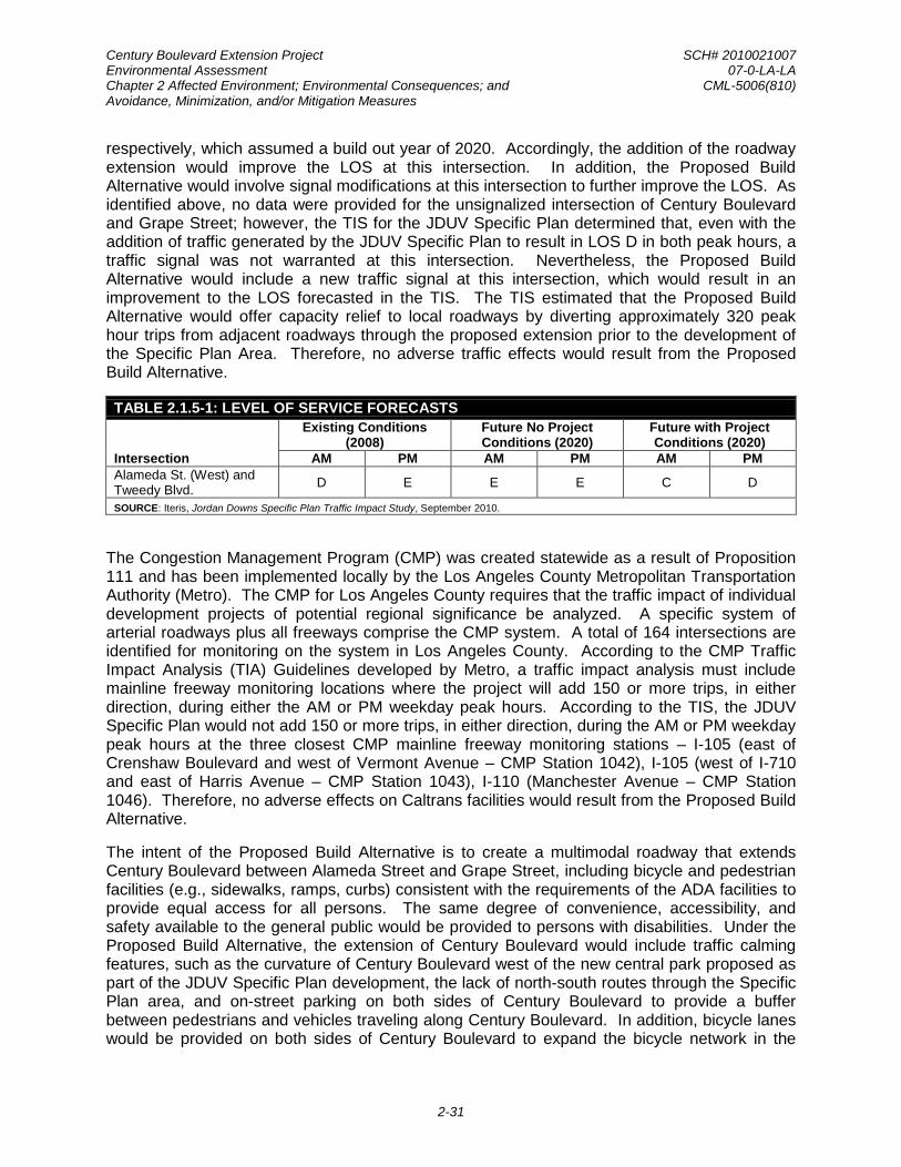
Century Boulevard Extension Project SCH# 2010021007 Environmental Assessment 07-0-LA-LA Chapter 2 Affected Environment; Environmental Consequences; and CML-5006(810) Avoidance, Minimization, and/or Mitigation Measures
2-31
respectively, which assumed a build out year of 2020. Accordingly, the addition of the roadway extension would improve the LOS at this intersection. In addition, the Proposed Build Alternative would involve signal modifications at this intersection to further improve the LOS. As identified above, no data were provided for the unsignalized intersection of Century Boulevard and Grape Street; however, the TIS for the JDUV Specific Plan determined that, even with the addition of traffic generated by the JDUV Specific Plan to result in LOS D in both peak hours, a traffic signal was not warranted at this intersection. Nevertheless, the Proposed Build Alternative would include a new traffic signal at this intersection, which would result in an improvement to the LOS forecasted in the TIS. The TIS estimated that the Proposed Build Alternative would offer capacity relief to local roadways by diverting approximately 320 peak hour trips from adjacent roadways through the proposed extension prior to the development of the Specific Plan Area. Therefore, no adverse traffic effects would result from the Proposed Build Alternative.
TABLE 2.1.5-1: LEVEL OF SERVICE FORECASTS
Intersection
Existing Conditions (2008)
Future No Project Conditions (2020)
Future with Project Conditions (2020)
AM PM AM PM AM PM Alameda St. (West) and Tweedy Blvd. D E E E C D
SOURCE: Iteris, Jordan Downs Specific Plan Traffic Impact Study, September 2010.
The Congestion Management Program (CMP) was created statewide as a result of Proposition 111 and has been implemented locally by the Los Angeles County Metropolitan Transportation Authority (Metro). The CMP for Los Angeles County requires that the traffic impact of individual development projects of potential regional significance be analyzed. A specific system of arterial roadways plus all freeways comprise the CMP system. A total of 164 intersections are identified for monitoring on the system in Los Angeles County. According to the CMP Traffic Impact Analysis (TIA) Guidelines developed by Metro, a traffic impact analysis must include mainline freeway monitoring locations where the project will add 150 or more trips, in either direction, during either the AM or PM weekday peak hours. According to the TIS, the JDUV Specific Plan would not add 150 or more trips, in either direction, during the AM or PM weekday peak hours at the three closest CMP mainline freeway monitoring stations – I-105 (east of Crenshaw Boulevard and west of Vermont Avenue – CMP Station 1042), I-105 (west of I-710 and east of Harris Avenue – CMP Station 1043), I-110 (Manchester Avenue – CMP Station 1046). Therefore, no adverse effects on Caltrans facilities would result from the Proposed Build Alternative.
The intent of the Proposed Build Alternative is to create a multimodal roadway that extends Century Boulevard between Alameda Street and Grape Street, including bicycle and pedestrian facilities (e.g., sidewalks, ramps, curbs) consistent with the requirements of the ADA facilities to provide equal access for all persons. The same degree of convenience, accessibility, and safety available to the general public would be provided to persons with disabilities. Under the Proposed Build Alternative, the extension of Century Boulevard would include traffic calming features, such as the curvature of Century Boulevard west of the new central park proposed as part of the JDUV Specific Plan development, the lack of north-south routes through the Specific Plan area, and on-street parking on both sides of Century Boulevard to provide a buffer between pedestrians and vehicles traveling along Century Boulevard. In addition, bicycle lanes would be provided on both sides of Century Boulevard to expand the bicycle network in the

Century Boulevard Extension Project SCH# 2010021007 Environmental Assessment 07-0-LA-LA Chapter 2 Affected Environment; Environmental Consequences; and CML-5006(810) Avoidance, Minimization, and/or Mitigation Measures
2-32
community. Therefore, no adverse effects to pedestrian and bicycle facilities are anticipated as a result of the Proposed Build Alternative.
No-Build (No-Action) Alternative
The No-Build (No-Action) Alternative assumes that Century Boulevard would not be extended through the Specific Plan area. However, the No-Build (No-Action) Alternative would not preclude the implementation of the JDUV Specific Plan, which consists of up to 1,800 newly-built homes, 7.2 acres of commercial use, as well as 9 acres of public parks and open space in the Specific Plan area. As discussed above, the JDUV Specific Plan would not result in adverse traffic effects at the two project intersections. Nevertheless, the No-Build (No-Action) Alternative would not promote alternatives to car ridership as it would not provide better connections and access to pedestrian and bicycle facilities between the surrounding communities and the Specific Plan area. The No-Build (No-Action) Alternative would not result in long-term benefit to community accessibility, walkability, and sustainability.
Cumulative Impacts
The traffic impacts identified for the JDUV Specific Plan Project in the TIS were based on traffic from anticipated ambient growth and related project; therefore, the TIS methodology is cumulative in nature, and the results of the traffic analysis for the Proposed Build Alternative represents a cumulative analysis. As indicated above, the Proposed Build Alternative, inclusive of cumulative effects, would improve traffic operations at the two project intersections and would be of a net benefit to the local community. Any cumulative, construction-related effects on traffic and facilities would be short-term and temporary in nature, and would not be considered adverse. The Proposed Build Alternative would not adversely affect any existing or planned bicycle facilities and, therefore, would not contribute to cumulative effects on such facilities.
Avoidance, Minimization, and/or Mitigation Measures
No avoidance, minimization, and/or mitigation measures are required or proposed.
2.1.6 CULTURAL RESOURCES AND SECTION 106 RESOURCES
Regulatory Setting
The term “cultural resources” as used in this document refers to all “built environment” resources, culturally important resources, and archaeological resources (both prehistoric and historic), regardless of significance. Laws and regulations dealing with cultural resources include the following:
The National Historic Preservation Act (NHPA) of 1966, as amended, sets forth national policy and procedures for historic properties, defined as districts, sites, buildings, structures, and objects included in or eligible for listing in the National Register of Historic Places (NRHP). Section 106 of the NHPA requires federal agencies to take into account the effects of their undertakings on historic properties and to allow the Advisory Council on Historic Preservation the opportunity to comment on those undertakings, following regulations issued by the Advisory Council on Historic Preservation (36 Code of Federal Regulations) [CFR] 800)]. On January 1, 2004 (amended January 2014), a Section 106 Programmatic Agreement (PA) between the Advisory Council, the Federal Highway Administration (FHWA), State Historic Preservation Officer (SHPO), and Caltrans went into effect for Caltrans projects, both state and local, with

Century Boulevard Extension Project SCH# 2010021007 Environmental Assessment 07-0-LA-LA Chapter 2 Affected Environment; Environmental Consequences; and CML-5006(810) Avoidance, Minimization, and/or Mitigation Measures
2-33
FHWA involvement. The PA implements the Advisory Council’s regulations, 36 CFR 800, streamlining the Section 106 process and delegating certain responsibilities to Caltrans. The FHWA’s responsibilities under the PA have been assigned to Caltrans as part of the Surface Transportation Project Delivery Program (23 United States Code [USC] 327).
Historic properties may also be covered under Section 4(f) of the U.S. Department of Transportation Act, which regulates the “use” of land from historic properties. See Appendix A for specific information about Section 4(f).
Affected Environment
Information Sources
The following documents, technical reports, and information sources were used to identify cultural resources and evaluate impacts:
• W. H. Bonner Associates, “Cultural/Paleontological Records Search for Jordan Downs Specific Plan, Los Angeles, California,” May 9, 2010
• BCR Consulting, Jordan Downs Specific Plan Project, Watts Community of Los Angeles, California, July 15, 2010
• City of Los Angeles Department of City Planning, Jordan Downs Specific Plan Draft Environmental Impact Report, November 2010
• Page and Turnbull, Jordan Downs Historic Significance Evaluation, August 24, 2011
• Anderson Environmental, Final Interim Remedial Action Plan for the Property Located at 9901 South Alameda Street, Los Angeles, California, June 30, 2014
• ICF International, Historic Property Survey Report for the Century Boulevard Extension Project (CML-5006(910)), October 26, 2015
Area of Potential Effects
In accordance with Section 106 PA, Stipulation VIII.A, Caltrans established an Area of Potential Effects (APE) for the proposed project in consultation with Caltrans’ Professionally Qualified Staff (PQS) Principal Architectural Historian and Caltrans’ Local Assistance Engineer. The APE is defined as the limits of proposed disturbance, including the limits of the current and proposed right-of-way and potential storage and staging areas, plus an additional area extending beyond the limits of proposed disturbance to account for effects on the built environment. The additional areas include the entirety of the abutting parcels near the proposed limits of disturbance, storage and staging areas, and the limits of the current and proposed right-of-way.
The APE includes the roadway extension right-of-way and the entirety of the Jordan Downs Public Housing Complex; however, only a small portion of the latter would be used as a part of the Century Boulevard extension. The APE includes residential and open space parcels. It is centered primarily on a 21-acre vacant parcel owned by HACLA and recreational open space at the Jordan Downs Public Housing Complex. The vertical extent of the APE is limited to the anticipated depths of ground-disturbing activities.

Century Boulevard Extension Project SCH# 2010021007 Environmental Assessment 07-0-LA-LA Chapter 2 Affected Environment; Environmental Consequences; and CML-5006(810) Avoidance, Minimization, and/or Mitigation Measures
2-34
Methods
Two cultural resources studies were completed for the JDUV Specific Plan project. David Brunzell, MA, RPA, of BCR Consulting, conducted a cultural resources assessment of the Jordan Downs Public Housing Complex property in July 2010, and Wayne H. Bonner, MA, RPA of W. H. Bonner Associates, completed a cultural resources records search for the entire Jordan Downs Specific Plan area in May 2010. The BCR Consulting assessment included a cultural resources records search conducted at the South Central Coastal Information Center at California State University, Fullerton (SCCIC), historical research, and an intensive-level field survey. The records search revealed that 10 prior studies have taken place in the vicinity of the Specific Plan area, resulting in the recording of no archaeological or historic resources on the Jordan Downs Public Housing Complex property. BCR Consulting also identified no additional cultural resources during their field survey. The records search completed by W.H. Bonner Associates entailed a review of all previously recorded prehistoric and historic archaeological sites situated within a half-mile radius of the APE, as well as a review of all cultural resource survey and excavation reports at the SCCIC. In addition, Los Angeles County Museum (LACM) recorded paleontological (fossil) sites were reviewed to determine if any significant fossil finds were reported in the search radius.
The results of this records search indicated the following:
• No prehistoric archaeological sites have been recorded at or within a half‐mile radius of the project area;
• No historic archaeological sites have been recorded at or within 100 feet of the project area;
• No area‐specific survey/excavation reports that address the project area are on file with SCCIC; and
• No paleontological sites/specimens have been recorded at or within a half‐mile radius of the project area.
The Final Interim Remedial Action Plan (IRAP) was prepared by Anderson Environmental in June 2014 and implemented in September 2015. The IRAP was prepared for the 21-acre parcel owned by HACLA, adjacent to the Jordan Downs Public Housing Complex. The depth of excavations ranged from 1.5 feet to 15 feet below grade. For the proposed project, the depth of disturbance is expected to range across the project site based upon the nature of the project activities with a maximum depth of 21 feet for one sanitary sewer proposed on the 21-acre HACLA site. The 21-foot deep excavation is necessary to tie the new sewer into an existing County sewer; as there is an existing sewer, the area was determined to have been previously disturbed.
Page and Turnbull conducted an intensive survey of the Jordan Downs Public Housing Complex Project to evaluate its potential historical significance in August 2011. The study recommended a determination for the Jordan Downs Public Housing Complex as not eligible for listing in the NRHP, California Register of Historical Resources (CRHR), and Historic Cultural Monument (HCM) designation in August 2011. The property includes 106 buildings in total: 103 residential buildings with recreation and maintenance buildings, each of which were completed in 1955 (in total, 105 buildings completed more than 50 years ago); and a later community center building completed in 1994 at 2011 East Century Boulevard. The study indicated that the complex does

Century Boulevard Extension Project SCH# 2010021007 Environmental Assessment 07-0-LA-LA Chapter 2 Affected Environment; Environmental Consequences; and CML-5006(810) Avoidance, Minimization, and/or Mitigation Measures
2-35
not meet NRHP criteria for eligibility and has undergone numerous alterations, including window, door, stoop, and canopy replacements (1995). It retains integrity of its original location, but its original design has been altered. The determination of not NRHP eligible was adopted by the Housing and Community Investment Department of the City of Los Angeles, on behalf of the U.S. Housing and Community Development Department (HUD), for a Section 106 review conducted under the City’s Programmatic Agreement for HUD-funded undertakings for the JDUV Specific Plan in September 2013.
ICF International prepared a Historic Property Survey Report (HPSR) for the proposed project in October 2015. The cultural resources studies completed for the project identified three properties in the APE. These properties are the single family residences at 9927 Grape Street and 10001 Grape Street, and the Jordan Downs Public Housing Complex, located at 9800 Grape Street.
The proposed project does not involve ground excavation in any areas not previously disturbed; therefore, Caltrans determined that an additional Archaeological Survey Report was not required for the project.
Environmental Consequences
Caltrans determined that the identified properties located within the APE at 9927 Grape Street and 10001 Grape Street are exempt from Section 106 review, per Section 106 PA, Attachment 4 (Properties Exempt from Evaluation), because they are buildings between 30 to 50 years old. The Jordan Downs Public Housing Complex, located at 9800 Grape Street, was found to have been previously evaluated as ineligible for the NRHP, CRHR, and HCM designation on August 17, 2011.11
Caltrans provided notice to the Native American Heritage Commission (NAHC) about the project in September 2015, and requested a Sacred Lands File search and a list of potentially interested Native American groups and individuals. The NAHC provided a list of 15 Native American contacts in Los Angeles County, California, and indicated that a search of the Sacred Lands File revealed no sacred lands or traditional cultural properties in proximity to the APE.
Caltrans determined the evaluation of not eligible for inclusion in the NRHP as still valid and submitted the HPSR to the SHPO for concurrence on October 29, 2015.
Notification letters were sent to all 15 Native American contacts in October 2015 about the proposed project. These letters were followed-up with telephone calls to those individuals and groups who did not respond. Caltrans received five responses by telephone and email. One respondent indicated they had no concerns about the project; another indicated the project site was in a sensitive area and requested Native American and archaeological monitoring during construction but subsequently expressed satisfaction with the information provided by Caltrans and indicated no further requests; another representative from the Gabrieleno Band of Mission Indians also indicated the project site was in a sensitive area and expressed a strong interest in Native American and archaeological monitoring during excavation activities; one requested a call with Caltrans about the project; and another requested the inclusion in the project documents of provisions for the unanticipated discovery of cultural materials during construction. The complete record of Native American consultation correspondence is included in Attachment C of the HPSR prepared for the project.
11Page and Turnbull, Jordan Downs Historic Significance Evaluation, August 24, 2011.

Century Boulevard Extension Project SCH# 2010021007 Environmental Assessment 07-0-LA-LA Chapter 2 Affected Environment; Environmental Consequences; and CML-5006(810) Avoidance, Minimization, and/or Mitigation Measures
2-36
In addition, Caltrans sent notification letters to government agencies, historical societies, and other historic preservation groups that may have knowledge or concerns about historic properties in the area. In the letters, information was requested regarding historic buildings, districts, sites, objects, and archeological sites of significance within the APE. The Los Angeles Office of Historic Resources (OHR) was the only respondent, and recommended checking the findings of SurveyLA, the City of Los Angeles’ citywide survey program. No additional cultural resources were identified in the APE.
Pursuant to Section 106 PA, Stipulation IX.A, Caltrans requested concurrence from the SHPO on the not eligible determination for the Jordan Downs Public Housing Complex and a finding of No Historic Properties Affected for the project in October 2015. The SHPO concurred with Caltrans’ determinations and finding on November 24, 2015.
Proposed Build Alternative
Temporary Impacts. No significant or protected cultural resources—archaeological resources, historic resources, or culturally significant properties—are known to exist in the APE. Therefore, construction of the Proposed Build Alternative would not be expected to have any temporary impacts on cultural resources.
Permanent Impacts. Because there are no known significant or protected cultural resources in the APE and because use of the Proposed Build Alternative would not involve ground-disturbing activities, the Proposed Build Alternative would have no permanent impacts on cultural resources.
No-Build (No-Action) Alternative
The No-Build (No-Action) Alternative assumes that Century Boulevard would not be extended through the Specific Plan area and the applicant would continue to operate its existing facility. The No-Build (No-Action) Alternative, however, would not preclude the implementation of the JDUV Specific Plan, which consists of up to 1,800 newly-built homes, 7.2 acres of commercial use, as well as 9 acres of public parks and open space in the Specific Plan area. Section 106 PA review of the JDUV Specific Plan was completed by the Housing and Community Investment Department of the City of Los Angeles, on behalf of HUD, under the City’s Programmatic Agreement for HUD-funded undertakings in September 2013. This review resulted in a finding of No Adverse Effect. Therefore, because of this finding and because there are no known significant or protected cultural resources in the APE, the No-Build (No-Action) Alternative would not be expected to have any impacts on cultural resources.
Cumulative Impacts
No significant or protected cultural resources were identified in the APE, and no impacts on cultural resources are expected from the Proposed Build Alternative. Because of this circumstance, the Proposed Build Alternative would have no cumulative impact on cultural resources.
Avoidance, Minimization, and/or Mitigation Measures
No significant or protected cultural resources were identified in the APE. Therefore, the Proposed Build Alternative is not expected to have direct, indirect, or cumulative impacts on cultural resources. Nevertheless, it remains possible that unknown cultural resources could be
Century Boulevard Extension Project SCH# 2010021007 Environmental Assessment 07-0-LA-LA Chapter 2 Affected Environment; Environmental Consequences; and CML-5006(810) Avoidance, Minimization, and/or Mitigation Measures
2-37
discovered through the course of construction of the proposed project. The following mitigation avoidance measures would minimize the adverse effect related to the unanticipated discovery of cultural resources:
CR1: If cultural materials are discovered during construction, all earth-moving activity within and around the immediate discovery area will be diverted until a qualified archaeologist can assess the nature and significance of the find.
CR2: If human remains are discovered, State Health and Safety Code Section 7050.5 states that further disturbances and activities shall stop in any area or nearby area suspected to overlie remains, and the County Coroner contacted. Pursuant to Public Resources Code (PRC) Section 5097.98, if the remains are thought to be Native American, the coroner will notify the NAHC, which will then notify the Most Likely Descendent (MLD). At this time, the person who discovered the remains shall contact Alex Kirkish, Ph.D., District Archaeologist, so that they may work with the MLD on the respectful treatment and disposition of the remains. Further provisions of PRC 5097.98 are to be followed as applicable.
CR3: During the excavation period associated with construction of the Century Boulevard Extension Project, a Native American monitor of the Gabrieleno Band of Mission Indians – Kizh Nation shall be present at all times during excavation activities. The excavation period includes, but is not limited to, pavement removal, potholing/boring, grading, excavation and trenching. The area of interest for Native American monitoring shall be focused on the western boundary of the project and excludes excavation activities within the boundaries of the 21-acre vacant parcel owned by HACLA, which has recently been subjected to extensive ground disturbance as a result of environmental remediation activities. Construction shall not be delayed or halted if the Native American Monitor is not available. The tribe shall be contacted within at least 3 business days of requiring monitoring services. If discoveries are made by either the Native American Monitor or construction personnel at any time during excavation or other construction activities (including the 21-acre vacant parcel), the provisions of Avoidance Measures CR1 and CR2 for the unanticipated discovery of cultural resources shall be fully enforced.
Century Boulevard Extension Project SCH# 2010021007 Environmental Assessment 07-0-LA-LA Chapter 2 Affected Environment; Environmental Consequences; and CML-5006(810) Avoidance, Minimization, and/or Mitigation Measures
2-38
This page is intentionally left blank.

Century Boulevard Extension Project SCH# 2010021007 Environmental Assessment 07-0-LA-LA Chapter 2 Affected Environment; Environmental Consequences; and CML-5006(810) Avoidance, Minimization, and/or Mitigation Measures
2-39
2.2 PHYSICAL ENVIRONMENT
2.2.1 WATER QUALITY AND STORM WATER RUNOFF
Regulatory Setting
Federal Requirements: Clean Water Act
In 1972, Congress amended the Federal Water Pollution Control Act, making the addition of pollutants to the waters of the United States (U.S.), from any point source12
• Sections 303 and 304 require states to issue water quality standards, criteria, and guidelines.
unlawful unless the discharge is in compliance with a National Pollutant Discharge Elimination System (NPDES) permit. This act and its amendments are known today as the Clean Water Act (CWA). Congress has amended the act several times. In the 1987 amendments, Congress directed dischargers of storm water from municipal and industrial/construction point sources to comply with the NPDES permit scheme. The following are important CWA sections:
• Section 401 requires an applicant for a federal license or permit to conduct any activity that may result in a discharge to waters of the U.S. to obtain certification from the state that the discharge will comply with other provisions of the act. This is most frequently required in tandem with a Section 404 permit request (see below).
• Section 402 establishes the NPDES, a permitting system for the discharges (except for dredge or fill material) of any pollutant into waters of the U.S. Regional Water Quality Control Boards (RWQCBs) administer this permitting program in California. Section 402(p) requires permits for discharges of storm water from industrial/construction and municipal separate storm sewer systems (MS4s).
• Section 404 establishes a permit program for the discharge of dredge or fill material into waters of the U.S. This permit program is administered by the U.S. Army Corps of Engineers (USACE).
The goal of the CWA is “to restore and maintain the chemical, physical, and biological integrity of the Nation’s waters.”
The USACE issues two types of 404 permits: General and Standard permits. There are two types of General permits: Regional permits and Nationwide permits. Regional permits are issued for a general category of activities when they are similar in nature and cause minimal environmental effect. Nationwide permits are issued to authorize a variety of minor project activities with no more than minimal effects.
Ordinarily, projects that do not meet the criteria for a Nationwide Permit may be permitted under one of the USACE’s Standard permits. There are two types of Standard permits: Individual permits and Letters of Permission. For Standard permits, the USACE decision to approve is based on compliance with U.S. Environmental Protection Agency (U.S. EPA) Section 404 (b)(1) Guidelines (U.S. EPA Code of Federal Regulations [CFR] 40 Part 230), and whether the permit
12A point source is any discrete conveyance such as a pipe or a man-made ditch.

Century Boulevard Extension Project SCH# 2010021007 Environmental Assessment 07-0-LA-LA Chapter 2 Affected Environment; Environmental Consequences; and CML-5006(810) Avoidance, Minimization, and/or Mitigation Measures
2-40
approval is in the public interest. The Section 404(b)(1) Guidelines (Guidelines) were developed by the U.S. EPA in conjunction with the USACE, and allow the discharge of dredged or fill material into the aquatic system (waters of the U.S.) only if there is no practicable alternative which would have less adverse effects. The Guidelines state that USACE may not issue a permit if there is a least environmentally damaging practicable alternative (LEDPA) to the proposed discharge that would have lesser effects on waters of the U.S. and not have any other significant adverse environmental consequences. According to the Guidelines, documentation is needed that a sequence of avoidance, minimization, and compensation measures has been followed, in that order. The Guidelines also restrict permitting activities that violate water quality or toxic effluent13
State Requirements: Porter-Cologne Water Quality Control Act
standards, jeopardize the continued existence of listed species, violate marine sanctuary protections, or cause “significant degradation” to waters of the U.S. In addition, every permit from the USACE, even if not subject to the Section 404(b)(1) Guidelines, must meet general requirements. See 33 CFR 320.4.
California’s Porter-Cologne Act, enacted in 1969, provides the legal basis for water quality regulation within California. This Act requires a “Report of Waste Discharge” for any discharge of waste (liquid, solid, or gaseous) to land or surface waters that may impair beneficial uses for surface and/or groundwater of the state. It predates the CWA and regulates discharges to waters of the state. Waters of the state include more than just waters of the U.S., like groundwater and surface waters not considered waters of the U.S. Additionally, it prohibits discharges of “waste” as defined, and this definition is broader than the CWA definition of “pollutant.” Discharges under the Porter-Cologne Act are permitted by Waste Discharge Requirements (WDRs) and may be required even when the discharge is already permitted or exempt under the CWA.
The State Water Resources Control Board (SWRCB) and RWQCBs are responsible for establishing the water quality standards (objectives and beneficial uses) required by the CWA, and regulating discharges to ensure compliance with the water quality standards. Details about water quality standards in a Specific Plan area are included in the applicable RWQCB Basin Plan. In California, the Regional Boards designate beneficial uses for all water body segments in their jurisdictions and then set criteria necessary to protect these uses. As a result, the water quality standards developed for particular water segments are based on the designated use and vary depending on that use. In addition, the SWRCB identifies waters failing to meet standards for specific pollutants. These waters are then state-listed in accordance with CWA Section 303(d). If a state determines that waters are impaired for one or more constituents and the standards cannot be met through point source controls (NPDES permits or WDRs), the CWA requires the establishment of Total Maximum Daily Loads (TMDLs). TMDLs specify allowable pollutant loads from all sources (point, non-point, and natural) for a given watershed.
State Water Resources Control Board and Regional Water Quality Control Boards
The SWRCB administers water rights, sets water pollution control policy, and issues water board orders on matters of statewide application, and oversees water quality functions throughout the state by approving Basin Plans, TMDLs, and NPDES permits. RWCQBs are
13The U.S. EPA defines “effluent” as “wastewater, treated or untreated, that flows out of a treatment plant,
sewer, or industrial outfall.”

Century Boulevard Extension Project SCH# 2010021007 Environmental Assessment 07-0-LA-LA Chapter 2 Affected Environment; Environmental Consequences; and CML-5006(810) Avoidance, Minimization, and/or Mitigation Measures
2-41
responsible for protecting beneficial uses of water resources within their regional jurisdiction using planning, permitting, and enforcement authorities to meet this responsibility.
National Pollutant Discharge Elimination System (NPDES) Program
Municipal Separate Storm Sewer Systems (MS4). Section 402(p) of the CWA requires the issuance of NPDES permits for five categories of storm water discharges, including Municipal Separate Storm Sewer Systems (MS4s). An MS4 is defined as “any conveyance or system of conveyances (roads with drainage systems, municipal streets, catch basins, curbs, gutters, ditches, human-made channels, and storm drains) owned or operated by a state, city, town, county, or other public body having jurisdiction over storm water, that is designed or used for collecting or conveying storm water.” The SWRCB has identified the City as an owner/operator of an MS4 under federal regulations. The City is included as a permittee under the MS4 permit issued to Los Angeles County. The SWRCB or the RWQCB issues NPDES permits for five years, and permit requirements remain active until a new permit has been adopted.
The City’s MS4 Permit (Order No. R4-2012-0175 as amended by Order WQ 2015-0075) was adopted on November 8, 2012 and became effective on December 28, 2012. The permit has three basic requirements:
1. The City must comply with the requirements of the Construction General Permit (see below);
2. The City must implement a year-round program in all parts of the City to effectively control storm water and non-storm water discharges; and
3. The City’s storm water discharges must meet water quality standards through implementation of permanent and temporary (construction) Best Management Practices (BMPs), to the Maximum Extent Practicable, and other measures as the SWRCB determines to be necessary to meet the water quality standards.
To comply with the permit, the City developed a Storm Water Management Plan (SWMP) to address storm water pollution controls related to construction in the City. The SWMP assigns responsibilities within the City for implementing storm water management procedures and practices as well as training, public education and participation, monitoring and research, program evaluation, and reporting activities. The SWMP describes the minimum procedures and practices the City uses to reduce pollutants in storm water and non-storm water discharges. It outlines procedures and responsibilities for protecting water quality, including the selection and implementation of BMPs. The proposed project will be programmed to follow the guidelines and procedures outlined in the latest SWMP to address storm water runoff.
Construction General Permit. Construction General Permit (Order No. 2009-009-DWQ), adopted on September 2, 2009, became effective on July 1, 2010. The permit regulates storm water discharges from construction sites that result in a Disturbed Soil Area (DSA) of one acre or greater, and/or are smaller sites that are part of a larger common plan of development. By law, all storm water discharges associated with construction activity where clearing, grading, and excavation result in soil disturbance of at least one acre must comply with the provisions of the General Construction Permit. Construction activity that results in soil disturbances of less than one acre is subject to this Construction General Permit if there is potential for significant water quality impairment resulting from the activity as determined by the RWQCB. Operators of regulated construction sites are required to develop storm water pollution prevention plans; to

Century Boulevard Extension Project SCH# 2010021007 Environmental Assessment 07-0-LA-LA Chapter 2 Affected Environment; Environmental Consequences; and CML-5006(810) Avoidance, Minimization, and/or Mitigation Measures
2-42
implement sediment, erosion, and pollution prevention control measures; and to obtain coverage under the Construction General Permit.
The 2009 Construction General Permit separates projects into Risk Levels 1, 2, or 3. Risk levels are determined during the planning and design phases, and are based on potential erosion and transport to receiving waters. Requirements apply according to the Risk Level determined. For example, a Risk Level 3 (highest risk) project would require compulsory storm water runoff pH and turbidity monitoring, and before construction and after construction aquatic biological assessments during specified seasonal windows. For all projects subject to the permit, applicants are required to develop and implement an effective Storm Water Pollution Prevention Plan (SWPPP). In accordance with the City’s Standard Specifications, a Water Pollution Control Plan (WPCP) is necessary for projects with DSA less than one acre.
Section 401 Permitting. Under Section 401 of the CWA, any project requiring a federal license or permit that may result in a discharge to a water of the U.S. must obtain a 401 Certification, which certifies that the project will be in compliance with state water quality standards. The most common federal permits triggering 401 Certification are CWA Section 404 permits issued by the USACE. The 401 permit certifications are obtained from the appropriate RWQCB, dependent on the project location, and are required before the USACE issues a 404 permit.
In some cases, the RWQCB may have specific concerns with discharges associated with a project. As a result, the RWQCB may issue a set of requirements known as Waste Discharge Requirements (WDRs) under the State Water Code (Porter-Cologne Act) that define activities, such as the inclusion of specific features, effluent limitations, monitoring, and plan submittals that are to be implemented for protecting or benefiting water quality. WDRs can be issued to address both permanent and temporary discharges of a project.
Affected Environment
The description of the affected environment is based on the following documents, technical reports, and information sources:
• Andersen Environmental, Environmental Sampling Report, 9901 South Alameda Street, April 13, 2010
• California Regional Water Quality Control Board, Los Angeles Region, Water Quality Control Plan, Los Angeles Region, adopted June 1994
• City of Los Angeles, City of Los Angeles General Plan Framework Chapter 9, 2001
• Los Angeles and San Gabriel Rivers Watershed Council, Compton Creek Watershed Management Plan, June 2005
• Los Angeles County Department of Public Works, Well Measurement Data, measured on April 1, 2012, available at http://dpw.lacounty.gov/wrd/wellinfo

Century Boulevard Extension Project SCH# 2010021007 Environmental Assessment 07-0-LA-LA Chapter 2 Affected Environment; Environmental Consequences; and CML-5006(810) Avoidance, Minimization, and/or Mitigation Measures
2-43
Regional Drainage
The project site is located in a highly urbanized area with paved roads and other impervious surfaces within the Los Angeles-San Gabriel Hydrologic Unit as defined by the LARWQCB.14 The Hydrologic Unit has three major drainage systems: Ballona Creek, Los Angeles River, and San Gabriel River.15
Local Drainage
These three drainage systems convey stormwater into the Pacific Ocean. Stormwater drainage from the project area is provided by the Los Angeles River, which is located approximately 3.3 miles east of the project site. The Los Angeles River conveys stormwater runoff from the Santa Monica Mountains to the San Pedro Bay of Long Beach Harbor. Major tributaries of the Los Angeles River include Burbank Western Channel, Pacoima Wash, Tujunga Wash, and Verdugo Wash in the San Fernando Valley; and the Arroyo Seco, Compton Creek, and Rio Hondo south of the Glendale Narrows.
Compton Creek serves drainage needs in the Specific Plan area, joining with the Los Angeles River before ultimately flowing into the Pacific Ocean. Compton Creek is a 42-square-mile sub-watershed of the Los Angeles River Watershed. Compton Creek is the only open water body near the Specific Plan area. Compton Creek, which originates at Main Street between 107th and 108th Streets, is approximately 2.1 miles west of the project site. The Compton Creek Channel was once a free-flowing Creek that was channelized in 1954. The Compton Creek Channel begins at Main Street, between 107th and 108th Street and ends at the Los Angeles River. The Compton Creek Channel has a design capacity for 50-year storm events and has a capacity of 3,900 cubic feet per second, at its origin, and maximum capacity of 21,700 cubic feet per second, just south of the 91 Freeway.16
Stormwater drainage from project area is managed by the City of Los Angeles Department of Public Works (LADPW) Bureau of Sanitation (BOS) and the Los Angeles County Flood Control District (LACFCD). The LACFCD constructs and manages major storm drains and open flood control channels, while the LADPW constructs local tributary drains and catch basins. The LACFCD designs its storm drain infrastructure to handle 50-year flood storm events, while the LADPW constructs its storm drain infrastructure to handle 10-year storm events.
17
Groundwater
A groundwater basin is a groundwater reservoir comprising an overlying land surface and the underlying aquifers that contain water stored in the reservoir. Groundwater basins are separated from adjacent basins by geologic features such as non-water-bearing rock, faults, or other geological structures or topographical features which impede groundwater movement. Aquifers are an underground layer of water-bearing rock permeable rock or unconsolidated materials (e.g., gravel, sand, silt, clay, etc.) from which groundwater can be extracted. The name “aquitard” is given to the less permeable silt and clay layers that separate the aquifers. Groundwater basins are recharged naturally by precipitation percolating through the soil to underlying aquifers. Groundwater basins are also recharged artificially with imported or
14California Regional Water Quality Control Board, Los Angeles Region, Water Quality Control Plan, Los
Angeles Region, adopted June 1994. 15Ibid. 16Los Angeles and San Gabriel Rivers Watershed Council, Compton Creek Watershed Management Plan,
June 2005. 17City of Los Angeles, City of Los Angeles General Plan Framework Chapter 9, 2001.

Century Boulevard Extension Project SCH# 2010021007 Environmental Assessment 07-0-LA-LA Chapter 2 Affected Environment; Environmental Consequences; and CML-5006(810) Avoidance, Minimization, and/or Mitigation Measures
2-44
reclaimed water. Artificial recharge is used to offset declining groundwater levels and provide storage for use in times of drought.
The project site is located within the northern portion of the Central Subbasin of the Coastal Plain of Los Angeles Groundwater Basin, in the South Coast Hydrologic Region.18
Groundwater pumped from the Central and West Coast Basin currently provides approximately 36 percent of the total water supplies used by the overlying population of four million people in 43 cities of southern Los Angeles County. The major aquifers identified in the Central Basin include the following, from shallowest to deepest:
This subbasin is commonly referred to as the “Central Basin” and is bounded on the north by a surface divide called the La Brea high; on the northeast and east by emergent less permeable Tertiary rocks of the Elysian, Repetto, Merced and Puente Hills; on the southeast by the Orange County Groundwater Basin; and on the southwest by the Newport Inglewood fault system. This area has unconfined groundwater conditions and extensive interconnected aquifers. Groundwater flow is generally to the south. The Los Angeles and San Gabriel Rivers drain inland basins and pass across the surface of the Central Basin on their way to the Pacific Ocean. Average annual precipitation throughout the subbasin ranges from 11 to 13 inches.
• Gaspur and Semiperched aquifers of the Holocene Alluvium Formation;
• Exposition, Artesia, Gage, and Gardena aquifers of the Upper Pleistocene Lakewood Formation;
• Hollydale, Jefferson, Lynwood, and Silverado aquifers of the Lower Pleistocene Upper San Pedro Formation; and
• Sunnyside Aquifer of the Lower Pleistocene Lower San Pedro Formation.
Groundwater elevations vary with the amount of pumping and recharge occurring. Most of the groundwater in the Central Basin remains at an elevation below sea level due to historic overpumping, so the importance of maintaining the seawater barrier wells to keep out the intruding saltwater is critical. Spreading grounds are used to enhance groundwater recharge by retaining as much surface water as possible. Areas are flooded with water which percolates into aquifers and supplements the natural supply. The process is limited by available storage capacity, and ability of the basin to accept the water. Spreading grounds are not always enough to compensate for declining groundwater levels.
The California Division of Mines and Geology 1997 Seismic Hazard Zone Report for the 7.5-Minute South Gate Quadrangle indicates that the historical high groundwater level at the Specific Plan area is less than 10 feet below ground surface (bgs).19 However, no groundwater was encountered to a maximum depth of 50 feet bgs during the subsurface investigation of the 21-acre property that comprises the majority of the project site.20
18Andersen Environmental, Environmental Sampling Report, 9901 South Alameda Street, April 13, 2010.
The Los Angeles County Department of Public Works (LACDPW) groundwater well measurement data indicates that wells 1475B and 1475C are located within approximately 300 feet from the southeast corner of the Specific Plan area. The highest historical groundwater depths reported for those wells from 1989 to 2012 was approximately 105 feet bgs in 1995. The most recent groundwater
19Ibid. 20Ibid.
Century Boulevard Extension Project SCH# 2010021007 Environmental Assessment 07-0-LA-LA Chapter 2 Affected Environment; Environmental Consequences; and CML-5006(810) Avoidance, Minimization, and/or Mitigation Measures
2-45
measurement, in April 2012, was approximately 124 feet bgs.21
Environmental Consequences
Based on these data, and on the current depth of groundwater near the project site, it is considered unlikely that groundwater beneath the roadway right-of-way would return to the shallow subsurface in the foreseeable future. Based on the surface topography and regional conditions, the groundwater flow direction is anticipated to be to the south.
Proposed Build Alternative
Temporary Impacts. Since no work would occur within any waters of the U.S., the Proposed Build Alternative would not require Section 401 water quality certification. While construction activities have the potential to increase discharge of accidental pollutants into the storm drain systems during earth moving, maintenance/operation of construction equipment, and handling/storage/disposal of materials, required implementation of temporary BMPs would ensure that this potential is minimized. As discussed above, construction activities disturbing greater than one acre of soil would be required to obtain coverage under the NPDES General Construction Activity Permit. In accordance with the requirements of the permit, a site-specific SWPPP would be prepared and implemented. The SWPPP would specify BMPs to be used during construction; these would include but not be limited to erosion control, sediment control, and non-stormwater management and materials management BMPs.
With implementation of these BMPs, included as part of the SWPPP, the Proposed Build Alternative would reduce or eliminate the discharge of potential pollutants to the maximum extent practicable. In addition, the project would be required to comply with the City grading permit regulations, which require necessary measures, plans (including a wet weather erosion control plan if construction occurs during the rainy season), and inspections to reduce sedimentation and erosion. Therefore, with compliance with NPDES requirements and City grading regulations, construction of the proposed project would not result in a violation of water quality standards or discharge requirements. Accordingly, no adverse effects on surface water quality would result from construction of the Proposed Build Alternative.
Permanent Impacts. The design of the Proposed Build Alternative would incorporate “Green Street” planting elements, such as bioswales, for use in managing and treating stormwater runoff. With implementation of source control and treatment BMPs, the Proposed Build Alternative would reduce or eliminate the discharge of potential pollutants from the stormwater runoff to the maximum extent practicable. Therefore, operation of the Century Boulevard extension would not result in a violation of water quality standards or discharge requirements. Similarly, no adverse effects on surface water quality would result from operation of the Proposed Build Alternative.
The majority of the project area is developed with primarily impervious surfaces and is not currently used for groundwater recharge activities. Under current conditions, stormwater flows through the project area rapidly and does not remain on-site long enough to recharge groundwater. The improvements that would occur as part of the proposed roadway extension would include a palette of infiltration planters and bioswales to allow stormwater to feed
21Los Angeles County Department of Public Works, Well Measurement Data, measured on April 1, 2012,
available at http://dpw.lacounty.gov/wrd/wellinfo/, accessed on September 29, 2015.

Century Boulevard Extension Project SCH# 2010021007 Environmental Assessment 07-0-LA-LA Chapter 2 Affected Environment; Environmental Consequences; and CML-5006(810) Avoidance, Minimization, and/or Mitigation Measures
2-46
landscaping and percolate through the soil. This would be an improvement from existing conditions as these improvements may slightly contribute to groundwater recharge.
No-Build (No-Action) Alternative
The No-Build (No-Action) Alternative assumes that Century Boulevard would not be extended through the Specific Plan area. The No-Build (No-Action) Alternative would not result in new or additional impacts to hydrology, water quality, and stormwater runoff relative to existing conditions. However, the No-Build (No-Action) Alternative would not preclude the implementation of the JDUV Specific Plan, which consists of up to 1,800 newly-built homes, 7.2 acres of commercial use, as well as 9 acres of public parks and open space in the Specific Plan area. Similar to the Proposed Build Alternative, the JDUV Specific Plan incorporates design features that would direct surface runoff water to vegetated bioswales and allow for more localized infiltration and recharge the groundwater supply at several locations throughout the Specific Plan area.
Cumulative Impacts
The Proposed Build Alternative would improve the existing conditions on the project site as they relate to water quality and storm water runoff. Accordingly, the project is not anticipated to result in any adverse effects related to water quality and storm water runoff. Therefore, the Proposed Build Alternative would not result in an adverse cumulative impact related to water quality and storm water runoff.
Avoidance, Minimization, and/or Mitigation Measures
WQ1: A site-specific Storm Water Pollution Prevention Plan (SWPPP) shall be prepared and implemented for the project. The SWPPP shall specify Best Management Practices to be used during construction; these would include but not be limited to erosion control, sediment control, and non-stormwater management and materials management BMPs.
WQ2: The project shall be required to comply with the City of Los Angeles grading permit regulations, which require necessary measures, plans (including a wet weather erosion control plan if construction occurs during the rainy season), and inspections to reduce sedimentation and erosion.
WQ3: The design of the Proposed Build Alternative shall incorporate “Green Street” planting elements, such as a palette of infiltration planters and bioswales, for use in managing and treating stormwater runoff to feed landscaping and percolate through the soil.
2.2.2 GEOLOGY/SOILS/SEISMIC/TOPOGRAPHY
Regulatory Setting
For geologic and topographic features, the key federal law is the Historic Sites Act of 1935, which establishes a national registry of natural landmarks and protects “outstanding examples of major geological features.”
This section also discusses geology, soils and seismic concerns as they relate to public safety and project design. Earthquakes are prime considerations in the design and retrofit of structures.
Century Boulevard Extension Project SCH# 2010021007 Environmental Assessment 07-0-LA-LA Chapter 2 Affected Environment; Environmental Consequences; and CML-5006(810) Avoidance, Minimization, and/or Mitigation Measures
2-47
State of California
Alquist-Priolo Earthquake Fault Zoning Act. The Alquist-Priolo Earthquake Fault Zoning Act (Alquist-Priolo Act) provides policies and criteria to assist cities, counties, and State agencies in the development of structures for human occupancy across the trace of active faults. The Alquist-Priolo Act was intended to provide the citizens of the State with increased safety and to minimize the loss of life during and immediately following earthquakes by facilitating seismic retrofitting to strengthen buildings, including historical buildings, against ground shaking.
Seismic Hazards Mapping Act. In order to address the effects of strong ground shaking, liquefaction, landslides, and other ground failures due to seismic events, the State of California passed the Seismic Hazards Mapping Act of 1990. Under the Seismic Hazards Mapping Act, the State Geologist is required to delineate “seismic hazard zones.” Cities and counties must regulate certain development projects within these zones until the geologic and soil conditions of the Specific Plan area are investigated and appropriate mitigation measures, if any, are incorporated into development plans. The State Mining and Geology Board provides additional regulations and policies to assist municipalities in preparing the Safety Element of their General Plan and encourage land use management policies and regulations to reduce and mitigate those hazards to protect public health and safety. Under Public Resources Code Section 2697, cities and counties shall require, prior to the approval of a project located in a seismic hazard zone, a geotechnical report defining and delineating any seismic hazard. Each city or county shall submit one copy of each geotechnical report, including mitigation measures, to the State Geologist within 30 days of its approval.
California Building Code. The California Building Code (CBC) Title 24 is a compilation of building standards, including seismic safety standards for new buildings. CBC standards are based on building standards that have been adopted by state agencies without change from a national model code; building standards based on a national model code that have been changed to address particular California conditions; and building standards authorized by the California legislature but not covered by the national model code. Given the State’s susceptibility to seismic events, the seismic standards within the CBC are among the strictest in the world. The CBC applies to all occupancies in California, except where stricter standards have been adopted by local agencies.
City of Los Angeles
City of Los Angeles General Plan Safety Element. The Safety Element of the General Plan addresses the issues of protection of people from unreasonable risks associated with natural disasters, fires, floods, and earthquakes. The Safety Element provides a contextual framework for understanding the relationship between hazard mitigation, response to a natural disaster, and initial recovery from a natural disaster.
City of Los Angeles Building Code. Earthwork activities, including grading, are governed by the Los Angeles Building Code, which is contained in Los Angeles Municipal Code, Chapter IX, Article 1. Specifically, Section 91.7006.7 includes requirements regarding import and export of material; Section 91.7010 includes regulations pertaining to excavations; Section 91.7011 includes requirements for fill materials; Section 91.7013 includes regulations pertaining to erosion control and drainage devices; Section 91.7014 includes general construction requirements as well as requirements regarding flood and mudflow protection; and Section 91.7016 includes regulations for areas that are subject to slides and unstable soils.
Century Boulevard Extension Project SCH# 2010021007 Environmental Assessment 07-0-LA-LA Chapter 2 Affected Environment; Environmental Consequences; and CML-5006(810) Avoidance, Minimization, and/or Mitigation Measures
2-48
Additionally, the Los Angeles Building Code includes specific requirements addressing seismic design, site grading, foundation design, cut and fill slope design, soil expansion, geologic investigations and reports before and during construction, retaining walls, soil and rock testing, basement walls, shoring of adjacent properties, and potential primary and secondary seismic effects and groundwater. The Los Angeles Building Code incorporates by reference the 2013 CBC, with City amendments for additional requirements, and the City Department of Building and Safety is responsible for implementing the provisions of the Los Angeles Building Code.
Affected Environment
The description of the affected environment is based on the following documents, technical reports, and information sources:
• California Department of Conservation, Seismic Hazard Zones, South Gate Quadrangle (1999), available at http://www.conservation.ca.gov/cgs/shzp/Pages/Index.aspx
• California Geological Survey, Alquist-Priolo Earthquake Fault Zones (2007), available at www.consrv.ca.gov/ .CGS/RGHM/AP/Pages/Index.aspx
• City of Los Angeles, General Plan Safety Element, Exhibits A and C, November 26, 1996
• City of Los Angeles Department of City Planning, Jordan Downs Specific Plan Draft Environmental Impact Report, November 2010
Geologic Setting
The Specific Plan area is part of the South Los Angeles Subregion which lies within the Los Angeles Basin. The basin is bounded on the north by the Santa Monica Mountains and Puente Hills, on the east by the Santa Ana Mountains and San Joaquin Hills, and on the west and south by the Palos Verdes Hills and the Pacific Ocean. The Basin is made up of a great thickness of sediments that was deposited on an ancient sea floor. Three major groups of rocks are represented: older igneous and metamorphic bedrock (100 to 75 million years old), older sedimentary rocks (about 65 to 15 million years old) and younger sedimentary rocks (15 to 1 million years old). The sedimentary rock layers contain shale, siltstone, sandstone, and conglomerates, as well as some interbedded volcanic rocks. The Specific Plan area is underlain by poorly consolidated Holocene to late Pleistocene alluvial fan and valley deposits, generally consisting of poorly sorted clay, sand, gravel, and cobbles. Native soils observed within the Specific Plan area generally consist of light brown silty sand with small to medium grain size.22
Seismicity
The Specific Plan area is within the seismically-active Southern California region, and, as such, earthquakes and seismically-induced effects are constant potential hazards. Issues of concern relating to earthquakes include fault rupture, strong ground shaking, liquefaction, and landslides, as described below.
22City of Los Angeles Department of City Planning, Jordan Downs Specific Plan Draft Environmental Impact
Report, November 2010.
Century Boulevard Extension Project SCH# 2010021007 Environmental Assessment 07-0-LA-LA Chapter 2 Affected Environment; Environmental Consequences; and CML-5006(810) Avoidance, Minimization, and/or Mitigation Measures
2-49
Fault Rupture. Fault rupture is defined as surface displacement caused by an earthquake. A fault is a fracture in the Earth’s crust along which rocks on one side have moved relative to rocks on the other side. Most faults are the result of repeated displacement over long periods of time.23
The City of Los Angeles is designated as a city affected by earthquake fault zones under the Alquist-Priolo Earthquake Fault Zoning Act (Alquist-Priolo Act). The Alquist-Priolo Act was passed as a direct result of the 1971 San Fernando Earthquake. The primary purpose of the Alquist-Priolo Act is to mitigate the hazards associated with fault rupture by “preventing construction of buildings used for human occupancy on the surface trace of active faults.”
Faults are characterized by California Geological Survey (CGS) as active, potentially active, or inactive, according to the last seismic activity of the fault. Active faults are faults that show evidence of surface displacement within Holocene time (i.e., the past 11,000 years). Potentially active faults are those that show evidence of surface displacement during the Pleistocene time (i.e., the past 1.6 million years). Faults showing no evidence of surface displacement within the last 1.6 million years are considered inactive.
24 The Alquist-Priolo Act has been revised numerous times to reflect changes and additions of affected cities. The City of Los Angeles also designates Fault Rupture Study Zones around potentially active and active faults to establish hazard potential.25
Ground Shaking. Ground shaking is the actual trembling or jerking motion of the ground during an earthquake. The most widespread damaging effects of earthquakes are caused by strong ground shaking and can vary widely across an area and depend on such factors as earthquake intensity and fault mechanism, duration of shaking, soil conditions, type of building, and other factors.
A review of the fault systems of Southern California revealed that no active or potentially active faults traverse the Specific Plan area. However, the Specific Plan area is located within the range of influence of several fault systems that are considered active or potentially active. One fault, the Newport-Inglewood Rose Canyon Fault, is located approximately three miles southwest of the Specific Plan area.
As with all properties in the seismically-active Southern California region, the Specific Plan area is susceptible to strong seismic ground shaking. Earthquakes generally occur on faults, which are the planar features within the earth. Numerous regional and local faults are capable of producing severe earthquakes of magnitude 6.0 or greater. Usually, the effect of an earthquake originating from any given fault will depend upon its distance from a particular site and the size of the earthquake the fault generates. The more distant the fault or the smaller the earthquake is, the less the effect of the event on the Specific Plan area.
Liquefaction. Liquefaction is a phenomenon where soil, saturated with water, behaves like liquid when shaken by an earthquake. Liquefaction results in lateral spreading, ground settlement, sand boils, and soil falls. Liquefaction typically occurs in areas with a high groundwater table and low-density, fine sandy soils. Liquefaction also occurs with high-density ground motion. The Specific Plan area is potentially subject to liquefaction in the event of an earthquake.26
23California Geological Survey, Alquist-Priolo Earthquake Fault Zones (2007), available at
www.consrv.ca.gov/ .CGS/RGHM/AP/Pages/Index.aspx, accessed February 26, 2009.
24Ibid. 25City of Los Angeles, General Plan Safety Element, Exhibit A, November 26, 1996. 26California Department of Conservation, Seismic Hazard Zones, South Gate Quadrangle (1999), available
at http://www.conservation.ca.gov/cgs/shzp/Pages/Index.aspx, accessed September 30, 2015.

Century Boulevard Extension Project SCH# 2010021007 Environmental Assessment 07-0-LA-LA Chapter 2 Affected Environment; Environmental Consequences; and CML-5006(810) Avoidance, Minimization, and/or Mitigation Measures
2-50
Landslides. Landslides include a wide range of ground movement, such as rock falls, deep failure of slopes, and shallow debris flows. Landslides begin as a result of rainfall, earthquakes, volcanic activity, changes in groundwater, disturbance and change of a slope by man-made construction activities, or any combination of these factors. Landslides occur in hillside areas with unstable geological conditions or soil types that would be susceptible to failure when saturated. The Specific Plan area is relatively flat with an elevation of approximately 110 feet above sea level. There are no major hills or land forms within the Specific Plan area, and no designated landslide areas are mapped in the vicinity of the Specific Plan area.27
Environmental Consequences
Proposed Build Alternative
Temporary Impacts. Construction of the Century Boulevard extension would be required to adhere to the seismic safety requirements contained in the City of Los Angeles specifications for roadway construction and the geotechnical report prepared for the project, which would specifically address soil conditions. Improvements, as directed by the soils engineer, may involve replacing the material under foundations and slabs-on-grade with “non-expansive” material, or modifying the expansive soil by compaction control, pre-wetting and the installation of moisture barriers. Therefore, with adherence to the requirements contained in a site-specific geotechnical investigation, no adverse effects related to geology, soils, seismicity, and topography would result from the construction of the Proposed Build Alternative.
Permanent Impacts. As with any new construction project in the City of Los Angeles, the Proposed Build Alternative would be required to conform to the provisions of the City’s specifications, including those for roadway construction, and the geotechnical report prepared for the project. Therefore, with adherence to the requirements contained in a site-specific geotechnical investigation, no adverse effects related to geology, soils, seismicity, and topography would result from the operation of the Proposed Build Alternative.
No-Build (No-Action) Alternative
The No-Build (No-Action) Alternative assumes that Century Boulevard would not be extended through the Specific Plan area. There would be no ground disturbance, and, therefore, there would be no potential for impacts related to geology, soils, seismicity, and topography. However, the No-Build (No-Action) Alternative would not preclude the implementation of the JDUV Specific Plan, which consists of up to 1,800 newly-built homes, 7.2 acres of commercial use, as well as 9 acres of public parks and open space in the Specific Plan area. Implementation of the Specific Plan would be would be subject to the same local, regional, State, and federal regulations pertaining to geology and soils as those applicable to the roadway extension.
Cumulative Impacts
Geotechnical hazards are site-specific, and there is little, if any, cumulative geological relationship between the project and other projects in the vicinity. Nevertheless, as with the Proposed Build Alternative, other future development projects would be subject to the same local, regional, State, and federal regulations pertaining to geology and soils, including City of Los Angeles specifications for new construction. Therefore, with adherence to such regulations,
27City of Los Angeles, General Plan Safety Element, Exhibit C, November 26, 1996.

Century Boulevard Extension Project SCH# 2010021007 Environmental Assessment 07-0-LA-LA Chapter 2 Affected Environment; Environmental Consequences; and CML-5006(810) Avoidance, Minimization, and/or Mitigation Measures
2-51
impacts related to geology, soils, seismicity, and topography would not be cumulatively considerable.
Avoidance, Minimization, and/or Mitigation Measures
GEO1: The project shall comply with the provisions of the City of Los Angeles specifications for roadway construction and geotechnical report prepared for the project to ensure that the project is consistent with the latest seismic design standards for structural loads and materials.
2.2.3 PALEONTOLOGY
Regulatory Setting
Paleontology is a natural science focused on the study of ancient animal and plant life as it is preserved in the geologic record as fossils. A number of federal statutes specifically address paleontological resources, their treatment, and funding for mitigation as a part of federally authorized projects. One federal statute that is relevant to the project is 23 United States Code (USC) 1.9(a), which requires that the use of federal-aid funds must be in conformity with federal and state law.
Affected Environment
The description of the affected environment is based on the following documents or technical reports:
• City of Los Angeles, South Los Angeles Subregion Master Environmental Assessment, 1992
• City of Los Angeles Department of City Planning, Jordan Downs Specific Plan Draft Environmental Impact Report, November 2010
The Los Angeles Basin is known for its significant paleontological resources, particularly those associated with Ice Age mammals. There have been several paleontological resources surveys conducted for the Los Angeles Basin. A fossil search conducted by the Los Angeles County Museum of Natural History found an area in Watts where there is a concentration of invertebrate paleontological resources from the Pleistocene Era (1.6 million to 10,000 years ago); however, no vertebrate paleontological resources have been identified within the Specific Plan area.28
A project-specific paleontological records search was performed in order to determine potential impacts of the JDUV Specific Plan development on paleontological resources. Results of the paleontological records search indicate that there are no recorded paleontological sites or specimens within one-half mile of the Specific Plan area. While it cannot be conclusively determined that any deeper excavations extending below previously disturbed surfaces could potentially encounter vertebrate fossils, the uppermost sediments are not likely to contain fossils.
28City of Los Angeles, South Los Angeles Subregion Master Environmental Assessment, 1992.

Century Boulevard Extension Project SCH# 2010021007 Environmental Assessment 07-0-LA-LA Chapter 2 Affected Environment; Environmental Consequences; and CML-5006(810) Avoidance, Minimization, and/or Mitigation Measures
2-52
Environmental Consequences
Proposed Build Alternative
Temporary Impacts. There are no temporary impacts to paleontological resources; if such resources are encountered during construction of the proposed roadway extension, impacts to paleontological resources would be permanent (see discussion below).
Permanent Impacts. As indicated above, the Specific Plan area is highly disturbed, and any paleontological resources that may have existed at the surface at one time have likely been disturbed by past development and the current on-going remediation activities being conducted on the majority of the roadway alignment. Therefore, the uppermost sediments are not likely to contain fossils. If, however, paleontological resources are encountered during excavation and grading activities for the construction of the proposed roadway extension, the Proposed Build Alternative would have an adverse effect on paleontological resources as it would permanently affect the presence of these resources.
No-Build (No-Action) Alternative
The No-Build (No-Action) Alternative assumes that Century Boulevard would not be extended through the Specific Plan area. Accordingly, the No-Build (No-Action) Alternative would not result in any ground disturbance beyond the current on-going remediation activities being conducted on the majority of the roadway alignment. Therefore, there would be no potential for impacts on paleontological resources. However, the No-Build (No-Action) Alternative would not preclude the implementation of the JDUV Specific Plan, which consists of up to 1,800 newly-built homes, 7.2 acres of commercial use, as well as 9 acres of public parks and open space in the Specific Plan area. Similar to the Proposed Build Alternative, implementation of the Specific Plan may have an adverse effect on paleontological resources if such resources are encountered during excavation and grading activities.
Cumulative Impacts
The Proposed Build Alternative is not expected to contribute to cumulative impacts related to paleontology. If unanticipated paleontological resources are discovered during project construction, implementation of Mitigation Measure P1 would ensure that the destruction of paleontological resources is minimized. Therefore, the Proposed Build Alternative is not expected to contribute to cumulative impacts related to paleontology.
Avoidance, Minimization, and/or Mitigation Measures
The Proposed Build Alternative is not anticipated to affect any paleontological resources. However, if unanticipated paleontological resources are encountered during excavation and grading activities, the following mitigation measure would minimize the adverse effect on paleontological resources:
P1: If a potential fossil is found, a qualified paleontologist retained for the project shall be allowed to temporarily divert or redirect grading and excavation activities from the area of the exposed fossil to facilitate evaluation and, if necessary, salvage. At the paleontologist’s discretion and to reduce any construction delay, the grading and excavation contractor shall assist in removing rock samples for initial processing. Any fossils encountered and recovered shall be prepared to the point of identification and

Century Boulevard Extension Project SCH# 2010021007 Environmental Assessment 07-0-LA-LA Chapter 2 Affected Environment; Environmental Consequences; and CML-5006(810) Avoidance, Minimization, and/or Mitigation Measures
2-53
catalogued before they are donated to their final repository. Any fossils collected should be donated to a public, nonprofit institution with a research interest in the materials, such as the Natural History Museum of Los Angeles County. Accompanying notes, maps, and photographs shall also be filed at the repository. If fossils are found, following the completion of the above tasks, the paleontologist shall prepare a report summarizing the results of the monitoring and salvaging efforts, the methodology used in these efforts, as well as a description of the fossils collected and their significance. The report shall be submitted by Bureau of Engineering to Caltrans, the Natural History Museum of Los Angeles County, and representatives of other appropriate or concerned agencies to signify the satisfactory completion of the salvaging efforts.
2.2.4 HAZARDOUS WASTE/MATERIALS
Regulatory Setting
Hazardous materials including hazardous substances and wastes are regulated by many federal laws. Statutes govern the generation, treatment, storage and disposal of hazardous materials, substances, and waste, and the investigation and mitigation of waste releases, air and water quality, human health, and land use.
The primary federal laws regulating hazardous wastes/materials are the Comprehensive Environmental Response, Compensation and Liability Act of 1980 (CERCLA) and the Resource Conservation and Recovery Act of 1976 (RCRA). The purpose of CERCLA, often referred to as “Superfund,” is to identify and clean up abandoned contaminated sites so that public health and welfare are not compromised. The RCRA provides for “cradle to grave” regulation of hazardous waste generated by operating entities. Other federal laws include:
• Community Environmental Response Facilitation Act (CERFA) of 1992
• Clean Water Act
• Clean Air Act
• Safe Drinking Water Act
• Occupational Safety & Health Act (OSHA)
• Atomic Energy Act
• Toxic Substances Control Act (TSCA)
• Federal Insecticide, Fungicide, and Rodenticide Act (FIFRA)
Section 121(d) of CERCLA requires that remedial action plans include consideration of more stringent state environmental “Applicable or Relevant and Appropriate Requirements” (ARARs). The 1990 National Oil and Hazardous Substances Pollution Contingency Plan (NCP) also requires compliance with ARARs during remedial actions and during removal actions to the extent practicable. As a result state laws pertaining to hazardous waste management and clean up of contamination are also pertinent.

Century Boulevard Extension Project SCH# 2010021007 Environmental Assessment 07-0-LA-LA Chapter 2 Affected Environment; Environmental Consequences; and CML-5006(810) Avoidance, Minimization, and/or Mitigation Measures
2-54
In addition to the acts listed above, Executive Order (EO) 12088, Federal Compliance with Pollution Control Standards, mandates that necessary actions be taken to prevent and control environmental pollution when federal activities or federal facilities are involved.
Worker and public health and safety are key issues when addressing hazardous materials that may affect human health and the environment. Proper management and disposal of hazardous material is vital if it is found, disturbed, or generated during project construction.
Affected Environment
The description of the affected environment is based on the following documents or technical reports:
• The Mark Group, Phase I Environmental Assessment and Selected Soil Sampling Report – 9901 South Alameda Street, Los Angeles, CA, February 9, 1996
• Environmental Geoscience Services, Phase I Environmental Site Assessment – 9901 South Alameda Street, Los Angeles, CA 90002, August 2004
• RCC Group, Phase II Environmental Site Assessment Report – 9901 South Alameda Street, Los Angeles, California, September 16, 2005
• Andersen Environmental, Phase I Environmental Site Assessment Report for the Jordan Downs Redevelopment Project Area – Jordan Downs Housing Development, March 24, 2010
• Andersen Environmental, Phase I Environmental Site Assessment Report - 9901 South Alameda Street, Los Angeles, California, April 13, 2010
• Andersen Environmental, Environmental Sampling Report, 9901 South Alameda Street, Los Angeles, California, April 13, 2010
• Andersen Environmental, Remediation Feasibility Study, 9901 South Alameda Street, Los Angeles, California 90002, June 30, 2014
• Andersen Environmental, Final Interim Remedial Action Plan, 9901 South Alameda Street, Los Angeles, California 90002, June 30, 2014
Jordan Downs Recreation Center
A Phase I Environmental Site Assessment (ESA) was previously conducted for an area that encompasses the Jordan Downs Recreation Center for the preparation of an Environmental Impact Report (EIR) for the Jordan Downs Specific Plan.29
29Andersen Environmental, Phase I Environmental Site Assessment Report for the Jordan Downs
Redevelopment Project Area – Jordan Downs Housing Development, March 24, 2010.
The research conducted for this Phase I ESA and the report prepared were in conformance with the U.S. Environmental Protection Agency (U.S. EPA) “All Appropriate Inquiries” standard and the American Society for Testing and Materials (ASTM) Standard Practice for Environmental Site Assessments: Phase I Environmental Site Assessment Process (1527).

Century Boulevard Extension Project SCH# 2010021007 Environmental Assessment 07-0-LA-LA Chapter 2 Affected Environment; Environmental Consequences; and CML-5006(810) Avoidance, Minimization, and/or Mitigation Measures
2-55
The Jordan Downs Recreation Center is comprised of an office, a community center associated with City of Los Angeles Department Parks and Recreation with playing field/playground, restroom structure, and daycare/preschool facility and are located on the east side of Grape Street between East 99th Place and Project Street within the JDUV Specific Plan area. The Phase I ESA identified a potential for asbestos-containing building materials and lead-based paint based on the age of on-site structures. However, the Phase I ESA indicated that the potential for oil and gas exploration and radon potential at the subject property was considered low and that the subject property was not located within a methane or methane buffer zone.
The Phase I ESA identified Jordan Downs (9800 Grape Street) to be listed on the Resource Conservation and Recovery Act (RCRA-SQG) and Facility Index System/Facility Registry System (FINDS) databases. Based on the information provided, the property was found to be a small quantity generator of hazardous waste that includes batteries, lamps, pesticides and thermostats. No violations were reported. The listing was not considered a significant environmental concern for the project area.
However, the Phase I ESA identified an upgradient property (9622 Kalmia Street, entities G K Disposal Inc. and Costa Management Inc.) to be listed on the Leaking Underground Storage Tank (LUST) database. Potential contaminants were listed to be gasoline, benzene, and trichloroethylene (TCE) that may potentially affect wells used for drinking water. However, due to the limited information in the database regarding the LUST listing, additional research for this site was performed at the Los Angeles Regional Water Quality Control Board (LARWQCB). This additional research indicated that removal of the underground storage tanks (USTs) and subsequent sampling of soil beneath the UST locations were performed under Los Angeles County Fire Department (LACFD) oversight. Further soils analysis was performed to determine the vertical and lateral extent of soil impact prior to completion of the UST removal project, and areas of impacted soils (of unspecified amount) identified were excavated from the site. The excavations were backfilled, and the case was forwarded to the LARWQCB. A work plan was submitted to the LARWQCB on March 4, 2009, for the installation of groundwater monitoring wells for this site. Though this site is located upgradient of the subject property, this site was not considered a significant environmental concern with respect to the subject area as the responsible party was identified and regulatory oversight was directed by the LARWQCB.
Because the Phase I ESA revealed no evidence of recognized environmental conditions at the subject property, including the Jordan Downs Recreation Center, no further assessments were conducted.
9901 South Alameda Street
The property at 9901 South Alameda Street is an L-shaped area located at the southwest corner of East 97th Street and South Alameda Street. The property is bounded by South Alameda Street to the east, by Jordan High School, an unimproved section of Century Boulevard, and Atlas Iron and Metal to the south, by East 97th Street and East 99th Place to the north, and the Jordan Downs Housing Development to the west.
Multiple Phase I and Phase II ESAs have been conducted for this property dating back to 1996. These ESAs are summarized below.
Century Boulevard Extension Project SCH# 2010021007 Environmental Assessment 07-0-LA-LA Chapter 2 Affected Environment; Environmental Consequences; and CML-5006(810) Avoidance, Minimization, and/or Mitigation Measures
2-56
In 1996, The Mark Group, Inc. performed a Phase I ESA and limited soil sampling investigation at the property.30
In 2004, Environmental Geoscience Services performed a Phase I ESA at the property.
The Phase I ESA was conducted based on the historical use of the entire property as a steel mill. Ten soil borings were performed to evaluate the presence of polychlorinated biphenyls (PCBs) and petroleum hydrocarbons in the area of suspected former transformer locations, a former settling pond, areas of metal scrap storage and a location of stained soil. PCBs were not detected in samples analyzed at that time. Petroleum hydrocarbons were detected in the samples collected in the areas of the former settling pond and areas of metal scrap storage.
31
In 2005, RCC Group performed a Phase II ESA.
This Phase I ESA assessed the environmental impact of the historical activities at the property and included a review of the 1996 Phase I ESA. Sampling was not conducted as part of this assessment. The recommendation was made to further investigate the property to expand the limited soil sampling conducted in 1996 by The Mark Group, Inc.
32
In 2009, Andersen Environmental performed a Phase I ESA of the property to identify recognized environmental conditions associated with the property that might require further investigation before the proposed redevelopment project (i.e., Jordan Downs Specific Plan) could proceed.
A limited sampling plan was proposed along the southern property line in pursuit of identifying whether or not the property contributed to contamination at Jordan High School following an investigation by the California Department of Toxic Substances Control (DTSC). Samples were analyzed for total concentrations of lead, copper, zinc, mercury, and PCB compounds. The sampling plan was developed due to 2005 court proceedings regarding the People of California, etc. v S & W Atlas Iron and Metal Co.
33
• Notable features at the central and western portions of the property included abandoned transformers and storm water drainage pits that qualified as recognized environmental conditions for the subject property. Transformers are a potential source of PCB contamination, and drainage pits are a potential pathway for surface contamination to the subsurface.
The following features potentially contributing to adverse environmental conditions were noted:
• Hazardous material storage at the property included storage of approximately 15 five-gallon containers of universal gear lube, gear oil, engine oil, and transmission fluid and four 55-gallon drums of engine oil, lubricant and motor oil in the northern structure at the southeast corner. Storage of approximately eight five-gallon containers of ‘mineral spirits’ and two 55-gallon drums of waste oil were observed in the southern structure at the southeast corner in addition to an approximately 7,500-gallon aboveground storage tank (AST) of diesel fuel to the north of the structure. Previously, the property had been utilized to store large quantities of various types of metals. Based on a review of building permits and plans, three tanks
30The Mark Group, Phase I Environmental Assessment and Selected Soil Sampling Report – 9901 South
Alameda Street, Los Angeles, CA, February 9, 1996. 31Environmental Geoscience Services, Phase I Environmental Site Assessment – 9901 South Alameda
Street, Los Angeles, CA 90002, August 2004. 32RCC Group, Phase II Environmental Site Assessment Report – 9901 South Alameda Street, Los Angeles,
California, September 16, 2005. 33Andersen Environmental, Phase I Environmental Site Assessment Report - 9901 South Alameda Street,
Los Angeles, California, April 13, 2010.

Century Boulevard Extension Project SCH# 2010021007 Environmental Assessment 07-0-LA-LA Chapter 2 Affected Environment; Environmental Consequences; and CML-5006(810) Avoidance, Minimization, and/or Mitigation Measures
2-57
were installed at the property: one 14,700-gallon fuel oil tank in 1952, one 7,500-gallon paint thinner tank and pump in 1957, and one 10,000-gallon gasoline UST in 1961. Based on an interview conducted as part of Phase I ESA completed in 1996 by The Mark Group, two USTs of unknown capacities were removed during demolition activities, and one 550-gallon UST was abandoned in place north of the structure formerly occupied by Lex West, LLC. The historical presence of the USTs was identified as a recognized environmental condition for the property.
• The former steel mill use at the property has been identified as a recognized environmental condition for the subject property due to the related general operations and contamination previously identified by The Mark Group, Inc. in their reports.
Given the current and former use of the property, the areas of concern, and the identification of subsurface soil contamination from previous investigations, Andersen Environmental recommended further assessment of the property in the form of a Phase II ESA investigation. Recommended field activities included a geophysical survey to identify subsurface features including possible USTs, and soil sampling to assess potential chemical impacts to subsurface soils.
From September through November 2009, Andersen Environmental conducted a Phase II ESA at the property.34
In September 2010, a total of 25 soil borings were performed to collect soil samples along the perimeter of the property. All soil borings were advanced to a depth of 10 feet bgs. The purpose of the soil sampling was to assess soils for the presence of metals, extractable petroleum hydrocarbons, and volatile organic compounds (VOCs) on the perimeter of the property. Metals were detected above residential California Human Health Screening Levels (CHHSLs) in the soil samples that were collected. However, petroleum hydrocarbons were not detected in excess of LACFD and LARWQCB screening levels.
The Phase II ESA involved 97 soil borings across the property to collect soil samples for chemical analyses. Laboratory analysis of soil samples revealed metals, TPH as diesel (TPHd) and oil (TPHo), and PCBs exceeding their respective screening levels in certain areas of the site to a maximum depth of eight feet bgs.
Subsequent to the Phase II ESA, the City of Los Angeles entered into a Voluntary Cleanup Agreement with DTSC, and a remedial investigation (RI) was completed in 2011. The RI included geophysical exploration in targeted areas, identification of new areas of potential concern, extensive soil sampling, and soil gas sampling. Soil samples were collected at various depths and each boring location were visually classified in accordance with the United Soil Classification System and screened for volatile organic vapors. Fifty-one soil borings were advanced during the RI. Select soil samples were analyzed for Title 22 Metals, TPH, PCBs, and polycyclic aromatic hydrocarbons (PAHs). The RI also included installation of 20 soil vapor probes to conduct a soil vapor survey.
Results of heavy metal analysis indicated antimony, arsenic, cadmium, copper, lead, and zinc were detected in concentrations above residential and commercial above CHHSLs (or above background levels in the case of arsenic) in multiple locations across the site to a maximum depth of seven feet bgs. The majority of CHHSL exceedances were in the samples collected
34Andersen Environmental, Environmental Sampling Report, 9901 South Alameda Street, Los Angeles,
California, April 13, 2010.

Century Boulevard Extension Project SCH# 2010021007 Environmental Assessment 07-0-LA-LA Chapter 2 Affected Environment; Environmental Consequences; and CML-5006(810) Avoidance, Minimization, and/or Mitigation Measures
2-58
from two feet bgs, and vertical delineation was achieved in all of the soil borings where CHHSL exceedances were identified. However, results of the Human Health Risk Assessment (HHRA) indicated only lead and arsenic posed an unacceptable risk to human health.
The areal distribution of ERPH impacts (eutrophication risk due to phosphorus) exceeded LARWQCB guidelines in only limited and isolated “hot spots” at the property. The vertical extent of ERPH impacts were defined and limited to a maximum depth of less than ten feet bgs. There was no evidence of a significant release of petroleum hydrocarbons at the suspected gasoline underground storage tank location.
PCBs were analyzed in soil samples collected from former transformer locations at the northwest corner of the property. Results of the HHRA indicated the isolated areas of PCB contamination would need to be addressed by remediation.
Overall, the results suggested that there was not a point source of heavy metal or petroleum hydrocarbon contamination. Rather, it appeared that historical industrial operations contributed to ubiquitous shallow soil impacts across the property. In general, heavy metals impacts were more prevalent in the western half of the property, extending to a maximum depth of eight feet bgs. In the eastern half of the property, metal impacts were less ubiquitous and extended down to a maximum of five feet bgs.
The results from the RI were used to define the extent and magnitude of contamination of various contaminants across the property. These data were used to identify site-specific risks to human health in the HHRA document. The HHRA designated remediation goals to minimize potential risks to human health considering the intended future use of the property. The potential threat to other receptors, such as groundwater, wildlife, and aquatic systems, was also considered and quantified in the HHRA.
Based on the findings of the HHRA, a Feasibility Study, which was used to prepare a Remedial Action Plan (RAP),35 was completed to explore remediation options that would satisfy the established risk based cleanup goals. The Remediation Feasibility Study concluded that excavation and off-site disposal of impacted material was the most feasible alternative for achieving cleanup of VOC-impacted soils to below the risk based cleanup goals.36
Presently, remediation activities are on-going at the property consistent with the requirements established in the RAP. Upon the satisfactory completion of the required remediation activities, consistent with the RAP and in compliance with all federal, State and local regulatory requirements and upon receipt of a “No Further Action” letter and/or a “Remedial Action Certification” from DTSC, the property would be deemed safe for unrestricted uses.
Environmental Consequences
Proposed Build Alternative
Temporary Impacts. During construction of the Proposed Build Alternative, unanticipated hazardous contaminants may be encountered in the soils although the potential is very low due
35Andersen Environmental, Final Interim Remedial Action Plan, 9901 South Alameda Street, Los Angeles,
California 90002, June 30, 2014. 36Andersen Environmental, Remediation Feasibility Study, 9901 South Alameda Street, Los Angeles,
California 90002, June 30, 2014.

Century Boulevard Extension Project SCH# 2010021007 Environmental Assessment 07-0-LA-LA Chapter 2 Affected Environment; Environmental Consequences; and CML-5006(810) Avoidance, Minimization, and/or Mitigation Measures
2-59
to the current remediation activities, which include excavation and export of contaminated soils. The project site is currently undergoing remediation to remove contaminated soils that resulted from past uses on the site. Remediation activities would be completed prior to the commencement of construction of the Proposed Build Alternative. Nevertheless, as needed, the investigation and remediation of an unanticipated release or threatened release of any hazardous substances at or from the project site would be overseen by the DTSC in accordance with the Voluntary Cleanup Agreement between DTSC and HACLA.
Permanent Impacts. Upon completion of the roadway extension, traffic operation on this roadway would not result in the generation of hazardous wastes that could impact the short corridor. Likewise, motorists would not impact the existing and future land uses in the vicinity of the roadway extension simply by driving through the Specific Plan area. Occasional vehicular accidents could result in the release of hazardous waste or materials, such as fuels for motor vehicles. The potential for such releases is not considered substantial or adverse as all hazardous materials must be properly manifested, packaged, labeled, and transported in accordance with federal regulations (49 CFR 170-179). Compliance with other federal, State, and local laws and regulations would further serve to limit potential hazardous materials releases. In addition, releases would be expected to be cleaned up as part of the established emergency response to each vehicle crash and would not constitute an adverse effect. Cleaning actions involve cordoning off the area, stabilizing and containing releases of hazardous materials, and remediating the released hazardous materials.
No-Build (No-Action) Alternative. The No-Build (No-Action) Alternative assumes that Century Boulevard would not be extended through the Specific Plan area. Accordingly, the No-Build (No-Action) Alternative would not result in any ground disturbance beyond the current on-going remediation activities being conducted on the majority of the roadway alignment. Therefore, there would be no potential for impacts related to hazardous waste/materials. However, the No-Build (No-Action) Alternative would not preclude the implementation of the JDUV Specific Plan, which consists of up to 1,800 newly-built homes, 7.2 acres of commercial use, as well as 9 acres of public parks and open space in the Specific Plan area. Similar to the Proposed Build Alternative, implementation of the Specific Plan may result in the discovery of unanticipated hazardous contaminants in the soils. Any remedial actions would be conducted in accordance with the Voluntary Cleanup Agreement between DTSC and HACLA.
Cumulative Impacts
The operation of the proposed roadway extension would not involve the use of hazardous materials and, thus, would not have adverse effects regarding hazardous wastes. Therefore, the project operation would not contribute to cumulative effects regarding hazardous wastes.
During construction, hazardous contaminants may be encountered in soils in associated and adjacent properties, which would be addressed through soil testing and standard mitigation measures to reduce potential and cumulative impacts. Soil/groundwater contamination related to associated/adjacent properties would be due to the nature and previous use of those sites. However, remediation activities are currently being conducted with DTSC oversight to reduce the potential and cumulative impacts related to hazardous waste/materials.

Century Boulevard Extension Project SCH# 2010021007 Environmental Assessment 07-0-LA-LA Chapter 2 Affected Environment; Environmental Consequences; and CML-5006(810) Avoidance, Minimization, and/or Mitigation Measures
2-60
Avoidance, Minimization, and/or Mitigation Measures
Existing federal and state laws and regulations provide stringent control over hazardous waste management, as well as prevention and response to spills and releases. Construction of the Proposed Build Alternative would be required to comply with all existing hazardous waste laws and regulations. To ensure that the potential to encounter soils that exceed site-specific clean-up goals, as approved by DTSC for the project site, is planned for, the following avoidance measures would be implemented in compliance with laws and regulations.
HAZ1: Prior to project construction, HACLA shall receive the certificate of completion from DTSC. The site shall be remediated to meet site-specific clean-up goals to allow for the development of unrestricted land uses, as approved by DTSC, prior to construction.
HAZ2: Should any previously unidentified soils that exceed site-specific clean-up goals, as approved by DTSC for the project site, be encountered during construction, an action plan shall be developed, approved by DTSC as appropriate, and implemented, prior to resuming construction activities in the contaminated area. As needed, the investigation and remediation of a release or threatened release of any hazardous substances at or from the project site shall be overseen by the DTSC in accordance with all federal, state, and local laws and regulations.
HAZ3: A Health and Safety Plan shall be prepared prior to construction activities to train workers to recognize potential health and safety hazards, communicate potential health and safety hazards to others, instruct personnel in procedures for performing work safely, mitigate hazards and avoid exposure to hazardous substances with the use of engineering and administrative controls, use protective equipment to limit exposure when engineering and administrative controls are not effective. The Health and Safety Plan shall contain provisions for providing breathing zone monitoring if workers will be exposed to concentrations of contaminants near the Permissible Exposure Limits, consistent with DTSC’s approved site-specific clean-up goals as they relate to the 21-acre site that is currently undergoing remediation.
HAZ4: Construction workers shall undergo Health and Safety training as required by Cal/OSHA regulations in Title 8 CCR for handling hazardous materials and/or wastes.
HAZ5: Construction shall use dust suppression methods when disturbing soil so as not to create visible dust emissions or cause soils that exceed site-specific clean-up goals, as approved by DTSC for the project site, to become airborne.
HAZ6: Prior to construction, an Excavation, Disposal, and Transportation Plan shall be prepared to describe the procedures and methodology for excavation, temporary storage, containerization, transport and disposal of hazardous waste. This includes construction of the temporary stockpile area (e.g., berms to prevent runoff, wetting, and cover to prevent soil from becoming airborne); use of USDOT-approved containers for storage and transport; use of registered transporter; decontamination of transport vehicles prior leaving the site; obtaining written acceptance of disposal facility prior to transport vehicle leaving site so load is not rejected upon arrival; and compliance with manifest requirements.

Century Boulevard Extension Project SCH# 2010021007 Environmental Assessment 07-0-LA-LA Chapter 2 Affected Environment; Environmental Consequences; and CML-5006(810) Avoidance, Minimization, and/or Mitigation Measures
2-61
HAZ7: South Coast Air Quality Management District (SCAQMD) Rule 1166 – Volatile Organic Compound (VOC) Emissions from Decontamination of Soil: SCAQMD Rule 1166 sets forth the requirements to control the emission of VOCs generated from the excavation and handling of VOC-impacted soil. Rule 1166 applies to all soil excavations with volumes exceeding one cubic yard of VOC-impacted soil. VOC-impacted soil is defined as having VOC concentrations exceeding 50 ppmv as measured by a hexane calibrated organic vapor analyzer. In compliance with the SCAQMD Rule 1166 requirements, an Excavation Management Plan and necessary permitting application forms shall be prepared and submitted for approval to the SCAQMD.
HAZ8: The City shall continue to implement an emergency response plan for responding to releases from accidents (e.g., LAFD, first responders from the Los Angeles County Hazardous Materials Unit). Actions may involve cordoning off the affected area, stabilizing and containing releases of hazardous materials, and remediating the released hazardous materials.
2.2.5 AIR QUALITY
Regulatory Setting
The Federal Clean Air Act (FCAA), as amended, is the primary federal law that governs air quality while the California Clean Air Act is its companion state law. These laws, and related regulations by the U.S. Environmental Protection Agency (U.S. EPA) and California Air Resources Board (ARB), set standards for the concentration of pollutants in the air. At the federal level, these standards are called National Ambient Air Quality Standards (NAAQS). NAAQS and state ambient air quality standards have been established for six transportation-related criteria pollutants that have been linked to potential health concerns: carbon monoxide (CO), nitrogen dioxide (NO2), ozone (O3), particulate matter (PM), which is broken down for regulatory purposes into particles of 10 micrometers or smaller (PM10) and particles of 2.5 micrometers and smaller (PM2.5), and sulfur dioxide (SO2). In addition, national and state standard exist for lead (Pb), and state standards exist for visibility reducing particles, sulfates, hydrogen sulfide (H2S), and vinyl chloride. The NAAQS and state standards are set at levels that protect public health with a margin of safety, and are subject to periodic review and revision. Both state and federal regulatory schemes also cover toxic air contaminants (air toxics); some criteria pollutants are also air toxics or may include certain air toxics in their general definition.
Federal air quality standards and regulations provide the basic scheme for project-level air quality analysis under NEPA. In addition to this environmental analysis, a parallel “Conformity” requirement under the FCAA also applies.
Conformity
The conformity requirement is based on FCAA Section 176(c), which prohibits the U.S. Department of Transportation (USDOT) and other federal agencies from funding, authorizing, or approving plans, programs, or projects that do not conform to State Implementation Plan (SIP) for attaining the NAAQS. “Transportation Conformity” applies to highway and transit projects and takes place on two levels: the regional- or planning and programming-level and the project level. The proposed project must conform at both levels to be approved.
Century Boulevard Extension Project SCH# 2010021007 Environmental Assessment 07-0-LA-LA Chapter 2 Affected Environment; Environmental Consequences; and CML-5006(810) Avoidance, Minimization, and/or Mitigation Measures
2-62
Conformity requirements apply only in nonattainment and “maintenance” (former nonattainment) areas for the NAAQS, and only for the specific NAAQS that are or were violated. U.S. EPA regulations at 40 Code of Federal Regulations (CFR) 93 govern the conformity process. Conformity requirements do not apply in unclassifiable/attainment areas for NAAQS and do not apply at all for state standards regardless of the status of the area.
Regional conformity is concerned with how well the regional transportation system supports plans for attaining the NAAQS for CO, NO2, O3, PM10, PM2.5, and in some areas (although not in California), SO2. California has nonattainment or maintenance areas for all of these transportation-related “criteria pollutants” except SO2, and also has a nonattainment area for Pb; however, lead is not currently required by the FCAA to be covered in transportation conformity analysis. Regional conformity is based on emission analysis of Regional Transportation Plans (RTPs) and FTIPs that include all transportation projects planned for a region over a period of at least 20 years for the RTP, and 4 years for the FTIP. RTP and FTIP conformity is uses travel demand and emission models to determine whether or not the implementation of those projects would conform to emission budgets or other tests at various analysis years showing that requirements of the FCAA and the SIP are met. If the conformity analysis is successful, the Metropolitan Planning Organization (MPO), FHWA, and Federal Transit Administration (FTA), make determinations that the RTP and FTIP are in conformity with the SIP for achieving the goals of the FCAA. Otherwise, the projects in the RTP and/or FTIP must be modified until conformity is attained. If the design concept, scope, and “open-to-traffic” schedule of a proposed transportation project are the same as described in the RTP and FTIP, then the proposed project meets regional conformity requirements for purposes of project-level analysis.
Conformity analysis at the project-level includes verification that the project is included in the regional conformity analysis and a “hot-spot” analysis if an area is “nonattainment” or “maintenance” for CO and/or PM10 or PM2.5. A region is “nonattainment” if one or more of the monitoring stations in the region measure a violation of the relevant standard and the U.S. EPA officially designates the area nonattainment. Areas that were previously designated as nonattainment areas but subsequently meet the standard may be officially redesignated to attainment by the U.S. EPA, and are then called “maintenance” areas. “Hot-spot” analysis is essentially the same, for technical purposes, as CO or particulate matter analysis performed for NEPA purposes. Conformity does include some specific procedural and documentation standards for projects that require a hot-spot analysis. In general, projects must not cause the “hot-spot”-related standard to be violated, and must not cause any increase in the number and severity of violations in nonattainment areas. If a known CO or particulate matter violation is located in the project vicinity, the proposed project must include measures to reduce or eliminate the existing violation(s) as well.
Affected Environment
General Climatic and Meteorological Conditions in the Project Study Area
The project is located within the South Coast Air Basin, which is comprised of parts of Los Angeles, Riverside, and San Bernardino counties, and all of Orange County. The South Coast Air Basin is bounded on the west by the Pacific Ocean and surrounded on all other sides by mountains. To the north lie the San Gabriel Mountains, to the north and east the San Bernardino Mountains, to the southeast the San Jacinto Mountains, and to the south the Santa Ana Mountains. The South Coast Air Basin forms a low plain and the mountains channel and confine airflow with tends to trap air pollutants.

Century Boulevard Extension Project SCH# 2010021007 Environmental Assessment 07-0-LA-LA Chapter 2 Affected Environment; Environmental Consequences; and CML-5006(810) Avoidance, Minimization, and/or Mitigation Measures
2-63
The South Coast Air Basin’s severe air pollution problem is a consequence of the combination of the mountainous terrain surrounding the South Coast Air Basin that trap pollutants as they are pushed inland with the sea breeze, emissions from the nation’s second largest urban area, and meteorological conditions what are adverse to the dispersion of those emissions. The average wind speed for Los Angeles is the lowest of the nation’s ten largest urban areas. In addition, the summertime daily maximum mixing heights (an index of how well pollutants can be dispersed vertically in the atmosphere) in Southern California are the lowest, on average, in the United States due to strong temperature inversions in the lower atmosphere that effectively trap pollutants near the surface. The Southern California area is also an area with abundant sunshine, which drives the photochemical reactions which form pollutants such as ozone and a significant portion of the PM2.5.
In the South Coast Air Basin, high concentrations of ozone are normally recorded during the late spring and summer months, when more intense sunlight drives enhanced photochemical reactions. In contrast, higher concentrations of carbon monoxide are generally recorded in late fall and winter, when nighttime radiation inversions trap the emissions at the surface. High inhalable PM10 and PM2.5 concentrations can occur throughout the year, but occur most frequently in fall and winter in the South Coast Air Basin. Although there are changes in emissions by season, the observed variations in pollutant concentrations are largely a result of seasonal differences in weather conditions. The climatological station closest to the site that monitors temperature is the Downey monitoring station (#042494) maintained by the Western Regional Climate Center. The annual average maximum temperature, as recorded from 1903 to 2012, ranged from 54.5 degrees Fahrenheit in March to 83.1 degrees Fahrenheit in August.
Almost all rainfall in Los Angeles County falls during the winter/early spring (November through April). Summer rainfall is normally restricted to scattered thundershowers in lower elevations, and somewhat heavier activity in the mountains. The Downey Monitoring Station (#042494) also monitors rainfall levels. Average monthly rainfall measured at this station varied from 0.02 inches in July to 3.40 inches in January with an average annual total of 14.46 inches.
Criteria Pollutants
Since the passage of the FCAA and subsequent amendments, the U.S. EPA has established and revised the NAAQS. The NAAQS was established for six major pollutants or criteria pollutants. The NAAQS are two tiered: primary, to protect public health, and secondary, to prevent degradation to the environment (i.e. impairment of visibility, damage to vegetation and property). The six criteria pollutants are O3, CO, PM10 and PM2.5, NO2, SO2, and Pb. Table 2.2.5-1 presents a list of attainment status for the South Coast Air Basin in which the proposed project is located, based on designations promulgated by the U.S. EPA.

Century Boulevard Extension Project SCH# 2010021007 Environmental Assessment 07-0-LA-LA Chapter 2 Affected Environment; Environmental Consequences; and CML-5006(810) Avoidance, Minimization, and/or Mitigation Measures
2-64
TABLE 2.2.5-1: STATE AND FEDERAL CRITERIA AIR POLLUTANT STANDARDS, EFFECTS, AND SOURCES
Pollutant Averaging
Time State
Standard /a/ Federal
Standard /b/ Principal Health and Atmospheric Effects Typical Sources
State Project Area Attainment
Status
Federal Project Area Attainment
Status Ozone (O3) 1 hour 0.09 ppm/c/ --- /d/ High concentrations irritate lungs.
Long-term exposure may cause lung tissue damage and cancer. Long-term exposure damages plant materials and reduces crop productivity. Precursor organic compounds include many known toxic air contaminants. Biogenic VOC may also contribute.
Low-altitude ozone is almost entirely formed from reactive organic gases/volatile organic compounds (ROG or VOC) and nitrogen oxides (NOx) in the presence of sunlight and heat. Common precursor emitters include motor vehicles and other internal combustion engines, solvent evaporation, boilers, furnaces, and industrial processes.
Nonattainment Nonattainment (Extreme) 8 hours 0.070 ppm 0.070 ppm
(4th highest in
3 years)
Carbon Monoxide (CO)
1 hour 20 ppm 35 ppm CO interferes with the transfer of oxygen to the blood and deprives sensitive tissues of oxygen. CO also is a minor precursor for photochemical ozone. Colorless, odorless.
Combustion sources, especially gasoline-powered engines and motor vehicles. CO is the traditional signature pollutant for on-road mobile sources at the local and neighborhood scale.
Attainment Attainment-Maintenance (Serious)
8 hours 9.0 ppm /a/ 9 ppm 8 hours
(Lake Tahoe) 6 ppm ---
Respirable Particulate Matter (PM10)/e/
24 hours 50 μg/m3 /f/
150 μg/m3 (expected number of
days above standard < or
equal to 1)
Irritates eyes and respiratory tract. Decreases lung capacity. Associated with increased cancer and mortality. Contributes to haze and reduced visibility. Includes some toxic air contaminants. Many toxic & other aerosol and solid compounds are part of PM10.
Dust- and fume-producing industrial and agricultural operations; combustion smoke & vehicle exhaust; atmospheric chemical reactions; construction and other dust-producing activities; unpaved road dust and re-entrained paved road dust; natural sources.
Nonattainment Attainment-Maintenance (Serious)
Annual 20 μg/m3 --- /e/
Fine Particulate Matter (PM2.5)/e/
24 hours --- 35 μg/m3 Increases respiratory disease, lung damage, cancer, and premature death. Reduces visibility and produces surface soiling. Most diesel exhaust particulate matter – a toxic air contaminant – is in the PM2.5 size range. Many toxic & other aerosol and solid compounds are part of PM2.5.
Combustion including motor vehicles, other mobile sources, and industrial activities; residential and agricultural burning; also formed through atmospheric chemical and photochemical reactions involving other pollutants including NOx, sulfur oxides (SOx), ammonia, and ROG.
Nonattainment Nonattainment (Moderate)
Annual 12 μg/m3 12.0 μg/m3 24 hours
(conformity process/g/)
--- 65 μg/m3
Secondary Standard
(annual; also for conformity
process/e/)
--- 15 μg/m3
(98th percentile over 3 years)
Nitrogen Dioxide (NO2)
1 hour 0.18 ppm 0.100 ppm/h/ Irritating to eyes and respiratory tract. Colors atmosphere reddish-brown. Contributes to acid rain & nitrate contamination of stormwater. Part of the “NOx” group of ozone precursors.
Motor vehicles and other mobile or portable engines, especially diesel; refineries; industrial operations.
Attainment Attainment-Maintenance (Serious)
Annual 0.030 ppm 0.053 ppm
Sulfur Dioxide (SO2)
1 hour 0.25 ppm 0.075 ppm/i/ (99th percentile
over 3 years)
Irritates respiratory tract; injures lung tissue. Can yellow plant leaves. Destructive to marble, iron, steel. Contributes to acid rain. Limits visibility.
Fuel combustion (especially coal and high-sulfur oil), chemical plants, sulfur recovery plants, metal processing; some natural sources like active volcanoes. Limited contribution possible from heavy-duty diesel vehicles if ultra-low sulfur fuel not used.
Attainment Attainment
3 hours --- 0.5 ppm/j/ 24 hours 0.04 ppm 0.14 ppm (for
certain areas) Annual --- 0.030 ppm (for
certain areas)

Century Boulevard Extension Project SCH# 2010021007 Environmental Assessment 07-0-LA-LA Chapter 2 Affected Environment; Environmental Consequences; and CML-5006(810) Avoidance, Minimization, and/or Mitigation Measures
2-65
TABLE 2.2.5-1: STATE AND FEDERAL CRITERIA AIR POLLUTANT STANDARDS, EFFECTS, AND SOURCES
Pollutant Averaging
Time State
Standard /a/ Federal
Standard /b/ Principal Health and Atmospheric Effects Typical Sources
State Project Area Attainment
Status
Federal Project Area Attainment
Status Lead (Pb)/k/ Monthly 1.5 μg/m3 --- Disturbs gastrointestinal system.
Causes anemia, kidney disease, and neuromuscular and neurological dysfunction. Also a toxic air contaminant and water pollutant.
Lead-based industrial processes like battery production and smelters. Lead paint, leaded gasoline. Aerially deposited lead from older gasoline use may exist in soils along major roads.
Attainment Nonattainment (Los Angeles County Only)
Calendar Quarter
--- 1.5 μg/m3 (for certain
areas) Rolling 3-month
average --- 0.15 μg/m3/l/
Sulfate 24 hours 25 μg/m3 --- Premature mortality and respiratory
effects. Contributes to acid rain. Some toxic air contaminants attach to sulfate aerosol particles.
Industrial processes, refineries and oil fields, mines, natural sources like volcanic areas, salt-covered dry lakes, and large sulfide rock areas.
Attainment N/A
Hydrogen Sulfide (H2S)
1 hour 0.03 ppm --- Colorless, flammable, poisonous. Respiratory irritant. Neurological damage and premature death. Headache, nausea. Strong odor.
Industrial processes such as: refineries and oil fields, asphalt plants, livestock operations, sewage treatment plants, and mines. Some natural sources like volcanic areas and hot springs.
Attainment N/A
Visibility Reducing Particles (VRP)
8 hours Visibility of 10 miles or more
(Tahoe: 30 miles) at relative
humidity less than 70%
--- Reduces visibility. Produces haze. NOTE: not directly related to the Regional Haze program under the Federal Clean Air Act, which is oriented primarily toward visibility issues in National Parks and other “Class I” areas. However, some issues and measurement methods are similar.
See particulate matter above. May be related more to aerosols than to solid particles.
Attainment N/A
Vinyl Chloride/k/
24 hours 0.01 ppm --- Neurological effects, liver damage, cancer. Also considered a toxic air contaminant.
Industrial processes N/A
/a/ State standards are “not to exceed” or “not to be equaled or exceeded” unless stated otherwise. /b/ Federal standards are “not to exceed more than once a year” or as described above. /c/ ppm = parts per million /d/ Prior to 6/2005, the 1-hour ozone NAAQS was 0.12 ppm. Emission budgets for 1-hour ozone are still be in use in some areas where 8-hour ozone emission budgets have not been developed, such as the S.F. Bay Area. /e/ Annual PM10 NAAQS revoked October 2006; was 50 μg/m3. 24-hr. PM2.5 NAAQS tightened October 2006; was 65 μg/m3. Annual PM2.5 NAAQS tightened from 15 μg/m3 to 12 μg/m3 December 2012 and secondary annual standard set at 15 μg/m3. /f/ μg/m3 = micrograms per cubic meter /g/ The 65 μg/m3 PM2.5 (24-hr) NAAQS was not revoked when the 35 μg/m3 NAAQS was promulgated in 2006. The 15 μg/m3 annual PM2.5 standard was not revoked when the 12 μg/m3 standard was promulgated in 2012. The 0.08 ppm 1997 ozone standard is revoked FOR CONFORMITY PURPOSES ONLY when area designations for the 2008 0.75 ppm standard become effective for conformity use (7/20/2013). Conformity requirements apply for all NAAQS, including revoked NAAQS, until emission budgets for newer NAAQS are found adequate, SIP amendments for the newer NAAQS are approved with a emission budget, EPA specifically revokes conformity requirements for an older standard, or the area becomes attainment/unclassified. SIP-approved emission budgets remain in force indefinitely unless explicitly replaced or eliminated by a subsequent approved SIP amendment. During the “Interim” period prior to availability of emission budgets, conformity tests may include some combination of build vs. no build, build vs. baseline, or compliance with prior emission budgets for the same pollutant. /h/ Final 1-hour NO2 NAAQS published in the Federal Register on 2/9/2010, effective 3/9/2010. Initial area designation for California (2012) was attainment/unclassifiable throughout. Project-level hot spot analysis requirements do not currently exist. Near-road monitoring starting in 2013 may cause re-designation to nonattainment in some areas after 2016. /i/ EPA finalized a 1-hour SO2 standard of 75 ppb (parts per billion [thousand million]) in June 2010. Nonattainment areas have not yet been designated as of 9/2012. /j/ Secondary standard, set to protect public welfare rather than health. Conformity and environmental analysis address both primary and secondary NAAQS. /k/ The ARB has identified vinyl chloride and the particulate matter fraction of diesel exhaust as toxic air contaminants. Diesel exhaust particulate matter is part of PM10 and, in larger proportion, PM2.5. Both the ARB and U.S. EPA have identified lead and various organic compounds that are precursors to ozone and PM2.5 as toxic air contaminants. There are no exposure criteria for adverse health effect due to toxic air contaminants, and control requirements may apply at ambient concentrations below any criteria levels specified above for these pollutants or the general categories of pollutants to which they belong. /l/ Lead NAAQS are not considered in Transportation Conformity analysis. SOURCE: Adapted from Sonoma-Marin Narrows Draft EIR and California ARB Air Quality Standards chart, available at http://www.arb.ca.gov/research/aaqs/aaqs2.pdf.

Century Boulevard Extension Project SCH# 2010021007 Environmental Assessment 07-0-LA-LA Chapter 2 Affected Environment; Environmental Consequences; and CML-5006(810) Avoidance, Minimization, and/or Mitigation Measures
2-66
State Implementation Plan (SIP) Status
The planning required for nonattainment areas is part of the Air Quality Management (AQM) process. This process relates air quality to emissions data in order to determine the reductions and control measures needed to meet the NAAQS. The AQM approach translates measured air quality problems into a regulatory clean air plan, or SIP. The SIP includes control measures that “clean the air” and meet the NAAQS level by the area’s attainment date. Essentially, the SIP is a legal agreement between California and the federal government to commit resources to improving air quality, and a current list and status of SIPs for the Los Angeles/South Coast Air Basin is presented in the Table 2.2.5-2.
TABLE 2.2.5-2: APPLICABLE STATE IMPLEMENTATION PLANS (SIPS) IN THE SOUTH COAST AIR BASIN
SIP Status Designation Date Classification Carbon Monoxide (CO) Maintenance 11/15/1990 Serious Lead (Pb) Nonattainment 12/31/2010 N/A Nitrogen Dioxide (NO2) Maintenance 12/10/2001 Serious Ozone - 1-Hour (1979) [O3] Revoked NAAQS 11/15/1990 Extreme Ozone - 8-Hour (1997) [O3] Nonattainment 6/15/2004 Subpart 2/Extreme Ozone - 8-Hour (2008) [O3] Nonattainment 7/20/2012 Extreme Fine Particulate Matter (1997) [PM2.5] Nonattainment 4/5/2005 Moderate Fine Particulate Matter (2006) [PM2.5] Nonattainment 12/14/2009 Moderate Particulate Matter (1987) [PM10] Maintenance 7/26/2013 Serious SOURCE: U.S. EPA, Status of SIP Requirements for Designated Areas, available at http://www3.epa.gov/airquality/urbanair/sipstatus/reports/ca_areabypoll.html, accessed November 3, 2015.
Health and Atmospheric Effects and Typical Sources of Pollutants
Since the passage of the FCAA and subsequent amendments, the U.S. EPA has established and revised the NAAQS. The NAAQS are two‐fold: primary, to protect public health, and secondary, to prevent degradation to the environment (i.e., impairment of visibility, damage to vegetation and property). Table 2.2.5-1 above summarizes the latest applicable state and national ambient air quality standards and health effect summary for all pollutants of concern.
Monitored Data
The South Coast Air Quality Management District (SCAQMD) and ARB maintain a network of air quality monitoring stations located throughout the South Coast Air Basin. The closest monitoring station to the project site is the Compton Monitoring Station, located at 700 North Bullis Road in the City of Compton. This monitoring station is approximately 3.5 miles southeast of the project site. Criteria pollutants monitored at the Compton Monitoring Station include O3, PM2.5, CO, and NO2. The Compton Monitoring Station does not monitor PM10 or SO2. The most representative monitoring station that measures PM10 is the Downtown Los Angeles Monitoring Station, located at 1630 North Main Street. This monitoring station is approximately 8.3 miles north of the project site. The most representative monitoring station that measures SO2 is the North Long Beach Monitoring Station, located at 3648 North Long Beach Boulevard. This monitoring station is approximately 8.8 miles south of the project site. Table 2.2.5-3 includes pollutant levels, the State and federal standards, and the number of exceedances recorded at monitoring stations.
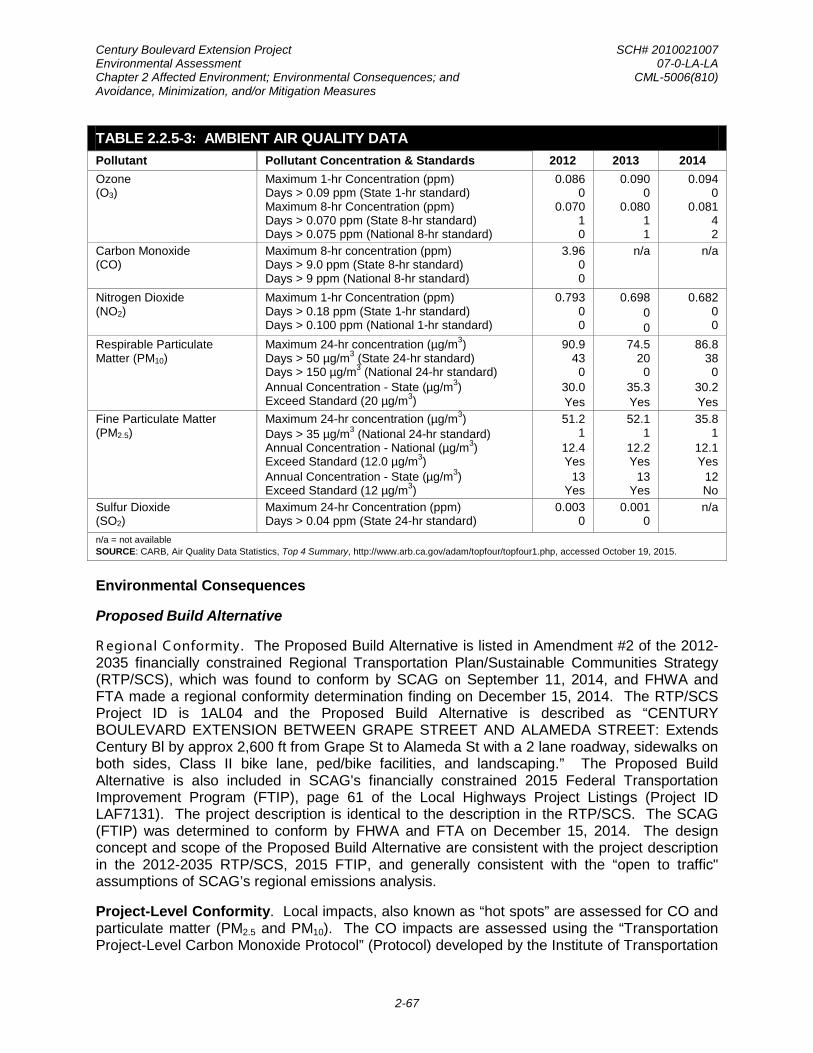
Century Boulevard Extension Project SCH# 2010021007 Environmental Assessment 07-0-LA-LA Chapter 2 Affected Environment; Environmental Consequences; and CML-5006(810) Avoidance, Minimization, and/or Mitigation Measures
2-67
TABLE 2.2.5-3: AMBIENT AIR QUALITY DATA Pollutant Pollutant Concentration & Standards 2012 2013 2014 Ozone (O3)
Maximum 1-hr Concentration (ppm) Days > 0.09 ppm (State 1-hr standard) Maximum 8-hr Concentration (ppm) Days > 0.070 ppm (State 8-hr standard) Days > 0.075 ppm (National 8-hr standard)
0.086 0
0.070 1 0
0.090 0
0.080 1 1
0.094 0
0.081 4 2
Carbon Monoxide (CO)
Maximum 8-hr concentration (ppm) Days > 9.0 ppm (State 8-hr standard) Days > 9 ppm (National 8-hr standard)
3.96 0 0
n/a
n/a
Nitrogen Dioxide (NO2)
Maximum 1-hr Concentration (ppm) Days > 0.18 ppm (State 1-hr standard) Days > 0.100 ppm (National 1-hr standard)
0.793 0 0
0.698 0 0
0.682 0 0
Respirable Particulate Matter (PM10)
Maximum 24-hr concentration (µg/m3) Days > 50 µg/m3 (State 24-hr standard) Days > 150 µg/m3 (National 24-hr standard) Annual Concentration - State (µg/m3) Exceed Standard (20 µg/m3)
90.9 43 0
30.0 Yes
74.5 20 0
35.3 Yes
86.8 38 0
30.2 Yes
Fine Particulate Matter (PM2.5)
Maximum 24-hr concentration (µg/m3) Days > 35 µg/m3 (National 24-hr standard) Annual Concentration - National (µg/m3) Exceed Standard (12.0 µg/m3) Annual Concentration - State (µg/m3) Exceed Standard (12 µg/m3)
51.2 1
12.4 Yes
13 Yes
52.1 1
12.2 Yes
13 Yes
35.8 1
12.1 Yes
12 No
Sulfur Dioxide (SO2)
Maximum 24-hr Concentration (ppm) Days > 0.04 ppm (State 24-hr standard)
0.003 0
0.001 0
n/a
n/a = not available SOURCE: CARB, Air Quality Data Statistics, Top 4 Summary, http://www.arb.ca.gov/adam/topfour/topfour1.php, accessed October 19, 2015.
Environmental Consequences
Proposed Build Alternative
R egional C onformity. The Proposed Build Alternative is listed in Amendment #2 of the 2012-2035 financially constrained Regional Transportation Plan/Sustainable Communities Strategy (RTP/SCS), which was found to conform by SCAG on September 11, 2014, and FHWA and FTA made a regional conformity determination finding on December 15, 2014. The RTP/SCS Project ID is 1AL04 and the Proposed Build Alternative is described as “CENTURY BOULEVARD EXTENSION BETWEEN GRAPE STREET AND ALAMEDA STREET: Extends Century Bl by approx 2,600 ft from Grape St to Alameda St with a 2 lane roadway, sidewalks on both sides, Class II bike lane, ped/bike facilities, and landscaping.” The Proposed Build Alternative is also included in SCAG's financially constrained 2015 Federal Transportation Improvement Program (FTIP), page 61 of the Local Highways Project Listings (Project ID LAF7131). The project description is identical to the description in the RTP/SCS. The SCAG (FTIP) was determined to conform by FHWA and FTA on December 15, 2014. The design concept and scope of the Proposed Build Alternative are consistent with the project description in the 2012-2035 RTP/SCS, 2015 FTIP, and generally consistent with the “open to traffic" assumptions of SCAG’s regional emissions analysis.
Project-Level Conformity. Local impacts, also known as “hot spots” are assessed for CO and particulate matter (PM2.5 and PM10). The CO impacts are assessed using the “Transportation Project-Level Carbon Monoxide Protocol” (Protocol) developed by the Institute of Transportation

Century Boulevard Extension Project SCH# 2010021007 Environmental Assessment 07-0-LA-LA Chapter 2 Affected Environment; Environmental Consequences; and CML-5006(810) Avoidance, Minimization, and/or Mitigation Measures
2-68
Studies at the University of California Davis for Caltrans. The protocol contains a series of flow charts with criteria to determine if the proposed project will result in local CO concentrations that exceed federal and California Ambient Air Quality Standards (CAAQS). A PM2.5 and PM10 hot-spot analysis is not required for projects that are not Projects of Air Quality Concern (POAQC). In the South Coast Air Basin, the SCAG Transportation Conformity Working Group (TCWG) makes the determination whether projects are, or are not, a POAQC. The details of the aforementioned local impact analyses regarding CO and particulate matter (PM2.5 and PM10) follow.
Carbon Monoxide (CO) Hot-Spots. Caltrans has developed a Transportation Project-Level Carbon Monoxide Protocol for assessing carbon monoxide impacts of transportation projects. The procedures and guidelines comply with the following regulations without imposing additional requirements: Section 176(c) of the 1990 FCAA Amendments, federal conformity rules, State and local adoptions of the federal conformity rules, and the CEQA requirements [California Code of Regulations Title 21 Section 1509.3(25)].
Two conformity-requirement decision flow charts are provided in the Transportation Project-Level Carbon Monoxide Protocol and are provided in the Air Quality Conformity Report. The flowcharts are included in the appendix. An explanatory discussion of the steps used to determine the conformity requirements that apply to the current project is provided below:
Is the project exempt from all emissions analyses? NO. The Proposed Build Alternative is a roadway extension project, which would not be exempt from regional emissions analysis per 40 CFR 93.126.
Is the project exempt from regional emissions analysis? NO. The Proposed Build Alternative is a roadway extension project, which would not be exempt from regional emissions analysis per 40 CFR 93.127.
Is the project locally defined as regionally significant? YES. The Proposed Build Alternative is included in the modeling for the 2012-2035 RTP/SCS and 2015 FTIP. The proposed project is defined as regionally significant.
Is the project in a federal attainment area? NO. The Proposed Build Alternative is located within an attainment/maintenance area for the federal CO standard as of June 11, 2007.
Is there a currently conforming RTP and FTIP? YES. The 2012-2035 RTP/SCS (Amendment #2) was found to conform by SCAG on September 11, 2014, and FHWA and FTA made a regional conformity determination finding on December 15, 2014 for the 2012-2035 RTP/SCS and the 2015 FTIP.
Is the project included in the regional emissions analysis supporting the currently conforming RTP and FTIP? YES. The design concept and scope is consistent with the project description in the 2012-2035 RTP/SCS, 2015 FTIP, and the open to traffic assumptions of the SCAG regional emissions analysis.
Has project design concept and/or scope changed significantly from that in regional analysis? NO. See previous response.

Century Boulevard Extension Project SCH# 2010021007 Environmental Assessment 07-0-LA-LA Chapter 2 Affected Environment; Environmental Consequences; and CML-5006(810) Avoidance, Minimization, and/or Mitigation Measures
2-69
Examine local impacts. Section 3.1.9 of the flowchart directs the project evaluation to Section 4 (Local Analysis) of the Transportation Project-Level Carbon Monoxide Protocol.
Assessment of the Proposed Build Alternative’s effect on localized ambient air quality is based on analysis of carbon monoxide. As stated in the Transportation Project-Level Carbon Monoxide Protocol, the determination of project-level carbon monoxide impacts should be carried out according to the local analysis. The following discussion provides explanatory remarks for every step of the local analysis of the protocol (screening methodology):
Is the project in a carbon monoxide nonattainment area? NO. The project site is located in a federal attainment/maintenance area as of June 11, 2007.
Was the area redesignated as “attainment” after the 1990 Clean Air Act? YES. See previous response.
Has "continued attainment" been verified with the local Air District, if appropriate? YES. Monitored CO concentrations in the project area were below the NAAQS for the latest three-year period (2013 to 2015).
Does the project worsen air quality? YES. The Proposed Build Alternative would add new roadway capacity and could worsen localized concentrations.
Is the project suspected of resulting in higher CO concentrations than those existing within the region at the time of the attainment demonstration?
The receptors at the Century Boulevard/Grape Street intersection would be the same distance or farther from the traveled roadway than the receptors at the Wilshire Boulevard/Veteran Avenue intersection for which attainment has been demonstrated. The attainment demonstration evaluated the CO concentrations at a distance of 3 meters (10 feet) from the edge of the roadways. Since the CO Protocol does not permit the modeling of receptor locations closer than 3 meters (10 feet), receptor locations for the Proposed Build Alternative would be the same or farther than the receptors evaluated for the attainment demonstration.
NO. To answer this question, Section 7.4.2 of the CO Protocol recommends selecting one of the worst-case locations in the region where attainment has been demonstrated and compare it to the build scenario of the project with a similar configuration. Therefore, the Wilshire Boulevard/Veteran Avenue intersection from the SCAQMD 2003 Air Quality Management Plan (AQMP) Appendix V attainment demonstration and the Century Boulevard/Grape Street intersection were compared to evaluate whether the Proposed Build Alternative would result in higher CO concentrations using the following conditions.
The Century Boulevard/Grape Street intersection would have lower traffic volumes when compared to the Wilshire Boulevard/Veteran Avenue intersection. The Century Boulevard/Grape Street intersection would be a 2x2 intersection in comparison to the Wilshire Boulevard/Veteran Avenue intersection, which is a 4x4 intersection. The traffic volumes are presented in Table 2.2.5-4.

Century Boulevard Extension Project SCH# 2010021007 Environmental Assessment 07-0-LA-LA Chapter 2 Affected Environment; Environmental Consequences; and CML-5006(810) Avoidance, Minimization, and/or Mitigation Measures
2-70
TABLE 2.2.5-4: INTERSECTION PEAK HOUR (PM) TRAFFIC LANE VOLUMES FOR THE CO HOT-SPOT ANALYSIS
Intersection
Peak-Hour Traffic Lane Volumes Total Volume Northbound Southbound Eastbound Westbound
Attainment Demonstration: Wilshire Blvd. and Veteran Ave. 467 700 517 829 2,513
No-Build (No-Action) Alternative (2017): Century Blvd. and Grape St. 126 107 96 14 343
Proposed Build Alternative (2017): Century Blvd. and Grape St. 266 128 389 269 1,052
No-Build (No-Action) Alternative (2035): Century Blvd. and Grape St. 136 116 104 16 371
Proposed Build Alternative (2035): Century Blvd. and Grape St. 276 137 397 271 1,080 SOURCE: SCAQMD, Modeling and Attainment Demonstrations for the Final 2003 Air Quality Management Plan, August 2003; Iteris, Jordan Downs Specific Plan Traffic Impact Study, September 2010.
The meteorology used for the Century Boulevard and Grape Street would be the same as the meteorology used for the Wilshire Boulevard/Veteran Avenue intersection in the attainment demonstration. The CAL3QHC model was used for the attainment demonstration. Therefore, if the Proposed Build Alternative were modeled, both intersections would be evaluated using the same meteorology settings in the CAL3QHC model, as the model only has one meteorological data set.
The peak hour traffic volumes presented in Table 2.2.5-4 show that the peak hour traffic lane volumes for Century Boulevard and Grape Street would be lower than the traffic volumes at the Wilshire Boulevard/Veteran Avenue intersection used in the attainment demonstration.
The number of vehicles operating in cold start mode was not available in the attainment demonstration for the Wilshire Boulevard/Veteran Avenue intersection. However, the percentage of vehicles operating during the peak hour in cold start mode for the Century Boulevard/Grape Street intersection would be expected to be the same or lower than Wilshire Boulevard/Veteran Avenue intersection.
The percentage of heavy-duty gas trucks utilizing the Century Boulevard/Grape Street intersection would be expected to be the same or less than the Wilshire Boulevard/Veteran Avenue intersection. It is assumed that the traffic distribution at the Wilshire Boulevard/Veteran Avenue intersection would not vary from the EMFAC2002 default distribution used for the attainment demonstration. The percentage of trucks would be expected to range from 1.0 to 2.4 percent under the Proposed Build Alternative, which would include both gasoline and diesel trucks. Therefore, the percentage of heavy-duty gas trucks would be expected to be less.
The average delay and queue length for the Century Boulevard/Grape Street intersection would be expected to be the same or less than the Wilshire Boulevard/Veteran Avenue intersection used for the attainment demonstration. The level of service (LOS) for the Wilshire Boulevard/ Veteran Avenue intersection used for

Century Boulevard Extension Project SCH# 2010021007 Environmental Assessment 07-0-LA-LA Chapter 2 Affected Environment; Environmental Consequences; and CML-5006(810) Avoidance, Minimization, and/or Mitigation Measures
2-71
the attainment demonstration was not listed; however, based on the traffic volumes and intersection geometry the intersection was likely LOS F. The average delay and queue length is not available for the Century Boulevard/Grape Street intersection. However, this intersection has less volume than the Wilshire Boulevard/Veteran Avenue intersection and could not have an LOS worse than F. Therefore, the average delay and queue length for would be expected to be the same or less than the Wilshire Boulevard/ Veteran Avenue intersection.
The background concentrations of CO in the project area are lower than the CO concentrations used in the attainment demonstration for the intersection of Wilshire Boulevard and Veteran Avenue. The maximum background 8-hour CO concentration measured between 2010 and 2014 at the Compton Monitoring Station, which represents the area in which the Century Boulevard and Grape Street intersection is located, was 3.96 parts per million. The maximum background 1-hour CO concentration is not available on the ARB database. According to the SCAQMD, 1-hour CO concentrations were last monitored in 2010 and the highest concentration near the Specific Plan area was 6 parts per million. This concentration is lower than the background concentrations used for the attainment demonstration, which were predicted to be 10.8 parts per million for the 1-hour measurements and 9.9 parts per million for the 8-hour measurements for the year 2002.
The evaluation of the above conditions has shown that the Century Boulevard and Grape Street intersection would not be expected to result in higher CO concentrations than the Wilshire Boulevard and Veteran Avenue intersection used for the attainment demonstrations. In addition, the SCAQMD 2003 AQMP Appendix V attainment demonstration indicated that in 1997 and 2002, 1-hour CO concentrations were considerably lower than the NAAQS and CAAQS (Table 2.2.5-5). The analysis was based on 1997 and 2002 traffic volumes and showed 38 to 45 percent reduction in concentrations between the two years. Therefore, according to the CO protocol, the Proposed Build Alternative is satisfactory, and no further analysis is needed. The Proposed Build Alternative would not be expected to create a CO hot-spot; therefore, the Proposed Build Alternative has demonstrated project level conformity for CO.

Century Boulevard Extension Project SCH# 2010021007 Environmental Assessment 07-0-LA-LA Chapter 2 Affected Environment; Environmental Consequences; and CML-5006(810) Avoidance, Minimization, and/or Mitigation Measures
2-72
TABLE 2.2.5-5: AVERAGE 1-HOUR CARBON MONOXIDE CONCENTRATIONS IN PPM AND TRAFFIC VOLUMES AT THE MOST CONGESTED INTERSECTIONS IN LOS ANGELES
Morning
/a/ Afternoon
/b/ Peak
/c/ Standard
Maximum One-Hour CO Concentration between
2010 and 2014 at the Downtown Los Angeles Monitoring Station /d/
1997 Wilshire Blvd. - Veteran Ave. /e/ 7.7 5.7 - 35 3 Sunset Blvd. - Highland Ave. /f/ 6.9 7.3 - 35 3 La Cienega Blvd. - Century Blvd. /g/ 6.4 5.2 - 35 3 Long Beach Blvd. - Imperial Hwy. /h/ 5.1 5.2 2.2 35 3 2002 Wilshire Blvd. - Veteran Ave. 4.6 3.5 - 35 3 Sunset Blvd. - Highland Ave. 4.0 4.5 - 35 3 La Cienega Blvd. - Century Blvd. 3.7 3.1 - 35 3 Long Beach Blvd. - Imperial Hwy. 3.0 3.1 1.2 35 3 /a/ Morning: 7-8 a.m. for, La Cienega - Century, 8-9 a.m. for Wilshire - Veteran, 7-8 a.m. for Long Beach - Imperial, and 8-9 a. m. for Sunset - Highland /b/ Afternoon: 3-4 p.m. for Sunset - Highland, 5-6 p.m. for Wilshire - Veteran, 4-5 p.m. and Long Beach - Imperial, and. 6-7 p.m. for and La Cienega - Century /c/ Peak: 11-12 p.m. (concentration at the hour of the observed peak). Peak is only provided for the Long Beach/Imperial intersection since it is intersection associated with the regional peak at Lynwood. /d/ The maximum background 1-hour CO concentration is not available on the ARB database. According the SCAQMD, 1-hour CO concentrations were last monitored in 2010 and the highest concentration in Los Angeles County was 3 parts per million. /e/ The most congested intersection in Los Angeles County. The average daily traffic volume is about 100,000 vehicles/day. /f/ One of the most congested intersections in the City of Los Angeles. The intersection study has been conducted and traffic data is available. /g/ One of the most congested intersections in the City of Los Angeles. The intersection study has been conducted and traffic data is available. /h/ The Lynwood Air Monitoring Station consistently records the highest 8-hour CO concentrations in the South Coast Air Basin each year. SOURCE: 2003 AQMP, Appendix V, Modeling and Attainment Demonstrations, page V-4-26.
PM10 and PM2.5 Hot-Spots. The project is located in Los Angeles County within the South Coast Air Basin, in an area designated as an attainment‐maintenance area (effective July 26, 2013) for PM10, but in nonattainment for PM2.5. Ambient levels of 24‐hour PM2.5 are higher at the project location than the standard, but the ambient levels of annual PM2.5 are measured lower than the standard. The Proposed Build Alternative is the extension of Century Boulevard through the Jordan Downs Specific Plan. The purpose of the extension is not to improve regional access to the roadway network or provide a locally significant through street but to provide the main thoroughfare for the Jordan Downs Specific Plan. Based on a qualitative assessment, the Proposed Build Alternative is not anticipated to result in new or worsened PM2.5 or PM10 violations. On August 25, 2015, the SCAG TCWG concurred that the Proposed Build Alternative would not be a POAQC and would not cause, contribute to, or increase the severity of, or exceedance of the NAAQS for PM2.5 or PM10. Therefore, the Proposed Build Alternative meets conformity requirements for the CFR Chapter 40, Section 93.116 and 93.123 for both PM2.5 or PM10 without the need for hot‐spot analyses.
Pursuant to 40 CFR Part 93, Caltrans requested a project-level conformity determination for the project. FHWA concurred with Caltrans’ determination that the project-level transportation conformity requirements of 40 CFR Part 93 have been met and finds that the project conforms

Century Boulevard Extension Project SCH# 2010021007 Environmental Assessment 07-0-LA-LA Chapter 2 Affected Environment; Environmental Consequences; and CML-5006(810) Avoidance, Minimization, and/or Mitigation Measures
2-73
with the SIP. This written concurrence was provided to Caltrans on January 26, 2016. The concurrence letter and Conformity Determination may be found in Appendix E of this environmental document.
Construction (Short-Term) Impacts and Conformity. During construction, short-term degradation of air quality may occur due to the release of particulate emissions (airborne dust) generated by excavation, grading, hauling, and other activities related to construction. Anticipated emissions from construction equipment may include carbon monoxide (CO), nitrous dioxide (NOx) volatile organic compounds (VOCs), directly-emitted particulate matter (PM10 and PM2.5), and toxic air contaminants, such as diesel exhaust particulate matter. Ozone is a regional pollutant that is derived from NOx and VOCs in the presence of sunlight and heat. Construction activities associated with the Proposed Build Alternative would be temporary in nature and would not require more than five years to complete; therefore, construction emissions are not considered for conformity purposes, or included in regional and project-level conformity analysis [40 CFR 93.123(c)(5)].
Site preparation and roadway construction would involve clearing, grading, and paving roadway surfaces. Construction-related effects on air quality would be greatest when multiple pieces of equipment are operating simultaneously and generating exhaust emissions. Construction activities could temporarily generate enough PM10, PM2.5, and small amounts of CO, sulfur dioxide (SO2), NOx, and VOCs to be of concern. Sources of fugitive dust would include disturbed soils at the construction site and trucks carrying uncovered loads of soils. Unless properly controlled, vehicles leaving the site could deposit mud on local streets, which could be an additional source of airborne dust after it dries. PM10 emissions would vary day-to-day, depending on the nature and magnitude of construction activity and local weather conditions. PM10 emissions would depend on soil moisture, silt content of soil, wind speed, and the amount of equipment operating. Larger dust particles would settle near the source, while fine particles would be dispersed over greater distances from the construction site.
The U.S. EPA estimates that construction activities for large development projects add 1.09 tonne (1.2 tons) of fugitive dust per acre of soil disturbed per month of activity. If water or other soil stabilizers are used to control dust, the emissions can be reduced by up to 50 percent. SCAQMD Rule 403 pertaining to dust minimization requires use of water or dust palliative compounds and will reduce potential fugitive dust emissions during construction.
In addition to fugitive dust emissions, heavy-duty trucks and construction equipment powered by gasoline and diesel engines would generate CO, SO2, NOx, VOCs and some soot particulate (PM10 and PM2.5) in exhaust emissions. If construction activities were to increase traffic congestion in the area, CO and other emissions from traffic would increase slightly while those vehicles are delayed. These emissions would be temporary and limited to the immediate area surround the construction site. In order to minimize the temporary exhaust emissions from the heavy-duty trucks and construction equipment adjacent to certain sensitive receptors, certain construction activities (e.g., extended idling, material storage, and equipment maintenance) would need to be conducted in areas at least 500 feet away from those sensitive receptors.
SO2 is generated by oxidation during combustion of organic sulfur compounds contained in diesel fuel. Off-road diesel fuel meeting Federal standards can contain 300 parts per million (ppm) or more of sulfur, whereas on-road diesel is restricted to less than 15 ppm of sulfur. However, under ARB regulations, off-road diesel fuel used in California must meet the same sulfur and other standards as on-road diesel fuel (not more than 15 ppm sulfur), thus SO2-

Century Boulevard Extension Project SCH# 2010021007 Environmental Assessment 07-0-LA-LA Chapter 2 Affected Environment; Environmental Consequences; and CML-5006(810) Avoidance, Minimization, and/or Mitigation Measures
2-74
related issues due to diesel exhaust is expected to be minimal. Some phases of construction, particularly asphalt paving, would result in short-term odors in the immediate area of each paving site(s). Such odors would be quickly dispersed below detectable thresholds as distance from the site(s) increases.
Construction activity would involve 3,700 cubic yards of cut and 8,100 cubic yards of fill materials. Construction of the proposed roadway extension, including staging and storage areas, would be contained within the roadway right-of-way, and, therefore, no temporary construction easements would be required. Construction duration is estimated to extend up to 12 months beginning in 2016. Emissions were estimated using the Sacramento Metropolitan Air Quality Management District’s Roadway Construction Emissions Model (RoadMod). RoadMod is specifically developed to estimate emissions associated with roadway construction projects since the default equipment, activities, and typical phasing are different than those of land use development projects and building construction projects. The methodologies and assumptions used in RoadMod are appropriate for road construction projects, including new road construction, road widening and bridge or overpass construction. Table 2.2.5-6 shows the estimated emissions associated with each construction phase. The emissions were estimated using RoadMod and the assumptions listed in the methodology discussion. Limited detailed construction information was available at the time of this analysis; therefore, the analysis relies on RoadMod default assumptions, including the fleet mix.
TABLE 2.2.5-6: CONSTRUCTION EMISSIONS
Activities Pounds Per Day
VOC NOX CO PM2.5 PM10 Grubbing/Land Clearing 1.2 14.8 8.0 3.7 15.6 Grading/Excavation 14.3 93.5 40.9 6.7 19.1 Drainage/Utilities 6.8 67.7 34.7 6.4 18.6 Paving 2.7 24.0 14.9 1.5 1.6 Total (tons/project) 1.1 8.7 4.2 0.7 2.1 SOURCE: Roadway Construction Emissions Model.
Naturally Occurring Asbestos (NOA). Asbestos is a term used for several types of naturally occurring fibrous minerals that are a human health hazard when airborne. The most common type of asbestos is chrysotile, but other types, such as tremolite and actinolite, are also found in California. Asbestos is classified as a known human carcinogen by state, federal, and international agencies and was identified as a toxic air disease and cancer.
Asbestos can be released from serpentinite and ultramafic rocks when the rock is broken or crushed. At the point of release, the asbestos fibers may become airborne, causing air quality and human health hazards. These rocks have been commonly used for unpaved gravel roads, landscaping, fill projects and other improvement projects in some localities. Asbestos may be released into the atmosphere due to vehicular traffic on unpaved roads, during grading for development projects, and at quarry operations. All of these activities may have the effect of releasing potentially harmful asbestos into the air. Natural weathering and erosion processes can act on asbestos bearing rock and make it easier for asbestos fibers to become airborne if such rock is disturbed. Serpentinite may contain chrysotile asbestos, especially near fault zones. Ultramafic rock, a rock closely related to serpentinite, may also contain asbestos minerals.

Century Boulevard Extension Project SCH# 2010021007 Environmental Assessment 07-0-LA-LA Chapter 2 Affected Environment; Environmental Consequences; and CML-5006(810) Avoidance, Minimization, and/or Mitigation Measures
2-75
Asbestos can also be associated with other rock types in California, though much less frequently than serpentinite and/or ultramafic rock. Serpentinite and/or ultramafic rock are known to be present in 44 of California's 58 counties. These rocks are particularly abundant in the counties of the Sierra Nevada foothills, the Klamath Mountains, and Coast Ranges. The California Department of Conservation, Division of Mines and Geology have developed a map of the state showing the general location of ultramafic rock in the state. Los Angeles County is one of the Counties identified as one of the Counties containing serpentinite and ultramafic rock. However, only the Catalina Island portion of Los Angeles County has been found to contain such rock; hence, it is not anticipated to be found in the project area. Therefore, no potential impacts from naturally occurring asbestos during project construction would occur.
Structural Occurring Asbestos. Site clearance for the Century Boulevard Extension would not include demolition of structures associated with the Jordan Downs public house complex. Therefore, no potential impacts from structural asbestos during project construction would occur.
Occurrence of Lead (Pb). Lead is not typically an air quality issue for transportation projects unless the project involves disturbance of soils containing high levels of Aerially Deposited Lead (ADL), or painting or modification of structures with lead‐based coatings. High levels of lead have been identified on the project site during soil sampling. The project site is currently undergoing site remediation. For additional information on this topic, please see Section 2.2.4 Hazardous Waste/Materials.
Mobile Source Air Toxics (MSATs). In addition to the criteria air pollutants for which there are NAAQS, the U.S. EPA also regulates air toxics. Most air toxics originate from human‐made sources, include on‐road mobile sources, non‐road mobile sources (e.g., airplanes), area sources (e.g., dry cleaners) and stationary sources (e.g., factories or refineries).
MSATs are a subset of the 188 air toxics defined by the FCAA. The MSATs are compounds emitted from highway vehicles and non‐road equipment. Some toxic compounds are present in fuel and are emitted to the air when the fuel evaporates or passes through the engine unburned. Other toxics are emitted from the incomplete combustion of fuels or as secondary combustion products. Metal air toxics also result from engine wear or from impurities in oil or gasoline. In the U.S. EPA’s latest final rule on the control of hazardous air pollutants from mobile sources, 93 compounds were identified, and from this list, seven in particular, were identified as priority MSATs; Acrolein (C3H4O), Benzene (C6H6), 1,3 – Butadiene (C4H6), DPM plus diesel exhaust organic gases (DEOG), Formaldehyde (CH2O), Naphthalene (C10H8), and Polycyclic Organic Matter (POM).
Due to the emerging state of the MSAT‐related science and techniques, there are no established criteria for determining the relative significance of air toxics emissions. Given the state, however, the FHWA, in its updated Interim Guidance published in December 2012, recommends a range of options deemed appropriate for addressing and documenting the MSAT issue in NEPA documents:
No analysis required for projects with no potential for meaningful MSAT effects—Applicable for categorically excluded projects under CFR Chapter 23, Section 771.117(c); exempt projects under CFR Chapter 40, Section 93.126; or projects with no meaningful impacts on traffic volumes or vehicle mix.

Century Boulevard Extension Project SCH# 2010021007 Environmental Assessment 07-0-LA-LA Chapter 2 Affected Environment; Environmental Consequences; and CML-5006(810) Avoidance, Minimization, and/or Mitigation Measures
2-76
Qualitative analysis required for projects with low potential MSA effects—Projects that serve to improve operations of highway, transit, or freight without adding substantial new capacity or without creating a facility that is likely to meaningfully increase emissions.
Quantitative analysis for project that have the potential for meaningful differences in MSAT emissions among project alternatives. In order to fall into this category, a project should:
• Create or significantly alter a major intermodal freight facility that has the potential to concentrate high levels of diesel particulate matter in a single location, involving a significant number of diesel vehicles for new projects or accommodating with a significant increase in the number of diesel vehicles for expansion projects; or
• Create new capacity or add significant capacity to urban highways such as interstates, urban arterials, or urban collector‐distributor routes with traffic volumes where the Annual Average Daily Traffic (AADT) is projected to be in the range of 140,000 to 150,000 or greater by the design year; and also
• Proposed to be located in proximity to populated areas.
The scope of the Proposed Build Alternative is to extend Century Boulevard through Specific Plan area. This would add new capacity to the roadway network although the capacity of the two-lane roadway would be well below the 140,000 AADT benchmark for a quantitative analysis. It is anticipated that the AADT volume on Century Boulevard would be approximately 5,880 vehicles in 2035.37
The No-Build (No-Action) Alternative does not include a Century Boulevard connection through the Specific Plan area. For the Proposed Build Alternative, the amount of MSAT emitted would be proportional to the vehicle miles traveled (VMT), assuming that other variables such as fleet mix are the same for each alternative. The Proposed Build Alternative would include approximately 2,940 VMT per day where there is not an existing road. This increase in VMT would lead to higher MSAT emissions for the Proposed Build Alternative along Century Boulevard, along with a corresponding decrease in MSAT emissions along the parallel routes. Century Boulevard through the Specific Plan area would be lined with residences. Residences and schools are located adjacent to the roadway along the parallel routes. The emissions increase within the Specific Plan area is offset somewhat by lower MSAT emission rates due to increased speeds; according to U.S. EPA's MOVES2010b model, emissions of all of the priority MSAT decrease as speed increases. Also, emissions will likely be lower than present levels in the design year as a result of U.S. EPA's national control programs that are projected to reduce annual MSAT emissions by over 80 percent between 2010 and 2050. Local conditions may differ from these national projections in terms of fleet mix and turnover, VMT growth rates, and local control measures. However, the magnitude of the U.S. EPA-projected reductions is so great (even after accounting for VMT growth) that MSAT emissions in the study area are likely to be lower in the future in nearly all cases.
Therefore, a qualitative analysis was performed and derived in part from a study conducted by the FHWA entitled, “A Methodology for Evaluating Mobile Source Air Toxic Emissions Among Transportation Project Alternatives,” which provided a basis for identifying and comparing the potential differences among MSAT emissions, if any, from the alternatives.
37Iteris, Jordan Downs Specific Plan Traffic Impact Study, September 2010.

Century Boulevard Extension Project SCH# 2010021007 Environmental Assessment 07-0-LA-LA Chapter 2 Affected Environment; Environmental Consequences; and CML-5006(810) Avoidance, Minimization, and/or Mitigation Measures
2-77
Incomplete or Unavailable Information for Project Specific MSAT Impacts Analysis. In FHWA’s view, information is incomplete or unavailable to credibly predict the project‐specific health impacts due to changes in MSAT emissions associated with a proposed set of highway alternatives. The outcome of such an assessment, adverse or not, would be influenced more by the uncertainty introduced into the process through assumption and speculation rather than any genuine insight into the actual health impacts directly attributable to MSAT exposure associated with a proposed action.
The U.S. EPA is responsible for protecting the public health and welfare from any known or anticipated effect of an air pollutant. They are the lead authority for administering the CAA and its amendments and have specific statutory obligations with respect to hazardous air pollutants and MSAT. The U.S. EPA is in the continual process of assessing human health effects, exposures, and risks posed by air pollutants. They maintain the IRIS, which is “a compilation of electronic reports on specific substances found in the environment and their potential to cause human health effects” (U.S. EPA, https://www.epa.gov/iris/). Each report contains assessments of non‐cancerous and cancerous effects for individual compounds and quantitative estimates of risk levels from lifetime oral and inhalation exposures with uncertainty spanning perhaps an order of magnitude.
Other organizations are also active in the research and analyses of the human health effects of MSAT, including the Health Effects Institute (HEI). Two HEI studies are summarized in Appendix D of FHWA’s Interim Guidance Update on Mobile source Air Toxic Analysis in NEPA Documents. Among the adverse health effects linked to MSAT compounds at high exposures are; cancer in humans in occupational settings; cancer in animals; and irritation to the respiratory tract, including the exacerbation of asthma. Less obvious is the adverse human health effects of MSAT compounds at current environmental concentrations (HEI, http://pubs.healtheffects.org/view.php?id=282) or in the future as vehicle emissions substantially decrease (HEI, http://pubs.healtheffects.org/view.php?id=306).
The methodologies for forecasting health impacts include emissions modeling; dispersion modeling; exposure modeling; and then final determination of health impacts – each step in the process building on the model predictions obtained in the previous step. All are encumbered by technical shortcomings or uncertain science that prevents a more complete differentiation of the MSAT health impacts among a set of project alternatives. These difficulties are magnified for lifetime (i.e., 70 year) assessments, particularly because unsupportable assumptions would have to be made regarding changes in travel patterns and vehicle technology (which affects emissions rates) over that time frame, since such information is unavailable.
It is particularly difficult to reliably forecast 70‐year lifetime MSAT concentrations and exposure near roadways; to determine the portion of time that people are actually exposed at a specific location; and to establish the extent attributable to a proposed action, especially given that some of the information needed is unavailable.
There are considerable uncertainties associated with the existing estimates of toxicity of the various MSAT, because of factors such as low‐dose extrapolation and translation of occupational exposure data to the general population, a concern expressed by HEI (http://pubs.healtheffects.org/view.php?id=282). As a result, there is no national consensus on air dose‐response values assumed to protect the public health and welfare for MSAT compounds, and in particular for diesel PM. The U.S. EPA (http://www.epa.gov/risk/

Century Boulevard Extension Project SCH# 2010021007 Environmental Assessment 07-0-LA-LA Chapter 2 Affected Environment; Environmental Consequences; and CML-5006(810) Avoidance, Minimization, and/or Mitigation Measures
2-78
basicinformation.htm#g) and the HEI (http://pubs.healtheffects.org/getfile.php?u=395) have not established a basis for quantitative risk assessment of diesel PM in ambient settings.
There is also the lack of a national consensus on an acceptable level of risk. The current context is the process used by the U.S. EPA as provided by the CAA to determine whether more stringent controls are required in order to provide an ample margin of safety to protect public health or to prevent an adverse environmental effect for industrial sources subject to the maximum achievable control technology standards, such as benzene emissions from refineries. The decision framework is a two‐step process. The first step requires U.S. EPA to determine an “acceptable” level of risk due to emissions from a source, which is generally no greater than approximately 100 in a million. Additional factors are considered in the second step, the goal of which is to maximize the number of people with risks less than 1 in a million due to emissions from a source. The results of this statutory two‐step process do not guarantee that cancer risks from exposure to air toxics are less than 1 in a million; in some cases, the residual risk determination could result in maximum individual cancer risks that are as high as approximately 100 in a million. In a June 2008 decision, the U.S. Court of Appeals for the District of Columbia Circuit upheld U.S. EPA’s approach to addressing risk in its two step decision framework. Information is incomplete or unavailable to establish that even the largest of highway projects would result in levels of risk greater than deemed acceptable.
Because of the limitations in the methodologies for forecasting health impacts described, any predicted difference in health impacts between alternatives is likely to be much smaller than the uncertainties associated with predicting the impacts. Consequently, the results of such assessments would not be useful to decision makers, who would need to weigh this information against project benefits, such as reducing traffic congestion, accident rates, and fatalities plus improved access for emergency response, that are better suited for quantitative analysis.
No-Build (No-Action) Alternative
The No-Build (No-Action) Alternative would not include construction emissions or a new roadway that would support vehicle exhaust emissions. There would be no change to the existing roadway-related emissions in the Specific Plan area. The No-Build (No-Action) Alternative would result in less emissions than the Proposed Build Alternative, and, similar to the Proposed Build Alternative, would not result in adverse effects.
Cumulative Impacts
Construction‐produced emissions in combination with the same emissions from any related projects or projects of concern that are occurring concurrently have the potential to create short‐term, cumulative impacts to local air quality although they would be temporary in nature, and would be minimized by complying with SCAQMD rules and regulations during construction. Under CFR 93.123(c)(5), temporary increases in emissions are those occurring no more than five years in a specific site. Regarding operational emissions, the purpose of the Century Boulevard Extension is to promote growth with smart, sustainable infill development and infrastructure investments. The Proposed Build Alternative would create a pedestrian-oriented, regional retail destination not currently available in the area. It would create a safe and inviting neighborhood that promotes reduced vehicle usage through improved walk-ability and transportation efficiency. The purpose of the extension is not to improve regional access to the

Century Boulevard Extension Project SCH# 2010021007 Environmental Assessment 07-0-LA-LA Chapter 2 Affected Environment; Environmental Consequences; and CML-5006(810) Avoidance, Minimization, and/or Mitigation Measures
2-79
roadway network or provide a locally significant through street. The Proposed Build Alternative would not contribute to a cumulative impact.
Avoidance, Minimization, and/or Mitigation Measures
Most of the construction impacts to air quality are short-term in duration and, therefore, will not result in long-term adverse conditions. Implementation of the following measures, some of which may also be required for other purposes such as storm water pollution control, will reduce any temporary effects of construction on local air quality:
AQ1: Apply water or dust palliative to the site and equipment as frequently as necessary to control fugitive dust emissions. Fugitive emissions generally must meet a “no visible dust” criterion either at the point of emission or at the right of way line as required by the SCAQMD.
AQ2: Spread soil binder on any unpaved roads used for construction purposes, and all project construction parking areas.
AQ3: Properly tune and maintain construction equipment and vehicles. Use low-sulfur fuel in all construction equipment as provided in California Code of Regulations Title 17, Section 93114.
AQ4: Develop a dust control plan documenting sprinkling, temporary paving, speed limits, and expedited revegetation as needed to minimize construction impacts to existing communities.
AQ5: Locate equipment and materials storage sites at least 500 feet from the sensitive receptors. Keep construction areas clean and orderly.
AQ6: Extended idling, material storage, and equipment maintenance should be prohibited within 500 feet of sensitive air receptors, to the extent feasible.
AQ7: Use track-out reduction measures such as gravel pads at project access points to minimize dust and mud deposits on roads affected by construction traffic.
AQ8: Cover all transported loads of soils and wet materials prior to transport, or provide adequate freeboard (space from the top of the material to the top of the truck) to minimize emission of dust (particulate matter) during transportation.
AQ9: Promptly and regularly remove dust and mud that are deposited on paved, public roads due to construction activity and traffic to decrease particulate matter.
AQ10: Route and schedule construction traffic to avoid peak travel times as much as possible, to reduce congestion and related air quality impacts caused by idling vehicles along local roads.
Minimization of PM10 During Construction and South Coast Air Quality Management District (SCAQMD) Rules. The SCAQMD adopts rules and regulations to implement portions of the Air Quality Management Plan (AQMP), which aims to control pollution from all sources, including stationary sources, area sources, and on-road and offroad mobile sources. Several of these rules may apply to construction or operation of the propose project. The most pertinent SCAQMD rules applicable to the proposed project are:

Century Boulevard Extension Project SCH# 2010021007 Environmental Assessment 07-0-LA-LA Chapter 2 Affected Environment; Environmental Consequences; and CML-5006(810) Avoidance, Minimization, and/or Mitigation Measures
2-80
AQ11: Rule 401 – Visible Emissions: A person shall not discharge into the atmosphere from any single source of emission whatsoever any air contaminants for a period or periods aggregating more than three (3) minutes in any one (1) hour which are as dark or darker in shade as that designated as No. 1 on the Ringelmann Chart or of such opacity as to obscure an observer’s view to a degree equal to or greater than smoke.
AQ12: Rule 402 – Nuisance: A person shall not discharge from any source whatsoever such quantities of air contaminants or other material which cause injury, detriment, nuisance or annoyance to any considerable number of persons or to the public or which endangers the comfort, repose, health or safety of any such persons or the public or which cause or have a natural tendency to cause injury or damage to business or property.
AQ13: Rule 403 – Fugitive Dust: SCAQMD’s Rule 403 requires that fugitive dust be controlled with the best available control measures (BACM) in order to reduce dust so that it does not remain visible in the atmosphere beyond the property line of the proposed project. It also requires a dust control plan to be submitted and approved prior to construction. The dust control plan should describe all applicable dust control measures that will be implemented at the project; and should describe types of dust suppressant, surface treatments and other measures to be utilized at the construction sites to comply with the Rule. The relevant specifics of Rule 403 are as follows:
o No person shall cause or allow the emissions of fugitive dust from any active operation, open storage pile, or disturbed surface area such that the dust remains visible in the atmosphere beyond the property line of the emission source; or the dust emission exceeds 20 percent opacity, if the dust emission is the result of movement of a motorized vehicle.
o No person shall conduct active operations without utilizing the applicable best available control measures included in Table 1 of Rule 403 to minimize fugitive dust emissions from each fugitive dust source type within the active operation.
o No person shall cause or allow PM10 levels to exceed 50 micrograms per cubic meter when determined, by simultaneous sampling, as the difference between upwind and downwind samples collected on high-volume particulate matter samplers or other U.S. EPA-approved equivalent method for PM10 monitoring.
o No person shall allow track-out to extend 25 feet or more in cumulative length from the point of origin from an active operation. Notwithstanding the preceding, all track-out from an active operation shall be removed at the conclusion of each workday or evening shift.
o No person shall conduct an active operation with a disturbed surface area of five or more acres or with a daily import or export of 100 cubic yards or more of bulk material without utilizing approved control measure/measures at each vehicle egress from the site to a paved public road.
2.2.6 NOISE
Regulatory Setting
The National Environmental Policy Act (NEPA) of 1969 provides the broad basis for analyzing and abating highway traffic noise effects. The intent of this law is to promote the general
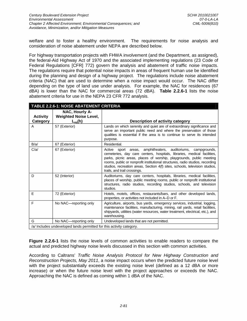
Century Boulevard Extension Project SCH# 2010021007 Environmental Assessment 07-0-LA-LA Chapter 2 Affected Environment; Environmental Consequences; and CML-5006(810) Avoidance, Minimization, and/or Mitigation Measures
2-81
welfare and to foster a healthy environment. The requirements for noise analysis and consideration of noise abatement under NEPA are described below.
For highway transportation projects with FHWA involvement (and the Department, as assigned), the federal-Aid Highway Act of 1970 and the associated implementing regulations (23 Code of Federal Regulations [CFR] 772) govern the analysis and abatement of traffic noise impacts. The regulations require that potential noise impacts in areas of frequent human use be identified during the planning and design of a highway project. The regulations include noise abatement criteria (NAC) that are used to determine when a noise impact would occur. The NAC differ depending on the type of land use under analysis. For example, the NAC for residences (67 dBA) is lower than the NAC for commercial areas (72 dBA). Table 2.2.6-1 lists the noise abatement criteria for use in the NEPA 23 CFR 772 analysis.
TABLE 2.2.6-1: NOISE ABATEMENT CRITERIA
Activity Category
NAC, Hourly A- Weighted Noise Level,
Leq(h) Description of activity category A 57 (Exterior) Lands on which serenity and quiet are of extraordinary significance and
serve an important public need and where the preservation of those qualities is essential if the area is to continue to serve its intended purpose.
B/a/ 67 (Exterior) Residential. C/a/ 67 (Exterior) Active sport areas, amphitheaters, auditoriums, campgrounds,
cemeteries, day care centers, hospitals, libraries, medical facilities, parks, picnic areas, places of worship, playgrounds, public meeting rooms, public or nonprofit institutional structures, radio studios, recording studios, recreation areas, Section 4(f) sites, schools, television studios, trails, and trail crossings.
D 52 (Interior) Auditoriums, day care centers, hospitals, libraries, medical facilities, places of worship, public meeting rooms, public or nonprofit institutional structures, radio studios, recording studios, schools, and television studios.
E 72 (Exterior) Hotels, motels, offices, restaurants/bars, and other developed lands, properties, or activities not included in A–D or F.
F No NAC—reporting only Agriculture, airports, bus yards, emergency services, industrial, logging, maintenance facilities, manufacturing, mining, rail yards, retail facilities, shipyards, utilities (water resources, water treatment, electrical, etc.), and warehousing.
G No NAC—reporting only Undeveloped lands that are not permitted. /a/ Includes undeveloped lands permitted for this activity category.
Figure 2.2.6-1 lists the noise levels of common activities to enable readers to compare the actual and predicted highway noise levels discussed in this section with common activities.
According to Caltrans’ Traffic Noise Analysis Protocol for New Highway Construction and Reconstruction Projects, May 2011, a noise impact occurs when the predicted future noise level with the project substantially exceeds the existing noise level (defined as a 12 dBA or more increase) or when the future noise level with the project approaches or exceeds the NAC. Approaching the NAC is defined as coming within 1 dBA of the NAC.

Century Boulevard Extension Project SCH# 2010021007 Environmental Assessment 07-0-LA-LA Chapter 2 Affected Environment; Environmental Consequences; and CML-5006(810) Avoidance, Minimization, and/or Mitigation Measures
2-82
Environmental AssessmentCentury Boulevard Extension FIGURE 2.2.6-1
NOISE LEVELS OF COMMON ACTIVITIES
SOURCE: TAHA, 2015.

Century Boulevard Extension Project SCH# 2010021007 Environmental Assessment 07-0-LA-LA Chapter 2 Affected Environment; Environmental Consequences; and CML-5006(810) Avoidance, Minimization, and/or Mitigation Measures
2-83
If it is determined that the project will have noise impacts, then potential abatement measures must be considered. Noise abatement measures that are determined to be reasonable and feasible at the time of final design are incorporated into the project plans and specifications. The analysis below discusses noise abatement measures that would likely be incorporated in the project.
Caltrans’ Traffic Noise Analysis Protocol sets forth the criteria for determining when an abatement measure is reasonable and feasible. Feasibility of noise abatement is basically an engineering concern. A minimum of 7 dBA in the future noise level must be achieved for an abatement measure to be considered feasible. Other considerations include topography, access requirements, other noise sources and safety considerations. The reasonableness determination is basically a cost-benefit analysis. Factors used in determining whether a proposed noise abatement measure is reasonable include residents’ acceptance and the cost per benefited residence.
Affected Environment
A field investigation was conducted to identify land uses that could potentially be affected by the proposed project, with the results incorporated in the Noise Study Report for the Century Boulevard Extension Project completed in October 2015. The following technical information has been excerpted from this report.
The urban environment surrounding the JDUV Specific Plan area is characterized by residential, recreational, institutional, and industrial land uses. Existing sources of noise include rail traffic within the Alameda Corridor and general industrial noise located on the eastern portion of the JDUV Specific Plan area. Typical urban noise sources include sirens, people (e.g., music, yelling/loud talking), and motorized vehicle traffic.
Existing land uses in the project area were categorized by Activity Category as defined in Table 2.2.6-1. Although all developed land uses were evaluated in the analysis, special consideration was given to locations of frequent human use that would benefit from a lowered noise level. The following areas, as shown in Figure 2.2.6-2, were identified as modeling receivers and characterized based on activity categories in Table 2.2.6-1:
• Area A: Future residences located to the north of the proposed Century Boulevard extension within the boundaries of the JDUV Specific Plan area (Activity Category “A”);
• Area B: Future residences located to the south of the proposed Century Boulevard extension within the boundaries of the JDUV Specific Plan area (Activity Category “B”);
• Area C: David Starr Jordan High School located approximately 150 feet to the south of the proposed Century Boulevard extension within the boundaries of the JDUV Specific Plan area (Activity Category “C”);
• Area D: Future recreational area located along the proposed Century Boulevard extension within the boundaries of the JDUV Specific Plan area (Activity Category “D”); and
• Area E: Future Central Park located along the proposed Century Boulevard extension within the boundaries of the JDUV Specific Plan area (Activity Category “E”).

Century Boulevard Extension Project SCH# 2010021007 Environmental Assessment 07-0-LA-LA Chapter 2 Affected Environment; Environmental Consequences; and CML-5006(810) Avoidance, Minimization, and/or Mitigation Measures
2-84
F
H
CENTURY BLVD
ALA
ME
DA
ST
103RD ST
A
B
E
I
G
C
TWEEDY BLVDD
Environmental AssessmentCentury Boulevard Extension FIGURE 2.2.6-2
LOCATION OF RECEPTORS
Proposed Century Boulevard Extension
Analysis Areas
LEGEND:
SOURCE: TAHA, 2015.
GR
AP
E S
TG
RA
PE
ST
97TH ST97TH ST
5

Century Boulevard Extension Project SCH# 2010021007 Environmental Assessment 07-0-LA-LA Chapter 2 Affected Environment; Environmental Consequences; and CML-5006(810) Avoidance, Minimization, and/or Mitigation Measures
2-85
Existing land uses located outside of the JDUV Specific Plan area include the following:
• Area F: Residences located along Century Boulevard (Activity Category “F”);
• Area G: Residences located along Century Boulevard (Activity Category “G”);
• Area H: Southeast Middle and High Schools located along Tweedy Boulevard (Activity Category “H”);
• Area I: Residences located along Tweedy Boulevard on the north side (Activity Category “I”);
A secure 24-hour location could not be identified in the project areas. Therefore, measurements were taken over a 15-minute period at each location during the time of day that could be considered as a peak noise hour. Existing noise level ranged from 52.0 dBA near David Starr Jordan High School to 65.2 dBA along Tweedy Boulevard near Southeast High School.
Environmental Consequences
Proposed Build Alternative
Temporary Impacts. During construction of the project, noise from construction activities may intermittently dominate the noise environment in the immediate area of construction. Construction noise is controlled by applicable local, state, and federal regulations. Construction equipment is expected to generate noise levels ranging from 70 to 90 dB at a distance of 50 feet, and noise produced by construction equipment would be reduced over distance at a rate of about 6 dB per doubling of distance. No adverse noise impacts from construction are anticipated because construction would be conducted in accordance with Best Management Practices identified under Avoidance, Minimization, and/or Abatement Measures below. Construction noise would be short-term, intermittent, and overshadowed by local traffic noise.
Permanent Impacts. Under 23 CFR 772.7, projects are categorized as Type I, Type II project, or Type III projects. FHWA defines a Type I project as a proposed federal or federal‐aid highway project for the construction of a highway on a new location, or the physical alteration of an existing highway which significantly changes either the horizontal or vertical alignment, or increases the number of through‐traffic lanes. This project has been identified as a Type I project due to the new alignment. As such, a traffic noise analysis has been conducted for the Proposed Build Alternative in accordance with the Protocol for Type I projects.
The traffic noise modeling results are shown in Table 2.2.6-2. Traffic noise levels at residences in Areas A, B, F, G, and I would range from 57 to 65 dBA Leq(h) in the design-year. The increase in noise from the No-Build (No-Action) Alternative would be 3 dBA for Areas A and B and 6 dBA for Areas F and G. Area I would not experience an increase in noise levels. No traffic noise impacts would occur at the recreational areas because the predicted design-year noise level does not approach or exceed the 67 dBA Leq(h) NAC. Therefore, noise abatement is not required to reduce the noise to the level that existed prior to construction of the Proposed Build Alternative.

Century Boulevard Extension Project SCH# 2010021007 Environmental Assessment 07-0-LA-LA Chapter 2 Affected Environment; Environmental Consequences; and CML-5006(810) Avoidance, Minimization, and/or Mitigation Measures
2-86
Traffic noise levels at recreational land uses located in Areas D and E would be 59 dBA Leq(h) and 61 dBA Leq(h), respectively, and that the increase in noise would be 3 dBA or less compared to the No-Build (No-Action) Alternative. No traffic noise impacts would occur at the recreational areas because the predicted design-year noise level would not approach or exceed the 67 dBA Leq(h) NAC. Therefore, noise abatement is not required to reduce the noise to the level that existed prior to construction of the Proposed Build Alternative.
Schools close enough to the roadway to potentially experience noise impacts include David Starr Jordan High School (Area C) and Southeast Middle and High Schools (Area H). Traffic noise levels would be 52 dBA Leq(h) in Area C and 62 dBA Leq(h) in Area H. Interior noise in Areas C and H due to vehicular noise from Century Boulevard would be 32 and 42 dBA Leq(h), respectively. Noise levels would not exceed the 67 dBA Leq(h) exterior NAC or 52 dBA Leq(h) interior NAC. Therefore, noise abatement is not required to reduce the noise to the level that existed prior to construction of the Proposed Build Alternative.
No-Build (No-Action) Alternative
The No-Build (No-Action) Alternative assumes that Century Boulevard would not be extended through the Specific Plan area. Therefore, no change in traffic noise levels would occur. However, the No-Build (No-Action) Alternative would not preclude the implementation of the JDUV Specific Plan, which consists of up to 1,800 newly-built homes, 7.2 acres of commercial use, as well as 9 acres of public parks and open space in the Specific Plan area. Mitigation measures identified for the implementation of the JDUV Specific Plan would ensure that no adverse impacts related to operational noise would occur.
TABLE 2.2.6-2: PREDICTED FUTURE NOISE AND BARRIER ANALYSIS
Receptor Area and Location
Existing Noise Level (dBA)
Predicted Noise Level w/o Project
(dBA)
Predicted Noise Level w/ Project
(dBA)
Noise Impact Requiring Abatement
Consideration
Predicted Noise Level with
Abatement (dBA) Reasonable and Feasible
6-ft Wall
9-ft Wall
12-ft Wall
Area A - Residential 58 58 61 No – – – – Area B - Residential 58 58 57 No – – – – Area C - David Starr Jordan High School 58 58 52 No – – – –
Area C - David Starr Jordan High School 38 38 32 No – – – –
Area D - Freedom Tree Park 58 58 59 No – – – –
Area E - Central Park 58 58 61 No – – – – Area F - Residential 59 59 65 No – – – – Area G - Residential 58 58 64 No – – – – Area H - Southeast Middle and High Schools
62 62 62 No – – – –
Area H - Southeast Middle and High Schools
42 42 42 No – – – –
Area I - Residential 62 62 62 No – – – –

Century Boulevard Extension Project SCH# 2010021007 Environmental Assessment 07-0-LA-LA Chapter 2 Affected Environment; Environmental Consequences; and CML-5006(810) Avoidance, Minimization, and/or Mitigation Measures
2-87
Cumulative Impacts
Noise is a localized disturbance typically limited to within 500 feet of the source. Construction of the Proposed Build Alternative would overlap with construction activity associated with the JDUV Specific Plan. No other related project would be within 500 feet of the project site and constructed at the same time as the Proposed Build Alternative. The City of Los Angeles has established Best Management Practices in the interests of maintaining a healthy environment in the surrounding project area. Therefore, the Proposed Build Alternative would not contribute to a cumulative adverse construction noise effect.
Regarding operational noise, the project analysis considered cumulative traffic conditions. No adverse effect was identified in the analysis. Therefore, the Proposed Build Alternative would not contribute to a cumulative adverse operational noise effect.
Avoidance, Minimization, and/or Abatement Measures
The following Best Management Practices would minimize the temporary noise impacts from construction:
N1: All construction equipment shall be equipped with mufflers and other suitable noise attenuation devices.
N2: Grading and construction contractors shall use quieter equipment as opposed to noisier equipment (such as rubber-tired equipment rather than metal-tracked equipment).
N3: The construction contractor shall locate construction staging areas away from sensitive uses.
N4: Construction haul truck and materials delivery traffic shall avoided residential areas whenever feasible.
N5: The construction contractor shall schedule high noise-producing activities between the hours of 8:00 a.m. and 5:00 p.m. to minimize disruption to sensitive uses.
N6: All residential units located within 500 feet of the construction site shall be sent a notice regarding the construction schedule of the proposed project. A sign, legible at a distance of 50 feet, shall also be posted at the construction site. All notices and signs shall indicate the dates and duration of construction activities, as well as provide a telephone number where residents can inquire about the construction process and register complaints.
N7: A “noise disturbance coordinator” shall be established. The disturbance coordinator shall be responsible for responding to any local complaints about construction noise. The disturbance coordinator shall determine the cause of the noise complaint (e.g., starting too early, bad muffler, etc.) and shall be required to implement reasonable measures such that the complaint is resolved. All notices that are sent to residential units within 500 feet of the construction site and all signs posted at the construction site shall list the telephone number for the disturbance coordinator.
Century Boulevard Extension Project SCH# 2010021007 Environmental Assessment 07-0-LA-LA Chapter 2 Affected Environment; Environmental Consequences; and CML-5006(810) Avoidance, Minimization, and/or Mitigation Measures
2-88
This page is intentionally left blank.

Century Boulevard Extension Project SCH# 2010021007 Environmental Assessment 07-0-LA-LA Chapter 2 Affected Environment; Environmental Consequences; and CML-5006(810) Avoidance, Minimization, and/or Mitigation Measures
2-89
2.3 BIOLOGICAL ENVIRONMENT
2.3.1 INVASIVE SPECIES
Regulatory Setting
On February 3, 1999, President William J. Clinton signed Executive Order (EO) 13112 requiring federal agencies to combat the introduction or spread of invasive species in the United States. The order defines invasive species as “any species, including its seeds, eggs, spores, or other biological material capable of propagating that species, that is not native to that ecosystem whose introduction does or is likely to cause economic or environmental harm or harm to human health.” Federal Highway Administration (FHWA) guidance issued August 10, 1999 directs the use of the State’s invasive species list, maintained by the California Invasive Species Council to define the invasive plants that must be considered as part of the National Environmental Policy Act (NEPA) analysis for a proposed project.
Affected Environment
The description of the affected environment is based on the following documents:
• City of Los Angeles Department of City Planning, Jordan Downs Specific Plan Draft Environmental Impact Report, November 2010
• U.S. Department of Agriculture, Natural Resources Conservation Service, California State-Listed Noxious Weeds List
The majority of the Specific Plan area, including the proposed roadway right-of-way, has been developed, paved, or landscaped; more specifically, a major portion of the proposed roadway right-of-way is currently undergoing remediation activities and being heavily disturbed. A previous assessment of biological resources, which was conducted for the preparation of the Environmental Impact Report (EIR) for the JDUV Specific Plan project, identified several plant species that can be found in the Specific Plan area, including salt brush, ice plant, and crystalline ice plant, which are considered to be invasive.38 However, these species do not appear on the California Noxious Weed List.39
Environmental Consequences
Proposed Build Alternative
Temporary Impacts. The Proposed Build Alternative has the potential to cause the disturbance and spread of the identified invasive species in the Specific Plan area during construction of the proposed roadway extension. Although these species are not part of the California Noxious Weed List, the spread of invasive species may occur during project construction and result in an adverse effect related to invasive species.
38City of Los Angeles Department of City Planning, Jordan Downs Specific Plan Draft Environmental Impact
Report, November 2010; California Invasive Plant Council, California Invasive Plant Inventory Database, accessed on September 29, 2015.
39U.S. Department of Agriculture, Natural Resources Conservation Service, California State-Listed Noxious Weeds List, accessed on September 29, 2015.

Century Boulevard Extension Project SCH# 2010021007 Environmental Assessment 07-0-LA-LA Chapter 2 Affected Environment; Environmental Consequences; and CML-5006(810) Avoidance, Minimization, and/or Mitigation Measures
2-90
Permanent Impacts. The Proposed Build Alternative would include implement an approved planting palette for streetscape enhancement, as well as incorporation of “Green Street” planting elements to increase the tree canopy and to support native habitat through landscaping in the parkways. The proposed Century Boulevard extension would be subject to the streetscape provisions established by the BOE and the LADOT. Tree species have been selected from the City of Los Angeles Urban Forestry Division Street Tree Selection Guide for their durability, tree canopy, and minimal predicted maintenance. The tree species would include Chinese flame tree, Berkeley sedge, sand dune sedge, blue oat grass, spreading rush, torch lily, and rose, none of which are considered invasive species. Therefore, no adverse effects related to invasive species would result from the operation of the Proposed Build Alternative.
No-Build (No-Action) Alternative
The No-Build (No-Action) Alternative would cause no changes or disturbance to the existing environment, and therefore, there would be no potential to spread identified invasive species in the Specific Plan area.
Cumulative Impacts
The Proposed Build Alternative may result in the spread of invasive species during project construction. However, implementation of Mitigation Measure IS1 would ensure that the spread of invasive species is minimized. Therefore, the Proposed Build Alternative is not expected to contribute to the cumulative spread of invasive species.
Avoidance, Minimization, and/or Mitigation Measures
The Proposed Build Alternative may result in the spread of invasive species during project construction. The following mitigation measure would minimize the adverse effect related to invasive species:
IS1: In compliance with the Executive Order on Invasive Species, EO 13112, and guidance from the Federal Highway Administration (FHWA), the landscaping and erosion control included in the proposed project shall not use any species on the California Noxious Weed List. In areas of particular sensitivity, extra precautions shall be taken if invasive species are found in or near construction areas. This includes the inspection and cleaning of construction equipment and eradication strategies to be implemented should an invasion occur.

Century Boulevard Extension Project SCH# 2010021007 Environmental Assessment 07-0-LA-LA Chapter 3 Comments and Coordination CML-5006(810)
3-1
C HAP T E R 3 C OMME NT S AND C OOR DINAT ION
Early and continuing coordination with the general public and appropriate public agencies is an essential part of the environmental process. It helps planners determine the scope of environmental documentation and the level of analysis required, and to identify potential impacts and avoidance, minimization, and/or mitigation measures and related environmental requirements. Agency consultation and public participation for this project have been accomplished through a variety of formal and informal methods, including Project Development Team (PDT) meetings, and interagency coordination meetings. This chapter summarizes the results of the Department’s efforts to fully identify, address, and resolve project-related issues through early and continuing coordination.
In compliance with the requirements of the California Environmental Quality Act (CEQA), an Environmental Impact Report (EIR) was prepared for the JDUV Specific Plan Project. In compliance with CEQA Guidelines Section 15082, a Notice of Preparation (NOP) for the JDUV Specific Plan Project was received and circulated by the State Clearinghouse (SCH) for a period of 30 days beginning February 2, 2010. The comment period was then extended through March 31, 2010, to provide additional opportunity for interested parties to comment on the scope of the EIR. A public scoping meeting was held on February 20, 2010 at the David Starr Jordan High School. The Draft EIR for the proposed project (SCH #2010021007) was prepared pursuant to the State CEQA Guidelines. In compliance with CEQA Guidelines Sections 15085 and 15087, a Notice of Availability of the Draft EIR issued on November 19, 2010. The Draft EIR was circulated and made available for public review for a 45-day period from November 18, 2010 through January 2, 2011, in accordance with Section 15087 of the State CEQA Guidelines. During this review period, the Lead Agency received 11 written comments from agencies and the public. These written comments and the corresponding responses to these comments were presented in Chapter II Comments and Responses to the Draft EIR of the Final EIR, which was subsequently certified by the City of Los Angeles City Council on April 17, 2013.
Specifically for the Century Boulevard Extension Project, Caltrans provided notice to the Native American Heritage Commission (NAHC) about the project in September 2015, and requested a Sacred Lands File search and a list of potentially interested Native American groups and individuals. The NAHC provided a list of 15 Native American contacts in Los Angeles County, California, and indicated that a search of the Sacred Lands File revealed no sacred lands or traditional cultural properties in proximity to the APE.
Notification letters were sent to all 15 Native American contacts in October 2015 about the proposed project. These letters were followed-up with telephone calls to those individuals and groups who did not respond. Caltrans received five responses by telephone and email. One respondent indicated they had no concerns about the project; another indicated the project site was in a sensitive area and requested Native American and archaeological monitoring during construction but subsequently expressed satisfaction with the information provided by Caltrans and indicated no further requests; another representative from the Gabrieleno Band of Mission Indians also indicated the project site was in a sensitive area and expressed a strong interest in Native American and archaeological monitoring during excavation activities; one requested a call with Caltrans about the project; and another requested the inclusion in the project documents of provisions for the unanticipated discovery of cultural materials during
Century Boulevard Extension Project SCH# 2010021007 Environmental Assessment 07-0-LA-LA Chapter 3 Comments and Coordination CML-5006(810)
3-2
construction. The complete record of Native American consultation correspondence is included in Attachment C of the HPSR prepared for the project.
In addition, Caltrans sent notification letters to government agencies, historical societies, and other historic preservation groups that may have knowledge or concerns about historic properties in the area. In the letters, information was requested regarding historic buildings, districts, sites, objects, and archeological sites of significance within the APE. The Los Angeles OHR was the only respondent, and recommended checking the findings of SurveyLA, the City of Los Angeles’ citywide survey program. No additional cultural resources were identified in the APE.
Pursuant to Section 106 PA, Stipulation IX.A, Caltrans requested concurrence from the SHPO on the not eligible determination for the Jordan Downs Public Housing Complex and a finding of No Historic Properties Affected for the project in October 2015. The SHPO concurred with Caltrans’ determinations and finding on November 24, 2015.
This EA was made available for public review beginning December 1, 2015 for a period of 30 days until December 30, 2015. Hard copies of the EA were made available at the locations identified in Section 5.1 of this EA, and an electronic copy of the EA was made available at both BOE’s and Caltrans’ websites. A Notice of Availability (NOA) and an electronic copy of the EA were distributed to the elected officials, agency representatives, and interested parties identified in Section 5.2 of this EA. In addition, a copy of the NOA was distributed to the residents of the JDUV Specific Plan area and published in La Opinión on December 1, 2015 and in Los Angeles Times and Los Angeles Watts Times on December 3, 2015. The NOA included information about the public hearing to receive comments concerning the proposed project and the EA.
The public hearing, which was held on December 17, 2015 at Jordan Downs Gymnasium, was facilitated by a representative from BOE. Based on the demographic composition of the community, a translator/interpreter was provided. The public hearing provided members of the public and residents an opportunity to ask questions about the project and submit spoken and written comments on the project and the EA. Nine residents of the Jordan Downs Public Housing Complex attended the public hearing, four of whom submitted written comments on the project; no spoken comments or testimonies were given at the public hearing. However, two questions were asked by the attendees regarding the project description and schedule. All verbal public comments and questions were recorded by a certified court reporter. Comments/questions in their entirety may be found in the Public Hearing Transcript (Appendix F). Table 3-1 identifies the speakers, their questions, the transcript page number for reference, and the responses to their questions.

Century Boulevard Extension Project SCH# 2010021007 Environmental Assessment 07-0-LA-LA Chapter 3 Comments and Coordination CML-5006(810)
3-3
TABLE 3-1: SUMMARY OF QUESTIONS FROM THE PUBLIC HEARING
Speaker Question Raised Transcript Page No.
John King
I have a question. So Century Boulevard as it comes through, how does the size, the width that will be within the development compare to the width of the street just across Grape on the other side? Will it be wider or more narrow? Bike lanes? Can you kind of describe that a little bit. Response: The speaker was directed to review the display boards that were made available at the public hearing. These display boards showed roadway widths and dimensions and the travel lanes and bike lanes that would be provided in the area.
10
Unidentified Public Hearing Attendee
I would like to know when you guys are going to start, February or beginning of March? How long is it going to take? Response: The speaker was told work would commence in October 2016. Site mitigation work and the relocation of the early learning center would need to be completed prior to commencing work related to the Century Boulevard Extension Project. Construction duration would be between 12 to 18 months.
11
During the 30-day public review period, four written comments were received from public agencies and interested parties, as follows:
• County of Los Angeles Fire Department
• County Sanitation Districts of Los Angeles County
• Los Angeles Unified School District
• Gabrieleno Band of Mission Indians – Kizh Nation
Responses to the all written comments are presented below.
Each comment letter or comment form has been assigned a number. The body of each comment letter or comment form has been separated into individual comments, which also have been assigned a letter (e.g., the first comment in Comment Letter No. 1 is depicted as Comment No. 1a and so on). These numbered comment letters are included in their entirety, followed by the corresponding responses.
Century Boulevard Extension Project SCH# 2010021007 Environmental Assessment 07-0-LA-LA Chapter 3 Comments and Coordination CML-5006(810)
3-4
This page is intentionally left blank.

Century Boulevard Extension Project SCH# 2010021007 Environmental Assessment 07-0-LA-LA Chapter 3 Comments and Coordination CML-5006(810)
3-5
COMMENT LETTER NO. 1
1a
1b

Century Boulevard Extension Project SCH# 2010021007 Environmental Assessment 07-0-LA-LA Chapter 3 Comments and Coordination CML-5006(810)
3-6
1c
1d
1e
1c
1d
1e
Century Boulevard Extension Project SCH# 2010021007 Environmental Assessment 07-0-LA-LA Chapter 3 Comments and Coordination CML-5006(810)
3-7
RESPONSES TO COMMENT LETTER NO. 1
Mr. Kevin T. Johnson, Acting Chief, Forestry Division Prevention Services Bureau County of Los Angeles Fire Department December 22, 2015
The comment acknowledges receipt of the Notice of Availability of the Environmental Assessment and Notice of Public Hearing and states that the different divisions of the Los Angeles County Fire Department have reviewed the Environmental Assessment. Comments provided by the different divisions are addressed below.
Response to Comment No. 1a
The Planning Division acknowledges that the project is located entirely within the City of Los Angeles outside of the emergency response area of the Los Angeles County Fire Department. The comment states that the project does not appear to have any impact the Los Angeles County Fire Department’s emergency responsibilities, and, therefore, no comments are provided at this time. No response to this comment is necessary.
Response to Comment No. 1b
The Land Development Unit of the Los Angeles County Fire Department acknowledges that the project is located entirely within the City of Los Angeles but that it is in close proximity to the jurisdictional area of the Los Angeles County Fire Department. However, the comment states that the project is unlikely to have an impact concerning general requirements from the Land Development Unit, and, therefore, no comments are provided at this time. No response to this comment is necessary.
Response to Comment No. 1c
The Forestry Division of the Los Angeles County Fire Department states that its statutory responsibilities include erosion control, watershed management, rare and endangered species, vegetation, fuel modification for Very High Fire Hazard Severity Zones or Fire Zone 4, archaeological and cultural resources, and the County Oak Tree Ordinance and that potential impacts in these areas should be addressed. Impacts in these areas have been disclosed in the Environmental Assessment in the following sections:
Response to Comment No. 1d
• Erosion Control – Section 2.2.1 on pages 2-45 and 2-46 and Section 2.2.2 on pages 2-50 and 2-51.
• Watershed Management – Section 2.2.1 on pages 2-45 and 2-46.
• Rare and Endangered Species – page 2-3.
• Vegetation – pages 2-2 and 2-3.
• Fuel modification for Very High Fire Hazard Severity Zones or Fire Zone 4 – The project site is located in a dense urban environment and is not within a Very High Fire Hazard Severity

Century Boulevard Extension Project SCH# 2010021007 Environmental Assessment 07-0-LA-LA Chapter 3 Comments and Coordination CML-5006(810)
3-8
Zone or Fire Zone 4.40
• Archaeological and Cultural Resources – Section 2.1.6 on pages 2-32 through 2-37.
Therefore, no impact related to fuel modification in these zones would occur.
• County Oak Tree Ordinance – The project site is devoid of significant vegetation, and there are no oak trees present on the project site.
The Health Hazardous Materials Division of the Los Angeles County Fire Department acknowledges that the remediation activities are currently overseen by the DTSC, and, therefore, no comments or objections are provided at this time. No response to this comment is necessary.
Response to Comment No. 1e
40California Department of Forestry and Fire Protection (CAL FIRE), Wildland Hazard and Building Codes,
CAL FIRE Very High Fire Hazard Severity Zones in LRA – Los Angeles, available at http://www.fire.ca.gov/fire_prevention/fhsz_maps/FHSZ/los_angeles/Los_Angeles.pdf, accessed January 6, 2016.

Century Boulevard Extension Project SCH# 2010021007 Environmental Assessment 07-0-LA-LA Chapter 3 Comments and Coordination CML-5006(810)
3-9
COMMENT LETTER NO. 2
2a

Century Boulevard Extension Project SCH# 2010021007 Environmental Assessment 07-0-LA-LA Chapter 3 Comments and Coordination CML-5006(810)
3-10
RESPONSES TO COMMENT LETTER NO. 2
Ms. Adriana Raza, Customer Service Specialist Facilities Planning Department County Sanitation Districts of Los Angeles County December 29, 2015
The City of Los Angeles Bureau of Engineering (BOE) is the agency who will be responsible for implementing the proposed project. As identified on page 1-9 of the Environmental Assessment, a Sewer Connection Permit will be sought and secured by BOE prior to project construction. This effort is outside the purview of the Environmental Assessment and will be pursued by BOE prior to project construction.
Response to Comment No. 2a

Century Boulevard Extension Project SCH# 2010021007 Environmental Assessment 07-0-LA-LA Chapter 3 Comments and Coordination CML-5006(810)
3-11
COMMENT LETTER NO. 3
3a
Century Boulevard Extension Project SCH# 2010021007 Environmental Assessment 07-0-LA-LA Chapter 3 Comments and Coordination CML-5006(810)
3-12
RESPONSES TO COMMENT LETTER NO. 3
Ms. Eimon Smith, CEQA Project Manager/Contract Professional Los Angeles Unified School District December 24, 2015
As discussed in the Environmental Assessment, the Century Boulevard Extension Project would not result in any long-term adverse effects. The Environmental Assessment has identified the necessary measures to ensure that the environmental effects of the proposed project, both temporary and permanent, would not result in any adverse effects. More specifically, impacts in the areas of traffic and transportation/ pedestrian safety, air quality, and noise have been disclosed in the Environmental Assessment in the following sections:
Response to Comment No. 3a
• Traffic and Transportation/Pedestrian Safety – Section 2.1.5 on pages 2-30 through 2-32.
• Air Quality – Section 2.2.5 on pages 2-62 through 2-80.
• Noise – Section 2.26 on pages 2-83 through 2-87.
As identified in these sections, the Century Boulevard Extension Project would not have any adverse effects to David Starr Jordan High School, which is immediately adjacent to the proposed roadway alignment, or other schools in the area, including Florence Griffith Joyner Elementary School (located approximately 500 feet south of the existing Century Boulevard) and Southeast Middle School (located approximately 830 feet east of the eastern terminus of the proposed roadway extension. It should be noted that the Century Boulevard Extension Project is being implemented separately from the redevelopment of the Jordan Downs community as envisioned in the JDUV Specific Plan.
Construction of the Century Boulevard Extension Project would be coordinated with all parties concerned, including LAUSD. As the Lead Agency under NEPA, it is Caltrans’ role to process the environmental clearance that will grant the Century Boulevard Extension Project federal funding from the Federal Highway Administration (FHWA). All coordination related to the Century Boulevard Extension Project will be the responsibility of the City of Los Angeles Bureau of Engineering. As identified in Section 2.1.3 Community Impacts of the Environmental Assessment, avoidance and minimization measures identified for air quality and noise would be implemented to reduce the environmental effects of the proposed Century Boulevard Extension Project during construction. These avoidance and minimization measures would also ensure that any cumulative effects, including those that may result from the improvements and soil removal that are proposed within the David Starr Jordan High School athletic field area, combined with the proposed project would not be considerable to result in adverse impacts.

Century Boulevard Extension Project SCH# 2010021007 Environmental Assessment 07-0-LA-LA Chapter 3 Comments and Coordination CML-5006(810)
3-13
COMMENT LETTER NO. 4
4a
4b
4c
Century Boulevard Extension Project SCH# 2010021007 Environmental Assessment 07-0-LA-LA Chapter 3 Comments and Coordination CML-5006(810)
3-14
RESPONSES TO COMMENT LETTER NO. 4
Mr. Andrew Salas, Chairman Gabrieleno Band of Mission Indians – Kizh Nation December 11, 2015
In response to the commenter’s request, an environmental commitment regarding a Tribal monitor has been added to Section 2.1.6 of the Environmental Assessment. This avoidance measure is as follows:
Response to Comment No. 4a
CR3: During the excavation period associated with construction of the Century Boulevard Extension Project, a Native American monitor of the Gabrieleno Band of Mission Indians – Kizh Nation shall be present at all times during excavation activities. The excavation period includes, but is not limited to, pavement removal, potholing/boring, grading, excavation and trenching. The area of interest for Native American monitoring shall be focused on the western boundary of the project and excludes excavation activities within the boundaries of the 21-acre vacant parcel owned by HACLA, which has recently been subjected to extensive ground disturbance as a result of environmental remediation activities. Construction shall not be delayed or halted if the Native American Monitor is not available. The tribe shall be contacted within at least 3 business days of requiring monitoring services. If discoveries are made by either the Native American Monitor or construction personnel at any time during excavation or other construction activities (including the 21-acre vacant parcel), the provisions of Avoidance Measures CR1 and CR2 for the unanticipated discovery of cultural resources shall be fully enforced.
The majority of the project alignment would traverse a 21-acre former industrial site that is currently undergoing remediation activities, which involve excavation and export of contaminated materials ranging in depth from 3 to 20 feet. At the completion of remediation activities, the 21-acre site would be graded to a depth that would accommodate the proposed roadway extension without necessitating any additional excavation. In this currently disturbed area, in particular, activities would involve the import of fill to construct the proposed roadway extension.
Response to Comment No. 4b
The avoidance measure identified above would address previously undisturbed areas, primarily within the recreational open space area at the Jordan Downs Public Housing Complex.
Please refer to Response to Comment No. 4a above.
Response to Comment No. 4c

Century Boulevard Extension Project SCH# 2010021007 Environmental Assessment 07-0-LA-LA Chapter 3 Comments and Coordination CML-5006(810)
3-15
COMMENT LETTER NO. 5
5a

Century Boulevard Extension Project SCH# 2010021007 Environmental Assessment 07-0-LA-LA Chapter 3 Comments and Coordination CML-5006(810)
3-16
RESPONSES TO COMMENT LETTER NO. 5
Ms. Katreka Gaines, Jordan Downs Resident Public Hearing on the Environmental Assessment December 17, 2015
As discussed on page 2-58 of the Environmental Assessment, remediation activities are presently on-going at the 21-acre former industrial site, which encompasses the majority of the proposed Century Boulevard Extension Project. The remediation activities include excavation and export of contaminated soils to clean up and eliminate concentrations of antimony, arsenic, cadmium, copper, lead, and zinc, which were detected at levels above residential California Human Health Screening Levels. Upon completion of remediation activities, the site will meet site-specific clean-up goals that will allow for the development of unrestricted land uses, including residential uses (associated with the JDUV Specific Plan), as approved by the Department of Toxic Substances Control. In addition, avoidance measures have been included in the Environmental Assessment to ensure that potential impacts related to the releases of hazardous materials are minimized, if not eliminated.
Response to Comment No. 5a
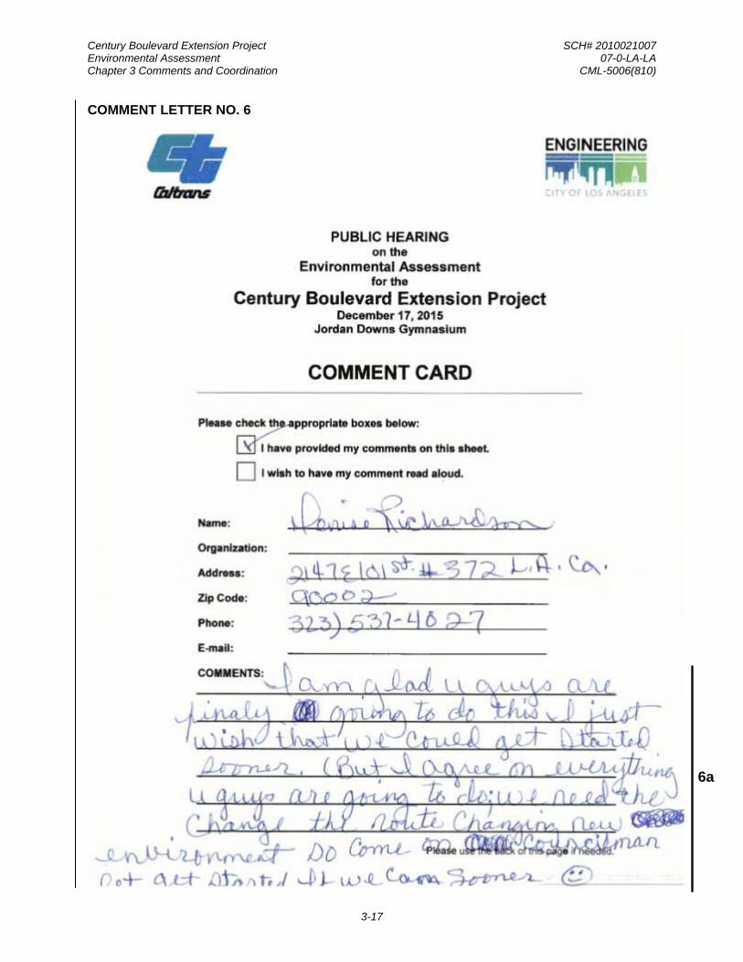
Century Boulevard Extension Project SCH# 2010021007 Environmental Assessment 07-0-LA-LA Chapter 3 Comments and Coordination CML-5006(810)
3-17
COMMENT LETTER NO. 6
6a

Century Boulevard Extension Project SCH# 2010021007 Environmental Assessment 07-0-LA-LA Chapter 3 Comments and Coordination CML-5006(810)
3-18
RESPONSES TO COMMENT LETTER NO. 6
Ms. Denise Richardson, Jordan Downs Resident Public Hearing on the Environmental Assessment December 17, 2015
The commenter’s support of the proposed project has been acknowledged.
Response to Comment No. 6a
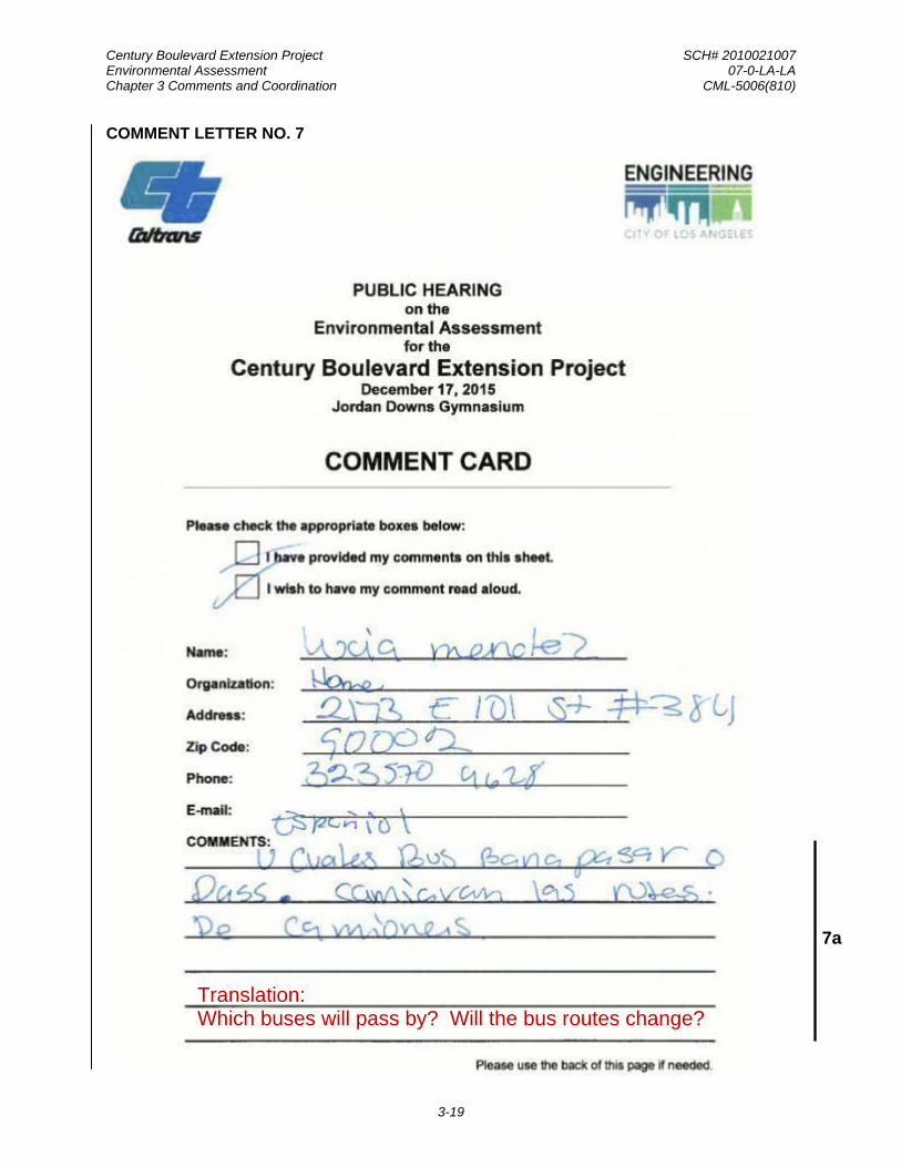
Century Boulevard Extension Project SCH# 2010021007 Environmental Assessment 07-0-LA-LA Chapter 3 Comments and Coordination CML-5006(810)
3-19
COMMENT LETTER NO. 7
7a
Translation: Which buses will pass by? Will the bus routes change?

Century Boulevard Extension Project SCH# 2010021007 Environmental Assessment 07-0-LA-LA Chapter 3 Comments and Coordination CML-5006(810)
3-20
RESPONSES TO COMMENT LETTER NO. 7
Ms. Lucia Mendez, Jordan Downs Resident Public Hearing on the Environmental Assessment December 17, 2015
The completion of the Century Boulevard Extension Project would result in a 74-foot to 86-foot-wide street with sufficient width to accommodate buses. The completion of the project in itself would not create any changes to the existing bus routes. However, upon the completion of JDUV Specific Plan Project, it is anticipated that Metro Bus Line 117 (which runs east/west every 20 minutes along 103rd Street to LAX and via Alameda Street and Tweedy Boulevard east to Downey), would be re-routed to Century Boulevard and through the Jordan Downs community to improve transit and accessibility.
Response to Comment No. 7a
Spanish Translation:
La finalización del proyecto Century Boulevard Extension resultara en una calle de 74 por 86 pies de ancho que estaría lo suficientemente amplia para acomodar autobuses. La finalización del proyecto en sí no crearía ningún cambio en las rutas existentes. Sin embargo, al finalizarse el proyecto de JDUV Specific Plan, se anticipa que la línea 117 del Metro Bus Line (que corre de este a oeste cada 20 minutos hacia la calle 103rd Street a LAX a través de Alameda Street y Tweedy Boulevard que está al este de Downey), seria redirigida a Century Boulevard y a través de la comunidad de Jordan Downs para mejorar transito y accesibilidad.
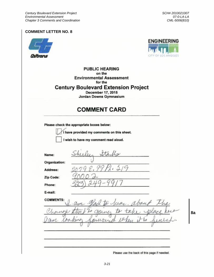
Century Boulevard Extension Project SCH# 2010021007 Environmental Assessment 07-0-LA-LA Chapter 3 Comments and Coordination CML-5006(810)
3-21
COMMENT LETTER NO. 8
8a

Century Boulevard Extension Project SCH# 2010021007 Environmental Assessment 07-0-LA-LA Chapter 3 Comments and Coordination CML-5006(810)
3-22
RESPONSES TO COMMENT LETTER NO. 8
Ms. Shirley Starks, Jordan Downs Resident Public Hearing on the Environmental Assessment December 17, 2015
The commenter’s support of the proposed project has been acknowledged.
Response to Comment No. 8a
Century Boulevard Extension Project SCH# 2010021007 Environmental Assessment 07-0-LA-LA Chapter 4 List of Preparers CML-5006(810)
4-1
C HAP T E R 4 L IS T OF P R E P AR E R S Caltrans District 7, Division Of Environmental Planning
Ron Kosinski, Deputy District Director
Garret Damrath, Office Chief
Mine Struhl, Branch Chief, Local Assistance, Senior Project Coordinator and Reviewer
Michael Enwedo, Associate Environmental Planner, Project Coordinator and Reviewer
Francesca Smith, Associate Environmental Planner, Architectural Historian, Technical Specialist Reviewer
Kelly Ewing-Toledo, Principal Architectural Historian, Senior Cultural/Historical Technical Specialist Reviewer
Andrew Yoon, Senior Transportation Engineer, Senior Air Quality Technical Specialist Reviewer/Coordinator
Liberty San Agustin, Transportation Engineer, Air Quality Technical Specialist Reviewer
Jin Lee, Senior Transportation Engineer, Senior Noise and Vibrations Technical Specialist Reviewer
Roland Cerna, Transportation Engineer, Noise and Vibrations Technical Specialist Reviewer
Paul Caron, District Senior Biologist, Biology Technical Specialist Reviewer
Steve Chan, Senior Transportation Engineer, Hazardous Waste and Materials Technical Specialist Reviewer
Penny Nakashima, Transportation Engineer, Hazardous Waste and Materials Technical Specialist Reviewer
Terry A. Hayes Associates Inc.
Terry A. Hayes, AICP, Principal-in-Charge, Environmental Document Preparation Overseer
Madonna Marcelo, Project Manager, Environmental Document Preparer
Sam Silverman, Senior Environmental Scientist, Air Quality Section and Noise Study Report Preparer
Michael Sullivan, AICP, Senior Planner, Section 4(f) De Minimis Findings, Community Impacts, and Environmental Justice Sections Preparer.
Seyedehsan Hosseini, Ph.D., Associate Environmental Scientist, Air Quality Section and Noise Study Report Preparer
Kieran Bartholow, Assistant Planner, Noise Measurement Technician for the Noise Study Report.

Century Boulevard Extension Project SCH# 2010021007 Environmental Assessment 07-0-LA-LA Chapter 4 List of Preparers CML-5006(810)
4-2
ICF International
Christopher Hetzel, Senior Architectural Historian, SHPO Liaison about the Findings for Jordan Downs Urban Village Specific Plan Project and Historic Property Survey Report Overseer
Elizabeth Hilton, Senior Architectural Historian, Historic Property Survey Report Preparer

Century Boulevard Extension Project SCH# 2010021007 Environmental Assessment 07-0-LA-LA Chapter 5 Distribution List CML-5006(810)
5-1
C HAP T E R 5 DIS T R IB UT ION L IS T
5.1 LOCATIONS WHERE EA MAY BE VIEWED
Copies of the EA were made available for viewing at the following locations:
• City of Los Angeles Bureau of Engineering 1149 S. Broadway, Suite 750 Los Angeles, CA 90015
• Caltrans District 7 100 S. Main Street Los Angeles, CA 90012
• Alma Reaves Woods – Watts Branch Library 10205 Compton Avenue Los Angeles, CA 90002
• Los Angeles Bureau of Engineering website (http://eng.lacity.org/techdocs/emg)
• Caltrans website (http://www.dot.ca.gov/dist07/resources/envdocs/)
5.2 EA DISTRIBUTION LIST
The following elected officials, agency representatives, and interested parties received an electronic copy of the Environmental Assessment and a notice informing them of its availability.
5.2.1 ELECTED OFFICIALS
FEDERAL
Hon. Dianne Feinstein, Senator 11111 Santa Monica Boulevard, Suite 915 Los Angeles, CA 90025-3343
Hon. Barbara Boxer, Senator 312 N. Spring Street, Suite 1748 Los Angeles, CA 90012
Rep. Janice Hahn U.S. Congressional District 44 140 W. 6th Street San Pedro, CA 90731
STATE
Senator Ricardo Lara California State Senate 33rd District 3939 Atlantic Avenue, Suite 107 Long Beach, CA 90807
Senator Isadore Hall, III California State Senate 35th District 222 West 6th Street, Suite 320 San Pedro, CA 90731

Century Boulevard Extension Project SCH# 2010021007 Environmental Assessment 07-0-LA-LA Chapter 5 Distribution List CML-5006(810)
5-2
Assembly Member Reggie Jones-Sawyer California State Assembly 59th District 700 Exposition Park Drive Los Angeles, CA 90037
Assembly Member Anthony Rendon California State Assembly 63rd District 12132 South Garfield Avenue South Gate, CA 90280
Assembly Member Mike A. Gipson California State Assembly 64th District 879 W. 190th Street, Suite 920 Gardena, CA 90248
COUNTY
Supervisor Hilda L. Solis County Board of Supervisors 1st District 856 Kenneth Hahn Hall of Administration 500 West Temple Street Los Angeles, CA 90012
Supervisor Mark Ridley-Thomas County Board of Supervisors 2nd District 866 Kenneth Hahn Hall of Administration 500 W. Temple Street Los Angeles, CA 90012
CITY
Mayor Eric Garcetti City of Los Angeles Office of Mayor 200 N. Spring Street Los Angeles, CA 90012
Marqueece Harris-Dawson City of Los Angeles City Council District 8 200 N. Spring Street, Room 450 Los Angeles, CA 90012
Curren D. Price, Jr. City of Los Angeles City Council District 9 200 North Spring Street, Suite 420 Los Angeles, CA 90012
Joe Buscaino City of Los Angeles City Council District 15 200 N. Spring Street, Room 410 Los Angeles, CA 90012
5.2.2 GOVERNMENTAL AGENCIES
FEDERAL
Administrator William Craig Fugate Federal Emergency Management Agency 500 C Street SW Washington, DC 20472
Federal Railroad Administration Region 7 801 I Street, Suite 466 Sacramento, CA 95814
U.S. Fish and Wildlife Service Carlsbad Fish and Wildlife Office 2177 Salk Avenue, Suite 250 Carlsbad, California 92008
U.S. Environmental Protection Agency Region 9 Office of Planning and Public Affairs 600 Wilshire Boulevard, Suite 1460 Los Angeles, CA 90017
National Center for Environmental Health Centers for Disease Control 1600 Clifton Road Atlanta, GA 30329
Susan Bromm, Director Environmental Protection Agency Office of Federal Activities 401 M Street, SW (Mail Code 2251-A) Washington, DC 20460
Century Boulevard Extension Project SCH# 2010021007 Environmental Assessment 07-0-LA-LA Chapter 5 Distribution List CML-5006(810)
5-3
Veronica Chan U.S. Army Corps of Engineers Regulatory Division 911 Wilshire Boulevard Los Angeles, CA 90017
U.S. Department of Transportation Federal Transit Administration Region 9 201 Mission Street, Suite 1650 San Francisco, California 94105
U.S. Department of Health and Human Services Office of Intergovernmental and External Affairs Hubert Humphrey Building, 620E 200 Independence Avenue, SW Washington, DC 20201
Michelle Simmons, Field Environmental Officer HUD - Los Angeles Regional Office 611 West 6th Street, Suite 800 Los Angeles, CA 90017-3127
STATE
Mark Nechodom, Director California Department of Conservation 801 K Street, 24th Floor Sacramento, CA 95814
Carol Roland-Nawi State Historic Preservation Officer California Office of Historic Preservation P.O. Box 942896 Sacramento, CA 95814
California Transportation Commission 1120 N Street, MS-52 Sacramento, CA 95814
Jennifer Gress, Legislative Director California Air Resources Board Office of the Chair P.O. Box 2815 Sacramento, CA 95812
Ed Pert California Department of Fish and Wildlife Region 5 3883 Ruffin Road San Diego, CA 92123
Governor’s Office of Planning and Research 1400 10th Street Sacramento, CA 95814
California Department of Transportation Headquarters P.O. Box 942873 Sacramento, CA 94273
California Regional Water Quality Control Board Los Angeles Region 320 West Fourth Street, Suite 200 Los Angeles, CA 90013
Cynthia Gomez, Executive Secretary Native American Heritage Commission 1550 Harbor Boulevard, Suite 100 West Sacramento, CA 95691
Secretary John Laird California Natural Resources Agency 1416 Ninth Street, Suite 1311 Sacramento, CA 95814
Stephen Testa, Executive Officer California Department of Conservation State Mining & Geology Board 801 K Street, Suite 2015 Sacramento, CA 95814
Tom Howard, Executive Director State Water Resources Control Board 1001 I Street Sacramento, CA 95814

Century Boulevard Extension Project SCH# 2010021007 Environmental Assessment 07-0-LA-LA Chapter 5 Distribution List CML-5006(810)
5-4
REGIONAL/COUNTY
South Coast Air Quality Management District 21865 Copley Drive Diamond Bar, CA 91765
General Manager Metropolitan Water District of Southern California P.O. Box 54153 Los Angeles, CA 90054-0153
Southern California Association of Governments 818 West 7th Street, 12th Floor Los Angeles, CA 90017
Director Gail Farber County of Los Angeles Department of Public Works 900 S. Fremont Avenue Alhambra, CA 91803
Chief Daryl Osby County of Los Angeles Fire Department 1320 N. Eastern Avenue Los Angeles, CA 90063
Los Angeles County Sanitation District 1955 Workman Mill Road Whittier, CA 90601
Director Richard Bruckner County of Los Angeles Department of Regional Planning 320 West Temple Street Los Angeles, California, 90012
County of Los Angeles Chief Executive Office Kenneth Hahn Hall of Administration 500 W. Temple Street, Room 713 Los Angeles, CA 90012
Sheriff Jim McDonnell Los Angeles County Sheriff's Department Hall of Justice 211 West Temple Street Los Angeles, CA 90012
Los Angeles County Metropolitan Transportation Authority 1 Gateway Plaza Los Angeles, CA 90012
CITY
Chief Ralph Terrazas City of Los Angeles Fire Department 200 North Main Street, 16th Floor Los Angeles, CA 90012
Director Michael LoGrande City of Los Angeles Dept. of City Planning 200 North Spring Street Los Angeles, CA 90012
General Manager Seleta Reynolds City of Los Angeles Dept. of Transportation 100 S. Main Street, 10th Floor Los Angeles, CA 90012
Chief Charlie Beck City of Los Angeles Police Department 100 West 1st Street Los Angeles, CA 90012
Executive Officer City of Los Angeles Department of Recreation and Parks 221 N Figueroa Street, Suite 350 Los Angeles, CA 90012
Los Angeles City/County Native American Indian Commission Ron Andrade, Director 3175 West 6th Street, Room 403 Los Angeles , CA 90020
Hartzog & Crabill for City of South Gate 17852 E. 17th Street, Suite 101 Tustin, CA 92780

Century Boulevard Extension Project SCH# 2010021007 Environmental Assessment 07-0-LA-LA Chapter 5 Distribution List CML-5006(810)
5-5
OTHER INTERESTED PARTIES
Los Angeles Conservancy 523 W. Sixth Street, Suite 826 Los Angeles, CA 90014
Beverly Salazar Folkes 1931 Shadybrook Drive Thousand Oaks CA 91362
Melissa M. Parra-Hernandez 119 North Balsam Street Oxnard , CA 93030
Patrick Tumamait 992 El Camino Corto Ojai , CA 93023
Gabrieleno Band of Mission Indians - Kizh Nation Andrew Salas, Chairperson P.O. Box 393 Covina, CA 91723
Randy Guzman-Folkes 4676 Walnut Avenue Simi Valley, CA 93063
Gabrieleno/Tongva San Gabriel Band of Mission Indian Anthony Morales, Chairperson P.O. Box 693 San Gabriel, CA 91778
Carol A. Pulido 165 Mountainview Street Oak View, CA 93022
Gabrielino/Tongva Nation Sandonne Goad, Chairperson 106 1/2 Judge John Aiso Los Angeles, CA 90012
Gabrielino/Tongva Nation Sam Dunlap, Cultural Resources Director P .0. Box 86908 Los Angeles , CA 90086
Gabrielino Tongva Indians of California Tribal Council Robert F. Dorame, Tribal Chair/ Cultural Resources P .0. Box 490 Bellflower, CA 90707
Gabrielino-Tongva Tribe Bernie Acuña, Co-Chairperson 1999 Avenue of the Stars, Suite 1100 Los Angeles, CA 90067
Gabrielino-Tongva Tribe Conrad Acuña 1999 Avenue of the Stars, Suite 1100 Los Angeles, CA 90067
Gabrielino-Tongva Tribe Linda Candelaria, Co-Chairperson 1999 Avenue of the Stars, Suite 1100 Los Angeles, CA 90067
Latham and Watkins for Atlas Iron and Metal Co. 355 S. Grand Avenue, Suite 100 Los Angeles, CA 90071

Century Boulevard Extension Project SCH# 2010021007 Environmental Assessment 07-0-LA-LA Chapter 5 Distribution List CML-5006(810)
5-6
This page is intentionally left blank.

Century Boulevard Extension Project SCH# 2010021007 Environmental Assessment 07-0-LA-LA Appendices CML-5006(810)
1
APPENDICES Appendix A. Section 4(f) Section 4(f) De Minimis Determination Section 6009(a) of Safe Accountable Flexible Efficient Transportation Equity Act: A Legacy for Users (SAFETEA-LU) amended Section 4(f) legislation at 23 USC 138 and 49 USC 303 to simplify the processing and approval of projects that have only de minimis impacts on lands protected by Section 4(f). This revision provides that once the U.S. Department of Transportation (USDOT) determines that a transportation use of Section 4(f) property, after consideration of any impact avoidance, minimization, and mitigation or enhancement measures, results in a de minimis impact on that property, an analysis of avoidance alternatives is not required and the Section 4(f) evaluation process is complete. FHWA’s final rule on Section 4(f) de minimis findings is codified in 23 Code of Federal Regulations (CFR) 774.3 and CFR 774.17.
Responsibility for compliance with Section 4(f) has been assigned to Caltrans pursuant to 23 USC 326 and 327, including determinations and approval of Section 4(f) evaluations, as well as coordination with those agencies that have jurisdiction over a Section 4(f) resource that may be affected by a project action.
Jordan Downs Recreation Center The Jordan Downs Recreation Center (JDRC), owned by the City of Los Angeles Department of Recreation and Parks, consists of a 7,000-square-foot building (0.16 acres) and approximately 3.16 acres of associated recreational space, which includes a playground, five picnic tables, a baseball field, and basketball courts. There is a childcare facility that is located in the southwest corner of the property; however, this area is fenced off separately from the rest of the property, is not open to the public, and is not considered as part of the Section 4(f) property. The JDRC is at the western edge of the project area and is located at the northeast corner of the Grape Street/Century Boulevard intersection. Figure A-1 shows the JDRC in relation to the proposed project. As shown in Figure A-1, the baseball field occupies the eastern half of the property, while the recreation center building, the basketball courts, playground, and parking lot are located on the western half of the property. Most of the activity at the JDRC occurs within the recreation center building and the basketball courts. The JDRC is accessible by car, bicycle, or pedestrians, and the building is open Tuesday through Friday from 11:30 a.m. to 9:00 p.m., Mondays from 1:00 p.m. to 6:00 p.m., and Saturdays from 9:30 a.m. to 4:00 p.m. The facility is closed on Sundays and holidays. The JDRC does not have nighttime lighting to allow for the use of the softball field or basketball courts. There are no other similar recreational facilities within the vicinity of the proposed project.
Impacts on Jordan Downs Recreation Center The extension of Century Boulevard would result in the direct use of the JDRC through acquisition of an area associated with the baseball field. As part of the Jordan Downs Specific Plan, Century Boulevard would be extended from Grape Street eastward, curving around a new central park, ultimately connecting at the Specific Plan area’s eastern edge with Tweedy Boulevard, where it crosses the Alameda Corridor. The extension of Century Boulevard would require the acquisition of approximately 1.1 acres of the 3.33 acres of the current recreation area. The extension of Century Boulevard would not require the acquisition of the recreation center building as the extension of Century Boulevard would pass immediately south of this building. Therefore, the recreation center building would remain in operation during the construction of the Century Boulevard extension; however, the baseball field located on the east side of the park would not be available for public use.
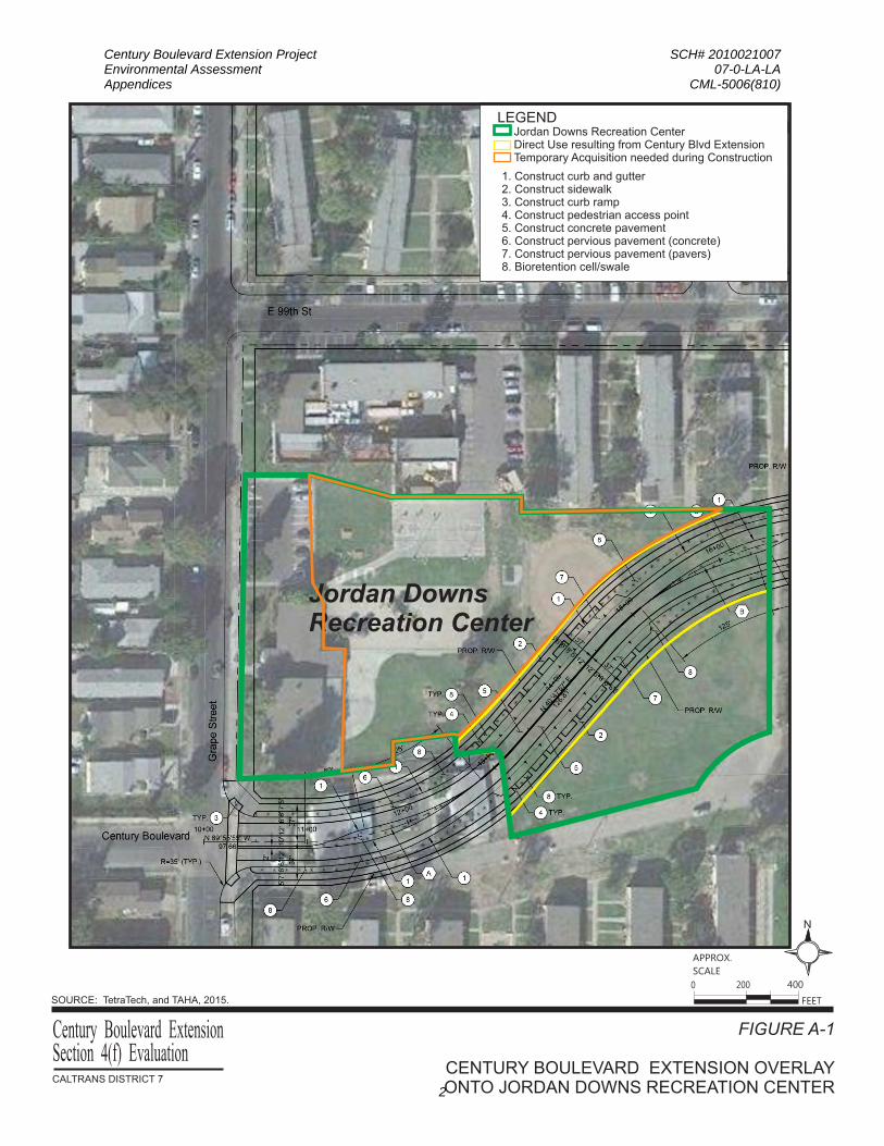
Century Boulevard Extension Project SCH# 2010021007 Environmental Assessment 07-0-LA-LA Appendices CML-5006(810)
2
Jordan Downs Recreation Center
1. Construct curb and gutter2. Construct sidewalk3. Construct curb ramp4. Construct pedestrian access point5. Construct concrete pavement6. Construct pervious pavement (concrete)7. Construct pervious pavement (pavers)8. Bioretention cell/swale
Jordan Downs Recreation CenterDirect Use resulting from Century Blvd ExtensionTemporary Acquisition needed during Construction
LEGEND
FIGURE A-1
CENTURY BOULEVARD EXTENSION OVERLAYONTO JORDAN DOWNS RECREATION CENTER
Century Boulevard Extension
SOURCE: TetraTech, and TAHA, 2015.
N
FEET
APPROX.
SCALE
0 400200
CALTRANS DISTRICT 7
Section 4(f) Evaluation

Century Boulevard Extension Project SCH# 2010021007 Environmental Assessment 07-0-LA-LA Appendices CML-5006(810)
3
De minimis Impact Finding
The proposed project does not adversely affect the activities, features, and attributes of the Section 4(f) resource. The open space grass area within the JDRC, including the baseball field, is not well maintained and in poor condition. Specifically, the baseball field is not programmed (does not have any planned use) and the area contains gopher holes, patches of sporadic grass interspersed by uneven dirt, creating an increased potential for trips and falls. This poor field condition has evoked safety concerns from the local community. As a result, the baseball field is underutilized and in need of repair/replacement.
Through coordination with the City of Los Angeles Department of Recreation and Parks, the Jordan Downs Specific Plan has been designed to substantially increase the amount of recreational facilities available to the residents of Jordan Downs.
Figure A-2 shows the new recreational area that would be created through implementation of the Jordan Downs Specific Plan. As shown in Figure A-2, a triangular part of the existing recreational area within the existing JDRC would be preserved in addition to another triangular recreational area directly to the south of the Century Boulevard Extension, creating a rectangular open space area that is bisected by the extension of Century Boulevard. The planned use of the new open space would include all of existing elements at the JDRC, including the baseball field. The resulting net increase in recreational facilities would be 9.16 acres, and the existing parkland at Jordan Downs would increase by 338 percent. The proposed project would build a new 6.38-acre neighborhood park (Central Park). In addition, the Jordan Downs Specific Plan would also result in 2.57 acres of additional open space areas throughout the Specific Plan area. A total of 11.36 acres of land within the Specific Plan area would be dedicated for park and recreational uses. A new Community Center would be located adjacent to the new Central Park and the extension of Century Boulevard. The Community Center will be located in the heart of the new neighborhood and contain a broad array of services and opportunities to serve the very young, teenagers, families, single adults and elders and enrich the lives of Jordan Downs residents and neighbors. Figure A-3 shows a rendering and proposed recreational improvements associated with the Community Center.
The six-acre park will be developed in the center of the housing adjacent to the Community Center and will serve as the focal point and galvanizing element of the Urban Village concept, creating the essence of a “town center”. Lighting will illuminate the entire park including the soccer field, baseball field, two basketball courts, an exercise path, passive open space and the perimeter of the Community Center, creating a safe, welcoming and healthy environment in the new Jordan Downs Urban Village mixed-income community.
Installation of energy efficient lighting will extend the capacity to use the park into the evening hours, providing access from the early hours of the morning to evening hours so that young people will have a safe place for recreation, programmed sports activities and to enjoy art and cultural activities. The park will be accessible for exercise as early as 5:00 a.m. The park will facilitate both passive and structured recreational activities administered through a consortium of community-based organizations to deliver comprehensive and quality programs and services for the residents of the redeveloped Jordan Downs Urban Village and the surrounding community:

Century Boulevard Extension Project SCH# 2010021007 Environmental Assessment 07-0-LA-LA Appendices CML-5006(810)
4
FIGURE A-2
NET CHANGE IN SECTION 4(F) PARKLANDCALTRANS DISTRICT 7
Century Boulevard ExtensionSection 4(f) Evaluation
SOURCE: WRT/Solomon E.T.C., and TAHA, 2105.
LEGEND:
Central
Park
Central
Park
Community Center
1
Central
Park
CENTURY BLVD
GR
AP
E S
T
ALA
ME
DA
ST
97TH ST
103RD ST
TWEEDY BLVD
ALA
ME
DA
TR
EN
CH
/CO
RR
IDO
R(B
NS
F&
UP
RR
)
N
FEET
APPROX.
SCALE
0 400200
CENTURY EXTENSION
Current Recreational Area
Additional Section 4(f) ParklandImplemented with the Proposed Project
Portion of Century Boulevard Extension Resultingin Direct Use of Jordan Downs Recreation Center
Community Center

Century Boulevard Extension Project SCH# 2010021007 Environmental Assessment 07-0-LA-LA Appendices CML-5006(810)
5
FIGURE A-3
COMMUNITY CENTER RENDERING AND
PLANNED RECREATIONAL ELEMENTS
Section 4(f) EvaluationCentury Boulevard ExtensionSOURCE: TAHA, 2015.
CALTRANS DISTRICT 7
Rendering of the main entrance to the new Community Center.
This shows the proposed site plan for the Community Center.
A new children’s garden will be provided as part ofthe new Community Center.
A full regulation-size basketball court and bleacherseating will be included in the Community Center.

Century Boulevard Extension Project SCH# 2010021007 Environmental Assessment 07-0-LA-LA Appendices CML-5006(810)
6
• The soccer field will serve a minimum of 500 youth ages 5 to 21 each month and 6,000 annually through their afterschool, weekend and summer participation in soccer, rugby, lacrosse and flag football clinics and games organized by program partners. Youths will also be able to enjoy leisure recreation games with friends and family.
• The two basketball courts will host a minimum of 200 youth ages 9–21 each month and 2,400 annually. The courts will primarily provide leisure game time for youth each day but will also be programmed for basketball clinics and tournaments on occasion.
• The park will be accessible every day for physical exercise activities for a minimum of 100 youth monthly and 1,200 annually specifically for walking or running around the exercise path and for programmed exercise classes such as yoga and Zumba.
• Art and cultural activities such as painting and music festivals will also be offered by program partners and enjoyed by a minimum of 100 youth monthly and 1,200 annually.
Development of a park for the entire neighborhood will erase the impenetrable boundary of Jordan Downs which is an important goal of the transformation strategy. Together with a combination of urban design, land use patterns and transportation systems that promote walking and bicycling, the Jordan Downs Project will help create an active, healthier, and more livable community and will facilitate the provision of healthy recreational programs in a safe environment for youth ages 6-21. Direct access to recreational activities will help foster positive interaction among youth and their families and help reduce obesity rates among low-income residents within the greater Watts community.
Construction activities associated with the extension of Century Boulevard are estimated to take approximately one year to complete. The nearest alternate baseball fields that would be available during construction are located at Will Rogers Park, approximately 0.75 miles to the west. In total, there are 23 alternate fields located within 3 miles of the JDRC. In addition, Major League Baseball operates an Urban Youth Baseball Academy, located approximately 5 miles to the south. This facility contains four fields with instructional teaching available to youths ages 7-18.
The reconfiguration of the park would increase access by providing additional mobility and connectivity to vehicles and by creating a more pedestrian-friendly connection to the community. The design of the park would create a more distinct sense of place that would result in a park that becomes more intertwined with the community and enhance the livability of the area. Due to this reason, the value of the parkland would increase over its existing condition and help create a better quality of life for the Jordan Downs area.
Pursuant to 23 CFR 771.135(p), Caltrans, in cooperation with City of Los Angeles Bureau of Engineering, will requestrequested written concurrence from the City of Los Angeles Department of Recreation and Parks after the public review and comment period is provided, regarding the above conditions. However, in response to the request, the City of Los Angeles Department of Recreation and Parks stated that it no longer operates and maintains the JDRC, which is now the responsibility of the Housing Authority of the City of Los Angeles (HACLA). Accordingly, Caltrans sought written concurrence from HACLA regarding the above conditions.

Century Boulevard Extension Project SCH# 2010021007 Environmental Assessment 07-0-LA-LA Appendices CML-5006(810)
7
Resources Evaluated Relative to the Requirements of Section 4(f)
This section of the document discusses parks, recreational facilities, wildlife refuges, and historic properties found within or next to the project area that do not trigger Section 4(f) protection because: 1) they are not publicly owned, 2) they are not open to the public, 3) they are not eligible historic properties, 4) the project does not permanently use the property and does not hinder the preservation of the property, or 5) the proximity impacts do not result in constructive use.
Watts Senior Center Rose Garden
The Watts Senior Center Rose Garden, owned by the City of Los Angeles Department of Recreation and Parks, consists of a gazebo, rose garden, an auditorium with a capacity of 125 persons, an atrium and waterfall, reception lounge, dining room, kitchen, and parking lot. The Watts Senior Center Rose Garden is located on an approximately 1.25-acre site. Approximately 0.57 acre of the site contains (primarily in the southern portion of the site) open space and a garden area; 0.38 acre of the site contains a parking lot (eastern portion of the site); and the remaining 0.30 acre (approximately 13,000 square feet) contains the building facilities (northern portion of the site). The Watts Senior Rose Garden is located at 1657 East Century Boulevard and is located approximately 0.4 mile from the proposed extension of Century Boulevard at Grape Street. Figure A-4 shows the location of the facility in relationship to the proposed project. The Watts Senior Center Rose Garden is accessible by car, bicycle, or pedestrians and does not have nighttime lighting to allow for the nighttime use of the rose garden. There are no other similar recreational facilities within the vicinity of the project site. The Watts Senior Center Rose Garden is adjacent to the existing Metro Blue Light Rail Line.
The extension of Century Boulevard would not require any temporary or permanent acquisition of land from the Watts Senior Center Rose Garden. The proposed extension of Century Boulevard is primarily for internal circulation of the Jordan Downs residents and would not substantially increase traffic flow on Century Boulevard, such that the activities, access, or other environmental consideration at the Watts Senior Center Rose Garden would be affected. Therefore, the provisions of Section 4(f) are not triggered.
Letters and Other Correspondence
The letter to the City of Los Angeles Department of Recreation and Parks is included below. In addition, the reissued letter of request and concurrence from HACLA is provided below.

Century Boulevard Extension Project SCH# 2010021007 Environmental Assessment 07-0-LA-LA Appendices CML-5006(810)
8
FIGURE A-4
LOCATION OF WATTS SENIOR CENTERSection 4(f) EvaluationCentury Boulevard Extension
CALTRANS DISTRICT 7
SOURCE: TAHA, 2015.
N
APPROX.
SCALE
FEET
0 400200
Proposed Century Boulevard Extension
LEGEND:
Jordan Downs Recreation Center
Watts Senior Center Rose Garden
CENTURY BLVDCENTURY BLVD
103 RD ST103 RD ST
GR
AP
E S
TG
RA
PE
ST
WIL
MIN
GT
ON
AV
EW
ILM
ING
TO
NA
VE
WIL
MIN
GT
ON
AV
E
GR
AN
DE
EA
VE
GR
AN
DE
EA
VE
GR
AN
DE
EA
VE


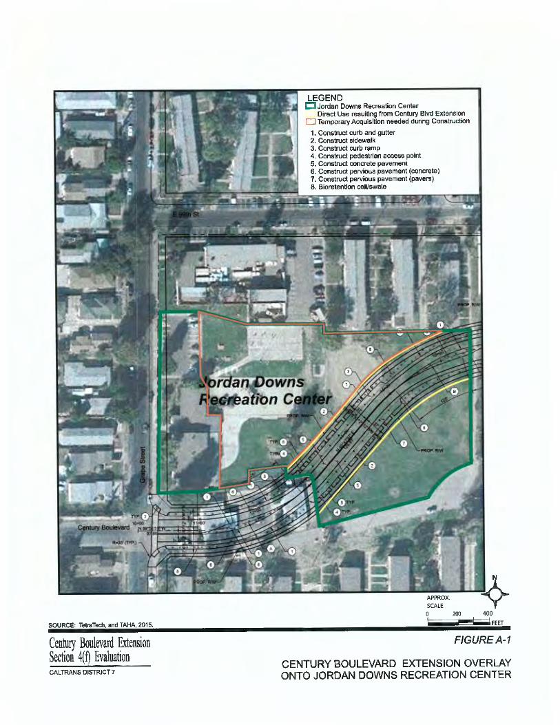


Century Boulevard Extension Project SCH# 2010021007Environmental Assessment 07-0-LA-LAAppendices CML-5006(810)
16
This page is intentionally left blank.


SOURCE: TetniTech, and TAHA, 2015.
Centuty Boulevard Extension Section ~n Evaluation CAL TRANS DISTRICT 7
LEGEND C Jordan Downs Recreation Center
Direct Use resulting from Century Blvd Extension D Temporary Acquisition needed during Construction
1. Construct curb and gutter 2. Construct sidewalk 3. Construct curb ramp 4. Construct pedestrian access point 5. Construct concrete pavement 6. Construct pervious pavement (concrete) 7. Construct pervious pavement (pavers) 8. Bioretention cell/swale
200 400 FEET
F/GUREA-1
CENTURY BOULEVARD EXTENSION OVERLAY ONTO JORDAN DOWNS RECREATION CENTER
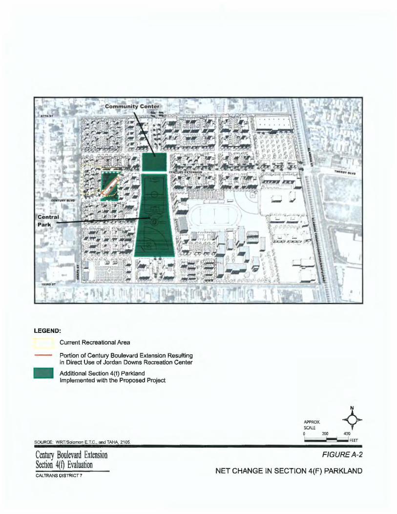
LEGEND:
Current Recreational Area
Portion of Century Boulevard Extension Resulting in Direct Use of Jordan Downs Recreation Center
Additional Section 4(f) Parkland Implemented with the Proposed Project
SOURCE: WRT/Solomon E.T.C., and TAHA, 2105.
Century Boulevard Extension Section 4(Q Evaluation CALTRANS DISTRICT7
APPROX. SCAlf 0 200 400
FEET
F/GUREA-2
NET CHANGE IN SECTION 4(F) PARKLAND

Jordan Downs Community Center
Rendering of the main entrance to the new Community Center.
This shows the proposed s1te plan for the Community Center.
SOURCE: TAHA 2015.
Cen~ Blvd Extension Section 4(n Evaluation CAL TRANS DISTRJCT 1
A new garden will be nro~•ic:led
the new Community Center.
A full regulation-size basketball court and bleacher seating will be included in the Community Center.
F/GUREA-3
COMMUNITY CENTER RENDERING AND PLANNED RECREATIONAL ELEMENTS

Century Boulevard Extension Project SCH# 2010021007 Environmental Assessment 07-0-LA-LA Appendices CML-5006(810)
Appendix B. Title VI Policy Statement

Century Boulevard Extension Project SCH# 2010021007 Environmental Assessment 07-0-LA-LA Appendices CML-5006(810)
This page is intentionally left blank.

Century Boulevard Extension Project SCH# 2010021007 Environmental Assessment 07-0-LA-LA Appendices CML-5006(810)

Century Boulevard Extension Project SCH# 2010021007 Environmental Assessment 07-0-LA-LA Appendices CML-5006(810)
This page is intentionally left blank.

Century Boulevard Extension Project SCH# 2010021007 Environmental Assessment 07-0-LA-LA Appendices CML-5006(810)
1
Appendix C. Avoidance, Minimization, and/or Mitigation Summary
This section contains a compilation of all avoidance, minimization, and mitigation measures for the proposed project.
PARKS AND RECREATIONAL FACILITIES
PRF1: Two modular structures and playground on the southern portion of the Jordan Downs Recreation Center property would be relocated less than 200 feet to the northwestern corner of the property to avoid any disruption to the operation of the existing early learning program.
COMMUNITY CHARACTER AND COHESION
See the avoidance, minimization, and/or mitigation measures identified in Sections 2.2.5 and 2.2.6.See Measures AQ1 through AQ13 and N1 through N7 below.
ENVIRONMENTAL JUSTICE
See the avoidance, minimization, and/or mitigation measures identified in Sections 2.2.4, 2.2.5, and 2.2.6.See Measures HAZ1 through HAZ8, AQ1 through AQ13, and N1 through N7 below.
CULTURAL RESOURCES AND SECTION 106 RESOURCES
CR1: If cultural materials are discovered during construction, all earth-moving activity within and around the immediate discovery area will be diverted until a qualified archaeologist can assess the nature and significance of the find.
CR2: If human remains are discovered, State Health and Safety Code Section 7050.5 states that further disturbances and activities shall stop in any area or nearby area suspected to overlie remains, and the County Coroner contacted. Pursuant to Public Resources Code (PRC) Section 5097.98, if the remains are thought to be Native American, the coroner will notify the NAHC, which will then notify the Most Likely Descendent (MLD). At this time, the person who discovered the remains shall contact Alex Kirkish, Ph.D., Caltrans Archaeologist, so that they may work with the MLD on the respectful treatment and disposition of the remains. Further provisions of PRC 5097.98 are to be followed as applicable.
CR3: During the excavation period associated with construction of the Century Boulevard Extension Project, a Native American monitor of the Gabrieleno Band of Mission Indians – Kizh Nation shall be present at all times during excavation activities. The excavation period includes, but is not limited to, pavement removal, potholing/boring, grading, excavation and trenching. The area of interest for Native American monitoring shall be focused on the western boundary of the project and excludes excavation activities within the boundaries of the 21-acre vacant parcel owned by HACLA, which has recently been subjected to extensive ground disturbance as a result of environmental remediation activities. Construction shall not be delayed or halted if the Native American Monitor is not available. The tribe shall be contacted within at least 3 business days of requiring monitoring services. If discoveries are made by either the Native American Monitor or construction personnel at any time during excavation or other construction activities (including the 21-acre vacant parcel), the provisions of Avoidance Measures CR1 and CR2 for the unanticipated discovery of cultural resources shall be fully enforced.

Century Boulevard Extension Project SCH# 2010021007 Environmental Assessment 07-0-LA-LA Appendices CML-5006(810)
2
WATER QUALITY AND STORM WATER RUNOFF
WQ1: A site-specific Storm Water Pollution Prevention Plan (SWPPP) shall be prepared and implemented for the project. The SWPPP shall specify Best Management Practices to be used during construction; these would include but not be limited to erosion control, sediment control, and non-stormwater management and materials management BMPs.
WQ2: The project shall be required to comply with the City of Los Angeles grading permit regulations, which require necessary measures, plans (including a wet weather erosion control plan if construction occurs during the rainy season), and inspections to reduce sedimentation and erosion.
WQ3: The design of the Proposed Build Alternative shall incorporate “Green Street” planting elements, such as a palette of infiltration planters and bioswales, for use in managing and treating stormwater runoff to feed landscaping and percolate through the soil.
GEOLOGY/SOILS/SEISMIC/TOPOGRAPHY
GEO1: The project shall comply with the City of Los Angeles specifications for roadway construction and geotechnical report prepared for the project to ensure that the project is consistent with the latest seismic design standards for structural loads and materials.
PALEONTOLOGY
P1: If a potential fossil is found, a qualified paleontologist retained for the project shall be allowed to temporarily divert or redirect grading and excavation activities from the area of the exposed fossil to facilitate evaluation and, if necessary, salvage. At the paleontologist’s discretion and to reduce any construction delay, the grading and excavation contractor shall assist in removing rock samples for initial processing. Any fossils encountered and recovered shall be prepared to the point of identification and catalogued before they are donated to their final repository. Any fossils collected should be donated to a public, nonprofit institution with a research interest in the materials, such as the Natural History Museum of Los Angeles County. Accompanying notes, maps, and photographs shall also be filed at the repository. If fossils are found, following the completion of the above tasks, the paleontologist shall prepare a report summarizing the results of the monitoring and salvaging efforts, the methodology used in these efforts, as well as a description of the fossils collected and their significance. The report shall be submitted by BOE to Caltrans, the Natural History Museum of Los Angeles County, and representatives of other appropriate or concerned agencies to signify the satisfactory completion of the salvaging efforts.
HAZARDOUS WASTE/MATERIALS
HAZ1: Prior to project construction, HACLA shall receive the certificate of completion from DTSC. The site shall be remediated to meet site-specific clean-up goals to allow for the development of unrestricted land uses, as approved by DTSC, prior to construction.
HAZ2: Should any previously unidentified soils that exceed site-specific clean-up goals, as approved by DTSC for the project site, be encountered during construction, an action plan shall be developed, approved by DTSC as appropriate, and implemented, prior to resuming construction activities in the contaminated area. As needed, the investigation and remediation of a release or threatened release of any hazardous substances at or

Century Boulevard Extension Project SCH# 2010021007 Environmental Assessment 07-0-LA-LA Appendices CML-5006(810)
3
from the project site shall be overseen by the DTSC in accordance with all federal, state, and local laws and regulations.
HAZ3: A Health and Safety Plan shall be prepared prior to construction activities to train workers to recognize potential health and safety hazards, communicate potential health and safety hazards to others, instruct personnel in procedures for performing work safely, mitigate hazards and avoid exposure to hazardous substances with the use of engineering and administrative controls, use protective equipment to limit exposure when engineering and administrative controls are not effective. The Health and Safety Plan shall contain provisions for providing breathing zone monitoring if workers will be exposed to concentrations of contaminants near the Permissible Exposure Limits, consistent with DTSC’s approved site-specific clean-up goals as they relate to the 21-acre site that is currently undergoing remediation.
HAZ4: Construction workers shall undergo Health and Safety training as required by Cal/OSHA regulations in Title 8 CCR for handling hazardous materials and/or wastes.
HAZ5: Construction shall use dust suppression methods when disturbing soil so as not to create visible dust emissions or cause soils that exceed site-specific clean-up goals, as approved by DTSC for the project site, to become airborne.
HAZ6: Prior to construction, an Excavation, Disposal, and Transportation Plan shall be prepared to describe the procedures and methodology for excavation, temporary storage, containerization, transport and disposal of hazardous waste. This includes construction of the temporary stockpile area (e.g., berms to prevent runoff, wetting, and cover to prevent soil from becoming airborne); use of USDOT-approved containers for storage and transport; use of registered transporter; decontamination of transport vehicles prior leaving the site; obtaining written acceptance of disposal facility prior to transport vehicle leaving site so load is not rejected upon arrival; and compliance with manifest requirements.
HAZ7: South Coast Air Quality Management District (SCAQMD) Rule 1166 – Volatile Organic Compound (VOC) Emissions from Decontamination of Soil: SCAQMD Rule 1166 sets forth the requirements to control the emission of VOCs generated from the excavation and handling of VOC-impacted soil. Rule 1166 applies to all soil excavations with volumes exceeding one cubic yard of VOC-impacted soil. VOC-impacted soil is defined as having VOC concentrations exceeding 50 ppmv as measured by a hexane calibrated organic vapor analyzer. In compliance with the SCAQMD Rule 1166 requirements, an Excavation Management Plan and necessary permitting application forms shall be prepared and submitted for approval to the SCAQMD.
HAZ8: The City shall continue to implement an emergency response plan for responding to releases from accidents (e.g., LAFD, first responders from the Los Angeles County Hazardous Materials Unit). Actions may involve cordoning off the affected area, stabilizing and containing releases of hazardous materials, and remediating the released hazardous materials.
AIR QUALITY
AQ1: Apply water or dust palliative to the site and equipment as frequently as necessary to control fugitive dust emissions. Fugitive emissions generally must meet a “no visible dust” criterion either at the point of emission or at the right of way line as required by the SCAQMD.
Century Boulevard Extension Project SCH# 2010021007 Environmental Assessment 07-0-LA-LA Appendices CML-5006(810)
4
AQ2: Spread soil binder on any unpaved roads used for construction purposes, and all project construction parking areas.
AQ3: Properly tune and maintain construction equipment and vehicles. Use low-sulfur fuel in all construction equipment as provided in California Code of Regulations Title 17, Section 93114.
AQ4: Develop a dust control plan documenting sprinkling, temporary paving, speed limits, and expedited revegetation as needed to minimize construction impacts to existing communities.
AQ5: Locate equipment and materials storage sites at least 500 feet from the sensitive receptors. Keep construction areas clean and orderly.
AQ6: Extended idling, material storage, and equipment maintenance should be prohibited within 500 feet of sensitive air receptors, to the extent feasible.
AQ7: Use track-out reduction measures such as gravel pads at project access points to minimize dust and mud deposits on roads affected by construction traffic.
AQ8: Cover all transported loads of soils and wet materials prior to transport, or provide adequate freeboard (space from the top of the material to the top of the truck) to minimize emission of dust (particulate matter) during transportation.
AQ9: Promptly and regularly remove dust and mud that are deposited on paved, public roads due to construction activity and traffic to decrease particulate matter.
AQ10: Route and schedule construction traffic to avoid peak travel times as much as possible, to reduce congestion and related air quality impacts caused by idling vehicles along local roads.
AQ11: Rule 401 – Visible Emissions: A person shall not discharge into the atmosphere from any single source of emission whatsoever any air contaminants for a period or periods aggregating more than three (3) minutes in any one (1) hour which are as dark or darker in shade as that designated as No. 1 on the Ringelmann Chart or of such opacity as to obscure an observer’s view to a degree equal to or greater than smoke.
AQ12: Rule 402 – Nuisance: A person shall not discharge from any source whatsoever such quantities of air contaminants or other material which cause injury, detriment, nuisance or annoyance to any considerable number of persons or to the public or which endangers the comfort, repose, health or safety of any such persons or the public or which cause or have a natural tendency to cause injury or damage to business or property.
AQ13: Rule 403 – Fugitive Dust: SCAQMD’s Rule 403 requires that fugitive dust be controlled with the best available control measures (BACM) in order to reduce dust so that it does not remain visible in the atmosphere beyond the property line of the proposed project. It also requires a dust control plan to be submitted and approved prior to construction. The dust control plan should describe all applicable dust control measures that will be implemented at the project; and should describe types of dust suppressant, surface treatments and other measures to be utilized at the construction sites to comply with the Rule. The relevant specifics of Rule 403 are as follows:
Century Boulevard Extension Project SCH# 2010021007 Environmental Assessment 07-0-LA-LA Appendices CML-5006(810)
5
o No person shall cause or allow the emissions of fugitive dust from any active operation, open storage pile, or disturbed surface area such that the dust remains visible in the atmosphere beyond the property line of the emission source; or the dust emission exceeds 20 percent opacity, if the dust emission is the result of movement of a motorized vehicle.
o No person shall conduct active operations without utilizing the applicable best available control measures included in Table 1 of Rule 403 to minimize fugitive dust emissions from each fugitive dust source type within the active operation.
o No person shall cause or allow PM10 levels to exceed 50 micrograms per cubic meter when determined, by simultaneous sampling, as the difference between upwind and downwind samples collected on high-volume particulate matter samplers or other U.S. EPA-approved equivalent method for PM10 monitoring.
o No person shall allow track-out to extend 25 feet or more in cumulative length from the point of origin from an active operation. Notwithstanding the preceding, all track-out from an active operation shall be removed at the conclusion of each workday or evening shift.
o No person shall conduct an active operation with a disturbed surface area of five or more acres or with a daily import or export of 100 cubic yards or more of bulk material without utilizing approved control measure/measures at each vehicle egress from the site to a paved public road.
NOISE
N1: All equipment shall be equipped with mufflers and other suitable noise attenuation devices.
N2: Grading and construction contractors shall use quieter equipment as opposed to noisier equipment (such as rubber-tired equipment rather than metal-tracked equipment).
N3: The construction contractor shall locate construction staging areas away from sensitive uses.
N4: Construction haul truck and materials delivery traffic shall avoided residential areas whenever feasible.
N5: The construction contractor shall schedule high noise-producing activities between the hours of 8:00 a.m. and 5:00 p.m. to minimize disruption to sensitive uses.
N6: All residential units located within 500 feet of the construction site shall be sent a notice regarding the construction schedule of the proposed project. A sign, legible at a distance of 50 feet, shall also be posted at the construction site. All notices and signs shall indicate the dates and duration of construction activities, as well as provide a telephone number where residents can inquire about the construction process and register complaints.
N7: A “noise disturbance coordinator” shall be established. The disturbance coordinator shall be responsible for responding to any local complaints about construction noise.

Century Boulevard Extension Project SCH# 2010021007 Environmental Assessment 07-0-LA-LA Appendices CML-5006(810)
6
The disturbance coordinator shall determine the cause of the noise complaint (e.g., starting too early, bad muffler, etc.) and shall be required to implement reasonable measures such that the complaint is resolved. All notices that are sent to residential units within 500 feet of the construction site and all signs posted at the construction site shall list the telephone number for the disturbance coordinator.
INVASIVE SPECIES
IS1: In compliance with the Executive Order on Invasive Species, EO 13112, and guidance from the Federal Highway Administration (FHWA), the landscaping and erosion control included in the proposed project shall not use any species on the California Noxious Weed List. In areas of particular sensitivity, extra precautions shall be taken if invasive species are found in or near construction areas. This includes the inspection and cleaning of construction equipment and eradication strategies to be implemented should an invasion occur.
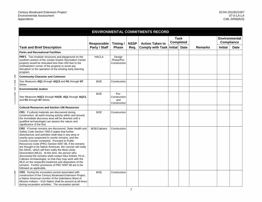
Century Boulevard Extension Project SCH# 2010021007 Environmental Assessment 07-0-LA-LA Appendices CML-5006(810)
7
ENVIRONMENTAL COMMITMENTS RECORD
Task and Brief Description Responsible Party / Staff
Timing / Phase
NSSP Req.
Action Taken to Comply with Task
Task Completed
Remarks
Environmental Compliance
Initial Date Initial Date Parks and Recreational Facilities
PRF1: Two modular structures and playground on the southern portion of the Jordan Downs Recreation Center property would be relocated less than 200 feet to the northwestern corner of the property to avoid any disruption to the operation of the existing early learning program.
HACLA Design Phase/Pre-
Construction
Community Character and Cohesion
See Measures AQ1 through AQ13 and N1 through N7 below.
BOE Construction
Environmental Justice
See Measures HAZ1 through HAZ8, AQ1 through AQ13, and N1 through N7 below.
BOE Pre-Construction
and Construction
Cultural Resources and Section 106 Resources
CR1: If cultural materials are discovered during construction, all earth-moving activity within and around the immediate discovery area will be diverted until a qualified archaeologist can assess the nature and significance of the find.
BOE Construction
CR2: If human remains are discovered, State Health and Safety Code Section 7050.5 states that further disturbances and activities shall stop in any area or nearby area suspected to overlie remains, and the County Coroner contacted. Pursuant to Public Resources Code (PRC) Section 5097.98, if the remains are thought to be Native American, the coroner will notify the NAHC, which will then notify the Most Likely Descendent (MLD). At this time, the person who discovered the remains shall contact Alex Kirkish, Ph.D., Caltrans Archaeologist, so that they may work with the MLD on the respectful treatment and disposition of the remains. Further provisions of PRC 5097.98 are to be followed as applicable.
BOE/Caltrans Construction
CR3: During the excavation period associated with construction of the Century Boulevard Extension Project, a Native American monitor of the Gabrieleno Band of Mission Indians – Kizh Nation shall be present at all times during excavation activities. The excavation period
BOE Construction

Century Boulevard Extension Project SCH# 2010021007 Environmental Assessment 07-0-LA-LA Appendices CML-5006(810)
8
ENVIRONMENTAL COMMITMENTS RECORD
Task and Brief Description Responsible Party / Staff
Timing / Phase
NSSP Req.
Action Taken to Comply with Task
Task Completed
Remarks
Environmental Compliance
Initial Date Initial Date includes, but is not limited to, pavement removal, potholing/boring, grading, excavation and trenching. The area of interest for Native American monitoring shall be focused on the western boundary of the project and excludes excavation activities within the boundaries of the 21-acre vacant parcel owned by HACLA, which has recently been subjected to extensive ground disturbance as a result of environmental remediation activities. Construction shall not be delayed or halted if the Native American Monitor is not available. The tribe shall be contacted within at least 3 business days of requiring monitoring services. If discoveries are made by either the Native American Monitor or construction personnel at any time during excavation or other construction activities (including the 21-acre vacant parcel), the provisions of Avoidance Measures CR1 and CR2 for the unanticipated discovery of cultural resources shall be fully enforced.
Water Quality and Storm Water Runoff
WQ1: A site-specific Storm Water Pollution Prevention Plan (SWPPP) shall be prepared and implemented for the project. The SWPPP shall specify Best Management Practices to be used during construction; these would include but not be limited to erosion control, sediment control, and non-stormwater management and materials management BMPs.
BOE Construction
WQ2: The project shall be required to comply with the City of Los Angeles grading permit regulations, which require necessary measures, plans (including a wet weather erosion control plan if construction occurs during the rainy season), and inspections to reduce sedimentation and erosion.
BOE Construction
WQ3: The design of the Proposed Build Alternative shall incorporate “Green Street” planting elements, such as a palette of infiltration planters and bioswales, for use in managing and treating stormwater runoff to feed landscaping and percolate through the soil.
BOE Design Phase/Pre-
Construction
Geology/Soils/Seismicity/Topography
GEO1: The project shall comply with the provisions of the City of Los Angeles specifications for roadway construction and geotechnical report prepared for the project to ensure that the project is consistent with the latest seismic design standards for structural loads and materials.
BOE Design Phase/Pre-
Construction

Century Boulevard Extension Project SCH# 2010021007 Environmental Assessment 07-0-LA-LA Appendices CML-5006(810)
9
ENVIRONMENTAL COMMITMENTS RECORD
Task and Brief Description Responsible Party / Staff
Timing / Phase
NSSP Req.
Action Taken to Comply with Task
Task Completed
Remarks
Environmental Compliance
Initial Date Initial Date Paleontology
P1: If a potential fossil is found, a qualified paleontologist retained for the project shall be allowed to temporarily divert or redirect grading and excavation activities from the area of the exposed fossil to facilitate evaluation and, if necessary, salvage. At the paleontologist’s discretion and to reduce any construction delay, the grading and excavation contractor shall assist in removing rock samples for initial processing. Any fossils encountered and recovered shall be prepared to the point of identification and catalogued before they are donated to their final repository. Any fossils collected should be donated to a public, nonprofit institution with a research interest in the materials, such as the Natural History Museum of Los Angeles County. Accompanying notes, maps, and photographs shall also be filed at the repository. If fossils are found, following the completion of the above tasks, the paleontologist shall prepare a report summarizing the results of the monitoring and salvaging efforts, the methodology used in these efforts, as well as a description of the fossils collected and their significance. The report shall be submitted by BOE to Caltrans, the Natural History Museum of Los Angeles County, and representatives of other appropriate or concerned agencies to signify the satisfactory completion of the salvaging efforts.
BOE Construction
Hazardous Waste/Materials
HAZ1: Prior to project construction, HACLA shall receive the certificate of completion from DTSC. The site shall be remediated to meet site-specific clean-up goals to allow for the development of unrestricted land uses, as approved by DTSC, prior to construction.
HACLA Pre-Construction
HAZ2: Should any previously unidentified soils that exceed site-specific clean-up goals, as approved by DTSC for the project site, be encountered during construction, an action plan shall be developed, approved by DTSC as appropriate, and implemented, prior to resuming construction activities in the contaminated area. As needed, the investigation and remediation of a release or threatened release of any hazardous substances at or from the project site shall be overseen by the DTSC in accordance with all federal, state, and local laws and regulations.
BOE Construction

Century Boulevard Extension Project SCH# 2010021007 Environmental Assessment 07-0-LA-LA Appendices CML-5006(810)
10
ENVIRONMENTAL COMMITMENTS RECORD
Task and Brief Description Responsible Party / Staff
Timing / Phase
NSSP Req.
Action Taken to Comply with Task
Task Completed
Remarks
Environmental Compliance
Initial Date Initial Date HAZ3: A Health and Safety Plan shall be prepared prior to construction activities to train workers to recognize potential health and safety hazards, communicate potential health and safety hazards to others, instruct personnel in procedures for performing work safely, mitigate hazards and avoid exposure to hazardous substances with the use of engineering and administrative controls, use protective equipment to limit exposure when engineering and administrative controls are not effective. The Health and Safety Plan shall contain provisions for providing breathing zone monitoring if workers will be exposed to concentrations of contaminants near the Permissible Exposure Limits, consistent with DTSC’s approved site-specific clean-up goals as they relate to the 21-acre site that is currently undergoing remediation.
BOE Pre-Construction
and Construction
HAZ4: Construction workers shall undergo Health and Safety training as required by Cal/OSHA regulations in Title 8 CCR for handling hazardous materials and/or wastes.
BOE Pre-Construction
and Construction
HAZ5: Construction shall use dust suppression methods when disturbing soil so as not to create visible dust emissions or cause contaminated soil to become airborne.
BOE Construction
HAZ6: Prior to construction, an Excavation, Disposal, and Transportation Plan shall be prepared to describe the procedures and methodology for excavation, temporary storage, containerization, transport and disposal of hazardous waste. This includes construction of the temporary stockpile area (e.g., berms to prevent runoff, wetting, and cover to prevent soil from becoming airborne); use of USDOT-approved containers for storage and transport; use of registered transporter; decontamination of transport vehicles prior leaving the site; obtaining written acceptance of disposal facility prior to transport vehicle leaving site so load is not rejected upon arrival; and compliance with manifest requirements.
BOE Pre-Construction
and Construction
HAZ7: South Coast Air Quality Management District (SCAQMD) Rule 1166 – Volatile Organic Compound (VOC) Emissions from Decontamination of Soil: SCAQMD Rule 1166 sets forth the requirements to control the emission of VOCs generated from the excavation and handling of VOC-impacted soil. Rule
BOE Pre-Construction

Century Boulevard Extension Project SCH# 2010021007 Environmental Assessment 07-0-LA-LA Appendices CML-5006(810)
11
ENVIRONMENTAL COMMITMENTS RECORD
Task and Brief Description Responsible Party / Staff
Timing / Phase
NSSP Req.
Action Taken to Comply with Task
Task Completed
Remarks
Environmental Compliance
Initial Date Initial Date 1166 applies to all soil excavations with volumes exceeding one cubic yard of VOC-impacted soil. VOC-impacted soil is defined as having VOC concentrations exceeding 50 ppmv as measured by a hexane calibrated organic vapor analyzer. In compliance with the SCAQMD Rule 1166 requirements, an Excavation Management Plan and necessary permitting application forms shall be prepared and submitted for approval to the SCAQMD. HAZ8: The City shall continue to implement an emergency response plan for responding to releases from accidents (e.g., LAFD, first responders from the Los Angeles County Hazardous Materials Unit). Actions may involve cordoning off the affected area, stabilizing and containing releases of hazardous materials, and remediating the released hazardous materials.
BOE Operation
Air Quality
AQ1: Apply water or dust palliative to the site and equipment as frequently as necessary to control fugitive dust emissions. Fugitive emissions generally must meet a “no visible dust” criterion either at the point of emission or at the right of way line as required by the SCAQMD.
BOE Construction
AQ2: Spread soil binder on any unpaved roads used for construction purposes, and all project construction parking areas.
BOE Construction
AQ3: Properly tune and maintain construction equipment and vehicles. Use low-sulfur fuel in all construction equipment as provided in California Code of Regulations Title 17, Section 93114.
BOE Construction
AQ4: Develop a dust control plan documenting sprinkling, temporary paving, speed limits, and expedited revegetation as needed to minimize construction impacts to existing communities.
BOE Construction
AQ5: Locate equipment and materials storage sites at least 500 feet from the sensitive receptors. Keep construction areas clean and orderly.
BOE Construction
AQ6: Extended idling, material storage, and equipment maintenance should be prohibited within 500 feet of sensitive air receptors, to the extent feasible.
BOE Construction
AQ7: Use track-out reduction measures such as gravel pads at project access points to minimize dust and mud deposits on roads affected by construction traffic.
BOE Construction

Century Boulevard Extension Project SCH# 2010021007 Environmental Assessment 07-0-LA-LA Appendices CML-5006(810)
12
ENVIRONMENTAL COMMITMENTS RECORD
Task and Brief Description Responsible Party / Staff
Timing / Phase
NSSP Req.
Action Taken to Comply with Task
Task Completed
Remarks
Environmental Compliance
Initial Date Initial Date AQ8: Cover all transported loads of soils and wet materials prior to transport, or provide adequate freeboard (space from the top of the material to the top of the truck) to minimize emission of dust (particulate matter) during transportation.
BOE Construction
AQ9: Promptly and regularly remove dust and mud that are deposited on paved, public roads due to construction activity and traffic to decrease particulate matter.
BOE Construction
AQ10: Route and schedule construction traffic to avoid peak travel times as much as possible, to reduce congestion and related air quality impacts caused by idling vehicles along local roads.
BOE Construction
AQ11: Rule 401 – Visible Emissions: A person shall not discharge into the atmosphere from any single source of emission whatsoever any air contaminants for a period or periods aggregating more than three (3) minutes in any one (1) hour which are as dark or darker in shade as that designated as No. 1 on the Ringelmann Chart or of such opacity as to obscure an observer’s view to a degree equal to or greater than smoke.
BOE Construction
AQ12: Rule 402 – Nuisance: A person shall not discharge from any source whatsoever such quantities of air contaminants or other material which cause injury, detriment, nuisance or annoyance to any considerable number of persons or to the public or which endangers the comfort, repose, health or safety of any such persons or the public or which cause or have a natural tendency to cause injury or damage to business or property.
BOE Construction
AQ13: Rule 403 – Fugitive Dust: SCAQMD’s Rule 403 requires that fugitive dust be controlled with the best available control measures (BACM) in order to reduce dust so that it does not remain visible in the atmosphere beyond the property line of the proposed project. It also requires a dust control plan to be submitted and approved prior to construction. The dust control plan should describe all applicable dust control measures that will be implemented at the project; and should describe types of dust suppressant, surface treatments and other measures to be utilized at the construction sites to comply with the Rule. The relevant specifics of Rule 403 are as follows: o No person shall cause or allow the emissions of
fugitive dust from any active operation, open storage
BOE Construction

Century Boulevard Extension Project SCH# 2010021007 Environmental Assessment 07-0-LA-LA Appendices CML-5006(810)
13
ENVIRONMENTAL COMMITMENTS RECORD
Task and Brief Description Responsible Party / Staff
Timing / Phase
NSSP Req.
Action Taken to Comply with Task
Task Completed
Remarks
Environmental Compliance
Initial Date Initial Date pile, or disturbed surface area such that the dust remains visible in the atmosphere beyond the property line of the emission source; or the dust emission exceeds 20 percent opacity, if the dust emission is the result of movement of a motorized vehicle.
o No person shall conduct active operations without utilizing the applicable best available control measures included in Table 1 of Rule 403 to minimize fugitive dust emissions from each fugitive dust source type within the active operation.
o No person shall cause or allow PM10 levels to exceed 50 micrograms per cubic meter when determined, by simultaneous sampling, as the difference between upwind and downwind samples collected on high-volume particulate matter samplers or other U.S. EPA-approved equivalent method for PM10 monitoring.
o No person shall allow track-out to extend 25 feet or more in cumulative length from the point of origin from an active operation. Notwithstanding the preceding, all track-out from an active operation shall be removed at the conclusion of each workday or evening shift.
o No person shall conduct an active operation with a disturbed surface area of five or more acres or with a daily import or export of 100 cubic yards or more of bulk material without utilizing approved control measure/measures at each vehicle egress from the site to a paved public road.
Noise
N1: All equipment shall be equipped with mufflers and other suitable noise attenuation devices.
BOE Construction
N2: Grading and construction contractors shall use quieter equipment as opposed to noisier equipment (such as rubber-tired equipment rather than metal-tracked equipment).
BOE Construction
N3: The construction contractor shall locate construction staging areas away from sensitive uses.
BOE Construction
N4: Construction haul truck and materials delivery traffic shall avoided residential areas whenever feasible.
BOE Construction
N5: The construction contractor shall schedule high noise-producing activities between the hours of 8:00 a.m. and 5:00 p.m. to minimize disruption to sensitive uses.
BOE Construction
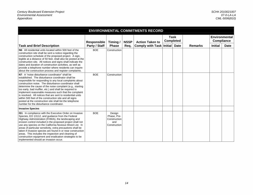
Century Boulevard Extension Project SCH# 2010021007 Environmental Assessment 07-0-LA-LA Appendices CML-5006(810)
14
ENVIRONMENTAL COMMITMENTS RECORD
Task and Brief Description Responsible Party / Staff
Timing / Phase
NSSP Req.
Action Taken to Comply with Task
Task Completed
Remarks
Environmental Compliance
Initial Date Initial Date N6: All residential units located within 500 feet of the construction site shall be sent a notice regarding the construction schedule of the proposed project. A sign, legible at a distance of 50 feet, shall also be posted at the construction site. All notices and signs shall indicate the dates and duration of construction activities, as well as provide a telephone number where residents can inquire about the construction process and register complaints.
BOE Construction
N7: A “noise disturbance coordinator” shall be established. The disturbance coordinator shall be responsible for responding to any local complaints about construction noise. The disturbance coordinator shall determine the cause of the noise complaint (e.g., starting too early, bad muffler, etc.) and shall be required to implement reasonable measures such that the complaint is resolved. All notices that are sent to residential units within 500 feet of the construction site and all signs posted at the construction site shall list the telephone number for the disturbance coordinator.
BOE Construction
Invasive Species
IS1: In compliance with the Executive Order on Invasive Species, EO 13112, and guidance from the Federal Highway Administration (FHWA), the landscaping and erosion control included in the proposed project shall not use any species on the California Noxious Weed List. In areas of particular sensitivity, extra precautions shall be taken if invasive species are found in or near construction areas. This includes the inspection and cleaning of construction equipment and eradication strategies to be implemented should an invasion occur.
BOE Design Phase, Pre-Construction
and Construction

Century Boulevard Extension Project SCH# 2010021007 Environmental Assessment 07-0-LA-LA Appendices CML-5006(810)
Appendix D. USFWS Species List

Century Boulevard Extension Project SCH# 2010021007 Environmental Assessment 07-0-LA-LA Appendices CML-5006(810)
This page is intentionally left blank.

Century Boulevard Extension Project SCH# 2010021007 Environmental Assessment 07-0-LA-LA Appendices CML-5006(810)

Century Boulevard Extension Project SCH# 2010021007 Environmental Assessment 07-0-LA-LA Appendices CML-5006(810)

Century Boulevard Extension Project SCH# 2010021007 Environmental Assessment 07-0-LA-LA Appendices CML-5006(810)

Century Boulevard Extension Project SCH# 2010021007 Environmental Assessment 07-0-LA-LA Appendices CML-5006(810)

Century Boulevard Extension Project SCH# 2010021007 Environmental Assessment 07-0-LA-LA Appendices CML-5006(810)

Century Boulevard Extension Project SCH# 2010021007 Environmental Assessment 07-0-LA-LA Appendices CML-5006(810)

Century Boulevard Extension Project SCH# 2010021007 Environmental Assessment 07-0-LA-LA Appendices CML-5006(810)
Appendix E. FHWA Air Conformity Concurrence
Century Boulevard Extension Project SCH# 2010021007 Environmental Assessment 07-0-LA-LA Appendices CML-5006(810)
This page is intentionally left blank.
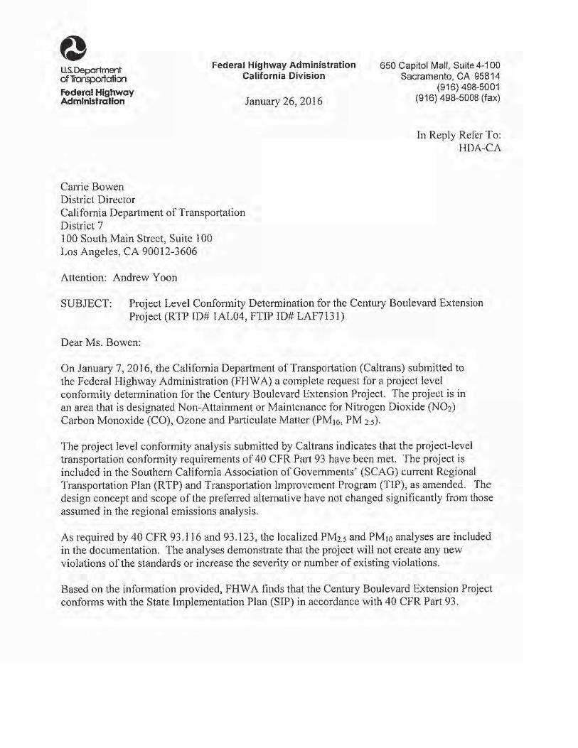

Century Boulevard Extension Project SCH# 2010021007 Environmental Assessment 07-0-LA-LA Appendices CML-5006(810)
Appendix F. Public Hearing Transcript

Century Boulevard Extension Project SCH# 2010021007 Environmental Assessment 07-0-LA-LA Appendices CML-5006(810)
This page is intentionally left blank.

���������������������������������������������������������������������
������������� ����������������
�����������������������������������������������������
������������!!��"#��"��
����$������������%&
���������������������������������������������������������������������������������������������������������
�������� ���
����
���� ������������������
�� ��
����� �������� ����������� �����
'���( ��������� !"#�$
������( ��%%&'���(&%�)
�%����( �*�+,%�*-%�.�%,)&/� 00##��,1��2���2 �*)�%3�4�)!�,4&'*�%&,0###"

H I N E S R E P O R T E R S 1
1
2
3 PUBLIC HEARING
4 ON THE
5 ENVIRONMENTAL ASSESSMENT
6 FOR THE
7 CENTURY BOULEVARD EXTENSION PROJECT
8
9
10
11
12 THURSDAY, DECEMBER 17, 2015
13
14
15
16
17
18
19 JORDAN DOWNS GYMNASIUM 9900 GRAPE STREET
20 LOS ANGELES, CALIFORNIA 90002
21
22
23
24
25 REPORTED BY: JENNIFER A. HINES, CSR NO. 6029

H I N E S R E P O R T E R S 2
Page 2
1 APPEARANCE OF PARTICIPANTS 2 NORMAN MUNDY,
LOS ANGELES BUREAU OF ENGINEERING 3
4 ANDREW JOHNSON,ENVIRONMENTAL PLANNER
5 ICF INTERNATIONAL 6
RUSSELL WHISMAN, 7 ENVIRONMENTAL PLANNER
ICF INTERNATIONAL 8
RAMIN KIANFAR, 9 HOUSING AUTHORITY OF THE COUNTY OF LOS ANGELES10
TERRY HAYES11 MADONNA MARCELO12
RAMNIK MUNGRA,13 PROJECT ENGINEER14 MINE STRUHL,
BRANCH CHIEF15 CALTRANS DISTRICT 716
17
18
19
20
21
22
23
24
25
Page 3
1 I N D E X
2
3 MEETING AGENDA
4
5
6 I. DISPLAY VIEWING AND INFORMATION DISCUSSION Caltrans and Bureau of Engineering staff
7 Available to Discuss Project
8
9 II. OVERVIEW OF PROJECT AND NATIONAL ENVIRONMENTAL POLICY ACT (NEPA) PROCESS
10 Presentation by Bureau of Engineering
11III. PUBLIC COMMENTS
12
13IV. INFORMATION DISCUSSION
14
15
16
17
18
19
20
21
22
23
24
25
Page 4
1 THURSDAY, DECEMBER 17, 2015; LOS ANGELES, CALIFORNIA
2 -0-
3 6:30 A.M.
4
5 MR. NORMAN MUNDY: Hello. Good evening.
6 AUDIANCE PARTICIPANT: Good evening.
7 MR. NORMAN MUNDY: Thank you for coming
8 tonight. I think we're ready to get started. First let
9 me introduce myself. My name is Norman Mundy, and I work
10 with the City of Los Angeles in the bureau of
11 engineering. And we're here tonight to talk about a
12 project that the Bureau of Engineering will be doing and
13 involved in the project approval is also the folks from
14 the California Department of Transportation which is
15 also known as Caltrans. So we have staff from both the
16 City here tonight and from Caltrans.
17 Here's a quick overview of what we're going
18 to do tonight.
19 It's a public hearing. We're talking about
20 the purpose of the hearing and then the project
21 overview. I'll quickly go through the environmental
22 process that we're doing now for the project. And then
23 probably most importantly, I'll tell you how you submit
24 comments on the project tonight, and that's sort of the
25 main purpose we're here tonight is to get comments on
Page 5
1 the project and comments on the environmental document 2 that's been prepared for the project. 3 The purpose of tonight's hearing is to get 4 public comments regarding the proposed project, which is 5 the extension of Century Boulevard from Grape Street to 6 Alameda Street. And we want to make sure that this 7 project is consistent with the goals and objectives of 8 various transportation plans and those plans can be 9 federal plans, state plans and local plans. So we want10 to make sure that this project is consistent with those11 other types of planning agencies.12 We're here specifically to talk about the13 Century Boulevard extension project tonight. That's the14 document we've prepared so that's what we want to focus15 on tonight.16 Now, the Century Boulevard project is a part17 of the overall Jordan Downs specific plan development18 and the creation of the Jordan Downs Urban Village. And19 they're -- as many of you know, there's remediation20 activities going on as part of the overall specific plan21 development.22 We're here tonight to talk about the Century23 Boulevard extension. Those other processes have been24 through a separate environmental review. So our subject25 tonight is going to focus on the Century Boulevard

H I N E S R E P O R T E R S 3
Page 6
1 extension project. 2 I should just point out that we have four 3 display boards back there if you which you could look at 4 when we're finished. 5 This is the information on the project. 6 Grape Street is here and west, and the project will 7 continue Century Boulevard from Grape Street, down to 8 the north and then continue across to Alameda on the 9 east. And it will connect there at the intersection of10 Alameda and Goldie Boulevard.11 The extended roadway has several features.12 It would be the main thoroughfare, the main roadway13 through Jordan Downs Urban Village, and it would be able14 to accommodate automobile traffic, buses, bike and also15 pedestrians. There will be pedestrians friendly16 amenities along the roadway extension.17 The design of the project includes18 environmental sustainable features such as bios fail19 which filter rain water and trees and vegetation and20 things like bike lanes for bicycle traffic.21 The Century Boulevard extension is going to22 be the first step in implementing the Jordan Downs23 specific plan which, again, as many of you are familiar24 with, has been -- is the result of years and years of25 planning. So the Century Boulevard project will be the
Page 7
1 first step in implementing that specific plan. 2 There are several primary purposes of the 3 project. First of all, it's going to be the main 4 thoroughfare, main roadway, through the specific plan 5 area, and the Century Boulevard extension is consistent 6 with the division of the Jordan Downs specific plan that 7 calls for constructing a roadway, in this case 74 feet 8 by 86 feet wide that accommodates buses, bicycles, 9 parkways, pedestrian enhancements, traffic calming10 measures and the function, main function, of the road is11 to provide a connection through the Jordan Downs12 specific plan area that will provide open space,13 community center and multi-use buildings.14 Because of the new roadway, there will be15 the opportunity to provide new bus service that would16 conduct residents to public transportation. And we have17 the Metro Line Blue trains, Blue Line at 103rd Street,18 and there will be bus access to David Star Jordan High19 School, and finally there will be bicycle baths for20 bicycles along the road.21 So this is a view of where the roadway will22 fit in within the overall specific plan development, and23 as you can see here, the roadway is in red. Again, Grape24 Street down here and Alameda at the top. And the roadway25 will connect Grape to Alameda. And this shows some of
Page 8
1 the features in this specific plan area that will follow 2 construction of the roadway. 3 We're here tonight because there's a federal 4 law called the National Environmental Policy Act, and 5 that law requires that projects like this undergo an 6 environmental review. And for this project Caltrans and 7 the City of Los Angeles have prepared a document that 8 studies the effects that the roadway parkway might have 9 on the environment. And the way they do that is by10 preparing a document called an Environmental Assessment,11 and we've prepared that document. And the document12 describes the environmental impacts of the project and13 also discusses potential alternatives to the project and14 ways of either avoiding, minimizing impacts and specific15 mitigation measures that would lessen the environmental16 impacts.17 As a part of NEPA, we are soliciting public18 comments on the environmental documents, and we would19 like to get from you comments in writing. So I hope20 when you signed in at the desk back there that you were21 provided with a comment form. If you weren't, we have22 plenty of them available back there. So we'd like you to23 submit your comments in writing. So we'd like you to24 submit your comments in writing on the cards we've25 supplied for you, and we'll assemble all the comments
Page 9
1 that are submitted both here tonight and also you'll 2 have the opportunity to submit comments in writing and 3 we'll take all those comments and respond to them when 4 we publish the final version of this environmental 5 assessment document. 6 And then in case you want to submit a 7 comment after tonight or if you know somebody who may 8 want to submit a comment, this is the information to 9 which you can send those written comments via U.S. mail.10 So we'll leave this slide up here.11 And this information is also on the FAQs12 sheet you were given. So we'll leave this up here if13 you want to copy it down or take the FAQs sheet, you can14 submit your comments in writing.15 So we want to make it as easy as possible16 for you to submit comments. You can put it on the17 comment form tonight, you can go home tonight and submit18 it in the mail later on.19 Okay. Good. So let me just leave this.20 So what we'd like now is to give everybody a21 chance to submit comments if they have them on the22 project.23 Does anybody need a comment form or.... we24 can take questions from the audience since we don't have25 that many people here.

H I N E S R E P O R T E R S 4
Page 10
1 Does anybody have any questions about the 2 project that we might be able to answer for them? No? 3 Okay. Well, again, I just point out that we 4 do have these display boards here so if you want to take 5 a look at those, that might give you an idea of 6 something you're interested in. So please, by all means, 7 submit comments tonight or think about things and then 8 submit them later. So you're welcome to circulate that 9 and take a look at the display boards.10 Yes sir?11 MR. JOHN KING: I have a question. So12 Century Boulevard as it comes through, how does the13 size, the width that will be within the development14 compare to the width of the street just across Grape on15 the other side? Will it be wider or more narrow? Bike16 lanes?17 Can you kind of describe that a little bit.18 MR. NORMAN MUNDY: Ramnik, can you help us19 with that?20 MR. RAMNIK MUNGRA: This is Ramnik Mungra21 also from the Bureau of Engineering.22 (Inaudible) basically the east side so23 basically left-turn lane and a bike lane in that area.24 MR. NORMAN MUNDY: Just to point out on one25 of the boards back there, I think it's the third one
Page 11
1 from the left, there is some dimensions in the roadway 2 and that might help answer your questions. So you're 3 certainly welcome to take a look at that and we can go 4 over that with you. 5 MR. RAMNIK MUNGRA: That shows so that you 6 can go later on if you want to. 7 MR. NORMAN MUNDY: You have the plans? So 8 he has some plans that would show the widths of the 9 roadway, and we can get those out for everybody to look10 at if you want to see that.11 Anymore questions? Any comments --12 AUDIANCE PARTICIPANT: I would like to know13 when are you guys going to start, February or beginning14 of March? How long is it going to take?15 MR. RAMNIK MUNGRA: We are still waiting for16 some things, for example, size mitigation work and also17 the pre-school. That needs to be located too before we18 can start work. So in October of next year.19 AUDIANCE PARTICIPANT: Approximately how20 long is it going to take, though, once you guys --21 MR. RAMNIK MUNGRA: Once we start, it will22 take I think 12 or 18 months?23 AUDIANCE PARTICIPANT: How many months?24 MR. RAMNIK MUNGRA: 12 or 18 months. A year25 and a half.
Page 12
1 MR. NORMAN MUNDY: So the schedule is 2 scheduled to start October 2016 and then continuing for 3 one year to a year and a half. So into October 2017 and 4 then into maybe 2018. So 12 to 18 months after they 5 start. 6 Any other questions? Okay. Then, again, 7 feel free to look at the display boards and we have lots 8 of folks here that are knowledgeable about the project 9 and can answer your questions.10 So thank you very much. And if you do have11 comment forms that you want to turn in, you can just12 leave them on the table there in the back. And, again,13 thank you, everybody, for coming.14 (Whereupon, the proceedings15 recessed at the hour of 6:45 p.m.)16
17
18
19
20
21
22
23
24
25

Century Boulevard Extension Project SCH# 2010021007 Environmental Assessment 07-0-LA-LA Appendices CML-5006(810)
This page is intentionally left blank.

Century Boulevard Extension Project SCH# 2010021007 Environmental Assessment 07-0-LA-LA Appendices CML-5006(810)
1
Appendix G. List of Technical Studies
Andersen Environmental, Environmental Sampling Report, 9901 South Alameda Street, April 13, 2010
Andersen Environmental, Final Interim Remedial Action Plan, 9901 South Alameda Street, Los Angeles, California 90002, June 30, 2014
Andersen Environmental, Phase I Environmental Site Assessment Report - 9901 South Alameda Street, Los Angeles, California, April 13, 2010
Andersen Environmental, Phase I Environmental Site Assessment Report for the Jordan Downs Redevelopment Project Area – Jordan Downs Housing Development, March 24, 2010
Andersen Environmental, Remediation Feasibility Study, 9901 South Alameda Street, Los Angeles, California 90002, June 30, 2014
California Department of Conservation, Seismic Hazard Zones, South Gate Quadrangle (1999), available at http://www.conservation.ca.gov/cgs/shzp/Pages/Index.aspx
California Geological Survey, Alquist-Priolo Earthquake Fault Zones (2007), available at www.consrv.ca.gov/ .CGS/RGHM/AP/Pages/Index.aspx
California Regional Water Quality Control Board, Los Angeles Region, Water Quality Control Plan, Los Angeles Region, adopted June 1994
City of Los Angeles, City of Los Angeles General Plan Framework, 2001
City of Los Angeles, General Plan Safety Element, November 26, 1996
City of Los Angeles, South Los Angeles Subregion Master Environmental Assessment, 1992
City of Los Angeles Department of City Planning, Jordan Downs Specific Plan Draft Environmental Impact Report, November 2010
City of Los Angeles Department of City Planning, The Housing Authority of the City of Los Angeles, and Los Angeles County Local Agency Formation Commission, City of Los Angeles Jordan Downs Annexation Plan for Municipal Services, February 2011
Environmental Geoscience Services, Phase I Environmental Site Assessment – 9901 South Alameda Street, Los Angeles, CA 90002, August 2004
ICF International, Historic Property Survey Report, October 2015
Iteris, Inc., Jordan Downs Specific Plan Traffic Impact Study, September 2010
Los Angeles and San Gabriel Rivers Watershed Council, Compton Creek Watershed Management Plan, June 2005
RCC Group, Phase II Environmental Site Assessment Report – 9901 South Alameda Street, Los Angeles, California, September 16, 2005

Century Boulevard Extension Project SCH# 2010021007 Environmental Assessment 07-0-LA-LA Appendices CML-5006(810)
2
Terry A. Hayes Associates Inc., Visual Impact Assessment (VIA) Questionnaire/Scenic Resource Evaluation and Visual Impact Assessment, September 2015
Terry A. Hayes Associates Inc., Summary of Environmental Site Assessment Memorandum, October 2015
Terry A. Hayes Associates Inc., Noise Study Report, October 2015
The Mark Group, Phase I Environmental Assessment and Selected Soil Sampling Report – 9901 South Alameda Street, Los Angeles, CA, February 9, 1996
U.S. Department of Agriculture, Natural Resources Conservation Service, California State-Listed Noxious Weeds List