center of excellence for urban development and climate adaptation prof. jyoti parikh ed - irade...
Post on 19-Dec-2015
219 views
TRANSCRIPT

Center of Excellence for Urban Development and Climate
Adaptation
Prof. Jyoti ParikhED - IRADe
Date: 9-6-2010
Urban floods and Climate change

Cities and Climate Change Climate change impacts felt locally—in cities,
towns, and other human settlements.
Due to rapid urbanization, cities are more at risk given the existing environmental, economic and social problems.
Cities with large concentration of population, property and crucial economic assets and infrastructure are in highly vulnerable

INCREASED URBANIZATION
Flooding has become a problem in recent years because:
1. Developments encroach • Floodplains, • Obstructing floodways and Waterways• Causing loss of natural flood storage.
2. Continued development and redevelopment to higher density land uses by high land costs in cities.

Conti…….
3. Increased impervious areas such as
• Roads, • Roofs and• Paving,
Due to increasing development densities means more run-off
In Urban Flood any part of city can badly get affected and more significantly low lying areas
• Urban floods are due to stagnation • Sometimes urban flood occurs due to inflow from river / sea in urban drains during high stage / high tides

5
• High and multidimensional risks
Climate Induced Vulnerability of Cities in India
• Mean minimum and maximum temperature by 2-4°C• 7-20% in mean annual precipitation• Frequency of heavy rainfall• Sea level by 0.8 meters by the end of this century• 5 to 25% in semiarid and drought prone central
India• Winter rainfall in north India• Number of rainy days

The urban heat island effect has resulted in an
increase in rainfall over urban areas
Climate change is resulting in • Changed weather patterns and • Increased intensities of rainfall in lesser number of rainfall
events during the monsoons Thus, many of our cities located
On the coast, On riverbanks, On downstream of major dams and Even otherwise need to have special provision for mitigation
of urban flood disasters,
Our urban centers should quickly recover from flooding incidences through adequate flood disaster mitigation measures
Conti……

The annual disasters from urban flooding are now much greater than the annual economic losses due to other disasters.
In 2001, there were 285 million people residing in 35 metro cities (having a population of 1 million plus).
This is estimated to exceed 600 million by 2021 in over a 100 metro cities.
Flooding in urban areas can be caused by flash floods, or coastal floods, or river floods, heavy rains
Urban floods is a specific phenomenon

Significant Urban floods in India in recent years
2005 Severe urban floods were reported from 10 cities and Mumbai was worst affected. 2006 Number of affected cities rose to 22. Surat was worst affected. Vishakhapattanam airport was inundated for more than 10 days. 2007 Number of affected cities rose to 35. Kolkata was worst affected.
2008 Jamshedpur, Mumbai, Hydrabad were worst affected

URBAN FLOODING
Flooding in the cities and the towns is a recent phenomenon caused by :
1. Increasing incidence of heavy rainfall in a short period of time,
2. Inadequate capacity of drains and 3. Lack of maintenance of the drainage
infrastructure.
In Urban Flood any part of city can badly get affected and more significantly low lying areas.
Sometimes urban flood occurs due to inflow from river / sea in urban drains during high stage / high tides.

URBAN FLOOD: Impacts
Urbanisation increases flood risk by up to three times Floods are now affecting a large number of people living in
urban India (peak flows result in flooding very quickly due to faster flow times
(in a matter of minutes),
Major cities have witnessed Loss of life and property, Disruptions to transport and power and Incidences of epidemics during the monsoons, Severe economic and infrastructure loss to industry and
commerce
Most notable amongst them being Mumbai in 2005, Surat in 2006 and Kolkata in 2007

Mega cities in East Asia

Coastal population vulnerable to sea level rise

…
Many cities are on risky sites – near rivers or harbours – while others, established on safer ground, have expanded onto riskier land like steep hillsides or floodplains.
Thus many cities are at risk from climate change impacts such as sea-level rise, floods and extreme weather.
1.2 billion people live along coastal areas with low elevation.
When cities flood, access to safe drinking water, food and sanitation is difficult, particularly for the poor. Children can drown, and disease outbreaks are rife.

Source. Human Development report 2007

Top Five States of India(Based on disaster occurrence)

Profile: Uttar Pradesh
0
5
10
15
20
25
30
35
1950-1959 1960-1969 1970-1979 1980-1989 1990-1999 2000-2009
Occurence
Storm
Flood
Extreme Temperature
Epidemic
Drought

0
5
10
15
20
25
1950-1959 1960-1969 1970-1979 1980-1989 1990-1999 2000-2009
Decade
Storm
Flood
ExtremeTemperatureEpidemic
Drought
Profile: Andhra Pradesh

Profile: Gujarat
0
2
4
6
8
10
12
14
16
18
20
1900-1909
1910-1919
1920-1929
1930-1939
1940-1949
1950-1959
1960-1969
1970-1979
1980-1989
1990-1999
2000-2009
Storm
Flood
Extreme Temperature
Epidemic
Earthquake
Drought

Profile: Bihar
0
2
4
6
8
10
12
14
16
18
1950-1959 1960-1969 1970-1979 1980-1989 1990-1999 2000-2009
Storm
Flood
Extreme Temperature
Epidemic
Earthquake
Drought

Profile: West Bengal
0
2
4
6
8
10
12
14
16
18
1950-1959 1960-1969 1970-1979 1980-1989 1990-1999 2000-2009
Decade
Occ
ure
nce
Storm
Flood
Extreme Temperature
Epidemic
Drought

0
5
10
15
20
25
30
35
1950-1959
1960-1969
1970-1979
1980-1989
1990-1999
2000-2009
Decade
Occ
ure
nce Bihar
Gujarat
Andhra
Uttar Pradesh
West Bengal
Comparative of 5 states

Key Observations
• All regions have a higher proportion of climate related disasters, with• northern and eastern states with highest occurrence of events since• 1950.
•Partially related climate disaster like epidemics also show a rise in occurrences over the decades.
•Floods are the most frequent disaster experienced in all regions with the highest occurrence in the South.
•Storm is the second most frequent disaster in the regions, but has the largest presence in the southern states with 40% of all disaster proportion.
•Extreme temperature has a larger presence in the northern states as compared other regions.
•The Top five states as per the highest registered events in the last decade are: Uttar Pradesh, Andhra Pradesh, Gujarat, Bihar, and West Bengal.
•These results are crucial in identifying the cities in these states that register the highest disaster occurrence.

Most vulnerable populations and elements in a city
Slum dwellers Settlements in low-lying areas Industrial and informal service sector
workers Buildings Industrial units Lifeline public and private infrastructure Ecosystems and the natural environment
Source: Aromar Revi

Vulnerable Groups
Slum-dwellers: They lack secure tenure, proper shelter, water,
sanitation, electricity and other services. Most have no insurance.
Their access to food and water depend on climatic conditions.
Climate change will increase their vulnerability in terms of health, access to food and income generation.
They are the least-informed, least-empowered, and least-mobile group in the face of climate hazards.

Vulnerable Groups
Women: Men control income distribution, property, access to
credit and decision- making. This exacerbates the vulnerability of women in disasters.
Women are largely excluded from city planning and decision- making. This has impact on planning priorities related to climate change.
Women are more prone to the effects of climate hazards because of the work they do and the discriminations they face in terms of access to resources, income or housing. (Nunan and Satterthwaite, 1999)

Climate Change Impacts on Cities
Sea Level
Temperature
Precipitation
Climate Phenomena
Impacted Sectors
Clim
ate
chang
e im
pact
s
Extreme events
Impacts Mitigation and Adaptation
Water
Infrastructure
Food
Health
Energy,Coastal zones
Air and water quality degradation
Increased diseases
Scarcity of water
Increased flooding
Increased heating
Increased migration
cultural heritage
Economic disruption
Increase energy use
Short term
Medium term
Long term

Solutions for Flood Mitigation
Urban flooding can be reduced with measures like;
• Maintaining existing drainage channels, • Providing alternative drainage paths (may be
underground), • On site storage of rainwater, • Control of solid waste entering the drainage
systems, • Providing porous pavements to allow infiltration
of rainwater, • Reserve low-lying areas for playgrounds and
parks, • Using state-of-the-art technologies to address
current problems The use of flood plains be regulated and a suitable
legislation for flood plain zoning be enacted and enforced

In case of urban areas,
Measures required as soon as flood warning is received, are; Installation of removable covers such as
steel or aluminium bulk heads over doors and windows,
Permanent closure of low level windows and other openings,
Keeping store counters on wheels, Closing of sewer wells, anchoring and Covering machinery and equipment with
plastic sheets, etc
Flood Plain proofing

WHAT CITIES SHOULD DO
Local governments should use their authority over land-use planning, waste-management, energy consumption and transportation to tackle climate change
Through planning and regulation, local governments should take pro-active role in adaptation of climate change.
Climate change already has impact on large cities in the coastal or low-lying zones. Therefore, local governments have to take adaptation measures.

Climate Resilience: 6 Major Risks
Temperature and precipitation variability Flooding and extreme rainfall Cyclone and storm surge Sea-level rise Environmental health risks Drought

Adaptation Disaster management: Floods and Cyclones Building shelters Changes in land use Controlled Inundation areas
Infrastructure: Engineering/Architectural Flyovers, Bridges, Dykes Drainage systems, storm sewers Green roofs Storage of flood waters for drought periods

Climate Resilience Measures Develop appropriate risk assessment
Building Retrofitting and Strengthening
Lifeline Infrastructure Development
Hazard Modification
Relocation and Rehabilitation
Improve water, sanitation and housing deficiencies in the poor neighborhoods of urban settlements

Adaptation in the urban areasCities will need to adapt for future floods, droughts,
storms and heat waves through following:
Remodeling drainage system that can accommodate sudden downpour.
High Capacity water supply and storage systems for drought periods.
Embankments of low-lying areas especially for coastal cities.
Stronger buildings, bridges, flyovers, also water supply and treatment plants that withstand storms.

Disaster Management Incorporate Disaster Management Plan as part of the
Master Plan Build stronger database for the city to increase
preparedness Frame higher safety standards for contractors and builders
Flood control initiatives No Encroachment /Construction in risk area Protective hard embankment River trenching Emergency response centre Emergency plan – Place & training
Conti…. 1

The techniques consist of; Providing raised platforms for flood shelter
for men and cattle, Raising the public utility installation
especially The platforms for drinking water hand pumps and
bore wells above flood level
In the existing developed areas, Possibilities of protecting against
submergence Or relocating to safer areas vital
installations like; Electricity sub-stations/ power houses, Telephone exchanges, The pumping stations meant for drinking water
supply etc.
Conti…. 2

IRADe Framework
For
Cities and Climate Adaptation

Urban Design & Climate Resilience
Identification of highly vulnerable zones
encourage new development only in non vulnerable zones
Mapping of Flood plains
Widening of drains to increase capacity
Flood pathway management to copewith heavy rainfall events
Promote sustainable designs
Effective Land Use Planning
Use risk information to apply land use planning as a tool for adaptive disasters
Introduce Diversion channel
Source control by upland management
Temporary water storage including green space use
Promote recycling water
Rainwater harvesting
Energy conservation measures
Landscaping using indigenous plants

Adaptation Strategy for Water Management
Water
Augment Water
Reduce Water Demand
Water Management
Treatment Plants
Pumping Stations
Infrastructure Location
Pipe Lines
Reduction in Water Resources
Water Conservation
Rain Water Harvesting
Reuse/Re-cycling
Surface
ground water
Storage
Ponds/lakes
Rivers/Canals
Hand Pumps
Wells/Bore wells
Natural
Manmade
recharging the ground water

Storm Water Management
Rapid conversion of land to urban and suburban areas has altered the water flow pattern.
During the flood increased volume of water and pollutants reduces the water quality.
The following adaptation strategy can be followed Reduce the volume of storm water. Reuse and Reduce water logging to maintain smooth flow. Reduce the pollution levels of storm water.

Limit Storm Water Impact and Reuse It
Storm Water
Reduction in Storm Water Volume
Reduction in Water Logging
Reuse of Storm Water
Quality Control before Disposal
capacity
treatment
power supply
Effective planning
Green land absorption
Maintenance
Emergency Responsiveness
Storage
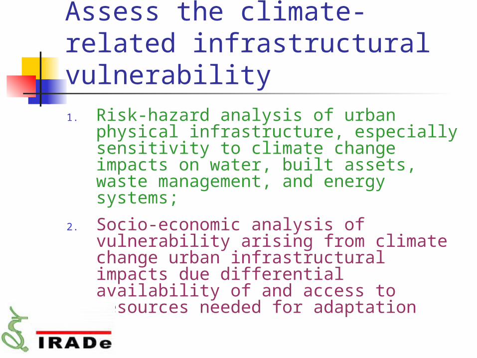
Assess the climate-related infrastructural vulnerability1. Risk-hazard analysis of urban physical
infrastructure, especially sensitivity to climate change impacts on water, built assets, waste management, and energy systems;
2. Socio-economic analysis of vulnerability arising from climate change urban infrastructural impacts due differential availability of and access to resources needed for adaptation

Assessment for Indian Cities
Classification of Baseline Development and Climate Change Interface.( need broad classification like coastal, arid cities..)
Further Classification Within the Above Categories Relevant to Adaptation .
Basic variable could be Social, Economic, Infrastructure, Urban design, Governance etc.
Accessing the scale and magnitude of adaption for Each City.
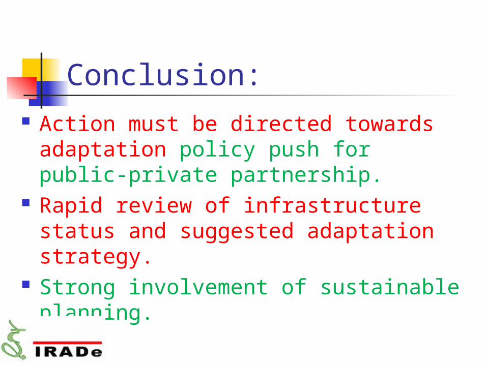
Conclusion: Action must be directed towards
adaptation policy push for public-private partnership.
Rapid review of infrastructure status and suggested adaptation strategy.
Strong involvement of sustainable planning.

THANK YOU