urban climate
TRANSCRIPT


Schedule• Climate in general• Macroclimate• Microclimate• Microclimate and architecture• Mesoclimate• Mesoclimate and urban environment• Air pollution• Urban heat island• Nonurban heat island• Advantages and disadvantages• Surface temperature and air temperature• Surface temperature (case study and statements)• Opportunities of modification

Climate in general I.• Definition: the sum and the distribution of the stages of the
atmosphere (spatial and temporal distribution)• Climate physics=atmosphere physics• Different scales: macroclimate, mesoclimate, microclimate• Over all of them: climate zones (tropical, temperate, cold)• Structure of the atmosphere: Troposphere (0-12 km),
stratosphere (12-50 km), mesosphere (50-80 km), thermosphere (80-700 km), exosphere (700 km-). These heights are changing (solar wind, seasons etc.)
• USA standard: the space is the region above 80 km (50 mi)• European standard: 100 km (Kármán line). • Van Allen belts: the inner is at about 1000 km high
(magnetism or gravitation)

Climate in general II.
• Atmosphere layers and Van Allen belts temperature distribution

Climate in general III.
• Atmosphere chemistry• 78% nitrogen, 21% oxigen, 1% other• 1% other is extremily important• Its greatest part are noble gases (argon and neon and a little
xenon)• In ppm scale: steam (H2O) and carbon dioxide (CO2), both is
very important, their distributions and balance are critical (Global Climate Change).
• Other important constituents: Ozone (O3), methane (CH4), nitrogen-oxides etc.
• Ozone and nitrogen-oxides are very important, but their artifical production is disadvantageous. Methane is a glasshouse gas (useful in fighting against ice ages).

Macroclimate.
• The typical climate of greater regions• There can be found such areas (many 10000 km2) where the
climatic conditions and their temporal (annual) distribuitons are very similar. These are the macroclimatic regions.
• Examples: European mediterranean, european oceanic, eurasian continental, subtropic deserts, temperate deserts (mostly highlands), monsoon and temperate monsoon climate zones, savannah types, tropical rainforest, temperate rainforests, etc.
• These are very important from the point of view of global population distribution (for example desert vs. monsoon zones). Precipitation in every season is mostly favoured.

Microclimate I.
• The other end of the scale.• The smallest atmosphere volumes, which have their well
distinguished climate attributes.• Usually there are very strict borders of these volumes.• The transition of different climate attributes are usually very
rapid through these borders• Most architectural spaces have their own microlimate.• For example: a cave, a room, a building, the southern wall of a
great rock, the northern wall of a great rock, the northern side of a solid fence on a southern slope, small mountain creeks, geysers, hot fountains, or even giant lonely trees.

Microclimate II.

Microclimate and architecture I.
• „Most architectural spaces have their own microlimate.”• The purpose of architecture (before deifying design) was to
create spaces with special microclimate• A cave (no precipitation), a cave with fire (no precipitation, no
cold, defended, with kitchen) and a lot of artifical types.• The Second Industrial Revolution made possible to deify
design while keeping function. Energy consumption (and sustainability) was the necessary sacrifice.
• Things like electric and natural gas networks made possible to create many 100 m tall glasshouses, which can be used as human dwellings.

Microclimate and architecture II.
• Nevertheless, it is hard to express the main difference between a very special, concave outer space (which is a cave) and a dwelling (which is an architectural product). There can be different answers. One of them:
dwelling special outer space

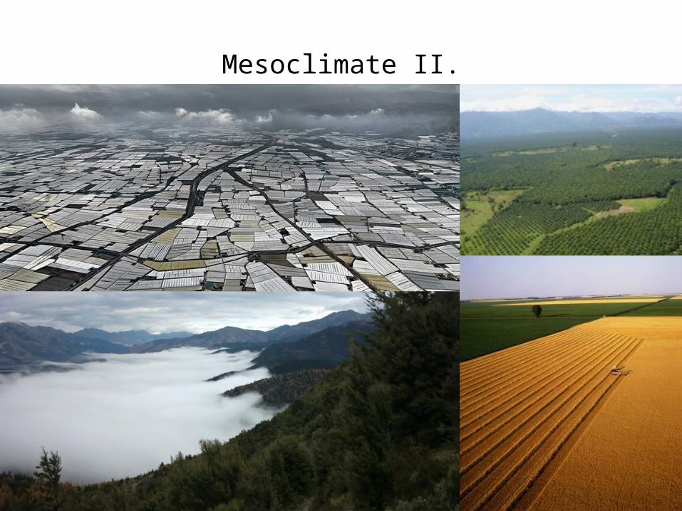
Mesoclimate I.
• Many 100 km2 scale. • There are regions (in this size), which climate is mostl
characterized by the macroclimate, but there exist some features, which are remarkably different.
• Urban climate is typically mesoclimate.• The climate of valleys and smaller highlands also belong to
this category. Climate of typical farmlands in the american continent, Africa and former Sovietunion.
• The boundaries of these zones are absolutely not so strict than in case of microclimatic regions. There is usually a smooth transition.
• The climatic differences are usually much smaller than in case of microclimate-macroclimate comparison.
Mesoclimate II.

Mesoclimate and urban environment
• „Urban climate is typically mesoclimate.”• A city, espcially a greater one, is typically in the mesoclimatic
size (Paris 100 km2, Budapest 525 km2).• Greater cities usually bigger from climatic aspect due to
agglomeration zones.• Furthermore, there are regions, where the agglomeration of
such greater cities are connected.• For example: Pearl River Delta in China (Hongkong, Macau,
Shenzhen, Guangdong and some other cities), its estimated population is 120 million. BAMA (Boston-Atlanta Metropolitan Axis) in the USA. Its population is about 50-60 million.
• Such entities can have even macroclimatic influence.

Mesoclimate and urban environment
Detroit

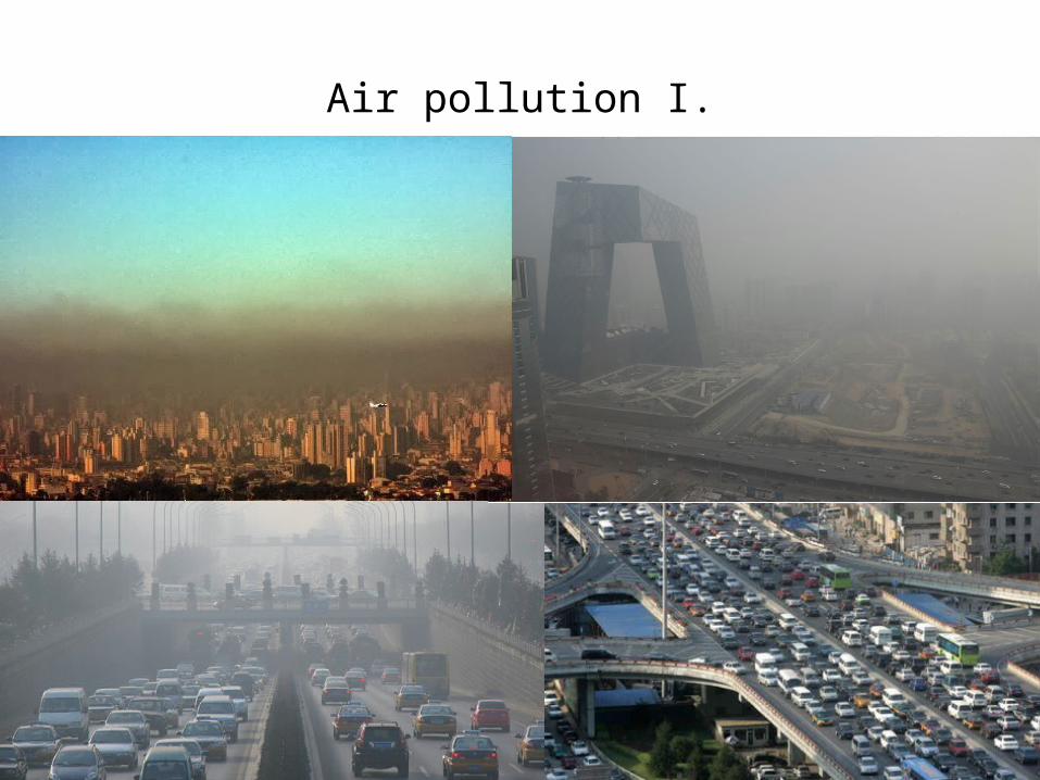
Air pollution I.
• One of the greatest problems of urbanisation• It has appeared even before the Industrial Revolution due to
usage of charcoal and wood for heating in greater settlements.
• It became serious problem in the second half of the 18th century due to the great factories in cities (Manchester, London etc.)
• A problem that is solved by Ebenezer Howard and the modernism
• The modernist solution created the new problem: transportation, the main source of air pollution in present days
• Previously mentioned megalopolises can cause continent sized smog clouds.
Air pollution I.

Urban heat island I.
• The other greatest problem of urbanisation• It was described first at the end of the 18th century• This phenomenon is closely related to the incresed size of
cities• A typical mesoclimatic phenomenon, its occurence is strongly
determined by the current macroclimatic stage.• In case of rainy weather, there is no urban heat island• In case of strong wind there is no urban heat island (similarly
to the smog)• The greatest heat islands can be measured during hot sunny
smooth days• The bigger is the city, the greater is the temperature
difference (between the city and its surroundings)

Urban heat island II.
• The correllation between the greatest temperature difference and the population number is described by the Oke-formula (statistical): Tmax[C]=2,01logP-4,06.
EuropeNorth-America

Urban heat island III.
• The daily periodicity of the urban heat island comes from the deviations of the radiation balance
Surfa
ce te
mpe
ratu
re
Ener
gy d
ensit
y of
radi
ation
Time (h)
Radiation surplus
Radiation shortage

Urban heat island IV.
The spatial distribution of the urban heat island considering different urban land use types.

Urban heat island V.
• Measuring the urban heat island• It is possible to use on site measurement tools (a network of
meteorological measurement units). These provide continously information during the whole measurement period, but the information bout spatial processes is very poor.
• It is possible to use remote sensing (thermal infrared cameras mounted on drones, helicopters, aeroplanes, satellites). These provide very good spatial information (the only limit is the spatial resolution of the given camera), but they can provide information only about a given moment. Moreover they can measure only surface temperature, not air temperature.
• Both of these methods must be used.

Urban heat island VI.
Thermal infrared satellite image Mobile weather station

Nonurban heat island I.
• There exist also nonurban heat islands• The most well known examples in Hungary are the vineyards• Other examples: tea plantations in Georgia, vineyards in
Germany (Rhine)

Advantages and disadvantages• The urban heat island used to be considered as a
disadvantageous phenomenon.• It is usually the question of geographical location.• Generally it causes greater mean temperature in every
season. This is disadvantegous on warmer arid climate zones (Hungary, Mediterraneum, tropical zones), but advantageous in colder regions (baltic coasts, Scandinavia,etc.).
• The warmer winter eventuates the decreasing number of deaths due to frost. This is unequivocally advantageous.
• The thermal effect can cause thermal air convection, which can reduce the local air pollution. This could be advantageous, but the rate of is effect is practically neglectible.
• The heat waves in tropic and temperate zones have mostly negative effects.

Advantages and disadvantages
Workers spray insecticide in Tokyo Yoyogi park. The park had to be closed because of Dengue fever and infected mosquitos. The urban heat island can have unexpected disadvantages.

Surface temperature and air temperature• The temperature, which is measured by remote sensing is the
temperature of a surface.• The meteorological temperature is air temperature.• The temperature, which is felt by humans is air
temperature….excepting in special cases, when there can be found very hot heat radiating surfaces close to the given human. The feeling is also influenced by the rate of relative air humidity.
• Furthermore, there must be considered the fact that the heating and cooling of the air happen through the heating and cooling impact of the bordering surface.
• Thus, the measuring of the surface temperatures are very usful for deeper undestanding of the urban heat island.
• Moreover it is strongly influenced by different urban surfaces.

Surface temperature (case study)
The effect of different vegetation types on the surface temperature

Oak-yard Grey poplar forest
Young wattle forest Old wattle tree stand
Surface temperature (case study)

Surface temperature (case study)
Thermal infrared satellite images, shot on 6th July 2001 and the 4th May 2002

Surface temperature (case study)
Grey poplar forest next to the Szilas Creek. The red line represents the site of the so called thermal cross section.

Surface temperature (case study)
Thermal cross section on 18th June 2006. The upper and lower temperature boundaries are 24 an 41 0C. The spatial unit is 90 m the pixel resolution of the satellite sensor.
Surface temperature (some statements I.)
• The land use plots of the regulation plans usually do not provide sufficient explanation to the development of the structure of the urban heat island.
• According to my examinations it can be unequivocally declared that even a single large-sized building can have a remarkable impact on the urban surface temperature distribution.
• In the case of similar sized, heated and similarly intensely used buildings even 12C (!) surface temperature differences can occur, depending mainly on the quality of the surface covering.
• The different built-up types significantly influence the surface temperature of the urban blocks.

Surface temperature (some statements II.)
• Urban water surfaces are the coolest surfaces in the summer period and in transitional seasons, while the same water surfaces are among the warmest surfaces in the wintertime.
• Surfaces covered by vegetation are the second most effective surface types (after water bodies) in mitigating the urban heat island.
• Tree stands protected from external environmental impacts have a greater cooling effect.

Opportunities of modification
• It is proven that we can modify the urban climate. Thus not only microclimate, but also mesoclimate can be modifyed by human. Global Climate Change is a proof that we can do it in case of macroclimate too.
• Modification on the level of landscape architecture: increasing the rate of water bodies and close canopy tree stands on urban open spaces.
• Water bodies are very effective even in winter for moderating the negative climate impacts.
• Using appropriate plant species some collateral problems can be avoided (for example using cedars and gingko the mosquito problem can be simply solved).
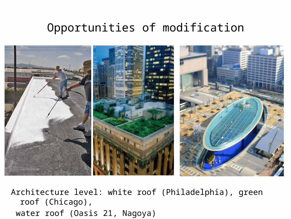
Opportunities of modification
Architecture level: white roof (Philadelphia), green roof (Chicago), water roof (Oasis 21, Nagoya)

Opportunities of modification
• The level of urban planning• Using freestanding built-in types instead of unbroken row of
buildings.• Using much wider streets and roads. Turning all of them into
alleys.• Creating well connected urban green systems.• Regulating the structure of private green areas (tree planting
obligation)• Regulating the privatebuildings (white/green/water roof
building obligation)• Using the natural resources of the settlements. For example
the Danube, its islands and banks in case of Budapest.

Thank you for your attention!