cayoosh creek watershed - forests, lands, … · · 2007-07-25cayoosh creek watershed is located...
TRANSCRIPT

CAYOOSH CREEK WATERSHED
Access Management Plan
Prepared for: Ainsworth Engineered Canada LP
Lillooet Division
Submitted by: Integrated ProAction Corp.
1425 Hugh Allan Drive, Kamloops, BC V1S 1J3 Phone: 250-828-7977 Fax: 250-828-2183
Website: www.intpac.ca
March 30, 2007

EXECUTIVE SUMMARY This Access Management Plan is a Forest Investment Account (FIA) funded initiative to identify the non-status roads that should be deactivated or that should receive environmental maintenance in the Cayoosh Creek Watershed. Ainsworth Engineered Canada LP is the lead licensee and responsible for the management of FIA funding in the Lillooet Timber Supply Area (TSA). This project followed the standards outlined in the FIA Activity Standards for Road Deactivation, Landslide and Gully Rehabilitation Projects Document (Version 5 – 2003/2004). The objective of the Access Management Plan is to identify and prioritize the non-status roads that should be deactivated or that should receive environmental maintenance. The Cayoosh Creek watershed is located southwest of the district of Lillooet and covers an area of approximately 1165.3 km2. The project area includes: Cayoosh Creek, Enterprise Creek, Downton Creek, Boulder Creek, Gott Creek, Van Horlick Creek, Casper Creek, Blowdown Creek, Texas Creek, and Seton ridge. The Access Management Plan was developed in conjunction with the Watershed Risk Assessment and comments gathered from the public and First Nations open houses and referrals. The procedure for developing the Access Management Plan included:
• Preparing an overview access map which included the risk analysis from the Watershed Risk Assessment.
• Referral letters were sent out to stakeholders requesting input into the development of the Access Management Plan.
• Draft Access options were added to the map for presentation at the February 7th Public and First Nations Open House where stakeholders were asked to comment on their access needs.
• Licensee, Government, First Nation, and stakeholder comments were compiled and cross-referenced to the risk ratings developed in the Watershed Risk Assessment to produce the Access Management Map.
• Each road was assessed and recommendations with supporting comments were made.
• The draft Access Management Map was presented at a second Open House on February 28th and stakeholder comments were collected.
• The final Access Management Plan was developed by incorporating the input from the two Open House meetings and referrals.

Table of Contents
1. INTRODUCTION ...................................................................................................... 1 1.1. PROJECT OVERVIEW ............................................................................................ 1 1.2. TERMS OF REFERENCE ......................................................................................... 1 1.3. LINKAGES TO OTHER LAND AND MANAGEMENT PLANS...................................... 1
2. STUDY AREA DESCRIPTION ................................................................................ 2 2.1. CHARACTERISTICS OF THE CAYOOSH CREEK WATERSHED.................................. 2 2.2. NON-STATUS ROADS WITHIN THE CAYOOSH CREEK WATERSHED ...................... 2 2.3. NON-STATUS ROAD LINKAGES TO THE PUBLIC ROAD SYSTEM......................... 2
3. SUMMARY OF RESOURCE USE AND ACTIVITIES........................................... 2 3.1. FIRST NATIONS AND TRADITIONAL USE .............................................................. 2 3.2. FISH AND WILDLIFE RESOURCES ......................................................................... 2 3.3. RECREATION RESOURCES .................................................................................... 3 3.4. FORESTRY RESOURCES ........................................................................................ 3 3.5. AGRICULTURE (FARMING/RANCHING) RESOURCES ............................................. 4 3.6. MINING/ENERGY RESOURCES.............................................................................. 4 3.7. WATER LICENSES ................................................................................................ 4
4. ACCESS MANAGEMENT PLAN ............................................................................ 5 4.1. OBJECTIVES OF THE ACCESS MANAGEMENT PLAN .............................................. 5 4.2. ACCESS MANAGEMENT STRATEGIES ................................................................... 5
4.2.1. Deactivation ................................................................................................ 5 4.2.1.1. Low risk roads with no access needs identified. ..................................... 5 4.2.1.2. Low risk roads with access needs. .......................................................... 5 4.2.1.3. Moderate risk roads with no access needs identified. ............................ 6 4.2.1.4. Moderate risk roads with access needs. ................................................. 6 4.2.1.5. High or Very High risk roads with identified access needs.................... 6 4.2.1.6. High or Very High Risk roads with no access needs. ............................. 6 4.2.2. Environmental Maintenance ....................................................................... 6
5. RESULTS ................................................................................................................... 7 6. ACCESS COMMENTS & RECOMMENDATIONS.............................................. 17 7. REFERENCES ......................................................................................................... 19
List of Tables
Table 1: Water Licenses within the Cayoosh Creek Watershed......................................... 4 List of Appendices
Appendix 1: General Location Map Appendix 2: Comments, Conflicts and Resolutions Appendix 3: Stakeholders & Open House Attendance Lists Appendix 4: Newspaper Advertisements & Open House Invitations Appendix 5: First Nations Referrals and Contact Summary Appendix 6: Referral Letters Appendix 7: Access Management Map

1. INTRODUCTION 1.1. PROJECT OVERVIEW
This Access Management Plan (AMP) is funded by the Forest Investment Account (FIA) Land-base Program, Restoration & Rehabilitation Component, Terrestrial Activity Area. Ainsworth Engineered Canada LP is the lead licensee and responsible for the management of FIA funding in the Lillooet Timber Supply Area (TSA). The intent of this project is to identify and prioritize the non-status roads that should be deactivated or that should receive environmental maintenance while taking into account the current and future access needs of road users. The Access Management Plan project area is the Cayoosh Creek watershed within the Lillooet Timber Supply Area (TSA) and includes: Cayoosh Creek, Enterprise Creek, Downton Creek, Boulder Creek, Gott Creek, Van Horlick Creek, Casper Creek, Blowdown Creek, Texas Creek, and Seton ridge. Refer to Appendix 1 for an overview map of the project area.
1.2. TERMS OF REFERENCE The Access Management Plan (AMP) was completed within the time frame and budget submitted to Ainsworth Engineered Canada LP by Integrated ProAction Corp. Furthermore, the AMP was drafted in accordance with both the 2003/2004 FIA standards for road deactivation, landslide and gully rehabilitation projects and the 2003/2004 FIA standards for environmental maintenance projects on non-status forest roads.
1.3. LINKAGES TO OTHER LAND AND MANAGEMENT PLANS Land use management plans prepared for the area include the draft Lillooet Land and Resources Management Plan (Lillooet LRMP), the Lillooet TSA Sustainable Forest Management Plan (SFMP), and the preliminary St’át’imc Draft Land Use Plan. The draft LRMP was developed in an attempt to provide strategic direction for the management and use of all provincially administered lands and resources in the Lillooet area (MSRM, 2004). Access management strategies for Texas Creek, Van Horlick Creek, and the Cayoosh Creek headwaters were identified in the draft LRMP. Where possible, these strategies have been incorporated into this project. Similarly, the Sustainable Forest Management Plan was developed to provide a management framework for developing, implementing and monitoring socially acceptable resource management plans. The Nxekmenlhkálha lti Tmícwa - St'át'imc Preliminary Draft Land Use Plan establishes the St’at’imc Nations’ vision and land use principles for their traditional land, as well as general management direction and special management direction for water, cultural heritage, wildlife, fish, and sensitive ecosystems.
Cayoosh Creek Watershed 1 Access Management Plan

2. STUDY AREA DESCRIPTION
2.1. CHARACTERISTICS OF THE CAYOOSH CREEK WATERSHED The Cayoosh Creek Watershed is located east of the Coast Mountains and west of the Thompson-Okanagan Plateau, within the Fraser Plateau, Eastern South Coast Mountains, and Northern Thompson Plateau hydrologic zones. The watershed is located southwest of the district of Lillooet (see Appendix 1) and covers and area of approximately 1165.3 km2, 97.1 % of which is crown land. Private land accounts for 23.3 km2(2%), and Indian Reserves account for the remaining 10.5 km2 (0.9%) of the land within the project area. The elevation within the watershed ranges from approximately 200m at the boundary on the Fraser River to a maximum of approximately 2880m at the mountain peaks around Enterprise, Copper, and Downton Creeks. The regions’ streamflow is generated from lakes, overland flow (runoff) and snowmelt. The Cayoosh Creek watershed has eight Biogeoclimatic Ecosystem Classification (BEC) zones within its boundary: Coastal Western Hemlock (CWH), Engelmann Spruce-Subalpine Fir (ESSF), Montane Spruce (MS), Interior Mountain-heather Alpine (IMA), Mountain Hemlock (MH), Coastal Mountain-heather Alpine (CMA), Interior Douglas Fir (IDF), and Ponderosa Pine (PP).
2.2. NON-STATUS ROADS WITHIN THE CAYOOSH CREEK WATERSHED Several sources were used to determine the status of roads within the project area including, consolidated FDP data, Land and Resource Data Warehouse (LRDW) road data, road data from Ainsworth, and TRIM data. Of the roads identified in the watershed, approximately 216 are currently not under permit and are classified as non-status roads.
2.3. NON-STATUS ROAD LINKAGES TO THE PUBLIC ROAD SYSTEM All of the roads within the project area directly or indirectly link to Highway 99, also known as the Duffey Lake road.
3. SUMMARY OF RESOURCE USE AND ACTIVITIES
3.1. FIRST NATIONS AND TRADITIONAL USE The Lillooet TSA, which includes the Cayoosh Creek Watershed, is the traditional territories of twenty eight First Nation groups. Of the twenty eight groups, twelve have communities or reserves within the TSA and they share the area with the sixteen other groups. The twenty eight First Nation groups are divided into four broad cultural groups (St’át’imc, Nlaka’pamux, Secwepemc and Tsilhqot’in) all of whom use the area for sustenance, cultural and spiritual reasons (MSRM, 2004).
3.2. FISH AND WILDLIFE RESOURCES There are high fisheries values within the project area. Cayoosh Creek is known to have populations of anadromous salmon (Sockeye, Chinook, Coho and Pink) as well as rainbow and lake trout, dolly varden, mountain whitefish and steelhead. In addition, Texas and Downton Creeks are known to support rainbow trout while Texas and Van Horlick Creeks are known to support populations of bull trout (MSRM, 2007).
Cayoosh Creek Watershed 2 Access Management Plan

Other wildlife populations within the project area include: three distinct grizzly bear population units, big horn sheep, mountain goats, mule deer, spotted owl, wolf, wolverine and various other small mammals including bats, marmots and ground squirrels (Lillooet TSA Committee, 2005). The Cayoosh Creek watershed is known to support various species at risk. These species can be affected considerably by different access management strategies. The Grizzly Bear Working Group (GBWG) noted that increased road access has been documented as one of the greatest threats to Grizzly Bears in North America. (S.Senger, personal communication, February 19, 2007). Consequently, decreasing road access in sensitive areas should reduce or ease the threat to such species. The draft LRMP highlighted specific areas within the Cayoosh Creek watershed with significant importance to the Grizzly Bear population. These areas were incorporated into the access management strategy in an attempt to reduce the risk to the Grizzly bear population. The plan has proposed deactivation for many of the roads within the project area and any deactivation that is completed will reduce access in the area thereby reducing the risk to not only the Grizzly Bear population but all species within the watershed. In addition, access on high and very high risk roads may further be restricted as a result of future remedial works (eg. full pullback of fill, bridge removal, etc).
3.3. RECREATION RESOURCES The watershed is located in an area that has been identified as having high recreation value largely due to the areas landforms, climatic variability, its relatively undeveloped state and its proximity to the lower mainland (MSRM, 2005). Recreational opportunities within the watershed include fishing, hunting, hiking, mountaineering, camping, skiing, climbing, mountain biking, snowmobiling and all-terrain-vehicle use. There are a number of popular marked hiking trails within the project area. Some of the trails are maintained by the Ministry of Tourism, Sports, and the Arts (MTSA), while some are maintained by the Lillooet Naturalist Society, and others are not currently maintained. The trails are accessed by both permitted and non-status roads. There is one provincial park within the watershed (Duffey Lake Park) and two provincial parks (Joffre Lake Park and the Stein Valley Nlaka’Pamux Heritage Park) are adjacent to the project area. Joffre Lake Park contains a popular trail network that is used to access various alpine glaciers and peaks. In addition to the provincial parks, there are six developed user maintained (MTSA) recreation sites, one undeveloped (MTSA) recreation site and a recreation area (the Seton Lake reservoir recreation area operated by BC Hydro) located in the Cayoosh Creek watershed.
3.4. FORESTRY RESOURCES Forestry and the associated development (i.e. roads) within the project area began during the 1960’s. The draft LRMP identified forestry as the largest industry in the Lillooet TSA, supporting approximately a quarter of the Plan area employment, indicating the importance of this sector in the economy.
Cayoosh Creek Watershed 3 Access Management Plan

Ainsworth is the largest Licensee within the project area, operating Forest License (FL) A18700. There are two woodlot tenures in the project area, WL1779 near Seton Ridge and WL0363 near Texas Creek.
3.5. AGRICULTURE (FARMING/RANCHING) RESOURCES Agriculture employs approximately 12% of the labour force and approximately 3% of the land within the Lillooet LRMP area is within the Agricultural Land Reserve (ALR) (Lillooet TSA Committee, 2005). There is one range tenure holder within the project area located in the Texas Creek drainage.
3.6. MINING/ENERGY RESOURCES Mining has played a large role in the development of Lillooet and the surrounding area. According to the Lillooet LRMP the area has some of the best mineral potential in the province (pg.27). Potential minerals include metals (gold, silver, copper, tungsten), industrial minerals (limestone, dimension stone, talc), aggregates (sand, gravel, crushed rock) and gems (jade, agate). There are approximately 102 mineral and/or placer claims, held by 26 different tenure holders, within the project area. The Lillooet LRMP also noted that, while expansion opportunities for large hydro-electric projects are limited, there is potential for smaller hydro-electric projects.
3.7. WATER LICENSES Cayoosh Creek, Enterprise Creek, Gott Creek, Casper Creek, Texas Creek, and Willpower, a small stream within the watershed, are currently licensed for water use. Table 1 highlights the licenses on the various creeks within the project area. Table 1: Water Licenses within the Cayoosh Creek Watershed
Number of Licenses License Status
Cayoosh Creek 9
(5 Current; 1 Active Application & 1 Awaiting Signing, 1 Refused Application, 1 Abandoned Application)
Enterprise Creek 3 (1 Current & 1 Pending Cancellation, 1 Abandoned) Gott Creek 1 (1 Active Application) Casper Creek 3 (3 Current) Texas Creek 11 (10 Current, 1 Refused Application) Willpower Creek 1 (1 Current) Seton River 2 (1 Awaiting Signing, 1 Active Application) Phair Creek 1 (Refused Application) Shaft Spring Creek 1 (Abandoned)
Cayoosh Creek Watershed 4 Access Management Plan

4. ACCESS MANAGEMENT PLAN
4.1. OBJECTIVES OF THE ACCESS MANAGEMENT PLAN The Access Management Plan (AMP) was carried out in conjunction with the Watershed Risk Assessment (WRA). The objective of the AMP is to identify and prioritize the non-status roads that should be deactivated or that should receive environmental maintenance. The intent of the plan is to match the listed road strategies with the identified access needs, while recognizing the need to minimize the risk to the watershed from the road network.
4.2. ACCESS MANAGEMENT STRATEGIES Access management strategies need to incorporate the interests of all stakeholders within the project area, while ensuring environmental (land and resource) protection. Possible management strategies fall under two main categories, deactivation or environmental maintenance, each of which is described below.
4.2.1. Deactivation The Forest Investment Account (FIA) Standards for Road Deactivation, Landslide and Gully Rehabilitation Projects (2003) states that the engineering goal of road deactivation on non-status roads is to reduce the risk of damage to environmental (forest resources), social and economic values within and adjacent to the road location from hazards such as landslides, uncontrolled soil erosion and uncontrolled sediment transport. As per FIA Activity Standards Document (Version 5 -2003/2004) Article 1, Objective 1.2 road deactivation includes:
(a) permanently deactivating a road to a stable and self maintaining state that will protect forest resources, property and other non-forest resource values at risk, and
(b) preventing access to the deactivated road by motor vehicle traffic, by installing a physical barrier at some key point(s) on the connecting road network.
However, under the Forest Planning and Practices Regulation Section 82 (2) a person deactivating a road may submit to the District Manager a request for exemption of the requirement to block the road.
4.2.1.1. Low risk roads with no access needs identified. Low risk roads with no identified access needs were proposed for deactivation. It should be noted however that low risk roads were considered low priority for FIA funded deactivation.
4.2.1.2. Low risk roads with access needs. Low risk roads with identified access needs were proposed to be left in their current state with no action required.
Cayoosh Creek Watershed 5 Access Management Plan

4.2.1.3.Moderate risk roads with no access needs identified. Moderate risk roads with no access needs identified were proposed for deactivation. It should be noted however that moderate risk roads were considered low priority for FIA funded deactivation.
4.2.1.4.Moderate risk roads with access needs. Moderate risk roads with identified access needs were proposed to be left in their current state with no action required.
4.2.1.5. High or Very High risk roads with identified access needs. Field assessments are required for all High and Very High risk roads. These roads are recommended for deactivation however, due to the identified access needs, access should be maintained subject to public safety and environmental considerations. In order to maintain access, an exemption is required under the Forest Planning and Practices Regulations, Part 5, Section 82 (2). In some cases, roads identified as high risk that were known to be stable and not posing a risk to the public or the environment were proposed to be left in their self-maintaining state.
4.2.1.6. High or Very High Risk roads with no access needs. High risk roads with no identified access needs, or where access would be considered unsafe or detrimental to the environment, were proposed for deactivation with no future vehicle access in accordance with the Forest Planning and Practices Regulations, Part 5, Section 82.
4.2.2. Environmental Maintenance Environmental maintenance projects are suitable when road deactivation is not desirable. Environmental maintenance projects, however, still have to take into account both the needs of stakeholders and the protection of the environment. The primary objective of environmental maintenance projects on non-status roads is to reduce the risk of damage to forest resources, property and other non-forest resources from various road-associated hazards. A secondary objective of environmental maintenance projects on non-status roads is to allow motor vehicle access (if desirable) where it will not adversely affect forest resources, property and other non-forest resource values and only if public health and safety is not at risk (MoF, 2003a). An environmental maintenance project may be more suitable than road deactivation where a non-status road is located on stable terrain, and where it will be placed under permit within the next 5 year period, and where continued motor vehicle access is required and feasible. (MoF, 2003a)
Cayoosh Creek Watershed 6 Access Management Plan

Neither Ainsworth nor BC Timber Sales have indicated plans to place any of the non-status roads within the project area under permit within five years. As a result, environmental maintenance is not recommended for any of the non-status roads.
5. RESULTS Following is a detailed summary by road of the risk rating, prescribed access, and restoration strategy.
Road #
Risk
(Hazard x
Consequence)
Prescribed Vehicle Access
Restoration Strategies Comments
23 Mile 1-1 H 4x4 Deactivation
Road is located on potentially unstable terrain; field assessment required; maintain 4x4 access to approximately 1.5km; exemption from blocking road required.
23 Mile 1-2 VH 4x4 Deactivation
Known problem area, previous instability; field assessment required; road will likely require full pullback; maintain a 4x4 access if possible (would require exemption from blocking the road).
23 Mile 1-3 H 4x4 Deactivation Road is located on or around potentially unstable terrain; maintain ATV access if possible.
23 Mile 2 H None Deactivation Beginning of road is located on potentially unstable terrain.
23 Mile 3 H None Deactivation Road is located on potentially unstable terrain. 23 Mile 4 H None Deactivation Road is located on potentially unstable terrain.
23 Mile 5 H None Deactivation Road is located on or adjacent to potentially unstable terrain.
Blowdown 10 M Maintain current N/A Road is located on or adjacent to potentially
unstable terrain, maintain current access.
Blowdown 11 M None Deactivation End of road is located on potentially unstable terrain; no access needs identified.
Blowdown 11.1 L None Deactivation No access needs identified. Blowdown 11.2 L None Deactivation No access needs identified. Blowdown 11.3 L None Deactivation No access needs identified.
Blowdown 12 M Maintain current N/A
Road is located on or adjacent to potentially unstable terrain; provides access to Stein Valley Park.
Blowdown 12.1 M Maintain current N/A
Road is located on or adjacent to potentially unstable terrain; provides access to Stein Valley Park.
Blowdown 12.2 M Maintain current N/A
Road is located on or adjacent to potentially unstable terrain; provides access to Stein Valley Park.
Cayoosh Creek Watershed 7 Access Management Plan

Road #
Risk
(Hazard x
Consequence)
Prescribed Vehicle Access
Restoration Strategies Comments
Blowdown 12.3 L Maintain current N/A
Road is located on or adjacent to potentially unstable terrain; provides access to Stein Valley Park.
Blowdown 2.1 M None Deactivation Road is located on potentially unstable terrain; no access needs identified.
Blowdown 3 M None Deactivation No access needs identified. Blowdown 5 L None Deactivation No access needs identified.
Blowdown 5.1 L None Deactivation No access needs identified. Blowdown 6 L None Deactivation No access needs identified.
Blowdown 7 H None Deactivation Road is located on or adjacent to potentially unstable terrain; no access needs identified.
Blowdown 8 L None Deactivation No access needs identified. Blowdown 9 L None Deactivation No access needs identified.
Boulder 1 M None Deactivation End of road is located on potentially unstable terrain, road itself low hazard; no access needs identified.
Boulder 2 M None Deactivation Beginning of road is located on potentially unstable terrain; road itself is low hazard; no access needs identified.
Boulder 3 L Maintain current N/A Potentially unstable terrain above road; roads itself
is low hazard.
Boulder 4 L None Deactivation Upslope of the road is potentially unstable and unstable terrain; no access needs identified.
Buddy 1 L None Deactivation Beginning of road is located above potentially unstable terrain; no access needs identified.
Buddy 2 M None Deactivation Road is on potentially unstable terrain; no access needs identified.
Casper 1 M None Deactivation Road is located on or adjacent to potentially unstable terrain; no access needs identified.
Casper 2 L None Deactivation No access needs identified.
Casper 3 M Maintain current N/A Section of road in upper watershed is located on or
potentially unstable terrain; road itself is low hazard.Casper 3.1 L None Deactivation Likely overgrown; no access needs identified.
Casper 3.2 L Maintain current N/A Low risk road, no action required.
Casper 4 L None Deactivation No access needs identified. Casper 5 L None Deactivation No access needs identified. Casper 6 L None Deactivation No access needs identified.
Casper 6.1 L None Deactivation No access needs identified. Casper 7 L None Deactivation No access needs identified.
Casper 7.1 L None Deactivation No access needs identified.
Casper 8 M None Deactivation Road is located on or adjacent to potentially unstable terrain; no access needs identified.
Cayoosh Creek Watershed 8 Access Management Plan

Road #
Risk
(Hazard x
Consequence)
Prescribed Vehicle Access
Restoration Strategies Comments
Cayoosh 11 L Maintain current N/A Low risk road, no action required.
Cayoosh 12 L Maintain current N/A Low risk road, no action required.
Cayoosh 13 M Maintain current N/A Low hazard road, no action required.
Cayoosh 13.1 L Maintain current N/A Low risk road, no action required.
Cayoosh 13.2 VH Maintain current N/A Field assessment required; likely self maintaining;
maintain access for mineral claims. Cayoosh 14 L None Deactivation No access needs identified. Cayoosh 16 L None Deactivation No access needs identified. Cayoosh 17 L None Deactivation No access needs identified. Cayoosh 18 L None Deactivation No access needs identified. Cayoosh 19 L None Deactivation No access needs identified. Cayoosh 20 L None Deactivation No access needs identified.
Cayoosh 21 H 2wd Deactivation Road is located on potentially unstable terrain; recreation use in area.
Cayoosh 21.1 M None Deactivation Road is located on potentially unstable terrain; no access needs identified.
Cayoosh 22 L None Deactivation No access needs identified.
Cayoosh 22.1 L None Deactivation Road is located near potentially unstable terrain; no access needs identified.
Cayoosh 23 L None Deactivation No access needs identified. Cayoosh 23.1 L None Deactivation No access needs identified. Cayoosh 24 L None Deactivation No access needs identified.
Cayoosh 24.1 L None Deactivation No access needs identified. Cayoosh 25 L None Deactivation No access needs identified.
Cayoosh 26 L Maintain current N/A Low risk road, no action required.
Cayoosh 26.1 H None Deactivation Road is located on potentially unstable terrain; no access identified.
Cayoosh 3 VH None Deactivation Field assessment required; if self-maintaining no actions required; if not in self-maintaining state deactivation required.
Cayoosh 4 M Maintain current N/A Mining road; used to access hiking trails; no action
required.
Cayoosh 4.1 M Maintain current N/A Mining road; no action required.
Cayoosh 4.2 M Maintain current N/A Mining road; no action required.
Cayoosh 4.3 M Maintain current N/A Mining road; no action required.
Cayoosh Creek Watershed 9 Access Management Plan

Road #
Risk
(Hazard x
Consequence)
Prescribed Vehicle Access
Restoration Strategies Comments
Cayoosh 4.4 M Maintain current N/A Mining road; no action required.
Cayoosh 5 VH None N/A Field assessment required; if self-maintaining no actions required; if not in self-maintaining state deactivation required.
Cayoosh 5.1 VH None N/A Field assessment required; if self-maintaining no actions required; if not in self-maintaining state deactivation required.
Cayoosh 6 L Maintain current N/A Low risk road, no action required.
Cayoosh 7 L Maintain current N/A Low risk road, no action required.
Cayoosh 9 L None Deactivation No access needs identified.
Cerise 1 M Maintain current N/A Bridge at junction with HWY 99 pulled.
Cerise 10 L None Deactivation No access needs identified. Cerise 11 L None Deactivation No access needs identified.
Cerise 11.1 L None Deactivation No access needs identified. Cerise 2 L None Deactivation No access needs identified. Cerise 3 L None Deactivation No access needs identified. Cerise 4 L None Deactivation No access needs identified. Cerise 5 L None Deactivation No access needs identified.
Cerise 6 M None Deactivation End of road located on potentially unstable terrain; No access needs identified.
Cerise 7 L None Deactivation No access needs identified. Cerise 8 L None Deactivation No access needs identified. Cerise 9 L None Deactivation No access needs identified.
Downton 1 M Maintain current N/A Road has potentially unstable and unstable terrain
located upslope; maintain current access.
Downton 1.1 M Maintain current N/A Road has potentially unstable and unstable terrain
located upslope; maintain current access.
Downton 2 M Maintain current N/A Low hazard road; no action required.
Downton 3 H Maintain current N/A
Road is on potentially unstable terrain; road is known to be self maintaining; access needed for mineral tenure; no action required.
Downton 4 L None Deactivation No access needs identified. Downton 4.1 L None Deactivation No access needs identified. Enterprise 1 L None Deactivation No access needs identified. Enterprise 2 L None Deactivation No access needs identified. Enterprise 3 L None Deactivation No access needs identified.
Enterprise 4 H None Deactivation Section of road is on potentially unstable terrain; no access needs identified.
Cayoosh Creek Watershed 10 Access Management Plan

Road #
Risk
(Hazard x
Consequence)
Prescribed Vehicle Access
Restoration Strategies Comments
Enterprise 4.1 M None Deactivation Low hazard road; no access needs identified.
Enterprise 5 H None Deactivation Road is on potentially unstable terrain; no access needs identified.
Gott 1 M None Deactivation Section of road is located on potentially unstable terrain; no access needs identified.
Gott 1.1 M None Deactivation Road is located on potentially unstable terrain; road itself is low hazard; no access needs identified.
Gott 1.2 M None Deactivation Beginning of road is located on potentially unstable terrain; road itself is low hazard; no access needs identified.
Gott 1.3 M None Deactivation End of road is located on potentially unstable terrain; road itself is low hazard; no access needs identified.
Gott 10 L None Deactivation No access needs identified. Gott 10.1 L None Deactivation No access needs identified.
Gott 2-1 VH 4X4 Deactivation
Field assessment required; high use recreation area; access required for mineral tenures; frequent instability in this section of road; maintain access if no risk to human life or environment.
Gott 2-2 VH 4x4 Deactivation
Unsafe bridges; field assessment required (including bridge inspections); maintain access as long as bridges are safe (as determined by inspections); remove bridges when unsafe; high recreation and cultural access needs.
Gott 3 L None Existing Deactivation Bridge already been removed; no action required.
Gott 3.1 H None Existing Deactivation
Currently no access due to removed bridge on Gott 3.
Gott 4 M 4X4 Deactivation
Road crosses or is adjacent to potentially unstable terrain; low hazard road however a potentially unsafe bridge on Gott 2-2 road may prevent future access.
Gott 5 L 4X4 Deactivation
Portion of road is located on or adjacent to potentially unstable terrain; low hazard road however a potentially unsafe bridge on Gott 2-2 road may prevent future access.
Gott 5.1 L None Deactivation No access needs identified. Gott 6 L None Deactivation No access needs identified. Gott 7 L None Deactivation No access needs identified. Gott 8 L None Deactivation No access needs identified. Gott 9 L None Deactivation No access needs identified.
Hurley Silvermine 1-1 L Maintain
current N/A Section of road links to Ainsworth permitted road; low risk road; maintain current access.
Cayoosh Creek Watershed 11 Access Management Plan

Road #
Risk
(Hazard x
Consequence)
Prescribed Vehicle Access
Restoration Strategies Comments
Hurley Silvermine 1-2 H None Deactivation
Road is located on potentially unstable terrain; existing slope failure in this section field assessment and deactivation prescription required no access needs identified.
Hurley Silvermine 2 L None Deactivation No access needs identified.
Hurley Silvermine 3 L None Deactivation No access needs identified.
Hurley Silvermine 4.1 L None Deactivation No access needs identified.
Hurley Silvermine 5 H None Deactivation Road is located on or near potentially unstable or
unstable terrain; no access needs identified. Hurley Silvermine
6 L Maintain current N/A Low risk road; no action required.
Hurley Silvermine 7 L Maintain
current N/A Low risk road; no action required.
Hurley Silvermine 7.1 L Maintain
current N/A Low risk road; no action required.
Hurley Silvermine 7.2 L Maintain
current N/A Low risk road; no action required.
Hurley Silvermine 8 L Maintain
current N/A Low risk road; no action required.
Hurley Silvermine 9 L Maintain
current N/A Low risk road; no action required.
Pamco 1 L None Deactivation No access needs identified. Pamco 2 L None Deactivation No access needs identified.
Pamco 2.1 L None Deactivation No access needs identified.
Pamco 3 H None Deactivation Road has existing slope instability; field assessment and deactivation prescription required; no access needs identified.
Pamco 4 L None Deactivation No access needs identified. Pamco 5 L None Deactivation No access needs identified.
Seton 1 L Maintain current N/A Low risk road - no action required.
Seton 10 L None Deactivation No access needs identified.
Seton 11 M Maintain current N/A
Section of road is located on or around potentially unstable terrain; low hazard road, no action required.
Seton 12 L Maintain current N/A Low risk road; no action required.
Seton 13 L Maintain current N/A
Low risk road required to access Road Permit R14863; maintain current access.
Cayoosh Creek Watershed 12 Access Management Plan

Road #
Risk
(Hazard x
Consequence)
Prescribed Vehicle Access
Restoration Strategies Comments
Seton 14 L Maintain current N/A Low risk road, no action required.
Seton 15 L Maintain current N/A Low risk road required to access Road Permit
R14863; maintain current access.
Seton 16 L Maintain current N/A Low risk road, no action required.
Seton 2 L 2wd Maintenance as required
Access required for multiple users, no action required.
Seton 3 L Maintain current N/A Access required for mineral tenure.
Seton 4 M Maintain current N/A Portion of road is located on potentially unstable
terrain; road itself is low hazard, no action required.
Seton 4.1 M Maintain current N/A Road is located on potentially unstable terrain.
Seton 5 L None Deactivation No access needs identified. Seton 6 L None Deactivation No access needs identified. Seton 7 L None Deactivation No access needs identified. Seton 8 L None Deactivation No access needs identified.
Seton 8.1 L None Deactivation No access needs identified.
Seton 9 H None Deactivation Road crosses or is adjacent to potentially unstable terrain; no access needs identified.
Steep Creek 1 L None Deactivation No access needs identified; Ainsworth permitted road provides general access.
Steep Creek 2 M None Deactivation Road is located on potentially unstable terrain; no access needs identified.
Steep Creek 3 H None Deactivation Road is located on potentially unstable terrain; no access needs identified.
Steep Creek 4 M None Deactivation Road is located on potentially unstable terrain; no access needs identified.
Steep Creek 5.1 L None Deactivation No access needs identified. Steep Creek 5.2 L None Deactivation No access needs identified. Steep Creek 5.3 L None Deactivation No access needs identified.
Steep Creek 5-1 VH None Deactivation Road is located on unstable terrain; no access needs identified.
Steep Creek 5-2 L None Deactivation No access needs identified. Steep Creek 6 L None Deactivation No access needs identified.
Texas 1 VH None N/A Field assessment required to ensure road is in self-maintaining state; if in self-maintaining state no action required.
Texas 10 L Maintain current Deactivation No access needs identified.
Texas 11 L None Deactivation Potentially unstable terrain upslope of road; road itself is low hazard; no access needs identified.
Cayoosh Creek Watershed 13 Access Management Plan

Road #
Risk
(Hazard x
Consequence)
Prescribed Vehicle Access
Restoration Strategies Comments
Texas 12 L Maintain current N/A Potentially unstable terrain upslope of road; road
itself is low hazard.
Texas 12.1 L Maintain current N/A Potentially unstable terrain upslope of road; road
itself is low hazard.
Texas 13 L Maintain current N/A Mining road
Texas 13.1 L Maintain current N/A Mining road
Texas 13.2 L Maintain current N/A Mining road
Texas 14 L Maintain current N/A Mining road
Texas 14.1 L Maintain current N/A Mining road
Texas 14.2 L Maintain current N/A Mining road
Texas 14.3 L Maintain current N/A Mining road
Texas 14.4 L Maintain current N/A Mining road
Texas 14.5 L Maintain current N/A Mining road
Texas 14.6 L Maintain current N/A Mining road
Texas 14.7 L Maintain current N/A Mining road
Texas 2 L Maintain current N/A Low risk road; no action required.
Texas 3 L Maintain current N/A Low risk road; no action required.
Texas 4 L Maintain current N/A Low risk road; no action required.
Texas 5 L None Deactivation No access needs identified.
Texas 6 H None Existing Deactivation Existing Deactivation
Texas 6.1 H None Existing Deactivation No access due to removed bridge.
Texas 7 H 4X4 Deactivation Field assessment required. Texas 7.1 L None Deactivation Low risk road, no access needs identified.
Texas 7.2 L None Deactivation Section of road is adjacent to potentially unstable terrain; road is low risk.
Texas 7.3 L None Deactivation Low risk road, no access needs identified.
Cayoosh Creek Watershed 14 Access Management Plan

Road #
Risk
(Hazard x
Consequence)
Prescribed Vehicle Access
Restoration Strategies Comments
Texas 8 L None Deactivation Road is adjacent to potentially unstable terrain; no access needs identified.
Texas 9 L None Deactivation No access needs identified. Van Horlick 1 L None Deactivation No access needs identified.
Van Horlick 10 L Maintain current N/A Road is adjacent to potentially unstable and unstable
terrain; low risk road; maintain current access. Van Horlick 10 (Bridge Only) VH None Deactivation Bridge inspection and removal if necessary.
Van Horlick 10.1 L None Deactivation No access needs identified.
Van Horlick 10.2 L None Existing Deactivation
Bridge has been removed, low risk road, no action required.
Van Horlick 10.3 L None Existing Deactivation
Bridge on Van Horlick 10.2 road has been removed, currently no access, no action required.
Van Horlick 10.4 L None Existing Deactivation
Road is adjacent to potentially unstable and unstable terrain; bridge on Van Horlick 10.2 road has been removed, currently no access, no action required..
Van Horlick 10.5 H None Existing Deactivation
Road is crosses or is adjacent to potentially unstable terrain; overgrown; bridge on Van Horlick 10.2 road has been removed, currently no access, no action required.
Van Horlick 10.6 L None Existing Deactivation
Bridge on Van Horlick 10.2 road has been removed, currently no access, no action required.
Van Horlick 11 L None Deactivation No access needs identified.
Van Horlick 12 L None Existing Deactivation
Bridge has been removed, low risk road, no action required.
Van Horlick 12.1 L None Existing Deactivation
Bridge on Van Horlick 12 has been removed, currently no access, no action required.
Van Horlick 13 M None Deactivation Portion of road is adjacent to potentially unstable terrain; no access needs identified.
Van Horlick 14 H None Deactivation
Road crosses or is adjacent to potentially unstable terrain; field assessment and deactivation prescription required; maintain ATV access if possible..
Van Horlick 14.1 L None Deactivation No access needs identified. Van Horlick 14.2 L None Deactivation No access needs identified.
Van Horlick 15 M None Deactivation Road is located on potentially unstable terrain; no access needs identified.
Van Horlick 16 M None Deactivation Road is located on potentially unstable terrain; no access needs identified.
Van Horlick 2 M Maintain current N/A Road section is located on potentially unstable
terrain; road is low hazard, no action required.
Van Horlick 3-1 L Maintain current N/A Low risk road, no action required.
Cayoosh Creek Watershed 15 Access Management Plan

Road #
Risk
(Hazard x
Consequence)
Prescribed Vehicle Access
Restoration Strategies Comments
Van Horlick 3-2 H Maintain current N/A
Road is located on potentially unstable terrain; overgrown; field assessment required; likely in self-maintaining state.
Van Horlick 4 H Maintain current N/A
Road is located on potentially unstable terrain; overgrown; field assessment required; likely in self-maintaining state.
Van Horlick 5 H Maintain current N/A
Road is located on potentially unstable terrain; overgrown; field assessment required; likely in self-maintaining state.
Van Horlick 6 H Maintain current N/A
Road is located on potentially unstable terrain; overgrown; field assessment required; likely in self-maintaining state.
Van Horlick 7.1 M None Deactivation Road is located on potentially unstable terrain; low hazard road, no action required.
Van Horlick 7.2 L None Deactivation No access needs identified.
Van Horlick 7-1 H None Deactivation Road is located on potentially unstable terrain; overgrown; field assessment required; likely in self-maintaining state.
Van Horlick 7-2 L None Deactivation No access needs identified.
Van Horlick 8.1 H None Deactivation
Road is located on and adjacent to potentially unstable terrain; field assessment and deactivation prescription required; maintain ATV access if no risk to human life or environment.
Van Horlick 8-1 VH None Deactivation
Road is located on and adjacent to potentially unstable terrain; field assessment and deactivation prescription required; maintain ATV access if no risk to human life or environment.
Van Horlick 8-2 L None Deactivation Maintain ATV access pending outcome of Van Horlick 8-1 deactivation prescription.
Van Horlick 9 L None Existing Deactivation
Road has potentially unstable terrain located upslope; currently no access due to removed bridge.
Van Horlick 9.1 L None Existing Deactivation
Currently no access due to removed bridge on Van Horlick 9.
West Boulder 1 VH None Rehabilitation Road is located upslope of unstable terrain; potential flat over steep issues; field assessment required; no access needs identified.
West Boulder 2 VH None Rehabilitation Road is located upslope of unstable terrain; potential flat over steep issues; field assessment required; no access needs identified.
*A field assessment of the roads by a qualified registered professional is needed to confirm the risk rating in the table above*
Cayoosh Creek Watershed 16 Access Management Plan

6. ACCESS COMMENTS & RECOMMENDATIONS The following comments and associated recommendations were summarized from the input gathered from the various user groups and are highlighted on the AMM:
o Maintain access on mainlines where access will not adversely effect the environment or will not pose a risk to the users.
o Maintain contact with resource users when managing or considering future access issues.
o Comments by area: • Enterprise Creek
o Popular walking trails, currently accessed by roads under permit to Ainsworth.
• Downton Creek o Active mineral claims in drainage. o Popular walking trails, currently accessed by roads under permit to
Ainsworth. • Boulder Creek
o Mainline is currently under permit to Ainsworth. o Some short low risk non-status roads in drainage.
• Casper Creek o Low risk non-status roads.
• Blowdown Creek o Mainline is currently under permit to Ainsworth. o Low risk non-status roads used to access Blowdown Lake and Stein
Valley Nlaka’Pamux Heritage Park. • Seton Ridge
o Maintain access over Seton Ridge to Seton Lake. o Many users and property owners that need access. o There is a section of road between MOT road and Ainsworth permitted
road that is non-status and likely not maintained. • Texas Creek
o Mainline is an FSR. o Many users need access and road structures are nearing the end of their
lifespan. o Bring users together to resolve issue.
• Gott Creek o Maintain access on West Fork (road labeled 2 on AMM) for as long as
possible providing the access does not pose a risk to either the environment or to human life.
o Bridge inspections to determine lifespan and load rating. o Pull bridges when they fail inspection.
• Van Horlick Creek o Maintain access on road labeled Van Horlick 10 on AMM for as long
as possible providing the access does not pose a risk to either the environment or to human life.
Cayoosh Creek Watershed 17 Access Management Plan

o Bridge inspection to determine lifespan and load rating. o Pull bridges when they fail inspection.
Cayoosh Creek Watershed 18 Access Management Plan

7. REFERENCES Ministry of Forests (MoF), 2004. Forest planning and practices regulation: Part 5 Roads.
Victoria, BC. Accessed March 7, 2007 at http://www.for.gov.bc.ca/tasb/legsregs/frpa/frparegs/forplanprac/fppr.htm
Ministry of Forests (MoF). (2003a). FIA activity standards document version 3
2003/2004: Standards for environmental maintenance projects on non-status forest roads. Victoria, BC. Accessed March 7, 2007 at http://www.for.gov.bc.ca/hth/documents/!publish/Engineer/fia-activity-standards-env-maint-projects-03-04.pdf
Ministry of Forests (MoF). (2003b). FIA activity standards document version 5
2003/2004: Standards for road deactivation, landslide and gully rehabilitation projects. Victoria, BC. Accessed March 7, 2007 at http://www.for.gov.bc.ca/hth/documents/!publish/Engineer/fia-activity-standards-deact-landslide-gully-03-04.pdf
Lillooet TSA Committee. (2005). Lillooet TSA sustainable forest management plan.
Accessed March 5, 2007 at http://www.for.gov.bc.ca/dcs/SustainableForestry/Lillooet/Lillooet%20SFM%20Plan%20(123105).pdf
Ministry of Sustainable Resource Management (MSRM). (2004). Draft Lillooet land
and resource management plan. Victoria, BC. July, 22, 2004. Accessed March, 5, 2007 at http://ilmbwww.gov.bc.ca/ilmb/lup/lrmp/southern/lillooet/plan/index.html
Ministry of Sustainable Resource Management (MSRM). (2007). FISS-fish distributions
query. Ministry of Sustainable Resource Management. Victoria. BC. Accessed March, 1, 2007 at http://srmapps.gov.bc.ca/apps/fidq/fissSpeciesSelect.do
Cayoosh Creek Watershed 19 Access Management Plan

APPENDIX 1
GENERAL LOCATION MAP
Cayoosh Creek Watershed 20 Access Management Plan
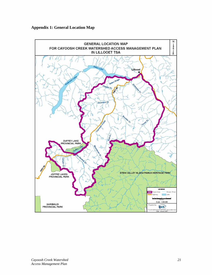
Appendix 1: General Location Map
Cayoosh Creek Watershed 21 Access Management Plan

APPENDIX 2
COMMENTS, CONFLICTS AND RESOLUTIONS
Cayoosh Creek Watershed 22 Access Management Plan

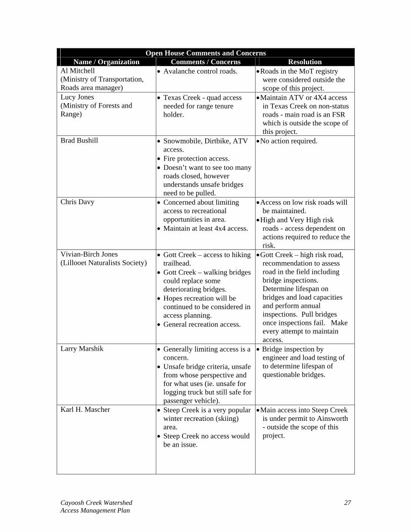
Appendix 2: Comments, Conflicts and Resolutions. February 7th, First Nations Open House Comments.
First Nation Open House Comments and Concerns Name / Organization Comments / Concerns Resolution
Michelle Edwards (Cayoosh Creek Indian Band)
• Hopefully not deactivating Gott and Downton Creeks.
• Areas used for traditional activities (berry picking, hunting, wood gathering).
• Foot bridges to replace any pulled bridges.
• Use at own risk signs in lieu of pulling bridges.
• Shared liability. • Limit access before 2010 to
decrease pressure on area during 2010.
• Helicopter access in Texas Creek during Grizzly closure
• Silviculture obligations
• Gott Creek – high risk road, recommendation to assess road in the field including bridge inspections. Determine lifespan on bridges and load capacities and perform annual inspections. Pull bridges once inspections fail. Make every attempt to maintain access.
• Mainly Ainsworth permitted roads in Downton Creek.
• Downton Creek has one stable high risk road – no action required.
• The other non-status roads in Downton are low risk and therefore low priority.
Henry Thevarge (Cayoosh Creek Indian Band)
• Hopefully not deactivating Gott and Downton Creeks.
• Areas used for traditional activities (berry picking, hunting, wood gathering).
• Tradition slash (access) trail for First Nations in Enterprise.
• Gott Creek – high risk road, recommendation to assess road in the field including bridge inspections. Determine lifespan on bridges and load capacities and perform annual inspections. Pull bridges once inspections fail. Make every attempt to maintain access.
• Mainly Ainsworth permitted roads in Downton Creek.
• Downton Creek has one stable high risk road – no action required.
• The other non-status roads in Downton are low risk and therefore low priority.
Laureen Weget
• Traditional activities in area (hushum berries), unsure of specific area
• No action required in specific area.
Cayoosh Creek Watershed 23 Access Management Plan

First Nation Open House Comments and Concerns Name / Organization Comments / Concerns Resolution
Norm (Tit’q’et Band Manager)
• Enterprise is frequently used. • Mainly Ainsworth permitted roads in Enterprise.
• Recommendations only affect short roads in back of watershed - minimal impact on access.
Ida Mary Peter (Seton Lake Indian Band)
• Traditional activities in Seton Ridge area.
• Concerned about hunters in Seton Ridge
• Limiting access to area for 2010 in order to limit number of people accessing area and disturbing wildlife and leaving garbage.
• Gates to prevent access.
• Seton Ridge mainline access maintained.
• Only proposed deactivation for small spur roads or roads with no access needs.
• Snow levels at the time of the 2010 Winter Olympics should prevent most access.
Christine Galliazzo MoF, First Nations / Stewardship Officer
• Seasonal closures • Forest For Tomorrow
(FFT)funding - looking at areas to target which may require access.
• Lots of snowmobile use in Hurley Silvermine
• Draft LRMP recommends seasonal closures in Texas Creek and Van Horlick Creek.
• FFT has funding to provide access to project areas.
• Hurley Silvermine road is an Ainsworth road at the lower end.
February, 7th Public Open House Comments.
Open House Comments and Concerns Name / Organization Comments / Concerns Resolution
A. Malm (Phoned again on February, 22, 2007 to voice concern)
• Property on Seton Ridge and needs access
• Texas Creek – Devils Lake is a good hike.
• Seton Ridge mainline access maintained.
• Only proposed deactivation for small spur roads or roads with no access needs.
• Texas Creek road is an FSR - outside the scope of this project.
Cayoosh Creek Watershed 24 Access Management Plan

Open House Comments and Concerns Name / Organization Comments / Concerns Resolution
Rob Scott (Inland Timber)
• Active mining claim in Molybdenite
• Hurley-Silvermine – winter skiing and summer hiking.
• Looking for hiking opportunities.
• Generally no concerns as long as they don’t close all the roads.
• Many roads overgrown.
• Access maintained to mineral claims • Hurley Silvermine road is
an Ainsworth road at the lower end.
Mickey Macri (Sqaumish-Lillooet Regional District)
• Wildfire access if roads are deactivated
• Recreational opportunities (hiking)
• Hiking access to anything that gets deactivated.
• Seton Ridge – needs access and has many users.
• Bridges needed for fire and tourism.
• Type of deactivation (totally impassable or 4x4 access)
• Fear of not being able to recreate on forest roads that have been used for years.
• Range agreements
• Seton Ridge mainline access maintained.
• Low to moderate risk roads will continue to have public access.
• Roads and bridges that pose a high risk to the public or the environment will be targeted for remedial work - access can not be maintained if it is unsafe.
Mr. James • Texas Creek – many users with interest in area.
• Texas Creek – ranching in upper end.
• Texas Creek – valley in Stein accessed via Texas Creek
• Texas Creek – Lillooet First Nation picnic site that is used by people.
• Texas Creek – questioned if there were any other access points to use.
• Blowdown Creek – snowmobiling area
• Enterprise – food source for First Nations
• Molybdenite – active miner claim
• Texas Creek road is an FSR - outside the scope of this project.
• Blowdown Creek and Enterprise roads are under permit to Ainsworth - outside the scope of this project.
Cayoosh Creek Watershed 25 Access Management Plan

Open House Comments and Concerns Name / Organization Comments / Concerns Resolution
Wayne Yasinowski (Bridge River Valley Snowmobile/ATV Association)
• Gott Creek – snowmobiling • Why rip out bridges when
they are needed for tourism and tourism is being promoted.
• Tourism should be paying
• Gott Creek – high risk road, recommendation to assess road in the field including bridge inspections. Determine lifespan on bridges and load capacities and perform annual inspections. Pull bridges once inspections fail. Make every attempt to maintain access. Maintain access into Gott until bridge inspection fails.
• Passed comments on to MTSA.
Ron Coggins (Bridge River Valley Snowmobile Club)
• Gott Creek – GPS’d as a snowmobile recreation trail.
• Downton Creek – used for snowmobiling.
• Downton Creek – walking trail from Downton Creek to Melvin Creek.
• Boulder Creek – used for snowmobiling.
• Pamco – slide area • Hurley-Silvermine – second
bridge in is burnt. If that is getting ripped out then first bridge may as well get ripped out.
• Van Horlick – active recreation area.
• Cerise – active recreation area.
• Blowdown Creek – heavy use
• Texas Creek – summer dirt biking and ATV area.
• Mountain bikers throughout area.
• Worried about seeing gates. • Not worried about ditches or
removing bridges.
• Gott Creek – high risk road, recommendation to assess road in the field including bridge inspections. Determine lifespan on bridges and load capacities and perform annual inspections. Pull bridges once inspections fail. Make every attempt to maintain access.
• Downton Creek – mainly Ainsworth permitted roads.
• Small spur roads proposed for deactivation but low priority.
• Mainline in Van Horlick west fork access maintained until bridge inspection fails.
• Boulder Creekk road is under permit to Ainsworth - outside the scope of this project.
• Cerise Creekk roads are low risk - maintain current access.
• Blowdown Creek road is under permit to Ainsworth - outside the scope of this project.
• Main portion of Texas Creek road is an FSR - outside the scope of this project.
Cayoosh Creek Watershed 26 Access Management Plan
Open House Comments and Concerns Name / Organization Comments / Concerns Resolution
Al Mitchell (Ministry of Transportation, Roads area manager)
• Avalanche control roads. • Roads in the MoT registry were considered outside the scope of this project.
Lucy Jones (Ministry of Forests and Range)
• Texas Creek - quad access needed for range tenure holder.
• Maintain ATV or 4X4 access in Texas Creek on non-status roads - main road is an FSR which is outside the scope of this project.
Brad Bushill • Snowmobile, Dirtbike, ATV access.
• Fire protection access. • Doesn’t want to see too many
roads closed, however understands unsafe bridges need to be pulled.
• No action required.
Chris Davy • Concerned about limiting access to recreational opportunities in area.
• Maintain at least 4x4 access.
• Access on low risk roads will be maintained.
• High and Very High risk roads - access dependent on actions required to reduce the risk.
Vivian-Birch Jones (Lillooet Naturalists Society)
• Gott Creek – access to hiking trailhead.
• Gott Creek – walking bridges could replace some deteriorating bridges.
• Hopes recreation will be continued to be considered in access planning.
• General recreation access.
• Gott Creek – high risk road, recommendation to assess road in the field including bridge inspections. Determine lifespan on bridges and load capacities and perform annual inspections. Pull bridges once inspections fail. Make every attempt to maintain access.
Larry Marshik • Generally limiting access is a concern.
• Unsafe bridge criteria, unsafe from whose perspective and for what uses (ie. unsafe for logging truck but still safe for passenger vehicle).
• Bridge inspection by engineer and load testing of to determine lifespan of questionable bridges.
Karl H. Mascher • Steep Creek is a very popular winter recreation (skiing) area.
• Steep Creek no access would be an issue.
• Main access into Steep Creek is under permit to Ainsworth - outside the scope of this project.
Cayoosh Creek Watershed 27 Access Management Plan

Open House Comments and Concerns Name / Organization Comments / Concerns Resolution
Ian Routley • All roads provide access to world class hiking.
• Understands liability issue. • Maintain walking access if
possible. • Bridge removal at beginning
of road will close access permanently.
• Clearly labeled ‘use at own risk’ and ensuring legislation to limit liability.
• Currently no mechanism in Legislation for ‘use at your own risk’ strategy.
• Level of access will be determined at the prescription stage.
February, 28th Open House Comments.
Open House Comments and Concerns Name / Organization Comments / Concerns Resolution
Larry Amey • Concerned this might be the first step in the area being designated as a watershed in the future.
• Designation as a watershed would severely limit exploration activity in area.
• Community or domestic watershed designations are outside the scope of this project.
Gary Polischuk • Mining access roads on the Raven mineral claim and Ample Goldmax Property are currently active.
• Needs access to mineral claims.
• Downton 3 used to access mineral tenures and access must remain.
• Cayoosh 4, 4.1, 4.2 used to access other mineral claims.
• Downton 3 road, although rated as high risk, is known to be self maintaining and stable and thus there is no action required.
• Cayoosh 4, 4.1, 4.2 are low risk roads and thus there is no action required or recommended.
Cayoosh Creek Watershed 28 Access Management Plan

Open House Comments and Concerns Name / Organization Comments / Concerns Resolution
Ron Coggins • Logging in back end of east Gott Creek fork.
• Gott Creek slide- culvert frequently gets plugged by slides (snow avalanches)
• If Gott Creek becomes impassable to snowmobilers then they will likely go to Cayoosh headwaters. (Winter non-motorized per LRMP)
• Concerned with maintaining access in Blowdown and Downton.
• Gott Creek – high risk road, recommendation to assess road in the field including bridge inspections. Determine lifespan on bridges and load capacities and perform annual inspections. Pull bridges once inspections fail. Make every attempt to maintain access. • Blowdown and Downton –
mainly permitted roads; some low risk non status therefore unlikely to receive action.
Bill Spencer • Concerned about Spotted Owl and Grizzly Bear and access effects on those species.
• Curious if Ainsworth is paying for any of the work.
• Would like to provide comments based on his knowledge of LRMP.
• The draft LRMP set out seasonal access restrictions for Grizzly Bear, roads in these areas were rated Moderate for wildlife consequence.
Comments Received by Phone or Email.
Name / Organization Comment / Concern Resolution Ed Abels Recreation Officer, MTSA Cascades District. (Email February, 14, 2007)
• Maintain safe access to Blowdown Lake for future development of recreation site. • Maintain access to Gott Creek recreation trail, where snowmobiling and hiking is popular. • Maintain safe access to/on Seton Ridge trail. • Maintain safe access to Downton Alpine Lake Trail. • Maintain safe access to Viola Lake Trail.
• Access into Blowdown Lake is a combination of roads under permit to Ainsworth and low risk non-status roads - no action required. • Gott Creek – high risk road, recommendation to assess road in the field including bridge inspections. Determine lifespan on bridges and load capacities and perform annual inspections. Pull bridges once inspections fail. Make every attempt to maintain access. • Access maintained on Seton Ridge.
Downton Lake trail and Viola Lake trail are accessed by roads under permit to Ainsworth.
Cayoosh Creek Watershed 29 Access Management Plan

Name / Organization Comment / Concern Resolution Ed Abels Recreation Officer, MTSA Cascades District. (Email March 8, 2007)
• Should safe access not be maintained to Texas Creek Recreation site there will be plans to deactivate/decommission the infrastructure and delete the site from the inventory. • Blowdown Lake Recreation site – encouraged there are no deactivation plans. • Texas Creek Recreation trail- should access not be made available to the trail head then deleting the trail from the inventory would be considered. • Gott Creek Snowmobile trail- Safe access to this resource should be maintained. Bridges along the road need to be assessed and load rated. If weight restrictions are needed the expectation would be bridges would be left in place with efforts to narrow access onto bridge. • It is vital snowmobile access be left for this area as trail will be maintained by Bridge River Snowmobile Club once an agreement is made with the Ministry. • Woodlot in vicinity and comments should be solicited from that individual. • Seton Ridge trail – assumed it will not be part of any deactivation plans derived from this planning process. • Downton Alpine lake and Viola Lake trails – maintain access. • Downton 1.1 on AMM access gravel pit and Ed would like access to this resource.
• No action required. • No action required. • Texas Creek road is an FSR
- outside the scope of this project.
• Gott Creek – high risk road, recommendation to assess road in the field including bridge inspections. Determine lifespan on bridges and load capacities and perform annual inspections. Pull bridges once inspections fail. Make every attempt to maintain access.
• Contacted • No action required • Downton Lake trail and Viola Lake trail are accessed by roads under permit to Ainsworth.
• Low risk non-status, maintain access.
Cayoosh Creek Watershed 30 Access Management Plan

Name / Organization Comment / Concern Resolution • Marriot Basin Hiking trail - 2wd access to 1km south of trailhead is needed and this location needs a parking area suitable for several vehicles to park and turn around.
- deactivation of road past this point should discourage 4x4 traffic but allow for walking.
- Water controls (ie. waterbars and associated ditch work) and brushing to allow easy access to trailhead.
• High risk road proposed for deactivation; maintain 2wd access for recreation.
Sue Senger (Letter, February 19, 2007)
• Limiting threat to Grizzly Bear population.
• The draft LRMP set out seasonal access restrictions for Grizzly Bear, roads in these area were rated Moderate for wildlife consequence.
William (Bill) Spencer (Email, March 8, 2007)
• Would like project to specify how any activities will affect SPOW recovery planning and prevent or reduce high risk to other species and ecosystems at risk.
• Give highest priority to permanently deactivating road segments to prevent motorized access to alpine areas.
• FIA funding eligibility of the non-status roads and previous commitments.
• AMP will lower amount of frequently traveled roads by limiting or removing access on high or very high risk roads and thereby reduce human impact on various species.
• Deactivation priority for this project was given to amount of risk associated with roads as per the objective of the project.
• Non-status roads within the watershed were identified as per the objective of the project, determining how these roads became non-status was not the focus of the project.
Evan Loveless Executive Director, Federation of Mountain Clubs. (Email, March 14, 2007)
• Concerned about potential impacts of plan on traditional access of club and members.
• Future plans should consider hosting and public meeting or open house in Sea to Sky corridor or Vancouver.
• Low to moderate risk roads will continue to have public access. Where possible on H and VH roads an attempt to maintain some form of access should be made.
Cayoosh Creek Watershed 31 Access Management Plan

Name / Organization Comment / Concern Resolution • Heavily used area is from
Cayoosh Pass east to Blowdown Creek.
• Network of logging roads are crucial for skier access, particularly, Cayoosh Creek to Cayoosh Mountain and Marriot Basin, Caspar Creek, Van Horlick Creek, Steep Creek, Blowdown Creek and Channel Creek.
• FMC would like specific line of communication with Ainsworth regarding access issues.
• FMC feels forest roads are public, as they were paid for with stumpage allowances, and licensees should maintain roads important for recreation and if not government should be responsible to do so.
• Road and area closures for environmental reasons will normally be supported by FMC provided: a) the reasons are sound, b) all options are explored, and c) they apply to all recreation users (motorized and commercial).
• Consistent deactivation standard that allows for appropriate recreation access while achieving environmental objectives.
• Any deactivation methods be minimal to permit 2wd vehicle access.
• FMC would like to work with Ainsworth on public access issues.
• Blowdown is mainly combination of Ainsworth permitted roads and low risk non-status. High risk road in Blowdown will not limit access to recreation resources.
• Most mainline roads are Ainsworth permitted.
• Access maintained on mainlines where no risk to environment or road users.
• Deactivation levels will ultimately be determined by field assessment and prescriptions. Maintain access were feasible and low risk to environment and road users.
Jay MacArthur FMCBC
• Passed on information presented in 2002 to LRMP.
• Incorporated information from LRMP where possible.
Cayoosh Creek Watershed 32 Access Management Plan

APPENDIX 3
STAKEHOLDERS & OPEN HOUSE ATTENDANCE LISTS
Cayoosh Creek Watershed 33 Access Management Plan
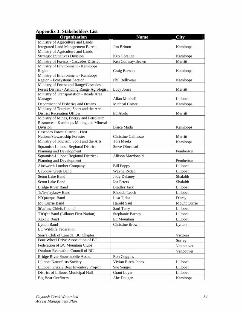
Appendix 3: Stakeholders List Organization Name City
Ministry of Agriculture and Lands Integrated Land Management Bureau Jim Britton Kamloops Ministry of Agriculture and Lands Strategic Initiatives Division Ken Gorsline Kamloops Ministry of Forests - Cascades District Ken Conway-Brown Merritt Ministry of Environment - Kamloops Region Craig Beeson Kamloops Ministry of Environment - Kamloops Region - Ecosystems Section Phil Belliveau Kamloops Ministry of Forest and Range/Cascades Forest District - Articling Range Agrologist Lucy Jones Merritt Ministry of Transportation - Roads Area Manager Allan Mitchell Lillooet Department of Fisheries and Oceans Micheal Crowe Kamloops Ministry of Tourism, Sport and the Arts - District Recreation Officer Ed Abels Merritt Ministry of Mines, Energy and Petroleum Resources - Kamloops Mining and Mineral Division Bruce Madu Kamloops Cascades Forest District - First Nations/Stewardship Forester Christine Galliazzo Merritt Ministry of Tourism, Sport and the Arts Tori Meeks Kamloops Squamish-Lillooet Regional District - Planning and Development
Steve Olmstead Pemberton
Squamish-Lillooet Regional District - Planning and Development
Allison Macdonald Pemberton
Ainsworth Lumber Company Bill Poppy Lillooet Cayoose Creek Band Wayne Redan Lillooet Seton Lake Band Jody Delaney Shalalth Seton Lake Band Ida Peters Shalalth Bridge River Band Bradley Jack Lillooet Ts’kw’aylaxw Band Rhonda Leech Lillooet N’Quatqua Band Lisa Tjelta D'arcy Mt. Currie Band Harold Saul Mount Currie St'at'imc Chiefs Council Saul Terry Lillooet T'it'q'et Band (Lillooet First Nation) Stephanie Barney Lillooet Xaxl'ip Band Ed Mountain Lillooet Lytton Band Christine Brown Lytton BC Wildlife Federation Sierra Club of Canada, BC Chapter Victoria Four Wheel Drive Association of BC Surrey Federation of BC Mountain Clubs Vancouver Outdoor Recreation Council of BC Vancouver Bridge River Snowmobile Assoc. Ron Coggins Lillooet Naturalists Society Vivian Birch-Jones Lillooet Lillooet Grizzly Bear Inventory Project Sue Senger Lillooet District of Lillooet Municipal Hall Grant Loyer Lillooet Big Boar Outfitters Abe Dougan Kamloops
Cayoosh Creek Watershed 34 Access Management Plan

Organization Name City Tallgrass Outfitting Tim Stephenson Lillooet Trapper Christopher Yost Vancouver Trapper Pemberton1 Trapper Ron Montgomery Maple Ridge Trapper Seton Lake Indian Band Range Tenure Holder Jeremy Manning Lillooet Coast Range Heliskiing Pemberton Whistler Alpine Guides Bureau Ltd Whistler Canada West Mountain School Vancouver Westcoast Mountain Guides Inc. Canadian Tourism College Vancouver NGR Resort Consultants Inc - Cayoosh Ski Resort Al & Nancy Greene Raine Sun Peaks Mineral Tenure Holder William Larry Amey Hope Mineral Tenure Holder Avino Gold and Silver Mine LTD Vancouver Mineral Tenure Holder Keith Blom Kamloops Mineral Tenure Holder Darrel Wayne Davis Enderby Mineral Tenure Holder David Robert Deering Burnaby Mineral Tenure Holder Guy Richard Delorme Vernon Mineral Tenure Holder Enterayon, INC Skippack, USA Mineral Tenure Holder William Gregory Filion Lillooet Mineral Tenure Holder Neil Malcom Finley Whistler
Mineral Tenure Holder Mark Stanley Gillard New Westminister
Mineral Tenure Holder Glen Hawk Minerals Vancouver Mineral Tenure Holder John Golanowski Coldstream Mineral Tenure Holder Allen Daniel Harvey Clinton Mineral Tenure Holder Robert Edwin Hurley Kamloops Mineral Tenure Holder David Joseph Javorsky Vancouver
Mineral Tenure Holder Rick Louis Kasum North Vancouver
Mineral Tenure Holder Francus Rene Larouche Kamloops Mineral Tenure Holder John Paul Larue Mcbride Mineral Tenure Holder Arlen Andrew Mcconnell Port Coquitlam Mineral Tenure Holder Melvin Larry Ovens Surrey Mineral Tenure Holder Gary Paul Polischuk Lillooet Mineral Tenure Holder Randy Allen Polischuk Lillooet Mineral Tenure Holder David Seven Deers Greenwood Mineral Tenure Holder Speebo Inc. Skippack, USA Mineral Tenure Holder Xenofon Stefanopoulos Vancouver
February 7th Open House Attendance Cayoose Creek Indian Band Michelle Edwards Lillooet Cayoose Creek Indian Band Henry Thevarge Lillooet Inland Timber Rob Scott Logan Lake A. Malm Lillooet
Cayoosh Creek Watershed 35 Access Management Plan

February 7th Open House Attendance Squamish Lillooet Regional District Mickey Macri Pavilion Lake Bridge River Valley Snowmobile and ATV Association Wayne Yasinowski Gold Bridge BC Sled Club Garry Donohue Lillooet Ministry of Transportation Allan Mitchell Lillooet LFNM Mr.James Lillooet Myrina Thevarge Lillooet BCSF Ron Coggins Lillooet Kenda Graham Lillooet ISS Ltd. Frank Wolfinger Penticton ISS Ltd. Al Todd Penticton MOFFR Lucy Jones Lillooet Brad Bushill Lillooet Chris Davy Lillooet Lillooet Medical Clinic Ian Routley Lillooet Lillooet Naturalist Society Vivian Birch-Jones Lillooet Jacquie Rasmussen Lillooet
Larry Marshik North Vancouver
Karl Heinz Mascher Lillooet Maria Mascher Lillooet John Courchesne Lillooet
February 28th Open House Attendance MTSA Ed Ables Merritt Leslie Hall Lillooet Maria Mascher Lillooet BCFS Ron Coggins Lillooet Grizzly Bear Working Group Sue Senger Lillooet Yalakom Ecological Society Bill Spencer Lillooet Gary Polischuk Lillooet GPEX Larry Amey Hope Annie ? Lillooet SLRD Mickey Macri Lillooet Greg LMC Ian Routley Lillooet MOFR Cascade District Christine Galliazzo Lillooet Lillooet Naturalists Society Kim North Lillooet Simon Warhurst Lillooet
Cayoosh Creek Watershed 36 Access Management Plan

APPENDIX 4
NEWSPAPER ADVERTISMENTS AND OPEN HOUSE INVITATIONS
Cayoosh Creek Watershed 37 Access Management Plan

Appendix 4: Newspaper Advertisements. Legal Advertisement for February 7th Open House Advertised in January 24th Lillooet News.
Cayoosh Creek Watershed 38 Access Management Plan

Notice for Open House on February 7th
Advertised in February 7th Lillooet News.
Cayoosh Creek Watershed 39 Access Management Plan

Legal Ad for February 28th Open House Advertised in February 21st Lillooet News
Cayoosh Creek Watershed 40 Access Management Plan

Notice for Open House on February 28th
Advertised in February 28th Lillooet News.
Cayoosh Creek Watershed 41 Access Management Plan

Example Open House Invitation.
Cayoosh Creek Watershed 42 Access Management Plan

APPENDIX 5
FIRST NATION REFFERALS AND CONTACT SUMMARY
Cayoosh Creek Watershed 43 Access Management Plan

Appendix 5: First Nations Referral and Contact Summary.
Cayoosh Creek Watershed 44 Access Management Plan

First Nations Contact Log
Cayoose Creek Band January, 16th, 2007 • Faxed invitation to February, 7th open
house. January, 29th, 2007 • Follow-up call, left message with
secretary. January, 30th, 2007 • Follow-up call. • Refaxed invitation to February 7th open
house. • Follow-up call, Fax was received.
February, 20th, 2007 • Faxed invitation to February 28th open
house. February, 22nd, 2007 • Follow-up call
Seton Lake Band January, 16th, 2007 • Faxed invitation to February, 7th open
house. January, 29th, 2007 • Follow-up call, left message.
January, 30th, 2007 • Follow-up call. • Refaxed invitation to February 7th open
house. • Follow-up call, would return phone call
once fax was picked up and looked at. January, 31, 2007 • Follow-up call, fax was received.
February, 20th, 2007 • Faxed invitation to February 28th open
house. February, 22nd, 2007 • Follow-up call
Bridge River Band January, 16th, 2007 • Faxed invitation to February, 7th open
house. January, 29th, 2007 • Follow-up call.
February, 20th, 2007 • Faxed invitation to February 28th open
house.
Cayoosh Creek Watershed 45 Access Management Plan

First Nations Contact Log February, 22nd, 2007 • Follow-up call
Ts’kw’aylaxw Band January, 16th, 2007 • Faxed invitation to February, 7th open
house. January, 29th, 2007 • Follow-up call, left message with
secretary. January, 31, 2007 • Follow-up email, fax was received.
February, 20th, 2007 • Faxed invitation to February 28th open
house. February, 22nd, 2007 • Follow-up call
N’Quatqua Band January, 16th, 2007 • Faxed invitation to February, 7th open
house. January, 29th, 2007 • Follow-up call, left message.
January, 30th, 2007 • Follow-up call, left message.
January, 31st, 2007 • Follow-up email, fax was received.
February, 20th, 2007 • Faxed invitation to February 28th open
house. February, 22nd, 2007 • Follow-up call
Mt. Currie Band January, 16th, 2007 • Faxed invitation to February, 7th open
house. January, 29th, 2007 • Follow-up call, left message.
January 31st, 2007 • Follow-up call.
February, 1st, 2007 • Returned call, fax had been received.
February, 20th, 2007 • Faxed invitation to February 28th open
house. February, 22nd, 2007 • Follow-up call
Cayoosh Creek Watershed 46 Access Management Plan

First Nations Contact Log St'at'imc Chiefs Council January, 16th, 2007
• Faxed invitation to February, 7th open house.
January, 29th, 2007 • Follow-up call.
January, 30th, 2007 • Follow-up call
February, 20th, 2007 • Faxed invitation to February 28th open
house. February, 22nd, 2007 • Follow-up call
T'it'q'et Band (Lillooet First Nation) January, 16th, 2007 • Faxed invitation to February, 7th open
house. January, 29th, 2007 • Follow-up call, left message.
February, 20th, 2007 • Faxed invitation to February 28th open
house. February, 22nd, 2007 • Follow-up call
Xaxl'ip Band January, 16th, 2007 • Faxed invitation to February, 7th open
house. January, 29th, 2007 • Follow-up call.
January, 30th, 2007 • Refaxed invitation to February, 7th open
house. February, 20th, 2007 • Faxed invitation to February 28th open
house. February, 22nd, 2007 • Follow-up call
Lytton Band January, 16th, 2007 • Faxed invitation to February, 7th open
house. January, 29th, 2007 • Follow-up call.
January, 30th, 2007 • Refaxed invitation to February, 7th open
house.
Cayoosh Creek Watershed 47 Access Management Plan

First Nations Contact Log February, 20th, 2007 • Faxed invitation to February 28th open
house. February, 22nd, 2007 • Follow-up call
Cayoosh Creek Watershed 48 Access Management Plan

APPENDIX 6
REFFERAL LETTERS
Cayoosh Creek Watershed 49 Access Management Plan

Appendix 6: Letter from Sue Senger
Cayoosh Creek Watershed 50 Access Management Plan

Cayoosh Creek Watershed 51 Access Management Plan

Cayoosh Creek Watershed 52 Access Management Plan

Cayoosh Creek Watershed 53 Access Management Plan

Cayoosh Creek Watershed 54 Access Management Plan

Cayoosh Creek Watershed 55 Access Management Plan

Cayoosh Creek Watershed 56 Access Management Plan

Cayoosh Creek Watershed 57 Access Management Plan

Cayoosh Creek Watershed 58 Access Management Plan

Cayoosh Creek Watershed 59 Access Management Plan

Cayoosh Creek Watershed 60 Access Management Plan
Cayoosh Creek Watershed 61 Access Management Plan

Cayoosh Creek Watershed 62 Access Management Plan

Cayoosh Creek Watershed 63 Access Management Plan

Appendix 6: Letter from Bill Spencer William Spencer
PO Box 1276 Lillooet, BC V0K 1V0
March 8, 2007 Stuart Card RPF Project Manager Integrated ProAction Corp. RE: Information and Comment on Cayoosh Creek Watershed Access Management These comments are based on my participation as a member of the Lillooet District Community Resources Board in the Lillooet LRMP (LLRMP). I was a member of the Lillooet LRMP’s Access Working Group. I have attached a number of maps and documents from the Draft LLRMP dated 12/19/01. This is the first draft published by MSRM. I believe this information best represents the work that the Access and Recreation Working Groups did to assess input from a wide variety of sources and apply it to specific locations throughout the LLRMP area. Under Access Management in the Rationale which accompanied the 12/19/01 draft, it states: “The draft plan has drawn on the table’s work and recommends area-specific access management to regulate user numbers, activities and timing in a way that balances economic and environmental values.” Later drafts of the LLRMP were altered to move away from the Access Categories and Strategies that the table as a whole was working on. I wish to provide you this information as a means to represent the input which the LLRMP table participants collected. In the attachments, the Access Master Table pages provide a unit by unit breakdown. The specific units which pertain to this project are highlighted with an orange dot on the left. There is also an indication of the degree of consensus reached by the table under “LLRMP inputs”. This information is mapped in the Access Categories and Strategies map. The Access and Recreation Units map shows the boundaries and number for each unit highlighted in the table. I have also attached the Access Management Objectives and Strategies from the 12/19/01 draft LLRMP to give the objective, intent and strategies for each of the four access categories. Finally, I have attached the Spring Access Objectives map to show additional natural closures on Downton and Gott Creeks. I hope this information is helpful.
Cayoosh Creek Watershed 64 Access Management Plan

Please note that the situation regarding Melvin Creek has changed dramatically. I strongly support the St’át’imc Chiefs position that Melvin Creek remain undeveloped. Access recommendations relevant to this project:
• In giving priority to deactivating non-status roads, consider the LLRMP objective of reducing road densities for the benefit of fisheries and wildlife and especially to protect Grizzly Bear habitat and movement. I would like to see road densities reduced in the Cayoosh Corridor, Unit 15 (see map: Access and Recreation Discussion Units).
• I would like the project submission to specify how any activities will affect
SPOW Recovery planning and prevent or reduce high risks to other species and ecosystems at risk, especially bull trout, goats and grizzlies.
• Give highest priority to permanently deactivating specific road segments to
prevent motorized access to alpine areas.
Eligibility concerns: Has the eligibility of all these non-status roads for FIA funding for rehabilitation been reviewed? I have copies of AEC FDP submissions for a number of years. For example, the 1995 – 2000 AEC FDP for F.L. A18700 lists all roads in CP 116 in Gott Creek as scheduled for permanent deactivation by 1998. It appears that AEC should be responsible for this work. Also, if proposed logging of CP 248 is approved, AEC would be required to correct any safety problems with this road. Why is this road included? Is there any intention to use FIA funding to correct the problems? Another example is 23 mile Creek, CP 123. This is also listed in Table iii on page 31 of the same FDP as scheduled for semi-permanent and permanent deactivation of all operational and block roads by 1995. In the FDP, AEC has committed to deactivating these roads saying that Table iii “identifies roads presently deactivated or scheduled to be completed based on PHSP referral comments and/or other planning processes.” I would like more details about this. I would like to better understand the purpose of this project. I have read a number of documents from the LBIP website. Thanks again for providing maps and information to assist me with this. Yours truly, William Spencer
Cayoosh Creek Watershed 65 Access Management Plan

Cayoosh Creek Watershed 66 Access Management Plan

Cayoosh Creek Watershed 67 Access Management Plan

APPENDIX 7
ACCESS MANAGEMENT MAP
Cayoosh Creek Watershed 68 Access Management Plan