cathedral canyon drive bridge project at whitewater river
TRANSCRIPT
PUBLIC NOTICE _________________________________________________________________________________________
U.S. ARMY CORPS OF ENGINEERS BUILDING STRONG®
LOS ANGELES DISTRICT
APPLICATION FOR PERMIT Cathedral Canyon Drive Bridge Project (Project) at Whitewater River
Public Notice/Application No.: SPL-2010-00505-VCL Project: Cathedral Canyon Drive Bridge Project at Whitewater River Comment Period: March 27, 2015 through April 27, 2015 Project Manager: Veronica Li; 213-452-3292; [email protected] Applicant John Corella City of Cathedral City Engineering Department 68-700 Avenida Lalo Guerro Cathedral City, California 92234
Contact John Criste Terra Nova Planning & Research, Inc 42635 Melanie Place Suite 101 Palm Desert, California 92211
Location The proposed Project is located at Cathedral Canyon Drive between Canyon Shores Drive and
Paseo Azulejo in the City of Cathedral City. Specifically, the proposed activities occur in the Whitewater River within the City of Cathedral City, Riverside County, California (at: Lat/Long: 33.7905522°W, -116.4668154°N). Please refer to the attached Project Vicinity Map (enclosed). Activity
The proposed Project (Option 10) would result in permanent impacts to 2.01 acres and temporary impacts to 5.57 acres of waters of the U.S. (with no wetlands impacts) associated with the following activities: permanent bridge and channel improvement structures including bridge piers, abutments, 8-foot wide bike path, extension of channel lining toe down, and concrete rip rap slopes and stream bottom; and temporary impacts including removal of the existing Cathedral Canyon roadway, grading, excavation, temporary construction access roads, and temporary traffic roads. Such activities are associated with the conversion of the existing Cathedral Canyon Drive low-water crossing with a raised bridge with 8-foot-wide shoulders, 5-foot-wide bike lanes, and 5-foot-wide sidewalk. The City of Cathedral City (City), California Department of Transportation (Caltrans), and the Federal Highways Administration (FHWA) have prepared a Categorical Exclusion/Categorical Exemption (CX/CE). Refer to the attached project map (Enclosure 2). For more information see pages 3 to 11 of this notice.
Interested parties are hereby notified an application has been received for a Department of the Army permit for the activity described herein and shown on the attached drawing(s). We invite you to review today’s public notice and provide views on the proposed work. By providing substantive, site-specific comments to the Corps Regulatory Division, you provide information that supports the Corps’ decision-making process. All comments received during the comment period become part of the record and will be considered in the decision. This permit will be issued, issued with special conditions, or denied under Section 404 of the Clean Water Act.

2
Comments should be mailed to:
DEPARTMENT OF THE ARMY LOS ANGELES DISTRICT, U.S. ARMY CORPS OF ENGINEERS REGULATORY DIVISION ATTN: Veronica Li 915 Wilshire Boulevard, Suite 930 Los Angeles, CA 90017-3401
Alternatively, comments can be sent electronically to: [email protected]
The mission of the U.S. Army Corps of Engineers Regulatory Program is to protect the Nation's aquatic resources, while allowing reasonable development through fair, flexible and balanced permit decisions. The Corps evaluates permit applications for essentially all construction activities that occur in the Nation's waters, including wetlands. The Regulatory Program in the Los Angeles District is executed to protect aquatic resources by developing and implementing short- and long-term initiatives to improve regulatory products, processes, program transparency, and customer feedback considering current staffing levels and historical funding trends.
Corps permits are necessary for any work, including construction and dredging, in the Nation's navigable water and their tributary waters. The Corps balances the reasonably foreseeable benefits and detriments of proposed projects, and makes permit decisions that recognize the essential values of the Nation's aquatic ecosystems to the general public, as well as the property rights of private citizens who want to use their land. The Corps strives to make its permit decisions in a timely manner that minimizes impacts to the regulated public.
During the permit process, the Corps considers the views of other Federal, state and local agencies, interest groups, and the general public. The results of this careful public interest review are fair and equitable decisions that allow reasonable use of private property, infrastructure development, and growth of the economy, while offsetting the authorized impacts to the waters of the United States. The permit review process serves to first avoid and then minimize adverse effects of projects on aquatic resources to the maximum practicable extent. Any remaining unavoidable adverse impacts to the aquatic environment are offset by compensatory mitigation requirements, which may include restoration, enhancement, establishment, and/or preservation of aquatic ecosystem system functions and services. Evaluation Factors
The decision whether to issue a permit will be based on an evaluation of the probable impact including cumulative impacts of the proposed activity on the public interest. That decision will reflect the national concern for both protection and utilization of important resources. The benefit, which reasonably may be expected to accrue from the proposal, must be balanced against its reasonably foreseeable detriments. All factors which may be relevant to the proposal will be considered including the cumulative effects thereof. Factors that will be considered include conservation, economics, aesthetics, general environmental concerns, wetlands, cultural values, fish and wildlife values, flood hazards, flood plain values, land use, navigation, shoreline erosion and accretion, recreation, water supply and conservation, water quality, energy needs, safety, food production and, in general, the needs and welfare of the people. In addition, if the proposal would discharge dredged or fill material, the evaluation of the activity will include application of the EPA Guidelines (40 C.F.R. part 230) as required by section 404 (b)(1) of the Clean Water Act.
3
The Corps of Engineers is soliciting comments from the public; Federal, state, and local agencies
and officials; Indian tribes; and other interested parties in order to consider and evaluate the impacts of this proposed activity. Any comments received will be considered by the Corps of Engineers to determine whether to issue, modify, condition or deny a permit for this proposal. To make this decision, comments are used to assess impacts on endangered species, historic properties, water quality, general environmental effects, and the other public interest factors listed above. Comments are used in the preparation of an Environmental Assessment and/or an Environmental Impact Statement pursuant to the National Environmental Policy Act. Comments are also used to determine the need for a public hearing and to determine the overall public interest of the proposed activity. Preliminary Review of Selected Factors
EIS Determination- A preliminary determination has been made an environmental impact statement is not required for the proposed work.
Water Quality- The applicant is required to obtain water quality certification, under Section 401 of the Clean Water Act, from the Colorado River Regional Water Quality Control Board (RWQCB) and on Tribal land, from the U.S. Environmental Protection Agency (USEPA). Section 401 requires any applicant for an individual Section 404 permit provide proof of water quality certification to the Corps of Engineers prior to permit issuance. A 401 Water Quality Certification has been issued by the Colorado River RWQCB on June 29, 2011. A 401 Water Quality Certification has not been issued by the USEPA.
Coastal Zone Management- This project is located outside the coastal zone and preliminary review indicates it would not affect coastal zone resources.
Essential Fish Habitat- No Essential Fish Habitat (EFH), as defined by the Magnuson-Stevens Fishery Conservation and Management Act, occurs within the project area and no EFH is affected by the proposed project.
Cultural Resources- FHWA, in association with the Caltrans and the City, propose to build a new bridge across the Whitewater River at Cathedral Canyon Drive. The Historic Property Survey Report (HPSR) for the undertaking has been prepared in compliance with Section 106 of the National Historic Preservation Act (NHPA), as implemented through federal regulations outlined in 36 CFR 800, and with the California Environmental Quality Act (CEQA; P.R.C. §21000, et seq.). The Area of Potential Effect (APE) is located mostly on the Agua Caliente Indian Reservation; therefore, the Tribal Historic Preservation Officer (THPO), would assume State Historic Preservation Officer functions in the Section 106 consultation process for this undertaking pursuant to section 101(d)(2) of the NHPA.
Caltrans indicated that there were no cultural resources of prehistoric or historic origin (i.e., more than 50 years old) encountered within or adjacent to the APE. All of the existing buildings in the APE are modern in appearance and evidently postdate 1978, according to the historic maps, and thus none of them requires any further consideration in this study. As a result, in accordance with the section 106 of the NHPA, a “Finding of No Historic Properties Affected” determination is proposed for this undertaking. Based on the consultation conducted between Caltrans and the THPO, no further review is required and this fulfills section 106 responsibilities under the NHPA.
Endangered Species- Preliminary determinations indicate the proposed activity would not affect federally-listed endangered or threatened species, or their critical habitat. Therefore, formal

4
consultation under Section 7 of the Endangered Species Act does not appear to be required at this time.
Public Hearing- Any person may request, in writing, within the comment period specified in this notice, that a public hearing be held to consider this application. Requests for public hearing shall state with particularity the reasons for holding a public hearing. Proposed Activity for Which a Permit is Required
Basic Project Purpose- The basic project purpose comprises the fundamental, essential, or irreducible purpose of the proposed project, and is used by the Corps to determine whether the applicant's project is water dependent (i.e., requires access or proximity to or siting within the special aquatic site to fulfill its basic purpose). Establishment of the basic project purpose is necessary only when the proposed activity would discharge dredged or fill material into a special aquatic site (e.g., wetlands, pool and riffle complex, mudflats, coral reefs). Because no fills are proposed within special aquatic sites, identification of the basic project purpose is not necessary.
Overall Project Purpose- The overall project purpose serves as the basis for the Corps' 404(b)(1) alternatives analysis and is determined by further defining the basic project purpose in a manner that more specifically describes the applicant's goals for the project, and which allows a reasonable range of alternatives to be analyzed. The overall project purpose for the proposed project is to improve vehicle and pedestrian safety and access along the Cathedral Canyon Drive Corridor within the vicinity of the Whitewater River and provide flood scour protection near the Cathedral Canyon bridge to protect the upstream properties. Additional Project Information
Baseline information- The existing Cathedral Canyon Drive low-water crossing is 64-feet-wide, with an 88-foot-wide right-of-way, and spans 0.2 miles (1,056 feet). It is subject to frequent closure during even small storm events several times a year and vehicles and pedestrians are subject to safety concerns when attempting to cross the flooded channel bed.
Existing channel velocities and capacities have resulted in severe erosion immediately downstream of the roadway. These conditions have created an approximately 5 to 8-foot drop in elevation from the low point in the low-water crossing to the low point in the eroded channel immediately downstream. Flows increase in speed down the slope face, which has resulted in scour and increased degradation downstream of Cathedral Canyon Drive.
Project description- The applicant has prepared a draft Section 404(b)(1) alternatives analysis, Cathedral Canyon Drive Low Water Crossing Replacement (New Bridge) at Whitewater River Project, Project Alternatives, for the project (prepared by Terra Nova, dated February 23, 2015). The applicant has proposed the following the alternatives, including the proposed project/applicant’s preferred alternative, as described below and in Table 1. No Federal Action Alternative: The No Project alternative would result in no bridge construction and would therefore avoid project-related impacts to the channel or upstream golf course or other planned developments. No improvements would be made within this reach of the channel under the No Project alternative. This alternative would avoid the effects associated with the proposed project’s construction and operation and would therefore not permanently affect the 2.01 acres and would not temporarily impact 5.57 acres of non-wetland waters of the U.S onsite.

5
Table 1: Alternatives Under Consideration
Cathedral Canyon Drive Low Water Crossing Replacement (New Bridge) at Whitewater RiverProject Alternatives
No FederalAction
Option 1
Option 2
Option 3
Option 4 Option 5
Option 6
Option7
Option 8
Option9
Option 10 (Proposed
Project) Bridge Height (ft) N/A 32.7’ 29.3’ 36.54’ 29.3’ 36.90’ 36.90’ 29.3’ 29.3’ 29.3’ 29.3’ Bridge Length (ft) N/A 636.43 599.00 599.00 599.00 685.00 685.00 599.00 599.00 599.00 599.00 Bridge Deck Thickness (ft) N/A 5.83’ 5.33’ 9.67’ 5.33’ 9.67’
(68.5’ depth) 9.67’
(53.0’ depth)5.33’ 5.33’ 5.33’ 5.42’
Earthwork Cut (cubic yards) N/A 94,741 85,269 85,269 239,628 (excavation)
85,269 85,269 85,269 85,269 80, 159
80,159
Earthwork Fill (cubic yards) N/A 13,879 13,137 13,137 14,137 14,137 13,137 13,137 7,302 7,302 Eng./Construction Cost (million) N/A $ 24.4 $ 22.1 $ 31.8 $ 103.8 $42.9 $36.4 $ 20.8 $21.5 $22.2 $22.6 Number of Piers N/A 5 4 2 4 0 1 4 4 4 4 Impacts to US Waters (Acres)
Temporary 0 5.85 5.85 5.85 22.26 0.97 4.00 4.48 5.98 5.84 5.57 Permanent Fill 0 1.73 1.73 1.73 17.5 0 0.00 0.50 1.20 1.74 2.01
6
Onsite Alternatives:
Option 1 Alternative (Five-Pier Design/ Drop Structure on the West Side of the Bridge): Option 1 proposes to replace the existing low-water crossing with an 88.6-foot-wide and 636-foot-long pre-cast, pre-stressed concrete I-girder bridge. In general, compared with the Applicant’s preferred alternative represented by Option 10 described below, Option 1 has a different bridge type, a longer bridge, a higher profile grade and more pier walls in the channel. The bridge deck would be 5.83 feet deep and would be supported by five reinforced concrete piers and two abutments. The bridge length and the profile grade were determined to eliminate the abutment walls from encroaching into the floodplain, and to provide an adequate vertical clearance of approximately 3 feet between the bridge bottom soffit and top of the riverbank at the abutments to meet future bridge maintenance needs. A 14-foot-wide bike path is also proposed on the south side of the channel. The total project cost for Option 1 is estimated to be approximately $22 million.
In addition to the bridge piers and abutments, structures in the channel would include a grouted riprap apron extending approximately 120 feet upstream (westerly) of the bridge and approximately 40 feet downstream. There is a concrete hydraulic drop structure approximately 44 feet long located approximately 18 feet upstream of the bridge. The invert section of the drop structure would be lined with grouted riprap. The upstream and downstream terminus of the channel apron would be tied down with a 12-foot and 6-foot deep ungrouted riprap cut-off walls, respectively. These hydraulic structures would be designed to provide continued stability and manage channel flow velocities in the upstream channel reach. Channel side slopes would be lined with concrete.
Downstream of the bridge beyond the grouted riprap apron, the channel would be graded as an earthen channel to match the existing channel geometry. The design minimizes impacts to the existing golf course upstream, west of Cathedral Canyon Drive, and mimics the topographic conditions of the channel in the project area by using the sloping hydraulic drop structure described above. Proposed channel improvements are expected to be minor with routine maintenance of the channel, which is periodically conducted by Riverside County Flood Control and Water Conservation District (RCFCWCD) and Coachella Valley Water District (CVWD). The replacement of the current roadway (1.09 acres) with riprap is considered a temporary impact due to the replacement of impervious surfaces with little to no change in the functions and services of the waters of the U.S. Option 1 proposes to permanently impact 1.73 acres and temporarily impact 7.07 acres of waters of the U.S.
Option 2 Alternative (Four-Pier Design/Drop Structure on the West Side of the Bridge): Under this alternative, the existing low water crossing would be replaced with a bridge that is 88.6 feet-wide and 599-feet-long. The bridge would be constructed of cast-in-place pre-stressed concrete box girders carried by four reinforced concrete piers constructed in the riverbed, and abutments on each end of the bridge. The design also provides for an 8-foot-wide shoulder, striped with a 5-foot-wide on-pavement bike lane in each direction, bordered by an eight-inch-high concrete curb, a 6-foot-wide sidewalk and a concrete barrier. To reduce the bridge length and manage construction costs, the bridge abutments were located closer to the channel, to the maximum extent allowed by channel hydraulics, so that a portion of the abutment wall would serve as a channel wall. The total project cost for Option 2 is estimated to be approximately $22 million.
Option 2 proposes the same channel lining, riprap apron, and drop structure as Option 1. As with Option 1, Option 2 proposes to permanently impact 1.73 acres and temporarily impact 7.07 acres of waters of the U.S.
7
Option 3 Alternative (Two-Pier Design/ Drop Structure on the West Side of the Bridge): This alternative is generally similar to Option 2, but would further reduce the number of piers from four to two to minimize disturbance in the channel. Under this alternative, bridge length is assumed to be the same as for the Preferred Alternative, and the roadway cross section would remain the same. The bridge profile grade would be substantially raised to accommodate a thicker bridge deck and meet the required hydraulic freeboards. The channel lining, riprap apron and drop structures would be constructed as described in both Option 1 with similar impacts to waters of the U.S.
Option 3 would increase the size of bridge structural elements to accommodate the longer bridge spans, which would also result in larger piers built in the channel. This alternative would impact the entrance drives of the approach street intersections and would require major reconstruction of the entire entrance drives and the guard house structures of the gated residential communities that are located to the north and south. Reconfiguration of entrance drives is estimated to cost $2 million dollars and additional materials for a thicker bridge deck would further increase costs beyond Options 1 and 2. Thus, the total project cost for Option 3 is estimated to be approximately $24 million.
Option 4 Alternative (Four-Pier Design/No Riprap apron or drop structure): This alternative is similar to Option 2 in terms of overall bridge design; it includes four piers and would have the same roadway cross section and vertical profile. All other improvements, including the bike path, would be constructed as under Option 2. However, this option would eliminate the drop structure requiring re-grading of approximately 6,058 linear feet or 22.26 acres of the channel bottom from Cathedral Canyon Drive to Dinah Shore Drive. This option also replaces the “exposed” grouted riprap lining along the channel bottom and through the bridge with “buried” articulated concrete blocks (commonly known as “ArmorFlex”) to address the channel scour with turf growing on top. The amount of armor flex would be approximately 17.5 acres within waters of the U.S. which is substantially more impactive to waters of the U.S. than Alternatives 1, 2, 3 or the Single-Span Bridge. The total project costs for Option 4 would be estimated at $95.6 million, which is substantially more than Alternatives 1 to 3 and would not be practicable.
Option 5 (Alternative (Single-Span Bridge): This alternative consists of constructing a single-span structure over the Whitewater River without any grading or other improvements on the existing channel bottom. The bridge span is estimated at about 685 feet on a raised roadway profile that provides a minimum of one-foot hydraulic freeboard over the Standard Project Flow water surface. The most feasible structure alternative for such long span is an arch steel bridge as it is much lighter than a concrete bridge and does not require any towers or suspension cables that would conflict with the approach access driveways. Depending on the location of the new access driveway, demolition and reconstruction of one or two residential buildings may be required. Without stream stabilization, the channel would continue to scour downstream of the drop structure at the crossing. This alternative would temporarily impact 0.97 acres of waters of the U.S. The total project costs for the Single-Span Bridge alternative would be estimated at $42.9 million, which is more than Alternatives 1 to 3.
Option 6 Alternative (No Permanent Impact Beyond Existing Fill): This alternative consists of constructing a double-span arch or cable-stayed steel bridge over the Whitewater River. A single pylon would be located in the center of the channel and bridge spring points supported by abutments would be incorporated into the existing channel’s side slope protection. Grouted riprap would replace the existing roadway to stabilize the channel bottom, dissipate flows, and protect the pylon. Depending on the location of the new access driveway, demolition and reconstruction of one or two residential buildings is anticipated. Option 6 proposes to temporarily impact 4.0 acres of waters of the U.S.

8
The abutments and the single pylon of the double-span steel arch bridge would be subject to scour and loss of structural support integrity during flood events. The limited riprap proposed would not sufficiently stabilize the channel bottom during high flow conditions leading to sediment transport and the potential for structural damage to the pylon and support structure. Flow velocity and storm debris could damage the pylon, bridge abutments, and erode the channel bottom. According to the applicant this alternative would not be practicable due to insufficient safety designs. The total project costs for Option 6 would be estimated at $36.4 million.
Option 7 Alternative (Nationwide Threshold Impacts): This alternative consists of constructing a 4-pylon bridge over the Whitewater River. The bridge would be constructed of cast-in-place pre-stressed concrete box girders carried by four reinforced concrete pylons constructed in the riverbed. An unlined drop structure would be located approximately 40 feet upstream from the existing roadway to reconcile the 9-foot difference in the existing channel grade and grouted rip rap would be placed beneath the proposed bridge. Permanent improvements within the channel would be limited to 0.5 acres beyond the existing roadway consisting of a 40-foot long grouted riprap apron immediately upstream of the existing roadway. Option 7 proposes to permanently impact 0.5 acres and temporarily impact 4.48 acres of waters of the U.S.
Given the lack of channel bottom lining and limited riprap apron within the existing roadway limits, this condition has the potential to result in adverse channel erosion sufficient to compromise the integrity of the drop structure, pylons, bridge abutments and structural support of the bridge. Similar to Option 6, the limited riprap apron may not sufficiently stabilize the channel bottom or protect the bridge’s structural elements from high velocity flows during storm events. Therefore, the applicant maintains that this alternative would not be practicable due to safety concerns. The total project costs for Option 7 would be estimated at $20.8 million.
Option 8 Alternative (Impact Minimization): This alternative consists of constructing a 4-pylon bridge over the Whitewater River. The bridge would be constructed of cast-in-place pre-stressed concrete box girders carried by four reinforced concrete pylons constructed in the riverbed. The bridge roadway would span approximately 600 feet. A drop structure would be located approximately 40 feet upstream from the existing roadway. The drop structure would be lined with concrete and grouted riprap to reduce erosion and provide slope stability to the drop structure. The channel section located between the bridge and the upstream drop structure, which is approximately 40 feet in length, would be unlined. Grouted riprap would replace the existing roadway to stabilize the channel bottom. Option 8 proposes to permanently impact 1.2 acres and temporarily impact 5.98 acres of waters of the U.S.
The 40-foot long unlined channel section downstream of the drop structure would be exposed to erosion from floodwaters flowing down from the drop structure. The proposed riprap within the limits of the existing roadway would not sufficiently stabilize the channel bottom during high flow conditions. Water velocity, sediment, and storm debris could damage the bridge support structure and channel, and compromise the integrity of the drop structure. Therefore, the applicant maintains that this alternative is not practicable due to safety concerns. The total project costs for Option 8 would be estimated at $21.5 million.
Option 9 Alternative (Minimize Hardscape Impacts to Waters of US): This alternative consists of constructing a 4-pylon bridge over the Whitewater River. The bridge would be constructed of cast-in-place pre-stressed concrete box girders carried by four reinforced concrete pylons constructed in the riverbed. The bridge roadway will span approximately 600 feet over the Whitewater River. A concrete lined drop structure will be located approximately 100 feet upstream from the existing roadway. The channel section located between the bridge and the upstream drop structure and under the bridge will be lined with either grouted riprap or concrete.

9
The drop structure will include concrete lining along the sloping surface as well as the top and toe of the drop structure. The concrete lined drop structure will be covered with 8 to 12 inches of soil. (Maintenance of the soil cover overtop the slope of the concrete lined drop structure is expected to be ongoing as it will be washed away during storm events.) A buried transverse cutoff wall at a 1 to 1 slope is also proposed at the upstream end of the drop structure to protect it from scour.
The channel section immediately downstream of the drop structure, including the toe of the drop structure, will be concrete lined and the channel section between the bridge and the drop structure, and under the bridge would consist of either grouted riprap or concrete lining. CVWD has expressed concern that this alternative would require extensive and costly long term maintenance. Additionally, CVWD has expressed its concern that the cutoff wall depth of 35 feet downstream of the bridge will be insufficient for providing adequate scour protection due to “flow crowding” that is expected to occur at the northeast section of the bridge/channel because of the skew configuration of the proposed bridge relative to the drop structure. Therefore, the applicant maintains that this alternative is not practicable due to safety concerns.
Construction of bridge pylons, concrete lining of the drop structure and downstream channel reach, as well as grouted riprap (or concrete lining) would result in permanent impacts of approximately 1.50 acres within Water of the US. The total project costs for Option 9 would be estimated at $22.2 million.
Option 10 (Applicant’s Preferred Alternative): This alternative consists of constructing a 4-pylon bridge over the Whitewater River. The bridge will be constructed of cast-in-place pre-stressed concrete box girders carried by four reinforced concrete pylons constructed in the riverbed. The bridge roadway will span approximately 600 feet over the Whitewater River. A concrete lined drop structure will be located approximately 100 feet upstream from the existing roadway. The channel section located between the bridge and the upstream drop structure and under the bridge will be lined with concrete.
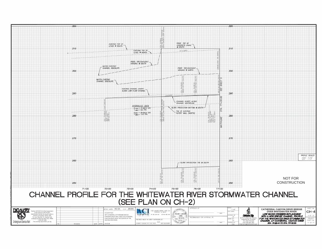
The channel section immediately downstream of the drop structure, including the toe of the drop structure, will be concrete lined. The balance of the channel section between the bridge and the drop structure, and under the bridge, approximately 180 feet, will consist of concrete lining. A buried transverse cutoff wall at a 1 to 1 slope and 32 feet deep is also proposed at the downstream end of the bridge to protect it from scour. A buried 32-foot wide ungrouted riprap pad will be placed at the toe of the cutoff wall. See Enclosure 3 for the plans and profiles for the Whitewater River.
Construction of bridge pylons, concrete lining of the drop structure and downstream channel reach, as well as concrete lining would result in permanent impacts of approximately 2.01 acres within Water of the US. The total project costs for Option 10 would be estimated at $22.6 million.
Off-site Alternatives: The applicant considered offsite alternatives including widening Date Palm Drive or Golf Club Drive were considered, however, they were eliminated from further consideration because they do not meet the overall project purpose which is to improve vehicle and pedestrian safety and access along the Cathedral Canyon Drive Corridor within the vicinity of the Whitewater River.
Proposed Mitigation– The proposed mitigation may change as a result of comments received in response to this public notice, the applicant's response to those comments, and/or the need for the project to comply with the 404(b)(1) Guidelines. In consideration of the above, the proposed mitigation sequence (avoidance/minimization/compensation), as applied to the proposed project is summarized below:

10
Avoidance: According to Cathedral City, the proposed alternatives have been developed and refined through an iterative process that considered potential impacts to waters of the U.S. on the project site and vicinity, hydraulic functions, circulation and connectivity to residences, as well as other factors such as cost and maintenance. The design and engineering as set forth in the proposed alternatives minimizes impacts to existing buildings and access drives, limits new structural elements associated with bridge support, and minimizes improvements within the channel while meeting the stabilization, flow, and freeboard requirements of the standard project flood and the 100-year flood. The Corps will be conducting a 404(b)(1) alternatives analysis to determine if further avoidance is practicable.
Minimization: The City has also considered multiple design alternatives in order to minimize adverse effects to aquatic resources to the maximum extent practicable, in addition to considering other sensitive areas.
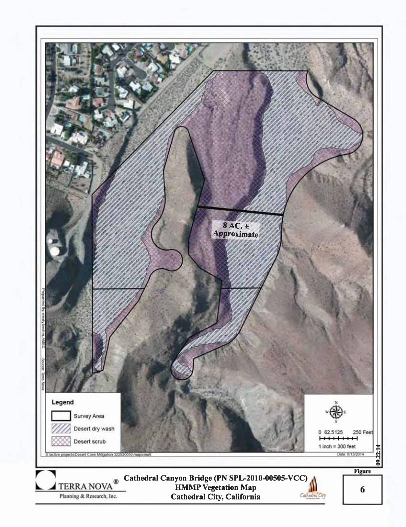
Compensation: The City is proposing to provide compensatory mitigation through the placement of a permanent conservation easement within East Cathedral Canyon Wash on lands owned by the City and has the potential to be developed into golf course use. City lands in the East Cathedral Canyon Wash would be managed by the Long Term Management Plan (LTMP) and related conservation easement currently under review by the Corps. The City intends that the compensatory habitat lands be managed and preserved in perpetuity as mitigation for unavoidable impacts to Waters of the US associated with the development of the Cathedral Canyon Drive Low Water Crossing Replacement Project (New Bridge) at the Whitewater River. The subject mitigation lands are part of the larger Preserve Unit being established for long-term conservation and located within the Upper East Cathedral Canyon Wash (ECCW). The proposed compensatory mitigation includes preservation of 3.98 acres of non-weltands waters of the U.S., consisting of desert dry wash woodland and 4.02 acres of adjacent desert scrub habitat, and totaling 8.00 acres. See Enclosure 4, HMMP Aerial View.
Proposed Special Conditions
No special conditions are proposed at this time.
For additional information please call Veronica Li of my staff at 213-452-3292 or via e-mail at [email protected]. This public notice is issued by the Chief, Regulatory Division.
Regulatory Program Goals: To provide strong protection of the nation's aquatic environment, including wetlands. To ensure the Corps provides the regulated public with fair and reasonable decisions. To enhance the efficiency of the Corps’ administration of its regulatory program.
__________________________________________________________
DEPARTMENT OF THE ARMY LOS ANGELES DISTRICT, U.S. ARMY CORPS OF ENGINEERS
915 Wilshire Boulevard, Suite 930 Los Angeles, CA 90017-3401
WWW.SPL.USACE.ARMY.MIL/MISSIONS/REGULATORY Enclosures: Enclosure 1: Project Vicinity Map Enclosure 2: Preferred Alternative (Option 10) Enclosure 3: Channel Plans and Profiles for the Whitewater Stormwater Channel Enclosure 4: HMMP Aerial View (Mitigation Site)


NOT FORCONSTRUCTION

NOT FORCONSTRUCTION
NOT FORCONSTRUCTION

NOT FORCONSTRUCTION