caribbean sea volume ii
TRANSCRIPT

PUB.
(ENROUTE)SAILING DIRECTIONS
★
★
2017
148
CARIBBEAN SEAVOLUME II
Prepared and published by theNATIONAL GEOSPATIAL-INTELLIGENCE AGENCY
Springfield, Virginia
© COPYRIGHT 2017 BY THE UNITED STATES GOVERNMENTNO COPYRIGHT CLAIMED UNDER TITLE 17 U.S.C.
SEVENTEENTH EDITION
For sale by the Superintendent of Documents, U.S. Government Printing Office
Internet: http://bookstore.gpo.gov Phone: toll free (866) 512-1800; DC area (202) 512-1800Fax: (202) 512-2250 Mail Stop: SSOP, Washington, DC 20402-0001

III
Pub. 148
Preface
0.0 Pub. 148, Sailing Directions (Enroute) Caribbean SeaVolume II, Seventeenth Edition, 2017, is issued for use inconjunction with Pub. 140, Sailing Directions (PlanningGuide) North Atlantic Ocean and Adjacent Seas. Companionvolumes are Pubs. 141, 142, 143, 145, 146, and 147.0.0 Digital Nautical Charts 14 and 15 provide electronic chartcoverage for the area covered by this publication.0.0 This publication has been corrected to 4 March 2017, includ-ing Notice to Mariners No. 9 of 2017. Subsequent updates havecorrected this publication to 30 October 2021, including Noticeto Mariners No. 44 of 2021.
Explanatory Remarks
0.0 Sailing Directions are published by the National Geospatial-Intelligence Agency (NGA) under the authority of Departmentof Defense Directive 5105.60, dated 29 July 2009, and pursu-ant to the authority contained in U. S. Code Title 10, Chapter22, Section 451 and Title 44, Section 1336. Sailing Directions,covering the harbors, coasts, and waters of the world, provideinformation that cannot be shown graphically on nauticalcharts and is not readily available elsewhere.0.0 Sailing Directions (Enroute) include detailed coastal andport approach information which supplements the largest scalechart produced by the National Geospatial-IntelligenceAgency. This publication is divided into geographic areascalled “Sectors.”0.0 Bearings.—Bearings are true, and are expressed in degreesfrom 000° (north) to 360°, measured clockwise. Generalbearings are expressed by the initial letters of the points of thecompass (e.g. N, NNE, NE, etc.). Adjective and adverbendings have been discarded. Wherever precise bearings areintended, degrees are used.0.0 Charts.—Reference to charts made throughout thispublication refer to both the paper chart and the DigitalNautical Chart (DNC). 0.0 Corrective Information.—Users should refer corrections,additions, and comments to NGA’s Maritime Operations Desk,as follows:
0.0 New editions of Sailing Directions are corrected through thedate of publication shown above. Important information toamend material in the publication is available is updated asneeded and available as a downloadable corrected publicationfrom the NGA Maritime Domain web site.
0.0 Courses.—Courses are true, and are expressed in the samemanner as bearings. The directives “steer” and “make good” acourse mean, without exception, to proceed from a point oforigin along a track having the identical meridional angle asthe designated course. Vessels following the directives mustallow for every influence tending to cause deviation from suchtrack, and navigate so that the designated course iscontinuously being made good.0.0 Currents.—Current directions are the true directions towardwhich currents set.0.0 Distances.—Distances are expressed in nautical miles of 1minute of latitude. Distances of less than 1 mile are expressedin meters, or tenths of miles.0.0 Geographic Names.—Geographic names are generallythose used by the nation having sovereignty. Names in paren-theses following another name are alternate names that mayappear on some charts. In general, alternate names are quotedonly in the principal description of the place. Diacritical marks,such as accents, cedillas, and circumflexes, which are related tospecific letters in certain foreign languages, are not used in theinterest of typographical simplicity.0.0 Geographic names or their spellings do not necessarily re-flect recognition of the political status of an area by the UnitedStates Government.0.0 Heights.—Heights are referred to the plane of referenceused for that purpose on the charts and are expressed in meters.0.0 Internet Links.—This publication provides Internet links toweb sites concerned with maritime navigational safety, includ-ing but not limited to, Federal government sites, foreign Hy-drographic Offices, and foreign public/private port facilities.NGA makes no claims, promises, or guarantees concerning theaccuracy, completeness, or adequacy of the contents of theseweb sites and expressly disclaims any liability for errors andomissions in the contents of these web sites.
NGA Maritime—Contact Information
Maritime Operations Desk
Toll free 1-800-362-6289
Commercial 571-557-5455
DSN 547-5455
E-mail [email protected]
Maritime Safety Office
DNC web site https://dnc.nga.mil
Maritime Domain web site
https://msi.nga.mil
E-mail [email protected]
Maritime Quality Feedback System (MQFS)
https://marhelp.nga.mil
Mailing address Maritime Safety OfficeNational Geospatial-Intelligence AgencyMail Stop N64-SFH7500 Geoint DriveSpringfield VA 22150-7500
NGA Maritime Safety Office Web site
https://msi.nga.mil
NGA Maritime—Contact Information
IV
Pub. 148
0.0 International Ship and Port Facility Security (ISPS)Code.—The ISPS Code is a comprehensive set of measures toenhance the security of ships and port facilities developed inresponse to the perceived threats to ships and port facilities inthe wake of the 9/11 attacks in the United States. Informationon the ISPS Code can be found at the International MaritimeOrganization web site:
0.0 Lights and Fog Signals.—Lights and fog signals are notdescribed, and light sectors are not usually defined. The LightLists should be consulted for complete information.0.0 National Ocean Claims.—Information on national oceanclaims and maritime boundary disputes, which have been com-piled from the best available sources, is provided solely in theinterest of the navigational safety of shipping and in no wayconstitutes legal recognition by the United States. These non-recognized claims and requirements may include, but are notlimited to:
1. A requirement by a state for advance permission ornotification for innocent passage of warships in the territorialsea.
2. Straight baseline, internal waters, or historic watersclaims.
3. The establishment of a security zone, where a stateclaims to control activity beyond its territorial sea for securi-ty reasons unrelated to that state’s police powers in its terri-tory, including its territorial sea.
0.0 Radio Navigational Aids.—Radio navigational aids and ra-dio weather services are not described in detail. PublicationNo. 117 Radio Navigational Aids and NOAA Publication, Se-lected Worldwide Marine Weather Broadcasts, should be con-sulted.0.0 Soundings.—Soundings are referred to the datum of thecharts and are expressed in meters. 0.0 Telephone and Facsimile Numbers.—Within this publica-tion, the international telephone and facsimile numbers provid-ed as contact information contain the minimum digitsnecessary to dial. Please note that these contact numbers do notinclude additional digits or special characters, such as (0) or(+), which may be required when dialing. The necessity ofsuch digits and characters depend upon numerous factors andconditions, such as the user’s geolocation and service provider.Mariners are advised to consult their communications equip-ment and service provider manuals for guidance.
0.0 Time.—Time is normally expressed as local time unlessspecifically designated as Universal Coordinated Time (UTC). 0.0 Time Zone.—The Time Zone description(s), as well as in-formation concerning the use of Daylight Savings Time, are in-cluded. The World Time Zone Chart is available on the Inter-net at the web site given below.
0.0 U.S. Maritime Advisory System.—The U.S. MaritimeAdvisory System is a streamlined inter-agency approach toidentifying and promulgating maritime security threats. Thesystem replaces Special Warnings to Mariners (StateDepartment), MARAD Advisories (Maritime Administration),and Marine Safety Information Bulletins (U.S. Coast Guard)and consists of the following items:
1. U.S. Maritime Alert—Provides basic information(location, incident, type, date/time) on reported maritimesecurity threats to U.S. maritime industry interests. U.S.Maritime alerts do not contain policy or recommendationsfor specific courses of information.
2. U.S. Maritime Advisory—Provides more detailedinformation, when appropriate, through a “whole-of-gov-ernment” response to an identified maritime threat.
0.0 Winds.—Wind directions are the true directions from whichwinds blow.
Reference List
0.0 The principal sources examined in the preparation of thispublication were:0.0 British Hydrographic Department Sailing Directions.0.0 Various port handbooks. 0.0 Reports from United States Naval and merchant vessels andvarious shipping companies.0.0 Other U.S. Government publications, reports, and docu-ments.0.0 Charts, light lists, tide and current tables, and other docu-ments in possession of the Agency.
International Maritime Organization Home Page
http://www.imo.org
Standard Time Zone of the World Chart
https://www.cia.gov/maps/world-regional
Maritime Administration (MARAD)—U.S. Maritime Advisory System
https://www.marad.dot.gov/environment-and-safety/office-of-security/msci
Date of Change: 30 October 2021
Notice to Mariners: 44/2021
Sector Paragraphs
Sector 1 Paragraphs 1.17, 1.35, 1.41, 1.42, 1.47, and 1.57
Sector 2 Paragraphs 2.12, 2.13, 2.16, 2.17, 2.25, 2.26, 2.30, 2.56, 2.60, and 2.61
Sector 3 Paragraph 3.19
Sector 4 Paragraphs 4.6, 4.8, 4.10, 4.12, 4.13, 4.14, 4.15, 4.18, 4.21, 4.26, 4.36, and 4.40

V
Pub. 148
Sector 5 Paragraphs 5.11, 5.15, 5.22, 5.24, 5.30, 5.37, and 5.50
Sector 6 Paragraphs 6.26, 6.33, 6.36, 6.40, 6.41, 6.45, 6.48, 6.49, 6.65, 6.69, 6.72, 6.77, and 6.80
Sector 7 Paragraphs 7.7, 7.10, 7.14, 7.16, 7.18, 7.20, 7.22, 7.31, 7.33, 7.36, and 7.37
Date of Change: 15 May 2021
Notice to Mariners: 20/2021
Sector Paragraphs
Sector 5 Paragraphs 5.47 and 5.48
Sector 7 Paragraphs 7.16 and 7.22
Sector 8 Paragraph 8.29
Date of Change: 30 January 2021
Notice to Mariners: 5/2021
Sector Paragraphs
Sector 1 Paragraphs 1.32, 1.36, and 1.50
Sector 2 Paragraphs 2.17, 2.23, 2.30, 2.40, 2.47, 2.54, and 2.65
Sector 3 Paragraphs 3.4, 3.7, 3.12, 3.17, and 3.19
Sector 4 Paragraph 4.8
Date of Change: 26 September 2020
Notice to Mariners: 39/2020
Sector Paragraphs
Sector 1 Paragraphs 1.8, 1.14, 1.17, 1.31, 1.32, 1.33, 1.34, 1.37, 1.38, 1.41, 1.42, 1.46, 1.47, 1.55, 1.56, 1.57, and 1.58
Sector 2 Paragraphs 2.12, 2.13, 2.16, 2.17, 2.18, 2.19, 2.23, 2.25, 2.30, 2.40, 2.45, 2.47, 2.54, 2.56, 2.65, 2.67, and 2.69
Sector 3 Paragraphs 3.1, 3.4, 3.8, 3.15, 3.16, 3.17, 3.19, 3.21, 3.23, and 3.25
Sector 4 Paragraphs 4.3, 4.8, 4.10, 4.14, 4.15, 4.18, 4.22, 4.26, 4.36, 4.39, and 4.40
Sector 5 Paragraphs 5.4, 5.11, 5.20, 5.22, 5.37, 5.40, and 5.49
Sector 6 Paragraphs 6.4, 6.8, 6.29, 6.36, 6.39, 6.40, 6.42, 6.48, 6.64, 6.70, 6.73, 6.75, and 6.77
Sector 7 Paragraphs 7.10, 7.14, 7.18, 7.20, 7.22, 7.24, 7.28, 7.31, 7.33, 7.36, and 7.37
Date of Change: 22 February 2020
Notice to Mariners: 8/2020
Sector Paragraphs
Sector 1 Paragraphs 1.8, 1.33, and1.54
Sector 2 Paragraph 2.54
Sector 3 Paragraphs 3.1, 3.12, and 3.14
Sector 4 Paragraphs 4.9, 4.10, and 4.17
Sector 5 Paragraph 5.24
Date of Change: 30 October 2021
Notice to Mariners: 44/2021
Sector Paragraphs

VI Pub. 148
Sector 6 Paragraphs 6.29, 6.48, 6.76, and 6.79
Sector 7 Paragraphs 7.31 and 7.36
Date of Change: 3 August 2019
Notice to Mariners: 31/2019
Sector Paragraphs
Sector 1 Paragraphs 1.3, 1.4, 1.8, 1.17, 1.33, 1.35, 1.36, 1.38, and 1.42
Sector 2 Paragraphs 2.12, 2.13, 2.17, 2.23, 2.26, 2.54, 2.56, 2.60, and 2.67
Sector 3 Paragraphs 3.4, 3.7, 3.8, 3.12, 3.14, and 3.16
Sector 4 Paragraphs 4.3, 4.9, 4.16, 4.16, 4.19, 4.37, 4.39, 4.41, 4.42, 4.44, and 4.45
Sector 5 Paragraphs 5.11, 5.22, 5.39, and 5.52
Sector 6 Paragraphs 6.26, 6.33, 6.36, 6.41, 6.64, 6.70, and 6.74
Sector 7 Paragraphs 7.7, 7.10, 7.16, 7.19, 7.20, 7.22, 7.33, 7.34, 7.35, 7.36, and 7.37
Date of Change: 5 January 2019
Notice to Mariners: 1/2019
Sector Paragraphs
Sector 1 Paragraphs 1.1, 1.3, 1.8, 1.17, 1.32, 1.42, 1.55, and 1.58
Sector 2 Paragraphs 2.16 and 2.65
Sector 4 Paragraphs 4.3, 4.7, 4.17, 4.18, and 4.34
Sector 5 Paragraphs 5.49, 5.58, 5.59, and 5.60
Sector 6 Paragraphs 6.5, 6.8, 6.9, 6.15, 6.18, 6.52, 6.63, 6.67, 6.68, and 6.74
Sector 7 Paragraphs 7.9, 7.10, 7.11, 7.16, 7.25, 7.33, 7.35, 7.36, and 7.37
Date of Change: 10 February 2018
Notice to Mariners: 6/2018
Sector Paragraphs
Sector 1 Paragraphs 1.2, 1.3, 1.7, 1.12, 1.17, 1.22, 1.33, and 1.34
Sector 2 Paragraphs 2.4, 2.17, 2.25, 2.26, 2.53, 2.54, 2.59, and 2.64
Sector 4 Paragraphs 4.9, 4.13, 4.16, 4.17, 4.18, 4.24, 4.37, 4.38, and 4.39
Sector 7 Paragraphs 7.10, 7.28, and 7.30
Date of Change: 22 February 2020
Notice to Mariners: 8/2020
Sector Paragraphs

VII
Pub. 148
0.0SECTOR LIMITS—PUB. 148
VIII Pub. 148
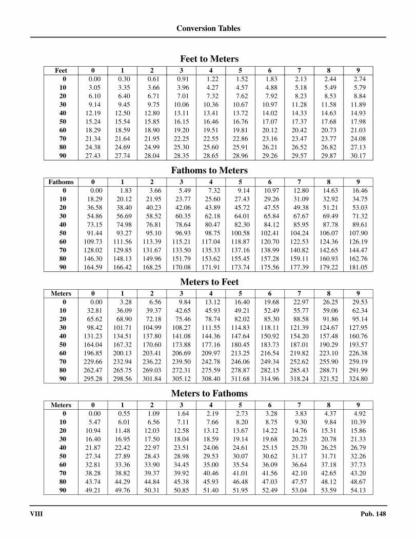
Conversion Tables
Feet to MetersFeet 0 1 2 3 4 5 6 7 8 9 0 0.00 0.30 0.61 0.91 1.22 1.52 1.83 2.13 2.44 2.74 10 3.05 3.35 3.66 3.96 4.27 4.57 4.88 5.18 5.49 5.79 20 6.10 6.40 6.71 7.01 7.32 7.62 7.92 8.23 8.53 8.84 30 9.14 9.45 9.75 10.06 10.36 10.67 10.97 11.28 11.58 11.89 40 12.19 12.50 12.80 13.11 13.41 13.72 14.02 14.33 14.63 14.93 50 15.24 15.54 15.85 16.15 16.46 16.76 17.07 17.37 17.68 17.98 60 18.29 18.59 18.90 19.20 19.51 19.81 20.12 20.42 20.73 21.03 70 21.34 21.64 21.95 22.25 22.55 22.86 23.16 23.47 23.77 24.08 80 24.38 24.69 24.99 25.30 25.60 25.91 26.21 26.52 26.82 27.13 90 27.43 27.74 28.04 28.35 28.65 28.96 29.26 29.57 29.87 30.17
Fathoms to MetersFathoms 0 1 2 3 4 5 6 7 8 9
0 0.00 1.83 3.66 5.49 7.32 9.14 10.97 12.80 14.63 16.46 10 18.29 20.12 21.95 23.77 25.60 27.43 29.26 31.09 32.92 34.75 20 36.58 38.40 40.23 42.06 43.89 45.72 47.55 49.38 51.21 53.03 30 54.86 56.69 58.52 60.35 62.18 64.01 65.84 67.67 69.49 71.32 40 73.15 74.98 76.81 78.64 80.47 82.30 84.12 85.95 87.78 89.61 50 91.44 93.27 95.10 96.93 98.75 100.58 102.41 104.24 106.07 107.90 60 109.73 111.56 113.39 115.21 117.04 118.87 120.70 122.53 124.36 126.19 70 128.02 129.85 131.67 133.50 135.33 137.16 138.99 140.82 142.65 144.47 80 146.30 148.13 149.96 151.79 153.62 155.45 157.28 159.11 160.93 162.76 90 164.59 166.42 168.25 170.08 171.91 173.74 175.56 177.39 179.22 181.05
Meters to FeetMeters 0 1 2 3 4 5 6 7 8 9
0 0.00 3.28 6.56 9.84 13.12 16.40 19.68 22.97 26.25 29.53 10 32.81 36.09 39.37 42.65 45.93 49.21 52.49 55.77 59.06 62.34 20 65.62 68.90 72.18 75.46 78.74 82.02 85.30 88.58 91.86 95.14 30 98.42 101.71 104.99 108.27 111.55 114.83 118.11 121.39 124.67 127.95 40 131.23 134.51 137.80 141.08 144.36 147.64 150.92 154.20 157.48 160.76 50 164.04 167.32 170.60 173.88 177.16 180.45 183.73 187.01 190.29 193.57 60 196.85 200.13 203.41 206.69 209.97 213.25 216.54 219.82 223.10 226.38 70 229.66 232.94 236.22 239.50 242.78 246.06 249.34 252.62 255.90 259.19 80 262.47 265.75 269.03 272.31 275.59 278.87 282.15 285.43 288.71 291.99 90 295.28 298.56 301.84 305.12 308.40 311.68 314.96 318.24 321.52 324.80
Meters to FathomsMeters 0 1 2 3 4 5 6 7 8 9
0 0.00 0.55 1.09 1.64 2.19 2.73 3.28 3.83 4.37 4.92 10 5.47 6.01 6.56 7.11 7.66 8.20 8.75 9.30 9.84 10.39 20 10.94 11.48 12.03 12.58 13.12 13.67 14.22 14.76 15.31 15.86 30 16.40 16.95 17.50 18.04 18.59 19.14 19.68 20.23 20.78 21.33 40 21.87 22.42 22.97 23.51 24.06 24.61 25.15 25.70 26.25 26.79 50 27.34 27.89 28.43 28.98 29.53 30.07 30.62 31.17 31.71 32.26 60 32.81 33.36 33.90 34.45 35.00 35.54 36.09 36.64 37.18 37.73 70 38.28 38.82 39.37 39.92 40.46 41.01 41.56 42.10 42.65 43.20 80 43.74 44.29 44.84 45.38 45.93 46.48 47.03 47.57 48.12 48.67 90 49.21 49.76 50.31 50.85 51.40 51.95 52.49 53.04 53.59 54.13
IX
Pub. 148
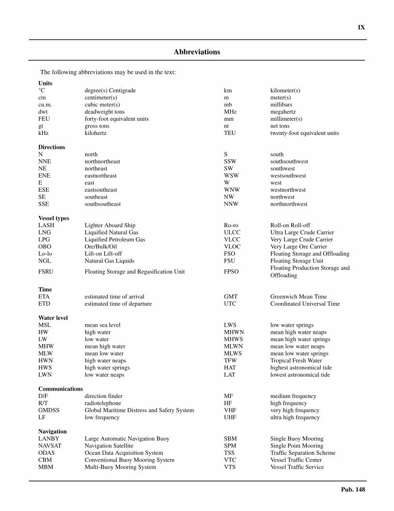
Abbreviations
The following abbreviations may be used in the text:
Units°C degree(s) Centigrade km kilometer(s)cm centimeter(s) m meter(s)cu.m. cubic meter(s) mb millibarsdwt deadweight tons MHz megahertzFEU forty-foot equivalent units mm millimeter(s)gt gross tons nt net tonskHz kilohertz TEU twenty-foot equivalent units
DirectionsN north S southNNE northnortheast SSW southsouthwestNE northeast SW southwestENE eastnortheast WSW westsouthwestE east W westESE eastsoutheast WNW westnorthwestSE southeast NW northwestSSE southsoutheast NNW northnorthwest
Vessel typesLASH Lighter Aboard Ship Ro-ro Roll-on Roll-offLNG Liquified Natural Gas ULCC Ultra Large Crude CarrierLPG Liquified Petroleum Gas VLCC Very Large Crude CarrierOBO Ore/Bulk/Oil VLOC Very Large Ore CarrierLo-lo Lift-on Lift-off FSO Floating Storage and Offloading NGL Natural Gas Liquids FSU Floating Storage Unit
FSRU Floating Storage and Regasification Unit FPSOFloating Production Storage and Offloading
TimeETA estimated time of arrival GMT Greenwich Mean TimeETD estimated time of departure UTC Coordinated Universal Time
Water levelMSL mean sea level LWS low water springsHW high water MHWN mean high water neapsLW low water MHWS mean high water springsMHW mean high water MLWN mean low water neapsMLW mean low water MLWS mean low water springsHWN high water neaps TFW Tropical Fresh WaterHWS high water springs HAT highest astronomical tideLWN low water neaps LAT lowest astronomical tide
CommunicationsD/F direction finder MF medium frequencyR/T radiotelephone HF high frequencyGMDSS Global Maritime Distress and Safety System VHF very high frequencyLF low frequency UHF ultra high frequency
NavigationLANBY Large Automatic Navigation Buoy SBM Single Buoy MooringNAVSAT Navigation Satellite SPM Single Point MooringODAS Ocean Data Acquisition System TSS Traffic Separation SchemeCBM Conventional Buoy Mooring System VTC Vessel Traffic CenterMBM Multi-Buoy Mooring System VTS Vessel Traffic Service

X
Pub. 148
CALM Catenary Anchor Leg Mooring
Miscellaneous
AIS Automatic Identification System MMSIMaritime Mobile Service Identity Code
COLREGS Collision Regulations No./Nos. Number/Numbers
IALAInternational Association of LighthouseAuthorities
PAPD
Position approximatePosition doubtful
IHO International Hydrographic Organization Pub. Publication
IMO International Maritime Organization SOLASInternational Convention for Safety of Life at Sea
IMDG Intermational Maritime Dangerous Goods CodeLOA length overall St./Ste. Saint/Sainte
UKC Under keel clearance ISPSInternational Ship and Port facility Security
ITCInternational Convention on the Tonnage Measurement of Ships (1969)
ECDISElectronic Chart Display and Information System
The following abbreviations may be used in the text:

Pub. 148 XI
Contents
Preface. . . . . . . . . . . . . . . . . . . . . . . . . . . . . . . . . . . . . . . . . . . . . . . . . . . . . . . . . . . . . . . . . . . . . . . . . . . . . . . . . . . . . . . . . . . . . . . . IIIChartlet—Sector Limits . . . . . . . . . . . . . . . . . . . . . . . . . . . . . . . . . . . . . . . . . . . . . . . . . . . . . . . . . . . . . . . . . . . . . . . . . . . . . . . . . VIIConversion Tables. . . . . . . . . . . . . . . . . . . . . . . . . . . . . . . . . . . . . . . . . . . . . . . . . . . . . . . . . . . . . . . . . . . . . . . . . . . . . . . . . . . . . VIIIAbbreviations . . . . . . . . . . . . . . . . . . . . . . . . . . . . . . . . . . . . . . . . . . . . . . . . . . . . . . . . . . . . . . . . . . . . . . . . . . . . . . . . . . . . . . . . . . IX
Sector 1
Sector 1—Trinidad and Tobago and the Coast of Venezuela—The Gulf of Paria and the Rio Orinoco . . . . . . . . . . . . . . . . . . . . . 1
Sector 2
Sector 2—Aruba, Bonaire, Curacao, and the Coast of Venezuela—Punta Penas to Cabo San Roman, with Off-lying Islands and Dan-
gers . . . . . . . . . . . . . . . . . . . . . . . . . . . . . . . . . . . . . . . . . . . . . . . . . . . . . . . . . . . . . . . . . . . . . . . . . . . . . . . . . . . . . . . . . . . . . . . . . . 35
Sector 3
Sector 3—Golfo de Venezuela and Lago de Maracaibo . . . . . . . . . . . . . . . . . . . . . . . . . . . . . . . . . . . . . . . . . . . . . . . . . . . . . . . . . 79
Sector 4
Sector 4—Coasts of Colombia and Panama—Punta Gallinas to and including the Panama Canal . . . . . . . . . . . . . . . . . . . . . . . . 93
Sector 5
Sector 5—Coasts of Panama, Costa Rica, and Nicaragua—The Panama Canal to Cabo Gras a Dios . . . . . . . . . . . . . . . . . . . . . 137
Sector 6
Sector 6—Coasts of Honduras, Guatemala, Belize, and Mexico—Cabo Gracias a Dios to Cabo Catoche . . . . . . . . . . . . . . . . . 159
Sector 7
Sector 7—Coast of Mexico—Cabo Catoche to the Rio Grande . . . . . . . . . . . . . . . . . . . . . . . . . . . . . . . . . . . . . . . . . . . . . . . . . . 197
Glossaries . . . . . . . . . . . . . . . . . . . . . . . . . . . . . . . . . . . . . . . . . . . . . . . . . . . . . . . . . . . . . . . . . . . . . . . . . . . . . . . . . . . . . . . . . . . . 225
Index—Gazetteer . . . . . . . . . . . . . . . . . . . . . . . . . . . . . . . . . . . . . . . . . . . . . . . . . . . . . . . . . . . . . . . . . . . . . . . . . . . . . . . . . . . . . . 231

1
Pub. 148
1. Sector 1—Trinidad and Tobago and the Coast of Venezuela—The Gulf of Paria
and the Rio Orinoco
1.0Additional chart coverage may be found in NGA/DLIS Catalog of Maps, Charts, and Related Products (Unlimited Distribution).SECTOR 1 — CHART INFORMATION

3
Pub. 148
SECTOR 1
TRINIDAD AND TOBAGO AND THE COAST OF VENEZUELA—THE GULF OF PARIA AND THE RIO ORINOCO
1.0 Plan.—This sector first describes Tobago and then the N, E,and S coasts of Trinidad. The approaches to the Gulf of Pariaare then described, including Dragons Mouth and SerpentsMouth. The W coast of Trinidad and the W shores of the Gulfare then described in a N to S sequence. The tributaries of theRio Orinoco flowing into the Gulf of Paria and its S approachare described with the Gulf of Paria. The Boca Grande water-way of the Rio Orinoco is described separately.
General Remarks
1.1 Tobago, the outermost island described in this sector,is 22 miles long and lies 19 miles NNE of Trinidad. Trinidadand Tobago is an independent member state of the BritishCommonwealth.1.1 Trinidad, the second largest and southernmost island of theWest Indies, lies 7 miles from the NE extremity of Venezuela.It is 50 miles long, 37 miles wide, and is crossed by two moun-tain systems. Port of Spain, the principal commercial port, issituated on the W coast of the island.1.1 Vessels passing between Tobago and Trinidad must avoidDrew Bank (11°05'N., 60°50'W.). Less water than charted wasreported (1986) to lie on this bank. The bank and several un-marked off-lying dangers lying off the E coast of Trinidad re-quire prudent navigation when in this vicinity. Vessels maystay clear of Drew Bank by keeping outside the 40m curve,which may best be seen on the chart.1.1 The Gulf of Paria lies between Trinidad and the mainlandcoast of Venezuela. Several ports are situated within the gulf.1.1 The Venezuelan river ports of Caripito and Pedernales areentered through river entrances, which lie in the SW and S partof the gulf.1.1 Vessels proceeding to the ports within the gulf generally pre-fer to use the Boca Grande Channel of the Dragons Mouth; toavoid the intricate passages of Serpents Mouth and the numer-ous oil platforms/drilling rigs situated in the middle and S partsof the gulf.1.1 The Boca Grande waterway of the Rio Orinoco, which lies100 miles SE of Serpents Mouth, is the only improved andmaintained channel for vessels proceeding to Palua, Puerto Or-daz, and Ciudad Bolivar.1.1 Winds—Weather.—The area covered by this sector lies atthe SW end of the NE trade wind system of the North Atlantic.Over the open sea N of 10°N, winds are predominately fromthe E and NE most of the year. These winds generally do notexceed force 6, except in heavy squalls. Land and sea breezesoccur along the mainland coast and to some extent aroundTrinidad; however, are seldom strong enough to do more thanmodify the prevailing trade wind.1.1 The main hurricane season in the E part of the Caribbeanusually occurs from the beginning of August to mid-Septem-ber, but has been known to occur as early as June and as late asNovember. The storms usually do not move S of 12°N, but a
heavy swell and rough seas may still be experienced along thecoastal area. Between 1878 to 2018, only four hurricanes havepassed Tobago and S. One of these affected Tobago (Septem-ber, 1963) while three affected Trinidad (September, 1878; Oc-tober, 1829; and June, 1933). 1.1 Squalls of varying intensity are rather common, especiallythose associated with thunderstorms, which are more frequentnear land, rather than over the open sea. White squalls, whichare squalls with little or no cloud, may occur in any season,both along the coast and at sea, and are usually accompaniedby a turbulent sea which rapidly subsides once the squall haspassed.1.1 Fog rarely occurs at sea and is uncommon on the coast.1.1 Temperatures are almost uniformly high and when accompa-nied by high humidity; can cause some discomfort, especiallyin calm conditions.1.1 Tides—Currents.—The surface currents described in thissector are governed by the North Equatorial Current and theSouth Equatorial Current. Current speeds and directions varyonly slightly with the seasons and generally set W or NW. Thegreatest local variations in the current pattern result from windsand storms.1.1 Off the N coasts of Trinidad and the Peninsula de Paria, thecurrent is strongest from July to October, with speeds rangingbetween 1.5 and 2 knots. River discharges at the E part of Ven-ezuela exert considerable influence on coastal water move-ments, especially during the rainy season. The same is true ofthe water flowing into the Gulf of Paria during the rainy sea-son, through Serpents Mouth and out of Dragons Mouth. Therate of the currents at such times may range from 2 to 2.5knots. Exiting Dragons Mouth, the current turns W and joinsthe Equatorial Current N of the mouth.1.1 Under normal weather conditions, the tidal currents flow in-to the Gulf of Paria from both ends through Dragons Mouthand Serpents Mouth while the tide is rising. They flow outthrough both channels while the tide is falling.
Tobago
1.2 Tobago (11°15'N., 60°40'W.), lying 19 miles NNE ofTrinidad, has a steep-to coast line and is indented by bays,some of which are suitable as anchorages. A ridge of irregularmountains, which attains an elevation of 582m, extends almosttwo thirds of the length of the island from its NE extremity.The summits of this ridge are mostly rounded and lack well-de-fined peaks. The slope on the N side of the ridge is generallysteep, but on the S side there are several fertile valleys whichlie between the spurs of the hills extending to the coast. TheSW section of the island consists of low-lying plains, fromwhich numerous hills rise.1.2 During the winter, the NW side of the island is subject to aground swell which occasionally breaks heavily over BuccooReef and Drew Bank, SW of Crown Point. At such times, ves-

4 Sector 1. Trinidad and Tobago —The Gulf of Paria and the Rio Orinoco
Pub. 148
sels leave the bays on that side of the island. The SE side of theisland is continually exposed to a heavy swell.1.2 Scarborough, at Rockly Bay on the SW side of the island, isthe chief town, while Charlottesville, at Man-of-War Bay onthe NE side of the island, is the largest.1.2 Anchorage can be taken in Man-of-War Bay, Great CourlandBay, King’s Bay, and Rockly Bay. Rockly Bay is most fre-quented by vessels; however, King’s Bay is deeper and pro-vides shelter from prevailing winds.1.2 The Saint Giles Islands (11°21'N., 60°31'W.), a rocky andsteep-to group of islands, lie 0.5 mile N of the NE extremity ofTobago. Melville Island is the southernmost and largest islandstanding 114m high. Marble Island lies N of Melville Islandand is 45m high. London Bridge lies W of Melville Island andhas a height of 49m. London Bridge is formed by a prominentrock shaped like an arch. 1.2 A rock, awash, lies midway between the largest island of theSaint Giles group and the NE extremity of Tobago. PointedRock lies SSE of the rock awash. There is a least depth of 27min the channels lying on either side of the rock awash, but theyare both narrow with a considerable current set. Vessels are ad-vised to pass N of the Saint Giles Islands, outside of the 50mcurve.
1.3 Man-of-War Bay (11°19'N., 60°34'W.) is entered be-tween North Point and Corvo Point, about1.5 miles WSW ofTobago’s NE extremity. It recedes about 1 mile from the head.A reef fringes North Point and extends up to 0.1 mile N of it.An islet lies near the seaward extremity of this reef. Booby Is-land, 33m high and steep-to, lies near the head of the bay.1.3 A sector light is located at the head of the bay, 0.7 mile E ofBooby Island.1.3 The E and S shores of the bay are fronted by a reef. Severalabove-water rocks lie on this reef and on all sides of the bay.An islet, 37m high, lies 0.5 mile ESE of Corvo Point; CardinalRock, which dries 0.5m, lies 0.2 mile E of the point.1.3 Charlotteville (11°19'N., 60°33'W.) is situated in the SEcorner of Man-of-War Bay and may be identified by some scat-tered small houses and a row of bungalows on the shore. 1.3 Hermitage House stands on the SW side of the bay, 0.8 mileSW of Corvo Point. This conspicuous dwelling has a greenroof and is surrounded by trees. An anchorage, with depths of22 to 33m, lies within Man-of-War Bay. Smaller vessels cananchor close inshore.1.3 Between Corvo Point and Courland Point (11°13'N.,60°47'W.) the 13.5 mile SW coast is generally steep-to androcky.1.3 The Brothers, breaking rocks, lie close offshore, about 2miles W of Corvo Point. A mixture of submerged and breakingrocks lie WSW of The Brothers on the 30m curve.1.3 The Sisters (11°20'N., 60°39'W.), a group of rocks, lie 3.5miles W of Corvo Point. The N rock of this group is 30m high.The passage leading between The Brothers and The Sistersshould not be attempted.1.3 This part of the coast is indented by several small bays. Fromthe NE they are Bloody Bay, Parlatuvier Bay, Englishman’sBay, Castara Bay, King Peter’s Bay, and Fromager Bay. Thesebays only afford anchorage to small craft with local knowl-edge. Castara Bay, lying 7.5 miles SW of Corvo Point, is theonly one that affords any shelter.
1.4 Great Courland Bay (11°12'N., 60°47'W.), a slightindentation, is entered between Courland Point and Hawk’sBill, 0.8 mile SSW. A light is shown from Courland Point.1.4 Plymouth is situated in the NE corner of Great CourlandBay. The church, a wooden building with a red roof and a smallspire, stands in the SW part of the town. The remains of an oldfort stand on the S side of Courland Point. A pier, in ruins, ex-tends from the shore abreast of the town.1.4 Anchorage can be taken, in a depth of 18m, about 0.5 mileSW of Courland Point. Small vessels can anchor closer in. Novessels should anchor in depths of less than 13m. When the
1.3Englishman’s Bay
1.3Parlatuvr Bay

Sector 1. Trinidad and Tobago —The Gulf of Paria and the Rio Orinoco 5
Pub. 148
wind is from the NE, a swell sets into the bay, but the holdingground is good. This is the principal anchorage on the NW sideof Tobago.1.4 Stone Haven Bay is entered between Hawk’s Bill and RockyPoint, l mile SW. It is exposed and is of little use as an anchor-age.1.4 Mount Irvine Bay (Little Courland Bay) is entered betweenRocky Point and Booby Point, 1 mile SW. A rock, 11m high,lies close off the latter point. A white house, with a red roof,stands on high ground about 0.8 mile ESE of Booby Point.1.4 Anchorage can be obtained, in a depth of 13m, within theNE part of the bay. This anchorage, although preferable to thatin Great Courland Bay, may at times become untenable.1.4 Caution.—Care should be taken to avoid numerous fish netsand traps which may be encountered in the N part of GreatCourland Bay.
1.5 Pigeon Point (11°10'N., 60°50'W.) is located 1.8miles WSW of Booby Point; Buccoo Bay is formed betweenthe two points. A shoal, with a depth of 0.6m, lies about 0.2mile W of Booby Point and breaks in heavy weather.1.5 Buccoo Reef extends about 1.3 miles N and 0.5 mile NWfrom Pigeon Point. Its outer edge dries and is clearly defined.A small and sandy islet, 0.6m high, lies on the NE part of thisreef. According to local information, the position of this isletmay vary with changing weather conditions. Lighted buoysmark the N and W extremities of the reef.1.5 Milford Bay, marked by a light close N of the airfield at itshead, is entered between Pigeon Point and Sandy Point, 1.3miles S. A rock, with a depth of 1.8m, lies on the edge of theshore bank, about 0.5 mile NNE of Sandy Point. A landingplace is situated about 0.1 mile SSW of Pigeon Point.1.5 When approaching Milford Bay, care should be taken not toround Crown Point or Buccoo Reef too closely.1.5 Crown Point (11°09'N., 60°51'W.) marked by a light, is lo-cated 0.5 mile SSW of Sandy Point and forms the SW extremi-ty of Tobago. The 5m curve lies about 0.4 mile offshore to theS of this point with breakers forming on the ledge.1.5 An SPM is moored about 0.5 mile WNW of the light, in adepth of 14m. Berthing takes place in daylight hours only. 1.5 Caution.—Three submarine cables, which may best be seenon the chart, extend SSW from the head of Milford Bay acrossGalleons Passage to Trinidad.1.5 Anchorage is prohibited within 0.2 mile of the cables in Mil-ford Bay and vessels should not anchor within 2 miles of thecables in Galleons Passage.
1.5 Tyrrel’s Bay (11°18'N., 60°32'W.) lies between a point lo-cated 2.5 miles S of the N extremity of Tobago and anotherpoint, 0.8 mile SSE. Its shores are fringed by reefs which ex-tend up to about 0.3 mile seaward in places. A detached shoal,with two above-water rocks lying on it, is located about 0.3mile ENE of the N entrance point of the bay.
1.6 Little Tobago (11°18'N., 60°30'W.), an irregularly-shaped island, that is 141m high, E of Tyrrel’s Bay, and lies 1mile offshore. Black Rock lies 0.5 mile NE of the N extremityof this island; Long Rock lies about 1 mile W of it. Goat Islandlies in the mouth of the bay, 0.5 mile W of the island. The Wside of Goat Island is fringed with reefs and numerous above-
water rocks lie close off its N and S ends.1.6 Several above and below-water rocks lie within 1 mile S ofLittle Tobago. Depths of 37 to 55m lie in the channels betweenLittle Tobago and Goat Island, and between Goat Island andTobago. The N current setting in these channels attains rates of2.5 to 4 knots.1.6 Anchorage can be taken, in depths of 26 to 44m, in the mid-dle of Tyrrel’s Bay, W of Goat Island.1.6 The channel leading between South Rock (11°17'N.,60°31'W.) and Little Tobago should be avoided. The currentdivides SW of Little Tobago and sets through the channel at aconsiderable rate.1.6 From the S entrance point of Tyrrel’s Bay, the coast trends1.5 miles S to Cape Gracias-a-Dios (11°16'N., 60°32'W.) andthen about 1 mile SSW to Pedro Point. This stretch of shoreshould be avoided by small craft as the current setting con-stantly against the wind raises a rough sea.1.6 Kings Bay (11°15'N., 60°33'W.) is entered between PedroPoint and a point located 1.3 miles SW. The bay extends about1 mile NW. A detached shoal patch, with a depth of 11.9m, liesin the middle of the bay, WNW of Pedro Point. A shoal, with adepth of 6.1m, and a rock, with a depth of 2.7m, lie about 0.2mile NE and about 0.3 mile NW, respectively, of the abovepatch.1.6 The best anchorage in Tobago may be obtained withinKing’s Bay, which is sheltered from the prevailing winds. Thebest berth lies near the head of the bay, in depths of 22 to 37m,fine sand, with practically no tidal current.1.6 Queen’s Island (11°14'N., 60°33'W.), which is 55m high,lies close offshore, about 0.5 mile SSW of the SW entrancepoint of King’s Bay. A rock, which dries 0.6m, lies about 0.1mile S of the island; another rock, 3m high, lies close N of it.1.6 Queen’s Bay, entered close W of Queen’s Island, has severalshoal patches lying across its entrance, but provides anchorageto small craft with local knowledge.1.6 Roxborough Rock, 16m high, lies 0.8 mile WSW of Queen’sIsland. Richmond Island, 44m high, lies 0.2 mile offshore, 2.3miles SW of Queen’s Island. This island is divided into twoparts, with a hummock on each. The bight lying between thisisland and Queen’s Island is known as Carapuse Bay.1.6 Mangrove Bay, Richmond Bay, and Goldsborough Bay lieSW of Richmond Island. These bays afford anchorage to smallvessels with local knowledge.1.6 Goldsborough Bay and the coast extending for about 1 mileSW of it is bordered by Great River Shoal (11°12'N.,60°37'W.). This shoal has depths 4.5 to 9m; the sea breaksheavily over it during strong ESE winds.
1.7 Granby Point (11°11'N., 60°40'W.) is surmounted bythe ruins of a fort and is located 4.3 miles SW of Richmond Is-land. Smith Island, marked by a light, lies about 0.1 mile ESEof the point. This island is 15m high; a rock lies close SW of it.1.7 Barbados Bay lies NW of Granby Point. Hillsborough Bay islocated W of the point. The latter bay is clear of dangers andprovides anchorage, in a depth of 11m, within its E part.1.7 A bank extends about 0.5 mile E from the coast, 1.3 milesSSW of the head of Hillsborough Bay. It has a least depth of6.5m, which breaks during a strong breeze. 1.7 Minster Point, located 2.5 miles WSW of Granby Point, is52m high. Minster Bay is entered between this point and Baco-
6 Sector 1. Trinidad and Tobago —The Gulf of Paria and the Rio Orinoco
Pub. 148
let Point, 0.8 mile SW. A rock, which dries 0.5m, lies about 0.5mile WSW of Minster Point. Minster Rock is composed of sev-eral large boulders. It has a least depth of 2m and lies 0.5 mileSSW of Minster Point. This rock usually breaks and is markedby a lighted buoy moored close WSW of it.1.7 Rockly Bay (11°10'N., 60°44'W.) is entered between Baco-let Point and Lowlands Point, 3.8 miles SW. The town of Scar-borough, fronted by a port area, stands in its N part. LowlandsPoint, which is 14m high, is fronted by a reef extending up to0.1 mile seaward.1.7 Red Rocks, 4m high, lie in the W part of the bay, 1.5 milesW of Bacolet Point. Middle Shoal, with a depth of 3.5m, liesnear the approach to Scarborough, about 0.5 mile NE of RedRocks. An obstruction lies about 1.6 miles E of LowlandsPoint. 1.7 The clear part of the roadstead, which lies along the NE sideof the bay, has depths of 11 to 29m. The middle and W parts ofthe bay are encumbered by numerous unmarked shoals whichbreak with fresh trade winds.
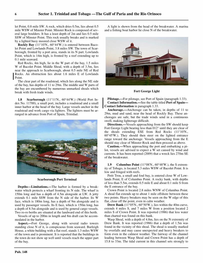
1.8 Scarborough (11°11'N., 60°44'W.) (World Port In-dex No. 11700), a small port, includes a roadstead and a smallinner harbor at the head of the bay. Large vessels anchor in theroadstead and work cargo via lighters. The lighters must be ar-ranged in advance from Port of Spain, Trinidad.
1.8 Depths—Limitations.—The harbor is formed by a break-water which protects a wharf fronting its N side. The wharf is150m long and has a depth of 4.5m alongside at LW. A jettyextends 0.1 mile SSW from the N side of the harbor. Its Wface, which is 180m long, has a depth of 9m alongside and isused by passenger vessels. Its E face, which is 150m long, hasa depth of 8.5m alongside and is used by general cargo vessels.Two ro-ro berths are situated at the landward end of this berth.1.8 Vessels of up to 200m in length and 8m draft can be accom-modated in the harbor.1.8 Aspect.—Fort George, along with several radio towersstanding close N of it, is conspicuous from seaward. BurleighHouse, a white building with a flat roof, stands 1.3 miles WSWof the town and is prominent. It is reported that the buildings inthe town do not show up well until vessels reach the upper partof the bay.
1.8 A light is shown from the head of the breakwater. A marinaand a fishing boat harbor lie close N of the breakwater.
1.8 Pilotage.—For pilotage, see Port of Spain (paragraph 1.33). 1.8 Contact Information.—See the table titled Port of Spain—Contact Information in paragraph 1.33.1.8 Anchorage.—Anchorage can be taken, in depths of 11 to29m, mud and sand, near the head of Rockly Bay. These an-chorages are safe, but the trade winds send in a continuousswell, making lighterage difficult.1.8 Directions.—Vessels approaching from the SW should keepFort George Light bearing less than 012° until they are clear ofthe shoals extending ESE from Red Rocks (11°10'N.,60°45'W.). They should then steer on the lighted entrancerange toward the anchorage. Vessels approaching from the Eshould stay clear of Minster Rock and then proceed as above.1.8 Caution.—When approaching the port and embarking a pi-lot, vessels are advised to expect a W set caused by wind andcurrents. It has been reported (2009) that a wreck lies 270m SEof the breakwater.
1.9 Columbus Point (11°08'N., 60°48'W.), the S extrem-ity of Tobago, is located 5.3 miles WSW of Bacolet Point. It islow and fringed with reefs.1.9 Petit Trou, a small and foul bay, is entered close W of Low-lands Point, E of Columbus Point. A rocky bank, with depthsof less than 5.5m, extends 0.5 mile E and about 0.1 mile S fromthe E entrance of the bay.1.9 Crown Point is located 2.8 miles WNW of Columbus Point.A shoal flat extends up to about 1 mile offshore between thesetwo points. Heavy breakers may be seen on the W edge of thisflat, close off the point, even in calm weather.1.9 Drew Bank (11°05'N., 60°50'W.), lies within the 40m curve,extends 4 miles S, and 7 miles W from a position located 2miles S of Crown Point. It was reported (1986) that less waterthan charted was found on this bank.1.9 Wasp Shoal, with a depth of 4.8m, lies on the N extremity ofDrew Bank. It was reported (1986) that a depth of 1.5m wasfound in the vicinity of this shoal. The shoal is usually markedby overfalls and may cause unexpected and heavy breakers toform even in the calmest weather. The fairway of the channelleading between Wasp Shoal and Crown Point has a depth of15.8 to 33m. The tidal current in this channel sets strongly to
1.8Scarborough Port Terminal
1.8Fort George Light

Sector 1. Trinidad and Tobago —The Gulf of Paria and the Rio Orinoco 7
Pub. 148
the W.1.9 Drew Shoal (11°05'N., 60°54'W.), with a least depth of 6m,lies near the SW extremity of Drew Bank. A ripple usually ex-ists at the edge, and the whole NW side of the bank can beidentified when the tidal current is running strongly.
Trinidad
1.10 Trinidad (10°30'N., 61°15'W.), the southernmost is-land of the West Indies, is separated from Tobago by GalleonsPassage. The island lies with Gallera Point, its NE extremity,located 19 miles SSW of Crown Point, Tobago. The Gulf ofParia indents the W side of the island. This gulf contains nu-merous safe anchorages for all classes of vessels, even duringthe hurricane season.1.10 A ridge of heavily-wooded mountains, 450 to 940m high,extends along the N side of the island. El Cerro del Aripo, thetallest peak, is 940m high and rises 21 miles WSW of GaleraPoint. Mount Tacuche, 936m high, stands 10 miles W of ElCerro del Aripo. The interior of the island is low and swampyto the S of the ridge.1.10 The S side of the island is bordered by a range of hills whichare considerably lower than the mountains along the N side.Trinity Hill, 304m high, stands 8 miles W of Galeota Point, theSE extremity.1.10 Naparima Hill, 177m high, stands close to the coast about130 miles ENE of Punta del Arenal, the SW extremity of theisland. It is the only elevation along the W coast.1.10 The N coast of Trinidad is rocky and the sea breaks on itwith such violence that it is impossible to land, except at a fewplaces under favorable conditions. The best shelter for smallvessels is in Maracas Bay.1.10 The E coast of Trinidad is so straight that no anchorages areprovided for large vessels, although there are a few placeswhere small vessels can find temporary shelter. The best an-chorage is in Cocos Bay, W of L’Ebranche Rocks.1.10 The S coast of Trinidad has very few off-lying dangers.1.10 The approaches to the N coast are generally clear, with mostof the fringing dangers lying no more than 0.5 mile offshore.1.10 Delaware Bank (10°50'N., 60°25'W.), a detached shoal, ex-tends for about 3 miles. It has a least depth of 27m and lies cen-tered 29 miles E of Galera Point. A shoal, with a depth of14.6m, was reported to lie about 34.5 miles E of Galera Point.1.10 Emerald Shoals, a coral bank about 6 miles long, has a leastdepth of 5.5m on its N part and lies 16 miles ESE of GaleraPoint. Prospector Patch, with a least depth of 11m, lies close Eof this bank.1.10 Caution.—Many drilling platforms, well heads, and pipe-lines exist off the coasts of Trinidad. Mariners are advised toexercise caution when navigating in the area.
1.11 Darien Rock (10°32'N., 60°38'W.), lying 14 miles Sof Emerald Shoals, is a detached and steep-to rocky head witha least depth of 2.4m. A wreck is located on this danger, whichis occasionally marked by rips and breakers. When approach-ing this rocky head from the S, the numerous oil rigs in the vi-cinity make very useful marks for navigating around it.1.11 Manzanilla Bank (10°24'N., 60°54'W.), with depths of lessthan 20m, extends about 17 miles ENE from Point Radix. Theseaward end of this bank consists of several detached coral
patches and has depths of 12 to 20m. The current causes ripsand a confused sea over parts of this bank.1.11 Tides—Currents.—The South Equatorial Current enters theCaribbean Sea setting in a WNW direction at a rate of 3 knots.This current divides off the SE coast of Trinidad, with one partsetting N along the E coast and then W into the Caribbean Sea.The other part flows W along the S coast into the Gulf of Pariaand then N, finally emerging through Dragons Mouth. Closeoffshore and within the gulf, they may be reversed or offset bylocal tidal currents.1.11 Along the N coast of Trinidad, E of Grande Riviere Bay, theE setting tidal currents are overcome by W currents setting be-tween Trinidad and Tobago. Close inshore, between GrandeRiviere Bay and Chupara Point, the E tidal current sets alongthe coast for the last 2 hours of the ebb and sometimes for thewhole duration. The E tidal current is always prevalent W ofChupara Point.1.11 The current increases in strength and its direction becomesmore N as Entrada Point is approached. The rate of the W tidalcurrent decreases as Entrada Point is approached, but is greateroffshore than near the coast.1.11 Off the N entrance to the Gulf of Paria, the N and NW settingtidal currents attain rates of 2 to 3 knots according to the seasonof the year.1.11 A branch of the Guiana Current sets through SerpentsMouth. This current turns N into the gulf and emerges throughDragons Mouth to rejoin the main body of the West GuianaCurrent, along the N coast of Trinidad.1.11 Tidal currents in the N entrance to the Gulf of Paria seldomexceed a rate of 1 knot at springs.1.11 Off the N entrance to the Gulf of Paria, the N flow attains arate of 2 to 3 knots depending upon the season, the strength ofthe current, and the outflow from the Rio Orinoco. The outflowfrom this river is strongest between July and October. Rates ofup to 5 knots may be experienced between the islands lying offthe W coast of Trinidad.
1.12 Galera Point (10°50'N., 60°55'W.), 15m high, isrocky and covered by coconut palms. Neptune Rock, awash,lies 0.5 mile E of the point and always breaks. This dangershould be given a berth of at least 1 mile because the currentsets strongly toward it. The point is marked by a light and thestructure has been reported to be radar conspicuous.1.12 Mormacland Bank, with a least depth of 20m, lies with itsshallowest part located 3.8 miles N of Galera Point.1.12 A bank, with a depth of 17m, and a detached shoal, with adepth of 13.5m, lie 3 miles NNW and about 1 mile N, respec-tively, of Galera Point.1.12 Toco Bay (10°50'N., 60°57'W.) is entered between ReefsPoint, located 1.8 miles W of Galera Point, and a group ofabove-water rocks lying close offshore, 1.5 miles WSW. Aheavy swell rolls into this bay and it is not recommended as ananchorage.1.12 Grande Riviere Bay, lying 6 miles W of Toco Bay, affordstemporary anchorage, in a depth of 16.5m. The berth lies withthe E end of a sandy beach at the head bearing 166° and the Eentrance point bearing 086°.1.12 Grand Matelot Point (10°49'N., 61°08'W.) is located 5miles WSW of the W entrance of Grande Riviere Bay. Thecoast between is high and rocky, though in a few places there

8 Sector 1. Trinidad and Tobago —The Gulf of Paria and the Rio Orinoco
Pub. 148
are sandy beaches. A number of above and below-water rocksfront the coast and lie within the 10m curve. 1.12 From Grand Matelot Point, the coast trends 13.5 miles W toChupara Point. Vessels may anchor in depths of up to 33m,mostly mud, anywhere off this stretch of coast and up to 1 mileoffshore.1.12 Machapure Rock, awash, lies 9 miles W of Grand MatelotPoint and is the outermost danger off this part of the coast.
1.13 Chupara Point (10°49'N., 61°22'W.), marked by alight, the most prominent headland on the N coast of Trinidad,is steep, cliffy, and 118m high. It is reported to be radar con-spicuous. Filette Point, the NE extremity of the headland, isfronted by above-water rocks extending up to about 0.5 mile Eof it. A reef, which usually breaks, extends up to 0.3 mile Wfrom the W extremity.1.13 Chupara Bay is entered between Chupara Point and Aber-cromby Point, 2.5 miles SW. It affords anchorage sheltered byChupara Point, but is not recommended. A radio mast, 61mhigh, stands 5.8 miles SSE of Chupara Bay.
Las Cuevas Bay is entered between Abercromby Point andLas Cuevas Point, 1.3 miles W. It provides anchorage with Ab-ercromby Point bearing 065° and 0.3 mile distant, but is ex-posed to the prevailing N wind.
1.13 Maracas Bay (10°46'N., 61°26'W.), entered 1.5 miles W ofLas Cuevas Bay, has a depth of 29m in its entrance and gradu-ally shoals to a depth of 9m near the head. This bay, thoughopen to the N, affords better shelter in its SE corner than anyother anchorage along this coast. However, being under highland, the winds experienced here are variable.1.13 La Vache Islet, 55m high, lies 4 miles W of Las Cuevas Pointand close off a small point that separates Balata Bay from La
Vache Bay. Neither of these two bays provides safe anchorage,nor do Morne Mal d’Estomac Bay and Sainte Cite Bay, lyingfarther W, because of the heavy swell setting into them.
1.14 Maravaca Islet (Saint d’Eau Islet) (10°46'N.,61°31'W.), 113m high, lies 0.5 mile N of Medine Point, whichseparates Morne Mal d’Estomac Bay from Sainte Cite Bay.The islet is wooded and marked by a light.1.14 The coast between Medine Point and Corozal Point, 6 milesWSW, is bold, rocky, and without shelter. A conspicuous whitetower stands on Corozal Point and a disused satellite trackingantenna, 35m high, stands 0.3 mile S of it. Numerous subma-rine pipelines lead N from Corozal Point and can best be seenon the chart. 1.14 North Post Signal Station stands, with its flagstaff and prom-inent radio masts, on a hill, 2.8 miles E of Corozal Point. It wasreported (1990) that an artificial reef had been establishedwithin 0.3 mile of Corozal Point.1.14 Maqueripe Bay, entered 1 mile SW of Corozal Point, has abelow-water rock lying close N of its NE entrance point. Twoother rocks, which break, lie off its SW side. In good weather,anchorage can be taken, in a depth of 44m, about 2.5 miles Wof this bay.1.14 A submarine pipeline extents S from the platform to shorepassing between Monos Island and Entrada Point across theGulf of Paria and ashore near Point Fortin, as seen on the chart.Submarine pipelines also lie about 10 miles NE of the plat-form, about 45 miles W of Milford Bay, Tobago.
1.15 Entrada Point (10°43'N., 61°40'W.), the NW ex-tremity of Trinidad, is located 4.3 miles SW of Corozal Point.A peak, 539m high, rises 2.3 miles E of the point and its east-ernmost summit is surmounted by a prominent radio tower.
The E coast of Trinidad between Galera Point and GaleotaPoint, 42 miles S, consists of one rocky stretch with three san-dy beaches, each about 10 miles long. These beaches are sepa-rated by irregular points of moderate height. A heavy surf rollsin along this entire section of the coast. Cumana Bay, with san-dy beaches at its head, lies 3 miles SW of Galera Point andGuayamaya Point is located 1.8 miles S of it. The coast be-tween the latter point and Islet a Bateau, lying 3.5 miles SW, iscliffy up to within 0.8 mile of the islet and then it becomes san-dy. 1.15 Balandra Bay, entered close S of Islet a Bateau, has a sandybeach at the head. A black building, with a red roof, stands onits N shore. Small vessels with local knowledge can anchor in adepth of about 5m off the N shore of the bay. 1.15 Saline Bay (10°42'N., 61°01'W.), lying W of Fronton de Sa-line, provides shelter to small craft with local knowledge. A12m high rocky islet fronts Fronton de Saline, 1.8 miles SW.1.15 Matura Point, located at the base of the N range of moun-tains, is the termination of the rocky coast. A river discharges 1mile SW of the point. The coast to the S consists of an almoststraight, sandy shore lined with coconut palms. The sea breakson this stretch with such violence that landing on any part of itis impracticable. The Oropuche River discharges 4.5 miles S ofMatura Point. 1.15 Matura Bay lies S of Saline Bay and is entered between Ma-tura Point and Manzanilla Point (10°31'N., 61°01'W.), 10 milesS. The coast between Matura Point and the Oropuche River
1.12Galera Point Light

Sector 1. Trinidad and Tobago —The Gulf of Paria and the Rio Orinoco 9
Pub. 148
consists of low red sand cliffs. Between the latter river andManzanilla Point, the coast rises in a series of prominent cliffs,15 to 24m high, which are streaked with red and white andbacked by dense jungle. Several prominent wooded peaksstand within 12 miles WSW of Manzanilla Point.1.15 McMillan Rock (10°37'N., 60°59'W.), with a least depth of7.5m, lies about 2.5 miles E of the mouth of the Oropuche Riv-er. An isolated shoal, with a depth of 7.5m, lies about 1.3 milesSE of this rock.
1.16 Manzanilla Bay (10°30'N., 61°01'W.) is formedclose W of Manzanilla Point. It consists of a small and sandyindentation protected on the E side by some rocky islets, up to5m high. Two wedge-shaped rocks, 5m high, lie about 0.1 mileE of Manzanilla Point. A reef, which dries 0.3m, extends up toabout 0.5 mile E of the point and breaks heavily. A light is dis-played ESE of Brigand Hill.1.16 L’Ebranche Rocks (10°30'N., 60°59'W.) lie on a shoalbank, 2.3 miles SE of Manzanilla Point. These rocks, whichdry 1.2m, always break. A small rock, awash, lies near the ex-tremity of the shoal bank, 0.8 mile W of the rocks. The bank,which usually breaks, extends up to 0.5 mile NE fromL’Ebranche Rocks. Near its edge, the depths decrease suddenlyfrom 20m to 4.5m.1.16 Cocos Bay is formed between Manzanilla Point and PointRadix, 11.3 miles SSE, and encompasses Manzanilla Bay. Sev-eral rivers discharge into this bay. The Ortoire River, the largestin Trinidad, enters the bay close W of Radix Point. The shoresof the bay are low and sandy. They are fringed with coconutpalms which extend up to 0.5 mile offshore and make landingalmost impossible. Anchorage can be taken, in a depth of 9m,mud, W of L’Ebranche Rocks and 1.8 miles SSW of Manzanil-la Point.1.16 Radix Point (10°20'N., 60°58'W.), a prominent headland,separates Cocos Bay from Mayaro Bay. The headland is 91mhigh, bold, radar conspicuous, and has high cliffs on threesides.1.16 Mayaro Bay, a shallow indentation, is formed between RadixPoint and Galeota Point, 12 miles SSW. The beach lying at theN end of this bay is sandy and fringed with coconut palms. Achapel, almost hidden by trees, stands on the coast, 5 milesSSW of Radix Point. From a point located 2 miles S of thechapel, the beach extending to Galeota Point is backed bycliffs, 6 to 12m high. These cliffs are densely wooded with anoccasional tall palm.1.16 Heavy breakers occur along the entire length of this part ofthe coast and prevent landing at any time. A strong S currentsets inshore.1.16 A prominent radio tower stands 6 miles N of Galeota Point.1.16 Tourmaline Shoals encumber the N part of Mayaro Bay andform a bank of foul ground, with depths of 5.5 to 10m, whichextends to within 2 miles of the shore. This bank extends towithin 2.5 miles ENE of the chapel. 1.16 Caution.—An extensive oil and gas field, with productionplatforms, extends up to 22 miles ENE and 20 miles E of Gale-ota Point. Numerous submarine pipelines lie in this vicinityand extend between the platforms and Galeota Point. Anotherplatform is reported to be situated about 30 miles ESE of Gale-ota Point. The northeastern most group of platforms in the areaare reported to be radar conspicuous. Anchorage is prohibited
within 0.5 mile of the platforms.1.16 A mud volcano, with a least depth of 1.8m, is located withinan area bounded by a circle with a radius of 200m centered onposition 10°22.7'N, 60°55.2'W. Mariners are advised to usecaution and avoid the area.
1.17 Galeota Point Terminal (10°08'N., 60°59'W.)(World Port Index No. 11772), the SE extremity of Trinidad, isthe site of an offshore terminal. The point is formed by a nar-row promontory. Its outer end, which is 64m high, is connectedto the mainland by lower land. The seaward side of the point iscomposed of white cone-shaped cliffs, which appear as islandsfrom a distance. Three detached rocks, about 7m high, lie closeoff the SW side of the promontory. An area of foul ground ex-tends up to about 0.5 mile SE of the point. The point should begiven a wide berth as the current in this vicinity sets toward it.A lighted CALM superbuoy lies about 2 miles SE of GranCayo Point. 1.17 Depths—Limitations.—An SBM is moored in a depth of25.9m about 2.5 miles SSW of Galeota Point. The buoy is 11min diameter, marked by a light, and equipped with a radar re-flector. It is connected to the shore by a submarine pipelinewhich extends NNE. The buoy is designed to handle tankers upto a maximum of 250,000 dwt.1.17 Vessels bound for the terminal should pass E and S of the oilrigs in the area, E of Galeota Point, and then approach GaleotaPoint with a heading between 040° and 050°. 1.17 Galeota Point Harbor has three piers. North Pier has a lengthof 103m, Middle Pier has a length of 140m, and South Pier hasa length of 107m. 1.17 Pilotage.—Pilotage is compulsory. Pilots board at position10°05.4'N, 61°02.3'W. See Port of Spain (paragraph 1.33) formore details. 1.17 Contact Information.—See the table titled Galeota PointTerminal—Contact Information.
1.17 Anchorage.—Anchorage is prohibited within 1 mile of theSBM and 0.5 mile of submarine pipelines.
1.18 Guayaguayare Bay (10°08'N., 61°02'W.) is enteredbetween Galeota Point and Gran Cayo Point, 4.3 miles WSW.
Galeota Point Terminal—Contact Information
Terminal
VHF VHF channels 6, 8, 9, 10, 12, and 16
RT Frequency 2182 kHz, 2292 kHz, 2398 kHz, 2735 kHz, and 2738 kHz
Telephone
868-622-7331
868-622-7332
868-622-7333
Operations
Telephone 868-623-2862
Facsimile 868-627-7863
E-mail [email protected]

10 Sector 1. Trinidad and Tobago —The Gulf of Paria and the Rio Orinoco
Pub. 148
It is a sandy and shallow bay which affords shelter in the E partto small vessels with local knowledge. A jetty extends about0.3 mile SW from the W side of Galeota Point and has a depthof 4m alongside its outer part.1.18 Anchorage can be taken, in a depth of 8.2m, good holdingground, about 1 mile SW of Galeota Point.1.18 In the channel leading between Trinidad and the mainland, Sof Galeota Point, the W current attains a rate of 1.5 to 2 knots,increasing to 3 knots in the vicinity of Serpents Mouth.1.18 The coast between Gran Cayo Point and Cape Casa Cruz,6.5 miles WSW, is steep and rocky. It is fronted by shoals ex-tending up to about 1 mile offshore in places. Trinity Hills,304m high, rises about 0.8 mile inland.1.18 From Cape Casa Cruz, the coast, which is steep with severalslight indentations, trends 6 miles W to Moruga Point(10°05'N., 61°16'W.). Several sandy beaches fringe this stretchof the coast and are separated by projecting points, which arefronted by rocks. The hills standing W of Trinity Hills gradual-ly decrease in height. The Moruga River discharges close W ofMoruga Point.
1.19 Taparo Point (10°04'N., 61°38'W.), is located 22miles W of the Moruga River. This section of the coast is 31 to46m high and covered by low shrubs. Occasional distinctiveoutcrops of yellow sandstone occur along this stretch. A num-ber of prominent houses stand on the heights of Palo Seco Bay,2.5 miles ENE of Taparo Point. Anchorage can be taken asconvenient over a bottom of sand and mud anywhere off thiscoast between Moruga Point and Taparo Point. 1.19 Erin Bay (Herine Bay) is entered between Erin Point, located1 mile W of Taparo Point, and Islote Point, 8 miles W. This baymay be identified by three conspicuous cliffs. Quoin Cliff rises3 miles NW of Erin Point. It is 49m high, red, and wedge-shaped. A red cliff, 80m high, rises 2 miles W of Quoin Cliff.A white cliff, 23m high, rises 1.5 miles W of the red cliff.1.19 La Fabiana, a prominent flat-topped hill, rises 2.5 miles N ofErin Point and is 117m high. 1.19 Erin Bay is bordered by a bank, with depths of less than 5m,which lies about 1.5 miles offshore. A reef lies on this bank,about 4.5 miles W of Erin Point. At times, a volcanic islet is re-ported to be formed on the reef. An isolated shoal bank, with aleast depth of 7.3m, lies 3.8 miles S of the reef.1.19 The coast between Islote Point and Punta del Arenal, 9 milesW, is low and sandy, except for some mud and clay cliffs rising3.8 miles W of Islote Point. 1.19 A dangerous wreck lies about 1.8 miles SE of Punta delArenal. A wreck, which dries, lies 1.5 miles SW of GalfaPoint.1.19 None of the bays formed between Taparo Point and Puntadel Arenal provide shelter from the prevailing ESE wind, butthe holding ground is good and anchorage may be taken asconvenient.
The Gulf of Paria
1.20 The Gulf of Paria (10°25'N., 61°48'W.), an extensivebody of water with moderate depths, is bordered on its E sideby Trinidad and by the coast of Venezuela on its other sides.The gulf has two entrances. Dragons Mouth is the N and pre-ferred entrance, and Serpents Mouth is the S entrance. Serpents
Mouth, although not as safe as Dragons Mouth, is available tovessels of moderate draft. It is advisable to exercise extremecare when using this passage, especially at night.1.20 Vessels proceeding to Port of Spain from the E save littletime by using Serpents Mouth.1.20 The ports within the gulf are important as trans-shipmentcenters for bauxite, iron ore, and petroleum products. Port ofSpain, situated on the W side of Trinidad, is the principal com-mercial port. Chaguaramas and Carenage Bays provide bauxiteterminals. Pointe-a-Pierre, La Brea, Brighton, and Point Fortinare important oil terminals. Puerto de Hierro and Guiria are sit-uated on the S side of the Peninsula de Paria. Guiria serves as apilot station for vessels proceeding to the Venezuelan riverports of Caripito and Pedernales, situated in the SW part of thegulf.1.20 Depths—Limitations.—The fairways of the channels lead-ing through Dragons Mouth have general depths in excess of20m. Boca Grande, the largest and W of the four channels, isthe preferred channel.1.20 Western Channel, the principal channel leading through Ser-pents Mouth, has depths of 11 to 22m in its central part, but isbordered by unmarked shoals on both sides of the fairway.1.20 The central part of the gulf has depths of 18 to 37m, but itsW part is shoal. The approaches to most of the ports and termi-nals have depths of less than 18m.
Tides—Currents.—A branch of the South Equatorial Cur-rent and the fresh water discharged from the tributaries of theRio Orinoco enter the gulf through Serpents Mouth and controlthe general water movement within the gulf. During the floodseason of the Rio Orinoco (May to October), fresh water flowsin abundance into the gulf from these tributaries. It dilutes thesea making the surface water almost fresh and directs the cur-rents toward the northernmost entrance.1.20 Rates of 2 to 3 knots have been observed in March and April.During the rainy season, the strength of the current is probablygreater by reason of the increased outflow from the Orinocosystem. Off the Venezuelan coast from Punta Baja, the currentsets W at a rate of 1 to 2 knots with no appreciable tidal effect.1.20 Off Punta de Arenal, the surface currents set constantly NWat a rate of 1 to 3 knots and slacken at about the time of LW. Astrong SE undercurrent has been observed to set below a depthof 9m. At the same time a SW current of yellowish muddy wa-ter, in contrast with the usual olive-green NW current, makesits appearance off Corral Point and passes S round the point,sometimes reaching as far as Wolf Rock. Vessels lying at an-chor off Corral Point usually swing with their bows to the Nuntil 2 to 3 hours after LW.1.20 In Middle Channel, about halfway between Punta del Arenaland Soldado Rock, the currents set NW at 1.5 knots and the tid-al currents NE and SW at 0.8 knot. The NE currents run forabout 5 hours after the time of HW at Georgetown, Guiana.1.20 To the NE of a line extending NW from Punta del Arenal, thecurrents are affected by the tides, both in direction andstrength, and are irregular until NE of Los Gallos Point. To theNE of Los Gallos Point, the currents have been observed to betidal with rates of 0.5 knot to 1.5 knots. The ebb current setsNE for 9 hours after HW, and the flood SW for 3 hours beforeHW. Later observations give the same rates, but with the cur-rents running for 6 hours after HW and LW, respectively.1.20 In Western Channel, the NW currents attain rates of 3 to 4

Sector 1. Trinidad and Tobago —The Gulf of Paria and the Rio Orinoco 11
Pub. 148
knots over the shoals on the SW side of the channel.1.20 The general current circulation within the gulf flows N,emerging through Dragons Mouth. During the period of influxof fresh water from the Orinoco system, a compensating salineundercurrent enters through the Dragons Mouth setting S andSW. However, during the dry season, both the surface and un-der currents are directed N when the influx of fresh water de-creases and the incoming saline undercurrent almostdisappears.1.20 Between Port of Spain and Brighton outside the 20m curve,the tidal currents are not well defined. During July and August,a SW current was observed running continuously for severaldays. At other times little or no current was observed in eitherdirection. In the dry season (November to June), the tidal cur-rents set S on the flood and N on the ebb. From June to Novem-ber, the tidal currents are irregular, sometimes being reversedin direction, setting N or S continuously for days. At othertimes there is little or no current. These variations apparentlydepend upon the influx of the river systems, but cannot be pre-dicted with any certainty.1.20 On the E side of the gulf, the tidal currents from DragonsMouth and Serpents Mouth meet just E of Brighton, but theyare irregular. Between Brighton and Cedros Point in June andJuly, the currents setting SW and NE were observed to bestronger at neaps than at springs. Off Guapo Bay, these cur-rents attain rates of 1 to 2 knots.1.20 In the W part of the gulf, the tidal currents set between Wand SW on the flood and between E and NE on the ebb.1.20 Additional current data is given with the port information.
Off the northernmost entrance of the gulf, the N and NW tid-al currents attain rates of 2 to 3 knots according to the seasonand the strength of the current and water levels of the Orinocosystem. Between July and October, the influence may be felt15 to 20 miles offshore. The water in the gulf for several milesoutside this entrance has a muddy appearance, and in Octoberthe water becomes reddish in color.1.20 The opposing tidal and ocean currents produce strong rip-ples, which from aloft may be seen extending in long curvedlines for several miles outside the gulf, gradually approachingthe entrance as the S flood increases its strength. In the en-trance, these ripples often become a race, dangerous to boats.1.20 In Boca Grande from July to October, the S tidal current runsfor 4 hours at springs, but its rate seldom exceeds 0.5 knot asthe N ocean current is then at its maximum strength, augment-ed by the influx of the swollen Orinoco system. During this pe-riod, the N tidal currents, accelerated by the ocean currents, runfor 8 hours at a rate of 2 to 3 knots. From November to June,the tidal currents have more effect as the ocean current is thenreduced, but they are at times variable due to various river lev-els. Strong rips occur in Boca Grande in the area of Isla Patos.1.20 In Boca de Navios, the S flood current seldom exceeds 1knot. The N ebb, accelerated by ocean currents, attains rates of2.5 to 3.5 knots.1.20 In Boca de Huevos, the N ocean currents are seldom offsetby the S flood currents, except on the E side of Huevos Island.The ebb current attains a rate of 3 to 4 knots, and even as muchas 5 knots in the rainy season.1.20 In Boca de Monos, there is no S current during the flood.Rates of 2 to 3 knots are attained during the N ebb current.1.20 Pilotage.—Pilotage is compulsory for all ports and terminals
on the W coast of Trinidad within the Gulf of Paria. This in-cludes Chaguaramas Bay, Saint Peter’s Bay, Grier Channel andbasin at Port of Spain, the oil jetty at Pointe-a-Pierre, La BreaPier, Brighton Pier, and Point Fortin Oil Pier. See paragraph1.33 for further information.1.20 Pilots from Port of Spain will, if required, board vessels out-side of the above port areas, including Dragons Mouth, provid-ed prior notice has been sent by radio.1.20 Pilotage is compulsory for vessels proceeding to the Venezu-elan river ports and pilots must be embarked at Guiria.1.20 Additional pilotage information is given with each port de-scription.1.20 Caution.—Oil wells and drilling platforms form a serioushazard to navigation within the gulf. Some platforms aremoved frequently and Notice to Mariners should be consulted.1.20 Extreme care is advised when navigating within the gulf asthe newly erected platforms may not be charted. Vessels shouldmake every effort to obtain the latest corrected charts of the ar-ea prior to entry.1.20 High speed craft operate between Scarborough, Tobago, Portof Spain, and Trinidad. Mariners are advised to maintain agood lookout. Some high speed craft generate large wakeswhich can have a serious impact on small craft and their moor-ings close to the shoreline and on shallow off-lying banks.
Dragons Mouth
1.21 Dragons Mouth (10°42'N., 61°45'W.), the N en-trance to the Gulf of Paria, is formed between Entrada Point,the NW extremity of Trinidad, and Punta Penas, the NE ex-tremity of Venezuela.1.21 Dragons Mouth is divided into four channels by three islandswhich, from E to W, are Monos Island, Huevos Island, andChacachacare Island.1.21 Boca de Monos (10°42'N., 61°40'W.) is formed betweenTrinidad and Monos Island, 0.5 mile W. The island is denselywooded and 287m high. The fairway channel of Boca deMonos is about 0.2 mile wide. Strong and irregular eddies oc-cur off the points and this passage is not recommended.1.21 Le Chapeau, marked by a light, lies 0.1 mile NE of MonosIsland, on the W side of the N entrance to Boca de Monos. Aspit, with a depth of less than 1.2m, extends up to about 0.1mile SE from the SE extremity of Monos Island. 1.21 Caution.—A dumping ground for explosives, which maybest be seen on the chart, lies centered 3.5 miles E of Punta Pe-nas.
1.22 Boca de Huevos (10°41'N., 61°42'W.) is about 0.8mile wide and deep. This channel separates Monos Island fromHuevos Island, which is the smallest and central of the islandsforming Dragons Mouth.1.22 Huevos Island, divided into two parts by Boca Sin Entrada,is joined near its center by a narrow neck of drying sand. Arock, 27m high, lies close off the NE extremity of Huevos andfoul ground, with depths of less than 1.8m, extends up to about0.1 mile E of its E extremity. 1.22 Chacachacare Island (10°41'N., 61°45'W.), thickly wood-ed, is connected near its center by a low isthmus. Boca deNavios, a deep and clear channel, is about 0.8 mile wide andleads between the S extremity of Huevos Island and the E ex-

12 Sector 1. Trinidad and Tobago —The Gulf of Paria and the Rio Orinoco
Pub. 148
tremity of Chacachacare Island.1.22 The NE side of Chacachacare Island between La Lue Pointand Point Girod, 1.8 miles SE, rises abruptly to heights of 183to 240m. Point Girod is composed of prominent, red cliffs. TheSW extremity of the island terminates in a perpendicular cliff,126m high.
1.23 Diamond Rock (10°40'N., 61°46'W.), composed ofcoral, lies about 0.3 mile W of the SW extremity of Chacach-acare Island. The rock is steep-to and has a least depth of 1.8m.The other dangers that fringe the coasts of the island lie nomore than 0.1 mile offshore.1.23 Chacachacare Bay, on the E side of the island, is entered be-tween Point Girod and Point Romain, 0.8 mile SW. Vesselsmay anchor, in depths of 24 to 29m, mud, within the bay. Ves-sels approaching this anchorage from the S should favor PointRomain until within the bay as a strong current sets NE acrossthe entrance.
1.23 Boca Grande (10°42'N., 61°48'W.), the principal channelleading into the Gulf of Paria, is about 5.8 miles wide betweenthe NW extremity of Chacachacare Island and Punta Penas. Ingeneral, the depths in the channel are over 16m. However, ashoal, with a least depth of 14.3m, lies near the middle of thechannel, 2.8 miles W of Chacachacare Island.1.23 Promontorio de Paria, rising on the W side of the DragonsMouth, is 299m high and appears as an island from a distanceto the NW or SE. La Islette, a small islet, is 70m high and liesclose N of the N extremity of the promontory. A rock, awash,lies about 0.3 mile NE of Punta Penas and tide rips form in itsvicinity.1.23 Punta Cerezo, 134m high, is located on the Venezuelancoast, 2.5 miles SSW of Punta Penas.1.23 Caution.—A dumping ground area, which may best be seen
on the chart, has been established for both wrecks and explo-sives off the SE coast of Chacachacare Island. It is reported(2018) that buoys and beacons could be missing or unreliablein the Boca Grande and Approaches and into the Rio Orinoco.
1.24 Garza Rocks (10°41'N., 61°53'W.) lie close together0.3 mile offshore, about 0.8 mile SSW of Punta Cerezo. Thelargest rock in this group is 66m high.1.24 From close W of Garza Rocks, the coast extends 1 mile SSWto Punta Garcitas, which rises to a height of 342m about 0.5mile N. Several red cliffs stand between Punta Penas and PuntaGarcitas.1.24 Isla Patos (10°38'N., 61°52'W.), a densely wooded islet, lies2.5 miles SSE of Punta Garcitas. This islet is 100m. 1.24 Strong tide rips are usually encountered about 0.5 mile S ofthe SE extremity of the islet and about 2 miles NE of the sameextremity.1.24 Caution.—Due to the many obstructions, wells, rigs, andsubmerged pipelines in the vicinity, vessels are advised toavoid the area whenever possible.1.24 Deep-draft vessels entering Boca Grande should transit inthe designated area as indicated on the chart.
Serpents Mouth
1.25 Serpents Mouth, the S entrance to the Gulf of Paria, isapproached between the S coast of Trinidad and the shoals ex-tending about 4 miles off the coast of Venezuela.1.25 Icacos Point (10°04'N., 61°54'W.), the SW extremity ofTrinidad, is low, flat, and forms the N entrance point of Ser-pents Mouth. Punta del Arenal is the SW extremity of thispoint and Corral Point is located 1 mile N of it.1.25 Serpents Mouth, though not as safe as Dragons Mouth, is ac-cessible by day to vessels of moderate size and draft. Vesselsproceeding from Port of Spain to Demerara will shorten thetime taken for the passage by avoiding much of the adversecurrent encountered when taking the usual route around the Nand E sides of Trinidad, although the distance is about thesame. At night, this passage through Serpents Mouth can bedangerous. The currents are strong and variable, and must beavoided, particularly during the rainy season, between the mid-dle of April and the middle of October. Continuous monitoringof the vessel’s position is absolutely necessary.
1.26 Green Hill (10°04'N., 61°52'W.), 65m high, is locat-ed 4.3 miles ENE of Punta del Arenal; a beacon, 34m high,stands close NE of it. This hill and the beacon are conspicuouswhen approaching Serpents Mouth from the E. 1.26 From Punta del Arenal, the coast of Icacos Point extends 1mile N to Corral Point and then 1.8 miles NE to Los GallosPoint. The latter point is yellow, cliffy, and 18m high. Thecoast between Corral Point and Los Gallos Point is fringed by abank, with depths of less than 5.5m which extends up to about0.8 mile offshore. During N winds, the sea breaks a consider-able distance offshore in this area.1.26 Los Gallos Rocks, up to 15m high, extend up to about 0.2mile W from the point and are marked by a lighted buoymoored 1 mile W.1.26 Soldado Rock (10°04'N., 62°01'W.), 36m high, lies on thebank, about 5.3 miles WNW of Corral Point. Pelican Rocks
1.22Chacachacare Light

Sector 1. Trinidad and Tobago —The Gulf of Paria and the Rio Orinoco 13
Pub. 148
and Southeast Rocks, similar groups about 2m high, lie 1 mileS and 0.8 mile SSE, respectively, of Soldado Rock.1.26 A bank, with depths of less than 20m, extends up to about6.8 miles W from Punta del Arenal. A number of above-waterrocks and shoal patches, with depths of less than 5m, lie withinthe limits of this bank.1.26 A detached shoal, with a least depth of 4.7m, lies on the SWside of Western Channel, 3.4 miles WSW of Pelican Rocks.
1.26 Southeast Ledge, an isolated shoal with a least depth of3.7m, lies about 2 miles SE of Soldado Rock.1.26 Three Fathom Bank (10°03'N., 61°57'W.), with a leastdepth of 3.4m, lies 0.3 mile W of Corral Point. Wolf Rock,with a depth of 1.2m, lies 0.4 mile NW of Punta del ArenalLight. Demerara Shoal, with a depth of 4.6m, lies 1 mile N ofthe light.1.26 An isolated patch, with a depth of 3.4m, lies about 0.5 mileNW of Demerara Shoal. The positions of other shoal patcheswithin the Three Fathom Bank area may best be seen on thechart.1.26 Access to the Gulf of Paria from Serpents Mouth may bemade through Eastern Channel, Second Channel, MiddleChannel, or Western Channel described below in paragraph1.27. Vessels other than those of shallow draft should avoid theshoal, with a depth of 7.3m, lying 5.5 miles SW of Erin Point.A dangerous wreck lies 1.8 miles SE of Punta del Arenal Lightand should also be avoided.
1.27 Eastern Channel (10°02'N., 61°56'W.), entered be-tween Punta del Arenal and Wolf Rock, has a least depth of6.1m.1.27 Second Channel, lying between Wolf Rock and Three Fath-om Bank, leads either E or W of Demerara Shoal. This channelhas a least depth of 7m in its entrance, but vessels with drafts ofup to 7.6m can transit through it.1.27 Middle Channel leads between Three Fathom Bank and theshoals lying SE of Soldado Rock. This channel has a leastdepth of 5.8m, but vessels with drafts of up to 7.9m can makethe transit.1.27 Western Channel leads between the shoal patches lying SWof Pelican Rocks and the shoals fronting the coast of Venezue-la. This channel is wide and deep, but it must be used with cau-tion as the NW currents run at rates of 3 to 4 knots, at times,over the dangerous patches on its SW side.1.27 Directions.—Approaching Serpents Mouth from the E, theS coast of Trinidad should be favored to avoid the incompletelysurveyed coast of Venezuela, where uncharted dangers may ex-ist.1.27 Having passed Galeota Point, vessels should keep about 3miles off the coast of Trinidad and in depths of 18 to 27m untilSW of Erin Point, where depths on the N side of the fairwaydecrease to 9 to 11m. 1.27 Eastern Channel should be entered by rounding Punta delArenal at a distance of 0.2 mile, passing midway between thepoint and Wolf Rock, and then passing E of Demerara Shoal.Punta del Arenal should not be brought to bear more than 166°until vessels have cleared the 5m curve, W of Icacos Point.This channel is narrow and may be partially obstructed by ves-sels at anchor.
1.28 Middle Channel is the one most generally used for
vessels with suitable draft. After rounding Punta del Arenal ata distance of 0.5 to 1 mile, vessels should steer for SoldadoRock until Cedros Point is in line with the outermost of the LosGallos Rocks, bearing 061°. Then, allowing for the current,vessels should steer to make good a course of about 342°. Theyshould proceed, passing midway between the lighted buoymarking Three Fathom Bank and the lighted buoy moored 1.3miles WNW, until clear of all dangers to the N of SoldadoRock.1.28 Vessels of light draft with local knowledge may, in fairweather, cross the outer part of the bank, with depths of lessthan 9m, lying NW of Icacos Point when Los Gallos Rocksbear more than 090°.1.28 Anchorage.—Good anchorage can be taken between IcacosPoint and Soldado Rock in convenient depths. The only placesmooth water can be depended upon, if there is wind, is underthe lee of Icacos Point, between Punta del Arenal and CorralPoint.1.28 Caution.—Soldado Marine Oil Field lies NE of the termina-tion of the above directions. Navigation is restricted within thelimits of this oil field and vessels are advised not to approachwithin the area bound by Lighted Buoy A through LightedBuoy E.
Trinidad—West Coast—Entrada Point to Port of Spain
1.29 From Entrada Point, the W coast of Trinidad trends1.8 miles S to Punta Delgado and forms the E side of Boca deMonos.1.29 From Punta Delgado (10°41'N., 61°40'W.), the coast trends2 miles E to Point Gourde and then continues 6 miles E to Portof Spain. Point Gourde is formed by a peninsula, 141m high. 1.29 Teteron Rock, which dries 0.9m, lies close W of Punta Del-gado and is marked by a light.
1.29 Gasparillo Islet (10°40'N., 61°39'W.), 42m high andmarked by a light on its SW extremity, lies close S of San JosePoint, 0.8 miles SE of Punta Delgado. A shoal, with a depth of
1.29Teteron Rock Light near Punta Delgado

14 Sector 1. Trinidad and Tobago —The Gulf of Paria and the Rio Orinoco
Pub. 148
8.8m, lies about 0.2 mile ENE of this islet. 1.29 Gaspar Grande Island, 103m high, lies 0.5 mile S of Gaspar-illo Islet; its W end is located 1 mile S of Punta Delgado. Scor-
pion Ledge, with a depth of 3m over its extremity, extends upto about 0.2 mile seaward from the SE side of the island. Thechannel leading between Gasparillo Islet and Gaspar GrandeIsland has depths of 31 to 48m. The channel lying E of the is-land has depths of 31 to 37m and is clear, except for ScorpionLedge. Lights are displayed at Epsolon Point, near the SW ex-tremity of the island, and at Reyna Point, the NW extremity.
Chaguaramas Bay (10°41'N., 61°39'W.)
World Port Index No. 11710
1.30 Chaguaramas Bay is entered between San Jose Pointand San Carlos Point, 1.3 miles SE. The port area consists of acoastal natural harbor which is protected on the E side by PointGourde. A bauxite terminal is situated on the E side of the bayand naval facilities stand on the N side of the bay.1.30 Tides—Currents.—The flood current flows through Bocade Monos, E around Punta Delgado, and then between GasparGrande Island and the coast of Trinidad.1.30 The current strikes the W side of Point Gourde and is de-flected Pier No. 4 and Pier No. 5, and in the bay to the W ofthem. This portion of the current is weak and confined to an ar-ea close to the shore. The ebb current flows W between GasparGrande Island and Trinidad, and then N through Boca deMonos. Eddies are caused in the bay to the W of Pier No. 4 andPier No. 5, as a portion of the current is deflected N by Gaspar-illo Islet. As this current weakens and the S current builds up atthe N end of Boca de Monos, a tidal surge, known locally asthe Re-Mou, sometimes occurs. It moves E through the chan-nel N of Gaspar Grande Island and is clearly visible as amarked line on the surface. 1.30 The Re-Mou arrives in Chaguaramas Bay between 30 min-utes and 1 hour after local LW and runs for 20 to 30 minutes. Itis irregular in occurrence and erratic in rate, varying between 1and 5 knots. In general, the surge is strongest in July and Au-gust and weakest in January through March, though maximumrates can occur at any season. As soon as the Re-Mou has dissi-
1.29Epsolon Point Light
1.29Reyna Point Light
1.29Chaguaramas Bay (aerial from E to W)
1.29Chaguaramas Terminal Wharf (center)

Sector 1. Trinidad and Tobago —The Gulf of Paria and the Rio Orinoco 15
Pub. 148
pated, the tidal current settles to its normal rate.1.30 Depths—Limitations.—The Bay contains a repair yard forcommercial vessels and is a supply base for the offshore oiland gas industries. For berthing information, see the table titledChaguaramas—Berth Information.1.30 Pilotage.—Pilotage is compulsory for vessels using the piersor wharves. Pilots are provided by Port of Spain and can becontacted on VHF channels 12 and 16 and board about 1 mileS of Cronstadt Islet. Vessels should send a request for pilotageand an ETA 72 hours, 48 hours, and 24 hours in advance. 1.30 Anchorage.—Authorized vessels can anchor, in a depth of26m, about 0.5 mile N of the E extremity of Gaspar Grande Is-land. However, this berth is not advisable due to strong cur-rents. In addition, numerous other vessels are generallyanchored in the vicinity. The safest and best anchorage for ves-sels awaiting repairs is located about 1.5 miles S of CronstadtIslet, situated S of Point Gourde. 1.30 Caution.—A wreck has been reported (2009) about 0.3 mileS of Chaguaramas near a buoy W of the N point of EscondidaCove. 1.30 It was reported (2008) that an uncharted wreck lies 0.5 mileNE of Reyna Point and is marked by a buoy and a woodenfloating dock.
1.31 The Diego Islands (10°39'N., 61°38'W.), consistingof Cronstadt Islet and Carrera Islet, lie 0.4 mile S of PointGourde. Some prominent buildings stand on both islets. 1.31 Depths—Limitations.—Cronstadt Quay, 65m long, frontsthe W side of Cronstadt Islet and has a depth of 13.7m along-side. Vessels of up to 131m in length can berth at this quay.1.31 A penal colony is situated on Carrera Islet.1.31 The intervening channel leading between the islets and PointGourde is deep and clear of dangers.1.31 Pilotage.—Pilotage is compulsory to the quay and berthingis carried out during daylight only. The pilot usually boardsabout 0.5 mile SW of the pier head. 1.31 Caution.—Submarine cables connect Carrera Islet, CronstatIslet, and Point Gourde.
1.32 The Five Islands (Las Cotorras) (Quarantine Islands)(10°39'N., 61°36'W.) are in reality six islets. However, CraigIslet, the smallest, is joined to Caledonia Islet, the largest, by anarrow drying reef. This group lies 1.3 miles E of Carrera Isleton two detached shoals, with depths of less than 5m. CaledoniaIslet, the N, is 25m high, and Nelson Islet, the S, is 11m high.Buildings stand on all these islets except one.
1.32 Carenage Bay (Tembladora) (10°41'N., 61°36'W.) lies be-tween Alice Point, the E extremity of Point Gourde, and PointSinet, located on the mainland 1 mile ENE. An extensive shoal,with depths of 2.1 to 5.5m, lies with its SW extremity located0.4 mile NE of Alice Point.1.32 Depths—Limitations.—Pier No. 1 has collapsed and con-stitutes an obstruction to navigation. Pier No. 2 is in ruins andits range marks have been discontinued.1.32 A pier with two wharves, each with a length of 207m, is usedfor alumina loading and discharging. The loading berth, on theE side, can accommodate vessels with a maximum alongsidedraft of 11m and a maximum air draft of 12m. The dischargeberth, on the W side, an accommodate vessels with a maximumalongside draft of 8.2m. 1.32 The channel is dredged to a depth of 11m, leading to theberths. A conspicuous tank stands 0.1 mile NNW of the rearrange structure.1.32 Pilotage.—Pilotage is compulsory. A 36-hour and 24-hournotification prior to arrival is required. Pilots are contacted onVHF channels 16 and 12. Pilots board at the entrance to the ap-proach channel in position 10°40.5'N, 61°36.3'W. 1.32 Caution.—A submarine cable extends E, parallel to theshore, and crosses under the pier close to its head.1.32 At times, the range lights may be difficult to distinguish be-cause of thick bauxite dust.1.32 A stranded wreck has been reported (2018) to lie in position10°41'32''N, 61°36'39''W. 1.32 Martin Point (10°40'N., 61°34'W.), located 2.3 miles ESEof the bauxite plant, lies at the W limit of Port of Spain. A baylies between Martin Point and the mouth of the Maraval River.
Chaguaramas—Berth Information
Berth Length Depth Remarks
Salt Jetty
No. 1 58m 8.0m —
No. 2 58m 8.0m —
Carib Dockyard
No. 4 150m 12.0m Located in the repair yard on N side of bay
No. 5 150m 12.0m Located in the repair yard on N side of bay
Quay — 7.0m Located in the repair yard
Chaguaramas Terminal
Berth 274m 10.5m Accommodates vessels up to 30,000 gt
Tanker Berth
Wharf 60m 6.0m Petroleum

16 Sector 1. Trinidad and Tobago —The Gulf of Paria and the Rio Orinoco
Pub. 148
Port of Spain (10°39'N., 61°31'W.)
World Port Index No. 11720
1.33 Port of Spain is a natural coastal port situated in theNE corner of the Gulf of Paria. It is the principal port for ves-sels in Trinidad and one of the most important ports in the WestIndies. Ample berthing spaces are provided for all classes ofvessels.
1.33 The city is the capital and the seat of Government of Trini-dad and Tobago.1.33 Winds—Weather.—The prevailing winds are from the E;however, strong W winds accompanied by rough seas may oc-
cur without warning from July to October. The E winds over-come the effect of the tidal currents and the current setting outof the Rio Caroni, so that vessels in the roadstead usually lieheading E.1.33 Tides—Currents.—The tides rise 1.2m at springs and 0.9mat neaps.
1.33 The flood tidal current sets SE at a rate of 0.5 knot and theebb current sets in the reverse direction at the same rate. About4 miles SW of the harbor area, the currents have been found tobe irregular and of considerable strength.1.33 Depths—Limitations.—The city and the harbor area arefronted by a shore bank with depths of less than 5m.1.33 Grier Channel, 165m wide, has a least depth of 9.8m andleads through the shore bank to a basin fronting Kings Wharfand Kings Wharf extension. There are eight berths, numbered1 through 8 from SE to NW. This basin has general depths of9.5 to 10.2m.
Port of Spain Home Page
http://www.patnt.com
Port of Spain—Berth Information
Berth Length DepthMaximum Vessel
RemarksLOA Draft
National Petroleum
NP Jetty 30m 6.1m — — Petroleum products. Berthing length of 304m (including dolphins).
Kings Wharf
No. 3 200m 9.0m — — Multi-purpose (main berth).
No. 4 200m 9.0m — — Multi-purpose (main berth).
No. 5 200m 9.0m — — Containers and ro-ro. Continuous quay length of 750m.
No. 6 200m 12.0m — — Containers and ro-ro. Continuous quay length of 750m.
No. 6A 200m 12.0m 245m 11.0m Containers and ro-ro. Continuous quay length of 750m.
No. 7 150m 12.0m — 9.0m Containers.
No. 8 170m 12.0m — 9.0m Dry bulk.
Port of Spain Water Taxi Terminal
North Pier 48m — — — Passengers.
South Pier 48m — — — Passengers.
St. Vincent Pier
North Pier 117m 6.0m — 4.0m Tugs and dredges.
South Pier 110m 6.0m — 4.0m Tugs and dredges.
Trinidad and Tobago Inter-Island Transport (TTIT)
TTIT Ferry Berth No. 1 105m — — — Ferries and ro-ro.
TTIT Ferry Berth No. 1 110m — — — Ferries and ro-ro.
Caricom Wharves
Caricom Dock 168m 6.5m — 4.0m General cargo and ro-ro.
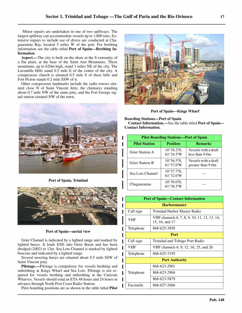
Sector 1. Trinidad and Tobago —The Gulf of Paria and the Rio Orinoco 17
Pub. 148
1.33 Minor repairs are undertaken in one of two spillways. Thelargest spillway can accommodate vessels up to 1,800 tons. Ex-tensive repairs to include use of divers are conducted at Cha-guaramas Bay, located 5 miles W of the port. For berthinginformation see the table titled Port of Spain—Berthing In-formation.1.33 Aspect.—The city is built on the shore at the S extremity ofa flat plain, at the base of the Saint Ann Mountains. Thesemountains, up to 620m high, stand 3 miles NE of the city. TheLaventille Hills stand 0.5 mile E of the center of the city. Aconspicuous church is situated 0.5 mile S of these hills andFort Picton stands 0.2 mile SSW of it.1.33 Other conspicuous landmarks include the radio towers situ-ated close N of Saint Vincent Jetty, the chimneys standingabout 0.7 mile NW of the same jetty, and the Fort George sig-nal station situated NW of the town.
1.33 Grier Channel is indicated by a lighted range and marked bylighted buoys. It leads ENE into Grier Basin and has beendredged (2002) to 12m. Sea Lots Channel is marked by lightedbeacons and indicated by a lighted range.1.33 Several mooring buoys are situated about 0.5 mile SSW ofSaint Vincent jetty.1.33 Pilotage.—Pilotage is compulsory for vessels berthing andunberthing at Kings Wharf and Sea Lots. Pilotage is not re-quired for vessels berthing and unberthing at the CaricomWharves. Vessels should send an ETA 48 hours and 24 hours inadvance through North Post Coast Radio Station. 1.33 Pilot boarding positions are as shown in the table titled Pilot
Boarding Stations—Port of Spain.1.33 Contact Information.—See the table titled Port of Spain—Contact Information.
1.33Port of Spain, Trinidad
1.33Port of Spain—aerial view
1.33Port of Spain—Kings Wharf
Pilot Boarding Stations—Port of Spain
Pilot Station Position Remarks
Grier Station A 10°38.2'N, 61°34.5'W
Vessels with a draft less than 9.0m
Grier Station B 10°36.5'N, 61°37.0'W
Vessels with a draft greater than 9.0m
Sea Lots Channel 10°37.7'N, 61°32.0'W —
Chaguaramas 10°39.0'N, 61°38.5'W —
Port of Spain—Contact Information
Harbormaster
Call sign Trinidad Harbor Master Radio
VHF VHF channels 6, 7, 8, 9, 10, 11, 12, 13, 14, 15, 16, and 17
Telephone 868-625-3858
Port
Call sign Trinidad and Tobago Port Radio
VHF VHF channels 6, 9, 12, 16, 25, and 26
Telephone 868-625-3195
Port Authority
Telephone
868-623-2901
868-623-2904
868-623-5879
Facsimile 868-627-2666

18 Sector 1. Trinidad and Tobago —The Gulf of Paria and the Rio Orinoco
Pub. 148
1.33 Anchorage.—Vessels may anchor in depths of 5.5 to 11m,stiff mud 1 mile off the center line of Grier Channel or SeaLots Channel. Vessels should not anchor within 0.5 mile of theof the channel entrances to avoid obscuring the lighted buoysand beacons. An explosives anchorage is located close S of theentrance of the Sea Lots Channel. 1.33 Caution.—The Grier Channel range lights are often ob-scured by smoke.1.33 Several wrecks and submerged obstructions, which may bestbe seen on the chart, lie in the basin and in vicinity of the chan-nels and pilot boarding stations. Several wrecks lie close W ofthe two mooring buoys positioned N of Sea Lots Channel. Ithas been reported (2004) that an obstruction may reduce thewidth of Grier Channel. 1.33 An explosives anchorage area, the limits of which are indi-cated on the chart, lies close S of the entrance to Sea LotsChannel. Several stranded wrecks and obstructions, some withdepths of as little as 3.8m, lie within this explosives anchorageand may best be seen on the chart.1.33 A floating pontoon, marked by a light, has replaced Immi-gration Jetty close NW of Jetty Head. 1.33 A spoil ground area, with a least depth of 4.2m, lies close Nof Grier Channel. Vessels with drafts of more than 3m are ad-vised not to navigate through this area.1.33 A ferry service operates between Port of Spain and San Fer-nando between the hours of 0530 and 2000 local time, Mondaythrough Friday. Mariners are requested to give the ferries awide berth, and exercise caution during the period of operation.
Port of Spain to San Fernando
1.34 The coast between Port of Spain and Cangrejos Point(10°26'N., 61°30'W.), 13.5 miles S, is low and swampy. It isfronted by a mud flat, with depths of less than 5m, which ex-tends up to 2 miles offshore. Three shallow rivers, which drainthe swampy land, discharge within 7 miles S of Port of Spain.Barrancones Point, located 8.5 miles SSE of Port of Spain, islow, but a conspicuous chimney stands 1.8 miles S of it. About1.5 miles N of Cangrejos Point, a few small cliffs may be seenthrough the mangroves.1.34 Cangrejos Point is not easily identified, but two conspicuouswhite chimneys stand 2.5 miles ESE of it. Another group ofchimneys stands about 0.5 mile S of the two white chimneys.
Caution.—An oil production platform is situated about 5miles NW of Cangrejos Point. A dangerous wreck, with adepth of 1.2m, lies about 4 miles NW of Cangrejos Point. Nu-merous offshore platforms with submarine pipelines run fromplatforms to shore. and can best be seen on the chart.
1.34 Savonetta Point (10°25'N., 61°30'W.) is located 1 mile S ofCangrejos Point. It is reported that vessels load sugar fromlighters off this point.1.34 Lisas Bay is entered between Savonetta Point and LisasPoint (10°23'N., 61°29'W.), 2 miles S. This bay is fringed by adrying bank extending up to about 0.5 mile offshore. Depths of5.5m lie up to 1.5 miles W of Lisas Point.1.34 Claxton Bay, a shallow indentation, is formed between LisasPoint and Pointe-a-Pierre, 3.3 miles SSE.
1.35 Point Lisas Industrial Port (10°24'N., 61°30'W.)(World Port Index No. 11750) consists of three operational ar-eas. The industrial port handles a variety of solid and liquidbulk material. Point Lisas Port, the main port, handles contain-ers and general cargo. Yara Trinidad (the ex-hydro agri port)located approximately 2 miles S handles LPG, ammonia andsugar.1.35 Depths—Limitations.—Savonetta Channel, which leads for2 miles through the shore bank to a turning basin, is 152m wideand dredged to a depth of 12.8m. The turning basin is alsodredged to a depth of 12.8m.1.35 A jetty, with a dolphin at its SE end, is situated on the NEside of the basin and provides a bulk cargo berth for the steelworks. A small jetty used by tugs is situated in the N corner ofthe basin.
Telex 294-22477 PATT WG
Web site http://www.patnt.com
Pilots
VHF VHF channels 12 and 16
Telephone
868-627-7222
868-625-1144
868-623-4364
Facsimile 868-624-7470
E-mail [email protected]
Web site http://www.ttmarinepilots.com
Port of Spain—Contact Information
Point Lisas Industrial Port—Berth Information
Berth Length DepthMaximum Vessel
RemarksLOA Draft
NEC (National Energy Corporation)
Savonetta Pier No. 1 North 115m 7.0m 115m 6.3m Bulk lube oil and bunker fuels.
Savonetta Pier No. 1 South 310m 12.8m 240m 11.5m LPG, ammonia, methanol, and urea.
Savonetta Pier No. 2 (SP2S) 312m 12.8m 200m 11.5m LPG, methanol, and ammonia.
Savonetta Pier No. 2 (SP2N) 230m 12.8m 200m 11.5m LPG, methanol, and ammonia.
Savonetta Pier No. 3 (NUCOR) 500m 12.8m 245m 11.5m Iron ore and menthanol

Sector 1. Trinidad and Tobago —The Gulf of Paria and the Rio Orinoco 19
Pub. 148
1.35 Vessels of up to 75,000 dwt, 243m in length, and 11.5m draftcan be accommodated at the port at LW, allowing for a 10 percent UKC. For further information, see the table titled PointLisas Industrial Port—Berth Information.1.35 Aspect.—A lighted range, indicates the channel leadingthrough the shore bank to the turning basin.1.35 A prominent steel plant stands about 0.3 mile inland fromthe port.1.35 Pilotage.—Pilotage is compulsory except for governmentvessels and vessels less than 50 gt. Pilots board in position10°22.6'N, 31°32'W and position 10°22.9'N, 61°31.2'W. Ves-
sels should send an ETA together with a request for pilot 5days, 4 days, 3 days, 48 hours, 24 hours, and 12 hours prior toarrival. See Port of Spain (paragraph 1.33) for pilot contact in-formation.1.35 Contact Information.—See the table titled Point LisasPorts—Contact Information.1.35 Anchorage.—Anchorage areas for inbound and outboundvessels are situated NW of the channel entrance. When the portis congested, vessels may be requested to anchor at Port ofSpain Roadstead before proceeding to Point Lisas IndustrialPort.
Savonetta Pier No. 4 (SP4) 380m 12.8m 245m 11.5m LPG, grain, aggregates, ammonia, and iron ore.
Iron Carbide Dock (ISPAT) 407m — 245m 11.6m Iron ore and steel products.
PLIPDECO (Point Lisas Industrial Port Development Corporation Limited)
Berth No. 1 35m 4.5m 25m 4.5m General, breakbulk, and ro-ro.
Berth No. 1A 30m 6.0m 100m 6.6m General, breakbulk, ro-ro, and lo-lo.
Berth No. 2 165m 4.5m 165m 4.5m General, breakbulk, and ro-ro.
Berth No. 3 105m 8.1m 130m 7.2m Containers, general cargo, breakbulk, and ro-ro.
Berth No. 4 110m 11.5m 165m 11.5m Containers, general cargo, and break-bulk.
Berth No. 5 200m 11.5m 200m 11.5m Containers, general cargo, and break-bulk.
ISCOTT Bulk Terminal
Bulk Terminal 407m 12.8m 245m 11.6m Iron ore, DRI, and steel products.
Phoenix Park Gas Processors Ltd. (PPGPL)
No. 1 186m 8.0m 171m 7.7m Butane, propane, and gasoline.
No. 2 243m 11.8m 230m 11.2m Caustic soda and sulphuric acid.
Yara Trinidad
No. 1 170m 8.5m — — LPG, propane, and butane.
No. 2 170m 8.5m — — LPG, ammonia, and acid.
Point Lisas Industrial Port—Berth Information
Berth Length DepthMaximum Vessel
RemarksLOA Draft
Lisas Point Port—Berth Information
BerthMaximum Vessel
RemarksLOA Draft
Tringen II Deep-water Terminal (North of entrance) 220m 11.6m Ammonia
HALT Jetty No. 1 171m 8.7m Butane, propane, and natural gas
HALT Jetty No. 2 171m 9.0m Ammonia, molasses, raw bulk sugar, caustic soda, sul-phuric acid, and voranol
Deep Water Terminal (South of entrance) 230m — Ammonia, molasses, raw bulk sugar, caustic soda, sul-
phuric acid, and voranol

20 Sector 1. Trinidad and Tobago —The Gulf of Paria and the Rio Orinoco
Pub. 148
1.36 Lisas Point Port (10°23'N., 61°29'W.) is located S ofPoint Lisas Industrial Port and should not be confused with thelatter. This is a Hydro-Agri port formerly known as Fedchem,Point Lisa. 1.36 Depths—Limitations.—The port is entered through a 250mwide approach channel using lighted beacons as lead marks.The channel is dredged to 12.8m up to the Tringen deep waterterminal and turning basin. Thereafter the channel is dredgedto 8.8m to the inner berths and turning basin. For further infor-mation, see the table titled Lisas Point Port—Berth Informa-tion.1.36 Tringen II provides berths for loading ammonia on the Nside of the entrance to the inner channel and Hydro-Agri Turn-
ing Basin. The terminal can accomodate vessels of 220mlength and 11.6m draft. 1.36 Pilotage.—Pilotage is compulsory. Vessels should send theirETA 48 hours, 24 hours, and 12 hours in advance of arrival. Pi-lots board at the entrance to the Lisas Point approach channelin the following positions:
a. 10°22.6'N, 61°31.9'W.b. 10°22.9'N, 61°31.2'W.
1.36 Anchorage.—Anchorage areas for inbound and outboundvessels is found as charted S of the entrance channel.
1.37 Claxton Bay Marine Terminal (10°21'N., 61°28'W.)is situated 1.5 miles N of Pointe-a-Pierre and is used for load-ing cement. The terminal is approached through a channeldredged to a depth of 6.4m (1985). This channel is marked bylighted beacons and leads to a turning basin. A lighted rangeindicates the fairway leading to a loading pier, with a length of60m, and a ro-ro berth, with a length of 60m, at the NE end ofthe basin. It is reported that pilots for this terminal can be em-barked at Lisas Point Port.1.37 Caution.—From a point on the shore located 0.2 mile S ofthe rear range light, a disused submarine pipeline, which maybest be seen on the chart, extends about 1 mile seaward andparallels the dredged channel.
Pointe-a-Pierre (10°19'N., 61°28'W.)
World Port Index No. 11730
1.38 Pointe-a-Pierre is an open roadstead, with severalberths and terminals for tankers.1.38 Winds—Weather.—From January to March, NE or E byNE winds predominate. They are at their strongest, averaging12 to 15 knots. From August to October, the winds, althoughvariable, are mainly E or SE and are at their weakest, averaging7 to 8 knots. In other months, the winds tend to be intermediateboth in direction and force between the values quoted forspring and autumn.1.38 Squalls of varying intensity are common during the seasonaltorrential rains from June to October. These rain squalls are of-
Point Lisas Ports—Contact Information
PLIPDECO Terminal
Call sign Plipdeco Marine
VHF VHF channels 9 and 16
Telephone868-636-2132
868-636-7678
Facsimile 868-679-2907
E-mail [email protected]
Web site http://www.plipdeco.com
Yara Terminal
VHF VHF channels 12, 14, and 16
Telephone 868-636-2781
Facsimile 868-636-7091
Web site http://www.yara.com
PPGPL Terminal (Head Office)
Telephone 868-636-1522
Facsimile 868-636-6810
E-mail [email protected]
Web site http://www.ppgpl.com
1.35Point Lisas Port (partial)
1.35Point Lisas Port (partial)

Sector 1. Trinidad and Tobago —The Gulf of Paria and the Rio Orinoco 21
Pub. 148
ten accompanied by sudden shifts in wind direction.1.38 The hurricane season is from the beginning of August tomid-September, but they may occur as early as June or as lateas November. It is unusual for the coasts of Trinidad to be di-rectly affected by these hurricanes, but may experience heavyswells and sometimes rough seas when a hurricane crosses tothe N of the island.1.38 Tides—Currents.—Off the pipeline jetty, both the N and Stidal currents attain rates of 0.5 to 1 knot. Outside the 20mcurve, the tidal currents are not well defined. During themonths of July and August, a SW current was observed run-ning continuously for several days, while at other times therewas little or no current either way.1.38 The tidal currents between November and June set S on theflood and N on the ebb, with rates of 0.5 to 1 knot. BetweenJune and November, the tidal currents are irregular and may setN or S for several days with rates considerably in excess of theaverage on occasions, but at certain times they are nonexistent.1.38 Depths—Limitations.—The berthing facilities consist oftwo jetties and two offshore island berths, connected by pipe-line with the S jetty, which extends from the shore. All of thesefacilities are served by several oil terminals and can accommo-date a number of tankers simultaneously.1.38 The main, or N jetty, is about 0.5 mile long and extendsWNW from the shore. The S jetty, is a viaduct supported onpiles, has dolphin-type Berth. The main channel has a con-trolling depth of 12.4m.1.38 The berthing limitations are given in the accompanying tabletitled Pointe-a-Pierre—Berth Information.1.38 An SPM is moored 3.3 miles WNW of the N jetty in a depthof 24m. It can accommodate vessels of up to 285,000 dwt and22.4m draft.1.38 Aspect.—Naparima Hill, 177m high, rises 2.5 miles S of theroot of the N jetty at Pointe-a-Pierre and is conspicuous. A
conspicuous water tank stands about 0.5 mile ENE of Pointe-a-Pierre. Three chimneys, each 81m high, stand 1 mile SE of thewater tank; a similar chimney, 80m high, is situated 1 mileWSW of them.1.38 The hills which extend NE from Pointe-a-Pierre have beenreported to be radar conspicuous.1.38 The oil terminals are not clearly visible from a distance, butthe landmarks may be useful.1.38 Pilotage.—Pilotage is compulsory. The pilot boards near10°19'N, 61°30'W, approximately 1 mile W of the main jettyhead. 1.38 Vessels using the berths embark pilots about 1.4 miles SE ofthe SPM.1.38 Vessels proceeding to the SPM usually embark pilots about 2miles W. Vessels must keep their engines at standby while atthe buoy. 1.38 Regulations.—Vessels should send an ETA via the agents72 hours, 48 hours, and 24 hours in advance. If the ETA chang-es by more than 2 hours, an amended ETA message should besent immediately. Vessels should contact the terminal at least 2hours before arrival. Tugs are required for berthing and un-berthing.1.38 Vessels in the vicinity of Pointe-a-Pierre are requested not touse VHF channels 6 and 10, which are used for transshipmentoperations. 1.38 When alongside the berths vessels are to maintain enginesand propulsion machinery in standby to leave the berth underfull power on short notice and repairs are not permitted thatwould interfere with this requirement. Hot work involvingtools that may produce frictional sparks is strictly prohibitedonboard tankers alongside or on vessels at anchorage handlingcargo. 1.38 Contact Information.—See the table titled Pointe-a-Pierre—Contact Information.
Pointe-a-Pierre—Berth Information
Berth Length DepthMaximum Vessel
RemarksLOA Draft
Petrotrin Terminal
No. 1 29m — 220m 11.8m Petroleum products.
No. 2N — — 236m 11.8m Petroleum products.
No. 2S — — 107m 7.0m Petroleum products.
No. 3N — — 104m — Petroleum products. Berthing length of 50m (including dolphins). Maximum beam of 18m.
No. 5 — 13.8m 274m 12.6m Petroleum products.
No. 6 — — 290m 15.8m Petroleum products.
No. 7 — — 213m 10.3m Petroleum products.
No. 8N — — 173.7m 8.7m Bunkers
No. 8S — — 79m 6.6m Petroleum products.
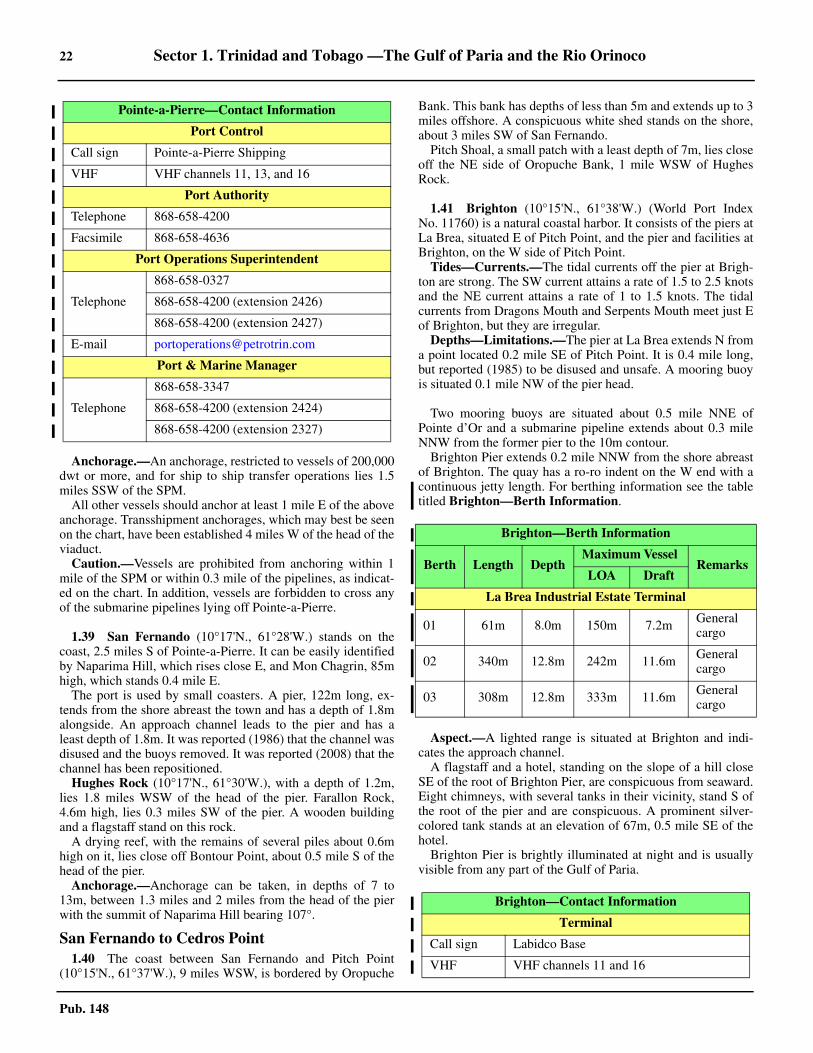
22 Sector 1. Trinidad and Tobago —The Gulf of Paria and the Rio Orinoco
Pub. 148
1.38 Anchorage.—An anchorage, restricted to vessels of 200,000dwt or more, and for ship to ship transfer operations lies 1.5miles SSW of the SPM.1.38 All other vessels should anchor at least 1 mile E of the aboveanchorage. Transshipment anchorages, which may best be seenon the chart, have been established 4 miles W of the head of theviaduct.1.38 Caution.—Vessels are prohibited from anchoring within 1mile of the SPM or within 0.3 mile of the pipelines, as indicat-ed on the chart. In addition, vessels are forbidden to cross anyof the submarine pipelines lying off Pointe-a-Pierre.
1.39 San Fernando (10°17'N., 61°28'W.) stands on thecoast, 2.5 miles S of Pointe-a-Pierre. It can be easily identifiedby Naparima Hill, which rises close E, and Mon Chagrin, 85mhigh, which stands 0.4 mile E.1.39 The port is used by small coasters. A pier, 122m long, ex-tends from the shore abreast the town and has a depth of 1.8malongside. An approach channel leads to the pier and has aleast depth of 1.8m. It was reported (1986) that the channel wasdisused and the buoys removed. It was reported (2008) that thechannel has been repositioned. 1.39 Hughes Rock (10°17'N., 61°30'W.), with a depth of 1.2m,lies 1.8 miles WSW of the head of the pier. Farallon Rock,4.6m high, lies 0.3 miles SW of the pier. A wooden buildingand a flagstaff stand on this rock.1.39 A drying reef, with the remains of several piles about 0.6mhigh on it, lies close off Bontour Point, about 0.5 mile S of thehead of the pier.1.39 Anchorage.—Anchorage can be taken, in depths of 7 to13m, between 1.3 miles and 2 miles from the head of the pierwith the summit of Naparima Hill bearing 107°.
San Fernando to Cedros Point1.40 The coast between San Fernando and Pitch Point
(10°15'N., 61°37'W.), 9 miles WSW, is bordered by Oropuche
Bank. This bank has depths of less than 5m and extends up to 3miles offshore. A conspicuous white shed stands on the shore,about 3 miles SW of San Fernando.1.40 Pitch Shoal, a small patch with a least depth of 7m, lies closeoff the NE side of Oropuche Bank, 1 mile WSW of HughesRock.
1.41 Brighton (10°15'N., 61°38'W.) (World Port IndexNo. 11760) is a natural coastal harbor. It consists of the piers atLa Brea, situated E of Pitch Point, and the pier and facilities atBrighton, on the W side of Pitch Point.1.41 Tides—Currents.—The tidal currents off the pier at Brigh-ton are strong. The SW current attains a rate of 1.5 to 2.5 knotsand the NE current attains a rate of 1 to 1.5 knots. The tidalcurrents from Dragons Mouth and Serpents Mouth meet just Eof Brighton, but they are irregular.1.41 Depths—Limitations.—The pier at La Brea extends N froma point located 0.2 mile SE of Pitch Point. It is 0.4 mile long,but reported (1985) to be disused and unsafe. A mooring buoyis situated 0.1 mile NW of the pier head.
1.41 Two mooring buoys are situated about 0.5 mile NNE ofPointe d’Or and a submarine pipeline extends about 0.3 mileNNW from the former pier to the 10m contour. 1.41 Brighton Pier extends 0.2 mile NNW from the shore abreastof Brighton. The quay has a ro-ro indent on the W end with acontinuous jetty length. For berthing information see the tabletitled Brighton—Berth Information.
1.41 Aspect.—A lighted range is situated at Brighton and indi-cates the approach channel.1.41 A flagstaff and a hotel, standing on the slope of a hill closeSE of the root of Brighton Pier, are conspicuous from seaward.Eight chimneys, with several tanks in their vicinity, stand S ofthe root of the pier and are conspicuous. A prominent silver-colored tank stands at an elevation of 67m, 0.5 mile SE of thehotel.1.41 Brighton Pier is brightly illuminated at night and is usuallyvisible from any part of the Gulf of Paria.
Pointe-a-Pierre—Contact Information
Port Control
Call sign Pointe-a-Pierre Shipping
VHF VHF channels 11, 13, and 16
Port Authority
Telephone 868-658-4200
Facsimile 868-658-4636
Port Operations Superintendent
Telephone
868-658-0327
868-658-4200 (extension 2426)
868-658-4200 (extension 2427)
E-mail [email protected]
Port & Marine Manager
Telephone
868-658-3347
868-658-4200 (extension 2424)
868-658-4200 (extension 2327)
Brighton—Berth Information
Berth Length DepthMaximum Vessel
RemarksLOA Draft
La Brea Industrial Estate Terminal
01 61m 8.0m 150m 7.2m General cargo
02 340m 12.8m 242m 11.6m General cargo
03 308m 12.8m 333m 11.6m General cargo
Brighton—Contact Information
Terminal
Call sign Labidco Base
VHF VHF channels 11 and 16
Sector 1. Trinidad and Tobago —The Gulf of Paria and the Rio Orinoco 23
Pub. 148
1.41 Pilotage.—Pilotage is compulsory for vessels berthing at LaBrea or Brighton. Pilots board at position 10°17'N 61°40'W.See Port of Spain (paragraph, 7.33) for pilot contactinformation. 1.41 Contact Information.—See table titled Brighton—Contact Information.1.41 Anchorage.—Anchorage can be taken, in depths of 13 to15m, mud, about 0.8 mile NE of Brighton Pier.1.41 Caution.—Anchorage is prohibited in the vicinity of thesubmarine pipeline, as charted. 1.41 A spoil ground is located W of and parallel to the approachlane, as best seen on the chart. Works in progress (2010) arebest seen on the chart. 1.41 Oil drilling operations take place within 2.5 miles NEthrough N to SW of Brighton Pier. Numerous drilling plat-forms, obstructions, and submarine pipelines may be encoun-tered in this area.
1.42 Guapo Bay is a slight indentation in the coast formedbetween Point Galba (10°15'N., 61°38'W.), located 0.5 mileSW of the root of Brighton Pier, and Point Fortin, 4.5 milesSW. This bay is shallow and its E part is encumbered by abank, which dries. Pelican Rocks, 1.5m high, lie on the bank, 1mile SW of Point Galba.1.42 Point Fortin (10°11'N., 61°41'W.) (World Port Index No.11770), an oil-loading and LNG terminal, has a loading piersituated at the seaward end of an illuminated viaduct. This via-duct carries a pipeline and extends 1.8 miles NNW from PointFortin. There are two arms at its head.1.42 The Atlantic LNG Terminal consists of two T-shaped jettiesextending 700m NW from the N point of reclaimed land.1.42 Tides—Currents.—The currents off the jetty heads set 250°on the flood and 055° on the ebb. The current turns about thetime of HW at Georgetown. The maximum rate is about 0.5knot at springs.1.42 Depths—Limitations.—A submarine cable extends be-tween the head of the jetty and the offshore mooring buoys sit-uated about 0.8 mile NNE.1.42 For berthing information refer to the table titled Pointe-For-tin—Berth Information. 1.42 Pilotage.—Pilotage is compulsory. Pilots board at position
10°13.6'N, 61°42.5'W for the Petrotrin Terminal and position10°14.3'N, 61°43.8'W for the Atlantic LNG Terminal. See Portof Spain (paragraph 1.33) for contact information. 1.42 Tugs are available and required for berthing vessels of morethan 30,000 dwt at the outer berths. 1.42 There is a port radio station at Point Fortin.1.42 Contact Information.—See the table titled Point Fortin—Contact Information.1.42 Regulations.—Vessels should send ETA messages 72, 48,and 24 hours in advance. Changes of 1 hour in the ETA shouldbe reported.
Telephone 868-636-8471
Facsimile 868-636-2905
Web site https://www.nationalenergy.tt/operations/labidco
Brighton—Contact Information
Point Fortin—Contact Information
Operations Control Centre
Call sign Trinmar
VHF VHF channels 11 and 16
Telephone868-648-2011 (extension 8102)
868-648-2011 (extension 8103)
Terminal Superintendent
Telephone868-648-3392
868-648-3472
Marine Base
Telephone 868-648-2011 (extension 8748)
Operators
Telephone
868-658-4200
868-658-4210
868-658-4220
868-658-4230
E-mail [email protected]
Web site http://www.petrotrin.com
LNG Terminal
Call sign Atlantic Marine
VHF VHF channel 17
Telephone 868-648-2916 (extension 2035)
Facsimile 868-648-2905
E-mail [email protected]
Web site http://www.atlanticlng.com
Pointe-Fortin—Berth Information
Berth Length DepthMaximum Vessel
RemarksLOA Draft
Atlantic LNG
Jetty No. 1 35m 13.0m 294m 11.5m LNG. Berthing length of 365m (including dolphins)
Jetty No. 2 35m 13.0m 330m 11.5m LNG. Berthing length of 365m (including dolphins)

24 Sector 1. Trinidad and Tobago —The Gulf of Paria and the Rio Orinoco
Pub. 148
1.42 Caution.—Soldado Marine Oil Fields lie up to 10 miles offthe coast between Point Fortin and Icacos Point, the SW end ofTrinidad, 14 miles WSW. Within this area there are numerousdrilling platforms and associated structures, many of which ex-hibit lights. Many submarine pipelines connect these structuresand converge on a landing place in Irois Bay.1.42 The oil field has been declared a restricted area, withinwhich navigation is prohibited to all vessels except those con-nected with oil field operations and small craft. Anchoring,trawling, and all seabed operations are prohibited.1.42 The N and W limits of the restricted area are marked bylighted buoys.1.42 A further group of lighted oil platforms and wells existbetween 1 mile and 5 miles from the W to NE of Soldado Rockoutside the Soldado Restricted Area. A submarine pipeline islaid ENE between this group and Riser Platform No. 1(10°10'N., 61°51'W.). Vessels should maintain a lookout forapproaching unauthorized craft.
1.43 Irois Bay (10°10'N., 61°44'W.), which is shallow, is aslight indentation in the coast. It is formed between Point For-tin and Point Rouge (10°09'N., 61°47'W.), 6.8 miles WSW.Challenger Shoal, a detached patch, has a least depth of 5.5mand lies 2 miles N of Point Rouge. Several shoal heads lie S ofa line extending from Point Fortin to Challenger Shoal and ves-sels should not proceed S of this line.1.43 Granville Bay, a slight indentation, lies between Point Rougeand Cedros Point, 2 miles WSW. This bay is fronted by foulground which extends up to 1 mile offshore.1.43 Cedros Bay (10°07'N., 61°52'W.), a shallow indentation,has depths of less than 5m and lies between Cedros Point andLos Gallos Point, 5.8 miles SW.1.43 Barrel of Beef, a rock with a depth of 1.5m, lies 1 mileWNW of Cedros Point. Loo Reef, with a depth of 1.8m, liesclose W of Barrel of Beef and is marked on its N side by alighted beacon.1.43 A shoal, with a least depth of 4.6m, lies 0.8 mile NW of theabove beacon. The remains of a light structure stand close NW.
The Gulf of Paria—West Side—Punta Penas toPunta Mata Redonda
1.44 Punta Penas (10°44'N., 61°51'W.) is the E extremityof the Peninsula de Paria; Punta Garcitas is located 5 milesSSW of it.
Ensenada Cariaquita (10°40'N., 61°54'W.) is entered be-
tween Punta Garcitas and Punta Picua, 0.8 mile SW, and pro-vides good anchorage to small vessels. The shore bank, withdepths of 5m or less, extends up to about 0.1 mile WNW ofPunta Garcitas. Rocks, with depths of less than 1.8m, are locat-ed close N and about 0.2 mile WNW of Punta Picua. The headof the bay is shoal and, at times, a considerable current setsacross the entrance to the bay.1.44 The coast between Punta Picua and the entrance to PuertoMacuro, 2 miles SW, is composed of red cliffs in places.1.44 A shoal, with a depth of 10.4m, lies about 0.5 mile ESE ofthe SW entrance point of Puerto Macuro.
1.45 Puerto Macuro (10°39'N., 61°56'W.), formerly Cris-tobal Colon, is divided by a point, into two parts, which has apier in ruins at its outer end. The E part is known as EnsenadaAricagua while the W part is known as Ensenada Macuro. Thetown of Macuro stands at the head of Ensenada Macuro.1.45 Tides—Currents.—The tidal currents in Puerto Macuro at-tain rates of 1 to 2 knots. The flood current runs clockwisearound the harbor; the ebb current runs counterclockwise. Theebb current attains the greater rate and reaches its maximum 2hours before LW by the shore. In the middle of the bay, slackwater occurs 1 hour after the stand of the tide.1.45 Depths—Limitations.—A wharf extends 165m ENE from apoint on the shore located 0.3 mile NNE of the W entrance toPuerto Macuro. It has been reported that vessels of up to 7.9mdraft can berth alongside. Two mooring buoys lie close N ofthe wharf; one mooring buoy lies close S of the wharf.1.45 Regulations.—In Venezuelan territorial waters, the Venezu-elan flag must be continuously displayed at the fore. At night,on request, the vessel’s name must be signaled by light.1.45 Anchorage.—Small vessels can anchor anywhere in the bay,but large vessels should anchor just outside a line joining theentrance points.1.45 Except in cases of shipwreck or “force majeure,” vessels areprohibited from anchoring within the territorial waters, exceptoff these ports or places used for commerce.
1.46 The coast between Puerto Macuro and Punta Carmo-na, 12 miles W, is indented by several small bays and backedby a mountain range with peaks up to 1,073m high. Largespurs extend S from this mountain range and terminate inpoints which form deep gorges at the head of some bays.1.46 Puerto de Hierro (10°38'N., 62°05'W.) (World Port IndexNo. 12275), a natural coastal harbor, is located 9 miles W ofPuerto Macuro and formed by a small bight. The port, under
Petrotin
Berth 1 24m 11.4m 212m 10.2m Closed. (2019)
Berth 2 24m 10.9m 212m — Closed. (2019)
Berth 3 24m 10.6m — — Closed. (2019)
Berth 4 91m 4.7m — — Closed. (2019)
Berth 5 (CBM) — 25.9m 259m 16.7m Closed. (2019)
Pointe-Fortin—Berth Information
Berth Length DepthMaximum Vessel
RemarksLOA Draft

Sector 1. Trinidad and Tobago —The Gulf of Paria and the Rio Orinoco 25
Pub. 148
control of the Venezuelan Navy, is primarily an ore-transship-ment facility. 1.46 Tides—Currents.—The tidal currents set W on the floodtide and E on the ebb at rates up to 2.5 knots.1.46 Depths—Limitations.—A steel pier has a length of 240mand three mooring dolphins. The E side of the pier has depth of6.1m over a usable length of 210m. The W side of the pier hasdepths of 4.6m on its outer end and 3.3m at the inner end. overa usable length of 182m. 1.46 A small pier, with depths of 3m along its E side, extends76m S from a point located close W of the root of the ore pier.1.46 The bay has been reported to have been dredged to a depth of12.8m, but the 5m curve lies within the approach to the W sideof the pier and depths of up to 8.1m lie in the approach on the Eside.1.46 The maximum size of vessel permitted to enter the port is45,000 dwt.1.46 Aspect.—The pier, with towers and oil storage tanks, isprominent when seen from the S and W. At night, a group oflights above the port may be seen at a distance of 20 miles.1.46 Pilotage.—Pilotage is compulsory. Pilots may be obtainedfrom Guiria. Vessels should give 72 hours notice and confirmor amend their ETA 48 hours and 24 hours before arrival. Ves-sels are berthed by day or night, but normally only at slack wa-ter.1.46 Anchorage.—Anchorage can be taken at a depth of 16m,sand, good holding ground, about 1 mile S of the pier head.1.46 Directions.—Entry is difficult and berthing only at slackwater is recommended. 1.46 Caution.—It was reported that silting occurs in the harbor.
1.46 Punta Carmona (10°38'N., 62°09'W.) is located 3 miles Wof Puerto de Hierro. From the former point, the coast trends 3.3miles W to Punta Juan Diego, then 3 miles W and 2.5 miles Sto Punta El Rincon, and then 2 miles S to Punta Guiria. Thebight in the coast lying NE of Punta Guiria is fronted by ashoal area. This area has depths of less than 11m and extendsup to 2.5 miles offshore. A detached shoal, with a least depthof 5.8m, was reported (1940) to lie about 1 mile SE of PuntaGuiria.
1.47 Guiria (10°34'N., 62°18'W.) (World Port Index No.12270), a small harbor protected by breakwaters, lies close Nof Punta Guiria.1.47 The town stands on a low plain. The port is important as a pi-lot boarding station for vessels proceeding to the river ports onthe S side of the Gulf of Paria.1.47 Depths—Limitations.—There are depths of 5 to 6m withinthe breakwaters, except alongside the berths, where less watermay be found. A shoal patch, with a depth of 3.2m, lies in thecenter of the harbor.1.47 A quay, 140m long with refrigeration facilities, is situated onthe inner side of the S breakwater near its head. Three piersproject N from the breakwater, W of the quay. The W pier isused by vessels carrying dangerous cargo.1.47 Four piers project from the W side of the harbor. The N pieris reserved for naval vessels. For berthing information see the
table titled Guiria—Berth Information.
1.47 Aspect.—The port may be identified by the prominentredroofed towers of a church. Several radio towers and a whitetank stand on the high cliffs, close N of the town.1.47 Recalada Guiria Light, shown from a white tower withorange bands, 12m high, stands 1 mile N of the port.1.47 Pilotage.—Pilotage is compulsory for merchant vesselsbound for Rio San Juan. Pilots board in the vicinity of thelighted buoy moored 2 miles ESE of Guiria harbor.1.47 Contact Information.—See the table titled Guiria—Con-tact Information.1.47 Anchorage.—Anchorage can be taken E of the harbor, indepths of 10 to 11m, mud, good holding ground.
1.48 The coast between Punta Guiria and Punta Guara-guara (10°32'N., 62°19'W.), 2.5 miles SW, is cliffy and treecovered.
Guiria—Berth Information
Berth Length Depth Remarks
Port of Guiria Terminal
North Berth 80m — General cargo.
East Berth 45m — General cargo.
Ice Factory Terminal
Ice Factory Berth 170m —
Containers, passen-gers, and fishing ves-sels.
Bunkering Terminal
Bunker Berth 78m — Bunkering.
Guiria—Contact Information
Port
RT Frequency 2182 kHz, 2638 kHz, or 2738 kHz,
Telephone 58-294-982-1041
Facsimile 58-294-982-1755
Port Captain
Telephone58-294-982-1034
58-294-982-1545
E-mail [email protected]
Agents
VHF VHF channels 9, 12, and 16
Pilots
VHF VHF channel 12
Telephone 58-294-982-1545
Facsimile 58-294-982-1545

26 Sector 1. Trinidad and Tobago —The Gulf of Paria and the Rio Orinoco
Pub. 148
1.48 Between Punta Guaraguara and Punta Arenas, 23 miles SW,the W part of the Gulf of Paria is almost entirely encumberedby shoals and fringing flats. There are no commercially signifi-cant ports within this area.1.48 Three detached shoals, with depths of less than 10m, lie be-tween 6.5 miles and 9 miles SW of Punta Guaraguara. Vesselsbound for Barra de Maturin are advised to pass E of thesepatches. It was reported that lesser depths than charted lie inthe vicinity of, and on the above-described patches.1.48 The Rio San Juan (10°15'N., 62°36'W.) discharges into theGulf of Paria between Punta Arenas (10°20'N., 62°38'W.) andPunta Campana, 6.5 miles SSE.1.48 Barra de Maturin (Maturin Bar) lies across the mouth of thisriver and has a dredged channel with a least depth of 7.9m. Itwas reported (1995) that vessels with drafts up to 10m werepermitted to use this channel. 1.48 It was reported (1993) that silting had changed the shape ofthe charted coastline in the vicinity of Punta Campana. A light-ed buoy is moored about 9 miles NE of Punta Campana andmarks the entrance to the dredged channel. From this buoy toPunta Gorda, located 4.5 miles SSW of Punta Campana, eachreach of the dredged channel is indicated by lighted ranges. Anumber of beacons are situated in the vicinity of the channeland should not be confused with the range lights.1.48 From a point located 2 miles SSE of Punta Gorda (10°10'N.,62°38'W.), the channel has depths in excess of 11m as far asPunta Carner, 32 miles upriver.1.48 The Cano Frances joins the Rio San Juan, 20 miles above itsmouth. It is about 230m wide and trends SW for almost 13miles. It is joined here by the shallow and narrow the RioGuarapiche, which trends W for 3.5 miles to the Cano Colora-do. From the junction of the Cano Frances and the Rio Guara-piche, a stream, known as the Cano dos Aguas, trends in a Ndirection and joins the Rio San Juan 7 miles below Punta Car-ner. One-way traffic is operated in the Rio San Juan above itsjunction with the Cano Frances at Punta Marieta. Inbound ves-sels required to wait may anchor in this area.1.48 The Rio Guanoco empties into the Rio San Juan, close W of
Punta Carner. The village of Guanoco stands on the W bank ofthe Rio Guanoco, 3 miles above the junction.1.48 Caution.—Vessels are advised that the currents are strongover the bar and within the river.
1.49 Guanoco (10°10'N., 62°56'W.) is situated at the baseof two hills, 107m and 76m high. A large deposit of pitch is lo-cated here.1.49 Depths—Limitations.—A wharf, with a depth of 7.6malongside, fronts Guanoco. The approach to Guanoco throughthe Rio Guanoco is only suitable for vessels with local knowl-edge. The river is about 140m wide and has depths of 3 to 9.1min the fairway. The controlling depth in the channel is 5.5m. 1.49 The river above the mouth of the Rio Cicaro is narrow. Ves-sels are turned at this junction and towed stern first about 0.8mile up to the wharf at Guanoco. Vessels should moor theirsterns very securely because of the strong currents. Vessels upto 85m in length can negotiate the turns when loaded.1.49 Pilotage.—Pilotage in the Rio San Juan is compulsory. Pi-lots can be obtained at Guiria, 3 days advance notice is re-quired.1.49 From Punta Carner (10°07'N., 62°57'W.), the Rio San Juantrends in a SW direction and then NW to Caripito, whichstands 51 miles above the entrance to the river.
1.50 Caripito (10°10'N., 63°02'W.) (World Port Index No.12280) is situated on a tributary of the Rio San Juan, 3 miles Wof the river. It is connected to the port area by rail and road. 1.50 Depths—Limitations.—Vessels entering are restricted to amaximum draft of not more than 10.4m.1.50 Three piers and a wharf front the W bank of the river. Thewharf, which is known as Muelle No. 1, is 107m long. It canaccommodate vessels of up to 137m long and 7m draft. 1.50 Muelle No. 2 and Muelle No. 3 are T-head piers, with dol-phins situated close off their faces. They have a depth of 10.7malongside. Vessels of up to 61,000 dwt, 230m in length, and10.3m draft can be accommodated at these piers.1.50 Muelle No. 4 is situated upstream of Muelle No. 1. Its T-head is 12.2m long and has a depth of 4.3m alongside. 1.50 Tankers of up to 52,000 dwt, 225m in length, and 10m draftcan be accommodated within the port. The usual method ofberthing is for vessels to proceed up river from the piers andturn around. If necessary, arrangements can be made for ves-sels to top off seaward of Barra de Maturin.1.50 Pilotage.—Pilotage is compulsory. Vessels should send anETA 72 hours, 48hours, and 24 hours in advance. Pilots areembarked and disembarked at the port of Guiria. Vessels await-ing a pilot should proceed to the Guiria Sea Buoy (10°33'N.,62°15'W.) 1.50 Contact Information.—See the table titled Caripito—Contact Information.
1.47Guiria Anchorage and Harbor
Caripito—Contact Information
Port
RT Frequency 2182 kHz, 2638 kHz, or 2738 kHz,
Telephone580-291-772-1070
580-291-772-1852

Sector 1. Trinidad and Tobago —The Gulf of Paria and the Rio Orinoco 27
Pub. 148
1.50 Anchorage.—Vessels unable to berth at Caripito usually an-chor about 0.5 mile upriver. However, at times, the current at-tains a rate of 3.5 knots. Anchorage is also available, in a depthof 14m, about 0.3 mile upstream.1.50 Caution.—It was reported (1995) that many beacons wereunlit or destroyed completely.
Mouths of the Rio Orinoco within the Gulf ofParia
1.51 From Punta Campana to Punta Mata Redonda(10°12'N., 62°31'W.), 5 miles SE, the coast is fringed by a dry-ing mud bank extending up to 0.8 mile seaward. A dangerouswreck, marked by a buoy, is located 9.5 miles E of Punta MataRedonda. Between Punta Mata Redonda and Punta Tolete, 22miles SE, the coast is indented by a large shallow bay, whichhas depths of 5m and less over its entire area. The bay is large-ly filled with mud flats and is navigable only by the smallestcraft. The W of the intricate network of waterways, which in-tersect the delta of the Orinoco, lies at the S end of the bay.Nearly the entire shore of the bay is covered by a dense growthof trees of uniform height.1.51 Several islands lie within the bay and are separated by rivers.From W to E, these rivers are the Cano Jacao, the Cano Vagre,the Cano Mananito, the Cano Manamo, and the Rio Pederna-les.1.51 The Rio Pedernales, the most important of these rivers, is en-tered between Isla Cotorra and Punta Tolete (10°02'N.,62°12'W.), 1 mile E. It was reported that the bar had a leastdepth of 3.4m, but silting causes rapid changes. The bottom issoft with good holding ground. Three lighted buoys mark theentrance of the Rio Pedernales. Buoy No. 1 is moored in posi-tion 10°04'N,62°07'W1.51 Within the bar, the Rio Pedernales divides into two channels.The E channel leads to the Cano Pedernales and the W channelto the Cano Manamo. The latter channel is used by coastal ves-sels. 1.51 The tides rise about 1.6m at springs and 1.2m at neaps.1.51 When the river is low, the currents in the vicinity of the barare weak and set in a NE and SW direction. Within the bar,slack water occurs 1 hour 30 minutes after the stand. The cur-rents usually set in the direction of the channels and attain ratesof 2 to 3 knots.
1.52 Puerto Pedernales (9°59'N., 62°15'W.) stands on theN end of Isla Pedernales, 4.5 miles SW of Punta Tolete. En-trance between Punta Tolete and the E point of Isla Cotorra 1.5miles W where it is thickly wooded and swampy. The bar ofthe river lying 5 miles NE of Punta Tolete has a reported depthof 3.4m but silting causes rapid changes. 1.52 Oil installations are situated in the vicinity of Puerto Peder-nales. Capure, 0.8 mile NE of Puerto Pedernales, is the site of aT-head pier which is used by small tankers with drafts up to4m. An older wharf is situated about midway between Capureand Punta Tolete.1.52 Pilotage.—Pilotage is compulsory. Pilots embark at Guiria
and will take vessels upriver as far as Ciudad Bolivar.1.52 Anchorage.—Anchorage is also available, in a depth of 9m,fine gray sand, abeam of a village situated about 1 mile SW ofPunta Tolete.
Punta Tolete to Punta Baja
1.53 The coast that forms the S side of Serpents Mouth ex-tends 80 miles E and SE to Punta Baja and encompasses part ofthe delta of the Rio Orinoco. This part of the coast has been on-ly partially surveyed. Depths of 18m have been reported to lie4 to 5 miles off the W section of the coast, decreasing graduallytoward the shore. Similar depths are reported to lie up to 13miles off the E part of this coast.1.53 Punta Bombeador (9°55'N., 61°40'W.) is located 34 milesESE of Punta Tolete and has a bank, with a least depth of 2.7m,extending 3 miles NW from it. A channel leads in a SWdirection through this bank to the mouth of the Cano Macareo.The maintenance of this channel has been discontinued and thenavigational aids removed. Local knowledge is required. An
Facsimile 580-291-640-5278
Caripito—Contact Information
1.52Puerto Pedernales
1.52Port of Pedernales
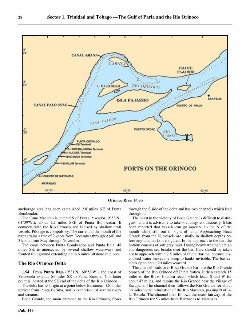
28 Sector 1. Trinidad and Tobago —The Gulf of Paria and the Rio Orinoco
Pub. 148
anchorage area has been established 2.8 miles NE of PuntaBombeador.1.53 The Cano Macareo is entered S of Punta Pescador (9°53'N.,61°39'W.), about 1.5 miles SSE of Punta Bombeadar. Itconnects with the Rio Orinoco and is used by shallow draftvessels. Pilotage is compulsory. The current at the mouth of theriver attains a rate of 2 knots from December through April and3 knots from May through November.1.53 The coast between Punta Bombeador and Punta Baja, 48miles SE, is intersected by several shallow waterways andfronted foul ground extending up to 6 miles offshore in places.
The Rio Orinoco Delta
1.54 From Punta Baja (9°31'N., 60°58'W.), the coast ofVenezuela extends 64 miles SE to Punta Barima. This latterpoint is located at the SE end of the delta of the Rio Orinoco.1.54 The delta has its origin at a point below Barrancas, 120 milesupriver from Punta Barima, and is comprised of several riversand streams.1.54 Boca Grande, the main entrance to the Rio Orinoco, flows
through the S side of the delta and has two channels which leadthrough it.1.54 The coast in the vicinity of Boca Grande is difficult to distin-guish and it is advisable to take soundings continuously. It hasbeen reported that vessels can go aground to the N of themouth while still out of sight of land. Approaching BocaGrande from the N, vessels are usually in shallow depths be-fore any landmarks are sighted. In the approach to the bar, thebottom consists of soft gray mud. During heavy weather, a highand dangerous sea breaks over the bar. Care should be takennot to approach within 2.5 miles of Punta Barima, because dis-colored water makes the steep-to banks invisible. The bar ex-tends up to about 20 miles seaward.
The channel leads over Boca Grande bar into the Rio Grandebranch of the Rio Orinoco off Punta Yatica. It then extends 15miles to the Brazo Imataca reach, which leads S and W forabout 47 miles, and rejoins the Rio Grande near the village ofSacupana. The channel then follows the Rio Grande for about36 miles to the bifurcation of the Rio Macareo, passing N of Is-la Tortola. The channel then follows the main fairway of theRio Orinoco for 53 miles from Barrancas to Matanzas.
1.53Orinoco River Ports

Sector 1. Trinidad and Tobago —The Gulf of Paria and the Rio Orinoco 29
Pub. 148
1.54 Tides—Currents.—In the approach to Boca Grande, theSouth Equatorial Current sets NW at a rate of 1 to 3 knots. Be-tween the discolored river water and the sea water, there is adistinct line which moves with the tides. At HW, the line is indepths of 7 to 9m and in depths of 11 to 14m at LW.1.54 For a short distance offshore, the currents set for about 6hours each way and allowance must be made for the W currentwhen crossing the bar.1.54 A choppy sea is raised in depths of less than 18m when theprevailing winds are NE.1.54 The seasonal rise of the Rio Orinoco and its tributaries be-gins immediately after the vernal equinox and reaches its max-imum height in July and August. The lowest level is reached inmid-November through mid-April, but at Ciudad Bolivar, theriver is low from December to March.1.54 At Barrancas, at the head of the delta, the maximum rise isabout 9.1m. Above Barrancas, the normal rise is estimated tobe about 15.2m, varying according to the width of the river, thenumber of tributaries, and the distance from the sea.1.54 The average annual rise at Ciudad Bolivar is 12.8m. 1.54 Depths—Limitations.—The North Channel, which leadsthrough Boca Grande, is available to shallow draft vessels andsmall craft. The entrance to the N channel is 9 miles NW of thedredged channel. It joins the water of the dredged channel, 6miles NNW of Punta Barima. It was reported (1990) that thischannel no longer exists.1.54 The South Channel is used by deep-draft vessels proceedingto Puerto Ordaz and the iron ore port, located 157 miles upriverfrom Punta Barima. The South Channel is also used by vesselsproceeding to Matanzas, another iron ore port, situated 12miles farther upstream. The channel depth over the bar is re-portedly maintained to allow vessels with a draft of 9.8m ac-cess to Puerto Ordazi. 1.54 The waterway is open to shipping 24 hours and, except forthe dredged channel section, two-way traffic can be handled.Vessels should contact Puerto Ordaz Port Radio before at-tempting transit and entry of the port.1.54 The river is maintained and marked from the dredged SouthChannel Lighted Buoy to Matanzas for vessels with drafts ofup to 12.8m (1987), under optimum river level and tide condi-tions. Under extreme low river conditions, the authorized draftshould not be more than 9m. The months of the lowest waterlevel in the river are March and April. The highest water leveloccurs from July to October.
1.54 The daily authorized draft is promulgated by the PortCaptain of the Rio Orinoco, by means of a bulletin in Spanishand English. The maximum authorized draft is subject to thevessel’s maximum fresh water load line.1.54 Vessels with drafts up to 2.3m can, at all times, reach CiudadBolivar. From May to January inclusive, vessels with drafts upto 4.6m have no difficulty ascending to this city, but the bestmonths are said to be from June to October.1.54 River distances.—The river distances are given in the tabletitled Rio Orinioco—River Distances.
Pilotage.—During the passage over the bar and within theriver, vessels must maintain a continuous radio watch. Radiostations are situated at the pilot station, Punta Barima, andPuerto Ordaz. These stations provide voice communicationsalong the entire route. The River Officer at Puerto Ordaz, byreference to the mile numbers of the navigational aids,provides continuous radio information of the latest positions ofvessels in the dredged channels and the river. Vessels mustreport their positions in the river hourly to Puerto Ordaz, fromwhere all traffic is controlled.1.54 Vessels should not enter the dredged channel until permis-sion is received from the pilot station or Radio Marina PuertoOrdaz. Vessels without permission are required to remain atanchorage 1 mile W of the approach buoys for either N or Schannel. Once permission is granted vessels should send theirETA at Lighted Buoy No. 28 to the pilot station. Once in theNew Barima Channel, position reports are due every hour.1.54 Pilotage is compulsory for transiting the Rio Orinoco. Sub-ject to a vessel’s ETA being reported by radio, the pilot willboard in the vicinity of Lighted Buoy No. 28, about 5 miles Wof Punta Barima. The ETA should be sent as soon as possibleand again 24 hours in advance of arrival at Punta Barima. Actu-al arrival at the Approach Buoy should be reported to the pilotstations by voice radio and the position of the vessel reportedhourly until the pilot is embarked.1.54 Pilots board and disembark vessels in the vicinity of Mile 36,due to sea conditions at the sea buoy which prevent boarding
Rio Orinioco—River Distances
PositionsDistance Between Positions
Total Distance
from Punta Barima
Boca Grande Waterway En-trance (sea buoy) to Punta Bari-ma
27 27
Punta Barima to Punta Yatica 15 15
Punta Yatica to Curiapo 18 33
Curiapo to Sacupana 48 81
Sacupana to Barrancas 35 116
Barrancas to Los Castillos 18 134
Los Castillos to San Felix 19 153
San Felix to Pulua 2 155
Palua to Puerto Ordaz 2 157
San Felix to Matanzas 16 169
Matanzas to Ciudad Bolivar 43 212
Ciudad Bolivar to Muitaco 62 274
Muitaco to Quanare 17 291
Quanare to Boca del Inferno 12 303
Boca del Inferno to Mapire 16 319
Mapire to Puerto Ayacucho 310 629
Rio Orinioco—River Distances
PositionsDistance Between Positions
Total Distance
from Punta Barima

30 Sector 1. Trinidad and Tobago —The Gulf of Paria and the Rio Orinoco
Pub. 148
from small boats. Once the pilot boards vessels should send thename and time of boarding to the pilot station.1.54 The pilot stations at Palua and Ciudad Bolivar are in radiocommunication with the stations at Punta Barima and PuertoOrdaz.1.54 The pilot usually remains on board the vessel for the returntrip, unless the duration of stay is expected to be lengthy.
Regulations.—Outbound vessels have the right of way.1.54 Vessels entering the river must carry only clean ballast.1.54 Vessels must display the Venezuelan flag at all times fromthe time of entry into the approach channel leading into the RioOrinoco.1.54 No vessel is allowed to anchor in the narrow channels of theriver or close to a turn.1.54 All vessels needing to anchor in the area between PuntaBarima and Mile 137, at the junction of the Cano Macareo, cando so; however, vessels must anchor as close as possible to theright hand bank.1.54 Emergency anchorage must be taken in such a way as toavoid obstructing the channel.1.54 River regulations provide for anchoring, as follows:
1.54 During HW stage, usually from May 15 to November 15, an-chorage can be taken at the junction of the Rio Orinoco and theRio Caroni, within 1 mile of the ore loading berth.1.54 Prior to entering the dredged channel from seaward, vesselsmust contact Puerto Ordaz port radio station and report theirname, nationality, and ETA off the pilot station at Punta Bari-ma. Vessels will then be given instructions either to enter, an-chor, or wait for an outbound vessel to clear the channel. In thewaterway, the outbound vessel is privileged.1.54 Signals.—Vessels should exercise extreme care when meet-ing or passing dredges. Dredges working in the dredged chan-nel through the bar in the approach to the Rio Orinoco use theInternational Code of Signals. Those working in the Rio Orino-co use the signals described below:
1. Vessels approaching a dredge should sound one longand three short blasts.
2. If the dredge then sounds one short blast, the vessel isto direct course to starboard and keep the dredge on the portbow.
3. If the dredge then sounds two short blasts, the vesselis to direct course to port and keep the dredge on the star-board bow.
4. If the dredge then sounds two long and two shortblasts, the vessel must not pass the dredge.
5. The dredge signal must be answered by the vessel.6. If two vessels are approaching the dredge from oppo-
site directions, the dredge will answer the outbound vesselfirst.
1.54 Contact Information.—YVM Control Station in Puerto Or-daz can be contacted on VHF channels 6, 13, 14, and 16. 1.54 Anchorage.—Anchorage can be taken, in a depth of 26m, at
Matanzas, about 0.8 mile NE of the head of the pier.1.54 The river is narrow at Ciudad Bolivar and there are depths of27 to 55m at low river stage. Anchorage can be taken with asingle anchor, in a depth of 12.8m, about 0.2 mile E of the mar-ket place and 0.2 mile offshore. This berth is out of the mainriver current and vessels will not swing more than 45°. Thecurrents attain a rate of 5 knots between August and December.1.54 Good temporary anchorage can be taken in the vicinity of thelighted approach buoy, clear of the entrance. This buoy,equipped with a racon, is the landfall for the dredged channel.Secure anchorage can be taken off Punta Barima with the dis-used lighthouse bearing 100° and distant 4 miles.1.54 Caution.—The positions and characteristics of the lightedbeacons and buoys in the Rio Orinoco are not to be relied upon.Obstructions may also exist where beacons have been de-stroyed. Mariners intending to navigate the Rio Orinoco mustconsult the appropriate local authorities for the latest informa-tion. It was reported (1993) that some of the lighted rangeswere inadequate. Night transit is not recommended. 1.54 It was reported (1986) that strandings in the Rio Orinoco hadincreased significantly. The river is navigable by large vesselsup to about 200 miles above the sea buoy. Over most of thisdistance, vessels must negotiate a narrow channel, said to beonly 99m wide between buoys, which is subject to strong crosscurrents. The variation in the channel depths is considerable,varying according to season in the upper river above Mile 44,and tidal below. 1.54 A feature of the Rio Orinoco is that the bottom consists of alayer of very soft mud, virtually in suspension and partly mo-bile, which is known locally as the “calambrina.” The consis-tency of this mud is such that it shows on most echo sounders,but the depth shown depends partly on the frequency of trans-mission. The “calambrina” is more pronounced in the summermonths, when rainfall in the interior is high, bringing downsediment in the river. The existence of the "calambrina" and itsmobility makes it difficult to calculate the actual depth of waterin the channel.1.54 Vessels are warned that the “calambrina” may severely hin-der their passage across the bar. Vessels with drafts of morethan 7.5m are likely to have to force a passage through a layerof mud, 1m or more thick, with a consequent loss of speed ofup to 50 percent.1.54 The Instituto Nacional de Canalizaciones (INC) publishesdaily bulletins that give the controlling depths, authorizeddrafts, etc., for the river.1.54 All navigational aids are numbered on the chart with theirdistance in miles from the seaward entrance to the dredgedchannel through Boca Grande.1.54 The dredged channel is 30 miles long and 122m wide. Thechannel is marked by lighted beacons and lighted buoys; how-ever, it was reported that many of these aids differ from thosecharted. Up-to-date information will be given by the radio sta-tion at Puerto Ordaz.
The Rio Orinoco—Port Terminal Facilities
1.55 Only the more important port facilities of the Rio Ori-noco are included. They are described in ascending order fromthe seaward to the head of the navigable waterway. Unless oth-erwise indicated, the distances shown are from Punta Barima.
Mile Marker Depth
139.3 to 140.4 12.8 to 20.0m
150.1 to 151.7 22.0 to 27.4m
178.0 to 179.0 23.8m

Sector 1. Trinidad and Tobago —The Gulf of Paria and the Rio Orinoco 31
Pub. 148
1.55 San Felix (8°22'N., 62°40'W.), a general cargo port, frontsthe S bank of the river, 153 miles upstream. A floating pier ex-tends from the shore abreast the settlement. Its outer face is123m long and can accommodate vessels of up to 8.8m draft atlow river. A floating pontoon dock, with a length of 120m, canaccommodate a vessel with a maximum draft of 8.5m.
1.56 Palua (8°22'N., 62°41'W.) (World Port Index No.12330) stands on the E side of the junction of the Rio Caroniand the Rio Orinoco, 155 miles above Punta Barima.1.56 Berthing alongside the iron ore terminal presents no difficul-ty, except when the river currents are strong. The use of a tug isadvisable at such times. Tugs are generally used for dockingand undocking, with a third tug used for vessels with drafts inexcess of 10.9m when undocking. Four tugs are available at theport. Docking is always done port side-to.1.56 The port has three piers, as follows:
1. The floating pier has a length of 122m and can ac-commodate a vessel with a maximum a draft of 4.9m.
2. The Ferromineral Jetty has a length of 90m and is outof use.
3. The marginal pier has a length of 241m.
1.57 Puerto Ordaz (8°21'N., 62°43'W.) (World Port IndexNo. 12335), an important ore-loading terminal, stands at thejunction of the Rio Caroni and the Rio Orinoco, 157 miles up-stream from Punta Barima. A dam extends into the Rio Caronijust above the terminal.1.57 Depths—Limitations.—The port facilities are approachedthrough a buoyed channel and a turning basin, which are main-tained by dredging to a depth sufficient to accommodate ves-sels of up to 10m draft. The width of the turning basin variesbetween 488m and 610m.1.57 There are three piers in the port, as follows:
1. Pier 1 has a length of 180m and a alongside depth of20m.
2. Pier 2 has a length of 285m and alongside depth of20m.
3. Pier 3 has a length of 90m and a alongside depth of20m.
1.57 Five private terminals are located between Mile 165 andMile 167. It is reported (2018) that depths less than chartedmay exist within Puerto Ordaz.1.57 Punta Cuchillo Oil Terminal consists of a T-headed platform,20m long, with two mooring dolphins. It can accommodatevessels of up to 47,000 dwt. The platform has a depth of 12.2malongside at low river, when the current is negligible. At highriver, the current in mid-channel attains a rate up to 6 knots.The loading depth is controlled by the stage of the river in thechannel.
1.57 Interalumina Terminal has a concrete pier, 350m long. It canaccommodate vessels of up to 60,000 dwt, with drafts of be-tween 9.8m and 12.8m. To berth, it is recommended that theturning basin at Matanzas be used.1.57 Alcasa Terminal has a loading pier, 45m long, with severaloff-lying buoys. It can accommodate vessels of up to 45,000dwt,with drafts of between 8.8m and 12.5m, depending on thestage of the river. 1.57 Vencemos Terminal is situated on the E side of the river,about 0.4 mile SW of Alcasa Terminal.1.57 Venalum Terminal is situated on the S bank of the river andhandles alumina and aluminum ingots. The terminal consists ofa quay, 215m long, with a depth of 12m alongside at LW.1.57 Pilotage.—Pilotage is compulsory on the Rio Orinoco fromLighted Buoy 28.0 and is only available in daylight hours. Pi-lots board by helicopter near position 8°55.8'N, 60°11.3'W.1.57 Contact Information.—See the table titled Puerto Or-
Ciudad Bolivar

32 Sector 1. Trinidad and Tobago —The Gulf of Paria and the Rio Orinoco
Pub. 148
daz—Contact Information.1.57 Caution.—Berthing is difficult at the facilities because ofthe strong currents, therefore, a docking pilot and tug are used.Several barges are available should it be necessary to lightenvessels in the case of grounding.1.57 The channel buoys are moved as necessary to provide thelargest navigable area, depending on the water level in the riv-er.
1.58 Puerto Mantanzas (8°17'N., 62°51'W.), an ore-load-ing terminal, is situated on the S bank of the river, about 10miles above Puerto Ordaz. For berthing information see the ta-ble titled Puerto Mantanzas—Berth Information.1.58 Anchorage.—Vessels awaiting a berth may anchor N ofPunta Cuchillo or in mid-channel close above the berth.
1.59 Ciudad Bolivar (8°08'N., 63°33'W.) (World PortIndex No. 12340), a port and the capital of the State of Bolivar,is the head of ocean navigation on the Rio Orinoco. It standsabout 212 miles from Punta Barima. This city is the mostnotable of those on the Rio Orinoco and a very conspicuouscathedral is situated in it.
1.59 Depths—Limitations.—The berthing facilities consist of awharf extending along the shore, fronted by two floating stag-es. These stages provide two berths.
1.59 The larger of the two has a depth of 4.6m alongside at lowriver and 9.1m at high river. It can handle vessels of up to 91min length.
1.59 Vessels may not sit on the bottom in the vicinity of the berthsbecause the river bed is both uneven and steep. Vessels shouldapproach the berths stemming the current. Vessels can alsoberth close off the river bank and work cargo over temporarygangways rigged to the shore.
1.59 Anchorage.—A depth of 33m lies close offshore at meanriver level. Vessels usually obtain anchorage near the E sectionof the city. This anchorage area is restricted as the middle ofthe river is deep.
1.57Ciudad Bolivar (cathedral in foreground)
Puerto Ordaz—Contact Information
Port
Telephone580-286-930-3775
580-286-930-3484
Facsimile 580-286-930-3783
Port Captain
Telephone
580-286-930-3549
580-286-923-7228
580-286-923-4082
E-mail [email protected]
Control Station
Call sign YVM
VHF VHF channels 6, 13, 14, and 16
Pilots
Call sign Barima Pilots
VHF VHF channel 16
Puerto Mantanzas—Berth Information
Berth Length DepthMaximum Vessel
RemarksLOA Draft Beam
Bauxilum
Barge Berth 165m — — — — Bauxite.
Bauxite Berth 370m 12.1m — 13.4m — Chemicals.
Matanzas
No. 1 156m 10.0m — 7.9m — Iron ore.
No. 2 176m 10.0m — 7.9m 32.2m Iron ore.
No. 3 204m 10.0m — 7.9m 32.2m Steel products.
No. 4 182m 10.0m — 7.9m — Steel products.

Sector 1. Trinidad and Tobago —The Gulf of Paria and the Rio Orinoco 33
Pub. 148
No. 5 160m 10.0m — 7.9m 32.2m Steel products.
No. 6 160m 10.0m — 7.9m — Steel products.
Note.—The Mantanzas facility has a continuous berthing length of 1,038m.
Venalum Terminal
Venalum Quay 304m — 320m 12.8m — Alumina and bauxite.
Puerto Mantanzas—Berth Information
Berth Length DepthMaximum Vessel
RemarksLOA Draft Beam

35
Pub. 148
2. Sector 2—Aruba, Bonaire, Curacao, and the Coast of Venezuela—Punta Penas
to Cabo San Roman, with Off-lying Islands and Dangers
2.0Additional chart coverage may be found in NGA/DLIS Catalog of Maps, Charts, and Related Products (Unlimited Distribution).SECTOR 2 — CHART INFORMATION

37
Pub. 148
SECTOR 2
ARUBA, BONAIRE, CURACAO, AND THE COAST OF VENEZUELA—PUNTA PENAS TO CA-BO SAN ROMAN, WITH OFF-LYING ISLANDS AND DANGERS
2.0 Plan.—This sector describes the N coast of Venezuela fromPunta Penas to Cabo San Roman and includes the off-lying is-lands and dangers. The off-lying islands and dangers are de-scribed first and are then followed by a description of theVenezuelan coast. The descriptive sequence is from E to W.
General Remarks
2.1 Vessels navigating along this coast between Punta Pe-nas and Cabo Codera should experience no difficulty. Vesselscan pass N of the off-lying islands and dangers, proceedingthrough Canal Margarita, a fairly deep coastal channel thatleads between Isla de Margarita, to the N, and Isla Coche andIsla Cubagua, to the S. This passage is marked by lighted aidsfor night transit.2.1 Although there are no navigational lights on some of the off-lying dangers, most of these islets and rocks are of sufficientheight to give reasonable radar returns. Care should be taken toclear the vicinity of Cumberland Bank, which has shoal heads,and the vicinity of La Sola and Roca del Norte, rocks which arelow, steep-to, and detached. Mariners should bear in mind thatthe general set of the current is to the W.2.1 Puerto La Cruz, with deep-draft oil terminal facilities, is oneof the major oil ports of Venezuela. Guanta is one of the moreimportant cargo ports. Puerto Carupano and Puerto Sucre, theport terminal for Cumano, are two smaller ports situated alongthis section of coast. Oil and cement terminals can be foundwithin Bahia de Pertigalete. 2.1 Vessels navigating between Cabo Codera and Cabo San Ro-man experienced no difficulty in clearing the off-lying islands.Most of the islands are steep-to, prominent, marked by lights,and make excellent radar targets. Care should be taken to navi-gate with caution when in the vicinity of Los Roques and Islasde Aves, because of the dangerous reefs and low cays in theirvicinity.2.1 The coast between Cabo Codera and Golfo Triste is backedby a high mountainous range and is generally bold. The nearshore dangers, expect for Farallon Centinela, lie within 2 milesof the coast. Between Golfo Triste and Cabo San Roman, thehills and terrain are lower and quite dispersed, with low landbeing found in places. Between Punta Tucacas and PuntaZamura there are detached dangers on the coastal bank whichextends up to 5 miles offshore in places. The more importantports to be found along this section of coast are LaGuaira andPuerto Cabello. The islands of Aruba and Curacao are import-ant oil refining centers.2.1 Winds—Weather.—The trade winds in the area are almostconstant throughout the year. Moving in a clockwise directionaround the Arquipelago dos Acores, they produce throughoutthe year a predominant wind regime that varies between NEand SE, depending on location and season. The tendency is forpredominantly NE winds in autumn and winter, and more Ewinds in the spring and summer months. There is generally an
increase in the force of these winds from mid-summer throughthe winter, and a falling off in velocity in spring and early sum-mer. Wind speeds average 8 to 12 knots in most localities. Thestrongest breeze of the day usually occurs around 1400, with aspeed two to three times that occurring during the pre-dawnhours.2.1 Land and sea breezes have a noticeable bearing on the windsover the island areas, adding force to the E winds of the tradeson the windward shores, and decreasing velocities to leeward.Such effects are more important over the larger islands wheretemperature contrasts between land and water are stronger. Insuch localities these winds are generally directed offshore inthe morning at all locations regardless of average weather situ-ations, while later in the day these offshore winds are obscuredor reversed by the stronger onshore velocities of the trades. Themorning land breezes are generally unnoticed more than 6miles at sea. Beyond this limit the trade winds again becomethe dominant control factor. With the passage of an occasionaltropical cyclone, the strong circulatory winds take precedenceover any local influences.2.1 Squalls accompanied by thunder and lightning are commonthroughout the area, but are most frequent in the vicinity ofland. These storms usually occur during the summer monthsand are usually proceeded by sultry weather and light variablewinds.2.1 Temperatures are of secondary importance over this region.Air temperatures over coastal areas average about 23.9° to26.7°C in the winter months and from 26.7° to 29.4°C in thesummer.2.1 The dry season prevails from January through April or Mayand the rainy season covers the rest of the year. Summer is thewettest season and is usually accompanied by frequent heavyshowers interspersed with periods of fair weather and sunshine.In general rain occurs at night or during the early morninghours at sea and in the afternoon over the land areas.2.1 During the summer, thunderstorms are numerous with thefrequency varying from place to place. The number is greatestover the larger islands and particularly in mountainous sec-tions. Thunderstorm activity is less frequent during the dry sea-son, because of the lower vertical cloud development.2.1 Visibility is generally good throughout this area, often ex-ceeding 30 miles.2.1 Hurricanes are very seldom a threat to the islands and coastalarea described in this sector. They generally pass N of thesewaters and only occasional heavy rain and seas are experi-enced.2.1 Tides—Currents.—The currents in the offing between Pun-ta Penas and Cabo San Roman generally set W to WNW andattain rates of 1 to 1.5 knots. Occasionally, rates up to 2 knotsmay be experienced depending upon influences of the wind.There appears to be very little seasonal variation, althoughtropical storms cause some periodic variation in both set andrate. Rates of less than 1 knot can normally be expected S of

38 Sector 2. Aruba, Bonaire, Curacao, and Coast of Venezuela—Punta Penas to Cabo San Roman
Pub. 148
the bank joining Isla de Margarita and Isla de Tortuga. Close tothe coast between Puerto La Cruz and Cabo Codera, slightcountercurrents have been experienced, but these are normallyweak and apparently influenced by the wind and hydrography.2.1 From September through December, in the vicinity of LaGuaira, this countercurrent may reach speeds of 2.5 knots attimes.
Off-lying Islands and Dangers
2.2 Los Testigos (11°23'N., 63°07'W.), a group of severalislets and above-water rocks, lie near the Panama Canal-to-Trinidad shipping lanes. The group has no commercial impor-tance except for fishermen and goat herders who inhabit someof the larger islands. Isla Testigo Grande, the largest island, ris-es to a prominent hill, 246m high, in its NW part. A light isshown from the summit of this island. The channels leading be-tween some of these islands are deep and clear.2.2 The current in the vicinity of Los Testigos often attains aconsiderable rate setting between W and NW. In August, itsrate may be as much as 1.5 knots; in February, it has beenfound to set NNW at a rate of 2 knots; and in July, it may attaina rate of up to 3 knots.2.2 Anchorage can be taken, in depths of 25 to 29m, mud, withthe summit of Isla Testigo Grande bearing 072° and the W ex-tremity of Isla Iguana (11°22'N., 63°08'W.) bearing 182°. Theabove-water rocks fronting the NW point of Isla TestigoGrande must be avoided when approaching this anchoragefrom the NW. 2.2 Approaching from the SE, care should be taken in the pas-sage lying between Isla Testigo Grande and Isla Iguana. Passmidway between the islet close E of Isla Iguana and a small is-let off the outer end of a reef, which extends 0.3 mile from theSW side of Isla Testigo Grande. The fairway of this passagehas a least depth of 11.3m in mid-channel. Isla Testigo Grandehas been reported to be a good radar target up to 22 miles andidentifiable, with charted features, by radar at 18 miles. Addi-tional lights are displayed on Isla Testigos Grande and IslaIguana.2.2 Caution.—The N islands of Los Testigos are surrounded byrelatively deep water. They should be given a wide berth atnight due to the constant W current.2.2 Many banks and shoals, with depths of less than 20m, lie upto 19 miles S of Isla Testigo Grande. Depths less than chartedmay exist; therefore, vessels with drafts exceeding 5.5m shouldavoid this area.
2.3 Cumberland Bank (11°12'N., 63°08'W.), which con-sists of Daring Shoal on its N part and Green Bank off its Eside, lies 3 to 14 miles S and SSE of Los Testigos. Depths of7.3 to 11m lie over these dangers. The bank is unmarked byany aids to navigation.2.3 Los Frailes (11°12'N., 63°44'W.), a group of rocky islets, lie7 to 9 miles ENE of Cabo de La Isla, the N extremity of Isla deMargarita. These islets have sparse scrub vegetation and aresteep-to. The S islet of the group is the largest and rises to anelevation of 91m. Los Frailes has been reported to be radarconspicuous. A light is displayed from the islets.2.3 Anchorage can be taken, in depths of 9 to 14.6m, about 0.2mile off the SW side of this islet.
2.3 Roca del Norte (North Rock) (11°16'N., 63°45'W.) lies 3miles N of Los Frailes. It is small, detached, steep-to, and 3mhigh. 2.3 Isla La Sola, a detached, steep-to rock, 8m high, lies 10.8miles ENE of Roca del Norte.
2.4 La Blanquilla (11°52'N., 64°36'W.), an island, 18mhigh, appears flat from seaward. The fringing dangers lie with-in 0.2 mile of the W and S sides of the island and 0.5 mile ofthe N and E sides. Clumps of trees and rocky outcrops stand onthe island. A light with a racon is shown from the middle of theS shore. 2.4 The best anchorage is off a sandy beach on the W coast ofthe island, 1.3 miles NE of Punta de La Aguada (11°51'N.,64°39'W.). Vessels anchor, in a depth of 14m, about 0.4 mileoff the beach. 2.4 Anchorage can be taken, in a depth of 26m, about 0.4 mile Sof the house. La Blanquilla has been reported to be radar prom-inent and shows up better when approaching from the W.2.4 Islas Los Hermanos (11°47'N., 64°25'W.), a chain of sevenbarren and rocky islets, lie within 7 miles E and 12 miles SE ofthe E side of La Blanquilla. They consist of Isla La Orquilla(11°50'N., 64°26'W.), Isla Los Morochos, Isla Grueso, Isla Pi-co (Isla Pando), Isla Fondeadero, and Isla Chiquito. All of theislets are fairly steep-to and have clear, deep passages lying be-tween them. 2.4 A shoal patch, with a depth of 14.6m, lies 0.9 mile E of theSE extremity of Isla Grueso. This latter islet is the largest, at-taining a height of 198m. Isla Chiquito, the S and lowest, is thesmallest islet. Isla Grueso has been reported to be radar promi-nent.2.4 Isla La Tortuga (10°56'N., 65°18'W.) is barren and rises toa height of over 40m. Punta Oriental, the E extremity, and Pun-ta Arenas, the W extremity, are both low, but distinct. The for-mer point may safely be passed at a distance of 0.3 mile. The Sside of the island is bold and steep-to, but its W and NW sidesare fringed by a sand and coral shoal that extends up to 2 milesoffshore. Another detached shoal area, with a depth of 18.3m,lies 3 miles WNW of Punta Arenas. Las Tortuguillas, twosmall islets, and Cayo Herradura, a small cay, lie near the outeredge of this shoal. Several radio towers stand in various loca-tions on the island. La Tortuga has been reported to be radarconspicuous. Lights are displayed from Punta Orientale andCayo Herradura.2.4 Anchorage can be taken, in a depth of 14.6m, sand, about 0.5miles NW of Punta Arenas, with that point bearing 140° andthe center of the W islet of Las Tortuguillas bearing 007°.
2.5 Farallon Centinela (10°49'N., 66°05'W.), a promi-nent light-colored rock, rises to an elevation of 28m. Its NEside is steep, but its SW side slopes gradually to the sea. Arock, which breaks, lies 0.3 mile NW of Farallon Centinela.Farallon Centinela has been reported to be a poor radar target.2.5 La Orchilla (11°48'N., 66°08'W.) is generally low and flat,but has seven distinct hills on its N side intersected by low val-leys. These hills are visible from a distance of 15 miles, andwhen first sighted from the N or S, appear as separate islands.A hill, 80m high, stands on the W end of the island and CerroWalker, the summit of the island, rises to a height of 139mabout 1 mile E of this hill. Two fairly high hills stand near the

Sector 2. Aruba, Bonaire, Curacao, and Coast of Venezuela—Punta Penas to Cabo San Roman 39
Pub. 148
NE extremity of the island. A low plain, with mud flats, lies Sof the hills. Four lights are shown from the island, as best seenon the chart.2.5 Caution.—Due to an established naval base, the area aroundLa Orchilla is restricted and closed to general navigation.
2.6 Cayo Nordeste (11°52'N., 66°06'W.) is the largest ofseveral cays lying on a bank extending NNE from the NE endof La Orchilla. Some ruined buildings can be seen on the N endof Cayo Nordeste. A shoal patch, with a depth of 17m, lies onthe bank, 5 miles NNE of the N extremity of Cayo Nordeste.2.6 Puerto Orchilla (11°51'N., 66°06'W.) lies between the Npart of Cayo Nordeste and the cays to the W. La Orchilla hasbeen reported to be radar prominent.
Banco Burgano (11°50'N., 65°55'W.), a small detachedbank with a reported least depth of 23m, lies 10 miles E of LaOrchilla.
Islas Los Roques
2.7 Islas Los Roques (11°50'N., 66°43'W.), a group ofmany cays on an extensive and dangerous coral reef, lies 22miles W of La Orchilla. The cays are all low and do not exceedheights of 7m, except El Roque, on the N extremity of the reef.This latter cay rises to a height of 116m at its W end. Scrubcovers the cays, and is taller in the E and S parts of the group.Lights are shown from El Roque, about 1 mile ESE of its Wextremity; from the SE point of Cayo Grande, the SE island ofthe group; and from the W extremity (11°50'N., 66°57'W.) ofthe W cay of the group.2.7 Off Islas Los Roques, the current is generally WNW, with anaverage rate of 1 to 1.5 knots. Close inshore the currents arevariable both in direction and rate, especially off the S and Wsides of the group. An E countercurrent has been observed N ofthe group. 2.7 The N extremity of El Roque (11°58'N., 66°41'W.), bearing077° or more, clears most dangers off the N side of Islas LosRoques. This bearing does not clear a 14m shoal lying in vicin-ity of (11°55'N., 66°56'W.), which is the northwestern mostdanger off Islas Los Roques.
2.7 A detached shoal patch, with a depth of 10m, has been re-ported to lie 5.8 miles N of El Roque Light. Vessels passing Eof Islas Los Roques should stay in depths of not less than 90m.As it is a lee shore, it is not advisable to approach the reef clos-er than 2 miles. The S side of the group is steep-to, the 200mcurve lying 0.3 to 0.8 mile offshore. Vessels passing along theSW side of the group should also stay in depths of not less than200m, because of the close proximity of this depth to the fring-ing dangers.
2.8 Puerto El Roque (11°57'N., 66°39'W.), an area lyingnear the N part of Los Roques and formed by a group of caysof which El Roque is the W, provides good anchorage to ves-sels with local knowledge under ordinary weather conditions.Four channels lead into Puerto El Roque. Vessels can anchoralmost anywhere in this sheltered area. The best berth is in thecenter of the E part, in depths of 16 to 25m, within an areaabout 0.3 mile in radius. Care should be taken to avoid a coralspit extending 0.2 mile S from a small cay (11°57'N.,66°39'W.). El Roque has been reported to be radar conspicu-ous.2.8 Directions.—To enter Puerto El Roque, a vessel should useCanal del Sur (11°56'N., 66°39'W.).2.8 If approaching from the E, pass not less than 1 mile N ofCayo Frances (11°58'N., 66°39'W.) and round the prominentW extremity of El Roque at a distance of 0.5 mile. Then steerSE to pass 0.8 mile SW of El Roque and Cayo Namans(11°56'N., 66°40'W.).
Isla de Aves (12°00'N., 67°24'W.) lies about 28 miles WNWof the W cay of Islas Los Roques. It consists of two groups oflow cays lying on dangerous coral reefs, 8.5 miles apart.2.8 Caution.—Great care must be observed when approachingthis group of cays, especially from the N, and normally theyshould be given a wide berth. Depths of 200m or more are to befound about 0.3 to 1.8 miles off all sides. Vessels should ob-serve the 200m curve and keep clear of the cays. Soundings
2.5Farallon Centinela Light
2.7El Roque Light

40 Sector 2. Aruba, Bonaire, Curacao, and Coast of Venezuela—Punta Penas to Cabo San Roman
Pub. 148
must be taken continuously while transiting this area.
2.9 Ave de Barlovento (11°58'N., 67°26'W.), the Egroup, is an area of reefs and shoals nearly circular in shape. Itis about 5 miles in diameter, with three cays on its SW part. Alight is shown from the S cay. The E and N sides of the groupconsist of an almost continuous drying reef. Heavy breakersoccur along this reef. Several channels on the W side of Ave deBarlovento lead from seaward between the reefs and shoals.They should not be attempted without local knowledge. Ave deBarlovento has been reported to be radar prominent.2.9 Ave de Sotavento (12°00'N., 67°40'W.), the W group, is anarea of reefs and shoals WNW of Ave de Barlovento. A largecay on its S side is covered with mangroves. An unbroken dry-ing reef extends from this cay along the E and N sides of thegroup. A heavy surf breaks along the entire length of this dry-ing reef, and foul ground extends almost 0.5 mile from it. Avede Sotavento has been reported to be radar prominent.2.9 There is a good clear passage, about 5.5 miles wide and withdepths of 200 to 900m, lying between Ave de Sotavento andAve de Barlovento.
Bonaire
2.10 Bonaire (12°09'N., 68°17'W.), the E island of theNetherlands Antilles, is rugged, uneven, and moderately highin its N part, but low and sandy in its S part. The trees on someparts of the island grow in clumps and have the appearance ofMartello towers when first sighted. Brandaris, a peak rising 2.5miles SSW of the NW extremity of the island, is 240m highand is often mistaken for a similar high peak at the NW end ofCuracao. The coasts of this island are steep-to, with clear wa-ter, and free from dangers. The wind on the W coast of Bonaireis predominately E or SE, and there is hardly any swell along-side the piers or at the anchorage. When a hurricane passesclose to the island, the wind becomes variable and the piers arethen untenable. The currents in the offing and around the pointsof this island are generally W. On days with little wind, a weakcurrent setting mostly parallel with the coast will be found inRede Kralendijk, on the W side of the island. A local magneticanomaly was reported (1947) to have been observed between10 and 15 miles N of Bonaire. Bonaire has been reported to beradar conspicuous.
2.11 Lacre Point (12°01'N., 68°15'W.), the S extremity ofthe island, is low and fringed by a sand and coral reef. Thispoint has been reported to be radar prominent.2.11 A stranded wreck lies 1 mile ENE of Lacre Point. FromLacre Point, the E coast of the island extends 12 miles NNE toBoca Spelonk, the NE extremity of the island which is markedby a light. A shallow bay, available only to small craft, indentsthe coast about 4.5 miles N of Lacre Point.2.11 Ceru Grandi (12°11'N., 68°15'W.), a peak 117m high,stands near the SE end of the mountain range located 3.8 milesSW of Boca Spelonk. From Boca Spelonk, the coast extends0.5 mile N and 12 miles WNW to Malmok, the N extremity ofthe islands. Several small open bays lie along this section ofcoast. Three fairly high peaks stand within 2 miles S and SE ofthe N extremity of the island. Other high peaks stand within 3.3miles and 4 miles SSE of the same extremity. From Malmok,
the W coast of the island extends 5 miles S and 9 miles SE toKralendijk. Fairly high hills border this section of coast a shortdistance inland.
2.11 Klein Bonaire (12°09'N., 68°19'W.), a low, rocky islet, isseparated from the coast to the E by Rede Kralendijk, a narrowchannel, with a least navigable width of 0.2 mile.2.11 A partially-obscured light is situated on the W end of the is-let.
2.12 Kralendijk (12°09'N., 68°17'W.) (World Port Index
2.11 Bonaire Light
2.11Kralendijk from SW

Sector 2. Aruba, Bonaire, Curacao, and Coast of Venezuela—Punta Penas to Cabo San Roman 41
Pub. 148
No. 11780), the capital and government seat of Bonaire, is asmall town with substantial trade and tourism. 2.12 Depths—Limitations.—The port provides alongside berth-ing for large vessels. The berthing facilities consist of two L-shaped piers, a ro-ro terminal, an airport pier and a small piernear the fresh water plant. 2.12 Bonoil Mooring, which consists of two mooring buoys, liesabout 3 miles N of Kralendijik. The Bonoil Terminal CBM canaccommodate vessels with a maximum loa of 200m and a max-imum draft of 12m. For berthing information, see the table ti-tled Kralendijk—Berth Information.2.12 Aspect.—Landmarks consist of a fort, a memorial column, aradio tower, and a high-roofed house near the shore. 2.12 Pilotage.—Pilotage is compulsory, being available 24 hours.Requests for a pilot, giving the vessel’s ETA 72 hours, 48hours, and 24 hours in advance, should be sent through Cura-cao Coast Radio Station to the vessel’s agent, who will relaythe information to the terminal management. Pilots board atposition 12°08.2N, 68°17.4'W for Kralendijk) and position12°04.8'N, 68°18.4'W for Zoutsteiger. 2.12 Pilotage is compulsory for arrival at the Bonoil Mooring;however, vessels may depart without a pilot by prior agree-ment.2.12 Contact Information.—See the table titled Kralendijk—Contact Information.2.12 Anchorage.—The coast of Bonaire is so steep-to that theonly anchorage is in Rede Kralendijk. The roadstead can be ap-proached either N or S of Klein Bonaire; however, the S ap-proach is more convenient.2.12 Anchoring is prohibited from the high water line up to adepth of 60m anywhere around Bonaire Island unless permis-sion is granted by the harbormaster. 2.12 Should a W wind arise, it is advisable to get underway im-mediately and proceed to deep water. Strong SW winds, whichmake the anchorage unsafe, may be experienced in September,October, and early November.2.12 It has been reported (1999) that as a result of Hurricane Len-ny, depths may differ from those charted in the approaches toKralendjik. Anchoring without the permission of the harbor-master is prohibited around the whole island between the HWline and the 60m depth contour.
2.13 Zoutsteiger Pier (Salina) (12°05'N., 68°17'W.) is aT-headed pier situated 4 miles S of Kralendijk. The Salt Pier is187m long, a depth of 14m alongside. Pilotage is compulsory.The pilot boards 1.3 miles W of the pier. For berthing informa-tion see the table titled Zoutsteiger (Salina)—Berth Informa-
tion.2.13 Contact Information.—See the table titled Kralendijk—Contact Information.
2.13 Goto Oil Terminal (Bopec Terminal) (12°13'N., 68°23'W.)(World Port Index No. 11781), operated by Bonaire PetroleumCorporation, maintains a marine petroleum transfer terminalon the S coast of the NW part of Bonaire, 7.5 miles NW ofKralendijk. The berthing facility consists of two oil piers,
2.12Zoutsteiger Pier (for bulk salt)
Kralendijk—Contact Information
Port Control
Call sign Bonaire Port Control
VHF VHF channels 11 and 16
Port Authority
Telephone 599-717-8151
Facsimile 599-717-8416
Pilots
Call sign Bonaire Pilots
VHF VHF channels 11 and 16
Kralendijk—Berth Information
Berth Length DepthMaximum Vessel
Remarks Draft
North Pier 225m 10.0m — Passenger vessels.
Middle Pier 100m — 5.5m Ro-ro.
South Pier 120m 12.1m — Passenger and cargo vessels.
El Paso Airport Pier 105.5m — 4.8m Tankers.

42 Sector 2. Aruba, Bonaire, Curacao, and Coast of Venezuela—Punta Penas to Cabo San Roman
Pub. 148
2.13 Depths—Limitations.—There are no length or beam re-strictions at either pier. Tankers up to 500,000 dwt can be ac-commodated at No. 1 Pier. No anchoring is possible. If theberth is occupied, vessels should remain within VHF rangepending instructions. For berthing information see the table ti-tled Goto Oil Terminal (Bopec Terminal)—Berth Informa-tion.
2.13 Pilotage.—Pilotage is compulsory and is available 24 hours.The pilot boards about 1.5 miles SW of the piers.2.13 Regulations.—An ETA should be forwarded 72 hours in ad-vance, with a confirmation sent 48 hours and 24 hours beforearrival.2.13 Tankers from Africa, the Mediterranean, or the Middle Eastshould also give their ETA 10 days and 5 days in advance. Ves-sels should contact the pilot on VHF channel 16 when within30 miles of the terminal.2.13 Tugs are compulsory. Two tugs are used for vessels up to150,000 dwt, three for vessels between 150,000 and 320,000dwt, and four for vessels over 350,000 dwt.2.13 Contact Information.—See the table titled Goto Oil Ter-minal (Bopec Terminal)—Contact Information.
2.13 Caution.—Tankers should keep more than 3 miles off theradio station (12°13.1'N., 68°19.2'W.) to avoid danger from in-duction sparks, due to strong radiation from the transmitter.
Curacao
2.14 Curacao (12°10'N., 68°58'W.), lying 35 miles off thecoast of Venezuela, is the seat of government for the Nether-lands Antilles. Four harbors in Curacao provide accommoda-tion for vessels. Willemstad, the main harbor, lies on the Scoast in the middle of the island. It consists of Sint Anna Baai
Channel and the adjacent inner bay, which is known as Schot-tegat.2.14 Caracasbaai, an open bay, lies 5 miles E of Willemstad andthe harbor of Fuikbaai lies 2 miles farther E. Bullenbaai, anoth-er open bay, lies 8 miles W of Willemstad. Two piers are at theE side of the bay, naturally protected from prevailing wind andsea, with depths up to 14.2m alongside.2.14 Curacao has a large oil refining complex. Shipping opera-tions consist of tanker delivery of crude oil to the refineries,shipment of refined petroleum products, bunkering, generalcargo, and passenger trade.2.14 Winds—Weather.—The prevailing winds are ENE or ESE,at an average velocity of 11 to 16 knots. The average tempera-ture is 28°C. The wet season, which has an annual rain fall of675mm, lasts from mid-October to mid-February.2.14 Hurricanes are a very rare occurrence. 2.14 Tides—Currents.—The tidal range in the ports and bays isabout 0.3m. The currents in the vicinity of Curacao generallyset to the W, but set strongly around the salient points. Alongthe SW coast, the currents may attain rates of 2 to 3 knots. Oc-casionally, the current may set E against the prevailing windand it creates a short choppy sea that breaks on the shore evenwhen the wind is light. It is important to give the coast a berthof at least 2 miles because of the currents. Local currents foundwithin the bays are described under the principal description ofthose places.
2.15 From Punt Kanon (Oostpunt), the SE extremity of Cu-racao, the coast extends 32 miles NW to Noordpunt and isrocky, but generally low. The NE coast of Curacao has not beenclosely examined. It is exposed to heavy seas and swells andshould be given a wide berth.2.15 Sint Joris Baai (12°08'N., 68°48'W.), which leads into a la-goon, is the largest of a number of small indentations and inletsalong this coast.2.15 Boca Plaja Canoa (12°11'N., 68°52'W.), 4.5 miles NW ofSint Joris Baai, is a small indentation. Between Boca PlajaCanoa and Plaja Grande, 14 miles NW, the coast recedes toform Bocht van Hato. The main airport is situated at Hato, 5.3miles W of Boca Plaja Grande. Boca Ascencion, a small cove,lies 2.5 miles S of Plaja Grande. The village of San Pedrostands 1.5 miles SSE of Boca Ascencion. From Plaja Grande,the coast extends 3 miles NNW and then 5 miles WNW toNoordpunt (12°24'N., 69°09'W.), the NW extremity ofCuracao. A light is displayed from Noordpunt.2.15 Aspect.—Curacao presents a barren aspect from seaward,with numerous hills standing along its entire length. Sint Chris-toffelberg, the highest hill, rises to a height of 372m and is thefirst object sighted in the approach from the N or W. This peakis often mistaken for Brandaris, which rises in the NW part ofBonaire. Sint Barbara, 194m high, is the first object seen in theapproach from the E. The island of Curacao has been reported
Fresh Water Plant Pier 76m — — Located NNW of Kralendijik. Extends from the coast near the freshwater plant.
Kralendijk—Berth Information
Berth Length DepthMaximum Vessel
Remarks Draft
Goto Oil Terminal (Bopec Terminal)—Berth Information
Berth Length DepthMaximum Vessel
LOA Draft
No. 1 525m 36.5m — 29.5m
No. 2 270m 17.3m 275m 15.5m
Goto Oil Terminal (Bopec Terminal)—Contact Information
Bopec Terminal
VHF VHF channels 13 and 16
Telephone 599-717-8177
Facsimile 599-717-8266

Sector 2. Aruba, Bonaire, Curacao, and Coast of Venezuela—Punta Penas to Cabo San Roman 43
Pub. 148
to be radar conspicuous.2.15 Tafelberg, 230m high, rises 1.8 miles SE of Sint Christoffel-berg and is also conspicuous. Sint Antonieberg, 172m high,stands 2 miles farther SE of Tafelberg and is prominent.2.15 The NW coast from Noordpunt to Kaap Sint Marie consistsof a succession of seldom-used small indentations. The middlepart of the SW coast from Bullen Baai to Willemstad is fairlyregular and steep-to. From Willemstad SE, the coast is low,backed by hills, and fairly steep-to.2.15 Westpuntbaai (12°22'N., 69°09'W.), with the small villageof San Pedro at its head, is entered 1.5 miles S of Noordpunt. Alight is shown at its head. A large church in this village is visi-ble between some high rocks. Small vessels can anchor off thevillage, but care is necessary because the shore bank is narrow.This anchorage should be approached with the church bearing070° and with the anchor lowered to 50m. When the anchortakes hold about 0.1 mile offshore, back down and drop a sec-ond anchor to prevent swinging too close to the shore. Currentswithin the bay are negligible.2.15 Temporary anchorage can be taken by small vessels in Knip-baai, about 1.5 miles S of Westpuntbaai.2.15 Boca Santa Cruz (Sint Kruisbaai) (12°18'N., 69°09'W.), asmall landlocked harbor used only by sailing vessels, is enteredabout 2 miles S of Knipbaai. It is entered on a course of 079°with the anchor lowered to 35m, steering for the S entrancepoint of the harbor. The anchor will take hold about 0.2 mileoffshore.2.15 Daaibooibaai, a small bay located 7 miles SE of Boca SantaCruz, provides temporary anchorage to small craft.
2.16 Bullenbaai (Curacao Oil Terminal) (12°11'N.,69°01'W.) (World Port Index No. 11820) is an open roadstead
which is spacious, with great depths in its central part. Thelargest vessels can enter the port safely. An oil-loading com-plex is situated on its E side.2.16 Gasoline and benzene produced at the Willemstad refineriesare shipped from this terminal. Large oil tanks and the terminalfacilities are prominent from the offing. At night, theseinstallations are brightly illuminated. 2.16 Winds—Weather.—The high hills backing this bay provideprotection from the prevailing winds.
2.16 Depths—Limitations.—Bullenbaai has been developed as atransshipment terminal at which tankers up to 530,000 dwt candischarge crude oil for loading and shipment by smallertankers. There are six berths on the NE side of the bay. Eachberth consists of a pier extending about 122m from the shore;at each pier head there is a platform flanked by berthingdolphins and with mooring dolphins nearer the shore. Depthsalongside are approximate.
2.16 For berth information see the table titled Bullenbaii—BerthInformation.2.16 Pilotage.—Pilotage is compulsory and provided byWillemstad. Pilots board in position 12°10.8'N, 69°03.5'W. 2.16 Contact Information.—See the table titled Bullenbaai(Curacao Oil Terminal)—Contact Information.
2.15Bullen Bay (Bullenbaai Terminal)
Bullenbaii—Berth Information
Berth Length Depth Remarks
Jetty No. 1 361m 22.2m Crude
Jetty No. 2 245m — Crude
Jetty No. 3 269m 17.6m Crude
Jetty No. 4 382m 34.0m Crude
Jetty No. 5 268m 19.8m Crude
Jetty No. 6 386m 34.0m Crude
Bullenbaai (Curacao Oil Terminal)—Contact Information
Terminal
Call sign Curacao Terminal
VHF VHF channel 11
Telephone599-9-466-5231 (mobile)
599-9-466-5232 (mobile)
Vessel Traffic Control Centre (VTCC), Fort Nassau
Call sign Fort Nassau Traffic Control
VHF VHF channels 12 and 16
Telephone 599-9-461-4581
Operators
Telephone
599-9-466-2700
599-9-466-2800
599-9-466-2900

44 Sector 2. Aruba, Bonaire, Curacao, and Coast of Venezuela—Punta Penas to Cabo San Roman
Pub. 148
2.16 Regulations.—An ETA should be forwarded 72 hours inadvance, with any alteration of more than 6 hours sentimmediately; the ETA should be confirmed 24 hours beforearrival. Ships are berthed at night as well as by day, port side-to. Tugs are compulsory. Ships must be adequately ballasted toensure good maneuverability. Ships should contact Fort NassauVessel Traffic Control Center on VHF channel 16 or 12 whenapproaching the terminal.2.16 Anchorage.—There is no anchorage in Bullenbaai. Vesselsawaiting berths are to remain in the vicinity within VHF radiorange.2.16 St. Michielbaii (12°09'N., 69°01'W.), a natural open bayprotected from the winds and sea, lies 4.5 miles SE of Bullen-baii. An SPM buoy is moored close to the shore in a depth of40m. This buoy provides a berth for vessels which, because ofdraft, quarantine, or dangerous cargo restrictions, cannot enterport. Vessels are moored stern-to with both anchors down andthe bow to seaward.
Willemstad (12°07'N., 68°56'W.)
World Port Index No. 11810
2.17 The port of Willemstad comprises Sint Anna Baai anda large inner bay called Schottegat. Together they form one ofthe best harbors in the West Indies. Administrative control isalso maintained over Bullenbaai (paragraph 2.16), Caracasbaai(paragraph 2.18), and Fuikbaai (paragraph 2.19), which are de-
2.17 Asiento, an irregular peninsula on the N side of the Schotte-gat, is the site of several large oil refineries. Most of the generalcargo berths are situated in Sint Anna Baai, repair and cargoberths on the E side of Schottegat, and tanker berths on the Nand W parts of Schottegat.2.17 Tides—Currents.—The tidal rise normally is only 0.3m.
2.17 The currents off the entrance usually set to the W, but may bevariable at times. The W current may attain rates up to 4 knots.The stronger currents may make it difficult for large vessels toenter because of the narrow entrance. Vessels are required toenter at slow speed, but with sufficient headway to maintaincontrol. The current becomes negligible in Sint Anna Baai.2.17 Depths—Limitations.—Vessels having lengths up to 280m,beams up to 42.6m, and drafts up to 13.7m may transit SintAnna Baai inbound or outbound. Occasionally, vessels 304min length have entered the harbor. The mid-channel depthsthrough Sint Anna Baai are 14.9 to 24m. The navigable portionof the entrance to the port is 264m wide and has a minimumdepth of 14.9m.
Facsimile599-9-466-2588
599-9-466-2488
Web site http://www.refineriaisla.com/main/bullen-bay-oil-terminal
Pilots
VHF VHF channel 9
Bullenbaai (Curacao Oil Terminal)—Contact Information
2.17Schottegat Bay area
Willemstad (Sint Anna Baai)—Berth Information
Berth LengthMaximum Vessels
RemarksDraft Beam
Sint Anna Baai (East Side)
Grote Wharf 200m 9.4m 17.6m Tugs, super yachts, and general cargo.
Klein Wharf 125m 7.3m 17.6m Tugs, super yachts, and general cargo.
Salazar Wharf 140m — — —
Jan Baarda Quay (Kade) 150m 7.3m 17.6m Tugs, super yachts, and general cargo.
De Wilde Wharves 130m — — Port Authority and general cargo.
Sint Anna Baai (West Side)
Mathey Wharf 198m 9.9m — Refrigerated cargo and cruise vessels.
West Wharf N 170m 11.0m — General cargo and cruise vessels.
West Wharf S 145m 7.7m — General cargo and cruise vessels.

Sector 2. Aruba, Bonaire, Curacao, and Coast of Venezuela—Punta Penas to Cabo San Roman 45
Pub. 148
2.17 Once past the pontoon bridge, which hinges on the W side ofthe bay and swings inward, berths line both sides of Sint AnnaBaai and are used for general cargo, bunkering, and passenger
vessels. For berthing information see the table titled Willems-tad (Sint Anna Baai)—Berth Information. 2.17 The fixed road bridge, about 0.5 mile NNE of the entrance,
Nieuwe Wharf 170m 10.1m — General cargo and cruise vessels.
Motet Wharf 190m 10.1m — Tankers, bunkering, general cargo, and cruise vessels.
Orange Wharf 90m 5.8m — Bunkers.
Schottegat Bay
Prins Hendrik Werf 211m 10.4m — Tankers, bunkering, and cruise vessels.
Nicastia Werf 40m 6.0m — General and bulk cargo.
Admiral Brion Multipurpose Piers
No. 1 and No. 2 310m 10.2m — General cargo.
No. 3 and No. 4 310m 10.2m — General cargo.
No. 5 and No. 6 290m 10.2m — General cargo and ro-ro vehicle access.
3/5 Ro-Ro (Pier End) 60m — — Ro-ro.
Brion (North) Nos. 1 and 2 T jetties and Piles. 181m 7.0m — General cargo.
Curacao Port Services Container Terminal (CPS)
No. 1 155m 12.2m — Containers and general cargo.
No. 2 155m 12.2m — Containers and general cargo.
No. 3 155m 12.2m — Containers, general cargo, and ro-ro.
Otrabanda (Sea front)
Mega Pier 1 144m 15.0m — Cruise vessels, bunkering, and vessels waiting for the inner harbor.
Mega Pier 2 — 15.0m — Cruise vessels. Extended by mooring dolphins NE and NW.
Willemstad(Emmasted Refinery)—Berth Information
Berth LengthMaximum Vessel
LOA Draft Beam Size
No. 1 133m 177m 8.2m 42.6m 25,500 metric tons
No. 2 93m 175m 9.1m 42.6m 25,500 metric tons
No. 3 93m 175m 9.3m 42.6m 25,500 metric tons
No. 4 56m 236m 11.5m 39.0m 54,000 metric tons
No. 5 75m 259m 12.8m 42.6m 100,000 metric tons
No. 6 56m 228m 11.4m 42.6m 54,000 metric tons
No. 7 35m 170m 9.4m 42.6m 25,500 metric tons
No. 8 42m 259m 12.8m 42.6m 100,000 metric tons
No. 9 70m 259m 10.2m 42.6m 40,000 metric tons
No. 10 60m 259m 6.4m 42.6m 40,000 metric tons
Willemstad (Sint Anna Baai)—Berth Information
Berth LengthMaximum Vessels
RemarksDraft Beam

46 Sector 2. Aruba, Bonaire, Curacao, and Coast of Venezuela—Punta Penas to Cabo San Roman
Pub. 148
has a vertical clearance of 55m.2.17 Beyond Sint Anna Baai is an adjacent inner bay known asSchottegat. Schottegat has piers on its N side, used mostly bytankers berthing at the refinery and storage tank facilities. TheE and deeper part of the harbor has depths of 10.6 to 18m in itsmiddle and is used generally by ocean-going vessels.2.17 Ten oil berths extend from Pier 1 in Baai van Valentijn(12°07'N., 68°56'W.), to the E side of the Asiento Peninsula, 1mile E; dolphins are situated off some of these piers. Smalltankers, which bring oil from Venezuela, use the westernmostpiers. An obstruction, marked close E by a lighted buoy, lies0.1 mile NE of No. 8 Pier at the SE extremity of the AsientoPeninsula. For berthing information see the table titled Wil-lemstad (Emmasted Refinery)—Berth Information. 2.17 At the E part of Schottegat is Admiral Brionwerven, whichhas six berths providing a total of 915m of docking space, witha depth of 10.4m alongside. Two special platforms for ro-roand container ships are situated close S. Vessels with drafts of7 to 10.1m can be handled. These platforms are also the moor-ing berths for ferries running between Curacao, Venezuela,Aruba, and Bonaire.
2.17 A container terminal, including some ro-ro facilities, is situ-ated close S of Admiral Brionwerven and has a depth of 10.4malongside.2.17 Mega Pier lies W of the Sint Anna Baai entrance. 2.17 Aspect.—Sint Anna Baai may be identified from a great dis-tance by Drie Gebroeders, a group of three hills which standbetween 1.8 miles and 3 miles NW of its entrance. In additionto two forts at the entrance to Sint Anna Baai, Fort Amsterdam(Nassau) on the S side of Schottegat, a little over 0.8 mile NNE
of Waterfort, is readily identified. The fixed bridge spanningSint Anna Baai is situated about 0.4 mile SW of Fort Amster-dam (Nassau). A prominent chimney painted yellow, with ablack top, stands near the coast about 1 mile WNW of Riffort.Another chimney stands close E of it. A conspicuous stadiumstands on the W side of the entrance to Sint Anna Baai, and aconspicuous windmill 1.3 miles ENE.
2.17 The range established on the W side of Sint Anna Baai, pro-vides the preferred approach.2.17 Pilotage.—Pilotage is compulsory for all vessels 50 gt andover. The pilot boards in position 12°05.5'N, 68°57.5'W.2.17 An ETA should be forwarded 48 hours and 24 hours prior toarrival through Curacao Coast Radio Station.
2.17Queen Emma pontoon bridge
Vessel Movement Signals
Day Night Meaning
Black ball (half mast) One white light One or more ships may depart.
Black ball Two red lights The bridge will be opened for one or more outbound ships.
Black ball and red flag Two red lights The bridge will be opened for one or more outbound ships.
Red flag * One red light * The last outbound ship is entering Sint Anna Baai and following ships must not enter the bay.
Red flag and black cone One red light over two white lights
The last outbound ship is passing Nieuwe Wharf and the bridge will remain open for one or more inbound ships.
Black cone Two white lights vertically disposed
In the event the bridge is closed, it will be opened for one or more inbound ships; in case the bridge is already open for outbound ships, the last ship is passing the bridge.
Green flag and black cone One green light The bridge is open for one or more incbound ships.
Green flag One green light The last inbound ship is passing the buoy and ships that follow are not allowed to enter.
Red flag over green flag One red light over one green light The harbor is closed because of a maneuvering ship.
Green flag over red flag One green light over one red light The harbor is closed because of unexpected circumstances.
Black cylinder Two green lights vertically disposed A ship is shifting berth.
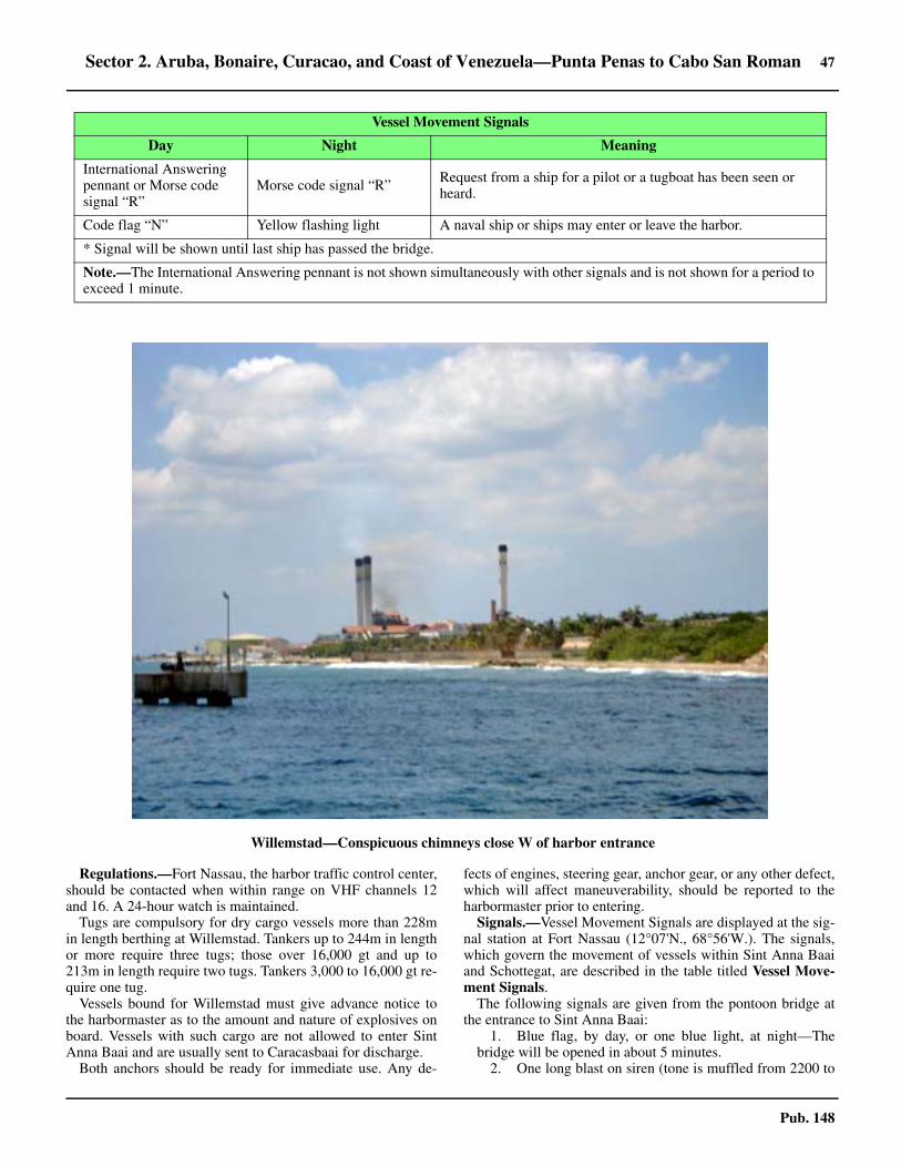
Sector 2. Aruba, Bonaire, Curacao, and Coast of Venezuela—Punta Penas to Cabo San Roman 47
Pub. 148
2.17 Regulations.—Fort Nassau, the harbor traffic control center,should be contacted when within range on VHF channels 12and 16. A 24-hour watch is maintained.2.17 Tugs are compulsory for dry cargo vessels more than 228min length berthing at Willemstad. Tankers up to 244m in lengthor more require three tugs; those over 16,000 gt and up to213m in length require two tugs. Tankers 3,000 to 16,000 gt re-quire one tug.2.17 Vessels bound for Willemstad must give advance notice tothe harbormaster as to the amount and nature of explosives onboard. Vessels with such cargo are not allowed to enter SintAnna Baai and are usually sent to Caracasbaai for discharge.2.17 Both anchors should be ready for immediate use. Any de-
fects of engines, steering gear, anchor gear, or any other defect,which will affect maneuverability, should be reported to theharbormaster prior to entering.
Signals.—Vessel Movement Signals are displayed at the sig-nal station at Fort Nassau (12°07'N., 68°56'W.). The signals,which govern the movement of vessels within Sint Anna Baaiand Schottegat, are described in the table titled Vessel Move-ment Signals.2.17 The following signals are given from the pontoon bridge atthe entrance to Sint Anna Baai:
1. Blue flag, by day, or one blue light, at night—Thebridge will be opened in about 5 minutes.
2. One long blast on siren (tone is muffled from 2200 to
International Answering pennant or Morse code signal “R”
Morse code signal “R” Request from a ship for a pilot or a tugboat has been seen or heard.
Code flag “N” Yellow flashing light A naval ship or ships may enter or leave the harbor.
* Signal will be shown until last ship has passed the bridge.
Note.—The International Answering pennant is not shown simultaneously with other signals and is not shown for a period to exceed 1 minute.
2.17Willemstad—Conspicuous chimneys close W of harbor entrance
Vessel Movement Signals
Day Night Meaning

48 Sector 2. Aruba, Bonaire, Curacao, and Coast of Venezuela—Punta Penas to Cabo San Roman
Pub. 148
0600)—The bridge will be opened within 1 minute and theland traffic must be stopped.
3. Four long blasts on siren—The bridge either cannot orwill not be opened.
2.17 The following signals for the bridge attendant are displayedat the harbor office:
2.17 The following harbor signals may be given by vessels:1. A black ball, by day, or one white light over one red
light, at night—The ship wants to shift.Note.—Either signal is to be followed immediately by a
long blast on the whistle or siren. It can only be given whenthe signals at Fort Nassau indicate that the harbor is clear.
2. Two long blasts on whistle or siren—The ship wants apilot immediately.
3. Three long blasts on whistle or siren—The ship re-quests the bridge to be opened.
4. Four long blasts on the whistle or siren—The maneu-vering of the ship has been stopped for the time being.
5. Ten short blasts on whistle or siren—There is a fireaboard the ship.
6. Morse code signal “K” on whistle or siren—Ship re-quests permission to block Sint Anna Baai Channel, prepara-tory to mooring or unmooring.
7. Morse code signal “B” on whistle or siren—Ship re-ports Sint Anna Baai Channel now open again.
8. Morse code signal “X” on whistle or siren—A tug isrequested.
9. Morse code signal “V” on whistle or siren when navi-gating in Sint Anna Baai—Ship is blocking Sint Anna Baai.
10. Morse code signal “V” on whistle or siren when navi-gating in the Schottegat—Ship is unmaneuverable; otherships should keep clear.
2.17 All vessels are prohibited from sounding their whistles or si-rens in the harbor area between 2200 and 0600. The limits ofthe above harbor area extend from Nieuwe Wharf to the en-trance. During these hours the following signals will be dis-played:
1. Two red lights (vertically disposed)—Ship requestspermission to get underway.
2. Extinguishing of above lights—When leaving, re-quest that the bridge be opened. In the event the ship is enter-ing or shifting, that the harbor is now clear again.
2.17 The following storm signals are shown from the lighthouseat Riffort:
1. Red flag with white background—Storm expectedover Curacao.
2. Two red flags with black background or one whitelight between two red lights (vertically disposed)—Hurri-cane expected over Curacao.
3. Green pennant below Signal 2—Hurricane exists or isexpected in the Caribbean Sea between 60° and 65°W.
4. Black pennant below Signal 2—Hurricane exists or isexpected in the Caribbean Sea between 65° and 70°W.
2.17 Two current meters are attached to the two lights situated 0.1mile and 0.2 mile W of Waterford Light, which stands on the Eentrance point of Sint Anna Baai. A third meter, visible onlyfrom within Sint Anna Baai, is situated on the inner wall ofWaterford. The direction and strength of the current is indicat-ed by colored lights, displayed vertically, from the meters asfollows:
1. Red, white, red, green—More than 2 knots, west-bound.
2. White, red, green—1.5 to 2 knots, westbound.3. Red, green—1 to 1.5 knots, westbound.4. Green—0 to 1 knot, westbound.5. Green, orange—0 to 1 knot, eastbound.
2.17 It was reported (1995) that the above current meters are in-operative. It has been reported (2001) that the signals for vesselmovement in the harbor are not always in use and that the pilot
Day Night Meaning
Green flag One green light The bridge attendant must close the bridge.
Red flag One red light The bridge attendant must keep the bridge open.
2.17Queen Juliana Bridge (background)
2.17Mega Pier

Sector 2. Aruba, Bonaire, Curacao, and Coast of Venezuela—Punta Penas to Cabo San Roman 49
Pub. 148
controls the use of signals.2.17 Contact Information.—See the table titled Willemstad—Contact Information.
2.17 Anchorage.—Generally, there are no outer anchorage areasin Willemstad Harbor. An anchorage area is located in the SWarea of Scottegat Bay. A dolphin, with a mooring buoy on eachside, available as a waiting berth subject to the harbormaster’spermission, has a depth of 12.9m; the distance between eachbuoy and dolphin is about 350m. 2.17 Directions.—Approach the entrance with the lightedbeacons in line, bearing 023°30'. This course leads between thelighted beacons on either side of the entrance. The inboundrange is also marked as white boards with red stripes and a reddiamond shape on the top of each. The aft range marker hasbeen reported (2011) as inconspicuously located mid-way up ahill. Having cleared these beacons, alter course passing in mid-channel through the pontoon bridge opening. Maintainsufficient headway to overcome any adverse effect of the windand current. The traffic signals must be strictly observed,because with vessels berthed on both sides of Sint Anna Baai,the fairway is too narrow for large vessels to safely pass eachother.
2.18 Caracasbaai (Caracas Bay) (12°04'N., 68°52'W.)(World Port Index No. 11800), an open roadstead, lies about 5miles ESE of Willemstad and has oil berthing facilities forshipping fuel oil and diesel oil in bulk. Passenger and cargovessels also use the harbor.2.18 Winds—Weather.—The NE trades are constant exceptduring the months of August through October, when they be-come light and variable. The currents, which are strong attimes, set NW across the bay entrance.2.18 Depths—Limitations.—The harbor is dredged to a depth of14.3m. Vessels with a maximum length of 320m and a draft of13.7m may be accommodated. 2.18 Berthing facilities, on the E side of the bay, consist of PierNo. 2 and Pier No. 3, about 0.2 mile SSE. These T-headed piershave concrete quays and are flanked by dolphins. Vessels berthport side to. The piers also serve as a passenger terminal. PierNo. 2 has a length of 98m and a alongside depth of 13.7m. PierNo. 3 has a length of 70m and a alongside depth of 13.7m. 2.18 Tugs are based at Willemstad and are provided automaticallyfor berthing only. Two tugs are used for tankers more than20,000 gt and for passenger liners and cargo vessels more than30,000 gt.2.18 The 10m curve lies up to 135m off the N and E shores; out-side this curve the depths increase sharply.2.18 Aspect.—Tafelberg (Santa Barbara), a 196m hill standingabout 1.8 miles E of Caracasbaai, and Fort Beekenburg, on theE side of the bay, are good landmarks from seaward. A formerquarantine building standing on the E entrance point is promi-nent. The large tanks and the terminal facilities are visible for aconsiderable distance and are brightly illuminated at night.
Willemstad—Contact Information
Vessel Traffic Control Centre (VTCC), Fort Nassau
Call sign Fort Nassau Traffic Control
VHF VHF channels 12 and 16
Telephone 599-9-461-4581
Harbormaster
Telephone 599-9-461-1740
Port Authority
Telephone 599-9-434-5999
Facsimile 599-9-461-3907
E-mail [email protected]
Web site http://www.curports.com
Port Services
Telephone599-9-461-5177
599-9-461-5079
Facsimile599-9-461-6356
599-9-461-3732
E-mail [email protected]
Web site http://www.curports.com
Pilots
VHF VHF channels 14 and 16
Telephone 599-9-434-5999
Facsimile 599-9-461-8479
Emmastad Refinery (Isla Oil Terminal)
Call sign Isla Loading Department
VHF VHF channel 19
Telephone
599-09-466-2700
599-09-466-2800
599-09-466-2900
Facsimile599-09-466-2588
599-09-466-2488
E-mail [email protected]
Web site http://www.refineriaisla.com
Duty Officer
Telephone599-09-466-3561 (mobile)
599-09-466-3562 (mobile)
Curacao Drydock
VHF VHF channels 6 and 16
Telephone 599-09-733-0000
Facsimile599-09-737-9950
599-09-736-5580
E-mail [email protected]
Web site http://www.cdmnv.com
Willemstad—Contact Information

50 Sector 2. Aruba, Bonaire, Curacao, and Coast of Venezuela—Punta Penas to Cabo San Roman
Pub. 148
2.18 Spaanse Haven (12°04'N., 68°51'W.) is a narrow channelleading into Spaanse Water, an irregular-shaped harbor usedsolely by yachts.2.18 The obscure entrance is identified by a cluster of oil storagetanks standing on top and fringing the side of the hill thatforms the left bank of the entrance.2.18 Pilotage.—Pilotage is compulsory and is available 24 hoursThe pilot boards 1 mile off Lijhoek (12°04'N., 68°52'W.).2.18 Anchorage.—The depths in the bay are too great for anchor-ing. Vessels awaiting a berth should remain well seaward untilordered to come alongside.
2.19 Fuikbaai (12°03'N., 68°50'W.), a narrow lagoon, isused as a phosphate-exporting center. The entrance has a leastnavigable width of 44.8m. Vessels with a length in excess of116m or a draft in excess of 7.3m cannot enter. Vessels ofgreater draft can moor with the help of floats placed betweenthe ship and the quay. For berth information see the table titledFuikbaaai—Berth Information. 2.19 Two lighted beacons lead into the lagoon.2.19 Generally, there is a strong W current in the approach.
During some months, usually August through October, strongE currents are encountered. These currents are of great impor-tance to vessels entering the lagoon.
2.20 Newport (Nieupoort) (12°03'N., 68°50'W.) is a smallport lying on the NE side of the lagoon, just N of Fuikbaai. Ithas a small phosphate wharf, with an alongside depth of 8.5m.A chimney and a flagstaff are prominent landmarks.2.20 Pilotage.—Pilotage is compulsory. The pilot boards 0.5 mileS of the entrance or in Caracasbaai. The harbor is entered byday only. The vessel must be properly ballasted to ensure safemaneuvering.2.20 The coast between Fuikbaai and Punt Kanon, about 5.5miles E, is low and bordered by three lagoons. This section ofcoast is steep-to and depths of over 200m are to be found with-in 0.5 mile of the shore. To avoid damage to the beaches, ves-sels are requested to proceed at a moderate speed when within3 miles of the S coast of Curacao. 2.20 Klein Curacao (11°59'N., 68°39'W.), lying 6 miles ESE ofPunt Kanon, is a low, bare, flat island. It is steep-to, especiallyon the E side. This island is radar prominent.
Fuikbaaai—Berth Information
Berth Length DepthMaximum Vessel
RemarksLOA Draft
No. 1 25m 6.1m 107m 4.3m Cement
No. 2 — 6.1m 107m — Phosphates
2.20Hooiberg (Haystack) from W

Sector 2. Aruba, Bonaire, Curacao, and Coast of Venezuela—Punta Penas to Cabo San Roman 51
Pub. 148
Aruba
2.21 Aruba (12°30'N., 70°00'W.), on which only sparsevegetation grows, lies with Punta Basora, its SE extremity, lo-cated 42 miles W of the N extremity of Curacao. The island isslightly hilly, with a few isolated peaks.2.21 The NE coast of Aruba is rocky and indented by small coves;it is exposed to heavy breakers and should not be closely ap-proached. The SW and W coasts are low. Much of the SWcoast is fronted by barrier reefs, with lagoons inside them.Some of the reefs are covered with mangroves. Aruba has beenreported to be radar conspicuous.2.21 Winds—Weather.—Aruba is generally considered to beoutside the hurricane belt of the Caribbean, destructive hurri-canes struck the island in 1954 and 1955. The prevailing NEwinds carry dense smoke seaward from the oil refineries, andat times the resultant haze may be such that the island is notvisible until within 6 miles.2.21 Tides—Currents.—In the vicinity of Aruba, the currentsusually set W at a rate of 0.5 to 1 knot, although around thepoints greater rates may be attained. Off Sint Nicolaas Baai,when the trade winds are strong, the currents may attain ratesof up to 3 knots. When the trade wind is weak or with variableW winds (usually October to December) the currents may set Eand attain a rate of up to 2 knots.2.21 Aspect.—Jamanota and Hooiberg, the two highest peaks,rise to elevations of 176 and 167m, respectively, 6 miles and9.5 miles NW of Punta Basora. These peaks are good land-marks from seaward, but become partially obscured by thedense smoke from the oil refineries at times.2.21 Caution.—Many small fishing vessels may be found an-chored off the S coast of Aruba at distances up to 3 miles off-shore. Some of the vessels may display no lights.2.21 To avoid the risk of pollution to the beaches on the W andSW coasts, tankers are advised not to anchor offshore betweenthe entrance to Haven Barcadera and the N extremity of the is-land.2.21 It was reported (1947) that a local magnetic disturbance oc-curred between Aruba and the mainland.
2.22 Ceru Colorado (12°25'N., 69°52'W.), a very darkhill, rises close NW of Punta Basora and has been reported tobe radar conspicuous. 2.22 From Ceru Colorado, the E side of Aruba extends 4.3 milesNNW and then 4.8 miles NW to Noordkaap. Depths of 18mand less lie within 1 mile S, 0.8 mile E, and 1.5 miles NNE ofPunta Basora. Two shoal heads, with depths of 9m and 10m,respectively, lie 0.5 mile ENE and 1 mile NE of Punta Basora.2.22 Two water towers stand 0.5 mile N and a conspicuous tank issituated 3 miles NW of Ceru Colorado.2.22 A range of hills, with peaks between 143 to 176m high, ex-tends 4.3 miles S from a position located 0.5 mile S of Noord-kaap.2.22 From Noordkaap, the coast extends 8 miles NW to the N ex-tremity of the island. California, about 0.5 mile ESE, is the NEextremity of Noordwestpunt, a peninsula forming the NW ex-tremity of the island.2.22 From Punta Basora, the SW coast of Aruba extends about 1mile W to a low sandy point from which a barrier reef, onwhich there are several low cays, extends about 0.8 mile W to
Indiaanskop, a small island, marked by a light. The barrier reef,with a long, narrow island on it, then extends about 0.5 mileNW to the S entrance to Sint Nicolaas Baai.2.22 A channel, 135m wide, has been dredged through the barrierreef about 0.5 mile NW of Indiaanskop; there is a least depth of12.8m in the fairway of the channel. Lighted beacons lie oneach side of the entrance to the channel. A lighted range stands0.4 mile NNE of Indiaanskop, leads through the dredged chan-nel.2.22 On the N side of the lagoon, 0.5 mile NNW of Indiaanskop,there is a pier, with 91m of berths, flanked by dolphins. It isused by dry cargo vessels with drafts up to 9.4m. A turning ar-ea, about 180m wide, lies S of the pier and has a least depth of9.7m.
Sint Nicolaas Baai (San Nicolas) (12°26'N., 69°54'W.)
World Port Index No. 11830
2.23 The port of Sint Nicolaas Baai, which is situated 2.5miles WNW of Punt Basora, has an oil terminal with a large re-finery. It imports and transships crude oil and exports refinedproducts. Protected on its SW side by a long, narrow island,and a reef; the port can be identified, by day, by the large oiltanks and, at night, by the ample lighting. Three conspicuouswhite chimneys stand on the shore in the SE part of the port.An aluminum-colored chimney, which stands near three yellowtanks, is situated about 0.5 mile ENE of the NW entrance andis very conspicuous.
2.23 The controlling depth in the entrance is 13.4m. Maximumarrival draft is 12.2m, while maximum departure draft is12.5m.2.23 Tides—Currents.—The tidal rise normally is about 0.2mand the maximum rise is about 0.5m. The movement is semi-diurnal. The maximum current near the terminal sets W at arate of 1 knot.2.23 The W currents found just off Sint Nicolaas Baai and theReef Berths can reach a velocity of 3 knots during the prevail-ing NE winds. However, during certain times of the year withvariable winds, the current may set vessels to the E.2.23 In general, the currents can be unpredictable. Countercur-rents also may exist from 0.2 to 2 miles off the coast.2.23 Depths—Limitations.—Vessels berthing at the principalpiers enter by the NW entrance and depart by the S entrance.
2.23Sint Nicolaas Baai (San Nicolas)
52 Sector 2. Aruba, Bonaire, Curacao, and Coast of Venezuela—Punta Penas to Cabo San Roman
Pub. 148
2.23 West Pier, is L-shaped, and situated on the N side of the bay,0.4 mile within the NW entrance; there are dolphins up to 0.2mile W of the W end of the pier head. The pier can was report-ed not in use in 2013. There is a boat quay situated close W ofthe root of West Pier.2.23 Reef Berth No. 1 and Reef Berth No. 2 project from theshore 0.5 mile and 1 mile, respectively, WNW of the NW en-trance to Sint Nicolaas Baai. Each is a T-headed jetty with off-lying dolphins for berthing large tankers. Vessels berth portside-to. Vessels should be ready to get underway on short no-tice. For berthing information see the table titled Sint NicolaasBaai (San Nicolaas)—Berth Information.2.23 Pilotage.—Pilotage is compulsory for merchant vessels. Forpilot boarding locations, the see the table titled Sint NicolaasBaai (San Nicolas)—Pilot Boarding Locations. Day andnight service is provided. The pilots can be contacted (callsign: Sint Nicolaas Pilot Station) on VHF channel 16.
2.23 Regulations.—Local harbor regulations are in force and acopy should be obtained from the facility or the agent.2.23 Contact Information.—See the table titled Sint NicolaasBaai (San Nicolas)—Contact Information.2.23 Anchorage.—Anchorage may be taken on the narrow shorebank outside the harbor, but it is advisable to employ a pilot.Pilots are available for daylight anchoring only. As a rule,vessels should not anchor E of Indiaanskop because the roughsea found there makes it difficult for the pilot boat and tugs togo alongside.2.23 Designated anchorage areas, which can best be seen on thechart, exist off Sint Nicolaas Baai. 2.23 Anchorage is prohibited between the coast and an arc with aradius 0.5 mile centered 0.5 mile WNW of the NW entrancepoint of the channel.2.23 It has been reported that good anchorage can be taken, in adepth of 56m, sand and coral, with the light on the SE side ofthe N entrance bearing 322° and the signal station bearing
016°.
2.23 Vessels over 20,000 dwt should proceed to a position about10 miles WSW of the harbor entrance and anchor, in depths of36 to 43m.2.23 Caution.—Due to traffic at the refineries, it is recommendedthat vessels remain at least 2 miles off the coast when transitingthis area. Daylight berthing for vessels over 152m, cargo andbunker operations may be stopped when winds exceed 30knots.
2.24 Commandeurs Baai (12°27'N., 69°57'W.) lies withinthe lagoon immediately NW of Sint Nicolaas Baai. The en-trance to Commandeurs Baai, at the W end of the lagoon, isformed by a narrow channel. This channel has a least depth of2.7m and leads through the barrier reef. There are depths of 3to 12m in the navigable part of the lagoon. It is used by localfisherman and only suitable for small craft. An obstructionwith a depth of 3.3m lies in the channel about 80m NE of thechannel buoy. 2.24 Spaans Lagoen (12°28'N., 69°58'W.), located 2 miles NWof Commandeurs Baai, is marked by a prominent group of tallchimneys standing on its NW entrance point.2.24 Pilotage.—Pilotage is compulsory and always available. Thepilot boards about 0.5 mile W of the Reef Berths.
Sint Nicolaas Baai (San Nicolas)—Pilot Boarding Locations
Inner Harbor 12°25.6'N, 69°56.3'W
Reef Berths 12°25.6'N, 69°57.2'W
HDS Piers and Coke Berth 12°25.1'N, 69°54.6'W
Sint Nicolaas Baai (San Nicolas)—Contact Information
Terminal
VHF VHF channels 8 and 16
Telephone
297-589-4202 (PFSO)
297-589-8131 (PFSO)
297-589-4384 (Asst. PFSO)
297-589-8450 (Asst. PFSO)
Tugs
VHF VHF channel 8
Pilots
Call sign Sint Nicolaas Pilot Station
VHF VHF channel 16
Sint Nicolaas Baai (San Nicolas)—Berthing Informati
Pier/Berth Length Depth Maximum Vessel
RemarksLOA Draft Beam
West Pier Terminal
West Pier 60m — 198m 10.1m — Closed (2019).
Petcoke Terminal
Petcoke Berth 75m — 244m 12.1m — Closed (2019).
Services Pier
Service Pier N 85m — — — — Pollution control vessels, tugs, and oth-ers.

Sector 2. Aruba, Bonaire, Curacao, and Coast of Venezuela—Punta Penas to Cabo San Roman 53
Pub. 148
2.24 Anchorage.—Anchorage can be taken, in a depth of 50m,off the barrier reef, with the group of chimneys bearing 346°.2.24 Caution.—A submarine cable, which may best be seen onthe chart, lies across the W entrance, about 0.2 mile within theentrance. A submarine pipeline, which may best be seen on thechart, lies across the entrance, close E of the cable.
2.25 Haven Barcadera (12°29'N., 70°00'W.) is situatedabout 2 miles NW of Spaans Lagoen and about 3 miles SE ofOranjestad.2.25 Winds—Weather.—Winds slightly S of E usually prevailand, if strong, affect the maneuvering of vessels in the vicinityof the quay. The wind usually diminishes before dawn and thefirst hours of daylight are the most favorable for entering. Ves-sels enter and depart 24 hours. However, under favorable cir-cumstances, the maneuvering time will be shorter and thereforeearly morning berthing is desirable.2.25 Tides—Currents.—To the W of the barrier reef, the currentsets W at a rate of 1 to 2 knots, but rarely exceeds 3 knots. Onoccasion, an E set may be experienced at a rate of no more than2 knots.
Depths—Limitations.—The harbor consists of the Bar-cadera terminal, with a dredged approach through the barrierreef. The harbor and approach are marked by navigational aids.Range beacons, lead through the barrier reef into the harbor.
Barcadera Multi Cargo Sea Terminal handles containers,breakbulk, aggregates, LPG and ro-ro. The single berth is
440m long and can accommodate vessels with a maximum loaof 245m and a maximum draft of 9.7m. 2.25 Pilotage.—Pilots are available 24 hours and can be obtainedfrom Oranjestad. A tug can be obtained from Oranjestad andits services are strongly recommended. See Oranjestad Pilot-age (paragraph 2.26) for more information.
Paarden Baai (Oranjestad) (12°31'N., 70°02'W.)
World Port Index No. 11840
2.26 Paarden Baai, a narrow bay protected on its W side bythe barrier reef, is the harbor area for Oranjestad, the adminis-trative seat of government for Aruba.
2.26 Tides—Currents.—Off the port there is a W current. It hasa rate of about 1 to 2 knots, but rarely exceeds 3 knots. Thereare times when there is no current or an E set may beexperienced. This set attains a velocity of 2 knots at times. Onoccasions, when the W set is strong, an E set of 0.5 knot maybe experienced within the harbor, but this is rarely noticedbecause the wind is much stronger and in the oppositedirection.
Service Pier S 100m — — — — Pollution control vessels, tugs, and oth-ers.
HDS Terminal
HDS Berth 100m 10.4m 213.3m 9.6m 28.9m Closed (2019).
Coastal Aruba Refinery
Reef Berth No. 1 30m — — 22.8m — Petroleum products. Berthing length of 395m (including dolphins).
Wickland Oil Company
Reef Berth No. 2 35m — — 32.3m — Crude oil. Berthing length of 490m (including dolphins).
Aruba Refinery
Pier 1 (North) 225m 11.8m 225.5m 11.5m 41.1m Closed (2019).
Pier 1 (South) 233m 11.8m 227m 11.5m 41.1m Closed (2019).
Pier 2 (North) 190m — 228.6m 12.1m 36.0m Petroleum products. Berthing length of 250m (including dolphins).
Pier 2 (South) 200m — 243.8m 11.5m 36.0m Petroleum products. Berthing length of 260m (including dolphins).
Pier 3 (North) 78m — 259m 12.1m 41.1m Closed (2019).
Pier 3 (South) 105m 12.5m 274.3m 12.1m 41.1m Closed (2019).
STS Aruba Trans-shipment Area — 48.0m — — — Petroleum products. Depths range from
48-82m.
Sint Nicolaas Baai (San Nicolas)—Berthing Informati
Pier/Berth Length Depth Maximum Vessel
RemarksLOA Draft Beam
Oranjestad Home Page
http://www.arubaports.com

54 Sector 2. Aruba, Bonaire, Curacao, and Coast of Venezuela—Punta Penas to Cabo San Roman
Pub. 148
2.26Parden Baai—Container Terminal
2.26Parden Baai—Westhaven—Berth H (left) and Berth G (right)
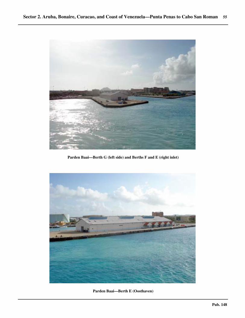
Sector 2. Aruba, Bonaire, Curacao, and Coast of Venezuela—Punta Penas to Cabo San Roman 55
Pub. 148
2.26Parden Baai—Berth G (left side) and Berths F and E (right inlet)
2.26Parden Baai—Berth E (Oosthaven)

56 Sector 2. Aruba, Bonaire, Curacao, and Coast of Venezuela—Punta Penas to Cabo San Roman
Pub. 148
2.26 Depths—Limitations.—Vessels usually enter through the Nchannel and depart through the S channel. Both channels havea least width of 0.1 mile. The N channel has a least depth of11.2m and the S channel has a least depth of 10m. Vessels upto 250m in length can enter, but their draft should not exceed10m. Minimum drafts are in force for tankers arriving or sail-ing in ballast. The use of tugs is advisable for large vessels andvessels in ballast.2.26 The berthing facilities consist of two basins, Westhaven andOosthaven, separated by a projecting wharf. The main wharf issituated SE of the basins.2.26 Both basins have berths, 167m and 198m long, with leastdepths of 8.5m alongside. The main wharf, 527m long, extendsSE from the SE entrance point of Oosthaven. There is a leastdepth of 9.9m alongside the SW part of this wharf, and 4.9malongside the SE part. The container terminal has depths of 11to 11.2m alongside.2.26 The entrance channel, the navigable part of the harbor, andthe harbor berths have depths of 11m that are maintained bydredging. Berth details are given in the table titled Oranjes-
tad—Berth Information.2.26 A large square concrete mooring dolphin, marked by a light,has been reported (2007) established about 75m SW of the endof Berth B off the main wharf.
2.26 The head of Westhaven comprises a ferry terminal and a ro-ro berth. A container berth is situated NW of the harbor office,which stands at the entrance to Westhaven. A wreck, markedby a yellow buoy, is found in the channel approximately 165mW of the head of the pier containing charted Berth H. 2.26 Aspect.—Oranjestad can be identified by a conspicuous wa-ter tower with a prominent church standing close NW of it.2.26 Pilotage.—Pilotage is compulsory for vessels over 50 gt andis available at all times. Request for pilot should be madethrough Curacao Coast Radio Station until within VHF range,giving 48 hours notice of ETA. Oranjestad Port Radio main-tains a continuous watch on VHF channels 11 and 16. FOr pi-lot boarding locations see table titled Oranjestad—PilotBoarding Locations. Vessels should approach this channel asnear as is prudent and make a lee for the pilot boat.
2.26Parden Baai—Cruise Terminal (Berth C) from NW
Oranjestad—Berth Information
BerthMaximim Vessel
RemarksLOA Draft
B, C, and D (Cruise Terminal) 527m 9.8m Cruise vessels.
E (Easthaven) 169m 9.1m Cruise vessels.
F (Easthaven) 180m 8.5m Cruise vessels.

Sector 2. Aruba, Bonaire, Curacao, and Coast of Venezuela—Punta Penas to Cabo San Roman 57
Pub. 148
2.26 Contact Information.—See the table titled Oranjestad—Contact Information.
2.26 Anchorage.—Paarden Baai provides anchorage W and S ofthe main wharf.2.26 Anchorages, suitable even for the deepest draft vessels, aresituated outside the protecting reef along the length of the Wand SW coast. Because of the sharply shelving nature of thebottom in this area, it is recommended that the services of apilot be obtained when letting go and weighing anchor.2.26 Caution.—Within the bay, the trend of the channel is almostacross the direction of the prevailing wind, so that large vesselsand those in ballast must exercise great caution, especially atnight, to avoid the reef to leeward. Some difficulty may beexperienced in berthing at the main wharf when the trade windis blowing, and it is then preferable to enter either Westhavenor Oosthaven, head to the wind.2.26 It was reported (1991) that lesser depths than charted exist atall Oranjestad harbor berths. A dangerous wreck lies about195m SW of the main pier and is marked by a buoy close NE.
2.27 Manshebu (12°32'N., 70°04'W.), also known asWestpunt, is the W extremity of Aruba. This point has been re-ported to be radar prominent.2.27 Druif (12°32'N., 70°04'W.), the site of a former bulk oil ter-minal and refinery, stands on the SW side of the point. This ar-ea can be identified by two conspicuous hotels.
2.27 From Manshebu, the coast extends 2.8 miles N and then 2.5miles NNW to the N extremity of Aruba. This section of coasthas no barrier reef, but is fronted by a shorebank which extendsup to 0.8 mile seaward in places. Depths of less than 20m lie upto 1 mile offshore.2.27 Anchorage.—Vessels awaiting instructions are often re-quested to anchor W of Noordwest Punt in order to conservebunkers.2.27 A restricted anchorage area, the limits of which are shownon the chart, extends W from the coast between Manshebu andBasiruti. It is reserved for the use of vessels carrying out re-pairs, tank cleaning, etc. It is the only anchorage in the vicinityof Aruba where these operations can be effected by VLCCsand ULCCs. 2.27 A pilot must be employed for these anchorages, as care isneeded not to obstruct the approach to Oranjestad and to avoidan abandoned submarine cable extending W and N from thecoast close S of Basiruti.2.27 Caution.—Offshore dangers lying on the coastal bank andpositioned relative to Pos Chikitu (12°33.7'N., 70°03.7'W.) are,as follows:
1. A stony shoal depth of 1.5m—0.5 mile W.2. A 2.2m shoal—0.6 mile NW. 3. A dangerous wreck—0.8 mile NNW.
2.27 In addition, stranded wrecks lie 1 mile and 2.5 miles N ofPos Chikitu; each is marked by a lighted buoy moored closeSW. A wreck, with a least depth of 6.1m, lies close SSE of theN stranded wreck.
Coast of Venezuela—Punta Penas to Punta Es-carceo
2.28 The coast between Punta Penas (10°44'N., 61°51'W.)and Cabo Mala Pascua, 67 miles W, is backed by mountainsmore than 1,200m high and completely covered by trees. CaboMala Pascua is not prominent.
Large spurs branch from the central ridge and terminate inbold points, forming deep gorges at the heads of the bays.
Generally the coast is bold and rocky, with no off-lying dan-gers. Rocks fringe this section of coast in places, but usually lieclose offshore. Cabo Tres Puntas, located 17.3 miles E of CaboMala Pascua and marked by a light, is bold and salient. Twoconspicuous peaks stand close together, 6 miles ESE of thiscape. The W peak, which is the highest, rises to an elevation of1,257m.2.28 Ensenada Unare (10°44'N., 62°45'W.), entered 3 milesWSW of Cabo Tres Puntas, is a small roadstead, with depths ofless than 5.5m, extending 0.3 mile from both entrance points.Some shelter is provided in the lee of the NE entrance point,which can be identified by a small conical hill surmounting its
G (Westhaven) 150m 8.5m Cruise and ro-ro vessels.
H (Westhaven) 200m 8.5m Cruise ro-ro vessels. Alongside depth of 10.3m.
CK 250m 9.8m Containers. Alongside depth of 11.2m.
Oranjestad—Berth Information
BerthMaximim Vessel
RemarksLOA Draft
Oranjestad—Pilot Boarding Locations
Northwest Entrance 12°31.9'N, 70°04.4'W
Southeast Entrance 12°30.0'N, 70°04.0'W
Barcadera 12°29.0'N, 70°02.2'W
Oranjestad—Contact Information
Marine Traffic Control Tower
VHF VHF channels 11 and 16
Telephone 297-582-1740
E-mail [email protected]
Port Authority
Telephone 297-523-4300
Facsimile 297-523-4343
E-mail [email protected]
Web site http://www.arubaports.com

58 Sector 2. Aruba, Bonaire, Curacao, and Coast of Venezuela—Punta Penas to Cabo San Roman
Pub. 148
outer part. The shore of the bay consists of a white, sandybeach, 1.8 miles long, through the middle of which flows astream. Landing in Ensenada Unare is best effected in the leeof the NE entrance point, but a surf usually makes it difficult.2.28 Puerto Rio Caribe (10°42'N., 63°07'W.), a small town,stands on the shores of Bahia Caribe, about 4 miles W of PuntaFrayle (10°43'N., 63°02'W.), a low rocky point. 2.28 Anchorage.—Small craft with local knowledge can anchorin this bay, in depths 11 to 13m, in the lee of the E entrancepoint.
2.29 Morro Puerto Santo (10°43'N., 63°10'W.), a T-shaped headland, is about 90m high at its outer part and isjoined to the mainland by a low sandspit on which the villageof Puerto Santo stands. The headland, with Isleta del PuertoSanto, marked by a light, lying close off its W side, appears de-tached from seaward and provides a good landmark. MontePuerto Santo, a 1,058m high peak, rises 6 miles S of the head-land and is prominent.2.29 Anchorage can be taken W of the isthmus, in depths of 6 to10m, mud, keeping W of the meridian of the W side of Isletadel Puerto Santo and between 0.2 mile and 0.4 mile off the Sshore of the bay.2.29 The coast between Morro del Puerto Santo and Punta HernanVasquez is bordered by depths of less than 11m, up to 1 mileoffshore.
2.30 Puerto Carupano (10°40'N., 63°15'W.) (World PortIndex No. 12260) consists of a pier protected by a 694m break-water on its NE side. Only vessels of limited draft can be ac-commodated.2.30 Vessels approaching from the E or W should keep in depthsof 11m or greater until N of the breakwater because of the foulground lying off the coast E of Punta Hernan Vasquez and be-cause of the many dangerous shoal heads that lie up to 1 mileoffshore, W of the breakwater head. 2.30 Morro del Puerto Santo and Punta del Tacquien are the mostsalient and prominent points to be seen from seaward. The ra-dio masts standing 0.8 mile S of the breakwater, the cathedral,and the church with twin spires situated in the town are allprominent marks.2.30 Depths—Limitations.—There are general depths of 7.9 to9.1m in the approach to the port and a depth of 8.5m over thebar. The jetty extends around two piers. A pier with dolphinsand connected to the jetty forms one berth. The second pier liesjust S of the jetty and has a two berths, one on the N side andone on the S side. 2.30 Pilotage.—Pilotage is compulsory. Pilots are available 24hours and board at an arranged location. 2.30 Contact Information.—See the table titled Carupano—Contact Information.
2.30 Anchorage.—Anchorage can be taken, in a depth of 8m,mud, about 0.2 mile NNW of the breakwater head with the Wspire of the twin-spired church bearing 168° and Isleta Jarro,close off Punta Salinas, bearing 263°. Smaller vessels cananchor closer in.
2.31 The coast between Puerto Carupano and Morro deChacopata, 33 miles W, is bordered by fringing rocks and dan-gers which lie within 1.5 miles of the coast. Islas Garrapatasforms the outermost danger.2.31 Morro Blanco (10°41'N., 63°20'W.), a rocky promontorycovered with dense growth, is located about 4.5 miles W ofPuerto Carupano. Punta Padilla, 2 miles W of Morro Blanco, isnot conspicuous, but it can be identified by a 46m islet with around summit and a gray rock formation at its base that liesclose off it. Small vessels with local knowledge can anchor inthe small bay lying W of Morro Blanco.2.31 Cerro San Jose, 1,030m high, stands 10 miles S of MorroBlanco and is a good landmark when not obscured by clouds.2.31 Punta de Tacquien (10°41'N., 63°23'W.), 2.3 miles WNWof Punta Padilla, is salient and rises to a rounded hill coveredwith vegetation and ending in gray, rocky bluffs. Rocks extendup to 0.2 mile off the point and, being white, are visible from aconsiderable distance offshore.2.31 Ensenada Garrapatal (10°39'N., 63°26'W.), a small baywith shallow depths and a village standing on its E side, lies1.5 miles SW of Punta de Tacquien.2.31 Islas Garrapatas (10°41'N., 63°28'W.), three rocks up to7m high, lie near the outer end of a foul area that extends about1.5 miles from the main coast at Morro de Lebranche(10°41'N., 63°28'W.). Vessels should not attempt to pass in-shore of the rocks as breakers have been reported to occur be-tween them and the coast.
2.32 Ensenada La Esmeralda (10°39'N., 63°30'W.) is en-tered 4 miles SW of Islas Garrapatas. Punta Esmeralda, togeth-er with Isla Esmeralda close off it, form the E side of the bay.Isletas Cascabel, three islets and some adjacent rocks, foul theE side of the bay.2.32 Anchorage can be taken, in a depth of 11m, mud, about 1mile N of the village of Saucedo, with the tangent of the NWside of Isla Esmeralda bearing 060° and the W islet of the Isle-tas Cascabel group bearing 103°. This latter islet is bare andwhite.2.32 Vessels approaching Ensenada La Esmeralda should give Is-las Garrapatas and Isla Esmeralda a berth of at least 0.5 mile.2.32 The coast between Ensenada La Esmeralda and PuntaGuarapotura (10°39'N., 63°42'W.), a bold and rocky head-land 13 miles W, consists of red cliffs, 12 to 45m high, brokenby occasional sandy beaches. Punta Manzanillo (10°38'N.,63°35'W.) and Punta Gorda, 1.5 miles W, are difficult to see.
Carupano—Contact Information
Port Authority
Telephone580-294-331-4755
580-294-332-2879
Facsimile 580-294-332-2387
Port Captain
Telephone580-294-331-1229
580-294-331-0085
E-mail [email protected]
Carupano—Contact Information

Sector 2. Aruba, Bonaire, Curacao, and Coast of Venezuela—Punta Penas to Cabo San Roman 59
Pub. 148
2.32 Between Punta Guarapotura and Escudo Blanco, 2.5 milesW, there are cliffs up to 18m high, which are white and distinc-tive in places.2.32 Morro de Chacopata (10°42'N., 63°49'W.) stands on the Nextremity of a headland from which a light is shown, about 4.5miles NW of Escudo Blanco. The headland is bold, rocky, 50mhigh, and reddish in color. The coast between Morro de Chaco-pata and Escudo Blanco is low and backed by a sandy plain.
2.33 Bahia Chacopata is a bay lying close W and SW ofMorro de Chacopata and is shoal. It should only be used byvessels of shallow draft with local knowledge. The islands IslaCaribe and Islote Lobos lie within 3.8 miles WSW of Morro deChacopata.2.33 Anchorage can be taken, in depths of 9 to 11m, about 0.8mile SE of Islote Lobos.2.33 Islotes la Tuna, the only off-lying dangers located off the Ncoast of Peninsula de Araya, lie about 9.3 miles WSW of Mor-ro de Chacopata. These islets are low and bare, the middle andhighest being white and the other two being brown.2.33 The current off the N side of the peninsula generally sets W,with a rate seldom exceeding 0.5 knot.2.33 Punta Tuna (10°38'N., 63°57'W.) lies on the N shore ofPeninsula de Araya, about 2.5 miles SE of the southernmost is-let of Islotes la Tuna. Punta Morros de la Pena, a rocky head-land, lies about 6 miles W of Punta Tuna. Between theheadland and Punta Gorda, 2.5 miles WSW, the coast is rocky.2.33 Ensenada Salinas, with a sandy beach, is entered betweenPunta Gorda and Punta Guachin, a low and rocky bluff 5 milesW. Between Ensenada Salinas and Punta Escarceo, 8 miles W,the coast is low, rising gradually toward that point.
Isla de Margarita
2.34 Isla de Margarita (11°00'N., 64°00'W.) is the largestof a group of islands, known as Nueva Esparata, lying withinan area extending 35 miles from the coast. The other islands ofthe group are Isla Coche, Isla Cubagua, and Los Frailes.2.34 Isla de Margarita consists of two rocky mountainous sectionsjoined together by a low sandy isthmus, about 2.5 miles wide.When seen from a short distance N or S, the island appears astwo separate islands. Picos de Maria Guevara are two hillsstanding in the middle of the S side of the isthmus. They areprominent when viewed from the N or S.2.34 The E and largest part of Isla de Margarita rises to Cerro SanJuan, a peak 988m high, near the E end of Cerros de la Vega deMargarita, a mountain range. This part of the island containsseveral summits with valleys in between them. La Asuncion,the capital, stands on the NE side of the mountain range.2.34 The W part of Isla de Margarita consists of Cerros del Ma-canao, another mountain range with four peaks. The highestsummit rises to a height of 1,160m. These peaks make excel-lent landmarks. This part of the island is scantily populated,whereas the E part is heavily populated.
2.35 Cabo de La Isla (Cabo Negro) (11°10'N., 63°53'W.),the N extremity of Isla de Margarita, marked by a light, has asmall islet lying close NE of it. A shoal, with a least depth of9.4m, lies about 7.5 miles NW of the cape.2.35 Punta Galera, a high point, forms the N extremity of Cerro
Galera and stands about 6.8 miles SW of Cabo de La Isla. IslaGalera, a small islet, lies 1.3 miles NNE of this point. 2.35 Bahia de San Juangriego (11°05'N., 64°00'W.), a small bayfringed by shoals which extend up to 1 mile offshore, lies be-tween Punta Galera and Punta Maria Libre, 3.3 miles SW. Thetown of Juangriego stands at the head of the bay. A prominentred church, with twin spires, stands in the town and a promi-nent white monument is situated 1 mile S of Punta Galera.2.35 Sheltered anchorage can be taken, in a depth of 11m, in thelee of Cerro Galera with the monument bearing 105°, distant 1mile.2.35 Caution.—Care should be taken to avoid a rocky shoal, witha least depth of 3.6m, lying near the middle of Bahia de SanJuangriego, 1 mile W of the church.
2.36 Bahia Norte (Ensenada La Guardia) (11°02'N.,64°05'W.) indents the coast between Punta Maria Libre andPunta de Tigre (Punta Tunar), marked by a light, 11 milesWNW. Depths shoal from 27m in the entrance to 11m and lessnear the head.2.36 The village of La Guardia, with a prominent church, standsalong the SE shore. The head of the bay is low and swampy.2.36 The coast between Punta de Tigre and Morro del Robledar,11.5 miles W, is clear and free of off-lying dangers. A largeshoal, with depths of 18m and less, lies between Morro del Ro-bledar and Punta Arenas, 4.5 miles S, and extends 10 milesNW from the coast. Bajio Ostial, a detached patch, has a leastdepth of 8.3m, and lies within this shoal, about 5.5 miles NWof Punta Arenas. A 12.2m shoal patch lies 2 miles WNW ofBajio Ostial.2.36 Vessels are advised to pass to the W of Bajio Ostial due tothe shallow patches reported to lie E of Bajio Ostial. Staying 10miles seaward of Morra del Robledar will clear the above-men-tioned dangers.2.36 From Cabo de La Isla, the E coast of Isla de Margarita ex-
2.34Isla de Margarita Light

60 Sector 2. Aruba, Bonaire, Curacao, and Coast of Venezuela—Punta Penas to Cabo San Roman
Pub. 148
tends 4 miles S to Cabo Blanco, a defined light gray rockypoint. Isletas del Cabo lie within 1.3 miles SE of Cabo de LaIsla. Two above-water rocks lie off Cabo Blanco. Puerto Fer-min, a small village, stands 0.5 mile SW of Cabo Blanco.2.36 The coast between Cabo Blanco and Punta de la Ballena, 8.5miles SSE, consists of an unbroken sandy beach. Punta de laBallena is a rocky headland marked by a light, 70m high, con-nected to the shore by a sandy pit. A 12.2m shoal patch liesabout 0.4 mile SE of Punta de la Ballena.2.36 Cerro del Balantia, 657m high, stands 4.8 miles S of CaboBlanco.
2.37 Bahia Pampatar (10°59'N., 63°50'W.), fringed by asandy beach, is entered between Punta de la Ballena and Morrode Puerto Moreno, 3.8 miles WSW. Depths within the bay are5.5m and less within 0.3 mile off the shore in places. Other-wise, the bay is clear of dangers. Isla Blanco, 30m high andprominent, lies 2 miles SSW of Punta de la Ballena. This islethas a white top and a dark base.2.37 A fort, with two towers, stands on the shore and is a goodlandmark. The cathedral, with a square tower, and the custom-house, a prominent gray building, stand close NW of the fort.2.37 Pampatar (10°59'N., 63°48'W.) is situated in the NW partof the bay. The port has a small pier used for landing cargo.This pier was reported (1991) to be dilapidated.2.37 Pilotage.—Pilots embark seaward of a line joining Punta dela Ballena and Morro de Puerto Moreno.2.37 Anchorage.—Good anchorage can be taken, in a depth of7m, about 1 mile WSW of Punta de la Ballena. Cargo is usual-ly worked into barges at this anchorage.2.37 Puerto Moreno, a shallow bay with a sandy beach at its head,lies between Morro de Puerto Moreno and a point about 2miles NNE.2.37 Caution.—It was reported (1994) that large concentrationsof fishing boats and their gear may be encountered betweenPunta de la Ballena and Punta Mosquito.
2.38 Bahia La Mar (10°55'N., 63°50'W.) indents the coastbetween Morro de Puerto Moreno and Punta Mosquito, 5 milesSW. The head of the bay is foul up to 0.3 mile offshore, withdepths of less than 9m.2.38 Punta Mosquito, marked by a light, is barren and reddish-brown in color. This point appears as an island from a distancebecause of the low land behind it.2.38 Anchorage can be taken, in a depth of 9m, with the church inthe town bearing 000° and the S extremity of Morro de PuertoMoreno bearing 061°.2.38 Porlamar (10°57'N., 63°51'W.), the principal town of Isla
de Margarita, is situated on the N side of the bay. The church inthe town and the two radio masts on the shore are good land-marks.2.38 Two piers, with shallow depths alongside, extend from theshore abreast the town. Cargo is discharged into barges at theanchorage.
2.39 Punta Carnero (10°53'N., 64°01'W.) is reported tobe a tank farm complex. A finger pier fronts the tank farm andextends 0.5 mile offshore. Small tankers and gas carriers canberth alongside its head.2.39 The tank farm also provides a sea berth for larger tankers,about 0.5 mile SSW of the pier head. This sea berth, which isilluminated at night, consists of mooring and breasting dol-phins connected by catwalks. A prohibited anchorage area liesbetween the tank farm sea berth and Punta Carnero, as bestseen on the chart. 2.39 From Punta Mosquito, the coast extends 10 miles W to PuntaMangle, a low sandy point. The dense, green mangroves onthis latter point help to identify it. Laguna Marites dischargesalong this section of the coast, about 3 miles W of Punta Mos-quito.2.39 Bahia Guamache (10°53'N., 64°05'W.) is entered betweenPunta Mangle and Punta de Piedras, 3 miles NW. It is borderedby shoal ground which extends up to 1 mile off the N shore.The village of Tubores stands close E of Punta de Piedras. An-chorage can be taken about 1 mile S of this village, in a depthof 9m, clear of the charted ferry routes. A prominent radio maststands 1.3 miles E of Punta de Piedras.2.39 Caution.—A dangerous wreck is reported to lie in position10°53'07''N, 64°07'06''W.
2.40 Puerto El Guamache (10°52'N., 64°04'W.) (WorldPort Index No. 12230), situated on the S coast of Isla de Mar-garita, is in an open roadstead, with one berth for general car-go. 2.40 Depths—Limitations.—For berthing information see thetable titled Puerto El Guamache—Berth Information.2.40 Pilotage.—Pilotage is compulsory. Pilot embarks on arrivalor at the anchorage. An ETA message should be sent 72 hours,48 hours, and 24 hours in advance through call signs ITT orYVG. Vessels will maintain their engines on standby at the an-chorage. Pilots board in position 10°52.4'N, 64°04.8'W. Theport office is equipped with VHF channel 16.2.40 Contact Information.—See the table titled Puerto El Gua-mache—Contact Information.2.40 Anchorage.—Anchorage is available on the W side of PuntaMangle at Bahia Guamache, in depths of 14 to 20m.
2.40Puerto El Guamache—Berth Information
Berth Length DepthMaximim Vessel
RemarksLOA Draft Beam
El Guamache Terminal
Main Berth 122m 10.6m 292m 10.5m 45.0m General cargo. Berthing length of 260m (in-cluding dolphins).
Ro-Ro Berth 26m 15.0m 105m — — —
Sector 2. Aruba, Bonaire, Curacao, and Coast of Venezuela—Punta Penas to Cabo San Roman 61
Pub. 148
2.41 Bahia de Mangle (10°56'N., 64°10'W.) is entered be-tween Punta de Piedras and Punta Manzanillo, 6.5 milesWNW. It is bordered by shoals which extend up to 1 mile off-shore. Laguna Grande discharges into the N part of this bay.The shores of the bay are low and covered by mangroves. Thevillage of Boca del Rio stands on the N side of the bay, on theW side of the entrance to the lagoon.2.41 A rock, with a depth of 2m or less, whose position is approx-imate, lies near the head of Bahia de Mangle in the approachesto Boca del Rio. A spit, with a least depth of 9.1m, extendsabout 1.8 miles S from Punta Manzanillo.2.41 From Punta Manzanillo, the coast extends about 12 miles Wto Puntas Arenas. The village of El Manglillo stands close E ofPunta Negra, 5 miles W of Punta Manzanillo.2.41 Between Punta Manzanillo and Punta Negra, the coast isbordered by a bank, with depths of less than 5.5m, which ex-tends up to 1 mile offshore. Between Punta Negra and PuntaArenas, this bank is about 0.5 mile wide and is steep-to.2.41 A dangerous wreck lies in the middle of Bahia de Mangle.
2.42 Canal de Margarita (10°50'N., 64°00'W.) lies be-tween Isla de Margarita and the mainland. It has a least depthof 16.5m in mid-channel. Large vessels can use the fairwayleading between Isla de Margarita, on the N side, and Isla Co-che and Isla Cubagua, on the S. The passage lying betweenthese latter two islands and the mainland is occasionally usedby coasters, but it is not recommended by those without localknowledge. The N fairway is marked by lighted buoys.
2.43 Isla Coche (10°46'N., 63°56'W.) is bare and mesa-shaped, with 61m high cliffs. Shoals, with depths of less than9m, extend SE from Isla Coche to the mainland. A shoal, withdepths of less than 1.8m, extends about 1.3 miles N from a lowspit that forms the NW extremity of Isla Coche. Islotes La Tu-
na, Isla Los Lobos, and Isla Caribe stand in the fairway be-tween Isla Coche and the mainland.2.43 Anchorage can be taken outside the reefs which border IslaCoche, but the best berth lies off the SW extremity, in a depthof 12m.
2.44 Isla Cubagua (10°49'N., 64°11'W.), bare and flat-topped, with 24m high bluffs, lies 8.5 miles W of Isla Coche.Shoals, with depths of less than 9m, extend up to 1.8 miles Efrom the E extremity and up to 1.8 miles S from the island.Lights are displayed from Punta Brasil and Punta Charagato onthe N coast of the island.2.44 Caution.—It is advised to use extreme caution when navi-gating this area, as many uncharted dangers may exist.
Coast of Venezuela—Punta Escarceo to PuertoSucre
2.45 The coast of Venezuela from Punta Escarceo extendsabout 2.8 miles SW to Punta Araya and is low and sandy.There are some scattered huts in the vicinity of the latter point.The SW extremity of Punta Araya is known as Punta Chica.2.45 Bajo de Araya (10°39'N., 64°18'W.), a shoal with depths of1.2 to 5.5m, extends about 2.3 miles WNW from the coast be-tween Punta Escarceo and Punta Araya. The sea breaks overthe shallow heads on this shoal bank with strong winds, and itshould be given a wide berth. This bank is fairly steep-to andsoundings cannot be relied on to give warning of its proximity. 2.45 The stretch of coast between Morro de Chacopata to the Eand Punta Araya to the W is known as Peninsula de Araya.This peninsula separates Canal de Margarita to the N fromGolfo de Carioco to the S. The peninsula is hilly in its E part,but low in its W part.2.45 Araya (10°34'N., 64°17'W.), a town about 4 miles SSE ofPunta Araya, is the site of a salt works. Punta Piedras, 2.8 milesNNW of the town, is bold. A wharf, 400m in length, has adepth alongside of 9.0m along the wharf and 7.0m on its SEside. 2.45 Pilotage.—Pilotage is compulsory. Pilots board at PuertoSucre. Berthing is carried out before 0900 due to high winds.
2.46 From Araya to Punta Arena, 4.5 miles SSE, the coastis fronted by bluffs, 15 to 18m high. A light is situated about3.5 miles S of Araya, on the coast near Punta Arena.2.46 Golfo de Cariaco (10°30'N., 64°00'W.) is a large, narrowbay entered between Punta Arena and Punta Carenero, 3 milesSE. The general depths range from 18 to 73m, and except forthe fringing shoals along the shores, the bay is clear of off-ly-ing dangers.2.46 The N shore of the gulf is backed by steep mountains andlined with small towns and fishing hamlets.
PDVSA Gas Isla de Margarita
Offshore Platform 62m 15.0m 183m 14.9m 32.2m Petroleum products. Berthing length of 245m (including dolphins).
2.40Puerto El Guamache—Berth Information
Berth Length DepthMaximim Vessel
RemarksLOA Draft Beam
Puerto El Guamache—Contact Information
Port Authority
VHF VHF channel 16
Telephone580-295-263-2045
580-295-263-5095
Facsimile 580-295-264-6155
E-mail [email protected]
Port Captain
Telephone580-295-262-2949
580-295-262-1454
E-mail [email protected]
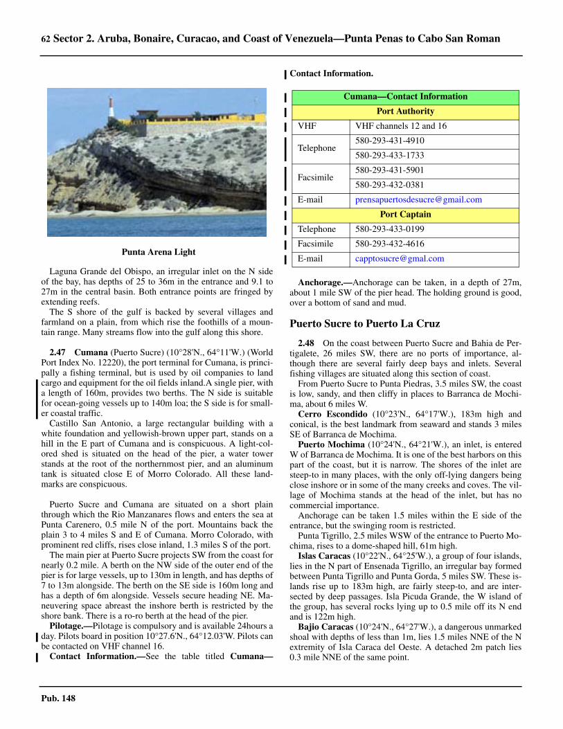
62 Sector 2. Aruba, Bonaire, Curacao, and Coast of Venezuela—Punta Penas to Cabo San Roman
Pub. 148
2.46 Laguna Grande del Obispo, an irregular inlet on the N sideof the bay, has depths of 25 to 36m in the entrance and 9.1 to27m in the central basin. Both entrance points are fringed byextending reefs.2.46 The S shore of the gulf is backed by several villages andfarmland on a plain, from which rise the foothills of a moun-tain range. Many streams flow into the gulf along this shore.
2.47 Cumana (Puerto Sucre) (10°28'N., 64°11'W.) (WorldPort Index No. 12220), the port terminal for Cumana, is princi-pally a fishing terminal, but is used by oil companies to landcargo and equipment for the oil fields inland.A single pier, witha length of 160m, provides two berths. The N side is suitablefor ocean-going vessels up to 140m loa; the S side is for small-er coastal traffic. 2.47 Castillo San Antonio, a large rectangular building with awhite foundation and yellowish-brown upper part, stands on ahill in the E part of Cumana and is conspicuous. A light-col-ored shed is situated on the head of the pier, a water towerstands at the root of the northernmost pier, and an aluminumtank is situated close E of Morro Colorado. All these land-marks are conspicuous.
2.47 Puerto Sucre and Cumana are situated on a short plainthrough which the Rio Manzanares flows and enters the sea atPunta Carenero, 0.5 mile N of the port. Mountains back theplain 3 to 4 miles S and E of Cumana. Morro Colorado, withprominent red cliffs, rises close inland, 1.3 miles S of the port.2.47 The main pier at Puerto Sucre projects SW from the coast fornearly 0.2 mile. A berth on the NW side of the outer end of thepier is for large vessels, up to 130m in length, and has depths of7 to 13m alongside. The berth on the SE side is 160m long andhas a depth of 6m alongside. Vessels secure heading NE. Ma-neuvering space abreast the inshore berth is restricted by theshore bank. There is a ro-ro berth at the head of the pier.2.47 Pilotage.—Pilotage is compulsory and is available 24hours aday. Pilots board in position 10°27.6'N., 64°12.03'W. Pilots canbe contacted on VHF channel 16. 2.47 Contact Information.—See the table titled Cumana—
Contact Information.
2.47 Anchorage.—Anchorage can be taken, in a depth of 27m,about 1 mile SW of the pier head. The holding ground is good,over a bottom of sand and mud.
Puerto Sucre to Puerto La Cruz
2.48 On the coast between Puerto Sucre and Bahia de Per-tigalete, 26 miles SW, there are no ports of importance, al-though there are several fairly deep bays and inlets. Severalfishing villages are situated along this section of coast.2.48 From Puerto Sucre to Punta Piedras, 3.5 miles SW, the coastis low, sandy, and then cliffy in places to Barranca de Mochi-ma, about 6 miles W.2.48 Cerro Escondido (10°23'N., 64°17'W.), 183m high andconical, is the best landmark from seaward and stands 3 milesSE of Barranca de Mochima.2.48 Puerto Mochima (10°24'N., 64°21'W.), an inlet, is enteredW of Barranca de Mochima. It is one of the best harbors on thispart of the coast, but it is narrow. The shores of the inlet aresteep-to in many places, with the only off-lying dangers beingclose inshore or in some of the many creeks and coves. The vil-lage of Mochima stands at the head of the inlet, but has nocommercial importance.2.48 Anchorage can be taken 1.5 miles within the E side of theentrance, but the swinging room is restricted.2.48 Punta Tigrillo, 2.5 miles WSW of the entrance to Puerto Mo-chima, rises to a dome-shaped hill, 61m high.2.48 Islas Caracas (10°22'N., 64°25'W.), a group of four islands,lies in the N part of Ensenada Tigrillo, an irregular bay formedbetween Punta Tigrillo and Punta Gorda, 5 miles SW. These is-lands rise up to 183m high, are fairly steep-to, and are inter-sected by deep passages. Isla Picuda Grande, the W island ofthe group, has several rocks lying up to 0.5 mile off its N endand is 122m high.2.48 Bajio Caracas (10°24'N., 64°27'W.), a dangerous unmarkedshoal with depths of less than 1m, lies 1.5 miles NNE of the Nextremity of Isla Caraca del Oeste. A detached 2m patch lies0.3 mile NNE of the same point.
2.46Punta Arena Light
Cumana—Contact Information
Port Authority
VHF VHF channels 12 and 16
Telephone580-293-431-4910
580-293-433-1733
Facsimile580-293-431-5901
580-293-432-0381
E-mail [email protected]
Port Captain
Telephone 580-293-433-0199
Facsimile 580-293-432-4616
E-mail [email protected]

Sector 2. Aruba, Bonaire, Curacao, and Coast of Venezuela—Punta Penas to Cabo San Roman 63
Pub. 148
2.49 Golfo de Santa Fe (10°18'N., 64°26'W.) is enteredbetween a point, located 1 mile S of Punta Gorda (10°20'N.,64°28'W.), and Punta del Escarpado Rojo, a red-cliffed point 3miles SSE of Punta Gorda. The bay is generally clear of dan-gers and has depths of 36 to 73m. An above-water rock liesabout 1 mile SSE of the N entrance point.2.49 The N shore is barren except for cactus, whereas the S shoreis wooded and cliffy in places. The fishing village of Santa Festands on the W bank of a river, about 2 miles E of the S en-trance point.2.49 Bahia Cruz (10°16'N., 64°27'W.), the bight between Puntadel Escarpado Rojo and Punta Cruz, about 1 mile SSW, is clearof dangers up to 0.1 mile offshore, except for a shoal fringingthe former point. Good anchorage is provided.2.49 Ensenada Harapos (10°15'N., 64°29'W.), the bay betweenPunta Cruz and Punta Comona, about 4.5 miles W, is generallyclear except for a shoal that extends about 0.4 mile offshore,1.8 miles E of the latter point. 2.49 Islas Harapos (10°16'N., 64°29'W.), two narrow islets about12m high, lie 0.8 mile W of Punta Cruz. A 7.5m shoal patchlies 0.3 mile ENE of the E extremity of the easternmost island.The passage leading between this patch and Punta Cruz isabout 0.3 mile wide and has a depth of 51m.2.49 Two above-water rocks lie 0.2 mile off the W end of the Wisland of Islas Harapos. Depths of less than 18m extend up to0.4 mile W of this island. Foul ground, which joins the two is-lands, extends 0.2 mile S from an above-water rock lying be-tween them.2.49 Shoal patches, with depths of 0.9m and 2.3m, lie 0.2 mile Sand about 0.3 mile WSW, respectively, of the W extremity ofthe easternmost island.2.49 Bahia de Comona (10°15'N., 64°32'W.), deep and clear ofdangers, is entered between Punta Comona and Punta Pertiga-lete, 0.8 mile W. A saddle-backed mountain, 1,030m high, rises2.5 miles inland of this bay.2.49 Caution.—Dangerous shoals lie 1.3 miles NE and 0.9 mileE of Punta Comona.
2.50 Isla Picuda Chica (10°18'N., 64°34'W.), marked by alight, lies in the approach to Bahia de Pertigalete, about 3.5miles NNW of Punta Pertigalete, and can be identified by itsreddish color. Isla Cachicamo lies 1 mile SE of this island andis small in extent. Isla Quirica, 32m high, lies 1 mile SW of IslaPicuda Chica and has a below-water rock located close NW ofit.2.50 Isla Chimana Chica, the E island of the Islas Chimana,which extends a little over 6 miles W, stands about 0.3 mile Wof Isla Quirica. A dangerous rocky ledge, with some rocksawash, extends 0.5 mile NNE from Chimana Chica.2.50 Isla Chimana Segunda, 114m high in its central part, liesclose W of Chimana Chica. A dark rock lies on a ledge extend-ing 0.2 mile W from the W end of this island. The passage ly-ing W of this rock has a least depth of 12.8m over a least widthof 0.3 mile; it is seldom used and then only by small vessels. Acharted Danger Zone between Isla Chimana Segunda and IslaChimana Chica should be avoided because of the shoals it en-compasses.2.50 Isla Monos (10°16'N., 64°33'W.), 191m high, lies close N ofPunta Pertigalete. Isla Tiguitigue, a small islet, lies close N ofIsla Monos. A detached 9.8m patch lies about 0.8 mile SW of
the islet.2.50 Bahia de Pertigalete (10°15'N., 64°34'W.) is the site of anoil-loading terminal and a cement-exporting facility. Islas dePlata, three in number, lie in the W part of the bay on a shoalspit which extends about 0.8 mile E from the W shore. Otherislets border the W end of the S shore. For berthing informa-tion see the table titled Pertigalete—Berth Information
2.51 Pamatacual (10°14'N., 64°34'W.) (World Port IndexNo. 12210) has an offshore mooring site and a oil-loading pierwhich extends 213m NNE from the S shore of the bay.2.51 Depths—Limitations.—The pier is 114m long and has adepth of 10m alongside. An oil pipeline lies parallel to thispier, about 135m to the W. Its seaward end is marked by abuoy. Vessels berth heading NE with both anchors out and thestern secured to mooring buoys. Tankers up to 244m in lengthand 15.2m draft can be accommodated.2.51 A narrow buoyed channel lies on the W side of the bay andto the W of the shoal spit with the Islas de Plata located on it.This channel should not be used without local knowledge.2.51 A large pier extends from the shore in the SE part of the bayabout 0.5 mile SE of the E end of Islas de Plata. A cement-loading berth is situated N of the pier and has mooring buoyslying off each side. The berth is 158m long and has a depth of11.9m alongside. It can accommodate vessels up to 150m inlength. A T-head pier extends from the northernmost islet ofthose bordering the W end of the S shore of the bay.2.51 Aspect.—A tower, 46m high, stands on a hill, with an eleva-tion of 457m, about 2.5 miles SSW of Punta Pertigalete.2.51 Pilotage.—A pilot must be embarked at Puerto La Cruz.Vessels are berthed during daylight hours only.2.51 Directions.—A vessel entering the bay should do so on aSW course, keeping midway between the E entrance point andIslas de Plata. When entering from the W, Punta Guanta shouldbe given a berth of at least 0.2 mile, and a vessel should passabout that distance E of the Islas de Plata.
2.52 Guanta (10°15'N., 64°35'W.) (World Port Index No.12200) lies within Bahia Guanta and is the major general cargofacility for the E part of Venezuela. The bay provides a naturalsheltered harbor with berthing facilities situated along the Sshore.2.52 Winds—Weather.—The winds are generally from the NE,but vessels are cautioned that S winds may be experiencedfrom June to September. Within the harbor, swells do not affectcargo operations.2.52 Tides—Currents.—Currents within the bay are negligible;the tidal rise is about 0.4m.2.52 Depths—Limitations.—The entrance channel leads S be-
Pertigalete—Berth Information
Berth Length Depth Remarks
No. 1 96m 2.4m General cargo
No. 2 149m 7.8m General cargo
No. 3 149m 7.8m General cargo
No. 4 70m 3.2m Ro-ro
No. 5 153m 10.9m General cargo

64 Sector 2. Aruba, Bonaire, Curacao, and Coast of Venezuela—Punta Penas to Cabo San Roman
Pub. 148
tween Isla Pitahaya, on the W side, and Round Island (Isla Re-donda), on the E side, and is about 180m wide. Lights markboth entrance islands. Reefs and rocks lie on the W side of theentrance channel and extend about 0.2 mile S from Isla Pitaha-ya. 2.52 The E side of the channel between Round Island and PuntaQueque, about 0.4 mile S, is fouled by a reef with some isletson it. Reefs encumber the SW part of the bay.2.52 For berthing information see the table titled Guanta—BerthInformation.2.52 Pilotage.—Pilotage is compulsory. Pilots embark at PuertoLa Cruz, 1 mile offshore, but are available during daylighthours only. An ETA should be sent 48 hours and 24 hours inadvance to “Meneven Puerto La Cruz” by VHF. Berthing iscarried out during daylight only, but departure can be arrangedfor any time.2.52 Anchorage.—Anchorage for Guanta is available in Bahia dePozuelos. Vessels awaiting a pilot or berth may anchor, indepths of 14 to 24m, protected, within the bay. There are nosize limitations for the anchorage.
2.53 Isla Chimana Grande (10°18'N., 64°40'W.) is thelargest of a group of rocky islands extending a little over 12miles W from the W extremity of Isla Cachicamo. Its coastsare precipitous, except at landslides on the N side and at sandybeaches at the heads of coves on the S side. Isla Chimana delSur lies 0.3 mile S of the E extremity of Isla Chimana Grande.Its SW end is formed by a bold headland, 95m high, which ter-minates in Punta Baregan, the SW extremity.2.53 Isla Chimana del Oeste (10°18'N., 64°41'W.) is joined tothe NW end of Isla Chimana Grande by a shallow bank on themiddle of which there is an islet.2.53 Morro Pelotas is a dark-colored islet lying 0.1 mile NW ofIsla Chimana del Oeste; a light is shown from the summit ofthe islet.2.53 Cayo Borracha (10°18'N., 64°45'W.), located 2.5 miles Wof Morro Pelotas, is rocky, precipitous, and almost withoutvegetation. The island, 376m high, is easily identified fromseaward and can be seen at a great distance. A light with aracon is located at the summit of the island.2.53 A W set, with a rate of 0.8 knot, has been reported (1994) tooccur off the N end of the island.2.53 Two islets lie on a shallow bank extending nearly 1 mile Wfrom the NW side of Cayo Borracha.2.53 A rock, with a depth of 2m or less, lies about 0.5 mile SW ofthe SW extremity of El Borracho (10°16'N., 64°45'W.).
2.53 Los Borrachitos, lying 1 mile SW of El Borracho, are steep-to on their SW sides.
Puerto La Cruz (10°14'N., 64°38'W.)
World Port Index No. 12185
2.54 The Puerto La Cruz area consists of the Los Cocosterminals, on the SE shore of Bahia de Pozuelos, and theGuaraguao and El Chaure terminals at Bahia Bergantin. Theseterminals form the outlet for the second most important petro-leum center of Venezuela. The Los Cocos terminals are distri-bution centers for coastal needs. The Guaraguao and El Chaureterminals are operated by the Mene Grande Oil Company andthe Sinclair Oil Company, respectively. The former companyacts as agent for several large oil firms and manages the largestterminal which has general cargo berths in addition to berthsfor large tankers.2.54 Depths—Limitations.—The main entrance channel lead-ing into Bahia de Pozuelos leads S between Morro Pelotas andCayo Borracha and must be used by all deep-draft vessels. Thischannel is 2 miles wide, clear of all dangers, and has depths of18.3 to 54.9m in the fairway. Depths in the roadstead within thebay range from 9.1 to 36.6m.
2.54 The entrance fairway into Bahia Bergantin leads E betweenIsla Burro (10°15'N., 64°38'W.) and the berthing facilities tothe S. This channel is clear of dangers, except for a detached8.7m patch on the S side of the fairway, about 0.3 mile SW ofIsla Burro. Shoal depths extend about 115m S from Isla Burro,and depths of 9.1 to 11m extend almost 0.5 mile WNW fromthe W end of the Guaraguao cargo wharf. The reefs withinBahia Bergantin are clearly visible during the day time and aremarked by aids. Vessels moor starboard side-to in BahiaBergantin.
Guaraguao (10°14'N., 64°38'W.), situated in the SW part ofBahia Bergantin, consists of oil berths and the cargo berth ofPuerto La Cruz. 2.54 Berth No. 1 to Berth No. 3, numbered from the W, extendalong a wharf.2.54 Berth No. 4 and Berth No. 5, situated close E of the wharf,are formed by a T-headed pier, with mooring dolphins spacedon each side of the pier head. 2.54 A wharf for general cargo is situated between PuntaGuaraguao and the oil loading wharf. It is 207m long and has adepth of 7.6m alongside.
Guanta—Berth Information
Berth Length DepthMaximum Vessel
RemarksLOA Draft
M3 160m — 160m 9.8m Ro-ro/lo-lo, containers, and breakbulk.
M4 160m — 160m 10.0m Containers and breakbulk.
M5 200m — 200m 10.3m Ro-ro/ lo-lo, containers, and breakbulk.
M6 200m — 200m 10.6m Ro-ro/ lo-lo, containers, and breakbulk.
Note.—The facility has a continuous berthing length of 720m.

Sector 2. Aruba, Bonaire, Curacao, and Coast of Venezuela—Punta Penas to Cabo San Roman 65
Pub. 148
2.54 El Chaure (10°15'N., 64°37'W.), a terminal in the SE part ofthe bay, is considered to be Berth No. 6 of Puerto La Cruz. Itconsists of a wharf, 30m long, with mooring dolphins on eachside. Vessels up to 60,000 dwt and 12.1m draft can be handledhere. The use of tugs is mandatory.2.54 A pier at Los Cocos (10°13'N., 64°39'W.) extends 168mfrom the shore at the SW end of Puerto La Cruz and serves asan oil terminal. Its outer end is 15m long, with a depth of 8malongside. Two clusters of dolphins stand parallel to and on ei-ther side of the pier head.
2.54 A ferry pier, situated close E of the oil pier, extends 120moffshore and has depths up to 3.7m alongside.
2.54 Aspect.—The adjacent islands, which lie in the approaches,are all moderately-high and rocky with sparse vegetation. Theradio towers situated 4 miles SW and 3 miles S of the town ofPuerto La Cruz are prominent. Cayo Borracha (10°18'N.,64°45'W.) and the lighthouse on the summit of Morro Pelotas,2 miles E, may be easily identified. Within Bahia de Pozuelos,the cranes and control tower at the Guaranguao Terminal areprominent as well as the oil tanks standing about 0.8 mile NEof Puerto La Cruz.2.54 Pilotage.—Pilotage is compulsory. An ETA should be given
72 hours, 48 hours, and 24 hours in advance to “CorpovenPuerto La Cruz” through Puerto La Guaira coast radio station.Pilots board in a position that is established with the port cap-tain.2.54 Contact Information.—See the table titled Puerto LaCruz—Contact Information.
2.54 Anchorage.—Anchorage can be taken, in depths of 14 to22m, within Bahia de Pozuelos, W and WNW of Isla Burro.The anchorage areas may best be seen on the chart. Ananchorage area also lies about 3.5 miles W of El Morro deBarcelona.2.54 Directions.—The channels on each side of Isla Burro can beused, but the normal entrance for vessels with drafts less than9.1m is through the S channel. It is reported (2019) all vesselsleaving Bahía de Bergantin must use the channel NE of IslaBurro. The current is negligible, but wind strength in theafternoon and evening should be considered. The NE channelis used by vessels with drafts of 9.1m and greater. Such vesselsshould enter by steering a SSE course to pass midway betweenthe charted aids.2.54 Caution.—Submarine cables are laid across the N entranceto Bahia de Pozuelos
Puerto La Cruz to Cabo Codera
2.55 The coast from Puerto La Cruz extends 3.2 milesWSW to a small spit located 0.5 mile W of the village of LaLecheria. 2.55 Bahia de Barcelona is entered between Morro de Barcelonaand Punta Chacopata, 15 miles WSW. Between the low sandyshore of the bay and the foothills inland there are extensive saltflats.
Puerto La Cruz—Oil Berth Information
BerthMaximum Vessel
LOA Draft Beam Size
No. 1 182m 11.5m 30.4m 50,000 dwt
No. 1 228m 11.5m 30.4m 50,000 dwt
No. 2 198m 11.5m 30.4m 50,000 dwt
No. 2 228m 11.5m 30.4m 50,000 dwt
No. 3 182m 11.5m 36.5m 45,000 dwt
No. 3 213m 11.5m 36.5m 45,000 dwt
No. 4 280m 16.7m 49.0m 120,000 dwt
No. 5 280m 16.7m 49.0m 120,000 dwt
No. 6 243m 12.1m 36.5m 58,000 dwt
No. 7 289m 15.5m 49.0m 120,000 dwt
Note.—The loa limitations apply if tankers are dockedsimultaneously at adjacent Berths No. 1, No. 2, and No.3. The maximum loa is permitted if the adjacent berth isunoccupied. The maximum dwt is only a guideline; ifthe vessel exceeds it, other restrictions should be strictlycomplied with.
Puerto La Cruz—Contact Information
Port
VHF VHF channel 16
RT Frequency 2182 kHz or 7765 kHz
Telephone 58-281-267-7452
Facsimile 58-281-267-7939
Port Captain
Telephone
58-281-267-7932
58-281-267-7452
58-281-263-0194
E-mail [email protected]
Puerto Jose (Jose Terminal)—Berthing Information
Berth Length DepthMaximum Vessel
RemarksLOA Draft
Petrozuata Solids Terminal
Solids Handing Berth — 13.8m 254m 11.8m Petcoke. Berthing length of 275m (including dol-phins). Maximum beam of 36m.

66 Sector 2. Aruba, Bonaire, Curacao, and Coast of Venezuela—Punta Penas to Cabo San Roman
Pub. 148
2.55 Morro de Barcelona (10°13'N., 64°43'W.), located about 4miles W of Puerto La Cruz, is rocky, 157m high, and heavilycovered with cactus. Several radio towers stand near the coastbetween these points.2.55 The town of Barcelona stands on the SW bank of the RioNeveri, about 4.5 miles S of Morro de Barcelona.
2.55 The coast between Morro de Barcelona and the mouth of theRio Uchire is bordered by depths of 11m and less which extendbetween 1 mile and 2.5 miles offshore in places. The W half ofthis section of coast is bordered by shallow lagoons fronted bynarrow strips of sandy beach.
2.56 Puerto Jose (Jose Terminal) (10°06'N., 64°51'W.)(World Port Index No. 12180) is situated at the W end of Bahiade Barcelona. It is a terminal for loading refined petroleumproducts.2.56 Depths—Limitations.—The approach channel is 150mwide, with a minimum depth of 13.6m.2.56 An SPM buoy, connected to storage tanks on shore by a sub-marine pipeline, is situated 1.8 miles NNE of Fairway LightedBuoy. For berthing information see the table titled Puerto Jose(Jose Terminal)—Berthing information.2.56 Aspect.—Fairway Lighted Buoy is moored 1.2 miles NNEof the terminal.
2.56 Pilotage.—Pilotage is compulsory. The pilots and the termi-nal may be contacted on VHF channels 12 and 16. Pilots preferdocking during daylight hours only.2.56 For pilot boarding locations see the table title Puerto Jose—Pilot Boarding Locations.
2.56 Regulations.—An ETA should be sent 7 days, 72 hours, 48hours, and 24 hours in advance. Contact with the terminal mustbe established at least 4 hours prior to arrival, confirming theETA or providing any changes.2.56 Maximum-sized vessels are only berthed during daylighthours and in wind speeds of less than Force 7.
Pequiven Petrochemical Terminal
Fertinitro (East) 41m 14.0m 255m 13.5m Chemical gases and LPG. Berthing length of 320m (including dolphins).
Fertinitro (West) 41m 14.0m 255m 13.5m Chemical gases and LPG. Berthing length of 320m (including dolphins).
Pequiven (East) 217m — — 12.4m —
Pequiven (West) 217m — — 12.4m Berthing length of 312m (including dolphins).
Sincor Petcoke Berth 10m — — — Petcoke and others. Berthing length of 250m (in-cluding dolphins).
BITOR SA SBM
BITOR SBM — 29.0m 280m 22.4m Crude and dirty products.
Complejo Criogenico de Oriente Jose
Berth 8 270m 13.8m 228m 12.6m Clean products, LPG, butane, iso-butane. propane, mogas, and pentane.
Berth 9 41m 13.8m 228m 12.6m Petroleum products. Continuous berthing length of 320m.
Petroterminal Jose Platform (TAEJ)
East Crude Berth 335m 24.9m 350m 22.8m Crude.
South — 22.0m 289m 20.0m Crude.
West Crude Berth 335m 24.9m 350m 22.8m Crude.
Petrozuata Jose SBM
Petrozuata Jose SBM — 25.0m 230m 22.0m Crude and dirty products.
Puerto Jose (Jose Terminal)—Berthing Information
Berth Length DepthMaximum Vessel
RemarksLOA Draft
Puerto Jose—Pilot Boarding Locations
10°09.2'N, 64°50.1'W
10°07.5'N, 64°50.5'W
10°08.8'N, 64°51.5''W
Puerto Jose—Contact Information
Jose Bitor SPM
VHF VHF channels 12 and 16

Sector 2. Aruba, Bonaire, Curacao, and Coast of Venezuela—Punta Penas to Cabo San Roman 67
Pub. 148
2.56 Contact Information.—See the table titled Puerto Jose—Contact Information.2.56 Anchorage.—Anchorage may be obtained in the W part ofBahia de Pozuelos. The bay is well-sheltered with goodholding ground, mud and sand bottom.2.56 Directions.—A Vessel Traffic System has been establishedin the navigable waters between Bergantin Bay and JoseTerminal. The service will advise vessels of safety hazards,traffic recommendations, and environmental regulations ineffect.2.56 Caution.—It is advised to use extreme caution when navi-gating this area as there are many unlit moorings, unlit con-struction equipment and other obstructions.
2.57 Islas Piritu (10°10'N., 64°57'W.), two in number, arelow and sandy. They lie 13 miles WSW of Morro de Barcelo-na. The narrow channel lying between the islands has a leastdepth of 9.1m, but should not be attempted without localknowledge.2.57 A light is shown from the W extremity of the W island. Thepassage lying between these islands and the coast is about 1.3miles wide at its narrowest part and is clear in mid-channel, ex-cept for an 8.5m shoal which lies about 1.3 miles S of the E ex-tremity of the E island.2.57 Puerto Piritu (10°04'N., 65°02'W.), a small fishing portavailable only to small craft, is situated on the coast about 7.5miles SW of Islas Piritu.2.57 Cerro Unare (10°05'N., 65°15'W.), 579m high, stands nearthe coast about 12.5 miles W of Puerto Piritu. From any dis-tance, this prominent peak appears as an isolated promontorybecause of the low coast in the vicinity.2.57 The coast between the Rio Uchire and the Rio Curiepe,about 45 miles NW, is generally low and swampy, but backed
by high hills inland. Laguna de Tacarigua, a shallow lagoon,lies about midway along this stretch of coast. The small townof Rio Chico stands a few miles NW of the W end of this la-goon, and the town of Higuerote is situated 12 miles fartherNW. A spit, with a depth of 4m at its outer end, extends about 1mile NE from this latter town. A drying rock stands on this spitabout 0.5 mile offshore. 2.57 Anchorage can be taken, in a depth of 10m, about 1 mile Eof the town. During daylight hours, the spit and the rock areclearly visible.
2.58 Puerto Carenero (10°32'N., 66°07'W.), situated 4miles NNW of Higuerote, consists of a small town fronted by ashallow harbor. The berthing facilities are available only tosmall vessels of shallow draft.2.58 Anchorage can be taken, in a depth of 9m, mud, about 0.4mile SW of the E entrance point of the harbor.2.58 Cabo Codera (10°35'N., 66°03'W.), a prominent steep-toheadland, is 264m high and marked by a light.2.58 Farallon Centinela (10°49'N., 66°05'W.) lies about 14miles N of Cabo Codera and was previously described in para-graph 2.5.
Cabo Codera to Puerto La Guaira
2.59 Between Cabo Codera and Puerto La Guaira, 52 milesW, the coast is generally bold, rocky, and marked by a few pro-jecting salient points that are prominent. Rocks fringe this sec-tion of coast, but most lie close offshore. The outermost dangeris a breaking rock which lies 1 mile E of Punta Masparro(10°39'N., 66°14'W.).2.59 Ensenada de Corsarios (10°35'N., 66°04'W.), a small openbay entered close W of Cabo Codera, provides anchorage, in adepth of 12m, about 0.4 mile offshore, SW of Punta El Morro,the NW extremity of the cape. The W shore of the bay is front-ed by foul ground.
Telephone
580-281-260-7314 (office)
580-281-260-4301 (office)
580-281-260-5557 (Platform Control Room)
Jose Gas Terminal
Facsimile 580-281-260-3099
Jose Petroterminal
VHF VHF channels 10, 14, and 16
Telephone580-281-260-7575
580-281-260-7576
Facsimile580-281-260-7325
580-281-260-7509
Jose Petrozuala SPM
VHF VHF channels 9 and 16
Telephone 580-281-262-7654
Facsimile 580-281-262-7504
E-mail [email protected]
Puerto Jose—Contact Information
2.59Cabo Codera Light

68 Sector 2. Aruba, Bonaire, Curacao, and Coast of Venezuela—Punta Penas to Cabo San Roman
Pub. 148
2.59 Bahia Chuspa (10°37'N., 66°20'W.), an open bay foularound its shores, lies 16.5 miles W of Cabo Codera. The lightsin the village of Chuspa, in the SE part of the bay, form a goodlandmark at night.2.59 Banco Sabana, a detached shoal with a least depth of 6m,lies in the entrance to this bay, about 3.5 miles WNW of thevillage of Chuspa.2.59 Anchorage can be taken 0.5 mile offshore in the vicinity ofPunta Chuspa, the E entrance point to Bahia Chuspa, but theholding ground is only fair. 2.59 A light is located on the coast 2 miles W of the village ofCaruao. 2.59 Punta Naiguata (10°37'N., 66°45'W.) is the first prominentpoint W of Bahia Chuspa. A village stands on high red bluffswithin and somewhat E of the point. A coconut plantation situ-ated near the point is prominent.2.59 A light is shown 0.5 mile SW of Punta Naiguata; however, ithas been reported to be of low visibility and almost obscuredby shore lights.
Punta Caraballeda (10°37'N., 66°51'W.) can be identifiedby a palm grove and a plantation with two chimneys. The Echimney can be seen from up to 10 miles offshore. Cerro Naig-uata, 2,765m high, stands 5.6 miles SSE of the point and is themost prominent peak along this coast.
La Guaira (10°37'N., 66°56'W.)
World Port Index No. 12150
2.60 Puerto La Guaira, an artificial harbor protected bybreakwaters, is the principal port of Venezuela and the seaportfor Caracas, the capital of the country. The harbor is shelteredby a N breakwater, 0.8 mile long. There are depths of 12 to
19m at the entrance to the harbor. There are a total of 27 berthsin the port. The main commercial quays have depths of 5.5 to11m alongside. 2.60 Winds—Weather.—The prevailing winds are the NE trades,which blow with great regularity from February to June. Calmsand W winds frequently occur from July to October.
2.60 Usually, once or twice a year during the autumn months,Calderetas, which are hot, sharp blasts from the mountains,have sufficient force to be dangerous to vessels not secured inthe harbor. These winds are not of long duration.2.60 Although Puerto La Guaira lies S of the hurricane belt, theeffects of these tropical storms are occasionally felt in the har-bor. During the hurricane season, vessels should be prepared toget underway on short notice.2.60 Tides—Currents.—The diurnal range at springs is about0.3m. The currents in the offing set to the W and near the coastare weak, seldom exceeding a rate of 0.3 knot. An inshorecountercurrent may be experienced during the prevalence of
2.59Farallon Centinela Light
2.60 La Guaira
2.60Puerto La Guaira North Breakwater Light

Sector 2. Aruba, Bonaire, Curacao, and Coast of Venezuela—Punta Penas to Cabo San Roman 69
Pub. 148
calms and variable winds, especially during the autumnmonths, and may attain a rate of 2.5 knots.2.60 Heavy and dangerous seas are experienced from October toMarch and result from strong gales in the Atlantic Ocean or theCaribbean Sea. They take the form of heavy ground swells,and, in the most severe cases, of long rollers usually coming ingroups of three or four at infrequent intervals. These rollershave enormous force and destructive power and can cause greatdamage. The rollers at times begin to show in depths of 12m inlines about 2 miles long, gradually rising as they approach thecoast. It has been reported that at Puerto La Guaira, a heavyground swell of a dangerous nature is almost always precededby calms or variable winds. During the rollers, there is a con-siderable scend in the harbor.2.60 Depths—Limitations.—In the roadstead outside the en-trance, there are general depths of 12 to 36m, decreasing todepths of 11 to 14.6m between the breakwater heads. There aredepths of 8 to 16.3m over the greater part of the harbor.2.60 The berthing facilities are situated on the S side of the innerpart of N breakwater and around the entire perimeter of theharbor. They are numbered in a clockwise direction. Port facil-ities at La Guaira have been expanded on the S side of theNorth (extended) Breakwater. Additional berths are providedalongside the East Pier and the West Pier, which project intothe harbor. All of the berths have dredged depths of 10.7malongside, with the exception of the berths situated in the E endof the harbor, where the depths may be less because of silting.It was reported that shoal patches, with depths of 9.1m, existalongside most of those piers. Also, as a result of constructionalong the S side of the North Breakwater, depths of less than6.1m exist within 60m of the breakwater.2.60 The old oil pier on the inner side of the West Breakwater isfor the exclusive use of naval vessels.Within the harbor, there isa turning basin with a diameter of 402m. For berthing informa-tion the table titled La Guaira—Berth Information.2.60 Vessels are required to use tugs for berthing and unberthing.
2.60Puerto La Guaira (aerial view)
2.60La Guaira Berthing Locations
La Guaira—Berth Information
Berth Length Depth Remarks
North Terminal
No. 1 160m 12.0m General cargo, containers, and ro-ro.
No. 2 177m 12.0m General cargo and containers.
No. 3 177m 12.0m General cargo and containers.
No. 4 177m 12.0m General cargo and containers.
No. 5 177m 12.0m General cargo and containers.
No. 6 237m 11.0m General cargo and containers.
No. 7 237m 11.0m Grain and general cargo.
No. 8 115m 11.0m Grain and general cargo.
No. 9 161m 6.0m Coastal trade and general cargo.
No. 10 161m 10.0m Coastal trade and general cargo.
Raymond Terminal
No. 11 137m 10.0m Coastal trade and general cargo.

70 Sector 2. Aruba, Bonaire, Curacao, and Coast of Venezuela—Punta Penas to Cabo San Roman
Pub. 148
2.60 Aspect.—A vessel approaching from the N will first sightthe high mountains in the interior in the vicinity of Caracas. Pi-co Avila, 3.5 miles SSE of Puerto La Guaira, has a distinctivetip at its summit.2.60 A cylindrical building standing close E of Pico Avila is con-spicuous from seaward. At night, the obstruction lights on thisbuilding are a good mark.2.60 On closer approach, several landmarks are readily identifi-able and are positioned from the root of the N breakwater, asfollows:
1. A grain elevator close E2. Three stacks, the E of which is situated 0.3 mile E3. A long stone building of fortress-type construction
situated about 0.3 mile SSE.2.60 There are numerous other prominent buildings in the city. Atnight, the lights of cars descending down the mountain behindthe city can be seen from a considerable distance to seaward.2.60 Pilotage.—Pilotage is compulsory and available from 0600to 2400. Pilots board in position 10°37.2'N, 66°57.8'W; posi-tion 10°35.3'N, 67°04.7'W; or position 10°35.1'N, 67°04.9'Wfor Conjuno Generador Josefa Sanchez Bastidas.2.60 Regulations.—An ETA must be sent 72 hours, 48 hours, and24 hours before arrival. Changes of 6 hours in ETA should bepromptly reported. 2.60 Signals.—A signal station is situated at El Vigia (10°36'N.,66°56'W.) and communicates with vessels by the InternationalCode of Signals.2.60 Contact Information.—See the table titled La Guaira—Contact Information.2.60 Anchorage.—The anchorage area off Puerto La Guaira is
centered 1.5 miles NE of the head of North Mole. The area isbest seen on the chart. It is exposed from the W through N to E,but is generally considered safe except in winter, the season ofrollers. The anchorages should be used only temporarily.
2.60 Vessels carrying dangerous cargoes should anchor in a re-stricted area centered about 1.25 miles at the NNW Punta Mu-latos. Quarantine anchorage lies E of the main anchorage,centered about 2 miles NNW of Punta Mulatos.
2.60 Caution.—Due to submarine cables, which may best beseen on the chart, anchoring and fishing are prohibited in an ar-ea, about 0.5 mile wide, extending 2.5 miles NNE of Punta
No. 12 137m 10.0m Coastal trade and general cargo.
No. 13 132m 10.0m Coastal trade and general cargo.
No. 14 152m 10.0m Coastal trade and general cargo.
Sur Terminal
No. 15 152m 10.0m Coastal trade and general cargo.
No. 16 152m 10.0m General cargo.
No. 17 152m 10.0m General cargo.
No. 18 152m 10.0m General cargo.
No. 19 152m 10.0m General cargo.
Maritime Terminal
No. 20 39m 10m General cargo and passengers.
No. 21 160m 10m Passengers, cruise vessels, and ro-ro.
No. 22 215m 10m Passengers and cruise vessels.
No. 23 215m 10.0m Passengers.
No. 24 160m 10.0m Passengers.
Container Terminal
No. 1 345m 10.0m Containers.
No. 2 345m 10.0m Containers.
La Guaira—Berth Information
Berth Length Depth Remarks
La Guaira—Contact Information
Port
Call sign La Guaira
VHF VHF channels 12 and16
Port Captain
Telephone
58-212-332-3115
58-212-332-0051
58-0212-332-6148
E-mail [email protected]
Pilots
Telephone 58-212-351-4911

Sector 2. Aruba, Bonaire, Curacao, and Coast of Venezuela—Punta Penas to Cabo San Roman 71
Pub. 148
Mulatos. 2.60 Numerous fishing boats may be encountered in the ap-proaches to La Guaira. Many are not lighted and only displaytheir lights upon the approach of another vessel.
Puerto La Guaira to Puerto Cabello
2.61 Cabo Blanco (10°37'N., 66°59'W.), located 2.5 milesW of Puerto La Guaira, is rocky, bold, and prominent. Severalradio towers stand on this cape. The cape has been reported tobe a poor radar target.2.61 Punta Calera, located 2 miles W of Cabo Blanco, is flat, rela-tively low, and can be identified by a cane plantation situatedclose inshore of it.
2.61 Catia De La Mar (10°36'N., 67°02'W.) (World Port IndexNo. 12145), a village, is situated 1.3 miles SW of Punta Caleraand has a T-head jetty extending 300m NNW from the shore.The head of this jetty has a depth up to 7m alongside. A con-spicuous house stands E of the jetty and a flat tableland risesbehind the village. A tank farm stands SW of the root of thebreakwater and four cement silos stand near the root of the jet-ty.2.61 Three offshore oil berths, marked by mooring buoys, lieabout 0,7 mile W and SW of the jetty.2.61 Contact Information.— The terminal can be contacted onVHF channel 12. Pilots can be contacted on VHF channel 16.2.61 Pilotage.—Pilotage is compulsory and available from 0600to 2400. Pilots board in position 10°37.2'N, 66°57.8'W; andposition 10°35.3'N, 67°04.7'W; or 10°35.1'N, 67°04.9'W forConjuno Generador Josefa Sanchez Bastidas.2.61 Vessels should contact the pilot 2 hours prior to arrival.
2.62 From Catia La Mar to Puerto La Cruz, 18.5 miles W,the coastal range stands farther inland and is not as high as theterrain to the E. A conspicuous power station stands near thecoast about 6.8 miles W of Catia La Mar. This power station isserved by an offshore oil terminal marked by five lightedbuoys.2.62 Puerto La Cruz (10°33'N., 67°21'W.), a small cove withmoderate depths, indents the coast only a short distance andhas no commercial value. This port should not be confusedwith the port of the same name which lies 165 miles E of Puer-to La Guaira.2.62 Morro Choroni (10°31'N., 67°36'W.) is a rounded headland
which can readily be distinguished from up to 10 miles off-shore. It appears detached from the lower land in the vicinityand rises to an elevation of 76m. La Mesa, a flat-topped peak,rises to an elevation of 2,240m, about 9.3 miles SSE of thepoint.2.62 Puerto de Ocumare (10°29'N., 67°46'W.), a small cove, hasa depth of 14.6m in the entrance decreasing to 7.3m about 0.3mile from its head. Pico Cucharonal, a prominent peak, is1,850m high and stands 9.8 miles SSW of the port.
Puerto Turiamo (10°27'N., 67°51'W.) is entered betweenPunta Turiamo and Punta Cambiador, about 1.3 miles W, andextends 2 miles S to its head.2.62 Caution.—Due to a naval base, the area around Isla Turiamois restricted and closed to general navigation. The RestrictedArea is best seen on the chart.
2.63 The coast from Puerto Turiamo to Puerto Cabello isrocky and bluffy to Punta El Penon, and then low and sandy toPunta Brava (10°30'N., 68°01'W.). Roca Lavendera (10°29'N.,67°54'W.), a dangerous rock, lies 0.2 mile NE of Punta Yapas-cua.2.63 Five islands lie within 1.3 miles of the coast between PuntaEl Penon and Punta Brava; they are Isla Larga, Isla Santo Do-mingo, Isla Alcatraz, Isla Raton, and Isla del Rey. All are ofsand and coral formation covered by scrub and grass.2.63 With the exception of Isla Raton, safe channels, with a leastdepth of 14.6m, exist in the passages between these islands.2.63 Isla Larga (10°29'N., 67°57'W.), the E and largest island,lies 1 mile NW of Punta El Penon.2.63 Good anchorage can be taken between this island and themainland, in depths of 18 to 22m, sand and mud, with the Wextremity of the island bearing 339°, distant 0.5 to 0.8 mile.Charted shoals and reefs encumber the SW approach to the is-land.2.63 Isla Alcatraz (10°30'N., 67°58'W.), the next largest islandand the N, lies 1.3 miles NW of Isla Larga. A large part of thisisland is occupied by a lagoon with its entrance at the NW end.A light and racon mark the SE entrance to the lagoon.2.63 A shoal, with a depth of 13m, lies 1 mile E of Isla Larga. An-other 13m shoal lies 0.5 mile S of Isla Alcatraz. A dangerouswreck lies 3 miles NW of Isla Alcatraz. 2.63 Caution.—Submarine cables, best seen on the chart, extendE and NE from the coast SE of Isla Raton. A ODAS buoy hasbeen reported (2009) to be positioned about 1 mile W of IslaAlcatraz.
2.64 Puerto Borburata (10°29'N., 67°59'W.) (World PortIndex No. 12130), a small cove, lies 1.5 miles E of Punta Bravaand is the site of an oil terminal. The fairway leading to the ter-minal is 135m wide with depths of 9.1 to 14.6m.2.64 The berthing facilities consist of a dolphin berth and a wharf.A lighted range leads in to the harbor. The berth can accommo-date tankers up to 180m in length and 9.4m draft. The smallwharf can accommodate tankers up to 122m in length and6.1m draft. It was reported (1987) that the wharf was not inuse. Vessels intending to use these facilities should obtain a pi-lot and clearance at Puerto Cabello. Pilotage is compulsory, butvessels must anchor 1 mile N of Punta Brava to await instruc-tions from the port authority.
Catia La Mar

72 Sector 2. Aruba, Bonaire, Curacao, and Coast of Venezuela—Punta Penas to Cabo San Roman
Pub. 148
Puerto Cabello (10°29'N., 68°00'W.)
World Port Index No. 12120
2.65 Puerto Cabello, the third ranking port of importancein Venezuela, provides facilities for the handling of generalcargo, containers, bulk cargo, and chemicals. It consists of anartificially-improved lagoon, with the commercial facilities inits outer part and a repair yard in its inner part.2.65 Due to many changes reported in the hydrography of the har-
bor, local knowledge is essential for entering.2.65 Ample alongside berthing facilities are available for allclasses of vessels.2.65 Depths—Limitations.—In the approach to the harbor, thedepths shoal gradually from 36m, about 3 miles NW of PuntaBrava, to 16.5m off the harbor entrance. 2.65 Bajo Larne, with a depth of 5.9m, lies 0.3 mile NE of IslaGoaigoaza W of the harbor entrance. This shoal breaks whenany sea is raised. Discolored water has been reported to occurabout 0.3 mile NW of Punta Brava.2.65 A dangerous wreck lies about 2.5 miles NNE of the lightshown on Islas Goaigoaza.
2.63Isla Alcatraz Light
2.64Fortin Solano
Puerto Cabello—Berth Information
Berth Length Depth Maximum Vessel
RemarksLOA Draft
Puerto Cabello Terminal
Pier A 25m — 125m 7.1m Chemicals. Berthing length of 217m (including dolphins).
Pier B 225m — 220m 11.4m Chemicals. Berthing length of 270m (including dolphins).
Pier C 225m — 220m 11.4m Berthing length of 270m (including dolphins).
Area 1
No. 1 137m 10.6m — — Passengers.
No. 2 137m 10.6m — — Passengers.
No. 3 200m 10.6m — — Passengers.
No. 4 131m 9.4m — — General cargo, dry bulk, and ro-ro.
No. 5 131m 9.4m — — General cargo, dry bulk, and ro-ro.
No. 6 131m 9.4m — — General cargo, dry bulk, ro-ro, and PPC.
No. 7 131m 9.4m — — General cargo, dry bulk, ro-ro, and PPC.
No. 8 170m 9.7m — — General cargo and dry bulk.
No. 9 170m 9.7m — — General cargo, dry bulk, and PPC.
No. 10 210m 10.0m — — General cargo and dry bulk.
No. 11 210m 10.0m — — General cargo and dry bulk.
Area 2
No. 12 260m 9.7m — — General cargo, containers, and reefer.

Sector 2. Aruba, Bonaire, Curacao, and Coast of Venezuela—Punta Penas to Cabo San Roman 73
Pub. 148
2.65 A tanker wharf called Venterminales S.A. extends about645m NE from shore about 0.4 mile SE of Islas Goaigoaza.Additional detailed information is available in the table titledPuerto Cabello—Berth Information.2.65 The 100m wide entrance channel, which leads W to E, has adredged depth of 9.1m. There are depths of 7 to 12.8m in theharbor.2.65 Vessels up to 35,000 gt, 230m in length, and 10m draft canenter the port.2.65 A concrete marginal wharf, 1,025m long, provides eightberths for vessels with drafts up to 10m and forms the N side ofthe outer harbor. A swinging basin, 0.3 mile wide, lies N of theE end of this wharf. There is another basin lying NE of theswinging basin with two piers at its head and a wharf on its Wside.2.65 A channel, at the E end of the concrete wharf, leads 0.2 mileS into a basin, which is dredged to a depth of 8.7m. The W side
of the channel (E pier) and the N side of the basin (S pier) arequayed, but depths are sufficient only for small vessels.2.65 From the SE corner of the swinging basin, a channel, 137mwide, leads to a dockyard. It is dredged to a depth of 11m. Onthe SW side of this channel is a bulk cargo wharf, 405m long,which can accommodate vessels with drafts up to 10.6m.2.65 A submarine pipeline for discharging petroleum products ex-tends about 0.3 mile N from the shore near a control station, alittle over 0.4 mile SW of the entrance to Puerto Cabello. Abuoy, moored close N of the seaward end of the pipeline, marksthe position for letting go the port anchor. Tankers up to 40,000dwt, 198m in length, and 10.4m draft can be handled at thisberth. A ro-ro berth is also available. Additional detailed infor-mation is available in the table titled Puerto Cabello—BerthInformation.2.65 Aspect.—The first landmark to be sighted will be Fortin So-lano, a fort-like structure situated on a high hill, about 1.3
No. 13 140m 9.4m — — Coastal trade, general cargo and livestock.
Area 4
No. 22 185m 11.2m — — Containers and general cargo.
No. 23 185m 11.2m — — Containers and general cargo.
No. 24 185m 11.2m — — Containers and general cargo.
Area 5
No. 24A 302m 11.5m — — Containers.
Area 6
No. 25 204m 11.5m — — Containers.
No. 26 204m 11.5m — — Containers.
No. 27 204m 12.1m — — Containers.
No. 28 200m 10.6m — — Grain.
No. 29 200m 12.1m — — Grain.
No. 30 200m 12.1m — — Grain.
No. 31 203m 12.8m — — Grain.
No. 32 203m 12.8m — — Grain, vegetable oils, and liquid asphalt.
Quimicos de Puerto Cabello (Terquimca)
No. 37 200m 10.8m 180m 8.8m Liquid chemicals.
No. 38 200m 10.8m 180m 9.7m Liquid chemicals.
OCAMAR Terminal
No. 39 180m 10m — — Containers, general cargo, and dry bulk.
No. 40 180m 10m — — Containers, general cargo, and dry bulk.
No. 41 180m 10m — — Containers, general cargo, and dry bulk.
No. 42 180m 10m — — Containers, general cargo, and dry bulk.
Puerto Borburata
Borburata 70m — 150m 9.7m Chemicals and crude products. Maximum beam of 21.9m.
Puerto Cabello—Berth Information
Berth Length Depth Maximum Vessel
RemarksLOA Draft

74 Sector 2. Aruba, Bonaire, Curacao, and Coast of Venezuela—Punta Penas to Cabo San Roman
Pub. 148
miles SSW of the harbor entrance. This structure can be seenfrom a distance of 20 miles on a clear day. A light is foundclose WNW of the fort. On closer approach, the lighthouse onPunta Brava will be seen.2.65 Several oil tanks and a water tower, with a power plantstanding in their vicinity, are situated 1.8 miles W of the harborentrance.2.65 Pilotage.—Pilotage is compulsory for vessels navigating inwaters S of latitude 10°34'N and W of longitude 67°57'W. Pi-lots operate in daylight hours with advance notice required foroperations at night. Pilots board in position 10°30.3'N.,68°01'W.2.65 Contact Information.—See the table titled Puerto Cabel-lo—Contact Information.2.65 Anchorage.—The bay lying W of Puerto Cabello, between
Punta Brava and Bajo Larne, provides anchorage, in depths of11 to 20m, sand and mud. Vessels should anchor clear of theentrance channel. Anchorage areas designated Alfa, Bravo, andCharlie are best seen on the chart. A quarantine anchorage islocated close E of Isla Goaigoaza.
Puerto Cabello to Puerto Chichiriviche
2.66 Golfo Triste (10°40'N., 68°13'W.), a large open bodyof water with fairly regular depths, lies between Punta Bravaand Punta Tucacas, 25 miles NNW. Several off-lying cays andshoals in the NW part of the gulf lie within 5 miles offshoreand can be considered dangers. Between Cayo del Sur andCayo del Medio and close NE of the latter, are depths of less
2.65Puerto Cabello
2.65Punta Bravo Light
Puerto Cabello—Contact Information
Port
VHF VHF channels 12 and 16
RT Frequency 2738 kHz
Telephone
58-242-361-9235
58-242-361-6656
58-242-361-7320
Facsimile 58-242-361-6939
Port Captain
Telephone58-242-361-8448
58-242-361-7168
E-mail [email protected]

Sector 2. Aruba, Bonaire, Curacao, and Coast of Venezuela—Punta Penas to Cabo San Roman 75
Pub. 148
than 5.5m. Depths of 3.7 to 7.3m lie up to 0.5 mile NNE ofCayo del Norte. Except for these cays and the shoal depths inthe vicinity of Punta Tucacas, the gulf is free of dangers. Thebottom is sand and mud, and shoals gradually and uniformlytoward the shore.2.66 The prevailing currents set W and are forced out to the N bythe cays and the coast in the vicinity of Punta Tucacas. An Ecurrent with eddies has been observed in the S part of the gulf.2.66 The coastal range descends to a plain W of El Palito and thelow coast is fronted by a sandy beach on which the surf is al-most continuous. Several rivers discharge discolored water intothe gulf, which may extend up to 3 miles offshore and give theappearance of shoals.
2.67 El Palito (10°30'N., 68°07'W.) (World Port Index No.12115), an oil terminal, stands on Punta Chavez, about 6.8miles W of Punta Brava.2.67 Tides—Currents.—Heavy swells may be encountered andvessels should be prepared to get underway at a moments no-tice. During January through March, heavy sea and swell con-ditions may delay berthing. The currents usually set W at a rateof 1 knot in the vicinity of the pier. The normal range of thetide is about 0.3m.2.67 Depths—Limitations—The terminal consists of two piersextending from Punta Chavez. A total of 825m of pier space isavailable at the E pier; there is 1,451m of pier space availableat the W pier. See table titled El Palito—Berth Information. 2.67 A refinery stands close S of Punta Chavez.2.67 Aspect.—Lights are shown from towers, 24m high, standingon the NW and SE sides of the E pier head.2.67 Three chimneys, each showing a flashing high intensitylight, are situated at the refinery. A prominent flare is also situ-ated at the refinery. When approaching the terminal at night,the navigational aids are often obscured by numerous back-ground lights.2.67 The chimney lights and the flare are reported to be visiblefrom about 20 miles to seaward. A group of five tanks standsabout 1.2 miles SSE of the E pier head. They are reported to bepainted white and visible from 20 miles seaward on a clear day. 2.67 Three conspicuous chimneys, painted in red and whitebands, stand 2 miles W of the terminal near Punta Moron.2.67 Pilotage.—Pilotage is compulsory. Pilots board at theanchorage and are available any time, day or night.2.67 Regulations.—An ETA should be sent at least 72 hours pri-or to arrival. The message should include the estimated time todischarge ballast. This ETA should also be confirmed 24 hoursprior to arrival.2.67 Vessels should call the terminal at least 4 hours prior to actu-al arrival.2.67 Vessels are berthed from sunrise to sunset, but may depart at
any time. 2.67 Contact Information.—See the table titled El Palito—Contact Information.
2.67 Anchorage.—Anchorage can be obtained 0.5 to 1 mile N orW of the E pier head.
2.68 The Rio Aroa (10°41'N., 68°18'W.) is located 11.8miles NW of the disused Moron Terminal. This river isavailable only to shallow-draft vessels which transport copperore from a mine inland to coastal vessels anchored off themouth.2.68 Tucacas (10°48'N., 68°19'W.) stands on the W entrancepoint of an extensive shallow lagoon on the NW side of theGolfo Triste. It was once an important shipping center for cop-per ore, but due to silting only a depth of 1m exists alongsidethe town wharf. There is a private wharf, 120m long, with adepth of 5.5m alongside its head. It can accommodate vesselsup to 80m in length.
2.68 Punta Tucacas (10°52'N., 68°14'W.), low and wooded, isnot prominent. Several low sandy cays lie close off this pointare practically indistinguishable. A conspicuous woodedmountain range extends about 5 miles W along the N side ofthe peninsula forming the point. The ridge decreases graduallyin height to the E and terminates rather abruptly at its E end.This ridge provides a fair landmark for offshore navigation,particularly from the N or S.2.68 Small vessels can take sheltered anchorage, in depths of 16to 20m, close SW of Cayo Sombrero, which lies close E ofPunta Tucacas. This anchorage should be approached from theS.2.68 Caution.—Vessels passing Punta Tucacas are advised tokeep outside of the 40m curve, because of the numerous shoalheads, with depth of 7.3 to 9.1m, which lie up to 3 miles SE, 2miles E, and 2.5 miles NE of Cayo Sombrero. Vessels shouldnot change course to the W until Cayo Borracho (10°58'N.,68°15'W.) bears 270°, distant 5 miles, because of the 10.4mshoal lying about 2.8 miles NNE of this latter cay.
El Palito—Contact Information
Terminal
Call sign El Palito Terminal
VHF VHF channels 6 and 16
Telephone58-242-360-4136
58-242-360-4130
Facsimile 58-242-360-4248
El Palito—Berth Information
Berth Length DepthMaximum Vessel
RemarksLOA Draft
No. 1 238m — 228m 12.2m Petroleum products.
No. 2 235m — 210m 11.0m Petroleum products. Berthing length of 235m (including dolphins).
No. 3 271m — 250m 14.6m Petroleum products. Berthing length of 271m (including dolphins).

76 Sector 2. Aruba, Bonaire, Curacao, and Coast of Venezuela—Punta Penas to Cabo San Roman
Pub. 148
2.69 Punta Chichiriviche (Punta Varadero) (10°55'N.,68°16'W.), a low and mangrove-covered peninsula, issurrounded by drying flats. It is connected to Punta Tucacas tothe S by a narrow neck of land. Banco Lavendera, a 2.7m shoalpatch, lies about 1 mile E of the point. Punta Chichiriviche hasa single pier 120m long, with an alongside depth of 7.3m. 2.69 Cayo Borracho stands 3.3 miles N of Punta Chichirivicheand is considerably higher than the other cays in the area. Thecays are more easily distinguished than the mainland.
2.70 Puerto Chichiriviche (10°55'N., 68°16'W.) (WorldPort Index No. 12100) must be approached between dangerousshoals and reef-fringed cays, some of which are buoyed. Thechannel should not be attempted at night. It is dredged to adepth of 9.8m.2.70 Tides—Currents.—Heavy swells at the entrance raiserough seas within the harbor.2.70 Depths—Limitations.—A 120m long wharf, with a depthof 7.3m alongside its head, fronts Puerto Chichiriviche. It canaccommodate vessels up to 80m in length. The wharf is ap-proached through a channel, marked by lighted buoys, that isdredged to a depth of 9.8m.2.70 Aspect.—A prominent church spire and a house, with ablack and white roof, stand in the village. An oil tank situatedclose SW of the pier and a windmill standing 0.4 mile SW ofthe church are also prominent landmarks.2.70 Pilotage.—Pilots and clearance must be obtained at PuertoCabello.2.70 Anchorage.—Anchorage can be taken, in a depth of 9.1m,mud and sand, N of a line joining the pier and Punta Chichiriv-iche, and 0.2 mile off the W shore of the harbor. Cargo isworked from lighters at the anchorage.
Puerto Chichiriviche to Cabo San Roman
2.71 The coast between Puerto Chichiriviche and PuntaSan Juan, 16.5 miles NNW, is low and flat. Some fairly distinc-tive hills, up to 92m high, rise several miles inland. Cayo Bor-racho and adjacent shoals have been previously mentioned inparagraph 2.69. The only other danger is La Piragua, a pinna-cle on a reef, which is located about 1 mile SE of Punta SanJuan.2.71 Punta San Juan (11°11'N., 68°24'W.), with Cayo San Juanlying close NW of it, is low with no distinctive features. Ob-struction lights were reported to be displayed at the head of Ba-hia San Juan, a small bay on the NW side of the point. Cayodel Noroeste, a small reef-fringed and scrub-covered cay,stands 3 miles NW of the NW extremity of the point.2.71 The coast for about 4 miles NW of Punta San Juan is low andfronted by a sandy beach, but further NW the land becomeshilly with red clay bluffs.
2.72 Punta Aguide (11°21'N., 68°42'W.), a red clay bluff,
is located 19.5 miles NW of Punta San Juan. It is 23m high butis prominent only from the E. A village and some palm treesstand on the point. Bajo Aguide and Bajo Uveros, each with adepth of 1.8m, lie about 4 miles NE and NW, respectively, ofthe point. Vessels should not proceed into depths of less than40m when passing this point.2.72 The coast between Punta Aguide and Punta Zamuro, 10miles NW, is alternately bluff and low, and backed by rollinghills inland. Both points are marked by lights.2.72 Caution.—An extensive area dangerous to navigation lieswithin an area extending 14 miles N from Cayo Noroeste, then22.8 miles W, then 3 miles S to Punta Zamuro as best seen onthe chart.
2.73 Punta Zamuro (11°27'N., 68°50'W.) is low and in-conspicuous, but may be identified by a small village with scat-tered buildings on it.2.73 Punta Sabana, about 17 miles WNW of Punta Zamuro, has arounded knoll which appears prominent only from the E or W.2.73 Punta Manzanillo (11°32'N., 69°16'W.) is a high bluff slop-ing to the W; it appears as the outer end of a ridge attaininghigher elevations to the S.2.73 Cerro de Ricoa, a 457m high prominent peak, stands about7.5 miles SE of the point. This peak is the E summit of thecoastal range which extends 20 miles to the W.
2.74 Puerto Cumarebo (11°29'N., 69°21'W.) (World PortIndex No. 12090), situated 5.8 miles SW of Punta Manzanillo,consists of the roadstead fronting the town of Cumarebo andthe oil terminal at Tucupido, about 2 miles NE of the town. Thechurch steeple and light at Cumarebo, and the oil tanks andpier at Tucupido, are prominent.
2.74 Banco Cumarebo, a shoal extending 2.5 miles in extent with
No. 4 271m — 250m 14.6m Petroleum products. Berthing length of 271m (including dolphins).
El Palito—Berth Information
Berth Length DepthMaximum Vessel
RemarksLOA Draft
2.74Puerto Cumarebo

Sector 2. Aruba, Bonaire, Curacao, and Coast of Venezuela—Punta Penas to Cabo San Roman 77
Pub. 148
a least depth of 10.4m, lies 6 miles NNW of Cumarebo. A ce-ment wharf for bulk cargo at Cumarebo is 600m in length and10m in depth on the outer end.2.74 An oil pier, 1,200m long, extends NNW from the shore atTucupido and has a depth of 6.7m alongside its outer end. Aplatform, at the outer end, has a dolphin on either side of it.2.74 Pilotage.—Pilotage is compulsory. The pilot boards 1 mileoff the pier head.2.74 Anchorage.—Anchorage can be taken, in a depth of 11m,about 1.3 miles N of the town.2.74 The coast between Puerto Cumarebo and Punta Taimataima,9.5 miles W, consists of sandy beaches backed by irregularsandstone bluffs and sand dunes.2.74 Punta Taimataima (11°30'N., 69°31'W.), a high roundedbluff, is easily identified as the coast turns abruptly SW from itto form Bahia Vela de Coro. A light is shown from PuntaTaimataima. The structure is difficult to identify from the off-ing against the background of trees.
2.75 Le Vela (11°28'N., 69°35'W.) stands in the SE cornerof Bahia Vela de Coro. It is the port for the town of Coro. Thereis a pier situated 1.8 miles NE of La Vela, with ro-ro facilitiesand a depth of 6.1m alongside. The customhouse, a conspicu-ous white building with a red roof with “Aduana” painted inwhite on its top, stands in La Vela.2.75 Pilotage.—Pilotage is compulsory. Vessels bound for thisport should await the pilot either at anchor or underway 2 milesN of the lighted buoy moored about 1 mile NW of the light-house on Punta Taimataima.2.75 Anchorage.—Anchorage can be taken, according to draft, inthe roadstead off the town in the vicinity of the lighted buoymoored about 1 mile NW of the town. This anchorage may beapproached by sounding as it is clear of dangers. With only amoderate breeze, a considerable sea is experienced in this bay.Punta Taimataima provides little shelter and breakers are near-ly always present at the head of the bay.2.75 Caution.—A wreck has been reported (2009) to lie approxi-
mately 1.5 miles NE of Le Vela about 0.3 mile offshore.
2.76 The coast between La Vela and a point on the shore 19miles NW forms the E side of Istmo de Medanos. 2.76 This isthmus is 2 to 3 miles wide and connects Peninsula deParaguana to the mainland. It consists of low sand hills markedby swampy land and lagoons.2.76 The E side of Peninsula de Paraguana extends about 33 milesNNW from the NE side of Istmo de Midanos to Cabo San Ro-man. This section of coast is generally low and sandy, but withfew distinguishing marks. Cerro Santa Ana rises to an elevationof 853m, about 11 miles SW of Punta Adicora, and is visiblefor about 60 miles on a clear day. However, it is frequently cov-ered by clouds. During the winter, haze usually prevents thisconspicuous peak from being visible from over a distance of 30miles. A conspicuous group of buildings have been reported tostand 9 miles N of Cerro Santa Ana.2.76 Caution.—An abnormal magnetic disturbance has been ob-served between Puerto Cumarebo and La Vela.
2.77 Punta Adicora (11°56'N., 69°48'W.), with the villageof Adicora standing on it, is low and fringed by a reef. Reefs,some awash, lie within the 10m curve in this area and up to 2miles offshore between this point and Punta Bravo, 3.8 milesNNW. A light is shown from Punta Adicora.2.77 The coast between Punta Adicora and Cabo San Roman, 19miles NNW, is generally low and backed by a plateau, about30m high.
2.77 Punta Brava (12°00'N., 69°50'W.), though low and incon-spicuous, is marked by a distinctive clump of mangroves. Aprominent white house stands 3.5 miles WSW of the point.2.77 Punta Tomatey (Punta Tumatey) (12°10'N., 69°56'W.), lo-cated 11.8 miles NNW of Punta Brava, is low, sandy, and cov-ered with sparse scrub.2.77 Cabo San Roman (12°11'N., 70°00'W.) is described inparagraph 3.3.

79
Pub. 148
3. Sector 3—Golfo de Venezuela and Lago de Maracaibo
3.0Additional chart coverage may be found in NGA/DLIS Catalog of Maps, Charts, and Related Products (Unlimited Distribution).
SECTOR 3 — CHART INFORMATION

81
Pub. 148
SECTOR 3
GOLFO DE VENEZUELA AND LAGO DE MARACAIBO
3.0 Plan.—This sector describes Golfo de Venezuela (Maracai-bo) and Lago de Maracaibo. The E and W side of the gulf aredescribed in an N to S sequence. The lake is described from itsN approaches.
General Remarks
3.1 Golfo de Venezuela and Lago de Maracaibo form theoutlet of one of the world’s most important petroleum produc-ing regions. Both crude and refined oil products are exported.The region supplies the important refineries at both Aruba andCuracao, the ports at Amuay, Las Piedras, and Puerto Cardonon Peninsula de Paraguana, and various ports in North Americaand Europe. The oil terminals within the gulf are situated alongthe E shore; the major terminals within the lake are similarlysituated. Large tankers can be accommodated at some of theterminals within the gulf and lake.3.1 Golfo de Venezuela is bordered to the E by Peninsula deParaguana and to the W by Peninsula de La Guajira. The im-portant oil ports of Bahia de Amuay, Bahia de Las Piedras, In-ternational Puerto Paraguana, and Puerto Cardon stand on theW side of Peninsula de Paraguana. Golfete de Coro, a large,foul, shallow bay lies along the S side of the peninsula and hasno commercial importance. Ensenada de Calabozo, an exten-sive but relatively unimportant open bay, indents the SE side ofPeninsula de La Guajira. Lago de Maracaibo is approachedthrough a dredged channel at the head of the gulf.3.1 Maracaibo, the principal city and port bordering the lake, is aport of entry.3.1 Winds—Weather.—The weather is very irregular. The an-nual mean temperature is about 28°C. Winds in the vicinity ofthe outer channel are stronger from November through Apriland invariably from the NE quadrant. They vary in intensityfrom 10 to 55 knots, with the strongest winds being experi-enced in the late evening during February to April. During themonths of June through August, the zone experiences frequentlocal squalls, generally from the E, known locally as “chuba-cos,” which can suddenly spring up with gusts up to 50 knots.These squalls usually occur in the late afternoon and the firstpart of the night lasting for 30 minutes to 1 hour. They havebeen experienced also outside the aforementioned session ofnormal occurrence. During “chubacos,” no maneuver can beeffected.3.1 The rainy season is generally from May through October.Rains are intense from May through October. Rains are intensebut of short duration and are concentrated in the months ofMay, June, and August. Annual precipitation ranges from 460to 500mm.3.1 Tides—Currents.—The currents generally set W off thegulf entrance and attain rates up to 3.5 knots. An E set has beenexperienced in October and November between Punta Galleonsand Los Monjes. Apparently, there is a circulation S into the Wpart of the gulf, because the currents along the SE coast of Pen-insula de la Guajira set SW and turn E along the S side of the
gulf as far as Punta Punas, where they turn N and dissipate inthe middle of the gulf. Along the S shore the axis of the flow isjust outside the 10m curve, where it sometimes attains a rate of1 knot during the strength of the trade winds.3.1 Along the E shore of the gulf the currents set SW and attainrates of 0.5 to 1 knot.3.1 Depths—Limitations.—Depths range between 30m, lying10 miles N of the entrance points of the gulf, and 10m and lesslying within 0.5 to 8 miles of the shores in places. The S half ofEnsenada de Calabozo has depths of less than 20m lying notmore than 5 miles offshore. The dredged entrance channelleading to Lago de Maracaibo passes through a shoal area, withdepths of 11m and less, which extends up to about 6 miles offthe SW shore of the gulf.
Off-lying Dangers
3.2 Los Monjes (12°26'N., 70°54'W.), a group of barrenislets and rocks, lies in the approach to the gulf, on the W sideof the entrance. The channels which lie between these dangersare deep and clear. Monjes del Sur, the two S islets of thegroup, are steep-to, with one being 70m high. A light, with aracon, is shown from Monjes del Sur. Monjes del Este, lying 3miles ENE of Monjes del Sur, is 43m high and also steep-to.Monjes del Norte, lying 7.3 miles NNW of Monjes del Este,consists of five rocks, the largest being 41m high. The rocks ofthe group are difficult to distinguish at night.3.2 A pinnacle rock, awash, the position of which is doubtful,was reported to lie about 18 miles S of Monjes del Sur. An un-successful search was made for this rock in 1940 and again in1970.3.2 Discolored water, with yellow patches, is frequently encoun-tered within the gulf. In the outer part, it has no significance.3.2 Caution.—Unlighted fishing boats, with nets out, may beencountered up to 8 miles offshore in this area.
Golfo de Venezuela—East and Southeast Coasts
3.3 Cabo San Roman (12°11'N., 70°00'W.), composedof red cliffs, is the N extremity of Peninsula de Paraguana. Thesea breaks heavily on the fringing rocks. The cape, marked bya light, has been reported to be radar prominent.3.3 From Cabo San Roman to Punta Macolla, 14 miles WSW,the coast consists of sand dunes interspersed with low rockycliffs. Rocky ledges extend up to 1 mile offshore in places.3.3 Anchorage can be taken, in depths of less than 18m, shel-tered from E breezes, between Cabo San Roman and Punta LasCruces, 9.5 miles WSW.Vessels should not anchor in a depth ofless than 11m as the shorebank is steep-to. 3.3 Punta Macolla (12°06'N., 70°13'W.) is surmounted by asand dune, 15m high. A few mangroves and the town of LaMacolla stand on this point. A light is shown from the pointand is sometimes visible across the peninsula from E of CaboSan Roman. Vessels should round this point at a distance of at

82 Sector 3. Golfo de Venezuela and Lago de Maracaibo
Pub. 148
least 3 miles to avoid the rocky ledges which extend up to 0.8mile seaward. A dangerous wreck lies 10 miles SW of thepoint.3.3 At Punta Jacuque, 8 miles SSW of Punta Macolla, there is a2.9m shoal about 1.3 miles offshore. A dangerous wreck liesclose to this shoal, 3 miles offshore. The area is always markedby discolored water and occasionally by breakers.3.3 From Punta Macolla to Punta Salinas, 14 miles SSW, thecoast is bordered by foul ground which extends up to 1.5 milesoffshore in places. Punta Salinas consists of a sand spit, withmangrove trees on it. A conspicuous house stands on the shoreof the Bahia Salinas, close E of the point.3.3 Bahia Salinas is sheltered from winds between the NNE andSSE. Good anchorage can be found, in depths of 5 to 18m,close SE of Punta Salinas. No current is felt in the bay.3.3 Bahia Los Taques (Punta Estanques) (11°49'N., 70°16'W.),entered close E of Punta Los Taques (Punta Estanques), has thetown of Los Taques at its head. A prominent church stands inthe town and a conspicuous water tower stands 0.5 mile E of it.3.3 Anchorage can be taken, in depths of 9 to 13m, sand andshells, within the bay. The anchorage is approached until a con-spicuous white house on a cliff just SE of the town bears 075°.A ship repair yard, consisting of a jetty and several buildings,has been established 2 miles SE of Punta Los Taques. 3.3 Caution.—Vessels transiting between Punta Macolla andPunta Los Taques should remain at least 6 miles clear of thecoast. The coastal area between the two points is reserved forthe use of shallow draft fishing vessels.
3.4 Bahia de Amuay (11°45'N., 70°14'W.), entered be-tween Punta Chiraguara and Punta Adaro, lies 4.5 miles SSE ofPunta Los Tacques. It consists of a large landlocked bay, foul inits N and S parts. The port facilities lie directly E of the en-trance points and are used almost exclusively by large tankersloading oil products.3.4 Amuay (11°45'N., 70°14'W.) (World Port Index No. 12070)
lies in the NW portion of the bay. The entrance to the bay isfouled by a detached shoal, with depths of 2.1 to 5.2m, whichlies close N of the fairway, about midway between the entrancepoints. Punta Judibana, which has berthing facilities extendingfrom it, has a conspicuous white house about 1 mile E of it anda similar house 1.5 miles SSE of it. A conspicuous water tankstands 2.3 miles NNE of the same point.
3.4 The entrance channel leading to port facilities has a dredgeddepth of 13.4m over a width of 0.1 mile and is marked by alighted range in line bearing 075°. The channel is marked bylighted buoys.3.4 Winds—Weather.—There is little rainfall at Amuay, whereannual precipitation averages 300mm. The rainy season usual-ly coincides with the Caribbean hurricane season, from Augustto November, although Amuay lies S of the usual hurricanetrack. During these months, calms are often experienced andwinds from a W direction may be expected. Normal winds aresteady from the NE, average force 4, with a maximum of force8. Temperatures average about 30°C, with little variation fromday to night or season to season.
3.3Amuay
Amuay—Berth Information
Berth Length DepthMaximum Vessel
RemarksLOA Draft Beam
Punta Adaro Petcoke Terminal
No. 1 156m 14.3m 240m 13.7m — Petcoke. Berthing length of 358m (including dolphins).
PDCVSA Oil Terminal
No. 1 337m — 304.8m 13.1m — Petroleum products.
No. 2 337m 14.5m 304.8m 13.1m — Petroleum products.
No. 3 150m — 198.1m 13.1m — Petroleum products. Berthing length of 192m (including dol-phins).
No. 4 165m — 213.4m 13.1m — Petroleum products. Berthing length of 200m (including dol-phins).
No. 5 72m — 213.4m 13.1m 32m Petroleum products. Berthing length of 258m (including dol-phins).
No. 6 72m — 213.4m 13.1m 32m Petroleum products. Berthing length of 258m (including dol-phins).

Sector 3. Golfo de Venezuela and Lago de Maracaibo 83
Pub. 148
3.4 Depths—Limitations.—The berthing facilities consist offour finger piers connected to Punta Judibana by a commoncauseway. Each pier provides a berth on each side; they arenumbered 1 to 8 from the S to N. Crude oil and fuel oil are han-dled at all eight berths. For berthing information see the tabletitled Amuay—Berth Information.3.4 Pilotage.—Pilotage is compulsory and is available 24 hours.Pilots board in position: 11°44.4'N, 70°15.6'W (oil terminal)and position 11°47.3'N, 70°16'W for the port. Vessels shouldforward their ETA at least 72 hours prior to arrival. 3.4 Contact Information.—See the table titled Amuay—Con-tact Information.
3.4 Signals.—A signal station stands on Punta Culata, situatedclose NE of Punta Adaro, and will give berthing instructions toarriving vessels.3.4 Anchorage.—Good anchorage can be taken off the entranceto the bay, in depths of 18 to 32m, in the charted area W ofPunta Chiraguara, heavy sand and silt, but care should be takennot to obstruct the entrance channel. Care should also be takento avoid a patch, with a depth of 8.8m, located about 0.8 mileWNW of Punta Chiraguara. Additional anchorage is availablein the charted reserved anchorage area close W of Punta Adaro.Small vessels can anchor within the bay, but clear of the turn-ing basin off the finger piers.3.4 Caution.—Two conspicuous wrecks, best seen on the chart,lie near the middle of the bay.
3.5 From Punta Adaro (11°44'N., 70°14'W.), the coasttrends nearly 2 miles SSE to Punta Piedras, a low point. Thecoast to within 0.5 mile of Punta Piedras is bordered by cliffs.There are no dangers outside the 10m curve, which lies 0.3 to0.5 mile off this part of the coast.3.5 Bahia Boca de Las Piedras, entered between Punta Piedrasand the N extremity of Punta Carirubana to the S, is a shelteredbay. There are depths of 9m about midway between the en-
trance points, gradually shoaling toward the shores. MenevenShoal, with a least depth of 4.7m, lies 0.8 mile SW of PuntaPiedras.
3.6 Las Piedras (11°43'N., 70°13'W.) (World Port IndexNo. 12060) is a village standing on the NW side of the bay.3.6 Depths—Limitations.—Muelle Naval projects about 0.5mile WNW from the S part of the bay. Tanker berths, at the LasPiedras Pier, positioned N of Muelle Naval Pier, are situated oneither side of the pier head. Additional berths are situated far-ther inshore. Strong NE trade winds during the winter some-times make it difficult for a vessel to go alongside this pier.Forberthing information, see table titled Las Piedras—Berth In-formation.
3.6 Aspect.—A conspicuous 12m high sand hill stands on PuntaAvencasa; a noticeable monument is situated close WSW of it.A light is shown from the head of Muelle Naval.3.6 Pilotage.—Pilotage is compulsory Pilotage is provided byAmuay Marine (see paragraph 3.4) and is available 24 hours.Pilots board 1.5 miles WNW of the SSW pier head from apower boat.3.6 Anchorage.—Anchorage can be taken about 1 mile NW ofMuelle Naval, in depths of 16 to 24m, sand or mud. This hold-ing ground is poor, so vessels may find better holding groundcloser to the pier in a depth of 11m. However, vessels generallydo not have to anchor, but go directly alongside. 3.6 Caution.—Three submarine cables, best seen on the chart,encumber the middle of the bay.
3.7 Caleta Guaranao (11°40'N., 70°13'W.), a small coveopen to the W, lies 2 miles S of Boca de Las Piedras. The headof the cove is low and sandy, but the coast N and S is cliffy. 3.7 An obstruction lies close SSW of the W extremity of thepier. Three detached shoals, with depths ranging from 3.6 to4.7m, lie 0.2 to 0.5 mile SW of the pier complex.
No. 7 — — 260.9m 13.1m 32m Petroleum products. Berthing length of 297m (including dol-phins).
No. 8 — — 260m 13.1m — Petroleum products. Berthing length of 297m (including dol-phins).
Amuay—Berth Information
Berth Length DepthMaximum Vessel
RemarksLOA Draft Beam
Amuay—Contact Information
Port
Call sign Amuay Marine
VHF VHF channels 6, 12, 13, and 16
RT Frequency 2182 kHz, 2638 kHz, 2738 kHz, and 8797.3 kHz
Telephone 580-269-240-6134
Facsimile 58-269-240-5215
Telex 31-54168 LASOMAR
Las Piedras—Berth Information
Berth Length Depth Remarks
Muelle de las Piedras 350m —
Mooring supply vessels and small craft
Muelle Naval 830m — Naval Pier
Muelle de Avencasa 350m —
Mooring supply vessels and small craft

84 Sector 3. Golfo de Venezuela and Lago de Maracaibo
Pub. 148
3.7 Depths—Limitations.—For berthing information, see thetable titled Guaranao—Berth Information.
3.7 Aspect.—A water tower stands close inland of Punta Gua-ranao, the N entrance point; a similar tower stands SE of theroot of the port pier.3.7 Pilotage.—Pilotage is compulsory. The pilot boards in posi-tion 11°40.6'N, 70°13.6'W. Vessels should provide an ETA atleast 72 hours in advance of arrival.3.7 Pilots for vessels bound for Lago de Maracaibo board offCaleta Guaranao. The pilot station is operated from Las Pie-dras and also provides service for Cardon.3.7 Contact Information.—See the table titled Guaranao—Contact Information.
3.7 Anchorage.—Anchorage can be taken, in a depth of 9m,mud and sand, about 0.5 mile offshore. 3.7 Caution.—A stranded wreck is located 0.2 mile WNW ofPunta Zarobon.
3.8 Puerto Cardon (11°37'N., 70°14'W.) (World Port In-dex No. 12050) is entered between Punta Gorda to the N andPunta Cardon to the S. It is the site of a large oil refinery andseveral piers. Punta Cardon is a low, sandy spit with a villageon it. 3.8 In the approach to the berthing facilities, there are no off-ly-ing dangers. Depths of 12.2m and greater exist off the ends ofall the piers.3.8 Depths—Limitations.—There are four petroleum piers andone general cargo pier with alongside depths of 6.4 to 14.6m.There are two additional piers, 170m and 50m long, for coastalvessels. For berthing information see the table titled PuertoCardon (Punta Cardon)—Berth Information. 3.8 Aspect.—Two prominent 122m high chimneys stand 1.5miles E of Punta Gorda. Two red and white banded chimneysstand near the root of Pier No. 1. A white church stands 0.3mile ESE of Punta Botija and two radio masts stand close N ofit. The gas flares and the lights of the refinery are conspicuousat night.
Guaranao—Contact Information
Pilots
Call sign Guaranao Pilots
VHF VHF channels 11, 12, and 16
Telephone 580-269-451-921
Telex 31-54119
Guaranao—Berth Information
Berth Length Depth Width Remarks
Old Breakwater 1 (North) 159m 10.0m 14.0m General cargo
Old Breakwater 2 (South) 120m 7.3m 14.0m General cargo
New Breakwater 1 (North) 180m 10.0m 15.0m General cargo
New Breakwater 2 (South) 180m 10.0m 10.5m General cargo
Coasting Trade (North) 170m Varies 44.0m —
Coasting Trade (South) 70m Varies 44.0m —
Breakwater 20m 6.4m 15.0m Ro-ro ferry terminal
Puerto Cardon (Punta Cardon)—Berth Information
Berth Length DepthMaximum Vessel
RemarksLOA Draft Beam
PDVSA Terminal
No. 1 North Inner 127m 9.9m 175m 9.4m — Closed (2019).
No. 1 South Inner 174m 9.4m 175m 9.4m — Closed (2019).
No. 2 North Inner 129m 6.4m 129m 5.9m — LPG. Continuous berthing length of 298m.
No. 2 South Inner 129m 7.0m 129m 6.5m 18.6m LPG. Continuous berthing length of 298m .
No. 5 — — 256m 13.7m 36.0m Petcoke and bunkers. Continuous berthing length of 298m.
Pier No. 1 (Green)
No. 3 216m 12.0m 216.4m 11.3m — Petroleum products. Continuous berthing length of 343m.
No. 4 216m 12.1m 216.4m 11.9m — Petroleum products. Continuous berthing length of 390m.

Sector 3. Golfo de Venezuela and Lago de Maracaibo 85
Pub. 148
3.8 Pilotage.—Pilotage is compulsory and is available 24 hours.Pilots board in position 11°38.1'N, 70°15.0'W or position11°36.9'N, 70°15.0'W. Vessels requiring berthing must give at
least 72 hours advance notice of arrival. Because of the strongprevailing winds, vessels of over 9,000 gt must be ballastedprior to going alongside the piers. 3.8 Vessels should maintain a listening watch on VHF channel
Pier No. 2 (Red)
No. 3 169m 12.2m 216.4m 11.9m — Petroleum products. Continuous berthing length of 298m.
No. 4 169m 12.2m 216.4m 11.6m — Petroleum products. Continuous berthing length of 298m.
Pier No. 3 (White)
No. 3 25m — 274.3m 13.5m 46.0m Petroleum products. Berthing length of 292m (including dolphins).
No. 4 25m 13.7m 274.3m 12.5m — Petroleum products. Berthing length of: 292m (including dolphins).
Pier No. 4 (Blue)
No. 3 160m — 274.3m 13.7m — Petroleum products.
No. 4 160m — 274.3m 13.7m — Petroleum products.
3.8Puerto Cardon (Punta Cardon)
Puerto Cardon (Punta Cardon)—Berth Information
Berth Length DepthMaximum Vessel
RemarksLOA Draft Beam
3.8Puerto Cardon Mole No. 5 and Gas Flare
3.8Puerto Cardon (Punta Cardon)

86 Sector 3. Golfo de Venezuela and Lago de Maracaibo
Pub. 148
12. A signal station, whose position is approximate, stands 0.2mile ESE of the root of Pier No. 2.3.8 Anchorage.—Within 2 miles W of the heads of the jetties,anchorage can be obtained, in depths up to 30m, mud, withsome patches of small stones, sand and shells; the holdingground is reported to be good. 3.8 Caution.—A drilling platform is situated about 10 miles Wof Punta Cardon. The lights and position of the platform maybe subject to frequent change. Maintaining a good lookout isrecommended as small fishing vessels frequent this area.
3.9 Golfete de Coro (11°35'N., 70°00'W.) is entered be-tween Punta Cardon and Punta Codore (Punta de Cauca), about16 miles SSW. It is shallow, unsurveyed, fouled by numerouscoral heads, and available only to small craft with local knowl-edge.3.9 The coast between Punta Codore and the entrance to Lago deMaracaibo, about 80 miles WSW, is low, backed by sanddunes, and occasionally interspersed by cliffs. The 10m curvelies between 2.5 miles and 5 miles offshore; the bottom is fairlyregular.3.9 The mountains which stand in the interior can be seen from aconsiderable distance in clear weather.3.9 From Cerro de la Teta, a 1,253m high peak rising 35 milesESE of Punta Codore, a range extends SW, decreasing in eleva-tion toward Lago de Maracaibo.3.9 Zararida, a village with several large red-roofed buildings, issituated 12 miles WSW of Punta Codore at the mouth of theRio Zazarida.3.9 Punta Borojo (Punta Cienagas) (11°11'N., 70°52'W.) con-sists of a bluff point rising to a prominent 35m high hill closeinland. A coastal light is shown 4 miles E of the point. A 12mhigh hill rises close to the coast, 19.5 miles SW of Punta Boro-jo. A white church with a steeple stands in the village of Casi-gua, about 4 miles inland and 8 miles E of the latter hill. Adangerous wreck, parts of which show above water, lies 21.5miles NNW of Casigua; the wreck is reported to be radar con-spicuous. An additional dangerous wreck lies 20.5 miles NNWof Casigua. A stranded wreck lies 23 miles NW of Casigua.
3.10 Punta Gallinas (12°28'N., 71°40'W.), the N extremi-ty of Peninsula de La Guajira, is low, inconspicuous, and front-ed by a sandy beach. A detached 7.3m shoal is located 8.0miles ENE of the point.3.10 From Punta Gallinas, the coast trends 5.5 miles E to PuntaTaroa. The first part of this coast is low and difficult to distin-guish, but from about 2 miles W of Punta Taroa, it is rocky,with cliffs from 15 to 18m high. Close SW of Punta Taroa isPuerto Taroa, in which a small bay affords good anchorage forsmall craft with local knowledge.3.10 A stranded wreck lies about 2.5 miles N of Punta Taroa. 3.10 About 5 miles E of Puerto Taroa, a stranded wreck lies closeN of Chimare. 3.10 Between Punta Taroa and Cabo Falso, located 16.5 milesESE and marked by a light, the coast is generally low, sandy,and fringed by foul ground.3.10 A stranded wreck lies close NE of Cabo Falso and to be ra-dar conspicuous.3.10 A customs house stands near the cape; a conspicuous whitehouse is situated on the beach about 4.5 miles SE of it.
3.10 Between Cabo Falso and Cabo Chichibacoa, 6.5 miles SE,the coast is backed by sand dunes for 4 miles. The latter pointconsists of 12m high rocky cliffs.3.10 Between Cabo Chichibacoa and Punta Espada, 14 milesSSE, the coast is backed by sand dunes as far as Punta de SantaCruz and then is rocky in places. A pyramidal peak, 414m highand conspicuous from the SE, stands 8.8 miles SSW of CaboChichibacoa. This coast is fringed by reefs in places.3.10 Sierra de Macuira, a mountain range extending W and inlandof Punta Espada, has several high peaks. The most prominentpeak is 820m high and stands 14 miles W of the point. Pan deAzucar, 300m high and 5.5 miles WSW of the same point, isthe E peak of this range.3.10 Punta Espada (12°05'N., 71°07'W.), marked by a light, isthe E extremity of Peninsula de La Guajira. Between this pointand Punta Castilletes, 18.5 miles SW, the coast is rocky forabout 8 miles and fringed by foul ground which extends up to1.8 miles offshore in places. This section of coast should begiven a wide berth when passing because of the irregular coralbottom.
3.11 Castilletes Anchorage (11°49'N., 71°20'W.), whichlies between Punta Castilletes and Punta Perrett to the S, is en-cumbered by numerous shoals and rocks and has been declareda danger area to shipping. The village of Castilletes is situated0.8 mile N of Punta Castilletes; conspicuous flat-topped cliffsstand in the vicinity. Isla Fuerte, small in extent, lies near themiddle of the bight located between the two entrance points. Adetached 8.5m shoal lies 3 miles SE of Punta Perrett.3.11 Ensenada de Calabozo (11°24'N., 71°40'W.), the large bayforming the SW part of Golfo de Venezuela, recedes betweenPunta Perrett and the NE side of Isla San Carlos, 50 milesSSW. The NW side of the bay is backed by a few sand dunesand several mountain peaks with defined summits. The princi-pal peak is 615m high and stands 27.5 miles WSW of PuntaPerrett. The W and SW shores of the bay are low and frontedby a sandy beach.3.11 The 10m curve lies 1 to 3 miles off the N shore and 1 to 1.5miles off the W and SW shores. There are few known dangerswithin the bay, including an obstruction reported to lie about18 miles NNW of the E end of Isla San Carlos. A wreck,marked by a buoy, is located 10 miles SSE of Punta Bandola. Awreck lies 9.5 miles NNE of Lighted Buoy EM. Ensenada deCalabozo has no commercial value to shipping, except as atemporary anchorage.
Lago de Maracaibo
3.12 Lago de Maracaibo, an extensive and almost land-locked body of water, is approached through a dredged chan-nel. It leads S through Bahia de Tablazo and between theislands separating the shallow bay from Golfo de Venezuela.3.12 The approach and the fairways of the various channels aremarked by navigational aids. The deepening of the channels bycontinuous dredging has made the lake accessible to largetankers at the various oil terminals.3.12 Numerous submarine cables are laid across the channel.3.12 Maracaibo, the second largest general cargo port in Venezue-la, is situated on the W side of the strait, 37 miles S of the outersea buoy. Puerto Miranda, Cabimas, La Salina, Bachaquero,

Sector 3. Golfo de Venezuela and Lago de Maracaibo 87
Pub. 148
and San Lorenzo are the largest of the oil terminals situatedwithin the lake proper.3.12 Tides—Currents.—The tide ranges decrease toward thehead of the lake and the influences are not felt above La Salina,where the range is negligible. There is about 0.3m differencebetween the range at Isla Zapara and the inner part of thedredged channel.3.12 Tide gauges are situated at Malecon and at Beacon E34 andBeacon T43. The tidal currents are generally weak at the en-trance channel, but under some conditions, rates of up to 3knots have been observed.3.12 Depths—Limitations.—Outer Channel begins at LightedBuoy EM (11°14'N., 71°34'W.). Pairs of lighted buoys markthe channel S to Isla Zapara, a distance of 14 miles. When en-tering and leaving the channel, vessels must leave this lightedbuoy to port. This channel is dredged to a depth of 12.8m. Thedepths are subject to constant change and a copy of the latestdepth bulletin, published by the Venezuelan government,should be obtained by vessels planning to enter the lake. Itshould be kept in mind that the controlling depths indicated inthis bulletin refer to a 60m wide track lying on each side of thechannel centerline.3.12 Inner Channel continues on the same course as Outer Chan-nel for about 10 miles, where the direction changes to 150°.The entire length of Inner Channel is 12 miles.3.12 At Punta de Palmas, the dredged channel joins the deeperstrait leading into the lake proper; however, this channel is di-vided into two marked fairways for inbound and outbound traf-fic.3.12 Within the lake, the channel depths in the middle part of thelake are in excess of 30m. The depths in the various accesschannels leading to oil terminals vary with the particular termi-nal.3.12 Vessels must take care to stay within the limits of the markedfairways. Inbound vessels must not use fairways for outboundtraffic, and must not, under any circumstances, cross the bowof outbound vessels. Where vessels must cross fairways toreach terminals, outbound traffic has the right-of-way.
Aspect.—Few details of the coast can be seen from the outerbuoy, which is moored 14 miles N of the lake entrance. IslaSan Carlos, on the W side of the entrance, is low, with somesand dunes and low vegetation.
Castillo San Carlos, with a pilot station, stands on the E endof the island. Isla San Bernardo and Isla Pajaros are both low.Isla Toas, with hills up to 122m high, lies 1 mile S of the E partof Isla San Carlos. Three framework towers stand on a hill onthe W part of Isla Toas. A cross stands on the summit of a hill,76m high, near the E end of the island.3.12 Isla Zapara, on the E side of the entrance channel, consists ofsand dunes. A breakwater lining the E side of the entrance ex-tends N from the NW end of Isla Zapara. The sand dunes attainheights of 32m toward the E part of the island; a village is situ-ated on the S side.3.12 Pilotage.—Pilotage is compulsory from Lighted Buoy EMinbound to any port area or terminal within the lake. Vesselsshould provide their ETA at Lighted Buoy EM 72 hours and 48hours in advance and request permission to enter Outer Chan-nel 24 hours and 12 hours in advance. 3.12 Punta Guaranao pilots board at position 11°40.88'N,70°15.85'W and disembark at position 11°40'.78'N,
70°15.35'W. 3.12 The government pilot station is situated at the SE end of IslaSan Carlos. Radiotelephone or VHF channel 16 contact withthe pilot station is to be established when within 10 miles ofLighted Buoy EM. A shift to VHF channel 12 or 14 will be di-rected. The pilot station should be advised of the ETA at Light-ed Buoy EM and Buoy 28, draft, and destination. Permission toenter Outer Channel should be requested during this call.3.12 Masters are warned to keep adequate speed in Outer Chan-nel, even when embarking the pilot, as strong cross currents areencountered near Isla San Carlos and Isla Zapara. Pilot boats
3.12Isla San Carlo Light
3.12Castillo San Carlos
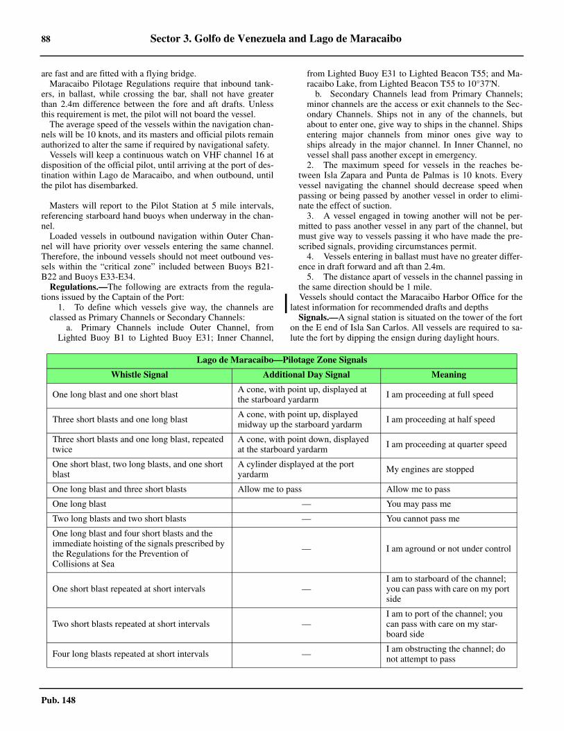
88 Sector 3. Golfo de Venezuela and Lago de Maracaibo
Pub. 148
are fast and are fitted with a flying bridge.3.12 Maracaibo Pilotage Regulations require that inbound tank-ers, in ballast, while crossing the bar, shall not have greaterthan 2.4m difference between the fore and aft drafts. Unlessthis requirement is met, the pilot will not board the vessel.3.12 The average speed of the vessels within the navigation chan-nels will be 10 knots, and its masters and official pilots remainauthorized to alter the same if required by navigational safety.3.12 Vessels will keep a continuous watch on VHF channel 16 atdisposition of the official pilot, until arriving at the port of des-tination within Lago de Maracaibo, and when outbound, untilthe pilot has disembarked.
3.12 Masters will report to the Pilot Station at 5 mile intervals,referencing starboard hand buoys when underway in the chan-nel.3.12 Loaded vessels in outbound navigation within Outer Chan-nel will have priority over vessels entering the same channel.Therefore, the inbound vessels should not meet outbound ves-sels within the “critical zone” included between Buoys B21-B22 and Buoys E33-E34.3.12 Regulations.—The following are extracts from the regula-tions issued by the Captain of the Port:
1. To define which vessels give way, the channels areclassed as Primary Channels or Secondary Channels:
a. Primary Channels include Outer Channel, fromLighted Buoy B1 to Lighted Buoy E31; Inner Channel,
from Lighted Buoy E31 to Lighted Beacon T55; and Ma-racaibo Lake, from Lighted Beacon T55 to 10°37'N.
b. Secondary Channels lead from Primary Channels;minor channels are the access or exit channels to the Sec-ondary Channels. Ships not in any of the channels, butabout to enter one, give way to ships in the channel. Shipsentering major channels from minor ones give way toships already in the major channel. In Inner Channel, novessel shall pass another except in emergency.2. The maximum speed for vessels in the reaches be-
tween Isla Zapara and Punta de Palmas is 10 knots. Everyvessel navigating the channel should decrease speed whenpassing or being passed by another vessel in order to elimi-nate the effect of suction.
3. A vessel engaged in towing another will not be per-mitted to pass another vessel in any part of the channel, butmust give way to vessels passing it who have made the pre-scribed signals, providing circumstances permit.
4. Vessels entering in ballast must have no greater differ-ence in draft forward and aft than 2.4m.
5. The distance apart of vessels in the channel passing inthe same direction should be 1 mile.Vessels should contact the Maracaibo Harbor Office for the
latest information for recommended drafts and depths 3.12 Signals.—A signal station is situated on the tower of the forton the E end of Isla San Carlos. All vessels are required to sa-lute the fort by dipping the ensign during daylight hours.
Lago de Maracaibo—Pilotage Zone Signals
Whistle Signal Additional Day Signal Meaning
One long blast and one short blast A cone, with point up, displayed at the starboard yardarm I am proceeding at full speed
Three short blasts and one long blast A cone, with point up, displayed midway up the starboard yardarm I am proceeding at half speed
Three short blasts and one long blast, repeated twice
A cone, with point down, displayed at the starboard yardarm I am proceeding at quarter speed
One short blast, two long blasts, and one short blast
A cylinder displayed at the port yardarm My engines are stopped
One long blast and three short blasts Allow me to pass Allow me to pass
One long blast — You may pass me
Two long blasts and two short blasts — You cannot pass me
One long blast and four short blasts and the immediate hoisting of the signals prescribed by the Regulations for the Prevention of Collisions at Sea
— I am aground or not under control
One short blast repeated at short intervals —I am to starboard of the channel; you can pass with care on my port side
Two short blasts repeated at short intervals —I am to port of the channel; you can pass with care on my star-board side
Four long blasts repeated at short intervals — I am obstructing the channel; do not attempt to pass

Sector 3. Golfo de Venezuela and Lago de Maracaibo 89
Pub. 148
3.12 The following traffic light signals are displayed at night fromthe yardarm of the above signal station:
1. One red light—Entry prohibited.2. One green light—Entry permitted.3. Two green lights—A vessel is aground, but there is
passage inward.4. Two red lights—A vessel is aground and entry is pro-
hibited.3.12 Vessels navigating in the pilotage zone may use the signalslisted in the accompanying table titled Lago de Maracaibo—Pilotage Zone Signals.3.12 Contact Information.—See the table titled San Carlos—Contact Information.
3.12 Anchorage.—Vessels can anchor, in depths of 15 to 18m, inthe vicinity of Lighted Buoy EM when waiting for the tide. 3.12 Vessels are to anchor under the direction of the Port Captain.3.12 If a vessel finds it necessary to anchor in the pilotage zone,anchorage must be taken in such a way so as not to obstructtraffic.3.12 Caution.—The General Raphael Urdaneta Bridge, connect-ed to both shores by a causeway, crosses the channel at a posi-tion close S of Punta Piedra. The maximum speed allowed inthe approaches to and between the bridge piers is 5 knots. Thevertical clearance of the bridge over the fairway of the channelis 45.1m.
3.12 Numerous uncharted oil rigs and drilling platforms are situ-ated outside the channel fairways in Lago de Maracaibo. Their
lights and positions may be subject to frequent change. Vesselsmust strictly adhere to fairways to avoid collision with thesestructures.3.12 Vessels must use extreme care in anchoring within the laketo avoid anchoring in the vicinity of submerged pipelines andcables.3.12 The traffic concentration within the lake is dense. Small ves-sels will be encountered crossing the main fairways to the nu-merous small terminals in the lake area.3.12 Dredges may be encountered at work in the main entrancechannels. Ships are required to stop their engines and proceedat slow speed when passing these vessels.
Ports and Terminals in Lago de Maracaibo
3.13 Palmarejo de Mara (10°48'N., 71°40'W.) is a smallterminal that comprises an oil pier and a tank farm. There arefour berths, but only the northernmost outer berth is used; theother three berths are no longer in use. This N berth is 129mlong and has a depth of 6.5m alongside. Depths in the ap-proaches from the SE are 5.5 to 7.3m. The terminal is used pri-marily by local tankers.
3.14 Puerto Miranda (10°46'N., 71°33'W.) (World PortIndex No. 12035) is an oil terminal that consists of two jettieswhose inner ends are joined and met by a causeway runningfrom the shore and extending to the SW. 3.14 Tides—Currents.—The tidal range at this terminal is about0.3m. The current, which sets at right angles to the pier, can attimes be very strong and subject to sudden change. The ebbruns for 7 or 8 hours while the flood runs for 4 to 5 hours.3.14 On arrival at Puerto Miranda, a berthing master will board toassist in docking the vessel as well as in undocking.3.14 Depths—Limitations.—There are two finger piers with atotal of four berths. For berthing information see the table titledPuerto Miranda—Berth Information.
3.14 Contact Information.—See the table titled Puerto Miran-da and El Tablazo—Contact Information.
San Carlos—Contact Information
Pilots
Call sign Piloto San Carlos
VHF VHF channels 12, 14, and 16
RT Frequency 2080 kHz, 2120 kHz, and 2182 kHz
Marine Traffic Control
VHF VHF channels 12, 14, and 16
3.12The General Rafael Urdaneta Bridge
Puerto Miranda—Berth Information
Berth Length Draft Remarks
Pier No. 2
No. 1 277m 11.3m 115,000 dwt
No. 2 277m 11.0m 115,000 dwt
Pier No. 3
No. 5 277m 11.3m 115,000 dwt
No. 6 277m 11.0m 115,000 dwt
Puerto Miranda and El Tablazo—Contact Information
Pilots
Call sign Piloto San Carlos
VHF VHF channels 12, 14, and 16
RT Frequency 2080 kHz, 2120 kHz, and 2182 kHz
90 Sector 3. Golfo de Venezuela and Lago de Maracaibo
Pub. 148
3.14 Directions.—When approaching from the S, vessels leavethe primary channel after passing W of Lighted Buoy B63. Achannel, marked by buoys, leads from Canal Interior betweenLighted Buoy B61 and Lighted Buoy B59A to the berths.
3.15 El Tablazo (10°45'N., 71°32'W.) (World Port IndexNo. 12037) is situated 1 mile E of Puerto Miranda and handlespetrochemical products. The port, with two main jetties, eachextending approximately 0.8 mile SW from the shore, can han-dle vessels up to 50,000 dwt, 198m in length, and 9m draft.3.15 The port is approached by a channel running NE from themain channel in the vicinity of Lighted Buoy B63 and LightedBuoy B64. 3.15 The jetties have berths on either side. On the N side of theSolid Cargo Pier. Dry cargo is handled at this jetty. For berth-ing information refer to the table titled El Tablazo—Berth In-formation.
3.15 Contact Information.—See the table titled Puerto Miran-da and El Tablzo—Contact Information.3.15 Altagracia (La Estacada) (10°42'N., 71°32'W.) has a berthused as a crude oil storage terminal; it is only used for loadingin an emergency.
3.16 Punta Camacho (10°33'N., 71°32'W.) lies on S ex-tremity of Punta de Leiva. Punta Camacho Terminal primarilyhandles chemicals and chemical gases. Pralca Pier, which has alength of 112m and an alongside depth of 6.6m, can handlevessels with a maximum loa of 135m and a maximum draft of6.3m.
3.17 Maracaibo (10°38'N., 71°36'W.) (World Port IndexNo. 11960), the second-largest city and cargo handling port inVenezuela, stands on the W side of the lake, about 20 miles Sof Isla San Carlos. The chief export is crude oil, but coffee isalso exported in major quantities.3.17 Winds—Weather.—Squalls, known locally as chubascos,occur most frequently between May and August, usually be-tween 1400 and 1900, and last from about 30 minutes to 1hour. Winds in the squall are generally S to SE and may attain avelocity of nearly 50 knots. A heavy rain usually follows thesesqualls.3.17 Depths—Limitations.—The following berthing facilitiesare situated on the N side of Bahia de Maracaibo For berth in-formation see the table titled Maracaibo—Berthing Informa-tion.
Port
Call sign Maraven Puerto Miranda
VHF VHF channels 12 and 16
RT Frequency 2182kHz
Telephone 58-261-76363
Facsimile 58-261-84741
Puerto Miranda and El Tablazo—Contact Information
El Tablazo—Berth Information
Berth Length DepthMaximum Vessel
RemarksLOA Draft
Dry Cargo Pier N 240m — 200m 9.4m Fertilizer.
Dry Cargo Pier S — — 250m 9.4m Fertilizer. Continuous berthing length of 520m.
Liquid Pier N 162m — 240m 9.4m LPG and chemicals.
Liquid Pier S 162m — 240m 9.4m LPG and chemicals
Maracaibo—Berth Information
Berth Length DepthMaximum Vessel Berth Length
(Continuous) RemarksLOA Draft
Muelle de Cabotaje
No. 1 118m 4.5m — — — Containers and breakbulk.
No. 2 118m 4.5m — — — Fast ferries, containers, and breakbulk.
No. 3 122m 4.5m — — — Containers and breakbulk.
No. 4 153m 6.7m — — — Containers and breakbulk.
Muelle Sur
No. 5 135m 5.1m 135m 5.6m
555m
Container and breakbulk.
No. 5a 60m 3.0m 60m 3.3m Containers.
No. 6 180m 6.1m 180m 6.3m Containers and breakbulk.
No. 7 180m 7.6m 180m 7.6m Grain and breakbulk.

Sector 3. Golfo de Venezuela and Lago de Maracaibo 91
Pub. 148
3.17 Pilotage.—Pilotage is compulsory. Vessels should send anETA message 72 hours prior to arrival. Messages are normallysent through Radio Curacao (PJC). A harbor pilot will boardafter clearance at the anchorage and take the vessel alongsideone of the wharves. No vessel with explosives aboard is al-lowed in the dock area. The pilot may be contacted by VHF.See the table titled San Carlos—Contact Information inparagraph 3.12.3.17 Contact Information.—See the table titled Maracaibo—Contact Information.3.17 Anchorage.—There are two anchorage areas off the port forlarge vessels and one for smaller vessels. There are generaldepths of 6.5 to 15.7m in the anchorages, which may best beseen on the chart. An explosives anchorage area, which may al-so best be seen on the chart, lies centered about 2 miles SE ofthe harbor berths.
3.18 Punta Piedra (10°35'N., 71°36'W.) is a terminal thatconsists of an offshore oil mooring berth, with mooring buoysmoored about 0.3 mile E of the T-head pier. Vessels up to35,000 dwt, 175m in length, and 9.1m draft can use this berth.
Berthing is by day only; unberthing is by day or night.3.18 A jetty extends 0.5 mile ENE from a position 0.3 mile S ofthe W root of the General Rafael Urdaneta Bridge. Four moor-ing buoys are reported to lie off the head of the jetty.
3.19 Bajo Grande (10°31'N., 71°38'W.) (World Port In-dex No. 12034) is a terminal that consists of an offshore oilplatform with three loading berths. 3.19 Muelle de Caballetes, a natural gas liquid terminal, extends1.8 miles E from a point on the shore a little over 1 mile S ofBajo Grande.3.19 For berth information, see the table titled Bajo Grande—Berthing Information.
3.19 Pilotage.—Pilots board at the terminal entrance lightedbuoys. See San Carlos Pilotage (paragraph 3.12) for more in-formation. 3.19 Contact Information.—See the table titled Bajo Grande—Contact Information.
Muelle Este
No. 8 180m 9.1m 180m 9.2m
525m
Grain and multipurpose.
No. 9 155m 8.8m 155m 7.4m Grain and breakbulk.
No. 10 190m 7.6m 190m 8.3m Grain.
Other
No. 11 172m 7.6m 152m 8.7m — Grain and breakbulk.
No. 12 172m 9.7m 176m 9.8m — Grain and breakbulk.
Muelle Malecon 400m — — — — Containers, breakbulk, naval vessels, govern-
ment vessels, and small vessels.
Maracaibo Cement Plant
Cement Pier 12m — — — 266m (including
dolphins)Cement. Pier stretches 916m for deeper draft vessels.
Maracaibo—Berth Information
Berth Length DepthMaximum Vessel Berth Length
(Continuous) RemarksLOA Draft
Maracaibo—Contact Information
Port
Call signCreole Marcaibo Marine
Marina Los Haticos
VHF VHF channels 6, 10, 12, 14, and 16
RT Frequency 2182 kHz, 2120 kHz, 2638 kHz, 2738 kHz, and 4420.7 kHz
Port Captain
Telephone580-261-721-1887
580-261-722-6480
E-mail [email protected] Bajo Grande—Berthing Information
Berth Length DepthMaximum
Vessel
LOA Draft
No. 1 270m 12.1m 229m 9.8m
No. 2 270m 10.8m 229m 9.4m
No. 3 275m 12.1m 260m 10.8m
Muelle de Cabalettes 262m — 213m 10.8m
Bajo Grande—Contact Information
Port Authority
VHF VHF channels 12 and 16

92 Sector 3. Golfo de Venezuela and Lago de Maracaibo
Pub. 148
3.20 Punta de Palmas (10°24'N., 71°34'W.) (World PortIndex No. 12032) is situated 15 miles S of the port of Maracai-bo. Punta de Palmas del Sur, situated close N, has a number ofoil tanks and a submarine pipeline which extends 4.5 miles SEto Punta de Palmas platform. 3.20 Berth No. 1 and Berth No. 2, each consisting of two pairs ofmooring buoys, are situated close E of the platform. They canaccommodate vessels up to 254m in length, with respectivedrafts up to 11.6m and 11.4m. Vessels up to 80,000 dwt can behandled. 3.20 Berth No. 3 can be used by vessels up to 271.5m in lengthand 12.8m draft. Vessels up to 100,000 dwt can be handled. 3.20 Material Dock, on the S shore of Punta de Palmas del Sur,consists of two barges secured together. Only small shallowdraft vessels can be accommodated.
3.21 Cabimas (10°23'N., 71°29'W.) and La Salina(10°22'N., 71°28'W.) (World Port Index No. 12025) are oil ter-minals that are operated by the Mene Grande Oil Company andthe Creole Petroleum Corporation, respectively. The accesschannel leading to the berths has a least depth of 12.8m.
The La Salina Terminal consists of an artificial island withtwo piers designated as Berth No. 6 and Berth No. 7; both piershave a berth on their N and S sides. Each berth has a length of340m and an alongside depth of 13m. All four berths can ac-commodate vessels with a maximum loa of 274m and a maxi-mum draft of 11.3m.
An offshore oil berth, designated as Pier No. 3, lies W of theW extremity of the artificial island. It can accommodate ves-sels with a maximum loa of 202.7m and a maximum draft of10.3m.
3.22 Lagunillas (10°08'N., 71°15'W.) is located on the Eside of Lago de Maracaibo. The harbor is used for the move-ment of personnel and the handling of boats and tugs. The quayis 433m long and a pier extends 94m from the quay.
3.23 Bachaquero (9°57'N., 71°10'W.) terminal is operatedby both the Shell Oil Company and the Mene Grande Oil Com-pany; it consists of a pier extending about 0.8 mile SW fromthe shore and has two berths on each side of its outer end. For
berth information see the table titled Bachaquero—Berth In-formation.3.23 It is reported that the port is not in service and all its aids tonavigation have been removed.3.23 An anchorage area for Bachaquero is situated about 0.5 mileSW of the pier. A mooring buoy is situated in the anchorage.
3.24 San Lorenzo (9°47'N., 71°04'W.) (World Port IndexNo. 11980) is situated about 10 miles SSE of Bachaquero. 3.24 Depths—Limitations.—A pier at San Lorenzo, with dol-phins, extends about 0.5 mile SW from the shore and has aberth on each side of its outer end. The terminal is used onlyfor handling crude oil and its product. Vessels up to 20,000 dwtcan be berthed alongside. Maximum permissible drafts are11.3m on the S side of the pier and 7.9m on the N side. Vesselsup to 170m in length may use the N side of the pier and vesselsup to 213m in length may use the S side. Tugs are required formooring.3.24 Aspect.—A lighted range leads to the pier.3.24 Anchorage.—Anchorage is available in the approach to theterminal in accordance with depths available and ship’s draft.
3.25 Le Ceiba (9°28'N., 71°04'W.) is a cement port.North Quay is 195m long and has an alongside depth of
10m; it can accommodate vessels with a loa of 190m. Coastalbulk and bagged cement vessels are berthed. Pier No. 2 is180m long and has an alongside depth of 11.5m; it can accom-modate commercial vessels up to 30,000 dwt.
A light stands on the coast about 6.5 miles N of Le Ceiba.
3.26 Coloncha (9°12'N., 71°45'W.), at the SW end of La-go de Maracaibo, is an oil terminal. A submarine pipeline ex-tends 1.3 miles E from the shore to a platform. Anotherpipeline extends 4 miles ENE from the shore to a platform.3.26 An offshore loading berth is situated close E of the eastern-most platform. It consists of four mooring buoys and has adepth of 10.7m alongside. Tankers are berthed heading N. An-chorage can also be obtained off Coloncha.3.26 A number of other small oil terminals are situated on theshores of the lake. They are available only to shallow-draft laketankers; local knowledge is required to reach them.
RT Frequency 2080 kHz, 2120 kHz, 2182 kHz, 2638 kHz, and 2738 kHz
Telephone 580-261-201-1111
Port Supervisor
Telephone 580-261-202-673
Bajo Grande—Contact Information
Bachaquero—Berth Information
Berth Length Depth Remarks
South Inner 143m 7.7m General cargo
North Outer 185.9m 10.3m Tankers
North Inner 152.4m 8.2m Tankers
South Outer 181.4m 10.3m Tankers

93
Pub. 148
4. Sector 4—Coasts of Colombia and Panama—Punta Gallinas to and including
the Panama Canal
4.0Additional chart coverage may be found in NGA/DLIS Catalog of Maps, Charts, and Related Products (Unlimited Distribution).SECTOR 4 — CHART INFORMATION

95
Pub. 148
SECTOR 4
COLOMBIA AND PANAMA—PUNTA GALLINAS TO AND INCLUDING THE PANAMA CA-NAL
4.0 Plan.—This sector describes the N coasts of Colombia andPanama, from Punta Gallinas to and including the Panama Ca-nal. The descriptive sequence is from E to W.
General Remarks
4.1 Punta Gallinas and the Panama Canal in Panama, theE and W limits of the coastal area described, are about 530miles apart in an approximate WSWENE direction. From Pun-ta Gallinas, the coast first extends generally WSW for 205miles to the mouth of the Rio Magdalena; then for about 200miles and with considerable irregularity, it extends SW, sharplyS, then SW again to Punta Caribana, the E entrance point ofGolfo de Uraba.4.1 Golfo de Uraba, with Bahia Colombia at its head, is a deep-water indentation 25 miles wide at its entrance, which extends25 miles S from Punta Caribana. From Cabo Tiburon, thegulf’s W entrance point, the coast extends NW for about 53miles to Punta Brava, then WNW and W for 90 miles to PuntaManzanillo, the only indentations of any consequence areGolfo de San Blas, and of lesser importance are Santa Martaand Covenas.4.1 Along this coastal stretch there are several bays of naviga-tional importance and many sheltered anchorages. The majorports are Barranquilla and Cartagena; ports of lesser impor-tance are Santa Marta and Covenas.4.1 The N coast of Panama, between Punta Manzanilla and theentrance to the Panama Canal, extends SW for 27 miles. It isindented by numerous bays and backed by a mountainous to-pography for the first 22 miles; the remainder is lowlands. Allof this coast is bordered by many closely off-lying islands andreefs.4.1 Limon Bay, the principal bay, comprises the N inner ap-proach to the Panama Canal and includes the harbors of CocoSolo, and Cristobal.4.1 The Panama Canal, traversing the Isthmus of Panama in a SEdirection for approximately 45 miles, connects Limon Bay onthe Atlantic side to Panama Bay on the Pacific side.4.1 Winds—Weather.—Except for the extreme E portion, thisentire area is clear of the usual hurricane paths. The prevailingwinds are the NE trades, which frequently assume a N or E di-rection, also a gusty character close inshore. These winds flowstrongly from December to March and to a much lesser degreein the months of July and August. For the most part the windsare of a greater variety. The dry season is from November andDecember to April and May, often varying considerably andwith the period of the E portion not entirely coinciding withthat of the W. During the dry season, the winds are strongerand the climate is more favorable.4.1 The wet season, comprising the other months of the year, ishot and humid and there is a great deal of evaporation. Duringthe heavy rain squalls, many of which are of torrential intensi-ty, the wind often flows with great fury for short periods. The
annual amount of rainfall is much higher in the W part of thisarea.4.1 During the dry season, the wind may freshen to a velocity of15 knots in the vicinity of the Panama Canal, but frequently ex-ceeds 20 knots for a period of 24 hours or more. During the wetseason in the same locality, the average wind velocity is about8 knots, but greater velocities are experienced during passinglocal rain squalls.4.1 The Northers occasionally reach as far S as Limon Bay,during the NE trade wind season, occurring from October orNovember to April, inclusive. They are strong and steady fromthe NE to the NW, blowing toward the equatorial belt of lowpressure from an anticyclonic area of high pressure lying to theN. When at their worse, they generally flow from the NW.Their approach cannot be foretold either by barometric read-ings or otherwise, and they last from 1 to 5 days, but their max-imum strength, when the wind velocity may reach 30 to 40knots, rarely exceeds 24 hours duration. The average occur-rence of Northers is barely 1 per year, but the swells and seasthat accompany them are heavy.4.1 In the vicinity of Cristobal, fogs rarely average more than 4or 5 a year and normally are of short duration.4.1 Tides—Currents.—The current along the Caribbean coastof South America is a continuation of that part of the Equatori-al Current which enters the Caribbean Sea by way of the Gulfof Paria and the various passages, which lie between Trinidadand Martinique. Off Punta Gallinas, its velocity is between 1knot and 1.5 knots, at this point its W direction begins to in-clude the S. From Cabo de La Vela the main body of the cur-rent sets generally to the W, sometimes inclining to the WSW,and it diminishes in velocity as it expands over a greater area.On nearing the mouth of the Rio Magdalena the current issometimes diverted to the NE, caused probably by the dis-charge from that river and by a coastal countercurrent.4.1 West of the Rio Magdalena, a part of the main current is de-flected SE into the Golfo de Uraba; between this part and theshore is the countercurrent. Off the Islas San Bernardo thecountercurrent has a velocity of 0.4 to 1.5 knots and its direc-tion is usually NE. From Golfo de Morrosquillo, SW and W,the coastal current is the general countercurrent of the area, theaverage velocity being from 1 to 2 knots, and in confined plac-es 2.5 to 3 knots.4.1 In the approach to Punta Manzanillo and the Panama Canal,from the vicinity of the mouth of the Rio Magdalena, it hasbeen observed that there are various components both of themain Equatorial Current and of the general countercurrent.There also are certain irregularities, largely unpredictable,most probably due in greater or lesser measure to the influenc-es of winds and to the discharge of rain swollen rivers. Occa-sionally, the normal current circulation may become sostrongly affected that its direction may completely reverse it-self while a hurricane is in progress to the N. The N galeswhich occur from time to time in the W Caribbean are very

96 Sector 4. Colombia and Panama— Punta Gallinas to and Including the Panama Canal
Pub. 148
likely to accelerate the countercurrent, the reaction to such anacceleration may temporarily discharge the normal current pat-tern over a very wide area.4.1 So complex are the convergence, divergence, and other char-acteristics of the Caribbean current system that navigators ofthis area are cautioned to be especially alert at all times, takingnothing for granted and not hesitate to change quickly to a saf-er course should there seem to be even the slightest possibilityof running into danger because of current vagaries.
Punta Gallinas to Puerto Bolivar
4.2 Punta Gallinas (12°28'N., 71°40'W.) has been previ-ously described in paragraph 3.10. A shoal, with a depth of11.9m, was reported to lie 13 miles W of Punta Gallinas.4.2 Bahia Hondita (12°24'N., 71°44'W.), a small indentationabout 5.5 miles SW of Punta Gallinas, is shallow and of nocommercial importance. Punta Soldado is the rocky S entrancepoint to the bay. A conspicuous white house stands on thepoint.4.2 Anchorage can be taken about 1 mile NW of Punta Soldado,in a depth of 12.8m, sand and gravel.4.2 Bahia Honda, adjoining Bahia Hondita to the SW, is consid-erably larger and has depths of 9 to 12m in its central part. An-chorage can be taken in this bay, but it is reported to be lesssheltered than off Bahia Hondita.4.2 Punta Canon (12°23'N., 71°49'W.), the W entrance point toBahia Honda, is bordered by very steep cliffs, 30m high, andsurmounted by imposing hillocks which are easily identifiedfrom seaward. Banco Boca, a rocky area with two rocks withless than 1.8m, lies about 1 mile ENE of Punta Canon. BancoBoca can be seen during a smooth sea. An 11m depth lies 0.5mile N of Banco Boca. Vessels entering the bay should passclose E of these two dangers. The E shore of this bay is low,sandy, and constantly changing due to high winds and chang-ing sands.4.2 From Punta Canon, the coast trends about 10.5 miles SW toPunta Coco, the NE entrance of Bahia de Portete. This stretchof coast is low, sandy, and bordered by rocky shoals. The coast-al bank, as defined by the 30m curve, lies up to 3 miles off thiscoast.4.2 Puerto Chico, a small bay, lies 1.5 miles SW of Punta Canon.A 4.6m high islet is located in Puerto Chico. Punta Coco risesto a prominent, rocky hill about 18m high.4.2 Punta Gran Tonel, the SW entrance to Bahia de Portete, isbordered on its E and S sides by cliffs, 15 to 27m high.
4.2 Bahia de Portete (12°15'N., 71°55'W.), located about 10miles SW of Bahia Honda, is entered between Punta Coco andMedia Luna, a cliffy point 1 mile SSW. Local knowledge isnecessary when entering the bay.4.2 Caution.—The Colombian authorities have advised vesselsto exercise care when sailing within coastal waters in depths ofless than 30m, as the hydrographic information shown on thecharts is derived from old survey data.
Puerto Bolivar (12°16'N., 71°57'W.)
World Port Index No. 11946
4.3 Puerto Bolivar is situated on Bahia de Portete’s SWentrance point. The harbor has berths which will handle a vari-ety of cargo, but handles mostly bulk coal.4.3 Winds—Weather.—The prevailing winds here, from theNE or NNE, are usually light in the morning, but may increaseto force 6 by evening.4.3 Tides—Currents.— Tide and current information for theport is not currently available. It has been reported that the en-trance has a SW current and the average tidal range is 0.3m.4.3 Depths—Limitations.—The dredged channel, entered 2miles NNW of the bay’s SW entrance point, shows a leastcharted depth of 16.7m as far as the coal berth. The channel is1.9 miles long and 225m wide. A turning basin lies S of thecoal berth; it has a radius of 600m and a dredged depth of9.2m. For berthing information refer to the table titled PuertoBolivar—Berth Information. 4.3 Aspect.—Piles of coal lie on the bays SW entrance point,while two white tanks stand close S of the commodities pier. Aconspicuous red and white checkered tank stands 1.3 mile fur-ther SSW.4.3 The dredged channel is marked by lighted buoys and a light-ed range.4.3 Pilotage.—Pilotage is compulsory. The pilot boards in posi-tion 12°18.5'N, 71°59.7'W. Vessels should send an ETA 5 daysprior to arrival. 4.3 Contact Information.—See the table titled Puerto Boli-var—Contact Information.4.3 Regulations.—See Pub. 140, Sailing Directions (PlanningGuide) North Atlantic Ocean and Adjacent Seas for details onregulations pertaining to vessels in Colombian waters.4.3 Entry to the port is restricted. Permission should be obtainedfrom the port authorities before proceeding to the anchorage,quarantine area, or the piers.
Puerto Bolivar—Berth Information
Berth Length DepthMaximum Vessel
RemarksLOA Draft Beam
Coal Berth — 19.0m 300m 17.5m 50m Berthing length of 340m (including dolphins).
New Coal Pier — 19.0m 295m 17.5m 47m Berthing length of 335m (including dolphins).
Commodities Pier E 270m 9.5m 225m 9.2m 43m Dirty products, containers, and breakbulk.
Commodities Pier W 270m 9.0m 186.3m 8.9m 28m Ro-ro, breakbulk, containers, and heavy lift.

Sector 4. Colombia and Panama— Punta Gallinas to and Including the Panama Canal 97
Pub. 148
4.3 Bulk cargo vessels arriving in ballast are restricted to a max-imum draft of 9m, as they are swung in the turning basin be-fore being berthed. Arriving vessels must be carrying cleanballast in segregated tanks, with their holds swept clean. Bulkvessels must be gas free. Vessels over 100,00dwt are not al-lowed to berth at night, but may unberth at any time.4.3 Anchorage.—The anchorages are open to NE winds. Thecharted general anchorage area, situated 2 miles NW of thebay’s SW entrance point, has depths of 5 to 27m, sand. TheQuarantine Anchorage area, centered 5.3 miles W of the samepoint, has depths of 11 to 37m, sand.4.3 Caution.—Caution is advised in the entrance channel, as avessel reported encountering a SW cross-channel set. The cur-rent reportedly caused a leeway of 10° until Buoy No. 7 andBuoy No. 8 were passed.
Puerto Bolivar to Cabo de La Aguja
4.4 Pilon de Azucar, 10.8 miles W of the entrance to Ba-hia de Portete, is a very prominent, sharp, rocky hill rising to aheight of 81m. A white statute, 6m high, stands on the summit
of this hill.4.4 From Pilon de Azucar, the rocky coast trends about 3 milesSW to Cabo de La Vela (12°13'N., 72°10'W.), which is bor-dered by very steep cliffs on its N side. It is topped by a fewconspicuous rocky hills, 45 to 81m high. Cabo de La Vela islow and sandy on its S side.4.4 Isla Cusachon, a small low islet, lies close W of the cape.Cerros del Carpentero, a group of hills, rise to a considerableheight about 5.5 miles SE of the cape and about 17 miles S. Ashort distance inland there is an unusual conical hill, mostlychalky in appearance.4.4 Cabo de La Vela is marked by a light and reported to be radarconspicuous. A dangerous wreck lies 2 miles SSW of the cape.4.4 Anchorage.—Anchorage, partially sheltered from the windand seas, can be taken S of the outer extremity of the cape, indepths of 12 to 16.5m. Care must be taken to avoid the danger-ous wreck S of the anchorage.
4.5 Punta Carrizal (12°01'N., 72°11'W.), located 13.5miles S of Cabo de La Vela, is a low, rounded point.
Punta Castilletes (11°50'N., 72°20'W.) lies 24 miles SSWof Cabo de La Vela. This part of the coast is low and PuntaCastilletes can only be recognized by a clump of mangrovesnear it. Cerro de Los Remedios stands 16 miles inland and 5miles farther NE is Cerro de Carrizal. These hills are the onlyelevations between Cerros del Carpintero, near Cabo de La Ve-la, and Cabo San Augustin, 105 miles SW.
Manaure (11°46'N., 72°27'W.), an open roadstead for load-ing bulk salt, lies about midway between Punta Castilletes andPunta Manaure, about 13 miles WSW. Vessels approach fromthe N and anchor, as convenient, 2 miles from a pier. Cargo isloaded from lighters at the anchorage. A light is shown, at anelevation of 27m, at Punta Manaure.4.5 The coast between Punta Manaure and Punta de La Cruz, 13miles WSW, has several small projections. Shallow water ex-tends up to 2 miles offshore and vessels are cautioned to transitthe area outside the 20m curve, which lies 3.5 miles from theshore.4.5 Caution.—A submarine gas pipeline extends 6 miles NNWfrom the coast, originating 8 miles WSW of Punta Manaure.This pipeline is marked by orange buoys and a drilling plat-form (11°47'13"N., 72°46'51"W.) is situated at its seaward end.Precautions must be taken when navigating near this restrictedarea.
4.6 Bajo Pajaro (11°43'N., 72°44'W.), 8 miles W of Pun-ta Manaure, is a dangerous sand bank, with depths of 3.7m be-tween it and the shore. The outer edge is reported to lie 2 milesoffshore and is reportedly always marked by breakers.4.6 Between Punta La Vela and the mouth of Riohacha, about 11miles SW, the coast is low and presents no conspicuous fea-tures. An obstruction, with a known depth of 5m lies about 4.5miles NE of Punta La Vela. 4.6 Riohacha (11°34'N., 72°55'W.), with the town of the samename along its banks, lies 24 miles SW of Punta Manaure. Theriver is reported to have a navigable depth of 3.7m, but cargo islightered out to the anchorage to be loaded. Only small coast-ers frequent this port. A light is shown W of the town.4.6 Contact Information.—See the table titled Riohacha—
Puerto Bolivar—Contact Information
Port
Call sign Puerto Bolivar Marine Operations
VHF VHF channels 14 and 16
E-mail [email protected]
Harbormaster
Telephone57-5-350-6511
57-5-350-6512
E-mail [email protected]
Web site http://www.dimar.mil.co/capitania_bolivar
Port Authority
Telephone57-5-350-6400
57-5-350-6820
Facsimile 57-5-350-2110
Web site http://www.cerrejoncoal.com
4.3Puerto Bolivar

98 Sector 4. Colombia and Panama— Punta Gallinas to and Including the Panama Canal
Pub. 148
Contact Information.
4.6 Anchorage.—A general and quarantine anchorage area issituated 4.5 miles NNW of Riohacha, as seen on the chart. Thisanchorage is exposed and is not recommended from Decemberto May because of the heavy swells which set in.4.6 Caution.—A submarine cable extends W from the coast Nof Riohacha toward Puerto Colombia.
4.7 Punta Caricare, 16 miles SW of Riohacha, separatestwo large lagoons. Banco Navio Quebrado, a shoal with adepth of less than 3.7m, lies about 2.5 miles NW of this point.4.7 From Riohacha to Dibulla, the coast extends SW for 30miles and then takes a W direction for about 39 miles to CaboSan Juan de Guia. This latter cape is radar conspicuous.4.7 Anchorage can be taken off a small town near Dibulla. Ves-sels anchor more comfortably here than at Riohacha.4.7 La Mesa is a very prominent flat-topped hill standing 2 milesinland, about midway between Cabo San Augustin, 15.5 milesW of Dibulla, and Punta Don Diego, 7.5 miles farther W. Asteep-to 14.6m bank is reported to lie about 3 miles N of PuntaDon Diego.
4.8 Puerto Brisa (11°17'N., 72°23'W.) lies 4.3 miles Wof Dibulla. A marked entrance channel leads to Puerto Brisa.The SA Pier has two berths, designated the East Berth and theWest Berth. Each berth is 360m long and can handle a vesselwith a maximum loa of 305m, a maximum draft of 18m, and amaximum beam of 45m. This terminal deals primarily in ag-gregates like cement, coal, gypsum, and iron ore. 4.8 Pilotage.—Pilotage is compulsory. The pilot boards in posi-tion 11°18.8'N, 73°23.8'W. 4.8 Contact Information.—See the table titled Puerto Brisa—Contact Information.
4.8 Sierra Nevada de Santa Marta (10°49'N., 73°48'W.) areremarkable high mountains standing 25 miles S of Cabo SanAugustin. The most prominent are two snow-capped sugarloafpeaks, the highest having an elevation of 5,700m. These moun-tains constitute the only really conspicuous landmarks on thiscoast for over 100 miles in either direction and can be seenclearly for a great distance offshore.4.8 Los Ancones are a group of small islets and coves which liebetween Cabo San Juan de Guia and Cabo de La Aguja. Thecoves are free from dangers and provide good shelter. They areseparated by bold rugged headlands that are steep-to. Whenviewed from the W, they appear as a group of islands.4.8 Parque Nacional Natural Tayrona (11°19'N., 74°02'W.)lies along the coast between Rio Biedras (11°17.8'N.,73°53.5'W) and Santa Marta. Entry into this area is affected bynumerous restrictions and prohibitions. See local authoritiesfor more details.
Cabo de La Aguja to Santa Marta
4.9 Cabo de La Aguja (11°18'N., 74°12'W.) is a shortbold projecting headland, with Islote del Cabo de La Aguja lo-cated close N of it. The cape has been reported to be radar con-spicuous.4.9 From Cabo de La Aguja to Punta Canoas, about 90 milesSW, the coast is generally low and flat. West of the Rio Magda-lena, the flatness is relieved by a series of coastal hills. Puertode Barranquilla and Santa Marta are the only two ports of anycommercial importance along this section of coast.4.9 Ancon De Taganga (11°16'N., 74°12'W.), 2.3 miles S ofCabo de La Aguja, is surrounded by high land. Some remark-able white cliffs stand in the vicinity and can be seen for a dis-tance of 10 to 12 miles offshore. These cliffs are good marksfor Santa Marta, as there are no others of the same appearanceon this part of the coast.4.9 Islote del Cabo de La Aguja, a small irregular islet, lies about0.5 mile N of Cabo de La Aguja. The fairway between them isfouled by two above-water rocks. Two above-water rocks liewithin 0.5 mile W and NW of the islet.
Santa Marta (11°15'N., 74°13'W.)
World Port Index No. 11940
4.10 Santa Marta, a small commercially-important port,stands in the NE corner of Bahia Santa Marta. This bay con-sists of an open roadstead protected from the prevailing NEwinds.4.10 Winds—Weather.—The prevailing winds are the NortheastTrade Winds, which assume a gusty character when they reachthe port after passing through the hills. Between the months ofMarch and December, a local wind extending 2 to 3 miles off-shore blows from the SW between 1000 to 1300.4.10 Tides—Currents.—There is no regular tide in Bahia SantaMarta, but in the month of March the water has been known torise about 1.2m.4.10 Depths—Limitations.—Except for the shoal on which IslaEl Morro stands, the depths in the approach are deep and regu-lar. Banco Pobea, as defined by the 5m curve, is a coastal bankthat extends up to 0.3 mile off the E shore of the bay. It was re-
Riohacha—Contact Information
Harbormaster
Telephone57-095-727-2488
57-095-727-0492
Facsimile 57-095-727-2488
57-095-727-0492
Puerto Brisa—Contact Information
Harbor Master
VHF VHF channels 11, 16, and 71
Telephone57-091-622-2327
57-091-622-2106
Facsimile 57-091-622-5931
E-mail [email protected]
Web site https://www.puertobrisa.com

Sector 4. Colombia and Panama— Punta Gallinas to and Including the Panama Canal 99
Pub. 148
ported extending W because of the silt flowing from the riverclose S of the town. There are general depths of 9 to 37m andnowhere in the approach to the berthing facilities are the chart-ed depths less than 9m.4.10 The cove at the N end of Bahia Santa Marta has seven berths,numbered 1 through 5 from seaward on the E side and 6 and 7on the W side. For berthing information see the table titledSanta Marta—Berth Information.4.10 Aspect.—The town of Santa Marta stands on the E shore ofthe bay. Isla El Morro (Morro Grande), a precipitous islet, 61mhigh, with the ruins of a fort on it, lies in the NW part of BahiaSanta Marta. Two rocks, awash, lie close W of the islet.
4.10 Morro Chico, a conical rocky islet, 25m high, stands close Wof the N entrance to Santa Marta.4.10 Inland of the extensive plain that fronts the shore are thelofty Sierra Nevada de Santa Marta that rise 40 miles SE of the
town. These peaks are good marks for vessels intending toenter the bay. In the event these peaks are obscured, SanQuemedo, the highest mountain at the S end of the rangebehind the town, will be visible and may be used as a mark forentering the bay
4.10 A cathedral, with one dome, situated near the center of thetown and a radio tower N of it are conspicuous. A white stonemonument stands on the summit of a hill, about 0.8 mile NNWof the cathedral. Several tanks also stand in this vicinity.
4.10Santa Marta from E
4.10Isla El Morro (with light at top)
4.10Santa Marta from S
4.10Sierra Nevada de Santa Marta and Rodadera Beach
Santa Marta—Berth Information
Berth Length DepthMaximum Vessel
RemarksLOA Draft Beam
Port Authority
No. 1 100m 5.6m — — — Small vessels.
100 Sector 4. Colombia and Panama— Punta Gallinas to and Including the Panama Canal
Pub. 148
4.10 Pilotage.—Pilotage is compulsory for all vessels larger than200 gt. Pilots board in position 11°14.6'N, 74°13.9'W. Vesselsshould send their ETA 72 hours and 24 hours prior to arrival. 4.10 Contact Information.—See the table titled Santa Marta—Contact Information.
4.10 Regulations.—Vessels should limit their speed to 6 knots inBahia Santa Marta.4.10 Anchorage.—Vessels will find good anchorage as chartedSE of Isla el Morro, in depths of 38 to 49m, with the cathedralbearing 090° or less. Because of the Northeast Trade Winds,vessels should allow a good scope of chain due to the strongwinds, the depths, and the shelving bottom.4.10 Caution.—A submarine cable lies near the coast S of SantaMarta and continues in a SW direction toward Punta Gaira.Another submarine cable lies between Punta Betin and Isla ElMorro.
Santa Marta to Puerto de Barranquilla
4.11 Between Santa Marta and the Rio Magdalena, 37.5miles WSW, a bay is formed by the coast receding 14.5 miles Sto San Juan de Cienaga and then extending regularly WNW anadditional 35 miles. The S shore consists of low, marshy landbacked by extensive shallow lagoons. There are no known off-lying dangers seaward of the 20m curve.4.11 Caution.—A marine reserve lies along the 20m curve fromTasajera to Punta Faro. A line joining Punta Gaira and PuntaFaro establishes the boundary of a restricted fishing area. Asubmarine cable lies within the restricted fishing area.
4.11 Punta Gaira (11°13'N., 74°14'W.) is a bluff, with twoabove-water rocks lying close off it. Cliffs, with occasionalsandy beaches, border the coast for 0.8 mile in a NE directionfrom Punta Gaira. There is a quay for barges, 110m long,which has a depth of 5.5m alongside.
4.12 Pozos Colorados (11°09'N., 74°15'W.) (World PortIndex No. 11935) is an offshore loading berth for oil.
International Terminal
No. 2 180m 12.1m — — — General cargo.
No. 3 165m 12.1m — — — General cargo.
Bulk Terminal
No. 4 240m 13.0m — — — Solid bulk and grain .
Breakbulk Terminal
No. 5 94m 6.4m — 6.1m — General cargo.
Carbosan Coal Terminal
No. 6 150m 18.3m 270m 14.3m 41.0m Coal.
No. 7 156m 15.3m 270m 14.3m 41.0m Coal.
Santa Marta—Berth Information
Berth Length DepthMaximum Vessel
RemarksLOA Draft Beam
Santa Marta—Contact Information
Harbormaster
VHF VHF channels 11 and 16
Telephone 57-095-421-0739
Facsimile 57-095-431-1876
Port Authority
Telephone 57-095-421-7970 (switchboard)
Facsimile 57-095-421-2161
E-mail [email protected]
Web site http://www.spsm.com.co
Baupres S.A.S. Pilotos Practicos BPP
Telephone57-095-438-1717
57-09-316-527-4026 (mobile)
Facsimile 57-095-438-1717
E-mail [email protected]
Web site https://www.bauprespilotos.com
STM Pilotos/Servicios Tecnicos Maritimos S.A.S.
VHF VHF channels 11 and 16
Telephone 57-095-431-9609
Facsimile 57-095-431-9465
Santa Marta—Contact Information

Sector 4. Colombia and Panama— Punta Gallinas to and Including the Panama Canal 101
Pub. 148
4.12 Depths—Limitations.—The berth consists of seven moor-ing buoys. It can handle vessels up to 70,000 dwt, 250m inlength, and 18m draft. Several conspicuous tanks are situatedon the shore NE of this offshore berth; a submarine pipelineextends from the berth NE to the shore near the tanks.4.12 Aspect.—A conspicuous church, with a spire, stands in thetown of San Juan de Cienaga, 8 miles S of the oil berth. Alighted range leads to the berth. A SPM is located NW of thesubmarine pipeline.4.12 Pilotage.—Pilotage is compulsory and Pozos Colorados is aport of entry. Vessels should provide an ETA at least 24 hoursin advance of arrival. Vessels are required to proceed to the an-chorage off Santa Marta (1 mile SSW of Isla El Morro) to com-plete free pratique and other operation procedures. Pilots boardin position 11°11.1'N, 74°15.0'W. Ships will not be berthed atnight.4.12 Contact Information.—The terminal can be reached onVHF channels 6 and 16, or by telex (3538849,. 4.12 Anchorage.—Anchorage can be taken S of the terminal, in adepth of 7.3m, with the church spire situated 2.5 miles WSWof Cienaga bearing 160°, distant 2.5 miles. Vessels arriving atnight anchor 1 mile seaward of the terminal.
4.13 Puerto Zuniga (11°08'N., 74°13'W.) is an open road-stead port for the export of coal located on the coast S of PozosColorados. Vessels anchor 1 to 2 miles offshore, where they areloaded by barges and floating cranes. The port consists of theadditional facilities of Puerto Prodeco (Puerto Carbonero)Puerto Prodeco has two berths, identified as Alpha and Bravo.Both are contained in an anchorage 2 to 2.5 miles W and NWof the T-head shore terminal. Alpha mooring has a depth of18m and Bravo has a mooring depth of 10.5m. 4.13 The coast between Puerto Zuniga and Punta Faro, 40 milesto the W, is low and swampy. It fronts the lagoon CienagaGrande de Santa Marta. The coast is undergoing constantchange and charted depths may be inaccurate. Caution is ad-vised in the vicinity of this stretch of coastline. A strandedwreck lies 3.75 miles NNE of Cienaga. 4.13 Pilotage.—Pilotage is compulsory. Pilots board in position11°14.6'N, 74°13.9'W and position 11°11.1'N, 74°15.0'W.
4.14 Puerto Nuevo (11°04'N., 74°14'W.) and Puerto
Drummond are open roadstead coal terminals lying 4.5 miles Sof Puerto Zuniga. A channel dredged to 20m leads SE to bothterminals. The Rio Cordoba Coal Terminal lies just S of PuertoNuevo and Puerto Drummond, where the pier sits on the 2mcurve. For berthing information see the table titled PuertoNuevo—Berth Information. 4.14 Pilotage.—Pilotage is compulsory. Pilots board in position11°14.6'N, 74°13.9'W and position 11°11.1'N, 74°15.0'W. 4.14 Contact Information.—See the table titled Puerto Nue-vo—Contact Information.
Puerto de Barranquilla (11°00'N., 74°48'W.)
World Port Index No. 11930
4.15 Puerto de Barranquilla comprises the outer 10 milesof the Rio Magdalena, which is the main artery of commercialtraffic of Colombia. The wharves and the city are situated 10.5miles within the river mouth which is navigable under normalconditions for a distance of 800 miles inland. Small local ves-sels can ascend to the city of Dorada, 592 miles upriver.
4.15 Winds—Weather.—The Northeast Trade Winds blowstrongly from December to March and again, but to a lesser ex-tent, from July to August. Winds from the other direction aregenerally light. The locality is out of the hurricane area.4.15 At times, entry cannot be made when the trade winds blow.Generally, these winds and accompanying seas moderateduring the night so that the early morning hours are the mostdesirable time of entry.
4.12Puerto Prodeco (Puerto Carbonero)
Puerto Nuevo—Contact Information
Puerto Drummond
VHF VHF channel 71
Telephone 57-093-157-211-325 (Loading Master)
Agent (Erolatina)
VHF VHF channel 16
Facsimile57-095-423-4538
57-095-432-2352
E-mail [email protected]
4.15Barranquilla from E

102 Sector 4. Colombia and Panama— Punta Gallinas to and Including the Panama Canal
Pub. 148
4.15 Tides—Currents.—The tidal range is about 0.3m at the riv-er entrance, but is very irregular. The rise has very little effecton the river current which always flows out.4.15 When the water level is low in the river, generally from Feb-ruary to April and August to October, the river current does notexceed 2 knots. When the water level is high in the river, gener-ally in July and November, the current attains a velocity of upto 6 knots, and floating debris and logs are encountered. Thediscolored water discharged from the river may be seen a longdistance seaward of the entrance.4.15 An ocean current, which varies according to the direction ofthe wind, sets across the river entrance. It normally sets E, butduring the period of the Northeast Trade Winds, there is aslight increase in the height and a noticeable steeping and
shortening of the waves. This is greatest at high river and on arising tide during the period of the NE trades. At such times, anentering vessel is best navigated at a good speed.4.15 Depths—Limitations.—The approaches are deep and the20m curve lies close N of the breakwaters at the mouth of theriver. A shoal, with a depth of 7.5m, lies 2.3 miles WNW of thehead of the W breakwater; and dangerous wrecks lie about 1mile WSW and close NNE of the W breakwater.4.15 Mariners are cautioned not to attempt to enter the river with-out the most recent information concerning depths and otherconditions from the local authorities, as depths in the entranceare subject to silting. The maximum draft is authorized by theport administration on the basis of soundings taken every otherday.
Puerto Nuevo—Berth Information
Berth Length DepthMaximum Vessel
RemarksLOA Draft Beam
Puerto Drummond
No. 1 Pier (NE side) 392m 20.5m 310m 18.4m 48m Coal.
No. 2 Pier (SW side) 373m 20.5m 310m 18.4m 48m Coal.
No. 3 Pier (NE side) 392m 20.5m 310m 18.4m 48m Coal.
No. 4 Pier (SW side) 373m 20.5m 310m 18.4m 48m Coal.
Note.—Berth No. 1 and Berth No. 3, on the NE side of the pier, have a continuous berthing length of 784m. Berth No. 2 and Berth No. 4, on the SW side of the pier, have a continuous berthing length of 746m.
Puerto Nuevo Coal Terminal
East Berth 347m 20.3m 301m 18.4m 47m Coal.
West Berth 347m 20.3m 301m 18.4m 47m Coal.
Sociedad Portuaria de Rio Cordoba
Rio Cordoba Pier 62m — 310m 14.0m 45m Coal.
Puerto de Barranquilla—Berth Information
Berth Length DepthMaximum Vessel
RemarksLOA Draft
Barranquilla Container Terminal (BCT)
No. 1 120m — — 10.0m Breakbulk and project cargo.
No. 2 182m — 185m 10.0m Containers.
Palermo Terminal
Center Berth — — — — General cargo and grain.
North Berth — — — — Coal and general cargo.
South Berth — — — — General cargo and containers.
Palermo Tank Berth 190m — — 12.5m Clean products.
SP Regional de Barranquilla Terminal
No. 1 177m 11-12m — — —
No. 2 177m 11-12m — — —
No. 3 177m 11-12m — — —

Sector 4. Colombia and Panama— Punta Gallinas to and Including the Panama Canal 103
Pub. 148
4.15 Dredging operations are continuous. Extensive shoaling hasbeen reported immediately W of the W breakwater head. 4.15 A 150m-wide channel, maintained to a depth of at least 9.1mand marked by lighted ranges and buoys, extends from the riverentrance at Bocas de Ceniza (11°06'N., 74°51'W.) to PuertoBarranquilla. The N side of the channel may not meet themaintained depth due to river migration. For berthing informa-tion see the table titled Puerto de Barranquilla—Berth In-formation.4.15 Aspect.—The coast E of the river entrance consists of flatsand dunes. To the W of the entrance, the coast consists of flat,partly wooded islands. An old disused lighthouse stands 3miles SE of the entrance and a conspicuous building stands 2miles farther E. A conspicuous white sand hill, 8m high, stands1 mile E of the old lighthouse. A conspicuous pilot housestands 0.3 mile SSE of the W breakwater head. The breakwaterheads are reported to be radar prominent. 4.15 A stone groin, marked by a light, extends from the E break-water between Light No. E1 and Light No. E3 at Punta Faro.Four stone groins, each marked by a light, have been construct-ed on the NE bank of the river, E and SE of Las Flores, andclose W of Isla 1972.4.15 Pilotage.—Pilotage is compulsory for all vessels over 200gross tons. An ETA should be sent 48 and 24 hours in advance.The pilot boards at position: 11°07'N, 74°52.5'W. If the pilot isunable to board because of heavy swell, the pilot vessel willlead the vessel into the river.
4.15 Contact Information.—See the table titled Barranquilla—Contact Information.4.15 Anchorage.—Anchorage can be taken, in depths of 18 to22m, as close as 0.8 mile W of W breakwater. However, ves-sels are advised that a dangerous wreck lies about 1 mile WSWof the head of the W breakwater. This wreck is not visible andvessels are advised that when anchoring, a safe distance of atleast 1.5 miles should be maintained from the W breakwater.Vessels are also advised to obtain good soundings prior to an-choring because the depths increase rapidly to the N and W ofthis anchorage.
No. 4 177m 11-12m — — —
No. 5 177m 11-12m — — —
No. 6 173m 11-12m — — —
River Port Terminal
Coal Berth — — — — Coal.
Grain Berth — — — — Grain.
Bravo Petroleum Terminal
No. 1 400m — — — Bulk and crude products.
Compas Terminal
No. 1 190m 9.5m — 9.5m Project cargo, breakbulk, liquid cargo, and solid bulk.
No. 2 120m — — 9.5m Project cargo, breakbulk, liquid cargo, and solid bulk.
Michellmar Terminal
No.1 150m — 180m 9.1m Coal and bio fuel. Maximum beam of 30m.
Monomeros Terminal
Pier 1 170m — 180m 9.1m Coal, LPG, and liquid cargo.
Portmagdalena Oil Terminal
Chemical Berth 51m — 150m 7.2m Chemicals. Maximum beam of 35m.
Vopak Terminal
Products Berth 135m 10.0m 145m 9.1m Petroleum products.
Puerto de Barranquilla—Berth Information
Berth Length DepthMaximum Vessel
RemarksLOA Draft
Barranquilla—Contact Information
Harbor Master
VHF VHF channels 13 and 16
Telephone 57-095-388-5131
Facsimile 57-095-349-2626
Port Authority
Telephone 575-371-6200

104 Sector 4. Colombia and Panama— Punta Gallinas to and Including the Panama Canal
Pub. 148
4.15 Caution.— Numerous changes to buoyage have taken place,with some buoys being moved and renumbered and otherbuoys completely removed. Local authorities should be con-sulted for the latest information on aids to navigation, depths inthe anchorage areas, and depths alongside the maintainedchannel.
Puerto de Barranquilla to Punta Canoas
4.16 The coast between the Rio Magdalena and Punta Her-mosa, 13 miles SW, is formed by a succession of flat, woodedlands. Isla Verde, the W of these islands, is a low spot of landcovered at all stages of the tide, with its S extremity extendingSW.4.16 Caution.—Because of the constant changing limits of theseislands and the submarine cables in the vicinity, vessels are ad-vised to navigate with care when in this vicinity.
Bahia de Sabanilla (11°00'N., 75°00'W.) recedes 4 miles E
between Isla Verde and Punta Morro Hermosa, 2.5 miles S.This point, marked by a light, rises in steps to an elevation of124m and is yellowish. Depths of 9 to 18m exist in the centralpart of the bay, but are reported to be much less around theshores because of silting.
Caution.—Several submarine cables lie near the seawardcoast of Puerto Colombia and continue in a NW direction.They can be best seen on the chart.
A stranded wreck is located 4.5 miles W of Punta Sabanilla.Vessels are cautioned not to approach within 1 mile of the
pier head at Puerto Colombia, in the SE part of the bay. Thisport was formerly used by commercial vessels, but is no longerin service.
4.16 It has been reported that no shelter is provided from the pre-vailing winds within the bay in sufficient depths for a vessel tolie with safety. Winds up to 20 to 25 knots can generate seas upto 2.4 to 3m. 4.16 Between Punta Morro Hermosa and Punta de La Garita, thecoast extends about 4 miles S and then about 15 miles SW.Hills up to 122m high stand close to the coast with higher hillsinland. Except for a detached 7.3m shoal lying about 4.5 milesNE of Punta de La Garita, depths of over 9m extend to within1.5 miles of the shore.4.16 An unnamed point, located 6 miles SW of Punta Hermosa, isreported to be radar prominent.4.16 Punta de La Garita (10°48'N., 75°16'W.) is a low, sandyprojection. A conspicuous tower and a building stand 0.8 mileS of this point.
Facsimile 575-371-6310
E-mail [email protected]
Web site http://www.puertodebarranquilla.com
Pilots
VHF VHF channels 13 and 16
Barranquilla—Contact Information
4.16Cartagena—Boca Chica—Isla Draga from NW

Sector 4. Colombia and Panama— Punta Gallinas to and Including the Panama Canal 105
Pub. 148
4.16 Between Punta de La Garita and Punta Canoas, the coast ex-tends 21 miles SW and is bordered by a large coastal bank.This bank, including the detached dangers with depths of 6.4mlying off its outer end, extends up to 8 miles seaward, about 11miles W of Punta de La Garita.4.16 This section of coast is generally low and sandy, withlagoons close within the beaches in places, but a group of hillsapproach the coast 8 miles SW of Punta de La Garita and also15 miles SW of the point.
Punta Canoas to Cartagena
4.17 Punta Canoas (10°34'N., 75°31'W.), low and rocky,is closely backed by hills. Several shoal depths lie within 1.5miles of the point.4.17 Between Punta Canoas and Punta Caribana, 143 miles SW,the coast extends S for 70 miles to the small port of Covenas, inthe S part of Golfo de Morrosquillo. It then extends for 25miles in a general W direction and continues S for an addition-al 64 miles. This coast presents a varied aspect of high, steepland, narrow coastal plains, low shores covered with man-groves, and prominent hilly landmarks. There are several baysand inlets off this section of coast, the most important beingBahia de Cartagena, in which lies the port of Cartagena. Thereare numerous small towns and villages along this stretch ofcoast, but the aids to navigation are sparse.4.17 Caution.—Several submarine exercise areas, which maybest be seen on the charts, lie 13 miles WNW and 18 miles Wof the summit of Isla Tierra Bomba, just N of the S entrancepoint of Bahia de Cartagena. As these areas are reserved for theColombian Navy, vessels are requested to navigate with careand keep a good lookout in this vicinity. 4.17 Between Punta Canoas and the city of Cartagena, 8.5 milesS, the coast is low to Punta Manzanilla, a conspicuous gray andwhite cliff, 46m high, about 4 miles S. Punta Manzanilla is re-ported to be radar prominent.4.17 Banco Playa Grande, as defined by the 20m curve, lies be-tween 3 and 5 miles offshore and has depths of less than 9mextending up to 3.5 miles WSW from Cartagena.4.17 Bancos de Salmedina (10°23'N., 75°40'W.), two detachedshoal areas of sand and coral, lie between 3 and 6.5 miles off-shore, about 14 miles SW of Punta Canoas. The W bank has areported least depth of 4.5m and is separated from the eastern-most bank by a passage, about 1 mile wide. Breakers have beenreported over this bank. The E bank has a least depth of 4m andis marked by a light on its NW side.
Cartagena (10°25'N., 75°32'W.)
World Port Index No. 11910
4.18 Cartagena, the largest and most secure harbor on theN coast of Colombia, lies in the E part of Bahia de Cartagenato the NE of Isla Tierra Bomba and Isla Draga. Boca Chica, theentrance to the bay, lies between these two islands 6.8 milesSSW of the city of Cartagena. Ample alongside berthing facili-ties are provided for vessels of all classes able to enter. 4.18 Winds—Weather.—In the season of strong winds, fromJanuary to June, the sea breeze sets in from the W and then
veers NW; at about noon, it blows parallel to the coast.4.18 During the wet season, from April to October, the climate ishot, and in the early morning, land breezes are usually preced-ed by rain squalls of short duration. During the dry season,from November to March, the winds are stronger and the cli-mate more healthful.4.18 Tides—Currents.—The mean HW interval at Cartagena is11 hours 42 minutes. The maximum range is about 0.3m andthe mean range is 0.1m. 4.18 The tidal current off the entrance to the inner harbor setsESE during the flood at a velocity of 0.5 knot and to the W atthe same velocity during the maximum ebb.4.18 Depths—Limitations.—The entrance channel through Bo-ca Chica has a depth limitation of 14.2m. A secondary entrancechannel also exists. This secondary channel splits off from themain channel to the N and moves around a shoal area betweenthe two entrance channels. This channel has a depth of 17 to32m. Depths in the outer harbor vary from 23.8 to 29.3m and10 to 18.3m in the inner harbor. The E channel of the inner har-bor has a least depth of 12.3m.4.18 Bahia de Cartagena is an irregularly-formed bay, shelteredon its E side by the mainland and on the W and S sides by IslaTierra Bomba. A submerged rock wall extends between IslaTierra Bomba and the W point of Boca Grande, providing shel-ter for the N anchorage area. This submerged wall encloses aninner harbor, an outer harbor, the bight in the N part of the bay,the facilities fronting the city, and the oil terminal of Mamonal.4.18 Most of the shoals which lie in the outer parts of both the in-ner and outer harbor, which are considered to be obstructionsto vessels entering and leaving, and are marked buoys.4.18 Terminal Muelles El Bosque is located on the Isla del DiabloIsland, S of the port of Cartagena, within the inner bay. 4.18 The port authorities at Cartagena would like to prohibit pas-sage of medium and deep-draft vessels through the presentchannel at Boca Chica due to the deteriorating effect of thechannel. The maximum draft allowed via Boca Chica is 11.7mand the channel cannot be easily deepened due to the rock bot-tom.
4.18 Mamonal (10°22'N., 75°32'W.) (World Port Index No.11905) is a zone of privately-owned industrial berths situated 5miles S of Cartagena.4.18 There are two oil terminals in the bay. Refinery Terminal(Mamonal Oil Terminal) is connected to the shore by sevensubmarine pipelines;. The mooring master boards about 0.5mile off each facility and remains onboard throughout the stayof the vessel.4.18 Puerto Bahia and Momonal are on the mainland side of theBahia de Cartagena leading into the main port of Cartagena.Berth information for all three ports can be found in the accom-panying table titled Cartagena—Berth Information.4.18 Aspect.—Cerro La Popa, a 156m high hill with the ruins ofan old convent and an illuminated cross near the top, stands 1mile E of the city. The city has many conspicuous spires,stacks, and towers. Obstruction lights are displayed from someof these towers. The radio tower at the summit of the hill andthe tower at the pilot station are reported to be conspicuous.Castillo Grande Light, the Cerro La Popa building on a hill Nof the inner harbor, and a statue in the inner harbor are alsoconspicuous. A hotel, with twin spires which are illuminated at
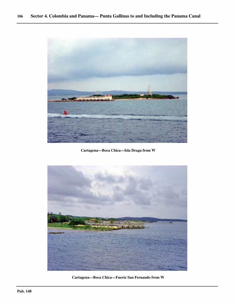
106 Sector 4. Colombia and Panama— Punta Gallinas to and Including the Panama Canal
Pub. 148
4.18Cartagena—Boca Chica—Isla Draga from W
4.18Cartagena—Boca Chica—Fuerte San Fernando from W

Sector 4. Colombia and Panama— Punta Gallinas to and Including the Panama Canal 107
Pub. 148
4.18Cartagena—Boca Chica—Fuerte San Fernando from E
4.18Cartagena—Colklinker Terminal

108 Sector 4. Colombia and Panama— Punta Gallinas to and Including the Panama Canal
Pub. 148
4.18Cartagena—Inner Harbor—Punta Castillo Grande and Naval Club Light from N
4.18Cartagena—Inner Harbor—Punta Castillo Grande and Naval Club Light from N

Sector 4. Colombia and Panama— Punta Gallinas to and Including the Panama Canal 109
Pub. 148
4.18Cartagena—Inner Harbor—Maritime Terminal
4.18Cartagena—Inner Harbor—Maritime Terminal and Cerro La Popa

110 Sector 4. Colombia and Panama— Punta Gallinas to and Including the Panama Canal
Pub. 148
night, stands near the beach on Castillo Grande SW of the city.As there are many high-rise hotels in the area, this hotel is con-spicuous in daylight because of its low profile and red tile roof.
4.18Cartagena—Inner Harbor—Cerro La Popa from WSW
4.18Punta Castillo Grande Light
4.18Cartagena—Inner Harbor—Statue

Sector 4. Colombia and Panama— Punta Gallinas to and Including the Panama Canal 111
Pub. 148
The summit of Isla Tierra Bomba is 84m high.4.18 Radar prominent landmarks include the cliffs on the W pointof Isla Tierra Bomba, Fort San Fernando, the Mamonal oil pier,the water tower E of Isla Bruja, the tank N of the oil pier, PuntaChabo, Punta de La Playa de Viente, Maritime Terminal PierNo. 1, and Punta Castillo Grande.4.18 Pilotage.—Pilotage is compulsory for vessels and is avail-able 24 hours. The pilot boards in position 10°18.9'N,75°35.9'W. Vessels entering Mamonal require a mooring mas-ter who will board in position 10°19'01.8''N, 75°31'18.0''W.4.18 The signal for a pilot by day is the prescribed signal from theInternational Code of Signals and also four long blasts fortankers and three long blasts for all other vessels. It is advisableto notify the pilotage office 48 hours and 24 hours prior to ar-rival. 4.18 Contact Information.—See the table titled Cartagena—Contact Information.
4.18 Regulations.—Vessels should not pass one another in BocaChica. Vessels entering the harbor should give way to vesselsleaving the harbor.4.18 Anchorage.—There is good anchorage in the outer harbor,in a depth of 22-27m, mud and good holding ground, SW ofPunta Castillo Grande. In the inner harbor there is anchorage,in depths of 14 to 16.5m, mud, about 0.3 mile SW of the Wpier. A mooring buoy is located near the center of theanchorage area S of Castillo Grande. A restricted anchoragefor naval vessels is situated E of the naval base and N of PuntaCastillo Grande. 4.18 There are additional specialized anchorage areas for tankers,barges, and vessels using Mamonal Port. Tankers will use An-chorage A centered about 1,000m E of the Mamonal pier head.Additional anchorage is centered about 3,000m E of Isla Aban-co. Barges will use a designated area in Bajos de Cienaga Hon-da. These areas can best be seen on the chart. 4.18 Caution.—A restricted area, reserved for naval operations ofthe Colombian Navy, lies in the SW approach to Bahia deCartagena and may best be seen on the chart. Mariners arerequested to navigate with care and to stay clear of therestricted area.4.18 Boca Chica, the entrance channel, accommodates one-waytraffic only; outbound vessels have the right of way.4.18 An obstruction, with a depth of 1.2m, lies near the center ofBahia de Cartagena, about 2 miles ENE of Isla Draga and ismarked by a buoy.
4.18Cartagena—Pilot Vessel
Cartagena—Contact Information
Harbormaster
VHF VHF channels 11, 14, and 16
Telephone57-095-664-3237
57-095-664-6125
Facsimile 57-095-664-9282
Port Authority
Telephone 57-095-660-7781
Facsimile 57-095-660-2239
E-mail [email protected]
Web site http://www.puertocartagena.com
Container Terminal (CONTECAR)
Telephone 57-095-657-1750
Facsimile 57-095-667-2995
Promar Pilots
VHF VHF channels 11 and 16
Telephone
57-095-664-4648
57-095-660-0655
57-095-664-7066
E-mail [email protected]
Web site http://www.promarpilots.com
CMS Pilots/Cartagena Pilots
VHF VHF channels 11 and 16
Telephone57-095-645-9743
57-093-126-599-806 (mobile)
Web site http://www.cartagenamaritime.com
Mamonal
Port Authority
VHF VHF channels 16 and 18
Telephone 57-095-653-5888
Facsimile 57-095-668-7037
E-mail [email protected]
Web site http://www.puertodemamonal.com
Cartagena—Contact Information

112 Sector 4. Colombia and Panama— Punta Gallinas to and Including the Panama Canal
Pub. 148
4.18 It has been reported that during the summer months, thundercell activity can generate winds strong enough to have vesselsdrag their anchors in the anchorage.4.18 The buoyage within Bahia de Cartagena is subject to fre-quent changes. Consult the local Port Authority for the latestinformation.
Cartagena to Golfo de Uraba
4.19 Between Punta Canoas and Punta Caribana, 143 milesSW, the coast extends S for 70 miles to the small port of Cove-nas, in the S part of Golfo de Morrosquillo. It then extends for25 miles in a general W direction and continues S for an addi-tional 64 miles. This coast presents a varied aspect of high,steep land, narrow coastal plains, low shores covered withmangroves, and prominent hilly landmarks. There are severalbays and inlets off this section of coast, the most important be-ing Bahia de Cartagena, in which lies the port of Cartagena.There are numerous small towns and villages along this stretchof coast, but the aids to navigation are sparse. Between Carta-gena and Golfo de Uraba, multiple marine reserves lie betweenthe shore and the 1,000m curve.
Islas del Rosario (10°11'N., 75°45'W.) consist of several is-lands standing on the detached banks that extend up to 9.5miles W through points lying 6.3 miles NW from Punta Baru.
Isla Tesoro, marked by a light, the northernmost island of thegroup, is small, sandy, and surrounded by foul ground whichextends up to about 0.8 mile offshore. A bank, with a leastdepth of 5.5m, lies with its shallowest part about 1.8 milesNNE of Isla Tesoro. 4.19 Isla del Rosario, the southernmost island of the group, lies 5miles W of Punta Baru, is marked by a light, and is coveredwith palm trees. Isla Grande, the largest of the group, is lowand lies 2.3 miles ENE of Isla del Rosario.4.19 The depths between the islands are very irregular and thereare many rocks and reefs. The outermost bank lies 3.3 miles Wof Isla del Rosario and has a least depth of 11.6m.4.19 Regulations.—A national marine park called Corales delRosario encompasses the waters surrounding Isla del Rosario,Banjo Tortuquilla, Islas San Bernardo, and the waters betweenthem.4.19 Anchoring, dumping, discharging, and fishing are prohibitedwith the Natural Coral National Park. Vessels transporting hy-drocarbons or other dangerous cargoes are prohibited fromtransiting.4.19 Ships, barges, fishing vessels, and major coastal craft are for-bidden to sail through the channels between Isla Arena, PuntaBaru, and Isla Grande. 4.19 Caution.—These banks, as well as Bajio Tortuga, describedbelow in paragraph 4.18, constitute a danger in the S approachto Bahia de Cartagena and should be given a wide berth.
Cartagena—Berth Information
Berth Length Depth Maximum Vessel
RemarksLOA Draft Beam
Cartagena
Automobiles Terminal
Ro-Ro Berth — — 200m 8.8m 35.4m Berthing length: of 240m (including dol-phins)
Manga Terminal Maritimo (SPRC)
No. 1 200m 6.1m 134.3m 5.7m 19.9m Cruise vessels and ro-ro.
No. 2 202m 12.0m 350m 11.5m 41.4m Cruise vessels and ro-ro. Berthing length of 436m (including dolphins).
No. 3 182m 12.0m 350m 11.5m 36.0mCruise vessels, containers, and general cargo. Berthing length of 416m (includ-ing dolphins).
No. 5 202m 12.0m 350m 11.5m 36.0mCruise vessels, containers, and general cargo. Berthing length of416m (includ-ing dolphins)
No. 6 182m 12.0m 350m 11.5m 32.2mCruise vessels, containers, and general cargo. Berthing length of 358m (includ-ing dolphins).
No. 7 217m 13.4m 350.5m 13.1m 48.4m Cruise vessels, containers, and general cargo.
No. 8 217m 13.7m 350.5m 13.1m 48.4m Cruise vessels, containers, and general cargo.
No. 9 217m 13.7m 330m 13.1m 48.4m Cruise vessels, containers, and general cargo.

Sector 4. Colombia and Panama— Punta Gallinas to and Including the Panama Canal 113
Pub. 148
Note.—Berth No. 7, Berth No. 8, and Berth No. 9 have a continuous berthing length of 651m.
Terminal de Contendores de Cartagena S.A. (CONTECAR)
Main Quay — 16.5m 350.5m 13.7m 48.4m Containers. Berthing length of 968m (continuous)
Terminal Maritimo Muelle el Bosque SA, Cartagena
Quay 1 148m 12.0m 210m 11.0m 32.2m Containers, project, and bulk carriers.
Quay 2 148m 12.0m 225m 11.0m 32.2m Containers, project cargo, and bulk carri-ers.
Quay 3 225m 11.5m 210m 9.0m 32.2m Containers, project cargo, and bulk carriers.
Quay 4 148m 12.0m 225m 11.0m 32.1m Containers, project cargo, and bulk carriers.
Note.—Quay 1, Quay 2, and Quay 4 have a continuous berthing length of 440m.
Algranel Terminal
Products Berth 12m — 180m 8.2m 27.4m Multipurpose. Berthing length of 152m (including dolphins).
Mamonal
Abacol Terminal
Abacol Berth 200m 7.3m 120m 6.0m — Fertilizer.
Bavaria Barley Terminal
Berth 1 — — 170m 9.7m — —
Puerto de Mamonal Terminal
Main Quay 300m — 190m 11.2m — Coal, bulk, heavy lift, and project cargo.
Colcinker Coal Terminal
Berth 1 380m 11.4m 250m 11.4m — Coal and cement.
Dow Terminal
Dow Chemicals 172m — 180m 8.2m — —
Colterminales
Colterminales Jetty 180m 8.5m 180m 8.5m — Chemicals.
Dexton Terminal
Dexton 52m — 130m 7.9m — Chemicals.
Vopak Terminal
Vopak Berth 270m — 180m 8.5m — Chemicals.
Olefins and Derivatives Terminal (Mexichem)
Mexichem Berth 83m — 91m 7.3m — Chemicals.
Petroquimica
Petroquimica Jetty 60m 7.9m 152.4m — — Chemicals.
Ecopetrol Refinery
Ecopetrol LPG Berth 142m — 110m 5.0m — LPG.
Cartagena—Berth Information
Berth Length Depth Maximum Vessel
RemarksLOA Draft Beam

114 Sector 4. Colombia and Panama— Punta Gallinas to and Including the Panama Canal
Pub. 148
4.19 The channel between and inside the islands and shoalsshould not be attempted without local knowledge.4.19 Depths in the vicinity of Islas del Rosario, Bajio Tortuga,and W of Isla Baru may be less than charted.4.19 A dangerous obstruction lies about 7.5 miles W of Isla Rosa-rio.
4.20 Bajio Tortuga (10°05'N., 75°52'W.), with depths of4.6 to 18.3m, lies between 3 miles and 9.5 miles SW of Isla delRosario.4.20 Islas San Bernardo are a group of low rocks, wooded cays,and shoal banks that extend up to 13.5 miles W through about14.5 miles NW from Punta San Bernardo (9°42'N., 75°42'W.).Isla Tintipan, the northernmost cay of the group and the largest,lies 9.3 miles NW of Punta San Bernardo. Isla Ceycen, thesouthernmost cay, lies 9.8 miles W of the same point and ismarked by a light. 4.20 Canal Salamanquilla is a narrow navigable channel, withdepths of 20.1m, between the coastal bank extending N fromPunta San Bernardo and the bank surrounding the E cay of thegroup 3.3 miles NW of the point. Another channel, about 1mile wide and with a least depth of 29.3m, lies between the lat-ter bank and the shoals surrounding the main group of cays.4.20 Between Punta Baru and Punta San Bernardo, a low sandypoint, about 26 miles S, the coast recedes about 9 miles NE toform Bahia de Barbacoas, about 7 miles E. This bay has nocommercial importance to shipping.4.20 Golfo De Morrosquillo (9°35'N., 75°40'W.) recedes about 8to 10 miles E between Punta San Bernardo and Punta Mesti-zos, 7 miles SSW. The low coast is fringed by mangroves andwooded swamps. A conspicuous tank and a church stand in thetown of Tolu, 12.5 miles SE of Punta San Bernardo; severalsmall jetty walls, which are radar conspicuous, extend a shortdistance from the beach just in front of the town.4.20 Roca Morrosquillo (9°36'N., 76°00'W.), a coral shoal con-sisting of two heads, one with a depth of 9.1m, while the other,
located 0.3 mile N, has a depth of 21m and is marked by buoys.The shoal lies in the approaches to Covenas Offshore Oil Ter-minal.
4.21 Covenas (9°25'N., 75°41'W.) (World Port Index No.11900), an oil-loading port, stands on the S side of Golfo deMorrosquillo. A water tank in the village is a good landmark.A private pier restricted to the Covenas oil terminal supportfleet, 501m in length and 7.9m alongside, is located E of thetank farm.
4.21 Pilotage.—Pilotage is compulsory. A docking master boardsvessels from a tug/pilot boat and leaves the dock on sightingthe vessel. The pilot boards in position 9°32.5'N, 75°50.0'W(tanker anchorage) and position 9°32.7'N, 75°45.9'W (vesselsberthing on arrival). The pilots can be contacted on channels16, 20, and 84; VHF channel 16 is monitored 24 hours.4.21 Regulations.—Mooring is limited to daylight hours; howev-er, unmooring can be undertaken at any time. A compulsory ar-
Ecopetrol Nestor Pineda Oil Berth 154m 16.0m 260m 10.9m 36m Offshore platform with dolphins.
Ecopetrol Refinery Jetty (Mamonal Oil Terminal)
Refinery Oil Berth 96m 14.0m 260m 10.9m 36m Petroleum products.
Puerto Bahia
Puerto Bahia Liquid Terminal
Jetty (N side) 335m 22.0m — 20.0m — Petroleum products.
Jetty (S side) 335m 22.0m — 20.0m — Petroleum products.
Barge Dock N 46m — — — — Petroleum products.
Barge Dock S 46m — — — — Petroleum products.
Multipurpose Terminal
Multipurpose Quay 300m 19.0m — 18.0m — Breakbulk, extra-heavy cargo, ro-ro, and containers.
Cartagena—Berth Information
Berth Length Depth Maximum Vessel
RemarksLOA Draft Beam
4.21Covenas Tank Farm

Sector 4. Colombia and Panama— Punta Gallinas to and Including the Panama Canal 115
Pub. 148
rival safety inspection will be conducted by the cargo loadingmaster.4.21 Vessels should establish contact with Covenas Port Controlwhen within 30 miles.4.21 All vessels loading at Covenas Terminal must send a notifi-cation 72 hours, 48 hours, and 24 hours prior to arrival.4.21 Contact Information.—See the table titled Covenas—Contact Information.
4.21 Anchorage.—Vessels awaiting customs and quarantine in-spection should anchor in the quarantine anchorage establishedas best seen on the chart. After being cleared for entry, vesselsmay proceed E to the designated anchorage area, as shown on
the chart, and anchor, in depths of 30 to 36m, mud. Strong SEwinds prevail in Golfo de Morrosquillo during the month ofDecember.4.21 Caution.—Anchorage and all other bottom activity is pro-hibited in the area spanning Punta Bolivar and Punta de Pie-dras, extending in a NW direction for a distance of about 10miles from the pier head. Submarine pipelines have been laidin this area for the purpose of cargo transfer. Reference shouldbe made to the chart. There is a large artificial reef in the SEbasin between Covenas and Tolu, which lies between the 10and 20m depth curve and close SW of the charted anchoragearea near Tolu.
4.22 Covenas Offshore Tanker Terminal (9°31.7'N.,75°47.2'W.) (World Port Index No. 11901), lying NW of Puer-to Covenas, consists of an SPM. It is situated about 9.8 milesNW of Covenas. A Tanker Loading Unit (TLU), consisting ofan SPM, is moored 6.5 miles NNW of Covenas. Two moreunits are moored 7.8 miles NW of Covenas.
4.22 Pilotage.—Pilotage is as previously described in the sectioncovering Covenas Pilotage.4.22 Regulations.—Vessels are warned that they risk prosecutionif they anchor, travel, or carry out other activities affecting thesea bed within the restricted areas. Such areas, which may bestbe seen on the chart, are situated in the vicinity of submarinepipelines. 4.22 Anchorage.—Anchorage areas were previously described inthe discussion for Covenas in paragraph 4.19.
4.23 Bahia de Cispata (Bahia Zispata) (9°25'N.,75°47'W.), with the Rio Sinu flowing into its head, lies be-tween Punta Mestizos and Punta Bello, about 3.4 miles E. Atall prominent stack stands in the ruins of a village on the SEside of the bay. Small craft, with the aid of a pilot from Carta-gena, can navigate several miles up the river. It was reportedthat depths of 4.6m, or less than charted, lie within the 10mcurve in Bahia de Cispata.4.23 Between Punta Mestizos and Punta Piedras, 18 miles WSW,the coast is low and fringed by mangroves. The 10m curve liesup to 4 miles offshore.4.23 Isla Fuerte (9°23'N., 76°11'W.), a low, wooded islet, liesabout 6.5 miles WNW of Punta Piedras and is surrounded byfoul ground that extends up to 2.5 miles from the S side andnearly 1.5 miles from its W side. The islet is difficult to distin-guish when approaching from the W. A village stands on its Sside. A light is shown from the island.4.23 Bushnell Shoal, with a least depth of 11.9m, lies about 9.5miles WNW of Isla Fuerte. In addition to the above dangers,there are several detached depths of less than 18m lying sea-
4.21Covenas Tanker Loading Unit (TLU-2)
Covenas—Contact Information
Terminal
Call signOcensa Control
Ecopetrol Coveñas Control
VHF VHF channels 16, 20, and 84
Harbormaster
Telephone
57-095-288-0199
57-095-288-0221
57-095-288-0303
Covenas Terminal—Berthing Information
BerthMaximum Vessel
LOA Draft
TLU-1 335m 17.0m
TLU-2 340m 22.0m
TLU-3 335m 22.0m

116 Sector 4. Colombia and Panama— Punta Gallinas to and Including the Panama Canal
Pub. 148
ward of the 20m curve.
4.24 Punta Piedra (9°20'N., 76°05'W.) is the extremity ofa bold headland which extends SW for 3 miles and terminatesat Punta de La Rada.4.24 Punta Broqueles, a rocky projection fringed by a reef extend-ing about 0.3 mile seaward, lies about 8 miles SW of PuntaPiedra. Bajio Toro, with a least depth of 1.2m, lies 1.3 miles Nof the point. Farallon, a group of rocks, up to 5m high, lies 1.8miles SW of the point. Two isolated depths of at least 6m lie 6miles SW of the point.4.24 Cerro Tortugon, a 208m high, prominent, conical hill, standsclose to the coast, 13 miles SSW of Punta Broqueles. Yuca, avillage with a conspicuous white church, is situated on thecoast 2.5 miles N of Cerro Tortugon.4.24 Isla Tortuguilla (9°02'N., 76°20'W.), a small wooded islet,lies 5 miles W of Cerro Tortugon. Depths of less than 9m liewithin 0.8 mile of the islet. A light is shown from the NW ex-tremity of the island.4.24 Punta Arboletes (8°53'N., 76°26'W.), a prominent lowwooded point, lies 14 miles SW of Cerro Tortugon. Cerro Ma-conda, a prominent hill, stands 5 miles E of the point.4.24 Punta San Juan (8°48'N., 76°31'W.), conspicuous from theNE and SW, stands 7 miles SW of Punta Arboletes. A villagestands close N of Punta San Juan.4.24 Punta Sabanilla (8°44'N., 76°38'W.), a low point, is located15 miles SW of Punta Arboletes. Cerros de Sabanillas, a groupof hills, rises 2.5 miles SSE of the point. The highest hill risesto an elevation of 248m. A bank, with unknown depths, liesabout 5 miles W of Punta Sabanilla. Punta Giganton, a low andsandy point, lies 1.3 miles SSW of Punta Sabanilla.
Golfo de Uraba
4.25 Punta Caribana (8°37'N., 76°53'W.), the E entrancepoint of Golfo de Uraba, is low, wooded, and marked by alight. Cerro Aguila stands close within the point and is an ex-cellent landmark. Foul ground, with some rocks awash, ex-tends 3.8 miles NNW from the point. The 20m curve lies 9miles N and 4 miles W of the point.4.25 The coast between Punta Caribana and Cabo Tiburon, 28miles W, recedes 45 miles S to form Golfo de Uraba. Theshores of the gulf are generally low, heavily-wooded, andswampy on the E, S, and SW sides, and hilly, with coves andsandy beaches, on the NW side. The coastline was reported(1985) to have extended seaward on both the E and W shoresof Golfo de Uraba, especially between 8°00'N and 8°10'N.Loss of depth due to sedimentation from the mouth of the Atra-to River has been found in Golfo de Uraba, SE of Isla LosMuertos. Serrania del Darien is a mountain range backing thecoastal plain on the W side about 12 to 15 miles inland. Severalrivers discharge into the gulf. The delta of the Rio Atrato ex-tends into the gulf from the SW side, forming a bight at itshead called Bahia Colombia.4.25 Winds—Weather.—Between Punta Caiman and PuntaRevesa, a current has been observed to set N at a velocity of upto 2 knots.4.25 Chocosanas is the name of S storms which are very commonfrom June to October. They occur most frequently from 2200to 2400 and are preceded by light N winds and general light-
ning around the horizon. The wind gradually shifts from N to Sincreasing in force. The main storm center lasts about 30 min-utes, with winds attaining nearly hurricane force. It is accom-panied by heavy rain and electrical disturbances, and as muchas 160mm of rain may fall during one storm.
4.26 From Punta Caribana, the low coast extends about 5.5miles SW to Punta Arenas del Norte (8°33'N., 76°56'W.),which is the W end of a sandy, steep-to peninsula which ismarked by a light. A stranded wreck lies 0.3 mile NW of PuntaArenas del Norte. 4.26 Between Punta Arenas del Norte and Punta Caiman(8°16'N., 76°46'W.), a low sandy point 19.5 miles SE, the coastrecedes 4.5 miles SE and is low, with several hills near theshore. Punta Uraba, a rocky bluff with a village on it, is locatedmidway between the two points. 4.26 From Punta Caiman, the coast extends S for 12.8 miles toPunta las Vacas (8°04'N., 76°44'W.), the N entrance point ofBahia Turbo. The coast between the latter point and a positionlying 5.5 miles N was reported (1983) to be extending W, withconsiderable reef build up. It also was reported that a point hasbeen formed at this position, and the Rio Turbo flows out atthis point.4.26 Depths—Limitations.—There are general depths of 18 to64m in Bahia Colombia. The 10m curve lies up to 1.8 miles offthe E shore of the gulf and up to 1.5 miles off the W shore. Inthe vicinity of the Rio Atrato, the 10m curve lies up to 2.3miles offshore; in the W part of the bay, the 10m curve lies upto 3 miles offshore.4.26 There are several small islets along the W side of the gulf,but they all lie within the 10m curve.4.26 Turbo (8°06'N., 76°43'W.) (World Port Index No. 11880) issituated 1.5 miles NE of Punta las Vacas. STS TranshipmentArea A and Area B handle containers loaded onto vessels vialighters and barges. 4.26 Pilotage.—Pilotage is compulsory in Bahia Colombia. Thepilot boards in position 8°03.7'N, 76°45.9'W. Departing vesselsshould advise pilots 2 hours prior to departure.4.26 Contact Information.—See the table titled Turbo—Con-tact Information.
4.26 Anchorage.—Vessels anchor about 2 miles W of Punta las
Turbo—Contact Information
Harbormaster
Call sign Capitania Turbo
VHF VHF channel 16
Telephone
57-094-882-1571
57-094-822-1572
57-094-822-1425
Coast Guard
Call sign Turbo Coastguard
VHF VHF channel 16

Sector 4. Colombia and Panama— Punta Gallinas to and Including the Panama Canal 117
Pub. 148
Vacas, in a depth of 13m, to await the boarding officials. Thereare two additional charted anchorages in the S and SW parts ofthe bay which can best be seen on the chart. Quarantine an-chorage is situated about 2.25 SSW of Punta las Vacas. 4.26 Caution.—A dangerous wreck lies about 6.6 miles SSW ofPunta las Vacas, near the S anchorage area.
4.27 Between Cabo Tiburon, the W entrance point ofGolfo de Uraba, and Punta Yerbasal, at the N end of the deltaof the Rio Atrato, 35 miles SE, the W coast of Golfo de Urabais rocky, rugged, and backed by heavily-wooded slopes. Thereare many bluffs and some sandy beaches and coves. Several is-lets and rocks lie within 1.5 miles offshore.
Acandi (8°31'N., 77°16'W.) lies at the mouth of the RioAcandi, 11 miles SE of Cabo Tiburon.
4.27 Terron de Azucar is an excellent landmark located betweenCabo Tiburon and Acandi. It is a precipitous dark rock lying1.3 miles offshore, about midway between the two positions. Adetached 6.8m depth lies 0.3 mile NNW of the rock. A rockyridge, over which the sea breaks in heavy weather, connectsTerron de Azucar with the coast.4.27 Between Acandi and Punta de La Goleta, a steep rocky point8 miles SE, there is a sandy beach that is broken by the hills ex-tending to the shore nearly 2 miles SE of the town. Two largerocks, 7m high, stand 0.5 mile NNE of the point.4.27 From Punta de La Goleta, the coast resumes its rugged andbold character and continues 13.3 miles SE to Playa Tarena, alow sandy beach that extends an additional 5.5 miles to PuntaYerbasal. Several rocks and islets lie within 1.5 miles of thiscoast.4.27 Isla Napu (8°25'N., 77°07'W.), a steep and rocky island,covered with brush and small trees, lies 2.8 miles ESE of Puntade La Goleta.4.27 The delta of the Rio Atrato, one of the largest rivers in SouthAmerica, lies between the vicinity of Punta Revesa (Punta Yer-basal) (8°16'N., 76°57'W.) and a position 15 miles S. Thislarge area is mangrove-covered swampy land extending up to6.5 miles E of the general trend of the coast. Isla Los Muertos(8°08'N., 76°50'W.), a small, wooded islet lying 10.5 miles SEof Punta Yerbasal, is the easternmost feature of the delta and is
the only solid ground in the whole area. Shoaling was reported(1982) E of Isla Los Muertos. Shoaling was also reported off asalient point located 6.8 miles SSW of the island. The river hasseveral principal mouths, the largest being the Boca Tarena, 2miles W of Punta Revesa.
Golfo de Uraba to the Panama Canal
4.28 Cabo Tiburon (8°41'N., 77°22'W.), the W entrancepoint of Golfo de Uraba, is a bold steep-to promontory, whichrises to a height of 123m a short distance inland. On its NW ex-tremity are two concrete beacons which mark the boundary be-tween Colombia and Panama. The seaward beacon stands on apinnacle rock. A light, with a racon, is shown from the cape.4.28 Between Cabo Tiburon and Punta Carreto, 12 miles NW, thecoast recedes about 3.5 miles W then NW to form a bight inwhich are several small coves. There are few dangers here.With the exception of a 10m shoal and a steep-to 19m coralbank lying 1.5 and 7.5 miles NE of Punta Carreto, respectively,the 20m curve follows the trend of the coast at 1 mile offshore.In heavy weather, the sea breaks on this shoal.4.28 Puerto Obaldia, a small cove in which there is a village, lies4 miles W of Cabo Tiburon. The intervening coast is rathersteep-to and rocky, with steep heavily-wooded hills rising in-land. A prominent rock lies 1 mile N of the E entrance point ofthe cove.
4.29 Puerto Perme (8°45'N., 77°32'W.), a narrow cove,lies 8 miles NW of Puerto Obaldia. A village is situated 1 mileSSW of Puerto Perme. The port is abandoned, but anchoragecan be taken, in a depth of 9.7m, in the center of the cove.4.29 Puerto Carreto, a small cove, lies close W of Punta Carreto.Two steep-to rocky patches lie 2.5 miles N of Punta Carretoand break with fresh breezes. There are general depths of 5.5 to16.5m in the cove. A small village stands near the mouth of ariver on the W side of the cove.4.29 Between Puerto Carreto and Punta Brava, 39.5 miles NW,the coast is fronted by many dangers which extend up to 5miles offshore. Some of the projecting headlands and isletsmake good landmarks. Punta Escoces, a remarkable headland,rises to a 177m summit about 5.5 miles NW of Puerto Carreto.4.29 Between Punta Escoces and Punta Sasardi, another peninsu-la 9 miles NW, there are several roadsteads which provide an-chorage. Islas Sasardi, a group of high islets, lie on the coastalbank within 2.5 miles of the coast between the above points.Bahia Caledonia lies W of Ilha de Oro, a high islet 3.8 milesNW of Punta Escoces. Bahia Sasardi lies SW of Punta Sasardi.The approaches to these roadsteads are intricate.4.29 From Punta Sasardi, the coast extends about 25 miles NW toPunta Brava. About midway between these points, a peninsulaprojects NW from the coast.4.29 All of the known dangers lie up to 4 miles offshore betweenPunta Sasardi and Punta Brava. Isla de Pinos, 122m high, lies0.3 mile offshore about 2.5 miles NW of Punta Sasardi. Isla Pa-jaros, a low islet surrounded by reefs, lies 2.5 miles fartherNW. It was reported that Isla Pajaros is an outstanding land-mark as it is densely wooded, with coconut trees about 24mhigh. 4.29 Caution.—Much of the coastal area between Cabo Tiburonand Punta Brava has not been surveyed. Extreme caution
4.27Acandi from W

118 Sector 4. Colombia and Panama— Punta Gallinas to and Including the Panama Canal
Pub. 148
should be used in approaching this stretch of coast.
4.30 Between Punta Brava (9°15'N., 78°03'W.) and Pun-ta Mandinga (9°28'N., 78°58'W.), 57 miles WNW, the coast isfronted by the Archipielago De San Blas, a closely borderedgroup of cays, reefs, and banks lying within 10 miles of thecoast. The village of Rio Diablo stands on two small islandsclose offshore 34 miles WNW of Punta Brava. Depths in thevicinity are reported to be less than charted.4.30 There are a number of navigable channels in the Archipiela-go de San Blas, and vessels with local knowledge have littletrouble navigating them. The E approach to Golfo de San Blasis made through this group via Canal Caobo (9°33'N.,78°40'W.) and Canal Mayflower (9°33'N., 78°45'W.).4.30 Golfo de San Blas (9°30'N., 79°00'W.) lies between PuntaSan Blas and Punta Mandinga, and is entered from the N byCanal de San Blas, which leads in adequate depths 2.5 miles Eof Punta San Blas. There are numerous detached dangers in theS and W parts of the gulf. Numerous creeks and rivers dis-charge into this gulf, but their entrances are obstructed by bars.The N shore of the gulf is swampy and fringed with man-
groves. The S shore is low, but E of Punta Mandinga the highland approaches the coast.4.30 Islas Robeson, a group of small islands, lie in the SW part ofthe Golfo de San Blas. Between these islands and the W side ofthe gulf lies Bajo Alden (9°28'N., 79°03'W.). A channel, whichis not buoyed, leads through Bajo Alden to a roadstead off theSW shore of the gulf. The entrance of this channel lies 1.3miles WNW of the westernmost island of Islas Ammen. Thechannel is about 270m wide and has depths of 18 to 35m. Cau-tion should be exercised to avoid the 1.5m depth lying 1.5miles W of the westernmost of the Islas Ammen.4.30 An man-made stone and coral island stands on a reef 0.3mile SW of Sail Rock (9°33'N., 78°57'W.), on the W side ofCanal de San Blas. This island shows clearly on radar. Astranded wreck lies close E of Sail Rock.4.30 Isla Porvenir lies 0.3 mile NNW of Sail Rock. A governmentstation compound, with two conspicuous buff-colored build-ings and several lesser structures, stands on the W side of theislet. All vessels transiting in and out of Golfo de San Blasmust contact this station. 4.30 Caution.—There are no charted navigation aids in the Golfo
Blue Sea Farm cage

Sector 4. Colombia and Panama— Punta Gallinas to and Including the Panama Canal 119
Pub. 148
de San Blas. Extreme caution is advised when navigating in thearea.
4.31 Punta San Blas (9°34'N., 78°58'W.) has a low ex-tremity. A hill, 46m high, rises 0.5 mile NW of its E extremity.A 61m hill, which is the highest of a group of four hills, risesl.5 miles WSW of the E extremity. A conspicuous tower stands0.8 mile SW of the extremity.4.31 Between Punta San Blas and Punta Macolla, (9°36'N.,79°26'W.), 28 miles W, the coast is low and wooded, but in thevicinity of the latter point, the mountains approach the coast.Two conspicuous peaks stand here and rise to high elevations.Several villages stand along this stretch of coast.
Piedra de Culebra (9°34'N., 79°13'W.) lies 0.5 mile N ofthe extremity of a projecting peninsula near Palmira. The isletis easily recognized and shows up dark against the mainland.4.31 The depths off this section of coast are very irregular; bankswith depths of 9m are found up to 6 miles offshore. A coral ar-ea lies, awash, about 2 miles offshore, about 9 miles WNW ofPunta San Blas; depths of 3.7 to 5.6m lie within 0.8 mile NNWof the coral area. Several small islets lie within 0.5 mile of theshore.4.31 Punta Macolla is bold, high, and easily identified. From theW, it appears as a dark bluff.
4.31 Punta Pescador (9°36'N., 79°28'W.) is a reef-fringed pointclose W of Punta Macolla. La Providencia Shoal, a bank with aleast depth of 8m, lies 3 miles N of the point.4.31 La Provendencia Shoal (9°39'N., 79°27'W.), located ap-proximately 3 miles NNE of Punta Pescador, has a least depthof 8.1m and an area with depths of less than 9m stretchingabout 1,000m from WNW to ESE. 4.31 Caution.—Open Blue Sea Farm, an aquaculture company,operates cages for the study of marine life close N of La Prov-endencia Shoal. These cages are marked by buoy. There havebeen reports (2011 and 2015) that vessels are passing too closeand creating a high risk of collision with them. All vesselsshould give these structures a wide berth when passing N of LaProvendencia Shoal.
4.32 Bahia San Cristobal (9°37'N., 79°30'W.), enteredbetween Punta Pescador and Punta Manzanillo, 5 miles WNW,is divided into several small bights. There are a number of dan-gers in the bay, the outermost being some rocks, nearly awash,2.3 miles W of Punta Pescador and some bare black rocks, thehighest about 1.4m high, lying 1.8 miles SE of Punta Manza-nillo. Depths of 9 to 18m exist within the bay.4.32 Bahia Nombre de Dios (9°35'N., 79°28'W.), a small shal-low bay with depths of 1.8 to 8.2m, lies about 1 mile SW of
Blue Sea Farm cage group

120 Sector 4. Colombia and Panama— Punta Gallinas to and Including the Panama Canal
Pub. 148
Punta Pescador. A narrow channel, with a least depth of 5.8m,leads S into the bay. A village is situated on the S side of thebay.4.32 A pier, about 180m long, is situated on the W side of the en-trance to Bahia Nombre de Dios and has a depth of 6.1malongside its head.4.32 Anchorage can be taken, in a depth of 12m, within Rada Pla-ya de Damas, close N of the entrance to Bahia Nombre de Di-os.4.32 Punta Manzanillo (9°38'N., 79°33'W.), the N extremity ofthe coast of Panama, is a high, precipitous projection with twoconical hillocks resembling a saddle. It is the termination of amountain ridge that extends along the coast to the mouth of theRio Piedras.4.32 Los Magotes De Manzanillo (9°38'N., 79°32'W.) consistsof two islets and some rocks lying within 1 mile NE of PuntaManzanillo. Mogote de Afuera, the outer islet, has a tree on itssummit and is 11m high. Magote de Adentro, the inner islet, iswooded, round topped, and 41m high.
4.33 Bajos Mafu, with a depth less than 1.8m, lies about0.3 mile NW of Punta Manzanilla within a bank with depths ofless than 18m. The sea generally breaks over these rocks.4.33 Isla Grande (9°38'N., 79°34'W.), a high palm tree-coveredisland, lies 1 mile W of Punta Manzanillo. Foul ground extendsalong all except its NE side. Isla Grande, marked by a light, isreported to be radar conspicuous.4.33 Cayo Tambor, a small flat-topped islet, lies 0.3 mile NNW ofIsla Grande and is connected to it by reefs, some of which areabove-water. The islet gives the appearance of an inverted panfrom the NE. Its N end is higher than the S end.4.33 A confused sea and tide rips are nearly always found in thevicinity of the islet.4.33 Between Punta Manzanillo and Punta Cacique, a high steep-to projection backed by twin projections, the coast is indentedby several small bays and is fronted by a number of islands andshoals.
4.34 Puerto Garote (9°36'N., 79°35'W.), a small harborentered 0.5 mile W of Isla Grande, is formed by the coast andseveral off-lying islands. The narrow entrance has depths of 11to 22m. The inlet leading into the harbor has a depth of 10.3mand there is a depth of 6.1m in the center of the harbor. A smallpier extends from the shore of the harbor.4.34 Anchorage can be taken in this harbor by one moderate-sizevessel.4.34 La Lavandera (9°38'N., 79°36'W.), two rocks with a leastdepth of 0.9m, lie in the approach to Puerto Garote, 1.3 milesW of the W end of Isla Grande. The sea almost always breakson La Lavandera; however, when the sea is very smooth, theremay not be a break for 15 to 20 minutes.4.34 Las Farallones, a group of rocks, some submerged, lie up to2 miles offshore NNW of Punta Cacique. Farallon Sucio, 24mhigh, is the largest of these rocks and displays a light. From adistance, the rocks appear as one and are easily discernible bytheir bare whiteness. Farallon Sucio is reported to be radarprominent.4.34 The coast between Punta Cacique and Punta Mantilla, about4.8 miles SW, is high and indented by several bays. With theexception of the coastal bank that extends up to 1 mile off-
shore, about midway between the above points and on whichare the two conspicuous islets of Duarte, the coast is fairlysteep-to, the 20m curve lying up to about 0.2 mile offshore.
Punta Esperanza (9°37'N., 79°38'W.), located 1 mile WSWof Punta Cacique, and Punta Sabanilla, about 1.5 miles furtherWSW, are both cliffy.4.34 Piedras La Gallina, two dangerous rocks, lie close together0.1 mile offshore and 0.5 mile NE of Punta Mantilla. IslaDrake, a small islet 21m high, lies 0.1 mile offshore and 0.3mile SW of Punta Mantilla. Its W extremity appears as a de-tached rock. Bajo Salmedina, a coral reef on which the seabreaks, lies on a bank located 0.3 mile WSW of Punta Mantil-la.
4.35 Portobelo (9°33'N., 79°40'W.), a good harbor of ref-uge, is entered between Iron Castle Point and Punta Coco, 0.3mile S. The depths in this bay decrease from 23.8 to 25.6m inthe entrance to about 11m in the inner part WNW of the town.4.35 The N and S sides of the harbor rise to hills, 182 to 396mhigh, which provide shelter. The head of the harbor is swampy.Depths may be less than charted because of silting. A conspic-uous church, with a large red roof and a small white tower,stands in Portobelo. Deep-draft vessels can take sheltered an-chorage in Portobelo.4.35 Between Punta Coco and Galeta Point, the N extremity ofGaleta Island, 14.5 miles SW, the coast extends irregularly andis high for the first 6.5 miles as far as the mouth of the Rio Pie-dras (9°27'N., 79°44'W.). It then gradually diminishes in heightand becomes low and fringed by mangroves.4.35 Caution.—Vessels without local knowledge should stay atleast 3 miles offshore and even further at night in this area.
4.35 Isla Los Mogotes lie close SW of Punta Coco. The outermostand larger of these islands is 48m high. Punta Gorda, which ris-es to a height of 47m close S of its extremity, lies 4.3 miles SWof Isla Los Mogotes. From Punta Gorda, the coast graduallybecomes very low and fringed with mangroves as it trends SWabout 6 miles to Cayos Naranjo. Cayos Naranjo are two reef-fringed heavily-wooded islets.
4.36 Bahia de las Minas (9°24'N., 79°49'W.) (World PortIndex No. 9875), which is encumbered by numerous islands,islets, and reefs, recedes S about 2.5 miles. Several rivers dis-charge along the shores of the bay. A large refinery is situatedon the E shore of Isla Payardi in the SE part of the bay. Tidalvariation in the port is less than 0.3m.4.36 Depths—Limitations.—For berthing information see thetable titled Bahia de las Minas—Berth Information.4.36 Aspect.—A stack, which emits a gas flare, is situated nearthe SE end of Payardi Island. This flare, which has been report-ed to be visible up to 20 miles seaward, is an excellent land-mark.4.36 Pilotage.—Pilotage is compulsory. The pilot boards in thevicinity of Approach Lighted Buoy (9°25.7'N., 79°49.6'W.).The pilot may also board near or just inside the breakwater.During rough weather a tug is used for boarding. Vessels ap-proaching port should advise ETA at least 24 hours prior to ar-rival. 4.36 The pilots can be contacted on VHF channel 10, 12, 14, or16.

Sector 4. Colombia and Panama— Punta Gallinas to and Including the Panama Canal 121
Pub. 148
4.36 Contact Information.—See the table titled Bahia De LasMinas—Contact Information.
4.36 Anchorage.—Vessels awaiting a pilot can anchor, in depthsof 20m, SSW and SE of LM Lighted Buoy. Caution should beused to avoid a dangerous wreck S of the buoy which can bestbe seen on the chart.
4.37 The coast between Galeta Point and Punta Margarita,2 miles SW, is formed by the N and W coasts of Galeta Islandand Margarita Island, and the smaller Isla Palma Media(9°24'N., 79°53'W.) which lies between them. Reefs fringe theshores of these three low mangrove-covered islands.4.37 Penas Guapas, on which the sea breaks, lies about 0.8 mileENE of Galeta Point. A rock, with a depth of 1.8m and whichalso breaks, lies 0.3 mile N of Galeta Point.4.37 Caution.—Vessels without local knowledge should stay atleast 3 miles offshore in this area.
Between Punta Margarita (9°23'N., 79°53'W.) and PuntaToro, 3.8 miles WSW, the coast recedes 4 miles S to the en-trance of the Panama Canal and forms Bahia Limon. The Nside of this bay is nearly enclosed by two extensive breakwa-ters. Bahia Manzanillo, which includes the harbor of Coco So-
lo, lies in the E part of Bahia Limon. The harbors of Cristobaland Colon lie in Bahia Limon.4.37 Between Punta Toro and Brujas Point, which is described inparagraph 5.2, the coast extends 2.5 miles SW and is fringedby a drying coral reef. The 10m curve extends up to 0.5 mileoffshore and the coast is backed by comparatively high woodedland.
The Panama Canal—Atlantic Approach
4.38 The Atlantic Entrance to the Panama Canal leadsfrom the Caribbean Sea, close N of the Cristobal breakwaterentrance, passing through the length of Bahia Limon, which isprotected by two breakwaters known as East Breakwater andWest Breakwater, extending across its N end. This entrance hasbeen recently (2016) widened to 520m and lies in the middle ofthe bay between the seaward ends of the breakwaters, markedby 6 buoys. 4.38 Winds—Weather.—The climatological year in the canal ar-ea is customarily divided into a wet season (April through De-cember) and a dry season (December through April). Averagerainfall during the dry season is about 110mm, whereas that ofthe wet season is about 1,690mm, with the maximum precipita-tion occurring during daylight hours in both seasons. Uniform-ly high temperature and humidity make the climate oppressive.4.38 Regulations.—An IMO-approved TSS has been establishedin the approaches to Puerto Cristobal. 4.38 The TSS, best seen on the chart in the outer approaches toPuerto Cristobal, is composed of the traffic separation scheme,several inshore traffic zones, and a precautionary area.
Puerto Cristobal (9°21'N., 79°55'W.)
World Port Index No. 9860
4.39 Puerto Cristobal is the Atlantic terminus of the Pana-ma Canal. The harbor of Cristobal consists of the dredged areaS of Muelle Cristobal and includes the inlet, S of Cristobal,which leads to the old French Canal. Pier 16 lies at the entranceto the French Canal. Three piers extend SW from Muelle Cris-tobal; a signal station, Cristobal Signal Station, communicateson VHF channel 12 and is situated near the head of the west-ernmost of these piers. There are numerous piers, a dry dock,and a marine railway on the E side of the inlet. The harbor ofPuerto Cristobal occupies a 0.5 mile square area just N ofMuelle Cristobal. 4.39 Tides—Currents.—The greatest variation in range is 0.6m.The range is frequently more affected by the direction of thewind than by any other factor. Fresh NW winds may causesome current setting SE in Bahia Limon.
Bahia De Las Minas—Contact Information
Port
VHF VHF channels 10, 12, 14, and 16
Oil Terminal
Telephone507-444-1658
507-444-1936
Facsimile 507-444-1936
Terminal Operators
Telephone507-444-1469
507-444-0473
Facsimile507-444-0736
507-444-0708
National Port Authority
Telephone507-501-5106
507-501-5227
Facsimile 507-501-5405
E-mail [email protected]
Web site http://www.amp.gob.pa
Bahia de las Minas—Berth Information
Berth Length DepthMaximum Vessel
RemarksLOA Draft Beam
Chevron Terminal
North Dock — 12.0m 228m 11.8m — Closed. Berthing length of 308m (including dolphins).
South Dock 20m 12.0m 228m 11.8m 32m Closed. Berthing length of 100m (including dolphins).

122 Sector 4. Colombia and Panama— Punta Gallinas to and Including the Panama Canal
Pub. 148
4.39 An E set across the channel outside the entrance is normallyencountered. Shallow water effect frequently causes vessels torespond adversely.4.39 Depths—Limitations.—From the 20m curve N of thebreakwater entrance, the depths gradually decrease to about16m between the breakwaters, 16.5m in the charted channel,and 16.2m between a 40m standoff from the W breakwatercoastline and a standoff distance from the E breakwater coast-line, and to a least depth in the dredged entrance channel of13m. The S part of Bahia Limon is shallow; this area is alsoused as a spoil area. A shoal area here uncovers. Severalwrecks lie in this part of the bay. The harbor has depths of 7.9to 11.3m. 4.39 See the table titled Cristobal—Berth Information for spe-
cific information regarding the berthing facilities at Cristobal.4.39 Aspect.—There are numerous charted conspicuous tanks,flag staffs, and other marks. The hotel on the NW side of Co-lon, and the tanks on the S side of Punta Coco Solo (9°23'N.,79°53'W.), are particularly prominent. The entrance betweenthe breakwaters has been reported to be radar prominent. Thelighted navigational aids on the E and W breakwater heads andthe signal station near Pier 6 have been reported as prominent.It is reported (2013) red and green buoys are positioned bothinside and outside of the breakwater and not all inner baybuoys are found on the chart. The track leg through the break-water entrance is marked with a range consisting of two whitediamond-shaped dayboards with black crosses. The channelwidth was reported to be 54.9m in 2012.
Bahia Las Minas Terminal
Cargo Dock — 6.7m 180m — — Berthing length of 91m (including dolphins).
Granelera Terminal
Dry Bulk Berth 171m 10.5m 180m — 31m Cement and breakbulk.
Samba Bonita Berth
Berth 67 67m — 180m — — Closed.
Bahia de las Minas—Berth Information
Berth Length DepthMaximum Vessel
RemarksLOA Draft Beam
Cristobal—Berth Information
Dock/Berth Berth Length
Depth Alongside
Maximum Vessel Remarks
LOA Draft Beam
Panama Ports Company
6A 157m 12.5m 296m 12.1m — Passengers, ro-ro vessels, and general cargo.
6B 157m 12.5m 296m 10.9m — Passengers, ro-ro vessels, and general cargo.
6C 157m 12.5m 314m 12.1m 32m Passengers, ro-ro vessels.
6D 157m 12.5m 314m 12.1m 32m Passengers, ro-ro vessels.
6E 70m 12.5m 73m 10.0m — Water.
7A 149m 12.5m 280m 12.1m 32m General cargo.
7B 149m 12.5m 280m 11.8m 32m General cargo.
7C 153m 13.5m 305m 13.1m 32m General cargo.
7D 153m 13.5m 305m 13.1m 32m General cargo.
7E 73m 12.5m 73m 12.1m — Water.
8A 151m 12.5m 287m 12.1m 32m General cargo.
8B 151m 12.5m 287m 10.0m 32m General cargo.
8C 154m 12.5m 291m 12.0m 32m Water and petroleum products.
8D 154m 12.5m 291m 11.5m 32m Water and petroleum products.
8E 76m 12.5m 76m 12.1m — Water and clean products,
9A 163m 13.8m 216m 12.8m 32m General cargo.

Sector 4. Colombia and Panama— Punta Gallinas to and Including the Panama Canal 123
Pub. 148
4.39 Pilotage.—Pilotage is compulsory for the Panama Canal, in-cluding Puerto Cristobal. Pilots board either on arriving insidethe breakwaters or at the anchorage. Pilots leave outbound ves-sels after passing the lighted beacon W of Muelle Cristobal andwhen the vessel is steadied on its course; however, pilots willaccompany vessels to a position just inside the breakwater en-trance if desired.
4.39 An ETA is required to be sent at least 96 hours in advance.Vessels approaching the canal from the Atlantic must report 12hours before arrival at Puerto Cristobal any change of 1 hour ormore in their ETA on VHF channel 12. Pilots do not operateoutside the breakwater. For Panama Canal Pilot Contact Infor-mation, see table titled Panama Canal Pilots—Contact In-formation, in paragraph 4.41.
9B 163m 13.8m 216m 12.8m 32m General cargo.
10 128m 15.8m 183m 13.5m — General cargo.
14 140m 10.3m 152m 8.5m — Repairs.
15 274m 8.8m 213m 8.8m — Repairs.
16A 163m 12.5m 305m 12.0m 33.5m Petroleum products and dry bulk.
16B 163m 12.5m 305m 12.0m 33.5m Petroleum products, and dry bulk.
16C 163m 12.5m 305m 12.1m 32.3m Petroleum products and dry bulk.
16D 163m 12.5m 305m 11.5m 33.5m Petroleum products, dry bulk, and heavy lift/project cargo.
16E 140m 12.5m 91m 12.1m — Water and petroleum products.
Telfer Tanks Terminal
Bunker Fuel Pier 360m — — — — Bunkering.
Coasta Norte LNG Import Terminal (AES Colon)
LNG Berth 50m — — — — LNG. Berthing length of 428m (including dolphins).
4.39Puerto Cristobal
Cristobal—Berth Information
Dock/Berth Berth Length
Depth Alongside
Maximum Vessel Remarks
LOA Draft Beam

124 Sector 4. Colombia and Panama— Punta Gallinas to and Including the Panama Canal
Pub. 148
4.39 Regulations.—All vessels must hoist their designator sig-nals during daylight when approaching and entering Bahia Li-mon. Vessels must call the signal station on VHF channel 12.Vessels shall, until a pilot boards, maintain a continuous watchon VHF channels 12 and 16.
4.39 Vessels approaching the Panama Canal shall communicateby radio with the Navigation Division not less than 48 hours inadvance of arrival.4.39 No vessel may approach within 1 mile of the breakwater en-trance until it has identified itself.4.39 Contact Information.—See the table titled Cristobal—Contact Information.
4.39 Anchorage.— At all times large deep-draft vessels and/orany vessel so directed may anchor outside the breakwater inthe approved area. Vessels will be given a definite time to enterthe breakwater, where the vessel will be met by transit pilots
and boarding officials. Anchorage Area F at Puerto Cristobalhas been resurveyed. Depths are approximately 1.3m less thancharted. 4.39 Anchorage is prohibited in or near the axis of the dredgedchannel.4.39 Caution.—A submarine telephone cable, which may best beseen on the chart, lies W of the approved anchorage areas.Mariners anchoring W of the approved anchorages should keepclear of this cable. Battery Pratt is no longer available and Cris-tobal Signal Station VHF channel 12 provides no addittionalinformation.
4.39 Vessels required to remain underway outside Bahia Limonare cautioned to keep N of the breakwaters until it is clear toenter.
Puerto Colon (9°22'N., 79°54'W.)
World Port Index No. 9865
4.40 Puerto Colon is located adjacent to Puerto Cristobalat the Atlantic terminus of the Panama Canal in Bahia Limon.Colon has a large international free trade zone. The port is lo-cated between Manzanillo Bay and the N side of Muelle Cris-tobal. Puerto Colon is reached via the Atlantic entrance to thePanama Canal, located between the E and W breakwaters at theN part of Bahia Limon or between the breakwaters W of PuntaMargarita, leading into Manzanillo Bay.
4.39Puerto Cristobal—Piers 6 through 10 (upper) and Pier 16 (left)
Cristobal—Contact Information
Port
VHF VHF channels 15, 16, and 17
Telephone 507-207-5100
E-mail [email protected]
Web site http://www.ppc.com.pa
4.39Cristobal—Pier 7 activity (center)
Colon—Berth Information
Dock/Berth Berthing Length
Depth Alongside
Maximum Vessel Remarks
LOA Draft
Colon Container Terminal
No. 1 239m 14.0m 240m —Containers. Continuous berthing length of 478m.
No. 2 239m 14.0m 240m —
No. 3 389m 16.5m — —Containers. Continuous berthing length of 778m.
No. 4 389m 16.5m — —

Sector 4. Colombia and Panama— Punta Gallinas to and Including the Panama Canal 125
Pub. 148
4.40 Depths—Limitations.—The entrance channel into Manza-nillo Bay has a depth of 16.4m. The distance between thebreakwaters W of Punta Margarita is 200m. The main berthingareas for Colon are Colon Container Terminal and ManzanilloInternational Terminal, both located at Coco Solo, on the Eside of Manzanillo Bay. Colon 2000, consisting of a passengerterminal for cruise vessels, lies on the W side of ManzanilloBay. Refer to the accompanying table titled Colon—Berth In-formation for specific information regarding the berthing fa-cilities at Cristobal.
4.40 Pilotage.—Pilotage is compulsory for vessels over 110 gt.Inbound vessels should contact the pilots 1 hour prior toarrival. Vessels arriving from the Panama Canal should contactthe pilots when entering the first chamber of the Gatun Locksand before departing the lower chamber. Pilots board inposition 9°24.5'N, 79°53.8'W. 4.40 Regulations.—The Panama Canal Vessel TrafficManagement System (VTMS) covers the approaches to Colonand its terminals. Vessels bound for Colon should followPanama Canal contact procedures and advise they areproceeding to Manzanillo Bay. For detailed procedures, seeparagraph 4.42.
4.40 Contact Information.—See the table titled Colon—Contact Information.
Oil Tanker Jetty No. 1 260m 12.5m 260m — Maximum vessel size of 60,000 dwt.
Manzanillo International Terminal
No. 1 310m 14.0m — —
Containers, project/heavy, steel products, and break-bulk. Continuous berthing length of 1,240m.
No. 2 310m 14.0m — —
No. 3 310m 14.0m — —
No. 4 310m 14.0m — —
No. 5 400m 16.5m 366m 15.2m Containers, project/heavy, steel products, and break-bulk.
No. 6 Ro-Ro (South) — 12.5m — — Ro-ro/lo-lo, project/heavy, steel products, and break-
bulk. Berthing length of 390m (including dolphins).
No. 7 Ro-ro (North) — 12.0m 300m — Ro-ro/lo-lo, project/heavy, steel products, and break-
bulk. Berthing length of 255m (including dolphins).
No. 8 400m — — — Containers, project/heavy cargo, steel products, and breakbulk.
Service Berth 153m — — — Containers, project/heavy cargo, steel products, and breakbulk.
Colon 2000 Passenger Terminals
Home Port Berth 93m 11.0m — — Cruise. Mooring bollards available, 297m each end.
Colon Cruise Port Terminal
Cruise Berth 200m — — — Cruise vessels and breakbulk.
Oiltanking Colon
Jetty (North side) 260m 12.5m 260m — Clean products and dirty products.
Jetty (South side) 260m — Barges and shallow draft vessels.— —
Colon—Berth Information
Dock/Berth Berthing Length
Depth Alongside
Maximum Vessel Remarks
LOA Draft
Colon—Contact Information
National Port Authority
Telephone507-510-5106
507-510-5227
Facsimile 507-510-5405
E-mail [email protected]
Web site http://www.amp.gob.pa
Port Authority
Telephone 507-430-9500
Facsimile 507-430-9530
Web site http://www.cct-pa.com
Manzanillo International Terminal
Call sign Manzanillo Control

126 Sector 4. Colombia and Panama— Punta Gallinas to and Including the Panama Canal
Pub. 148
4.40 Anchorage.—For anchorage information, see paragraph4.44.4.40 Directions.—Vessels bound S for the Panama Canal or canalanchorages from Colon must first exit Manzanillo Bay throughthe E breakwater, then proceed to the main entrance to the Pan-ama Canal or anchorages.
The Panama Canal
4.41 The Panama Canal, a lock-type canal traversing theIsthmus of Panama in a SSE direction for approximately 43miles, connects Bahia Limon on the Atlantic side with PanamaBay on the Pacific side. The ports of entry for the canal areCristobal, on the Atlantic side, and Balboa, on the Pacific side.
4.41 All ships should be familiar with the Panama Canal Authori-ty home page, especially the Maritime Services tab where thereare Maritime Regulations. These regulations can be accessedfrom the Panama Canal Authority (ACP) home page providedbelow. Vessels should also be familiar with the Notices to Ship-ping section from the Panama Canal Authority (ACP) homepage, most notably the Panama Canal Harbor Operations Re-quirements and the Panama Canal Vessel Requirements. Ves-sels should consult these regulations prior to transiting. A brief
discussion of some of these regulations and requirements areprovided for reference in this paragraph. These regulations ap-ply to all navigable waters in the Atlantic entrance and the At-lantic anchorage areas, the port of Cristobal, and through thecanal itself. 4.41 The Panama Canal is largely made possible by the GatunLake watershed, which has a maximum operating level of27.1m above sea level, and can vary according to the season ofthe year, or due to prolonged periods of no rainfall, and the RioChagres, which lies about in the middle of the Isthmus ofPanama. 4.41 Gatun Lake is reached through three sets of locks, which arearranged in duplicate on either side of the most elevated part ofthe canal, or through the new Atlantic and Pacific side expan-sion locks.
The canal has recently completed (2016) a multi-year exten-sive expansion project to accommodate vessels that exceed theold Panamax dimensions. The expansion project has includedthe following improvements:
1. Widening and deepening of the Gatun Lake naviga-tional channel,
2. Construction of a third set of locks on the Pacific (Co-coli Locks) and Atlantic (Agua Clara Locks) sides.
3. Raising the maximum operational level of GatunLake.
4. Widening of channel reaches and the turns in GatunLake.
5. Construction of a new Pacific Access channel thatwill bypass Miraflores Lake and the Miraflores Locks, con-necting the new Pacific locks with the Culebra Cut.
6. Deepening of the Culebra Cut.4.41 The original Canal lock gates and valves are electrically op-erated from a central control station. A vessel is moored toelectric towing locomotives (mules) which run on tracks onboth sides of the lock, pulling the vessel through and keeping itin position. 4.41 The entire operation is directed by a lock master on the cen-ter wall. All of the canal lock chambers are similar in dimen-sions and method of operation. 4.41 In transiting the canal, a vessel is raised in three steps, orlockages; first to the level of Gatun Lake through the GatunLocks, then is subsequently lowered in three steps to sea levelon the other side of the isthmus. The flights of locks are in du-plicate, enabling vessels to pass in opposite directions simulta-neously. Although two-way transit is possible, traffic typicallytransits the canal in shifts of northbound traffic or southboundtraffic, running both channels in the same direction simultane-ously. The average canal transit time is 12 hours.4.41 The Panama Canal Expansion project has added two newsets of locks; one on the Atlantic Ocean side (Agua ClaraLocks) and one on the Pacific Ocean side (Cocoli Locks). Thenew Atlantic side lock complex is situated E of the existing Ga-tun Locks and the new Pacific side lock complex is located SWof the existing Miraflores Locks.4.41 Each of the new lock complexes are comprised of three lev-els (chambers) similar to the Gatun Lock complex. Each lockchamber has three water-saving basins enabling the reuse of60% of the water for each transit. The new locks have 16 roll-ing gates operating from concrete recesses located perpendicu-lar to the lock chambers. This is different from the original
VHF VHF channels 9 and 16
Telephone 507-430-9800
Facsimile 507-430-9809
E-mail [email protected]
Web site www.mitpan.com
Operations
VHF VHF channels 15, 16, and 17
Telephone 507-430-9522
Facsimile 507-430-9532
E-mail [email protected]
Cruise Terminal
Telephone 507-447-3197
Facsimile 507-447-3197
Panama Pilots
Call sign Panama Pilots
VHF VHF channels 16 and 69
Telephone507-430-2127
507-430-3836
E-mail [email protected]
Web site http://panamapilots.com
Panama Canal Authority (ACP) Home Page
http://www.pancanal.com
Colon—Contact Information

Sector 4. Colombia and Panama— Punta Gallinas to and Including the Panama Canal 127
Pub. 148
locks which use miter gates and is designed to increase the ca-pacity and flexibility of the lock operations.4.41 The new lock complexes do not use mules (electric locomo-
tives) to move vessels through each individual lock, but insteadutilizes a tug towing the vessel. 4.41 The new locks have increased cargo capacity to 14,855 TEUper transit up from the 4,800 TEU limit through the originallocks.4.41 Approaching the canal from the Atlantic side, the tidal flowextends to Gatun Locks, but currents due to their influencealone are slight. Fresh NW winds may cause some current inLimon Bay setting SE toward the harbor berths, and spilling atGatun Locks causes strong currents for a short time in thechannel immediately below the locks.
Panama Canal—Depths and Limitations
4.42 General.—The Panama Canal is approached througha channel approximately 7.45 miles in length, 225m in width atthe beginning, narrowing to 218m for the access channel to theAgua Clara locks, dredged to a depth of 16.1m.
The Panama Canal Authority (ACP) has defined 3 types ofvessels able to use the Panama Canal, defined in the list below:
1. Panamax—Includes all vessels that have been usingthe Panama Canal prior to the expansion. The maximum loa,including bulbous bow, for commercial or non-commercialvessels acceptable for transit through the original locks is289.6m; passenger and container vessels may have a loa of
Components of Panama Canal Expansion Project
Electric locomotive (mule) used in original locks
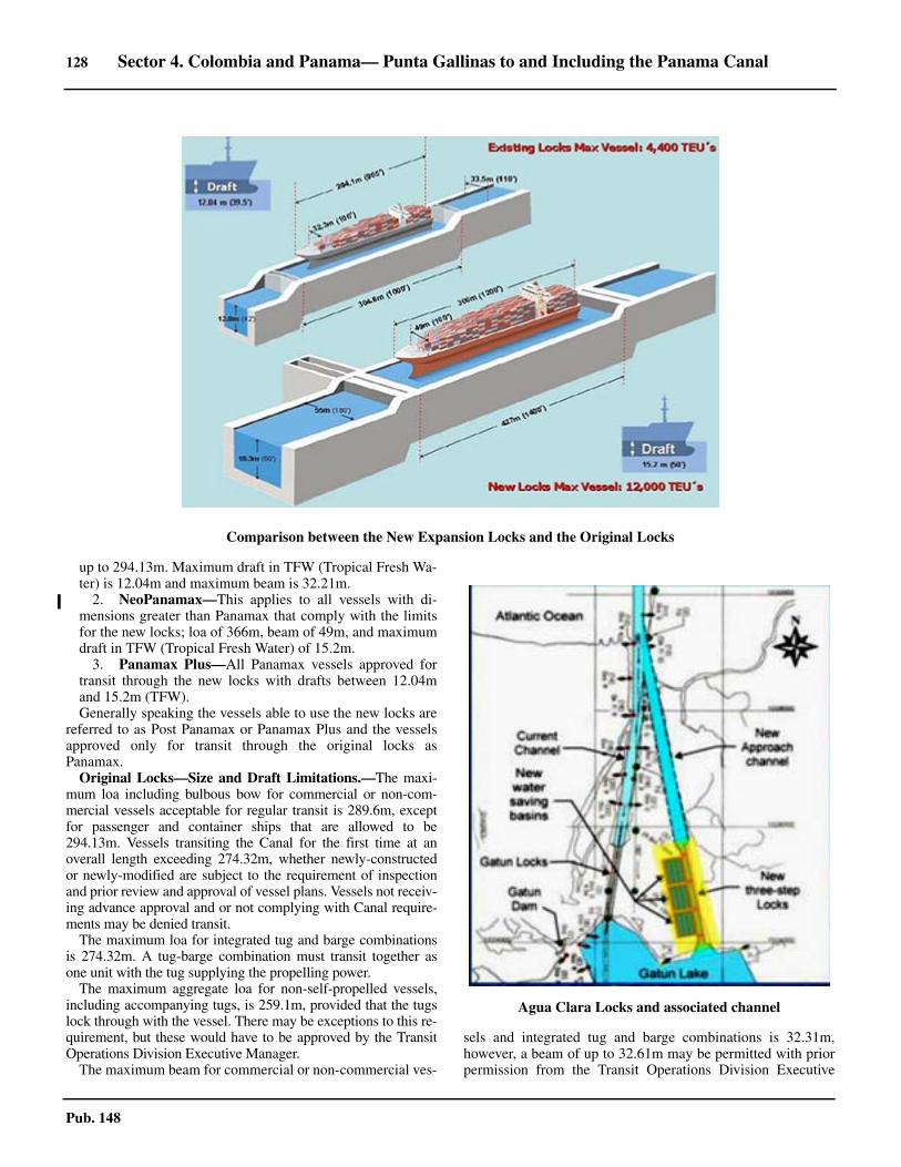
128 Sector 4. Colombia and Panama— Punta Gallinas to and Including the Panama Canal
Pub. 148
up to 294.13m. Maximum draft in TFW (Tropical Fresh Wa-ter) is 12.04m and maximum beam is 32.21m.
2. NeoPanamax—This applies to all vessels with di-mensions greater than Panamax that comply with the limitsfor the new locks; loa of 366m, beam of 49m, and maximumdraft in TFW (Tropical Fresh Water) of 15.2m.
3. Panamax Plus—All Panamax vessels approved fortransit through the new locks with drafts between 12.04mand 15.2m (TFW).
4.42 Generally speaking the vessels able to use the new locks arereferred to as Post Panamax or Panamax Plus and the vesselsapproved only for transit through the original locks asPanamax.
Original Locks—Size and Draft Limitations.—The maxi-mum loa including bulbous bow for commercial or non-com-mercial vessels acceptable for regular transit is 289.6m, exceptfor passenger and container ships that are allowed to be294.13m. Vessels transiting the Canal for the first time at anoverall length exceeding 274.32m, whether newly-constructedor newly-modified are subject to the requirement of inspectionand prior review and approval of vessel plans. Vessels not receiv-ing advance approval and or not complying with Canal require-ments may be denied transit.
The maximum loa for integrated tug and barge combinationsis 274.32m. A tug-barge combination must transit together asone unit with the tug supplying the propelling power.
The maximum aggregate loa for non-self-propelled vessels,including accompanying tugs, is 259.1m, provided that the tugslock through with the vessel. There may be exceptions to this re-quirement, but these would have to be approved by the TransitOperations Division Executive Manager.
The maximum beam for commercial or non-commercial ves-
sels and integrated tug and barge combinations is 32.31m,however, a beam of up to 32.61m may be permitted with priorpermission from the Transit Operations Division Executive
Comparison between the New Expansion Locks and the Original Locks
Agua Clara Locks and associated channel

Sector 4. Colombia and Panama— Punta Gallinas to and Including the Panama Canal 129
Pub. 148
Manager, provided that the deepest point of immersion doesnot exceed 11.3m TFW (Tropical Fresh Water). The maximumbeam for non-self-propelled vessels is 30.5m. 4.42 Vessels with protrusions that extend beyond the hull, exceptfor the anchors, must obtain confirmation from the Transit Op-erations Division Executive Manager that these protrusionswill not interfere with the safe transit of the vessel nor will theycause any hazard to the locks. 4.42 The maximum draft for vessels using the Panamax (original)locks allowed has been set at 12.04m, TFW at a Gatun Lakelevel of 24.01m or higher. Gatun Lake density is 0.9954 tons/m3 at 29.4°C. This provides a safe navigational margin of atleast 1.52m over critical elevations in the Canal and a clearanceover the south sill of Pedro Miguel Locks of 0.5m) at a Mira-flores Lake Level of 16.61m).
New Locks—Size and Draft Limitations.—The maximumloa including bulbous bow for commercial or non-commercialvessels acceptable for regular transit is 366m. Vessels transitingthe Canal for the first time at an overall length exceeding274.32m, whether newly-constructed or newly-modified aresubject to the requirement of inspection and prior review and ap-proval of vessel plans. Vessels not receiving advance approvaland or not complying with Canal requirements may be deniedtransit.
The maximum loa for integrated tug and barge combinationsis 366m. A tug-barge combination must transit together as oneunit with the tug supplying the propelling power.
The maximum aggregate loa for non-self-propelled vessels,including accompanying tugs, is 305m, provided that the tugslock through with the vessel. There may be exceptions to this re-quirement, but these would have to be approved by the Transit
Operations Division Executive Manager.The maximum beam for commercial or non-commercial ves-
sels and integrated tug and barge combinations is 49m. Themaximum beam for non-self-propelled vessels is 36.5m. Themaximum beam restriction must not be exceeded by any cargoprotection method. 4.42 Vessels with protrusions that extend beyond the hull, exceptfor the anchors, must obtain confirmation from the Transit Op-erations Division Executive Manager that these protrusionswill not interfere with the safe transit of the vessel nor will theycause any hazard to the locks.
4.42 The maximum draft allowed has been set at 15.20m, TFW ata Gatun Lake level of 25.91m or higher. Gatun Lake density is0.9954 tons/m3 at 29.4°C. This provides a safe navigationalmargin of at least 1.52m over critical elevations in the naviga-tional channels and a clearance over the lock sills of 3.05m. 4.42 Limitations for all Vessels.—The maximum allowableheight for any vessel transiting the canal or entering the port ofBalboa at any state of the tide is 57.91m, measured from thewaterline to its highest point. With prior permission on a case-by-case basis, the maximum allowable height may be increasedto 62.5m for vessels passing Balboa at MLWS. 4.42 Vessels with a length of up to 129.54m must be trimmed sothe pilot can see the ranges over the forecastle from the centerof the navigation bridge.4.42 See the table titled Panama Canal—Minimum Drafts inTropical Salt Water (TSW) for the minimum drafts requiredto provide the proper trim of vessels greater than 129.54m inlength intending to board a pilot. Any drag beyond 1.83m or1% of the loa is considered adverse drag in the canal and adja-
Agua Clara Locks (Atlantic side)

130 Sector 4. Colombia and Panama— Punta Gallinas to and Including the Panama Canal
Pub. 148
M/V Baroque approaching Aqua Clara Locks
M/V Baroque entering into Gatun Lake from Agua Clara Locks

Sector 4. Colombia and Panama— Punta Gallinas to and Including the Panama Canal 131
Pub. 148
cent waters.
4.42 If there is any doubt concerning a vessel's suitability, thisshould be clarified directly with the Transit Operations Divi-sion.4.42 The currents in Gatun Lake may be caused by winds and floodinflow, but they are seldom strong enough to greatly affect ship-ping. Currents in Gaillard Cut produced by water being drawn atthe Pedro Miguel Locks may attain a velocity of 1.5 knots.
Panama Canal—Pilotage
4.43 Pilotage is compulsory at the Atlantic entrance from aline starting at the Cristobal Mole, passing by Lighted BeaconNo. 1 (Mole), and Lighted Buoy No. 2, until passing the linepassing by Buoys No. 1 and No. 2 at the Pacific entrance to theCanal, extending from Lighted Buoy X to San Jose Rock, east
of the channel. 4.43 Pilotage is also compulsory for vessels departing AnchorageArea C (south of Buoy No. 2) until the vessel has cleared safelyinto the channel and is clear of any oncoming traffic. 4.43 Vessels requiring the services of a pilot before entering thebreakwater should contact the Cristobal Signal Station to re-quest the pilot while the vessel waits outside the breakwater. 4.43 The Panama Canal Authority will grant exemptions fromcompulsory pilotage to certain vessels provided the vesselowners or operators submit a request for this exemption to theTransit Operations Division Executive Manager. All exemp-tions granted will be valid for 1 year and if a continuation of agranted exemption is needed, a new request must be submittedwithin 1 month before expiration of the existing exemption.Failure to make the continuation request within 1 month of ex-piration of the existing exemption will result in a new requesthaving to be submitted. 4.43 This exemption is valid for commercial vessels only withthe following characteristics:
1. Self-propelled vessels up to 38.1m in length.2. Self-propelled vessels up to 1,000 ITC gross tons.3. Self-propelled passenger vessels up to 500 ITC gross
tons.4. Towboats without tows.
4.43 Pilots must be utilized if available when sailing to and fromthe canal channel from the entrance to the harbor. If the portcaptain authorizes movement without a pilot, the vessel shallestablish communications on VHF channel 12 with the SignalStation and maintain watch on that channel throughout themovement. 4.43 All vessels with a pilotage exemption must inform his inten-tion and obtain permission from the Cristobal Signal Station
4.42Gatun Lock entering from the Caribbean Sea
Panama Canal—Minimum Drafts in Tropical Salt Water (TSW)
Length Overall Draft Forward Draft Aft
> 129.54m 2.44m 4.27m
> 144.80m 5.50m 6.01m
> 160.02m 6.10m 6.71m
> 176.78m 6.71m 7.32m
> 190.05m 7.32m 7.92m
> 304.80m 7.92m 8.53m
> 335.28m 8.53m 9.14m

132 Sector 4. Colombia and Panama— Punta Gallinas to and Including the Panama Canal
Pub. 148
prior to any movement in or out of the harbor, including arrivalor departure, when shifting berths, as well as when shifting an-chorage area. The Signal Station will inform Marine trafficControl for the proper dissemination of the information to sur-rounding traffic. The vessel must obey at all times any and allinstructions given by the Signal Station and will maintain acontinuous radio watch on VHF channel 12 in order to receiveany further instructions while maneuvering in Canal waters 4.43 All vessels with pilotage exemption are still subject to board-ing and inspection by personnel from the Panama Canal per-sonnel. 4.43 There are many additional requirements that must be met byany individuals requesting an exemption and these are listed inthe Panama Canal Harbor Operations Requirements posted onthe ACP Home Page identified earlier in this paragraph or bycontacting the Transit Operations Division directly. 4.43 Contact Information.—See the table titled Panama CanalPilots—Contact Information.
Panama Canal—Vessel Traffic Management Sys-tem (VTMS)
4.44 Vessels are required to forward their ETA at least 96hours in advance to the Marine Traffic Control Unit of the Pan-ama Canal Authority. See the table titled Panama Canal—Ad-vance Reporting Required Information for information thatmust included in this report. The word NEGAT shall be usedfor any of the designators that do not have any informationavailable. Additional reporting requirements from the PanamaCanal Authority are described in paragraph 4.43. 4.44 Vessels arriving or departing the Atlantic Anchorages are re-quired to contact the Port Entry Coordinator (PEC) in the Cris-tobal Signal Station on VHF channel 12 when 12 miles fromthe breakwaters. The PEC shall contact vessels when they are 5miles off the breakwater, if such vessels have not previouslycalled to state their intentions. 4.44 The following vessels will need to advise the Marine TrafficControl Unit when ready to commence canal transit and willneed to monitor VHF channels 12 and 16 until the pilot is onboard:
1. All power driven vessels of 300 gt or more.2. All vessels, 100 gt or more, carrying one or more pas-
sengers. 3. All commercial towing vessels greater than 7.93m.
4.44 The actual transit time is advised over VHF channel 12.4.44 All vessels underway in the canal will maintain a continuouswatch on VHF channel 13. Bridge to bridge communicationsbetween vessels in the canal will be carried out on VHF chan-nel 13 as well. During the time when the Canal pilot is onboard, VHF channel 13 may only be used by the pilot or at hisdirection, solely for navigational communications. All commu-nications between the Signal Station and vessels should be inEnglish.4.44 If any of the following events occur during canal transit, a re-port must be made to the Marine Traffic Control Unit:
1. Any accident or other incident which may cause delayor require assistance.
2. Discovery of any defect that may interfere with safenavigation.
3. Anchoring or mooring when visibility falls below305m.
4.44 Vessel Traffic Management Contact Information.—Seethe table titled Vessel Traffic Management System—ContactInformation.
Panama Canal Pilots—Contact Information
Panama Canal Pilots
VHF VHF channels 12, 13, and 16
Telephone507-228-4015
507-314-1026
Facsimile 507-228-4125
E-mail [email protected]
Web site http://www.panamacanalpilots.com
COOPRAC Pilots
VHF VHF channels 12, 13, and 16
Telephone
507-314-0627
507-314-0995
507-314-1523
Facsimile 507-314-1083
E-mail [email protected]
Web site http://www.coopracrl.com
Docking Operations
VHF VHF channels 4B
Panama Canal—Advance Reporting Required Information
Designator Information
ALPHA The Panama Canal Identification Number of the vessel.
BRAVO Estimated date and time of arrival, port of arrival, and request for canal transit if desired.
CHARLIEEstimated draft upon arrival as well as for transit; confirm if the vessel is scheduled for loading or bunkering before transit. Draft to be given in meters and decimeters, fore and aft, in TFW (Tropical Fresh Water).
DELTA Any changes in the vessel's name, country of registry, structure or use of tanks that have occurred since the vessel last transited the Panama Canal.

Sector 4. Colombia and Panama— Punta Gallinas to and Including the Panama Canal 133
Pub. 148
ECHOConfirm if the vessel will dock at Balboa or Cristobal. What is the reason for docking? If it is for cargo operations, fuel or water, give the tonnage involved in each case. Is there any other reason the vessel will not be ready to transit upon arrival? If so, for what reason?
FOXTROT The nature and tonnage of any deck cargo.
GOLF
If the vessel is carrying any explosives or dangerous cargoes in bulk, state the following:1. Correct technical name.2. Quantity (in metric tons).3. United Nations classification number.4. IMO class and division (including compatibility group only for explosives).5. Stowage plan for each dangerous product carried.6. Flashpoint of each product.7. Use of inert gas in cargo or cargo slop tanks. Tankers claiming to be gas-free
shall report the following statement: “cargo tanks including cargo slop tanks are safe forhot work and safe for entry”.
8. Last cargo of empty tanks not gas-free. If the vessel is a tanker in ballastcondition and not gas-free, it shall state the following information about the previouslycarried cargo:
i. Technical name.ii. United Nations classification number.iii. IMO class and division.
If the vessel is carrying any explosives or dangerous cargoes in bulk, state the following:Tankers reporting GOLF: NEGAT shall, in addition, state the technical names of non-dangerous cargoes carried.
HOTEL If the vessel is carrying any packaged dangerous goods other than explosives, and if so, state the IMO class and division and the total quantity in long tons within each class.
INDIA
Quarantine and immigration information:1. Is radio pratique desired?2. State the ports at which the vessel has called within 15 days before arrival at the
canal.3. State all cases of communicable disease aboard and the nature of the disease or
diseases, if known.4. The number of deaths which have occurred since departure from the last port and
the cause of each death, if known.5. The number of passengers disembarking and their port of disembarkation.6. The number and ports of origin of any stowaways and a brief description of the
identity papers of each stowaway.7. The number and type of any animals aboard, as well as their country of origin.
Are any animals to be landed?8. The country of origin of all meat, whether carried as cargo or as ship's stores.9. Has the vessel called at a port in any country infected with foot-and-mouth
disease or rinderpest during its present voyage, in accordance with the list issuedperiodically by the World Health Organization?
10. Specify whether the vessel has a valid Ship Sanitation Control ExemptionCertificate (SSCEC) or a Ship Sanitation Control Certificate (SSCC) issued within 180days prior to arrival.
Panama Canal—Advance Reporting Required Information
Designator Information
Vessel Traffic Management System—Contact Information
Panama Canal Authority and Marine Bureau
VHF VHF channels 12, 13, and 16
Telephone 507-272-4500
Facsimile 507-272-3892
Web site http://www.pancanal.com
Marine Traffic Control Unit
Telephone 507-272-4201
Facsimile 507-272-3976
Vessel Traffic Management System—Contact Information

134 Sector 4. Colombia and Panama— Punta Gallinas to and Including the Panama Canal
Pub. 148
Panama Canal—Regulations
4.45 All vessels greater than 300 gt or over 20m in lengthmust be equipped with an Automatic Identification System (AIS)transponder that meets the standards set by the International Mari-time Organization. Any vessels without this equipment must rentportable AIS units from the Panama Canal Authority. The PanamaCanal Authority has implemented the usage of Pilot PortableUnits (PPU) for NeoPanamax vessels that replace AIS systems.The new PPU system consists of a tablet computer (iPad) and anexternal Real Time Kinematics (RTK) antenna, which will be in-stalled by Canal officials who board NeoPanamax vessels sched-uled for transit and be removed prior to their departure fromPanama Canal waters. 4.45 Masters of all vessels should familiarize themselves with allthe quarantine regulations and requirements for both the PanamaCanal and the ports of Colon and Panama in the Republic ofPanama.
4.45 All vessels arriving in canal waters shall be granted free orprovisional pratique after being inspected by the Canal Authori-ty. Upon special request, the Canal Authority may grant pratiqueby radio to a vessel upon the basis of information received priorto arrival, provided the entry of the vessel will not result in theintroduction, transmission, or spread of any communicable dis-eases. 4.45 The discharge overboard of any ballast or other waste isstrictly prohibited anywhere in canal waters. 4.45 All vessels must declare all cargo being carried on board atleast 96 hours in advance of arrival. Vessels that arrive from
ports that are less than 96 hours away must submit revisions totheir original cargo declarations if necessary. 4.45 Exceptions to this requirement are, as follows:
1. Bins (standard size open top containers) or any otherreceptacles (not containers) that are carried on deck to storeequipment that is not welded or spot welded. Any informa-tion regarding these items must be disclosed to the CanalAuthority boarding officers upon arrival.
2. Vessels carrying radioactive fissionable material asdefined in the IAEA’s Regulations for the Safe Transport ofRadioactive Material, shall provide 30 day advance notifica-tion.
3. Vessels carrying dangerous cargo, other than radioac-tive material, shall report 48 hours in advance of canal transitto confirm that all cargo alarms, safety, and shut down deviceshave been tested and are in good working order.
4.45 The cargo and other pre-arrival information to visit or transitthe canal may be submitted through the Panama Canal ServicePortal, by way of the following web site:
4.45 Panama Canal Authority boarding officers will verify cargoinformation submitted in the pre-arrival notification and anydiscrepancies will be reported. Failure to submit accurate andtimely information or to resolve any discrepancies may resultin transit delays, escorting of the vessel, or additional chargesand possible fines. 4.45 Commercial passenger vessels shall be given preference overother vessels in order of transit provided they have bookedtheir transit prior to arrival. The exception to this would be ifsuch preference would impair the safe and efficient operationof the canal. 4.45 It has been reported that there is a speed restriction of 12knots once inside the approach channel, dropping to 8 knots inthe vicinity of the marina. 4.45 See Pub. 153, Sailing Directions (Enroute) West Coasts ofMexico and Central America for further details regarding addi-tional regulations and requirements of vessels transitingthrough the Panama Canal.
Panama Canal—Anchorage
4.46 Many designated anchorage areas are located bothoutside and inside the breakwaters, as well as in the canal. Allanchorages can best be seen on the chart.
Panama Canal—Caution
4.47 It is reported (2012) that the light strength for lightedbuoys marking dredging operations found throughout the canalis weak so a sharp lookout should be maintained for identifica-tion of these hazards between sunset and sunrise. 4.47 It is reported (2012) that between sunset and sunrise, allrange lights are sectored to minimize light pollution. Conse-quently, visual fixes will not be possible during this time. It isalso reported (2012) that there are little to no visual aids avail-able for navigation through Gatun Lake for nighttime transit.
E-mail [email protected]
Transit Operations Division
Telephone 507-272-4211
Facsimile 507-272-4288
Admeasurement and Billing Unit
Telephone 507-272-4567
Facsimile 507-272-5514
E-mail [email protected]
Dangerous Cargo Information
Telephone507-272-4219
507-272-4213
VHF 507-272-3015
E-mail [email protected]
Flamenco Island Signal Station
Call WHC
VHF VHF channels 12 and 16
Cristobal Signal Station
VHF VHF channels 12 and 16
Vessel Traffic Management System—Contact Information
Panama Canal Service Portal
https://serviceportal.pancanal.com/

Sector 4. Colombia and Panama— Punta Gallinas to and Including the Panama Canal 135
Pub. 148
4.47 Mariners must be alert for frequent vessel movements around the canal entrances and anchorages.

137
Pub. 148
5. Sector 5—Coasts of Panama, Costa Rica, and Nicaragua—The
Panama Canal to Cabo Gras a Dios
5.0Additional chart coverage may be found in NGA/DLIS Catalog of Maps, Charts, and Related Products (Unlimited Distribution).
SECTOR 5 — CHART INFORMATION

139
Pub. 148
SECTOR 5
COASTS OF PANAMA, COSTA RICA, AND NICARAGUA—THE PANAMA CANAL TO CABO GRACIAS A DIOS
5.0 Plan.—This sector describes the N and E coasts of CentralAmerica from Brujas Point, Panama to Cabo Gracias a Dios,Honduras, including Cayos de Perlas and Cayos Misquitos. Itthen describes Isla de San Andres, Isla de Providencia, and oth-er off-lying islets, banks, and dangers. The descriptive se-quence is W then N.
General Remarks
5.1 This sector includes that part of the Central Americancoast which lies between the Panama Canal and Cabo Graciasa Dios, 383 miles NNW. It includes a part of the N coast ofPanama and the E coasts of Costa Rica and Nicaragua.5.1 The coast, which is low with occasional bold promontoriesand bluffs, is indented by several large lagoons. Aids to naviga-tion are sparse, but sufficient to allow for safe navigation to theimportant commercial ports.5.1 Depths along the coast are ample from Brujas Point to Puntadel Mona, with the 200m curve lying from 3 to 11 miles off-shore, except in the vicinity of Escudo de Veraguas, where itlies 20 miles offshore. From about 30 miles S of Punta del Mo-na, the 200m curve extends generally NE to a position about 29miles E of that point. From there, the 200m curve continues NEto a position about 90 miles E of Cabo Gracias a Dios. Withinthis curve, N of Punta del Mona, the depths are very irregularand range from 20 to 55m. There are numerous off-lying dan-gers, cays, and islets between Punta del Mona and up to about65 miles N of Bluefields, where they become less frequent.The outermost of these lie about 60 miles offshore. BetweenPuerto Cabezas and Cabo Gracias a Dios, these dangers againbecome very numerous.5.1 The western Caribbean, outside the 200m curve off Nicara-gua and Honduras, is fouled and marked by scattered banks,cays, and islands. Cayos de Albuquerque, located 107 miles Eof Bluefields, and Serranilla Bank, located 187 miles ENE ofCabo Gracias a Dios, are the S and E dangers of those de-scribed in this sector. Rosalind Bank and the dangers W andNW of it are described beginning in paragraph 6.3.5.1 Many of the cays and islands are on banks that are steep-toand composed of coral. These banks should be approachedwith caution at all times and given a wide berth at night. Theaids to navigation are few and unreliable, and the currents arefairly swift and unpredictable, especially after storms.5.1 Winds—Weather.—In the area covered by this sector, theNortheast Trade Winds prevail during most of the year, al-though strong N winds are frequent and may reach gale forcefor short periods of time, especially during the winter months.5.1 There is clear sunny weather over the whole area, exceptduring the wet season, which prevails from May or June untilNovember or December. This season is usually marked by fre-quent heavy rain squalls and thunderstorms of short duration.Sea fog seldom occurs in any part of the area.5.1 Several hurricanes cross the Caribbean Sea during the season
from June to November, but very rarely do they travel S of15°N. However, rough seas and heavy swells occur during thepassage of a hurricane further N.5.1 During the season of the northers, which occur from Octoberto April, heavy rain accompanied by rough seas and swellsmay be experienced by vessels in exposed coastal areas. Thosenorthers which do reach the coasts of Nicaragua, Costa Rica,and Panama are usually short-lived and seldom reach galeforce.5.1 While fogs are rare, the frequent heavy rains may reduce vis-ibility as much as the thickest fogs. The summits of inlandpeaks are usually enveloped in clouds and seldom visible, ex-cept at dawn or on sudden cessations of heavy rains, when theatmosphere will almost instantly become remarkably clear.5.1 Tides—Currents.—Throughout the year, the highly con-stant offshore Equatorial Current sets WNW at a mean rate of0.5 to 1 knot. A few currents in the area have been observed toset at a rate of 2 knots; the maximum rate reported was be-tween 3 and 4 knots. As the current approaches MosquitoBank, the greater part is deflected NW at a mean rate of 1.5knots.5.1 The main current sets through the off-lying islands S of Ser-ranilla Bank in directions mostly between NW and SW at amean rate of 1 knot and a maximum rate of 2 to 3 knots. Thegreater part then sets N to NW around Mosquito Bank but, inthe vicinity of Isla de Providencia, a part of the current is de-flected SW toward San Juan del Norte, where it turns S and lat-er rounds Golfo de Los Mosquito continuing E as acountercurrent with a mean rate of 1 knot. Over MosquitoBank, inshore of these deflected currents, the currents are vari-able and to a large degree dependent on the prevailing winds.In particular, a norther may cause a current of 0.5 to 1 knot toset S close inshore along the entire bank S of Cabo Gracias aDios to join the countercurrent in the vicinity of San Juan delNorte.
Brujas Point to Punta Valiente
5.2 Brujas Point (9°21'N., 79°59'W.) is a bold rockywooded headland. Brujas Rock, a bush-covered rock, 11mhigh, stands close offshore about 0.5 mile NE of the point. It isprominent when open of the point and its sides are perpendicu-lar.5.2 From Brujas Point, the coast extends about 2.5 miles SSW tothe entrance to the Rio Chigress. The coastline consists ofrocky bluffs topped with thick vegetation. There are no con-spicuous features visible from seaward.5.2 The Rio Chigress is the outlet for the surplus waters of GatunLake. The flow is regulated by spillways in Gatun Dam. Threepromontories stand on the N side of the river entrance. The Npromontory is 37m high. The S promontory, about the sameheight, is marked by the ruins of a fort and a castle. Punta Are-nas, on the S side of the river entrance, consists of a low, sandy

140 Sector 5. Coasts of Panama, Costa Rica, and Nicaragua
Pub. 148
beach backed by trees. Heavy breakers extend off the beach.The town of Chigress stands on the N bank of this river.
Lajas Reef, a rocky ledge nearly awash in the fairway for theRio Chigress, lies 0.1 mile W of the W extremity of the Spromontory. Two channels lead on either side of Lajas Reefand then across a bar into the river. There was a reported(1952) least depth of 3m in the channel E of the ledge and 4.3min the channel W of the ledge. Four beacons, with a diagonalblack stripe on each, stand on the S side of the entrance. Onepair of beacons, in line bearing 156°, leads through the E chan-nel and another pair of beacons, in line bearing 130°, leadsthrough the W channel. Another pair of beacons stand on the Ebank of the river and, in line bearing 101°, lead from the inter-section of the two entrance channels into the river.5.2 Anchorage can be taken off the river, in a depth of 18m,mud, with the ruins of the fort and castle bearing 123° and Bru-jas Rock bearing 055°.5.2 From Punta Arenas to Punta Boca de la Furnia, 0.8 mileWSW, the coast is low and sandy. The mouth of a small creeklies E of the point. A rock, awash, and some below-water rockslie off the mouth of the creek.
5.3 From Punta Boca de la Furnia to Los Morrillos, wherethe coast rises, a group of above-water rocks lies close off anabrupt cliff, 0.5 mile WSW of Los Morrillos. From Los Morril-los to the Rio Pina, about 2.5 miles farther SW, the coast isfronted by red clay banks. The village of Pina stands on the Nside of this river.5.3 Morro Guisao, a rocky promontory 15m high, is located 2.8miles SW of Pina. The village of Lagarto is situated on the Sside of the entrance to the Rio Lagarto, 0.8 mile farther SW.5.3 Between the Rio Lagarto and Punta Rincon, about 43 milesSW, the coast continues low with a few occasional cliffs. Arange of hills rises about midway along this stretch of coast andbacks the shore for a distance of 18 miles.5.3 From Lagarto, the coast extends WSW for about 3 miles tothe Rio Salud and continues in the same direction for 8.5 milesto a ridge of low, red cliffs about 0.5 mile long, with a 108mround hill in the middle of them. The coast then extends 2.5miles SW to the village of Donoso, on the E bank of the RioMiguel.5.3 The Rio Mangle, 8 miles farther SSW is marked by a low,rocky point on the E side of the entrance. Behind this point theSierra de Miguel de La Borda rises abruptly to a height of180m and continues to its 473m high summit 5 miles SSE ofthe river mouth.5.3 Pilon de Miguel de La Borda rises to an isolated conicalpeak, 509m high, 15 miles SE of the entrance to the Rio Man-gle.5.3 From Punta Platanal, 3.5 miles W of the Rio Mangle, thecoast extends 5 miles SW to the Rio Cocle del Norte, with thevillage of the same name on its E bank.5.3 Sierra de Cocle de Norte (9°02'N., 80°34'W.) rises to aconical peak, 463m high, 4 miles S of the mouth of the river ofthe same name.
5.4 Punta Rincon (9°01'N., 80°41'W.), a bold, rocky,headland, rises to a height of 168m about 0.8 mile inland, and aheight of 244m, 3 miles to the S. Minera Panama Power Plantconsists of MPSA Berth, 135m in length, and MPSA Conveyor
Jetty, 90m in length with a depth of 30m alongside. 5.4 Between Punta Rincon and Punta Icaca, 58 miles W, thecoast is indented 12 miles S by the head of the Golfo de LosMosquitos. This entire stretch of coast is backed by a mountainrange which follows the coast for almost its entire length.5.4 From Punta Rincon, the coast gradually decreases in heightand extends 19 miles SW to the Rio Concepcion, which has thetown of Concepcion on its E bank. About 1.5 miles SW of theriver entrance there is a conspicuous red cliff, 30m high. PuntaZapatero, a low, sandy point 1 mile W of the river, is markedby breakers which extend about 0.5 mile offshore.5.4 The Cordillera de Veragua, a mountain range, rises abruptlyto a height of 318m about 4 miles WSW of Punta Zapatero and2 miles inland. This range attains a height of over 2,133m andtraverses the Isthmus of Panama for a distance of 70 miles fromE to W about 15 miles from the coast.
5.5 Silla de Veragua, at the E extremity of the range and20 miles SSE of Punta Rincon, rises from the Panamanianplain to a height of 1,350m. When viewed from the NW thismountain resembles a double peak or saddle. Castle Choco, amountain rising 15 miles W of Silla de Veragua, ascends al-most perpendicularly to a flat 1,933m summit which has theappearance of a huge square castle with a small tower at oneangle. From the base of Castle Choco, irregular wooded hillsextend NW and attain an elevation of 948m, 6 miles SSW ofPunta Zapatero. The base of this range then backs the shoreand extends to about 8 miles S of Punta Icaca.5.5 From Punta Zapatero, the coast extends 3.5 miles WSW tothe Rio Bejuco. The river discharges into the head of a sandybay, about 0.8 mile wide. The W entrance point of the bay is ahigh, rocky bluff.5.5 From a position 4 miles W of the Rio Bejuco, some promi-nent red cliffs, 30 to 61m high, extend 2.5 miles W. When thesun shines on these cliffs they glitter and sometimes resemblewhite sails. The E cliff has been likened to the stern of a largeship.5.5 A high, bold, rocky headland lies 0.8 mile E of where theRio Candelaria (8°48'N., 81°11'W.) discharges into the sea.The Rio Calovebora discharges through a wide valley 2 milesW of the Rio Candelaria. Some red cliffs, topped by trees, lieabout 0.8 mile W of the river. A ridge rises gradually to aheight of 797m, 5 miles SE of the river mouth.
5.6 Punta Coaica (8°48'N., 81°17'W.), low and sandy, isthe S point of the coast on this side of the Isthmus of Panama.From this point, the coast extends W about 7 miles to a ridge ofred cliffs, and then 4.5 miles farther W to a bold promontoryconsisting of two bold headlands close together. Punta Penascode Guapan lies 1.5 miles farther W. All three bluffs rise steeplyto rounded cones, 213 to 245m high. Pico del Rey Buppan,standing 4 miles S of Punta Penasco de Guapan, is a narrowhill, 758m high, backed by a higher mountain.5.6 From a position 2 miles W of Punta Penasco de Guapan, alow sandy beach extends NW in a very regular sweep for a dis-tance of 19 miles and terminates at Punta Icaca (Coco PlumPoint) (9°02'N., 81°43'W.). The entrance to the Rio Cana is lo-cated 1.5 miles SE of Punta Icaca.5.6 Isla Escudo De Veraguas (9°06'N., 81°34'W.) is locatedwith its W extremity lying 10 miles ENE of Punta Icaca. This

Sector 5. Coasts of Panama, Costa Rica, and Nicaragua 141
Pub. 148
island is low and wooded, the trees being 30 to 55m high. Red-dish brown cliffs, 12 to 15m high, stand on the E side of the is-land. A light is shown from this side of the island. The W and Ssides of the island are low and swampy, with dark sandy beach-es.5.6 Tides—Currents.—During the daytime, there is usually aW current in the anchorage. There is usually a NW current be-tween Escudo de Veraguas and the mainland.5.6 Anchorage.— Vessels can anchor off the SW extremity ofthe island, but the holding ground is poor and may not be safeat all times.
5.7 The coast between Punta Icaca and Punta Valiente isirregular and extends 14.5 miles NW along Peninsula Valiente.Reefs fringe Punta Icaca and Punta Vieja Isabel (Old BessPoint), 3 miles NW. The wooded coast about midway betweenthese two points rises to a height of 142m.5.7 Punta Gorda de Tobobo, a bold headland 152m high, stands5 miles NW of Punta Vieja Isabel. An irregular shoal bight,with a dangerous reef extending across it, lies between thesetwo points.5.7 Cayo de Platanos (Big Plantain Cay) (9°08'N., 81°48'W.)lies near the outer edge of a rocky reef which extends 1 mileNE from Punta Gorda de Tobobo. Tobobo Bank, a detachedshoal with a least depth of 12.8m and marked by heavy rollers,lies about 5.5 miles E of Cayo de Platanos.5.7 From Punta Gorda de Tobobo, the bold high coast extends 5miles NW to Punta Chiriqui. Several rugged islets lie close offthis latter point. From Punta Chiriqui, the coast extends 2.3miles W to Punta Valiente.
Punta Valiente to Punta Terraba
5.8 Between Punta Valiente and Punta Terraba, the cur-rent sets SE at a velocity of about 2 knots. Currents setting E atvelocities of 1 to 2 knots will be encountered in the approachesto Canal del Tigre and Boca del Toro.5.8 Punta Valiente (9°11'N., 81°55'W.), a bold, densely woodedpoint, rises to an elevation of 152 to 183m on the E side of theE entrance to Laguna de Chiriqui. Foul ground extends 1.3miles W from the point and continues S about 1.8 miles to theentrance to Bluefield Creek. Cayos Valiente, a group of isletsextending about 0.3 mile in an E-W direction, lie on the N partof this reef. Virginia Rocks lie on the W edge of the reef 1.3miles WSW of Punta Valiente, and Bluefield Rock, a smallblack rock 9.8m high, stands on the S edge about 1.5 miles S ofthe point.
5.8 Pico Valiente (9°10'N., 81°55'W.), a conspicuous 213mhigh hill, stands 1 mile S of Punta Valiente.5.8 Cayos Tigre (Tiger Cays) (9°13'N., 81°55'W.), consisting ofseveral red clay islets about 1 mile long in a E-W direction, lie1.8 miles N of Punta Valiente. Roca Tigre, a detached smallrock, marked by a beacon, equipped with a racon, lies 2.5 milesNNW of Punta Valiente. Reventazones Tigre, a small rockawash, over which the sea usually breaks, together with severalshoal patches, lies on a bank within 0.8 mile NW of Roca Ti-gre. During calm weather, Reventazones Tigre cannot alwaysbe seen.5.8 A 7m coral patch lies 0.3 mile WNW of Roca Tigre
5.9 Laguna de Chiriqui (8°56'N., 82°07'W.) (World PortIndex No. 9825), a deep bay, is 30 miles long, lies in an E-Wdirection, and is 10 miles wide. It is bound on the E side byPeninsula Valiente, on the S and W sides by the mainland, andon the N side by Isla Popa, Isla Cayo de Agua, and the adjacentislands and reefs. Canal del Tigre, which lies between Peninsu-la Valiente and Cayo de Agua, is the main approach channel.5.9 The N side of the lagoon, including the entrance, is fringedby detached shoals. These lie up to about 5 miles S of the en-trance and along the E shore of the lagoon. The W end of thelagoon, S of the fringing reefs, is almost entirely clear of dan-gers. A pier extends 320m ESE from a small village close S ofCemetery Cay from the W end of the lagoon.5.9 The low shores of the lagoon are indented by numeroussmall bays and rivers and are marked by several villages.5.9 Canal Valiente (9°12'N., 81°55'W.), the NE approach chan-nel leading into Canal del Tigre, lies between Cayos Tigre andthe W end of Cayos Valiente, and has depths of 12.8 to 18.3min the fairway on either side of Reventazones Valiente, a 5.5mshoal area about 0.8 mile NW of Virginia Rocks. There is usu-ally a very heavy swell in the channel.5.9 The flood current in Canal Valiente sets SW at a velocity of0.5 to 1 knot; the ebb sets in the opposite direction at a velocityof 1 to 2 knots.
5.10 Canal del Tigre (Tiger Channel) (9°11'N.,81°59'W.), the N approach to Laguna de Chiriqui, lies betweenRoca Tigre and the SE side of Cayos Zapatilla to the W. Thischannel lies between two 40m curves which converge from Eand W and extends S between Reventazones Tigre, awash,about 0.5 mile WNW of Roca Tigre, and Cayos Zapatilla. Itenters the lagoon between Punta Bluefield to the E and PuntaPiedra Roja (9°09'N., 82°00'W.) to the W. 5.10 Channel depths range from 36 to 72m, but some lesserdepths may be encountered. The channel fairway has beendredged to an effective depth of 18.3m. Inside the lagoon andon the W side of the channel an extensive shoal lies between2.5 miles S and 5 miles SW of Punta Piedra Roja. On the Eside of the channel, there are two detached shoals, with depthsof 5.5m and less, which lie 2.5 and 4 miles S of the same point.5.10 Another channel leads into the lagoon between the W side ofCayo de Agua and Isla Popa (9°10'N., 82°08'W.) to the W, butis not recommended without local knowledge.5.10 Bluefield Creek, entered 1.5 miles N of Punta Bluefield, ex-tends 2 miles E to its head and is considerably narrowed byfringing reefs. Cayos del Toro, a small group of islets, lies onthe S side of the approach to this creek on the outer edge of anarea of foul ground which extends l mile NNW and N fromPunta Bluefield. Densely-wooded hills rise on the N side of thecreek. The head of the creek is swampy and fringed with man-groves.5.10 Sheltered anchorage can be taken, in a depth of 20m, mud,with Bluefield Rock bearing 292°, distant 0.7 mile.5.10 Caution.—When entering the creek, vessels should avoidthe 5.5 m shoal depth lying about l.3 miles W of BluefieldRock. Areas of uncharted shoals lie SW of Isla Agua and Pen-insula Valiente as seen on the chart.
5.11 The Rio Cricamale (8°59'N., 81°55'W.) has itsmouth lying close W of Cricamale, a village which stands on a

142 Sector 5. Coasts of Panama, Costa Rica, and Nicaragua
Pub. 148
salient point backed by trees up to 37m high. A low mangrove-covered cay located W of this point divides the river mouth in-to two channels. The Rio Biarra enters the lagoon close W of adefined point lying 5 miles WSW of the Rio Cricamale.5.11 The S side of the lagoon extends irregularly W from the RioCricamale for 20 miles to Punta Muerto (9°00'N., 82°15'W.).The principal settlement of Chiriqui Grande is situated midwayalong this stretch of coast and is reported to be radar promi-nent.5.11 Tides—Currents.—Tidal currents are seldom experiencedwithin Laguna de Chiriqui, but a N set may be caused by therivers. In the dry season, from March to June, off the mouth ofthe Rio Cricamale and as far as the entrance to Canal del Tigre,the ebb current attains velocities of 0.5 to 1 knot; there is aweak flood current on the rising tide.5.11 Depths—Limitations.—Two SPM offshore oil facilities aresituated just offshore, NNE and NE of Chiriqui Grande village.Submerged pipelines extend from the shoreside facility, closeN of Chiriqui Grande, to these terminals.The facility can ac-cept vessels with an loa up to 330m. The controlling depths atthe SPMs is 21 to 22m. The General Cargo Dock has a lengthof 185m and a depth alongside of 11m. It can handle vesselswith a maximum loa of 200m and a maximum draft of 10m. 5.11 Pilotage.—Pilotage is compulsory for mooring/unmooringto an SBM. Pilotage for Canal del Tiger is optional. Vessels re-quiring a pilot should send a request via VHF. If pilots are notavailable, vessels should anchor outside the lagoon within 1mile of position 9°12'N, 82°00'W) Pilots board at position:8°59'N, 82°05.3'W. Pilot can also be requested from the an-chorage. 5.11 Contact Information.—When inside 50 miles of the termi-nal, a vessel should contact the oil terminal (call sign: RambalaControl) on VHF channel 16. See the table titled ChiriquiGrande—Contact Information.
5.11 Anchorage.—Secure anchorage can be taken in most partsof Laguna de Chiriqui. Vessels can anchor, in depths of 12.8 to18m, mud, SE of the pier at Eureka (8°57'N., 82°07'W.). 5.11 There are also three anchorage berths available for vesselsawaiting their turn at the SBMs.5.11 The E berth (8°59'18"N., 81°59'30"W.) has a depth of 27m,the middle berth (8°59'48"N., 82°01'30"W.) has a depth of35m, and the W berth (9°00'18"N., 82°03'30"W.) has a depthof 40m.5.11 Caution.—Focused attention is required in entering the la-goon because the water in the entrance is not very clear andshoals may not be seen. Since the shoals are steep-to, sound-ings are of little help. The water lying S of the entrance is re-ported to be clear and shoals may be seen.
5.12 From Punta Muerto, the W side of the lagoon extendsabout 10 miles N to Monkey Cay (9°10'N., 82°15'W.) near thehead of Ensenada Uyama. Several villages which serve theplantations inland stand along this stretch of coast. The greaterpart of the S and W sides of the lagoon are low and swampy,but toward the W part of the S shore the land rises to severalhigh peaks 3 miles inland. Along the W shore, the land rises toa height of 457m, 4 miles inland.5.12 The N coast of the lagoon between Monkey Cay and PuntaPiedra Roja, 15 miles E, passes along the S coasts of Isla SplitHill (9°09'N., 82°10'W.), Isla Popa, and Isla Cayo Agua.5.12 The S part of Isla Popa rises to a height of 115m; Cerro Popais a prominent 109m high peak in the NE part of the island. IslaSplit Hill, 1.3 miles long, lies between the SW end of Isla Popaand the mainland to the W. Two narrow channels lead on eitherside of this island into the Bahia de Almirante, but both requirelocal knowledge.
5.13 Isla Bastimentos (9°18'N., 82°08'W.), from its E ex-tremity of Punta Patino, extends 8 miles NW to Cabo Toro, theE entrance point of Boca del Toro.5.13 Cabo Toro (Punta Toro) (9°22'N., 82°12'W.), a bold head-land, terminates to the N in a conspicuous, 35m high rock. Asteep-to, breaking reef fringes the point and extends 1.5 milesSW around Punta Bastimentos, which is low and sandy, andthe W end of Isla Bastimentos. Roca Toro lies, awash, closeNE of Cabo Toro; several rocks lie up to about 1 mile ESE andSE of the point. A shoal depth of 6.6m lies 1 mile ENE of thepoint.5.13 A ridge of irregular hills standing on the N side of Isla Basti-mentos attains an elevation of 122m, but the S side of the is-land is low.5.13 Crawl Cay Channel (9°14'N., 82°08'W.), fouled by severalcays and shoal depths, lies between the S end of Isla Bastimen-tos and the N end of Isla Popa, and extends W into the E part ofBahia de Amirante. Local knowledge is necessary to enter thischannel.5.13 Cayo Nancy (9°19'N., 82°11'W.) lies with Hospital Point,its NW extremity, located 0.8 mile SSW of Punta Bastimentos.The densely-wooded island extends 3.5 miles SE and is nearlyjoined to a W projection of Isla Bastimentos. Hospital Bight,
Chiriqui Grande—Contact Information
Terminal
Call sign Rambala Control
VHF VHF channels 11, 13, 14, and 16
Telephone507-756-9125
507-756-9126
Facsimile 507-756-9128
Operator (Chiriquí)
Telephone 507-775-6513
Facsimile 507-775-4958
Operator (Panama City)
Telephone 507-263-7777
Facsimile 507-263-9949
E-mail [email protected]
Web site http://www.petroterminal.com
Pilots
Call sign Chiriqui Grand Pilots
VHF VHF channels 11, 12, 13, 14, and 16
Chiriqui Grande—Contact Information
Sector 5. Coasts of Panama, Costa Rica, and Nicaragua 143
Pub. 148
an encumbered inlet, lies between Cayo Nancy and Isla Basti-mentos. The bight should not be entered without local knowl-edge.
5.14 Isla Colon (9°25'N., 82°17'W.), densely-wooded,about 6.5 miles long, and from 3 to 4 miles wide, rises toheights of 61 to 122m. From Long Bay Point, a 16m highrocky bluff, located 2.8 miles NW of Cabo Toro, the N coast ofthe island, extends 4.2 miles NW to Punta Norte, low androcky, and then 2.3 miles WSW to Punta Cauro (9°26'N.,82°19'W.). The SE part of the island is a low peninsula.5.14 Cayo Carenero (9°21'N., 82°14'W.), a low, narrow islandfringed by foul ground up to about 0.3 mile E, lies close off theE side of Bocas del Toro. Roca Norte, 6.4m high and conspicu-ous, stands close N of Cayo Carenero.5.14 Bahia de Almirante, 15 miles long and 10 miles wide, isbound by Isla Popa, Isla Bastimentos, and the adjacent islandsand dangers to the E; Isla Colon to the N; and the mainland tothe S and W. The commercial port of Almirante and the townof Bocas del Toro are the only two towns of any size within thebay. Several small towns and villages are found along theshores of the bay, but they have little or no commercial impor-tance.5.14 Isla San Cristobal, the largest of several islands found withinthe bay, lies almost in the middle and divides it into three largebights. The E end of the bay is fringed by numerous cays andreefs, whereas the central and SW parts are comparatively freeof dangers. General depths within the bay are 12.8 to 27.4m,but less water is encountered in the NW and SE bights.5.14 The irregular coast forms numerous bights and lagoons, intowhich several rivers discharge. The S side of the bay is backed2 miles inland by a table ridge, which ranges in height from533 to 614m and which extends 15 miles from the SE to theNW. The mainland SE and the islands to the E and N rise toheights of about 150m, but the mainland coast at the NW endof the bay is low.
5.15 Canal de Bocas del Toro (9°20'N., 82°15'W.), theprincipal entrance channel, lies between Cabo Toro and LongBay Point and is about 0.8 mile wide between Isla Bastimentosand Cayo Carenero. However, both sides are fringed by coralreefs and detached shoals which narrow the navigable width ofthe channel.5.15 The buoyed channel between Lighted Buoy No. 1 and Light-ed Buoy No. 2, as far S as Lighted Buoy No. 5 and LightedBuoy No. 6, has a depth of 9.1m. From there, it has depths inexcess of 12.2m, except for the 9.7m patch which extends 90mS of Lighted Buoy No. 7, a 7.5m patch lying close E of LightedBeacon No. 8, and the W edge of Dry Reef, which extends,with a depth of 8.4m, close SW of Lighted Beacon No. 9. Thislatter beacon was reported (1995) to be missing.5.15 Pilotage.—Pilotage is compulsory. Pilots board in position9°21.7'N, 82°12'W. Pilots can be contacted on VHF channels14 and 16. 5.15 Nancy Shoal (Bajo Solarte) (9°20'N., 82°13'W.), with aleast depth of 2.5m, lies about midway between Punta Basti-mentos and Hospital Point and extends about 0.5 mile NNW.Nancy Rock (Roca Solarte), a reef with a depth of less than1.8m and on which the sea generally breaks, lies on the S endof this shoal.
5.15 Shepherd Bank (Bajo Garcia) fronts the S end of Bocas delToro, about 0.8 mile SW of Hospital Point, and has a leastdepth of 5m. Clear channels pass SE and NW of this bank. Pal-las Shoal, a detached shoal with a least depth of 5m, lies about0.5 mile SSW of the S extremity of Cayo Carenero.5.15 A current, which enters Bahia de Almirante through Bocadel Drago and emerges through Bocas del Toro, sets SE alongthe S side of Isla Colon. As a result, the ebb is increased andthe flood is decreased in Canal de Bocas del Toro. A velocityof 1 knot is sometimes encountered. In the approach to Canalde Bocas del Toro, a SE setting current with a velocity of 1 to 2knots will be encountered.
5.16 Boca del Drago (9°25'N., 82°20'W.), the W entranceleading into Bahia de Almirante, lies between the W end of IslaColon and the mainland to the W. This passage is 0.8 to 1.3miles wide, but the channel is only about 0.3 mile wide be-tween the 10m curves in the entrance and about 340m wide atits narrowest part. Because of the sharp turns and lack of navi-gational aids, it is not advisable for a vessel other than one ofshallow draft to attempt to enter without a pilot.5.16 Sail Rock, Wreck Rock, and Swan Cay, all above-water dan-gers, lie between 2 miles and 2.3 miles NE of Punta Cauro, onthe E side of the approach, and have been reported to be radarprominent. These features could be as much as 100m out of po-sition to the SW and should be given a wide berth.5.16 The E side of the channel between Punta Cauro and LimePoint, a low and sandy point about 1 mile SSW, is fringed byshoal ground and detached shoals which extend up to 1 mileoffshore.
5.17 Punta Sarabeta (9°26'N., 82°20'W.), the W entrancepoint of Boca del Drago, lies 1 mile W of Punta Cauro and isfringed by foul ground extending about 0.8 mile E into thechannel. Five Fathom Bank, small in extent, with a least depthof 9.1m, lies on the W side of the approach 1 mile NE of PuntaSarabeta. Mandeville Rock, a dangerous pinnacle with a leastdepth of 2.4m, lies 0.5 mile ENE of the same point. The sea oc-casionally breaks over this danger.5.17 The currents in Boca del Drago are irregular in set and veloc-ity. When a strong current sets E outside the passage it is de-flected into the passage where it attains a velocity of 1 knot onthe flood, but is inappreciable during the ebb.5.17 The W part of Bahia de Almirante extends 14 miles S fromPunta Anton on the W side of Boca del Drago. Punta Pond-sock, the E extremity of a peninsula, is located about midwayalong the W side of the bay and 3 miles W of Punta Juan. Aninner bay, which is entered between Punta Pondsock and JuanPoint (Punta Juan), extends 6.3 miles S from a line joiningthose points to the head of Logan Bight, and about the samedistance WNW from the middle of the W side of Isla Cristobalto the head of Ensenada Ambrusio, a bight with the port of Al-mirante at its head.5.17 Laguna Porras and Laguna Palos (9°14'N., 82°15'W.), twoalmost landlocked bodies of water at the S end of Isla Cristob-al, are available only to small craft with local knowledge.5.17 Ensenada Shepherd lies in the SW side of Bahia de Almiran-te between Punta de Pargo (9°12'N., 82°19'W.) and Punta deGallinazo, 3.8 miles NW. Isla Pastores, together with severalsmall cays, lies across the entrance to this bay on a line joining

144 Sector 5. Coasts of Panama, Costa Rica, and Nicaragua
Pub. 148
the two above points. Two channels lead into the bay. The NWchannel lying between Isla Pastores and Punta de Gallinazo isfouled by an extending shoal, whereas the SE channel lying be-tween Cayo Roldan and Punta de Pargo is deep and clear, ex-cept for a detached 14.6m depth which is located near mid-channel.5.17 Anchorage can be taken, in a depth of 22m, mud, about 0.5mile S of the middle part of Isla Pastores.
5.18 Split Hill, 336m high, stands 2.1 miles SE of Punta dePargo. Middle Channel Hill, 106m high, stands on the E part ofIsla Pastores. Both of these peaks are prominent. 5.18 Sister Cays (9°16'N., 82°21'W.), two reef-fringed islets,stand near the outer end of an area of foul ground extending 1mile SE from the coast, about midway between Punta de Galli-nazo and Punta Pondsock, 3.2 miles NNE.5.18 Ensenada Ambrosio (Ambrosio Bight) (9°16'N.,82°22'W.), entered between Punta Gallinazo and Sister Cays,extends 3 miles NW to the port of Almirante at its head.Depths within the bay range from 27m in the entrance to adepth of 10m at its head. There are several cays located closealong its shores and a 9.2m shoal lies at the mouth of EnsenadaAmbrosio, 1 mile SSE of Gerechow Cay.5.18 Pondsock Reef (9°17'N., 82°20'W.) lies on an area of foulground extending about 1.5 miles ESE from Punta Pondsock.Two above-water wrecks lie near the SE end of the reef. Alighted beacon marks the SE end of the reef.5.18 The W shore of Bahia de Almirante between Punta Pond-sock and Punta Donato, 5.3 miles N, recedes 2.5 miles W in itsmiddle part. All of the dangers between the two points are con-tained within the 10m curve, which lies between 0.5 and 1.3miles offshore.5.18 The N side of the W part of Bahia de Almirante is borderedby the SW coast of Isla de Colon, which extends 6.5 miles SEbetween Punta Rancho and Mangrove Point, the SE extremityof the island. The 10m curve lies about 0.1 mile offshore be-tween these two points and contains most of the dangers. An18.3m shoal patch lies 0.8 mile offshore, about 3 miles NW ofMangrove Point; NW of this patch, about 0.5 mile offshore,there are several detached reefs with depths of less than 1.8m.5.18 Anchorage.—Vessels can anchor practically anywhere inBahia de Almirante and in many places can lie safely close off-
shore. Inside Boca del Drago, good anchorage can be taken Sand W of Lime Point, in depths of 9 to 13m, mud.
5.19 Bocas del Toro (9°21'N., 82°14'W.) (World Port In-dex No. 9840) lies at the inner end of Canal de Bocas del Toro,on the E extremity of the low peninsula at the SW end of Islade Colon. It consists of an inner anchorage and an outer an-chorage lying SE of the town. There are no alongside berthingfacilities for vessels and cargo must be worked into barges. Thetown has one pier, 53m long, with a depth of 6.4m alongside; itis used by barges and small coastal vessels.5.19 Pilotage.—Pilotage is compulsory for Canal de Bocas delToro and advisable for Boca del Drago. Pilots are stationed atBocas del Toro and board about 1.3 miles NNW of Cabo Toro.The pilot should be requested on VHF channel 16 when about30 miles off. The pilot boat can be contacted on VHF channel14.5.19 Anchorage.—Vessels can anchor as convenient in the outeranchorage, in depths of 22 to 24m, mud, about 0.5 mile fromPallas Shoal and 0.8 mile S of Cayo Carenero. Good inner an-chorage can be found, in depths of 13 to 18m, about 0.2 mileSSW of Cayo Carenero, but vessels approaching this anchor-age must avoid Pallas Shoal and the patches within it. Smallvessels can anchor off the town.5.19 Caution.—Muddy water in the approaches to Canal de Bo-cas del Toro may obscure the shoals. The sea never breaksacross the entrance. Allowance should be made for the E cur-rent at the entrance. A 0.9m shoal lies at the extremity of a spitextending about 1 mile NW from Punta Coco (9°18'N.,82°16'W.), the NE extremity of Isla San Cristobal.
5.20 Almirante (9°18'N., 82°24'W.) (World Port IndexNo. 9830), a banana-loading port, stands at the head of Ensena-da Ambrosio in the SW corner of Bahia de Almirante.
Depths—Limitations.—Two piers form the port of Almi-rante. Pier 1 is 182m long with a alongside depth of 7.3m. Pier2 is 110m long with a alongside depth of 7.3m. 5.20 The morning has been reported to be the best time to berth ashigh winds usually prevail the rest of the day.5.20 Pilotage.—For pilotage information, see Bocas del Toro inparagraph 5.19.5.20 Contact Information.—See the table titled Almirante—
5.17Almirante (Bocas del Toro)

Sector 5. Coasts of Panama, Costa Rica, and Nicaragua 145
Pub. 148
Contact Information.
5.20 Anchorage.—Good anchorage can be taken, in depths up to27m, within the bay. Anchorage can also be taken close off thepier, in depths of 15 to 18m.5.20 Caution.—A shoal depth of 7.8m lies close S of the E end ofthe quay.
Punta Terraba to Punta Mono
5.21 Punta Terraba (9°26'N., 82°21'W.) is the NW ex-tremity of a small, wooded peninsula forming the W side of theentrance to Boca del Drago. The N side of the point is reef-fringed and usually marked by heavy breakers. Foul ground ex-tends about 0.5 mile from the W side of the point and up to 1mile S from it.5.21 Between Punta Terraba and Punta Mona (9°38'N.,82°37'W.), a conspicuous broad headland of white cliffs 20miles NW, the coast is low, regular, and broken by several riv-ers. Isla Mona, a 27m high rock, lies close SE of the point andmay be identified by the hole worn through it by sea action.Immediately behind the point, Monkey Hills rise to a height of155m and 11 miles SW of it stands a 948m high peak.5.21 Between Punta Mona and Punta Cahuita, a low rocky pointlocated 13 miles NW, the coast extends irregularly and recedesin its middle part to form an embankment. An isolated hill risessteeply from the sea to a height of 218m, about one quarter ofthe distance along this section of coast. Punta Uva, low androcky, lies 4 miles W of Punta Mona. Several shoals, withdepths of 10 to 14.6m, lie between 2 miles and 4 miles SE ofPunta Cahuita. This point is bordered by a breaking reef. PicoVargas, 347m high, stands 5 miles SW of Punta Cahuita.5.21 Punta Blanca (10°00'N., 83°02'W.), 20 miles NW of PuntaCahuita, is a bold white, cliffy point 122m high; it is the NE
extremity of a promontory extending 0.5 mile E from the gen-eral line of the coast. A prominent 1,375m high peak of theMatama range rises 15 miles SSW of Punta Blanca. Isla Uvita,small in extent, lies on a coral reef lying 0.8 mile E of Punta Li-mon. A dangerous wreck lies 0.3 mile E of Punta Blanca.
5.22 Puerto Limon (10°00'N., 83°01'W.) (World Port In-dex No. 9810), an open coastal harbor, is the principal CostaRican port on the Caribbean coast. Bananas and cocoa are theprincipal exports, but a considerable amount of general cargo isalso handled. It is an increasingly popular port for cruise ships.It has been reported (2007) that the old banana berth is no lon-ger used and all banana loading takes place at Puerto Moin. 5.22 Winds—Weather.—A typical Central American climateprevails in the Puerto Limon area. The annual mean daily tem-perature is 31°C. The annual mean relative humidity is 85 percent. The rainfall is heavy, frequently torrential, and varyingfrom 2,600 to 4,800mm per year. Fog occurs only in the earlymornings and is generally very light.5.22 Tides—Currents.—A S setting current is generally experi-enced between Isla Uvita and Puerto Limon. During the dryseason, it attains a velocity of less than 1 knot, and 0.7 to 1.2knots in the rainy season. During the rainy season, there is astrong discharge from the mouth of the rivers in the NW part ofthe bay.5.22 Between Punta Terraba and Puerto Limon, the current setsSE. A 2-knot current setting ESE was experienced by a vesselapproaching Puerto Limon from the E.
Almirante—Contact Information
National Port Authority
VHF VHF channels 15, 16, and 17
Telephone507-510-5106
507-510-5227
Facsimile 507-510-5405
E-mail [email protected]
Web site http://www.amp.gob.pa
5.21Puerto Limon (inner E side-Aleman Pier/Quay)
Puerto Limon—Berth Information
Berth Length DepthMaximum Vessel
RemarksLOA Draft
Terminal Hernan Garron Salazar
No. 2-1 295m 9.5m — — General cargo and ro-ro.
No. 3-1 250m 9.5m — — Ro-ro. Ramp width of 30.0m.
No. 3-2 250m 9.5m 300m — Cruise vessels and passengers. Berthing length of 325m (including dolphins).

146 Sector 5. Coasts of Panama, Costa Rica, and Nicaragua
Pub. 148
5.22 Depths—Limitations.—Vessels with drafts up to 10.m andlengths up to 300m can be accommodated in Puerto Limon. Atsome berths, vessels are held off by hauling off buoys becauseof the scend. An offshore anchor is also used when the scend isheavy.
5.22 The upper T-head portion of the Metallic Pier, previouslycharted as Railroad Wharf and sometimes referred to as theCruise Ship Pier, has been destroyed by hurricane activity. 5.22 Caution is necessary as it has been reported (2009) that theSeventy Pier (Setenta Pier) is not a recommended berth for
large ships. There is a partially-submerged wreck close W ofSeventy Pier. For details on berthing facilities see the table ti-tled Puerto Limon—Berth Information.5.22 Aspect.—In approaching the port, the sugarloaf peak at theE end of Matama range is prominent, although the coast hasbeen reported to be a poor radar target. At night, the loom ofthe bright lights on the piers can be seen well out to sea,beyond the range of any of the aids to navigation. The piers arereported to be easily identifiable by day at a distance of 8miles. 5.22 Pilotage.—Pilotage is compulsory. The ETA should be sentthrough the ship’s agent at least 24 hours prior to arrival. Thepilot will board in position 9°59.2'N, 83°00.6'W.
No. 3-3 250m 7.0m 300m — Cruise vessels and passengers. Berthing length of 325m (including dolphins).
No. 4-2 210m 9.0m — — Containers, breakbulk, and ro-ro, Continuous berthing length of 420m.No. 4-3 210m 10.5m — —
Terminal Gaston Kogan (Puerto Moin)
No. 5-1 110m 11.8m 213.3m 11.5m Petroleum products. Quay length of 218m (342m including dolphins).
No. 5-2 108m 10.0m 200m 9.5m Ro-ro. Quay length of 218 (342m including dol-phins).
No. 5-3 150m 10.0m 150m 9.5m Bulk cargo, bananas, and refrigerated cargo.
No. 5-4 150m 10.2-10.5m 150m 9.7m Bulk cargo, bananas, and refrigerated cargo.
No. 5-5 325m 11.0m 150m 10.5m Bulk cargo, bananas, and refrigerated cargo.
No. 5-6 250m 11.0m 210m 10.6m Bulk cargo, bananas, and refrigerated cargo.
Note.—Berth Nos, 5-3 to 5-6 have a continuous berthing length of 785m.
Moin Container Terminal (MTC)
Container Berth — — — — Under construction (2019).
Puerto Limon—Berth Information
Berth Length DepthMaximum Vessel
RemarksLOA Draft
5.22Puerto Limon
Puerto Limon—Contact Information
Port Office
VHF VHF channel 16
Telephone 506-279-82133
Facsimile 506-275-83329
Operations
Telephone
506-279-83417
506-279-90210
506-279-91000
Web site http://www.japdeva.go.cr
Pilots
VHF VHF channels 14 and 16

Sector 5. Coasts of Panama, Costa Rica, and Nicaragua 147
Pub. 148
5.22 Contact Information.—See the table titled Puerto Li-mon—Contact Information.5.22 Anchorage.—There is anchorage, clear of the dangerouswrecks, 1.5 mile SE of Puerto Limon. This anchorage has goodholding ground and receives partial shelter from Isla Uvita. Agood berth is reported to be 1 mile S of the S extremity of IslaUvita. Anchorage can also be taken, in depths of 12 to 16.5m,about 0.4 mile WNW of the S extremity of Isla Uvita. A vesselthat anchored about 1 mile S of Isla Uvita experienceddragging in E and NE winds, but found good holding groundfarther E, about 1.4 miles SSE of Isla Uvita. 5.22 Caution.—The anchorage and piers are exposed to swelland surging may be encountered pierside. Lesser depths thancharted may be encountered due to earthquake activity.
5.23 The coast between Punta Blanca and Punta Castilla,58 miles NW, is low, bordered by a dark sandy beach, andbacked by numerous lagoons which parallel almost the entirecoast 1 mile inland. There is no protection from the NortheastTrade Winds and a continuous heavy surf breaks on the shore.Depths of 5.5m are found 0.5 mile offshore, but the depths in-crease gradually to the 200m curve which follows the coastaltrend 6 to 7 miles offshore. Excellent holding ground, over abottom of dark green mud, can be found 3 to 4 miles offshore,in a depth of about 36m.
Bahia de Moin (10°00'N., 83°05'W.) lies 3 miles W of Pun-ta Blanca and indents the coast 1 mile. Isla Pajaros, heavilywooded and 30m high, lies off the E entrance point and the RioMoin discharges into the SE part of the bay. A bare rock is lo-cated close off the NW side of Isla Pajaros. A light is alsoshown from this same side of the islet. Depths range from18.3m at the entrance to 5.5m about 0.2 mile NW of the rivermouth. A 9.1m shoal lies 0.8 mile WSW of Isla Pajaros.
5.24 Puerto Moin (10°00'N., 83°05'W.) (World Port IndexNo. 9805) lies on the E side of Bahia de Moin, N of the en-trance to the lagoon.5.24 Depths—Limitations.—A channel, 200m wide, with adredged depth of 15m, leads to the berths. The port is designedfor banana exportation and the importation of crude oil.5.24 There is no turning basin and vessels must be towed in orout. It was reported (2001) that a Navy frigate-size vessel wasable to back out of the port having moored port side-to at thetanker pier. There is a continual alongside surge, but it is re-
ported to be not as strong as in Puerto Limon.The swell is mostpronounced during N winds in December and January, whichcan cause vessels to surge alongside the berths. For berthing in-formation refer to the Puerto Moin—Berth Information ta-ble.
5.24 A new container terminal is under construction (2019) on theW side of Bahia de Moin. When completed, it will be ap-proached through a 18m deep access channel and have a 650mlong quay with a 14.5m depth alongside. 5.24 Aspect.—Range lights are shown from short towers markedwith black and white horizontal stripes. The front marker isseen from seaward between the rooftops of two buildings at thepier. The rear marker stands on a small hill and may be partial-ly obscured by brush. It has been reported (2001) that the rangeis useless, with the rear mark totally obscured by brush, and thefront mark not visible if any vessel is already using the piers.5.24 Pilotage.— Pilotage is compulsory. Pilots board in position:10°02'N, 83°04.5'W. Pilotage is provided by Puerto Limon.5.24 Regulations.—In order to berth, vessels should arrive atPuerto Limon by 1500. 5.24 Contact Information.—See the table titled Puerto Moin—Contact Information.
Puerto Moin—Contact Information
Port Office
VHF VHF channels 10 and 16
Telephone 506-279-54143
Facsimile 506-279-53316
Port Authority
Telephone
506-279-83417
506-279-90210
506-279-91000
Web site http://www.japdeva.go.cr
Pilots
Call sign Moin Pilot
VHF VHF channels 10 and 16
Puerto Moin—Berth Information
Berth Length Draft Remarks
No. 5-1 109m 13.0m Bulk cargo, petroleum products, and asphalt. Dolphins extend berth length to 233m.
No. 5-2 150m 13.0m Ro-ro pier, with a ramp width of 30m.
No. 5-3 150m 10.5m Bananas and refrigerated cargo.
No. 5-4 150m 10.5m Bananas and refrigerated cargo.
No. 5-5 225m 13.0m Bananas and refrigerated cargo.
No. 5-6 250m 13.0m Containers.

148 Sector 5. Coasts of Panama, Costa Rica, and Nicaragua
Pub. 148
5.24 Anchorage.—Anchorage is located in the charted area N ofthe port. The holding ground of packed sand was reported ex-cellent (2001).5.24 Caution.—Depths have been reported (1993) to be as muchas 1.5m less than charted due to earthquake activity.
5.25 From Bahia de Moin, the coast extends 25 miles NWto the outlet of the Rio Parismina (10°19'N., 83°21'W.). Twoother rivers, the Rio Matina and the Rio Pacuare, lie along thisstretch of coast. This portion of coastline should be navigatedwith caution. A heavy swell always rolls in from the NE andbreaks heavily on the beach.5.25 Volcan Turrialba (10°01'N., 83°45'W.), a 3,460m high in-active volcano, stands 30 miles WSW of the mouth of the RioParismina. When seen from the E, the peak and crater appearclearly defined, with the hollow of the crater being on the Nside. The volcano is generally hidden by clouds.5.25 Monte Irazu, 3,627m high, stands close S of the above peak.On a clear day, these conspicuous peaks can be seen for a con-siderable distance.5.25 From the Rio Parasmina, the low coast extends 31 milesNNW to the mouth of the Rio Colorado (10°46'N., 83°35'W.).This shallow river leads inland to the Rio San Juan and then toLago de Nicaragua. The mud carried out by this river discolors
the sea for some distance. A prominent two story red-roofedbuilding stands in the village of Barra del Colorado, on the Sbank near the mouth of the Rio Colorado.5.25 Cerro de Las Lomas, a prominent ridge of hills, 354m high,rises 10 miles N of the Rio Parismina and 4 miles inland. Thisridge of hills is usually covered by mist rising from the marsh-es around them. An easily-identified conical hill, 213m high,stands between them and the shore.5.25 Cerro Tortuguero (10°35'N., 83°30'W.), a small isolatedhill, 137m high, stands on the coast 18 miles NNW of the RioParismina. This hill is a useful mark. When seen from the NE,it appears wedge-shaped, with the higher end to the E. Fromthe E and SE, it appears as a rounded lump as broad as it ishigh, rising almost perpendicularly on its S side, but slopinggradually N and terminating in one or two hillocks.5.25 The current along the coast between Bahia de Moin and Pun-ta Castillo sets SE and increases from 1 knot to as much as 3knots as it approaches the bay.
5.26 Punta Castillo (10°56'N., 83°40'W.), a low pointmarked by breakers located 10 miles NNW of the Rio Colora-do, has the entrance to San Juan del Norte lying 2.8 miles W ofit. Morris Shoal, 4 miles long and 1 mile wide, lies 10 miles Eof this point and has depths of 18.3 to 22m, over soft mud.
5.26Puerto Moin

Sector 5. Coasts of Panama, Costa Rica, and Nicaragua 149
Pub. 148
San Juan del Norte (10°56'N., 83°42'W.) is located W ofPunta Castillo. This place is notable as the proposed Atlanticterminus of the Nicaraguan ship canal. The harbor of San Juandel Norte has been closed to shipping because of silting and isnow available only to small craft. The village and the aban-doned equipment are now obscured by trees.5.26 The best anchorage off San Juan del Norte, in depths of 18 to20m, mud and sand, lies about 3.5 miles NW of Punta Castillo.
Punta Mono to Bluefields
5.27 Punta Mono (11°36'N., 83°40'W.) is the S extremityof a bold, rocky peninsula which extends 1.5 miles SE and is 2miles wide. Red Hill, 30m high and red in color, stands in themiddle of the promontory 1 mile NNE of Punta Mono. Redcliffs extend 1 mile NW from Black Bluff, on the NE end ofthe promontory. Shoal water and several cays lie within 1 mileof Punta Mono.5.27 Isla del Pajaro Bobo (11°30'N., 83°43'W.), a 47m high is-let, is wooded and lies 5.8 miles SW of Punta Mono and 3miles offshore. When seen from the E it appears as a smallgreen conical hill, but from the S it appears wedge-shaped,with the higher end to the W.
Tides—Currents.—Between Punta Mono and Punta Gorda,the currents on the edge of the 200m curve are affected by theEquatorial Current, and generally from the vicinity of Isla deProvidencia, part of the current recurves to the SW, while themain flow continues NW across Miskito Bank. Subsequently,the currents along the coast are variable and subject to greatand sudden change, being influenced to a large extent by thewind; however, they tend to run S at a velocity varying from0.5 to 3 knots. This S set has at times reversed its direction forseveral days before resuming its normal flow.5.27 The current is stronger in the vicinity of Punta Mono, whereit sometimes sets E, then between Cayos de Perlas and PuertoCabezas. Between Puerto Cabezas and Punta Gorda, the cur-rent is variable, but tends to set N; however, it too may be com-pletely reserved by a norther. A countercurrent setting S maybe experienced close inshore.5.27 Aspect.—The unusually low aspect of the coast is broken bya few bluffs and low hills. Several lagoons and numerous riversindent the shore and there is an occasional village.5.27 Caution.—Numerous dangerous reefs and cays lie off thiscoast.
5.28 From Black Bluff (11°37'N., 83°39'W.), on the NEextremity of a promontory, the low swampy coast extends 10miles N to a ridge of low red cliffs which terminate 1 mile far-ther N at Green Point. A small ridge of low red cliffs lies about1 mile S of Green Point. The coast continues 12 miles N fromGreen Point to El Bluff, on the E side of the main entrance toLaguna de Bluefields. A shallow S entrance lies about 4 milesN of Green Point and leads into the lagoon, from which Isla LaVenada extends 8 miles to the N entrance. The sea usuallybreaks heavily on the bar at the S entrance.5.28 Silk Grass Cay, wooded and 18m high at its SW end, liesabout 1 mile SSE of Black Bluff.5.28 French Cay (11°44'N., 83°37'W.), a small, wooded isletwith a flat summit, 27m high, lies 7.5 miles NNE of BlackBluff on the N part of a narrow reef, 1.3 miles long.
5.28 Sister Cays, consisting of three small islets, lies 8.5 miles Nof Black Bluff.5.28 Breaking reefs lie 3 miles SE and 2.5 miles E of Green Point.5.28 Cayo de la Paloma, reef-fringed and 33m high, with a sad-dle-shaped summit, lies 1.5 miles ENE of Green Point and isthe largest cay in this vicinity. White Rock, 15m high andprominent, is located 0.5 mile NNW of Cayo de la Paloma.Trees cover this rock.5.28 Guano Cay, composed of red cliffs on its sides, lies 7 miles Sof El Bluff. Two breaking reefs lie 2 miles and 4.3 miles N ofthis cay.5.28 Caution.—There are many reefs and dangers, the positionsof which can best be seen on the chart, in the vicinity of theabove cays.
5.29 El Bluefields Bluff (El Bluff)(12°00'N., 83°41'W.), abold promontory, 43m high and wooded, stands on the E sideof the entrance to Laguna De Bluefields and is connected to themainland to the N by a narrow strip of land known as theHaulover. Red cliffs stand on the E side of the promontory.From seaward, the bluff has the appearance of an island. Alight is located on the NE side of El Bluff. A small port facilitylies on the NW side of promontory.
5.29 Depths—Limitations.—The lagoon entrance lies betweenSchooner Point, on the SW side of El Bluff, and Deer Point, onthe N end of Isla del Venado. Cayo Casaba, a low and woodedislet with Isla San Demetri, a smaller islet located close W of it,lies in the middle of the entrance. The navigable channel is 0.1to 0.2 mile wide.5.29 On the bar extending S from Schooner Point, there is a limit-ing depth of 3.4m. It has been reported (2009) that recentdredging has increased the limiting depth to 4.2m. The recom-mended draft for vessels entering at LW is not more than 2.7m;however, vessels with a draft of 3.7 have entered at HW with acalm sea. Deep water in the harbor is confined to an area offthe wharves that is 0.5 mile long and 0.1 mile wide. Depths inthis area range from 5.5 to 6.2m. Elsewhere, the depths are lessthan 5.5m. 5.29 A wharf fronts the NW side of El Bluff. It is 183m long andhas a depth of 6.1m alongside. The E end of this wharf has a
5.29Light on NE side of El Bluff
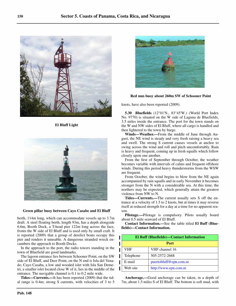
150 Sector 5. Coasts of Panama, Costa Rica, and Nicaragua
Pub. 148
berth, 114m long, which can accommodate vessels up to 3.7mdraft. A steel floating berth, length 93m, has a depth alongside6.6m, Booth Dock, a T-head pier 122m long across the face,fronts the W side of El Bluff and is used only by small craft. Itis reported (2009) that a group of derelict boats occupy thispier and renders it unusable. A dangerous stranded wreck en-cumbers the approach to Booth Docks.5.29 In the approach to the port, the radio towers standing in thetown of Bluefield are good landmarks.5.29 The lagoon entrance lies between Schooner Point, on the SWside of El Bluff, and Deer Point, on the N end is Isla del Vena-do, Cayo Casaba, a low and wooded islet with Isla San Deme-tri, a smaller islet located close W of it, lies in the middle of theentrance. The navigable channel is 0.1 to 0.2 mile wide.5.29 Tides—Currents.—It has been reported (2009) that the tid-al range is 0.4m; strong S currents, with velocities of 3 to 5
knots, have also been reported (2009).
5.30 Bluefields (12°01'N., 83°45'W.) (World Port IndexNo. 9770) is situated on the W side of Laguna de Bluefields,3.5 miles inside the entrance. The port for the town stands onthe W and NW sides of El Bluff, where all cargo is handled andthen lightered to the town by barge.5.30 Winds—Weather.—From the middle of June through Au-gust, the NE wind is steady and very fresh raising a heavy seaand swell. The strong S current causes vessels at anchor toswing across the wind and roll and pitch uncomfortably. Rainis heavy and frequent, coming up in fresh squalls which followclosely upon one another.5.30 From the first of September through October, the weatherbecomes variable with intervals of calms and frequent offshorewinds. During this period heavy thunderstorms from the WSWare frequent.5.30 From October, the wind begins to blow from the NE againaccompanied by rain squalls and in early November it becomesstronger from the N with a considerable sea. At this time, thenorthers may be expected, which generally attain the greatestviolence from NW to N.5.30 Tides—Currents.—The current usually sets S off the en-trance at a velocity of 1.5 to 2 knots, but at times it may reverseitself at reduced strength for a day at a time for no apparent rea-son.5.30 Pilotage.—Pilotage is compulsory. Pilots usually boardabout 0.5 mile seaward of El Bluff. 5.30 Contact Information.—See the table titled El Buff (Blue-fields)—Contact Information.
5.30 Anchorage.—Good anchorage can be taken, in a depth of7m, about 1.5 miles S of El Bluff. The bottom is soft mud, with
5.29El Bluff Light
5.29Green pillar buoy between Cayo Casabe and El Bluff
5.29Red nun buoy about 260m SW of Schooner Point
El Buff (Bluefields)—Contact Information
Port
VHF VHF channel 16
Telephone 505-2572-2668
E-mail [email protected]
Web site http://www.epn.com.ni

Sector 5. Coasts of Panama, Costa Rica, and Nicaragua 151
Pub. 148
excellent holding ground. Vessels should use the starboard an-chor because they will invariably lie heading N with the windon the starboard bow. The anchorage area will be designated bythe pilot.5.30 Inside the bar, there is a good, though confined, anchorage,in a depth of 8m, close W of the wharf on the NW side of ElBluff.
Bluefields to Punta de Perlas
5.31 Blowing Rock (12°02'N., 83°02'W.), 1.2m high andwith a hole in its center through which water is occasionallyforced like the spouting of a whale, lies 38 miles E of El Bluff.5.31 A shoal, with a depth of 10.1m, is located 22 miles E ofBlowing Rock. Another shoal, with a depth of 20m, lies 3.5miles SW of Blowing Rock.
5.31 Isla Grande del Maiz (12°10'N., 83°03'W.), 2.5 miles longand 2 miles wide, lies 38 miles ENE of El Bluff. Mount Pleas-ant rises to a 113m wooded peak in the middle of the N part ofthe island. A 30m high, rocky, bluff stands at the S end of theisland. The island is fringed by foul ground extending 0.3 mileto 1.5 miles offshore.5.31 A wreck that lies stranded 1.3 miles NNE of the summit ofMount Pleasant is reported to be radar prominent.5.31 Anchorage can be taken in Southwest Bay, on the SW side ofthe island, in depths of 8 to 9m; in Brig Bay, on the W side ofthe island, in depths of 9 to 11m; and in Long Bay, on the SEside of the island, in a depth of 9m. Care should be taken toavoid the reefs and shoal patches in or near these anchorages.5.31 A pier, which is 98m long and has depths of 2.1 to 4m along-side, extends from the shore in the vicinity of a shrimp-pro-cessing plant at the head of Southwest Bay. This conspicuousbuilding is lighted at night. A similar building, also lighted atnight, stands at the head of Brig Bay.
Isla Pequena del Maiz (12°18'N., 82°59'W.), 0.5 mile long,0.5 mile wide, and 38m high, stands 7.5 miles NNE of IslaGrande del Maiz. The N and E sides of the island are fringedby reefs extending 0.5 to 1 mile offshore. The W side of the is-land is fairly steep-to seaward of the 10m curve, which lies be-tween 0.2 mile and 0.5 mile offshore.5.31 Anchorage can be taken in Pelican Bay, on the SW side ofthe island, in a depth of 11m, with the W tangent of the islandbearing 342° and the S tangent of the island bearing 106°.
Cayman Roca (12°05'N., 83°39'W.), a small rock, 8m highand marked by a red conical tower, lies 6 miles NNE of ElBluff. False Bluff, a green mound, 18m high, stands on a smallpoint of red bluffs about 12 miles N of El Bluff.5.31 Cerro Cucra (12°15'N., 83°46'W.), isolated and 192m high,rises 16 miles NNW of El Bluff and is a good landmark for theapproach to BluefieldsFrom El Bluff, the low and swampycoast extends 21 miles N to Punta Mosquito, the N entrancepoint of Laguna de Perlas. This lagoon is 1 to 6 miles wide andnavigable only by small craft.5.31 Between El Bluff and Punta de Perlas, 6 miles E of PuntaMosquito, most of the coastal dangers are contained within the10m, curve which lies between 1 mile and 4.5 miles offshore.Punta de Perlas, bordered by a white sandy beach, is a promi-nent projection when seen from the S.
Cayos de Perlas
5.32 Cayos de Perlas (12°29'N., 83°19'W.) and severalreefs lie between Punta de Perlas and a position lying 13.5miles E. They extend 12 miles N. All of the cays and reefs liewithin the 20m curve, which follows the irregular coastal trendin this vicinity a distance of 8 to 17 miles offshore. Several de-tached patches, with depths of 12 to 18m, lie up to 2 miles sea-ward of the 20m curve to the E of these cays.5.32 Although there are depths of 11 to 18m in this area, naviga-tion is very hazardous because of the numerous charted and un-charted reefs and shoals, some of which may not be visiblebecause of the turbid waters. Although soundings in manyplaces show a muddy bottom, it is only a thin covering overcoral; trippling gear and a buoy should be used to prevent lossof the anchor.5.32 It is evident that because of the dangers within these cays itis prudent to avoid them entirely and pass to the E.
Seal Cay (12°25'N., 83°17'W.), the southeasternmost of theCayos de Perlas, is a small coral ridge 0.9m high, lying 12.5miles E of Punta de Perlas. Foul ground extends 0.5 mile NWand 1 mile SSW from the cay, but the SE side is steep-to. Sev-eral 9m shoal patches lie within 1.8 miles S through about 4.5miles SW of the cay.5.32 The S limits of the Cayos de Perlas are marked by Columbil-la Cay, a steep-to reef-fringed islet, 33m high to the tops of thetrees, lying 6.5 miles SW of Seal Cay. Maroon Cay, a similarislet on the edge of a reef extending 2 miles E from Punta dePerlas, stands at the SW extremity of these cays. MaroonKnoll, with a least depth of 5.5m, together with several de-tached 7.3 to 9.1m patches, lies up to 2.5 miles SSE of MaroonCay.5.32 Boden Reef (12°30'N., 83°19'W.), 0.8 mile long and with aleast depth of 4.3m, lies on the E edge of the Cayos de Perlas,about midway between Seal Cay and the NE Cays 8 miles NWof Seal Cay. The NE Cays, a small group of reef-fringed isletswith several rocks, awash, lying 1 mile NW, mark the NE ex-tremity of the Cayos de Perlas. Numerous rocks, awash, and 3to 5.5m patches lie up to 5 miles WSW of these cays.5.32 Within the limits indicated above lie the Crawl Cays and theTungawarra Cays, as well as numerous other small cays andshoals.5.32 Although ample depths exist throughout the limits of theCayos de Perlas, the numerous unmarked dangers and intricatechannels make it advisable to pass well E of them.5.32 Good anchorage can be taken about 0.3 mile SW of LittleTungawarra Cay. This anchorage should be approached fromthe S. Other anchorages may be found in the lee of the largercays.5.32 Two detached 7.3m depths and a shoal, with depths of 3 to9m, lie 5 miles N of Cays de Perlas and between 4.5 miles and8.2 miles offshore.
Punta de Perlas to Puerto Cabezas
5.33 The Rio Grande (12°54'N., 83°32'W.) is navigableby barges up to 106 miles upstream. A depth of 1.5m exists onthe bar at the entrance to the river. The village of Rio Grande issituated on the N bank of the river close within the entrance. Afruit station and a wharf lie on the S bank. Two radio towers
152 Sector 5. Coasts of Panama, Costa Rica, and Nicaragua
Pub. 148
standing on the S side of the entrance are conspicuous; the vil-lage of Sandy Bay, situated 3.5 miles N, is a fairly good land-mark.
Great King Cay (12°45'N., 83°21'W.) is 21m high and thelargest of a group of islets lying 12 miles N of the Cayos dePerlas and 9 to 13 miles offshore. Little King Cay, 10m high,stands 0.8 mile E of Great King Cay. Rocky Cays, two in num-ber, lie 1 mile NW and Little Tyra Cay, 2.4m high togetherwith a detached 3.9m patch, lie between 2 miles and 3 milesWSW of Great King Cay.5.33 Great Tyra Cay (12°52'N., 83°23'W.), 18m high to the topsof the trees and with foul ground extending 0.5 mile N from it,is the largest of a group of islets and shoals which lie 8 miles Nof Great King Cay. Seal Cay, two barren rocks 3m high, lies0.8 mile S of Great Tyra Cay. A dangerous shoal patch lies 1mile E of Seal Cay; several detached reefs lie between 1 mileand 3 miles SW of Great Tyra Cay. There are two detachedshoals lying 1 mile and 5 miles NW of Great Tyra Cay.5.33 Roca Tyra, 2.4m high and steep-to on its E side, lies 4.5miles NE of Great Tyra Cay. Numerous detached reefs andshoals, over which the sea breaks, lie up to 3.5 miles W and 1mile N of Tyra Rock.
5.34 Cayos Man O War (13°01'N., 83°23'W.), a cluster ofislets, with the largest being 15m high, lies 11 miles offshore,6.8 miles NW of Tyara Rock. An old oil barge, formerly usedas a storage tank, stands on the W cay. A sheltered bight on theW side of this cay has pilings where vessels formerly mooredto load lightered cargo. Depths alongside range from 4 to 6.7m.5.34 Numerous detached reefs and shoals lie up to 3 miles SSWand WNW of Cayos Man O War. A 9.1m depth lies 5 milesWSW and two 9.1m depths lie 6 and 7 miles WNW of thecays. A coral head, with a depth of less than 7.3m, lies 2 milesW of Cayos Man O War.5.34 Egg Rock (13°02'N., 83°22'W.), 1.8m high and steep-to, lies1.4 miles NE of Cayos Man O War.5.34 A dangerous shoal lies 13 miles NNW of Cayos Man O War.5.34 Caution.—Many vessels have reported striking coral headsinside the 20m curve in the vicinity of Cayos Man O War andbetween them and Puerto Cabezas. It is advisable to keep sea-ward of the 20m curve when navigating along this part of thecoast. A shoal, with a depth of 6.4m, lies about 49 miles SE ofPuerto Cabezas.
5.35 Puerto Isabel (13°22'N., 83°34'W.), an open road-stead and a privately-owned port, is situated about 28 miles Nof the Rio Grande. 5.35 Tides—Currents.—From March to April, the current sets ina N direction at a velocity of 1 to 2 knots; from May to Febru-ary it sets in a S direction at the same velocity.5.35 Depths—Limitations.—A pier, extending 0.5 mile E fromthe shore abreast of the town, has a berth, 76m long, situated atits outer end, with depths of 4.6 to 5.2m alongside. Vesselsberth port side-to on the S side of the pier, with their bowsheading E, using the anchor and running a wire rope to a moor-ing dolphin off the head of the pier. Only vessels up to 4.6mdraft can berth due to the heavy E swell. The N side of the pieris shoal. 5.35 Aspect.—Landmarks consist of the houses in the town, threeoil tanks, and a conspicuous ore loader standing on the pier.
Lighted range beacons are situated on the pier.5.35 Pilotage.—No pilots are available and berthing is limited todaylight hours.5.35 Anchorage.—Anchorage can be taken about 0.3 mile E ofthe pier head, in depths of 5.5 to 7.3m, hard sand, good holdingground.
5.36 The Rio Prinzapolca (13°25'N., 83°34'W.), with asmall village on its S bank, lies 10 miles N of Puerto Isabel.Shoal water, with depths of less than 1.8m, extends 1 mile Efrom the river mouth.
The Rio Walpasixa (Rio Hualpasixa) (13°29'N., 83°33'W.),with a village situated at its entrance, lies 4 miles N of the RioPrinzapolca.5.36 The sea breaks heavily on a bar at the river mouth. The vil-lage of Wounta stands on the S side of the entrance of a smalllagoon located 4 miles N of the Rio Walpasixa. Foul groundextends about 3 miles E from a position just N of the lagoonentrance. Two shoals lie about 6 miles and 11 miles NNE ofWounta.5.36 Several prominent mounds, each 24m high, stand near thecoast 14 miles N of Wounta. From a position lying 11 miles Nof the Rio Grande to a position E of these mounds, numerousdangers are contained within the 20m curve, but from there toPuerto Cabezas, it is comparatively free of charted dangerswithin the 10m curve, which lies 2 to 4 miles offshore.5.36 The Rio Wawa (Rio Huahua) (13°53'N., 83°27'W.) dis-charges 21 miles N of Wounta. After heavy rains, muddy riverwater discolors the sea for some distance offshore. From theRio Wawa, the coast extends 10 miles N to Bragman Bluff, abold headland, 30m high, with red cliffs extending 0.5 milealong its E edge.
5.37 Puerto Cabezas (14°01'N., 83°23'W.) (World PortIndex No. 9760) consists of an open roadstead fronted by a pierextending SE from Bragmans Bluff. The principal exports arebananas and lumber.5.37 Tides—Currents.—The current in the vicinity of the piersets S or SSW at a velocity of 1.3 knots. Current signals aredisplayed at the head of the pier to facilitate berthing.5.37 Depths—Limitations.—In the vicinity of the port, depths of5.5m lie up to about 0.5 mile offshore and depths of 9m lie 1 to2 miles offshore. Isolated depths of 8 to 9m are found outsidethe 10m curve, about 1.8 miles SE and 2 to 3 miles E of thebluff. A number of wrecks lie 0.3 to 0.7 mile E and ESE of thehead of the jetty. They can best be seen on the chart.5.37 Government Wharf extends 0.5 mile SE from the S extremi-ty of Bragman Bluff. It is 169m long with a depth of 6.7malongside the seaward end. Vessels up to 120m in length with adraft of 6.5m can be handled. 5.37 A sand bar, with a depth of 5.2m, was reported (1985) to lieclose SW of the wharf.
Aspect.—Several water towers, the radio towers on the Eside of the town, and several chimneys in its SE part are promi-nent landmarks.
At night, the glare of the lights in the town may be seen longbefore the navigational lights can be identified. The beach isreported to form a poor radar target, although the railroad carson the siding are reported to be radar conspicuous. The pier isalso reported to be radar conspicuous.

Sector 5. Coasts of Panama, Costa Rica, and Nicaragua 153
Pub. 148
5.37 Pilotage.—Pilotage is compulsory. Pilots will berth vesselsonly during daylight hours. The pilot boards 1 mile off the port.5.37 Contact Information.—See the table titled Puerto Cabe-zas—Contact Information.
5.37 Anchorage.—Anchorage can be taken off the end of thepier, in depths of 6 to 9m, mud, good holding ground. Good an-chorage can also be taken, in a depth of 8m, with the pier headbearing 319°, distant 0.4 mile. Care should be taken to avoid anobstruction lying 0.5 mile ESE of the pier head. There is practi-cally no shelter from the wind and sea.
Puerto Cabezas to Punta Gorda
5.38 The coast between Puerto Cabezas and Punta Gorda,23 miles NE, is low and wooded, with few distinguishingmarks other than the mouth of the Rio Hueson, lying 8.8 milesNE of Puerto Cabezas. A prominent steeple stands 2.8 milesSW of the mouth of the Rio Hueson.5.38 Most of the dangers that lie adjacent to this section of coastare contained within the 10m curve, which lies between 1 mileand 2 miles offshore. Some shoal patches, with depths of 7.3 to10m, lie outside that curve, but within 2 miles of the shore. Anarrow shoal, with a least depth of 7.3m, extends 1.3 miles Sfrom a position located 2 miles SE of Punta Gorda.5.38 The W edge of the reefs and other dangers, which are a partof the Cayos Miskitos, lies 7.5 miles E of Punta Gorda and ex-tends SE to a position located 29 miles E of the mouth of theRio Hueson.
Punta Gorda (14°21'N., 83°12'W.) is a low wooded pointwith almost no identifying features. About 5 miles NNW of thepoint, there is a conspicuous ridge, 7m high, which parallelsthe shore 1 mile inland for a distance of 2 miles. The 10mcurve lies less than 1 mile offshore; there are depths of 14.6 to20.1m in Miskito Channel between Punta Gorda and the W ofthe Cayos Miskitos, 7.5 miles E.
Cayos Miskitos and the Surrounding Cays and Reefs
5.39 From a position located 72 miles E of Punta Gorda,the 200m curve extends NE to a position lying 92 miles E ofCabo Gracias a Dios. Inside this curve, the water of this part ofMiskito Bank shoals rapidly to depths of less than 37m, andthere are numerous patches and banks between it and the Eedge of Cayos Miskitos, 40 to 50 miles offshore. The largest ofthese banks extends 12 miles N from a position lying 63 milesNE of Punta Gorda and is 6 miles wide. Between the cays andthe mainland, most of the dangers are contained within the10m curve, which follows the coastal trend between 0.5 mileand 4 miles offshore.5.39 In the deep water off the edge of the 200m curve, the bottomis formed of fine sand, sometimes with a few broken shells, andon the E part of the Miskito Bank coral sand is prevalent withsome coarser areas of small, flat, white stones. The bottom isgenerally rocky within small patches lying in depths of lessthan 18m.5.39 The NE part of the bank consists of fine sand with smallblack specks and minute shells, which merges into blue mud asthe cays are approached. In places, this bottom sediment be-comes pale and so soft as to be washed off the sounding lead;near the cays it may be light gray in color. The beaches areformed of finely broken shells.5.39 The numerous cays are small, with little or no vegetation,having been stripped by heavy seas and gales; however, someof the larger ones are wooded. Many of the cays and reefs aresteep-to on the windward side, and there are numerous deepcuts which may provide sheltered anchorage.
5.40 The Cayos Miskitos group, consisting of Cayos Mi-skitos and the surrounding cays and reefs, lies within a circle,with a radius of 19 miles, centered on the largest cay, 26 milesE of Punta Gorda. Approach to this area is dangerous from anydirection because of the many detached reefs and shoals andthe lack of any navigational aids.5.40 Cayos Miskitos (14°23'N., 82°46'W.), the largest cays of thegroup, consists of one main island, 2.5 miles in diameter, withseveral smaller islands and islets lying adjacent to it and sever-al others separated from it by a shallow lagoon. Cayos Miski-tos, extending 5.5 miles NE, lies near the middle of the CayosMiskitos group and in the center of the S half of a reef whichextends 19 miles NNE from a position located 21 miles E ofPunta Gorda. Porgee Channel (14°26'N., 82°41'W.), narrowand intricate, bisects the reef from E to W, about 0.5 mile NEof the NE island. To the N of the cays, the channel widens intoa bay with depths of 12 to 18m.5.40 Blue Channel (14°25'N., 82°50'W.), about 1.5 to 3 mileswide, has depths of 9 to 25m and runs parallel to the W side ofMiskito Reef (14°28'N., 82°42'W.) and between it and theMorrison Dennis Cays, the Ualpatara Reefs (14°27'N.,82°58'W.), and others which extend 12 miles N.
5.41 Hamkera (14°34'N., 82°58'W.), a small group of is-lets and reefs, lies 15 miles NNW of Cayos Miskitos on theNW limits of the reef and the Cayos Miskitos group. FromOuter Mohegan, the largest of the Hamkera group, numerousdetached reefs extend about 3.5 miles N to several rocks
5.37Puerto Cabezas Light and Government Wharf
Puerto Cabezas—Contact Information
Port
VHF VHF channel 16
Telephone 505-2282-2411
E-mail [email protected]
Web site http://www.epn.com.ni

154 Sector 5. Coasts of Panama, Costa Rica, and Nicaragua
Pub. 148
awash.5.41 Auiapuni Reef (14°31'N., 83°05'W.), a group of shoalpatches 1.5 miles in extent, lies 7.5 miles SW of Outer Mohe-gan and at the W extremity of the Cayos Miskitos group.Depths over this reef are 4.8 to 8.5m.5.41 Tsiankualaia Rock (14°20'N., 83°04'W.), with a depth of2.7m, lies on the SW side of the Cayos Miskitos group, 7.8miles E of Punta Gorda. Several rocks, with depths of less than1.8m, lie within 0.5 mile S and SE of this rock. Waham Cay,0.9m high, lies 3.5 miles NNE of the rock. Toro Cay and Kisu-ra Cay, two similar islets, lie 2 miles NNW and 2 miles N, re-spectively, of Waham Cay.5.41 Alice-Agnes Rocks, several rocks awash, with detached 7.3and 8.2m patches within 1 mile of them, lie on the SW limits ofthe Cayos Miskitos group, 13 miles WSW of Cayos Miskitosand about the same distance SE of Punta Gorda.
5.42 Ned Thomas Cay (14°10'N., 82°48'W.) and The Wit-ties lie in the center of a group of reefs about 8 miles in extent,11.5 miles S of Cayos Miskitos. Sea Devil Reef, a 5.9m shoalpatch, and Franklin Reef, a 4.6m shoal patch, lie on the S limitsof the Cayos Miskitos group, 3.5 miles SW and 4 miles SSE ofThe Witties.5.42 Southeast Rock (14°10'N., 82°29'W.), with a least depth of2.7m, lies on a 10m bank 1 mile in extent, 19.5 miles E of Cay-os Miskitos, at the SE extremity of the group. A 9.1m shoalpatch lies 3 miles SE of the rock, and there are depths of 10mnear the 20m curve, about 5.5 miles farther SE. A 4m shoalpatch was reported (1975) to lie about 12 miles SE of the rock.5.42 From Southeast Rock, the E edge of the Cayos Miskitosgroup extends 32 miles N to the NE extremity of the group,where a 6.7m shoal patch is located.5.42 Hannibal Shoals (14°26'N., 82°31'W.), with a least depth of7.6m, lie on the E edge of the Cayos Miskitos group, 13.3miles E of Cayos Miskitos.5.42 Within the described limits of the Cayos Miskitos group ma-ny other reefs and shoals exist, and although there are depths of11 to 25m in the vicinity of these dangers, navigation through-out this area is difficult and dangerous.
5.43 Edinburgh Reef (14°50'N., 82°39'W.), 4 miles longand awash, lies about 8.3 miles N of the N limits of the CayosMiskitos group. Edinburgh Cay lies detached about 1.5 milesWNW of the SW end of Edinburgh Reef. Edinburgh Channel,lying between Edinburgh Reef and the reefs to the S, is a clearpassage with depths of 14 to 27m.5.43 Cock Rocks, a group of several drying rocks 0.5 mile in ex-tent, lies 4.5 miles N of Edinburgh Reef. A 7.3m shoal patchand a 12.2m shoal patch lie 2.5 miles E and 4 miles SE, respec-tively, of these rocks.
Punta Gorda to Cabo Gracias a Dios
5.44 Between Punta Gorda, described in paragraph 5.38,and Cabo Gracias a Dios, 39 miles N, the low coast is indented7 miles W by a gradual bight. Several streams and rivers dis-charge along this coast and there are a few settlements.5.44 Between Punta Gorda and Cabo Gracias a Dios, the normalset of the current over Miskito Bank is NW, at a velocity of 0.3to 0.8 knot. In the vicinity of Cayos Miskitos, the set is more to
the N, and between Kisura Cay and Ualpatara Reefs it sets N ata velocity of 1 knot. Inside the 20m curve and close to thecoast, a countercurrent setting S may be experienced.5.44 The currents near this coast are variable and at times may becompletely reversed.
5.45 From Punta Gorda, the low coast extends 26 milesNNW to Laguna Huani, fronted by a shallow entrance 2 mileswide and partly obstructed by islands; the coast then extends15 miles NE to Cabo Gracias a Dios. With the exception of aridge 5 miles N of Punta Gorda, and the mouths of several shal-low rivers, the coast is low, with few distinguishing marks oth-er than groups of trees, 9 to 21m high.5.45 The Sandy River, a narrow river leading into a lagoon, dis-charges 7 miles N of Punta Gorda; another river, the RioTeikapalaga, discharges 13 miles farther NNW.5.45 Most of the dangers are contained within the 10m curve,which lies 0.5 to 1 mile off the coast between Punta Gorda anda position 15 miles NNW, where it extends N to the cape andlies up to 4 miles offshore.
Uatlatara Rocks (14°34'N., 83°12'W.), two dangerous pin-nacles with a least depth of 5.8m, lie 3 miles offshore, about12.5 miles N of Punta Gorda.5.45 Between the Rio Teikapalga and Cabo Gracias a Dios, thereare numerous 9m shoal patches lying up to 1 mile outside the10m curve. A bank, with a depth of 10.5m, lies 8.5 miles E ofthe Laguna Huani entrance. It is 4 miles long and 2 miles wide.A 9.1m shoal patch lies about 4.3 miles SE of Cabo Gracias aDios.5.45 The Rio Coco (14°59'N., 83°10'W.), which discharges onthe S side of Cabo Gracias a Dios, is obstructed by several caysat its mouth. The bar has a depth of 1.8m, but this is subject tochange because of silting.
5.46 Cabo Gracias a Dios (15°00'N., 83°10'W.), a smalltown, stands on the S side of the cape and is the seat of the gov-ernor. Timber and bananas are exported on vessels which callirregularly. Vessels desiring local assistance in sending a boatacross the bar should proceed to a position E of the town andsignal by whistle, light, or radio. They should then anchorclose S of the bar to await the pilot.5.46 Except for several radio masts standing in the town, thebuildings cannot be seen by vessels approaching from the Sdue to heavy foliage.
Cayos de Albuquerque and Cayos del Este Sud-este
5.47 Cayos de Albuquerque (12°10'N., 81°51'W.) lie 111miles ENE of Punta Mono on a bank about 5 miles in extent.The edge of this bank is steep-to and has depths of 18m andless within the edge of the 200m curve. Numerous rocky headsand drying reefs exist, particularly near the E and S sides of thebank.5.47 Cayo del Norte and Cayo del Sur, near the E side of thebank, are about 1.8m and 1.2m high, respectively, and havebeen reported to be radar prominent. Both cays have been re-ported to be heavily wooded with palm trees, 18m high. A lightis shown from Cayo del Norte. 5.47 Caution.—Entry into the Cayos de Albuquerque is governed

Sector 5. Coasts of Panama, Costa Rica, and Nicaragua 155
Pub. 148
by numerous restrictions and regulations. Consult local author-ities for more details. 5.47 Strong winds and currents surround the cay.
5.48 Cayos del Este Sudeste (12°24'N., 81°28'W.), 7miles long and 2 miles wide, lie on a coral bank lying 24 milesENE of Cayos de Albuquerque. A reef extends across the bank1.5 miles within the N end. North and E of this reef the depthsrange from 9 to 31m, coral and sand, to the edge of the bank.The E side of the reef is steep-to and extends 2 miles S to abight indenting the E side. A broken reef continues S to about 1mile within the bank’s S extremity. Between this reef and the Send of the bank, the depths range from 11 to 23.8m, sand, coraland rock. The middle and W parts of the bank have numerousshallow patches. A stranded wreck lies on this reef, 3.3 milesNW of Cayo Bolivar Light.5.48 Cayo del Este lies on the SE portion of the bank. The cay,about 0.3 mile long and 1.2m high, is thickly wooded withpalm trees. Cayo Bolivar, 1.3 miles W of Cayo del Este, is1.8m high with several palm trees on it. West Cay, 0.4 mileWNW of Cayo del Este, is very small and low. Cayo Arena is asmall dry sand bank 1.3 miles NW of Cayo del Este. Huts havebeen erected on these cays by fishermen. Cayo Arena is report-ed to be radar conspicuous.5.48 Anchorage can be taken on the W part of the bank, outsidethe reef.5.48 Caution.—Entry into the Cayos del Este Sudeste is gov-erned by numerous restrictions and regulations. Consult localauthorities for more details.
Isla de San Andres
5.49 Isla de San Andres (12°33'N., 81°43'W.) lies 16miles WNW of Cayos del Este Sudeste. It is about 7 miles longand 1.5 miles wide, and is marked by a ridge of hills extendingfrom near its N end to within 1.5 miles of its S end. Three flat-topped summits rise above this ridge. These summits appear asonly two hills when viewed from the N or S. A cliff at the Nend of the ridge is distinctive. The island is reported to be radarconspicuous.5.49 The General Cargo Berth has a continuous length of 420mand alongside depths of 6.7-8.5m. This berth can accommodatevessels with a maximum draft of 5.3m. 5.49 Punta Norte (12°36'N., 81°42'W.), the N extremity of Islade San Andres, is fringed by foul ground which extends about1 mile N from it. Blowing Rocks, low rocks over which the seabreaks heavily during N winds, lie 0.8 mile N of the point.5.49 Cayo Johnny (Cayo Sucre), low, small, and covered by palmtrees, lies on the NW end of a detached reef 1 mile ENE ofPunta Norte. The coastal reef which lies 0.5 mile N and E ofCayo Sucre extends 4 miles S to a position about 1.8 milesENE of Punta Sterthemberg. The S side of the reef is indentedby a narrow irregular channel which leads N to Bahia de SanAndres, 2.3 miles N. South of Punta Sterthemberg, the coastalreef nowhere lies more than 0.3 mile offshore. The W side ofthe island is steep-to and free of dangers.
Punta Sur (12°29'N., 81°44'W.), the S extremity of Isla deSan Andres, is of moderate elevation, wooded, and marked bya light. The W side of the island is composed mainly of rockycliffs and is indented 2.5 miles N of Punta Sur by Rada El
Cove.5.49 Temporary anchorage can be taken about 0.3 mile W andSW of the cove, in a depth of 13m, sand, but the swingingroom is restricted. Although the holding ground is reportedgood, this anchorage is not recommended during the season ofthe northers.5.49 The principal town is San Andres, situated on the N side ofthe island. A small pier used by lighters extends from the shoreSE of the town. San Luis, a small village, stands S of PuntaSterthemberg.5.49 On the N end of Isla de San Andres, the current generallysets strongly to the W, except during and after northers, when itsets S. This may be considered a locality where variable cur-rents exist. It was reported (1959) that an unusual E set was ex-perienced between Cristobal and Isla de San Andres.
5.50 Bahia de San Andres (12°35'N., 81°42'W.) is formedon its E side by the coastal reef extending S from Cayo Sucreand by the W side of Isla de San Andres. 5.50 Depths—Limitations.—A wharf, 300m long, is reported tohave depths of 6.7 to 8.5m alongside. It lies parallel to theshore in the SW part of the bay. The channel leading to thiswharf is entered about 2.3 miles S of the bay and is reported tobe available to small vessels with drafts up to 4.6m.5.50 Pilotage.—Pilotage is compulsory, but is available duringdaylight hours only. The pilot boards in the vicinity of Ap-proach Lighted Buoy.5.50 Contact Information.—See the table titled San Andres—Contact Information.
5.50 Anchorage.—Anchorage can be taken, in depths of 5.5 to9m, in the bight at the entrance to the harbor. Anchorage canalso be taken, in a depth of 11m, sand, SW of Cayo Cordoba(12°33'N., 81°41'W.).5.50 Caution.—Shoal depths are reported (1997) to exist in theentrance to the bay.
Isla de Providencia
5.51 Isla de Providencia (13°21'N., 81°22'W.) lies 50miles NNE of Isla de San Andres. Together with Isla SantaCatalina, close off its N end, these islands extend 4.5 miles in aN-S direction. The mountainous center rises to three peaks ofabout the same elevation, the highest being 363m high. The is-lands lie on a bank, as defined by the 200m curve, that extends10.5 miles N and 3 miles S from them. The N extremity of Isla
San Andres—Contact Information
Harbormaster
VHF VHF channels 14, 16, 24, 28, and 71
Telephone
57-098-512-5613
57-098-512-2380 (extension 100)
57-098-512-2347
Facsimile 57-098-512-7077 (extension 116)

156 Sector 5. Coasts of Panama, Costa Rica, and Nicaragua
Pub. 148
de Providencia is Jones Point. On a spur extending S from thispoint stands Spit Hill, 168m high. From the NW or SE, a rockychasm, about 18m wide and 24m deep, is prominent on SplitHill. Isla de Providencia is reported to be radar conspicuous.
5.51 A reef lies within 2 miles of the E and S sides of the island andup to 8 miles N from its N side. Between the N end of the reefand the outer edge of the bank, about 2 miles N and 2.8 milesNE, there are general depths of 11 to 36m; between the S end ofthe reef and the edge of the bank, 1.8 miles S, the depths rangefrom 7.3 to 95m. The W side of the island is foul, except for anarea about 1.5 miles in extent W of Catalina Harbor.5.51 Caution.—A dangerous wreck exists about 3 miles SE of Is-la de Providencia.
5.51 Low Cay (13°32'N., 81°21'W.), which shows a light, is lo-cated on the NW extremity of the reef 8.5 miles N of JonesPoint. A reef, which dries in places, extends up to about 0.5mile S from it.5.51 Good anchorage can be taken 1 mile S of Low Cay, in depthsof 11 to 18m, sand. Care should be taken to avoid the shoalpatches in the vicinity.5.51 Basalt Cay and Palm Cay, 0.3 mile N of Isla Santa Catalina,are small with moderate elevations. Palm trees stand on the lat-ter island. A light is shown from Palm Cay.
5.52 Catalina Harbor (Bahia Catalina) (13°23'N.,81°23'W.), on the W side of the N part of Isla de Providencia,is 1 mile long and 0.5 mile wide. It provides sheltered anchor-age to vessels with drafts up to 4.6m. The greater part of theharbor is shoal and depths of 5.5m and more can be found in asmall area off the SW side of Isla Santa Catalina. MorganHead, about 1.25 miles W of Isla Santa Catalina, is a promi-nent 12m high black rock.5.52 Isabel Village (13°23'N., 81°22'W.), the chief settlement ofIsla de Providencia, is situated close SE of Isla Santa Catalina.5.52 Anchorage.—Sheltered anchorage from the prevailingwinds can be taken, in depths of 5.5 to 8m, close SW of IslaSanta Catalina. Anchorage can be taken on the outer part of thebank, in a depth of 9m, with Morgan Head bearing 143° and
the two small cays N of Isla Santa Catalina nearly in line bear-ing 094°. Anchorage can also be taken, in a depth of 11m,about 1.3 miles SW of the above anchorage on the outer part ofthe bank with Alligator Point, the W extremity of Isla de Prov-idencia, bearing 168°, and the N extremity of Isla Santa Catali-na bearing 072°. Isolated shallow depths may exist in this area.5.52 Caution.—Caution must be exercised, as the depths havebeen reported to be as much as 0.6m less than charted. Strongand irregular currents exist in the vicinity of Isla de Providen-cia and should be guarded against by vessels passing throughthis area.
Off-lying Dangers and Banks
5.53 From a position lying 25 miles S of Punta del Mono(Monkey Point) (11°36'N., 83°40'W.), the 200m curve extendsNNE to a position 28 miles E of that point, and then extendsNNE to a position lying 72 miles E of Punta Gorda. This areais part of the Miskito Bank, which lies between the coast andthe 200m curve to the E. A detached shoal, with depths of 10 to18m, lies 65 miles ENE of Punta Mono and 8 miles E of the200m curve.5.53 The depths within the 200m curve are irregular and numer-ous cays, islands, and other dangers exist. In the E edge of thebank, depths of 36 to 55m will be found, but there are numer-ous 9 to 18m detached steep-to patches and some with depthsas little as 1.8m. The greater part of the bank has depths of 24to 33m. During a gale, the water over the fine sand or muddybottom near the cays becomes turbid.5.53 Coral reefs in these waters may grow about 6cm annually,and depths may be formed which are less than those charted.5.53 Most dangers are contained within the 200m curve, whichfollows somewhat irregularly the coastal trend from 2 to 17miles offshore between Punta Mono and a position 13 miles Sof Puerto Cabezas.5.53 A 9.1m shoal depth, located on a bank with depths up to20m, about 4 miles in extent, lies 16 miles NE of Punta delMono; a similar shoal depth lies 20 miles NNE of the bank.5.53 Caution.—Great care is required when navigating in this ar-ea due to the unreliability and/or age of the surveys, the growthof reefs, and reports of new shoals.
5.54 Roncador Bank (13°34'N., 80°04'W.) lies with its Npart located 75 miles ENE of Isla de Providencia. This verysteep-to bank, as defined by the 200m curve, is 7 miles longand has a maximum width of 3.5 miles. Roncador Cay, com-posed of sand and blocks of coral, lies on the N part of the bankand is 4m high. With the exception of an area 0.5 mile widewithin the E edge of the bank, where the general depths rangefrom 9 to over 73m, the bank is covered by reefs, drying sand-banks, and coral heads. A light is shown from the N end of thebank. The SW part of the bank has more regular depths, but nu-merous coral heads and shallow depths lie scattered throughoutthe area. A conspicuous stranded wreck lies on the S end ofRoncador Bank and has been reported to be radar conspicuous.5.54 Anchorage.—Good anchorage can be taken on the W edgeof the bank, in depths of 9 to 13m, but care should be taken toavoid the coral heads which are easily seen.5.54 Caution.—A large area of discolored water, having the ap-pearance of a shoal, was reported to lie 7 miles NW of Ronca-
5.51Isla de Providencia Light from N
Sector 5. Coasts of Panama, Costa Rica, and Nicaragua 157
Pub. 148
dor Cay. In 1980, it was reported that a shoal, with a depth of9.1m, was located 7 miles NNW of Roncador Cay
5.55 Serrana Bank (14°24'N., 80°16'W.), an extensivedangerous shoal area, lies with its SW end located 45 milesNNW of Roncador Cay. This steep-to bank is 20 miles longand 6 miles wide. All sides except the W and SW edges arefringed by a nearly unbroken reef. The sea breaking over thereef on the E side of the bank is visible for several miles fartherthan the cays which stand on it. Mariners are advised to use ex-treme caution when in the vicinity of Serrana Bank because ofthe strong currents. On the W and SW parts of the bank, thereare numerous heads of live coral, with depths of only 1m. Thispart of the bank should be avoided by all except small craftwith local knowledge.5.55 Southwest Cay (14°16'N., 80°24'W.), composed of sandcovered with grass and stunted brushwood, is 10m high and thelargest cay on Serrana Bank. This cay has been reported to beradar conspicuous. A light is shown from the cay.5.55 Eclipse Rock, a steep-to pinnacle with a depth of 4.6m, lies0.4 mile WSW of Southwest Cay.5.55 Temporary anchorage can be taken by small craft, in depthsof 13 to 16.5m, about 0.6 mile NNW of Southwest Cay. Asteep-to reef extends 9 miles NE from Southwest Cay, is par-tially protected by the windward reefs and is not always visi-ble. A 0.6m high ledge stands on the edge of the reef lying 6miles NE of Southwest Cay. A drying sandbank lies 1.5 milesfarther NE.5.55 North Cay (14°28'N., 80°17'W.), located 13.5 miles NE ofSouthwest Cay, lies on the N end of the reef and is small andlow. An object resembling a light pylon was reported to standon or near this cay. It should not be mistaken for the light struc-ture on Southwest Cay. A reef, which is only visible during Nwinds or strong trade winds, extends 3 miles from the cay in aSW direction. A stranded wreck was reported (1971) to lie 1mile SW of North Cay.5.55 Turtle fishermen visit this area from March to August. Onoccasion, the masts of their vessels and their temporary hutsmay be sighted before the reefs themselves.5.55 South Channel (14°21'N., 80°15'W.), about midway alongthe SE side of Serrana Bank, is about 0.3 mile wide betweenthe cays and fringing dangers which lie on either side. Depthsin the fairway range from 7.3 to 12.8m. Care should be taken toavoid several 3.7m shoal patches which lie within the reef.5.55 Temporary anchorage can be taken by small craft, in a depthof 8m, about 1 mile NE of the channel entrance or just withinthe entrance in a depth 12m about midway between the cays.5.55 East Channel (14°21'N., 80°11'W.), 4 miles E of SouthChannel, is about 0.5 mile wide between the fringing dangersand has depths of 18.3 to 25.6m in the fairway. East Cay lies onthe W side of the entrance and a spur of the reef extends about2 miles N from it.5.55 Anchorage can be taken by small craft, in depths of 13 to16.5m, about 0.8 mile NE of East Cay.5.55 The current sets in and out of South Channel and East Chan-nel at a velocity of 1.5 to 2 knots.5.55 An extensive bank, with a least known depth of 52m, wasdiscovered (1973) lying about 25 miles ESE of Southwest Cay.
5.56 Quita Sueno Bank (14°15'N., 81°15'W.) lies with its
S end located 39 miles NNE of Isla de Providencia and is verysteep-to and dangerous. This bank, as defined by the 200mcurve, extends 34 miles N and has a maximum width of 13.5miles. Depths over this bank, exclusive of the 22 mile long reefwhich lies along its E side, range from 11 to 57m. From time totime, lesser depths have been reported to exist on this bank.5.56 Good anchorage can be taken, in depths of 18 to 25m, clearsand and coral, W of the rocky ground that lies near the middleof the reef.5.56 The two wrecks which lie stranded near mid bank are report-ed to be radar prominent. An additional stranded wreck lies inthe SE corner of the reef.5.56 Caution.—Great caution should be exercised by vesselspassing E of Quita Sueno Bank, as the current here sets strong-ly to the W and on to the bank. Care is also required since thedescription of this area is based on inadequate surveys. 5.56 A vessel struck a coral head about 14 miles SW and a dan-gerous below-water rock is charted 19 miles SSW of the Nedge of the reef. It seems probable that another unsurveyed reefexists W of Quita Sueno Bank. A shoal depth of 18.3m was re-ported (1964) to lie 38 miles WNW of Quita Sueno Light.
5.57 Serranilla Bank (15°55'N., 79°54'W.) lies 78 milesNNE of Serrana Bank. This bank, as defined by the 200mcurve, is 24 miles long, 20 miles wide, and very steep-to. Withthe exception of the shoal area in the vicinity of the cays on theE and S parts of the bank, there are general depths of 9 to 37m.5.57 There is no perceptible current on this bank, but a currentgenerally sets WNW at a rate of 0.3 to 1 knot.5.57 East Cay (15°52'N., 79°44'W.), the easternmost above-wa-ter feature on Serranilla Bank, is a small bush-covered cay,2.1m high, that lies 3 miles W of the E edge of the bank. Foulground, consisting of reefs and coral heads, extends 2.5 milesN through NE from the cay.5.57 Northeast Breaker, a coral ledge with a rock, awash, on its Sedge, lies 1 mile W of the edge of the bank, 3 miles NE of EastCay.5.57 Beacon Cay (15°47'N., 79°50'W.), the largest of the threecays on the bank, lies 7.5 miles SW of East Cay, and is com-posed of sand and coral. This 2.4m high cay is covered withgrass and is marked by a coral stone beacon on its W end. Alight is shown from Beacon Cay. 5.57 There are numerous obstructions in the area lying N of a linejoining East Cay and Beacon Cay, and within the limits of linesdrawn 4.5 miles NW from each cay. A small 2.1m cay, MiddleCay, lies in this foul area almost 2 miles W of East Cay.5.57 A 15.5m shoal, existence doubtful, is charted 36 miles SWof the light, midway between Serrana Bank and RosalindBank.5.57 Good anchorage can be taken, in a depth of 11m, about 1mile NW of Beacon Cay, but care should be taken to avoid thecoral heads.5.57 West Breaker (15°48'N., 79°59'W.), a dangerous breakingledge about 0.6m high, lies almost 8 miles W of Beacon Cayand is the W danger on the bank. It has been reported (1985)that West Breaker extends 2 miles W of its charted position.
5.58 Alice Shoal (16°05'N., 79°18'W.), located NE of Ser-ranilla Bank, with a least depth of 11m, coral, lies at the E edgeof a circular bank about 10 miles in extent as defined by the

158 Sector 5. Coasts of Panama, Costa Rica, and Nicaragua
Pub. 148
200m curve. Depths over the greater part of the bank are lessthan 36m. The bottom is fine white sand. Rips mark the edgesof the bank.5.58 Currents in the vicinity of the bank attain a velocity of about2 knots. An observation of short duration taken at the E edge ofthe bank revealed a set NE at a velocity of 1 knot with lightESE breezes. This current probably is a countercurrent that setsacross the bank.5.58 Unconfirmed reports (1983) indicate that depths on the Wpart of Alice Shoal may be considerably less than charted.5.58 Bajo Nuevo (New Bank) (15°53'N., 78°33'W.), about 5miles wide, is 14 miles long. It has been reported (1967) thatBajo Nuevo has extended W to about position 15°48'N,78°55'W. The bank has not been completely examined and itsSW end is not well defined. The NW side of the bank is clearof known dangers. Depths of 3.7m are reported to extend up to10 miles W of Bajo Nuevo. Seals gather on the reefs of thebank and are hunted in March and April. East Reef and WestReef, consisting of numerous rocky heads and separated by an
opening about 0.5 mile wide, extend along the SE side of thebank. They are over 2.5 miles wide and steep-to on the SE andN sides. Sand accumulates on the reefs and forms low ridges,barely awash. At times these wash away. A stranded wreck,which is reported to be radar conspicuous, lies at the NE end ofEast Reef. Another stranded wreck lies on the W end of WestReef.
5.58 Low Cay (15°52'N., 78°39'W.), 1.5m high and barren, lies atthe N end of West Reef. It is composed of broken coral, drift-wood, and sand. In moderate weather, exposed anchorage canbe taken, in depths of 12 to 14m, sand and coral, about 1.5miles W of Low Cay. The anchorage should be approachedfrom the W. Care must be taken to avoid a 3.7m coral head thatlies 2 miles WSW of the cay and the foul ground between. Thecurrent in the vicinity of the bank sets W and SW and attains avelocity of 2 knots.5.58 Bajo Nuevo Light is shown from a tower standing on LowCay.

159
Pub. 148
6. Sector 6—Coasts of Honduras, Guatemala, Belize, and Mexico—Cabo Gracias
a Dios to Cabo Catoche
6.0Additional chart coverage may be found in NGA/DLIS Catalog of Maps, Charts, and Related Products (Unlimited Distribution).SECTOR 6 — CHART INFORMATION
161
Pub. 148
SECTOR 6
COASTS OF HONDURAS, GUATEMALA, BELIZE, AND MEXICO—CABO GRACIAS A DIOS TO CABO CATOCHE
6.0 Plan.—This sector describes the Caribbean coasts of Hon-duras, Guatemala, Belize, and Mexico from Cabo Gracias a Di-os to Cabo Catoche. It includes the off-lying islands, banks,and other dangers. The descriptive sequence from Cabo Gra-cias a Dios is W, then N.
General Remarks
6.1 The coasts between Cabo Gracias a Dios and CaboCatoche, 450 miles NW, together with the off-lying islands,banks, and other dangers are described in this sector. The coastbetween Cabo Gracias a Dios and the W head of Bahia de Am-atique, 345 miles WNW, extends 130 miles NW to Cabo Ca-maron and then 235 miles W to the head of the bay. The coastof Honduras comprises 320 miles of this coast and the coast ofGuatemala comprises the remaining 45 miles. The coast is gen-erally low, swampy, and fronted by sandy beach. Cays andbanks extend offshore up to 72 miles E, through N, from CaboGracias a Dios. Those banks and islands which lie seaward ofthe 200m curve are described separately under off-lying depthsand dangers.6.1 An irregular chain of mountains, Sierras La Cruz, risesabruptly from the lowlands about 10 miles S of Cabo Camaronand extends along the entire W part of this coast. This rangereaches the coast in some localities and in others recedes up to20 miles inland.6.1 Few navigational lights are shown along this coast. Severalpeaks of the above-mentioned range are prominent landmarksin this area.6.1 The principal ports within this area are Puerto Castilla, LaCeiba, Tela, and Puerto Cortes in Honduras and Puerto Barriosand Santo Tomas de Castilla in Guatemala. Few sheltered an-chorages are to be found along this section of coast.6.1 The coasts of Belize and Mexico extend NNE for a distanceof 375 miles from the head of Bahia de Amatique to Cabo Ca-toche, the NE extremity of Peninsula de Yucatan. This coast,with the exception of the S part, is low and offers few promi-nent landmarks to the offshore navigator. The coast of Belize, adistance of 165 miles to the Mexican boundary, is indented inseveral places by shallow bays.6.1 This coast is fronted by a barrier reef that lies up to 22 milesoffshore, and by cays and reefs which lie up to 45 miles off-shore. The cays and reefs are of the most dangerous type, asthey are low and very steep-to. The Mexican part of the coast,formed by the E side of Peninsula de Yucatan, is generallysteep-to and clear of off-lying dangers with the exception ofBanco Chinchoro, 25 miles E of Majaqual, and the banks anddangers off the N part of this coast between Puerto Morelosand Cabo Catoche. Lights are shown on the principal off-lyingislands and dangers and on some of the principal points alongthe coast. The major port within this area is Belize City, Belize.There are several good anchorages off this coast.6.1 Winds—Weather.—The winds along the Honduran coast
are E throughout the year, with a pronounced diurnal variationin the late night and early morning calms, and light offshorewinds are frequent. During the day and into the night, the tradewinds are prevalent, sometimes attaining considerable strengthin the afternoon.6.1 Seldom do strong winds blow in the early morning, exceptduring the months of November and December. Nearly everyyear during these months, there are a few days with N winds ofgale force and with heavy rain continuing throughout the 24hours.6.1 Rainfall is plentiful throughout the year, with a maximum inNovember and a minimum in March through May. The amountincreases from E to W.6.1 The climate is hot and humid, with the temperature rangingfrom 23°C in January to 27°C in May.6.1 Along the coast of Belize, the prevailing winds or trades areE or SE. They reach their gales and constancy in July. The ve-locity of the trade wind averages 10 to 13 knots, but frequentlyincreases to 30 knots or more.6.1 From October to January, N winds predominate and the aver-age velocity is slightly lower. Northers are quite frequentduring these months.6.1 The diurnal variation as observed at Belize City is not nearlyas evident at Tela, Honduras, although there is some accelera-tion during the day due to the sea breeze and some decelerationduring the night and early morning due to the land breeze.6.1 Tropical cyclones that form in the W Caribbean during June,late September, October, and early November do not as a ruleattain sufficient strength to be damaging until they have passedBelize. Of those which form in the Atlantic and pass throughthe Caribbean, occasionally one may follow a more S courseand pass inland. A well-developed storm of this type maycause great damage. The hurricane of September 10, 1931,which passed through Belize, is an outstanding example of thistype. It was reported that as a result of Hurricane Mitch (1998)all navigational aids along the Honduran coast have either beendestroyed or are unreliable. Local authorities should be con-sulted. 6.1 Rainfall is abundant throughout the year, with the leastamount falling in March, April, and May. The amount increas-es from N to S, averaging 1,252mm at Corozal and 4,290mm atPunta Gorda.6.1 The climate would be very oppressive were it not for the pre-vailing winds which blow off the sea during the hot months.May to September are the warmest, with an average of tem-perature of 27°C; December and January the coolest, with anaverage temperature of 23°C.
Off-lying Banks and Islands
6.2 The 200m curve lies up to 134 miles ENE of CaboGracias a Dios, then extends 105 miles NW to a position lying125 miles NE of the cape. From this position, it extends SW to-

162 Sector 6. Coasts of Honduras, Guatemala, Belize, and Mexico
Pub. 148
ward the coast to a position lying 18 miles N of Punta Patuca.This area contains numerous cays, reefs, and other dangers andis generally known as the N part of the Miskito Bank.6.2 The 200m curve, from its position N of Punta Patuca, ex-tends 104 miles W to a position lying 8 miles N of Punta Caxi-nas.6.2 The outer edge of the 200m curve is steep-to on all sides andcontains general depths of 18 to 64m within its limits. In thedeep water off the edge of the bank, the bottom is mostly coralsand with a few small broken shells. The E and NE parts of thebank have similar bottoms. In the vicinity of small patches,where the depths decrease to less than 18m, the bottom is gen-erally rocky. As the cays are approached, the bottom changesfrom fine sand and minute shells to blue mud. Nearer the cays,this bottom has been reported to be of a light gray color whichis easily agitated.6.2 The numerous cays on the bank are small and have little orno vegetation. In heavy weather, the sea breaks completelyacross them. The cays and reefs are generally steep-to on thewindward side, but slope gradually on the lee side. When navi-gating over the bank, it is advantageous to have an observeraloft, the sun directly overhead, the sea clear and smooth, andno haze or mist.6.2 Caution.—Coral reefs in this region have been known togrow at a rate of about 6cm annually, and depths less thancharted may be encountered. Seaward of the 200m curve,which defines the limits of the N part of Miskito Bank, thereare several banks and two small islands which lie NE, N, andNW of Cabo Gracias a Dios. These dangers are described first,followed by a description of the dangers within the 200mcurve.
6.3 Rosalind Bank (16°26'N., 80°31'W.) lies with its Sextremity located 167 miles ENE of Cabo Gracias a Dios. Thisbank, as defined by the 200m curve, is 63 miles long and 35miles wide. General depths range from 18 to 37m, coarse sandand coral.6.3 Several 7.3 to 11m patches lie on a 14 mile long coral ledgelocated 2 miles within the SE edge of the bank. A detached11m patch lies near the SW edge of the bank, 13.5 miles WNWof the S end of this ledge. A depth of 10.9m, first reported in1983, lies close to the N edge of the bank.6.3 Tides—Currents.—The current generally sets NW at a ve-locity of 1.5 knots over Rosalind Bank. On striking the ledgenear the SE edge, it causes a race which has the appearance ofbreakers.6.3 Caution.—An extensive bank, 41 miles long and 10 mileswide, lies 11 miles W of Rosalind Bank. Depths over this bankrange from 7 to 66m. The shallowest detached patches arefound along the E edge of the bank. A detached 11m patch lieson the N part of the bank. A wreck lies on the E side of thebank near position 16°21'N 80°20'W.
Thunder Knoll (16°27'N., 81°20'W.), about 11 miles in ex-tent and composed of coral sand, lies 4 miles W of the N partof Rosalind Bank. Depths over this bank range from 11 to 27m.Two detached shoals, with depths of 12.8 to 15.5m and 35 to37m, lie between 4.5 miles and 8.5 miles W of Thunder Knoll.A detached 11m patch was reported to lie about 4 miles SW ofthe SW part of Thunder Knoll. It is reported (2006) that a leastdepth of 7.3m exists in the vicinity of Thunder Knoll.
6.4 Islas Santanilla (Swan Islands) (17°25'N.,83°56'W.), located 150 miles NNW of Cabo Gracias a Dios,are two small islands lying close together near the W part of anarrow bank about 18 miles long. The E island is 1.5 mileslong, 18m high, and has a bold rocky shore. The island isdensely covered by trees and bushes. The W island is 1.8 mileslong and flat, and covered also by trees about 18m high. AHonduran Navy post and a cattle farm exist on the SW end ofthe W island. A narrow foul passage separates the two islands.6.4 Islas Santanilla have been reported to be radar conspicuous.A light with an aeronautical radio-beacon stands on the NWside of the W island.6.4 Pilotage.—Pilotage is not compulsory, but pilots are avail-able, if requested, both by day and night, about 0.5 mile off-shore. 6.4 Anchorage.—Anchorage can be taken, in a depth of 12m,off the sandy bay at the W end of the W island. 6.4 It is necessary, in fair weather, to select a clear berth, whichcan easily be done by eye, but the NW extremity of the islandmust not be brought to bear more than 054° in order to avoidthe foul ground on the N edge of the bank, which has a depth ofabout 8.2m6.4 During N winds, sheltered anchorage can be taken close in-shore S of the W end of the island; during S and SW gales, an-chorage can be taken N of the island, nearer the E than the Wend.6.4 Caution.—A bank, with depths of 27 to 91m, extends about13 miles E from a position about 44 miles SE of Islas Santanil-la. In 1972, a 8m patch was reported to lie about in the centerof this bank.
6.5 Misteriosa Bank (18°51'N., 83°50'W.), about 24miles long and from 2 to 7 miles wide, lies centered about 87miles N of Islas Santanilla. Depths over this reddish coral bankrange from 12.8 to 49m.6.5 Rosario Bank (18°30'N., 84°04'W.), about 10 miles in ex-tent, lies about 62 miles N of Islas Santanillaand has depths of18 to 64m.6.5 In the general vicinity of the above two banks, there are sev-eral other small banks and patches, with depths ranging from20 to 64m. A detached 7.3m patch was reported to lie about 6miles E of the E side of Rosario Bank.6.5 Arrecife de La Media Luna (Half Moon Reef) (15°13'N.,82°38'W.) has its N extremity about 34 miles ENE of CaboGracias a Dios and forms the N end of a group of reefs andcays which lie on a bank, as defined by the 20m curve, extend-ing 20 miles S to Cock Rocks. This bank has a maximum widthof about 11 miles, 6 miles S of its N end. Logwood Cay (CayoModera) stands on the W side of Arrecife de La Media Luna.6.5 Cayo Media Luna (Half Moon Cay) lies about 2.5 miles S ofLogwood Cay; a crescent-shaped reef extends about 0.5 mile Eand then 0.8 mile N from it. A coral patch, with a least depth of8.2m, lies about 2.5 miles E of Cayo Media Luna.6.5 A coral patch, with a least depth of 12.8m, lies 7 miles NNWof the N end of Arrecife de La Media Luna. A 7.3m detachedpatch was reported to lie close W of the 12.8m patch.6.5 Bobel Cay stands about 4 miles SSE of Cayo Media Luna,and Hall Rock, with a depth of 6.4m, lies about 2.5 miles far-ther SSE. Two cays stand close together between 6.3 miles and7 miles ESE of Cayo Media Luna. Several rocky heads lie in

Sector 6. Coasts of Honduras, Guatemala, Belize, and Mexico 163
Pub. 148
the vicinity of these cays.6.5 Savanna Cut, a narrow passage with depths of 11 to 18.3m,lies between Arrecife de la Media Luna and Savanna Reefs(15°10'N., 82°25'W.), about 5 miles E.6.5 Savanna Cay lies at the southwestern most edge of SavannaReefs. Port Royal Cay and Porpoise Cay lie about 1.5 milesSSW of Savanna Cay. South Cay, three isolated cays, lies about3.5 miles S of the southernmost part of Savanna Reefs. 6.5 Alargate Reef (Arrecife Alagardo), the E visible danger onMiskito Bank, lies about 5 miles E of Savanna Reefs. The seabreaks heavily on this reef. During the season of fresh NEwinds, there is often a strong set toward the E side of the reef,which adds considerably to its danger. It has been reported(1986) that Alargate Reef lies 2 miles E of its charted position.
6.6 Banco del Cabo (Main Cape Shoal) (15°16'N.,82°57'W.), nearly awash in places and steep-to, lies about 17miles NE of Cabo Gracias a Dios. This shoal is about 4 milesin length, but the sea seldom breaks over it. The discolored wa-ter may be seen from aloft in clear weather.6.6 Main Cape Channel, the passage between Banco del Caboand Arrecife de La Media Luna, is clear of known dangers andhas general depths of 18 to 29m.6.6 A 7.3m patch was reported in 1970 to lie about 13 miles NEof the N end of Banco del Cabo.6.6 Gorda Bank (15°36'N., 82°13'W.), with depths of less than20.1m, extends about 52 miles NW from a position about 18miles ENE of the NE extremity of Alargate Reef. Lesser depthsthan charted may exist on this bank. The bottom is clearly visi-ble. On its N side there are a number of patches of flat coral,covered with dark weed, but the depths appear to be regular.Vessels of deep draft should avoid this bank.6.6 In 1981, lesser depths than those charted were reported be-tween position 15°40'N, 82°08'W and position 15°07'N,82°00'W. Also in 1981, a depth of 10.1m, whose position is ap-proximate, was reported to lie about 14 miles N of the S ex-tremity of Gorda Bank.6.6 Cay Gorda (15°52'N., 82°24'W.) stands on the N edge ofGorda Bank. This barren cay is 4m high and composed of sand,broken coral, and large stones. A reef extends about 1.8 milesNW from it, but its E and S sides are steep-to.6.6 Caution.—A stranded wreck lies about 4.8 miles WSW ofCay Gorda.
6.7 Farrall Rock, 5 miles E of Cay Gorda, breaks only inheavy weather and can be identified by its dark appearance, incontrast to the white sandy bottom of the bank on which it lies.The two parts of the stranded wreck near the rock were report-ed to be radar prominent.6.7 Bancos del Cabo Falso (False Cape Bank) (15°32'N.,83°03'W.), a dangerous steep-to breaking bank, lies about 32miles NNE of Cabo Gracias a Dios. A 16.4m patch was report-ed to lie 9 miles SSW of the S end of Bancos del Cabo Falso.6.7 Cayos Cocorocuma (15°43'N., 83°00'W.), a reef about 5miles long and convex-shaped to the E, lies about 44 milesNNE of Cabo Gracias a Dios. A detached coral patch thatbreaks lies about 0.8 mile W of its N end. A group of sevensmall cays, not over 0.6m high and about 1 mile in extent, lieon the S end of the reef. The S and largest cay is covered withbushes and some coconut trees on its E end. Another cay, about
1 mile N of this cay, has a square clump of brushwood, about4.6m high, which resembles an isolated rock when seen from adistance.
6.8 Cayos Pichones (Pigeon Cays) (15°45'N., 82°56'W.),two in number, lie 3 miles E of Cayos Cocorocuma. The W is asmall islet at the S end of a dangerous steep-to half-moonedreef, about 0.8 mile in extent, over which the sea breaks inheavy weather. A steep-to reef lies about 2.8 miles SE of thisislet.6.8 Banco Vivorillo (Vivario Bank) (15°54'N., 83°22'W.), a cor-al bank about 10 miles long, lies with its NW extremity about59 miles N of Cabo Gracias a Dios. Depths over this bankrange from 2.7 to 10m.6.8 Cayos Vivorillo (Vivario Cays) (15°50'N., 83°18'W.) consistof several tree and bush-covered cays which lie on a coral reefat the SE end of Banco Vivorillo. A light stands at the SE endof this reef. A continuous line of breakers front the steep-to Eside of the reef. Practically all of this reef is usually dry or justawash.6.8 A coral ledge about 5 miles wide and 7 miles long, lying 22miles W of Cayos Vivorillo and 26 miles ENE of Punta Patuca,has general depths of 12.8 to 16.5m. A10m patch lies in thecenter of this ledge. 6.8 Cayos Becerro (15°55'N., 83°16'W.), about 5.5 miles NNEof Cayos Vivorillo, consists of eight small cays lying on a coralledge about 3.5 miles long and 1 mile wide. The sea alwaysbreaks along the E and N sides of this reef. Grand Becerro Cay,the largest cay, consists of two parts and stands near the S partof the ledge. This cay is covered with mangroves and a con-spicuous palm tree stands on its W side.6.8 El Becerro, a rock over which the sea usually breaks, stands1.2 miles SE of the largest cay, mentioned above, on a coralreef with depths of 3.7 to 9m. Several 16.5m patches lie within1.5 miles E of this rock. Rocky pinnacles, with a depth of about9m, lie 5.5 miles NNE of El Becerro.6.8 Hannibal Banks, two small shoals about 0.8 mile apart, lie inthe SE part of the passage which lies between Cayos Vivorilloand Cayos Becerro. The N shoal has a least depth of 10.4mwhile the S shoal has a least depth of 12.8m.6.8 Cayos Caratasca (16°02'N., 83°20'W.) consist of a group ofseven small cays which lie in about the middle of a shoal bank,about 9 miles NW of Cayos Becerro. The S of these cays hassome vegetation, but the others are barren.
6.9 Cayos Cajones (Hobbies) (16°06'N., 83°13'W.), asteep-to reef about 13 miles long in an E and W direction, liescentered about 11 miles N of El Becerro. The narrow W partnearly always dries, but it does not always break. A small cay,with bushes and coconut trees, stands about 3 miles W of the Eend of the reef. A 7m patch was reported (1970) to lie about 5.5miles NW of the middle part of Cayos Cajones. Another patch9.1m lies about 6 miles S of the same part of this reef.6.9 Caution.—Vessels approaching from the N, at night or inhazy weather, should not venture into depths of less than 55m.Depths of 37m may be found about 4 miles off the reef. It is re-ported that seaward of this depth, the bottom consists of mud,while inside this depth, the bottom consists of coral and sand.Off the NW end of Cayos Cajones, the mud is reported to be sosoft that it is difficult to even obtain a sample of the bottom.

164 Sector 6. Coasts of Honduras, Guatemala, Belize, and Mexico
Pub. 148
6.9 During the season of fresh NE winds, there is often a strongset toward the N side of Cayos Cajones, which adds consider-ably to the danger.
Cabo Gracias a Dios to Punta Patuca
6.10 Cabo Gracias a Dios (15°00'N., 83°09'W.) is low,swampy, and covered with trees. The radio masts, up to 46mhigh, which stand close W of the disused lighthouse are thebest landmarks in this area during the day.6.10 Caution.—Lesser depths than charted have been reported tolie 4 miles SE and between 4 miles and 10 miles E of the cape.Vessels should stay at least 10 miles from the cape and, in thickweather, should keep in depths of more than 18m.
Between Cabo Gracias a Dios and Cabo Falso, about 16miles NW, the coast is low, swampy, and covered with stuntedtrees and brushwood.6.10 Cabo Falso (15°12'N., 83°20'W.) is a low point backed byseveral isolated trees and brushwood. It should be approachedwith caution as a hard sand bank, with depths of less than5.5m, extends about 3 miles NE from it; the sea usually breaksover this bank and the inner part dries in places. The 10m curvelies about 6.5 miles NE of Cabo Falso.6.10 Caution.—The area in the vicinity of Cabo Falso has notbeen thoroughly examined and passing vessels should give it awide berth.
The Rio Cruta, lying about 3.5 miles NW of Cabo Falso, ismarked at its shallow mouth by high trees which have the ap-pearance of a bluff. When viewed from the W they may bemistaken for Cabo Falso. In 1973, the mouth of the river waseasily identified by radar.
6.11 Punta Patuca (15°49'N., 84°17'W.), a low prominentpoint, lies about 64 miles NW of the Rio Cruta. The coast pres-ents the same low general aspect as the coast SE of the RioCruta.6.11 The entrance to the Laguna Caratasca lies about 27 milesWNW of the Rio Cruta and can be identified by a large groupof 27m high trees on either side. This large fresh water lagoonparallels the coast for about 35 miles and is separated from thesea by a narrow low thinly-wooded ridge of sand. In 1973, theprominent point on the E side of the entrance to Laguna Car-atasca was reported to be radar prominent.6.11 Estero Tabacunta, the W outlet for the Laguna Caratasca, liesabout 28 miles NW of the above entrance. Both entrances arefronted by shallow bars, but the latter entrance has a channelwith a depth of 1.8m. Low white sand cliffs in the vicinity ofEstero Tabacunta serve to identify this part of the coast.6.11 The Rio Patuca lies about 9 miles NNW of Estero Tabacun-ta; Punta Patuca is the W entrance point. The river, about 150miles in length, is one of the largest rivers in Honduras.6.11 The mouth of the Rio Patuca is about 200m wide, but is diffi-cult to make out unless a vessel is close-in. A light stands at themouth of the Rio Patuca. The depth over the bar is about 1.8mduring the dry season, and from 2.4 to 3m during the wet sea-son. The outgoing current, even during the dry season, attains arate of 1.5 knots. The only landmarks are a series of light-col-ored bluffs which stand SE of the river mouth and a low, round-ed hill in which the land to the E seems to end. The E entrancepoint of the river is low and sandy.
Punta Patuca to Punta Caxinas
6.12 The coast between Punta Patuca and Cabo Camaron,about 44 miles WNW, is low, thickly wooded, and fronted by asandy beach.6.12 Cerro Payas (Poyas Peak) (15°45'N., 84°56'W.), a 1,128mpeak, rises abruptly from low land about 37 miles W of PuntaPatuca and forms the E end of the Sierras La Cruz, an irregularmountain chain. This peak is frequently obscured by clouds,but Pico Panoche, 625m high, about 5 miles to the N, is usuallyvisible. A vessel proceeding W will sight these peaks soon af-ter passing Punta Patuca. The entrance to the Laguna de Brus islocated at the W end of the lagoon, about 22 miles W of PuntaPatuca, and is marked on its W side by a clump of trees higherthan those elsewhere in the vicinity. The entrance is difficult tomake out from seaward. The bar across the entrance has depthsof 1.8 to 2.1m during the dry season and is usually fronted byheavy breakers. There are depths of 3 to 3.4m within the la-goon, but there are many shoals and shallow depths.6.12 The Rio Sico discharges into the sea about 16 miles WNWof the entrance to the Laguna de Brus. The bar which obstructsits entrance has a least depth of 1.5m in the dry season and asmuch as 2.7m in the rainy season, and is only passable by boatsduring moderate weather. The land rises abruptly on both sidesof this river and the mountains approach fairly close to thecoast. The flat, swampy part of Honduras ends here and theland to the W is traversed by numerous ridges, which reach thecoast in places.
6.13 Cabo Camaron (16°00'N., 85°00'W.), marked by alight, which lies about 5 miles WNW of the Rio Sico, is a low,rounded point topped by trees 24m high. The land is flat forsome distance inland.6.13 Because of the low sand bars on either side of the rivers be-tween Cabo Camaron and Punta Caxinas, approaches are ad-vised only for small boats assisted by local knowledge.6.13 The coast between Cabo Camaron and the Rio Aguan, about42 miles W, is indented by a bight that extends about 6 miles S.The E part of the bight is low and sandy and the W part is a lowthinly-wooded beach topped by some sand hills, 12 to 18mhigh.6.13 From Cabo Camaron, the coast trends about 15 miles WSWto Piedracito, a small, distinctive rocky bluff, and then about 11miles W to Cabeza Piedra Grande.6.13 Iriona, a small settlement, stands 8 miles SW of Cabo Cama-ron. Iriona is the seat of government for the territory E to theNicaraguan border.6.13 A lower ridge of mountains rises S of Iriona and extends Wto a position close S of Cabeza Piedra Grande.6.13 From a position about midway between Cabo Camaron andPiedracito, as far W as Cabeza Piedra Grande, the lower slopesof the mountains inland nearly reach the coast.
6.14 Cerro Sangrelaya (15°52'N., 85°09'W.), 1,875mhigh, stands about 5 miles SE of Piedracito; a conical peak,960m high, rises 7 miles S of the same point. A saddle-shapedsummit stands about 5 miles SW of the latter peak.6.14 Cabeza Piedra Grande (15°54'N., 85°29'W.) is a rockybluff about 122m high. From Cabeza Piedra Grande, the coasttrends about 35 miles WNW to Punta Caxinas (16°02'N.,

Sector 6. Coasts of Honduras, Guatemala, Belize, and Mexico 165
Pub. 148
86°01'W.), which shows a light, and is located at the W ex-tremity of Cabo de Honduras, which is a narrow neck of lowland about 5 miles in length. The cape is bordered by a beachwith some scattered scantily-wooded sand hills, 12 to 18 high.6.14 Depths of 73m are found up to 17 miles offshore along themiddle of this stretch of course, which then decrease to 18.3mabout 3 miles offshore; the soundings are sparse. Within 17miles of Cabo de Honduras, the depths become irregular, withshoals between 9.1m and 18.3m to the NE, 17.4m to the N, and9.1 to 17.2m to the NW of the Cape.6.14 The mountain range S of Cabeza Piedra Grande extends Wfor about 14 miles and then appears to terminate rather abrupt-ly in a saddle-shaped summit, 762m high, about 8 miles S ofthe mouth of the Rio Aguan. A sugarloaf peak, of much less el-evation, stands W of the summit. A wide valley lies betweenthis peak and Montanas de Trujillo.
6.15 The Rio Aguan enters the sea by two mouths about2.5 miles apart and extends about 120 miles inland. The Emouth lies about 16 miles WNW of Cabeza Piedra Grande.Both entrances have shallow depths. The E side of the entranceforms a distinct point, and about 3 miles SE of it and close tothe coast is a hill about 24m high. It appears round when seenfrom the E or W, but from the N its W end appears as a flat-tened summit and its E end as a sugarloaf hill, separated by achasm.6.15 The settlement of Santa Rosa de Aguan stands on the E bankof the river, about 1 mile within the E entrance.6.15 Vessels bound for the Rio Aguan should call at Trujillo forclearance in entering and departing.6.15 Anchorage.—Anchorage can be taken, in a depth of about8m, about 1 mile off the mouth of the river. The anchorageshould be approached from the NE and continuous soundingsshould be taken.6.15 Between the Rio Aguan and Punta Caxinas (Punta Castilla),about 16 miles WNW, the coast is low and has no prominentfeatures.
Islas de la Bahia (Bay Islands)
6.16 Islas de La Bahia consist of Isla de Guanaja, Isla deRoatan, Isla de Utila, and three small islands. They front thecoast for a distance of 75 miles in a WSW direction from a po-sition about 30 miles NNE of Punta Castilla. The group be-longs to Honduras.6.16 Winds—Weather.—The prevailing winds on the sheltered Sside of the islands are from the SE and at times attain a maxi-mum velocity of 45 knots. During the winter months, the windsmay come from any direction.6.16 Tides—Currents.—The currents in and around the islandsare extremely uncertain, particularly during the summer. TheEquatorial Current N of the islands sets W, but when the north-ers have ceased, its surface influence is felt on the islands. Thecountercurrent generally sets in the opposite direction S of theislands.6.16 The currents in the area may be greatly altered or even re-versed by winds and tides. The range of the tropic tide at IslaRoatan is greater than anywhere else in the area. The currentwith a rising tide sets W and N, and with a falling tide sets Sand E. A counterclockwise eddy is observed N of Isla Utila.
6.17 Isla de Guanaja (16°28'N., 85°54'W.), the E islandof the group, is about 8.3 miles long and 2.5 miles wide at itswidest part. The island is composed of rugged densely-woodedhills that rise to a height of 415m near its center. The NE ex-tremity consists of a bold peninsula which terminates in EastCliff, 31m high and of an ochre color. Ochre Bluff, at the SWend of the island, is of the same height and color. Several an-chorages are available within the coastal reefs, especially onthe SE side of the island.6.17 The island stands on a very steep-to bank of coral and sand,as defined by the 200m curve, which extends about 5 miles NEfrom East Cliff and from 0.8 to 2.8 miles from its other sides.The depths on the bank are irregular and numerous reefs,shoals, and small cays fringe the island, especially on its SEside.6.17 Between East Cliff and a position about 4.3 miles SSW, achain of small low wooded cays lies on the outer edge of afringing reef. These cays lie from about 0.5 to 1 mile offshore;the intervening area is interspersed with foul ground andshoals. Various openings between some of the reefs lead intogood anchorages, but their use is not recommended to thosewithout local knowledge.6.17 Swift Ridge and Lark Ridge (16°25'N., 85°53'W.), about 1mile long with a depth of 2.7m, lie about 4 miles ENE of OchreBluff. They usually break in heavy weather and at other timesare easily seen from aloft.6.17 Southwest Cay (Cayo Suroeste), small and tree-covered, lieson a rocky reef about 3.3 miles E of Ochre Bluff. A rocky reef,with general depths of 5.5 to 7.3m, extends about 0.3 mile Efrom its E side. A 5.5m patch lies 1 mile SW of the SW ex-tremity of the cay.6.17 Pond Cay (16°26'N., 85°54'W.), a small cay marked by alight, stands 1.5 miles N of Southwest Cay. Sheen Cays, two is-lands joined by a bridge, with a settlement on them, stand be-tween Pond Cay and Isla de Guanaja.6.17 Carib Sand Bore, a reef separated from Pond Cay by a nar-row deep passage, extends about 1.8 miles SW. The passagehas depths of 18 to 31m and is clear of known dangers.6.17 Good anchorage can be taken, in depths of 18 to 20m, about0.5 mile W of Pond Cay. Other good anchorages exist in the ar-ea between Pond and Sheen Cays, in depths of 7 to 16.5m. Thisentire area has a sand and coral bottom.6.17 Anchorage can be taken about 0.5 mile W of Carib SandBore, in a depth of 11m, with the N extremity of SouthwestCay bearing 116°. Smaller vessels can anchor, in 5.5 to 7.3m,on the same bearing, about 0.8 mile W of Southwest Cay. Thereef that extends SW from Carib Sand Bore should be given awide berth when approaching these anchorages.6.17 The area between Southwest Cay and Ochre Bluff providessheltered anchorages from northers, but care must be taken toavoid the many shoals.6.17 Southwest Cay should be approached from the S and acourse laid between the cay and Swift Ridge, putting Pond Cayon the port bow. The reef that extends SW from Pond Cay andthe N side of Carib Sand Bore are both steep-to; the water isdeep and clear alongside. The reefs are clearly seen.
6.18 Bonacca (Guanaja) (16°26'N., 85°54'W.), a small set-tlement, stands on Sheen Cays, 0.3 mile off the SE side of theisland. Some of the buildings stand on piles around the cays. In

166 Sector 6. Coasts of Honduras, Guatemala, Belize, and Mexico
Pub. 148
1953, the controlling depth in the approach channels and en-trance was 9.1m. In 1948, a vessel with a draft of 6.7m enteredand anchored within 0.3 mile of the piers. Three small piers offthe settlement have depths of 3 to 5.5m alongside.6.18 The usual anchorage lies about 0.3 mile W of the settlement.Vessels are met by fishermen about 0.5 mile E of Pond Cay,who direct them to the loading places. The settlement can becontacted by radiotelephone. Recommended courses to the an-chorages are shown on the chart.
6.19 Isla de Roatan (16°25'N., 86°23'W.), the largest is-land of the group, stands about 15 miles W of Isla Guanaja andis about 28 miles long and 2 miles wide. Isla Morat and IslaBarbareta stand close off its E end.6.19 The island is densely-wooded and hilly, with general heightsof 91 to 152m. A 224m peak rises about 7 miles from the E endof the island while a 244m peak rises about 6 miles from the Wend of the island.6.19 Punta Oeste is the SW extremity of the island. A light isshown from the point. A conspicuous white church, with a redroof and a square bell tower, stands about 2 miles ENE of Pun-ta Oeste. Coxen Road and Puerto Real, both on the S shore,provide the best anchorage for larger vessels. Other bays andcoves indent the S side of the island, but are available only tosmall craft. The population of the island is concentrated alongthe S shore.6.19 The W and SW parts of the island are steep-to, but elsewherethe island is fringed by a steep-to reef that extends up to 1 mileoffshore. Isla Barbareta, off the E end of the island, is frontedby a reef that lies up to about 2 miles off its E and S sides.6.19 The only other known off-lying dangers lie off the coast inthe vicinity of Coxen Road.
6.20 Puerto Real (16°24'N., 86°17'W.), a small harbor onthe S side of the island, provides anchorage, in depths of 9 to18m. Shelter is provided from the S by George Reef, GeorgeCay, and Long Reef. George Reef extends about 1 mile Wfrom the E side of the harbor and George Cay, low and wood-ed, with the ruins of a fort at its W end, stands about 230mfrom the W end of the reef. Long Reef, separated from GeorgeReef by a channel about 0.1 mile wide, is a nearly dry ledge,0.8 mile long, that protects the W side of the harbor.6.20 In 1938, the 0.1 mile wide channel between the reefs had areported depths of 5.5 to 8.2m. The eye is sufficient guide, asthe reefs are steep-to and easily seen. A good landmark is the224m peak that stands about 0.8 mile W of the harbor.6.20 The best anchorage is in a depth of 11m, sand, about 0.4 mileNW of George Cay.6.20 Oak Ridge Harbor is located about 4 miles W of Puerto Realand is entered through a narrow channel, with a least depth of6.1m, which leads N to the anchorage off the town. Coastalvessels, with drafts up to 4.9m, can anchor here, in depths of 6to 7.6m.6.20 A conspicuous, stranded wreck lies close W of the entranceof the channel and is a good mark in the approach. A pier ex-tends from the shore of the harbor.6.20 French Harbor stands about 10 miles W of Puerto Real. Thetown of French Harbor is almost surrounded by water, as an ex-tensive lagoon backs it. There are anchorages, in depths of 22to 36m, but local knowledge or the services of a local pilot is
necessary.
6.21 Coxen Hole (Coxen Road) (Roatan) (16°19'N.,86°33'W.) (World Port Index No. 9675), the principal harboron the island, occupies the E part of a bight on the S shore ofthe island, about 3.8 miles ENE of Punta Oeste. It is the onlyport of entry for the Islas de La Bahia and is also the seat ofgovernment. Vessels must enter here first before proceeding tothe other islands in the group.
6.21 A T-shaped pier is situated on the S side of the harbor. Thepier has a length of 160m and with use of the dolphins can ac-commodate a vessel loa of 305m with an alongside depth of10.4m.6.21 Its W side is bordered by dark, 6.1m high cliffs; its E and Ssides are bordered by the reef upon which Coxen Cay (BigCay) stands. Carib Point, in about the middle of the bight, hashigh coconut trees on it. Hendricks Hill, a conspicuous 91mhill, stands about 0.5 mile N of the point. A 274m peak risesabout 0.8 mile NE of Hendricks Hill. 6.21 Banco Becerro (Seal Bank), nearly awash near its center andwith depths of 2.7 to 5.5m elsewhere, lies about 0.3 mile SW ofCoxen Cay (Big Cay). A 275m wide channel, with depths of9.1 to 18m, leads between Banco Becerro and the reef SW ofCoxen Cay. The use of this channel is not recommended be-cause of the dangers which lie S and SE of the entrance.
6.21Coxen Hole (background)
6.21Coxen Hole (small port area)

Sector 6. Coasts of Honduras, Guatemala, Belize, and Mexico 167
Pub. 148
6.21 An isolated shoal, with a depth of 9.1m, was reported (1962)to lie about 11 miles SSE of the light at the SW end of the is-land. A 15m shoal was reported (1985) to lie 4.5 miles SW ofthe light. 6.21 Banco Smith (16°17'N., 86°35'W.), with a least depth of5.5m, lies about 1 mile SSW of Coxen Cay; Banco Cordelia,which dries, lies about the same distance ESE. A bank, about 1mile in extent, with depths of 5.5 to 22m, lies 1.5 miles SE ofCoxen Cay. 6.21 Daring Shoal, a detached 4.6m patch, lies 2.5 miles E ofCoxen Cay and is reported joined to Banco Cordelia by a nar-row ridge with depths of less than 18m. 6.21 Pilotage.—Pilots are available and board about 2 miles ENEof Punta Oeste Light. The signal for a pilot is one long blast onthe whistle or siren in addition to the prescribed flag hoist. 6.21 Anchorage.—The best anchorage lies off the NW side ofCoxen Cay, in a depth of 12m, with the SW extremity of thecay bearing 156°. Other good anchorages are available in thevicinity, in depths of 26 to 29m, but they are generally more ex-posed. The bottom is sand interspersed with coral beds.
6.22 Isla de Utila (16°06'N., 86°56'W.), the W island ofthe group, stands about 18 miles SW of Isla de Roatan. The is-land is about 7.5 miles long and varies from 1.3 to 2.8 mileswide. It is generally low, swampy, and thickly wooded, is andmarked by a range of 18 to 21m high hills near its E end.Pumpkin Hill, 88m high and conical, stands near the NE ex-tremity of the island. A disused black framework light structurestands near the W extremity of the island. 6.22 The island, with the exception of its SW side, is relativelysteep-to and has general depths of 29 to 37m lying about 0.1mile offshore; in many places deep water extends to the shore.The N side of the island is indented by several shallow bays. 6.22 An area of foul ground extends about 4.8 miles SW from theSW side of the island and is about 3 to 4 miles wide. Severalgood anchorages lie within this area, but their use is restrictedto those with local knowledge.6.22 A 12.8m shoal was reported (1973) to lie 10 miles NW of theW end of Isla de Utila and an 11m shoal was reported to lie
about 7 miles SSW of the same point.6.22 An 11m patch lies about 6.5 miles S of the SE extremity ofthe island, with several soundings of 12.8 to 14.6m being foundin between.
6.23 Puerto Este (East Harbor) (16°06'N., 86°54'W.)(World Port Index No. 9665), the principal and only deep-wa-ter harbor on the island, stands about 1 mile W of the 6m blackand red cliffs that form the SE extremity of Isla de Utila. Theharbor is about 0.8 mile in extent and provides anchorage, indepths of 7 to 11m, clay over coral. There is a small settlementat Puerto Este. Cargo is lightered in large canoes. 6.23 Depths—Limitations.—The entrance leading into the har-bor is narrowed to a width of 275m by reefs extending from theE and W sides of the harbor. Depths in the entrance channelrange from 9.1 to 11m, shoaling to a depth of 7.3m about 0.2mile from the shore within the harbor. 6.23 Pilotage.—Pilotage is compulsory; reliable pilots are avail-able and should be used. Pilots board vessels about 0.5 to 1mile seaward of the entrance. The signal for a pilot is one longblast on the whistle or siren. 6.23 Anchorage.—Sheltered anchorage is available for two orthree moderate-size vessels. 6.23 Directions.—The entrance must be navigated by eye toavoid the reefs on either side of the entrance and two small cor-al heads that lie within the harbor, about 0.3 mile from the Eshore. A church steeple, in line bearing 020° with a prominenttree, is the leading mark used by local pilots.6.23 It was reported that to enter the harbor a vessel should steer040°, passing about 0.1 mile off a stake on the coral reef on theE side of the entrance. Careful use of the lead is important.
Punta Caxinas to La Ceiba
6.24 Punta Caxinas (16°02'N., 86°01'W.), a low roundedpoint with a narrow beach backed by swamps and woods,stands at the W extremity of Cabo de Honduras and is the Nentrance point to Bahia de Trujillo.6.24 Bahia de Trujillo is 7 miles wide between Punta Caxinas andthe coast to the S, and recedes 5 miles to the E.6.24 The coast from the S entrance point of Bahia Trujillo extendsW for 115 miles to Punta Caballos. The shore is generally low,wooded, and bordered by sandy beaches. Mountain ranges,that reach the shore in some localities and recede up to 10miles in others back the coast from Bahia Trujillo to Tela,about 85 miles W. South of Tela, the mountain ranges curve in-land and extend to the SW. An extensive low densely-woodedplain lies between the base of the ranges and Montanas deOmoa, about 30 miles to the W.6.24 The above ranges rise to high prominent peaks S and SW ofBahia de Trujillo and S and SE of Punta Congrejal. Thesepeaks are good landmarks from the offing, particularly CerroCongrejal, a 2,454m peak that stands 10 miles SW of PuntaCongrejal.6.24 Few navigational aids exist along this stretch of coast.
6.25 Bahia de Trujillo (15°58'N., 86°00'W.) is about 7miles wide at its entrance and recedes 5 miles E to its head.Puerto Castilla stands on the N side of the bay and Trujillo onthe SE side.
6.21Wreck near Coxen Hole
168 Sector 6. Coasts of Honduras, Guatemala, Belize, and Mexico
Pub. 148
6.25 Within Bahia de Trujillo, there is very little current duringcalms or E winds; with W winds the current sets E and counter-clockwise around the bay at rates ranging up to 2 knots.6.25 During strong NW to NE winds, a heavy swell is experi-enced in the bay.
A shallow channel at the E end of the bay leads into a spa-cious lagoon. Depths in the central part of the bay range from11.9 to 56m. An 18m depth was reported (1984) to lie 1 mileSSW of the W extremity of Cabo de Honduras and a 10mdepth was reported to lie 2.3 miles WNW of the same point.6.25 The 20m curve lies just off the pier at Puerto Castilla and ex-tends E and W about 0.3 mile offshore. Callo Blanco, a danger-ous reef, lies about 5 miles S of Punta Caxinas.6.25 The N and E shores of Bahia de Trujillo are low, swampy,and wooded; they offer no prominent landmarks. The S shoreis backed by a high mountain chain which extends almost tothe shore at Trujillo. Pico Colentura, a 975m peak, stands 3miles S of the town and the Vigia, or lookout hill, 762m high,stands at the NE end of the mountain chain. These mountainsare sometimes referred to as Montanas de Trujillo.6.25 The tank situated in Puerto Castilla is higher than the sur-rounding vegetation and can be seen about 12 miles from theN.6.25 The twin spires of the church in Trujillo are conspicuous.6.25 Pilotage is compulsory when entering Bahia Trujillo. Vesselsmay enter and depart only during daylight hours. Vessels areadvised that there are only a few navigational aids available,and those few are unreliable.6.25 Vessels approaching Bahia de Trujillo should steer to pass 1to 1.5 miles off Punta Caxinas.
6.26 Puerto Castilla (16°00'N., 85°58'W.) (World Port In-dex No. 9690) stands about 2 miles SE of Cabo de HondurasLight on the N side of Bahia de Trujillo.
Depths—Limitations.—A concrete pier, 225m long and38m wide, can accommodate a vessel with a maximum draft of10.9m. 6.26 Pilotage.—Pilotage is compulsory for vessels over 300 gt.Pilots must be ordered 24 hours in advance. 6.26 Contact Information.—See the table titled Puerto Castil-la—Contact Information.
6.26 Anchorage.—Anchorage, sheltered from all except Wwinds, may be taken about 0.2 mile S of the pier head at PuertoCastilla, in a depth of 30m, hard sand and mud.
6.27 Trujillo (15°55'N., 85°57'W.) (World Port Index No.9680), a port of entry, stands on a slight eminence, with a smallfort in front, on the S side of Bahia de Trujillo. Pilotage is rec-ommended but not compulsory. The town pier is 61m long andhas a least depth of 4.9m alongside its S face. The coast be-tween Bahia Trujillo and Punta Catchabutan, about 27 milesW, is indented by Ensenada Quemada, a bight that recedesabout 5 miles S from the general line of the coast. Shoals ex-tend from both entrance points and the depths off the bight areirregular and necessitate caution. The bight itself is apparentlyclear of dangers.6.27 High rugged wooded mountains back the coast from BahiaTrujillo to Balfate, a small town on the S shore of EnsenadaQuemada. These mountains nearly reach the shore just S ofBalfate. In the vicinity of the town the shore is rocky, uneven,and heavily wooded.6.27 Between Punta Catchabutan and Punta Congrejal, about 17miles to the W, the coast is low, wooded, and backed by a highmountain chain. This chain rises to Cerro Nana Cruz, a 1,859mpeak, located 9 miles SE of Punta Congrejal.
6.28 Punta Congrejal (15°47'N., 86°51'W.), a low sandypoint, is marked by the trunks of trees. Discolored water fromthe Rio Congrejal extends some distance seaward from thepoint. Depths of less than 11m extend up to 1.5 miles off thispoint. A tall tree, prominent from the E, stands about 0.8 mileW of the point.6.28 The mountain chain that backs this part of the coast rises toCerro Nana Cruz, SE of Punta Congrejal, and to Cerro Congre-jal (Bonito Peak), about 10 miles SW of the point. This 2,454mpeak, when seen from the NE, appears above the neighboringmountains as a well-defined sharp cone, but when seen fromthe NW, a small flat shoulder projects E just below the summit.
La Ceiba (15°47'N., 86°48'W.)
World Port Index No. 9670
6.29 La Ceiba, an open roadstead, is situated about 1 mileSW of Punta Congrejal. It is one of the principal ports of Hon-duras and is a port of entry. 6.29 Winds—Weather.—The prevailing winds during the dayare NE while the prevailing winds at night are SW. Normallythe weather is calm with gentle breezes, except during the sea-son of the northers, when winds of gale force occur.6.29 Tides—Currents.—The current in the area has been report-ed to be W, attaining a velocity of 2 knots at times. During thenorthers the current sets S.6.29 Depths—Limitations.—The 10m curve lies about 0.3 to 0.5mile offshore, decreasing gradually to the shore. Vessels with amaximum draft of 8m can enter the harbor.6.29 La Ceiba pier (fishing pier), W side length 427m with depthsalongside of 5.8 to 10.8m at the outer end. The berth on the Eside has lesser depths.6.29 A smaller port area, known as the New Cabotage Port, liesabout 2.5 miles E of La Ceiba. This facility is approached be-tween two breakwaters, which create an entrance with a widthof about 100m. The W breakwater is about 500m long, whilethe E breakwater is about 300m long. The quay is 300m inlength and handles vessels with a maximum draft of 4m.
Puerto Castilla Home Page
http://www.enp.hn/puerto-castilla.html
Puerto Castilla—Contact Information
Port
VHF VHF channels 6 and 16
Telephone 504-242-98013
Facsimile 504-242-98013
Web site http://www.enp.hn/puerto-castilla.html

Sector 6. Coasts of Honduras, Guatemala, Belize, and Mexico 169
Pub. 148
6.29 Pilotage.—Pilotage is compulsory. Pilots board about 1 mileNW of the pier. Vessels should send ETA no more than 24hours and no less than 8 hours prior to arrival. Pilot should berequested 2 hours prior to arrival. Docking and undocking canbe done at anytime. 6.29 Anchorage.—Vessels may anchor as convenient, but an-chorage is prohibited E of the pier. In 1985, a vessel with adraft of 10.7m anchored 1 mile NW of the pier, in a depth of15m, sand and mud, good holding ground. On the approach ofa norther, vessels are advised to proceed to sea.6.29 Caution.—A vessel with a maximum draft of 5.5m wassighted laying aground about 0.3 mile NE of the pier head; thedepth in this position is 10.4m.6.29 Discolored water from the mouth of the Rio Congrejal ex-tends for some distance off the coast.
Off-lying Banks and Islands
6.30 The 200m curve generally follows the trend of thecoast and lies up to 24 miles offshore; N of Punta Sal, the curveturns abruptly and extends S to the coast. Soundings are irregu-lar in the area within the curve between Tela and Punta Sal.West of Punta Sal, the 200m curve lies 1 mile off the Rio Uluaand about 4 miles N of Punta Caballos.6.30 A 9.1m patch lies 7 miles WNW of Punta Caxinas; a depthof 14.6m lies 4.5 miles NW of the same point. A depth of17.4m lies 7.5 miles N of Punta Caxinas.6.30 Cayos Cochinos (15°58'N., 86°34'W.) lie about 9 miles N ofPunta Catchabutan and 27 miles W of Punta Caxinas. The E is-land of the group is densely wooded and rises to a height of131m. The N side of the island is steep-to, but a coral spit, withdepths of 7.3 to 11m, extends 1.3 miles from the E side. Agroup of cays and rocks lies a short distance off the S side. Alight stands on the E side of the island of Cochino Grande.6.30 Cochino Pequeno, another island lying 1 mile farther SW,rises to a height of 152m; it is wooded. A steep-to coral ledge,with numerous cays and sand banks, extends about 3 miles SWfrom the islands. The channel between the islands has depthsof 26 to 29m. Depths of 7.6 to 11.3m lie off the NW side ofthese two islands.
6.30 Banco Providencia (15°55'N., 86°38'W.), a dangerousbank, lies 9 miles NW of Punta Catchabutan.6.30 Caution.—Dangerous uncharted shoals are likely to be en-countered anywhere within the 200m contour in this area.
6.31 Banco Salmedina (15°55'N., 87°05'W.) lies 25 milesW of Banco Providencia and 10 miles offshore; it is a danger-ous steep-to coral patch. There is a least depth of 0.6m near itsE end, which breaks when there is any swell. A detached 7.3mpatch lies about 1 mile SSE of the bank and a 4.6m patch lies 6miles NE of it. The bank should be given a berth of at least 2miles.6.31 Winds—Weather.—The winds along the coast of Hondurasare E throughout most of the year, with a pronounced diurnalvariation. Calms and light offshore winds are frequent duringthe late night and early morning. Strong winds seldom blow inthe early morning, except during the months of November andDecember. During these months, there are several days with Nwinds that attain gale force.6.31 Tides—Currents.—The usual set of the current off thiscoast is E within the 200m curve. This current is uncertain,however, due to the influence of the tides and winds.
La Ceiba to Punta Caballos
6.32 Between Punta Congrejal and Punta Izapo, about 34miles to the W, the flat coastal plain gradually widens as themountains become more sloping and recede inland. There areswamps and marshes a short distance inland and numerousstreams discharge into the sea. The shore is covered with treesand thick vegetation that almost reaches the water’s edge.6.32 Punta Izopo (Obispo) (15°51'N., 87°23'W.), a bluff, rocky,and tree-covered headland, is the termination of a conspicuous,conical, and grassy hill. The Clerks, a group of rocks 6m high,lie close off the point; depths of 37m lie within 0.5 mile or lessof the rocks.6.32 The entire area from the NE through N to NW of Punta Iza-po have depths as little as 6.4m; these depths may best be seenon the chart.6.32 Punta El Triunfo, a bold rocky projection, stands about 4miles SW of Punta Izapo.6.32 Caution.—It has been reported (2009) that a wreck liesabout 10.5 miles N of Punta Izopo in a depth of 36m. 6.32 Bahia de Tela (15°47'N., 87°27'W.), entered between PuntaEl Triunfo and Punta Sal, about 12.5 miles NW, is bordered bya low sandy coast, but is backed by a high mountain ridge,about 8 miles S of Punta Izapo. A mountain range, 610 to914m high, backs the coast in the vicinity of Tela, but just W ofthe town it veers inland and extends S.6.32 Laguana de los Micos, a large, shallow, body of water, backsthe bay and is entered about 6 miles NW of Tela.
6.33 Tela (15°47'N., 87°27'W.) (World Port Index No.9660), an open roadstead, is situated in the SE part of Bahia deTela, close within the E entrance point. This is the second rank-ing port in Honduras.6.33 Winds—Weather.—The prevailing winds are E and NE, butseveral strong northers may be experienced in the wintermonths. During a N wind of any significance, it is impossibleto remain at the pier.
6.29La Ceiba—New Cabotage Port

170 Sector 6. Coasts of Honduras, Guatemala, Belize, and Mexico
Pub. 148
6.33 The average tidal range is about 0.3m, but the water level isalso raised or lowered by the wind. The current off the pier hasbeen reported to set W in the morning and E in the afternoon.6.33 Depths—Limitations.—A jetty, about 610m long, extendsN from shore abreast the town. 6.33 DIPPSA Atlantic Terminal (15°47.4'N., 87°27.6'W.) consistsof a CBM (six mooring buoys) laid approximately 0.2 mile Nof the ruined pier. A submarine pipeline, marked by a whitepillar buoy, is connected to the shore; the ends of the flexibledischarge hoses are marked by small red buoys. Vessels con-nect the hoses to the starboard manifold. Vessels up to 50,000dwt with a maximum length of 200m can be handled. 6.33 Aspect.—A few houses and a prominent bridge standing Eof the pier are the first objects to be sighted on approaching thetown.6.33 Pilotage.—Pilotage is compulsory for vessels over 300 grosstons and is provided by Puerto Cortez. The pilot board in posi-tion 15°48.8'N, 87°28.2'W. 6.33 Contact Information.—See the table titled Tela—ContactInformation.
6.33 Anchorage.—Anchorage can be taken N or NW of the pierhead, in depths of 14 to 18m. It is recommended that the mainengines remain on standby during the months from Decemberto May at this anchorage, as the vessel may need to put to seaquickly due to an occasional and sudden build up of swell.
6.34 Punta Sal (15°55'N., 87°36'W.), a bold rocky prom-ontory, projects about 2 miles NE from the coast and rises towooded, irregular hills. It appears as an island when viewedagainst the low land to the S. A light is shown from the N endof Punta Sal. Four islets, similar to The Clerks, but much high-er, lie about 0.5 mile off the E extremity of the point.6.34 The coast between Punta Sal and Punta Caballos, about 22miles WSW, is low, sandy, and densely-wooded. Montanas deOmoa back the latter part of this coast.6.34 Puerto Escondido, a cove, lies 2 miles SW of Punta Sal, andthe entrance to Laguna Tinto lies 1 mile farther SW; they areavailable only to small coasters.6.34 Punta Ulua, a low-defined point, stands on the E side of theentrance to the Rio Ulua, about 4 miles W of the entrance toLaguna Tinto. This large river is navigable by small riversteamers for about 139 miles. The muddy discharge from theriver discolors the sea for some distance offshore.6.34 The Rio Chamelecon entrance, about 6 miles WSW of the
Rio Ulua, may be identified by an isolated 194m conical hillnearby.6.34 Punta Caballos stands about 9 miles WSW of the Rio Cha-melecon. The low, wooded intervening coast is backed by amountain range. Shoals border about 5 miles of this section ofcoast and extend up to 2.3 miles offshore in places.6.34 The 20m curve lies about 0.5 mile off Punta Sal, while itruns close under Punta Ulua. About 8 miles SSW of PuntaUlua, a dangerous rock lies close within the 10m contour,about 1 mile offshore.6.34 A dangerous below-water rock lies 1.5 miles NW of CerroCardona and a 12.8m shoal was reported (1960) 1.5 miles far-ther NW. A shoal, with a depth of 9.1m, lies about 3.3 milesWNW of Cerro Cardona. These dangers are best seen on thechart.6.34 Shoals, with depths of 9.1m and 10.1m, have been reported2.5 miles NNE and 3 miles N, respectively, of Punta Caballos.6.34 Anchorage.—Anchorage may be taken about 0.5 mile offLaguna Tinto in moderate weather, in a depth of 14m, mud.The bottom is rocky farther out.
Punta Caballos to Puerto Cortes
6.35 Punta Caballos (15°50'N., 87°58'W.) is the W ex-tremity of a low, wooded peninsula that forms the N side of theharbor of Puerto Cortes. Numerous detached shoal patches,with depths of 8.2 to 15.5m, have been reported at varioustimes to lie within an area bounded by a line extending 4 milesWSW from Punta Caballos Light, then 4.5 miles N, then 3.8miles E, and then S to the shore. The positions of these shoalscan best be seen on the chart.6.35 The coast from Punta Caballos to Cabo Tres Puntas, 39 milesWNW, forms a bight that indents the coast about 11 miles tothe S. Puerto Cortes occupies the E part of this bight whileEnsenada de Omoa occupies the S part. The Rio Motagua en-
Tela—Contact Information
Port
VHF VHF channel 16
Telephone504-244-82448
504-244-82501
Operators
Telephone 504-228-08900
E-mail [email protected]
Web site http://www.pumaenergy.com/en/regions/americas/honduras
6.34Punta Sal

Sector 6. Coasts of Honduras, Guatemala, Belize, and Mexico 171
Pub. 148
ters the sea near the W part of Ensenada de Omoa and formsthe boundary between Honduras and Guatemala. The E side ofthe bight is bounded by the base of the Montanas de Omoa,which rise to several prominent peaks. This range extends in-land to the SW from the head of the bight and the land to the Wbecomes low and swampy.6.35 Bahia de Amatique (Honduras Bay) is entered between CaboTres Puntas and Punta Gorda, about 13.5 miles NW. The E sideof the bay recedes about 13 miles S to the narrow entrance ofBahia de Santo Tomas, which recedes an additional 2.5 milesto its head. The W side of the bay extends about 23 miles NW,then curves NE for 10 miles to Punta Gorda. The Sarstoon Riv-er, which defines the boundary between Guatemala and Belize,lies about 5 miles SSE of the W head of the bay.
6.35 The coast of Belize extends about 102 miles NNE betweenPunta Gorda and Belize City.6.35 This coast is fronted by a barrier reef which lies from 10 to22 miles offshore, and numerous cays, reefs, and shoals are in-terspersed in the area between the barrier reef and the coast.The passages between these dangers and the coast are knownas the Inner or Main Channel.6.35 Few landmarks are to be found along the coast and on thecays, but lights mark most of the principal points along thecoast and some of the cays and off-lying dangers.6.35 The 200m curve lies about 4 miles NW of Punta Caballosand follows the general trend of the coast for about 18 miles toa position 6 miles NNW of the Rio Motagua. From this latterposition it extends 13 miles to the shoals S of the S part of thebarrier reef off the coast of Belize. It then extends in a generalN direction for 94 miles to a position about 8 miles E of BelizeCity.
6.35 In the approach to Punta Caballos, Cerro Cardona (15°53'N.,87°51'W.), an isolated conical hill 158m high, is located 7.5miles ENE of the point. Several radio masts situated on thepoint are good landmarks.6.35 Caution.—Care is necessary when navigating in the vicinityof Punta Caballos as the area has not been completely exam-ined.
Puerto Cortes (15°50'N., 87°57'W.)
World Port Index No. 9650
6.36 Puerto Cortes, the major importing town of Honduras,is situated on the N side of the Bahia de Cortes, close withinthe S side of the peninsula terminating at Punta Caballos. 6.36 Winds—Weather.—The prevailing winds are from the Eand NE. West and SW winds raise moderate to heavy surfwithin the bay. The harbor is sheltered from northers, butstorms are infrequent.6.36 Tides—Currents.—The current within the harbors is uncer-tain and large vessels approaching the piers should do so withcaution, as unexpected currents and winds may be experienced.The current is often contrary to the wind. It has been reported asignificant E current was experienced 2 miles N of Punta Ca-ballos.6.36 Depths—Limitations.—The North Channel access to theterminal is 1,200m long and 400m wide. It has a controllingdepth of 11m and is marked by beacons and lighted beacons.For berthing information see the table titled Puerto Cortes—Berth Information. 6.36 The piers are exposed to W and SW winds, which may causeberthing problems.
Puerto Cortes—Berth Information
Berth Length DepthMaximum Vessel
RemarksLOA Draft Beam
Texaco Terminal
No. 1 Oil Berth — 12.0m 228m — 35m Petroleum products. Berthing length of 120m (including dolphins).
Molasses Terminal
No. 1A — 10.9m 185m 9.1m 32m Chemicals and vegetable oil. Berthing length of 210m (including dolphins).
Multipurpose Terminal
No. 3 195m 11.2m 250m 10.3m 40m Multipurpose.
No 3A 220m — — — — Multipurpose.
International Container Terminal Services, Inc. (ICTSI)
No. 4 400m 10.5m 225m — 32m Ro-ro, bulk, wheat, soy, rice, fertilizer, coal, and containers. Continuous berthing length of 800m.
No. 5 400m 10.5m 225m — 32m Containers, general cargo, and ro-ro.
No. 6 350m 14.0m 225m — 32m Containers.
Gases del Caribe Terminal
CBM — 13.0m 230m 11.5m 36m CBM facility for LPG vessels.

172 Sector 6. Coasts of Honduras, Guatemala, Belize, and Mexico
Pub. 148
6.36 Aspect.—On approaching Puerto Cortes, the radio masts onPunta Caballos; the towers of the refinery, about 0.3 mile E ofthe light on Punta Caballos; Saddle Hill, 536m high, 5 milesSSE of Punta Caballos; the red roof of the hotel in PuertoCortes; and the water tank 2.3 miles SE of Punta Caballos aregood landmarks. Puerto Cortes Light is located on the W coastof the penninsula.6.36 Pilotage.—Pilotage is compulsory for vessels over 300 gt.An ETA is required 72 hours, 48 hours, and 24 hours prior to
arrival. For pilot boarding locations see the table titled PuertoCortes—Pilot Boarding Locations.
6.36 Contact Information.—See the table titled PuertoCortes—Contact Information.
6.36Puerto Cortes
6.36Puerto Cortes
Puerto Cortes—Pilot Boarding Locations
A 15°50.1'N, 87°57.8'W
B 15°52.0'N, 87°58.0'W
Omoa LPG Terminal 15°49.0'N, 88°02.9'W
Puerto Cortes—Contact Information
Port Control
Call sign Puerto Cortes Control
VHF VHF channel 16
Port Authority
Telephone504-266-50192
504-266-50612
Facsimile 504-266-50968
E-mail [email protected]
Web site http://www.enp.hn/puerto-cortes.html
Pilots
VHF VHF channel 6

Sector 6. Coasts of Honduras, Guatemala, Belize, and Mexico 173
Pub. 148
6.36 Anchorage.—Good anchorage, sheltered from northers, canbe taken, in depths of 11 to 16.5m, mud or sand, about 0.5 milefrom shore. Once a vessel enters the bay and no berthing spacehas been indicated, the vessel should anchor more than 0.5mile from the closest pier and await the official boarding partyfor clearance.6.36 Caution.—Submarine cables extend seaward for about 2miles NNW from the N peninsula of Puerto Cortes.
Puerto Cortes to Puerto Barrios
6.37 For about 2 miles WSW of Punta Caballos (15°50'N.,87°58'W.), the coast, which is low, sandy, and wooded, isbacked by high wooded mountains; it is fronted by a bank,with depths of less than 5m, which extends up to nearly 1 mileoffshore.6.37 The Rio Tulian discharges into the bay, about 2.5 miles SSWof Punta Caballos; the Rio Chivana, a small stream dischargesinto the bay about 1.8 miles farther WSW.6.37 Punta de Omoa (15°47'N., 88°03'W.) is a low, but promi-nent, point about 6.3 miles SW of Punta Caballos. Red cliffsstand on the coast about 3 miles E of the point; the interveninglow sandy coast is backed by high, wooded ground and moun-tains. A disused lighthouse stands on Punta de Omoa.6.37 Omoa, a small sheltered port, stands close S of Punta deOmoa. A small wharf fronts the town.6.37 Ensenada de Omoa is a bight which lies between Punta de
Omoa and the mouth of the Rio Montagua, about 10.5 milesWSW. There are depths of 37 to 55m lying about 1 mile off-shore, and the bight is clear of any known dangers. A heavyswell rolls in after northers.6.37 The mountain range that backs this section of coast is knownas Montanas de Omoa. This range terminates about 9 milesSW of the head of Ensenada de Omoa in Pico de Montagua, a2,228m peak. The other prominent peaks in this range are usu-ally obscured. The two most useful peaks are Saddle Hill, S ofPunta Caballos, and a prominent 997m peak which standsabout 3.5 miles S of Omoa and has a sharp cone. When viewedfrom the NW, this peak has a small shoulder projecting from it,just below the summit.6.37 Berthing and cargo operations are only carried out in day-light hours and in good weather. Pilots board about 1.5 N of theberth. The CBM berth for handling LPG has a least depth of9m. 6.37 Caution.—A submarine pipeline extends from the shore to agroup of mooring buoys about 0.5 mile N of Punta de Omoa.
6.38 The Rio Montagua (15°44'N., 88°13'W.), a fairlylarge, shallow river is navigable by river boats up to about 35miles above its mouth. This river marks the boundary betweenHonduras and Guatemala.6.38 Between the Rio Montagua and Cabo Tres Puntas, about 27miles NW, the low, swampy coast is bordered by a dark sandybeach backed by trees.6.38 The Rio San Francisco del Mar discharges about 14 milesNW of the Rio Montagua; a branch of this river leads to BahiaLa Graciosa.6.38 A conspicuous 183m high tableland stands about 8 milesSW of the mouth of this river.6.38 Cabo Tres Puntas (Cape Three Points) (15°58'N.,88°37'W.), a prominent well-wooded point, is the NW extrem-ity of a low, wooded peninsula about 11 miles long which bor-ders the NE side of Bahia de Amatique. A conspicuous towerstands on the cape. Steep-to foul ground, which usually breaks,extends about 0.5 mile W from the cape.6.38 A detached 11m patch lies about 2.5 miles ENE of CaboTres Puntas; a detached 14.6m shoal patch lies about 3 milesfarther in the same direction.
Bahia de Amatique
6.39 Bahia de Amatique (Honduras Bay) (15°56'N.,88°44'W.) is entered between Cabo Tres Puntas and Punta Go-rda, about 13.5 miles NW. It has general depths of 9 to 31mover its central part, shoaling gradually toward the shore. The Eside of the bay recedes about 13 miles S to the narrow entranceof Bahia de Santo Tomas de Castilla, which recedes an addi-tional 2.5 miles S to its head. The land on the E side of the bayis generally flat, swampy, and densely wooded. From the en-trance to Bahia de Santo Tomas de Castilla, the W side of thebay extends about 23 miles NW and then about 10 miles NE toPunta Gorda. The land on the W side of the bay is higher,densely wooded, and backed by mountain ranges.6.39 From Cabo Tres Puntas the E side of the bay extends about1.5 miles SSE to Punta Manabique, and then about 5.8 milesSE to Firewood point.6.39 Bahia La Graciosa (Hospital Bight) is a shallow bight that
6.36Puerto Cortes Light (Punta Caballas)

174 Sector 6. Coasts of Honduras, Guatemala, Belize, and Mexico
Pub. 148
recedes about 4 miles to the SE and is entered between Fire-wood Point and Punta Manglar. A sand bar, with a depth of4.3m, extends across the entrance.6.39 Ox Tongue Shoal (15°53'N., 88°38'W.), a narrow shoal withdepths of 5.5m and less, extends about 7.5 miles WNW fromPunta Manglar. A light stands on the W extremity of OxTongue Shoal. It has been reported (1984) that due to reefbuildup, this light should be kept at least 1.3 miles to the Ewhen entering or leaving port.
6.39 Heredia Shoal, with a least depth of 5.5m, lies 3 miles SSEof Ox Tongue Shoal and is marked by a light on the N side.
6.39 Shoals, with depths of 8.5m and 12.8m, lie 3.3 miles and 4.8miles SE, respectively, of Heredia Shoal Light.6.39 Joseph John Shoal, with a depth of 4m, and Key Shoal, witha depth of 4.6m, lie 1 mile SW and 1.8 miles SW, respectively,
from Heredia Shoal.6.39 Anchorage.—Tanker anchorage can be obtained in an areaabout 1.5 miles E of Joseph Shoal, in 13 to 16m, mud. 6.39 Bajo Villedo (15°45'N., 88°37'W.), marked by a light, has aleast charted depth of 4.7m; it lies W of the range lights leadingto Puerto Santo Tomas de Castilla.6.39 From Punta Manglar, the low and swampy coast extendsabout 7.5 miles SSW to the E entrance point of Bahia de SantoTomas de Castilla.6.39 Good anchorage can be taken, in depths of 9 to 10m, about 2miles N of Bajo Villedo.6.39 Bahia de Santo Tomas de Castilla is entered between thepoint mentioned above and Punta Palma, about 1.5 milesWNW. Its densely-wooded shores are bordered by a mud flat,leaving a navigable basin about 2 miles in extent between the5m curves. There are general depths of 5.3 to 10.5m in the bay.An isolated 4.1m patch is located in the W side of the bay,about 0.8 mile SSE from Punta Palma. Although the bay isopen to the N, it is quite safe as winds from that direction donot affect this part of the coast.
Puerto Barrios (15°44'N., 88°36'W.)
World Port Index No. 9620
6.40 Puerto Barrios, the principal port of Guatemala,stands on the E side of Bahia de Santo Tomas de Castilla, closewithin the entrance. This port handles about 75 per cent of theimport trade of Guatemala.6.40 Winds—Weather.—Land and sea breezes are the predomi-nating winds at Puerto Barrios. The sea breeze blows from theN quadrant during daylight hours and gradually diminishes byevening. The land breeze blows from the S quadrant fromabout midnight until sunrise. This regular cycle is altered bynorthers which occur during the winter months.6.40 Tides—Currents.—The current off the pier is reported to bediurnal in nature. During the morning, the current sets NW at arate of 0.4 knots and occasionally at 2.3 knots. The velocity in-
6.39Ox Tongue Shoal Light
6.39Heredia Shoal Light
6.39Bajo Villedo Light

Sector 6. Coasts of Honduras, Guatemala, Belize, and Mexico 175
Pub. 148
creases after a strong norther has abated and during periods ofheavy rain. In the afternoon, the current reverses and sets SE ata rate of 0.2 to 0.6 knots. The mean rise and fall of the tide isless than 0.3m.6.40 Depths—Limitations.—The depth at the channel entranceis 9.7m and is marked by lit buoys.6.40 A pier, 305m long, extends W from the shore in Puerto Bar-rios. A submerged ruined extension of this jetty, extending335m further WNW, is marked by lighted buoys. There areberths on both sides of the pier. Berth position is indicated by a
white flag. For berthing information see the table titled PuertoBarrios—Berth Information.6.40 Aspect.—The most conspicuous landmarks to be seen whenapproaching Puerto Barrios are the pier and the buildings of thetown. A conspicuous wreck lies about 1.9 miles S of the pierand is marked by a light.
Pilotage.—Pilotage is compulsory, for vessels over 100
6.39Puerto Barrios
6.40Puerto Barrios (aerial view)
6.40Cabo Tres Light
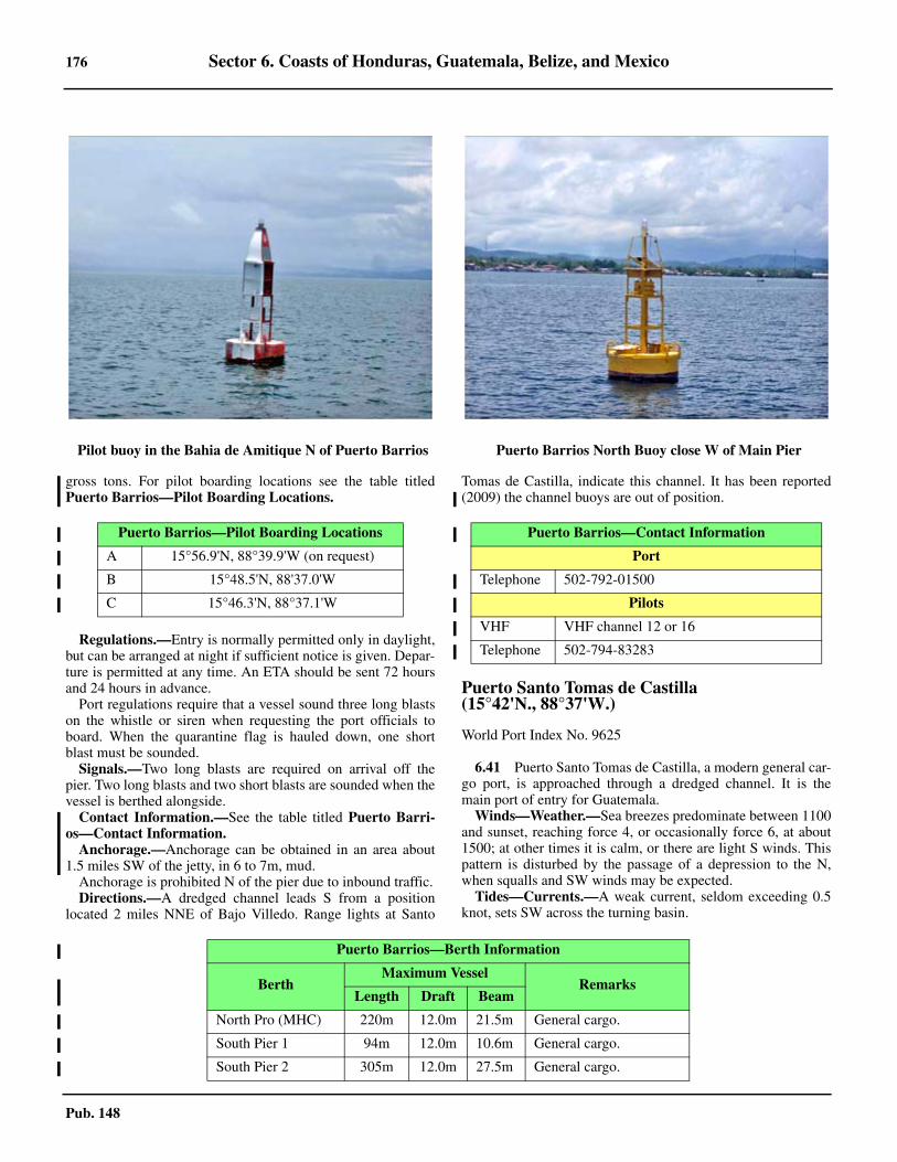
176 Sector 6. Coasts of Honduras, Guatemala, Belize, and Mexico
Pub. 148
gross tons. For pilot boarding locations see the table titledPuerto Barrios—Pilot Boarding Locations.
6.40 Regulations.—Entry is normally permitted only in daylight,but can be arranged at night if sufficient notice is given. Depar-ture is permitted at any time. An ETA should be sent 72 hoursand 24 hours in advance. 6.40 Port regulations require that a vessel sound three long blastson the whistle or siren when requesting the port officials toboard. When the quarantine flag is hauled down, one shortblast must be sounded.6.40 Signals.—Two long blasts are required on arrival off thepier. Two long blasts and two short blasts are sounded when thevessel is berthed alongside.6.40 Contact Information.—See the table titled Puerto Barri-os—Contact Information.6.40 Anchorage.—Anchorage can be obtained in an area about1.5 miles SW of the jetty, in 6 to 7m, mud. 6.40 Anchorage is prohibited N of the pier due to inbound traffic.6.40 Directions.—A dredged channel leads S from a positionlocated 2 miles NNE of Bajo Villedo. Range lights at Santo
Tomas de Castilla, indicate this channel. It has been reported(2009) the channel buoys are out of position.
Puerto Santo Tomas de Castilla (15°42'N., 88°37'W.)
World Port Index No. 9625
6.41 Puerto Santo Tomas de Castilla, a modern general car-go port, is approached through a dredged channel. It is themain port of entry for Guatemala.6.41 Winds—Weather.—Sea breezes predominate between 1100and sunset, reaching force 4, or occasionally force 6, at about1500; at other times it is calm, or there are light S winds. Thispattern is disturbed by the passage of a depression to the N,when squalls and SW winds may be expected.6.41 Tides—Currents.—A weak current, seldom exceeding 0.5knot, sets SW across the turning basin.
6.40Pilot buoy in the Bahia de Amitique N of Puerto Barrios
Puerto Barrios—Pilot Boarding Locations
A 15°56.9'N, 88°39.9'W (on request)
B 15°48.5'N, 88'37.0'W
C 15°46.3'N, 88°37.1'W
6.40Puerto Barrios North Buoy close W of Main Pier
Puerto Barrios—Contact Information
Port
Telephone 502-792-01500
Pilots
VHF VHF channel 12 or 16
Telephone 502-794-83283
Puerto Barrios—Berth Information
BerthMaximum Vessel
RemarksLength Draft Beam
North Pro (MHC) 220m 12.0m 21.5m General cargo.
South Pier 1 94m 12.0m 10.6m General cargo.
South Pier 2 305m 12.0m 27.5m General cargo.

Sector 6. Coasts of Honduras, Guatemala, Belize, and Mexico 177
Pub. 148
6.41 Depths—Limitations.—The berthing facility consists of asingle wharf, about 918m long, t it is usual for vessels to moorstern to the wharf because of limited maneuvering room andthe strong onshore winds. Vessels with drafts up to 11m cansafely enter port and moor alongside the pier. There are no spe-cialized container berths. Operations are carried out using theship’s cranes or shore mobile cranes. For berthing informationsee the table titled Santo Tomas de Castilla—Berth Informa-tion.
6.41 The approach channel was dredged to a depth of 11m in1993.6.41 There are transit markers on the W side of the port to assistin letting go the anchor when berthing. Anchors are liable todrag.
6.41 Pilotage.—Pilotage is compulsory for vessels of greater than500 gt. See Puerto Barrios (paragraph 6.40) for pilotage infor-mation. 6.41 Contact Information.—See the table titled Santo Tomasde Castilla—Contact Information.6.41 Anchorage.—Anchorage can be taken S of the pier at Puer-to Barrios, in the center of the bay, clear of the dredged chan-nel. Vessels with a draft over 7.2m can anchor about 1 mile Nof Villedo Light.
6.41 Caution.—It has been reported (2010) that the forwardrange for the inbound channel is misaligned and should not beused. An obstruction, marked with a light, with a depth of 3.1mlies about 525m E of the channel and about 0.8 mile N of therange light.
Puerto Santo Tomas de Castilla to Belize City
6.42 Between Punta Palma and Punta Herreria (15°49'N.,88°44'W.), about 7 miles NW, the S shore of Bahia de Ama-tique is backed by high ground that reaches an elevation of341m about 3 miles S of Livingston Bay. The entire terrain isheavily wooded.6.42 Livingston Bay is entered between Punta Herreria and apoint 1.3 miles NW. The Rio Dulce enters the head of the bay.The 2m curve extends across the entrance to the bay and about0.5 mile farther seaward. The 5m curve lies about 0.5 mile far-ther seaward.6.42 Caution.—Marine Protected Areas are located along the
Santo Tomas De Castilla—Berth Information
Berth Length Draft
No. 1 152.4m 9.8m
No. 2 152.4m 9.8m
No. 3 152.4m 9.8m
No. 4 152.4m 9.8m
No. 5 152.4m 9.8m
No. 6 152.4m 9.8m
Note.—The six berths have a continu-ous length of 914.5m.
Santo Tomas de Castilla—Contact Information
Marine Traffic Control
VHF VHF channels 14 and 25
Telephone502-794-83088
502-794-83060
Harbor Master
VHF VHF channels 12 and 16
Telephone 502-794-83102
Facsimile 502-794-83127
Port Authority
Telephone502-772-04040 (switchboard)
502-772-04075
Facsimile
502-796-00584
502-796-00585
502-796-00586
E-mail [email protected]
Web site http://www.japdeva.go.cr
Tugs
VHF VHF channels 9 and 16
Pilots
Call sign Santo Tomas Pilot
VHF VHF channels 12 and 16
Telephone 502-794-83283
6.41Puerto Santo Tomas de Castilla Front Range Light
Santo Tomas de Castilla—Contact Information

178 Sector 6. Coasts of Honduras, Guatemala, Belize, and Mexico
Pub. 148
coast between Puerto Santo Tomas de Castilla and Belize City.These areas have multiple restrictions and prohibitions on nav-igation, anchoring, fishing, and diving. Marine Protected Areascan best be seen on the chart. For further information consultlocal authorities.
6.43 Livingston (15°50'N., 88°45'W.) is important for thetransit of goods by river from the interior. The winds in the areaare mostly NE and are most often strong from May to Septem-ber, with frequent heavy thunder squalls at night. The air is hu-mid in all seasons, with May to October being the unhealthiesttime.6.43 A channel 1.8m deep, marked by buoys, leads to the customhouse wharf at Livingston.6.43 Vessels usually anchor about 2 miles NE of the town, in
6.41Puerto Santo Tomas de Castilla Rear Range Light
6.41Light marking a Submerged Obstruction near Puerto Santo Tomas de Castilla (E of Main Channel)
6.41Wreck in the Shallow Draft Anchorage Area NW of Puerto Santo Tomas de Castilla’s Main Channel
6.41Buoy 11—Puerto Santo de Castilla
6.41Puerto Santo Tomas de Castilla
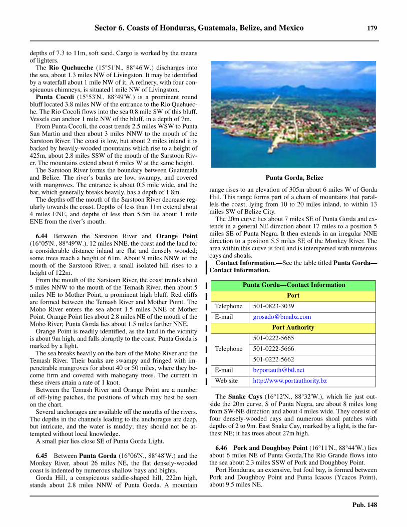
Sector 6. Coasts of Honduras, Guatemala, Belize, and Mexico 179
Pub. 148
depths of 7.3 to 11m, soft sand. Cargo is worked by the meansof lighters.6.43 The Rio Quehueche (15°51'N., 88°46'W.) discharges intothe sea, about 1.3 miles NW of Livingston. It may be identifiedby a waterfall about 1 mile NW of it. A refinery, with four con-spicuous chimneys, is situated l mile NW of Livingston.6.43 Punta Cocoli (15°53'N., 88°49'W.) is a prominent roundbluff located 3.8 miles NW of the entrance to the Rio Quehuec-he. The Rio Cocoli flows into the sea 0.8 mile SW of this bluff.Vessels can anchor 1 mile NW of the bluff, in a depth of 7m.6.43 From Punta Cocoli, the coast trends 2.5 miles WSW to PuntaSan Martin and then about 3 miles NNW to the mouth of theSarstoon River. The coast is low, but about 2 miles inland it isbacked by heavily-wooded mountains which rise to a height of425m, about 2.8 miles SSW of the mouth of the Sarstoon Riv-er. The mountains extend about 6 miles W at the same height.6.43 The Sarstoon River forms the boundary between Guatemalaand Belize. The river’s banks are low, swampy, and coveredwith mangroves. The entrance is about 0.5 mile wide, and thebar, which generally breaks heavily, has a depth of 1.8m.6.43 The depths off the mouth of the Sarstoon River decrease reg-ularly towards the coast. Depths of less than 11m extend about4 miles ENE, and depths of less than 5.5m lie about 1 mileENE from the river’s mouth.
6.44 Between the Sarstoon River and Orange Point(16°05'N., 88°49'W.), 12 miles NNE, the coast and the land fora considerable distance inland are flat and densely wooded;some trees reach a height of 61m. About 9 miles NNW of themouth of the Sarstoon River, a small isolated hill rises to aheight of 122m.6.44 From the mouth of the Sarstoon River, the coast trends about5 miles NNW to the mouth of the Temash River, then about 5miles NE to Mother Point, a prominent high bluff. Red cliffsare formed between the Temash River and Mother Point. TheMoho River enters the sea about 1.5 miles NNE of MotherPoint. Orange Point lies about 2.8 miles NE of the mouth of theMoho River; Punta Gorda lies about 1.5 miles farther NNE.6.44 Orange Point is readily identified, as the land in the vicinityis about 9m high, and falls abruptly to the coast. Punta Gorda ismarked by a light.6.44 The sea breaks heavily on the bars of the Moho River and theTemash River. Their banks are swampy and fringed with im-penetrable mangroves for about 40 or 50 miles, where they be-come firm and covered with mahogany trees. The current inthese rivers attain a rate of 1 knot.6.44 Between the Temash River and Orange Point are a numberof off-lying patches, the positions of which may best be seenon the chart.6.44 Several anchorages are available off the mouths of the rivers.The depths in the channels leading to the anchorages are deep,but intricate, and the water is muddy; they should not be at-tempted without local knowledge.6.44 A small pier lies close SE of Punta Gorda Light.
6.45 Between Punta Gorda (16°06'N., 88°48'W.) and theMonkey River, about 26 miles NE, the flat densely-woodedcoast is indented by numerous shallow bays and bights.6.45 Gorda Hill, a conspicuous saddle-shaped hill, 222m high,stands about 2.8 miles NNW of Punta Gorda. A mountain
range rises to an elevation of 305m about 6 miles W of GordaHill. This range forms part of a chain of mountains that paral-lels the coast, lying from 10 to 20 miles inland, to within 13miles SW of Belize City.6.45 The 20m curve lies about 7 miles SE of Punta Gorda and ex-tends in a general NE direction about 17 miles to a position 5miles SE of Punta Negra. It then extends in an irregular NNEdirection to a position 5.5 miles SE of the Monkey River. Thearea within this curve is foul and is interspersed with numerouscays and shoals.6.45 Contact Information.—See the table titled Punta Gorda—Contact Information.
6.45 The Snake Cays (16°12'N., 88°32'W.), which lie just out-side the 20m curve, S of Punta Negra, are about 8 miles longfrom SW-NE direction and about 4 miles wide. They consist offour densely-wooded cays and numerous shoal patches withdepths of 2 to 9m. East Snake Cay, marked by a light, is the far-thest NE; it has trees about 27m high.
6.46 Pork and Doughboy Point (16°11'N., 88°44'W.) liesabout 6 miles NE of Punta Gorda.The Rio Grande flows intothe sea about 2.3 miles SSW of Pork and Doughboy Point.6.46 Port Honduras, an extensive, but foul bay, is formed betweenPork and Doughboy Point and Punta Icacos (Ycacos Point),about 9.5 miles NE.
6.45Punta Gorda, Belize
Punta Gorda—Contact Information
Port
Telephone 501-0823-3039
E-mail [email protected]
Port Authority
Telephone
501-0222-5665
501-0222-5666
501-0222-5662
E-mail [email protected]
Web site http://www.portauthority.bz

180 Sector 6. Coasts of Honduras, Guatemala, Belize, and Mexico
Pub. 148
6.46 The Deep River (Rio Hondo) flows into the N part of PortHonduras, about 4.5 miles NW of Punta Icacos. There aredepths of 0.6m over the bar, and of 3.7 to 5.5m within it. Thereis anchorage for vessels with local knowledge, in depths of4.5m, off the W side of the entrance to the Deep River.6.46 Punta Icacos (16°15'N., 88°35'W.) is the S extremity of asmall cay located close S of a tongue of land which extends 1mile S; the cay is covered with pine trees.6.46 Wilson Cay is located about 0.8 mile S of Punta Icacos, andabout 1.5 miles WNW of the same point are Bedford Cays.There are numerous cays in Port Honduras; their positions maybest be seen on the chart.
6.46 Punta Negra (16°16'N., 88°33'W.) is a conspicuous bluffwhich stands about 2.8 miles NE of Punta Icacos. BetweenPunta Negra and the Monkey River, 6.5 miles NNE, the coastis more elevated and is bordered by a sandy beach.
6.46 The Monkey River may be identified by some of the promi-nent houses in the town, centered principally on the S bank. Alight is situated on the S bank of the river at its entrance.
6.46 From the Monkey River, the coast extends in a NNE direc-
tion about 11 miles to Placentia Point, then continues NNE an-other 19 miles to Sittee Point.6.46 The 20m curve in the vicinity of the Monkey River is ill-de-fined and follows no definite limit. The 10m curve off thiscoast is defined and lies 1 mile E of the mouth of the MonkeyRiver, about the same distance off Placentia Point and 0.5 mileoff Sittee Point. Vessels that use the Inner Channel or the MainChannel should keep outside its limits, as numerous dangers liewithin the curve.6.46 Numerous uncharted rocks lie outside of the Inner Channelbetween Sittee Point and Monkey River. Underwater rockswithin the Inner Channel have been reported (2018). Marinersare advised to use caution wile navigating in the area.
6.47 Monkey Shoal (16°23'N., 88°25'W.), a 4m patchwith a 5.5m patch close W of it, lies about 4 miles ENE of thelight at the Monkey River. A 6.5m patch lies about 0.7 mileSSW of Monkey Shoal; other isolated shoal patches lie in thisarea. A lighted buoy is moored 1 mile E of Monkey Shoal.6.47 A 5.5m patch and a 5m patch lie 2 miles SSW and 2.3 milesENE, respectively, from Monkey Shoal; they lie close E of theMain Channel.6.47 Penguin Shoals, with a least charted depth of 3m, lie about 3miles NNE of Monkey Shoal. There is a 7.5m detached patchabout 1.3 miles E of the 3m depth.6.47 Middle Shoal, 0.5 mile NNE of Penguin Shoals, has a leastdepth of 4m; a lighted buoy is moored 1 mile NE of it.6.47 Potts Shoal, with a least depth of 3.7m, lies about 1.5 milesN of Middle Shoal. A shoal, with a depth of 5.6m, lies 1.3miles SE of Potts Shoal.6.47 Bugle Cays (16°29'N., 88°19'W.) lie about 3 miles SE ofPlacentia Point; these two cays are located on the E side of thechannel. Without local knowledge, these cays will not be dis-tinguished from a distance of more than 4 miles.6.47 Shoals, with depths of 1.8 to 5.5m, extend about 4.8 miles Sof Bugle Cays. The Narrows lie between these dangers andPotts Shoal and the other dangers on the W side of the passage.The narrows are about 1.5 miles wide with general depths of 10to 26m.6.47 From the Monkey River, the coast extends about 11 milesNNE to the entrance to Placentia Lagoon and is low, swampy,and wooded. This shore is fringed by low, wooded cays and in-tersected by numerous small creeks and streams.
6.48 Harvest Cay (16°28'N., 88°24'W.) lies about 2 milesS of the entrance to Placentia Lagoon and has a conspicuous24m wooded table hill on it. The 75-acre island is privatelyowned and operated by Norwegian Cruise Lines. One cruiseship berth is located at the SE end of the cay. 6.48 Contact Information.—See the table titled Harvest Cay—Contact Information.
6.46Punta Negra Bluff
6.46Monkey River
Harvest Cay—Contact Information
Port
Telephone 501-0521-2500
E-mail [email protected]
Web site http://www.nclhltd.com

Sector 6. Coasts of Honduras, Guatemala, Belize, and Mexico 181
Pub. 148
6.49 Big Creek (16°30'N., 88°25'W.) is situated at the Wside of the entrance to Placentia Lagoon.6.49 Depths—Limitations.—The channel leading to the quayand turning basin at Big Creek has a dredged depth of 10.9m.Big Creek Group Quay has two berths; Berth 02 has a length of167m while Berth 03 has a length of 150m. Both berths ahve adredged depth alongside of 11m. A small jetty lies 6 miles NEof Placentia Point. It is sheltered by Placentia Cay and has adepth of 4.0m alongside. 6.49 Placentia Lagoon, a shallow body of water bordered on itsseaward side by a narrow ridge of low land, parallels the coast.A fishing harbor lies at the entrance to the lagoon. 6.49 Pilotage.—Pilotage is compulsory. Pilots will board at posi-tion: 16°21.6'N, 88°24.0'W.6.49 Contact Information.—See the table titled Big Creek—Contact Information.
6.49 Anchorage.—Anchorage may be taken at position16°26.0'N, 88°21.1'W. 6.49 Caution.—The buoys marking the channel may be unlit.
6.50 From Placentia Point (18°31'N., 88°22'W.), the coasttrends 8.8 miles NNE to Jonathan Point. A series of small baysare formed on this coast by Rum Point, False Point, and RockyPoint, which lie 1.8, 4.3, and 5.3 miles N, respectively, of Pla-centia Point.6.50 From Jonathan Point, the coast trends about 4 miles N to themouth of South Stann Creek, then about 3 miles N to the en-trance to Sapodilla Lagoon. The 10m curve lies up to 1.5 milesoff this part of the coast.6.50 The coast between Placentia Point and the mouth of SouthStann Creek is backed by an extensive plain of ridges from 15to 30m high, bound about 10 miles inland by mountains whichreach a height of 1,122m, about 18 miles W of Sapodilla La-goon. Two peaks, 620m and 512mhigh, rise about 11.3 milesNW and 9.5 miles WSW, respectively, of the entrance to Sapo-dilla Lagoon.
6.51 False Cay (16°36'N., 88°20'W.) lies about 0.8 mileoffshore and about 5 miles NNE of Placentia Point. The cay islow, narrow, and covered with bushes and palms. Foul groundextends about 0.3 mile from it NE through E to its SW side.The W and NW side is steep-to, with depths up to 10m be-tween it and the shore. Sheltered anchorage may be found offthe W side of False Cay in depths of 10m.6.51 A pier extends about 150m from shore at the village of Riv-ersdale, about 2.8 miles N of Jonathan Point.6.51 South Stann Creek flows into the sea across a shallow barabout 2 miles NNE of Riversdale. 6.51 Anchorage may be taken about 0.5 mile NE of its mouth, in adepth of 7m.6.51 Sittee Point (16°48'N., 88°15'W.), marked by a light, is a de-fined wooded point extending about 0.8 mile from the coast; itforms the S entrance point to the Sittee River.6.51 The Sittee River (16°48'N., 88°15'W.) has a depth of 0.9mover the bar at its entrance; dead tree stumps rise from the bot-tom. Depths of less than 5.5m extend about 0.5 mile E from theriver.6.51 There are some ledges located 3.8 miles SE and 4 miles NEof the light on Sittee Point; there are least depths of 4m and4.5m, respectively, on these ledges. The ledges restrict the fair-way of the Inner Channel to 3 miles.6.51 False Sittee Point, a narrow projection of land, stands 2 milesNNW of Sittee Point. Shoal ground extends about 0.8 mile Eand NE from the point.6.51 Commerce Bight, entered between False Sittee Point and apoint about 6.5 miles NNE, recedes about 3 miles W. Thedepths within the bight decrease gradually from 11m in the en-trance to 5.5m about 0.3 to 0.5 mile offshore.6.51 A conspicuous white building stands close to the coast 2miles NNW of False Sittee Point.6.51 A pier, with depths of 1.5m alongside the W and S sides, lies0.5 mile E of the mouth of Yemeri Creek, about 5.3 miles NNEof False Sittee Point. A road connects the pier with StannCreek Town, about 2.3 miles NE. A light stands on the pier.6.51 Caution.—Less water than charted has been reported (1994)to lie within Commerce Bight.
6.52 Stann Creek Town (16°58'N., 88°13'W.) stands closeN of Commerce Bight, on the N and S sides of North StannCreek. The village, which fronts the coast for about 1 mile, isthe seat of government for the district of Stann Creek. A resi-dent officer resides here.6.52 A jetty, about 122m long, available only to boats, standsabout 0.3 mile NNW of the mouth of the creek. There are manyprominent buildings between the jetty and the creek. A privatejetty, about 183m long, is situated 0.5 mile S of the mouth ofthe creek.6.52 In 1972, it was reported that a church with a white tower, anda conspicuous square tank on a metal framework tower, stoodin the town. Two conspicuous radio mast stands close W of thetank.6.52 Anchorage can be taken, in a depth of 7.3m, less than 0.5mile off the entrance to North Stann Creek.6.52 From North Stann Creek, the coast trends 6.3 miles NNW toColson Point (17°04'N., 88°15'W.), which is marked by a light.The 10m curve lies about 2.3 miles off this point. A rock, witha depth of 2m, lies 0.3 mile NNW of the point.
Port Authority
Telephone
501-0222-5665
501-0222-5666
501-0222-5662
E-mail [email protected]
Web site http://www.portauthority.bz
Harvest Cay—Contact Information
Port
VHF VHF channels 10 and 16
RT Frequency 2182 kHz
Telephone 501-0523-2003
E-mail [email protected]
Web site www.bigcreekgroup.com
Harvest Cay—Contact Information
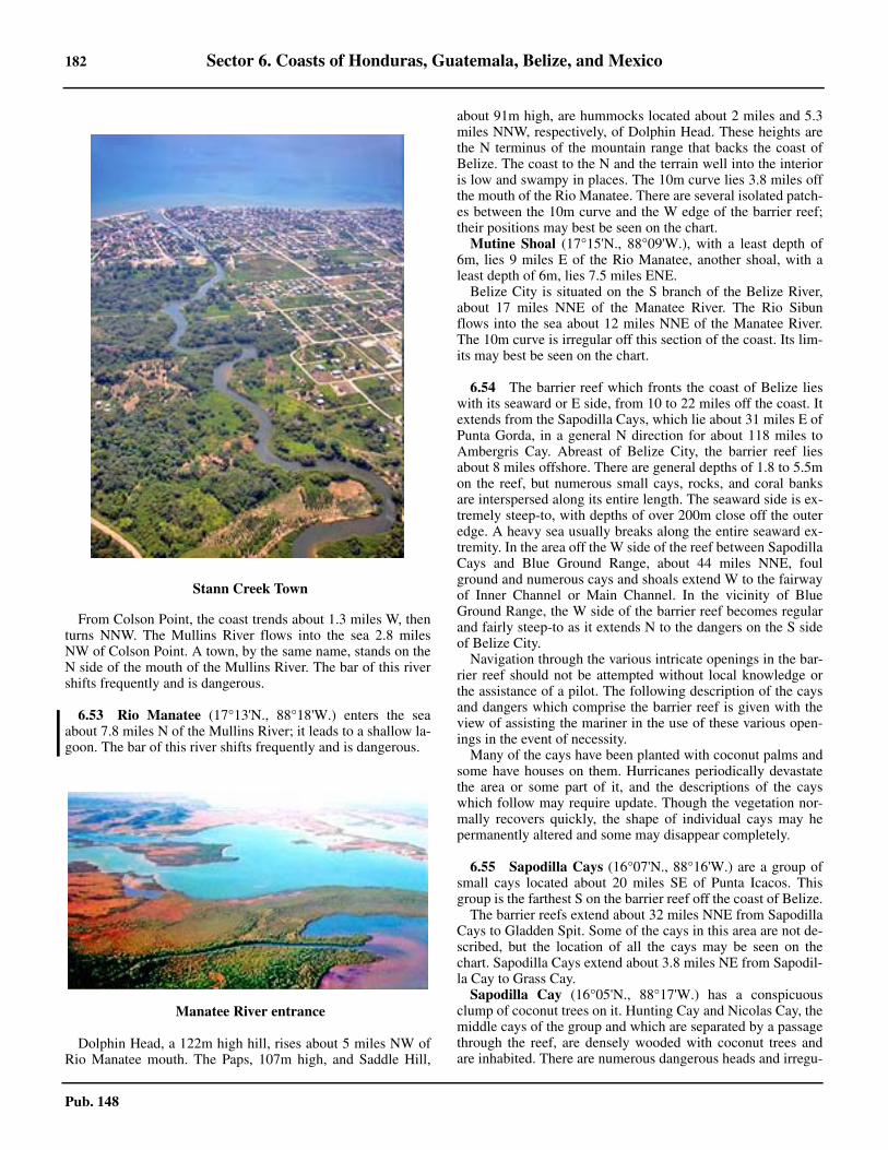
182 Sector 6. Coasts of Honduras, Guatemala, Belize, and Mexico
Pub. 148
6.52 From Colson Point, the coast trends about 1.3 miles W, thenturns NNW. The Mullins River flows into the sea 2.8 milesNW of Colson Point. A town, by the same name, stands on theN side of the mouth of the Mullins River. The bar of this rivershifts frequently and is dangerous.
6.53 Rio Manatee (17°13'N., 88°18'W.) enters the seaabout 7.8 miles N of the Mullins River; it leads to a shallow la-goon. The bar of this river shifts frequently and is dangerous.
6.53 Dolphin Head, a 122m high hill, rises about 5 miles NW ofRio Manatee mouth. The Paps, 107m high, and Saddle Hill,
about 91m high, are hummocks located about 2 miles and 5.3miles NNW, respectively, of Dolphin Head. These heights arethe N terminus of the mountain range that backs the coast ofBelize. The coast to the N and the terrain well into the interioris low and swampy in places. The 10m curve lies 3.8 miles offthe mouth of the Rio Manatee. There are several isolated patch-es between the 10m curve and the W edge of the barrier reef;their positions may best be seen on the chart. 6.53 Mutine Shoal (17°15'N., 88°09'W.), with a least depth of6m, lies 9 miles E of the Rio Manatee, another shoal, with aleast depth of 6m, lies 7.5 miles ENE.6.53 Belize City is situated on the S branch of the Belize River,about 17 miles NNE of the Manatee River. The Rio Sibunflows into the sea about 12 miles NNE of the Manatee River.The 10m curve is irregular off this section of the coast. Its lim-its may best be seen on the chart.
6.54 The barrier reef which fronts the coast of Belize lieswith its seaward or E side, from 10 to 22 miles off the coast. Itextends from the Sapodilla Cays, which lie about 31 miles E ofPunta Gorda, in a general N direction for about 118 miles toAmbergris Cay. Abreast of Belize City, the barrier reef liesabout 8 miles offshore. There are general depths of 1.8 to 5.5mon the reef, but numerous small cays, rocks, and coral banksare interspersed along its entire length. The seaward side is ex-tremely steep-to, with depths of over 200m close off the outeredge. A heavy sea usually breaks along the entire seaward ex-tremity. In the area off the W side of the reef between SapodillaCays and Blue Ground Range, about 44 miles NNE, foulground and numerous cays and shoals extend W to the fairwayof Inner Channel or Main Channel. In the vicinity of BlueGround Range, the W side of the barrier reef becomes regularand fairly steep-to as it extends N to the dangers on the S sideof Belize City.6.54 Navigation through the various intricate openings in the bar-rier reef should not be attempted without local knowledge orthe assistance of a pilot. The following description of the caysand dangers which comprise the barrier reef is given with theview of assisting the mariner in the use of these various open-ings in the event of necessity.6.54 Many of the cays have been planted with coconut palms andsome have houses on them. Hurricanes periodically devastatethe area or some part of it, and the descriptions of the cayswhich follow may require update. Though the vegetation nor-mally recovers quickly, the shape of individual cays may hepermanently altered and some may disappear completely.
6.55 Sapodilla Cays (16°07'N., 88°16'W.) are a group ofsmall cays located about 20 miles SE of Punta Icacos. Thisgroup is the farthest S on the barrier reef off the coast of Belize.6.55 The barrier reefs extend about 32 miles NNE from SapodillaCays to Gladden Spit. Some of the cays in this area are not de-scribed, but the location of all the cays may be seen on thechart. Sapodilla Cays extend about 3.8 miles NE from Sapodil-la Cay to Grass Cay.6.55 Sapodilla Cay (16°05'N., 88°17'W.) has a conspicuousclump of coconut trees on it. Hunting Cay and Nicolas Cay, themiddle cays of the group and which are separated by a passagethrough the reef, are densely wooded with coconut trees andare inhabited. There are numerous dangerous heads and irregu-
6.52Stann Creek Town
6.53Manatee River entrance

Sector 6. Coasts of Honduras, Guatemala, Belize, and Mexico 183
Pub. 148
lar depths that range from 3.7 to 55m in an area that extendsfrom 5 miles SW through 8.5 miles W of Sapodilla Cay. Sever-al detached shoal patches, with depths of 7.3 to 17.4m, lie be-tween 7.8 miles S through 6.5 miles SSW of Sapodilla Cay.
6.55 Seal Cay (16°10'N., 88°20'W.), an islet with a few trees onit, is located on the NE part of a small circular reef enclosing alagoon. The former Seal Cays, 2.5 miles S, are reported to havebeen destroyed by a hurricane in 1945, and in 1972, only asand bar remained. Shoal patches, with depths of 4.6 to 8.2m,lie in the area W and N of the ledge and extend up to about 4miles off.6.55 Lawrence Rock (16°10'N., 88°24'W.), with a least depth of1.2m, lies about 3.3 miles W of Seal Cay. This rock is danger-ous because the water over it is not sufficiently discolored toindicate its position. A 5.5m coral patch, about 1 mile SSW,and an 11m patch, about 1.8 miles WNW, of Lawrence Rockare the SW dangers on the E side of the entrance of InnerChannel or Main Channel. The ground is foul between Law-rence Rock and Seal Cay.6.55 Between Sapodilla Cays and Gladden Spit, the barrier reef isgenerally broken and there are numerous cays, rocks, andopenings along its entire length.
6.56 Ranguana Cay (16°20'N., 88°10'W.) lies about mid-
way along this section of the reef and about 1.3 miles from theseaward side. Trees up to 15.2m high cover the cay. RanguanaEntrance, an opening through the reef about 0.3 mile wide, liesabout 1.5 miles SE of the cays. There are depths of 6.1 to 7.3min this passage.6.56 Pompion Cay (16°24'N., 88°06'W.), actually a group ofwooded islands, stands about 4.8 miles NE of Ranguana Cayand is reported to be inhabited.6.56 Little Water Cay and Hatchet Cay, both wooded, lie about 3miles N and 4.3 miles NNE of Pompion Cay. The two cayshave been reported to be good radar targets.6.56 Gladden Spit (16°31'N., 87°59'W.) is the E projection of thebarrier reef. This spit has been reported to lie about 2 miles Eof its charted position.
6.56 The entrances to Gladden Cay and Queen Cay lie about 1.5miles and 4.5 miles SW of Gladden Spit and have least charteddepths of 2.5m and 4m. These openings lead to Inner Channelor Main Channel through narrow intricate passages. Theyshould not be attempted without local knowledge or the ser-vices of a pilot.6.56 Victoria Channel is the navigable passage which lies be-tween the dangers extending E from Bugle Cays and those ex-tending W from Gladden Spit. Victoria Channel may be usedas an alternate route to Inner Channel or Main Channel and isthe passage through which vessels passing through the barrierreef by Queen Cay Entrance, Gladden Entrance, and the small-er openings in the reef to the S can reach Inner Channel orMain Channel.6.56 For about 14 miles, to South Cut, the barrier reef extendsNNW in a solid coral barrier, with no cays; then for about 6miles farther NNW to Water Cay, it is broken, with numerousdry sandbanks and some above-water rocky heads. There areseveral cuts along this part of the barrier reef, which are avail-able to small vessels with local knowledge. The W side of thereef is irregular and the area W to Inner Channel or MainChannel is interspersed with numerous cays and shoals.
6.57 South Water Cay (16°49'N., 88°05'W.) is a fairlylarge, wooded cay, with trees about 18m high.6.57 Blue Ground Range (16°48'N., 88°09'W.) is a group of
6.55Sapodilla Cay
6.55Seal Cay Islet
6.56Gladden Spit
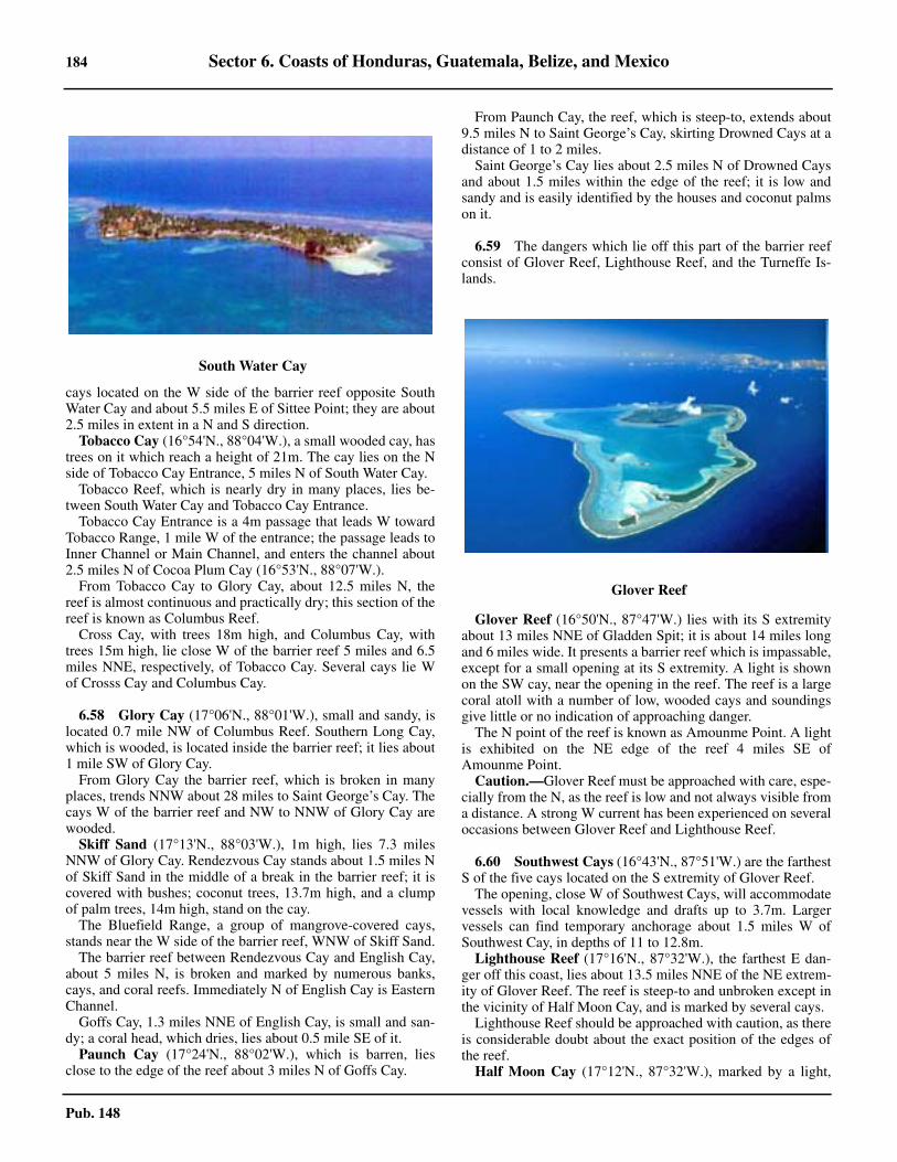
184 Sector 6. Coasts of Honduras, Guatemala, Belize, and Mexico
Pub. 148
cays located on the W side of the barrier reef opposite SouthWater Cay and about 5.5 miles E of Sittee Point; they are about2.5 miles in extent in a N and S direction.6.57 Tobacco Cay (16°54'N., 88°04'W.), a small wooded cay, hastrees on it which reach a height of 21m. The cay lies on the Nside of Tobacco Cay Entrance, 5 miles N of South Water Cay.6.57 Tobacco Reef, which is nearly dry in many places, lies be-tween South Water Cay and Tobacco Cay Entrance.
Tobacco Cay Entrance is a 4m passage that leads W towardTobacco Range, 1 mile W of the entrance; the passage leads toInner Channel or Main Channel, and enters the channel about2.5 miles N of Cocoa Plum Cay (16°53'N., 88°07'W.).6.57 From Tobacco Cay to Glory Cay, about 12.5 miles N, thereef is almost continuous and practically dry; this section of thereef is known as Columbus Reef.6.57 Cross Cay, with trees 18m high, and Columbus Cay, withtrees 15m high, lie close W of the barrier reef 5 miles and 6.5miles NNE, respectively, of Tobacco Cay. Several cays lie Wof Crosss Cay and Columbus Cay.
6.58 Glory Cay (17°06'N., 88°01'W.), small and sandy, islocated 0.7 mile NW of Columbus Reef. Southern Long Cay,which is wooded, is located inside the barrier reef; it lies about1 mile SW of Glory Cay.6.58 From Glory Cay the barrier reef, which is broken in manyplaces, trends NNW about 28 miles to Saint George’s Cay. Thecays W of the barrier reef and NW to NNW of Glory Cay arewooded.6.58 Skiff Sand (17°13'N., 88°03'W.), 1m high, lies 7.3 milesNNW of Glory Cay. Rendezvous Cay stands about 1.5 miles Nof Skiff Sand in the middle of a break in the barrier reef; it iscovered with bushes; coconut trees, 13.7m high, and a clumpof palm trees, 14m high, stand on the cay.6.58 The Bluefield Range, a group of mangrove-covered cays,stands near the W side of the barrier reef, WNW of Skiff Sand.6.58 The barrier reef between Rendezvous Cay and English Cay,about 5 miles N, is broken and marked by numerous banks,cays, and coral reefs. Immediately N of English Cay is EasternChannel.6.58 Goffs Cay, 1.3 miles NNE of English Cay, is small and san-dy; a coral head, which dries, lies about 0.5 mile SE of it.6.58 Paunch Cay (17°24'N., 88°02'W.), which is barren, liesclose to the edge of the reef about 3 miles N of Goffs Cay.
6.58 From Paunch Cay, the reef, which is steep-to, extends about9.5 miles N to Saint George’s Cay, skirting Drowned Cays at adistance of 1 to 2 miles.6.58 Saint George’s Cay lies about 2.5 miles N of Drowned Caysand about 1.5 miles within the edge of the reef; it is low andsandy and is easily identified by the houses and coconut palmson it.
6.59 The dangers which lie off this part of the barrier reefconsist of Glover Reef, Lighthouse Reef, and the Turneffe Is-lands.
6.59 Glover Reef (16°50'N., 87°47'W.) lies with its S extremityabout 13 miles NNE of Gladden Spit; it is about 14 miles longand 6 miles wide. It presents a barrier reef which is impassable,except for a small opening at its S extremity. A light is shownon the SW cay, near the opening in the reef. The reef is a largecoral atoll with a number of low, wooded cays and soundingsgive little or no indication of approaching danger. 6.59 The N point of the reef is known as Amounme Point. A lightis exhibited on the NE edge of the reef 4 miles SE ofAmounme Point.6.59 Caution.—Glover Reef must be approached with care, espe-cially from the N, as the reef is low and not always visible froma distance. A strong W current has been experienced on severaloccasions between Glover Reef and Lighthouse Reef.
6.60 Southwest Cays (16°43'N., 87°51'W.) are the farthestS of the five cays located on the S extremity of Glover Reef.6.60 The opening, close W of Southwest Cays, will accommodatevessels with local knowledge and drafts up to 3.7m. Largervessels can find temporary anchorage about 1.5 miles W ofSouthwest Cay, in depths of 11 to 12.8m.6.60 Lighthouse Reef (17°16'N., 87°32'W.), the farthest E dan-ger off this coast, lies about 13.5 miles NNE of the NE extrem-ity of Glover Reef. The reef is steep-to and unbroken except inthe vicinity of Half Moon Cay, and is marked by several cays.6.60 Lighthouse Reef should be approached with caution, as thereis considerable doubt about the exact position of the edges ofthe reef.6.60 Half Moon Cay (17°12'N., 87°32'W.), marked by a light,
6.57South Water Cay
6.59Glover Reef
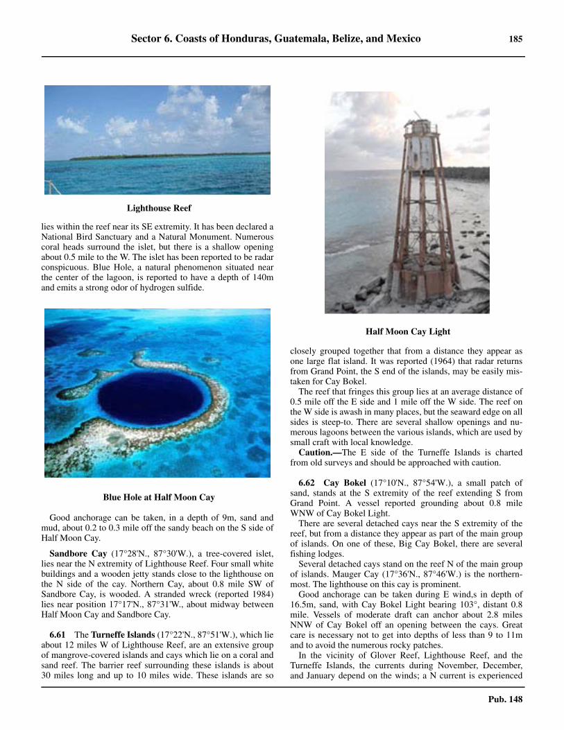
Sector 6. Coasts of Honduras, Guatemala, Belize, and Mexico 185
Pub. 148
lies within the reef near its SE extremity. It has been declared aNational Bird Sanctuary and a Natural Monument. Numerouscoral heads surround the islet, but there is a shallow openingabout 0.5 mile to the W. The islet has been reported to be radarconspicuous. Blue Hole, a natural phenomenon situated nearthe center of the lagoon, is reported to have a depth of 140mand emits a strong odor of hydrogen sulfide.
6.60 Good anchorage can be taken, in a depth of 9m, sand andmud, about 0.2 to 0.3 mile off the sandy beach on the S side ofHalf Moon Cay.
6.60 Sandbore Cay (17°28'N., 87°30'W.), a tree-covered islet,lies near the N extremity of Lighthouse Reef. Four small whitebuildings and a wooden jetty stands close to the lighthouse onthe N side of the cay. Northern Cay, about 0.8 mile SW ofSandbore Cay, is wooded. A stranded wreck (reported 1984)lies near position 17°17'N., 87°31'W., about midway betweenHalf Moon Cay and Sandbore Cay.
6.61 The Turneffe Islands (17°22'N., 87°51'W.), which lieabout 12 miles W of Lighthouse Reef, are an extensive groupof mangrove-covered islands and cays which lie on a coral andsand reef. The barrier reef surrounding these islands is about30 miles long and up to 10 miles wide. These islands are so
closely grouped together that from a distance they appear asone large flat island. It was reported (1964) that radar returnsfrom Grand Point, the S end of the islands, may be easily mis-taken for Cay Bokel.6.61 The reef that fringes this group lies at an average distance of0.5 mile off the E side and 1 mile off the W side. The reef onthe W side is awash in many places, but the seaward edge on allsides is steep-to. There are several shallow openings and nu-merous lagoons between the various islands, which are used bysmall craft with local knowledge.6.61 Caution.—The E side of the Turneffe Islands is chartedfrom old surveys and should be approached with caution.
6.62 Cay Bokel (17°10'N., 87°54'W.), a small patch ofsand, stands at the S extremity of the reef extending S fromGrand Point. A vessel reported grounding about 0.8 mileWNW of Cay Bokel Light.6.62 There are several detached cays near the S extremity of thereef, but from a distance they appear as part of the main groupof islands. On one of these, Big Cay Bokel, there are severalfishing lodges.6.62 Several detached cays stand on the reef N of the main groupof islands. Mauger Cay (17°36'N., 87°46'W.) is the northern-most. The lighthouse on this cay is prominent.6.62 Good anchorage can be taken during E wind,s in depth of16.5m, sand, with Cay Bokel Light bearing 103°, distant 0.8mile. Vessels of moderate draft can anchor about 2.8 milesNNW of Cay Bokel off an opening between the cays. Greatcare is necessary not to get into depths of less than 9 to 11mand to avoid the numerous rocky patches.6.62 In the vicinity of Glover Reef, Lighthouse Reef, and theTurneffe Islands, the currents during November, December,and January depend on the winds; a N current is experienced
6.60Lighthouse Reef
6.60Blue Hole at Half Moon Cay
6.60Half Moon Cay Light

186 Sector 6. Coasts of Honduras, Guatemala, Belize, and Mexico
Pub. 148
during W winds, while a S current is experienced with Nwinds.6.62 During February and March, the currents usually set N at arate of about 1.5 knots. In April and May, the currents usuallyset S, at a rate of 1.5 knots. In June, July, and August, the cur-rent usually sets N at a rate of 1.5 knots, which increases to 2knots during September and October.
6.63 From Saint George’s Cay, the reef trends about 19miles N to abreast the S end of Ambergris Cay; it is steep-to.6.63 The area W of the barrier reef between these two cays isshoal; the general depths vary from 1.2 to 4.6m. Numerouscays are located in this shoal area; their position may best beseen on the chart.6.63 Ambergris Cay (18°02'N., 87°55'W.) is low and swampy;its N end is separated from the mainland by Boca Bacalar Chi-co, a narrow boat channel, but the island appears to be part ofthe coast. The reef skirts Reef Point, the E extremity of the is-land, at a distance of 0.5 to 1.5 miles, then it gradually ap-proaches the coast of the mainland about 9 miles N of ReefPoint.6.63 Directions.—Vessels proceeding N to, or S from, Belize orcalling at places on the coast, can do so by Inner Channel orMain Channel, a deep channel between the cays on the W sideof the barrier reef and the mainland. The least depth in thechannel was reported to be 10.1m in 1972, but 7.3m should beconsidered as a prudent controlling depth.6.63 To enter Inner Channel or Main Channel from the S, a ves-sel’s position should be accurately determined to enable acourse to be shaped to clear all the dangers S and W of Sapo-dilla Cay (16°05'N., 88°17'W.). East Snake Cay should besteered for bearing 339° and when it is about 4.3 miles distant,course may be shaped for The Narrows off Placentia Point(16°31'N., 88°22'W.). In approaching The Narrows, soundingswill not indicate the position owing to the irregularity of thebottom.6.63 In the vicinity of Monkey Shoal (16°23'N., 88°25'W.) a ves-sel should keep a little E of the track which passes near a 7.3mpatch in Penguin Shoals area.6.63 After passing about 0.5 mile W of Bugle Cay, a vesselshould steer to pass about 3.8 miles W of Cocoa Plum Cay(16°53'N., 88°07'W.). From abeam this cay, a vessel shouldsteer N for about 27 miles in charted depths of 14.5 to 18.5m,passing about 1 mile W of a 6m patch, 7.5 miles ENE of themouth of the Rio Manatee, then steer mid-channel to the en-trance to Southern Grennels Channel.6.63 Vessels generally leave Belize in the evening in order to ar-rive off Placentia Point early on the following morning, so as tohave full daylight while finding their way through The Nar-rows. With the establishment of lights on various points, andwith proper precautions, vessels with local knowledge canmake a safe passage through The Narrows.6.63 Caution.—The current generally sets strongly toward thebarrier reef, accompanied by a heavy swell, so that every possi-ble caution should be observed in this area.
6.64 Victoria Channel.—Victoria Channel, about 45miles in length, is an alternate route for approaching BelizeCity from the S. There are charted depths of 7.5m in and nearthis channel.
6.64 To enter Victoria Channel from the S, proceed as directed forInner Channel or Main Channel. When in a position about 2.8miles SE of East Snake Cay, a vessel should steer NE about 20miles to a position about 3.3 miles S of Laughing Bird Cay(16°26'N., 88°12'W.). From this position, continue NNE to aposition about 3 miles NE of the cay, when course should bechanged to the N, passing 1 mile E of Moho Cay (16°30'N.,88°10'W.). Continue N about 1 mile until Quamino Cay(16°39'N., 88°13'W.) bears 330°, when it should be steered for.When abreast Crawl Cay, a WNW course should be steered topass midway between the reefs extending N from that cay andthe reef extending S from Quamino Cay. When a vessel is W ofthe S extremity of the reefs off Quamino Cay, follow the direc-tions for Inner Channel or Main Channel to Belize City.
6.64 Eastern Channel.—When approaching Eastern Channelfrom the N, steer for a position about 7.5 miles W of MaugerCay (17°36'N., 87°46'W.). Steer a SSW course to pass nearmid-channel between the Turneffe Islands and the barrier reefuntil the lights on English Cay are in line 300°.6.64 When approaching Eastern Channel from the S, steer for aposition 2.8 miles S of Cay Bokel (17°10'N., 87°54'W.), thendirect a mid-channel course between Turneffe Islands Reef andRendezvous Cay, until the lights on English Cay are in line.
6.64 To enter Eastern Channel, steer for the lights on English Cay,bearing 300°, until the E side of Water Cay (17°23'N.,88°04'W.) bears 340°. Alter course to this heading and main-tain it until Eastern Channel opens WNW. Then proceedthrough the sinuous passage maintaining a mid-channel courseuntil One Man Cay Channel is reached. The E entrance to OneMan Cay Channel is about 0.2 mile wide between the reefs;each reef is marked by a light. Steer a NW course through thechannel until Robinson Point (17°22'N., 88°12'W.), marked bya light, bears 233°, then steer as required to the anchorage.6.64 Pilots will embark about 2 miles E of English Cay. It is re-ported pilots do not consider the lights in Eastern Channel sat-isfactory for nighttime passage and therefore night arrivals anddepartures should be avoided. However, freighters have madenight arrivals using radar with no apparent difficulty. These di-rections are for reference only and proper planning for navigat-ing these areas should be used.
6.64English Cay Light

Sector 6. Coasts of Honduras, Guatemala, Belize, and Mexico 187
Pub. 148
Belize City (17°30'N., 88°11'W.)
World Port Index No. 9590
6.65 Belize City, a roadstead harbor with limited port facil-ities, stands between the coast and the barrier reef at the N endof Inner Channel or Main Channel. It can be approached aspreviously described. This city, which is the principal port ofBelize, is situated on both sides of Haulover Creek, the S en-trance of the Belize River. Berthing facilities in the port areavailable only for small craft. Other vessels handle cargo at theanchorages S of the city.
6.65 Winds—Weather.—East and SE winds prevail from themiddle of February to the end of September, with the greatestperiod of calm at the end of February. Northeast through NWwinds prevail during the rest of the year. The average wind ve-locity is about 10 knots. Northers are most likely to occur inNovember and December, but they rarely exceed force 4 or 5.6.65 Tides—Currents.—The current generally sets S through theharbor at a rate of 1.5 knots, but during the season of the north-ers this rate may increase to 3 knots. North currents which at-tain a velocity of 1.5 to 2 knots may be experienced during therainy season.6.65 The mean range of the tide is negligible. East winds raise thewater level and N winds lower it; however, during northers, thefall may be as much as 0.6 to 0.8m.6.65 Depths—Limitations.—Belize City Harbor consists of aroadstead about 7.5 miles in extent, with depths ranging from5.5 to 12.8m. The 5m curve within the roadstead follows thegeneral trend of the W side of the barrier reef and The Flat onthe S side of the roadstead. On the W side of the roadstead, the5m curve extends up to 2 miles offshore; on the N side of theroadstead, it extends E to the barrier reef from a position about0.5 mile S of Belize City.6.65 There are many isolated patches within the roadstead, withdepths from 3.4 to 5.5m; some of these patches are marked bylights. For their exact positions, refer to the chart.6.65 There are several wharves lining the shore at Belize City, butnone are available for deep-draft vessels. The Deepwater Pier(King Pier) is 800m in length. There is a ro-ro berth on the NWside of King Pier.
6.65 An offshore oil terminal, formed by mooring buoys, lies 0.5mile SE of the T-head pier, depth 6.0m. Vessels moor headingESE. In the absence of tugs, difficulty may be experienced un-less the weather is calm. For berthing information see the tabletitled Belize City—Berth Information.
Belize Harbor Home Page
http://www.portauthority.bz
6.65Belize City
6.65 Iolated patches NE of Belize City
Belize City—Berth Information
Berth Length DepthMaximum Vessel
RemarksLOA Draft Beam
Belize Terminal
King Pier 67m — 121m — — Containers and general cargo.
Ro-Ro Berth 25m 4.7m — — — Ro-ro.
Esso Terminal
CBM — — 183m 5.0m 32.3m Petroleum products.
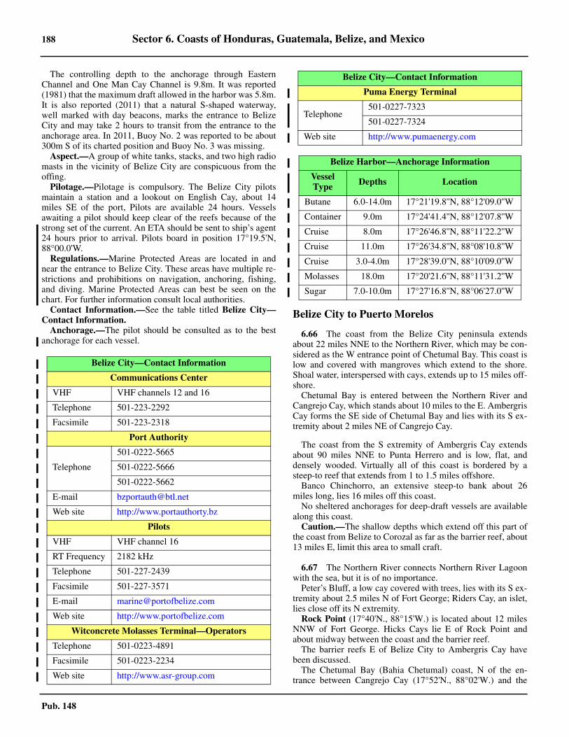
188 Sector 6. Coasts of Honduras, Guatemala, Belize, and Mexico
Pub. 148
6.65 The controlling depth to the anchorage through EasternChannel and One Man Cay Channel is 9.8m. It was reported(1981) that the maximum draft allowed in the harbor was 5.8m.It is also reported (2011) that a natural S-shaped waterway,well marked with day beacons, marks the entrance to BelizeCity and may take 2 hours to transit from the entrance to theanchorage area. In 2011, Buoy No. 2 was reported to be about300m S of its charted position and Buoy No. 3 was missing. 6.65 Aspect.—A group of white tanks, stacks, and two high radiomasts in the vicinity of Belize City are conspicuous from theoffing.6.65 Pilotage.—Pilotage is compulsory. The Belize City pilotsmaintain a station and a lookout on English Cay, about 14miles SE of the port, Pilots are available 24 hours. Vesselsawaiting a pilot should keep clear of the reefs because of thestrong set of the current. An ETA should be sent to ship’s agent24 hours prior to arrival. Pilots board in position 17°19.5'N,88°00.0'W. 6.65 Regulations.—Marine Protected Areas are located in andnear the entrance to Belize City. These areas have multiple re-strictions and prohibitions on navigation, anchoring, fishing,and diving. Marine Protected Areas can best be seen on thechart. For further information consult local authorities. 6.65 Contact Information.—See the table titled Belize City—Contact Information.6.65 Anchorage.—The pilot should be consulted as to the bestanchorage for each vessel.
Belize City to Puerto Morelos
6.66 The coast from the Belize City peninsula extendsabout 22 miles NNE to the Northern River, which may be con-sidered as the W entrance point of Chetumal Bay. This coast islow and covered with mangroves which extend to the shore.Shoal water, interspersed with cays, extends up to 15 miles off-shore.6.66 Chetumal Bay is entered between the Northern River andCangrejo Cay, which stands about 10 miles to the E. AmbergrisCay forms the SE side of Chetumal Bay and lies with its S ex-tremity about 2 miles NE of Cangrejo Cay.
6.66 The coast from the S extremity of Ambergris Cay extendsabout 90 miles NNE to Punta Herrero and is low, flat, anddensely wooded. Virtually all of this coast is bordered by asteep-to reef that extends from 1 to 1.5 miles offshore.6.66 Banco Chinchorro, an extensive steep-to bank about 26miles long, lies 16 miles off this coast.6.66 No sheltered anchorages for deep-draft vessels are availablealong this coast.6.66 Caution.—The shallow depths which extend off this part ofthe coast from Belize to Corozal as far as the barrier reef, about13 miles E, limit this area to small craft.
6.67 The Northern River connects Northern River Lagoonwith the sea, but it is of no importance.6.67 Peter’s Bluff, a low cay covered with trees, lies with its S ex-tremity about 2.5 miles N of Fort George; Riders Cay, an islet,lies close off its N extremity.6.67 Rock Point (17°40'N., 88°15'W.) is located about 12 milesNNW of Fort George. Hicks Cays lie E of Rock Point andabout midway between the coast and the barrier reef.6.67 The barrier reefs E of Belize City to Ambergris Cay havebeen discussed.6.67 The Chetumal Bay (Bahia Chetumal) coast, N of the en-trance between Cangrejo Cay (17°52'N., 88°02'W.) and the
Belize City—Contact Information
Communications Center
VHF VHF channels 12 and 16
Telephone 501-223-2292
Facsimile 501-223-2318
Port Authority
Telephone
501-0222-5665
501-0222-5666
501-0222-5662
E-mail [email protected]
Web site http://www.portauthorty.bz
Pilots
VHF VHF channel 16
RT Frequency 2182 kHz
Telephone 501-227-2439
Facsimile 501-227-3571
E-mail [email protected]
Web site http://www.portofbelize.com
Witconcrete Molasses Terminal—Operators
Telephone 501-0223-4891
Facsimile 501-0223-2234
Web site http://www.asr-group.com
Puma Energy Terminal
Telephone501-0227-7323
501-0227-7324
Web site http://www.pumaenergy.com
Belize Harbor—Anchorage Information
Vessel Type Depths Location
Butane 6.0-14.0m 17°21'19.8''N, 88°12'09.0''W
Container 9.0m 17°24'41.4''N, 88°12'07.8''W
Cruise 8.0m 17°26'46.8''N, 88°11'22.2''W
Cruise 11.0m 17°26'34.8''N, 88°08'10.8''W
Cruise 3.0-4.0m 17°28'39.0''N, 88°10'09.0''W
Molasses 18.0m 17°20'21.6''N, 88°11'31.2''W
Sugar 7.0-10.0m 17°27'16.8''N, 88°06'27.0''W
Belize City—Contact Information
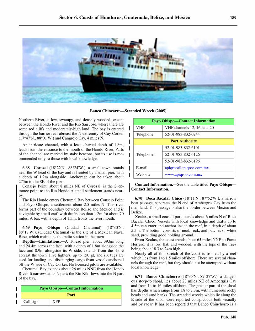
Sector 6. Coasts of Honduras, Guatemala, Belize, and Mexico 189
Pub. 148
Northern River, is low, swampy, and densely wooded, exceptbetween the Hondo River and the Rio San Jose, where there aresome red cliffs and moderately-high land. The bay is enteredthrough the barrier reef abreast the N extremity of Cay Corker(17°47'N., 88°01'W.) and Cangrejo Cay, 4 miles N.
6.67 An intricate channel, with a least charted depth of 1.8m,leads from the entrance to the mouth of the Hondo River. Partsof the channel are marked by stake beacons, but its use is rec-ommended only to those with local knowledge.
6.68 Corozal (18°22'N., 88°24'W.), a small town, standsnear the W head of the bay and is fronted by a small pier, witha depth of 1.2m alongside. Anchorage can be taken about275m to the SE of the pier.6.68 Consejo Point, about 8 miles NE of Corozal, is the S en-trance point to the Rio Hondo.A small settlement stands near-by.6.68 The Rio Hondo enters Chetumal Bay between Consejo Pointand Payo Obispo, a settlement about 2.5 miles N. This riverforms part of the boundary between Belize and Mexico and isnavigable by small craft with drafts less than 1.2m for about 70miles. A bar, with a depth of 1.5m, fronts the river mouth.
6.69 Payo Obispo (Ciudad Chetumal) (18°30'N.,88°17'W.), (Ciudad Chetumal) is the site of a Mexican NavalBase, which maintains the radio station in the town.6.69 Depths—Limitations.—A T-head pier, about 39.6m longand 24.4m across the face, with a depth of 1.8m alongside theface and 0.9m alongside its W side, extends from the shoreabreast the town. Five lighters, up to 150 gt, and six tugs areused for loading and discharging cargo from vessels anchoredoff the W side of Cay Corker. No licensed pilots are available.6.69 Chetumal Bay extends about 26 miles NNE from the HondoRiver. It narrows at its N part; the Rio Kik flows into the N partof the bay.
6.69 Contact Information.—See the table titled Payo Obispo—Contact Information.
6.70 Boca Bacalar Chico (18°11'N., 87°52'W.), a narrowboat passage, separates the N end of Ambergris Cay from themainland. This passage is also the border between Mexico andBelize. 6.70 Xcalax, a small coastal port, stands about 6 miles N of BocaBacalar Chico. Vessels with local knowledge and drafts up to4.5m can enter and anchor inside the reef, in a depth of about5.5m. The bottom consists of mud, rock, and patches of whitesand, providing good holding ground.6.70 From Xcalax, the coast trends about 65 miles NNE to PuntaHerrero; it is low, flat, and wooded, with the tops of the treesbeing about 18.3 to 24m high.6.70 Nearly all of this stretch of the coast is fronted by a reefwhich lies from 1 to 1.5 miles offshore. There are several chan-nels through the reef, but they should not be attempted withoutlocal knowledge.
6.71 Banco Chinchorro (18°35'N., 87°27'W.), a danger-ous steep-to shoal, lies about 28 miles NE of Ambergris Cayand from 14 to 16 miles offshore. The greater part of the shoalhas depths which range from 1.8 to 7.3m, with numerous rockyheads and sand banks. The stranded wrecks which lie along theE side of the shoal were reported conspicuous both visuallyand by radar. It has been reported that Banco Chinchorro is a
6.67Banco Chincarro—Stranded Wreck (2005)
Payo Obispo—Contact Information
Port
Call sign XFP
VHF VHF channels 12, 16, and 20
Telephone 52-01-983-832-0244
Port Authority
Telephone
52-01-983-832-6101
52-01-983-832-6126
52-01-983-832-6196
E-mail [email protected]
Web site www.apiqroo.com.mx
Payo Obispo—Contact Information

190 Sector 6. Coasts of Honduras, Guatemala, Belize, and Mexico
Pub. 148
good radar target for southbound vessels.6.71 Cayo Lobos, a small cay about 0.8 mile inside the 200mcurve, stands near the S extremity of Banco Chinchorro. Sever-al openings, available only to small craft with local knowledge,cut through the reef to the W and NW of Cayos Lobos.6.71 Cayo Centro (18°36'N., 87°20'W.) stands in the middle ofBanco Chinchorro, about 1.5 miles from its E side. This lowcay is composed of sand about 2.5 miles long and is coveredwith bushes and coconut trees. A salt water lagoon, about 1mile long, lies in the middle of the cay. A strong, dangerouscurrent sets into Firefly Bight, about 2 miles SE of Cayo Cen-tro.6.71 Cayo Norte (18°45'N., 87°19'W.), two long cays, lie withinthe reef about 1.5 miles S of the N extremity of Banco Chin-chorro. Dense vegetation and trees, about 12.2 to 15.2m high,cover the cays. A disused lighthouse and building stand close Sof the light on Cayo Norte.6.71 There are a number of wrecks on the E side of the bankwhich have been reported to be radar prominent.6.71 Caution.—In the vicinity of Banco Chinchorro there is usu-ally a very strong current that sets toward its entire E side.6.71 The passage between Banco Chinchorro and the coast W isclear of dangers and has depths of 183 to 1,024m.
6.72 Puerto Costa Maya (18°43'N., 87°42'W.) is a smallport designed for the cruise ship industry is situated on PuntaXococh. The port was built to support tourism and can accom-modate up to three cruise ships simultaneously.6.72 Depths—Limitations.—Berthing is comprised of a jetty390m in length connected to a pier 340m in length. For berth-ing information see the table titled Puerto Costa Maya—Berth Information. 6.72 Pilotage.—Pilotage is compulsory for all vessels, exceptMexican vessels under 500 gt. The pilot boards in position18°43.8'N, 87°41.2'W. 6.72 Contact Information.—See the table titled Puerto CostaMaya—Contact Information.
6.73 Punta Herrero (19°18'N., 87°26'W.), the S entrancepoint of Bahia del Espiritu Santo, is fronted by foul groundwhich extends up to about 1 mile offshore. In the entrance ofthe bay to the N the area is generally foul.
Bahia del Espiritu Santo (19°22'N., 87°28'W.), entered be-tween Punta Herrero, and Punta Tupac about 11 miles N, re-cedes about 16 miles SW and is about 7 to 10 miles wide. Thedepths in the entrance and for a short distance within the bayrange from 6.1 to 9.1m. 6.73 From Punta Tupac, the coast, which is bordered by a rockyledge, trends about 7.8 miles NNE to Punta Pajaros (19°34'N.,87°25'W.). A drying reef extends about 0.5 mile E from PuntaPajaros, which is also marked by a light.6.73 Depths of less than 9.1m lie up to 0.6 mile off this part of thecoast, and depths of less than 200m extend between 1 mile and1.3 miles offshore.6.73 Bahia de La Ascension (19°41'N., 87°30'W.) is enteredbetween Punta Hualaxtoc (Punta Nohku) (19°37'N.,87°28'W.), about 3.3 miles NW of Punta Pajaros, and PuntaAllen, about 8 miles N. The bay recedes about 16 miles SWand is from 5 to 11 miles wide. 6.73 The entrance of the bay is obstructed by a bar with a depth of2.4m. Cayo Culebra consists of a group of mangrove cayswhich stand in the middle of the entrance just within the bar.Two yellow range beacons stand on these cays. An openingabout 2 miles wide leads through the reef stretching across theentrance. Depths of 5.5 to 6.7m are found in this opening andas far W as the seaward side of the bar. There are depths of 3 to5.5m within the bar, but the inner reaches of the bay have notbeen surveyed.
Puerto Costa Maya—Contact Information
Port
VHF VHF channels 12 and 16
Telephone 52-983-834-5644
Facsimile 52-983-834-5645
E-mail [email protected]
Web site http://www.puertocostamaya.com
Port Authority
Telephone
52-983-832-6101
52-983-832-6126
52-983-832-6196
E-mail [email protected]
Web site http://www.apiqroo.com.mx
Pilots
VHF VHF channels 16 and 72
Telephone 52-983-834-5986
Puerto Costa Maya—Contact Information
Puerto Costa Maya—Berth Information
Berth Length Depth Remarks
No. 1 390m 12.5m Cruise vessels. Maximum draft of 9.3m, Maximum loa of 338.7m.
No. 2 390m 10.0m Cruise vessels. Maximum beam of 39.7m.
No. 3 — 10.0m Cruise vessels.
No. 4 164m — Cruise vessels.
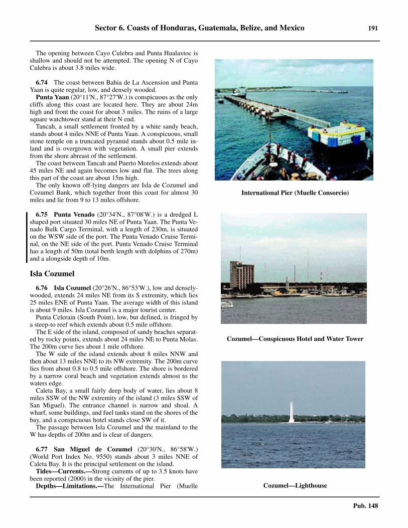
Sector 6. Coasts of Honduras, Guatemala, Belize, and Mexico 191
Pub. 148
6.73 The opening between Cayo Culebra and Punta Hualaxtoc isshallow and should not be attempted. The opening N of CayoCulebra is about 3.8 miles wide.
6.74 The coast between Bahia de La Ascension and PuntaYaan is quite regular, low, and densely wooded.6.74 Punta Yaan (20°11'N., 87°27'W.) is conspicuous as the onlycliffs along this coast are located here. They are about 24mhigh and front the coast for about 3 miles. The ruins of a largesquare watchtower stand at their N end.6.74 Tancah, a small settlement fronted by a white sandy beach,stands about 4 miles NNE of Punta Yaan. A conspicuous, smallstone temple on a truncated pyramid stands about 0.5 mile in-land and is overgrown with vegetation. A small pier extendsfrom the shore abreast of the settlement.6.74 The coast between Tancah and Puerto Morelos extends about45 miles NE and again becomes low and flat. The trees alongthis part of the coast are about 15m high.6.74 The only known off-lying dangers are Isla de Cozumel andCozumel Bank, which together front this coast for almost 30miles and lie from 9 to 13 miles offshore.
6.75 Punta Venado (20°34'N., 87°08'W.) is a dredged Lshaped port situated 30 miles NE of Punta Yaan. The Punta Ve-nado Bulk Cargo Terminal, with a length of 230m, is situatedon the WSW side of the port. The Punta Venado Cruise Termi-nal, on the NE side of the port. Punta Venado Cruise Terminalhas a length of 50m (total berth length with dolphins of 270m)and a alongside depth of 10m.
Isla Cozumel
6.76 Isla Cozumel (20°26'N., 86°53'W.), low and densely-wooded, extends 24 miles NE from its S extremity, which lies25 miles ENE of Punta Yaan. The average width of this islandis about 9 miles. Isla Cozumel is a major tourist center.6.76 Punta Celerain (South Point), low, but defined, is fringed bya steep-to reef which extends about 0.5 mile offshore. 6.76 The E side of the island, composed of sandy beaches separat-ed by rocky points, extends about 24 miles NE to Punta Molas.The 200m curve lies about 1 mile offshore.6.76 The W side of the island extends about 8 miles NNW andthen about 13 miles NNE to its NW extremity. The 200m curvelies from about 0.8 to 0.5 mile offshore. The shore is borderedby a narrow coral beach and vegetation extends almost to thewaters edge.6.76 Caleta Bay, a small fairly deep body of water, lies about 8miles SSW of the NW extremity of the island (3 miles SSW ofSan Miguel). The entrance channel is narrow and shoal. Awharf, some buildings, and fuel tanks stand on the shores of thebay, and a conspicuous hotel stands close SW of it.6.76 The passage between Isla Cozumel and the mainland to theW has depths of 200m and is clear of dangers.
6.77 San Miguel de Cozumel (20°30'N., 86°58'W.)(World Port Index No. 9550) stands about 3 miles NNE ofCaleta Bay. It is the principal settlement on the island.6.77 Tides—Currents.—Strong currents of up to 3.5 knots havebeen reported (2000) in the vicinity of the pier.6.77 Depths—Limitations.—The International Pier (Muelle
6.77International Pier (Muelle Consorcio)
6.77Cozumel—Conspicuous Hotel and Water Tower
6.77Cozumel—Lighthouse
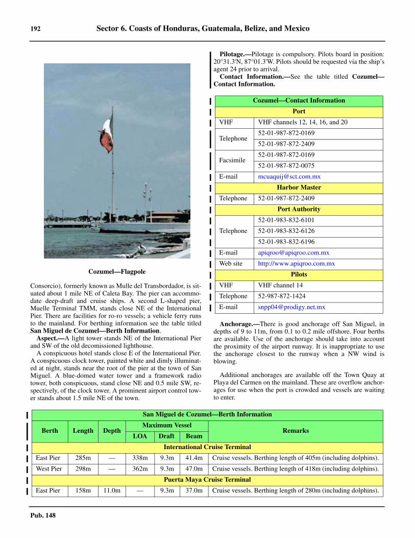
192 Sector 6. Coasts of Honduras, Guatemala, Belize, and Mexico
Pub. 148
Consorcio), formerly known as Mulle del Transbordador, is sit-uated about 1 mile NE of Caleta Bay. The pier can accommo-date deep-draft and cruise ships. A second L-shaped pier,Muelle Terminal TMM, stands close NE of the InternationalPier. There are facilities for ro-ro vessels; a vehicle ferry runsto the mainland. For berthing information see the table titledSan Miguel de Cozumel—Berth Information. 6.77 Aspect.—A light tower stands NE of the International Pierand SW of the old decomissioned lighthouse. 6.77 A conspicuous hotel stands close E of the International Pier.A conspicuous clock tower, painted white and dimly illuminat-ed at night, stands near the root of the pier at the town of SanMiguel. A blue-domed water tower and a framework radiotower, both conspicuous, stand close NE and 0.5 mile SW, re-spectively, of the clock tower. A prominent airport control tow-er stands about 1.5 mile NE of the town.
6.77 Pilotage.—Pilotage is compulsory. Pilots board in position:20°31.3'N, 87°01.3'W. Pilots should be requested via the ship’sagent 24 prior to arrival. 6.77 Contact Information.—See the table titled Cozumel—Contact Information.
6.77 Anchorage.—There is good anchorage off San Miguel, indepths of 9 to 11m, from 0.1 to 0.2 mile offshore. Four berthsare available. Use of the anchorage should take into accountthe proximity of the airport runway. It is inappropriate to usethe anchorage closest to the runway when a NW wind isblowing.
6.77 Additional anchorages are available off the Town Quay atPlaya del Carmen on the mainland. These are overflow anchor-ages for use when the port is crowded and vessels are waitingto enter.
6.77Cozumel—Flagpole
Cozumel—Contact Information
Port
VHF VHF channels 12, 14, 16, and 20
Telephone52-01-987-872-0169
52-01-987-872-2409
Facsimile52-01-987-872-0169
52-01-987-872-0075
E-mail [email protected]
Harbor Master
Telephone 52-01-987-872-2409
Port Authority
Telephone
52-01-983-832-6101
52-01-983-832-6126
52-01-983-832-6196
E-mail [email protected]
Web site http://www.apiqroo.com.mx
Pilots
VHF VHF channel 14
Telephone 52-987-872-1424
E-mail [email protected]
San Miguel de Cozumel—Berth Information
Berth Length DepthMaximum Vessel
RemarksLOA Draft Beam
International Cruise Terminal
East Pier 285m — 338m 9.3m 41.4m Cruise vessels. Berthing length of 405m (including dolphins).
West Pier 298m — 362m 9.3m 47.0m Cruise vessels. Berthing length of 418m (including dolphins).
Puerta Maya Cruise Terminal
East Pier 158m 11.0m — 9.3m 37.0m Cruise vessels. Berthing length of 280m (including dolphins).

Sector 6. Coasts of Honduras, Guatemala, Belize, and Mexico 193
Pub. 148
6.77 Caution.—A dangerous wreck (position approximate) liesabout 0.3 mile N of the lighthouse.6.77 Submarine cables extend from N of San Miguel to themainland at Playa del Carmen and are best seen on the chart.
6.78 Punta Norte, the NW extremity of the island, liesabout 3.3 miles NE of the entrance to Banco Playa yachtharbor. The shore between is lined with numerous hotels one ofwhich, a white building, is conspicuous and can be seen from aconsiderable distance seaward.6.78 The N side of the island extends about 10 miles ENE from itsNW extremity to Punta Molas. A conspicuous clump ofcoconut trees stands about 2.5 miles E of the NW extremity ofthe island. A reef extends up to 1.8 miles offshore; the 10mcurve lies up to 2.8 miles offshore. Some coral heads lie withinthis latter curve. La Laguna, an almost landlocked body ofwater, lies across the N part of the island.6.78 Punta Molas (20°35'N., 86°44'W.), the NE extremity of theisland, may be identified by a tall isolated tree and some huts.The point is marked by a light.6.78 Cozumel Bank extends N from the N side of the island andlies up to 6 miles N of Punta Molas. The bank has been report-ed to extend up to 14 miles NNE and 4 miles E from Punta Mo-las. General depths on the bank range from 9.1 to 40m.Ripples, which at times have the appearance of breakers, markthe E edge of this bank.
Puerto Morelos to Cabo Catoche
6.79 Puerto Morelos (20°51'N., 86°54'W.) is a small fish-ing and ferry port with depths of 6.7 to 10.1m. The village ofPuerto Morelos is protected by reefs which lie 0.3 mile off-shore abreast the village and up to 1 mile offshore abreast the Spart of the harbor. Some of these reefs are 0.6 to 0.9m high inplaces. A 123m pier, with a depth of 4.9m alongside its head,extends from the shore N of the village.6.79 Anchorage can be taken abreast the village, in depths of 8 to9m, but it is advisable that vessels moor.6.79 The coast between Puerto Morelos and Cabo Catoche ex-tends about 14 miles NE and then curves NNW for 36 miles toCabo Catoche. The terrain is generally low and wooded. Sandhills stand along some parts of the coast. The terrain in the Npart of this area becomes more elevated, with trees up to 40mabove the sea.6.79 Caution.—The 200m curve, which lies about 2 miles SE ofPuerto Morelos, gradually extends from the coast and liesabout 37 miles E of Cabo Catoche.
6.79 The coast about 5 miles SW of Puerto Morelos is fringed bya steep-to reef which extends up to 1.3 miles offshore.6.79 Numerous islands, cays, and other dangers lie within the areaenclosed by the 200m curve, which lies between 1 mile and 15miles offshore between Puerto Morelos and Cabo Catoche.6.79 Numerous marine reserves located along the coast betweenPuerto Morelos to Isla Mujeres are best be seen on the chart.
6.80 Isla Cancun (21°05'N., 86°47'W.) stands about 14miles NNE of Puerto Morelos and is composed of sand hills 12to 18m high. The N and S extremities of this island curve to theW and almost reach the mainland. There are two bridges con-necting the island with the mainland. A 1970 report stated that
Outer Pier 149m — 330m 8.6m 38.4m Cruise vessels. Berthing length of 350m (including dolphins).
West Pier 165m 12.0m — 9.3m 38.6m Cruise vessels. Berthing length of 285m (including dolphins).
Punta Langosta Terminal
East Pier 275m — 293.9m 8.6m 32.2m Cruise vessels.
West Pier 288m — 333.3m 9.2m 41.0m Cruise vessels.
San Miguel de Cozumel—Berth Information
Berth Length DepthMaximum Vessel
RemarksLOA Draft Beam
6.79Punta Molas Light

194 Sector 6. Coasts of Honduras, Guatemala, Belize, and Mexico
Pub. 148
the S end of the island appeared to be connected to the main-land when viewed by radar.6.80 A conspicuous tower, marked by a red fixed obstructionlight, and a structure in the shape of a truncated pyramid standnear Punta Cancun. Another tower, marked by a red fixed ob-struction light, stands 2.8 miles SSW of the point.6.80 Isla Cancun encloses a series of interconnected lagoons hav-ing shallow channels to the sea. A natural harbor for small craftis located S of Punta Nizue, the S extremity of the island, and isprotected by a reef. Local knowledge is required to enter it.6.80 Contact Information.—See the table titled Cancun—Con-tact Information.
6.81 Isla Mujeres (21°14'N., 86°45'W.), which standsabout 4.5 miles NNE of Isla Cancun, is about 4 miles long,low, narrow, and wooded. The S part is slightly elevated andhas trees about 27m above the sea. The ruins of a square watchtower stand near the S part of the island. The E side of the is-land is composed of fairly steep-to rocky shelves and termi-nates at its N end in Roca El Yungue (Anvil Rock), which issquare, black, and about 1.8m high. Some white cliffs standabout midway along the E side of the island. A large, squarewhite hotel stands on the N extremity of the island and hasbeen reported to be a good radar target.6.81 Puerto Juarez, a small town on the mainland, stands about5.5 miles WSW of the light on the S end of Isla Mujeres. Thetown serves as a terminal for ferries servicing Isla Mujeres. Apier, about 244m long, with a depth of 1.8m alongside, extendsfrom the shore abreast of the town. A ferry service for vehiclesoperates from Punta Sam, 3 miles N of Puerto Juarez.
6.82 Bahia de Mujeres (21°13'N., 86°46'W.) lies betweenIsla Mujeres and the mainland; it is entered between the NE ex-tremity of Isla Cancun and the S extremity of Isla Mujeres.6.82 A sand bank extends about 2 miles W from the S extremityof Isla Mujeres, then trends N about 2 miles toward the island;the 5m curve marks this sandbank. There are many coral headson this bank; some of them near the S end nearly dry. The SWedge of this bank is marked by a lighted buoy.6.82 A passage between this bank and the shoals W is about 0.3mile wide and leads N past Puerto Mujeres, where it joins Ca-nal las Pailas, passing N of Isla Mujeres to deep water about0.5 mile N of Roca El Yunque.6.82 The general depths in the area between Isla Mujeres and themainland are from 2 to 8m; only vessels with local knowledgeshould attempt this passage. 6.82 A charted submarine cable and aquaduct cross the bay be-tween Punta Sam and Isla Mujeres.6.82 Anchorage.—A designated anchorage, with depths of 7 to8m, lies 2 miles WNW of Roca la Bandera. 6.82 Puerto Mujeres (21°16'N., 86°45'W.) is situated at the Nend of Isla Mujeres, on its W side. The harbor lies in a smallbay entered between the NW extremity of the island and RocaLa Carbonera, about 0.5 mile S. A channel for small vesselsleads through the shoal which extend across the entrance to thebay. There are six quays, with depths of 2.4m, and a ferry berthin the bay.6.82 There is an anchorage in Bahia de Mujeres, about 2.3 milesW of the S extremity of Isla Mujeres, in depths of 6 to 7m.
6.83 Arrowsmith Bank (21°05'N., 86°25'W.) lies about16 miles E of Isla Cancun. The bank is about 17 miles long andfrom 1.5 to 5 miles wide. There are depths to 16.4 to 38m, withthe shallowest part lying on the center of its E part.6.83 The E edge of the bank is reported (1981) to lie about 4miles farther E than charted.6.83 A NNE current sets across Arrowsmith Bank, attaining a rateof from 2 to 3 knots; the S end of the bank is marked by strongrips.6.83 In 1980, it was reported that an area of heavily breaking seaswas observed, centered in position 20°50'N, 86°35'W, S of Ar-rowsmith Bank; there was a moderate SE wind at the time ofthe observation.
Cozumel—Contact Information
Port
VHF VHF channels 12, 16, and 20
Telephone 52-01-998-880-1360
Port Authority
Telephone
52-01-983-832-6101
52-01-983-832-6126
52-01-983-832-6196
E-mail [email protected]
Web site http://www.apiqroo.com.mx
6.80Isla Cancun
Sector 6. Coasts of Honduras, Guatemala, Belize, and Mexico 195
Pub. 148
6.83 A shoal, with a depth of 8.2m, was reported (1960) to lienear the NE extremity of Arrowsmith Bank.6.83 From a position on the coast about 5 miles W of the S ex-tremity of Isla Mujeres, the coast trends about 3.5 miles N to anarrow ridge of sand about 2m high, which connects a narrowneck of land about 4 miles long with the mainland. The contin-uation, about 5 miles farther N, is known as Isla Blanca(21°22'N., 86°49'W.).6.83 From the S end of the ridge of sand, a reef fringes the coast,extending past Isla Blanca to Isla Contoy, about 4 miles fartherN; there are one or two openings for small craft.
6.84 Isla Contoy (21°30'N., 86°49'W.) stands about 4miles NNE of Isla Blanca and 6.5 miles offshore. Its E side iscomposed of a narrow ridge of sand hills covered with bushesand trees to within 1.5 miles of its NW extremity. A narrowridge of coral, with depths of 5.5m, extends about 3 miles
NNW from two rocks close off the NW extremity of the island.The greater part of the W side of the island is intersected by nu-merous small lagoons. The island is a bird sanctuary.6.84 A bank, with a depth of 27m, was reported (1946) to lieabout 17 miles ENE of the N extremity of Isla Contoy. A shoaldepth of 18.3m was reported (1968) to lie about 16 miles NE ofthe N end of the island.
6.84 From Cayo Sucio (21°25'N., 86°53'W.), which lies close offthe coast 3 miles NW of Isla Blanca, the coast trends about 8miles NW. This coastal section is more elevated and denselywooded, with some trees standing 37 to 40m above the sea.The conspicuous ruins of a church stand at the N end of thisstretch of coast. 6.84 From the ruins of the church, the coast extends about 6 milesWNW to abreast Cabo Catoche, which is the N extremity of Is-la Holbox.

197
Pub. 148
7. Sector 7—Coast of Mexico—Cabo Catoche to the Rio Grande
7.0Additional chart coverage may be found in NGA/DLIS Catalog of Maps, Charts, and Related Products (Unlimited Distribution).SECTOR 7 — CHART INFORMATION
199
Pub. 148
SECTOR 7
COAST OF MEXICO—CABO CATOCHE TO THE RIO GRANDE
7.0 Plan.—This sector describes the coast of Mexico from CaboCatoche W along the N coast of Peninsula de Yucatan, then Sand W around the shores of the Bay of Campeche, and then Nto the Rio Grande.
General Remarks
7.1 The E coast of Mexico between Cabo Catoche and theRio Grande extends WNW for 615 miles.7.1 Peninsula de Yucatan, which forms the SE side of Mexico,has as its E side the coast between Chetumal Bay and Cabo Ca-toche. The N coast of the peninsula extends in a general W di-rection for about 190 miles between Cabo Catoche and PuntaBoxcohuo. The W side of the peninsula extends 105 miles Sfrom Punta Boxcohuo and then an additional 78 miles SW tothe W entrance of Laguna de Terminos. The N and W sides ofthe peninsula are low and arid, and have very few conspicuouslandmarks.7.1 Banco de Campeche, an extensive coastal bank, as definedby the 200m curve, extends up to 155 miles N from the N sideof Peninsula de Yucatan and as far as 120 miles from the Wside of the peninsula. This bank is very steep-to, has irregulardepths, and many cays, shoals, and reefs are found within itslimits.7.1 Between Punta Boxcohuo, the NW extremity of the peninsu-la, and Cabo Rojo, 390 miles W, the coast recedes 195 miles Sto form the Bay of Campeche. The E side of the gulf is formedby Peninsula de Yucatan, the S side by the coast between Lagu-na de Terminos and Punta Zapotitlan, and the W side by thecoast between Punta Zapotitlan and Cabo Rojo. The low E andS coasts of the gulf are indented by several lagoons. The coast-al plain on the W side of the gulf is backed by mountain rangesrising 10 miles inland. The S and W parts of the gulf have reg-ular depths and few off-lying dangers. Numerous rivers dis-charge into the gulf along its S and W shores.7.1 From Cabo Rojo, the E coast of Mexico extends farther N for270 miles to the Rio Grande. This section of coast is marked atirregular intervals by low sand hills and wooded hummocks.Several large lagoons lie adjacent to the coast. Ranges of hills,several of which make good landmarks, stand farther inland.7.1 Puerto Veracruz, Tampico, and Coatzacoalcos are the princi-pal ports for large vessels, but there are also several small portsfor vessels with shallow drafts.7.1 Winds—Weather.—The prevailing winds come from direc-tions between the NE and SE, but are interrupted by northersduring the cooler months of the year and by tropical cyclonesfrom June to November. Northers generally last about 1 to 2days, but severe storms last for 2 to 5 days.7.1 Along the E and N coasts of Peninsula de Yucatan, the tradewind freshens in the afternoon and diminishes and shifts to theSE late at night and in the early morning.7.1 Along the W coast, from 1000 to 1400, the interval ofchange from the land to the sea breeze, the wind falls graduallyto nearly a calm and gradually springs up again from the N,
and at about 1500 is established from the NE.7.1 Rainfall varies from 500 to 1,000mm along the coast. Pro-greso has an average annual fall of 470mm. Precipitation isheaviest near Coatzacoalcos and decreases in both directionsalong the coast. In general, the maximum occurs in September.7.1 Ships’ observations taken in the area between the coast and20°N, 95°W show early winds predominate for all months butSeptember, October, and November, when the prevailing windis NE. Average wind velocities range from 8 to 12 knots, beingsomewhat higher from October to March. Gales are most fre-quent in October and November, when 4 per cent of observa-tions report winds of force 8 or higher.7.1 In the vicinity of Puerto Veracruz and N to 25°N, the prevail-ing winds are E, with a large percentage of N winds from Sep-tember to April. The latter period, but more especiallybeginning with October, is known as the norther season, whenthe trades are frequently interrupted by northers. The remain-der of the year is known as the trade wind season.7.1 Wind velocities average considerably higher during themonths of October through April, being highest in December,when ships’ observations show an average velocity of 12 knots. 7.1 Fog is frequent, but most likely in March.7.1 The climate is hot and humid, although the oppressiveness isconsiderably lessened during the norther season when cool Nwinds are felt.7.1 Tides—Currents.—The main offshore current sets Wacross Banco de Campeche, 20 to 30 miles from the N coast ofPeninsula de Yucatan, at a velocity of 0.5 to 1.5 knots. It thensets SW across the Bay of Campeche and N, following thetrend of the coast to the Rio Grande, 20 to 30 miles offshore,decreasing somewhat in velocity. From October to May, thecurrent circles the Bay of Campeche in a counterclockwise di-rection a distance of 10 to 30 miles offshore at a rate of 0.3 to0.5 knot.7.1 Off the mouth of the Rio Grande and anywhere within 100miles of the coast, the current is mainly governed by the pre-vailing wind, setting N in the summer and S in the winter.
Banco de Campeche
7.2 Banco de Campeche extends 155 miles N from the Ncoast of Peninsula de Yucatan and 120 miles W from its Wside.7.2 From a position lying 35 miles E of Cabo Catoche, the 200mcurve, which defines the limits of this bank, extends N and NWfor 170 miles, then irregularly W and SW to a position lying140 miles NW of Punta Boxcohuo. It then extends S quite reg-ularly at a distance of 120 miles off the W side of the peninsu-la.7.2 From a position lying 14 miles N of Cabo Catoche, the 20mcurve extends W along the N side of the peninsula at a distanceof 12 to 18 miles offshore to a position lying 24 miles N ofPunta Boxcohuo. On the W side of the peninsula, the 20mcurve extends SW and S at a distance of 20 to 38 miles off-

200 Sector 7. Coast of Mexico—Cabo Catoche to the Rio Grande
Pub. 148
shore. All of the dangers contained within this curve are de-scribed under the principal description of the coastal features.This steep-to bank has very irregular depths and is marked onits E and N edges by heavy ripples and a confused sea. Some ofthe dangers within the limits of the bank are marked by discol-ored water.7.2 Banco de Campeche has not been surveyed for many yearsand, as reports of new shoals are constantly received, it is rea-sonable to assume that many more dangers exist than areshown on the charts. 7.2 The following shoals were reported in the years indicatedwith the distances and bearings from Cabo Catoche (21°36'N.,87°04'W.):
1. A 6.4m shoal (1932), 13 miles N.2. An 18m shoal (1968), 25.5 miles ENE.3. A 12.8m shoal (1960), with a 16.5m depth (1967)
close E of it, 38 miles NNE.4. A 25.6m patch (1973), 33.5 miles NE. Several shoals,
with depths of 27 to 58m, lie within 6 miles N through NE ofthis shoal.
5. A depth of 11m (1971), 58 miles N.6. A depth of 22m (1957), 61 miles N.7. A shoal bank, with depths of 110 to 200m (1959),
about 120 miles N. An 8.2m patch was reported (1961) to lieon the S end of this shoal bank.
8. A 14.6m depth (1968), 111 miles N.9. A 27.4m depth (1946), 30 miles E.
7.2 The following shoals were reported in the years indicatedwith the distances and bearings from Punta Yalkubul(21°32'N., 88°37'W.):
1. A small shoal patch (1921), depth unknown, 39 milesNNE.
2. Aeolus Shoal, with a depth of 9.1m, 31 miles N.3. Iphigenia Rock, with a depth of 14.6m, 26 miles N.4. Bajos Nortes, two coral banks with depths of 20.1 to
36.6m, lie 5 miles apart, 100 miles N. A 5.5m patch was re-ported (1907) to lie on the southern most bank.
5. Granville Shoal, with a depth of 8.2m, about 45 milesWNW. A 12.8m patch lies 10 miles N of Granville Shoal. A17.4m patch lies 20 miles SSW of Granville Shoal.
7.3 Arrecife Alacran (22°29'N., 89°42'W.), a steep-tohalf-moon shaped reef, lies 34 miles NW of Granville Shoal.The reef covers an area extending 14 miles N and 10 miles E.The NE side of the reef is composed of a compact mass of cor-al, awash, on which the sea breaks heavily. The SW side iscomposed of detached coral heads and sandbanks, with deepwater between some of the features. Soundings give no indica-tion of the proximity of the reef. Isla Chica and Isla Pajaros,two small low cays lying 0.3 mile apart, stand near the S end ofthe reef. Isla Desterrada, a small cay 3m high marked by alight, is located 3 miles within the N edge of the reef.
Isla Perez, a narrow cay 0.5 mile long and 4.3m high, is lo-cated 1.8 miles within the S edge of Arrecife Alacran. This cayis marked by a light with a racon. The light tower is fully visi-ble when approaching from the W and is reported to be radarconspicuous. A gray masonry tower stands adjacent to the lighttower.7.3 Anchorage can be taken by small vessels, in depths of 11 to18m, fine sand, mud and coral, about 0.3 mile E of Isla Perez.
The anchorage is approached from the S through an unmarkedchannel with a depth of 7.3m. This channel should not be at-tempted without local knowledge. In 1977, a vessel with a draftof 5.5m anchored about 2 miles, bearing 093°, from Isla PerezLight, in a depth of 44m, good holding ground.7.3 Isla Desertora, a small cay 4m high, lies 3 miles NW of IslaPerez.7.3 The current usually sets W in the vicinity of ArrecifeAlacran at a rate of 1 knot, but may set N or S, depending onthe direction of the wind.7.3 Arrecife Madagascar (21°26'N., 90°18'W.), a narrow coralledge, with a least depth of 2.7m, lies 69 miles SSW of Arreci-fe Alacran and 20 miles NNW of Punta de Piedra. The sea doesnot break on this ledge, which is covered with weeds and ap-pears the same color as the water. Two 12.8m patches lie 2miles and 3 miles W of the ledge.7.3 Breakers were reported (1909) about 6 miles NNE of Arreci-fe Madagascar.7.3 Arrecife de La Serpiente (Snake Rock), with a least depth of8.2m, lies 11.5 miles W of Arrecife Madagascar.
7.4 Cayo Arenas (22°07'N., 91°24'W.), a guano-coveredcay 6m high, lies on the SE edge of a detached reef, 0.8 milelong. A ledge extends 5 miles W from the cay. The horns of thereef extend 0.5 mile NW and 0.3 mile W from the cay. A smallwharf stands on the NW side of the cay. A detached reef, 1.3miles long, with a rocky patch, 2.1m high, on its S end and asmall coral patch, 0.6m high, off its NW end, lies 1 mile E ofCayo Arenas. A stranded wreck lies 0.2 mile W of a light, witha racon, which stands on the reef. The intervening channel isabout 0.5 mile wide at its N entrance. At its S end lie three cor-al patches, with a depth of 4.1 to 8.2m, about 0.3 mile SE ofCayo Arenas.7.4 A 11m patch was reported (1968) to lie about 15 miles ENEof Cayo Arenas. A 14.6m patch lies 3 miles W of the same cayand a 29.2m patch lies 19 miles E of the cay. A shoal, with aleast depth of 27.4m, lies about 18 miles ENE of the cay.7.4 Several shoals, with depths between 14.6m and 21.9m, liebetween 29 miles and 53 miles SSE of Cayo Arenas. Shoalpatches, with depths of 12.8m and 18.3m, lie 60 miles SSWand 54 miles SW, respectively from Cayo Arenas.7.4 A detached pinnacle, with a depth of less than 20m, was re-ported (1961) to lie 24 miles NW of Cayo Arenas. A detachedbank, with depths of 45.7 to 54.9m, was reported (1911) to lie43 miles NNW of Baja Nuevo. A depth of 23.7m was reported(1982) to exist 13 miles WNW of Baja Nuevo.7.4 Anchorage.—Anchorage may be found as charted in thechannel, in depths of 15 to 27m, close E of the light.
7.5 Cayo Nuevo (Nuevo Reef) (21°50'N., 92°05'W.),with a depth of less than 1.8m, lies 40 miles WSW of CayoArenas and is marked by breakers. Depths of less than 36m ex-tend up to 5 miles off the reef’s NE side and up to 3 miles offthe other sides of this reef. A detached 18.3m patch lies 25miles NNW of Cayo Nuevo. A depth of 23.5m was reported(1982) to exist 13 miles WNW of Baja Nuevo.7.5 Banco Ingleses (Ingleses Bank) (21°49'N., 91°56'W.), twobanks of coral and sand with depths of 9 to 34m, lie with theirshallowest part located 8 miles SE of Cayo Nuevo.7.5 Arrecifes Triangulos (20°57'N., 92°14'W.) consists of two

Sector 7. Coast of Mexico—Cabo Catoche to the Rio Grande 201
Pub. 148
groups of coral reefs lying 6 miles apart, which lie 53 miles Sof Cayo Nuevo. Depths of 49 to 53m exist in the channel be-tween them.7.5 Triangulo Oeste, a reef 0.8 mile long, with a cay 3.4m highon its SW end, has a ledge with depths of 11 to 16.5m extend-ing NE from the cay. Seal Bank, a ledge with a least depth of12.8m, lies 1.5 miles farther NE.7.5 A disused lighthouse stands near the light on the cay near theSW end of Triangulo Oeste.7.5 A dangerous wreck lies 22 miles NE of the light on Triangu-lo Oeste.7.5 Triangulo Este (20°55'N., 92°13'W.) and Triangulo Sur(20°54'N., 92°14'W.), which nearly dry, are separated by achannel 0.2 mile wide, with depths of 10 to 20m. A cay, 7.3mhigh, stands on the S end of Triangulo Este. A stranded wrecklies on the E edge of Triangulo Sur. A reef extends 1 mile NEfrom the cay, and a coral ledge extends about 1 mile fartherNE. Triangulo Sur has a ledge extending about 1 mile SW fromthe SW cay of several which stand on it.7.5 An 11m patch was reported (1916) to lie 25 miles NNE ofTriangulo Este. A rock, awash, was reported (1921) to lie 7miles S of this patch. A detached 14.6m patch lies about mid-way between these two dangers.7.5 Anchorage.—Anchorage can be taken, in a depth of 13m,about 1 mile SW of the SW cay on Triangulo Sur.
7.6 Banco Ciudad Condal, a detached shoal with a depthof 11m, lies 8 miles S of Triangulo Este.7.6 In 1977, a depth of 33m was reported to lie 6 miles SE ofBanco Ciudad Condal.7.6 Obispo Norte (20°29'N., 92°12'W.) and Obispo Sur, twodangerous shoals with general depths of 7 to 18m, lie 25 milesS of Triangulo Este and are marked by discolored water. A pas-sage, about l.3 miles wide with a depth of 51m, separates theshoals. Obispo Norte has a depth of 4.5m lying near its N end.A dangerous wreck lies between the two shoals.7.6 Banco Pera (20°42'N., 91°56'W.) and Banco Nuevo, twoshoal banks with least depths of 16.4m and 14.6m, respective-ly, lie 28 miles and 38 miles SE, respectively, of TrianguloOeste.7.6 Cayos Arcas (20°13'N., 91°58'W.), the S dangers of Bancode Campeche, are a group of three islets which lie 44 milesSSE of Triangulo Este.7.6 Cayo del Centro, the N and largest, is composed of sand andrises at its S end to a height of 6m. It lies on the SE end of areef which extends about 1 mile NW and 0.5 mile W from it;this reef is encumbered by foul ground and is always visible.The islet is scantily-covered with grass. Bushes and several
clumps of palms are also present. A pair of lighted range bea-cons, in line bearing 107°, stand on the cay. 7.6 Anchorage can be taken, in depths of 11 to 18m, coral androck, about 1 mile WNW of the cay on the alignment of therange.
7.6 Cayo del Este, a small cay, 3m high, lies on a detached reeflying 0.3 mile SE of Cayo del Centro. The intervening channelhas depths of 11 to 25.6m. 7.6 Cayo del Oeste, a small 2m high cay, lies on a small de-tached reef about 0.8 mile W of the S end of Cayo del Centro.The narrow intervening passage has depths of 6.4 to 91m.
7.7 Cayos Arcas Terminal (20°10'N., 91°59'W.) (WorldPort Index No. 9395) lies close SW of the cays within the lim-its of an Area to be Avoided associated with a marine oil field.Two distribution platforms are situated at the N end of a sub-marine pipeline carrying oil from the marine oil field, 45 milesS. Operations are conducted 24 hours.7.7 Depths—Limitations.—Submarine pipelines are laid fromthe above platforms to two SPMs within the terminal area. Twomoored storage tankers are also in use. For berthing informa-tion see the table titled Cayo Arcos Terminal—Berth Infor-mation. 7.7 Pilotage.—Pilotage is compulsory. Pilots are available Mon-day through Saturday from 0800 to 1800 and on Sunday from0800 to 1200. An ETA should be sent to PEMEX through theagent prior to arrival at the terminal. Pilots board in position20°07.8'N, 91°59.7'W. 7.7 For pilot contact information, see table titled Cayos ArcasTerminal—Contact Information.
7.7 Anchorage.—Vessels can obtain anchorage in the chartedanchorage area SE of the terminal.
Cayos Arcas Terminal—Contact Information
Port Authority
Telephone 52-01-981-812-0815
Facsimile 51-01-981-812-0816
Web site http://www.apixampeche.com.mx
Pilots
Telephone 52-938-382-3687
Facsimile 52-938-382-4420
E-mail [email protected]
Cayo Arcos Terminal—Berth Information
Berth DepthMaximum Vessel
RemarksLength Beam Size
FPSO Yuum Kak Naab 105m — — 350,000 dwt Crude oil
SPM No. 1 44m 350m 51m 250,000 dwt Crude oil
SPM No. 2 44m 350m 51m 275,000 dwt Crude oil
Ta’kuntah FSO 75m 389m 60m 350,000 dwt Crude oil

202 Sector 7. Coast of Mexico—Cabo Catoche to the Rio Grande
Pub. 148
7.7 Directions.—On approaching the terminal, masters ofinbound tankers should head directly for the anchorage area,where vessels will be boarded by a mooring master.
Cabo Catoche to Punta Boxcohuo
7.8 Cabo Catoche (21°36'N., 87°04'W.), a sand projec-tion on the N point of Isla Holbox, is fringed by depths of 5.5to 9m which extend 10 miles N and NE.7.8 The coast from Cabo Catoche extends 85 miles W to PuntaYalkubul, and then 105 miles WSW to Punta Boxcohuo. Thissection borders the N coast of Peninsula de Yucatan and is lowand arid, with few conspicuous landmarks. Many detachedshoals and patches fringe this coast. Lagartos Lagoon, anarrow, shallow lagoon, lies parallel to almost all of thissection of coast.7.8 Progreso is the only port of any importance. Several smallvillages lie on the coast. 7.8 The 20m curve lies 14 miles N of Cabo Catoche and extendsW along the coast 12 to 18 miles offshore to a position 24miles N of Punta Boxcohuo. The dangers seaward of this curvehave been previously described. A shallow coastal bank, as de-fined by the 5m curve, fronts this coast 1 to 5 miles offshore.Irregular depths lie between the 5 and 20m curves. The dangerswithin the 20m curve are described under the principal descrip-tion of the coastal features. 7.8 Between Cabo Catoche and Punta Boxcohuo, the currentsets W at a rate of 0.5 to 1 knot, following the trend of the coast30 miles offshore.7.8 The mean rise at springs ranges from 0.4 to 0.7m. The wateron the off-lying banks is influenced by the winds, as well as thetides. The effect of the latter may be offset by the wind effectfor a period of several days.
7.8 Isla Holbox (21°33'N., 87°14'W.) is one of a chain of low,narrow islands which front the coast between Cabo Catocheand Boca de Conil to the W. Punta Francisca is the NW ex-tremity of the island. A chain of cays, fronted by numeroussand ridges, with depths of 2.4 to 9.1m, extends 8 miles NEfrom Cabo Catoche and 9 miles NW from Punta Francisca. Ba-jo Corsario, with a least depth of 4.6m, lies 8 miles N of PuntaFrancisca.7.8 Boca de Conil (21°29'N., 87°35'W.), 3 miles wide, is the Wentrance to Laguna de Yalahua, a shallow body of water lyingbetween Isla Holbox and the mainland. Foul ground extends 7miles NW from Boca de Conil.7.8 The low sandy coast between Boca de Conil and Cuyo, 16miles W, is marked by conspicuous groves of trees near its Eend.7.8 Cuyo (21°32'N., 87°41'W.), a town, is fronted by a wharf,107m long, with a depth of 2.1m alongside its outer end. Itstands on the narrow strip of land between the sea and the la-goon which parallels this coast. El Cuyo, a 12m high hill,stands close to the town. A 3.7m shoal lies 5 miles N of thetown.
7.9 Las Coloradas (21°37'N., 88°01'W.), fronted by anopen roadstead, has two small piers. The principal export issalt, which is barged out to the anchorage. From the N, depthsin the approach are 7.3 to 9.1m and are quite regular, with no
known dangers in the immediate vicinity. The two piers are re-ported to be radar conspicuous.7.9 The coast between Cuyo and the Rio Lagartos, 30 miles W,is fronted by a low, sandy beach. The Rio Lagartos is the outletof the narrow lagoon that parallels this coast.7.9 Alert Patch, existance doubtful, with a least depth of 4.6m,lies 14 miles NW of the Rio Lagartos entrance.7.9 Bajo Antonieta, a shoal which uncovers 0.6m, lies 4 milesWNW of the Rio Lagartos. Between the Rio Lagartos and Pun-ta Yalkubul, 22 miles W, the coast is more elevated, being 52mhigher 6 miles E of the point.7.9 Punta Yalkubul (21°32'N., 88°37'W.) is low and marked bytrees. Bajo Carmelita, a shoal with depths of less than 4.6m (re-ported in 1895), lies 11 miles NW of the point. BajoPawashick, a shoal with a least depth of 2.7m, lies 9 miles W ofthe point.7.9 The coast between Punta Yalkubul and Punta Arenas, 13miles SW, remains low. A shallow lagoon entrance lies close Eof the latter point.7.9 Dzilam (Silan), a small town fronted by a pier, is situated 6miles W of Punta Arenas.7.9 Between Punta Arenas and Progreso, 48 miles W, the coastconsists of low sandy beach, slightly wooded, and backed byswampy ground. A prominent coastal light is shown 2 miles SEof the village of Telchac. Several additional villages lie alongthis section of coast.
7.9 Chicxulub, a small village fronted by a pier, is situated 2miles E of Progreso.
7.10 Progreso (21°17'N., 89°40'W.) (World Port IndexNo. 9510) is the most prominent port on Peninsula de Yucatan.7.10 Winds—Weather.—The prevailing winds are from the NEto SE. Northers occur between October and March.7.10 Tides—Currents.—The current sets to the W. The tidalrange is 0.4m.7.10 Depths—Limitations.—In the approach to the port from N,vessels will pass through a dredged channel, with a depth of12.0m, and approximately 150m in width, extending 4 miles Nof Terminal Remota. Muelle Fiscal is on the causeway about 1mile from shore. It is 204m long and has an alongside depth of4.9m.
7.9Telchac Light

Sector 7. Coast of Mexico—Cabo Catoche to the Rio Grande 203
Pub. 148
7.10 Pino Suarez Pier, close W of the root of the causeway, islighted and has an alongside depth of 2.7m. For berthing infor-mation see the table titled Puerto Progreso—Berth Informa-tion.
7.10 A turning circle, marked by lighted buoys, has been estab-
Puerto Progreso—Berth Information
Berth Length Draft Remarks
Remota Terminal
North Pier 330m 9.0m Passengers
South Pier 330m 9.0m Passengers
Ferry Dock 130m 6.5m Ferries
Multipurpose Terminal
No. 3 250m 7.0m Containers and general cargo
No. 4 140m 7.0m Containers and general cargo
Container Terminal
No. 5 215m 8.0m Containers
No. 6 260m 9.7m Containers
No. 7 270m 9.7m Reported (2013) under construction
Bulk Terminal
No. 8 188m 9.7m Grain
Tanker Berths (Oil Terminal)
Pemex 260m 9.7m Petroleum products
7.10Terminal Remota at Puerto Progreso
7.10Progreso Cruise Ship Pier
7.10Terminal Remota

204 Sector 7. Coast of Mexico—Cabo Catoche to the Rio Grande
Pub. 148
lished for vessels approaching the berths at Terminal Remota.7.10 Aspect.—A lighted causeway and pier about 3 miles longruns from Terminal Remota to the shore just N of ProgressoLight. Terminal Remota is marked by lights, one of which hasa racon.
7.10 When approaching Progreso, a square tower, 18m high,stands close W of the light. East of the town, and somewhat de-tached from it, is a large square building close to the coast andpartly surrounded by trees. The town itself appears as a groupof low gray or white buildings. The piers, together with thewarehouses on them, are prominent.7.10 Pilotage.—Pilotage is compulsory. For vessels with a draftof 7.0m or greater, pilots board at Pilot Station No. 1(21°25.5'N., 89°41.35'W.). Vessels with a draft less than 7.0mwill board at Pilot Station No. 2 (21°22.0'N., 89°42.0'W.). 7.10 For pilot contact information, see table title Progreso—Contact Information. 7.10 Contact Information.—See the table titled Progreso—Contact Information.
7.10 Regulations.—Vessels should provide an ETA at least 24hours in advance of arrival.7.10 Signals.—Storm signals are displayed from a flagstaff nearthe light.7.10 Anchorage.—General anchorage can be taken about 5.5miles NNW of the Terminal Remota, in depths of 9 to 15m, byvessels with drafts up to 7.0m. Dangerous cargo anchorage ispositioned about 2.5 miles E of the general anchorage. Vesselswith drafts of less than 7.0m can anchor 3.0 miles NW of Ter-
minal Remota, in a depth of 6.4m.7.10 Caution.—Due to the dumping of construction material,mariners are cautioned to avoid the N side of the Terminal Re-mota and the E and W sides of the mole, as shown on the chart.A dangerous wreck lies about 1 mile NNW of Progreso Light.7.10 A dangerous wreck, in a depth of 11m, is located in position21°25.7'N, 89°42.0'W.A dangerous wreck is also located in po-sition 21°50.0'N, 89°30.0'W, about 11 miles SW of GranvilleShoal.
7.11 Puerto de Yukalpeten (21°17'N., 89°43'W.), 3 milesW of Progreso, is used primarily by fishing vessels and yachts.The E breakwater extends approximately 2.7 miles from theshore, while the W breakwater is less prominent. The accesschannel and the berths alongside the two piers are dredged to aleast depth of 3m. A power transmission line, with a verticalclearance of 25m, crosses the channel entrance. 7.11 The coast between Puerto de Yukalpeten and Sisal, about 20miles WSW, is marked by several villages and is more woodedthan elsewhere in the vicinity.7.11 Arrecife Sisal (21°21'N., 90°09'W.), a coral reef with an ob-struction on it, lies 12 miles NNW of Sisal and may be markedby discolored water under certain weather conditions. A 6.4mcoral shoal lies 6.5 miles WNW of Sisal.7.11 The coast between Sisal and Punta Boxcohuo, 17 miles SW,is low and sandy. A building in ruins, 5 miles SW of Sisal, isthe only conspicuous landmark.7.11 The coast between Sisal and a position lying 5 miles S of Ce-lestun is radar conspicuous.
Punta Boxcohuo to Punta Buey
7.12 Punta Boxcohuo (21°02'N., 90°18'W.), the NW ex-tremity of Peninsula de Yucatan, is a low, sandy projection.Several shoals are reported to lie near the 10m curve, about 9miles seaward of the point. A 2.7m shoal lies 3 miles N of thepoint. A shoal, depth unknown, has been reported to lie 20miles WNW of the light on the point.7.12 The section of coast forming the W side of Peninsula de Yu-catan and the E side of the Bay of Campeche extends 13 milesSSW from Punta Boxcohuo to Celestun, then 60 miles further
Progreso—Contact Information
Port Control
VHF VHF channel 16
Telephone 52-01-969-934-4457
Facsimile52-01-969-934-4457
52-01-969-934-3276
Harbormaster
Telephone 52-01-969-935-0046
Facsimile 52-01-969-935-2629
Port Authority
Telephone 52-01-969-934-3250
Facsimile 52-01-969-934-3277
E-mail [email protected]
Website www.puertosyucatan.com
Pilots
Telephone 5201-969-9350-300
Facsimile 5201-969-9350-009
E-mail [email protected]
7.10Progreso—Terminal Remota Pier

Sector 7. Coast of Mexico—Cabo Catoche to the Rio Grande 205
Pub. 148
S to the town of Campeche. A wide and shallow bank frontsthis portion of the coast, preventing even light-draft vesselsfrom sighting the shore.7.12 Between Campeche and Punta Morro, 13 miles SW, andChampoton, 20 miles farther S, the coast is bolder and backedby prominent ridges of hills.7.12 Between Champoton and Punta Xicalango, 80 miles SW, thecoast is low, wooded, and fronted by a continuous sandy beach.Laguna de Terminos indents the S part of this coast. For a dis-tance of 30 miles SW of Champoton, numerous sand and shellpatches, with depths of 4.3 to 9.1m, extend as far as 12 milesoffshore.7.12 From Punta Xicalango, the coast extending W for about 45miles to Punta Buey is low and free of dangers. There are nocommercial ports along this section of coast. 7.12 Regulations.—A mandatory Maritime Traffic Control Sys-tem serves the Bay of Campeche. The system includes Areas tobe Avoided surrounding the marine oil fields and at Cayo Ar-cas, precautionary areas at track junctions, and specified trafficlanes. These areas are best seen on the chart. Control Centersare located at Cayo Arcas, Dos Bocas, and at four additionalplatforms, designated IXTOC1, AKAL-C, KU1, and ECO1.
7.12 Vessels intending to enter an area should report to a ControlCenter 1 hour prior to entry with the following information:
1. Vessel name.2. Port of registry.3. Vessel number.4. Name of owner (company).5. Master’s name.6. Destination.7. Port of departure.8. Displacement.9. Draft.10. Type of cargo.
7.12 Within the area, vessels must follow instructions from theControl Center. Permission must be obtained prior to anchor-ing. 7.12 Radar surveillance is maintained between Cayo Arcas and
Dos Bocas and in their approaches. Vessels will be guided asneeded within the radar surveillance area. Control Centers alsoserve as information centers for the area.
7.12 Caution.—Offshore oil fields are being extensively devel-oped in the Bay of Campeche. Mobile drilling rigs, platforms,and associated structures, sometimes unlit, sometimes with ra-cons, may be encountered anywhere in the area. Numeroussubmarine pipelines, many uncharted, exist within the oilfieldsand between them and the shore.7.12 Most of the platforms are in a specific Area to be Avoided,whose boundaries are best seen on the chart. A storage tankeris moored NNE of the NE boundary of the area.7.12 A directional swell measurement buoy lies about 20 miles Wof Punta Morro. An obstruction is located about 3.4 miles NNEof Punta Xicalango and about 1.4 miles NNW of the outerrange lighted buoy. 7.12 A major offshore oil field is situated between 40 miles and58 miles SSW of Cayos Arcas. Several production platforms,interconnected by submarine pipelines, are situated throughoutthis area. A submarine pipeline extends SW between the cen-tral platform (19°24'N., 92°02'W.) and a terminal on the coastat Barra de dos Bocas. Ship movements in the area are con-trolled by a Maritime Controller on a 24-hour basis.Vesselsplanning to enter the area should report to the Maritime Con-troller on VHF channel 16 and comply with the Maritime Con-troller’s directions.
The depths seaward of the 20m curve have been previouslydescribed. The depths within this curve, which lies up to 35miles offshore, are irregular. The coastal bank, as defined bythe 5m curve, extends up to 12 miles offshore between PuntaBoxcohuo and Champoton, which is described in paragraph7.13.
7.12Platform Akal-C
7.12Cayo Arcas Platform

206 Sector 7. Coast of Mexico—Cabo Catoche to the Rio Grande
Pub. 148
7.13 Bancos de Champoton (19°23'N., 90°50'W.), agroup of detached patches with depths of 4.3 to 8.2m, extends10 to 15 miles W from Champoton.7.13 Bancos de Sabancuy (19°10'N., 91°16'W.), a group ofpatches with depths of 4.3 to 9.1m, lies 32 miles SW of Cham-poton and extends up to 12 miles offshore. An artificial reeflies about 1.5 miles N of Sabuncuy in depths of 5 to 8m. 7.13 Between Punta Boxcohuo and Celestun, the coast is low andsandy. Two shoal patches, with depths of 8.2m and 9.1m, lieabout 16 miles W of Celestun. 7.13 There is seldom any current off the W side of Peninsula deYucatan.7.13 During the rainy season, from June to September, squalls de-velop at times with considerable force. 7.13 The prevailing winds are from directions between the NEand SE.
7.13 Real de Las Salinas (20°45'N., 90°26'W.), the W entranceto the lagoon which parallels the N coast of Peninsula de Yu-catan, lies 6 miles S of Celestun.7.13 Between Real de Las Salinas and Campeche, 55 miles to theS, the low coast is bordered by swampy ground for about 25miles and then becomes more elevated, rising to heights of 30to 85m N of Campeche. Isla de Piedras, 9m high, stands closeoffshore, 23 miles N of Campeche.
7.14 Campeche (19°51'N., 90°33'W.) (World Port IndexNo. 9500), the capital of the state of Campeche, stands on aplain bordered on three sides by a small amphitheater of hills.
Fort San Jose stands on the NE outskirts of the city and FortSan Miguel stands on the SW perimeter of the city. The cityserves as the distributing point for the W coast of Peninsula deYucatan. Sisal is the principal export. Port facilities are locatedat the town of Lerma, 3.5 miles SW of Campeche, and Sey-baplaya, 16 miles SW of Campeche.
7.14 Depths—Limitations.—Vessels are restricted to a maxi-mum draft of 10m and must stay in the channel due to sandbars in the port approach. A lighted range, in line bearing 139°,leads into the port. The seaward safe water buoy marking therange has been reported missing (2001). 7.14 Muelle Castillo Breton, a pier about 500m long, with a depthof 3.6m alongside, extends from the village of Lerma, 3.5miles SW of Campeche. The pier has 213m of berthing spaceat its outer end, 122m of which is reserved for local fishingvessels.
7.14 Muelle Fiscal (Muelle Pemex) is 521m long and has a depthof 5.1m alongside.7.14 Muelle Unidad Pesquera has a depth of 4.2m alongside andis used exclusively by fishing vessels.7.14 Puerto de Abrigo is situated 0.3 mile SE of Muelle CastilloBreton; there is a small pier about 0.3 mile NE of the same jet-ty.7.14 Pilotage.—Pilotage is compulsory for vessels berthingalongside.7.14 Regulations.—The Marine Traffic Control System is a man-datory system which applies to vessels intending to enter thearea bounded by lines joining the following positions:
a. 20°30'N, 93°30'W.b. 20°30'N, 91°25'W.c. 18°15'N, 91°25'W.d. 18°15'N, 93°30'W.
7.14 It has been reported (2013) the control system is not opera-tional. 7.14 Signals.—A signal station is situated atop Fort San Jose NEof Campeche Light. A blue flag indicates threatening weatherwhile a red flag indicates that the port is closed.7.14 Contact Information.—See the table titled Campeche—
7.12Faro Sabancuy
7.14Campeche

Sector 7. Coast of Mexico—Cabo Catoche to the Rio Grande 207
Pub. 148
Contact Information.
7.14 Anchorage.—Anchorage may be obtained in an area cen-tered on position 19°50.1'N, 90°37.5'W. A restricted area en-compassing a marine reserve lies N of the anchorage. 7.14 Caution.—Vessels approaching the anchorage should notethat dangerous wrecks lie 10 miles NW and 18 miles W ofPunta Mastun. An artificial reef lies about 2.5 miles E of Ler-ma in depths of 5 to 8m.
7.15 Between Campeche and Punta Mastun Grande, awooded, 129m high headland about 9 miles SW, and PuntaMorro, 5 miles farther SSW, the coast is bold and backed byridges of hills.7.15 Between Punta Morro and the Rio Champoton, 20 miles S,the coast is backed by a ridge of hills that are more broken thanthose to the N. The ridge terminates in a prominent, 110m highhill about 8 miles S of the river.7.15 Champoton (19°22'N., 90°43'W.), a small village, stands onthe S side of the entrance to the Rio Champoton. An old fortand two churches stand in the town. Observation Cay, 1.5mhigh, lies close off the river entrance.7.15 The river is entered passing S of Observation Cay, a rocky is-let which lies 0.2 mile off the mouth of the river. There is adepth of 0.9m over the bar and depths of 6 to 7m inside the riv-er.7.15 Between the Rio Champoton and Barra de Puerto Real, 55miles SW, the low, wooded coast is fronted by a continuousstretch of sandy beach. Numerous sand and shell patches, withdepths of 2.4 to 5.5m, lie up to 5 miles off this section of coast.7.15 Barra de Puerto Real (18°47'N., 91°30'W.), the E entranceto Laguna de Terminos, is 2 miles wide and has depths of 1.8 to3.7m. A pair of lighted beacons, in line bearing 151°, stand onPunta del Tigre on the N side of the entrance. A shallow, break-ing spit extends 2.5 miles WNW from the point. A channel forvessels with drafts of less than 3m leads to an anchorage offPunta del Tigre, but should not be attempted without localknowledge. A road connects Isla Aguada on the E side of theentrance with the coast SE of Purerto Real on the W side. 7.15 Isla del Carmen, low and sparsely wooded, fronts Laguna deTerminos between Barra de Puerto Real and Barra Principal,the W entrance of the lagoon, lying 20 miles WSW.
7.16 Ciudad del Carmen (18°39'N., 91°50'W.) (WorldPort Index No. 9490) consists of numerous jetties and wharveswhich project from the W shore of the town. There is a dredgedfishing vessel haven to the N of the jetties. A naval base is situ-
ated to the S of the harbor.7.16 Depths—Limitations.—The Main Quay, 350m long, has analongside depth of 3.6m and is used mainly by offshore petro-leum companies. Muelle Fiscal, 130m in length, has a depth3.3m. The Navy jetty is 70m in length and an alongside depthof 5.5m.
Campeche—Contact Information
Port Authority
VHF VHF channel 16
Telephone52-01-981-812-0815
52-01-981-812-0816
Facsimile 52-01-981-812-0813
E-mail [email protected]
Web site http://www.apicampeche.com.mx
7.15Faro Isla Aguada
7.15Ciudad del Carmen from SW

208 Sector 7. Coast of Mexico—Cabo Catoche to the Rio Grande
Pub. 148
7.16 Barra Principal is 6 miles wide between Punta Vigia, 0.5mile SE of the SW end of Isla del Carmen, and Punta Xicalan-go, on the opposite side of the entrance. A breaking spit ex-tends 4.5 miles NW from Punta Vigia and depths of 1.8 to3.7m extend 3 miles N from Punta Xicalango. A buoyed chan-nel, with depths of 3.7 to 4.3m, leads through these shoals tothe town of Ciudad del Carmen, on the SE side of Punta Vigia.A rock bar in the channel limits the size of vessels using theport to a draft of 3.7m.
7.16 Aspect.—Two lighted beacons, in line bearing 180°, standon the W side of the entrance and indicate the fairway of thischannel.7.16 Pilotage.—Pilotage is compulsory. For pilot contact infor-mation, see table titled Ciudad del Carmen—Contact Infor-mation7.16 Contact Information.—See the table titled Ciudad delCarmen—Contact Information.7.16 Anchorage.—Good anchorage can be taken, in depths of 7to 9m, about 8 miles NNW of Punta Vigia. The mud bottom isgood holding ground, but this anchorage is not safe during theseason of the northers.
7.16 Secure anchorage can be taken off the town in depths of 9 to11.9m, keeping clear of the approach to the wharves.Anchorage is also recommended 6 miles N of Punta Vigia, in adepth of 4.9m.7.16 Between Barra Principal and the Rio Grijalva, 46 miles W,the coast is low and has no prominent features. 7.16 Caution.—Considerable changes to depths, navigationalaids, and the coastline have taken place in the approaches toCiudad del Carmen. The most recent editions of appropriatecharts should be consulted. Shoaling has been reported (2009)close W of the 180° approach route and about 2.8 miles N ofXicalango Range Lights. 7.16 A precautionary area is situated about 10 miles N of Ciudaddel Carmen. Only petroleum exploration and exploitation ac-tivities and transiting fishing vessels are allowed in this area, asseen on the chart.
Punta Buey to Coatzacoalcos
7.17 Punta Buey (18°39'N., 92°43'W.) is a low pointwhich has been reported to be extending N and NW. Depths of5.5 to 7.3m extend about 1.5 miles N and NW from the point. 7.17 The coast recedes 8 miles SW from Punta Buey, then extendsin a general WSW direction for a distance of 95 miles to Coa-tzacoalcos, then W for 10 miles and then NNW for an addition-al 25 miles to Punta Zapotitlan. This low, marshy coast isindented by several lagoons and is covered with very heavyvegetation, except in the tidal marshes. Several rivers dischargeinto the gulf, and hills stand 3 to 8 miles inland on the W partof this coast. 7.17 The 20m curve lies 7 miles NW of Punta Buey and extendsalong the coast 2 to 4 miles offshore. With the exception of ashoal, with a least depth of 7.9m, which lies 5 miles NW of themouth of the Rio Coatzacoalcos, there are no known off-lyingdangers. 7.17 From October to March, the current near the shore sets E at arate of 1 to l.5 knots.7.17 The winds tend to blow from the N. Northers occur at about8 day intervals between October and March.
7.18 Frontera (Alvaro Obregon) (18°35'N., 92°39'W.)
7.16Faro Xicalango
Ciudad del Carmen—Contact Information
Port Authority
Telephone52-01-981-812-0815
52-01-981-8120816
Facsimile 52-01-981-812-0813
E-mail [email protected]
Web site http://www.apicampeche.com.mx
Harbormaster
VHF VHF channels 12, 16, and 20
Telephone 52-01-938-382-3596
Facsimile 52-01-938-382-1365
E-mail [email protected]
Pilots
Telephone 52-938-382-4868
Facsimile 52-938-382-7453
E-mail [email protected]
Ciudad del Carmen—Contact Information

Sector 7. Coast of Mexico—Cabo Catoche to the Rio Grande 209
Pub. 148
(World Port Index No. 9440) stands on the E bank of the RioGrijalva, 5 miles S of the entrance. The port is used mainly bysmall coastal vessels.7.18 Tides—Currents.—There is only one tidal rise every 24hours. The tidal rise is 0.6 to 1.2m at springs.7.18 When the river is at its highest level, the bar has the leastdepth over it; and when it is at its lowest, the channel beingcontracted, is flushed out and becomes deeper. At the end ofthe rainy season in December, the least depths may be expect-ed, but the first norther will increase the depth by about 0.9mand again a freshet may reduce it by a similar amount.7.18 Depths—Limitations.—Depths of less than 5m extend 0.8mile N and 1 mile NW from the E entrance point, and similardepths extend 1.5 miles N and 0.5 mile W from Punta Buey.The bar, which lies N of the entrance points, has been reporteddredged to a depth of 4.6m. The buoyed channel within the riv-er has a navigable width of about 230m with depths of 3.7 to4.9m. The preferred channel passes E of Isla Buey, about 3miles S of the entrance.7.18 Grijalva Canal, which crosses the peninsula S of Punta Buey,was a former river entrance, but is no longer used.7.18 Fiscal Wharf, which parallels the shore abreast the town, is300m long and has a depth of 5.5m alongside. Vessels withdrafts up to 4.6m have entered the port.7.18 Pilotage.—Pilotage is compulsory. Pilots are summonedfrom the lighthouse for vessels arriving before 2200. At least 1hour is required for the pilot launch to go from the town to theanchorage off the canal entrance.7.18 Contact Information.—See the table titled Frontera—Contact Information.
7.18 Anchorage.—Anchorage can be obtained in an area W ofthe Rio Grajalave entrance, in depths of 7-9m, centered on po-sition 18°36'18.0'''N, 92°44'50.4''W. 7.18 Anchorage may be obtained off the W entrance to Grijalvacanal. Care must be taken to avoid the wrecks in the vicinity.7.18 Anchorage can be taken in the river off the town. Anchorageberths are allocated by the port authorities.7.18 Caution.—An overhead cable, with a vertical clearance of36m, spans the river close N of Frontera.7.18 It has been reported (2009) that recent hurricane activity hasreduced the channel depths to 2.7m. It is therefore advisable toexercise caution when navigating this area.
7.19 Between Punta Buey and Coatzacoalcos, 100 milesWSW, the coast is low, fairly steep-to, and bordered by man-groves and palm trees.7.19 The Rio Gonzalez (18°26'N., 93°04'W.), 23 miles SW ofPunta Buey, is a shallow river. It can be navigated by light-draftvessels up to 90 miles inland. Barra de Chiltepec, marked by alight, is the E entrance of this river and has the village ofChiltepec on its W entrance point. Small coastal vessels fre-quent this port, but a local pilot is necessary.7.19 Barra de Dos Bocas, the entrance leading into a lagoon, lies3.5 miles W of the Rio Gonzalez.7.19 A dangerous wreck lies about 9 miles NE of Barra de DosBocas.
7.20 Dos Bocas Terminal (18°25'N., 93°08'W.), situated 5miles W of Chiltepec Light, lies at the SW end of the subma-rine pipeline extending from the marine oil field. 7.20 Depths—Limitations.—Two SPMs for tankers situatedabout 11 miles N of the terminal. Submarine pipelines extend Sfrom the mooring buoys to the shore.7.20 For berth information see the table titled Dos Bocas—BerthInformation. 7.20 Pilotage.—Pilotage is compulsory. Pilots are available from0800 to 1800, Monday to Saturday, and from 0800 to 1200 onSunday. Pilots board in position 18°39.6'N, 93°10.6'W.7.20 Regulations.—Vessels should send ETA to Pemex and theship’s agent 72 hours, 48 hours, and 24 hours prior to arrival.Any change of ETA of more than 12 hours should be reported.7.20 Contact Information.—See the table titled Dos Bocas—Contact Information.7.20 Anchorage.—An anchorage for vessels waiting to berth iscentered in position 18°45.2'N, 93°10.5'W, 7 miles N of thetanker anchorage.
Ciudad del Carmen—Contact Information
Port Authority
Telephone52-01-913-332-0046
52-01-913-332-0508 (extension 101)
Harbormaster
VHF VHF channel 16
Telephone 52-01-913-332-0046
Pilots
Telephone 52-01-913-332-0643
Facsimile 52-01-319-332-0643
Dos Bocas—Berth Information
Berth Length DepthMaximum Vessel
RemarksLOA Draft
Pemex Supply Terminal
Berth 2,090m 7.0m — 5.2m Supply vessels
Multi Purpose Terminal
Quay 300m — — 7.3mPassenger vessels. Can accommodate ro-ro vessels of 27,000 gt, bulk and tanker vessels of 13,000 gt, and general cargo vessels of 21,000 gt

210 Sector 7. Coast of Mexico—Cabo Catoche to the Rio Grande
Pub. 148
7.20 Anchoring is prohibited within an area shown on the chartenclosing the moorings and submarine pipelines.
7.21 Barra de Tupilco (18°26'N., 93°25'W.), a shallowentrance leading into a lagoon, lies 16 miles W of Barra de DosBocas. A disused tower stands on the E side of the entrance.7.21 Laguna del Carmen, a lagoon, lies 26 miles W of Barra deTupilco. A rock, awash, was reported (1976) to lie 17 milesNNW of Laguna del Carmen.7.21 The Rio Tonala (18°13'N., 94°08'W.), with depths of 2.4 to3m on the bar at its entrance, lies 16 miles W of Laguna delCarmen. Each river entrance point is marked by a conspicuoussand hill. A light is shown from the W entrance. Small vesselswith drafts up to 2.4m can enter the river, but local knowledgeis necessary. Vessels anchor within the above-mentioned riversto load mahogany.7.21 An SPM is reported to be situated about 3 miles NE of Coa-tzacoalcos harbor entrance.
Coatzacoalcos (18°09'N., 94°25'W.)
World Port Index No. 9405
7.22 Coatzacoalcos, formerly known as Puerto Mexico,stands on the W bank of the Rio Coatzacoalcos, close withinthe entrance, and is a first port of entry. The free port stands onthe same side of the river, S of the town. On the E side of the
entrance is a round hill. The town, with its buildings and radiotowers, is prominent from seaward. Low land fronts the hills oneither side. Approaching from seaward, several high dark greenhills will be observed E of the entrance. Some low sandhills ap-pear W of the entrance, the tops of which are covered withgreen vegetation. The water is muddy for about 1.5 miles out-side the heads of the breakwater. The breakwaters are conspic-uous. The E side of the river mouth is radar conspicuous at 40miles.7.22 Winds—Weather.—The port of Coatzacoalcos is occasion-ally closed, in some cases for 2 or 3 days, during strong north-ers, which generally occur from November to March. Thesestorms can raise the water level considerably in the port.7.22 Tides—Currents.—Strong currents may be encountered inthe vicinity of the port.
7.22 Depths—Limitations.—The maximum allowable draft ofvessels crossing the entrance bar is 11.3m. It was reported thatthe depths over the bar were liable to decrease considerably be-cause of unusually strong currents setting to the W, but more sowhen the river is flooding, from June to October, when bothcurrents are strong.7.22 The approach channel from the entrance to Darsena de Pa-jaritos is dredged to a depth of 14m over a width of 100m. Thechannel leading to the Rio Coatzacoalcos is 200m wide anddredged to a depth of 10m. For berthing information see the ta-ble titled Coatzacoalcos—Berth Information.7.22 Coatzacoalcos Bridge, a vertical lift bridge. has a verticalclearance of 12m when closed and a vertical clearance of 38mwhen open.7.22 Pilotage.—Pilotage is compulsory. Vessels should send anETA through the agent, 24 hours prior to arrival. Pilots board inposition 18°11.8'N, 94°25.4'W. In bad weather pilots board justinside the breakwaters.
Offshore Oil Terminal
SPM No. 1 — 32.0m 350m 21.9m Can accommodate vessels in excess of 200,000 dwt
SPM No. 2 — 32.0m 350m 21.9m Can accommodate vessels in excess of 200,000 dwt
Dos Bocas—Berth Information
Berth Length DepthMaximum Vessel
RemarksLOA Draft
Dos Bocas—Contact Information
Port Authority
Telephone 52-01-933-333-2744
E-mail [email protected]
Web site http://www.puertodosbocas.com.mx
Harbormaster
Telephone 52-01-933-333-0888
Facsimile 52-01-933-333-2514
Pilots
VHF VHF channels 14 and 16
Telephone 52-01-933-333-1688
Facsimile 52-01-933-333-1655
E-mail [email protected]
Terminal
VHF VHF channels 8, 9, and 16
7.22Coatzacolcos Entrance Light on the breakwater

Sector 7. Coast of Mexico—Cabo Catoche to the Rio Grande 211
Pub. 148
7.22 Pilotage for vessels up to 220m in length is available 24hours. Pilotage for vessels over 220m in length is available on-ly from 0600 to 1700.7.22 For pilot contact information, see table titled Coatzacoal-cos—Contact Information. 7.22 Regulations.—A traffic separation scheme leads SSE fromthe safe water buoy to the entrance channel. This scheme is notadopted by the IMO.7.22 Contact Information.—See the table titled Coatzacoal-cos—Contact Information.7.22 Caution.—Because of the strong currents, all vessels of2,500 gt or greater are required to employ a tug for berthing,undocking, or maneuvering within the limits of the harbor.
7.23 Pajaritos (18°09'N., 94°25'W.) consists of the PemexWharves, which are composed of seven concrete finger piers,with a berth on either side. These piers are situated within theSW part of Darsena de Pajaritos.7.23 Tides—Currents.—Offshore, the current sets NW, but nearthe breakwaters it sets E. The current in the river varies withthe stage of the tide, attaining its maximum rate of 5 to 5.5knots about 2 hours after HW. During the first 3 hours of theflood, the rate ranges from 2.5 to 3 knots. The rise of the tide isabout 0.6m.7.23 Depths—Limitations.—In the approach to the port, depthsof 16m are encountered within 1 mile N of the breakwaterheads. They shoal gradually to general depths of 9 to 10.4m,between the breakwaters and the navigable channel within theriver.
7.23 The channel leading to the existing berths and the turning ba-sin is dredged to a depth of 14m at MLW.7.23 In the E part of Darsena de Pajaritos there is a quay, 425mlong. Vessels up to 35,000 gt and 10m draft can be accommo-dated.
Coatzacoalcos—Contact Information
Port
Call sign Coatzacoalcos marine Control
VHF VHF channels 9, 10, 11, 12, 14, 16, and 20
Harbormaster
Telephone 52-01-921-213-0606
Facsimile 52-01-921-212-0169
Port Authority
Telephone 52-01-921-214-6744
52-01-921-211-0270
Facsimile 52-01-921-214-6758
E-mail [email protected]
Web site www.puertocoatzacoalcos.com.mx
Pilots
Call sign Practicos Coatzacoalcos
VHF VHF channels 10, 11, 14, and 16
Telephone5201-921-212-0094
5201-921-212-4341
Facsimile 5201-921-213-0697
E-mail [email protected]
Coatzacoalcos—Contact Information
Coatzacoalcos—Berth Information
Berth Length DepthMaximum Vessel
RemarksLOA Draft Beam
Recinto Fiscal Berths (Coatzacoalcos City Berths)
Mulle de Cabatoge 144m 11.0m — 9.7m — Coastal trade.
No. 1 220m 12.3m 200m 11.2m — General cargo.
No. 2 158m 11.6m 200m 10.6m — General cargo.
No. 2A/3 210m 10.9m 200m 9.7m — Grain.
No. 3A 120m 11.0m 200m 9.7m — General cargo.
No. 4 126m 11.0m 200m 9.7m — General cargo.
No. 9 118m — 177m 7.6m — Double decker ro-ro ferry.
Naval Base 200m — — — — Naval vessels and replenishment tankers.
Recinto Fiscal Berth
No. 5 180m 11.0m 200m 9.7m — Containers.
No. 6 250m 11.0m 200m 9.7m — Pemex, liquid cargo, and sulphur.
No. 7 290m 11.0m 200m 9.7m — Fertilizer.

212 Sector 7. Coast of Mexico—Cabo Catoche to the Rio Grande
Pub. 148
No. 8 200m 11.0m 200m 9.7m — Petrochemicals.
Terminal Maritima de Troy Industries
East side 232m — — 10.3m —Sulfuric acids. Maximum loa of 235m during daylight hours; Maximum loa of 180m at night.
West side 252m — — 10.3m —Phosphoric rock. Maximum loa of 235m during daylight hours; Maximum loa of 200m at night.
Terminal Maritima de Argonitrogenados
East side 340m — 207m 10.9m 32m Break bulk
West side 340m — — 10.9m 32mLiquid cargo. Maximum loa of 207m during daylight hours; maximum loa of 180m at night.
Tanker Berths
Pemex Pajaritos
No. 1 East 235m 12.2m 170m 10.6m 30m LPG. Accommodates vessels up to 26,666 tons.
No. 1 West 235m 12.4m 190m 10.6m 30m LPG. Accommodates vessels up to 26,666 tons.
No. 2 East 280m 13.5m 230m 11.8m 36m LPG and chemicals. Accommo-dates vessels up to 53,333 tons.
No. 2 West 280m 13.5m 230m 11.8m 36m LPG and chemicals. Accommo-dates vessels up to 53,333 tons.
No. 3 East 300m 12.8m 240m 11.8m 37m LPG and crude. Accommodates vessels up to 72,000 dwt.
No. 3 West 300m 13.5m 250m 11.8m 42m LPG and crude. Displacement 80,000 tons.
No. 4 East 300m 13.5m 250m 11.8m 42m Petroleum products. Accommo-dates vessels up to 72,000 dwt.
No.4 West 300m 13.5m 230m 11.8m 42m Petroleum products. Accommo-dates vessels up to 72,000 dwt.
No. 5 220m 14.0m 230m 11.8m 42m Petroleum products. Accommo-dates vessels up to 60,000 dwt.
No. 6 250m 13.5m 250m 11.8m 42m Petroleum products. Accommo-dates vessels up to 80,000 dwt.
No. 7 East 370 14.0m 250m 11.8m 42m Petroleum products. Accommo-dates vessels up to 80,000 tons.
No. 7 West 370m 14.0m 250m 11.8m 42m Petroleum products. Accommo-dates vessels up to 80,000 dwt.
No. 9 East 370m — 250m 11.8m 42m Accommodates vessels up to 80,000 dwt.
No. 9 West 370m — 250m 11.8m 42m Accommodates vessels up to 80,000 dwt.
Coatzacoalcos—Berth Information
Berth Length DepthMaximum Vessel
RemarksLOA Draft Beam

Sector 7. Coast of Mexico—Cabo Catoche to the Rio Grande 213
Pub. 148
7.23 Pilotage.—Pilotage is compulsory. The pilot boat will meetvessels 0.5 to 3 miles off the breakwater. A vessel should notapproach the breakwaters too closely, due to the strong currentswhich set across the entrance.7.23 Pilotage for vessels up to 220m long is available 24 hours.Pilotage for vessels over 220m long is available only from0600 to 1700.7.23 An ETA should be sent soon after departure from the lastport of call but at least 24 hours before arrival. The Coatzacoal-cos pilots provide pilotage for Pajaritos.7.23 Anchorage.—The anchorage areas in the vicinity of the portmay best be seen on the chart. It was reported that the holdingground in the anchorages was poor and during a N wind mostvessels dragged their anchors.7.23 Two anchorage areas, designated E and W, have been estab-lished for vessels both entering and sailing from Coatzacoalcosand Pajaritos, and for vessels operating at the SPM buoy.7.23 Directions.—The landfall should be made E of the river en-trance because the current usually sets to the W or NW. Attimes, an E current has been observed near the breakwaterheads. By day, the town can be identified by the smoke over it,and at night by the glare of the lights. Having sighted the lightson the heads of the breakwaters, a vessel should steer for a po-sition about 1.5 miles NNW of the breakwaters. From this po-sition, the lighted range beacons should be brought to bear162°, which leads through the entrance channel. Care shouldbe taken to strictly adhere to this alignment because the depthsshoal in places a short distance from it. The edges of the chan-nel are defined by range beacons. When abeam of the ferrylanding on the E bank of the river, course may be altered as re-quired for the desired berth.
7.24 Nanchital, Concepcion, and Minatitlan, all oil-loadingfacilities, lie upriver from Coatzacoalcos. A bridge spans theRio Coatzacoalcos about 2.8 miles from the entrance. It has acentral lifting span which is opened for traffic at 1100 daily forabout 1 hour.7.24 Nanchital (18°04'N., 94°25'W.) (World Port Index No.9410) is situated 6.5 miles above the river entrance, on the Ebank of the Rio Coatzacoalcos. The river channel is availablefor vessels with drafts up to 8.2m. The port has two T-headedpiers, with depths of 8 to 9m alongside and a marginal quay,239m long, with a depth of 8m alongside. A tug usually ac-companies vessels proceeding to Nanchital as far as the Coa-tzacoalcos Bridge. 7.24 The maximum vertical clearance is 29.9m due to the heightof the bridge. Vessels are able to turn a little beyond this port,where the river is about 140m wide and has a dredged depth of10.7m. Vessels up to 177m in length and 8.4m draft can behandled. 7.24 Concepcion (17°37'N., 92°49'W.), a similar oil-loading fa-cility, stands on the Rio Uspanapa, 24 miles above its junctionwith the Rio Coatzacoalcos, which is 3 miles above Nanchital.Vessels up to 91.4m in length and 4.7m draft can be accommo-dated.7.24 Minatitlan (18°00'N., 94°32'W.) (World Port Index No.9420), 14 miles above Nanchital, is the site of an oil refinery. 7.24 Depths—Limitations.—There are several T-head piersavailable. There is a turning basin, 850m long and 190m wide,which has depths of 7 to 11m.
7.24 Vessels proceeding to Minatitlan unload at Nanchital untiltheir draft is reduced to 6.4m, then proceed to Minatitlan to dis-charge the remainder of their cargo; the reverse procedure isused when loading and outbound. 7.24 Vessels up to 145m in length and 6.4m draft can be handled.7.24 Pilotage.—Pilotage is compulsory. The pilot boards off theentrance to Coatzacoalcos.
Coatzacoalcos to Puerto Veracruz
7.25 Between Coatzacoalcos and the Rio Barilla, about 12miles W, the coast is low and unvaried.7.25 The Rio Barilla is the entrance of a lagoon which is connect-ed to Coatzacoalcos by a river S of the city.7.25 Punta San Juan (18°17'N., 94°37'W.), 5 miles N of the RioBarilla, has a small islet lying close off it.7.25 Between Punta San Juan and Punta Zapotitlan, 20 milesNNW, the coast is backed by mountain ranges rising 3 to 8miles inland. Cerro San Martin, conspicuous from seaward,stands 8 miles inland W of Punta San Juan.
Punta Zapotitlan (18°33'N., 94°48'W.), marked by a light,is a prominent point bordered by a reef which extends 0.5 mileoffshore. A 21.9m shoal patch was reported (1950) to lie about13 miles NNE of the point.7.25 An old disused lighthouse stands near the light structure onthe point.7.25 An area between Punta Zapotitlan and Punta Roca Partida,up to 12 miles offshore is a Firing Practice Area (as best seenon the chart). Caution is advised when traveling in this area.
7.25 The coast between Punta Zapotitlan and Cabo Rojo extendsin a general NW direction for 230 miles. Mountain ranges,with some conspicuous peaks, back the coastal plain. The moreprominent coastal features and dangers are lighted. Numerousislets, shoals, and other dangers lie off this section of coast.
7.26 Arrecife Santiaguillo (19°09'N., 95°48'W.), 2m high,lies 11 miles ENE of Punta Coyal, at the NE end of a group ofreefs. The reef is marked by a light with a racon.7.26 Arrecife Anegadilla, the outermost reef of the group lyingoff Punta Coyal, is located 0.5 mile ESE of Arrecife Santiagu-illo.7.26 Arrecife Anegada de Afuera (19°09'N., 95°51'W.), 2.5miles long, lies about 1.5 miles WNW of Arrecife Santiaguillo.
7.25Punta Zapotitlan Light

214 Sector 7. Coast of Mexico—Cabo Catoche to the Rio Grande
Pub. 148
A small reef with a cay, Isla Topatillo, on it close, off its S end,is located on Arrecife Anegada de Afuera.7.26 Arrecife Cabeza, 3.5 miles long and 1.5 miles wide, lies 4miles SSW of Arrecife Santiaguillo. Lights are shown from theNW and SE extremities of the reef. The passages E and W ofthis reef have depths of 29 to 36.6m.7.26 Arrecife de Enmedio, with shoal patches close off its W sideand a small reef and another patch close off its N end, lies 3.5miles NE of Punta Coyal. A small cay, marked by a light, lieson the S end of the reef.7.26 Arrecife Rizo, 1.5 miles long, lies 1.5 miles SSE of Arrecifede Enmedio. A spit, with a depth of 2m over its outer end, ex-tends a little more than 0.5 mile N from the N extremity of Ar-recife Rizo. A light marks the SE extremity of the reef.7.26 Arrecife Chopas (19°05'N., 95°58'W.), 3.3 miles long, lies2 miles N of Punta Coyal. A small reef lies close S Isla Salme-dina, a grass-covered cay, on the S end of the reef. Severalsmall reefs lie close off the N and NW ends.7.26 Arrecife Blanca, 0.3 mile in extent with a small cay on it, lies1 mile W of Arrecife Chopas.7.26 Vessels without local knowledge should not attempt the pas-sages between Arrecife Rizo, Arrecife de Emmedio, and Arre-cife Chopas. Foul ground lies in the passage between ArrecifeChopas and Arrecife Blanca. This passage should not be used.7.26 Caution.—An Area to be Avoided, the limits of which maybest be seen on the chart, has been established around the reefsin order to protect the National Marine Park, including theReef System of Veracruz, from the risk of pollution. All vesselsgreater than 500 gt and all vessels carrying oil, chemicals, toxiccargo, or nuclear cargo should avoid this area.7.26 The group of reefs which lie in the approach to Puerto Vera-cruz are described under the principal description of that portin paragraph 7.32.
7.27 Between Punta Zapotitlan and Alvarado, 56 milesWNW, the first 33 miles of coast is backed by ranges of hillsrising 3 to 8 miles inland. The remaining part of the coast islower, being composed of sand hills 15 to 61m high.7.27 Barra Sontecomapan, a bar with a depth of 1.8m, obstructsthe entrance of Laguna Sontecomapan, 10 miles W of PuntaZapotitlan. The entrance may be identified by a conspicuousumbrella-shaped tree which stands on a bluff a little to the Wof it. 7.27 Punta El Barco, a bold, rounded bluff, rises 15 miles WNWof Punta Zapotitlan.7.27 Punta Roca Partida (18°42'N., 95°11'W.), marked by alight, consists of perpendicular cliffs located 8 miles WNW ofPunta El Barco. A rocky islet lies close off the point.7.27 Volcan San Martin (18°33'N., 95°12'W.), 10 miles S ofPunta Roca Partida, is a 1,650m high volcano, which can bereadily distinguished from a great distance in clear weather.When active, the column of smoke by day and the flames atnight make this volcano an excellent landmark.
7.28 Alvarado (18°47'N., 95°46'W.), primarily a fishingport, lies within the entrance of a lagoon of the same name ly-ing 32 miles WNW of Punta Roca Partida. 7.28 Depths—Limitations.—A shoal, with a least depth of 4.2m,lies 1.7 miles N of the E entrance point. Two patches, withdepths of 2.4m and 2.1m, lie in mid-channel, about 0.3 mile
NW and 0.8 mile SSW, respectively, of the E entrance point.7.28 The bar is located about 0.5 mile outside the entrance points;it is constantly shifting and the sea nearly always breaks on it.7.28 The river is navigable by vessels having drafts less than 3mfor a distance of 24 miles upriver.7.28 In 1985, a depth of 8m was reported over the bar.7.28 Aspect.—A conspicuous sandy bluff and a beacon stand onthe E entrance point. A beacon stands on the W entrance point.7.28 Pilotage.—Pilotage is compulsory.7.28 Anchorage.—Anchorage can be taken, in depths of 18 to22m, about 2.5 miles seaward of the bar, but it is not safeduring the winter or in the season of the northers. Anchoragecan also be taken, in depths of 5.5 to 11m, off Alvarado.
7.29 The coast between Alvarado and Punta Coyol, 20miles NW, is bordered by two large lagoons along its S halfand by low land along its NW half.7.29 Punta Coyol (19°03'N., 95°58'W.), a blunt point composedof low sand hills, is marked by a light. An 80m high sand hillrises 3 miles W of the point. The village of Anton Lizardostands on the N side of the point.7.29 Arrecife El Giote extends 0.8 mile from the coast close W ofAnton Lizardo.7.29 Anton Lizardo Anchorage (19°04'N., 95°59'W.), lying be-tween Arrecife Chopas and Punta Coyol, has depths of 12.8 to20m, sand and mud, and provides protection from the northers.7.29 Directions.—During the winter months, there is frequently ahaze which obscures the land until near the reefs. Under suchconditions, it is safer to make the land to the W, where it is boldand clear of dangers, and proceed to the anchorage through theW channel.7.29 Under ordinary conditions, the reefs are marked and there isno difficulty in entering from either the E or W. A vessel hav-ing sighted Arrecife Santiaguillo Light, if approaching fromthe NE, should steer to pass about 2 miles E of it; after havingpassed E and S of Arrecife Cabeza, a course should then besteered to pass about 0.8 mile S of Arrecife Rizo Light. WhenIsla Blanca Light bears 299°, it should be steered for on thatbearing and anchorage taken as convenient. Care should betaken to avoid the 10.4m patch about 1.5 miles S of ArrecifeCabeza and the 9.8m patch lying 1.8 miles SSE of Isleta Sal-medina.7.29 A vessel approaching from the N should steer to pass at least1 mile E of Arrecife Anegada de la Adentro and round IslaBlanca at a distance of 0.5 mile. When Arrecife Rizo Lightbears 107°, it should be steered for on that bearing and anchor-age taken as convenient.
7.30 Between Punta Coyol and Punta Mocambo, 9 milesNW, the coast recedes 2 miles to form a sandy bay bordered bylow sand hills. A reef lies about 0.8 mile SE of Punta Mocam-bo. The Rio Jamapa, with depths of 0.9 to 1.8m over the bar,discharges into the gulf 2.5 miles S of Punta Mocambo.7.30 The coast between Punta Mocambo and Puerto Veracruz, 4miles NW, is low and sandy. 7.30 Arrecife Anegada de Adentro (19°14'N., 96°04'W.), theoutermost reef, is 1 mile long, 0.3 mile wide, and lies 4 milesENE of the harbor entrance. Two shoal patches, with depths of7.8 to 9.6m, lie within about 0.3 mile of the SW edge of thereef.

Sector 7. Coast of Mexico—Cabo Catoche to the Rio Grande 215
Pub. 148
7.30 It was reported (1994) that a conspicuous wreck lies on the Send of the reef. Another wreck is reported to lie about 0.6 mileNW of the conspicuous wreck.7.30 Isla Verde, a low white cay marked by a light, stands on the Send of a reef lying 1.5 miles SSW of Arrecife Anegada de Ad-entro. The intervening channel is about 1 mile wide and hasdepths of 25 to 36m.7.30 Bajo Paducah (19°12'N., 96°05'W.), a shoal with a leastdepth of 8.9m, lies about 0.3 mile W of the N end of the reef onwhich Isla Verde lies.7.30 Arrecife de Pajaros, 1 mile long, lies 1.3 mile WSW of IslaVerde. A light is displayed from the NW tip of the reef. The in-tervening channel has depths of 20 to 29m.7.30 Isla de Sacrificios, a small cay, lies on the S end of a reefclose S of Arrecife de Pajaros. A light, with a racon, is shownfrom the island. The passage between Isla de Sacrificios andArrecife de Pajaros is narrow and foul.7.30 Bajo Mersey (19°11'N., 96°06'W.), with a least depth of4.5m, lies 0.8 mile NW of Isla de Sacraficios. Shoals with aleast depth of a little over 6m, extend up to about 0.3 mile NWfrom Bajo Mersey.7.30 Arrecife Blanquilla, 0.5 mile in extent, lies 1.8 miles W ofArrecife Anegada de Adentro. Two shoal patches, with depthsof 15m and 16m, lie about 0.8 mile WNW and 1 mile NW, re-spectively, of Arrecife Blanquilla. A 9.7m shoal patch lies 0.5mile E of the root of the NE breakwater. The channel betweenArrecife Blanquilla and Arrecife Anegada de Adentro is 1.5miles wide and has depths of 16 to 40m. The channel W of Ar-recife Blanquilla is about 0.8 mile wide and has depths of 18 to31m.7.30 Arrecife La Gallega extends 1.3 miles N from the N side ofthe harbor. Arrecife Galleguilla, marked by a light, lies close
NE of its N end.7.30 Arrecife Hornos extends about 0.3 mile E from the root ofSE breakwater.
Puerto Veracruz (19°12'N., 96°08'W.)
World Port Index No. 9380
7.31 Puerto Veracruz, one of the principal ports of Mexicoand a port of entry, is an artificial harbor protected on threesides by breakwaters. Ample berthing facilities are providedfor all classes of vessels.7.31 Winds—Weather.—With the exception of the land breezesat night, the winds usually blow from seaward and are heavilysaturated with moisture causing a high humidity rate. Marchand April are the least humid months.7.31 Offshore, the trade winds blow from NE to the ESE. Duringthe season of the northers, from October to March, winds up to50 knots occur, making it impossible for vessels to enter theharbor. After April, there are light N winds, calms, squalls, andunsettled weather until about the middle of August, when thetrades again resume.7.31 Land and sea breezes regularly alternate, even in the inter-vals between the northers. The former begins shortly after sun-set; the latter begins about 0900.7.31 Tides—Currents.—The diurnal range of the tide is 0.5m.The water level is appreciably influenced by the force anddirection of the wind.7.31 The tidal currents are weak and are overcome by the coastalcurrents which are also affected by the winds. During the win-ter, the current usually sets S and in the opposite directionduring the summer.
7.30San Juan de Ulua in Puerto Veracruz Harbor
Veracruz—Berth Information
Berth Length DepthMaximum Vessel
Remarks Draft
Fiscal Pier 1N 222m 10.0-12.0m 9.4m General and bulk cargo
Fiscal Pier 1S 222m 10.0-12.0m 9.4m General and bulk cargo
Fiscal Pier 2N 203m 12.0m 9.7m General and bulk cargo

216 Sector 7. Coast of Mexico—Cabo Catoche to the Rio Grande
Pub. 148
7.31 Depths—Limitations.—In normal weather conditions,there are no restrictions on entry or departure. The sole consid-eration is the draft of the vessel since, if the draft exceeds 8.8m,the time of the tide must be considered; after a strong N wind, avessel with a draft of more than 7.3m must wait for the tide.The access channel has depths of 10 to 12m.7.31 In the basin formed by the above reefs, the depths rangefrom 18 to 40m. The 20m curve lies 0.8 mile off the harbor en-trance, with the depths shoaling gradually to a depth of 10.5m
between the breakwater heads. Considerable silting has takenplace within the harbor and only vessels with a maximum draftof 9m are able to enter.7.31 Additional berths with shallower depths are available forsmall coastal vessels and fishing craft. It has been reported thatworks are in progress to build an extension to the port in BahiaVergara, increasing the number of berths. See table titled Vera-cruz—Berth Information for more details on berthing.7.31 Aspect.—Volcan Citaletepet (Pico de Orizaba), 5,303mhigh, rises 63 miles W of the city. This inactive volcano has acrater 3.5 miles in circumference, which can easily be distin-guished from a considerable distance on a clear day.7.31 Cerro Nauhcampatepetl, 4,280m high, is located 25 milesNNE of the above volcano and has a peculiar shape. Snow fallson isolated spots at elevations of 3,650m or greater.7.31 A prominent high radio tower stands 0.8 mile S of the root ofthe SE breakwater.
The steep-to reefs in the approach to Puerto Veracruz breakand are easily identified in clear weather from aloft. For berth-ing refer to the Veracruz—Berth Information table.7.31 Pilotage.—Pilotage is compulsory for vessels over 500 gt,and is available 24 hours. Pilots should be ordered through theagent at least 24 hours in advance and contacted 1 hour prior to
Fiscal Pier 2E 67m 12.0m 10.6m General and bulk cargo
Fiscal Pier 2S 203m 12.0m 10.6m General and bulk cargo
Fiscal Pier 4S 381m 13.0m 10.3m General and bulk cargo
Fiscal Pier 4E 100m 12.0m — General and bulk cargo
Fiscal Pier 4N 315m 12.0m 9.7m General and bulk cargo
Fiscal Pier 5N 260m 12.5m 11.2m General and bulk cargo
Fiscal Pier 5S 260m 12.5m 10.6 m General and bulk cargo
Fiscal Pier 6N 290m 13.0m 10.6m General and bulk cargo
Fiscal Pier 6S 260m — — General and bulk cargo
TUM Pier 7S 273m 14.0m 11.2m General and bulk cargo
TUM Pier 7E 266m 13.5m 10.9m General and bulk cargo
Cement Pier 277m — 10.9m General and bulk cargo
Fiscal Pier 8E 200m 13.0m 11.5m General and bulk cargo
Fiscal Pier 8W 200m 13.0m 11.5m General and bulk cargo
Container Pier N/S (ICAVE) 507m 14.0m 12.8m General and bulk cargo
T-Pier 200m — 8.4m General and bulk cargo
Pemex E/W 374m — 9.4m General and bulk cargo
Cruise 96m 3.0m — Cruise vessels
Armanda Pier 49m 9.0m — —
Bicentennial Pier 1 120m 7.5m — —
Bicentennial Pier 2 120m 7.5m — —
Veracruz—Berth Information
Berth Length DepthMaximum Vessel
Remarks Draft
7.31Puerto Veracruz—NE inner entrance
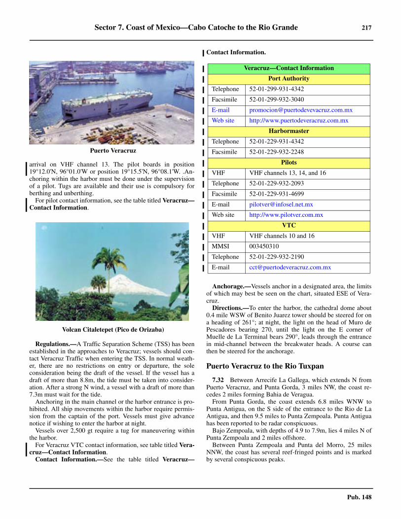
Sector 7. Coast of Mexico—Cabo Catoche to the Rio Grande 217
Pub. 148
arrival on VHF channel 13. The pilot boards in position19°12.0'N, 96°01.0'W or position 19°15.5'N, 96°08.1'W. .An-choring within the harbor must be done under the supervisionof a pilot. Tugs are available and their use is compulsory forberthing and unberthing.7.31 For pilot contact information, see the table titled Veracruz—Contact Information.
7.31 Regulations.—A Traffic Separation Scheme (TSS) has beenestablished in the approaches to Veracruz; vessels should con-tact Veracruz Traffic when entering the TSS. In normal weath-er, there are no restrictions on entry or departure, the soleconsideration being the draft of the vessel. If the vessel has adraft of more than 8.8m, the tide must be taken into consider-ation. After a strong N wind, a vessel with a draft of more than7.3m must wait for the tide.7.31 Anchoring in the main channel or the harbor entrance is pro-hibited. All ship movements within the harbor require permis-sion from the captain of the port. Vessels must give advancenotice if wishing to enter the harbor at night.7.31 Vessels over 2,500 gt require a tug for maneuvering withinthe harbor.7.31 For Veracruz VTC contact information, see table titled Vera-cruz—Contact Information. 7.31 Contact Information.—See the table titled Veracruz—
Contact Information.
7.31 Anchorage.—Vessels anchor in a designated area, the limitsof which may best be seen on the chart, situated ESE of Vera-cruz.7.31 Directions.—To enter the harbor, the cathedral dome about0.4 mile WSW of Benito Juarez tower should be steered for ona heading of 261°; at night, the light on the head of Muro dePescadores bearing 270, until the light on the E corner ofMuelle de La Terminal bears 290°, leads through the entrancein mid-channel between the breakwater heads. A course canthen be steered for the anchorage.
Puerto Veracruz to the Rio Tuxpan
7.32 Between Arrecife La Gallega, which extends N fromPuerto Veracruz, and Punta Gorda, 3 miles NW, the coast re-cedes 2 miles forming Bahia de Veragua.7.32 From Punta Gorda, the coast extends 6.8 miles WNW toPunta Antigua, on the S side of the entrance to the Rio de LaAntigua, and then 9.5 miles to Punta Zempoala. Punta Antiguahas been reported to be radar conspicuous.7.32 Bajo Zempoala, with depths of 4.9 to 7.9m, lies 4 miles N ofPunta Zempoala and 2 miles offshore.7.32 Between Punta Zempoala and Punta del Morro, 25 milesNNW, the coast has several reef-fringed points and is markedby several conspicuous peaks.
7.31Puerto Veracruz
7.31Volcan Citaletepet (Pico de Orizaba)
Veracruz—Contact Information
Port Authority
Telephone 52-01-299-931-4342
Facsimile 52-01-299-932-3040
E-mail [email protected]
Web site http://www.puertodeveracruz.com.mx
Harbormaster
Telephone 52-01-229-931-4342
Facsimile 52-01-229-932-2248
Pilots
VHF VHF channels 13, 14, and 16
Telephone 52-01-229-932-2093
Facsimile 52-01-229-931-4699
E-mail [email protected]
Web site http://www.pilotver.com.mx
VTC
VHF VHF channels 10 and 16
MMSI 003450310
Telephone 52-01-229-932-2190
E-mail [email protected]
218 Sector 7. Coast of Mexico—Cabo Catoche to the Rio Grande
Pub. 148
7.32 Pico Zempoala (19°33'N., 96°27'W.), the S peak, is 701mhigh and stands about 10 miles NW of Punta Zempoala. LosDos Antriscos, a peak 799m high, rises 5 miles SW of Puntadel Morro. A bare chimney rock, 267m high and prominent, islocated 2 miles WNW of Punta Penon, which lies 9 milesNNW of Punta Zempoala.
7.32 Isla Bernal Chico (19°40'N., 96°23'W.), 44m high, liesclose offshore, 12 miles NNW of Punta Zempoala. A promi-nent bare rocky hill, over 90m high, stands on the coast 1.8miles WSW of this island.7.32 The coast between Punta Gorda and the Rio Nautla, 30 milesNW, and the Rio Tecolutla lying 18 miles farther NW, is front-ed by a narrow thickly-wooded strip of land paralleled by anarrow lagoon. A range of hills rises 5 miles inland.7.32 Dos Hermanos (20°06'N., 96°52'W.), a conspicuous peak,rises to an elevation of 357m about 9 miles SSW of the RioNautla. Cerro Burras stands about 9 miles SW of the Rio Teco-lutla. A dangerous wreck lies 4 miles E of the N side of themouth of the Rio Tecolutla.7.32 Between the Rio Tecolutla and Punta de Piedras, a reef-fringed point located 25 miles NW, several rivers discharge in-to the gulf from the lagoon which backs the coast.7.32 Between Punta de Piedras and the Rio Tuxpan, 9 miles NW,the coast is 30m high.
7.33 The Rio Tuxpan (20°58'N., 97°19'W.) has a maxi-mum depth of 4.9m over the bar and is fronted by breakwaterswhich extend 0.3 mile offshore from the entrance points. With-in the bar, the depths increase considerably. The least depth, asfar as the town of Tuxpan, is 2.7m. Vessels with drafts up to2.1m can proceed as far as 36 miles above the entrance. 7.33 Depths—Limitations.—Situated 5 miles above the entranceto the river, Tuxpan consists of Fiscal Wharf and two additionalwharves. For berthing Information refer to the Rio Tuxpan—Berth Information. 7.33 Aspect.—Several tall stacks and oil tanks standing on thebanks of the river are conspicuous from seaward. 7.33 Pilotage.—Pilotage is compulsory. The pilot boards in posi-tion 20°59'50.4''N, 97°15'00.6''W. Vessels should send an ETAat least 24 hours in advance.7.33 Movements into and out of the port are restricted to daylighthours. Vessels up to a maximum length of 190m can be han-
dled.
7.33 For pilot contact information, see the table titled Rio Tux-pan—Contact Information. 7.33 Contact Information.—For contact information, see tabletitled Rio Tuxpan—Contact Information.
7.33 Anchorage.—The anchorage area for vessels awaitingberths is centered about 4 miles E of Rio Tuxpan North Light.7.33 Anchorage can be taken off the river entrance, in a depth of13m, mud, with the lighthouse bearing 234° keeping well clearof the charted anchorage prohibited area. The currents arestrong and unpredictable off the river entrance.
Rio Tuxpan—Contact Information
Port Authority
VHF VHF channel 17
Telephone 52-01-783-102-3030
Facsimile 52-01-783-102-3055
Web site http://www.puertotuxpan.com.mx
Harbormaster
Call sign Tuxpan Port
VHF VHF channels 12 and 16
Telephone52-01-783-837-0250
52-01-783-837-0063
E-mail [email protected]
Pilots
Call sign Tuxpan Pilot
VHF VHF channels 13 and 71
Telephone52-01-783-837-0559
52-01-783-837-0437
Facsimile 52-01-783-837-0558
Rio Tuxpan—Berth Information
Berth Length Depth Remarks
Fiscal Wharf 60m 4.9m Petroleum products.
Container 300m 11.0m —
Tanker Berths
Exxon Mobile 80m 5.5m Chemicals and lubricants.
Mulle de Pemex 90m 6.6m Bulk liquid.
Offshore Tanker Berths
North Berth — 12.1m Petroleum. Located 2.0 miles offshore. Vessels moor to five buoys.
South Berth — 10.9m Petroleum. Located 1.5 miles offshore. Vessels moor to four buoys.
Sector 7. Coast of Mexico—Cabo Catoche to the Rio Grande 219
Pub. 148
7.33 Directions.—Vessels from the S can approach the coast towithin 5 miles and sight the previously-mentioned landmarks.7.33 A vessel approaching from the N should pass E and S of Ba-jo de Tuxpan and approach with Tuxpan Light bearing 257°.Bajo de Tuxpan is clearly visible by day in clear weather. Inhazy visibility, when the lights are visible, a vessel should keepin depths of 27m or greater, anchor, and then await clear weath-er.7.33 Caution.—The navigational lights at the river entrance arehard to identify and may often be confused with the numerouslights of fishing vessels found in the vicinity.
The Rio Tuxpan to Tampico
7.34 Between the Rio Tuxpan and Cabo Rojo, the lowcoast extends NW for a distance of 19 miles, then NNE an ad-ditional 18 miles, forming a bight called Puerto Lobos. Thisbight provides some protection from the northers which blowwith considerable strength during the winter. A vessel with lo-cal knowledge can ride out the gale by using both anchors.
Cabo Rojo (21°33'N., 97°20'W.), a blunt headland com-posed of sand hills, 11m high, is bordered by a reef which ex-tends 1.8 miles E from it. There are general depths of 18 to46m lying about 4 to 5 miles offshore. 7.34 The coast extends NW for a distance of 49 miles from CaboRojo to the Rio Panuco, then 160 miles N and an additional 67miles NNE to the Rio Grande. In general, the coast is com-posed of sand dunes and wooded hummocks. Mountain rangeswith conspicuous peaks lie farther inland along the S part ofthis coast. Several extensive lagoons, separated from the coastby narrow strips of land, lie along this section and through itseveral rivers discharge into the gulf.7.34 Tampico, a major oil port, lies within the entrance of the RioPanuco. 7.34 The 20m curve lies 4 miles E of Cabo Rojo and follows thecoast 2 to 5 miles offshore to a position lying 9 miles E of theRio Grande.7.34 With the following exceptions, all of the dangers lie withinthe 20m curve and are described under the principal descrip-tion of the coastal features:
1. An obstruction reported (1921) to exist about 32 milesE of the mouth of the Rio Panuco
2. A shoal, with a depth of 10m, lying 25 miles E of theentrance to Tampico harbor.
3. An isolated 2.5m shoal lying 5 miles SSE of the en-trance to Tampico harbor.
7.34 During the winter, the current sets N; they set in the oppositedirection during the summer. About 15 to 20 miles offshore,the current generally sets N at a rate of 1 knot. The winds areESE from August to April and E from April to June. Duringthe summer, the land breezes blow from midnight to 0900 and
then yield to the sea breezes as far N as 26°N, where the moun-tain ranges terminate.7.34 Between Cabo Rojo and the Rio Panuco, 49 miles NW, thecoast is bordered by a narrow strip of land, 100m to 5 mileswide, fronting Laguna de Tamiahua. Canal del Chijol crossesthis lagoon and is frequented by small craft going from Tuxpanto Tampico. The sand hills backing the coast 4 miles N of CaboRojo are 21m high and rise to heights of 106m about 18 milesfarther N. The coast then becomes very low as far N as the RioPanuco.
7.35 Bajo Blake (20°45'N., 96°58'W.), a shoal with adepth of 9m, lies 13 miles SE of Punta de Piedras.7.35 An obstruction was reported (1923) to lie about 13 milesENE of Punta de Piedras. A depth of 7m was reported (1967)to lie the same distance ESE of the same point. The existenceof the 8.9m shoal reported to lie 18 miles NE of Punta de Pie-dras is doubtful. A depth of 7.5m lies 3.3 miles NNW of BajoBlake.
Arrecife Tuxpan (21°01'N., 97°12'W.), a small steep-to reefwith a low cay on it, lies 6 miles ENE of the Rio de Tuxpan. Alight, with a racon, is shown on the S side of the reef.7.35 Arrecife Enmedio, a small reef, lies 3 miles NW of ArrecifeTuxpan.7.35 Arrecife Tanguijo, a small steep-to drying reef, lies 7 milesNW of Arrecife Tuxpan. A light is shown from the NW part ofthe reef. The passages between the above reefs are clear of anyknown dangers.7.35 Caution.—A submerged wreck lies about 5.7 miles E of theTuxpan breakwater and about 2.4 miles S of Arrecife TuxpanBajo Centro light. 7.35 Isla Lobos (21°28'N., 97°13'W.), a small islet 9m high, lies9 miles SE of Cabo Rojo. A reef extends 1 mile N from it. Alight, with a racon, is shown from the SW tip of the island.7.35 Arrecife Medio, a small steep-to reef marked by a light, lies3 miles NW of Isla Lobos Light.7.35 Arrecife Blanquilla, a breaking reef with a drying sandbankon it, lies 6 miles NW of Isla Lobos. A light stands on the reef.7.35 The passages between the above reefs have depths of 17.4 to51m, but the passage between Arrecife Blanquilla and the coastnear Cabo Rojo (21°33'N., 97°20'W.) is of doubtful safety, asthe soundings are irregular.7.35 The currents off this coast are variable, uncertain, and usual-ly dependent on the force and direction of the wind.7.35 The coastal current usually sets S in the winter and N in thesummer.7.35 The trade winds blow from NE to ESE. After the season ofthe northers, from October to March, there are light N breezes,calms, squally rains, and intermittent thick weather up to themiddle of August, when the trades resume again.
Deep Sea Buoy — 18.2m One SBM located in position 21°01’18''N, 97°15'45''W. Two subma-rine pipelines used for loading.
Rio Tuxpan—Berth Information
Berth Length Depth Remarks

220 Sector 7. Coast of Mexico—Cabo Catoche to the Rio Grande
Pub. 148
Tampico (22°13'N., 97°52'W.)
World Port Index No. 9360
7.36 Tampico consists of the lower reaches of the Rio Pa-nuco, from a position lying 1 mile E of the breakwater heads,for a distance of 15 miles to a position lying 9 miles above Ciu-dad de Tampico. This city stands on the N bank of the riverabout 5 miles above the entrance. The port, an important centerof the petroleum industry, has a considerable commercial trade.Ample berthing facilities are available to handle all classes ofvessels alongside the river wharves.
7.36 Winds—Weather.—Hot SW winds blow in the months ofMarch and April and usually begin about 1100 and sometimeslast until 1500 or 1600, and then back to the ESE.7.36 Northers are frequent during the winter season and usuallylast 8 to 24 hours. At such times the port is closed.7.36 Tides—Currents.—The tides are irregular and in the vicini-ty of the bar are greatly affected by the prevailing winds andthe rate of discharge from the Rio Panuco. The maximum riseabove MLW is about 0.6m.7.36 The general current in the Gulf of Mexico begins to be feltbetween S and SE about 1.5 miles offshore.7.36 The Rio Panuco current, when the river is in flood, attains avelocity of 8.5 knots between the sea walls and a velocity of 6knots in the upper reaches. Normally, the current in the riverflows at a rate of 3 knots.7.36 Depths—Limitations.—The depths in the approaches aresubject to frequent changes and vessels should not enter with-out a pilot.7.36 Uncharted dangers are reported to lie within 3 miles of thecoast to the S and within 2 miles of the coast to the N of themouth of the Rio Panuco. Considerable shoaling has been re-ported to extend up to 3 miles from the S breakwater. 7.36 A channel, 110m wide, leads across the bar and midway be-tween the breakwaters into the river. The entrance bar has acontrolling depth of 11m and is maintained by dredging.During the rainy season when the river is flooding, this depthwill decrease due to heavy silting.7.36 The principal wharves are situated on the N bank of the river.The public wharves provide about 850m of berthage; the pri-vate wharves provide about 2,285m of berthage.7.36 A mineral ore-loading berth is situated on the N bank close S
of Tampico Light.7.36 Ciudad Madero, on the N bank about 1.5 miles within theriver, is the principal oil terminal.
7.36 Fiscal Wharf, a general cargo berth, lies on the S side of thecity. It is situated 6 miles within the entrance and has nineberths. 7.36 Puente Tampico, with a vertical clearance of 48m, crossesthe river about 1.5 miles SW of the entrance to Canal del Chi-jol. For berthing information see the table titled Tampico—Berth Information. 7.36 Aspect.—The harbor area may be identified by the numer-ous chimneys and tanks of the oil refineries. The hills to the Sof the river are grass-covered and higher than those to the N,which are composed of whitish-gray sand. On closer approach,Tampico Light, standing on the N side of the river entrance,and the light structures situated on the breakwater heads will besighted.
7.36 Pilotage.—Pilotage is compulsory for all foreign vessels,and optional for Mexican vessels under 500 gt. Vessels may an-chor there while awaiting the pilot. Pilots board in position22°16.3'N, 97°44.8'W. Vessels should send their ETA and re-quest for pilots 48 hours prior to arrival or 24 hours if arrivingfrom another Mexican port.
Tampico Home Page
http://www.puertodetampico.com.mx
Tampico—Contact Information
Port Authority
Telephone 52-01-833-241-1400
E-mail [email protected]
Web site www.puertotuxpan.com.mx
Harbormaster
VHF VHF channels 14 and 16
Telephone 52-01-833-214-2460
Facsimile 52-01-833-219-2348
Pilots
VHF VHF channels 12, 14, and 16
Telephone52-01-833-212-4749
52-01-833-214-1728
Facsimile 52-01-833-212-7305
E-mail [email protected]
Tampico—Berth Information
Berth Length DepthMaximum Vessel
RemarksLOA Beam
PEMEX 102m 10.9m — — Petroleum products
CEMEX Wharf No. 2 500m 8.5m — — Cement, clinkers, and lime
Minera Autian 160m 6.7m — — Bulk minerals
PROTAMSA 180m 9.1m — — Agri-bulk, cement, and timber

Sector 7. Coast of Mexico—Cabo Catoche to the Rio Grande 221
Pub. 148
7.36 For pilot contact information, see the table titled Tampico—Contact Information.7.36 Contact Information.—For contact information, see tabletitled Tampico—Contact Information.7.36 Anchorage.—Anchorage can be taken within the river, butpermission must be obtained. Several prohibited anchorage ar-eas, which may be best seen on the chart, lie in the approaches.7.36 Directions.—Vessels should enter with the lighted rangebeacons bearing 256°30', keeping a little N of the range toavoid the shoals. The current sets N across the entrance attimes and vessels should enter at a sufficient speed to offset it.7.36 Caution.—The smoke from the refineries may make themain white light appear red when the wind is from the SW andthe humidity is high.7.36 Several offshore platforms stand about 18 miles E of the en-trance to the Rio Panuco. A number of submarine pipelines liein this area and extend W to the shore.7.36 A fish haven marked by a lighted buoy was reported (2004)
to be situated about 11 miles NNE of La Barra Light.7.36 It has been reported (2008) that a sand bank in the mouth ofthe Rio Panuco has reduced the depth in Puerto de Tampico to8.68m at high tide.
Tampico to the Rio Grande
7.37 Altamira (22°25'N., 97°55'W.), a general cargo ter-minal, is situated 14 miles NNW of La Berra Light. It consistsof a wet dock with berths for 16 vessels. The controlling depthin the approaches is 12.5m. There is a marginal quay, 250mlong, with a depth alongside of 13m and ro-ro facilities. 7.37 The port handles bulk, container, and general cargo. Vessels
Termimar 240m 9.1m — — Bulk minerals
Del Golfo 500m 6.1m — — Agri-bulk
Tergosa Public Terminal Docks No. 1-9 1,586m 10.0m — — Containers, general cargo, and vehicles
Docks No. 10-11 576m 10.0m — — General cargo and molassas
Docks No. 14-19 — 9.1m — — —
Dock No. 4, Berth No. 1 219m 10.0m — — Cruise ships
Terminal Maritima Madero
M-1 105m 11.5m 237m 32m Petroleum products
M-2 70m 11.5m 237m 32m Petroleum, LPG, and aviation fuel
M-3 70m 11.5m 237m 32m Petroleum
M-4 70m 11.5m 237m 32m Petroleum
M-5 70m 11.5m 237m 32m Petroleum
Altimir Gas — 9.0m — — Maximum draft of 9.1m
Oil Petrochemical 240m 8.8m 121m — —
Tampico—Berth Information
Berth Length DepthMaximum Vessel
RemarksLOA Beam
7.36Tampico
7.36Tampico—from W to E toward breakwater

222 Sector 7. Coast of Mexico—Cabo Catoche to the Rio Grande
Pub. 148
up to 50,000 dwt, 210m in length, and 10m draft can be accom-modated. 7.37 Pilotage.—Pilotage is compulsory. The pilot boards at posi-tion 22°29.5'N, 97°48.4'W. Pilots will establish contact 1 hourprior to arrival on VHF channel 14. If communication is not es-tablished, vessels should contact the pilots via Tampico Radio. 7.37 Regulations.—Vessels should send their ETA 48 hours priorto arrival and confirm 2 hour prior. Vessels arriving from portsless than 24 hours away should send their ETA 12 hours priorto arrival. 7.37 Contact Information.—For contact information, see tabletitled Altamira—Contact Information.7.37 Anchorage may be obtained NE and SE of the breakwaters
and clear of the precautionary area, within a 2-mile radius ofthe Altamira Lighted Buoy.
7.36Tampico—N shore of the Rio Panuco
7.36Tampico Light
7.36La Pesca Light
7.37Altamira Light (foreground) and breakwater
Altamira—Contact Information
Port Authority
Telephone 52-01-833-260-6063
Facsimile 52-01-833-260-6072

Sector 7. Coast of Mexico—Cabo Catoche to the Rio Grande 223
Pub. 148
7.38 Between Tampico and Barra de Chavarria and Barrade La Trinidad, two shallow lagoon entrances lying 23 and 30miles N, the coast is backed by wooded hills, about 60m high.A 5.5m shoal patch was reported (1912) to lie about 9 miles Nof the Tampico harbor entrance. An obstruction was reported(1928) to lie 17 miles N of the Tampico harbor entrance. Shal-low water lies up to 1.5 miles offshore between the entrances tothe lagoons.
7.38 Cerro Metate (22°47'N., 97°58'W.), a flat-topped hill, 264mhigh, is located 32 miles NNW of Tampico.7.38 Between Barra de La Trinidad and Barra del Torda, a shal-low lagoon entrance lying 18 miles N, the coast is low and san-dy. Some rocks lie up to 2 miles offshore in places.7.38 Between Barra del Torda and the Rio Indios Morales(23°24'N., 97°46'W.), 28 miles N, the coast is backed by wood-ed hummocks, 21m high. La Pesca (23°46'N., 97°44'W.) is afishing harbor located at the entrance to Rio Soto la Marina. 7.38 From abreast Punta Jerez, a range of hills, Sierra de San Josede Las Rusias, extends 52 miles N at a distance of 7 to 12 milesinland. A conspicuous sugarloaf peak is located 18 miles SWof the Rio Indios Morales.7.38 The coast between the Rio Indios Morales and the Rio SotoLa Marina, 21 miles N, is bordered by a narrow strip of landthat fronts a lagoon.7.38 Between the Rio Soto La Marina and Boquillas Cerradas(25°02'N., 97°30'W.), 77 miles N, and the Rio San Fernando,25 miles farther NNE, the coast is bordered by a strip of land 1to 5 miles wide fronting Laguna de La Madre. The high hills inthe interior terminate 24 miles N of the Rio Soto de La Marina.7.38 A shoal, 3 miles in extent, lies 25 miles N of the Rio Soto LaMarina. It is located about 2 miles offshore and has a leastdepth of 4.6m. 7.38 Boquillas Cerradas are four nearly closed entrances of Lagu-na de La Madre.7.38 The Rio San Fernando (25°23'N., 97°23'W.), with a depthof 0.9m on the bar, drains a lagoon in the interior.7.38 A shoal, 3 miles long, with a least depth of 3m, lies with its Send located 5 miles N of the Rio San Fernando and about 3miles offshore.7.38 The Rio Grande (25°58'N., 97°09'W.), lying 36 miles N ofthe Rio San Fernando, forms the boundary between the UnitedStates and Mexico. By international agreement, the river isclosed to navigation.
E-mail [email protected]
Web site http://www.puertoaltamira.com.mx
Harbormaster
VHF VHF channels 12 and 16
Telephone 52-01-833-260-1052
Facsimile 52-01-833-260-1002
Pilots
Call sign Altamira Pilots
VHF VHF channel 14
Telephone 52-01-833-260-9123
Facsimile 52-01-833-260-9123
Tampico Radio
VHF VHF channels 12, 16, 26, and 27
RT Frequency 2182 (kHz)
VTS
Call sign Altamira Traffic
VHF VHF channel 17
Altamira—Contact Information
Pub. 148
Glossaries 225Glossaries
Dutch
DUTCH English
Aaan .......................................................................at, near, on
Bbaak .......................................................................... beaconberg................................................................. mountain, hillbinnen,......................................................................... innerblauwe ........................................................................... bluebol ................................................................................. ballboom ............................................................................. treebocht.............................................................bay, bend, lightbosch .......................................................................... forestboschje ................................................... small wood, brushbreed ........................................................................... broadbrug ........................................................................... bridgebuiten............................................................................ outerbult ............................................................................. hump
Ddam.............................................................dam, breakwaterde, den .............................................................................thediep............................................................................... deepdijk ................................................................................ dikedorp ...........................................................................villagedraaikalk....................................................................... eddydrempel .......................................................................... bardric .............................................................................. threedrichoek................................................................... triangledroogte ........................................................................ shoalduin ................................................................ dune, sandhilldwars ........................................................... across, athwart
Eeiland.......................................................................... island
Ffriesche...................................................................... frisian
Ggat ............................................................................ channelgeul...............................................................narrow channelgroei ............................................................................greengronden ...................................................................groundsgroot ............................................................................ great
Hhaven ......................................................................... harborhelft ............................................................................... halfhet.................................................................................... theheuvel ............................................................................. hillhoek ....................................................................cape, pointhoofd ............................................................................ headhoog.............................................................................. high
Kkaap ...............................................................cape, headlandkake ..............................................................................quaykegel ............................................................................. conekil ............................................................................ channelklein .............................................................................smallklip ............................................................................... rockkop ................................................................................headkreek ............................................................................creekkromme ....................................................................crookedkust .............................................................................. coast
Llaag, lage ........................................................................ lowlang ...............................................................................longlicht .............................................................................. lightloods ............................................................................. pilotloodswezen .............................................................pilotage
Mmeer ......................................................................inland seamiddel, midden ......................................................... middlemodder .......................................................................... mudmolen ............................................................................ mill
Nnauw ........................................................................narrowsnieuw ............................................................................. newnoord ........................................................................... northnoorder ................................................................... northern
Ooost ................................................................................ eastoud ..................................................................................old
Ppeilschaal .............................................................. tide gageplaat ............................................................................. shoalplaatje..................................................................small shoalplat ................................................................................. flatpolder ........................................................... reclaimed landpunt ............................................................................. point
Rrak ........................................................................... channelrechthoekig ........................................................rectangularreddingboot ............................................................. lifeboatrede ...................................................................... roadsteadrode, rood........................................................................ redrots .............................................................................. rocksrug ............................................................................... ridgeruitvormig ................................................. diamond-shaped
Sschaar ...................................................................... channelscherm ....................................................................... screenschor ............................................................................ shoal schutaluis ............................................................... lock gateseinen ........................................................................signalssluis ...............................................................................locksmal .......................................................................... narrowspits, spitse ...............................................................pointedspoorweg ..................................................................railwaystaart ............................................................. tail (of a bank)stad ...............................................................................townsteen ............................................................................ stone steiger ....................................................................jetty, piersteile ............................................................................ steepstrand ................................................................beach, shorestroom ..........................................................current, stream
Ttoegang ...................................................................... accesstramweg .................................................................tramway
U
uit .................................................................................... out
DUTCH English
Pub. 148
226 Glossaries
Vvaart ............................................................................. canalvaarwater ................................................................. fairwayvalsch ........................................................................... falsevan ................................................................................... ofveerboot........................................................................ ferryverklikker ....................................................... warning lightvlakte ....................................................... flat below surfacevliegtuigen ................................................................aircraft
Wwad ....................................................... drying coastal bankwal...................................................................... banks, wall
DUTCH English
watergetijden .................................................... tidal currentwaterweg .............................................................. waterwayweg ................................................................................ waywerk .............................................................................workwester ...................................................................... westernwit, witte ..................................................................... whitewrak ........................................................................... wreck
Z
zand .............................................................................. sandzee ...................................................................................seazeegat ....................................................................... estuaryzuid ............................................................................. south
DUTCH English
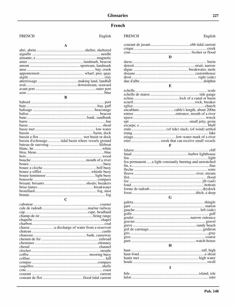
Pub. 148
Glossaries 227
French
FRENCH English
Aabri, abrite ..................................................shelter, shelteredaiguille ....................................................................... needleaimante, e ...............................................................magneticamer ......................................................... landmark, beaconamont ....................................................upstream, landmarkanse ...................................................................... bay, creekappontement.............................................. wharf, pier, quayargile .............................................................................. clayatterrissage ..........................................making land, landfallaval ..................................................... downstream, seawardavant port ..............................................................outer portazur.................................................................................blue
Bbabord ............................................................................ portbaie..........................................................................bay, gulfbalisage ................................................................beaconagebalise ......................................................................... beaconbanc..............................................................bank, sandbankbarre .................................................................................barbasse............................................................................. shoalbasse mer............................................................... low waterbassin ................................................................. basin, dockbassin a flot .............................................. wet basin or dockbassin d'echouage..............tidal basin where vessels groundbateau de sauvetag ................................................... lifeboatblanc, he .......................................................................whitebleu, bleue......................................................................bluebois...............................................................................woodbouche.........................................................mouth of a riverbouee.............................................................................buoybouee a cloche........................................................bell buoybouee a sifflet ................................................... whistle buoybouee lumineuse .................................................. light buoyboussole ..................................................................compassbrisant; brisants ........................................... shoals; breakersbrise-lames ..........................................................breakwaterbrouillard................................................................ fog, mistbrume .............................................................................. fog
Ccaboteur..................................................................... coastercale de radoub ...............................................marine railwaycap.................................................................cape, headlandchamp-de-tir....................................................... firing rangechapelle ...................................................................... chapelcharbon........................................................................... coalchasse .........................a discharge of water from a reservoirchateau .........................................................................castlechaussee ...................................................... bank, causewaychemin de fer ........................................................... railroadcheminee ................................................................. chimneychenal ....................................................................... channelclocher........................................................................steeplecoffre .............................................................. mooring buoycolline.............................................................................. hillcompas ....................................................................compasscoquilles .......................................................................shellscote............................................................................... coastcourant ...................................................................... currentcourant de flot ..........................................flood tidal current
courant de jusant.........................................ebb tidal currentcrique ........................................................................... creekcrue .............................................................. freshet or flood
Ddarse............................................................................. basindetroit...............................................................strait, narrowdigue ......................................................... breakwater, moledouane.............................................................. customhousedroit..................................................................... right (side)due d'albe ..................................................................dolphin
Eechelle...........................................................................scaleechelle de maree .................................................. tide gaugeecluse ...............................................lock of a canal or basinecueil................................................................rock, breakereglise.......................................................................... churchencablure.................................... cable's length, about 200mentree ...........................................entrance, mouth of a riverepave ........................................................................... wreckepi .............................................................. small jetty, groinescarpe, e ...................................................................... bluffetale.................................... (of tide) slack; (of wind) settledetang .............................................................................. lakeetiage............................................ low-water mark of a riveretier .............................. creek that can receive small vessels
Ffalaise............................................................................. clifffanal ..........................................................harbor lighthousefeu ..................................................................................lightfeu permanent .....a light constantly burning and unwatchedfin, e ................................................................................finefleche ............................................................................ soirefleuve ................................................................ river, streamflot............................................................................... .floodfoc ........................................................................... jib (sail)fond............................................................................bottomforme de radoub.......................................................drydockfosse ..................................................................ditch, a deep
Ggaleta......................................................................... shinglegare ............................................................................ stationgauche................................................................... left (side)golfe ............................................................................... gulfgoulet .......................................................... narrow entrancegravier ......................................................................... gravelgreve ................................................................. sandy beachgril de carenage........................................................ gridirongris .................................................................................graygros .............................................................................coarseguet ...................................................................watch-house
Hhaut .........................................................................tall, highhaut-fond....................................................................a shoalhaute mer .............................................................high waterhoule ............................................................................ swell
I
hile .......................................................................island, islehilot................................................................................ islet
FRENCH English

Pub. 148
228 Glossaries
Jjaune...........................................................................yellowjetee................................................................................jettyjusant...............................................................................ebb
Llac................................................................................... lake
Mmadrague................................................................tunny netmarias.............................................................swamp, marshmaree...............................................................................tidemaree descendante .............................................. falling tidemaree montante.....................................................rising tidemassif ........................................... main group of mountainsmat ................................................................................ mastmole ..................................................................... mole, piermortes eaux ...........................................................neap tidesmouillage ............................................................. anchoragemoulin ............................................................................ millmusoir .....................................................................pierhead
Nniveau............................................................................ levelnoeud..............................................................................knotnoir, noire .....................................................................blacknouveau, nouvel ............................................................. new
Ooccidental, e ............................................................. westernonde.............................................................................. waveoriental, e .................................................................. easternouest .............................................................................. west
Ppasse.................................................. pass, fairway, channelpatente de sante................................................ bill of healthpertuis......................................................... opening or straitpetit, e........................................................................... smallphare.................................................................... .lighthousepic.................................................................................. peakpierre ............................................................................ stonepin ..................................................................pine or fir treeplage..................................................................shore, beachplateau....................................tableland, or flat below waterpleine mer ............................................................high water
FRENCH English
pointe ............................................................................pointpont ................................................................... bridge, deckpresq'ile..................................................................peninsula
Qquai .................................................................... quay, wharf
Rrade .............................................................. road, roadsteadrafale ........................................................................... squallraz (bas breton) ........ a name given to a violent tidal currentrecif.................................................................................reefressac ............................................................................. surfroche ..............................................................................rockrocher ........................................rock, generally above waterrouge ................................................................................redruisseau .......................................................................rivulet
Ssable ...............................................................................sandsalines ................................... salt-water lagoons, salt worksseche ............................................................... dry shelf, flatseuil........................................................... sill (as of a dock)sud................................................................................ south
Ttemps............................................................... time, weathertenue ............................................................ holding groundterre-plein ..................................... leveled ground, platformtete ............................................................................... headtour............................................................................... towertourelle .....................................................small tower, turrettribord .................................................................... starboard
U
usine...........................................................................factoryV
val ................................................................... narrow valleyvase ................................................................................mudvasiere ................................................................... mudbankvent ...............................................................................windvert ............................................................................... greenvieux, vieil, vieille ............................................. old, ancientville ............................................................................... townvive-eau................................................................spring tide
FRENCH English

Pub. 148
Glossaries 229
Spanish
SPANISH English
Aabrigo ........................................................................ shelteraduana ............................................................. customhouseaguas muertas........................................................neap tidesaguas vivas ......................................................... spring tidesaguja.......................................................................... needlealbufera .................................................................. tidal lakealdea ................................................. small village, a hamletalfaque............................................................ sandbank, baralmadraba.........................................................tunny fisheryalto ............................................................................. heightamarillo ..................................................................... yellowarena............................................................................. sandarrabal ....................................................................... suburbarrecife .......................................................................... reefarroyo ........................................................................ rivuletastillero.................................................................. dockyardatalaya ....................................................... an elevated place
Bbabor ............................................................................. portbahia............................................................................... baybajamar.................................................................. low waterbajo............................................................ shoal, under, lowbaliza........................................................................ beaconbanco............................................................................ bankbarlovento ............................................................ windwardbarra ............................ bar at the mouth of a river or harborbarrio.............................................suburb, district of a townblanco.......................................................................... whitebote sal avidas .......................................................... lifeboatboya.............................................................................. buoybraza......................................................................... fathombrujula .................................................................... compassbruma ..................................................................... fog, hazebuque............................................................................. ship
Ccabezo ......................................................... summit of a hillcabo............................................................cape or headlandcala .......................................................... creek or small baycaleta ............................................................................ covecamino de hierro ...................................................... railwaycampanario..................................................... steeple, belfrycanal ............................................................channel or straitcapilla........................................................................ chapelcarabineros ........................... a post of military coast guardscarbon de piedra............................................................ coalcarrazon............................................... dark, cloudy weathercarta de sanidad................................................ bill of heallhcasa............................................................................. housecascada .................................................................. waterfallcascajo........................................................................ gravelcaserio ......................................................... series of housescaseta..................................................................small housecastillo..........................................................................castlecerro ................................................................................ hillchico............................................................................. smallciudad.................................................................... city, townco......................................................................... rock, shoalconcha ........................................................................ a shellcontrastes ............... winds blowing from opposite direction
cubierta ......................................................................... deckcueva ............................................................................. cave
Ddarsena............................................................ dock or basindique .................................................................... dock, dikedique seco ............................................................... drydockdraga ........................................................................ dredger
Eensenada ........................................................... bay or creekermita ................................................................... hermitageescollo........................................................................... rockespigon..............................................a kind of wharf or pierestero...................................................................small creekestrecho........................................................................ straitestribor ................................................................... starboard
Ffanal .................................................................... lighthousefango ............................................................................. mudfaro................................................................................ lightferrocarril ................................................................. railwayfondeadero .......................................................... anchoragefondo............................................................ bottom, groundfraile.............................................................................. friarfreo............................................................................... straitfuente ............................................ fountain, spring of waterfuerte.............................................................................. fort
Ggarita .............................................................. lookout housegolfo............................................................................... gulfgrande .......................................................................... greatgris ................................................................................ gray
Iiglesia........................................................................ churchisla.............................................................................. islandislote ............................................................................. islet
Llago ............................................................................... lakelaguna ....................................................................... lagoonlaja .......................................................................... flat rocklimo............................................................................... mudlugar .................................................... village or small townluz ................................................................................. light
Mmalecon.......................................................................... dikemarea .............................................................................. tidemarea creciente ..................................................... flood tidemarea menguante..................................................... ebb tidemeridional............................................................... southernmesa....................................................................... tablelandmolino............................................................................ millmontana .................................................................mountainmonte ..........................................................................mountmuelle .............................................................. mole or jetty
N
negro ............................................................................ blackniebla ...............................................................................fognorte ............................................................................. north
SPANISH English
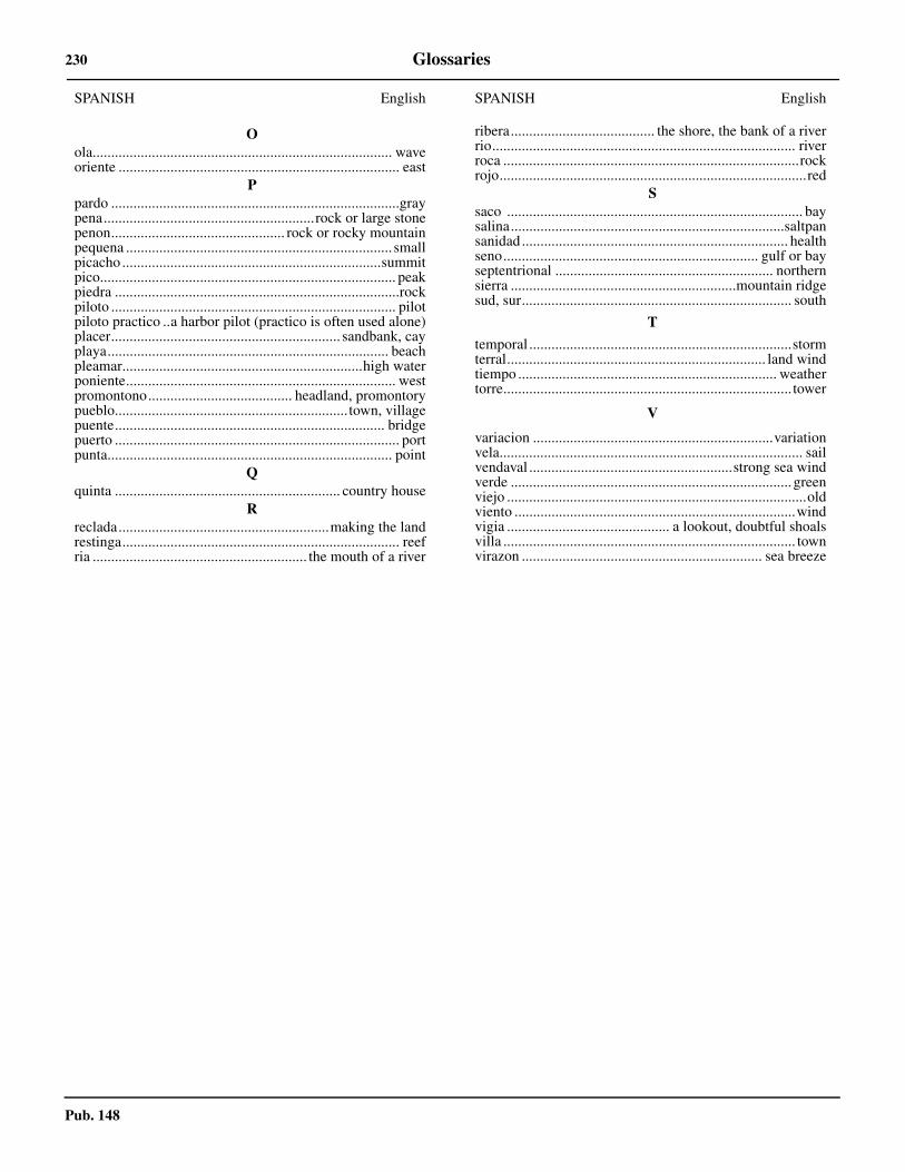
Pub. 148
230 Glossaries
Oola................................................................................. waveoriente ............................................................................ east
Ppardo ..............................................................................graypena.........................................................rock or large stonepenon............................................... rock or rocky mountainpequena ........................................................................ smallpicacho ......................................................................summitpico................................................................................ peakpiedra .............................................................................rockpiloto ............................................................................. pilotpiloto practico ..a harbor pilot (practico is often used alone)placer.............................................................. sandbank, cayplaya............................................................................ beachpleamar.................................................................high waterponiente......................................................................... westpromontono....................................... headland, promontorypueblo............................................................... town, villagepuente......................................................................... bridgepuerto ............................................................................. portpunta............................................................................. point
Qquinta ............................................................. country house
Rreclada.........................................................making the landrestinga........................................................................... reefria .......................................................... the mouth of a river
SPANISH English
ribera....................................... the shore, the bank of a riverrio.................................................................................. riverroca ................................................................................rockrojo...................................................................................red
Ssaco ................................................................................ baysalina..........................................................................saltpansanidad ........................................................................ healthseno..................................................................... gulf or bayseptentrional ........................................................... northernsierra .............................................................mountain ridgesud, sur......................................................................... south
T
temporal .......................................................................stormterral...................................................................... land windtiempo ...................................................................... weathertorre.............................................................................. tower
V
variacion .................................................................variationvela.................................................................................. sailvendaval .......................................................strong sea windverde ............................................................................ greenviejo .................................................................................oldviento ............................................................................windvigia ............................................ a lookout, doubtful shoalsvilla ............................................................................... townvirazon ................................................................. sea breeze
SPANISH English

231
Pub. 148
How to use the Index—Gazetteer
Geographic names of navigational features are generally those used by the nation having sovereignty and are listedalphabetically. Diacritical marks, such as accents, cedillas, and circumflexes, which are related to specific letters in certain foreignlanguages, are not used in the interest of typographical simplicity.
Geographic names or their spellings do not necessarily reflect recognition of the political status of an area by the United StatesGovernment. Positions are approximate and are intended merely as locators to facilitate reference to the charts.
To use as a Gazetteer note the position and Sector number of the feature and refer to the Chart Information diagram for theSector. Plot the approximate position of the feature on this diagram and note the approximate chart number.
To use as an Index of features described in the text note the paragraph number at the right. To locate this feature on the bestscale chart use the Gazetteer procedure above.
Index—Gazetteer
Position° ' ° '
Position° ' ° '
Sec.Para
Sec.Para
AACANDI 8 31 N 77 16 W 4.27ALICE SHOAL 16 05 N 79 18 W 5.58ALMIRANTE 9 18 N 82 24 W 5.20ALTAGRACIA 10 42 N 71 32 W 3.15ALTAMIRA 22 25 N 97 55 W 7.37ALVARADO 18 47 N 95 46 W 7.28ALVARO OBREGON 18 35 N 92 39 W 7.18AMBERGRIS CAY 18 02 N 87 55 W 6.63AMBROSIO BIGHT 9 16 N 82 22 W 5.18AMUAY 11 45 N 70 14 W 3.4ANCON DE TAGANGA 11 16 N 74 12 W 4.9ANTON LIZARDO ANCHORAGE 19 04 N 95 59 W 7.29ARAYA 10 34 N 64 17 W 2.45ARRECIFE ALACRAN 22 29 N 89 42 W 7.3ARRECIFE ANEGADA DE ADENTRO 19 14 N 96 04 W 7.30ARRECIFE ANEGADA DE AFUERA 19 09 N 95 51 W 7.26ARRECIFE CHOPAS 19 05 N 95 58 W 7.26ARRECIFE DE LA MEDIA LUNA 15 13 N 82 38 W 6.5ARRECIFE MADAGASCAR 21 26 N 90 18 W 7.3ARRECIFE SANTIAGUILLO 19 09 N 95 48 W 7.26ARRECIFE SISAL 21 21 N 90 09 W 7.11ARRECIFES TRIANGULOS 20 57 N 92 14 W 7.5ARROWSMITH BANK 21 05 N 86 25 W 6.83ARUBA 10 30 N 70 00 W 2.21AUIAPUNI REEF 14 31 N 83 05 W 5.41AVE DE BARLOVENTO 11 58 N 67 26 W 2.9AVE DE SOTAVENTO 12 00 N 67 40 W 2.9AYO SUCIO 21 25 N 86 53 W 6.84
BBAAI VAN VALENTIJN 12 07 N 68 56 W 2.17BACHAQUERO 9 57 N 71 10 W 3.23BAHIA CATALINA 13 23 N 81 23 W 5.52BAHIA CHUSPA 10 37 N 66 20 W 2.59BAHIA CISPATA 9 25 N 75 47 W 4.23BAHIA CRUZ 10 16 N 64 27 W 2.49BAHIA DE AMATIQUE 15 56 N 88 44 W 6.39BAHIA DE AMUAY 11 45 N 70 14 W 3.4BAHIA DE COMONA 10 15 N 64 32 W 2.49BAHIA DE LA ASCENSION 19 41 N 87 30 W 6.73BAHIA DE LAS MINAS 9 24 N 49 49 W 4.36BAHIA DE MANGLE 10 56 N 64 10 W 2.41BAHIA DE MOIN 10 00 N 83 05 W 5.23BAHIA DE MUJERES 21 13 N 86 46 W 6.82BAHIA DE PERTIGALETE 10 15 N 64 34 W 2.50BAHIA DE PORTETE 12 15 N 71 55 W 4.2BAHIA DE SABANILLA 11 00 N 75 00 W 4.16BAHIA DE SAN ANDRES 12 35 N 81 42 W 5.50BAHIA DE SAN JUANGRIEGO 11 05 N 64 00 W 2.35BAHIA DE TELA 15 47 N 87 27 W 6.32BAHIA DE TRUJILLO 15 58 N 86 00 W 6.25BAHIA DE ZISPATA 9 25 N 75 47 W 4.23BAHIA DEL ESPIRITU SANTO 19 22 N 87 28 W 6.73BAHIA ESTANQUES 11 49 N 70 16 W 3.3BAHIA GUAMACHE 10 53 N 64 05 W 2.39
BAHIA HARAPOS 10 15 N 64 29 W 2.49BAHIA HONDITA 12 24 N 71 44 W 4.2BAHIA LA MAR 10 55 N 63 50 W 2.38BAHIA NOMBRE DE DIOS 9 35 N 79 28 W 4.32BAHIA NORTE 11 02 N 64 05 W 2.36BAHIA PAMPATAR 10 59 N 63 50 W 2.37BAHIA SAN CRISTOBAL 9 37 N 79 30 W 4.32BAJIO CARACA 10 24 N 64 27 W 2.48BAJIO TORTUGA 10 05 N 75 52 W 4.20BAJO ALDEN 9 28 N 79 03 W 4.30BAJO BLAKE 20 45 N 96 58 W 7.35BAJO DE ARAYA 10 39 N 64 18 W 2.45BAJO DE TUXPAN 21 01 N 97 12 W 7.35BAJO GRANDE 10 31 N 71 38 W 3.19BAJO MERSEY 19 11 N 96 06 W 7.30BAJO NUEVO 15 53 N 78 33 W 5.58BAJO NUEVO 21 50 N 92 05 W 7.5BAJO PADUCAH 19 12 N 96 05 W 7.30BAJO PAJARO 11 43 N 72 44 W 4.6BAJO SOLARTE 9 20 N 82 13 W 5.15BAJO VILLEDO 15 45 N 88 37 W 6.39BANCO BURGANO 11 50 N 65 55 W 2.6BANCO CHINCHORRO 18 35 N 87 27 W 6.71BANCO DEL CABO 15 16 N 82 57 W 6.6BANCO PERA 20 42 N 91 56 W 7.6BANCO PROVIDENCIA 15 55 N 86 38 W 6.30BANCO SALMEDINA 15 55 N 87 05 W 6.31BANCO SMITH 16 17 N 86 35 W 6.21BANCO VIVORILLO 15 54 N 83 22 W 6.8BANCOS DE CHAMPOTON 19 23 N 90 50 W 7.13BANCOS DE SABANCUY 19 10 N 91 16 W 7.13BANCOS DE SALMEDINA 10 23 N 75 40 W 4.17BANCOS DEL CABO FALSO 15 32 N 83 03 W 6.7BANCOS INGLESES 21 49 N 91 56 W 7.5BARRA DE PUERTO REAL 18 47 N 91 30 W 7.15BARRA DE TUPILCO 18 26 N 93 25 W 7.21BEACON CAY 15 47 N 79 50 W 5.57BELIZE CITY 17 30 N 88 11 W 6.65BIG CREEK 16 30 N 88 25 W 6.49BLACK BLUFF 11 37 N 83 39 W 5.28BLOWING ROCK 12 02 N 83 02 W 5.31BLUE CHANNEL 14 25 N 82 50 W 5.40BLUE GROUND RANGE 16 48 N 88 09 W 6.57BLUEFIELDS 12 01 N 83 45 W 5.30BOCA BACALAR CHICO 18 11 N 87 52 W 6.70BOCA DE CONIL 21 29 N 87 35 W 7.8BOCA DE HUEVOS 10 41 N 61 42 W 1.22BOCA DE MONOS 10 42 N 61 40 W 1.21BOCA DEL DRAGO 9 25 N 82 20 W 5.16BOCA GRANDE 10 42 N 61 48 W 1.23BOCA PLAJA CANOA 12 11 N 68 52 W 2.15BOCA SANTA CRUZ 12 18 N 69 09 W 2.15BOCAS DE CENIZA 11 06 N 74 51 W 4.15BOCAS DEL TORO 9 21 N 82 14 W 5.19BODEN REEF 12 30 N 83 19 W 5.32BONACCA ISLAND 16 28 N 85 54 W 6.17BONAIRE 12 09 N 68 17 W 2.10BOPEC TERMINAL 12 13 N 68 23 W 2.13BOQUILLAS CERRADAS 25 02 N 97 30 W 7.38

232 Index—Gazetteer
Pub. 148
Position° ' ° '
Position° ' ° '
Sec.Para
Sec.Para
BRIGHTON 10 15 N 61 38 W 1.41BRUJAS POINT 9 21 N 79 59 W 5.2BUGLE CAYS 16 29 N 88 19 W 6.47BULLENBAAI 12 11 N 69 01 W 2.16
CCABEZA PIEDRA GRANDE 15 54 N 85 29 W 6.14CABIMAS 10 23 N 71 29 W 3.21CABO BLANCO 10 37 N 66 59 W 2.61CABO CAMARON 16 00 N 85 00 W 6.13CABO CATOCHE 21 36 N 87 04 W 7.8CABO CODERA 10 35 N 66 03 W 2.58CABO DE LA AGUJA 11 18 N 74 12 W 4.9CABO DE LA ISLA 11 10 N 63 53 W 2.35CABO DE LA VELA 12 13 N 72 10 W 4.4CABO FALSO 15 12 N 83 20 W 6.10CABO GRACIAS A DIOS 15 00 N 83 09 W 6.10CABO GRACIAS A DIOS 15 00 N 83 10 W 5.46CABO NEGRO 11 10 N 63 53 W 2.35CABO ROJO 21 33 N 97 20 W 7.34CABO SAN ROMAN 12 11 N 70 00 W 3.3CABO TIBURON 8 41 N 77 22 W 4.28CABO TORO 9 22 N 82 12 W 5.13CABO TRES PUNTAS 15 58 N 88 37 W 6.38CALETA GUARANAO 11 40 N 70 13 W 3.7CAMPECHE 19 51 N 90 33 W 7.14CANAL CAOBAS 9 33 N 78 40 W 4.30CANAL DE BOCAS DEL TORO 9 20 N 82 15 W 5.15CANAL DE MARGARITA 10 50 N 64 00 W 2.42CANAL DEL SUR 11 56 N 66 39 W 2.8CANAL DEL TIGRE 9 11 N 81 59 W 5.10CANAL MAYFLOWER 9 33 N 78 45 W 4.30CANAL VALIENTE 9 12 N 81 55 W 5.9CANGREJO CAY 17 52 N 88 02 W 6.67CANGREJOS POINT 10 26 N 61 30 W 1.34CAPE GRACIAS-A-DIOS 11 14 N 60 32 W 1.6CAPE THREE POINTS 15 58 N 88 37 W 6.38CARACASBAAI 12 04 N 68 52 W 2.18CARENAGE BAY 10 41 N 61 36 W 1.32CARIPITO 10 10 N 63 02 W 1.50CARMEN 18 39 N 91 50 W 7.16CARTAGENA 10 25 N 75 32 W 4.18CASTILLETES ANCHORAGE 11 49 N 71 20 W 3.11CATALINA HARBOR 13 23 N 81 23 W 5.52CATIA LA MAR 10 36 N 67 02 W 2.61CAY BOKEL 17 10 N 87 54 W 6.62CAY CORKER 17 47 N 88 01 W 6.67CAYMAN ROCA 12 05 N 83 39 W 5.31CAYO ARCAS TERMINAL 20 10 N 91 59 W 7.7CAYO ARENAS 22 07 N 91 24 W 7.4CAYO BORRACHA 10 18 N 64 45 W 2.53CAYO BORRACHO 10 58 N 68 15 W 2.68CAYO CARENERO 9 21 N 82 14 W 5.14CAYO CENTRO 18 36 N 87 20 W 6.71CAYO CORDOBA 12 33 N 81 41 W 5.50CAYO DE PLATANOS 9 08 N 81 48 W 5.7CAYO FRANCES 11 58 N 66 39 W 2.8CAYO GORDA 15 52 N 82 24 W 6.6CAYO NAMANS 11 56 N 66 40 W 2.8CAYO NORDESTE 11 52 N 66 06 W 2.6CAYO NORTE 18 45 N 87 19 W 6.71CAYO SOLARTE 9 19 N 82 11 W 5.13CAYOS ARCAS 20 13 N 91 58 W 7.6CAYOS BECERRO 15 55 N 83 16 W 6.8CAYOS CAJONES 16 06 N 83 13 W 6.9CAYOS CARATASCA 16 02 N 83 20 W 6.8CAYOS COCHINOS 15 58 N 86 34 W 6.30CAYOS COCOROCUMA 15 43 N 83 00 W 6.7CAYOS DE ALBUQUERQUE 12 10 N 81 51 W 5.47CAYOS DE PERLAS 12 29 N 83 19 W 5.32CAYOS DEL ESTE SUDESTE 12 24 N 81 28 W 5.48CAYOS MAN O WAR 13 01 N 83 23 W 5.34CAYOS MISKITOS 14 23 N 82 46 W 5.40CAYOS PICHONES 15 45 N 82 56 W 6.8CAYOS TIGRE 9 13 N 81 55 W 5.8CAYOS VIVORILLO 15 50 N 83 18 W 6.8CEDROS BAY 10 07 N 61 52 W 1.43CERRO CARDONA 15 53 N 87 51 W 6.35CERRO ESCONDIDO 10 23 N 64 17 W 2.48CERRO METATE 22 47 N 97 58 W 7.38
CERRO PAYAS 15 45 N 84 56 W 6.12CERRO SANGRELAYA 15 52 N 85 09 W 6.14CERRO TORTUGUERO 10 35 N 83 30 W 5.25CERRO UNARE 10 05 N 65 15 W 2.57CERU COLORADO 12 25 N 69 52 W 2.22CERU GRANI 12 11 N 68 15 W 2.11CHACACHACARE ISLAND 10 41 N 61 45 W 1.22CHAGUARAMAS BAY 10 40 N 61 39 W 1.30CHAMPOTON 19 22 N 90 43 W 7.15CHARLOTTESVILLE 11 19 N 60 33 W 1.3CHIMANA DEL OESTE 10 18 N 64 41 W 2.53CHIMANA GRANDE 10 18 N 64 40 W 2.53CHUPARA POINT 10 49 N 61 22 W 1.13CIUDAD BOLIVAR 8 08 N 63 33 W 1.59CLAXTON BAY MARINE TERMINAL 10 21 N 61 28 W 1.37COATZACOALCOS 18 08 N 94 25 W 7.22COCO PLUM POINT 9 02 N 81 43 W 5.6COCOA PLUM CAY 16 53 N 88 07 W 6.57COLONCHA 9 12 N 71 45 W 3.26COLSON POINT 17 04 N 88 15 W 6.52COLUMBUS POINT 11 08 N 60 48 W 1.9COMMANDEURS BAAI 12 27 N 69 57 W 2.24CONCEPCION, 17 37 N 92 49 W 7.24COROZAL 18 22 N 88 24 W 6.68COURLAND POINT 11 13 N 60 47 W 1.3COVENAS 9 25 N 75 41 W 4.21COVENAS TANKER TERMINAL 9 32 N 75 47 W 4.22COXEN HOLE 16 19 N 86 33 W 6.21CRAWL CAY CHANNEL 9 14 N 82 08 W 5.13CROWN POINT 11 09 N 60 51 W 1.5CUMBERLAND BANK 11 12 N 63 08 W 2.3CURACAO 12 10 N 68 58 W 2.15CURACAO OIL TERMINAL 12 11 N 69 01 W 2.16CUYO 21 32 N 87 41 W 7.8
DDARIEN ROCK 10 32 N 60 38 W 1.11DELAWARE BANK 10 50 N 60 25 W 1.10DIAMOND ROCK 10 40 N 61 46 W 1.23DIEGO ISLANDS 10 39 N 61 38 W 1.31DOS BOCAS TERMINAL 18 25 N 93 08 W 7.20DOS HERMANOS 20 06 N 96 52 W 7.32DRAGONS MOUTH 10 42 N 61 45 W 1.21DREW BANK 11 05 N 60 50 W 1.9DREW SHOAL 11 05 N 60 54 W 1.9DRUIF 12 32 N 70 04 W 2.27
EEAST CAY 15 52 N 79 44 W 5.57EAST CAY CHANNEL 14 21 N 80 11 W 5.55EAST HARBOR 16 06 N 86 54 W 6.23EASTERN CHANNEL 10 02 N 61 56 W 1.27EDINBURGH REEF 14 50 N 82 39 W 5.43EGG ROCK 13 02 N 83 22 W 5.34EL BLUFF 12 00 N 83 41 W 5.29EL BORRACHO 10 16 N 64 45 W 2.53EL CHAURE 10 15 N 64 37 W 2.54EL PALITO 10 30 N 68 07 W 2.67EL ROQUE 11 58 N 66 41 W 2.7EL TABLAZO 10 45 N 71 32 W 3.15EL VIGIA 10 36 N 66 56 W 2.60EM LIGHTED BUOY 11 14 N 71 34 W 3.12ENSENADA AMBROSIO 9 16 N 82 22 W 5.18ENSENADA CARIAQUITA 10 40 N 61 54 W 1.44ENSENADA DE CALABOZO 11 24 N 71 40 W 3.11ENSENADA DE CORSARIOS 10 35 N 66 04 W 2.59ENSENADA GARRAPATA 10 39 N 63 26 W 2.31ENSENADA LA ESMERALDA 10 39 N 63 30 W 2.32ENSENADA LA GUARDIA 11 02 N 64 05 W 2.36ENSENADA UNARE 10 44 N 62 45 W 2.28ENTRADA POINT 10 43 N 61 40 W 1.15ESCUDO DE VERAGUAS 9 06 N 81 34 W 5.6EUREKA 8 57 N 82 07 W 5.11
FFALSE CAPE BANK 15 32 N 83 03 W 6.7

Index—Gazetteer 233
Pub. 148
Position° ' ° '
Position° ' ° '
Sec.Para
Sec.Para
FALSE CAY 16 36 N 88 20 W 6.51FARALLON CENTINELA 10 49 N 66 05 W 2.5FIVE ISLANDS 10 39 N 61 36 W 1.32FORT NASSAU 12 07 N 68 56 W 2.17FRENCH CAY 11 44 N 83 37 W 5.28FRONTERA 18 35 N 92 39 W 7.18FUIKBAAI 12 03 N 68 50 W 2.19
GGALEOTA POINT TERMINAL 10 08 N 60 59 W 1.17GALERA POINT 10 50 N 60 55 W 1.12GARZA ROCKS 10 41 N 61 53 W 1.24GASPARILLO ISLET 10 40 N 61 39 W 1.29GLADDEN SPIT 16 31 N 87 59 W 6.56GLORY CAY 17 06 N 88 01 W 6.58GLOVER REEF 16 50 N 87 47 W 6.59GOLFETE DE CORO 11 35 N 70 00 W 3.9GOLFO DE CARIACO 10 30 N 64 00 W 2.46GOLFO DE MORROSQUILLO 9 35 N 75 40 W 4.20GOLFO DE SAN BLAS 9 30 N 79 00 W 4.30GOLFO DE SANTA FE 10 18 N 64 26 W 2.49GOLFO TRISTE 10 40 N 68 13 W 2.66GORDA BANK 15 36 N 82 13 W 6.6GOTO OIL TERMINAL 12 13 N 68 23 W 2.13GRANBY POINT 11 11 N 60 40 W 1.7GRAND MATELOT POINT 10 49 N 61 08 W 1.12GREAT COURLAND BAY 11 12 N 60 47 W 1.4GREAT KING CAY 12 45 N 83 21 W 5.33GREAT RIVER SHOAL 11 12 N 60 37 W 1.6GREAT TYRA CAY 12 52 N 83 23 W 5.33GREEN HILL 10 04 N 61 52 W 1.26GUANOCO 10 10 N 62 56 W 1.49GUARAGUAO 10 14 N 64 38 W 2.54GUAYAGUAYARE BAY 10 08 N 61 02 W 1.18GUIRIA 10 34 N 62 18 W 1.47GUIRIA SEA BUOY 10 33 N 62 15 W 1.50GULF OF PARIA 10 25 N 61 48 W 1.20GUNTA 10 15 N 64 35 W 2.52
HHALF MOON CAY 17 12 N 87 32 W 6.60HALF MOON REEF 15 13 N 82 38 W 6.5HAMKERA 14 34 N 82 58 W 5.41HANNIBAL SHOALS 14 26 N 82 31 W 5.42HARVEST CAY 16 28 N 88 24 W 6.48HAVEN BARCADERA 12 29 N 70 00 W 2.25HOBBIES 16 06 N 83 13 W 6.9HONDURAS BAY 15 56 N 88 44 W 6.39HUALPASIXA 13 29 N 83 33 W 5.36HUGHES ROCK 10 17 N 61 30 W 1.39
IICACOS POINT 10 04 N 61 54 W 1.25IROIS BAY 10 10 N 61 44 W 1.43ISABEL VILLAGE 13 23 N 81 22 W 5.52ISLA ALCATRAZ 10 30 N 67 58 W 2.63ISLA BASTIMENTOS 9 18 N 82 08 W 5.13ISLA BERNAL CHICO 19 40 N 96 23 W 7.32ISLA BLANCA 21 22 N 86 49 W 6.83ISLA BURRO 10 15 N 64 38 W 2.54ISLA CANCUN 21 05 N 86 47 W 6.80ISLA COCHE 10 46 N 63 56 W 2.43ISLA COLON 9 25 N 82 17 W 5.14ISLA CONTOY 21 30 N 86 49 W 6.84ISLA CUBAGUA 10 49 N 64 11 W 2.44ISLA DE AVES 12 00 N 67 24 W 2.8ISLA DE COZUMEL 20 26 N 86 53 W 6.76ISLA DE GUANAJA 16 28 N 85 54 W 6.17ISLA DE MARGARITA 11 00 N 64 00 W 2.34ISLA DE PROVIDENCIA 13 21 N 81 22 W 5.51ISLA DE ROATAN 16 25 N 86 23 W 6.19ISLA DE SAN ANDRES 12 33 N 81 43 W 5.49ISLA DE UTILA 16 06 N 86 56 W 6.22ISLA DEL MAIZ PEQUENA 12 18 N 82 59 W 5.31ISLA DEL PAJARO BOBO 11 30 N 83 43 W 5.27ISLA FUERTE 9 23 N 76 11 W 4.23
ISLA GRANDE 9 38 N 79 34 W 4.33ISLA HOLBOX 21 33 N 87 14 W 7.8ISLA IGUANA 11 22 N 63 08 W 2.2ISLA LA ORQUILLA 11 50 N 64 26 W 2.4ISLA LA TORTUGA 10 56 N 65 18 W 2.4ISLA LARGA 10 29 N 67 57 W 2.63ISLA LOBOS 21 28 N 97 13 W 7.35ISLA LOS MUERTOS 8 08 N 76 50 W 4.27ISLA MONOS 10 16 N 64 33 W 2.50ISLA MUJERES 21 14 N 86 45 W 6.81ISLA NAPU 8 25 N 77 07 W 4.27ISLA PALMA MEDIA 9 24 N 79 53 W 4.37ISLA PATOS 10 38 N 61 52 W 1.24ISLA PICUDA CHICA 10 18 N 64 34 W 2.50ISLA PIRITU 10 10 N 64 57 W 2.57ISLA POPA 9 10 N 82 08 W 5.10ISLA TORTUGUILLA 9 02 N 76 20 W 4.24ISLAS CARACA 10 22 N 64 25 W 2.48ISLAS DEL ROSARIO 10 11 N 75 45 W 4.19ISLAS GARRAPATAS 10 41 N 63 28 W 2.31ISLAS HARAPOS 10 16 N 64 29 W 2.49ISLAS LOS ROQUES 11 50 N 66 43 W 2.7ISLAS SANTANILLA 17 25 N 83 56 W 6.4ISLETA CULEBRA 9 34 N 79 13 W 4.31IZAPO 15 51 N 87 23 W 6.32
KKING'S BAY 11 15 N 60 33 W 1.6KLEIN BONAIRE 12 09 N 68 19 W 2.11KLEIN CURACAO 11 59 N 68 39 W 2.20KRALENDIJK 12 09 N 68 17 W 2.12
LL'EBRANCHE ROCKS 10 30 N 60 59 W 1.16LA BLANQUILLA 11 52 N 64 36 W 2.4LA CEIBA 15 46 N 86 50 W 6.29LA ESTACADA 10 42 N 71 32 W 3.15LA LAVANDERA 9 38 N 79 36 W 4.34LA ORCHILLA 11 48 N 66 08 W 2.5LA SALINA 10 22 N 71 28 W 3.21LACRE POINT 12 01 N 68 15 W 2.11LAGUNA DE CHIRIQUI 8 56 N 82 07 W 5.9LAGUNA PALOS 9 14 N 82 15 W 5.17LAGUNILLAS 10 08 N 71 15 W 3.22LARK RIDGE 16 25 N 85 53 W 6.17LAS COLORADAS 21 37 N 88 01 W 7.9LAS COTORRAS 10 39 N 61 36 W 1.32LAS PIEDRAS 11 43 N 70 13 W 3.6LAUGHING BIRD CAY 16 26 N 88 12 W 6.64LAWRENCE ROCK 16 10 N 88 24 W 6.55LE CEIBA 9 28 N 71 04 W 3.25LE VELA 11 28 N 69 35 W 2.75LIGHTHOUSE REEF 17 16 N 87 32 W 6.60LIJHOEK 12 04 N 68 52 W 2.18LISAS POINT 10 23 N 61 29 W 1.34LITTLE TOBAGO 11 18 N 60 30 W 1.6LIVINGSTON 15 50 N 88 45 W 6.43LOS COCOS 10 13 N 64 39 W 2.54LOS FRAILES 11 12 N 63 44 W 2.3LOS HERMANOS 11 47 N 64 25 W 2.4LOS MAGOTES DE MANZANILLO 9 38 N 79 32 W 4.32LOS MONJES 12 26 N 70 54 W 3.2LOS TESTIGOS 11 23 N 63 07 W 2.2LOW CAY 13 32 N 81 21 W 5.51LOW CAY 15 52 N 78 39 W 5.58
MMAIN CAPE SHOAL 15 16 N 82 57 W 6.6MANATEE RIVER 17 13 N 88 18 W 6.53MANAURE 11 46 N 72 27 W 4.5MAN-OF-WAR BAY 11 19 N 60 34 W 1.3MANSHEBU 12 32 N 70 04 W 2.27MANZANILLA BANK 10 24 N 60 54 W 1.11MANZANILLA BAY 10 30 N 61 01 W 1.16MANZANILLA POINT 10 31 N 61 01 W 1.15MARACAIBO 10 38 N 71 36 W 3.17

234 Index—Gazetteer
Pub. 148
Position° ' ° '
Position° ' ° '
Sec.Para
Sec.Para
MARACAS BAY 10 46 N 61 26 W 1.13MARAVACA ISLET 10 46 N 61 31 W 1.14MARTIN POINT 10 40 N 61 34 W 1.32MAUGER CAY 17 36 N 87 46 W 6.62MCMILLAN ROCK 10 37 N 60 59 W 1.15MELVILLE ISLANDS 11 21 N 60 31 W 1.2MINATITLAN 18 00 N 94 32 W 7.24MISKITO REEF 14 28 N 82 42 W 5.40MISTERIOSA BANK 18 51 N 83 50 W 6.5MOHO CAY 16 30 N 88 10 W 6.64MONKEY CAY 9 10 N 82 15 W 5.12MONKEY SHOAL 16 23 N 88 25 W 6.47MONTE CUCRA 12 15 N 83 46 W 5.31MORRO BLANCO 10 41 N 63 20 W 2.31MORRO CHORONI 10 31 N 67 36 W 2.62MORRO DE BARCELONA 10 13 N 64 43 W 2.55MORRO DE CHACOPATA 10 42 N 63 49 W 2.32MORRO DE LEBRANCHE 10 41 N 63 28 W 2.31MORRO DEL PUERTO SANTO 10 43 N 63 10 W 2.29MORUGA POINT 10 05 N 61 16 W 1.18MUTINE SHOAL 17 15 N 88 09 W 6.53
NNANCHITAL 18 04 N 94 25 W 7.24NANCY SHOAL 9 20 N 82 13 W 5.15NED THOMAS CAY 14 10 N 82 48 W 5.42NEWPORT 12 03 N 68 50 W 2.20NOORDPUNT 12 24 N 69 09 W 2.15NORTH CAY 14 28 N 80 17 W 5.55NORTH ROCK 11 16 N 63 45 W 2.3
OOBISPO NORTE 20 29 N 92 12 W 7.6ORANGE POINT 16 05 N 88 49 W 6.44OUTHWEST CAYS 16 43 N 87 51 W 6.60OX TONGUE SHOAL 15 53 N 88 38 W 6.39
PPAARDEN BAAI 12 31 N 70 02 W 2.26PAJARITOS 18 09 N 94 25 W 7.23PALMAREJO 10 48 N 71 40 W 3.13PALUA 8 22 N 62 41 W 1.56PAMATACUAL 10 14 N 64 34 W 2.51PAMPATAR 10 59 N 63 48 W 2.37PARQUE NACIONAL NATURAL TAYRONA 1119N 74 02 W 4.8PAUNCH CAY 17 24 N 88 02 W 6.58PAYO OBISPOL 18 30 N 88 17 W 6.69PICO ZEMPOALA 19 33 N 96 27 W 7.32PIGEON CAYS 15 45 N 82 56 W 6.8PIGEON POINT 11 10 N 60 50 W 1.5PITCH POINT 10 15 N 61 37 W 1.40PLACENTIA POINT 16 31 N 88 22 W 6.63PLACENTIA POINT 18 31 N 88 22 W 6.50PLANTAIN CAY 9 08 N 81 48 W 5.7PLUM CAY 16 53 N 88 07 W 6.63POINT FORTIN 10 11 N 61 41 W 1.42POINT GALBA 10 15 N 61 38 W 1.42POINT LISAS INDUSTRIAL PORT 10 24 N 61 30 W 1.35POINT ROUGE 10 09 N 61 47 W 1.43POINTE-A-PIERRE 10 19 N 61 28 W 1.38POMPION CAY 16 24 N 88 06 W 6.56POND CAY 16 26 N 85 54 W 6.17PONDSOCK REEF 9 17 N 82 20 W 5.18PORGEE CHANNEL 14 26 N 82 41 W 5.40PORK AND DOUGHBOY POINT 16 11 N 88 44 W 6.46PORLAMAR 10 57 N 63 51 W 2.38PORT LISAS POINT 10 23 N 61 29 W 1.36PORT OF SPAIN 10 39 N 61 31 W 1.33PORTOBELO 9 33 N 79 40 W 4.35POS CHIKITU 12 34 N 70 04 W 2.27POYAS PEAK 15 45 N 84 56 W 6.12POZOS COLORADOS 11 09 N 74 15 W 4.12PROGRESO 21 17 N 89 40 W 7.10PUERTO BARRIOS 15 44 N 88 36 W 6.40PUERTO BOLIVAR 12 16 N 71 57 W 4.3PUERTO BORBURATA 10 29 N 67 59 W 2.64
PUERTO BRISA 11 17 N 72 23 W 4.8PUERTO CABELLO 10 29 N 68 00 W 2.65PUERTO CABEZAS 14 01 N 83 23 W 5.37PUERTO CARDON 11 37 N 70 14 W 3.8PUERTO CARRENERO 10 32 N 66 07 W 2.58PUERTO CARUPANO 10 40 N 63 15 W 2.30PUERTO CASTILLA 16 00 N 85 58 W 6.26PUERTO CHICHIRIVICHE 10 55 N 68 16 W 2.70PUERTO COLON 9 22 N 79 54 W 4.40PUERTO CORTES 15 50 N 87 57 W 6.36PUERTO CRISTOBAL 9 21 N 79 55 W 4.39PUERTO CUMAREBO 11 29 N 69 21 W 2.74PUERTO DE BARRANQUILLA 11 00 N 74 48 W 4.15PUERTO DE HIERRO 10 38 N 62 05 W 1.46PUERTO DE OCUMARE 10 29 N 67 46 W 2.62PUERTO DE YUKALPETEN 21 17 N 89 43 W 7.11PUERTO EL GUAMACHE 10 52 N 64 04 W 2.40PUERTO EL ROQUE 11 57 N 66 39 W 2.8PUERTO ESTE 16 06 N 86 54 W 6.23PUERTO GAROTE 9 36 N 79 35 W 4.34PUERTO ISABEL 13 22 N 83 34 W 5.35PUERTO JOSE 10 06 N 64 51 W 2.56PUERTO LA CRUZ 10 14 N 64 38 W 2.54PUERTO LA CRUZ 10 33 N 67 21 W 2.62PUERTO LA GUAIRO 10 37 N 66 56 W 2.60PUERTO LIMON 10 00 N 83 01 W 5.22PUERTO MACURO 10 39 N 61 56 W 1.45PUERTO MANTANZAS 8 17 N 62 51 W 1.58PUERTO MIRANDA 10 46 N 71 33 W 3.14PUERTO MOCHIMA 10 24 N 64 21 W 2.48PUERTO MOIN 10 00 N 83 05 W 5.24PUERTO MORELOS 20 51 N 86 54 W 6.79PUERTO MUJERES 21 16 N 86 45 W 6.82PUERTO NUEVO 11 04 N 74 14 W 4.14PUERTO ORCHILLA 11 51 N 66 06 W 2.6PUERTO ORDAZ 8 21 N 62 43 W 1.57PUERTO PEDERNALES 9 59 N 62 15 W 1.52PUERTO PERME 8 45 N 77 32 W 4.29PUERTO PIRITU 10 04 N 65 02 W 2.57PUERTO REAL 16 25 N 86 19 W 6.20PUERTO RIO CARIBE 10 42 N 63 07 W 2.28PUERTO SANTO TOMAS DE CASTILLA 15 42 N 88 37 W 6.41PUERTO SUCRE 10 28 N 64 11 W 2.47PUERTO TURIAMO 10 27 N 67 51 W 2.62PUERTO VERACRUZ 19 12 N 96 08 W 7.31PUERTO ZUNIGA 11 08 N 74 13 W 4.13PUNTA ADARO 11 44 N 70 14 W 3.5PUNTA ADICORA 11 56 N 69 48 W 2.77PUNTA AGUIDE 11 21 N 68 42 W 2.72PUNTA ARBOLETES 8 53 N 76 26 W 4.24PUNTA ARENAS 10 20 N 62 38 W 1.48PUNTA ARENAS DEL NORTE 8 33 N 76 56 W 4.26PUNTA BAJA 9 31 N 60 58 W 1.54PUNTA BLANCA 10 00 N 83 02 W 5.21PUNTA BOMBEADOR 9 55 N 61 40 W 1.53PUNTA BOROJO 11 11 N 70 52 W 3.9PUNTA BOXCOHUO 21 02 N 90 18 W 7.12PUNTA BRAVA 10 30 N 68 01 W 2.63PUNTA BRAVA 12 00 N 69 50 W 2.77PUNTA BRAVA 9 15 N 78 03 W 4.30PUNTA BUEY 18 39 N 92 43 W 7.17PUNTA CABALLOS 15 50 N 87 58 W 6.35PUNTA CAIMAN 8 16 N 76 46 W 4.26PUNTA CAMACHO 10 33 N 71 32 W 3.16PUNTA CANOAS 10 34 N 75 31 W 4.17PUNTA CANON 12 23 N 71 49 W 4.2PUNTA CARABALLEDA 10 37 N 66 51 W 2.59PUNTA CARIBANA 8 37 N 76 53 W 4.25PUNTA CARMONA 10 38 N 62 09 W 1.46PUNTA CARNER 10 07 N 62 57 W 1.49PUNTA CARNERO 10 53 N 64 01 W 2.39PUNTA CARRIZAL 12 01 N 72 11 W 4.5PUNTA CASTILLETES 11 50 N 72 20 W 4.5PUNTA CASTILLO 10 56 N 83 40 W 5.26PUNTA CAURO 9 26 N 82 19 W 5.14PUNTA CAXINAS 16 02 N 86 01 W 6.24PUNTA CAYO DE AGUA 9 09 N 82 00 W 5.10PUNTA CHICHIRIVICHE 10 55 N 68 16 W 2.69PUNTA CIENAGAS 11 11 N 70 52 W 3.9PUNTA COAICA 8 48 N 81 17 W 5.6PUNTA COCO 9 18 N 82 16 W 5.19PUNTA COCO SOLO 9 23 N 79 53 W 4.39

Index—Gazetteer 235
Pub. 148
Position° ' ° '
Position° ' ° '
Sec.Para
Sec.Para
PUNTA COCOLI 15 53 N 88 49 W 6.43PUNTA CONGREJAL 15 47 N 86 51 W 6.28PUNTA COYAL 19 03 N 95 58 W 7.29PUNTA DE LA AGUADA 11 51 N 64 39 W 2.4PUNTA DE LA GARITA 10 48 N 75 16 W 4.16PUNTA DE OMOA 15 47 N 88 03 W 6.37PUNTA DE PALMAS 10 24 N 71 34 W 3.20PUNTA DE PARGO 9 12 N 82 19 W 5.17PUNTA DEL TACQUIEN 10 41 N 63 23 W 2.31PUNTA DELGADO 10 41 N 61 40 W 1.29PUNTA ESPADA 12 05 N 71 07 W 3.10PUNTA ESPERANZA 9 37 N 79 38 W 4.34PUNTA FRAYLE 10 43 N 63 02 W 2.28PUNTA GAIRA 11 13 N 74 14 W 4.11PUNTA GALLINAS 12 28 N 71 40 W 3.10PUNTA GORDA 10 10 N 62 38 W 1.48PUNTA GORDA 10 20 N 64 28 W 2.49PUNTA GORDA 14 21 N 83 12 W 5.38PUNTA GORDA 16 06 N 88 48 W 6.45PUNTA GUARAGUARA 10 32 N 62 19 W 1.48PUNTA GUARAPOTURA 10 39 N 63 42 W 2.32PUNTA HERRERIA 15 49 N 88 44 W 6.42PUNTA HERRERO 19 18 N 87 26 W 6.73PUNTA ICACA 9 02 N 81 43 W 5.6PUNTA LAS VACAS 8 04 N 76 44 W 4.26PUNTA MACOLLA 12 06 N 70 13 W 3.3PUNTA MACOLLA, 9 36 N 79 26 W 4.31PUNTA MANDINGA 9 28 N 78 58 W 4.30PUNTA MANZANILLA 9 38 N 79 33 W 4.32PUNTA MANZANILLO 10 38 N 63 35 W 2.32PUNTA MANZANILLO 11 32 N 69 16 W 2.73PUNTA MARGARITA 9 23 N 79 53 W 4.37PUNTA MASPARRO 10 39 N 66 14 W 2.59PUNTA MATA REDONDA 10 12 N 62 31 W 1.51PUNTA MICO 11 36 N 83 40 W 5.53PUNTA MOLAS 20 35 N 86 44 W 6.78PUNTA MONA 9 38 N 82 37 W 5.21PUNTA MONO 11 36 N 83 40 W 5.27PUNTA MUERTO 9 00 N 82 15 W 5.11PUNTA NAIGUATA 10 37 N 66 45 W 2.59PUNTA NEGRA 16 16 N 88 33 W 6.46PUNTA NOHKU 19 37 N 87 28 W 6.73PUNTA NORTE 12 36 N 81 42 W 5.49PUNTA OBISPO 15 51 N 87 23 W 6.32PUNTA PAJAROS 19 34 N 87 25 W 6.73PUNTA PATUCA 15 49 N 84 17 W 6.11PUNTA PENAS 10 44 N 61 51 W 1.44PUNTA PESCADOR 9 36 N 79 28 W 4.31PUNTA PESCADOR 9 53 N 61 39 W 1.53PUNTA PIEDRAS 10 35 N 71 36 W 3.18PUNTA PIEDRAS 9 20 N 76 05 W 4.24PUNTA REVESA 8 16 N 76 57 W 4.27PUNTA RINCON 9 01 N 80 41 W 5.4PUNTA ROCA PARTIDA 18 42 N 95 11 W 7.27PUNTA SABANILLA 8 44 N 76 38 W 4.24PUNTA SAL 15 55 N 87 36 W 6.34PUNTA SAN BERNARDO 9 42 N 75 42 W 4.20PUNTA SAN BLAS 9 34 N 78 58 W 4.31PUNTA SAN JUAN 11 11 N 68 24 W 2.71PUNTA SAN JUAN 18 17 N 94 37 W 7.25PUNTA SAN JUAN 8 48 N 76 31 W 4.24PUNTA SARABETA 9 26 N 82 20 W 5.17PUNTA SUR 12 29 N 81 44 W 5.49PUNTA TAIMATAIMA 11 30 N 69 31 W 2.74PUNTA TERRABA 9 26 N 82 21 W 5.21PUNTA TOLETE 10 02 N 62 12 W 1.51PUNTA TOMATEY 12 10 N 69 56 W 2.77PUNTA TORO 9 22 N 82 12 W 5.13PUNTA TUCACAS 10 52 N 68 14 W 2.68PUNTA TUMATEY 12 10 N 69 56 W 2.77PUNTA TUNA 10 38 N 63 57 W 2.33PUNTA VALIENTE 9 11 N 81 55 W 5.8PUNTA VARADERO 10 55 N 68 16 W 2.69PUNTA VENADO 20 34 N 87 08 W 6.75PUNTA YAAN 20 11 N 87 27 W 6.74PUNTA YALKUBUL 21 32 N 88 37 W 7.9PUNTA YCACOS 16 15 N 88 35 W 6.46PUNTA YERBASAL 8 16 N 76 57 W 4.27PUNTA ZAMURO 11 27 N 68 50 W 2.73PUNTA ZAPOTITLAN 18 33 N 94 48 W 7.25
QQUAMINO CAY 16 39 N 88 13 W 6.64QUARANTINE ISLANDS 10 39 N 61 36 W 1.32QUEEN'S ISLAND 11 14 N 60 33 W 1.6QUITA SUENO BANK 14 15 N 81 15 W 5.56
RRADIX POINT 10 20 N 60 58 W 1.16RANGUANA CAY 16 20 N 88 10 W 6.56REAL DE LAS SALINAS 20 45 N 90 26 W 7.13RED ROCKS 11 10 N 60 45 W 1.8RIO AROA 10 41 N 68 18 W 2.68RIO CANDELARIA 8 48 N 81 11 W 5.5RIO COCO 14 59 N 83 10 W 5.45RIO COLORADO 10 46 N 83 35 W 5.25RIO CRICAMALE 8 59 N 81 55 W 5.11RIO GONZALEZ 18 26 N 93 04 W 7.19RIO GRANDE 12 54 N 83 32 W 5.33RIO HUAHUA 13 53 N 83 27 W 5.36RIO INDIOS MORALES 23 24 N 97 46 W 7.38RIO MONTAGUA 15 44 N 88 13 W 6.38RIO PARISMINA 10 19 N 83 21 W 5.25RIO PIEDRAS 9 27 N 79 44 W 4.35RIO PRINZAPOLCA 13 25 N 83 34 W 5.36RIO QUEHUECHE 15 51 N 88 46 W 6.43RIO SAN FERNANDO 25 23 N 97 23 W 7.38RIO SAN JUAN 10 15 N 62 36 W 1.48RIO TONALA 18 13 N 94 08 W 7.21RIO TUXPAN 20 58 N 97 19 W 7.33RIO WALPASIXA 13 29 N 83 33 W 5.36RIOHACHA 11 34 N 72 55 W 4.6RISER PLATFORM NO. 1 10 10 N 61 51 W 1.42ROBINSON POINT 17 22 N 88 12 W 6.64ROCA DEL NORTE 11 16 N 63 45 W 2.3ROCA LAVENDERA 10 29 N 67 54 W 2.63ROCA MORROSQUILLO 9 36 N 76 00 W 4.20ROCK POINT 17 40 N 88 15 W 6.67ROCKLY BAY 11 10 N 60 44 W 1.7RONCADOR BANK 13 34 N 80 04 W 5.54ROSALIND BANK 16 26 N 80 31 W 6.3ROSARIO BANK 18 30 N 84 04 W 6.5
SSAIL ROCK 9 33 N 78 57 W 4.30SAINT D'EAU ISLET 10 46 N 61 31 W 1.14SAINT GILES ISLANDS 11 21 N 60 31 W 1.2SALINE BAY 10 42 N 61 01 W 1.15SAN FELIX 8 22 N 62 40 W 1.55SAN FERNANDO 10 17 N 61 28 W 1.39SAN JUAN DEL NORTE 10 56 N 83 42 W 5.26SAN LORENZO 9 47 N 71 04 W 3.24SANDBORE CAY 17 28 N 87 30 W 6.60SANTA MARTA 11 15 N 74 13 W 4.10SAPODILLA CAY 16 05 N 88 17 W 6.55SAPODILLA CAYS 16 07 N 88 16 W 6.55SAVANNA REEFS 15 10 N 82 25 W 6.5SAVONETTA POINT 10 25 N 61 30 W 1.34SCARBOROUGH 11 11 N 60 44 W 1.8SEAL CAY 12 25 N 83 17 W 5.32SEAL CAY 16 10 N 88 20 W 6.55SERRANA BANK 14 24 N 80 16 W 5.55SERRANILLA BANK 15 55 N 79 54 W 5.57SIERRA DE COCLE DE NORTE 9 02 N 80 34 W 5.3SIERRA NEVADA DE SANTA MARTA 10 49 N 73 48 W 4.8SINT JORIS BAAI 12 08 N 68 48 W 2.15SINT KRUISBAAI 12 18 N 69 09 W 2.15SINT NICOLAAS BAAI 12 26 N 69 54 W 2.23SISTER CAYS 9 16 N 82 21 W 5.18SITTEE POINT 16 48 N 88 15 W 6.51SITTEE RIVER 16 48 N 88 15 W 6.51SKIFF SAND 17 13 N 88 03 W 6.58SLA DEL MAIZ GRANDE 12 10 N 83 03 W 5.31SOLDADO ROCK 10 04 N 62 01 W 1.26SOUTH CAY CHANNEL 14 21 N 80 15 W 5.55SOUTH ROCK 11 17 N 60 31 W 1.6SOUTHEAST ROCK 14 10 N 82 29 W 5.42SOUTHWEST CAY 14 16 N 80 24 W 5.55
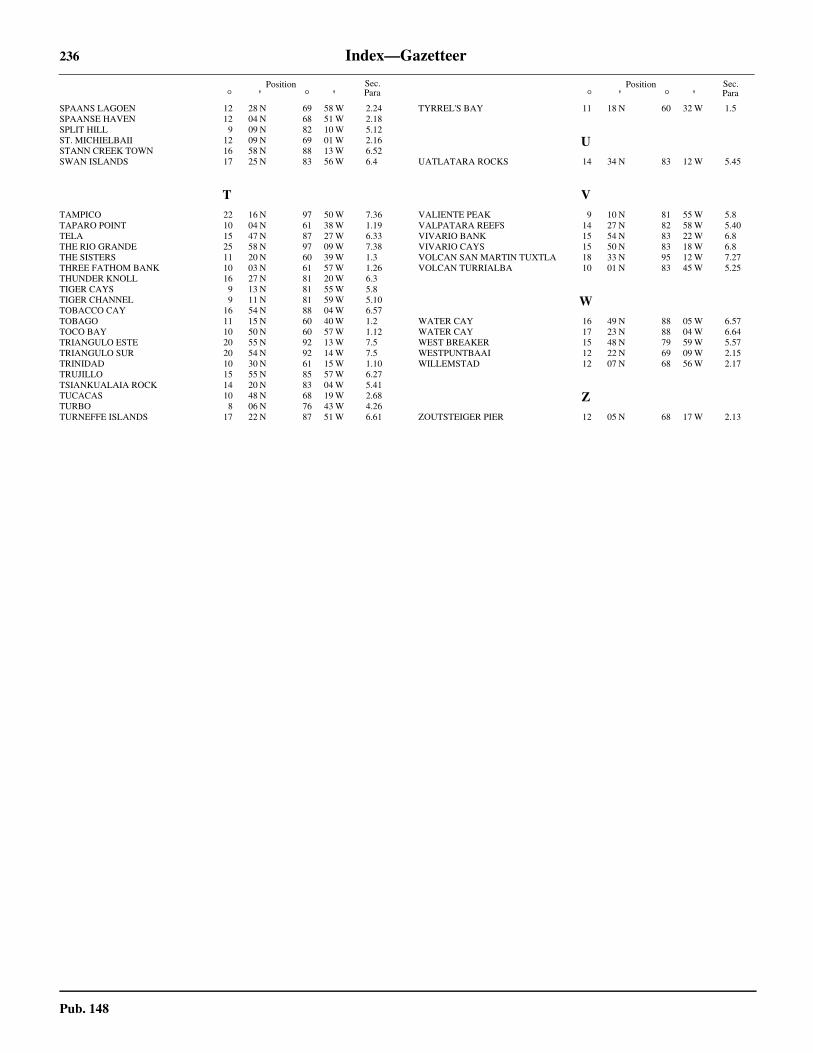
236 Index—Gazetteer
Pub. 148
Position° ' ° '
Position° ' ° '
Sec.Para
Sec.Para
SPAANS LAGOEN 12 28 N 69 58 W 2.24SPAANSE HAVEN 12 04 N 68 51 W 2.18SPLIT HILL 9 09 N 82 10 W 5.12ST. MICHIELBAII 12 09 N 69 01 W 2.16STANN CREEK TOWN 16 58 N 88 13 W 6.52SWAN ISLANDS 17 25 N 83 56 W 6.4
TTAMPICO 22 16 N 97 50 W 7.36TAPARO POINT 10 04 N 61 38 W 1.19TELA 15 47 N 87 27 W 6.33THE RIO GRANDE 25 58 N 97 09 W 7.38THE SISTERS 11 20 N 60 39 W 1.3THREE FATHOM BANK 10 03 N 61 57 W 1.26THUNDER KNOLL 16 27 N 81 20 W 6.3TIGER CAYS 9 13 N 81 55 W 5.8TIGER CHANNEL 9 11 N 81 59 W 5.10TOBACCO CAY 16 54 N 88 04 W 6.57TOBAGO 11 15 N 60 40 W 1.2TOCO BAY 10 50 N 60 57 W 1.12TRIANGULO ESTE 20 55 N 92 13 W 7.5TRIANGULO SUR 20 54 N 92 14 W 7.5TRINIDAD 10 30 N 61 15 W 1.10TRUJILLO 15 55 N 85 57 W 6.27TSIANKUALAIA ROCK 14 20 N 83 04 W 5.41TUCACAS 10 48 N 68 19 W 2.68TURBO 8 06 N 76 43 W 4.26TURNEFFE ISLANDS 17 22 N 87 51 W 6.61
TYRREL'S BAY 11 18 N 60 32 W 1.5
UUATLATARA ROCKS 14 34 N 83 12 W 5.45
VVALIENTE PEAK 9 10 N 81 55 W 5.8VALPATARA REEFS 14 27 N 82 58 W 5.40VIVARIO BANK 15 54 N 83 22 W 6.8VIVARIO CAYS 15 50 N 83 18 W 6.8VOLCAN SAN MARTIN TUXTLA 18 33 N 95 12 W 7.27VOLCAN TURRIALBA 10 01 N 83 45 W 5.25
WWATER CAY 16 49 N 88 05 W 6.57WATER CAY 17 23 N 88 04 W 6.64WEST BREAKER 15 48 N 79 59 W 5.57WESTPUNTBAAI 12 22 N 69 09 W 2.15WILLEMSTAD 12 07 N 68 56 W 2.17
ZZOUTSTEIGER PIER 12 05 N 68 17 W 2.13