caribe ews rfp #1 “sea level stations in the caribbean sea” · 2014-10-08 · request for...
TRANSCRIPT

30 July 2012
REQUEST FOR PROPOSAL (SERVICES)
CARIBE EWS RFP #1 “SEA LEVEL STATIONS IN THE CARIBBEAN SEA”
(Please quote this UNESCO reference in all correspondence)
1. Proposals for services in respect to the above referenced project are hereby invited.
Proposals could form the basis for a contract between your firm/institution and the United Nations Educational, Scientific and Cultural Organization (UNESCO).
2. To enable you submit a Proposal, attached documents include this cover page and
the following Annexes:
Section I Instructions to Offerors
Section II General Conditions of Contract
Section III Statement of Requirements
Section IV Proposal Submission Form
Section V Price Schedule Form
Section VI Information about the sea level station sites
This letter is not to be construed in any way as an offer to contract with your firm/institution.
3. Proposal shall be prepared in triplicate with one copy marked “Original” and the other one marked “Copy”. The proposal shall be sealed in one outer and two inner envelopes, as detailed below. The outer envelope must carry the bid reference hereunder.
Both inside envelopes shall indicate your firm’s name and address. The first envelope shall be marked “Technical Proposal” and contain the Proposal Submission Form and Technical Component of your Proposal. The second inner envelope shall be marked “Price Proposal” and include financial cover letter and Price Schedule.
4. Additional information can be provided by Bernardo Aliaga ([email protected]) or Thorkild Aarup ([email protected])
UNESCO UNESCO ADM/DCO/FCS 7 PLACE DE FONTENOY,
F - 75352 PARIS O7 SP, FRANCE BID FOR TENDER - DO NOT OPEN
Reference: CARIBE EWS SEA LEVEL STATIONS
BID CLOSING DATE AND TIME: 30 AUGUST 2012, 18:00 (GMT+01:00)

UNITED NATIONS EDUCATIONAL, SCIENTIFIC AND CULTURAL ORGANIZATION ORGANISATION DES NATIONS UNIES POUR L'EDUCATION, LA SCIENCE ET LA CULTURE
Reference: CARIBE EWS RFP #1 “SEA LEVEL STATIONS IN THE CARIBBEAN SEA”
SECTION I – INSTRUCTIONS TO OFFERORS
A. Introduction
1. General: The purpose of the Request for Proposals (RFP) is to invite submissions of proposals for the installation of 7 sea level stations in the Caribbean region that are part of the IOC coordinated Caribbean Early Warning Tsunami and Other Coastal Hazards Warning System. 2. Scope and Responsibilities: Role of UNESCO/IOC as UN Coordinator is to coordinate the establishment of the Caribbean and Adjacent Regions Tsunami and other Coastal Hazards Early Warning System, including sea level observing systems. 3. Implementation Schedule: It is anticipated that a decision will be made to select a Contractor by 10 September 2012. After selecting a Contractor, UNESCO/IOC expects to be in a position to finalise the contract by 25 September 2012. The contract is expected to be awarded for a 6 months period to cover the installation of seven sea level stations in the Caribbean sea, specifically in Cayman Islands, Guatemala, Haiti (2 stations) Nicaragua, St Kitts & Nevis and St Vincent & the Grenadines. 4. Cost of Proposal: The Offeror shall bear all costs associated with the preparation and submission of the Proposals. UNESCO/IOC will in no case be responsible or liable for those costs, regardless of the conduct or outcome of the solicitation.
B. Solicitation Documents
5. Contents of Solicitation Documents: UNESCO/IOC may, in its absolute discretion consider a Proposal for part of the required services, with due consideration given to the unit prices and the available funds. However, UNESCO/IOC would prefer that Proposals address the full scope of services. If the successful Bidder does not have all the expertise for the assignment, there is no objection to the Bidder subcontracting another firm/institution, to enable a full range of expertise to be implemented. Any invited firm/institution may not participate in more than one consolidated Proposal. The Bidder is expected to examine all corresponding instructions, forms, terms and specifications contained in the Solicitation Documents. Failure to comply with these documents will be at the Bidder’s risk and may affect the evaluation of the Proposal. 6. Clarification of Solicitation Documents: A prospective Bidder requiring any clarification of the Solicitation Documents may notify UNESCO/IOC in writing or by e-mail. All communications by the Bidder or any party connected with this procurement activity must be directed exclusively to the UNESCO/IOC official identified on the cover page. UNESCO/IOC will respond in writing to any request for clarification of the Solicitation Documents that it receives earlier than two weeks prior to the deadline for the submission of Proposals. Written copies of the organisation’s response (including an explanation of the query but without identifying the source of inquiry) will be sent by e-mail to all prospective Bidders that have received the Solicitation Documents. 7. Amendments of Solicitation Documents: At any time prior to the deadline for submission of Proposals, UNESCO/IOC may, for any reason, whether at its own initiative or
in response to a clarification requested by a prospective Bidder, modify the Solicitation Documents by amendment. All prospective Bidders that have received the Solicitation Documents will be notified in writing of all amendments.
C. Preparation of Proposals
8. Language of the Proposal: The Proposal prepared by the Offeror and all correspondence and documents relating to the Proposal exchanged by the Offeror and UNESCO/IOC shall be in English. 9. Documents Comprising the Proposal: The Proposal shall comprise the following components:
(a) Proposal submission form;
(b) Technical Proposal, including detailed operational and technical plan to demonstrate that the Offeror meets all the requirements for which these services are sought;
(c) Financial Proposal, i.e. UNESCO/IOC Price Schedule Form and Offeror’s budget and detailed cost plan including proposed schedule of payments;
(d) In addition, the organisation submitting the proposal should submit the following: Organisational Profile and Documents highlighting the organisations financial status
10. Proposal Form: With reference to the enclosed Statement of Requirements, the Bidder shall structure its Technical Proposal as follows: (a) Management Plan This should provide a corporate profile including the year and country of incorporation and a brief description of the Bidder’s activities, which should focus on services related to the Proposal. This Section should describe the organisational unit(s) that will be responsible for the contract, and the general management approach towards a project of this kind. The Bidder should comment on its experience with similar projects and identify the person(s) representing the Bidder in any future dealings with UNESCO/IOC. In line with Section III – Statement of Requirements - this Section should also provide detailed information that will facilitate our assessment of the Bidder’s reliability and financial and managerial capacity to provide the necessary services. (b) Resource Plan and Understanding of the Requirements This should fully explain the Bidder’s resources in terms of personnel and facilities necessary for the implementation of this contract. (c) Proposed Approach, Methodology, Timing and Outputs This section should include any comments or suggestions to the RFP and its requirements, as well as provide a detailed description of the manner in which the Bidder would respond to the Statement of Requirements, within the given time table. (d) Proposed Team Structure An organigram illustrating the reporting lines, together with a description of the team structure and personnel in the country of assignment (and/or at the home office), should support the Bidder’s Proposal.

UNITED NATIONS EDUCATIONAL, SCIENTIFIC AND CULTURAL ORGANIZATION ORGANISATION DES NATIONS UNIES POUR L'EDUCATION, LA SCIENCE ET LA CULTURE
Reference: CARIBE EWS RFP #1 “SEA LEVEL STATIONS IN THE CARIBBEAN SEA”
The curriculum vitae of professional members of the team is required. It is mandatory that the Bidder’s Proposal numbering system corresponds with the numbering system used in the body of this RFP. All references to descriptive material and brochures should be included in the appropriate response paragraph, though material/documents themselves may be provided as annexes to the Proposal/response. 11. Financial Proposal: The Bidder should propose an appropriate budget and detailed cost plan, including the costs of services it proposes to supply under the contract. Prices should be quoted in US dollars (USD). 12. Period of validity of Proposals: The Proposals shall remain valid for ninety (90) days after the closing date. UNESCO/IOC may reject a Proposal that is valid for a shorter period on the grounds that it is non-responsive. In exceptional circumstances, UNESCO/IOC may solicit the Bidder’s consent to an extension of the period of validity. The request and the responses shall be made in writing. However, Bidders are not permitted to modify their Proposals. 13. Format and signing of Proposals: The Bidder shall prepare three copies of the Proposal, separately for a Technical and Financial Proposal, clearly marking each “Original Proposal” and “Copy of Proposal” as appropriate. In the event of any discrepancy between them, the original shall govern. The three copies of the Proposal shall be typed or written in indelible ink and shall be signed by the Bidder or a person or persons duly authorised to bind the Bidder to the contract. The latter authorisation shall be indicated by written power-of-attorney accompanying the Proposal. A Proposal shall contain no erasures or overwriting except, as necessary to correct errors made by the Bidder, in which case such corrections shall be initialed by the person or persons signing the Proposal. 14. Payment: UNESCO/IOC shall effect payments to the Contractor after acceptance by UNESCO/IOC of the invoices submitted by the contractor, upon achievement of the agreed schedule. Please, note that UNESCO/IOC’s policy is not to grant advance payments except in unusual situations where a potential Bidder specifies, in the Proposal, that there are specific circumstances warranting an advance payment. UNESCO/IOC, at its discretion, may however determine that such payment is not warranted, or determine the conditions under which such payment would be made. In any case, where an advance payment is requested and subsequently approved, UNESCO/IOC will normally require a bank guarantee or other suitable security arrangement. Any request for an advance payment is to be justified and documented and must be submitted with the Financial Proposal. This justification shall explain the need for the advance payment, itemize the amount requested and provide a time-schedule for utilization of said amount.
D. Submission of Proposals
15. Sealing and marking of Proposals: The Bidder shall seal the Proposal in one outer and two inner envelopes, as detailed below.
The outer envelope shall be addressed as follows:
UNESCO ADM/DCO/FCS 7 PLACE DE FONTENOY,
F - 75352 PARIS O7 SP, FRANCE BID FOR TENDER - DO NOT OPEN
Reference: CARIE EWS SEA LEVEL STATIONS
Bid Closing Date and Time: 30 August 2012, 18:00 (GMT+01:00)
Both inner envelopes shall indicate the name and address of the Bidder. The first inner envelope shall be marked “Technical Proposal” and contain the Proposal Submission Form and Technical component. The second inner envelope shall be marked “Financial Proposal” and include the financial offer in the form of a detailed cost plan. If the inner envelopes are not sealed and marked as per the instructions in this clause, UNESCO/IOC will not assume responsibility for the Proposal’s misplacement or premature opening. 16. Deadline for submission of Proposals Proposals must be received by UNESCO at the address specified by no later than 30 August 2012, 18h00 (GMT+01:00). UNESCO/IOC may, at its own discretion extend this deadline for the submission of Proposals by amending the solicitation documents in accordance with clause Amendments of Solicitation Documents, in which case all rights and obligations of UNESCO/IOC and Bidders previously subject to the deadline, will thereafter be subject to the new deadline. 17. Late Proposals Any Proposal received by UNESCO/IOC after the deadline for submission of Proposals will be rejected. 18. Modification and withdrawal of Proposals A Bidder may withdraw its Proposal provided that written notice of the withdrawal is received by UNESCO/IOC prior to the deadline prescribed for submission of Proposals. The Bidder’s withdrawal notice shall be prepared, sealed, marked, and dispatched in accordance with the provisions of clause Deadline for Submission of Proposals. The withdrawal notice may also be sent by email or fax but followed by a signed confirmation copy. No Proposal may be modified subsequent to the deadline for submission. No Proposal may be withdrawn in the interval between the deadline for submission and the expiration of the period of validity specified by the Bidder on the Proposal Submission Form.
E. Opening and Evaluation of Proposals
19. Opening of Proposals UNESCO/IOC will open all Proposals in the presence of a committee convened by UNESCO/IOC. 20. Clarification of Proposals To assist in the examination, evaluation and comparison of Proposals, UNESCO/IOC may ask the Bidder for clarification of its Proposal. The request for clarification and the response shall be

UNITED NATIONS EDUCATIONAL, SCIENTIFIC AND CULTURAL ORGANIZATION ORGANISATION DES NATIONS UNIES POUR L'EDUCATION, LA SCIENCE ET LA CULTURE
Reference: CARIBE EWS RFP #1 “SEA LEVEL STATIONS IN THE CARIBBEAN SEA”
in writing and no change in price or substance shall be sought, offered or permitted. 21. Preliminary examination UNESCO/IOC will examine the Proposals to determine whether they are complete, any computer errors have been made, the documents have been properly signed, and the Proposals generally in order. Prior to the detailed evaluation, UNESCO/IOC will determine the substantial responsiveness of each Proposal to the Request for Proposals (RFP). For purposes of these Clauses, a substantially responsive Proposal is one, which conforms to all the terms and conditions of the RFP without material deviations. UNESCO/IOC’s determination of a Proposal’s responsiveness is based on the contents of the Proposal itself without recourse to extrinsic evidence. A Proposal determined as not substantially responsive will be rejected by UNESCO/IOC and may not subsequently be resubmitted. 22. Evaluation and comparison of Proposals In general, all Proposals will be assessed to determine that which represents the best value for money, in accordance with UNESCO/IOC policies. A two-stage procedure will be is utilized in evaluating the Proposals: evaluation of the Technical Proposal will be completed prior to any evaluation of the Financial Proposal. The Financial Proposal will be opened only for those firms/institutions whose Technical Component meets the requirements for the assignment. The total number of points which the firm/institution may obtain for both components is 1200 points. The technical proposal, which has the total possible value of 1000 points, will be evaluated using the following criteria:
Summary of Technical Proposal Evaluation Forms
Score Weight
Points Obtainable
1. Expertise of Firm / Institution submitting Proposal
30%
300
2. Proposed Work Plan and Approach
50%
500
3.
Personnel
20%
200
Total
1000
In the Second Stage, the price proposals of all firms/institutions, who have attained minimum 70% score in the technical evaluation will be taken into account in the following manner: The total amount of points allocated for the price component is 200 points. The maximum number of points will be allotted to the lowest price proposal that is opened and compared among those invited firms/institutions which obtain the threshold points in the evaluation of the technical component. All other price proposals will receive points in inverse proportion to the lowest price. UNESCO may enter into contract negotiations with the firm/institution having the highest overall score. However, such negotiations do not constitute an award of contract. Please note that the UNESCO is not bound to select any of the firms/institutions submitting proposals. Furthermore, since a contract will be awarded in respect of the proposal which is considered most
responsive to the needs of the project concerned, due consideration being given to UNESCO’s general principles including economy and efficiency, UNESCO does not bind itself in any way to select the firm/institution offering the lowest price.
F. Award of Contract
23. Award criteria, award of contract UNESCO/IOC reserves the right to accept or reject any Proposal and to annul the solicitation process and reject all Proposals at any time prior to the awarding of the contract, without incurring any liability to the Bidder or any obligation to inform the Bidder or Bidders of the grounds for UNESCO/IOC’s action Prior to expiration of the period of proposal validity, UNESCO/IOC will award the contract to the qualified Offeror whose Proposal, after being evaluated, is considered to be the most appropriate for the needs of UNESCO/IOC and activity concerned. 24. UNESCO/IOC’s right to vary requirements at time of award UNESCO/IOC reserves the right at the time of award of contract to vary the quantity of services and goods specified in the RFP without any change in unit prices or other terms and conditions. 25. Signing of the contract Within 5 days of receipt of the contract the successful Bidder shall sign and date the contract and return it to UNESCO/IOC. .

UNITED NATIONS EDUCATIONAL, SCIENTIFIC AND CULTURAL ORGANIZATION ORGANISATION DES NATIONS UNIES POUR L'EDUCATION, LA SCIENCE ET LA CULTURE
Reference: CARIBE EWS RFP #1 “SEA LEVEL STATIONS IN THE CARIBBEAN SEA”
SECTION II – GENERAL CONDITIONS OF CONTRACT
1. LEGAL STATUS The Contractor shall be considered as having the legal status of an independent contractor vis-à-vis UNESCO. The Contractor’s personnel and sub-contractors shall not be considered in any respect as being the employees or agents of UNESCO or the United Nations.
2. SOURCE OF INSTRUCTIONS The Contractor shall neither seek nor accept instructions from any authority external to UNESCO in connection with the performance of its services under this Contract. The Contractor shall refrain from any action, which may adversely affect UNESCO or the United Nations and shall fulfill its commitments with the fullest regard to the interests of UNESCO.
3. CONTRACTOR’S RESPONSIBILITY FOR EMPLOYEES The Contractor shall be responsible for the professional and technical competence of its employees and will select, for work under this Contract, reliable individuals who will perform effectively in the implementation of this Contract, respect the local customs, and conform to a high standard of moral and ethical conduct.
4. ASSIGNMENT The Contractor shall not assign, transfer, pledge or make other disposition of this Contract or any part thereof, or any of the Contractor’s rights, claims or obligations under this Contract except with the prior written consent of UNESCO.
5. SUB-CONTRACTING In the event the Contractor requires the services of sub-contractors, the Contractor shall obtain the prior written approval and clearance of UNESCO for all sub-contractors. The approval of UNESCO of a sub-contractor shall not relieve the Contractor of any of its obligations under this Contract. The terms of any sub-contract shall be subject to and conform with the provisions of this Contract.
6. OFFICIALS NOT TO BENEFIT The Contractor warrants that no official of UNESCO or the United Nations has received or will be offered by the Contractor any direct or indirect benefit arising from this Contract or the award thereof. The Contractor agrees that breach of this provision is a breach of an essential term of this Contract.
7. INDEMNIFICATION The Contractor shall indemnify, hold and save harmless, and defend, at its own expense, UNESCO, its officials, agents, and employees from and against all suits, claims, demands, and liability of any nature or kind, including their costs and expenses, arising out of acts or omissions of the Contractor, or the Contractor’s employees, officers, agents or sub-contractors, in the performance of this Contract. This provision shall extend, inter-alia, to claims and liability in the nature of workmen’s compensation, products liability and liability arising out of the use of patented inventions or devices, copyrighted material or other intellectual property by the Contractor, its employees, officers, agents, servants or sub-contractors. The obligations under this Article do not lapse upon termination of this Contract.
8. INSURANCE AND LIABILITIES TO THIRD PARTIES 8.1 The Contractor shall provide and thereafter maintain insurance against all risks in respect of its property and any equipment used for the execution of this Contract.
8.2 The Contractor shall provide and thereafter maintain all appropriate workmen's compensation insurance, or its equivalent, with respect to its employees to cover claims for personal injury or death in connection with this Contract. 8.3 The Contractor shall also provide and thereafter maintain liability insurance in an adequate amount to cover third party claims for death or bodily injury, or loss of or damage to property, arising from or in connection with the provision of services under this Contract or the operation of any vehicles, boats, airplanes or other equipment owned or leased by the Contractor or its agents, servants, employees or sub-contractors performing work or services in connection with this Contract. 8.4 Except for the workmen's compensation insurance, the insurance policies under this Article shall:
(i) Name UNESCO as additional insured; (ii) Include a waiver of subrogation of the Contractor's rights to the insurance carrier against UNESCO; (iii) Provide that UNESCO shall receive thirty (30) days written notice from the insurers prior to any cancellation or change of coverage. 8.5 The Contractor shall, upon request, provide UNESCO with satisfactory evidence of the insurance required under this Article.
9. ENCUMBRANCES/LIENS
The Contractor shall not cause or permit any lien, attachment or other encumbrance by any person to be placed on file or to remain on file in any public office or on file with UNESCO against any monies due or to become due for any work done or materials furnished under this Contract, or by reason of any other claim or demand against the Contractor.
10. TITLE TO EQUIPMENT Title to any equipment and supplies that may be furnished by UNESCO shall rest with UNESCO and any such equipment shall be returned to UNESCO at the conclusion of this Contract or when no longer needed by the Contractor. Such equipment, when returned to UNESCO, shall be in the same condition as when delivered to the Contractor, subject to normal wear and tear. The Contractor shall be liable to compensate UNESCO for equipment determined to be damaged or degraded beyond normal wear and tear. 11. COPYRIGHT, PATENTS AND OTHER PROPRIETARY RIGHTS UNESCO shall be entitled to all intellectual property and other proprietary rights including but not limited to patents, copyrights, and trademarks, with regard to products, or documents and other materials which bear a direct relation to or are produced or prepared or collected in consequence of or in the course of the execution of this Contract. At UNESCO’s request, the Contractor shall take all necessary steps, execute all necessary documents and generally assist in securing such proprietary rights and transferring them to UNESCO in compliance with the requirements of the applicable law
12. USE OF NAME, EMBLEM OR OFFICIAL SEAL OF UNESCO OR THE UN The Contractor shall not advertise or otherwise make public the fact that it is a Contractor with UNESCO, nor shall the Contractor, in any manner whatsoever use the name, emblem or official seal of UNESCO or the United Nations, or any abbreviation of the name of UNESCO or the United Nations in connection with its business or otherwise.
13. CONFIDENTIAL NATURE OF DOCUMENTS AND INFORMATION 13.1 All maps, drawings, photographs, mosaics, plans, reports, recommendations, estimates, documents and all other data compiled by or received by the Contractor under this Contract shall be the property of UNESCO, shall be treated as confidential and shall be delivered only to UNESCO authorized officials on completion of work under this Contract. 13.2 The Contractor may not communicate at any time to any other person, Government or authority external to UNESCO, any information known to it by reason of its association with UNESCO, which has not been made public except with the authorization of UNESCO; nor shall the Contractor at any time use such information to private advantage. These obligations do not lapse upon termination of this Contract. 14. FORCE MAJEURE; OTHER CHANGES IN CONDITIONS 14.1 Force majeure, as used in this Article, means acts of God, war (whether declared or not), invasion, revolution, insurrection, or other acts of a similar nature or force, which are beyond the control of the Parties. 14.2 In the event of and as soon as possible after the occurrence of any cause constituting force majeure, the Contractor shall give notice and full particulars in writing to UNESCO, of such occurrence or change if the Contractor is thereby rendered unable, wholly or in part, to perform its obligations and meet its responsibilities under this Contract. The Contractor shall also notify UNESCO of any other changes in conditions or the occurrence of any event, which interferes or threatens to interfere with its performance of this Contract. The notice shall include steps proposed by the Contractor to be taken including any reasonable alternative means for performance that is not prevented by force majeure. On receipt of the notice required under this Article, UNESCO shall take such action as, in its sole discretion, it considers to be appropriate or necessary

UNITED NATIONS EDUCATIONAL, SCIENTIFIC AND CULTURAL ORGANIZATION ORGANISATION DES NATIONS UNIES POUR L'EDUCATION, LA SCIENCE ET LA CULTURE
Reference: CARIBE EWS RFP #1 “SEA LEVEL STATIONS IN THE CARIBBEAN SEA”
in the circumstances, including the granting to the Contractor of a reasonable extension of time in which to perform its obligations under this Contract. 14.3 If the Contractor is rendered permanently unable, wholly, or in part, by reason of force majeure to perform its obligations and meet its responsibilities under this Contract, UNESCO shall have the right to suspend or terminate this Contract on the same terms and conditions as are provided for in Article 15, “Termination”, except that the period of notice shall be seven (7) days instead of thirty (30) days. 15. TERMINATION 15.1 Either party may terminate this Contract for cause, in whole or in part, upon thirty days notice, in writing, to the other party. The initiation of arbitral proceedings in accordance with Article 16 “Settlement of Disputes” below shall not be deemed a termination of this Contract. 15.2 UNESCO reserves the right to terminate without cause this Contract at any time upon 15 days prior written notice to the Contractor, in which case UNESCO shall reimburse the Contractor for all reasonable costs incurred by the Contractor prior to receipt of the notice of termination. 15.3 In the event of any termination by UNESCO under this Article, no payment shall be due from UNESCO to the Contractor except for work and services satisfactorily performed in conformity with the express terms of this Contract. The Contractor shall take immediate steps to terminate the work and services in a prompt and orderly manner and to minimize losses and further expenditures. 15.4 Should the Contractor be adjudged bankrupt, or be liquidated or become insolvent, or should the Contractor make an assignment for the benefit of its creditors, or should a Receiver be appointed on account of the insolvency of the Contractor, UNESCO may, without prejudice to any other right or remedy it may have, terminate this Contract forthwith. The Contractor shall immediately inform UNESCO of the occurrence of any of the above events. 16. SETTLEMENT OF DISPUTES 16.1 Amicable Settlement The Parties shall use their best efforts to settle amicably any dispute, controversy or claim arising out of, or relating to this Contract or the breach, termination or invalidity thereof. Where the parties wish to seek such an amicable settlement through conciliation, the conciliation shall take place in accordance with the UNCITRAL Conciliation Rules then obtaining, or according to such other procedure as may be agreed between the parties. 16.2 Arbitration Unless, any such dispute, controversy or claim between the Parties arising out of or relating to this Contract or the breach, termination or invalidity thereof is settled amicably under the preceding paragraph of this Article within sixty (60) days after receipt by one Party of the other Party’s request for such amicable settlement, such dispute, controversy or claim shall be referred by either Party to arbitration in accordance with the UNCITRAL Arbitration Rules then obtaining, including its provisions on applicable law. The arbitral tribunal shall have no authority to award punitive damages. The Parties shall be bound by any arbitration award rendered as a result of such arbitration as the final adjudication of any such controversy, claim or dispute. 17. PRIVILEGES AND IMMUNITIES Nothing in or relating to this Contract shall be deemed a waiver, express or implied, of any of the privileges and immunities of the United Nations, including its subsidiary organs. 18. TAX EXEMPTION 18.1 Section 7 of the Convention on the Privileges and Immunities of the United Nations provides, inter-alia, that the United Nations, including its subsidiary organs, is exempt from all direct taxes, except charges for public utility services, and is exempt from customs duties and charges of a similar nature in respect of articles imported or exported for its official use. In the event any governmental authority refuses to recognize the United Nations exemption from such taxes, duties or charges, the Contractor shall immediately consult with UNESCO to determine a mutually acceptable procedure. 18.2 Accordingly, the Contractor authorizes UNESCO to deduct from the Contractor’s invoice any amount representing such taxes, duties or charges,
unless the Contractor has consulted with UNESCO before the payment thereof and UNESCO has, in each instance, specifically authorized the Contractor to pay such taxes, duties or charges under protest. In that event, the Contractor shall provide UNESCO with written evidence that payment of such taxes, duties or charges has been made and appropriately authorized. 19. CHILD LABOUR 19.1 The Contractor represents and warrants that neither it, nor any of its suppliers is engaged in any practice inconsistent with the rights set forth in the Convention on the Rights of the Child, including Article 32 thereof, which, inter-alia, requires that a child shall be protected from performing any work that is likely to be hazardous or to interfere with the child’s education, or to be harmful to the child’s health or physical mental, spiritual, moral or social development. 19.2 Any breach of this representation and warranty shall entitle UNESCO to terminate this Contract immediately upon notice to the Contractor, at no cost to UNESCO. 20. MINES 20.1 The Contractor represents and warrants that neither it nor any of its suppliers is actively and directly engaged in patent activities, development, assembly, production, trade or manufacture of mines or in such activities in respect of components primarily utilized in the manufacture of Mines. The term “Mines” means those devices defined in Article 2, Paragraphs 1, 4 and 5 of Protocol II annexed to the Convention on Prohibitions and Restrictions on the Use of Certain Conventional Weapons Which May Be Deemed to Be Excessively Injurious or to Have Indiscriminate Effects of 1980. 20.2 Any breach of this representation and warranty shall entitle UNESCO to terminate this Contract immediately upon notice to the Contractor, without any liability for termination charges or any other liability of any kind of UNESCO. 21. OBSERVANCE OF THE LAW The Contractor shall comply with all laws, ordinances, rules, and regulations bearing upon the performance of its obligations under the terms of this Contract.
22. AUTHORITY TO MODIFY No modification or change in this Contract, no waiver of any of its provisions or any additional contractual relationship of any kind with the Contractor shall be valid and enforceable against UNESCO unless provided by an amendment to this Contract signed by the authorized official of UNESCO.

UNITED NATIONS EDUCATIONAL, SCIENTIFIC AND CULTURAL ORGANIZATION ORGANISATION DES NATIONS UNIES POUR L'EDUCATION, LA SCIENCE ET LA CULTURE
Reference: CARIBE EWS RFP #1 “SEA LEVEL STATIONS IN THE CARIBBEAN SEA”
SECTION III
Call for Tender
CARIBE EWS RFP #1 “SEA LEVEL STATIONS IN THE CARIBBEAN SEA”
Statement of requirements BACKGROUND
The Intergovernmental Oceanographic Commission has been given the mandate by its member states to coordinate the implementation of the Tsunami and other Coastal Hazards Warning System for the Caribbean Sea and Adjacent Regions (CARIBE EWS). The last major Western Atlantic basin tsunami event took place in August, 1946. Since then, population shifts to Caribbean coastal communities and “explosive” tourism has taken place (USA alone has millions of citizens vacationing there annually). Assessing risks based just on historical deaths, greatly understates today’s potential loss of life from Caribbean tsunamis. Despite coastal populations at risk being so much less in the past, we know at least 3503 lives were lost in the Caribbean Basin since 1842 (165 years). The CARIBE-EWS places special emphasis on costal hazard monitoring as both hurricanes and tsunamis are of concern to the region. The CARIBE EWS is based on observation networks of seismometers and sea level measuring stations, which report their observations in real time to national and regional warning centers that with this information are able to confirm or cancel a tsunami watch or warning. The CARIBE EWS is carried out in accordance with the implementation plan that has been adopted by the member states in the intergovernmental coordination group for the CARIBE EWS. Of 100 sea level stations identified as part of the required CARIBE-EWS core sea level network, only 38 coastal stations are presently delivering real-time data within 15 minute - the requirement for stations within the Caribbean due to the very short travel time of tsunamis to coastal areas. The real time sea level observations is a key element in the CARIBE-EWS as sea level observations are used to confirm the existence of a major tsunami or to cancel a tsunami watch after a strong earthquake. Sea level observations are also used for several other purposes than tsunami monitoring and warning. For example sustained long term sea level observations are used to: (i) underpin assessment of regional long term sea level rise due to climate change; (ii) satellite altimeter calibration; (iii) storm surge monitoring; (iv) coastal circulation modeling; (v) coastal zone management; (vi) safe navigation and (vii) establishment of chart-datum. Sustaining a sea level observation network is an on-going effort and the operation of sea level stations requires regular and routine maintenance by a dedicated staff of operators and/or traveling technicians. For some countries, it is financially impractical and time inefficient to maintain a staff to look after. In some cases only one or two national tide gauge stations and an arrangement with a traveling technician shared by several countries may be more optimal. The tentative station list to be installed are presented in Annex I. IMPLEMENTATION
The proposal should address the acquisition, installation and maintenance/leveling visits of the tide gauge equipment over one-year period. Details should be provided on how the maintenance visits will be carried out (i.e. number of repeat visits per year, involvement and on-site training of local tide gauge operators, costing etc.). It is envisioned that local Point of Contacts (POC) during the one-year project period gradually should take over the maintenance of the installed equipment. The proposed configuration of the sea level stations should be based on high quality equipment that perform to the requirements and accuracy of the Global Sea Level Observing System (GLOSS) [See Manuals on Sea Level: Measurement and Interpretation, IOC Manuals and Guides 14; Annex I; http://unesdoc.unesco.org/images/0014/001477/147773e.pdf]
The proposed stations should have sufficient built in redundancy to function under conditions that can be expected in the region.

UNITED NATIONS EDUCATIONAL, SCIENTIFIC AND CULTURAL ORGANIZATION ORGANISATION DES NATIONS UNIES POUR L'EDUCATION, LA SCIENCE ET LA CULTURE
Reference: CARIBE EWS RFP #1 “SEA LEVEL STATIONS IN THE CARIBBEAN SEA”
Without being prescriptive it is expected that a typical station configuration will consist of a primary tide gauge, two under water pressure sensor (secondary tide gauge), data logger, DCP geostationary satellite transmitter, modem, battery backup, solar panel, cables, mountings. Redundant data transmission channels (e.g. Internet or alternative (i.e. via Inmarsat BGAN or similar), as well as via dial-in modem access) should be implemented where possible. The redundant transmission can either be connected directly to the DCP/Datalogger for the primary water level sensors, or it can be a separate transmission unit connected to a second water level sensor. The bidder should provide comprehensive details on the set up and functionality of the proposed redundant transmission channel. Stations should be able to run for a minimum of 48hrs without external power. The sea level station shall function independently of other equipment that may be installed in the vicinity (i.e. meteorological or other oceanographic equipment). For each sensor at the station site, 1-minute data samples shall be transmitted in CREX format via the public geostationary meteorological satellites (METEOSAT or GOES) every 5 minutes and every five minutes via the redundant transmission option. Supplementary specification details are provided in Annex II.
It is expected that the bidder will obtain a volume-discounted price for the equipment given the number of
gauges and spare parts that are expected to be purchased. The installed sea level stations should be set up to deliver sea level observations to hosting agencies (POCs) and should also be transmitted on to the GTS. The performance of the installed gauges will be monitored in terms of data capture/up-time and the delivery data delivery performance (number of observations delivered versus the expected number of observations expected should be higher than 99% per 24 hours).
Any civil works such as construction of a tide gauge hut for housing instruments or instrument mounting poles, furnace of mains power, stilling well, security and similar should be included in the Proposal but could be coordinated with POCs to obtain local costs.
All equipment should be “Delivered Duty Paid” to the tide gauge site. POCs can help facilitate the entry of the equipment into the country
The bidder is asked to inform about: (i) if any additional services will be offered (i.e. data processing, quality control, provision of sea level
products, assistance in case of technical problems or similar). (ii) past, present and future tide gauge installation activities in the beneficiary countries and nearby countries
that it has, is or will be involved in.
Training
The selected vendor should provide training in the operation and maintenance of the selected tide gauge hardware to staff at POCs agencies. The bidders are asked to detail training plans. It is also expected that technicians from POC agency will accompany technicians of the selected vendor to the sites and follow the installations and hands-on training should be provided. This should also include precision leveling of gauge to nearby local tide gauge benchmarks and regular dipping measurements to level in the gauge. Costing
The bidder is requested to provide the costing information as follows:
Tide gauge hardware should be specified on a per unit basis (average) and with appropriate configuration details.
Maintenance of tide gauge hardware for a five-year period should be specified on a per unit basis (average). This should include estimated costs for a pool of spare parts and other materials used for maintenance.
Installation costs (including technician day fees)
Travel (ticket costs and per diem) per installation (average) for technician
Travel (ticket costs and per diem) per maintenance visit (average) for technician
Training
The expected number of gauges to be installed per technician and information on the expected number maintenance visits per gauge over a one-year maintenance period should also be provided.

UNITED NATIONS EDUCATIONAL, SCIENTIFIC AND CULTURAL ORGANIZATION ORGANISATION DES NATIONS UNIES POUR L'EDUCATION, LA SCIENCE ET LA CULTURE
Reference: CARIBE EWS RFP #1 “SEA LEVEL STATIONS IN THE CARIBBEAN SEA”
REPORTING Following each installation the selected contractor shall provide a comprehensive installation report to UNESCO/IOC documenting the work and providing leveling information. Following each maintenance visit a report shall be provided with including updated levelling information. PROVISIONARY TIMETABLE
Process Dates Remarks
Deadline for submission of bids 30 August 2012
Selection of contractor 10 September 2012
Establishment of contract 25 September 2012
Installation of gauges to begin October 2012
Start of maintenance phase January 2013
End of vendor supported maintenance phase 25 September 2013

UNITED NATIONS EDUCATIONAL, SCIENTIFIC AND CULTURAL ORGANIZATION ORGANISATION DES NATIONS UNIES POUR L'EDUCATION, LA SCIENCE ET LA CULTURE
Reference: CARIBE EWS RFP #1 “SEA LEVEL STATIONS IN THE CARIBBEAN SEA”
ANNEX I: LIST OF SEA LEVEL STATION SITES AND SITE STUDIES
One Sea level stations to be installed in each of the following countries: 1.- Cayman Islands : Grand Cayman Airport field. (site 1) Geographical location: Latitude: 19.294413 N, Longitude: 81.347220 W
Point of Contact: Mr. Lee Madison, Deputy Director Operations at Grand Cayman Email: [email protected] 1-345-244-3144 2.- Guatemala: Muelle de remolques, Base naval del Atlántico (site 3) Geographical location : Latitude: 15.694617 N, Longitude: 88.622018 W
Point of Contact: Sergio Vega (INSIVUMEH) Tel (502) 23105029 Cel (502) 582 59461 Email [email protected] 3.- Nicaragua: Corn Islands, port CAF (site 1) Geographical location: Latitude: 12.160503 N, Longitude: 83.06789 W
Point of Contact: Isaías Montoya (INETER) Tel (505) 2249-3590 Cel (505) 8663-1851 Email [email protected] 4.- Saint Kitts & Nevis: St. Kitts Coast Guard Base. (site 1) Geographical location: Latitude: 17.290028 N, Longitude: 62.705917 W
Point of Contact: Mr. Carl Herbert NEMA’s National Disaster Coordinator [email protected] , Tel. 1-869-466-5100 5.- Saint Vincent and The Grenadines: SVG Coast Guard at Calliaqua. (site 1) Geographical location: Latitude: 13.129953 N, Longitude: 61.195428 W
Point of Contact: Sr. Peter Providence Meteorological Office E.T. Joshua Airport, Arnos Vale St. Vincent and the Grenadines Tel. 1-784-458-4011. E-mail: [email protected] Two (2) Stations to be installed in Haiti, one in Jacmel and one in Port au Prince Geographical Location Jacmel: 18.135143 Latitude Nord, 72.320736 Longitude Ouest Geographical Location Port au Prince : 18.320364 Latitude Nord, 72.224645 Longitude Ouest
Point of Contact: Gerard Metayer,Ing [email protected] (509) 3713 5936 Diana Mosquera [email protected] (509) 3445 1204

UNITED NATIONS EDUCATIONAL, SCIENTIFIC AND CULTURAL ORGANIZATION ORGANISATION DES NATIONS UNIES POUR L'EDUCATION, LA SCIENCE ET LA CULTURE
Reference: CARIBE EWS RFP #1 “SEA LEVEL STATIONS IN THE CARIBBEAN SEA”
Annex II SUPPLEMENTARY FUNCTIONAL AND PERFORMANCE REQUIREMENTS FOR SEA LEVEL STATION
The tide gauge shall provide data logging/memory for one year without data link The power system of the tide gauge shall be warranted by rechargeable batteries; power storage shall be provided for 48 hours of nominal operation without charging The power system of the tide gauge should also be supported by mains power where feasible The tide gauge shall have an autonomous self start capability after power outage Electronic equipment shall be accommodated to the extent possible in a waterproof box (IP66 or higher) Access to the tide gauge shall be controlled, i.e. appropriate security measures / authorization means shall be provided The tide gauge shall be designed for a target lifetime of 8 years Baring unforeseen events (i.e. storms or lack of cleaning of solar panels) the equipment should be able to function for at least 12 months without a need of a maintenance visit 1.1 Tide Gauge Sensor Requirements • Temperature range of -2° to +60°C • Humidity up to 100%RH • Torrential rain • Wind speed range at least 0-50 knots • Pressure sensor should measure up to 40 dBar • Minimum sampling interval 1 minute under all circumstances • Allow for GTS operation • Lightening strike protection 1.2 Solar Power Requirements • 12 V or 24 V system • The power system shall be galvanically isolated • Lightening strike protection 1.3 Mains Power Requirements • Fuse protected • Lightening strike protection

UNITED NATIONS EDUCATIONAL, SCIENTIFIC AND CULTURAL ORGANIZATION ORGANISATION DES NATIONS UNIES POUR L'EDUCATION, LA SCIENCE ET LA CULTURE
Reference: CARIBE EWS RFP #1 “SEA LEVEL STATIONS IN THE CARIBBEAN SEA”
SECTION IV – PROPOSAL SUBMISSION FORM:
To: UNESCO
Dear Sir / Madam,
Having examined the Request for Proposal Documents, the receipt of which is hereby duly acknowledged, we, the
undersigned, offer to provide Professional Services for the ………………… as may be ascertained in accordance with
the Proposal Submission Documents attached herewith and made part of this Proposal.
We undertake, if our Proposal is accepted, to commence and complete delivery of all services specified in the contract
within the time frame stipulated.
We agree to abide by this Proposal for a period of 90 days from the date fixed for opening of Proposals in the Request
for Proposal, and it shall remain binding upon us and may be accepted at any time before the expiration of that period.
We understand that you are not bound to accept any Proposal you may receive.
Name of Bidder
Address of Bidder
Authorised Signature
Date:
Name of Authorised
Signature (type or print)
Functional Title of Signatory

UNITED NATIONS EDUCATIONAL, SCIENTIFIC AND CULTURAL ORGANIZATION ORGANISATION DES NATIONS UNIES POUR L'EDUCATION, LA SCIENCE ET LA CULTURE
Reference: CARIBE EWS RFP #1 “SEA LEVEL STATIONS IN THE CARIBBEAN SEA”
SECTION V – PRICE SCHEDULE FORM
Pricing Information Cost USD Estimated Completion
Date
Total Cost USD
Note: - The Price Schedule Form and Bidder’s separate budget and detailed cost plan including proposed schedule of payments shall constitute the Bidder’s Financial Proposal.
Issued on: ____________________ Bidder’s name: ____________________ The Proposal has been prepared in accordance with the stipulations of the Solicitation Documents. Bidder’s Signature: ____________________

SECTION VI

Strengthening Sea Level Observation Network and Coordination
Activities in the Caribbean
By
Puerto Rico Seismic Network February 26, 2012
Objective: Carry out a technical visit to inspect and evaluate potential sea level stations sites in the
Caribbean.
Sites (figure 1): Nicaragua, Guatemala, Grand Cayman, St. Vincent and the Grenadines, and St. Kitts and
Nevis.
Justification: The UNESCO IOC Intergovernmental Coordinating Group for the Tsunami and Other Coastal Hazards Warning System for the Caribbean and Adjacent Regions (ICG/CARIBE EWS) is responsible for coordinating the implementation of the Caribbean Tsunami Warning System. The need for sea level data in the Caribbean to suit operational and research needs was identified as a priority for the real time detection and forecasting of tsunamis and other coastal hazards. This technical report is performed within the framework of the approved program for 2010-2011, specifically the “Prevention and Reduction of the impacts of Natural Hazards”.
Figure 1. Great Caribbean showing the visited sites.

I. Guatemala
Agency: INSIVUMEH (Instituto Nacional de Sismología, Vulcanología, Meteorología e Hidrografía)
Contact Points:
1. Sergio Vega (INSIVUMEH)
Tel (502) 23105029 Cel (502) 582 59461
Email [email protected]
2. Oscar Rene Pacajoj (Navy)
Tel (502) 424 46695
Goes Status: Installed but functionality Unknown
Installation Type: New, not data available
Benchmarks: Unknown
Tide Level: Below a meter, shore exposed to tropical systems
Summary: Three sites were visited. Figure 1.1. (1) Atracadero Naval del Atlántico, (2) Punta de
Monabique, (3) Muelle de remolques, Base naval del Atlántico
Figure 1.1 Geographical Google earth map showing the proposed sites.

1.1. Atracadero Naval del Atlántico (site 1)
Geographical location and site description (Figure 1.2): Latitude: 15.693958 N Longitude: 88.621014 W Water Depth: 2.5 m Height of the pier: 2 m Remarks: This is the pier of Guatemala Navy, there is a secure site (24 hours service) and we found 2
Bench-marks in the area (Georeference unknown). Near this place they installed an already out of
service Tide Gauge which works for near two years and make average every 10 minute (Data availability
unknown). A potential problem is the fact that the pier is under construction. As showed in the figure
1.3 the pier is in bad condition and is under construction.
Figure 1.2 Geographical Google earth map showing the proposed site 1 (top). Bottom Left: the optional point, bottom right: illustrates the condition of the pier.

1.2. Punta de Monabique. (site 2)
Geographical location (Figure 1.3): Latitude: 15.949984 N Longitude: 88.616718 W Water Depth: 2.0 m Height of the pier: 1.5 m Ramarks: This pier in Punta Manabique is a private pier and is in wood. We think this is not a good place
to install the tide gauge due to the fact that is a wood structure and additional paper work. Security is an
additional concern.
Figure 1.3 Geographical Google earth map showing the proposed site 2. Subframe is a Picture of
the proposed site.

1.3. Muelle de remolques, Base naval del Atlántico (site 3)
Geographical location (Figure 1.4): Latitude: 15.694617 N Longitude: 88.622018 W Water Depth: 4.0 m Height of the pier: 1.75 m Remarks: This site is inside of the facility of the Navy of Guatemala close to site 1. Site is secure and the
pier is out of service. We recommend this as the best option because security, the pier is in good
condition and the water depth is 4 m. Figure 1.4.
Figure 1.4 Geographical Google earth map showing the proposed site 3. Bottom, pictures of the
proposed site 3.

II. Nicaragua
Agency: INETER (Instituto Nicaragüense de Estudios Territoriales)
Contact Points:
1. Isaías Montoya (INETER)
Tel (505) 2249-3590 Cel (505) 8663-1851
Email [email protected]
2. Francisco Javier Buitrago (EPN, Empresa Portuaria Nacional)
Tel (505) 2572 2668 Cel (505) 8851 4648
Email [email protected]
Goes Status: Installed and working, compatibility unknown
Installation Type: New, few data available in Puerto Cabezas, north of the proposed sites.
Benchmarks: Two points in Bluefields and none in Corn Islands, datum unknown.
Tide Level: Below a meter, shore exposed to tropical systems
Summary (Figure 2.1): Two sites were visited. (1) Port CAF in Corn Island and (2) Port EPN in Bluefields.
Figure 2.1 Geographical Google earth map showing the proposed sites.

2.1. Corn Islands, port CAF (site 1)
Geographical location and site description (Figure 2.2): Latitude: 12.160503 N Longitude: 83.06789 W Water Depth: 6 m Height of the pier: 2.2/2.5 m Remarks: This concrete pier is used to load gasoline or diesel. They have security 24 hours but local
visitors can move inside. This site is recommended by local authorities, the only concern is the
accessibility (only one fly per day). In general this is a small to medium busy port. Pier is in good
condition. Open sky.
Figure 2.2 Pictures of the proposed site 1.

2.2. Bluefields , Port EPN. (site 2)
Geographical location and site description (Figure 2.3): Latitude: 11.996694 N Longitude: 83.693522 W Water Depth: 2 m Height of the pier: 1.0 m Remarks: This site is located in El Bluff- Bluefields and is belongs EPN, the National Port Authority. This
facility is used for load gasoline and diesel. Port is close to public and they have security 24 hours. A
strict permission is required to enter this site. EPN will be pleased to provide logistic during the
installation. Open sky.
Figure 2.3 Pictures of the proposed site 2.

III. Cayman Islands
Agency: Meteorology Bureau and Hazard Management Office
Contact Points:
1. Mr. McCleary Frederick, Director of Grand Cayman Islands, Hazard Management Office
1-345-244-3144
2. Mr. Lee Madison, Deputy Director Operations at Grand Cayman
Email: [email protected]
1-345-244-3144
3. Mr. John Tibbetts, Chief Meteorologist
Goes Status: Unknown
Installation Type: New, no data available.
Benchmarks: Unknown, officers will provide any if needed.
Tide Level: Below a meter, shore exposed to tropical systems, energetic waves.
Summary (Figure 3.1): Although five sites were visited, only two meet the requirements. (1) Grand
Cayman Airport field and (2) Grand Cayman Light House.
Figure 3.1 Geographical Google earth map showing the proposed sites.

3.1. Grand Cayman Airport field. (site 1)
Geographical location and site description (Figure 3.2): Latitude: 19.294413 N Longitude: 81.347220 W Water Depth: 2.5 m Height of the pier: 1.0 m Maximum high tide: 2.6 m (according to the water marks at the pier) Remarks: Wooden pier with 8” diameter cements columns and 8.5’ high supporting the structure. No
bench marks around the structure seen. Local government is available to install them if necessary. No
rivers at the island to avoid. The site is a restricted property but permissions are already if this site is
selected. The site has electricity and it is an open sky view for communications line of sight with the
airport terminal and other offices if Ethernet is installed also easy access by car.
Figure 3.2. Google Map aerial illustration of the site (Top view). Bottom views, the whole structure. Support
structure is wood with cements columns of 8’’ diameter each columns. Additional work has to be done to install
the sensors and data logger. The cabin at the right could be used as a shelter for the batteries and data logger.

3.2. Grand Cayman Light House. (site 2)
Geographical location and site description (Figure 3.3): Latitude: 19.30279 N Longitude: 81.35868 W Water Depth: 2.5 m Height of the pier: 2.0 m Maximum high tide: 2.6 m (according to the water marks at the pier) Contact Person: Mr. Neville Scott, telephone number 345-945-5773 and his email address: [email protected] Remarks: This site is a private and it is a new concrete construction at the Island. The barcadere is a 20
acre mixed use development, centered around an existing marina, now under construction on the
Southwestern shore of Grand Cayman’s North Sound. It is located on the North Sound coastline of
George Town, the capital of the Cayman Islands, immediately adjacent to the Owen Roberts
international airport and only a few minutes from the Royal Watler port facility and cruise ship landing
downtown. They open canals to let tourist get in the marina by boat, at the shore they build a light
house. Those canals have about 20 feet width and around 2.5m deep in some places.
Figure 3.2. Google Map aerial illustration of the site (Top left view). Top right view, the whole structure

IV. Saint Vincent and the Grenadines
Agency: Saint Vincent Meteorology Office
Contact Points:
Sr. Peter Providence Meteorological Office E.T. Joshua Airport, Arnos Vale St. Vincent and the Grenadines Tel. 1-784-458-4011. E-mail: [email protected]
Goes Status: Unknown
Installation Type: New, old data available but status unknown.
Benchmarks: SVG Coast Guard, georeference Unknown.
Tide Level: Below 1.5 meters, shore exposed to tropical systems, energetic waves.
Summary (Figure 4.1): Although three sites were visited, local authorities specifically recommended the SVG Coast Guard Port as it is a secure site, access and maintenance should be provided by local authorities. (1) SVG Coast Guard (Calliaqua); (2) St. Vincent, Kingstown Terminal and (3) Ottley Hall Marina and Shipyard port.
Figure 4.1 Geographical Google earth map showing the proposed sites, subframe is indicated in red.
St Vincent & the Grenadines

4.1. SVG Coast Guard at Calliaqua. (site 1)
Geographical location and site description (Figure 4.2): Latitude: 13.129953 N Longitude: 61.195428 W Water Depth: 2.5/3.0 m Height of the pier: 2.0 m Maximum high tide: 2.0 m (according to the water marks at the pier) Remarks: Concrete Pier, there is a benchmark around the structure. A Tide gauge stations was currently
installed there but the same is dead and basic infrastructure is in place. A complete new installation is
recommended for this site. No rivers at the island to avoid. The site is secure and access is granted by
local authorities. There is an agreement between the Coast Guard and the Met office.
Figure 4.2. Google Map aerial illustration of the site-1 (Top view). Bottom views, the whole concrete structure.
Remains of a tide gauge are still in place, see the pipes and anchors. Red arrow indicates the proposed site.

4.2. St. Vincent, Kingstown Terminal. (site 2)
Geographical location and site description (Figure 4.3): Latitude: 13.147644 N Longitude: 61.224939 W Water Depth: 6.0 m Height of the pier: 1.5 m Maximum high tide: Unknown Remarks: Public Wood/Concrete Pier, modern structure but not recommended by local authorities due
to security concerns. Not benchmarks around the site.
Figure 4.3. Google Map aerial illustration of the site-2 (Left view). Right views, the whole wood/concrete structure.
Red arrow indicates the proposed site.

4.3. Ottley Hall Marina and Shipyard port at Clare Valley. (site 3)
Geographical location and site description (Figure 4.4): Latitude: 13.160158 N Longitude: 61.246697 W Water Depth: 20.0 m Height of the pier: 1.25 m Maximum high tide: Unknown Remarks: Busy private Concrete Pier, modern structure but not recommended by local authorities due
to security, access concerns and tourist/technical activities. Not benchmarks around the site.
Figure 4.4. Google Map aerial illustration of the site-3 (Top view). Bottom views, the whole concrete structure.
Red arrow indicates the proposed site.
Boatyard

V. St. Kitts and Nevis
Agency: National Emergency Management Agency (NEMA)
Contact Points:
1. Minister of Education and Information, Hon. Nigel A. Carty. 2. Mr. Carl Herbert NEMA’s National Disaster Coordinator
[email protected] , Tel. 1-869-466-5100 3. Mr. Antonio Maynard UNESCO Office in St. Kitts y Nevis 4. Mr. Perryette Peets, NEMA’s Deputy National Disaster Coordinator
[email protected], Tel. 1-869-466-5100 5. Ms. Angela Delphe, Department of Physical Planning, Natural recourses and Environment. 6. Mr. Spencer W. Hanley, General Manager of Nevis Air &Sea Ports Authority,
[email protected]. www.NevisPorts.com Tel. 1-869-469-2001
Goes Status: Unknown
Installation Type: New, old data available upon request.
Benchmarks: Coast Guard base at St. Kitts, georeference Unknown.
Tide Level: Below 2.0 meters, shore exposed to tropical systems, energetic waves.
Summary (Figure 5.1): Three sites were visited. (1) The St. Kitts Coast Guard Base; (2) The port of disembark Port Sante and (3) Long Point Port. Local authorities recommend site 1.
Figure 5.1 Geographical Google earth map showing the proposed sites.
St. Kitts
Nevis

5.1. St. Kitts Coast Guard Base. (site 1)
Geographical location and site description (Figure 5.2): Latitude: 17.290028 N Longitude: 62.705917 W Water Depth: 1.5/2.0 m Height of the pier: 1.0 m Maximum high tide: Unknown Remarks: Concrete Pier, there is a benchmark around the structure. A Tide gauge stations was currently
installed there and data are available upon request. None in place actually so a complete new
installation is recommended for this site. No rivers at the island to avoid. The site is secure and access is
granted by local authorities. All shipment of equipment must be through the NEMA.
Figure 5.2. Google Map aerial illustration of the site-1. Subframe is a picture of the remains of a tide gauge, an
antenna tower is in place but a new one is recommended.

5.2. The port of disembark Port Sante at St. Kitts. (site 2)
Geographical location and site description (Figure 5.3): Latitude: 17.291361 N Longitude: 62.722619 W Water Depth: 7.0 m Height of the pier: 1.2 m Maximum high tide: Unknown Remarks: Concrete Pier, benchmarks unknown. Semipublic very busy site, so security is a concern. All
shipment of equipment must be through the NEMA.
Figure 5.3. Google Map aerial illustration of the site-2. Subframes red arrows indicates the proposed site.

5.3. Long Point Port at Nevis. (site 3)
Geographical location and site description (Figure 5.4): Latitude: 17.109014 N Longitude: 62.623450 W Water Depth: 3.0 m Height of the pier: 1.25 m Maximum high tide: Unknown Remarks: Concrete public pier belongs to the Nevis Air &Sea Ports Authority, benchmarks unknown.
Figure 5.4. Google Map aerial illustration of the site-3. Subframe red arrow indicates the proposed site, as shown
this site is subject to docking activity

CONDITIONS DE CHOIX DU SITE DU MAREGRAPHE Jacmel, Haiti
1 2 3
• Installation résistante aux pires conditions météorologiques (neige, tempête)
• Sol stable, sans tassement et sans glissement
• Pas d’embouchures de rivières
• Site ouvert à l’océan • Cap ou pointe et bruits à éviter
• Endroit ou quai destiné à subir des
aménagements et où sont prévues des constructions • Courant électrique , génératrice,
• Site anti-feu, antivol, anti-vandalisme et accès approprié
pour installation et entretien • Benchmarks installés pour contrôle géodésique
• Au moins 2 mètres d’eau de profondeur
1= mauvais 2= moyen 3= bon La sécurité peut être portée a 3. Pour le moment il y a un (1) agent de sécurité durant la journée. Les institutions concernées doivent se réunir pour qu’il y ait un autre agent de sécurité la nuit
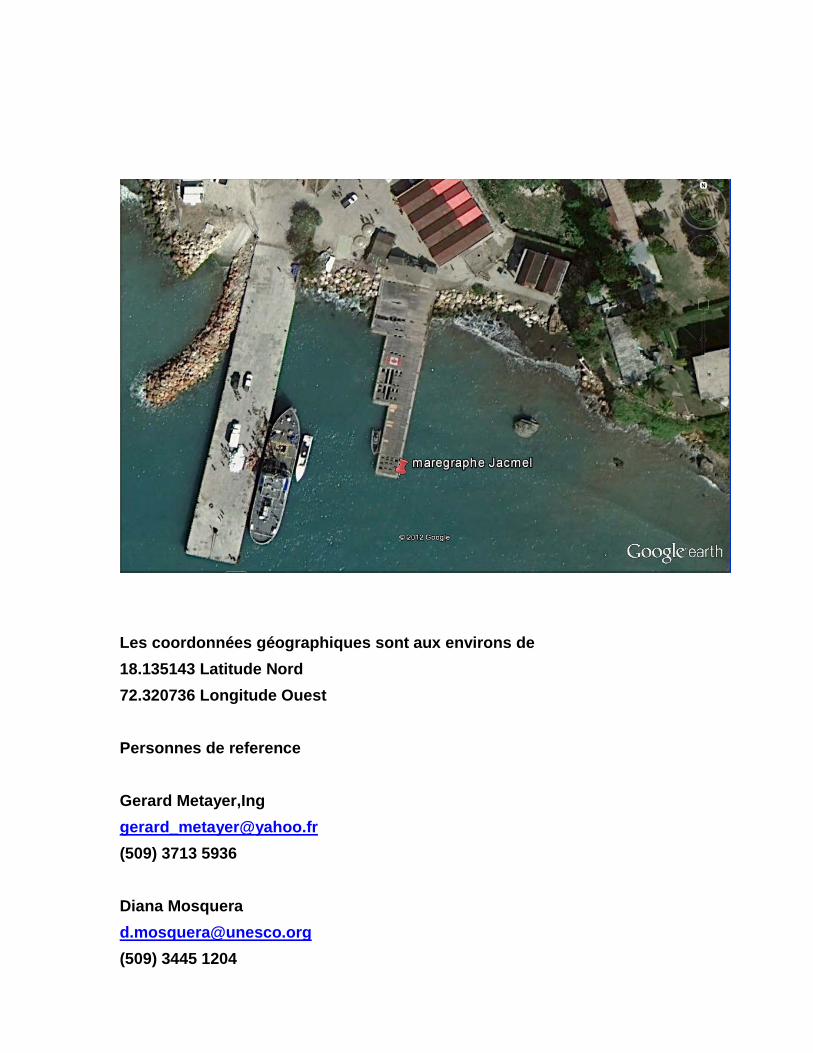
Les coordonnées géographiques sont aux environs de 18.135143 Latitude Nord 72.320736 Longitude Ouest Personnes de reference Gerard Metayer,Ing [email protected] (509) 3713 5936 Diana Mosquera [email protected] (509) 3445 1204

C’est un quai pour les touristes. Le quai est très jeune (10ans) Sa structure est une poutraison sur un ensemble de pieux en béton armé Le marégraphe sera placé sur une poutre profonde a l’extrémité du quai


CONDITIONS DE CHOIX DU SITE DU MAREGRAPHE Port-au-Prince, Haiti
1 2 3
• Installation résistante aux pires conditions météorologiques (neige, tempête)
• Sol stable, sans tassement et sans glissement
• Pas d’embouchures de rivières
• Site ouvert à l’océan • Cap ou pointe et bruits à éviter
• Endroit ou quai destiné à subir des
aménagements et où sont prévues des constructions • Courant électrique , génératrice,
• Site anti-feu, antivol, anti-vandalisme et accès approprié
pour installation et entretien • Benchmarks installés pour contrôle géodésique
• Au moins 2 mètres d’eau de profondeur
1= mauvais 2= moyen 3= bon Sur le quai il y a un benchmark installé dont il faut vérifier la validité. Dans le cas de non-validite, il faut installer un autre

Les coordonnées géographiques sont aux environs de 18.320364 Latitude Nord 72.224645 Longitude Ouest Le marégraphe sera installé au site des Garde cotes sur une partie du quai en remblai et recouvert de béton armé. Cette zone est indépendante de tout trafic des bateaux de garde cotes et de tous travaux de construction d’aménagement du port Personnes de reference Gerard Metayer [email protected] (509) 3713 5936 Diana Mosquera [email protected] (509) 3713 5936
