capacity for change: urban development and historic
TRANSCRIPT

1 Oxfordshire Historic Landscape Characterisation
Capacity for change: urban development and historic landscape character in
Oxfordshire
1 Introduction ........................................................................................................... 2
2 Methodology .......................................................................................................... 3
2.1 Stage 1: Scenario ............................................................................................ 3
2.2 Stage 2: Assessing potential impact on the Historic Landscape ............... 4
2.3 Stage 3: Assessing Historic Significance of HLC Types ............................ 5
2.4 Stage 4: Capacity Modelling and Mapping ................................................... 6
2.5 Stage 5: Additional Constraints .................................................................... 6
3 Results ................................................................................................................... 8
3.1 Capacity Category 1: Low ............................................................................ 10
3.2 Capacity Category 2: Low-Medium ............................................................. 10
3.3 Capacity Category 3: Medium ...................................................................... 10
3.4 Capacity Category 4: Medium-High ............................................................ 10
3.5 Capacity Category 5: High ........................................................................... 11
3.6 Mapping Capacity for large-scale Urban Development ............................. 11
3.6.1 Capacity Map .......................................................................................... 12
4 Conclusion ........................................................................................................... 15

2 Oxfordshire Historic Landscape Characterisation
1 Introduction The case study was chosen due to the increasing pressure the landscape is facing from development and urban growth. It is hoped that HLC data can provide another tool for better managing this growth. Current growth estimates anticipate the population of Oxfordshire to rise from 672,000 residents recorded in 2014 to 928,000 residents in 2051.0F
1 In response to this growing population, a need to improve housing affordability, and in order to support continued economic growth, the Oxford Strategic Housing Market Assessment (SHMA) has identified a need for between 93,560 and 106,560 new homes in the county between 2011 and 2031.1F
2 These homes will add pressure to the landscape both within and surrounding Oxfordshire’s current settlements and it was, therefore, desirable to assess the impact on the historic character of the county. A pilot study was carried out which examined the character of a two kilometre buffer around five of Oxfordshire’s major settlements: Oxford, Banbury, Chipping Norton, Wantage, and Wallingford. It proposed a method by which the capacity of these areas to absorb changes wrought by urban development can be measured. With the support of Historic England and the Oxfordshire HLC project Stakeholder Group, this pilot study has been expanded to cover the whole county. This case study provides information for any landowner, developer, or planning officer considering new urban development in Oxfordshire. This tool allows better judgements regarding the positioning and layout of new urban development in respect of the historic landscape. The resultant dataset is a baseline upon which to build detailed site assessment, it is not a substitute for consulting the HER or the Local Authority archaeologists. The tool is designed for use as part of the pre-planning application process that developers routinely undertake. It will help them establish the risks and thus the potential constraints and costs when dealing with aspects of the historic environment and the landscape. An Operational Guide has been produced to accompany this report. The guide is designed for all those involved in new urban development planning and describes four steps on how to use the data produced by this research.
1 Population growth as predicted by Oxfordshire County Council Research and Intelligence Unit, available from
www.oxfordshire.gov.uk/insight 2 Oxford Strategic Housing Market Assessment Report, prepared by G L Hearn Limited, March 2014.
3 Oxfordshire Historic Landscape Characterisation
2 Methodology To assess the capacity for urban development in Oxfordshire, five stages were defined: scenario; assessing vulnerability and capacity of the historic landscape; assessing significance of HLC types; capacity modelling and mapping; and additional constraints. This methodology has been influenced by work in Cornwall and by a current review being conducted by Historic England with regards to assessing sensitivity to change. 2F
3 The data compiled is presented in the accompanying Data Table.
2.1 Stage 1: Scenario Large-scale urban development in Oxfordshire. The scenario includes: housing, commercial sites, educational, religious, and health facilities, and supporting infrastructure. Potential impacts of large-scale urban development Many potential impacts of urban development will affect the historic landscape whilst others will have little or no effect.3F
4 As a starting point, however, all potential impacts were considered and
classified as shown in Table 1, with potential negative impacts in red and positive impacts in green:
Category Impact Code
Potential Impacts of Urban Development
Economic 1.1 Increase in employment opportunities
1.2 Growth of retail
1.3 Loss of local businesses
1.4 Decrease in productive agricultural land
1.5 Decrease in large industrial sites
1.6 Decrease in tourism reliant on rural environment
Social (Communal and Historic)
2.0 Increase in homes
2.1 Investment in Civic Amenities – utilities, waste, sewage
2.2 Increase in health, education, and civil facilities
2.3 Increase in some leisure facilities – leisure centres and gyms, in particular
2.4 Increase in hospitality facilities – restaurants and bars etc
2.5 Loss of other Leisure Facilities, particularly those covering large areas
2.6 Loss of communal open spaces such as greens, recreation grounds, and land used for communal activities like fetes
2.7 Loss of sites with perceived communal value
2.8 Loss of / damage to historic landmarks or buildings
2.9 Loss of sites with perceived historic value
2.10 Damage to archaeological remains
2.11 Loss of agricultural way of living and local produce
3 Cornwall Council. 2010. Historic Landscape Character and sensitivity mapping for Photo-Voltaic (Solar Farms)
installations in Cornwall; Herring, P. & McOmish, D. forthcoming. Using Historic Landscape Characterisation when assessing sensitivity to change. Historic England. 4 Potentially impacts were derived from the works of Simon, D. 2008; Heimlich, R. E. & Anderson, W. D. 2001.
Development at the Urban Fringe and Beyond: Impacts on Agricultural and Rural Land. Economic Research Service. United States Department of Agriculture; Bhatta, B. 2010. Analysis of Urban Growth and Sprawl in Remote Sensing Data. Pp. 17-36.

4 Oxfordshire Historic Landscape Characterisation
2.12 Degradation of community cores by large-scale retail outlets refocusing economic activity to fringes
2.13 Increase in house prices, pricing out local families
2.14 Development of commuter settlements with a lack of sense of community
2.15 Loss of settlement boundaries through sprawl, decreasing sense of communal identity
2.16 Congestion
Environmental (Environmental, Aesthetic, and Health)
3.1 Increased accessibility to health and care facilities
3.2 Increased pollution – noise, light, air, and litter
3.3 Loss of perceived healthy environment contributing to mental health issues
3.4 Increased use of cars with environmental and health impacts
3.5 Loss of historic lanes, replaced with modern roads
3.6 Reduction in social interaction as community suffers and commuting increases
3.7 Mental health problems associated with loss of community
3.8 Loss of places with high aesthetic value
3.9 Reduction in biodiversity
3.10 Reduction in landscape diversity creating homogenous environments
3.11 Loss of habitats
3.12 Subdivision and disruption of remaining habitats
3.13 Deforestation and removal of hedgerows
3.14 Loss of sensitive environments such as wetlands and floodplains
3.15 Increased surface run-off, effecting flood hazard Table 1 The potential impacts of large-scale urban development
2.2 Stage 2: Assessing potential impact on the Historic Landscape Having identified ways in which the creation of large-scale urban development might have an effect on historic landscape character, the potential impact on each HLC Type was assessed. It must be emphasised that this assessment was based on sites in Oxfordshire and nowhere else. For example, judgements about the HLC Type Prison were based upon examples of prisons in Oxfordshire and would not, necessarily, be the same judgements as those made about prisons in London or Nottinghamshire. Impact values were assigned a weighted score which ranged between -0.5/-1 and -2/-4, reflecting varying degrees of impact: -0.5/-1 = little or no impact; -2 = likely high impact on character which can add historic value (landscapes which have environmental or aesthetic qualities which may derive from or enhance a historic landscape); -4 = likely high impact on historically important landscapes (Table 2).
Capacity Threat Weighted Score
Effect on Legibility and Readability of Time Depth How likely is the scenario to change the ability to read or see a landscape’s history?
Loss of historic settlement boundaries through expansion Removal of hedgerows defining historic fields Removal of historic lanes and replacement with new roads
-1 to -4

5 Oxfordshire Historic Landscape Characterisation
Loss of Ancient Woodland or historic Enclosure types due to development Loss of sites with perceived historical value
Impact on Archaeological Remains How likely is the scenario to disturb known or predicted archaeological remains?
Removal of / damage to archaeological remains through development
-1 to -4
Impact on Historic Built Structures How likely is the scenario to disturb historic built structures?
Loss of / damage to historic landmarks or buildings through redevelopment
-1 to -4
Change in Landscape Character How likely is the scenario to affect how the historic landscape contributes to the overall landscape?
Removal or loss of landscapes characteristic of an area Removal or loss of historic landscapes which are now rare in an area Removal or loss of ancient landscapes
-1 to -4
Effect on Semi-Natural Components How likely is the scenario to disturb historically significant ecosystems or landforms?
Loss of / damage to biodiversity Loss of Ancient Woodland through deforestation Loss of Rough Ground through development Loss of old hedgerows through development or landscape reorganisation Disruption to widespread historic ecosystems
-0.5 to -2
Effect on Amenity How likely is the scenario to affect amenity activity?
Pollution Loss of places of communal importance Reduction in landscape diversity Loss of Aesthetically and Environmentally important places Change of public access routes
-0.5 to -2
Table 2 Impact values: how the historic landscape may be affected by large-scale urban development
2.3 Stage 3: Assessing Historic Significance of HLC Types Historic significance was suggested using two methods. The first used data from the HLC project to determine the occurrence, trajectory of change, biodiversity potential, and period of origin for each HLC type. The second used the results of two surveys: archaeological potential was assigned by the Oxfordshire Archaeological Team and historic, aesthetic, and communal value was assigned using the results of a public survey.4F
5 N.B. Types which were only used within Oxford City could not be assigned a Trajectory of Change Value, so it was not possible to assign these types a historic significance value. As a consequence, it
5 For further information on these surveys, see Chapter 5.1.7 of the Oxfordshire HLC Final Report.

6 Oxfordshire Historic Landscape Characterisation
was not possible to model these types’ capacity for large-scale urban development. The existing urban context of these types, however, reduces the impact of large-scale urban development and their absence from the modelling is, therefore, though to be of only limited concern. Weighting As with the generation of impact values, historic significance values were weighted, this was to reflect the likely effect on the historic aspect of the landscape. These weighted scores ranged from 1 to 7, with one signalling common, rapidly increasing, low biodiversity and archaeological potential, and modern types with low historic, aesthetic and communal value (Table 3). Occurrence: to differentiate between Very Rare Modern types, which have less of an impact on the historic character of a landscape, and Very Rare Medieval types which would be of more significance, the Occurrence value was further adjusted according to the Period of each type. This was done using the following formula: (Occurrence Value x Period Value)/5. The value was divided by five to give a number between 0 and 6, in line with the other values used. Archaeological Potential and Historical Value: to reflect the importance of these values for historic character of a landscape, these values were weighted more heavily than Biodiversity Potential and Aesthetic/Communal Value. These were valued at 1 (low), 3 (medium), or 6 (high).
Significance Criteria Weighted Score Occurrence How rare or commonplace is an HLC type? 0 (Low) to 6 (High)
Trajectory of Change Is an HLC Type decreasing or increasing? 1 to 7
Biodiversity Potential What is an HLC type’s potential for biodiversity? 1 to 5
Archaeological Potential What is an HLC type’s potential for preserved archaeological or historic building remains?
1 to 6
Period of Origin What period does an HLC type tend to date to? 1 to 6
Historical Value How well does an HLC type link people to the past? 1 to 6
Aesthetic Value How attractive or inspiring is an HLC Type? 1 to 3
Communal Value How important is an HLC Type to a community? 1 to 3 Table 3 Significance values: how valuable is a historic landscape type?
2.4 Stage 4: Capacity Modelling and Mapping The impact value was multiplied by the historic significance value to give an indicator of the capacity for large-scale urban development an HLC Type might or might not have.
Impact Value x Historic Significance Value = Capacity for Urban Development Value These capacity values were divided into quintiles – High, Medium-High, Medium, Low-Medium, and Low – and then mapped. This resulted in a map of Oxfordshire: Capacity for Urban Development.
2.5 Stage 5: Additional Constraints To this map a capacity constraints layer was added which shows parts of Oxfordshire where a designation applies which needs to be taken into consideration in any application for large-scale urban development (Table 4). It is anticipated that these designations will not necessarily preclude any change of land use to urban development; their presence, however, should form part of any assessment of the suitability of the land and the impact of the proposed application.

7 Oxfordshire Historic Landscape Characterisation
Designation (Map key) Description World Heritage Site (WHS) One World Heritage site covering 930 hectares: Blenheim Palace
Scheduled Monument (SM) 291 Scheduled Monuments covering 1,540 hectares
Registered Parks and Gardens (RPaG)
56 Parks and Gardens covering 5,111 hectares
Registered Battlefield (RB) Two Battlefields covering 339 hectares: Chalgrove (1643) and Cropredy (1644)
Area of Outstanding Natural Beauty (AONB)
Three AONBs covering 66,733 hectares: Cotswold Hills, Chiltern Hills, and the North Wessex Downs
Site of Special Scientific Interest (SSSI)
161 sites covering 4,472 hectares
Table 4 Designated land superimposed on the capacity mapping
Conservation Areas, Archaeological Notification Areas, and Listed Buildings and non-designated Monuments should also be considered when assessing proposals for large-scale urban development. These were not, however, mapped. Firstly, Oxfordshire County Council only holds information on the Conservation Areas in Cherwell and South Oxfordshire Districts; no mapping was available for the purposes of this study for the districts of West Oxfordshire, Oxford City, and the Vale of the White Horse. Secondly, the Archaeological Notification Areas previously used by the Archaeology Team were only used to indicate where the team would like to be consulted on planning applications and did not directly equate to areas of known heritage assets of importance or areas with the potential for important archaeological deposits. Furthermore, these areas are no longer used or distributed and, consequently, hold little relevance to this analysis. Finally, Listed Buildings and non-designated monuments (heritage assets) recorded by the HER were not mapped as there are too many to display at a county-wide scale: there are 12,113 Listed Buildings and 24,955 heritage assets. It is recommended that people consult the HER directly when considering a proposal and use the data provided by that service alongside this evidence base.

8 Oxfordshire Historic Landscape Characterisation
3 Results HLC Types were initially divided equally between five capacity categories, with between 21 and 19 types assigned to each (Table 5). The HLC Types in each Capacity Category are shown below in Table 6 and the raw data with Impact Values, Historic Significance Values, and Capacity Values are stored in the accompanying Data Table.
Capacity Category Capacity Value # HLC Types
1 – Low -682.5 to -510 21
2 -510 to -247.4 19
3 -247.4 to -133.4 19
4 -133.4 to -60.3 20
5 – High -60.3 to -39 20 Table 5 The number of HLC Types in each Capacity Category

9 Oxfordshire Historic Landscape Characterisation
Capacity Category 1 - Low 2 3 4 5 - High
HLC Types
Military - Castle Rural - Country House
Recreation - Public Park
Civil Provision - Gov Office and Civic Centre Military - Barracks
Military - Hillfort
Woodland -Woodland Pasture
Communication -Bike Path/ bridleway
Communication - Airfield (Commercial)
Recreation - Other Leisure facilities
Open Field System
Piecemeal Enclosure Urban - Town
Prairie / Amalgamated Enclosure
Recreation - Community Centre
Urban - Historic Urban Core Rural - Hamlet Urban - City
Recreation - Racing Sports Sites
Communication - Main Road
Orn -Deer Park Rural - Village Urban - Dwelling
Civil Provision - Health Care Facility
Industry -Energy Industry
Woodland - Ancient Woodland
Communication -Canals and Locks
Recreation - Golf Course Military base
Industry -Extractive Works
Orn-Parkland / Designed Landscape
Woodland -Secondary Woodland Urban - Market
Commercial - Fish Farm
Commercial- Road Side Service Centre
Communication -Ridgeway
Orchard and Hort - Allotment Rural - Dwelling
Industry -Flooded Extractive pits
Communication - Telecommunications
Unenclosed -Rough Ground
Planned Enclosure
Enclosure - Paddocks and Stables
Industry -Manufacturing
Civil Provision - Park and Ride
Crofts (medieval & Post Medieval)
Rural -Farmstead
Woodland -Plantation Urban - Hotel
Commercial -Shopping Centre
Orn -Ornamental water body
Industry -Mill / Mill Complex
Military - Shooting Range
Urban - Caravan and Camp site/ chalet site
Communication -Major Road Junction
Assarted Enclosure
Water - Water Meadow
Recreation -Sports Facilities
Civic Amenities - Reservoir
Communication -Motorways
Managed Archaeological Site
Recreation - Nature Reserve
Orchard and Hort - Vineyard
Civil Provision - Police station
Commercial -Retail park
Unenclosed -Green
Water - Watercress Beds Urban - Public House
Enclosure - Reclaimed land
Civic Amenities - Waste Disposal
Closes
Communication -Rail transport sites Rural - Hotel
Recreation - Hunting Site
Civil Provision - Immigration Detention Centre
Ancient Enclosure
Recreation - Country Park
Orchard and Hort - Nursery/ Garden Centre
Industry - Processing industry
Commercial - Business Park
Civil Provision - Religious and Funerary
Water - Fresh Water Body
Military - Military Airfield
Civic Amenities - Sewerage Treatment Works Industry - Depot
Ladder Field System
Orn -Domestic Garden
Reorganised Enclosures
Civic Amenities - Utilities Industry -Scrap Yard
Squatter Enclosure
Civil Provision - Educational Facility
Rural - Caravan/Chalet/ Camping site
Military - Communications
Industry -Timber Yard
Orchard and Hort - Orchard
Civil Provision - Prison
Industry -Industrial Estate
Water - River
Table 6 HLC Types in each Capacity Category using the Capacity for Urban Development Value

10 Oxfordshire Historic Landscape Characterisation
3.1 Capacity Category 1: Low HLC Types included in this category are those with the lowest capacity for large-scale urban development; types whose historic character would be most affected by the change of land use. For example, this might be because a type has good historic legibility which would be obscured by the building of houses or is typically associated with high archaeological potential which might be susceptible to damage. Types in this category include some of the most historic parts of the county: Castle, Hillfort, Ridgeway, and Historic Urban Core. These types have structures or highly visible features which clearly demonstrate links to the past – the post medieval, medieval, and prehistoric periods – and it is these that are vulnerable to urban development. A number of enclosure types are also included within this category – Open Field System, Closes, Crofts, Assarted Enclosure, Ancient Enclosure, Ladder Field System, and Squatter Enclosure. These are typically not as old as the types mentioned above, but they frequently date to the post medieval period and, given the large areas they cover, are important for preserving the historic legibility and historic coherence of our landscapes. Woodland and Ornamental types also appear here as they often date to the later medieval or post-medieval periods and serve as very visible reminders of the depth of history in the landscape.
3.2 Capacity Category 2: Low-Medium The nineteen HLC Types in this category have slightly more capacity for urban development than those in Category 1, but they are still vulnerable to some of the changes which might be brought about. These types are frequently post-medieval in date, but may have seen some adaptation over time which would reduce the potential impact of urban development. For example, Piecemeal and Planned Enclosure and Secondary Woodland. Some types in this category cover smaller areas than those in Category 1, so have less of a contribution to local or regional character. This means that a proposed change in land use would potentially have less of an effect. Allotments, Orchards, and Woodland Pasture are good examples. A number of types with historic buildings are included within this category. As an existing part of the built environment the effect of urban development is likely to be reduced; however, the age of many of the buildings means that they are likely to be susceptible to negative impacts associated with this change scenario.
3.3 Capacity Category 3: Medium Types in this category are typically modern and many are found within settlement contexts, for example: City, Market, Public House, and Sports Facilities. As modern built types, these have been assigned a higher capacity for urban development as they are less likely to contribute to historic legibility or preserve archaeological remains or historic structures. Many of these building-related types, however, might have some communal value, so they have not been assigned to a higher capacity category. There are some non-built types included within this category which cover very large areas and which consequently dominate local character – namely Airfields, Golf Courses, and Paddocks. Despite being modern types some archaeological potential may remain and some historic buildings may exist. Combined with their dominance, this reduces their capacity for new woodland.
3.4 Capacity Category 4: Medium-High Types in this category are, in the main, modern and of little historic significance. Types include: Government Office and Civic Centre, Police Station, Hotel, and Reclaimed Land. They tend to relate to the built environment, but there are also some Enclosure types. These types have some communal or environmental value which has reduced their capacity for change. The types

11 Oxfordshire Historic Landscape Characterisation
Manufacturing and Processing are included here as they can have some historic value, the Jam Factory and University Press in Oxford, for example. Some modern types which often cover large areas and which, therefore, contribute to local or regional character can also be found in this category – for example, Commercial Airfield, Prairie/ Amalgamated Enclosure and Flooded Extractive Pits.
3.5 Capacity Category 5: High Types in this category have the highest capacity for large-scale urban development as they rarely preserve historic legibility or archaeological potential, are not often associated with historic buildings, frequently contribute little to local character, and have been assigned low communal, aesthetic, and/or environmental value. Modern infrastructure types feature largely in this category – Main Road, Motorway, Major Road Junction, Road Side Service Centre, Communications, and Telecommunications. So to do Industrial and Commercial types may be more appropriate – Extractive Works, Industrial Estates, Timber and Scrap Yards, Retail and Shopping Centres.
3.6 Mapping Capacity for large-scale Urban Development Using an Attribute query in MapInfo it was possible to append the Capacity Category to the HLC table using the HLC Type, thus linking these categories to each and every polygon in Oxfordshire. The table below (Table 7) shows how many polygons were assigned to each category, with Category 2 (Low-Medium) and Category 3 (Medium) being the most common.
Table 7 The number of polygons assigned to each Capacity Category
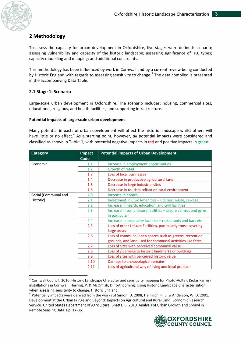
Using the updated HLC table it was possible to map the distribution of capacity for large-scale urban development. When the total area of Oxfordshire covered by each Capacity Category was analysed, it showed very similar results to Table 7, with types in Categories 2 and 3 covering an almost equal amount and the majority of the county (Table 8).
1 - Low 2 3 4 5 - High
Polygons 1382 6117 5013 1628 664
0
1000
2000
3000
4000
5000
6000
7000
Nu
mb
er
of
Po
lygo
ns
Number of polygons in each Capacity Category
12 Oxfordshire Historic Landscape Characterisation
Table 8 Total Area of Oxfordshire covered by each Capacity Category
A map was then produced which shows how the capacity for large-scale urban development varies across the county. This map also shows a constraint layer overlay to identify World Heritage Sites, Scheduled Monuments, Register Parks and Gardens, Registered Battlefields, Areas of Outstanding Natural Beauty, and Sites of Specific Scientific Interest. The capacity for urban development in Oxfordshire map is available as a pdf and as GIS shapefiles, both available from the project archive. It is also possible to explore an interactive map online here. It should be emphasised that these maps represent a snapshot point in time. Landscape change is a continuous process and, therefore, these maps should be seen as a guide for what might be achieved with this data. When considering an application for development or identifying a potential site, the current land use should be established and then located within the accompanying Data Table, where information on how urban development might affect aspects of historic character and the Capacity Category are stored for each HLC Type. 3.6.1 Capacity Map5F Figure 16 suggests that the area with the lowest capacity (Category 1) for urban development is the south-eastern part of Oxfordshire, broadly corresponding with the Chiltern Hills AONB. The low capacity in this area is due to the concentration of surviving Ancient Woodland on the chalk hills and the Ancient Enclosures which lie between these tracts. The largest sites with the lowest capacity for urban development, however, are found outside of this area. These cluster in the central part of the county, north of the city of Oxford and typically correlate with large ornamental landscapes: Blenheim Park, Eynsham Park, Cornbury Park, and Middleton Park etc. Wytham Hill immediately to the north-west of Oxford represents another concentration of low capacity, comprising a large ancient wood and a country house with grounds. There is a wide band of Category 2 types running southwest – northeast across the north-western part of the county, spanning both West Oxfordshire and Cherwell Districts. This band contains the Cotswold Hills AONB but, unlike the Chilterns, is not restricted to the designated area, expanding north and east beyond the AONB, but still keeping to the higher ground. This band is a result of a
6 A larger version of this map is reproduced in the accompanying map tiff file.
1 - Low 2 3 4 5 - High
Hectares 22135 87988 87841 56758 5176
0
20000
40000
60000
80000
100000H
ect
are
s
Area of Oxfordshire covered by each Capacity Category

13 Oxfordshire Historic Landscape Characterisation
concentration of post-medieval Planned and Piecemeal Enclosures which have not been reorganised or amalgamated by modern agricultural regimes. This is likely to relate to the prevalence of pastoralism in this part of the county which, in itself, has a long history and has shaped the landscape. Running east-west across the southern part of Oxfordshire there is an area with higher capacity for urban development, with a concentration of Category 4 and 5 types. This area includes parts of the Vale of the White Horse District and, interestingly, the North Wessex Downs AONB. The Vale and western part of South Oxfordshire District have a large number of Amalgamated and Reorganised Enclosures reflecting both the quality of the land which has been exploited by modern farming and also reorganisation of the landscape around major modern development on the edge of places like Didcot and Abingdon and along major communication routes, such as railways and dual carriageways. The high number of types categorised as having a high capacity on the North Wessex Downs may be a little surprising but it is a feature of the late enclosure of the downland landscape and the presence of very large Prairie Enclosures. The equestrian industry is also a contributing factor with large parts of the area converted to paddocks and gallops. There is another area of high capacity encircling Oxford, reflecting the number of modern communication links, industrial, commercial, and recreational sites which have focussed here due to the proximity of a major urban population. These along with urban development in surrounding towns, such as Woodstock, have led to high levels of landscape reorganisation which has significantly reduced historic legibility. Figure 1 additionally shows some correspondence between areas of low capacity and designated landscapes included within the constraints layer. Register Parks and Gardens, for example, directly relate to the HLC Types Parkland and Deer Park, both of which are categorised as having a low capacity. The only World Heritage Site in Oxfordshire, Blenheim Park, is also characterised as the type Parkland and is consequently also afforded a low capacity for new woodland. However, other features on the constraints layer are found within areas thought to have a higher capacity for urban development. Scheduled Monuments, in particular, are often found within Reorganised or Prairie/Amalgamated Enclosures. This is due to HLC Types deriving from dominant landscape character and many SMs not being large enough to affect character or indeed be captured by the HLC project, which used a digitisation minimum of two hectares. Additionally some designated features do not affect landscape character, battlefields and buried archaeological sites, for example. The differences between the datasets serve to show how important it is to consider other aspects which might affect capacity for change, not just historic landscape character. These constraints along with historic landscape character do not serve as a barrier to urban development, but should be considered in any application in order that important heritage assets and landscapes of environmental and historical importance are better managed for future generations.

14 Oxfordshire Historic Landscape Characterisation
Figure 1 Capacity for large-scale Urban Development in Oxfordshire

15 Oxfordshire Historic Landscape Characterisation
4 Conclusion This research has resulted in a dataset which can be used to promote sustainable development. The historic environment, whether that be ancient monuments, historic buildings, or whole landscapes is the inheritance of us all and it is our responsibility to manage its character for future generations. The National Planning Policy Framework (NPPF) recognises the significance and fragility of this resource and requires the consideration of the historic environment in applications for change of land use.6F
7 As an evidence base, this dataset can be used to identify parts of the landscape where large-scale urban development is likely to have the greatest and the lowest impact on the character of the historic landscape. It is, therefore, an excellent tool to aid in the identification of new development sites.
7 See Chapter 12 of the National Planning Policy Framework for further information about the Historic
Environment https://www.gov.uk/government/uploads/system/uploads/attachment_data/file/6077/2116950.pdf