california passage - caltrans · five new fish passage remediation projects have been ... 15 2...
TRANSCRIPT


California Department 2013 Fish Passage of Transportation Annual Report to Legislature
Page 1 of 16
Annual Report to the Legislature
For Calendar Year 2013
COASTAL ANADROMOUS FISH PASSAGE ASSESSMENT
AND REMEDIATION PROGRESS REPORT
*Chadd Creek (D1) Fish Passage structure
Prepared:
October 2014
Prepared by the California Department of Transportation
Division of Environmental Analysis

California Department 2013 Fish Passage of Transportation Annual Report to Legislature
Page 2 of 16
Table of Contents
Executive summary…………………………………………………………………………………...………………. Page 3
Related Policy and Regulation …….………………………….………………….…………………………. Page 5
Table 1 ‐ Figure 1 ‐ 2013 Completed Fish Passage Remediation ….....…...……... Page 6
Table 2 ‐ Figure 2 ‐ 2013 Completed Fish Passage Assessments …….…..………… Page 7
Table 3 ‐ Active Fish Passage Remediation Projects …….….…………................……. Page 8
Figure 3 – Active Fish Passage Remediation Projects ………..………….…………...…. Page 10
Table 4 ‐ Priority Fish Passage Barriers for Remediation …….……………………….. Page 11
Figure 4 ‐ Priority Fish Passage Barriers for Remediation ….……………..………….. Page 13
Programmatic Environmental Review Process ………..…………………….……………….. Page 14
Appendix A – Completed Fish Passage Remediated, 2006 – 2013 ……………… Page 15

California Department 2013 Fish Passage of Transportation Annual Report to Legislature
Page 3 of 16
Executive Summary
The purpose of this report is to provide fish passage assessment and remediation information
regarding state highways barrier locations, for which the California Department of
Transportation (Caltrans) is responsible. This report updates Caltrans’ progress and describes
assessment and remediation activities between January 1 and December 31, 2013.
Fish Passage Program Accomplishments2013 ‐ Completed Barrier Remediations 4
2013 ‐ Completed Passage Assessments 4
Current Remediation Projects (programmed) 27
Statewide Priority Fish Passage Barriers (future program) 36
Total Remediated Fish Passage Barriers (Jan 1, 2006 to Dec 31, 2013) 31
Estimated Caltrans barriers, per the Passage Assessment Database (PAD), maintained by California Department of Fish & Wildlife (CDFW)
569
Caltrans has worked with CDFW to create the first combined priority list of fish passage barriers on the state highway system.
Five new fish passage remediation projects have been programmed since the last annual report (pages 8 & 9).
There are twenty‐nine prioritized locations that have been added since the last annual report (pages 11 & 12), in coordination with CDFW.
6%
4%
1%4%85%
Fish Passage Program
2013 Statewide Priority Fish Passage Barriers (future program)
2013 Current Remediation Projects (programmed)
2013 Completed Barrier Remediations
Total Completed Barriers (2006‐2012)
Estimate Caltrans Barriers (future program)

California Department 2013 Fish Passage of Transportation Annual Report to Legislature
Page 4 of 16
Caltrans Fish Passage Barriers by District(all future program locations)
District Estimated Fish Passage Barriers
2013 Priority Locations
1 – Eureka 322 11
2 ‐ Redding 56 9
3 ‐ Marysville 6 0
4 ‐ Oakland 72 10
5 – San Luis Obispo 87 2
6 – Fresno 0 0
7 – Los Angeles 23 2
10 – Stockton 0 0
11 – San Diego 2 2
12 ‐ Orange 1 0
TOTAL 569 36 *Per the Passage Assessment Database (PAD)
In coordination with CDFW, Caltrans has completed a quality assurance/quality control review (QA/QC) of all state highway locations within the PAD. The purpose of the QA/QC was to review and remove duplicate locations and locations that do not correlate with state highway facilities to determine where additional fish passage assessments are needed. The above table, Caltrans Fish Passage Barriers by District, lists existing fish passage barriers, in all district with current or history anadromous fish habitat, as provided by the PAD QA/QC effort.
Related to the above bullet, Caltrans has funded a task order to assess identified stream crossings, statewide, to investigate additional fish passage barriers that may exist. The scope of this effort is currently in development. The task order was executed Oct 1, 2014.
Caltrans District Map
California Department 2013 Fish Passage of Transportation Annual Report to Legislature
Page 5 of 16
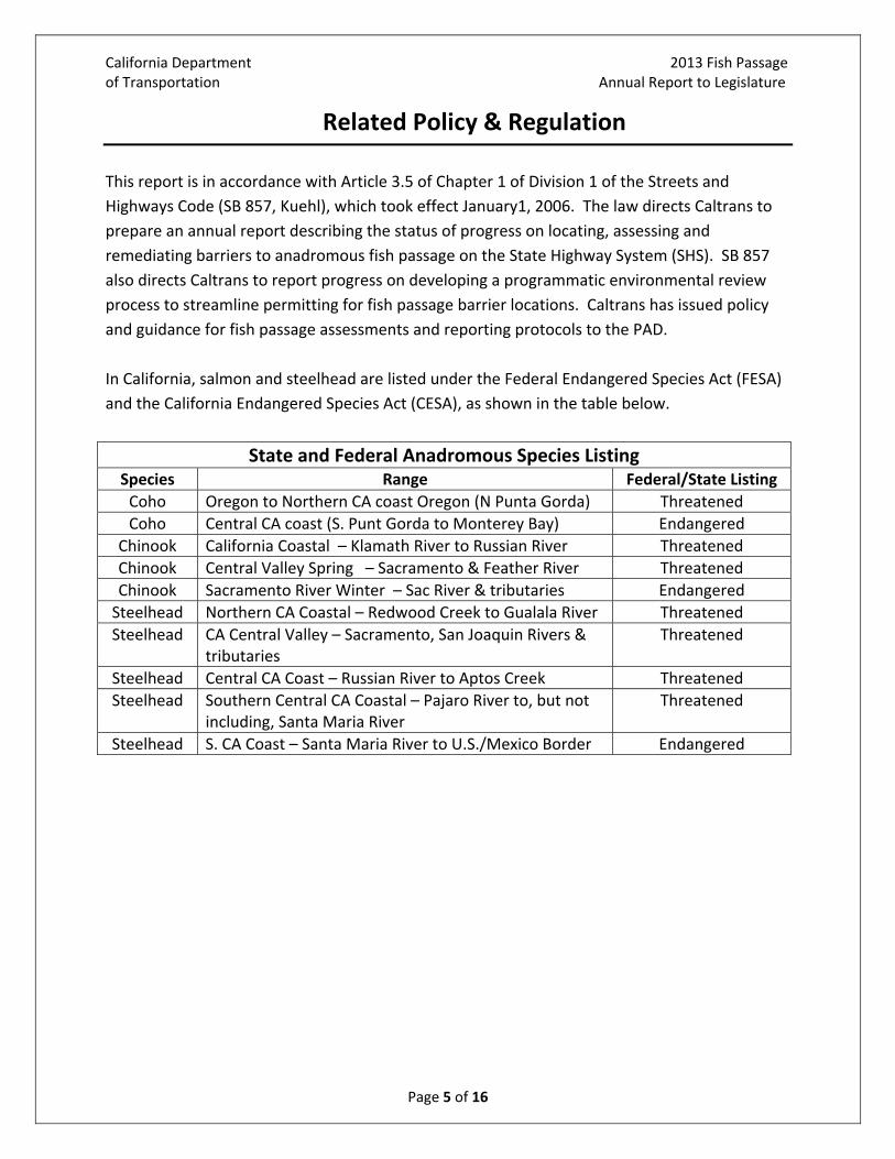
Related Policy & Regulation
This report is in accordance with Article 3.5 of Chapter 1 of Division 1 of the Streets and
Highways Code (SB 857, Kuehl), which took effect January1, 2006. The law directs Caltrans to
prepare an annual report describing the status of progress on locating, assessing and
remediating barriers to anadromous fish passage on the State Highway System (SHS). SB 857
also directs Caltrans to report progress on developing a programmatic environmental review
process to streamline permitting for fish passage barrier locations. Caltrans has issued policy
and guidance for fish passage assessments and reporting protocols to the PAD.
In California, salmon and steelhead are listed under the Federal Endangered Species Act (FESA)
and the California Endangered Species Act (CESA), as shown in the table below.
State and Federal Anadromous Species Listing Species Range Federal/State Listing
Coho Oregon to Northern CA coast Oregon (N Punta Gorda) Threatened
Coho Central CA coast (S. Punt Gorda to Monterey Bay) Endangered
Chinook California Coastal – Klamath River to Russian River Threatened
Chinook Central Valley Spring – Sacramento & Feather River Threatened
Chinook Sacramento River Winter – Sac River & tributaries Endangered
Steelhead Northern CA Coastal – Redwood Creek to Gualala River Threatened
Steelhead CA Central Valley – Sacramento, San Joaquin Rivers & tributaries
Threatened
Steelhead Central CA Coast – Russian River to Aptos Creek Threatened
Steelhead Southern Central CA Coastal – Pajaro River to, but not including, Santa Maria River
Threatened
Steelhead S. CA Coast – Santa Maria River to U.S./Mexico Border Endangered

California Department 2013 Fish Passage of Transportation Annual Report to Legislature
Page 6 of 16
2013 Completed Fish Passage Remediation
Four fish passage remediation projects were completed in 2013. Table 1, 2013 Completed Fish
Passage Remediation, contains information on the four locations. Below Table 1 is Figure 1,
showing the locations that are listed in Table 1.
Table 1 – 2013 Completed Fish Passage RemediationMap #
Caltrans District
County Route Post Mile
Pad ID #
Stream Name Project Name
1 1 Del Norte 197 2.12 720982 Peacock Creek Peacock Creek Emergency Project
2 1 Humboldt 299 4.2 716742 Hall Creek Mad River Bridges Replacement ‐ Mitigation
3 1 Mendocino 1 92.8 706958 Dunn Creek 10 Mile Bridge Replacement Mitigation
4 1 Mendocino 101 83.99 706987 Rattlesnake Creek
Rattlesnake Creek Fish Passage Remediation
Figure 1 ‐ 2013 Completed Fish Passage Remediation
The fish passage remediation projects,
above, which were completed in 2013 were
initiated due to mitigation needs for bridge
replacement projects (Dunn & Hall Creek),
an emergency culvert repair (Peacock
Creek) and maintenance upgrades that
were needed (Rattlesnake Creek).

California Department 2013 Fish Passage of Transportation Annual Report to Legislature
Page 7 of 16
2013 Completed Fish Passage Assessments
Four fish passage assessments were completed in 2013. Table 2, 2013 Completed Fish Passage
Assessments, contains information on assessment locations. Below Table 2 is Figure 2, showing
the locations that are listed in Table 2.
Table 2 – 2013 Completed Fish Passage AssessmentsMap #
Caltrans District
Report Date
County Route Post Mile
PAD ID #
Stream Name
Tributary to
1 4 2/27/13 Alameda 580 11.04 758578 Arroyo Seco Arroyo de la Laguna
2 4 2/27/13 Alameda 880 10.66 758579 Crandall Creek
Alameda Creek
3 4 3/01/13 Marin 1 50.5 732678 Americano Creek
Estero Americano
4 4 12/5/13 Santa Clara
9 3.6 733926 Booker Creek
Saratoga Creek
*Location 4 is a private diversion structure that is under the state highway.
Figure 2 ‐ 2013 Completed Fish Passage Assessments
District 4 (Oakland) staff completed
above assessments, as required, for work
within planned SHS project locations.

California Department 2013 Fish Passage of Transportation Annual Report to Legislature
Page 8 of 16
Active Fish Passage Remediation Projects
Caltrans has 27 projects that are currently underway, to remediate fish passage barrier
locations. Table 3, Active Fish Passage Remediation Projects, contains information on the
current remediation project locations. Locations listed in the table below are either funded
through construction, or partially funded for planning, design or permitting. Figure 3, (pg 10), is
a map of locations that are listed in Table 3. The locations that are bold and underlined are
new to the 2013 Fish Passage Annual Report.
Table 3 – Active Fish Passage Remediation ProjectsMap #
Caltrans District
County Route Post Mile
Estimated CCA Date1
PAD ID #
Stream Name Project Name
1 1 Mendocino 101 44.0 8/1/2019 713107 Unnamed tributary to Haehl Creek
Willits BypassMitigation
2 1 Mendocino 101 44.5 8/1/2019 712894 Unnamed tributary to Haehl Creek
Willits Bypass Mitigation
3 1 Mendocino 101 48.1 8/1/2019 705136 Upp Creek Willits Bypass
4 1 Mendocino 101 52.25 10/1/2015 707085 South Fork Ryan Creek
Willits BypassMitigation
5 1 Mendocino 101 52.4 8/1/2015 707086 North Fork Ryan Creek
North Fork Ryan Creek
6 1 Mendocino 101 66.5 10/1/2015 707096 Ten Mile Creek 36 Culverts
7 1 Mendocino 101 89.04 10/15/2016 706954 Cedar Creek Cedar Creek
8 1 Mendocino 128 20.15 7/3/2015 707196 Unnamed 22 Culverts2
9 1 Mendocino 128 21.8 9/15/2015 707199 Clow Creek 22 Culverts
10 1 Mendocino 128 27.5 9/15/2015 707205 Graveyard Creek
22 Culverts
11 1 Mendocino 128 36.6 9/15/2015 707208 Lost Creek 22 Culverts
12 1 Mendocino 128 39.8 9/15/2015 707210 Beebe Creek 22 Culverts
13 2 Shasta 299 32.2 11/3/2015 737295 Yank Creek/Lemm Creek Bridge
Bella Diddy Roadway Rehabilitation
14 2 Siskiyou 96 56.0 1/16/2015 707168 Fort Goff Creek Fort Goff Creek Fish Passage
1 Estimated Construction Contract Acceptance (CCA) dates. 2 22 culverts; only 5 of the 22 culverts have fish passage issues, all 5 are listed in this table.

California Department 2013 Fish Passage of Transportation Annual Report to Legislature
Page 9 of 16
Table 3 – Active Remediation ProjectsMap #
Caltrans District
County Route Post Mile
Estimated CCA Date1
PAD ID #
Stream Name Project Name
15 2 Trinity 299 68.0 9/15/2014 720511 Little Grass Valley Creek
Trinity Dam Boulevard Fish Ladder
16 2 Trinity 299 68.2 9/15/2014 735688 Little Grass Valley Creek
Trinity Dam Boulevard Fish Ladder
17 4 Contra Costa
80 8.4 10/15/15 723716 Pinole Creek Pinole Creek Fish Passage
18 4 Marin 1 24.77 10/30/18 732502 Tributary to Olema Creek
Olema Creek Culvert Replacement
19 4 Sonoma 1 15.1 2/1/2016 733223 Scotty Creek Gleason Beach Highway Realignment
20 5 Santa Barbara
1 15.6 4/1/20151 700085 Salsipuedes Creek
Salsipuedes Bridge Replacement
21 5 Santa Barbara
101 5.6 1/5/2022 734310 Arroyo Parida Creek
South Coast HOV
22 5 Santa Barbara
101 9.4 1/5/2022 705161 Romero Creek South Coast HOV
23 5 Santa Barbara
101 9.6 1/5/2022 734342 San Ysidro Creek
South Coast HOV
24 5 Santa Barbara
101 0.0 1/5/2022 707368 Rincon Creek South Coast HOV
25 5 Santa Barbara
101 38.8 9/15/2015 707403 Tajiguas Creek Tajiguas Fish Passage
26 5 Santa Barbara
101 2.2 5/1/2020 707182 Carpinteria Creek
Highway 101 Linden/ Casitas Pass
27 5 Santa Barbara
192 15.5 9/4/2017 706239 Arroyo Parida Crk
Arroyo Parida Creek
*Projects that are bold and underlined are new to the list, for the 2013 Fish Passage Annual Report.

California Department 2013 Fish Passage of Transportation Annual Report to Legislature
Page 10 of 16
Figure 3 ‐ Active Fish Passage Remediation Projects

California Department 2013 Fish Passage of Transportation Annual Report to Legislature
Page 11 of 16
Priority Fish Passage Barriers for Remediation
Caltrans has worked with CDFW to create the first combined priority list of known fish passage
barriers located on the State Highway System. Table 4, Priority Fish Passage Barriers for
Remediation, is listed below. All listed crossings have equal priority at this time. Caltrans
continues to work with resource agency partners toward the development of a statewide fish
passage barrier ranking and optimization system. The locations that are bold and underlined
are locations that are new to the 2013 Fish Passage Annual Report. There are 29 new locations
identified on the priority table.
Table 4 – Priority Fish Passage Barriers for RemediationMap #
Caltrans District
County Route Post Mile
PAD ID # Stream Name Tributary to
1 1 Del Norte 101 39.78 707134 Dominie Creek Smith River
2 1 Del Norte 197 5.0 707143 Sultan Creek Smith River
3 1 Del Norte 197 6.2 707142 Little Mill Creek Smith River
4 1 Del Norte 199 31.31 707137 Griffin Creek Middle Fork Smith River
5 1 Del Norte 199 34.04 712954 Broken Kettle Creek
Elk Creek
6 1 Humboldt 101 124.49 713025 Little Lost Man Prairie Creek
7 1 Humboldt 254 4.2 707157 Fish Creek – Ave of the Giants
South Fork Eel River
8 1 Humboldt 299 2.97 713051 Essex Gulch Mad River
9 1 Mendocino 1 4.64 713068 Fish Rock Gulch Pacific Ocean
10 1 Mendocino 1 54.62 707070 Doyle Creek Pacific Ocean
11 1 Mendocino 1 58.78 707072 Digger Creek Pacific Ocean
12 2 Shasta 36 3.57 737281 Harrison Gulch Middle Fork Cottonwood
13 2 Shasta 273 18 707132 Sulphur Creek Sacramento River
14 2 Siskiyou 3 6.5 707148 Big Mill Creek Scott River
15 2 Siskiyou 5 27.18 720504 Parks Creek Shasta River
16 2 Siskiyou 96 43.2 720541 Cade Creek Klamath River
17 2 Siskiyou 96 56.9 707169 Portuguese Creek
Klamath River
18 2 Trinity 299 49.6 720523 West Weaver Crk Trinity River
19 2 Trinity 299 51.2 737674 Sydney Gulch Trinity River
20 2 Trinity 299 51.4 735941 Garden Gulch Trinity River
21 4 Marin 1 22.67 706059 John West Fork Olema Creek
22 4 Marin 1 22.78 706058 Giacomini Gulch Olema Creek

California Department 2013 Fish Passage of Transportation Annual Report to Legislature
Page 12 of 16
Table 4 – Priority Fish Passage Barriers for RemediationMap #
Caltrans District
County Route Post Mile
PAD ID # Stream Name Tributary to
23 4 Marin 1 18.69 706078 McCurdy Creek Pine Gulch Creek (Bolinas Lagoon)
24 4 Marin 1 18.69 706079 North Fork McCurdy Creek
McCurdy Creek/ Pine Gulch Creek
25 4 Napa 29 33.17 705459 Ritchie Creek Napa River
26 4 Napa 121 9.3 758605 Sarco Creek Miliken Creek
27 4 San Mateo 1 4.32 705302 Whitehouse Creek
Pacific Ocean
28 4 San Mateo 1 22.75 716835 Lobitos Creek Pacific Ocean
29 4 San Mateo 84 19.25 705768 Bear Creek San Francisquito
30 4 San Mateo 84 19.98 705768 West Union Creek
Bear Creek/San Francisquito Creek
31 5 San Luis Obispo
1 22.8 700040 Pennington Creek
Chorro Creek
32 5 San Luis Obispo
101 16.4 707126 Pismo Creek Pacific Ocean
33 7 Los Angeles 1 50.3 705781 Solstice Creek Pacific Ocean
34 7 Ventura 101 0.0 707368 Rincon Creek Pacific Ocean
35 11 San Diego 76 29.5 712680 Pauma Creek San Luis Rey River
36 11 San Diego 76 45.5 735076 Wigham Creek San Luis Rey River *Projects that are bold and underlined are new to the list, for the 2013 Fish Passage Annual Report.

California Department 2013 Fish Passage of Transportation Annual Report to Legislature
Page 13 of 16
Figure 4 ‐ Priority Fish Passage Barriers for Remediation

California Department 2013 Fish Passage of Transportation Annual Report to Legislature
Page 14 of 16
Programmatic Environmental Review Process
Caltrans and the National Oceanic and Atmospheric Administration (NOAA) finalized a
Programmatic Biological Opinion (PBO) on October 18, 2013. The geographic scope of the
programmatic is for coastal drainages from the Oregon border to Santa Cruz County and is
consistent with the range of Coho salmon, which are endangered in California. The PBO
streamlines the majority of fish passage improvement activities that can be characterized as
either routine maintenance or small projects. Routine maintenance includes culvert repair,
culvert cleaning, vegetation management, and some categories of small projects to include
culvert installation, weir and baffle installation and small bridge construction.
Caltrans continues to work on a programmatic agreement with the U.S. Fish and Wildlife
Service (USFWS) and CDFW to streamline similar consultations. Caltrans has recently
reinitiated programmatic discussions with the USFWS and both parties are working together to
define the species, activities and associated impacts that are proposed for inclusion in the
renewed programmatic effort. During preliminary discussions with CDFW, management has
conveyed a continued interest in streamlining permitting efforts for routine activities, to
include fish passage. CDFW has identified staff who will be working with Caltrans on this effort.

California Department 2013 Fish Passage of Transportation Annual Report to Legislature
Page 15 of 16
Appendix A – Completed Fish Passage Remediations
Senate Bill 857 was enacted into law effective January 1, 2006. Appendix A is a list of all fish
passage barriers that Caltrans has remediated since SB 857 was enacted, to the end of the
reporting period for the previous Annual Report, December 31, 2013.
Appendix A – Completed Fish Passage RemediationsMap #
Caltrans District
County Route Post Mile
PAD ID #
Stream Name Project Name
1 1 Del Norte 101 4.04 737008 Unnamed Tributary
Tributary to Elk Creek
2 1 Del Norte 101 43.7 715563 Lopez Creek Smith River Widening
3 1 Del Norte 197 2.12 720982 Peacock Creek Peacock Creek Emergency Project
4 1 Humboldt 101 40.7 722447 Chadd Creek Chadd Creek Fish Passage
5 1 Humboldt 101 115.3 737005 Unnamed Tributary
Stone Lagoon
6 1 Humboldt 169 22.37 706138 Cappell Creek Four Bridges Project
7 1 Humboldt 299 4.2 716742 Hall Creek Mad River Bridges Replacement ‐ Mitigation
8 1 Mendocino 1 62.5 737008 Unnamed Tributary
Culvert Rehab Trib to Pudding Creek
9 1 Mendocino 1 92.8 706958 Dunn Creek 10 Mile Bridge Replacement Mitigation
10 1 Mendocino 101 81.4 706986 Rattlesnake Creek
Rattlesnake Creek
11 1 Mendocino 101 83.99 706987 Rattlesnake Creek
Rattlesnake Creek Fish Passage
12 1 Mendocino 101 99.0 707115 Red Mountain Creek
Confusion Hill Mitigation
13 1 Mendocino 128 49.66 707220 Edwards Creek Edwards Creek Fish Passage

California Department 2013 Fish Passage of Transportation Annual Report to Legislature
Page 16 of 16
Appendix A – Completed Fish Passage Remediations Map #
Caltrans District
County Route Post Mile
PAD ID #
Stream Name Project Name
14 1 Mendocino 128 39.37 707209 Beebe Creek Beebe Creek Storm Damage
15 1 Mendocino 128 39.95 707211 John Hatt Creek Beebe Storm Damage
16 1 Mendocino 128 39.95 707212 John Hatt Creek Beebe Storm Damage
17 1 Mendocino 128 39.95 713145 John Hatt Creek Beebe Storm Damage
18 2 Shasta 299 20.7 737289 Salt Creek Salt Creek Fish Passage Project
19 2 Siskiyou 96 56.0 707168 Fort Goff Creek Fort Goff Creek Fish Passage
20 2 Siskiyou 96 65.4 707147 O’Neil Creek O’Neil Creek Fish Passage
21 2 Tehama 5 16.9 737006 Elder Creek Elder Creek Scour Mitigation Project
22 2 Tehama 5 28.1 737007 Dibble Creek Elder & Dibble Creek Scour Mit
23 2 Tehama 99 14.0 737012 Craig Creek Craig Creek and Sunset Canal Bridges Project
24 2 Tehama 99 15.6 737013 Sunset Canal Sunset Canal Bridge
25 4 Napa 121 1 733333 Huichica Creek Duhig Rd Realign Curves and Widen Shoulder
26 5 Santa Barbara
101 33.9 707398 El Capitan Creek El Capitan Creek
27 5 Santa Barbara
101 41.0 707405 Arroyo Hondo Creek
Arroyo Hondo
28 5 Santa Barbara
101 47.2 706669 Gaviota Creek Gaviota Creek
29 5 Santa Cruz 1 10.0 706703 Valencia Creek Tributary to Aptos Creek
30 5 Santa Cruz 1 17.4 735367 Branciforte Creek
Branciforte Creek and Carbonera Creek
31 7 Ventura 150 28.7 723744 Santa Paula Creek
Santa Paula Creek
*Projects that are bold and underlined are new to the list, for the 2013 Fish Passage Annual Report.