california law for surveyors - · pdf fileprofessional land surveyors act...
TRANSCRIPT

UN
IT
16
CALIFORNIA LAW FOR SURVEYORS Mitchell Duryea LS Nowack and Associates Inc Santa Clara CA
Introduction There are two specific sections of California statute law that are covered on the Land Surveyor exam The Professional Land Surveyors Act is the code of law that governs the practice of surveying outlines the requirements and procedures for licensure defines surveying and includes the provisions regulating records of surveys and corner records The Subdivision Map Act is the series of laws that allows local governments to control and regulate the subdivision of land The Map Act includes the requirements for the preparation and processing of tentative parcel and final maps along with other subdivision requirements
Only California law will be covered on the LS exam Questions normally require citation of sections from the appropriate statutes Quick retrieval of information is of utmost importance so surveyors should develop a personalized index system for the latest revision of the statutes
Caltrans LSLSIT Video Exam Preparation Course
Performance Expected on the Exams
Learning Objectives
Define surveying practice what services require licensure and what titles are reserved for licensure
Outline the requirements for licensure
Outline the requirements for a record of survey and corner record
Explain the various exclusions and exemptions to the Subdivision Map Act
Outline the purposes and requirements for the three different types of maps defined in the Subdivision Map Act
Explain the requirements for lot line adjustments and Certificates of Compliance
Key Terms Constructive notice Advisory agency
Professional Land Surveyors Act Appeal board
Board of Registration for Professional City engineersurveyor Engineers and Surveyors Design
Improvement Local agency Construction surveying Local ordinance Topographic surveying Subdivider Cadastral surveying Subdivision Subdivision surveying Contiguous parcels Boundary surveying Preemption doctrine Geodetic surveying Tentative map Legal descriptions Parcel map Photogrammetry Final map Record of survey (ROS or RS) Major subdivision Basis of bearings Minor subdivision Memorandum of oaths Lot line adjustment
16-2
California Law for Surveyors
Right of entry
Corner record
Subdivision Map Act
Subdivided Lands Act
Certificate of compliance
Lot merger
Amended map
Certificate of correction
Video Presentation Outline
Professional Land Surveyors Act (PLSA)ndashSections 8700 to 8806 of the Business and Professions Code
Article 1 General provisions
Article 2 Administration
Article 23 Survey review committee
Article 3 Application of the chapter
Article 4 Issuance of license
Article 5 Surveying practice
Article 55 Photogrammetry
Article 6 Disciplinary proceedings
Article 7 Offenses against the chapter
Article 8 Revenues
Article 3 Application of the Chapter
bull Definition of survey practice (8726)
bull Exceptions to licensure (8730)
bull Titles that require licensure (8708 8775 8751)
16-3
Caltrans LSLSIT Video Exam Preparation Course
Article 5 Surveying PracticendashRecord of Surveys
bull Mandatory filing requirements (8762)
bull Subdivision of land not allowed (87625)
bull Form (8763)
bull Technical requirements (8764)
bull Required statements (87645)
bull Exemptions (8765)
bull Examination and fees (8766 87665)
bull Corrections (87705 ndash SMA Article 7)
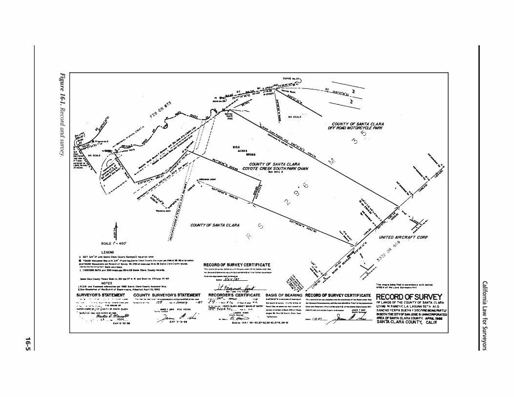
Guide to the Preparation of Records of Survey and Corner Records
See Figure 16-1
Corner Records (8773ndash87734)
bull Requirements and exemptions for filing (8773 8765d)
bull Form and content (87731)
Board Rule 464
See Figure 16-2
16-4
CUIIY( 27
~ lC uJl 0lt ~~ bullbull ~r bullbull 0- -A - 0 e roo - bullbull - bull
_ ~~o~------_ ------f- --- lmiddot -
1 ~ --11lt - -ltOJ - ~ ~~ 1 ltt ~ 1 I 00 CALE =~ ~ i bull ~ CO 0 = IO ~-- J i -~ I
Oi ~ ~ I ~-fl ~O ~ -- --- - _ (V _ ~ j - 0 ~ bull -IZ~ i h _ ~
bull r COUNTY OF SANTA CLARA
COYOTE CREEl( SOUTH PIIRK CHAIN
~+ 0 ~I~~~~ - ~ -tfJ ~ ~ - c J ~-
~~ +4 ~~~ ~ 1- ~- r ~ A oil 0 Ii -- ~
~t SCALE Imiddot 400
LEGEND o IT V4~I wi I e e-ti bullbull netll
~ l I
~
i~ 1
CIXNTY OF SANTA CLARA c)
lt~
I bullbull I ~ fI
bull X
1 t(
y UNITED AIRCRAFT CORI
~~r-t bull 0
1 bull AA --lt-
bull ltlUND 111_ ~lI4 I S c_e_s bullbull GulIO ~ _ bullbull bull ZM 35 SlSeMC COolllty_ - I 1 HtOtIO 011 bullbullbull I H ar c-
RECORD OF SURVEY CERTIFICATE - - _ __ - _ _ IM CI l ~_
c _-=~ ~~ t~
f
~~+ 4~~ )p ~y
~1middot lt-
C e-trTN II IIO~7 WI l1li Z53 51middot10
NOTES lilo r-t I s c c-t ~ I bull 1 bullbull bullbull 1 I M A 1IIH2
SURVEYOS STATEMENT COUNTY SURVEYORS STATEMENT ~ __ _ _ _ _n4~
~I - - - IZ~ _~~ middot87 _ T
qr cp_ Of T cuu ~~ INl ItC~
t_PI~ ~s ~ _~~o~__
pound)(~tO
r _ ~ ItCI bullbull
----Ja- d UP 3-31-
Jf h-- jj
RECORD~-C~~ICATE middotiimiddot2lt4I~ bullbull ~-_ ~ 1111 bull ~_ SJ _ _
__ bull IMfllll QNIIIII COWTT 10M 01 IUIIDr
~ 1~04-oL __ pf-
L bullbullbull ~-----
~_4_~
ti C~1o 4- - BASIS OF BEARING RECORD Of SURVEY CERTllflCATE middotmiddot _el_ f T _n __ _ ___ _
_ _011 _ Ioc - IM ___ _ _ _ c_a__ C cc- middot __ bull - 1 I1 _c_
i 1441 s~szmiddotUmiddotU51-S15middot5I
=middott~--L n
T_ til WI _ Int bullbull I L I AU
RECaID OF SURVEY OF LA OS or THE COUNTy Of SANTA Cl MA LYI IN ANCtC LA L GUNA SEA tD JANCHO V[RA lIurl r SOCIWAETY INII01HlltEClTYOFSMJOSE 1 ~ED IMA OF SANTA CLARA COUNTY APIIL_ SANTl CLARA COlMlTY CALIF
Figure 16-1 Record and survey
California Law for Surveyors
16
-5
Caltrans LSLSIT Video Exam Preparation Course
SEAL
SEAL
Figure 16-2 Corner record form
16-6
California Law for Surveyors
Subdivision Map Act (SMA)ndashSections 66410 through 6649958 of the Government Code Chapter 1 General provisions
Chapter 2 Maps
Chapter 3 Procedure
Chapter 4 Requirements
Chapter 45 Development rights
Chapter 5 Improvement security
Chapter 6 Reversions and exclusions
Chapter 7 Enforcement and judicial review
Definitions
History of the SMA
Local Subdivision Ordinances
bull Preemption
bull Limitations on local regulation (66411)
When is a Subdivision Map Required
bull Definition of a subdivision (66424)
(1) The division of land (2) by any subdivider (3) of any unit or units of improved or unimproved land or any portion
thereof (4) shown on the latest equalized County Assessment Roll (5) contiguous (6) for the purpose of sale lease or financing (7) whether immediate or future
16-7
Caltrans LSLSIT Video Exam Preparation Course
bull Contiguous parcels (see Figure 16-3)
bull Gifts inheritances partitions etc
bull Condominiums cooperatives community apartment projects
bull Government Lots
Exclusions and Exemptions to the SMA
bull Agricultural leases (66424)
bull Statutory exclusions (66412)
bull Conveyance to public entities (664265 66428)
What Type of Subdivision Map is Required
bull Three types of maps in the Subdivision Map Act
bull Determining which type of map is required (66426)
bull Final map exemptions
bull Parcel counting (see Figure 16-4)
bull Tentative map content 664245 664741 (see Figure 16-5)
bull Parcel map content 66444 through 66450 (see Figure 16-6)
bull Final map content 66433 through 66443
Lands of Smith
1
2
State Highway
Lands of Smith
A
B
D
C
State Highway
Figure 16-3 Contiguous parcels Figure 16-4 Parcel counting
16-8
California Law for Surveyors
Chapter 3 Procedure
bull Time limits (664511)
bull Local agency fees (664512)
bull Notice of public hearings (664513)
bull Tentative maps (66452ndash6645210)
bull Final maps (66456ndash664625)
bull Parcel maps (66463ndash664635)
bull Recording of maps (66464ndash664681)
bull Amendments to maps (66469)
Miscellaneous Topics
bull Lot line adjustment (66412)
bull Mergers (6645110ndash6645121)
bull Certificate of compliance (6649935)
16-9
Caltrans LSLSIT Video Exam Preparation Course
Figure 16-5 Tentative m
ap
16
-10
111 0 BARIH
~~~~~~Ijmiddot=i ~J~ ~ --t _WI JWt
~~
l ~
NOTlII AND UIHO AIIi_U - 11_ 01 14 t __ tIII
J
~
middot~tI ~~ PqCF
J f
tAP Ps p_ 34)
--~ ~1 c
al 0~
f iJ bull r bull II tI
PAllCoL (~ 464 APS PGS 22 23
bull ) z
_l~ Ii t~ItJmiddotmiddot-__ --TIIIfgt __ I ~ 1_- lII-
~t~camiddot~~~~MM~ f- tOO
tlontOGDl QO~ CPIOCII amp7
~ ~ ---a lO~ PARCEL MAP
a UrdiCIIhkI4f11M ApI _IIgt~__4t
01amp tItt+M_ 7171 u bull bull r IlIf ~N bull O bull
1JUampJ 1I111JfY IAIIT
~II4M~ CJAtI T~ MT AN llAAlTATIIIN IN AlIU~~I NI4U 04r bullbull DlnCC1 IIT lt
) lOcAT COItO QiII ~ImiddotOPi~IClA~~ 0 DL u ~IU COLlN~ QUles
1 MOCATI ~CCItO QlllTA Ii ~II M lIaI 101 eel( 4 OIIAilS i-i ttpoundUINoiT CiA CO~NTr IllKOIDs
)- NOICAns CDIIO OATA IItIGOJtO 0 5U~ IIA 1111 )QQc U ClPr1APSAT ~ ~A ~ampA cou~ lca C
-RIDGMEW ISTATU CON515T1NIa 01 TWO (1 tHiES SING IIOImQN OlltOTI 5HOW~ ONTHAT allTAIN NTITIICIA 0 NJSTQHIIIUIDItLQN OIIQTSUI 0 AIIlT QP1QTS71 01 TWI
middot-~~r=~~~ =g~~~-= TOWN 01 LOS ALlOS HILLS CALIF bull $ eI
~NOWACk ANOMSOCIAtIJlIi c~ INQi bullbull 5 _ANNI bullbull ~ bull c NQ_T fOUIlpI aTtleeT loa ~~LfIIO IIlt
~CT 011 ~ AWtt
Figure 16-6 Parcel m
ap
California Law for Surveyors
16-1
1
Caltrans LSLSIT Video Exam Preparation Course
Sample Test Questions Cite a reference for each answer given
1 List those titles that are reserved by law to licensed land surveyors
2 On what items is it mandatory for a licensed land surveyor to place his signature and show his license number or stamp his seal
3 Define ldquomaterial discrepancyrdquo with respect to the Professional Land Surveyors Act
4 Define ldquoresponsible chargerdquo with respect to the Professional Land Surveyors Act
5 Under what conditions may a registered civil engineer practice land surveying
6 Define ldquocertifyrdquo with respect to the Professional Land Surveyors Act
7 What act or activities performed by a person constitutes the practice of land surveying within the meaning of the Land Surveyors Act
8 When may a land surveyor administer or certify oaths
9 On January 29 1991 you performed a survey and set the corners of the lands of V Breshears described as follows
ldquoThe South 7500 feet of the East 20000 feet of Lot 2 Tract 500 recorded in Book 8 of Maps Page 86 Rainbow County Records State of California
The client acquired the property in 1959 from B Rogers who still owns the remainder of Lot 1rdquo
Is a record of survey required Explain
10 What is the ldquolocal agencyrdquo
11 ldquoSubdivisionrdquo includes a condominium project as defined by what code
12 Which section of the Subdivision Map Act covers the merger of contiguous parcels of land
13 In your own words define ldquosubdivisionrdquo
14 What is the difference between a parcel map final map and tentative map
15 Under what conditions may a parcel map be based upon ldquorecord informationrdquo
16 Can the local agency require a tentative map parcel map or final map for a lot line adjustment
17 Under what circumstances can a record of survey delineate parcels of land not shown on the latest adopted county assessment roll as a unit or contiguous units
16-12
18 Problem D-7 1980 LS
You have been hired to prepare a parcel map from ldquorecord datardquo A recently filed record of survey prepared by another surveyor has determined the boundary In checking for the previously set monuments you determined that the previous surveyor has used an erroneous section corner to control his survey This results in a difference in the position of the true corners and the monumented corners of distances from 05 ft to 32 ft No improvements have been constructed on the property Your client is in a rush because interest rate charges are causing problems with his potential sale
A Describe your actions with regard to your client
B Describe your actions with regard to the other surveyor
C Describe your actions with regard to the preparation of the parcel map
19 Problem A-1 1989 LS
Given the information denoted in the diagram below the client has asked you to provide surveying and mapping services necessary to create the parcels as shown
N
Not to Scale
10 Acres
12 Acres
15 Acres
20 Acres8 Acres
Bypass Road Granted to the County in 1950
Bypa
ss R
oad
Legend
Monuments Found Denoting the Clients Property That Was Purchased in 1940
California Law for Surveyors
16-13Ecirc
Caltrans LSLSIT Video Exam Preparation Course
Required
The answers to the following questions are based upon current California law You are to answer each of the questions briefly in your own words or indicate the appropriate citations
A What type of map or maps if any are required for this land division
B If a map is required who shall prepare it
C Explain whether or not the new parcels are required to be monumented
D If monuments are required or requested when must they be set
E If a map or maps are required under what conditions would holders of beneficial interests not be required to sign
F Excluding lawsuits and moratoriums and if a final map or parcel map is required what is the maximum time allowed to record the map
G Under what conditions may the monuments called for on a parcel map or final map be set by another licensed land surveyor
H After the completion of your work on the clientrsquos property a tractor removed the monument that you found at the exterior southeast corner The contractor asks you to replace the corner What document if any would you prepare
I Assuming it is necessary to gain access to the neighboring property to conduct your field survey and the neighbors question your right to be on their property how would you respond
J How can non-title information (ie building setback lines etc) be filed or recorded with a subdivision map
16-14
California Law for Surveyors
Answer Key
1 LS Act 8708 Licensed land surveyor professional land surveyor or land surveyor
LS Act 8751 Professional engineer in land surveying land survey engineer survey engineer geodetic engineer and geometronic engineer
2 LS Act 8761 Maps plats reports descriptions or other documents
3 LS Act 8762(b) Difference in position of points lines or dimensions between a survey and information found on any subdivision map official map or record of survey on file with the County Recorder or surveyor or any map or survey record maintained by the Bureau of Land Management
4 LS 8703 Independent control and direction by use of initiative skill and independent judgment of the observations measurements and descriptions involved in land surveying work
5 LS Act 8731 A civil engineer registered before January 1 1982 can practice land surveying otherwise the engineer must obtain a land surveying license
6 LS Act 87706 An expression of professional opinion regarding facts or findings which are the subject of certification Use of the word certify does not constitute a warranty or guarantee
7 LS Act 8726
8 LS Act - 8760 Oaths may be used to take testimony for the identification of obliterated monuments to perpetuate evidence of monuments found in perishable condition and when it is desirable to administer an oath to assistants for the faithful performance of their duty
9 LS Act 8762(d)(e) A record of survey will be required because corners not shown on a record map will be established
10 SMA 66420 City county or city and county
11 SMA 66424 Section 1350 of the Civil Code
12 SMA Article 15
13 SMA 66424 - Your definition must include the phrase ldquofor the purpose of sale lease or financingrdquo
16-15Ecirc
Caltrans LSLSIT Video Exam Preparation Course
14
15
16
17
18
19
SBA Chapter 2 Tentative maps are used in the subdivision approval process and are not recorded Parcel maps are used for land divisions of four or fewer parcels or for divisions listed in 66426 (a)(b)(c) and (d) and are recorded with the County Recorder Final maps are required for division of five or more parcels and are recorded with the County Recorder
SMA 66448 Parcel maps may be based on record information if local ordinance does not require a field survey and sufficient information exists on filed maps to locate and retrace the exterior lines of the parcel map if the location of at least one boundary line can be established from an existing monumented line
SMA 66412(d) No
LS Act 87625 SMA 6649935 A record of survey can only show new parcels of land if it is accompanied with a Certificate of Compliance SMA 664265 A record of survey can show a parcel of land created for conveyance to a public entity for right-of-way purposes
A I would inform my client that because of errors on the record of survey sufficient record data does not exist to file a parcel map based on the record information (SMA 66448)
B Inform the other surveyor of the problems and have him correct his survey
C I would inform my client that he could wait until the other surveyor had corrected his survey and then file the parcel map based on record information or we could go ahead with a parcel map based on a field survey I would provide my client with estimated costs and time frames for each of these alternatives The client would have to base his decision on his own budget and time considerations
A A tentative final or parcel map (SMA 66426 66424)
B A licensed land surveyor or civil engineer authorized to practice land surveying (SMA 66434 LSA 8731)
C SMA 66495 requires sufficient durable monuments also see LSA 8771 The surveyor must also set additional monuments as required by local ordinance (SMA 66495) (SMA 66495 does not require parcels to be monumented)
D At least one exterior line shall be monumented prior to the map recording (SMA 66495) The interior monuments may be delayed to no later than a specific date noted in the surveyorrsquos statement (SMA 66496 66441)
16-16
California Law for Surveyors
E Beneficial interest holders or their trustees are not required to sign parcel maps (SMA 66436 664453E)
F Two years with a maximum one-year time extension if allowed by local ordinance (SMA 664526) (Five years acceptable per 664526E)
G Death disability retirement of original surveyor or refusal (SMA 66498)
H Corner record LSA 8773 through 87734 board rule 464
I Right of Entry (LSA 8774)
J Supplemental information sheet may be filed concurrently with the final map or recorded as a separate document (SMA 664342)
16-17Ecirc
Caltrans LSLSIT Video Exam Preparation Course
References Professional Land Surveyors Act Sections 8700ndash8806 State of California
Business and Professions Code
Subdivision Map Act Sections 66410ndash6649958 State of California Government Code
Important These references are being constantly revised by the State Legislature The latest version of the statutes can be obtained for $10 from
California Land Surveyors Association PO Box 9098 Santa Rosa CA 95405
_______ Guide to the Preparation of Records of Survey and Corner Records County Engineers Association of California 1989
This publication can be obtained by sending a check for $330 to Orange County Surveyorrsquos Office 400 Civic Center Dr Room 225 Santa Ana CA 92702
16-18

Caltrans LSLSIT Video Exam Preparation Course
Performance Expected on the Exams
Learning Objectives
Define surveying practice what services require licensure and what titles are reserved for licensure
Outline the requirements for licensure
Outline the requirements for a record of survey and corner record
Explain the various exclusions and exemptions to the Subdivision Map Act
Outline the purposes and requirements for the three different types of maps defined in the Subdivision Map Act
Explain the requirements for lot line adjustments and Certificates of Compliance
Key Terms Constructive notice Advisory agency
Professional Land Surveyors Act Appeal board
Board of Registration for Professional City engineersurveyor Engineers and Surveyors Design
Improvement Local agency Construction surveying Local ordinance Topographic surveying Subdivider Cadastral surveying Subdivision Subdivision surveying Contiguous parcels Boundary surveying Preemption doctrine Geodetic surveying Tentative map Legal descriptions Parcel map Photogrammetry Final map Record of survey (ROS or RS) Major subdivision Basis of bearings Minor subdivision Memorandum of oaths Lot line adjustment
16-2
California Law for Surveyors
Right of entry
Corner record
Subdivision Map Act
Subdivided Lands Act
Certificate of compliance
Lot merger
Amended map
Certificate of correction
Video Presentation Outline
Professional Land Surveyors Act (PLSA)ndashSections 8700 to 8806 of the Business and Professions Code
Article 1 General provisions
Article 2 Administration
Article 23 Survey review committee
Article 3 Application of the chapter
Article 4 Issuance of license
Article 5 Surveying practice
Article 55 Photogrammetry
Article 6 Disciplinary proceedings
Article 7 Offenses against the chapter
Article 8 Revenues
Article 3 Application of the Chapter
bull Definition of survey practice (8726)
bull Exceptions to licensure (8730)
bull Titles that require licensure (8708 8775 8751)
16-3
Caltrans LSLSIT Video Exam Preparation Course
Article 5 Surveying PracticendashRecord of Surveys
bull Mandatory filing requirements (8762)
bull Subdivision of land not allowed (87625)
bull Form (8763)
bull Technical requirements (8764)
bull Required statements (87645)
bull Exemptions (8765)
bull Examination and fees (8766 87665)
bull Corrections (87705 ndash SMA Article 7)
Guide to the Preparation of Records of Survey and Corner Records
See Figure 16-1
Corner Records (8773ndash87734)
bull Requirements and exemptions for filing (8773 8765d)
bull Form and content (87731)
Board Rule 464
See Figure 16-2
16-4
CUIIY( 27
~ lC uJl 0lt ~~ bullbull ~r bullbull 0- -A - 0 e roo - bullbull - bull
_ ~~o~------_ ------f- --- lmiddot -
1 ~ --11lt - -ltOJ - ~ ~~ 1 ltt ~ 1 I 00 CALE =~ ~ i bull ~ CO 0 = IO ~-- J i -~ I
Oi ~ ~ I ~-fl ~O ~ -- --- - _ (V _ ~ j - 0 ~ bull -IZ~ i h _ ~
bull r COUNTY OF SANTA CLARA
COYOTE CREEl( SOUTH PIIRK CHAIN
~+ 0 ~I~~~~ - ~ -tfJ ~ ~ - c J ~-
~~ +4 ~~~ ~ 1- ~- r ~ A oil 0 Ii -- ~
~t SCALE Imiddot 400
LEGEND o IT V4~I wi I e e-ti bullbull netll
~ l I
~
i~ 1
CIXNTY OF SANTA CLARA c)
lt~
I bullbull I ~ fI
bull X
1 t(
y UNITED AIRCRAFT CORI
~~r-t bull 0
1 bull AA --lt-
bull ltlUND 111_ ~lI4 I S c_e_s bullbull GulIO ~ _ bullbull bull ZM 35 SlSeMC COolllty_ - I 1 HtOtIO 011 bullbullbull I H ar c-
RECORD OF SURVEY CERTIFICATE - - _ __ - _ _ IM CI l ~_
c _-=~ ~~ t~
f
~~+ 4~~ )p ~y
~1middot lt-
C e-trTN II IIO~7 WI l1li Z53 51middot10
NOTES lilo r-t I s c c-t ~ I bull 1 bullbull bullbull 1 I M A 1IIH2
SURVEYOS STATEMENT COUNTY SURVEYORS STATEMENT ~ __ _ _ _ _n4~
~I - - - IZ~ _~~ middot87 _ T
qr cp_ Of T cuu ~~ INl ItC~
t_PI~ ~s ~ _~~o~__
pound)(~tO
r _ ~ ItCI bullbull
----Ja- d UP 3-31-
Jf h-- jj
RECORD~-C~~ICATE middotiimiddot2lt4I~ bullbull ~-_ ~ 1111 bull ~_ SJ _ _
__ bull IMfllll QNIIIII COWTT 10M 01 IUIIDr
~ 1~04-oL __ pf-
L bullbullbull ~-----
~_4_~
ti C~1o 4- - BASIS OF BEARING RECORD Of SURVEY CERTllflCATE middotmiddot _el_ f T _n __ _ ___ _
_ _011 _ Ioc - IM ___ _ _ _ c_a__ C cc- middot __ bull - 1 I1 _c_
i 1441 s~szmiddotUmiddotU51-S15middot5I
=middott~--L n
T_ til WI _ Int bullbull I L I AU
RECaID OF SURVEY OF LA OS or THE COUNTy Of SANTA Cl MA LYI IN ANCtC LA L GUNA SEA tD JANCHO V[RA lIurl r SOCIWAETY INII01HlltEClTYOFSMJOSE 1 ~ED IMA OF SANTA CLARA COUNTY APIIL_ SANTl CLARA COlMlTY CALIF
Figure 16-1 Record and survey
California Law for Surveyors
16
-5
Caltrans LSLSIT Video Exam Preparation Course
SEAL
SEAL
Figure 16-2 Corner record form
16-6
California Law for Surveyors
Subdivision Map Act (SMA)ndashSections 66410 through 6649958 of the Government Code Chapter 1 General provisions
Chapter 2 Maps
Chapter 3 Procedure
Chapter 4 Requirements
Chapter 45 Development rights
Chapter 5 Improvement security
Chapter 6 Reversions and exclusions
Chapter 7 Enforcement and judicial review
Definitions
History of the SMA
Local Subdivision Ordinances
bull Preemption
bull Limitations on local regulation (66411)
When is a Subdivision Map Required
bull Definition of a subdivision (66424)
(1) The division of land (2) by any subdivider (3) of any unit or units of improved or unimproved land or any portion
thereof (4) shown on the latest equalized County Assessment Roll (5) contiguous (6) for the purpose of sale lease or financing (7) whether immediate or future
16-7
Caltrans LSLSIT Video Exam Preparation Course
bull Contiguous parcels (see Figure 16-3)
bull Gifts inheritances partitions etc
bull Condominiums cooperatives community apartment projects
bull Government Lots
Exclusions and Exemptions to the SMA
bull Agricultural leases (66424)
bull Statutory exclusions (66412)
bull Conveyance to public entities (664265 66428)
What Type of Subdivision Map is Required
bull Three types of maps in the Subdivision Map Act
bull Determining which type of map is required (66426)
bull Final map exemptions
bull Parcel counting (see Figure 16-4)
bull Tentative map content 664245 664741 (see Figure 16-5)
bull Parcel map content 66444 through 66450 (see Figure 16-6)
bull Final map content 66433 through 66443
Lands of Smith
1
2
State Highway
Lands of Smith
A
B
D
C
State Highway
Figure 16-3 Contiguous parcels Figure 16-4 Parcel counting
16-8
California Law for Surveyors
Chapter 3 Procedure
bull Time limits (664511)
bull Local agency fees (664512)
bull Notice of public hearings (664513)
bull Tentative maps (66452ndash6645210)
bull Final maps (66456ndash664625)
bull Parcel maps (66463ndash664635)
bull Recording of maps (66464ndash664681)
bull Amendments to maps (66469)
Miscellaneous Topics
bull Lot line adjustment (66412)
bull Mergers (6645110ndash6645121)
bull Certificate of compliance (6649935)
16-9
Caltrans LSLSIT Video Exam Preparation Course
Figure 16-5 Tentative m
ap
16
-10
111 0 BARIH
~~~~~~Ijmiddot=i ~J~ ~ --t _WI JWt
~~
l ~
NOTlII AND UIHO AIIi_U - 11_ 01 14 t __ tIII
J
~
middot~tI ~~ PqCF
J f
tAP Ps p_ 34)
--~ ~1 c
al 0~
f iJ bull r bull II tI
PAllCoL (~ 464 APS PGS 22 23
bull ) z
_l~ Ii t~ItJmiddotmiddot-__ --TIIIfgt __ I ~ 1_- lII-
~t~camiddot~~~~MM~ f- tOO
tlontOGDl QO~ CPIOCII amp7
~ ~ ---a lO~ PARCEL MAP
a UrdiCIIhkI4f11M ApI _IIgt~__4t
01amp tItt+M_ 7171 u bull bull r IlIf ~N bull O bull
1JUampJ 1I111JfY IAIIT
~II4M~ CJAtI T~ MT AN llAAlTATIIIN IN AlIU~~I NI4U 04r bullbull DlnCC1 IIT lt
) lOcAT COItO QiII ~ImiddotOPi~IClA~~ 0 DL u ~IU COLlN~ QUles
1 MOCATI ~CCItO QlllTA Ii ~II M lIaI 101 eel( 4 OIIAilS i-i ttpoundUINoiT CiA CO~NTr IllKOIDs
)- NOICAns CDIIO OATA IItIGOJtO 0 5U~ IIA 1111 )QQc U ClPr1APSAT ~ ~A ~ampA cou~ lca C
-RIDGMEW ISTATU CON515T1NIa 01 TWO (1 tHiES SING IIOImQN OlltOTI 5HOW~ ONTHAT allTAIN NTITIICIA 0 NJSTQHIIIUIDItLQN OIIQTSUI 0 AIIlT QP1QTS71 01 TWI
middot-~~r=~~~ =g~~~-= TOWN 01 LOS ALlOS HILLS CALIF bull $ eI
~NOWACk ANOMSOCIAtIJlIi c~ INQi bullbull 5 _ANNI bullbull ~ bull c NQ_T fOUIlpI aTtleeT loa ~~LfIIO IIlt
~CT 011 ~ AWtt
Figure 16-6 Parcel m
ap
California Law for Surveyors
16-1
1
Caltrans LSLSIT Video Exam Preparation Course
Sample Test Questions Cite a reference for each answer given
1 List those titles that are reserved by law to licensed land surveyors
2 On what items is it mandatory for a licensed land surveyor to place his signature and show his license number or stamp his seal
3 Define ldquomaterial discrepancyrdquo with respect to the Professional Land Surveyors Act
4 Define ldquoresponsible chargerdquo with respect to the Professional Land Surveyors Act
5 Under what conditions may a registered civil engineer practice land surveying
6 Define ldquocertifyrdquo with respect to the Professional Land Surveyors Act
7 What act or activities performed by a person constitutes the practice of land surveying within the meaning of the Land Surveyors Act
8 When may a land surveyor administer or certify oaths
9 On January 29 1991 you performed a survey and set the corners of the lands of V Breshears described as follows
ldquoThe South 7500 feet of the East 20000 feet of Lot 2 Tract 500 recorded in Book 8 of Maps Page 86 Rainbow County Records State of California
The client acquired the property in 1959 from B Rogers who still owns the remainder of Lot 1rdquo
Is a record of survey required Explain
10 What is the ldquolocal agencyrdquo
11 ldquoSubdivisionrdquo includes a condominium project as defined by what code
12 Which section of the Subdivision Map Act covers the merger of contiguous parcels of land
13 In your own words define ldquosubdivisionrdquo
14 What is the difference between a parcel map final map and tentative map
15 Under what conditions may a parcel map be based upon ldquorecord informationrdquo
16 Can the local agency require a tentative map parcel map or final map for a lot line adjustment
17 Under what circumstances can a record of survey delineate parcels of land not shown on the latest adopted county assessment roll as a unit or contiguous units
16-12
18 Problem D-7 1980 LS
You have been hired to prepare a parcel map from ldquorecord datardquo A recently filed record of survey prepared by another surveyor has determined the boundary In checking for the previously set monuments you determined that the previous surveyor has used an erroneous section corner to control his survey This results in a difference in the position of the true corners and the monumented corners of distances from 05 ft to 32 ft No improvements have been constructed on the property Your client is in a rush because interest rate charges are causing problems with his potential sale
A Describe your actions with regard to your client
B Describe your actions with regard to the other surveyor
C Describe your actions with regard to the preparation of the parcel map
19 Problem A-1 1989 LS
Given the information denoted in the diagram below the client has asked you to provide surveying and mapping services necessary to create the parcels as shown
N
Not to Scale
10 Acres
12 Acres
15 Acres
20 Acres8 Acres
Bypass Road Granted to the County in 1950
Bypa
ss R
oad
Legend
Monuments Found Denoting the Clients Property That Was Purchased in 1940
California Law for Surveyors
16-13Ecirc
Caltrans LSLSIT Video Exam Preparation Course
Required
The answers to the following questions are based upon current California law You are to answer each of the questions briefly in your own words or indicate the appropriate citations
A What type of map or maps if any are required for this land division
B If a map is required who shall prepare it
C Explain whether or not the new parcels are required to be monumented
D If monuments are required or requested when must they be set
E If a map or maps are required under what conditions would holders of beneficial interests not be required to sign
F Excluding lawsuits and moratoriums and if a final map or parcel map is required what is the maximum time allowed to record the map
G Under what conditions may the monuments called for on a parcel map or final map be set by another licensed land surveyor
H After the completion of your work on the clientrsquos property a tractor removed the monument that you found at the exterior southeast corner The contractor asks you to replace the corner What document if any would you prepare
I Assuming it is necessary to gain access to the neighboring property to conduct your field survey and the neighbors question your right to be on their property how would you respond
J How can non-title information (ie building setback lines etc) be filed or recorded with a subdivision map
16-14
California Law for Surveyors
Answer Key
1 LS Act 8708 Licensed land surveyor professional land surveyor or land surveyor
LS Act 8751 Professional engineer in land surveying land survey engineer survey engineer geodetic engineer and geometronic engineer
2 LS Act 8761 Maps plats reports descriptions or other documents
3 LS Act 8762(b) Difference in position of points lines or dimensions between a survey and information found on any subdivision map official map or record of survey on file with the County Recorder or surveyor or any map or survey record maintained by the Bureau of Land Management
4 LS 8703 Independent control and direction by use of initiative skill and independent judgment of the observations measurements and descriptions involved in land surveying work
5 LS Act 8731 A civil engineer registered before January 1 1982 can practice land surveying otherwise the engineer must obtain a land surveying license
6 LS Act 87706 An expression of professional opinion regarding facts or findings which are the subject of certification Use of the word certify does not constitute a warranty or guarantee
7 LS Act 8726
8 LS Act - 8760 Oaths may be used to take testimony for the identification of obliterated monuments to perpetuate evidence of monuments found in perishable condition and when it is desirable to administer an oath to assistants for the faithful performance of their duty
9 LS Act 8762(d)(e) A record of survey will be required because corners not shown on a record map will be established
10 SMA 66420 City county or city and county
11 SMA 66424 Section 1350 of the Civil Code
12 SMA Article 15
13 SMA 66424 - Your definition must include the phrase ldquofor the purpose of sale lease or financingrdquo
16-15Ecirc
Caltrans LSLSIT Video Exam Preparation Course
14
15
16
17
18
19
SBA Chapter 2 Tentative maps are used in the subdivision approval process and are not recorded Parcel maps are used for land divisions of four or fewer parcels or for divisions listed in 66426 (a)(b)(c) and (d) and are recorded with the County Recorder Final maps are required for division of five or more parcels and are recorded with the County Recorder
SMA 66448 Parcel maps may be based on record information if local ordinance does not require a field survey and sufficient information exists on filed maps to locate and retrace the exterior lines of the parcel map if the location of at least one boundary line can be established from an existing monumented line
SMA 66412(d) No
LS Act 87625 SMA 6649935 A record of survey can only show new parcels of land if it is accompanied with a Certificate of Compliance SMA 664265 A record of survey can show a parcel of land created for conveyance to a public entity for right-of-way purposes
A I would inform my client that because of errors on the record of survey sufficient record data does not exist to file a parcel map based on the record information (SMA 66448)
B Inform the other surveyor of the problems and have him correct his survey
C I would inform my client that he could wait until the other surveyor had corrected his survey and then file the parcel map based on record information or we could go ahead with a parcel map based on a field survey I would provide my client with estimated costs and time frames for each of these alternatives The client would have to base his decision on his own budget and time considerations
A A tentative final or parcel map (SMA 66426 66424)
B A licensed land surveyor or civil engineer authorized to practice land surveying (SMA 66434 LSA 8731)
C SMA 66495 requires sufficient durable monuments also see LSA 8771 The surveyor must also set additional monuments as required by local ordinance (SMA 66495) (SMA 66495 does not require parcels to be monumented)
D At least one exterior line shall be monumented prior to the map recording (SMA 66495) The interior monuments may be delayed to no later than a specific date noted in the surveyorrsquos statement (SMA 66496 66441)
16-16
California Law for Surveyors
E Beneficial interest holders or their trustees are not required to sign parcel maps (SMA 66436 664453E)
F Two years with a maximum one-year time extension if allowed by local ordinance (SMA 664526) (Five years acceptable per 664526E)
G Death disability retirement of original surveyor or refusal (SMA 66498)
H Corner record LSA 8773 through 87734 board rule 464
I Right of Entry (LSA 8774)
J Supplemental information sheet may be filed concurrently with the final map or recorded as a separate document (SMA 664342)
16-17Ecirc
Caltrans LSLSIT Video Exam Preparation Course
References Professional Land Surveyors Act Sections 8700ndash8806 State of California
Business and Professions Code
Subdivision Map Act Sections 66410ndash6649958 State of California Government Code
Important These references are being constantly revised by the State Legislature The latest version of the statutes can be obtained for $10 from
California Land Surveyors Association PO Box 9098 Santa Rosa CA 95405
_______ Guide to the Preparation of Records of Survey and Corner Records County Engineers Association of California 1989
This publication can be obtained by sending a check for $330 to Orange County Surveyorrsquos Office 400 Civic Center Dr Room 225 Santa Ana CA 92702
16-18

California Law for Surveyors
Right of entry
Corner record
Subdivision Map Act
Subdivided Lands Act
Certificate of compliance
Lot merger
Amended map
Certificate of correction
Video Presentation Outline
Professional Land Surveyors Act (PLSA)ndashSections 8700 to 8806 of the Business and Professions Code
Article 1 General provisions
Article 2 Administration
Article 23 Survey review committee
Article 3 Application of the chapter
Article 4 Issuance of license
Article 5 Surveying practice
Article 55 Photogrammetry
Article 6 Disciplinary proceedings
Article 7 Offenses against the chapter
Article 8 Revenues
Article 3 Application of the Chapter
bull Definition of survey practice (8726)
bull Exceptions to licensure (8730)
bull Titles that require licensure (8708 8775 8751)
16-3
Caltrans LSLSIT Video Exam Preparation Course
Article 5 Surveying PracticendashRecord of Surveys
bull Mandatory filing requirements (8762)
bull Subdivision of land not allowed (87625)
bull Form (8763)
bull Technical requirements (8764)
bull Required statements (87645)
bull Exemptions (8765)
bull Examination and fees (8766 87665)
bull Corrections (87705 ndash SMA Article 7)
Guide to the Preparation of Records of Survey and Corner Records
See Figure 16-1
Corner Records (8773ndash87734)
bull Requirements and exemptions for filing (8773 8765d)
bull Form and content (87731)
Board Rule 464
See Figure 16-2
16-4
CUIIY( 27
~ lC uJl 0lt ~~ bullbull ~r bullbull 0- -A - 0 e roo - bullbull - bull
_ ~~o~------_ ------f- --- lmiddot -
1 ~ --11lt - -ltOJ - ~ ~~ 1 ltt ~ 1 I 00 CALE =~ ~ i bull ~ CO 0 = IO ~-- J i -~ I
Oi ~ ~ I ~-fl ~O ~ -- --- - _ (V _ ~ j - 0 ~ bull -IZ~ i h _ ~
bull r COUNTY OF SANTA CLARA
COYOTE CREEl( SOUTH PIIRK CHAIN
~+ 0 ~I~~~~ - ~ -tfJ ~ ~ - c J ~-
~~ +4 ~~~ ~ 1- ~- r ~ A oil 0 Ii -- ~
~t SCALE Imiddot 400
LEGEND o IT V4~I wi I e e-ti bullbull netll
~ l I
~
i~ 1
CIXNTY OF SANTA CLARA c)
lt~
I bullbull I ~ fI
bull X
1 t(
y UNITED AIRCRAFT CORI
~~r-t bull 0
1 bull AA --lt-
bull ltlUND 111_ ~lI4 I S c_e_s bullbull GulIO ~ _ bullbull bull ZM 35 SlSeMC COolllty_ - I 1 HtOtIO 011 bullbullbull I H ar c-
RECORD OF SURVEY CERTIFICATE - - _ __ - _ _ IM CI l ~_
c _-=~ ~~ t~
f
~~+ 4~~ )p ~y
~1middot lt-
C e-trTN II IIO~7 WI l1li Z53 51middot10
NOTES lilo r-t I s c c-t ~ I bull 1 bullbull bullbull 1 I M A 1IIH2
SURVEYOS STATEMENT COUNTY SURVEYORS STATEMENT ~ __ _ _ _ _n4~
~I - - - IZ~ _~~ middot87 _ T
qr cp_ Of T cuu ~~ INl ItC~
t_PI~ ~s ~ _~~o~__
pound)(~tO
r _ ~ ItCI bullbull
----Ja- d UP 3-31-
Jf h-- jj
RECORD~-C~~ICATE middotiimiddot2lt4I~ bullbull ~-_ ~ 1111 bull ~_ SJ _ _
__ bull IMfllll QNIIIII COWTT 10M 01 IUIIDr
~ 1~04-oL __ pf-
L bullbullbull ~-----
~_4_~
ti C~1o 4- - BASIS OF BEARING RECORD Of SURVEY CERTllflCATE middotmiddot _el_ f T _n __ _ ___ _
_ _011 _ Ioc - IM ___ _ _ _ c_a__ C cc- middot __ bull - 1 I1 _c_
i 1441 s~szmiddotUmiddotU51-S15middot5I
=middott~--L n
T_ til WI _ Int bullbull I L I AU
RECaID OF SURVEY OF LA OS or THE COUNTy Of SANTA Cl MA LYI IN ANCtC LA L GUNA SEA tD JANCHO V[RA lIurl r SOCIWAETY INII01HlltEClTYOFSMJOSE 1 ~ED IMA OF SANTA CLARA COUNTY APIIL_ SANTl CLARA COlMlTY CALIF
Figure 16-1 Record and survey
California Law for Surveyors
16
-5
Caltrans LSLSIT Video Exam Preparation Course
SEAL
SEAL
Figure 16-2 Corner record form
16-6
California Law for Surveyors
Subdivision Map Act (SMA)ndashSections 66410 through 6649958 of the Government Code Chapter 1 General provisions
Chapter 2 Maps
Chapter 3 Procedure
Chapter 4 Requirements
Chapter 45 Development rights
Chapter 5 Improvement security
Chapter 6 Reversions and exclusions
Chapter 7 Enforcement and judicial review
Definitions
History of the SMA
Local Subdivision Ordinances
bull Preemption
bull Limitations on local regulation (66411)
When is a Subdivision Map Required
bull Definition of a subdivision (66424)
(1) The division of land (2) by any subdivider (3) of any unit or units of improved or unimproved land or any portion
thereof (4) shown on the latest equalized County Assessment Roll (5) contiguous (6) for the purpose of sale lease or financing (7) whether immediate or future
16-7
Caltrans LSLSIT Video Exam Preparation Course
bull Contiguous parcels (see Figure 16-3)
bull Gifts inheritances partitions etc
bull Condominiums cooperatives community apartment projects
bull Government Lots
Exclusions and Exemptions to the SMA
bull Agricultural leases (66424)
bull Statutory exclusions (66412)
bull Conveyance to public entities (664265 66428)
What Type of Subdivision Map is Required
bull Three types of maps in the Subdivision Map Act
bull Determining which type of map is required (66426)
bull Final map exemptions
bull Parcel counting (see Figure 16-4)
bull Tentative map content 664245 664741 (see Figure 16-5)
bull Parcel map content 66444 through 66450 (see Figure 16-6)
bull Final map content 66433 through 66443
Lands of Smith
1
2
State Highway
Lands of Smith
A
B
D
C
State Highway
Figure 16-3 Contiguous parcels Figure 16-4 Parcel counting
16-8
California Law for Surveyors
Chapter 3 Procedure
bull Time limits (664511)
bull Local agency fees (664512)
bull Notice of public hearings (664513)
bull Tentative maps (66452ndash6645210)
bull Final maps (66456ndash664625)
bull Parcel maps (66463ndash664635)
bull Recording of maps (66464ndash664681)
bull Amendments to maps (66469)
Miscellaneous Topics
bull Lot line adjustment (66412)
bull Mergers (6645110ndash6645121)
bull Certificate of compliance (6649935)
16-9
Caltrans LSLSIT Video Exam Preparation Course
Figure 16-5 Tentative m
ap
16
-10
111 0 BARIH
~~~~~~Ijmiddot=i ~J~ ~ --t _WI JWt
~~
l ~
NOTlII AND UIHO AIIi_U - 11_ 01 14 t __ tIII
J
~
middot~tI ~~ PqCF
J f
tAP Ps p_ 34)
--~ ~1 c
al 0~
f iJ bull r bull II tI
PAllCoL (~ 464 APS PGS 22 23
bull ) z
_l~ Ii t~ItJmiddotmiddot-__ --TIIIfgt __ I ~ 1_- lII-
~t~camiddot~~~~MM~ f- tOO
tlontOGDl QO~ CPIOCII amp7
~ ~ ---a lO~ PARCEL MAP
a UrdiCIIhkI4f11M ApI _IIgt~__4t
01amp tItt+M_ 7171 u bull bull r IlIf ~N bull O bull
1JUampJ 1I111JfY IAIIT
~II4M~ CJAtI T~ MT AN llAAlTATIIIN IN AlIU~~I NI4U 04r bullbull DlnCC1 IIT lt
) lOcAT COItO QiII ~ImiddotOPi~IClA~~ 0 DL u ~IU COLlN~ QUles
1 MOCATI ~CCItO QlllTA Ii ~II M lIaI 101 eel( 4 OIIAilS i-i ttpoundUINoiT CiA CO~NTr IllKOIDs
)- NOICAns CDIIO OATA IItIGOJtO 0 5U~ IIA 1111 )QQc U ClPr1APSAT ~ ~A ~ampA cou~ lca C
-RIDGMEW ISTATU CON515T1NIa 01 TWO (1 tHiES SING IIOImQN OlltOTI 5HOW~ ONTHAT allTAIN NTITIICIA 0 NJSTQHIIIUIDItLQN OIIQTSUI 0 AIIlT QP1QTS71 01 TWI
middot-~~r=~~~ =g~~~-= TOWN 01 LOS ALlOS HILLS CALIF bull $ eI
~NOWACk ANOMSOCIAtIJlIi c~ INQi bullbull 5 _ANNI bullbull ~ bull c NQ_T fOUIlpI aTtleeT loa ~~LfIIO IIlt
~CT 011 ~ AWtt
Figure 16-6 Parcel m
ap
California Law for Surveyors
16-1
1
Caltrans LSLSIT Video Exam Preparation Course
Sample Test Questions Cite a reference for each answer given
1 List those titles that are reserved by law to licensed land surveyors
2 On what items is it mandatory for a licensed land surveyor to place his signature and show his license number or stamp his seal
3 Define ldquomaterial discrepancyrdquo with respect to the Professional Land Surveyors Act
4 Define ldquoresponsible chargerdquo with respect to the Professional Land Surveyors Act
5 Under what conditions may a registered civil engineer practice land surveying
6 Define ldquocertifyrdquo with respect to the Professional Land Surveyors Act
7 What act or activities performed by a person constitutes the practice of land surveying within the meaning of the Land Surveyors Act
8 When may a land surveyor administer or certify oaths
9 On January 29 1991 you performed a survey and set the corners of the lands of V Breshears described as follows
ldquoThe South 7500 feet of the East 20000 feet of Lot 2 Tract 500 recorded in Book 8 of Maps Page 86 Rainbow County Records State of California
The client acquired the property in 1959 from B Rogers who still owns the remainder of Lot 1rdquo
Is a record of survey required Explain
10 What is the ldquolocal agencyrdquo
11 ldquoSubdivisionrdquo includes a condominium project as defined by what code
12 Which section of the Subdivision Map Act covers the merger of contiguous parcels of land
13 In your own words define ldquosubdivisionrdquo
14 What is the difference between a parcel map final map and tentative map
15 Under what conditions may a parcel map be based upon ldquorecord informationrdquo
16 Can the local agency require a tentative map parcel map or final map for a lot line adjustment
17 Under what circumstances can a record of survey delineate parcels of land not shown on the latest adopted county assessment roll as a unit or contiguous units
16-12
18 Problem D-7 1980 LS
You have been hired to prepare a parcel map from ldquorecord datardquo A recently filed record of survey prepared by another surveyor has determined the boundary In checking for the previously set monuments you determined that the previous surveyor has used an erroneous section corner to control his survey This results in a difference in the position of the true corners and the monumented corners of distances from 05 ft to 32 ft No improvements have been constructed on the property Your client is in a rush because interest rate charges are causing problems with his potential sale
A Describe your actions with regard to your client
B Describe your actions with regard to the other surveyor
C Describe your actions with regard to the preparation of the parcel map
19 Problem A-1 1989 LS
Given the information denoted in the diagram below the client has asked you to provide surveying and mapping services necessary to create the parcels as shown
N
Not to Scale
10 Acres
12 Acres
15 Acres
20 Acres8 Acres
Bypass Road Granted to the County in 1950
Bypa
ss R
oad
Legend
Monuments Found Denoting the Clients Property That Was Purchased in 1940
California Law for Surveyors
16-13Ecirc
Caltrans LSLSIT Video Exam Preparation Course
Required
The answers to the following questions are based upon current California law You are to answer each of the questions briefly in your own words or indicate the appropriate citations
A What type of map or maps if any are required for this land division
B If a map is required who shall prepare it
C Explain whether or not the new parcels are required to be monumented
D If monuments are required or requested when must they be set
E If a map or maps are required under what conditions would holders of beneficial interests not be required to sign
F Excluding lawsuits and moratoriums and if a final map or parcel map is required what is the maximum time allowed to record the map
G Under what conditions may the monuments called for on a parcel map or final map be set by another licensed land surveyor
H After the completion of your work on the clientrsquos property a tractor removed the monument that you found at the exterior southeast corner The contractor asks you to replace the corner What document if any would you prepare
I Assuming it is necessary to gain access to the neighboring property to conduct your field survey and the neighbors question your right to be on their property how would you respond
J How can non-title information (ie building setback lines etc) be filed or recorded with a subdivision map
16-14
California Law for Surveyors
Answer Key
1 LS Act 8708 Licensed land surveyor professional land surveyor or land surveyor
LS Act 8751 Professional engineer in land surveying land survey engineer survey engineer geodetic engineer and geometronic engineer
2 LS Act 8761 Maps plats reports descriptions or other documents
3 LS Act 8762(b) Difference in position of points lines or dimensions between a survey and information found on any subdivision map official map or record of survey on file with the County Recorder or surveyor or any map or survey record maintained by the Bureau of Land Management
4 LS 8703 Independent control and direction by use of initiative skill and independent judgment of the observations measurements and descriptions involved in land surveying work
5 LS Act 8731 A civil engineer registered before January 1 1982 can practice land surveying otherwise the engineer must obtain a land surveying license
6 LS Act 87706 An expression of professional opinion regarding facts or findings which are the subject of certification Use of the word certify does not constitute a warranty or guarantee
7 LS Act 8726
8 LS Act - 8760 Oaths may be used to take testimony for the identification of obliterated monuments to perpetuate evidence of monuments found in perishable condition and when it is desirable to administer an oath to assistants for the faithful performance of their duty
9 LS Act 8762(d)(e) A record of survey will be required because corners not shown on a record map will be established
10 SMA 66420 City county or city and county
11 SMA 66424 Section 1350 of the Civil Code
12 SMA Article 15
13 SMA 66424 - Your definition must include the phrase ldquofor the purpose of sale lease or financingrdquo
16-15Ecirc
Caltrans LSLSIT Video Exam Preparation Course
14
15
16
17
18
19
SBA Chapter 2 Tentative maps are used in the subdivision approval process and are not recorded Parcel maps are used for land divisions of four or fewer parcels or for divisions listed in 66426 (a)(b)(c) and (d) and are recorded with the County Recorder Final maps are required for division of five or more parcels and are recorded with the County Recorder
SMA 66448 Parcel maps may be based on record information if local ordinance does not require a field survey and sufficient information exists on filed maps to locate and retrace the exterior lines of the parcel map if the location of at least one boundary line can be established from an existing monumented line
SMA 66412(d) No
LS Act 87625 SMA 6649935 A record of survey can only show new parcels of land if it is accompanied with a Certificate of Compliance SMA 664265 A record of survey can show a parcel of land created for conveyance to a public entity for right-of-way purposes
A I would inform my client that because of errors on the record of survey sufficient record data does not exist to file a parcel map based on the record information (SMA 66448)
B Inform the other surveyor of the problems and have him correct his survey
C I would inform my client that he could wait until the other surveyor had corrected his survey and then file the parcel map based on record information or we could go ahead with a parcel map based on a field survey I would provide my client with estimated costs and time frames for each of these alternatives The client would have to base his decision on his own budget and time considerations
A A tentative final or parcel map (SMA 66426 66424)
B A licensed land surveyor or civil engineer authorized to practice land surveying (SMA 66434 LSA 8731)
C SMA 66495 requires sufficient durable monuments also see LSA 8771 The surveyor must also set additional monuments as required by local ordinance (SMA 66495) (SMA 66495 does not require parcels to be monumented)
D At least one exterior line shall be monumented prior to the map recording (SMA 66495) The interior monuments may be delayed to no later than a specific date noted in the surveyorrsquos statement (SMA 66496 66441)
16-16
California Law for Surveyors
E Beneficial interest holders or their trustees are not required to sign parcel maps (SMA 66436 664453E)
F Two years with a maximum one-year time extension if allowed by local ordinance (SMA 664526) (Five years acceptable per 664526E)
G Death disability retirement of original surveyor or refusal (SMA 66498)
H Corner record LSA 8773 through 87734 board rule 464
I Right of Entry (LSA 8774)
J Supplemental information sheet may be filed concurrently with the final map or recorded as a separate document (SMA 664342)
16-17Ecirc
Caltrans LSLSIT Video Exam Preparation Course
References Professional Land Surveyors Act Sections 8700ndash8806 State of California
Business and Professions Code
Subdivision Map Act Sections 66410ndash6649958 State of California Government Code
Important These references are being constantly revised by the State Legislature The latest version of the statutes can be obtained for $10 from
California Land Surveyors Association PO Box 9098 Santa Rosa CA 95405
_______ Guide to the Preparation of Records of Survey and Corner Records County Engineers Association of California 1989
This publication can be obtained by sending a check for $330 to Orange County Surveyorrsquos Office 400 Civic Center Dr Room 225 Santa Ana CA 92702
16-18
Caltrans LSLSIT Video Exam Preparation Course
Article 5 Surveying PracticendashRecord of Surveys
bull Mandatory filing requirements (8762)
bull Subdivision of land not allowed (87625)
bull Form (8763)
bull Technical requirements (8764)
bull Required statements (87645)
bull Exemptions (8765)
bull Examination and fees (8766 87665)
bull Corrections (87705 ndash SMA Article 7)
Guide to the Preparation of Records of Survey and Corner Records
See Figure 16-1
Corner Records (8773ndash87734)
bull Requirements and exemptions for filing (8773 8765d)
bull Form and content (87731)
Board Rule 464
See Figure 16-2
16-4
CUIIY( 27
~ lC uJl 0lt ~~ bullbull ~r bullbull 0- -A - 0 e roo - bullbull - bull
_ ~~o~------_ ------f- --- lmiddot -
1 ~ --11lt - -ltOJ - ~ ~~ 1 ltt ~ 1 I 00 CALE =~ ~ i bull ~ CO 0 = IO ~-- J i -~ I
Oi ~ ~ I ~-fl ~O ~ -- --- - _ (V _ ~ j - 0 ~ bull -IZ~ i h _ ~
bull r COUNTY OF SANTA CLARA
COYOTE CREEl( SOUTH PIIRK CHAIN
~+ 0 ~I~~~~ - ~ -tfJ ~ ~ - c J ~-
~~ +4 ~~~ ~ 1- ~- r ~ A oil 0 Ii -- ~
~t SCALE Imiddot 400
LEGEND o IT V4~I wi I e e-ti bullbull netll
~ l I
~
i~ 1
CIXNTY OF SANTA CLARA c)
lt~
I bullbull I ~ fI
bull X
1 t(
y UNITED AIRCRAFT CORI
~~r-t bull 0
1 bull AA --lt-
bull ltlUND 111_ ~lI4 I S c_e_s bullbull GulIO ~ _ bullbull bull ZM 35 SlSeMC COolllty_ - I 1 HtOtIO 011 bullbullbull I H ar c-
RECORD OF SURVEY CERTIFICATE - - _ __ - _ _ IM CI l ~_
c _-=~ ~~ t~
f
~~+ 4~~ )p ~y
~1middot lt-
C e-trTN II IIO~7 WI l1li Z53 51middot10
NOTES lilo r-t I s c c-t ~ I bull 1 bullbull bullbull 1 I M A 1IIH2
SURVEYOS STATEMENT COUNTY SURVEYORS STATEMENT ~ __ _ _ _ _n4~
~I - - - IZ~ _~~ middot87 _ T
qr cp_ Of T cuu ~~ INl ItC~
t_PI~ ~s ~ _~~o~__
pound)(~tO
r _ ~ ItCI bullbull
----Ja- d UP 3-31-
Jf h-- jj
RECORD~-C~~ICATE middotiimiddot2lt4I~ bullbull ~-_ ~ 1111 bull ~_ SJ _ _
__ bull IMfllll QNIIIII COWTT 10M 01 IUIIDr
~ 1~04-oL __ pf-
L bullbullbull ~-----
~_4_~
ti C~1o 4- - BASIS OF BEARING RECORD Of SURVEY CERTllflCATE middotmiddot _el_ f T _n __ _ ___ _
_ _011 _ Ioc - IM ___ _ _ _ c_a__ C cc- middot __ bull - 1 I1 _c_
i 1441 s~szmiddotUmiddotU51-S15middot5I
=middott~--L n
T_ til WI _ Int bullbull I L I AU
RECaID OF SURVEY OF LA OS or THE COUNTy Of SANTA Cl MA LYI IN ANCtC LA L GUNA SEA tD JANCHO V[RA lIurl r SOCIWAETY INII01HlltEClTYOFSMJOSE 1 ~ED IMA OF SANTA CLARA COUNTY APIIL_ SANTl CLARA COlMlTY CALIF
Figure 16-1 Record and survey
California Law for Surveyors
16
-5
Caltrans LSLSIT Video Exam Preparation Course
SEAL
SEAL
Figure 16-2 Corner record form
16-6
California Law for Surveyors
Subdivision Map Act (SMA)ndashSections 66410 through 6649958 of the Government Code Chapter 1 General provisions
Chapter 2 Maps
Chapter 3 Procedure
Chapter 4 Requirements
Chapter 45 Development rights
Chapter 5 Improvement security
Chapter 6 Reversions and exclusions
Chapter 7 Enforcement and judicial review
Definitions
History of the SMA
Local Subdivision Ordinances
bull Preemption
bull Limitations on local regulation (66411)
When is a Subdivision Map Required
bull Definition of a subdivision (66424)
(1) The division of land (2) by any subdivider (3) of any unit or units of improved or unimproved land or any portion
thereof (4) shown on the latest equalized County Assessment Roll (5) contiguous (6) for the purpose of sale lease or financing (7) whether immediate or future
16-7
Caltrans LSLSIT Video Exam Preparation Course
bull Contiguous parcels (see Figure 16-3)
bull Gifts inheritances partitions etc
bull Condominiums cooperatives community apartment projects
bull Government Lots
Exclusions and Exemptions to the SMA
bull Agricultural leases (66424)
bull Statutory exclusions (66412)
bull Conveyance to public entities (664265 66428)
What Type of Subdivision Map is Required
bull Three types of maps in the Subdivision Map Act
bull Determining which type of map is required (66426)
bull Final map exemptions
bull Parcel counting (see Figure 16-4)
bull Tentative map content 664245 664741 (see Figure 16-5)
bull Parcel map content 66444 through 66450 (see Figure 16-6)
bull Final map content 66433 through 66443
Lands of Smith
1
2
State Highway
Lands of Smith
A
B
D
C
State Highway
Figure 16-3 Contiguous parcels Figure 16-4 Parcel counting
16-8
California Law for Surveyors
Chapter 3 Procedure
bull Time limits (664511)
bull Local agency fees (664512)
bull Notice of public hearings (664513)
bull Tentative maps (66452ndash6645210)
bull Final maps (66456ndash664625)
bull Parcel maps (66463ndash664635)
bull Recording of maps (66464ndash664681)
bull Amendments to maps (66469)
Miscellaneous Topics
bull Lot line adjustment (66412)
bull Mergers (6645110ndash6645121)
bull Certificate of compliance (6649935)
16-9
Caltrans LSLSIT Video Exam Preparation Course
Figure 16-5 Tentative m
ap
16
-10
111 0 BARIH
~~~~~~Ijmiddot=i ~J~ ~ --t _WI JWt
~~
l ~
NOTlII AND UIHO AIIi_U - 11_ 01 14 t __ tIII
J
~
middot~tI ~~ PqCF
J f
tAP Ps p_ 34)
--~ ~1 c
al 0~
f iJ bull r bull II tI
PAllCoL (~ 464 APS PGS 22 23
bull ) z
_l~ Ii t~ItJmiddotmiddot-__ --TIIIfgt __ I ~ 1_- lII-
~t~camiddot~~~~MM~ f- tOO
tlontOGDl QO~ CPIOCII amp7
~ ~ ---a lO~ PARCEL MAP
a UrdiCIIhkI4f11M ApI _IIgt~__4t
01amp tItt+M_ 7171 u bull bull r IlIf ~N bull O bull
1JUampJ 1I111JfY IAIIT
~II4M~ CJAtI T~ MT AN llAAlTATIIIN IN AlIU~~I NI4U 04r bullbull DlnCC1 IIT lt
) lOcAT COItO QiII ~ImiddotOPi~IClA~~ 0 DL u ~IU COLlN~ QUles
1 MOCATI ~CCItO QlllTA Ii ~II M lIaI 101 eel( 4 OIIAilS i-i ttpoundUINoiT CiA CO~NTr IllKOIDs
)- NOICAns CDIIO OATA IItIGOJtO 0 5U~ IIA 1111 )QQc U ClPr1APSAT ~ ~A ~ampA cou~ lca C
-RIDGMEW ISTATU CON515T1NIa 01 TWO (1 tHiES SING IIOImQN OlltOTI 5HOW~ ONTHAT allTAIN NTITIICIA 0 NJSTQHIIIUIDItLQN OIIQTSUI 0 AIIlT QP1QTS71 01 TWI
middot-~~r=~~~ =g~~~-= TOWN 01 LOS ALlOS HILLS CALIF bull $ eI
~NOWACk ANOMSOCIAtIJlIi c~ INQi bullbull 5 _ANNI bullbull ~ bull c NQ_T fOUIlpI aTtleeT loa ~~LfIIO IIlt
~CT 011 ~ AWtt
Figure 16-6 Parcel m
ap
California Law for Surveyors
16-1
1
Caltrans LSLSIT Video Exam Preparation Course
Sample Test Questions Cite a reference for each answer given
1 List those titles that are reserved by law to licensed land surveyors
2 On what items is it mandatory for a licensed land surveyor to place his signature and show his license number or stamp his seal
3 Define ldquomaterial discrepancyrdquo with respect to the Professional Land Surveyors Act
4 Define ldquoresponsible chargerdquo with respect to the Professional Land Surveyors Act
5 Under what conditions may a registered civil engineer practice land surveying
6 Define ldquocertifyrdquo with respect to the Professional Land Surveyors Act
7 What act or activities performed by a person constitutes the practice of land surveying within the meaning of the Land Surveyors Act
8 When may a land surveyor administer or certify oaths
9 On January 29 1991 you performed a survey and set the corners of the lands of V Breshears described as follows
ldquoThe South 7500 feet of the East 20000 feet of Lot 2 Tract 500 recorded in Book 8 of Maps Page 86 Rainbow County Records State of California
The client acquired the property in 1959 from B Rogers who still owns the remainder of Lot 1rdquo
Is a record of survey required Explain
10 What is the ldquolocal agencyrdquo
11 ldquoSubdivisionrdquo includes a condominium project as defined by what code
12 Which section of the Subdivision Map Act covers the merger of contiguous parcels of land
13 In your own words define ldquosubdivisionrdquo
14 What is the difference between a parcel map final map and tentative map
15 Under what conditions may a parcel map be based upon ldquorecord informationrdquo
16 Can the local agency require a tentative map parcel map or final map for a lot line adjustment
17 Under what circumstances can a record of survey delineate parcels of land not shown on the latest adopted county assessment roll as a unit or contiguous units
16-12
18 Problem D-7 1980 LS
You have been hired to prepare a parcel map from ldquorecord datardquo A recently filed record of survey prepared by another surveyor has determined the boundary In checking for the previously set monuments you determined that the previous surveyor has used an erroneous section corner to control his survey This results in a difference in the position of the true corners and the monumented corners of distances from 05 ft to 32 ft No improvements have been constructed on the property Your client is in a rush because interest rate charges are causing problems with his potential sale
A Describe your actions with regard to your client
B Describe your actions with regard to the other surveyor
C Describe your actions with regard to the preparation of the parcel map
19 Problem A-1 1989 LS
Given the information denoted in the diagram below the client has asked you to provide surveying and mapping services necessary to create the parcels as shown
N
Not to Scale
10 Acres
12 Acres
15 Acres
20 Acres8 Acres
Bypass Road Granted to the County in 1950
Bypa
ss R
oad
Legend
Monuments Found Denoting the Clients Property That Was Purchased in 1940
California Law for Surveyors
16-13Ecirc
Caltrans LSLSIT Video Exam Preparation Course
Required
The answers to the following questions are based upon current California law You are to answer each of the questions briefly in your own words or indicate the appropriate citations
A What type of map or maps if any are required for this land division
B If a map is required who shall prepare it
C Explain whether or not the new parcels are required to be monumented
D If monuments are required or requested when must they be set
E If a map or maps are required under what conditions would holders of beneficial interests not be required to sign
F Excluding lawsuits and moratoriums and if a final map or parcel map is required what is the maximum time allowed to record the map
G Under what conditions may the monuments called for on a parcel map or final map be set by another licensed land surveyor
H After the completion of your work on the clientrsquos property a tractor removed the monument that you found at the exterior southeast corner The contractor asks you to replace the corner What document if any would you prepare
I Assuming it is necessary to gain access to the neighboring property to conduct your field survey and the neighbors question your right to be on their property how would you respond
J How can non-title information (ie building setback lines etc) be filed or recorded with a subdivision map
16-14
California Law for Surveyors
Answer Key
1 LS Act 8708 Licensed land surveyor professional land surveyor or land surveyor
LS Act 8751 Professional engineer in land surveying land survey engineer survey engineer geodetic engineer and geometronic engineer
2 LS Act 8761 Maps plats reports descriptions or other documents
3 LS Act 8762(b) Difference in position of points lines or dimensions between a survey and information found on any subdivision map official map or record of survey on file with the County Recorder or surveyor or any map or survey record maintained by the Bureau of Land Management
4 LS 8703 Independent control and direction by use of initiative skill and independent judgment of the observations measurements and descriptions involved in land surveying work
5 LS Act 8731 A civil engineer registered before January 1 1982 can practice land surveying otherwise the engineer must obtain a land surveying license
6 LS Act 87706 An expression of professional opinion regarding facts or findings which are the subject of certification Use of the word certify does not constitute a warranty or guarantee
7 LS Act 8726
8 LS Act - 8760 Oaths may be used to take testimony for the identification of obliterated monuments to perpetuate evidence of monuments found in perishable condition and when it is desirable to administer an oath to assistants for the faithful performance of their duty
9 LS Act 8762(d)(e) A record of survey will be required because corners not shown on a record map will be established
10 SMA 66420 City county or city and county
11 SMA 66424 Section 1350 of the Civil Code
12 SMA Article 15
13 SMA 66424 - Your definition must include the phrase ldquofor the purpose of sale lease or financingrdquo
16-15Ecirc
Caltrans LSLSIT Video Exam Preparation Course
14
15
16
17
18
19
SBA Chapter 2 Tentative maps are used in the subdivision approval process and are not recorded Parcel maps are used for land divisions of four or fewer parcels or for divisions listed in 66426 (a)(b)(c) and (d) and are recorded with the County Recorder Final maps are required for division of five or more parcels and are recorded with the County Recorder
SMA 66448 Parcel maps may be based on record information if local ordinance does not require a field survey and sufficient information exists on filed maps to locate and retrace the exterior lines of the parcel map if the location of at least one boundary line can be established from an existing monumented line
SMA 66412(d) No
LS Act 87625 SMA 6649935 A record of survey can only show new parcels of land if it is accompanied with a Certificate of Compliance SMA 664265 A record of survey can show a parcel of land created for conveyance to a public entity for right-of-way purposes
A I would inform my client that because of errors on the record of survey sufficient record data does not exist to file a parcel map based on the record information (SMA 66448)
B Inform the other surveyor of the problems and have him correct his survey
C I would inform my client that he could wait until the other surveyor had corrected his survey and then file the parcel map based on record information or we could go ahead with a parcel map based on a field survey I would provide my client with estimated costs and time frames for each of these alternatives The client would have to base his decision on his own budget and time considerations
A A tentative final or parcel map (SMA 66426 66424)
B A licensed land surveyor or civil engineer authorized to practice land surveying (SMA 66434 LSA 8731)
C SMA 66495 requires sufficient durable monuments also see LSA 8771 The surveyor must also set additional monuments as required by local ordinance (SMA 66495) (SMA 66495 does not require parcels to be monumented)
D At least one exterior line shall be monumented prior to the map recording (SMA 66495) The interior monuments may be delayed to no later than a specific date noted in the surveyorrsquos statement (SMA 66496 66441)
16-16
California Law for Surveyors
E Beneficial interest holders or their trustees are not required to sign parcel maps (SMA 66436 664453E)
F Two years with a maximum one-year time extension if allowed by local ordinance (SMA 664526) (Five years acceptable per 664526E)
G Death disability retirement of original surveyor or refusal (SMA 66498)
H Corner record LSA 8773 through 87734 board rule 464
I Right of Entry (LSA 8774)
J Supplemental information sheet may be filed concurrently with the final map or recorded as a separate document (SMA 664342)
16-17Ecirc
Caltrans LSLSIT Video Exam Preparation Course
References Professional Land Surveyors Act Sections 8700ndash8806 State of California
Business and Professions Code
Subdivision Map Act Sections 66410ndash6649958 State of California Government Code
Important These references are being constantly revised by the State Legislature The latest version of the statutes can be obtained for $10 from
California Land Surveyors Association PO Box 9098 Santa Rosa CA 95405
_______ Guide to the Preparation of Records of Survey and Corner Records County Engineers Association of California 1989
This publication can be obtained by sending a check for $330 to Orange County Surveyorrsquos Office 400 Civic Center Dr Room 225 Santa Ana CA 92702
16-18

Caltrans LSLSIT Video Exam Preparation Course
SEAL
SEAL
Figure 16-2 Corner record form
16-6
California Law for Surveyors
Subdivision Map Act (SMA)ndashSections 66410 through 6649958 of the Government Code Chapter 1 General provisions
Chapter 2 Maps
Chapter 3 Procedure
Chapter 4 Requirements
Chapter 45 Development rights
Chapter 5 Improvement security
Chapter 6 Reversions and exclusions
Chapter 7 Enforcement and judicial review
Definitions
History of the SMA
Local Subdivision Ordinances
bull Preemption
bull Limitations on local regulation (66411)
When is a Subdivision Map Required
bull Definition of a subdivision (66424)
(1) The division of land (2) by any subdivider (3) of any unit or units of improved or unimproved land or any portion
thereof (4) shown on the latest equalized County Assessment Roll (5) contiguous (6) for the purpose of sale lease or financing (7) whether immediate or future
16-7
Caltrans LSLSIT Video Exam Preparation Course
bull Contiguous parcels (see Figure 16-3)
bull Gifts inheritances partitions etc
bull Condominiums cooperatives community apartment projects
bull Government Lots
Exclusions and Exemptions to the SMA
bull Agricultural leases (66424)
bull Statutory exclusions (66412)
bull Conveyance to public entities (664265 66428)
What Type of Subdivision Map is Required
bull Three types of maps in the Subdivision Map Act
bull Determining which type of map is required (66426)
bull Final map exemptions
bull Parcel counting (see Figure 16-4)
bull Tentative map content 664245 664741 (see Figure 16-5)
bull Parcel map content 66444 through 66450 (see Figure 16-6)
bull Final map content 66433 through 66443
Lands of Smith
1
2
State Highway
Lands of Smith
A
B
D
C
State Highway
Figure 16-3 Contiguous parcels Figure 16-4 Parcel counting
16-8
California Law for Surveyors
Chapter 3 Procedure
bull Time limits (664511)
bull Local agency fees (664512)
bull Notice of public hearings (664513)
bull Tentative maps (66452ndash6645210)
bull Final maps (66456ndash664625)
bull Parcel maps (66463ndash664635)
bull Recording of maps (66464ndash664681)
bull Amendments to maps (66469)
Miscellaneous Topics
bull Lot line adjustment (66412)
bull Mergers (6645110ndash6645121)
bull Certificate of compliance (6649935)
16-9
Caltrans LSLSIT Video Exam Preparation Course
Figure 16-5 Tentative m
ap
16
-10
111 0 BARIH
~~~~~~Ijmiddot=i ~J~ ~ --t _WI JWt
~~
l ~
NOTlII AND UIHO AIIi_U - 11_ 01 14 t __ tIII
J
~
middot~tI ~~ PqCF
J f
tAP Ps p_ 34)
--~ ~1 c
al 0~
f iJ bull r bull II tI
PAllCoL (~ 464 APS PGS 22 23
bull ) z
_l~ Ii t~ItJmiddotmiddot-__ --TIIIfgt __ I ~ 1_- lII-
~t~camiddot~~~~MM~ f- tOO
tlontOGDl QO~ CPIOCII amp7
~ ~ ---a lO~ PARCEL MAP
a UrdiCIIhkI4f11M ApI _IIgt~__4t
01amp tItt+M_ 7171 u bull bull r IlIf ~N bull O bull
1JUampJ 1I111JfY IAIIT
~II4M~ CJAtI T~ MT AN llAAlTATIIIN IN AlIU~~I NI4U 04r bullbull DlnCC1 IIT lt
) lOcAT COItO QiII ~ImiddotOPi~IClA~~ 0 DL u ~IU COLlN~ QUles
1 MOCATI ~CCItO QlllTA Ii ~II M lIaI 101 eel( 4 OIIAilS i-i ttpoundUINoiT CiA CO~NTr IllKOIDs
)- NOICAns CDIIO OATA IItIGOJtO 0 5U~ IIA 1111 )QQc U ClPr1APSAT ~ ~A ~ampA cou~ lca C
-RIDGMEW ISTATU CON515T1NIa 01 TWO (1 tHiES SING IIOImQN OlltOTI 5HOW~ ONTHAT allTAIN NTITIICIA 0 NJSTQHIIIUIDItLQN OIIQTSUI 0 AIIlT QP1QTS71 01 TWI
middot-~~r=~~~ =g~~~-= TOWN 01 LOS ALlOS HILLS CALIF bull $ eI
~NOWACk ANOMSOCIAtIJlIi c~ INQi bullbull 5 _ANNI bullbull ~ bull c NQ_T fOUIlpI aTtleeT loa ~~LfIIO IIlt
~CT 011 ~ AWtt
Figure 16-6 Parcel m
ap
California Law for Surveyors
16-1
1
Caltrans LSLSIT Video Exam Preparation Course
Sample Test Questions Cite a reference for each answer given
1 List those titles that are reserved by law to licensed land surveyors
2 On what items is it mandatory for a licensed land surveyor to place his signature and show his license number or stamp his seal
3 Define ldquomaterial discrepancyrdquo with respect to the Professional Land Surveyors Act
4 Define ldquoresponsible chargerdquo with respect to the Professional Land Surveyors Act
5 Under what conditions may a registered civil engineer practice land surveying
6 Define ldquocertifyrdquo with respect to the Professional Land Surveyors Act
7 What act or activities performed by a person constitutes the practice of land surveying within the meaning of the Land Surveyors Act
8 When may a land surveyor administer or certify oaths
9 On January 29 1991 you performed a survey and set the corners of the lands of V Breshears described as follows
ldquoThe South 7500 feet of the East 20000 feet of Lot 2 Tract 500 recorded in Book 8 of Maps Page 86 Rainbow County Records State of California
The client acquired the property in 1959 from B Rogers who still owns the remainder of Lot 1rdquo
Is a record of survey required Explain
10 What is the ldquolocal agencyrdquo
11 ldquoSubdivisionrdquo includes a condominium project as defined by what code
12 Which section of the Subdivision Map Act covers the merger of contiguous parcels of land
13 In your own words define ldquosubdivisionrdquo
14 What is the difference between a parcel map final map and tentative map
15 Under what conditions may a parcel map be based upon ldquorecord informationrdquo
16 Can the local agency require a tentative map parcel map or final map for a lot line adjustment
17 Under what circumstances can a record of survey delineate parcels of land not shown on the latest adopted county assessment roll as a unit or contiguous units
16-12
18 Problem D-7 1980 LS
You have been hired to prepare a parcel map from ldquorecord datardquo A recently filed record of survey prepared by another surveyor has determined the boundary In checking for the previously set monuments you determined that the previous surveyor has used an erroneous section corner to control his survey This results in a difference in the position of the true corners and the monumented corners of distances from 05 ft to 32 ft No improvements have been constructed on the property Your client is in a rush because interest rate charges are causing problems with his potential sale
A Describe your actions with regard to your client
B Describe your actions with regard to the other surveyor
C Describe your actions with regard to the preparation of the parcel map
19 Problem A-1 1989 LS
Given the information denoted in the diagram below the client has asked you to provide surveying and mapping services necessary to create the parcels as shown
N
Not to Scale
10 Acres
12 Acres
15 Acres
20 Acres8 Acres
Bypass Road Granted to the County in 1950
Bypa
ss R
oad
Legend
Monuments Found Denoting the Clients Property That Was Purchased in 1940
California Law for Surveyors
16-13Ecirc
Caltrans LSLSIT Video Exam Preparation Course
Required
The answers to the following questions are based upon current California law You are to answer each of the questions briefly in your own words or indicate the appropriate citations
A What type of map or maps if any are required for this land division
B If a map is required who shall prepare it
C Explain whether or not the new parcels are required to be monumented
D If monuments are required or requested when must they be set
E If a map or maps are required under what conditions would holders of beneficial interests not be required to sign
F Excluding lawsuits and moratoriums and if a final map or parcel map is required what is the maximum time allowed to record the map
G Under what conditions may the monuments called for on a parcel map or final map be set by another licensed land surveyor
H After the completion of your work on the clientrsquos property a tractor removed the monument that you found at the exterior southeast corner The contractor asks you to replace the corner What document if any would you prepare
I Assuming it is necessary to gain access to the neighboring property to conduct your field survey and the neighbors question your right to be on their property how would you respond
J How can non-title information (ie building setback lines etc) be filed or recorded with a subdivision map
16-14
California Law for Surveyors
Answer Key
1 LS Act 8708 Licensed land surveyor professional land surveyor or land surveyor
LS Act 8751 Professional engineer in land surveying land survey engineer survey engineer geodetic engineer and geometronic engineer
2 LS Act 8761 Maps plats reports descriptions or other documents
3 LS Act 8762(b) Difference in position of points lines or dimensions between a survey and information found on any subdivision map official map or record of survey on file with the County Recorder or surveyor or any map or survey record maintained by the Bureau of Land Management
4 LS 8703 Independent control and direction by use of initiative skill and independent judgment of the observations measurements and descriptions involved in land surveying work
5 LS Act 8731 A civil engineer registered before January 1 1982 can practice land surveying otherwise the engineer must obtain a land surveying license
6 LS Act 87706 An expression of professional opinion regarding facts or findings which are the subject of certification Use of the word certify does not constitute a warranty or guarantee
7 LS Act 8726
8 LS Act - 8760 Oaths may be used to take testimony for the identification of obliterated monuments to perpetuate evidence of monuments found in perishable condition and when it is desirable to administer an oath to assistants for the faithful performance of their duty
9 LS Act 8762(d)(e) A record of survey will be required because corners not shown on a record map will be established
10 SMA 66420 City county or city and county
11 SMA 66424 Section 1350 of the Civil Code
12 SMA Article 15
13 SMA 66424 - Your definition must include the phrase ldquofor the purpose of sale lease or financingrdquo
16-15Ecirc
Caltrans LSLSIT Video Exam Preparation Course
14
15
16
17
18
19
SBA Chapter 2 Tentative maps are used in the subdivision approval process and are not recorded Parcel maps are used for land divisions of four or fewer parcels or for divisions listed in 66426 (a)(b)(c) and (d) and are recorded with the County Recorder Final maps are required for division of five or more parcels and are recorded with the County Recorder
SMA 66448 Parcel maps may be based on record information if local ordinance does not require a field survey and sufficient information exists on filed maps to locate and retrace the exterior lines of the parcel map if the location of at least one boundary line can be established from an existing monumented line
SMA 66412(d) No
LS Act 87625 SMA 6649935 A record of survey can only show new parcels of land if it is accompanied with a Certificate of Compliance SMA 664265 A record of survey can show a parcel of land created for conveyance to a public entity for right-of-way purposes
A I would inform my client that because of errors on the record of survey sufficient record data does not exist to file a parcel map based on the record information (SMA 66448)
B Inform the other surveyor of the problems and have him correct his survey
C I would inform my client that he could wait until the other surveyor had corrected his survey and then file the parcel map based on record information or we could go ahead with a parcel map based on a field survey I would provide my client with estimated costs and time frames for each of these alternatives The client would have to base his decision on his own budget and time considerations
A A tentative final or parcel map (SMA 66426 66424)
B A licensed land surveyor or civil engineer authorized to practice land surveying (SMA 66434 LSA 8731)
C SMA 66495 requires sufficient durable monuments also see LSA 8771 The surveyor must also set additional monuments as required by local ordinance (SMA 66495) (SMA 66495 does not require parcels to be monumented)
D At least one exterior line shall be monumented prior to the map recording (SMA 66495) The interior monuments may be delayed to no later than a specific date noted in the surveyorrsquos statement (SMA 66496 66441)
16-16
California Law for Surveyors
E Beneficial interest holders or their trustees are not required to sign parcel maps (SMA 66436 664453E)
F Two years with a maximum one-year time extension if allowed by local ordinance (SMA 664526) (Five years acceptable per 664526E)
G Death disability retirement of original surveyor or refusal (SMA 66498)
H Corner record LSA 8773 through 87734 board rule 464
I Right of Entry (LSA 8774)
J Supplemental information sheet may be filed concurrently with the final map or recorded as a separate document (SMA 664342)
16-17Ecirc
Caltrans LSLSIT Video Exam Preparation Course
References Professional Land Surveyors Act Sections 8700ndash8806 State of California
Business and Professions Code
Subdivision Map Act Sections 66410ndash6649958 State of California Government Code
Important These references are being constantly revised by the State Legislature The latest version of the statutes can be obtained for $10 from
California Land Surveyors Association PO Box 9098 Santa Rosa CA 95405
_______ Guide to the Preparation of Records of Survey and Corner Records County Engineers Association of California 1989
This publication can be obtained by sending a check for $330 to Orange County Surveyorrsquos Office 400 Civic Center Dr Room 225 Santa Ana CA 92702
16-18

California Law for Surveyors
Subdivision Map Act (SMA)ndashSections 66410 through 6649958 of the Government Code Chapter 1 General provisions
Chapter 2 Maps
Chapter 3 Procedure
Chapter 4 Requirements
Chapter 45 Development rights
Chapter 5 Improvement security
Chapter 6 Reversions and exclusions
Chapter 7 Enforcement and judicial review
Definitions
History of the SMA
Local Subdivision Ordinances
bull Preemption
bull Limitations on local regulation (66411)
When is a Subdivision Map Required
bull Definition of a subdivision (66424)
(1) The division of land (2) by any subdivider (3) of any unit or units of improved or unimproved land or any portion
thereof (4) shown on the latest equalized County Assessment Roll (5) contiguous (6) for the purpose of sale lease or financing (7) whether immediate or future
16-7
Caltrans LSLSIT Video Exam Preparation Course
bull Contiguous parcels (see Figure 16-3)
bull Gifts inheritances partitions etc
bull Condominiums cooperatives community apartment projects
bull Government Lots
Exclusions and Exemptions to the SMA
bull Agricultural leases (66424)
bull Statutory exclusions (66412)
bull Conveyance to public entities (664265 66428)
What Type of Subdivision Map is Required
bull Three types of maps in the Subdivision Map Act
bull Determining which type of map is required (66426)
bull Final map exemptions
bull Parcel counting (see Figure 16-4)
bull Tentative map content 664245 664741 (see Figure 16-5)
bull Parcel map content 66444 through 66450 (see Figure 16-6)
bull Final map content 66433 through 66443
Lands of Smith
1
2
State Highway
Lands of Smith
A
B
D
C
State Highway
Figure 16-3 Contiguous parcels Figure 16-4 Parcel counting
16-8
California Law for Surveyors
Chapter 3 Procedure
bull Time limits (664511)
bull Local agency fees (664512)
bull Notice of public hearings (664513)
bull Tentative maps (66452ndash6645210)
bull Final maps (66456ndash664625)
bull Parcel maps (66463ndash664635)
bull Recording of maps (66464ndash664681)
bull Amendments to maps (66469)
Miscellaneous Topics
bull Lot line adjustment (66412)
bull Mergers (6645110ndash6645121)
bull Certificate of compliance (6649935)
16-9
Caltrans LSLSIT Video Exam Preparation Course
Figure 16-5 Tentative m
ap
16
-10
111 0 BARIH
~~~~~~Ijmiddot=i ~J~ ~ --t _WI JWt
~~
l ~
NOTlII AND UIHO AIIi_U - 11_ 01 14 t __ tIII
J
~
middot~tI ~~ PqCF
J f
tAP Ps p_ 34)
--~ ~1 c
al 0~
f iJ bull r bull II tI
PAllCoL (~ 464 APS PGS 22 23
bull ) z
_l~ Ii t~ItJmiddotmiddot-__ --TIIIfgt __ I ~ 1_- lII-
~t~camiddot~~~~MM~ f- tOO
tlontOGDl QO~ CPIOCII amp7
~ ~ ---a lO~ PARCEL MAP
a UrdiCIIhkI4f11M ApI _IIgt~__4t
01amp tItt+M_ 7171 u bull bull r IlIf ~N bull O bull
1JUampJ 1I111JfY IAIIT
~II4M~ CJAtI T~ MT AN llAAlTATIIIN IN AlIU~~I NI4U 04r bullbull DlnCC1 IIT lt
) lOcAT COItO QiII ~ImiddotOPi~IClA~~ 0 DL u ~IU COLlN~ QUles
1 MOCATI ~CCItO QlllTA Ii ~II M lIaI 101 eel( 4 OIIAilS i-i ttpoundUINoiT CiA CO~NTr IllKOIDs
)- NOICAns CDIIO OATA IItIGOJtO 0 5U~ IIA 1111 )QQc U ClPr1APSAT ~ ~A ~ampA cou~ lca C
-RIDGMEW ISTATU CON515T1NIa 01 TWO (1 tHiES SING IIOImQN OlltOTI 5HOW~ ONTHAT allTAIN NTITIICIA 0 NJSTQHIIIUIDItLQN OIIQTSUI 0 AIIlT QP1QTS71 01 TWI
middot-~~r=~~~ =g~~~-= TOWN 01 LOS ALlOS HILLS CALIF bull $ eI
~NOWACk ANOMSOCIAtIJlIi c~ INQi bullbull 5 _ANNI bullbull ~ bull c NQ_T fOUIlpI aTtleeT loa ~~LfIIO IIlt
~CT 011 ~ AWtt
Figure 16-6 Parcel m
ap
California Law for Surveyors
16-1
1
Caltrans LSLSIT Video Exam Preparation Course
Sample Test Questions Cite a reference for each answer given
1 List those titles that are reserved by law to licensed land surveyors
2 On what items is it mandatory for a licensed land surveyor to place his signature and show his license number or stamp his seal
3 Define ldquomaterial discrepancyrdquo with respect to the Professional Land Surveyors Act
4 Define ldquoresponsible chargerdquo with respect to the Professional Land Surveyors Act
5 Under what conditions may a registered civil engineer practice land surveying
6 Define ldquocertifyrdquo with respect to the Professional Land Surveyors Act
7 What act or activities performed by a person constitutes the practice of land surveying within the meaning of the Land Surveyors Act
8 When may a land surveyor administer or certify oaths
9 On January 29 1991 you performed a survey and set the corners of the lands of V Breshears described as follows
ldquoThe South 7500 feet of the East 20000 feet of Lot 2 Tract 500 recorded in Book 8 of Maps Page 86 Rainbow County Records State of California
The client acquired the property in 1959 from B Rogers who still owns the remainder of Lot 1rdquo
Is a record of survey required Explain
10 What is the ldquolocal agencyrdquo
11 ldquoSubdivisionrdquo includes a condominium project as defined by what code
12 Which section of the Subdivision Map Act covers the merger of contiguous parcels of land
13 In your own words define ldquosubdivisionrdquo
14 What is the difference between a parcel map final map and tentative map
15 Under what conditions may a parcel map be based upon ldquorecord informationrdquo
16 Can the local agency require a tentative map parcel map or final map for a lot line adjustment
17 Under what circumstances can a record of survey delineate parcels of land not shown on the latest adopted county assessment roll as a unit or contiguous units
16-12
18 Problem D-7 1980 LS
You have been hired to prepare a parcel map from ldquorecord datardquo A recently filed record of survey prepared by another surveyor has determined the boundary In checking for the previously set monuments you determined that the previous surveyor has used an erroneous section corner to control his survey This results in a difference in the position of the true corners and the monumented corners of distances from 05 ft to 32 ft No improvements have been constructed on the property Your client is in a rush because interest rate charges are causing problems with his potential sale
A Describe your actions with regard to your client
B Describe your actions with regard to the other surveyor
C Describe your actions with regard to the preparation of the parcel map
19 Problem A-1 1989 LS
Given the information denoted in the diagram below the client has asked you to provide surveying and mapping services necessary to create the parcels as shown
N
Not to Scale
10 Acres
12 Acres
15 Acres
20 Acres8 Acres
Bypass Road Granted to the County in 1950
Bypa
ss R
oad
Legend
Monuments Found Denoting the Clients Property That Was Purchased in 1940
California Law for Surveyors
16-13Ecirc
Caltrans LSLSIT Video Exam Preparation Course
Required
The answers to the following questions are based upon current California law You are to answer each of the questions briefly in your own words or indicate the appropriate citations
A What type of map or maps if any are required for this land division
B If a map is required who shall prepare it
C Explain whether or not the new parcels are required to be monumented
D If monuments are required or requested when must they be set
E If a map or maps are required under what conditions would holders of beneficial interests not be required to sign
F Excluding lawsuits and moratoriums and if a final map or parcel map is required what is the maximum time allowed to record the map
G Under what conditions may the monuments called for on a parcel map or final map be set by another licensed land surveyor
H After the completion of your work on the clientrsquos property a tractor removed the monument that you found at the exterior southeast corner The contractor asks you to replace the corner What document if any would you prepare
I Assuming it is necessary to gain access to the neighboring property to conduct your field survey and the neighbors question your right to be on their property how would you respond
J How can non-title information (ie building setback lines etc) be filed or recorded with a subdivision map
16-14
California Law for Surveyors
Answer Key
1 LS Act 8708 Licensed land surveyor professional land surveyor or land surveyor
LS Act 8751 Professional engineer in land surveying land survey engineer survey engineer geodetic engineer and geometronic engineer
2 LS Act 8761 Maps plats reports descriptions or other documents
3 LS Act 8762(b) Difference in position of points lines or dimensions between a survey and information found on any subdivision map official map or record of survey on file with the County Recorder or surveyor or any map or survey record maintained by the Bureau of Land Management
4 LS 8703 Independent control and direction by use of initiative skill and independent judgment of the observations measurements and descriptions involved in land surveying work
5 LS Act 8731 A civil engineer registered before January 1 1982 can practice land surveying otherwise the engineer must obtain a land surveying license
6 LS Act 87706 An expression of professional opinion regarding facts or findings which are the subject of certification Use of the word certify does not constitute a warranty or guarantee
7 LS Act 8726
8 LS Act - 8760 Oaths may be used to take testimony for the identification of obliterated monuments to perpetuate evidence of monuments found in perishable condition and when it is desirable to administer an oath to assistants for the faithful performance of their duty
9 LS Act 8762(d)(e) A record of survey will be required because corners not shown on a record map will be established
10 SMA 66420 City county or city and county
11 SMA 66424 Section 1350 of the Civil Code
12 SMA Article 15
13 SMA 66424 - Your definition must include the phrase ldquofor the purpose of sale lease or financingrdquo
16-15Ecirc
Caltrans LSLSIT Video Exam Preparation Course
14
15
16
17
18
19
SBA Chapter 2 Tentative maps are used in the subdivision approval process and are not recorded Parcel maps are used for land divisions of four or fewer parcels or for divisions listed in 66426 (a)(b)(c) and (d) and are recorded with the County Recorder Final maps are required for division of five or more parcels and are recorded with the County Recorder
SMA 66448 Parcel maps may be based on record information if local ordinance does not require a field survey and sufficient information exists on filed maps to locate and retrace the exterior lines of the parcel map if the location of at least one boundary line can be established from an existing monumented line
SMA 66412(d) No
LS Act 87625 SMA 6649935 A record of survey can only show new parcels of land if it is accompanied with a Certificate of Compliance SMA 664265 A record of survey can show a parcel of land created for conveyance to a public entity for right-of-way purposes
A I would inform my client that because of errors on the record of survey sufficient record data does not exist to file a parcel map based on the record information (SMA 66448)
B Inform the other surveyor of the problems and have him correct his survey
C I would inform my client that he could wait until the other surveyor had corrected his survey and then file the parcel map based on record information or we could go ahead with a parcel map based on a field survey I would provide my client with estimated costs and time frames for each of these alternatives The client would have to base his decision on his own budget and time considerations
A A tentative final or parcel map (SMA 66426 66424)
B A licensed land surveyor or civil engineer authorized to practice land surveying (SMA 66434 LSA 8731)
C SMA 66495 requires sufficient durable monuments also see LSA 8771 The surveyor must also set additional monuments as required by local ordinance (SMA 66495) (SMA 66495 does not require parcels to be monumented)
D At least one exterior line shall be monumented prior to the map recording (SMA 66495) The interior monuments may be delayed to no later than a specific date noted in the surveyorrsquos statement (SMA 66496 66441)
16-16
California Law for Surveyors
E Beneficial interest holders or their trustees are not required to sign parcel maps (SMA 66436 664453E)
F Two years with a maximum one-year time extension if allowed by local ordinance (SMA 664526) (Five years acceptable per 664526E)
G Death disability retirement of original surveyor or refusal (SMA 66498)
H Corner record LSA 8773 through 87734 board rule 464
I Right of Entry (LSA 8774)
J Supplemental information sheet may be filed concurrently with the final map or recorded as a separate document (SMA 664342)
16-17Ecirc
Caltrans LSLSIT Video Exam Preparation Course
References Professional Land Surveyors Act Sections 8700ndash8806 State of California
Business and Professions Code
Subdivision Map Act Sections 66410ndash6649958 State of California Government Code
Important These references are being constantly revised by the State Legislature The latest version of the statutes can be obtained for $10 from
California Land Surveyors Association PO Box 9098 Santa Rosa CA 95405
_______ Guide to the Preparation of Records of Survey and Corner Records County Engineers Association of California 1989
This publication can be obtained by sending a check for $330 to Orange County Surveyorrsquos Office 400 Civic Center Dr Room 225 Santa Ana CA 92702
16-18

Caltrans LSLSIT Video Exam Preparation Course
bull Contiguous parcels (see Figure 16-3)
bull Gifts inheritances partitions etc
bull Condominiums cooperatives community apartment projects
bull Government Lots
Exclusions and Exemptions to the SMA
bull Agricultural leases (66424)
bull Statutory exclusions (66412)
bull Conveyance to public entities (664265 66428)
What Type of Subdivision Map is Required
bull Three types of maps in the Subdivision Map Act
bull Determining which type of map is required (66426)
bull Final map exemptions
bull Parcel counting (see Figure 16-4)
bull Tentative map content 664245 664741 (see Figure 16-5)
bull Parcel map content 66444 through 66450 (see Figure 16-6)
bull Final map content 66433 through 66443
Lands of Smith
1
2
State Highway
Lands of Smith
A
B
D
C
State Highway
Figure 16-3 Contiguous parcels Figure 16-4 Parcel counting
16-8
California Law for Surveyors
Chapter 3 Procedure
bull Time limits (664511)
bull Local agency fees (664512)
bull Notice of public hearings (664513)
bull Tentative maps (66452ndash6645210)
bull Final maps (66456ndash664625)
bull Parcel maps (66463ndash664635)
bull Recording of maps (66464ndash664681)
bull Amendments to maps (66469)
Miscellaneous Topics
bull Lot line adjustment (66412)
bull Mergers (6645110ndash6645121)
bull Certificate of compliance (6649935)
16-9
Caltrans LSLSIT Video Exam Preparation Course
Figure 16-5 Tentative m
ap
16
-10
111 0 BARIH
~~~~~~Ijmiddot=i ~J~ ~ --t _WI JWt
~~
l ~
NOTlII AND UIHO AIIi_U - 11_ 01 14 t __ tIII
J
~
middot~tI ~~ PqCF
J f
tAP Ps p_ 34)
--~ ~1 c
al 0~
f iJ bull r bull II tI
PAllCoL (~ 464 APS PGS 22 23
bull ) z
_l~ Ii t~ItJmiddotmiddot-__ --TIIIfgt __ I ~ 1_- lII-
~t~camiddot~~~~MM~ f- tOO
tlontOGDl QO~ CPIOCII amp7
~ ~ ---a lO~ PARCEL MAP
a UrdiCIIhkI4f11M ApI _IIgt~__4t
01amp tItt+M_ 7171 u bull bull r IlIf ~N bull O bull
1JUampJ 1I111JfY IAIIT
~II4M~ CJAtI T~ MT AN llAAlTATIIIN IN AlIU~~I NI4U 04r bullbull DlnCC1 IIT lt
) lOcAT COItO QiII ~ImiddotOPi~IClA~~ 0 DL u ~IU COLlN~ QUles
1 MOCATI ~CCItO QlllTA Ii ~II M lIaI 101 eel( 4 OIIAilS i-i ttpoundUINoiT CiA CO~NTr IllKOIDs
)- NOICAns CDIIO OATA IItIGOJtO 0 5U~ IIA 1111 )QQc U ClPr1APSAT ~ ~A ~ampA cou~ lca C
-RIDGMEW ISTATU CON515T1NIa 01 TWO (1 tHiES SING IIOImQN OlltOTI 5HOW~ ONTHAT allTAIN NTITIICIA 0 NJSTQHIIIUIDItLQN OIIQTSUI 0 AIIlT QP1QTS71 01 TWI
middot-~~r=~~~ =g~~~-= TOWN 01 LOS ALlOS HILLS CALIF bull $ eI
~NOWACk ANOMSOCIAtIJlIi c~ INQi bullbull 5 _ANNI bullbull ~ bull c NQ_T fOUIlpI aTtleeT loa ~~LfIIO IIlt
~CT 011 ~ AWtt
Figure 16-6 Parcel m
ap
California Law for Surveyors
16-1
1
Caltrans LSLSIT Video Exam Preparation Course
Sample Test Questions Cite a reference for each answer given
1 List those titles that are reserved by law to licensed land surveyors
2 On what items is it mandatory for a licensed land surveyor to place his signature and show his license number or stamp his seal
3 Define ldquomaterial discrepancyrdquo with respect to the Professional Land Surveyors Act
4 Define ldquoresponsible chargerdquo with respect to the Professional Land Surveyors Act
5 Under what conditions may a registered civil engineer practice land surveying
6 Define ldquocertifyrdquo with respect to the Professional Land Surveyors Act
7 What act or activities performed by a person constitutes the practice of land surveying within the meaning of the Land Surveyors Act
8 When may a land surveyor administer or certify oaths
9 On January 29 1991 you performed a survey and set the corners of the lands of V Breshears described as follows
ldquoThe South 7500 feet of the East 20000 feet of Lot 2 Tract 500 recorded in Book 8 of Maps Page 86 Rainbow County Records State of California
The client acquired the property in 1959 from B Rogers who still owns the remainder of Lot 1rdquo
Is a record of survey required Explain
10 What is the ldquolocal agencyrdquo
11 ldquoSubdivisionrdquo includes a condominium project as defined by what code
12 Which section of the Subdivision Map Act covers the merger of contiguous parcels of land
13 In your own words define ldquosubdivisionrdquo
14 What is the difference between a parcel map final map and tentative map
15 Under what conditions may a parcel map be based upon ldquorecord informationrdquo
16 Can the local agency require a tentative map parcel map or final map for a lot line adjustment
17 Under what circumstances can a record of survey delineate parcels of land not shown on the latest adopted county assessment roll as a unit or contiguous units
16-12
18 Problem D-7 1980 LS
You have been hired to prepare a parcel map from ldquorecord datardquo A recently filed record of survey prepared by another surveyor has determined the boundary In checking for the previously set monuments you determined that the previous surveyor has used an erroneous section corner to control his survey This results in a difference in the position of the true corners and the monumented corners of distances from 05 ft to 32 ft No improvements have been constructed on the property Your client is in a rush because interest rate charges are causing problems with his potential sale
A Describe your actions with regard to your client
B Describe your actions with regard to the other surveyor
C Describe your actions with regard to the preparation of the parcel map
19 Problem A-1 1989 LS
Given the information denoted in the diagram below the client has asked you to provide surveying and mapping services necessary to create the parcels as shown
N
Not to Scale
10 Acres
12 Acres
15 Acres
20 Acres8 Acres
Bypass Road Granted to the County in 1950
Bypa
ss R
oad
Legend
Monuments Found Denoting the Clients Property That Was Purchased in 1940
California Law for Surveyors
16-13Ecirc
Caltrans LSLSIT Video Exam Preparation Course
Required
The answers to the following questions are based upon current California law You are to answer each of the questions briefly in your own words or indicate the appropriate citations
A What type of map or maps if any are required for this land division
B If a map is required who shall prepare it
C Explain whether or not the new parcels are required to be monumented
D If monuments are required or requested when must they be set
E If a map or maps are required under what conditions would holders of beneficial interests not be required to sign
F Excluding lawsuits and moratoriums and if a final map or parcel map is required what is the maximum time allowed to record the map
G Under what conditions may the monuments called for on a parcel map or final map be set by another licensed land surveyor
H After the completion of your work on the clientrsquos property a tractor removed the monument that you found at the exterior southeast corner The contractor asks you to replace the corner What document if any would you prepare
I Assuming it is necessary to gain access to the neighboring property to conduct your field survey and the neighbors question your right to be on their property how would you respond
J How can non-title information (ie building setback lines etc) be filed or recorded with a subdivision map
16-14
California Law for Surveyors
Answer Key
1 LS Act 8708 Licensed land surveyor professional land surveyor or land surveyor
LS Act 8751 Professional engineer in land surveying land survey engineer survey engineer geodetic engineer and geometronic engineer
2 LS Act 8761 Maps plats reports descriptions or other documents
3 LS Act 8762(b) Difference in position of points lines or dimensions between a survey and information found on any subdivision map official map or record of survey on file with the County Recorder or surveyor or any map or survey record maintained by the Bureau of Land Management
4 LS 8703 Independent control and direction by use of initiative skill and independent judgment of the observations measurements and descriptions involved in land surveying work
5 LS Act 8731 A civil engineer registered before January 1 1982 can practice land surveying otherwise the engineer must obtain a land surveying license
6 LS Act 87706 An expression of professional opinion regarding facts or findings which are the subject of certification Use of the word certify does not constitute a warranty or guarantee
7 LS Act 8726
8 LS Act - 8760 Oaths may be used to take testimony for the identification of obliterated monuments to perpetuate evidence of monuments found in perishable condition and when it is desirable to administer an oath to assistants for the faithful performance of their duty
9 LS Act 8762(d)(e) A record of survey will be required because corners not shown on a record map will be established
10 SMA 66420 City county or city and county
11 SMA 66424 Section 1350 of the Civil Code
12 SMA Article 15
13 SMA 66424 - Your definition must include the phrase ldquofor the purpose of sale lease or financingrdquo
16-15Ecirc
Caltrans LSLSIT Video Exam Preparation Course
14
15
16
17
18
19
SBA Chapter 2 Tentative maps are used in the subdivision approval process and are not recorded Parcel maps are used for land divisions of four or fewer parcels or for divisions listed in 66426 (a)(b)(c) and (d) and are recorded with the County Recorder Final maps are required for division of five or more parcels and are recorded with the County Recorder
SMA 66448 Parcel maps may be based on record information if local ordinance does not require a field survey and sufficient information exists on filed maps to locate and retrace the exterior lines of the parcel map if the location of at least one boundary line can be established from an existing monumented line
SMA 66412(d) No
LS Act 87625 SMA 6649935 A record of survey can only show new parcels of land if it is accompanied with a Certificate of Compliance SMA 664265 A record of survey can show a parcel of land created for conveyance to a public entity for right-of-way purposes
A I would inform my client that because of errors on the record of survey sufficient record data does not exist to file a parcel map based on the record information (SMA 66448)
B Inform the other surveyor of the problems and have him correct his survey
C I would inform my client that he could wait until the other surveyor had corrected his survey and then file the parcel map based on record information or we could go ahead with a parcel map based on a field survey I would provide my client with estimated costs and time frames for each of these alternatives The client would have to base his decision on his own budget and time considerations
A A tentative final or parcel map (SMA 66426 66424)
B A licensed land surveyor or civil engineer authorized to practice land surveying (SMA 66434 LSA 8731)
C SMA 66495 requires sufficient durable monuments also see LSA 8771 The surveyor must also set additional monuments as required by local ordinance (SMA 66495) (SMA 66495 does not require parcels to be monumented)
D At least one exterior line shall be monumented prior to the map recording (SMA 66495) The interior monuments may be delayed to no later than a specific date noted in the surveyorrsquos statement (SMA 66496 66441)
16-16
California Law for Surveyors
E Beneficial interest holders or their trustees are not required to sign parcel maps (SMA 66436 664453E)
F Two years with a maximum one-year time extension if allowed by local ordinance (SMA 664526) (Five years acceptable per 664526E)
G Death disability retirement of original surveyor or refusal (SMA 66498)
H Corner record LSA 8773 through 87734 board rule 464
I Right of Entry (LSA 8774)
J Supplemental information sheet may be filed concurrently with the final map or recorded as a separate document (SMA 664342)
16-17Ecirc
Caltrans LSLSIT Video Exam Preparation Course
References Professional Land Surveyors Act Sections 8700ndash8806 State of California
Business and Professions Code
Subdivision Map Act Sections 66410ndash6649958 State of California Government Code
Important These references are being constantly revised by the State Legislature The latest version of the statutes can be obtained for $10 from
California Land Surveyors Association PO Box 9098 Santa Rosa CA 95405
_______ Guide to the Preparation of Records of Survey and Corner Records County Engineers Association of California 1989
This publication can be obtained by sending a check for $330 to Orange County Surveyorrsquos Office 400 Civic Center Dr Room 225 Santa Ana CA 92702
16-18

California Law for Surveyors
Chapter 3 Procedure
bull Time limits (664511)
bull Local agency fees (664512)
bull Notice of public hearings (664513)
bull Tentative maps (66452ndash6645210)
bull Final maps (66456ndash664625)
bull Parcel maps (66463ndash664635)
bull Recording of maps (66464ndash664681)
bull Amendments to maps (66469)
Miscellaneous Topics
bull Lot line adjustment (66412)
bull Mergers (6645110ndash6645121)
bull Certificate of compliance (6649935)
16-9
Caltrans LSLSIT Video Exam Preparation Course
Figure 16-5 Tentative m
ap
16
-10
111 0 BARIH
~~~~~~Ijmiddot=i ~J~ ~ --t _WI JWt
~~
l ~
NOTlII AND UIHO AIIi_U - 11_ 01 14 t __ tIII
J
~
middot~tI ~~ PqCF
J f
tAP Ps p_ 34)
--~ ~1 c
al 0~
f iJ bull r bull II tI
PAllCoL (~ 464 APS PGS 22 23
bull ) z
_l~ Ii t~ItJmiddotmiddot-__ --TIIIfgt __ I ~ 1_- lII-
~t~camiddot~~~~MM~ f- tOO
tlontOGDl QO~ CPIOCII amp7
~ ~ ---a lO~ PARCEL MAP
a UrdiCIIhkI4f11M ApI _IIgt~__4t
01amp tItt+M_ 7171 u bull bull r IlIf ~N bull O bull
1JUampJ 1I111JfY IAIIT
~II4M~ CJAtI T~ MT AN llAAlTATIIIN IN AlIU~~I NI4U 04r bullbull DlnCC1 IIT lt
) lOcAT COItO QiII ~ImiddotOPi~IClA~~ 0 DL u ~IU COLlN~ QUles
1 MOCATI ~CCItO QlllTA Ii ~II M lIaI 101 eel( 4 OIIAilS i-i ttpoundUINoiT CiA CO~NTr IllKOIDs
)- NOICAns CDIIO OATA IItIGOJtO 0 5U~ IIA 1111 )QQc U ClPr1APSAT ~ ~A ~ampA cou~ lca C
-RIDGMEW ISTATU CON515T1NIa 01 TWO (1 tHiES SING IIOImQN OlltOTI 5HOW~ ONTHAT allTAIN NTITIICIA 0 NJSTQHIIIUIDItLQN OIIQTSUI 0 AIIlT QP1QTS71 01 TWI
middot-~~r=~~~ =g~~~-= TOWN 01 LOS ALlOS HILLS CALIF bull $ eI
~NOWACk ANOMSOCIAtIJlIi c~ INQi bullbull 5 _ANNI bullbull ~ bull c NQ_T fOUIlpI aTtleeT loa ~~LfIIO IIlt
~CT 011 ~ AWtt
Figure 16-6 Parcel m
ap
California Law for Surveyors
16-1
1
Caltrans LSLSIT Video Exam Preparation Course
Sample Test Questions Cite a reference for each answer given
1 List those titles that are reserved by law to licensed land surveyors
2 On what items is it mandatory for a licensed land surveyor to place his signature and show his license number or stamp his seal
3 Define ldquomaterial discrepancyrdquo with respect to the Professional Land Surveyors Act
4 Define ldquoresponsible chargerdquo with respect to the Professional Land Surveyors Act
5 Under what conditions may a registered civil engineer practice land surveying
6 Define ldquocertifyrdquo with respect to the Professional Land Surveyors Act
7 What act or activities performed by a person constitutes the practice of land surveying within the meaning of the Land Surveyors Act
8 When may a land surveyor administer or certify oaths
9 On January 29 1991 you performed a survey and set the corners of the lands of V Breshears described as follows
ldquoThe South 7500 feet of the East 20000 feet of Lot 2 Tract 500 recorded in Book 8 of Maps Page 86 Rainbow County Records State of California
The client acquired the property in 1959 from B Rogers who still owns the remainder of Lot 1rdquo
Is a record of survey required Explain
10 What is the ldquolocal agencyrdquo
11 ldquoSubdivisionrdquo includes a condominium project as defined by what code
12 Which section of the Subdivision Map Act covers the merger of contiguous parcels of land
13 In your own words define ldquosubdivisionrdquo
14 What is the difference between a parcel map final map and tentative map
15 Under what conditions may a parcel map be based upon ldquorecord informationrdquo
16 Can the local agency require a tentative map parcel map or final map for a lot line adjustment
17 Under what circumstances can a record of survey delineate parcels of land not shown on the latest adopted county assessment roll as a unit or contiguous units
16-12
18 Problem D-7 1980 LS
You have been hired to prepare a parcel map from ldquorecord datardquo A recently filed record of survey prepared by another surveyor has determined the boundary In checking for the previously set monuments you determined that the previous surveyor has used an erroneous section corner to control his survey This results in a difference in the position of the true corners and the monumented corners of distances from 05 ft to 32 ft No improvements have been constructed on the property Your client is in a rush because interest rate charges are causing problems with his potential sale
A Describe your actions with regard to your client
B Describe your actions with regard to the other surveyor
C Describe your actions with regard to the preparation of the parcel map
19 Problem A-1 1989 LS
Given the information denoted in the diagram below the client has asked you to provide surveying and mapping services necessary to create the parcels as shown
N
Not to Scale
10 Acres
12 Acres
15 Acres
20 Acres8 Acres
Bypass Road Granted to the County in 1950
Bypa
ss R
oad
Legend
Monuments Found Denoting the Clients Property That Was Purchased in 1940
California Law for Surveyors
16-13Ecirc
Caltrans LSLSIT Video Exam Preparation Course
Required
The answers to the following questions are based upon current California law You are to answer each of the questions briefly in your own words or indicate the appropriate citations
A What type of map or maps if any are required for this land division
B If a map is required who shall prepare it
C Explain whether or not the new parcels are required to be monumented
D If monuments are required or requested when must they be set
E If a map or maps are required under what conditions would holders of beneficial interests not be required to sign
F Excluding lawsuits and moratoriums and if a final map or parcel map is required what is the maximum time allowed to record the map
G Under what conditions may the monuments called for on a parcel map or final map be set by another licensed land surveyor
H After the completion of your work on the clientrsquos property a tractor removed the monument that you found at the exterior southeast corner The contractor asks you to replace the corner What document if any would you prepare
I Assuming it is necessary to gain access to the neighboring property to conduct your field survey and the neighbors question your right to be on their property how would you respond
J How can non-title information (ie building setback lines etc) be filed or recorded with a subdivision map
16-14
California Law for Surveyors
Answer Key
1 LS Act 8708 Licensed land surveyor professional land surveyor or land surveyor
LS Act 8751 Professional engineer in land surveying land survey engineer survey engineer geodetic engineer and geometronic engineer
2 LS Act 8761 Maps plats reports descriptions or other documents
3 LS Act 8762(b) Difference in position of points lines or dimensions between a survey and information found on any subdivision map official map or record of survey on file with the County Recorder or surveyor or any map or survey record maintained by the Bureau of Land Management
4 LS 8703 Independent control and direction by use of initiative skill and independent judgment of the observations measurements and descriptions involved in land surveying work
5 LS Act 8731 A civil engineer registered before January 1 1982 can practice land surveying otherwise the engineer must obtain a land surveying license
6 LS Act 87706 An expression of professional opinion regarding facts or findings which are the subject of certification Use of the word certify does not constitute a warranty or guarantee
7 LS Act 8726
8 LS Act - 8760 Oaths may be used to take testimony for the identification of obliterated monuments to perpetuate evidence of monuments found in perishable condition and when it is desirable to administer an oath to assistants for the faithful performance of their duty
9 LS Act 8762(d)(e) A record of survey will be required because corners not shown on a record map will be established
10 SMA 66420 City county or city and county
11 SMA 66424 Section 1350 of the Civil Code
12 SMA Article 15
13 SMA 66424 - Your definition must include the phrase ldquofor the purpose of sale lease or financingrdquo
16-15Ecirc
Caltrans LSLSIT Video Exam Preparation Course
14
15
16
17
18
19
SBA Chapter 2 Tentative maps are used in the subdivision approval process and are not recorded Parcel maps are used for land divisions of four or fewer parcels or for divisions listed in 66426 (a)(b)(c) and (d) and are recorded with the County Recorder Final maps are required for division of five or more parcels and are recorded with the County Recorder
SMA 66448 Parcel maps may be based on record information if local ordinance does not require a field survey and sufficient information exists on filed maps to locate and retrace the exterior lines of the parcel map if the location of at least one boundary line can be established from an existing monumented line
SMA 66412(d) No
LS Act 87625 SMA 6649935 A record of survey can only show new parcels of land if it is accompanied with a Certificate of Compliance SMA 664265 A record of survey can show a parcel of land created for conveyance to a public entity for right-of-way purposes
A I would inform my client that because of errors on the record of survey sufficient record data does not exist to file a parcel map based on the record information (SMA 66448)
B Inform the other surveyor of the problems and have him correct his survey
C I would inform my client that he could wait until the other surveyor had corrected his survey and then file the parcel map based on record information or we could go ahead with a parcel map based on a field survey I would provide my client with estimated costs and time frames for each of these alternatives The client would have to base his decision on his own budget and time considerations
A A tentative final or parcel map (SMA 66426 66424)
B A licensed land surveyor or civil engineer authorized to practice land surveying (SMA 66434 LSA 8731)
C SMA 66495 requires sufficient durable monuments also see LSA 8771 The surveyor must also set additional monuments as required by local ordinance (SMA 66495) (SMA 66495 does not require parcels to be monumented)
D At least one exterior line shall be monumented prior to the map recording (SMA 66495) The interior monuments may be delayed to no later than a specific date noted in the surveyorrsquos statement (SMA 66496 66441)
16-16
California Law for Surveyors
E Beneficial interest holders or their trustees are not required to sign parcel maps (SMA 66436 664453E)
F Two years with a maximum one-year time extension if allowed by local ordinance (SMA 664526) (Five years acceptable per 664526E)
G Death disability retirement of original surveyor or refusal (SMA 66498)
H Corner record LSA 8773 through 87734 board rule 464
I Right of Entry (LSA 8774)
J Supplemental information sheet may be filed concurrently with the final map or recorded as a separate document (SMA 664342)
16-17Ecirc
Caltrans LSLSIT Video Exam Preparation Course
References Professional Land Surveyors Act Sections 8700ndash8806 State of California
Business and Professions Code
Subdivision Map Act Sections 66410ndash6649958 State of California Government Code
Important These references are being constantly revised by the State Legislature The latest version of the statutes can be obtained for $10 from
California Land Surveyors Association PO Box 9098 Santa Rosa CA 95405
_______ Guide to the Preparation of Records of Survey and Corner Records County Engineers Association of California 1989
This publication can be obtained by sending a check for $330 to Orange County Surveyorrsquos Office 400 Civic Center Dr Room 225 Santa Ana CA 92702
16-18
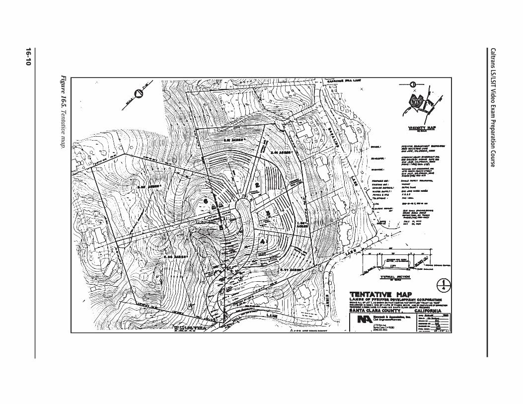
Caltrans LSLSIT Video Exam Preparation Course
Figure 16-5 Tentative m
ap
16
-10
111 0 BARIH
~~~~~~Ijmiddot=i ~J~ ~ --t _WI JWt
~~
l ~
NOTlII AND UIHO AIIi_U - 11_ 01 14 t __ tIII
J
~
middot~tI ~~ PqCF
J f
tAP Ps p_ 34)
--~ ~1 c
al 0~
f iJ bull r bull II tI
PAllCoL (~ 464 APS PGS 22 23
bull ) z
_l~ Ii t~ItJmiddotmiddot-__ --TIIIfgt __ I ~ 1_- lII-
~t~camiddot~~~~MM~ f- tOO
tlontOGDl QO~ CPIOCII amp7
~ ~ ---a lO~ PARCEL MAP
a UrdiCIIhkI4f11M ApI _IIgt~__4t
01amp tItt+M_ 7171 u bull bull r IlIf ~N bull O bull
1JUampJ 1I111JfY IAIIT
~II4M~ CJAtI T~ MT AN llAAlTATIIIN IN AlIU~~I NI4U 04r bullbull DlnCC1 IIT lt
) lOcAT COItO QiII ~ImiddotOPi~IClA~~ 0 DL u ~IU COLlN~ QUles
1 MOCATI ~CCItO QlllTA Ii ~II M lIaI 101 eel( 4 OIIAilS i-i ttpoundUINoiT CiA CO~NTr IllKOIDs
)- NOICAns CDIIO OATA IItIGOJtO 0 5U~ IIA 1111 )QQc U ClPr1APSAT ~ ~A ~ampA cou~ lca C
-RIDGMEW ISTATU CON515T1NIa 01 TWO (1 tHiES SING IIOImQN OlltOTI 5HOW~ ONTHAT allTAIN NTITIICIA 0 NJSTQHIIIUIDItLQN OIIQTSUI 0 AIIlT QP1QTS71 01 TWI
middot-~~r=~~~ =g~~~-= TOWN 01 LOS ALlOS HILLS CALIF bull $ eI
~NOWACk ANOMSOCIAtIJlIi c~ INQi bullbull 5 _ANNI bullbull ~ bull c NQ_T fOUIlpI aTtleeT loa ~~LfIIO IIlt
~CT 011 ~ AWtt
Figure 16-6 Parcel m
ap
California Law for Surveyors
16-1
1
Caltrans LSLSIT Video Exam Preparation Course
Sample Test Questions Cite a reference for each answer given
1 List those titles that are reserved by law to licensed land surveyors
2 On what items is it mandatory for a licensed land surveyor to place his signature and show his license number or stamp his seal
3 Define ldquomaterial discrepancyrdquo with respect to the Professional Land Surveyors Act
4 Define ldquoresponsible chargerdquo with respect to the Professional Land Surveyors Act
5 Under what conditions may a registered civil engineer practice land surveying
6 Define ldquocertifyrdquo with respect to the Professional Land Surveyors Act
7 What act or activities performed by a person constitutes the practice of land surveying within the meaning of the Land Surveyors Act
8 When may a land surveyor administer or certify oaths
9 On January 29 1991 you performed a survey and set the corners of the lands of V Breshears described as follows
ldquoThe South 7500 feet of the East 20000 feet of Lot 2 Tract 500 recorded in Book 8 of Maps Page 86 Rainbow County Records State of California
The client acquired the property in 1959 from B Rogers who still owns the remainder of Lot 1rdquo
Is a record of survey required Explain
10 What is the ldquolocal agencyrdquo
11 ldquoSubdivisionrdquo includes a condominium project as defined by what code
12 Which section of the Subdivision Map Act covers the merger of contiguous parcels of land
13 In your own words define ldquosubdivisionrdquo
14 What is the difference between a parcel map final map and tentative map
15 Under what conditions may a parcel map be based upon ldquorecord informationrdquo
16 Can the local agency require a tentative map parcel map or final map for a lot line adjustment
17 Under what circumstances can a record of survey delineate parcels of land not shown on the latest adopted county assessment roll as a unit or contiguous units
16-12
18 Problem D-7 1980 LS
You have been hired to prepare a parcel map from ldquorecord datardquo A recently filed record of survey prepared by another surveyor has determined the boundary In checking for the previously set monuments you determined that the previous surveyor has used an erroneous section corner to control his survey This results in a difference in the position of the true corners and the monumented corners of distances from 05 ft to 32 ft No improvements have been constructed on the property Your client is in a rush because interest rate charges are causing problems with his potential sale
A Describe your actions with regard to your client
B Describe your actions with regard to the other surveyor
C Describe your actions with regard to the preparation of the parcel map
19 Problem A-1 1989 LS
Given the information denoted in the diagram below the client has asked you to provide surveying and mapping services necessary to create the parcels as shown
N
Not to Scale
10 Acres
12 Acres
15 Acres
20 Acres8 Acres
Bypass Road Granted to the County in 1950
Bypa
ss R
oad
Legend
Monuments Found Denoting the Clients Property That Was Purchased in 1940
California Law for Surveyors
16-13Ecirc
Caltrans LSLSIT Video Exam Preparation Course
Required
The answers to the following questions are based upon current California law You are to answer each of the questions briefly in your own words or indicate the appropriate citations
A What type of map or maps if any are required for this land division
B If a map is required who shall prepare it
C Explain whether or not the new parcels are required to be monumented
D If monuments are required or requested when must they be set
E If a map or maps are required under what conditions would holders of beneficial interests not be required to sign
F Excluding lawsuits and moratoriums and if a final map or parcel map is required what is the maximum time allowed to record the map
G Under what conditions may the monuments called for on a parcel map or final map be set by another licensed land surveyor
H After the completion of your work on the clientrsquos property a tractor removed the monument that you found at the exterior southeast corner The contractor asks you to replace the corner What document if any would you prepare
I Assuming it is necessary to gain access to the neighboring property to conduct your field survey and the neighbors question your right to be on their property how would you respond
J How can non-title information (ie building setback lines etc) be filed or recorded with a subdivision map
16-14
California Law for Surveyors
Answer Key
1 LS Act 8708 Licensed land surveyor professional land surveyor or land surveyor
LS Act 8751 Professional engineer in land surveying land survey engineer survey engineer geodetic engineer and geometronic engineer
2 LS Act 8761 Maps plats reports descriptions or other documents
3 LS Act 8762(b) Difference in position of points lines or dimensions between a survey and information found on any subdivision map official map or record of survey on file with the County Recorder or surveyor or any map or survey record maintained by the Bureau of Land Management
4 LS 8703 Independent control and direction by use of initiative skill and independent judgment of the observations measurements and descriptions involved in land surveying work
5 LS Act 8731 A civil engineer registered before January 1 1982 can practice land surveying otherwise the engineer must obtain a land surveying license
6 LS Act 87706 An expression of professional opinion regarding facts or findings which are the subject of certification Use of the word certify does not constitute a warranty or guarantee
7 LS Act 8726
8 LS Act - 8760 Oaths may be used to take testimony for the identification of obliterated monuments to perpetuate evidence of monuments found in perishable condition and when it is desirable to administer an oath to assistants for the faithful performance of their duty
9 LS Act 8762(d)(e) A record of survey will be required because corners not shown on a record map will be established
10 SMA 66420 City county or city and county
11 SMA 66424 Section 1350 of the Civil Code
12 SMA Article 15
13 SMA 66424 - Your definition must include the phrase ldquofor the purpose of sale lease or financingrdquo
16-15Ecirc
Caltrans LSLSIT Video Exam Preparation Course
14
15
16
17
18
19
SBA Chapter 2 Tentative maps are used in the subdivision approval process and are not recorded Parcel maps are used for land divisions of four or fewer parcels or for divisions listed in 66426 (a)(b)(c) and (d) and are recorded with the County Recorder Final maps are required for division of five or more parcels and are recorded with the County Recorder
SMA 66448 Parcel maps may be based on record information if local ordinance does not require a field survey and sufficient information exists on filed maps to locate and retrace the exterior lines of the parcel map if the location of at least one boundary line can be established from an existing monumented line
SMA 66412(d) No
LS Act 87625 SMA 6649935 A record of survey can only show new parcels of land if it is accompanied with a Certificate of Compliance SMA 664265 A record of survey can show a parcel of land created for conveyance to a public entity for right-of-way purposes
A I would inform my client that because of errors on the record of survey sufficient record data does not exist to file a parcel map based on the record information (SMA 66448)
B Inform the other surveyor of the problems and have him correct his survey
C I would inform my client that he could wait until the other surveyor had corrected his survey and then file the parcel map based on record information or we could go ahead with a parcel map based on a field survey I would provide my client with estimated costs and time frames for each of these alternatives The client would have to base his decision on his own budget and time considerations
A A tentative final or parcel map (SMA 66426 66424)
B A licensed land surveyor or civil engineer authorized to practice land surveying (SMA 66434 LSA 8731)
C SMA 66495 requires sufficient durable monuments also see LSA 8771 The surveyor must also set additional monuments as required by local ordinance (SMA 66495) (SMA 66495 does not require parcels to be monumented)
D At least one exterior line shall be monumented prior to the map recording (SMA 66495) The interior monuments may be delayed to no later than a specific date noted in the surveyorrsquos statement (SMA 66496 66441)
16-16
California Law for Surveyors
E Beneficial interest holders or their trustees are not required to sign parcel maps (SMA 66436 664453E)
F Two years with a maximum one-year time extension if allowed by local ordinance (SMA 664526) (Five years acceptable per 664526E)
G Death disability retirement of original surveyor or refusal (SMA 66498)
H Corner record LSA 8773 through 87734 board rule 464
I Right of Entry (LSA 8774)
J Supplemental information sheet may be filed concurrently with the final map or recorded as a separate document (SMA 664342)
16-17Ecirc
Caltrans LSLSIT Video Exam Preparation Course
References Professional Land Surveyors Act Sections 8700ndash8806 State of California
Business and Professions Code
Subdivision Map Act Sections 66410ndash6649958 State of California Government Code
Important These references are being constantly revised by the State Legislature The latest version of the statutes can be obtained for $10 from
California Land Surveyors Association PO Box 9098 Santa Rosa CA 95405
_______ Guide to the Preparation of Records of Survey and Corner Records County Engineers Association of California 1989
This publication can be obtained by sending a check for $330 to Orange County Surveyorrsquos Office 400 Civic Center Dr Room 225 Santa Ana CA 92702
16-18

Caltrans LSLSIT Video Exam Preparation Course
Sample Test Questions Cite a reference for each answer given
1 List those titles that are reserved by law to licensed land surveyors
2 On what items is it mandatory for a licensed land surveyor to place his signature and show his license number or stamp his seal
3 Define ldquomaterial discrepancyrdquo with respect to the Professional Land Surveyors Act
4 Define ldquoresponsible chargerdquo with respect to the Professional Land Surveyors Act
5 Under what conditions may a registered civil engineer practice land surveying
6 Define ldquocertifyrdquo with respect to the Professional Land Surveyors Act
7 What act or activities performed by a person constitutes the practice of land surveying within the meaning of the Land Surveyors Act
8 When may a land surveyor administer or certify oaths
9 On January 29 1991 you performed a survey and set the corners of the lands of V Breshears described as follows
ldquoThe South 7500 feet of the East 20000 feet of Lot 2 Tract 500 recorded in Book 8 of Maps Page 86 Rainbow County Records State of California
The client acquired the property in 1959 from B Rogers who still owns the remainder of Lot 1rdquo
Is a record of survey required Explain
10 What is the ldquolocal agencyrdquo
11 ldquoSubdivisionrdquo includes a condominium project as defined by what code
12 Which section of the Subdivision Map Act covers the merger of contiguous parcels of land
13 In your own words define ldquosubdivisionrdquo
14 What is the difference between a parcel map final map and tentative map
15 Under what conditions may a parcel map be based upon ldquorecord informationrdquo
16 Can the local agency require a tentative map parcel map or final map for a lot line adjustment
17 Under what circumstances can a record of survey delineate parcels of land not shown on the latest adopted county assessment roll as a unit or contiguous units
16-12
18 Problem D-7 1980 LS
You have been hired to prepare a parcel map from ldquorecord datardquo A recently filed record of survey prepared by another surveyor has determined the boundary In checking for the previously set monuments you determined that the previous surveyor has used an erroneous section corner to control his survey This results in a difference in the position of the true corners and the monumented corners of distances from 05 ft to 32 ft No improvements have been constructed on the property Your client is in a rush because interest rate charges are causing problems with his potential sale
A Describe your actions with regard to your client
B Describe your actions with regard to the other surveyor
C Describe your actions with regard to the preparation of the parcel map
19 Problem A-1 1989 LS
Given the information denoted in the diagram below the client has asked you to provide surveying and mapping services necessary to create the parcels as shown
N
Not to Scale
10 Acres
12 Acres
15 Acres
20 Acres8 Acres
Bypass Road Granted to the County in 1950
Bypa
ss R
oad
Legend
Monuments Found Denoting the Clients Property That Was Purchased in 1940
California Law for Surveyors
16-13Ecirc
Caltrans LSLSIT Video Exam Preparation Course
Required
The answers to the following questions are based upon current California law You are to answer each of the questions briefly in your own words or indicate the appropriate citations
A What type of map or maps if any are required for this land division
B If a map is required who shall prepare it
C Explain whether or not the new parcels are required to be monumented
D If monuments are required or requested when must they be set
E If a map or maps are required under what conditions would holders of beneficial interests not be required to sign
F Excluding lawsuits and moratoriums and if a final map or parcel map is required what is the maximum time allowed to record the map
G Under what conditions may the monuments called for on a parcel map or final map be set by another licensed land surveyor
H After the completion of your work on the clientrsquos property a tractor removed the monument that you found at the exterior southeast corner The contractor asks you to replace the corner What document if any would you prepare
I Assuming it is necessary to gain access to the neighboring property to conduct your field survey and the neighbors question your right to be on their property how would you respond
J How can non-title information (ie building setback lines etc) be filed or recorded with a subdivision map
16-14
California Law for Surveyors
Answer Key
1 LS Act 8708 Licensed land surveyor professional land surveyor or land surveyor
LS Act 8751 Professional engineer in land surveying land survey engineer survey engineer geodetic engineer and geometronic engineer
2 LS Act 8761 Maps plats reports descriptions or other documents
3 LS Act 8762(b) Difference in position of points lines or dimensions between a survey and information found on any subdivision map official map or record of survey on file with the County Recorder or surveyor or any map or survey record maintained by the Bureau of Land Management
4 LS 8703 Independent control and direction by use of initiative skill and independent judgment of the observations measurements and descriptions involved in land surveying work
5 LS Act 8731 A civil engineer registered before January 1 1982 can practice land surveying otherwise the engineer must obtain a land surveying license
6 LS Act 87706 An expression of professional opinion regarding facts or findings which are the subject of certification Use of the word certify does not constitute a warranty or guarantee
7 LS Act 8726
8 LS Act - 8760 Oaths may be used to take testimony for the identification of obliterated monuments to perpetuate evidence of monuments found in perishable condition and when it is desirable to administer an oath to assistants for the faithful performance of their duty
9 LS Act 8762(d)(e) A record of survey will be required because corners not shown on a record map will be established
10 SMA 66420 City county or city and county
11 SMA 66424 Section 1350 of the Civil Code
12 SMA Article 15
13 SMA 66424 - Your definition must include the phrase ldquofor the purpose of sale lease or financingrdquo
16-15Ecirc
Caltrans LSLSIT Video Exam Preparation Course
14
15
16
17
18
19
SBA Chapter 2 Tentative maps are used in the subdivision approval process and are not recorded Parcel maps are used for land divisions of four or fewer parcels or for divisions listed in 66426 (a)(b)(c) and (d) and are recorded with the County Recorder Final maps are required for division of five or more parcels and are recorded with the County Recorder
SMA 66448 Parcel maps may be based on record information if local ordinance does not require a field survey and sufficient information exists on filed maps to locate and retrace the exterior lines of the parcel map if the location of at least one boundary line can be established from an existing monumented line
SMA 66412(d) No
LS Act 87625 SMA 6649935 A record of survey can only show new parcels of land if it is accompanied with a Certificate of Compliance SMA 664265 A record of survey can show a parcel of land created for conveyance to a public entity for right-of-way purposes
A I would inform my client that because of errors on the record of survey sufficient record data does not exist to file a parcel map based on the record information (SMA 66448)
B Inform the other surveyor of the problems and have him correct his survey
C I would inform my client that he could wait until the other surveyor had corrected his survey and then file the parcel map based on record information or we could go ahead with a parcel map based on a field survey I would provide my client with estimated costs and time frames for each of these alternatives The client would have to base his decision on his own budget and time considerations
A A tentative final or parcel map (SMA 66426 66424)
B A licensed land surveyor or civil engineer authorized to practice land surveying (SMA 66434 LSA 8731)
C SMA 66495 requires sufficient durable monuments also see LSA 8771 The surveyor must also set additional monuments as required by local ordinance (SMA 66495) (SMA 66495 does not require parcels to be monumented)
D At least one exterior line shall be monumented prior to the map recording (SMA 66495) The interior monuments may be delayed to no later than a specific date noted in the surveyorrsquos statement (SMA 66496 66441)
16-16
California Law for Surveyors
E Beneficial interest holders or their trustees are not required to sign parcel maps (SMA 66436 664453E)
F Two years with a maximum one-year time extension if allowed by local ordinance (SMA 664526) (Five years acceptable per 664526E)
G Death disability retirement of original surveyor or refusal (SMA 66498)
H Corner record LSA 8773 through 87734 board rule 464
I Right of Entry (LSA 8774)
J Supplemental information sheet may be filed concurrently with the final map or recorded as a separate document (SMA 664342)
16-17Ecirc
Caltrans LSLSIT Video Exam Preparation Course
References Professional Land Surveyors Act Sections 8700ndash8806 State of California
Business and Professions Code
Subdivision Map Act Sections 66410ndash6649958 State of California Government Code
Important These references are being constantly revised by the State Legislature The latest version of the statutes can be obtained for $10 from
California Land Surveyors Association PO Box 9098 Santa Rosa CA 95405
_______ Guide to the Preparation of Records of Survey and Corner Records County Engineers Association of California 1989
This publication can be obtained by sending a check for $330 to Orange County Surveyorrsquos Office 400 Civic Center Dr Room 225 Santa Ana CA 92702
16-18

Caltrans LSLSIT Video Exam Preparation Course
Required
The answers to the following questions are based upon current California law You are to answer each of the questions briefly in your own words or indicate the appropriate citations
A What type of map or maps if any are required for this land division
B If a map is required who shall prepare it
C Explain whether or not the new parcels are required to be monumented
D If monuments are required or requested when must they be set
E If a map or maps are required under what conditions would holders of beneficial interests not be required to sign
F Excluding lawsuits and moratoriums and if a final map or parcel map is required what is the maximum time allowed to record the map
G Under what conditions may the monuments called for on a parcel map or final map be set by another licensed land surveyor
H After the completion of your work on the clientrsquos property a tractor removed the monument that you found at the exterior southeast corner The contractor asks you to replace the corner What document if any would you prepare
I Assuming it is necessary to gain access to the neighboring property to conduct your field survey and the neighbors question your right to be on their property how would you respond
J How can non-title information (ie building setback lines etc) be filed or recorded with a subdivision map
16-14
California Law for Surveyors
Answer Key
1 LS Act 8708 Licensed land surveyor professional land surveyor or land surveyor
LS Act 8751 Professional engineer in land surveying land survey engineer survey engineer geodetic engineer and geometronic engineer
2 LS Act 8761 Maps plats reports descriptions or other documents
3 LS Act 8762(b) Difference in position of points lines or dimensions between a survey and information found on any subdivision map official map or record of survey on file with the County Recorder or surveyor or any map or survey record maintained by the Bureau of Land Management
4 LS 8703 Independent control and direction by use of initiative skill and independent judgment of the observations measurements and descriptions involved in land surveying work
5 LS Act 8731 A civil engineer registered before January 1 1982 can practice land surveying otherwise the engineer must obtain a land surveying license
6 LS Act 87706 An expression of professional opinion regarding facts or findings which are the subject of certification Use of the word certify does not constitute a warranty or guarantee
7 LS Act 8726
8 LS Act - 8760 Oaths may be used to take testimony for the identification of obliterated monuments to perpetuate evidence of monuments found in perishable condition and when it is desirable to administer an oath to assistants for the faithful performance of their duty
9 LS Act 8762(d)(e) A record of survey will be required because corners not shown on a record map will be established
10 SMA 66420 City county or city and county
11 SMA 66424 Section 1350 of the Civil Code
12 SMA Article 15
13 SMA 66424 - Your definition must include the phrase ldquofor the purpose of sale lease or financingrdquo
16-15Ecirc
Caltrans LSLSIT Video Exam Preparation Course
14
15
16
17
18
19
SBA Chapter 2 Tentative maps are used in the subdivision approval process and are not recorded Parcel maps are used for land divisions of four or fewer parcels or for divisions listed in 66426 (a)(b)(c) and (d) and are recorded with the County Recorder Final maps are required for division of five or more parcels and are recorded with the County Recorder
SMA 66448 Parcel maps may be based on record information if local ordinance does not require a field survey and sufficient information exists on filed maps to locate and retrace the exterior lines of the parcel map if the location of at least one boundary line can be established from an existing monumented line
SMA 66412(d) No
LS Act 87625 SMA 6649935 A record of survey can only show new parcels of land if it is accompanied with a Certificate of Compliance SMA 664265 A record of survey can show a parcel of land created for conveyance to a public entity for right-of-way purposes
A I would inform my client that because of errors on the record of survey sufficient record data does not exist to file a parcel map based on the record information (SMA 66448)
B Inform the other surveyor of the problems and have him correct his survey
C I would inform my client that he could wait until the other surveyor had corrected his survey and then file the parcel map based on record information or we could go ahead with a parcel map based on a field survey I would provide my client with estimated costs and time frames for each of these alternatives The client would have to base his decision on his own budget and time considerations
A A tentative final or parcel map (SMA 66426 66424)
B A licensed land surveyor or civil engineer authorized to practice land surveying (SMA 66434 LSA 8731)
C SMA 66495 requires sufficient durable monuments also see LSA 8771 The surveyor must also set additional monuments as required by local ordinance (SMA 66495) (SMA 66495 does not require parcels to be monumented)
D At least one exterior line shall be monumented prior to the map recording (SMA 66495) The interior monuments may be delayed to no later than a specific date noted in the surveyorrsquos statement (SMA 66496 66441)
16-16
California Law for Surveyors
E Beneficial interest holders or their trustees are not required to sign parcel maps (SMA 66436 664453E)
F Two years with a maximum one-year time extension if allowed by local ordinance (SMA 664526) (Five years acceptable per 664526E)
G Death disability retirement of original surveyor or refusal (SMA 66498)
H Corner record LSA 8773 through 87734 board rule 464
I Right of Entry (LSA 8774)
J Supplemental information sheet may be filed concurrently with the final map or recorded as a separate document (SMA 664342)
16-17Ecirc
Caltrans LSLSIT Video Exam Preparation Course
References Professional Land Surveyors Act Sections 8700ndash8806 State of California
Business and Professions Code
Subdivision Map Act Sections 66410ndash6649958 State of California Government Code
Important These references are being constantly revised by the State Legislature The latest version of the statutes can be obtained for $10 from
California Land Surveyors Association PO Box 9098 Santa Rosa CA 95405
_______ Guide to the Preparation of Records of Survey and Corner Records County Engineers Association of California 1989
This publication can be obtained by sending a check for $330 to Orange County Surveyorrsquos Office 400 Civic Center Dr Room 225 Santa Ana CA 92702
16-18
California Law for Surveyors
Answer Key
1 LS Act 8708 Licensed land surveyor professional land surveyor or land surveyor
LS Act 8751 Professional engineer in land surveying land survey engineer survey engineer geodetic engineer and geometronic engineer
2 LS Act 8761 Maps plats reports descriptions or other documents
3 LS Act 8762(b) Difference in position of points lines or dimensions between a survey and information found on any subdivision map official map or record of survey on file with the County Recorder or surveyor or any map or survey record maintained by the Bureau of Land Management
4 LS 8703 Independent control and direction by use of initiative skill and independent judgment of the observations measurements and descriptions involved in land surveying work
5 LS Act 8731 A civil engineer registered before January 1 1982 can practice land surveying otherwise the engineer must obtain a land surveying license
6 LS Act 87706 An expression of professional opinion regarding facts or findings which are the subject of certification Use of the word certify does not constitute a warranty or guarantee
7 LS Act 8726
8 LS Act - 8760 Oaths may be used to take testimony for the identification of obliterated monuments to perpetuate evidence of monuments found in perishable condition and when it is desirable to administer an oath to assistants for the faithful performance of their duty
9 LS Act 8762(d)(e) A record of survey will be required because corners not shown on a record map will be established
10 SMA 66420 City county or city and county
11 SMA 66424 Section 1350 of the Civil Code
12 SMA Article 15
13 SMA 66424 - Your definition must include the phrase ldquofor the purpose of sale lease or financingrdquo
16-15Ecirc
Caltrans LSLSIT Video Exam Preparation Course
14
15
16
17
18
19
SBA Chapter 2 Tentative maps are used in the subdivision approval process and are not recorded Parcel maps are used for land divisions of four or fewer parcels or for divisions listed in 66426 (a)(b)(c) and (d) and are recorded with the County Recorder Final maps are required for division of five or more parcels and are recorded with the County Recorder
SMA 66448 Parcel maps may be based on record information if local ordinance does not require a field survey and sufficient information exists on filed maps to locate and retrace the exterior lines of the parcel map if the location of at least one boundary line can be established from an existing monumented line
SMA 66412(d) No
LS Act 87625 SMA 6649935 A record of survey can only show new parcels of land if it is accompanied with a Certificate of Compliance SMA 664265 A record of survey can show a parcel of land created for conveyance to a public entity for right-of-way purposes
A I would inform my client that because of errors on the record of survey sufficient record data does not exist to file a parcel map based on the record information (SMA 66448)
B Inform the other surveyor of the problems and have him correct his survey
C I would inform my client that he could wait until the other surveyor had corrected his survey and then file the parcel map based on record information or we could go ahead with a parcel map based on a field survey I would provide my client with estimated costs and time frames for each of these alternatives The client would have to base his decision on his own budget and time considerations
A A tentative final or parcel map (SMA 66426 66424)
B A licensed land surveyor or civil engineer authorized to practice land surveying (SMA 66434 LSA 8731)
C SMA 66495 requires sufficient durable monuments also see LSA 8771 The surveyor must also set additional monuments as required by local ordinance (SMA 66495) (SMA 66495 does not require parcels to be monumented)
D At least one exterior line shall be monumented prior to the map recording (SMA 66495) The interior monuments may be delayed to no later than a specific date noted in the surveyorrsquos statement (SMA 66496 66441)
16-16
California Law for Surveyors
E Beneficial interest holders or their trustees are not required to sign parcel maps (SMA 66436 664453E)
F Two years with a maximum one-year time extension if allowed by local ordinance (SMA 664526) (Five years acceptable per 664526E)
G Death disability retirement of original surveyor or refusal (SMA 66498)
H Corner record LSA 8773 through 87734 board rule 464
I Right of Entry (LSA 8774)
J Supplemental information sheet may be filed concurrently with the final map or recorded as a separate document (SMA 664342)
16-17Ecirc
Caltrans LSLSIT Video Exam Preparation Course
References Professional Land Surveyors Act Sections 8700ndash8806 State of California
Business and Professions Code
Subdivision Map Act Sections 66410ndash6649958 State of California Government Code
Important These references are being constantly revised by the State Legislature The latest version of the statutes can be obtained for $10 from
California Land Surveyors Association PO Box 9098 Santa Rosa CA 95405
_______ Guide to the Preparation of Records of Survey and Corner Records County Engineers Association of California 1989
This publication can be obtained by sending a check for $330 to Orange County Surveyorrsquos Office 400 Civic Center Dr Room 225 Santa Ana CA 92702
16-18
Caltrans LSLSIT Video Exam Preparation Course
14
15
16
17
18
19
SBA Chapter 2 Tentative maps are used in the subdivision approval process and are not recorded Parcel maps are used for land divisions of four or fewer parcels or for divisions listed in 66426 (a)(b)(c) and (d) and are recorded with the County Recorder Final maps are required for division of five or more parcels and are recorded with the County Recorder
SMA 66448 Parcel maps may be based on record information if local ordinance does not require a field survey and sufficient information exists on filed maps to locate and retrace the exterior lines of the parcel map if the location of at least one boundary line can be established from an existing monumented line
SMA 66412(d) No
LS Act 87625 SMA 6649935 A record of survey can only show new parcels of land if it is accompanied with a Certificate of Compliance SMA 664265 A record of survey can show a parcel of land created for conveyance to a public entity for right-of-way purposes
A I would inform my client that because of errors on the record of survey sufficient record data does not exist to file a parcel map based on the record information (SMA 66448)
B Inform the other surveyor of the problems and have him correct his survey
C I would inform my client that he could wait until the other surveyor had corrected his survey and then file the parcel map based on record information or we could go ahead with a parcel map based on a field survey I would provide my client with estimated costs and time frames for each of these alternatives The client would have to base his decision on his own budget and time considerations
A A tentative final or parcel map (SMA 66426 66424)
B A licensed land surveyor or civil engineer authorized to practice land surveying (SMA 66434 LSA 8731)
C SMA 66495 requires sufficient durable monuments also see LSA 8771 The surveyor must also set additional monuments as required by local ordinance (SMA 66495) (SMA 66495 does not require parcels to be monumented)
D At least one exterior line shall be monumented prior to the map recording (SMA 66495) The interior monuments may be delayed to no later than a specific date noted in the surveyorrsquos statement (SMA 66496 66441)
16-16
California Law for Surveyors
E Beneficial interest holders or their trustees are not required to sign parcel maps (SMA 66436 664453E)
F Two years with a maximum one-year time extension if allowed by local ordinance (SMA 664526) (Five years acceptable per 664526E)
G Death disability retirement of original surveyor or refusal (SMA 66498)
H Corner record LSA 8773 through 87734 board rule 464
I Right of Entry (LSA 8774)
J Supplemental information sheet may be filed concurrently with the final map or recorded as a separate document (SMA 664342)
16-17Ecirc
Caltrans LSLSIT Video Exam Preparation Course
References Professional Land Surveyors Act Sections 8700ndash8806 State of California
Business and Professions Code
Subdivision Map Act Sections 66410ndash6649958 State of California Government Code
Important These references are being constantly revised by the State Legislature The latest version of the statutes can be obtained for $10 from
California Land Surveyors Association PO Box 9098 Santa Rosa CA 95405
_______ Guide to the Preparation of Records of Survey and Corner Records County Engineers Association of California 1989
This publication can be obtained by sending a check for $330 to Orange County Surveyorrsquos Office 400 Civic Center Dr Room 225 Santa Ana CA 92702
16-18