c and e : nepal nepalc498469.r69.cf2.rackcdn.com/2006/405_nepal_aaj2006.pdf · annapurna, 14th for...
TRANSCRIPT

Nepal
AnnApurnA HimAl
Annapurna, 14th for Viesturs, accident. The well-known American mountaineer Ed Viesturs went to Cho Oyu to acclimatize and then quickly to his last 8,000er, Annapur-na I. The north face of this 8,091m mountain, the 10th highest in the world, is notorious for fatal avalanches. Viesturs went in the spring of 2000 and witnessed constant avalanching all across the face. He returned from having climbed no higher than 5,900m and declared he would never go there again. His next attempt, in 2002, was via the long east ridge, which he decided was not for him. So he was back on the north face after all.
This time he and his frequent partner, Viekka Gustafsson of Finland, already well-accli-matized, moved quickly up the face, pitched their high camp at just 6,900m, waited three days for the wind to drop, and were on the summit on May 12, less than two weeks after arriving at base camp. Viesturs was amazed by how free the face was from avalanching.
On the summit he felt it was “a dream come true. I had my doubts that I’d ever get there, because of our conservatism and its dangerous avalanching.” He thinks he is the seventh or eighth person to scale all 8,000ers without using bottled oxygen [in fact, he appears to be only the fifth to complete all 14 without using oxygen on either ascent or descent—Ed.]. What next? “Now that I’ve gotten the 8,000ers out of the way, maybe some 7,000ers in Nepal; maybe Ant-arctica.” He had no definite plans yet.
Viesturs and Gustafsson left the mountain on May 14 without having experienced avalanche problems. On the 18th four men from an Italian team led by Abele Blanc reached 6,300m in the same gully climbed by the American and Finn, when suddenly huge blocks of ice, some 3m square, came crashing down. Christian Kuntner, for whom Annapurna was the last 8,000er he had left to scale, received fatal internal injuries. Blanc, who was in the lead, was struck on the side of his head so hard that he was unconscious for 18 hours and has no mem-ory of the incident. Two of his ribs were broken. (Annapurna was his final unclimbed 8,000er also.) The last two men going up the shallow couloir, Stephan Andres and Marco Barmasse, were not so seriously hurt.
ElizabEth hawlEy, AAC Honorary Member, Nepal
KutAng HimAl
Swelokan, south face and northwest ridge attempts. A small Japanese team became the first climbers to attempt the remote 6,180m Swelokan, which lies on the Tibet border north-north-east of Manaslu, in what is sometimes referred to as the Kutang Himal. Base camp was estab-lished at just over 4,400m in the upper Buru Gandaki, from where Sadmasu Kitagawa and
Cl i m b s A n d Ex p E d i t i o n s : nE pA l 405
pg405-431_Nepal.indd 405 6/30/06 10:38:39 AM

tH E Am E r i C A n Al p i n E Jo u r nA l , 2006406
Hiroh Shogo had originally planned to attempt the south face. However, before reaching this point Shogo had been forced to retire by altitude sickness, so Kitagawa made his first attempt with Dorchi Sherpa. On April 27 these two reached only 5,200m, where a rock barrier blocked the glacier up which they were traveling. They moved base camp to the northwest and on May 2 camped at 5,400m on the southwest face. Next day they reached 5,800m on the northwest ridge, only to find the crest above was sharp, with loose rock and fresh snow. They gave up, though they noted that the south face would provide a good route for technical climbers.
tom Nakamura and the JapaNEsE alpiNE NEws
dAmodAr HimAl
Pt 6,417m, first ascent; corrections to some previous reports on Gaugiri.In May 2002 Americans Peter Ackroyd and Jim Frush made the first ascent of Gaugiri,
an often snowless but isolated 6,110m rock pyramid on the Tibet border. The Nepalese Minis-try of Tourism places Gaugiri at 84° 11' 16" E, 29° 02' 45" N. This agrees exactly with its posi-tion as marked on the new HGM Finn map (Sheet 2984-13: the HGM Finn maps are generally considered the official cartographic reference to the Nepal Himalaya) and also with its refer-ence in Classification of the Himalaya, a scholarly work published in the AAJ 1985 by Adams Carter. However, the Finnish map marks the Damodar Kunda Lakes, a notable pilgrimage site, immediately below (and north west of) Gaugiri, where there are in fact a few small ponds at 5,420m. The true lakes lie some nine kilometers south (considerably further when walking this terrain) close to where sheet 2884-01 shows some very small lakes just north of the Namta Khola. This confusion led to the American pair separating from their porters and spending a night out without equipment before the team eventually re-united—see AAJ 2003 pp. 385-386 for a full report. The American route up the southwest ridge was repeated by Austrians in 2004 for what is now believed to be the second ascent of the mountain.
A rare view of the Lugula Group, Damodar Himal, and mountains of the Peri Himal from the northwest. Identifying little known peaks can be an inexact science but it is thought that (A) is Ratna Chuli (7,035m, first climbed in October 1996 by a large joint Nepalese-Japanese expedition along the west ridge over the 6,604m West Summit, climbed three times since), (B) is Pt 6,687m, and (C) is Pt 6,572m on the long east ridge of Lugula. Peaks behind C form part of the Peri Himal. (D) Is definitely the unclimbed Lugula (6,899m). Peter Ackroyd
pg405-431_Nepal.indd 406 6/30/06 10:38:40 AM
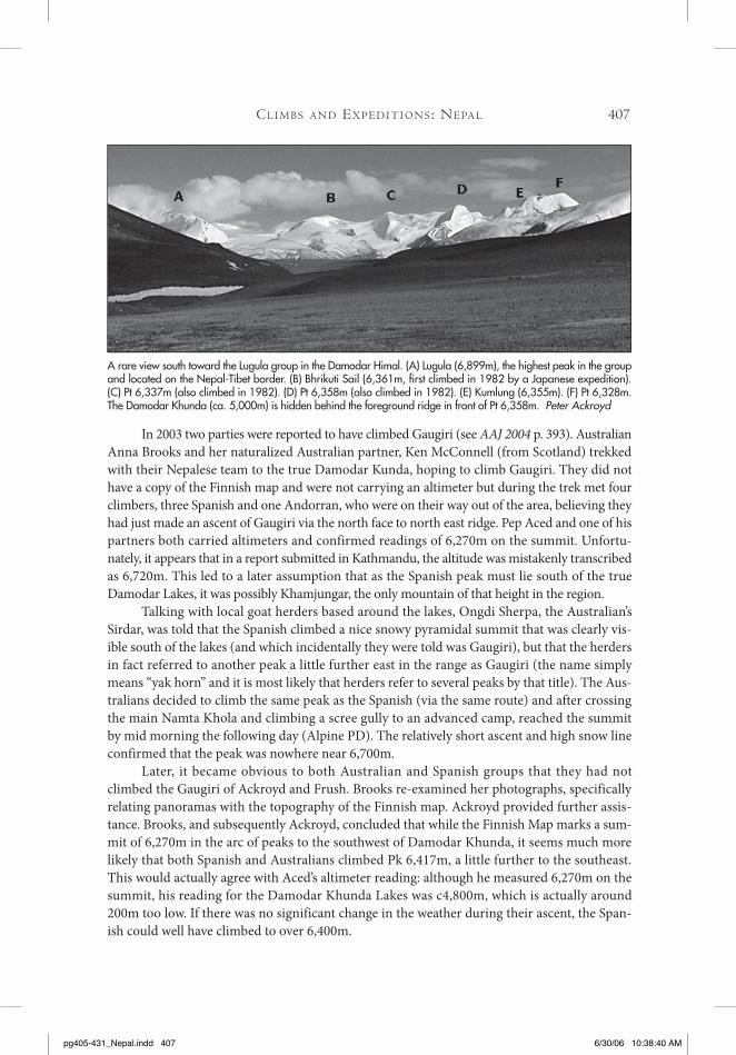
In 2003 two parties were reported to have climbed Gaugiri (see AAJ 2004 p. 393). Australian Anna Brooks and her naturalized Australian partner, Ken McConnell (from Scotland) trekked with their Nepalese team to the true Damodar Kunda, hoping to climb Gaugiri. They did not have a copy of the Finnish map and were not carrying an altimeter but during the trek met four climbers, three Spanish and one Andorran, who were on their way out of the area, believing they had just made an ascent of Gaugiri via the north face to north east ridge. Pep Aced and one of his partners both carried altimeters and confirmed readings of 6,270m on the summit. Unfortu-nately, it appears that in a report submitted in Kathmandu, the altitude was mistakenly transcribed as 6,720m. This led to a later assumption that as the Spanish peak must lie south of the true Damodar Lakes, it was possibly Khamjungar, the only mountain of that height in the region.
Talking with local goat herders based around the lakes, Ongdi Sherpa, the Australian’s Sirdar, was told that the Spanish climbed a nice snowy pyramidal summit that was clearly vis-ible south of the lakes (and which incidentally they were told was Gaugiri), but that the herders in fact referred to another peak a little further east in the range as Gaugiri (the name simply means “yak horn” and it is most likely that herders refer to several peaks by that title). The Aus-tralians decided to climb the same peak as the Spanish (via the same route) and after crossing the main Namta Khola and climbing a scree gully to an advanced camp, reached the summit by mid morning the following day (Alpine PD). The relatively short ascent and high snow line confirmed that the peak was nowhere near 6,700m.
Later, it became obvious to both Australian and Spanish groups that they had not climbed the Gaugiri of Ackroyd and Frush. Brooks re-examined her photographs, specifically relating panoramas with the topography of the Finnish map. Ackroyd provided further assis-tance. Brooks, and subsequently Ackroyd, concluded that while the Finnish Map marks a sum-mit of 6,270m in the arc of peaks to the southwest of Damodar Khunda, it seems much more likely that both Spanish and Australians climbed Pk 6,417m, a little further to the southeast. This would actually agree with Aced’s altimeter reading: although he measured 6,270m on the summit, his reading for the Damodar Khunda Lakes was c4,800m, which is actually around 200m too low. If there was no significant change in the weather during their ascent, the Span-ish could well have climbed to over 6,400m.
Cl i m b s A n d Ex p E d i t i o n s : nE pA l 407
A rare view south toward the Lugula group in the Damodar Himal. (A) Lugula (6,899m), the highest peak in the group and located on the Nepal-Tibet border. (B) Bhrikuti Sail (6,361m, first climbed in 1982 by a Japanese expedition). (C) Pt 6,337m (also climbed in 1982). (D) Pt 6,358m (also climbed in 1982). (E) Kumlung (6,355m). (F) Pt 6,328m. The Damodar Khunda (ca. 5,000m) is hidden behind the foreground ridge in front of Pt 6,358m. Peter Ackroyd
pg405-431_Nepal.indd 407 6/30/06 10:38:40 AM

tH E Am E r i C A n Al p i n E Jo u r nA l , 2006408
Pk 6,417m: first ascent (October 8, 2003) by Josep Aced (leader), Serge Philippe Benet, Adria Font and Francesc Zapater; second ascent (October 21, 2003) by Anna Brooks, Ken McConnell (leader), Dendi Sherpa and Ongdi Sherpa.
liNdsay GriffiN, from iNformatioN providEd by pEtEr ackroyd and aNNa brooks.
pEri HimAl
Kang Guru, avalanche tragedy to French expedition. The worst disaster ever to befall an expedition in the Nepalese Himalaya struck a seven-member French team trying to climb 6,981m Kang Guru. The only previous death on the mountain was that of a West German named Bernd Arenz, who died in a fall on October 24, 1985. On October 20, 2005, all the French and 11 of their Nepalese employees, who were inside their base camp tents after the members’ late-afternoon tea, were swept by a giant avalanche into a deep gorge below. All 18 perished. These included 60-year old leader Daniel Stolzenberg, his wife, three high-altitude climbers, base camp cook and kitchen boys, and low-altitude load-carrying porters. Several other porters were outside their tents at the time and managed to survive. They trekked to the nearest village, Meta, where they met a French-Israeli expedition planning to climb another mountain in the area, Ratna Chuli. This team imme-diately informed the French embassy in Kathmandu of the disaster. (Because of snow conditions, the Ratna Chuli team made no attempt to continue to their peak).
During early attempts to retrieve the bodies, only one, that of Bruno Chardin, a ski resort manager, was found before the search was suspended due to more avalanches. In the meantime specialists in avalanche searches arrived from France with special equipment and two sniffer dogs. By mid-November, when they called off their work until early the next year, they had discovered only the bodies of another French member, Jean-Francois Jube, an advisor to the French Ministry of Youth and Sports, and a low-altitude porter, Manilal Gurung.
The previous record death toll by avalanche to a single expedition in Nepal occurred in April 1972 and involved a Korean team on Manaslu. Ten Nepalese, four Koreans, and one Japa-nese cameraman were killed when an avalanche struck their tents at 3:15 a.m. But most of the Koreans were inexperienced in the Nepalese Himalaya, whereas at least two of the Frenchmen had been to Nepalese or Pakistani 8,000m mountains, and all of them lived in mountainous parts of France. Stolzenberg, for example, came from Chamonix, was a professional guide and a profes-
Looking north from the summit of Pokharkan in the Damodar Himal. (A) Pt 6,358m, (B) Pt 6,337m, (C) Bhrikuti Sail (6,361m), (D) Pt 6,285m, (E) Lugula (6,899m), (F) Pt 6,760m, (G) Pt 6,260m and (H) Chako (6,704m). The big peaks to the right are officially unclimbed and lie on the Tibetan frontier. It seems likely that A and B, and possibly D were climbed by the 1982 Japanese Bhrikuti expedition. Martin Scott
pg405-431_Nepal.indd 408 6/30/06 10:38:42 AM

Cl i m b s A n d Ex p E d i t i o n s : nE pA l 409
sor at the prestigious ENSA (National School of Skiing and Alpinism), where he had worked for over 30 years. The leader of the Nepalese staff was an experienced Sirdar, Iman Gurung, who had summited Everest twice, most recently in May this year, as well as Cho Oyu twice.
It is easy to be wise after the event, and some people questioned the wisdom of the base camp’s location, as it was surrounded by 35-40° slopes. One porter reportedly suggested that the camp be moved to what he considered a safer location downhill, but his proposal was not acted upon.
A noted French climbing instructor, Jean Coudray, who came to Kathmandu after he had discussed this subject with previous Kang Guru leaders, noted that the team had placed its base camp at the normal site. “In this area there is no place for base camp that is completely safe; there is no safer site than the one everyone has used.” Furthermore, he pointed out, there had been continuous heavy snowfall for many hours. The result was a powder-snow avalanche, which is the worst kind, because it can travel at 200+ km/hour down a slope of 30° or more, and its target is impossible to predict: it can often shift direction.
Kang Guru is situated in the Manang region northeast of Annapurna. It lies east of Pisang Peak, which is favored by climbers preferring a lower mountain and less bureaucratic red tape for a permit. In recent years Kang Guru has been a favorite of some French commercial expe-dition organizers. The approach route goes through colorful mountain villages. It apparently was considered safe; as mentioned above, only one climber had died on the 27 previous expedi-tions, and that occurred two decades ago.
ElizabEth hawlEy, AAC Honorary Member, Nepal.
Editor’s Note: this disaster is second only in terms of single-avalanche death toll to the 1990 accident on Pik Lenin, where 43 climbers were engulfed in a camp. The heavy storm responsible for this accident also trapped many nearby Annapurna Circuit trekkers, some of whom were eventually evacuated by helicopter.
Gyajikang, second ascent and first complete ascent of west ridge. A primarily French commercial expedition led by Paulo Grobel to 7,047m Gyajikang made the second recorded ascent of the mountain, via a partial new route, the West Ridge Integral. The first ascent of the peak was made in October 1994 by a large Japanese-Nepalese expedition (joint leaders Taichi Fujimatsu and Gupta Bahadur Rana), which put no less than 17 people on the summit. The team fixed 1,500m of rope on the northwest spur, which they climbed to reach the west ridge at 6,600m. The summit area was so vast that, according to one Japanese member, it would have been possible to play football.
Grobel’s expedition approached from the south and established base camp at 5,200m, then set up Camp 1 at 5,700m, close to the foot of the west ridge. After passing an initial section of crumbly rock, they established two more camps before reaching the broad but crevassed summit plateau. They crossed the plateau to the highest point, gained on May 2 by Grobel with Max-ime Blanc, Yves Exbrayat, Michel Gayton, and Jerome Jarry (all French), and Nicolas Hougardy (Belgian). They fixed the steepest section, 35-40° slopes above Camp 2, with 350m of rope. They estimated the overall grade of this potential Himalayan classic to be IV/PD+
Information provided by paolo GrobEl from his website
Editor’s note: On September 26 seven Japanese led by 70-year old Shigeyoshi Kido, with three other members over 60, and seven Nepalese reached the summit via the northwest ridge, for the third ascent. It is believed they followed the 1994 original route.
pg405-431_Nepal.indd 409 6/30/06 10:38:42 AM

tH E Am E r i C A n Al p i n E Jo u r nA l , 2006410
mAnAslu HimAl
P2, second ascent, via partial new route. On October 13 Ukrainians Sergei Bublyk, Sergei Kovalev, Aleksander Lavrynenko, and Orest Verbytsky, from a five-member expedition led by Kovalev, made the second ascent of P2 (a.k.a. Simnang Himal; 6,251m) via the east ridge, which they approached from the Lidanda Glacier to the south. The first ascent of this peak, which lies on the long east ridge of Peak 29 southeast of Manaslu, was made in May 2001, the year in which it was opened, by Mistislav Gorbenko, Vadim Leontiev, Sergei Pugachov, and Mikhaylo Zagi-myak. Those four Ukrainians reached the col on the east ridge from the Pungen Glacier to the north and were part of a large expedition that eventually climbed a new route on Manaslu (AAJ 2002, p.405).
ElizabEth hawlEy, AAC Honorary Member, Nepal.
JugAl HimAl
Gyalzen, attempt and map identity. Our four-person, primarily American party planned to attempt Gyalzen (6,151m) on the Tibetan border. We were not successful, partially due to bad weather but more because of confusion as to identity of the peak. Gyalzen stands close to Leonpo Gang (Big White Peak) and can only be seen clearly from farther away (30km from where it is possible to view the entire Jugal). The Gyalzen marked on the HGM Finn Map is not the correct peak. The peak climbed by the 1955 women’s expedition and named Gyalzen is called Gumba Chuli on the map. This was confirmed by Evelyn McNicol, who accompanied our team and was part of the 1955 expedition. After figuring all this out there was no time left to explore Gyalzen, other than climb onto a ridge coming down from Phurba Chyachu.
bEcky harrisoN
Editor’s note: The first ascent of Gyalzen Peak was made on May 11, 1955, by the south face and southwest
ridge by British women Monica Jackson and Elizabeth Stark, with Sherpas Mingma Gyalzen and Ang
Temba. It was named after Mingma. Evelyn Camrass, her name then, was the third U.K. member of this
team from the Ladies Scottish Climbing Club but did not attempt the mountain. This is generally regarded
as the first all-woman Himalayan expedition and is recorded in Jackson and Stark’s book, Tent in the
Clouds (1956). The peak has only received two more recorded ascents, by Japanese teams in 1960 and
1961. There are several instances of peaks being misnamed on the HMG map, generally the result of HGM
giving misinformation to map makers.
rolwAling HimAl
Drangang Ri, second ascent, by a new route; Ripimo Shar, possible new route; Chekigo, first authorized ascent. The goals of the Academic Alpine Club Zurich expedition to the Rolwaling were Drangnag Ri (6,757m) and Chekigo (6,257m). The team members were I (Scottish, lead-er), Oliver von Rotz (Swiss, deputy), Monika Hronska (Swiss, medic), Paul Hartmann (U.S.), Beatriz Vidondo (Spanish), and Marco Scarsi (Italian). We were joined by the incomparable Dhan Kumar as sirdar/cook and the equally hard-working Phule as assistant. The final “mem-
pg405-431_Nepal.indd 410 6/30/06 10:38:43 AM

Cl i m b s A n d Ex p E d i t i o n s : nE pA l 411
ber,” our liaison officer, accompanied the expedition as far as the roadhead at Dolakha, doing a good job only as a living example of the corrupt and clue-less Nepalese ruling classes. He had never been out of Kathmandu and was dumbfounded by the sight of our por-ters gearing up: “Are they really going to carry that?”
Our first breakfast on the trail was disturbed by local Maoist rebels, one carrying a concealed revolver, who asked for 3,000Rs per foreigner to enter an area they controlled; we paid 2,000Rs ($28) each in exchange for a stamped chit authorizing our pres-ence. The rebels also made good stereotypes of their role: Nepalese society’s bottom-feeders who have found an easier living in threats than in work. The trek took us from the rushing blue waters of the Bhote Kosi under the ramparts of Gaurishankar and into the Sherpa region of the upper Rolwaling. At the natural dam of the Tsho Rolpa we turned north along the lateral moraine of the Ripimo Shar Glacier, and on April 24 found an acceptable site for base camp at Drangnak Kharka (4,900m). Directly above base lie Pk. 5,946m and Kang Nachugo, while across the glacier are the commanding bulk of Chobutse, the fluted peak of Dragkar Go, Pk. 6,665m, and other 6,000m points leading north to Drangnag Ri.
Drangnag Ri (6,757m) seen across the Ripimo Shar Glacier from Pt 5,965m on the Nepal-Tibet border. The new route via the west face and southwest ridge is marked. The peaks on the ridge run-ning south (right skyline) are unnamed, the first being Pt 6,508m and the far right Pt 6,662m. Bruce Normand
Looking southwest at Chobutse (6,686m, on the left), Chukyma Go (6,259m, rising above the cloud in the middle and situated on the south side of the main Rolwaling Valley), and Pt 5,981m (on the near right, above the Ripimo Shar Glacier). Chobutse (a.k.a. Chobuje) has been climbed at least three times, the first in 1972 by Germans, Gustav and Nikolaus Harder, Peter Vogler, and Wolfgang Weinzierl, via the northwest ridge facing the camera (between light and shade). The right skyline (southwest ridge) was climbed by New Zealanders in 1985 and repeated in 2002 by a Frenchman, solo. Bruce Normand
pg405-431_Nepal.indd 411 6/30/06 10:38:44 AM

tH E Am E r i C A n Al p i n E Jo u r nA l , 2006412
Unstable weather plagued our acclimatization, and a van-guard needed showshoes to reconnoiter up-glacier. Oliver and I, then Oliver and Paul, carried loads to a dump at 5,300m, before Paul and I established an advanced base, on April 30, at 5,500m on the Ripimo Shar Glacier, below the west face of Drangnag Ri. On May 1 we crossed the upper glacier to the snow dome of Pk. 5,965m, scoring the expedition’s first summit but seeing nothing in the clouds.
The other four climbers later reached advanced base and enjoyed a beautiful day on Pk. 5,965m, with impressive views of Drangnag Ri, Pk. 6,705m, Men-lungtse, and Kang Nachugo. Paul and I tried the west ridge of Pk. 6,705m, also referred to as Ripimo Shar, turning back in a whiteout at 6,500m. At base camp we planned strategy. The southwest ridge of Drangnag Ri was in much worse condition than in pictures we’d seen, and the north side was simi-
larly impassable. Paul and I were the only takers for the technical difficulties of its west face. Oliver and I started the summit campaign on May 7, with the west ridge of Ripimo Shar,
enjoying spectacular sunrise views of Menlungtse and Cho Oyu. The “climbing” was mostly deep trail-breaking. Rising cumulus beat us to the summit, but there was no afternoon snow. The next day was cloudless, as Paul and I readied ourselves in advanced base.
The triangular west face of Drangnag Ri has a central buttress of pink granitic rock. The left side is heavily serac-hung, and the right is fluted and cornice-hung. The safest route skirts the rock on its right. By sun-up we had crossed the snowfield below the buttress and were tack-ling four mixed pitches, the last a full ropelength of high-quality 80° ice. Beyond were more ice gullies and a soft-snow traverse, leading into a dripping but refreezing exit couloir, where night fell. At the top the ice turned to impassable meringue, and I fell 20m, landing back beside Paul, fortunately without injuring either of us. We found a crawl-through crevasse in a neighboring fluting and settled inside for a bivouac.
The weather next morning was perfect, but Paul had severe leg cramps and decided he wasn’t going anywhere. However, we couldn’t descend before dark, so I picked my way cautiously to, and then along, the convoluted ridge, across a snowfield, and onto the summit
The unnamed Pt 6,662m rising above the east bank of the Ripimo Shar Glacier. There is no record of this mountain having been climbed. Bruce Normand
The west face of Chekigo (6,257m), showing the route followed by Normand and von Rotz. The bergschrund at the base of the final snow/ice face is at ca. 5,950m. Bruce Normand
pg405-431_Nepal.indd 412 6/30/06 10:38:46 AM

Cl i m b s A n d Ex p E d i t i o n s : nE pA l 413
crest. Clouds blew in from the west but cleared partially as I reached the top, at 4 p.m. on May 10. I had excel-lent views of the Rolwaling and Khumbu. I retraced my steps, avoided the ridge by climbing down 60° ice on its east side, and was back at the cave by nightfall. Leaving at midnight, we made 15 rappels down our route to the lower snowfield and were back in base by evening.
Unstable weather returned as we moved to our final project, a lightweight attempt on Chekigo. Now well acclimatized, Monika, Oliver, and I hiked to a new base camp at 5,000m, arriving in a snowstorm. The next day we climbed the glacier, to be engulfed in a blizzard near the Manlung La (5,600m). The morning brought clear skies on a north wind, and we headed for the direct west face. Monika lacked the confidence to solo the exposed approach ridge, turning back to wait at high camp. Oliver and I wallowed into the snow bowl below the face, then climbed eight pitches of straightforward 55° ice/névé. We completed the first recorded ascent at 2:30 p.m. on May 15, behind returning cumulus. Our rappel descent was efficient and the walk-out quick, trading the narrow ridge for a sprint down a serac-threatened slope to reach high camp by dark.
The trek out was uneventful, although the bus journey back to Kathmandu may have been the most dangerous event of the expedition. For the team it was a successful venture and a rich experience, but also one clouded by the current state of Nepal. The Maoist rebellion is finally a countrywide scourge, met only with political and military incompetence and paraly-sis. The vanishing tourist dollar is being replaced by insecurity, poverty, and fear, reflected in more begging, more praying, less civility, and fewer smiles on once-bright faces. Can this sort of damage be repaired?
The Rolwaling expedition would like to thank the Academic Alpine Club Zurich for its generous financial support. We are indebted to Chris Bonington, Eva Hronska, and especially Takanobu Sakagaki for their help.
brucE NormaNd, Switzerland
Tengi Ragi Tau East, first ascent of peak via south pillar. In autumn 2004 a team of young French alpinists attempted to climb a new route on the northeast face of Tengkangpoche. They were unable to achieve this, due to high objective and avalanche dangers, and settled for a new route on Phamlahaka [a.k.a. Tangi Ragi Tau Southeast; 6,187m; first known ascent in 2002 via the south ridge; AAJ 2003, p. 382—Ed.], which they climbed via the striking southwest ridge (Le Sourire de Migma; AAJ 2005, p.389).
The team’s main players returned in October 2005 for an attempt on the neighbouring, higher, Tengi Ragi Tau East and found much drier conditions than they had the year before. Maxime Belleville, Sébastien Corret, Louis Laurent, Julien Herry, and Xavier Vimal, all aspirant high mountain guides from Chamonix, spent time acclimatizing, with an ascent of nearby Par-
Early morning on May 15, as Bruce Normand heads along the ridge toward the snow basin below the west face of Chekigo (6,257m). The main top is on the left. Normand and Oliver von Rotz made the first authorized ascent of this peak via the ice face directly below the summit. Oliver von Rotz
pg405-431_Nepal.indd 413 6/30/06 10:38:48 AM
tH E Am E r i C A n Al p i n E Jo u r nA l , 2006414
chamo (6,279m), before returning to base camp to prepare for the main objective, the south pillar of Tengi Ragi Tau East (6,650m; the virgin summit between 6,938m Tengi Ragi Tau and Phamlahaka). The team spent several days fer-rying loads and climbing rock pitches of grade F5 and 6. That the climbing went free, with some excellent pitches, came as a pleas-ant surprise; they had expected it to require aid. At 6,200m they were finally repulsed by fatigue
and wind, so they descended to base camp, removing all their fixed rope and gear.With 10 days remaining, Corret, Laurent, and Vimal left camp in search of projects for
future visits. Belleville and Herry stayed, motivated by their objective, which now seemed pos-sible, given a recent stable weather forecast. They went lightweight, whittling their sacks down to 15kg, plus a 20kg haul bag. The early rock pitches went easily and, leaving gear at 6,000m on the first bivouac ledge, they set off for the second day’s climbing. After mixed terrain leading to the second tower, they passed their previous high point and were on unknown terrain. A “tra-verse of the gods” enabled them to avoid an overhanging gendarme and reach delicate mixed ground. Above lay a sharp arête, which had posed a question from the start. Two pitches of fine crack climbing (F6a, 6b) provided the key to this passage and, farther on, they discovered a good ledge for their second bivouac. The height was 6,400m.
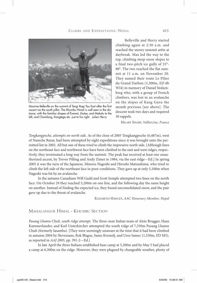
At the top of the first tower (ca. 6,000m) during the initial attempt on the south pillar of Tengi Ragi Tau East (6,650m). Julian Herry collection
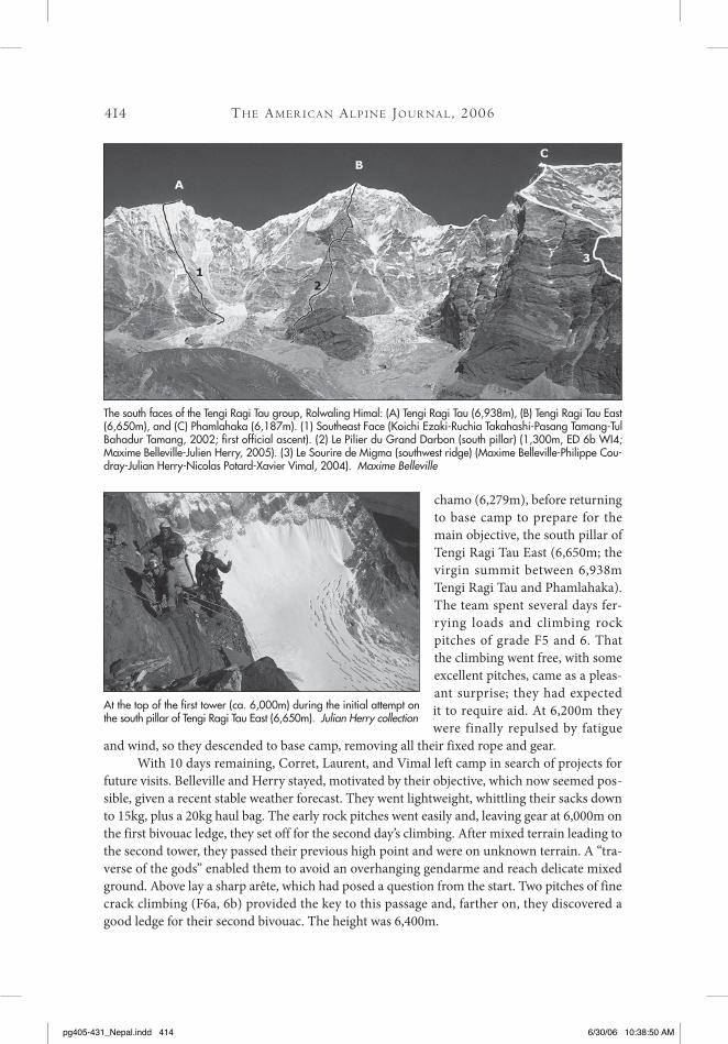
The south faces of the Tengi Ragi Tau group, Rolwaling Himal: (A) Tengi Ragi Tau (6,938m), (B) Tengi Ragi Tau East (6,650m), and (C) Phamlahaka (6,187m). (1) Southeast Face (Koichi Ezaki-Ruchia Takahashi-Pasang Tamang-Tul Bahadur Tamang, 2002; first official ascent). (2) Le Pilier du Grand Darbon (south pillar) (1,300m, ED 6b WI4; Maxime Belleville-Julien Herry, 2005). (3) Le Sourire de Migma (southwest ridge) (Maxime Belleville-Philippe Cou-dray-Julian Herry-Nicolas Potard-Xavier Vimal, 2004). Maxime Belleville
pg405-431_Nepal.indd 414 6/30/06 10:38:50 AM
Cl i m b s A n d Ex p E d i t i o n s : nE pA l 415
Belleville and Herry started climbing again at 2:30 a.m. and reached the snowy summit arête at daybreak. Max led the way to the top, climbing steep snow slopes to a final two-pitch ice gully of 55°-80°. The two reached the flat sum-mit at 11 a.m. on November 20. They named their route Le Pilier du Grand Darbon (1,300m, ED 6b WI4) in memory of Daniel Stolzen-berg who, with a group of French climbers, was lost in an avalanche on the slopes of Kang Guru the month previous [see above]. The descent took two days and required 30 rappels.
hilary sharp, Vallorcine, France
Tengkangpoche, attempts on north side. As of the close of 2005 Tengkangpoche (6,487m), west of Namche Bazar, had been attempted by eight expeditions since it was brought onto the per-mitted list in 2002. All but one of these tried to climb the impressive north side. [Although lines on the northeast face and northwest face have been climbed to the east and west ridges, respec-tively, they terminated a long way from the summit. The peak has received at least one unau-thorized ascent, by Trevor Pilling and Andy Zimet in 1984, via the east ridge—Ed.] In spring 2005 it was the turn of the Japanese, Minoru Nagoshi and Hiroshi Matsushima, who tried to climb the left side of the northeast face in poor conditions. They gave up at only 5,100m when Nagoshi was hit by an avalanche.
In the autumn Canadians Will Gadd and Scott Semple attempted two lines on the north face. On October 29 they reached 5,200m on one line, and the following day the same height on another. Instead of finding the expected ice, they found unconsolidated snow, and the pair gave up due to the threat of avalanche.
ElizabEth hawlEy, AAC Honorary Member, Nepal
mAHAlAngur HimAl - KHumbu sECtion
Pasang Lhamu Chuli, south ridge attempt. The three-man Italian team of Alois Brugger, Hans Kammerlander, and Karl Unterkircher attempted the south ridge of 7,350m Pasang Lhamu Chuli (formerly Jasamba). [They were seemingly unaware at the time that it had been climbed in autumn 2004 by Slovenians, Rok Blagus, Samo Kremelj, and Uros Samec (1,550m, ED M5), as reported in AAJ 2005, pp. 391-2—Ed.]
In late April the three Italians established base camp at 5,200m and by May 5 had placed a camp at 6,300m on the ridge. However, they were plagued by changeable weather, plenty of
Maxime Belleville on the summit of Tengi Ragi Tau East after the first ascent via the south pillar. The Khumbu Himal is well seen in the dis-tance, with the familiar shapes of Everest, Lhotse, and Makalu to the left, and Chamlang, Kangtega etc. just to his right. Julien Herry
pg405-431_Nepal.indd 415 6/30/06 10:38:51 AM

snow fall, and almost constant high wind, which prevented them setting up a higher camp or making much progress on the mountain. Finally, on the 17th, all three set out at 4 a.m. in strong winds and poor snow conditions for a summit attempt. Brugger turned back, but the remaining two pressed on until they reached a point estimated to be 600m below the summit. Here they judged the avalanche danger to be extreme. They retreated and gave up any further attempt. To date the mountain, renamed to commemorate the first Nepalese women to climb Everest, has only four recorded ascents.
Adapted from the web site of haNs kammErlaNdEr
Gyachung Kang, fourth ascent from Nepal, via variants to southwest spur. On October 17 Hiro-shi Hanada, Eisuke Shigekawa, and Tamting Sherpa from a seven-member Japanese expedition (Fukuoka University) led by Mitsuo Uematsu, reached the summit of Gyachung Kang (7,952m) for the sixth overall ascent and fourth from Nepal. In 1988 an expedition that included Hanada and Uematsu attempted the southwest couloir, joining the 1986 French Route on the southwest spur at a height of 7,200m. Three members pushed this line to 7,800m but while descending to Camp 4 at 7,300m, one of the climbers fell to his death, and the expedition was abandoned. Last year the Japanese followed a similar route but, when close to the top, traversed right for several pitches over new ground before reaching the summit. It would appear the 1986 French Route has not been repeated in its entirety. The Korean expedition making the third ascent of the mountain in 1988 mostly climbed the southwest face between the French Route and the original 1964 Japanese Route on the northwest ridge.
liNdsay GriffiN, Mountain INFO, CLIMB Magazine
Kyajo Ri, first recorded ascent of southeast ridge. On October 24 Seth Hobby and I established base camp at 4,600m below the east face of Kyajo Ri (6,186m). Our plan was to climb the mountain from the northeast. Photos provided by our friend and trekking agent, Ang Karma, seemed to show a series of runnels and smears up the northeast buttress that led to the upper north ridge. Whether those runnels ever existed, or perhaps this was just a dry year, is not clear, but closer inspection proved there were no obvious lines.
The best option appeared to be the southeast ridge, which we knew to have been climbed to 5,600m in autumn 2002 by the team that eventually made the first official ascent of the mountain. [Kyajo Ri was first brought onto the permitted list in 2002, and in that year was ascended via the southwest ridge; AAJ 2003, pp. 394-396. The mountain is believed to have received unauthorized ascents before that—Ed.] On the 29th we left our camp around 6:00 a.m. and traversed under the east face to reach the glacier leading to the col at the foot of the ridge. Gaining the glacier turned out to be one of the cruxes of the climb, with a 40m section of 85° snowy, mixed terrain. Seth then led up through another delicate mixed band to the start of the ridge, where we found a cairn left by the 2002 party. Here we dumped the stove, second rope, and our second tools, in order to move as fast as possible on the technical rock above.
The first several hundred meters were mostly easy climbing on generally good rock, with difficulties never more than 5.7-5.8. Wild towers on the first half of the ridge forced us onto the east flank, and in bypassing the second tower we had to climb into a slabby gully that led to several hundred meters of absolute choss. We regained the crest via a pitch of 5.8 X and
tH E Am E r i C A n Al p i n E Jo u r nA l , 2006416
pg405-431_Nepal.indd 416 6/30/06 10:38:52 AM

Cl i m b s A n d Ex p E d i t i o n s : nE pA l 417
arrived below the final rock tower. There was no easy way to avoid this tower, so I downclimbed a little, then traversed to a series of good-looking holds that led round a corner. The holds were posi-tive but the moves a few degrees beyond vertical; the sack and big boots, combined with the altitude of 5,900m, made it all feel serious. From a stance, a short pendulum got me to a ledge and easier climb-ing. From here we simul-climbed over easy rock and mixed terrain all the way to the summit ridge, which proved to be one of the most aesthetic mountain features either of us had climbed.
We didn’t linger on the summit, approaching darkness and a cold wind prompting a hasty descent. We rappelled the southwest ridge and continued all the way down to the Kyajo Ri Glacier, below the south face. The only problem was that our camp was on the other side of the mountain. Tired, hungry, and out of water, we reached it by quality alpine suffering, with the biggest hurdle being climbing 600m of frozen kitty litter to regain the col at the foot of the southeast ridge. A few rappels and a glacier slog led us to our camp, 21 hours after leaving. We graded our route V 5.9 AI3.
JohN kEar, AAC
Cholatse, first winter ascent of north face, by new variants to French Route. Kore-ans Park Jung-hun and Choi Kang-sik reached the summit of 6,440m Cholatse at midday on January 16, having made the first winter ascent of the north face. The two arrived at base camp (4,200m) on January 2 and climbed East Lobuje to acclimatize. Due to the onset of poor
Kyajo Ri (6,187m) from a base camp at 4,600m to the east. The route followed by Americans Hobby and Kear, to make the first recorded ascent of the southeast ridge, is marked. John Kear
The 1,400m north face of Cholatse (6,440m) in winter. (1) Slovenian variant to 1984 American Route (northeast face to southeast ridge) (M6 6a 90°, Humar-Kozelj-Opresnik, 2005). (2) 2003 Korean attempt to 6,000m (110° mixed and aid sections, high point reached on October 30 by Kim Chae-ho and Hwang Young-soon). (3) Swiss direct finish (F5 M6 90°, Steck, 2005). (4) French Route (90°, Badaroux-Batoux-Challa-mel-Mora-Robach, 1995). (5) Korean first winter ascent (90° mixed and some aid, Park Jung-hun-Choi Kang-sik, 2005). (6) 2002 Korean attempt to 5,200m. Peter Jensen-Choi
pg405-431_Nepal.indd 417 6/30/06 10:38:54 AM

tH E Am E r i C A n Al p i n E Jo u r nA l , 2006418
weather on the 9th, the two men were unable to begin their alpine-style ascent until the 13th. They traveled as lightly as possible, pack-ing for only one night out and two days climbing. They took a 55-liter rucksack, two 55m ropes (a 7mm and a 5mm Kevlar), 15 pitons, 10 slings, two quickdraws, four screws, a fish hook, three RURPs, two snow stakes, a bivouac sack each, one gas canister, one stove, two Sierra cups, power bars, power gel, coffee, cocoa, and only two biscuits between the two.
Before sunrise the two men trudged through crusty snow to the main wall. They began the lower section with three pitches on a moderate 60° spur. After the fifth pitch they followed a seven-meter-wide, 80° couloir, where each pitch of blue ice took from 40 minutes to one-and-a-half hours. At around 1 p.m. the climbers reached a difficult section of black ice at 5,600m. One pitch above, at 5,650m, they made their first bivouac.
By 8:00 the following morning Park had worked through an overhanging section using RURPs and a hook. The pair then made a short traverse left and climbed four pitches of 75° mixed climbing to reach a fork in the couloir at 5,900m. Here, they made their second bivouac.
The next morning they followed the right branch, a 65° couloir, and made their third bivouac on the northwest ridge, just five pitches shy of the summit. They began their trudge to the top by 8:00 the next morning, summited around noon, shot three rolls of film, then began their descent of the southwest ridge. To speed their descent, they left pitons and ice-screws and by 4 p.m. had made it down to walkable terrain. There they shortened the length of rope between them.
Low on the glacier Choi suddenly fell 25m into a bergschrund 1m wide and 50m deep. He broke a leg, and Park fractured ribs in his fall. By the time Choi had been brought to the surface, freezing darkness had descended. Despite being only four hours from the nearest habi-tation, Na La, their injuries, lack of provisions, and exhaustion forced them to bivouac for a fourth night. The two men reached Na La the next day and asked an elderly man to summon a rescue helicopter. Both climbers were successfully evacuated, but Park eventually lost eight fingers, while Choi lost nine fingers and all of his toes. All the camera film was lost in the
Cholatse (6,440m) from the west, showing the line of the Standard Route on the southwest ridge. This was the line descended by Koreans Park Jung-hun and Choi Kang-sik after their successful winter ascent of the north face. The accident took place just as the pair was close to the end of the glacier at the bottom of the picture. To the left of the Stan-dard Route, the prominent West Rib (Collins-Selters-Walter, 1988) rises to join it above half-height. Left again is the difficult Northwest Ridge (Selters-Walter, 1988), and in profile to its left is the north face. The big peak on the right is Tawoche (6,495m). Lee Young-jun collection
Park Jung-hun (left) with Choi Kang-sik at Cholatse base camp prior to their successful winter ascent of the north face. Lee Young-jun collection
pg405-431_Nepal.indd 418 6/30/06 10:38:57 AM

Cl i m b s A n d Ex p E d i t i o n s : nE pA l 419
bergschrund, and while Park returned the following spring to see if he could find the camera and film, he was unsuccessful. This ascent is the most dramatic and, despite the injuries, most acclaimed effort of all winter alpine-style first ascents made by Koreans.
lEE youNG-JuN, Corean Alpine Club (translated by Peter Jensen-Choi)
Cholatse, northeast face, second ascent with variant. At first believing they were opening a new route, Slovenians Tomaz Humar, Ales Kozelj, and Janko Opresnik climbed the steep and icy 1,300m northeast face of 6,440m Cholatse, more or less following the 1984 American Route to the upper part of the face (the Slovenians climbed an excellent 60m icefall right of the original line to gain the central gully system), before making a long traverse left to reach, then climb, the 1982 Swiss Route up the southeast ridge. The original and only route to ascend the entire face—a seven-day alpine-style push in November 1984 by Todd Bibler, Catherine Freer, Renny Jackson, and Sandy Stewart—remains unrepeated. The Swiss Route was climbed on the second ascent of the mountain by Nikolas Alpiger, Heidi Ludi, and Kancha Tamang, and 11 days later by Alpiger (again) and Werner Zaher.
The three Slovenians acclimatized by first climbing 6,083m Cholu Peak, then began their ascent of Cholatse on April 19. They were hit by bad weather on the second day, forcing an early bivouac in a snow cave. On the 21st they decided that, under the prevailing difficult and dangerous conditions, it would be best to escape to the crest of the southeast ridge as soon as possible. The three made a long leftward traverse below the upper funnel, reached the ridge, and a little higher bivouacked under a snow mushroom. Next afternoon they reached the sum-mit. The technical difficulties of the Slovenian route were rated M6 6a+ and 90°.
They descended the 23rd by the southeast ridge. When 300m from the bottom, Opresn-ik, who had been suffering from altitude, fell whilst climbing down a short section unroped, but the two others managed to grab him. If he had been only slightly out of reach, he would have gone the full length of the wall below.
liNdsay GriffiN, Mountain INFO, CLIMB Magazine
Cholatse, northeast face, third ascent, with variation finish. After our ascent of Kyajo Ri described above, we trekked to the foot of Cholatse (6,440m), arriving below the north-east face on November 2. This was Seth’s second visit to the mountain. His proposed route followed a mostly continuous ribbon of ice up the face. Closer inspection convinced us that we could access the ribbon despite a blank section near the bottom. [At the time the pair was unaware that this face had previously been climbed—Ed.]
Seth Hobby at grips with the main ice flow in the middle of the northeast face of Cholatse during the third ascent. John Kear
pg405-431_Nepal.indd 419 6/30/06 10:38:58 AM
tH E Am E r i C A n Al p i n E Jo u r nA l , 2006420
On Nov 7 we began climbing around 7 a.m. The first pitch was an amazing 60m flow of WI4+. A couple of traversing pitches and easy rock led to a buttress of unique turf climb-ing. The first pitch on this buttress we called “Turf Wars” (M4), not know-ing that it was only a warm up for the climb’s mental crux. The next pitch, dubbed “Tuff Reliance,” was a bit of a third eye opener at M6 R/X. These pitches were the key to the climb and led us into the icy meat of the route. We continued for another 400m of excel-lent terrain, which included a couple of very cool and often thin pitches up to WI5+ M5, then after some 780m of climbing, at an altitude of 5,300m, we found a decent bivouac site.
Next morning, after an easy scramble up to a cave, the Hobbit (Seth) led a slightly overhanging cool whip, thinly plastered in a granite cor-ner. Dubious protection insured that the Hobbit would send. A few hundred meters of easy ice and crunchy névé led to the heart of the route: a silvery blue
ice flow 360m long. In the middle of the flow the “Dragon” bared its teeth. The first shot was a rock to Seth’s right hand, which we first thought was broken. I set off on the next lead, only to be stopped by a second barrage of stone fall. Again, one of the rocks found the Hobbit’s belay and smacked him on the head. We needed shelter fast, whether it was up or down. We chose up. Pitch after pitch of sustained grade 4 and 5 ice, combined with the rockfall, took everything we had. As darkness fell, we luckily found a safe, reasonably comfortable bivouac site, where we were able to pitch the tent, albeit in a precarious position.
On the following morning, leaving our high camp in place, we began simul-climbing several pitches of 60° and 70° alpine ice. Then the route steepened, as we hit the headwall. The Hobbit headed right up into the maw and found himself in the middle of one of the highest-quality mixed pitches either of us had ever climbed. Steep black rock led through a series of bulges into a wickedly steep corner (M6), all with positive holds and great dry-tooling. I got the consolation prize above, a steep smear of 85° to 95° ice snaking up to the summit ridge. Six full pitches of AI4 led up the crest to the summit mushrooms; we arrived at the top in the dark a little after 6 p.m. It was cold, and there was no time to hang around. Sixteen rappels got us back to our high camp and our warm down bags, and the following day we rappelled the rest of the route, which we graded VI WI5+ M6.
JohN kEar, AAC
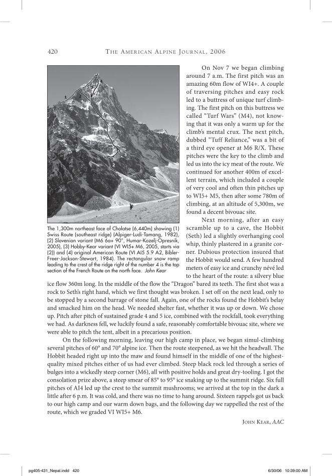
The 1,300m northeast face of Cholatse (6,440m) showing (1) Swiss Route (southeast ridge) (Alpiger-Ludi-Tamang, 1982), (2) Slovenian variant (M6 6a+ 90°, Humar-Kozelj-Opresnik, 2005), (3) Hobby-Kear variant (VI WI5+ M6, 2005, starts via (2)) and (4) original American Route (VI AI5 5.9 A2, Bibler-Freer-Jackson-Stewart, 1984). The rectangular snow ramp leading to the crest of the ridge right of the number 4 is the top section of the French Route on the north face. John Kear
pg405-431_Nepal.indd 420 6/30/06 10:39:00 AM

Cl i m b s A n d Ex p E d i t i o n s : nE pA l 421
Editor’s note: Hobby and Kear more or less climbed the same line as the Slovenians (reported above) to the base of the upper funnel. Here, they climbed up to the crest of the southeast ridge via a line approximately midway between that followed by the Slovenians in the spring and the more direct finish climbed by the Americans in 1984.
Cholatse, southwest ridge, winter attempt. Ross Lynn and I spent three days on Cholatse (6,440m) from January 30 to February 1, 2006. On the first day we climbed from base camp to the ca. 5,550m col at the foot of the southwest ridge, at one point having to cross beneath seracs to avoid a technical crevassed section on the glacier. A final 180m slope of 70° ice led to the col, which we reached by 2:00 p.m. We spent one night camped on this col, preparing for a one-day summit mission on the 31st. We left the col at 6 a.m. Some 300m of mostly rock climbing up the first buttress put us at a more level section of ridge, above which we simul-climbed. We reached the point where the sun-cooked southwest ridge joins the south ridge at around 3 p.m. Here we stashed unnecessary gear and charged for the summit. Two hours into it we realized that we were not going to make it before dark. Close but no cigar! We estimated our elevation to be 6,400m. At 5 p.m., with a building cold wind, we started heading down.
Due to an unusually warm, dry winter, the upper ridge gave us more technical difficulty than anticipated. There were many open crevasses and short steps that ate up our daylight. From our high point we had to make two rappels before reaching our stash of gear. We continued rap-pelling into the night and finally regained our tent around midnight. We estimated the tempera-tures we experienced on the mountain as somewhere between -12 and -20°C. During the descent I wore all my layers, including a down jacket, and my feet were cold. In hindsight we realized that an earlier start would have considerably increased our chances of reaching the top.
On February 1 we woke feeling tired and descended to our base camp. A few technical mistakes cost us the summit, but we now have more tricks in the bag for next time.
whit maGro
Tawoche, east-southeast face; Cholatse, direct finish to French Route; Ama Dablam, northwest face, attempt. While hundreds of climbers were in the early stages of their wanderings up and down Everest, one Swiss, Ueli Steck, was totally alone on the east- southeast face of Tawoche. He went to the base of the northeast pillar of this 6,495m peak, but saw there was too much loose rock falling down the couloir of his intended approach, so he went around to the east-southeast face. At 11:30 p.m. on April 24 he started for the face from his base at 5,200m, reached the summit in 4½ hours, and was back at base camp by 8:00 a.m. An hour after his return to camp, snow avalanches started coming down the face. “I didn’t pick the perfect route,” he commented. “It was dark.” He had stayed on the face throughout his climb, but he thinks the best route is probably one leading to the southeast summit and from there traversing to the left along the summit ridge to the highest point.
ElizabEth hawlEy, AAC Honorary Member, Nepal
Editor’s note: Steck’s route on Tawoche climbed a left-slanting couloir/ramp on the far left side of the east-northeast face (sections of M5) to reach the big snow slopes that form the right side of the southeast face. These mainly consisted of 50-60° snow/ice, though in the upper section there were a few vertical ice steps through serac formations. He climbed the 1,200m line unroped.
pg405-431_Nepal.indd 421 6/30/06 10:39:00 AM
422
His new line on the north face of 6,440m Cholatse is a direct finish to the 1995 French Route, finish-ing up the final section of the northeast face. He spent 37 hours on the climb, made one bivouac at 6,000m and compared the terrain to the north face of the Eiger, with rock to F5, ice to 90°, and M6 terrain.
On Ama Dablam he attempted to solo the third ascent of the Slovenian Route on the northwest face (Stane Belak-Srauf Memorial Route; ca. 1,600m, 5.7, AI 5, A2; Vanja Furlan-Tomaz Humar, 1996). He reached 5,900m, before retreating due to avalanche danger. Steck’s account of his Khumbu adventures appears earlier in the Journal.
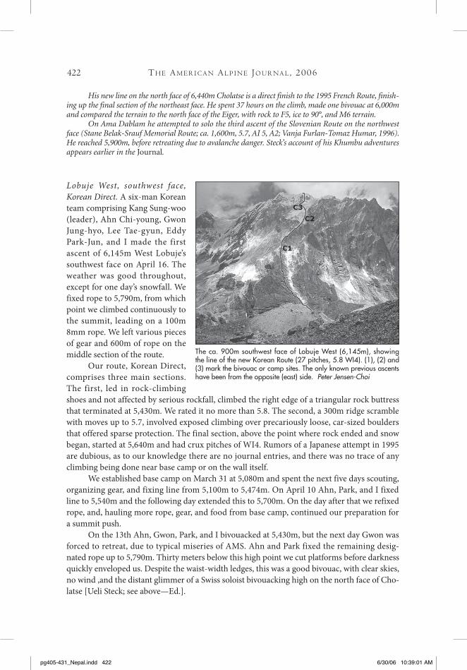
Lobuje West, southwest face, Korean Direct. A six-man Korean team comprising Kang Sung-woo (leader), Ahn Chi-young, Gwon Jung-hyo, Lee Tae-gyun, Eddy Park-Jun, and I made the first ascent of 6,145m West Lobuje’s southwest face on April 16. The weather was good throughout, except for one day’s snowfall. We fixed rope to 5,790m, from which point we climbed continuously to the summit, leading on a 100m 8mm rope. We left various pieces of gear and 600m of rope on the middle section of the route.
Our route, Korean Direct, comprises three main sections. The first, led in rock-climbing shoes and not affected by serious rockfall, climbed the right edge of a triangular rock buttress that terminated at 5,430m. We rated it no more than 5.8. The second, a 300m ridge scramble with moves up to 5.7, involved exposed climbing over precariously loose, car-sized boulders that offered sparse protection. The final section, above the point where rock ended and snow began, started at 5,640m and had crux pitches of WI4. Rumors of a Japanese attempt in 1995 are dubious, as to our knowledge there are no journal entries, and there was no trace of any climbing being done near base camp or on the wall itself.
We established base camp on March 31 at 5,080m and spent the next five days scouting, organizing gear, and fixing line from 5,100m to 5,474m. On April 10 Ahn, Park, and I fixed line to 5,540m and the following day extended this to 5,700m. On the day after that we refixed rope, and, hauling more rope, gear, and food from base camp, continued our preparation for a summit push.
On the 13th Ahn, Gwon, Park, and I bivouacked at 5,430m, but the next day Gwon was forced to retreat, due to typical miseries of AMS. Ahn and Park fixed the remaining desig-nated rope up to 5,790m. Thirty meters below this high point we cut platforms before darkness quickly enveloped us. Despite the waist-width ledges, this was a good bivouac, with clear skies, no wind ,and the distant glimmer of a Swiss soloist bivouacking high on the north face of Cho-latse [Ueli Steck; see above—Ed.].
The ca. 900m southwest face of Lobuje West (6,145m), showing the line of the new Korean Route (27 pitches, 5.8 WI4). (1), (2) and (3) mark the bivouac or camp sites. The only known previous ascents have been from the opposite (east) side. Peter Jensen-Choi
tH E Am E r i C A n Al p i n E Jo u r nA l , 2006
pg405-431_Nepal.indd 422 6/30/06 10:39:01 AM

423
Our third day was equally slow, due to a relaxed start. The weather remained clear, and climbing commenced with me jugging up our fixed line and improving a mediocre anchor on an ice ridge. From there (5,790m) we climbed without fixed rope. Ahn pulled out a monster 90m lead along the right side of the ice ridge, and I finished with a 70m pitch up to the right of a large exposed granite slab, where we had originally anticipated finding a tent platform. There was none, and we spent the rest of the afternoon cutting a ledge at 5,900m, fixing safety lines, and cramming into the tiny two-man tent before night closed in.
On April 16 we were off by 6:15 a.m. with a few meager packets of dehydrated soup, nuts, and chocolate bars. This was our only chance of reaching the summit without starving the next day. I began by traversing left for 50m, then Ahn led directly up a steep ice gully to the top of an enormous snow terrace, just below and to the left of a building-sized cornice (WI4). Eddy led the second crux pitch (WI4), which led left of this large terrace and up the right side of a 50m+ steep granite headwall. I then traversed right and gained a gully of hard snow, rock, and ice, up which I climbed for more than 70m, placing mostly chocks and slinging horns. Ahn jugged the rope and led through, then finally Eddy reached the summit 50m above us. The time was 3:18 p.m. and we had climbed 27 pitches. [Base camp to summit was 1,000m, though the amount of climbing was estimated to be 1,300-1,400m—Ed.] Ahn and I followed and were able to straddle the saddle-like summit with our right legs on West Lobuje’s northeast face and left legs down the southwest face. After taking pictures for 20 minutes, I led down, and we arrived back at our tent just as dusk blackened into night, our minds and hearts filled with the summit light.
pEtEr JENsEN-choi, Corean Alpine Club
Cl i m b s A n d Ex p E d i t i o n s : nE pA l
The 700m Losar icefall, nestled into the north-facing hillside directly opposite Namche Bazar in the Khum-bu. The first known ascent, in 1994, took three days but the route was soloed in just under six hours early in 2006. Whit Magro
Brady Robinson on low-angle terrain, approaching the 120m headwall of Losar icefall. The crux WI5 pillar is at the top of the climb. Whit Magro
pg405-431_Nepal.indd 423 6/30/06 10:39:04 AM

424
Losar, ascent and possible future permit requirement. On January 10, 2006 Whit Magro and I climbed the stupendous frozen waterfall, Losar, which lies directly opposite Namche Bazaar. After 1½-hour approach, we took nine hours to reach the top, simul-climbing all but the last two crux pitches of the 700m route. The climbing was surprisingly moderate (WI3-4), with a little WI5 pillar at the top. We kept a steady, rather than frantic, pace and thoroughly enjoyed ourselves. It must be one of the greatest ice routes in the world. Over a dozen V-thread rappels got us back down in time for dinner in Namche.
We were in the region as volunteers for the Khumbu Climbing School, a program organized by the Alex Lowe Charitable Foundation (www.alexlowe.org), that strives to increase the safety of Nepali climbers and high-altitude workers through ice climbing, first aid, and English instruction. It seems that the only reason we got permission to climb the route was our affiliation with the ALCF. Jenni Lowe, President of ALCF, accompanied us to the park headquarters in Namche. After several hours of discussion and drafted letters, we received authorization. We learned that, shortly before our arrival, two Canadian climbers had been denied a go-ahead to climb the route, because they lacked a permit. Future parties should research the situation, as it may be that they will need a permit arranged and paid for prior to leaving Kathmandu.
On the 22nd Kris Erickson, Seth Hobby, and Renan Ozturk also climbed Losar. All three were affiliated with the ALCF and only received permission after protracted negotiations with park authorities.
brady robiNsoN
Editor’s note: this icefall, which cuts through the north-facing pastures below Nupla (5,885m), had its first known ascent over three days in early 1994 by Catherine Destivelle and Erik Decamp, with photog-rapher Beth Wald. They fixed ropes on the initial, thinly iced pitches.
Losar, solo ascent. Sometime after the ascent reported above and after I returned from an attempt on Cholatse’s southwest ridge, I found myself back in Namche with a few days to spare. Losar allowed me to ascend and descend in just under six hours, by means of a leashless free solo.
whit maGro
Ama Dablam, Lagunak Ridge, attempt. Between October 1 and November 2, Tina Di Batista and I were members of a Slovenian Jubilee expedition to Ama Dablam. The expedition was organized to honor the 30th anniversary of the first Slovenian ascent of an 8,000m peak. In 1975 a Slovenian team (though in those days we were still Yugoslavia) climbed a new route on the south face of Makalu. Four of the seven Makalu summiters were on the 2005 Ama Dablam expedition, and all reached the top via the southwest ridge; Janko Azman, Janez Dovzan, Viki Groselj (expedition leader) and Marjan Manfreda. These four climbers were accompanied by Croatian Stipe Bozic, who was making a film.
Tina and I made an attempt on the Lagunak Ridge, which was climbed for the first time in 1985 by a Spanish–American trio, who completed the route using fixed ropes (this is the south ridge of Ama Dablam, which joins the Standard Route up the southwest ridge at ca. 6,500m—Ed.). We tried it in alpine-style. We started early in the morning of October 19. In the lower section we found fixed ropes along a rocky part of the ridge. We bivied below a
tH E Am E r i C A n Al p i n E Jo u r nA l , 2006
pg405-431_Nepal.indd 424 6/30/06 10:39:04 AM
425
small cornice at 6,070 m. Next day we continued over tricky mixed terain but by afternoon it had begun to snow. We waited for an hour at 6,250m but the situation was exposed and when avalanches started to fall around us, we began to rappel. We arrived at a safe spot below an overhanging rock wall after dark and bivouacked here at ca. 5,800m. Next day we continued rappeling and in the aftenoon reached the foot of the route. Shortly after, we were resting in the expedition Camp 1 on the southwest ridge. Next day weather was better, so instead of descend-ing to Pangboche as originally planned, we decided to try the southwest ridge. We reached the summit on the 23rd.
tomaz Jakofcic, Slovenia
Everest, summary of events during the pre-monsoon season. Once upon a time—a decade ago—everyone knew that the period of good weather for summiting Everest was between May 5 and 15. Commercial expedition leaders set from the 6th to the 10th as their target. Later in the 1990s the weather pattern seemed to push the favorable period to later in the month, from the 18th to 25th, but never as late as June. That is, until 2004, when two Russians made the first June ascent, on the first day of the month. In 2005 a number of teams summited in June, after weeks of waiting for suitable weather, and didn’t leave their base camps until the second week of the month.
Commercial expeditions were back in strength, and many were receiving daily forecasts via satellite from well-known meteorological centers, such as Bracknell in England. They want-ed to know about impending snowstorms but were particularly looking for predictions about wind velocity on Everest, in order to know when there would be three or four continuous days of gentle breezes. They could then plan to send members and Sherpas up to the highest camp for summit bids. But not only commercial teams were closely following the forecasts; the small two-member parties did their best to learn what predictions the others were receiving.
The problem was that the forecasters were constantly getting it wrong. On the basis of inaccurate predictions, especially for the southern side of the mountain, climbers were going up and down like yo-yos and even trekking below base camp, tiring themselves out and becom-ing increasingly frustrated. Some independent climbers ignored the received wisdom, made their attempts to reach the summit, failed, and went home. “If it wasn’t snowing, the wind was blowing,” said one, who gave up waiting for a break in the weather. Other climbers, both inde-pendents and members of larger groups, stubbornly stayed till late May and early June. Many of these were finally rewarded with success.
On the north side a few teams summited on May 21 and 22, but then there was a gap until the 27th, after which parties continued to succeed until June 5. On the south side no one reached the top until May 30. This and the following day were those on which almost all suc-cesses were achieved; the others went to the summit on June 2 and 5.
This does not include the claim by a French helicopter pilot, Didier Delsalle, to have taken off from Lukla airfield, landed his Ecureuil on the 8,850m top of the world on May 14, stepped out of the cockpit, and stayed there for over two minutes, before flying safely back to Lukla. The Nepalese authorities denied his claim and invited him to leave the country for breaking rules.
A large number of unhappy climbers aimed to reach the top in the normal way, on their own two feet. They belonged to an unprecedented number of 101 teams on the mountain: 49 on the Tibet side, 42 on the Nepal side. They ranged in size from one foreigner without Sherpa support to
Cl i m b s A n d Ex p E d i t i o n s : nE pA l
pg405-431_Nepal.indd 425 6/30/06 10:39:04 AM
426
an expedition on the northern side with 27 members and 36 supporting Sherpas and Tibetans.In spring 2004, 64 teams went to Everest and only 10 (16%) failed. In spring 2005, out of
the 101 groups an astonishing 48 (48%) failed to put anyone on top. There were 326 summiters in spring 2004, but in 2005 only 306 men and women claimed success.
An Australian climber figured how to beat the weather on the south side: go around to the north. Piers Buck originally planned to make a traverse from south to north and had per-mits to do so. He had gotten to only 7,500m on May 16, when the weather became unsettled for many days. However, on the north side people started getting to the top on the 21st. So he left the team he was with on the southern side, flew by helicopter to Kathmandu on the 23rd, and went by road to the north side’s base camp. He summited on June 5 as a member of the expedition with which he had been given permission to descend.
Another late arrival at base camp on the north side climbed without any Sherpa support or bottled oxygen. Marcin Miotk was on an unsuccessful Polish expedition to the south face of Annapurna I and returned to Kathmandu in mid-May. But instead of going home he went to Everest, was at base camp on May 18, and made two summit bids. On the first he climbed with two Austrians but turned back at 7,900m, on June 1, because of strong wind. His second try was a success. Climbing alone from advance base camp, he was on top at 2:30 p.m. on June 5, the last person to summit during the season.
Back on the south side it was a miracle that massive fatalities didn’t occur on May 4, when a huge avalanche of rock and ice crashed down from the west shoulder. It hit tents pitched at Camp 1 just above the top of the Icefall, but few people were occupying this camp at the time. Those in camp or nearby received relatively light cuts and bruises, except for a Sherpa whose back was injured. Numerous tents and the gear inside were lost.
ElizabEth hawlEy, AAC Honorary Member, Nepal
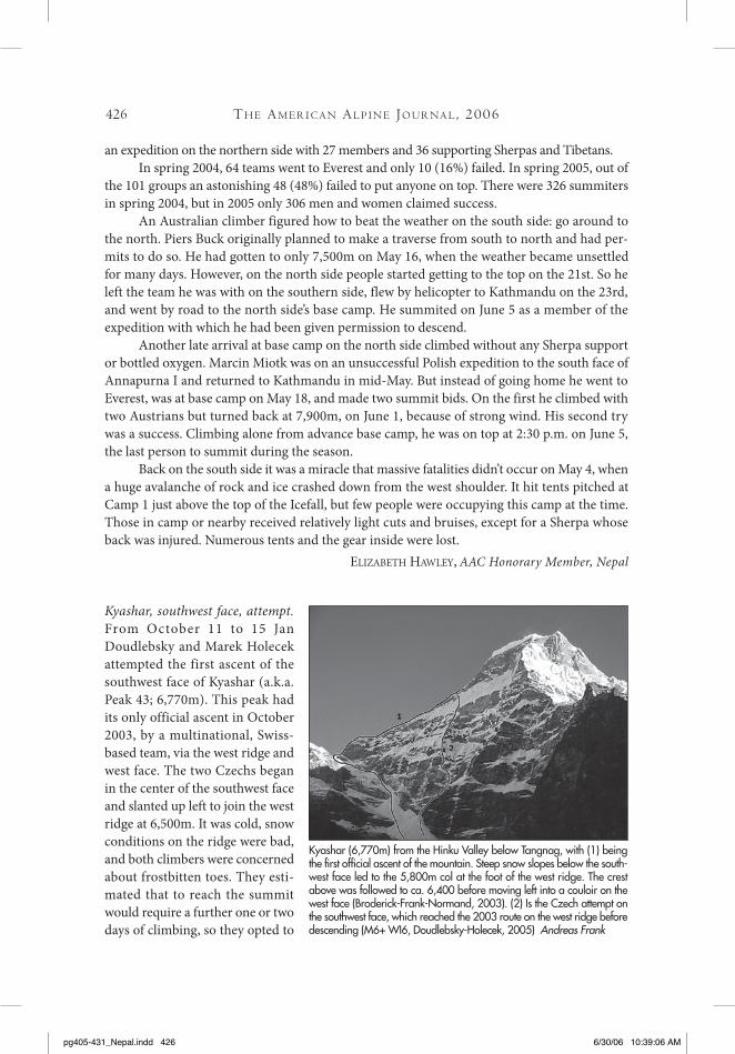
Kyashar, southwest face, attempt. From October 11 to 15 Jan Doudlebsky and Marek Holecek attempted the first ascent of the southwest face of Kyashar (a.k.a. Peak 43; 6,770m). This peak had its only official ascent in October 2003, by a multinational, Swiss-based team, via the west ridge and west face. The two Czechs began in the center of the southwest face and slanted up left to join the west ridge at 6,500m. It was cold, snow conditions on the ridge were bad, and both climbers were concerned about frostbitten toes. They esti-mated that to reach the summit would require a further one or two days of climbing, so they opted to
tH E Am E r i C A n Al p i n E Jo u r nA l , 2006
Kyashar (6,770m) from the Hinku Valley below Tangnag, with (1) being the first official ascent of the mountain. Steep snow slopes below the south-west face led to the 5,800m col at the foot of the west ridge. The crest above was followed to ca. 6,400 before moving left into a couloir on the west face (Broderick-Frank-Normand, 2003). (2) Is the Czech attempt on the southwest face, which reached the 2003 route on the west ridge before descending (M6+ WI6, Doudlebsky-Holecek, 2005) Andreas Frank
pg405-431_Nepal.indd 426 6/30/06 10:39:06 AM

427
descend the west ridge. Although their route did not reach the summit, it joined an existing line, and the climbers have called it Ramro Chaina. Difficulties were about M6+ and WI6.
JaN krEisiNGEr, Czech Republic
Although the following event took place in the winter of 2006, it was such a notable tragedy that we include it in this Journal.
mAHAlAngur HimAl - mAKAlu sECtion
Makalu, winter solo attempt and tragedy. The well-known French mountaineer, Jean-Chris-tophe Lafaille, 40 years old, vanished on January 27, 2006, while attempting to make an entirely solo ascent of Makalu (8,485m), the world’s fifth highest mountain. The highest he is known to have reached is 7,600m, where he pitched his small red tent on the 26th [after almost six weeks on the mountain—Ed.] and from which he set out alone for the top early in the morning of the 27th. He reported his departure by satellite phone to his wife Katya in France. This was expected to be the first of several reports to her that day, but he never made contact with her or his base camp staff again. [Lafaille had remarked that he felt really up to it, despite the fact he hadn’t been able to sleep, due to altitude and cold (down to -30°C). The forecast predicted slightly changeable conditions, with summit wind speeds possibly reach-ing 40-50km/hour—Ed.]
A helicopter search of the mountainside took place on February 4. Searchers included his wife, her brother, and Veikka Gustafsson, a Finnish mountaineer who had climbed with Lafaille and knew from his own ascent of Makalu the route Lafaille was following. They saw the tent but no other trace of him. The search team left a tent with sleeping bag, stove, food, fuel, and a few other necessities at base camp, in case he did manage to return alive. But Gustafsson knew there was no hope for Lafaille’s survival, and thought he understood exactly what had happened to the Frenchman.
Ten years previously Gustafsson had climbed the same (Normal) route that Lafaille was. He had two climbing partners, Ed Viesturs and Rob Hall, but led most of the final part to the summit. He found numerous treacherous crevasses and fell into three of them. He was always belayed and emerged unscathed. Gustafsson is convinced the Frenchman fell into one and became fatally trapped.
Gustafsson considers Lafaille to have been “one of the world’s greatest climbers.” If he had succeeded, Lafaille would have been the first person to climb Makalu in winter. He had already attempted the mountain unsuccessfully in spring 2004, in an earlier solo bid by a dif-ferent route, approaching the mountain from Tibet over Makalu II. Makalu was one of only three 8,000m peaks he had not yet summited.
ElizabEth hawlEy, AAC Honorary Member, Nepal.
Editor’s note: beginning with Renato Casarotto’s Italian expedition in January 1981, there have been 11 winter attempts on Makalu, which remains the only Nepalese 8,000m peak not to be climbed in winter, despite serious attempts by the great Polish winter specialists. While nearly all teams encountered good snow/ice conditions, higher up the mountain they found progress impossible in fierce winds.
Cl i m b s A n d Ex p E d i t i o n s : nE pA l
pg405-431_Nepal.indd 427 6/30/06 10:39:06 AM

428
umbAK HimAl
Pabuk Kang, first known attempt. Two Japanese, led by the explorer-mountaineer Tamotsu Ohnishi, who specializes in visiting remote areas along Nepal’s border with Tibet, planned to try the south side of Pabuk Kang [6,244m; just east of the Pabuk La at the head of the Yangma valley in the Ohmi Kangri Group, first brought onto the permitted list in 2003—Ed.].
On October 20 they pitched their advanced base camp at 5,550m just east of the Yan-makang Pass (a.k.a. Pabuk La, Dhangla Bhanjyang) and south-southwest of the peak. For the next three days it snowed, depositing 130 cm, and the two climbers abandoned their plans. On the approach to the mountain they met five parties of Maoists but paid only two of them, pay-ing 2,000Rs or about $27 per member to each party.
ElizabEth hawlEy, AAC Honorary Member, Nepal.
JAnAK HimAl
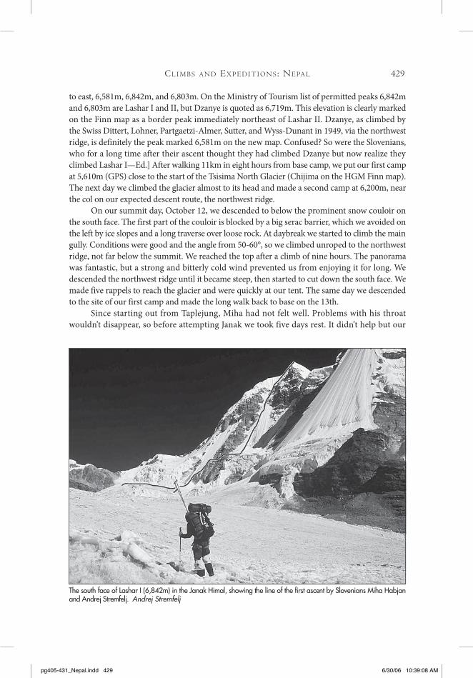
Lashar I, first ascent of peak via south face; Janak, south face, attempt. I first saw the south face of Janak (7,041m) in autumn 2000, when leading an expedition to Jongsang, Pathibara, and Kiratchuli. From the upper Broken Glacier the southwest pillar looked like an excellent objec-tive for a small expedition. The time for fulfilling this dream arrived in autumn 2005. The Slo-venian Janak 2005 expedition comprised only the young climber Miha Habjan and I, though we were joined in Kathmandu by Padam Tamang, the expedition Sirdar and cook, Guirme Sherpa as his assistant, and our liaison officer, Gopi Lal Nepal.
After using local buses for the three-day drive to eastern Nepal, travel not only uncom-fortable but also risky, we arrived in Taplejung. Surrounded by barbed wire and with a strong military presence, this village now seems like a fortress and was the last place on our journey toward the mountains that had any government power. After a seven-day approach we reached Lhonak, where we established base camp on September 29. In Chirwa, on the second day of our trek, we encountered Maoists. They didn’t make any real trouble for us; we just paid them 2,000 Nepali Rupees per person.
On October 6, after short acclimatization trips around base camp, we went to our advanced base camp at the end of the lateral moraine on the upper Broken Glacier. After more than 9km of walking from base camp, we camped at 5,710m and the next day climbed the 6,096m [6,095m HGM Finn map] mountain above camp. [This was probably the third ascent of the peak, which was first climbed by a Anglo-Nepalese party in 1998—Ed.] We later continued to the south Tsi-sima peaks and after climbing Tsisima III, descended to base camp because of bad weather.
On October 10 we went for the next stage in our acclimatization program. Our goal was the nice pyramid of Lashar I, which is visible from Lhonak. [There is some confusion surround-ing the names of Tibetan border peaks west of Janak. The old Swiss map, which appears to be relatively accurate in depicting the topography of this region and has been generally used as a benchmark for subsequent Japanese maps and the Kangchenjunga trekking map by Nepa Publi-cations, places three border peaks at the head of the northerly branch of the Tsisima Glacier: from west to east, Dzanye (6,710m), Lashar I (6,930m), and Lashar II (6,860m). The new HGM Finn map, Janak Himal, does not name any of these peaks but gives them altitudes of, again from west
tH E Am E r i C A n Al p i n E Jo u r nA l , 2006
pg405-431_Nepal.indd 428 6/30/06 10:39:07 AM
429
to east, 6,581m, 6,842m, and 6,803m. On the Ministry of Tourism list of permitted peaks 6,842m and 6,803m are Lashar I and II, but Dzanye is quoted as 6,719m. This elevation is clearly marked on the Finn map as a border peak immediately northeast of Lashar II. Dzanye, as climbed by the Swiss Dittert, Lohner, Partgaetzi-Almer, Sutter, and Wyss-Dunant in 1949, via the northwest ridge, is definitely the peak marked 6,581m on the new map. Confused? So were the Slovenians, who for a long time after their ascent thought they had climbed Dzanye but now realize they climbed Lashar I—Ed.] After walking 11km in eight hours from base camp, we put our first camp at 5,610m (GPS) close to the start of the Tsisima North Glacier (Chijima on the HGM Finn map). The next day we climbed the glacier almost to its head and made a second camp at 6,200m, near the col on our expected descent route, the northwest ridge.
On our summit day, October 12, we descended to below the prominent snow couloir on the south face. The first part of the couloir is blocked by a big serac barrier, which we avoided on the left by ice slopes and a long traverse over loose rock. At daybreak we started to climb the main gully. Conditions were good and the angle from 50-60°, so we climbed unroped to the northwest ridge, not far below the summit. We reached the top after a climb of nine hours. The panorama was fantastic, but a strong and bitterly cold wind prevented us from enjoying it for long. We descended the northwest ridge until it became steep, then started to cut down the south face. We made five rappels to reach the glacier and were quickly at our tent. The same day we descended to the site of our first camp and made the long walk back to base on the 13th.
Since starting out from Taplejung, Miha had not felt well. Problems with his throat wouldn’t disappear, so before attempting Janak we took five days rest. It didn’t help but our
Cl i m b s A n d Ex p E d i t i o n s : nE pA l
The south face of Lashar I (6,842m) in the Janak Himal, showing the line of the first ascent by Slovenians Miha Habjan and Andrej Stremfelj. Andrej Stremfelj
pg405-431_Nepal.indd 429 6/30/06 10:39:08 AM

430
time was short, so on October 18 we regained our advanced base on the Broken Glacier. We rested most of the next day, making only a short reconnaissance of the approach to the southwest pillar. Late that evening we made a decision: with Miha still not well and the weather looking more dubious, we abandoned the pillar and attempted a shorter and somewhat easier route towards the right side of the south face, left of the obvious big serac. This was the line we had initially planned to use for descent.
The night was cloudy, forcing us to postpone our departure. Finally, at 4 a.m., we left the tent and two hours later were at the foot of the face. We climbed the lower section unroped, but began to belay ca. 50m below the serac. Seven pitches later we were on the plateau that forms a 6,650m shoulder on the east ridge. There had been two difficult sections: hard water ice around the left flank of the serac and mixed ground above. As we approached the ridge the wind became steadily fiercer, so strong that it broke ice from the rock walls to our left and bombarded the slope below.
We arrived on the plateau at nightfall. Crawling on all fours due to the wind, we were tired after climbing all day. The weather was cloudy, and with no moonlight we were unable to find the route to the summit. Without tents and sleeping bags, we had to find shelter immediately. Work-ing hard for three hours, we dug a hole that gave us semi-protection from the wind. We sat and froze until 1 a.m. To keep warm we worked at enlarging the hole for the next three hours.
Next morning the weather deteriorated fast. A brief ray of sun was like a reminder from God that we needed to hurry. The wind on the edge of the plateau was even stronger than dur-ing the night, and we couldn’t hear each other. We started to rappel, and soon it began to snow. In five minutes the whole face was being swept by avalanches. It was like a river. Often the rope would be pinned by avalanches, and we couldn’t rappel. At 2 p.m, after 15 rappels, we reached the glacier, now covered with 40cm of fresh snow. The mist was so dense that we couldn’t locate our ski sticks and had a difficult job finding our advanced base.
tH E Am E r i C A n Al p i n E Jo u r nA l , 2006
The south face of Janak (7,041m), seen across the upper Broken Glacier in eastern Nepal. (1) The route of the first ascent, in May 2006, by Andrej Stremfelj and Rok Zalokar via the ca. 1,150m southwest pillar. This will be reported in the 2007 AAJ. (2) The attempt on the south face to a high point at 6,650m, the plateau that forms a shoulder on the east ridge (Habjan-Stremfelj, 2005). Andrej Stremfelj
pg405-431_Nepal.indd 430 6/30/06 10:39:09 AM
431
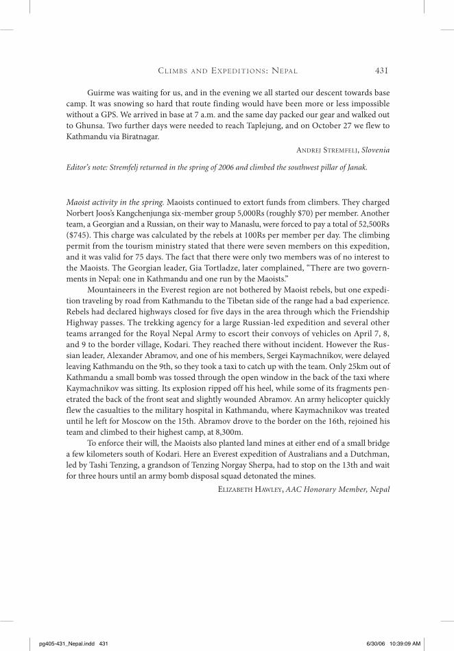
Guirme was waiting for us, and in the evening we all started our descent towards base camp. It was snowing so hard that route finding would have been more or less impossible without a GPS. We arrived in base at 7 a.m. and the same day packed our gear and walked out to Ghunsa. Two further days were needed to reach Taplejung, and on October 27 we flew to Kathmandu via Biratnagar.
aNdrEJ strEmfElJ, Slovenia
Editor’s note: Stremfelj returned in the spring of 2006 and climbed the southwest pillar of Janak.
Maoist activity in the spring. Maoists continued to extort funds from climbers. They charged Norbert Joos’s Kangchenjunga six-member group 5,000Rs (roughly $70) per member. Another team, a Georgian and a Russian, on their way to Manaslu, were forced to pay a total of 52,500Rs ($745). This charge was calculated by the rebels at 100Rs per member per day. The climbing permit from the tourism ministry stated that there were seven members on this expedition, and it was valid for 75 days. The fact that there were only two members was of no interest to the Maoists. The Georgian leader, Gia Tortladze, later complained, “There are two govern-ments in Nepal: one in Kathmandu and one run by the Maoists.”
Mountaineers in the Everest region are not bothered by Maoist rebels, but one expedi-tion traveling by road from Kathmandu to the Tibetan side of the range had a bad experience. Rebels had declared highways closed for five days in the area through which the Friendship Highway passes. The trekking agency for a large Russian-led expedition and several other teams arranged for the Royal Nepal Army to escort their convoys of vehicles on April 7, 8, and 9 to the border village, Kodari. They reached there without incident. However the Rus-sian leader, Alexander Abramov, and one of his members, Sergei Kaymachnikov, were delayed leaving Kathmandu on the 9th, so they took a taxi to catch up with the team. Only 25km out of Kathmandu a small bomb was tossed through the open window in the back of the taxi where Kaymachnikov was sitting. Its explosion ripped off his heel, while some of its fragments pen-etrated the back of the front seat and slightly wounded Abramov. An army helicopter quickly flew the casualties to the military hospital in Kathmandu, where Kaymachnikov was treated until he left for Moscow on the 15th. Abramov drove to the border on the 16th, rejoined his team and climbed to their highest camp, at 8,300m.
To enforce their will, the Maoists also planted land mines at either end of a small bridge a few kilometers south of Kodari. Here an Everest expedition of Australians and a Dutchman, led by Tashi Tenzing, a grandson of Tenzing Norgay Sherpa, had to stop on the 13th and wait for three hours until an army bomb disposal squad detonated the mines.
ElizabEth hawlEy, AAC Honorary Member, Nepal
Cl i m b s A n d Ex p E d i t i o n s : nE pA l
pg405-431_Nepal.indd 431 6/30/06 10:39:09 AM