bute map 3: ardbeg to scoulag point - scape - scottish coastal
TRANSCRIPT

BUTE MAP 3: ARDBEG to SCOULAG POINT
Hinterland Geology and Coastal Geomorphology: Dalradian schists and gritsdominate the area around Rothesay Bay. The Highland Boundary Fault-line runsthrough this coastal unit forming a clear boundary between Dalradian schists andUpper Old Red Sandstone. Towards Bogany Point, an intrusive Permo-Carboniferousdyke trends east to west. Raised marine deposits dominate the hinterland whistshingle and sand dominates the foreshore. Most of this coastal cell contains rockabrasion platforms and shingle beaches. Rothesay Bay is defended by sea walls. Theartificial nature of this section of coastline is described in Leask (1996 152). Aroundthe Milburn Bridge area Lower Carboniferous sediments outcrop on the shore. Anumber of fault lines are also present, one of which forms a distinct boundary betweenthe aforementioned Lower Carboniferous deposits and Ascog Bay which is dominatedhere by Upper Old Red Sandstone. Tertiary intrusions also occur at Ascog Bay. Thisnorth-south Tertiary dyke is unusual with upstanding outer portions of basaltsurrounding an eroded highly berated middle. West of Ascog Bay a tombola connectsEilean Aoide with the mainland. Raised marine deposit continues along thehinterland. Shingle and exposed rock platform is present along the length of this unit. Erosion Class: This unit of coastline was found to be stable owing to the hard seadefences present for much of the coastline although there are local pockets of shingleaccretion and local erosion along the HWMST at Ascog Bay and Kerrycroy Bay.Occasional low berms of shingle are present at the HWMST in front of the concretesea walls but this material is highly mobile and well distributed on each high tide. AtBogany Point there is evidence of erosion due to excessive overtopping wave action.Towards Scoulag Point more of the intertidal area is exposed at MHWST. There isevidence of shingle accretion between the exposed rock platforms. Built Heritage & Archaeology: The built heritage in this area mainly relates toRothesay’s past as a tourist destination, and all dates to within the past two hundredyears. The bathing station at Skeoch Wood and the numerous and grandly built publicconveniences that were dotted around the esplanade and pier area are the bestindicators of Rothesay’s tourist orientated heyday,. Seawalls and defences protectmost of the coastline in this area. The hinterland remains include churches and theold Regal Cinema on Argyle Street. These sites are unlikely to be affected by coastalerosion due to the scale and strength of the coastal defences, but some, like thecinema, are in a poor state of repair due to being abandoned and falling into neglect.The coastal sites are all maritime structures like Rothesay Pier and various othersmaller jetties along the coast. The poorly preserved and eroding remains ofCraigmore Steamer Pier and Craigmore Old Pier, were also noted there. The pierswere abandoned when the ferry connections to Rothesay Pier were cancelled. AroundAscog coastline, a salt pan (NS16SW 2) was observed to be in a poor state and indanger of erosion as some of the walls have already been abraded by wave action.Ascog Free Church is in good condition, and further to the south, the AscogBoathouse (NS16SW 17) was noted as being in a fairly good condition, although therelated slipway was in poor condition.
FICL/876/0/27/7/04 35 of 219 CFA

BUTE MAP 3: HINTERLAND GEOLOGY AND COASTALGEOMORPHOLOGY__________________________________________________________________________________
1. ROTHESAY BAY NH 0900 6500 4.5km Stones and shingle Low edge (<5m) Raised beach Rothesay Bay is a wide structural baycorresponding to the Loch Fad-Scalpsie Bay axis.Rock abrasion platforms with narrow shingle andstone beaches are covered at high tide. Its entirelength is protected by a concrete sea wall.Rothesay town is built on top of raised beachdeposits.
2. CRAIGMORE to ASCOG BAY NH 1070 6450. 2km Rock platforms and shingle Low edge (<5m) Marine deposits Raised beach deposits dominate the hinterland.Shingle beach with some exposed rock platformat MLWM. Sea defences are present at Monford.
3. ASCOG BAY NH 1070 6340 Mainly shingle Low edge (<5m) Raised beach Occasional Tertiary dyke intrusion around AscogBay and nearby Point. Ascog bay consists of threesmall inlets that join together at low tide to form asouthward facing bay. West of Ascog bay atombola connects Eilean Aoide with themainland. The beaches in this bay are mainlycomposed of shingle, gravel and sub-angularcobbles with large shell fragments on the upperbeach and sandbanks exposed at low tide. Ritchie(1975) suggested that geomorphological activitywas restricted to short term changes particularlyduring storm events.
4. ASCOG BRIDGE NH 1070 6240 2km Mainly rock platform Low edge (<5m) Marine deposits This section of coastline is uniform comprisinglow rock abrasion platforms interspersed byboulders and shingle. Outcropping Tertiary dykesare exposed on the shoreline. The hinterlandconsists of marine deposits.
FICL/876/0/27/7/04 36 of 219 CFA

Port Bannatyne to Rothesay & Kerrycroy BayBUTE MAP 3 - HINTERLAND GEOLOGY AND FORESHORE GEOMORPHOLOGY
HELENSBURGH
DUMBARTON
CLYDEBANK
GREENOCK
ROTHESAY
0 1km0.5
Scale 1:25,000
LEGEND
1
2
3
4
SEE MAP 4
FICL/876/0/27/7/04 37 of 219 CFA
© Crown Copyright. All rights reserved [Historic Scotland] [100017509][2005]

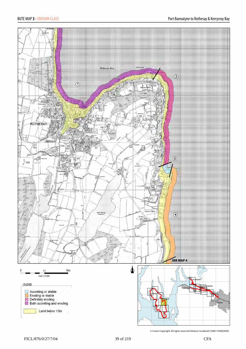
BUTE MAP 3: EROSION__________________________________________________________________________________
1. ARDBEG POINT to CRAIGMORE NS 0850 6500 4.9km Both accreting and eroding Rothesay Bay is considered to be both accretingand erosion. Concrete sea walls and promenadesdefend the sea front. Sand and shingle is thrownup against the base of the sea walls and tends tobe shifted around during the different phases ofthe tidal cycles.
2. MONTFORD NS 1070 6430 2.5km Both accreting and eroding This section of coastline is fairly exposed to southeasterly gales but is defended towards Craigmoreby sea walls. Towards Ascog bay exposed lowrocky platforms are prone to scouring and shingleis accreting at the HWMS mark.
3. ASCOG BAY NH 1070 6340 Accreting or stable 0.5km The beach in this bay are mainly composed ofshingle, gravel and sub-angular cobbles with largeshell fragments on the upper beach and sandbanksexposed at low tide. Shingle is beingconcentrated into a low bank at the HWMS mark.
4. ASCOG POINT to KERRYCROY BAY NS 1080 6200 2.4km Both accreting and eroding This section of coastline is experiencing bothaccretion and erosion. The low abrasionplatforms are being scoured during stormconditions and shingle is being banked up at theHWMS mark.
FICL/876/0/27/7/04 38 of 219 CFA
Port Bannatyne to Rothesay & Kerrycroy BayBUTE MAP 3 - EROSION CLASS
HELENSBURGH
DUMBARTON
CLYDEBANK
GREENOCK
ROTHESAY
0 1km0.5
Scale 1:25,000
LEGEND
1
2
3
4
SEE MAP 4
FICL/876/0/27/7/04 39 of 219 CFA
© Crown Copyright. All rights reserved [Historic Scotland] [100017509][2005]

BUTE MAP 3: BUILT HERITAGE AND ARCHAEOLOGY ____________________________________________________________________ Sites on the Coast Edge & Foreshore Sites on the Hinterland
35. SKEOCH WOODNS06NE 63NS 0836 6556Bathing Station (disused)Poor19th-20th ADMonitor
36. ROTHESAYNS06SSE 690839 6540Red Shed, BoatyardUncertainUnknownNil
38. ROTHESAYNS06SE 111NS 0853 6488CinemaPoor19th-20th ADNil
39. WEST FREE CHURCHNS06SE 110NS 0849 6485ChurchPoor19th-20th ADNil
41. ROTHESAY, GALLOWSCRAIGNS06SE 68NS 086 647UncertainUnknownNil
54. BOGANY POINTNS16NW 13NS 105 654CistUncertainUnknownNil
57. ASCOGNS16SW 17NS 105 645Cist and food vesselUncertain4thMil-1st ADNil
59. ASCOGNS16SW 1NS 1067 6397Coin HoardUncertainUnknownNil
60. MONTFORDNS16SW 11NS 107 639Stone implementUncertainUnknownNil
65. ASCOGNS 0776 6308Slipway (possible)Poor19th-20th ADMonitor
Listed buildings (seeAppendix 1)
34. Grouped entryROTHESAY1, 18-21, 24-25 ARDBEG RDListed C(s)14 ARDBEG ROAD Listed BARDBEG BAPTIST CHUCRHListed BUncertainUnknownNil
37. Grouped entryROTHESAYARGYLE STREET Listed C(s)ARGYLE PLACE Listed B andC(s)ARGYLE TERRACE Listed Band C(s)ROTHESAY ACADEMYListed BVICTORIA STREET Listed Band C(s)VICTORIA STREET, STPAUL'S EPISCOPALCHURCH Listed BWINTER GARDENS Listed AGUILDFORD COURT HOTELListed C(s)WESTLAND ROAD Listed Band C(s)WEST PIER, SHELTER ListedC(s)ROTHESAY CASTLE Listed BWEST PRINCES STREETListed C(s)RUSSELL STREET Listed C(s)YORK TERRACE Listed C(s)MILL STREET Listed BSTUART STREET Listed BBUTE MUSEUM Listed BUPPER UNION STREETListed BMADEIRA, PRIVATE HOTELListed C(s)HEWISON HOUSE Listed C(s)MONTAGUE STREET ListedB and C(s)BUTE ESTATE OFFICE ListedAHIGH STREET Listed B andC(s)
FICL/876/0/27/7/04 40 of 219 CFA

BUTE MAP 3: BUILT HERITAGE AND ARCHAEOLOGY Continued ____________________________________________________________________
Sites on the Hinterland
37. ContinuedFORMER UNITED FREECHURCH Listed C(s)WEIGHBRIDGE HOUSE ListedC(s)JOHN STREET Listed C(s)EAST PRINCES STREET ListedB and C(s)KING STREET Listed BCOLUMSHILL STREET ListedB and C(s)COLUMSHILL PLACE Listed BACADEMY TERRACE ListedC(s)ALBERT PLACE Listed B andC(s)ALMA TERRACE Listed C(s)BATTERY PLACE Listed B andC(s)MOUNT PLEASANT ROADListed B and C(s)MINISTER’S BRAE Listed B andC(s)BISHOP STREET Listed B andC(s)BISHOP TERRACE Listed B andC(s)BRIDGE STREET Listed BARGYLE STREET, WEST FREECHURCH Listed BST ANDREWS R.C. CHURCHHALL Listed BCASTLE STREET Listed B andC(s)BRIDGEND STREET LISTEDC(s)CHAPEL HILL, FREE CHURCHListed BST ANDREW'S ROMANCATHOLIC CHURCH,COLUMSHILL ROAD Listed ANot SeenUnknownNil
40. ROTHESAY, 2-36 BRIDGEST.NS06SE 69NS 085 647Watching BriefN/aUnknownNil
42. ROTHESAY PIERPUBLIC TOILET
NS06SE 64NS 0883 6482Listed BGentlemen’s public toiletsGood18th – 20th ADNil
43. ROTHESAY, MARKETCROSSNS06SE 7NS 088 646Listed C(s)UncertainUnknownNil
44. ROTHESAY, 65WATERGATENS06SE 185NS 089 646Sheriff Court HouseUncertainUnknownNil
45. ROTHESAY, ALBERTPLACENS06SE 65NS 089 647Gentlemen’s Urinal BuildingUncertainUnknownNil
46. ROTHESAY HARBOURNS06SE 53NS 089 647HarbourGood18th-20th ADNil
47. ROTHESAY, 6-8 EASTPRINCES STNS06SE66NS 090 646Listed C(s)ResidenceUncertainUnknownNil
FICL/876/0/27/7/04 41 of 219 CFA

BUTE MAP 3: BUILT HERITAGE AND ARCHAEOLOGY Continued ____________________________________________________________________
Sites on the Hinterland
48. ROTHESAY PIERNS06SE 166NS 089 648Good18th-20th CenNil
49. CRAIGMORE PIERNS06NE 45NS 093 651Uncertain18th-20th ADNil
50. Grouped entryROTHESAYMOUNTSTUART ROADListed B and C(s)CHRICHTON ROAD Listed Band C(s)CRAIGMORE HOTEL ListedBGLENFAULDS COTTAGEListed BWEST FIRWOOD,GLENBURN ROAD Listed BEAST FIRWOOD,GLENBURN ROAD Listed BGLENBURN HOTEL Listed BUncertain18th-20th ADNil
51. CRAIGMORE U.P.CHURCH / HALLNS06NE 65NS 097 665ChurchUncertain18th-20th ADNil
52. LAIGH BOGANYNS06NE 14NS 098 653FarmhouseUncertainUnknownNil
53. ROTHESAY, Mt STUARTRD, ST BRENDAN’SCHURCHNS06NE 71NS 098 653Listed BUncertain18th-20th ADNil
55. Grouped entryCRAIGMORE PUBLICTOILET Listed BROTHESAY, WELLPARKROAD, ROCK VILLA Listed C(s)ROTHESAY, EASTLANDSROAD, EDGEHILL Listed C(s)ROTHESAY, EASTLANDSROAD, HILLPARK Listed C(s)ASCOG, AGNES PATRICKSTEVENSON RESIDENTIALSCHOOL Listed C(s)MILLBANK HOUSE Listed BMILLBANK HOUSE,STABLES, COACH-HOUSEAND DOWER HOUSE ListedC(s)ASCOG, 1 MILLBURNCOTTAGES Listed C(s)ASCOG, MILLBURN HOUSEListed BASCOG, THE OLD MANSEListed C(s)ASCOG, ST MARGARET'SListed BASCOG, SOUTHPARKRESIDENTIAL SCHOOLListed BSCOG, SOUTHPARK, LODGEListed C(s)CRAIGMORE, 24CRAIGMORE ROAD ListedC(s)ASCOG, LAIDLAWMEMORIAL HOME Listed AASCOG, BALMORY ROAD,BALMORY HOUSEGATELODGE Listed C(s)ASCOG, BOAT HOUSE ListedC(s)ASCOG HALL, LODGE ListedC(s)
FICL/876/0/27/7/04 42 of 219 CFA

BUTE MAP 3: BUILT HERITAGE AND ARCHAEOLOGY Continued ____________________________________________________________________
Sites on the Hinterland
55. ContinuedASCOG, THE HERMITAGEAND SUMMER HOUSE ListedC(s)ASCOG HOUSE, ASCOGLODGE Listed BASCOG HOUSE, PINKLODGE Listed C(s)7, 15, 16, 22, 23, 27, 28, 35CRAIGMORE ROAD Listed Band C(s)ARDENCRAIG ROAD,ARDENCRAIG Listed BARDENCRAIG ROAD,ARDENCRAIG, LODGEListed C(s)CRAIGMORE, ARDENCRAIGROAD, ROCKHILL CASTLEListed BOTHESAY, ARDENCRAIGROAD, TOR HOUSE Listed AASCOG FREE CHURCHListed BASCOG, ASCOG HALL ListedBASCOG BAY, SALT PANListed BASCOG HOUSE Listed BASCOG BANK Listed BUncertainUnknown Nil
56. ARDENCRAIGGARDENSNS16SW 33.1NS 105 646Garden, greenhouseUncertainUnknownNil
58. ASCOG MILLNS 105 640Field System; Turf Walls;March Dyke; Corn Kiln(possible); MillsUncertain15th-17th ADUnknown
61. ASCOGNS16SW 22NS 108 633QuayUncertain18th-20t ADNil
62. TYRONE COTTAGE &STELLA MATATINANS16SW 9NS 107 633CottagesUncertainUnknownNil
63. ASCOG COTTAGENS16SW 8NS 107 632ResidenceUncertainUnknownNil
64. ASCOGNS16SW 4NS 108 632Coal workingsUncertainUnknown Nil
FICL/876/0/27/7/04 43 of 219 CFA

Port Bannatyne to Rothesay & Kerrycroy BayBUTE MAP 3 - BUILT HERITAGE AND ARCHAEOLOGY
HELENSBURGH
DUMBARTON
CLYDEBANK
GREENOCK
ROTHESAY
0 1km0.5
Scale 1:25,000
LEGEND
34
35
3637
38
39 40
41 42
4344
45
4647
48
49
50
5152
53
54
55
56
57
58
59
60
61
62
63
64
65
FICL/876/0/27/7/04 44 of 219 CFA
© Crown Copyright. All rights reserved [Historic Scotland] [100017509][2005]