burnett basin water management protocol february 2020
TRANSCRIPT

Burnett Basin
Water Management Protocol
February 2020 (amended September 2020)

This publication has been compiled by Water Policy, Department of Natural Resource, Mines and Energy.
© State of Queensland, 2020
The Queensland Government supports and encourages the dissemination and exchange of its information. The copyright in this publication is licensed under a Creative Commons Attribution 4.0 International (CC BY 4.0) licence.
Under this licence you are free, without having to seek our permission, to use this publication in accordance with the licence terms. You must keep intact the copyright notice and attribute the State of Queensland as the source of the publication.
Note: Some content in this publication may have different licence terms as indicated.
For more information on this licence, visit https://creativecommons.org/licenses/by/4.0/.
The information contained herein is subject to change without notice. The Queensland Government shall not be liable for technical or other errors or omissions contained herein. The reader/user accepts all risks and responsibility for losses, damages, costs and other consequences resulting directly or indirectly from using this information.
Interpreter statement:
The Queensland Government is committed to providing accessible services to Queenslanders from all culturally and linguistically diverse backgrounds. If you have difficulty in understanding this document, you can contact us within Australia on 13QGOV (13 74 68) and we will arrange an interpreter to effectively communicate the report to you.

Burnett Basin Water Management Protocol, Department of Natural Resources, Mines and Energy 2020 1
Contents
Chapter 1 Preliminary ...................................................................................................................... 5
1 Short title ......................................................................................................................... 5
2 Commencement of the water management protocol ...................................................... 5
3 Purpose of protocol ......................................................................................................... 5
4 Interpretation of words used in this protocol ................................................................... 5
5 Area to which this protocol applies ................................................................................. 5
6 Water to which this protocol applies ............................................................................... 5
7 Information about areas, schemes and zones ................................................................ 5
8 Notification of changes to data collection and reporting standards ................................ 6
Chapter 2 Water allocation dealing rules—supplemented allocations ............................................ 7
9 Scope of chapter 2 .......................................................................................................... 7
10 Definitions for chapter 2 .................................................................................................. 7
Part 1 General provisions .......................................................................................................... 7
11 Assessed changes .......................................................................................................... 7
12 Application for changes not specified as permitted, prohibited or assessed .................. 7
Part 2 Bundaberg water supply scheme .................................................................................... 7
13 Scope of part 2 ................................................................................................................ 8
14 Permitted changes .......................................................................................................... 8
15 Prohibited changes ......................................................................................................... 8
Part 3 Upper Burnett water supply scheme ............................................................................... 9
16 Scope of part 3 ................................................................................................................ 9
17 Permitted changes .......................................................................................................... 9
18 Prohibited changes ......................................................................................................... 9
Part 4 Barker Barambah water supply scheme ....................................................................... 10
19 Scope of part 4 .............................................................................................................. 10
20 Permitted changes ........................................................................................................ 10
21 Prohibited changes ....................................................................................................... 11
Part 5 Boyne River and Tarong water supply scheme ............................................................ 11
22 Scope of part 5 .............................................................................................................. 11
23 Permitted changes ........................................................................................................ 11
24 Prohibited changes ....................................................................................................... 12
Chapter 3 Water management areas—general provisions ............................................................ 13
25 Scope of chapter 3 ........................................................................................................ 13
26 Permitted changes ........................................................................................................ 13
27 Prohibited changes ....................................................................................................... 13

Burnett Basin Water Management Protocol, Department of Natural Resources, Mines and Energy 2020 2
28 Application for changes not specified as permitted or prohibited ................................. 13
Chapter 4 Lower Burnett and Kolan Rivers water management area ........................................... 14
29 Scope of chapter 4 ........................................................................................................ 14
Part 1 Water sharing rules ....................................................................................................... 14
30 Taking water under a water allocation .......................................................................... 14
31 Maximum annual volume .............................................................................................. 14
32 Calculation of the annual announced limit .................................................................... 14
33 Announced periods for taking water ............................................................................. 15
Part 2 Dealing with water allocations ....................................................................................... 15
34 Scope of part 2 .............................................................................................................. 15 Division 1 Permitted changes ................................................................................... 15
35 Permitted changes ........................................................................................................ 15 Division 2 Prohibited changes .................................................................................. 16
36 Prohibited changes ....................................................................................................... 16
Part 3 Seasonal water assignment rules ................................................................................. 16
37 Seasonal water assignment rules ................................................................................. 16
Chapter 5 Upper Burnett and Nogo Rivers water management area ............................................ 17
38 Scope of chapter 5 ........................................................................................................ 17
Part 1 Water sharing rules ....................................................................................................... 17
39 Taking water under a water allocation .......................................................................... 17
40 Maximum annual volume .............................................................................................. 17
41 Calculation of the annual announced limit .................................................................... 17
42 Announced periods for taking water ............................................................................. 18
Part 2 Dealing with water allocations ....................................................................................... 18
43 Scope of part 2 .............................................................................................................. 18 Division 1 Permitted changes ................................................................................... 19
44 Permitted changes ........................................................................................................ 19 Division 2 Prohibited changes .................................................................................. 19
45 Prohibited changes ....................................................................................................... 19
Part 3 Seasonal water assignment rules ................................................................................. 19
46 Seasonal water assignment rules ................................................................................. 19
Chapter 6 Barker Barambah Creeks water management area ..................................................... 21
47 Scope of chapter 6 ........................................................................................................ 21
Part 1 Water sharing rules ....................................................................................................... 21
48 Taking water under a water allocation .......................................................................... 21
49 Announced periods for taking water ............................................................................. 21
Part 2 Dealing with water allocations ....................................................................................... 22
50 Scope of part 2 .............................................................................................................. 22 Division 1 Permitted changes ................................................................................... 22

Burnett Basin Water Management Protocol, Department of Natural Resources, Mines and Energy 2020 3
51 Permitted changes ........................................................................................................ 22 Division 2 Prohibited changes .................................................................................. 22
52 Prohibited changes ....................................................................................................... 22
Part 3 Seasonal water assignment rules ................................................................................. 23
53 Seasonal water assignment rules ................................................................................. 23
Chapter 7 Boyne and Stuart Rivers water management area ....................................................... 24
54 Scope of chapter 7 ........................................................................................................ 24
Part 1 Water sharing rules ....................................................................................................... 24
55 Taking water under a water allocation .......................................................................... 24
56 Minimum levels in waterholes ....................................................................................... 24
57 Access to water in bed sands ....................................................................................... 24
58 Maximum annual volume .............................................................................................. 25
59 Calculation of the annual announced limit .................................................................... 25
60 Announced periods for taking water ............................................................................. 26
Part 2 Dealing with water allocations ....................................................................................... 26
61 Scope of part 2 .............................................................................................................. 26
62 Prohibited changes ....................................................................................................... 26
Part 3 Seasonal water assignment rules ................................................................................. 26
63 Seasonal water assignment rules ................................................................................. 26
Chapter 8 Coastal Burnett groundwater management area .......................................................... 27
64 Scope of chapter 8 ........................................................................................................ 27
Part 1 Water sharing rules ....................................................................................................... 27
Division 1 Water allocations ........................................................................................................... 27
65 Announced entitlements for taking water ...................................................................... 27
66 Seawater intrusion index ............................................................................................... 27
67 Announced entitlement calculation ............................................................................... 28
68 Taking water under a water allocation or other authorisation in zone 80, 81 and 82 ... 29
69 Taking water under a water allocation .......................................................................... 30
Division 2 Water licences ............................................................................................................... 30
70 Announced entitlement for taking water ........................................................................ 30
71 Announced entitlement calculation ............................................................................... 30
Part 2 Dealings with water allocations ..................................................................................... 31
72 Scope of part 2 .............................................................................................................. 31 Division 1 Permitted changes ................................................................................... 31
73 Permitted changes ........................................................................................................ 31 Division 2 Prohibited changes .................................................................................. 32
74 Prohibited changes ....................................................................................................... 32
Part 3 Seasonal water assignment rules ................................................................................. 35

Burnett Basin Water Management Protocol, Department of Natural Resources, Mines and Energy 2020 4
Division 1 Water allocations ........................................................................................................... 35
75 Seasonal water assignment rules within zones and between zones and zone groups 35
76 Potential take volume calculation .................................................................................. 37
77 Total allowable take volume calculation ........................................................................ 38
78 Prohibited seasonal assignments between zones and zone groups ............................ 39
Division 2 Water licences ............................................................................................................... 39
79 Seasonal water assignment rules ................................................................................. 39
Chapter 9 Barambah Creek groundwater management area........................................................ 40
80 Scope of chapter 9 ........................................................................................................ 40
81 Sub-areas ...................................................................................................................... 40
Part 1 Water sharing rules ....................................................................................................... 40
82 Annual announced volume for taking water .................................................................. 40
83 Announced entitlement calculation ............................................................................... 40
84 Annual announced volume ............................................................................................ 41
Chapter 10 Monitoring ..................................................................................................................... 42
85 Monitoring ...................................................................................................................... 42
86 Natural ecosystems monitoring ..................................................................................... 42
87 Assessment ................................................................................................................... 42
Attachment 1 Dictionary ..................................................................................................................... 43
Attachment 2 Coastal Burnett groundwater management area: Water allocation announced entitlement decision tables .................................................................................................................... 45
Attachment 3 Coastal Burnett groundwater management area: Water licence announced entitlement decision tables .................................................................................................................... 69
Attachment 4 Barambah Creek groundwater sub-areas ................................................................... 88

Burnett Basin Water Management Protocol, Department of Natural Resources, Mines and Energy 2020 5
Chapter 1 Preliminary
1 Short title (1) This water management protocol may be cited as the Burnett Basin Water
Management Protocol.
(2) Reference in this document to ‘this protocol’ means the Burnett Basin Water Management Protocol.
2 Commencement of the water management protocol (1) This protocol commenced on 6 December 2016; however
(2) Chapter 9 of this protocol commences 1 July 2021.
3 Purpose of protocol This protocol implements parts of the Water Plan (Burnett Basin) 2014.
4 Interpretation of words used in this protocol Unless defined under the relevant provisions, the dictionary in attachment 1 defines particular words used in this protocol.
5 Area to which this protocol applies This protocol applies to parts of the plan area defined in the Water Plan (Burnett Basin) 2014.
6 Water to which this protocol applies
(1) This protocol applies to the following water in the plan area—
(a) water in a watercourse or lake; and
(b) water in a spring not connected to water to which the Water Plan (Great Artesian Basin and Other Regional Aquifers) 2017 applies;
(c) unsupplemented groundwater in the—
(i) Coastal Burnett groundwater management area; and
(ii) Barambah Creek groundwater management area.
7 Information about areas, schemes and zones (1) The location of plan area and subcatchment area boundaries, water supply schemes
and zones are held in digital electronic form by the department.
(2) The location of zone boundaries are also detailed in attachment 4.
(3) The information held in digital electronic form can be reduced or enlarged to show the details of the boundaries1.
1 The boundaries held in digital electronic form may be inspected at any of the department’s offices or on https://qldglobe.information.qld.gov.au/

Burnett Basin Water Management Protocol, Department of Natural Resources, Mines and Energy 2020 6
8 Notification of changes to data collection and reporting standards The chief executive must notify the resource operations licence holder at least 20 business days before any substantive changes are made to the —
(a) water monitoring data collection standards; and (b) water monitoring data reporting standards.

Burnett Basin Water Management Protocol, Department of Natural Resources, Mines and Energy 2020 7
Chapter 2 Water allocation dealing rules—supplemented allocations
9 Scope of chapter 2 This chapter contains water allocation dealing rules for all supplemented water allocations managed under a resource operations licence.
10 Definitions for chapter 2 In this chapter—
total nominal volume in a zone means the sum of the nominal volumes of all water allocations in the same priority group—
(a) for the zone or zones; and
(b) for which relevant valid water allocation dealing certificates have been issued under section 159 of the Water Act 2000.
Part 1 General provisions
11 Assessed changes (1) This section applies to a holder of a water allocation in the Bundaberg water supply
scheme and Boyne River and Tarong water supply scheme.
(2) For a water allocation that states a purpose of ‘distribution loss’, the holder may apply to the chief executive under section 159 of the Water Act 2000 to change the purpose of the water allocation to ‘any’.
(3) The water allocation holder must provide information with the application detailing that there is sufficient volume held under water allocations to provide for distribution losses within the system.
(4) Distribution loss is the nominated purpose for losses associated with the delivery of water from a diversion point on a watercourse through the holder’s off-stream distribution system.
12 Application for changes not specified as permitted, prohibited or assessed An application for a change to a water allocation that is not specified as permitted, prohibited or assessed in this part or parts 2, 3, 4 or 5 of this protocol may be made in accordance with section 72 of the Water Regulation 2016.
Part 2 Bundaberg water supply scheme

Burnett Basin Water Management Protocol, Department of Natural Resources, Mines and Energy 2020 8
13 Scope of part 2 This part states the water allocation change rules for the Bundaberg water supply scheme which are permitted or prohibited in addition to changes stated in chapter 2, part 1 of this protocol.
14 Permitted changes (1) This section applies to a water allocation with a purpose of 'agriculture' or 'any'.
(2) The following changes to a water allocation are permitted—
(a) a change from one of the following zones to any other of those zones if the change—
(i) is between AA and AB, AC, AD, CA, CB, or GZ;
(ii) is between AB and AA, AC, AD, CA, CB or GZ;
(iii) is between AC and AA, AB, AD, CA, CB or GZ;
(iv) is between AD and AA, AB, AC, CA, CB or GZ;
(v) is between CA and CB or GZ;
(vi) is between CB and CA or GZ;
(vii) is between GZ and CA or CB;
(viii) would not result in a total nominal volume in a zone that is greater than the maximum volumes or less than the minimum volumes in Table 1;
(ix) would not result in more than 8000 ML of medium priority water allocations changing from AA, AB, AC and AD to CA, CB and GZ; and
(b) a change to the purpose where the change results in the purpose being 'agriculture' or 'any'.
Table 1 – Limits of total nominal volume (ML) in a zone
Priority group Nominal volume
Zones
AA AB AC AD CA CB GZ
High Minimum 3100 0 0 3990 8840 0 0
Maximum 3600 105 280 4190 36 570 37 050 20 000
Medium Minimum 36 025 2785 0 46 750 64 325 4 450 2 855
Maximum 42 553 6790 5160 67 180 189 325 156 760 41 235
15 Prohibited changes The following changes to a water allocation are prohibited—
(a) a change to a location that is not mentioned in Table 1; or
(b) a change to a priority group that is not medium or high; or
(c) a change to a purpose that is not ‘agriculture’ or ‘any’; or
(d) a change to the nominal volume other than a change that is a consequence of a change to another attribute of a water allocation.

Burnett Basin Water Management Protocol, Department of Natural Resources, Mines and Energy 2020 9
Part 3 Upper Burnett water supply scheme 16 Scope of part 3
This part states the water allocation change rules for the Upper Burnett water supply scheme which are permitted or prohibited in addition to changes stated in chapter 2, part 1 of this protocol.
17 Permitted changes (1) This section applies to a water allocation with a purpose of 'agriculture' or 'any'.
(2) The following changes to a water allocation are permitted—
(a) a change from one of the following zones to any other of those zones if the change—
(i) is between GY and GB, NA, NB, NC, OA, MA, OB, OC or SB;
(ii) is between GB, and GY, NA, NB, NC, OA, MA, OB, OC or SB;
(iii) is between NB, and GY, GB, NA, NC, OA, MA, OB, OC or SB;
(iv) is between NA, and GY, GB, NB, NC, OA, MA, OB, OC or SB;
(v) is between NC, and GY, GB, NB, NA, OA, MA, OB, OC or SB;
(vi) is between OA, and GY, GB, NB, NA, NC, MA, OB, OC or SB;
(vii) is between MA, and GY, GB, NB, NA, OA, NC, OB, OC or SB;
(viii) is between SB, and GY, GB, NB, NA, OA, NC, MA, OC or OB;
(ix) is between OB, and GY, GB, NB, NA, OA, NC, MA, OC or SB;
(x) is between OC, and GY, GB, NB, NA, OA, NC, OB, MA or SB;
(xi) is between OD and PA;
(xii) would not result in a total nominal volume in a zone that is greater than the maximum volumes or less than the minimum volumes in Table 2; and
(b) a change to the purpose where the change results in the purpose being 'agriculture' or 'any'.
Table 2 – Limits of total nominal volume (ML) in a zone
Priority Group
Nominal volume
GY GB NA NB NC MA OA OB OC SA SB OD PA
High Minimum 0 0 820 0 0 0 320 0 200 0 10 0 0
Maximum 180 0 1000
0 0 0 320 0 350 0 10 0 0
Medium
Minimum 960 913 195
1 3488
2411
883 5863 6405
0 0 0 0 0
Maximum
7410
7363
8601
10 138
12 861
10 593
16 253
11 005
4283
4000
4050
1560 1560
14 444 20 507 11 338 1560
18 Prohibited changes The following changes to a water allocation are prohibited—

Burnett Basin Water Management Protocol, Department of Natural Resources, Mines and Energy 2020 10
(a) a change to the location that is not mentioned in in Table 2;
(b) a change to a priority group that is not ‘medium’ or ‘high’;
(c) a change to a purpose that is not ‘agriculture’ or ‘any’; and
(d) a change to the nominal volume other than a change that is a consequence of a change to another attribute of a water allocation.
Part 4 Barker Barambah water supply scheme
19 Scope of part 4 This part states the water allocation change rules for the Barker Barambah water supply scheme which are permitted or prohibited in addition to changes stated in chapter 2, part 1 of this protocol.
20 Permitted changes (1) This section applies to a water allocation with a purpose of 'agriculture' or 'any'.
(2) The following changes to a water allocation are permitted—
(a) a change from one of the following zones to any other of those zones if the change— (i) is between HB and HZ, HC, HD, HE or JA;
(ii) is between HC and HB, HZ, HD, HE or JA;
(iii) is between HD and HB, HZ, HC, HE or JA;
(iv) is between HE and HB, HZ, HC, HD or JA;
(v) is between HZ and HB, HC, HD, HE or JA;
(vi) is between JA and HB, HZ, HC, HD or HE;
(vii) would not result in a total nominal volume in a zone that is greater than the maximum volumes or less than the minimum volumes in Table 3; and
(b) a change to the purpose where the change results in the purpose being ‘agriculture’ or ‘any’.
Table 3 – Limits of total nominal volume (ML) in a zone
Priority group Nominal volume
Zones
HB HZ HC HD HE JA
High Minimum 0 0 450 1786 0 0
Maximum 0 0 450 1786 0 0
Medium
Minimum 9633 4953 6147 777 4343 24
5314
Maximum
11 002 6659 8662
2577
7040 2721
16 661 7314
11 002 15 321

Burnett Basin Water Management Protocol, Department of Natural Resources, Mines and Energy 2020 11
21 Prohibited changes The following changes to a water allocation are prohibited—
(a) a change to the location that is not mentioned in Table 3;
(b) a change to a priority group that is not ‘medium’ or ‘high’;
(c) a change to a purpose that is not ‘agriculture’ or ‘any’; and
(d) a change to the nominal volume other than a change that is a consequence of a change to another attribute of a water allocation.
Part 5 Boyne River and Tarong water supply scheme
22 Scope of part 5 This part states the water allocation change rules for the Boyne River and Tarong water supply scheme which are permitted or prohibited in addition to changes stated in chapter 2, part 1 of this protocol.
23 Permitted changes (1) The following changes to a water allocation are permitted—
(a) a change from one of the following zones to any other of those zones if the change—
(i) is between LA and KA; (ii) is between KA and LA; (iii) would not result in a total nominal volume in a zone that is greater than
the maximum volumes or less than the minimum volumes in Table 4; (b) a change to the priority group from ‘medium’ to ‘high’ if—
(i) the conversion is of the entire volume of medium priority water specified on the water allocation; and
(ii) there has been no water taken under the water allocation to be converted for the relevant water year in which the application to change has been made; and
(iii) the location to be specified on the water allocation converted to high priority is zone KA; and
(iv) a conversion ratio of 2.5:1 is used to convert the volume of water from medium to high priority; and
(v) the conversion occurs when the announced allocation for medium priority water is no less than 100%; and
(c) a change to the purpose where the change results in the purpose being ‘agriculture’ or ‘any’.
Table 4 – Limits of total nominal volume (ML) in a zone
Priority group Nominal volume Zones
LA KA
High Minimum 0 32 390
Maximum 0 37 714
Medium Minimum 0 0
Maximum 13 309.3 13 309.3

Burnett Basin Water Management Protocol, Department of Natural Resources, Mines and Energy 2020 12
24 Prohibited changes The following changes to a water allocation are prohibited—
(a) a change to the location that is not permitted;
(b) a change to the priority group that is not a change from ‘medium’ to ‘high’;
(c) a change to the purpose that is not ‘agriculture’ or ‘any’; and
(d) a change to the nominal volume other than a change that is a consequence of a change to another attribute of a water allocation.

Burnett Basin Water Management Protocol, Department of Natural Resources, Mines and Energy 2020 13
Chapter 3 Water management areas—general provisions
25 Scope of chapter 3 This chapter contains general provisions which apply to all water allocations in a water management area.
26 Permitted changes (1) Subdivision of a water allocation is permitted where the maximum rate for taking
water of each new water allocation will be proportional to the volume of the new water allocation.
(2) Amalgamation of water allocations is permitted where—
(a) the annual volumetric limit of the new water allocation is equal to the sum of the annual volumetric limits of the water allocations being amalgamated and the new rate will be determined during the application process.
(b) Subsection (2)(a) does not apply to the Barker Barambah Creeks water management area.
(3) A change to the purpose of a water allocation is permitted where the change results in the purpose being ‘agriculture’ or ‘any’.
27 Prohibited changes The following changes to a water allocation are prohibited—
(a) a change to the purpose where the change results in the purpose being other than ‘agriculture’ or ‘any’;
(b) a change that would alter the water allocation group that applies to a water allocation;
(c) a change to the maximum rate of a water allocation that is not a consequence of a change to another attribute of a water allocation; and
(d) a change to a water allocation must not be a change that would lead to the water allocation being managed under a resource operations licence.
28 Application for changes not specified as permitted or prohibited An application for a change to a water allocation that is not specified as permitted or prohibited in this chapter or chapters 4, 5, 6, 7 and 8 of this protocol may be made in accordance with section 72 of the Water Regulation 2016.

Burnett Basin Water Management Protocol, Department of Natural Resources, Mines and Energy 2020 14
Chapter 4 Lower Burnett and Kolan Rivers water management area
29 Scope of chapter 4 This chapter applies to water allocations to take unsupplemented water located in the Lower Burnett and Kolan Rivers water management area.
Part 1 Water sharing rules 30 Taking water under a water allocation
(1) The take of water under a water allocation must be metered.
(2) Water taken under the water allocation may be used for ‘any’ purpose.
(3) The total volume of water taken under an allocation in a water year must not exceed the volume calculated under section 31.
(4) A water allocation holder must advise and provide meter readings to the chief executive at the start and finish of the announced period and at the end of the water year if required by the chief executive.
(5) Unsupplemented water may be taken under a water allocation only during an announced period.
(6) Any water taken that is not in accordance with these rules for unsupplemented water and taken from within the limits of the Bundaberg water supply scheme will be treated as supplemented water.
31 Maximum annual volume (1) The annual announced limit (AALi) is the percentage that is announced by the chief
executive for each subcatchment.
(2) The AALi must not be greater than 100%.
(3) The maximum annual volume of water that may be taken in a water year will be calculated using the formula—
AALi * Volumetric Limit
where—
AALi is the annual announced limit percentage (calculated in section 32).
32 Calculation of the annual announced limit (1) The chief executive must determine and announce the annual announced limit within
ten business days after the start of the water year.
(2) The annual announced limit must be determined by the following formulae—
TAALi = 50 + AALi-1 – (TUi-1/SVL * 100) + RAALi-1
RAALi-1 = greater {TAAL i-1 – 100, 0}
AALi = lesser {100, TAALi}
(3) The parameters used in the formulae for the annual announced limit are defined in Table 5.

Burnett Basin Water Management Protocol, Department of Natural Resources, Mines and Energy 2020 15
Table 5 – Parameters for calculation of the annual announced limit
Parameter Definition
i Current water year
i – 1 Previous water year
AAL Annual announced limit. That is, the percentage of the water allocation volumetric limit that may be taken for the water year
TAAL Trial annual announced limit. That is, the trial annual announced limit is a percentage of the water allocation volumetric limit and determines the annual announced limit for a water year and the residual announced allocation limit for the next year.
TU Total use. That is, the total diverted unsupplemented water allocations (ML) in the subcatchment for the water year.
SVL Sum volumetric limit. That is, the sum of the volumetric limits (ML) for the subcatchment.
RAAL Residual annual announced limit. That is, the residual is the amount by which the trial annual announced limit was greater than 100% in the previous year. This may be available in the following water year. The RAAL is limited between 0% and 50%.
33 Announced periods for taking water The chief executive will—
(a) determine and notify water allocation holders of the start and end of an announced period during which water may be taken for each water allocation group; and
(b) advise the resource operations licence holder of the Bundaberg water supply scheme of the meter readings and the approved quantities of unsupplemented water taken within ten business days of the conclusion of all announced periods for the Lower Burnett and Kolan Rivers water management area.
Part 2 Dealing with water allocations
34 Scope of part 2 This part states the water allocation change rules which are permitted or prohibited, in addition to changes stated in chapter 3 of this protocol.
Division 1 Permitted changes
35 Permitted changes A change from one of the following zones to any other of those zones if the change—
(a) is between AA and AB or AC;
(b) is between AB and AA or AC;
(c) is between AC and AA or AB;
(d) is between CA and CB;

Burnett Basin Water Management Protocol, Department of Natural Resources, Mines and Energy 2020 16
(e) would not result in a total nominal volume in a zone that is greater than the maximum volumes or less than the minimum volumes in Table 6.
Table 6 – Limits of total nominal volume (ML) in a zone
Nominal volume Zones
AA AB AC CA CB
Minimum 223 0 466 1082 382
Maximum 335 170 788 1828 646
Division 2 Prohibited changes
36 Prohibited changes The change to the location of a water allocation that is not permitted is prohibited.
Part 3 Seasonal water assignment rules
37 Seasonal water assignment rules The chief executive may approve a seasonal assignment for a water allocation or seasonal water assignment notice to take unsupplemented water that has not been taken in the current water year where—
(a) the water allocation is within any zone or between zone—
(i) AA and AB or AC;
(ii) AB and AA or AC;
(iii) AC and AA or AB;
(iv) CA and CB;
(b) the amount seasonally assigned must not exceed the unused portion of the maximum annual volume for the water allocation calculated under section 31.
(c) the flow condition under which water may be taken under seasonal assignment is the same as the flow condition for the allocation that is being seasonally assigned;
(d) maximum rate of take at which water may be taken under a seasonal assignment will be determined during the processing of the application;
(e) the seasonal assignment would not result in the water allocation being managed under a resource operations licence;
(f) the seasonal assignment would not result in a total nominal volume in a zone that is greater than the maximum volumes or less than the minimum volumes in Table 6.

Burnett Basin Water Management Protocol, Department of Natural Resources, Mines and Energy 2020 17
Chapter 5 Upper Burnett and Nogo Rivers water management area
38 Scope of chapter 5 This chapter applies to water allocations to take unsupplemented water located in the Upper Burnett and Nogo Rivers water management area.
Part 1 Water sharing rules
39 Taking water under a water allocation (1) The take of water under a water allocation must be metered.
(2) Water taken under the water allocation may be used for ‘any’ purpose.
(3) The total volume of water taken under an allocation in a water year must not exceed the volume calculated under section 40.
(4) A water allocation holder must advise and provide meter readings to the chief executive at the start and finish of the announced period and at the end of the water year if required by the chief executive.
(5) Unsupplemented water may be taken under a water allocation only during an announced period.
(6) Any water taken that is not in accordance with these rules for unsupplemented water and taken from within the limits of the Upper Burnett water supply scheme will be treated as supplemented water.
40 Maximum annual volume (1) The annual announced limit (AALi) is the percentage that is announced by the chief
executive for each subcatchment.
(2) The AALi must not be greater than 100%.
(3) The maximum annual volume of water that may be taken in a water year will be calculated—
AALi * Volumetric Limit
where—
AALi is the annual announced limit percentage (calculated in section 41).
41 Calculation of the annual announced limit (1) The chief executive must determine and announce the annual announced limit within
ten business days after the start of the water year.
(2) The annual announced limit must be determined by the following formulae—
TAALi = 50 + AALi-1 – (TUi-1/SVL * 100) + RAALi-1
RAALi-1 = greater {TAAL i-1 – 100, 0}
AALi = lesser {100, TAALi}

Burnett Basin Water Management Protocol, Department of Natural Resources, Mines and Energy 2020 18
(3) The parameters used in the formulae for the annual announced limit are defined in Table 7.
(4) Despite subsection (2) the AAL is 100% for zones OD and PA.
Table 7 – Parameters for calculation of the annual announced limit
Parameter Definition
i Current water year
i – 1 Previous water year
AAL Annual announced limit. That is, the percentage of the water allocation volumetric limit that may be taken for the water year.
TAAL Trial annual announced limit. That is, the trial annual announced limit is a percentage of the water allocation volumetric limit and determines the annual announced limit for a water year and the residual announced allocation limit for the next year.
TU Total use. That is, the total diverted unsupplemented water allocations (ML) in the subcatchment for the water year.
SVL Sum volumetric limit. That is, the sum of the volumetric limits (ML) for the subcatchment.
RAAL Residual annual announced limit. That is, the residual is the amount by which the trial annual announced limit was greater than 100% in the previous year. This may be available in the following water year. The RAAL is limited between 0% and 50%.
42 Announced periods for taking water The chief executive will—
(a) determine and notify water allocation holders of the start and end of an announced period during which water may be taken for each water allocation group; and
(b) advise the resource operations licence holder of the Upper Burnett water supply scheme of the meter readings and the approved quantities of unsupplemented water taken within ten business days of the conclusion of all announced periods for the Upper Burnett and Nogo Rivers water management area.
Part 2 Dealing with water allocations
43 Scope of part 2 This part states the water allocation change rules which are permitted or prohibited, in addition to changes stated in chapter 3 of this protocol.

Burnett Basin Water Management Protocol, Department of Natural Resources, Mines and Energy 2020 19
Division 1 Permitted changes
44 Permitted changes A change from one of the following zones to any other of those zones if the change—
(a) is between GA and GB;
(b) is between NA and NB or NC;
(c) is between NB and NA or NC;
(d) is between NC and NA or NB;
(e) is between OA and OB, OC or MA;
(f) is between OB and OA, OC or MA;
(g) is between OC and OA, OB or MA;
(h) is between MA and OA, OB or OC;
(i) would not result in a total nominal volume in a zone that is greater than the maximum volumes or less than the minimum volumes in Table 8.
Table 8 – Limits of total nominal volume (ML) in a zone
Nominal volume
Zones
GA GB MA NA NB NC OA OB OC
Minimum 483 407 119 422 840 776 912 584 21
Maximum 806 679 199 703 1400 1293 1519 973 35
Division 2 Prohibited changes
45 Prohibited changes The change to the location of a water allocation that is not permitted is prohibited.
Part 3 Seasonal water assignment rules
46 Seasonal water assignment rules The chief executive may approve a seasonal assignment for a water allocation or seasonal water assignment notice to take unsupplemented water that has not been taken in the current water year where—
(a) the water allocation is within any zone or between zone—
(i) GA and GB;
(ii) NA and NB or NC;
(iii) NB and NA or NC;
(iv) NC and NA or NB;
(v) OA and OB, OC or MA;

Burnett Basin Water Management Protocol, Department of Natural Resources, Mines and Energy 2020 20
(vi) OB and OA, OC or MA;
(vii) OC and OA, OB or MA;
(viii) MA and OA, OB or OC;
(b) the amount seasonally assigned must not exceed the unused portion of the maximum annual volume for the water allocation calculated under section 40;
(c) the flow condition under which water may be taken under seasonal assignment is the same as the flow condition for the allocation that is being seasonally assigned;
(d) maximum rate of take at which water may be taken under a seasonal assignment will be determined during the processing of the application;
(e) the seasonal assignment would not result in the water allocation being managed under a resource operations licence;
(f) the seasonal assignment would not result in a total nominal volume in a zone that is greater than the maximum volumes or less than the minimum volumes in Table 8.

Burnett Basin Water Management Protocol, Department of Natural Resources, Mines and Energy 2020 21
Chapter 6 Barker Barambah Creeks water management area
47 Scope of chapter 6 This chapter applies to water allocations to take unsupplemented water located in the Barker Barambah Creeks water management area.
Part 1 Water sharing rules
48 Taking water under a water allocation (1) The take of water under a water allocation must be metered.
(2) Water taken under the water allocation may be used for ‘any’ purpose.
(3) The total volume of water taken under an allocation in a water year must not exceed the volumetric limit for the allocation.
(4) A water allocation holder must advise and provide meter readings to the chief executive at the start and finish of the announced period and at the end of the water year if required by the chief executive.
(5) Unsupplemented water may be taken under a water allocation only during an announced period.
(6) Any water taken that is not in accordance with these rules for unsupplemented water and taken from within the limits of the Barker Barambah water supply scheme will be treated as supplemented water.
49 Announced periods for taking water The chief executive will—
(a) determine and notify water allocation holders of the start and end of an announced period during which water may be taken for each water allocation group; and
(b) advise the resource operations licence holder of the Barker Barambah water supply scheme of the meter readings and the approved quantities of unsupplemented water taken within ten business days of the conclusion of all announced periods for the Barker Barambah Creeks water management area.

Burnett Basin Water Management Protocol, Department of Natural Resources, Mines and Energy 2020 22
Part 2 Dealing with water allocations
50 Scope of part 2 This part states the water allocation change rules which are permitted or prohibited, in addition to changes stated in chapter 3 of this protocol.
Division 1 Permitted changes
51 Permitted changes (1) A change from one of the following zones to any other of those zones if the change—
(a) is between HJ and HK;
(b) is between HK and HJ or HL;
(c) is between HL and HK;
(d) would not result in a total nominal volume in a zone that is greater than the maximum volumes or less than the minimum volumes in Table 9.
Table 9 – Limits of total nominal volume (ML) in a zone
Nominal volume Zones
HJ HK HL JC JD
Minimum 2849 2876 752 34 780
Maximum 4749 4794 1254 56 1300
Division 2 Prohibited changes
52 Prohibited changes The following changes to a water allocation are prohibited—
(a) a change to the location from—
(i) zone JC to any other zone;
(ii) zone JD to any other zone;
(b) a change that would result in a water allocation with the water allocation group ‘class 1H’ being located in zone HL;
(c) a change that would result in a water allocation with a water allocation group ‘class 3H’ being located in zone HJ.

Burnett Basin Water Management Protocol, Department of Natural Resources, Mines and Energy 2020 23
Part 3 Seasonal water assignment rules
53 Seasonal water assignment rules The chief executive may approve a seasonal assignment for a water allocation or seasonal water assignment notice to take unsupplemented water that has not been taken in the current water year where—
(a) the water allocation is within any zone or between zone—
(i) HJ and HK;
(ii) HK and HJ or HL;
(iii) HL and HK;
(b) the amount seasonally assigned must not exceed the unused portion of the annual volumetric limit of the water allocation;
(c) the flow condition under which water may be taken under seasonal assignment is the same as the flow condition for the allocation that is being seasonally assigned;
(d) maximum rate of take at which water may be taken under a seasonal assignment will be determined during the processing of the application;
(e) the seasonal assignment would not result in the water allocation being managed under a resource operations licence;
(f) the seasonal assignment would not result in a total nominal volume in a zone that is greater than the maximum volumes or less than the minimum volumes in Table 9.

Burnett Basin Water Management Protocol, Department of Natural Resources, Mines and Energy 2020 24
Chapter 7 Boyne and Stuart Rivers water management area
54 Scope of chapter 7 This chapter applies to water allocations to take unsupplemented water located in the Boyne and Stuart Rivers water management area.
Part 1 Water sharing rules
55 Taking water under a water allocation (1) The take of water under a water allocation must be metered.
(2) The taking of water under a water allocation in groups 2K, 4K and 6K must be limited by a device approved by the chief executive.
(3) Water taken under the water allocation may be used for ‘any’ purpose.
(4) The total volume of water taken under an allocation in a water year must not exceed the volumetric limit for the allocation.
(5) A water allocation holder must provide meter readings to the chief executive at the end of the water year if required by the chief executive.
(6) A water allocation holder in water allocations groups 1L, 2L, 2K, 3L, 3K, 4L, 4K and 6K must provide meter readings to the chief executive at the start and finish of any period of take.
(7) Unsupplemented water may be taken only during announced periods in water allocation groups 1L, 2L, 3L, 3K and 4L.
(8) Any water taken that is not in accordance with these rules for unsupplemented water and taken from within the limits of the Boyne and Tarong water supply scheme will be treated as supplemented water.
56 Minimum levels in waterholes (1) This section applies to waterholes within the extent of the Boyne and Stuart Rivers
water management area.
(2) A water allocation may be taken from a waterhole only if the water level in the waterhole is above the level that is 0.5m below the level at which the waterhole normally flows.
(3) Section (2) does not apply if the taking of water is in accordance with section 52 of the Water Plan (Burnett Basin) 2014.
57 Access to water in bed sands (1) Holders of water allocations in zone KB may take water from bed sands.
(2) The volume of water taken in the relevant water year must not exceed the water allocation holder’s volumetric limit.

Burnett Basin Water Management Protocol, Department of Natural Resources, Mines and Energy 2020 25
58 Maximum annual volume (1) The maximum volume of water that may be taken in a water year for allocations in
water allocation groups 1K, 5K and 6K will be the volumetric limit as stated on the allocation.
(2) The AALi must not be greater than 100%.
(3) For water allocations groups 2K, 3K, 4K, 7K, 1L, 2L, 3L, and 4L the maximum volume of water that may be taken in a water year will be calculated using the formula—
AALi * Volumetric Limit
where—
AALi is the annual announced limit percentage (calculated in section 59).
59 Calculation of the annual announced limit (1) The chief executive must determine and announce the annual announced limit within
ten business days after the start of the water year;
(2) The annual announced limit in each subcatchment, except water allocations in water allocation groups 1K, 5K and 6K, must be determined by the following formulae—
TAALi = 50 + AALi-1 – (TUi-1/SVL * 100) + RAALi-1
RAALi-1 = greater {TAAL i-1 – 100, 0}
AALi = lesser {100, TAALi}
(3) The parameters used in the formulae for the annual announced limit are defined in Table 10.
Table 10 – Parameters for calculation of the annual announced limit
Parameter Definition
i Current water year
i – 1 Previous water year
AAL Annual announced limit. That is, the percentage of the water allocation volumetric limit that may be taken for the water year.
TAAL Trial annual announced limit. That is, the trial annual announced limit is a percentage of the water allocation volumetric limit and determines the annual announced limit for a water year and the residual announced allocation limit for the next year.
TU Total use. That is, for the water year, the total diverted unsupplemented water allocations (ML) in water allocation groups 2K, 3K, 4K and 7K for subcatchment K and in water allocation groups 1L, 2L, 3L and 4L for subcatchment L.
SVL Sum volumetric limit. That is, the sum of the volumetric limits (ML) in water allocation groups 2K, 3K, 4K and 7K for subcatchment K and in water allocation groups 1L, 2L, 3L and 4L for subcatchment L.
RAAL Residual annual announced limit. That is, the residual is the amount by which the trial annual announced limit was greater than 100% in the previous year. This may be available in the following water year. The RAAL is limited between 0% and 50%.

Burnett Basin Water Management Protocol, Department of Natural Resources, Mines and Energy 2020 26
60 Announced periods for taking water (1) This section does not apply to water allocations groups 1K, 2K, 4K, 5K, 6K and 7K.
(2) The chief executive will—
(a) determine and notify water allocation holders in water allocation groups 1L, 2L, 3L, 3K and 4L of the start and end of an announced period during which water may be taken for each water allocation group; and
(b) advise the resource operations licence holder of the Boyne and Tarong water supply scheme of the approved quantities of unsupplemented water taken within ten business days of the conclusion of all announced periods for the Boyne and Stuart Rivers Water Management Area where water is taken from supplemented reaches of the Boyne River.
Part 2 Dealing with water allocations
61 Scope of part 2 This part states the water allocation change rules which are prohibited, in addition to changes stated in chapter 3 of this protocol.
62 Prohibited changes A change to the location of a water allocation from zone LA, KA, KB, KC, KD and KE to any other zone is prohibited.
Part 3 Seasonal water assignment rules
63 Seasonal water assignment rules The chief executive may approve a seasonal assignment for a water allocation or seasonal water assignment notice to take unsupplemented water that has not been taken in the current water year where—
(a) the water allocation is within the same zone;
(b) the amount seasonally assigned must not exceed the unused portion of the maximum annual volume for the water allocation calculated under section 58;
(c) the flow condition under which water may be taken under seasonal assignment is the same as the flow condition for the allocation that is being seasonally assigned;
(d) maximum rate of take at which water may be taken under a seasonal assignment will be determined during the processing of the application;
(e) the seasonal assignment would not result in the water allocation being managed under a resource operations licence.

Burnett Basin Water Management Protocol, Department of Natural Resources, Mines and Energy 2020 27
Chapter 8 Coastal Burnett groundwater management area
64 Scope of chapter 8 This chapter applies to water allocations and water licences that take unsupplemented water located in the Coastal Burnett groundwater management area.
Part 1 Water sharing rules
Division 1 Water allocations
65 Announced entitlements for taking water (1) The announced entitlement (AE) is the proportion of a water allocation’s annual
volumetric limit that an allocation holder is entitled to extract for a given water year.
(2) The chief executive must—
(a) calculate and set the announced entitlement for each zone group to take effect on the first day of each water year in accordance with section 67;
(b) recalculate the announced entitlement for a zone group—
(i) quarterly;
(ii) following a significant recharge event; or
(iii) following the adjustment of a seawater intrusion index to 1, in accordance with section 66(3);
(c) reset the announced entitlement for a zone group if a recalculation indicates that the set announced entitlement would increase by five or more percentage points;
(d) apply the announced entitlement set for a zone group, to all zones within that zone group; and
(e) publish details on the department’s website of the set announced entitlement for each zone in the Coastal Burnett groundwater management area within five business days of setting or resetting an announced entitlement.
66 Seawater intrusion index
(1) The preferential seawater intrusion index (SIIpref) applies to water allocations in water allocations groups—CB-KBA-A, CB-BEA-A and CB-FMA-A and the standard seawater intrusion index (SIIstd) applies to water allocations in water allocation groups—CB-KBA-B, CB-BEA-B, CB-EGA-B and CB-FMA-B in each zone group mentioned in Table 12, column 1. The seawater intrusion indices mentioned in Table 12 must be determined as follows—
(a) if the electrical conductivity of water in the bore mentioned in Table 12, column 2, at the depth mentioned in column 3, is less than the level mentioned in Table 12,column 4, then SIIstd is 1 and SIIpref is 1; or

Burnett Basin Water Management Protocol, Department of Natural Resources, Mines and Energy 2020 28
(b) if the electrical conductivity of water in the bore mentioned in Table 12, column 2, at the depth mentioned in column 3, is greater than or equal to the level mentioned in Table 12, column 4, but less than the level mentioned in Table 12,column 5 then SIIstd is 0.5 and SIIpref is 0.75; or
(c) if the electrical conductivity of water in the bore mentioned in Table 12, column 2, at the depth mentioned in column 3, is greater than or equal to the level mentioned in Table 12, column 5 then SIIstd is 0 and SIIpref is 0.5.
(2) Despite subsection (1)(a), (1)(b) and (1)(c), the preferential seawater intrusion index and standard seawater intrusion index will be 1 if the chief executive is satisfied that an electrical conductivity reading is unrelated to the intrusion of seawater.
(3) The preferential seawater intrusion index and standard seawater intrusion index will increase to 1 when the conductivity of water in the corresponding bore mentioned in Table 12, column 2, at the depth mentioned in Table 12, column 3, is less than or equal to the level mentioned in Table 12, column 6.
67 Announced entitlement calculation (1) The annual volume of water that may be taken under a water allocation in a water
year will be calculated using the following formulae—
(a) for preferential access water allocations - Annual Volumetric Limit * AEpref
(b) for standard access water allocations - Annual Volumetric Limit * AEstd
(2) For each zone group mentioned in attachment 2 that contains zone(s) with water allocations in water allocation groups CB-KBA-A, CB-BEA-A or CB-FMA-A the announced entitlement for preferential access water allocations must be calculated using the formula—
AEpref = 100% * SIIpref
(3) For each zone group mentioned in attachment 2, table 1 that contains zone(s) with water allocations in water allocation groups CB-KBA-B,CB-BEA-B, CB-EGA-B or CB-FMA-B, the announced entitlement for standard access water allocations must be calculated as follows—
(a) determine the groundwater level for each assessment site in the relevant zone group mentioned in the decision tables in attachment 2;
(b) round down each level to a corresponding water level mentioned in the decision tables in attachment 2;
(c) for each level determined in (3)(b) select the corresponding announcement factor for that assessment site;
(d) determine the announced entitlement using the following formula, rounded to the nearest 5%—
AEstd = (f1 + f2 + ….+ fn) / n * SIIstd
(4) The parameters used in the formulae in this section for the announced entitlement are defined in Table 11.

Burnett Basin Water Management Protocol, Department of Natural Resources, Mines and Energy 2020 29
Table 11 – Parameters for calculation of the announced entitlement
Parameter Definition
AEpref Announced entitlement for preferential access water allocations, calculated under section 67(2).
AEstd Announced entitlement for standard access water allocations, calculated under section 67(3).
Annual volumetric limit
The annual volumetric limit stated on the water allocation.
SIIpref Preferential access seawater intrusion index as calculated in section 66.
SIIstd Standard access seawater intrusion index as calculated in section 66.
n Number of assessment sites for each respective zone group.
fi Announcement factor for a particular assessment site.
Table 12 – Seawater intrusion index, trigger bore and conductivity levels
Column 1 Column 2 Column 3 Column 4 Column 5 Column 6
Zone group(s) Trigger bore (RN2)
Elevation (m AHD)
Stage 1 (μS/cm3)
Stage 2 (μS/cm)
Recovery target
(μS/cm)
ZG01 and ZG03 13500110B -13.05 2450 2950 2200
ZG02 and ZG03 13500117B -20.73 1400 2650 1000
ZG04 and ZG05 13600174A -17.85 1150 1650 900
ZG11, ZG14, and ZG15 13600220B -22.86 1800 1900 1700
ZG11 and ZG15 13700199B -7.81 1700 1900 1500
ZG13 and ZG16 13700157A -8.09 3300 4000 3000
ZG14 and ZG17 13600223A -12.62 850 1350 600
ZG21 and ZG22 13700186A -0.76 1900 2100 1850
ZG36 13500170A -57.84 1650 2500 1200
ZG38 13700205A -30.43 1500 1550 1450
68 Taking water under a water allocation or other authorisation in zone 80, 81 and 82 (1) Authorisation holders in zone 80, 81 and 82 must cease groundwater extraction when
either—
(a) the assessed groundwater level at site 427294E 7262873N is at or below - 3.5 m AHD; or
(b) the assessed groundwater level at site 426640E 7263852N is at or below - 4.0 m AHD.
(2) Authorisation holders may recommence groundwater extraction when—
(a) the assessed groundwater level at site 427294E 7262873N is at or above 0.5 m AHD; and
(b) the assessed groundwater level at site 426640E 7263852N is at or above 0.0 m AHD.
2 RN refers to the Registered Number recorded in the departmental groundwater database. 3 μS/cm is the abbreviation for microSiemens per centimetre, a unit of measurement for electrical conductivity.

Burnett Basin Water Management Protocol, Department of Natural Resources, Mines and Energy 2020 30
(3) The chief executive will notify the holders of the water allocations to which these rules apply when the cessation or recommencement rules in this section apply.
(4) In this section—
site is a geographical location stated in eastings and northings as Map Grid of Australia 1994 (MGA94) zone 56 coordinates for which the assessed groundwater level is to be determined.
69 Taking water under a water allocation (1) Despite sections 67 and 68, water allocation holders are prohibited to take water
under a water allocation if the electrical conductivity of the water taken would be greater than 2500 microSiemens per centimetre (μS/cm).
(2) Subsection 1 does not apply if the chief executive is satisfied that an electrical conductivity reading greater than 2500 μS/cm is unrelated to the intrusion of seawater.
Division 2 Water licences
70 Announced entitlement for taking water (1) The announced entitlement (AE) is the proportion of a water licence’s nominal
entitlement volume that a licence holder is entitled to extract for a given water year.
The chief executive must—
(a) calculate and set the announced entitlement for each zone to take effect on the first day of each water year in accordance with section 71; and
(b) make a recalculation of the announced entitlement for a zone quarterly or following a significant recharge event, in accordance with section 71; and
(c) reset the announced entitlement for a zone if a recalculation indicates that the set announced entitlement would increase by five or more percentage points; and
(d) publish details on the department’s website of the set announced entitlement for each zone in the Coastal Burnett groundwater management area within five business days of setting or resetting an announced entitlement.
71 Announced entitlement calculation For each zone in the Coastal Burnett groundwater management area that contains water licences to which this division applies, the announced entitlement must be calculated as follows—
(a) determine the groundwater level for each assessment site in the relevant zone group mentioned in the decision tables in attachment 3;
(b) round down each level to a corresponding water level mentioned in the decision tables in attachment 3;
(c) for each level determined in (b), select the corresponding announcement factor for that site;
(d) determine the announced entitlement using the formula below and round the result to the nearest 5%;
AEWL = (f1 + f2 … + fn) / n

Burnett Basin Water Management Protocol, Department of Natural Resources, Mines and Energy 2020 31
(e) The parameters used in the formula for the announced entitlement are defined in Table 13.
Table 13 – Parameters for calculation of the announced entitlement
Parameter Definition
AEWL Announced entitlement for water licences
n Number of assessment sites for each respective zone
fi Announcement factor for a particular assessment site
Part 2 Dealings with water allocations 72 Scope of part 2
This part states the water allocation change rules which are permitted or prohibited, in addition to changes stated in chapter 3 of this protocol.
Division 1 Permitted changes
73 Permitted changes (1) The following changes to a water allocation are permitted—
(a) a change to the location, if the water allocation states for water allocation groups CB-KBA-A, CB-BEA-A or CB-FMA-A, if the change—
(i) would not result in a change to a location in a different subarea;
(ii) the new location is a zone mentioned in Table 15;
(iii) would not result in the total nominal volume of preferential access water allocations for a zone greater than the allowable nominal volume for the zone identified in Table 15;
(iv) would not result in the total nominal volume of preferential access water allocations for a zone group greater than the allowable nominal volume for the zone group identified in Table 15;
(b) a change to the location, if the water allocation states water allocation group CB-KBA-B, CBBEA-B, CB-EGA-B or CB-FMA-B, if the change—
(i) would not result in a change to a location in a different subarea;
(ii) the new location is a zone mentioned in Table 16;
(iii) would not result in the total nominal volume of standard access water allocations for a zone greater than the allowable nominal volume for the zone identified in Table 16;
(iv) would not result in the total nominal volume of standard access water allocations for a zone group greater than the allowable nominal volume for the zone group identified in Table 16;
(v) the annual volumetric limit of the water allocation is changed using the following formula—
WAAVL = WAnv x ZGti

Burnett Basin Water Management Protocol, Department of Natural Resources, Mines and Energy 2020 32
(vi) the parameters used in the formula for the annual volumetric limit are defined in Table 14.
Table 14 – Parameters for calculation of the annual volumetric limit
Parameter Definition
WAAVL Annual volumetric limit for the water allocation. This will be rounded to the nearest 1ML.
WAnv Nominal volume for the water allocation
ZGti Trading index for the zone group relating to the destination zone, as detailed in Table 16.
(2) In this section—
total nominal volume of preferential access water allocations for a zone is the total nominal volume of all water allocations in water allocation groups CB-KBA-A, CB-BEA-A and CB-FMA-A located in the zone and for which relevant valid water allocation dealing certificates have been issued under section 159 of the Water Act 2000.
total nominal volume of preferential access water allocations for a zone group is the total nominal volume of all water allocations in water allocation groups CB-KBA-A, CB-BEA-A and CB-FMA-A located in zones within the zone group and for which relevant valid water allocation dealing certificates have been issued under section 159 of the Water Act 2000.
total nominal volume of standard access water allocations for a zone is the total nominal volume of all water allocations in water allocation groups CB-KBA-B, CB-BEA-B, CB-EGA-B and CB-FMA-B located in the zone and for which relevant valid water allocation dealing certificates have been issued under section 159 of the Water Act 2000.
total nominal volume of standard access water allocations for a zone group is the total nominal volume of all water allocations in water allocation groups CB-KBA-B, CB-BEA-B, CB-EGA-B and CB-FMA-B located in zones within the zone group and for which relevant valid water allocation dealing certificates have been issued under section 159 of the Water Act 2000.
Division 2 Prohibited changes
74 Prohibited changes The following changes to a water allocation are prohibited—
(a) a change to the purpose;
(b) a change to the water allocation group;
(c) for water allocations in water allocation groups CB-KBA-B, CB-BEA-B, CB-EGA-B and CB-FMA-B, a change to a location if—
(i) it would result in a change to a location in a different subarea mentioned in Table 15 or Table 16;
(ii) the new location is not a zone mentioned in Table 15 or Table 16;

Burnett Basin Water Management Protocol, Department of Natural Resources, Mines and Energy 2020 33
(iii) it would result in the total nominal volume of standard access water allocations for a zone greater than the allowable nominal volume for the zone identified in Table 16;
(iv) it would result in the total nominal volume of standard access water allocations for a zone group greater than the allowable nominal volume for the zone group identified in Table 16; or
(v) the annual volumetric limit of the water allocation is changed other than using the formula in section 73.
(d) In this section—
total nominal volume of standard access water allocations for a zone is the total nominal volume of all water allocations in water allocation groups CB-KBA-B, CB-BEA-B, CB-EGA-B and CB-FMA-B located in the zone.
total nominal volume of standard access water allocations for a zone group is the total nominal volume of all water allocations in water allocation groups CB-KBA-B, CB-BEA-B, CB-EGA-B and CB-FMA-B located in zones within the zone group.
Table 15 – Zone and zone group allowable nominal volumes for preferential access water allocations
Subarea Zone Group Zone Group
Allowable Nominal Volume (ML)
Zone Zone Allowable Nominal Volume (ML)
Column 1 Column 2 Column 3 Column 4 Column 5
Coastal Burnett Unit 1
Kolan Burnett A
ZG03 (Booyan) 230 004 230
ZG04 (Gooburrum) 15 010 15
ZG06 (Welcome Creek/ Meadowvale/ Oakwood) 150 017 150
Burnett Elliott A
ZG17 (Bundaberg) 6 020 053 6 020
ZG18 (Alloway) 225 060 225
Coastal Burnett Unit 2
Fairymead A
ZG38 (Woongarra/ Windermere) 200 088 200
ZG39 (Calavos lower) 200 090 200
Table 16 – Zone and zone group allowable nominal volumes for standard access water allocations
Subarea Zone Group Zone Group
Allowable Nominal Volume (ML)
Zone Zone Allowable
Nominal Volume (ML)
Standard Access Trade
Index
Column 1 Column 2 Column 3 Column 4 Column 5 Column 6
Coastal Burnett Unit 1

Burnett Basin Water Management Protocol, Department of Natural Resources, Mines and Energy 2020 34
Subarea Zone Group Zone Group
Allowable Nominal Volume (ML)
Zone Zone Allowable
Nominal Volume (ML)
Standard Access Trade
Index
Column 1 Column 2 Column 3 Column 4 Column 5 Column 6
Kolan Burnett A
ZG03 (Booyan) 4670
004 380
1.31
005 1 418
006 957
007 870
008 1 571
ZG04 (Gooburrum) 4791
009 1 736
1.21
010 601
011 864
012 403
013 824
014 880
ZG06 (Welcome
Creek/ Meadowvale/ Oakwood)
2383
017 550
1.11 018 586
019 924
020 561
Burnett Elliott A
ZG15 (Woongarra) 3227
038 686
1.94
039 420
040 436
041 10
042 332
043 784
044 906
ZG16 (Calavos) 5541
045 464
1.57
046 754
047 655
048 1 360
049 751
050 782
051 874
052 755
ZG17 (Bundaberg) 2426
053 254
1.42
054 1 088
055 1 067
056 58
057 304
ZG18 (Alloway) 1389
058 470
1.10 059 760
060 298

Burnett Basin Water Management Protocol, Department of Natural Resources, Mines and Energy 2020 35
Subarea Zone Group Zone Group
Allowable Nominal Volume (ML)
Zone Zone Allowable
Nominal Volume (ML)
Standard Access Trade
Index
Column 1 Column 2 Column 3 Column 4 Column 5 Column 6
Elliott Gregory A ZG21 (Elliott River south) 1643
063 386
1.0 064 1 003
065 418
Coastal Burnett Unit 2
Fairymead A
ZG38 (Woongarra/ Windermere)
1521
084 589
1.5
085 173
086 84
087 495
088 277
089 132
ZG39 (Calavos
lower) 1389
090 502 1.14
091 1 026
ZG40 (Coonarr
Road west) 1086 092 1 086 1.15
ZG41 (Mahogany
Creek) 2231
094 1 086 1.32
095 1 368
Part 3 Seasonal water assignment rules Division 1 Water allocations
75 Seasonal water assignment rules within zones and between zones and zone groups (1) The chief executive may approve a seasonal water assignment for a water allocation
or seasonal water assignment notice to take unsupplemented water that has not been taken in the current water year if —
(a) the zone from which the extraction would occur under the assignment is the same as the location for the water allocation.
(b) the zone from which the extraction would occur under the assignment is not the location for the water allocation, if—
(i) the zone from which the extraction would occur under the assignment is a zone mentioned in Table 17;
(ii) the approval would result in a potential take volume for a zone calculated in section 76(1) less than or equal to the total allowable take volume for that zone;
(iii) the approval would result in a potential take volume for a zone group calculated in section 76(2) less than or equal to the total allowable take volume for that zone group calculated .
(2) In addition to subsection (1), the chief executive may approve a seasonal assignment of a water allocation located within zone group 36 if—

Burnett Basin Water Management Protocol, Department of Natural Resources, Mines and Energy 2020 36
(a) the zone from which the extraction would occur under the assignment is located within the Kolan Burnett A sub-area; and
(b) the seasonal assignment volume is not greater than 25% of the total announced entitlement for all water allocations located in zone group 36; and
(c) the seasonal assignment volume is not greater than 50% of the announced entitlement for the water allocation.
Table 17 – zone and zone group allowable take volumes
Zone Group
Zone Group Allowable Take Volumes (ML)
Zone
Zone Allowable Take Volume (ML)
Preferential Access
Standard Access
Preferential Access
Standard Access
Coastal Burnett Unit 1
ZG03 (Booyan) 230 6111
004 230 497
005 0 1858
006 0 1254
007 0 1139
008 0 2084
ZG04 (Gooburrum) 15 5787
009 0 2100
010 15 727
011 0 1045
012 0 487
013 0 997
014 0 1064
ZG06 (Welcome Creek/
Meadowvale/ Oakwood)
150 2645
017 150 611
018 0 651
019 0 1026
020 0 622
ZG15 (Woongarra) 0 6276
038 0 1331
039 0 814
040 0 845
041 0 19
042 0 643
043 0 1522
044 0 1758
ZG16 (Calavos) 0 8708
045 0 728
046 0 1184
047 0 1028
048 0 2135
049 0 1180
050 0 1228
051 0 1372

Burnett Basin Water Management Protocol, Department of Natural Resources, Mines and Energy 2020 37
Zone Group
Zone Group Allowable Take Volumes (ML)
Zone
Zone Allowable Take Volume (ML)
Preferential Access
Standard Access
Preferential Access
Standard Access
052 0 1185
ZG17 (Bundaberg) 6020 3453
053 6 020 361
054 0 1544
055 0 1515
056 0 82
057 0 431
ZG18 (Alloway) 225 1528
058 0 517
059 0 836
060 225 327
ZG21 (Elliott River south) 0 1643
063 0 386
064 0 1003
065 0 418
Coastal Burnett Unit 2
ZG38 (Woongarra/ Windermere)
200 2388
084 0 883
085 0 259
086 0 12
087 0 743
088 200 415
089 0 198
ZG39 (Calavos lower) 200 1583
090 200 572
091 0 1170
ZG40 (Coonarr Road west) 0 1249 092 0 1249
ZG41 (Mahogany Creek) 0 2949
094 0 1433
095 0 1806
76 Potential take volume calculation (1) The potential take volume for a zone, for a given point in time is to be calculated
using the following formula—
PTVZ = (ZVLpref * AEpref) + (ZVLstd * AEstd) + SWAin – SWAout
(2) The potential take volume for a zone group, for a given point in time is to be calculated the following formula—
PTVZG = (ZGVLpref * AEpref) + (ZGVLstd * AEstd) + SWAin – SWAout
(3) The parameters used in calculating the potential take volume are defined in
Table 18 and Table 19.

Burnett Basin Water Management Protocol, Department of Natural Resources, Mines and Energy 2020 38
Table 18 – Parameters for calculation of the potential take volume – subsection (1)
Parameter Definition
PTVz Potential take volume for a zone
SWAin The volume of water seasonally assigned into the zone for the current water year.
SWAout The volume of water seasonally assigned out of the zone for the current water year.
ZVLpref The sum of the volumetric limits of preferential access water allocations located in the zone.
ZVLstd The sum of the volumetric limits of standard access water allocations located in the zone.
lAEpref Current announced entitlement for preferential access water allocations for the zone.
AEstd Current announced entitlement for standard access water allocations for the zone.
Table 19 – Parameters for calculation of the potential take volume – subsection (2)
Parameter Definition
PTVZG Potential take volume for a zone group
SWAin The volume of water seasonally assigned into the zone group for the current water year.
SWAout The volume of water seasonally assigned out of the zone group for the current water year.
ZGVLpref The sum of the volumetric limits of preferential access water allocations located in the zone group.
ZGVLstd The sum of the volumetric limits of standard access water allocations located in the zone group.
AEpref Current announced entitlement for preferential access water allocations for the zone group
AEstd Current announced entitlement for standard access water allocations for the zone group.
77 Total allowable take volume calculation (1) The total allowable take volume for a zone, for a given point in time is to be calculated
using the following formula—
TATVZ = (ZATVpref * AEpref) + (ZATVstd * AEstd)
(2) The total allowable take volume for a zone group, for a given point in time is to be calculated using the following formula—
TATVZG = (ZGATVpref * AEpref) + (ZGATVstd * AEstd)

Burnett Basin Water Management Protocol, Department of Natural Resources, Mines and Energy 2020 39
(3) The parameters used in calculating the total allowable take volume is defined in Table 20 and Table 21.
Table 20 – Parameters for calculation of the total allowable volume– subsection (1)
Parameter Definition
TATVZ Total allowable take volume for a zone.
ZATVpref The preferential access allowable take volume for a given zone as stated in Table 17.
ZATVstd The standard access allowable take volume for a given zone as stated in Table 17.
AEpref Current announced entitlement for preferential access water allocations for the zone.
AEstd Current announced entitlement for standard access water allocations for the zone.
Table 21 – Parameters for calculation of the total allowable volume– subsection (2)
Parameter Definition
TATVZG Total allowable take volume for a zone group.
ZGATVpref The preferential access allowable take volume for a given zone group as stated in Table 17.
ZGATVstd The standard access allowable take volume for a given zone group as stated in Table 17.
AEpref Current announced entitlement for preferential access water allocations for the zone group.
AEstd Current announced entitlement for standard access water allocations for the zone group.
78 Prohibited seasonal assignments between zones and zone groups A seasonal water assignment that is not permitted under section 75 is prohibited.
Division 2 Water licences 79 Seasonal water assignment rules
(a) The chief executive may only approve a seasonal water assignment for a water licence or seasonal water assignment notice to take unsupplemented water that has not been taken in the current water year where— the seasonal water assignment will be for taking water from a lot/plan within the location zone stated on the licence; and
(b) the volume of the seasonal water assignment is no greater than the unused nominal entitlement that may be taken under the authority of the water licence.

Burnett Basin Water Management Protocol, Department of Natural Resources, Mines and Energy 2020 40
Chapter 9 Barambah Creek groundwater management area
80 Scope of chapter 9 This chapter applies to water licences that take unsupplemented groundwater located in the Barambah Creek groundwater management area.
81 Sub-areas Each of the sub-areas are shown on the map in attachment 4.
Part 1 Water sharing rules
82 Annual announced volume for taking water (1) The annual announced volume is the volume of water that a water licence holder is
entitled to take for a given water year in accordance with section 84.
(2) For each sub-area the chief executive must—
(a) calculate and set the announced entitlement to take effect on the first day of each water year in accordance with section 83;
(b) recalculate the announced entitlement quarterly;
(c) reset the announced entitlement if a recalculation indicates that the set announced entitlement would increase; and
(d) publish details on the department’s website of the set announced entitlement within five business days of setting or resetting an announced entitlement.
83 Announced entitlement calculation For each sub-area the announced entitlement must be calculated as follows—
(a) for each assessment site mentioned in Table 22, determine the announced entitlement factor based on the corresponding groundwater level;
(b) for each sub-area, average the announced entitlement factors and round to the nearest 25%;
(c) if the monitoring bore used for the assessment site cannot be used, another method of determining the groundwater level may be used, subject to approval by the chief executive.

Burnett Basin Water Management Protocol, Department of Natural Resources, Mines and Energy 2020 41
Table 22 – Announced entitlement decision table
Sub-area Assessment site (registered number)
Announced entitlement factor 50% 75% 100%
Groundwater level metres AHD
Groundwater level metres AHD
Groundwater level metres AHD
A 13620177 <256.87 256.87 - 257.29 >257.29 A 13620179 <256.04 256.04 - 256.46 >256.46 A 13620341 <255.86 255.86 - 256.28 >256.28 B 13620151 <263.90 263.90 - 264.25 >264.25 B 13620167 <260.85 260.85 - 261.20 >261.20 B 13620340 <263.53 263.53 - 263.88 >263.88 C 13620163 <261.07 261.07 - 261.62 >261.62
C 13620172 <257.43 257.43 - 257.98 >257.98
C 13620338 <269.11 269.11 - 269.66 >269.66
D 13620190 <255.02 255.02 - 255.65 >255.65 D 13620342 <255.80 255.80 - 256.43 >256.43 D 13620343 <253.20 253.20 - 253.83 >253.83
84 Annual announced volume The annual announced volume for—
(a) a water licence with a nominal entitlement of 10ML or more, is the greater of—
(i) the nominal entitlement multiplied by the announced entitlement for that sub-area; or
(ii) 10ML.
(b) A water licence with a nominal entitlement less than 10ML, is the nominal entitlement.

Burnett Basin Water Management Protocol, Department of Natural Resources, Mines and Energy 2020 42
Chapter 10 Monitoring
85 Monitoring The chief executive must measure and record—
(a) water quantity;
(b) water quality;
(c) water taken;
(d) groundwater levels;
(e) salinity profiles for the Coastal Burnett groundwater management area.
86 Natural ecosystems monitoring The chief executive must collect and keep publicly available information on ecological assets that are linked to the ecological outcomes of the Water Plan (Burnett Basin) 2014.
87 Assessment The chief executive must make ongoing assessments of whether the trends in the data measured, collected and recorded under sections 85 and 86 of this protocol indicate that outcomes specified in the Water Plan (Burnett Basin) 2014 are being achieved.

Burnett Basin Water Management Protocol, Department of Natural Resources, Mines and Energy 2020 43
Attachment 1 Dictionary Term Definition
AHD Refers to Australian Height Datum, a geodetic datum for altitude measurement in Australia.
annual volumetric limit
For the purpose of this protocol, the annual volumetric limit, refers to the maximum volume of water authorised to be taken under an unsupplemented water allocation or water licence.
high priority water allocation
A water allocation within a priority group for which the WASO (performance indicator) is in the range specified in the Water Plan (Burnett Basin) 2014.
medium priority water allocation
A water allocation within a priority group for which the WASO (performance indicator) is in the range specified in the Water Plan (Burnett Basin) 2014.
MGA94 Is used in relation to geographical co-ordinates stated in the Map Grid of Australia 1994 (MGA94) Zone 56 datum.
nominal allocation The quantity of water apportioned under an existing authorisation for a regulated water supply.
nominal entitlement Is the volume of water authorised to be taken during a water year under a water licence.
potential take volume
Refers to the total volume of water authorised to be taken from a zone or zone group at a given point in time considering the current announced entitlement as well as any seasonal water assignments.
preferential access water allocations Water allocations belonging to a preferential access water allocation group.
preferential access water allocation groups
Refers to water allocation groups CB-KBA-A, CB-BEA-A, CB-EGA-A and CB-FMA-A, which includes water allocations converted from existing authorisations for ‘town water supply’ or ‘urban’ purposes.
priority group A grouping of water allocations for taking supplemented water from a water supply scheme with the same WASO.
seawater intrusion Means the movement inland of seawater into aquifers that contain freshwater.
standard access water allocations Water allocations belonging to a standard access water allocation group.
standard access water allocation groups
Refers to water allocation groups CB-KBA-B, CB-BEA-B, CB-EGA-B and CB-FMA-B, which includes water allocations converted from existing authorisations for purposes other than ‘town water supply’ or ‘urban’ purposes.
supplemented water
Supplemented water means water supplied under an interim resource operations licence, resource operations licence or other authority to operate water infrastructure.
total allowable take volume
Refers to the maximum volume of water that may be authorised to be taken in a zone or zone group at a given point in time considering the current announced entitlement.
unsupplemented water Unsupplemented water means water that is not supplemented water.
volume of water allocation
The maximum quantity of water that may be taken in a water year in accordance with the terms and conditions of a water allocation.

Burnett Basin Water Management Protocol, Department of Natural Resources, Mines and Energy 2020 44
waterhole A part of a watercourse that contains water after the watercourse ceases to flow, other than a part of a watercourse that is within the storage area of a dam on the watercourse.
zone
A geographic location defined by a reach of a watercourse. Zones are for defining the location of a water allocation and operational arrangements under the water management protocol or relevant operations manual. Zones are defined in the Water Plan (Burnett Basin) 2014.
zone group A zone group is a group of zones to which similar management rules are applied.

Burnett Basin Water Management Protocol, Department of Natural Resources, Mines and Energy 2020 45
Attachment 2 Coastal Burnett groundwater management area: Water allocation announced entitlement decision tables
Assessment site geographical locations in this attachment are stated in eastings (E) and northings (N) as Map Grid of Australia 1994 (MGA94) zone 56 coordinates.
Table 1: Index of announced entitlement decision tables
Zone group Zones Table number
ZG01 001 2
ZG02 002-003 3
ZG03 004-008 4
ZG04 009-014 5
ZG05 015-016 6
ZG06 017-020 7
ZG11 025-026 8
ZG12 027-029 9
ZG13 030-036 10
ZG14 037 11
ZG15 038-044 12
ZG16 045-052 13
ZG17 053-057 14
ZG18 058-060 15
ZG21 063-065 16
ZG22 066 17
ZG23 067 18
ZG24 068 19
ZG36 080-082 20
ZG38 084-089 21
ZG39 090-091 22
ZG40 092-093 23
ZG41 094-095 24

Burnett Basin Water Management Protocol, Department of Natural Resources, Mines and Energy 2020 46
Table 2: Zone group 01—announced entitlement decision table
Groundwater level metres AHD Assessment site 1 E:
424410 N:7266805
Groundwater level metres AHD Assessment site 2 E:
425850 N:7265274
Groundwater level metres AHD Assessment site 3 E: 425678
N:7266380 Announceme
nt factor %
0.5 0.50 0.52 0
0.53 0.53 0.54 5
0.57 0.57 0.55 10
0.60 0.60 0.57 15
0.63 0.63 0.58 20
0.67 0.67 0.60 25
0.70 0.70 0.61 30
0.73 0.73 0.63 35
0.77 0.77 0.64 40
0.80 0.80 0.66 45
0.83 0.83 0.67 50
0.87 0.87 0.69 55
0.90 0.90 0.70 60
0.93 0.93 0.72 65
0.97 0.97 0.73 70
1.00 1.00 0.75 75
1.16 1.16 1.10 80
1.32 1.32 1.45 85
1.48 1.49 1.80 90
1.64 1.65 2.15 95
1.8 1.81 2.50 100

Burnett Basin Water Management Protocol, Department of Natural Resources, Mines and Energy 2020 47
Table 3: Zone group 02—announced entitlement decision table
Groundwater level metres AHD Assessment site 1 E: 431845
N:7260659
Groundwater level metres AHD Assessment site 2 E:
429751 N:7262940
Groundwater level metres AHD Assessment site 3 E:
433780 N:7258197 Announcement
factor %
0.50 0.5 0.50 0
0.53 0.53 0.52 5
0.57 0.57 0.54 10
0.60 0.60 0.55 15
0.63 0.63 0.57 20
0.67 0.67 0.59 25
0.70 0.70 0.60 30
0.73 0.73 0.62 35
0.77 0.77 0.64 40
0.80 0.80 0.65 45
0.83 0.83 0.67 50
0.87 0.87 0.68 55
0.90 0.90 0.70 60
0.93 0.93 0.72 65
0.97 0.97 0.73 70
1.00 1.00 0.75 75
1.30 1.30 1.10 80
1.60 1.60 1.45 85
1.90 1.90 1.80 90
2.20 2.20 2.15 95
2.50 2.5 2.5 100

Burnett Basin Water Management Protocol, Department of Natural Resources, Mines and Energy 2020 48
Table 4: Zone group 03—announced entitlement decision table
Groundwater level metres AHD assessment site 1 E:
426928 N:7261260
Groundwater level metres AHD assessment site 2 E:
427871 N:7258632
Groundwater level metres AHD assessment site 3 E:
425288 N: 7263243 Announcement
factor %
2.03 3.17 2.14 0
2.22 3.35 2.32 5
2.40 3.53 2.51 10
2.59 3.71 2.69 15
2.77 3.89 2.87 20
2.96 4.07 3.06 25
3.14 4.25 3.24 30
3.33 4.43 3.42 35
3.51 4.61 3.60 40
3.70 4.79 3.79 45
3.88 4.97 3.97 50
4.07 5.15 4.15 55
4.25 5.33 4.34 60
4.44 5.51 4.52 65
4.62 5.69 4.70 70
4.80 5.87 4.89 75
5.34 6.77 5.18 80
5.88 7.68 5.47 85
6.42 8.58 5.75 90
6.96 9.49 6.04 95
7.50 10.39 6.33 100

Burnett Basin Water Management Protocol, Department of Natural Resources, Mines and Energy 2020 49
Table 5: Zone group 04—announced entitlement decision table
Groundwater level metres AHD
Assessment site 1 E: 432260 N:7255144
Groundwater level metres AHD
Assessment site 2 E: 428949
N:7256980
Groundwater level metres AHD
Assessment site 3 E: 431586 N:7252268
Groundwater level metres AHD
Assessment site 4 E: 429791 N:7254477
Announcement factor %
1.96 3.17 1.74 4.29 0
2.11 3.37 1.88 4.47 5
2.25 3.56 2.03 4.64 10
2.40 3.76 2.17 4.82 15
2.55 3.96 2.32 4.99 20
2.70 4.16 2.46 5.17 25
2.84 4.35 2.60 5.34 30
2.99 4.55 2.75 5.52 35
3.14 4.75 2.89 5.69 40
3.28 4.94 3.04 5.87 45
3.43 5.14 3.18 6.04 50
3.58 5.34 3.32 6.22 55
3.72 5.54 3.47 6.39 60
3.87 5.73 3.61 6.57 65
4.02 5.93 3.76 6.74 70
4.17 6.13 3.90 6.92 75
4.31 6.33 4.04 7.09 80
4.46 6.52 4.19 7.27 85
5.45 7.20 4.79 8.18 90
6.45 7.88 5.39 9.09 95
7.44 8.55 6.00 10 100

Burnett Basin Water Management Protocol, Department of Natural Resources, Mines and Energy 2020 50
Table 6: Zone group 05—announced entitlement decision table
Groundwater level metres AHD Assessment site 1 E: 431644
N:7250576
Groundwater level metres AHD Assessment site 2 E: 434400 N:
7252448 Announcement factor %
0.47 0.28 0
0.52 0.32 5
0.57 0.36 10
0.62 0.40 15
0.67 0.44 20
0.72 0.49 25
0.76 0.53 30
0.81 0.57 35
0.86 0.61 40
0.91 0.65 45
0.96 0.69 50
1.01 0.73 55
1.06 0.77 60
1.11 0.81 65
1.16 0.85 70
1.21 0.90 75
1.25 0.94 80
1.30 0.98 85
1.35 1.02 90
1.40 1.06 95
1.45 1.10 100

Burnett Basin Water Management Protocol, Department of Natural Resources, Mines and Energy 2020 51
Table 7: Zone group 06—announced entitlement decision table
Groundwater level metres AHD
Assessment site 1 E: 421054 N:7264475
Groundwater level metres AHD
Assessment site 2 E: 429036 N:7255882
Groundwater level metres AHD
Assessment site 3 E: 428378 N:7253795
Groundwater level metres AHD
Assessment site 4 E: 423722 N:7259229
Announcement factor %
8.16 3.91 6.77 8.34 0
8.28 4.08 6.84 8.97 5
8.41 4.25 6.91 9.61 10
8.53 4.43 6.97 10.24 15
8.65 4.60 7.04 10.87 20
8.77 4.77 7.11 11.51 25
8.90 4.94 7.18 12.14 30
9.02 5.11 7.25 12.77 35
9.14 5.29 7.31 13.40 40
9.26 5.46 7.38 14.04 45
9.39 5.63 7.45 14.67 50
9.51 5.80 7.52 15.30 55
9.63 5.97 7.59 15.94 60
9.76 6.15 7.65 16.57 65
9.88 6.32 7.72 17.20 70
10.00 6.49 7.79 17.84 75
10.29 6.66 8.25 18.66 80
10.58 6.83 8.70 19.49 85
10.86 7.01 9.16 20.32 90
11.15 8.01 9.61 21.15 95
11.44 9.02 10.07 21.98 100

Burnett Basin Water Management Protocol, Department of Natural Resources, Mines and Energy 2020 52
Table 8: Zone group 11—announced entitlement decision table
Groundwater level metres AHD Assessment site 1 E: 440553 N:7254309
Groundwater level metres AHD Assessment site 2 E: 442657 N:7257865
Groundwater level metres AHD Assessment
site 3 E: 439732 N:7259920
Announcement factor %
1.72 0.5 0.5 0
1.80 0.56 0.53 5
1.89 0.63 0.56 10
1.97 0.69 0.59 15
2.05 0.76 0.62 20
2.14 0.82 0.65 25
2.22 0.88 0.68 30
2.30 0.95 0.71 35
2.38 1.01 0.74 40
2.47 1.08 0.77 45
2.55 1.14 0.81 50
2.63 1.20 0.84 55
2.72 1.27 0.87 60
2.80 1.33 0.90 65
2.93 1.53 1.04 70
3.07 1.74 1.18 75
3.21 1.94 1.32 80
3.34 2.14 1.47 85
3.48 2.35 1.61 90
3.61 2.55 1.75 95
3.75 2.75 1.90 100

Burnett Basin Water Management Protocol, Department of Natural Resources, Mines and Energy 2020 53
Table 9: Zone group 12—announced entitlement decision table
Groundwater level metres AHD Assessment site 1 E: 446153 N:7247803
Groundwater level metres AHD Assessment site 2 E: 446850 N:7249641
Groundwater level metres AHD Assessment site 3 E: 446451 N:7251622
Announcement factor %
2.21 1.25 0.71 0
2.46 1.41 0.79 5
2.70 1.57 0.86 10
2.95 1.73 0.94 15
3.19 1.89 1.02 20
3.44 2.05 1.10 25
3.68 2.21 1.17 30
3.93 2.37 1.25 35
4.17 2.54 1.33 40
4.42 2.70 1.40 45
4.66 2.86 1.48 50
4.91 3.02 1.56 55
5.15 3.18 1.63 60
5.40 3.34 1.71 65
5.64 3.50 1.79 70
6.03 3.83 1.99 75
6.43 4.17 2.19 80
6.82 4.50 2.39 85
7.21 4.83 2.59 90
7.61 5.17 2.80 95
8.00 5.50 3.00 100

Burnett Basin Water Management Protocol, Department of Natural Resources, Mines and Energy 2020 54
Table 10: Zone group 13—announced entitlement decision table
Groundwater level metres AHD Assessment site 1 E: 447190 N:7244744
Groundwater level metres AHD Assessment site 2 E: 445155 N:7242454
Groundwater level metres AHD Assessment site 3 E: 446044 N:7244002
Announcement factor %
0 1.24 1.58 0
0.17 1.44 1.70 5
0.35 1.64 1.82 10
0.52 1.84 1.94 15
0.70 2.04 2.06 20
0.87 2.24 2.18 25
1.05 2.44 2.29 30
1.22 2.64 2.41 35
1.39 2.84 2.53 40
1.57 3.04 2.65 45
1.74 3.24 2.77 50
1.92 3.43 2.89 55
2.09 3.63 3.01 60
2.27 3.83 3.13 65
2.44 4.03 3.25 70
2.77 4.23 3.60 75
3.10 4.43 3.95 80
3.42 4.63 4.29 85
3.75 4.83 4.64 90
4.08 5.03 4.99 95
4.41 5.23 5.34 100

Burnett Basin Water Management Protocol, Department of Natural Resources, Mines and Energy 2020 55
Table 11: Zone group 14—announced entitlement decision table
Groundwater level metres AHD Assessment site 1 E: 435645 N:7249961 Announcement factor %
0.00 0
0.13 5
0.25 10
0.38 15
0.50 20
0.63 25
0.75 30
0.88 35
1.00 40
1.13 45
1.25 50
1.38 55
1.50 60
1.63 65
1.75 70
1.88 75
2.00 80
2.13 85
2.25 90
2.38 95
2.50 100

Burnett Basin Water Management Protocol, Department of Natural Resources, Mines and Energy 2020 56
Table 12: Zone group 15—announced entitlement decision table
Groundwater level metres AHD Assessment site 1
E: 442615 N:7250695
Groundwater level metres AHD Assessment
site 2 E: 440197 N:7249663
Groundwater level metres AHD Assessment
site 3 E: 443414 N:7247770
Announcement factor %
2.96 2.85 2.99 0
3.26 3.10 3.12 5
3.56 3.34 3.25 10
3.87 3.59 3.37 15
4.17 3.83 3.50 20
4.47 4.08 3.63 25
4.77 4.32 3.76 30
5.07 4.57 3.88 35
5.38 4.81 4.01 40
5.68 5.06 4.14 45
5.98 5.30 4.27 50
6.28 5.55 4.39 55
6.58 5.79 4.52 60
6.89 6.04 4.65 65
7.19 6.28 4.78 70
7.49 6.53 4.90 75
8.38 6.93 5.79 80
9.27 7.33 6.68 85
10.15 7.73 7.57 90
11.04 8.13 8.46 95
11.93 8.53 9.35 100

Burnett Basin Water Management Protocol, Department of Natural Resources, Mines and Energy 2020 57
Table 13: Zone group 16—announced entitlement decision table
Groundwater level metres AHD Assessment site 1
E: 438423 N:7239681
Groundwater level metres AHD Assessment
site 2 E: 439896 N:7242998
Groundwater level metres AHD Assessment site 3 E: 441509 N:7239387
Announcement factor %
6.5 5.32 3.25 0
6.65 5.52 3.52 5
6.79 5.72 3.78 10
6.94 5.92 4.05 15
7.09 6.12 4.31 20
7.24 6.32 4.58 25
7.38 6.52 4.85 30
7.53 6.72 5.11 35
7.68 6.92 5.38 40
7.82 7.12 5.64 45
7.97 7.32 5.91 50
8.12 7.52 6.18 55
8.27 7.72 6.44 60
8.41 7.92 6.71 65
8.56 8.12 6.97 70
8.71 8.32 7.24 75
8.85 8.52 7.51 80
9.00 8.73 7.78 85
9.85 9.49 8.22 90
10.69 10.25 8.66 95
11.54 11.00 9.09 100

Burnett Basin Water Management Protocol, Department of Natural Resources, Mines and Energy 2020 58
Table 14: Zone group 17—announced entitlement decision table
Groundwater level metres AHD Assessment site 1
E: 438532 N:7246885
Groundwater level metres AHD Assessment site 2
E: 435305 N:7246680
Groundwater level metres AHD Assessment site 3 E: 438616 N:7244930
Announcement factor %
3.80 4.27 5.21 0
3.98 4.38 5.34 5
4.16 4.49 5.47 10
4.35 4.59 5.60 15
4.53 4.70 5.73 20
4.71 4.81 5.86 25
4.89 4.92 5.99 30
5.07 5.03 6.12 35
5.26 5.13 6.26 40
5.44 5.24 6.39 45
5.62 5.35 6.52 50
5.80 5.46 6.65 55
5.98 5.57 6.78 60
6.17 5.68 6.91 65
6.35 5.78 7.04 70
6.53 5.89 7.17 75
7.12 6.00 7.90 80
7.71 6.48 8.63 85
8.31 6.95 9.37 90
8.90 7.43 10.10 95
9.49 7.91 10.83 100

Burnett Basin Water Management Protocol, Department of Natural Resources, Mines and Energy 2020 59
Table 15: Zone group 18—announced entitlement decision table
Groundwater level metres AHD assessment site 1 E: 437291 N:7238271
Groundwater level metres AHD assessment site 2 E: 433168 N:7241383
Groundwater level metres AHD Assessment site 3 E: 435589 N:7240130
Announcement factor %
8.65 14.36 13.87 0
9.14 14.55 14.11 5
9.63 14.74 14.35 10
10.13 14.93 14.59 15
10.62 15.13 14.83 20
11.11 15.32 15.07 25
11.60 15.51 15.31 30
12.09 15.70 15.55 35
12.59 15.89 15.79 40
13.08 16.08 16.02 45
13.57 16.28 16.26 50
14.06 16.47 16.50 55
14.56 16.66 16.74 60
15.05 16.85 16.98 65
15.54 17.04 17.22 70
16.03 17.23 17.46 75
16.52 17.42 17.70 80
17.02 17.62 17.94 85
17.51 17.81 18.18 90
18.00 18.00 18.42 95
24.55 21.82 21.24 100

Burnett Basin Water Management Protocol, Department of Natural Resources, Mines and Energy 2020 60
Table 16: Zone group 21—announced entitlement decision table
Groundwater level metres AHD Assessment site 1
E: 434389 N:7234907
Groundwater level metres AHD Assessment site 2
E: 437520 N:7235813
Groundwater level metres AHD Assessment site 3
E: 440786 N:7237348 Announcement
factor %
9.07 5.04 2.38 0
9.38 5.26 2.53 5
9.70 5.48 2.67 10
10.01 5.69 2.82 15
10.32 5.91 2.96 20
10.64 6.13 3.11 25
10.95 6.35 3.26 30
11.26 6.57 3.40 35
11.57 6.78 3.55 40
11.89 7.00 3.69 45
12.20 7.22 3.84 50
12.51 7.44 3.99 55
12.83 7.66 4.13 60
13.14 7.87 4.28 65
13.45 8.09 4.42 70
13.77 8.31 4.57 75
14.08 8.53 4.72 80
14.39 8.75 4.86 85
14.70 8.96 5.01 90
15.02 9.18 5.15 95
15.33 9.40 5.30 100

Burnett Basin Water Management Protocol, Department of Natural Resources, Mines and Energy 2020 61
Table 17: Zone group 22—announced entitlement decision table
Groundwater level metres AHD Assessment site 1 E: 444202 N:7233858
Groundwater level metres AHD Assessment site 2 E: 442084 N:7236347
Groundwater level metres AHD Assessment site 3 E: 438193 N:7234290
Announcement factor %
7 4.25 7.67 0
7.24 4.77 7.79 5
7.47 5.28 7.92 10
7.71 5.80 8.04 15
7.94 6.32 8.16 20
8.18 6.83 8.29 25
8.41 7.35 8.41 30
8.65 7.87 8.53 35
8.88 8.38 8.65 40
9.12 8.90 8.78 45
9.35 9.42 8.90 50
9.59 9.93 9.02 55
9.82 10.45 9.15 60
10.06 10.96 9.27 65
10.29 11.48 9.39 70
10.53 12.00 9.51 75
10.76 12.51 9.63 80
11.00 13.03 10.35 85
11.97 13.55 11.07 90
12.94 14.06 11.78 95
13.91 14.58 12.50 100

Burnett Basin Water Management Protocol, Department of Natural Resources, Mines and Energy 2020 62
Table 18: Zone group 23—announced entitlement decision table
Groundwater level metres AHD Assessment site 1 E: 452526 N:7222669 Announcement factor %
2.01 0
2.06 5
2.11 10
2.16 15
2.21 20
2.26 25
2.31 30
2.36 35
2.41 40
2.46 45
2.51 50
2.56 55
2.61 60
2.66 65
2.71 70
2.76 75
2.81 80
2.86 85
2.91 90
2.96 95
3.01 100

Burnett Basin Water Management Protocol, Department of Natural Resources, Mines and Energy 2020 63
Table 19: Zone group 24—announced entitlement decision table
Groundwater level metres AHD Assessment site 1 E: 438193 N:7234290
Announcement factor %
7.67 0
7.76 5
7.84 10
7.93 15
8.02 20
8.10 25
8.19 30
8.28 35
8.36 40
8.45 45
8.54 50
8.62 55
8.71 60
8.80 65
8.88 70
8.97 75
9.74 80
10.52 85
11.29 90
12.07 95
12.84 100

Burnett Basin Water Management Protocol, Department of Natural Resources, Mines and Energy 2020 64
Table 20: Zone group 36—announced entitlement decision table
Groundwater level metres AHD Assessment site 1 E: 426640 N:7263852
Groundwater level metres AHD Assessment site 2
E: 425850 N:7265274
Groundwater level metres AHD Assessment site 3 E: 426210 N:7262098
Announcement factor %
-4.00 -3.00 -2.63 0
-3.65 -2.75 -2.35 5
-3.29 -2.50 -2.07 10
-2.94 -2.25 -1.79 15
-2.58 -2.00 -1.50 20
-2.23 -1.75 -1.22 25
-1.87 -1.50 -0.94 30
-1.52 -1.25 -0.66 35
-1.16 -1.00 -0.38 40
-0.81 -0.75 -0.10 45
-0.45 -0.50 0.19 50
-0.10 -0.25 0.47 55
0.26 0.00 0.75 60
0.61 0.25 1.03 65
0.95 0.50 1.31 70
1.29 0.75 1.59 75
1.63 1.00 1.87 80
1.98 1.25 2.16 85
2.32 1.50 2.44 90
2.66 1.75 2.72 95
3.00 2.00 3.00 100

Burnett Basin Water Management Protocol, Department of Natural Resources, Mines and Energy 2020 65
Table 21: Zone group 38—announced entitlement decision table
Groundwater level metres AHD Assessment site 1 E: 442615 N:7250695
Groundwater level metres AHD Assessment site 2 E: 440363 N:7252380
Groundwater level metres AHD Assessment site 3
E: 443414 N:7247770 Announcement
factor %
0.00 0.55 1.22 0
0.39 0.76 1.51 5
0.78 0.97 1.79 10
1.17 1.18 2.08 15
1.56 1.39 2.37 20
1.94 1.61 2.65 25
2.33 1.82 2.94 30
2.72 2.03 3.23 35
3.11 2.24 3.51 40
3.50 2.45 3.80 45
3.89 2.66 4.09 50
4.28 2.87 4.37 55
4.67 3.08 4.66 60
5.05 3.29 4.95 65
5.44 3.50 5.23 70
5.83 3.72 5.52 75
6.22 3.93 5.81 80
6.61 4.14 6.09 85
7.00 4.35 6.38 90
8.00 4.56 7.88 95
9.00 4.77 9.38 100

Burnett Basin Water Management Protocol, Department of Natural Resources, Mines and Energy 2020 66
Table 22: Zone group 39— announced entitlement decision table
Groundwater level metres AHD Assessment site 1 E: 441503 N:7239390
Groundwater level metres AHD Assessment site 2 E: 441297 N:7241231
Groundwater level metres AHD Assessment site 3 E: 440886 N:7244089
Announcement factor %
3.39 3.49 4.55 0
3.61 3.73 4.73 5
3.82 3.96 4.91 10
4.04 4.20 5.09 15
4.26 4.44 5.28 20
4.47 4.68 5.46 25
4.69 4.91 5.64 30
4.90 5.15 5.82 35
5.12 5.39 6.00 40
5.34 5.63 6.18 45
5.55 5.86 6.37 50
5.77 6.10 6.55 55
5.99 6.34 6.73 60
6.20 6.58 6.91 65
6.42 6.81 7.09 70
6.63 7.05 7.27 75
6.85 7.29 7.46 80
7.38 7.90 8.19 85
7.91 8.51 8.93 90
8.43 9.13 9.67 95
8.96 9.74 10.41 100

Burnett Basin Water Management Protocol, Department of Natural Resources, Mines and Energy 2020 67
Table 23: Zone group 40—announced entitlement decision table
Groundwater level metres AHD assessment site 1 E: 440344 N:7235884
Groundwater level metres AHD assessment site 2 E: 440015 N:7234795
Groundwater level metres AHD assessment site 3 E: 440254 N:7233932
Announcement factor %
3.12 2.46 2.53 0
3.43 2.87 3.00 5
3.74 3.28 3.47 10
4.05 3.69 3.93 15
4.36 4.10 4.40 20
4.67 4.51 4.87 25
4.97 4.92 5.34 30
5.28 5.33 5.81 35
5.59 5.74 6.27 40
5.90 6.15 6.74 45
6.21 6.57 7.21 50
6.52 6.98 7.68 55
6.83 7.39 8.15 60
7.14 7.80 8.61 65
7.45 8.21 9.08 70
7.76 8.62 9.55 75
8.06 9.03 10.02 80
8.37 9.44 10.49 85
8.68 9.85 10.95 90
8.99 10.26 11.42 95
9.30 10.67 11.89 100

Burnett Basin Water Management Protocol, Department of Natural Resources, Mines and Energy 2020 68
Table 24: Zone group 41—announced entitlement decision table
Groundwater level metres AHD Assessment site 1 E: 437452 N:7234104
Groundwater level metres AHD Assessment site 2 E: 438328 N:7233492
Announcement factor %
7.03 7.88 0
7.26 8.19 5
7.48 8.50 10
7.71 8.80 15
7.94 9.11 20
8.16 9.42 25
8.39 9.73 30
8.62 10.03 35
8.84 10.34 40
9.07 10.65 45
9.30 10.96 50
9.52 11.26 55
9.75 11.57 60
9.97 11.88 65
10.20 12.19 70
10.43 12.49 75
10.65 12.80 80
10.88 13.11 85
11.11 13.42 90
11.33 13.72 95
11.56 14.03 100

Burnett Basin Water Management Protocol, Department of Natural Resources, Mines and Energy 2020 69
Attachment 3 Coastal Burnett groundwater management area: Water licence announced entitlement decision tables
Assessment site geographical locations in this attachment are stated in eastings (E) and northings (N) as Map Grid of Australia 1994 (MGA94) zone 56 coordinates.
Table 1: Index of announced entitlement decision tables
Zone Group Zones Table number
ZG07 021 2
ZG08 022 3
ZG09 023 4
ZG10 024 5
ZG19 061 6
ZG20 062 7
ZG25 069 8
ZG26 070 9
ZG27 071 10
ZG29 073 11
ZG30 074 12
ZG31 075 13
ZG32 076 14
ZG33 077 15
ZG34 078 16
ZG43 097 17
ZG45 099 18
ZG46 100 19

Burnett Basin Water Management Protocol, Department of Natural Resources, Mines and Energy 2020 70
Table 2: Zone group 07—announced entitlement decision table
Groundwater level metres AHD Assessment site 1 E: 416252 N: 7262861
Groundwater level metres AHD Assessment site 2 E: 417179 N: 7264371
Groundwater level metres AHD Assessment site 3 E: 417365 N: 7261858
Announcement factor %
0.00 0.00 0.00 0
0.12 0.11 0.12 5
0.24 0.21 0.24 10
0.36 0.32 0.36 15
0.48 0.42 0.48 20
0.60 0.53 0.60 25
0.72 0.63 0.72 30
0.84 0.74 0.84 35
0.96 0.84 0.96 40
1.08 0.95 1.08 45
1.20 1.05 1.20 50
1.32 1.16 1.32 55
1.44 1.26 1.44 60
1.56 1.37 1.56 65
1.68 1.47 1.68 70
1.80 1.58 1.80 75
1.92 1.68 1.92 80
2.04 1.79 2.04 85
2.16 1.89 2.16 90
2.28 2.00 2.28 95
2.40 2.10 2.40 100

Burnett Basin Water Management Protocol, Department of Natural Resources, Mines and Energy 2020 71
Table 3: Zone group 08—announced entitlement decision table
Groundwater level metres AHD Assessment site 1 E: 419637 N:7256444
Groundwater level metres AHD Assessment site 2 E: 418995 N:7258090
Announcement factor %
19.62 12.67 0
20.28 13.50 5
20.93 14.33 10
21.59 15.16 15
22.24 15.99 20
22.90 16.82 25
23.55 17.65 30
24.21 18.48 35
24.86 19.31 40
25.52 20.14 45
26.17 20.97 50
26.83 21.80 55
27.48 22.63 60
28.14 23.46 65
28.79 24.29 70
29.45 25.12 75
30.10 25.95 80
30.76 26.78 85
31.41 27.61 90
32.07 28.44 95
32.72 29.27 100

Burnett Basin Water Management Protocol, Department of Natural Resources, Mines and Energy 2020 72
Table 4: Zone group 09—announced entitlement decision table
Groundwater level metres AHD assessment site 1
E: 425807 N: 7249554
Groundwater level metres AHD assessment site 2
E: 426311 N:7251112 Announcement factor %
3.53 2.84 0
3.74 2.92 5
3.95 3.01 10
4.17 3.09 15
4.38 3.17 20
4.59 3.26 25
4.80 3.34 30
5.01 3.42 35
5.23 3.50 40
5.44 3.59 45
5.65 3.67 50
5.86 3.75 55
6.07 3.84 60
6.29 3.92 65
6.50 4.00 70
7.00 4.16 75
7.50 4.32 80
8.00 4.48 85
8.50 4.64 90
9.00 4.80 95
9.50 4.96 100

Burnett Basin Water Management Protocol, Department of Natural Resources, Mines and Energy 2020 73
Table 5: Zone group 10—announced entitlement decision table
Groundwater level metres AHD Assessment site 1 E:
417282 N:7243758
Groundwater level metres AHD Assessment site 2 E:
413884 N:7243245
Groundwater level metres AHD Assessment site 3 E:
419231 N:7245428 Announcement
factor %
39.99 42.81 35.75 0
40.44 43.40 36.18 5
40.89 43.99 36.62 10
41.34 44.58 37.05 15
41.78 45.17 37.48 20
42.23 45.76 37.91 25
42.68 46.35 38.35 30
43.13 46.94 38.78 35
43.58 47.53 39.21 40
44.03 48.12 39.64 45
44.48 48.71 40.08 50
44.92 49.29 40.51 55
45.37 49.88 40.94 60
45.82 50.47 41.37 65
46.27 51.06 41.81 70
46.72 51.65 42.24 75
47.17 52.24 42.67 80
47.61 52.83 43.10 85
48.06 53.42 43.54 90
48.51 54.01 43.97 95
48.96 54.60 44.40 100

Burnett Basin Water Management Protocol, Department of Natural Resources, Mines and Energy 2020 74
Table 6: Zone group 19—announced entitlement decision table
Groundwater level metres AHD Assessment site 1 E:
426258 N:7241438
Groundwater level metres AHD Assessment site 2 E:
426956 N:7242627
Groundwater level metres AHD Assessment site 3 E:
428145 N:7243710 Announcement
factor %
23.50 28.18 23.40 0
23.91 28.52 23.73 5
24.31 28.87 24.07 10
24.72 29.21 24.40 15
25.12 29.56 24.74 20
25.53 29.90 25.07 25
25.94 30.24 25.41 30
26.34 30.59 25.74 35
26.75 30.93 26.08 40
27.15 31.28 26.41 45
27.56 31.62 26.75 50
27.97 31.96 27.08 55
28.37 32.31 27.42 60
28.78 32.65 27.75 65
29.18 33.00 28.09 70
29.59 33.34 28.42 75
30.00 33.68 28.75 80
31.17 34.51 29.94 85
32.34 35.34 31.13 90
33.51 36.16 32.31 95
34.68 36.99 33.55 100
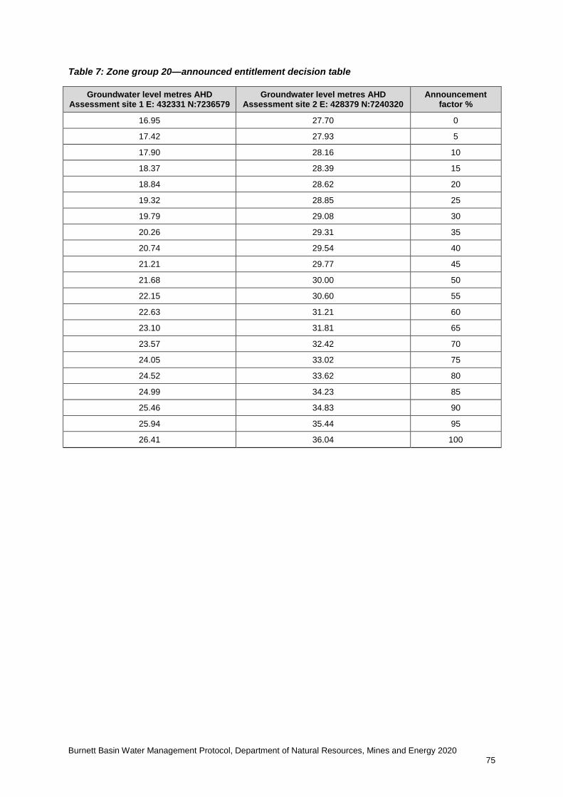
Burnett Basin Water Management Protocol, Department of Natural Resources, Mines and Energy 2020 75
Table 7: Zone group 20—announced entitlement decision table
Groundwater level metres AHD Assessment site 1 E: 432331 N:7236579
Groundwater level metres AHD Assessment site 2 E: 428379 N:7240320
Announcement factor %
16.95 27.70 0
17.42 27.93 5
17.90 28.16 10
18.37 28.39 15
18.84 28.62 20
19.32 28.85 25
19.79 29.08 30
20.26 29.31 35
20.74 29.54 40
21.21 29.77 45
21.68 30.00 50
22.15 30.60 55
22.63 31.21 60
23.10 31.81 65
23.57 32.42 70
24.05 33.02 75
24.52 33.62 80
24.99 34.23 85
25.46 34.83 90
25.94 35.44 95
26.41 36.04 100

Burnett Basin Water Management Protocol, Department of Natural Resources, Mines and Energy 2020 76
Table 8: Zone group 25—announced entitlement decision table
Groundwater level metres AHD Assessment site 1 E: 452526 N:7222669 Announcement factor %
2.01 0
2.06 5
2.11 10
2.16 15
2.21 20
2.26 25
2.31 30
2.36 35
2.41 40
2.46 45
2.51 50
2.56 55
2.61 60
2.66 65
2.71 70
2.76 75
2.81 80
2.86 85
2.91 90
2.96 95
3.01 100

Burnett Basin Water Management Protocol, Department of Natural Resources, Mines and Energy 2020 77
Table 9: Zone group 26—announced entitlement decision table
Groundwater level metres AHD Assessment site 1 E: 434366 N:7224716 Announcement factor %
36.55 0
36.94 5
37.33 10
37.72 15
38.11 20
38.50 25
38.89 30
39.28 35
39.67 40
40.06 45
40.45 50
40.84 55
41.23 60
41.62 65
42.01 70
42.40 75
42.79 80
43.18 85
43.57 90
43.96 95
44.35 100

Burnett Basin Water Management Protocol, Department of Natural Resources, Mines and Energy 2020 78
Table 10: Zone group 27—announced entitlement decision table
Groundwater level metres AHD Assessment site 1 E: 432532 N:7226181 Announcement factor %
25.02 0
25.25 5
25.48 10
25.71 15
25.95 20
26.18 25
26.41 30
26.64 35
26.87 40
27.10 45
27.34 50
27.57 55
27.80 60
28.03 65
28.26 70
28.49 75
28.72 80
28.96 85
29.19 90
29.42 95
29.65 100

Burnett Basin Water Management Protocol, Department of Natural Resources, Mines and Energy 2020 79
Table 11: Zone group 29—announced entitlement decision table
Groundwater level metres AHD Assessment site 1 E: 429569 N:7226924 Announcement factor %
33.33 0
33.45 5
33.58 10
33.70 15
33.82 20
33.94 25
34.07 30
34.19 35
34.31 40
34.43 45
34.56 50
34.68 55
34.80 60
34.92 65
35.05 70
35.17 75
35.29 80
35.41 85
35.54 90
35.66 95
35.78 100

Burnett Basin Water Management Protocol, Department of Natural Resources, Mines and Energy 2020 80
Table 12: Zone Group 30—announced entitlement decision table
Groundwater level metres AHD Assessment site 1 E: 427812
N:7230670
Groundwater level metres AHD Assessment site 2 E: 432714
N:7235424 Announcement factor %
50.00 20.00 0
50.27 20.30 5
50.54 20.60 10
50.81 20.90 15
51.08 21.20 20
51.35 21.50 25
51.61 21.80 30
51.88 22.10 35
52.15 22.40 40
52.42 22.70 45
52.69 23.00 50
52.96 23.30 55
53.23 23.60 60
53.50 23.90 65
53.77 24.20 70
54.04 24.50 75
54.30 24.80 80
54.57 25.10 85
54.84 25.40 90
55.11 25.70 95
55.38 26.00 100

Burnett Basin Water Management Protocol, Department of Natural Resources, Mines and Energy 2020 81
Table 13: Zone group 31—announced entitlement decision table
Groundwater level metres AHD Assessment site 1 E: 424002
N:7227919
Groundwater level metres AHD Assessment site 2 E: 425880
N:7229349 Announcement factor %
59.35 53.03 0
59.73 53.36 5
60.10 53.69 10
60.48 54.02 15
60.86 54.35 20
61.23 54.69 25
61.61 55.02 30
61.99 55.35 35
62.36 55.68 40
62.74 56.01 45
63.12 56.34 50
63.49 56.67 55
63.87 57.00 60
64.25 57.33 65
64.62 57.66 70
65.00 58.00 75
65.77 59.08 80
66.54 60.15 85
67.30 61.23 90
68.07 62.30 95
68.84 63.38 100

Burnett Basin Water Management Protocol, Department of Natural Resources, Mines and Energy 2020 82
Table 14: Zone group 32—announced entitlement decision table
Groundwater level metres AHD Assessment site 1 E: 422683
N:7227766
Groundwater level metres AHD Assessment site 2 E: 422335
N:7228666 Announcement factor %
62.35 62.69 0
62.97 63.01 5
63.59 63.32 10
64.21 63.64 15
64.84 63.95 20
65.46 64.27 25
66.08 64.58 30
66.70 64.90 35
67.32 65.21 40
67.94 65.53 45
68.57 65.85 50
69.19 66.16 55
69.81 66.48 60
70.43 66.79 65
71.05 67.11 70
71.67 67.42 75
72.29 67.74 80
72.92 68.05 85
73.54 68.37 90
74.16 68.68 95
74.78 69.00 100

Burnett Basin Water Management Protocol, Department of Natural Resources, Mines and Energy 2020 83
Table 15: Zone group 33—announced entitlement decision table
Groundwater level metres AHD Assessment site 1 E: 426600
N:7225127
Groundwater level metres AHD Assessment site 2 E: 426456
N:7223997 Announcement factor %
44.69 53.95 0
45.26 54.15 5
45.84 54.35 10
46.41 54.55 15
46.98 54.76 20
47.56 54.96 25
48.13 55.16 30
48.70 55.36 35
49.27 55.56 40
49.85 55.76 45
50.42 55.97 50
50.99 56.17 55
51.57 56.37 60
52.14 56.57 65
52.71 56.77 70
53.29 56.97 75
53.86 57.17 80
54.43 57.38 85
55.00 57.58 90
55.58 57.78 95
56.15 57.98 100

Burnett Basin Water Management Protocol, Department of Natural Resources, Mines and Energy 2020 84
Table 16: Zone group 34—announced entitlement decision table
Groundwater level metres AHD Assessment site 1 E: 426457
N:7221699
Groundwater level metres AHD Assessment site 2 E: 425269
N:7219545 Announcement factor %
65.51 70.15 0
66.13 70.63 5
66.75 71.11 10
67.38 71.60 15
68.00 72.08 20
68.62 72.56 25
69.24 73.04 30
69.86 73.52 35
70.49 74.01 40
71.11 74.49 45
71.73 74.97 50
72.35 75.45 55
72.97 75.93 60
73.60 76.42 65
74.22 76.90 70
74.84 77.38 75
75.46 77.86 80
76.08 78.34 85
76.71 78.83 90
77.33 79.31 95
77.95 79.79 100

Burnett Basin Water Management Protocol, Department of Natural Resources, Mines and Energy 2020 85
Table 17: Zone group 43—announced entitlement decision table
Groundwater level metres AHD Assessment site 1 E: 433362 N:7227586 Announcement factor %
20.00 0
20.42 5
20.84 10
21.26 15
21.68 20
22.10 25
22.52 30
22.94 35
23.36 40
23.78 45
24.20 50
24.61 55
25.03 60
25.45 65
25.87 70
26.29 75
26.71 80
27.13 85
27.55 90
27.97 95
28.39 100

Burnett Basin Water Management Protocol, Department of Natural Resources, Mines and Energy 2020 86
Table 18: Zone group 45—announced entitlement decision table
Groundwater level metres AHD Assessment site 1 E: 431621 N:7226358 Announcement factor %
25.85 0
25.99 5
26.14 10
26.28 15
26.43 20
26.57 25
26.72 30
26.86 35
27.01 40
27.15 45
27.30 50
27.44 55
27.58 60
27.73 65
27.87 70
28.02 75
28.16 80
28.31 85
28.45 90
28.60 95
28.74 100

Burnett Basin Water Management Protocol, Department of Natural Resources, Mines and Energy 2020 87
Table 19: Zone group 46—announced entitlement decision table
Groundwater level metres AHD Assessment site 1 E: 429618
N:7223006
Groundwater level metres AHD Assessment site 2 E: 429210
N:7224026 Announcement factor %
32.40 32.83 0
33.13 33.43 5
33.85 34.04 10
34.58 34.64 15
35.30 35.25 20
36.03 35.85 25
36.75 36.46 30
37.48 37.06 35
38.20 37.67 40
38.93 38.27 45
39.65 38.87 50
40.38 39.48 55
41.10 40.08 60
41.83 40.69 65
42.55 41.29 70
43.28 41.90 75
44.00 42.50 80
45.12 43.57 85
46.25 44.64 90
47.37 45.71 95
48.49 46.78 100

Burnett Basin Water Management Protocol, Department of Natural Resources, Mines and Energy 2020 88
Attachment 4 Barambah Creek groundwater sub-areas

DNRM report template portrait - black 1