bryant’s marina / uw police facilities 1139 - cpd.uw.edu marina uw police...bryant’s marina / uw...
TRANSCRIPT

Bryant’s Marina / UW Police Facilities 1139 – 1299 NE Boat Street Historic Resources Addendum
BOLA Architecture + Planning January 29, 2013

Bryant’s Marina / UW Police Facilities 1139 – 1299 NE Boat Street Historic Resources Addendum January 29, 2013
CONTENTS
1. INTRODUCTION 1 Background Research
2. HISTORIC PRESERVATION – REGULATORY FRAMEWORK 2 The University’s Stewardship and Historic Preservation Policies National Register Eligibility
3. HISTORIC CONTEXT 4 Development of the University District and Lake Union’s Portage Bay Historic Use of the Property The Marina’s Construction Early Property Owner, Jerry C. Bryant Bryant’s Chris-Craft Dealership The Building’s Designers and Contractor Acquisition and Use by the University of Washington
4. ARCHITECTURAL DESCRIPTION 11 Construction History Existing Building and Structures Vernacular Style Industrial Buildings
5. RECOMMENDATIONS 14
6. BIBLIOGRAPHY 15 7. HISTORIC MAPS, PHOTOS, AND DRAWINGS 17 8. CONTEMPORARY PHOTOS 22
Cover: A photo of the marina and surrounding neighborhood from 1962 (Seattle Municipal Archives), and A current view of buildings B, D, and G (BOLA).
BOLA Architecture + Planning 159 Western Avenue West, Suite 486 Seattle, Washington 98119 206.447.4749

Bryant’s Marina / UW Police Facilities Historic Resource Addendum for the University of Washington, Seattle BOLA Architecture + Planning January 29, 2013 1. INTRODUCTION Background This report provides historic and architectural information about the former Bryant’s Marina property, an assembly of five buildings and accessory structures at 1101 - 1137 NE Boat Street that is currently occupied by the University of Washington’s Police Department. The property, located on the north shore of Lake Union's Portage Bay, also includes an open parking lot and several short docks with boat slips. The University is considering an action that will result in the demolition of the buildings and structures and the redevelopment of the site as a public park property. The project, which will be undertaken by the Washington State Department of Transportation (WSDOT), originated with the current WSDOT project to replace the nearby 520-highway bridge across Lake Washington. The 520 project will impact several trail properties within the nearby Washington Arboretum that were originally funded by specific federal grants from the National Park Service. Because of the funding sources, the trail properties are protected in perpetuity under Federal Land and Water Conservation Act, Section 6(f). The sponsors of the two original grants, the City of Seattle and the University of Washington, must identify properties located on a navigable waterway of equal or greater value to replace the trail properties for equivalent recreation use. Having studied over 80 potential equivalent properties, the City of Seattle and the University identified the former Bryant’s Marina property as the best replacement site. The Bryant site was identified in University's 2003 Master Plan as a potential demolition and redevelopment site. As part of the environmental reviews of the 520-bridge project required under the State Environmental Policy Act (SEPA), historical and cultural properties in the areas were surveyed for their potential significance as part of an EIS developed by WSDOT. In its review of the EIS documentation in historic property inventory forms, the Washington State Department of Archaeology and Historic Preservation (DAHP) determined on 9.16.2010 that the Bryant’s Marina property was eligible for listing in the National Register of Historic Places (NRHP). Consultation under Section 106 of the 1966 federal Historic Preservation Act is being addressed by the National Park Service and Washington State Recreational Conservation Office, since this particular federal action is being led by NPS. BOLA prepared preliminary reports on the Bryant property in April 2005 and March 2007 for the University. The property’s history subsequently was surveyed as part of the 520 project EIS. This current report incorporated information from the prior studies along with additional documentation and descriptions of current conditions. The report contains historic and contemporary maps, photographs and drawings, and is assembled in a format consistent with requirements of the University’s Historic Resources Addendum (HRA).

Bryant’s Marina / UW Police Dept. Facilities University of Washington HRA BOLA Architecture + Planning January 29, 2013, page 2
Research Research for this historic report involved several tours of the building and site and the collection and review of historic documents, maps, and photos from the following sources:
Permit and drawing research at the City of Seattle Department of Planning and Development, Microfilm Library
Online historic materials and digital photo collections from the UW Special
Collections, Museum of History and Industry (MOHAI), City of Seattle Archives, and Seattle Public Library
Historic Kroll maps, historic Sanborn Maps, historic Baist's Real Estate Atlas, the
Special Collections card catalog, and review of maps from the Sanborn Insurance Company
References for the Bryant Company from the Seattle Public Library, including
business listings in the library’s card catalogues and a local history of the business, Bryant's 1928-1978 (Crimmin, 1978)
Seattle Times articles regarding Jerry Bryant and Bryant's Marina – Seattle Public
Library, microfilm collection
Drawings and previous studies of the subject property and structures provided by the University
The draft report and recommendations were reviewed with University personnel
prior to the finalization of the document. 2. HISTORIC PRESERVATION – REGULATORY FRAMEWORK The University’s Stewardship and Historic Preservation Policies As outlined in the University of Washington Master Plan (2003 Master Plan) for the Seattle Campus, stewardship for historic buildings is provided by the Regents. Using historic campus planning documents, the Master Plan identified well-known buildings that are associated with the early campus development and early campus master plans: the 1898 Oval Plan, the 1909 Alaska Yukon Pacific Exposition Plan, and the 1915 Regents Plan. The 2003 Master Plan also identified significant and unique landscapes on the campus. The Bryant property was acquired by the University in the 1970s, and thus it is not associated with the early development of the campus. In the 2003 Master Plan, the University cited the Bryant’s property as a potential candidate for retention, as “preserve as feasible,” and also identified the Bryant’s property as Site No. 435, a potential redevelopment site, 43S, with 86,782 square feet of demolition for academic use (Figure IV-74, shown on the following page).

Bryant’s Marina / UW Police Dept. Facilities University of Washington HRA BOLA Architecture + Planning January 29, 2013, page 3
The site and buildings are situated in the Southwest Campus in an area made up by approximately 30 acres. Development of this area was guided by a plan adopted in 1994 as a supplement to the University General Physical Development Plan of 1991-2001. The City of Seattle approved the University’s Property Use and Development Agreement for the Southwest Campus Plan. The 2003 Master Plan characterized the Southwest Campus area as including “University facilities leased for private houseboats, private boat moorages, and one private property, the Jensen Motor Boat Company. City streets, including a street-end boat launch and a University-owned park, currently provide public access to the waterfront. Maintaining these uses, and maintaining the maritime character of the area, and meeting University facility needs are major objectives in the development of the Southwest Campus” (University of Washington Master Plan, Seattle Campus: Goals and Objectives, p. 14).
Above, the Southwest Campus development area that includes Site 43S, the Bryant Marina Property (University of Washington Master Plan – Seattle Campus: Development Program, 2003, p. 112).
National Register Eligibility As noted, the property was determined to be eligible for listing in the National Register by DAHP in 2010. The NRHP is the official federal list of districts, sites, buildings, structures, and objects significant in American history, architecture, archaeology, engineering, and culture. (The National Park Service administers the register, and reviews nomination to it, which may come from state and

Bryant’s Marina / UW Police Dept. Facilities University of Washington HRA BOLA Architecture + Planning January 29, 2013, page 4
federal preservation offices, individuals, organizations, and local governments. The Washington State Advisory Council, which is organized and staffed by the DAHP, considers each nomination and makes a recommendation on its eligibility.) In the Final Environmental Impact Statement for the SR 520 Bridge Replacement, Bryant’s Marina was cited as meeting two NRHP listing criteria. These include Criterion A, “for its historic significance as part of the development of the Seattle waterfront and as a remnant of the commercial and maritime history of the region [….] [and] for its association with the Chris-Craft Boat Company.” (The evaluation found that the property met this criterion due to its “associated with events that have made a significant contribution to the broad patterns of our history.”) The building was evaluated also as eligible for listing under Criterion C, “as an intact example of a mid-twentieth century boat-building warehouse and showroom,” as one of “very few intact examples of this one common architectural type left in Seattle,” and since the property “retains integrity of location, setting, feeling, design, workmanship and materials.” The property met this criterion, which requires the “embodiment of the distinctive characteristics of a type, period or method of construction or represents the work of a master, or possesses high artistic values, or presents a significant and distinguishable entity whose components lack individual distinction.” (Note: Local municipal recognition of historic properties in Seattle is provided through the process of designation of the property as a Seattle landmark. However, due to its unique status as an early institution established by the Washington State Legislature, the University of Washington is exempt from the local jurisdiction of the city's landmark ordinance.) 3. HISTORIC CONTEXT (NOTE: The Bryant Marina and University’s facilities were developed separately. However, they were developed around the same time and in part by the same people, so there is some overlapping information in both sections.) Development of the University District and Lake Union’s Portage Bay What became the University District began as a forested area quite far north of the initial Euro-American settlement in the area. It was crossed by Native American trails and used by the Duwamish Indians for hunting and berry growing. In 1855, the area was surveyed and divided into townships by the federal government. As part of the Oregon Territory, the land was governed by that Territory's Organic Act, which reserved Sections 16 and 36 of each township for the maintenance of public schools. Section 16 was therefore not available for settlement. In 1867, Christian and Harriet Brownfield became the first homesteaders in the area, filing a claim for 174 acres adjacent to Section 16. Additional settlers arrived, and in 1887 the line of the Seattle, Lake Shore, and Eastern Railroad was laid from the early town of Fremont to Union Bay on Lake Washington. Development of nearby properties along the rail route commenced. Plans for a ship canal to link Puget Sound and Salmon Bay with Lake Union and Lake Washington also increased land values. The Brownfield’s' property was repeatedly sold and platted, and finally acquired in 1890 by developer James A. Moore, who re-platted it as the Brooklyn Addition. A year later, the communities of Brooklyn, Fremont, Wallingford, Latona, and Green Lake were annexed by the City of Seattle.

Bryant’s Marina / UW Police Dept. Facilities University of Washington HRA BOLA Architecture + Planning January 29, 2013, page 5
The year 1891 was a formative one for the University District. The Latona Bridge was constructed from what was then 6th Avenue NE across Lake Union to the north end of Capitol Hill, providing passage for David Denny's streetcar, which continued on a route along present-day University Way NE. The streetcar stimulated a linear corridor of commercial development. Around the same time, the State Legislature voted to move the State's University from its downtown location to Section 16. The move occurred in 1895, prompting a renaming of the area from Brooklyn to University Station. Neighborhoods around the campus were almost entirely platted by 1910. The decision to site the Alaska Yukon Pacific Exposition (AYPE) of 1909 on the grounds of the University of Washington was a critical step in the expansion of the campus and its surroundings. The fair attracted between 3,000,000 and 4,000,000 visitors to the grounds, which were designed by John Charles Olmsted of the renowned Olmsted Brothers firm from Brookline, Massachusetts. A number of the buildings constructed for the fair were intended as permanent structures and were retained for the University's subsequent use. In addition, hotels and commercial structures were constructed nearby to serve fair visitors. After the AYPE, the University District neighborhood saw increased residential development. Growth was further stimulated in the area by transportation and infrastructure improvements. This included completion of the ship canal in 1917, the replacement of the earlier Latona Bridge with the University Bridge at the foot of 10th Avenue NE (later Roosevelt Way NE) in 1919, and construction of the Montlake Bridge in 1925. The ensuing construction boom extended into the 1920s. In 1928 a streetcar loop connected the Montlake and Wallingford neighborhoods with the University District. Industrial use of Lake Union began early in its history, with resource-extraction industries positioned along its shoreline. Prior to construction of the Ship Canal in 1917, logs and coal were brought by ship via Lake Washington and Portage Bay to Lake Union and from there by railroad lines that ran from the city’s central harbor along Elliott Bay to Ballard, and then further through Fremont and Latona. In ca. 1910 another rail line was constructed along Westlake Avenue North to link with the south shore of Lake Union – the site of the large Denny Mill (later Brace Lumber). Other early industrial plants were located along the lake’s south edge, including the City Light Hydro Plant, beginning in 1909, and the 1913 Ford Assembly Plant, in addition to several concrete and gravel companies. Early maps and photographs of Portage Bay suggest that initial industrial uses on the north shore included mills, shipping facilities, and a cooperage, as well as shipbuilding and repair facilities along with marinas and moorages for fishing boats and other vessels. The south shore of the bay was the site of residential development. After 1910, the Seattle Yacht Club moved to its present location at 1801 East Hamlin Street, near the west entrance of the Montlake Cut at the east end of Portage Bay. Historic Sanborn maps of 1905 and the Kroll map of 1912-20 show the presence of two public waterways: No. 12 near the foot of 13th (Brooklyn) Avenue NE and No. 13 at the southern end of what was 10th Avenue NE, and the platted street grid with north-south streets from 5th NE to 15th NE terminating at North Lake Avenue, along with the cross streets of East 38th and 40th Streets and the Washington Lake Shore rail line along the current route of the Burke Gilman Trail and NE Pacific Avenue. Campus and neighborhood growth also spawned traffic congestion. Partly in response to this development, University President Henry Suzzallo proposed a formal and functional westerly approach to the campus. A broad boulevard was initially indicated in a 1923 Bebb and Gould campus plan, although the location of the current Campus Parkway would not be realized for many
Bryant’s Marina / UW Police Dept. Facilities University of Washington HRA BOLA Architecture + Planning January 29, 2013, page 6
years. Development in the University District and the campus halted during the Great Depression, but some infrastructure improvements were made under the federal government's Public Works Administration and Works Progress Administration programs, such as street expansions and bridge upgrading. Despite these plans, the southern area of the University District continued to serve as an area where older industry and low-rise residences were mixed. Development throughout the city was limited during the Depression era, and during World War II many lake front industries were transformed to serve the war effort, including shipbuilding and repairs, along with continued transportation use. However, the regional and local economy changed after the end of World War II, with dramatic development in the aerospace industry, airplane construction and trade, and steep declines in resource-based industrial activity. “From 1946 to the present Lake Union [saw] a decline in industrial and increased mixed-commercial and recreational use of the lakeshore” (Tobin, December 9-15, 1987). After World War II, returning soldiers flooded the University seeking college degrees under the provisions of the GI Bill. Residential buildings as well as academic ones were inadequate as enrollment rapidly increased. The University began to extend beyond its original campus, and the establishment in 1946 of the medical program prompted further enlargement. The University's 1948 Plan recommended acquisition of the Northlake area, to the southwest of the traditional campus. Despite neighborhood opposition, the University carried out its plans to expand to the south and west. Construction of NE Campus Parkway was completed and two new dormitories, Terry and Lander Halls, were located along it in the 1950s. Other post-war construction in the Northlake area included the construction of the Applied Physics Laboratory, and a number of Northwest Modern style low-rise wood frame dwellings for married students in a complex along Brooklyn Avenue N to the south of NE Pacific Street (Bassetti and Morse, 1947-48, demolished ca. 1980). Aerial photographs from the late 1950s and early 1960s show the persistence of older residences and commercial structures in addition to industries along the lakeshore. Construction of Interstate 5 and the long ramp to the 520 Bridge in the early 1960s impacted both the University District and the nearby neighborhoods of North Capitol Hill, Montlake, and Wallingford. The highway bridge was set far above the neighborhood streets immediately on the north and south sides of Portage Bay, but it severed the balance of the Wallingford/University District and the North Capitol Hill/Eastlake neighborhoods. Completion of the 520 Bridge also isolated the residential blocks along the south side of the Montlake Cut. Within the neighborhoods, traffic was funneled along several arterials, including NE Pacific Avenue. Increased urbanization and commercial and residential development near the shorelines impacted traditional industrial development along Portage Bay and Lake Union. Other impacts resulted from changes in environmental and shoreline regulations. The State Environmental Policy Act (SEPA) was enacted in 1971, following the federal National Environmental Policy Act of 1969. Among other provisions, it called for management of shoreline development and established protection for water-related uses, including industrial ones. Passage and implementation of the regional Forward-Thrust in the 1970s resulted in water clean-up efforts by Seattle, other nearby cities, and King County. In addition to industrial uses, parts of Portage Bay and Lake Union had served as the site of many houseboat dwellings, which originated as a floating “Hooverville” for low-income residents and seasonal workers in the early part of the 20th century. The small, wood-frame buildings had been modeled on boat houses supported on log floats.

Bryant’s Marina / UW Police Dept. Facilities University of Washington HRA BOLA Architecture + Planning January 29, 2013, page 7
Beginning in the 1970s, most were gradually replaced by larger single-family residential structures built on foam and concrete floats. With the closure of the Lake Union Steam Plant at the south end, and the Seattle Gas Company at the north end of Lake Union in the early 1970s, the former blue collar residential neighborhoods of Eastlake and Wallingford became increasingly popular for middle and upper-class residents. Transformation of the lakeshore continued with the creation of many street-end parks, including one at the foot of Brooklyn Avenue NE, and Gas Works Park. Meanwhile, zoning in the areas around the campus was changed, allowing for increased density and taller, larger apartment buildings. Historic Use of the Property The current Bryant’s Marina property, at 1139 – 1299 NE Boat Street, is an assembly of buildings that were constructed prior to the University’s acquisition of the site in 1970. The buildings were built at different periods as part of a sawmill and a wood box-manufacturing plant, with later modifications and additions made to accommodate various industrial/commercial marine uses, including a boat moorage, boat manufacturing, service and repair, and retail sales. According to historic Baist maps, the area around the base of 11th and 12th Avenues NE, south of East Northlake Avenue (presently NE Boat Street) on Portage Bay, was occupied by Pacific Lumber & Laundry Timber Saw Mill in 1912. Bryant’s Marina Building E, which is no longer extant, may have been constructed as part of this mill. By 1920, Puget Sound Box & Lumber Company had taken over the site. Between 1912 and 1920 a number of additional structures had been constructed. Ten years later, in 1930, this same company occupied the site. Records suggest that, between 1930 and 1938, the Los Angeles Lumber & Box Company acquired the property, although the owner of record was the fee owner up until at least 1945, according to property tax records. The marina and many of the pre-existing structures on the site were used by the Seattle Motor Boat Company, and then Bryant’s Corporation (Bryant’s Marina) from 1928 to ca. 1966. The Marina’s Construction Jerry Bryant and his partners Latham Goble and Dan Lundin began to occupy the building complex on the subject property on Northlake Way NE, at the foot of 11th and 12th Avenues NE, when they established the Seattle Motor Boat Marina, Inc. in 1937. The company's self-published history, Eileen Crimmin's Bryant's: 1928-1978, notes that the firm initially subleased the property from a Vic Franck Boat Company, which had, in turn, leased from the Los Angeles Lumber & Box Company. At that time the Bryant Company also operated out of its leased facilities on Seattle’s downtown waterfront, at 64 Marion Street, which had housed Latham Goble's office and the firm’s other boat yard functions. Soon after 1938, the subject property came up for sale under a forced liquidation. The property consisted of six acres and “included almost 1,000 feet of water frontage and a truly enormous rambling of buildings, sheds, and connected structures of from one- to four-stories” (Crimmin, p. 27). Stockholders of the Box Company sued to stop the impending sale, and it was litigated in court for three years. Bryant’s business continued to lease the property for $100 per month during this period, and purchased it for an estimated $31,000 when the suit was resolved. In February it changed the name of the business, along with the signage on the buildings to Bryant’s Marina. (Records as to the date

Bryant’s Marina / UW Police Dept. Facilities University of Washington HRA BOLA Architecture + Planning January 29, 2013, page 8
of the marina ownership are somewhat unclear. The fee owner, according to King County assessor’s records, remained Puget Sound Lumber and Building Company up until 1945.) Bryant and his partners immediately made plans to alter the pre-existing buildings on the site once they assumed its ownership, but apparently these plans changed as the company instead utilized and adapted many of the existing structures on the site for various functions: the buildings along the street (Buildings C and D) were remodeled to serve as a boat display showroom, storage area, parts rooms for hardware, marine materials, etc., and sales staff and administrative offices. Other buildings were adapted for use as outboard motor repair shops. A paint shop, wet and dry dock storage, small boat repair and construction areas, covered moorage, docks, a gas dock, and boat slips were built, and two cranes were provided to lift boats of up to 50’ in length from the water onto cradles for repair work. Some structures on the property, such as the highly visible and conical-shaped metal wood burner, a feature of early mills, were demolished by the Bryant’s company in the mid-1940s. Bryant embarked on its pleasure boating program in 1945 and staged the first Seattle Boat Show in tents along the north side of Boat Street in 1946. In 1947 the company acquired the Evinrude outboard motor distributor franchise, and Jerry Bryant founded the Pacific NW Marine Dealers Association. The business continued to expand in the 1950s and 1960s, with manufacture of 26’-long utility fishing boats (gill-netters) in 1952, and the addition of “aerial repair services” in 1953, after the company purchased its own seaplane for its mechanics’ use at remote locations. In 1955 Bryant’s Marina received a $500,000 order for boats from the Navy, and in 1957 it expanded to create Bryant’s Walla Walla, Inc. By this date the company reportedly had facilities in Bellingham, Port Angeles, and Anacortes. In 1956 Lundin died. After his other partner, Latham Goble, was killed in an accident Jerry Bryant assumed full control of the company (Crimmin, p. 134-135) By 1960 the marina reportedly employed over 165 people. The business continued to prosper due to boat sales even as its employee numbers decreased. In 1947 its inventory was valued at nearly $300,000. Revenue figures reflected the continued success of Bryant’s Marina: from $36,652 in 1938 to $166,125 in 1940; $593,516 in 1945; $1,647,351 in 1950; and $3,474,842 in 1955; rising to $6,666,301 in 1960 (Crimmin, Appendix #3, p. 79). In 1963 Jerry Bryant sold the Bryant’s Marina business to George Babcock, Sheffield Phelps, and Tedrowe Watkins. In 1966-68 the new owners decided to focus solely on its wholesale sales, and the subject property was sold to the Bullitt Company, a local real estate investment firm. The property was acquired by the University of Washington, which purchased it from the Bullitt Company in 1970. Soon afterwards the Bryant Marina firm purchased property in Woodinville, Washington, for its reorganized business, moving there in 1973. The Early Property Owner, Jerry C. Bryant Jerry C. Bryant (1907 - 1970) was a critical participant in recreational boating in the second half of the 20th century in Seattle and the Puget Sound area. Born and raised in Seattle, Bryant was the son of a prominent Seattle ship chandler (a dealer in ropes, sales and other provisions), and the grandson of a ship captain. He attended the University of Washington, but left just before graduating in 1929. He began his career as a successful early motorboat racer, and owned his own outboard motor shop by the late 1920s. Bryant was active in local boating organizations throughout his life, and was recognized late in his career as the “Father of Northwest Boating.” Along with other Seattle business leaders, he established a Seattle advocacy group, the Sea Salts (later known as Greater Seattle), which he led as president in the 1950s. He was the

Bryant’s Marina / UW Police Dept. Facilities University of Washington HRA BOLA Architecture + Planning January 29, 2013, page 9
General Chairman of Seafair, the city’s annual water-related festival, which he also helped establish in 1951, and served as commissioner of the American Power Boating Association and as a member of the Harbor Advisory Committee, Rotary, Seattle Yacht Club, and Broadmoor Country Club. Jerry Bryant is also credited with coining the promotional phrase for boosting local tourism, “Seattle – the Boating Capital of the World,” and through his efforts and company’s support the annual Seattle Boat Show was founded. The city’s reputation as the “boating capital” appears to have factual basis, as there are more pleasure boats per capita than anywhere else in the US (Seattle Parks and Recreation Department). In early 2013 the Boat Show celebrated its 66th year.
Bryant’s Chris-Craft Dealership In the late 1920s and early 1930s, Jerry Bryant concentrated on the service and sales of outboard motors. In 1937 he and his business partners, Latham Goble and Dan Lundin, began a new business relationship with the Michigan-based Chris-Craft Company as a regional dealer for its popular and highly regarded inboard recreational boats. The Chris-Craft Company, which was formed in ca. 1910 and incorporated in 1922, was known throughout the 1920s for its sleek, high-end cruisers and runabouts. With the onset of the Depression, the company diversified and began mass-manufacturing and marketing a wide range of less expensive recreational powerboats. In contrast to conventional outboard powerboats, those built by Chris-Craft were sleek designs with mahogany hulls (Chris-Craft, Inc. website, History Timeline). The dealership role that Bryant took on with Chris-Craft contributed significantly to the decision he made with his partners to expand the operations of their Seattle Motor Boat Marina, Inc. on Portage Bay. They changed the name of their business to Bryant’s Marina in 1938, and within two years had established the company as the leading full-service boating facility in the city. Bryant’s involvement as the first Chris-Craft dealership in the Pacific Northwest began that year with its initial order and sale of two carloads of pleasure boats. In December 1941, the nation’s entry into the war brought about the conscription and appropriation of many private individuals’ boats for coastal patrol and marine training programs. Bryant’s Marina continued to include and promote its extensive product lines with nationally recognized maritime supply manufacturers such as Evinrude Outboard Motors, Penn Yan Boat Company, and Michigan Propellers (Michigan Wheel Marine), and Marine Motors in marketing materials distributed by the company (Crimmin, p. 29, 32). Its role as a Chris-Craft dealership waned during the war era but was established again in the late 1940s. In 1941 Bryant’s also developed a boat manufacturing plant in Everett, which produced two 26-foot long patrol cruisers for the Seattle Harbor Department’s fleets on Elliott Bay and Lake Washington. The marina’s attention to diversifying its business resulted in the area’s most comprehensive collection of marine products and services, with the acquisition of Jerry Bryant’s Boats & Motors’ complete product inventory in 1943, and the subsequent incorporation of Bryant’s Marina, Inc. that same year. Following this acquisition, and for the remaining two years of World War II, Bryant’s Marina and Chris-Craft separately pursued and produced vessels for the United States Navy’s and Army’s operations in Europe and throughout the Pacific Ocean. However, following a decline in the profitability of military contracts at the end of the war, Bryant’s focused on the sale and distribution of Chris-Craft’s and other power boats, as well as maritime engines made by national manufacturers, notably Evinrude.

Bryant’s Marina / UW Police Dept. Facilities University of Washington HRA BOLA Architecture + Planning January 29, 2013, page 10
Bryant’s reorganization from producing vessels for World War II military contracts to offering marine services and sales in the burgeoning post-war private market culminated in Jerry Bryant’s decision to hold an extensive display of current boat models at the marina in 1946. Tents were set up on a vacant parcel just north of the marina for the city’s first boat show. The following year the official Seattle Boat Show was established as an annual showcase of the latest vessel designs and marine technology in the area. Interest in pleasure boating throughout Western Washington expanded dramatically from 1945 to 1959. In 1960, an estimated 38,000 households in Seattle owned a motorboat (The Southern Missourian, August 11, 1960). Bryant’s Marina grew and added a branch in Spokane, and founded the Bryant Distributing Company in 1959, through which Chris-Craft boats were distributed to dealerships in Tacoma, Wenatchee, Olympia, Bellingham, Port Angeles, Olympia, Juneau, and Sitka. The company also was a franchise distributing Evinrude and other outboard motors, and other marine engines and propellers, DuPont marine paint, Atwood brass hardware, Kermath Marine Engines, and other products to customers and retailers in Western Washington, Alaska, Idaho, and Western Montana. It also had Bryant boats made in Everett, which it sold from 1952 to 1958. In addition to national manufacturers, such as Chris-Craft, noteworthy wood and fiberglass-hulled recreational vessels were made by local and regional firms in response to unprecedented growth in recreational boating. Among these were the N.J. Blanchard Boat Company, Grandy Boat Company, Lester & Frank Boat Company, and Shain Manufacturing Company. In 1952 the Tolleycraft Company was established in Kelso, and in 1957 the Bayliner Company began manufacturing powerboats in Seattle. Seattle’s post-war identity as the country’s second largest recreational boating market was surpassed only by New York City. The economic impact resulting from the increasing popularity of boating supported the region’s diverse maritime industries. Much of the growth of this industry in the 1950s and 1960s is attributable to the early involvement of Bryant’s Marina with the Chris-Craft Company as its first Pacific Northwest dealer.
The Building’s Designers and Contractor Jerry Bryant selected his friend, La Monte J. Shorett as the architect for a major remodel of the marina facility in 1963-64, along with structural engineer Sigmund Ivarsson. The project they designed transformed the former box plant into an active marina facility. Reportedly the contractor for the remodel was Jerry Bryant’s brother, Bill Bryant. La Monte Judson Shorett (1905 – 1991) was a 20th-century Seattle architect known largely for his association with his uncle, the prominent Seattle architect, Arthur L. Loveless. During his career he worked with Loveless, and with George W. Stoddard, who succeeded his well-known father’s practice. Shorett also established a partnership with architect Richard E. Lytel in 1936-42 (University of Washington Libraries, Pacific Coast Architecture Database). Shorett was a member of the local AIA, and served as an office in the Washington State Chapter. One of Shorett’s best known designs was the Seattle Fire Station No. 22 at 901 East Roanoke Street (1964) on Capitol Hill. Sigmund Ivarsson (1899 – 1968) was a talented Seattle structural engineer, and principal of his own firm. He worked with many well-recognized local architects, notably with George W. Stoddard & Associates on the southern part of the University of Washington Stadium (1949-1950), and with Paul Kirk and Victor Steinbrueck on the University’s Faculty Center/Faculty Club (1961). A review of his projects suggests that Ivarsson may have focused on the design of industrial facilities. He is

Bryant’s Marina / UW Police Dept. Facilities University of Washington HRA BOLA Architecture + Planning January 29, 2013, page 11
credited with the design of the Modern-style Lyle Branchflower Company Plant in Ballard (1951), the Ace Tank Plant on Seattle’s Elliott Avenue (ca. 1950, with architect George Stoddard)), the East Shore Unitarian Church in Bellevue (1956), and the remodel of a former laundry as the Tacoma Coca-Cola Bottling Plant, a designated local landmark (1948). A separate project involving Ivarsson was the 1966 remodel and addition to the 1939 Seattle Coca-Cola Bottling Plant, a designated Seattle landmark. Acquisition and Use by the University of Washington’s In 1970 the University acquired the former Bryant’s Marina property along with the Timmerman’s Marina property to the west of it. The Burke-Gilman Trail was established around this same time along the former right-of-way for the Seattle, Lake Shore & Eastern Railroad from Fremont and the northern shore of Lake Union and Portage Bay. From there the trail was developed to extend to the northeast along the northwestern shore of Lake Washington and beyond. This pedestrian and bike path provides a link to neighborhoods, as well as a reprieve from the heavily trafficked streets. The University continued to grow, undertaking 80 major construction projects between 1962 and 1994 (Johnston, p. 66). These projects included the Mercer Hall dormitories, the Ethnic Cultural Center, and expansion of the Oceanography and Fisheries buildings – all in the southwest section of the campus as it moved into the neighborhood. In the last two decades, expansion has continued in the Northlake area, with the most recent construction including four new six-story dormitory buildings between NE Northlake Way and NE Campus Parkway. The lakefront area to the west of University Way and the University Hospital complex contains a number of academic facilities, along with a café and kayak-rental business. Among all of this development, the historic Jensen Boat Company has remained at 1417 NE Boat Street, on property it has owned since 1927. After purchasing the property, the University made changes to utilize several of the buildings on the site for academic and service uses. The University’s Police Department moved into the building assembly around this time. Offices were inserted into Building B, while the two large open sheds on the west side of the property along the lakeshore were utilized for storage and parking. The former boatyard platform was converted into a vehicle parking area. (Portions of the marina have continued to operate up to the present with boat slip rentals.) Other occupants after 1970 included marine tenants, a recycle center, and the University’s Security Department. As many as seven buildings or structures remained on the former marina site in 1978, according to a sketched site plan in the published history of Bryant’s Marina (Crimmin, pp. 44-45). 4. ARCHITECTURAL DESCRIPTION Construction History Note: Historic records are limited. Information cited in this description of the site and buildings, and changes made through time relies largely on drawings and reports from the University facility files, the King County Assessment Department i-Map database, King County Assessor’s archival property record cards for 1101 NE Boat Street, and Eileen Crimmin’s Bryant’s Marina history, along with the historic Sanborn Fire Insurance map of 1905-50, historic Kroll Company maps, and historic aerial photographs from 1936, 1946, 1954 and 1974 by the Walker Company (provided in Shannon and Wilson, 1993).

Bryant’s Marina / UW Police Dept. Facilities University of Washington HRA BOLA Architecture + Planning January 29, 2013, page 12
Up to eight buildings were located on the site and constructed at different times. In 1978 seven of these structures were identified as Buildings A., B., C. D, E, F, and G. In addition to buildings, the property contained a paved driveway and parking lot, over-water marine moorage, and several boat slips for small craft. Historic records for the earliest structure on the site are few, and no drawings have been discovered. With the exception of Buildings B and C, these were vernacular structures, designed, constructed and modified by unknown builders or by the prior occupants and owners of the property. One of the identified buildings has been removed. Building E was a large heavy-timber shed structure with side and cross gable roofs that was once located on the site to the east of Building D, and in the area of the current paved parking/access. This shed was built in ca. 1908, but was demolished and removed by 1982. In 1922 another structure with space for five boats was built, which featured a shed-shaped roof and wood and timber framing, and was approximately 45’ by 60+’ or 3,300 square feet. This latter structure does not appear to be one of the present ones. A Walker Company aerial photo from 1974 shows the present buildings on the site with the exception of the small west addition (Building A). At this time 11th and 12th Avenues NE remained through-streets terminating at Boat Street. As early as 1936 and as late as 1956, as shown in an aerial photo of that year, there remained a large, gable-roofed mill building in close proximity to and south of Building D. In the 1946 aerial photo there are boat slips and a dock in its place along the west side of the Building B/C. A covered moorage structure, dating from 1940, is also visible in this photo as an elongated hipped-roof 84’ by 36’, 12’-tall, wood framed, metal roofed structure on pilings. Permits indicate that in 1956 a new dock building, designated as No. 3, was constructed. It was a 35’ by 47’ structure with a vaulted roof shape with internal catwalks. Open on four sides, it was a 1,645 square foot structure made of wood and timber framing on piles, and had a partial canvas and aluminum roof. In 1957 a covered boat moorage dock was added. A fire on the site in 1958 swept through the marina, destroying many of the covered moorages and boats, with losses totaling between $75,000 and $100,000 (Crimmin, p. 64). Presumably repairs to the structures were undertaken after this date. Between 1963 and 1966 a total of seven fuel tanks were installed on the site in the vicinity of Buildings C and D. These tanks were removed and the site remediated in 1970. Existing Buildings and Structures Building A is a narrow, flat-roofed, undistinguished wood-framed structure west of the
current Police/Emergency Operations Center (EOC). The garage-type building directly abuts the EOC on its east side. Its original date is unknown. The building is characterized by its relatively solid facades, with minimal fenestration, and the roll-up corrugated door that fills the north, street-facing facade. The building is situated on the steep slope down to the waterfront, and exterior stair access to the dock level is located on the west side of the building. The lower level is set into the slope and accessed from the dock on the south side.
Buildings B and C currently houses the University Police and EOC. The section to the
north, along NE Boat Street, was built in the 1930s. Another section, Building B was built as a west side addition to Building C in the 1940s. Both of these buildings were assembled and open internally to one another when they were used for boat sales under

Bryant’s Marina / UW Police Dept. Facilities University of Washington HRA BOLA Architecture + Planning January 29, 2013, page 13
the remodel designed by Shorett & Ivarsson in 1963-64. The first floor (ground floor) plans remained relatively open until the UW acquired the property. In 1970 the buildings were renovated for use by the UW's Drama Department, and a second floor extension was constructed. Subsequently, this space was converted into office and service areas for the University Police, who has been the occupant since June 1970.
Together the building assembly A, B and C forms an irregular L-shape, with overall dimensions of 276’ to 292’ by 142’ to 150’. It is a two-story, wood and timber-frame building, constructed in 1922 with a 14,361 square-foot dock. The north facade of B and C is continuous, brick-clad mass at the first level and vertical wood siding above. Building C’s saw-tooth roof form with clerestory gazing is a distinctive feature, although its roof form is concealed from view on the north by a parapet wall. The clerestory windows are no longer visible. Building B is flat-roofed, and has limited fenestration on its east, south and west facades. Viewed from the south, C and B can be clearly differentiated from one another. The facades are clad with corrugated metal siding and brick veneer, metal roofing, with a 26,960 square-foot concrete basement and foundations. The first floor interior spaces of the building have been divided into office spaces, with the exception of the workout room and a large, two-story conference room. The second floor spaces are largely dedicated to storage, and in many places the roof structure is still visible. This building contained 18 plumbing fixtures, 7 toilets and basins in restrooms. The 139’ by 40’ asphalt paved dock structure on the south side extends south from Building B. Building D, the large open heavy-timber shed structure south of B/C. Records suggest
that it was built in the late 1940s or early 1950s. The building is open on its east side, facing onto the paved parking area. Its prominent feature is the central raised gable-roofed monitor. The east half of the building is wider than the west, extending further to the south. The building has regularly spaced large, rectangular window openings on the north and south walls of the monitor and on its west and south facades, which have been covered over. Building D is primarily used for vehicle storage.
Building F is a small lean-to addition on the south side of D of an unknown
construction date. Building G is the small heavy-timber shed, east of B/C, located along Boat Street, built
in 1950 - 1960. The structure is open to the east and south, and clad in vertical board and batten siding and plywood on its north and west facades. The low-sloped gable roof is concealed from view on the north facade by a parapet wall. Building G is currently a University recycling facility.
Vernacular Style Industrial Buildings The Bryant’s Marina property originated in a re-purposed lumber mill, which was later used as a box–manufacturing plant, and the purpose-built portions of the building appear to have been those with public exposure, e.g., the dealership showroom and offices in addition to the primary façade of Building B/C. In addition, the changes represent the on-site skills of the marina workers. With exception of the 1963-64 project, they likely undertook both the design and construction of many minor modifications up until the University’s acquisition of the property in 1970.

Bryant’s Marina / UW Police Dept. Facilities University of Washington HRA BOLA Architecture + Planning January 29, 2013, page 14
With the exception of the former retail and office sections of Building B, designed by Seattle architect La Monte Shorett, the assembled buildings on the Bryant’s Marina site are made up by vernacular structures that predate the University’s ownership. Most of these are associated with the recreational boating industry, particularly during its time of growth in the post-World War II era, and specifically with the Bryant’s Marine Company. The vernacular style buildings on the Bryant’s property were likely the result of a building tradition rather than self-conscious design, and they evidence many changes in cladding and opening locations for windows and doors in response to functional needs. This level of change is typical of industrial structures, which emphasize functionality and an informal, hand-on approach to refinements. 5. RECOMMENDATIONS The proposed project by the University of Washington will involve demolition of some or all of the buildings and structures as part of a new park development. The following options are recommended as way to mitigate the loss of the historic property, and provide some recognition and interpretation of the historic significance of the site: A. Develop the new park with some temporary moorage space for small powerboats in recognition
of the role of motorized boating in the history of post-war recreational boats at the Bryant’s site. Alternately, consider the provision of kayak storage or launch space, or a kayak rental facility on the new park property.
B. Provide funding to the Center for Wooden Boats to restore a Bryant and/or Chris-Craft
runabout from the post-war period of ca. 1946 – 1960. C. Help establish a local annual regatta or on-lake exhibit for owners of vintage Bryant and Chris-
Craft powerboats with local clubs. D. Develop an interpretive and on-line exhibit for the Center for Wooden Boats and UW Libraries
Special Collections about the history of the marina, the life and work of Jerry Bryant, and his company’s role in Seattle’s post-war recreational boating culture.
E. Consistent with goals in the 2003 University of Washington Campus Master Plan, Illustrative
Development Area S/W-5, “preserve the existing Bryant Annex Shed (Building D),” (p. 110). Investigate the condition of the piers as part of an adaptive reuse feasibility study. Consider the success of Gasworks Park, which serves as an example of a transformation and partial preservation of industrial buildings for new recreational.
F. Sponsor an annual seminar, in conjunction with historic preservation organizations and academic
departments on campus, on traditional and vernacular design in marine environments.

Bryant’s Marina / UW Police Dept. Facilities University of Washington HRA BOLA Architecture + Planning January 29, 2013, page 15
6. BIBLIOGRAPHY AIA, American Architects Directory, First Edition, 1956. R.R. Bowker LLC, 1955,
http://communities.aia.org/sites/hdoaa/wiki/Wiki Pages/1956 (accessed 1.7.2013). Berner, Richard C. Seattle 1900 - 1920: From Boomtown to Restoration. Seattle: Charles Press, 1991. Boating Magazine, “A Moving Tribute – The Outboard Motor Turns 100,”
www.boatingmag.com/moving-tribute?page-0,0 (accessed 1.4.2013). Boyle, Susan and Katrina Deines. “The Industrial Shed in Seattle,” Master's Thesis, Seattle:
University of Washington, 1981. Chris-Craft website, Historic Timeline. http://www.chriscraft.com/history/history-timeline/ (accessed
1.2.2013). City of Seattle: Municipal Archives Photography Collection, http://clerk.ci.seattle.wa.us (accessed 1.4.2013) Department of Parks and Recreation, Motorized Boat Launches,
www.seattle.gov/parks/boat/motorized.htm (accessed 1.5.2013). Department of Planning and Development, Microfilm Permit and Drawing Files. Crimmin, Eileen. Bryant's: 1928-1978. Woodinville, Washington: The Bryant Corporation, 1978. Dorpat, Paul and Genevieve McCoy. Building Washington: A History of Washington State Public
Works. Seattle: Tartu Publications, 1998. Hale, Prentiss and Rob Hutchinson. “Jensen Motor Boat Co.,” Column 5, Vol. IX, 1995, p. 40-43. Johnston, Norman J. The Fountain to the Mountain - The University of Washington Campus,
1895 – 1995. Seattle: University of Washington Press, 1995. King County KCGIS, i-Maps, http://www.kingcounty.gov/operations/GIS/Maps/iMAP.aspx (accessed
12.22.2012). Property Tax Records for Parcel No. 1142004555. Kroll Map Company. “Kroll Maps of Seattle,” 1912 -1920, 1940, and ca. 2002, Seattle. Museum of History and Industry, Digital Photo Collection, http://www.seattlehistory.org (accessed
1.5.2012). Nyberg, Folke and Steinbrueck Victor. “University District - An Inventory of Buildings and Urban
Design Resource,” Historic Seattle, 1975. Ochsner, Jeffrey Karl, editor. Shaping Seattle Architecture: A Historical Guide to the Architects. Seattle:
University of Washington Press, 1994. O’Donnell, Lawrence E. and Jack C., “Evolution of a Vibrant Everett Waterfront – A Story of
Sawdust Salmon & Speedboats.” Everett: A Port of Everett Publication, 2010, pp. -129-156.

Bryant’s Marina / UW Police Dept. Facilities University of Washington HRA BOLA Architecture + Planning January 29, 2013, page 16
Pacific Northwest Boating News, “From show queen to super yachts: Seattle Boat Show turns 65,”
February 2, 2012 (accessed 1.4.2013). Peninsula Daily News, “Tollefson, legendary boat builder, turns 99,” January 24, 2010 (accessed
1.4.2013). Sanborn Atlas of Seattle, 1919 - 1950. Chicago: Sanborn Insurance Map Company. Seattle Times: “Bryant’s Marina (advertisement),” August 15, 1945, p. 20. “Pleasure Boat Industry Booms,” Sunday Magazine Section, October 28, 1945. “It’s Always Seafair Time When You Own a Boat (advertisement), August 11, 1957, p. 50. “Bryant's Marina Sale Announced,” July 20, 1966, p.12. “Jerry Bryant: Father of Northwest Boating,” January 9, 1970, C1, C18 and C19. “Rites Set Monday for Jerry Bryant, 63,” November 27, 1970, p. E6. Shannon and Wilson, “772-ER-3, “Timmerman Marina and Adjacent Bryant’s Building Site History
Review, Project 1720 - Timmerman’s Marina – Tank Removal” prepared for the University of Washington, Seattle, May 1993.
“No Other Water Show Like Seattle’s Seafair’” Southwest Missourian, August 15, 1960. Steinbrueck Victor. Seattle Cityscapes. Seattle: University of Washington Press. 1962. Tobin, Caroline, “Shifting Tides: An Industrial History of Lake Union Traces the City's Boom and
Bust Economy,” Seattle Weekly, December 9-15, 1987. Tobin, Carol, and Sarah Sodt. “University District Historic Survey Report,” Seattle Department o
Neighborhoods, September 2002. University of Washington Capital Project Office and Facility Archives
Echelon Engineering. “Underwater Inspection Report, Bryant Hall, Lake Union,” April 2003. Goettel & Associates Inc. “Benefit-Cost Analysis: University of Washington Bryant Hall (Police Department, 911 Dispatch and Emergency Operations Center), Structural and Non-Structural Seismic Retrofit,” February 14, 2004. Merritt Architecture. “University of Washington Police Department, Bryant Building Existing Conditions Picture Report,” July 16, 2003. Merritt Architecture. “University of Washington Police Department, Emergency Operations Center Seismic Study, Project No. 10136,” November 4, 2003 Perbix Bykonen. “Natural Hazards Assessment, Bryant Hall,” Memorandum, May 3, 2003. Robison Engineering, Inc. “University of Washington, Emergency Center Operations Study.”
Washington State Department of Transportation. “SR 520, I-5 to Medina Bridge Replacement and
HOV Project, Final Environmental Impact Statement and Final Section 4(f) and 6(f) Evaluations, Attachment 15 - Section 6(f) Environmental Evaluation,” May 2011. (This document includes the 5/20/2010 Historic Property Inventory Report for Bryant’s Marina, 1139-1299 NE Boat St., Seattle, prepared by field recorder Megan Venno.)
Vaughan, Thomas, editor. Space, Style and Structure – Buildings in Northwest America. Vol. 1.
Portland, Oregon: Oregon Historical Society, 1974.

Bryant’s Marina / UW Police Dept. Facilities University of Washington HRA BOLA Architecture + Planning January 29, 2013, page 17 7. HISTORIC MAPS, PHOTOS & DRAWINGS
Figure 1. Above, a 1907 map showing the wharfs along Lake Union (Seattle Municipal Archives, Item no. 955). Figure 2. Below, excerpt from a ca. 1905+ map showing the property, which was then identified as the Federal Mill. North is oriented up. (Sanborn Insurance Company, Map of Seattle, Vol. 6, Sheet 690, Seattle Public Library research database.)

Bryant’s Marina / UW Police Dept. Facilities University of Washington HRA BOLA Architecture + Planning January 29, 2013, page 18
Figure 3. Above, view looking east from the University Bridge at Portage Bay on July 1, 1919. The collection of industrial structures appears to have been the Federal Mill property (Seattle Municipal Archives, Item No. 12662). Figures 4 – 5. Left and lower left, figure ground analysis of the property over time showing the buildings and/or structures on the subject site shaded on Kroll maps: above, 1912-1920 and below, 1940-1960.

Bryant’s Marina / UW Police Dept. Facilities University of Washington HRA BOLA Architecture + Planning January 29, 2013, page 19
Figure 6. Above, a historic 1932 photograph, looking west at the “new” University Bridge and one of the Seattle Motor Boat Company’s buildings and dock. This was the original name Jerry Bryant gave his new business on the site (Seattle Municipal Archives Item no. 5483). Figure 7. Left, a historic photograph showing the marina and its surroundings during the first Seattle Boat Show, which Bryant’s established in 1946 (Crimmin 1978, Figure I-11).

Bryant’s Marina / UW Police Dept. Facilities University of Washington HRA BOLA Architecture + Planning January 29, 2013, page 20
Figure 8. Above, an aerial view looking north at the university campus, a portion of Portage Bay, the Montlake Cur and Seattle Yacht Club in 1940 (Seattle Municipal Archives Item No. 604049). Figure 9. Left, a historic photograph showing the marina and the character of the surrounding neighborhood around the date of completion of the I-5 Highway Bridge (in the foreground), April 18, 1962. The southwest part of the campus was then a mix of industrial, commercial and older, low-rise residential structures. The Bryant’s Marina property, in the middle right, then contained a number of older, gable roofed sheds dating from the original lumber mill. (Seattle Municipal Archives, Item No. 71036).

Bryant’s Marina / UW Police Dept. Facilities University of Washington HRA BOLA Architecture + Planning January 29, 2013, page 21
Figure 10. Above, an undated sketch showing the buildings of Bryant’s Marina during its operation. North is oriented down on this drawing (Crimmin 1978, p. 44-45). Figure 11. Below, a site plan, with the same orientation, “U of W Property Acquisition, ‘Bryant’s Marina,’ Yates Marina Service, Standard Oil of California Lease Option,” dated 10-1-69 (University of Washington Facility Records). Highlighting and letter has been added to indicate buildings and structures at present that time, including covered moorage. Letters added identify the remaining the buildings A, B, C, D, and west portion of G (University of Washington Facilities Records).

Bryant’s Marina / UW Police Dept. Facilities University of Washington HRA BOLA Architecture + Planning January 29, 2013, page 22 8. CONTEMPORARY PHOTOS The following contemporary photographs of the property are by BOLA Architecture + Planning, and were taken in December 2012.
Figures 12 – 13. Above, view looking southeast on NE Boat Street at the primary facade north of the UW Police offices, Building B. Below, view looking west at the north facades of the north shed, Building G, in the foreground and Building B and a portion of the I5 highway bridge in the background.

Bryant’s Marina / UW Police Dept. Facilities University of Washington HRA BOLA Architecture + Planning January 29, 2013, page 23
Figure 14. Above, view looking southwest at the east facade of Building G and a portion of Portage Bay beyond. Figure 15. Below, view looking west at the east facades of Buildings D (to the left), and G (right), and a portion of Building B between them.
Bryant’s Marina / UW Police Dept. Facilities University of Washington HRA BOLA Architecture + Planning January 29, 2013, page 24
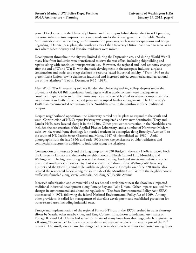
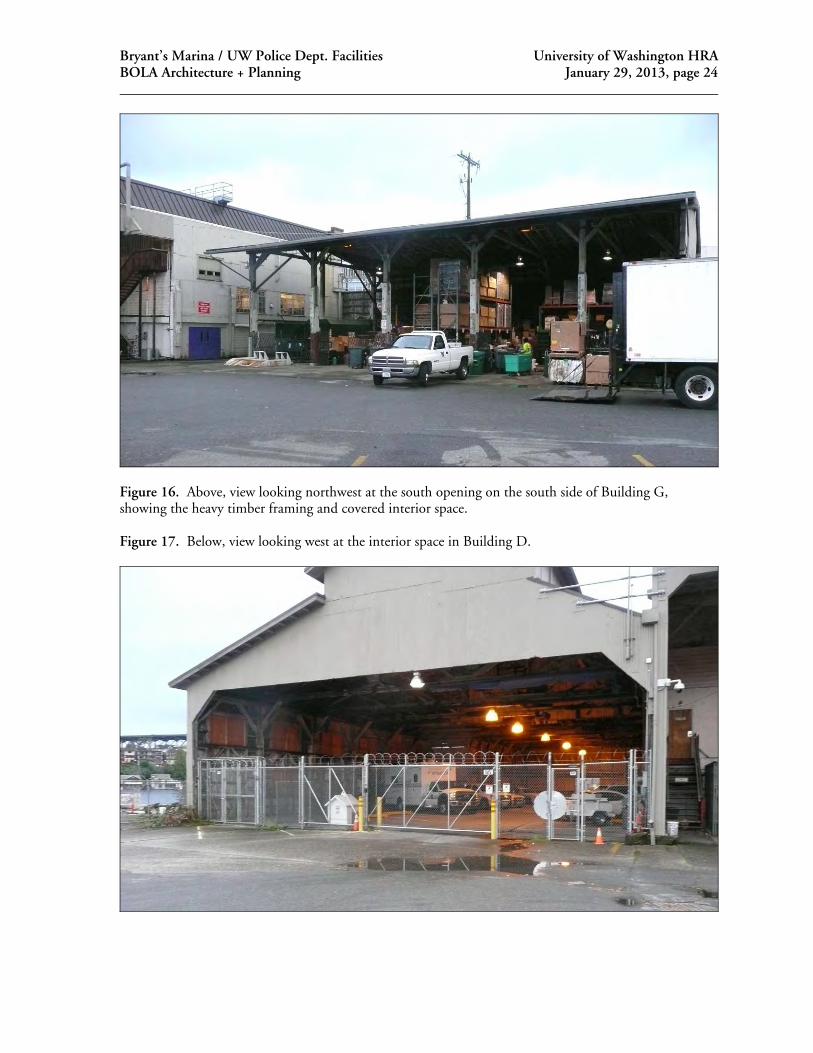
Figure 16. Above, view looking northwest at the south opening on the south side of Building G, showing the heavy timber framing and covered interior space. Figure 17. Below, view looking west at the interior space in Building D.

Bryant’s Marina / UW Police Dept. Facilities University of Washington HRA BOLA Architecture + Planning January 29, 2013, page 25
Figure 18. Above left, detail view looking west at the covered exterior space and stairs on the east side of Building B. Figure 19. Below left, view looking north toward a stairs leading to Boat Street and the open space between Buildings B and G.

Bryant’s Marina / UW Police Dept. Facilities University of Washington HRA BOLA Architecture + Planning January 29, 2013, page 26
Figure 20. Above, view looking northeast at the south facades of Buildings D (with saw tooth roof) and an oblique view of the south and west facades of Building B. Figure 21. Below, a view looking northwest at the south and east facades of building C and a portion of Building B. These views also show the current marina docks.

Bryant’s Marina / UW Police Dept. Facilities University of Washington HRA BOLA Architecture + Planning January 29, 2013, page 27
Figure 22. Above, view looking north at the south facade of Building A and a portion of Building C. Figure 23. Below, A view looking east at the west facade of Building C, and covered boat moorage spaces.
Bryant’s Marina / UW Police Dept. Facilities University of Washington HRA BOLA Architecture + Planning January 29, 2013, page 28
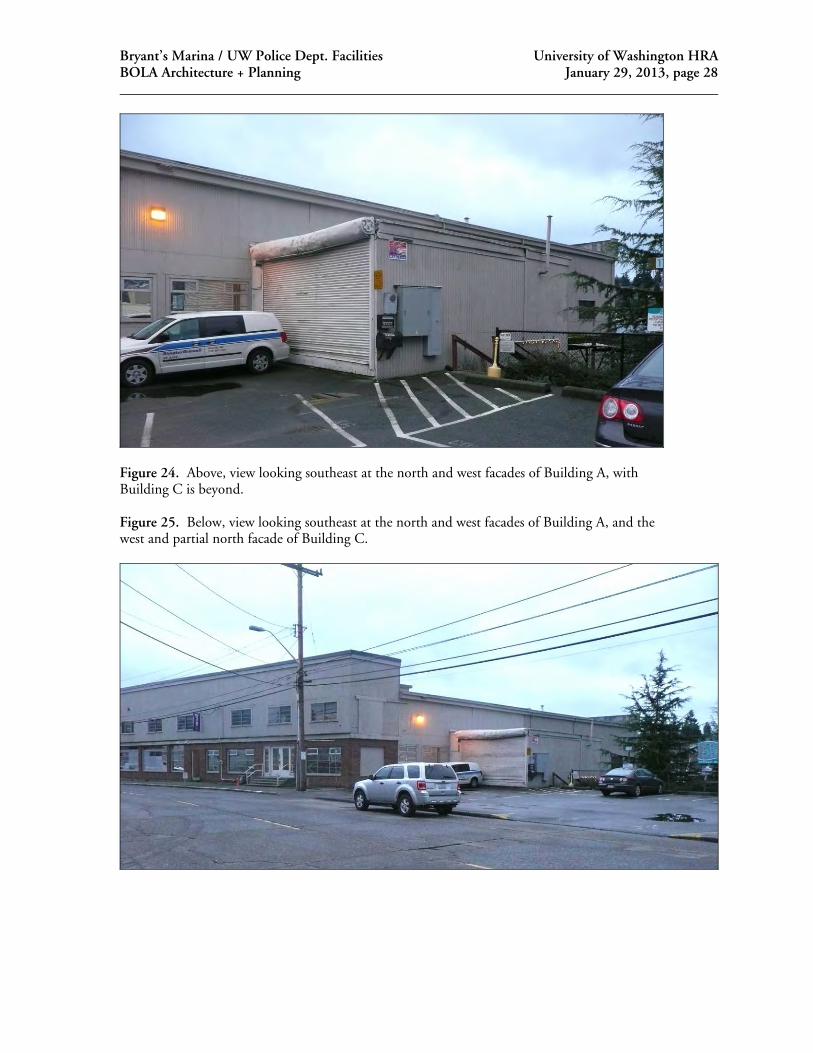
Figure 24. Above, view looking southeast at the north and west facades of Building A, with Building C is beyond. Figure 25. Below, view looking southeast at the north and west facades of Building A, and the west and partial north facade of Building C.

Bryant’s Marina / UW Police Dept. Facilities University of Washington HRA BOLA Architecture + Planning January 29, 2013, page 29
Figure 26. Above, view looking north from the entry lobby of building B. Figure 27. Below, interior view of a typical office space in Building B, currently occupied by the UW Police Department.

Bryant’s Marina / UW Police Dept. Facilities University of Washington HRA BOLA Architecture + Planning January 29, 2013, page 30
Figures 28 – 29. Above, view of a conference and meeting room in Building B. Below, view of a typical upper floor storage and locker room space in this building. Heavy timber framing and mechanical ductwork are typically exposed. Finishes, fixtures, partitions and mechanical/electrical system elements are non-original.