brrtp anf supplemental water resources technical report...portions of the brrtp alternatives would...
TRANSCRIPT
June 2011
BARREN RIDGE RENEWABLE TRANSMISSION PROJECT
Water Resources and Hydrology Supplemental Technical Report
PROJECT NUMBER:
122708
PROJECT CONTACT:
ALLISON CARVER
EMAIL:
PHONE:
714-507-2700

POWER ENGINEERS, INC. BRRTP – WATER RESOURCES AND HYDROLOGY SUPPLEMENTAL TECHNICAL REPORT FOR THE ANF
ANA 119-150 (PER-02) 122708 (JUNE 2011) AC
Water Resources and Hydrology Supplemental Technical Report for the Angeles National Forest
PREPARED FOR: LOS ANGELES DEPARTMENT OF WATER AND POWER
111 NORTH HOPE STREET
LOS ANGELES CA 90012
PREPARED BY: POWER ENGINEERS, INC.
(714) 507-2700
WWW.POWERENG.COM
ALLISON CARVER WATER RESOURCES
(714) 507-2705
MICHEL YBARRONDO, P.E. (HYDROLOGY) (208) 288-6131

POWER ENGINEERS, INC. BRRTP – WATER RESOURCES AND HYDROLOGY SUPPLEMENTAL TECHNICAL REPORT FOR THE ANF
ANA 119-150 (PER-02) 122708 (JUNE 2011) AC i
TABLE OF CONTENTS
1.0 INTRODUCTION ............................................................................................................................ 1
2.0 PURPOSE AND SCOPE .................................................................................................................. 2 2.1 Issues ............................................................................................................................................. 2
3.0 BACKGROUND .............................................................................................................................. 3 3.1 General Description ...................................................................................................................... 3
4.0 AFFECTED ENVIRONMENT ........................................................................................................ 7 4.1 Water Resource Inventory .......................................................................................................... 10 4.2 Watersheds .................................................................................................................................. 10
4.2.1. Liebre Gulch-Piru Creek Watershed (HUC 180701020509) .............................................. 10 4.2.2. Upper Castaic Creek Watershed (HUC 180701020303) .................................................... 11 4.2.3. Fish Creek-Piru Creek Watershed (HUC 180701020602) .................................................. 11 4.2.4. Lake Piru-Piru Creek Watershed (HUC 180701020603) ................................................... 12 4.2.5. Lower Castaic Creek Watershed (HUC 180701020306) .................................................... 13 4.2.6. San Francisquito Canyon Watershed (HUC 180701020402) ............................................. 13 4.2.7. Lower Bouquet Canyon Watershed (HUC 180701020202) ............................................... 14 4.2.8. Elizabeth Lake Watershed (HUC 180701020301) ............................................................. 15 4.2.9. Elizabeth Lake Canyon Watershed (HUC 180701020304) ................................................ 15 4.2.10. Agua Dulce Canyon Watershed (HUC 180701020104) ..................................................... 16 4.2.11. Mint Canyon Watershed (HUC 180701020106) ................................................................ 17 4.2.12. Upper Bouquet Canyon Watershed (HUC 180701020201) ................................................ 17
5.0 GUIDING LAWS, REGULATIONS, POLICIES, AND DIRECTION ......................................... 19
6.0 MANAGEMENT OBJECTIVES (DESIRED CONDITIONS) ..................................................... 21
7.0 IMPACT ASSESSMENT METHODOLOGY ............................................................................... 22 7.1 Impact Model .............................................................................................................................. 22
7.1.1. RUSLE Analysis ................................................................................................................. 22 7.1.2. Hydrologic Modeling .......................................................................................................... 22
7.2 Resource Sensitivity .................................................................................................................... 23 7.2.1. Sensitivity Values ............................................................................................................... 23 7.2.2. Access Levels and Ground Disturbance ............................................................................. 24
7.3 Impact Levels .............................................................................................................................. 24 7.4 Impact Assessment Methodology by Project Component .......................................................... 25
7.4.1. 230 kV Transmission Line .................................................................................................. 25 7.4.2. New 230 kV Circuit ............................................................................................................ 25 7.4.3. Reconductoring ................................................................................................................... 26 7.4.4. New Haskell Canyon Switching Station ............................................................................. 26 7.4.5. Expansion of Barren Ridge Switching Station .................................................................... 26
7.5 Impacts and Mitigation Planning ................................................................................................ 26 7.5.1. Types of Impacts ................................................................................................................. 37
8.0 IMPACT RESULTS ....................................................................................................................... 40 8.1 Alternative 1 ................................................................................................................................ 40 8.2 Alternative 2 ................................................................................................................................ 40 8.3 Alternative 2a .............................................................................................................................. 41 8.4 Alternative 3 ................................................................................................................................ 42 8.5 No Action Alternative ................................................................................................................. 42
9.0 CUMULATIVE WATERSHED EFFECTS ................................................................................... 43 9.1 Introduction ................................................................................................................................. 43

POWER ENGINEERS, INC. BRRTP – WATER RESOURCES AND HYDROLOGY SUPPLEMENTAL TECHNICAL REPORT FOR THE ANF
ANA 119-150 (PER-02) 122708 (JUNE 2011) AC ii
9.2 Impact Area ................................................................................................................................. 43 9.3 Present and Reasonably Foreseeable Actions ............................................................................. 43
9.3.1. Transmission Projects ......................................................................................................... 43 9.3.2. Transportation and Public Facilities.................................................................................... 44 9.3.3. Maintenance and Landscape Management Projects............................................................ 44 9.3.4. Local Projects ...................................................................................................................... 45
9.4 Cumulative Effects Analysis ....................................................................................................... 45 9.4.1. Direct and Indirect Effects Summary .................................................................................. 45 9.4.2. Cumulative Effects Evaluation ........................................................................................... 46
10.0 REFERENCES ............................................................................................................................... 47
APPENDIX A: RUSLE ANALYSIS ......................................................................................................... 48
APPENDIX B: STUDIED WATERSHED MAPS .................................................................................... 49
APPENDIX C: ASSUMPTIONS AND RESULTS ................................................................................... 50
TABLES Table 1. Watersheds in the BRRTP Area. .................................................................................................... 7 Table 2. Condition Categories for Watersheds in the USFS Pacific Southwest Region............................... 8 Table 3. Water Resources Impacts by Access Level Category ................................................................... 24 Table 4. General Practices .......................................................................................................................... 28 Table 5. Specifically Recommended Mitigation Measures ........................................................................ 31

POWER ENGINEERS, INC. BRRTP – WATER RESOURCES AND HYDROLOGY SUPPLEMENTAL TECHNICAL REPORT FOR THE ANF
ANA 119-150 (PER-02) 122708 (JUNE 2011) AC 1
1.0 INTRODUCTION
The City of Los Angeles Department of Water and Power (LADWP) is proposing the Barren Ridge
Renewable Transmission Project (BRRTP or Project) to access clean, renewable resources in the
Tehachapi Mountains and Mojave Desert areas, and to improve reliability and upgrade transmission
capacity.
LADWP, the US Department of Agriculture, Forest Service (USFS or Forest Service) and the U.S
Department of the Interior, Bureau of Land Management (BLM) are preparing a joint Environmental
Impact Statement (EIS) / Environmental Impact Report (EIR) for the proposed BRRTP. LADWP is the
California Environmental Quality Act (CEQA) Lead Agency, while the USFS and BLM are the federal
Co-Lead Agencies under the National Environmental Policy Act (NEPA). An EIS/EIR is an informational
disclosure document used to inform agency decision makers and the public of the potential significant
environmental effects of a project, identify possible ways to eliminate or minimize the potential
significant effects, and describe reasonable alternatives to the Proposed Action /Project.
The purpose of the water resources and hydrology study is to inventory existing water resources and
assess the potential impacts to water resources of each of the proposed transmission line alternative
corridors, proposed switching station, and expansion of the existing switching station. The water resource
environmental analysis will:
present the regulatory framework
provide an overview of the technical methodology used in collecting baseline conditions and
evaluating impacts
examine the affected environment within the study corridors and vicinity, where appropriate
describe the potential impacts on water resources resulting from construction and operation of the
Project
evaluate the level of potential impacts based upon National Environmental Policy Act
(NEPA)/California Environmental Quality Act (CEQA) criteria
present specifically recommended mitigation measures to minimize potential impacts.
Portions of the BRRTP Alternatives would traverse the western section of the Angeles National Forest
(ANF or Forest), and have the potential to adversely affect the watersheds through which they cross.
Adverse effects may result from vegetation clearance and general ground disturbance during construction
of the Project, as well as leaks or spills of oils or other hazardous fluids from construction and
maintenance vehicles or equipment. Specifically, Forest watersheds could be adversely affected by
sedimentation and erosion resulting from construction activities. This report contains an inventory of
water resources within affected Forest watersheds, and evaluates the potential for Project-related erosion
and related changes in hydrology. Potential adverse effects are analyzed for each BRRTP Alternative.

POWER ENGINEERS, INC. BRRTP – WATER RESOURCES AND HYDROLOGY SUPPLEMENTAL TECHNICAL REPORT FOR THE ANF
ANA 119-150 (PER-02) 122708 (JUNE 2011) AC 2
2.0 PURPOSE AND SCOPE
The purpose of this report is to identify water resources potentially affected by the Alternatives of the
BRRTP, and to analyze effects of construction and operation of the Project on erosion and sedimentation.
The scope of this report is limited to those portions of each BRRTP Alternative that would be located
within the Angeles National Forest.
This report is supplemental to the complete Water Resources Technical Report, and has been prepared at
the request of Mr. Paul Gregory, ANF Hydrologist.
2.1 ISSUES
This report will focus on identifying and analyzing BRRTP effects on water resources within HUC 12 (6th
Level) watersheds. In addition to analyzing potential effects on existing water resources, Mr. Gregory
requested a Revised Universal Soil Loss Equation (RUSLE) analysis (Appendix A of this report) to
predict the rate of erosion that would potentially result from construction of the BRRTP within the Forest.
Mr. Gregory also requested a statistical analysis of 6th level watersheds within the ANF that would be
affected by the BRRTP Alternatives, to predict peak flow within the watersheds pre- and post-
construction.

POWER ENGINEERS, INC. BRRTP – WATER RESOURCES AND HYDROLOGY SUPPLEMENTAL TECHNICAL REPORT FOR THE ANF
ANA 119-150 (PER-02) 122708 (JUNE 2011) AC 3
3.0 BACKGROUND
3.1 GENERAL DESCRIPTION
The BRRTP would be located within the western section of the Angeles National Forest, in the Santa
Clara/Mojave Rivers Ranger District. The Project area includes 16 HUC 12 6th level watersheds, 12 of
which would be affected by BRRTP Alternatives, as described in this report. These affected watersheds
are Liebre Gulch-Piru Creek, Upper Castaic Creek, Fish Creek-Piru Creek, Lake Piru-Piru Creek, Lower
Castaic Creek, Elizabeth Lake, Elizabeth Lake Canyon, San Francisquito Canyon, Lower Bouquet
Canyon, Agua Dulce Canyon, Mint Canyon, and Upper Bouquet Canyon (Figure 1).
The BRRTP is located in portions of Township 05N Range 16W Sections 20, 21, 22, 25, 26, and 27;
Township 05N Range 17W Section 4; Township 06N Range 17W Sections 6, 7, 8, 17, 20, 21, 28, 33, and
34; Township 07N Range 17W Sections 19, 30, and 31; Township 07N Range 18W Sections 2, 11, 12,
13, and 24; and Township 08N Range 18W Section 35, in Los Angeles County, California.
Land Use Zones have been designated within the ANF to identify appropriate uses that are consistent with
the Forest Land Management Plan (USFS 2005). Some Zones have restrictions that may affect projects
proposed within them.
One Wild and Scenic River, and one eligible Wild and Scenic River are within the Project area. Piru
Creek, a designated Wild and Scenic River, is located approximately two miles west of Alternative 1. San
Francisquito Canyon Creek, which is eligible for Wild and Scenic River designation, is located in the
center of the Project area, and is generally paralleled by Alternatives 2 and 2a.
Three Critical Biological Areas occur in the Project area. One is located in San Francisquito Canyon, and
is designated Critical Habitat for the California red-legged frog (Rana draytonii). The remaining two
Critical Biological Areas are located in Castaic Creek and Fish Creek, and host Critical Habitat for the
arroyo toad (Anaxyrus californicus).
Riparian Conservation Areas (RCAs) combine the ecologic concerns of riparian ecosystems with the
hydrologic concerns of floodplains and streamside slopes. RCAs have been established within the
Angeles National Forest to protect, maintain, or improve water quality, site productivity, channel stability,
riparian vegetation, and riparian-dependent species and habitats. RCAs are associated with many streams
within the Forest, including West Fork Liebre Gulch, Liebre Gulch, San Francisquito Canyon, Dry
Canyon, Bee Canyon, Pettinger Canyon, Munz Canyon, Mint Canyon, and multiple unnamed streams.
The Project area is located in the Transverse Ranges Geomorphic Province, which is characterized by
east-west trending mountain ranges and fault systems. The province is bounded on the northeast by the
San Andreas Fault, and extends west and south from the study area. The Project area is underlain by
Tertiary and pre-Tertiary rock formations, with the exception of canyon bottoms and other drainage areas
comprised of alluvium. Soil erosion along the BRRTP Alternatives ranges from Slight to Very Severe.
The climate of the BRRTP area is Mediterranean, with warm, dry summers and cool, wet winters. Most
precipitation occurs between November and March, when storm systems from the north Pacific approach
the area from the west or southwest, often producing precipitation simultaneously throughout the area.
The orographic effect often results in intense precipitation along and within the San Gabriel Mountains.
Annual precipitation averages 14.32 inches at Elizabeth Lake, with much falling as snow; in the higher
elevations, precipitation averages up to 40 inches, with over 95% falling as snow. Maximum daily
temperatures vary with elevation, but range from the 90s during the summer months to the 30s during the
winter months (Western Regional Climate Center 2011).
POWER ENGINEERS, INC. BRRTP – WATER RESOURCES AND HYDROLOGY SUPPLEMENTAL TECHNICAL REPORT FOR THE ANF
ANA 119-150 (PER-02) 122708 (JUNE 2011) AC 4
THIS PAGE INTENTIONALLY LEFT BLANK

POWER ENGINEERS, INC. BRRTP – WATER RESOURCES AND HYDROLOGY SUPPLEMENTAL TECHNICAL REPORT FOR THE ANF
ANA 119-150 (PER-02) 122708 (JUNE 2011) AC 5
FIGURE 1. STUDY WATERSHED AND ASSOCIATED HYDROLOGIC UNITS

POWER ENGINEERS, INC. BRRTP – WATER RESOURCES AND HYDROLOGY SUPPLEMENTAL TECHNICAL REPORT FOR THE ANF
ANA 119-150 (PER-02) 122708 (JUNE 2011) AC 6
THIS PAGE INTENTIONALLY LEFT BLANK
POWER ENGINEERS, INC. BRRTP – WATER RESOURCES AND HYDROLOGY SUPPLEMENTAL TECHNICAL REPORT FOR THE ANF
ANA 119-150 (PER-02) 122708 (JUNE 2011) AC 7
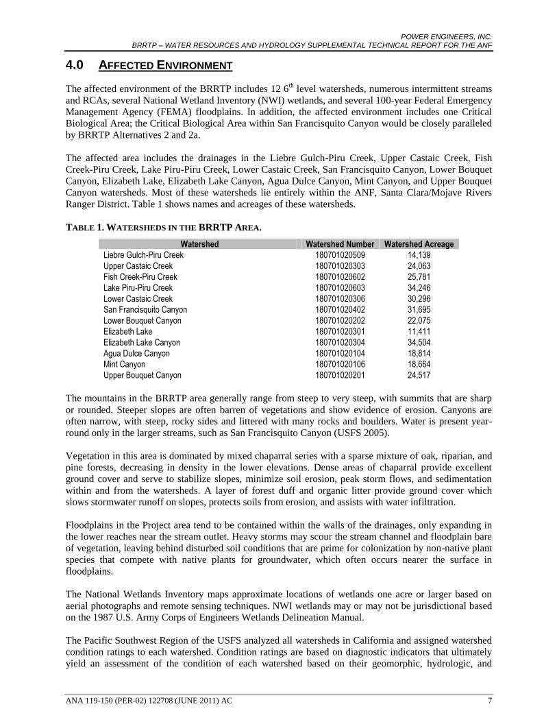
4.0 AFFECTED ENVIRONMENT
The affected environment of the BRRTP includes 12 6th level watersheds, numerous intermittent streams
and RCAs, several National Wetland Inventory (NWI) wetlands, and several 100-year Federal Emergency
Management Agency (FEMA) floodplains. In addition, the affected environment includes one Critical
Biological Area; the Critical Biological Area within San Francisquito Canyon would be closely paralleled
by BRRTP Alternatives 2 and 2a.
The affected area includes the drainages in the Liebre Gulch-Piru Creek, Upper Castaic Creek, Fish
Creek-Piru Creek, Lake Piru-Piru Creek, Lower Castaic Creek, San Francisquito Canyon, Lower Bouquet
Canyon, Elizabeth Lake, Elizabeth Lake Canyon, Agua Dulce Canyon, Mint Canyon, and Upper Bouquet
Canyon watersheds. Most of these watersheds lie entirely within the ANF, Santa Clara/Mojave Rivers
Ranger District. Table 1 shows names and acreages of these watersheds.
TABLE 1. WATERSHEDS IN THE BRRTP AREA.
Watershed Watershed Number Watershed Acreage
Liebre Gulch-Piru Creek 180701020509 14,139
Upper Castaic Creek 180701020303 24,063
Fish Creek-Piru Creek 180701020602 25,781
Lake Piru-Piru Creek 180701020603 34,246
Lower Castaic Creek 180701020306 30,296
San Francisquito Canyon 180701020402 31,695
Lower Bouquet Canyon 180701020202 22,075
Elizabeth Lake 180701020301 11,411
Elizabeth Lake Canyon 180701020304 34,504
Agua Dulce Canyon 180701020104 18,814
Mint Canyon 180701020106 18,664
Upper Bouquet Canyon 180701020201 24,517
The mountains in the BRRTP area generally range from steep to very steep, with summits that are sharp
or rounded. Steeper slopes are often barren of vegetations and show evidence of erosion. Canyons are
often narrow, with steep, rocky sides and littered with many rocks and boulders. Water is present year-
round only in the larger streams, such as San Francisquito Canyon (USFS 2005).
Vegetation in this area is dominated by mixed chaparral series with a sparse mixture of oak, riparian, and
pine forests, decreasing in density in the lower elevations. Dense areas of chaparral provide excellent
ground cover and serve to stabilize slopes, minimize soil erosion, peak storm flows, and sedimentation
within and from the watersheds. A layer of forest duff and organic litter provide ground cover which
slows stormwater runoff on slopes, protects soils from erosion, and assists with water infiltration.
Floodplains in the Project area tend to be contained within the walls of the drainages, only expanding in
the lower reaches near the stream outlet. Heavy storms may scour the stream channel and floodplain bare
of vegetation, leaving behind disturbed soil conditions that are prime for colonization by non-native plant
species that compete with native plants for groundwater, which often occurs nearer the surface in
floodplains.
The National Wetlands Inventory maps approximate locations of wetlands one acre or larger based on
aerial photographs and remote sensing techniques. NWI wetlands may or may not be jurisdictional based
on the 1987 U.S. Army Corps of Engineers Wetlands Delineation Manual.
The Pacific Southwest Region of the USFS analyzed all watersheds in California and assigned watershed
condition ratings to each watershed. Condition ratings are based on diagnostic indicators that ultimately
yield an assessment of the condition of each watershed based on their geomorphic, hydrologic, and

POWER ENGINEERS, INC. BRRTP – WATER RESOURCES AND HYDROLOGY SUPPLEMENTAL TECHNICAL REPORT FOR THE ANF
ANA 119-150 (PER-02) 122708 (JUNE 2011) AC 8
biological integrity relative to their natural condition, as judged by Forest Service geologists,
hydrologists, and biologists (USFS 2000). Ratings and their descriptions are shown in Table 2 below.
TABLE 2. CONDITION CATEGORIES FOR WATERSHEDS IN THE USFS PACIFIC SOUTHWEST REGION.
Category Description
Category Condition I
Watersheds that are currently exhibiting high geomorphic, hydrologic, and biotic integrity relative to their natural potential condition and exhibit a stable drainage network. Physical and biological conditions suggest that aquatic and riparian systems are predominantly functional in terms of supporting dependent species and beneficial uses of water. The risks of management induced disturbance have not been expressed or resulted in significant alteration of geomorphic, hydrologic, and biotic processes.
Category Condition II
Watersheds that are currently exhibiting moderate geomorphic, hydrologic, and biotic integrity relative to its natural potential condition and portions of these watersheds exhibit an unstable drainage network. Physical and biological conditions suggest that aquatic and riparian systems are at risk in being able to support dependent species and retain beneficial uses of water. The risks of management induced disturbance are variable and effects have partially been expressed or have resulted in localized alteration of geomorphic, hydrologic, and biotic processes.
Category Condition III
Watersheds that are currently exhibiting low geomorphic, hydrologic, and biotic integrity relative to their natural potential condition and a majority of the drainage network is unstable. Physical and biological conditions suggest that riparian and aquatic systems do not support dependent species nor beneficial uses of water. The risks of management induced disturbance are high; they have been fully expressed and/or have resulted in deterioration of geomorphic, hydrologic, and/or biotic processes.
The California State Water Resources Control Board (SWRCB) requires individual Regional Water
Quality Control Boards (RWQCBs) to develop Basin Plans (water quality control plans) designed to
preserve and enhance water quality and protect the beneficial uses of all Regional waters. Specifically,
Basin Plans designate beneficial uses for surface waters and groundwater, set narrative and numerical
objectives that must be attainted or maintained to protect the designated beneficial uses and conform to
the States antidegradation policy, and describe implementation programs to protect all waters in the
Regions. In addition, Basin Plans incorporate by reference all applicable State and Regional Board plans
and policies, and other pertinent water quality policies and regulations. Within the ANF, the BRRTP is
under the jurisdiction of the Basin Plan of the Los Angeles Regional Water Quality Control Board.
Section 303(d) unites the water quality management strategies of the federal Clean Water Act (CWA).
Section 303(d) requires that states make a list of waters that exceed the minimum level of pollutants put in
place by the CWA. For waters on this list the states must develop total maximum daily loads (TMDLs),
which account for all sources of the pollutants that caused the water to be listed. The TMDLs must
account for contributions from both point sources and nonpoint sources, as defined by Section 402 of the
CWA. In California, the SWRCB has interpreted state law to require that implementation of TMDLs be
addressed when incorporated into Basin Plans (water quality control plans).
Within the ANF, the BRRTP Alternatives would cross two groundwater basins and one sub-basin. These
basins are described in California’s Groundwater Bulletin 118 and summarized below.
Antelope Valley Groundwater Basin (Groundwater Basin Number 6-44). The Antelope
Valley Groundwater Basin drains a surface area of approximately 1,010,000 acres (1,580 square
miles). The basin underlies an extensive alluvial valley in the western Mojave Desert, and is
bounded on the northwest by the Garlock fault zone at the base of the Tehachapi Mountains, on
the southwest by the San Andreas fault zone at the northern base of the San Gabriel Mountains,
on the east by ridges, buttes, and low hills that form a surface and groundwater drainage divide,
and on the north by the Fremont Groundwater Basin described above.
The primary aquifers in this basin are unconsolidated alluvial and lacustrine deposits from the
Pleistocene and Holocene, forming an upper aquifer and a lower aquifer. The upper aquifer is the

POWER ENGINEERS, INC. BRRTP – WATER RESOURCES AND HYDROLOGY SUPPLEMENTAL TECHNICAL REPORT FOR THE ANF
ANA 119-150 (PER-02) 122708 (JUNE 2011) AC 9
primary source of groundwater in the Antelope Valley, and is generally unconfined. The basin
comprises three large sediment-filled structural sub-basins separated by extensively faulted,
elevated bedrock. Numerous faults displace the water table and impede groundwater flow within
the basin.
Total storage capacity of the Antelope Valley Groundwater Basin is between 68,000,000 and
70,000,000 af, except for an area of the basin where the groundwater is between 20 and 220 feet
in depth. In that area, the storage capacity is approximately 5,400,000 af. Between 1975 and
1998, groundwater in this basin ranged from an increase of 84 feet to a decrease of 66 feet. The
area of the basin that experienced a decrease in groundwater depth is along the State Route 14
corridor from Palmdale to Rosamond. In the vicinity of the study corridors that cross the
Antelope Valley Groundwater Basin, recent depth-to-water measurements in USGS wells ranged
between 152.83 feet and 390.79 feet (DWR 2003).
Acton Valley Groundwater Basin (Groundwater Basin Number 4-5). The Acton Valley
Groundwater Basin drains a surface area of approximately 8,270 acres (12.9 square miles). The
basin is unconfined, and groundwater is found in alluvium and stream terrace deposits. The basin
is bounded by the Sierra Pelona on the north, and the San Gabriel Mountains on the south, east,
and west.
Groundwater in the basin is unconfined. The water-bearing formations in this basin are Holocene
alluvial deposits and Pleistocene stream terrace deposits. The alluvial deposits reach a maximum
thickness of approximately 225 feet in the Santa Clara River channel near the community of
Acton, and thin out east and west of this area. The stream terrace deposits are found on low-lying
flanks of the foothills and upper reaches of the tributaries of the Santa Clara River, and reach a
maximum thickness of approximately 210 feet north of Acton.
Total storage capacity of the Acton Valley Groundwater Basin is approximately 40,000 af.
Groundwater levels declined from the 1950s through the mid-1970s; groundwater levels
increased from the late 1970s through the mid-1980s, but began declining again. Current depth-
to-water measurements were unavailable for the Acton Valley Groundwater Basin (DWR 2003).
Santa Clara River Valley East Sub-basin (Groundwater Basin Number 4-4.07). The Santa
Clara River Valley East Sub-basin drains a surface area of approximately 66,200 acres (103
square miles). The basin is bounded on the north by the Piru Mountains, on the west by
impervious rocks of the Modelo and Saugus Formations and a constriction in the alluvium, on the
south by the Santa Susana Mountains and the San Gabriel Mountains, and on the east by the San
Gabriel Mountains.
Groundwater in the sub-basin is found in Holocene alluvium, Pleistocene terrace deposits, and in
the late Pliocene to early Pleistocene Saugus Formation. Groundwater is generally unconfined in
the alluvium, but may be confined, semi-confined, or unconfined in the Saugus Formation.
Alluvium deposits reach a maximum thickness of approximately 240 feet below the Santa Clara
River channel and thin laterally away from the channel, and east and west of the community of
Acton. The terrace deposits generally lie above the water table, and are found on the low-lying
flanks of the foothills and upper reaches of the Santa Clara River tributaries. These deposits reach
thicknesses of up to 200 feet near Saugus, Agua Dulce, and Acton. The Saugus Formation is up to
8,500 feet thick, and is not widely utilized as a groundwater source for municipal and agricultural
uses, as the water can be brackish. The maximum depth to the base of fresh water ranges from
1,500 feet northeast of the San Gabriel Fault to 5,500 feet between the San Gabriel Fault and the
Holser Fault.

POWER ENGINEERS, INC. BRRTP – WATER RESOURCES AND HYDROLOGY SUPPLEMENTAL TECHNICAL REPORT FOR THE ANF
ANA 119-150 (PER-02) 122708 (JUNE 2011) AC 10
Although the Saugus Formation is displaced by both the San Gabriel and Holser Faults,
groundwater movement in the Formation has not been affected. The water-bearing alluvial
deposits have not been affected by fault displacement.
Total storage capacity of the sub-basin is approximately 240,000 af in the alluvial aquifer, and
approximately 1,650 af in the Saugus Formation. Between 1970 and 2000, groundwater levels
were relatively stable with depth-to-water levels in the alluvial aquifer measuring from between
approximately 13 feet to 37 feet in the western portion of the sub-basin, 10 feet to 50 feet in the
central portion, and 15 feet to 100 feet in the eastern portions of the sub-basin. In the Saugus
Formation, depth-to-water levels have also remained stable. In the vicinity of the study corridors
adjacent to the Santa Clara River Valley East Sub-basin, recent depth-to-water measurements in
USGS wells ranged between 9.60 feet and 10.20 feet (DWR 2003).
4.1 WATER RESOURCE INVENTORY
The goal of the water resource inventory was to identify, map, describe, and document existing water
resources within the affected watersheds of each BRRTP Alternative. Detailed data inventories were
compiled to facilitate the assessment of potential water resource effects resulting from construction and
operation of the Project.
Initially, base maps of the Project area were prepared at a scale of 1:12,000. Water resource data collected
from federal and state databases were reviewed, refined, and updated. Existing maps from the United
States Geological Survey (USGS), National Wetland Inventory (NWI), and Federal Emergency
Management Agency (FEMA) were collected and included in the inventory, as appropriate. These data
were compiled and mapped utilizing a geographic information system (GIS).
The study used National Agriculture Imagery Program (NAIP) 2005 color aerial photography, and
national, state, and local agency GIS data layers to identify and more accurately assess surface land uses
and land cover types.
A description of water resources was divided by affected watershed. Existing water resources were
identified within the Alternative study corridor to present an overview of the water resources that would
potentially be affected by the transmission line alternatives.
4.2 WATERSHEDS
4.2.1. Liebre Gulch-Piru Creek Watershed (HUC 180701020509)
The Liebre Gulch-Piru Creek Watershed is located in the Castaic Unit of the ANF, and has a Summary
Watershed Condition Category rating of I. This watershed drains approximately 14,139 acres; drainages
in this watershed include those in West Fork Liebre Gulch, Liebre Gulch, and Posey Canyon, all of which
drain into Pyramid Lake. Pyramid Lake and the southernmost reach of West Fork Liebre Gulch have
associated FEMA 100-year floodplains.
The NWI has mapped two wetlands within this watershed: Pyramid Lake has been mapped as a lacustrine
wetland (L1UB); and a small 0.4-mile portion of West Fork Liebre Gulch immediately north of Interstate
5 has been mapped as Other Wetland.
Within the ANF, many of the larger drainages and their tributaries have associated RCAs; in the ANF
portion of the Liebre Gulch-Piru Creek Watershed, there are approximately 39 RCAs.
Beneficial uses of surface waters in this watershed include Municipal and Domestic Supply, Industrial
Service Supply, Industrial Process Supply, Agricultural Supply, Ground Water Recharge, Freshwater
Replenishment, Hydropower Generation, Water Contact Recreation, Non-contact Water Recreation,

POWER ENGINEERS, INC. BRRTP – WATER RESOURCES AND HYDROLOGY SUPPLEMENTAL TECHNICAL REPORT FOR THE ANF
ANA 119-150 (PER-02) 122708 (JUNE 2011) AC 11
Warm Freshwater Habitat, Cold Freshwater Habitat, Wildlife Habitat, Rare, Threatened, or Endangered
Species, Spawning, Reproduction, and/or Early Development, and Wetland Habitat.
The Liebre Gulch-Piru Creek Watershed does not lie above a defined groundwater basin.
BRRTP Alternative 1 would cross the ANF section of the Liebre Gulch-Piru Creek Watershed from mile
marker 58.1 to 62.9, at mile marker 64.2, and from mile marker 64.6 to 64.8. Ground slope in the vicinity
of Alternative 1 typically ranges from 20 percent to 30 percent; however, in many areas, slope is greater
than 30 percent.
4.2.2. Upper Castaic Creek Watershed (HUC 180701020303)
The Upper Castaic Creek Watershed is located in the San Francisquito Unit of the ANF, and has a
Summary Watershed Condition Category rating of III. This watershed drains approximately 24,063 acres;
drainages within this watershed include those in Trough Canyon, Cold Canyon, Cienega Canyon, Pine
Canyon, Bear Canyon, and Redrock Canyon, as well as Falls Creek, Castaic Creek, and Salt Creek.
FEMA has not mapped 100-year floodplains associated with these drainages.
Palustrine forested (PFO) wetlands, palustrine scrub-shrub (PSS) wetlands, and “other” wetlands have
been mapped by the NWI in and adjacent to Cienega Canyon (T07N R17W Sections 15, 22, and 27).
Additional PFO wetlands are mapped in Section 14 NW, in Section 12 SW at the northern end of Bear
Canyon, and in Section 10 SW.
There is a Critical Biological Area located in Castaic Creek that contains designated Critical Habitat for
arroyo toad.
Much of Castaic Creek and many of its tributaries have associated RCAs. In the Upper Castaic Creek
Watershed there are approximately 55 RCAs.
Beneficial uses of surface waters in this watershed include Municipal and Domestic Supply, Industrial
Service Supply, Industrial Process Supply, Agricultural Supply, Ground Water Recharge, Freshwater
Replenishment, Water Contact Recreation, Non-contact Water Recreation, Commercial and Sport
Fishing, Warm Freshwater Habitat, Wildlife Habitat, and Rare, Threatened, or Endangered Species.
The southern portion of the Upper Castaic Creek Watershed lies above the Santa Clara River Valley East
Groundwater Sub-basin.
BRRTP Alternative 1 would cross through the ANF section of the Upper Castaic Creek Watershed from
mile marker 62.7 to 64.2, and from mile marker 64.6 to 66.5. Ground slope in the vicinity typically ranges
from 20 percent to 30 percent, with many slopes adjacent to Alternative 1 greater than 30 percent.
4.2.3. Fish Creek-Piru Creek Watershed (HUC 180701020602)
The Fish Creek-Piru Creek Watershed is located in the Upper Piru Unit of the ANF, and has a Summary
Watershed Condition Category rating of II. This watershed drains approximately 25,781 acres; drainages
within this watershed include those in Cherry Canyon, Osito Canyon, Turtle Canyon, Ruby Canyon, and
Oak Flats, as well as Piru Creek, North Fork Fish Creek, Fish Creek, and Michael Creek. FEMA has
mapped 100-year floodplains associated with Piru Creek from Pyramid Dam to the border of the Los
Padres National Forest, a distance of approximately 3.5 miles. Piru Creek is a designated Wild and Scenic
River, from 0.5 mile south of Pyramid Dam to the Los Angeles-Ventura Counties border, a distance of
7.5 miles.
The NWI has mapped a number of wetlands within the Fish Creek-Piru Creek watershed, many of which
are associated with Piru Creek, which is itself designated a riverine upper perennial (R3) wetland. Other

POWER ENGINEERS, INC. BRRTP – WATER RESOURCES AND HYDROLOGY SUPPLEMENTAL TECHNICAL REPORT FOR THE ANF
ANA 119-150 (PER-02) 122708 (JUNE 2011) AC 12
NWI wetlands associated with Piru Creek are PFO and PSS wetlands. Additional NWI wetlands are
located near Halfway Spring Campsite, Cobblestone Springs, both of which are in the Los Padres
National Forest. In the ANF, the NWI has mapped a PFO wetland near Oak Flat Spring in T06N R17W
Section 19NW.
Fish Creek, Piru Creek, and many of their tributaries have associated RCAs. In the ANF portion of the
Fish Creek-Piru Creek Watershed, there are approximately 26 RCAs.
Beneficial uses of surface waters in this watershed include Municipal and Domestic Supply, Industrial
Service Supply, Industrial Process Supply, Agricultural Supply, Ground Water Recharge, Freshwater
Replenishment, Water Contact Recreation, Non-contact Water Recreation, Warm Freshwater Habitat,
Cold Freshwater Habitat, Wildlife Habitat, Rare, Threatened, or Endangered Species, Spawning,
Reproduction, and/or Early Development, and Wetland Habitat.
Piru Creek is listed on the 2006 CWA Section 303(d) List of Water Quality Limited Segments Requiring
TMDLs as impaired by unhealthy chloride and pH levels.
The Fish Creek-Piru Creek Watershed does not lie above a defined groundwater basin.
BRRTP Alternative 1 would cross through the ANF section of the Fish Creek-Piru Creek Watershed from
mile marker 66.0 to 68.5. Ground slope in the vicinity typically ranges from 20 percent to 30 percent,
with many slopes adjacent to Alternative 1 greater than 30 percent.
4.2.4. Lake Piru-Piru Creek Watershed (HUC 180701020603)
The Lake Piru-Piru Creek Watershed is located in the Upper Piru Unit of the ANF, and has a Summary
Watershed Condition Category rating of II. This watershed drains approximately 34,246 acres; drainages
in this watershed include those in Big Oak Flat, Canton Canyon, Santa Felicia Canyon, Devil Canyon,
Sharps Canyon, Oak Canyon, Lechler Canyon, Dominguez Canyon, Maple Canyon, and Reasoner
Canyon, all of which drain into Lake Piru, which is located on the southern border of the watershed. Only
Lake Piru has an associated FEMA 100-year floodplain.
The NWI has mapped the lower reaches of Canton Canyon as an intermittent riverine (R4) wetland. As in
the Fish Creek-Piru Creek Watershed, Piru Creek is designated an R3 wetland, with associated PFO and
PSS wetlands. The NWI has designated stretches of Reasoner Canyon and Dominguez Canyon as
Riparian Forests. A palustrine emergent (PEM) wetland is mapped on the western edge of Lake Piru,
below the confluence of the Reasoner Canyon and Dominguez Canyon drainages. Lechter, Santa Felicia,
and Devil Canyons have associated PFO wetlands, and the NWI has also mapped a PSS wetland in an
unnamed tributary to Santa Felicia Canyon, approximately 0.7 mile east of the Los Angeles-Ventura
Counties line.
The drainages in Canton Canyon, Big Oak Flat, and many of their tributaries have associated RCAs. In
the ANF portion of the Lake Piru-Piru Creek Watershed, there are approximately 24 RCAs.
Beneficial uses of surface waters in this watershed include Municipal and Domestic Supply, Industrial
Service Supply, Industrial Process Supply, Agricultural Supply, Ground Water Recharge, Freshwater
Replenishment, Hydropower Generation, Water Contact Recreation, Non-contact Water Recreation,
Commercial and Sport Fishing, Warm Freshwater Habitat, Cold Freshwater Habitat, Wildlife Habitat,
Rare, Threatened, or Endangered Species, and Spawning, Reproduction, and/or Early Development.
The southeastern portion of the Lake Piru-Piru Creek Watershed lies above the Santa Clara River Valley
East Groundwater Sub-basin.

POWER ENGINEERS, INC. BRRTP – WATER RESOURCES AND HYDROLOGY SUPPLEMENTAL TECHNICAL REPORT FOR THE ANF
ANA 119-150 (PER-02) 122708 (JUNE 2011) AC 13
BRRTP Alternative 1 would cross the ANF section of the Lake Piru-Piru Creek Watershed from mile
marker 68.3 to 71.5. Ground slope in the vicinity typically ranges from 20 percent to 30 percent, with
some slopes greater than 30 percent.
4.2.5. Lower Castaic Creek Watershed (HUC 180701020306)
The Lower Castaic Creek Watershed is located in the San Francisquito Unit of the ANF, and has a
Summary Watershed Condition Category rating of III. This watershed drains approximately 30,296 acres;
drainages in this watershed include those in Grasshopper Canyon, Marple Canyon, Violin Canyon, Bitter
Canyon, Charlie Canyon, Tapia Canyon, Wayside Canyon, Hasley Canyon, and Romero Canyon, as well
as Castaic Creek. FEMA has mapped 100-year floodplains associated with Castaic Creek below Castaic
Dam, Hasley Canyon, Marple Canyon, Charlie Canyon, and several additional tributaries to Castaic
Creek.
The NWI has mapped PFO wetlands in Tapia Canyon (T05N R16W Sections 21SW and 31NE), and PSS
wetlands in Wayside Canyon (T04N R16W S32E). In Castaic Creek, the NWI has mapped PFO, PEM,
and PSS wetlands along the banks of the creek in the vicinity of Castaic Junction. Additional PFO
wetlands have been mapped in Sloan Canyon (T05N R17W Section 34NE).
In this watershed, Charlie Canyon, Bitter Canyon, and many of their tributaries have associated RCAs. In
the ANF portion of the Lower Castaic Creek Watershed, there are approximately 13 RCAs.
Beneficial uses of surface waters in this watershed include Municipal and Domestic Supply, Industrial
Service Supply, Industrial Process Supply, Agricultural Supply, Ground Water Recharge, Freshwater
Replenishment, Hydropower Generation, Water Contact Recreation, Non-contact Water Recreation,
Commercial and Sport Fishing, Warm Freshwater Habitat, Cold Freshwater Habitat, Wildlife Habitat,
Rare, Threatened, or Endangered Species, and Spawning, Reproduction, and/or Early Development.
The southern portion of the Lower Castaic Creek Watershed lies above the Santa Clara River Valley East
Groundwater Sub-basin.
BRRTP Alternative 1 would cross the ANF section of the Lower Castaic Creek Watershed from mile
marker 71.5 to 80.3. Ground slope in the vicinity typically ranges from 20 percent to 30 percent, with
slopes in some areas greater than 30 percent.
4.2.6. San Francisquito Canyon Watershed (HUC 180701020402)
The San Francisquito Canyon Watershed is located in the Elizabeth Unit of the ANF, and has a Summary
Watershed Condition Category rating of I. This watershed drains an area of approximately 31,695 acres;
drainages in this watershed include those in San Francisquito Canyon, South Portal Canyon, Dowd
Canyon, Clearwater Canyon, Cherry Canyon, Bee Canyon, and Drinkwater Canyon. FEMA has mapped
100-year floodplains in San Francisquito Canyon, and in the lower reach of Bee Canyon.
The NWI has mapped a PFO wetland in San Francisquito Canyon in T05N R15W Section 6 and T05N
R16W Section 1. San Francisquito Canyon creek is designated an R4 wetland. In the lower reach of San
Francisquito Canyon creek, PEM wetlands have been mapped near the confluence with the Santa Clara
River.
San Francisquito Canyon and many of its tributaries have associated RCAs. In the ANF portion of the
San Francisquito Canyon Watershed, there are approximately 56 RCAs.
Beneficial uses of surface waters in this watershed include Municipal and Domestic Supply, Industrial
Service Supply, Industrial Process Supply, Agricultural Supply, Ground Water Recharge, Freshwater
Replenishment, Water Contact Recreation, Non-contact Water Recreation, Commercial and Sport

POWER ENGINEERS, INC. BRRTP – WATER RESOURCES AND HYDROLOGY SUPPLEMENTAL TECHNICAL REPORT FOR THE ANF
ANA 119-150 (PER-02) 122708 (JUNE 2011) AC 14
Fishing, Warm Freshwater Habitat, Wildlife Habitat, Rare, Threatened, or Endangered Species,
Spawning, Reproduction, and/or Early Development, and Wetland Habitat.
The southern portion of the San Francisquito Canyon Watershed lies above the Santa Clara River Valley
East Groundwater Sub-basin.
There is a Critical Biological Area within San Francisquito Canyon that is designated Critical Habitat for
the California red-legged frog. In addition to the California red-legged frog, arroyo chub (Gila orcutti)
and Santa Ana sucker (Catostomus santaanae) have been recorded in San Francisquito Canyon,
immediately downstream of the PFO wetland. Unarmored threespine stickleback (Gasterosteus aculeatus
williamsoni) was previously known to occupy San Francisquito Canyon, but is now believed to be
extirpated following heavy flood events in 2005 (CDFG 2011).
BRRTP Alternative 1 would cross the ANF section of the San Francisquito Canyon Watershed from mile
marker 81.4 to 81.7. Ground slope in this vicinity ranges from flat to slopes greater than 30 percent.
BRRTP Alternatives 2 and 2a would cross this watershed from mile marker 46.4 to 55.8, most of which
would be within the ANF. Ground slope in the vicinity of these Alternatives is generally between 20
percent and 30 percent, with areas of slopes greater than 30 percent. The Alternative 2a re-route (Green
Valley Re-route) would also cross this watershed from mile marker 3.6 to 6.6; this stretch would be
entirely within the ANF. Ground slope in the vicinity of this re-route are generally greater than 30
percent, with a few areas of lesser slope ranging from 10 percent to 20 percent.
4.2.7. Lower Bouquet Canyon Watershed (HUC 180701020202)
The Lower Bouquet Canyon Watershed is located in the Bouquet Unit of the ANF, and has a Summary
Watershed Condition Category rating of III. This watershed drains an area of approximately 22,075 acres;
drainages in this watershed include those in Haskell Canyon, Bouquet Canyon, Vasquez Canyon, Plum
Canyon, Dry Canyon, and Pettinger Canyon. FEMA has mapped 100-year floodplains for Bouquet
Canyon, Vasquez Canyon, Plum Canyon, Haskell Canyon, and Dry Canyon.
The NWI has mapped PFO wetlands in areas of Dry Canyon, Haskell Canyon, and Bouquet Canyon. In
Bouquet Canyon, Vasquez Canyon, and Plum Canyon, the NWI has also mapped PSS wetlands (T05N
R15W Section 34NE, T04N R15W Sections 6S and 9NW). The NWI has designated each of these
drainages R4 wetlands.
Haskell Canyon, Pettinger Canyon, and many of their tributaries have associated RCAs. In the ANF
portion of the Lower Bouquet Canyon Watershed, there are approximately 20 RCAs.
Beneficial uses of surface waters in this watershed include Municipal and Domestic Supply, Industrial
Service Supply, Industrial Process Supply, Agricultural Supply, Ground Water Recharge, Freshwater
Replenishment, Water Contact Recreation, Non-contact Water Recreation, Commercial and Sport
Fishing, Warm Freshwater Habitat, Cold Freshwater Habitat, Wildlife Habitat, Rare, Threatened, or
Endangered Species, Spawning, Reproduction, and/or Early Development, and Wetland Habitat.
Dry Canyon Creek is listed on the 2006 CWA Section 303(d) List of Water Quality Limited Segments
Requiring TMDLs as impaired by high levels of fecal coliform.
The southern portion of the Lower Bouquet Canyon Watershed lies above the Santa Clara River Valley
East Groundwater Sub-basin.
There are multiple known instances of unarmored threespine stickleback within Bouquet Creek south of
the ANF boundary (CDFG 2011).

POWER ENGINEERS, INC. BRRTP – WATER RESOURCES AND HYDROLOGY SUPPLEMENTAL TECHNICAL REPORT FOR THE ANF
ANA 119-150 (PER-02) 122708 (JUNE 2011) AC 15
BRRTP Alternative 1 would cross the ANF section of the Lower Bouquet Canyon Watershed from mile
marker 81.7 to 83.2. In the vicinity of this Alternative, ground slope is greater than 30 percent. This
watershed would also be crossed by BRRTP Alternatives 2 and 2a from mile marker 55.9 to 60.7, all of
which is located in the ANF. In the vicinity of these Alternatives, ground slope is typically between 20
percent and 30 percent, interspersed with areas of slopes less than 20 percent and slopes greater than 30
percent.
4.2.8. Elizabeth Lake Watershed (HUC 180701020301)
The Elizabeth Lake Watershed is located in the San Francisquito Unit of the ANF and has a Summary
Watershed Condition Category rating of III. This watershed drains an area of approximately 11,411 acres;
drainages in this watershed include those in Shake Canyon, Pine Canyon, Sterner Canyon, Forsythe
Canyon, Spring Canyon, Abrams Canyon, Lucky Canyon, Munz Canyon, and Burns Canyon, all of which
drain into Lake Hughes, Munz Lake, or Elizabeth Lake. FEMA 100-year floodplains have been mapped
in Pine Canyon upstream from Lake Hughes, for Lake Hughes and Elizabeth Lake, and for the unnamed
drainage east of Elizabeth Lake.
The NWI has mapped PFO and PEM wetlands from north of Lake Hughes (T07N R15W Section 22SE)
to south of Elizabeth Lake, near Power Line Drive (T06N R14W Section 2NW). Near the eastern edge of
Elizabeth Lake is a palustrine aquatic bed (PAB) wetland; in addition, Munz Lake has been designated a
PAB wetland by the NWI. Hughes Lake and Lake Elizabeth have been designated L1UB wetlands. Lake
Hughes, Munz Lake, and Elizabeth Lake are rift lakes, which are formed in depressions created where
active or recent strike/slip fault movement has impounded drainage.
Pine Canyon and many of its tributaries have associated RCAs. In the ANF portion of the Elizabeth Lake
Watershed, there are approximately 17 RCAs.
Beneficial uses of surface waters in this watershed include Municipal and Domestic Supply, Industrial
Service Supply, Industrial Process Supply, Agricultural Supply, Ground Water Recharge, Freshwater
Replenishment, Water Contact Recreation, Non-contact Water Recreation, Commercial and Sport
Fishing, Warm Freshwater Habitat, Wildlife Habitat, and Rare, Threatened, or Endangered Species.
The Elizabeth Lake Watershed lies above the San Andreas Rift Zone portion of the Antelope Valley
Groundwater Basin.
Elizabeth Lake is listed on the 2006 CWA Section 303(d) List of Water Quality Limited Segments
Requiring TMDLs as impaired by eutrophication, organic enrichment/low dissolved oxygen, unhealthy
levels of pH, and trash. Lake Hughes is listed as impaired by algae, eutrophication, fish kills, odor, and
trash; Munz Lake is listed as impaired by eutrophication and trash.
BRRTP Alternatives 2 and 2a would cross the ANF section of the Elizabeth Lake Watershed from mile
markers 46.0 to 46.4. Ground slope in the vicinity of these Alternatives ranges from 0 percent to 30
percent. The Alternative 2a re-route (Green Valley Re-route) would also cross the ANF section of this
watershed from mile marker 0.7 to 3.0. Ground slope in the vicinity of this portion of Alternative 2a is
generally greater than 30 percent, with areas of lesser slope ranging from 10 percent to 30 percent.
4.2.9. Elizabeth Lake Canyon Watershed (HUC 180701020304)
The Elizabeth Lake Canyon Watershed is located in the San Francisquito Unit of the ANF, and has a
Summary Watershed Condition Category rating of III. This watershed drains an area of approximately
11,411 acres; drainages in this watershed include those in Elizabeth Lake Canyon, Kleine Canyon,
Prospect Canyon, Turkey Canyon, Deer Canyon, Hiatt Canyon, Tule Canyon, South Tule Canyon, Ruby
Canyon, Dry Gulch, and Warm Springs Canyon, as well as Fish Creek. FEMA has mapped 100-year

POWER ENGINEERS, INC. BRRTP – WATER RESOURCES AND HYDROLOGY SUPPLEMENTAL TECHNICAL REPORT FOR THE ANF
ANA 119-150 (PER-02) 122708 (JUNE 2011) AC 16
floodplains in the northern portion of Elizabeth Lake Canyon and along the edges of the east branch of
Castaic Lake.
The NWI has mapped a relatively large PFO wetland in the northern end of Elizabeth Lake Canyon
(T07N R15W Section 27). Smaller PSS wetlands are mapped along the northeastern branch of Castaic
Lake (T05N R16W Section 5NE), and small, isolated PFO wetlands are mapped along the west slopes of
Elizabeth Lake Canyon at the 2,800-foot level and the 3,000-foot level, and north of Turkey Canyon
between 3,400 feet and 4,000 feet. The NWI has designated Castaic Lake a L1UB wetland.
Elizabeth Lake Canyon and many of its tributaries have associated RCAs. In the ANF portion of the
Elizabeth Lake Canyon Watershed, there are approximately 63 RCAs.
Beneficial uses of surface waters in this watershed include Municipal and Domestic Supply, Industrial
Service Supply, Industrial Process Supply, Agricultural Supply, Ground Water Recharge, Freshwater
Replenishment, Water Contact Recreation, Non-contact Water Recreation, Commercial and Sport
Fishing, Warm Freshwater Habitat, and Wildlife Habitat.
The southern portion of the Elizabeth Lake Canyon Watershed lies above the Santa Clara River Valley
East Groundwater Sub-basin.
The BRRTP Alternative 2a re-route (Green Valley Re-route) would cross the ANF section of the
Elizabeth Lake Canyon Watershed from mile marker 3.0 to 3.6. Ground slope in the vicinity of this
portion of the re-route are from 20 percent to greater than 30 percent.
4.2.10. Agua Dulce Canyon Watershed (HUC 180701020104)
The Agua Dulce Canyon Watershed is located in the Soledad (Aliso) Unit of the ANF, and has a
Summary Watershed Condition Category rating of III. This watershed drains an area of approximately
18,814 acres; drainages in this watershed include those in Letteau Canyon, Willow Springs Canyon,
Hauser Canyon, Agua Dulce Canyon, Santa Margarita Canyon, and Escondido Canyon. FEMA has
mapped 100-year floodplains in the Sierra Pelona Valley from the confluence of the Agua Dulce, Hauser,
and Letteau Canyon drainages south to Soledad Canyon.
The NWI has mapped small, isolated PFO wetlands in Letteau Canyon (T05N R13W Section 6),
Escondido Canyon (T04N R14W Section 2NW, T05N R14W Sections 35NE and 36NE, and T05N
R13W Section 30SW), and Agua Dulce Canyon (T04N R14W Section 3SE). PSS wetlands are mapped
adjacent to the PFO wetlands in these canyons.
No RCAs have been identified in the ANF portion of the Agua Dulce Canyon Watershed.
Beneficial uses of surface waters in this watershed include Municipal and Domestic Supply, Industrial
Service Supply, Industrial Process Supply, Agricultural Supply, Ground Water Recharge, Freshwater
Replenishment, Water Contact Recreation, Non-contact Water Recreation, Commercial and Sport
Fishing, Warm Freshwater Habitat, Wildlife Habitat, Rare, Threatened, or Endangered Species, and
Wetland Habitat.
The Agua Dulce Canyon Watershed lies above the Acton Valley Groundwater Basin.
BRRTP Alternative 3 would cross through the ANF section of the Agua Dulce Canyon Watershed from
mile marker 60.3 to 61.9. Ground slope in the vicinity of this Alternative typically ranges from 20 percent
to 30 percent.

POWER ENGINEERS, INC. BRRTP – WATER RESOURCES AND HYDROLOGY SUPPLEMENTAL TECHNICAL REPORT FOR THE ANF
ANA 119-150 (PER-02) 122708 (JUNE 2011) AC 17
4.2.11. Mint Canyon Watershed (HUC 180701020106)
The Mint Canyon Watershed is located in the Soledad (Aliso) Unit of the ANF, and has a Summary
Watershed Condition Category rating of III. This watershed drains an area of approximately 18,664 acres;
drainages in this watershed include those in Mint Canyon, Spade Spring Canyon, Spade Canyon, Rowler
Canyon, and Rush Canyon. FEMA has mapped 100-year floodplains for Mint Canyon, Spade Spring
Canyon, and two tributaries (T04N R15W Section 2NE).
The NWI has mapped isolated PFO wetlands in Fryingpan Springs (T06N R13W Section 31SE). The
drainages in Mint Canyon and Spade Spring Canyon are designated R4 wetlands.
Mint Canyon, Rowler Canyon, Spade Spring Canyon, and many of their tributaries have associated
RCAs. In the ANF portion of the Mint Canyon Watershed, there are approximately 24 RCAs.
Beneficial uses of surfaces waters in this watershed include Municipal and Domestic Supply, Industrial
Service Supply, Industrial Process Supply, Agricultural Supply, Ground Water Recharge, Freshwater
Replenishment, Water Contact Recreation, Non-contact Water Recreation, Commercial and Sport
Fishing, Warm Freshwater Habitat, and Wildlife Habitat.
Mint Canyon Creek is listed on the 2006 CWA Section 303(d) List of Water Quality Limited Segments
Requiring TMDLs as impaired by high levels of nitrate and nitrite.
The northeast portion of the Mint Canyon Watershed lies above the Acton Valley Groundwater Basin and
the southern portion of this watershed lies above the Santa Clara River Valley East Groundwater Sub-
basin.
BRRTP Alternative 3 would cross through the ANF section of the Mint Canyon Watershed from mile
marker 62.0 to 69.0. In the vicinity of this Alternative, ground slope is typically greater than 30 percent,
with some areas with slopes between 20 percent and 30 percent.
4.2.12. Upper Bouquet Canyon Watershed (HUC 180701020201)
The Upper Bouquet Canyon Watershed is in the Bouquet Unit of the ANF, and has a Summary
Watershed Condition Category rating of III. This watershed drains an area of approximately 24,517 acres;
drainages in this watershed include those in Spunky Canyon, Bouquet Canyon, Martindale Canyon, Texas
Canyon, Fall Canyon, Mystic Canyon, and Course Gold Canyon. Bouquet Reservoir is located in the
northern portion of this watershed. FEMA has mapped 100-year floodplains for Bouquet Reservoir, and
the lower reaches of Bouquet Canyon and Texas Canyon.
The NWI has mapped PSS and PFO wetlands in Bouquet Canyon just east of Bouquet Reservoir, and a
PSS wetland on the western edge of the reservoir. The reservoir is designated an L1UB wetland. In
Bouquet Canyon, near the confluence with the Texas Canyon drainage, the NWI has mapped PEM and
PFO wetlands (T05N R15W Sections 21 and 28). The drainages in Bouquet Canyon, Texas Canyon, and
several tributaries to bouquet Canyon are designated R4 wetlands.
Bouquet Canyon, Texas Canyon, and many of their tributaries have associated RCAs. In the ANF portion
of the Upper Bouquet Canyon Watershed, there are approximately 46 RCAs.
Beneficial uses of surface waters in this watershed include Municipal and Domestic Supply Industrial
Service Supply, Industrial Process Supply, Agricultural Supply, Ground Water Recharge, Freshwater
Replenishment, Hydropower Generation, Water Contact Recreation, Non-contact Water Recreation,
Commercial and Sport Fishing, Warm Freshwater Habitat, Cold Freshwater Habitat, Wildlife Habitat,
Rare, Threatened, or Endangered Species, Spawning, Reproduction, and/or Early Development, and
Wetland Habitat.

POWER ENGINEERS, INC. BRRTP – WATER RESOURCES AND HYDROLOGY SUPPLEMENTAL TECHNICAL REPORT FOR THE ANF
ANA 119-150 (PER-02) 122708 (JUNE 2011) AC 18
The southern portion of the Upper Bouquet Canyon Watershed lies above the Santa Clara River Valley
East groundwater Sub-basin.
There are multiple known instances of unarmored threespine stickleback within Bouquet Creek south of
Bouquet Reservoir to Texas Canyon (Hitchcock et al. 2006).
BRRTP Alternative 3 would cross through the ANF section of the Upper Bouquet Canyon Watershed
from mile marker 69.1 to 70.1. In the vicinity of this Alternative, ground slope is typically greater than 30
percent.

POWER ENGINEERS, INC. BRRTP – WATER RESOURCES AND HYDROLOGY SUPPLEMENTAL TECHNICAL REPORT FOR THE ANF
ANA 119-150 (PER-02) 122708 (JUNE 2011) AC 19
5.0 GUIDING LAWS, REGULATIONS, POLICIES, AND DIRECTION
The proposed Project must comply with the following laws, regulations, and policies:
Angeles National Forest Land Management Plan. The United States Forest Service (USFS) developed
a Land Management Plan (USFS 2005) for the Angeles National Forest (Forest), which provides
management direction for activities within the Forest. The Plan includes a description of Program
Strategies and Tactics geared toward achieving the desired goals of the Plan. Strategies associated with
water resources include Watershed Function, Water Management, and Hazardous Materials.
Forest Service Handbook, Angeles National Forest. The Forest Service Soil and Water Conservation
Practices Handbook (FSH 2509.22; USFS 2005) sets forth guidance for the delineation and management
of Riparian Conservation Areas on the Angeles National Forest. This handbook is supplemental to the
2005 Angeles National Forest Land Management Plan.
Water Quality Management Best Management Practices. The USFS Pacific Southwest Region
developed guidance for the practices, procedures, and Best Management Practices (BMPs) used for water
quality management on USFS lands within the State of California. The BMPs described in this document
are in conformance and compliance with the provisions and requirements of Sections 208 and 319 of the
Clean Water Act (CWA), and are also within the guidelines of the Basin Plans developed by the nine
California Regional Water Quality Control Boards.
Section 303(d) Clean Water Act. Section 303(d) unites the water quality management strategies of the
CWA. Section 303(d) requires that states make a list of waters that exceed the minimum level of
pollutants put in place by the CWA. For waters on this list, the states must develop total maximum daily
loads (TMDLs), which account for all sources of the pollutants that caused the water to be listed. The
TMDLs must account for contributions from both point sources and non-point sources, as defined by
Section 402 of the CWA. In California, the State Water Resources Control Board (SWRCB) has
interpreted state law to require that implementation of TMDLs be addressed when incorporated into Basin
Plans (water quality control plans).
Section 401 Clean Water Act. Pursuant to Section 401 of the CWA, a water quality certification is
required from the California Regional Water Quality Control Board (RWQCB) for Section 404 permit
activities in individual Regions. The RWQCB certifies that the discharge complies with state water
quality standards and ensures that there is no net loss of wetlands through impact avoidance,
minimization, and mitigation. The ANF portion of the proposed Project is located in the jurisdiction of
the Los Angeles RWCQB.
Section 404 Clean Water Act. Waters of the U.S. including wetlands are subject to U. S. Army Corps of
Engineers (USACE) jurisdiction under Section 404 of the Clean Water Act CWA. A Section 404 permit
is required for the discharge of dredged or fill material into Waters of the U.S. The Los Angeles District
of the USACE would provide review and permitting services for this Project.
Wild and Scenic Rivers Act. The National Wild and Scenic Rivers System was created by Congress in
1968 (Public Law 90-542; 16 U.S.C. 1271 et seq.) to preserve certain rivers with outstanding natural,
cultural, and recreational values in a free-flowing condition for the enjoyment of present and future
generations. The Act is notable for safeguarding the special character of these rivers, while also
recognizing the potential for their appropriate use and development. Designated segments need not
include the entire river, and may include tributaries.
Basin Plan. The California State Water Resources Control Board (SWRCB) requires individual
RWQCBs to develop Basin Plans (water quality control plans) designed to preserve and enhance water
quality and protect the beneficial uses of all Regional waters. Specifically, Basin Plans designate

POWER ENGINEERS, INC. BRRTP – WATER RESOURCES AND HYDROLOGY SUPPLEMENTAL TECHNICAL REPORT FOR THE ANF
ANA 119-150 (PER-02) 122708 (JUNE 2011) AC 20
beneficial uses for surface waters and groundwater, set narrative and numerical objectives that must be
attainted or maintained to protect the designated beneficial uses and conform to the States antidegradation
policy, and describe implementation programs to protect all waters in the Regions. In addition, Basin
Plans incorporate by reference all applicable State and Regional Board plans and policies, and other
pertinent water quality policies and regulations. The ANF portion of the BRRTP is under the jurisdiction
of the Basin Plan of the Los Angeles RWQCB.
Construction Storm Water Program. The SWRCB and the nine RWQCBs implement water quality
regulations under the federal CWA and California Porter Cologne Water Quality Control Act. Existing
water quality regulations require compliance with the National Pollutant Discharge Elimination System
(NPDES) for discharges of storm water runoff associated with a construction activity.
Dischargers whose projects disturb one or more acres of soil are required to obtain coverage under the
General Permit for Discharges of Storm Water Associated with Construction Activity (Construction
General Permit, 2009-2009-DWQ). Construction activity subject to this permit includes clearing, grading,
and disturbances to the ground such as stockpiling or excavation, but does not include regular
maintenance activities performed to restore the original line, grade, or capacity of the facility.
The Construction General Permit requires the development and implementation of a Storm Water
Pollution Prevention Plan (SWPPP). The SWPPP should contain a site map(s) which shows the
construction site perimeter, existing and proposed buildings, lots, roadways, storm water collection and
discharge points, general topography both before and after construction, and drainage patterns across the
Project. The SWPPP must list Best Management Practices (BMPs) the discharger will use to protect
storm water runoff and the placement of those BMPs. Additionally, the SWPPP must contain a visual
monitoring program, a chemical monitoring program for “non-visible” pollutants to be implemented if
there is a failure of BMPs, and a sediment monitoring plan if the site discharges directly to a water body
listed on the 303(d) list for sediment.
A complete Notice of Intent Package, including SWPPP, and Notice of Termination must be uploaded to
the SWRCB Storm Water Multiple Application and Report Tracking System (SMARTS) database by the
Project Owner.

POWER ENGINEERS, INC. BRRTP – WATER RESOURCES AND HYDROLOGY SUPPLEMENTAL TECHNICAL REPORT FOR THE ANF
ANA 119-150 (PER-02) 122708 (JUNE 2011) AC 21
6.0 MANAGEMENT OBJECTIVES (DESIRED CONDITIONS)
Forest Goal 5.1 requires sustaining high water quality throughout Forest watersheds, streams, wetlands,
and other water resources; Forest Goal 5.2 resolves to maintain and improve riparian conditions so that
RCAs will contain primarily native botanical and wildlife species. Specifically, desired conditions within
the BRRTP area includes improvement of habitat conditions for threatened, endangered, proposed, and
candidate species (e.g., arroyo toad and California red-legged frog), and reduction and control of exotic
species. Achievement of these conditions requires management of water quality and water needs to
provide for forest ecosystem needs and in-stream flows necessary to support surface and subsurface
resources (USFS 2005).

POWER ENGINEERS, INC. BRRTP – WATER RESOURCES AND HYDROLOGY SUPPLEMENTAL TECHNICAL REPORT FOR THE ANF
ANA 119-150 (PER-02) 122708 (JUNE 2011) AC 22
7.0 IMPACT ASSESSMENT METHODOLOGY
Initial impact levels of each Alternative were evaluated by combining resource sensitivity and access
level category (i.e., level of impact expected from ground disturbance). All known water resources within
the study corridors of each segment were inventoried and evaluated to determine potential impacts
resulting from the Project.
Impacts to inventoried water resources were evaluated considering the following factors:
1. Construction, operation, and maintenance-related impacts;
2. Occurrence of affected water resources;
3. Water resource sensitivity levels;
4. Access level category (level of impact expected from ground disturbance);
5. BMPs or mitigation measures to reduce initial impact levels.
7.1 IMPACT MODEL
To determine the intensity of Project-related impacts, an impact model was developed for water
resources. The impact assessment model combines resource sensitivity and access levels. The
combination of these assessment variables determined the level of impact (high, moderate, low). The
results of the impact assessment are presented in detail in Section 8.0 of this report.
Once initial impacts levels were established for each segment, BMPs or specific measures for mitigating
or reducing predicted high- or moderate-level impacts were applied. Residual impacts are the impacts
remaining after application of these measures.
7.1.1. RUSLE Analysis
Initial analysis of Project-related impacts revealed the potential for impacts to water quality through
erosion of disturbed soils, leading to increased sedimentation and turbidity of receiving waters within the
Angeles National Forest. At the request of the USFS, POWER Engineers, Inc. prepared a watershed
analysis to predict erosion rates (tons/acre/year) that would potentially result from construction of the
alternative transmission line routes in the Angeles National Forest. This analysis allows for the
comparison of potential impacts on sensitive aquatic habitat and species, and beneficial uses of waters
from construction of the alternative routes within the Angeles National Forest. The RUSLE Analysis is
included in Appendix A of this report.
7.1.2. Hydrologic Modeling
To determine what effect, if any, Project-related ground disturbance would have on watersheds within the
Forest, a range of subwatersheds were modeled using the hydrologic modeling program WinTR-55. Due
to the comparatively large size of the 6th level watersheds, a relative approach was utilized to determine
effects of BRRTP Alternatives on watershed hydrology. Rather than delineating and modeling all 6th level
watersheds in the BRRTP area, a representative sample of smaller subwatersheds was selected, in
collaboration with Mr. Gregory, to provide a representative sample of the varied characteristic of the area
watersheds. If little or no change were determined in these subwatersheds, then it could be logically
assumed that similar percentages of change (i.e., post-construction changes from baseline) would occur in
similar subwatersheds with similar Project-related impacts. If, however, the model produced significant
differences between pre- and post-construction conditions, modeling of the remaining subwatersheds
would be required to quantify impacts.
Of the 12 watersheds that would be affected by BRRTP Alternatives, five sample subwatersheds were
selected with acreages that fell within the limitations of the WinTR-55 program. Each of the sample
subwatersheds are situated in different locales, are of varying sizes, and each BRRTP Alternative is
represented (for maps of sample subwatersheds, please refer to Appendix B, Studied Watersheds).

POWER ENGINEERS, INC. BRRTP – WATER RESOURCES AND HYDROLOGY SUPPLEMENTAL TECHNICAL REPORT FOR THE ANF
ANA 119-150 (PER-02) 122708 (JUNE 2011) AC 23
Model Input
A brief summary of model inputs are outlined below. For a more detailed description of the model inputs
and any associated assumptions, please refer to Appendix C.
Storm Data
o 24-Hour Design Storm Data obtained from NOAA Precipitation Frequency Data Server
website at http://hdsc.nws.noaa.gov/hdsc/pfds/pfds_map_cont.html?bkmrk=ca
Time of Concentration
o Delineated using GIS for each subwatershed
o Assumed 100 feet of sheet and shallow concentrated flow, followed by channel flow
Land Use
o Utilized National Land Use Cover Datasets (NLCD) in GIS format and cover type was
converted as described in the Assumptions Table to fit WinTR-55 input requirements
o For post-construction conditions, pre-construction conditions were modified by “burning
in” access roads. This was the only variable modified to reflect pre- and post-construction
conditions.
o Access roads were conservatively assumed to be impervious, and 10 meters (32.8 feet)
wide (typical dirt and gravel access roads are pervious and less than 5 meters wide).
7.2 RESOURCE SENSITIVITY
Resource sensitivity is the measure of the probable adverse effect that a resource would experience
through direct or indirect impacts associated with construction, operation, and maintenance of the Project.
Adverse effects to water resources were assessed using three major criteria: the susceptibility of the
resource to the potential changes resulting from construction, operation, and maintenance activities;
significance of the potential change on the resource; and occurrence or abundance of affected water
resources within the study area. Also considered were hydrological capacity, accessory benefits (e.g.,
plant and wildlife habitat), and potential to affect engineering and design.
Determination of Potential Change. Changes are brought about by construction of the Project, the
physical presence and operation of the Project facilities, and management and maintenance of the Project
facilities. This potential for change is predicted by evaluating environmental conditions, the Project
description, and implementation specifications.
Significance of Changes. The effect of potential changes on resources is described in levels of
significance. The significance of any change relates to the immediate- and long-term effects that the
change may have, either directly or indirectly, on the resource. Accordingly, a sensitivity value of
maximum, moderate, or minimal was assigned to each resource to represent the potential level of
significance.
7.2.1. Sensitivity Values
Sensitivity values are based on the function and value of the resource, and the level of impacts or adverse
effect to that resource. For example, Palustrine Forested (PFO) wetlands are designated at a maximum
sensitivity level because they provide high functional values and would be permanently impacted by
clearing, ROW maintenance, and filling for access road construction.
A maximum sensitivity value was assigned to:
Areas with occurrences of perennial rivers or streams, including Lower Perennial Riverine (R2)
wetlands;
Palustrine Emergent (PEM), Palustrine Scrub-Shrub (PSS), or PFO wetlands;
Riparian Conservation Areas.
A moderate sensitivity value was assigned to:
100-year floodplains;
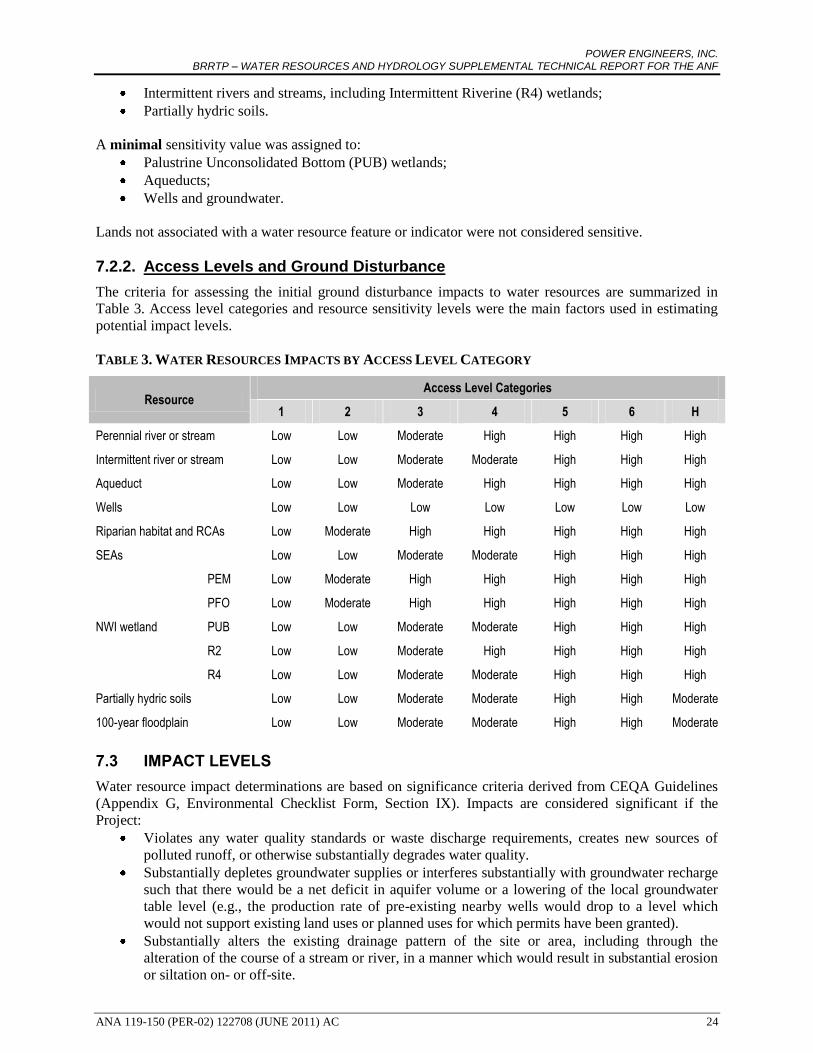
POWER ENGINEERS, INC. BRRTP – WATER RESOURCES AND HYDROLOGY SUPPLEMENTAL TECHNICAL REPORT FOR THE ANF
ANA 119-150 (PER-02) 122708 (JUNE 2011) AC 24
Intermittent rivers and streams, including Intermittent Riverine (R4) wetlands;
Partially hydric soils.
A minimal sensitivity value was assigned to:
Palustrine Unconsolidated Bottom (PUB) wetlands;
Aqueducts;
Wells and groundwater.
Lands not associated with a water resource feature or indicator were not considered sensitive.
7.2.2. Access Levels and Ground Disturbance
The criteria for assessing the initial ground disturbance impacts to water resources are summarized in
Table 3. Access level categories and resource sensitivity levels were the main factors used in estimating
potential impact levels.
TABLE 3. WATER RESOURCES IMPACTS BY ACCESS LEVEL CATEGORY
Resource Access Level Categories
1 2 3 4 5 6 H
Perennial river or stream Low Low Moderate High High High High
Intermittent river or stream Low Low Moderate Moderate High High High
Aqueduct Low Low Moderate High High High High
Wells Low Low Low Low Low Low Low
Riparian habitat and RCAs Low Moderate High High High High High
SEAs Low Low Moderate Moderate High High High
NWI wetland
PEM Low Moderate High High High High High
PFO Low Moderate High High High High High
PUB Low Low Moderate Moderate High High High
R2 Low Low Moderate High High High High
R4 Low Low Moderate Moderate High High High
Partially hydric soils Low Low Moderate Moderate High High Moderate
100-year floodplain Low Low Moderate Moderate High High Moderate
7.3 IMPACT LEVELS
Water resource impact determinations are based on significance criteria derived from CEQA Guidelines
(Appendix G, Environmental Checklist Form, Section IX). Impacts are considered significant if the
Project:
Violates any water quality standards or waste discharge requirements, creates new sources of
polluted runoff, or otherwise substantially degrades water quality.
Substantially depletes groundwater supplies or interferes substantially with groundwater recharge
such that there would be a net deficit in aquifer volume or a lowering of the local groundwater
table level (e.g., the production rate of pre-existing nearby wells would drop to a level which
would not support existing land uses or planned uses for which permits have been granted).
Substantially alters the existing drainage pattern of the site or area, including through the
alteration of the course of a stream or river, in a manner which would result in substantial erosion
or siltation on- or off-site.

POWER ENGINEERS, INC. BRRTP – WATER RESOURCES AND HYDROLOGY SUPPLEMENTAL TECHNICAL REPORT FOR THE ANF
ANA 119-150 (PER-02) 122708 (JUNE 2011) AC 25
Substantially alters the existing drainage pattern of the site or area, including through the
alteration of the course of a stream or river, or substantially increases the rate or amount of
surface runoff in a manner which would result in flooding on- or off-site.
Creates or contributes runoff water which would exceed the capacity of existing or planned
stormwater drainage systems or provides substantial additional sources of polluted runoff.
Has a substantial adverse effect on federally protected wetlands as defined by Section 404 of the
Clean Water Act (including, but not limited to, marsh, vernal pool, coastal, etc.) through direct
removal, filling, hydrological interruption, or other means.
Places housing within a 100-year flood hazard area as mapped on a federal Flood Hazard
Boundary or Flood Insurance Rate Map or other flood hazard delineation map.
Places within a 100-year flood hazard area structures which would impede or redirect flood
flows.
Exposes people or structures to a significant risk of loss, injury or death involving flooding,
including flooding as a result of the failure of a levee or dam.
Results in or is subject to damage from inundation by seiche, tsunami, or mudflow.
7.4 IMPACT ASSESSMENT METHODOLOGY BY PROJECT COMPONENT
All components of the proposed BRRTP are described in this section; however, for the purposes of this
report, only potential impacts related to those components that would cross through the ANF, or that
would affect watersheds within the ANF, will be discussed hereafter. For details regarding impact
assessment for those components and sections of the BRRTP that would be located outside the ANF,
please refer to the Water Resources Technical Report.
7.4.1. 230 kV Transmission Line
To assess impacts to water resources associated with the new 230 kV transmission line, each water
resource within 0.5 mile of the proposed centerline was mapped at a scale of 1:24,000 using GIS. Based
on this map, location-specific analyses of temporary and permanent impacts could be made, and after
considering the inherent sensitivity of perennial streams, intermittent streams, NWI wetlands, and other
water resources that could be affected, a determination was made of whether high, moderate, or low
impacts would result. This analysis was conducted throughout all Project Alternatives.
For each of the initially proposed segments, the presence of streams, wetlands, aqueducts, wells, riparian
habitat, RCAs, hydric soils, and 100-year floodplains within one-half mile of the centerline was
determined to the nearest tenth of a mile, and mile marker begin/end points were recorded. Permanent and
temporary impacts to each resource (in acres) were determined based on the ground disturbance level
applicable to the location evaluated. Permanent disturbance within the ground disturbance areas would be
limited to the tower foundations and the footprint of new access roads. All other ground disturbance
would be temporary.
All initial probable 230 kV component impacts were re-assessed in light of the effectiveness of USFS
BMPs, BRRTP General Practices (GPs) and Mitigation Measures (MMs) to reduce potential impacts. As
summarized in Table 3 above, the initial 230 kV Project impacts were assessed with consideration to the
sensitivity of each water resource type. After assigning initial ground disturbance impact levels for all
water resources traversed by the 0.5-mile corridor for the centerline, BMPs, GPs and MMs were
considered and the degree to which they would reduce the initial impact was evaluated. These BMPs, GPs
and MMs were then applied, as appropriate, to reduce the level of residual impacts to each water resource.
7.4.2. New 230 kV Circuit
In the Castaic Transmission Corridor, LADWP has two existing parallel double-circuit 230 kV towers.
The northern towers hold the Castaic-Olive 230 kV Transmission Line and the second position is vacant.
POWER ENGINEERS, INC. BRRTP – WATER RESOURCES AND HYDROLOGY SUPPLEMENTAL TECHNICAL REPORT FOR THE ANF
ANA 119-150 (PER-02) 122708 (JUNE 2011) AC 26
LADWP proposes the addition of approximately 12 miles of a new 230 kV transmission circuit onto
existing Castaic – Olive 230 kV Transmission Line structures (towers 1-1 through 12-1).
7.4.3. Reconductoring
As part of the BRRTP, LADWP is proposing to upgrade the existing BR-RIN line from the Barren Ridge
Switching Station to the Rinaldi Substation with larger-capacity conductors. Permanent impacts would
occur from rehabilitation of the existing access and spur roads, and clearing of the right-of-way (ROW).
By utilizing the existing structures and ROW, the Project would minimize permanent impacts while
allowing additional transmission capacity along the corridor. Temporary impacts would occur where
equipment staging, line work, or construction traffic access would be needed. Upgrading the existing BR-
RIN would involve approximately 13 miles of USFS lands and four miles of BLM lands.
7.4.4. New Haskell Canyon Switching Station
Ground disturbance at the Haskell Canyon Switching Station site would lead to permanent impacts within
the proposed switching site fence line and associated new access roads. The station would require an area
of approximately 400 feet by 600 feet to accommodate the necessary equipment such as steel support
structures, circuit breakers, disconnect switches, and associated equipment, and a relay house and control
house containing control and protective relaying equipment. Temporary impacts within the area would
occur where equipment staging, line work, or construction traffic access would be needed.
7.4.5. Expansion of Barren Ridge Switching Station
Expansion of the Barren Ridge Switching Station site would lead to permanent impacts within the
proposed site fence line. LADWP proposes expansion of the existing Barren Ridge Switching Station to
the east side by 235 feet by 500 feet for a total station size of 485 feet by 500 feet (approximately 5.6
acres). Existing access roads would be used and permanent impacts would be restricted to the site
expansion. Temporary impacts within the area would occur where equipment staging, line work, or
construction access would be needed.
7.5 IMPACTS AND MITIGATION PLANNING
Potential impacts to water resources include temporary (construction-related) impacts and long-term
(permanent) impacts. When evaluating potential impacts to water resources, it was assumed that the
Project would comply with all applicable federal, state, and local regulatory requirements that protect
surface water and groundwater.
The USFS, Pacific Southwest Region has established water quality protection BMPs and BMP evaluation
protocols for use on Forest lands. The following USFS BMPs will be implemented on Forest lands as part
of the proposed Project:
PRACTICE 2-1: Locate and design roads with minimal resource damage. Roads will be located to fit
the terrain, and to minimize damage to improvements and resources. Sensitive areas such as wetlands,
inner gorges, and unstable ground will be avoided to the extent practical.
PRACTICE 2-2: Erosion Plan. An erosion plan will be included as part of the required SWPPP, and
implemented throughout the Project to limit and mitigate erosion and sedimentation during construction
activities.
PRACTICE 2-3: Timing of construction activities. To minimize erosion and sedimentation, construction
activities will be planned to occur during minimal runoff periods to the extent practical.
PRACTICE 2-4: Stabilization of slope surfaces and spoil disposal areas. To minimize post-construction
erosion from exposed or disturbed work areas, LADWP shall prepare a Restoration and Revegetation

POWER ENGINEERS, INC. BRRTP – WATER RESOURCES AND HYDROLOGY SUPPLEMENTAL TECHNICAL REPORT FOR THE ANF
ANA 119-150 (PER-02) 122708 (JUNE 2011) AC 27
Plan for the project. The Plan shall be incorporated into the Special Use Authorization to be issued by the
USFS.
PRACTICE 2-12: Servicing and refueling of equipment. To prevent pollutants such as fuels, lubricants,
and other harmful materials from being discharged into or near rivers, streams, or wetlands, refueling, or
addition or changing of oil and other fluids for equipment and heavy machinery shall be performed only
at approved staging and construction areas. Staging and construction yards will be located on upland sites
and spill containment measures will be used to minimize risk of spill or drainage into waterways. Oil and
other fluids will be disposed of as required by California law. Emergency refueling, or emergency
addition or changing of oil or other fluids shall not be performed within 500 feet of natural stream
channels or wetlands.
PRACTICE 7-2: Floodplain hazard analysis and evaluation. Structures and new access roads placed
with a 100-year floodplain will be engineered so that they do not impede or redirect flood flows or raise
the flood elevation; in addition, structures located within the 100-year floodplain of rivers and streams
will be designed to minimize the capture of flood debris to prevent flow obstructions and scouring during
flood flows.
PRACTICE 7-3: Protection of wetlands. To avoid adverse water quality impacts associated with
destruction, disturbance, or modification of wetlands, Project features will be places so as to avoid
sensitive features including, but not limited to, riparian areas and water courses. If sensitive water
resource features such as riparian areas, habitats of endangered species, streambeds, and wetlands cannot
be avoided, a qualified biological contractor shall conduct site-specific assessments for each affected site.
These assessments shall be conducted in accordance with USACE wetland delineation guidelines, as well
as California Department of Fish and Game streambed and lake assessment guidelines, and shall include
impact minimization measures to reduce wetland impacts. Staging/storage areas for equipment and
materials shall be located outside of riparian areas. Construction of new access through streambeds that
require filling for access purposes would require a Streambed Alteration Agreement from CDFG and/or
consultation with the USACE.
PRACTICE 7-4: Forest and Hazardous Substance Spill Prevention, Countermeasure, and Control
(SPCC) Plan. To prevent contamination of waters from accidental spills, LADWP will prepare or update
an existing Spill Prevention, Countermeasure, and Control Plan for proposed and/or expanded switching
stations if necessary or required by EPA guidelines. The plans will include engineered and operational
methods for preventing, containing, and controlling potential fluid releases, and provisions for quick and
safe cleanup.
PRACTICE 7-5: Control of activities under Special Use Permit. To protect surface and subsurface water
quality from physical, chemical, and biological pollutants resulting from activities that are under Special
Use Permit, the Project will comply with conditions of the Permit, including management requirements
and mitigation measures necessary to protect water quality. The Project will also conform to all applicable
State and local regulations governing water quality and sanitation.
PRACTICE 7-6: Water quality monitoring. A water quality monitoring plan will be prepared as part of
the required SWPPP. Analysis of the data will be performed by a State-certified laboratory, trained Forest
personnel, or combinations of these as appropriate.
PRACTICE 7-7: Management by closure to use (seasonal, temporary, and permanent). If the condition
of a watershed becomes sensitive to the extent that any use during a given portion of year could result in
soil and/or land stability problems and associated adverse effects could adversely affect water quality, the
Forest Supervisor, District Ranger, or Forest Service Officer responsible for resource protection may
determine that a particular resource needs protection from use and decide to close an area. This would
occur only after an evaluation of alternative methods of protection dictate that closure is the required
action, and is usually a last step protective measure.

POWER ENGINEERS, INC. BRRTP – WATER RESOURCES AND HYDROLOGY SUPPLEMENTAL TECHNICAL REPORT FOR THE ANF
ANA 119-150 (PER-02) 122708 (JUNE 2011) AC 28
In addition to the USFS BMPs, the GPs described in Table 4 below are measures that would be included
in the Project description and implemented as part of the proposed Project.
Impact analysis assumed that all BMPs and GPs would be implemented as defined. The specifically
recommended Mitigation Measures described in Table 5 below would be used on a site-specific basis to
minimize Project-related impacts if it is determined that BMPs and GPs would not fully mitigate the
impacts for which they are presented.
TABLE 4. GENERAL PRACTICES
Plans
GP-1
Plan of Development & Construction, Operation and Maintenance Plans. In consultation with the Forest Service and BLM Authorizing Officers prior to construction, LADWP shall develop a Construction, Operation and Maintenance Plan (COM Plan) with the Forest Service and Plan of Development (POD) with BLM. These plans shall be attached to and become a part of the Special Use and Right-of-Way Authorizations. The COM Plan and POD shall include, at a minimum, road maintenance specifications, vegetation treatment and rehabilitation specifications, and conditions on maintenance and replacement of improvements. The agencies may combine the POD and COM plans into a single document for the Project.
GP-3
Hazardous Materials/Waste Management Plan. A project-specific hazardous materials management and hazardous waste management program will be developed prior to initiation of the project. The program will outline proper hazardous materials use, storage and disposal requirements as well as hazardous waste management procedures. The program will identify types of hazardous materials to be used during the project and the types of wastes that will be generated. All project personnel will be provided with project-specific training. This program will be developed to ensure that all hazardous materials and wastes were handled in a safe and environmentally sound manner. Hazardous wastes will be handled and disposed of according to applicable rules and regulations. Employees handling wastes will receive hazardous materials training and shall be trained in hazardous waste procedures, spill contingencies, waste minimization procedures and Treatment, Storage and Disposal Facility (TSDF) training in accordance with OSHA Hazard Communication Standard and 22 CCR. If degraded soil or groundwater is encountered during excavation (e.g., there is an obvious sheen, odor, or unnatural color to the soil or groundwater), it shall be excavated, tested, and disposed of in accordance with state hazardous waste disposal requirements. The Plan shall also include procedures detailing emergency responses to releases of hazardous materials. It will prescribe hazardous materials handling procedures for reducing the potential for a spill during construction, and will include an emergency response program to ensure quick and safe cleanup of accidental spills. All hazardous materials spills or threatened release, including petroleum products such as gasoline, diesel, and hydraulic fluid, regardless of the quantity spilled, will be immediately reported to the appropriate agency as outlined in the Plan if the spill has entered a navigable water, stream, lake, wetland, or storm drain, if the spill impacted any sensitive area including conservation areas and wildlife preserves, or if the spill caused injury to a person or threatens injury to public health. All construction personnel, including environmental monitors, will be aware of state and federal emergency response reporting guidelines.
GP-5
Stormwater Pollution Prevention Plan. A project-specific Construction Stormwater Pollution Prevention Plan (SWPPP) will be prepared and implemented prior to the start of construction. The SWPPP will utilize Best Management Practices (BMPs) to address the storage and handling of hazardous materials and sediment runoff during construction activities.
GP-6
Spill Prevention, Countermeasure, and Control Plan. LADWP will prepare or update existing Spill Prevention, Countermeasure, and Control Plan (SPCC Plan) for proposed and/or expanded switching stations if necessary or required by EPA guidelines. The plans will include engineered and operational methods for preventing, containing, and controlling potential fluid releases, and provisions for quick and safe cleanup.
GP-7
Soil Management Plan. A Soil Management Plan will be developed and implemented for construction of the proposed Project. The objective of the Soil Management Plan is to provide guidance for the proper handling, onsite management, and disposal of impacted soil that might be encountered during construction activities. The plan will include practices that are consistent with California Title 8, Occupational Safety and Health Administration (Cal-OSHA) regulations, as well as appropriate remediation standards that are

POWER ENGINEERS, INC. BRRTP – WATER RESOURCES AND HYDROLOGY SUPPLEMENTAL TECHNICAL REPORT FOR THE ANF
ANA 119-150 (PER-02) 122708 (JUNE 2011) AC 29
protective of the planned use. The Plan will provide guidelines for identification of impacted soil, assessing impacted soil, soil excavation, impacted soil storage, verification sampling, and impacted soil characterization and disposal. In the event that potentially contaminated soils are encountered within the footprint of construction, soils will be tested and stockpiled. The appropriate Certified Unified Program Agency (CUPA) will determine whether further assessment is warranted.
Design
GP-11
Project features will be placed so as to avoid sensitive features including, but not limited to, riparian areas, water courses, and cultural sites, and/or to allow conductors to clearly span the features, within limits of standard tower design. This will minimize the amount of sensitive features disturbed and/or reduce visual contrast.
GP-12 Drainage control features will be installed, as appropriate, to minimize the amount of stormwater flow from areas of active construction. Details would be described in the SWPPP.
Construction Vehicles/Equipment
GP-15 All trucks hauling soils or other loose materials shall be covered, or maintain at least two feet of freeboard (distance between the material and the top of the truck).
GP-16 Where visible soil material is carried onto adjacent public streets, the affected streets shall be cleaned daily with water sweepers.
GP-17 All vehicles and equipment operating within 100 feet of an active stream will be inspected daily to ensure they are free of any leaks of fuel, cooling, or lubricating fluids.
GP-18 All construction vehicles shall maintain a hazardous materials spill kit, which shall include absorbent materials, tarps, small storage containers or waterproof bags, and latex gloves. Field personnel shall be made aware of these kits and instructed on how to use them.
GP-19
Refueling, or addition or changing of oil and other fluids for equipment and heavy machinery shall be performed only at approved staging and construction yards. Staging and construction yards will be located on upland sites and spill containment measures will be used to minimize risk of spill or drainage into waterways. Oil and other fluids will be disposed of as required by California law. Emergency refueling, or emergency addition or changing of oil or other fluids shall not be performed within 500 feet of natural stream channels or wetlands.
GP-20
Helicopters utilized for construction will be refueled at helicopter staging areas or local airports. Procedures will include the use of drop cloths made of plastic and drip pans and trays to be placed under refilling areas to ensure that chemicals do not come into contact with the ground. Refueling areas will be located in designated areas where absorbent pads and trays are available.
Access Roads
GP-23 The alignment of any new access roads or overland routes shall follow the designated area’s landform contours where possible, providing that such alignment does not additionally impact resource values.
GP-24 To the extent practical, any re-grading of access roads shall be the minimum necessary to provide safe access of construction equipment, and erosion control measures.
GP-25 Construction vehicles shall use paved roads to access the construction site when available.
GP-33 In areas where soils and vegetation are particularly sensitive to disturbance, existing access roads would be repaired only in areas where they are otherwise impassable or unsafe.
Construction Areas
GP-34 Construction activities shall be limited to the designated right-of-way and approved access and work areas as identified in the ROD and POD. Any deviations from the approved areas must be cleared with the jurisdictional agency and/or landowner.
GP-35 Grading areas shall be clearly marked and no equipment or vehicles shall disturb slopes or drainages outside of the grading area.
GP-36 No paint or permanent discoloring agents will be applied to rocks or vegetation to indicate survey or construction activity limits.
GP-37
In construction areas (e.g., marshalling yards, tower sites, spur roads from existing access roads) where ground disturbance is significant or where recontouring is required, surface restoration shall occur as required by the landowner or land management agency. The method of restoration will normally consist of returning disturbed areas back to their natural contour, reseeding, installing cross drains for erosion control as necessary, placing water bars in the road as necessary, and filling ditches.
GP-38
Soil excavated from construction activities shall not be left at work areas where the slopes exceed 10 percent or where the work area is within 100 feet of a natural stream or waterbody (receiving water). In these situations, loose soil shall be used elsewhere within the immediate area or stockpiled at the staging area. Stockpiled soil shall be managed as required by the SWPPP. No stockpiling or spreading of soil or
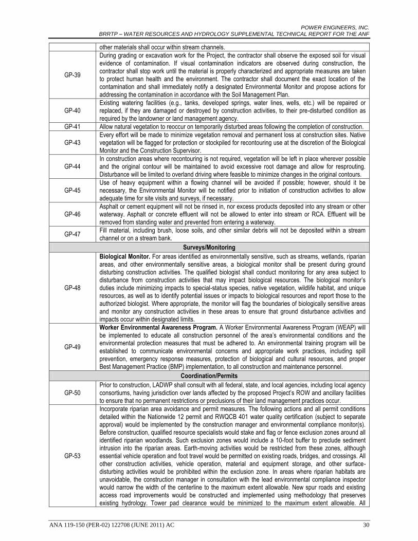
POWER ENGINEERS, INC. BRRTP – WATER RESOURCES AND HYDROLOGY SUPPLEMENTAL TECHNICAL REPORT FOR THE ANF
ANA 119-150 (PER-02) 122708 (JUNE 2011) AC 30
other materials shall occur within stream channels.
GP-39
During grading or excavation work for the Project, the contractor shall observe the exposed soil for visual evidence of contamination. If visual contamination indicators are observed during construction, the contractor shall stop work until the material is properly characterized and appropriate measures are taken to protect human health and the environment. The contractor shall document the exact location of the contamination and shall immediately notify a designated Environmental Monitor and propose actions for addressing the contamination in accordance with the Soil Management Plan.
GP-40 Existing watering facilities (e.g., tanks, developed springs, water lines, wells, etc.) will be repaired or replaced, if they are damaged or destroyed by construction activities, to their pre-disturbed condition as required by the landowner or land management agency.
GP-41 Allow natural vegetation to reoccur on temporarily disturbed areas following the completion of construction.
GP-43 Every effort will be made to minimize vegetation removal and permanent loss at construction sites. Native vegetation will be flagged for protection or stockpiled for recontouring use at the discretion of the Biological Monitor and the Construction Supervisor.
GP-44 In construction areas where recontouring is not required, vegetation will be left in place wherever possible and the original contour will be maintained to avoid excessive root damage and allow for resprouting. Disturbance will be limited to overland driving where feasible to minimize changes in the original contours.
GP-45 Use of heavy equipment within a flowing channel will be avoided if possible; however, should it be necessary, the Environmental Monitor will be notified prior to initiation of construction activities to allow adequate time for site visits and surveys, if necessary.
GP-46 Asphalt or cement equipment will not be rinsed in, nor excess products deposited into any stream or other waterway. Asphalt or concrete effluent will not be allowed to enter into stream or RCA. Effluent will be removed from standing water and prevented from entering a waterway.
GP-47 Fill material, including brush, loose soils, and other similar debris will not be deposited within a stream channel or on a stream bank.
Surveys/Monitoring
GP-48
Biological Monitor. For areas identified as environmentally sensitive, such as streams, wetlands, riparian areas, and other environmentally sensitive areas, a biological monitor shall be present during ground disturbing construction activities. The qualified biologist shall conduct monitoring for any area subject to disturbance from construction activities that may impact biological resources. The biological monitor’s duties include minimizing impacts to special-status species, native vegetation, wildlife habitat, and unique resources, as well as to identify potential issues or impacts to biological resources and report those to the authorized biologist. Where appropriate, the monitor will flag the boundaries of biologically sensitive areas and monitor any construction activities in these areas to ensure that ground disturbance activities and impacts occur within designated limits.
GP-49
Worker Environmental Awareness Program. A Worker Environmental Awareness Program (WEAP) will be implemented to educate all construction personnel of the area’s environmental conditions and the environmental protection measures that must be adhered to. An environmental training program will be established to communicate environmental concerns and appropriate work practices, including spill prevention, emergency response measures, protection of biological and cultural resources, and proper Best Management Practice (BMP) implementation, to all construction and maintenance personnel.
Coordination/Permits
GP-50 Prior to construction, LADWP shall consult with all federal, state, and local agencies, including local agency consortiums, having jurisdiction over lands affected by the proposed Project’s ROW and ancillary facilities to ensure that no permanent restrictions or preclusions of their land management practices occur.
GP-53
Incorporate riparian area avoidance and permit measures. The following actions and all permit conditions detailed within the Nationwide 12 permit and RWQCB 401 water quality certification (subject to separate approval) would be implemented by the construction manager and environmental compliance monitor(s). Before construction, qualified resource specialists would stake and flag or fence exclusion zones around all identified riparian woodlands. Such exclusion zones would include a 10-foot buffer to preclude sediment intrusion into the riparian areas. Earth-moving activities would be restricted from these zones, although essential vehicle operation and foot travel would be permitted on existing roads, bridges, and crossings. All other construction activities, vehicle operation, material and equipment storage, and other surface-disturbing activities would be prohibited within the exclusion zone. In areas where riparian habitats are unavoidable, the construction manager in consultation with the lead environmental compliance inspector would narrow the width of the centerline to the maximum extent allowable. New spur roads and existing access road improvements would be constructed and implemented using methodology that preserves existing hydrology. Tower pad clearance would be minimized to the maximum extent allowable. All
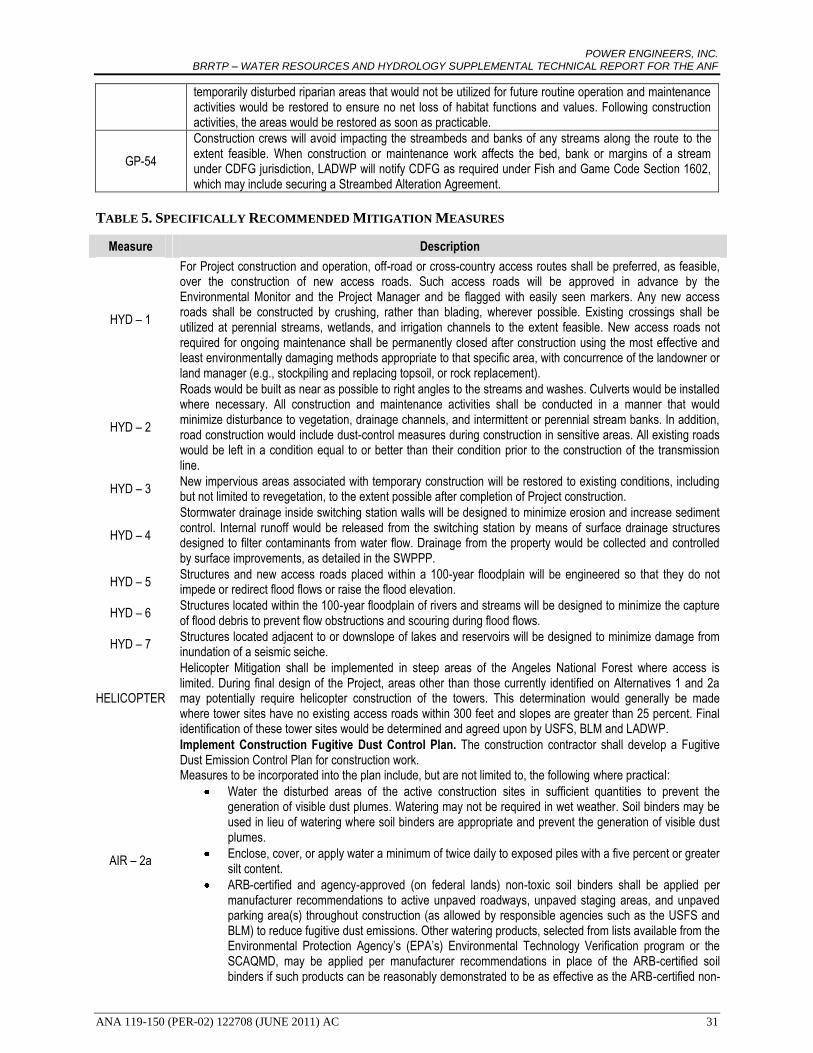
POWER ENGINEERS, INC. BRRTP – WATER RESOURCES AND HYDROLOGY SUPPLEMENTAL TECHNICAL REPORT FOR THE ANF
ANA 119-150 (PER-02) 122708 (JUNE 2011) AC 31
temporarily disturbed riparian areas that would not be utilized for future routine operation and maintenance activities would be restored to ensure no net loss of habitat functions and values. Following construction activities, the areas would be restored as soon as practicable.
GP-54
Construction crews will avoid impacting the streambeds and banks of any streams along the route to the extent feasible. When construction or maintenance work affects the bed, bank or margins of a stream under CDFG jurisdiction, LADWP will notify CDFG as required under Fish and Game Code Section 1602, which may include securing a Streambed Alteration Agreement.
TABLE 5. SPECIFICALLY RECOMMENDED MITIGATION MEASURES
Measure Description
HYD – 1
For Project construction and operation, off-road or cross-country access routes shall be preferred, as feasible, over the construction of new access roads. Such access roads will be approved in advance by the Environmental Monitor and the Project Manager and be flagged with easily seen markers. Any new access roads shall be constructed by crushing, rather than blading, wherever possible. Existing crossings shall be utilized at perennial streams, wetlands, and irrigation channels to the extent feasible. New access roads not required for ongoing maintenance shall be permanently closed after construction using the most effective and least environmentally damaging methods appropriate to that specific area, with concurrence of the landowner or land manager (e.g., stockpiling and replacing topsoil, or rock replacement).
HYD – 2
Roads would be built as near as possible to right angles to the streams and washes. Culverts would be installed where necessary. All construction and maintenance activities shall be conducted in a manner that would minimize disturbance to vegetation, drainage channels, and intermittent or perennial stream banks. In addition, road construction would include dust-control measures during construction in sensitive areas. All existing roads would be left in a condition equal to or better than their condition prior to the construction of the transmission line.
HYD – 3 New impervious areas associated with temporary construction will be restored to existing conditions, including but not limited to revegetation, to the extent possible after completion of Project construction.
HYD – 4
Stormwater drainage inside switching station walls will be designed to minimize erosion and increase sediment control. Internal runoff would be released from the switching station by means of surface drainage structures designed to filter contaminants from water flow. Drainage from the property would be collected and controlled by surface improvements, as detailed in the SWPPP.
HYD – 5 Structures and new access roads placed within a 100-year floodplain will be engineered so that they do not impede or redirect flood flows or raise the flood elevation.
HYD – 6 Structures located within the 100-year floodplain of rivers and streams will be designed to minimize the capture of flood debris to prevent flow obstructions and scouring during flood flows.
HYD – 7 Structures located adjacent to or downslope of lakes and reservoirs will be designed to minimize damage from inundation of a seismic seiche.
HELICOPTER
Helicopter Mitigation shall be implemented in steep areas of the Angeles National Forest where access is limited. During final design of the Project, areas other than those currently identified on Alternatives 1 and 2a may potentially require helicopter construction of the towers. This determination would generally be made where tower sites have no existing access roads within 300 feet and slopes are greater than 25 percent. Final identification of these tower sites would be determined and agreed upon by USFS, BLM and LADWP.
AIR – 2a
Implement Construction Fugitive Dust Control Plan. The construction contractor shall develop a Fugitive Dust Emission Control Plan for construction work. Measures to be incorporated into the plan include, but are not limited to, the following where practical:
Water the disturbed areas of the active construction sites in sufficient quantities to prevent the generation of visible dust plumes. Watering may not be required in wet weather. Soil binders may be used in lieu of watering where soil binders are appropriate and prevent the generation of visible dust plumes.
Enclose, cover, or apply water a minimum of twice daily to exposed piles with a five percent or greater silt content.
ARB-certified and agency-approved (on federal lands) non-toxic soil binders shall be applied per manufacturer recommendations to active unpaved roadways, unpaved staging areas, and unpaved parking area(s) throughout construction (as allowed by responsible agencies such as the USFS and BLM) to reduce fugitive dust emissions. Other watering products, selected from lists available from the Environmental Protection Agency’s (EPA’s) Environmental Technology Verification program or the SCAQMD, may be applied per manufacturer recommendations in place of the ARB-certified soil binders if such products can be reasonably demonstrated to be as effective as the ARB-certified non-

POWER ENGINEERS, INC. BRRTP – WATER RESOURCES AND HYDROLOGY SUPPLEMENTAL TECHNICAL REPORT FOR THE ANF
ANA 119-150 (PER-02) 122708 (JUNE 2011) AC 32 ANA 119-150 (PER-02) 122708 (JUNE 2011) AC 32
Measure Description
toxic soil binders and be approved by the affected federal agency.
Water all roads used for any vehicular traffic at least once per every two hours of active operations [3 times per normal 8-hour work day]; OR Water all roads used for any vehicular traffic once daily and restrict vehicle speeds to 15 miles per hour. Apply a chemical stabilizer to all unpaved road surfaces in sufficient quantity and frequency to maintain a stabilized surface, to reduce fugitive dust emissions.
All vehicle tires shall be inspected, are to be free of dirt, and washed as necessary prior to entering paved roadways. In lieu of washing vehicle tires, the construction contractor may sweep roads on a regular basis or employ similar methods to reduce dust track-out.
Install wheel washers or wash the wheels of trucks and other heavy equipment where vehicles exit unpaved areas.
Cover all trucks hauling soil and other loose material, or require at least two feet of freeboard.
Establish a vegetative ground cover (in compliance with biological resources impact mitigation measures) as appropriate or otherwise create stabilized surfaces on all unpaved areas at each of the construction sites after active construction operations have ceased.
Increase the frequency of watering unpaved surfaces under active construction to more than three times daily, or implement other additional fugitive dust mitigation measures, to all active disturbed fugitive dust emission sources as required by SCAQMD Rule 403 prior to wind events.
Travel routes to each construction site shall be developed to minimize unpaved road travel.
AIR – 2b Properly Maintain Mechanical Equipment. The construction contractor shall ensure that all mechanical equipment associated with Project construction is properly tuned and maintained in accordance with the manufacturer’s specifications to the extent feasible.
AIR – 2f
Off-road Diesel-fueled Equipment Standards. All off-road construction diesel engines not registered under ARB’s Statewide Portable Equipment Registration Program, which have a rating of 50 horsepower (hp) or more, shall meet, at a minimum, the Tier 2 California Emission Standards for Off-Road Compression-Ignition Engines as specified in California Code of Regulations, Title 13, Section 2423(b)(1) unless such engine is not available for a particular item of equipment. In the event a Tier 2 engine is not available for any off-road engine larger than 100 hp, that engine shall be equipped with a Tier 1 engine. In the event a Tier 1 engine is not available for any off-road engine larger than 100 hp, that engine shall be equipped with a catalyzed diesel particulate filter (soot filter), unless certified by engine manufacturers that the use of such devices is not practical for specific engine types. Equipment properly registered under and in compliance with ARB’s Statewide Portable Equipment Registration Program are in compliance with this mitigation measure.
BIO – 1
Provide restoration/compensation for impacted sensitive vegetation communities.
1a. The intent of this mitigation measure is to require LADWP to restore disturbed sites to pre-construction conditions or the desired future conditions per the Angeles National Forest (ANF) Land Management Plan (LMP). Prior to construction LADWP shall have a qualified biologist, where concurrence on the biologist has been provided by the USFS and BLM, document the community type and acreage of vegetation that would be subject to Project disturbance. Impacts to all oaks and native trees will be documented by identifying the species, number, location, and diameter at breast height (DBH). On non-federal lands, all protection and replacement measures shall be consistent with applicable local jurisdiction requirements, such as the Los Angeles County Oak Tree Ordinance. Tree removal shall not be permitted until replacement trees have been planted or transplanting sites are approved. 1) For NFS and BLM lands, the USFS and BLM shall prepare a Habitat Restoration and Revegetation
Plan, in discussion with LADWP, for the Project, which shall include plans for restoration, enhancement/re-vegetation and/or mitigation banking. For non-federal lands, LADWP shall prepare the Habitat Restoration and Revegetation Plan. Both plans shall include at minimum: (a) the location of the mitigation site (off-site mitigation may be required); (b) locations and details for topsoil storage; (c) the plant species to be used; (d) seed and cutting collecting guidelines; (d) a schematic depicting the mitigation area; (e) time of year that the planting will occur and the methodology of the planting; (f) a description of the irrigation methodology for container, bare-root or other planting needing irrigation; (g) measures to control exotic vegetation on site; (h) success criteria; (i) a detailed monitoring program;( j) locations and impacts to all oaks and native trees (over 3 inches DBH); (k) locations of temporary or permanent gates, barricades, or other means to control unauthorized vehicle access on access and spur roads as deemed necessary by the USFS and BLM (NFS and BLM lands only).
2) LADWP shall utilize a USFS/BLM approved locally collected seed mix, locally collected cuttings, bare-root stock, etc. to revegetate areas disturbed by construction activities. All habitats dominated by non-native species prior to Project disturbance shall be revegetated using appropriate native species.
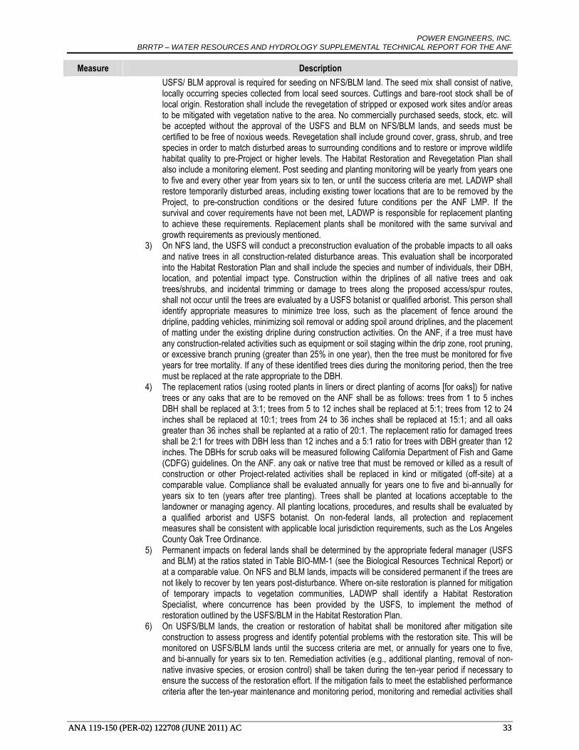
POWER ENGINEERS, INC. BRRTP – WATER RESOURCES AND HYDROLOGY SUPPLEMENTAL TECHNICAL REPORT FOR THE ANF
ANA 119-150 (PER-02) 122708 (JUNE 2011) AC 33 ANA 119-150 (PER-02) 122708 (JUNE 2011) AC 33
Measure Description
USFS/ BLM approval is required for seeding on NFS/BLM land. The seed mix shall consist of native, locally occurring species collected from local seed sources. Cuttings and bare-root stock shall be of local origin. Restoration shall include the revegetation of stripped or exposed work sites and/or areas to be mitigated with vegetation native to the area. No commercially purchased seeds, stock, etc. will be accepted without the approval of the USFS and BLM on NFS/BLM lands, and seeds must be certified to be free of noxious weeds. Revegetation shall include ground cover, grass, shrub, and tree species in order to match disturbed areas to surrounding conditions and to restore or improve wildlife habitat quality to pre-Project or higher levels. The Habitat Restoration and Revegetation Plan shall also include a monitoring element. Post seeding and planting monitoring will be yearly from years one to five and every other year from years six to ten, or until the success criteria are met. LADWP shall restore temporarily disturbed areas, including existing tower locations that are to be removed by the Project, to pre-construction conditions or the desired future conditions per the ANF LMP. If the survival and cover requirements have not been met, LADWP is responsible for replacement planting to achieve these requirements. Replacement plants shall be monitored with the same survival and growth requirements as previously mentioned.
3) On NFS land, the USFS will conduct a preconstruction evaluation of the probable impacts to all oaks and native trees in all construction-related disturbance areas. This evaluation shall be incorporated into the Habitat Restoration Plan and shall include the species and number of individuals, their DBH, location, and potential impact type. Construction within the driplines of all native trees and oak trees/shrubs, and incidental trimming or damage to trees along the proposed access/spur routes, shall not occur until the trees are evaluated by a USFS botanist or qualified arborist. This person shall identify appropriate measures to minimize tree loss, such as the placement of fence around the dripline, padding vehicles, minimizing soil removal or adding spoil around driplines, and the placement of matting under the existing dripline during construction activities. On the ANF, if a tree must have any construction-related activities such as equipment or soil staging within the drip zone, root pruning, or excessive branch pruning (greater than 25% in one year), then the tree must be monitored for five years for tree mortality. If any of these identified trees dies during the monitoring period, then the tree must be replaced at the rate appropriate to the DBH.
4) The replacement ratios (using rooted plants in liners or direct planting of acorns [for oaks]) for native trees or any oaks that are to be removed on the ANF shall be as follows: trees from 1 to 5 inches DBH shall be replaced at 3:1; trees from 5 to 12 inches shall be replaced at 5:1; trees from 12 to 24 inches shall be replaced at 10:1; trees from 24 to 36 inches shall be replaced at 15:1; and all oaks greater than 36 inches shall be replanted at a ratio of 20:1. The replacement ratio for damaged trees shall be 2:1 for trees with DBH less than 12 inches and a 5:1 ratio for trees with DBH greater than 12 inches. The DBHs for scrub oaks will be measured following California Department of Fish and Game (CDFG) guidelines. On the ANF. any oak or native tree that must be removed or killed as a result of construction or other Project-related activities shall be replaced in kind or mitigated (off-site) at a comparable value. Compliance shall be evaluated annually for years one to five and bi-annually for years six to ten (years after tree planting). Trees shall be planted at locations acceptable to the landowner or managing agency. All planting locations, procedures, and results shall be evaluated by a qualified arborist and USFS botanist. On non-federal lands, all protection and replacement measures shall be consistent with applicable local jurisdiction requirements, such as the Los Angeles County Oak Tree Ordinance.
5) Permanent impacts on federal lands shall be determined by the appropriate federal manager (USFS and BLM) at the ratios stated in Table BIO-MM-1 (see the Biological Resources Technical Report) or at a comparable value. On NFS and BLM lands, impacts will be considered permanent if the trees are not likely to recover by ten years post-disturbance. Where on-site restoration is planned for mitigation of temporary impacts to vegetation communities, LADWP shall identify a Habitat Restoration Specialist, where concurrence has been provided by the USFS, to implement the method of restoration outlined by the USFS/BLM in the Habitat Restoration Plan.
6) On USFS/BLM lands, the creation or restoration of habitat shall be monitored after mitigation site construction to assess progress and identify potential problems with the restoration site. This will be monitored on USFS/BLM lands until the success criteria are met, or annually for years one to five, and bi-annually for years six to ten. Remediation activities (e.g., additional planting, removal of non-native invasive species, or erosion control) shall be taken during the ten-year period if necessary to ensure the success of the restoration effort. If the mitigation fails to meet the established performance criteria after the ten-year maintenance and monitoring period, monitoring and remedial activities shall

POWER ENGINEERS, INC. BRRTP – WATER RESOURCES AND HYDROLOGY SUPPLEMENTAL TECHNICAL REPORT FOR THE ANF
ANA 119-150 (PER-02) 122708 (JUNE 2011) AC 34 ANA 119-150 (PER-02) 122708 (JUNE 2011) AC 34
Measure Description
extend beyond the ten-year period until the criteria are met or unless otherwise specified by the USFS/BLM (as appropriate). If a fire occurs in a revegetation area within the ten-year monitoring period, LADWP shall be responsible for a one-time replacement. If a second fire occurs, no replanting is required, unless the fire is caused by LADWP activity. Off-site mitigation for NFS/BLM and non-NFS/BLM lands may be required if mitigation rates exceed what can be achieved on NFS/BLM land. This may be in the form of funding for land purchase for inclusion into the Angeles National Forest, mitigation banking, removing existing structures, or comparable restoration efforts.
1b. During and after construction, USFS/BLM-identified entrances to access roads on NFS/BLM lands shall be gated or blockaded in some manner and maintained to prevent the unauthorized use of these roads by the general public. Signs prohibiting unauthorized use of the access roads shall be posted on these gates.
1c. Treat cut tree stumps with Sporax. All stumps of trees (conifers and hardwoods) resulting from activities associated with construction of the Project shall be treated with Sporax according to product directions to prevent the spread of annosus root disease. Only licensed applicators shall apply Sporax. Sporax shall not be used during rain events unless otherwise approved by the USFS.
BIO – 2
The following prescriptions would prevent the spread of invasive weeds into previously uninfested areas in the designated construction right-of-way.
2a Prepare and implement a Weed Control Plan. LADWP/ANF/BLM shall prepare and implement a comprehensive, adaptive Weed Control Plan on NFS/BLM lands for pre-construction and construction invasive weed abatement. The long-term Weed Control Plan, including monitoring and eradication, will be defined as part of the 50 year Operations and Maintenance Permit. On the ROW easement lands administered by the USFS/BLM, the Weed Control Plan shall incorporate all appropriate and legal agency-stipulated regulations. The Weed Control Plan shall be submitted to the USFS/BLM for final authorization of weed control methods, practices, and timing prior to implementation of the Weed Control Plan on public lands. Weed control on BLM lands using pesticides will require an approved BLM Pesticide Use Permit. Pesticide Use Permits are issued for a maximum of three years. ROW easements located on private lands shall include adaptive provisions such as wheel and equipment washing for the implementation of the Weed Control Plan. The Weed Control Plan shall include the following:
1) A pre-construction weed inventory shall be conducted on NFS and BLM lands by surveying all areas subject to ground-disturbing activity, including, but not limited to, tower pad preparation and construction areas, tower removal sites, pulling and tensioning sites, assembly yards, and areas subject to grading for new or improved access and spur roads. Weed populations that: (1) are rated High or Moderate for negative ecological impact in the California Invasive Plant Inventory Database (Cal-IPC 2006); (2) aid and promote the spread of wildfires (such as cheatgrass, Saharan mustard, and medusa head); and (3) are considered by the USFS and/or BLM as species of priority (for NFS/BLM lands only) shall be mapped and described according to density and area covered. In areas subject to ground disturbance, weed infestations shall be treated prior to construction according to control methods and practices for invasive weed populations designed in consultation with the USFS/BLM. The Weed Control Plan shall be updated and utilized for eradication and monitoring post-construction.
2) Weed control treatments shall include all legally permitted herbicide, manual, and mechanical methods applied with the authorization of the USFS/BLM. The application of herbicides shall be in compliance with all State and federal laws and regulations under the prescription of a Pest Control Advisor (PCA), where concurrence has been provided by the USFS/BLM, and implemented by a Licensed Qualified Applicator. Herbicides shall not be applied during or within 72 hours of a scheduled rain event. Herbicides shall not be used within Riparian Conservation Areas (RCAs) on the ANF without approval of the USFS. In riparian areas, only water-safe herbicides shall be used. Herbicides shall not be applied when wind velocities exceed 6 mph. Where manual and/or mechanical methods are used, disposal of the plant debris will follow the regulations set by the USFS/BLM. The timing of the weed control treatment shall be determined for each plant species in consultation with the USFS/BLM (on NFS/BLM lands) with the goal of controlling populations before they start producing seeds.
For the preconstruction and construction of the Project, measures to control the introduction and spread of noxious weeds in the Project work area shall be taken as follows. 3) On the ANF and BLM lands, surveying for new invasive weed populations and the monitoring of
identified and treated populations shall be required at all sites impacted by construction (tower pads, staging areas, landing zones, etc.), including access/spur roads disturbed during the Project.

POWER ENGINEERS, INC. BRRTP – WATER RESOURCES AND HYDROLOGY SUPPLEMENTAL TECHNICAL REPORT FOR THE ANF
ANA 119-150 (PER-02) 122708 (JUNE 2011) AC 35 ANA 119-150 (PER-02) 122708 (JUNE 2011) AC 35
Measure Description
Surveying and monitoring for weed infestations shall occur annually for years one to five and bi-annually for years six to ten, or until success criteria are met. Treatment of all identified weed populations shall occur at an appropriate interval so as to meet the success criteria. When no new seedlings or resprouts are observed at treated sites for three consecutive, normal rainfall years, the weed population can be considered eradicated and weed control efforts may cease for that impact site.
4) During Project preconstruction and construction, all seeds and straw materials shall be weed-free rice straw, and all gravel and fill material shall be certified weed-free by the county Agriculture Commissioners’ Offices. Any deviation from this must be approved by a USFS/BLM botanist. All plant materials used during restoration shall be native, certified weed-free, and approved by the USFS/BLM.
5) Prior to beginning preconstruction activities, the USFS, in coordination with LADWP, will determine suitable locations to install field washing stations as part of the Weed Control Plan. Prior to commencing construction activities, LADWP shall document that all vehicles, equipment, and tools used on the Project have been cleaned at existing construction yards or legally operating car washes. This is a one-time requirement designed to address the potential of new species of weeds being transported from outside the area. If, however, vehicles, equipment, or tools are used or driven off paved roads on non-NFS lands, washing must occur prior to entering USFS lands.
During Project preconstruction and construction, all vehicles, equipment, or tools which will be used outside of permitted Project roadways shall be washed at the nearest station before operating off-road. In other areas also designated by the USFS, vehicles, equipment, and tools will be washed at the nearest station after exiting those areas. Vehicles that do not leave permitted Project roadways are not required to be washed after the initial washing described above. All washing shall take place where rinse water is collected and disposed of in either a sanitary sewer or landfill, unless otherwise approved by the USFS. Written daily logs shall be kept for all vehicle/equipment/tool washing that states the date, time, location, type of equipment washed, methods used, and staff present. The log shall include the signature of a responsible staff member. Logs shall be available to the USFS for inspection at any time and shall be submitted to the USFS permit administrator on a monthly basis.
6) During Project operation and maintenance activities, weeds shall be cleared and disposed of in assembly yards, helicopter landing areas, tower pads, spur roads, staging areas, and any other disturbance areas in a USFS/BLM-approved method.
2b Remove weed seed sources from construction access routes. Prior to construction, LADWP shall initiate invasive species eradication. Populations to be treated will be small to moderate and isolated, but have the potential to spread aggressively during construction. Post-construction, these isolated populations will be included and treated according to the restoration plan. Per the Forest Service Manual (FSM) 2080 Best Management Practice (BMP) guideline, LADWP shall also remove or reduce sources of weed seed along the travel routes associated with Project construction identified in Appendix L. To prevent the introduction or control the spread of noxious weeds, hand removal or other control methods will be implemented to reduce seed production during Project construction. Following Project approval and during the time of year when weed species can be observed and identified, LADWP shall identify, using a qualified plant ecologist, any other weed seed sources that could contribute to Project-related weed spread on the ANF and BLM lands. Target infestations identified by Project surveys should be controlled prior to construction. LADWP shall initiate eradication of the target infestations discovered during pre-construction surveys along construction routes.
2c Remove weed seed sources from assembly yards, staging areas, tower pads, pull sites, landing zones, and spur roads. Prior to construction and during each year of use for construction at all assembly yards, staging areas, tower pads, pull sites, landing zones, and spur roads within the ANF and BLM lands, weed-infested areas should be hand-weeded and/or treated as appropriate for the individual weed species under the guidance of a qualified plant ecologist or restoration ecologist, where concurrence on the ecologist has been provided by the USFS/BLM. Unless otherwise authorized by the USFS/BLM, weed control efforts in these areas shall be timed annually to reduce shortpod mustard, tocalote, bromes and other noxious weed seed production, by hand-removing or weed-whacking infestations when flowering has just started, but before seeds have been produced. All plant debris shall be disposed of at a USFS/BLM
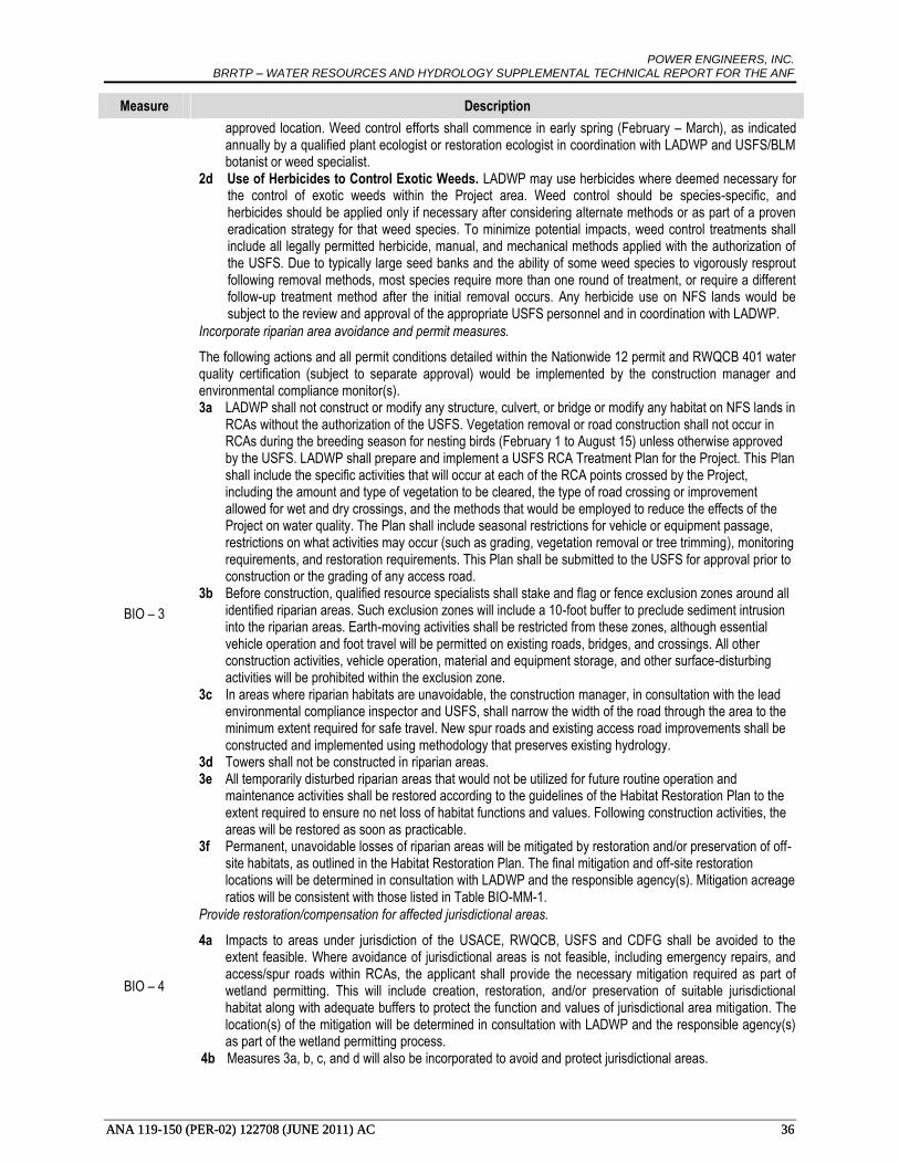
POWER ENGINEERS, INC. BRRTP – WATER RESOURCES AND HYDROLOGY SUPPLEMENTAL TECHNICAL REPORT FOR THE ANF
ANA 119-150 (PER-02) 122708 (JUNE 2011) AC 36 ANA 119-150 (PER-02) 122708 (JUNE 2011) AC 36
Measure Description
approved location. Weed control efforts shall commence in early spring (February – March), as indicated annually by a qualified plant ecologist or restoration ecologist in coordination with LADWP and USFS/BLM botanist or weed specialist.
2d Use of Herbicides to Control Exotic Weeds. LADWP may use herbicides where deemed necessary for the control of exotic weeds within the Project area. Weed control should be species-specific, and herbicides should be applied only if necessary after considering alternate methods or as part of a proven eradication strategy for that weed species. To minimize potential impacts, weed control treatments shall include all legally permitted herbicide, manual, and mechanical methods applied with the authorization of the USFS. Due to typically large seed banks and the ability of some weed species to vigorously resprout following removal methods, most species require more than one round of treatment, or require a different follow-up treatment method after the initial removal occurs. Any herbicide use on NFS lands would be subject to the review and approval of the appropriate USFS personnel and in coordination with LADWP.
BIO – 3
Incorporate riparian area avoidance and permit measures.
The following actions and all permit conditions detailed within the Nationwide 12 permit and RWQCB 401 water quality certification (subject to separate approval) would be implemented by the construction manager and environmental compliance monitor(s). 3a LADWP shall not construct or modify any structure, culvert, or bridge or modify any habitat on NFS lands in
RCAs without the authorization of the USFS. Vegetation removal or road construction shall not occur in RCAs during the breeding season for nesting birds (February 1 to August 15) unless otherwise approved by the USFS. LADWP shall prepare and implement a USFS RCA Treatment Plan for the Project. This Plan shall include the specific activities that will occur at each of the RCA points crossed by the Project, including the amount and type of vegetation to be cleared, the type of road crossing or improvement allowed for wet and dry crossings, and the methods that would be employed to reduce the effects of the Project on water quality. The Plan shall include seasonal restrictions for vehicle or equipment passage, restrictions on what activities may occur (such as grading, vegetation removal or tree trimming), monitoring requirements, and restoration requirements. This Plan shall be submitted to the USFS for approval prior to construction or the grading of any access road.
3b Before construction, qualified resource specialists shall stake and flag or fence exclusion zones around all identified riparian areas. Such exclusion zones will include a 10-foot buffer to preclude sediment intrusion into the riparian areas. Earth-moving activities shall be restricted from these zones, although essential vehicle operation and foot travel will be permitted on existing roads, bridges, and crossings. All other construction activities, vehicle operation, material and equipment storage, and other surface-disturbing activities will be prohibited within the exclusion zone.
3c In areas where riparian habitats are unavoidable, the construction manager, in consultation with the lead environmental compliance inspector and USFS, shall narrow the width of the road through the area to the minimum extent required for safe travel. New spur roads and existing access road improvements shall be constructed and implemented using methodology that preserves existing hydrology.
3d Towers shall not be constructed in riparian areas. 3e All temporarily disturbed riparian areas that would not be utilized for future routine operation and
maintenance activities shall be restored according to the guidelines of the Habitat Restoration Plan to the extent required to ensure no net loss of habitat functions and values. Following construction activities, the areas will be restored as soon as practicable.
3f Permanent, unavoidable losses of riparian areas will be mitigated by restoration and/or preservation of off-site habitats, as outlined in the Habitat Restoration Plan. The final mitigation and off-site restoration locations will be determined in consultation with LADWP and the responsible agency(s). Mitigation acreage ratios will be consistent with those listed in Table BIO-MM-1.
BIO – 4
Provide restoration/compensation for affected jurisdictional areas.
4a Impacts to areas under jurisdiction of the USACE, RWQCB, USFS and CDFG shall be avoided to the extent feasible. Where avoidance of jurisdictional areas is not feasible, including emergency repairs, and access/spur roads within RCAs, the applicant shall provide the necessary mitigation required as part of wetland permitting. This will include creation, restoration, and/or preservation of suitable jurisdictional habitat along with adequate buffers to protect the function and values of jurisdictional area mitigation. The location(s) of the mitigation will be determined in consultation with LADWP and the responsible agency(s) as part of the wetland permitting process.
4b Measures 3a, b, c, and d will also be incorporated to avoid and protect jurisdictional areas.

POWER ENGINEERS, INC. BRRTP – WATER RESOURCES AND HYDROLOGY SUPPLEMENTAL TECHNICAL REPORT FOR THE ANF
ANA 119-150 (PER-02) 122708 (JUNE 2011) AC 37
7.5.1. Types of Impacts
Below are descriptions of the criteria in which an impact would be determined significant.
Construction-related Impacts
Violation of water quality standards, creation of new sources of polluted runoff, or other degradation
of water quality.
Temporary impacts to water quality could result from stormwater runoff during construction of the
Project. Construction of the transmission line and the new Haskell Canyon Switching Station, and
reconductoring of the existing BR-RIN line, would require ground-disturbing activities, including
clearing and grading for structure installation work areas, and access construction. Disturbed soils
accelerate erosion and increase sediment in stormwater runoff to receiving waters, causing increased
turbidity and sedimentation. Dewatering during construction activities could potentially release
contaminated groundwater to surface water channels or drainage features. Additionally, fuel, oil, and
other fluids used in construction vehicles, equipment, and heavy machinery could enter streams and
contaminate water. Potential impacts to water quality from sedimentation, turbidity, and oil/chemical
contamination would be less than significant. Application of GPs, and implementation of PRACTICE 2-
1, 2-2, 2-3, 2-12, 7-4, 7-5, and 7-6, and mitigation measure HYD-1 would further reduce these potential
impacts.
HYD-1 would minimize the potential for erosion, sedimentation, and increased turbidity by restricting
where roads may be sited, minimize the use of blading for new road construction, and requiring the use of
existing stream crossings, where feasible.
Substantial alteration of existing drainage patterns resulting in substantial erosion or siltation on- or
off-site.
Construction of the transmission line and the new Haskell Canyon Switching Station, and reconductoring
of the existing BR-RIN line would require ground-disturbing activities, including clearing and grading for
structure installation work areas, and access construction. This ground disturbance could potentially alter
drainage patterns within the work areas and result in soil erosion leading to increased sedimentation.
Potential impacts resulting from substantial drainage pattern alteration would be significant without
mitigation. Application of GPs, and implementation of PRACTICE 2-1, 2-2, 2-4, and 7-7, and mitigation
measures HYD-1, HYD-2, and HELICOPTER would reduce potential impacts resulting from substantial
drainage pattern alteration to less than significant.
Substantial alteration of existing drainage patterns, including through the alteration of the course of a
stream or river, or substantial increase of the rate or amount of surface runoff in a manner which
would result in flooding on- or off-site.
Construction of the transmission line and the new Haskell Canyon Switching Station, and reconductoring
of the existing BR-RIN line would require ground-disturbing activities, including clearing and grading for
structure installation work areas, and access construction. The proposed transmission lines would cross
numerous streams and drainages, including the Santa Clara River. Ground disturbance related to
construction of the proposed transmission line could potentially alter drainage patterns within the work
areas and result in an increase of the rate or amount of surface water runoff. Potential impacts resulting
from flooding through alteration of existing drainage patterns would be significant without mitigation.
Application of GPs, and implementation of PRACTICE 2-1, 2-2, 7-4, 7-5, and 7-6, and implementation of
mitigation measures HYD-1, HYD-2, and HELICOPTER would reduce potential impacts resulting from
runoff or flooding through alteration of existing drainage patterns to less than significant.
HYD-2 reduces potential impacts to existing drainage patterns of streams and washes by requiring new
permanent or temporary roads to be constructed in a manner that would minimize disturbance to
vegetation, drainage channels, and intermittent or perennial stream banks.
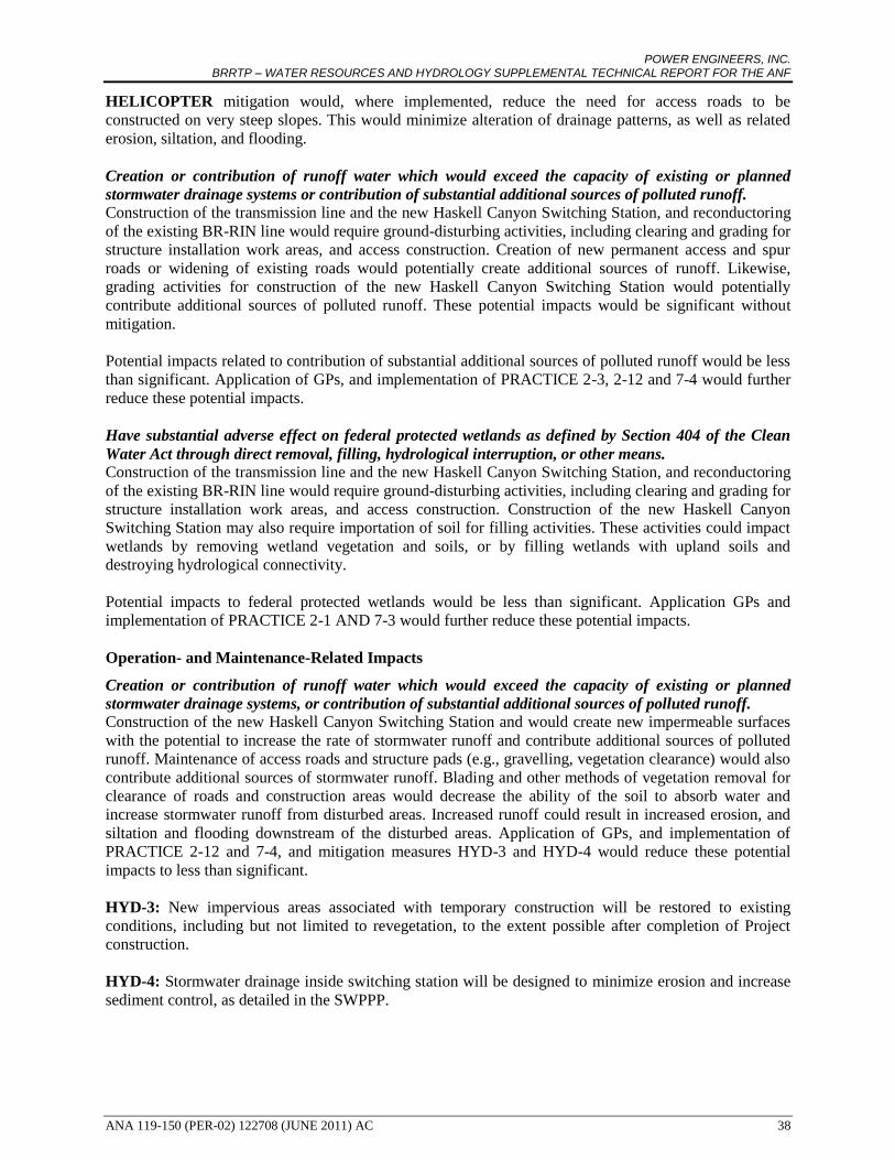
POWER ENGINEERS, INC. BRRTP – WATER RESOURCES AND HYDROLOGY SUPPLEMENTAL TECHNICAL REPORT FOR THE ANF
ANA 119-150 (PER-02) 122708 (JUNE 2011) AC 38
HELICOPTER mitigation would, where implemented, reduce the need for access roads to be
constructed on very steep slopes. This would minimize alteration of drainage patterns, as well as related
erosion, siltation, and flooding.
Creation or contribution of runoff water which would exceed the capacity of existing or planned
stormwater drainage systems or contribution of substantial additional sources of polluted runoff.
Construction of the transmission line and the new Haskell Canyon Switching Station, and reconductoring
of the existing BR-RIN line would require ground-disturbing activities, including clearing and grading for
structure installation work areas, and access construction. Creation of new permanent access and spur
roads or widening of existing roads would potentially create additional sources of runoff. Likewise,
grading activities for construction of the new Haskell Canyon Switching Station would potentially
contribute additional sources of polluted runoff. These potential impacts would be significant without
mitigation.
Potential impacts related to contribution of substantial additional sources of polluted runoff would be less
than significant. Application of GPs, and implementation of PRACTICE 2-3, 2-12 and 7-4 would further
reduce these potential impacts.
Have substantial adverse effect on federal protected wetlands as defined by Section 404 of the Clean
Water Act through direct removal, filling, hydrological interruption, or other means.
Construction of the transmission line and the new Haskell Canyon Switching Station, and reconductoring
of the existing BR-RIN line would require ground-disturbing activities, including clearing and grading for
structure installation work areas, and access construction. Construction of the new Haskell Canyon
Switching Station may also require importation of soil for filling activities. These activities could impact
wetlands by removing wetland vegetation and soils, or by filling wetlands with upland soils and
destroying hydrological connectivity.
Potential impacts to federal protected wetlands would be less than significant. Application GPs and
implementation of PRACTICE 2-1 AND 7-3 would further reduce these potential impacts.
Operation- and Maintenance-Related Impacts
Creation or contribution of runoff water which would exceed the capacity of existing or planned
stormwater drainage systems, or contribution of substantial additional sources of polluted runoff.
Construction of the new Haskell Canyon Switching Station and would create new impermeable surfaces
with the potential to increase the rate of stormwater runoff and contribute additional sources of polluted
runoff. Maintenance of access roads and structure pads (e.g., gravelling, vegetation clearance) would also
contribute additional sources of stormwater runoff. Blading and other methods of vegetation removal for
clearance of roads and construction areas would decrease the ability of the soil to absorb water and
increase stormwater runoff from disturbed areas. Increased runoff could result in increased erosion, and
siltation and flooding downstream of the disturbed areas. Application of GPs, and implementation of
PRACTICE 2-12 and 7-4, and mitigation measures HYD-3 and HYD-4 would reduce these potential
impacts to less than significant.
HYD-3: New impervious areas associated with temporary construction will be restored to existing
conditions, including but not limited to revegetation, to the extent possible after completion of Project
construction.
HYD-4: Stormwater drainage inside switching station will be designed to minimize erosion and increase
sediment control, as detailed in the SWPPP.

POWER ENGINEERS, INC. BRRTP – WATER RESOURCES AND HYDROLOGY SUPPLEMENTAL TECHNICAL REPORT FOR THE ANF
ANA 119-150 (PER-02) 122708 (JUNE 2011) AC 39
Placement of structures within a 100-year flood hazard area which would impede or redirect flood
flows.
Construction of the new 230 kV transmission line would result in the placement of tower structures
within 100-year flood hazard areas. Structures placed in these areas could potentially impede flood flows
or redirect flood flows to areas not currently within a flood hazard area by raising the base flood elevation
level. Implementation of PRACTICE 7-2 and mitigation measures HYD-5 and HYD-6 would reduce
potential impacts resulting from impeding or redirecting flood flows to less than significant.
HYD-5: Structures and new access roads placed within a 100-year floodplain will be engineered so that
they do not impede or redirect flood flows or raise the flood elevation.
HYD-7: Structures located adjacent to lakes and reservoirs will be designed to minimize damage
resulting from inundation from a seismic seiche.
Other Potential Impacts
Potential Project-related impacts resulting from construction, operation, and maintenance were assessed
with regards to the following significance criteria. As discussed below, the Project was determined to
have no impact with regards to these criteria, which will not be discussed hereafter.
Substantial depletion of groundwater supplies or interference with groundwater recharge resulting in a
net deficit of aquifer volume or lowering of level of the local groundwater table.
No Impact. Construction of steel lattice structures for the new transmission line would require concrete
foundations with footings averaging a depth of 20 feet, depending on soil conditions, and construction of
TSPs would require foundations from 15 feet to 30 feet deep, depending on soil conditions.
Aquifers in the BRRTP area are generally unconfined, and depths of water-bearing formations exceed the
distance required for foundations and footings. While there is potential for groundwater to be encountered
during auguring activities along certain segments, dewatering activities are unlikely to deplete
groundwater supplies. Construction, operation, and maintenance of the Project will not interfere with
groundwater recharge or otherwise lower the levels of local groundwater tables.
Placement of housing within a 100-year flood hazard area as mapped on a federal Flood Hazard
Boundary or Flood Insurance Rate Map or other flood hazard delineation map.
No Impact. Construction of the transmission line and the new Haskell Canyon Switching Station, and
reconductoring of the existing BR-RIN line does not involve the placement of housing within a 100-year
flood hazard area.
Exposure of people or structures to a significant risk of loss, injury, or death involving flooding,
including flooding as a result of the failure of a levee or dam.
No Impact. Although segments of the new 230 kV transmission line would be located adjacent to
reservoirs, structures for the transmission line would be sited so that the line would span the area of
hazard (e.g., Castaic Lake). Construction and operation of the Project would not cause or increase the
likelihood of failure of a levee or dam that could result in flooding. As such, the Project would not expose
people or structures to a significant risk of loss, injury, or death involving flooding resulting from the
failure of a levee or dam.

POWER ENGINEERS, INC. BRRTP – WATER RESOURCES AND HYDROLOGY SUPPLEMENTAL TECHNICAL REPORT FOR THE ANF
ANA 119-150 (PER-02) 122708 (JUNE 2011) AC 40
8.0 IMPACT RESULTS
Project-related impacts were initially assessed without reference to USFS BMPs, GPs or MMs. Once
initial impacts were determined using the methodology described in Section 7.0, BMPs, GPs and MMs
were recommended and applied to each impact to minimize potential impacts resulting from construction,
operation, and maintenance of BRRTP.
8.1 ALTERNATIVE 1
The Alternative 1 230 kV double-circuit transmission line would cross approximately 17 miles of ANF
lands, and would affect seven 6th level watersheds: Liebre Gulch-Piru Creek, Lake Piru-Piru Creek, Fish
Creek-Piru Creek, Upper Castaic Creek, Lower Bouquet Creek, Lower Castaic Creek, and San
Francisquito Canyon. These watersheds have a combined area of 182,295 acres.
At the request of the USFS, a RUSLE analysis to estimate the rate of erosion resulting from construction
and operation of the Project was performed for the portion of Alternative 1 that crosses the ANF. The
RUSLE analysis estimated an average post-construction erosion increase of 0.68 percent (48.43
tons/acre/year), assuming no implementation of GPs, BMPs, or MMs. Of the studied watersheds, the
Liebre Gulch-Piru Creek Watershed would have the largest potential increase (2.26 percent) over baseline
conditions from construction of Alternative 1 (please see Appendix A for details of the RUSLE analysis).
The following subwatersheds along Alternative 1 were analyzed via WinTR-55: West Fork Liebre Gulch
(ID2), Big Oak Flat (ID8), and Charlie Canyon (ID13). Results of the analysis indicated there would be
no change in watershed-wide hydrograph characteristics as a result of construction of Alternative 1. In
addition, these results are based on a very conservative approach: subwatersheds delineated to focus on
the Alternative, assumption of 10-meter wide roads, and exclusion of any BMPs that would be mandated
and monitored during construction. For a tabular and graphical representation of the model results for this
subwatershed, please refer to Appendix C, Alternative 2 Results.
In the Forest, adverse effects of Alternative 1 would range from high to low before implementation of
BMPs, GPs, and MMs, depending on the terrain. Alternative 1 would cross or closely parallel multiple
intermittent streams, including West Fork Liebre Gulch, Trough Canyon, Posey Canyon, Big Oak Flat,
Violin Canyon, Bitter Canyon, Charlie Canyon, and Dry Canyon. Alternative 1 would also cross or
parallel approximately 23 RCAs. Alternative 1 would cross steep, rugged terrain (with slopes ranging
from 10 percent to greater than 30 percent) where few roads exist that would be suitable for construction.
Existing roads would have to be improved to allow for safe construction access and new roads would be
constructed in currently roadless areas, increasing the risk of erosion and sedimentation downstream of
disturbance areas; however, utilization of helicopters for construction within the steeper areas would
decrease impacts resulting from erosion and sedimentation.
After implementation of GPs, PRACTICE 2-1, 2-2, 2-3, 2-12, 7-2, 7-4, 7-5, 7-6, and 7-7, and mitigation
measures HYD-1, HYD-2, HYD-3, HYD-4, HYD-5, HYD-6, HYD-7, and HELICOPTER, adverse
effects resulting from construction of Alternative 1 would be less than significant.
8.2 ALTERNATIVE 2
The Alternative 2 230 kV double-circuit transmission line would cross approximately 13 miles of ANF
lands, and would affect three 6th level watersheds: Elizabeth Lake, San Francisquito Canyon, and Lower
Bouquet Canyon. These watersheds have a combined area of 66,181 acres.
For the portion of Alternative 2 that would cross the Forest, the RUSLE analysis estimated an average
post-construction erosion increase of 1.18 percent (44.43 tons/acre/year), assuming no implementation of
GPs, BMPs, or MMs. Of the studied watersheds, the Elizabeth Lake Watershed would have the largest
potential increase (1.59 percent) over baseline conditions from construction of Alternative 2.

POWER ENGINEERS, INC. BRRTP – WATER RESOURCES AND HYDROLOGY SUPPLEMENTAL TECHNICAL REPORT FOR THE ANF
ANA 119-150 (PER-02) 122708 (JUNE 2011) AC 41
Along Alternative 2, the Lake Elizabeth subwatershed (2G1) was analyzed with WinTR-55. Results of the
analysis indicated there would be no change in subwatershed-wide hydrograph characteristics as a result
of construction of Alternative 2. In addition, these results are based on a very conservative approach:
subwatershed delineated to focus on the Alternative, assumption of 10-meter wide roads, and exclusion of
any BMPs that would be mandated and monitored during construction. For a tabular and graphical
representation of the model results for these subwatersheds, please refer to Appendix C, Alternative 2
Results.
In the ANF, adverse effects of Alternative 2 would range from moderate to low before implementation of
BMPs, GPs, and MMs, depending on the terrain. Alternative 2 would cross or closely parallel multiple
intermittent streams, including Portal Canyon, Bee Canyon, Baird Canyon, Dry Canyon, and Pettinger
Canyon. Alternative 2 would also cross or parallel 16 RCAs. Alternative 2 would cross steep, rugged
terrain (with slopes ranging from 10 percent to greater than 30 percent) in relatively roadless areas.
Existing roads would have to be improved to allow for safe construction access and new roads would be
constructed in areas where no roads currently exist, increasing potential for erosion and sedimentation in
areas downstream of disturbance areas.
After implementation of GPs, PRACTICE 2-1, 2-2, 2-3, 2-12, 7-2, 7-3, 7-4, 7-5, 7-6, and 7-7, and
implementation of mitigation measures HYD-1, HYD-2, HYD-3, HYD-4, HYD-5, and HYD-6, potential
adverse effects resulting from construction of Alternative 2 would be less than significant.
8.3 ALTERNATIVE 2A
The Alternative 2a 230 kV double-circuit transmission line would cross approximately 16 miles of ANF
lands, and would affect four 6th level watersheds: Elizabeth Lake, Elizabeth Lake Canyon, San
Francisquito Canyon, and Lower Bouquet Canyon. These watersheds have a combined area of 99,685
acres.
Alternative 2a was developed after completion of the RUSLE analysis; however, given that Alternative 2a
is identical to Alternative 2 with the exception of a deviation to the west around South Portal Canyon, it
may be assumed the average estimated post-construction erosion increase due to construction of
Alternative 2a would be similar to that of Alternative 2, keeping in mind that Alternative 2a would also
cross approximately 0.7 mile of the Elizabeth Lake Canyon Watershed.
Given the overall similarity of Alternative 2a to Alternative 2, the Lake Elizabeth subwatershed (2G1)
was considered as representative of watersheds affected by Alternative 2a, as well as of Alternative 2;
therefore, the Lake Elizabeth subwatershed analysis results for Alternative 2 are applicable to Alternative
2a. As previously described, results of the analysis indicated there would be no change in subwatershed-
wide hydrograph characteristics as a result of construction of Alternative 2a. As formerly discussed, these
results are based on a very conservative approach: subwatershed delineated to focus on the Alternative,
assumption of 10-meter wide roads, and exclusion of any BMPs that would be mandated and monitored
during construction. For a tabular and graphical representation of the model results for this subwatershed,
please refer to Appendix C, Alternative 2 Results.
In the Forest, adverse effects of Alternative 2a would range from high to low before implementation of
BMPs, GPs, and MMs, depending on the terrain. Alternative 2a would cross or closely parallel multiple
intermittent streams, including Bruns Canyon, South Portal Canyon, Munz Canyon, Portal Canyon, Bee
Canyon, Baird Canyon, Dry Canyon, and Pettinger Canyon. Alternative 2a would also cross or parallel 16
RCAs. Alternative 2a would cross steep, rugged terrain (with slopes ranging from 10 percent to greater
than 30 percent) in relatively roadless areas. Existing roads would have to be improved to allow for safe
construction access and new roads would be constructed in areas where no roads currently exist,
increasing potential for erosion and sedimentation in areas downstream of disturbance areas.

POWER ENGINEERS, INC. BRRTP – WATER RESOURCES AND HYDROLOGY SUPPLEMENTAL TECHNICAL REPORT FOR THE ANF
ANA 119-150 (PER-02) 122708 (JUNE 2011) AC 42
In the portion of Alternative 2a that would deviate to the west toward South Portal Canyon, where
existing access is limited or resources are very sensitive, helicopter construction (HELICOPTER) would
be utilized as a general mitigation measure to reduce the need for construction of new access roads for
tower construction. This measure would minimize ground disturbance associated with crane pads,
structure laydown areas, and the need for large construction vehicles and equipment. In certain areas of
the Forest, new temporary access roads may be constructed for access to pulling and tensioning sites and
staging areas.
After implementation of GPs, PRACTICE 2-1, 2-2, 2-3, 2-12, 7-2, 7-3, 7-4, 7-5, 7-6, and 7-7, and
mitigation measures HYD-1, HYD-2, HYD-3, HYD-4, HYD-5, HYD-6, and HELICOPTER, adverse
effects resulting from construction and operation of the Alternative 2a transmission line would be less
than significant.
8.4 ALTERNATIVE 3
The Alternative 3 230 kV double-circuit transmission line would cross approximately 4.7 miles of ANF
lands, and would affect three 6th level watersheds: Agua Dulce Canyon, Mint Canyon, and Upper Bouquet
Canyon. These watersheds have a combined area of 61,995 acres.
For the portion of Alternative 3 that would cross the ANF, the RUSLE analysis estimated an average
post-construction erosion increase of 1.35 percent (35.82 tons/acre/year), assuming no implementation of
GPs, BMPs, or MMs. Of the studied watersheds, the Agua Dulce Canyon Watershed would have the
largest potential increase (2.04 percent) over baseline conditions from construction of Alternative 3.
Along Alternative 3, the subwatershed of Unnamed Tributary of Mint Canyon (316) was analyzed using
WinTR-55. Results of the analysis indicated there would be no change in subwatershed-wide hydrograph
characteristics as a result of construction of Alternative 3. As with the aforementioned analyses, these
results are based on a very conservative approach: subwatershed delineated to focus on the Alternative,
assumption of 10-meter wide roads, and exclusion of any BMPs that would be mandated and monitored
during construction. For a tabular and graphical representation of the model results for this subwatershed,
please refer to Appendix C, Alternative 3 Results.
In the Forest, adverse effects of Alternative 3 would range from high to moderate before implementation
of BMPs, GPs, and MMs, depending on the terrain. Alternative 3 would cross or closely parallel several
intermittent streams, including Vasquez Canyon. Alternative 3 would not cross RCAs. Alternative 3
would cross steep, rugged terrain (with slopes ranging from 10 percent to greater than 30 percent).
Existing roads would have to be improved to allow for safe construction access and new roads would be
constructed in areas where no roads currently exist, increasing potential for erosion and sedimentation in
areas downstream of disturbance areas.
After implementation of GPs, PRACTICE 2-1, 2-2, 2-3, 2-12, 7-2, 7-4, 7-5, 7-6, and 7-7, and
implementation of mitigation measures HYD-1, HYD-2, HYD-3, HYD-4, HYD-5, and HYD-6, potential
adverse effects resulting from construction of Alternative 3 would be less than significant.
8.5 NO ACTION ALTERNATIVE
Under the No Action Alternative, the construction of a new 230 kV transmission line, the addition of a
new circuit on existing structures from Haskell Canyon to the Castaic Power Plant, the reconductoring of
the existing BR-RIN transmission line, and the construction of a new Haskell Canyon Switching Station
would not occur. Current, on-going operation and maintenance activities for existing facilities in the
Project area would continue.

POWER ENGINEERS, INC. BRRTP – WATER RESOURCES AND HYDROLOGY SUPPLEMENTAL TECHNICAL REPORT FOR THE ANF
ANA 119-150 (PER-02) 122708 (JUNE 2011) AC 43
9.0 CUMULATIVE WATERSHED EFFECTS
9.1 INTRODUCTION
Cumulative effects are those effects that result from incremental impacts of the proposed action when
added to other past, present and reasonably foreseeable future actions. Analysis of cumulative effects
places project-specific impacts into a broader context that takes into account the full range of impacts of
actions taking place over a given space and time. Cumulative effects may be considered a significant
impact to the environment, as degradation of important resources may result from the combined,
incremental effects of actions. Cumulative effects may result from individually minor or insignificant
actions, which collectively may be considered significant as they accumulate over time and space from
one or more actions or sources.
9.2 IMPACT AREA
The BRRTP Alternatives are located in 12 6th level watersheds, as described in Section 4.2, all of which
are located within the greater Santa Clara River Watershed (HUC 18070102). Since the BRRTP and other
projects in this region have potential to affect the entire watershed, as opposed to affecting only a smaller
geographic area or subwatershed, the Santa Clara River Watershed defines the impact area for this
cumulative effects analysis.
9.3 PRESENT AND REASONABLY FORESEEABLE ACTIONS
The cumulative effects analysis utilized a list of present and reasonable foreseeable projects within one-
half mile radius of each Alternative. The list of projects include: 1) Electricity Transmission Projects; 2)
Power Generation Projects; 3) Transportation and Public Facilities Projects; 4) Community Development
Projects; 5) Recreation Projects; 6) Maintenance/Landscaping Projects; and 7) Local Development
Projects. Any proposed or future project that would potentially preclude the use of, disturb, or diminish
the function of a particular land use within this study area may contribute to a cumulative effect.
As the project list comprises projects in various stages of planning and development, it is likely that some
of these projects would be completed as currently proposed while others would not. To be conservative,
the cumulative analysis assumes that all projects listed would be built and in operation during the
operating lifetime of the proposed Project.
9.3.1. Transmission Projects
Antelope Transmission Project – Construction of Southern California Edison’s (SCE) proposed Antelope
Transmission Project is underway and is proceeding in three sequential segments. Construction of
Segments 1, 2 and 3A have been completed. Construction of Segment 3B, from Windhub Substation to
and including Highwind Substation, has not started and no schedule has been developed by SCE
(California Public Utilities – Current Projects).
Tehachapi Renewable Transmission Project (TRTP) – SCE is proposing to construct the TRTP, which
would involve new and upgraded transmission infrastructure along 173 miles of new and existing rights-
of-way, in southern Kern County, portions of Los Angeles County including the ANF, and the
southwestern portion of San Bernardino County. Stated objectives for the project include providing the
electrical facilities necessary to integrate levels of wind generation in excess of 700 MW and up to
4,500 MW in the Tehachapi Wind Resource Area (California Public Utilities – Current Projects).
The environmental review process for the project is currently underway. Construction began in April
2010 on approved sections. Project construction is estimated to be completed in 2015.

POWER ENGINEERS, INC. BRRTP – WATER RESOURCES AND HYDROLOGY SUPPLEMENTAL TECHNICAL REPORT FOR THE ANF
ANA 119-150 (PER-02) 122708 (JUNE 2011) AC 44
9.3.2. Transportation and Public Facilities
California High Speed Rail – This project proposes a ±700-mile high speed rail line from Sacramento to
San Diego. The Statewide Programmatic EIS/EIR was completed in 2005, and the Bay Area to Central
Valley High-Speed Train Program EIS/EIR was completed in 2008. Multiple second-tier project-level
environmental documents (with preliminary engineering design) are currently underway (California High
Speed Rail Authority).
Pacific Pipeline Storm Relocation Project and Access Road Repairs – Pacific Pipeline is proposing to
relocate several miles of crude oil pipeline to more stable ground within the ANF. Project implementation
was expected in November 2010 (Forest Service Schedule of Proposed Actions for the Angeles National
Forest).
Soledad Canyon Cemex Project – The Soledad Canyon Cemex project would be a 56-million-ton sand
and gravel mining project in the Soledad Canyon area. The BLM approved the project with mitigating
measures in 2000, and the Interior Board of Land Appeals affirmed that decision in 2002. A City of Santa
Clarita challenge to the US Supreme Court was denied in 2006. This project is pending development with
ongoing challenges and delays (Cemex United States).
9.3.3. Maintenance and Landscape Management Projects
Bouquet Canyon Road Realignment – Los Angeles County Department of Public Works is proposing to
straighten some sections of Bouquet Canyon Road and to raise the road surface by approximately nine
feet. A Memorandum of Understanding between ANF and Los Angeles County is currently under
development to initiate the project (Forest Service Schedule of Proposed Actions for the Angeles National
Forest).
San Francisquito Road Rehabilitation and Sediment Disposal Site – Los Angeles County Department of
Public Works is proposing a road realignment and new bridge along San Francisquito Road within the
ANF and to use eight acres of Forest land as a spoils site in support of construction activities. Public
Scoping began in June 2007, and a decision was expected in September 2010 (Forest Service Schedule of
Proposed Actions for the Angeles National Forest).
Old Ridge Route Storm Damage Repair – USFS is proposing to repair and provide maintenance to seven
storm-damaged locations along the Old Ridge Route in ANF. A decision on the project is expected in late
2010 (Forest Service Schedule of Proposed Actions for the Angeles National Forest).
Tule Ridge/South Portal Fuels Reduction Project – USFS proposes fuels reduction and re-establishment
of a fuel break to provide protection to unincorporated community of Green Valley. The project would
also enhance wildlife for mammals and birds (Forest Service Schedule of Proposed Actions for the
Angeles National Forest).
Jupiter Fuelbreak Project – USFS proposes to re-establish an existing fuel break that begins southwest of
the unincorporated community of Green Valley and travels east, bisecting Jupiter Mountain, before
heading south to Bouquet Reservoir.
Santa Clara/Mojave River Rangers District Plantation Maintenance Project – The proposed project would
consist of vegetation maintenance at 13 plantations located within the ANF in order to reduce wildfire
risk, and improve wildlife habitat and the vitality of individual remaining trees. Proposed actions include
removal of dead trees, thinning of live trees, pruning, removing weeds, and planting for reforestation
where necessary. This action was approved by the District Ranger in January 2010 (Forest Service
Schedule of Proposed Actions for the Angeles National Forest).

POWER ENGINEERS, INC. BRRTP – WATER RESOURCES AND HYDROLOGY SUPPLEMENTAL TECHNICAL REPORT FOR THE ANF
ANA 119-150 (PER-02) 122708 (JUNE 2011) AC 45
Lake Hughes Plantation Restoration Project – The proposed project would restore unauthorized off-
highway vehicle trails at the Christian and Taylor Plantations located within the ANF in order to reduce
soil erosion, the spread of weeds, destruction of native plants, soil compaction, and wildlife habitat loss.
Proposed actions include recontouring and decompacting soils, reseeding with native species, and
reinforcing check dams. The project was approved by the District Ranger in 2009 and scheduled for
implementation in January 2010 (Forest Service Schedule of Proposed Actions for the Angeles National
Forest).
Bouquet and San Francisquito Habitat Improvement Project – The project proposes invasive species
removal in Bouquet and San Francisquito Canyons (Forest Service Schedule of Proposed Actions for the
Angeles National Forest).
9.3.4. Local Projects
In conjunction with the major projects described above, foreseeable local projects that would potentially
contribute to cumulative effects of the BRRTP watersheds were also reviewed. These proposed projects
include single family residential projects, multifamily residential projects, schools, religious-related
projects, public and recreational facilities, commercial and office development, hotels or motels, medical
care center facilities, industrial facilities, animal facilities, and non-commercial energy facilities. These
projects would be located in the following Los Angeles County Districts: Bouquet Canyon, Castaic
Canyon, Leona Valley, Mount Gleason, Sand Canyon, and Soledad.
9.4 CUMULATIVE EFFECTS ANALYSIS
9.4.1. Direct and Indirect Effects Summary
Construction and operation of the BRRTP Alternatives would potentially impact water quality through
ground-disturbing activities, including clearing and grading for structure installation work areas, and
access construction.
Disturbed soils accelerate erosion and increase sediment in stormwater runoff to receiving waters, causing
increased turbidity and sedimentation. Additionally, fuel, oil, and other fluids used in construction
vehicles, equipment, and heavy machinery could enter streams and contaminate water. Project-related
ground disturbance could potentially alter drainage patterns within the work areas and result in soil
erosion leading to increased sedimentation or increase of the rate or amount of surface water runoff.
Grading activities could also potentially create additional sources of runoff, including polluted runoff.
Dewatering during construction activities could potentially release contaminated groundwater to surface
water channels or drainage features. Construction of the Project could also result in adversely impacting
wetlands by removing or degrading wetland soils, damaging or removing wetland plants, or disrupting
wetland hydrology. The Project would also result in placement of structures within a 100-year floodplain.
Many of the present and reasonably foreseeable projects described above involve grading activities,
including large-scale grading activities that would continue for years after the BRRTP is completed.
These projects would have potential to affect the impact area by altering drainage patterns, accelerating
erosion, and adding additional sediment to local drainages.
Compacted or new paved areas, including railroad beds, would potentially increase the rate or amount of
stormwater runoff, or create additional sources of stormwater runoff. Polluted runoff could be introduced
to the impact area as oil products collect on new paved surfaces and are washed into the system with
stormwater runoff. Projects using improper dewatering procedures could release contaminated
groundwater into drainages within the impact area.
Along the foothills and drainages of the San Andreas Rift Zone, and within the ANF are Palustrine
Emergent (PEM), Palustrine Scrub-Shrub (PSS), and Palustrine Forested (PFO) wetlands that could be
POWER ENGINEERS, INC. BRRTP – WATER RESOURCES AND HYDROLOGY SUPPLEMENTAL TECHNICAL REPORT FOR THE ANF
ANA 119-150 (PER-02) 122708 (JUNE 2011) AC 46
filled by at least one project, and could be impacted by altered soils, vegetation, or hydrology resulting
from other projects.
Most of the projects described above would cross or be located within FEMA 100-year floodplains, and
would place structures within a 100-year floodplain, potentially impeding or redirecting flood flows.
9.4.2. Cumulative Effects Evaluation
Whenever multiple activities at a single site, or activities at multiple sites, produce similar or
complementary changes to environmental parameters or watershed processes, the resulting impacts can be
cumulatively significant, even if they are individually insignificant. For example, soil compaction
resulting from construction vehicles driving over a natural surface decreases pore space and collapses
conduits between pores, reducing soil porosity and permeability, and increasing runoff rates, which
causes erosion. Likewise, replacement of natural surfaces with impermeable material allows a high
stormwater runoff ratio and increases both peak flows and total flow volume. Removal of topsoil, which
leaves mineral soil exposed, also increases the rate of stormwater flow, which in turn creates more erosion
(Reid 1993). Increased and eroding stormwater flows carry increased sediment load into drainages, which
increases turbidity. When these processes are occurring at multiple sites, sediment load can increase
turbidity such that water temperature can increase, which in turn decreases the level of dissolved oxygen,
which can lead to increased stress or death of aquatic animals.
Polluted stormwater runoff could introduce petroleum products or pathogens, or otherwise alter water
chemistry, including pH levels. Runoff from multiple sources could lead to water quality impacts that
exceed water quality objective thresholds. In addition, some introduced chemicals can alter the mobility
or chemical composition of chemicals already present, and may contribute to nutrient deficiencies or
inhibit the ability of plants to make use of available nutrients. Introduced chemicals may be deposited
within streams, and repeated addition of chemicals may cause a cumulative increase in concentration
(Reid 1993).
When topography is altered for construction purposes, the change in natural contours can change local
and downstream hydrology. Altered hydrology can decrease water availability to wetlands, which would
impact wetland plant populations and eventually create upland conditions. Altered hydrology can also
modify the timing and amount of storm runoff, which could change base flows, peak flows, and flood
seasonality. In response to these changes, flood frequencies could change, stream channels could be
aggraded, incised, or widened, and the size distribution of streambed sediment would be modified (Reid
1993). These effects would not be limited to the physical environment, but would also affect wetland and
riparian plant populations and aquatic animal populations. Changes in flood frequency and distribution
could also affect human populations.
Impacts that are individually less than significant are cumulatively significant if they contribute
incrementally to a cumulative impact that is already significant. For example, if a project results in
sedimentation impacts that are less than significant on a project-level basis, the cumulative impact from
sedimentation can be significant if the sediment is released into a stream that has not yet recovered from
previous sedimentation impacts. Potential impacts to water resources resulting from construction and
operation of the BRRTP may be less than significant; however, even with implementation of USFS
BMPs, mitigation measures, and GPs, they would have a cumulative effect on the watersheds in which
they occur as they add to the impacts of past and contemporary projects, and as the impacts of future
projects are added to them. While Project-level BMPs, mitigation measures, and GPs are not sufficient to
negate cumulative watershed effects, effectively implemented they are an important component of a
broader watershed-scale approach to recovery from human activities.

POWER ENGINEERS, INC. BRRTP – WATER RESOURCES AND HYDROLOGY SUPPLEMENTAL TECHNICAL REPORT FOR THE ANF
ANA 119-150 (PER-02) 122708 (JUNE 2011) AC 47
10.0 REFERENCES
California Department of Fish and Game (CDFG). 2011. California Natural Diversity Database, Rare
Find3, commercial version 3.1.1.
California Department of Water Resources. 2003. California’s Groundwater, Bulletin 118.
______. Water Data Library. http://www.water.ca.gov/waterdatalibrary/. Accessed January 2009.
California Regional Water Quality Control Board, Los Angeles Region. 1994. Water Quality Control
Plan, Los Angeles Region.
______. 2007. Watershed Management Initiative.
County of Los Angeles. 1980. County of Los Angeles General Plan. Adopted November 1980.
Federal Emergency Management Agency (FEMA). Title 44 – Emergency Management Assistance,
Chapter 1, Part 60. Accessed October 2008.
Hitchcock, C. J., A. R. Backlin, and R. N. Fisher. 2006. Data summary for the 2006 unarmored threespine
stickleback (Gasterosteus aculeatus williamsoni) survey conducted in Bouquet Canyon in the
Angeles National Forest. U.S. Geological Survey data summary prepared for the Angeles
National Forest, Arcadia, CA. 4 pp.
POWER Engineers, Inc. 2010. Barren Ridge Renewable Transmission Project Alternatives Development
Report. Prepared for Los Angeles Department of Water and Power, Los Angeles, California.
Prepared by POWER Engineers, Inc., Anaheim, California.
Reid, L. M. 1993. Research and cumulative watershed effects General Technical Report PSW-141.
Berkeley, Calif.: U.S. Department of Agriculture, Forest Service, Pacific Southwest Research
Station. 118 p.
United States Department of Agriculture, Natural Resources Conservation Service. WinTR-55, Small
Watershed Hydrology. Version 1.00.09.
United States Department of Agriculture, U.S. Forest Service, Pacific Southwest Region (USFS). 2000.
Water Quality Management for Forest System Lands in California: Best Management Practices.
______. 2005. Land Management Plan, Angeles National Forest.
U.S. Fish and Wildlife Service. (1976, 1983, 1985 – 1987, 2002). National Wetlands Inventory website.
U.S. Department of the Interior, Fish and Wildlife Service, Washington, D.C.
http://www.fws.gov/wetlands.
Western Regional Climate Center (WRCC). 2008. Western U.S. Climatological Data Summaries.
http://www.wrcc.dri.edu/climsum.html. Accessed May 2011.