bridge # msas 104(7th st) over zumbro river · with up to 2 inches of penetration and an associated...
TRANSCRIPT
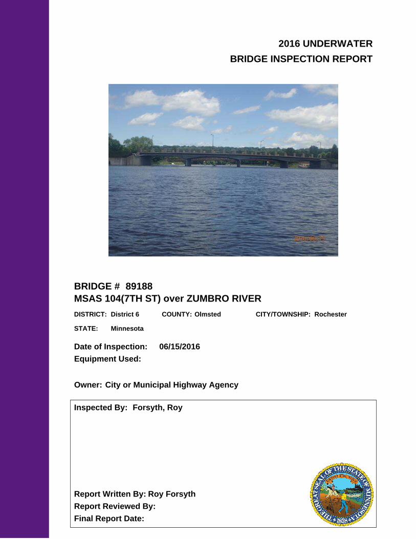
2016 UNDERWATER
BRIDGE INSPECTION REPORT
BRIDGE #
DISTRICT: COUNTY: CITY/TOWNSHIP:
Date of Inspection:
Equipment Used:
Inspected By:
Report Written By:
Report Reviewed By:
Final Report Date:
89188
MSAS 104(7TH ST) over ZUMBRO RIVER
District 6 Olmsted Rochester
06/15/2016
Forsyth, Roy
Roy Forsyth
City or Municipal Highway AgencyOwner:
MinnesotaSTATE:

UNDERWATER SUMMARY 3
UNDERWATER INSPECTION 4
UNDERWATER INSPECTION PROCEDURES 6
STRUCTURE INVENTORY 7
ELEMENTS 8
PICTURES 12
DRAWINGS 15
TABLE OF CONTENTS
PAGE NUMBER

Contractor:
(A) Monitor the cracking along the pier shafts at Piers 1, 2 and 3 and the West Abutment, with special attention to the minor 1/8-inch wide differential along the northern end of Pier 1 for any further progression and/or movement.
(B) Reinspect the submerged substructure units at the normal maximum recommended (NBIS) interval of sixty (60) months.
Collins Engineers, Inc.
9687Contractor Job Number:
RECOMMENDATIONS
REPORT SUMMARY
UNDERWATER INSPECTION
The substructure units inspected below water at Bridge No. 89188, the West Abutment and Piers 1, 2, and 3, were found to be in good to satisfactory condition. Several hairline to 1/4-inch-wide cracks were noted along the pier shafts and the abutment wall, with a very slight, 1/8-inch differential noted along the northern quarter point of Pier 1. The channel bottom appeared to be stable, and the scour protection system in-place around the substructure units was in good condition.
(A) The concrete piers were typically in smooth and sound condition.
(B) Two vertical 1/8-inch-wide cracks were observed at the upstream and downstream 1/4 points along the pier shaft of Piers 2 and 3 and extended from the top of the pier to the top of the concrete scour protection. Both cracks extended through the full depth of the pier shaft.
(C) Four vertical hairline to 1/4-inch-wide cracks were observed along the Pier 1 shaft and extended from the top of the pier to top of the concrete scour protection. All cracks extended through the full depth of the pier shaft.
(D) A 1/8-inch differential (east / west) was observed at the top of the Pier 1 shaft at the northern 1/4-inch wide crack.
(E) A vertical 1/8-inch-wide crack was observed at the upstream 1/4 point along the West Abutment and extended from the top of the abutment to the concrete scour protection.
(F) A 4-inch-diameter spall was observed near the 12 inch storm sewer at the upstream 1/4 point along the West Abutment with up to 2 inches of penetration and an associated hairline crack that extended up.
(G) A 1/16-inch wide vertical crack was observed at the middle joint of the West Abutment.
(H) A hairline crack was observed at the downstream 1/4 point of the West Abutment and extended from the top of abutment to top of concrete scour protection.
(I) The channel bottom consisted of silty sand with 3 inches of probe rod penetration around all substructure units.
INSPECTION FINDINGS
Page 3 of 16

WATERLINE DATUM4.
7.5
Water Level Reference:
975.4.Waterline Elevation (feet):
The top of the pier cap at the north end of Pier 1.
Substructure(s) Inspected:
SUBSTRUCTURE INSPECTION DATA3.
West Abutment and Piers 1, 2, and 3
Maximum Water Depth at Substructure(s) Inspected (feet):
Oblong rectangular shafts with pointed upstream and downstream ends supported by rectangular footings that are founded on timber piles. A sloped concrete scour-protection apron surrounds each of the piers and also extends along the West Abutment.
General Shape:
Code:Item 61: Channel and Channel Protection:
6
8
Code:Item 62: Culvert:
5.
The waterline was approximately 7.8 feet below reference. Description:
NBIS CODING INFORMATION
Code:Item 60: Substructure:
(Minnesota specific codes are used for 92B and 113)
None/Negligible
District:
MSAS 104(7TH ST)Facility Carried:
District 6
Bridge Description:
055 - OlmstedCounty:
BRIDGE DATA1.
UNDERWATER INSPECTION
Bridge #:
ZUMBRO RIVERFeature Intersected:
89188
Weather Conditions:
06/15/2016Date of Underwater Inspection:
Sunny, 80°F
Waterway Velocity (ft/sec):
1.0 ftUnderwater Visibility (feet):
INSPECTION DATA2.
The superstructure consists of four spans of multiple reinforced concrete beams supporting a reinforced concrete deck. The bridgeis supported by two reinforced concrete abutments and three reinforced concrete piers, which are founded on timber piles. The piers are numbered 1 through 3 from the west to east.
Professional Engineer/Team Leader:
Marc SternInspection Diver:
Roy A. Forsyth
Page 4 of 16

885 Scour 11 EA
210
4
132 18LFReinforced Concrete Pier Wall 150
STRUCTURAL ELEMENT CONDITION RATING6.
No (Mark your selection with an X)
Item 113: Scour Critical Bridge: Code:
Y 48 06/2016Item 92B: Underwater Inspection: Code:
Yes X
P
Bridge is scour critical because abutment or pier foundation is rated as unstable due to observed scour at bridge site.
CS4CS3CS1 CS2
LF 6165215 Reinforced Concrete Abutment
Conditions
Quantity UnitElement DescriptionELEM #
Page 5 of 16

The routine underwater inspection of Bridge 89188 (7th Street over the Zumbro River) was completed on June 15, 2016. The underwater inspection was conducted from 14 ft boat. The inspection was conducted by a team consisting of a PE-Diver with a valid MnDOT Team leader certification, a backup diver and a dive tender. The inspection utilized commercial dive equipment and techniques (SSA and/or SCUBA) in accordance with OSHA regulations. Profiles were taken along the upstream and downstream faces of the bridge and around the periphery of substructure units to determine the presence, location and area of scour. The bridge elements inspected consisted of 1 reinforced concrete abutment and 3 reinforced concrete pier walls. According to the bridge inventory or design drawings, the West Abutment and Piers 1, 2, and 3 were founded on concrete pile footings. Inspection procedures followed FHWA guidance and the MnDOT Bridge and Structure Inspection Program Manual with channel bottom probing to search for bottom foundations. The routine underwater inspection frequency is recommended to remain at a maximum of 60 months based on those findings and risk factors. Also, inspection procedures should continue to follow the above approach and standard guidance with 100% Level I and 10% Level II intensity efforts.
INSPECTION PROCEDURES
UNDERWATER INSPECTION
Page 6 of 16

Spec. Feat.Pier Foundation (Material/Type)
1 - CONCCantilever ID
+ W A T E R W A Y +Number of Spans Historic Status
3 - FTG PILE
Underwater Y 60Culvert Type 3 - FTG PILE
Pinned Asbly. N
06/15/2016
Barrel Length
254.5 ft. Navigation Control
Waterway Opening (sf.) 3430Structure Length
ft. Year Painted
0 - No nav. control on waterwayDeck Width (Out-to-Out) 60.0
+ P A I N T +
APPR: 0 TOTAL:5 - Not eligible
MAIN: 4
Main Span Length 70.0 ft.Drainage Area (sq. mi.) 259.4
B R I D G E D A T A +Main Span Detail
N - NOT REQUIRED+ M I S C.
Appr. Span Type Structure Flared
GR Termini N - NOT REQUIRED
Appr. Guardrail
Main Span Type 2 - Concrete Continuous Median Width On Bridge
ft. Bridge Railing 1 - MEETS STANDARDS
N - NOT REQUIRED
Main Span Design 06 - Deck Girder
ft. GR Transition
Skew 20 RIGHT
Y/N Freq Date
NAbutment Foundation (Material/Type)
1 - CONC Frac. Critical
D E P T H I N S P. +Appr. Span Design
0 - No flare+ I N
Appr. Span Detail Field Conn. ID
Parallel Structure N - No parallel structure
Pier Protection
0 - Not Required
Rating Date 07/20/201611194 sq. ft. Traffic
ft. 50B. Rt 6.00Sidewalk Width 50A. Lt 6.00
Roadway Area (Curb-to-Curb)
Posted Load 2 - Vehicle & Semi (Type R12-5)
PostingStructure Area (Out-to-Out) 15270 sq. ft.
34 DBL: 32VEH: 26 SEMI:
Rt 01 ARail Type Lt 01 C X - DeniedX - Denied B X - Denied
N - Not Applicable Overweight Permit CodesCurb Height Lt
ft. Horizontal 0 - Not Required
0.75 ft. Vertical0.75 ft. Rt
Wear Surf Install Year 1981
sq. ft. Nav. Vert. Lift Bridge Clear. (ft.)
P - STBL - PROT INPL
Year 2007Primer Type MN Scour Code
Painted Area
Unsound Paint % Nav. Clr. (ft.)Deck Material 1 - Concrete Cast-in-Place 0.0Wear Surf Type 4 - Low Slump Concrete
Vert. 0.0 Horiz.
S I G N S +Operating Rating 3 - HL-93
0 - None + B R I D G E
Inventory Rating 3 - HL-93 0.34
0.51Deck Rebars Install Year
Deck Rebars
Finish TypeWear Course/Fill Depth 0.12 ft.
0 - None
Design Load A - HL 93
+ C A P A C I T Y R A T I N G S +Deck Membrane
44 ° 1
Inspector Name Forsyth, Roy
Latitude Control Section (TH Only) Status' 49.56 ''
2 - 2-way traffic
Routine Inspection Frequency 24
Sect., Twp., Range
0.3 MI E OF JCT TH 63 Level of Service 1 - MAINLINE
- 14W Roadway Type36 - 107N
Detour Length 1.0 mi.R A T I N G S +
Custodian 04 - City or Municipal Highway Agency
Owner 04 - City or Municipal Highway Agency
Deck 6 Unsound Deck %
C O N D I T I O N° 27 '
B - Open, Posting Required
Longitude 92 003+00.010 + N B I 27.26 '' Reference Point
Crew
+ I N S P E C T I O N +
Agency Br. No. 189
District 06
Bridge Match ID (TIS) 0 Userkey
MSAS 104(7TH ST) over ZUMBRO RIVER
Minnesota Structure Inventory Report
Bridge ID: 89188
+ G E N E R A L + + R O A D W A Y +
Date: 07/28/2016
Sufficiency Rating 42.7Roadway Name or Description
104
City Rochester
Routine Inspection Date 05/04/2015
Desc. Loc.
Township MSAS 104
Number
NRoadway O/U Key Route On StructureMaint. Area Structurally Deficient
YRoute Sys 05 - MSASCounty 055 - Olmsted Functionally Obsolete
Lanes
Waterway Adequacy 6Max. Vert. Clear.
ft.Legislative District 30Aft.Potential ABC 2 - N/A ft.
ft.On - Off System Roadway Width 44.00 ft.
Vertical Clearance ft.1 - ON
Underclearances N
Service On 5 - Highway-pedestrian Appr. Surface Width+ S A F E T Y F E A T U R E S +
5 - Waterway Bridge Roadway Width 44.0
56.0 ft.
Service Under
ft.
43.9 ft. Approach Alignment 8Horizontal Clear.
ft.
ft.+ S T R U C T U R E + Lateral Clearance
HCADT ADTT6
Year Built 1956
MN Year Reconstructed Functional Class
%Channel 8
Substructure
0Superstructure 6
ON 4 UNDER
7900 YEAR 2008BMU Agreement ADT
Structure Evaluation 3If Divided
D I M E N S I O N S +Bridge Plan Location 4 - MUNICIPAL
10/1/1956Deck Geometry 2
NB-EB SB-WBDate Opened to Traffic
+ R D W Y
FHWA Year Reconstructed
MN Temporary Status
16 - Urban - Minor ArterialCulvert N
A P P R A I S A L R A T I N G S ++ N B I
Page 7 of 16

County:
City:
Township:
Township:Section: Range:
Span Type:
NBI Deck: Super: Sub: Chan: Culv:
Appraisal Ratings - Approach: Waterway:
Required Bridge Signs - Load Posting:
Horizntal:
Traffic:
Vertical:
MN Scour Code:
Open, Posted, Closed:
Location:
Route:
Control Section:
Local Agency Bridge Nbr.:
Ref. Pt.:
Maint. Area:
Length:
Deck Width:
Rdwy. Area/ Pct. Unsnd:
Paint Area/ Pct. Unsnd:
Culvert:
Olmsted
Rochester
107N36 14W
2 - Concrete Continuous 3 - Girder andFloorbeam System
6 6 6 8 N
8 6
2 - Vehicle & Semi (TypeR12-5)
0 - Not Required
0 - Not Required
N - Not Applicable
P - STBL - PROT INPL
0.3 MI E OF JCT TH 63
05 - MSAS 104 003+00.010
254.5
60.0
11194 sq. ft. / %
sq. ft. / %
N/A
B - Open, PostingRequired
ft.
ft.
Postings: 26 34 32List:
MINNESOTA BRIDGE INSPECTION REPORT
09/14/2016
Inspector: CO Bridge
BRIDGE 89188 MSAS 104(7TH ST) OVER ZUMBRO RIVER
Unofficial Structurally Deficient N
YUnofficial Functionally Obsolete
Unofficial Sufficiency Rating 42.7
ELEMNBR ELEMENT NAME INSP. DATE QUANTITY
QTYCS 1
QTYCS 2
QTYCS 3
QTYCS 4REPORT TYPE
Reinforced Concrete Deck 06/15/2016 15270 SF 14965 0 305 012 Underwater
15270 SF 14965 0 305 0Migrated Values
Notes: Transverse cracks with efflorescence on underside of slab. Concrete end dams are cracked. Some spalling observed at the first spanfrom the east abutment.
[2013] Longitudinal crack at centerline. [2015] - Span 4 North overhang has large areas of spall/delam.[2015] - There are transverse cracks with efflorescence in all spans. Span 4 has a spall with exposed conduit on the South side of G1 at theabutment.. Span 3 has an area of poorly consolidated concrete between G3 and G4 near pier 3.
510 - Wearing Surfaces 11194 SF 11194 0 0 0
Notes: Low Slump Overlay with Uncoated Rebar Notes: [-2011] Random alligator cracking is evident over a majority of concrete surface.[2013] Moderate size cracks of moderate density. [2015] - No spalls or delams noted.
Underwater 06/15/2016
11194 SF 11194 0 0 0Migrated Values
Reinforced Concrete OpenGirder/Beam
06/15/2016 1506 LF 1496 4 6 0110 Underwater
1506 LF 1496 4 6 0Migrated Values
Notes: . 1989 - Peoples Natural Gas hung new gas main on south side of girder number 6. 2001 - Crack at bearing plate at E abutment ongirder 1. 2001 - Large spall at bearing plate at E abutment on girder 6. 2006 - N. edge 2 spalls, 1 delam. at east span @ conduit. 2008 - Crackat bearing plate girder # 6. 2010- Vertical cracks
[2011 - 2013] Shear/Spall 1'x6"at east end girders 1 and girder 6. Light vertical cracks moderate density, over length of girders, on all spans[2015] - Span 4 Beam 1 East end has a shear crack 7' from the beam end. Beam 6 East end has a shear crack and two diagonal cracks. [2015]- Snooper inspection needed for closer insp. and monitoring.[2015] - Beams were inspected using an underdeck snooper truck 11/09/2015. All girders have minor vertical cracks approx. 5' from piers.There is a small rebar spall on the bottom of G3 in span 2 near pier 2.
Reinforced Concrete Pier Wall 06/15/2016 164 LF 146 18 0 0210 Underwater
164 LF 146 18 0 0Migrated Values
Notes: EAST PIER 1/16' wide vertical crack in pier wall under and between girders number 5-6. 1/8' wide vertical crack in pier wall under girdernumber 2. Vertical crack down center of diaphragm support. Concrete spall in diaphragm support. Water leakage on pier cap and down pierwall. CENTER PIER 1/16' wide vertical cracks in pier wall under and between girders number 1-2, 2-3, and under girder number 5. Verticalcrack down center of diaphragm support. Water leakage on pier cap and down pier wall. WEST PIER 1/8' wide vertical cracks in pier wall underand between girders number 1-2, 2-3, and 4-6. 1/4' wide vertical crack in pier wall under girder number 5. Vertical crack down center ofdiaphragm support.[2015] - As noted.[2016 Underwater Inspection] - All noted cracks extend below water to the top of concrete scour protection.
Page 8 of 16
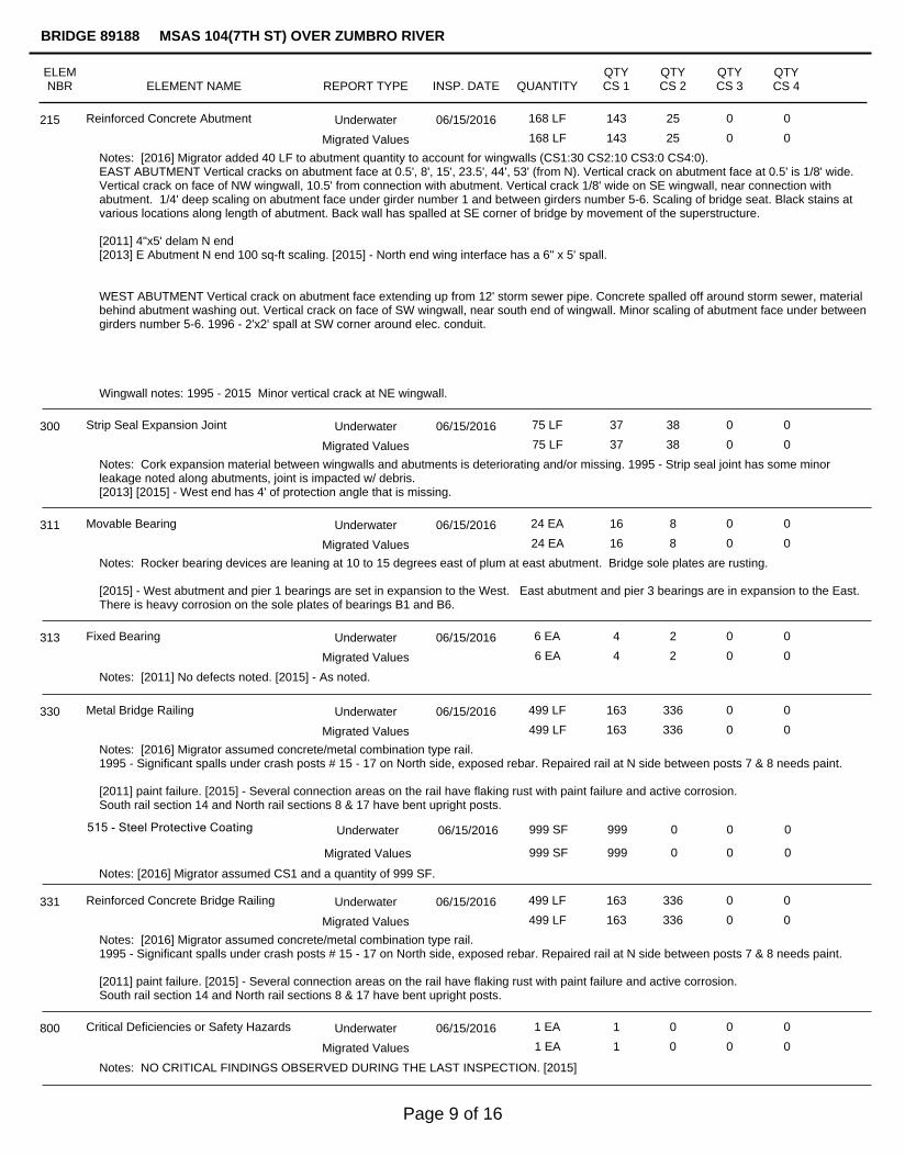
Reinforced Concrete Abutment 06/15/2016 168 LF 143 25 0 0215 Underwater
168 LF 143 25 0 0Migrated Values
Notes: [2016] Migrator added 40 LF to abutment quantity to account for wingwalls (CS1:30 CS2:10 CS3:0 CS4:0).EAST ABUTMENT Vertical cracks on abutment face at 0.5', 8', 15', 23.5', 44', 53' (from N). Vertical crack on abutment face at 0.5' is 1/8' wide.Vertical crack on face of NW wingwall, 10.5' from connection with abutment. Vertical crack 1/8' wide on SE wingwall, near connection withabutment. 1/4' deep scaling on abutment face under girder number 1 and between girders number 5-6. Scaling of bridge seat. Black stains atvarious locations along length of abutment. Back wall has spalled at SE corner of bridge by movement of the superstructure.
[2011] 4"x5' delam N end[2013] E Abutment N end 100 sq-ft scaling. [2015] - North end wing interface has a 6" x 5' spall.
WEST ABUTMENT Vertical crack on abutment face extending up from 12' storm sewer pipe. Concrete spalled off around storm sewer, materialbehind abutment washing out. Vertical crack on face of SW wingwall, near south end of wingwall. Minor scaling of abutment face under betweengirders number 5-6. 1996 - 2'x2' spall at SW corner around elec. conduit.
Wingwall notes: 1995 - 2015 Minor vertical crack at NE wingwall.
Strip Seal Expansion Joint 06/15/2016 75 LF 37 38 0 0300 Underwater
75 LF 37 38 0 0Migrated Values
Notes: Cork expansion material between wingwalls and abutments is deteriorating and/or missing. 1995 - Strip seal joint has some minorleakage noted along abutments, joint is impacted w/ debris.[2013] [2015] - West end has 4' of protection angle that is missing.
Movable Bearing 06/15/2016 24 EA 16 8 0 0311 Underwater
24 EA 16 8 0 0Migrated Values
Notes: Rocker bearing devices are leaning at 10 to 15 degrees east of plum at east abutment. Bridge sole plates are rusting.
[2015] - West abutment and pier 1 bearings are set in expansion to the West. East abutment and pier 3 bearings are in expansion to the East.There is heavy corrosion on the sole plates of bearings B1 and B6.
Fixed Bearing 06/15/2016 6 EA 4 2 0 0313 Underwater
6 EA 4 2 0 0Migrated Values
Notes: [2011] No defects noted. [2015] - As noted.
Metal Bridge Railing 06/15/2016 499 LF 163 336 0 0330 Underwater
499 LF 163 336 0 0Migrated Values
Notes: [2016] Migrator assumed concrete/metal combination type rail.1995 - Significant spalls under crash posts # 15 - 17 on North side, exposed rebar. Repaired rail at N side between posts 7 & 8 needs paint.
[2011] paint failure. [2015] - Several connection areas on the rail have flaking rust with paint failure and active corrosion.South rail section 14 and North rail sections 8 & 17 have bent upright posts.
515 - Steel Protective Coating 999 SF 999 0 0 0
Notes: [2016] Migrator assumed CS1 and a quantity of 999 SF.
Underwater 06/15/2016
999 SF 999 0 0 0Migrated Values
Reinforced Concrete Bridge Railing 06/15/2016 499 LF 163 336 0 0331 Underwater
499 LF 163 336 0 0Migrated Values
Notes: [2016] Migrator assumed concrete/metal combination type rail.1995 - Significant spalls under crash posts # 15 - 17 on North side, exposed rebar. Repaired rail at N side between posts 7 & 8 needs paint.
[2011] paint failure. [2015] - Several connection areas on the rail have flaking rust with paint failure and active corrosion.South rail section 14 and North rail sections 8 & 17 have bent upright posts.
Critical Deficiencies or Safety Hazards 06/15/2016 1 EA 1 0 0 0800 Underwater
1 EA 1 0 0 0Migrated Values
Notes: NO CRITICAL FINDINGS OBSERVED DURING THE LAST INSPECTION. [2015]
ELEMNBR ELEMENT NAME INSP. DATE QUANTITY
QTYCS 1
QTYCS 2
QTYCS 3
QTYCS 4
BRIDGE 89188 MSAS 104(7TH ST) OVER ZUMBRO RIVER
REPORT TYPE
Page 9 of 16

Plow Fingers 06/15/2016 1 EA 0 1 0 0815 Underwater
1 EA 0 1 0 0Migrated Values
Notes: Two plow fingers at east end of bridge are missing. One plow finger at west end of bridge is missing. 1996 - 1 additional plow finger ismissing on E end of bridge ( 3 total). 2008 - 2 missing E end, 1 missing W end.
[2011 - 2013] 10 straps missing. [2015] - West 6 missing. East 6 missing.
Bituminous Approach Roadway 06/15/2016 2 EA 0 2 0 0822 Underwater
2 EA 0 2 0 0Migrated Values
Notes: Bit. approaches have settled at ends of bridge.
[2011] light to moderate cracking[2015] - East approach has several unsealed cracks and deterioration at the joint. West approach has settled 1 - 1 1/2" with transverse open cracks.
Secondary Members (Superstructure) 06/15/2016 65 EA 55 10 0 0855 Underwater
65 EA 55 10 0 0Migrated Values
Notes: 1995 - 2015 End diaphrams are cracked and spalling.
Concrete Shear Cracking 06/15/2016 1 EA 0 1 0 0883 Underwater
1 EA 0 1 0 0Migrated Values
Notes: [2015] - Shear cracking found in 2015 inspection. See element 110. New pictures taken.
Scour 06/15/2016 1 EA 1 0 0 0885 Underwater
1 EA 1 0 0 0Migrated Values
Notes: P - Stable due to protection. Inspect countermeasures. [2015]
Slopes & Slope Protection 06/15/2016 1 EA 1 0 0 0892 Underwater
1 EA 1 0 0 0Migrated Values
Notes: 1990 - Corps of Engineers flood control project reworked slopes.
[2013 - 2015] Slope behind NW wingwall, concrete migrating downhill. Minor erosion.
Deck & Approach Drainage 06/15/2016 1 EA 1 0 0 0894 Underwater
1 EA 1 0 0 0Migrated Values
Notes: Water from drains is leaking on fascia girders. 1995 - Water runs along bottom of fascia arch to bearing devices. [2015] NC
Sidewalk, Curb, & Median 06/15/2016 1 EA 1 0 0 0895 Underwater
1 EA 1 0 0 0Migrated Values
Notes: Transverse and longitudinal cracks on surface of walk. Concrete spalls on face of north curb near concrete crash posts number 7-8.Concrete spalls on face of south curb near concrete crash post numbers 9, 16, and 17-18. Light to medium scaling of curbs and walks, scalingmore prevalent on east ? of north side. Large spalls on underside of north walk under concrete crash posts 15, 16, 17. Longitudinal crackingthrough walks under and between concrete crash posts. 1996 - Major scaling w/ minor spalls on S outside sidewalk fascia between crash posts#1 & #4. 2008 - Large cracks at SW corner under sidewalk slight eff. S edge of walk chipping away. 2' x 2' spall under walk at S side EAbutment. 9' Spall under post 8 south .
Concrete walk at SE corner settled 3/4'. Bit. walk at NW corner cracked and settled 1'. Cracked walk at 2nd and 3rd panel at SE corner.Cracked walk at 2nd and 3rd panel at SW corner. Settled curb at NW corner.
[2011] Severe spalling/raveling along both walk/curbs. SE panel broken/tipping. [2015] - South sidewalk has 30' of severely deterioratedconcrete with deep spalling and exposed rebar with moderate LOS.
Protected Species 06/15/2016 1 EA 1 0 0 0900 Underwater
1 EA 1 0 0 0Migrated Values
Notes: Use this element to track the presence of protected species living on this structure.
General Notes: Inspectors: David Moore, Brian Monosmith.Channel & ProtectionCorps of Engineers flood control, channel work with riprap, retaining wall construction at NW and SW corners and east side.
[2015] - inspected in 2015 by MNDOT inspector Aaron Forthun and Tony Bale assisted.[2015] - Bridge was inspected using a snooper truck 11/09/2015 by Tom Miles and Tony Bale assisted.NOTE: NBI for superstructure was lowered to 5 due to structural cracking.
Schedule bridge for snooper inspection.
ELEMNBR ELEMENT NAME INSP. DATE QUANTITY
QTYCS 1
QTYCS 2
QTYCS 3
QTYCS 4
BRIDGE 89188 MSAS 104(7TH ST) OVER ZUMBRO RIVER
REPORT TYPE
Page 10 of 16

ELEMNBR ELEMENT NAME INSP. DATE QUANTITY
QTYCS 1
QTYCS 2
QTYCS 3
QTYCS 4
BRIDGE 89188 MSAS 104(7TH ST) OVER ZUMBRO RIVER
REPORT TYPE
Inspector's Signature Reviewer's Signature
Roy Forsyth
Inventory Notes:
[2015] - inspected in 2015 by MNDOT inspector Aaron Forthun and Tony Bale assisted.[2015] - Bridge was inspected using a snooper truck 11/09/2015 by Tom Miles and Tony Bale assisted.NOTE: NBI for superstructure was lowered to 5 due to structural cracking.
Schedule bridge for snooper inspection.
58. Deck NBI:
36A. Brdg Railings NBI:
36B. Transitions NBI:
36C. Appr Guardrail NBI:
36D. Appr GuardrailTerminal NBI:
59. Superstructure NBI:
60. Substructure NBI:
61. Channel NBI:
62. Culvert NBI:
71. Waterway Adeq NBI:
72. Appr RoadwayAlignment NBI:
NBI is 6 due to minor spall/delam on deck underside.
NBI is 5 due to structural/shear cracking at beam ends.
[2016 Underwater inspection] - NBI changed to 6 due to cracking.
Flood control project, protected by rip rap and concrete wall.
no speed reduction required.
Page 11 of 16

Photo 2 - View of West Abutment, looking west.
Photo 3 - View of East Abutment, looking east.
Pictures
Page 12 of 16

Pictures
Photo 4 - View of Pier 1, looking west.
Photo 5 - View of Pier 2, looking west.
Page 13 of 16

Pictures
Photo 6 - View of PIer 3, looking west.
Page 14 of 16

Page 15 of 16

Page 16 of 16