biological assessment for the wild goose phase 3...
TRANSCRIPT
Biological Assessment
for the
Wild Goose Phase 3 Expansion Project
April 2009
Prepared for: Wild Goose Storage, LLC
607 8th Avenue SW, Suite 400 Calgary, Alberta
Canada
Prepared by:
80 Stone Pine Road, Suite 200
Half Moon Bay, CA 94019


Wild Goose Phase 3 Expansion Project April 2009 Biological Assessment i
TABLE OF CONTENTS 1.0 INTRODUCTION...............................................................................................................1
1.1 SCOPE..........................................................................................................................1 1.2 PROJECT BACKGROUND........................................................................................... 1
2.0 PROJECT DESCRIPTION................................................................................................5 2.1 REMOTE FACILITY SITE ............................................................................................. 5 2.2 DELEVAN INTERCONNECT SITE ............................................................................... 5
3.0 ENVIRONMENTAL SETTING ........................................................................................11 3.1 VEGETATION.................................................................................................................11 3.2 SENSITIVE SPECIES..................................................................................................... 11 3.3 STATE AND FEDERALLY LISTED SPECIES................................................................ 11 3.4 SPECIES OF SPECIAL CONCERN ............................................................................... 24
4.0 METHODS ......................................................................................................................27 4.1 LITERATURE REVIEW............................................................................................... 27 4.2 FIELD RECONNAISSANCE STUDY .......................................................................... 27 4.3 BIOLOGICAL SURVEYS ............................................................................................ 27
5.0 RESULTS .......................................................................................................................28 5.1 PLANT COMMUNITIES .............................................................................................. 28
6.0 POTENTIAL EFFECTS AND RECOMMENDATIONS ...................................................32 6.1 PLANTS ...................................................................................................................... 33 6.2 INVERTEBRATES ...................................................................................................... 33 6.3 WESTERN SPADEFOOT (SPEA HAMMONDII) ........................................................ 34 6.4 GIANT GARTER SNAKE (THAMNOPHIS GIGAS) .................................................... 34 6.5 NORTHWESTERN POND TURTLE (ACTINEMYS MARMORATA MARMORATA) .. 35 6.6 TRICOLORED BLACKBIRD (AGELAIUS TRICOLOR) .............................................. 35 6.7 WESTERN BURROWING OWL (ATHENE CUNICULARIA) ...................................... 35 6.8 SWAINSON’S HAWK (BUTEO SWAINSONI) ............................................................ 36 6.9 BLACK TERN (CHLIDONIAS NIGER) ........................................................................ 36 6.10 NORTHERN HARRIER (CIRCUS CYANEUS) ........................................................... 37 6.11 WHITE-TAILED KITE (ELANUS LEUCURUS) ........................................................... 37 6.12 LOGGERHEAD SHRIKE (LANIUS LUDOVICIANUS) ................................................ 37 6.13 WHITE-FACED IBIS (PLEGADIS CHIHI) ................................................................... 38 6.14 SAN JOAQUIN POCKET MOUSE (PEROGNATHUS INORATUS) ........................... 38 6.15 CUMULATIVE EFFECTS............................................................................................ 38
7.0 CONCLUSIONS AND DETERMINATION STATEMENTS.............................................40 8.0 REFERENCES................................................................................................................41

April 2009 Wild Goose Phase 3 Expansion Project ii Biological Assessment
LIST OF TABLES Table 1: Special Status Species with Potential to Occur in the Project Area ............................... 13 LIST OF FIGURES Figure 1: Project Vicinity Map ....................................................................................................... 3 Figure 2: Remote Facility Site Map................................................................................................ 7 Figure 3: Delevan Interconnect Site Map ....................................................................................... 9 Figure 4: Plant Communities Map................................................................................................ 29 LIST OF ATTACHMENTS Attachment A: Official USFWS Species List and CNDDB List and Maps Attachment B: Photographs of Communities at Project Sites
Wild Goose Phase 3 Expansion Project April 2009 Biological Assessment 1
1.0 INTRODUCTION
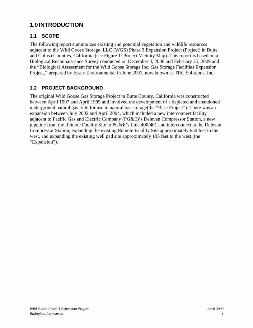
1.1 SCOPE The following report summarizes existing and potential vegetation and wildlife resources adjacent to the Wild Goose Storage, LLC (WGS) Phase 3 Expansion Project (Project) in Butte and Colusa Counties, California (see Figure 1: Project Vicinity Map). This report is based on a Biological Reconnaissance Survey conducted on December 4, 2008 and February 25, 2009 and the “Biological Assessment for the Wild Goose Storage Inc. Gas Storage Facilities Expansion Project,” prepared by Essex Environmental in June 2001, now known as TRC Solutions, Inc.
1.2 PROJECT BACKGROUND The original Wild Goose Gas Storage Project in Butte County, California was constructed between April 1997 and April 1999 and involved the development of a depleted and abandoned underground natural gas field for use in natural gas storage(the “Base Project”). There was an expansion between July 2002 and April 2004, which included a new interconnect facility adjacent to Pacific Gas and Electric Company (PG&E)’s Delevan Compressor Station, a new pipeline from the Remote Facility Site to PG&E’s Line 400/401 and interconnect at the Delevan Compressor Station, expanding the existing Remote Facility Site approximately 650 feet to the west, and expanding the existing well pad site approximately 195 feet to the west (the “Expansion”).

April 2009 Wild Goose Phase 3 Expansion Project 2 Biological Assessment
0 1 2 3 4 5 �
DELEVANINTERCONNECTSITEiiAND LATERALi LINE WELL
PADSITE
REMOTEFACILITYSITE
Map copyright 1993 by the California State Automobile Association. Reproduction by permission.
Figure 1: Vicinity Map
Line 400 Connection Pipeline and Storage Pipeline Loop
GLENNCOLUSA
5
Wild Goose Phase 3 Expansion Project
February 26, 2009, TRC
Project Sites
Scale in Miles
To Willows
GLENNCOLUSA
HATC
H
Sacr
amen
to R
iver
Study Area

Wild Goose Phase 3 Expansion Project April 2009 Biological Assessment 5
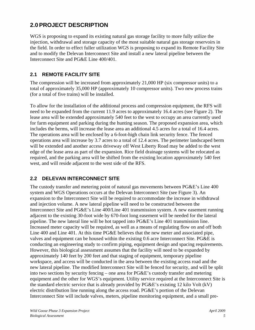
2.0 PROJECT DESCRIPTION
WGS is proposing to expand its existing natural gas storage facility to more fully utilize the injection, withdrawal and storage capacity of the most suitable natural gas storage reservoirs in the field. In order to effect fuller utilization WGS is proposing to expand its Remote Facility Site and to modify the Delevan Interconnect Site and install a new lateral pipeline between the Interconnect Site and PG&E Line 400/401.
2.1 REMOTE FACILITY SITE The compression will be increased from approximately 21,000 HP (six compressor units) to a total of approximately 35,000 HP (approximately 10 compressor units). Two new process trains (for a total of five trains) will be installed. To allow for the installation of the additional process and compression equipment, the RFS will need to be expanded from the current 11.9 acres to approximately 16.4 acres (see Figure 2). The lease area will be extended approximately 540 feet to the west to occupy an area currently used for farm equipment and parking during the hunting season. The proposed expansion area, which includes the berms, will increase the lease area an additional 4.5 acres for a total of 16.4 acres. The operations area will be enclosed by a 6-foot-high chain link security fence. The fenced operations area will increase by 3.7 acres to a total of 12.4 acres. The perimeter landscaped berm will be extended and another access driveway off West Liberty Road may be added to the west edge of the lease area as part of the expansion. Rice field drainage systems will be relocated as required, and the parking area will be shifted from the existing location approximately 540 feet west, and will reside adjacent to the west side of the RFS.
2.2 DELEVAN INTERCONNECT SITE The custody transfer and metering point of natural gas movements between PG&E’s Line 400 system and WGS Operations occurs at the Delevan Interconnect Site (see Figure 3). An expansion to the Interconnect Site will be required to accommodate the increase in withdrawal and injection volume. A new lateral pipeline will need to be constructed between the Interconnect Site and PG&E’s Line 400/Line 401 transmission system. A new easement running adjacent to the existing 30-foot wide by 670-foot long easement will be needed for the lateral pipeline. The new lateral line will be hot tapped into PG&E’s Line 401 transmission line. Increased meter capacity will be required, as well as a means of regulating flow on and off both Line 400 and Line 401. At this time PG&E believes that the new meter and associated pipe, valves and equipment can be housed within the existing 0.6 acre Interconnect Site. PG&E is conducting an engineering study to confirm piping, equipment design and spacing requirements. However, this biological assessment assumes that the facility will need to be expanded by approximately 140 feet by 200 feet and that staging of equipment, temporary pipeline workspace, and access will be conducted in the area between the existing access road and the new lateral pipeline. The modified Interconnect Site will be fenced for security, and will be split into two sections by security fencing – one area for PG&E’s custody transfer and metering equipment and the other for WGS’s equipment. Utility service required at the Interconnect Site is the standard electric service that is already provided by PG&E’s existing 12 kilo Volt (kV) electric distribution line running along the access road. PG&E’s portion of the Delevan Interconnect Site will include valves, meters, pipeline monitoring equipment, and a small pre-

April 2009 Wild Goose Phase 3 Expansion Project 6 Biological Assessment
engineered metal building to house its instrumentation electronics, calibration system, computer control system, high voltage alternating current (HVAC), recorders, chromatograph, valve solenoids, and communications and metering equipment. WGS’s portion of the equipment at the meter station site include an actuated block valve, control valve and associated electrical instrumentation devices for monitoring and control of equipment. The station piping will tie-in immediately downstream of the 30-inch pig launcher, before the pipeline enters the ground departing east towards the RFS.
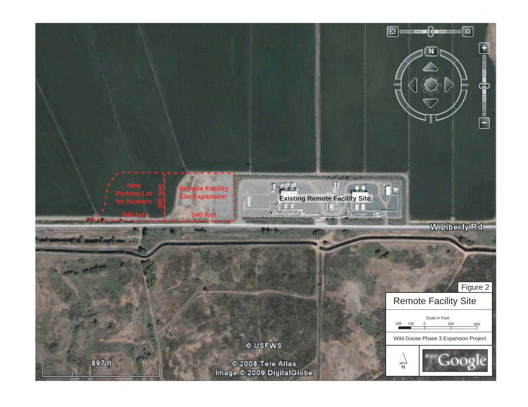
Remote Facility Site Expansion
NewParking Lotfor Hunters
540 feet 540 feet
Existing Remote Facility Site
Scale in Feet
Wild Goose Phase 3 Expansion Project
P
Figure 2
Remote Facility Site
200 0 200 400100
390
feet


Scale in Feet
Wild Goose Phase 3 Expansion Project
P
Figure 3
Delevan Interconnect Site
0 200 400100200
Existing Delevan InterconnectSite
Line 400 Connection Pipeline
PG&
E L4
00/4
01
PG&EDelevan Station
Glenn-Colusa Canal
New Lateral Line

Wild Goose Phase 3 Expansion Project April 2009 Biological Assessment 11
3.0 ENVIRONMENTAL SETTING
The Project is located near the center of the Sacramento Valley approximately 62 miles northwest of Sacramento. The facilities are located within the very flat terrain of the valley floor. Like most parts of California, the region experiences a Mediterranean type climate, with hot dry summers and mild wet winters.
3.1 VEGETATION The valley area historically has consisted of an extensive wetland and marsh system sustained by the Sacramento River and its tributaries, including Butte Creek and the Colusa Drain area. Over the last 100 years, most of this system has been developed into agricultural production, primarily rice and millet. To the west of the Glenn-Colusa Canal, which encompasses the Delevan Interconnect Site, the plant community type changes to annual grassland that contains vernal pools and swales. Therefore, plant community types consist of natural landscapes (primarily grasslands) and human-altered landscapes (agriculture). In general, the natural landscapes that can be found within the project vicinity include the Sacramento National Wildlife Refuge, the Gray Lodge Wildlife Area, and the Butte Sink.
3.2 SENSITIVE SPECIES During planning for the Project, it was determined that there were 19 sensitive plant and 22 sensitive wildlife species whose range could encompass the Project area (see Table 1). Many of these identified species were eliminated from further consideration for one or more of the following reasons: • Lack of suitable habitat in the project study area • Outside of species range The results of this evaluation indicated that 2 plant and 15 animal species were known to occur in the Project study area, or that the proposed Project components could affect suitable habitat within their known range. These species are highlighted gray in Table 1 and described below.
3.3 STATE AND FEDERALLY LISTED SPECIES Palmate-bracted Bird’s Beak (Cordylanthus palmatus) Palmate-bracted bird’s beak is listed under both the Federal and California Endangered Species Acts as an endangered species. It is found in chenopod scrub and low alkaline grasslands. There are only three populations known to exist in Colusa County. There is a low potential for this species to occur in the grasslands around the Delevan Interconnect Site. Milo Baker’s Lupine (Lupinus milo-bakeri) Milo Baker’s Lupine is listed under the California Endangered Species Act as a threatened species. It is found in the foothill woodlands and valley grasslands of Colusa County. There is a low potential for this species to occur in the grasslands around the Delevan Interconnect Site.

April 2009 Wild Goose Phase 3 Expansion Project 12 Biological Assessment

Wild Goose Phase 3 Expansion Project April 2009 Biological Assessment 13
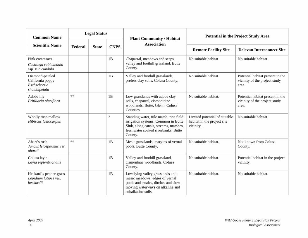
Table 1: Special Status Species with Potential to Occur in the Project Area
Legal Status Potential in the Project Study Area Common Name
Scientific Name Federal State CNPS
Plant Community / Habitat Association
Remote Facility Site Delevan Interconnect Site
Plants
Ferris’s milkvetch Astragalus tener var. ferrisiae
** 1B Playas, mesic meadows, and subalkaline flats in low grasslands. Butte County.
No suitable habitat. Not known from Colusa County.
Heartscale Atriplex cordulata
** 1B Saline/alkaline grassland/scrub, pastures. An annual saltbush. Butte County.
No suitable habitat. Not known from Colusa County.
Brittlescale Atriplex depressa
** 1B Chenopod scrub, alkaline meadows, low grasslands. Glenn and Colusa Counties.
No suitable habitat. Potential habitat present in the vicinity of the project site.
San Joaquin spearscale Atriplex joaquiniana
** 1B Valley and foothill grassland, Chenopod scrub, restricted to alkaline/saline soils. Glenn and Colusa Counties.
No suitable habitat. Potential habitat present in the vicinity of the project site.
Lesser saltscale Atriplex minuscule
1B Chenopod scrub, alkaline meadows, low grasslands, Butte County.
No suitable habitat. Not known from Colusa County.
Vernal pool smallscale Atriplex persistens
1B Chenopod scrub, alkaline meadows, low grasslands, Butte and Glenn Counties.
No suitable habitat. Vernal pool habitat found in the vicinity of the project site and will be avoided.
Palmate-bracted bird’s beak Cordylanthus palmatus*
FE SE 1B Chenopod scrub, low alkaline grasslands. Only three populations known to exist. Colusa County.
No suitable habitat. Potential habitat present in the vicinity of the project site.
* Special status species highlighted in gray have been known to occur within the project area and/or have suitable habitat within their known range which may be affected by various project components. These species are described in further detail in section 3.3 of this report.
April 2009 Wild Goose Phase 3 Expansion Project 14 Biological Assessment
Legal Status Potential in the Project Study Area Common Name
Scientific Name Federal State CNPS
Plant Community / Habitat Association
Remote Facility Site Delevan Interconnect Site
Pink creamsacs Castilleja rubicundula ssp. rubicundula
1B Chaparral, meadows and seeps, valley and foothill grassland. Butte County.
No suitable habitat. No suitable habitat.
Diamond-petaled California poppy Eschschotzia rhombipetala
1B Valley and foothill grasslands, prefers clay soils. Colusa County.
No suitable habitat. Potential habitat present in the vicinity of the project study area.
Adobe lily Fritillaria pluriflora
** 1B Low grasslands with adobe clay soils, chaparral, cismontaine woodlands. Butte, Glenn, Colusa Counties.
No suitable habitat. Potential habitat present in the vicinity of the project study area.
Woolly rose-mallow Hibiscus lasiocarpus
2 Standing water, tule marsh, rice field irrigation systems. Common in Butte Sink, along canals, streams, marshes, freshwater soaked riverbanks. Butte County.
Limited potential of suitable habitat in the project site vicinity.
No suitable habitat.
Ahart’s rush Juncus leiospermus var. ahartii
** 1B Mesic grasslands, margins of vernal pools. Butte County.
No suitable habitat. Not known from Colusa County.
Colusa layia Layia septentrionalis
1B Valley and foothill grassland, cismontane woodlands. Colusa County.
No suitable habitat. Potential habitat in the project vicinity.
Heckard’s pepper-grass Lepidium latipes var. heckardii
1B Low-lying valley grasslands and mesic meadows, edges of vernal pools and swales, ditches and slow-moving waterways on alkaline and subalkaline soils.
No suitable habitat. No suitable habitat.
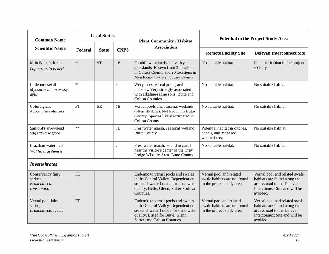
Wild Goose Phase 3 Expansion Project April 2009 Biological Assessment 15
Legal Status Potential in the Project Study Area Common Name
Scientific Name Federal State CNPS
Plant Community / Habitat Association
Remote Facility Site Delevan Interconnect Site
Milo Baker’s lupine Lupinus milo-bakeri
** ST 1B Foothill woodlands and valley grasslands. Known from 2 locations in Colusa County and 20 locations in Mendocino County. Colusa County.
No suitable habitat. Potential habitat in the project vicinity.
Little mousetail Myosurus minimus ssp. apus
** 3 Wet places, vernal pools, and marshes. Very strongly associated with alkaline/saline soils. Butte and Colusa Counties.
No suitable habitat. No suitable habitat.
Colusa grass Neostapfia colusana
FT SE 1B Vernal pools and seasonal wetlands (often alkaline). Not known in Butte County. Species likely extirpated in Colusa County.
No suitable habitat. No suitable habitat.
Sanford's arrowhead Sagittaria sanfordii
** 1B Freshwater marsh, seasonal wetland. Butte County.
Potential habitat in ditches, canals, and managed wetland areas.
No suitable habitat.
Brazilian watermeal Wolffia brasiliensis
2 Freshwater marsh. Found in canal near the visitor's center of the Gray Lodge Wildlife Area. Butte County.
No suitable habitat. No suitable habitat.
Invertebrates
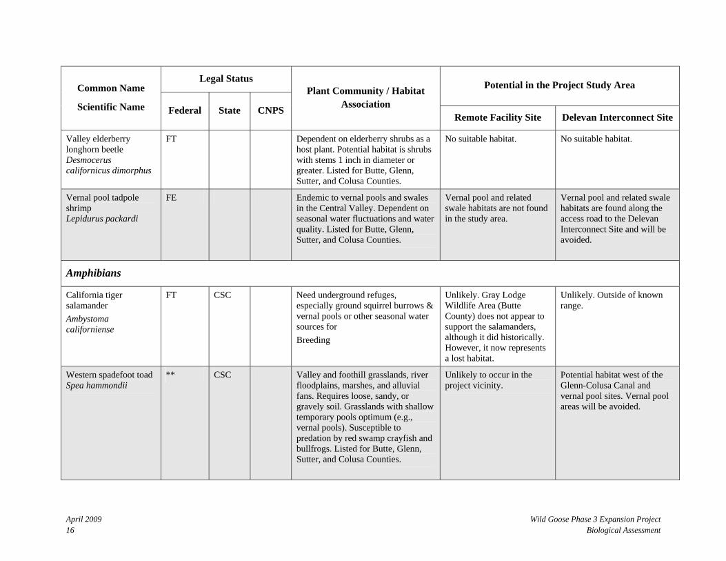
Conservancy fairy shrimp Branchinecta conservatio
FE Endemic to vernal pools and swales in the Central Valley. Dependent on seasonal water fluctuations and water quality. Butte, Glenn, Sutter, Colusa Counties.
Vernal pool and related swale habitats are not found in the project study area.
Vernal pool and related swale habitats are found along the access road to the Delevan Interconnect Site and will be avoided.
Vernal pool fairy shrimp Branchinecta lynchi
FT Endemic to vernal pools and swales in the Central Valley. Dependent on seasonal water fluctuations and water quality. Listed for Butte, Glenn, Sutter, and Colusa Counties.
Vernal pool and related swale habitats are not found in the project study area.
Vernal pool and related swale habitats are found along the access road to the Delevan Interconnect Site and will be avoided.
April 2009 Wild Goose Phase 3 Expansion Project 16 Biological Assessment
Legal Status Potential in the Project Study Area Common Name
Scientific Name Federal State CNPS
Plant Community / Habitat Association
Remote Facility Site Delevan Interconnect Site
Valley elderberry longhorn beetle Desmocerus californicus dimorphus
FT Dependent on elderberry shrubs as a host plant. Potential habitat is shrubs with stems 1 inch in diameter or greater. Listed for Butte, Glenn, Sutter, and Colusa Counties.
No suitable habitat. No suitable habitat.
Vernal pool tadpole shrimp Lepidurus packardi
FE Endemic to vernal pools and swales in the Central Valley. Dependent on seasonal water fluctuations and water quality. Listed for Butte, Glenn, Sutter, and Colusa Counties.
Vernal pool and related swale habitats are not found in the study area.
Vernal pool and related swale habitats are found along the access road to the Delevan Interconnect Site and will be avoided.
Amphibians
California tiger salamander Ambystoma californiense
FT CSC Need underground refuges, especially ground squirrel burrows & vernal pools or other seasonal water sources for Breeding
Unlikely. Gray Lodge Wildlife Area (Butte County) does not appear to support the salamanders, although it did historically. However, it now represents a lost habitat.
Unlikely. Outside of known range.
Western spadefoot toad Spea hammondii
** CSC Valley and foothill grasslands, river floodplains, marshes, and alluvial fans. Requires loose, sandy, or gravely soil. Grasslands with shallow temporary pools optimum (e.g., vernal pools). Susceptible to predation by red swamp crayfish and bullfrogs. Listed for Butte, Glenn, Sutter, and Colusa Counties.
Unlikely to occur in the project vicinity.
Potential habitat west of the Glenn-Colusa Canal and vernal pool sites. Vernal pool areas will be avoided.
Wild Goose Phase 3 Expansion Project April 2009 Biological Assessment 17
Legal Status Potential in the Project Study Area Common Name
Scientific Name Federal State CNPS
Plant Community / Habitat Association
Remote Facility Site Delevan Interconnect Site
Reptiles
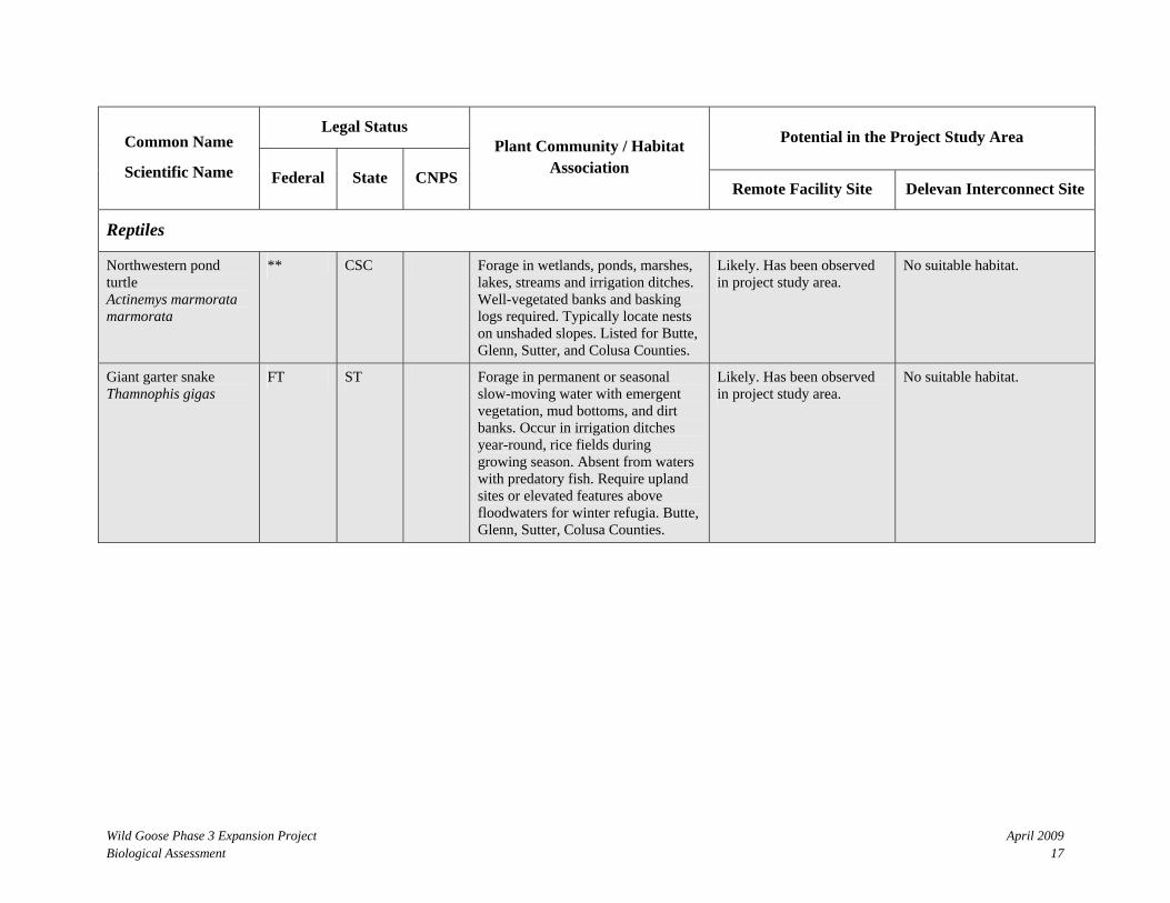
Northwestern pond turtle Actinemys marmorata marmorata
** CSC Forage in wetlands, ponds, marshes, lakes, streams and irrigation ditches. Well-vegetated banks and basking logs required. Typically locate nests on unshaded slopes. Listed for Butte, Glenn, Sutter, and Colusa Counties.
Likely. Has been observed in project study area.
No suitable habitat.
Giant garter snake Thamnophis gigas
FT ST Forage in permanent or seasonal slow-moving water with emergent vegetation, mud bottoms, and dirt banks. Occur in irrigation ditches year-round, rice fields during growing season. Absent from waters with predatory fish. Require upland sites or elevated features above floodwaters for winter refugia. Butte, Glenn, Sutter, Colusa Counties.
Likely. Has been observed in project study area.
No suitable habitat.
April 2009 Wild Goose Phase 3 Expansion Project 18 Biological Assessment
Legal Status Potential in the Project Study Area Common Name
Scientific Name Federal State CNPS
Plant Community / Habitat Association
Remote Facility Site Delevan Interconnect Site
Birds
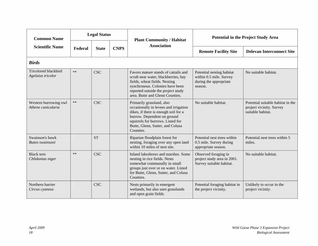
Tricolored blackbird Agelaius tricolor
** CSC Favors mature stands of cattails and scrub near water, blackberries, hay fields, wheat fields. Nesting synchronous. Colonies have been reported outside the project study area. Butte and Glenn Counties.
Potential nesting habitat within 0.5 mile. Survey during the appropriate season.
No suitable habitat.
Western burrowing owl Athene cunicularia
** CSC Primarily grassland, also occasionally in levees and irrigation dikes, if there is enough soil for a burrow. Dependent on ground squirrels for burrows. Listed for Butte, Glenn, Sutter, and Colusa Counties.
No suitable habitat. Potential suitable habitat in the project vicinity. Survey suitable habitat.
Swainson's hawk Buteo swainsoni
ST Riparian floodplain forest for nesting, foraging over any open land within 10 miles of nest site.
Potential nest trees within 0.5 mile. Survey during appropriate season.
Potential nest trees within 5 miles.
Black tern Chlidonias niger
** CSC Inland lakeshores and marshes. Some nesting in rice fields. Nests somewhat communally in small groups just over or on water. Listed for Butte, Glenn, Sutter, and Colusa Counties.
Observed foraging in project study area in 2001. Survey suitable habitat.
No suitable habitat.
Northern harrier Circus cyaneus
CSC Nests primarily in emergent wetlands, but also uses grasslands and open grain fields.
Potential foraging habitat in the project vicinity.
Unlikely to occur in the project vicinity.

Wild Goose Phase 3 Expansion Project April 2009 Biological Assessment 19
Legal Status Potential in the Project Study Area Common Name
Scientific Name Federal State CNPS
Plant Community / Habitat Association
Remote Facility Site Delevan Interconnect Site
Western yellow-billed cuckoo Coccyzus americanus occidentalis
FC SE Riparian, floodplain forest, shrubs. Prefer large woodlands with unbroken canopy and trees with vertical branches for nesting.
No suitable habitat. No suitable habitat.
White-tailed kite Elanus leucurus
FP Hunts over all habitats, including agricultural areas. Perches and nests in trees and shrubs in riparian areas. Glenn, Sutter, and Colusa Counties.
Year-round resident. Potential nesting or roosting within 0.5 mile. Survey suitable habitat.
Unlikely to occur in the project vicinity.
Merlin Falco columbarius
WL Seacoast, tidal estuaries, open woodlands, savannahs, edges of grasslands and deserts, farms and ranches. Butte County.
No suitable habitat. No suitable habitat.
Greater sandhill crane Grus canadensis tabida
ST, FP Nests in wetland habitats in northeastern California and winters in the Central Valley. Prefers grain fields within 4 miles of a shallow body of water used as a communal roost site. About 35 adults observed within 1.5 mile northeast of RFS and 50 within 0.7 miles southeast of RFS.
No suitable nesting habitat. No suitable nesting habitat.
Loggerhead shrike Lanius ludovicianus
** CSC Common resident and winter visitor throughout the lowlands and foothills of California. Listed for Butte, Glenn, Sutter, and Colusa Counties. Confirmed on Gray Lodge near Remote Facility Site (RFS). Prefers habitats with scattered shrubs, trees, posts, fences, utility lines and other perches.
Have been observed in the project study area. Survey suitable habitat.
Unlikely to occur in the project vicinity.

April 2009 Wild Goose Phase 3 Expansion Project 20 Biological Assessment
Legal Status Potential in the Project Study Area Common Name
Scientific Name Federal State CNPS
Plant Community / Habitat Association
Remote Facility Site Delevan Interconnect Site
California black rail Laterallus jamaicensis coturniculus
ST Inhabits freshwater marshes, wet meadows and shallow margins of saltwater marshes bordering larger bays. Needs water depths of about 1 inch that does not fluctuate during the year and dense vegetation for nesting habitat.
Have been recorded 3.5 miles northwest of site in semi-permanent wetlands. Very low potential within roadside drainage.
No suitable habitat.
White-faced ibis Plegadis chihi
** WL Any water area, rice field or other harvested grain fields. Nests in aquatic vegetation, shrubs and low trees in large colonies. Listed for Butte, Glenn, Sutter, and Colusa Counties.
Potential foraging habitat in the project vicinity.
Unlikely to occur in the project vicinity.
Bank swallow Riparia riparia
ST Colonial nesters in riparian and other lowland habitats where they dig neat holes in vertical banks and cliffs with fine-textured or sandy soils.
No suitable habitat. No suitable habitat.
Mammals
San Joaquin pocket mouse Perognathus inornatus
** CSC Dry, open, grassy or weedy areas; fine-textured soil. Listed for Butte, Glenn, Sutter, and Colusa Counties.
No suitable habitat. Unlikely. Not documented during previous surveys.
Sources: CDFG, 1985; CDFG, 1990; CDFG, 2008; CNPS, 1993; Hickman, 1993, USFWS, 2008; Zeiner et al., 1990

Wild Goose Phase 3 Expansion Project April 2009 Biological Assessment 21
STATUS CODES: U.S. Fish and Wildlife Service FC = Listed as Candidate by the Federal Government FE = Listed as Endangered by the Federal Government FT = Listed as Threatened by the Federal Government ** = In 2002, this used to be Federal Species of Concern (FSC), but the Sacramento Fish and Wildlife office no longer maintains a list of species of special concern. However, various other agencies and organizations maintain lists of at-risk species. These lists provide essential information for land management planning and conservation efforts.
California Natural Plant Society CNPS 1A = Presumed extinct in California CNPS 1B = Rare, threatened, or endangered in California CNPS 2 = Rare, threatened, or endangered in California, but more common elsewhere CNPS 3 = Need more information about this plant (Review List)
California Department of Fish and Game CSC = Listed as California Species of Special Concern FP = Fully Protected SE = Listed as Endangered by the State Government ST = Listed as Threatened by the State Government WL = Watch List

April 2009 Wild Goose Phase 3 Expansion Project 22 Biological Assessment
Wild Goose Phase 3 Expansion Project April 2009 Biological Assessment 23
Conservancy Fairy Shrimp (Branchinecta conservatio), Vernal Pool Fairy Shrimp (Branchinecta lynchi), and Vernal Pool Tadpole Shrimp (Lepidurus packardi) Three types of fairy shrimp that are typically found in vernal pools and swales could potentially be found in the Project area. Conservancy fairy shrimp and vernal pool tadpole shrimp are listed under the Federal Endangered Species Act as endangered species. Vernal pool fairy shrimp is listed under the Federal Endangered Species Act as threatened species. These species may be present in the vernal pools that were identified along the access road to the Delevan Interconnect Site.
Giant Garter Snake (Thamnophis gigas) Giant garter snake is listed under both the Federal and California Endangered Species Acts as a threatened species. The giant garter snake is one of several garter snakes found in North America. It is endemic to the valley floor wetlands of the Sacramento and San Joaquin Valleys of Central California (USFWS, 1993). They are the largest species of garter snakes, reaching up to five feet in length with females tending to be slightly longer and proportionately heavier than the males. This snake’s cryptic coloration varies from brownish to olive with a checkered pattern of black spots, separated by a yellow dorsal stripe and two light colored lateral stripes. They are active diurnal snakes, basking on emergent vegetation not far from water during the day. At night they retreat to small mammal burrows and crevices. Giant garter snakes are active from mid-March until October and breeding typically occurs in March and April. They are dormant during the winter months of November to mid-March, when they retreat to winter hibernacula. The giant garter snake is one of the most aquatic species of garter snakes, rarely inhabiting areas away from water (California Department of Fish and Game (CDFG), 1979). They are primarily associated with wetlands, marshes and sloughs, low gradient streams, agricultural wetlands, and irrigation and drainage canals. They forage along streams for fish, amphibians, and amphibian larvae. They are absent from larger rivers and do not occupy riparian habitat. While once a common snake, the elimination and degradation of their preferred aquatic habitat has drastically reduced their population. Habitat loss and urbanization are the main factors contributing to the decline in this species, with the majority of their original favored wetlands lost to development. In addition, contaminants from agricultural fields and introduced predators threaten the giant garter snakes' future success and viability (CDFG, 1979). Giant garter snakes could forage in the rice fields and ditches surrounding the Remote Facility Site and could utilize the parking area and the berms around the Remote Facility Site as upland hibernacula.
Swainson’s Hawk (Buteo swainsoni) Swainson’s hawk is listed under the California Endangered Species Act as a threatened species. At one time, Swainson’s hawks were amongst the most common raptor species in the state, but it is estimated that their breeding population has declined by 91 percent since 1900 (Bloom, 1980). Swainson’s hawks breed in California, primarily within the Central Valley, and migrate to South

April 2009 Wild Goose Phase 3 Expansion Project 24 Biological Assessment
America for the winter. Potential nesting habitat includes riparian woodlands, isolated trees, oak groves, and roadside trees. This habitat is generally adjacent or in close proximity to agricultural fields, where they forage on voles (Microtus spp.), pocket gophers (Thomomys bottae), mice (Peromyscus spp.), ground squirrels (Spermophilus beecheyi), and various birds and insects. The reason for the decline in nesting pairs has been attributed to loss of native nesting and foraging habitat along with conversion of agricultural areas to urban land uses. In addition, herbicide use, shooting, and disturbances at their wintering sites have affected Swainson’s hawks. Swainson’s hawks appear to favor riparian trees for nesting and much of the riparian habitat in the Central Valley has been lost to agricultural practices and flood control activities. Swainson’s hawks could nest in trees within 0.5 mile of the Remote Facility Site and within 5 miles of the Delevan Interconnect Site.
3.4 SPECIES OF SPECIAL CONCERN In 2002, the Federal Species of Concern (FSC) was eliminated from consideration and the Sacramento Fish and Wildlife office no longer maintains a list of species of special concern. However, various other agencies and organizations maintain lists of at-risk species. These lists provide essential information for land management planning and conservation efforts. The state of California still maintains a list of Species of Special Concern as detailed below.
Western Spadefoot Toad (Spea hammondii) The Western spadefoot Toad is considered a California species of concern. Potential breeding sites are in the form of vernal pools or swales and summer estivation sites are in the form of cracks or small mammal burrows in the grasslands. This species could utilize the vernal pools along the access road to the Delevan Interconnect Site but are not likely to occur at the Delevan Interconnect Site which is approximately 2,000 feet away.
Northwestern Pond Turtle (Actinemys marmorata marmorata) Northwestern pond turtle is considered a California species of concern. Female pond turtles typically deposit eggs within excavated holes on unshaded, often partially south-facing slopes, with a substrate of high clay or silt fraction. Most nesting sites are located within 200 yards of an aquatic site (Jennings and Hayes, 1994). This species could potentially be found in the ditches associated with rice fields at the Remote Facility Site.
Tricolored Blackbird (Agelaius tricolor) Tricolored blackbird is considered a Federal and California species of concern. Nesting colonies of tricolored blackbirds can be found in thickets of riparian scrub, blackberry, wild rose, or freshwater marsh near water. Breeding takes place between mid-April and late July. Colonies will forage in pastures, grasslands, or croplands up to four miles from the breeding site. Insects make up the majority of the diet during the breeding season, whereas seeds and grains make up most of the fall and winter diet. Large breeding colonies can be vulnerable to mammalian and

Wild Goose Phase 3 Expansion Project April 2009 Biological Assessment 25
avian predators (Zeiner et al., 1990). This species could potentially nest within 0.5 mile of the RFS.
Western Burrowing Owl (Athene cunicularia) The western burrowing owl is considered a Federal and California species of concern. They are mostly year-round residents of open, dry grasslands and other dry habitats, but some northern range individuals may winter in the south (Zeiner et al., 1990). Though grasslands are their primary habitat, they can also be found in levees and irrigation dikes where ground squirrel burrows provide suitable roosting and nesting cover. Breeding occurs from March through August. Conversion of grasslands to agriculture and poisoning of ground squirrels have been implicated in a reduction of numbers in recent years (Zeiner et al., 1990). Potential nesting habitat for this species occurs in the grasslands around the Delevan Interconnect Site.
Black tern (Chlidonias niger) Black tern is considered a California species of special concern. They occur primarily as a migrant and summer resident in California. Loss of their original wetlands habitat has been replaced by rice fields as a place for these animals to reside (Shuford et al., 2001). Black terns have been observed foraging in the vicinity of the Remote Facility Site and have been known to nest in rice fields.
Northern Harrier (Circus cyaneus) Northern harrier is considered a California species of special concern. Northern harriers nest on the ground in freshwater marsh, grasslands, or grain fields. They hunt by making low flights over open ground, or they hover and dive on prey. They feed primarily on small mammals, birds, frogs, reptiles, and insects. Whereas harriers can be locally abundant where suitable habitat remains intact, loss of wetland habitat and disturbance of breeding areas during the breeding cycle have been cited as reasons for decline (Zeiner et al., 1990). This species could forage in the vicinity of the Remote Facility Site and could nest in wetland areas associated with Gray Lodge and nearby hunting clubs.
White-tailed Kite (Elanus caeruleus) White-tailed kite is a fully protected species in California. They can be common year-round residents in valley lowlands near agricultural areas. White-tailed kites mostly prey on small mammals in open grasslands, farmlands, and emergent wetlands. They typically hover and glide slowly down on prey. Nests are located near the top of oak, willow, or other dense tree stands near open foraging areas. Potential nesting trees are present within 0.5 mile of the Remote Facility Site.
Loggerhead Shrike (Lanius ludovicianus) Loggerhead shrike is considered a California species of concern. They can be found in a variety of plant communities where there are openings and scattered shrubs, trees, or other perches, such as posts or fences. They search for prey, primarily large insects, from low perches, and often

April 2009 Wild Goose Phase 3 Expansion Project 26 Biological Assessment
catch prey on barbed wire, thorns, or sharp twigs for later feeding. Nesting usually occurs within dense foliage in trees or shrubs (Zeiner et al., 1990). Loggerhead shrikes have been observed along West Liberty Road near the Remote Facility Site.
White-faced Ibis (Plegadis chihi) White-faced ibis is on the California Department of Fish and Game watch list. They are colony-nesting birds that form rookeries in aquatic vegetation, shrubs, or low trees near water or wetlands. They feed in emergent wetland vegetation, wet meadows, shallow waters, pastures, and flooded rice fields. Breeding colonies in California have become rare, likely due to destruction of extensive marsh systems (Zeiner et al., 1990). This species could forage in the vicinity of the Remote Facility Site.
San Joaquin Pocket Mouse (Perognathus inornatus) San Joaquin pocket mouse is considered a California species of concern. They dig burrows in dry grassy or weedy areas where there is fine-textured soil. At the northern extreme of its range, it occurs on rocky south-facing slopes with chamise (Adenostoma fasciculatum) and buck brush (Ceanothus cuneatus) (Best, 1993). San Joaquin pocket mice are nocturnal, foraging primarily for seeds. Breeding occurs from March to July. Potential habitat occurs in the grasslands around the Delevan Interconnect Site. However, this species was not found during three days of trapping for the Expansion.

Wild Goose Phase 3 Expansion Project April 2009 Biological Assessment 27
4.0 METHODS
4.1 LITERATURE REVIEW Known locations of sensitive species were obtained from the California Natural Diversity Database (CNDDB), the California Native Plant Society (CNPS), and the United States Fish and Wildlife Service (USFWS). A total of 41 sensitive species – 19 plant and 22 wildlife species – were identified from these databases as potentially occurring in the portion of the Sacramento Valley in which the Project is located (CDFG, 2008, USFWS, 2008 and CNPS, 2008). This list served as a starting point in determining if there were known locations of sensitive species or whether suitable habitat might actually be found in the project study area and could potentially be affected by the proposed project components. See Attachment A for USFWS Official List of federally protected species, CNDDB list with sensitive species and complementary CNDDB maps.
4.2 FIELD RECONNAISSANCE STUDY A field reconnaissance study was conducted on December 4, 2008 to evaluate the habitats in the Project study areas. Both the Remote Facility Site and the Delevan Interconnect Site were visited. See Attachment B for photos of the project sites.
4.3 BIOLOGICAL SURVEYS Biological surveys for many of these species were conducted in 2002 and were included in the original Biological Technical Report.

April 2009 Wild Goose Phase 3 Expansion Project 28 Biological Assessment
5.0 RESULTS
5.1 PLANT COMMUNITIES Plant community types in the Project area are divided into natural communities and developed or agricultural categories (see Figure 4). The WGS Project area supports annual grassland, freshwater marsh and agriculture (rice). These plant communities and habitat types are described below.
Freshwater Marsh At the Remote Facility Site, freshwater marsh occurs mainly in small, isolated patches within drainage ditches associated with rice fields. Freshwater marsh plant communities are dominated by perennial, emergent monocots to 5 meters tall, often forming completely closed canopies. Sites typically lack significant flow and are permanently flooded by freshwater. Prolonged saturation permits accumulation of deep, peaty soils (Holland, 1996). This plant community in the project area is dominated by common tule (Scirpus acutus) sometimes occurring in monotypic stands.
Open Water Open water is mainly found in irrigation canals and ditches adjacent to the Remote Facility Site, often in association with freshwater marsh.
Annual Grasslands Annual grasslands occur west of the Glenn-Colusa Canal to the Delevan Compressor Station. The grasslands near the Delevan Compressor Station are regularly grazed. Annual grasslands occur on fine-textured, usually clay soils, that are moist or even waterlogged during the winter rainy season and very dry during the summer and fall (Holland, 1986). They are often found adjacent to oak woodlands associated with numerous species of showy, native annual wildflowers (Holland, 1986). Germination occurs with the onset of the late fall rains; growth, flowering, and seed-set occur from winter through spring (Holland, 1986). With few exceptions, the plants are dead through the summer and fall dry season, persisting as seeds (Holland, 1986).

0 1 21Scale in Miles
Wnc.Gas Storage F acilities Expansion Project
Project Components
Febr
uary
26,
200
9, T
RC
PG
&E
L40
0/40
1
Wild Goose Phase 3 Expansion Project
0 1 21Scale in Miles
Seasonal Wetlands
Annual Grassland
RiparianScrub/Woodland
RiparianScrub/Woodland
Waterways / Canals
Perennial Wetland(includes managed waterfowl areas as well as natural marsh habitat)
Plant Communities MapFigure 4
PG&E L167
PG
&E
L17
2
Line 400 Connection Pipeline
Delevan Interconnect Site and Lateral Line
DelevanStation
RemoteFacilitySite
Storage Pipeline and Loop
Well Pad Site

Wild Goose Phase 3 Expansion Project April 2009 Biological Assessment 31
Annual grasslands in the Project area are dominated by Italian ryegrass, soft chess brome (Bromus hordeaceus), and barley (Hordeum spp.). Other components of these grasslands include wild oat (Avena barbata), ripgut brome, Bermuda grass, red brome, yellow star thistle, filaree (Erodium sp.), bur-chervil (Anthriscus caucalis), and clover (Trifolium sp.).
Vernal Pool/Vernal Swale Vernal pools were identified in the vicinity of the Delevan Interconnect Site. Three low-quality vernal pools were identified in the grassland between the Delevan Interconnect Site and the Glenn-Colusa Canal. These vernal pools are along the road and almost 2000 feet from the Delevan Interconnect Site . The areas were dominated by the following species: Italian ryegrass, Mediterranean barley (Hordeum marinum), toad rush (Juncus bufonius), and swamp timothy. The entire grassland area, including the vernal pools is subject to cattle grazing. The vernal pool areas appear to suffer more severe impact due to the cattle concentrating around areas of standing water.
General Agriculture Extensive agriculture fields that are currently in rice production are found throughout the Remote Facility Site.
April 2009 Wild Goose Phase 3 Expansion Project 32 Biological Assessment
6.0 POTENTIAL EFFECTS AND RECOMMENDATIONS
The following section summarizes the potential direct and indirect effects of the project on sensitive species and provides recommendations for minimizing effects. Direct and indirect impacts are discussed for each species and the associated critical habitat that may be affected by the Project. These types of impacts are described below. Direct impacts are defined as effects to species or their critical habitat that occur during the implementation of a project. These impacts are likely to result from construction of the project, but are not likely to continue once construction is complete. Indirect impacts are defined as effects that occur to species or their critical habitat after implementation of the project is complete. These effects are caused by or result from project activities and are reasonably certain to occur. Preconstruction surveys are recommended for a number of sensitive species. These surveys should be conducted in suitable habitat, as identified in Table 1. In addition, the goals for general and species-specific protection measures implemented during construction include:
• no significant adverse change or loss of critical habitat, • no significant disturbance of special-status species individuals, and • restoration and natural revegetation of temporarily disturbed surfaces within one growing
season. Protection measures are designed to avoid negatively impacting sensitive species that are in the area during construction. Preconstruction surveys will be conducted for sensitive species. Strategies that will reduce all potential impacts to an insignificant level include:
• avoidance of sensitive species during the breeding or dormancy period, • utilizing construction techniques that will minimize or avoid impacts, • preconstruction measures to discourage sensitive species from entering the work area, • training of construction personnel on sensitive species protection requirements, and • enhancement of habitat values for giant garter snake excavation sites.
WGS will develop a comprehensive training program to ensure that all Project staff is thoroughly briefed on their environmental responsibilities. The training program includes the following elements:
Management Training A four-hour management training program at construction start will be held with the environmental team, construction team, lands team, key agency personnel, and contractor management staff. The purpose of this program will be twofold: 1) to provide an overview of the environmental requirements, with presentations on the different resource specialty areas, and 2) to promote cross training and team building

Wild Goose Phase 3 Expansion Project April 2009 Biological Assessment 33
Crew Training A 30- to 45-minute session will be held for all crews upon arrival to the job site. These sessions will emphasize Project rules and key environmental requirements for the construction workforce. Special-status species identification and responsibilities concerning sensitive species and habitat protection will be discussed at these sessions.
Tailgate Training Tailgate training will be held in the field as necessary to train crews on particular resources or specific construction methods. Tailgates will often be used when sensitive resources are involved (e.g., giant garter snake) or when specific construction techniques are needed to meet mitigation requirements. Mandatory tailgates will be used as a tool to manage noncompliance incidents.
6.1 PLANTS Direct Effects Direct effects to sensitive plants species could occur by clearing and grading activities.
Indirect Effects Temporary loss of habitat could result due to construction work or staging activities. An indirect effect due to ground-disturbing activities could occur from the introduction of non-native weeds into the project area. Additionally, loss of one season of seed production may result due to the removal of annual plants.
Recommendations Conduct sensitive plant species surveys prior to construction within suitable habitat and during the appropriate survey window. Establish exclusion zones as necessary. Avoid flowering periods; strip and stockpile topsoil; ensure a post-construction replacement ratio of 1:1 for each plant removed or severely impacted. Limit construction activities in wetlands to the driest periods (approximately early-June through mid-August). Implement Best Management Practices (BMPs), such as equipment cleaning to prevent the introduction of weed into the area.
6.2 INVERTEBRATES Direct Effects Direct effects to invertebrate species that may be in the Project area are not expected to occur because WGS has committed to avoiding sensitive habitat (e.g., vernal pools). Indirect Effects Due the distance of the Delevan Interconnect Site from vernal pools, indirect effects vernal pool species are not expected.

April 2009 Wild Goose Phase 3 Expansion Project 34 Biological Assessment
Recommendations Install and maintain temporary erosion controls during construction in the grassland areas north of the Glenn-Colusa Canal. Confine vehicles and equipment to the access road that leads to the Delevan Interconnect Site.
6.3 WESTERN SPADEFOOT (SPEA HAMMONDII) Direct Effects No breeding sites for western spadefoot have been identified in the Project area; therefore, no direct effects are expected to occur.
Indirect Effects As stated above, no known locations of breeding spadefoot are documented within close proximity of the Project area. Therefore, indirect effects are not expected to occur to this species.
Recommendations Conduct preconstruction surveys in the grasslands during the breeding season to confirm the presence or absence of this species.
6.4 GIANT GARTER SNAKE (THAMNOPHIS GIGAS) Direct Effects Direct effects to giant garter snake could occur due to direct mortality of snakes during construction activities, temporary disruption of breeding and foraging, and permanent loss of foraging habitat. Potential foraging habitat in the form of ditches and flooded rice fields occur at the Remote Facility Site. The primary impacts to aquatic habitat will occur as a result of work conducted in rice fields. Approximately 4.5 acres of rice field will be permanently filled as a result of the expansion at the Remote Facility Site.
Indirect Effects Indirect effects could include loss of foraging, breeding, or hibernation opportunities.
Recommendations Implement measures for the protection of giant garter snake as described in the Biological Resources Protection Plan and the US Fish and Wildlife Service Biological Opinion that were developed for the) Expansion. Also, in order to avoid impact to the giant garter snake, surface-disturbing activities in potential snake habitat cannot generally occur during the months of October through April while the snake is hibernating. Potential habitat includes all flooded rice fields, wetlands, and both agricultural and natural water bodies. To avoid increased impacts to wetland vegetation and soils in the Butte Sink area, construction should occur during the dry season — typically from early-June through late-August.
Wild Goose Phase 3 Expansion Project April 2009 Biological Assessment 35
6.5 NORTHWESTERN POND TURTLE (ACTINEMYS MARMORATA MARMORATA)
Direct Effects Direct effects to pond turtles may result as direct mortality or loss of breeding locations.
Indirect Effects Temporary disruption of foraging habitat in the Project area may result due to construction activities adjacent to pond turtle habitat.
Recommendations Implement measures for the protection of northwestern pond turtle as described in the Biological Resources Protection Plan that was developed for the Expansion. . This includes performing preconstruction surveys to relocate any pond turtles from harm’s way.
6.6 TRICOLORED BLACKBIRD (AGELAIUS TRICOLOR) Direct Effects Project activities are unlikely to directly affect tricolored blackbirds.
Indirect Effects No indirect effects to tricolored blackbirds are expected.
Recommendations Conduct preconstruction surveys to confirm no tricolored blackbirds are nesting in the Project area. Avoid active nest sites until tricolored blackbirds have finished nesting. If nests are found, then establish a minimum 250-foot buffer zone around the nest.
6.7 WESTERN BURROWING OWL (ATHENE CUNICULARIA) Direct Effects Nesting and foraging burrowing owls may be disturbed during construction activities at the Delevan Interconnect Site.
Indirect Effects Increased noise and human presence may harass the birds away from nest locations and disrupt foraging behavior.

April 2009 Wild Goose Phase 3 Expansion Project 36 Biological Assessment
Recommendations Conduct preconstruction surveys to confirm that no burrowing owls are nesting or foraging in the Project area. If nests are found, establish a minimum 250-foot buffer zone around the nest until relocation activities are completed (non-breeding season only). Excavate burrows after relocation activities are completed. Replace each burrow excavated with one natural or artificial burrow outside of the 250-foot exclusion zone.
6.8 SWAINSON’S HAWK (BUTEO SWAINSONI) Direct Effects Nesting and foraging Swainson's hawks may be temporarily disturbed during construction activities. Increased noise and human presence may harass the birds away from nest locations and disrupt foraging behavior. Approximately 0.6 acre of foraging habitat will be lost as a result of expansion at the Delevan Interconnect Site.
Indirect Effects Indirect effects are not expected to occur to this species.
Recommendations Implement measures for the protection of Swainson’s hawk as described in the Biological Resources Protection Plan that was developed for the Expansion. . Limit construction activities to outside the time period for breeding and nesting (March 1 to August 1) of the Swainson's hawk. If construction must occur within a half mile of known nesting sites, a qualified biologist will monitor the nest site to ensure that the hawks are not substantially disturbed (i.e., show signs of upset, repeatedly leaving the nest as a result of construction). Halt construction activities if signs of disturbance are indicated.
6.9 BLACK TERN (CHLIDONIAS NIGER) Direct Effects Nesting is not likely to occur in the Project area. Therefore, direct effects to black terns are not expected to occur as a result of this Project.
Indirect Effects Black terns have been noted foraging over the rice fields in the Project area. Temporary disruption of rice production may impact the foraging areas utilized by the terns.
Recommendations Perform preconstruction surveys to confirm no black terns are nesting in the Project area. Avoid active nest sites until terns have finished nesting. If nests are found, then establish a minimum 250-foot buffer zone around the nest.
Wild Goose Phase 3 Expansion Project April 2009 Biological Assessment 37
6.10 NORTHERN HARRIER (CIRCUS CYANEUS) Direct Effects Northern harriers have been noted foraging over the rice fields in the project area. Temporary disruption of rice production may impact the foraging areas utilized by this species.
Indirect Effects Permanent loss of foraging habitat will result due to Remote Facility Site expansion. Recommendations Conduct preconstruction surveys to determine if any harriers are actively nesting near the project sites. If found, then establish exclusion zones (minimum of 250 feet) around the nesting area until the harriers have successfully fledged their young. Restore foraging and nesting habitat to preconstruction or better conditions.
6.11 WHITE-TAILED KITE (ELANUS LEUCURUS) Direct Effects Nesting and foraging white-tailed kite may be temporarily disturbed during construction activities. Increased noise and human presence may harass the birds away from nest locations and disrupt foraging behavior. Approximately 0.6 acre of foraging habitat will be lost as a result of the expansion at the Delevan Interconnect Site.
Indirect Effects Permanent loss of foraging habitat will result due to Delevan Interconnect Site expansion.
Recommendations Perform preconstruction survey of suitable habitat. If nests are found, then establish a minimum 500-foot buffer zone around the nest.
6.12 LOGGERHEAD SHRIKE (LANIUS LUDOVICIANUS) Direct Effects Nesting activities are largely completed prior to the open construction window for giant garter snake (May 1). If nesting goes on beyond May 1, then nesting birds near the construction area could avoid or abandon their nest.
Indirect Effects Permanent loss of foraging habitat may occur due to Remote Facility Site expansion.
April 2009 Wild Goose Phase 3 Expansion Project 38 Biological Assessment
Recommendations Perform preconstruction survey of suitable habitat. If nests are found, then establish a minimum 250-foot buffer zone around the nest.
6.13 WHITE-FACED IBIS (PLEGADIS CHIHI) Direct Effects Nesting is not likely to occur in the Project area. Therefore, direct effects to white-faced ibis are not expected to occur as a result of this Project. Indirect Effects Ibis have been regularly noted as foraging in rice fields, so there may be an indirect effect due to loss of rice fields. Recommendations No impacts to this species are expected.
6.14 SAN JOAQUIN POCKET MOUSE (PEROGNATHUS INORATUS) Direct Effects This species was not found during three days of trapping for the Expansion. Therefore, direct effects to San Joaquin pocket mouse are not expected to occur as a result of this Project. Indirect Effects Indirect effects are not expected to occur to this species. Recommendations No additional surveys are necessary for this species.
6.15 CUMULATIVE EFFECTS Impacts to sensitive species will be mitigated during construction using avoidance measures and sensitive construction techniques. All of these effects are expected to be less than significant, and therefore, are not expected cumulatively to adversely affect any sensitive species. The vast majority of habitat for the giant garter snake impacted by the Project is in the form of flooded rice fields. No wetlands will be disturbed but a small amount of rice field will be permanently lost by the expansion of the Remote Facility Site. The US Fish and Wildlife Service will require that these losses be compensated for by off-site habitat preservation. Rice production is the dominant agricultural commodity in Colusa County where agriculture makes up 36 percent of the economy. Rice production is similarly important to Butte County, although the economy is heavily influenced by the City of Chico. Consequently, giant garter

Wild Goose Phase 3 Expansion Project April 2009 Biological Assessment 39
snake habitat provided by rice fields is not likely to be cumulatively lost by development forces in the region. Rice fields are more likely lost when they are converted into managed wetlands to add to the recreational hunting and bird watching activities. As wetlands typically provide as good or better habitat for giant garter snake, any cumulative impacts would not be considered significant.
April 2009 Wild Goose Phase 3 Expansion Project 40 Biological Assessment
7.0 CONCLUSIONS AND DETERMINATION STATEMENTS
Potential direct effects resulting from this project include species harassment, displacement, or mortality; habitat destruction; or impacted water quality resulting from accidental hazardous material spills, sedimentation, or altered hydrology. Potential indirect effects include loss or degradation of future habitat functionality or impacted water quality resulting from adverse habitat modification causing future sedimentation and/or altered hydrology. Potential adverse impacts to these species and their habitats can be minimized or avoided if project conservation measures are implemented. Implementation of appropriate construction BMPs, restricting work to non-sensitive or designated areas, providing environmental awareness to the crew, and restoring the site appropriately are general measures that will minimize or avoid the negative effects that may be associated with construction of the project. Additional conservation measures that may avoid or minimize adverse affects to potentially occurring special-status species include avoiding sensitive temporal windows for wildlife, conducting appropriate preconstruction surveys for wildlife species in the project action area, checking for wildlife beneath vehicles and equipment in the project area, restricting construction activities to daylight hours where feasible, and having a qualified biologist on-site for construction monitoring. Implementation of these measures will greatly reduce the potential for impact to special-status species and their habitats.
Wild Goose Phase 3 Expansion Project April 2009 Biological Assessment 41
8.0 REFERENCES
Best. 1993. Perognathus inornatus. Published by the American Society of Mammalogists. Copy available at Essex Environmental, San Luis Obispo, CA.
Bloom, P.H. 1980. The Status of the Swainson’s hawk in California. U.S. Department of Interior,
Bureau of Land Management, Sacramento. Project W-54-R-12, Job II-8. Final Rep. 42 pp.
California Department of Fish and Game (CDFG), California Interagency Wildlife Task Group.
1979. California Wildlife Habitat Relationships System. Online, http://www.dfg.ca.gov/whdab/R079.html. Site visited on March 12, 2001.
California Department of Fish and Game (CDFG). 1985. California’s Wildlife. Volume I:
Amphibians and Reptiles. California Statewide Wildlife Habitat Relationships System. California Department of Fish and Game (CDFG). 1990. California’s Wildlife. Volume III:
Mammals. California Statewide Wildlife Habitat Relationships System. California Department of Fish and Game (CDFG), Natural Heritage Division. 2008. California
Natural Diversity Data Base (CNDDB). California Native Plant Society (CNPS). 2008. California Native Plant Society’s Inventory of
Rare and Endangered Plants of California. 7th Edition. Online: http://cnps.web.aplus.net/cgi-bin/inv/inventory.cgi. Site visited: December 2008.
Hickman, J. 1993. The Jepson Manual: Higher Plants of California. University of California
Press. Berkeley. Holland, R.F. 1986. Preliminary Description of Terrestrial Natural Communities of California.
State of California. The Resources Agency, Department of Fish and Game. Jennings, Mark R., and Marc P. Hayes. 1994. Amphibian and Reptile Species of Special Concern
in California. California Department of Fish and Game, Rancho Cordova, CA. May Consulting Services. 1999. Reconnaissance-level Vernal Pool/Swale Site Assessment for the
Proposed Wild Goose – Delevan Pipeline Expansion Corridor. Walnut Grove, California.
Shuford, W. D. and T. Gardali. 2008. California Bird Species of Special Concern: A ranked
assessment of species, subspecies, and distinct populations of birds of immediate conservation concern in California. Studies of Western Birds 1. Western Field Ornithologists, Camarillo, California, and California Department of Fish and Game, Sacramento.

April 2009 Wild Goose Phase 3 Expansion Project 42 Biological Assessment
United States Fish and Wildlife Service (USFWS). 1993. Code of Federal Regulations, Title 50 Part 17. Endangered and Threatened Wildlife and Plants; Determination of Threatened Status for the Giant Garter Snake.
United States Fish and Wildlife Service (USFWS). 1999. Conservation Guidelines for the Valley
Elderberry Longhorn Beetle. United States Fish and Wildlife Service (USFWS). 2008. Sacramento Fish and Wildlife Office.
Species List for Sensitive Biological Resources in Study Area Located Within Biggs, Gridley, West of Biggs, Butte City, Sanborn Slough, Pennington, Logandale, Maxwell, Logan Ridge, and Sites U.S.G.S. 7 1/2 Minute Quads.
Zeiner, David C., W.F. Laudenslayer, Jr., K.E. Mayer, and M. White. 1990. California’s Wildlife
Volume II Birds. California Department of Fish and Game, Sacramento, CA.
Attachment A
Official USFWS Species List and CNDDB Species List and Maps


U.S. Fish & Wildlife Service
Sacramento Fish & Wildlife Office Federal Endangered and Threatened Species that Occur in
or may be Affected by Projects in the Counties and/or U.S.G.S. 7 1/2 Minute Quads you requested
Document Number: 081217063500 Database Last Updated: September 11, 2008
Quad Lists
Listed Species
Invertebrates Branchinecta conservatio
Conservancy fairy shrimp (E)
Branchinecta lynchi vernal pool fairy shrimp (T)
Desmocerus californicus dimorphus valley elderberry longhorn beetle (T)
Lepidurus packardi vernal pool tadpole shrimp (E)
Fish Acipenser medirostris
green sturgeon (T) (NMFS)
Hypomesus transpacificus delta smelt (T)
Oncorhynchus mykiss Central Valley steelhead (T) (NMFS) Critical habitat, Central Valley steelhead (X) (NMFS)
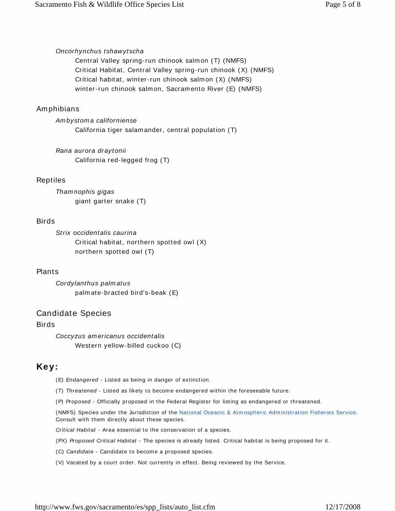
Oncorhynchus tshawytscha Central Valley spring-run chinook salmon (T) (NMFS) Critical Habitat, Central Valley spring-run chinook (X) (NMFS) winter-run chinook salmon, Sacramento River (E) (NMFS)
Amphibians Ambystoma californiense
California tiger salamander, central population (T)
Rana aurora draytonii California red-legged frog (T)
Reptiles Thamnophis gigas
giant garter snake (T)
Birds Strix occidentalis caurina
Page 1 of 8Sacramento Fish & Wildlife Office Species List
12/17/2008http://www.fws.gov/sacramento/es/spp_lists/auto_list.cfm
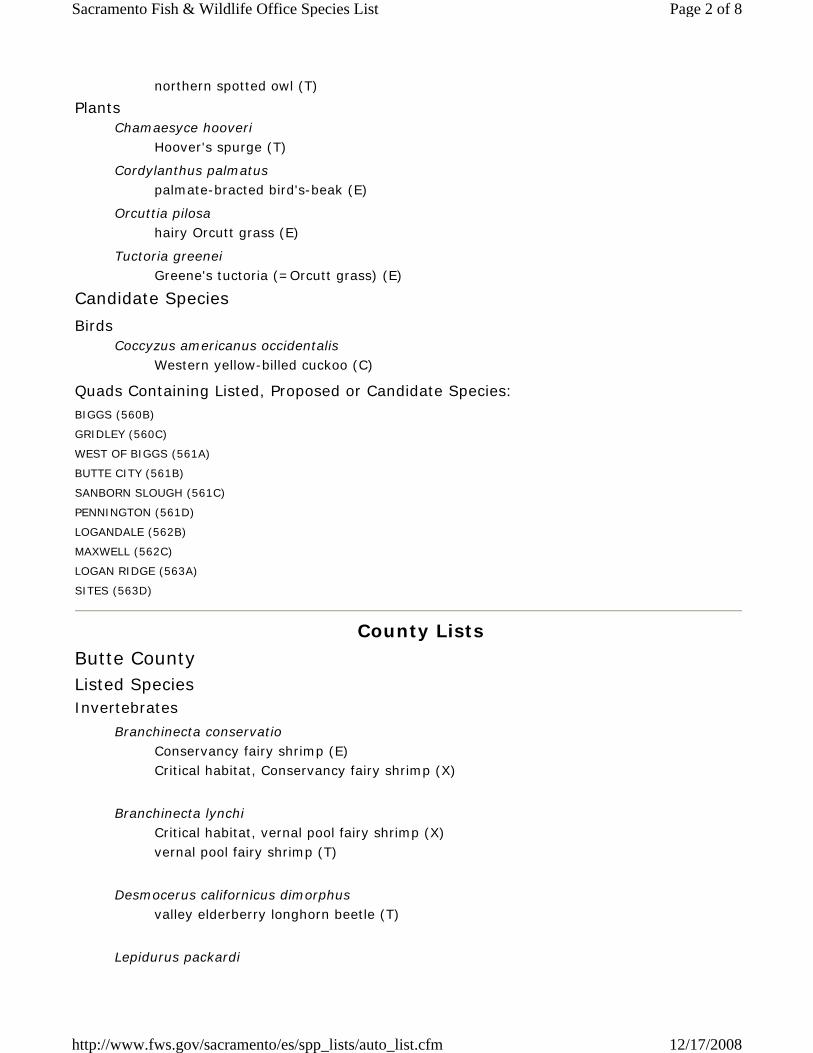
northern spotted owl (T)
Plants Chamaesyce hooveri
Hoover's spurge (T)
Cordylanthus palmatus palmate-bracted bird's-beak (E)
Orcuttia pilosa hairy Orcutt grass (E)
Tuctoria greenei Greene's tuctoria (=Orcutt grass) (E)
Candidate Species
Birds Coccyzus americanus occidentalis
Western yellow-billed cuckoo (C)
Quads Containing Listed, Proposed or Candidate Species: BIGGS (560B)
GRIDLEY (560C)
WEST OF BIGGS (561A)
BUTTE CITY (561B)
SANBORN SLOUGH (561C)
PENNINGTON (561D)
LOGANDALE (562B)
MAXWELL (562C)
LOGAN RIDGE (563A)
SITES (563D)
County Lists Butte County Listed Species Invertebrates
Branchinecta conservatio Conservancy fairy shrimp (E) Critical habitat, Conservancy fairy shrimp (X)
Branchinecta lynchi
Critical habitat, vernal pool fairy shrimp (X) vernal pool fairy shrimp (T)
Desmocerus californicus dimorphus
valley elderberry longhorn beetle (T)
Lepidurus packardi
Page 2 of 8Sacramento Fish & Wildlife Office Species List
12/17/2008http://www.fws.gov/sacramento/es/spp_lists/auto_list.cfm

Critical habitat, vernal pool tadpole shrimp (X) vernal pool tadpole shrimp (E)
Fish
Acipenser medirostris green sturgeon (T) (NMFS)
Oncorhynchus mykiss
Central Valley steelhead (T) (NMFS) Critical habitat, Central Valley steelhead (X) (NMFS)
Oncorhynchus tshawytscha
Central Valley spring-run chinook salmon (T) (NMFS) Critical Habitat, Central Valley spring-run chinook (X) (NMFS) Critical habitat, winter-run chinook salmon (X) (NMFS) winter-run chinook salmon, Sacramento River (E) (NMFS)
Amphibians
Ambystoma californiense California tiger salamander, central population (T)
Rana aurora draytonii
California red-legged frog (T) Critical habitat, California red-legged frog (X)
Reptiles
Thamnophis gigas giant garter snake (T)
Plants
Chamaesyce hooveri Critical habitat, Hoover's spurge (X) Hoover's spurge (T)
Limnanthes floccosa ssp. californica
Butte County (Shippee) meadowfoam (E) Critical habitat, Butte County (Shippee) meadowfoam (X)
Orcuttia pilosa
Critical habitat, hairy Orcutt grass (X) hairy Orcutt grass (E)
Orcuttia tenuis
Page 3 of 8Sacramento Fish & Wildlife Office Species List
12/17/2008http://www.fws.gov/sacramento/es/spp_lists/auto_list.cfm

slender Orcutt grass (T)
Tuctoria greenei
Critical habitat, Greene's tuctoria (=Orcutt grass) (X) Greene's tuctoria (=Orcutt grass) (E)
Candidate Species Amphibians
Rana muscosa mountain yellow-legged frog (C)
Birds
Coccyzus americanus occidentalis Western yellow-billed cuckoo (C)
Mammals
Martes pennanti fisher (C)
Colusa County Listed Species Invertebrates
Branchinecta conservatio Conservancy fairy shrimp (E)
Branchinecta lynchi
vernal pool fairy shrimp (T)
Desmocerus californicus dimorphus
valley elderberry longhorn beetle (T)
Lepidurus packardi
Critical habitat, vernal pool tadpole shrimp (X) vernal pool tadpole shrimp (E)
Fish
Acipenser medirostris green sturgeon (T) (NMFS)
Oncorhynchus mykiss
Central Valley steelhead (T) (NMFS) Critical habitat, Central Valley steelhead (X) (NMFS)
Page 4 of 8Sacramento Fish & Wildlife Office Species List
12/17/2008http://www.fws.gov/sacramento/es/spp_lists/auto_list.cfm
Oncorhynchus tshawytscha
Central Valley spring-run chinook salmon (T) (NMFS) Critical Habitat, Central Valley spring-run chinook (X) (NMFS) Critical habitat, winter-run chinook salmon (X) (NMFS) winter-run chinook salmon, Sacramento River (E) (NMFS)
Amphibians
Ambystoma californiense California tiger salamander, central population (T)
Rana aurora draytonii
California red-legged frog (T)
Reptiles
Thamnophis gigas giant garter snake (T)
Birds
Strix occidentalis caurina Critical habitat, northern spotted owl (X) northern spotted owl (T)
Plants
Cordylanthus palmatus palmate-bracted bird's-beak (E)
Candidate Species Birds
Coccyzus americanus occidentalis Western yellow-billed cuckoo (C)
Key:
(E) Endangered - Listed as being in danger of extinction.
(T) Threatened - Listed as likely to become endangered within the foreseeable future.
(P) Proposed - Officially proposed in the Federal Register for listing as endangered or threatened.
(NMFS) Species under the Jurisdiction of the National Oceanic & Atmospheric Administration Fisheries Service. Consult with them directly about these species.
Critical Habitat - Area essential to the conservation of a species.
(PX) Proposed Critical Habitat - The species is already listed. Critical habitat is being proposed for it.
(C) Candidate - Candidate to become a proposed species.
(V) Vacated by a court order. Not currently in effect. Being reviewed by the Service.
Page 5 of 8Sacramento Fish & Wildlife Office Species List
12/17/2008http://www.fws.gov/sacramento/es/spp_lists/auto_list.cfm
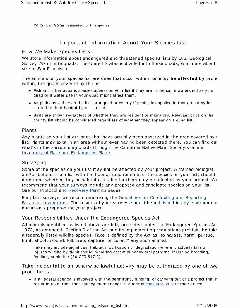
(X) Critical Habitat designated for this species
Important Information About Your Species List
How We Make Species Lists We store information about endangered and threatened species lists by U.S. Geological Survey 7½ minute quads. The United States is divided into these quads, which are about tsize of San Francisco.
The animals on your species list are ones that occur within, or may be affected by projewithin, the quads covered by the list.
Fish and other aquatic species appear on your list if they are in the same watershed as your quad or if water use in your quad might affect them.
Amphibians will be on the list for a quad or county if pesticides applied in that area may be carried to their habitat by air currents.
Birds are shown regardless of whether they are resident or migratory. Relevant birds on the county list should be considered regardless of whether they appear on a quad list.
Plants Any plants on your list are ones that have actually been observed in the area covered by tlist. Plants may exist in an area without ever having been detected there. You can find outwhat's in the surrounding quads through the California Native Plant Society's online Inventory of Rare and Endangered Plants.
Surveying Some of the species on your list may not be affected by your project. A trained biologist and/or botanist, familiar with the habitat requirements of the species on your list, should determine whether they or habitats suitable for them may be affected by your project. Werecommend that your surveys include any proposed and candidate species on your list. See our Protocol and Recovery Permits pages.
For plant surveys, we recommend using the Guidelines for Conducting and Reporting Botanical Inventories. The results of your surveys should be published in any environmentdocuments prepared for your project.
Your Responsibilities Under the Endangered Species Act All animals identified as listed above are fully protected under the Endangered Species Act1973, as amended. Section 9 of the Act and its implementing regulations prohibit the takea federally listed wildlife species. Take is defined by the Act as "to harass, harm, pursue, hunt, shoot, wound, kill, trap, capture, or collect" any such animal.
Take may include significant habitat modification or degradation where it actually kills or injures wildlife by significantly impairing essential behavioral patterns, including breeding, feeding, or shelter (50 CFR §17.3).
Take incidental to an otherwise lawful activity may be authorized by one of twoprocedures:
If a Federal agency is involved with the permitting, funding, or carrying out of a project that mresult in take, then that agency must engage in a formal consultation with the Service.
Page 6 of 8Sacramento Fish & Wildlife Office Species List
12/17/2008http://www.fws.gov/sacramento/es/spp_lists/auto_list.cfm

During formal consultation, the Federal agency, the applicant and the Service work together toavoid or minimize the impact on listed species and their habitat. Such consultation would resuin a biological opinion by the Service addressing the anticipated effect of the project on listed proposed species. The opinion may authorize a limited level of incidental take.
If no Federal agency is involved with the project, and federally listed species may be taken as part of the project, then you, the applicant, should apply for an incidental take permit. The Service may issue such a permit if you submit a satisfactory conservation plan for the species that would be affected by your project.
Should your survey determine that federally listed or proposed species occur in the area and alikely to be affected by the project, we recommend that you work with this office and the California Department of Fish and Game to develop a plan that minimizes the project's direct aindirect impacts to listed species and compensates for project-related loss of habitat. You shouinclude the plan in any environmental documents you file.
Critical Habitat When a species is listed as endangered or threatened, areas of habitat considered essentiato its conservation may be designated as critical habitat. These areas may require special management considerations or protection. They provide needed space for growth and normal behavior; food, water, air, light, other nutritional or physiological requirements; cover or shelter; and sites for breeding, reproduction, rearing of offspring, germination or seed dispersal.
Although critical habitat may be designated on private or State lands, activities on these lands are not restricted unless there is Federal involvement in the activities or direct harmlisted wildlife.
If any species has proposed or designated critical habitat within a quad, there will be a separate line for this on the species list. Boundary descriptions of the critical habitat may found in the Federal Register. The information is also reprinted in the Code of Federal Regulations (50 CFR 17.95). See our Map Room page.
Candidate Species We recommend that you address impacts to candidate species. We put plants and animalson our candidate list when we have enough scientific information to eventually propose thfor listing as threatened or endangered. By considering these species early in your planninprocess you may be able to avoid the problems that could develop if one of these candidatwas listed before the end of your project.
Species of Concern The Sacramento Fish & Wildlife Office no longer maintains a list of species of concern. However, various other agencies and organizations maintain lists of at-risk species. Theselists provide essential information for land management planning and conservation effortsMore info
Wetlands If your project will impact wetlands, riparian habitat, or other jurisdictional waters as definby section 404 of the Clean Water Act and/or section 10 of the Rivers and Harbors Act, yowill need to obtain a permit from the U.S. Army Corps of Engineers. Impacts to wetland habitats require site specific mitigation and monitoring. For questions regarding wetlands, please contact Mark Littlefield of this office at (916) 414-6580.
Page 7 of 8Sacramento Fish & Wildlife Office Species List
12/17/2008http://www.fws.gov/sacramento/es/spp_lists/auto_list.cfm

Updates Our database is constantly updated as species are proposed, listed and delisted. If you address proposed and candidate species in your planning, this should not be a problem. However, we recommend that you get an updated list every 90 days. That would be March17, 2009.
Page 8 of 8Sacramento Fish & Wildlife Office Species List
12/17/2008http://www.fws.gov/sacramento/es/spp_lists/auto_list.cfm
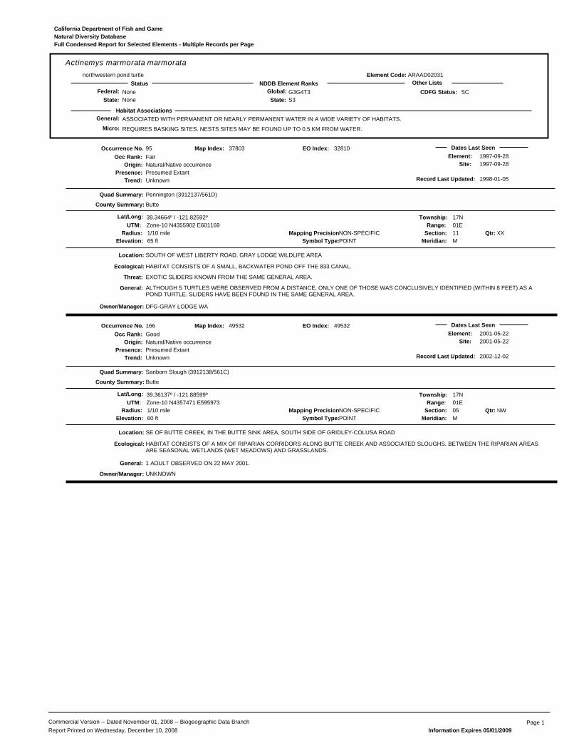
General: ASSOCIATED WITH PERMANENT OR NEARLY PERMANENT WATER IN A WIDE VARIETY OF HABITATS.
REQUIRES BASKING SITES. NESTS SITES MAY BE FOUND UP TO 0.5 KM FROM WATER.
ARAAD02031
Actinemys marmorata marmoratanorthwestern pond turtle
NoneNone
G3G4T3S3State:
Global:NDDB Element RanksStatus Other Lists
State:Federal: SC
Habitat Associations
CDFG Status:
Element Code:
Micro:
Natural Diversity DatabaseCalifornia Department of Fish and Game
Full Condensed Report for Selected Elements - Multiple Records per Page
95
Presence:Trend:
Fair
Location:
Element:Site:
EXOTIC SLIDERS KNOWN FROM THE SAME GENERAL AREA.
DFG-GRAY LODGE WA
Natural/Native occurrencePresumed ExtantUnknown
Dates Last Seen1997-09-281997-09-28
Quad Summary:
County Summary:
Pennington (3912137/561D)
Butte
SOUTH OF WEST LIBERTY ROAD, GRAY LODGE WILDLIFE AREA
Lat/Long: 39.34664º / -121.82592º Township: 17NRange: 01E
Section: 11 XXMeridian: M
Mapping Precision:NON-SPECIFIC1/10 mileSymbol Type:POINTElevation: 65 ft
37803
UTM: Zone-10 N4355902 E601169
Map Index:
HABITAT CONSISTS OF A SMALL, BACKWATER POND OFF THE 833 CANAL.
ALTHOUGH 5 TURTLES WERE OBSERVED FROM A DISTANCE, ONLY ONE OF THOSE WAS CONCLUSIVELY IDENTIFIED (WITHIN 8 FEET) AS APOND TURTLE. SLIDERS HAVE BEEN FOUND IN THE SAME GENERAL AREA.
Qtr:
Origin:
Occurrence No.Occ Rank:
Ecological:
Threat:
General:
Owner/Manager:
Radius:
Record Last Updated: 1998-01-05
32810EO Index:
166
Presence:Trend:
Good
Location:
Element:Site:
UNKNOWN
Natural/Native occurrencePresumed ExtantUnknown
Dates Last Seen2001-05-222001-05-22
Quad Summary:
County Summary:
Sanborn Slough (3912138/561C)
Butte
SE OF BUTTE CREEK, IN THE BUTTE SINK AREA, SOUTH SIDE OF GRIDLEY-COLUSA ROAD
Lat/Long: 39.36137º / -121.88599º Township: 17NRange: 01E
Section: 05 NWMeridian: M
Mapping Precision:NON-SPECIFIC1/10 mileSymbol Type:POINTElevation: 60 ft
49532
UTM: Zone-10 N4357471 E595973
Map Index:
HABITAT CONSISTS OF A MIX OF RIPARIAN CORRIDORS ALONG BUTTE CREEK AND ASSOCIATED SLOUGHS. BETWEEN THE RIPARIAN AREASARE SEASONAL WETLANDS (WET MEADOWS) AND GRASSLANDS.
1 ADULT OBSERVED ON 22 MAY 2001.
Qtr:
Origin:
Occurrence No.Occ Rank:
Ecological:
General:
Owner/Manager:
Radius:
Record Last Updated: 2002-12-02
49532EO Index:
Commercial Version -- Dated November 01, 2008 -- Biogeographic Data Branch Page 1Report Printed on Wednesday, December 10, 2008 Information Expires 05/01/2009

General: HIGHLY COLONIAL SPECIES, MOST NUMBEROUS IN CENTRAL VALLEY & VICINITY. LARGELY ENDEMIC TO CALIFORNIA.
REQUIRES OPEN WATER, PROTECTED NESTING SUBSTRATE, & FORAGING AREA WITH INSECT PREY WITHIN A FEW KM OF THE COLONY.
ABPBXB0020
Agelaius tricolortricolored blackbird
NoneNone
G2G3S2State:
Global:NDDB Element RanksStatus Other Lists
State:Federal: SC
Habitat Associations
CDFG Status:
Element Code:
Micro:
Natural Diversity DatabaseCalifornia Department of Fish and Game
Full Condensed Report for Selected Elements - Multiple Records per Page
387
Presence:Trend:
Unknown
Location:
Element:Site:
PVT
Natural/Native occurrencePresumed ExtantUnknown
Dates Last Seen2003-XX-XX2003-XX-XX
Quad Summary:
County Summary:
Pennington (3912137/561D)
Sutter
ALONG NORTH BUTTE ROAD, 0.7 MILE WEST OF WEST BUTTE ROAD, ON THE NW EDGE OF THE SUTTER BUTTES.
Lat/Long: 39.28869º / -121.87120º Township: 17NRange: 01E
Section: 33 NWMeridian: M
Mapping Precision:SPECIFIC80 metersSymbol Type:POINTElevation: 60 ft
52975
UTM: Zone-10 N4349421 E597347
Map Index:
NESTING SUBSTRATE CONSISTS OF BLACKBERRIES; THIS BLACKBERRY THICKET EXTENDS FOR ~0.5 MILE ALONG NORTH BUTTE ROAD.SURROUNDED BY RICE FARMING, GRAZING, AND GRAY LODGE WILDLIFE MANAGEMENT AREA.
LOCATED ~2.5 MILES SSE OF THE WILD GOOSE WELL PAD SITE.
~200 ADULTS OBSERVED AT THIS SITE THROUGHOUT THE 2003 SEASON; NESTING PRESUMED.
Qtr:
Origin:
Occurrence No.Occ Rank:
Location Detail:
Ecological:
General:
Owner/Manager:
Radius:
Record Last Updated: 2003-10-21
52975EO Index:
Commercial Version -- Dated November 01, 2008 -- Biogeographic Data Branch Page 2Report Printed on Wednesday, December 10, 2008 Information Expires 05/01/2009

General: CENTRAL VALLEY DPS LISTED AS THREATENED. SANTA BARBARA & SONOMA COUNTIES DPS LISTED AS ENDANGERED.
NEED UNDERGROUND REFUGES, ESPECIALLY GROUND SQUIRREL BURROWS & VERNAL POOLS OR OTHER SEASONAL WATER SOURCES FORBREEDING
AAAAA01180
Ambystoma californienseCalifornia tiger salamander
ThreatenedNone
G2G3S2S3State:
Global:NDDB Element RanksStatus Other Lists
State:Federal: SC
Habitat Associations
CDFG Status:
Element Code:
Micro:
Natural Diversity DatabaseCalifornia Department of Fish and Game
Full Condensed Report for Selected Elements - Multiple Records per Page
85
Presence:Trend:
None
Location:
Element:Site:
DFG-GRAY LODGE WA
Natural/Native occurrenceExtirpatedUnknown
Dates Last Seen1965-11-261965-11-26
Quad Summary:
County Summary:
Pennington (3912137/561D)
Sutter, Butte
GRAY LODGE WATERFOWL MANAGEMENT AREA.
Lat/Long: 39.32186º / -121.81781º Township: 17NRange: 01E
Section: 14 XXMeridian: M
Mapping Precision:NON-SPECIFICSymbol Type:POLYGONElevation: 65 ft
32389
UTM: Zone-10 N4353161 E601903
Map Index:
SPECIMEN OBSERVED BY HAYES AT A SOMEWHAT ALKALINE VERNAL POOL. DATE UNKNOWN. RECORDS FROM THE 1950'S & FROM 1965FROM THE ENTRANCE STATION & ENTRANCE STATION PARKING LOT.
THIS IS THE ONLY KNOWN OCCURRENCE FOR THIS TAXON IN BUTTE COUNTY. JENNINGS CONSIDERS THIS SITE EXTIRPATED.
Qtr:
Origin:
Occurrence No.Occ Rank:
Location Detail:
General:
Owner/Manager:
Area:
Record Last Updated: 2001-11-14
29329EO Index:
Commercial Version -- Dated November 01, 2008 -- Biogeographic Data Branch Page 3Report Printed on Wednesday, December 10, 2008 Information Expires 05/01/2009

General: CISMONTANE WOODLAND, VALLEY AND FOOTHILL GRASSLAND.
50-500M.
PDBOR01070
Amsinckia lunarisbent-flowered fiddleneck
NoneNone
G2S2.2State:
Global:NDDB Element RanksStatus Other Lists
State:Federal: 1B.2
Habitat Associations
CNPS List:
Element Code:
Micro:
Natural Diversity DatabaseCalifornia Department of Fish and Game
Full Condensed Report for Selected Elements - Multiple Records per Page
47
Presence:Trend:
Unknown
Location:
Element:Site:
UNKNOWN
Natural/Native occurrencePresumed ExtantUnknown
Dates Last Seen2003-03-242003-03-24
Quad Summary:
County Summary:
Lodoga (3912234/563C), Sites (3912233/563D)
Colusa
VICINITY OF SITES, HILLS NORTH OF THE SITES-LODOGA RD, AND STONE CORRAL CREEK.
Lat/Long: 39.34777º / -122.37331º Township: 17NRange: 05W
Section: 12 XXMeridian: M
Mapping Precision:NON-SPECIFIC1 mileSymbol Type:POINTElevation: 900 ft
62443
UTM: Zone-10 N4355558 E553999
Map Index:
GRASSY SLOPES IN BLUE OAK WOODLAND. CLAY SOILS. SW TO SSE FACING SLOPES. ASSOC WITH CEANOTHUS CUNEATUS, JUNIPERUSCALIFORNICUS, THYSANOCARPUS CURVIPES, LUPINUS BICOLOR, GERANIUM MOLLE, AVENA, LOTUS WRANGELIANUS, L. HUMISTRATUS, ETC.
EXACT LOCATION(S) UNKNOWN. MAPPED BY CNDDB AS BEST GUESS BASED UPON ABOVE SITE DESCRIPTION AND T-R-S OF T17N, R5W (NOSECTIONS GIVEN). BOTH SITES AND LODOGA QUADS LISTED BY THE COLLECTORS. ELEVATIONS GIVEN AS: 650-750', 910', AND 1060'.
ONLY SOURCES OF INFORMATION FOR THIS OCCURRENCE ARE THREE 2003 COLLECTIONS BY CASTRO & HENDRICKSON. FOUR COLONIESOBSERVED IN 2003. TWO OF THESE HAD 3-12 PLANTS EACH. 50-100 AND 200 PLANTS OBSERVED IN EACH OF THE OTHER COLONIES.
Qtr:
Origin:
Occurrence No.Occ Rank:
Location Detail:
Ecological:
General:
Owner/Manager:
Radius:
Record Last Updated: 2005-08-30
62480EO Index:
Commercial Version -- Dated November 01, 2008 -- Biogeographic Data Branch Page 4Report Printed on Wednesday, December 10, 2008 Information Expires 05/01/2009
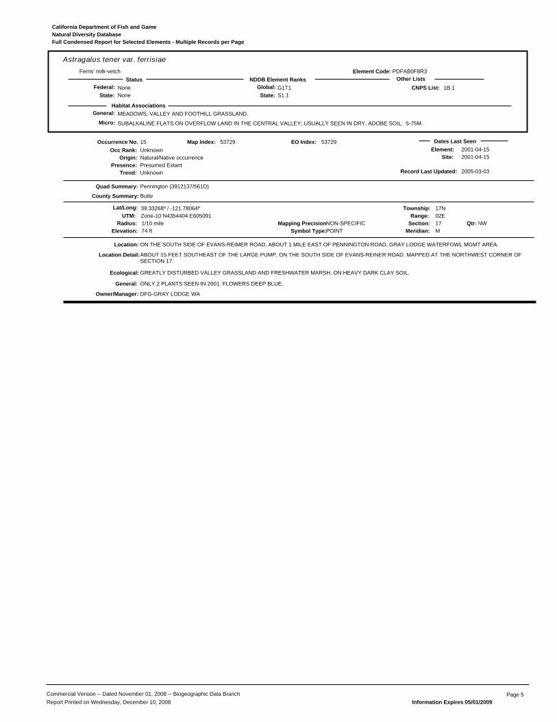
General: MEADOWS, VALLEY AND FOOTHILL GRASSLAND.
SUBALKALINE FLATS ON OVERFLOW LAND IN THE CENTRAL VALLEY; USUALLY SEEN IN DRY, ADOBE SOIL. 5-75M.
PDFAB0F8R3
Astragalus tener var. ferrisiaeFerris' milk-vetch
NoneNone
G1T1S1.1State:
Global:NDDB Element RanksStatus Other Lists
State:Federal: 1B.1
Habitat Associations
CNPS List:
Element Code:
Micro:
Natural Diversity DatabaseCalifornia Department of Fish and Game
Full Condensed Report for Selected Elements - Multiple Records per Page
15
Presence:Trend:
Unknown
Location:
Element:Site:
DFG-GRAY LODGE WA
Natural/Native occurrencePresumed ExtantUnknown
Dates Last Seen2001-04-152001-04-15
Quad Summary:
County Summary:
Pennington (3912137/561D)
Butte
ON THE SOUTH SIDE OF EVANS-REIMER ROAD, ABOUT 1 MILE EAST OF PENNINGTON ROAD, GRAY LODGE WATERFOWL MGMT AREA.
Lat/Long: 39.33268º / -121.78064º Township: 17NRange: 02E
Section: 17 NWMeridian: M
Mapping Precision:NON-SPECIFIC1/10 mileSymbol Type:POINTElevation: 74 ft
53729
UTM: Zone-10 N4354404 E605091
Map Index:
GREATLY DISTURBED VALLEY GRASSLAND AND FRESHWATER MARSH. ON HEAVY DARK CLAY SOIL.
ABOUT 15 FEET SOUTHEAST OF THE LARGE PUMP, ON THE SOUTH SIDE OF EVANS-REINER ROAD. MAPPED AT THE NORTHWEST CORNER OFSECTION 17.
ONLY 2 PLANTS SEEN IN 2001. FLOWERS DEEP BLUE.
Qtr:
Origin:
Occurrence No.Occ Rank:
Location Detail:
Ecological:
General:
Owner/Manager:
Radius:
Record Last Updated: 2005-03-03
53729EO Index:
Commercial Version -- Dated November 01, 2008 -- Biogeographic Data Branch Page 5Report Printed on Wednesday, December 10, 2008 Information Expires 05/01/2009
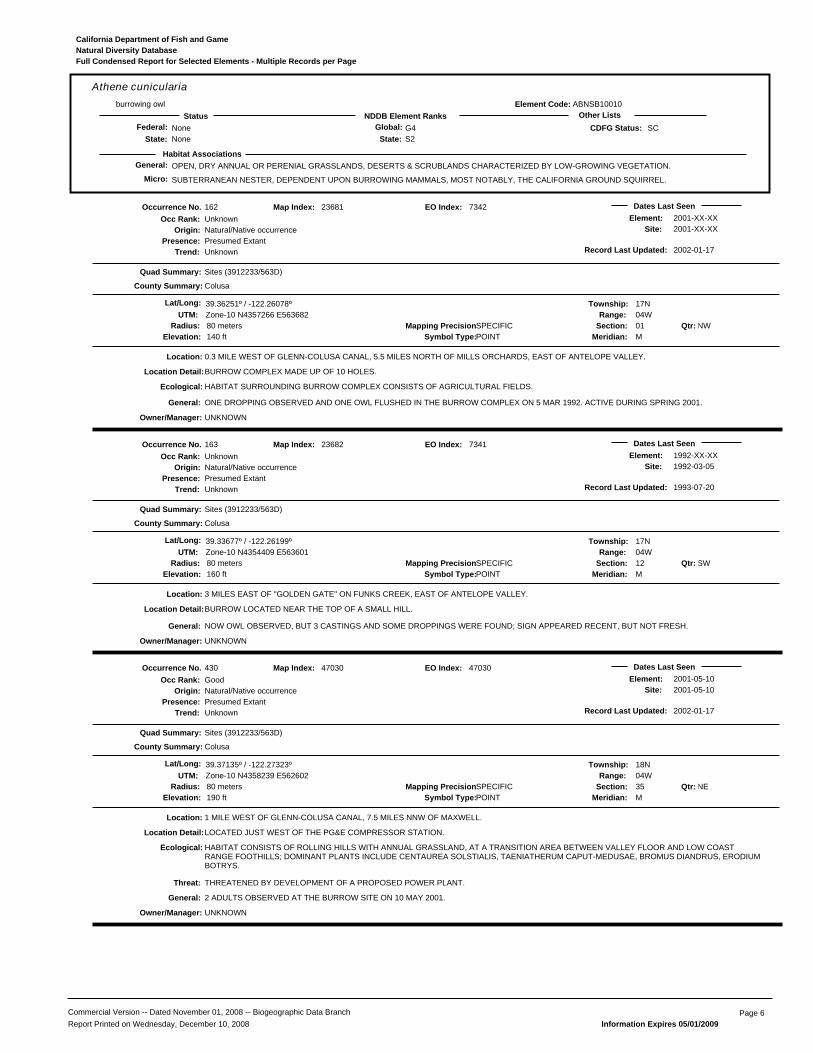
General: OPEN, DRY ANNUAL OR PERENIAL GRASSLANDS, DESERTS & SCRUBLANDS CHARACTERIZED BY LOW-GROWING VEGETATION.
SUBTERRANEAN NESTER, DEPENDENT UPON BURROWING MAMMALS, MOST NOTABLY, THE CALIFORNIA GROUND SQUIRREL.
ABNSB10010
Athene cuniculariaburrowing owl
NoneNone
G4S2State:
Global:NDDB Element RanksStatus Other Lists
State:Federal: SC
Habitat Associations
CDFG Status:
Element Code:
Micro:
Natural Diversity DatabaseCalifornia Department of Fish and Game
Full Condensed Report for Selected Elements - Multiple Records per Page
162
Presence:Trend:
Unknown
Location:
Element:Site:
UNKNOWN
Natural/Native occurrencePresumed ExtantUnknown
Dates Last Seen2001-XX-XX2001-XX-XX
Quad Summary:
County Summary:
Sites (3912233/563D)
Colusa
0.3 MILE WEST OF GLENN-COLUSA CANAL, 5.5 MILES NORTH OF MILLS ORCHARDS, EAST OF ANTELOPE VALLEY.
Lat/Long: 39.36251º / -122.26078º Township: 17NRange: 04W
Section: 01 NWMeridian: M
Mapping Precision:SPECIFIC80 metersSymbol Type:POINTElevation: 140 ft
23681
UTM: Zone-10 N4357266 E563682
Map Index:
HABITAT SURROUNDING BURROW COMPLEX CONSISTS OF AGRICULTURAL FIELDS.
BURROW COMPLEX MADE UP OF 10 HOLES.
ONE DROPPING OBSERVED AND ONE OWL FLUSHED IN THE BURROW COMPLEX ON 5 MAR 1992. ACTIVE DURING SPRING 2001.
Qtr:
Origin:
Occurrence No.Occ Rank:
Location Detail:
Ecological:
General:
Owner/Manager:
Radius:
Record Last Updated: 2002-01-17
7342EO Index:
163
Presence:Trend:
Unknown
Location:
Element:Site:
UNKNOWN
Natural/Native occurrencePresumed ExtantUnknown
Dates Last Seen1992-XX-XX1992-03-05
Quad Summary:
County Summary:
Sites (3912233/563D)
Colusa
3 MILES EAST OF "GOLDEN GATE" ON FUNKS CREEK, EAST OF ANTELOPE VALLEY.
Lat/Long: 39.33677º / -122.26199º Township: 17NRange: 04W
Section: 12 SWMeridian: M
Mapping Precision:SPECIFIC80 metersSymbol Type:POINTElevation: 160 ft
23682
UTM: Zone-10 N4354409 E563601
Map Index:
BURROW LOCATED NEAR THE TOP OF A SMALL HILL.
NOW OWL OBSERVED, BUT 3 CASTINGS AND SOME DROPPINGS WERE FOUND; SIGN APPEARED RECENT, BUT NOT FRESH.
Qtr:
Origin:
Occurrence No.Occ Rank:
Location Detail:
General:
Owner/Manager:
Radius:
Record Last Updated: 1993-07-20
7341EO Index:
430
Presence:Trend:
Good
Location:
Element:Site:
THREATENED BY DEVELOPMENT OF A PROPOSED POWER PLANT.
UNKNOWN
Natural/Native occurrencePresumed ExtantUnknown
Dates Last Seen2001-05-102001-05-10
Quad Summary:
County Summary:
Sites (3912233/563D)
Colusa
1 MILE WEST OF GLENN-COLUSA CANAL, 7.5 MILES NNW OF MAXWELL.
Lat/Long: 39.37135º / -122.27323º Township: 18NRange: 04W
Section: 35 NEMeridian: M
Mapping Precision:SPECIFIC80 metersSymbol Type:POINTElevation: 190 ft
47030
UTM: Zone-10 N4358239 E562602
Map Index:
HABITAT CONSISTS OF ROLLING HILLS WITH ANNUAL GRASSLAND, AT A TRANSITION AREA BETWEEN VALLEY FLOOR AND LOW COASTRANGE FOOTHILLS; DOMINANT PLANTS INCLUDE CENTAUREA SOLSTIALIS, TAENIATHERUM CAPUT-MEDUSAE, BROMUS DIANDRUS, ERODIUMBOTRYS.
LOCATED JUST WEST OF THE PG&E COMPRESSOR STATION.
2 ADULTS OBSERVED AT THE BURROW SITE ON 10 MAY 2001.
Qtr:
Origin:
Occurrence No.Occ Rank:
Location Detail:
Ecological:
Threat:
General:
Owner/Manager:
Radius:
Record Last Updated: 2002-01-17
47030EO Index:
Commercial Version -- Dated November 01, 2008 -- Biogeographic Data Branch Page 6Report Printed on Wednesday, December 10, 2008 Information Expires 05/01/2009

General: CHENOPOD SCRUB, VALLEY AND FOOTHILL GRASSLAND, MEADOWS.
ALKALINE FLATS AND SCALDS IN THE CENTRAL VALLEY, SANDY SOILS. 1-150(600)M.
PDCHE040B0
Atriplex cordulataheartscale
NoneNone
G2?S2.2?State:
Global:NDDB Element RanksStatus Other Lists
State:Federal: 1B.2
Habitat Associations
CNPS List:
Element Code:
Micro:
Natural Diversity DatabaseCalifornia Department of Fish and Game
Full Condensed Report for Selected Elements - Multiple Records per Page
2
Presence:Trend:
Good
Location:
Element:Site:
DFG-GRAY LODGE WA
Natural/Native occurrencePresumed ExtantUnknown
Dates Last Seen1993-07-291993-07-29
Quad Summary:
County Summary:
Pennington (3912137/561D)
Butte
0.1 MILE SE OF THE HEADQUARTERS FOR GRAY LODGE WILDLIFE AREA, SOUTH SIDE OF RUTHERFORD RD, WEST SIDE OF LEVEE RD.
Lat/Long: 39.32086º / -121.83131º Township: 17NRange: 01E
Section: 14 SWMeridian: M
Mapping Precision:SPECIFIC80 metersSymbol Type:POINTElevation: 65 ft
24346
UTM: Zone-10 N4353035 E600741
Map Index:
GROWING ON BARE, DRY, ALKALI SOIL WITH ATRIPLEX DEPRESSA.
10 PLANTS OBSERVED IN 1982 BY AHART.
Qtr:
Origin:
Occurrence No.Occ Rank:
Ecological:
General:
Owner/Manager:
Radius:
Record Last Updated: 2005-09-20
26915EO Index:
3
Presence:Trend:
Good
Location:
Element:Site:
SITE IS MANAGED FOR MIGRATORY WATERFOWL & UPLAND HUNTING.
DFG-GRAY LODGE WA
Natural/Native occurrencePresumed ExtantUnknown
Dates Last Seen1993-07-291993-07-29
Quad Summary:
County Summary:
Pennington (3912137/561D)
Butte
GRAY LODGE WILDLIFE AREA; 2 MILES SE OF THE HEADQUARTERS BUILDINGS. JUST SOUTH OF RUTHERFORD RD, WEST OF LEVEE RD.
Lat/Long: 39.31727º / -121.80881º Township: 17NRange: 01E
Section: 24 NWMeridian: M
Mapping Precision:SPECIFIC80 metersSymbol Type:POINTElevation: 70 ft
25629
UTM: Zone-10 N4352661 E602686
Map Index:
BARE PATCHES IN HARD, DRY, ALKALI CLAY WITH ATRIPLEX DEPRESSA, AND A. MINUSCULA.
100 FEET SOUTH OF PARKING LOT 5 ON RUTHERFORD RD.
PRESENCE NOTED AS "LOCALLY COMMON" IN 1993.
Qtr:
Origin:
Occurrence No.Occ Rank:
Location Detail:
Ecological:
Threat:
General:
Owner/Manager:
Radius:
Record Last Updated: 2005-09-20
25663EO Index:
40
Presence:Trend:
Unknown
Location:
Element:Site:
UNKNOWN
Natural/Native occurrencePresumed ExtantUnknown
Dates Last Seen1920-07-121920-07-12
Quad Summary:
County Summary:
Logandale (3912242/562B)
Glenn
NORTH OF NORMAN.
Lat/Long: 39.42547º / -122.19273º Township: 18NRange: 03W
Section: 10 XXMeridian: M
Mapping Precision:NON-SPECIFIC1 mileSymbol Type:POINTElevation: 95 ft
25374
UTM: Zone-10 N4364304 E569482
Map Index:
MAPPED BETWEEN NORMAN AND LOGANDALE.
SCARCE. ONLY SOURCE OF INFORMATION FOR THIS SITE IS 1920 COLLECTION BY HALL. AREA SHOULD BE FIELD CHECKED FOR PRESENCEOF SUITABLE HABITAT.
Qtr:
Origin:
Occurrence No.Occ Rank:
Location Detail:
General:
Owner/Manager:
Radius:
Record Last Updated: 1994-02-15
5898EO Index:
Commercial Version -- Dated November 01, 2008 -- Biogeographic Data Branch Page 7Report Printed on Wednesday, December 10, 2008 Information Expires 05/01/2009

General: CHENOPOD SCRUB, VALLEY AND FOOTHILL GRASSLAND, MEADOWS.
ALKALINE FLATS AND SCALDS IN THE CENTRAL VALLEY, SANDY SOILS. 1-150(600)M.
PDCHE040B0
Atriplex cordulataheartscale
NoneNone
G2?S2.2?State:
Global:NDDB Element RanksStatus Other Lists
State:Federal: 1B.2
Habitat Associations
CNPS List:
Element Code:
Micro:
Natural Diversity DatabaseCalifornia Department of Fish and Game
Full Condensed Report for Selected Elements - Multiple Records per Page
58
Presence:Trend:
Unknown
Location:
Element:Site:
USFWS-SACRAMENTO NWR
Natural/Native occurrencePresumed ExtantUnknown
Dates Last Seen1994-XX-XX1994-XX-XX
Quad Summary:
County Summary:
Logandale (3912242/562B)
Glenn
SACRAMENTO NATIONAL WILDLIFE REFUGE; 0.5 MI SE OF JCT NORMAN ROAD AND SOUTHERN PACIFIC RAILROAD.
Lat/Long: 39.40469º / -122.18286º Township: 18NRange: 03W
Section: 22 NWMeridian: M
Mapping Precision:SPECIFIC13.5 acresSymbol Type:POLYGONElevation: 85 ft
32955
UTM: Zone-10 N4362005 E570353
Map Index:
ON BOTH SIDES OF ROAD. IN BOTH NW1/4 AND NE1/4 OF SECTION 22.
Qtr:
Origin:
Occurrence No.Occ Rank:
Location Detail:
Owner/Manager:
Area:
Record Last Updated: 1996-02-28
804EO Index:
Commercial Version -- Dated November 01, 2008 -- Biogeographic Data Branch Page 8Report Printed on Wednesday, December 10, 2008 Information Expires 05/01/2009
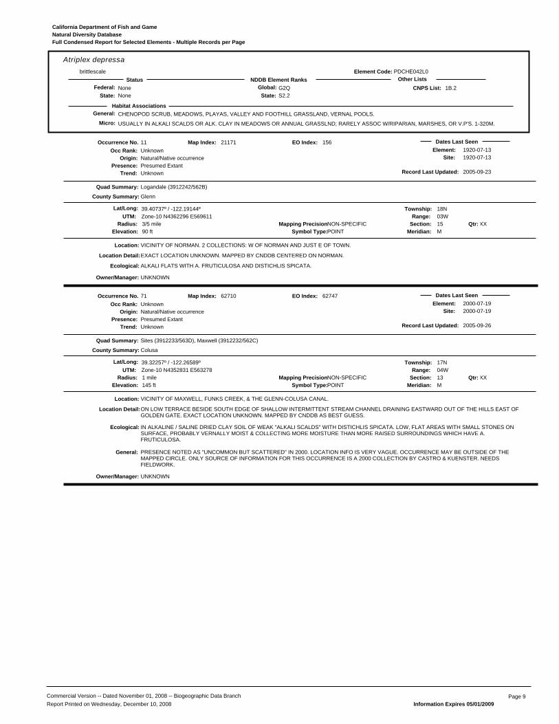
General: CHENOPOD SCRUB, MEADOWS, PLAYAS, VALLEY AND FOOTHILL GRASSLAND, VERNAL POOLS.
USUALLY IN ALKALI SCALDS OR ALK. CLAY IN MEADOWS OR ANNUAL GRASSLND; RARELY ASSOC W/RIPARIAN, MARSHES, OR V.P'S. 1-320M.
PDCHE042L0
Atriplex depressabrittlescale
NoneNone
G2QS2.2State:
Global:NDDB Element RanksStatus Other Lists
State:Federal: 1B.2
Habitat Associations
CNPS List:
Element Code:
Micro:
Natural Diversity DatabaseCalifornia Department of Fish and Game
Full Condensed Report for Selected Elements - Multiple Records per Page
11
Presence:Trend:
Unknown
Location:
Element:Site:
UNKNOWN
Natural/Native occurrencePresumed ExtantUnknown
Dates Last Seen1920-07-131920-07-13
Quad Summary:
County Summary:
Logandale (3912242/562B)
Glenn
VICINITY OF NORMAN. 2 COLLECTIONS: W OF NORMAN AND JUST E OF TOWN.
Lat/Long: 39.40737º / -122.19144º Township: 18NRange: 03W
Section: 15 XXMeridian: M
Mapping Precision:NON-SPECIFIC3/5 mileSymbol Type:POINTElevation: 90 ft
21171
UTM: Zone-10 N4362296 E569611
Map Index:
ALKALI FLATS WITH A. FRUTICULOSA AND DISTICHLIS SPICATA.
EXACT LOCATION UNKNOWN. MAPPED BY CNDDB CENTERED ON NORMAN.
Qtr:
Origin:
Occurrence No.Occ Rank:
Location Detail:
Ecological:
Owner/Manager:
Radius:
Record Last Updated: 2005-09-23
156EO Index:
71
Presence:Trend:
Unknown
Location:
Element:Site:
UNKNOWN
Natural/Native occurrencePresumed ExtantUnknown
Dates Last Seen2000-07-192000-07-19
Quad Summary:
County Summary:
Sites (3912233/563D), Maxwell (3912232/562C)
Colusa
VICINITY OF MAXWELL, FUNKS CREEK, & THE GLENN-COLUSA CANAL.
Lat/Long: 39.32257º / -122.26589º Township: 17NRange: 04W
Section: 13 XXMeridian: M
Mapping Precision:NON-SPECIFIC1 mileSymbol Type:POINTElevation: 145 ft
62710
UTM: Zone-10 N4352831 E563278
Map Index:
IN ALKALINE / SALINE DRIED CLAY SOIL OF WEAK "ALKALI SCALDS" WITH DISTICHLIS SPICATA. LOW, FLAT AREAS WITH SMALL STONES ONSURFACE, PROBABLY VERNALLY MOIST & COLLECTING MORE MOISTURE THAN MORE RAISED SURROUNDINGS WHICH HAVE A.FRUTICULOSA.
ON LOW TERRACE BESIDE SOUTH EDGE OF SHALLOW INTERMITTENT STREAM CHANNEL DRAINING EASTWARD OUT OF THE HILLS EAST OFGOLDEN GATE. EXACT LOCATION UNKNOWN. MAPPED BY CNDDB AS BEST GUESS.
PRESENCE NOTED AS "UNCOMMON BUT SCATTERED" IN 2000. LOCATION INFO IS VERY VAGUE. OCCURRENCE MAY BE OUTSIDE OF THEMAPPED CIRCLE. ONLY SOURCE OF INFORMATION FOR THIS OCCURRENCE IS A 2000 COLLECTION BY CASTRO & KUENSTER. NEEDSFIELDWORK.
Qtr:
Origin:
Occurrence No.Occ Rank:
Location Detail:
Ecological:
General:
Owner/Manager:
Radius:
Record Last Updated: 2005-09-26
62747EO Index:
Commercial Version -- Dated November 01, 2008 -- Biogeographic Data Branch Page 9Report Printed on Wednesday, December 10, 2008 Information Expires 05/01/2009

General: CHENOPOD SCRUB, ALKALI MEADOW, VALLEY AND FOOTHILL GRASSLAND.
IN SEASONAL ALKALI WETLANDS OR ALKALI SINK SCRUB WITH DISTICHLIS SPICATA, FRANKENIA, ETC. 1-250M.
PDCHE041F3
Atriplex joaquinianaSan Joaquin spearscale
NoneNone
G2S2.1State:
Global:NDDB Element RanksStatus Other Lists
State:Federal: 1B.2
Habitat Associations
CNPS List:
Element Code:
Micro:
Natural Diversity DatabaseCalifornia Department of Fish and Game
Full Condensed Report for Selected Elements - Multiple Records per Page
67
Presence:Trend:
Unknown
Location:
Element:Site:
UNKNOWN
Natural/Native occurrencePresumed ExtantUnknown
Dates Last Seen1920-07-121920-07-12
Quad Summary:
County Summary:
Logandale (3912242/562B)
Glenn
WEST OF NORMAN.
Lat/Long: 39.40716º / -122.21783º Township: 18NRange: 03W
Section: 17 XXMeridian: M
Mapping Precision:NON-SPECIFIC1 mileSymbol Type:POINTElevation:
49797
UTM: Zone-10 N4362253 E567340
Map Index:
WITHIN WET SWALE WITH TISSA.
LOCATION MAPPED WEST OF NORMAN ALONG MAIN ROAD.
ONLY SOURCE OF INFORMATION FOR THIS SITE IS 1920 COLLECTION BY HALL. NEEDS FIELDWORK.
Qtr:
Origin:
Occurrence No.Occ Rank:
Location Detail:
Ecological:
General:
Owner/Manager:
Radius:
Record Last Updated: 2003-01-07
49797EO Index:
79
Presence:Trend:
Unknown
Location:
Element:Site:
TRAMPLING BY CATTLE.
UNKNOWN
Natural/Native occurrencePresumed ExtantUnknown
Dates Last Seen2000-07-192000-07-19
Quad Summary:
County Summary:
Sites (3912233/563D), Maxwell (3912232/562C)
Colusa
VICINITY OF FUNKS CREEK & THE GLENN-COLUSA CANAL.
Lat/Long: 39.32257º / -122.26589º Township: 17NRange: 04W
Section: 13 XXMeridian: M
Mapping Precision:NON-SPECIFIC1 mileSymbol Type:POINTElevation: 145 ft
62710
UTM: Zone-10 N4352831 E563278
Map Index:
ALKALINE / SALINE DRIED CLAY SOIL OF WEAK ALKALI SCALDS ALONG A COWPATH. ASSOC WITH FRANKENIA SALINA, ATRIPLEX DEPRESSA,A. FRUTICULOSA, HEMIZONIA PARRYI, HORDEUM MARINUM, BROMUS HORDEACEUS, AND LOLIUM.
BESIDE SOUTH EDGE OF SHALLOW EPHEMERAL STREAM CHANNEL DRAINING EASTWARD OUT OF THE HILLS EAST OF GOLDEN GATE. EXACTLOCATION UNKNOWN. MAPPED BY CNDDB AS BEST GUESS.
VERY UNCOMMON AT SITE IN 2000. A FEW SCATTERED PLANTS OBSERVED IN 2002. ONLY SOURCES OF INFORMATION FOR THISOCCURRENCE ARE A 2000 COLLECTION BY CASTRO & KUENSTER AND A 2002 COLLECTION BY JANEWAY. NEEDS FIELDWORK.
Qtr:
Origin:
Occurrence No.Occ Rank:
Location Detail:
Ecological:
Threat:
General:
Owner/Manager:
Radius:
Record Last Updated: 2005-09-28
62784EO Index:
Commercial Version -- Dated November 01, 2008 -- Biogeographic Data Branch Page 10Report Printed on Wednesday, December 10, 2008 Information Expires 05/01/2009
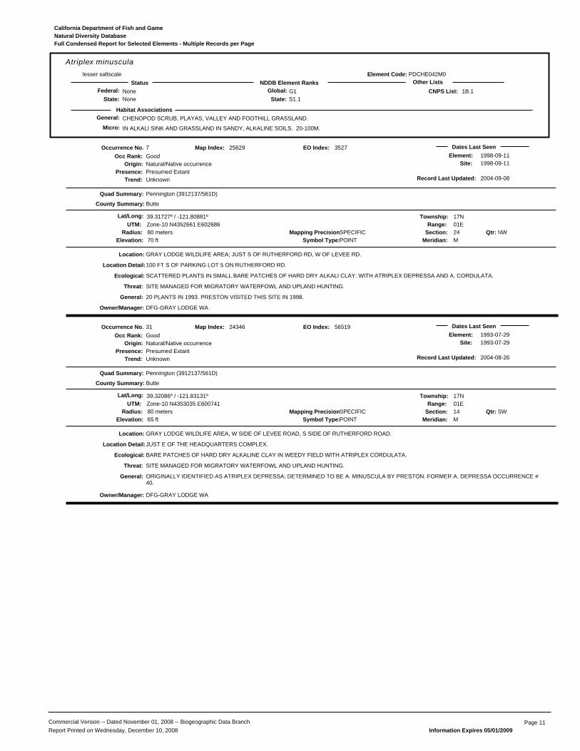
General: CHENOPOD SCRUB, PLAYAS, VALLEY AND FOOTHILL GRASSLAND.
IN ALKALI SINK AND GRASSLAND IN SANDY, ALKALINE SOILS. 20-100M.
PDCHE042M0
Atriplex minusculalesser saltscale
NoneNone
G1S1.1State:
Global:NDDB Element RanksStatus Other Lists
State:Federal: 1B.1
Habitat Associations
CNPS List:
Element Code:
Micro:
Natural Diversity DatabaseCalifornia Department of Fish and Game
Full Condensed Report for Selected Elements - Multiple Records per Page
7
Presence:Trend:
Good
Location:
Element:Site:
SITE MANAGED FOR MIGRATORY WATERFOWL AND UPLAND HUNTING.
DFG-GRAY LODGE WA
Natural/Native occurrencePresumed ExtantUnknown
Dates Last Seen1998-09-111998-09-11
Quad Summary:
County Summary:
Pennington (3912137/561D)
Butte
GRAY LODGE WILDLIFE AREA; JUST S OF RUTHERFORD RD, W OF LEVEE RD.
Lat/Long: 39.31727º / -121.80881º Township: 17NRange: 01E
Section: 24 NWMeridian: M
Mapping Precision:SPECIFIC80 metersSymbol Type:POINTElevation: 70 ft
25629
UTM: Zone-10 N4352661 E602686
Map Index:
SCATTERED PLANTS IN SMALL BARE PATCHES OF HARD DRY ALKALI CLAY. WITH ATRIPLEX DEPRESSA AND A. CORDULATA.
100 FT S OF PARKING LOT 5 ON RUTHERFORD RD.
20 PLANTS IN 1993. PRESTON VISITED THIS SITE IN 1998.
Qtr:
Origin:
Occurrence No.Occ Rank:
Location Detail:
Ecological:
Threat:
General:
Owner/Manager:
Radius:
Record Last Updated: 2004-09-08
3527EO Index:
31
Presence:Trend:
Good
Location:
Element:Site:
SITE MANAGED FOR MIGRATORY WATERFOWL AND UPLAND HUNTING.
DFG-GRAY LODGE WA
Natural/Native occurrencePresumed ExtantUnknown
Dates Last Seen1993-07-291993-07-29
Quad Summary:
County Summary:
Pennington (3912137/561D)
Butte
GRAY LODGE WILDLIFE AREA, W SIDE OF LEVEE ROAD, S SIDE OF RUTHERFORD ROAD.
Lat/Long: 39.32086º / -121.83131º Township: 17NRange: 01E
Section: 14 SWMeridian: M
Mapping Precision:SPECIFIC80 metersSymbol Type:POINTElevation: 65 ft
24346
UTM: Zone-10 N4353035 E600741
Map Index:
BARE PATCHES OF HARD DRY ALKALINE CLAY IN WEEDY FIELD WITH ATRIPLEX CORDULATA.
JUST E OF THE HEADQUARTERS COMPLEX.
ORIGINALLY IDENTIFIED AS ATRIPLEX DEPRESSA; DETERMINED TO BE A. MINUSCULA BY PRESTON. FORMER A. DEPRESSA OCCURRENCE #40.
Qtr:
Origin:
Occurrence No.Occ Rank:
Location Detail:
Ecological:
Threat:
General:
Owner/Manager:
Radius:
Record Last Updated: 2004-08-26
56519EO Index:
Commercial Version -- Dated November 01, 2008 -- Biogeographic Data Branch Page 11Report Printed on Wednesday, December 10, 2008 Information Expires 05/01/2009
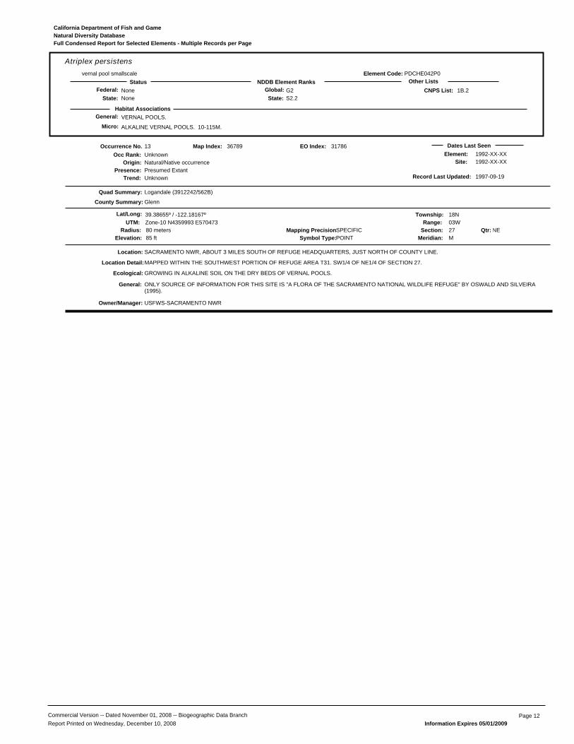
General: VERNAL POOLS.
ALKALINE VERNAL POOLS. 10-115M.
PDCHE042P0
Atriplex persistensvernal pool smallscale
NoneNone
G2S2.2State:
Global:NDDB Element RanksStatus Other Lists
State:Federal: 1B.2
Habitat Associations
CNPS List:
Element Code:
Micro:
Natural Diversity DatabaseCalifornia Department of Fish and Game
Full Condensed Report for Selected Elements - Multiple Records per Page
13
Presence:Trend:
Unknown
Location:
Element:Site:
USFWS-SACRAMENTO NWR
Natural/Native occurrencePresumed ExtantUnknown
Dates Last Seen1992-XX-XX1992-XX-XX
Quad Summary:
County Summary:
Logandale (3912242/562B)
Glenn
SACRAMENTO NWR, ABOUT 3 MILES SOUTH OF REFUGE HEADQUARTERS, JUST NORTH OF COUNTY LINE.
Lat/Long: 39.38655º / -122.18167º Township: 18NRange: 03W
Section: 27 NEMeridian: M
Mapping Precision:SPECIFIC80 metersSymbol Type:POINTElevation: 85 ft
36789
UTM: Zone-10 N4359993 E570473
Map Index:
GROWING IN ALKALINE SOIL ON THE DRY BEDS OF VERNAL POOLS.
MAPPED WITHIN THE SOUTHWEST PORTION OF REFUGE AREA T31. SW1/4 OF NE1/4 OF SECTION 27.
ONLY SOURCE OF INFORMATION FOR THIS SITE IS "A FLORA OF THE SACRAMENTO NATIONAL WILDLIFE REFUGE" BY OSWALD AND SILVEIRA(1995).
Qtr:
Origin:
Occurrence No.Occ Rank:
Location Detail:
Ecological:
General:
Owner/Manager:
Radius:
Record Last Updated: 1997-09-19
31786EO Index:
Commercial Version -- Dated November 01, 2008 -- Biogeographic Data Branch Page 12Report Printed on Wednesday, December 10, 2008 Information Expires 05/01/2009

General: VALLEY AND FOOTHILL GRASSLAND.
LITTLE INFO AVAILABLE. MADRONO VOL. 44 NO.2 ONLY SOURCE CURRENTLY. 40-100M.
PDCHE042T0
Atriplex subtilissubtle orache
NoneNone
G2S2.2State:
Global:NDDB Element RanksStatus Other Lists
State:Federal: 1B.2
Habitat Associations
CNPS List:
Element Code:
Micro:
Natural Diversity DatabaseCalifornia Department of Fish and Game
Full Condensed Report for Selected Elements - Multiple Records per Page
20
Presence:Trend:
Good
Location:
Element:Site:
SITE MANAGED FOR MIGRATORY WATERFOWL AND UPLAND HUNTING.
DFG-GRAY LODGE WA
Natural/Native occurrencePresumed ExtantUnknown
Dates Last Seen1998-09-111998-09-11
Quad Summary:
County Summary:
Pennington (3912137/561D)
Butte
GRAY LODGE WILDLIFE AREA; JUST S OF RUTHERFORD RD, W OF LEVEE RD.
Lat/Long: 39.31727º / -121.80881º Township: 17NRange: 01E
Section: 24 NWMeridian: M
Mapping Precision:SPECIFIC80 metersSymbol Type:POINTElevation: 70 ft
25629
UTM: Zone-10 N4352661 E602686
Map Index:
SCATTERED PLANTS IN SMALL BARE PATCHES OF HARD DRY ALKALI CLAY. WITH ATRIPLEX DEPRESSA AND A. CORDULATA. COMMONASSOCIATES INCLUDE DISTICHLIS SPICATA, HEMIZONIA PUNGENS, CRESSA TRUXILLENSIS, ETC.
100 FT S OF PARKING LOT 5 ON RUTHERFORD RD. NE1/4 OF NW1/4 SEC 24.
20 PLANTS IN 1993. 20-30 PLANTS SEEN BY PRESTON IN 1998. ORIGINALLY IDENTIFIED AS A. MINUSCULA; IDENTIFIED AS A. SUBTILIS BYPRESTON. FORMER A. MINUSCULA OCCURRENCE #7.
Qtr:
Origin:
Occurrence No.Occ Rank:
Location Detail:
Ecological:
Threat:
General:
Owner/Manager:
Radius:
Record Last Updated: 2004-08-30
56547EO Index:
Commercial Version -- Dated November 01, 2008 -- Biogeographic Data Branch Page 13Report Printed on Wednesday, December 10, 2008 Information Expires 05/01/2009

General: ENDEMIC TO THE GRASSLANDS OF THE NORTHERN TWO-THIRDS OF THE CENTRAL VALLEY; FOUND IN LARGE, TURBID POOLS.
INHABIT ASTATIC POOLS LOCATED IN SWALES FORMED BY OLD, BRAIDED ALLUVIUM; FILLED BY WINTER/SPRING RAINS, LAST UNTIL JUNE.
ICBRA03010
Branchinecta conservatioConservancy fairy shrimp
EndangeredNone
G1S1State:
Global:NDDB Element RanksStatus Other Lists
State:Federal:
Habitat Associations
CDFG Status:
Element Code:
Micro:
Natural Diversity DatabaseCalifornia Department of Fish and Game
Full Condensed Report for Selected Elements - Multiple Records per Page
13
Presence:Trend:
Unknown
Location:
Element:Site:
USFWS-SACRAMENTO NWR
Natural/Native occurrencePresumed ExtantUnknown
Dates Last Seen1994-03-031994-03-03
Quad Summary:
County Summary:
Logandale (3912242/562B)
Glenn
1.5 MILES SSE OF NORMAN, 0.6 MILE EAST OF I-5, SACRAMENTO NATIONAL WILDLIFE REFUGE, NORTH OF GLENN/COLUSA COUNTY LINE.
Lat/Long: 39.38707º / -122.18045º Township: 18NRange: 03W
Section: 27 NEMeridian: M
Mapping Precision:NON-SPECIFICSymbol Type:POLYGONElevation: 85 ft
41873
UTM: Zone-10 N4360052 E570578
Map Index:
VERNAL POOL
VERNAL POOL IN THE SW 1/4 OF THE NE 1/4 OF SECTION 27. D. BELK ACCESSION #'S DB1107 & DB1163
UNKNOWN NUMBER COLLECTED IN 1 FEB 1993 AND 3 MAR 1994.
Qtr:
Origin:
Occurrence No.Occ Rank:
Location Detail:
Ecological:
General:
Owner/Manager:
Area:
Record Last Updated: 1999-11-10
41873EO Index:
Commercial Version -- Dated November 01, 2008 -- Biogeographic Data Branch Page 14Report Printed on Wednesday, December 10, 2008 Information Expires 05/01/2009

General: BREEDS IN GRASSLANDS WITH WITH SCATTERED TREES, JUNIPER-SAGE FLATS, RIPARIAN AREAS, SAVANNAHS, & AGRICULTURAL OR RANCH
REQUIRES ADJACENT SUITABLE FORAGING AREAS SUCH AS GRASSLANDS, OR ALFALFA OR GRAIN FIELDS SUPPORTING RODENT POPULATIONS.
ABNKC19070
Buteo swainsoniSwainson's hawk
NoneThreatened
G5S2State:
Global:NDDB Element RanksStatus Other Lists
State:Federal:
Habitat Associations
CDFG Status:
Element Code:
Micro:
Natural Diversity DatabaseCalifornia Department of Fish and Game
Full Condensed Report for Selected Elements - Multiple Records per Page
54
Presence:Trend:
Unknown
Location:
Element:Site:
PVT
Natural/Native occurrencePresumed ExtantUnknown
Dates Last Seen1979-07-241979-07-24
Quad Summary:
County Summary:
Pennington (3912137/561D)
Butte
SOUTH SIDE GRIDLEY ROAD
Lat/Long: 39.35960º / -121.83054º Township: 17NRange: 01E
Section: 02 NWMeridian: M
Mapping Precision:NON-SPECIFIC1 mileSymbol Type:POINTElevation: 65 ft
10641
UTM: Zone-10 N4357335 E600752
Map Index:
DFG SWHA #BU001. ONE ADULT OBSERVED IN 1979; NO NEST FOUND. BLOOM/SCHLORFF
Qtr:
Origin:
Occurrence No.Occ Rank:
General:
Owner/Manager:
Radius:
Record Last Updated: 1989-08-10
27238EO Index:
280
Presence:Trend:
Unknown
Location:
Element:Site:
LAND SUBJECT TO FLOODING FOR DUCK PONDS AND FIRE FROM AG BURNING.
PVT
Natural/Native occurrencePresumed ExtantUnknown
Dates Last Seen1985-07-151985-07-15
Quad Summary:
County Summary:
Butte City (3912148/561B), West of Biggs (3912147/561A)
Butte, Glenn
HOODOO ISLAND, E SIDE OF BUTTE CREEK, 1 MI BELOW BIGGS-AFTON ROAD.
Lat/Long: 39.40599º / -121.88859º Township: 18NRange: 01E
Section: 17 SWMeridian: M
Mapping Precision:NON-SPECIFIC1 mileSymbol Type:POINTElevation: 65 ft
10489
UTM: Zone-10 N4362420 E595687
Map Index:
VALLEY OAK WOODLAND HABITAT.
INCL NW OF SEC 20.
ONE LIGHT PHASE HAWK OBS. NESTING PROBABLE.
Qtr:
Origin:
Occurrence No.Occ Rank:
Location Detail:
Ecological:
Threat:
General:
Owner/Manager:
Radius:
Record Last Updated: 1995-10-27
27033EO Index:
878
Presence:Trend:
Fair
Location:
Element:Site:
COL COUNTY
Natural/Native occurrencePresumed ExtantUnknown
Dates Last Seen2000-07-082000-07-08
Quad Summary:
County Summary:
Maxwell (3912232/562C)
Colusa
ALONG HIGHWAY 99W, 0.2 MILE NORTH OF LENAHAN ROAD, SOUTH OF DELEVAN.
Lat/Long: 39.33719º / -122.19174º Township: 17NRange: 03W
Section: 09 SWMeridian: M
Mapping Precision:SPECIFIC80 metersSymbol Type:POINTElevation: 100 ft
43675
UTM: Zone-10 N4354507 E569655
Map Index:
BLACK WALNUTS LINE BOTH ROAD SHOULDERS.
NESTING ACTIVITY OBSERVED FROM 20 APR-8 JUL 2000 (7 VISITS); 1 CHICK OBSERVED ON 26 JUN 2000, 1 YOUNG FLEDGED.
Qtr:
Origin:
Occurrence No.Occ Rank:
Location Detail:
General:
Owner/Manager:
Radius:
Record Last Updated: 2000-08-30
43675EO Index:
Commercial Version -- Dated November 01, 2008 -- Biogeographic Data Branch Page 15Report Printed on Wednesday, December 10, 2008 Information Expires 05/01/2009

General: BREEDS IN GRASSLANDS WITH WITH SCATTERED TREES, JUNIPER-SAGE FLATS, RIPARIAN AREAS, SAVANNAHS, & AGRICULTURAL OR RANCH
REQUIRES ADJACENT SUITABLE FORAGING AREAS SUCH AS GRASSLANDS, OR ALFALFA OR GRAIN FIELDS SUPPORTING RODENT POPULATIONS.
ABNKC19070
Buteo swainsoniSwainson's hawk
NoneThreatened
G5S2State:
Global:NDDB Element RanksStatus Other Lists
State:Federal:
Habitat Associations
CDFG Status:
Element Code:
Micro:
Natural Diversity DatabaseCalifornia Department of Fish and Game
Full Condensed Report for Selected Elements - Multiple Records per Page
880
Presence:Trend:
Poor
Location:
Element:Site:
CALTRANS
Natural/Native occurrencePresumed ExtantUnknown
Dates Last Seen2000-07-082000-07-08
Quad Summary:
County Summary:
Maxwell (3912232/562C)
Colusa
0.15 MILE NORTH OF LORETZ ROAD, BETWEEN HIGHWAY 99W AND I-5, JUST NORTH OF THE VILLAGE OF DELEVAN.
Lat/Long: 39.35847º / -122.19239º Township: 17NRange: 03W
Section: 04 NWMeridian: M
Mapping Precision:SPECIFIC80 metersSymbol Type:POINTElevation: 85 ft
43678
UTM: Zone-10 N4356868 E569578
Map Index:
NEST TREE IS A WILLOW; NEST IS VERY SMALL AND RAGGED.
NEST TREE IS THE LARGEST AND MOST NORTHERN OF SEVERAL SMALL, RAGGED WILLOWS.
NESTING ACTIVITY OBSERVED FROM 26 JUN-08 JUL 2000 (6 VISITS); NO CHICKS OBSERVED/FLEDGED.
Qtr:
Origin:
Occurrence No.Occ Rank:
Location Detail:
Ecological:
General:
Owner/Manager:
Radius:
Record Last Updated: 2000-08-30
43678EO Index:
898
Presence:Trend:
Good
Location:
Element:Site:
PVT?
Natural/Native occurrencePresumed ExtantUnknown
Dates Last Seen2000-07-222000-07-22
Quad Summary:
County Summary:
Maxwell (3912232/562C)
Colusa
LENAHAN ROAD, 0.2 MILE WEST OF SUTTON ROAD, 3.5 MILES NNW OF MAXWELL.
Lat/Long: 39.33242º / -122.21385º Township: 17NRange: 03W
Section: 17 NEMeridian: M
Mapping Precision:NON-SPECIFIC1/5 mileSymbol Type:POINTElevation: 110 ft
43709
UTM: Zone-10 N4353961 E567754
Map Index:
NEST TREE IS PRESUMABLY A COTTONWOOD; SURROUNDED BY ONIONS TO THE NORTH AND SOUTH, SUNFLOWERS EAST OF THE MOSTSOUTHERN TREES, AND WALNUTS EAST OF THE MOST NORTHERN TREES.
PRESUMED NEST LOCATED SOMEWHERE WITHIN A NORTH-SOUTH ROW OF OLD, COLUMNAR COTTONWOODS, WHOSE SHAPE REFLECTSEXTENSIVE PRUNING OF SUBTRUNKS.
ALTHOUGH NEST WAS NOT FOUND, NESTING ACTIVITY WAS OBSERVED BETWEEN 19 APR-22 JUL 2000; 3 YOUNG FLEDGED.
Qtr:
Origin:
Occurrence No.Occ Rank:
Location Detail:
Ecological:
General:
Owner/Manager:
Radius:
Record Last Updated: 2000-09-05
43709EO Index:
924
Presence:Trend:
Fair
Location:
Element:Site:
PVT
Natural/Native occurrencePresumed ExtantUnknown
Dates Last Seen2003-06-182003-06-18
Quad Summary:
County Summary:
Maxwell (3912232/562C)
Colusa
WEST SIDE OF ROAD 99W, 0.25 - 0.40 MILE SOUTH OF DELEVAN ROAD, NORTH OF MAXWELL
Lat/Long: 39.34416º / -122.19202º Township: 17NRange: 03W
Section: 09 NEMeridian: M
Mapping Precision:SPECIFIC15.3 acresSymbol Type:POLYGONElevation: 100 ft
43809
UTM: Zone-10 N4355281 E569624
Map Index:
NEST TREE IS A SYCAMORE; SURROUNDED BY ROADSIDE WEEDS TO THE WEST, AGRICULTURAL BUSINESS TO THE NORTH, AND RICEFIELDS TO THE SOUTH AND EAST.
2000 NEST WAS LOCATED AT THE 90% HEIGHT OF THE SECOND SYCAMORE ON THE WEST ROAD SHOULDER NORTH OF THE NORTHDRIVEWAY OF FARMSTEAD #4789. 2003 NEST WAS LOCATED 0.15 MILE NORTH OF THE 2000 NEST TREE.
ADULT OBSERVED DEFENDING THE NEST ON 8 AUG 2000. 2003 NEST OBSERVED THROUGH INCUBATION/HATCHING; PRESENCE OF ONECHICK CONFIRMED THROUGH NEAR-FLEDGING STAGE OF DEVELOPMENT (FLEDGING NOT CONFIRMED).
Qtr:
Origin:
Occurrence No.Occ Rank:
Location Detail:
Ecological:
General:
Owner/Manager:
Area:
Record Last Updated: 2003-09-09
43809EO Index:
Commercial Version -- Dated November 01, 2008 -- Biogeographic Data Branch Page 16Report Printed on Wednesday, December 10, 2008 Information Expires 05/01/2009

General: BREEDS IN GRASSLANDS WITH WITH SCATTERED TREES, JUNIPER-SAGE FLATS, RIPARIAN AREAS, SAVANNAHS, & AGRICULTURAL OR RANCH
REQUIRES ADJACENT SUITABLE FORAGING AREAS SUCH AS GRASSLANDS, OR ALFALFA OR GRAIN FIELDS SUPPORTING RODENT POPULATIONS.
ABNKC19070
Buteo swainsoniSwainson's hawk
NoneThreatened
G5S2State:
Global:NDDB Element RanksStatus Other Lists
State:Federal:
Habitat Associations
CDFG Status:
Element Code:
Micro:
Natural Diversity DatabaseCalifornia Department of Fish and Game
Full Condensed Report for Selected Elements - Multiple Records per Page
925
Presence:Trend:
Fair
Location:
Element:Site:
UNKNOWN
Natural/Native occurrencePresumed ExtantUnknown
Dates Last Seen2003-06-302003-06-30
Quad Summary:
County Summary:
Logandale (3912242/562B)
Glenn
EAST SIDE OF ROAD 99W, 0.5 MILE NORTH OF THE GLENN COUNTY LINE, NORTH OF MAXWELL.
Lat/Long: 39.39305º / -122.19177º Township: 18NRange: 03W
Section: 22 SWMeridian: M
Mapping Precision:SPECIFIC80 metersSymbol Type:POINTElevation: 85 ft
43810
UTM: Zone-10 N4360707 E569597
Map Index:
NEST TREE IS A WILLOW, THE TALLEST IN ITS IMMEDIATE VICINITY; SURROUNDED BY HIGHWAYS AND RICE FARMING.
NEST TREE IS A WILLOW LOCATED EAST OF THE RAILROAD TRACKS; NEST IS LOCATED AT 80% HEIGHT OF THE NEST TREE.
NESTING ACTIVITY OBSERVED BETWEEN 26 JUN-27 JUL 2000; 1 CHICK OBSERVED ON 26 JUN 2000, AT LEAST 1 FLEDGED; 2 FLEDGLINGSOBSERVED JUST NORTH OF THIS SITE AFTER FLEDGING OCCURRED. PAIR OBSERVED INCUBATING ON 30 JUN 2003.
Qtr:
Origin:
Occurrence No.Occ Rank:
Location Detail:
Ecological:
General:
Owner/Manager:
Radius:
Record Last Updated: 2003-09-09
43810EO Index:
1002
Presence:Trend:
Fair
Location:
Element:Site:
PVT
Natural/Native occurrencePresumed ExtantUnknown
Dates Last Seen2003-06-032003-06-03
Quad Summary:
County Summary:
Maxwell (3912232/562C)
Colusa
NORTH OF LORTEZ ROAD AND EAST OF HIGHWAY 99, 0.6 MILE NORTH OF DELEVAN ROAD, IN THE COMMUNITY OF DELEVAN
Lat/Long: 39.35693º / -122.18809º Township: 17NRange: 03W
Section: 03 XXMeridian: M
Mapping Precision:NON-SPECIFICSymbol Type:POLYGONElevation: 90 ft
50651
UTM: Zone-10 N4356701 E569950
Map Index:
NEST TREE IS IN A RESIDENTIAL AREA, SURROUNDED BY RICE FIELDS.
1 ADULT OBSERVED ON NEST ON 25 MAY 2001. PAIR ARRIVED ON THE TERRITORY IN LATE APR 2003; NORMAL BEHAVIOR DURING NESTREFURBISHMENT/INCUBATION. FIRST NEST FAILED DUE TO CORVID PREDATION; NEW NEST BUILT 500' WEST OF FIRST NEST.
Qtr:
Origin:
Occurrence No.Occ Rank:
Ecological:
General:
Owner/Manager:
Area:
Record Last Updated: 2003-09-09
50651EO Index:
1269
Presence:Trend:
Fair
Location:
Element:Site:
PVT
Natural/Native occurrencePresumed ExtantUnknown
Dates Last Seen2003-06-302003-06-30
Quad Summary:
County Summary:
Logandale (3912242/562B)
Colusa
EAST SIDE OF OLD HIGHWAY 99 (FRONTAGE ROAD), ~2 MILES NORTH OF DELEVAN
Lat/Long: 39.38368º / -122.19168º Township: 18NRange: 03W
Section: 27 NWMeridian: M
Mapping Precision:SPECIFIC80 metersSymbol Type:POINTElevation: 92 ft
52376
UTM: Zone-10 N4359667 E569614
Map Index:
NEST TREE LOCATED ALONG OLD HIGHWAY 99.
PAIR OBSERVED ON 30 JUN 2003, DURING INCUBATION; PRODUCTIVITY UNKNOWN.
Qtr:
Origin:
Occurrence No.Occ Rank:
Location Detail:
General:
Owner/Manager:
Radius:
Record Last Updated: 2003-09-09
52376EO Index:
Commercial Version -- Dated November 01, 2008 -- Biogeographic Data Branch Page 17Report Printed on Wednesday, December 10, 2008 Information Expires 05/01/2009
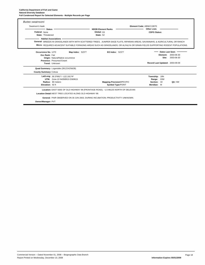
General: BREEDS IN GRASSLANDS WITH WITH SCATTERED TREES, JUNIPER-SAGE FLATS, RIPARIAN AREAS, SAVANNAHS, & AGRICULTURAL OR RANCH
REQUIRES ADJACENT SUITABLE FORAGING AREAS SUCH AS GRASSLANDS, OR ALFALFA OR GRAIN FIELDS SUPPORTING RODENT POPULATIONS.
ABNKC19070
Buteo swainsoniSwainson's hawk
NoneThreatened
G5S2State:
Global:NDDB Element RanksStatus Other Lists
State:Federal:
Habitat Associations
CDFG Status:
Element Code:
Micro:
Natural Diversity DatabaseCalifornia Department of Fish and Game
Full Condensed Report for Selected Elements - Multiple Records per Page
1270
Presence:Trend:
Fair
Location:
Element:Site:
PVT
Natural/Native occurrencePresumed ExtantUnknown
Dates Last Seen2003-06-302003-06-30
Quad Summary:
County Summary:
Logandale (3912242/562B)
Colusa
EAST SIDE OF OLD HIGHWAY 99 (FRONTAGE ROAD), ~1.5 MILES NORTH OF DELEVAN
Lat/Long: 39.37691º / -122.19174º Township: 18NRange: 03W
Section: 34 NWMeridian: M
Mapping Precision:SPECIFIC80 metersSymbol Type:POINTElevation: 92 ft
52377
UTM: Zone-10 N4358915 E569615
Map Index:
NEST TREE LOCATED ALONG OLD HIGHWAY 99.
PAIR OBSERVED ON 30 JUN 2003, DURING INCUBATION; PRODUCTIVITY UNKNOWN.
Qtr:
Origin:
Occurrence No.Occ Rank:
Location Detail:
General:
Owner/Manager:
Radius:
Record Last Updated: 2003-09-09
52377EO Index:
Commercial Version -- Dated November 01, 2008 -- Biogeographic Data Branch Page 18Report Printed on Wednesday, December 10, 2008 Information Expires 05/01/2009

General: CHAPARRAL, MEADOWS AND SEEPS, VALLEY AND FOOTHILL GRASSLAND.
OPENINGS IN CHAPARRAL OR GRASSLANDS. ON SERPENTINE. 20-900M.
PDSCR0D482
Castilleja rubicundula ssp. rubicundulapink creamsacs
NoneNone
G5T2S2.2State:
Global:NDDB Element RanksStatus Other Lists
State:Federal: 1B.2
Habitat Associations
CNPS List:
Element Code:
Micro:
Natural Diversity DatabaseCalifornia Department of Fish and Game
Full Condensed Report for Selected Elements - Multiple Records per Page
4
Presence:Trend:
Unknown
Location:
Element:Site:
DFG-GRAY LODGE WA
Natural/Native occurrencePresumed ExtantUnknown
Dates Last Seen1988-05-251988-05-25
Quad Summary:
County Summary:
Pennington (3912137/561D)
Butte
GRAY LODGE WATERFOWL MANAGEMENT AREA. 0.25 MI S OF RUTHERFORD RD. AND 0.5 MI W OF PENNINGTON RD.
Lat/Long: 39.31275º / -121.80542º Township: 17NRange: 01E
Section: 24 NEMeridian: M
Mapping Precision:NON-SPECIFICSymbol Type:POLYGONElevation: 70 ft
49126
UTM: Zone-10 N4352164 E602985
Map Index:
GROWING AMONG GRASSES ON THE BOTTOM OF A DRYING POND.
SW1/4 OF NE1/4 OF SEC 24.
SCATTERED GROUPS OF PLANTS.
Qtr:
Origin:
Occurrence No.Occ Rank:
Location Detail:
Ecological:
General:
Owner/Manager:
Area:
Record Last Updated: 2002-10-23
49126EO Index:
Commercial Version -- Dated November 01, 2008 -- Biogeographic Data Branch Page 19Report Printed on Wednesday, December 10, 2008 Information Expires 05/01/2009

General: COASTAL PRAIRIE, MEADOWS AND SEEPS, COASTAL SALT MARSH, VALLEY AND FOOTHILL GRASSLAND.
VERNALLY MESIC, OFTEN ALKALINE SITES. 2-420M.
PDAST4R0P2
Centromadia parryi ssp. parryipappose tarplant
NoneNone
G4T2S2.2State:
Global:NDDB Element RanksStatus Other Lists
State:Federal: 1B.2
Habitat Associations
CNPS List:
Element Code:
Micro:
Natural Diversity DatabaseCalifornia Department of Fish and Game
Full Condensed Report for Selected Elements - Multiple Records per Page
18
Presence:Trend:
Unknown
Location:
Element:Site:
DFG-GRAY LODGE WA
Natural/Native occurrencePresumed ExtantUnknown
Dates Last Seen1998-09-111998-09-11
Quad Summary:
County Summary:
Pennington (3912137/561D)
Butte
GRAY LODGE WILDLIFE AREA, 2.0 MILES SE OF HEADQUARTERS.
Lat/Long: 39.31727º / -121.80881º Township: 17NRange: 01E
Section: 24 NWMeridian: M
Mapping Precision:SPECIFIC80 metersSymbol Type:POINTElevation: 70 ft
25629
UTM: Zone-10 N4352661 E602686
Map Index:
OPEN AREAS WITH ANNUAL GRASSLAND, IN ALKALINE SOIL. WITH DISTICHLIS SPICATA, ATRIPLEX CORDULATA, ATRIPLEX MINISCULA ANDATRIPLEX SUBTILIIS.
ONE POLYGON MAPPED IN THE NE 1/4 OF THE NW 1/4 OF SECTION 24.
UNKNOWN NUMBER OF PLANTS SEEN IN 1998.
Qtr:
Origin:
Occurrence No.Occ Rank:
Location Detail:
Ecological:
General:
Owner/Manager:
Radius:
Record Last Updated: 2004-08-25
56506EO Index:
Commercial Version -- Dated November 01, 2008 -- Biogeographic Data Branch Page 20Report Printed on Wednesday, December 10, 2008 Information Expires 05/01/2009

General: COASTAL SALT & FRESH-WATER MARSH. NEST & FORAGE IN GRASSLANDS, FROM SALT GRASS IN DESERT SINK TO MOUNTAIN CIENAGAS.
NESTS ON GROUND IN SHRUBBY VEGETATION, USUALLY AT MARSH EDGE; NEST BUILT OF A LARGE MOUND OF STICKS IN WET AREAS.
ABNKC11010
Circus cyaneusnorthern harrier
NoneNone
G5S3State:
Global:NDDB Element RanksStatus Other Lists
State:Federal: SC
Habitat Associations
CDFG Status:
Element Code:
Micro:
Natural Diversity DatabaseCalifornia Department of Fish and Game
Full Condensed Report for Selected Elements - Multiple Records per Page
47
Presence:Trend:
Unknown
Location:
Element:Site:
DFG-LITTLE DRY CREEK UNIT
Natural/Native occurrencePresumed ExtantUnknown
Dates Last Seen1993-XX-XX1993-XX-XX
Quad Summary:
County Summary:
Pennington (3912137/561D), Sanborn Slough (3912138/561C)
Butte
NORTH OF BUTTE SINK, ABOUT 0.8 MILES NE OF CONFLUENCE OF BUTTE CREEK AND SANBORN SLOUGH. UPPER BUTTE BASIN WILDLIFEAREA
Lat/Long: 39.36637º / -121.88240º Township: 18NRange: 01E
Section: 32 XXMeridian: M
Mapping Precision:NON-SPECIFIC2/5 mileSymbol Type:POINTElevation: 60 ft
69237
UTM: Zone-10 N4358030 E596274
Map Index:
NEST LOCATED IN FIELD, 2 PAIRS OBSERVED RESIDING IN AREA DURING SPRING/SUMMER MONTHS, 1993.
Qtr:
Origin:
Occurrence No.Occ Rank:
General:
Owner/Manager:
Radius:
Record Last Updated: 2007-05-10
70016EO Index:
Commercial Version -- Dated November 01, 2008 -- Biogeographic Data Branch Page 21Report Printed on Wednesday, December 10, 2008 Information Expires 05/01/2009
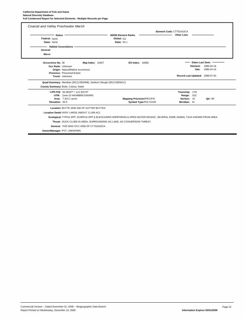
General:
CTT52410CA
Coastal and Valley Freshwater Marsh
NoneNone
G3S2.1State:
Global:NDDB Element RanksStatus Other Lists
State:Federal:
Habitat Associations
Element Code:
Micro:
Natural Diversity DatabaseCalifornia Department of Fish and Game
Full Condensed Report for Selected Elements - Multiple Records per Page
36
Presence:Trend:
Unknown
Location:
Element:Site:
DUCK CLUBS IN AREA, SURROUNDING AG LAND, AG CONVERSION THREAT.
PVT, UNKNOWN
Natural/Native occurrencePresumed ExtantUnknown
Dates Last Seen1986-04-161986-04-16
Quad Summary:
County Summary:
Meridian (3912128/545B), Sanborn Slough (3912138/561C)
Butte, Colusa, Sutter
BUTTE SINK NW OF SUTTER BUTTES.
Lat/Long: 39.28437º / -121.91074º Township: 17NRange: 01E
Section: 31 NEMeridian: M
Mapping Precision:SPECIFIC7,324.1 acresSymbol Type:POLYGONElevation: 50 ft
10427
UTM: Zone-10 N4348899 E593943
Map Index:
TYPHA SPP, SCIRPUS SPP & ELEOCHARIS W/RIPARIAN & OPEN WATER MOSAIC. SEVERAL RARE ANIMAL TAXA KNOWN FROM AREA.
VERY LARGE (ABOUT 11,000 AC).
THIS WAS OCC #036 OF CTT52410CA.
Qtr:
Origin:
Occurrence No.Occ Rank:
Location Detail:
Ecological:
Threat:
General:
Owner/Manager:
Area:
Record Last Updated: 1998-07-20
16060EO Index:
Commercial Version -- Dated November 01, 2008 -- Biogeographic Data Branch Page 22Report Printed on Wednesday, December 10, 2008 Information Expires 05/01/2009
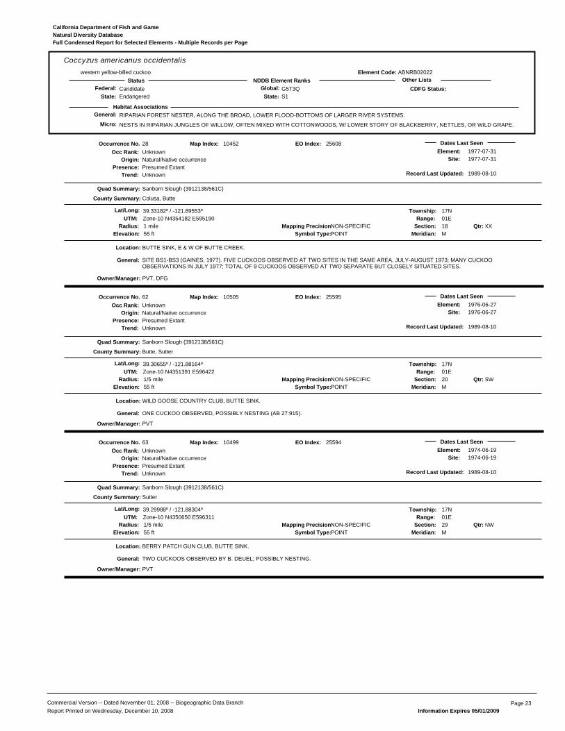
General: RIPARIAN FOREST NESTER, ALONG THE BROAD, LOWER FLOOD-BOTTOMS OF LARGER RIVER SYSTEMS.
NESTS IN RIPARIAN JUNGLES OF WILLOW, OFTEN MIXED WITH COTTONWOODS, W/ LOWER STORY OF BLACKBERRY, NETTLES, OR WILD GRAPE.
ABNRB02022
Coccyzus americanus occidentaliswestern yellow-billed cuckoo
CandidateEndangered
G5T3QS1State:
Global:NDDB Element RanksStatus Other Lists
State:Federal:
Habitat Associations
CDFG Status:
Element Code:
Micro:
Natural Diversity DatabaseCalifornia Department of Fish and Game
Full Condensed Report for Selected Elements - Multiple Records per Page
28
Presence:Trend:
Unknown
Location:
Element:Site:
PVT, DFG
Natural/Native occurrencePresumed ExtantUnknown
Dates Last Seen1977-07-311977-07-31
Quad Summary:
County Summary:
Sanborn Slough (3912138/561C)
Colusa, Butte
BUTTE SINK, E & W OF BUTTE CREEK.
Lat/Long: 39.33182º / -121.89553º Township: 17NRange: 01E
Section: 18 XXMeridian: M
Mapping Precision:NON-SPECIFIC1 mileSymbol Type:POINTElevation: 55 ft
10452
UTM: Zone-10 N4354182 E595190
Map Index:
SITE BS1-BS3 (GAINES, 1977). FIVE CUCKOOS OBSERVED AT TWO SITES IN THE SAME AREA, JULY-AUGUST 1973; MANY CUCKOOOBSERVATIONS IN JULY 1977; TOTAL OF 9 CUCKOOS OBSERVED AT TWO SEPARATE BUT CLOSELY SITUATED SITES.
Qtr:
Origin:
Occurrence No.Occ Rank:
General:
Owner/Manager:
Radius:
Record Last Updated: 1989-08-10
25608EO Index:
62
Presence:Trend:
Unknown
Location:
Element:Site:
PVT
Natural/Native occurrencePresumed ExtantUnknown
Dates Last Seen1976-06-271976-06-27
Quad Summary:
County Summary:
Sanborn Slough (3912138/561C)
Butte, Sutter
WILD GOOSE COUNTRY CLUB, BUTTE SINK.
Lat/Long: 39.30655º / -121.88164º Township: 17NRange: 01E
Section: 20 SWMeridian: M
Mapping Precision:NON-SPECIFIC1/5 mileSymbol Type:POINTElevation: 55 ft
10505
UTM: Zone-10 N4351391 E596422
Map Index:
ONE CUCKOO OBSERVED, POSSIBLY NESTING (AB 27:915).
Qtr:
Origin:
Occurrence No.Occ Rank:
General:
Owner/Manager:
Radius:
Record Last Updated: 1989-08-10
25595EO Index:
63
Presence:Trend:
Unknown
Location:
Element:Site:
PVT
Natural/Native occurrencePresumed ExtantUnknown
Dates Last Seen1974-06-191974-06-19
Quad Summary:
County Summary:
Sanborn Slough (3912138/561C)
Sutter
BERRY PATCH GUN CLUB, BUTTE SINK.
Lat/Long: 39.29988º / -121.88304º Township: 17NRange: 01E
Section: 29 NWMeridian: M
Mapping Precision:NON-SPECIFIC1/5 mileSymbol Type:POINTElevation: 55 ft
10499
UTM: Zone-10 N4350650 E596311
Map Index:
TWO CUCKOOS OBSERVED BY B. DEUEL; POSSIBLY NESTING.
Qtr:
Origin:
Occurrence No.Occ Rank:
General:
Owner/Manager:
Radius:
Record Last Updated: 1989-08-10
25594EO Index:
Commercial Version -- Dated November 01, 2008 -- Biogeographic Data Branch Page 23Report Printed on Wednesday, December 10, 2008 Information Expires 05/01/2009

General: SEACOAST, TIDAL ESTUARIES, OPEN WOODLANDS, SAVANNAHS, EDGES OF GRASSLANDS & DESERTS, FARMS & RANCHES.
CLUMPS OF TREES OR WINDBREAKS ARE REQUIRED FOR ROOSTING IN OPEN COUNTRY.
ABNKD06030
Falco columbariusmerlin
NoneNone
G5S3State:
Global:NDDB Element RanksStatus Other Lists
State:Federal:
Habitat Associations
CDFG Status:
Element Code:
Micro:
Natural Diversity DatabaseCalifornia Department of Fish and Game
Full Condensed Report for Selected Elements - Multiple Records per Page
10
Presence:Trend:
Good
Location:
Element:Site:
DFG-LITTLE DRY CREEK UNIT
Natural/Native occurrencePresumed ExtantUnknown
Dates Last Seen1993-10-141993-10-14
Quad Summary:
County Summary:
West of Biggs (3912147/561A)
Butte
LITTLE DRY CREEK UNIT, ABOUT 0.7 MILES SW OF SCHOHR RANCH.
Lat/Long: 39.38227º / -121.84795º Township: 18NRange: 01E
Section: 27 SWMeridian: M
Mapping Precision:NON-SPECIFIC1/10 mileSymbol Type:POINTElevation: 70 ft
69240
UTM: Zone-10 N4359832 E599219
Map Index:
MANAGED UPLANDS AND WETLANDS. VETCH IS DOMINANT PLANT.
WINTERING SITE. 1 INDIVIDUAL OBSERVED ON 14 OCT 1993.
Qtr:
Origin:
Occurrence No.Occ Rank:
Ecological:
General:
Owner/Manager:
Radius:
Record Last Updated: 2007-05-14
70019EO Index:
Commercial Version -- Dated November 01, 2008 -- Biogeographic Data Branch Page 24Report Printed on Wednesday, December 10, 2008 Information Expires 05/01/2009
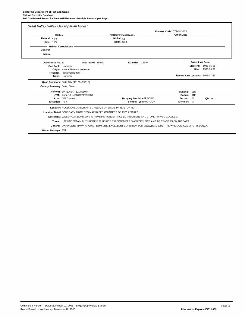
General:
CTT61430CA
Great Valley Valley Oak Riparian Forest
NoneNone
G1S1.1State:
Global:NDDB Element RanksStatus Other Lists
State:Federal:
Habitat Associations
Element Code:
Micro:
Natural Diversity DatabaseCalifornia Department of Fish and Game
Full Condensed Report for Selected Elements - Multiple Records per Page
31
Presence:Trend:
Unknown
Location:
Element:Site:
USE UNCERTAIN BUT HUNTING CLUB USE EXPECTED PER SNOWDEN. FIRE AND AG CONVERSION THREATS.
PVT
Natural/Native occurrencePresumed ExtantUnknown
Dates Last Seen1986-05-011986-05-01
Quad Summary:
County Summary:
Butte City (3912148/561B)
Butte, Glenn
HOODOO ISLAND, BUTTE CREEK, S OF BIGGS-PRINCETON RD.
Lat/Long: 39.41761º / -121.89107º Township: 18NRange: 01E
Section: 08 WMeridian: M
Mapping Precision:SPECIFIC321.0 acresSymbol Type:POLYGONElevation: 70 ft
10475
UTM: Zone-10 N4363707 E595458
Map Index:
VALLEY OAK DOMINANT IN RIPARIAN FOREST; INCL BOTH MATURE AND V. OAK RIP VEG CLASSES.
BOUNDARY FROM DFG MAP BASED ON INTERP OF 1976 AERIALS.
SWAINSONS HAWK KNOWN FROM SITE. EXCELLENT CONDITION PER SNOWDEN, 1986. THIS WAS OCC #031 OF CTT61430CA.
Qtr:
Origin:
Occurrence No.Occ Rank:
Location Detail:
Ecological:
Threat:
General:
Owner/Manager:
Area:
Record Last Updated: 1998-07-31
15597EO Index:
Commercial Version -- Dated November 01, 2008 -- Biogeographic Data Branch Page 25Report Printed on Wednesday, December 10, 2008 Information Expires 05/01/2009

General: NESTS IN WETLAND HABITATS IN NORTHEASTERN CALIFORNIA; WINTERS IN THE CENTRAL VALLEY.
PREFERS GRAIN FIELDS WITHIN 4 MI OF A SHALLOW BODY OF WATER USED AS A COMMUNAL ROOST SITE; IRRIGATED PASTURE USED AS LOA
ABNMK01014
Grus canadensis tabidagreater sandhill crane
NoneThreatened
G5T4S2State:
Global:NDDB Element RanksStatus Other Lists
State:Federal:
Habitat Associations
CDFG Status:
Element Code:
Micro:
Natural Diversity DatabaseCalifornia Department of Fish and Game
Full Condensed Report for Selected Elements - Multiple Records per Page
529
Presence:Trend:
Good
Location:
Element:Site:
PVT
Natural/Native occurrencePresumed ExtantUnknown
Dates Last Seen2003-02-132003-02-13
Quad Summary:
County Summary:
Pennington (3912137/561D)
Butte
GRAY LODGE WILDLIFE MANAGEMENT AREA IS JUST TO THE WEST. SITE IS NORTH OF WEST LIBERTY ROAD AND WEST OF FERRIS ROAD.
Lat/Long: 39.35339º / -121.79239º Township: 17NRange: 02E
Section: 06 SWMeridian: M
Mapping Precision:NON-SPECIFICSymbol Type:POLYGONElevation: 82 ft
52265
UTM: Zone-10 N4356689 E604047
Map Index:
SURROUNDING AREA IS RICE FARMING.
AREA PLOTTED BY TOWNSHIP, RANGE, 1/4 OF 1/4 SECTION. REPORTED LATITUDE AND LONGITUDE DID NOT PLOT TO SAME AREA; PLOTTEDTO NW 1/4 OF SE 1/4 OF SEC 8.
WINTERING AREA, ABOUT 35 ADULTS OBSERVED
Qtr:
Origin:
Occurrence No.Occ Rank:
Location Detail:
Ecological:
General:
Owner/Manager:
Area:
Record Last Updated: 2003-08-27
52265EO Index:
530
Presence:Trend:
Excellent
Location:
Element:Site:
DFG-GRAY LODGE WA
Natural/Native occurrencePresumed ExtantUnknown
Dates Last Seen2003-02-172003-02-17
Quad Summary:
County Summary:
Pennington (3912137/561D)
Butte
GRAY LODGE WILDLIFE MANAGEMENT AREA, ABOUT 1/2 MILE SOUTH OF WEST LIBERTY ROAD. ABOUT 1.6 MILES NE OF HEADQUARTERS
Lat/Long: 39.33846º / -121.81286º Township: 17NRange: 01E
Section: 12 SWMeridian: M
Mapping Precision:NON-SPECIFIC1/5 mileSymbol Type:POINTElevation: 65 ft
52266
UTM: Zone-10 N4355009 E602305
Map Index:
WETLAND AND FLOODED MEADOW AREA, SURROUNDING AREA IS RICE FARMING
WINTERING AREA, ABOUT 50 ADULTS OBSERVED IN THE AREA
Qtr:
Origin:
Occurrence No.Occ Rank:
Ecological:
General:
Owner/Manager:
Radius:
Record Last Updated: 2003-08-27
52266EO Index:
627
Presence:Trend:
Unknown
Location:
Element:Site:
PVT
Natural/Native occurrencePresumed ExtantUnknown
Dates Last SeenXXXX-XX-XXXXXX-XX-XX
Quad Summary:
County Summary:
Pennington (3912137/561D), West of Biggs (3912147/561A)
Butte
ADJACENT TO SE BOUNDARY OF UPPER BUTTE SINK MGMT UNIT OF GRAY LODGE WA, JUST N OF CHEROKEE CANAL & COLUSA HWYJUNCTION.
Lat/Long: 39.36860º / -121.86380º Township: 18NRange: 01E
Section: 33 XXMeridian: M
Mapping Precision:NON-SPECIFICSymbol Type:POLYGONElevation: 70 ft
69241
UTM: Zone-10 N4358297 E597873
Map Index:
LEVELED RICE FARMLAND.
IN THE 1989 PROPERTY ACQUISITION PROPOSAL IT STATED THAT THIS PROPERTY IS USED BY OVER HALF OF THE CENTRAL VALLEYWINTERING POPULATION OF THE GREATER SANDHILL CRANE. CRANE USE DOES NOT EXCEED 200 BIRDS AT ANY ONE TIME.
Qtr:
Origin:
Occurrence No.Occ Rank:
Ecological:
General:
Owner/Manager:
Area:
Record Last Updated: 2007-05-14
70020EO Index:
Commercial Version -- Dated November 01, 2008 -- Biogeographic Data Branch Page 26Report Printed on Wednesday, December 10, 2008 Information Expires 05/01/2009

General: MARSHES AND SWAMPS (FRESHWATER).
MOIST, FRESHWATER-SOAKED RIVER BANKS & LOW PEAT ISLANDS IN SLOUGHS; IN CALIF., KNOWN FROM THE DELTA WATERSHED. 0-150M.
PDMAL0H0Q0
Hibiscus lasiocarpuswoolly rose-mallow
NoneNone
G4S2.2State:
Global:NDDB Element RanksStatus Other Lists
State:Federal: 2.2
Habitat Associations
CNPS List:
Element Code:
Micro:
Natural Diversity DatabaseCalifornia Department of Fish and Game
Full Condensed Report for Selected Elements - Multiple Records per Page
8
Presence:Trend:
Good
Location:
Element:Site:
AGRICULTURE IS A THREAT.
DFG-UPPER BUTTE BASIN WA, PVT
Natural/Native occurrencePresumed ExtantUnknown
Dates Last Seen1993-06-301993-06-30
Quad Summary:
County Summary:
West of Biggs (3912147/561A), Butte City (3912148/561B), Sanborn Slough (3912138/561C)
Glenn, Colusa, Butte
BUTTE CREEK AND ASSOCIATED DRAINAGES; EXTENDING FROM 1-4 MILES SOUTH OF BIGGS-PRINCETON ROAD.
Lat/Long: 39.38171º / -121.88115º Township: 18NRange: 01E
Section: 29 XXMeridian: M
Mapping Precision:SPECIFIC553.0 acresSymbol Type:POLYGONElevation: 60 ft
10500
UTM: Zone-10 N4359733 E596361
Map Index:
IN FRESHWATER MARSH ON HEAVY CLAY SOIL. ASSOCIATED WITH TULE AND CATTAILS.
SEVERAL COLONIES MAPPED WITHIN SECTIONS 20, 29, AND 32.
MORE THAN 1,500 STEMS OBSERVED BY SNOWDEN IN 1989; 9,300 REPORTED BY ROCCO IN 1993. SITE QUALITY MOSTLY GOOD DEPENDINGON SITE HISTORY. MUCH OF AREA FORMER RICE FIELDS. INCLUDES FORMER OCCURRENCE #74.
Qtr:
Origin:
Occurrence No.Occ Rank:
Location Detail:
Ecological:
Threat:
General:
Owner/Manager:
Area:
Record Last Updated: 2006-09-12
20784EO Index:
41
Presence:Trend:
Unknown
Location:
Element:Site:
AGRICULTURE IS A THREAT.
DFG-GRAY LODGE WA
Natural/Native occurrencePresumed ExtantUnknown
Dates Last Seen1983-08-121983-08-12
Quad Summary:
County Summary:
Pennington (3912137/561D)
Butte
WEST EDGE OF GRAY LODGE WILDLIFE AREA, ABOUT 4.5 MILES WNW OF PENNINGTON.
Lat/Long: 39.32033º / -121.87226º Township: 17NRange: 01E
Section: 16 SWMeridian: M
Mapping Precision:SPECIFIC12.0 acresSymbol Type:POLYGONElevation: 55 ft
10532
UTM: Zone-10 N4352931 E597212
Map Index:
IN FRESHWATER MARSH ON HEAVY CLAY SOIL.
MAPPED IN CHANNEL ABOUT 2 MILES WEST OF GRAY LODGE HEADQUARTERS AND 1.2 MILES NORTH OF BUTTE/SUTTER COUNTY LINE.
Qtr:
Origin:
Occurrence No.Occ Rank:
Location Detail:
Ecological:
Threat:
Owner/Manager:
Area:
Record Last Updated: 1995-10-25
20786EO Index:
42
Presence:Trend:
Unknown
Location:
Element:Site:
AGRICULTURE IS A THREAT.
DFG-UPPER BUTTE BASIN WA
Natural/Native occurrencePresumed ExtantUnknown
Dates Last Seen1983-08-121983-08-12
Quad Summary:
County Summary:
Sanborn Slough (3912138/561C)
Butte
0.2 TO 0.8 MILE SOUTH OF TULE GOOSE GUN CLUB, BUTTE SINK.
Lat/Long: 39.32350º / -121.88195º Township: 17NRange: 01E
Section: 17 SMeridian: M
Mapping Precision:SPECIFIC32.3 acresSymbol Type:POLYGONElevation: 55 ft
10506
UTM: Zone-10 N4353273 E596372
Map Index:
IN FRESHWATER MARSH ON HEAVY CLAY SOIL.
TWO COLONIES.
INCLUDES FORMER OCCURRENCE #43.
Qtr:
Origin:
Occurrence No.Occ Rank:
Location Detail:
Ecological:
Threat:
General:
Owner/Manager:
Area:
Record Last Updated: 2006-09-07
13231EO Index:
Commercial Version -- Dated November 01, 2008 -- Biogeographic Data Branch Page 27Report Printed on Wednesday, December 10, 2008 Information Expires 05/01/2009

General: MARSHES AND SWAMPS (FRESHWATER).
MOIST, FRESHWATER-SOAKED RIVER BANKS & LOW PEAT ISLANDS IN SLOUGHS; IN CALIF., KNOWN FROM THE DELTA WATERSHED. 0-150M.
PDMAL0H0Q0
Hibiscus lasiocarpuswoolly rose-mallow
NoneNone
G4S2.2State:
Global:NDDB Element RanksStatus Other Lists
State:Federal: 2.2
Habitat Associations
CNPS List:
Element Code:
Micro:
Natural Diversity DatabaseCalifornia Department of Fish and Game
Full Condensed Report for Selected Elements - Multiple Records per Page
44
Presence:Trend:
Unknown
Location:
Element:Site:
AGRICULTURE IS A THREAT.
PVT
Natural/Native occurrencePresumed ExtantUnknown
Dates Last Seen1983-08-121983-08-12
Quad Summary:
County Summary:
Sanborn Slough (3912138/561C)
Colusa, Butte
ALONG BUTTE CREEK FROM SANBORN SLOUGH SOUTH TO JUST NORTH OF SUTTER COUNTY LINE; BUTTE SINK.
Lat/Long: 39.32388º / -121.90446º Township: 17NRange: 01E
Section: 18 SEMeridian: M
Mapping Precision:SPECIFIC207.2 acresSymbol Type:POLYGONElevation: 55 ft
10454
UTM: Zone-10 N4353291 E594431
Map Index:
IN FRESHWATER MARSH ON HEAVY CLAY SOIL.
LARGE POPULATION MAPPED ALONG THE WEST SIDE OF THE BUTTE SINK.
Qtr:
Origin:
Occurrence No.Occ Rank:
Location Detail:
Ecological:
Threat:
Owner/Manager:
Area:
Record Last Updated: 2006-09-07
19234EO Index:
45
Presence:Trend:
Unknown
Location:
Element:Site:
AGRICULTURE IS A THREAT.
PVT
Natural/Native occurrencePresumed ExtantUnknown
Dates Last Seen1983-08-121983-08-12
Quad Summary:
County Summary:
Sanborn Slough (3912138/561C)
Butte, Colusa
ALONG BUTTE CREEK AND SANBORN SLOUGH NEAR THE SANBORN SLOUGH GUN CLUB.
Lat/Long: 39.35162º / -121.89320º Township: 17NRange: 01E
Section: 06 SEMeridian: M
Mapping Precision:SPECIFIC25.5 acresSymbol Type:POLYGONElevation: 55 ft
10462
UTM: Zone-10 N4356382 E595364
Map Index:
IN FRESHWATER MARSH ON HEAVY CLAY SOIL.
2 COLONIES. EAST COLONY IS NEAR GUN CLUB BUILDINGS. WEST COLONY IS 0.3 AIR MILE EAST OF BUILDINGS.
INCLUDES FORMER OCCURRENCE #46.
Qtr:
Origin:
Occurrence No.Occ Rank:
Location Detail:
Ecological:
Threat:
General:
Owner/Manager:
Area:
Record Last Updated: 2006-09-07
19235EO Index:
62
Presence:Trend:
Unknown
Location:
Element:Site:
AGRICULTURE IS A THREAT.
PVT
Natural/Native occurrencePresumed ExtantUnknown
Dates Last Seen1983-08-121983-08-12
Quad Summary:
County Summary:
Sanborn Slough (3912138/561C)
Butte
EAST OF BUTTE CREEK, ABOUT 1.25 AIR MI SW OF TULE GOOSE GUN CLUB, BUTTE SINK.
Lat/Long: 39.31763º / -121.89882º Township: 17NRange: 01E
Section: 19 NEMeridian: M
Mapping Precision:SPECIFIC13.3 acresSymbol Type:POLYGONElevation: 55 ft
10439
UTM: Zone-10 N4352604 E594925
Map Index:
IN FRESHWATER MARSH ON HEAVY CLAY SOIL.
Qtr:
Origin:
Occurrence No.Occ Rank:
Ecological:
Threat:
Owner/Manager:
Area:
Record Last Updated: 2006-09-07
19232EO Index:
Commercial Version -- Dated November 01, 2008 -- Biogeographic Data Branch Page 28Report Printed on Wednesday, December 10, 2008 Information Expires 05/01/2009
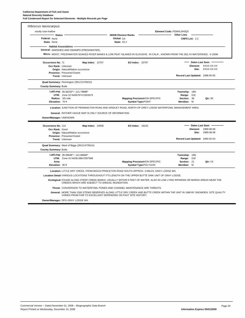
General: MARSHES AND SWAMPS (FRESHWATER).
MOIST, FRESHWATER-SOAKED RIVER BANKS & LOW PEAT ISLANDS IN SLOUGHS; IN CALIF., KNOWN FROM THE DELTA WATERSHED. 0-150M.
PDMAL0H0Q0
Hibiscus lasiocarpuswoolly rose-mallow
NoneNone
G4S2.2State:
Global:NDDB Element RanksStatus Other Lists
State:Federal: 2.2
Habitat Associations
CNPS List:
Element Code:
Micro:
Natural Diversity DatabaseCalifornia Department of Fish and Game
Full Condensed Report for Selected Elements - Multiple Records per Page
71
Presence:Trend:
Unknown
Location:
Element:Site:
UNKNOWN
Natural/Native occurrencePresumed ExtantUnknown
Dates Last SeenXXXX-XX-XXXXXX-XX-XX
Quad Summary:
County Summary:
Pennington (3912137/561D)
Butte
JUNCTION OF PENNINGTON ROAD AND GRIDLEY ROAD, NORTH OF GREY LODGE WATERFOWL MANAGEMENT AREA.
Lat/Long: 39.36233º / -121.79888º Township: 18NRange: 01E
Section: 36 SEMeridian: M
Mapping Precision:NON-SPECIFIC3/5 mileSymbol Type:POINTElevation: 70 ft
10707
UTM: Zone-10 N4357674 E603475
Map Index:
RATHER VAGUE MAP IS ONLY SOURCE OF INFORMATION.
Qtr:
Origin:
Occurrence No.Occ Rank:
General:
Owner/Manager:
Radius:
Record Last Updated: 1998-05-05
20797EO Index:
114
Presence:Trend:
Good
Location:
Element:Site:
CONVERSION TO WATERFOWL PONDS AND CHANNEL MAINTENANCE ARE THREATS.
DFG-GRAY LODGE WA
Natural/Native occurrencePresumed ExtantUnknown
Dates Last Seen1989-08-081989-08-08
Quad Summary:
County Summary:
West of Biggs (3912147/561A)
Butte
LITTLE DRY CREEK, FROM BIGGS-PRINCETON ROAD SOUTH APPROX. 3 MILES; GRAY LODGE WA.
Lat/Long: 39.39648º / -121.86666º Township: 18NRange: 01E
Section: 21 XXMeridian: M
Mapping Precision:NON-SPECIFICSymbol Type:POLYGONElevation: 80 ft
24938
UTM: Zone-10 N4361388 E597589
Map Index:
FOUND ALONG STEEP CREEK BANKS, USUALLY WITHIN 5 FEET OF WATER. ALSO IN LOW LYING RIPARIAN OR MARSH AREAS NEAR THECREEKS WHICH ARE SUBJECT TO ANNUAL INUNDATION.
VARIOUS LOCATIONS THROUGHOUT IT'S LENGTH ON THE UPPER BUTTE SINK UNIT OF GRAY LODGE.
MORE THAN 1500 STEMS OBSERVED ALONG LITTLE DRY CREEK AND BUTTE CREEK WITHIN THE UNIT IN 1989 BY SNOWDEN. SITE QUALITYVARIES FROM FAIR TO EXCELLENT DEPENDING ON PAST SITE HISTORY.
Qtr:
Origin:
Occurrence No.Occ Rank:
Location Detail:
Ecological:
Threat:
General:
Owner/Manager:
Area:
Record Last Updated: 1994-02-03
19233EO Index:
Commercial Version -- Dated November 01, 2008 -- Biogeographic Data Branch Page 29Report Printed on Wednesday, December 10, 2008 Information Expires 05/01/2009

General: INHABITS FRESHWATER MARTSHES, WET MEADOWS & SHALLOW MARGINS OF SALTWATER MARSHES BORDERING LARGER BAYS.
NEEDS WATER DEPTHS OF ABOUT 1 INCH THAT DOES NOT FLUCTUATE DURING THE YEAR & DENSE VEGETATION FOR NESTING HABITAT.
ABNME03041
Laterallus jamaicensis coturniculusCalifornia black rail
NoneThreatened
G4T1S1State:
Global:NDDB Element RanksStatus Other Lists
State:Federal:
Habitat Associations
CDFG Status:
Element Code:
Micro:
Natural Diversity DatabaseCalifornia Department of Fish and Game
Full Condensed Report for Selected Elements - Multiple Records per Page
101
Presence:Trend:
Good
Location:
Element:Site:
DFG-LITTLE DRY CREEK UNIT
Natural/Native occurrencePresumed ExtantUnknown
Dates Last Seen1993-09-161993-09-16
Quad Summary:
County Summary:
Sanborn Slough (3912138/561C)
Butte
NORTH OF SUTTER BUTTES; APPROXIMATELY 1.4 KM NORTHEAST OF SANBORN SLOUGH X BUTTE CREEK.
Lat/Long: 39.36568º / -121.88005º Township: 18NRange: 01E
Section: 32 SEMeridian: M
Mapping Precision:SPECIFIC80 metersSymbol Type:POINTElevation: 60 ft
34886
UTM: Zone-10 N4357956 E596478
Map Index:
SEMI-PERMANENT WETLANDS; FALLOW RICE FIELDS WITH A DITCHLINE AT BOTTOM OF FIELD; CATTAILS, SMARTWEED PRESENT AND AREAWAS FILLING WITH WATER.
ROC93U0005 LOCATION INCLUDED HERE; THE MAP ATTACHED IS VAGUE BUT IS BY THE SAME AUTHOR AND ON THE SAME DATE AS THEFIELD SURVEY FORM.
1 RAIL WAS OBSERVED BY C. ROCCO ON 16 SEPTEMBER 1993.
Qtr:
Origin:
Occurrence No.Occ Rank:
Location Detail:
Ecological:
General:
Owner/Manager:
Radius:
Record Last Updated: 2007-05-10
5858EO Index:
Commercial Version -- Dated November 01, 2008 -- Biogeographic Data Branch Page 30Report Printed on Wednesday, December 10, 2008 Information Expires 05/01/2009
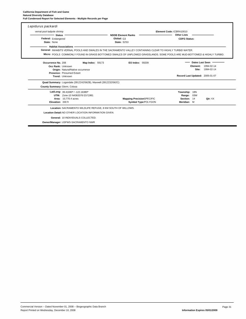
General: INHABITS VERNAL POOLS AND SWALES IN THE SACRAMENTO VALLEY CONTAINING CLEAR TO HIGHLY TURBID WATER.
POOLS COMMONLY FOUND IN GRASS BOTTOMED SWALES OF UNPLOWED GRASSLANDS. SOME POOLS ARE MUD-BOTTOMED & HIGHLY TURBID.
ICBRA10010
Lepidurus packardivernal pool tadpole shrimp
EndangeredNone
G3S2S3State:
Global:NDDB Element RanksStatus Other Lists
State:Federal:
Habitat Associations
CDFG Status:
Element Code:
Micro:
Natural Diversity DatabaseCalifornia Department of Fish and Game
Full Condensed Report for Selected Elements - Multiple Records per Page
208
Presence:Trend:
Unknown
Location:
Element:Site:
USFWS-SACRAMENTO NWR
Natural/Native occurrencePresumed ExtantUnknown
Dates Last Seen1994-02-141994-02-14
Quad Summary:
County Summary:
Logandale (3912242/562B), Maxwell (3912232/562C)
Glenn, Colusa
SACRAMENTO WILDLIFE REFUGE, 8 KM SOUTH OF WILLOWS.
Lat/Long: 39.41690º / -122.16380º Township: 18NRange: 03W
Section: 14 XXMeridian: M
Mapping Precision:SPECIFIC10,770.4 acresSymbol Type:POLYGONElevation: 330 ft
59173
UTM: Zone-10 N4363376 E571981
Map Index:
NO OTHER LOCATION INFORMATION GIVEN.
10 INDIVIDUALS COLLECTED.
Qtr:
Origin:
Occurrence No.Occ Rank:
Location Detail:
General:
Owner/Manager:
Area:
Record Last Updated: 2005-01-07
59209EO Index:
Commercial Version -- Dated November 01, 2008 -- Biogeographic Data Branch Page 31Report Printed on Wednesday, December 10, 2008 Information Expires 05/01/2009
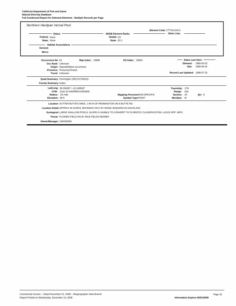
General:
CTT44110CA
Northern Hardpan Vernal Pool
NoneNone
G3S3.1State:
Global:NDDB Element RanksStatus Other Lists
State:Federal:
Habitat Associations
Element Code:
Micro:
Natural Diversity DatabaseCalifornia Department of Fish and Game
Full Condensed Report for Selected Elements - Multiple Records per Page
61
Presence:Trend:
Unknown
Location:
Element:Site:
PLOWED FIELD ON W, RICE FIELDS NEARBY.
UNKNOWN
Natural/Native occurrencePresumed ExtantUnknown
Dates Last Seen1980-05-021980-05-02
Quad Summary:
County Summary:
Pennington (3912137/561D)
Sutter
SUTTER BUTTES AREA. 1 MI W OF PENNINGTON ON N BUTTE RD.
Lat/Long: 39.29265º / -121.80553º Township: 17NRange: 01E
Section: 25 SMeridian: M
Mapping Precision:NON-SPECIFIC1/5 mileSymbol Type:POINTElevation: 80 ft
10688
UTM: Zone-10 N4349933 E603005
Map Index:
LARGE SHALLOW POOLS, SLOPE=0 UNABLE TO CONVERT TO FLORISTIC CLASSIFICATION, LACKS SPP. INFO.
APPROX 40 ACRES, BOUNDED ON E BY RIDGE W/QUERCUS DOUGLASII.
Qtr:
Origin:
Occurrence No.Occ Rank:
Location Detail:
Ecological:
Threat:
Owner/Manager:
Radius:
Record Last Updated: 1998-07-15
26924EO Index:
Commercial Version -- Dated November 01, 2008 -- Biogeographic Data Branch Page 32Report Printed on Wednesday, December 10, 2008 Information Expires 05/01/2009

General: TYPICALLY FOUND IN GRASSLANDS AND BLUE OAK SAVANNAS.
NEEDS FRIABLE SOILS.
AMAFD01061
Perognathus inornatus inornatusSan Joaquin pocket mouse
NoneNone
G4T2T3S2S3State:
Global:NDDB Element RanksStatus Other Lists
State:Federal:
Habitat Associations
CDFG Status:
Element Code:
Micro:
Natural Diversity DatabaseCalifornia Department of Fish and Game
Full Condensed Report for Selected Elements - Multiple Records per Page
40
Presence:Trend:
Unknown
Location:
Element:Site:
UNKNOWN
Natural/Native occurrencePresumed ExtantUnknown
Dates Last Seen1929-10-061929-10-06
Quad Summary:
County Summary:
Sites (3912233/563D)
Colusa
1.5 MI E SITES.
Lat/Long: 39.30932º / -122.30915º Township: 17NRange: 04W
Section: 21 SEMeridian: M
Mapping Precision:NON-SPECIFIC1 mileSymbol Type:POINTElevation:
09294
UTM: Zone-10 N4351330 E559560
Map Index:
MVZ #43248; COLLECTED 4 OCTOBER 1929.
Qtr:
Origin:
Occurrence No.Occ Rank:
General:
Owner/Manager:
Radius:
Record Last Updated: 1989-08-10
23929EO Index:
41
Presence:Trend:
Unknown
Location:
Element:Site:
UNKNOWN
Natural/Native occurrencePresumed ExtantUnknown
Dates Last Seen1911-04-281911-04-28
Quad Summary:
County Summary:
Sites (3912233/563D)
Colusa
SITES.
Lat/Long: 39.30932º / -122.33693º Township: 17NRange: 04W
Section: 20 SWMeridian: M
Mapping Precision:NON-SPECIFIC1 mileSymbol Type:POINTElevation:
09238
UTM: Zone-10 N4351312 E557165
Map Index:
MVZ #12969.
Qtr:
Origin:
Occurrence No.Occ Rank:
General:
Owner/Manager:
Radius:
Record Last Updated: 1989-08-10
23924EO Index:
Commercial Version -- Dated November 01, 2008 -- Biogeographic Data Branch Page 33Report Printed on Wednesday, December 10, 2008 Information Expires 05/01/2009
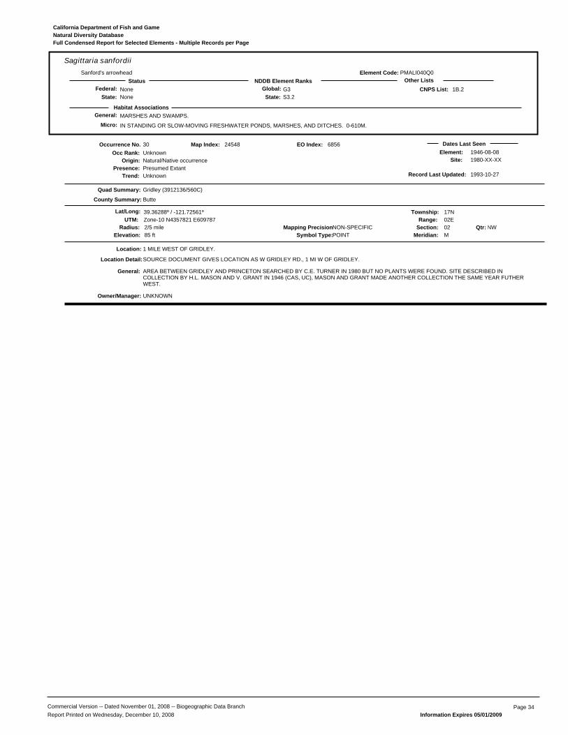
General: MARSHES AND SWAMPS.
IN STANDING OR SLOW-MOVING FRESHWATER PONDS, MARSHES, AND DITCHES. 0-610M.
PMALI040Q0
Sagittaria sanfordiiSanford's arrowhead
NoneNone
G3S3.2State:
Global:NDDB Element RanksStatus Other Lists
State:Federal: 1B.2
Habitat Associations
CNPS List:
Element Code:
Micro:
Natural Diversity DatabaseCalifornia Department of Fish and Game
Full Condensed Report for Selected Elements - Multiple Records per Page
30
Presence:Trend:
Unknown
Location:
Element:Site:
UNKNOWN
Natural/Native occurrencePresumed ExtantUnknown
Dates Last Seen1946-08-081980-XX-XX
Quad Summary:
County Summary:
Gridley (3912136/560C)
Butte
1 MILE WEST OF GRIDLEY.
Lat/Long: 39.36288º / -121.72561º Township: 17NRange: 02E
Section: 02 NWMeridian: M
Mapping Precision:NON-SPECIFIC2/5 mileSymbol Type:POINTElevation: 85 ft
24548
UTM: Zone-10 N4357821 E609787
Map Index:
SOURCE DOCUMENT GIVES LOCATION AS W GRIDLEY RD., 1 MI W OF GRIDLEY.
AREA BETWEEN GRIDLEY AND PRINCETON SEARCHED BY C.E. TURNER IN 1980 BUT NO PLANTS WERE FOUND. SITE DESCRIBED INCOLLECTION BY H.L. MASON AND V. GRANT IN 1946 (CAS, UC), MASON AND GRANT MADE ANOTHER COLLECTION THE SAME YEAR FUTHERWEST.
Qtr:
Origin:
Occurrence No.Occ Rank:
Location Detail:
General:
Owner/Manager:
Radius:
Record Last Updated: 1993-10-27
6856EO Index:
Commercial Version -- Dated November 01, 2008 -- Biogeographic Data Branch Page 34Report Printed on Wednesday, December 10, 2008 Information Expires 05/01/2009

General: PREFERS FRESHWATER MARSH AND LOW GRADIENT STREAMS. HAS ADAPTED TO DRAINAGE CANALS & IRRIGATION DITCHES.
THIS IS THE MOST AQUATIC OF THE GARTER SNAKES IN CALIFORNIA.
ARADB36150
Thamnophis gigasgiant garter snake
ThreatenedThreatened
G2G3S2S3State:
Global:NDDB Element RanksStatus Other Lists
State:Federal:
Habitat Associations
CDFG Status:
Element Code:
Micro:
Natural Diversity DatabaseCalifornia Department of Fish and Game
Full Condensed Report for Selected Elements - Multiple Records per Page
90
Presence:Trend:
Good
Location:
Element:Site:
DFG-GRAY LODGE WA
Natural/Native occurrencePresumed ExtantUnknown
Dates Last Seen1993-XX-XX1993-XX-XX
Quad Summary:
County Summary:
Pennington (3912137/561D)
Butte
CANAL #21, NORTH OF FIELD #64, EAST OF PENNINGTON ROAD, GRAY LODGE WILDLIFE AREA.
Lat/Long: 39.31085º / -121.77850º Township: 17NRange: 02E
Section: 20 SWMeridian: M
Mapping Precision:NON-SPECIFIC1/5 mileSymbol Type:POINTElevation: 70 ft
21411
UTM: Zone-10 N4351984 E605308
Map Index:
HABITAT CONSISTS OF OPEN FIELDS WITH SEMIPERMANENT AND PERMANENT WATER AREAS AND CANALS. AREA MANAGED FORWATERFOWL AND UPLAND GAME BIRDS (PHEASANTS).
THREE ADULTS OBSERVED DURING 20 MAY 1992. UNKNOWN NUMBER OF SNAKES OBSERVED DURING 1993.
Qtr:
Origin:
Occurrence No.Occ Rank:
Ecological:
General:
Owner/Manager:
Radius:
Record Last Updated: 2006-05-16
27565EO Index:
95
Presence:Trend:
Good
Location:
Element:Site:
FLOODING, EROSION.
DFG-LITTLE DRY CREEK UNIT
Natural/Native occurrencePresumed ExtantUnknown
Dates Last Seen1993-10-011993-10-01
Quad Summary:
County Summary:
Sanborn Slough (3912138/561C), Butte City (3912148/561B)
Colusa, Butte
NORTHERN PORTION OF BUTTE SINK; APPROX. 1.7 KM NORTHEAST OF THE INTERSECTION BETWEEN GRIDLEY ROAD AND BUTTE CREEK.
Lat/Long: 39.37600º / -121.88165º Township: 18NRange: 01E
Section: 32 NWMeridian: M
Mapping Precision:NON-SPECIFIC1/5 mileSymbol Type:POINTElevation: 60 ft
32390
UTM: Zone-10 N4359099 E596326
Map Index:
SEMI-PERMANENT WETLANDS WITH CREEK NEAR THE AREA; OLD RICE GROUND.
1 JUVENILE OBSERVED.
Qtr:
Origin:
Occurrence No.Occ Rank:
Ecological:
Threat:
General:
Owner/Manager:
Radius:
Record Last Updated: 2002-11-20
1630EO Index:
96
Presence:Trend:
Good
Location:
Element:Site:
FLOODING, FIRE.
DFG-UPPER BUTTE BASIN WA
Natural/Native occurrencePresumed ExtantUnknown
Dates Last Seen1993-07-281993-07-28
Quad Summary:
County Summary:
Pennington (3912137/561D), West of Biggs (3912147/561A)
Butte
LITTLE DRY CREEK UNIT OF UPPER BUTTE BASIN WILDLIFE AREA; APPROX. 3.0 KM SOUTHWEST OF SCHOHR RANCH.
Lat/Long: 39.37631º / -121.86929º Township: 18NRange: 01E
Section: 33 NWMeridian: M
Mapping Precision:NON-SPECIFIC1/5 mileSymbol Type:POINTElevation: 65 ft
32391
UTM: Zone-10 N4359147 E597390
Map Index:
1 INDIVIDUAL OBSERVED AT SITE.
Qtr:
Origin:
Occurrence No.Occ Rank:
Threat:
General:
Owner/Manager:
Radius:
Record Last Updated: 1995-08-10
7113EO Index:
Commercial Version -- Dated November 01, 2008 -- Biogeographic Data Branch Page 35Report Printed on Wednesday, December 10, 2008 Information Expires 05/01/2009

General: PREFERS FRESHWATER MARSH AND LOW GRADIENT STREAMS. HAS ADAPTED TO DRAINAGE CANALS & IRRIGATION DITCHES.
THIS IS THE MOST AQUATIC OF THE GARTER SNAKES IN CALIFORNIA.
ARADB36150
Thamnophis gigasgiant garter snake
ThreatenedThreatened
G2G3S2S3State:
Global:NDDB Element RanksStatus Other Lists
State:Federal:
Habitat Associations
CDFG Status:
Element Code:
Micro:
Natural Diversity DatabaseCalifornia Department of Fish and Game
Full Condensed Report for Selected Elements - Multiple Records per Page
103
Presence:Trend:
Good
Location:
Element:Site:
FLOODING, FIRE.
DFG-UPPER BUTTE BASIN WA
Natural/Native occurrencePresumed ExtantUnknown
Dates Last Seen1993-10-031993-10-03
Quad Summary:
County Summary:
West of Biggs (3912147/561A), Butte City (3912148/561B)
Butte
EAST OF BUTTE CREEK; APPROX. 3.5 KM SSE OF THE INTERSECTION BETWEEN PRINCETON ROAD AND BUTTE CREEK.
Lat/Long: 39.38827º / -121.87683º Township: 18NRange: 01E
Section: 29 NEMeridian: M
Mapping Precision:NON-SPECIFIC1/5 mileSymbol Type:POINTElevation: 65 ft
32398
UTM: Zone-10 N4360466 E596724
Map Index:
SEMI-PERMANENT WETLANDS WITH IRRIGATION CANAL THROUGH THE AREA.
1 JUNVENILE OBSERVED.
Qtr:
Origin:
Occurrence No.Occ Rank:
Ecological:
Threat:
General:
Owner/Manager:
Radius:
Record Last Updated: 1995-07-25
1634EO Index:
160
Presence:Trend:
Excellent
Location:
Element:Site:
SITE NEAR A BUSY ROAD.
PVT
Natural/Native occurrencePresumed ExtantUnknown
Dates Last Seen2001-05-222001-05-22
Quad Summary:
County Summary:
Pennington (3912137/561D)
Butte
CHEROKEE CANAL, 6.3 MILES NW OF PENNIGNTON; NEAR INTERSECT OF GRIDLEY ROAD AND CHEROKEE CANAL.
Lat/Long: 39.36266º / -121.86775º Township: 18NRange: 01E
Section: 33 SWMeridian: M
Mapping Precision:SPECIFIC80 metersSymbol Type:POINTElevation: 65 ft
46872
UTM: Zone-10 N4357634 E597542
Map Index:
HABITAT CONSISTS OF TULES AND CATTAILS GROWING ALONG MARGIN OF CANAL. MATTED AQUATIC VEGETATION PRESENT WITHIN SLOWMOVING WATER. SURROUNDING LAND CONSISTS OF WILDLIFE REFUGE, RICE FIELDS AND MANAGED HUNT CLUBS.
22 MAY 2001: 1 ADULT OBSERVED.
Qtr:
Origin:
Occurrence No.Occ Rank:
Ecological:
Threat:
General:
Owner/Manager:
Radius:
Record Last Updated: 2001-12-21
46872EO Index:
179
Presence:Trend:
Good
Location:
Element:Site:
THREATENED BY TRAFFIC ON ROAD
DFG-GRAY LODGE WA, PVT
Natural/Native occurrencePresumed ExtantUnknown
Dates Last Seen1997-10-071997-10-07
Quad Summary:
County Summary:
Pennington (3912137/561D)
Butte
PENNINGTON ROAD, ABOUT 135 FT SOUTH OF JUNCTION WITH WEST LIBERTY ROAD. GRAY LODGE WATERFOWL MANAGEMENT AREA.
Lat/Long: 39.34689º / -121.79873º Township: 17NRange: 01E
Section: 12 NEMeridian: M
Mapping Precision:SPECIFIC80 metersSymbol Type:POINTElevation: 70 ft
52032
UTM: Zone-10 N4355960 E603511
Map Index:
AREA TO WEST OF ROAD IS A MANAGED WATERFOWL AREA WITH FRESHWATER MARSH, UPLAND LEVEES, IRRIGATION DITCHES, &SCATTERED EUCALYPTUS, WILLOW, & COTTONWOOD TREES. EAST SIDE OF ROAD IS IRRIGATION DITCH WITH GRAZED PASTURE BEYOND.
1 ADULT, 28 INCHES LONG, FOUND DEAD ON ROAD 7 OCT 1997.
Qtr:
Origin:
Occurrence No.Occ Rank:
Ecological:
Threat:
General:
Owner/Manager:
Radius:
Record Last Updated: 2003-08-06
52032EO Index:
Commercial Version -- Dated November 01, 2008 -- Biogeographic Data Branch Page 36Report Printed on Wednesday, December 10, 2008 Information Expires 05/01/2009
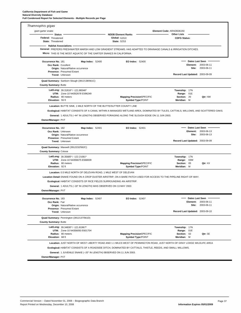
General: PREFERS FRESHWATER MARSH AND LOW GRADIENT STREAMS. HAS ADAPTED TO DRAINAGE CANALS & IRRIGATION DITCHES.
THIS IS THE MOST AQUATIC OF THE GARTER SNAKES IN CALIFORNIA.
ARADB36150
Thamnophis gigasgiant garter snake
ThreatenedThreatened
G2G3S2S3State:
Global:NDDB Element RanksStatus Other Lists
State:Federal:
Habitat Associations
CDFG Status:
Element Code:
Micro:
Natural Diversity DatabaseCalifornia Department of Fish and Game
Full Condensed Report for Selected Elements - Multiple Records per Page
181
Presence:Trend:
Excellent
Location:
Element:Site:
PVT
Natural/Native occurrencePresumed ExtantUnknown
Dates Last Seen2003-06-112003-06-11
Quad Summary:
County Summary:
Sanborn Slough (3912138/561C)
Butte
BUTTE SINK, 1 MILE NORTH OF THE BUTTE/SUTTER COUNTY LINE
Lat/Long: 39.31816º / -121.88346º Township: 17NRange: 01E
Section: 20 NWMeridian: M
Mapping Precision:SPECIFIC80 metersSymbol Type:POINTElevation: 55 ft
52400
UTM: Zone-10 N4352678 E596249
Map Index:
HABITAT CONSISTS OF A CANAL WITHIN A MANAGED WETLAND AREA, DOMINATED BY TULES, CATTAILS, WILLOWS, AND SCATTERED OAKS.
1 ADULTS (~44" IN LENGTH) OBSERVED FORAGING ALONG THE SLOUGH EDGE ON 11 JUN 2003.
Qtr:
Origin:
Occurrence No.Occ Rank:
Ecological:
General:
Owner/Manager:
Radius:
Record Last Updated: 2003-09-09
52400EO Index:
182
Presence:Trend:
Unknown
Location:
Element:Site:
PVT
Natural/Native occurrencePresumed ExtantUnknown
Dates Last Seen2003-06-132003-06-13
Quad Summary:
County Summary:
Maxwell (3912232/562C)
Colusa
0.5 MILE NORTH OF DELEVAN ROAD, 1 MILE WEST OF DELEVAN
Lat/Long: 39.35685º / -122.21061º Township: 17NRange: 03W
Section: 05 XXMeridian: M
Mapping Precision:SPECIFIC80 metersSymbol Type:POINTElevation: 92 ft
52401
UTM: Zone-10 N4356675 E568009
Map Index:
HABITAT CONSISTS OF RICE FIELDS SURROUNDING AN AIRSTRIP.
SNAKE FOUND ON A CROP DUSTER AIRSTRIP, ON A BARE PATCH USED FOR ACCESS TO THE PIPELINE RIGHT-OF-WAY.
1 ADULTS (~18" IN LENGTH) WAS OBSERVED ON 13 MAY 2003
Qtr:
Origin:
Occurrence No.Occ Rank:
Location Detail:
Ecological:
General:
Owner/Manager:
Radius:
Record Last Updated: 2003-09-09
52401EO Index:
183
Presence:Trend:
Fair
Location:
Element:Site:
PVT
Natural/Native occurrencePresumed ExtantUnknown
Dates Last Seen2003-06-112003-06-11
Quad Summary:
County Summary:
Pennington (3912137/561D)
Butte
JUST NORTH OF WEST LIBERTY ROAD AND 1.1 MILES WEST OF PENNINGTON ROAD, JUST NORTH OF GRAY LODGE WILDLIFE AREA
Lat/Long: 39.34830º / -121.81967º Township: 17NRange: 01E
Section: 02 SEMeridian: M
Mapping Precision:SPECIFIC80 metersSymbol Type:POINTElevation: 68 ft
52407
UTM: Zone-10 N4356093 E601704
Map Index:
HABITAT CONSISTS OF A ROADSIDE DITCH, DOMINATED BY CATTAILS, THISTLE, REEDS, AND SMALL WILLOWS.
1 JUVENILE SNAKE (~20" IN LENGTH) 0BSERVED ON 11 JUN 2003.
Qtr:
Origin:
Occurrence No.Occ Rank:
Ecological:
General:
Owner/Manager:
Radius:
Record Last Updated: 2003-09-10
52407EO Index:
Commercial Version -- Dated November 01, 2008 -- Biogeographic Data Branch Page 37Report Printed on Wednesday, December 10, 2008 Information Expires 05/01/2009
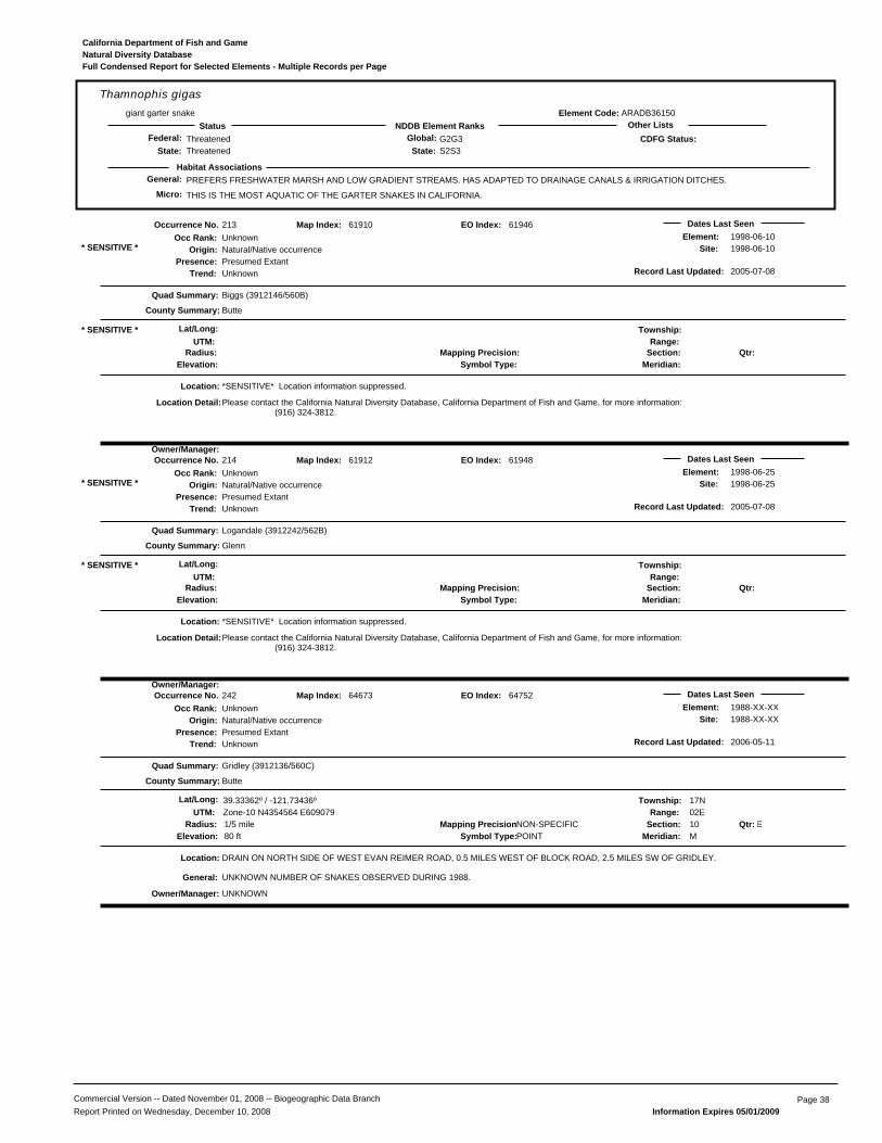
General: PREFERS FRESHWATER MARSH AND LOW GRADIENT STREAMS. HAS ADAPTED TO DRAINAGE CANALS & IRRIGATION DITCHES.
THIS IS THE MOST AQUATIC OF THE GARTER SNAKES IN CALIFORNIA.
ARADB36150
Thamnophis gigasgiant garter snake
ThreatenedThreatened
G2G3S2S3State:
Global:NDDB Element RanksStatus Other Lists
State:Federal:
Habitat Associations
CDFG Status:
Element Code:
Micro:
Natural Diversity DatabaseCalifornia Department of Fish and Game
Full Condensed Report for Selected Elements - Multiple Records per Page
213
Presence:Trend:
Unknown
Location:
Element:Site:Natural/Native occurrence
Presumed ExtantUnknown
Dates Last Seen1998-06-101998-06-10
Quad Summary:
County Summary:
Biggs (3912146/560B)
Butte
*SENSITIVE* Location information suppressed.
Lat/Long: Township:Range:
Section:Meridian:
Mapping Precision:Symbol Type:Elevation:
61910
UTM:
Map Index:
Please contact the California Natural Diversity Database, California Department of Fish and Game, for more information: (916) 324-3812.
* SENSITIVE *
Qtr:
Origin:
Occurrence No.Occ Rank:
Location Detail:
Owner/Manager:
Radius:
* SENSITIVE *
Record Last Updated: 2005-07-08
61946EO Index:
214
Presence:Trend:
Unknown
Location:
Element:Site:Natural/Native occurrence
Presumed ExtantUnknown
Dates Last Seen1998-06-251998-06-25
Quad Summary:
County Summary:
Logandale (3912242/562B)
Glenn
*SENSITIVE* Location information suppressed.
Lat/Long: Township:Range:
Section:Meridian:
Mapping Precision:Symbol Type:Elevation:
61912
UTM:
Map Index:
Please contact the California Natural Diversity Database, California Department of Fish and Game, for more information: (916) 324-3812.
* SENSITIVE *
Qtr:
Origin:
Occurrence No.Occ Rank:
Location Detail:
Owner/Manager:
Radius:
* SENSITIVE *
Record Last Updated: 2005-07-08
61948EO Index:
242
Presence:Trend:
Unknown
Location:
Element:Site:
UNKNOWN
Natural/Native occurrencePresumed ExtantUnknown
Dates Last Seen1988-XX-XX1988-XX-XX
Quad Summary:
County Summary:
Gridley (3912136/560C)
Butte
DRAIN ON NORTH SIDE OF WEST EVAN REIMER ROAD, 0.5 MILES WEST OF BLOCK ROAD, 2.5 MILES SW OF GRIDLEY.
Lat/Long: 39.33362º / -121.73436º Township: 17NRange: 02E
Section: 10 EMeridian: M
Mapping Precision:NON-SPECIFIC1/5 mileSymbol Type:POINTElevation: 80 ft
64673
UTM: Zone-10 N4354564 E609079
Map Index:
UNKNOWN NUMBER OF SNAKES OBSERVED DURING 1988.
Qtr:
Origin:
Occurrence No.Occ Rank:
General:
Owner/Manager:
Radius:
Record Last Updated: 2006-05-11
64752EO Index:
Commercial Version -- Dated November 01, 2008 -- Biogeographic Data Branch Page 38Report Printed on Wednesday, December 10, 2008 Information Expires 05/01/2009
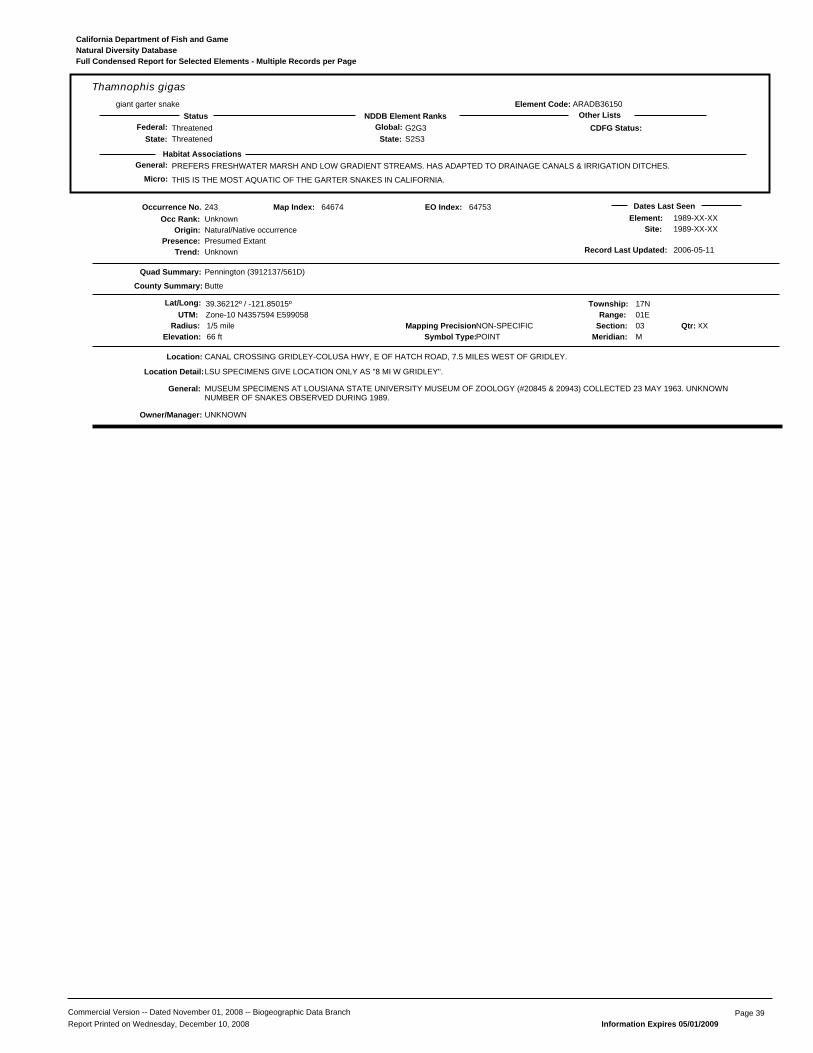
General: PREFERS FRESHWATER MARSH AND LOW GRADIENT STREAMS. HAS ADAPTED TO DRAINAGE CANALS & IRRIGATION DITCHES.
THIS IS THE MOST AQUATIC OF THE GARTER SNAKES IN CALIFORNIA.
ARADB36150
Thamnophis gigasgiant garter snake
ThreatenedThreatened
G2G3S2S3State:
Global:NDDB Element RanksStatus Other Lists
State:Federal:
Habitat Associations
CDFG Status:
Element Code:
Micro:
Natural Diversity DatabaseCalifornia Department of Fish and Game
Full Condensed Report for Selected Elements - Multiple Records per Page
243
Presence:Trend:
Unknown
Location:
Element:Site:
UNKNOWN
Natural/Native occurrencePresumed ExtantUnknown
Dates Last Seen1989-XX-XX1989-XX-XX
Quad Summary:
County Summary:
Pennington (3912137/561D)
Butte
CANAL CROSSING GRIDLEY-COLUSA HWY, E OF HATCH ROAD, 7.5 MILES WEST OF GRIDLEY.
Lat/Long: 39.36212º / -121.85015º Township: 17NRange: 01E
Section: 03 XXMeridian: M
Mapping Precision:NON-SPECIFIC1/5 mileSymbol Type:POINTElevation: 66 ft
64674
UTM: Zone-10 N4357594 E599058
Map Index:
LSU SPECIMENS GIVE LOCATION ONLY AS "8 MI W GRIDLEY".
MUSEUM SPECIMENS AT LOUSIANA STATE UNIVERSITY MUSEUM OF ZOOLOGY (#20845 & 20943) COLLECTED 23 MAY 1963. UNKNOWNNUMBER OF SNAKES OBSERVED DURING 1989.
Qtr:
Origin:
Occurrence No.Occ Rank:
Location Detail:
General:
Owner/Manager:
Radius:
Record Last Updated: 2006-05-11
64753EO Index:
Commercial Version -- Dated November 01, 2008 -- Biogeographic Data Branch Page 39Report Printed on Wednesday, December 10, 2008 Information Expires 05/01/2009
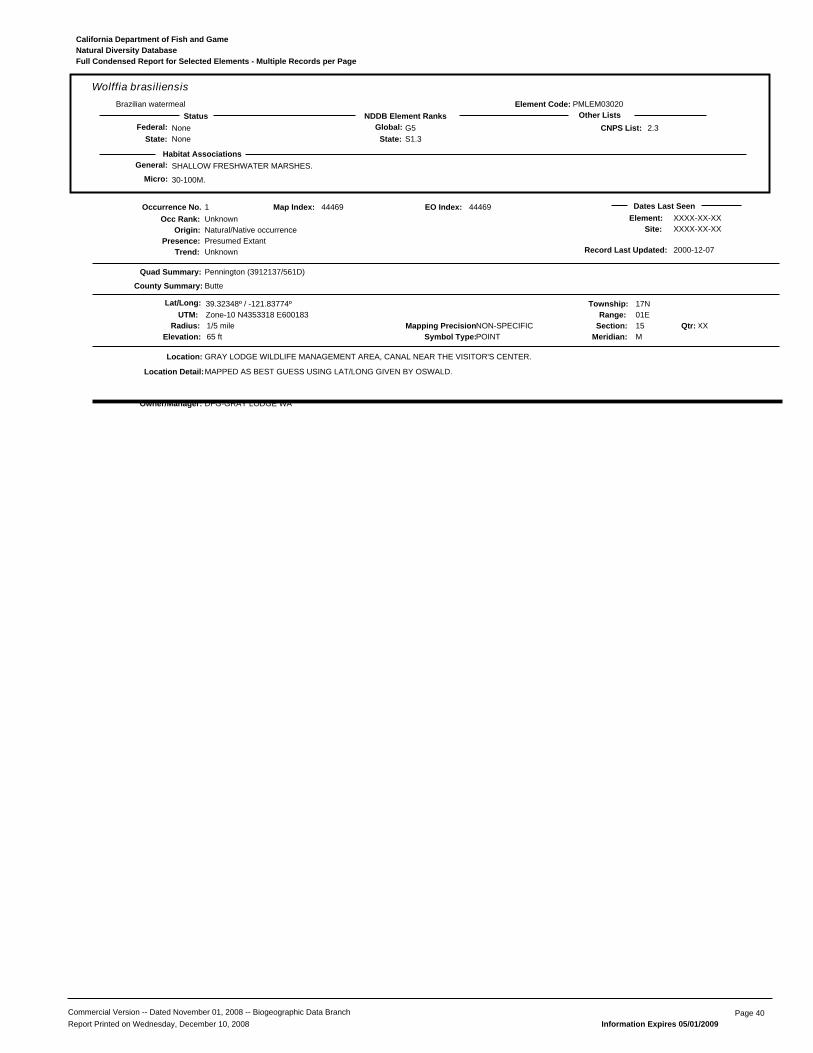
General: SHALLOW FRESHWATER MARSHES.
30-100M.
PMLEM03020
Wolffia brasiliensisBrazilian watermeal
NoneNone
G5S1.3State:
Global:NDDB Element RanksStatus Other Lists
State:Federal: 2.3
Habitat Associations
CNPS List:
Element Code:
Micro:
Natural Diversity DatabaseCalifornia Department of Fish and Game
Full Condensed Report for Selected Elements - Multiple Records per Page
1
Presence:Trend:
Unknown
Location:
Element:Site:
DFG-GRAY LODGE WA
Natural/Native occurrencePresumed ExtantUnknown
Dates Last SeenXXXX-XX-XXXXXX-XX-XX
Quad Summary:
County Summary:
Pennington (3912137/561D)
Butte
GRAY LODGE WILDLIFE MANAGEMENT AREA, CANAL NEAR THE VISITOR'S CENTER.
Lat/Long: 39.32348º / -121.83774º Township: 17NRange: 01E
Section: 15 XXMeridian: M
Mapping Precision:NON-SPECIFIC1/5 mileSymbol Type:POINTElevation: 65 ft
44469
UTM: Zone-10 N4353318 E600183
Map Index:
MAPPED AS BEST GUESS USING LAT/LONG GIVEN BY OSWALD.
Qtr:
Origin:
Occurrence No.Occ Rank:
Location Detail:
Owner/Manager:
Radius:
Record Last Updated: 2000-12-07
44469EO Index:
Commercial Version -- Dated November 01, 2008 -- Biogeographic Data Branch Page 40Report Printed on Wednesday, December 10, 2008 Information Expires 05/01/2009

woolly rose-mallow
woolly rose-mallow
woolly rose-mallow
Sanford's arrowheadwoolly rose-mallow
woolly rose-mallow
Brazilian watermeal
pink creamsacs
woolly rose-mallow
woolly rose-mallow
woolly rose-mallow
Ferris' milk-vetch
woolly rose-mallow
woolly rose-mallow
woolly rose-mallow
woolly rose-mallowwoolly rose-mallow
woolly rose-mallow
woolly rose-mallow
heartscaleheartscale
California tiger salamander
Swainson's hawk
western yellow-billed cuckoo
giant garter snake
Swainson's hawk
northern harrier greater sandhill crane
giant garter snake
giant garter snake
giant garter snake giant garter snake
giant garter snake
giant garter snake
greater sandhill crane
merlin
western yellow-billed cuckoo
western yellow-billed cuckoo
greater sandhill crane
northwestern pond turtle giant garter snakegiant garter snake
tricolored blackbird
Coastal and Valley Freshwater Marsh
Northern Hardpan Vernal Pool
Great Valley Valley Oak Riparian Forest
Remote Facility Site
LEGEND
5 mile buffer
Plants
Animals
Communities
0 1 21Scale in Miles
Wild Goose Phase 3 Expansion Project
Project ComponentsCNDDB Results
February 26, 2009, TRC
0 1 21
Remote Facility Site

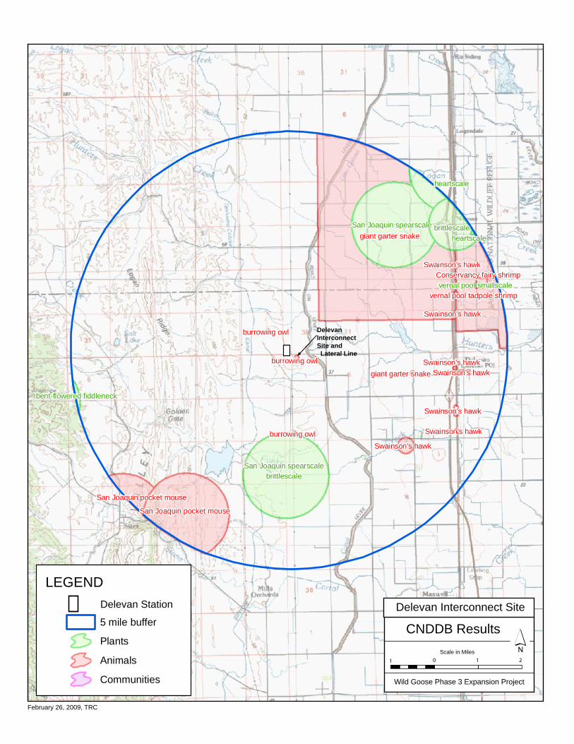
brittlescale
San Joaquin spearscale
San Joaquin spearscale
brittlescale
heartscale
bent-flowered fiddleneck
heartscale
vernal pool smallscale
giant garter snake
San Joaquin pocket mouse
vernal pool tadpole shrimp
San Joaquin pocket mouse
Swainson's hawk
Conservancy fairy shrimp
Swainson's hawk
Swainson's hawk
burrowing owl
burrowing owl
burrowing owl
Swainson's hawk
Swainson's hawk
Swainson's hawk
Swainson's hawk
giant garter snake
LEGEND Delevan Station
5 mile buffer
Plants
Animals
Communities
Delevan Interconnect Site and Lateral Line
Scale in Miles
Wild Goose Phase 3 Expansion Project
Project ComponentsCNDDB Results
0 1 21
February 26, 2009, TRC
Delevan Interconnect Site

Attachment B
Photographs of Communities at Project Sites


Parking lot for the hunters at the Remote Facility Site, December 4, 2008.
Remote Facility Site – Berm and waters to the west of the parking lot, December 4, 2008.
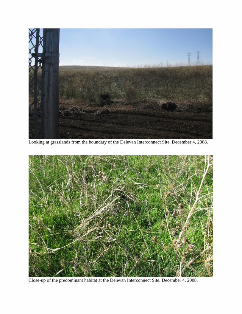
Looking at grasslands from the boundary of the Delevan Interconnect Site, December 4, 2008.
Close-up of the predominant habitat at the Delevan Interconnect Site, December 4, 2008.