best street high street masterplan
DESCRIPTION
Best Street High Street MasterplanTRANSCRIPT
CHATHAm HigH STreeT / BeST STreeT AreA mASTerplAn | drAfT mASTerplAn repOrT | mArCH 2010 | 1
Ch21CHATHAm HigH STreeT / BeST STreeT AreA mASTerplAn
STAge 3 drAfT repOrT - drAfT mASTerplAn | mAy 2010
Chatham 21
UrBAn prACTiTiOnerS | STOCK WOOlSTenCrOfT | nATHAniel liCHfield & pArTnerS | COlin BUCHAnAn | BiOregiOnAl

2 | CHATHAm HigH STreeT / BeST STreeT AreA mASTerplAn | drAfT mASTerplAn repOrT | mArCH 2010
CHATHAm HigH STreeT / BeST STreeT AreA mASTerplAn | drAfT mASTerplAn repOrT | mArCH 2010 | 3
COnTenTS
0.0 | inTrOdUCTiOn
1.0 | lOCAl COnTeXT
2.0 | CHATHAm AS A regiOnAl CenTre
3.0 | CHATHAm’S ACCeSSiBiliTy
4.0 | CreATing An ATTrACTiVe TOWn CenTre
5.0 | refined OBJeCTiVeS And ApprOACH
6.0 | drAfT mASTerplAn
7.0 | drAfT implemenTATiOn plAn
OS maps: All the maps in this document are reproduced from/based upon Ordnance Survey material with the permission of Ordnance Survey on behalf of the Controller of Her Majesty's Stationery Office © Crown copyright and/or database right, 2010. All rights reserved. Unauthorised reproduction infringes Crown copyright and may lead to prosecution or civil proceedings 100024225. Aerial photographs: © Getmapping 2009
4 | CHATHAm HigH STreeT / BeST STreeT AreA mASTerplAn | drAfT mASTerplAn repOrT | mArCH 2010
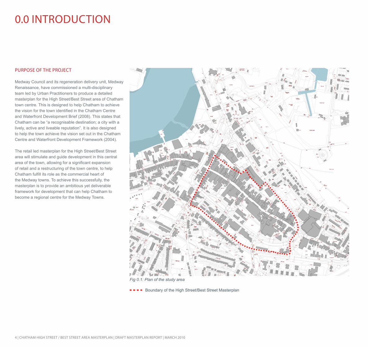
pUrpOSe Of THe prOJeCT Medway Council and its regeneration delivery unit, Medway Renaissance, have commissioned a multi-disciplinary team led by Urban Practitioners to produce a detailed masterplan for the High Street/Best Street area of Chatham town centre. This is designed to help Chatham to achieve the vision for the town identified in the Chatham Centre and Waterfront Development Brief (2008). This states that Chatham can be “a recognisable destination; a city with a lively, active and liveable reputation”. It is also designed to help the town achieve the vision set out in the Chatham Centre and Waterfront Development Framework (2004).
The retail led masterplan for the High Street/Best Street area will stimulate and guide development in this central area of the town, allowing for a significant expansion of retail and a restructuring of the town centre, to help Chatham fulfill its role as the commercial heart of the Medway towns. To achieve this successfully, the masterplan is to provide an ambitious yet deliverable framework for development that can help Chatham to become a regional centre for the Medway Towns.
0.0 inTrOdUCTiOn
Boundary of the High Street/Best Street Masterplan
Fig 0.1: Plan of the study area

CHATHAm HigH STreeT / BeST STreeT AreA mASTerplAn | drAfT mASTerplAn repOrT | mArCH 2010 | 5
STUdy AreA
The study area for the masterplan focuses on the key section of the High Street between The Brook and Waterfront Way (formerly John Hawkins Way); and on Best Street. The study area boundary is shown in Figure 0.1.
AdJACenT STUdieS A number of adjacent studies are currently underway or have recently been completed within the town centre and it is important that the masterplan takes these plans into consideration so that plans for these critical areas within Chatham do not conflict with one another.
These studies include:
- Pentagon Centre Brief (adopted 2006)
- Waterfront Masterplan (adopted 2008)
- Station Gateway Masterplan (adopted 2008)
- Brook Masterplan (adopted 2008)
- Chatham Centre and Waterfront Development Framework SPG (adopted 2004)
- Gun Wharf Masterplan (under preparation by BDP)

6 | CHATHAm HigH STreeT / BeST STreeT AreA mASTerplAn | drAfT mASTerplAn repOrT | mArCH 2010
1.0 lOCAl COnTeXT
plAnning pOliCy COnTeXT
National policyThe Medway region is at the heart of the Thames Gateway regeneration area and is expected to accommodate significant residential growth over the next 20 years. The regeneration of the Thames Gateway is integral to the Sustainable Communities agenda. 15,700 new homes are planned to be provided in part of the Medway unitary area (South East Regional Spatial Strategy (RSS), 2009). The whole area is highlighted as Growth Area, reflecting its role in the Thames Gateway growth corridor and a higher density development is directed towards urban areas, locating housing, employment and community services in areas accessible by public transport.
The South East Plan (2009) states the development of dynamic and successful town centres is central to the achievement of sustainable development in the South East. Chatham’s town centre is recognised as an area of concentrated economic activity and transport services and is designated as a primary retail centre, as the Plan states the area will be a focus for those town centre uses set out in PPS6.
Policy TCI identifies Chatham’s centre as one of twelve “Centres for Significant Change”. These town centres will be the focus for significant growth, and provision should be made for major retail developments and other town centre uses of a large scale. Policy KTG5 states Chatham will be further developed as a major town centre at which new mixed retail, leisure and service uses will be concentrated. Additionally, Policy KTG3 advocates high quality proposals for intensifying or expanding the technology and knowledge sectors at Chatham Maritime.
North Kent Economic Development Strategy (2009)
The strategy, published by the Thames Gateway Kent Partnership, states there is distinct a lack of business or retail units of suitable quality in Chatham Town Centre that has lead to the decline of the area.
The strategy maintains however, despite these issues, retail is a key element for regeneration plans in the area, as retail floor space will be doubled. In terms of office space, the strategy suggests Chatham is the favoured location in relation to the other Medway towns.
Local Plan (2003) and Core Strategy (2009)
The Medway Local Plan was adopted in 2003 and the whole plan was saved under the transitional arrangements for the LDF process (in 2007). The LDF Core Strategy was progressed and submitted for examination but withdrawn in September 2007.
The revised Core Strategy Issues and Options Report was published for public consultation in July 2009. The report considers the key issues and challenges facing Medway, outlining choices for where development should be allocated. The saved 2003 policies still remain valid until new LDF policies are adopted.
Both Local and Core Strategies aspire to develop Chatham into a city centre for both Medway and the wider Thames Gateway area. As the main centre in Medway, the strategy states Chatham should compete with other large regional and sub-regional centres such as Maidstone, Bromley and Canterbury. In order to achieve this, Chatham should be the focus for major retail developments, large-scale leisure and other uses that attract large numbers of people.
Chatham lags behind other sub-regional centres in terms of the amount and type of national multiples represented. If Chatham is to be enhanced in order to compete more effectively, then a critical mass of at least 30,000sq m
gross of additional comparison retail floor-space will need to be provided, as identified in the Nathaniel Lichfield and Partners’ Retail Study (2009). Policies R1 and R2 of the Local Plan state retail development which would undermine the potential vitality and viability of Chatham town centre will not be permitted. Additionally, Policy R12 of the Local Plan promotes mixed use development within Chatham.
The Core Strategy suggests new housing development should be concentrated near the transport hub of Chatham. The South East Plan (2009) advocates Medway Borough must provide 16,300 new homes between 2006 and 2026, and in order to help meet this target the Local Council has proposed to build 2,000 new dwellings in the Chatham Centre and Waterfront area.

CHATHAm HigH STreeT / BeST STreeT AreA mASTerplAn | drAfT mASTerplAn repOrT | mArCH 2010 | 7
TOWn CenTre iniTiATiVeS
Medway Waterfront Renaissance Strategy (2004)
The Medway Waterfront Renaissance Strategy (2004) sets out development guidance up until 2024. The strategy seeks to transform Chatham into Medway Waterfront’s strategic commercial, cultural and civic heart. The aspirations and opportunities identified in the Strategy include:
• Greatly improve shopping and leisure facilities in Chatham
• Introduction of a range of new housing to increase community activity in the area
• Create a new focus for civic activity in the heart of the Centre
• promote creative and cultural activity and business development, including inward investment, particularly at the Waterfront and in the Lower High Street
• Strengthen the relationship and physical links between the High Street area and the waterfront
The key capacity figures identified in the strategy for the core Medway area are 3,350-3,900 new dwellings and3,820-4,500 new jobs on a total site area 64 hectares.
- A new central library and learning resource
- Major environmental improvements including a new riverside promenade, improved access to the waterfront and improvements along the high street
- A number of accessibility improvements to the centre
Chatham Centre and Waterfront Development Brief: Supplementary Planning Document (2008)
Adopted as a Supplementary Planning Document in August 2008, the framework document builds upon objectives identified with the Medway Waterfront Renaissance Strategy (2004) and aspires to transform Chatham into a city centre for Medway.
A major step in creating this modern, exciting waterfront city is to develop key regeneration areas along the River Medway with Chatham at its heart. Chatham Centre and Waterfront will be the centre of strategic commercial, cultural and civic activity for well over a quarter of a millionpeople in Medway. A number of key objectives are identified, including:
• New development should be of an appropriate scale and use in prominent locations, to frame the space and create an urban energy throughout the centre;
• Sensitively designed taller buildings could add to and reinforce Chatham’s already impressive cultural and historical identity. The designs should be of high quality, should minimise overshadowing of key public spaces and any negative effects on biodiversity;
• A sense of expectation and arrival is to be established by the formation of clearly identifiable gateways and routes including from the railway station, along the High Street, along the waterfront, up to Town Hall Gardens, to Great Lines and cross-routes through the town centre from one side of the valley to the other;
• Currently bland or uninviting areas will be animated and upgraded in keeping with the public realm strategy;
The Medway Regeneration Framework 2006 - 2016
The Medway Regeneration Framework seeks to provide the long-term vision to transform Medway into a city of learning, culture, tourism and enterprise by 2016. It seeks to guide collaborative development between the areas of Chatham Centre and Waterfront, Rochester Riverside, and the town centres of Strood, Rochester, Gillingham and Rainham.
Chatham Centre and Waterfront Development Framework: Supplementary Planning Guidance (2004)
Like the Local Plan and emerging LDF, the adopted development framework aspires to transform Chatham’s town centre into the thriving and vibrant centre of Medway. The document identifies the reduction of naval trade, and the subsequent closure of the Chatham dockyard, as the primary reason behind the area’s poor economic performance. The framework suggests new development should be focused on the town centre and waterfront in order to provide social and economic regeneration to Chatham. The development framework suggests bold transformation, as opposed to modest change, which is required to change Chatham into the economic and cultural heart of the wider Medway area.
The framework sets out projects and investments which will transform Chatham’s centre, which includes the following schemes:
- Expansion and refurbishment of the Pentagon Centre to increase floor-space by approximately 15,000 square meters.
- A new food store approximately 8,000 square meters
- Over 8,000 square meters of small scale employment space and ground floor leisure uses
- A world class waterfront comprising a new performing arts facility, a visual arts facility, a new park and hotel

8 | CHATHAm HigH STreeT / BeST STreeT AreA mASTerplAn | drAfT mASTerplAn repOrT | mArCH 2010
1.0 lOCAl COnTeXT
• New safety conscious, welcoming and direct pedestrian links should be established, particularly between the High Street and the waterfront and north-south routes across the centre from New Road to the Great Lines City Park;
• The quality, natural surveillance and use of existing pedestrian routes should be enhanced where possible;
• Perimeter block development is to be promoted, fronting streets and access routes and, where appropriate, enclosing semi-private spaces;
• Visual connections should be created from within and to the centre and waterfront, linking with the River Medway and the Great Lines City Park.
Pentagon Centre Development Brief
The main objective of the Pentagon Development Brief is to set parameters for extending and refurbishing the Pentagon Centre to include a mix of uses. In addition the brief aspires to enable the Council to secure a viable and high quality scheme that is closely integrated with the Chatham Centre and Waterfront Development Framework, and adopted local and regional planning policy.
Given the prominence of the refurbishment and extension of the Pentagon Centre to Chatham town centre, the brief identifies a number of components that should be considered within the overall design process. These elements will help inform the character and identity of the building and ensure it is well integrated into its surroundings. The brief identifies there are three main opportunities for the extension and refurbishment of the Pentagon Centre:
- The refurbishment of the existing centre through new opportunities created through relocating the bus station
- The major extension of the centre into the area around Solomon’s Road and the demolition of the existing Brook car park
- The extension of the centre fronting the Paddock, by reclaiming highway land to provide a new development frontage
The outlines of other masterplans within Chatham are illustrated in fig 1.1, below.
Fig 1.1: Additional Chatham masterplans

CHATHAm HigH STreeT / BeST STreeT AreA mASTerplAn | drAfT mASTerplAn repOrT | mArCH 2010 | 9
Transport and movement
Currently significant changes are underway for Chatham town centre’s movement network and the bus station in the town.
Land ownership
Figure 1.2 indicates the identified development areas within the town centre, and Medway Council land ownership, to provide context in terms of land parcels and deliverablility of a masterplan for the town centre.
Areas of council ownership
Masterplan boundaries
1
2
3
4
5
1 - High Street/Best Street Masterplan 2 - Waterfront Area Masterplan 3 - Pentagon Centre Development Brief 4 - The Brook Masterplan 5 - Station Gateway Masterplan
Fig 1.2: Council land ownership

10 | CHATHAm HigH STreeT / BeST STreeT AreA mASTerplAn | drAfT mASTerplAn repOrT | mArCH 2010
2.0 CHATHAm’S rOle AS A regiOnAl CenTre
CHATHAm’S reTAil prOfile
As part of the evidence base for the 2009 LDF Core Strategy Issues and Options Report, NLP prepared a retail needs assessment for Medway Council, the Medway Retail Study dated March 2009. This study included a quantitative and qualitative assessment of the need for new retail facilities in Medway up to 2026 and an analysis of Chatham town centre’s strengths and weakness as a shopping destination. The key findings and recommendations in relation to retail facilities in Chatham town centre are summarised below.
- Despite having the main concentration of retail facilities in Medway, multiple retailer representation in Chatham town centre is ranked significantly lower than its main competing centres in the sub-region e.g. Bluewater, Maidstone, Canterbury and Tunbridge Wells.
- Chatham has a reasonable number of multiple and independent outlets but the depth and quality of the retail offer are generally poor. The retail sector is focused on the value/discount end of the market.
- Property indicators (retail rents and yields) are less buoyant in Chatham when compared with the main competing centres and retail property capital values are significantly lower.
- The proportion of vacant units in Chatham town centre is higher than the national average (17.4% compared with 11%).
- Chatham town centre’s market share of the comparison goods expenditure generated by residents within Medway urban area is only 21%. The market share in the outer catchment area is only 3%. Overall Chatham town centre attracts only 9% of comparison expenditure within the catchment area, which equates to just 65,000 customers.
- Chatham’s market share amongst the most affluent households (economic groups A, B and C1) in the catchment area is only 7%, compared with 11% for the least affluent households (economic groups C2, D and E). Chatham is attracting a disproportionately low number of affluent customers from the catchment area.
- Comparison shopping facilities in Medway are too dispersed (city centre, five district centres and out-of-centre retail warehouse parks) and the area needs a better focal point for this type of shopping.
- Comparison expenditure leakage from Medway urban area is currently 27% (£185 million in 2008). If improvements to comparison retail provision are not secured this leakage is expected to increase in the future. Significant development is needed just to maintain market share, if not reduce expenditure leakage.
- As a minimum, based on just maintaining market share and low population growth projections, Medway will require about 37,000 sq m gross of additional retail (Class A1 to A5) floorspace by 2016, over and above commitments in 2008. A further 40,000 sq m gross could be required between 2016 and 2021.
- Chatham town centre should be enhanced as a major regional centre, in order to serve both Medway urban area and the surrounding catchment area. The town centre needs to embrace a wide range of activities and should be the main focus for comparison shopping, leisure, entertainment and cultural activities in Medway.
- New comparison retail floorspace should be concentrated in Chatham town centre in order to provide an appropriate critical mass, around 30,000 sq m gross. The priority sites for new development are the Waterfront regeneration area, expansion of the Pentagon Centre, the Best Street regeneration area and The Brook.
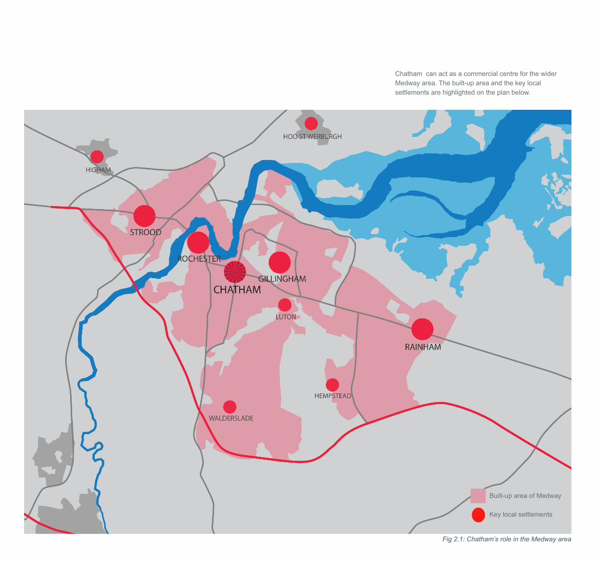
Chatham’s catchment area
Chatham town centre has about 15,500 people living within 1 kilometre. The centre also draws customers from Medway urban area and its rural hinterland. Medway’s population was just over 260,000 in 2008, with a total comparison goods spending potential of £0.7 billion. Based on the Medway Council’s most cautious projections, this population will increase to 272,000 by 2016. Spending potential in real terms will increase to £1 billion by 2016.
Medway’s wider catchment area extends approximately 20 minutes drive time from Chatham town centre. Population within this drive area is 423,000, which is expected to increase to 444,000 by 2016. The comparison goods spending potential of this 20 minute drive time catchment area is £1.2 billion in 2008, increasing to over £1.6 billion in 2016.
Figure 2.1 illustrates Chatham’s catchment and its role in the Medway area.
CHATHAm HigH STreeT / BeST STreeT AreA mASTerplAn | drAfT mASTerplAn repOrT | mArCH 2010 | 11
Chatham can act as a commercial centre for the wider Medway area. The built-up area and the key local settlements are highlighted on the plan below.
Built-up area of Medway
Key local settlements
Fig 2.1: Chatham’s role in the Medway area

12 | CHATHAm HigH STreeT / BeST STreeT AreA mASTerplAn | drAfT mASTerplAn repOrT | mArCH 2010
2.0 CHATHAm’S rOle AS A regiOnAl CenTre
Chatham town centre’s current retail offer
The Medway Retail Study indicates that Chatham town centre has 406 retail premises, of which 337 were occupied in 2007 (Source: Goad). The vacancy rate is relatively high, 17.4% compared with the national average of 11%. There were 203 occupied Class A1 retail outlets, of which 99 were multiples operators and 104 were independent traders. For a centre of its size, Chatham town centre has a high proportion of independent traders. In terms of comparison goods outlets there are only 142 shops (only 35% of all units), which in proportional terms is below the Goad average for town centres across the country (45%). One would expect a shopping centre of Chatham’s size and catchment potential to have a much higher proportion of comparison shops, around 50% to 60% of all units. The choice, range and quality of comparison goods shopping in Chatham are poor. The key anchor/major comparison stores in Chatham are:
Debenhams 10,122 sq m gross Wilkinson 3,726 sq m grossBoots 1,847 sq m grossArgos 1,843 sq m grossPrimark 3,200 sq m gross*TK Maxx 1,254 sq m grossWH Smith 790 sq m grossSuperdrug 758 sq m grossBon March 568 sq m grossJJB Sports 552 Sq m gross
* approx. including extension into former Woolworth unit
Source: Experian Goad
There is a shortfall of anchor tenants and major space users (MSU’s). The provision of discount/value comparison retailing is particularly strong in Chatham e.g. Primark, 99p Shop, Peacock, Shoefayre and charity shops. Food and grocery shopping is reasonably well represented with Tesco, Sainsbury and Iceland as the main stores.
The majority of Class A1 retail outlets within Chatham town centre are small units (less than 200 sq m gross), as shown in the graph below. In order to attract higher quality retailers to Chatham a range of modern units will need to be provided, i.e. small unit shops (100 to 200 sq m gross), medium sized units (200 to 500 sq m gross) and larger MSU’s and anchor stores.
0.0%
5.0%
10.0%
15.0%
20.0%
25.0%
30.0%
35.0%
40.0%
45.0%
Under 100 100 to 199 200 to 499 500 to 1,000 Over 1,000 Size of Unit Sq M
% o
f C
lass
A1
Ou
tlet
s
Comparative retail analysis
Benchmark centres have been identified and compared against Chatham town centre. The benchmark centres include Chatham’s main competing centres in the north Kent sub-region plus other towns that have a similar population but better retail centres. The benchmark centres are:
- Brighton
- Peterborough
- Canterbury
- Plymouth
- Derby
- Southampton
- Maidstone
- Swindon
- Milton Keynes
- Wolverhampton
The key driver for the success of higher order shopping centres is comparison shopping facilities, and in particular fashion shopping and major anchor stores. Management Horizon’s UK Shopping Index provides an index of retail centres on the basis of a weighted score for multiple retailers represented in centres across the country. The weighted score comprises anchor stores, specialty stores, service operators and supermarkets. The weighted score reflects the tenant mix of centres and the quality/attraction of retailers. For example, key attraction retailers such as John Lewis and Debenhams department stores and other anchors such as Marks & Spencer carry a much higher weighting than smaller high street multiples and independents. On this basis, each centre is attributed a score, and all centres are ranked by this score. Chatham town centre’s weighted score (150 points) and national rank (188th) are compared with the main competing centres in the sub-region in table 2.3.
Table 2.2: Percentage and size of A1 outlets in Chatham

CHATHAm HigH STreeT / BeST STreeT AreA mASTerplAn | drAfT mASTerplAn repOrT | mArCH 2010 | 13
Centre RankMHE Index Score
Bluewater Shopping Centre 25 321
Maidstone 41 277
Tunbridge Wells 69 240
Canterbury 82 244
Dartford 163 161
Gravesend 173 155
Chatham 188 150
Tonbridge 285 107
Sittingbourne 355 91
Hempstead Valley Shopping Centre
393 84
Sevenoaks 405 82
Gillingham 477 72
Strood 694 51
Sheerness 797 45
Faversham 959 37
Rainham 959 37
Dockside Shopping Centre 1,175 31
Rochester 1,789 19
Source: Management Horizons Europe 2008.
Nationally, Chatham town centre is ranked 188th, compared with 159th in 2003. Although not directly comparable with Management Horizon’s data, historic information suggests Chatham town centre has steadily fallen down the national rankings. Hillier Parker’s Shopping Centres of Great Britain suggests Chatham’s rank fell from 64th in 1984 to 98th in 1995 (excluding four new regional centres developed during that period).
Notwithstanding the decline in national rank, Management Horizon’s shopping index suggests Chatham town centre is still the primary comparison shopping destination within Medway urban area, out-scoring Hempstead Valley, Gillingham, Strood, Rainham and Rochester. However, Chatham’s retail offer is significantly below that found in other competing centres, in particular Bluewater, Maidstone, Tunbridge Well and Canterbury. Chatham has a similar offer when compared with Dartford and Gravesend, despite having a much larger population.
It is unlikely Chatham town centre will ever compete on an equal footing with Bluewater Shopping Centre. Bluewater is a true regional centre that serves Kent, South East London and beyond, and its focus is primarily on upper and upper-middle market fashion retailing. The future aspiration for Chatham town centre must be to compete more effectively with the other main centres in north Kent, in particular Maidstone, Gravesend and to a lesser extent Canterbury.
The 2008 Medway Retail Study indicates that 37% of comparison expenditure leakage from Medway urban area (£68 million in 2008) was attracted to Maidstone, just below the amount of leakage to Bluewater (38% and £70 million). Gravesend also attracted £10.5 million.
Table 2.4 on the next page sets out the benchmark centres listed by their Management Horizon’s rank/score. The prime retail Zone A rental figures achieved in each centre are also compared and provide an indicator of retail vitality and occupier demand.
Table 2.3: Retail rankings in Kent

14 | CHATHAm HigH STreeT / BeST STreeT AreA mASTerplAn | drAfT mASTerplAn repOrT | mArCH 2010
Centre2008 MHERank
2008 MHE Index Score
Local Authority AreaONS Population 2009
Prime Zone ARetail Rents in 2008 PSF
Brighton 9 458 254,500 £190
Plymouth 17 374 253,900 £180
Southampton 19 350 235,100 £320
Milton Keynes 30 304 234,400 £275
Maidstone 41 277 145,700 £150
Peterborough 43 270 167,300 £210
Wolverhampton 52 256 235,100 £130
Swindon 55 253 192,300 £170
Derby 58 249 241,300 £180
Canterbury 82 244 153,200 £230
Chatham 188 150 262,600 £105
Source: Management Horizons Europe, ONS population and Colliers CBRE.
2.0 CHATHAm’S rOle AS A regiOnAl CenTre
All the benchmark centres have lower population than Chatham (Medway LA), but have a much higher MHE score and higher Zone A rental levels. This suggests Chatham town centre is not currently punching its weight in terms of retail offer and property values. There is a significant spread in rental values across the benchmark centres, with a range of Zone A levels from £130 to £320 per sq ft. Chatham is significantly below this range. An improved retail offer and modern development with an appropriate critical mass could assist Chatham in reaching rents of at least £150 per sq ft Zone A (i.e. the level of Maidstone) which would assist the potential viability of any major new retail developments. Small scale in-fill development is unlikely to generate the required uplift in rental levels to make development commercially attractive.
In terms of overall match, Chatham is closest to Derby, Swindon and Wolverhampton. All three of these centres have major retail led development proposals currently planned or recently completed, e.g. the opening of Westfield’s scheme will have elevated Derby in the hierarchy, and will have increased the centre’s MHE.
Brighton, Plymouth, Southampton and Milton Keynes have a similar population when compared with Medway, but have town centres with a MHE more than double that of Chatham. These centres are highly aspirational, with rankings in the top 30 in the UK, and therefore a step change in Chatham’s retail offer would need to be delivered if the town centre is to reach equivalent retail status. More realistically, Chatham town centre could aspire to a place within the top 50, which would require an MHE score of around 260 points, a 73% increase from its current score.
In order for Chatham town centre to compete on a more equal footing with its nearest competitor Maidstone, its Management Horizon’s score would need to increase by at least 100 points, which would be in line with some of the smaller benchmark centres, such as Derby and Swindon.
Table 2.4: Benchmark retail centres for Chatham
CHATHAm HigH STreeT / BeST STreeT AreA mASTerplAn | drAfT mASTerplAn repOrT | mArCH 2010 | 15
Management Horizon’s weighting scoring system is summarised as follows:
anchor department/variety stores = 10 to 15 points;other major space uses = 3 to 8 points; andsmaller space user = 1 to 2 points.
By way of example, a 100 point increase in Chatham’s weighted score could be achieved via a new department store, five major space users (MSU) and about 40 unit shops, which would require a development of at least 20,000 sq m GLA.
In addition to the overall MHE weighted score and rank, Management Horizon’s quantifies what proportion of the weighted score relates to market sectors i.e.:
- upmarket (luxury/ upper and upper middle markets);
- middle-market; and
- down-market (value and lower middle markets).
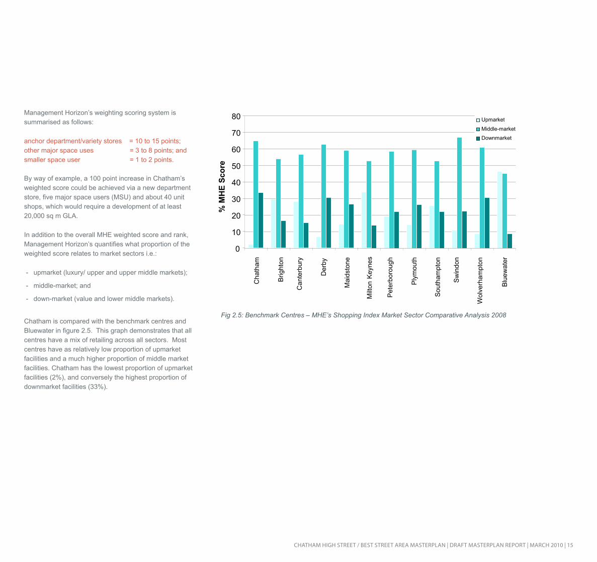
Chatham is compared with the benchmark centres and Bluewater in figure 2.5. This graph demonstrates that all centres have a mix of retailing across all sectors. Most centres have as relatively low proportion of upmarket facilities and a much higher proportion of middle market facilities. Chatham has the lowest proportion of upmarket facilities (2%), and conversely the highest proportion of downmarket facilities (33%).
0
10
20
30
40
50
60
70
80
Cha
tham
Brig
hton
Can
terb
ury
Der
by
Mai
dsto
ne
Milt
on K
eyne
s
Pet
erbo
roug
h
Ply
mou
th
Sou
tham
pton
Sw
indo
n
Wol
verh
ampt
on
Blu
ewat
er
% M
HE
Scor
e
Upmarket Middle-market Downmarket
Fig 2.5: Benchmark Centres – MHE’s Shopping Index Market Sector Comparative Analysis 2008
16 | CHATHAm HigH STreeT / BeST STreeT AreA mASTerplAn | drAfT mASTerplAn repOrT | mArCH 2010
2.0 CHATHAm’S rOle AS A regiOnAl CenTre
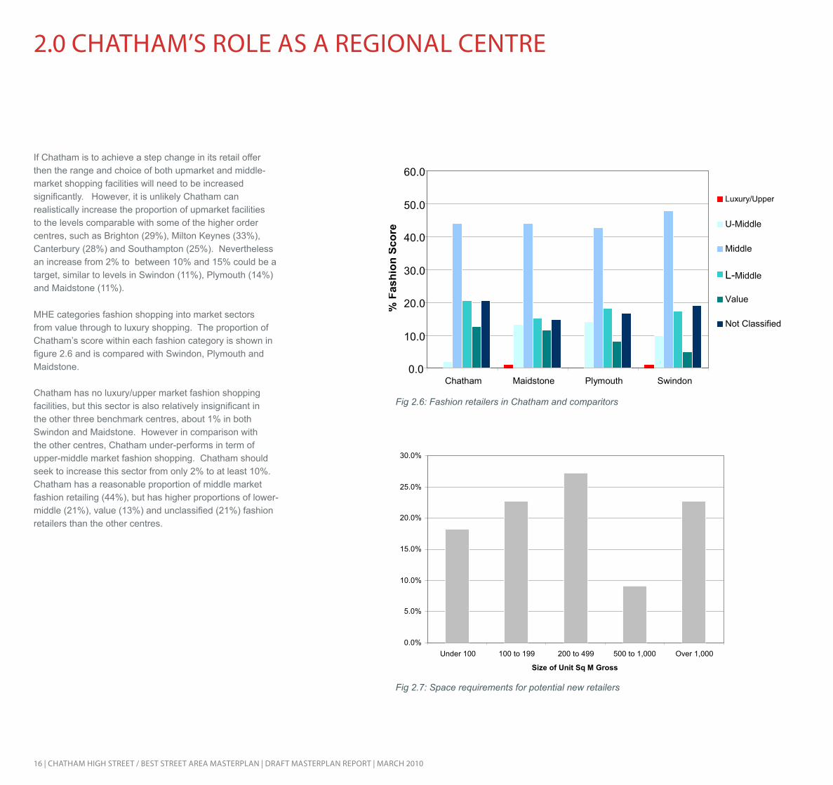
If Chatham is to achieve a step change in its retail offer then the range and choice of both upmarket and middle-market shopping facilities will need to be increased significantly. However, it is unlikely Chatham can realistically increase the proportion of upmarket facilities to the levels comparable with some of the higher order centres, such as Brighton (29%), Milton Keynes (33%), Canterbury (28%) and Southampton (25%). Nevertheless an increase from 2% to between 10% and 15% could be a target, similar to levels in Swindon (11%), Plymouth (14%) and Maidstone (11%).
MHE categories fashion shopping into market sectors from value through to luxury shopping. The proportion of Chatham’s score within each fashion category is shown in figure 2.6 and is compared with Swindon, Plymouth and Maidstone.
Chatham has no luxury/upper market fashion shopping facilities, but this sector is also relatively insignificant in the other three benchmark centres, about 1% in both Swindon and Maidstone. However in comparison with the other centres, Chatham under-performs in term of upper-middle market fashion shopping. Chatham should seek to increase this sector from only 2% to at least 10%. Chatham has a reasonable proportion of middle market fashion retailing (44%), but has higher proportions of lower-middle (21%), value (13%) and unclassified (21%) fashion retailers than the other centres.
0.0
10.0
20.0
30.0
40.0
50.0
60.0
Chatham Maidstone Plymouth Swindon %
Fas
hion
Sco
re
Luxury/Upper
U-Middle
Middle
L-Middle
Value
Not Classified
0.0%
5.0%
10.0%
15.0%
20.0%
25.0%
30.0%
Under 100 100 to 199 200 to 499 500 to 1,000 Over 1,000 Size of Unit Sq M Gross
Fig 2.6: Fashion retailers in Chatham and comparitors
Fig 2.7: Space requirements for potential new retailers

CHATHAm HigH STreeT / BeST STreeT AreA mASTerplAn | drAfT mASTerplAn repOrT | mArCH 2010 | 17
Potential New Retailers
Nationally the demand for retail premises has reduced due to the effects of the recession and the short term prospects for attracting new occupiers in most town centres is poor. In the longer term the demand for retail accommodation is expected to improve when the economy recovers.
Some retail operators release their current space requirements and this information is published by Estate Gazette Interactive (EGi). This database provides details of the number and type of national multiple retailers seeking representation in different centres across the UK. At present there are only 8 space requirements listed for Chatham, as follows:
Best Buy - 2,787 to 5,574 sq m grossCostcutter - 111 to 325 sq m gross HomeSense - 1,394 to 4,645 sq m gross Poundworld - 279 to 929 sq m gross River Island - 650 to 1,394 sq m gross Store Twenty One - 372 to 557 sq m grossVirgin Media - 60 to 111 sq m grossWaitrose - 929 to 3,252 sq m gross. Other retailers with current space requirements in the South East region are shown in figure 2.8. An analysis of the size of units required by these operators is shown in figure 2.7 (based on the mid-point of the size of unit required).
These current space requirements suggest a broad mix of unit sizes will be required to attract new retailers to Chatham. It should be noted that the requirements listed above are a snapshot and it is necessary to take a longer term view of the potential operators who could be attracted to Chatham.
Operator r etail Activity location r equired Unit S ize (s q m)
As nature intended pharmacy Health & Beauty in town 279 - 465B ay Clothing in Town/ S hopping Centre 111 - 186B hs department S tore & Variety in town/ S hopping Centre 1394 - 6039B orders Books Video & mus ic in town/ Out of town/ S hopping Centre 1858 - 2323Cargo Home S hop Hous ehold goods in town 279 - 465Carluccio' s res taurant Bars & Cafes in town not s pecified
Clas Ohis ondepartment s tore & Variety S tore, Hardware & diy S hopping Centre 1394 - 1858
Coas t Clothing in town 130Crocs Clothing in town/ S hopping Centre 46 - 93debenhams department S tore edge of town/ in town/ S hopping Centre 5574 - 13935gant Clothing in town 214 - 232HmV Books Video & mus ic in town/ S hopping Centre 186 - 1858Holland and B arrett pharmacy Health & Beauty in town/ S hopping Centre 74 - 139Homeform group Hous ehold goods in town 163 - 232Hous e of fras er department S tore in town 12077ins tore department S tore & Variety S tore edge of town/ in town/ Out of town 557 - 929Jane norman Clothing in town/ S hopping Centre 139 - 325Jes s ops S ervices - retailing in town/ S hopping Centre 93 - 139Jones B ootmaker Clothing in town/ S hopping Centre 102 - 149Julian graves food in town/ S hopping Centre 46 - 111
lakelanddepartment S tore & Variety S tore, Hous ehold goods in town 465 - 557
lus h pharmacy Health & Beauty in town/ S hopping Centre 46 - 139mango Clothing in town/ S hopping Centre 300 - 372
marks & S pencer department S tore & Variety S toreedge of town/ in town/ Out of town/ S hopping Centre 3716 - 18580
moda in pelle Clothing in town/ S hopping Centre 28 - 130mons oon Acces s ories & Jewellery, Clothing in town/ S hopping Centre 93 - 372mos s B ros Clothing factory Outlet/ in town 167new look Clothing in town/ Out of centre/ S hopping Centre 929 - 3716
next Clothing, Hous ehold goodsedge of town/ in town/ Out of town/ S hopping Centre 929 - 1394
OKA Hous ehold goods edge of town/ in town 232 - 372Ollie & nic Acces s ories & Jewellery in town 60 - 65
Orange electrical & Computer goodsedge of town/ factory Outlet/ in town/ Out of town/ S hopping Centre 84 - 139
paddy power S ervices - retailing in town not s pecifiedpapa John' s res taurant Bars & Cafes edge of town/ in town not s pecifiedphas e eight Clothing in town 65 - 186quiz Clothing in town/ S hopping Centre 139 - 232r eis s Clothing in town 167 - 279r epublic Clothing in town/ S hopping Centre 279 - 1115r obert dyas Hardware & diy, Hous ehold goods in town 186 - 372S tore Twenty One Clothing edge of town/ in town 279 - 557S uits you Clothing in town/ S hopping Centre 204 - 232T-mobile electrical & Computer goods in town/ S hopping Centre 74 - 93Thorntons food, gift & S peciality in town/ S hopping Centre 37 - 56Tiffinbites res taurant Bars & Cafes in town/ S hopping Centre not s pecified
TK maxx Clothingedge of town/ in town/ Out of town/ S hopping Centre 1394 - 4645
Top S hop Acces s ories & Jewellery, Clothing in town/ S hopping Centre 150 - 3716US C Clothing in town/ S hopping Centre 465 - 929White S tuff Clothing in town 139 - 186
Fig 2.8: Retailers with current space requirement in the South East region
18 | CHATHAm HigH STreeT / BeST STreeT AreA mASTerplAn | drAfT mASTerplAn repOrT | mArCH 2010
2.0 CHATHAm’S rOle AS A regiOnAl CenTre
Based on an analysis of retail representation in the most comparable benchmark centres the target operators could realistically be attracted to Chatham if the right scale and quality of development was implemented are listed below.
Anchor Stores
Bhs House of FraserMarks & Spencer TJ HughesWaitrose
Major Space Users
French ConnectionGapH&MHMVMatalan Miss Selfridge * previously in Chatham
Mothercare* Next*River IslandTopshopWallis Zara
Other Unit Shops
3 Store All SaintsBarratts Beaverbrooks Blue Arrow Build-A-Bear WorkshopBirthdays Blue BananaBuild a Bear Card factoryCargo HomeShopClarks Coast CultDiamonds and Pearls EvolutionF. Hinds Faith Fat FaceFraser Hart
Games Workshop Goldsmiths Herbs & AcupunctureHotel ChocolatInspireJane Norman JessopsJones Bootmaker Julian GravesLa SenzaLacoste Levi’sLush Madhouse MilletsMillie’s CookiesMonsoon Moss BrosOasis
Past TimesPulp Pumpkin Patch Republic Robert DyasRymanSchuhSoap & Co Sole Trader Sony CentreStorm Suits YouSunglass Hut Tie RackVirgin MediaWarehouse
Conclusion and Recommendations
The aspirational targets for Chatham town centre are as follows:
- Chatham town centre must compete more effectively with Maidstone, Gravesend and Canterbury.
- Chatham town centre should aspire to a place within the top 50 of shopping centres across the county.
- Chatham town centre should have a much higher proportion of comparison shops, at least 50% rather than the current proportion of 35%.
- In order to attract higher quality retailers to Chatham a range of modern units will need to be provided, i.e. small unit shops (100 to 200 sq m gross), medium sized units (200 to 500 sq m gross) and larger MSU’s and anchor stores.
- New development must provide the necessary critical mass in order to attract customers, operators and increase property values to assist the viability of development. The vicious circle of lack of customer, operator demand for space and low property values needs to be broken.
- If Chatham is to achieve a step change in its retail offer then the range and choice of both upmarket and middle-market shopping facilities will need to be increased significantly. An increase from 2% to at least 10% should be the target.
- New development will need to be marketed to mainstream national multiples not currently represented in Chatham, particularly in the middle market sectors.
Fig 2.9: Target retail operators for Chatham

CHATHAm HigH STreeT / BeST STreeT AreA mASTerplAn | drAfT mASTerplAn repOrT | mArCH 2010 | 19
CHATHAm’S eVening eCOnOmy Chatham in a regional context
Chatham sits at the centre of the large metropolitan area covering the Medway towns, with a potential catchment area of 260,000 people for its evening economy. However, there are a number of competing centres within the region which are popular for evening uses and it will be important for Chatham to provide a strong offer which can set it apart from these centres if it is to compete successfully.
Maidstone, to the south, has a restaurant offer, a strong pub offer, a semi-central area dedicated to leisure uses and a well developed nightclub scene. These have helped to create an evening economy circuit within the town, and although this can sometimes cause anti-social behaviour problems, it does attract a large number of people and bring activity to the centre during the evening.
Rochester, immediately to the west of Chatham, has a strong restaurant offer with diverse cuisines represented in small, atmospheric premises. It also has a number of pubs and bars which host live music. Chatham has potential to provide a complementary offer to Rochester, to strengthen the appeal of both locations, and this option will be explored.
Finally, Gillingham to the east, also provides a nightclub offer, though this is not considered to attract an audience from a regional catchment and is instead considered to have more of a local appeal.
Chatham’s strengths and weaknesses
Chatham currently has a small cluster of restaurants and take-away premises at the eastern end of the High Street, a grouping of pubs along Station Road and a few dispersed theatres; the most high profile of these being the Central Theatre on the High Street.
Childish. This coupled with the live music acts which have their roots in Rochester, such as Morcheeba and James Taylor Quartet, could provide the basis of a strong cultural offer in the town.
In addressing Chatham’s wider identity issues, it is important to highlight these and other creative assets and attributes the town has, including the well regarded University of the Creative Arts, where Tracey Emin, Zara Rhodes, Billy Childish and Karen Millen studied, amongst others.
The evening economy within the town centre is fairly disparate, without a clear circuit linking these, and with a quality of public realm which does not provide an appealing environment in which to walk between the offers in the town.
However, Chatham does have an attractive historic environment in some sections of the town centre which could certainly support a stronger evening economy. It also has cultural gems, in its local bars which have hosted high profile and cult acts such as the early Libertines and Billy
Evening economy use or support use
Fig 2.10: Chatham’s evening economy uses

20 | CHATHAm HigH STreeT / BeST STreeT AreA mASTerplAn | drAfT mASTerplAn repOrT | mArCH 2010
Potential for improving Chatham’s evening economy
Figure 2.11 indicates Chatham’s existing evening economy ‘nodes’, with the restaurants shown along the High Street towards Rochester, the pubs along Station Road and the cluster of small restaurants and take-aways at the eastern end of the High Street. The key cultural buildings, the thea-tres and art centre, are also highlighted.
The large node at the waterfront represents the Council’s ambitions to establish an area of cultural and leisure uses at this attractive spot within the town centre, which is a highly suitable location and presents the potential to effec-tively complement the offer in Rochester.
Considering the location of these fixed areas of evening economy activity, we have assessed the streets on which people would be most likely to be circulating during the evening, if they were to be making their way between restaurant, theatre, and bar and created a heat spectrum to indicate which streets and routes are likely to be the most well used within Chatham. The nodes and heat spectrum highlight the importance of the Station Road/Military Road area and the key apex with the High Street. It also high-lights the isolated nature of the evening economy activity at the eastern end of the High Street.
In order to help address the disparate nature of the evening economy at present, and to help create an effective circuit for these activities, key locations have been identified for additional evening economy uses. These are based at, or close to, the United Reform Church on Clover Street and by the pumping station, just to the north of the High Street. These locations are close to attractive, historic building assets within the town centre and at proposed open spaces within the masterplan options, to help ensure an attrac-tive environment for the evening economy and encourage people to spend their leisure time in the town centre. They also both sit comfortably at a key point of the proposed re-tail circuit within the masterplan options, which could work equally effectively as an evening economy circuit, helping to bring the current activity areas together and create a more integrated evening economy offer in Chatham.
Levels of activity intensity on streets in the evening
Key existing cultural uses
Potential new evening economy nodes
Existing evening economy nodes
2.0 CHATHAm’S rOle AS A regiOnAl CenTre
Fig 2.11: Improving Chatham’s evening economy offer

CHATHAm HigH STreeT / BeST STreeT AreA mASTerplAn | drAfT mASTerplAn repOrT | mArCH 2010 | 21
3.0 CHATHAm’S ACCeSSiBiliTy
Chatham is highly accessible by train, and has the potential for growth in travel by rail by shoppers and leisure visitors. The study area is the retail heart of Chatham, and could be for the whole of the Medway Towns. Therefore access to and from the railway station from Chatham and the High Street area is very important. Unfortunately existing pedestrian access is poor, with only one route along Railway Street available, due to the significant barrier created by Best Street.
Other key pedestrian routes are shown in figure 3.2 from Chatham Centre & Waterfront Development Framework (EDAW 2004). These routes should be improved to connect the High Street area to the rest of Chatham.
S U P P L E M E N T A R Y P L A N N I N G G U I D A N C E : C H A T H A M C E N T R E & W A T E R F R O N T D E V E L O P M E N T F R A M E W O R K | 2 1
EDAW . DONALDSONS . WSP . KMA . COMEDIA
==
Figure 3.2 Key Spaces and Strateg ic Pedest r ian LInks
RamsgateRochesterBromley South
Maidstone
Strood
Gravesend
DartfordLee
BexleyheathLondon
Abbey Wood
St Pancras International
Chatham Gillingham Rainham Faversham
DoverAshford International
Canterbury
Fig 3.2: Pedestrian accessibility in Chatham, identified in 2008 Development Framework (EDAW)
Fig 3.1: The rail network to which Chatham connects

22 | CHATHAm HigH STreeT / BeST STreeT AreA mASTerplAn | drAfT mASTerplAn repOrT | mArCH 2010
Bus access is also very important to the regeneration of Chatham. This much underused transport mode should see a significant increase in popularity in the coming years. This is due to the construction of the Dynamic Bus Facility to replace the existing bus station in the Pentagon, and highway improvements.
However, bus services in operation at present connect the centre of Chatham with a number of key local destinations. The bus plan in figure 3.3 shows the main locations served, and some of the key facilities available. It also shows how easy it could be for residents of a very wide area to access Chatham by bus for shopping or leisure trips.
Chatham
Gillingham
Medway Hospital
TwydallRainham
Hempstead Valley
Luton
LordswoodWalderslade
Wigmore
Sittingbourne
Park Wood
RochesterStrood
GrainCliffe
Gravesend
Bluewater
Maidstone
St. Mary’s Island
133, 136, 140, 141, 142, 145, 151, 155, 172, 173, 191, 700, 701
133, 136, 140, 141, 151, 172, 173, 191, 700, 701
191
136
155
101
701
113, 114 116, 130, 132, 700
113, 114, 116, 130,
132
132, 176, 700
101, 113, 114, 116, 121, 182, 327
116, 121, 176, 326, 327 113,
114
113, 114
130, 132
182
326, 327
116, 700
Dockside Shuttle,
100
113, 114, 179, 181,
701
166, 701
179, 181, 701
130
133
700, 701
Employment
Leisure
Retail
Sport
Rail connections
Key attractions
Fig 3.3: Bus accessibility to and from Chatham, with retail and leisure offer at nearby towns highlighted
CHATHAm HigH STreeT / BeST STreeT AreA mASTerplAn | drAfT mASTerplAn repOrT | mArCH 2010 | 23
3.0 CHATHAm’S ACCeSSiBiliTy
Any additional measures to help reduce bus delays and journey times will be highly beneficial. Access by bus to the High Street area, providing convenient bus stops with quality waiting facilities will be essential to regeneration. The low car ownership in residential areas to the centre of Chatham means such facilities, along with the improvements explained already, are highly likely to increase bus use.
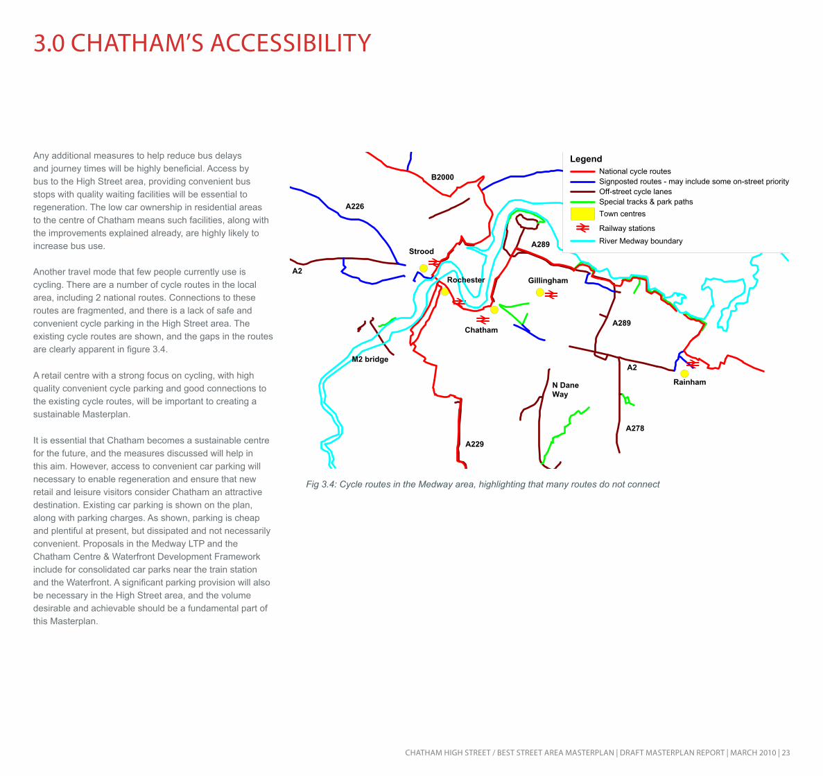
Another travel mode that few people currently use is cycling. There are a number of cycle routes in the local area, including 2 national routes. Connections to these routes are fragmented, and there is a lack of safe and convenient cycle parking in the High Street area. The existing cycle routes are shown, and the gaps in the routes are clearly apparent in figure 3.4.
A retail centre with a strong focus on cycling, with high quality convenient cycle parking and good connections to the existing cycle routes, will be important to creating a sustainable Masterplan.
It is essential that Chatham becomes a sustainable centre for the future, and the measures discussed will help in this aim. However, access to convenient car parking will necessary to enable regeneration and ensure that new retail and leisure visitors consider Chatham an attractive destination. Existing car parking is shown on the plan, along with parking charges. As shown, parking is cheap and plentiful at present, but dissipated and not necessarily convenient. Proposals in the Medway LTP and the Chatham Centre & Waterfront Development Framework include for consolidated car parks near the train station and the Waterfront. A significant parking provision will also be necessary in the High Street area, and the volume desirable and achievable should be a fundamental part of this Masterplan.
Fig 3.4: Cycle routes in the Medway area, highlighting that many routes do not connect

24 | CHATHAm HigH STreeT / BeST STreeT AreA mASTerplAn | drAfT mASTerplAn repOrT | mArCH 2010
4.0 CreATing An ATTrACTiVe TOWn CenTre
The project team has reviewed the 2008 Chatham Centre and Waterfront Masterplan to identify the key messages regarding creating an attractive town centre for Chatham, and has focused upon the immediate High Street and Best Street area for new urban design analysis. This has helped to avoid the duplication of work undertaken for the earlier study and to provide targeted analysis and proposals for the core study area for this project.
In undertaking the urban design analysis, the project team has used the framework of the By Design document, produced by the then DETR and CABE. This document, published to promote higher standards in urban design, sets out key themes in the consideration of good urban design for towns and cities. These are:
1 Character – a place with its own identity
2 Continuity and enclosure – a place where the public and private spaces are clearly distinguished
3 Legibility – a place that has a clear image and is easy to understand
4 Ease of movement – a place that is easy to get to and move through
5 Adaptability – a place that can change easily
6 Diversity – a place with variety and choice
7 Security – a place where the users feel and are as safe as possible
We have followed these themes in considering the charac-teristics of the natural and built environment in Chatham.
CHArACTer
Chatham has an extremely unusual topography, being situated on a sharp bend in the River Medway, and between two hills which rise up either side of the town, the Great Lines green space to the north and New Road area residential neighbourhoods to the south. These characteristics form a wedge shape, within which the town sits, providing a wide, flat waterfront at the north west and a linear high street, with the town tapering towards the south east.
This natural environment provides Chatham with a unique identity but also presents challenges in ensuring strong design and strategic planning for the town. Much of the waterfront area is within a significant flood risk zone, which significantly impacts on the options for ground floor uses in this area. This in turn presents challenges in accommodating the cultural and leisure uses that are needed in the town and in creating active ground floor uses which can bring activity and life to the waterfront area.
In the High Street/Best Street area, the topographical challenges are more closely related to the significant level changes between the High Street, Best Street and New Road, and the impact this might have on the accommodation of new uses, parking capacity and the creation of active ground floor uses. It will be important for the masterplan to look for the opportunities provided by the level changes and work with this as far as possible.
The steep level changes will also influence suitable building heights for the area and again, it will be important to work with the topography here, rather than specifically placing taller or small scale buildings on higher ground.
The town’s existing skyline is dominated by Mountbatten House, which sits between the town centre and the waterfront. Aside from this building and Anchorage House to the west, the building heights in the town centre are predominantly low. Within the masterplan area, the Pentagon car park (6 storeys), the office building on Rome Terrace (9 storeys) and the telephone exchange building on Best Street (7 storeys).
Looking northward to the High Street, along Meeting House Lane, with the multi-storey car park and the hills in the distance.

CHATHAm HigH STreeT / BeST STreeT AreA mASTerplAn | drAfT mASTerplAn repOrT | mArCH 2010 | 25
Landmark building
Council Offices
Fort Amherst
War Memorial
The Pentagon
The Brook Theatre
The Pentagon car park
The Pumping Station
Debenhams
Gala Bingo
Tesco
Mountbatten House
The Post Office building
Clover Street office block
Modern residential block
Residential blocks
Fig 4.1: Landmark buildings in Chatham, in terms of architecture, height or scale
26 | CHATHAm HigH STreeT / BeST STreeT AreA mASTerplAn | drAfT mASTerplAn repOrT | mArCH 2010
4.0 CreATing An ATTrACTiVe TOWn CenTre
A
B
C
Mountbatten House
Mountbatten House
Fig 4.2: Sections taken along Chatham High Street indicating the significant level changes between the High Street, New Road and The Lines.

CHATHAm HigH STreeT / BeST STreeT AreA mASTerplAn | drAfT mASTerplAn repOrT | mArCH 2010 | 27
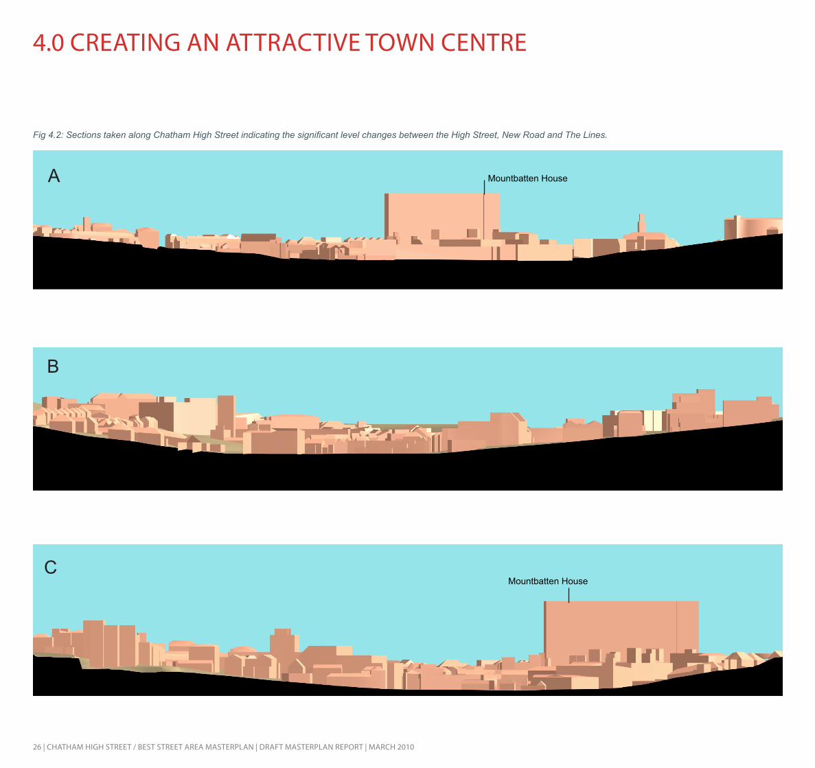
Topography
The sectionsin figure 4.2 highlight the unique topography of Chatham town centre and the level changes in the High Street/Best Street area. It also highlights the impact of Mountbatten House of the skyline of the town.
Heritage and conservation
Figure 4.4 sets out the key heritage and character at-tributes of Chatham, including listed buildings, the ancient scheduled monument, conservation area and the World Heritage Site buffer zone. Also included are existing land-marks and potential new landmarks within the town centre. These have been identified as the key block between the High Street and the waterfront and just to the south of Best Street, marking the eastern entrance to the town. Areas which are not designated as conservation areas or have listed buildings but are considered to have historic assets are also identified.
Important view corridors have been identified from both the New Road/Best Street area and the rail station area to the War Memorial on the hill to the north of the town centre.
A
B
AB
C
C
Fig 4.3: Plan to accompany fig 4.2 sections
Fig 4.4: Heritage and character attributes
28 | CHATHAm HigH STreeT / BeST STreeT AreA mASTerplAn | drAfT mASTerplAn repOrT | mArCH 2010
4.0 CreATing An ATTrACTiVe TOWn CenTre
Character areas
The linear nature of Chatham town centre and the resulting length of the High Street mean that character areas can be identified along this central artery. Different uses and retail types have developed over time in response to building footprint sizes, their location, building frontage and access.
- Small, independent retailers and take-aways can be found at the eastern end of the High Street;
- Large retailers are found in the central section, with large, primary retailers on the southern side of the street, including Primark and Debenhams;
- Smaller retail units are found to the west of this, including banks, buildings societies and jewellery stores. Military Road and the lower part of Station Road share a similar character to this section of the High Street and can be included within this.
- There is a break in the retail and frontage to the High Street at what was the Sir John Hawkins flyover and is now Waterfront Way. This presents a strong opportunity for developing a quality public realm with a sense of openness in the town centre.
- The small, historic buildings are then re-established to the west of Waterfront Way with independent stores and offices. This marks the point at which Chatham and Rochester join.
In addition to the sections of the High Street, Chatham has other character areas, which include:
- The loop which encircles the town centre currently has a uniform character. Best Street to the south and The Brook to the north both form a route from which the town centre is not visible and drivers are drawn around and beyond the town. It will be beneficial to explore means of dismantling this character area, so that the sections of the road circling the town become part of the areas immediately surrounding them, rather than operating as a monotonous and detached experience which is divorced from the town centre.
- Either side of this route, though particularly on the inner side of the road, is a large area with service or multi-storey car parking and the ‘backlands’ servicing area to the High Street. This character area also presents an opportunity to transform the physical environment within Chatham town centre and ensure that the centre is visible to visitors as they arrive.
- The section of New Road, which runs to the south of Best Street, provides some of the strongest historic environment within Chatham, which should be preserved and enhanced. The existing BT exchange and Post Office building do not fit well with the character
of this area and it will be important to provide suitable uses and frontage on the north side of the road, in the longer term, to strengthen this historic area.
Fig 4.5: Character areas

CHATHAm HigH STreeT / BeST STreeT AreA mASTerplAn | drAfT mASTerplAn repOrT | mArCH 2010 | 29
New Road Best Street The Brook
The High Street Station Road Backlands between the High Street and Best Street

30 | CHATHAm HigH STreeT / BeST STreeT AreA mASTerplAn | drAfT mASTerplAn repOrT | mArCH 2010
4.0 CreATing An ATTrACTiVe TOWn CenTre
COnTinUiTy And enClOSUre
Townscape quality
The project team has undertaken a high level review of the quality of the townscape along the central High Street. This helps in assessing the quality of the environment in the heart of the town and strengthening the role and the vitality of the main retail street and also in identifying opportunities to provide new links from the High Street, to create a more integrated retail centre with a clear and attractive pedes-trian circuit.
A traffic light system has been used in the analysis, with red indicating buildings which are considered to have a nega-tive impact on the appearance of the High Street, yellow indicating buildings with a neutral impact and green indicat-ing high quality buildings with a positive impact on the High Street. As can be seen in figure 4.6, the western end of the High street, incorporating the northern section of Station Road and Military Road, has a concentration of quality, his-toric buildings which contribute positively to the character of the town centre.
Further east, on the north side of the High Street, the townscape is not of such quality and a number of points have been identified where buildings could be replaced to strengthen frontage to the High Street, create links from the High Street and ‘complete the block’ with The Brook, help-ing to address the issue of backlands here.
On the southern side of the High Street the Debenhams building has been identified as having a negative impact on the street, in townscape terms, and it is worth considering whether this could be either reprovided, with a new anchor building for the department store, or at least with improve-ments to this in terms of the front facade and in providing ‘wrap-around’ development on the side and rear to improve the impact of the building.
Poor quality
Neutral
High quality
High quality grouping
Fig 4.6: Townscape quality of buildings on Chatham High Street
CHATHAm HigH STreeT / BeST STreeT AreA mASTerplAn | drAfT mASTerplAn repOrT | mArCH 2010 | 31
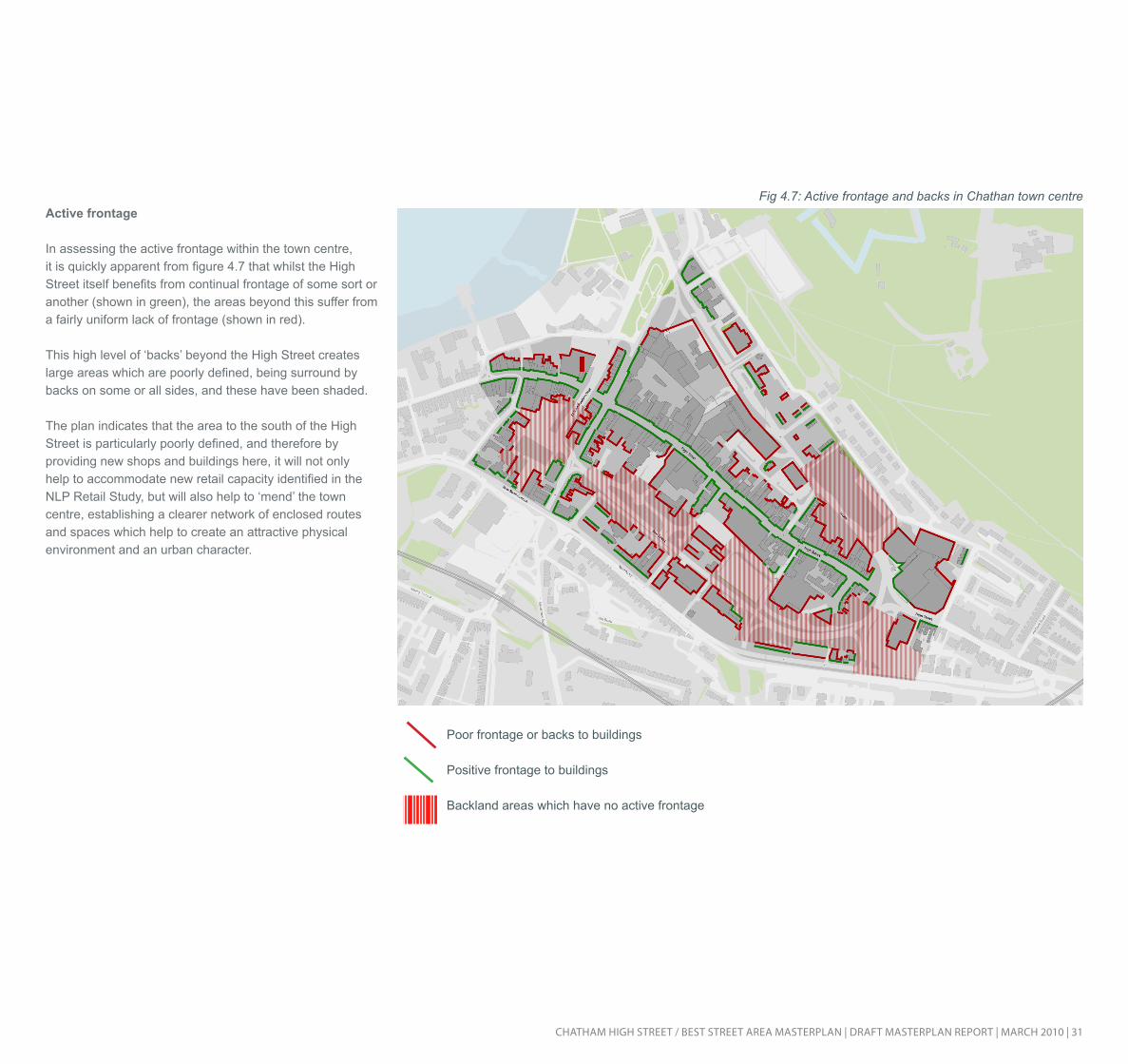
Active frontage
In assessing the active frontage within the town centre, it is quickly apparent from figure 4.7 that whilst the High Street itself benefits from continual frontage of some sort or another (shown in green), the areas beyond this suffer from a fairly uniform lack of frontage (shown in red).
This high level of ‘backs’ beyond the High Street creates large areas which are poorly defined, being surround by backs on some or all sides, and these have been shaded.
The plan indicates that the area to the south of the High Street is particularly poorly defined, and therefore by providing new shops and buildings here, it will not only help to accommodate new retail capacity identified in the NLP Retail Study, but will also help to ‘mend’ the town centre, establishing a clearer network of enclosed routes and spaces which help to create an attractive physical environment and an urban character.
Poor frontage or backs to buildings
Positive frontage to buildings
Backland areas which have no active frontage
Fig 4.7: Active frontage and backs in Chathan town centre

32 | CHATHAm HigH STreeT / BeST STreeT AreA mASTerplAn | drAfT mASTerplAn repOrT | mArCH 2010
4.0 CreATing An ATTrACTiVe TOWn CenTre
qUAliTy Of pUBliC reAlm
Green space and public spaces
As indicated in figure 4.8, Chatham benefits from a large amount of open space to the north of the town, with the Great Lines and Fort Amherst, but has very little green space in the town itself.
Similarly, Chatham also currently lacks hard landscaped public spaces with seating where people might eat their lunch during summer months or read a newspaper.
Providing green pocket parks and/or small hard landscaped spaces close to the High Street would greatly improve the physical environment within the town centre, and strength-en its appeal to local residents and visitors alike.
Fig 4.8: Green space surrounding Chatham town cente, but not within it

CHATHAm HigH STreeT / BeST STreeT AreA mASTerplAn | drAfT mASTerplAn repOrT | mArCH 2010 | 33
eASe Of mOVemenT
Pedestrian links to the High Street
In understanding the movement patterns within the town centre, the project team has reviewed the routes into the retail heart for visitors, whether they arrive by car from the wider Medway region, by public transport to the rail or bus station or on foot from surrounding neighbourhoods or the university campuses nearby. We have used the location of the planned dynamic bus station in this analysis.
Figure 4.9 indicates that the current location of car parks in the town centre allow visitors to reach the High Street at one of a number of pedestrian passageways leading from the main street, if they take the shortest route. This scatter-ing of arrival points helps to support the economic health of the shops along the High Street by ensuring that all sec-tions have reasonable levels of footfall. The current pre-dominance of surface level car parks in the centre should be addressed in order to improve the physical environment and provide more retail in the centre but it will also be important for consolidated parking to be located where it can ensure that all areas of the High Street benefit from the footfall. This might mean ensuring there is parking towards the eastern end of the High Street given the large number of parking spaces at the Pentagon Centre.
The plan also indicates the fractured routes into the centre from the south with a number of dead ends for pedestrians and a number of awkward routes. There is currently no clear and accessible route from the south.
Looking at the convergence of routes and arrival points in the centre indicates the importance of the eastern end of the High Street as an arrival point to the town centre, and of the junction of the High Street, Station Road and Military Road, as the apex of the town, both historically and today. These two points have consequently been identified as key areas for public realm improvements.
Fig 4.9: Pedestrian routes to the High Street from arrival points in the town

34 | CHATHAm HigH STreeT / BeST STreeT AreA mASTerplAn | drAfT mASTerplAn repOrT | mArCH 2010
4.0 CreATing An ATTrACTiVe TOWn CenTre
Links between the town centre and the waterfront
To fully understand the movement patterns within the town centre, and the important relationship between the town centre and the waterfront, it is important to analyse the links between these two key areas. The waterfront is the loca-tion for ambitious plans to create a leisure and cultural hub within the town, taking advantage of the waterside setting, the parklands and the attractive historic buildings in the area.
Key activity points in the town centre have been identi-fied which might act as origination points for trips to the waterfront. These are the rail station, Debenhams and the Pentagon Centre. The routes that pedestrians are likely to take between these and the waterfront have been reviewed and critical points which would be passed on more than one route to the waterfront have been highlighted. This shows the importance of the space at the junction of the High Street, Station Road and Military Road; the point at the south west corner of the Paddock which marks the ar-rival to the waterfront; the junction of the High Street and the new Waterfront Way; and the area immediately around St John’s Church.
In terms of legibility, the block on the north west corner of the High Street/Waterfront Way junction becomes highly important as a landmark and guide in reaching the water-front, both from the east and from the south. It is therefore proposed that this corner should be the location of a land-mark building with active frontage, drawing people towards before leading them onto the waterfront. Pedestrian routes to waterfront
Key junctions along routes
Landmarks - origination points
and orientation aids
The waterfront
Fig 4.10: Key routes to the waterfront
CHATHAm HigH STreeT / BeST STreeT AreA mASTerplAn | drAfT mASTerplAn repOrT | mArCH 2010 | 35
legiBiliTy
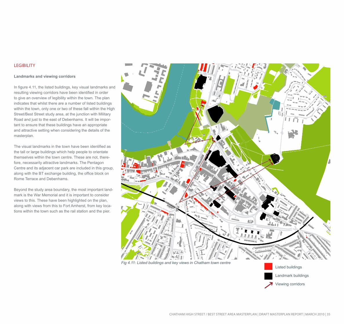
Landmarks and viewing corridors
In figure 4.11, the listed buildings, key visual landmarks and resulting viewing corridors have been identified in order to give an overview of legibility within the town. The plan indicates that whilst there are a number of listed buildings within the town, only one or two of these fall within the High Street/Best Street study area, at the junction with Military Road and just to the east of Debenhams. It will be impor-tant to ensure that these buildings have an appropriate and attractive setting when considering the details of the masterplan.
The visual landmarks in the town have been identified as the tall or large buildings which help people to orientate themselves within the town centre. These are not, there-fore, necessarily attractive landmarks. The Pentagon Centre and its adjacent car park are included in this group, along with the BT exchange building, the office block on Rome Terrace and Debenhams.
Beyond the study area boundary, the most important land-mark is the War Memorial and it is important to consider views to this. These have been highlighted on the plan, along with views from this to Fort Amherst, from key loca-tions within the town such as the rail station and the pier.
Listed buildings
Landmark buildings
Viewing corridors
Fig 4.11: Listed buildings and key views in Chatham town centre
36 | CHATHAm HigH STreeT / BeST STreeT AreA mASTerplAn | drAfT mASTerplAn repOrT | mArCH 2010
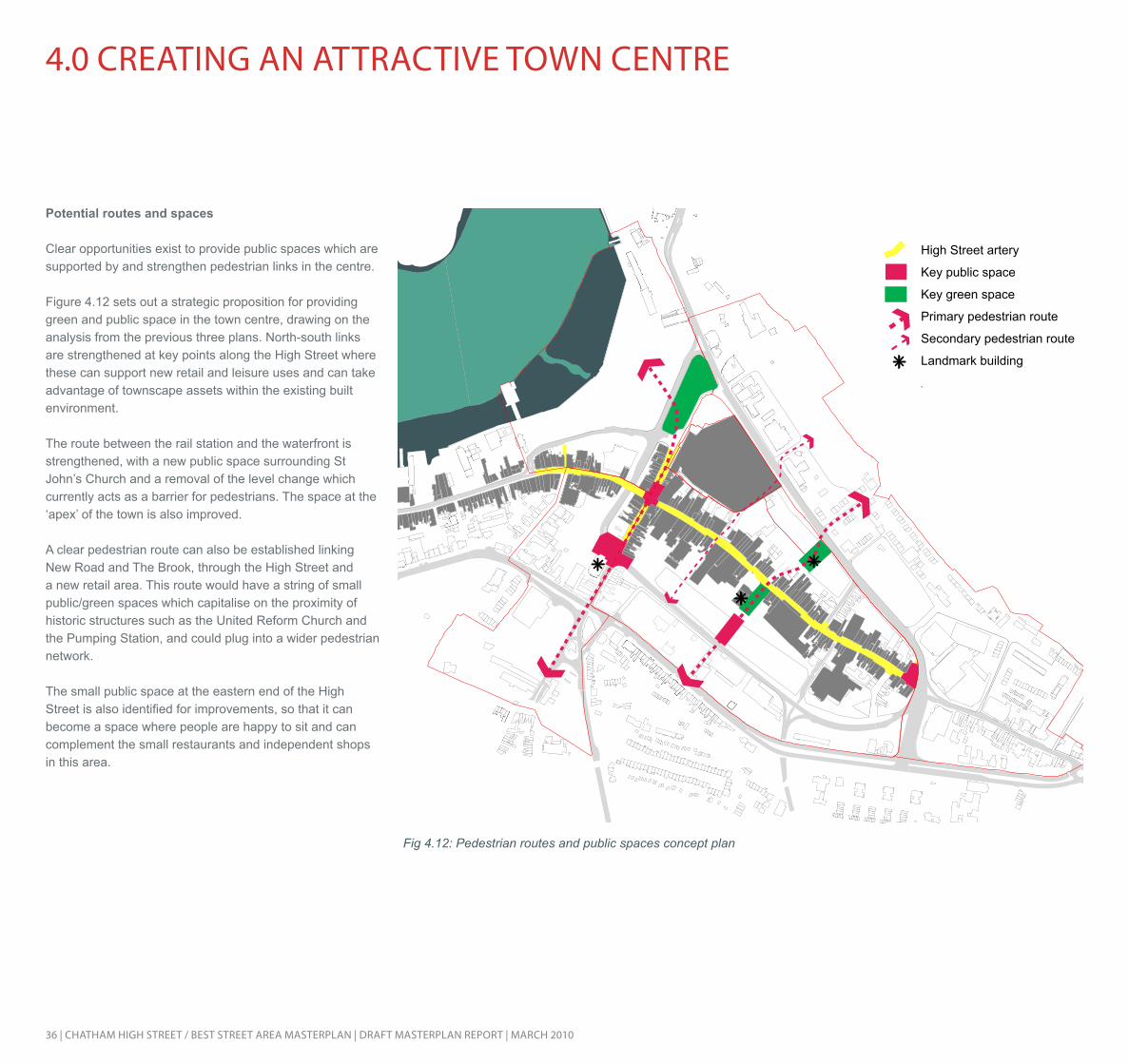
High Street artery
Key public space
Key green space
Primary pedestrian route
Secondary pedestrian route
Landmark building
Potential routes and spaces
Clear opportunities exist to provide public spaces which are supported by and strengthen pedestrian links in the centre.
Figure 4.12 sets out a strategic proposition for providing green and public space in the town centre, drawing on the analysis from the previous three plans. North-south links are strengthened at key points along the High Street where these can support new retail and leisure uses and can take advantage of townscape assets within the existing built environment.
The route between the rail station and the waterfront is strengthened, with a new public space surrounding St John’s Church and a removal of the level change which currently acts as a barrier for pedestrians. The space at the ‘apex’ of the town is also improved.
A clear pedestrian route can also be established linking New Road and The Brook, through the High Street and a new retail area. This route would have a string of small public/green spaces which capitalise on the proximity of historic structures such as the United Reform Church and the Pumping Station, and could plug into a wider pedestrian network.
The small public space at the eastern end of the High Street is also identified for improvements, so that it can become a space where people are happy to sit and can complement the small restaurants and independent shops in this area.
4.0 CreATing An ATTrACTiVe TOWn CenTre
Fig 4.12: Pedestrian routes and public spaces concept plan

CHATHAm HigH STreeT / BeST STreeT AreA mASTerplAn | drAfT mASTerplAn repOrT | mArCH 2010 | 37
AdApTABiliTy
Building footprint sizes
Building footprint sizes along Chatham High Street are varied, which is considered an asset in terms of adaptabil-ity and flexibility in the long term for the town centre. The majority of the large building footprints are on the southern side of the High Street, with the two Primark buildings (one formerly Woolworths) and Debenhams, amongst others. The multi-storey car park has also been included. Individual units within the Pentagon Centre are not shown but it is known from the NLP study that a mix of unit sizes are also available in the centre.
Medium sized units are scattered fairly evenly along the High Street, although there are slightly more on the north side. Smaller units are also scattered along the north side of the High Street but concentrations of smaller units also exist at the eastern end of the High Street and along Sta-tion Road and Military Road.
The NLP study noted that whilst it is important for anchor units to be accommodated, including potentially a food store, demand has also been identified for small to medium units in the town.
Large footprints
Medium footprints
Small footprints
Fig 4.13: Building footprints on Chatham High Street
38 | CHATHAm HigH STreeT / BeST STreeT AreA mASTerplAn | drAfT mASTerplAn repOrT | mArCH 2010
4.0 CreATing An ATTrACTiVe TOWn CenTre
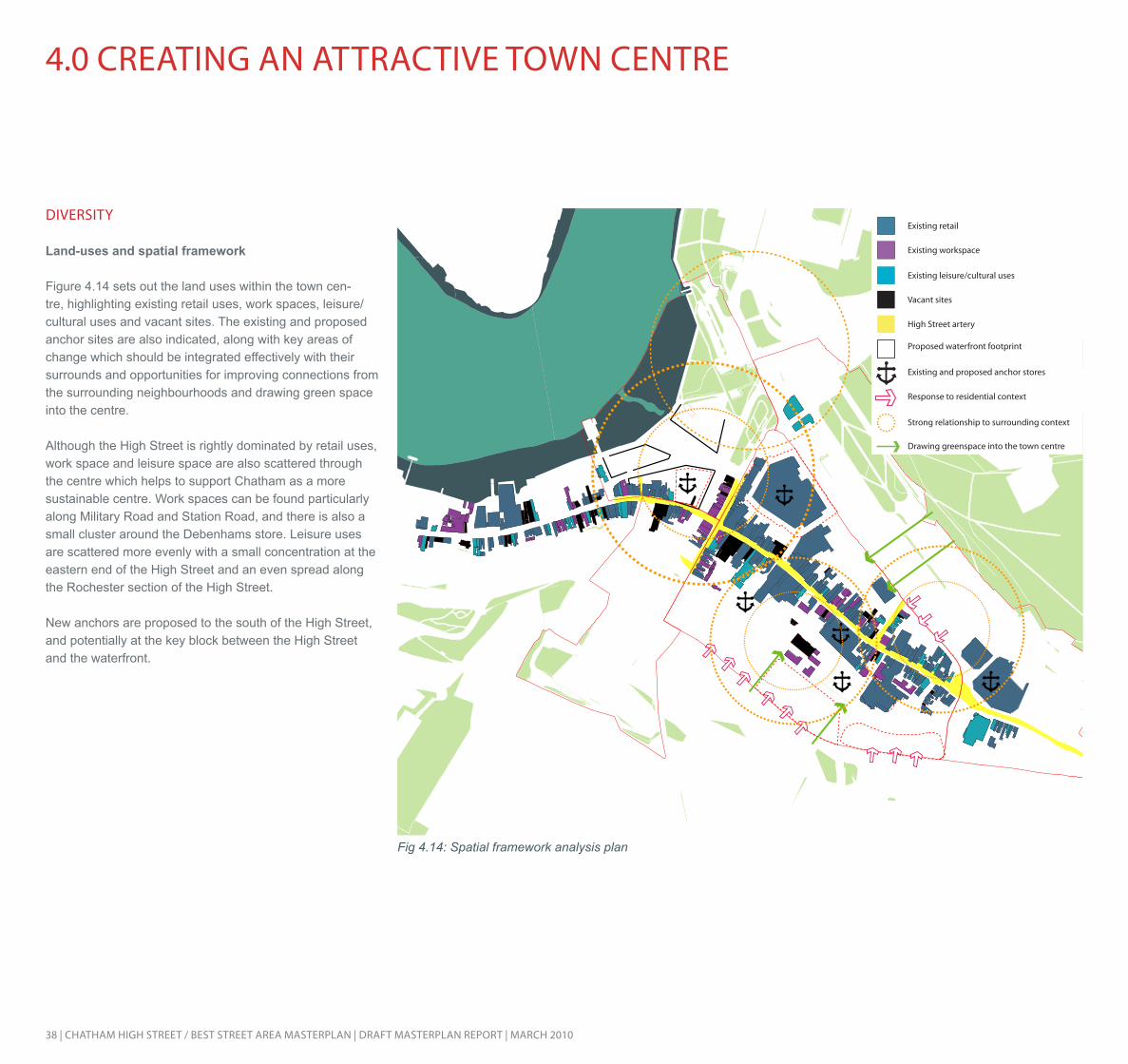
diVerSiTy
Land-uses and spatial framework
Figure 4.14 sets out the land uses within the town cen-tre, highlighting existing retail uses, work spaces, leisure/cultural uses and vacant sites. The existing and proposed anchor sites are also indicated, along with key areas of change which should be integrated effectively with their surrounds and opportunities for improving connections from the surrounding neighbourhoods and drawing green space into the centre.
Although the High Street is rightly dominated by retail uses, work space and leisure space are also scattered through the centre which helps to support Chatham as a more sustainable centre. Work spaces can be found particularly along Military Road and Station Road, and there is also a small cluster around the Debenhams store. Leisure uses are scattered more evenly with a small concentration at the eastern end of the High Street and an even spread along the Rochester section of the High Street.
New anchors are proposed to the south of the High Street, and potentially at the key block between the High Street and the waterfront.
Fig 4.14: Spatial framework analysis plan

CHATHAm HigH STreeT / BeST STreeT AreA mASTerplAn | drAfT mASTerplAn repOrT | mArCH 2010 | 39
Retail types
Taking account of the current retail patterns in town and the recommendations made in the 2008 masterplan for the town centre and waterfront, suitable areas for retail in the town centre in the future have been identified.
The retail core for the centre, containing primary and na-tional retailers selling comparison goods, should be centred around the High Street and the area immediately to the north and south of this, incorporating the Pentagon Centre and stretching to the critical block identified at the junction of the High Street and Waterfront Way.
The area between Best Street and New Road has been identified for some retail and residential uses, providing a sensitive transition between the town centre and the local centre feel of New Road.
Edge of town retail with large footprints is identified for The Brook area, taking advantage of its accessibility on the major road network.
Independent and specialist retail is identified for the east-ern end of the High Street, the Station Road area and the waterfront area. Leisure supporting retail uses are also proposed for the waterfront area. This includes gift shops and specialist shops.
The existing and proposed anchors for the town centre are again shown in figure 4.15. Primary retail spine
Primary and national comparison retailers
Cultural and specialist retail
Cultural/evening economy retail
National and specialist retail
Large footprint retail
Retail anchors
Street market
Evening economy focus
Fig 4.15: Proposed retail character areas in Chatham centre

40 | CHATHAm HigH STreeT / BeST STreeT AreA mASTerplAn | drAfT mASTerplAn repOrT | mArCH 2010
5.0 refined OBJeCTiVeS And ApprOACH
OVerArCHing frAmeWOrK
An overarching framework shown in figure 5.1 has been developed to inform the options for the High Street/Best Street masterplan. This sets out the key aspirations for the town centre and provides a broad guide which the options then address in greater detail.
- The High Street is retained as the central route of the town centre, but permeability is improved, with the creation of a retail circuit effectively connecting the Pentagon Centre with new development to the north and south of the High Street. This helps to address the backland areas beyond the High Street.
- A series of public spaces are created in order to address the current lack of such spaces in the centre and to support the movement network.
- Active frontage is to be provided along new routes and onto new public spaces in order to provide a sense of continuity and enclosure within the town centre.
- New development is proposed for the areas between the High Street and The Brook and between the High Street and Best Street, helping to address the areas of poorly defined space in the centre.
- Replacement car parking is located predominantly to the south of the High Street, ensuring access points along the High Street from car parks, which can help to support the economic vitality of the full length of the High Street.
- Pedestrian links from surrounding neighbourhoods are strengthened, particularly from the south, and north-south links within the town centre are strengthened.
- Views of the War Memorial are preserved and enhanced.
- Retail anchors are enhanced at the Pentagon Centre and Debenhams, and a new anchor is provided to the south east of Debenhams.
- Service access is provided at two key locations on the north side of Best Street to provide access to new retail development in this area.
- New development is established between Best Street and New Road, providing more appropriate uses and a better quality environment for the important conservation area at New Road.
- The eastern end of the High Street is revitalised, with infill development providing new shops and improvements to the public realm
- Public transport links are improved by the new dynamic bus station, through grouped bus stops and a taxi rank at the eastern end of the High Street and improvements at the rail station.
- A mixed-use approach with work space and residential units provided above retail in the centre town.
- New community uses, including the Healthy Living Centre planned for the town centre and potential community uses at the United Reform Church.
- Provision of a hotel in the town centre.
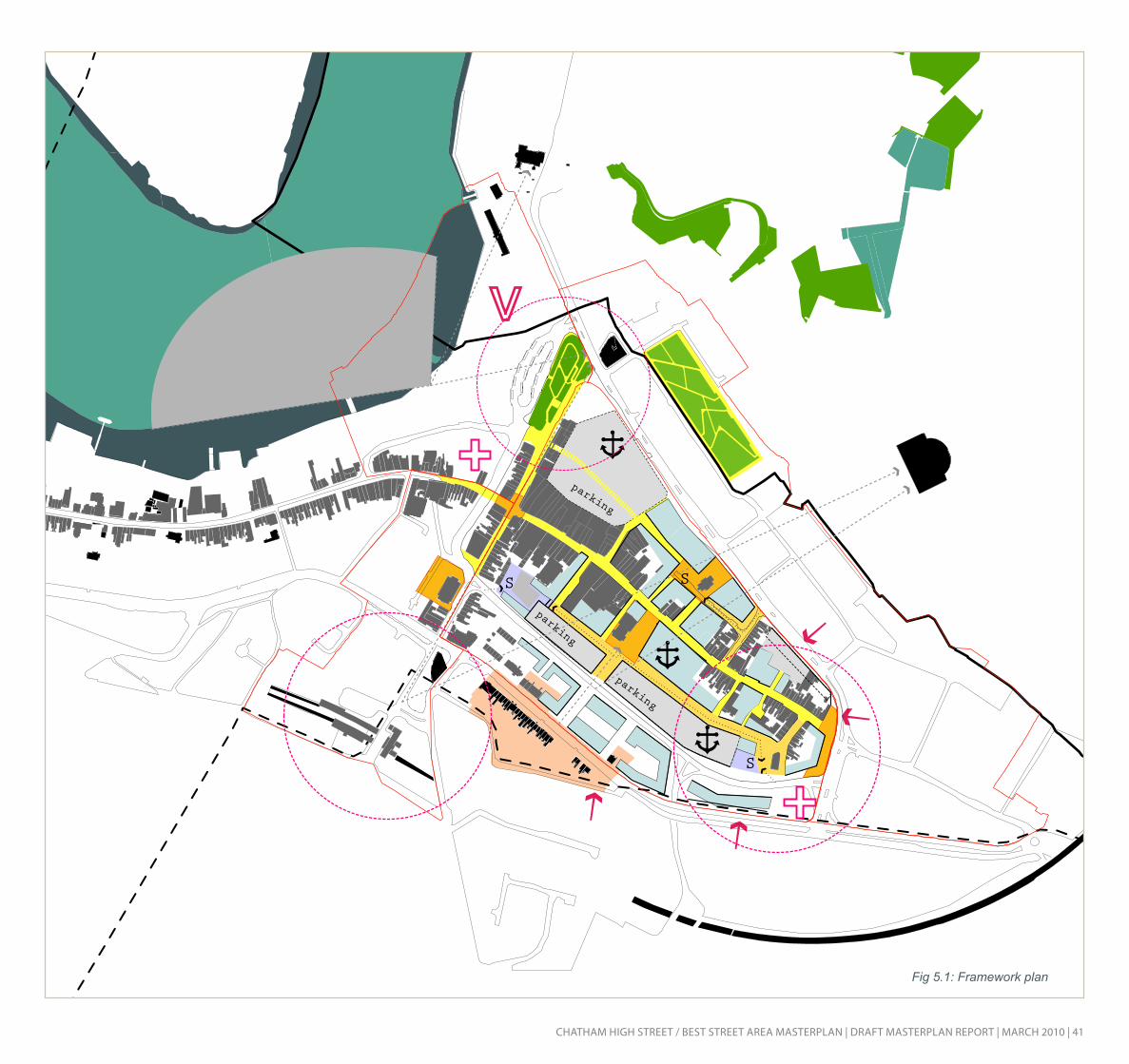
CHATHAm HigH STreeT / BeST STreeT AreA mASTerplAn | drAfT mASTerplAn repOrT | mArCH 2010 | 41
Fig 5.1: Framework plan

42 | CHATHAm HigH STreeT / BeST STreeT AreA mASTerplAn | drAfT mASTerplAn repOrT | mArCH 2010
T
T
T
T
CHATHAm in THe eVening
Figure 5.2 sets out the overarching plan for the evening economy in Chatham.
The High Street is highlighted as the main route for the town centre with this role continuing in the evening.
The key cultural buildings which will bring life to the town centre in the evening are identified as the new cultural centre at the waterfront, the two theatres, the pubs along Station Road and the two churches, which have scope for community activities. The arts centre is also highlighted.
A new concentration of night time uses are identified around a new square by the water tower taking advantage of the restaurants and take-aways which already exist in this area.
Taxi ranks are identified at the eastern end of the High Street by a new public square, by the station, at the water-front and by the Pentagon Centre.
5.0 refined OBJeCTiVeS And ApprOACH
T
Proposed development
Night time uses
Proposed residential overlook
Proposed taxi rank
Key public realm improvements
Proposed lit routes
Fig 5.2: Secure by design plan for Chatham
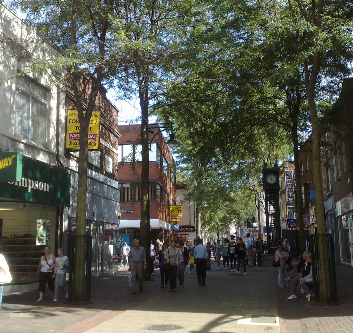
CHATHAm HigH STreeT / BeST STreeT AreA mASTerplAn | drAfT mASTerplAn repOrT | mArCH 2010 | 43

44 | CHATHAm HigH STreeT / BeST STreeT AreA mASTerplAn | drAfT mASTerplAn repOrT | mArCH 2010
6.0 drAfT mASTerplAn
The detailed options appraisal for the High Street/Best Street masterplan clearly identified the masterplan option as being most effective at meeting the objectives identified for the masterplan. This option has therefore been taken forward and further developed as the preferred option for consultation purposes.
grOUnd flOOr
The key features of the ground floor level of the masterplan are set out in figure 6.1, to the right.
reTAil prOViSiOn
- A new retail area for the town centre between Best Street and Richard Street with a major food retailer incorporated into new frontage on Richard Street, with upper level parking accessed from Best Street split over two storeys to support this.
- New retail development along the north west section of Best Street, accessed from Richard Street, with upper level parking accessed from Best Street.
- New development in the High Street at sensitive points to allow for the creation of a new retail area connecting the Pentagon extension to a rejuvenated High Street.
- New retail development on the site of the current indoor market, with potential for provision of small units for high quality small retailers to create an attractive boutique retail environment.
- Coordination with the proposed Pentagon Extension, providing two levels of retail plus upper floor car parking.
CUlTUrAl/leiSUre/COmmUniTy prOViSiOn
- Posstible expansion of the Central Theatre, with the addition of cafe facilities, enterprise and associated offer.
- Accommodation of the proposed Primary Care Trust building, located in a central location with access from Richard Street and Best Street.
- Creation of a new community/civic cluster around Meeting House, with retail frontage onto the High Street.
- Proposed hotel development as a landmark feature at the eastern end of New Road - creating a key gateway into the town centre and benefiting from proximity to the High Street/Best Street and upgraded pedestrian crossings.
- Support for the evening economy with greater activity around the pump house square and timed access to the eastern end of the High Street.
WOrK SpACe prOViSiOn
- A work space cluster at the eastern end of the High Street, fronting onto the new junction.
- New work space between Best Street and New Road, creating an active and attractive frontage to Best St, whilst simultaneously allowing for rationalisation of movement between these two streets.
- New work space provided onto the Brook, which also provides frontage onto this important route
- Potential for work space to be included in the landmark feature building at the eastern end of New Road.
pHySiCAl enVirOnmenT imprOVemenTS
- Possible remodelling of the Iceland building and neighbouring sites to create a new north-south route from the Brook to the High Street, allowing completion of the Brook frontage and ground level parking in the courtyard.
- Potential remodelling of Debenhams to wrap the block and create active frontage to Richard Street.
- Creation of a new square around the pump house to the north of the High Street with restaurants and cafés fronting this.
- Creation of a new square around the Clover Street church.
- Creation of a strong north-south pedestrian route linking the Brook and Best Street, through these two new squares.
- Creation of a clearly defined public space at the High Street/Railway Street junction
- A legible and attractive route for pedestrians at the Railway Street/Best Street junction.
- Potential creation of a new square around a refurbished St John’s Church.
- Paving, lighting, planting and street furniture improvements throughout and to Best Street, the High Street and Richard Street in particular.

CHATHAm HigH STreeT / BeST STreeT AreA mASTerplAn | drAfT mASTerplAn repOrT | mArCH 2010 | 45
Fig 6.1: The ground floor masterplan
46 | CHATHAm HigH STreeT / BeST STreeT AreA mASTerplAn | drAfT mASTerplAn repOrT | mArCH 2010
6.0 drAfT mASTerplAn
Upper flOOrS
The preferred option has been developed with inbuilt flexibility, to maximise the potential for the masterplan to respond to the property market and other changing conditions. However, a number of upper floor uses have been suggested in order to help support a mixed-use, sustainable town centre.
The upper floor areas are considered suitable spaces for new homes and work spaces, to help ensure that the town centre retains activity throughout the day and evening. The upper floors are also suitable locations for replacement and new parking facilities (covered in further detail on the fol-lowing pages).
Lastly, the upper floors of the masterplan provide valuable opportunities for creating roof gardens and green roofs - both improving the physical environment within the town centre and contributing to a sustainable future for the town.
HOUSing prOViSiOn
- Residential accommodation provided above retail development on Richard Street, with intelligent use of level changes to provide street access onto Best Street.
- Residential development over new retail at the north west end of Best Street.
- Residential units above new work space between Best Street and New Road, fronting onto Best Street.
- Residential units above retail space fronting onto on the Brook and coordinating with the separate masterplan for this area.
WOrK SpACe prOViSiOn
- A work space cluster at the eastern end of the High Street, fronting onto the new junction.
- Upper floor work space provided opposite the PCT building, on the key junction of Richard Street and Clover Street.
- New office space provided above retail units between the High Street and new square based around the pump house.
- New work space provided onto the Brook, which provides frontage onto this important route.
- Potential for work space to be included in the landmark feature building at the eastern end of New Road.
pArKing prOViSiOn
- Re-provision of two floors of upper level parking at the Pentagon extension
- Re-provision of multi-level car park above new retail development between Best Street and Richard Street, to replace the NCP car park
- Provision of new multi-level parking above new retail development at the western end of Best Street.
THe pHySiCAl enVirOnmenT
- Creation of roof gardens and green roofs throughout the town centre - particularly at the sites of upper level residential development along Best Street, Richard Street and the Brook.

CHATHAm HigH STreeT / BeST STreeT AreA mASTerplAn | drAfT mASTerplAn repOrT | mArCH 2010 | 47
Fig 6.2: The upper floors masterplan

48 | CHATHAm HigH STreeT / BeST STreeT AreA mASTerplAn | drAfT mASTerplAn repOrT | mArCH 2010
6.0 drAfT mASTerplAn
A CleAr mOVemenT neTWOrK A number of proposals are made within the preferred option, which both coordinate with the transport and movement proposals currently being brought forward by Medway Council and identify options for improving movement within the High Street/Best Street area.
The following is proposed and illustrated in figures 6.3 and 6.4: priVATe VeHiCleS
- Improved links between New Road and Best Street
- Rationalisation of Best Street and the parallel section of Clover Street, in order to simplify the road network and create space to establish active frontage on to Best Street here
- Evening access to the eastern section of the High Street and Batchelor Street, to animate the area and support the evening economy here.
pedeSTriAn mOVemenT
- Strengthened north-south connections between Best Street, the High Street and the Brook.
- Clear connection between Pentagon extension and the High Street
- Better links to the waterfront from the town centre
- Alternative route through the new St John’s square, to and from the rail station
- clear retail circuits in the town centre, connecting new and replaced anchors
pUBliC TrAnSpOrT/TAXiS
- Bus only access for the immediate future along Waterfront Way in line with current Medway Council proposals
- Introduction of bus stops on Best Street to provide pedestrian access to the High Street and the new retail area on Richard Street from the south
- Proposed taxi ranks at the entrance to the Pentagon, at the eastern end of the High Street, by the train station and in the waterfront area.
SerViCing And ACCeSS
- Two new service access points from Best Street onto Richard Street, with turning circles in each case. Servicing access to Richard Street would be time limited.
- Service Access from The Brook to Solomons Road with a turning circle accommodated here
- Front servicing access to retail units at the eastern end of the High Street
- Front servicing access to retail units fronting The Brook
P
P
P
P
P
Public Transport Hub
Proposed Bus Stop to Support New Retail
Primary Movement from Public Transport
Vehicular Movement
Parking
Primary Pedestrian Movement
Secondary Pedestrian Route
Fig 6.3: Pedestrian movement

CHATHAm HigH STreeT / BeST STreeT AreA mASTerplAn | drAfT mASTerplAn repOrT | mArCH 2010 | 49
T
T
T
T
P
B
R
P
P
P
B
T
R
P
Gateway Locations
Vehicular Routes
Controlled Access Vehicular Routes
Bus and Taxi Only Routes
Service Routes (Largely Controlled Access)
Service Areas
Taxi Rank
Rail Station
Bus facility
Parking
Fig 6.4: Movement and servicing

50 | CHATHAm HigH STreeT / BeST STreeT AreA mASTerplAn | drAfT mASTerplAn repOrT | mArCH 2010
qUAliTy pArKing prOViSiOn
The parking strategy for the preferred option has been informed by a number of principles designed to help create an attractive and usable environment which will attract customers from across the Medway area and perhaps beyond. These are set out below and illustrated in figure 6.5:
High quality parking spacesParking design has improved significantly over the last few years, with the development of multi-storey parking provision which does not have a negative impact on the surrounding environment and which provides users with a safe, attractive and high usable resource. Developments such as the Westfield Centre at White City in London have followed methods used in Continental Europe which direct drivers to free spaces and provide a comfortable environment.
Parking provision in Chatham is currently of a poor quality, but the central masterplan provides an opportunity to address this and provide high quality parking provision which attracts customers through its ease of use.
6.0 drAfT mASTerplAn
Encouragement of modal shift By encouraging Chatham to be the commercial centre of the Medway City area, it is envisaged that public transport will become a more feasible alternative to the private car in the future. The recent expansion of student numbers in the town are likely to support the role of public transport in the area. This will help to relieve congestion and create a more attractive environment in addition to providing environmental benefits in the shorter term.
A quality retail offerPopular shopping destinations are not driven by the level of parking available but by the retail offer at the location. Examples of this are the success of Oxford Street as the country’s premier shopping destination and the fact that people do not visit Bluewater simply for the parking spaces but for the shops on offer.
A key focus for the masterplan is to create an attractive en-vironment with a strong offer of shops and services which attract people to the town.
pArKing CApACiTy
An overall parking capacity of 1,242 spaces has been identified with the draft masterplan in the preferred option. When taken in conjunction with the 500 parking spaces proposed as part of the Pentagon extension, this relates to an overall gain in parking spaces in the town centre.
A plan setting out the parking locations is provided to the right, including proposed access points and internal circula-tion patterns to multi-storey car parks at Best Street and for the Pentagon Centre.
The breakdown of parking spaces according to sites is set out below:
Site SpacesPentagon extension 260Best Street (western end) 304Best Street (eastern end) 568The Brook (surface parking) 35Best Street (surface parking) 35Best Street (on street parking) 23TOTAL 1,225
This represents a gain in parking spaces for the town centre, of approximately 200 spaces, along with the qualitative improvements and short term parking provision that will make each space provide more value during the day.

CHATHAm HigH STreeT / BeST STreeT AreA mASTerplAn | drAfT mASTerplAn repOrT | mArCH 2010 | 51
Upper level parkingSurface level parking
Fig 6.5: Parking provision

52 | CHATHAm HigH STreeT / BeST STreeT AreA mASTerplAn | drAfT mASTerplAn repOrT | mArCH 2010
6.0 drAfT mASTerplAn
reTAil CApACiTy
The levels of retail capacity developed for the draft masterplan have been informed by the detailed retail capacity study by Nathaniel Lichfield and Partners (2009), which identified a role for Chatham as the commercial centre of the Medway towns. It established that Chatham’s retail ranking, and therefore overall image, had slipped significantly in recent years but identified a strong retail demand for the short and medium term future which could help transform this situation. The study identified capacity for:- 7,298 sqm of new large foodstore (convenience) space
and 4,379 sqm of small foodstore space by 2016
- 24,000-55,000 sqm of comparison goods space, up until 2016
- A further 24,000-28,000 sqm between 2016 and 2021
The report was undertaken in the aftermath of the economic downturn and it is important to note that these figures already take account of shifts in the retail and property markets associated with the downturn. Taking this information into account the total retail capacities identified for the town centre are:
It is important to emphasise a number of key considerations relating to these retail capacity figures:
- These figures represent the maximum floorspace figures the final masterplan could achieve, based on the maximum number of storeys and plot density that would be appropriate for the town centre.
- The capacity figures cover both comparison and convenience retail and so are designed to address both the total of 24,000-55,000sqm of comparison space and 11,577sqm of total convenience space capacities identified in the NLP report.
- The phasing for the masterplan will take place at the next stage of the project but it is not envisaged that this retail space would all come forward by 2016. A proportion of the retail capacity identified therefore relates to the 24,000-28,000sqm identified for the time period between 2016 and 2021.
HOUSing CApACiTy
New residential development within the draft masterplan is designed to bring activity to the town centre throughout the day and evening and to encourage sustainable living patterns in the local area. Such new accommodation could serve the growing student population very effectively and support the evening economy in the town. The residential units are, however, designed to be a mix of tenure and size in order to ensure a balanced community. The capacity for new homes in the draft masterplan has been identified as:
Site HomesHalfords 30Best Street (west) 72
Best Street (east) 124Paddock (west) 9Paddock (east) 15TOTAL 250
WOrK SpACe CApACiTy
The draft masterplan has been developed in order to ensure a balanced and strong economy and providing employment opportunities for Chatham will be critical in helping to establish the town as the commercial centre for the Medway City area.
The number of jobs which the masterplan can support has been identified through the retail and hotel development, through office space and through enterprise space. These calculations do not yet take account of the number of jobs which will be replacement jobs in the town centre, but there is likely to be a healthy increase in the number of jobs. The capacities have been identified as:
N.B these capacities have all been calculated as net figures.
Site SqmPentagon extension 13,890Halfords 1,940High Street central 1,990Iceland/The Brook 1,680The theatre 444Primark extension 3,128Best Street (west) 3,942Meeting House 437Best Street (east) 16,394Debenhams 16,680Indoor market 1,380Richard Street 390Total 62,295Amount of replaced retail 20,874
TOTAL NEW RETAIL 41,421
Site JobsPentagon extension 347Halfords 49
High Street Central 149Iceland 126The Brook 82The theatre extension 48Primark extension 78Best Street (west) 140Meeting House 33Best Street (east) 471Debenhams 417Indoor market 69Richard Street 20Paddock west 85High Street south east 107Paddock west 32Paddock east 86Eastern Marker 119TOTAL 2,372Replacement jobs 1,091TOTAL NEW JOBS 1,281

CHATHAm HigH STreeT / BeST STreeT AreA mASTerplAn | drAfT mASTerplAn repOrT | mArCH 2010 | 53
a
1a
3
4a
5a
68
10
11a
15
9
13
14
1b
1c
7
4b
11b
5b
2
4c
12
a The Pentagon1 The Pentagon extension2 Halfords3 High Street central4 Iceland/The Brook5 The Theatre Extension6 Primark extension7 Best Street (west)8 Meeting House9 Best Street (east)10 Debenhams11 Indoor market12 High Street south east13 Paddock (west)14 Paddock (east)15 Eastern marker
Fig 6.6: Key sites in the masterplan

54 | CHATHAm HigH STreeT / BeST STreeT AreA mASTerplAn | drAfT mASTerplAn repOrT | mArCH 2010
6.0 drAfT mASTerplAn
SeCTiOn Of THe drAfT mASTerplAn
Chatham’s topography provides one of the town’s most distinctive features and whilst this helps to give Chatham a clear identity this also presents challenges when planning for new development in the town centre.
The section in figure 6.7 illustrates the level changes at work between New Road and Cross Street in the town centre with close to a three-storey level difference found between New Road and Best Street and a three-storey level difference between Best Street and Richard Street.
These level changes have a significant impact on the depth of building it is possible to achieve between these streets and consequently inform the uses for each site. However, it has been possible to work intelligently with the levels in order to accommodate parking in the masterplan and to ensure that both retail and residential uses can each address the street. The proposed location of a food store anchor, for example, Between Best Street and Richard Street (eastern end) has been designed to work with these level changes.
Fig 6.7: Section of the proposed draft masterplan, indicating building levels and uses

CHATHAm HigH STreeT / BeST STreeT AreA mASTerplAn | drAfT mASTerplAn repOrT | mArCH 2010 | 55
Mounbatten house

56 | CHATHAm HigH STreeT / BeST STreeT AreA mASTerplAn | drAfT mASTerplAn repOrT | mArCH 2010
6.0 drAfT mASTerplAn
Fig 6.8: Masterplan view from the north west

CHATHAm HigH STreeT / BeST STreeT AreA mASTerplAn | drAfT mASTerplAn repOrT | mArCH 2010 | 57
Fig 6.9: Masterplan view from the south east

58 | CHATHAm HigH STreeT / BeST STreeT AreA mASTerplAn | drAfT mASTerplAn repOrT | mArCH 2010
6.0 drAfT mASTerplAn
Fig 6.10: Masterplan view from the south west

CHATHAm HigH STreeT / BeST STreeT AreA mASTerplAn | drAfT mASTerplAn repOrT | mArCH 2010 | 59
Fig 6.11: Aerial view of the masterplan

60 | CHATHAm HigH STreeT / BeST STreeT AreA mASTerplAn | drAfT mASTerplAn repOrT | mArCH 2010
The Chatham High Street/Best Street Masterplan represents a vision and physical framework which could be realised in a number of ways. The Masterplan identifies a range of opportunities to deliver significant improvements in Chatham town centre and this Implementation Plan sets out broad principles to show how this vision and framework could be delivered. A comprehensive programme of proposals is suggested to transform the town centre and provide the step change which is overdue for Chatham. Delivering the Masterplan vision will require co-ordinated action and commitment from both the public and private sectors. The Masterplan will provide the basis for partnership working in bringing forward opportunities and for the coordination of public and private sector investment. In this sense the Masterplan provides a key tool in promoting and facilitating development and regeneration of the town centre. The proposed opportunities have the potential to come forward over varying timescales and this is addressed in the phasing section of the implementation plan.
Medway Council will have a strategic role as local planning authority in delivering the Masterplan but on specific opportunities it will also have a key role as landowner. This gives the Council the ability to have a direct influence over the development process, uses, and delivery over and above their normal planning authority role and means that the Council is in a position to help drive the changes forward. The two main identified development opportunities, the Pentagon Centre and Best Street areas, do not all fall within the Council’s land ownership and the Council is open to using statutory power to help bring these sites forward if this is needed.
The important parcels of land for the masterplan have been identified as:
The Pentagon Centre (units 20 to 26) and the multi-• storey car park;The Halfords store, Solomons Road;• High Street shops premises (numbers 211 to 223);• High Street shop premises (numbers 235 to 251);• Debenhams Department Store;• Victory House office building on Rome Terrace;• Various uses bounded by Richard St, James St, Best • St and Clover St.;The NCP car park on Rhode Street; and • The Trafalgar Centre (270-272 High Street). •
Development opportunities may also involve the assembly of other smaller parcels of land but these may not be critical to the implementation of the overall objectives of the masterplan.
The implementation of the Masterplan provides a significant opportunity for Chatham town centre to re-position itself as a high quality retail, leisure and employment destination for the Medway Towns - a role which has repeatedly been identified for the town in past vision, retail and spatial studies. In order to achieve this investment the town centre and the Council plans to actively market the opportunities.
The masterplan proposals will need to be packaged into a number of self-contained projects that can be delivered separately. The appropriate phasing of projects will be established before the first phase of projects is taken to the market. The Council will work with investors/developers to establish a clear indication of how each project fits into the overall vision for the town centre.
7.0 drAfT implemenTATiOn STrATegy
The planning policy context for the Masterplan seeks to provide certainty. The masterplan itself then promotes development and can give investors/developers confidence there is planning support and commitment to deliver the identified opportunities. There are a number of delivery mechanisms and funding available and the preferred route will be different for each project. Development projects could be delivered as private sector developments, joint ventures between the public and private sector or a public sector led scheme. The key projects are likely to be joint ventures and this approach has the greatest potential for success. The investment required will be predominantly private sector but some funding support from the public sector is likely, for example the provision of land or technical input. The implementation of public realm and infrastructure improvements identified in the masterplan will provide an attractive canvas for investors and developers and attract more people to the town centre. In addition to funding support, the Council will have a key role to play in land assembly, ensuring suitable relocation of uses and more detailed feasibility appraisals for each project.

CHATHAm HigH STreeT / BeST STreeT AreA mASTerplAn | drAfT mASTerplAn repOrT | mArCH 2010 | 61
pHASing Of deVelOpmenT The key projects set out in the Masterplan will be brought forward over differing timescales depending on the nature of the project, delivery mechanism, the need to minimise disruption and land assembly issues. The masterplan proposals can be divided into two broad zones, that is north of the High Street (including the Pentagon Centre) and south of the High Street (Best Street). The area to the south of the High Street is expected to deliver the largest quantum of new retail floorspace (over 40,000 sq m gross). In order to deliver the necessary step change in Chatham’s retail offer, the masterplan must deliver a critical mass of new floorspace within the early phases of development. The first phases of development are likely to occur south of the High Street which will act as a catalyst for longer term investment in other areas. The proposed phasing of development is summarised in the table to the right.
The table sets out the preferred phasing plan to ensure efficient re-provision of uses in the town centre so that parking and key retailers can be maintained continuously. However, this phasing could be adapted, should the Pentagon extension outlined in the existing Development Brief come forward in the short term. If this was to happen, a suitable phasing schedule would then be:
Phase 1: Pentagon extension and north west area of Best Street
Phase 2: south east area of Best Street and Halfords/High Street area
This flexibility has been built in to the High Street/Best Street masterplan so that Chatham can effectively respond to opportunities as they arise and bring about the step change in the shortest possible time frame.
The areas which have been identified for the four phases are distinct areas which could come forward separately. As it is possible for these areas to come forward independent-ly, it might also be possible for a different phasing strategy to respond to this. As with the phasing strategy set out here, the decant issues and reprovision of key retailers and parking spaces would be a key issue.
The phasing table and plan of the areas of phasing are set out on the following page.

62 | CHATHAm HigH STreeT / BeST STreeT AreA mASTerplAn | drAfT mASTerplAn repOrT | mArCH 2010
7.0 drAfT implemenTATiOn STrATegy
Phase 1 Best Street North West End
Description - development of the area to the rear of the Theatre and Primark store, to provide about 8,000 sq m of retail space, upper level car parking, residential and workspace uses.
Constraints - requires the acquisition of Victory House and is likely to require the relocation of existing office uses. Loss of around 70 car parking spaces during construction.
Phase 2 Best Street South East End
Description - redevelopment of Debenhams store to provide a new flagship store and the Best Street car park, NCP car park and indoor market area, to provide about 36,000 sq m retail space, upper level car parking and mixed uses.
Constraints - requires cooperation of Debenhams and acquisition of the NCP car park, the indoor market and a number of other uses. There is potential to relocate some displaced uses to Phase 1. Loss of around 430 car parking spaces during construction, which should be partially offset by a net increase in car parking provision provided in Phase 1.
.
Phase 3 Pentagon Centre Extension
Description - redevelopment of Pentagon Centre multi-storey car park and High Street shop premises to extend the shopping centre and improve links to the High Street. Replacement upper floor car parking will be provided. In total about 14,000 sq m of retail floorspace will be provided.
Constraints - requires cooperation of Pentagon Centre and acquisition of High Street shop premises. Potential to relocate displaced uses to Phase 2. Loss of around 289 car parking spaces, partially offset by new provision in Phases 1 and 2. Demolition of Halfords store for Phase 4 could also provide temporary surface car parking during construction.
Phase 4 Halfords and High Street North
Description - redevelopment of Halfords and High Street shop premises, Iceland store and premises on the Brook to provide about 6,000 sq m of retail floorspace and mixed uses.
Constraints - requires acquisition of the Halfords store and High Street shop premises, but potential to relocate displaced uses to Phase 2 and 3.
Fig 7.1: Possible phasing of the masterplan

CHATHAm HigH STreeT / BeST STreeT AreA mASTerplAn | drAfT mASTerplAn repOrT | mArCH 2010 | 63
1
2
3
4
Phase 1: Best Street North-West End
Phase 2: Best Street South-East End
Phase 3: Pentagon Centre Extension
Phase 4: Halfords and High Street North Fig 7.2: Illustrated proposed phasing of the masterplan

64 | CHATHAm HigH STreeT / BeST STreeT AreA mASTerplAn | drAfT mASTerplAn repOrT | mArCH 2010