beaver bea/er lake dam study - north dakotabeaver lake inlet structure there is a control on the...
TRANSCRIPT
BEAVER
HIGHWAY 3
WISHEK
PRELIMINARYENGINEERINGREPORT
CREEK
BEAVER LAKESTATE PARK
BURNSTAD
BEAVER LAKE
LOGAN COUNTY
BEA/ER LAKE DAM STUDYLOGAN COUNTY, NORTH DAKOTA
McINTOSH COUNTY
HIGHWAY 13
SWC PROJECT NO. 390
NORTH DAKOTASTATE WATER COMMISSIONMAY, 198Íì

TABLE OF CONTENTS
I.II.
ITI.
IV.
v.
Figure 1
Figure 2
Figure 3
Figure 4 Weir Structure..... r r...... ¡
tructed Weir.

I. INTRODUCTIOI.I
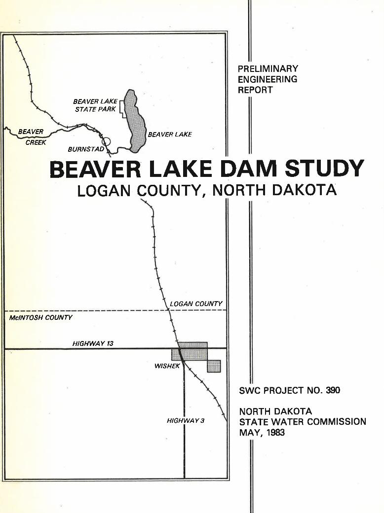
The Logan County l'fater Resource Board asked the State lllater Conmission
to study the feasibility of reconstructing the outlet of Beaver Lake.
(The study area is shown in Figure 1.) Appendix A contains a copy ofthe agreement. This prelininary engineering report contains the studyresults of the engineering analysis using a hydrologic study to evaluatethe watershed. Evaluation of the watershed and existing outlet providedinfornation for prelininary design and cost estimates for reconstruction.Flood frequency events of 10, 25, 50, and 100-year also were determined.Reconstructing the lakers outlet involves field surveys, hydrologicanalysis, evaluating existing conditions, prelininary reconstructiondesign and cost estimate.
FIGURE 1 - Study Area Location
II. STUDY AREA ¡]ESCRIPTIOT,I
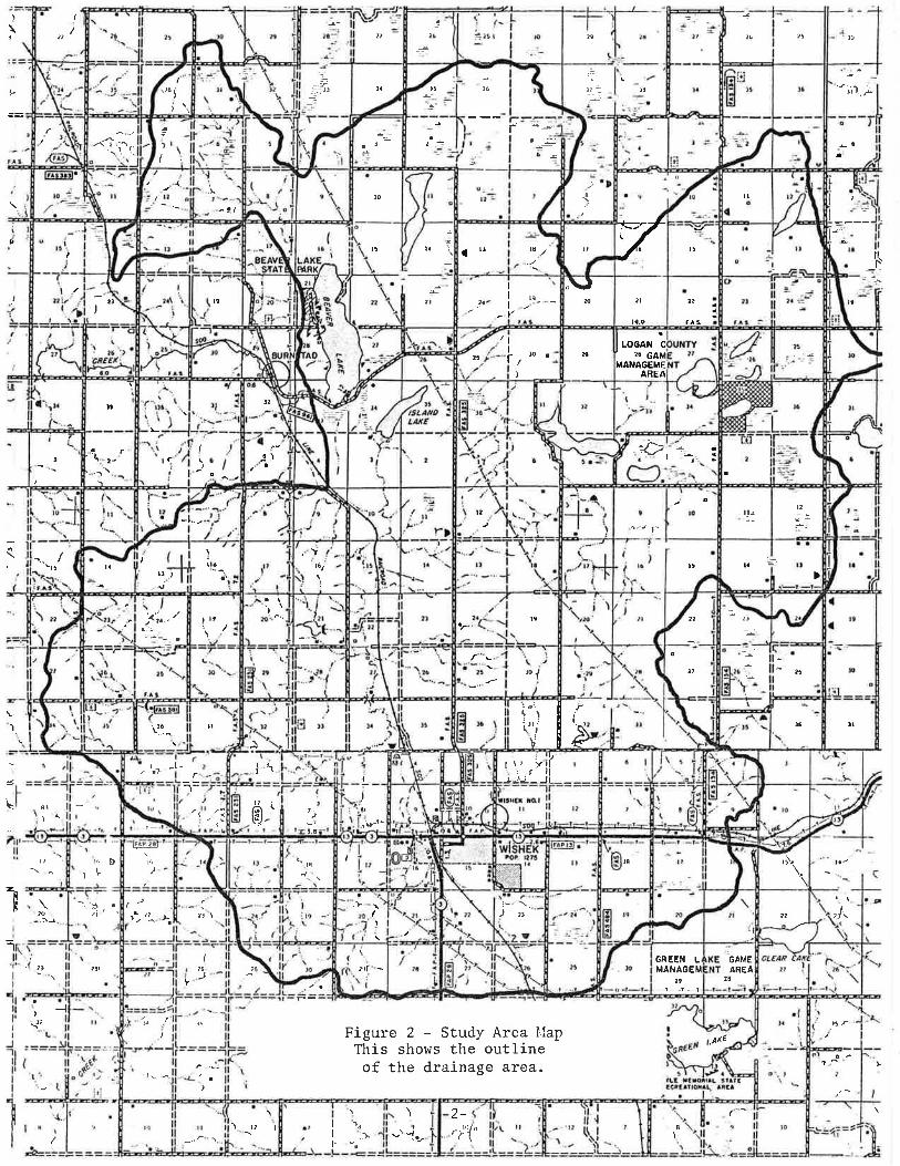
Beaver Lake I'fatershed is in Logan County with a southern portion inN{crntosh county (Figure 2). The nain inlet for Beaver Lake is in theNltldz of section 34, Township 134 North, Range 71 lrlest. The outlet is in
orvl0c rltr¡¡¡L¡utt3. U /gÌta 4.úAl,3!llgwllr
w^¡¡Íw¡¡¡t¡a
{1*(-wA¡D
r'ú Htlr¡YP¡DI''3
aDl¡oll
lfX,,rTATL
DDDY
lll tDtat¡l
toéTEn
wút',aL¡.0Rlooa
atatl
éAlttlultlt^Ù
l ßll3txrD0fr
-J aarra râ¡aÖrLoaa ¡.a xa¡l¡ll!?nrñrt
acr't¡ llcrv aâ¡a¡at
¡Ëurl
-1-
"Í^.^<.8(
-lII
.J ta
{I
,a\( t--
r8¿"' !'
L
f,_
o¿Y'
1( a,
.,È:
ót
\F
(
t';
I
/¡ 4'¡,,,.-.af-i ._ ¿1
\t¿
II
1¿¿a 9¿ 6¿
t. I! nr' rf
.r i\' !-: ¿\/ t!(;
I
9tça
J
ti-
'\. t.
:il
a,) ll
Ått
a¿(
6t w
ñ
OI
9l ,t
a¿ óTaz,lI
II
t¿
o'tt
.E
vfuv 3H:I9VNVvtl,\lVO e¿
c Nv901 I
.t9¿ J
II
(
.tr 6a
ta ¿a
(r-Q;
.Li¡ -2-\ \I
)
tt "Í¡ ¿t
tl (I
tt(tt
rì:
lgt
A
6lI
tt '-'
çt
J.ól.'"!'
tzoa ¡ a¿
a¿-._-
t¡
,\,lttÌ \ì
g 9t rt";J.
tT- ltr lt ^7'ì"T-¿r I- t*
tl
=L-
tì,, ,,
I \Tr
,-Q¡5
r8
(-t
, 8t ,ñ,
a¿(t r¿( '\- -i
- ,f¿
6¿
r,{39VNVn1 N33U9
\r¿t- -.. ta
8¿
vluv3WVo
'eêJB eSBurEJP aql Joeurrtrno etll s¡loqs sTqJ
dei¡ ee.ry fpnts - Z ernSrJ
f'9¿
)g¿
4
( ùt'
(
l.r\(, "k!'
I I
I
0(9¿
tt
the NE% of Section 33, Township 134 North, Range 71 lVest. The drainage
area is L79 square miles, with approximately 75 square miles being
noncontributing. Three slough areas in the l^Jatershed act like reservoirs,
which accounts for the majority of noncontributing drainage area. Their
capacity and outlet elevations prevents them from discharging. A fourth
area is on the upstrean side of the inlet to Beaver Lake. The inletacts as a reservoir with the inlet structure being the control fordischarges. The najor land use is pasture.
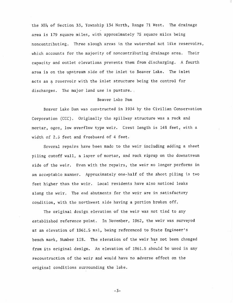
Beaver Lake Dan
Beaver Lake Dan was constructed in 1954 by the Civilian Conservation
Corporation (CCC). Originally the spillway structure was a rock and
mortar, ogee, Iow overflow type weir. Crest length is 148 feet, with a
width of 2.5 feet and freeboard of 4 feet.Several repairs have been made to the weir including adding a sheet
piling cutoff wall, a Iayer of mortar, and rock riprap on the downstream
side of the weir. Even with the repairs, the weir no longer performs in
an acceptable manner. Approximately one-half of the sheet piling is two
feet higher than the weir. Local residents have also noticed leaks
along the weir. The end abutments for the weir are in satisfactorycondition, with the northwest side having a portion broken off.
The original design elevation of the weir was not tied to any
established reference point. In November, 7962, the weir was surveyed
at an elevation of 1961.5 ns1, being referenced to State Engineerrs
bench mark, Number 118. The elevation of the weir has not been changed
from its original design. An elevation of 1961.5 should be used in any
reconstruction of the weir and would have no adverse effect on the
original conditions surrounding the lake.
-3-
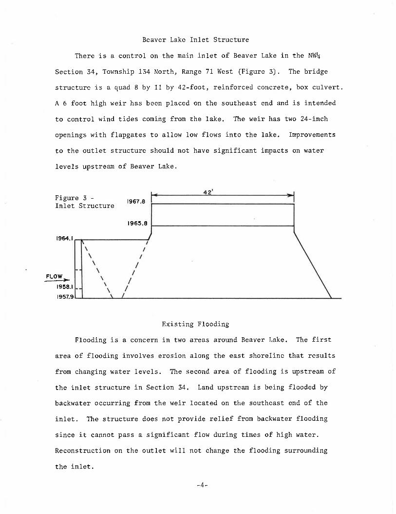
Beaver Lake Inlet Structure
There is a control on the main inlet of Beaver Lake in the NltI%
Section 34, Tolvnship 134 North, Range 71 West (Figure 3). The bridge
structure is a quad 8 by 11 by 42-foot, reinforced concrete, box culvert.A 6 foot high weir has been placed on the southeast end and is intended
to control rvind tides corning frorn the lake. The weir has two 24-inch
openings with flapgates to allow low flows into the lake. Improvements
to the outlet structure should not have significant impaets on water
leve1s upstream of Beaver Lake.
Figure 3 -Inlet Structure t967.8
t965.8
1964.t
FLOW t-r958.tr957.9
Existing Flooding
Flooding is a concern in thro areas around Beaver Lake. The firstarea of flooding involves erosion along the east shoreline that resultsfrom changing water 1eve1s. The second area of flooding is upstrearn ofthe inlet structure in Section 34, Land upstream is being flooded by
backwater occurring from the weir located on the southeast end of the
in1et. The structure does not provide relief fron backwater flooding
since it cannot pass a significant flow during times of high water.
Reconstruction on the outlet wilI not change the flooding surrounding
the in1et.
-4-
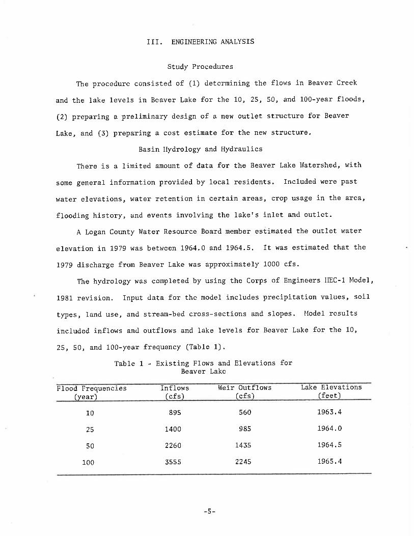
III. ENGINEERING ANALYSIS
Study Procedures
The procedure consisted of (1) determining the flows in Beaver Creek
and the lake 1evels in Beaver Lake for the 10,25,50, and L00-year floods,
(2) preparing a preliminary design of a new outlet structure for Beaver
Lake, and (3) preparing a cost estimate for the new structure.
Basin Hydrology and Hydraulics
There is a línited anount of data for the Beaver Lake l{atershed, with
some general infornation provided by loca1 residents. Included were past
water elevations, water retention in certain areas, crop usage in the area,
flooding history, and events involving the lakefs inlet and outlet.A Logan County ltJater Resource Board member estinated the outlet water
elevation in 1979 was between 1964.0 and 1964.5. It was estinated that the
1979 discharge from Beaver Lake was aPproxinately 1000 cfs.
The hydrology was completed by using the Corps of Engineers HEC-1 Model,
L981 revision. Input data for the nodel includes precipitation values, soiltypes, land use, and stream-bed cross-sections and slopes. l{ode1 results
included inflows and outflows and lake levels for Beaver Lake for the 10,
25, 50, and 100-year frequency (Table 1).
Table 1 - Existing Flows and Elevations forBeaver Lake
Flood Frequencies(year)
Inflows(cfs)
l{eir Outflowslcfs)
Lake Elevationslfeetl
10
25
50
89s
1400
2260
3555
560
985
145s
224s
7963.4
7964.0
1964.5
196s.4100
5
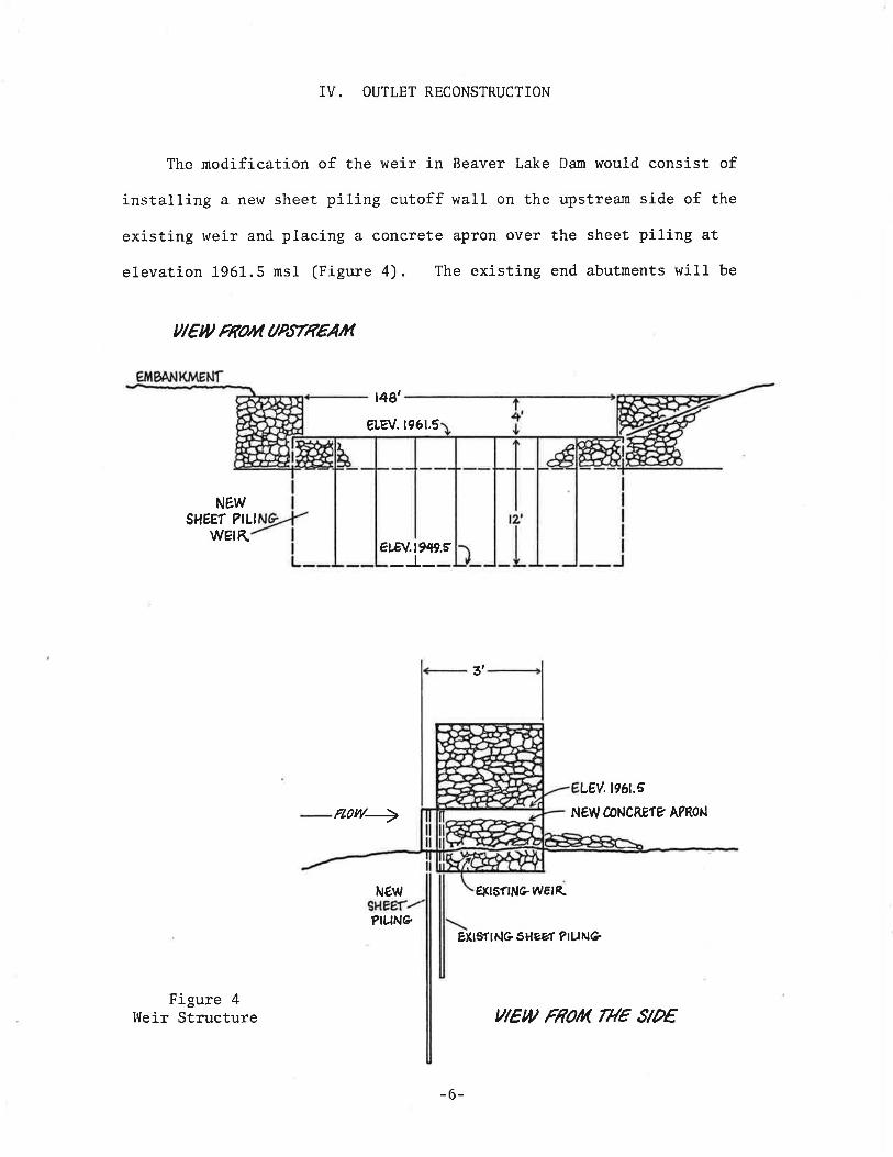
IV. OUTLET RECONSTRUCTION
Tlre nodification of the weir in Beaver Lake Dan would consist ofinstalling a new sheet piling cutoff wall on the upstream side of the
existing weir and placing a concrete apron over the sheet piling at
elevation 1961.5 ms1 (Figure 4). The existing end abutments will be
ul€w Flo/vt aP,tTRÊAtn
t4ø'
eLev.ß61.5
NEWSHÉEÍ ?!LI
wstK etEv.lw.r
3t
LEV. t96t.E
Ft?w+ NEW CONCREÍÉ A?RON
NÉW É.FrsflNeW€tR
PIUN@EXtSrlNeSHeV't ?tUNè
Figure 4llreir Structure
-6-
YlEU FNOA THE SlPê
used and the existing 148 foot width will not be changed.
A coffer dan will be constructed to prevent flows through the dan
during the repair period. It is proposed to bury the existing structure
in its present location as the existing piling is not reuseable. Ifproblems develop, the existing stlucture may have to be removed.
Cost estimates for the changes are shown in Table 2. The cost
estimate of $40,000, is based on the construction being conpleted by
State lVater Corunission personnel. New structure discharges and lake
leve1s for selected frequency floods are in Table 3. Water elevations
for the reconstructed outlet ufould be approximately 0.6 to 0.8 foot
lower than for existing conditions.
Table 2 - Estinated Reconstruction Costs(Force Account)
Materials
PSA 25 - LI2 pcs @ 12r = 47,260.80 #
Concrete - 20 cu. yds @ $75
Rebar - 2,000 1bs @ .55
Gunite - 15 yds @ $75
Mesh (2x2) - 750 square feet G $.30
Materials Total
$15, 000. 00
1, 500 . 00
700.00
1, 125 . 00
22s.00
$18,550. o0
$ 8,510.00
$ 3,500. 00
$ 9,ó40.00
$40, 0oo . oo
Labor
Four nen - 15 days 0 $554
Equipment
Contr act Administration. Continsencies, E Ensineerins
Total Estimated Cost
-7-

Table 3 - Discharge Flow andElevations for Reconstructed Weir
f, Iood Frequen(Year)
c]-es 0ut t Iow E 1 evat].onIfeet)(cfs)
10
25
50
100
680
1130
15 80
24s0
1962.8
1963.4
1963.8
7964.6
V. SUMMARY AND RECOMMENDATIONS
The preliminary engineering report contains the results of a feas-
ibility study for reconstructing Beaver Lake outlet. A new concrete
apron would be constructed along with a sheet piling cutoff wall. The
weir would be set at the current outlet elevation of 1961.5 ns1 and
current weir length of 148 feet. The Logan County lVater l{anagement
Board members recommended that the existing outlet elevation not be
changed.
The estinated cost of these inprovernents r{as estirnated at $40'000.
These costs assune that the construction would be by State ltlater Connission
field personnel and that the construction could be completed in 15 work
days. We recommend the Beaver Lake Outlet be reconstructed as described
in the report.
-8-

APPENDIX A
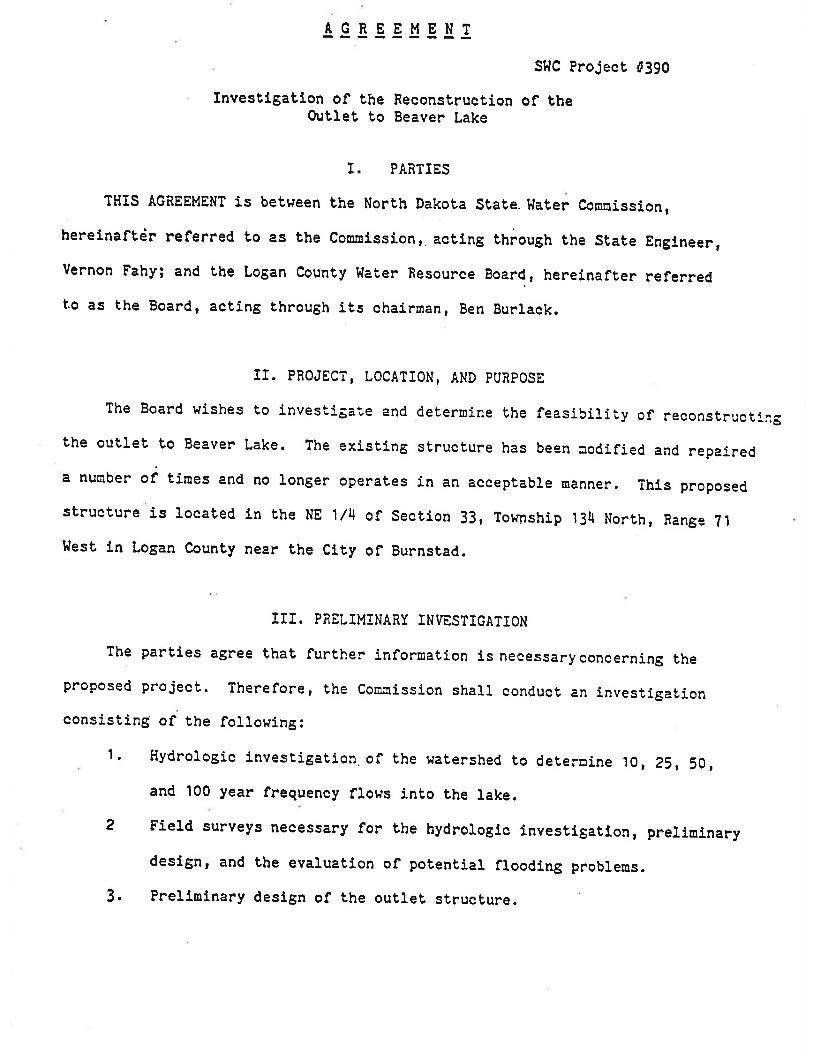
AGREEMENTSHC Project Í390
Invesffgatlon of Bhe Reconsbruction of tbeO.¡blet lo Beaver Lake
I PARTIES
THIS AGREEMENT is between the North Dakota State. Hater Conoission,hereinaftêr referred to as the Con¡ission,. acting through the State Engfneer,Vernon Fahy; and the Logan County l{afer Besource Board, hereinafter referredto as the Board, actÍng through its chairman, Ben gurraek.
II. PRoJECî, LoCATIoN, AND PURPOSE
The Board wishes to inves'"iga'"e and defer¡nine the feasibiliiy of reconstructirgthe outle! to Beaven Lake. The exis!Íng structure has beEn aodifj.ed and repaireda nunber oi tit"" and no longer operates in an aecepiable ¡nanner. ThÍs proposedsfructure Ís Loeated in the NE 1/4 of Section 33, Township 1JI North, Bange ?.t
Hest ln Logan Counfy near the Clty of Burnsbad.
III. PRELIMINARY INVESTIGATION
The parties agree that further Ínformation Ís necessary eoncerning theproposed project. Therefore, the Con¡fssion shall conduct an investigafionconsisting of the foLlowing:
'l . Hydrol.ogic lnvestigation. of the Hatershed lo defernine tO, Z1,', 50,and 100 year frequeney flows inLo the 1ake.
2 FieLd surveys necessary for the hydrologic lnvestigatlon, prelininarydeslgn, and the evaluabion of potential flooding pnoble¡os.
3. Prellninary deslgn of lhe oubleb structure.

ll . Prellnlnary foundaÈron and oaLerrars lnveslrgatlon at Éhe slte of
5
the control structure.A detailed cost esüluale of the proJect.A prelirninary engineering report.6
IV. DEPOSII-REFUND
the Board shar.r deposrü a tobal of $4,000 wrth the connission to pay forhalf the costs of the investigailon. Upon recelpt of a request froo the tsoardfo ùerninate proceeding further wffh lhe preliurinary lnvestlgation on upon abreach of thls agreement by any of the parties, the con¡nission shalr provideihe Board wfih a stateuent of all expenses incunred in the investigatlon andshall refund fo þhe Board any unexpended deposit funds.
V. RTG¡TTS OF ENTRT
the Board agrees to obtain written pernlssion fron any affectedrandowners for fÍeÌd lnvestigattons by
"he con¡nisslon which are requlred forthe prelfninary invesftgaÈlon.
VI. INDEMNIFICATION
The Board hereby accepts responsLbiri"y for and hoLds ihe coc¡issionharnless fron all elaÍns for danages Lo pubric on privaie property, rights onpe'rsons arising out of 'r'he projec! and. the Lraver to and fron the proJect siteby the Board or any of its subcontractors, agents or enployees. rn the eventsuch a suit ls lnitiated or Judgnent entered agalnst bhe conoisslon¡ lhe Boardwill lndennify the connÍssfon for any setllenent arrived at or judgrnentsaÈlsfied' No lnde¡onlficatlon wilr be required of the Board for cìaf¡osresulting frou neg!.fgent acts of the Con¡lssl.on.
-è-
l.TI. CIIANGES TO THE AGREE}.IENÎ
changes to. any conLraetual provlsions herein will not be effective orbindlng unless such ehanges are nade in wrltlng, slgned by both partÍes andaüt,ached herefo.
-tBURLACK l,E RNON FÂHTChaf r¡oan State Englneer
DAÎE:DATE ¡
)rr Iî YLWITNESS Iì
-3-