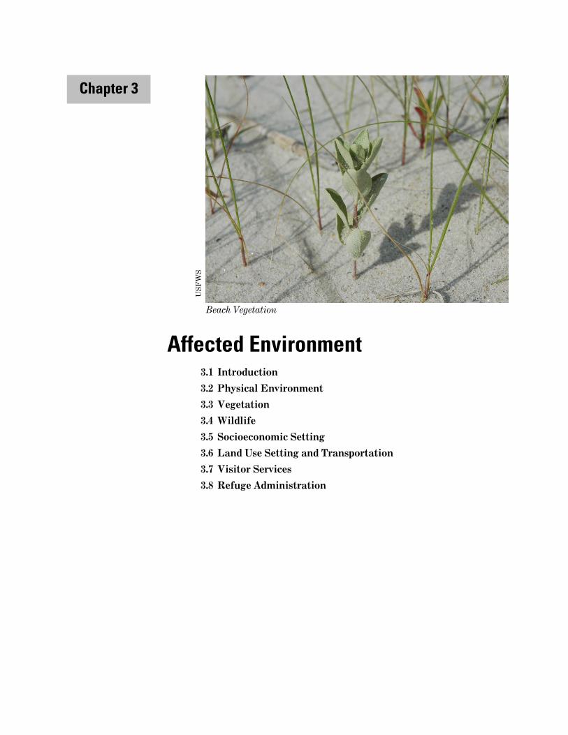
beach vegetation affected environment - u.s. fish … 3_chn draft ccpeis_part i.pdf · chapter 3...
TRANSCRIPT
Affected Environment 3.1 Introduction
3.2 Physical Environment
3.3 Vegetation
3.4 Wildlife
3.5 Socioeconomic Setting
3.6 Land Use Setting and Transportation
3.7 Visitor Services
3.8 Refuge Administration
Chapter 3
Beach Vegetation
USF
WS

Chapter 3 May 2014
Chincoteague and Wallops Island National Wildlife Refuges CCP/EIS
Chapter 3: Affected Environment ......................................................................................................................... 1
3.1 Introduction ................................................................................................................................................... 1
3.2 Physical Environment .................................................................................................................................. 1
3.2.1 Geology and Erosion ................................................................................................................................ 1
3.2.2 Soils ............................................................................................................................................................ 3
3.2.3 Air Quality ............................................................................................................................................... 10
3.2.4 Hydrology and Water Quality .............................................................................................................. 11
3.2.5 Climate Change and Sea Level Rise .................................................................................................... 15
3.3 Vegetation .................................................................................................................................................... 25
3.3.1 Assateague Island Unit ......................................................................................................................... 25
3.3.2 Southern Island Units ............................................................................................................................ 30
3.3.3 Wallops Island NWR ............................................................................................................................. 30
3.4 Wildlife .......................................................................................................................................................... 30
3.4.1 Federal and State Threatened and Endangered Species ................................................................. 31
3.4.2 Birds ......................................................................................................................................................... 35
3.4.3 Fish and Other Aquatic Species ........................................................................................................... 43
3.4.4 Mammals .................................................................................................................................................. 45
3.4.5 Reptiles and Amphibians ....................................................................................................................... 47
3.4.6 Invertebrates .......................................................................................................................................... 48
3.4.7 Invasive/Exotic Species of Concern ..................................................................................................... 50
3.5 Socioeconomic Setting ................................................................................................................................ 51
3.5.1 Socio-Demographic Characteristics ..................................................................................................... 51
3.5.2 Economic Characteristics of Chincoteague and Accomack County ................................................ 52
3.5.3 Refuge Recreation Visits and Economics ........................................................................................... 55
3.5.4 Environmental Justice ........................................................................................................................... 56
3.6 Land Use Setting and Transportation ..................................................................................................... 60
3.6.1 Land Use.................................................................................................................................................. 60
3.6.2 Transportation and Access .................................................................................................................... 66
3.7 Visitor Services ............................................................................................................................................ 75
3.7.1 Hunting .................................................................................................................................................... 75
3.7.2 Fishing ..................................................................................................................................................... 77
3.7.3 Environmental Education and Interpretation ................................................................................... 79
3.7.4 Wildlife Observation and Photography ............................................................................................... 79
3.7.5 Recreational Beach Use ........................................................................................................................ 80
3.7.6 Other Recreational Uses ....................................................................................................................... 81
3.8 Refuge Administration ............................................................................................................................... 84
3.8.1 Facilities and Maintenance ................................................................................................................... 84
3.8.2 Staffing ..................................................................................................................................................... 90

Chapter 3 May 2014
Chincoteague and Wallops Island National Wildlife Refuges CCP/EIS
3.8.3 Volunteer Programs ............................................................................................................................... 90
3.8.4 Management Units ................................................................................................................................. 91
3.8.5 Landscape Conservation Cooperatives ............................................................................................... 91
Chapter 3 May 2014
3-1 Chincoteague and Wallops Island National Wildlife Refuges CCP/EIS
Chapter 3: Affected Environment
3.1 Introduction This chapter describes the physical, biological, and socioeconomic environment of the refuge. The physical environment section includes the refuge’s geographic setting, its hydrogeomorphic features, soil information, and air and water quality. Biological resources are covered in sections on vegetation and wildlife that discuss how those resources have been influenced by human activity and management. For the refuge’s current sociological environment, we explain refuge socioeconomics, land use and transportation, and visitor services. Finally, at the end of the chapter we explain the cultural and historic resources on the refuge, as well as important aspects of refuge administration. The information in this chapter acts as a reference for chapter 4, which documents the Environmental Consequences of each alternative on these resources.
3.2 Physical Environment
3.2.1 Geology and Erosion
Geology Regionally, the Delmarva Peninsula lies in the Atlantic Coastal Plain physiographic province, a seaward sloping province bounded on the west by a fall line and the Chesapeake Bay, and on the east by the Atlantic Ocean. The peninsula extends about 200 miles in a north-south direction and includes the State of Delaware and the eastern shores of Maryland and Virginia. The surficial sediments of Assateague Island are discontinuous Holocene Series deposits (tidal marsh and barrier sands). The subsurface sediments of the Delmarva Peninsula form a wedge of unconsolidated sands, silts, and clays that is over 7,000 feet thick and ranges in age from Cretaceous to Tertiary. The subsurface sediments rest on a seaward sloping basement of Paleozoic crystalline rocks. The basement is folded and faulted into a series of northwest-southeast trending ridges and depressions.
The Delmarva Peninsula was formed about 14,000 to 18,000 years ago during the last glacial retreat, when rising sea levels filled the large valley of the lower Susquehanna River, which became the Chesapeake Bay, thus isolating the area from the mainland. Consequently, the Delmarva Peninsula coastline with its barrier islands has changed dramatically since the retreat of the last glacial ice sheets and the melting of the polar icecaps. Sea level has risen more than 300 feet and the shoreline has shifted approximately 50 miles to the west. In general, the continued sea level rise will result in the submerging of the continental shelf and shifting barrier islands landward and upward.
However, the processes of barrier island and marsh-lagoonal system formation, and the migration of barrier islands along the eastern side of the Delmarva Peninsula (formed over several thousand years by broad sea level fluctuations) are not completely understood. One hypothesis is that as the sea level rose along the coastline, beaches retreated. Ridges of beach dunes originally formed by wind-blown sands were breached by storm waves from the rising water. The lowlands between the ridges and the coast were flooded and the ridges became barrier islands.
Assateague Island is a sand barrier resting on soft lagoonal mud that contains oyster, clam, and snail shells. The lagoonal mud overlies organic coastal salt marsh mud, and peat, which, in turn, overlies organic debris-rich sandy mud (USACE 1994). The sand and mud surface of Assateague
Chapter 3 May 2014
3-2 Chincoteague and Wallops Island National Wildlife Refuges CCP/EIS
Island is underlain by 4,500 to 7,500 feet of discontinuous layers of sand, gravel, and clay that have accumulated during 135 million years of continental erosion and coastal action. Cretaceous Cenozoic and Mesozoic sands, silts, and clays account for more than half of the thickness of subsurface sediments (USDA 1994).
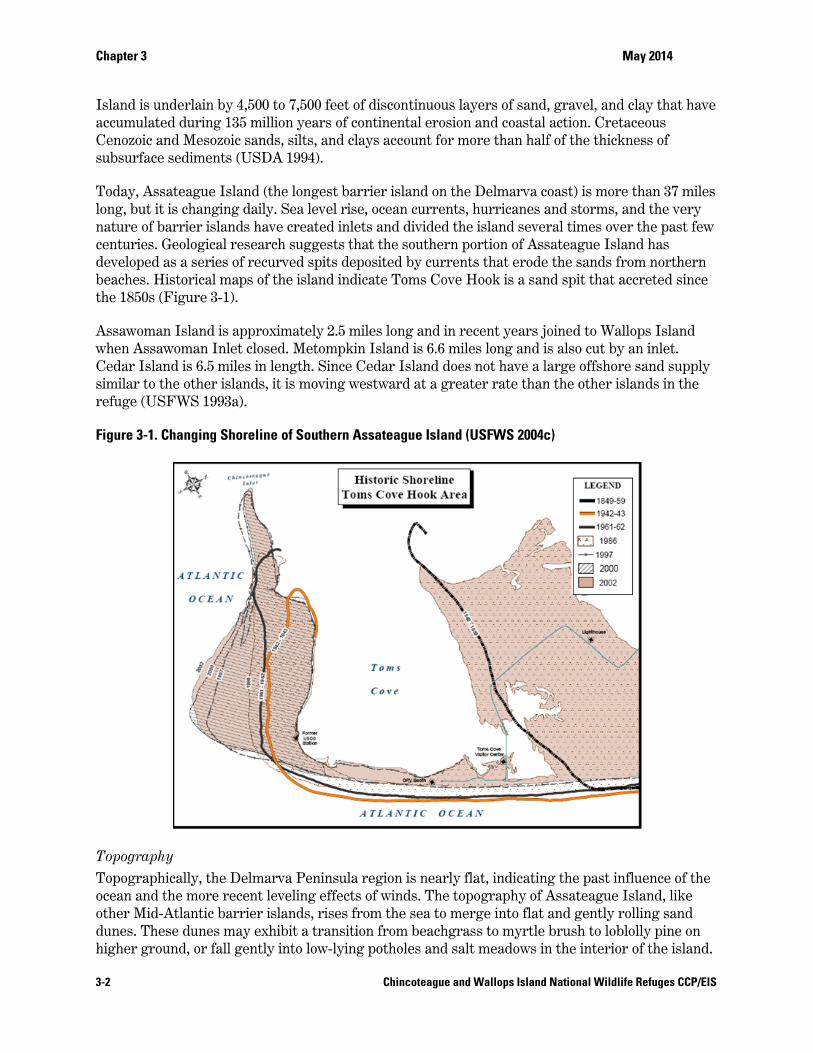
Today, Assateague Island (the longest barrier island on the Delmarva coast) is more than 37 miles long, but it is changing daily. Sea level rise, ocean currents, hurricanes and storms, and the very nature of barrier islands have created inlets and divided the island several times over the past few centuries. Geological research suggests that the southern portion of Assateague Island has developed as a series of recurved spits deposited by currents that erode the sands from northern beaches. Historical maps of the island indicate Toms Cove Hook is a sand spit that accreted since the 1850s (Figure 3-1).
Assawoman Island is approximately 2.5 miles long and in recent years joined to Wallops Island when Assawoman Inlet closed. Metompkin Island is 6.6 miles long and is also cut by an inlet. Cedar Island is 6.5 miles in length. Since Cedar Island does not have a large offshore sand supply similar to the other islands, it is moving westward at a greater rate than the other islands in the refuge (USFWS 1993a).
Figure 3-1. Changing Shoreline of Southern Assateague Island (USFWS 2004c)
Topography Topographically, the Delmarva Peninsula region is nearly flat, indicating the past influence of the ocean and the more recent leveling effects of winds. The topography of Assateague Island, like other Mid-Atlantic barrier islands, rises from the sea to merge into flat and gently rolling sand dunes. These dunes may exhibit a transition from beachgrass to myrtle brush to loblolly pine on higher ground, or fall gently into low-lying potholes and salt meadows in the interior of the island.
Chapter 3 May 2014
3-3 Chincoteague and Wallops Island National Wildlife Refuges CCP/EIS
Island elevations range from sea level to approximately 14 meters mean sea level (MSL) (about 46 feet) with the bay side of the island mostly timbered with pines and bordered by salt marsh and salt meadows.
Accretion and Erosion—Wind and Wave Effects on Barrier Islands Due to the natural phenomenon of barrier island systems, Assateague Island is changing. The Maryland Geological Survey estimates that the eastern shore of Assateague Island is eroding at a rate of about 1.5 feet each year. Barrier islands are coastal features composed of sand and other loose sediments transported by waves, currents, storm surges, and winds. They are formed by sediments eroded from glacial deposits, or from ocean bottom sediments and/or coastal plain materials. For every 1-foot rise in sea level, it has been estimated that coastal barrier islands move 100 to 1,000 feet inland. When more sand is deposited than removed, the beach is said to be accreting. When longshore transport results in a net loss of sand, it is eroding. Erosion and accretion rates differ from island to island, as a result of differing sand supplies, prevailing winds, and wave energies; this, coupled with sea level rise, leads to an ever-changing landscape throughout the Virginia Barrier Islands (USFWS 1988).
The near shore zone is an area of wave turbulence and littoral drift where constant ocean currents and wave action create sand bars and shallow troughs that are exposed at low tide. Long shore currents move from north to south, transporting sands to Toms Cove Hook, where they accrete on bars and flats. Accreting spits, like Toms Cove Hook, are often sites for beach ridge development. Long shore currents and waves build new platforms of sand (i.e., beach), and organic debris accumulates on the beach crests. As sands continue to build, plants grow from buried drift lines, accumulating more sand in curved ridges corresponding to the original drift line position. Continued shoreline accretion builds more curvilinear ridges. The resulting spit displays a system of ridges with upland vegetation; between them, low interdunal areas support wetland species.
The beach is the transition area between marine and upland environments. By definition, barrier islands protect other features, such as lagoons and salt marshes, from direct ocean wave attack. Assateague Island protects Chincoteague Bay from the forces of the open sea, providing quiet waters where sands and silts settle out and accumulate. Inlet currents and wave action along the shore push these sediments into calmer areas where they eventually build up into the intertidal zone as sand and mudflats. The intertidal foreshore is flooded and exposed by daily tides; the backshore, separated from the foreshore by a berm, or terrace, is subject to storm waves. Broken rhizomes and beach plant seeds, along with other organic debris, accumulate in drift lines along the backshore. Windblown sands are caught in this debris and build up around sprouting plants. Capable of surviving sand burial, beach grasses grow with the accumulating sand, providing a relatively stable substrate and facilitating dune development. Erosion by storm action or other interference often precludes this process.
3.2.2 Soils Soils directly influence habitat by shaping the kind and amount of vegetation and the amount of water available. In this way, they indirectly influence the kind of wildlife that can live in an area. Soils are organized into a taxonomic classification system by the USDA, Natural Resources Conservation Service, in which each soil is categorized by order, suborder, great group, subgroup, family, and soil series. Nationwide, there are 12 soil orders. Entisols are the dominant soil order on the refuge. Entisols are soils defined by the absence or near absence of horizons (layers) that clearly reflect soil-forming processes. The soils of the refuge consist of sand, silty loams, and shell
Chapter 3 May 2014
3-4 Chincoteague and Wallops Island National Wildlife Refuges CCP/EIS
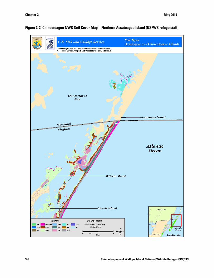
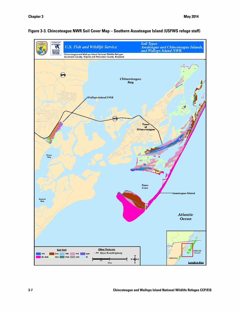
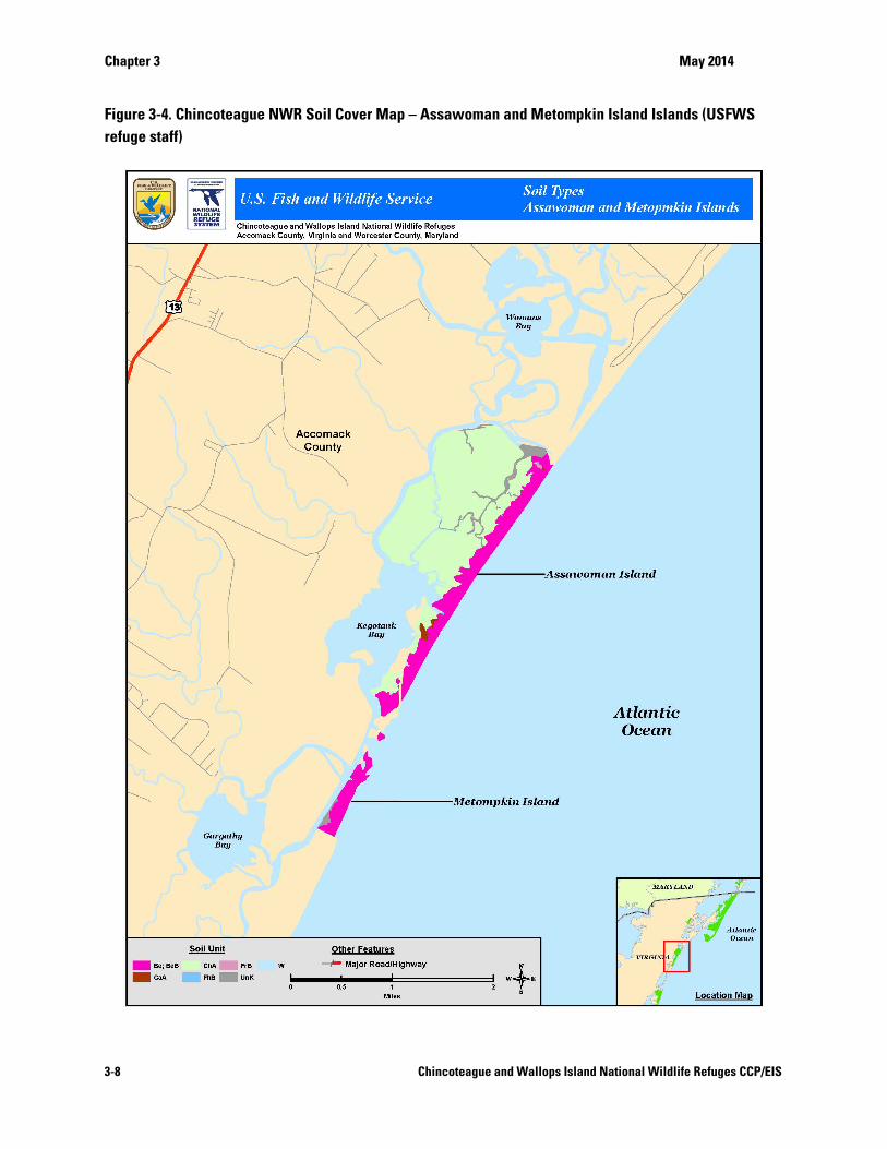
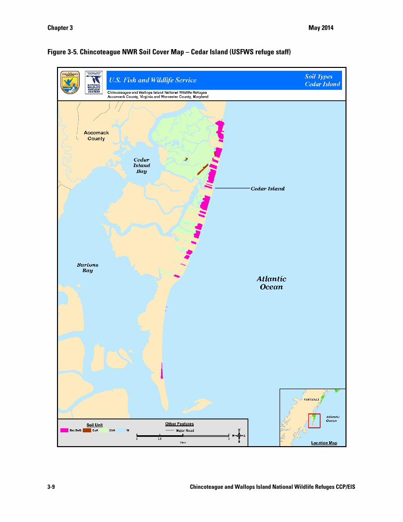
fragments, with sands found primarily on upland areas and silty loams found on tidal marshes and other wetlands. The soils of the refuge are a mixture of several Entisol soil series, all of which have a thermic soil temperature regime and mixed mineralogy as shown in Table 3-1, Figure 3-2, Figure 3-3, Figure 3-4, and Figure 3-5. Chincoteague NWR Soil Cover Map – Cedar Island (USFWS refuge staff). Chincoteague silt loam (0-1 percent slope), Assateague fine sand (2-35 percent slope), Camocca fine sand (0-2 percent slope), Fisherman fine sand (0-6 percent slope), Beach sand (1-5 percent slope), and other Entisol soils that occur within Udorthents and Udipsamments great group soils (see below) are the dominant soils found on the refuge. All of these soils are mixed and intermingled in many locations on the islands. Other associated soil complexes recognized by the soil scientists include Fisherman-Camocca (0-6 percent slope) and Fisherman-Assateague (0-35 percent slope) (USFWS 1992a).
Details for the dominant soil series are:
Soils of the Chincoteague silt loam series are nonacid Typic Sulfaquents (great group) that are very deep and very poorly drained. They are formed in loamy sediments and are found throughout the refuge impoundments and in salt marshes primarily between the barrier islands and the seaside mainland as well as some barrier tidal flats. Soil permeability is moderately slow and they are very poorly drained with slow runoff, and saturated with salt water. These soils provide habitat for wetland wildlife and spawning grounds for shellfish and fin-fish species. Common plant life consists of cordgrasses, glasswort, and saltgrass. Cultivated crops, nursery stock, pasture grasses and legumes, and loblolly pines are all unsuitable on this soil because of flooding by salt water, wetness, excess salt, and ponding. Construction is similarly unsuitable with additional limitations of low strength and potential groundwater pollution.
Soils of the Assateague fine sand series are primarily quartz (and other heavy minerals) within Typic Udipsammments (great group). They are very deep and excessively drained with very rapid permeability and are formed in sandy sediments. Assateague soils are found on undulating to steep sand dunes associated with beaches and salt marshes throughout Assateague Island. Assateague fine sand areas are rarely flooded. These soils provide habitat for wildlife and recreation. Common plant life consists of wax myrtle, bayberry, loblolly pine, and beach grasses. Potential for loblolly pine productivity on this soil is moderately high, although some areas support only salt-tolerant shrubs because of salt spray. Seedling survival is limited by moisture stress (very low water storage capacity). Cultivated crops, pasture grasses, and legumes are all unsuited to this soil. Flooding by salt water, low availability of fresh water, and erosion by water (slight) and wind (severe) are limitations.
Soils of the Camocca fine sand series are Typic Psammaquents (great group) with a mixed mineralogy. Camocca soils are very deep, poorly drained and rapidly permeable. They are formed in sandy sediments and are found in shallow depressions (concave surface) between coastal dunes and on nearly level flats between dunes and marshes. Salt water flooding is common and the soil is periodically inundated by storm tides. The soil provides habitat for wildlife and a foundation for recreation. Common plant life consists of waxmyrtle, cordgrass, and greenbrier shrub community. Some areas support sparse stands of native pines and hardwoods where salt water flooding is less frequent.
Chapter 3 May 2014
3-5 Chincoteague and Wallops Island National Wildlife Refuges CCP/EIS
Soils of the Fisherman fine sand series are Aquic Udipsamments with a mixed mineralogy. Fisherman soils are very deep, moderately well drained, have very rapid permeability, and are formed in sandy sediments. They are found on nearly level and gently sloping areas and in depressions of undulating areas (back dunes) associated with dunes and salt marshes on Assateague and Chincoteague Islands. Depth to the water table is usually only 18-36 inches. The soil provides habitat for wildlife and a foundation for recreation. The natural plants are commonly cordgrasses, saltgrasses, and wax myrtle.
Beach soils are found along a thin strip on the seaward side of the island. These are regularly flooded and generally characterized by poor drainage and are subject to wave, wind, and tidal action. This nearly level to moderately sloping soil unit consists of sandy sediments deposited by wave action. It is used primarily for recreation and for wildlife habitat. Most other uses are limited by flooding with salt water, severe erosion, and accretion of sediments.
Other sulfaquent soils are found in association with tidal marshes located behind the beaches on all three southern islands (Cedar, Metompkin and Assawoman). They have high sulfur content, drain poorly, and subject to tidal flooding, excessive settlement, and salinity (USFWS 1988).
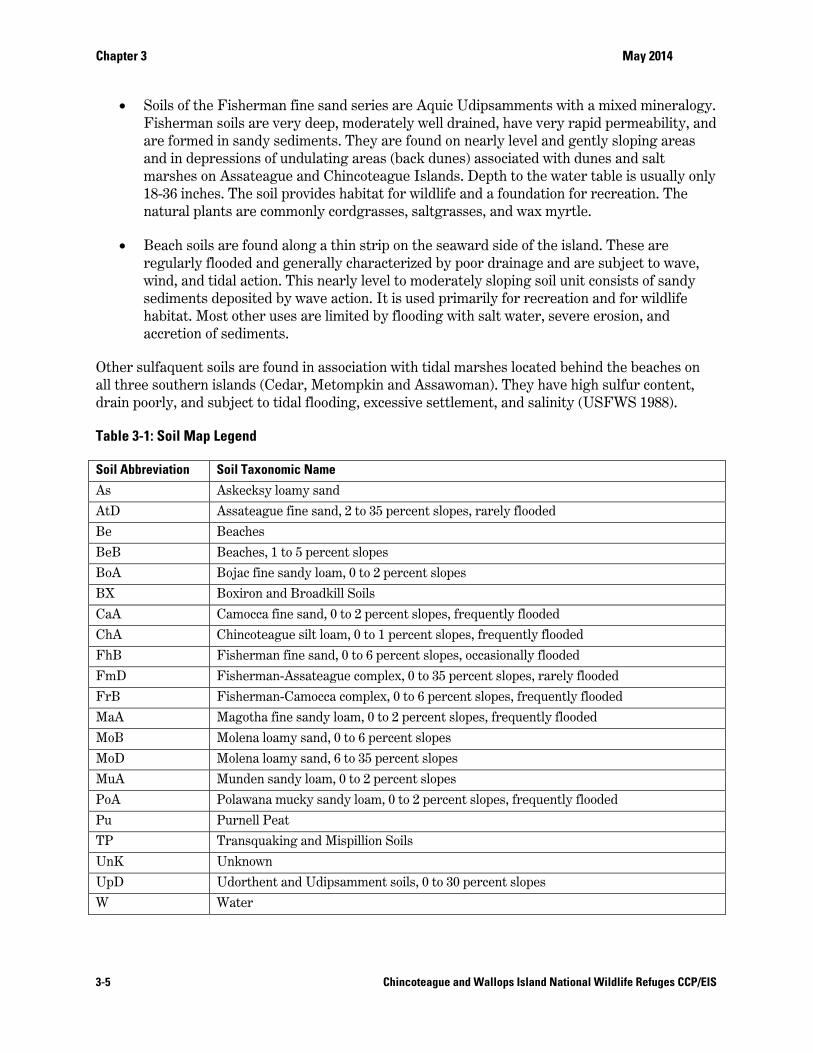
Table 3-1: Soil Map Legend
Soil Abbreviation Soil Taxonomic Name
As Askecksy loamy sand
AtD Assateague fine sand, 2 to 35 percent slopes, rarely flooded
Be Beaches
BeB Beaches, 1 to 5 percent slopes
BoA Bojac fine sandy loam, 0 to 2 percent slopes
BX Boxiron and Broadkill Soils
CaA Camocca fine sand, 0 to 2 percent slopes, frequently flooded
ChA Chincoteague silt loam, 0 to 1 percent slopes, frequently flooded
FhB Fisherman fine sand, 0 to 6 percent slopes, occasionally flooded
FmD Fisherman-Assateague complex, 0 to 35 percent slopes, rarely flooded
FrB Fisherman-Camocca complex, 0 to 6 percent slopes, frequently flooded
MaA Magotha fine sandy loam, 0 to 2 percent slopes, frequently flooded
MoB Molena loamy sand, 0 to 6 percent slopes
MoD Molena loamy sand, 6 to 35 percent slopes
MuA Munden sandy loam, 0 to 2 percent slopes
PoA Polawana mucky sandy loam, 0 to 2 percent slopes, frequently flooded
Pu Purnell Peat
TP Transquaking and Mispillion Soils
UnK Unknown
UpD Udorthent and Udipsamment soils, 0 to 30 percent slopes
W Water
Chapter 3 May 2014
3-6 Chincoteague and Wallops Island National Wildlife Refuges CCP/EIS
Figure 3-2. Chincoteague NWR Soil Cover Map – Northern Assateague Island (USFWS refuge staff)
Chapter 3 May 2014
3-7 Chincoteague and Wallops Island National Wildlife Refuges CCP/EIS
Figure 3-3. Chincoteague NWR Soil Cover Map – Southern Assateague Island (USFWS refuge staff)
Chapter 3 May 2014
3-8 Chincoteague and Wallops Island National Wildlife Refuges CCP/EIS
Figure 3-4. Chincoteague NWR Soil Cover Map – Assawoman and Metompkin Island Islands (USFWS refuge staff)
Chapter 3 May 2014
3-9 Chincoteague and Wallops Island National Wildlife Refuges CCP/EIS
Figure 3-5. Chincoteague NWR Soil Cover Map – Cedar Island (USFWS refuge staff)

Chapter 3 May 2014
3-10 Chincoteague and Wallops Island National Wildlife Refuges CCP/EIS
3.2.3 Air Quality Air quality in the area of the refuge is influenced both by local sources of pollutants, such as ammonia from agricultural operations, and by industrial and automobile emissions occurring hundreds of miles away.
Since 2000, a National Atmospheric Deposition Program monitoring station (NADP-MD18) that is located on Assateague Island, adjacent to Assateague State Park in Worchester County, Maryland, has been monitoring atmospheric (wet) deposition of nitrogen, a major source of the nutrient load affecting the coastal bays adjacent to Assateague Island. The NADP station collects rainwater samples weekly and measures them for nitrogen compounds. Atmospheric deposition makes up more than 30 percent of the overall nitrogen load to the bays. Other air pollutants such as mercury seem to be less problematic as recurring surveys of aquatic sediments have failed to detect heavy metals at levels of concern. Recent ozone monitoring data from 2004 to present indicate that the area does experience periodic high levels during the summer months, but that local meteorological conditions serve to moderate the potential threat (National Parks Conservation Association 2007).
The Clean Air Act (CAA) of 1970 (as amended in 1990 and 1997) requires the U.S. Environmental Protection Agency (EPA) to implement air quality standards to protect the nation's health and welfare. National Ambient Air Quality Standards (NAAQS) were set for six pollutants commonly found throughout the United States: lead, ozone, nitrogen oxides (NOx), carbon monoxide (CO), sulfur dioxide (SO2), and particulate matter less than 1.0 and 2.5 microns in diameter (PM10 and PM2.5).
Regionally, the states of Virginia, Maryland, and Delaware all maintain and operate air quality programs that satisfy the CAA monitoring requirements to assess compliance with the NAAQS. The Office of Air Quality Monitoring in Virginia's Department of Environmental Quality measures ambient air quality at approximately 45 locations throughout the Commonwealth (Virginia Department of Environmental Quality 2007). Maryland's Air Quality Monitoring Program in the Air and Radiation Management Administration, Department of the Environment, conducts ambient air monitoring at 26 sites (Maryland Department of the Environment 2006). The Air Quality Management Section of Delaware's Division of Air and Waste Management, Department of Natural Resources and Environmental Control, maintains an ambient air monitoring network consisting of 11 sites (Delaware Department of Natural Resources 2006 and 2008). Although these monitoring sites are located throughout the region, most of the sites are concentrated in the urban/industrial areas, which have the highest population and largest number of pollutant sources. Areas that meet the NAAQS are designated “attainment areas,” while areas not meeting the standards are termed “non-attainment” areas.
On a regional basis (including the refuge), NAAQS for ambient concentrations of lead, carbon monoxide, nitrogen dioxide, and sulfur dioxide are in attainment; and long-term trends indicate that concentrations of the criteria pollutants have either been level or declining.
EPA's Air Quality Index (AQI) is a summary index for reporting daily air quality. It tells how clean or polluted the air is, and what associated health effects might be of concern. The AQI focuses on health effects that humans may have experienced within a few hours or days after breathing polluted air. EPA calculates the AQI for five major air pollutants regulated by the CAA: ground-level ozone, particle pollution (also known as particulate matter), carbon monoxide, sulfur dioxide, and nitrogen dioxide. Because all areas of the United States are currently attaining the
Chapter 3 May 2014
3-11 Chincoteague and Wallops Island National Wildlife Refuges CCP/EIS
NAAQS for lead, the AQI does not specifically address lead. For each of these pollutants, EPA has established national air quality standards to protect public health. The higher the AQI value is, the greater the level of air pollution, and the greater the health concern. For example, an AQI value of 50 represents good air quality with little potential to affect public health, while an AQI value over 300 represents hazardous air quality. An AQI value of 100 generally corresponds to the national air quality standard for the pollutant, which is the level EPA has set to protect public health. AQI values below 100 are generally thought of as satisfactory. When AQI values are above 100, air quality is considered to be unhealthy at first for certain sensitive groups of people, then for everyone as AQI values get higher (EPA 2011).
More than 80 air quality monitoring sites are located within 100 miles of the refuge. However, the two closest sites, and thereby those two sites assumed to be most representative of the air quality of Assateague Island, are located in Sussex County on the Delaware Eastern Shore, about 70 air miles north of the refuges. They are Lewes (site # 10-005-1003), a coastal site, and Seaford (site #10-005-1002), a suburban site. Calculated AQI values, based on data collected in 2006 and 2007 at these two sites, showed that the air quality in Sussex County (representative of the air quality on the refuge) had good air quality 67 to 70 percent of the time; moderate air quality 26 to 27 percent of the time, and unhealthy/sensitive air quality 4 to 6 percent of the time. The single pollutant responsible for the highest index value is referred to as the “Main Pollutant.” The Main Pollutant was ozone (74 to 75 percent of the time) and particulate matter less than 2.5 microns (25 to 26 percent of the time). High AQI values due to ozone and small particulate matter are often associated with bright summer days and periods of hot, stagnant, summertime air, favoring the formation of ozone and condensation nuclei (EPA 2009).
3.2.4 Hydrology and Water Quality
Hydrology No natural freshwater streams or lakes exist on the refuge. Rainfall and tidal overwash are the only sources of surface water on Assateague Island. Overwash is the process that causes the transportation and deposition of water and sediment over the beach crest. The man-made moist-soil units (impoundments) are slightly brackish to highly saline because of tidal overwash, salt spray, and the accumulation of salt residue as water evaporates. These same environmental factors also render the shallow groundwater beneath the islands brackish. Evaporation and transpiration account for major surface water depletion during the summer months. The drinking water supply for Chincoteague Island and the refuge comes via pipeline from three deep wells and a shallow well field near the NASA base on the mainland. On Cedar Island, there are approximately a dozen wells, and none currently exist on either Metompkin or Assawoman Islands (USFWS 1988). Large bodies of water bordering the island are the Atlantic Ocean (to the east) and Chincoteague Bay and Assateague Channel (to the west) (USFWS 2007b).
Assateague Island protects Chincoteague Bay from the strong wave activity of the open ocean, which allows for the accumulation of sands and silts that can eventually build up into mud flats. Algal mats, salt marsh cord grass, and mollusk colonies help stabilize the flats. This low salt marsh zone is flooded by tides twice daily. Tides and tidal currents in the inshore waters of Chincoteague Bay are controlled by the inlets at either end of Assateague Island. Ocean City inlet to the north and Chincoteague inlet to the south have mean tidal ranges of 3.4 to 3.8 feet, but near the midpoint between the two inlets in Chincoteague Bay, the tidal range is only about 0.4 feet. Through the
Chapter 3 May 2014
3-12 Chincoteague and Wallops Island National Wildlife Refuges CCP/EIS
tides, approximately 7 percent of the water in the bays is renewed each day (USACE 1994, USFWS 1992a).
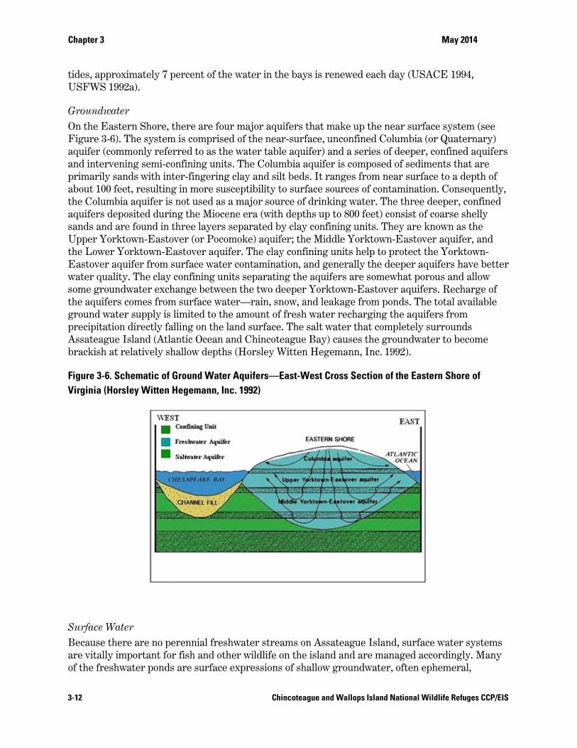
Groundwater On the Eastern Shore, there are four major aquifers that make up the near surface system (see Figure 3-6). The system is comprised of the near-surface, unconfined Columbia (or Quaternary) aquifer (commonly referred to as the water table aquifer) and a series of deeper, confined aquifers and intervening semi-confining units. The Columbia aquifer is composed of sediments that are primarily sands with inter-fingering clay and silt beds. It ranges from near surface to a depth of about 100 feet, resulting in more susceptibility to surface sources of contamination. Consequently, the Columbia aquifer is not used as a major source of drinking water. The three deeper, confined aquifers deposited during the Miocene era (with depths up to 800 feet) consist of coarse shelly sands and are found in three layers separated by clay confining units. They are known as the Upper Yorktown-Eastover (or Pocomoke) aquifer; the Middle Yorktown-Eastover aquifer, and the Lower Yorktown-Eastover aquifer. The clay confining units help to protect the Yorktown-Eastover aquifer from surface water contamination, and generally the deeper aquifers have better water quality. The clay confining units separating the aquifers are somewhat porous and allow some groundwater exchange between the two deeper Yorktown-Eastover aquifers. Recharge of the aquifers comes from surface water—rain, snow, and leakage from ponds. The total available ground water supply is limited to the amount of fresh water recharging the aquifers from precipitation directly falling on the land surface. The salt water that completely surrounds Assateague Island (Atlantic Ocean and Chincoteague Bay) causes the groundwater to become brackish at relatively shallow depths (Horsley Witten Hegemann, Inc. 1992).
Figure 3-6. Schematic of Ground Water Aquifers—East-West Cross Section of the Eastern Shore of Virginia (Horsley Witten Hegemann, Inc. 1992)
Surface Water Because there are no perennial freshwater streams on Assateague Island, surface water systems are vitally important for fish and other wildlife on the island and are managed accordingly. Many of the freshwater ponds are surface expressions of shallow groundwater, often ephemeral,
Chapter 3 May 2014
3-13 Chincoteague and Wallops Island National Wildlife Refuges CCP/EIS
forming during the wet winter months and drying during the summer. Surface waters consist of bays, lagoons, and ponds. The numerous bays and inlets formed by the barrier island serve as a mixing zone for sea water that flows from the east and for the less saline waters from mainland creeks and streams. Due to the lack of a significant freshwater inflow, these back bays are not considered to be estuaries in the classical sense. Nonetheless, they are extremely important as finfish and shellfish areas, providing important nursery habitat for a rich variety of fish (USFWS 1988).
Freshwater wetlands on Chincoteague NWR occur at natural low points in the dunes or flats, or, impounded areas. On Toms Cove Hook, low areas between the beach ridges and dunes collect rainwater and support wetland vegetation. A few other small natural freshwater marshes occur behind the dunes of the northern beach. The refuge's impoundments are located between mean high and spring high tide and abut upland areas as well as fresh or brackish marshes not affected by tides (USFWS 1992a).
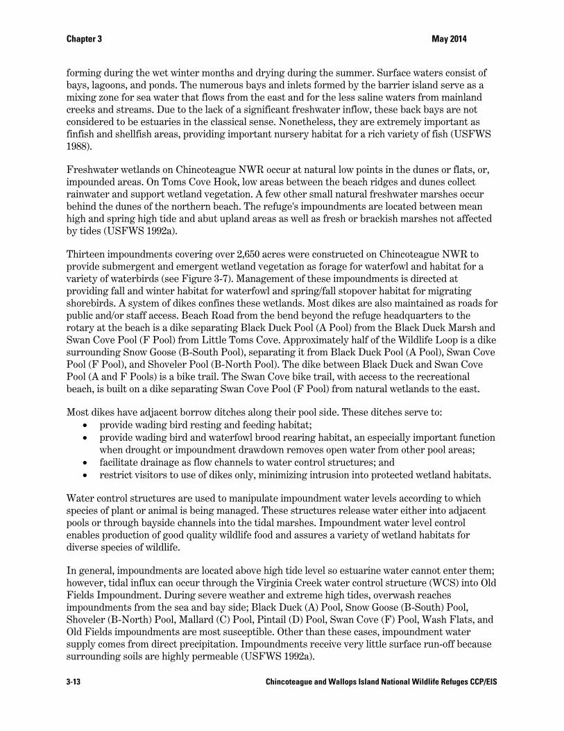
Thirteen impoundments covering over 2,650 acres were constructed on Chincoteague NWR to provide submergent and emergent wetland vegetation as forage for waterfowl and habitat for a variety of waterbirds (see Figure 3-7). Management of these impoundments is directed at providing fall and winter habitat for waterfowl and spring/fall stopover habitat for migrating shorebirds. A system of dikes confines these wetlands. Most dikes are also maintained as roads for public and/or staff access. Beach Road from the bend beyond the refuge headquarters to the rotary at the beach is a dike separating Black Duck Pool (A Pool) from the Black Duck Marsh and Swan Cove Pool (F Pool) from Little Toms Cove. Approximately half of the Wildlife Loop is a dike surrounding Snow Goose (B-South Pool), separating it from Black Duck Pool (A Pool), Swan Cove Pool (F Pool), and Shoveler Pool (B-North Pool). The dike between Black Duck and Swan Cove Pool (A and F Pools) is a bike trail. The Swan Cove bike trail, with access to the recreational beach, is built on a dike separating Swan Cove Pool (F Pool) from natural wetlands to the east.
Most dikes have adjacent borrow ditches along their pool side. These ditches serve to: provide wading bird resting and feeding habitat; provide wading bird and waterfowl brood rearing habitat, an especially important function
when drought or impoundment drawdown removes open water from other pool areas; facilitate drainage as flow channels to water control structures; and restrict visitors to use of dikes only, minimizing intrusion into protected wetland habitats.
Water control structures are used to manipulate impoundment water levels according to which species of plant or animal is being managed. These structures release water either into adjacent pools or through bayside channels into the tidal marshes. Impoundment water level control enables production of good quality wildlife food and assures a variety of wetland habitats for diverse species of wildlife.
In general, impoundments are located above high tide level so estuarine water cannot enter them; however, tidal influx can occur through the Virginia Creek water control structure (WCS) into Old Fields Impoundment. During severe weather and extreme high tides, overwash reaches impoundments from the sea and bay side; Black Duck (A) Pool, Snow Goose (B-South) Pool, Shoveler (B-North) Pool, Mallard (C) Pool, Pintail (D) Pool, Swan Cove (F) Pool, Wash Flats, and Old Fields impoundments are most susceptible. Other than these cases, impoundment water supply comes from direct precipitation. Impoundments receive very little surface run-off because surrounding soils are highly permeable (USFWS 1992a).
Chapter 3 May 2014
3-14 Chincoteague and Wallops Island National Wildlife Refuges CCP/EIS
Figure 3-7. Refuge Impoundments – Chincoteague NWR (USFWS refuge staff)

Chapter 3 May 2014
3-15 Chincoteague and Wallops Island National Wildlife Refuges CCP/EIS
Water Quality Concerns Dissolved ammonia and nitrates are the dominant nutrients in ground water in the area. Submarine discharges from the shallow groundwater aquifer into the estuarine system have been found to carry nutrient and contaminant loads. Chincoteague Bay (and Sinepuxent Bay) suffers from an influx of excess nutrients, primarily nitrogen and phosphorus. As much as one-half of the excess nutrients are believed to come from agricultural sources such as chemical fertilizers and manure generated by intensive chicken production facilities on the mainland. Atmospheric nitrogen, primarily from coal-fired power plants and motor vehicles, is also a significant source (~ 30 percent) of nutrient deposition into Chincoteague Bay surface waters. These nutrients promote the growth of algae blooms that deplete dissolved oxygen levels in the water when the algae die and decompose, resulting in fish die-offs. Since 1972, the Maryland DNR has documented a decrease in the abundance of forage species such as bay anchovy, menhaden, spot, and Atlantic silverside in Assateague Island's bayside waters. Small forage fish are most susceptible to fish kills when summer algal blooms create anaerobic conditions in shallow bays and canals. Brown tide, a harmful alga that can kill sedentary species such as shellfish, has been documented every year since 1999 in Assateague's bayside waters. Sea grasses have been increasingly stressed by deteriorating water quality and the associated proliferation of algae, which reduce light availability. Bays such as Chincoteague are particularly prone to algal blooms because their waters are exchanged with open ocean waters relatively slowly. At Chincoteague, flushing may take as long as 63 days (National Parks Conservation Association 2007 and Dillow 2002).
Floodplains The majority of the Chincoteague NWR landmass falls within the one percent flood zone, commonly called the 100 year flood line. The only portions of the island not in the 100 year flood zone are the White Hills, located north of the Wildlife Loop. These hills, with the highest elevation of the refuge, are located within the 0.2 percent or 500 year flood zone (FEMA 2009). The average base flood elevation for the flood zones on the island are approximately eight to nine feet, meaning that this elevation, relative to the mean sea level, has a one percent chance or greater of flooding in a given year as determined by the Federal Emergency Management Agency (FEMA).
3.2.5 Climate Change and Sea Level Rise
Current Climate and Overwash Conditions The climate of the refuge is generally temperate and humid. Seasonal temperature ranges are influenced by the moderating effects of the Delmarva Peninsula's proximity to Chesapeake Bay and the Atlantic Ocean. The area lies in the zone of prevailing westerlies, where most weather systems track west to east. The low relief and Atlantic exposure of the refuge make it extremely vulnerable to storms.
The climatic conditions of the refuge are moderated by the Atlantic Ocean. Summer days are typically hot and humid, with prevailing winds from the northeast and southeast. Occasional thunderstorms hit with little notice, presenting danger of lightning strikes and exposure to beach goers and other visitors. Although autumn days are typically cool and clear, the season also marks the onset of nor’easters. These low pressure systems move up the coast, generating storms caused by counterclockwise cycling of moist air. Nor’easters are characterized by heavy rain, strong northeast winds, high tides, and rough seas. Conditions may last for 2 to 5 days. Winter temperatures tend to be mild, though nor’easters are usually more intense, and carry the greatest
Chapter 3 May 2014
3-16 Chincoteague and Wallops Island National Wildlife Refuges CCP/EIS
potential for overwash of the primary dunes along the ocean side of Assateague Island (USFWS 1992a).
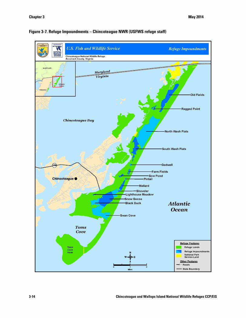
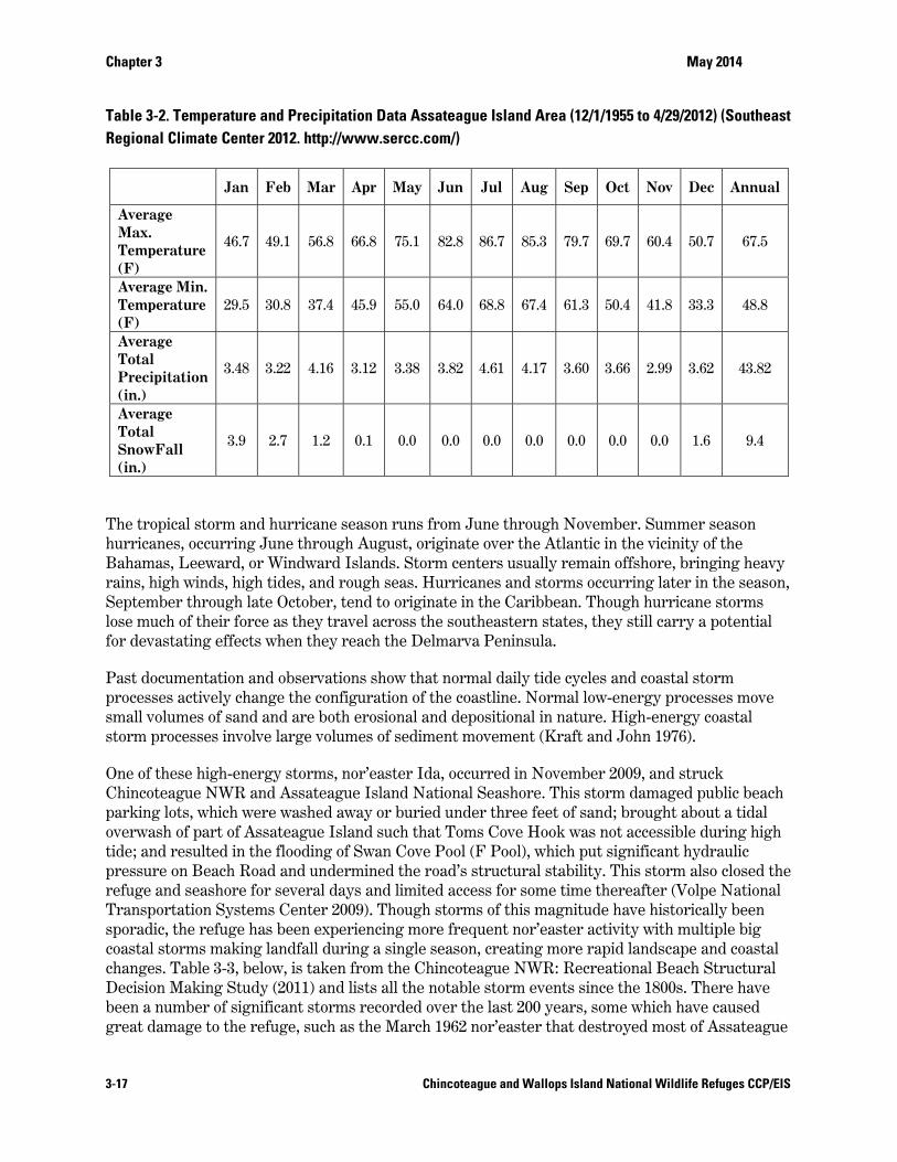
Figure 3-8 and Table 3-2 present historic temperature and precipitation data for Assateague Island. The lowest mean monthly temperature is about 36F, in January; and, the highest monthly mean temperature is about 76F, in August. Rainfall is rather uniformly distributed throughout the year averaging about 3.5 inches a month and totaling about 43 inches a year. Annual precipitation totals have ranged from between 30 to 60 inches. Snowfall is light, with February historically having accumulations of about two inches. Total annual snowfall is only about 5 inches (Southeast Regional Climate Center 2007 and USFWS 2007d). Figure 3-8. Daily Average Temperature for Assateague Island National Seashore area, and Predicated Future Climate Change (NASA 2012)
Chapter 3 May 2014
3-17 Chincoteague and Wallops Island National Wildlife Refuges CCP/EIS
Table 3-2. Temperature and Precipitation Data Assateague Island Area (12/1/1955 to 4/29/2012) (Southeast Regional Climate Center 2012. http://www.sercc.com/)
Jan Feb Mar Apr May Jun Jul Aug Sep Oct Nov Dec Annual
Average Max. Temperature (F)
46.7 49.1 56.8 66.8 75.1 82.8 86.7 85.3 79.7 69.7 60.4 50.7 67.5
Average Min. Temperature (F)
29.5 30.8 37.4 45.9 55.0 64.0 68.8 67.4 61.3 50.4 41.8 33.3 48.8
Average Total Precipitation (in.)
3.48 3.22 4.16 3.12 3.38 3.82 4.61 4.17 3.60 3.66 2.99 3.62 43.82
Average Total SnowFall (in.)
3.9 2.7 1.2 0.1 0.0 0.0 0.0 0.0 0.0 0.0 0.0 1.6 9.4
The tropical storm and hurricane season runs from June through November. Summer season hurricanes, occurring June through August, originate over the Atlantic in the vicinity of the Bahamas, Leeward, or Windward Islands. Storm centers usually remain offshore, bringing heavy rains, high winds, high tides, and rough seas. Hurricanes and storms occurring later in the season, September through late October, tend to originate in the Caribbean. Though hurricane storms lose much of their force as they travel across the southeastern states, they still carry a potential for devastating effects when they reach the Delmarva Peninsula.
Past documentation and observations show that normal daily tide cycles and coastal storm processes actively change the configuration of the coastline. Normal low-energy processes move small volumes of sand and are both erosional and depositional in nature. High-energy coastal storm processes involve large volumes of sediment movement (Kraft and John 1976).
One of these high-energy storms, nor’easter Ida, occurred in November 2009, and struck Chincoteague NWR and Assateague Island National Seashore. This storm damaged public beach parking lots, which were washed away or buried under three feet of sand; brought about a tidal overwash of part of Assateague Island such that Toms Cove Hook was not accessible during high tide; and resulted in the flooding of Swan Cove Pool (F Pool), which put significant hydraulic pressure on Beach Road and undermined the road’s structural stability. This storm also closed the refuge and seashore for several days and limited access for some time thereafter (Volpe National Transportation Systems Center 2009). Though storms of this magnitude have historically been sporadic, the refuge has been experiencing more frequent nor’easter activity with multiple big coastal storms making landfall during a single season, creating more rapid landscape and coastal changes. Table 3-3, below, is taken from the Chincoteague NWR: Recreational Beach Structural Decision Making Study (2011) and lists all the notable storm events since the 1800s. There have been a number of significant storms recorded over the last 200 years, some which have caused great damage to the refuge, such as the March 1962 nor’easter that destroyed most of Assateague
Chapter 3 May 2014
3-18 Chincoteague and Wallops Island National Wildlife Refuges CCP/EIS
Island's natural foredune, and the storm in January 1992, which destroyed much of the dune line on the lower portion of the island and greatly reduced the primary dune line to the north.
More recently, in October 2012, the refuge was significantly impacted by damaging winds and water as a result of Hurricane Sandy. Trees knocked down by strong winds fell across many refuge roads and trails. One remote restroom was destroyed, some shingles were lost, and the bunkhouse roof was damaged, but other refuge buildings were spared major damage. Earthen dikes surrounding refuge impoundments suffered some erosion but there were no major breaches in these dikes. There was one ocean breach, just north of parking lot 1. All beach parking lots were washed over by the storm surge, which compromised the clay base and shell surface. The asphalt surface and shoulders of Beach Road were significantly damaged.
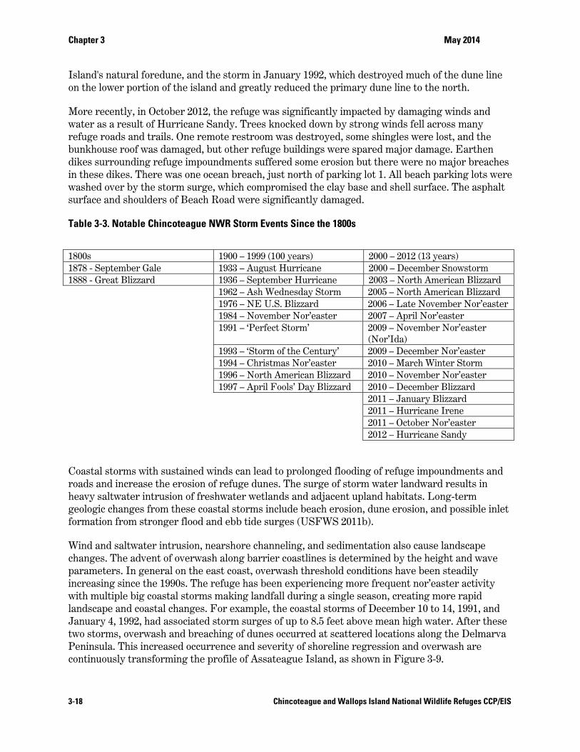
Table 3-3. Notable Chincoteague NWR Storm Events Since the 1800s
Coastal storms with sustained winds can lead to prolonged flooding of refuge impoundments and roads and increase the erosion of refuge dunes. The surge of storm water landward results in heavy saltwater intrusion of freshwater wetlands and adjacent upland habitats. Long-term geologic changes from these coastal storms include beach erosion, dune erosion, and possible inlet formation from stronger flood and ebb tide surges (USFWS 2011b).
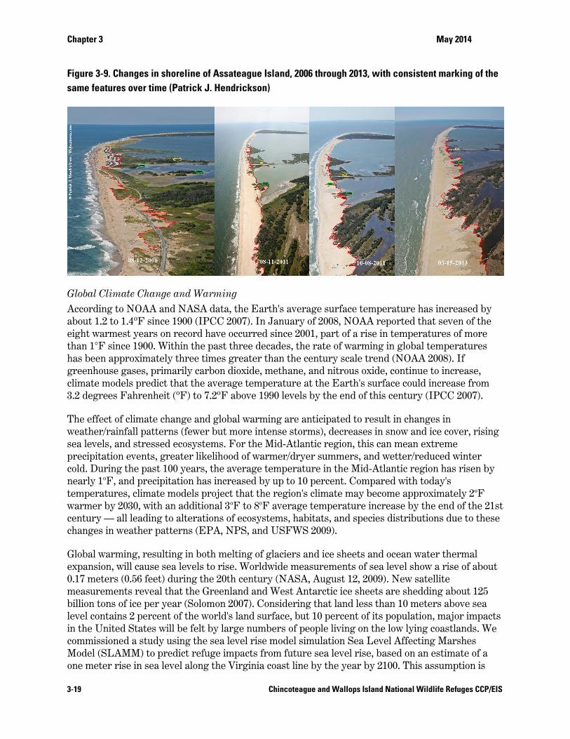
Wind and saltwater intrusion, nearshore channeling, and sedimentation also cause landscape changes. The advent of overwash along barrier coastlines is determined by the height and wave parameters. In general on the east coast, overwash threshold conditions have been steadily increasing since the 1990s. The refuge has been experiencing more frequent nor’easter activity with multiple big coastal storms making landfall during a single season, creating more rapid landscape and coastal changes. For example, the coastal storms of December 10 to 14, 1991, and January 4, 1992, had associated storm surges of up to 8.5 feet above mean high water. After these two storms, overwash and breaching of dunes occurred at scattered locations along the Delmarva Peninsula. This increased occurrence and severity of shoreline regression and overwash are continuously transforming the profile of Assateague Island, as shown in Figure 3-9.
1800s 1900 – 1999 (100 years) 2000 – 2012 (13 years) 1878 - September Gale 1933 – August Hurricane 2000 – December Snowstorm 1888 - Great Blizzard 1936 – September Hurricane 2003 – North American Blizzard
1962 – Ash Wednesday Storm 2005 – North American Blizzard 1976 – NE U.S. Blizzard 2006 – Late November Nor’easter 1984 – November Nor’easter 2007 – April Nor’easter 1991 – ‘Perfect Storm’ 2009 – November Nor’easter
(Nor’Ida) 1993 – ‘Storm of the Century’ 2009 – December Nor’easter 1994 – Christmas Nor’easter 2010 – March Winter Storm 1996 – North American Blizzard 2010 – November Nor’easter 1997 – April Fools’ Day Blizzard 2010 – December Blizzard
2011 – January Blizzard 2011 – Hurricane Irene 2011 – October Nor’easter 2012 – Hurricane Sandy
Chapter 3 May 2014
3-19 Chincoteague and Wallops Island National Wildlife Refuges CCP/EIS
Figure 3-9. Changes in shoreline of Assateague Island, 2006 through 2013, with consistent marking of the same features over time (Patrick J. Hendrickson)
Global Climate Change and Warming According to NOAA and NASA data, the Earth's average surface temperature has increased by about 1.2 to 1.4ºF since 1900 (IPCC 2007). In January of 2008, NOAA reported that seven of the eight warmest years on record have occurred since 2001, part of a rise in temperatures of more than 1°F since 1900. Within the past three decades, the rate of warming in global temperatures has been approximately three times greater than the century scale trend (NOAA 2008). If greenhouse gases, primarily carbon dioxide, methane, and nitrous oxide, continue to increase, climate models predict that the average temperature at the Earth's surface could increase from 3.2 degrees Fahrenheit (ºF) to 7.2ºF above 1990 levels by the end of this century (IPCC 2007).
The effect of climate change and global warming are anticipated to result in changes in weather/rainfall patterns (fewer but more intense storms), decreases in snow and ice cover, rising sea levels, and stressed ecosystems. For the Mid-Atlantic region, this can mean extreme precipitation events, greater likelihood of warmer/dryer summers, and wetter/reduced winter cold. During the past 100 years, the average temperature in the Mid-Atlantic region has risen by nearly 1oF, and precipitation has increased by up to 10 percent. Compared with today's temperatures, climate models project that the region's climate may become approximately 2oF warmer by 2030, with an additional 3oF to 8oF average temperature increase by the end of the 21st century — all leading to alterations of ecosystems, habitats, and species distributions due to these changes in weather patterns (EPA, NPS, and USFWS 2009).
Global warming, resulting in both melting of glaciers and ice sheets and ocean water thermal expansion, will cause sea levels to rise. Worldwide measurements of sea level show a rise of about 0.17 meters (0.56 feet) during the 20th century (NASA, August 12, 2009). New satellite measurements reveal that the Greenland and West Antarctic ice sheets are shedding about 125 billion tons of ice per year (Solomon 2007). Considering that land less than 10 meters above sea level contains 2 percent of the world's land surface, but 10 percent of its population, major impacts in the United States will be felt by large numbers of people living on the low lying coastlands. We commissioned a study using the sea level rise model simulation Sea Level Affecting Marshes Model (SLAMM) to predict refuge impacts from future sea level rise, based on an estimate of a one meter rise in sea level along the Virginia coast line by the year by 2100. This assumption is
Chapter 3 May 2014
3-20 Chincoteague and Wallops Island National Wildlife Refuges CCP/EIS
consistent with Virginia’s Climate Change Action Plan (Governor’s Commission on Climate Change 2008). Rising sea levels will result in tidal marsh submergence and habitat migration as salt marshes transgress landward and replace tidal freshwater wetlands and brackish marsh, in addition to increased beach and shoreline erosion due to wave activity. The SLAMM analysis further projects that climate change could cause a variety of coastal habitat changes, including increased loss of barrier islands and wetlands; increased risk of shoreline flooding due to sea level rise, storm surge, and extreme overwash events; and alterations of ecosystems and habitats due to changes in weather patterns.
The Intergovernmental Panel on Climate Change (IPCC) estimates that 20 to 30 percent of plant and animal species will be at risk of extinction if temperatures climb more than 1.5° to 2.5°C (Solomon 2007). Warmer air or water temperatures can also impact animal species. For example, evidence suggests that the gender of sea turtles is determined by the surrounding temperature at critical stages in development, with warmer temperatures producing more females. Warmer temperatures could thus create reproductive problems for an already declining species (Mrosovsky and Provancha 1992). A recent study of the effects of climate change on eastern U.S. bird species concluded that as many as 78 bird species could decrease by at least 25 percent, while as many as 33 species could increase in abundance by at least 25 percent (Matthews et al. 2004).
Potential Effects and Shoreline Vulnerability due to Climate Change and Sea Level Rise DOI Secretarial Order 3226 states that there is a consensus in the international community that global climate change is occurring and that it should be addressed in Federal governmental decision-making. This Order requires Departmental planning and decision-making to take climate change impacts into account. Additionally, it calls for the incorporation of climate change considerations into long-term planning documents, such as a CCP. It is difficult to predict the specific effects climate change and potential sea level rise will have on the refuge in the future, but past and current events have been documented and analyzed to allow for more informed management. As a barrier island with an elevation of no more than 46 feet (14 meters) at its highest points, Assateague Island will be greatly affected by the predicted changes in sea level associated with global climate change. Furthermore, the refuge is located in a “hotspot” of accelerated sea level rise. For this “hotspot,” which spans 1,000-kilometers along the highly populated North American Atlantic coast north of Cape Hatteras, scientists estimate that sea level rise increased at a much higher rate than the global average between 1950 to 1979 and 1980 to 2009 (Salinger 2012).
Meteorological and climatological events, such as hurricanes and sea level rise, pose challenges for refuge management, and continuously morph the landscape of the refuge. To highlight the change in shoreline, Figure 3-10 shows the historic shoreline change of southern Assateague Island. This figure represents how significantly a barrier island can change in a mere 150 years, and specifically shows the variability in the refuge’s shoreline due to increased storm activity, continued shoreline erosion, and sedimentary transportation events such as overwash.

Chapter 3 May 2014
3-21 Chincoteague and Wallops Island National Wildlife Refuges CCP/EIS
Figure 3-10. Shoreline Change for Toms Cove, Assateague Island, from 1850 to 2005 (Assateague Island National Seashore/NPS staff)
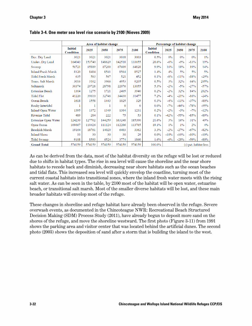
Further climate change related stressors will likely enhance impacts on shoreline morphology even more in years to come. Using past climate and weather data, we commissioned a study to project the effects of sea level rise on the barrier islands extending from Ocean City Inlet, Maryland to Fisherman Island, Virginia in the Delmarva Peninsula with a main focus on Chincoteague NWR, incorporating the SLAMM model (Nieves 2009). The study itself used three different model scenarios for sea level rise: the IPCC prediction of 0.7 m by 2100, and a 1 m, and 1.5 m global sea level rise by 2100. Simulations were executed in 25 year increments from the date of available existing conditions (1988-2003) until 2100. The study found that the most significant changes would occur on the eastern shore beaches and marshes. A significant conversion of salt marsh to open estuarine water is anticipated for Assateague Island and other barrier islands within the refuge by 2075 or 2100 in the 1.0 and 1.5 meter rise scenarios, respectively. Ocean beach habitat would decline by 80 percent by the year 2100 in the 1.0 meter sea level rise scenario, while estuarine beaches, on the other hand, are projected to gain habitat. Table 3-4 shows the total habitat change percentages for the refuge assuming the 1.0 m sea level rise by 2100 scenario, which the refuge currently uses for management purposes.
Chapter 3 May 2014
3-22 Chincoteague and Wallops Island National Wildlife Refuges CCP/EIS
Table 3-4. One meter sea level rise scenario by 2100 (Nieves 2009)
As can be derived from the data, most of the habitat diversity on the refuge will be lost or reduced due to shifts in habitat types. The rise in sea level will cause the shoreline and the near shore habitats to recede back and diminish, decreasing near shore habitats such as the ocean beaches and tidal flats. This increased sea level will quickly envelop the coastline, turning most of the current coastal habitats into transitional zones, where the inland fresh water meets with the rising salt water. As can be seen in the table, by 2100 most of the habitat will be open water, estuarine beach, or transitional salt marsh. Most of the smaller diverse habitats will be lost, and these main broader habitats will envelop most of the refuge.
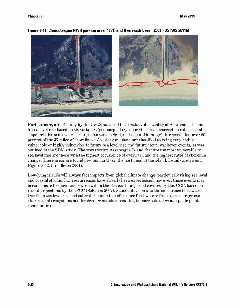
These changes in shoreline and refuge habitat have already been observed in the refuge. Severe overwash events, as documented in the Chincoteague NWR: Recreational Beach Structured Decision Making (SDM) Process Study (2011), have already begun to deposit more sand on the shores of the refuge, and move the shoreline westward. The first photo (Figure 3-11) from 1991 shows the parking area and visitor center that was located behind the artificial dunes. The second photo (2003) shows the deposition of sand after a storm that is building the island to the west.
Chapter 3
3-23
Figure 3-1
Furthermto sea levslope, relpercent ovulnerabloutlined isea level change. TFigure 3-
Low-lyinand coastbecome mrecent prlens fromalter coascommuni
11. Chincotea
more, a 2004 vel rise basedlative sea levof the 37 milele or highly vin the SDM srise are thos
These areas -12. (Pendlet
g islands wiltal storms. Smore frequenrojections by
m sea level risstal ecosysteities.
gue NWR par
study by thed on six variavel rise rate, es of shorelinvulnerable tostudy. The ase with the hare found prton 2004).
ll always faceSuch occurrennt and severey the IPCC (Sse and saltwems and fresh
rking area (19
e USGS asseables (geomomean wave h
ne of Assateao future sea
areas within Ahighest occurredominantly
e impacts fronces have alre within the Solomon 200ater inundathwater mars
Chincoteague a
991) and Overw
essed the coaorphology, shheight, and mague Island alevel rise anAssateague rrence of ovey on the nort
om global cliready been e15-year time
07). Saline inttion of surfacshes resultin
and Wallops Isla
wash Event (2
astal vulnerahoreline erosmean tide raare classifiedd future storIsland that a
erwash and tth end of the
imate changeexperienced;e period covetrusion into ce freshwateng in more sa
and National Wi
2003) (USFWS
ability of Asssion/accretio
ange). It repod as being verm washoverare the mostthe highest re island. Deta
e, particularl; however, thered by this the subsurfa
ers from storalt-tolerant a
May 2014
ldlife Refuges C
S 2011b)
sateague Islaon rate, coastorts that oveery highly r events, as wt vulnerable trates of shoreails are given
ly rising sea hese events mCCP, based ace freshwatrm surges caaquatic plant
CCP/EIS
and tal
er 60
was to eline n in
level may on
ter an t
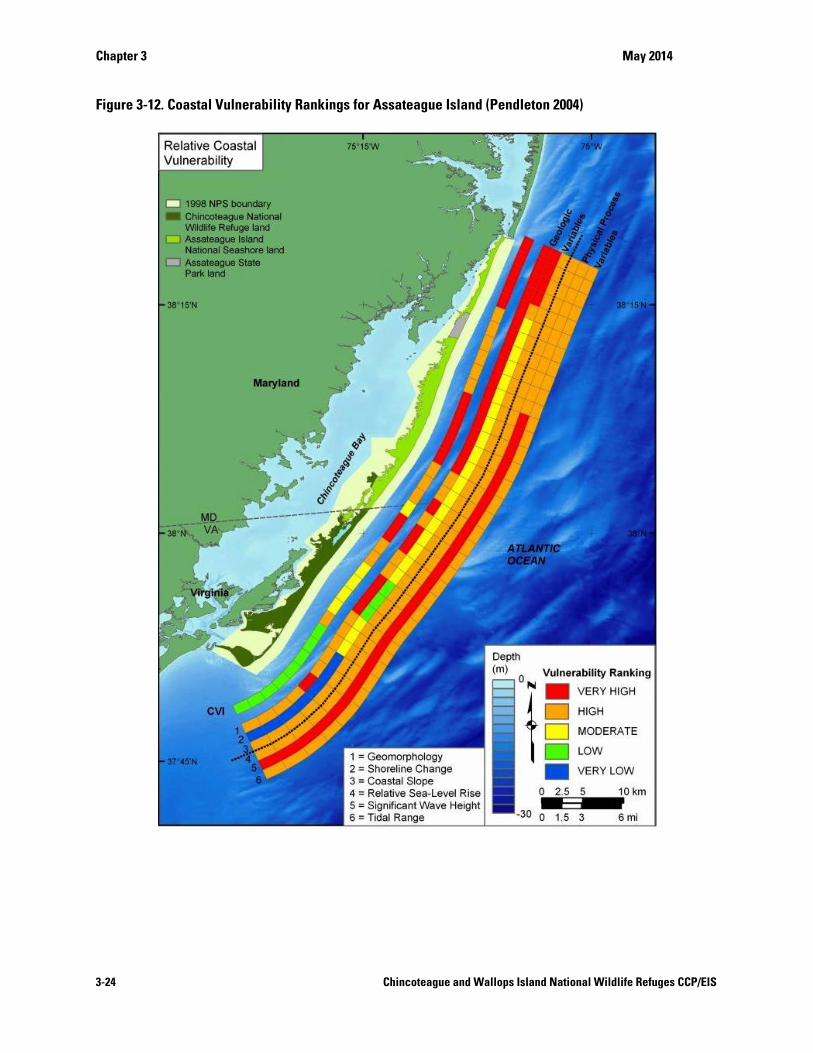
Chapter 3 May 2014
3-24 Chincoteague and Wallops Island National Wildlife Refuges CCP/EIS
Figure 3-12. Coastal Vulnerability Rankings for Assateague Island (Pendleton 2004)
Chapter 3 May 2014
3-25 Chincoteague and Wallops Island National Wildlife Refuges CCP/EIS
3.3 Vegetation From sandy beaches along the island's seaward side to salt marshes on the western bay side, Assateague Island hosts a wide variety of habitats and vegetative communities. A diverse array of environmental conditions—elevation, the availability of water, ranging from fresh to salt, distance from the impacts of the ocean, the movement of sand, storm-driven winds and seas—all work to shape these habitats and vegetative communities, providing unique environs within which a plethora of different species live.
Chincoteague NWR is a dynamic area with constant fluctuations in its shoreline boundaries and habitat acreage. Current vegetation cover is strongly associated with a certain habitat, and is so described in this section. There are five major habitat types found on the refuge (which include three smaller divisions: Assawoman Island, Metompkin Island and Cedar Island). They are: Beach-Dune habitat (approximately 1,800 acres); Shrub-Early Successional habitat (approximately 2,900 acres); Forested Uplands habitat (approximately 1,800 acres); Impoundments and Freshwater Wetlands habitat (approximately 2,000 acres); and over 5,800 acres of salt marshes.
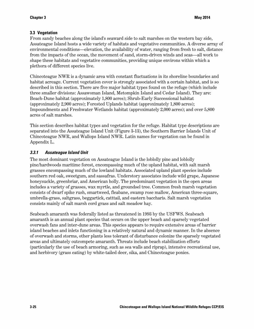
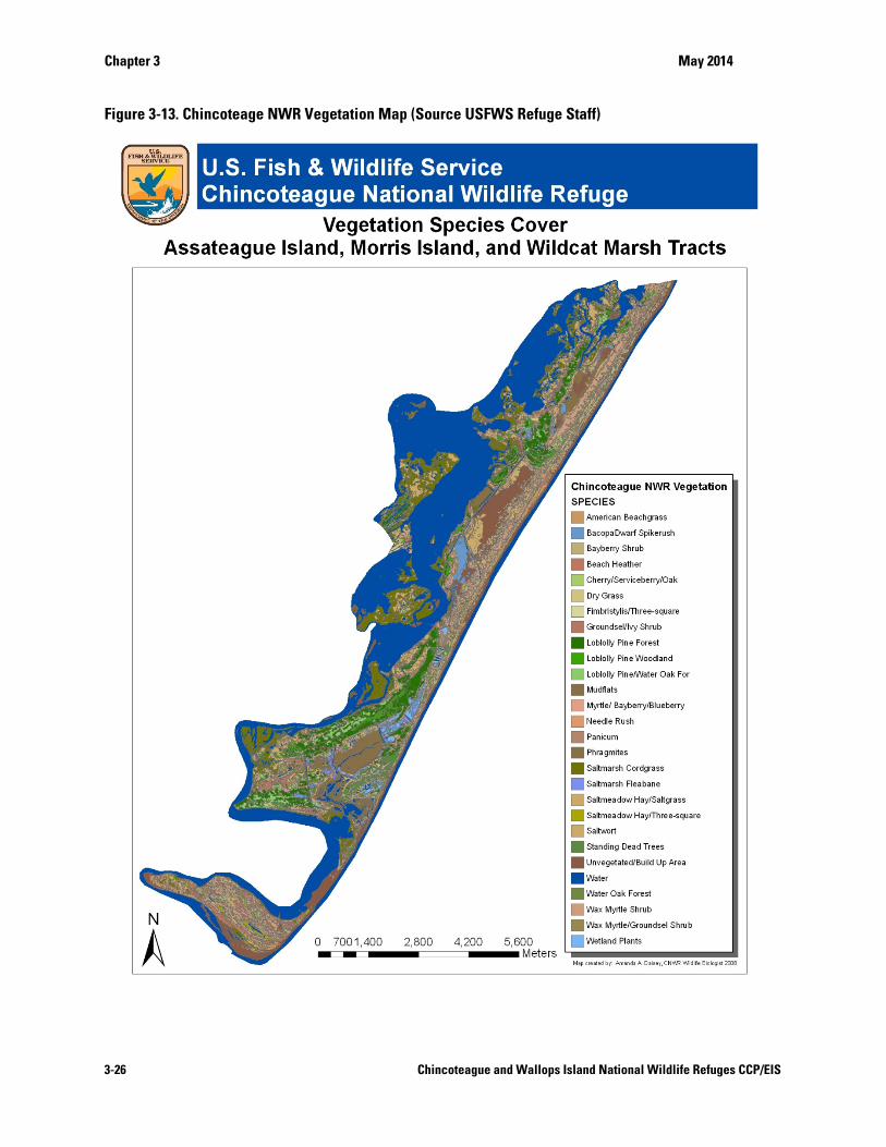
This section describes habitat types and vegetation for the refuge. Habitat type descriptions are separated into the Assateague Island Unit (Figure 3-13), the Southern Barrier Islands Unit of Chincoteague NWR, and Wallops Island NWR. Latin names for vegetation can be found in Appendix L.
3.3.1 Assateague Island Unit The most dominant vegetation on Assateague Island is the loblolly pine and loblolly pine/hardwoods maritime forest, encompassing much of the upland habitat, with salt marsh grasses encompassing much of the lowland habitats. Associated upland plant species include southern red oak, sweetgum, and sassafras. Understory associates include wild grape, Japanese honeysuckle, greenbriar, and American holly. The predominant vegetation in the open areas includes a variety of grasses, wax myrtle, and groundsel tree. Common fresh marsh vegetation consists of dwarf spike rush, smartweed, fleabane, swamp rose mallow, American three-square, umbrella-grass, saltgrass, beggartick, catttail, and eastern baccharis. Salt marsh vegetation consists mainly of salt marsh cord grass and salt meadow hay.
Seabeach amaranth was federally listed as threatened in 1993 by the USFWS. Seabeach amaranth is an annual plant species that occurs on the upper beach and sparsely vegetated overwash fans and inter-dune areas. This species appears to require extensive areas of barrier island beaches and inlets functioning in a relatively natural and dynamic manner. In the absence of overwash and storms, other plants less tolerant of disturbance colonize the sparsely vegetated areas and ultimately outcompete amaranth. Threats include beach stabilization efforts (particularly the use of beach armoring, such as sea walls and riprap), intensive recreational use, and herbivory (grass eating) by white-tailed deer, sika, and Chincoteague ponies.
Chapter 3 May 2014
3-26 Chincoteague and Wallops Island National Wildlife Refuges CCP/EIS
Figure 3-13. Chincoteage NWR Vegetation Map (Source USFWS Refuge Staff)
Chapter 3 May 2014
3-27 Chincoteague and Wallops Island National Wildlife Refuges CCP/EIS
Seabeach amaranth was first documented on the refuge in 1966 by Dr. Elizabeth Higgins as a graduate student, and the species was also present in 1967 and 1972. It was not recorded on the refuge between 1972 and 2001, nor were any surveys documented. In 2001, nine plants were found just south of the Maryland/Virginia border, a year after the NPS began a program to restore the species in Maryland. Since 2001, refuge staff has conducted surveys for seabeach amaranth on the beaches of Assateague Island each August, often in conjunction with NPS personnel. The number of plants identified varies but a peak of 69 plants was documented in 2005.
In addition to seabeach amaranth, Assateague Island supports several other rare plants, in particular: seabeach knotweed, sea purslane, seabeach orach, and seabeach sandwort, which all occupy beach habitats similar to amaranth.
Fragile communities of submerged aquatic vegetation along Assateague’s bay side are an important component of the estuarine ecosystem. Beds of sea grasses such as eelgrass and less abundant widgeon grass provide shelter for mollusks such as the Atlantic bay scallop, critical nursery habitat for fish and crustaceans, and foraging grounds for waterfowl, river otters, and other animals. Sea grasses are extremely sensitive to water quality. Excess suspended sediments and algal blooms caused by nutrient enrichment can kill sea grass by blocking sunlight. Boats can also destroy sea grasses in shallow waters when they become grounded or when propellers churn through and tear up the grasses. Boating restrictions help protect against this damage. A southern corridor provides access to the north side of Toms Cove for personal watercraft from nearby Chincoteague Island. Another corridor provides access to the north end of the island close to Ocean City where boat traffic has traditionally been heaviest. All other personal watercraft use within Assateague Island National Seashore is prohibited.
Beach – Dune This habitat type covers approximately 970 acres, or 10 percent, of the Assateague Island Unit. Its width varies along its 27 km (17 mile) interface with the ocean. Considered pioneer species, beach plants are exposed and adapted to constantly shifting sands, limited fresh water, temperature and wind extremes, and frequent salt water spray and overwash. The entire community can be covered by tidal surges. The beach extends from the intertidal zone into the dunes along the entire east and south sides of Assateague Island. Smaller areas are along Toms Cove and Assateague Point and Channel. The most common beach species are American sea rocket and sea lavender.
The dune habitat serves as a line of defense against storm surges, protecting other habitats from alteration due to salt water intrusion. A gradual transition to the dune grass community occurs beyond the high tide line. Dune grass establishes readily on the stabilized dunes as well as in natural areas. Characteristic species are American beach grass, sea oats, saltmeadow cordgrass, seaside goldenrod, dune sandbur, rough buttonweed, carpetweed, and seabeach evening primrose. Seabeach amaranth occurs in very low numbers.
Shrub-Early Successional Between the dunes and the upland forest community lies a lower, flat expanse (swales) with a successional shrub community that covers about 2,872 acres (roughly 25- 30 percent) of the Assateague Island Unit. Deciduous trees, shrubs, and vines are the predominant plant forms. This shrub community is important for migrating and nesting songbirds, as well as to migrating monarch butterflies. The shrub habitat adjacent to the freshwater impoundments and the transition zone between the forest and salt and fresh water marshes provide important foraging
Chapter 3 May 2014
3-28 Chincoteague and Wallops Island National Wildlife Refuges CCP/EIS
for a variety of neotropical migrant birds. The shrub community composition varies with groundwater supply, elevation, proximity to salt spray, and frequency of tidal inundation. In general, the shrub community vegetation zone extends north and south on barrier flats and backdunes, gradually merging on the east with dunegrasses and on the west with forests or marshes. The majority of shrub habitat is scattered throughout the refuge with most adjacent to the forests, saltmarshes, and impoundments. In the sheltered zone beyond the dunes where fresh water is more plentiful, vegetative cover can reach 80 percent and is predominantly characterized by less salt-tolerant shrubs and thickets. Here, taller plants undergo a natural pruning process, as salt-laden winds blowing over the dunes stunt their growth.
Common species in these areas include wax myrtle and northern bayberry, which provide food and cover for songbirds, small rodents, and rabbits. Other common shrub species include black cherry, serviceberry, blackberry, poison ivy, and greenbrier. Evergreens are less frequent, but include red cedar and American holly. False heather or beach-heath along with jointweed and broom-sedge can be the dominant species in localized areas within the shrub community. These species form large mound-shaped colonies on low interior dunes that are generally very dry and free of salt spray. This plant community is an important dune stabilizer, capturing windblown sands. Most of the shrub species occur to a lesser degree in the forest community.
Forested Uplands Where Assateague Island is wide enough to allow sufficient protection from the ocean's salt spray and overwash, trees are able to establish a foothold. The forest stands occur on large stable dunes (such as White Hills), generally west of shrub areas and impoundments, indicative of parts of the island that have been stable for several decades. Approximately 1,600 acres (17 percent) of the Assateague Island Unit are classified as upland forest and are comprised almost entirely of loblolly pine, a hardy salt-tolerant and fire-resistant tree. Loblolly pine requires full sunlight to establish new stands, and can produce cone crops in as little as ten years, although seed production is greater in older trees. Thinning of stands has been shown to increase production of cones and seeds by dominant and co-dominant trees. These forests are important to the survival of the endangered Delmarva fox squirrel and other forest dwelling wildlife, particularly the white-tailed deer, turkey, eastern hognose snake, and many species of woodland migratory birds.
Mixed stands of loblolly pine and hardwood usually contain southern red oak, white oak, and water oak as the most abundant hardwoods. The mixed hardwood forest provides premium Delmarva Peninsula fox squirrel and woodcock habitat. The hardwood stands have developed only in areas where topography and distance from salt water provide maximum protection from aerosol salt spray. Other mixed hardwood species may include red maple, sweet gum, sassafras, black gum, black cherry, American holly, and wax myrtle. Forested wetlands occur on the west side of Snow Goose (B-South) Pool, in the vicinity of the Woodland Trail, and in lowlands near the White Hills. Dominant vegetative species in these areas include red maple, black willow, wax myrtle, and marsh elder.
Forested understory vegetation is usually composed of dogwood, high-bush blueberry, blackberry, greenbrier, poison ivy, common chokecherry, and fox grape. Many of the rarest plants on Assateague Island are found in the forests, including Indian pipe, crested yellow orchid, spotted wintergreen, and partridgeberry.
Approximately 400 acres of the forested uplands on Assateague Island in Virginia were mapped as maritime upland forest community as defined by the Virginia Department of Conservation and

Chapter 3 May 2014
3-29 Chincoteague and Wallops Island National Wildlife Refuges CCP/EIS
Recreation (VDCR) and 50CFR 84.11 (Berman and Berquist 2007). According to VDCR, maritime upland forests are considered globally rare because of restricted ranges, narrow habitat requirements, and threats from coastal development. Maritime upland forests contain species-poor evergreen and mixed coastal forests, often pine-dominated with an understory of deciduous trees; they grow in well to rapidly drained nutrient poor sandy soils (Berman and Berquist 2007). They occur on old coastal dunes that have been stable long enough to sustain forests, have well-drained sandy soils, and a water table close to the surface (50 CFR 84.11).
Wetlands The 13 impoundments (roughly 22-28 percent of the Assateague Island Unit) are managed to provide submergent and emergent wetland vegetation and mudflats as foraging areas and cover for waterfowl, shorebirds, and other waterbirds. Approximately 2,650 acres of this “habitat type” is contained within the dikes. The discrepancy between this and the 2,012 acreage figure obtained from the cover map is due to shrub encroachment on the edges, which was mapped as shrub/early successional. Since many impoundments tend to be brackish due to storm overwash and salty soils, they are inhabited by plants with some salt tolerance. Characteristic plants include dwarf spike rush, salt marsh fleabane, Bacopa, sago pondweed, American three-square, saltgrass, Bidens, smartweed, umbrella-grass, and salt meadow grass. Non-native Phragmites grows in many of the impoundments and other wetland areas. This invasive plant has been the target of mechanical and chemical control efforts.
Wax myrtle and loblolly pine encroach into some of the impoundments where these woody species are not regularly controlled. Currently, Sow Pond, Ragged Point, Pintail Pool (D Pool), South Wash Flats, and North Wash Flats (NWF) have expanding areas of woody vegetation that will require management to maintain open shallow water habitat favored by shorebirds and some waterfowl. On the other hand, flooded myrtle habitat is used by wintering black ducks, and landbirds use shrub habitat on impoundment edges for breeding, winter, and migration habitat.
Forested wetlands occur on the west side of Snow Goose (B-South) Pool, in the vicinity of the Woodland Trail, and in lowlands near the White Hills. Dominant species include red maple, black willow, wax myrtle, ferns, and blueberries.
A more open transitional freshwater marsh that borders uplands and salt marshes on the bayside of Assateague Island includes groundsel tree, cattails, wax myrtle, swamp rose, and marsh elder. Approximately 108 acres of wetlands also occur on Toms Cove Hook on the flats and in low areas between the beach ridges and dunes that pond collect rainwater. A few other small natural freshwater marshes occur behind the dunes of the northern beach.
Salt Marsh Approximately 2,875 acres of salt marshes are located along the western boundaries of the Assateague Island Unit. Tidal flooding influences the distribution of salt marsh plants. Salt marsh cordgrass is the dominant species in the low marsh, the zone between mean high tide and mean low tide. Salt meadow cordgrass (also called salt meadow hay), saltgrass, and saltwort grow in the less frequently flooded high marsh. Northern sea lavender and marsh elder occur at upper levels, along the marsh/upland edge.
Chapter 3 May 2014
3-30 Chincoteague and Wallops Island National Wildlife Refuges CCP/EIS
3.3.2 Southern Island Units Salt marsh habitat covers approximately 95 percent (406 acres) of the Morris Island Unit and approximately 87 percent (485 acres) of the Wildcat Marsh Unit. Salt marsh cord grass, salt meadow cordgrass, and saltwort are the major vegetation species. Upland vegetation on Morris Island is limited to a few scattered sites (21 acres) of loblolly pine, wax myrtle, black cherry, and sassafras. Approximately 13 percent (73 acres) of the southern part of Wildcat Marsh is an upland forest consisting of loblolly pine, oak, and typical understory associates. Wax myrtle is scattered throughout the area.
Assawoman and Metompkin islands are barrier islands with habitat types consisting of beach, dunes, and extensive salt marshes to the west of the islands. The predominant species in the marsh include salt marsh cordgrass and salt meadow hay. On Metompkin, the marsh extends to the mainland, although it is intersected by numerous creeks and channels. The remainder of the island is predominantly sparse grasslands with little woody growth. Assawoman Island also contains extensive salt marshes, particularly in the northern half of the island. A cobble-laden washover area, located at the northern tip and formed by the sealing of Assawoman Inlet, provides good habitat for nesting birds. Pockets of woody shrubs occur in depressions between the beach front and the westward marshes. Plants found here include wax myrtle, bayberry and groundsel bush.
Cedar Island is dominated by beach and dune habitats on the ocean side and a brackish marsh dominated by salt meadow cordgrass on the bay side. A small thicket dominated by eastern red cedar and poison ivy occurs on the north end of the island. It is adjacent to the beach and is eroding rapidly. The north end also supports most of the island's other plant diversity. Dead shrubs and some low-growing vegetation are present in overwash areas. Other habitat types found on Cedar Island include a salt flat to the south and mudflats that are exposed at low tide.
3.3.3 Wallops Island NWR Wallops Island NWR is composed of 195 acres of salt marsh, 121 acres of forest, and 57 acres of old-field/early successional forests. Loblolly pine is the dominant species in the forest habitat and secondary components include: tulip poplar, red maple, southern red oak, wild cherry, dogwood, sassafras, and sweet gum. Understory includes: American holly, spicebush, Devil’s walkingstick, and greenbrier. Transition zones between the marsh and woodland are dominated by groundsel tree and wax myrtle. The salt marsh is dominated by cordgrasses.
A Simoneaston Bay sea-level fen, named the Lucky Boy Fen, is found on Wallops Island NWR. Sea-level fens are nutrient-poor, maritime seepage wetlands, confined to a few sites within the Mid-Atlantic region that have an unusual combination of environmental conditions (VDCR 2001). The sea-level fen is a globally significant (ranked as “G1” or critically imperiled) community type (Fleming and Patterson 2010); only four occur in Virginia, all of them in Accomack County (VDCR 2001). Lucky Boy Fen is located just above highest tide levels, at the base of a slope where abundant groundwater discharges. It is less than one-half acre in size, but supports six rare plant species.
3.4 Wildlife Despite the often harsh conditions that occur in a coastal environment, a wide variety of wildlife species thrive on the refuge. Each of the islands’ different habitats supports a multitude of birds, mammals, reptiles, amphibians, and invertebrates. In addition, the coastal waters that surround
Chapter 3 May 2014
3-31 Chincoteague and Wallops Island National Wildlife Refuges CCP/EIS
the refuge teem with life. The sheltered, nutrient-rich waters of the estuary formed by the islands provide breeding and spawning habitat for many aquatic species, and important feeding areas for birds. Wildlife species in the refuge are described below. Latin names for wildlife can be found in Appendix L.
3.4.1 Federal and State Threatened and Endangered Species Although the refuge habitat is used by several protected species, the only resident Federal endangered species is the Delmarva Peninsula fox squirrel. Other known Federal endangered or threatened species that can be found on the refuge but that are not resident include the piping plover, roseate tern, and the leatherback and loggerhead sea turtles. Red knot, a species proposed to be listed as threatened under the ESA, uses Chincoteague NWR beaches during spring and fall migration.
Wilson’s plover is on Virginia’s State endangered bird list. State-threatened birds that are present or breed on the refuge include the gulled tern, upland sandpiper, and the peregrine falcon. In 2012, the Board of the Virginia Department of Game and Inland Fisheries (VDGIF) decided to remove the bald eagle from the Virginia State list of threatened and endangered species effective January 1, 2013.
Several Federal listed threatened and/or endangered species are found in the study area, although not all of them are resident to the refuge. A full list of threatened and endangered flora and fauna that are found in the vicinity of the refuge is provided in Appendix L. The species that are most pertinent to the refuge are described in detail below.
Delmarva Peninsula fox squirrel The Delmarva Peninsula fox squirrel is both a Federal and state listed endangered species inhabiting the Chincoteague NWR's loblolly pine forests. Fox squirrels can be commonly seen in the headquarters area and around the Woodland Trail. Their coloring is similar to the gray squirrel, but the fox squirrel is larger with a bushier tail and is more terrestrial than the gray squirrel.
The Delmarva Peninsula fox squirrel's original range stretched from central New Jersey south through eastern Pennsylvania and down the length of the Delmarva Peninsula. As woodland has been cleared for farming and altered by forestry, available fox squirrel habitat has dwindled, and the known population has been reduced to several sites in Maryland, Delaware, and Chincoteague NWR in Virginia. The refuge population was translocated here in the early l970s. Over the past few years their numbers on the refuge have stabilized.
On Chincoteague NWR, Delmarva Peninsula fox squirrels live in forest stands predominated by mature loblolly pines. In other parts of its range, the fox squirrel is usually found in mixed stands of mature hardwoods where a variety of mast-producing trees ensure a reliable food source. With its terrestrial habits, the fox squirrel is adapted to a park-like, open understory and is rarely found in dense underbrush, although production in areas with a developed understory has been observed on Chincoteague NWR. Because they spend so much time on the ground, road accidents are a mortality factor of the Delmarva Peninsula fox squirrel. Major natural predators are red fox, raccoon, and great horned owl.
Refuge forest management and predator control objectives are designed to provide optimum fox squirrel habitat. Specific practices include:
Chapter 3 May 2014
3-32 Chincoteague and Wallops Island National Wildlife Refuges CCP/EIS
Maintain open understory in specified areas; Provide nesting boxes to supplement natural tree cavities; Reduce competition from gray squirrels; Protect from hunting and natural predation; Supply reliable food source through management of vegetation.
Marine Mammals Federal endangered marine mammals with ranges that encompass the waters of Assateague Island include: 5 species of baleen whales (humpback, gin, sei, blue, and northern right); one toothed whale (sperm); and, one sirenian (West Indian manatee). Anecdotal observations suggest that these species visit the Island's waters; however, most do so only as occasional transients or seasonal migrants. The species most at risk is the northern right whale, with a North Atlantic population of approximately 200. A number of right whales winter along the Assateague Island coastline and can occasionally be seen from the beach.
Sea Turtles Five species of Federal listed sea turtles use Assateague Island's ocean and bay waters. The leatherback sea turtle (which is also State-listed), Kemp’s Ridley sea turtle, and the hawkbill sea turtle are Federal endangered species. The loggerhead sea turtle and green sea turtle are Federal-threatened, with the loggerhead also being State-threatened.
Piping Plover The piping plover, a Federal and State-threatened species since January 1986, nests on sandy or cobble beaches and overwash areas. The eastern coast of Virginia is a significant area for nesting piping plovers, supporting approximately 20 percent of the breeding population on the U.S. Atlantic Coast. Chincoteague NWR is one of the most important plover nesting areas of any of the Virginia barrier islands and supports one of the largest concentrations of piping plovers along the Atlantic coast. In order to protect this species, the Chincoteague NWR closes certain critical nesting areas to public entry.
In Virginia, piping plovers begin displaying territorial behavior and their elaborate courtship rituals in mid-March. This is followed by egg-laying in mid-April. Each pair forms a shallow depression in the sand to serve as a nest in which usually four eggs are laid. The eggs hatch in about 25 days, and the downy young are soon able to follow their parents in foraging for marine worms, crustaceans, and insects, which they pluck from sand and mudflats in the intertidal zone. Both eggs and young are so well-camouflaged that they are apt to go undetected. When predators and other intruders come close, the young squat motionless on the sand while the parents attempt to attract the attention of the intruders to themselves, often by feigning a broken wing. Surviving young fly within about 30 days of hatching. Storm tides, predators, or human activity often disrupt nesting before the eggs hatch. When this happens, fledglings from late nesting efforts may not fly until mid-August. Plovers commonly gather in groups on undisturbed beaches prior to their southward migration. Feeding occurs along the intertidal zone and on sand flats and mudflats. The plover's diet consists mainly of worms, crustaceans, mollusks, and other invertebrates.
Beaches on Assateague (including the Hook, Overwash, and Wild Beach), Assawoman, Metompkin, and Cedar islands are managed and intensively monitored for nesting shorebirds including the American oystercatcher, terns, and piping plover. The NWF impoundment is also intensely managed for piping plover nesting habitat as mitigation for the loss of habitat at the recreational beach. The number of piping plover nesting pairs on Chincoteague NWR has
Chapter 3 May 2014
3-33 Chincoteague and Wallops Island National Wildlife Refuges CCP/EIS
increased from 50 pairs in 1987 to 100 or more pairs in recent years (2005 to 2010). The number of piping plover chicks fledged increased steadily between 1987 (when monitoring began) and 2004 (with a peak of 224 fledged chicks), declined from 2005 to 2008, and increased slightly (132 chicks fledged) in 2009 and 2010. Weather events and predation affect fledgling success. Productivity has reached or exceeded the Recovery Plan goal of 1.5 chicks/pair in 5 of the last 10 years (USFWS 1995). Prior to 2007, Assateague Island consistently had the highest number of nesting plover pairs, but in recent years (2007-2009), Cedar and Assawoman islands have had more breeding pairs and higher fledgling success. Increased flooding events due to high tides on the Hook and Overwash during the breeding season, and erosion of Wild Beach are factors.
The following factors have contributed to the decline of the piping plover along the Atlantic Coast and depress plover production at Chincoteague NWR:
Human disturbance can curtail breeding success. Pedestrians and off-road vehicles may cause plover parents to desert the nest, exposing eggs or chicks to the summer sun and predators, not to mention the possibility of the vehicles crushing the well-camouflaged nests or young. Interruption of feeding may stress juvenile birds during critical periods in their development.
Predation from ghost crabs and foxes is a significant factor in survival. Six total nests on Assateague Island were disturbed by predators in 2011 (Refuge biology data), resulting in significant loss of eggs. However, in 2011, the most significant loss of eggs (n=42) was due to weather and tide, with the nests being over washed during full or new moon tide cycles (USFWS 2011a)).
Monitoring and management efforts for the 2011 nesting season (USFWS 2011a) included:
Pre-season surveys were conducted opportunistically beginning in March; staff surveyed all shorebird breeding areas for plover and other nesting shorebird species arrival, establishment of territories, courtship display, and preliminary nest scrapes. Initial surveys allowed observers to estimate the number of potential nesting plover and shorebird pairs for the season. More intense monitoring began in mid-April when territorial pairs were firmly documented.
Using binoculars and spotting scopes, staff observed individual nesting shorebirds or pairs from a vehicle or dune. As mating pairs were identified, staff walked through nesting areas at a slow pace looking for scrapes and bird tracks. Once the nest was located, the observer placed a paint stick 10 meters from the nest and recorded the location. Paint sticks allowed observers to identify and observe a nest from a distance without disturbing the incubating adults. Weather conditions, time, and potential stress on the birds was considered while nest searching. Nests were located from late April through early July 2011.
Brood monitoring (determining the location and number of chicks in each brood) was attempted 7 days a week on Assateague and Assawoman Islands and 4 days on Cedar Island. Metompkin Island was monitored weekly by Chincoteague NWR staff. NASA staff attempted brood monitoring on Wallops Island three mornings a week. Brood monitoring was accomplished by observations of chicks from a vehicle using spotting scopes or by foot. Metompkin and Cedar islands are not accessible by vehicle. Staff traveled to and from the islands by boat. Shorebird surveys, nest searches, and brood monitoring were conducted by foot. To reduce brood disturbance, chick observations lasted only long enough to count the chick numbers. Brood monitoring was not conducted in extreme weather conditions such as mid-day heat, rain, or high wind.
Chapter 3 May 2014
3-34 Chincoteague and Wallops Island National Wildlife Refuges CCP/EIS
Staff used invasive plant management, crushed shells, pony grazing, ditching, and water pumps as tools to improve shorebird nesting habitat on Chincoteague NWR. A portable diesel water pump was used to reduce the level of water held on the NWF shorebird breeding area into the South Wash Flats impoundment during breeding season. This season, maintenance staff placed crushed shells on the flats as a continuation of the nesting island creation on the area. Due to dry weather conditions and previous management, the maintenance staff operated the pump in February for 16 hours, a considerable lower amount compared to last year (335 hours).
As part of the invasive plant management to improve shorebird nesting habitat, USFWS along with cooperating agencies sprayed patches of Phragmites along the Virginia barrier island system, in September 2009 and 2010. Due to the success of this effort, no treatment occurred in 2011.
Predator management activities began on Assateague Island from February through June and on Assawoman Island from January to May confined to areas known to be piping plover habitat. Chincoteague NWR possesses a VDGIF Scientific Collections permit to conduct mammalian predator management on refuge lands targeting red fox, raccoon, mink, and opossum.
Predator exclosures were also used on the refuge to help protect nesting birds and eggs. Exclosures used on the Hook, Overwash, Public Beach, and Wild Beach formed a 3.7 m diameter around nests. Six 1.5 m pieces of 12.7 mm diameter rebar were evenly spaced around the perimeter and driven into the ground to secure the welded wire in place.
Loggerhead sea turtle The Federal and State-threatened loggerhead sea turtle nests on Assateague Island, which is the northern extent of its breeding range. Crawl and nesting activity occurs June through August, but activity tends to occur every other year according to refuge data. Because incubation takes longer (90 or more days) at this latitude, the hatch window is August through October. Nesting activity on Assateague Island and Wallops Island has risen noticeably in recent years, perhaps the result of a loggerhead translocation project. From 1969 to 1979, sea turtle eggs from nests laid on Cape Island of Cape Romain NWR, Charleston County, SC, were translocated to Chincoteague NWR. During this time, and the two decades following (1970 – 1999), staff recorded 16 crawls on Assateague Island and Wallops Island; 10 resulted in nests and 6 were false crawls, meaning no nest was made. Loggerhead nesting activity from 2000 to 2010 had a total of 62 crawls; 22 resulted in nests and 40 were false crawls. Loggerhead sea turtles take 30 years to reach maturity, so females that were part of the transplant project may now be returning to their hatch and release sites.
Chincoteague NWR staff monitors for and manages sea turtle crawls and nests on the Virginia portion of Assateague Island and assists when needed on NASA’s Wallops Island and the Maryland portion of Assateague Island, in accordance with the Chincoteague NWR Intra-Service Section 7 and Biological Opinion (USFWS 2008b). Chincoteague NWR maintained records of all crawl, nesting, and hatching activity (Figure 3-14).
During the 2011 nesting season, 12 loggerhead sea turtle crawls were identified on Assateague Island’s Maryland and Virginia sides combined; 2 crawls with no confirmed nesting in Maryland and 10 crawls with 5 confirmed nests on Chincoteague NWR in Virginia. All nests received predator screening and barriers to deter walking and driving near or on the nests (USFWS 2008b). Ropes and poles were placed around Wild Beach 01 and Wild Beach 02 nests as they were in areas not already closed to public access. During routine monitoring, Chincoteague NWR
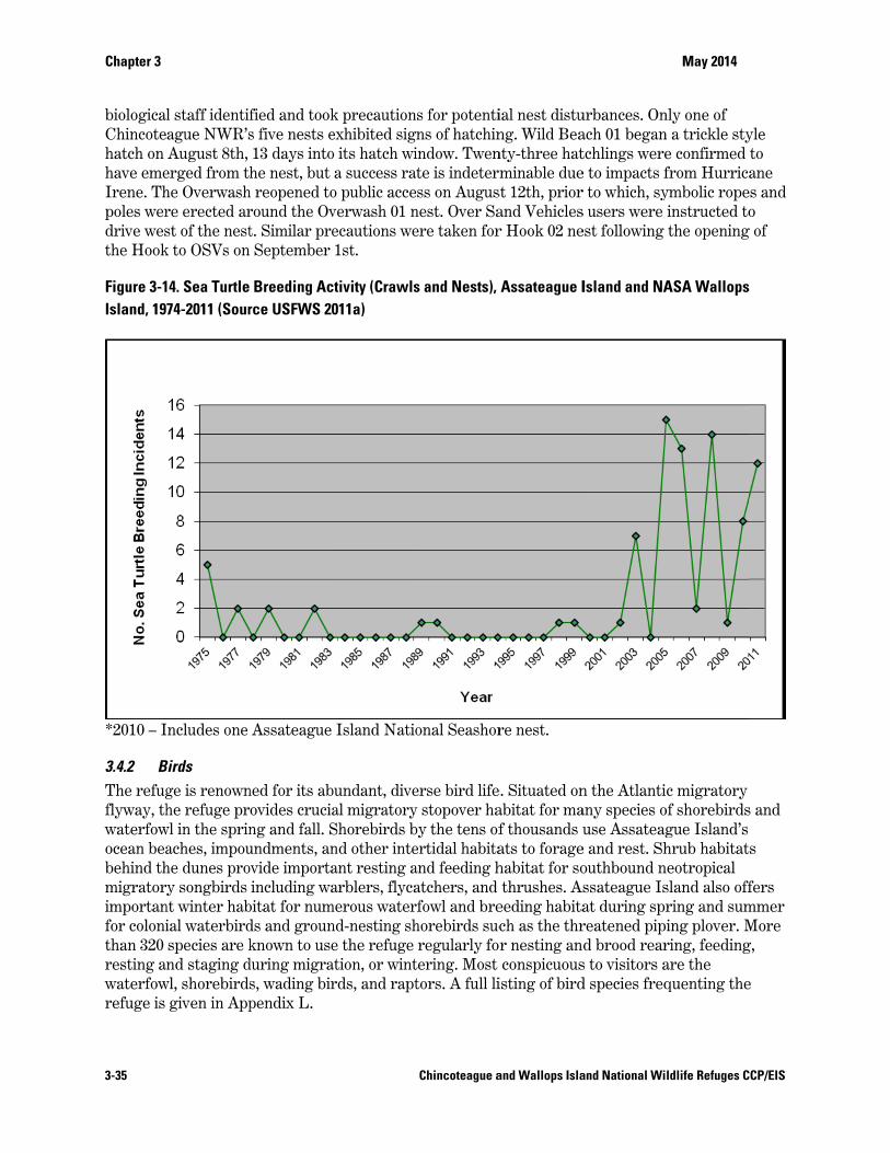
Chapter 3
3-35
biologicalChincotehatch on have emeIrene. Thpoles werdrive westhe Hook
Figure 3-1Island, 19
*2010 – I
3.4.2 BThe refugflyway, thwaterfowocean beabehind thmigratorimportanfor colonithan 320 resting awaterfowrefuge is
l staff identifague NWR’sAugust 8th,
erged from thhe Overwashre erected arst of the nestk to OSVs on
14. Sea Turtle74-2011 (Sour
ncludes one
Birds ge is renownhe refuge pr
wl in the sprinaches, impouhe dunes proy songbirds
nt winter habial waterbirdspecies are knd staging d
wl, shorebirdsgiven in App
fied and tooks five nests e13 days intohe nest, but
h reopened toround the Ovt. Similar pre September
Breeding Acrce USFWS 20
Assateague
ned for its abovides cruciang and fall. Sundments, anovide importa
including wabitat for numds and grounknown to use
during migras, wading birpendix L.
k precautionexhibited sigo its hatch wia success ra
o public acceverwash 01 necautions we1st.
ctivity (Crawls011a)
Island Natio
bundant, diveal migratoryShorebirds bnd other inteant resting aarblers, flyca
merous waternd-nesting she the refuge
ation, or wintrds, and rapt
Chincoteague a
s for potentins of hatchinindow. Twente is indetermss on Augus
nest. Over Saere taken for
s and Nests),
onal Seashor
erse bird lifey stopover haby the tens ofertidal habitaand feeding hatchers, and rfowl and brehorebirds sucregularly for
tering. Most tors. A full li
and Wallops Isla
ial nest distung. Wild Beanty-three hatminable due
st 12th, priorand Vehiclesr Hook 02 ne
Assateague I
re nest.
e. Situated onabitat for maf thousands uats to foragehabitat for sothrushes. As
eeding habitach as the thrr nesting anconspicuous
isting of bird
and National Wi
urbances. Onach 01 begantchlings weree to impacts fr to which, sys users were est following
Island and NA
n the Atlantiany species ouse Assateag
e and rest. Shouthbound nssateague Isat during sprreatened pipd brood rear
s to visitors ad species freq
May 2014
ldlife Refuges C
nly one of n a trickle stye confirmed from Hurricaymbolic ropeinstructed tothe opening
ASA Wallops
c migratory of shorebirdsgue Island’s hrub habitat
neotropical sland also offring and suming plover. Mring, feedingare the quenting the
CCP/EIS
yle to ane
es and o
g of
s and
s
fers mmer More g,
e
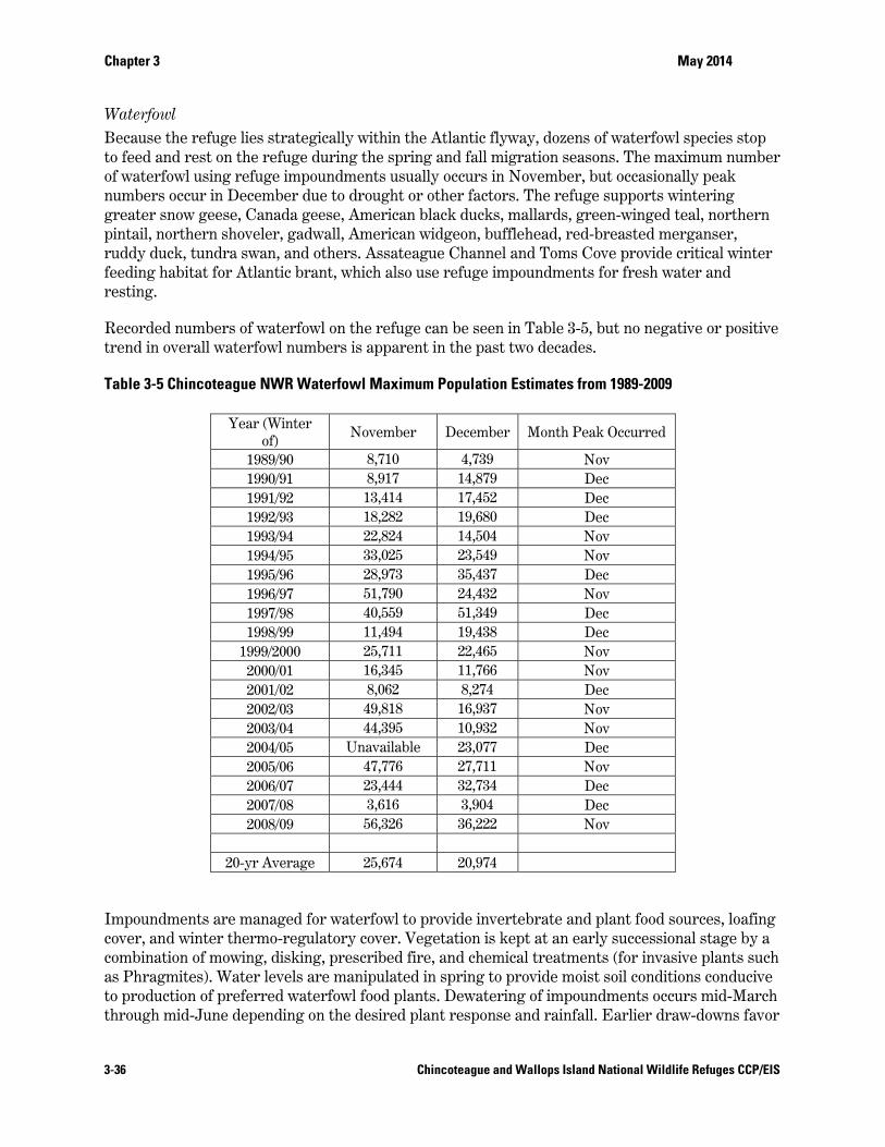
Chapter 3 May 2014
3-36 Chincoteague and Wallops Island National Wildlife Refuges CCP/EIS
Waterfowl Because the refuge lies strategically within the Atlantic flyway, dozens of waterfowl species stop to feed and rest on the refuge during the spring and fall migration seasons. The maximum number of waterfowl using refuge impoundments usually occurs in November, but occasionally peak numbers occur in December due to drought or other factors. The refuge supports wintering greater snow geese, Canada geese, American black ducks, mallards, green-winged teal, northern pintail, northern shoveler, gadwall, American widgeon, bufflehead, red-breasted merganser, ruddy duck, tundra swan, and others. Assateague Channel and Toms Cove provide critical winter feeding habitat for Atlantic brant, which also use refuge impoundments for fresh water and resting.
Recorded numbers of waterfowl on the refuge can be seen in Table 3-5, but no negative or positive trend in overall waterfowl numbers is apparent in the past two decades.
Table 3-5 Chincoteague NWR Waterfowl Maximum Population Estimates from 1989-2009
Year (Winter of)
November December Month Peak Occurred
1989/90 8,710 4,739 Nov 1990/91 8,917 14,879 Dec 1991/92 13,414 17,452 Dec 1992/93 18,282 19,680 Dec 1993/94 22,824 14,504 Nov 1994/95 33,025 23,549 Nov 1995/96 28,973 35,437 Dec 1996/97 51,790 24,432 Nov 1997/98 40,559 51,349 Dec 1998/99 11,494 19,438 Dec
1999/2000 25,711 22,465 Nov 2000/01 16,345 11,766 Nov 2001/02 8,062 8,274 Dec 2002/03 49,818 16,937 Nov 2003/04 44,395 10,932 Nov 2004/05 Unavailable 23,077 Dec 2005/06 47,776 27,711 Nov 2006/07 23,444 32,734 Dec 2007/08 3,616 3,904 Dec 2008/09 56,326 36,222 Nov
20-yr Average 25,674 20,974
Impoundments are managed for waterfowl to provide invertebrate and plant food sources, loafing cover, and winter thermo-regulatory cover. Vegetation is kept at an early successional stage by a combination of mowing, disking, prescribed fire, and chemical treatments (for invasive plants such as Phragmites). Water levels are manipulated in spring to provide moist soil conditions conducive to production of preferred waterfowl food plants. Dewatering of impoundments occurs mid-March through mid-June depending on the desired plant response and rainfall. Earlier draw-downs favor
Chapter 3 May 2014
3-37 Chincoteague and Wallops Island National Wildlife Refuges CCP/EIS
sedges, smartweeds, and bulrushes, while later drawdowns favor grasses. Late summer re-flooding provides desirable feeding sites for early fall migrants, particularly shorebirds. However, this is only possible with adequate rainfall. Fall re-flooding produces feeding conditions conducive to later migrants and to wintering waterfowl. Maintaining certain impoundments with high water levels year round, and flooding very large impoundments during the fall migration, creates roosting and loafing sites. Thermo-regulatory areas for waterfowl are maintained by allowing woody plants to remain within certain impoundments, or by raising the water level to flood wooded areas.
Black duck management is a high priority throughout this species’ range because of declining populations and hybridization with mallards. Wintering habitat quality on the refuge is enhanced by controlling Phragmites and wax myrtle in favor of vegetation with higher waterfowl food value, such as three square, spikerush, and red root flat-sedge. Refuge black duck populations peak during fall migration when 1,100 to 1,400 are typically counted during November impoundment surveys. Black ducks in winter use tidal salt marsh and impoundments to a lesser extent.
Snow goose populations have recovered significantly since the 1930s and 1940s, when they were considered an imperiled species. The refuge's current mid-winter snow goose population averages around 6,000 to 12,000 geese but can range as high as 50,000 for a few weeks. These birds rest in the protected refuge impoundments, and regularly feed in adjacent salt marshes and in agricultural fields on the mainland. Occasionally geese feeding activity is concentrated in particular salt marsh locations, undesirably uprooting salt marsh cordgrass and creating muddy devegetated "eat-out" areas.
Chincoteague is not considered a significant waterfowl production refuge, and production data is not collected. However, during the 1980s, duck and goose production was emphasized on this refuge and many others throughout the Refuge System due to extended prairie drought and declining duck numbers. Intensive management activities to enhance waterfowl nesting no longer occur. Usually, a few broods of gadwall, mallards, black ducks, and wood ducks are present each year. Resident geese and non-native mute swans are selectively removed from Chincoteague NWR because they damage habitat on which migrant and wintering species depend.
Wading Marsh and Waterbirds A variety of wading birds inhabit the tidal creeks and moist soil management units of the refuge to include the glossy ibis, great egrets, snowy egrets, green herons, little blue herons, tri-colored herons, black-crowned night herons, and cattle egrets, as well as several rail species. Being fairly large, beautiful, and plentiful along refuge trails, these birds offer visitors with excellent viewing and photography moments, particularly during the spring and summer when species of egret, heron, and ibis frequent the impoundment borrow ditches, eating small finfish and eels. Colonial nesting birds such as heron, egret, and ibis commonly nest on salt marsh islands in Chincoteague Bay. Other rookeries are located in the outer marsh fringe between Chincoteague Island and the mainland. Grebes and loons winter at the refuge, resting and feeding on adjacent waters. The eastern brown pelican (whose populations have recovered from population declines due to the use of the pesticide DDT and are now no longer endangered) frequent the refuge's intertidal zones, the ocean, and Assateague Channel. Pelicans nest in coastal areas south of the refuge; however, over the past few years they have nested progressively northward.
Chapter 3 May 2014
3-38 Chincoteague and Wallops Island National Wildlife Refuges CCP/EIS
Shorebirds, Gulls, and Terns Chincoteague NWR is one of the country’s top five shorebird migration staging areas east of the Rocky Mountains (USFWS 1993a). It is designated a site of international importance by the Western Hemisphere Shorebird Reserve Network (WHSRN). Peak shorebird numbers during spring migration occur in May. The fall migration usually peaks in August and spans the period of July to October.
Spring migration begins with the arrival of piping plovers in March, but there are few other signs of migration before mid-April. During early spring migration, defined as the period of April 7 to May 6, 1,000 to 4,000 shorebirds may be present on Assateague Island habitats. The great majority are dunlins (50 percent) and sanderlings (22 percent), but short-billed dowitchers, black-bellied plovers, willets, and whimbrel are also present (Wilds 2007 and Refuge unpubl. data). During late spring migration, defined as the period of May 7 to June 6, between 6,000 and 26,000 (typically 12,000 – 13,000) birds are present on Assateague Island. The majority (46 percent) are semipalmated sandpipers, but good numbers of dowitchers, sanderlings, least sandpipers, dunlin, and ruddy turnstones are also present (Wilds 2007 and Refuge unpubl. data).
Fall migration begins around July 1 with the arrival of short-billed dowitchers. Soon thereafter greater and lesser yellowlegs and least and semipalmated sandpipers arrive, the latter species making up the vast majority (around 40 percent) of shorebird numbers present July through September (Wilds 2007). Virtually all migrants present in July are adults. Hatching year migrants are not common until the last third of August, and by the last third of September, juveniles usually comprise the only shorebirds around, except for adults of shorebird species that overwinter.
Red knot, a species proposed to be listed as threatened under the ESA, uses Chincoteague NWR beaches during spring and fall migration, with peak spring numbers occurring in the last half of May and peak fall numbers occurring in August (Smith et al. 2008a), as confirmed by refuge data. Since the 1980s, the population of red knots has declined 68 to 80 percent; the severe decrease in a major food item during migration—horseshoe crab eggs in Delaware Bay—is a suspected cause (Cohen et al. 2009). A significant proportion (25 to 30 percent) of the population of red knots (estimate 10,000 to 13,000) use Virginia’s barrier islands during spring migration (Cohen et al. 2009). These recent findings that Virginia barrier islands support a significant migratory red knot population add importance to Chincoteague NWR’s role in red knot conservation.
Shorebirds were historically reported to occur in “huge numbers,” but hunting for sport and food during the late 1800s and early 1900s resulted in decreases in populations of many species of shorebirds. Although hunting has been illegal for all but two species of shorebirds since 1916, many populations of shorebirds are still declining today. Many of the negative shorebird population trends suggest habitat degradation (50 percent of U.S. wetlands have been lost or degraded), depletion of critical food supplies (over-harvest of Delaware horseshoe crabs may be the most recent example), or other factors at work” (Harrington 1999). The United States Shorebird Conservation Plan identifies a number of shorebird characteristics that pose “conservation challenges” including: (1) long distance migration; (2) low productivity and resulting slow population recovery; (3) concentration of populations and increased vulnerability to environmental occurrences; (4) dispersed and ephemeral habitat; (5) loss of habitat; (6) population changes and (7) the need to conserve across international borders (Brown et al 2001).
Avian migration is largely governed by endogenous rhythms, but annual variations in schedules may occur due to sex and age composition of flocks (Holmgren et al. 1993, Nebel et al. 2000), and
Chapter 3 May 2014
3-39 Chincoteague and Wallops Island National Wildlife Refuges CCP/EIS
weather, tides, and prey availability at stopover sites (Akesson and Hedenstrom 2000, Alerstam 2003). Virginia stopover site has been of historic importance in supporting red knots during spring migration and is not simply an ephemerally used satellite site to Delaware Bay (Cohen et al. 2009). The diet of red knots in Virginia includes coquina clams (Donax variabilis) and blue mussels (Mytilus edulis; Truitt et al. 2001), as was also the case historically (MacKay 1893), and lacks the horseshoe crab (Limulus polyphemus) eggs that are a staple in the Delaware Bay. Furthermore, unlike Delaware Bay, the Virginia habitat consists of high–wave-energy ocean shoreline, similar to much of the rest of the historic stopover range (Cohen et al. 2009). As many as 10,000 knots also stage on the outer barrier islands along the Virginia coast (Watts and Truitt 2000). Red knots tagged in Argentina, Brazil, and Chile stopped in Virginia in 2007 (Smith et al. 2008) as well as in Delaware and New Jersey, providing evidence that both stopover sites hosted birds from the southern wintering sites (Cohen et al. 2009).
Stopover duration for knots in Virginia from 2006 to 2010 was shorter, on average, than for Delaware Bay. The duration in Virginia was 7 to 8 days through May 25th, and increased to 9 to 12 days from May 26th to June 6th. Red knots exhibited two peaks in the duration of stopover. The first occurred during the first through third week of May, and the second occurred from the last week in May to the first week in June. The pattern of stopover duration in Virginia may be driven by abundance of benthic prey. In 2007, prey peaked at the end of May through early June (Cohen et al. 2009). Arrival to Virginia appears to be constant throughout stopover, while changes in fidelity rates (0.76 – 0.84) mirror peaks in total stopover duration (Duerr et al. 2011). Analysis of mark-resight data on an annual basis (Cohen et al. 2009) provided evidence that red knots from Virginia move between Virginia and one or more other spring locations. Movement from Virginia to an unobserved location (60 percent) was greater than fidelity to Virginia (40 percent). However, this movement was not permanent, as many (48 percent) returned in subsequent years (Duerr et al. 2011).
Virginia supports the second largest number of red knots in the Eastern U.S. during their final stopover during the northward migration in spring (Duerr et al. 2011). Although numbers of animals that use an area is not an indication of habitat quality (Van Horne 1983), survival of those animals is a valid indicator of quality. The Virginia annual survival (0.87) is higher than the estimates for knots from Tierra del Fuego and Delaware Bay prior to (0.84) and after (0.54) a population decline in 2000 (Baker et al. 2004, Duerr et al. 2011).
The barrier islands along the Delmarva Peninsula in Virginia provide high quality habitat for migrating red knots. This area contributes to high survival, and supports tens of thousands of birds. Early preservation of the barrier islands and lagoon systems in Virginia contribute to the long-term survival of the rufa subspecies, potentially helping to avert steep short-term declines that were predicted (Baker et al. 2004) for Delaware Bay. Knots using Virginia and Delaware Bay constitute a single population that includes red knots from throughout their winter range (Duerr et al. 2011).
Migrant shorebirds use Assateague Island beaches, tidal flats, and impoundments. Shoveler Pool (B-North Pool), Snow Goose Pool (B-South Pool), Swan Cove Pool (F Pool), Black Duck Pool (A Pool), Old Fields, South Wash Flats, and NWF are the most important for shorebirds (Wilds 2007), as confirmed by refuge data. Pintail and Gadwall (D and E Pools), Sow Pond, and Ragged Point typically have little or no shorebird use. The Hook is the most important beach area on Assateague Island for migrant and nesting shorebirds (Refuge unpublished data).
Chapter 3 May 2014
3-40 Chincoteague and Wallops Island National Wildlife Refuges CCP/EIS
Refuge staff have cooperated with the VDGIF and TNC to monitor American oystercatcher population size and breeding success since 2001. In 2008, the refuge supported 25 percent (100) of the total number (395) of nesting pairs on Virginia’s barrier islands. This amounts to 14 percent of the State’s total number of breeding pairs (731). Cedar Island has the most breeding pairs on the refuge, followed by Assawoman and Assateague Islands. Metompkin Island had the largest population (95 breeding pairs) of oystercatchers on any of Virginia’s barrier islands, however only 14 pairs nested on the refuge portion. Refuge staff also conduct boat-based breeding and fall/ winter roost surveys of oystercatchers in Chincoteague Bay, when staffing allows.
The refuge also provides excellent nesting habitat for colonial and other beach nesting birds. Colonial species include common terns, least terns, gull-billed terns, and black skimmers. Wilson's and piping plovers nest on beach ridges and overwash areas (Assateague Island is the northern limit of Wilson's plover breeding range). Intertidal sand and mud flats on the cove side of Toms Cove Hook contain horseshoe crab eggs and other high quality food during the entire shorebird season. Willets and oystercatchers nest on the cove side beach and around the natural freshwater marsh in the Hook interior. Oystercatchers also nest in the dunes and recently-vegetated areas near Fishing Point.
Herring, ring-billed, and laughing gulls are the three gull species commonly seen during summer months. Great black-backed gulls have recently expanded their range southward, and can be found on the refuge yearlong. Gulls nest along the causeway connecting Chincoteague Island to the mainland. They feed and rest along refuge beaches and in impoundments.
In regards to numbers of shorebirds using an area during the southward migration, Chincoteague NWR ranks fourth among 454 sites east of the Rockies where a census was taken in the United States, and is important for many species on an international scale. The refuge ranked second in diversity of shorebird species from among all 450 sites in the International Shorebird Survey network (Schulte and Chan 1985, Manomet 2008), and the barrier islands of Virginia and Maryland were dedicated as part of the International Shorebird Reserve.
Raptors Many raptors are known to be present on or adjacent to the refuge, with the American kestrel, osprey, black vulture, red-tailed hawk, bald eagle, and great horned owl among the most common species.
Bald eagles were de-listed from the Federal ESA in 2007 and de-listed from the Virginia list as of January 1, 2013. The three known bald eagle nests on Chincoteague NWR are checked for activity in March and May each year by VDGIF; they are currently located in a loblolly pine tree at Black Duck Pool (A Pool), Great Neck (directly west of Old Fields), and Wallops Island.
Assateague Island is a major resting and feeding area for peregrine falcons during fall migration. They hunt shorebirds and other prey and use the beach as a resting area. In 1980, a peregrine hacking tower was erected on the NWF. Hacking is a falconry technique in which chicks are placed in artificial nests and fed until they are ready to fly. Eight falcon chicks were hacked from the tower in 1980 and 1981. The first successful nesting of peregrine falcons in Virginia after the DDT era occurred on the NWF tower in 1982, and pairs nesting on this tower produced a total of 54 fledglings between 1982 and 2003. Between 2004 and 2008, pairs occupied the tower, but nesting was assumed to be unsuccessful based on behavior and aerial surveys. In 2008, the tower was climbed for the first time in several years, and evidence of mammalian predation (probably
Chapter 3 May 2014
3-41 Chincoteague and Wallops Island National Wildlife Refuges CCP/EIS
raccoon) on the eggs was found, and the predator guards were in disrepair. The tower was removed prior to the 2009 breeding season because of conflicts with piping plover management objectives on the NWF and a statewide decision to not repair or maintain existing peregrine towers located in important shorebird areas within the seaside lagoon system. The peregrine hacking tower on Metompkin Island was removed in 2010 for this reason (Watts et al. 2008).
Ospreys fish in refuge marshes and Swan Cove Pool (F Pool), northern harriers hunt in marshes and impoundments, and red-tailed hawks nest in forests. Three species of owls are year-round residents. Eastern screech owls nest in Delmarva Peninsula fox squirrel and wood duck nest boxes, as well as in natural cavities. Barn owls often nest in hunting blinds on adjacent marshes. Great horned owls prey on rabbits, Delmarva Peninsula fox squirrels, and shorebirds. Southbound migrating hawks stop to rest and feed on the refuge during fall migration as they fly over the Delmarva Peninsula. Large numbers of hawks stop to rest and feed during their fall migration, including kestrels, merlins, sharp-shinned hawks, and Cooper's hawks. Turkey vultures are occasionally seen roosting in trees or flying over the refuge in search of carrion. The known raptor migration through the area occurs in September and October.
Landbirds From 1999 to 2009, refuge volunteer Dr. Richard (Dick) Roberts monitored landbird habitat use through mist netting and banding. During these 10 years, Dr. Roberts sampled 14 different areas on Chincoteague NWR, comprising shrub/early successional, forested uplands, and shrub/pine edge habitats. Some areas have been sampled for 5 consecutive years or more, others for 3 years or fewer (Roberts 2009). Nets were operated year-round, weather permitting. Overall goals of this monitoring were to:
Collect baseline data on species using refuge habitats as a basis for management decisions; Identify habitats being used by species of special concern; Document/confirm nesting and migrating species; Document the occurrence of rare or unusual species; and Conduct environmental education.
In shrub habitat dominated by wax myrtle/bayberry vegetation adjacent to the South Wash Flats impoundment, 72 species were captured during the 5-year sample period. Evidence of breeding of common yellowthroats, gray catbirds, and prairie warblers was found. The latter is a highest priority Bird of Conservation Concern for the New England/Mid-Atlantic Coast (BCR 30) and gray catbird is a medium priority BCR 30 species (USFWS 2008c). Yellow-rumped (myrtle) warblers depend upon this habitat extensively during migration and winter. BCR Highest or High Priority Species that have been banded in this habitat during breeding or migration include (in order of relative abundance): field sparrow, prairie warbler, brown thrasher, eastern towhee, great crested flycatcher, Baltimore oriole, eastern kingbird, worm-eating warbler, and northern flicker. Medium priority BCR 30 species captured in this habitat in order of relative abundance are gray catbird, Canada warbler, and blackburnian warbler.
Dr. Roberts considers shrub habitats behind beach dunes, such as that typified by his study site adjacent to Toms Cove Visitor Center, essential stopover habitat for southbound fall migrants. This habitat is particularly important to juvenile birds (and hence recruitment into the population), since 85 to 90 percent of birds migrating southbound through the mid-Atlantic coast are hatch-year birds (2009). This vegetation on the lee side of the dunes appears to provide
Chapter 3 May 2014
3-42 Chincoteague and Wallops Island National Wildlife Refuges CCP/EIS
important refuge to birds inexperienced in navigation that may otherwise be blown out to sea without somewhere to shelter and re-fuel (Roberts 2009). BCR Highest or High Priority Species that have been captured in migration during 5 years of mist-netting in this site include (in order of relative abundance): field sparrow, black-and-white warbler, eastern towhee, eastern kingbird, prairie warbler, Louisiana waterthrush, Baltimore oriole. Gray catbird, a medium priority BCR 30 species, was captured in this study site, but at relatively low numbers compared to other sites.
Mist-netting/banding sites in forest habitat have been operated for 1 to 3-year periods in approximately six locations along the Woodland Trail and Wildlife Loop to measure response to habitat modifications such as pine bark beetle outbreaks and prescribed burns. The following BCR Highest or High Priority Species have been among the 75 species captured in this habitat in order of relative abundance: brown thrasher, field sparrow, northern flicker, eastern towhee, black-and-white warbler, Baltimore oriole, great-crested flycatcher, prairie warbler, eastern kingbird, and worm-eating warbler. Medium priority BCR 30 species captured in this habitat in order of relative abundance are gray catbird, brown-headed nuthatch, and red-headed woodpecker.
The longest consecutive mist netting/banding site operated by Dr. Roberts (2001-2009) is adjacent to the Woodland Trail parking lot. It is located on the edge between forested uplands and salt marsh habitat and contains more understory shrubs (myrtle, bayberry, greenbrier, and other berry-producing shrubs) than typical mature loblolly pine forest on Assateague Island. Bird species diversity was high: 87 species captured in a 9-year period. Gray catbird, a medium priority BCR 30 species, has the highest number of captures here compared to any other site. The following BCR Highest or High Priority Species have been captured at this site (in order of relative abundance): black and white warbler, eastern towhee, Baltimore oriole, prairie warbler, eastern kingbird, northern flicker, field sparrow, and worm-eating warbler (Roberts 2009).
The mist-netting study has provided valuable data, particularly for skulking species, non-singing migrants, and wintering birds. However, canopy birds and larger species such as crows and bobwhite are under-represented. A breeding bird survey (BBS), conducted for 10 years between 1996 and 2006, provides additional data on the refuge’s landbird population. Two BBS routes of 30 points each, spaced 0.5 miles apart, in myrtle shrub and loblolly pine forest (total = 60 points) were run during the second week of June using slightly modified BBS protocols (Chincoteague NWR 1996).
Appendix L lists the 20 most abundant birds (in order of relative abundance) observed in each of the two habitats (myrtle shrub and loblolly pine forest) during the 10 year BBS period. Ten BCR 30 Priority Species breed on the refuge: gray catbird, northern bobwhite, and brown thrasher—found in both habitats; field sparrow, eastern kingbird, and prairie warbler—found in myrtle shrub; and eastern towhee, great-crested flycatcher, northern flicker, and brown-headed nuthatch—found in loblolly pine forest.
Appendix L also compares the BBS results with Dr. Robert’s 20 most abundant mist-net captures (1999-2007). Only nine species were on the top 20 in both the BBS and the mist net study: gray catbird, common yellowthroat, song sparrow, house wren, northern cardinal, common grackle, Carolina wren, field sparrow, and yellow-breasted chat. Birds that appear on Dr. Robert’s “Top 20” and not on the BBS are generally wintering or migrant birds. For example, the most numerous wintering and migrant bird on the refuge—yellow-rumped warbler—was not encountered at all on the BBS. Birds that appear on the BBS “Top 20” and not on Dr. Robert’s
Chapter 3 May 2014
3-43 Chincoteague and Wallops Island National Wildlife Refuges CCP/EIS
study are canopy birds such as eastern wood peewee, brown-headed nuthatch, and great-crested flycatcher, or species too large to be captured in passerine mist nets such as crows and bobwhite.
Upland Game Birds Based on the 10-year BBS noted above, northern bobwhite quail are widespread with a stable to increasing population trend on the refuge. They were detected on 29 of 30 possible points in myrtle shrub vegetation over the 10-year period, and on average detected on 40 percent of the points each year. Quail were detected on all 30 points in loblolly pine vegetation at one time or another during the 10-year survey and on average detected on 36 percent of the points each year. According to refuge data records, the number of quail counted in both the myrtle shrub and loblolly forest BBS routes has increased between 1996 and 2006 (unpubl. data, Refuge files).
Four American woodcock singing-ground survey routes (totaling 40 survey points) encompass all suitable woodcock habitat on the refuge accessible by road. Routes have been run intermittently in 8 of the past 20 years, beginning in 1990. A maximum of 15 woodcock were detected during the 2000 survey, and the most recent survey in 2009 counted five woodcock. Birds have been counted on each route with the exception of the North Service Road. Beach Road/Woodland Trail has had the highest number of detections and been the most consistent in having woodcock over the years. The Swan Cove Trail/Wildlife Loop did not have any woodcock during the first 10 years of the survey but has had more woodcock than any other route during the most recent decade. It was the only area with woodcock in 2009. No long-term trend can be determined from the data except that higher numbers of woodcock were counted during the first half of March, irrespective of the year. Counts after March 21 generally detect fewer birds, perhaps indicating that Chincoteague NWR is more important to migrating or wintering woodcock than breeding birds. Wallops Island NWR appears to have suitable habitat but lacks survey data.
The first turkeys on Assateague Island were sighted in March 2005 by an employed law enforcement officer. Coincidentally, the NPS staff reported turkeys on the north end of Assateague Island around the same time. Turkeys are regularly encountered on the bi-weekly waterfowl survey. The population size of turkeys is unknown, but a flock no greater than 20 birds (adults and juveniles) was observed in December 2009 (Buffa 2009). Turkeys are thought to be at least stable and probably increasing, according to refuge data. Turkeys are also frequently sighted on Wallops Island NWR.
3.4.3 Fish and Other Aquatic Species A full list of fish species collected on the refuge during the refuge’s Fish Survey is listed in Appendix L.
Finfish The refuge and surrounding area has a diverse assemblage of fish species that inhabit the impoundments and is somewhat tolerant of fluctuating water salinity. During droughts and periods of water level drawdown, fish are confined to borrow ditches, where they are an easy food source for wading birds, skimmers, terns, and osprey. Species include the sheepshead minnow, rainwater killifish, striped killifish, mummichog, banded killifish, tidewater silverside, threespine and fourspine stickle-back, white and yellowperch, and American eel.
Myriads of fish spawn and feed in the nutrient rich, protected waters on Assateague Island's bay side. Marine finfish of primary recreational or commercial importance in the refuge vicinity