bcra 16-2-1989
DESCRIPTION
BCRA 16-2-1989; BCRA 16-2-1989TRANSCRIPT
Ca e Science The Transactions of the British Cave Research Association BeRA
I Volume 16 Number 2 August 1989 I
Tufa - the whole dam story
Tower karst cave sediments from China
Mulu expedition, 1988
Karst windows in Thailand

Cave Science
The Transactions of the British Cave Research covers all aspects of speleological science, including geology, geomorphology, hydrology, chemistry, physics, archaeology and biology in their application to caves. It also publishes articles on technical matters such as exploration, equipment, diving, surveying, photography and documentation, as well as expedition reports and historical or biographical studies. Papers may be read at meetings held in various parts of Britain, but they may be submitted for publication without being read. Manuscripts should be sent to the Editor, Dr. T. D. Ford, at 21 Elizabeth Drive, Oadby, Leicester LE2 4RD. Intending authors are welcome to contact either the Editor or the Production Editor who will be pleased to advise in any cases of doubt concerning the preparation of manuscripts.
NOTES FOR CONTRIBUTORS
These notes are intended to help the authors to prepare their material in the most advantageous way so as to expedite publication and to reduce both their own and editorial labour. It saves a lot of time if the rules below are followed.
All material should be presented in a format as close as possible to that of CAVE SCIENCE since 1985. Text should be typed double-spaced on one side of the paper only. Subheadings within an article should follow the system used in CAVE SCIENCE; a system of primary, secondary, and if necessary, tertiary subheadings should be clearly indicated.
Abstract: All material should be accompanied by an abstract stating the essential results of the investigation for use by abstracting, library and other services. The abstract may also be published in CAVES AND CAVING.
References to previously published work should be given in the standard format used in CAVE SCIENCE. In the text the statement referred to should be followed by the relevant author's name and date (and page number, if appropriate) in brackets. Thus: (Smith, 1969, p. 42). All such references cited in the text should be given in full, in alphabetical order, at the end. Thus: Smith, D. E., 1969. The speleogensis of the Cavern Hole. Bulletin Yorkshire Caving Assoc., Vol. 7, p. 1-63. Books should be cited by the author, date, title, publisher and where published. Periodical titles should be abbreviated in standard style, or, where doubt exists, should be written out in full.
Acknowledgements: Anyone who has given a grant or helped with the investigation, or with the preparation of the article, should be acknowledged briefly. Contributors in universities and other institutions are reminded that grants towards the cost of publication may be available and they should make the appropriate enquiries as early as possible. Expedition budgets should include an element to help publication, and the editor should be informed at the time of submission.
Illustration: Line diagrams and drawings must be in BLACK ink on either clean white paper or card, or on tracing paper or such materials as Kodatrace. Anaemic grey ink and pencil will not reproduce! Illustrations should be designed to make maximum use of page space. Maps must have bar scales only. If photoreduction is contemplated all lines and letters must be large and thick enough to allow for their reduction. Letters must be done by stencil, Letraset or similar methods, not handwritten. Diagrams should be numbered in sequence as figures, and referred to in the text, where necessary, by inserting (Fig. I) etc. in brackets. A full list of figure captions should be submitted on a separate sheet.
Photographs are welcome. They must be good clear black and white prints, with sharp focus and not too much contrast; prints about 15 x 10 cm (6 x 4 inches) are best; if in doubt a selection may be submitted. They should be numbered in sequence, but not referred to in the text, except where essential and then after discussion with the Production Editor. A full list of plate captions, with photographer credits where relevant, should be submitted on a separate sheet.
Tables: These should not be included in the text but should be typed, or clearly handwritten, on separate sheets. They should be numbered in sequence, and a list of captions, if necessary, should be submitted on a separate sheet.
Approximate locations for tables, plates and figures should be marked in pencil in the manuscript margin.
Copyright: If any text, diagrams or photos have been published elsewhere, it is up to the author to clear any copyright or acknowledgement matters.
Speleological expeditions have a moral obligation to produce reports (contractual in the cases of recipients of awards from the Ghar Parau ,Foundation). These should be concise and cover the results of the expedition as soon as possible after the return from overseas, so that later expeditions are informed for their planning. Personal anecdotes should be kept to a minimum, but useful advice such as location of food supplies, medical services, etc., may be included, normally as a series of appendices.
Authors will be provided with 20 reprints of their own contribution, free of charge, for their own private use. Additional reprints can be available at cost, and should be requested at the time of submission of the manuscript.
Manuscripts on disk are welcome, as text may be set directly from them. Please submit a hard copy to the Editor in the normal way, and advise him that you have a disk, which you can submit after any editorial corrections.
If you have any problems regarding your material, please consult either of the Editors in advance of submission.

Cave Science
TRANSACTIONS OF THE BR1TISH CAVE RESEARCH ASSOCIATION
Volume 16 Number 2 August 1989
Contents
Tufa - the Whole Dam Story Trevor D. Ford
Cave Sediments from Chuan Shan Tower Karst , Guilin, Ch ina Peler A. Bu//, Yuan Daoxian and Hu Mengyu
The Mulu Caves '88 Ex pedi tion Malt Kirby
The Karst Windows of the Nam Khlong Ngu, Western Thailand John Dunkley, Grahame Wilton-Jones and Jane Clark
Forum
39
51
57
71
75
Cover: View down the Firecracker River Passage in Blackrock Cave (Lubang Batau Padeng), ye t another massive strike-orientated passage discovered in the incred ible limestone mountains of the Gu nong Mulu Nat ional Park in northern Sarawak. By Je rry Wooldridge.
Editor: Dr. T. D. Ford , 21 Elizabeth Drive, Oadby, Le icester LE2 4RD.
Production Editor: Dr. A. C Waltham, Civi l Engi neering Department, Trent Polytechnic, Nottingham NG I 4BU.
Cave Science is published by the British Cave Research Association, and is issued to all paid up members of the Associa tion. 1989 subscription rate fo r non-members is £ 16.00. Membership Secretary: N. Briggs, 127 Bulls Head Lane, Coventry CV3 I FW.
Individual copies and back numbers of Cave Science are obtai nab le from: B. C R.A. Sales, 20 Woodland Avenue, Westonzoyland, Bridgwater, Somerset TA 7 OLQ. The permanent address for B.CR.A. is: B.CM.-B.CR.A., London WCIN 3XX.
Copyright the British Cave Research Association, 1989. No part of th is publication may be reproduced in any other publication , used in advertisi ng, stored in an electronic retrieval system, or o therwise used for commercial purposes, without the prio r written consent of the a uthors a nd o f the Association .
ISSN 0263-760X


CAVE SCIENCE Vol. 16. No.2, August 1989 Transactions of the British Cave Resea rch Association
Tufa - the Whole Dam Story Trevor D. FORD
Abstract: A review is presented of the nature and origm of the calcareous deposits in freshwater environments known as tufa or travertine. T ufa is deposited by inorganic degassing of CO2 from carbonate saturated waters, by the metabolic biochemistry of primitive plants such as cyanobacteria and a lgae, and by the indirect b iochemical precipitation caused by plants' uptake of CO2, Raised summer temperatures are desirable for all these react ions. Some tufa is deposited by cooling of thermal waters, and some by reactions in saline or alkaline lakes . Brief reviews of important tufa deposits and some current research programmes are included.
Visits by the writer to the P litvice National Park in Yugoslavia, with its series of tufa-dammed lakes, have focused his attention on this generally crumbly, white fresh-water carbonate deposit. A lthough deposits occur widely scattered around the world, tufa has not often been studied in its own right, and is usually dismissed in a sentence or two in text-books on sedimentary geology . Tufalike speleothems occur in many cave entrances throughout the world , but are generally only recorded as " crumbly white stalactites" . However, tufa is a fascinating substance generally intimately associated with karst scenery and hydrology and well worthy of consideration in its own right. Its origin is often controversial, with unanswered questions as to its inorganic chemical or biologic origin. The only world-wide review traced is the short note by Julia (1983) so the present article attempts to redress that situation .
The term " tufa " is based on Tophus, a term used by Pliny to describe both what we now know as tufa and some fine-grained whitish volcanic dust deposits, which we would now call Tuff. Such volcanic deposits are clearly distinct from calcareous tufa and are not considered further herein. Tufa is more or less synonymous in some literature with travertine, which is a corruption of lapis tiburtino, derived from " Stone of Tibur", the river which runs through Rome. Travertine has been intensively quarried for ornamental stone at Bagni di Tivoli (baths of Tivoli) and other localities some 30 km east of Rome (Chafetz & Folk, 1984). The porous, laminated, cream-coloured stone, often wi th numerous holes like gorgonzola cheese, can be seen as a frontage to many public buildings, shops etc. throughout Europe, and was used as a building stone in ancient Rome. Whilst Bagni di Tivoli was the principal source, much modern travertine comes from North Africa today. Whilst ornamental stone masons use the term travertine almost always, some geologists reserve travertine for the harder compact varieties, leaving tufa for the crumbly material. This, however, means that some massive deposits are composed of bands of travertine within tufa! Travertine has also been used as a collective term for stalagmitic deposits in caves and for the deposits around some hot-springs. The former of these is perhaps best forgotten , and the latter redefined as " thermal tufa". Some continental writers also use the term sinter to cover either tufa or travertine, both open-air or in caves; most British and American writers reserve sinter for siliceous deposits round hot springs, as in Yellowstone Park , Wyoming (see also Bagli, 1980; Julia, 1983; and Chafetz & Folk (1984) for discussion of terminology).
Tufa is sometimes used as a generic term for all speleothems in caves, indeed the front cover of Geotimes for March 1989 shows gou r pools in a stream cave and calls them " tufa " but this usage is misleading, unless they are truly crumbly calcium carbonate deposits as understood on the surface. For simplicity herein, tufa refers to a ll the deposits of ca lcium carbonate in fresh -water streams and lakes; qualified as thermal tufa there are the closely simila r deposits associated with hot springs. Travertine may be used for the harder, generally stratigraphically older materia l. used for ornamenta l stone. Sinter is best forgotten in these contexts.
Mechanisms of Deposition
Several mechanisms of deposition have been proposed. Firstly, a purely inorganic physico-chemical precipitation of CaC03 as a consequence of degassing of CO2 from karst waters to achieve equilibrium with the adjacent atmosphere (Zeller & Wray, 1956, Lorah & Herman , 1988). The amount of CaC03 which can be dissolved in water is in direct proportion to the CO2 content of that water, as it is held in the form of the bicarbonate . The amount of rainfall, the duration of contact with limestone and the residence time in that limestone are thus factors in the amount of tufa which can be deposited (see Kempe & Emeis, 1985). However, a
considerable degree of supersatura tion is required before calcite will precipitate . (Lorah & Herman , 1988). Some organic compounds such as humic and fulvic acids and organo-phosphates "poison " possible nucleation sites on calcite particles. Indeed receptive calcite particles are essential before nucleation will take place. Excessive magnesium will also block precipitation. Thus precipitation often does not take place at springs but starts a kilometre or so downstream, particularly where turbulence is greatest. Secondly, it has been argued that the metabolic activity of micro-organisms such as blue-green a lgae (nowadays referred to as cyanobacteria) is the essential process whereby calcium carbonate is an integral part of the organisms themselves, and thereby tufa is deposited by the decay of dead organisms. Pentecost (1978) and Pedley (1987) have deduced that only 2-3% tufa is due to this process whilst Lorah & Herman (1988) argue that the metabolic contribution is negligible. Thirdly, the simple fact that plant growth takes CO2 out of the immediate micro-environment must mean that excess CaC03 is precipitated , and in fact it often occurs as sheaths round the algal filaments, as well as coatings on higher plants. The decay of the latter involves fungi as well and similarly causes an indirect biochemical reaction . Both Golubic (1973) and Chafetz & Folk (1984) have argued that this may be the most important primary process . The relative proportions due to these processes is the subject of controversy though most writers now agree that a combination of all three is the best explanation of tufa deposition.
A fourth process is somewhat distinct - the cooling of waters emerging from hot springs; deposition from nearly boiling water is obviously an inorganic process but as the thermal waters cool away from the vents algae and bacteria nourish in the warm water and a biochemical effect takes increasing importance. Whilst distinct in their initiation, thermal tufa deposits d iffer little in morphology
Tl!la l'II£Tltst;ng a mass of l'ege/aliol/ ill (he Grand Canyon, Arizona: the tubular structures (Ire aholll 1 em in diameter.
_II
39

('/lls/£'r5 (~r /Ufo "shruhs" giring {f concretioNary appearance /0 1I I'ug-like m il1i-l'{II'e at
A/port-hy - YOIi/greal'C'. Derhyshire ( ('umew -Iells ('up IiJI" s('(fle J.
from normal karstic deposits and a gradation between them is a normal situation. However, therma l tufa is deposited all year round whereas "'normal" tufas a re temperature-controlled and often only precipitated in the summer, and commonly show either diurnal or seasonal laminae.
A firth process is a chemical one by which highly alkaline lakes can only hold a small amount of CaC03 in solution and any excess due to inflowing streams or to evaporation is precipitated as a crust on submerged rocks etc. Occa ional arguments invoke the presence of magnesium in karst wa ters as a critical factor. Magnesium is an essential part of chlorophyll and thus of plants associated with tufa, but the carbonate deposited is usually lowmagnesium calcite, and magnesium is often very low in the karst waters, so that it is difficult to support arguments in favour of magnesium as anything more than an incidenta l part of photosynthetic processes.
Recent studies by Pentecost (1978,1981,1984, 1985) and others have shown that cyanobacteria flourish in the active zones of tufa cascades and tha t tufa deposition is an important part of their life cycle. However, Pentecost has argued that only a small proportion, generally less than 3% of the CaC03 present, is metabolised by the cyanobacteria, and most is precipitated as a consequence of photosynthetic extraction of CO2 from the water i.e. a chemical reaction influenced by organic processes. The very fine-grained CaC03 particles adhere to the mucous surfaces of the cyanobacteria, accumulate as sheaths round the filaments or are simply trapped in interstices. Tufa deposits are often laminated, either in thin (less than 0.5 mm) diurnal layers or in thick (up to 7 mm) annual layers (Chafetz & Folk, 1984).
At Checa in central Spain , exceptional growth rates of tufa deposits on the mosses Brywn pseudolriquelrum, Craloneuron commulatum and Caloscopium nigrilul17 have been studied by Weijermars el al (1986) who found spongy tufa was being deposited at around 4 cm per annum. They deduced that the 8m high terrace was less than 2000 years old. Experiments showed that tufa deposition seeded artificially with the first two mosses, could reach as much as 14 cm per annum and that some practical use might be made of this .
Aragonite is uncommon in tufa deposits, though Stoffers (1975) has noted its presence apparently associated with certain mosses at Plitvice. The lack of magnesium in both waters and the calcite of tufa is generally sufficient to preclude aragonite precipitation. However, magnesium has been found to increase downstream in some deposits as calcium is taken out of the system by tufa deposition.
Srdoc el al (1985) have noted that tufa deposition is largely restricted to a stretch of only about 12 km of the Korana river and that there is little or no deposition in the 136 km downstream in
40
spite of little change in chemical conditions. In fact the only significant change is an increase in dissolved organic carbon which seems to inhibit the nucleation of calcite crystals. Comparable increases in organic carbon in the water elsewhere may explain why tufa deposition has stopped in Holocene times, e.g. due to excess peat washing into rivers in the Yorkshire Dales (see Pentecost & Lord 1988).
Algae and Bacteria
The primitive plants apparently responsible for tufa deposition have been identified in only a few localities (see list in Viles, 1988) and a global survey of the species concerned has yet to be done. The relative importance of the biological contribution has been over-stressed according to Viles (1988). The barrel-shaped cyanobacterium Phormidium seems to aggregate larger crystals of calcite than the filamentous Schi:othrix, both having mucous coatings to which the micro-crystals adhere (Chafetz & Folk, 1984, see also Golubic, 1973). Bryophytes such as Cratoneuron and Rhynchoslegium are locally important (Pentecost & Lord, 1988). Tufa-encrusted mosses occur in shady seepages and include the genera Euc!adium and Gymnoslomum. There is some evidence to suggest that micro-morphological variants occur due to growth being mainly cyanobacterial when constantly underwater; liverworts are dominant in areas intermittently covered by water, whilst mosses accumulate tufa in areas wetted only by splashing (Julia , 1983). Sheaths around the cyanobacterium Rivularia occur in both wet and intermittently wetted areas (Pedley, 1987). The layers coat adventitio us vegetable matter in cascades and streams, and give a " petrifying" effect to twigs, leaves, branches, treetrunks, mollusc shells, insect ca rapaces, and vertebrate bones on occasion . Siliceous diatoms may be present as they too extract CO2 from water and may thus indirectly cause tufa growth (Kempe & Emeis, 1985).
Precipitation of CaC03 may take place with no algal involvement at si tes of geothermal springs. The dissolved bicarbonate content is already high and a combination of CO2 exsolution, evaporation and cooling may cause inorganic precipitation. The resultant tufa may then be more compact, without diurnal or annual lamination , and mineralogically more akin to stalagmites in caves. However, downstream cooling may permit cyanobacteria algae and , later, mosses, to grow so that thermal tufa may grade into non-thermal (Scholl & Taft. 1964).
Adolphe (1981) noted tufa concretions in a river in northern France which showed expansive growth of domes which swelled in spring due to tangled masses of filaments, but with sparse filaments in the autumn; however, it is not clear whether he was dealing with true tufa or with algal nodules.
Experiments carried out in the tufa falls of Plitvice used different materials as nucleating surfaces for calcite crystals: copper failed to show any nuclei and Srdoc el al (1985) take this to indicate its poisonous effect on biological processes, and argue that this confirms the importance of biogenic precipitation . However. control experiments in an abiogenic environment do not appear to have been carried out and it may be that copper has an inhibiting effect on calcite generally.
Morphotypes
Several different morphological types of tufa may be distinguished : wa terfalls and cascades; lake fills; sloping mounds. cones and fans ; terraces; and thermal orifice "chimneys" (Dunn, 1953; Chafetz & Folk , 1964; Pedley, 1987). Each has its own micromorphological types of deposit: cascades have sheets of miniature "shrubs" and encrusting laminae (Chafetz & Folk, 1984; Pentecost & Lord, 1988); lake-fills are more or less amorphous fine-grained carbonate mud; mounds and fans have sheets of shrubby growth and coarse-grained carbonate mud laminae. The thermal chimneys at Mono Lake have much coarse, non-laminated chalky carbonate rock, some of which is characterized by botryoidal masses having dendritic or radial tubular openings internally. Thinolite at Mono Lake consists of irregularly oriented crystal-like pyramids of compact calcite (Dunn , 1953) but this rock type does not appear to have been recognized elsewhere.
Tufa build-ups of generally fine-grained tufa form the lips of cascades and are termed " phytoherms" by Pedley (1987). As water flows over the lip of cascades there is micro- turbulence, and this releases CO2 to the atmosphere directly causing a simple chemical precipitation of CaC03 which also may coat plant debris or other objects, so that it is not easy to differentiate the chemical and biochemical contributions. Turbulence associated with storms or periods of high stream-flow may denude the growing edge of its fine-grained precipitate which is washed into quieter stretches of the streams. In this way a series of growing cascades separated by

B/'()k ~1/ seC(;UII ("rough pel/dli/oliS IIIl1SSeS 0/ "shrtthhy" fI~/(/ lvhich mo{\ (/ smull c(l re: A/porlhy- You/egrc({\'(', Derh.1'shir£'.
ponds or lakes may develop. Such effects may be on a micro-scale with " algal " ridges no more than a few millimetres high damming up pools a few centimetres across or they may be on a macro-sca le with cascades more than 30 m hi gh damming up lakes a ki lometre o r so in length , as at Plitvice a nd Krka Falls in Yugoslavia. If growth on the cascade lip wanes or ceases, then it may be eroded and its products accumulate in the pools or lakes up to the point of filling them - wide sheets of tufa may grow in this way. Or, if growth on some cascades increases they may ra ise the lake level behind until o ther cascades upstream are completely drowned. Lake levels a t Plitvice are currently rising by a t least I cm per annum, and the average quantity precipitated is estimated a t around 10,000 tons per annum. Srdoc el a/ (1986) have demonstrated average sedimentat ion rates in some 12 km of la kes at a round I mm per annum.
The morphology of individua l tufa deposits may reveal something of their histo ry and mode of growth, th ough it has rarely been described in detail , owing to the difficult ies of cutting thin sections of such crumbly materials. The growing surface is often composed of miniature "shrubs" up to 3 mm high with radiating clusters of CaC03 fib rous microcrys ta ls (Chafetz & Fol k, 1984; Pedley, 1987). The voids between these are filled with fine-grained amorpho us precipita te. The cessation of plant growth in winter may lead to sheets of fine-grained in organic tufa draped over the shrubs, and a new generation of shru bs grows the following summer, giving annual " mini-varves" . Layers of shrubs may encrust adventitious plant material. Small scale turbulence may detach lumps of shrubby material which then rota te in minipools whilst being encrusted in new layers . The result is pisoids, or pseudo-ooliths, sometimes found in discontinuous layers or clusters in tufa (Folk & Chafetz, 1983). Encrustat io n of large pla nt ' debns, such as tree branches, may lead to cauliflower-like spheroidal masses similar to marine stromatolites . Rotting away of encrusted plants may leave a variety of tubul ar hollows within a tufa deposit. Occasionally animal foss ils may be found in tufa -ranging from bones or even skeletons of vertebrates to insects a nd shells of terrestria l snai ls. Breaks in deposi tion may be marked by humic soil layers, often rich in shell s. On a larger scale, collapse of tufa dams and subsequent overgrowth may lead to tufa conglomerates with unconformit ies at al l angles. Some tufa cascades overhang to the extent that shallow caves become hidden behi nd walls of tufa . Stalactites and stalagmites may grow in these. and in turn they may provide nuclei for la ter growth if they become submerged.
Tufa dams and cascades a re, of co urse, constructional landforms, and deserve notice simply for their con trast with the normal destructional character of waterfa lls as erosional features of rivers . The la kes held up by tufa ba rriers are simi larly constructional, in stead of the ephemera l nature of most lakes.
Isotope Studies
The distribu tion and proportio n o f stable isotopes (2-H, 13-C and 18-0) and radioactive isotopes (3-H, 14-C) in tufa should help
P elldu/UIIS luhu/(fl" oll /sses '!/ Ili/l l /(II"I"l' ''~1" CI1(TIISf ;lIg II/os.'· ;11 (Ill ahalldollcd parr of (/ Il~j(/ barrh'/" at P/il1";('(', Yug(}s/ur;l'.
to answer many problems. but studies have only been carried out in a few localities, and then only with some isotopes (e.g. Srdoc el
a/1985; Thorpe, 1981; Thorpe el a/1980) . Factors which have been investigated include the age of the deposit s, largely based on 14-C, with occasional comparisons with uranium/thorium series disequilibrium ages . Most ages so determined confirm the geomorphologica l evidence of the dominant period of deposi tion being post-glacial (H oloccne). Together with 18-0, studies of distribution of 14-C indicate that climatic control is important, with minimum temperatures o f deposition rarely being much below 12°e. Studies of 13-C and 3-H have helped to indicate that some deposition is in thin laminae of seasona l or even diurnal character, and tha t layers up to a few centimetres thick have been deposited since atomic bomb testing started in the I 940s. Using a fresh section provided by a cutting on a footpa th , Srdoc el a/ (1986) have been able to demonstra te by means of 14-C ages that growth of a dam at Plitvice was largely in vertica l sheets giving vert ical isochrons. The Mean Residence Time of waters in the karst
Rfcly .'I(dN\ed {/1/(/11"('{/ lhered 111/0 ,,/w1ring gru11"lh 101"('/"., gel/{'/"l/flr 1-IUI/IIJ1 'hief.... A/port-h.\"- } 'o ulgr('(l1"£'. Oerhyshire. . .
4 1

Cascades ul'er fI~r(J harr;ers ;f1 lhe PHll 'h'C' N afl'ollol Park , Yugosllll'hl,
aq uifers and the degree of mixing have been in vest igated by Srdoc el al with the MRT commonly being 1--4 years, with almost complete mixing. Srdoc el al have also argued tha t 13-C ratios indicate a high proportion of Plitvice tufa is of biogenic origin.
A combination of 14-C and 13-C determinations was used by Thorpe (1982) to characterize the flow through paths and residence times in the source aquifers supplying tufa springs at three localities in England. 18-0 determinations suggested that temperatures were higher today than in the " little Ice Age" of 1200 - 1700 AD.
Usi ng 14-C Utech & Chafetz (1989) in O~lahoma have shown that periods of precipitati on corre late with high rainfall, owing to displacement of stored karst wate rs from the aquifers. 18-0 distribution shows high summer activity alternati ng with low winter deposition.
Srdoc el al (1985) have noted that the proportion of 14-C may increase downstream owing to contributions from rotting vegetation , from the respi ration of roots and from interchange with atmospheric CO2 due to turb ulence over dams. Some care in sampling the most upstream points and in interpretation is necessary or dates may be misleading.
The proportions of 13-C and 18-0 in the hot spring waters at Mammoth Hot Springs, Yellowstone, have been shown to be si milar to those of the limestones beneath, confi rming that they were the source of CO, in solution (Friedman, 1970).
Hennig el al (1983) collated a list of 141 uranium/thorium dates on travertines mainly in central Europe and the Middle East , tho ugh wi thout giving details of thei r sampling localities . The dates show a post-glacial peak , a mild peak in part of the last interglacial and a spread of earlier dates, th us providing limited confirmation th at tufa deposition is greatest in a warm climate.
An alternative method of dat ing tufa deposits uses electron spin resonance techniq ues, but the onl y applica tions so far appear to be oriented towards testing the accuracy of the method on materials already dated by uranium/thorium methods (Grun el al 1988). Whilst the ESR dates are generally comparable with UrTh dates the technique st ill needs more research before it can generally be appl ied.
Much work remains to be done on isotope distributions before a global consens us of their significance can be deduced. Indeed. the
4:2
on-going programme at Plitvice (Srdoc et a/) is still constrained by the problem of obtain ing a complete sequence through anyone deposit, since the ba rriers hold back substantial lakes. A programme of carefully planned boreholes might yield a comprehensive history without damage to the tufa barriers, both at Plitvice and elsewhere.
Diagenesis
The role of diagenesis, that is the recrystallization of the various fo rms of primary calcite into secondary rock-types, has rarely been studied in detail and some of the interpretations of mechanisms of tufa deposition appear to have overlooked such processes. In general it seems that some fine-grained granular " chalky" tufa may recrystallize into radiating layers of coarsely crystalline calcite (Love & Chafetz, 1988; Pedley, 1987). This neomorphism results in the loss of biological details and may lead to underestimation of the importance of organic processes. Love & Chafetz (1988) urge caution before a non-biological cause of tufa precipitation is accepted. The factors which cause or allow some tufa to recrystallize and other apparently similar tufa not to do so, are not understood. Some writers refer to the hard recrystallized material as travertine leaving the softer deposits as tufa. Interlayering of these two is not uncommon, e.g. at Bagni di Tivoli, Italy (Chafetz & Folk , 1984). The application of isotope dating to such phenomena may yield dates of both original deposition and of recrystallization, and it is likely that some published dates are a blend of the two processes.
Caves in Tufa
Many of the larger tufa deposits noted below contain caves. These range upwards from large vugs perhaps a metre in diameter to whole systems of caverns and passages. The literature on tufa makes little mention of these and no discussion of speleogenesis in tufa has been traced. It seems likely that the most common mode of origin is the simple overhang of cascade or waterfall deposits leaving chambers perhaps a few metres high and long behind them. Several of the Plitvice barriers have such caves but one can rarely penetrate beyond the range of daylight. In Lathkill Dale, at low water fl ow one can crawl in under the tufa sheet for some 100 metres, but this is partly due to scouring out of loose gravel beneath tufa in flood conditions. Most tufa caves have abundant stalactitic speleothems of rather crumbly " chalky" calcite, deposi ted due to percolation through the tufa cascade. Primary caves in tufa up to 10 x 8 m have been noted by Jennings (1985) at Lliafured in Hungary . An apparently unique show cave in tufa is H6llgrotte, at Barr, Switzerland (Gigon, 1965) where some 300m of caves are connected by tunnels.
In the Himalayas Waltham (1971) found a tufa cave at Kursangmo where it seems that CaC03 leached from boulder clay is deposited as overhanging terraces at the edge of an eroded boulder clay sheet.
Caves in thermal tufa deposits may represent the feeder channels of former hot springs, now abandoned, but they should be treated with caution on account of possible sudden reactivation by hot water or even steam, and because they may contain pockets of CO2 or H2S (Bargar, 1978).
It should be noted that since most tufa masses are post-glacial in age, it follows tha t the caves in them must be even younger, i.e. late Holocene.
British Tufa Deposits A survey of the morphology and distribution of major British
tufa deposits reveals several interesting facts. The tufa cascades at Gordale Scar, near Malham in North Yorkshire, encrust a steeply descending gorge in carboniferous limestone, but they appear only to be growing in limited patches today (Pi tty, 1971; Pentecost & Lord, 1988) . Rather, indeed, they are being channelled by more aggress ive run-off (Thorpe, 1982). Their position clearly indicates a postglacial date so what has happened to change the regime from depositional to erosional? Isotopic studies suggest that the main growth period was from c. 4600 B.P. to 1900 B.P. Since then there has been a minor climatic change towards cooler conditions and it seems that this is sufficient to discourage the cyanobacterial growth. The upland catchment area has seen widespread deforestation partly at the hand of man, wi th concommitant peat growth giving more acidic run-off and higher organic carbon con tent, and this has apparently resulted in solutional erosion in small channels adjacent to deposition of broad sheets nearby. The breaching of the Hole in the Wall about 1730 AD may have increased turbulance (Thorpe, 1982). Barely a mile downstream at
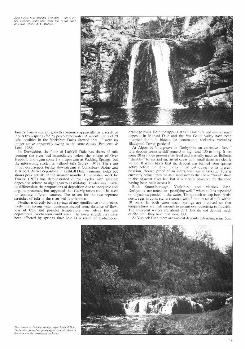
Jailer :~. Foss. Ileal' Malhmn . Yorkshire - olle oI rhe fell' Yorkshire Dales sires Il'here fL~fa is sril/ being deposilet/. (pholu: A. C. Wa/lham ).
Janet 's Foss waterfall, growth continues apparently as a result of inputs from springs fed by percolation water. A recent survey of 29 tufa localities in the Yorkshire Dales showed that 17 were no longer active apparently owing to the sa me causes (Pentecost & Lord, 1988).
In Derbyshire, the floor of Lathkill Dale has sheets of tufa forming the river bed immediately below the village of Over Haddon, and again some 2 km upstream at Pudding Springs, but the intervening stretch is without tufa (Burek, 1977). There are minor occurrences further downstream at Conksbury Bridge and at Alport. Active deposition in Lathkill Dale is minimal today but shows peak activity in the summer months. Unpublished work by Towler ( 1977) has demonstrated diurnal cycles with greatest deposition related to algal growth at mid-day. Towler was unable to differentiate the proportions of deposition due to inorganic and organic processes, but suggested that Ca/Mg ratios could be used to separate different sources. The reason for the two separate stretches of tufa in the river bed is unknown.
Neither is directly below springs of any significance and it seems likely that spring water upstream needed some distance of flow , loss of CO2 and possible temperature rise before the tufa depositional mechanism could work. The lower stretch may have been a ffected by springs since lost as a result of lead-miners '
Th" ('{/SC'"/" til Pudding Springs, upper Lalhkill Da/e, Derhyshirl!: /i)fI1led hy quarrying {limy a fl{fa shl!eI ill rhl! ril 'er bed ji)l' urnlllllental rucker/I!s.
drainage levels. Both the upper Lathkill Dale tufa and several small deposits in Monsal Dale and the Via Gellia va lley have been quarried for tufa blocks for ornamental rockeries. including Blackpool Tower gardens!
At Alport-by-Youlgreave in Derbyshire an extensive "fossil" tufa deposit forms a cliff some 5 m high a nd 150 m long. It lies some 20 m above present river level and is totally inactive. Bulbous "shrubby" forms and encrusted caves with small dams a re clearly visible. It seems likely that the deposit was formed from springs active before the River Lathkill had cut down to its present position , though proof of an interglacial age is lacking. Tufa is currently being deposited as a successor to the above "fossil " sheet in the adjacent river bed but it is largely obscured by the road having been built across it.
Both Knaresborough , Yorkshire, and Matlock Bath, Derbyshire, arc noted for "petrifying wells " where tufa is deposited on objects suspended in the water. Things such as top-hats, birds ' nests, eggs in cups. etc. are coated with 5 mm or so of tufa within 10 years. In both cases warm springs are involved so that temperatures a re high enough to permit cyanobacteria to fl ourish. The emergent waters are about 20°C but do not deposit much calcite until they have lost some COo.
At Matlock Bath there are ancient deposits extending some 50m
43

up the hillside, and various buildings have been erected upon them. In fac t some post-war houses have had problems wi th their foundations owing to spring water seepages. Isotope studies have suggested that the waters are of meteoric origin which have circulated deeply through limestones, dolomites and basaltic lavas for at least 15 years (Edmunds, 1971) but their chemistry is not substantially different from the warm springs at Buxton where the emergent temperature is c. 27°C and no tufa is deposited, perhaps due to the hot spring stream being joined and diluted by cold waters from moorland streams soon after emergence. Near Ma tlock there are la rge tufa deposits, now inactive, in the Via Gellia valley where the unusual house, Marl Cottage, is built of la rge blocks of tufa . Thorpe ( 1982) has dated the main period of deposition at 9000 - 4000 years B.P. and suggests that decreased rainfall was the reason why tufa deposi tion stopped.
All the tufa deposits in Derbyshire are similar in appearance but the only one still active is that at Matlock Bath, where warm springs give a thermal effect. If the spring ever dried up we should be left wi th tufa deposits of " normal " and '" thermal" types which could not be differentiated morphologically.
At Caerwys in North Wales, a la rge tufa deposit has been quarried for many years for agricultural lime (Maw, 1966). The deposit is up to 12 m thick and one kilometre long over a height range of 46 m. Studies by Martin Pedley (1987) have shown that this deposit is of post-glacial age, start ing about 7880 ± 160 years B.P. and it is no longer act ive. The quarry faces show excellent textu ra l and structural features such as laminated banks of shrubby and micritic tufa, overhangs with caves and stalagmites, pool deposits subsequently overgrown by flat sheets of tufa, pisoid lenses and interbedded humus layers. The deposit is unusual in that it does not directly overlie limestone, th ough it was fed by streams derived from the Carboniferous Limestone a kilometre upstream.
Crumbly white stalagmites and fl owstone occur in the entrance to Ingleborough Cave in N.W. Yorkshire though they are apparen tly no longer active. Mosses and li verworts encrust many of these speleothems and show reduction in size of the thallus lobes with decreasing light intensity (Piearce, 1975). Apart from records of insects li ving on such tufaceous material no chemical or biochemical studies appear to have been undertaken.
Comparable massive tufa-like stalactites occur in avens in the roof of Peak Cavern entrance in Derbyshire, some being almost beyond the penetration of daylight. No detailed studies appear to have been conducted here.
Small scale tufa deposits are widespread in British chalk country and on the Jurassic limestone outcrops (see Pitty 197 1 and Thorpe 1982). None is spectacular and the on ly significant investigations of them have been in Kent (Preece, 1978 , 1980; Kerney, Preece & Turner, 1980) and the Cotswolds (Thorpe, 1982).
Other Tufa Deposits
Overseas tufa deposits are many and on ly a few can be considered here. The classic " traverti ne marbles" of Bagni Oi
44
Tivoli east of Rome have been thoroughly investigated by Chafetz & Folk (1984) . Quarried for over 2000 years they have been used for such buildings as the Colosseum and the colonnade of St Peters in Rome and the quarries are still worked. The tufa deposits spread over thousands of square metres of hillside at each of three main localities, and the total height at each is at least 80 metres. The tufa is quarried in 10 m high benches. The weakly thermal tufa is still being deposited. Tufa dams and cascades built up and held back lakes, subsequently filled in with bacterial mud tufa. Sloping mounds, fans and cones spread into terraces and ridges. Each is composed of shrubby growth, both finely and crudely laminated carbonate mud, often indurated to the extent that it can be sawn out in blocks in the quarries. Bacterial pisoids, stromatolites, coated bubbles and tubular sheaths are recognized amongst the detailed textures. Precipitation seems to vary from bacterial in good conditions, with water temperatures around 20°C, and dominantly inorganic in less favourable (cooler) conditions. Whilst the main age of the deposits is clearly late Pleistocene to Recent, the date of initiation has not yet been determined. Both large and small lamination is present; large annual laminae average 7 mm thick and each may have up to 200 fine diurnal laminae 0.1-D.5 mm thick , indicating the length of the growing season as around 200 days (Chafetz & Folk, 1984).
Across the Adriatic at Plitvice are probably the most spectacular and most intensively studied deposits of all in the Yugoslavian karst (Anon, 1965; Sweeting, 1972; Stoffers, 1975; Srdoc et af 1980, 1983, 1986). The river Korana flows in a gorge in Mesozoic limestones for some 12 kilometres; the limestones overlie impermeable Triassic dolomites which maintain a high watertable. The growth of tufa dams up to 30 m high has created a series of picturesque lakes. The river cascades over the dams resulting in spectacular waterfalls. The position of the individual dams is partly due to the reactions caused by inflowing tributary streams but there is more to it than that. Investigations by local karst geologists (summarized in a "coffee-table book " by Sobat et al 1985) have shown that no tufa is deposited until several kilometres downstream from the main springs, and that this is due to the water temperature being too low on resurgence at 7°C. On warming in the Yugoslavian summer to at least 12°C, degassing of CO2 takes place and tufa is precipitated. Algae also begin to grow and tufa deposition is a ugmented . Some of the dams have suffered partial collapse, perhaps due to earthquakes, and it is possible to see that the internal structure of some is characterized by unconformities. Other dams have concretionary tufa encrusting tree-trunks and branches. Isotope studies using 14-C (Srdoc el aI, 1980, 1983 & 1986) have shown that there have been two periods of deposi tion of the main tufa barriers from c.37000 to 25000 years BP, and since 6500 years BP up to the present. The latter is clearly Holocene and the former is probably to be associated with a warm interstadial within the Wiirm glacial phase (not the Riss/Wiirm interglacial as claimed by Srdoc el al 1986). Still older deposits occur high on the walls of the gorge. It has not yet been possible
The colol/llades around Sf, Pefer 's Square ill Rome are built oJ the "ll'lI l'erlinl! ma,.hh~" ji·vl11 nearby Bagl1i Di Tiroli. (photo: A. C. Waltham ).

Part 0/ the Skradin Falls. Krka Fall,' National Park. Yugu.'i/lII'ia: ,111:,' is part 0/ a pust glacial Il~ra harrier
45111 high holding back a lake snerol kilollletres long.
to demonstrate the mechanism of initiation of any dam since the critical sections are beneath waterfalls and holding up lakes behind the dams. It is possible that log-jams in the gorge provided nuclei for both inorganic deposition and for cyanobacterial growth. Some dams have grown to the extent that they have caused the immersion of other dams upstream beneath impounded lake waters. Up to 50 cm increase in the height of some dams has occurred in the last 35 years and the lake floors have gained an equivalent amount of fine carbonate mud. Kempe & Emeis (1985) estimate that as much as 10 000 tonnes of calcite is precipitated each year at Plitvice, and that the dams and hence lake levels are being raised by an average of one cen timetre per annum. Several other rivers in Yugoslavia have tufa dams; most notable are those on the Krka River some 10- 20 km inland from Sibenik on the Dalmatian coast (Anon , 1965). The Skradin Falls (commonly referred to as the Krka Falls) constitute tufa cascades some 45 m high across the gorge holding back a lake 8 km long. Other cascades further ups tream have been part ly quarried away or red uced by hydro-electric diversions. The base of the Skradin Falls is not far a bove sea level in an incised va lley drowned by the postglacial rise in sea level. So far as can be determined the tufa dams are Holocene in age, but there are relics of earlier deposits on the valley sides. Inactive tufa deposits are widespread in central Europe; most yield dates from the Atlantic warm period
Mamllloth /-/0/ Springs ther/1U11 lujel lerruces, Yellows/olle NlIIicmal Park , Wyoming. USA . Note Ihl' trees englllji'd by the adl'llllcing Ill/if (photo: A. C. Waithalll ).
(5000-2500 years ago) (8ogli, 1980) when there may have been increased biological activity, as well as slightly increased daily temperatures in summer.
Sheets of tufa totalling 18km2 occur in the Hula Valley of northern Israel, and appear to have been deposited intermittently over the last one milli on years, deposition becoming virtually defunct about 25000 years ago (Heimann & Sass, 1989). The sheets interdigitate with coarse gravels and with volcanic lavas, and deposition seems to have been affected both by tectonic activity causing changes in the hydrological regime, and by climatic factors during the Pleistocene. The near termination of deposition at c25000 years ago can be related to tectonic uplift causing falling water tables, and to progressive desiccation in post-pluvial conditions.
In the United States, a detailed study of the chemical evolution of Falling Spring Creek, Virginia, showed that the principal factor in tufa deposition was degassing by turbulence, but that this did not occur for several kilometres downstream from the spring at a 20m high waterfall; deposition was also greatest in the summer months when flow rates were low and temperatures high (Lorah & Herman, 1988) .
Most of the hot springs and geysers in Yellowstone National Park, Wyoming, U.S.A" deposit si liceous sinter and so do not co ncern us here; the Mammoth Hot Springs, however, deposit
45
calcium carbonate in large tufa masses (Allen & Day, 1935; Bargar, 1978) . The lime is derived from underlying volcanic and sedimentary rocks, and transported by hot circulating groundwaters wa rmed by residual magmatic heat. On emergence the hot spring waters are around 74°C and immediately sta rt depositing CaCOJ as a result of evaporation and degassing CO2,
i.e. thermal tufa. Cascades with dams and sha llow pools of nearly boiling waters extend several hundred metres down the hillside (Keefer, 1976; Bargar. 1978). The dams often overhang and grottos of sta lac tites are frequent. Concealed feeder channels are sometimes enlarged by solution and their roofs collapse giving lines of pits. These in turn may lead into caves, often with excess CO2 trapped, and sometimes remain ing steam-hea ted. Lateral movement of whole terraces occasionally opens fissures and if these
46
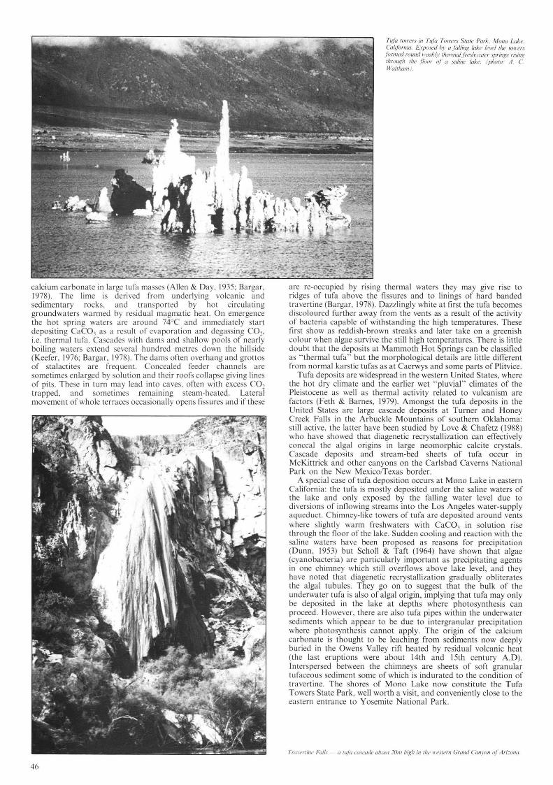
Tt!la {OII 'er ;; ill TI!!a TOIl'ers SlOfe Park, Mono Llike. ((ili/omia. Exposed h I" a F,lIil/g lake lei'''' 'he 'oll ·e/".I" fonlled round lI'eak(l' Ihennal j i'eslll l'aler springs rising ,"roug" '''1' fluo /" oj" a sa/ille lake. (1'''0/0: A. C. Wal,"ml/ ).
are re-occupied by rising thermal waters they may give rise to ridges of tufa above the fissures and to linings of hard banded travertine (Bargar, 1978). Dazzlingly white at first the tufa becomes d iscoloured furth er away from the vents as a result of the activity of bacteria capable of withstanding the high temperatures. These first show as reddish-brown streaks and later take on a greenish colour when algae survive . the still high temperatures . There is little doubt that the deposits at Mammoth Hot Springs can be classified as " thermal tufa" but the morphological details a re little different from normal karstic tufas as a t Caerwys and some pa rts of Plitvice.
Tufa deposi ts are widespread in the western United States, where the hot dry climate and the ea rlier wet "pluvial" climates of the Pleistocene as well as thermal activity re lated to vulcanism are fac tors (Feth & Barnes, 1979). Amongst the tufa deposi ts in the United States are large cascade deposits at Turner and Honey Creek Falls in the Arbuckle Mountains of southern Oklahoma: still ac tive, the latter have been studied by Love & Chafetz (1988) who have showed that diagenetic recrystallization can effectively conceal the algal origins in large neomorphic calcite crystals. Cascade deposits and stream-bed sheets of tufa occur in McKittrick and other canyons on the Ca rlsbad Caverns National Park on the New MexicofTexas border.
A specia l case of tufa deposition occurs at Mono Lake in eastern California: the tufa is mostly deposi ted under the saline waters of the lake and only exposed by the falling water level due to diversions of inflowing streams into the Los Angeles water-supply aqueduct. Chimney-like towers of tufa are deposited a round vents where slightly warm freshwaters with CaC0 3 in solution rise through the floor of the lake. Sudden cooling and reaction with the sa line waters have been proposed as reasons for precipitation (Dunn, 1953) but Scholl & Taft (1964) have shown that algae (cyanobacteria) are particularly important as precipitating agents in one chimney which still overflows above lake level, and they have noted that diagenetic recrystallization gradually obliterates the alga l tubules. They go on to suggest that the bulk of the underwater tufa is also of algal origin, implying that tufa may only be deposited in the lake at depths where photosynthesis can proceed. However, there a re also tufa pipes within the underwater sediments which appear to be due to intergranular precipitation where photosynthesis cannot apply. The origin of the calcium ca rbonate is thought to be leaching from sediments now deeply buried in the Owens Valley rift heated by residual volcanic heat (the last eruptions were abo ut 14th and 15th century A.D). Interspersed between the chimneys a re sheets of soft granula r tufaceous sed iment some of which is indurated to the condition of travertine. The shores of Mono Lake now constitute the Tufa Towers State Pa rk, well worth a visit , and conveniently close to the eas tern entrance to Yosemite at ional Park .
Tral'('fril1(, Falls II fit/a {'(lsl'lIdf! ahow ]UII/ high ill (he II '('S I (,I"II Grand Cal/yon vI Ari: UlIlI.

Tire 30 l11elre high IllIa lerract! al Allla/aya UII Ihe sOlllh coast of'Turkel'. (photu: A. C Wliithalll ).
In the adjacent Basin & Range area of Nevada and California there are many other lakes with tufa deposits a long shorelines past and present. These include Searles, Pyramid and Walker Lakes. The last has been described in detail by Newton & Grossman (1988) . Falling lake levels due to evaporation have left tufa heads on old strand lines, but no thermal freshwater reaction with the saline waters of the lake seems to be evident. In stead the high alkalinity of the lake means that even low concentrations of CaC03 (11 ppm) lead to precipitation of crusts underwater on gravel and boulders. Salt and alkali-tolerant algae are present but not thought to play any significant part in the precipitation.
Lake margin tufa deposits with associated beaches occur in some of the former glacial lakes in up-state New York , notably at Green Lake near Syracuse (Dean & Fouch , 1983). Algal stromatolites are common in the growing ledges just beneath water level, and masses of the bryophyte Chara occur in slightly deeper water. The absence of waterfalls o r of any factor causing degassing by turbulence indicates that these tufa deposits are predominantly of biological origin.
The Grand Canyon of the Colorado in Arizona has many tufa deposits, so far little investigated. They range from a dome some 150 m high round a weakly thermal spring, to ancient and deeply eroded cascades at numerous points along some 500 km of Canyon. Some of these cover massive cliff-fall breccias and have in turn been dissected by run-off streams. Both are now inactive but the positions clearly indicate a Pleistocene age perhaps when the climate was wetter during " pluvial" periods contemporary with glacial episodes further north. Percolation through the limestone strata of the canyon walls apparently picked up CaC03 in solution and deposited it on resurgence from springs a t the base of the limestones. Two 30 m high waterfalls in the tributary Havasupai Canyon are formed where tufa encrusts a Pleistocene si lt fill , and much tufa forms low dams in the rest of this stream.
Tufa deposits are widespread over the rest of the world, particularly in hot or semi-arid countries. Large sheets or dams occur in North Africa, Mexico, West Indies. Spain and Turkey. Some such as Plitvice, and Dunn's Falls in Jamaica are important tourist attractions. At Antalaya on the south coast of Turkey, tufa sheets spread over some 30 km of the bay shore and at one point a river draining the Taurus karst cascades directly into the sea over a 30 m high cliff. Thel111al tufa terraces simi lar to Mammoth Hot Springs in Yellowstone occur at Pamukkale in southwest Turkey. where the front of the terrace has taller barriers and deeper pools, and these form a major tourist attraction. In China there are many large deposits : the Huanglong terraces in Sichuan Province comprise a series of dams 7 km long - a tourist attraction comparable with Plitvice. The Huangguoshu waterfall is one of many massive tufa barrages across rivers in the karst of Guizhou Province (Waltham, 1984).
Thermal H(/il lerraces (I{ PalllUkkole, lI 'esH'elllral 7itrkey (photo: A. C. ~V(/III/(IfJ/ ).
In Afghanistan, the Band-e-Amir Lakes, in the Hindu Kush, some 200 km west of Kabul are held up by tufa barriers round three sides of the lakes in a broad valley, contrasting with the Plitvice gorge (de Lapparent , 1966: Brett, 1980). Occurring over a 12 km length of the Band-e-Amir River va lley, the dams are particular ly striking in that they form near vertical walls up to 10m high but little more th an 3 m thick. Such vertical dams may reflect the sparsity of vegeta ti on. in contrast to the luxuriant flora on the cascades at Plitvice and Krka . The upper ends of the lakes have spreads of fluvial sand with a limited vegeta tio n cover which may affect pH conditions loca lly. A sequence of tufa dam growth and destruction has been described by Jux & Kempf(1971): they argue that there has been tufa dam growth in the last two interglacial periods as well as in the Holocene. interrupted by nearly complete
47

destruction by river incision during two glacial episodes. An extensive series of "waterfa ll tufas" apparently once forming
dams like Plitvice has been described from the eastern Transvaal province, South Africa (Marker, 1971 , 1973). There is little depositional activity today and Marker suggested that a wetter climate must have been necessary for the karstic solution upstream to have supplied enough CaC03. A correlation with periods of speleothem growth in nearby caves is indicated but in the absence of absolute dates any correlation with major climatic phases such as "pluvials" cannot be proven.
Fossil Tufa Deposits If tufa deposits are so widespread in present day and post-glacial
situations, it can be argued that they ought to be present in the past stratigraphic record but few occurrences have been recognised . Perhaps the best known in Britain is the so-called fossil forest in the late Jurassic rocks of Dorset, particularly near Lulworth Cove. Here it seems that shallow tufa-dammed lakes surrounded treestumps and shrubby growth developed bulbous masses around these. The wood has since rotted away leaving hollow bowls where the boles were once' Tufa-like limestones also occur in the Oligocene of the Isle of Wight. Palaeosols of Carboniferous age occur associa ted with palaeokarst surfaces in the Dinantian limestones of South Wales, but few structures comparable with tufa have been described as yet. Perhaps a more intensive search of ancient " rubbly" limestones will reveal more palaeo-tufa. In the Creede volcanic caldera in Colorado, U.S.A., tufas of Pliocene age are interbedded with both volcanic rocks and with inwashed clastic sediments, (Steven & Ratte, 1965); presumably the tufas represent ancient thermal spring deposits .
Tufas interbedded with other sediments have been noted in several localities, notably Pliocene-Pleistocene deposits in Malta (Pedley, 1980) and in Israel (Heimann & Sass, 1989).
CONCLUSIONS
Tufa may be deposited as a result of one or more processes; inorganic chemical , by means of degassing of CO2 on warming of spring waters particularly in turbulent conditions, or by reaction with other solutes in saline or alkaline waters. Magnesium seems to play little part in the reactions but excess dissolved organic carbon seems to inhibit precipitation. Tufa may be deposited as a result of the metabolic life processes of cyanobacteria and algae, but this is generally only a minor process. Tufa may be deposited by an indirect biochemical means whereby primitive plants take up CO2 and thus cause precipitation of CaC03. Tufa may encrust various other plants, shells and bones but these are only incidental as nuclei.
The controlling factors are (a) saturation with CaC03; (b) moderately high temperatures, generally above 12°C; (c) turbulence; (d) low dissolved organic carbon; (e) the presence of cyanobacteria and other algae helps but is not essentia l; (f) thermal waters may deposit tufa on cooling though loss of CO2 is probably more important.
48
A tujil dam holding back a lake al Band-e-Amir. Ajghanistan (phuto: W E. Rensh{/)I' ).
Most major tufa deposits are clearly of post-glacial (Holocene) age; relatively few have been proved to be of earlier date, and then most of these can be correlated with warmer interglacial periods.
Both seasonal and diurnal laminations have been recognised, reflecting ambient temperature changes .
ACKNOWLEDGMENTS
Thanks are due to Tony Waltham and to Martin Pedley for useful discussions and critical reading of early drafts of this paper.
REFERENCES Adolphe, J.P. 1981. Examples des contributions microorganiques dans les
constructions carbona tees continenta les. Bull. Assoc. Geogr. Francaise. 479-480, 194-5.
Allen , E.T. & Day, A.L. 1935. The Hot springs of Yellowstone National Park. Carnegie Inst. Washington. Publ. 466. 525pp.
Anon , 1965. Gu ide book of excursion through the Dinaric Karst. 4th Internat. Congo Speleology. Ljubljana, Yugoslavia.
Adolphe, J .P. 1981. Examples des contributions microorganiques dans les constructions carbona tees continentales. Bull. Assoc. Geogr. Francaise. 479-480. 194-5.
All en , E.T. & Day. A.L. 1935. The Hot springs of Yellowstone National Park. Carnegie Inst. Washington. Publ. 466. 525pp.
Anon. 1965. Guide book of excursion th rough the Dinaric Karst. 4th Internat. Congo Speleology. Ljubljana, Yugoslavia.
Bargar, K.E. 1978. Geology and thermal history of Mammoth Hot Springs, Yellowstone National Park, Wyoming. U.S Geological Survey Bulletin 1444, 55pp.
Bogli , A. 1980. Karst hydrology & Physical Speleology. Springer Verlag, Berlin. Brett. T.E.W. 1970. A study of tufa deposition at the Band-e-Amir Lakes of central
Afghanistan. In Afghanistan Expedition Report. University of Bristol. 1970. 14pp. Burek , C. 1977. The Quaternary - other superfic ial deposits. pp. 97-98 in Ford, T.D.
(ed) . "Limestones and Caves of the Peak District". Geo-Books. Norwich. Chafetz. H.S. & Folk, R.L. 1984. Travertines: depositional morpho logy and the
bacteria ll y constructed constituents. Jour. Sediment. Petrology. vol. 54. pp. 289-316.
Dean , W.T. & Fouch. T.D. 1983. The Lacustrine Environment pp . 97-130 In Carbonate Depositional Environments. P.A. Scholle. D. Bebout & c. Moore (eds), Amer. Assoc. Petrol. Geol. Memoir 33. Tulsa. Oklahoma.
Dunn , J.R. 1953. The origin of the deposi ts of tufa a t Mono lake. Jo ur. Sediment. Petrology. vol. 23 , pp. 18-23.
Edmu nds. W.M. 197 1. Hydrogeochemistry of ground waters in the Derbyshire dome with special reference to trace constituents. Inst. Geol. Sciences Report no. 7117.
Feth, J .H. & Barnes. 1. 1979. Spring-deposited travertine in eleven western states. U.S. Geological Survey Water Resources Invest igations, 79 , 35.
Folk, R.L. & Chafetz. H.S. 1983. Pisolites (Pi so ids) in Quaternary travertines of Tivoli, Italy . pp. 474-487 IN "Coated Grains" ed by T.M. Peryt. Springer-Verlag, New York. 655pp.
Friedman. 1. 1970. Some investigations of the deposition of travertine from hot springs: 1 The isotopic chemistry of travertine-deposi ting springs. Geochimica Cosmochimica Acta. vol. 34, pp.1303-13 15.
Gigon. R. 1965. Les grottes touristiques suisses. Cavernes. vol. 9, no. 2. pp.29-39. Golubic, S. 1973. The relationship between blue-green a lgae and carbonate deposits.
pp.434-472 IN " Biology of Blue-Green Algae" eds. N.G. Carr & B.A. Whitt on. Blackwell. Oxford. 676pp.
Grun. R .. Schwarcz. H.P. , Ford. D.C. , & Hentasch. B. 1988. ESR dating of springdeposited travertines. Quaternary Science Reviews. vol. 7. pp. 429-432.
Heimann, A. & Sass, E. 1989. Travertines in the northern Hula Valley, Israel. Sedimento logy, vol. 36. pp. 95-108.
Hennig, G.J. , Grun. R .. & Brunnacker. K. 1983. Speleothems, Travertines and Palaeoclimates. Quaternary Research. vol. 20. pp. 1-29.
Jennings. J .N. 1985. Karst geomorphology. Blackwell , Oxford. 293 pp. Julia. R. 1983. Travertines. pp . 64-72 in "Carbonate Depositiona l Environments"
edited by P.A. Scholle. D.G. Bebout & C.H. Moore, American Association of Petroleum Geologists Memoir 33. Tulsa, Oklahoma.
Jux. U. & Kempf. E.K. 1971. Stauseen durch Travertinabsatz in zentralafghanischen Hochgebirgc. Zeit. Geomorph. Suppl. Bd . 12. pp. 107- 137.
Keefer. W.R. 1976. The geologic story of Yellowstone Na tional Park. U.S. Geologica l Survey Bulletin 1347. 92pp.
Kempe. S. & Emeis . K. 1985. Carbonate Chem istry and the Formation of the Plitvice Lakes. M itt. Geol-Paliiont. In st. Univ. Hamburg. Heft 58. Sonderband. pp. 35 1-383.
Kerney . M.P. Preeee. R.e. & T urner. e. 1980. Mol lu scan and plant bios tra tigraphy of some Late Devensian a nd Flandrian deposits in Kent. Phil. T rans. Roya l Soc. vol. B291 . pp. 1-43.
de Lapparent. A.F. 1966. Les depots de travertines des Illonlagncs afgha ncs a !'ouest de Kaboul. Revue de Geographic Ph ysiq ue et de Geo logic Dynam ique (2). vo l. 8. Fasc. 5. pp. 351-357.
Lorah. M.M. & Herman. J. S. 1988. The chemical evolution ora travertine-depositing stream: geochemocal processes and mass lransfer reactions. Water Resou rces Research. vol. 24. no. 9. pp. 1541-1552.
Love. K.M. & C hafetz, H.S. 1988. Diagenesis of laminated tra vertinc crus ts. Arbuckle Mountains. Oklahoma. Jour Sediment. Petrology. vol. 5~ . pp 441-445.
Ma rker, M.E. 197 1 Waterfall tu fas: a facet of karst geomorp hology in South Africa. Zeit. Geomorp h. Suppl. Bd. 12. pp. 138-152.
Ma rker. M.E. 1973. Tufa formation in South Africa. Zeit. Geomorph. N.F. vol. 17. (4). pp. 460-473.
Maw. G. 1866. On the occurrencc o f cx tensive deposits of tufa in Flintshire. Geological Magazine, vo l. 3. pp. 253-256.
Newton. M.S. & Grossman. E. L. 1988. Late Qua ternary chronOlogy of tufa deposits. Wa lker Lake. Nevada. Jour. Geology. vol. 96. pp. 417-433 .
Pedlcy. H.M. 1980. Th e occurre nce and sedimento logy ofa Plci stocene tra vert ine in the Fiddien Valley. Malta . Proc. Geologists Assoc. vol. 91. Pl'. 195-202.
Pedley. H.M. 1987. The Flandrian (Q uaternary) Caerwys Tu fa. North Wales: an a ncient bar rage tufa deposit. Proceedings of the Yorkshire Geologica l Society. vol. 46. pp. 141-1 52.
Pentecos t. A. 1978. Blue-gree n a lgae and freshwater ca rbona tc deposit s. Proceedings o f the Royal Socie ty. series B. vo l. 200. pp. 43-6 1.
Pentecos t. A. 198 1. The tul'a deposits of the Malham distric t. Field Studies. vo l. 5. Pl'. 365-387.
Pen tecos t. A. 1984. The growth of C/wra glohlliaris and its rela tionship to calcium carbona te deposition a t Ma lh am Tarn. Field Studies. vo l. 6. pp. 53-58.
Pentecost. A. 1985. Association of cyanobacteria with tufa deposi ts: identity. enumeration and nature of th e sheath material revealed by hi stochem ist ry. Geomicrobiologica l Journal. vol. 4. pp. 285-298.
Pentecost. A. & Lord. T. 1988. Post-glacia l tufas and travertines from the Crave n District of Yorkshire. Cave Science. vol. 15. (I). pp. 15-19.
Piea ree. T . 1975. Observations o n the fauna and nora of Ingleborough Cavern . Yorkshi re. Trans. Briti sh Cave Resea rch Assoc. vol. 2 (3). Pl'. 107-1 15.
Pi tty. A.F. 1971. Observatio ns of tu fa deposition. Area. vol. 3. (3). pp. 185 -1 89. Pi tty. A.F. 1971. Biologica l ac ti vity a nd the uptake a nd redepos it ion ol'ca lcium car
bo nate in na tura l water. Enviro nmental Lette rs. vo l. I. (2). Pl' . 103- 109. Preece. R.e. 1978. The biostratigraphy of the Flandrian tul'as in so uthern Britain .
Unpubl. PhD. thesis. Univ. Lond on. Preece. R.e. 1980. The biost ra tigraphy of the tufa deposit at th e Mesolithic site at
Blashenwe ll. Dorset. England. Jour. Archaeologica l Science. vol. 7. pp. 345-362. Scholl . D.W. & Taft. W.H. 1964. Algae. contributors to the formation of calcareous
tufa. Mono Lake . California. Jour. Sediment. Petrology. vol. 34. Pl'. 309-319. Sobat. A .. Brnek-Kostic, & Movcan. J . 1985. Plitvice. published by Plit vice Natio nal
Par k, Yugos lavia. 94 pp. Srdoc. D. 1980. Radi oca rbo n dating of traverti ne sediments in Pl it vice Natio nal Park.
Fizika. vo l. 12, supp. 2. pp. 2 19-230. Srdoe. D .. Obelic. B .. Horva tincic . N. 1980. Radiocarbon dating ol'calcareous tufa:
how reli able data ca n we expect? Radiocarbon. vol. 22. Pl'. X58-862. Srdoe, D. , Horvatineie, N. , & Obelic. B .. & Sliepcevic. A. In3. Radiocarbon dating
of tufa in pa leoclimatic st udies. Radiocarbon. vo l. 25. Pl'. 42 1-427. Srdoc, D ., Horvatinc ic. N .. Obelie. B .. Krajcar. I .. & Sliepcevic. A. 1%5. Calcite
deposition processes in karstwatcrs with special emphasis on the Plilvice Lakes, Yugoslavia. Krs J ugoslavije. vo l. I I. no. 4-6. Pl' . 101-204. (English summary 198-204).
Srdoe. D., Horvatincic. N .. Obeli e. B .. Krajcar-Bronic. I. & O·Malley. P. 1986. The effects of contamination of ca lca reolls sediment s on th eir radio-carbon ages. Radioca rbon . vo l. 28. pp. 5 10-5 14.
Srdoc. D.& Krajcar-Bro nie. I. 1986. The applica tion 01' stable and radioacti ve isoto pes in karst wa ter research. NAS KRS . (Sarajevo) (=Bull. Speleo. Soc. Bosa nskoHercegovacki-Krs) vo l. X II . Pl'. 37-47.
Steven. T .A. & Ratte, J .e. 1965. Geology a nd structura l control of ore depositio n in the C reede district. San Juan Mountai ns. Colorado. U.S. Geological Survey Professiona l Paper 487. 90pp. (pp. 46-50 on tufa).
Stoffers. P. 1975. Recent carbonate sed imentati on in the lakes or Plitvice. Yugosla via. Neues Jahrbuch fur Mineralogic. vol. 9. pp. 412-41 8. -
Sweeting. M.M. Karst landforms. MacMillan. London . 362 Pl'. Thorpe. P.M. 1981. Isoto pe st udies of UK tufa deposi ts and associated so urce waters.
Unpub l. D. Phil. thesis. Univ. Oxford. 303 pp. T ho rpe. P.M .. Otlet. R .L .. & Swee ting. M.M. 1980. Hydrologica l impli cations fr om
14-C pro filing of U. K. Tufa. Radiocarbon. vo l. 22. Pl'. 897-908. Tow ler. P.A . 1977. A geo logica l survey and a n in vestigation in to the depositi on and
relationship wi th the present environm ent of the lura deposit s in Lathkill Dale. Derbyshire. Unpubli shed BSc di sse rtation. Universit y of Bri stol Geography & Geo logy Departments. I l0pp.
U tech. N. M. & C hafetz. H.S. 1989. Geochemical and petrographic analysis of travertine-deposi ti ng wa leI' and travertine deposits. Arbuckle Mountain s. Oklahoma. (abst ract) Amer. Assoc. Petro l. Geol. Bull. vol. 73. p. 421
Viles. H. 1988. Biogeomorp hology. Basi l Bl ackwe ll. Oxfo rd. 365pp. Waltha m. A.e. 197 1. The tufa caves of Kursa ngmo. pp. 5 1-54 ill Briti sh Karst
Research Exped it ion to the Himalaya . 1970. Report edited by A.e. Waltham. Trent Polytechnic. Nottingham.
Waltham, A.e. 1984. Some features of ka rs t geomo rph o logy in so uth Chin a. Cave Science. vo l. II. (4). pp . 185- 198.
Weijermars. R .. Mulder-Blanken. e. W .. & Wiegers. J . 1986. Growt h ra te observation from the moss-built Cheea trave rt ine terrace. central Spain. Geological Magazine. vol. 123. Pl'. 279-286.
Zeller. E. J . & Wray. J. 1956. Fac tors inn uencing precip itati o n of calcium carbonate. Bull. ArneI'. Assoc . Pet rol. Geol. vol. 40. Pl'. 140-1 52.
Received J une 1989
Trevor D . Ford Geo logy Department University of Leiceste r Leices ter LE I 7R H
49

50

CAVE SCIENCE Vol. 16, No.2, August 1989 Transactions of the British Cave Research Association
Cave Sediments from Chuan Shan Tower Karst, Guilin, China Peter A. Bull, Yuan Daoxian and Hu Mengyu
Abstract: A sed imentological study from four distinct cave levels in a limestone tower from Chuan Shan Park reveals that the deposits are derived from varied external sources. The angular nature of the sediments from the lower three cave levels suggest that the material derives from nearby (10 km +) sources . They may have been colluviated or wind blown into the caves before the tower was produced. The sediments from the upper two cave levels differ from those below in that they have derived from aeolian, fluvial and colluvial sources . It is likely that the depositional history of at least some of these sediments pre-dates tower karst development.
The area around Guilin in Southern China (Figure I) is renowned for the development of spectacular tower karst development. The origin of this karst is quite problematic. Cl imatic geomorphologists suggest that the features are predominantly a product of tropical/subtropical wea thering processes. Indeed , by introducing the idea of gradual plate tectonic processes into the model of landscape development it may be possible to explain how these distinctive features could develop as they were once in a more southerly position . Yuan (1981) reported , however, that these towers may occur in quartzite and, in comment, Jennings (1985) concluded that these features can have a very complicated genesis. It appears that lithologic structure may well represent an importa nt element in the control of tower ka rst. This point is confirmed from microstudies undertaken by Young (1988) on tower karst developed in sandstones in north-west Australia. Williams (1987) too, considered the development of tower karst to be multi-causal. His schematic model of tower karst evolution suggests that the features are in fact time-transgressive landforms. This means, for example, that the towers are inherited from a previous cockpit karst phase and that simultaneous solution of the peak and the base of the tower results in the gradual lowering of the tower form without significantly changing its shape.
The traditional fenglin karst (isolated towers rising from level plains) and fengcong karst (clustered peaks sharing a common base) can both be seen in the Guilin area. However, geomorphic zones of these and other karst types are recognised throughout these southern China limestone areas, as being caused by many factors; neotectonic uplift, especially in the Quaternary (Song, 1986); by the rale of tectonic uplift with remarkably limited geological control (Smart el aI, 1986); and also by lithological control of cave karst development and tectonic control of hill peak and tower (fencong and fenglin) karst (Waltham, 1984).
What is clear however, is the presence of large and extensive assemblages of limestone towers in Southern China (Plate. I). Furthermore, what is of particular importance to the speleologist is the development of discrete cave levels within these towers. Even
Pfaff! I. Typical Towel' Karst Scellery ji'unI tlte Lijiol1g Ril'er Il(;'al' Guilin
casual field observation of the towers notes large cave passages produced by phreatic solution with or without vadose modification which appear to be produced at very similar levels across scores of towers. Since the caves often show the classic keyhole profile (phreatic cave development followed by subsequent vadose downcutting, indicative of the transition from saturated to unsaturated groundwater horizons) it seems most likely that these caves have developed either before the towers themselves were produced or during the process of down-cutting of the tower following the Williams (1987) model. The pertinent question therefore is: are the sediments in those caves a relic of deposition prior to tower forn1ation , during tower formation, or indeed have they been deposited later after tower formation , perhaps by aeolian processes? The aim of thi s paper is to attempt to answer this question and to provide a basis for what must be a much more extensive study at a later date .
Geological Background The geology around the Guilin area (Figure I) is characterised
by a series of faulted Devonian and Carboniferous limt:stone and sandstone series which are folded into east/west trending synclines and anticlines. This sequence is underlain by Cambrian and Ordovician basement rocks (sandstones, shales and limestones) and punctuated by granite emplacements predominantly from the Caledonian and Mesozoic Eras. The main exposures in the a rea a re of Devonian sandstones and limestones of which the Rongxian Series predominates as the type rock for tower karst formation. The north east/south west fault seq uences mirror the NE-SW strike of the outcrops with the more limited exposures of Carboniferous limestones also striking NE-SW. Extensive valley bottom deposits of unconsolidated Quaternary alluvium, sands and gravels also occur in the area. These deposits are currently being reworked by present-day rivers which meander broad ly across the Lijiang Valley about Guilin.
Chuan Shan Tower (apparently called Tunnel Hill Tower by Williams, 1987) is situated in Chuan Shan Park some 2 km to the
51

[[]
E3J2 ~3
04 ~5 o , km
F(f{ fWC I . Geologica/map vf (lte urea lIrmllld Cui/ill: . . . ( I ) QUlllerl1ary Sediments, ( 2 ) Cretaceous 5{JJui\'/0I/e. ( J ) Carhoniferous LUlle.wolle. ( 4 )
Del'OlIiml L imesfUlI(" ( 5 ) Derollioll SOl/{lr;fUI1l'
F(r.;ure 2, LoclI tion mop of S'U[~\' sill' alld r/iaKfOlIIlIllIlic r epreSl'l1fllliofl l?f Chllon Slum TOII'e/'. P A B 1-6 II/'e sIIlI/ple siles.
52
METRES ABOVE LOCAL BASE
LEVEL 60m
50m
40m
30m
20m
10m
o RIVER
LIJIANG
south east of central Guilin and is developed, as with many other towers in the area, in relatively horizontal Devonian limestones of the Rongxian formation (Upper Devonian). The tower is immediately to the east of the Xiaodong River, a tributary of the more extensive Lijiang River. The tower rises some 50 m + above the general LijianglXiaodong terrace which itself comprises Lower and Middle Pleistocene sands and gravels together with Holocene sandy soils and gravels. The Rongxian formation is predominantly a pure limestone, well bedded and intercollated with occasional dolomite bands. Field observation suggests that there is little sand or shale bedding within the limestones and dolomites and in consequence most of the clastic cave deposits are allochthonous. A test for insoluble residue in the laboratory produced only undifferentiated clay size particles and certainly no sand-sized quartz, feldspar or mica grains.
Figure 2 provides a diagrammatic section of the Chuan Shan Tower within the Rongxian limestone formation. There are four distinct cave levels. The basal cave development appears to be a foot-cave sapping development or basal corrosion following Williams (1987) enhancing a Bogli-like mixing corrosion solutional hollow (Plate 2). The second level (20m) contains a large phreatic cave passage which pierces the tower (Chuan Shan means " pierce") which is known as Through Cave. The third cave level is developed between 40 and 50m and is known as Moon Cave, which similarly pierces the tower. This cave (Plate 3) comprises a phreatic cave passage with subsequent vadose trenching. An upper level developmen t of this major cave can be seen at approximately 50m. It does not extend th rough the tower, is largely phreatic in origin and appears to be very simila r to the classic, poorly developed " upper storey" passages of many extensive three dimensional cave networks.
All of the caves with the exception of the lowest, foot cave, exhibit extensive flowstone covering. The proximity to daylight and subseq uent biogenic alteration most probably prevents any meaningful geochronometric dating of the speleothems (it is probably far too old anyway, indeed Williams (1987) and Williams el at ( 1986) imply that this tower may well be Pliocene to early Pleistocene at the top, grading to Late Pleistocene at the bottom).
Plale 2. Sample sill' PA B 5 shm ring sO/lIIiuna/ elll';!)' filled I\';,h saudy sedimellf .

P/lIl!' 3. A l'i('l r lIoril/-ln',\1 (H'Cr Guilin j rulII ,\loon ClIrc, SUlllp/e PAB } U'lI.\ IlIAell / rvlII iI/(' /e/( I('(!~('.
CAVE SEDIMENT SITES
Sediments were collected from a ll four cave leve ls and, for compa rison, from the nearby Pleistocene/Hol ocene collu vial terraces. The terrace sediments were ta ken some 5m above the Xiaodong River from what appeared to be overbank deposits. The foo t cave sediments (Plate 2) were col lected from a small solutionen larged cavity of coarsely laminated sa nd , silt a nd clay material. The sediments filled the cavity to the roof and exhibited "birdseye structures" (Bull 1975) indicative of the periodic fl ood ing of dry aerated sediment. Field observation suggested tha t this material may well have been just a high magnitude, low freq uency contemporary overbank deposi t from the Xiaodong River (this assumption was no t to be confirmed by late r labora to ry analys is and perha ps suppo rts Williams' ( 1987) co nten tion that the basal sappi ng and sediments we re Holocene but not necessa rily co ntempora ry).
The sediment samples taken from Thro ugh Cave were collected from protected wal l deposits from 2m and 4m above the cave fl oo r. Care was taken no t to choose si tes from which it was likely that fine-gra ined sed imen tation from above (thro ugh cracks in a translatory fl ow mechani sm) cou ld have occurred (Bull , 1981).
Cave sediments were a lso collec ted from undist urbed deposits in Moon Cave (Pla te 3). As with the Through Cave deposi ts these were collected from wall si tes away from translatory fl ow influences.
SAMPLE M UNSEL L CO LO UR MUNSELL H UE
I Pinkish Grey 7.5yr 612
2 Brownish Yel low 10yr 6/6
3 Pinki sh Grey 7. 5yr 612
4 Reddi sh Yellow 7.5yr 7/6
5 White 2.5yr 8/2
6 Lighti sh Ye ll o wish Brown 10yr 6/4
The final sediments co llected were from the upper sto rey above Moon Cave. They were taken from the matrix of an angular pebble-sized scree which occupied a large portion of the small passage near the entrance. It was, to say the leas t, very surprising to find such a coa rse-grained deposit some 50m above the gro und . Due to fl owstone indura ti on of the deposit it was difficult to determine whether the materia l was matrix supported o r matrix rich (tha t is to say whether the larger part icles floated within the fin e grain matrix indica ting a mudflow or whether the la rge particles were in contact with each other to be subsequently infilled wit h finer materia l as is the case with fluvial deposits).
All of the materia ls collected were si lty/sa nd y deposi ts and none of the sites exhibited sediment with a ny structures such as crossbedding or laminations which could infer the means of deposition within the cave.
RESULTS
General Sediment Characteristics The grain size distribution, basic mineralogy and sed iment
colour designations are provided in Table I. Perhaps the most striking difference between the samples collected from Chuan Shan Tower cave sediments is the very varied colour of the ma terials.
SAND '!/" SILT % CLAY % M INERALS PRESENT
63.45 32.25 2.3 Quartz. Fe ldspar. Garnet
6 1. 13 34.47 4.0 Q uar tz, Muscovite, Biot ite ( 10' :"; , m ica) Feldspa r
77.35 20.95 1.7 Qual'l z. Muscovite. Biotite . Feldspar
32.83 63.07 4 . 1 Quartz (grains a nd fl our), Fe ldspar, Muscovi te, Bio tite
18.65 57.55 23.8 Quartz, Muscovite , Bio tite. Opaques, Feldspar
68.35 29.65 2.0 Quartz. Ca lcite, MusC0vitc, Opaques. Biot ite, Ga rnet, Fe ldspars
Tah/e / , Gram Silt' (!J.\/nhwuJII, IJ IIJlerlllugr ({lit / Cfi/UIf,. 0/ \('tf/IJ/ell( .. /rum (/Juall S/UII/ Tower,
53

The basic colour is one of a yellow/red produced by a mixture of loessic silt , iron-stained quartz and feld spar and a quite significant proportion of muscovite and biotite. A further red component derives from the insoluble residue of the limestone. Perhaps the variation in colour can be best explained by the proportion of each of these colouring agents in the sample. Sample 2 for example is designated white on the Munsell Colour Chart and is predominated by loess materials. This deposit was taken from the mudflow deposit in Moon Cave but derives initially from allochthonous sandstones which themselves must have been composed of quartz, muscovite, biotite, opaque minerals and feldspars.
The grain size distribution of all of the sa mples is roughly similar (with the exception of sample 2; matrix materiaL Moon Cave) . There is a high percentage of sand-sized grains which are predominantly quartz. The equally high proportion of silt-sized particles (that is to say high in proportion to normal fluvial deposition) must be a consequence of loessic input. The very low clay content in most of the samples seems to support the contention that the deposits were wind-bl own, since the selecti ve winnowing process of aeolian transportation deposits the silt-sized particles whilst keeping the clays in suspension. The lack of clay may also be due to the lack of clay-sized particles in the source materia l. But what it a lso shows, however, is the lack of postdepositional clay production by weathering processes . The high clay content (23.8'%) from sample 2 in Moon Cave seems to support the contention provided by SEM analysis (see below) and field observations, that this material is distinct and separate from other deposits in underlying cave levels. The high clay content indeed indicates matrix-supported mudflow deposition .
Scanning Electron Microscopy Scanning Electron Microscope (SEM) analysis of quartz grain
surface textures is by now a well established technique. Since the early work of Krinsley and his co-workers in the 1960s (Krinsley & Doornkamp 1973 for review) there have been some 700 or so publications (Bull el al 1985 for review). This abundance of papers indicates the power of the technique for environmental reconstruction. SEM analysis, when allied to cave sediment studies is an even more powerful tool of reconstruction. This is because cave sediment sites tend not only to be geologica l traps collecting detritus from the surface but also tend to be three dimensional fl ood plains where upper cave level deposits are left abandoned by the down-cutting cave stream. Such analysis is therefore a most pertinent technique for examining sedimen ts in multi-levelled tower karst caves .
The basic rationale of the technique is quite simple. Quartz, being a very resistant mineral , can survive modification within va rious modes of transportation. These modes, such as glacial , fluvial , aeolian and marine transportation, all move and buffet grains in quite characteristic ways . Glaciers, for example, grind materials together producing angular features with many
SURFACE FEATURE CATEGORIES
breakages and scratches on the grain surface. Water and wind transportation impart free-grain collisions in their respective fluid media (they just have a different viscosity) . In conseq uence, the surface textures on the quartz grains contain informa tion relating to the energy conditions within this water or wind transportation mode . [f a deposit were to be laid down for a long period of time and a soil horizon formed then various chemical agencies caused by percolating waters would impart a whole series of different textures on the grain surfaces . Sequential texture development, one set upon another, on a grain surface can be identified from grains which have undergone a varied transporta tion and depositional history.
[t is not the presence of one individual texture that indicates a palaeoenvironmental modification event, but rather it is the combination of textures that identifies the palaeohistory of a sand grain and hence of a sample. Care must be taken in SEM analysis. Far too many papers published lack any statistical rigour; they represent look-and-see scientific enquiry and their interpretations are quite meaningless. For a fuller account of the pitfalls of!:;EM analysis see the various articles in the book entitled "Clastic Particles" (Marshall 1987).
Samples for SEM analysis were collected as described above from various cave levels in Ch uan Shan Tower and returned to the laboratory where they were split into 5g sub-samples. The sediment was boiled in dilute HCI for 10 minutes, washed in distilled water and treated with sodi um hexametaphosphate to disperse finegrained materials. Twenty five unicrystalline quartz grains were randomly picked from the dried residue, mounted on an aluminium stub and gold sputter-coated, prior to examination by SEM. The abundance or absence of 34 different surface textures was then noted for each sample and the results presented in a diagrammatic form as in Figure 3. This table provides a summary of the surface features found on grains taken from the four main cave levels in Chuan Shan Tower (samples 1-5) together with one sample (sample 6) taken from the river terrace above the Xiaodong River. The table indicates a broad simi larity of textures found on grains from samples 3, 4 and 5 (Through Cave and Foot Cave) although there is an increase in edge abrasion of the grains with the relative height of sample site up the tower. These samples are very fresh (note the lack of textures 25-34) and very angular (Plates 4, 5 and 6). This indicates that the grains have not been transported any great distance from their source rock where they had escaped diagenetic alteration and indeed comprised a very angular-grained sandstone. This conforms with previous SEM analysis in the Guilin a rea by Yuan el af (J 985) where it was shown that the unconsolidated Quaternary terrace deposits in the Lijiang Valley origina ted from colluviation from the topographically higher Yaoshan sandstones to the north, east and west of Guilin (for comparison see Goudie and Bull 1985). Yuan el al (1985) concluded that these deposits may have originated from a mudflow (supporting the ideas of Derbyshire 1983) but most certainly were not transported into the area by aeolian, fluvial or glacial action.
Mechanically derived features Morphological features Chemically derived featurlls
r-----------------------~/\~--------------------_.r-------~/\~-------.r-------------JA~------------~
ex: ... ~ I---~+--~_t ::> z r---~~--r_~--~ ~ I---~+--~-<t <n '-__ '-...1-__ .... _
• Abundant > 75% ~ Common 25-75% @] Present 2-25%
F~l!,lI/,(' 3. Surface /elllilre nll('gory diagra/JI of (11IUl'll g rain [e.r lUre.\ troll I ,\lImp/e,\ wkell .frum ClwulI Slum TUII 'el'.
"4
D Absent <2%

Plale 4. Fresh quarlo grain (sample PA B 3: Through CaFe) Fiewed by SEM. NOle minimal edge abrasion and Ihe large number oI plaley qllarlo particles (loess) adhering 10 Ihe grain sUlface.
Plale 6. Quarlo grain micrograph from sample PAB 2 taken from Fool Cave. NOle Ihelresh angular appearance of Ihe grain, very bmi/eel edge abrasion and adhering quar,: flour.
Higher up the tower sam ples taken from Moon Cave and its upper storey (Figure 3, samples I and 2) show themselves to be a t least in part very different from the underlying cave deposits. Whilst they do contain some grains that ex hibit the fresh angular surface textures found in the lower cave levels (Plate 7) they also contain a mixture of material deri ved from aeolian and flu vial action (Figure 3 categories 16, 17 and 18 and Plate 8). Furthermore, chemical alteration to the grain surfaces increases up-tower (Plate 9) and whilst this may well be a function of sitespecific conditions (for example the presence of calcium carbonate en ha nces the solution of quartz) it may also be a broad indication of the increasing age of the deposits.
Plale 7. Quart: lnicrograph of grain j i'om Moon Cave scul1ple PA B 2 sltOll'ing very angular edges wilh lillie if any edge abrasion. The grain surlace is covered in challermark Irails which were produced mosl probably by posl-deposilional chemical modificalion Or are palimpsesl Iealures (see Orr and Folk. 1983: l or review).
Plale 5. SEM micrograph ala IIIIISCOl'ilt mica grail/frO/II Sample PAB 3 in Through CaFe shol1'ing edge abrasion and palm indelllors ( fOp centre) caused h.lo' \rind Inmsportalion.
The fin al sample taken from the Xiaodong river terrace exhi bits a ll the classic features found on short-tra nsport fluvial sand grains (Plate 10). The prono unced edge abrasion of grains (Figure 3 category 2) together with the very characteristic mecha nical v-pits found on many of the grains (category 16) suggests free-grain collision in a fluid media. Surprisingly these samples differ remarkably from those of the Foot Cave (sample 5), indicating that these cave deposits are not merely contemporary deposition of high magnitude, low freq uency overbank deposition fro m the Xiaodong River.
Perhaps the most puzzling sample ana lyzed by SEM analysis is sample 2 from Moon Cave (Figures 2 a nd 3). Whilst it is feasible that the aeolian-type sand grains found in this deposit were blown into the cave, (perhaps at the same time as the aeolian deposition from Through Cave and Foot Cave) it remains difficult to explain why the deposit also contains very angular (colluvial-mudflow) and very round (fl uvial) grains that do not possess any aeolia n imprint at all (see Plate 7). Thus, it is possible that the materials, already mixed, were introduced into the cave when the surro unding plain was a t the same relative height as the cave passage (Williams, 1987) or that these la ter deposits were already in the cave before the aeolian material was introduced. In either case it makes those sediments very old indeed .
SEM analysis of the material taken from the upper storey cave deposits (Figure 3, sample 1) shows a similar mixing of fluvi a l and aeolian modified sand gra ins in terspe rsed with the more cornmon angular sedimen ts found a t lower levels. It is likely that these materials derive from similar so urces and were emplaced during the same phases of deposition as those in Moon Cave.
T he scenario presenting itself therefore, is one of quartz gra ins derived from the Quaternary blanket of unconsolidated deposits around the Lijiang Valley and ei ther being gently wind blown in
Plale 8. Quarlo micrograph oI rOllllded grain from sample PAB 5 ( Upper Slorey). The grain shOll'S extensive de veloplnent oj impacl pits produced in a flu vial environment.
55

Plafe 9. SEl\1 m;crograph show;ng ('Xlfl'fI/(' chelll;cal SOlllf;OIl 011 fhl' sw/ae(' (d' a grain Wh£,N .Iimll III(' l/'/}('r Sfurey.
very low densities into the cave openings limiting the occurrences of grain to grain collision or very low energy Ouvial or colluvial sediment input. The very low densi ty of sed iment movement by aeolian input suggests slow deposition rates of the material in the caves which in turn would account for the lack of sedimentary structures within those deposits, (although the lack of structures would be problematic for the Ouvial sedi mentation hypothesi s (Williams, 1987». What this reconstruction does not account for, however, is how the material is mixed with pre-existing Ouvial and aeolian grains found in the Upper Storey and in Moon Cave. It is evident that the angular, clastic scree in Moon Cave is a gravitational feature and, although it may represent an autochthonous re-sedimentation of materials from the upper storey these cou ld equally have been derived from topographically higher deposits before tower karst formation. Most certainly the rounded Ouvia l and extensively aeolian-modified grains cannot be derived as contemporary aeolian inputs from the Quaternary deposits on the valley Ooors outside. but they may have undergone very low energy input into the caves which were at the time at the same relative height as the outside plain (the Williams model). Such selective winnowing and deposition of materials from different provenances does no t make for a very sa tisfactory (and simple) explanation. In our experience cave sedimentation procedures, whilst somewhat unusual in comparison to conventiona l surface deposition mechanisms, are simple and rarely require introverted explanations (an idea somewhat in contrast to those of Osborne ( 1984)). Although there appear to be problems with the cave sedimentation procedures of Chuan Shan Park Tower it may be that the ideas of Williams (1987) a re at least in part correct in explaining the Ouviallaeolian mix of Upper Storey materia ls.
CONCLUSIONS
This brief st udy has shown that the Chuan Shan Tower cave sediments a rc different from contemporary river deposits and seem to derive from a number of sources. The o ldest deposits appear to be those from Moon Cave and comprise a gravity-fed, mudOowlike deposit which has a matrix consisting of fluvi a l, colluvial and aeolian grains. At least the Ouvial and colluvial components, if not so me o f the aeolian materia l too, can be logically supposed to predate most of the tower formation. The Williams model would fit this sedimentation phase a lot easier than assuming that the sediments , and maybe even the cave ystem, pre-dated any tower formation at all. One day we may find, however, that the search for simple explanations of karst sedimentation processes is wrong.
The samples from Upper Storey seem to be equally varied and these two highest cave level deposi ts (Upper Storey and Moon Cave) are significantly different from the underlying Foot Cave and Through Cave sediments. These latter deposits seem to derive originally from nea rby sandstones, which were then colluviated into valley bottoms and then wind-blown into the cave in either low density, relatively low energy, dust clouds or very low energy colluvial/Ouvial deposition. The mineralogy of all of the samples appears broadly similar, a lthough once aga in the Upper Storey and Moon Cave deposits differ from the other sediments in that they contain a greater va riety of minera l types and may well reflect sedimentation at periods which correspond to downcutting events, as explained by the Willi ams model. together with later even
56
PlaIt' 10. Class;c edge abras;un cliused hy.flllrial frml.,;purrafioll: sample PA B I.F()/1/ fhe RiI'er Li;uJI Terrac£'.
contemporary, aeolian-derived deposits. This pre liminary study suggests that it would be worthwhi le not only comparing sediments within, but also between. towers on a regional basis.
ACKNOWLEOG EMENTS
We wish to thank the Ministry of Geology and Mineral Resources in Beijing and Gu ilin for permission and funding to enablc us to work in the People 's Republic of China. PAB acknowledges the University of Oxford (Sub-faculty a nd School of Geogra ph y) for travc\ funds and for supplementary funding and support for this report. Additional thanks are due to K.A. Smart and Dr. B. Wall for the production of thi s pa per (V H/4).
REFERENCES Bull. P.A. 1975 Birdseye structures in caves. Transactions of British Cave Research
Group. Vol2, pp 35-40 Bull. P.A. 198 1 Some fine grained sedimentation phenomena in caves. Earth Surface
Processes and Landforms. Vo1. 6. pp 11-22 Bull . P.A .. Whalley. W.B. and Magee. A.W. 1981 An anno ta ted bibliography of
environmen tal reconstruction by SEM 1962-1 985. Technical Bulletin. British Geomorphological Research Gro up. 94pp
Derbyshire. E. 1983 The Lu Shan Dilemma. Pleistocene Glaciation South of the Cha ng Jiang (Yangtze River). Zeitschrift fur Geomo rphologie. N.F. Vo1.27. (4). pp 445-471
Goudie. A.S . a nd Bull. P.A. 1984 Slope process change and coll uvium deposi tion in Swaziland : an SEM a nalysis. Ea rth Surface Processes and Landforms. Vo1.9. pp 289-299
Jennings. J .N. 1985 ' Karst Geomorphology'. Basil Blackwell : Oxford. 280pp Krinsley. D.H. and Doornk amp. J .e. 1973 Atlas of Quartz Sa nd Surface Textures.
Cambridge University Press: Cambridge. 91pp Marshall. J .R. (ed) 1987 Clastic Particles. Van Nostrand Reinhold : New York , 346 pp Orr. E. D. a nd Folk . R .L. 1983 New scen ts on the chattermark trail : weathering
en hances obscure microfractures. Jo urna l of Sedimentary Petro logy. Vol. 53. (I). pp 12 1-129
Osborne. R .A.L. 1984 Lateral Facies cha nges. unco nform ities and stratigraph ic reversals: their significance for cave sediment strat igraphy. Cave Science. Vo l. I I. (3). pp 175- 184
Smart. P .. Waltham. A.C .. Yang. M. and Zhang. Y. 1986 Karst Geomorphology of western Guizhou. China. Cave Science. Trans. Brit Cave Res. Assoc. Vol. 13. (3). pp 89- 103
Song. L.. 1986 Ka rst geomorphology and subterranea n drainage in So uth Dusham. Guizhou Pro vince. China. Cave Science. Trans. Brit Cave Res. Assoc. Vol. 13. (2). pp 49-63
Waltham. A.C .. 1984 Some features of karst geomorphology in South China Cave Science. Trans. Brit Cave Res. Assoc. Vo l. I I. (4). pp 185- 198
Williams. P.W. 1987 Geomorphic Inheritance and the Development of Tower Karst. Earth Surface Processes and Landforms. Vol. 12. pp 45 3-465
Williams. P.W .. Lyo ns. R.G .. Wang. X. , Fang. L. and Bao, H. 1986 Illlerpretatio n of the pa laeomagnetism of cave sediments from a karst lOwer at Guilin. Carsologica Sinica. Vol. 6. pp 11 9-125
Young, R.W. 1988 Quartz Etching and Sandstone Karst· Examples from the East Kimberleys. Northwestern Australia . Zeitschrift flir Geomorphologie. Vol. 32. (4). pp 409-423
Yuan. D. 198 1 A Brief Introduction 10 China's Research in Karst. Institute of Karst Geology. Guilin.
Yuan. D. Hu. M .. Bull. P.A. and Sweeting. M.M. 1985 Aspects of the Quaternary Deposits a round Guilin. Guangxi. South China . A SEM study. Carsologica Sinica. Vol. 8. (3). pp 267-271
Received June 1989
Peter A. Bull School of Georgraphy Un iversity of Oxford Mansfi eld Road Oxford OX I 3TB
Yuan Daoxian and Hu Mengyu Karst Institute Guida Road Guilin Peo ples Republic of China

CAVE SCIENCE Vol. 16, No.1. August 1989 Transactions of the British Cave Research Association
The Mulu Caves '88 Expedition Matt KIRBY, Compiler
Abstract: During November 1988 a six-strong British team, sponsored by Malaysia Airlines visited the Gunung M ulu National Park in Sarawak. Working closely wi th national parks staff in the region of Gunung Api 16km. of new passages were explored and surveyed. A link was found between Clearwater Cave and Cave of the Winds. establishing the Clearwater System as the longest in Southern Asia. A major new system 14km long, named ' Lubang Batau Padeng' or 'Blackrock Cave' was found to the north of C learwater. This cave provides potential for a link to be established between ' Clearwater and the Melinau Gorge .
The Gunung M ulu National Park is situated in north-eastern Sarawak, with its northern boundary forming part of the border with Brunei, (Fig. 2). It was officially consti tuted in 1974 and opened to visitors in 1985 . Lying 4°N . of the equator it covers an area of S44sq km.
The Park is dominated by the sandstone mass ofGunung Mu lu which rises to 2376m. To the west of Mulu and on its nanks lies a band of 'Melinau ' limestone wh ich fo rm s the lesser peaks of Gunung Api and Gunung Benarat. The lower slopes are covered in dense tropical rainforest which rises up to meet the montane forest of Mulu 's upper slopes.
Mulu is a rich mixture of plant and wildlife and in the limestones, beneath the jungle canopy. lie some of the world 's most impressive caves .
History of Exploration The existence of large caves in the Gunung Mulu area of
Northern Sarawak has been documented for over 100 years. In 18S8 reference was made to " Detached ma ses of limestone, much water-worn , with caverns and natural tunnels" around the base of Mulu by Spenser St. John in his book ' Life in the Forests of the Far East ' . St. John who was 'Consul General in the Great Island of Borneo', made some of the ear liest exploratory journeys of any westerner into the interior of Sarawak. His attempts to reach the summit of Mulu were thwarted by limestone cliffs, dense jungle and sharp pinnacles of rock and he says. " It is almost impossible to conceive the difficulty of ascending this mountain " .
Mulu was to keep the secrets of its summit for a further 74 yea rs until Edward Shackleton with the Oxford Univers ity Expedition of 1932 successfully climbed the mountain .
In 1961 G. E. Wilford of the Malaysian Geological Survey visited the area to explore its caves. His work included the su,rvey in g of Deer Cave and parts of Cave of the Winds among others and he predicted that M ulu would yield many more caves in the future.
During 1977-8 the Royal Geographica l Society spent IS months in the area studying many aspects of the rainforest. Included in the team were six cavers who in three months explored and surveyed SOkm. of cave including parts of Clearwater Cave, Green Cave and others. It was obvious from these findings that Mulu ranked as one of the World 's foremost caving regions.
As a result of the RGS expedition two further caving expeditions were mounted. In 1980 the Mulu '80 exped ition explored and surveyed SOkm of new passage including the world 's largest underground cavi ty, Sarawak C hamber, which forms the final chamber of 'Lubang Nasib Bagus ' or 'Good Luck Cave ' . A further SOkm were discovered in 1984 by the Sarawak '84 expedi ti on. These two expeditions carried out a great deal of scientific research associated with the caves including dye tracing, geology, ecology, cavc mineralogy. etc. However a lthough ISOkm of some of the largest caves in the world had been surveyed some very large areas of limestone remained totally unexplored presenting enormous potential for further exploration.
S lipstream, BI""kro('k COI'e ( All photus by l en'." Wuoldridge. ex('ept those labelled MlK hy Mall Kirby ).
S7

~ .,.
. '
... " '~\) :'~~" . , . c · : / ~~
, !f~~ L AY 5 I A H8 ~" <1 -
<>
Figure I.
NORTHERN SARAWAK ~
K u ~ I~
"' IR!
S. E. A 5 I A 0 - 100
N
~
lcaOKm
N E W
/
Figure 2.
(
1
\ ~'
c'SABAH
\ i \
"--, > ,~ -- )
GUNUNG MUlU / ('/- .... '
PARK \,f <:
K
.t. :: _~,I.N-:
'. l::
/ I
During late '87 and early '88 plans were made to mount another caving expedition to the area. This would be the first expedition to visit the park si nce its open ing to the public in 1985 and was primari ly aimed a t exploration , surveying and photography.
Objectives A request had been made by the National Park for an attempt
to be made to connect Cave of the Winds to Clearwater Cave. Adding Cave of the Winds' length to Clearwate r's would make the Clearwate r System the longest in Southern Asia. a great boost for the park 's tourism potential. Continuing with Clea rwater, it was known that the 1980 expedition had left one large lead at the base of a 100m shaft (Ronnie 's Delight) which presented potential for further discoveries at a lower level. It was a lso felt that the northern end of Clearwater held a certain amount of potential as some areas which were very extensive had only been visited once or twice during the origina l surveying trips in 1980.
In addition to this work it was intended to carry out a thorough search of the foot slopes of Gunung Api between Imperial Cave, at that time the most northerly cave known on Api , and Camp 5 in the Melinau Gorge . This section of the mountain represented a large blank area on the map which it was felt would contain extensive cave development to the north of Clearwater, (Fig. 3).
Also from Camp 5 an attempt was to be made to reach a large entrance (Canopy Cave) which had been seen in the cliff on the south side of the Melinau Gorge during 1984. It was hoped that this would provide access to caves under northern Api although a serious climb would be required to reach this entrance, (Eavis, 1985, p.39).
EXPLORATIONS IN CLEARWATER CAVE
The Cave of the Winds connection According to the survey of the two caves a passage leading south
westwards from 'King Seth's Maze' came to within 40m of Illusion Passage in Cave of the Winds. Although two expedition members had visited Mulu before. neither had spent any time in the areas of Clearwater or Cave of the Winds where the connection would be
58
found, With this in mind, and with a doubt that the connection existed at all , a time limit was set for this work. Two days were allowed for in each cave to become fami liar with the already known passages, plus one extra day to push the leads.
These first four days were to prove invaluable both for acclimatisation to Mulu caving and for getting to know the guides who would be working with us. A note left by two 1984 expedition members was found in 'The Battleship' area of Clearwater which asked ' Is this Cave of the Winds or Clearwater~ ' , This forewarned of the complexity of the passages beyond.
Two days were spent searching in Illusion Passage during which a previously unrecorded exi t was found leading into a large doline in the forest. A quick search was made around part of the doline but this revealed no accessible entrances, although a thorough search may be more fruitful.
Following crawls at the base of the final slope in Illusion Passage a pitch was found but not descended. This was estimated to be over 20m deep.
In the final section of Illusion Passage draughts were found emitting from between boulders in many places along the eastern wall . Squeezes were followed between large unstable boulders with no apparent ways on.
A resurvey of Illusion Passage was undertaken to clarify the original survey and to tie in the new discoveries, During this a lower passage was found to loop back into the main passage, and a pitch was found but not descended . This was estimated to be 10m deep and draughting and could lead into an undiscovered section of King Seth 's Maze,
At the top of Illusion 's final boulder slope, access was gained via a tight squeeze through stalagmites to a steeply ascending, well decorated passage terminating in a breakdown chamber. A way through the boulders was found into a passage trending along the strike but with no way on .
Whilst work was being carried out in Cave of the Winds another team spent two days in Clearwater trying to find the way to the main lead. The route was via the main streamway, Battleship, Broadside Chamber and into the immense passageways of Hyperspace Bypass.
A route-finding error revealed a small draughting passage at the southern end of Hyperspace which led into a large, finely decorated, joint-control1ed passage. This terminated after 500m; however, due to a lack of survey equipment that day it was not surveyed.
The connection was finally made from the Clearwater side on the fourth day of exploration, After some hours spent route-finding in the complex low level mud-filled tubes of King Seth 's Maze, the lead at the end was reached and a 3m climb overcome. A short low horizontal passage terminated in a tight steep ramp approximately 300mm wide. This led to an unstable area beneath large boulders.
Figure 3.
GUN UNG
CAVES MU l U •
2377 m of
GUNUNG API

200
ProjlHted elevilt io n on ]0 0
150
100
Babel Ill usion PasuQe . ~ ~~trl!.et ,
50 '~II c:JCJ_~( ~,----/'\.\K,"g~:::, Ove--;'time ~~ Clearwater
:· sl'laft? Cave m.ul 0
HUlU (AVES '88
Figure 4.
CLEARWATER I CAVE of the WINDS 'W an Way Street' connection
Gunung Mulu National Park, Sarawak
BCRA grade Sb
OWG
A very tight squeeze between the boulders led out into lIIusion Passage, (Fig. 4).
This connection, named 'Wan Way Street' after one of our guides, is a potentially lethal rou te between the two caves. The original survey proved to be little more than 15m inaccurate in altitude and length. Now that the relative positions have been established it is only a matter of time before more connections are made, hopefully via more stable routes.
Northern Clearwater A jungle camp was established outside Leopard Cave, (Fig. 3) ,
and access to Clearwater was via the 'Snake Track ' entrances. It was intended that whilst half of the gro up pushed 'Ronnie 's Delight ' the others wou ld attempt to find the most northerly entrance from inside.
This entrance was discovered during 1980 lying 280m to the north east of Leopard Cave, and it was hoped would give quick access from camp to the Gnome Oxbow area. Due to the density of the jungle and the small proportions of this entrance it was considered an easier option to locate it from within the cave.
Sheer Delight Whilst heading for the northern entrance, attempts were made
to enter the Gnome Oxbow area via Sheer Delight. This was found to be impossible without climbing aids. The normal way to Gnome Oxbow is via Beckoning Finger Passage and a 20m pitch. Unfortunately the Ronnie 's Delight team were using most of the ropes and further progress was abandoned. Whilst in Sheer Delight, a climb into the roof on the west side led to 50m of new passage and a 19m shaft which dropped into water with no way on.
Ronnie's Delight T his dramatic 100m shaft was descended in the hope of
extend ing the bedding passage at the bottom towards its postulated o rigin , the Hidden Valley (Smart, in Eavis, 1981). The leads on the south wall of the first bedding cha mber were reached by climbing steep sediment banks which needed very careful
Figure 5.
GUA AIR JERNIH (l earwatH ( av e
EXTEN S IONS in ~ONNJ E'S DE Li GHT
SeRA grade Sb
Deep Tho ught U~lI .. u .. d.d Pl t ( ~ 1DO ••
negotiation. Both leads were found to be blind, pinched out to the roof with sediment infill.
Going to the end of Colin Boothroyd 's exploration a continuation was found in the north east corner into a further bedding chamber with a strike-orientated passage leading down to the head of a huge hole, (Fig. 5). The pitch, 'Deep Thought ', was estimated to be over 100m deep. The remoteness of this site together with the tack le requirements precluded further investigation. This pitch and the further sedimen t climbs in the first chamber are prime sites for future exploration.
SURFACE EXPLORA nON
The foot slopes of Gunung Api present a very awkward terrain to search. They are very steep and covered in a dense jungle undergrowth. The rock underfoot is often loose and can never be trusted , we soon learnt from our guides, who were able to move very quickly over such ground , that it was far safer to trust the vines and roots as hand holds than the rock. It is a lmost impossible to carry out a line search as personnel soon lose contact with each other both visually and audibly due to the density of the forest and the nature of the slopes , and every so often a shout is necessary to get one 's bearings with the rest of the party. Added to this, the fallen timber, the heat , the fireants , the snakes, the horseflies, the leeches, and the rain make surface reconnaissance arduo us work.
From Leopard Camp a track was cut through the jungle north eastwards along the alluvial plain at the base of the limestone. Local Penan porters were hired for this and their local knowledge and ski ll with a parang were invaluable. Track cutting is best left to these people as a parang in inexperienced hands is undoubtedly a potential hazard.
The foot slopes were searched as thoroughly as possible to approximately 50m above the alluvial plain . In all three days were spent on the surface covering approxima tely 2km of ground to the north east of Leopard Cave. Thirteen entrances were found of varying significance as follows.
Clearwater's Northern entrance After the failure to find the northern entrance to Clearwater
Cave from inside it was decided to attempt to locate it from the surface . After a thorough search this was found with a roaring draught emitting from between boulders. It appears that since 1980 this entrance has collapsed as no way in cou ld be found. At present the closest entrance to the northern reaches of Clearwater is Snake Track.
MINOR NEW DISCOVERIES
Python Passage Exit
T he mountain was climbed just to the north of Leopard Cave to approximately 300m above the a lluvia l plain. Only a small doline was found but on the return above the 'Pussyfoot Chamber' entrance to Leopard Cave a large en trance was noticed high up in the cliff face . Access was gained via a difficult climb using tree roots for aid.
From this 25m wide entrance a passage runs down dip parallel with the cliff face but is blocked by calcite both up and down dip after on ly 80m.
It appears from its relative position and alt itude that this could
59

JO
20 Projected elevation on 90 0
10
-10
HULU (AVES '88
Figure 6.
BIRTHDAY CAVE Gunung Mulu Nati0nal Park, Sarawak
Length 200m . Oepth +25 . -1 0m
SCRA grade 5b
OIiG
well form a continuation of Python Passage, (Fig. 10), in Clearwater which has never been fully explored.
Birthday Cave Whilst searching for the north.ern entrance, Birthday Cave was
discovered 250m to the north of Leopard Cave and 20m above the alluvial plain, (Fig . I 0).
A complex series of passages are largely developed down dip in a succession of bedding planes overlying each other, (Fig. 6). It is possible to see through so lution holes in the Ooor to the next en larged bedding below. Disconcerting for the explorer as in places the separation is less than 500mm thick.
The lower entrance descends to boulders and connects through to the lower passage. A climb up dip joins the upper entrance. This passage can be followed for a short distance along the strike to a steep climb down. A short low section follows to the start of a large ramp overhanging a 10m deep pit. At the base of the ramp the lower passage leads to another steeply ascending ramp and a short length of horizontal passage. A roped traverse and descent follows to a series of mud filled tubes .
Noah's Cave Situated 1.1 km north of Leopard Cave and 30m above the
alluvial plain this cave forms a well decorated upper level of Imperial Cave, (Figs. 7 & 10). Unfortunately all leads are heavily blocked by large calcite deposits.
The entrance passage leads via a short traverse around a deep pit to a large chamber. To the south west a nicely decorated ascending passage terminates at a calcite blockage, but to the north east a climb down followed by a series of traverses leads to the second entrance which is directly above the upstream entrance to Imperial Cave. 30m before the second entrance is reached a climb up reaches a decorated calcite-blocked passage which corresponds with a heavily calcited passage off the main chamber.
This cave appears to be the roost for a colony of small bats, which were found on the traverse just inside the main entrance.
Approximately 20m above the main entrance is another large entrance. A passage can be followed for about 15m down dip to end in a sand-filled blockage which is still within sight of daylight.
60
JO
eleVJtlon on 30° 10
10
~----::."'- " ~ -YW''-Jl1 '--~""'-~'" En'
-10
- 40
LUBANG NOAH (Noah's Cave)
Gunung Mulu National Park . Sarallak
Length 425m Oepth 39m
SCRA grade 5b
HUlU (AVES 'S8 OIiG
Figure 7.
Access to this entrance is gained via an awkward climb and traverse using tree roots as hand holds.
LUBANG BATAU PADENG (BLACKROCK CAVE)
On the 12th of November whilst search ing back towards Leopard Cave from the end of the cut track, leaves were noticed waving in a draught on a small ledge approximately 30m above the alluvial plain . Closer inspection revealed a strong smell of guano drifting down the hillside. Unfortunately a violent windstorm broke out preceding heavy rain and thunder. A hasty retreat was made from the hillside as large pieces of timber began to crash down from trees high above. Wind is fairly rare in the forest but when it does occur its effects can be disastrous .
The following day whilst others continued work on the surface, two ex pedition members and one guide returned and gained access to a small entrance later named 'Centipede'. A healthy draught was emitting but with no sign of the guano smell.
Centipede to Milliways Bivouac From the entrance a short passage leads to a climb down into
a bedding controlled ramp with a vadose slot at its base. Travelling along the stri ke to the south various ways lead off to other entrances, but a climb up dip following a small stream leads via a body sized squeeze through stal into a much larger passage heading north/south. North leads quickly to entrance o. 2, The Hay Loft ', whilst south leads to a well-decorated section and low crawls through stalagmites formed on boulder sediment. After 180m there is an abrupt change in direction as the passage swings round to the east and becomes much larger.
This larger passage is apparently the on ly way on as the passage from the Hayloft continues as a tight slot in the far wall. From this point passage sizes are approximately 13m wide by 10m high with a Ooor made up of bou ldery sandy sediments. From survey data it appears that this passage is running above 'Slipstream' (described later) and there are many deep pits in the sediment Ooor which suggest a slow collapse into fissures or shafts.
After a further 150m a 10m drop is reached where sediment collapse has revealed a step in the original passage Ooor. This is

Passage leading to the bivouac. Blackl'ock ClIJ'e.
associated with a joint which crosses the passage at this point. The head of this pitch is capped with sediment which makes rigging awkward. At the base of the pitch a large hole continues downward and is assumed to lead to Slipstream. This was not descended but is estimated to be 30m deep. Directly a bove the pitch is a 30m aven which leads to the ' Dapa Series". The base of the pitch is in a 10m deep pit and a climb back up a sediment slope at the far side leads , after 200m of similar passage, to a large four way junction, 'Milli ways ', the bivouac site.
S ta lagmite near the bi l'uuac sill' . Blackrock CtII'e.
Dapa Entrance Series Led by the smell of guano this bea utiful 15m by 3m high
en trance was found lying almost directly above the smaller entrances to the system. A large fossil passage runs just inside and para llel to the surface slope coming so close it punctures the outside world. The resulting truncated bend gives the en trance its oblong shape. This passage is, in general , 15m wide and 10m high being calci te-blocked to the south after 150m and to the north after 100m where, through the calcite, daylight can be reached. Off the southern branch a slope leads up to 'Eyeballs in the Sky', a chamber with a population of large 'golden eyed ' bats. Passing benea th a rain of urine a small passage leads on north east to the head of a steep ramp and the 30m pitch , ' Evidence ', leading down to the pitch head in the Centipede entrance series. Various other small passages were explored and surveyed.
Slip Stream 60m north west from Milliways bivouac a bedding ramp is
descended 30m to a very fine streamway 7m by 3m of classic Mulu character following the strike on 30°. Evidence of backing up gives early indication of a sump which is met 450m downstream . Upstream the passage passes beneath the 'The Pit' , (described later), and continues north splitting into various inlets. There are numerous indications of passage development above the streamway in the bed bu t, in those which were easi ly accessible, passages could only be followed for short distances before once again becoming steep bedding ramps. The 'Pollnagollum' and ' Black Water Snake ' Passages both end in flat out muddy crawls presumably very close to the flood plain . The main passage terminates in a surface associated boulder choke although daylight was not reached . Th is streamway, I .Skm long, may drain to Leopard Cave which would be the obvious conclusion from a study of the plan (Fig. 10); however, the relative levels are uncertain . Dye-tracing will be required to prove a link.
The Pit & Old Holborn Continuing north-eastwards beyond Milliways a climb up on
the right (east) is passed after SOm. This side passage rises steeply up a flowstone wall and terminates in boulders . A slight draught was noticed here indicating that further upward progress may be possible, leading to the elusive higher levels.
61

Entrances
MULU CAVES '88
Figure 8.
62
N
mag.
S r a
Rae e
S e r
e
Gl i tter Black Collapse
Silk Black Sump
bypass
LUBANG BATAU PADENG Blackrock Cave
Gunung Mulu National Park, Sarawak
SCRA grade 5b Mulu [aves '88 Expedit i on

> -
"'''''' :~.: S"'ES
5liP::~t~::d' ~~~~lJ:.-,~ &;P_
I off set , ..,
T ,h'FI'w't~~'J~I::ln __ :.: .... , 1: ___ -. OldH,.,'.'b. ll~~_ '"--_-~_,--.,---- .:£ SERIES : ~ ~- ' Dam oeles
H all
- ,
100 +----- o _-l,__ ,U = ____ t ___ --../~J 51~':: ':n-9'- 0 I
offset
E E
"' so +---- Eagle's
Ramp --
- so
--so
RACER SERIES o-~-o _______________ UlJ
I
A
LUBANG BATAU PADENG (Blackrock Cavel Gunung Mulu National Park. Sarawak
B 'f' I
r - - ------- offset ____ __ __ _ ______ ...J
I
B ,-: Main Lead 30 "
.,:_~"," W ( 'aWI ,
so
PROJECTED ELEVATION ON 30' BCRA grade 5b Hulu Ca", '88 bp,d;t;" ~ o su mp
B vert ic al sc a l e 2)( norizonhl scale heights in metres above Centipede "n t rance
Fig ure 9.
100m beyond this side passage a large chamber is entered , The Pit ' . Massive sediment collapse has taken place here forming two enormous holes in the Ooor, with a causeway of sediment between them. The largest is surrounded by vertical banks of sediment 10m high. This was not descended but it is believed that a slope leads down from the base of this pit to connect with Slipstream, as voice contact was established . Continuing over the causeway a traverse on a small clay ledge leads to a low sediment filled tunnel 'Old Holborn ' . This continues to reach a chamber with a small inlet in the roof. A passage to the right connects with the main route to the ' Flower Shop '.
Beyond the inlet a fine 15m high passage containing much boulder sediment fill can be followed to the north east along the strike . A low mud--filled passage on the right has been explored to a traverse across a hole and low canal which has not been passed.
In Old Holborn the passage continues in the same grand manner until a slippy calcite and mud covered downward slope is reached . An inlet enters from the roof at the east side of the passage with the water sinking in the muddy floor of the final chamber. Beyond the inlet the roof descends abruptly into the mud but high level holes in the roof were noticed; however, bolting would be required to reach these. A slight draught was noticed in this area.
Immediately before the slope into the final chamber a hole to the left drops down to a steep slope requiring a rope. This was not descended but a draught was noticed .
Considering the close proximity to the ' Racer Series ' (described later), which lies 180m to the north east and at the same level , a major connection here may be possible .
Milliways to Brighton Beach From Milliways a passage leads along the strike south
southwest. This is at least 15m wide but largely filled with dry sandy bouldery sediments so that its full extremities can not always be reached. The first 100m is a low stooping height passage 'Duckdown '. Here inlets enter from the roof on the east side and the water soaks away into gravely pits. These inlets respond quickly to heavy rain outside and provided a good indication of weather conditions as well as a convenient shower after a hard day 's caving.
HJK
Beyond Duckdown the passage lowers and passes through a very well decorated and complex area known as the 'Flower Shop'. This gains its name from the profusion of Gypsum Flowers which decorate the area. In places the sediments are covered with a thin crust of calcite and occasionally undercutting has created hollow cavities which should be treated with caution. The strong
Slatacliles in Otd Hatborn Passage. Btackrock Cave.
63

draught has left the sediments very dry and has caused stalactites to be formed with an obvious leading edge and thin wing like cross section. It appears that the prevailing draught is from the south as no evidence of stalactite growth into a northerly draught could be found.
The Flower Shop continues past large holes in the sediment to end abruptly in a sheer wall of sediment 10m high which drops down into the chaos of 'Damocles Hall'. A 3m high side passage ' Firefly ' bypasses the drop. This attractive uniform tube is so named because of the selenite needles which glisten on its walls.
''',." ,
False .floor ill DuckdolVn Passage. Black rock Cave.
Damocles Hall is a large echoey chamber strewn with huge boulders. Steep ramps lead off upwards to the east, one ending in an enormous vertical shaft disappearing upwards into blackness. Damocles has possibly been formed by the collapse of a series of ramps onto the previous sediment filled passage as at the far end of the Hall a climb down boulders leads to a continuation of the strike-controlled sandy passages.
Continuing past more sandy pits leads quickly to an abrupt change in direction at ' Brighton Beach ' .
" ,
"" ,,,,,,, ,,,,,\1,,,,,,,"'\'
"""',,,, ,, ,,,,, ,, ,,
Slipstream
Oamo cles hall s.lippery
CLEARWATER / Sout hern BLACKROCK
Gunung Mulu Na t ional Park, Sarawak, Area Plan 100 SOOm
~--~~~~! Plan based on RGS 1978,
Slippery \in!!n .... e t Oamocles Hall
Flower shop
200 Gnome oxbow
Westpassi!QI! ~ ~~~~
100 _~-~ - --------- 100 i:shaft ?
Proj ected elevation on ) 0'
- -the re l a tiv e leve l of Bla ck ro ck is un cer ta in -m.iI.s.!.
Figure /0.
64
The Slippery Bits Between Damocles Hall and Brighton Beach there are
numerous accesses to a much smaller strike-controlled series. This is first noticed forming Firefly Passage. It appears to have been lost in the chaos of Damocles Hall but continues from there to run to the west of, and parallel to, the main route as far as Brighton Beach. From there it continues as a 2m high passage with slimy muddy walls for 150m to end at a very steep ramp heading down dip. Onwards becomes too tight. The ramp was not descended, (see 'Future Exploration ').
Brighton Beach to Jimmy's Quarry Brighton beach is a very sandy area. The main way on drops
down between bouldery sandy walls to meet a small stream entering from the south wall. This stream runs east for 40m to disappear into a small sump at the intersection with another strike controlled passage which now forms the way on.
This very straight large uniform tube 'The Blowpipe ' runs north northeast parallel to Damocles and the Flower Shop. The floor is made of clay and sand sediments mixed with larger boulders. Water enters from the roof on the east side and percolates away between boulders in large pits . After 350m a small sumpy side passage leads off to the west; this was not explored but this point is only 100m from the Flower Shop and a link here could provide a short cut bypassi ng 750m of passage, (see 'The Crinkly Bits')
At this point the main route swings round to the east and continues over boulders and mountains of clayey sediments to arrive at the base of a large boulder slope, ' Jimmy 's Quarry' . To the left here a small passage leads, via hands and knees crawls and an awkward climb, to emerge at the far side of Jimmy 's Quarry. This passage named 'Quarry Bypass' does not provide a short cut around the main boulder slope.
At the entrance to the Quarry Bypass the skeleton of a small mammal was found lying on a clay ledge. It measured 600mm from nose to pelvis and there was no evidence of a tail. The skull displayed a powerful jaw, blunt incisors and prominent upper and lower canines. From photographic evidence it has since been suggested by authorities in Sarawak that this is most likely the skeleton of a young bear. As this point is over 2km from the entrance it is possible that the body was washed into the cave and deposited here by floodwaters. A large inlet enters through the roof at th is point.
The way on from here is up the main boulder slope. Ascent of this should be treated with care as most of the slope is lying at the angle of repose and is unstable.
The Crinkly Bits In an attempt to bypass the Damocles/Brighton Beach areas,
ramps leading east from the Flower Shop were investigated.
Skeleton of a young bear. Blackrock Cave ( MJK).
After a climb up and pitch of 6m, steeply ascending ramps lead to the base of a vertical shaft with a sizeable inlet raining down and soaking away into boulders. Another ramp leads to a steeper section which was not pushed, but which requires further investigation with a bolting kit.
Although on plan these passages head in the right direction for a short cut into the Blowpipe, due to their classic Mulu ramp controlled nature they end 45m above the required position.
Slarti's Revenge From the top of the Quarry a descent, equally as dangerous as
the ascent, leads to a far safer section under a large inlet which enters from the roof. The floor of the passage beyond is covered in greasy mud covered boulders and an end looks almost certain when an area of breakdown is entered. However three separate ways can be followed through boulders to unite in the continuation of this uninspiring passage. The route to the far left is by far the easiest and safest. Continuing on, a greasy climb down into a pool is followed by an even harder climb up using mud as handholds. A traverse over a slot in the floor and a further climb down leads to 'Junction 34' and the magnificent 'Rudang Gallery'.
Junction 34 From Junction 34 a huge tunnel penetrates into the mountain
both to the north and south. This is the point where groups exploring opposite ends of the system part company, and is a handy place to leave notes for each other when returning. A survey cairn was built here and below this is a lake, 'Blackpool ' , which varies in size depending on weather conditions.
Junction 34 to Eagle's Ramp At Junction 34, as with all of Slarti 's Revenge, there is constant
evidence of water regularly backing up. Everything is covered in slimy muddy sediment .
South from here leads along Rudang Gallery South. This is a passage 25m wide by 15m high with sandy muddy banks to the eastern side and a small stream to the west which drains into BJackpool. After 200m is a climb over a steep slope of clay and boulders. This slope forms a feature named 'The Hoover Dam'. The total ascent here is 20m and the slope appears to dam the passage, although a small low level bypass was later found .
Beyond the Dam the passage continues 30m wide by 20m high through banks of sandy sediment which become muddier with depth. After 400m a climb up boulders passes the entrance to ' Purgatory' on the left . Between here and the Dam, water drains into small sumps under the west wall , and receding flood waters appear to have cut channels in the sediments. Water enters from avens along the east wall.
Beyond the entrance to Purgatory, a 43° slope of boulders is met 'The Eagle 's Ramp'. This rises 136m up slope to a solid wall with another inaccessible ramp disappearing in the roof above. This is at present the highest point in the cave at 7lm above the entrance.
Purgatory and the Black Magic River From Rudang South a climb down mud covered boulders leads
to ' Purgatory Passage '. The passage abruptly turns to the south following a small wet weather stream until a junction is reached. Continuing south the passage rises to a nasty loose boulder climb and a dead end. A hole in the roof leads upwards but is out of reach.
Left and to the east at the junction lies the 'Black Magic River'. Just before the River is reached an inlet enters from a water filled passage heading north east which sumps after 20m. This small stream joins the other wet weather stream but is lost amongst the boulders at the junction.
The Black Magic River heads downstream in a southerly direction but was only followed for 280m due to high water conditions. The flow was in the order of 5 cumecs, enough to sweep the explorers off their feet. This is the lowest point in the cave at 45m below the entrance. In this area there is evidence of much backing up as the walls are covered in mud, it therefore seems likely that a sump will soon be found downstream.
Upstream the River appears from the base of a boulder pile. This can be climbed to a breakdown area with two ways on. Right leads steeply down but could not be safely descended without a rope. Straight on, a traverse was followed for over 100m in a small strike-controlled uninspiring passage which was not followed to a conclusion.
65

The magnificent Rudang Gallery. B/a<'krock Ca\'e.
Rudang Gallery North From Junction 34 Rudang Gallery heads north 25m wide by
15m high over sandy gravelly banks. Three large holes in the roof are passed on the south east side which could be reached by bolting. Two roof inlets enter in this vicinity and drain into a
Firecracker River Passage. Black rock Cave.
66
sump under the west wall. From here the tunnel runs almost dead straight for nearly half a kilometre. The route continues over enormous piles of boulders before descending to meet the 'Firecracker Streamway ' which joins from the west. Continuing north east and downstream a pleasant phreatic sandy-floored tunnel leads after 180m to a sump.
Black Silk Passage. One hundred metres upstream from the sump at the end of
Rud ang Gallery, an obvious passage in the east wall leads to a ramp which was heavil y used by swifts. 30m up this a passage branches off a lo ng the stri ke . The ramp continues upwards but was not fully explored , this may lead to an upper series.
Along the branch an elliptical tube continues for 160m to another ramp which leads back down to the streamway to bypass the sump. Upstream leads to the sump whilst downstream 600m of fine passage in striking black dolamitic limestone , named ' Black Silk Passage ', leads to a junction. Water flows down the eastern branch to disappear in the Silk Black sump while the western fossil branch ends in a sizeable area of collapse 'Glitter Black Collapse' which is particularly impressive with many large black blocks speckled with selenite crystals
Firecracker Streamway The Firecracker Streamway has a total explored length of 3km,
from Rudang Gallery to the upstream sump. 300m south west and upstream from Rudang Gallery the passage abruptly swings round to the north east. The next 2.7km impressively follows the strike of the same major bed . For virtually the whole length of this splendid passage, which regularly attai ns 30m by 30m dimensions, the stream meanders among high mud banks and undercuts the walls having initially emerged from a sump near the 'Great Bows ', (a pair of giant dry oxbows) .
The volume of the stream is increased man y times in its length by inlets coming down the bed. Evidence of high flood levels can be seen clearly on 'The Wings of Gold ', draught orientated stalactite curtains Sm a bove the normal stream level , and by water level marks on the mud banks There are few breaks in the uniformity of this part of the cave with only one major lead, the ' Racer Series ', (described later).

Eventually a sump is reached from which the streamway emerges. At thi s point the ma in route on is a large high level passage which can be seen continuing above the east wall. This is guarded by loose sediment cliffs and still awaits explo ration . Ahead the passage degenerates into fl a t out crawls which were no t pushed. Other roof tubes were no ticed but not entered.
Firecracker streamway demonstrates many classic Mulu fea tures including a series of wall no tches and ga ping water-worn holes in sediment banks.
The Racer Series 900m upst ream from Rudang Gallery a large passage in the
west wall of Firecracker forms the entrance to the Racer Series. This impressive se ries of grand propo rtio ns heads north west
over awkward bouldery pits for 150m before turning south west to rejoin the strike. Normal going is over clayey muddy sed iments and around collapsed pits for a further 600m to where the passage decreases in size and turns a 90° bend . Now heading north west past more awkwa rd pits a 3m climb up is reached . At this point the passage is 6m wide by 10m high however, during the only trip into this series, the draught here was sufficient to extinguish a carbide flame. Th is represents an enormous flow of air and suggests an entrance close by.
At the top of the 3m climb exploration was ha lted whilst a 2m lo ng 'Cave Racer ' snake which gua rded the way o n was allowed to slowly slither away.
Pas t here the passage agai n turns thro ugh 90° to head north east to the 'Snake Pit' , a large chamber where the floor has colla psed . At the far side of this the continuatio n can be seen disappearing high in the west wall. Cl imbing down into the Snake Pit an inlet cascades down from the roof and disa ppears into the
bouldery floor. A sma ll passage leads off downwards and northeas t and 3m above this a small tube appears to join the main continuation . This climb is the obvio us way into the continuation of the Racer Series but lies as yet unexplored .
Continuing down ove r muddy boulders a small st ream can be seen amongst the rocks and after this the passage climbs dramatically up a ramp to end in a well decorated grotto.
NOTES ON FLOODING
Beyond Brighton Beach there is considerable evidence of water regularly backing up . Deposi ts of fine slimy muds become extensive with depth, beari ng a ma rked resembl ance to large 's limes lagoon ' associa ted with a mineral processing pl ant.
Blackrock appears to act as a large reservoir during times of heavy rain, storing floodwaters in the Rudang Gallery/ Firecracker areas to be re leased slowly as inlet flows subside.
The slopes of the Hoover Dam display evidence of previous fl ood levels. Just off the crest of the dam is an upper flood level which appears to be echoed in other areas of the system. Although a downstream sump was not reached thi s point is known to be 26m a bove the lowest st rea m level in the cave . It is no t known whether the cave floods to this level today; however, the same level of flooding is shown by tide lines left on the Wings of Gold formations in Firecracker, I km to the north . It is almost certain from the extent of wet slimy muds that a large pro portion of Rud ang Gallery and Slarti 's Revenge are regularly flooded , to form an enormous la ke. Future stud y of the footprints left in 1988 may indica te the extent a nd regularity of such flood s.
With the above in mind future ex plo rers would be well advised to treat the Black Magic, Rudang Ga llery and Slarti 's Revenge
CAVES of
GUNUNG MULU ,
2 377 m.
GUNUNG A PI o 5 Km . Iiiiiiiiiiiiiii~~iiiiiiiiiiiiiil~~_
S LIMEST O NE ~ RI VER S
o JU N G L E (A M P
Ptan based on surveys from : ~ '1 8, '80, 'S4. 1,. '88 expedit ions Figure II .
67

areas with caution.
NOTES ON GEOMORPHOLOGY
Water tracing during the Mulu '80 expedition proved two major links to the Clearwater resurgence, from the Melinau Paku to the east, and from the Melinau Gorge to the north. With the exploration of Clearwater 3 in 1984 the first of these links was better understood. Now with the discovery of Blackrock and its three underground rivers the Api jigsaw is beginning to link up, (Figs. 3 & II).
Although as yet no connection has been established between the Firecracker and Black Magic rivers it seems likely that one will exist. From a study of the plan it seems probable that after entering the Silk Black Sump the Firecracker streamway will swing to the south to re-appear as the Black Magic River. Whether another streamway joins during this distance can only be speculation, however observations showed Black Magic to be in high flow conditions on a day when Firecracker was not, and vice versa, suggesting a tributary to exist which would take its feed from higher up the gorge.
The multiple peaks shown by the dye trace tests in fact suggest at least three distinctly different routes from the Melinau Gorge to exist. In Clearwater at least two major streamways are present, that emerging from Clearwater 4 sump being the larger, but also a second significant stream emerges from the upstream sump in Volcano passage to travel southwards under Inflation and appear as the western branch in Clearwater 2 where it joins the main flow.
Further dye tracing or exploration will be required before the relationship between the Firecracker, Black Magic and Clearwater Streams can be understood.
Slipstream forms a continuation of the marginal drainage system developed all along the western flank of Gunung Api, deriving its water locally from the alluvial plain. A significant sink was reported further to the north by Hans Friederich (in Smart & Willis, 1982, p. 101) which may form one of the inlets at the upstream end of this. It is possible that Slipstream reappears from the upstream sump of Leopard Cave, as flows were of the same proportions, however evidence of considerable backup in Slipstream suggests that either there is a major constriction between the two, or that Slipstream lies at a much lower level than Leopard.
Sediment banks in Blackrock Cave.
68
Although earlier passages are clearly probable, given the very limited height range of Blackrock compared to the Troll Caverns area of Clearwater, the initial flow was via the Racer Series into Old Holborn and via The Mistrale Series into Rudang South. This circuitous route was then captured by the Rudang North link. Subsequently a second capture into Black Silk Passage occurred, the existing stream perhaps being pirated by a larger hydraulically more efficient streamway nearer the centre of the mountain.
Firecracker is typical of major Mulu passages, it is developed along the strike and has an undulating phreatic profile with vadose segments incised progressively into the higher parts. This gives a low passage gradient, as exemplified by the Rudang Gallery segment which is now abandoned.
The present stream in Firecracker is a misfit , the passage having been formed initially by the underground diversion of a substantial part of the Melinau River from the gorge. At present the entrance to this passage lies buried under the aggradational fan gravels derived from the 'Mulu Formation ' uplands above the gorge. The present stream is thus derived predominantly by leakage through these gravels, the only known sink being very small and descending vertically at least 10m from the present gorge floor.
As the alluvial fan started to build up, infill of the existing vadose cave passage occurred , steepening the gradient to keep pace with the gravel transport into the cave. Finally as the sink was overwhelmed flow in the cave stream was greatly reduced. Although gravel transport ceased, breakdown of the very friable sandstone cobbles in the cave , together with the continued entry of water borne mud by percolation through the gravels, continued sediment supply. The reduced stream was sufficiently competent to transport this material down the steepened vadose segments but it became deposited as flows subsided in the low gradient phreatic passages, causing infill and blockage. Ponding therefore occurred, and continues today, with backing up, and the deposition of mud , into previously abandoned passages, (See 'Notes on Flooding').
Blackrock Cave adds another significant piece to the Mulu cave mosaic, filling in a blank area on the map and providing an important insight into the behaviour of the upstream parts of the cave systems during fluvial aggradation.

FUTURE EXPLORATION
With the possi ble exception of the entrance se ries, all o f the known cave forms part of a low level active system. As yet no evidence of an upper fossil series has been found. It is almost certa in that this does exist but ga ining entry may be difficult. Many ramps lead off the main trunk routes however the ones which were explored became excessively steep or vertical and further progress would require aid.
All major leads in the cave were pushed to either an end or a natural barrier of some sort; however, some of these will present little or no problem to overcome.
Tying together the Clearwater and Blackrock surveys, (Fig. 10), has revealed many interesting facts. The undescended ramp at the southern end of Blackrock 's 'Slippery When Wet' lies only 350m to the north east of Gnome Oxbow in Clearwater, although the relative levels are uncertain.
The Slipstream streamway a ppears to be heading for the upstream sump of Leopa rd Cave, approximately I km to the south west, although following this will be a job for divers .
The superb singleminded Firecracker Streamway is l500m short of the Melinau Gorge (Fig. II), and still going. Scaling the steep sediment banks at its northern end is a prime site for further investigation .
The Racer Series with its incredible draught must be nearing an exit which could provide a safer route into the Firecracker area.
Further surface work may be required to gain entry to the upper levels of the cave, searching the foot slopes to a t least 100m above the alluvial plain.
CONCLUSIONS
Although Blackrock has answered many questions regarding the caves of Mulu its discovery has left far more unanswered . With 14km of passage explored to date, it takes its place as the third longest system in the park , only one kilometre behind Cobweb Cave. There is grea t potential to extend the system possibly to form the link between Clearwater and the Melinau Gorge, but certain ly to become the second longest cave in the park . The magnificent Firecracker Streamway stands as yet another of Mulu 's natural wonders and the possible open ing up of an entrance through the Race r Series may provide a safer access for more adventurous tourists to sha re its splendours.
This expedition has shown once aga in that the enormous potential for exploration in Mulu's caves is far from exhausted. With vast areas still totally untouched , future explorers will be making major new discoveries well into the next century, however it is unlikely that Mulu will ever surrender a ll of its hidden secrets
EXPEDITION MEMBERS
From the U.K. Jerry Woo ldridge, (Leader) Professional Pho tographer. Cavi ng expedi ti ons: Mulu '80 & Sarawak '84. Peru '87,
Chi na Caves Project. Tim Fogg. (Co-Leader) Profess ional Caverrreacher. Cave Rescue Co ntroller . Cav in g ex pedi ti ons: - Sarawak
'84. Indonesia '85, C hina Caves Project '85, '86, '88. C loud Mountain s '88. Richard C hambers, (Eq uipment Officer) Sales Ma nager. Cave Rescue Cont ro ller. Cave and Mine exploration expe rience in
Great Britain a nd Fra nce. Mall Kirby. (T reasurer) Hydro logical Engineer. Cave Resew! Con tro ller. Cave and Mine ex plorat io n
experience in G rea t Britain a nd France . Pam Fogg Outdoor Educati on InstruclOrrreacher. Caving expeditio ns:- Chi na Caves Projec t
'88, Cloud Mountai ns '88. Dave Gill Electricia n & Professiona l Caver. Cave Resc ue Con troller. Caving Expedi tions:
Numerous, including , Mexico. New Bri ta in . ew Gui nea. Peru . China Caves Project, Java.
From Sarawak Mike Mered ith , Wa n Kulia Engan , Edmund Maren, Phillip La win g, Joshua Daring, Michea l Dapa. Simon Lagang, Yusuf Baya , Jimmy Saw ing. Noah Abang, Hell en Shukor, Lusing Jeluman, Musi Jeluman, Miri .
ACKNOWLEDGEMENTS
Mulu Caves '88 wish to thank the foll owi ng for their assistance in mak ing the expedi tion a great success:
In Sa ra wa k The Sarawak Government: The Sarawak State Secretary: Datuk James Wong, Minister of Enviro nmen t and To urism: Leo Chai, Director of Forests. Sarawak; Ph ill ip Ngau , National Pa rks and Wi ldl ife Officer, Kuchin g; Dr. Paul C ha i, Ministry of Environment and Touri sm.
Oswald Braken, National Parks and Wildli'fe Officer. Miri : Mik e Meredith , Development Officer, Mulu National Park ; All our G uid es, Porters, Cooks, Boatmen, etc, etc. who looked a fter us so we ll , Johnny Leong; Richard Lee and his sta ff at Benerat; AI and Teri Frank .
En Route Malaysia Airlines, and thei r sta ff a nd officers in Kuala Lumpur, London, Kuching and Miri .
In the U.K. The Sports Cou ncil ; The Nort hern Ireland Sports Co uncil ; The Ulster Sports and Recreation Trust; Fermanagh Sports Ad viso ry Commillee; Cascade Designs Ltd . for Thermarest Sleeping Mats; Alexandra Workwea r: Lyon Equipment: Duracell: Inglesport: Carrington Performance Fabrics; Pete Sma rt , for Geomorphological Notes; Ben Lyo n; Pat Troy; The Untamed Ri ve r Expedition; Bronica U.K. ; Jessop of Leicester Ltd. ; Pho to Technology; Photax. The ones we left at home; Margaret Chambers, Maggie Hill , Liz Kirby a nd Julie Wooldrid ge.
REFERENCES
Brook D . & Waltham A.C. (editors) 1978. 'Caves of Mulu ', Royal Geog. Soc ., Lond on
Eavis AJ . (compiler) 198 1. 'Caves of Mulu "80', Roya l Geog. Soc., London . Eavis AJ . (compiler) 1985. 'Caves of Mu lu "84 ', British Cave Research Assoc. Smart P. & Willis R.G. (compi lers) 1982. ' Mulu ', Cave Science, Volume 9, No . 2. St. John , S. 1862. ' Life in the Fo rests of the Far East '. Smith Elder & Co., London.
Reprinted by the Oxfo rd Uni versity Press, 1986.
Received July 1989
Mall Kirby Chantry COllage West Witton Leyburn DL8 4NA
I. Medical
APPENDICES
Although the expedition was planned as a short and sma ll team venture we expected the usual range of medical problems associated with caving in Mulu, which have been well documented by previous expeditions. We had. therefo re. included a docto r in the team but he was unable to join us. First aid and trauma kits were brought from the U. K. and contained a wide ra nge of dressi ngs. antibiotics. antiseptics etc. with particular considera tion for Mulu Foot and Leptospirosis.
Before leaving the U. K. up-to-date informati on on necessary vaccinations and Malaria prophylaxis was sought and acted upo n. In the field Mulu Foot was ex perienced by those who did not stick to a very stric t ro utine of foot care. This consisted of wea ring wet-socks o r thick socks which were washed after every trip. with two pairs bei ng used in rota tion. Feet were trea ted before and after trips underground with foot powder of vario us makes while high lace up 'Jungle boots' and the modern Bri tish Army boot possibly reduced the amou nt of abrasive material getting into the foot wear. National Pa rk Guides suffer the condition after prolonged surface walks as well as from caving trips.
All minor cuts were trea ted as soon as possible wit h Betadine paint and we had no problems with septicaemia.
Two expedi tion members and one Guide suffered some of the symptoms of leptospirosis. They were treated with a ntibio tics and recovered . On return to the U.K . bl ood tests proved to be negative for this bacterial infection.
The total number of days lost for medica l reasons from explora tion time were ten man days out of a tota l of one hundred and eighty.
2. Underground Rescue During the exploration of Luba ng Batau Padeng one of the Park G uides. Jimmy.
who was on sta ff tra ining. fel l and suffered major inj uries to both legs. He had pa rt icipated in the 1984 expedi tion. including exploration of Cobweb Cave
in Gunung Benarat. The caving involved was of a similar nature. The accident occurred a t The Quarry'. later renamed 'Jimmy's Quarry'. a 25m wide chamber with a steep bou lder slope one hou rs caving from the bivi a t Milliways. While descending the slope Jimmy fell and rolled three metres, suffering a broken lower leg and injuries to the knee of the o ther leg. Damage to his hel met showed that head injuries had been prevented. A lOtal of twelve people were in the cave a t the time. six of us, five Park Guides and a coo k. Two Penan pon ers were at the Leopard Cave camp. We were able to initiate the ca rry out of the cave.
There was a small medica l kit at the bivouac and a larger kit at the camp. The smal l kit had pain killers (Temgesic and Valium) which proved to be a good combination. Improvisation of a hammock and poles cut in the forest made a very satisfactory stretcher which lasted the arduous seven hour carry by nine of us to Milliways. The hammock design was the key to the stre tcher's success. It had pole sleeves on a ll sides which mean t that head and foo t poles were held in place preventing the stretcher from folding. Splints for the legs were also made from wood cut in the forest but 'Thermarest' sleeping mats also gave rigidity and padding.
From the bivouac out to the surface the Park's 'SKED' stretcher was used and a si t and chest harness were rigged on the pat ient. The cave passage negotia ted during the carry was varied and difficu lt ranging through loose boulder piles, nat out crawls, short cli mbs and traverses which needed rope protection plus a ten metre pitch.
From the bivouac to the surface and then on to Leopard Cave Ca mp, Long Pala and Marudi the numbers of resc ue helpers was boosted dramatically by Park personnel : however. rescue control was not handed over until the patient left the cave.
All the Park Guides who were involved in the underground ca rry were very strong and agile making them good movers in the cave. This. with the experience of the British members, contributed to the speed a nd efficiency of the carry. The tota l time from the accident to the patient 's arrival at Marudi hospital was thirty six hours which cou ld have been grea tly reduced if a helicopter had been made available when it was requested.
The high temperature in the cave meant that there was no problem with the patient suffering hypothermia and that hospita lization at the bivi for a few hours was comfortable. Some time was lost in transporting the 'SKED' stretcher to the rescue as the cave en trance was no t well marked .
There a re vario us aspects of this rescue which may be of interest and use to future exped itions to Mulu and other pa rts of the world .
Five members of the expedition were act ive members of cave rescue teams (four being underground controllers) and had first aid training. The use of sophisticated. well prac tised. vertica l hau ling techniques made the pitCh a simple problem to negotiate. T his ex perience of self sufficient rescue techn iq ues was invaluable and should be a prime consideration in any exped ition plan .
69

3. Logistics The Expedition was planned to be lightweight and a lthough the list of members grew
to nine during the planning stage the final tcam consisted of six. This proved to be an excel lent number as we wcre able to remain and work as a sma ll unit throughout the expedition. Travel and accommodation en route were fairly straightforward altho ugh all six of us had to share a double room in Kuala Lumpur when we arrived there late in the evening.
Two nights were spent in Miri whilst permits. visas. etc were sorted out and during this l ime trave llers cheques were exchanged.
One night was spent in Marudi where a further permit was required. a lso various last minute provisions were purchased. Most things can be bought in Marudi and it is pointless taking a lot o f heavy food. ca mping gea r or ca rbide from the U.K. when it is all available there. The bulk o f o ur food had been ordered and purchased from Johnny Leong. in Marudi. before leavi ng the U. K. which saved a lot ofvaluablc time. Th is was shipped up to Mulu for ou r arrival.
Whilst working in so uthern Clearwater we stayed in the National Park's accommodation at Long Pal a which proved excellent fo r o ur needs. During this time loca l porters were employed to construct a Jungle Camp outside Leopard Cave and to carry food and equi pment to there.
Two large. purpose built. camp sheets were taken out from the .K. and provided shelter for 1'1./0 groups of seven. Additional roofing was provided. where nccc~sary. by the porters. This was made from interwoven palm leaves. and proved to be very efTective at turning heavy rain.
All visitors entering the Park a re required to hire recognised guides to accompany them. We employed two guides throughout our stay: however. to spread the experience amongst them all they worked in rotation and at times extra guides joined us on staff traini ng. With their natural abilities these lads mak e excellcI1l cavers and at times we wondered just who was training who.
After o ne week at Long Pala we moved to the Leopard Camp which was beller si tuated for working in Northern Clearwater and north from there. We remained there for the next three ~veeks. apart from a three day break at Long Pala following the rescue.
Five days were taken up with Northern Clea rwater and su rface searching. Eleven days. including the resc ue. were spent in Blackrock . The en trance to thi s was one hour's walk to the north and as so much time was bei ng wasted in gelling to the cave an underground bivouac was established. This was occupied for a total of eight nights.
During the height of activities in Blackrock there were up to 15 people in Leopard Camp at one time which put a stra in o n resources. As well as feedi ng ourselves. both surface and undergro und food was provided for the guides. po rters and cook. Extra food was sent up from Marudi for us whilst in Leopard Camp but we drastically underestimated for midday snacks. chocolate. peanuts. raisins. etc. and could have done with twice the amount.
Due lO rai n and heavy tranic. the tracks between Camp a nd Cave became very boggy. Leeches were a problem: however. a liberal application of insect repellent did deter them.
Two days were spent disman tling the camp and transport ing equipmen t back to base where two further days were spent ploning surveys and soning out gear before heading home.
4. Sun-eying and levels All surveying was carried o ut using a 'Suu nto' c1ino & compass with a 30 o r 50m
tape. Over 800 survey legs were reduced using a 'Casio FX 700P' programmable calculator. Another 'Sharp' computer was taken which incorporated a sma ll printer. Unfortu nately the da mp conditions and extremely small print size made this difficu lt to read. so it was abandoned at an early stage. All survey data and resu lt ing coordinates were logged in a hardbacked A4 note book which proved indispensable.
In o rder to tie in the newly-discovered entrances a su rface traverse was surveyed from the Centipede entrance back to Leopard Cave wh ich was known to lie a t 36.5m above sea level. (Rose. in Smart & Willis. 1982. PI' 113-127).
The res ul ts of this survey show Blackroek to lie 20m above Leo pard. Th is has caused con fu sion as it places both the Slipstream and Bl ack Magic ri vers below the C1earwaler resurgence level.
In an a llempt to explain this the surface traverse was recalculated introducing plus and minus ) 0 errors in cline readings. The;: results of this exercise vary Leopard between + 14m and -51m relalive to Blackrock. and highl ight the need for precisely levelled lraverses to accuratdy I!stablish relati ve levels of enlrances remote from known datums.
With the above in mind no relative levels are shown. However if Sli pstream and Leopard do prove to be connected this wou ld establish the Centipede entrance a t approxi mately 78 .5m above sea level. \vhich places the Black Magic Ri ver only 9m above the Clearwater resurgence some 5.5km away. At present this Ca n only be spec ulation and much more work will be requ ired to tie the systems together.
Jung/e Camp au/side Leopard Cave.
70
Huntsman spider.
5. Access to Mulu Persons wishing to visit Mulu will requ ire a visa. normally obtained at the point of
entry into Sarawak. Permits to enter Mulu National Park are required from the Nationa l Parks and Wild li fe Oniee in Miri. and a perm it to travel as far as Marudi is required from the 'Resident' in Miri . To travel onwards from Ma rudi to Mu lu a further Permit is required from the 'Resident' in Marudi.
The Gunung Mulu National Park is fa st becoming one of Sarawak's main Tourist attractions. Local tour operators now run package tours based in comfortable accommoda tion near Lo ng Pala . j ust outside the Park boundary. They will attend to the necessary tra vel permits requ ired for anyone travelling wit h them. They also provide boat transport from Long Terawan lO the Park and within the Park .
The Na tional Park offers self-catering accommodation at Long Pa la which must be booked in advance. Persons staying here will have to make their own travel a nd meal arrangements.
It is a National Park req uirement that any visitors entering the Park must be accompanied by a recognised National Park Guide. Guides are provided by the Pa rk. subject to ava ilabi lity, but must be paid for by the visitor. Guides can take visitors to various places such as the summit of Mulu or the Pinnacles on Gunung Api both of which require an overnight SLOp in a sub camp.
There are two show caves. Deer Cave and the entrance to C learwater Cave. More active tourists/cavers can sample 'Wild Caving' trips into various systems away from the footpaths and lights of the show caves. providi ng the Guides will accompan y them and the trip is sui table. However this is not the way to enter the Park to carry out prime cave exploration.
Persons wishing to enter Sarawak to ca rry out work of a scientific or exploratory nature. ie. caving expeditions. must have written permission from the Sarawak Slate Secretary before entering Sarawak. Before this is applied for it wou ld be advisable to seek approval for the project from the necessa ry government depa rtment. for Mulu it would be the National Parks and Wi ldlife Office in Kuehing.
The relevant add resses for these departments are as follows;-The Sarawak State Secretary. Bangunan Tunku Abdul Rahman . Petra Jaya. 93502 Kuchi ng. Sarawak. Malaysia. The National Park and Wi ldlife Onice. Forest Departmen t Headquarters. Kuching. Sarawak. Malaysia.

CAVE SCIENCE Vol. 16, No.2, August 1989
The Karst Windows of the Nam Khlong Ngu, Western Thailand John DUNKLEY, Grahame WlL TON-JONES and Jane CLARK
Abstract: The Nam Khlong Ngu (Snake River) in western Thailand forms a suite of karst features strongly influenced by structural alignment, juxtaposition of carbonate and non-carbonate rocks and regional epeirogenesis. Most notable is the series of caves, karst windows, daylight holes and gorges contrasting markedly with the tower karst which is more characteristic of the country.
The Nam Khlong Ngu (Snake River) is a tributary of the Mae Nam Khwae Yai in Kanchanaburi Province, western Thailand. It drains a rugged region lying between the two branches of the well known River Kwai , the Khwae Yai and Khwae Noi. The stream is also variously referred to as Huai Mae Phli in its upper cou rse and as Huai Ong Pho in its middle section . The nearest town is 50km distant, and apart from a lead mine at Song Tho and two smaller mines there are only 5 or 10 small villages within 20km. Access is quite difficult: there is a reasonable a ll-weather road from Kanchanaburi via Si Sawat but this requires 2 ferry crossings of Sri Nagarind Dam. An alternative route via Thong Pha Phum contains a very steep climb, and another on the west side of the dam is often impassable except in unusually dry conditions. A spur from a mine access road enables a four wheel drive vehicle to approach within a kilometre of the main cave.
The climate is monsoonal , with annual precipitation estimated at 2000mm, primarily in the wet season from June to November. The dominant vegeta tion is a largely undisturbed tropical monsoo n Dipterocarp forest with extensive stands of bamboo.
Parts of the area were traditionally inhabited by Karen people until 20 or 30 years ago. It was first explored by someone with an interest in the karst in 1982 (Pedall, pers. comm.). A French group carried out limited exploration a nd surveying in 1986 and 1987 (Oostermann 1988) followed by the authors in May 1987. Occasional parties of Thais apparently visit Tham Lot, which is becoming more accessible with the spread o f domestic tourist operations on Sri Nagarind Dam. There are no facilities yet but the scenic tourist potential is considerable.
Although exploration to date has been cursory, the purpose of this note is to draw attention to a superb suite of karst windows in a pristine forest, on a scale which must be rare anywhere in the world. Karst windows are elongated collapse dolines that reveal a cave stream for a short distance (Jennings 1985). The only example known to the authors on a similar sca le is o n the Tanama River in Puerto Rico, whi le smaller exa mples occur in Australia, Yugoslavia and China. This description is based on a limited fie ld visit, local information and inference from available ma ps .
The Nam Khlong Ngu and several tributaries rise a nd run for some distance on impermeable rocks before entering a strike belt of Palaeozoic limestones varying in age from Ordovicia n to Middle Permian. The stream has a drainage area of approximately 500 sq km upstream of the first cave entrance, ensuring a permanent flow of potentially aggressive runoff. About half way along its length of SOkm, the valley narrows, the stream rapidly becomes entrenched and soon enters a large cave. Over the next 13km the stream falls from 480 to 200m, flowin g through a succession of caves separated by a t least 4 spectacula r karst windows, 3 daylight holes and a precipitous 400m deep canyon. Shortly after emerging from the last cave, the canyon is cut even deeper, nearly 600m through a prominent ridge of impermeable Palaeozoic and Mesozoic sediments . The stream then debouches into the waters of Sri Nagarind Dam at an elevation of approximately 160m. Total length of the caves is estimated to be at least 6km, but some sections have yet to be visited. All distances have been estimated .
GEOLOGY
The Nam Khlong Ngu is located in an extensively folded and faulted strike belt of mai nly Palaeozoic sediments, with some Cambrian sandstone and Triassic plutonics at its headwaters. The regional strike is NNW-SSE following the tectonic axis of mountain ranges which extend the length of Thailand from Malaysia to Shan State in Burma. The Permian limestone within which the ma in caves are formed is interpreted as synclinal troughs in surrounding impermeable Carboniferous sediments. It is thus locally impounded within older rocks.
I n the eastern margins of the area, between the limestone and the
graben presently occupied by the Mae Nam Khwae Yai and Sri Nagarind Dam, is a series of impermeable Paleozoic and Mesozoic sediments. This is interpreted as a fault-bounded thrust block.
Extensive faulting has resulted in close juxtaposition of carbonate and non-carbonate rocks. Aided by laterite weathering profiles up to 80m deep it has also promoted deep karstification in the limestone. This is evidenced at Song Tho mine, where the water table is shallow, its gradien t corresponding with surface gradient, and irruptions of karst water into mine adits occur up to 200m below the water table (Pedall pers. comm.). These irruptions appear to be associated with draw-down cones beneath depressions, and one intersected in 1986 produced a lengthy flow of I 0-15mJmin 2, continuing at 2.5m3min2 well into the dry season of 1987.
SURFACE GEOMORPHOLOGY
The surface geomorphology is strongly influenced by three factors : the NNW-SSE structural alignment, the alternation of carbonate and non-carbonate rocks, and the effect of regional epeirogenic uplift . Fault lines may also have played some role in preferentia lly directing drainage; for example, the course of the Huai Ku, a northern tributary of the Nam Khlong Ngu. Runoff gathering on non-carbonate rocks attains a concentrated flow before entering the limestone in a potentially aggressive state.
The largest depressions are those associated with the karst windows. Of these, the la rgest is a complex uvala about 100m deep with an area of about 2 sq. km. At least five windows and daylight holes give access to the cave passage beneath.
Apart from the karst windows, closed depressions are present on a small scale. At a contour interval of 20m, less than 100 are apparent in an area of 200 sq km, mostly quite small and shallow. With areas of 0.5 - I sq.km. the larger of these, yet to be explored , are formed near the bo undary with non-carbonate sediments and appea r to be small karst margin poljes . In the field the density of shallower depressions is more evident, especially close to the canyon. They are markedly absent from the gently-sloping upland Permian surface .
A suggestive alignment of wind gaps and depressions points to the location of possible drainage channels predating the present caves and gorge, at an elevation of approximately 600m. Some of these channels may be associated with inferred fault lines and do not correspond to present drainage.
Three main types of landform can be identified in the drainage basin of the Nam Khlong Ngu . Uplands with quite gentle slopes are found at about 700-800m, so clearly defined as to suggest development of an earlier planation surface. Thus north-east of the karst windows, the tributary Huai Ku flows south for some 25km on a gently sloping surface before descending over waterfalls some 600m in a distance of ba rely 3km to the lower gorge of the Nam Khlong Ngu. In a similar distance the southerly tributary Huai Ong Pho descends over 400m just upstream of Tham Lot.
A second prominent landform comprises steep-sided hills and ridges protruding a further 100-200m above this upland level. Of those in limestone at least some appear to be formed on the erosion surface, showing extensive thrusting with intercalations of noncarbonate rocks. They have the appearance of degraded towers but may represent thrust blocks. Others are in the surrounding impermeable sediments, for example Khao Bo Ngam. The third landform is the entrenched canyon of the Khlong Ngu itself, with associated closed depressions, karst windows and caves .
THAM NAM KHLONG NGU
The main cave is known locally as Tham Nok Na Nang (Swallow Cave), Tham Khao Ngu (Snake Mounta in Cave) or Tham Nam Khlong Ngu (Snake River Cave). The latter has for
71

convenience been adopted to refer to the whole series of caves traversed by the stream.
The first cave, Tham Nok Na Nang (Swallow Cave) has a length of nearly 3km, interrupted in the first kilometre by two small karst windows, one little more than a high daylight hole. The entrance at an elevation of 480m has deep water and swimming is often necessary within the cave. At severai points the roof dips to within a few metres of the surface, but elsewhere passages are up to SOm high. Huge tree trunks here and there is evidence of an enormous flow in high flood. Small tributary streams enter the cave in several places . The downstream entrance (known as Swallow Cave after the swallows or swifts which spiral in and out of the karst window) is about SOm high and 30m wide, and is readily accessible by a track well-known locally. A map of this section of the cave has been published (Oostermann 1988). Some attempt was made in 1986 to mine guano at this point. A small cave nearby, within the karst window and passed en route, has shown evidence of a prehistoric occupation site (Pedall, pers. comm.).
This first large window (no. 3) is 300m long, about SOm wide and 100m deep, with a vertical eastern face . There follows a large cave, lit by daylight from both ends, about 250 x 30 x 30m, with excellent gours and a view from the centre across the next window (no. 4) to another cave entrance 10m high. Inside this next cave enlarges to 40m in places, while the stream flows in a deep channel in the floor. A short distance inside there is a roof hole (no. 5) about 2m in diameter. After 150m a further karst window (no. 6) is reached, about 100m long. The next entrance is low and blocked by debris, with a cave about 80m long. It can be bypassed along an old high level dry stream bed to the north. There is then yet another window (no. 7) 100m long with a small waterfall at its upper end, leading to another entrance. All of the preceding five windows are contained in a complex closed depression about I.Skm long.
. : : : : : : 9'8: :
72
...... A ..
••••• e •••
0 ••• •••• • ....... ... 0 ••• oc •••• ...... ... . • · ..... ·.0 . •• •• e •••••• .... .... .... ....... ..... ••• •••••• 0 '0 _
............ 0 •••••• 0 •••• ........... . ........... . ..... . . .... . .... . .. . . . .
.0 ••••••••
0 ••••••••
..... . . ........ : :
: : :
: :
: To
Dam :
An as yet unexplored cave then leads 2km in a straight line to the next rising. Here the cave has been penetrated a short distance upstream to a point where a low roof was encountered. The Khlong Ngu then flows in a 400m deep canyon (no. 8) for 7km to another entrance. A through cave known as Tham Lot can be traversed by rubber boat, and a description with photographs has appeared in a Thai tourist promotion magazine.
Below Tham Lot the now 600m deep canyon continues, now located in Sri Nagarind National Park , its lower section drowned by water backed up from Sri Nagarind Dam.
DISCUSSION
It seems likely that a drainage pattern was established on a planation surface by the Middle Tertiary and that entrenchment was initiated by regional epeirogenic movements towards the end of the Tertiary. The stream was able to maintain its course across a rising block of impermeable sediments which separate the karst from the graben presently occupied by the Mae Nam Khwae Yai and Sri Nagarind Dam, leaving less competent tributaries perched, such as the Huai Ku and Huai Ong Pho.
The suite of caves, while often 30-S0m high are seldom more than 100m below the surface, so that the karst windows are largely fortuitous. Apart from the superb karst windows, the karst is of significance in the contrast it offers with the better known and more characteristic karst of Thailand: that of aligned strike belts of prominent limestone towers.
Limestone even less accessible than this occurs in the upper reaches of the Khwae Yai and Khwae Noi drainage basins, and further exploration is likely to discover more extensive karst and caves .
o I
2 I
km
3 I
<I I
Khao K.l.
.. c ~ .
" c
A IDI0
starraUs
SRI NAGAR It() DAM
(160m)

Figure 2. Underground course, karst lrindOlrs Gild associated depressions of the NOI1l Khlong Ngu.
.-r • 0 • 0
"0. (II" '. ~ "0. ~ . ~
• 0
'. l'
". '.
'. '.
-.. Windgaps
.......
, ... Underground course
of Ram Khlong Rgu
Karst windows & daylight holes
ACKNOWLEDGMENTS
We are especially graterul to Dr G. Pedall and the management or Song Tho Mine ror inrormation, advice and on-site assistance ror this project. Dr J.M .Oostermann also provided valuable advice on the region.
REFERENCES
Delannoy, J-J., 1982 Un karst tropical de moyenne montagne: les plateaux du Bilauktaung Central. Thai lande. Spelunca 8: 34-37.
Hagen, D. & Kemper, E .. 1976 : Geology or the Thong Pha Phum area (Kanchanaburi Province, western Thailand) . Geologische Jahrbuch B21 : 53 - 91 , Hanover.
Jennings, J .N., 1985 : Karst Geomorphology . Oxrord: Basil Blackwell Ltd. Koch, K.E., 1975: Geology orthe region Si Sawat- Thong Pha Phum - Sangkhlaburi
(Kanchanaburi Province, Thailand). Bulletin or the Geological Society or Malaysia 6 : 177- 185, Kuala Lumpu r.
Oostermann, J.M. , 1988 Thailande 86: Expedition Speleologique. Groupe Speleo Scientiflque et Sportir, Perigueux, 145pp.
Received July 1989
J. R. Dunkley 3 Stops Place Chiney ACT 2606, Australia
76J 4
G. Wilton-Jones and Jane Clark Cedar Farm Wet Lane Draycott Cheddar BS27 3TG
o I
km
4 859
4 700
73

74
CAVE SCIENCE Vol. 16, No.2, August 1989 Transactions of the British Cave Research Association
Forum
Readers are invited to ofTer review articles. shorter scientific no tes. comments o n previo usly published papers and discussions of general interest fo r publica tion in the Forum section of Cave Science.
DRAGONFLIES IN CAVES
D. J. Thompson
The main aim of the Kimberley Research Project, an AngloAustralian multi-disciplinary project, was to study some aspects of the biology and geomorphology of the Kimberley region of Western Australia. One of the study areas was the Napier Range, a limestone range derived from a Devonian barrier reef, which stretched in a NW-SE direction off what was then the south-west coast of a land mass now constituting the heart of the Kimberleys. The Napier Range contains a number of caves.
Attention was drawn to the caves by one of the project 's geomorphologists, who reported regular sightings of dragonflies in the caves in which he was working. The insects rested on the walls of the caves throughout the day and flew only when disturbed. They were a uniform brown colour, 6cm in length, with a wingspan of a little over 12cm. Two specimens were captured and identified . They were members of the aeshnid genus Gynacantha. but belong to an, as yet, unnamed, species. Other members of this genus are crepuscular flyers ; it is likely that this species, too, restricts its feeding flights to dawn and dusk. Two of the three caves in which the adults were seen contain permanent water, so an attempt was made to establish evidence of breeding in the caves of searching for a larva or exuvium of the species. (An exuvium is the shed skin of the last larval stage from which the adult dragonfly has emerged). Two such exuviae were found in the Old Napier Downs Cave, a full description of which is given by Jennings & Sweeting (1966) . The floor of the main cave is practically horizontal, and is largely composed of flowstone . A succession of rimstone dams encloses basins. The exuviae were found clinging to the edge of one such basin, about one foot below the rim and 50ft from the cave entrance. The dragonflies must have completed their life-cycles entire ly within the pool. No detailed sampling of the aquatic fauna of the cave was attempted , though it was clear that gammarid shrimps were common in the pool. Dragonfly larvae are voracious predators and the shrimps were a likely food source, at least for the older larvae. The energy source for the food chain in this cave was undoubtedly bat droppings. It is most unlikely that the Gynacantha species found in the caves of the Napier Range breeds only in pools in caves, for such habitats are rare and the species is not uncommon from the west of the Kimberleys through the Northern Territories to north Queensland (1. A. L. Watson , pers. comm.). It is more likely that it is an opportunistic cave breeder. However, to date, there are no other breeding records and the exuviae are the first to be discovered. It is not clear to those with interests in the dragonflies to what extent they use cave pools/streams as breeding sites. The aim of this note is then, to report on the occurrence of this cave-breeding species, and to ask for any information/sightings of dragonflies in caves elsewhere.
REFERENCE
Jennings. J. N. & Sweeting. M. M .. 1966. Old Napier Downs Cave, West Kimberley, w. A. Helicrire 4, 25·32.
Received July 1989
Dr. D. J . Thompson Depa rtment of Environmental & Evolutionary Biology Li verpool University, L69 3BX
TWO NEW KARST BOOKS
Tony Waltham
Reviews of: Ford, D.C. and Williams. P.W. , 1989, Karst Geomorphology and Hydrology. Unwin Hyman, London . 60 I pages, 259 illustrations, ISB N 0·04·55 1 106-3, paperback £24.95 (hardback £75 .00). White, W.B., 1988, Geomorphology and Hydrology of Karst Terra ins. Oxford University Press. 464 pages, 192 illustrat ions. ISB N 0-19-504444-4, hardback £35 .00.
Two new books virtually constitute a literature explosion in the world of karst - and both of these are major publications from very knowledgeable authors based on long careers in karst studies. Will
White, from Pennsylvania, got his book out in late 1988, to be followed and challenged in the summer of 1989 by the combined talents of Derek Ford from Canada and Pa ul Williams from New Zealand (both with British roots).
The two books cover basically the same ground. Overall impressions are that Ford and Williams is the more comprehensive, thorough and systematic, while White is strong on concepts but has a peculiar structure and suffers severely from parochialism. It is appropriate to review the books together.
The coverage on caves by Ford and Williams is as excellent as we would expect by these authors. Their 74 page chapter wi ll long remain the standard text on cave morphology and genesis. (But what a shame that they say that caves terminate in syphons and breakdown, whereas only the explorations terminate there, while the caves continue.) White's chapters on caves do not present such a clear overall picture, though they do incl ude some very neat concepts (including an excellent diagram on conduit evolution -which then is reproduced in Ford and Williams). He covers geological controls on caves very well, but mars his discussions with some pointless exploration-biased statistics. Both books also have chapters on cave deposits including useful reviews on modern dating techniques.
For coverage of surface karst geomorphology, Ford and Williams again come out on top. Their explanations of karren, poljes and solutional plains are very good, and so is that of dolines except where they ramble a bit too far into morphometric analysis with rather little outcome. Then , sad ly, they blur the distinction between karst cones and karst towers, and make no adequate reference to the hemispherical 'cones of Java and other karsts; the reader could have expected some explanation of the morphological contrasts, but does not get one. Their diagram of karst tower evolution starts with a tower - how did that evolve? The evolution of tower karst is a long-standing problem and warrants better discussion in modern books of this nature; a clearer explanation of cones and towers has already been published by Peter Smart in Cave Science (1986, vol 13, plOO) - should not this have been referenced? Similarly, White fa ils to adequately address the genetic distinctions of cone and tower karst, and has hardly any reference to Chinese data. His chapter on surface karst morphology is thin overall , and also gives only minimal attention to glaciokarst and periglacial karst.
Hydrological aspects are covered comprehensively by both books; each starts with heavyweight considerations of geohydrology, followed by data and discussions particular to the vagaries of karst aquifers, and Ford and Williams then goes on to review aq uifer analysis with a useful review of dye techniques. Similarly both books provide comprehensive reviews of carbonate chemistry.
Limestone geology gets most of a chapter to itself in Ford and Williams; not so with White, though he does make pertinent reference to lithology in the context of caves and landforms. But then cave minerals are treated rather more fully by White. The difficult subject of cavern roof breakdown is reviewed in both books, with each only going as far as a cautious minimum of quantitative data. Ford and Williams then continue rock strength concepts into dolines, but make an unreal analogy with plastic deformation over coal mines before confusing the issue of collapse do lines by citing the South African examples of rapidly developed subsidence dolines.
Both books again meet rock strength implications in their closing chapters on resources and engineering in karst. White has a wider coverage of water resources and pollution problems, and the two books have comparable reviews of construction problems. Especially in the latter subject area, the case histories reflect the authors ' experiences, as does the brief mention of radon in caves only by White, and acid rain in karst only by Ford and Williams.
In summary, the two books give similar wide coverage of karst sciences, but also have major differences. Ford and Williams is undoubtedly the more comprehensive, and comes out clearly ahead in the description and discussions of both surface and underground geomorphology; it is a lso the more systematic and much the easier to use as an encyclopedic resource. On the other hand White may come out ahead in his data on pure and applied aspects of
75

hydrology, and his innovative approach to karst science brings some new insights and clear concepts though at the expense of a systematic documentation; also his bias towards North America lets him down.
The ultimate question is which to buy. Serious students of karst and cave science will want and need to have both; their overlap is outweighed by their differences. Among the one-book buyers, White will have a following in the American college market, but everywhere else Ford and Williams will probably, and quite justifiably, get the larger sales. Price is significant, and the cheaper paperback available in Britain enhances the value for money of Ford and Williams. For the amateur caver who just wants to learn some more about caves and karst, the book by Joe Jennings (Karst Geomorphology, 1985, Oxford University Press, 293 pages, 136 illustrations, paperback £ 1 0.95) must still be considered seriously; it gives a very good review and is a much easier read at a lower price, though it obviously lacks comprehensive coverage. Jennings is still a great introduction , but Ford and Williams will remain the bible of caves and karst for many years to come.
A. C. Waltham Civil Engineering Department Trent POlytechnic Nottingham NGI 4BU
76

B.C.R.A. Research Funds and Grants
THE JEFF JEFFERSON RESEARCH FUND The British Cave Research Association has established the Jeff Jefferson Research Fund to promote research into all aspects of speleology in Britain and abroad. Initially, a total of £500 per year will be made available . The aims of the scheme are primarily: a) To assist in the purchase of consumable items such as water-tracing dyes, sample holders or chemical reagents without which it
would be impossible to carry out or complete a research project. b) To provide funds for travel in association with fieldwork or to visit laboratories which could provide essential facilities. c) To provide financial support for the preparation of scientific reports. This could cover, for example, the costs of photographic
processing, cartographic materials or computing time. d) To stimulate new research which the BCRA Research Committee considers could contribute significantly to emerging areas of
speleology.
The award scheme will not support the salaries of the research worker(s) or assistants, attendance at conferences in Britain or abroad, nor the purchase of personal caving clothing, equipment or vehicles. The applicant(s) must be the principal investigator(s), and must be members of the BCRA in order to qualify. Grants may be made to individuals or small groups, who need not be employed in universities, polytechnics or research establishments. Information and applications for Research Awards should be made on a form available from S. A. Moore, 27 Parc Gwelfor, Dyserth, Clwyd LL18 6LN.
GHAR PARAU FOUNDATION EXPEDITION AWARDS An award, or awards, with a maximum of around £1000 available annually, to overseas caving expeditions originating from within the United Kingdom. Grants are normally given to those expeditions with an emphasis on a scientific approach and/or exploration in remote or little known areas. Application forms are available from the GPF Secretary, David Judson, Rowlands House , Summerseat, Bury, Lancs . BL9 5NF. Closing date 1st February.
SPORTS COUNCIL GRANT-AID IN SUPPORT OF CAVING EXPEDITIONS ABROAD
Grants are given annually to all types of caving expeditions going overseas from the U.K. (including cave diving), for the purpose of furthering cave exploration, survey, photography and training. Application forms and advice sheets are obtainable from the GPF Secretary, David Judson, Rowlands House, Summerseat, Bury, Lancs. BL9 5NF and must be returned to him for both GPF and Sports Council Awards not later than 1st February each year for the succeeding period, April to March.
Expedition organisers living in Wales, Scotland or Northern Ireland, or from caving clubs based in these regions should contact their own regional Sports Council directly in the first instance (N.B. the closing date for Sports Council for Wales Awards applications is 31st December).
THE E. K. TRATMAN AWARD
An annual award, currently £25, made for the most stimulating contribution towards speleological literature published within the United Kingdom during the past 12 months . Suggestions are always welcome to members of the GPF Awards Committee, or its Secretary, David Judson, not later than 1st February each year.
BRITISH CAVE RESEARCH ASSOCIATION PUBLICATIONS CAVE SCIENCE - published three times annually, a scientific journal comprising original research papers, reviews and discussion forum, on all aspects of speleological investigation, geology and geomorphology related to karst and caves, archaeology, biospeleology, exploration and expedition reports . Editor: Dr. Trevor D. Ford, 21 Elizabeth Drive, Oadby, Leicester LE2 4RD. (0533-715265).
CAVES & CAVING - quarterly news magazine of current events in caving, with brief reports of latest explorations and expeditions, news of new techniques and equipment, Association personalia etc. Editor: A. Hall, 342 The Green , Eccleston, Chorley, Lancashire PR7 5TP. (0257-452763).
CAVE STUDIES SERIES - occasional series of booklets on various speleological or karst subjects. Editor: Tony Waltham , Civil Engineering Department, Trent Polytechnic, Nottingham NGI 4BU . (0602-418418, ext. 2133). No. I Caves & Karst of the Yorkshire Dales; by Tony Waltham & Martin Davies, 1987. No.2 An Introduction to Cave Surveying; by Bryan Ellis, 1988. No. 3 Caves & Karst of the Peak District; by Trevor Ford & John Gunn, in prep.
CURRENT TITLES IN SPELEOLOGY - annual listings of international publications. Editor: Ray Mansfield, Downhead Cottage, Downhead, Shepton Mallet, Somerset BA44LG.
CAVING PRACTICE AND EQUIPMENT, edited by David Judson, 1984.
LIMESTONES AND CAVES OF NORTHWEST ENGLAND, edited by A. C. Waltham, 1974. (out of print)
LIMESTONES AND CAVES OF THE MENDIP HILLS, edited by D. I. Smith, 1975. (out of print)
LIMESTONES AND CAVES OF THE PEAK DISTRICT, edited by T. D. Ford, 1977. (out of print)
LIMESTONES AND CAVES OF WALES, edited by T. D. Ford , 1989.
Obtainable from B.C.R.A. Sales B. M. Ellis, 20 Woodland Avenue, Westonzoyland, Bridgwater, Somerset TA 7 OLQ.
