bc geological survey assessment report 38048
TRANSCRIPT

GEOLOGICAL (scale, area)
Ground, mapping
Photo interpretation
GEOPHYSICAL (line-kilometres)Ground
Magnetic
Electromagnetic
Induced Polarization
Radiometric
Seismic
Other
Airborne
GEOCHEMICAL (number of samples analysed for...)
Soil
Silt
Rock
Other
DRILLING (total metres; number of holes, size)
Core
Non-core
RELATED TECHNICAL
Sampling/assaying
Petrographic
Mineralographic
Metallurgic
PROSPECTING (scale, area)
PREPARATORY / PHYSICAL
Line/grid (kilometres)
(scale, area)
Legal surveys (scale, area)
Road, local access (kilometres)/trail
Topographic/Photogrammetric
Trench (metres)
Underground dev. (metres)
Other
TYPE OF WORK IN THIS REPORT
EXTENT OF WORK (IN METRIC UNITS)
ON WHICH CLAIMS PROJECT COSTS APPORTIONED
(incl. support)
TOTAL COST:
(scale, area)
Line/grid (kilometres)
PROSPECTING (scale, area)
Metallurgic
Mineralographic
Petrographic
Sampling/assaying
Non-core
Core
Other
Rock
Silt
Soil
Airborne
Other
Seismic
Radiometric
Induced Polarization
Electromagnetic
Magnetic
Photo interpretation
Ground, mapping

2018 Exploration Technical Report
Prospecting and Geological Survey
on the
17-005 C Property
near
Chetwynd, BC
Liard Mining Division
Mineral Claims:
1059137
NTS 093 O
Latitude 55.696082° Longitude -122.361301°
Owned and Operated By:
543077 Alberta Ltd.
9175 14 Street
Edmonton, Alberta T6P 0C9
Author:
Michelle St. Louis, B.Sc, P.Geol.
543077 Alberta Ltd.
Date Submitted:
February 7, 2019

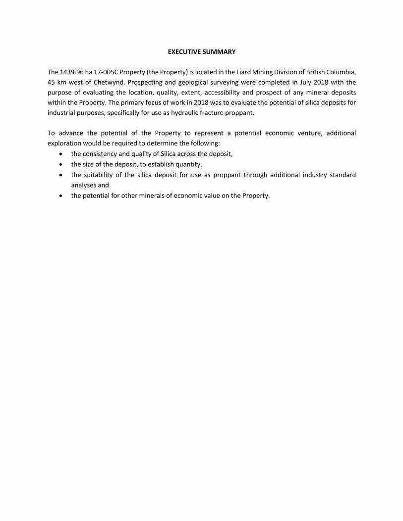
EXECUTIVE SUMMARY
The 1439.96 ha 17-005C Property (the Property) is located in the Liard Mining Division of British Columbia,
45 km west of Chetwynd. Prospecting and geological surveying were completed in July 2018 with the
purpose of evaluating the location, quality, extent, accessibility and prospect of any mineral deposits
within the Property. The primary focus of work in 2018 was to evaluate the potential of silica deposits for
industrial purposes, specifically for use as hydraulic fracture proppant.
To advance the potential of the Property to represent a potential economic venture, additional
exploration would be required to determine the following:
the consistency and quality of Silica across the deposit,
the size of the deposit, to establish quantity,
the suitability of the silica deposit for use as proppant through additional industry standard
analyses and
the potential for other minerals of economic value on the Property.

TABLE OF CONTENTS
EXECUTIVE SUMMARY .................................................................................................................................. 3
1.0 INTRODUCTION ................................................................................................................................. 5
1.1 Property Location and Access ....................................................................................................... 5
1.2 Property History ............................................................................................................................ 5
1.3 Surrounding Infrastructure and Resource Development ............................................................. 6
1.4 Climate, Physiography and Vegetation ......................................................................................... 6
1.5 Summary of 2018 Exploration Work ............................................................................................. 6
2.0 GEOLOGY ........................................................................................................................................... 7
2.1 Bedrock Geology ........................................................................................................................... 7
2.2 Surficial Geology ........................................................................................................................... 7
3.0 EXPLORATION ................................................................................................................................... 8
3.1 Prospecting ................................................................................................................................... 8
3.2 Sample Processing and Analysis ................................................................................................... 8
3.3 Geological Mapping ...................................................................................................................... 8
4.0 RESULTS AND DISCUSSION ................................................................................................................ 8
5.0 CONCLUSION ..................................................................................................................................... 8
6.0 STATEMENT OF COSTS ...................................................................................................................... 9
7.0 STATEMENT OF QUALIFICATIONS ..................................................................................................... 9
7.1 Report Compilation, Geological Interpretation and Conclusions ................................................. 9
7.2 Co-authors and Field Personnel .................................................................................................. 10
8.0 LIST OF SOFTWARE PROGRAMS...................................................................................................... 10
9.0 REFERENCES .................................................................................................................................... 11
LIST OF DRAWINGS
Drawing 1.
Drawing 2.
Location and Claim Map Sample Location Map
Drawing 3. Bedrock Geology Map
Drawing 4. Traverse Map
LIST OF APPENDICES
Appendix A. Photographs of the Property and Field Work
Appendix B. Detailed Sample Logs
Appendix C. Prospecting Field Observations

1.0 INTRODUCTION
This Technical Report was prepared by 543077 Alberta Ltd. (hereinafter referred to as “543077”). 543077
is a Canadian mineral exploration company that has identified, explored for and developed various
industrial minerals.
The 17-005C property consists of one Mineral Claim totaling 1439.96 ha as described in Table 1
(hereinafter referred to as the “Property”). The Property is located in northeast British Columbia within
the Liard Mining Division, approximately 45 km west of Chetwynd. The property is wholly owned and
operated by 543077.
Table 1. Mineral Claim Details for the 17-005C Property.
Mineral Claim Number Area (ha) Date of Issue Good to Date Owner
1059137 1439.96 3/6/2018 3/6/2019 543077 Alberta Ltd. (100%)
This report describes and summarizes the location and geology of the Property, previous exploration work
and, pursuant to the Mineral Tenure Act Regulation, describes the technical exploration conducted during
the 2018 exploration program.
1.1 Property Location and Access
The Property is situated in northeastern British Columbia, approximately 45 km west of Chetwynd. The
centered geographic coordinates of the Property are UTM 10N: 540145.99m E 6172440.02m N (NAD 83).
It lies within NTS map sheet 093 O in the Liard Mining Division.
The Property can be accessed if Highway 97 is taken to travel approximately 45 km west of Chetwynd. The
Property can be further accessed via various forestry roads and existing cutlines to the north of Highway
97.
A Location Map and Claim map have been provided as Drawing 1.
1.2 Property History
Within the property, there has not been any direct studies or development. However, the region has been
subject to several studies.
The Peace Region Foothills has been subject to a number of research projects. The Government of British
Columbia’s Ministry of Energy, Mines and Petroleum Resources initiated a study in 1983 to create a
1:50000 compilation map of the region (Peace River coalfield) in order to further develop coal resources
(Legun, 1988). Posters created by the British Columbia Geological Survey highlight the history, stratigraphy
and coal quality of the Peace River coalfield (British Columbia Geological Survey 2015, 2018). With
horizontal wells and hydraulic fracturing becoming more and more common, more recent studies into
tight/shale gas plays and hydraulic fracture sand sources in the region have become more prevalent.
Works by Petrel Robertson Consulting Ltd. and associates (2011) for Deep Subsurface Aquifer

Characterization of the Montney Formation, as well as Hickin (2005, 2006, 2010 and 2011) and associates,
for Preliminary Assessments of Hydraulic Fracture sand in Northeastern BC highlight new studies.
1.3 Surrounding Infrastructure and Resource Development
The Project is located within the Peace River region of northeast British Columbia which supports a diverse
range of land and resource use activities, including oil and gas exploration and development, mining,
hydroelectric projects, forestry, agriculture, outdoor recreation, trapping and guide outfitting. The
Mineral Claims overlaps the Doig River First Nations, the McLeod Lake Indian Band, the Halfway River First
Nations, the West Moberly First Nations, the Blueberry River First Nations, the Saulteau First Nations and
the Horse Lake First Nations. Additionally, this Mineral Claim overlaps a mineral and placer reserve, a coal
reserve, a uranium and thorium reserve and a post 1988 Crown Grants Reserve.
Oil and gas exploration and development in British Columbia is concentrated in the northeast, particularly
in the Montney and Horn River Basins (BC OGC, 2014). As the oil and gas industry grows in the Peace River
region, expanded infrastructure is required for development, production, processing and transportation
of natural gas and oil. A network of roads and pipelines have been constructed and maintained throughout
the area by industry to support access and transportation (BC OGC, 2014).
1.4 Climate, Physiography and Vegetation
The Sub-Boreal Interior Ecoprovince is characterized by cold winters and warm summers and an equal
amount of precipitation in the summers as in the winters. Moisture from the Pacific Ocean loses its
precipitation over the mountain ranges before moving over the ecoprovince and there are frequent
outbreaks of winter Arctic air. Mountains receive a high volume of snow fall. There are several
physiographic systems present within the ecoprovince, such as; the Nechako Lowlands (low-lying
plateau), the southern part of the Northern Rocky Mountain Trench, the southern Skeena and Omineca
Mountains to the northwest, the Hart Ranges and foothills (in the east portion of the area) and the
Muskwa Ranges and foothills and the McGregor Plateau (Demarchi, 1996). The primary types of
vegetation consist of: sub-boreal pine and spruce and Engelmann spruce (BEC WEB, 2019)
The Property covers a variety of physiography including mountains, foothills, valleys, forests and streams
and is located near a portion of the Peace River watershed.
Elevation of the Property varies from 1370 masl to 795 masl.
1.5 Summary of 2018 Exploration Work
Following a desktop geological review and field scouting, 543077 identified the Property as having
potential for a mineral resource. During July 2018, 543077 conducted preliminary evaluation of the
geology of the Property summarized in Table 2.

Table 2. Summary of Exploration Work Completed on the 17-005C Property in 2018.
Type of Work Mineral Claims Work Performed On Description
Geological Survey 1059137 165 ha surveyed at a 1:X000 scale
Prospecting 1059137 70 ha prospected
In support of the exploration program, 543077 engaged and consulted with Indigenous groups that may
be affected by the exploration activities. Engagement and consultation activities included discussions with
Indigenous groups regarding exploration plans through email and in-person meetings.
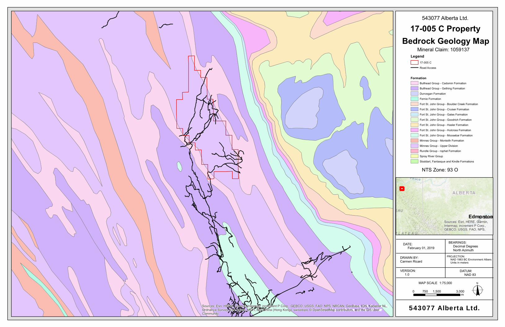
2.0 GEOLOGY
2.1 Bedrock Geology
The underlying geology if the Property contains:
- The Minnes Group: The formations of interest
within this group are the Monach and Monteith
Formations; both quartzitic in nature (Bienia et al.,
1980)
- The Bullhead Group:
o Cadomin Formation: is characterized as
a well-developed chert conglomerate
and coarse sandstone (Bienia et al.,
1980; Stott, 1973)
o Gething Formation: a fine-grained
quartz to chert sandstone unit with
intermittent shales and carbonaceous
mudstone (Stott, 1973)
Figure 1 (left). Tentative correlation of Lower
Cretaceous and Jurassic formation in the mountains of
British Columbia (from A. E. Bienia, G.D. Childs, J.
Forrest, J. Hamp, G. Hoffman, G. Jordan, J. LaMarre, S.
McKenzie and H. D. Zschach, 1980).
2.2 Surficial Geology
The Property is located within the British Columbia foothills and consists of outcropping bedrock geology.
Surficial geology is minimal and would mainly consist of eroded material such as scree or fluvial sediment.
This eroded material settles in topographical lows.

3.0 EXPLORATION
Following a desktop geological review and field scouting, 543077 identified the Property as having
potential for a mineral resource. During July 2018, 543077 conducted preliminary prospecting and
geological evaluation of the property to assess accessibility and for the collection and analysis of rock
samples to support future geological mapping. The work was undertaken to determine the location,
quality, extent and prospect of any mineral deposit within the Property. The primary focus of work in 2018
was to evaluate the potential of silica deposits for industrial purposes, specifically for the use as hydraulic
fracture proppant.
3.1 Prospecting
Bedrock samples were collected from outcrops using a rock hammer. Outcrops were investigated and
geological contacts were defined. Garmin GPS instruments were used to record UTM coordinates of
sample locations and geological contacts. Field observations, including geologic descriptions of the
bedrock material and descriptions of the land vegetation, were recorded at each sample location. Three
samples were collected. The amount of material collected varied from 0.75 kg to 2.75 kg per sample.
Samples were placed in a labelled plastic bag with the location ID, sample depth, elevation and date. UTM
coordinates of the sample location was recorded along with a field description of the sample and sample
area. Detailed sample information is provided in Appendix B. Photographs were taken during the 2018
exploration program and have been included in Appendix A. Prospecting Field Observations have been
included in Appendix C.
3.2 Sample Processing and Analysis
Samples collected during the exploration program were recorded in a database.
3.3 Geological Mapping
GPS coordinates were taken at each sample point and silica deposit thickness was measured or height
was visually estimated and recorded at various sample points. Strike and dip measurements of the silica
bedding were recorded during sample collection to be used for future mapping of the claim.
4.0 RESULTS AND DISCUSSION
Sandstones were identified within the Property. A brief description of the sandstone characteristics can
be found in Appendix B Work completed in 2018 focused on sample collection and the collection of
regional-scale data. Sample analysis that will be conducted in 2019 will center on describing the chemical
and physical traits of the silica, and grading its suitability for use as a proppant.
5.0 CONCLUSION
To advance the potential of the Property to represent a potential economic venture, additional
exploration would be required including the determination of:
the consistency and quality of silica across the deposit,
the size of the deposit, to establish quantity,

the suitability of the silica deposit for use as proppant through additional industry standard
analyses and
the potential for other minerals of economic value on the Property.
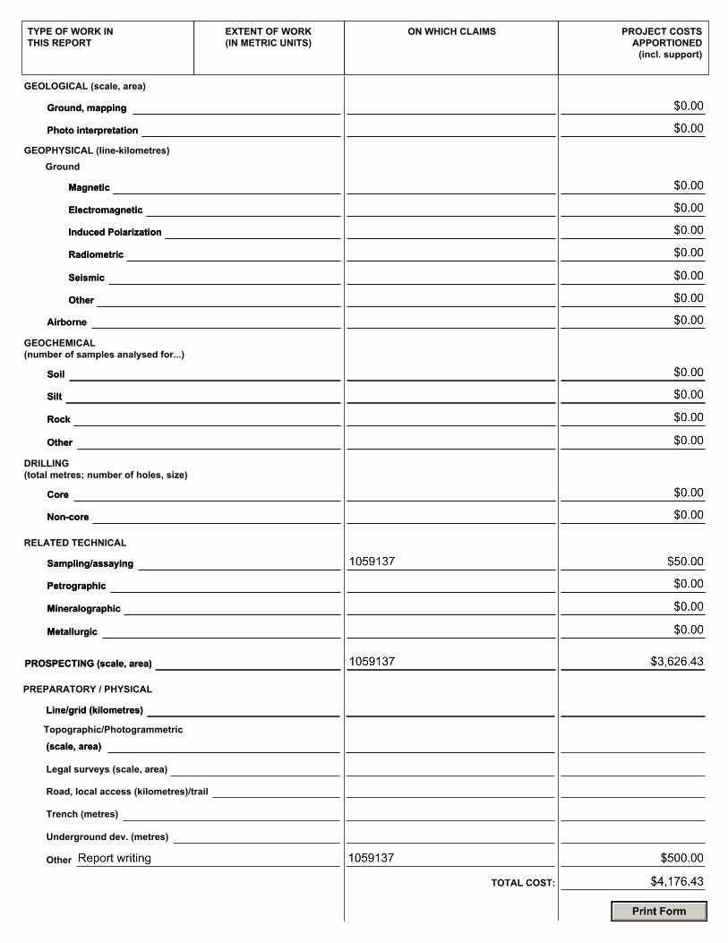
6.0 STATEMENT OF COSTS
Work on Mineral Claims 1059137 was completed between July 23, 2018 and July 27, 2018 the value as
follows:
Prospecting and Sampling
Labour
Angela Wu – 7/24/2018 – 7/26/2018– 13 Hours @ 100/hour $1,300.00
Nathan Holden G.I.T. – 7/24/2018 – 7/26/2018– 14.5 Hours @ 120/hour $1,740.00
Travel & Transportation
Truck - 1 days @ $200/day $200.00
Fuel (from gas receipts) $90.99
Food/Lodging
Actual Costs of Food and Lodging
Subtotal
$295.44
$3,626.43
Technical Assessment
Sample Analysis
Sample Handling and Storage 1 @ $50.00/sample $50.00
Subtotal
Other Report Writing 1 days @ $500/day
Subtotal
$50.00
$500.00
$500.00
TOTAL $4,176.43
7.0 STATEMENT OF QUALIFICATIONS
7.1 Report Compilation, Geological Interpretation and Conclusions
As author of this report, I, Michelle St. Louis, P.Geo. hereby certify that:
1. I am currently the Senior Geologist of 543077 Alberta Ltd., with a registered busniess address at
9175 14 Street, Edmonotn, Alberta.
2. I am the author of this report entitled “2018 Exploration Technical Report – Mineral Claims:
1059137 dated February 6, 2019 to which this statement of qualifications applies.
3. I graduated with a Bachelor of Science in Geology in 2001 from the University of Saskatchewan.
4. I am registered with the Association of Professional Engineers and Geoscientists of Alberta since
2009.
5. I have been practicing geology continually for 19 years.
7.2 Co-authors and Field Personnel
Field Lead Nathan Holden, B.Sc. GIT, – 2.5 Years Exploration Experience
Field Geologist Brandon Stoner, B.Sc. GIT, - 1.5 Year Exploration Experience
Field Geologist Cody Lazowski, B.Sc. GIT, – 11 Months Exploration Experience
Field Geologist Mitchell McCaig, B.Sc. GIT, – 6 Months Exploration Experience
Field Geologist Carmen Ricard, B.Sc. GIT, – 1.5 Year Exploration Experience
Field Geologist Angela Wu, B.Sc. GIT, – 1 Year Exploration Experience
As a co-author of this report, I Carmen Ricard, G.I.T. hereby certify that:
1. I am currently a Junior Geologist-in-Training at 543077 Alberta Ltd., with a registered business
address at 9175 14 Street, Edmonton, Alberta.
2. I am a co-author of this report entitled “2018 Exploration Technical Report – Mineral Claims”:
1059137 dated February 6, 2019 to which this statement of qualifications applies.
3. I graduated with a Bachelor of Science in Geology in 2016 from the University of Alberta.
4. I am registered with the Association of Professional Engineers and Geoscientists of Alberta since
2013.
5. I have been practicing geology intermittently for 1.5 years.
8.0 LIST OF SOFTWARE PROGRAMS
The following software programs were used in support of the exploration and development and the
preparation of this report:
- Microsoft Word
- Microsoft Excel
- Foxit PhantomPDF
- ArcMap 10.5.1
- Google Earth Pro

9.0 REFERENCES
A. E. Bienia, G.D. Childs, J. Forrest, J. Hamp, G. Hoffman, G. Jordan, J. LaMarre, S. McKenzie and H. D.
Zschach. (1980). Gulf Canada Resources Inc. Windfall Coal Report. Report number: 0692,
Government of British Columbia. Web. February, 2019.
BC Oil and Gas Commission (OGC). 2014. Oil and Gas Use in Northeast British Columbia. Technical Reports
Available at: https://www.bcogc.ca/reports/technical-reports. Accessed: December 2017.
BEC WEB. (2019). For.gov.bc.ca. Retrieved 3 February 2019, from
https://www.for.gov.bc.ca/hre/becweb/resources/maps/ProvinceWideMaps.html
British Columbia Geological Survey (2015). The Peace River Coalfields (NTS 93P,I,O & 94B). Retrieved 17
December 2018, from
http://webmap.em.gov.bc.ca/mapplace/minpot/Publications_Summary.asp?key=5592
British Columbia Geological Survey (2018). The Peace River Coalfields (poster). Retrieved 17 December
2018, from
http://webmap.em.gov.bc.ca/mapplace/minpot/Publications_Summary.asp?key=5942
Demarchi, D. A. (1996). An introduction to the ecoregions of British Columbia. Victoria, British Columbia,
Canada. Wildlife Branch, Ministry of Environment, Lands and Parks.
Hickin, A.S. and Kerr, B. (2005). Bedrock topography mapping and shallow gas in northeast BC. in Summary
of Activities 2005, British Columbia Ministry of Energy and Mines.
Hicken, A.S. (2006). Aggregate potential of selected glaciofluvial terraces on the East Kiskatinaw River,
Northeastern British Columbia. BC Ministry of Energy Mines and Petroleum Resources. Aggregate
Prospect Report 2006-1, 1:50 000 scale map.
Hickin, A. S., Ferri, F., Ferbey, T., & Smith, I. R. (2010). Preliminary assessment of potential hydraulic
fracture sand sources and their depositional origin, northeast British Columbia. Geoscience
Reports 2010, British Columbia Ministry of Energy, Mines and Petroleum Resources, 35-91.
Hicken, A.S. and M.A. Fournier. (2011). Compilation of Geological Survey of Canada surficial geology maps
NTS 94A and 93P. BC Ministry of Energy and Mines, Energy Open File 20111-2, Geoscience BC
Map 2011-08-1, 1:250,000 scale.
Legun, A. S. (1988). Geology and coal resources of the Carbon Creek map area, Peace River District.
Ministry of Energy, Mines and Petroleum Resources

Petrel Robertson Consulting Ltd., & Canadian Discovery Ltd. (2011). Deep Subsurface Aquifer
Characterization in support of Montney Tight Gas Development: Geological Report (NTS 93O,P,
94A,B,G,H). Ministry of Energy, Mines and Petroleum Resources.
Stott, D F; (1973). Lower Cretaceous Bullhead Group between Bullmoose Mountain and Tetsa River, Rocky
Mountain Foothills, northeastern British Columbia, Geological Survey of Canada, Bulletin no. 219

DRAWINGS

Sources: Esri, HERE, Garmin, Intermap, increment P Corp., GEBCO, USGS, FAO, NPS, NRCAN, GeoBase, IGN, Kadaster NL,Ordnance Survey, Esri Japan, METI, Esri China (Hong Kong), swisstopo, © OpenStreetMap contributors, and the GIS UserCommunity
543077 Alberta Ltd.
0 1,500 3,000750m
DATE: February 04, 2019
DRAWN BY:Carmen Ricard
VERSION: 1.0
BEARINGS: Decimal Degrees North Azimuth
PROJECTION: NAD 1983 BC Environment Albers Units in meters
DATUM: NAD 83
oMAP SCALE 1:75,000
17-005 C Property
Mineral Claim: 1059137
NTS Zone: 93 O
Location and Claim
Sources: Esri, HERE, Garmin,Intermap, increment P Corp.,GEBCO, USGS, FAO, NPS,
Legend17-005 CRoad Access
Edmonton

!(17-005C OC 18003
Sources: Esri, HERE, Garmin, Intermap, increment P Corp., GEBCO, USGS, FAO, NPS, NRCAN, GeoBase, IGN, Kadaster NL,Ordnance Survey, Esri Japan, METI, Esri China (Hong Kong), swisstopo, © OpenStreetMap contributors, and the GIS UserCommunity
543077 Alberta Ltd.
0 1,500 3,000750m
DATE: February 01, 2019
DRAWN BY:Carmen Ricard
VERSION: 1.0
BEARINGS: Decimal Degrees North Azimuth
PROJECTION: NAD 1983 BC Environment Albers Units in meters
DATUM: NAD 83
oMAP SCALE 1:75,000
17-005 C Property
NTS Zone: 93 O
Sources: Esri, HERE, Garmin,Intermap, increment P Corp.,GEBCO, USGS, FAO, NPS,
Sample Location MapMineral Claim: 1059137
Legend17-005 C Mineral ClaimWaterbodies
!( Sample LocationsRoad Access
Edmonton
543077 Alberta Ltd.
Sources: Esri, HERE, Garmin, Intermap, increment P Corp., GEBCO, USGS, FAO, NPS, NRCAN, GeoBase, IGN, Kadaster NL,Ordnance Survey, Esri Japan, METI, Esri China (Hong Kong), swisstopo, © OpenStreetMap contributors, and the GIS UserCommunity
543077 Alberta Ltd.
0 1,500 3,000750m
DATE: February 01, 2019
DRAWN BY:Carmen Ricard
VERSION: 1.0
BEARINGS: Decimal Degrees North Azimuth
PROJECTION: NAD 1983 BC Environment Albers Units in meters
DATUM: NAD 83
oMAP SCALE 1:75,000
17-005 C Property
Mineral Claim: 1059137
NTS Zone: 93 O
Bedrock Geology Map
Sources: Esri, HERE, Garmin,Intermap, increment P Corp.,GEBCO, USGS, FAO, NPS,
Legend17-005 CRoad Access
FormationBullhead Group - Cadomin FormationBullhead Group - Gething FormationDunvegan FormationFernie FormationFort St. John Group - Boulder Creek FormationFort St. John Group - Cruiser FormationFort St. John Group - Gates FormationFort St. John Group - Goodrich FormationFort St. John Group - Hasler FormationFort St. John Group - Hulcross FormationFort St. John Group - Moosebar FormationMinnes Group - Monteith FormationMinnes Group - Upper DivisionRundle Group - rophet FormationSpray River GroupStoddart, Fantasque and Kindle Formations
Edmonton
543077 Alberta Ltd.

Sources: Esri, HERE, Garmin, Intermap, increment P Corp., GEBCO, USGS, FAO, NPS, NRCAN, GeoBase, IGN, Kadaster NL,Ordnance Survey, Esri Japan, METI, Esri China (Hong Kong), swisstopo, © OpenStreetMap contributors, and the GIS UserCommunity
543077 Alberta Ltd.
0 1,500 3,000750m
DATE: February 01, 2019
DRAWN BY:Carmen Ricard
VERSION: 1.0
BEARINGS: Decimal Degrees North Azimuth
PROJECTION: NAD 1983 BC Environment Albers Units in meters
DATUM: NAD 83
oMAP SCALE 1:75,000
17-005 C Property
Mineral Claim: 1059137
NTS Zone: 93 O
Traverse Map
Sources: Esri, HERE, Garmin,Intermap, increment P Corp.,GEBCO, USGS, FAO, NPS,
Legend17-005 CRoad Access
Edmonton
543077 Alberta Ltd.

APPENDIX A
Photographs of the Property and Field Work

Picture 2. Viewing washed out road way on the Property
Picture 1. Viewing weathered sandstone outcrop
17-005 C 543077 Alberta Ltd.

Picture 3. Viewing road way on the Property
Picture 4. Viewing sandstone outcrop
17-005 C 543077 Alberta Ltd.

APPENDIX B
Detailed Sample Logs

Sample IdYear
SampledEasting
(UTM)
Northing
(UTM) Elevation MSL (m)*
Overburden Thickness (m)
Deposit Top Elevations MSL
(m)
Deposit Top Elevation
MSL (m)
Deposit Bottom
Elevation MSL (m)*
Deposit Thickness
(m)**Sample Description
17-005C OC 18003 2018 539762 6170453 1248 0.00 N/A ? ?
dark brown fine-grained sandstone,
interbedded with tan shale; iron-
staining; extremely weathered
* - Adjusted based on hole location and topographic data (topographic contours or LIDAR elevation data)
** - Includes non-silica layers or parting such as clay, gravel, etc.
Exploration Sample Results Summary
17-005 C - November 2018

APPENDIX C
Prospecting Field Observations

