bankstown - nsw department of planning, industry, and ... · 1/20/2017 · april 2016 bankstown to...
TRANSCRIPT

BANKSTOWNFINE GRAIN,
PUBLIC DOMAIN+ STATION INTEGRATION
STUDYSYDENHAM
TO BANKSTOWN CORRIDOR
20 JANUARY 2017AILEEN SAGE ARCHITECTS
+ LEFT BANK CO.

INTRODUCTION
AILEEN SAGE ARCHITECTS + LEFT BANK CO. 2
This study looks at providing a public domain led integrated urban vision for Bankstown based on an analysis of the existing urban fabric and the impact of future built form including the construction of the new Sydney Metro City and Southwest line.
Bankstown Railway station opening in April 1909, Bankstown Library
We recognise the following existing studies /reports:
Sydenham to Bankstown Urban Renewal Corridor StrategyNSW Government Planning and EnvironmentOctober 2015 + draft review 2016
Sydenham to Bankstown Urban Renewal Corridor: Consultation UpdateNSW Government Planning and EnvironmentApril 2016
Bankstown to Sydenham Rail Corridor, Walking and Cycling Corridor and Linear Park ReportGovernment Architect’s Office, Department of Public Works12 February 2016
Sydenham to Bankstown Urban Renewal Corridor: Integrated Transport StrategyArup, 26 October 2015
Sydenham to Bankstown Social Infrastructure Study (Draft)Arup, 30 September 2015
Bankstown to Sydenham Corridor Strategy: Open Space and Recreation Strategy (Draft)Government Architect’s Office, Department of Public Works25 May 2015
LEP 2015 Heritage Controls and Items of Local SignificanceCity of Cantebury Bankstown

AILEEN SAGE ARCHITECTS + LEFT BANK CO. 3
EXECUTIVE SUMMARY
The objective of this study is to identify urban place making opportunities as a result of the construction of the new Sydney Metro line, providing an integrated urban vision for Bankstown including the station precinct and immediate connected areas within walking distance of the station.
This study has been informed by analysis of at various scales including Metropolitan (macro), City Centre (middle) and Fine Grain (micro). This includes identifying: - transport corridors- cultural and landscape catchments- barriers and connection points within the city grid- distinct city precincts – cultural, civic, retail and parklands- precinct distinctiveness including built form, materiality, signage, pattern and cultural history- opportunities for intervention within public and privately owned landFrom this analysis key attributes and challenges were identified.
Key strategies were then formulated including:- Underground Rail line- New civic spaces- Consolidated public spaces- Provision of Privately owned Public Space (POPS)- New Bus interchange- Extension of linear park along the rail line- Improved connection to Southern Parklands precinct- Maintain existing built fabric within Cultural precinct- Consolidated Parking- Public Art
Illustrated Opportunities include- New Civic Space – Eat Street Carpark- New Civic Space – Station Square- Green Streets- Laneway Activation- Public Space within Private Development- Extension of the Linear Park- Connection to Southern Parklands
Through these illustrations Bankstown is recognized as a dynamic multicultural community with an established arts and cultural identity. The building of the new Sydney Metro train line provides an opportunity to improve connectivity within the CBD and create new vibrant public spaces. Building on existing urban patterns and precinct identities, these spaces will be welcoming, lively and adaptable, creating a unique urban identity for Bankstown.

METROPOLITAN SCALE ANALYSISINDIGENOUS HERITAGE + COMMUNITY
AILEEN SAGE ARCHITECTS + LEFT BANK CO. 4
Prior to European settlement the land around Bankstown was occupied by the Bediagal people, of the Dharug nation. Bankstown has a strong Indigenousheritage and has been home toIndigenous rights protest.
current communityLocated in South-western Sydney, Bankstown is home to a diverse multicultural community including Vietnamese and Lebanese ethnic groups. At the last census only 16.9% of people responded that they speak English as the first language with over 60 languages spoken by residents.
dharug
eora
sydney CBD
sydenham
hurstville
bankstown
lidcome
parramatta
cabramatta
liverpool
regional centers
Bankstown CBD
Salt Pan Creekopen space corridor
KEY
Salt Pan Creek is the country of the Bediagal clan of the Dharug people on the northern shore of theGeorges River, between what is now Padstow and Riverwood.
It is the country of Pemulwuy - an Aboriginal Australian man born around 1750 in the area of BotanyBay in New South Wales. He is noted for his resistance to the European settlement of Australia that beganwith the arrival of the First Fleet 1788. Pemulwuy was killed under the orders of Governor Philip. His head
was preserved in spirits and sent to England to Sir Joseph Banks accompanied by a letter from GovernorKing, who wrote: "Although a terrible pest to the colony, he was a brave and independent character."
From as early as 1809, the land surrounding Salt Pan Creek was the site of uprising by Australian Aboriginalpeople against colonial settlement, and Pemulway's son Tedbury continued the struggle for a number ofyears before being killed in 1810. Between 1926 and 1935, lands surrounding the creek became a focal
point for indigenous rights, as they set up squattercamps that consisted of refugee families whose traditionallands had been resumed and also those seeking to escape the Aboriginal Protection Board.
Aboriginal People lived on this land by working in cash jobs but also by using their knowledge of theflowers and game along the river and on the sandstone. Some gathered the many wildflowers that grewalong Salt Pan Creek and sold them door-to-door in the area. They gathered the vivid red gum tips and
Christmas bush to sell at the markets on Friday nights. All the Aboriginal people living there were able togather oysters, prawns and river fish as well as hunting swamp wallabies and other game. Salt Pan Creek
was named by early colonial settlers, who took salt from the swampland by evaporating the salt water.
�http://dictionaryofsydney.org/entry/aboriginal_people_on_sydneys_georges_river_from_1820https://en.m.wikipedia.org/wiki/Salt_Pan_Creek
https://en.m.wikipedia.org/wiki/Pemulwuy
Samuel John Neale, Pimbloy: Native of New Holland in acanoe of that country, engraving, 1804
Ex-soldier and Aboriginal activist Herbert Groves, 1947 May Day procession (Photograph courtesy Australian War Memorial, P01248.001). Afterreturning from WWII in 1945 Bert settled at Salt PanCreek in Sydney with his family. He was an active andvocal Sydney-based Aboriginal activist in the 1950sand 60s, who improved the lives of Aboriginal and Torres Strait Islander peoples across Australia.

METROPOLITAN SCALE ANALYSISTRANSPORT INTERCHANGE
AILEEN SAGE ARCHITECTS + LEFT BANK CO. 5
The Construction of the new SydneyMetro and associated development willenable increased connectivity between
Bankstown and Central Sydney and otherregional centers through a multitude of
transport modes.
contextBankstown is currently home to a large industrial area as well asBankstown airport, which mostly serves recreational and charter
flights. Access to public transport along with cafes, restaurants andshops is currently highly prized by residents along with access to
community facilities such as the library and arts center.
connectionsBankstown is proposed as the last stop on the new Sydney Metro
Southwest line with interchange to existing rail services towardsCabramatta and Liverpool. It is also a major bus interchange.
growthCurrent proposals include an almost doubling in the number of
homes and large increase in jobs within the area.
sydney CBD
sydenham
hurstville
bankstown
lidcome
parramatta
cabramatta
liverpool
regional centers
KEY
sydney airport
new metro
train line
potential light rail
bus routes
rapid access bus
main roads
cycle routes
bankstownairport

METROPOLITAN SCALE ANALYSISWATER CATCHMENTS + GREEN SPACE
AILEEN SAGE ARCHITECTS + LEFT BANK CO. 6
Whilst Bankstown residents currently havelimited access to open space, there are a
number of active links proposed under theSydney Green Grid that will ensure greater
opportunity. The proposed linear park alongthe new Metro line will connect to the Salt
Pan Creek open space corridor.
sydney CBD
sydenham
hurstville
bankstown
lidcome
parramatta
cabramatta
liverpool
regional centers
KEY
sydney airport
Bankstown CBD
Bankstown Industrial zone
Sydney Green GridOpen Space
Sydney Green GridActive Links (proposed and existing)
proposed linear parkalong rail corridor
National park
proposed metro line
salt pan creek
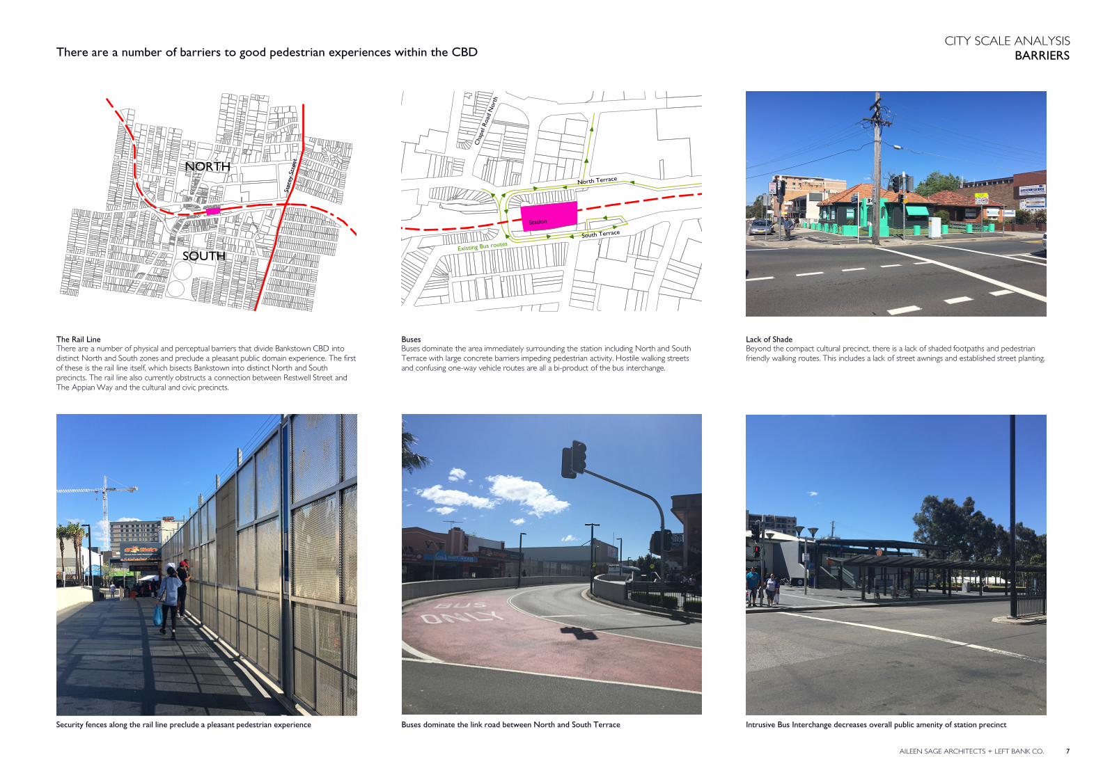
CITY SCALE ANALYSISBARRIERS
AILEEN SAGE ARCHITECTS + LEFT BANK CO. 7
The Rail LineThere are a number of physical and perceptual barriers that divide Bankstown CBD into distinct North and South zones and preclude a pleasant public domain experience. The first of these is the rail line itself, which bisects Bankstown into distinct North and South precincts. The rail line also currently obstructs a connection between Restwell Street and The Appian Way and the cultural and civic precincts.
BusesBuses dominate the area immediately surrounding the station including North and South Terrace with large concrete barriers impeding pedestrian activity. Hostile walking streets and confusing one-way vehicle routes are all a bi-product of the bus interchange.
Security fences along the rail line preclude a pleasant pedestrian experience Buses dominate the link road between North and South Terrace
NORTH
SOUTH
Stac
ey S
tree
t
North Terrace
South Terrace
Cha
pel R
oad
Nor
th
Existing Bus routes
Lack of ShadeBeyond the compact cultural precinct, there is a lack of shaded footpaths and pedestrian friendly walking routes. This includes a lack of street awnings and established street planting.
Intrusive Bus Interchange decreases overall public amenity of station precinct
There are a number of barriers to good pedestrian experiences within the CBD
Station

CITY SCALE ANALYSISBARRIERS
AILEEN SAGE ARCHITECTS + LEFT BANK CO. 8
Lack of Civic Presence - Arts CentreBankstown Arts Centre on Olympic Parade has no visual connection to the city centre and no sense of city presence or direct association with the Eat Street precinct. Despite itsproximity to the station and rail line, there are limited visual and physical connections between these two locations.
Large Impenatrable SitesThe Bankstown Sports Centre and School sites sit between the station and Bankstown Memorial Park and existing pedestrian and cycle paths that follow the Salt Pan Creekcorridor. These impenetrable sites mean that whilst physically quite close, this area haslimited connection to the station.
The Arts Centre has limited connections to the vibrant Eat Street precinct adajacent.The rear of the centre / back of house spaces face the city centre and station precinct.
The Sports Centre site has no street presense or street address and acts a a barrier towalk through trade and precludes access from the station to the Southern Parklands
Disconnected Civic PrecinctBankstown civic precinct including Bryan Brown Theatre, Bankstown Library and Paul Keating Park is disconnected from the rest of the city due to unpleasant walking streets, inparticular The Mall, which is vehicular dominant and separates Paul Keating Park from adjacent pocket parks. The area also has no visual connection to the station or the Culturalprecinct to the South.
No visual connection between Civic precinct and the station
North Terrace
Olym
pic Parade
Arts Centre
Cha
pel R
oad
There are limited pedestrian and visual connections between key public facilities
Carpark
Station
Station
Green Space
Barriers
Station
Cultural Precinct
Civic Precinct

CITY SCALE ANALYSISCONNECTIONS
AILEEN SAGE ARCHITECTS + LEFT BANK CO. 9
Laneways + ArcadesWithin this zone there are also a number of pedestrian connections via arcades (with retail activation) and laneways. A public covered arcade connects the Station to the SportsCentre and includes a musical installation that provides an increased sense of surveillanceand safety at night.
Civic Anchors - Post OfficeThe main Post Office is currently located away from the main civic and retail zones, with good connection to the station. This is currently a main anchor for this part of the CBD.Additional post shops are located within the Bankstown Central development.
Vibrant "Eat Street"The area to the immediate Southwest of the station is an “Eat Street” that includesBankstown City Plaza and Chapel Road is the most vibrant area of the city. It has widenedfootpaths, street trees, street parking and street front tables used as market stalls, meetingplaces for older people and passive recreation. A smaller on grade carpark provides apedestrian connection between the Eat Street and the Bankstown Arts Centre.
Arcades link "Eat Street" with Stewart Lane Covered walkways connect the station to Eat Street, schools and the Sports Centre The post office is a civic anchor attracting pedestrian activity to the edge of the precinct
Station
Walking route
Laneways and arcades
Station
Post office
Civic anchors include the vibrant "Eat Street" along with amenities such as the post office. These are well connected via a network of laneways and arcades.