banglamphu maps and data
DESCRIPTION
Banglamphu maps and dataTRANSCRIPT

Fig. 1: สภาพปจจุบันของชุมชนในยานบางลําพู (The Current Conditions of the Communities in Yarn Banglamphu)
ท่ีมา: วิมลรัตน อิสระธรรมนูญ, 2009 (สํารวจและถายภาพโดย วิมลรัตน อิสระธรรมนูญ, 2008; อางอิงจากแผนท่ีจัดทําโดย คณะสถาปตยกรรมศาสตร จุฬาลงกรณมหาวิทยาลัย, 2007)

Fig. 2: ชุมชนและพืน้ทีเ่พือ่การทองเทีย่วในยานบางลําพ ู(The Communities and Tourist Domains in Yarn Banglamphu)
ท่ีมา: วิมลรัตน อิสระธรรมนูญ, 2009 (สํารวจและถายภาพโดย วิมลรัตน อิสระธรรมนูญ, 2008; ปรับจาก แผนท่ีจากสํานักผังเมือง กรุงเทพมหานคร โดยผูเขียนทําการสํารวจระหวาง กันยายน 2007 – เมษายน 2008)
Communities
Religious Institutes
Market Places / shops serving for local needs
Tourist Place / Tourist-related Places
Governmental Institutes
Boundaries of Communities
①. Trok Kiennivas-kaichae Community (TKK)
②. Masjid Chak Krapong Community (MCK)
③. Wat Sangwet Community (WAS) ④. Wat Sam Phraya Community (WSP) ⑤. Trok Bowon Rangsri Community (TBR) ⑥. Masjid Ban Tukdin Community (MBT)
. The Khaosan Road Area (KSR)
1 2
3
4
5
6
7

Table 3: สภาพของชุมชนและมรดกวัฒนธรรมของชุมชนในยานบางลําพุ (The Community Conditions and Heritage Contexts of Communities in Yarn Banglamphu)
Communities Community Condition Heritage Contexts
1. Trok Kiennivas-kaichae Community (TKK)
Illustrations: 1) A guesthouse in Trok Kiennivas-kaichae Community; 2) A community meeting (Apr. 17th, 2008); 3) A ceremony of Krom Luang Chak Jessada, at Trok Kiennivas-kaichae Community (Jan 2nd - 3rd, 2008)
- Location: Trok Kiennivas-kaichae Community is located in the area between Wat Chana Songkram Temple and Phra Athit Street. It combines two areas, which are Trok (narrow lane) Kiennivas and Trok Kaichae. - Age of Community: 200 years (King Rama I / The community is recognised as a community of the government servants, based on the palaces and institutions that were built around 80 years ago (King Rama VI-VII) - Current Physical Conditions: the wooden and brick houses 1-2 stories high - Population, Household and Areas: 1200 people within 120 households or 80 houses in 2 Rai (3600 sq.m.) - Community Type: ‘urban community’ - Religious: Almost all of the community’s people are Buddhism - Ethnic: Mon, Thai - Landowner / Property owner: Almost all of the lands in the community (95 per cent) are belonging to the Crown Property Bureau.
Tangible Heritage: There are unique wooden houses, and an urban pattern – the narrow lanes. Intangible Heritage: The community has retained sub-cultures ground on Buddhism and Mon cultures Meaning – Palace community Activities – local traditional and religious ceremonies – New Year Day, Songkran Festival / local specialty careers – the Thai traditional drama cloth making Heritage Commodity: - Some activities serving tourists – three guesthouses
Phra Athit Street Area (PAS)
Illustrations: 4) Shophouses along Phra Athit Street
Shophouses (around 80 shops) are located along Phra Athit Street. The shophouses are part of Trok Kiennivas-kaichae Community
Tangible Heritage: one-hundred-year shophouses Intangible Heritage: Meaning – Bohemian style shops, a tourist-related place Activities – numerous activities serving local people, tourists café, and art galleries for college students and artists Heritage Commodity – pubs and bars / souvenir shops
2. Masjid Chak Krapong Community (MCK)
Illustrations: 5) Masjid Chak Krapong; 6) The public health voluntary office
- Location: Masjid Chak Krapong Community is located in the area inside the block bounded by Chak Krapong Street on the east, Phra Sumane Street on the north, Ram Buttri Street on the south, and Trok Kaichae on the west. - Age of Community: 100 years (King Rama V) / some tenants have stayed in the community for around 30 years. - Current Physical Conditions: the wooden and brick houses 1-2 stories high in dense area. - Population, Household and Areas: 750 people within 160 households or 120 houses in 1 Rai (1600 sq.m.) - Community Type: ‘Urban community’ - Religious: 55 per cent of people are Buddhism and 45 percent are Muslim - Ethnic: Muslim, Thai, and Chinese-Thai - Landowner / Property owner: Almost all of the lands are belonging to the private owners, particularly Muslim families.
Tangible Heritage: An enclosed community, surrounded by shophouses and walkways. The shophouses are not included in the community. There are some traditional Thai wooden houses, and mosque and urban pattern – the narrow lanes. The significant monument is Masjid Chak Krapong, built in the reign of King Rama V. The most significance is a listed building. Intangible Heritage: The community has retained sub-cultures, grounded on Muslim heritage. Meaning – Thai Muslim Mosque Community Activities – local traditional and religious ceremonies –Muslim ceremonies / local specialty careers – gold craft and traditional food Heritage Commodity: there is rare activity serving tourists and outsiders. There is only one mansion for Muslim people
3. Wat Sangwet Community (WSW)
Illustrations: 7) Row houses in the community; 8) Duriyapraneet Traditional Thai Musical Institute; 9) The office of committees of chumchon and the public health voluntary office
- Location: Wat Sangwet Community is located on the bank of the Rob Krung Canal (called Khlong Banglamphu) on the south, the bank of Chao Phraya River on the West, Sam Sen 3 Street on the north, and Sam Sen Street on the east. The community surrounds Wat Sangwet Visyaram. - Age of Community: More than 200 years (founded in the Ayutthaya Era, before the Rattanakosin Era) - Current Physical Conditions: the row-houses, wooden and brick houses 1-2 stories high, mansions, and guesthouses are located in a dense area. - Population, Household and Areas: 1700 people within 300 households or 296 houses in 5 Rai (8000 sq.m.) (The old families that have lived in the communities for many generations are less than 50 per cent) - Community Type: ‘Urban community’ - Religious: Almost all of the community’s people (98 per cent) are Buddhism, and some are Muslim. - Ethnic: Thai, Chinese-Thai, and Muslim - Landowner / Property owner: Almost all of the lands in the community are belonging to the Sangwet Visyaram Temple. Some riverside areas are belonging to the Crown Property Bureau.
Tangible Heritage: Enclosed community with clear boundary and, the shophouses are not included in the community. There are some wooden houses, shophouses, a temple, and an urban pattern – the narrow lanes. Intangible Heritage: Meaning – Temple Community Activities – local traditional and religious ceremonies – Buddhist ceremonies / local specialty careers – Traditional Thai Music School Heritage Commodity: numerous activities serving tourists and outsiders – guesthouses nearby the riverside areas (Residential and commercial areas 60 per cent / Guesthouse around 20 per cent / Sub-rent houses and apartments around 20 per cent)
1 2
3
4
4
5 6
7 8 9
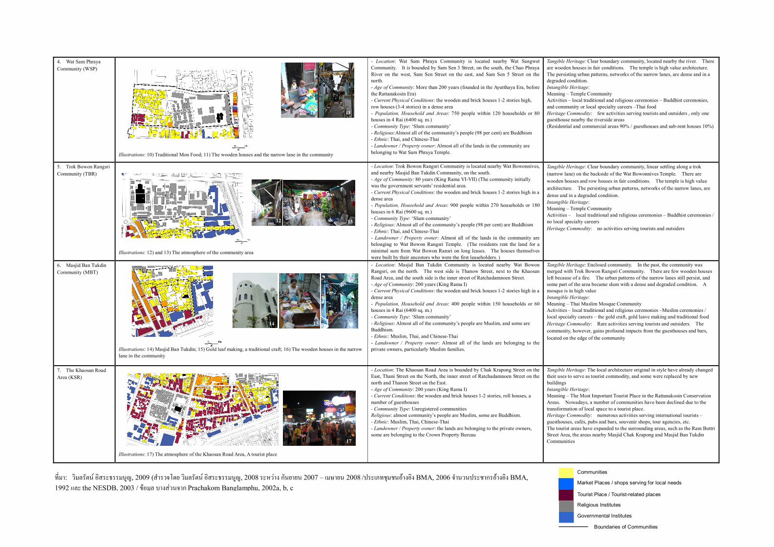
4. Wat Sam Phraya Community (WSP)
Illustrations: 10) Traditional Mon Food; 11) The wooden houses and the narrow lane in the community
- Location: Wat Sam Phraya Community is located nearby Wat Sangwet Community. It is bounded by Sam Sen 3 Street, on the south, the Chao Phraya River on the west, Sam Sen Street on the east, and Sam Sen 5 Street on the north. - Age of Community: More than 200 years (founded in the Ayutthaya Era, before the Rattanakosin Era) - Current Physical Conditions: the wooden and brick houses 1-2 stories high, row houses (3-4 stories) in a dense area - Population, Household and Areas: 750 people within 120 households or 80 houses in 4 Rai (6400 sq. m.) - Community Type: ‘Slum community’ - Religious:Almost all of the community’s people (98 per cent) are Buddhism - Ethnic: Thai, and Chinese-Thai - Landowner / Property owner: Almost all of the lands in the community are belonging to Wat Sam Phraya Temple.
Tangible Heritage: Clear boundary community, located nearby the river. There are wooden houses in fair conditions. The temple is high value architecture. The persisting urban patterns, networks of the narrow lanes, are dense and in a degraded condition. Intangible Heritage: Meaning – Temple Community Activities – local traditional and religious ceremonies – Buddhist ceremonies, and community or local specialty careers –Thai food Heritage Commodity: few activities serving tourists and outsiders , only one guesthouse nearby the riverside areas (Residential and commercial areas 90% / guesthouses and sub-rent houses 10%)
5. Trok Bowon Rangsri Community (TBR)
Illustrations: 12) and 13) The atmosphere of the community area
- Location: Trok Bowon Rangsri Community is located nearby Wat Bowonnives, and nearby Masjid Ban Tukdin Community, on the south. - Age of Community: 80 years (King Rama VI-VII) (The community initially was the government servants’ residential area. - Current Physical Conditions: the wooden and brick houses 1-2 stories high in a dense area - Population, Household and Areas: 900 people within 270 households or 180 houses in 6 Rai (9600 sq. m.) - Community Type: ‘Slum community’ - Religious: Almost all of the community’s people (98 per cent) are Buddhism - Ethnic: Thai, and Chinese-Thai - Landowner / Property owner: Almost all of the lands in the community are belonging to Wat Bowon Rangsri Temple. (The residents rent the land for a minimal sum from Wat Bowon Ransri on long leases. The houses themselves were built by their ancestors who were the first leaseholders. )
Tangible Heritage: Clear boundary community, linear settling along a trok (narrow lane) on the backside of the Wat Bowonnives Temple. There are wooden houses and row houses in fair conditions. The temple is high value architecture. The persisting urban patterns, networks of the narrow lanes, are dense and in a degraded condition. Intangible Heritage: Meaning – Temple Community Activities – local traditional and religious ceremonies – Buddhist ceremonies / no local specialty careers Heritage Commodity: no activities serving tourists and outsiders
6. Masjid Ban Tukdin Community (MBT)
Illustrations: 14) Masjid Ban Tukdin; 15) Gold leaf making, a traditional craft; 16) The wooden houses in the narrow lane in the community
- Location: Masjid Ban Tukdin Community is located nearby Wat Bowon Rangsri, on the north. The west side is Thanow Street, next to the Khaosan Road Area, and the south side is the inner street of Ratchadamnoen Street. - Age of Community: 200 years (King Rama I) - Current Physical Conditions: the wooden and brick houses 1-2 stories high in a dense area - Population, Household and Areas: 400 people within 150 households or 60 houses in 4 Rai (6400 sq. m.) - Community Type: ‘Slum community’ - Religious: Almost all of the community’s people are Muslim, and some are Buddhism. - Ethnic: Muslim, Thai, and Chinese-Thai - Landowner / Property owner: Almost all of the lands are belonging to the private owners, particularly Muslim families.
Tangible Heritage: Enclosed community. In the past, the community was merged with Trok Bowon Rangsri Community. There are few wooden houses left because of a fire. The urban patterns of the narrow lanes still persist, and some part of the area became slum with a dense and degraded condition. A mosque is in high value Intangible Heritage: Meaning – Thai Muslim Mosque Community Activities – local traditional and religious ceremonies –Muslim ceremonies / local specialty careers – the gold craft, gold leave making and traditional food Heritage Commodity: Rare activities serving tourists and outsiders. The community, however, gains profound impacts from the guesthouses and bars, located on the edge of the community
7. The Khaosan Road Area (KSR)
Illustrations: 17) The atmosphere of the Khaosan Road Area, A tourist place
- Location: The Khaosan Road Area is bounded by Chak Krapong Street on the East, Thani Street on the North, the inner street of Ratchadamnoen Street on the north and Thanon Street on the East. - Age of Community: 200 years (King Rama I) - Current Conditions: the wooden and brick houses 1-2 stories, roll houses, a number of guesthouses - Community Type: Unregistered communities Religious: almost community’s people are Muslim, some are Buddhism. - Ethnic: Muslim, Thai, Chinese-Thai - Landowner / Property owner: the lands are belonging to the private owners, some are belonging to the Crown Property Bureau
Tangible Heritage: The local architecture original in style have already changed their uses to serve as tourist commodity, and some were replaced by new buildings Intangible Heritage: Meaning – The Most Important Tourist Place in the Rattanakosin Conservation Areas. Nowadays, a number of communities have been declined due to the transformation of local space to a tourist place. Heritage Commodity: numerous activities serving international tourists – guesthouses, cafés, pubs and bars, souvenir shops, tour agencies, etc. The tourist areas have expanded to the surrounding areas, such as the Ram Buttri Street Area, the areas nearby Masjid Chak Krapong and Masjid Ban Tukdin Communities
Communities
Religious Institutes
Market Places / shops serving for local needs
Tourist Place / Tourist-related places
Governmental Institutes
Boundaries of Communities
10 11
12 13
14 15 16
17
ท่ีมา: วิมลรัตน อิสระธรรมนูญ, 2009 (สํารวจโดย วิมลรัตน อิสระธรรมนูญ, 2008 ระหวาง กันยายน 2007 – เมษายน 2008 /ประเภทชุมชนอางอิง BMA, 2006 จํานวนประชากรอางอิง BMA, 1992 และ the NESDB, 2003 / ขอมูล บางสวนจาก Prachakom Banglamphu, 2002a, b, c

1. ชุมชนตรอกเขียนนิวาสน – ไกแจ Trok Kiennivas-kaichae Community (TKK)
- ท่ีตั้ง : ชุมชนตรอกเขียนนิวาสน-ไกแจ ตั้งอยูระหวางวัดชนะสงครามและถนนพระอาทิตย ประกอบดวย 2 ชุมชน
ไดแก ตรอกเขียนนิวาสน และตรอกไกแจ
- อายุของชุมชน : 200 ป โดยปรากฏหลักฐานวาในสมัย ร. 1 ชุมชนนี้เปนชมุชนของขาราชบริพาร
ปจจุบันยังคงเหลืออาคารบานเสนาบดีในพื้นท่ีรอบชุมชนเปนอาคารท่ีสรางในสมัย ร. 6 - ร. 7
- สภาพองคประกอบทางกายภาพในปจจุบัน : บานไม อิฐและคอนกรีต ชั้นเดียว – สองชั้น
- ประชากร ครัวเรือน และพื้นท่ี : 1,200 คน 120 ครัวเรือน บาน 80 หลัง พื้นท่ี 2 ไร
- ประเภทชุมชน : ชุมชนเมือง
- ศาสนา : พุทธ
- กลุมเชื้อชาติ : มอญ ไทย
- เจาของท่ี : 95 % ของพื้นท่ีเปนพื้นท่ีของสํานักงานทรัพยสินสวนพระมหากษัตริย
1 2
3
ชุมชน
ศาสนสถาน
ตลาดและรานคาตาม ความตองการของคนในชุมชน
พืนที่การทองเที่ยว/เกี่ยวเนื่องกับกิจกรรมการทองเที่ยว
สถานที่ราชการ
ขอบเขตชุมชน

2. ชุมชนมัสยิดจักรพงษ Masjid Chak Krapong Community (MCK)
- ท่ีตั้ง : ชุมชนมัสยิดจักรพงษตั้งอยูในพื้นท่ีดานในบล็อก ลอมรอบดวยถนนจักรพงษทางดานตะวันออก ถนนพระ
สุเมรุทางดานเหนือ ถนนรามบุตรีทางดานใต และตรอกไกแจทางดานตะวันตก
- อายุของชุมชน : 100 ป (ร. 5) ชุมชนนี้เปนชุมชนมุสลิม จากปตตานี ท่ีมาตั้งถ่ินฐานในสมัยรัชกาลท่ี 5 แตคน
ชุมชนสวนหนึ่งเปนผูเขามาเชาบานอยูในตรอก อยูมานานประมาณ 30 ป
- สภาพองคประกอบทางกายภาพในปจจุบัน : บานไม อิฐและคอนกรีต ชั้นเดียว – สองชั้น ตั้งอยูอยางหนาแนนใน
ตรอกแคบ
- ประชากร ครัวเรือน และพื้นท่ี : 750 คน 160 ครัวเรือน บาน 120 หลัง พื้นท่ี 1 ไร
- ประเภทชุมชน : ชุมชนเมือง
- ศาสนา : 55% พุทธ 45% มุสลิม
- กลุมเชื้อชาติ : มุสลิม ไทย จีน-ไทย
- เจาของท่ี : พื้นท่ีเกือบท้ังหมดเปนพื้นท่ีเอกชน โดยเฉพาะท่ีดินของครอบครัวชาวมุสลิม
5 6

3. ชุมชนวดัสงัเวช Wat Sangwet Community (WSW)
- ท่ีตั้ง : ชุมชนวัดสังเวชตั้งอยูบนฝงดานเหนือของคลองรอบกรุง (คลองบางลําพ)ู มีถนนสามเสน 3 ทางดานเหนือ
และถนนสามเสนทางดานตะวันออก ชุมชนลอมรอบวัดสังเวชวิศยาราม
- อายุของชุมชน : 200 ป โดยปรากฏหลักฐานวาชุมชนวัดสังเวชเร่ิมตั้งถ่ินฐานในสมัยกรุงศรีอยุธยา กอนสมัย
รัตนโกสินทร
- สภาพองคประกอบทางกายภาพในปจจุบัน : บานไม อิฐและคอนกรีต ชั้นเดียว – สองชั้น มีอาคารพกัอาศัยประเภท
แมนชั่น เกสตเฮาส ตั้งอยูอยางหนาแนน
- ประชากร ครัวเรือน และพื้นท่ี : 1,700 คน 300 ครัวเรือน บาน 296 หลัง พื้นท่ี 5ไร (มีคนท่ีอยูอาศัยในพื้นท่ีมา
นานหลายรุน ไมถึง 50%)
- ประเภทชุมชน : ชุมชนเมือง
- ศาสนา : 98% พุทธ และมุสลิมจํานวนหนึ่ง
- กลุมเชื้อชาติ : ไทย จีน-ไทย และมุสลิม
- เจาของท่ี พื้นท่ีสวนใหญเปนท่ีดินของวัดสังเวช พื้นท่ีริมน้ําสวนหนึ่งเปนพื้นท่ีของสํานักงานทรัพยสินสวน
พระมหากษัตริย และพื้นท่ีสวนหนึ่งเปนท่ีดินของเอกชน
7 8 9

4. ชุมชนวดัสามพระยา Wat Sam Phraya Community (WSP)
- ท่ีตั้ง : ชุมชนวัดสามพระยาตั้งอยูใกลกับวัดสามพระยา มีถนนสามเสน 3 ทางดานใต แมน้ําเจาพระยาทางทิศ
ตะวันตก ถนนสามเสนทางดานตะวันออก และถนนสามเสน 5 ทางดานเหนือ
- อายุของชุมชน : 200 ป โดยปรากฏหลักฐานวาชุมชนวัดสังเวชเร่ิมตั้งถ่ินฐานในสมัยกรุงศรีอยุธยา กอนสมัย
รัตนโกสินทร
- สภาพองคประกอบทางกายภาพในปจจุบัน : บานไม อิฐและคอนกรีต ชั้นเดียว – สองชั้น และมีบานแถวสูง 3-4
ชั้น ตั้งอยูอยางหนาแนน
- ประชากร ครัวเรือน และพื้นท่ี : 750 คน 120 ครัวเรือน บาน 80 หลัง พื้นท่ี ภไร (มีคนท่ีอยูอาศัยในพื้นท่ีมานาน
หลายรุน ไมถึง 50%)
- ประเภทชุมชน : ชุมชนสลัม
- ศาสนา : 98% พุทธ มุสลิมจํานวนหนึ่ง
- กลุมเชื้อชาติ : ไทย และ จีน-ไทย
- เจาของท่ี พื้นท่ีเกือบท้ังหมดเปนท่ีดินของวัดสามพระยา
10 11