balkan oil&gas summit - athens 2012
TRANSCRIPT
8/12/2019 Balkan Oil&GAS Summit - Athens 2012
http://slidepdf.com/reader/full/balkan-oilgas-summit-athens-2012 1/26
COMBINED GEODESICAL, TOPOGRAPHICAL,PHOTOGRAMMETRY and GIS WORKS
www.gauss.ro 1
Use of 2D and 3D Linear Referencing Systems in pipeline surveys eng. Cristian GABORGAUSS srl – Timișoara ROMÂNIA

8/12/2019 Balkan Oil&GAS Summit - Athens 2012
http://slidepdf.com/reader/full/balkan-oilgas-summit-athens-2012 2/26
Topography, Geodesy, Cadastre, GIS
Topographical & Photogrammetrical Surveys
ROLE of Surveying – to accurately determine the three dimensionalpositions of points needed in any/all phases of a project lifecycle.
Methods and technologies currently employed – Establishment of the Control Survey Network
– Topographical surveys
– Aerial/Satellite Photogrammetry
– LiDAR data gathering
– Underground surveys (passive/active detection)
– Bathimetry
– GIS - data storage, integration, representation, processing etc.
www.gauss.ro 2
8/12/2019 Balkan Oil&GAS Summit - Athens 2012
http://slidepdf.com/reader/full/balkan-oilgas-summit-athens-2012 3/26
Topography, Geodesy, Cadastre, GIS
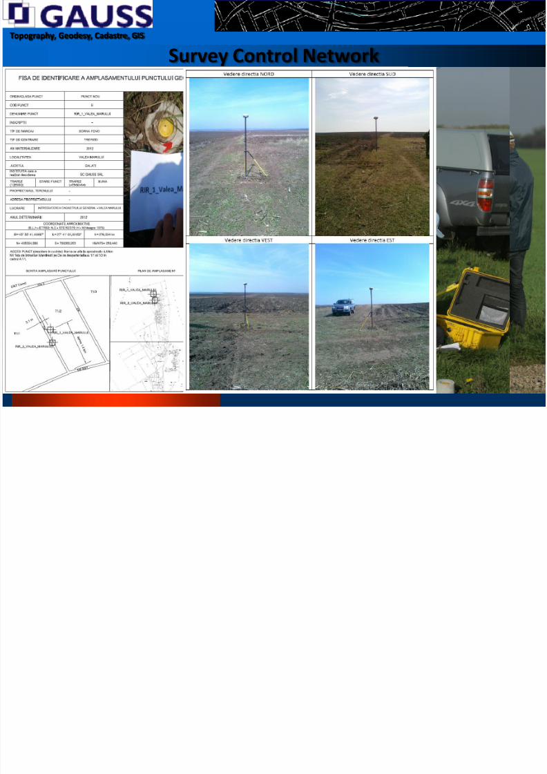
Survey Control Network
“Give me a fixed point place to stand on, and I will move the
Earth.”
Archimedes - 3rd
century B.C.
www.gauss.ro 327th September, 2012
8/12/2019 Balkan Oil&GAS Summit - Athens 2012
http://slidepdf.com/reader/full/balkan-oilgas-summit-athens-2012 4/26
Topography, Geodesy, Cadastre, GIS
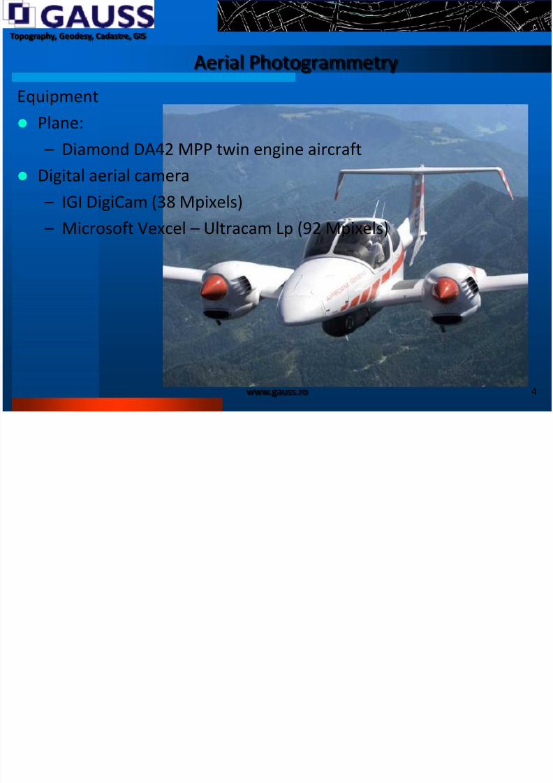
Aerial Photogrammetry
Equipment Plane:
– Diamond DA42 MPP twin engine aircraft
Digital aerial camera
– IGI DigiCam (38 Mpixels)
– Microsoft Vexcel – Ultracam Lp (92 Mpixels)
www.gauss.ro 4

8/12/2019 Balkan Oil&GAS Summit - Athens 2012
http://slidepdf.com/reader/full/balkan-oilgas-summit-athens-2012 5/26
Topography, Geodesy, Cadastre, GIS
LiDAR scanner
RIEGL LMS-S560 Airborne Laser Scanner System – Densities higher than 1 point per sqm for
flying heights arround 1,000 m
www.gauss.ro 5

8/12/2019 Balkan Oil&GAS Summit - Athens 2012
http://slidepdf.com/reader/full/balkan-oilgas-summit-athens-2012 6/26
Topography, Geodesy, Cadastre, GIS
Combined Photogrammetric/Lidar flight
www.gauss.ro 6
8/12/2019 Balkan Oil&GAS Summit - Athens 2012
http://slidepdf.com/reader/full/balkan-oilgas-summit-athens-2012 7/26
Topography, Geodesy, Cadastre, GIS
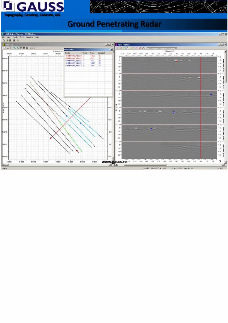
Ground Penetrating Radar
www.gauss.ro 7

8/12/2019 Balkan Oil&GAS Summit - Athens 2012
http://slidepdf.com/reader/full/balkan-oilgas-summit-athens-2012 8/26
Topography, Geodesy, Cadastre, GIS Deliverables
27th September, 2012 www.gauss.ro 8
- Ground control network- Point coordinates inventory- Burying depths for existing pipelines- Topographical and cadastral maps- DSM/DTM and derivate data (contours, watersheds, slope maps,volumes computations etc.)- Longitudinal/transversal profiles- Alignment sheets
- GIS

8/12/2019 Balkan Oil&GAS Summit - Athens 2012
http://slidepdf.com/reader/full/balkan-oilgas-summit-athens-2012 9/26
Topography, Geodesy, Cadastre, GIS
27th September, 2012 www.gauss.ro 9
Established Control Network for TAU Valea Mărului(41 points)
8/12/2019 Balkan Oil&GAS Summit - Athens 2012
http://slidepdf.com/reader/full/balkan-oilgas-summit-athens-2012 10/26
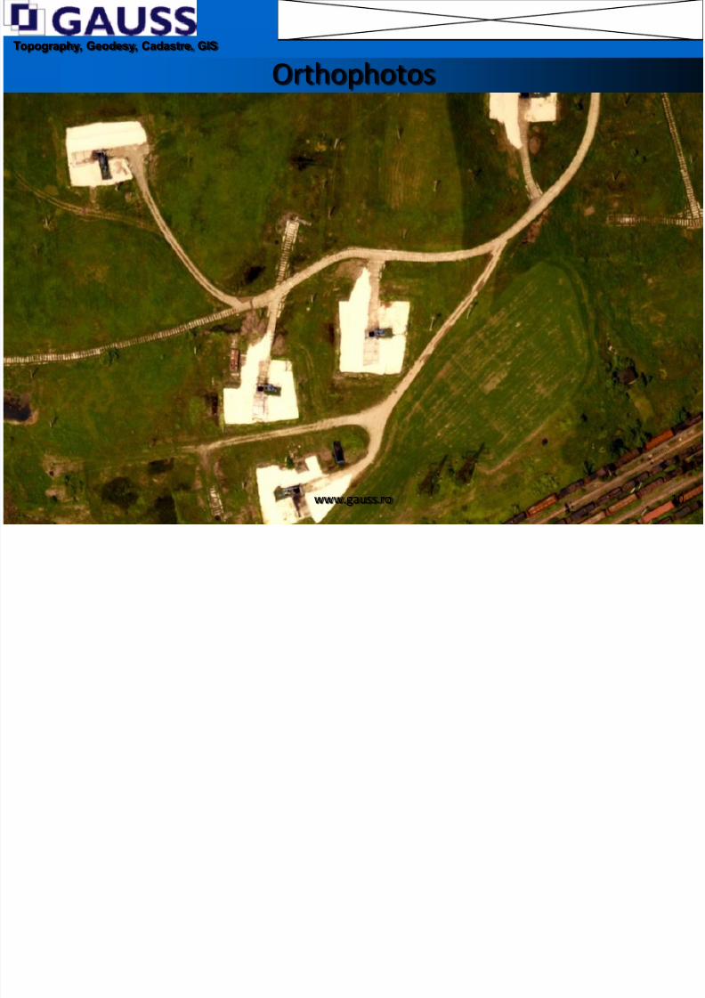
Topography, Geodesy, Cadastre, GIS Orthophotos
www.gauss.ro 10
8/12/2019 Balkan Oil&GAS Summit - Athens 2012
http://slidepdf.com/reader/full/balkan-oilgas-summit-athens-2012 11/26
Topography, Geodesy, Cadastre, GIS Lidar cloud points
27th September, 2012 www.gauss.ro 11
8/12/2019 Balkan Oil&GAS Summit - Athens 2012
http://slidepdf.com/reader/full/balkan-oilgas-summit-athens-2012 12/26
Topography, Geodesy, Cadastre, GIS
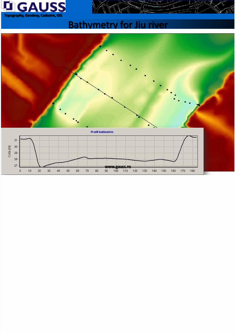
Bathymetry for Jiu river
www.gauss.ro

8/12/2019 Balkan Oil&GAS Summit - Athens 2012
http://slidepdf.com/reader/full/balkan-oilgas-summit-athens-2012 13/26
Topography, Geodesy, Cadastre, GIS
Perspective views – Cerna crossing
www.gauss.ro 13

8/12/2019 Balkan Oil&GAS Summit - Athens 2012
http://slidepdf.com/reader/full/balkan-oilgas-summit-athens-2012 14/26
Topography, Geodesy, Cadastre, GIS
Route Maps
www.gauss.ro 14

8/12/2019 Balkan Oil&GAS Summit - Athens 2012
http://slidepdf.com/reader/full/balkan-oilgas-summit-athens-2012 15/26
Topography, Geodesy, Cadastre, GIS
Alignment sheets
www.gauss.ro 15

8/12/2019 Balkan Oil&GAS Summit - Athens 2012
http://slidepdf.com/reader/full/balkan-oilgas-summit-athens-2012 16/26
Topography, Geodesy, Cadastre, GIS
Cadastral Route Maps
www.gauss.ro 1627th September, 2012
8/12/2019 Balkan Oil&GAS Summit - Athens 2012
http://slidepdf.com/reader/full/balkan-oilgas-summit-athens-2012 17/26
Topography, Geodesy, Cadastre, GIS
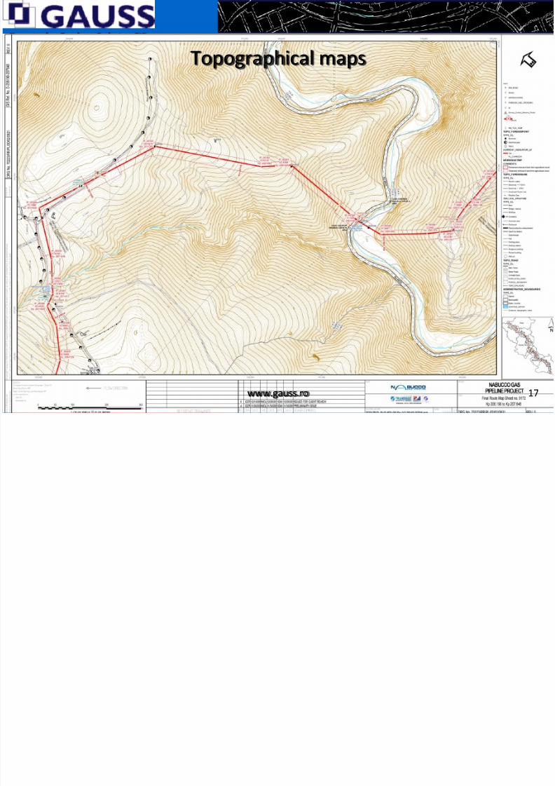
Topographical maps
www.gauss.ro 17

8/12/2019 Balkan Oil&GAS Summit - Athens 2012
http://slidepdf.com/reader/full/balkan-oilgas-summit-athens-2012 18/26
Topography, Geodesy, Cadastre, GIS
Cadastral mapping
www.gauss.ro 18

8/12/2019 Balkan Oil&GAS Summit - Athens 2012
http://slidepdf.com/reader/full/balkan-oilgas-summit-athens-2012 19/26
Topography, Geodesy, Cadastre, GIS
Linear Referencing Systems
Linear referencing (also called linear reference system or linearreferencing system or LRS), is a reference system in which thelocations of features are identified by a relative measure along alinear element, for example a milestone along a road. Each featureis located by either a point (known as a "milepoint") or a line("segment"). The system is designed so that if a segment of a routeis changed only those milepoints on the changed segment need tobe updated.
Linear referencing is suitable for management of data related to
linear features like roads, railways, oil and gas transmissionpipelines, power and data transmission lines, and rivers.
www.gauss.ro 1927th September, 2012

8/12/2019 Balkan Oil&GAS Summit - Athens 2012
http://slidepdf.com/reader/full/balkan-oilgas-summit-athens-2012 20/26
Topography, Geodesy, Cadastre, GIS
Where?
Linear elements mapping created the need to implement LRS
www.gauss.ro 2027th September, 2012
26 5'51.58"E
44 53'14.78"N Km 46+360

8/12/2019 Balkan Oil&GAS Summit - Athens 2012
http://slidepdf.com/reader/full/balkan-oilgas-summit-athens-2012 21/26
Topography, Geodesy, Cadastre, GIS
Advantages of using LRS
Kp 10 20 30 40 50 60 70 80 90 100
Classlocation
1 2 3 4
Protected
areas SCI Timi SPA Vinga
Capitalrepair
2015 2020 2017 2020
Incidents * * *
www.gauss.ro 2127th September, 2012
- locations are generally more intuitive than locations specified withtraditional coordinates- Easy data overlay, LRS allows attribute data from multiple sourcesto be associated with the network
- On the fly transformation of route measures from one revision toanother

8/12/2019 Balkan Oil&GAS Summit - Athens 2012
http://slidepdf.com/reader/full/balkan-oilgas-summit-athens-2012 22/26
Topography, Geodesy, Cadastre, GIS
LRS data exchange via tables
www.gauss.ro 2227th September, 2012
kp rev E start kp rev E end RUTA NOTE
2000 9000 D NU SE SCHIMBA
17200 17300 WP
42000 51500 D NU SE SCHIMBA
71500 72100 E
99500 99750 E
116200 116350 E
135350 137620 E
144730 145220 E
147650 148150 E
149600 150870 D NU SE SCHIMBA153610 157260 B (ELLIMINATED ip 135, 136, 137)
157260 157470 E (elliminated IP 139)
157470 15840 WP (elliminated IP 141)
160100 161250 E
161250 161450 D
162200 162600 E (IP 154, 156 elliminated)
163450 163700 E IP164-IP165- KILOMETRAREA GRESITA !!!
165300 172700 E (Cazanesti VOR)172700 174150 NEW ROUTE (elliminated Ips)
178760 182640 E
182990 184460 E DE VERIFICAT INTERFERENTA CU TRANSELECTRICA
185350 185720 WP (elliminated ip 201, 202)
187300 187420 E (elliminated ip 210, 211, 212)
187700 188100 NEW ROUTE (elliminated Ips)
188100 189160 E
189960 190380 E DE VERIFICAT DACA SE POATE MERGE PINA IN IP 235
190600 191570 E- MODIFICATA ATENTIE LA CIMITIR

8/12/2019 Balkan Oil&GAS Summit - Athens 2012
http://slidepdf.com/reader/full/balkan-oilgas-summit-athens-2012 23/26
Topography, Geodesy, Cadastre, GIS
LRS implementation in ESRI ArcMap
www.gauss.ro 2327th September, 2012

8/12/2019 Balkan Oil&GAS Summit - Athens 2012
http://slidepdf.com/reader/full/balkan-oilgas-summit-athens-2012 24/26
Topography, Geodesy, Cadastre, GIS
www.gauss.ro 2427th September, 2012
8/12/2019 Balkan Oil&GAS Summit - Athens 2012
http://slidepdf.com/reader/full/balkan-oilgas-summit-athens-2012 25/26
Topography, Geodesy, Cadastre, GIS
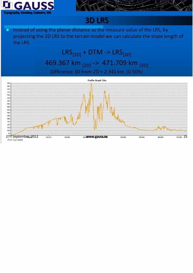
3D LRS Instead of using the planar distance as the measure value of the LRS, by
projecting the 2D LRS to the terrain model we can calculate the slope length ofthe LRS.
LRS[2D] + DTM -> LRS[3D]
469.367 km [2D] -> 471.709 km [3D]
Difference 3D from 2D = 2.341 km (0.50%)
www.gauss.ro 2527th September, 2012
8/12/2019 Balkan Oil&GAS Summit - Athens 2012
http://slidepdf.com/reader/full/balkan-oilgas-summit-athens-2012 26/26
Topography, Geodesy, Cadastre, GIS
Thank you for your attention!
www.gauss.ro 2627th September, 2012