b e l o w · pictures: gold street and nugget buildings plaques, tiverton, devon i.a.recordings,...
TRANSCRIPT

“Below” 99.3 1
E L O W !B
Additions to the LibraryA number of publications have beenadded to the club library since the lastissue of ‘Below’ these include:
North Wales C.C.Newsletter:No. 261, July 1999; No. 262, August1999; No. 263, September 1999
Mining Heritage Society of Ireland:Newsletter No11, July 1999
Norfolk Mineral & Lapidary Society:Stone Chat Volume 20, No. 1 Autumn1999 - contains an interesting article onthe Cardiganshire Lead Miner "Howhe lived and worked", plus a gazeteer ofHudeshope Levels, Middleton-on-Teesdale.
Cave & Karst Science (Transactionsof the BCRA), Vol.26 No.1, April 1999.
Caves & Caving (BCRA Bulletin), Issue84, Summer’99 - interesting report onthe developments at Titan Shaft, Peakcavern; Issue 85, Autumn ’99
Shropshire Mines Trust: NewsletterNo.13, September 1999.
Quarterly Journal of the Shropshire Caving & Mining Club Autumn Issue No: 99.3
AGM NewsNo change on the committeeAssociate Members now have full
voting rights and this category ofmembership will be merged with FullMembers.
Special discount on your membership ifyou pay within 3 months:Full: £15, pay £13Family: £22, pay £20Junior: £8Day: £3
Snailbeach BonfireThe annual bonfire is on November 6th,organised by local residents, ClubMembers traditionally help build it -volunteers welcome.
Millenium FundingThere is a possibility of funding forrestoration work on East and Old Gritengine houses in the Millenium
Shropshire Mines TrustThey have now become involved in theBog Centre and hope to use it out ofseason for meetings. Next year theywill also be involved in donating materialfor displays etc.. Due to theirinvolvement a Trust Member has joinedthe Board of Management of theCentre.
Chatterley WhitfieldEnglish Heritage have agreed to partlyfinance the (re)restoration of theChatterley Whitfield Mining Museu Siteby providing £1m to save the listedcolliery buildings (and presumably theengine?).
They have no plans to re-open the siteas a museum, but are appealing fordonations of items that could formexhibits (!).
The Shropshire Mines Trust might belooking to donate the Tinsley Engine tothe site - although in light of whathappened to the museum before I wouldhave thought ownership of any'donations' should be retained andcontracts drawn up to ensure the safetyof the exhibit!
Mid week MeetingsSteve Holding plans to hold regular midweek meetings to push a particular minesite or for training exercises.
It is proposed to have a regular trainingsession on the wednesday after a ClubMeeting. If you are interested inknowing where the session is going tobe held (probably Snailbeach), the timeand place to meet, then contact Steve -address on the back page.
NCA - BCRA MergerDue to financial problems at the NCAthere is a prossibility that the twoorganisations will merge.
Book Thank YouI have recently received a letter fromMalcolm Newton with some presscuttings for ‘Below’ and have beenasked to pass on his thanks:
As you see I’m still here, if proppedup by pills and can still writealthough its difficult if notimpossible to draw pictures now.
I would like to thank everyone forthe lamp book and the kindmessages people wrote inside, itwas all very much appreciated andreminded me of the many good timesI had with the club. It is nice to knowthat things are moving at Snailbeachat long last and that the headgearover Georges Shaft has been re-erected.
Best wishes to you allMalcolm

2 “Below” 99.3
News Round-Up 1by Ivor Brown
Queries1. Mid Devon District Council would
like any information on a group ofShropshire miners who, afterTiverton Merchants in 1756 raised£500 in 50 x £10 shares to pay them,sank a shaft about 400 yards fromthe town centre to 150ft. in the searchfor coal. “No coal was found and theminers went home leaving the shaftopen” (Quote from Dunsford,Memoirs of Tiverton 1790).
Recently a farmer searching for abullock found the shaft open, it wasbricklined for 116ft. depth. TheCouncil have had it capped but sinceit is now believed to be full of water,on high ground above the villagethey want to know whether therewere any adits or soughs pointingin their direction.
2. Prof. Torrens of Keale University issearching for a book “Thoughts onthe Formation of the Earth”,published in Shrewsbury in 1802,by a ‘Farmer’.
3. With the closure of the last tin mine,Florence Haematite Mine in Cumbriais now the only UK mine raising ametalliferous mineral as its mainproduct.
Mining Journal, 16.7.99
Mines Inspectors ReportThe Mines Inspectors Report of 1900gives some interesting statisticsregarding the use of steam at Coal,Ironstone and Clay Mines in Shropshire.
No. of Steam EnginesWinding 75Ventilating 8Hauling 15Pumping 28Generating Electricity 4Miscellaneous 33Loco Engines 5
168
VentilatorsGuibal 4Schiele 2Chandler 1Blowing 1
8
Boiler TypesLancashire 23Cornish 45Egg-ended 82Vertical 10Portable & Loco type 8Balloon(Haystack?) 7
175Note:4 of the steam engines in Shropshire (2winding and 2 pumping) were ancientmachines with open topped cylinders.
Aerial Ropeways 2Following the item in the last issue of‘Below’ on aerial ropeways DavidPoyner and the writer have put togetherthe following list of ropeways to carryminerals in Shropshire:
Bayton Colliery (part)Billingsley CollieryHighley CollieryClee Hills QuarryBog MineHuglith Mine
- six in all, but have we missed any?
Societies MergeA pleasant surprise for the writer nowthat the Institution of Mining Engineersand the Institution of Mining &Metallurgy have amalgamated (underthe latter name) - he is entitled to freemembership since “his years ofCorporate Membership plus age exceed100”.
Now if the SCMC had such a rule itwould be equally worthwhile - perhapsan item for next years AGM!
Telford TalkDr. I.J.Brown will be giving a talk onTelford’s Mining Landscape - past andpresent to Ironbridge Gorge MuseumFriends, at Coalbrookdale Museum onWed. 8th Dec. 1999, at 7.30pm. Allmembers of the SCMC are welcome.
Tiverton a Major Mining Area?The Query from Mid Devon DistrictCouncil is interesting, as I have oftenwondered how much mining took placein the Tiverton area. The canal basin inthe town has a very large lime-kiln setinto its embankment and I have alwaysassumed that both coal and limestonewas brought in by canal, the querywould seem to suggest that there mayhave been local coal mines whichpresumably supplied the fuel - althoughIvor Brown assures me that the geologyis not right for coal mines in this area.
Metal MiningConnections?
On another mining link for the area, the
Pictures: Gold Street and NuggetBuildings plaques, Tiverton, Devon
I.A.Recordings, KL: cs144.28
Can anyone throw any light on this?
Kelvin
main street running down the hill fromthe centre of the town is called GoldStreet, while this might be dismissed acoincidence, particularly as severaltowns in this area of Devon have GoldStreets (and Silver Streets in somecases), Tiverton has an added item ofinterest in that a building about halfway down Gold Street is called “NuggetBuildngs”, with suitable motifs on theplaque..
I.A.Recordings, KL: cs144.29

“Below” 99.3 3
A Tunnel System at Hampton Loade Forgeby David Poyner
At the end of the Eighteenth Centurytwo iron forges were established atEardington and Hampton Loade on theRiver Severn, between Bridgnorth andHighley. Their histories have beendocumented previously1. TheEardington Forges are known for,amongst other things, being linked byan underground canal2 and this wasexplored by the club in the 1960s.
Hampton Loade Forge (SO 748864) wasbuilt in about 1796, on or close to thesite of a mid-Seventeenth Century blastfurnace3. It was equipped with both asteam engine and a water wheel. In the1820s a short-lived tinworks wasestablished on the site. The forge closedin 1866.
The industrial archaeology of the sitehas not been studied in any great detail.Although much of the works wasdemolished at the end of this century,a group of houses remain and the areaforms a small hamlet. In May this yearthe Alveley Historical Society visitedthe forge site. During the course of thisvisit, the group (of which I was part)was shown the entrance to a tunnel.The tunnel is only known to those whohave lived locally, as far as I am aware.With the permission of the landownersI was able to return in June to explore itin more detail.
Tunnel InvestigationThe forge at Hampton Loade had twoponds; an upper and a lower pond(Figure 1). Both of these are nowdrained. The mouth of the tunnel isbesides what was the lower pond and itheads in the direction of the upperpond. It is set into a steep bank. Atpresent the entrance to the tunnel isunderneath a tree root; there is a stoneretaining wall on the east side which isabout 6 feet long. The tree root makesit difficult to say what was the originalarrangement at the tunnel mouth.
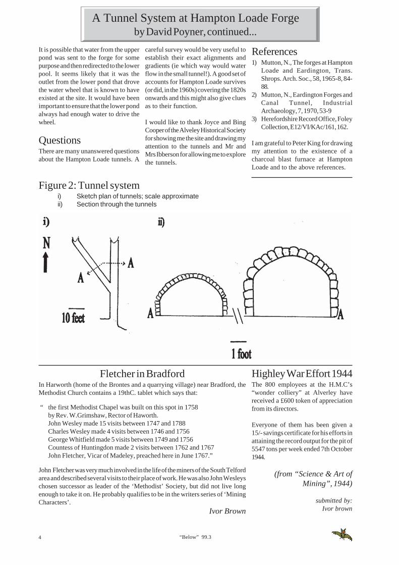
Once in the bank itself the tunnel is ingood condition. It is made of sandstoneblocks and is shaped like an invertedU, 5 feet wide and 4 feet high (Figure2). It stretches for about 50 feetapproximately due north until it isblocked by a fall.
Tunnel FunctionsThe functions of the tunnels aremysterious. It is not clear whether theywere built together. The small bricktunnel must date from the time of theforge and it is reasonable to assume thelarger tunnel was also built for the forgerather than the blast furnace 150 yearsearlier. Given the alignment of the largetunnel it seems reasonable to think thatit might have carried water from theupper to the lower pool, presumablyconnecting with a short shaft that is notnow visible. Quite why this would bepreferred to a more conventionaloverflow channel is unclear.
If the large tunnel carried water, so mustthe smaller tunnel. Presumably the“drainage” holes must have beenblocked up; the slot in the floor mighthave held a baulk of timber. The smalltunnel seems to be heading in thedirection of the forge complex itself.Perhaps it was built for waterconservation?
Figure 1Hampton Loade Forge based on Tithe Map of c1840
About 18 feet from the entrance there isa branch tunnel, heading NNW. This isof the same profile but is made of brickand is 4 feet wide and 2’6" high. Afterabout 40 feet this is also blocked by afall, although just before this point itseems to be swinging round to go in amore northerly direction. The floor ofboth tunnels is covered with severalinches of silt but it is possible to see thatat least in the smaller tunnel there aretiles or plates about 3/4" thick whichactually form the true floor.
At several places in the smaller of thetunnels bricks are missing from thebottom course to create openings thatlook like drains; in the middle of thesmall tunnel these are either side of aslot in the floor where there is a gapabout 6" wide between the plates. Closeto this there is an iron nail and towardsthe end of the small tunnel are severallarge pieces of clinker and slag.
Both tunnels are approximately drivenon the horizontal.
F: Forge BuildingC: Cottage or HouseW: probable waterwheel site
4 “Below” 99.3
It is possible that water from the upperpond was sent to the forge for somepurpose and then redirected to the lowerpool. It seems likely that it was theoutlet from the lower pond that drovethe water wheel that is known to haveexisted at the site. It would have beenimportant to ensure that the lower pondalways had enough water to drive thewheel.
QuestionsThere are many unanswered questionsabout the Hampton Loade tunnels. A
References1) Mutton, N., The forges at Hampton
Loade and Eardington, Trans.Shrops. Arch. Soc., 58, 1965-8, 84-88.
2) Mutton, N., Eardington Forges andCanal Tunnel, IndustrialArchaeology, 7, 1970, 53-9
3) Herefordshire Record Office, FoleyCollection, E12/VI/KAc/161, 162.
I am grateful to Peter King for drawingmy attention to the existence of acharcoal blast furnace at HamptonLoade and to the above references.
careful survey would be very useful toestablish their exact alignments andgradients (ie which way would waterflow in the small tunnel!). A good set ofaccounts for Hampton Loade survives(or did, in the 1960s) covering the 1820sonwards and this might also give cluesas to their function.
I would like to thank Joyce and BingCooper of the Alveley Historical Societyfor showing me the site and drawing myattention to the tunnels and Mr andMrs Ibberson for allowing me to explorethe tunnels.
Figure 2: Tunnel systemi) Sketch plan of tunnels; scale approximateii) Section through the tunnels
Fletcher in BradfordIn Harworth (home of the Brontes and a quarrying village) near Bradford, theMethodist Church contains a 19thC. tablet which says that:
“ the first Methodist Chapel was built on this spot in 1758by Rev. W.Grimshaw, Rector of Haworth.John Wesley made 15 visits between 1747 and 1788Charles Wesley made 4 visits between 1746 and 1756George Whitfield made 5 visits between 1749 and 1756Countess of Huntingdon made 2 visits between 1762 and 1767John Fletcher, Vicar of Madeley, preached here in June 1767.”
John Fletcher was very much involved in the life of the miners of the South Telfordarea and described several visits to their place of work. He was also John Wesleyschosen successor as leader of the ‘Methodist’ Society, but did not live longenough to take it on. He probably qualifies to be in the writers series of ‘MiningCharacters’.
Ivor Brown
Highley War Effort 1944The 800 employees at the H.M.C’s“wonder colliery” at Alverley havereceived a £600 token of appreciationfrom its directors.
Everyone of them has been given a15/- savings certificate for his efforts inattaining the record output for the pit of5547 tons per week ended 7th October1944.
(from “Science & Art ofMining”, 1944)
submitted by:Ivor brown
A Tunnel System at Hampton Loade Forgeby David Poyner, continued...
“Below” 99.3 5
By 1881 their family consisted of:John Maiden age 12, Mary Maiden age 10, William Brown age 7,Enoch Brown age 5, Samuel Brown* age 2, Elizah Brown age 1 month
* Samuel Brown (above) was my grandfather
Their home at Rednal Hill or Bank, an old ironstone mine tip at Madeley Woodstill survives - it is a single storey 2 room squatter-type cottage.
Enoch Brown died in 1911, but Sarah (Maiden) lived until 1915, she died after aserious illness living with son Samuel and his family - my father John rememberedher clearly.
We have lost all trace of John and Mary Maiden (who were step-kindred to mygrandfather Samuel), but about 1919 John M. lived in Glasgow, Mary Maiden(married name Kitson) lived in Attercliffe, Sheffield.
In 1995 I put a wooden cross on both Enoch’s and Sarah’s graves in MadeleyChurchyard to prevent them being re-used (unmarked graves ‘believed to beabandoned’ can be dug out and used again).
Simplified ‘family tree’ relationship
Browns Maidens1807-67 Benjamen Richard - brothers - William
| m: 1866 | |1837-1911 Enoch = Sarah = Charles Thomas - brothers - Joseph
| m: 1872 Maiden died 1870-1 b:1849 | died in pit| | disaster
1878-1949 Samuel William b:1879| |
1905-90 John John b: 1891| |
1937- Ivor Brown Thomas b: 1923|
Mr. Allen b: 1955
Since writing this article I have been in touch with Mr. Allen in America and wenow know that the above family tree is correct; Ivor Brown’s great-grandmotherand Mr.Allenss great, great grandfather were cousins-in-law!
Ivor Brown
The Relationship betweenA.C.Maiden (Below 99.2, p23) and I.J.Brown
Ironbridge, History and Guideand surviving remains, the book alsoincludes chapters on the ‘Beginnings’,Iron, The Iron Bridge, Raw Material,Clay Industries, and the IndustrialCommunities.
Mining is principally covered in ‘RawMaterials’, a chapter of 9 pages (!), thegeology gets hardly a mention and,when it does, the terminology issometimes doubtful - clay being formedin ‘veins’, for example (on pages 58 and61).
The photographs in the book are clear
By: R.Hayman and W.Horton,published by Tempus Publishing Ltd.1999. ISBN 07524 14607, price £14.99,soft covers, 160 pages, 25 coloured and75 b/w photos.
‘Ironbridge’ is really a misnomer as italso covers Madeley, Broseley and theother smaller communities, but it is areadable book which brings into focusthe many aspects for which the area isnow so well known.
As well as guided ‘tours’ of the variousparishes, indicating their development
and effective and the use of so manycoloured ones, particularly generous.
In keeping with modern trendshowever many of the photos areundated. Similarly there are noreferences in the text so that statementsmade cannot be followed up, althoughthere is a guide to ‘Further Reading’.
Ivor Brown
Not a weighty tome, but may makesomeone an interesting ChristmasPresent.
Kelvin
This is a follow-up to the item from Mr.Allen in ‘Below 99.2, p23:- There wereseveral families named ‘Maiden’ in theMadeley Wood area in 1851, but twoseem to be of brothers Richard andWilliam Maiden.
William Maiden: Tithe Map PlotNo.2144, age 35.
Wife Ellen, age 33. Children:Elizabeth; 12, Rebecca; 8, Joseph; 5and Thomas; 2. (Joseph was killedin the pit disaster, aged 18 in 1864).
Richard Maiden: Tithe Map PlotNo.2212, age 40, a coalminer.
Wife Mary, age 30, a laundress.Children: Mary; 7, and Charles age5 (Charles Maiden born 1846 marriedSarah Pountney of Broseley in 1866.He was 20, she was 17. Charles waskilled or died between March 1870and April 1871 - I have not checkedthe register of Deaths for cause ordate.)
In the 1871 Census, Sarah Maiden isdescribed as age 22, a “pauper widow”with 2 children, John age 2 years andMary age 3 months.)
On November 4th, 1872 Sarah Maiden(“otherwise Pountney”) aged 24, awidow working as a charwoman marriedmy great grandfather; Enoch Brownage 34, a bachelor working as anironstone miner of Lloyds Gate(Madeley Wood).

6 “Below” 99.3
The Club - the early yearsIn response to Ivor Brown’s item (seebelow), there is no doubt at all about thefoundation date of our Club, it is the 6thSeptember 1961 and our 40thanniversary will thus be on 6thSeptember 2001. That was the date ofthe inaugural meeting held in theupstairs room at 36 St. Mary Street,Newport, I enclose a copy of the minutesas proof of this.
You are right however in saying thatthere was some undergroundexploration and work done before thisdate, but it was not done by a ‘Club’ assuch and cannot therefore be includedas part of it’s activities, although muchof the information gained at this periodwas made use of by the Club andpublished after it’s formation.
I will explain:Although there must have been aprevious latent interest the idea reallybegan during an expedition I led toPlynlimmon in 1958 when we, (allmembers of Newport Young Farmer’sClub) found a number of mine levelswhich we decided we would like toexplore.
My good friend John Mason urgedcaution until we had the right equipmentand a little more knowledge. During thefollowing few months he gathered thenecessary helmets, lamps, ropes etc.and we returned in March 1959 toactually enter them. John on his ownbat and with other friends had alreadystarted to have a look at the remains ofthe mines in South Shropshire, I firstwent there in December 1958.
At about this time Mike Warner foundthe entry to the Lilleshall limestonemine which we explored. In 1959 I met upwith David Corbyn who advised us,and the archaeologist Miss Lilly Chittysuggested strongly that we should dothe job properly and to record what wefound. The Survey of the SouthShropshire mines was thereforecommenced in January 1960 and inOctober we surveyed the LilleshallMine, with trips to Derbyshire andvarious other places. John Mason was
the undisputed leader, he provided allthe tackle, I was his nominal second incommand and kept the records etc..
During this period the Newport RotaryClub organised a hobbies exhibitionand we were asked to take part. Johnand I put a stand together and notingthat all the other stands had nameplatesI asked him what we should callourselves. By this time we were knownas ‘the miners’ but I did not think thatthis was appropriate. I suggested ‘TheMining Club’ and then realising that wewere probably the only people locallydoing this sort of thing thought that wecould make it ‘The Shropshire MiningClub’, I went back and made up the signwhich I still have. So the name was born,but it was only a name.
As we went on more people began totake an interest in what we were doingand wanted to take part. I suggested toJohn that we should form a proper Clubwith elected officers and a Constitution,but John would have none of it, we werehe maintained a group of friends, he didnot welcome outsiders and we shouldstay as we were. We reluctantly agreedto differ, in the meantime I gatheredmore interested people, but John wouldnot accept them into the group. Thefinal schism came at our Easter Camp atGwynfynedd in 1961 when I told himthat my new friends, Mike James, MikeGaut, and David Crow wanted to comeon the camp. He refused point blank,there was a regrettable argument, andwe ended up with two camps a hundredyards apart.
I must point out that up to this timeexcept by using our new name, we wereby no means a Club, there were noelected officers, we had no funds, andall the tackle was the personal propertyof John Mason, we were his closedgroup of friends and that was that. Ihave since therefore called this periodthe activities of the Shropshire Mining‘Group’ for want of a better description.
On the final day of the Gwynfyneddcamp, 3rd April, I walked the foresttracks churning the problem over in mymind and made the decision to go italone and found the Club myself. Quite
a difficult decision as it meant breakinglong-standing friendships, and I hadno tackle whatsoever and had relied onJohn’s leadership.
All that summer I spent collecting it,with advice from David Corbyn andhelp from Mike James and Mike Gaut.The Club was thus formally foundedon 6th September 1961, I was the onlymember of the original group. John wasat first very opposed to the Club, buteventually became an associate memberin 1964, although except for the oddoccasion he never took an active part init.
The new Club then went on to publishthe work done by the previous groupand recorded by myself, together withtheir own continuation work. Thisseems to have led to the confusion overour date of founding which seems toexist.
I hope this helps to clear up the matter,but I do intend to prepare a proper moredetailed history at a future time.
David AdamsFounder Member
Formation of the ClubThe article from David was the result ofa draft note which I sent to him in whichI put forward a view that the Club wasnot giving itself full credit for beingolder than both the PDMHS (formed in1959) and NMRS (formed 1960).
In the Mining Heritage Guide the Clubclaims 1959 and David admits there wasa ‘group’ of friends under various namessurveying the South Shropshire minesfrom at least March 1959.
By January 1960 this survey had beenput on a more formal footing, togetherwith other surveys and in October 1960a “short limited publication wasproduced entitled Account No.1”. Thesurvey of South Shropshire mines “waspublished by the Shropshire MiningClub in 1962” (both quotations beingtaken from David’s history of the ClubSMC Journal 1972/3).
When did the Club Start?

“Below” 99.3 7
So the confusion starts with thepublication of the surveys or‘Accounts’. The present group(SCMC) still publishes ‘Accounts’numbered consecutively from the No.1of October 1960 - eleven months beforethe ‘inaugural meeting’ of SMC, andthe Club was using the name SMC atthat date.
Now, the ‘Accounts’ commenced in1960, the results of work commenced in1959 was published in 1962 and otherdocumentary evidence shows that theequipment purchased before 1961passed into the hands of the ‘new’ Clubin 1961. Furthermore, reading the earlyYearbooks there are many referencesback to earlier visits of the members tovarious mines, indeed the referencingeg: “5th visit to ....” etc. seems to takeinto account these earlier visits.
I raise the issue only because I wonderif the Club is being fair on itself in nottaking credit for an earlier formationthan the ‘big two’ PDMHS and NMRS,but David was there I was not, my letterof interest was not put in until April1962 (and that is another story).
The Club has indeed changed its formand name several times over the years,but this does not affect its age - it hashappened to other groups. Why should1961 be the start of the SMC, the namewas in use before this, same peopleinvolved, same equipment, working onthe same project, using the same notesand the publication of results has beencontinuous?
Why not claim the earlier date: 1958,1959 or at least 1960 - the date of the firstpublication carrying its name? Whynot celebrate the anniversary inMillennium Year?
References:1. Short history of the SMC, SMC
Journal 1972/32. Yearbook 1961/2, 1962/3, 1963/43. Draft handbook to the SCMC
(proposed Account No.14, 1981, notpublished)
4. Letter: DRA to IJB 10 April 1962.
I.J.Brown
August 31st. Letter despatched to a number of people who might be interested inproperly founding The Shropshire Mining Club. These included: Messrs. JohnPagett, D.A.Corbyn & sons, R.Ratcliff & M.Gatensburg, D.Crow, E.Brookes,K.Price.
September2nd: Club Room procured - No.36 St. Mary Street, originally Mus.4th/5th: Muskins flat. Large hole in roof rear portion, front rooms in very good
condition. Electric wiring was found to be faulty, no power, no lights, someconsiderable trouble was spent in repairing this but was not entirelysuccessful, light being procured in stoveroom only. A temporary line was putin to give ;light in the main Clubroom. This was fully carpeted and furnishedcomplete with bar.All equipment was stowed in the stoveroom.
6th: Official Foundation of the Shropshire Mining Club (36 St. Mary Street,Newport)A meeting was held in the Club Room on Wednesday 6th September toofficially found the Shropshire Mining Club. Those present included:- Mr.D.B.Corbyn and his son Andrew, Messrs. J.A.Pagett, P.T.Watkins, R.Meeson,and Miss M.Nellman of the Wellington Group of the ShropshireArchaeological Society.Also Messrs. M.Gaut, M.Boldeustone, M.Bridgwood, M.Jones and myself.
I opened the meeting by giving the complete history of the ‘Shropshire MiningClub’ to date, and explaining the reasons for its proper foundation and it’sfuture aims etc. I then showed those present the equipment which had beenpurchased for Club use. This included: 8 lamps and batteries, with two moreloaned from Mr. Corbyn, 10 helmets, 100ft. and 50ft. nylon rope and two 30ft.rope ladders, together with numerous stakes, crowbars and hammers.I then asked how many of those present would be prepared, having heard ofour intentions, to form a Club. All those present agreed to become memberswithout exception.
It was then proposed that Mr. D.B.Corbyn should become the Club’s firstPresident and be chief advisor to it. To this he agreed. It was then suggestedthat I should continue as both Leader and Secretary of the Club, which Iaccepted.
Some discussion was held as to who should take on the post of ClubTreasurer. M.Gaut was unanimously elected to take on this post.The newly formed Club then went on to discuss the financial situation withregard to the equipment.The main expenses were outlined as follows:-7 lamps ex. G.W.George - £ 14 - 10 - 08 helmets ex. Helmets Ltd. - £ 5 - 3 - 32 nylon ropes ex. British Ropes - £ 7 - 8 - 62 30ft. rope ladders ex Mottram - £ 8 - 15 - 01 Sledgehammer ex. R.Adams - 9 - 01 Letterfile ex. W.H.Smith - 7 - 0 Paper & Stamps ex. P.Office - 3 - 012 bottles beer, ex O.D.Murphy - 19 - 11 bottle cider ex. Lloyds - 2 - 5
£ 37 - 17 - 3This sum had been paid by myself. Some considerable discussion was thenheld as to how the repayment should be made. No discussion was reached atthe meeting but it was suggested that 5 people should be guarantors for thesum of £ 8 each. With regard to subscriptions it was unanimously agreed thatthis should be £ 1 per annum.I suggested that the 1st. expedition should be to Llanymynech on Sunday 4thOctober and this was agreed to. It was proposed that a further businessmeeting should be held prior to this date on 28th September to complete thefinancial arrangements.
David Adams
Extracts from the Minutesof the Shropshire Mining Club 1961
8 “Below” 99.3
As a one-time operator of the full-sizereplica Newcomen engine at the BlackCountry Museum, Dudley, and an avidstudent of the subject of early steamengines and locomotives, I would liketo comment on Part 7 of Ivor Brown’s“The Mines and Tunnels of theIronbridge Gorge” dealing withShawfield Colliery (‘Below’, 99.1).
It can be categorically stated that theengine described is not a Heslop enginesince it only has one cylinder. Althoughsuch references as I have are somewhatconfused and also conflicting in certaindetails, the following account attemptsto provide a reasonable outline ofHeslop’s achievements which howeverneed further research in order to makea more definitive statement concerninghis engine design and its exact mode ofoperation.
Adam Heslop, a native of Cumberlandalthough trained and working at KetleyIronworks, did indeed produce amodified Newcomen engine possiblywith the help of William Revnolds. byutilizing; a second cylinder in which thesteam was condensed, and placed atthe other end of the beam, patented in1790 (Patent No. 1760). The operating,or hot, cylinder at the connecting rodend of the beam, was supplied withsteam at anything up to 5 PSI (this wasreported to be the most economicalpressure in 1880, when there were stillthree engines working for the MadeleyWood Company), thus raising thepiston and working as a single actingcylinder, à la Watt.
At the opposite end of the beam, thecold cylinder, immersed in a tank ofcold water, and into which the steamfrom the hot cylinder passed via a water-jacketed eduction pipe controlled by avalve, condensed this steam using a jetof cold water, thus behaving as anatmospheric cylinder pulling down thebeam, à la Newcomen. Both cylinderswere open topped, an air pumpreportedly removing air from the coldcylinder; there was no snifting valve,and one account suggests some sort ofvalve in the piston of the cold cylinder.This arrangement if acting in concert,which at this stage is far from clear to me
but I shall obtain the patentspecification to elucidate the problem,would help the single-acting nature ofthe rotative Newcomen engine bymaking it effectively double acting.
Clearly, the Heslop engine infringedWatt’s patent for the separatecondenser, which in effect the coldcylinder was, although no serious legalaction appears to have commencedunlike that which befell other betterknown engine builders like Trevithickand Bull. Heslop subsequentlydeparted for Whitehaven, Cumbria,where he built at least 14 engines for thelocal coalfield, including one for LordLonsdale at Workington. An enginewas also erected in London in 1795.Nevertheless, his machines provedpopular in the Ironbridge Gorge, andseveral survived into the photographicera being shown in variouspublications.
Relatively crude affairs, the A-framessupporting the beam being clad inwooden planks to provide shelter, withthe rest exposed to the elements, theywere doubtless reliable workhorseswhere coal was cheap; for example, onewas employed at the head of the HayInclined Plane to raise tub boats ontheir cradles from the River Severn tothe level of the canal, a vertical heightof 207 ft. Erected around 1795 at Kell’sPit, one of the Whitehaven engines waspresented to the Patent Museum (nowthe Science Museum) in 1878; the hotcylinder is 34.4" diameter with a 34"stoke, and the dimensions of the coldcylinder 25.4" and 39" respectively.(sadly this engine is now dismantalledand in ‘storage’, Kelvin)
Most of Heslop’s machines were usedfor winding at collieries, with some stilloperating into this century. I am notaltogether convinced however that allphotographs purporting to be Heslopengines do in fact have two cylinders,so beware of jumping to conclusionsbased on the caption without examiningthese early photographs very carefully.An engine without a beam was erectedat Wombridge by Heslop in 1794.
What is shown is a fairly standard
Newcomen engine designed for rotativeuse, and with a separate condensermounted beneath the cylinder and inpermanent communication with it,usually known as a “pickle-potcondenser”. Many engines wereadapted in this way, particularly afterthe expiry of Watt’s patent in 1800, tomaintain a higher temperature in thecylinder and a permanently lower one inthe pickle-pot. The bucket pumpsituated in the well and actuated by therod from the beam, supplied water to acistern possibly in the roof of the houseor at least at beam level; the pipeworkon the gable end carrying this waterupwards can be seen clearly in thephotographs on pages 7, 9 and 10.
What I think is the overflow pipe fromthe cistern can be seen on the westernelevation of the house best seen in thephotograph on page 9. Water from thiscistern was used for injection into thecondenser, as well as providing a waterseal above the piston; the small diameterpipe with regulating valve can be madeout in the upper left corner of thephotograph of the engine cylinder, againon page 10. The higher the cistern, thegreater was the pressure for theinjection water, a point realized by JohnSmeaton and others in the design ofengine houses.
For a rotative engine, positiveconnexions between piston, beam andcrankshaft were vital due to reversal ofloads, unlike the chains used in pumpingengines where the weight of the pumprods always kept the chains in tension.Note the rather primitive crosshead andslide bar arrangement designed to keep,the piston rod in the correct alignment.The pin in the outer end of the beam(Diagram, page 10) should actually bepositioned directly above the centre ofthe crankshaft, as shown in thephotograph opposite. By very carefulexamination, it is seen that the square-section crankshaft transmitted powervia a reduction gear (spur gears) of 7: 1,far more likely than the 4: 1 reported in1912, with the power shaft apparentlysupported at its driven end by asubstantial brick wall built with a gable.(A very similar power transmission iseasily visible in the well-known
Shawfield Colliery EngineNewcomen or Heslop?

“Below” 99.3 9
published photograph of the NiblandColliery engine taken about 1855). Thepower shaft had two winding drumswith spokes to hold the rattle chainevenly, winding in opposite directions(photograph page 7) from the two shafts660 ft deep. Thus for every 7 rotationsof the crankshaft, the winding shaftmade one revolution.
There was clearly an excellentmechanical advantage for winding uploads because of this reduction gearand the fact that the chain being woundup was at its smallest diameter, whilethe chain being wound down was at itslargest diameter. For a Newcomenengine with its single power stroke percycle (of two strokes, or one revolutionin the case of a rotative engine), windinga constant load was somewhatdisadvantageous, hence the massiveflywheel and reduction gear. The inertiaof flywheel and winding drums wouldcarry the engine through its non-powerstroke to begin the next power-producing one; whether the steampressure of 4 - 6 Psi in the boiler(s)played any part of this is debatablesince the small diameter steam pipe(photograph page 9), seeminglyunlagged and exposed to the weather,would mitigate against this. It is mybelief that in general, steam was drawninto the cylinder for most of the strokeby the upward travel of the piston,rather than performing any useful workin pushing it, and hence the beam,upwards.
The number of strokes (7 in 3 minutes)reported by the “Engineer” in 1917 isutterly erroneous, and may be due to amisunderstanding. The reporteradmittedly does not seem to know theprecise workings of the Newcomenengine and of course we must rememberthat it was not running at the time of hisvisit.
The first known Newcomen engine of1712 with a 21" bore was capable ofsome 12 power strokes per minute, andfollowing the introduction of rotativeNewcomen engines around 1780, itbecame the norm to run them on lightloads and at much faster speeds,possibly 18 rpm for a 36" cylinder,
equivalent to 154 revs per hour for thewinding shaft. At an average chainwinding diameter of say 7½ft. (thephotograph on page 9 suggests anoverall diameter to the ends of thespokes of about 13 ft in comparisonwith the 15 ft flywheel, and assumingthe chain to be 2" thick, then a 660 ftlength wound on to the drum wouldoccupy some 9 ft. 4 in, equating with acore diameter of nearly 3 ft., allseemingly reasonable dimensions),winding from a 660 ft shaft would takenearly 11 minutes with the enginerunning at constant speed!
Some means of ensuring the enginewould start in the opposite directionafter raising would be needed,presumably by stopping the crankpinin the required position and holding itthere during unloading, and I shouldlike to learn of any such detailsregarding the braking mechanism andreversing techniques for engines suchas this. Assuming the rattle chainweighed 3 lb per foot, then the totalweight of chain fully extended downthe shaft would have been almost 2000lb. At the commencement of winding,due to the small diameter of the drum,the mechanical advantage would befavourable and the actual rate of ascentslow. Assuming the engine worked atconstant speed, winding wouldprogressively become faster, andincreasingly, the weight of thedescending chain would help tocounterbalance the ascending load.Presumably, this accelerating rate ofascent would be carefully regulated asthe load neared surface!
The valve gear depicted, probablysimple drop valves operated by therack and pinion, was fairly common inlatter-day engines. The valves would.be switched over just before the end ofeach stroke, by pegs in the plug rodactuating the lever. For example, withthe piston nearing the top of its stroke,the steam valve would close and thewater injection valve open. A jet of coldwater entering the pickle-pot at highvelocity, would condense the steamthus creating a partial vacuum.Atmospheric pressure did the actualwork by acting on the upper surface of
Shawfield Colliery EngineNewcomen or Heslop?
the piston, injection water pluscondensate being subsequentlydischarged from the condenser througha non-return (flap) valve. This waterwhich was very hot, was often used asboiler feed using gravity systems inthe earlier engines, or with a small feedpump in later ones.
Museum AcquisitionsPerhaps like many other people, I oncethought that artefacts acquired by, ordonated to, museums would be properlylooked after and displayed in perpetuityfor the benefit of the community atlarge. Not so! Having been associatedwith several “industrial” museums, Icould take anybody to see manydisgraceful examples of the almostcomplete lack of suitable care. It appearsthat increasing their inventory is thesole aim of many curators seeminglyoblivious to future maintenancerequirements; indeed a lick of paint, adrop of oil, and wood preservative suchas creosote or even tar-based products,seem totally beyond theircomprehension, or perhaps more to thepoint, their pocket. In this respect, oneof the worst offenders (‘Below’, 99.1,page 13) is surely the Ironbridge GorgeMuseum. Indeed it is sad to see their“unique collection of blowing engines”:for example the woodwork of David &-Sampson is unfortunately so rottenthat the public is barred from access,and if they were able to make anexamination at close quarters, theywould clearly see the effects of years oflack of maintenance to an ancientmonument in the supposed care of aninstitution specifically designed tosave, display, interpret and conservesuch artefacts from the golden age ofengineering, for posterity. Heaven helpthe exhibits we do not see!
Still, what can we expect from a museumwhich, according to my understanding,compels the volunteers to becomeFriends of the Museum at no little costto themselves, whereas I would havethought that any monetary exchangeshould by rights be in the oppositedirection!
Richard Lamb
continued...

10 “Below” 99.3
Shawfield Colliery EngineNewcomen or Heslop?
References:The Steam Engine of Thomas
Newcomen by Rolt & AllenDynasty of Ironfounders by RaistrickJames Watt & the Steam Engine by
Dickinson & JenkinsIronbridge Gorge by ClarkThe Industrial Revolution in Shropshire
by TrinderThe Blackwell Encyclopaedia of
Industrial Archaeology edited byTrinder
The Archaeology of the IndustrialRevolution by Bracegirdle
Beam Engines by Crowley.
End view of a Heslop Engine House,cylinder, and boiler arrangementbased on Patent Specification diagram,July 1790
A
D
RackRack
PinionHand Lever
Doo
rway
Val
ve R
od
Pum
p R
od
CrossHead
Slide Bar
Floor Level
SteamInlet
InjectionPipe
Exhaust
Pump
Platform
Diagram of the Shawfield Colliery Atmospheric EngineBlists Hill, Madeley, Shropshire. NGR: SJ 698 037Based on "The Engineer", 3rd August 1917 issue, page 95
Adam HeslopHeslop and his engine, was going to bethe subject of the Mining Charactersspot for this issue, unfortunately dueto the pressure of space and time, thisarticle has been held over until the nextedition of ‘Below’.
However to help you understand someof the points the Richard Lamb wasmaking in his letter on pages 8 and 9, Ihave reproduced the diagram of theShwafield engine from ‘Below’ 99.1(bottom right) plus a side view of aHeslop engine based on the originalPatent specification (top right).
I think it is fairly safe to say that theengine at Shawfield was a Newcomentype engine, while the engine at theBlists Hill Mine a little further along thecanal (and now used by the IronbridgeGorge Museum) was of the Hesloptype.
I would be interested in answers tosome of the points that Richard raises,particularly the point about how to startwinding with a Newcomen engine.
As an aside, presumably winding chaindid not stretch like wire rope, so thelanding position of the cage couldalways be predicted?
Answers on a postcard (or severalsheets of paper) to me please, for futureprinting in ‘Below’.
Kelvin

“Below” 99.3 11
were situated at the Broseley end of the‘Ironbridge’ the postal address was“Ironbridge” and their geographic andpostal location is the only reason forthem being included here.
2. BedlamSituated in Waterloo Street, it isbelieved that they were established inthe 1780’s or 90’s by Roger Cock onland above the Bedlam Furnaces. Thesewere ‘white’ brickworks and the claywas obtained from adits near the siteand by tramways from the Lloyds andLodge Pits.
The owners of these pits; the MadeleyWood Company, took over thebrickworks before 1850. Cock’s addressin the 1820’s to 1850’s was‘Hodgebower’ and at this place therewas until recently two inscribed brickson a property formerly owned by himbearing the words “Imperial Clay Mines”and “P.Cook” (or was it really‘R.Cock’?). No other reference to thename Imperial Clay Mines has beenfound. It is understood that the workshad closed by 1905.
There is however a brief description inJohn Randall’s entry in ‘VictorianCounty History of Shropshire’ (FirstEdition) which says that the works hadan Heslop-type open-cylinder enginetended by an old women. There is alsoa good photograph of the site c.1895showing two chimneys in ‘Telford, Pastand Present’ (published by the TelfordDevelopment Corporation, 1978).
3. HodgebowerA ‘brickyard’ owned and occupied byR.J.Stirrop is shown on the ‘Slang’ nearthe present Crown Inn on the 1847 TitheMap. This may also have been workedsome time by Cock. Bagshaws Directoryin 1851 lists Samuel Roden as a brickand tile manufacturer at Hodgebowerand this may have been the same site.The rough land formerly between theLodge and the Woodlands Grangecould have been the source of the clay.
4. & 5. Madeley HillTwo brickworks operated here at thetime of the 1849 Tithe map survey, both
The ‘red-clay’ mines of this “LittleJackfield” area on the north side of theIronbridge Gorge have been greatlyovershadowed by the mines ofJackfield itself to the south, but theyhave an impressive history just thesame. The ‘red’ brick and tile clays arefound in the Hadley Formation of theUpper Coal Measures and in this areathey lie directly on much lower Middleand Lower Coal Measure rocks due toa geological unconformity. These redclays have been found and worked onthe north bank at The Lloyds (see Part4 in this series) and Blists Hill (Part 6)and at the Lodge and Woodlands sitesbetween Ironbridge and Madeley.
Around the Lodge and Woodlands (SeeMap 1, on next page), the red clays areless than 100ft. deep and have beenboth mined and quarried. Clays musthave a high premium quality to beeconomic for shaft mining but this wasthe case in the areas mentioned above.
The products they gave could bemarketed under the high value‘Broseley’ trade mark which had a veryhigh reputation. Some of the other CoalMeasure clays have also been workedin the area, including the MCMPennystone Measures which could givea bluish hue and the LCM fireclayswhich gave whiter bricks. Maw andCompany were working similar clays atthe Benthall Tile Works on the oppositebank of the Gorge and in 1858 the book“Quarries of the UK” described theclays produced as ‘best tile clay, Ganiesclay, Pennystone clay and three others’.
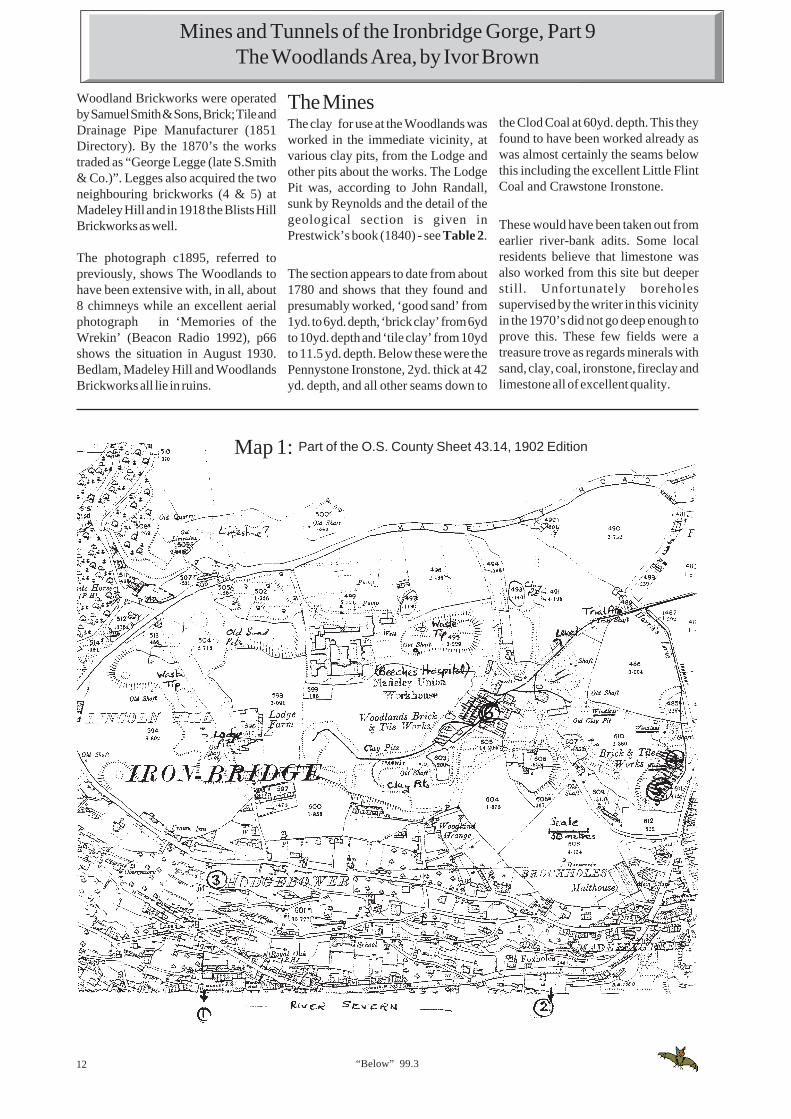
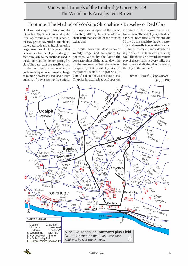
The BrickworksSix brick and/or tile works are known tohave operated in this vicinity since themid-nineteenth century. Five of themwere inter-related by virtue of ownershipor using clays from the same source atvarious times, so they are all referred tohere (see Map 1).
1. Burton’s WhiteBrickworks
This was the odd one out, the worksused ‘white clays’ from south of theriver under various owners from the1790’s to the 1950’s. Although the works
having shafts on site (see Map 1). Thenorthern works (4) was operated byB.Dodd and the southern works (5) byJ.Davies. The late W.H.Williamsbelieved that the Davies family hadstarted the works in the late 1790’s andthat the Madeley Wood Company hadat some time also been the operator. Asstated, by 1849, there were two operatorson site and various other operatorsfollowed. In 1851, for example, Bayliss,and Davies were producing bricks at‘Madeley Wood’.
However both works were apparentlyacquired by George Legge in the 1870’sand closed early this century. Nothingis known about the mining of clay onthis site, there are no working shaftslisted in 1891, but they would have beenquite shallow, probably less than 60ft.The 1849 Tithe Survey, plot numbersand uses are shown in Table 1.
A photograph c1895 in ‘Telford, Pastand Present’ shows the buildings withat least two tall chimneys. A tramwayconnected these works to theWoodlands.
6. WoodlandsThere is some evidence to show thatthese works were started by theMadeley Wood Company in the late1700’s (W.H.Williams said 1780 andthis is the date claimed for theestablishment by Geo. Legge &Company). They were probably startedbefore Reynolds’ involvement sincethe Lodge and nearby Lodge Pits werestill owned by the Darby family in 1849.It is believed that these pits had inearlier days supplied Woodlands withits coal and clay. The Woodlands laterbecame, because of this, the focal pointfor the extensive tramway (called rail-road on early maps) with rails leadingoff in up to 5 directions (see Part 8 inlast issue of ‘Below’and Map 1).
A map by C. & J. Greenwood of 1827shows a crossing of ‘rail-roads’ at thispoint, near which is also the words“Tile Kiln” and the 1833 OS Map alsoshows railroads and some buildingshere.
From the early 1800’s to about 1860 the
Mines and Tunnels of the Ironbridge Gorge, Part 9The Woodlands Area, by Ivor Brown
12 “Below” 99.3
Woodland Brickworks were operatedby Samuel Smith & Sons, Brick; Tile andDrainage Pipe Manufacturer (1851Directory). By the 1870’s the workstraded as “George Legge (late S.Smith& Co.)”. Legges also acquired the twoneighbouring brickworks (4 & 5) atMadeley Hill and in 1918 the Blists HillBrickworks as well.
The photograph c1895, referred topreviously, shows The Woodlands tohave been extensive with, in all, about8 chimneys while an excellent aerialphotograph in ‘Memories of theWrekin’ (Beacon Radio 1992), p66shows the situation in August 1930.Bedlam, Madeley Hill and WoodlandsBrickworks all lie in ruins.
Map 1: Part of the O.S. County Sheet 43.14, 1902 Edition
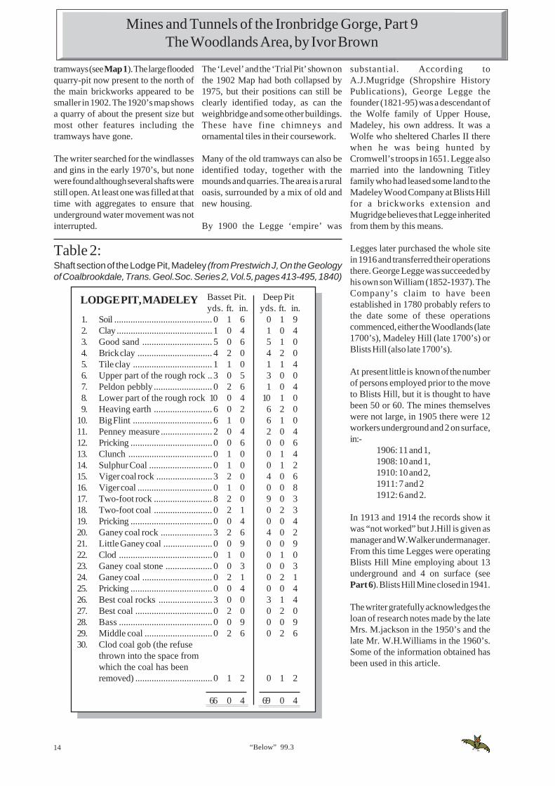
The MinesThe clay for use at the Woodlands wasworked in the immediate vicinity, atvarious clay pits, from the Lodge andother pits about the works. The LodgePit was, according to John Randall,sunk by Reynolds and the detail of thegeological section is given inPrestwick’s book (1840) - see Table 2.
The section appears to date from about1780 and shows that they found andpresumably worked, ‘good sand’ from1yd. to 6yd. depth, ‘brick clay’ from 6ydto 10yd. depth and ‘tile clay’ from 10ydto 11.5 yd. depth. Below these were thePennystone Ironstone, 2yd. thick at 42yd. depth, and all other seams down to
the Clod Coal at 60yd. depth. This theyfound to have been worked already aswas almost certainly the seams belowthis including the excellent Little FlintCoal and Crawstone Ironstone.
These would have been taken out fromearlier river-bank adits. Some localresidents believe that limestone wasalso worked from this site but deeperstill. Unfortunately boreholessupervised by the writer in this vicinityin the 1970’s did not go deep enough toprove this. These few fields were atreasure trove as regards minerals withsand, clay, coal, ironstone, fireclay andlimestone all of excellent quality.
Mines and Tunnels of the Ironbridge Gorge, Part 9The Woodlands Area, by Ivor Brown

“Below” 99.3 13
Figure 1: Advertisement by George Legge & Son, late 19th Century
Table 1Land Associated with brickworking from the 1849 Tithe MapPlot No. Category of Use Owner Occupier IJB
Note1901 Brickkiln Piece John Onions Geo.Davies1902 Brickworks & Stable John Onions Benj. Dodd (4)1903 Brickworks etc. John Onions Geo. Davies Jn (5)2030 Slang used as brickyard R.J.Stirrop R.J.Stirrop (3)2700 Clay Pits Sam Smith & Co. Sam Smith & Co2701 Clay Pits & part of brickworks Sam Smith & Co. Sam Smith & Co.2706 Woodlands, Brickworks road (6)
and waste Sam Smith & Co. Sam Smith & Co.1676 Brick & Tile Works Jos. Reynolds Madeley Wood Co. (2)
IJB Note: (2) Bedlam, (3) Hodgebower, (4 & 5) Madeley Hill, (6) Woodlands
The ‘sandholes’ near the old BeechesHospital were said to have contained“several beds of fine sand which ismuch used by the CoalbrookdaleCompany in their beautiful castings”(Bagshaw 1852). These glacial depositsare shown on the Tithe Map to havebeen owned by the Darbys in 1849.
The deep borehole put down east ofThe Lodge in March 1972 in a surveysupervised by the writer (see BGSGeological Sheet) showed that most ofthe coal seams had been taken at sometime (Big Flint at 47.8m deep, Ganey64.65m, Best, Randle and Clod 74.10m).The Lodge Pit was apparentlyexhausted before the 1840’s, its surfacelevel is 436ft. aod and grid O S. reference:SJ 6730 0376.
To the north of the WoodlandsBrickworks there is a large mound anda shaft (sometimes called the ‘BeechesShaft’) but nothing seems to be knownof its history. The mound dominatesthe northern bank on all earlyphotographs and was not, until recentyears covered in vegetation. This ispresumably the waste from an oldironstone mine and is shown on the1849 Survey. Based on the size of thetip, this must have been a substantialmine.
Little is known of the actual mining andquarrying for clay at the Woodlandsbut by 1849 there were at least two clayquarries and about 8 shafts including 2pump shafts. The type of pump is notknown but there is no evidence of asteam engine at either of the shafts. In
1891 a survey shows that 2 shafts werein use each 6ft. diameter and 72ft. and 78ft. deep respectively. The survey alsoshows that the mine ventilation wasnatural and that the manager wasP.Titley. The official lists of quarriesdoes not mention the Woodlands in1858 but by 1896 the quarry was “workedoccasionally” by two workmen.
The 1883 OS map shows fewer shaftsthan the 1849 Map, but it also showsgreater surface extraction areas as “claypits“. The 1902 OS map is unusuallydescriptive, it has the word ‘windlass’printed against 3 shafts (presumablythere were hand winches) and 2 shaftshave a 18ft. diameter dotted circle bythem, probably representing horse gins.There is also a ‘Level’ and a ‘Trial Shaft’marked together with a number of
Mines and Tunnels of the Ironbridge Gorge, Part 9The Woodlands Area, by Ivor Brown
14 “Below” 99.3
The ‘Level’ and the ‘Trial Pit’ shown onthe 1902 Map had both collapsed by1975, but their positions can still beclearly identified today, as can theweighbridge and some other buildings.These have fine chimneys andornamental tiles in their coursework.
Many of the old tramways can also beidentified today, together with themounds and quarries. The area is a ruraloasis, surrounded by a mix of old andnew housing.
By 1900 the Legge ‘empire’ was
Basset Pit. Deep Pityds. ft. in. yds. ft. in.
1. Soil .......................................... 0 1 6 0 1 92. Clay ......................................... 1 0 4 1 0 43. Good sand .............................. 5 0 6 5 1 04. Brick clay ................................ 4 2 0 4 2 05. Tile clay .................................. 1 1 0 1 1 46. Upper part of the rough rock ..3 0 5 3 0 07. Peldon pebbly ......................... 0 2 6 1 0 48. Lower part of the rough rock 10 0 4 10 1 09. Heaving earth ......................... 6 0 2 6 2 0
10. Big Flint .................................. 6 1 0 6 1 011. Penney measure ...................... 2 0 4 2 0 412. Pricking ................................... 0 0 6 0 0 613. Clunch .................................... 0 1 0 0 1 414. Sulphur Coal ........................... 0 1 0 0 1 215. Viger coal rock ........................ 3 2 0 4 0 616. Viger coal ................................ 0 1 0 0 0 817. Two-foot rock ......................... 8 2 0 9 0 318. Two-foot coal ......................... 0 2 1 0 2 319. Pricking ................................... 0 0 4 0 0 420. Ganey coal rock ...................... 3 2 6 4 0 221. Little Ganey coal ..................... 0 0 9 0 0 922. Clod ........................................ 0 1 0 0 1 023. Ganey coal stone .................... 0 0 3 0 0 324. Ganey coal .............................. 0 2 1 0 2 125. Pricking ................................... 0 0 4 0 0 426. Best coal rocks ....................... 3 0 0 3 1 427. Best coal ................................. 0 2 0 0 2 028. Bass ........................................ 0 0 9 0 0 929. Middle coal ............................. 0 2 6 0 2 630. Clod coal gob (the refuse
thrown into the space fromwhich the coal has beenremoved) ................................. 0 1 2 0 1 2
66 0 4 69 0 4
LODGE PIT, MADELEY
tramways (see Map 1). The large floodedquarry-pit now present to the north ofthe main brickworks appeared to besmaller in 1902. The 1920’s map showsa quarry of about the present size butmost other features including thetramways have gone.
The writer searched for the windlassesand gins in the early 1970’s, but nonewere found although several shafts werestill open. At least one was filled at thattime with aggregates to ensure thatunderground water movement was notinterrupted.
Table 2:Shaft section of the Lodge Pit, Madeley (from Prestwich J, On the Geologyof Coalbrookdale, Trans. Geol.Soc. Series 2, Vol.5, pages 413-495, 1840)
Mines and Tunnels of the Ironbridge Gorge, Part 9The Woodlands Area, by Ivor Brown
substantial. According toA.J.Mugridge (Shropshire HistoryPublications), George Legge thefounder (1821-95) was a descendant ofthe Wolfe family of Upper House,Madeley, his own address. It was aWolfe who sheltered Charles II therewhen he was being hunted byCromwell’s troops in 1651. Legge alsomarried into the landowning Titleyfamily who had leased some land to theMadeley Wood Company at Blists Hillfor a brickworks extension andMugridge believes that Legge inheritedfrom them by this means.
Legges later purchased the whole sitein 1916 and transferred their operationsthere. George Legge was succeeded byhis own son William (1852-1937). TheCompany’s claim to have beenestablished in 1780 probably refers tothe date some of these operationscommenced, either the Woodlands (late1700’s), Madeley Hill (late 1700’s) orBlists Hill (also late 1700’s).
At present little is known of the numberof persons employed prior to the moveto Blists Hill, but it is thought to havebeen 50 or 60. The mines themselveswere not large, in 1905 there were 12workers underground and 2 on surface,in:-
1906: 11 and 1,1908: 10 and 1,1910: 10 and 2,1911: 7 and 21912: 6 and 2.
In 1913 and 1914 the records show itwas “not worked” but J.Hill is given asmanager and W.Walker undermanager.From this time Legges were operatingBlists Hill Mine employing about 13underground and 4 on surface (seePart 6). Blists Hill Mine closed in 1941.
The writer gratefully acknowledges theloan of research notes made by the lateMrs. M.jackson in the 1950’s and thelate Mr. W.H.Williams in the 1960’s.Some of the information obtained hasbeen used in this article.
“Below” 99.3 15
Coalpit
Old L
ane
(182
7)
from
Gre
enwoo
d
BrickKiln Leasow
Rail Road
Stone
Woodlands
Meadow
Ironbridge
Lake Head
Bedlam
Paddocks
Styches,
Mine ’Railroads’ or Tramways plus FieldNames, based on the 1849 Tithe MapAdditions by Ivor Brown, 1999
Mines Shown
’Coalpit’ 2. BedlamOld Lane LakeheadBrickkiln Paddock?
6. Woodlands Styches3. Hodgebower Stone4. & 5. Madeley Hill1. Burton’s White Brickworks
Beeches
Lodge
1
3
2
4
5
6
Mines and Tunnels of the Ironbridge Gorge, Part 9The Woodlands Area, by Ivor Brown
Footnote: The Method of Working Shropshire’s Broseley or Red Clayexclusive of the engine driver andbanks-man. The red clay is picked outand sent up separately, for this an extra3d or 4d a ton is paid to the contractor.The shaft usually in operation is about7ft. to 9ft. diameter, and extends to adepth of 20 or 30ft; the cost of sinkingwould be about 30s per yard. It requirestwo of these shafts to every mile; onebeing the air shaft, the other for raisingthe clay to the surface”.
from ‘British Clayworker’,May 1894
“Unlike most clays of this class, the‘Broseley Clay’ is not procured by theusual openwork system, but is mined,the clay getters have to descend shafts,make gate roads and air headings, usinglarge quantities of pit timber and othernecessaries for the clays working, infact, similarly to the methods used inthe Stourbridge district for getting fireclay. The gate roads are usually drivento the boundary; when reached, aportion of clay is undermined, a chargeof mining powder is used, and a largequantity of clay is sent to the surface.
This operation is repeated, the minersretreating little by little towards theshaft until that section of the mine isexhausted.
The work is sometimes done by day orweekly wage, and sometimes bycontract. When by the latter thecontractor finds all the labour down thepit, the remuneration being based uponthe quantity of stacks of clay raised tothe surface, the stack being 6ft 2in x 6ft2in x 3ft 1in, and the weight about 5 tons.The price for getting is about 1s per ton,

16 “Below” 99.3
News Round-Up 2
Omega Pacific Ltd.Recently made known to the House ofLords Science and Technology SelectCommittee is the Trecwn Valley Facilityat Fishguard, Dyfed, South Wales. Thisis an ex- M.O.D. (Navy Department)underground storage facility that hasbeen acquired by Omega Pacific Ltd.
They are advertising it for industrialand storage use. In particular they areproposing to adapt the undergroundchambers for the storage of radioactivematerial.
The main feature of the site is its railwaynetwork, some standard gauge alongwith 18 miles of 2ft. 6in. gauge lineconnecting 58 underground cavernsdriven off from the sides of the Trecwnvalley.
Narrow Gauge News, Issue233, July 1999
Submitted by Brian Tildesley
Bevans Lead MineWisconsin, USAThis mine has been opened up as atourist mine, where you are taken in viamine trains.
Mining BadgersDuring my daughter and son-in-lawsvisit to the USA, when they were in theWisconsin State Capital, Madison, theycommented on the large number ofbadgers incorporated into thedecoration of the Capitol building andother monuments.
They were told that a badger was thelocal term for a miner, and mining was sowidespread in the State that it wassometimes referred to as the BadgerState.
Apparently Wisconsin is a pleasantState for a summer holiday, not being apopular tourist area, but perhaps shouldbe avoided in the winter - the housethey were staying in had one foot thickthermal insulation built into the externalwalls!
Brian Tildesley
Hanwood Mill CollapsesFriday December 19, 1897
All of the occupants but two wereenabled to quit the building and thecentral part of the mill collapsed.
A man called Samuel Rogers whoseduty was to repair barrels was workingat the end of his bench and his little boy,five years of age, who had recentlycome to keep his father company, wasat the other end of the bench in themiddle of the room.
A strange feature of the affair is that thewalls and both ends of the buildingwere left standing and while the fatherwas perfectly unharmed, the boy, whowas only a few foot away was crushedunderneath and when his body wasfound, quite dead.
Shrewsbury Chronicle18/12/97
An accident of the most alarming andserious nature occurred in the village ofHanwood near Shrewsbury early onSaturday morning when the mill used bythe Wotherton Barytes Companysuddenly collapsed and the buildingwas totally wrecked.
The mill, which is a long brick structure,is situated at the bottom of the lanewhich leads to the Rea Brook and usedfor the purpose of grinding spar.
The machinery is such which is of heavydescription and the shafting, wheelsand pulleys employed run through thewhole building of four storeys. At aboutseven o'clock when the workmen wereat the various occupations some bricksfell and a cracking noise which washeard above the noise of the machineryalarmed them.
Mine RevampWork in under way to save North Wales’last surviving colliery headgear at theformer Bersham Colliery, near Wrexham.Restoration work includes grit blastingto remove old paint, repair of its damagedsuperstructure and repainting. Twoshafts were sunk at Bersham Colliery in1868 and coal mining continued thereuntil 1986.
Shropshire Star, 3/8/99
British Pothole Triorescued
Three British potholers: AndrewHitchcock, Andrew McGee and PeterAsford were rescued on Sunday (1stAugust) after they became lost in amaze of tunnels in the Glas cave at Dentde Crolles near Grenoble in the FrenchAlps.
Shropshire Star, 2/8/99
items above, submitted by Nick Southwick
Catch a train ride around the Mininng Museum grounds in ore cars puilledby a 1931 mine locomotive. Here the train passes the 1845 Bevans LeadMine. (Mining museum, Box 252, Platteville, WI 53818; 608/348-3301).Photo by J.Mooney Photo.

“Below” 99.3 17
Access for Caving on Mynydd Ddu(The Black Mountain) An open letter to cavers
common’ with others. There are severalgraziers associations that representthe interests of many of the commoners.
The National Park Authority ownsabout 12,000 hectares of the area andmanages a further 2,000 hectares onbehalf of Dwr Cymru. This letterrelates to land that is owned andmanaged by the National ParkAuthority. The Authority manages thearea according to it’s purposes set outin the 1995 Environment Act. Theseare: to conserve and enhance naturalbeauty, wildlife and cultural heritageand to promote opportunities forunderstanding and enjoyment of theParks special qualities. It is alsorelevant to note that as landowner theAuthority has a duty of care to all usersof the area, and an associated liabilityif it is negligent in exercising that duty.
Being a publicly funded organisationthe Authority must manage its liabilitiesso as to protect itself - and the publicpurse - from damage claims. Most of thearea is designated under the Wildlife &Countryside Act as a “Site of SpecialScientific Interest” SSSI, and thisrequires the landowners to ensure thatthe interest of the site is not damaged.
Caving is formally recognised by theAuthority as an appropriate activity inthe Park setting, and the Authoritytherefore has a duty to promote theenjoyment and understanding of caves.It must also look after the interests ofcommoners, and exercise a duty of careto visitors. Finally it must ensure theconservation of the area, and ensurethat the SSSI is not damaged.
AccessLegal rights of access are provided bypublic rights of way. ‘De facto’ access,or that of long-standing tradition orcustom, is also established. TheNational Part Authority as a matter ofpolicy allows open access on foot forquiet, informal enjoyment. ‘De facto’access does not extend to access forcaving or digging, and these activitiesare only lawful if conducted with theconsent of the landowner.
A New ApproachHistorically the Park Authority hasmade a number of false starts in tryingto manage the issues of cave accessand conservation, and is aware thatsome cavers view its motives withsuspicion. The following arrangementssatisfy the remit of the National ParkAuthority, maximise accessibility,minimise bureaucracy and recognisethe critical role played by cavers in themanagement of cave exploration andconservation. The new approach shouldform the basis of a more productiverelationship between the cavingcommunity and enviromentalorgansiations.
The National Park Authority proposes:
To declare a “standing permission” forall cavers to visit (on foot) all sites ofspeleological interest on Mynydd Du,on the condition that:i). Cavers follow the NCA advice and
code of conduct regardingconservation of the caveenvironment
ii). Cavers have their own 3rd partyliability insurance, and undertakeall such activities entirely at theirown risk
iii). Nothing is done that damages therights of commoners.
To make available (at least possiblecost) the Mynydd Du Cave Survey,and to put in place & fund arrangementsfor its maintenance by cavers.
To declare a ‘standing permission’ forall cavers to conduct explorationactivity in caves and on the surface, onthe condition that:
i ), ii), iii) - As above.iv). That digging and other exploration
activity is recorded at the outsetwith the Mynydd Du Cave Survey(details may be held with restrictedaccess if requested), and the surveyis regularly updated through theduration of the activity. Details oflocation and persons responsiblewill be needed.
v). ‘Between visits’ any works are leftentirely safe and secure, and poseno threat to people, stock or otheranimals.
This letter is being circulated widely inthe caving community. The NationalPark Authority wishes to agree withcavers; access and conservationarrangements for Mynydd Ddu and it’scaves. This letter, which is intended tostimulate debate, outlines the legalrequirements for managed access andsuggests how this might be delivered.Comments from individuals andorganisations are welcome, and shouldbe sent to the address at the end of thisletter. Every person or organisationsubmitting comments will be invited toattend an informal meeting towards theend of the year.
The AreaMynydd Ddu is the area of uplandlying broadly between the UpperSwansea Valley, in the east and thecommunity of Trap in the west. Itextends to almost 15,000 hectares, andincludes an important limestoneoutcrop, an area which must provideone of the greatest opportunities forcave exploration in Britain. Survey workcompleted by local cavers in 1997identified 296 sites of speleologicalsignificance, three quarters of whichwere visited, photographed anddescribed. Twenty five of these wererecorded as being in a dangerous state,most of which are abandoned digs. ThePark Authority is now obliged toundertake works to these to renderthem safe. Offers of assistance fromcavers - are invited.
The same survey has also collated avery comprehensive bibliography, andmade many recommendations toimprove access and conservationmanagement. Paper copies of thesurvey are held by the South WalesCaving Club and National ParkAuthority. This should prove to be animportant exploration and conservationtool, and arrangements will be made forit’s transfer to digital media to make itaccessible and maintainable.
Ownership &Management
The whole area is ‘common land’ - landover which ‘commoners’ have rights(such as grazing) which they share ‘in

18 “Below” 99.3
It is thought that the contents of theNAMHO Newsletter are not circulatedwithin all Member Organisations as wellas was expected. The reasons for thisare numerous and complex ranging frompracticalities, size of the memberorganisation and multiple membershipsby individuals. It is also impractical forNAMHO to send a copy to all membersof the Member Organisations. It hasbeen decided that to try and improvethe circulation, the current Newsletterwill be added to the NAMHO web sitewhich is operated on our behalf byAdrian Pearce. In addition, PeterClaughton will put the currentNewsletter on the Mining History List.
INTERnationalNAMHO 2000
This, the 21st NAMHO AnnualNational Event will be held on 14th to18th July 2000. It will be hosted by CarnBrea Mining Society and CamborneSchool of Mines and will be based inTruro. Anyone requiring furtherinformation should contact LawrenceHolmes, Rivergarth, Bar Meadows,Malpas, Truro, Cornwall, TR1 1SS.Tel: 01872 278234.
vi). When complete the site is leftpermanently safe and secure.
To annual review the impacts ofexploration activity, to ensure that legalrequirements of the SSSI designationare not being breached.
To hold an open meeting so that thesuccess of these access andconservation arrangements may bediscussed.
Subject to the views of the cavingcommunity and other interested parties,the National Park Authority intendsthat the new approach should beeffective from 1st January 2000.
Please forward comments to :Jon Young,Brecon Beacons National ParkAuthority, 7 Glamorgan Street,Brecon, Powys LD3 7DP
Open Cavers Letter Cont...
Landmarks in MiningHistory Organisations1999 sees a number of significantanniversaries within NAMHO and it’smember organisations. NAMHO itselfis 20 years old this year. The WelshMines Society has also celebrated its20th Birthday. The Peak District MinesHistorical Society also celebrated its40th Birthday in June.
If any other member organisations arecelebrating a significant birthday in thenear future, please let Wes Taylor knowso that it can be reported in futureeditions of the NAMHO Newsletter.
Minewater in Northumberland
There is concern over the possibility ofserious pollution of the River Coquetand its tributaries as a result of risingwater levels in the abandoned workingsof the Whittle Colliery, near Alnwick.Water levels are currently beingmonitored. The problem has receivedconsiderable publicity in the local pressand on television.
Recent serious flooding in the Spittalarea of Berwick-upon-Tweed appearsto have resulted from an overflow ofwater from flooded coal workings inthe Scremerston area. Similar potentialhazards are associated with abandonedmine workings throughoutNorthumberland.
Whereas the risks and consequencesof mine water and gas reaching thesurface from abandoned workings arerelatively well known, less wellunderstood problems may also occur.Rising water levels may cause serioussurface instability, movement alongfaults and may also result in significantchanges to the permeability of the rocksadjacent to the old workings and it maynot be possible to achieve controlleddrainage of water from known shaftsand adits. Considerable areas of landslipped ground have recently beenidentified in the area underlain by theWhite Colliery workings. Althoughapparently stable under presentconditions, rising groundwater levelscould initiate further slippage. There is
thus a real risk to ground stability abovemine workings and perhaps oversubstantial adjoining areas not directlyundermined.
The Tempus-NAMHOMining Books
The collaboration between Tempus andNAMHO proceeds apace, movingtowards what should be a uniquenational collection of regional mininghistory publications. Unique becauseof the balance between informed,educated, keenly researched detail andgeneral interest, and because ofTempus’ own publishing programme,which maintains quality across a largerange of titles while keeping prices low,and especially for its aim of coveringevery significant mining area in thecountry.
At the moment, two NAMHO-affiliatedtitles are awaiting publication:
The East Shropshire Coalfield, by IvorBrown, and Peak District Mining andQuarrying, by Lynn Willies and HarryParker. These books are now available,from bookshops or Mike Moore, theyretail for £9.99each.
With NAMHO’s assistance in findingauthors, we hope to publish ten moreTempus/NAMHO titles before the endof the year 2000. In addition to therequirements for ten compilers toproduce “picture books” for miningregions by the end of 2000, thepublishers are now so confident ofsuccess that they have asked NAMHOto find authors for more descriptive,higher priced books, for each majormining area. It is envisaged that thesebooks will be illustrated, 160 or 196 pagebooks of about 60,000 words with colourplates. It is expected that they will retailat £15 - £24 each.
Authors will have an individual royaltycontract with the publishers. If you areinterested, or know someone who wouldbe interested, in preparing such a bookeither alone or in collaboration withothers, then please contact the NAMHOSecretary, Wes Taylor, as soon aspossible.
Extracts from the NAMHO Newsletter,Issue 36, Summer 1999, editor - Wes Taylor,

“Below” 99.3 19
sulphide and methane, plus carbondioxide concentrations in air weremeasured by lowering the meters downthe three shafts with the followingresults:
Climbing Shaft: oxygen > 20%; carbondioxide <0.5%
Chapel Dale Engine Shaft: carbondioxide >0.5% @ -20m & >1.0% @ -35m. oxygen >19% to base.
Fourways Shaft: carbon dioxide >0.5%@ -20m & >1.0% @ -25m. oxygen>19% to base.
The lids of the two deep shafts were leftopen to aid ventilation and wedescended the climbing shaft makingcontinuous measurements as weproceeded.
CO2 AlarmThe carbon dioxide meter has two alarmlevels, the first at 0.5% and the secondat 1.0%. The first alarm level wastriggered while descending the 2ndpitch into Pearl Chamber (S2) and thesecond between Pearl Chamber and‘The Chain’ (S3). Oxygen levels weredeclining and the alarm level of 19.0%was triggered at S4, the junctionbetween the level which continuesthrough two low, wet squeezes to theBung Series and a series of climbsdown to the Waterfall Pitch.
At this point there was also anintermittent bad smell but after dueconsideration we decided, somewhatreluctantly that a relatively swift tripdown to Waterfall Chamber was justifiedboth to measure the gas concentrationsand to obtain water samples for theEnvironment Agency.
However, the risks involved in a tripdown the north crosscut to the base ofFourways Shaft were not considered tobe justifiable and a rapid exit was made.
The following day [30th July] a returnwas made with breathing apparatus andDavid Nixon descended FourwaysShaft. The level leading to KnotlowFarm ‘Engine Shaft’ was found to begrossly polluted but the Chapel DaleLevel was essentially pollution free so
that at the foot of ‘Fourways Shaft’ theoxygen concentrations were slightlyhigher and the carbon dioxideconcentrations slightly lower than inthe upstream part of the mine.
Hydrogen sulphide and methaneconcentrations were zero throughoutthe mine.
Current ThoughtsOur current thoughts are that pollutedwater, with a high content of organicmaterial, is entering the mine from theKnotlow Farm ‘Engine Shaft’ and froma bedding plane near the top of theWaterfall Pitch.
One litre water samples were collectedfrom a number of sites and are beinganalysed by the Environment Agency.
Officers from the Environment Agencyare visiting farms in the area in an effortto determine where the pollution iscoming from and it is hoped that theresults of the water analyses willprovide an indication as to whethersewage or silage is the majorconstituent. However, it is important tounderstand that the reduction in airquality is an indirect result of the waterpollution since it appears to be due tooxidation of the organic matter which isdeposited in the cave. Although thepollutant inputs may be sporadic thefoul air will be more persistent, a factorlikely to be exacerbated by the poornatural ventilation in the mine.
Consideration is being given to howthe organic material may be flushed outof the system more rapidly and to howventilation might be improved as wellas to the question of the ultimatesource of the material.
Given the low oxygen and high carbondioxide cavers are strongly advised notto attempt to enter Knotlow until furthernotice. The Environment Agency hasposted warning notices on all entrances,including the entrances to Hillocks andto Whalf Mine as a precaution althoughno direct measurements have been madein these parts of the system.
John Gunn, (LRG),University of Huddersfield
The LRG are retained by English Natureto provide a ‘rapid response’ capabilitywhereby we visit Knotlow as soon aspossible after a report of pollution andrepeat the air, sediment and watersampling. However, the contract allowsfor a maximum of five visits whichmeans that we have to have a definitereason to undertake sampling.
In February 1999, it was noted thatthere were no problems with ‘bad air’anywhere in Knotlow and no visualevidence of water pollution apart fromsome pink growths in the level betweenthe base of Fourways Shaft and whatwill henceforth be called the KnotlowFarm Engine Shaft to avoid confusionwith other ‘Engine Shafts’.
During April and May there wereconflicting accounts from visitors tothe system, some reporting noproblems, others ‘bad air’. Followingthese, on 20th May, Paul Hardwicktested the oxygen, hydrogen sulphideand methane concentrations in air bylowering a meter down the three shafts:
Climbing ShaftChapel Dale Engine Shaft (also known
as the 210’ or simply as ‘the’ EngineShaft)
Fourways Shaft (also known as CrimboHollow Engine Shaft)
No evidence of ‘bad air’ was obtained,and oxygen levels were >19%.
This was confirmed by a party whovisited on 31st May and reported ‘nosmells’ although visitors on 4th & 6thJune reported ‘bad smells’. Thispresented us with some difficulty asthe air monitoring equipment, withoutwhich we cannot undertake any visit tothe mine because of Health & Safetyconsiderations, costs £120 to hire in,and it was decided not to undertake afull sampling visit until there was acertainty that there was a pollutionproblem. This visit was made on 29thJuly by John Gunn and Dave Nixonwhen we also hired in a carbon dioxidemeter which proved to be extremelyuseful.
As on 20th May, the oxygen, hydrogen
Pollution in Knotlow Cavernand Hillocks Mine
20 “Below” 99.3
Dear S.C.M.C.We have the pleasure to announce toyou that the Registration Form for the3rd European Speleological Congressis now available on the web just byclicking on our web site:
http://ip.pt/%7eip259832/eurospeleo99
Here you can see all the latest newsabout the congress such as photosabout pre-congress excursions, theprogramme, speleo-camps and fees. Ifyou prefer please ask us for a printed2nd Circular. Don’t forget to join us onthe Atlantic border next October.
Best RegardsAntonio SobreiraIII EUROPEAN SPELEOLOGICALCONGRESSRua Saraiva de Carvalho,233 1350 - 301LisboaPORTUGALPhone/Fax: +351 1 3966291E-mail: [email protected] http://ip.pt/
%7eip259832/eurospeleo99
Art and Cornish MineRemainsDuring the summer the concreteloadings of a horizontal winding engine,at Wheal Cock , were covered by a 16foot concrete cube. The building of thishas left cement debris strewn over thearea including the dumps which are anSSSI.
The area is under consideration tobecome a scheduled ancient monumentand forms part of the area for the WorldHeritage Site Status bid for Cornwall.Access to these important remains willbe denied to industrial archaeologistsuntil the structure is removed nextMay.
The organisers of this particular workare St Ives International a charitabletrust reliant on public funding, theycould not be persuaded to move thisstructure a short distance away despiteEnglish Heritage saying the locationwas inappropriate.
At Geevor Mining Museum there is anart and sculpture exhibition, large partsof the site are littered with ‘sculpture’good, bad and terrible and the new tableplant building houses more works.
Gold MinersMany Cornish miners emigrated to theUnited States - some went to NorthCarolina, where a gold rush precededCalifornia’s. For those researching themigration of Cornish miners to NorthAmerica the following web site whichcontains an article detailing NorthCarolina’s gold rush, along with a listof links to additional websitesregarding the subject and a relatedconference could be of interest:
http://members.home.net/teylu/jenkins/gold_nc.html
‘Owned by the miners:Tower’The National Library of Wales currentlyhave an on-line photographic exhibitionby Roger Tiley, illustrating work in thelast deep colliery in Wales.
www.llgc.org.uk/exhbind.htm
Old OS MapsRally Maps of West Wellow are able tosupply copies of O.S. County Seriesc1850 to c1940 (plus older sheets).These are high quality copies offoriginals onto a similar weight of paperto the originals.
These maps work out at £20 pluspostage per sheet and they have a turnround of a few days.
Rally Maps can be contacted by phoneon: 01794-515444 and email at:[email protected]
They also have a web site at:www.rallymap.demon.co.uk
Foreign Mining Incidents
ChinaSix Chinese miners managed to stayalive for 4 weeks after being trapped bya collapse in a mine at Langroa, HebeiProvince.
They kept alive by eating their belts(presumably leather, rather thannylon!) and sipping water drippingfrom the rocks.
Mining Journal
AustriaTen rescuers died while attempting tosave a trapped miner in a talc mine atLassing in Austria. The miner wastrapped by an inundation of mud inworkings about 60m below the surface.
The trapped man was intially unhurtand was in contact with the surface. Asthe rescue team was getting organisedunderground a second more seriousinrush of mud trapped all the men.
Attempts to rescue them involvedpumping out the mine, which causedfurther problems by lowering the localwater table causing a 100m diametercrater to appear at the surface, intowhich two houses fell.
The mine has been active since 1901,produces approximately 30,000 tonnesof talc per annum and employs about 30men.
Mining Journal
Jaded WorkersChinese Workers are digging out theworld’s largest piece of jade. It is a rockweighing 60,000 tonnes and some 30min diameter.
House CollapsesMembers will have seen the local newsreports about the collapse of a house inWalsall.
The 50 year old house in Hughes Road,Moxley was built on the site of mid-19thCentury mine workings (presumablylimestone, or coal?). The house startedcracking and literally fell into hole thatopened up under it ten minutes later.
Luckily the 64 year old resident managedto escape unhurt.
News Round-Up 3

“Below” 99.3 21
“What the Papers Have Been Saying”compiled by Nick Southwick
Shropshire Star: 29th June 1999
Shropshire Star: 10th June 1999

22 “Below” 99.3
Perran Foundry Preservation Work 1compiled by Malcom Newton
Both items from:The Packet (Falmouth)17th July 1999

“Below” 99.3 23
Perran Foundry Preservation Work 2compiled by Malcom Newton
All items from: The West BritonThursday, 15th July 1999
Company chairman Christopher Downes atthe Perran Foundry site.Picture by Camera Craft

24 “Below” 99.3
Jules UnlimitedDutch TV Visit
As promised in the last issue here are afew pictures from the visit of the Dutchfilm crew recording an item for thepopular ‘Jules Unlimited’ programme.
There was some initial concern whenwe learnt that the actual film crewworked for NOB TV, but it had aperfectly inocent meaning
Below: The film crew (sound man, director and camera man in action onthe 40 yard level recording the MineCam - while it recorded them!
The Minecam had been lowered down Chapel Shaft foran “interview” with Mano the programme presenter - hewas holding the Minecam and talking to camera.
Sorting out kit and equipping the crew with completeSRT rigs, on the surface near shaft 22.
The first stage was descending tothe 40 yard level via Perkins. ThePresenter had to abseil past theMineCam which was hung from thebridge in Perkins level
While we enjoyedourselves underground,Tom West, Alan Taylorand Pete Egglestonenjoyed the sunshine onthe surface ‘manning’ thewinch for haulingequipment and workingthe communications
They also complained about the odddrop of rain!
“Below” 99.3 25
Videos and Events
e-mail: [email protected] or visit their web site at:http://www.iarecordings.org/
Mining Videos(available from the Club)
If you are interested in doing a bit ofarmchair mine exploration the followingvideos, produced by I.A.Recordingswith help from Club members, may be ofinterest to you.
A Tour of Clive Copper Mine£14.95A comprehensive guided tour of Clive,with Edwin Thorpe acting the‘experienced’ expert and Kelvin Lakethe ‘novice’. The tour covers both theupper and lower levels, plus theNorthern stope (the access to which isnow a bit dodgey).
Clive Rescue Practice, £9.95An action packed ‘head banging’record of a Club rescue practice,featuring the ‘infamous’ maypole winzetraverse!
Snailbeach, £14.95The rise and fall of Snailbeach, oncerenowned as the “richest per acre ofground in Europe”, is traced in thisproduction through the use of historicphotographs, animated plans andsections, and unique undergroundvideo footage.
Glengowla, £6.58A tour around this amazing mineral richlead mine in Ireland, complete withcommentary and diagrams. [12 mins.]
Collections from the ArchivesThe following tapes contain almost allthe footage recorded at the given mine,and are intended as a resource base, nota finished production:
C.15:Dudley Tunnel ’88 to ’89, £14.10C.18:Donisthorpe Colliery, £11.75C.20a:Snailbeach - Final Frontier, £9.87C.23: Bagworth Colliery, £11.75C.28: Morse’s Level, £9.87C.29: SCMC in Cornwall, £16.45C.32: SCMC in Ireland, £14.10C.37: Dudley Tunnel - Wrens Nest East
Mine. Local historians have oftentalked about ‘Step Pit’ an accessshaft to the East Mine undergroundcanal basin and caverns that wasreputed to have a spiral staircase,recent stabilisation work hasuncovered fragments of thesaircase, plus allowed an interestinginsight to the canal and mines in thisarea. £9.87
C.41: Hem Heath Winders, £9.87
For more details about videos contact:I.A.Recordings, PO Box 476, Telford, TF8 7RH
In the Bewick Vein - Story of a Northumberland Lead MineThe Somerset Coalfieldby Shane Gould, papaer-back, 67pp.The book includes plenty of plans andphoto’s of surviving buildings,including a useful location map of theprincipal collieries, supplemented by aGazetteer. Price: £ 6.95 + £1.00 post andpacking.
Somerset’s IndustrialHeritage a Guide andGazetteerEdited by Derrick Warren, paper-back,A5 68pp. Produced in the style of AIApublications, a very useful guide to theindustrial past of this county area forlocals and visitors. Price: £4.95 + £1.00p&p
Available from Mike Moore at Clubmeetings.
’The Salt and CoalIndustries at St Monans,Fife’The second monograph newlypublished by the Tayside and FifeArchaeological Committee.
In the 1770s, capital, raw materials,skilled labour, and innovativeengineering solutions were combinedon the Firth of Forth at St Monans tocreate one of the most important sites ofthe Industrial Revolution in ruralScotland.
The results of 10 years of excavationsat the saltpans are integrated in thisattractive publication, with newresearch into social and economichistory, aerial photography, and earlymaps. The monograph is lavishlyillustrated in b&w and colour, togetherwith foldouts interpreting a key 18th C.estate plan, as well as plots of theextensive cropmark evidence of earlymining.
Format: A4, 70pp, with papers by, ColinMartin, Robin Murdoch and JohnLewis, and Paula Martin.
Ask Mike Moore for copies.
By Susan Harley, 70 pp, 16 figures (5coloured), 15 plates.Price: £ 4.95 (plus85p p&p from Honeycrook Press)
The veins at the Langley Barony Mine,near Haydon Bridge, were tried in the18th century, but it was not until 1871that Thomas John Bewick proved theirtrue potential. Unlike many veins in theNorth Pennines, mineralisation herepersisted over a depth of around 57fathoms and, when the mine closed in1893, it had produced 40,761 tons oflead concentrates. The section coveringthe history and layout of the mines,which are centred on Honeycrook Burn,is supplemented by one giving useful
biographical notes on T J Bewick andhis later association with C.A. Moreingin founding an international firm ofconsulting mining engineers.
The sections on the production andwashing of lead ore and the workingconditions at the mines work well andare illustrated with appropriatephotographs. There are a few minorerrors in places, but overall a well writtenand researched book.
Available from: Honeycrook Press,Joicey Shaft Cottage, Haydon Bridge,Northumberland, NE47 6NF or speak toMike Moore.

26 “Below” 99.3
For organised Club trips please refer tothe Monthly Meets lists.
22nd-25th Oct.: SUICRO XVSymposium, leenaun, Co. Galaway
1st-4th Nov.:First European CaveRescue Symposium, Goppingen,Germany.
13th-14th Nov.: DCA/NCA Caver’sWorkshop, Pindale Farm, Castleton,Derbyshire.
200029th April to 1st May: 4th EuropeanExploration Speleology Congress
14th-18th July: INTERnationalNAMHO 2000, hosted by carn BreaMining Society and Cambourne Schoolof Mines, based in Turo. Theme“Acquire, Record and Display”.
30th Aug.- 7th Sept.: The InternationalCommittee for the Conservation ofIndustrial Heritage Millenium Congress,first 4 days in London, then a choice oftours to Cornwall, Wales or Scotland.Welsh and Cornish tours will have asignificant mining bias.
13th-16th Sept.: International MiningHistory Congress, Milos Island, Greece
Diary DatesClub Officers
The Annual Conference- Rain Stopped Play ......Never!
Registration: A good nights rest ..
Enjoying the surface walks:Can you tell where we are yet?
Undergroundtrips:
Mind the sump
The Saturday Dinner:She’s rightthe ground ISsoft!Please sign-in, then pitch your tent...
I’m sorry if the ground is a little soft!
Catch us on the World Wide Web. Club activities & the labyrinth: http://www.shropshirecmc.org.uk/
President: Alan Taylor
Chairman: Neal Rushton
Vice Chair: Tom West
Secretary: John [email protected]
Treasurer: Bob Taylor
Tackle Officer: Andy Harris
Training Officer:Steve Holding
First Aid Officer:Alan Moseley
Conservation Officer:Nick Southwick
Bat Officer: Mike Worsfold
Assistant Secretary:Eileen Bowen
Rescue Officer:Role undertaken by the RescueWardens: Neal Rushton, Steve Holding,Alan Robinson, Andy Yapp
‘Below’ Editor: Kelvin Lakee-mail: [email protected]