attachment 4 draft reso no. r-02-16 - civicplus
TRANSCRIPT

Attachment 4
Draft Reso No. R-02-16

Figure10
Location of Proposed Detention/Water Quality BasinAgua Mansa Logistics Center Initial StudyThe Altum Group
ProjectSite
Santa
Ana R
iver
Rialto
Channel;
Existing Off-siteDetention Basins
WastewaterTreatment
Facility
Source: Google Earth 2012 Imagery
Leve
e

ISSUES
Potentially Significant
Impact
Less than Significant
with Mitigation
Incorporated
Less Than Significant
Impact No
Impact
Page 58 Agua Mansa Logistics Center Initial Study October 2013
5. CULTURAL RESOURCES - Would the project:
a) Cause a substantial adverse change in the
significance of a historical resource as defined in §15064.5?
b) Cause a substantial adverse change in the significance of an archaeological resource pursuant to §15064.5?
c) Directly or indirectly destroy a unique paleontological resource or site or unique geologic feature?
d) Disturb any human remains, including those interred outside of formal cemeteries?
Information for this section is from the following source: Historical/Archaeological Resources Survey Report Assessor’s Parcel Numbers 0260-072-01 TO -04, -15, AND -16 In the City of Colton San Bernardino County, California, prepared by CRM Tech, June 13, 2013 (Appendix D) and Phase I Environmental Site Assessment, 42-acre Agua Mansa Project, 1350-1600 Agua Mansa Road, Colton, California 92324, prepared by SCS Engineers, April 2013 ( Appendix F). Setting Prior to the arrival of Spanish explorers, the foothills and valleys surrounding the project area were occupied and used by both Gabrielino and Serrano Indians. The Inland Empire area received its first European visitors during the early and mid-1770s, shortly after the beginning of Spanish colonization of Alta California in 1769. For the next 45-50 years, however, the region received little impact from these colonization activities until the establishment of the mission asistencia in 1819. In 1834, the Mexican government began the process of secularizing the mission system in Alta California. In the 1830s-1840s, several expansive tracts of former mission land in the vicinity were granted to various prominent citizens of the province. One of the largest among these land grants, Rancho Jurupa, was awarded to Juan Bandini in 1838. Within a few years, Bandini divided the land grant into two parts and sold them to two ranchéros, one of whom was his son-in-law Abel Stearns. After the annexation of Alta California by the United States in 1848, the original land grant was confirmed as two separate entities, the 6,750-acre Rancho Jurupa (Rubidoux) and the 25,519-acre Rancho Jurupa (Stearns). The project area was part of Rancho Jurupa (Stearns). Historically, the general vicinity of the project area was home to the earliest non-Native communities in the San Bernardino-Riverside area, Agua Mansa and La Placita. Both were founded in the mid-1840s by hispanicized Native American families who had migrated from New Mexico. In 1862, both villages were destroyed by flood, and were subsequently rebuilt on higher ground. By the early 20th century, as their residents moved away in search of employment, Agua Mansa and La Placita gradually lost their identity

ISSUES
Potentially Significant
Impact
Less than Significant
with Mitigation
Incorporated
Less Than Significant
Impact No
Impact
Page 59 Agua Mansa Logistics Center Initial Study October 2013
as separate communities from the larger towns nearby. Today, few remnants remain of the two villages, but their legacy is a well-known chapter in local history. The project site lies on the northwestern bank of the Santa Ana River, the main natural waterway in the San Bernardino Valley. The terrain in the vicinity is relatively level, with elevations varying between approximately 875 feet and 890 feet above sea level. Two vacant residential buildings stand in the western portion, one of them accompanied by a concrete block garage, a shed, and a stable. An abandoned wastewater treatment plant, consisting of evaporation ponds, tanks, pipelines, and a small building, is located near the eastern boundary. A power transmission line crosses the southern portion of the project site. Discussion a) Less Than Significant Impact With Mitigation Incorporated. The results of the records search
indicate that two historic-period sites, namely the former site of the Agua Mansa village and the Agua Mansa Ditch, were previously identified as lying partially within the project site. In addition, the Bloomington-Colton-Colton Cement power transmission line, reportedly built in 1911, was also noted as lying partially within the project site during previous studies but has not been formally recorded as a historical/archaeological site. During the archaeological field survey, two residential buildings and an abandoned wastewater treatment facility, all dating to the early to mid-20th century, were recorded into the California Historical Resources Inventory. According to previous studies of the area, the Bloomington-Colton-Colton Cement 66-kV transmission line crossed the southern portion of the project site, and its presence was confirmed during the field survey. The power line remains in use as a working component of the modern infrastructure, and is similar in appearance to utility lines of modern vintage, undoubtedly due to past upgrading and maintenance. The power line is an entirely utilitarian feature of standard design and construction that exhibits no particular historic, architectural, technological, engineering, or aesthetic qualities. Due to the lack of any potential for historic significance, the segment of the Bloomington-Colton-Colton Cement 66-kV transmission line across the project site is not considered to be a historical/archaeological site. There are five potential historical resources sites identified in the Historical/Archaeological Resources Survey Report for the project, (1) the site of the former village of Agua Mansa, (2) the Agua Mansa Ditch, (3) the City of Colton Wastewater Treatment Plant, (4) a residence at 650 Agua Mansa Road and (5) a residence at 656 Agua Mansa Road.
(1) The general location of the former village of Agua Mansa. The boundaries of the village encompass portions of the southwestern corner of the project site. Agua Mansa was founded in the mid-1840s and destroyed by flood in 1862; then rebuilt on higher ground, but it gradually lost its community identity around the turn of the 20th century. Historical sources suggest that none of the activities or developments associated with the Agua Mansa village during its heyday, namely the 1840s-1860s, happened within the boundaries of the project site. Historic maps show that the original location of the "New Mexican Settlement of Agua Mansa" was roughly a mile southwest of the project site, and

ISSUES
Potentially Significant
Impact
Less than Significant
with Mitigation
Incorporated
Less Than Significant
Impact No
Impact
Page 60 Agua Mansa Logistics Center Initial Study October 2013
archival property records indicate no building anywhere within the project site until 1912. Furthermore, current documentation on the village identifies no buildings, structures, features, or artifact deposits associated with the village within or adjacent to the project site and no physical manifestation of the village was encountered during the field survey. No physical elements that contribute to the significance and integrity of the former Agua Mansa village exist within the boundaries of the project site.
(2) The Agua Mansa Ditch, was constructed in 1862 as a part of the rebuilding effort after the
flood that washed out the village and deposited a layer of sand over the fields, making irrigation necessary. In 1886, an easement for the ditch was recorded across the project site in favor of the Agua Mansa Water Company, which was updated in 1899 in favor of the Riverside Water Company. The course of the ditch was delineated across the central portion of the project site, per the easement documentation. The ditch was among the earliest in the area and integral to the growth of the rebuilt Agua Mansa settlement. By 1900, very little of the original Agua Mansa land was under cultivation and a deep frost in 1913 killed much of local citrus and other crops, further sealing the demise of the ditch.
At the project site, no physical evidence of a ditch was found during the field survey despite close examination along the charted alignment. It is unclear from the surface inspection whether any remains of the abandoned ditch have survived the past century of agricultural, construction, and other activities on the property, but at this point no features or artifacts associated with the site is known to be present within the project boundaries.
(3) The abandoned sewage treatment plant with two large concrete ponds, a large concrete
settling tank, a concrete aeration sludge tank, an above-ground sludge digestion tank, concrete sidewalks, metal walkways around and across the settling tank, rusted metal pipes connecting the tanks to each other, and a well housing/storage building. Overall, the site appears to be in fair condition despite having been abandoned for an extended period of time. The plant was built as a part of the City of Colton's sewer system and was present at least by 1938, according to historic aerial photographs. An inquiry to the City of Colton Public Works yielded no further information on the facility or its years of operation. Because the site is not currently listed in a local register of historical resources, and does not appear to hold any special historical interest in the local community, it does not appear to meet any of the criteria for listing in the California Register of Historical Resources, and does not qualify as a historical resource.
(4) A one-story residential building located at 650 Agua Mansa Road (APN 0260-072-02). It
appears to be the result of joining an older, rectangular wood-framed structure with a pre-formed module of similar shape and size but about a foot shorter. The entire building rests on raised concrete footings, and is painted grey with peeling blue trim. The building is vacant and in dilapidated condition.
Archival records indicate that a 948-square-foot residence may have been constructed at this address as early as 1912, although its presence on the property was not documented until around 1926. City records reveal a series of upgrades to the property in 1978,

ISSUES
Potentially Significant
Impact
Less than Significant
with Mitigation
Incorporated
Less Than Significant
Impact No
Impact
Page 61 Agua Mansa Logistics Center Initial Study October 2013
including electrical work, the addition of a barn with a metal roof, and the installation of a mobile home for offices and security.
The building does not appear to have had a particularly important connection to any unique businesses operated at the site, nor does it appear to be closely associated with any events or persons of recognized significance in national, state, or local history. Additionally, the building does not stand out as an important example of its style, type, period, region, or method of construction, nor does it embody any particular architectural ideals or design concepts. Furthermore, the altered appearance of the building significantly compromises its ability to relate to its possible 1912 origin. Therefore, this building does not appear eligible for listing in the California Register of Historical Resources, and does not qualify as a historical resource.
(5) A one-story single-family residence at 656 Agua Mansa Road (APN 0260-072-01), a wood-
framed structure resting on a concrete foundation and surmounted by a medium-pitched cross-gable roof. Facing the northwest, this irregularly shaped building consists essentially of a T-shaped main mass with hip-roofed wings in the rear and on the southwestern side. The house is vacant and neglected, with overgrown grasses and weeds surrounding the buildings. Archival records indicate that the first building or buildings appeared on APN 0260-072-01 around 1934. In light of its Ranch-style elements, a design that became very popular after World War II, this particular residence most likely represents a later structure from the 1950s. This building appears to have been expanded and extensively remodeled on the exterior, resulting in a somewhat modern overall appearance that diminishes its ability to relate to the early post-World War II period. It does not demonstrate any particularly notable architectural, artistic, or esthetic qualities, nor have any important events or persons been identified in association with its history. Therefore, this building does not appear eligible for listing in the California Register of Historical Resources, and does not meet CEQA's definition of a historical resource.
Because none of these sites qualify as historic resources, the proposed project would not adversely impact them. However, the site of the former Agua Mansa village and the Agua Mansa ditch are important local historical resources and the portions of the project site overlapping these recorded sites are considered to be sensitive for subsurface archaeological remains that may be of historic significance. The following mitigation measures are recommended to reduce impacts to archaeological resources to less than significant.
Mitigation Measures CR-1 Due to the heightened sensitivity for possible subsurface deposits of historic-period
cultural remains, earth-moving operations within the boundaries of the Agua Mansa village site and along the course of the Agua Mansa Ditch shall be monitored by a qualified archaeologist. This measure shall appear as notes on any plans that call for site disturbance including but not limited to the grading plan, and any utility plans that would require excavation in the sensitive area.

ISSUES
Potentially Significant
Impact
Less than Significant
with Mitigation
Incorporated
Less Than Significant
Impact No
Impact
Page 62 Agua Mansa Logistics Center Initial Study October 2013
CR-2 Prior to commencement of any site disturbing activities such as importing and
stockpiling soil, clearing and grubbing, or grading the may occur in the area around the alignment of the Agua Mansa Ditch, trenching across the alignment of the Agua Mansa Ditch should be implemented to ascertain the presence or absence of subsurface remains of the Ditch. Note: this would not preclude site disturbing activities from occurring in other areas of the project site that are not sensitive for archaeological resources.
b) Less Than Significant Impact With Mitigation Incorporated. See Response 5.a above.
c) Less Than Significant Impact With Mitigation Incorporated. Appendix I of the Initial Study
includes a series of exhibits from the recently certified General Plan EIR (2013). As shown on the City's General Plan EIR Exhibit 4.6-2, the project site is located in an area made up of recent wash deposits (Qw3) and young axial-channel deposits (Qya3). The City's General Plan EIR states that these geologic units have a high potential for containing paleontological resources. The project proponent proposes to grade the entire site and to overexcavate to a depth of five feet below the surface in some areas. In addition, trenching for utilities would also occur in various locations around the site. An underground storm water storage system and storm water basin will also be constructed below ground surface in the southern corner of the site. The project is not likely to encounter paleontological resources over the majority of the site; however, the likelihood to encounter resources during construction of the storm water components and utility trenching of the project site is higher. For this reason and due to the sensitivity of the geologic units found at the site, mitigation measures will be implemented to reduce impacts to less than significant levels.
Mitigation Measures CR-3 A qualified paleontologist shall conduct a review of the project site grading plans and
submit a monitoring program to the satisfaction of the Development Services Director, that will outline the measures to be implemented in case any fossils are exposed during grading. Monitors shall be equipped to salvage fossils, if encountered, as they are unearthed, to avoid construction delays, and to remove samples of sediments that are likely to contain the remains of small fossil invertebrates and vertebrates. Monitors shall also be empowered to temporarily halt or divert equipment to allow removal of abundant or large specimens, if they are encountered. Should significant paleontological resources be discovered, paleontological recovery, identification, and curation shall be implemented.
d) Less Than Significant With Mitigation Incorporated. It is unlikely that human remains will be
found during construction activities. However, in the event human remains are encountered, the project developer is required to comply with State of California Public Resources Health and Safety Code Section 7050.5-7055. Specifically, Health and Safety Code Section 7050.5 describes the requirements if any human remains are discovered during excavation of a site.

ISSUES
Potentially Significant
Impact
Less than Significant
with Mitigation
Incorporated
Less Than Significant
Impact No
Impact
Page 63 Agua Mansa Logistics Center Initial Study October 2013
CR-4 As required by state law, the requirements and procedures set forth in Section 5097.98 of the California Public Resources Code shall be implemented, including notification of the County Coroner, notification of the Native American Heritage Commission, and consultation with the individual identified by the Native American Heritage Commission to be the “most likely descendant.” If human remains are found during excavation, excavation must stop in the vicinity of the find and any area that is reasonably suspected to overlie adjacent remains until the County Coroner has been contacted, the remains investigated, and appropriate recommendations made for the treatment and disposition of the remains.
Given required compliance with state regulations that detail the appropriate actions necessary in the event human remains are encountered, impacts associated with the project would be less than significant with implementation of measure CR-4.
6. GEOLOGY AND SOILS - Would the project:
a) Expose people or structures to potential substantial
adverse effects, including the risk of loss, injury, or death involving:
i. Rupture of a known earthquake fault, as delineated on the most recent Alquist-Priolo Earthquake Fault Zoning Map Issued by the State Geologist for the area or based on other substantial evidence of a known fault? Refer to Division of Mines and Geology Special Publication 42.
ii. Strong seismic ground shaking?
iii. Seismic-related ground failure, including liquefaction?
iv. Landslides?
b) Result in substantial soil erosion or the loss of topsoil?
c) Be located on a geologic unit or soil that is unstable, or that would become unstable as a result of the project, and potentially result in on or off site landslide, lateral spreading, subsidence, liquefaction or collapse?

ISSUES
Potentially Significant
Impact
Less than Significant
with Mitigation
Incorporated
Less Than Significant
Impact No
Impact
Page 64 Agua Mansa Logistics Center Initial Study October 2013
d) Be located on expansive soil, as defined in Table 181-B of the California Building Code (2001) creating substantial risks to life or property?
e) Have soils incapable of adequately supporting the use of septic tanks or alternative wastewater disposal systems where sewers are not available for the disposal of wastewater?
Information for the preparation of this section is from the following sources: Geotechnical Investigation and Liquefaction Evaluation, Proposed Agua Mansa Logistics Center, SWC of Agua Mansa Road and West Cartier Lane, Colton, California for Howard Industrial Partners, prepared by Southern California Geotechnical, Inc, May 2013 (Appendix E); Custom Soil Resource Report for San Bernardino County Southwestern Part, California, Agua Mansa Logistics Center, USDA NRCS, August 2013 (Appendix E); and Preliminary Hydrology Study for Agua Mansa Logistics Center, Tentative Parcel Map 19471, August 2013 (Appendix G). Setting Geologic Setting The majority of the planning area is covered by sediment deposited as alluvium from fans emanating from the San Gabriel Mountains which are part of the west-east trending Transverse Ranges north of the City of Colton. The La Loma Hills located south of the project site on the south side of the Santa Ana River is an example of the Peninsular Ranges Provinces limited surface exposure in the area (see Figure 2, Project Vicinity). The Peninsular Ranges are a north-south trending mountain range extending through southern California into Mexico. The Peninsular Ranges basement rock assemblage underlies most of the City of Colton; specifically, all areas west of the San Jacinto Fault Zone. The La Loma Hills and Slover Mountain (north of the project site) represent instances of plutonic rock within the assemblage. Plutonic rocks are igneous rocks that form below the surface, unlike volcanic rocks that form above the surface. The rest of the City, including the project site and vicinity generally consists of Holocene and late Pleistocene alluvial fan complexes extending from Lytle Creek which traverses the east side of the City of Colton in a north to south direction until it connects with the Santa Ana River west of Mt Vernon Avenue and south of Congress Street to the east of the project site. The general distribution of geologic units (including surficial deposits and assemblages) within the City is shown on the Exhibit 4.6-2 Geologic Units. This exhibit has been included in Appendix I of the Initial Study. As shown on this exhibit, the project site and vicinity are very young wash deposits (Qw3). Faulting and Fault Hazards The San Andreas is the main fault in a series of faults spanning over 800 miles and extending at least 10 miles into the Earth. The San Jacinto Fault Zone is a major branch of the San Andreas Fault System and extends in a northwest to southeast direction through the City of Colton. The San Jacinto Fault Zone is the most active fault zone in southern California and includes the Rialto-Colton Fault. The San Jacinto Fault Zone consists of a series of faults, many of which show surface features such as scarps and offset drainages that are indicators of recent ground rupture. Significant earthquakes include a magnitude 6.7 in 1899 near San Jacinto (southeast of the City) that resulted in surface rupture along an estimated two

ISSUES
Potentially Significant
Impact
Less than Significant
with Mitigation
Incorporated
Less Than Significant
Impact No
Impact
Page 65 Agua Mansa Logistics Center Initial Study October 2013
miles of the fault and a magnitude 6.8 in 1918 also near San Jacinto. Table 11 lists the faults that can affect the City of Colton and the distance between the fault and the City boundary.
Table 11 - Faults Potentially Affecting the Project Site
Fault Estimated Max Magnitude
Approximate Distance and Direction From Site
Crafton Hills 6.5 16 miles east Cucamonga 6.9 15 miles northwest Mill Creek 7.3 17 miles northeast Rialto-Colton 6.5 1.9 miles north San Andreas 7.5 11 miles north San Jacinto 6.7 3.5 miles east Source: San Bernardino County. General Plan Safety Element Background Report, 2005
Geologic hazards associated with seismic events on regional faults include ground rupture, sever ground shaking, liquefaction, slope failure and landsliding. The project site is not located within an earthquake fault zone (Alquist Priolo Zone) where a fault traverses the site and during a seismic event fault rupture could occur. However, various types of ground failure can occur as a result of earthquake shaking; that can cause substantial damage to the built environment. Ground failure types include settlement, collapse, subsidence, expansion, liquefaction, and slope failure. Areas prone to liquefaction and other ground deformation hazards are shown in General Plan EIR Exhibit 4.6-4 (Geologic Hazards) which is included in this Initial Study in Appendix I. Soils As noted above, the geologic unit dominating the project site and vicinity is made up of very young wash deposits (Qw3). Soil types associated with this geologic unit are further defined by the Natural Resources Conservation Service (NRCS). According to the web soil survey of the project site (Appendix E) soil types on the project site include the following:
Map Unit Symbol Map Unit Name ScC SAN EMIGDIO FINE SANDY LOAM, 2 TO 9 PERCENT
SLOPES TvC TUJUNGA GRAVELLY LOAMY SAND, 0 TO 9 PERCENT
SLOPES Db DELHI FINE SAND
All soils on site originate on alluvial fans and are all excessively well drained soils, but with relatively shallow depth to groundwater. Discussion a) Expose people or structures to potential substantial adverse effects, including the risk of loss, injury,
or death involving: i. Fault Rupture - No impact. There are no known active faults projecting toward or extending
through the project site. Additionally, although the site is within a seismically active area of southern California the site is not situated within a designated State of California Earthquake

ISSUES
Potentially Significant
Impact
Less than Significant
with Mitigation
Incorporated
Less Than Significant
Impact No
Impact
Page 66 Agua Mansa Logistics Center Initial Study October 2013
Fault Zone. Therefore, ground rupture along a known earthquake fault would not occur on site.
ii. Strong Seismic Groundshaking - Less Than Significant. There are a number of nearby faults
that could produce significant ground shaking at the site during a major earthquake (see Table 11). The closest known active fault is the Rialto-Colton fault located approximately 1.9 miles north of the project site and has a maximum magnitude moment of 6.5. Strong seismic groundshaking would occur on site during an earthquake event. However, adherence to the requirements set forth in the California Building Code for site grading and building construction will ensure that this impact is less than significant and no mitigation is required.
iii. Seismic-related Ground Failure - Less Than Significant Impact With Mitigation
Incorporated. Seismic related ground failure consists of liquefaction, slope failure and land sliding. The project site is relatively flat to gently trending from north to south toward the river so slope failure and land sliding are not likely to occur at the site.
Seismic-related groundshaking could cause liquefaction, the loss of soil strength in saturated alluvial soils due to an applied stress such as shaking associated with earthquakes. Liquefaction is the loss of the strength in generally cohesionless, saturated soils when the pore water pressure induced in the soil by a seismic event becomes equal to or exceeds the overburden pressure. The primary factors which influence the potential for liquefaction include groundwater table elevation, soil type and grain size characteristics, relative density of the soil, initial cofining pressure, and intensity and duration of ground shaking. The depth within which the occurrence of liquefaction may impact surface improvements is generally identified as the upper 50 feet below the existing ground surface. Liquefaction potential is greater in saturated, loose, poorly graded fine sands. The County’s General Plan Geologic Hazard Overlay for the San Bernardino South Quadrangle (Map FH30C) indicates that the subject site is located within a zone of high liquefaction susceptibility. Therefore, the geotechnical investigation included a site-specific liquefaction evaluation. The historic high groundwater depth in the vicinity of the project site appears to be approximately 31 feet below ground surface at approximately 350 feet southwest of the project site. The historic high groundwater table was considered to be 18± feet for the liquefaction evaluation conducted for the project. As part of the liquefaction evaluation, boring no. B-2 was extended to a depth of 50± feet. Plate 2 in the Geotechnical Evaluation (Appendix E) shows the location of this boring, which is along the southeast corner of the project site at the approximate location of the southeast corner of the proposed building. This boring encountered free water at a depth of 45± feet below ground surface during drilling. The analysis was performed for this boring and the liquefaction potential of the site was analyzed utilizing a maximum peak ground acceleration (PGA) of 0.41g for a magnitude 6.8 seismic event. The results of the liquefaction analysis identified potentially liquefiable strata located at various depths between 18 and 50± feet. Soils which are located above the historic

ISSUES
Potentially Significant
Impact
Less than Significant
with Mitigation
Incorporated
Less Than Significant
Impact No
Impact
Page 67 Agua Mansa Logistics Center Initial Study October 2013
groundwater table, or possess factors of safety in excess of 1.3 are considered non-liquefiable. Settlement analyses were conducted for each of the potentially liquefiable strata and it was determined that a total dynamic (liquefaction induced) settlement of 1± inch could be expected at boring location B-2. The associated differential settlement would therefore be on the order of 0.6± inch. The estimated differential settlement could be assumed to occur across a distance of 100 feet, indicating a maximum angular distortion of less than 0.001 inches per inch. This settlement is considered to be within the structural tolerances of a typical building supported on a shallow foundation system. However, it should be noted that minor to moderate repairs, including repair of damaged drywall and stucco, etc., could be required after the occurrence of liquefaction induced settlements. The use of a shallow foundation system, as described in the geotechnical report, is typical for buildings of the type proposed, where buildings are underlain by the extent of liquefiable soils encountered at this site. The post-liquefaction damage that could occur within the building proposed for this site will also be typical of similar buildings in the vicinity of this project.
Mitigation Measures The Geotechnical Investigation prepared for the proposed project included a number of recommendations for grading and construction. These are incorporated into mitigation measure GEO-1 so that all relevant recommendations appear as notes on all grading and construction plans/drawings to be implemented by the appropriate contractors to the satisfaction of the City Engineer.
GEO-1 All grading plans, utility plans, construction and landscape plans shall include the relevant recommendations as set forth in the Geotechnical Investigation prepared for the project entitled “Geotechnical Investigation and Liquefaction Evaluation, Proposed Agua Mansa Logistics Center, SWC of Agua Mansa Road and West Cartier Lane, Colton, California for Howard Industrial Partners”, prepared by Southern California Geotechnical, Inc, May 2013, unless a subsequent geotechnical evaluation supersedes this report.
iv. Landslides - Less Than Significant. The project site is relatively flat; therefore, the potential
for landslides at the project site is considered to be low.
b) Less Than Significant with Mitigation Incorporated. The project site is currently covered by a combination of vegetation, buildings, and other ancillary structures associated with the current activities. Site preparation and grading will remove the vegetation and structures as well as some overexcavation to remove old pavement and artificial fill encountered on site during the geotechnical investigation. During these site preparation activities soil erosion could occur either during periods of high wind or rain events so that wind or water could transport soil off site. Section 3, Air Quality contains a number of measures that must be implemented during all grading and construction activities to reduce wind erosion. Likewise Section 8, Hydrology and Water Quality, includes a discussion of water erosion and the transport of sediment off site in storm water. These erosion impacts can be mitigated to less than significant levels as outlined in these sections.

ISSUES
Potentially Significant
Impact
Less than Significant
with Mitigation
Incorporated
Less Than Significant
Impact No
Impact
Page 68 Agua Mansa Logistics Center Initial Study October 2013
c) Less Than Significant with Mitigation Incorporated. See response to 3.a.iii above.
d) Less than Significant. The geotechnical evaluation of the project site (Appendix E) concluded that the near surface on-site soils possess a very low expansion potential.
e) No impact. The proposed project does not include the use of septic tanks or other alternative
wastewater disposal system. 7. GREENHOUSE GAS EMISSIONS - Would the project:
a) Generate greenhouse gas emissions, either directly or
indirectly, that may have a significant impact on the environment?
b) Conflict with an applicable plan, policy or regulations adopted for the purpose of reducing the emissions of greenhouse gases?
Information for the preparation of this section is from the following sources: Agua Mansa Logistics Center Air Quality, Global Climate Change and Health Risk Assessment Impact Analysis, prepared by Kunzman Associates, September 2013 (Appendix B); and Agua Mansa Logistics Center Traffic Impact Analysis (revised), prepared by Kunzman Associates, September 2013 (Appendix H). Setting Greenhouse Gas (GHG) emissions are measured in million metric tons of carbon dioxide equivalent (“MMT CO2EQ”) units. A metric ton is approximately 2,205 lbs. Some GHGs emitted into the atmosphere are naturally occurring, while others are caused solely by human activities. The proposed project is anticipated to generate GHG emissions from area sources, energy usage, mobile sources, waste, water, and construction equipment. The CalEEMod Version 2013.2 was used to calculate the GHG emissions from the proposed project that was analyzed in the CalEEMod model based on 808,500 square feet of Industrial Park and 16.4 acres of other non-asphalt surfaces land uses. The operating emissions were based on the year 2015, which is the anticipated opening year for the proposed project. Each source of GHG emissions is described in greater detail below. Area Sources Area sources include emissions from consumer products, landscape equipment and architectural coatings. No changes were made to the default area source emissions that would impact GHG emissions. Energy Usage Energy usage includes emissions from the generation of electricity and natural gas used on-site. The energy usage was based on the CalEEMod default emissions for 808,500 square feet of industrial uses. No changes were made to the default energy usage parameters.

ISSUES
Potentially Significant
Impact
Less than Significant
with Mitigation
Incorporated
Less Than Significant
Impact No
Impact
Page 69 Agua Mansa Logistics Center Initial Study October 2013
Mobile Sources Mobile sources include emissions from the additional vehicle miles generated from the proposed project. The vehicle trips associated with the proposed project have been analyzed by inputting the project-generated vehicular trips from the Traffic Impact Analysis into the CalEEMod Model. The Traffic Impact Analysis found that the proposed project would create 1,081 automobile round trips, 47 2-axle truck round trips, 63 3-axle truck round trips, and 167 4+-axle truck round trips per day. The vehicle mix in the CalEEMod model was adjusted based on the vehicle mix provided in the Traffic Impact Analysis and the resultant vehicle mix is shown in Table 9. For vehicle types such as automobiles that would fit in multiple categories in the CalEEMod model, the same ratio that was provided in the default values were maintained for the with-project values. The Southern California Association of Governments (SCAG) analyzed vehicle trips from the City of Colton and found that in 2012, the average truck trip was 30.62 miles. The SCAG model printouts are provided in Appendix C of the Air Quality Assessment (Appendix B). In order to account for the SCAG study, the commercial to commercial (C-C) trip length was increased to 30.62 miles, while the default values of 8.9 miles for employee home to work, and 7.4 miles for other locations were used in this analysis. In order to maintain consistency with the vehicle mix, the Commercial to Commercial (C-C) trip percentage was set to 21 percent to match the percentage of truck trips from the Traffic Impact Analysis (Appendix H). To offset this change, the Home to Work (C-W) trip percentage was set to 70 percent and the Other (C-NW) trip percentage was set to 10 percent. The CalEEMod model applies the emission factors for each trip which is provided by the EMFAC2011 model to determine the vehicular traffic pollutant emissions. Solid Waste Solid waste includes the GHG emissions generated from the processing of waste from the proposed project as well as the GHG emissions from the waste once it is interred into a landfill. The CalEEMod default value for waste generated from 808,500 square feet of industrial park uses of 1,002.54 tons of solid waste per year was utilized in the analysis. Water Water includes the water used for the interior of the building as well as for landscaping and is based on the GHG emissions associated with the energy used to transport and filter the water. The interior water usage was calculated based on Appendix C from Pacific Institute, which found that a Transportation Equipment based industrial use would use 228 gallons per day per employee based on a 225 work day year. This resulted in 51,300 gallons per year per employee. According to the Traffic Analysis, there are 77 passenger car trips per the PM peak hour, which has been assumed to be the number of employees that would work at the proposed project. This results in an interior water usage rate of 3,950,100 gallons per year. For the exterior water usage rate that was based on Appendix B from Pacific Institute, which found for the South Coast region that 34 percent of the water use is outdoor. Based on this ratio from the interior water usage rate, the outdoor water usage rate is 1,343,034 gallons per year. Construction The construction-related GHG emissions were also included in the analysis and were based on a 30 year amortization rate as recommended in the SCAQMD GHG Working Group meeting on November 19, 2009.

ISSUES
Potentially Significant
Impact
Less than Significant
with Mitigation
Incorporated
Less Than Significant
Impact No
Impact
Page 70 Agua Mansa Logistics Center Initial Study October 2013
Discussion a) Less Than Significant With Mitigation Incorporated. Construction and operation of the proposed
808,500 square foot would generate greenhouse gas emissions both directly and indirectly as summarized in the Setting Section above. Table 12 provides a summary of the results of the CalEEMod Model run after mitigation measures have been incorporated into the project. These measures are included in Section 3, Air Quality but are summarized herein. The data provided in Table 12 shows that with implementation of Mitigation Measures AQ-3, AQ-4, and AQ-5, the proposed project would generate 8,180.12 metric tons of CO2e per year. According to the thresholds of significance, a cumulative global climate change impact would occur if the GHG emissions created from the on-going operations would exceed 10,000 metric tons per year of CO2e. Therefore, a less than significant cumulative impact to global climate change would occur from the on-going operations of the proposed project.
Table 12 -Project-Related GHG Emissions
Category
Greenhouse Gas Emissions (Metric Tons/Year)
Bio-CO2 NonBio-
CO2 CO2 CH4 N2O CO2e Area Sources1 0.00 0.02 0.02 0.00 0.00 0.02 Energy Usage2 0.00 4,083.97 4,083.97 0.12 0.03 4,094.61 Mobile Sources3 0.00 3,516.52 3,516.52 0.11 0.00 3,518.84 Solid Waste4 203.51 0.00 203.51 12.03 0.00 456.07 Water and Wastewater5 1.25 30.15 31.40 0.13 0.00 35.12 Construction6 0.00 75.46 75.46 0.01 0.00 75.46 Total Emissions 204.76 7,706.12 7,910.88 12.39 0.03 8,180.12 SCAQMD Industrial Threshold 10,000 Source: CalEEMod Version 2013.2 Notes:
1. Area sources consist of GHG emissions from consumer products, architectural coatings, and landscape equipment.
2. Energy usage consist of GHG emissions from electricity and natural gas usage. 3. Mobile sources consist of GHG emissions from vehicles with implementation of Mitigation
Measures 3, 4, and 5. 4. Solid waste includes the CO2 and CH4 emissions created from the solid waste placed in
landfills. 5. Water includes GHG emissions from electricity used for transport of water and processing of
wastewater. 6. Construction GHG emissions based on a 30 year amortization rate.
Mitigation Measures Mitigation Measures AQ-3, AQ-4, and AQ-5 have been included in the mobile source GHG emissions calculations. Measure AQ-3 requires the applicant to provide sidewalks along the property frontage onto Agua Mansa Road. Measure AQ-4 requires future tenants of the proposed project to institute

ISSUES
Potentially Significant
Impact
Less than Significant
with Mitigation
Incorporated
Less Than Significant
Impact No
Impact
Page 71 Agua Mansa Logistics Center Initial Study October 2013
a ride sharing program that is open to all employees. Measure AQ-5 requires that the applicant install a CNG filling station on the project site and requires that all trucks and equipment that operate exclusively on-site be powered by either electricity or natural gas.
b) Less Than Significant With Mitigation Incorporated. The proposed project would have the potential
to conflict with any applicable plan, policy or regulation of an agency adopted for the purpose of reducing the emissions of greenhouse gases. The City of Colton does not yet have a Climate Action Plan or Greenhouse Gas Reduction Plan. Although the County of San Bernardino has adopted a Greenhouse Gas reduction Plan, the City did not collaborate with the preparation of the County’s plan and has no agreements with the County with regard to implementation of the County’s plan. Instead, the City relies on the expertise of the SCAQMD and utilizes the SCAQMD as guidance for the environmental review of plans and development proposals within its jurisdiction. Therefore, the SCAQMD’s GHG emission threshold is applicable to the proposed project.
The SCAQMD has adopted an industrial source GHG emission threshold of 10,000 MTCO2e per year, where SCAQMD is the lead agency. The SCAQMD provided this interim threshold in order to conform to the required GHG emissions reductions required by AB 32. This threshold was developed through the findings of a Working Group, which found that the 10,000 MTCO2e annual threshold would capture 90 percent of all new stationary source industrial projects and excludes small projects that will in aggregate contribute less than one percent of future 2050 statewide GHG emissions target of 85 MMTCO2e per year. In addition, these small projects are already subject to Best Available Control Technologies (BACT) for criteria pollutants and may be subject to future applicable GHG control regulations that would further reduce their overall future contribution to the statewide GHG inventory. According to the project GHG emissions calculations provided in Table 12, with implementation of Mitigation Measures AQ-3, AQ-4, and AQ-5 (see Air Quality discussion in response 3.a), the proposed project would generate 8,180.12 metric tons of CO2e per year. The proposed project would be below the SCAQMD threshold of 10,000 MTCO2e per year. Therefore, the proposed project would not conflict with any applicable plan, policy or regulation of an agency adopted for the purpose of reducing the emissions of greenhouse gases.
8. HAZARDS AND HAZARDOUS MATERIALS – Would the project:
a) Create a significant hazard to the public or the environment through the routine transport, use, or disposal of hazardous materials?
b) Create a significant hazard to the public or the environment through reasonably foreseeable upset and accident conditions involving the release of hazardous materials into the environment?
c) Emit hazardous emissions or handle hazardous or acutely hazardous materials, substances, or waste

ISSUES
Potentially Significant
Impact
Less than Significant
with Mitigation
Incorporated
Less Than Significant
Impact No
Impact
Page 72 Agua Mansa Logistics Center Initial Study October 2013
within one-quarter mile of an existing or proposed school?
d) Be located on a site which is included on a list of hazardous materials sites compiled pursuant to Government Code Section 65962.5 and, as a result, would it create a significant hazard to the public or the environment?
e) For a project located within an airport land use plan or, where such a plan has not been adopted, within two miles of a public airport or public use airport, would the project result in a safety hazard for people residing or working in the project area?
f) For a project within the vicinity of a private airstrip, would the project result in a safety hazard for people residing or working in the project area?
g) Impair implementation of or physically interfere with an adopted emergency response plan or emergency evacuation plan?
h) Expose people or structures to a significant risk of loss, injury or death involving wildland fires, including where wildlands are adjacent to urbanized areas or where residences are intermixed with wildlands?
Information for the preparation of this section is from the following sources: Phase I Environmental Site Assessment, 42-acre Agua Mansa Project, 1350-1600 Agua Mansa Road, Colton, California 92324, prepared by SCS Engineers, April 2013 (Appendix F). Setting The project site is situated on approximately 42 acres, located on the south side of Agua Mansa Road, in the City of Colton. It is located in the Upper Santa Ana River Valley southwest of Slover Mountain at an elevation of approximately 875-880 feet above mean sea level. Site topography is generally flat with a slight regional slope to the southwest. The project site lies along the north bank of the Santa Ana River within a 100-year flood plain. The general character of the area is industrial in nature. The Agua Mansa Landfill is located northwest of the site and the Colton Sanitary Landfill is located southwest of the project site, across the Santa Ana River. The project site has historically been used primarily for agricultural or industrial uses, including farming, livestock grazing, wastewater treatment, poultry raising, and animal sanctuary. The project site is currently used primarily as a paintball and airsoft game park and includes a number of individual playing fields with crude plywood buildings, large concrete pipes, trenches, and a variety of other gaming

ISSUES
Potentially Significant
Impact
Less than Significant
with Mitigation
Incorporated
Less Than Significant
Impact No
Impact
Page 73 Agua Mansa Logistics Center Initial Study October 2013
apparatus. Other features on the site include an abandoned wastewater treatment plant (settling tank, sludge drying beds, etc.) located near the east end of the property. Toward the center of the site is a house used seasonally as a “haunted house,” a vehicle barn, and several other small buildings used for maintenance, storage, restrooms, etc. The western quarter of the site is generally unused and contains a vacant house and garage surrounded by heavily overgrown vegetation. With the exception of the area immediately around the abandoned trickling filter which was part of the wastewater treatment plant, the site is unpaved and is accessible from entry roads covered in gravel. Entrance to the project site is from a point along the east end of the site and approximately 300 feet from Dunn Ranch Road on the west end of the site. Surrounding properties include:
• North – Agua Mansa Road, across which are vacant undeveloped land and a portion of the California Portland Cement operation.
• East – Overgrown fallow fields. • South and southeast – Santa Ana River. • West and southwest – Water infiltration ponds associated with the Colton/San Bernardino Rapid
Infiltration and Extraction Treatment Facility (RIX Plant) located at 1900 Agua Mansa Road. Airports There are seven (7) airports within 15 miles of the project site. One major airport, the LA/Ontario International Airport, is located approximately 13 miles west of the project site. The nearest airport to the site is the Flabob Airport, which is 5.5 miles southwest of the site in Riverside County. In addition, the San Bernardino Airport (former NortonAir Force Base) is located approximately miles northeast of the project site. The project site is not within the airport influence area of any of these airports, and it is not within any other airport influence areas. Wildland Fire Areas Exhibit 4.8-2 of the City's General Plan Update EIR (see Appendix I) shows that the project site is located near an area that is designated as a Very High Fire Hazard Severity Zone through the California Department of Forestry and Fire Protection (CALFIRE) Fire and Resource Assessment Program. Discussion a) Less than Significant Impact. The Phase I Environmental Site Assessment (ESA) prepared for the
project determined that no hazardous materials or evidence of the past use, storage, or disposal of hazardous materials were observed on the site. At the time of the site visit for the ESA, the site was heavily littered with paintballs; however, Material Safety Data Sheets (MSDS) indicate that paintballs are non-hazardous from a toxicological or environmental perspective. No recognized environmental conditions were observed on the site. The project does not include any uses which would routinely transport, use, or dispose hazardous materials. Therefore the project would have a less than significant impact.
b) Less than Significant Impact with Mitigation Incorporated. One pole-mounted transformer was
observed in the parking lot at the eastern end of the project site. Electrical power and the transmission/distribution system in the City of Colton are provided by the City’s Electric Utility and Southern California Edison has other transmission lines that run through the City to serve other cities in the area. Some transformers are known to contain PCB-contaminated dielectric fluids.

ISSUES
Potentially Significant
Impact
Less than Significant
with Mitigation
Incorporated
Less Than Significant
Impact No
Impact
Page 74 Agua Mansa Logistics Center Initial Study October 2013
Without testing, it is impossible to ascertain whether this particular transformer contains PCBs. Additionally, there was no evidence of any leakage from the transformer. As the project site is developed it will be the responsibility of the Utility to remove the transformer and any fluid spilled during removal, but it will be the responsibility of the project developer to coordinate with the Utility to implement this.
The existence of past agricultural activities on the project site and in adjacent areas indicates a potential for pesticide and/or heavy metal (associated with dusting powders) contamination. It is not uncommon to find trace levels of pesticides in soils at former agricultural areas in southern California. However, these trace concentrations are rarely cause for environmental concern. Without specific evidence of pesticide storage or mismanagement on the project site, collection and analysis of soil samples for pesticides is unwarranted. Until recently, farm underground tanks were not required to be registered with the County. As a result, there often is no record of such tanks in County files; however, no evidence of underground tanks was noted during the site inspection. Because of the past use of the project site, there is a potential to encounter an old domestic septic tank/leach field system. If this equipment is found, it will be removed from the site prior to grading activities.
Mitigation Measure HAZ-1 Prior to issuance of an occupancy permit for the project, the project proponent shall
coordinate with the City of Colton to evaluate the condition of the electrical transformer located on the east side of the project site and determine if the transformer should be removed or replaced.
c) No Impact. There are no schools within ¼-mile of the site therefore, the project would have no
impact.
d) Less than significant impact. As part of the Phase I ESA, a database search for sites listed on various federal, state, tribal, and local databases in the area around the project site was obtained from Environmental Data Resources (EDR). Among the databases included in the EDR report are NPL (federal, tribal, and state-equivalent), proposed and delisted NPL, CORRACTS (RCRA facilities subject to corrective actions), hazardous waste sites identified for investigation or remediation (CERCLIS, State CERCLIS, VCP, Brownfields Calsites, etc.), LUST, sites with engineering controls, former CERCLIS (NFRAP), RCRA and state hazardous waste generators, ERNS, SWLF, USTs, and Toxic Pits. The project site was not found on any of these lists.
Two sites of potential concern were identified within 0.25 miles of the project site. The Agua Mansa Landfill located on the north side of Agua Mansa Road, approximately 0.15 miles west-northwest of the project site. This is a Class III disposal site that accepts primarily inert construction and demolition waste. The site is not permitted for hazardous waste or municipal solid waste. Because of the nature of the wastes disposed at the site, leachate and landfill gas generation are anticipated to be minimal. Consequently, the landfill is unlikely to impact the project site.

ISSUES
Potentially Significant
Impact
Less than Significant
with Mitigation
Incorporated
Less Than Significant
Impact No
Impact
Page 75 Agua Mansa Logistics Center Initial Study October 2013
The Colton Landfill, which accepts municipal solid waste generated within the City of Colton is located across the Santa Ana River, approximately 1,000 feet southeast of the project site. This landfill has an active landfill gas control/energy recovery facility, and Santa Ana River would be expected to act as a natural groundwater barrier. Consequently, the project site is unlikely to be impacted by any contaminated groundwater or methane generated by the Colton Landfill.
e) No Impact. The project site is not within any airport influence areas of public airports in the regional
vicinity. Additionally, the project site is not within 2 miles of any public airports and is not near any private airstrips. Therefore, the project would not result in safety hazards for people working in the area.
f) No Impact. See response 8.e above. g) No Impact. The project site would be designed to accommodate emergency access and would not
interfere with emergency plans. The site design includes two access points off of Agua Mansa Road, one on the west end of the site and one on the east end (Refer to Figure 6, Site Plan). The access point of the west end of the site will be open for public access. The driveway will split off and trucks will proceed to the scale on the right and the parking area will be on the left. Emergency vehicles will proceed through the parking area to a gate at the south end of the building where a Knox box will be installed. A 26' fire lane is proposed to go around the entire building. The access point on the east end is proposed for emergency access only and will be gated and include a Knox box as well.
h) Less than significant impact. The site is located near a Very High Fire Hazard Severity Zone.
The Santa Ana River acts as a buffer between this area and the project site. As discussed above, the project site would have adequate access for fire vehicles. Additionally, the project would be built with fire resistant materials to minimize fire risk.
9. HYDROLOGY AND WATER QUALITY - Would the project:
a) Violate any water quality standards or waste
discharge requirements?
b) Substantially deplete groundwater supplies or interfere substantially with groundwater recharge such that there would be a net deficit in aquifer volume or a lowering of the local groundwater table level (e.g., the production rate of pre-existing nearby wells wuld drop to a level that would not support existing land uses or planned uses for which permits have been granted)?
c) Substantially alter the existing drainage pattern of the site or area, including through the alteration of the
ISSUES
Potentially Significant
Impact
Less than Significant
with Mitigation
Incorporated
Less Than Significant
Impact No
Impact
Page 76 Agua Mansa Logistics Center Initial Study October 2013
course of a stream or river, in a manner that would result in substantial erosion or siltation on- or off-site?
d) Substantially alter the existing drainage pattern of the site or area, including through the alteration of the course of a stream or river, or substantially increase the rate or amount of surface runoff in a manner that would result in flooding on- or off-site?
e) Create or contribute runoff water that would exceed the capacity of existing or planned storm water drainage systems or provide substantial additional sources of polluted runoff?
f) Otherwise substantially degrade water quality?
g) Place housing within a 100-year flood hazard area as mapped on a Federal Flood Hazard Boundary or Flood Insurance Rate Map or other flood hazard delineation map?
h) Place within a 100-year flood hazard area structure that would impede or redirect flood flows?
i) Expose people or structures to a significant risk of loss, injury or death involving flooding, including flooding as a result of the failure of a levee or dam?
j) Inundation by seiche, tsunami, or mudflow?
Information for the preparation of this section is from the following sources: Preliminary Hydrology Study for Agua Mansa Logistics Center, Tentative Parcel Map 19471, August 2013 (Appendix G); and Geotechnical Investigation and Liquefaction Evaluation, Proposed Agua Mansa Logistics Center, SWC of Agua Mansa Road and West Cartier Lane, Colton, California for Howard Industrial Partners, prepared by Southern California Geotechnical, Inc, May 2013 (Appendix E). Setting The project site is located north of the Santa Ana River and east of the Rialto Channel, a major flood control channel, in the southerly end of the City of Colton. Past site uses include various agricultural uses (crops cattle, duck farm) with two single family dwellings, an abandoned waste water treatment facility, and several mobile home pads. Currently the site is used as a recreational paintball park, with several courses, and the single family dwellings remain (though occupancy is unknown). An estimated 20 percent of the site is currently paved in either an old asphalt material or aggregate base. Some building roofs and lined game fields are also present. For the purposes of the Preliminary Drainage

ISSUES
Potentially Significant
Impact
Less than Significant
with Mitigation
Incorporated
Less Than Significant
Impact No
Impact
Page 77 Agua Mansa Logistics Center Initial Study October 2013
Study prepared for the site, a detailed breakdown of the existing impervious surfaces was performed and the roads and areas covered with aggregate base were assumed to have 50 percent imperviousness. Based on these assumptions and area delineations it was concluded that 12 percent of the site is covered with impervious surfaces. Elevations across the site vary from 882 feet above mean sea level (msl) in the northeast corner to 867 feet above msl in the southwest corner. The existing site general drainage pattern is to the southwest, with overland flows exiting the project site onto a vacant parcel owned by the San Bernardino County Flood Control District, located at the south west corner of the site. There are also off-site areas of approximately 8.2 acres north of Agua Mansa Road which impact the project site. The storm runoff generated from the off-site areas cross Agua Mansa Road at two existing sag locations and enter the site, then follow the existing site flow patterns towards the vacant parcel to the west where flows exit the site. According to the latest Federal Emergency Management Agency (FEMA) Flood Insurance Rate Map (FIRM) the majority of the project site falls within a Zone X (Shaded) designation under the FEMA Map 06071C8686H, dated August 28, 2008. Zone X (Shaded) represents areas of moderate flood hazard, usually the area between the limits of the 100-year and 500-year floods. The zone is also used to designate base floodplains of lesser hazards, such as areas protected by levees from 100-year flood, or shallow flooding areas with average depths of less than one foot or drainage areas less than 1 square mile. A small area along the southerly project boundary falls within the Santa Ana River Floodplain with Zone AE designation. The floodplain limit crosses the proposed truck loading deck area of the proposed development. Water Quality Management Requirements Stormwater runoff from urban areas including project sites and adjacent roads carries urban pollutants that are commonly transported to water bodies including the Santa Ana River through municipal separate storm sewer systems (MS4) more commonly referred to as storm drains through which storm water and urban runoff are discharged into waters of the United States (Waters of the US) that are located within the Santa Ana Region. Owners and/or operators of storm water and urban runoff conveyance systems, including flood control facilities are the County of San Bernardino and local cities, including the City of Colton, in the County within the Santa Ana Regional Water Quality Control Board (RWQCB) region. These operators must obtain a NPDES permit and develop/implement a stormwater management program (SWMP). The County of San Bernardino updated its SWMP and the RWQCB adopted Waste Discharge Requirements (WDRs) for the County (permittee) and each of the cities within the County within the region (co-permittees) in January 2010 (Order No. R8-2010-0036, NPDES No. CAS 618036). This order renews waste discharge requirements for the discharge of urban storm water from areas of San Bernardino County within the Santa Ana Region to waters of the US. The NPDES permit is valid through the January 2015. Discussion a) Less Than Significant Impact. Violations of water quality standards or waste discharge
requirements, or degradation of water quality can result in potentially significant impacts to water
ISSUES
Potentially Significant
Impact
Less than Significant
with Mitigation
Incorporated
Less Than Significant
Impact No
Impact
Page 78 Agua Mansa Logistics Center Initial Study October 2013
quality and result in environmental damage in the Santa Ana River. However, because the RWQCB has adopted strict regulations for the control and release of stormwater into the Santa Ana River, the applicant will be responsible for preparing a Stormwater Pollution Prevention Plan (SWPPP) that must be implemented throughout the 2-year construction period. The SWPPP must describe best management practices (BMPs) for the control and treatment of runoff from the project site for the following: 1) Soil Stabilization (erosion control); 2) Sediment Control; 3) Tracking Control; 4) Wind Erosion Control; 5) Construction Site Management; 6) Non-Stormwater control; and 7) Waste Management and Materials Pollution Control. A copy of the SWPPP prepared by a Qualified SWPPP Developer (QSD) and implemented by a Qualified SWPPP Practitioner (QSP) must be maintained and updated at the project site and available for review during the entirety of the construction period.
In addition, the Santa Ana RWQCB requires post-construction BMPs to be implemented for new development. Post-construction BMPs are proposed and submitted to the RWQCB for review and approval in the form of a Draft Water Quality Management Plan (WQMP). The City of Colton as a co-permittee, has also adopted WQMP Procedures that require the applicant to apply for an Initial Preliminary WQMP that must be maintained and updated by the subsequent owner or lessee (if applicable). The Preliminary WQMP must include the following: 1) Site Design Best Management Practices (BMPs); 2) Treatment Control BMPs; 3) Conceptual Grading Plan; 4) Preliminary Drainage Report; and 5) Preliminary Geotechnical Report. Once the City has approved the Preliminary WQMP, a Project WQMP is then required, to be composed of the following: 1) Source Control BMPs; 2) Maintenance BMPs; 3) Drainage Report with hydrology calculations, map, and hydraulic calculations for storm drain plans and Sizing Treatment Control BMPs; and 4) Geotechnical Report.
Existing requirements under the adopted WDRs for the County of San Bernardino and its co-permittees, and the additional oversight by the City of Colton through its adopted WQMP procedures, for the preparation and implementation of a construction SWPPP and a project specific WQMP, will ensure that the proposed project would not violate any water quality standards or waste discharge requirements.
Mitigation Measures HWQ-1 Construction BMPs outlined in the SWPPP and operational BMPs outlined in the project’s
WQMP will ensure that pollutants associated with construction and operations will be controlled and no further mitigation is required.
b) Less Than Significant Impact. As described in Section 6 Geology and Soils, groundwater in the vicinity of the project is at shallow depths. However, the proposed project does not include the use of on-site groundwater from a well. Instead, the project will rely on water delivered to the site by the City of Colton’s Water Department for both construction water (mainly dust control) and operation. Water usage at typical high cube warehouse facilities is relatively low because the use does not include any residential or commercial water uses. Therefore, water usage will generally be limited to landscape irrigation, and restroom use. Also see Section 17, Utilities and Service Systems for a discussion of the site’s water usage. In addition, the project site is not used for groundwater recharge. Recharge basins are located in the vicinity generally north and northeast of the project site and these basins would not be affected by the proposed project.

ISSUES
Potentially Significant
Impact
Less than Significant
with Mitigation
Incorporated
Less Than Significant
Impact No
Impact
Page 79 Agua Mansa Logistics Center Initial Study October 2013
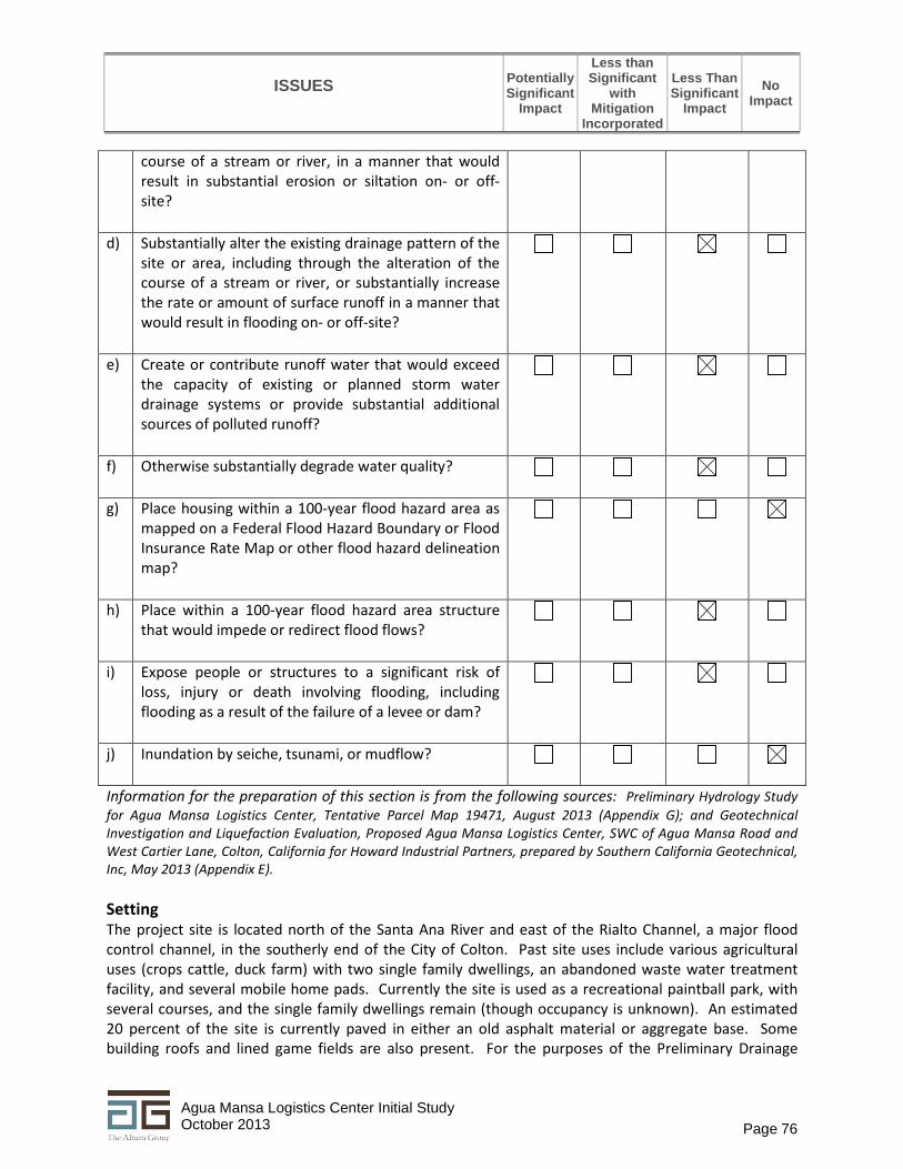
c) Less Than Significant Impact. The development of the proposed project would alter the drainage patterns across the project site. The existing site’s general drainage pattern is to the southwest, with overland flows exiting the project site onto a vacant parcel owned by the San Bernardino County Flood Control District, located at the south west corner of the site. Some of these flows enter the site from the northwest from Agua Mansa Road. The proposed drainage pattern will perpetuate the existing one, and the proposed on-site basins will take care of the increased runoff from development and maintain the site at pre-development levels. The proposed on-site storm drain system and drainage design will maintain these existing flows by the following methods (also see Figure 8, Conceptual Grading Plan and Figure 10, Off-site Detention Basins):
• The proposed site is delineated into two main subareas – northerly and southerly subareas.
The generated runoff from the northerly area will be collected and conveyed to the west via an open swale along Agua Mansa Road. At the northwest side the flow will be directed into an underground storm drain which will run to the south and outlet into the proposed Detention/Water Quality Basin.
• The generated runoff from the southerly area will be collected and conveyed via a concrete curb and gutter which runs westerly along the south property boundary. The flows will be collected and directed to the detention/water quality basin via inlets and storm drain culverts.
• The existing off-site flow on the north side of Agua Mansa Road, and the flow generated
within the road right-of-way, will be collected in catch basins at the two road sag locations and will be rerouted to the west via a proposed publicly owned and maintained storm drain on Agua Mansa Road. Then the storm drain is proposed to be directed to the south within the site along the westerly property boundary and outlet into the San Bernardino Flood Control vacant parcel. A drainage easement will be provided to the City of Colton by the Coounty for maintenance.
• The proposed detention/water quality basin at the southwest corner of the site will treat
the necessary water quality volume and will provide needed volumes for mitigation of the increased runoff during the postdeveloped conditions as evaluated in the Prelminary Hydrology Plan. The 1, 2, 5, 10 and 100-year storm events with 24-hour duration were routed through the basin. The routed outlet flow rates are lower than the existing conditions rates for each of the analyzed storm events. The results of the routing are presented in Table 13.
• There is additional underground storm volume storage proposed to extent the detention
basin volume that will be located immediately north of the basin under the parking lot (see location in Figure 8). It consists of 10 perforated 48-inch CMP pipes within gravel pack with total length of 350 linear feet. A volume breakdown between the basin and the proposed underground storage is presented in Table 13.
• A concrete outlet structure is proposed to control the basin outlet flows. First row of 5
orifices with 6-inch diameter is proposed to be at 2.2 feet of depth (water quality depth).

ISSUES
Potentially Significant
Impact
Less than Significant
with Mitigation
Incorporated
Less Than Significant
Impact No
Impact
Page 80 Agua Mansa Logistics Center Initial Study October 2013
The top of the box will be at 3 feet of depth and will serve as a weir with 12 feet of length. An outlet pipe at the bottom of the outlet structure will convey the routed flows towards the outlet location.
The proposed project’s drainage/water quality system must be designed to prevent site erosion and resulting siltation/sedimentation from leaving the site. The system must be designed to both control runoff leaving the site, and any pollutants or sediments that are generated on-site from leaving the site. Therefore this system is both a drainage control system and a water quality management system. The system will be maintained and inspected through measures adopted in the project’s WQMP. Therefore, no additional mitigation measures are required.
Table 13 Detention/WQMP Basin Output Summary
Storm Duration Existing Conditions Developed Conditions Flood/Volume
(ac/ft) Peak Flow (CFS)
Flood/Volume (ac/ft)
Peak Flow (CFS)
Basin Volume (ac/ft)1
Routed Peak (CFS)
Basin Depth (feet)2
1-Year 24 hour 1.0 4.6 4.4 22.0 4.44 4.1 3.0 2-Year 24 hour 1.7 19.2 6.0 32.4 4.86 11.5 3.3 5-Year 24 hour 2.9 30.8 8.1 46.1 5.37 22.4 3.6 10-Year 24 hour 6.5 47.5 9.8 56.9 5.63 31.0 3.7 100-Year
24 hour 15.5 70.1 15.5 92.3 6.35 59.1 4.2
Source: Agua Mansa Preliminary Hydrology Study, August 2013. 1. Includes 3.03 ac.ft. Vbmp up to 2.2 feet of depth 2. Basin operational depth 4.2 feet - 1, 2, 5,10 and 100-yr storm event, 24-hour duration mitigated. Basin
freeboard min 0.8'
d) Less Than Significant Impact. See response to 9.c above.
e) Less Than Significant Impact. See response to 9.c above.
f) Less Than Significant Impact. See response to 9.c above.
g) No Impact. The proposed project is an industrial use and no housing is proposed.
h) Less Than Significant Impact. A small area along the southerly project boundary falls within the Santa Ana River Floodplain with Zone AE designation. The floodplain limit crosses the proposed truck loading deck area (surface parking area) of the proposed development. The project will be designed so that no habitable structures are placed in a 100-year flood zone. The finished floor of the building is proposed to be more than one foot above the potential one-foot of flooding within the flood hazard area. In addition, no habitable structure is proposed within the floodplain limits. The truck loading deck area is proposed to be graded in a manner that no flooding deeper than 18 inches will occur during Santa Ana River 100-year flood events. Therefore, the impact would be less than significant.
ISSUES
PotentiallySignificant
Impact
Less than Significant
with Mitigation
Incorporated
Less ThanSignificant
Impact No
Impact
Page 81 Agua Mansa Logistics Center Initial Study October 2013
i) Less Than Significant Impact. The proposed project would not expose people or structures to significant risk of flooding as a result of a dam failure. The Santa Ana River is an ephemeral river that flows intermittently during the year only during heavy rain event or in the spring with snow melt. The nearest dam on the Santa Ana River (Seven Oaks Dam) is located approximately 15 miles northeast of the project site.
j) No Impact. The project site is not located in an area that is subject to seiche hazard (large wave of
water generated in an enclosed or partially enclosed body of water such as a lake), tsunami hazard (large wave of water or rapidly rising tide generally associated with a seismic event that affects coastal areas), or mudflow hazard.
10. LAND USE AND PLANNING ‐ Would the project:
a) Physically divide an established community?
b) Conflict with any applicable land use plan, policy, or regulation of an agency with jurisdiction over the project (including, but not limited to the general plan, specific plan, local coastal program, or zoning ordinance) adopted for the purpose of avoiding or mitigating an environmental effect?
c) Conflict with any applicable habitat conservation plan or natural community conservation plan?
Information for the preparation of this section is from the following sources: City of Colton General Plan Update, 2013; and General Habitat Suitability Evaluation, ±43‐acre Howard Industrial Partners Site, prepared by Ecological Sciences, Inc., June 17, 2013 (Appendix C). The General Plan and Specific Plan are available for review at the City of Colton Development Services Department counter or on the City’s website: www.ci.colton.ca.us/index.aspx?NID=313 Setting The project site is located on the south side of Agua Mansa Road in the Agua Mansa area of the City adjacent to the Santa Ana River that is sparsely developed with a mix of industrial uses including mining, landfill operations, and wastewater treatment. The project has an interim use as a recreation site (paintball). Discussion a) No Impact. There is no established community associated with the project site and vicinity. b) Less Than Significant Impact. Development of the proposed project is consistent with the General
Plan because the site is designated as an Industrial site, Heavy Industrial (M‐2). Surrounding properties are designated for similar uses with the exception of the Santa Ana River area.

ISSUES
Potentially Significant
Impact
Less than Significant
with Mitigation
Incorporated
Less Than Significant
Impact No
Impact
Page 82 Agua Mansa Logistics Center Initial Study October 2013
c) Less Than Significant Impact. Neither the City of Colton nor the County of San Bernardino has adopted a habitat conservation plan or natural community conservation plan. However, the adjacent area to the south in the Santa Ana River is designated as critical habitat for the federally listed (threatened) Santa Ana sucker (Catostomus santaanae) which is considered a California species of concern by the State. The proposed project would have a less than significant impact on the Santa Ana River as discussed in detail in Section 4, Biological Resources, and again in Section 9, Hydrology and Water Quality.
11.
MINERAL RESOURCES - Would the project:
a) Result in the loss of availability of a known mineral resource that would be of value to the region and the residents of the state?
b) Result in the loss of availability of a locally important mineral resource recovery site delineated on a local general plan, specific plan or other land use plan?
Information for this section is from the City of Colton General Plan Update Program EIR, 2013 and Exhibit 4.11-1 Mineral Resources. The exhibit is included in Appendix I of the Initial Study. Setting The predominant mineral resource in the Colton area is aggregate derived from alluvial material associated with the Santa Ana River, Lytle Creek and Warm Creek. As shown in Exhibit 4.11-1 of the General Plan EIR, the southerly portion of the project site and adjacent sites in the area has been identified as having is deposits of Portland cement concrete (PCC) grade aggregate material as this portion of the site and adjacent sites are classified as Mineral Resources Zone 2 (MRZ-2). The designation means areas where geologic data indicates that significant PCC grade resources are present. This exhibit and other exhibits from the General Plan Program EIR are included in Appendix I. Discussion a) Less Than Significant Impact. The proposed project would result in the loss of the site for recovery
of PCC grade material, however, by itself the approximately 20 acres designated MRZ-2 would be too small for an operator to economically use the site. The City has designated the project area as Heavy Industrial where aggregate mining and sales of material are allowed. Therefore, the loss of this approximately 20 acres would be a less than significant impact when the entire heavy Industrial area and other areas along the Santa Ana River flood plain and related Lytle Creek and Warm Creek areas are taken into consideration. Each of these washes contain aggregate material and there are a number of existing aggregate mine sites in these washes in the cities of Colton, Rialto and San Bernardino, as well as in the County of San Bernardino.
b) No Impact. The City of Colton has not identified any locally important mineral resources and no
other City planning documents identify any locally important mineral resources.

ISSUES
Potentially Significant
Impact
Less than Significant
with Mitigation
Incorporated
Less Than Significant
Impact No
Impact
Page 83 Agua Mansa Logistics Center Initial Study October 2013
12. NOISE - Would the project result in:
a) Exposure of persons to or generation of noise levels in excess of standards established in the local general plan or noise ordinance, or applicable standards of other agencies?
b) Exposure of persons to or generation of excessive ground borne vibration or ground borne noise levels?
c) A substantial permanent increase in ambient noise levels in the project vicinity above levels existing without the project?
d) A substantial temporary or periodic increase in ambient noise levels in the project vicinity above levels existing without the project?
e) For a project located within an airport land use plan or, where such a plan has not been adopted, within two miles of a public airport or public use airport, would the project expose people residing or working in the project area to excessive noise levels?
f) For a project within the vicinity of a private airstrip, would the project expose people residing or working in the project area to excessive noise levels?
Information for this section is from the City’s General Plan Program EIR (2013) and the City’s Municipal Code Section 18.42 Performance Standards. The General Plan and Municipal Code are available for review at the City of Colton Development Services Department counter or on the City’s website: www.ci.colton.ca.us/index.aspx?NID=313 Setting The project site is designated for Heavy Industrial (M-1) uses. The surrounding properties to the north, east and west are also designated with similar uses, except for the property to the west, west of the Rialto Channel, which is designated for public use and is developed with the City of Colton/City of San Bernardino jointly operated Rapid Infiltration and Extraction (RIX) facility, that receives secondary treated water, and releases tertiary treated water into the Santa Ana River. Figure 2 in the Project Description is an aerial photograph showing land uses in the area. Land uses to the north and west include mining, vacant land and landfilling operations. To the east is vacant land and to the south are the Santa Ana River and the Colton Landfill. There are no residential land uses around the project site

ISSUES
Potentially Significant
Impact
Less than Significant
with Mitigation
Incorporated
Less Than Significant
Impact No
Impact
Page 84 Agua Mansa Logistics Center Initial Study October 2013
that would be adversely affected by noise from the proposed project. The nearest residential use is approximately 1,950 feet (0.36 mile) east of the site. City of Colton Municipal Code The sections of the City of Colton Municipal Code that could be applicable to the proposed project with regard to noise and vibration are found in Section 18.42 Performance Standards as follows:
• Section 18.42.040 – Noise: The maximum sound level radiated by any use of facility, when measured at the boundary line of the property on which the sound is generated, shall not be obnoxious by reason of its intensity, pitch or dynamic characteristics as determined by the city, and shall not exceed 65 dBA.
• 18.42.050 – Vibration: All activities shall be operated so as not to generate ground vibration by equipment other than motor vehicles, trains or by temporary construction or demolition, which is perceptible without instruments by the average person at or beyond any lot line of the lot containing the activities.
County of San Bernardino Development Code In addition, the County of San Bernardino Development Code provides more direction for the evaluation of noise on the environment. Section 83.01.080 of the County of San Bernardino 2007 Development Code discusses the General Performance Standards for Noise. In particular, Table 83-2 Section 83.01.080(d) defines the noise standards for stationary noise sources and Table 83-3 in Section 83.01.080(d) defines the mobile source standards. Table 14 shows the stationary noise limits from County Development Code Table 83-2. Mobile noise limits were not included here because Table 83-3 of the County’s Noise Ordinance does not include noise standards for mobile sources adjacent to industrial uses. Definitions Leq = Equivalent Energy Level. The equivalent energy level is the sound level corresponding to a steady-state sound level containing the same total energy as a time-varying signal over a given sample period, typically one, eight or 24 hours. dB(A) = A-weighted Sound Pressure Level. A weighting is the sound pressure level, in decibels, as measured on a sound level meter using the A-weighting filter network. The A-weighting filter de-emphasizes the very low and very high frequency components of the sound, placing greater emphasis on those frequencies within the sensitivity range of the human ear. Ldn = Day-Night Noise Level. The day-night noise level is the average equivalent A-weighted sound level during a 24-hour day obtained by adding 10 decibels to the hourly noise levels measured during the night (from 10:00 pm to 7:00 am). In this way Ldn takes into account the lower tolerance of people for noise during nighttime periods.

ISSUES
Potentially Significant
Impact
Less than Significant
with Mitigation
Incorporated
Less Than Significant
Impact No
Impact
Page 85 Agua Mansa Logistics Center Initial Study October 2013
Table 14 - Noise Standards for Stationary Noise Sources Affected Land Uses (receiving noise) 7 AM to 10 PM Leq 10 PM to 7 AM Ldn
Residential 55 dBA 45 dBA Professional Services 55 dBA 55 dBA Other Commercial 60 dBA 60 dBA Industrial 70 dBA 70 dBA Source: Table 83-2 in County of San Bernardino Development Code.
The County’s Development Code exempts temporary construction noise between 7 AM and 7 PM except Sundays and Federal holidays are exempt from the noise limits. In addition, Section 83.01.090 (Vibration) of the County ordinance gives limits on the allowable vibration levels as follows:
• No ground vibration shall be allowed that can be felt without the aid of instruments at or beyond the property line, nor shall any vibration be allowed which produces a particle velocity greater than or equal to two-tenths (0.2) inches per second measured at or beyond the property line.
• However, construction between 7:00 AM and 7:00 PM, except Sundays and Federal holidays, is exempt from the vibration standard.
In summary, the County of San Bernardino Development Code limits construction noise and vibration between 7 PM to 7 AM and on Sundays and Federal holidays. Discussion a) Less Than Significant Impact. As discussed in the setting section above, there are no residential
land uses around the project site that would be adversely affected by noise from the proposed project. The nearest residential use is approximately 1,950 feet (0.36 mile) east of the site. In addition, there are not commercial or professional businesses in close proximity, nor a hospital, school or other sensitive receptor that may be adversely affected by noise associated with the construction and operation of the proposed project.
During construction activities operation of grading and excavation equipment and other heavy equipment will likely generate noise in excess of the City’s thresholds for noise of 65 dBA. However, as shown in Figure 2, Project Vicinity, the site is surrounded by vacant land or industrial uses such that people would not be exposed to high noise levels for extended period. The future facility is proposed to be a 24-hour operation.
b) Less Than Significant Impact. Like the noise standards described above, vibration standards are related to proximity of sensitive land uses (residential, institutional). Some ground vibration will occur during construction of the project due to the use of heavy equipment, particularly during grading. However, because there are no adjacent of nearby (within ¼ mile) sensitive land uses, impacts associated with ground vibration during construction would be less than significant.
c) Less Than Significant Impact. See response to 12.a above.
d) Less Than Significant Impact. See response to 12.a above.

ISSUES
Potentially Significant
Impact
Less than Significant
with Mitigation
Incorporated
Less Than Significant
Impact No
Impact
Page 86 Agua Mansa Logistics Center Initial Study October 2013
e) No Impact. The project is not located within an airport land use plan or within two miles of a public airport. The site is located approximately 13 miles east of the Ontario Airport, and 6 miles southwest of the San Bernardino Airport.
f) No Impact. The project site is not located near a private airstrip.
13. POPULATION AND HOUSING - Would the project:
a) Induce substantial population growth in an area, either directly (for example, by proposing new homes and businesses) or indirectly (for example, through extension of roads or other infrastructure)?
b) Displace substantial numbers of existing housing, necessitating the construction of replacement housing elsewhere?
c) Displace substantial numbers of people, necessitating the construction of replacement housing elsewhere?
Information for this section is from the City of Colton General Plan Housing Element and General Plan Program EIR, 2013, 2010 Census website http://www.census.gov/2010census/popmap/, accessed September 2013, and the State Department of Finance website http://www.dof.ca.gov/research/demographic/reports/estimates/e-1/view.php, accessed September 2013. Setting According to the 2010 Census, Colton's population was 52,154 in 2010. The State Department of Finance estimates the City's 2013 population to be 52,956. This represents an approximate annual growth rate of 0.7%. The national and regional economic recession that began late in 2007 has significantly stymied local and regional jobs and housing growth. The City had 16,268 housing units as of 2009. The City's Housing Element shows that the City has a surplus of housing in the City. The project site is located in the Agua Mansa Industrial Corridor. The project site is not zoned for residential use and is not a vacant or underutilized site that can be used for housing. Discussion a) Less than significant Impact. The proposed logistics center would not induce substantial
population growth in the area. No new homes are proposed as part of the project. The logistics center would employ up to 300 people and would hire employees from the local area, including the City of Colton, but also future employees from surrounding cities with similar demographics including Rialto, Fontana, Moreno Valley and San Bernardino. Because the City has a housing surplus, the proposed project would not negatively affect the jobs/housing balance in the City. The project does not include the extension of a road or infrastructure.
b) No Impact. The project site is in a predominantly industrial area and no housing is located on the site. The majority of the site is currently used as a paintball park. There are two abandoned houses

ISSUES
Potentially Significant
Impact
Less than Significant
with Mitigation
Incorporated
Less Than Significant
Impact No
Impact
Page 87 Agua Mansa Logistics Center Initial Study October 2013
on the site but they are not occupied. Development of the proposed logistics center would not displace any existing housing.
c) No Impact. There are two abandoned houses on the project site but they are not occupied.
Development of the proposed logistics center would not displace any people.
14. PUBLIC SERVICES
a) Would the project result in substantial adverse physical impacts associated with the provision of new or physically altered governmental facilities, need for new or physically altered governmental facilities, the construction of which could cause significant environmental impacts, in order to maintain acceptable service ratios, response times or other performance objectives for any of the public services:
i. Fire Protection?
ii. Police Protection?
iii. Schools?
iv. Parks?
v. Other Public Facilities?
Information for this section was gathered from the following sources: • Colton Fire Department website, http://coltonfire.com/index.cfm?Section=1, accessed September 2013 • Colton Police Department website, http://www.coltonpd.org/, accessed September 2013 • City of Colton General Plan Update EIR, January 2013 • Colton Community Services website, http://www.ci.colton.ca.us/index.aspx?NID=256, accessed September
2013 • Colton Joint Unified School District website, http://www.colton.k12.ca.us/
education/components/scrapbook/default.php?sectiondetailid=939&linkid=nav-menu-container-4-120808, accessed September 2013
Setting Fire Protection The Colton Fire Department’s (CFD) service area includes the entire incorporated City of Colton and small unincorporated areas adjacent to the City. CFD’s territory is approximately 19 square miles and is currently divided into four service areas. Emergency medical service is provided by the Emergency Medical Services (EMS) division and American Medical Response (AMR) provides ambulance service to the City. The nearest station to the project site is Station 213 at 1100 S. La Cadena Ave, which is 1.25 miles northeast of the project site. Station 213 is staffed by a captain, engineer, and firefighter/paramedic and is the Heavy Rescue Unit headquarters. The facility is equipped with one fire engine.

ISSUES
Potentially Significant
Impact
Less than Significant
with Mitigation
Incorporated
Less Than Significant
Impact No
Impact
Page 88 Agua Mansa Logistics Center Initial Study October 2013
Police Protection Police services within the City are provided by the Colton Police Department (CPD) which is staffed with 46 sworn officers and 24 non-sworn employees. CPD headquarters are located at the City Hall Campus, 650 North La Cadena Drive in Colton, between East D Street and East E Street, approximately 2.2 miles northwest of the project site. Schools The project site is located within the boundaries of the Colton Joint Unified School District. The nearest school to the project site is San Salvador Preschool at 471 Agua Mansa Road, approximately 1.15 miles northwest of the project site. Parks The City of Colton Community Services Department and the County of San Bernardino maintain parks, open space, trails, and community facilities for public use in Colton. The City of Colton Community Services Department maintains 25 parks and recreational facilities, including community centers, neighborhood parks, and shared school facilities. There is an additional 3.2 acres of Edison easements, used as open space along with two trail systems, one of which is a City bike path and the other is the Santa Ana River Trail, which is a regional public resource located to the southeast of the project site across the Santa Ana River. Library The Colton Public Library’s three facilities provide library services in the City of Colton. The Main Public Library is located at 656 Ninth Street, the Luque Branch Library is located at 294 East O Street, and the Carnegie Building is located at 380 North La Cadena Drive. Other Public Facilities Other public facilities would consist of public infrastructure such as roads, water and sewer service, storm drains etc. These facilities are evaluated in Section 17, Utilities and Service Systems below. Discussion a.i) Less Than Significant Impact. The Insurance Services Office (ISO) provides rating and
statistical information for the insurance industry in the United States. For planning purposes, the ISO recommends that developed portions of a community should be within 1.5 miles of a fire station equipped with an engine company and within 2.5 miles of a fire station with a ladder equipped engine company. The project site is located 1.25 miles from Station 213, which is equipped with an engine company. Additionally, the project site is located 2.3 miles from Station 211, which is equipped with a ladder engine company. The project site is within the distances recommended by ISO. The project will also implement fire safety features, such as a 26-foot fire lane around the entire building for ease of access to the building, and will be constructed with fire sprinklers. The project would also be required to pay development impact fees to help offset impacts to fire services. Therefore, the project would have a less than significant impact on fire services.
a.ii) Less Than Significant Impact. The project would introduce a logistics center in the area which
may operate 24 hours a day, and employ up to 300 employees which will be working in shifts during these hours. For purposes of this assessment, the shift count was assumed as follows: day

ISSUES
Potentially Significant
Impact
Less than Significant
with Mitigation
Incorporated
Less Than Significant
Impact No
Impact
Page 89 Agua Mansa Logistics Center Initial Study October 2013
shift - 175 employees, swing (evening) shift - 75 employees and the graveyard (overnight) shift - 50 employees. The project is not expected to have a significant impact on police services since it would not substantially induce population growth in the City. For the purposes of this assessment, the assumption was made that employees are mobile and would live in the City of Colton, but also would live in any of the surrounding cities (Rialto, Riverside, San Bernardino, Fontana, Moreno Valley, etc.) all of which have similar demographics. In addition, the project site would be designed to accommodate emergency access and would not interfere with emergency plans. The project site is designed to have two access points off of Agua Mansa Road, one on the west end of the site and one on the east end (Refer to Figure 6, Site Plan). The access point of the west end of the site will be open for public access. The driveway will split off and trucks will proceed to the scale at the southwest corner of the site and the parking area will be on the left in front of the building. A scalehouse/guardhouse and scales will be at the southwest end of the building. The access point on the east end is proposed for emergency access only and will be gated and include a Knox box. The site will be fully enclosed with fencing parking lot lighting and security lighting. The project would also be required to pay development impact fees to help offset impacts to police services. Therefore, impacts on Police Services would be less than significant.
a.iii) Less Than Significant Impact. Although the project itself would not generate school aged
children (no residential use proposed), for planning purposes it is always assumed that a certain percentage of the new employees would reside within the local school district boundaries. Therefore, the project would be responsible for paying school fees for development of the site in the amount of $0.51/sq. ft. for industrial developments.
a.iv) Less Than Significant Impact. Although the project itself would not generate school aged
children (no residential use proposed), for planning purposes it is always assumed that a certain percentage of the new employees would reside in the City of Colton. Some employees may already be residents, but some may be new arrivals. However, impacts to park and recreation facilities are generally considered within the context of residential development and development impacts fees and other fees such as Quimby fees for new park development are focused on residential development projects. Therefore, the project would not impact parks and recreational facilities.
a.v) Less Than Significant Impact. The project would not impact library services since it would not
generate substantial population growth in the City. The project would also be required to pay development impact fees for library services.

ISSUES
Potentially Significant
Impact
Less than Significant
with Mitigation
Incorporated
Less Than Significant
Impact No
Impact
Page 90 Agua Mansa Logistics Center Initial Study October 2013
15. RECREATION
a) Would the project increase the use of existing neighborhood and regional parks or other recreational facilities such that substantial physical deterioration of the facility would occur or be accelerated?
b) Does the project include recreational facilities or require the construction or expansion of recreational facilities, which might have an adverse physical effect on the environment?
Information for this section is from the City of Colton General Plan Housing Element and General Plan Program EIR, 2013. Setting The City of Colton Community Services Department and the County of San Bernardino maintain parks, open space, trails, and community facilities for public use in Colton. The City of Colton Community Services Department maintains 25 parks and recreational facilities, including community centers, neighborhood parks, and shared school facilities. Discussion
a) Less Than Significant Impact. The project would employ up to 300 people working three different shifts over a 24-hour period. The project would not substantially induce the amount of population in the area as these employees would be hired from the local workforce in the City of Colton as well as from surrounding cities such as Rialto, Fontana, Moreno Valley and San Bernardino. Therefore, the project is not expected to cause a significant impact to existing park and recreation facilities as families of the employees to be hired are likely using these facilities already.
b) No Impact. The proposed project is not a residential project and does not include a recreational component. The project would not require the construction or expansion of recreational facilities.

ISSUES
Potentially Significant
Impact
Less than Significant
with Mitigation
Incorporated
Less Than Significant
Impact No
Impact
Page 91 Agua Mansa Logistics Center Initial Study October 2013
16. TRANSPORTATION/TRAFFIC - Would the project:
a) Conflict with an applicable plan, ordinance or policy establishing measures of effectiveness for the performance of the circulation system, taking into account all modes of transportation including mass transit and non-motorized travel and relevant components of the circulation system, including but not limited to intersections, streets, highways and freeways, pedestrian and bicycle paths, and mass transit?
b) Conflict with an applicable congestion management program, including, but not limited to level of service standards and travel demand measures, or other standards established by the county congestion management agency for designated roads or highways?
c) Result in a change in air traffic patterns, including either an increase in traffic levels or a change in location that results in substantial safety risks?
d) Substantially increase hazards due to a design feature (e.g., sharp curves or dangerous intersections) or incompatible uses (e.g., farm equipment)?
e) Result in inadequate emergency access?
f) Conflict with adopted policies, plans, or programs regarding public transit, bicycle, or pedestrian facilities, or otherwise decrease the performance or safety of such facilities?
Information for this section is from the following: Agua Mansa Logistics Center Traffic Impact Analysis (revised), prepared by Kunzman Associates, September 2013 (Appendix H). Setting The project site is located at 1350 to 1600 West Agua Mansa Road between Riverside Avenue and Rancho Avenue in the City of Colton. Regional access to the project site is provided by the I-10 Freeway. Local access is provided by various roadways in the vicinity of the site. Figure 10 shows the project site within the larger road network. The east-west roadways which will be most affected by the project include Slover Avenue, Santa Ana Avenue, Jurupa Avenue, Resource/Industrial Drive, and Agua Mansa Road. The north-south roadways which will be most affected by the project include Riverside Avenue and Rancho Avenue. The project will take access to Agua Mansa Road.

ISSUES
Potentially Significant
Impact
Less than Significant
with Mitigation
Incorporated
Less Than Significant
Impact No
Impact
Page 92 Agua Mansa Logistics Center Initial Study October 2013
Existing and Forecast Traffic Conditions The analysis of the traffic impacts from the proposed development and the assessment of the required mitigation measures were based on an evaluation of the existing and forecast traffic conditions in the vicinity of the site with and without the project. The following analysis years were considered in the TIA:
• Existing Conditions (2013) • Existing Plus Project Conditions • Project Opening Year Conditions (2016) • Horizon Year Conditions (2035)
Definitions of Deficiencies The following definitions of deficiencies and significant impacts were developed in accordance with the City of Colton requirements in order to evaluate the proposed project. The City’s definition of an intersection deficiency is when a peak hour intersection operates at a Level of Service (LOS) E or F. Therefore, the City’s threshold for a intersection operation is LOS D or better. For freeway facilities, the San Bernardino Congestion Management Program (CMP) controls the definition of deficiency. The CMP definition of deficiency is based on maintaining a Level of Service standard of Level of Service E or better, except where an existing Level of Service F condition is identified in the CMP. A CMP deficiency is, therefore, defined as any freeway segment operating or projected to operate at Level of Service F, unless the segment is identified explicitly in the Congestion Management Program document. Table 15 provides the Level of Service and the delay ranges, in seconds per vehicle, for each level.
Table 15 - Intersection Level of Service and Delay Ranges
LOS Delay (seconds/vehicle) Signalized Intersections Unsignalized Intersections
A < 10.0 < 10.0 B > 10.0 to < 20.0 > 10.0 to < 15.0 C > 20.0 to < 35.0 > 15.0 to < 25.0 D > 35.0 to < 55.0 > 25.0 to < 35.0 E > 55.0 to < 80.0 > 35.0 to < 50.0 F > 80.0 > 50.0
Source: 2000 Highway Capacity Manual. Definition of Significant Impact The City of Colton defines a significant impact on road segments and intersections as a project:
i) contributing measurable traffic to a roadway; and ii) substantially and adversely changing the Level of Service at any off-site location projected to
experience deficient operations under foreseeable cumulative conditions, and where feasible improvements consistent with the City of Colton General Plan cannot be constructed.

Figure11
Study Area Intersections Agua Mansa Logistics Center Initial Study
The Altum Group
Source: Kunzman Associates, Inc. 2013

ISSUES
Potentially Significant
Impact
Less than Significant
with Mitigation
Incorporated
Less Than Significant
Impact No
Impact
Page 94 Agua Mansa Logistics Center Initial Study October 2013
The City of Colton General Plan Circulation Element was adopted in accordance with CEQA requirements, and any roadway improvements within the City of Colton that are consistent with the Circulation Element are not considered a significant impact, so long as the project contributes its “fair share” funding for improvements. Existing Intersection Conditions (2013) Under existing conditions, all intersections in the project study area operate at LOS C or better except for the intersection of La Cadena Drive and Rancho Avenue which operates at LOS D during Evening Peak Hour, as shown in Table 16.
Table 16 - Existing Intersection Delay and Level of Service
Intersection Traffic
Control
Peak Hour Delay/LOS
Morning Evening Riverside Avenue (NS) at: I-10 Freeway WB Ramps (EW) TS 14.4-B 15.3-B I-10 Freeway EB Ramps (EW) TS 15.4-B 17.6-B Slover Avenue (EW) TS 20.2-C 20.9-C Santa Ana Avenue (EW) TS 19.7-B 19.2-B Jurupa Avenue (EW) TS 13.0-B 13.3-B Resource/Industrial Drive TS 20.1-C 14.4-B Agua Mansa Road (EW) TS 30.4-C 30.4-C Rancho Avenue (NS) at: I-10 Freeway WB Ramps (EW) TS 15.9-B 14.7-B I-10 Freeway EB Ramps (EW) TS 14.9-B 22.4-C Agua Mansa Road (EW) TS 15.9-B 17.6-B La Cadena Drive
Rancho Avenue (EW) CSS 12.5-B 26.3-D
Source: Agua Mansa Logistics Center TIA, Kunzman Associates September 2013. Note: TS = Traffic Signal
Existing Traffic Signal Warrant Analysis A traffic signal appears to currently be warranted at the following study area intersection for existing traffic conditions:
La Cadena Drive (NS) at: Rancho Avenue (EW)
The unsignalized intersection has been evaluated for a traffic signal using the California Department of Transportation Warrant 3 Peak Hour traffic signal warrant analysis, as specified in the California Manual of Uniform Traffic Control (January 2012).

ISSUES
Potentially Significant
Impact
Less than Significant
with Mitigation
Incorporated
Less Than Significant
Impact No
Impact
Page 95 Agua Mansa Logistics Center Initial Study October 2013
Discussion a) Less Than Significant with Mitigation Incorporated.
Construction Traffic Short-term construction activities include grading the project site and importing fill. The assumption made for trips associated with import of 130,000 cubic yards of fill from an off-site source location are as follows:
• Trucks with a load capacity of 24 cubic yards will be used to haul fill material. • Approximately 5,417 inbound and 5,417 outbound truck hauling trips are anticipated. • The applicant is working with the property owner directly north on Agua Mansa Road to
purchase fill material. Therefore, haul trucks will only travel directly across Agua Mansa Road to the subject property.
• No study area intersections will be affected.
Other project construction activities would generate traffic from construction worker travel. Heavy construction equipment would be staged on-site and would not travel to and from the project site on a daily basis. Equipment needs associated with grading activities would include dozers, scrapers, compactors, water trucks, vibratory rollers, and other related heavy-duty equipment. Generally, construction activity is anticipated to begin at 7:00 AM. In general, the majority of the construction workers are expected to arrive at the construction activity area during off-peak hours (i.e., arrive prior to 7:00 AM). It is anticipated that the majority of the construction workers would remain on-site throughout the day and would not leave the site for lunch via their vehicles. The number of construction worker vehicles is estimated using the average ridership of 1.135 persons per vehicle per the SCAQMD CEQA Air Quality Handbook. Based on this assumption, the project is not projected to add 50 employee peak hour trips during the morning or evening peak hours, thus no off-site study area intersections are analyzed for short-term construction activities. To minimize short term impacts associated with construction activities, the applicant will prepare a truck haul route program for the construction at the project site to minimize the impact caused by the hauling of fill material to the project. At a minimum the program will include:
• Days and hours of haul will be approved by the City to mitigate area and peak hour traffic conflicts.
• Limit any potential lane closures to off-peak travel periods. No truck queuing or staging on public streets.
• Schedule receipt of construction materials during non-peak travel periods, to the extent possible.
• Provide flag men at the project entry to Agua Mansa Road. Traffic control measures shall conform to the California Manual of Uniform Traffic Control Devices.
• Require the construction workers to park on the predetermined off-street parking area specified by the applicant.
• Coordinate deliveries to minimize loading and unloading time. • Other measures as stipulated by the City of Colton Public Works Department.

ISSUES
Potentially Significant
Impact
Less than Significant
with Mitigation
Incorporated
Less Than Significant
Impact No
Impact
Page 96 Agua Mansa Logistics Center Initial Study October 2013
Long Term Operation The analysis of traffic impacts associated with the proposed 808,500 square foot high cube warehouse takes into consideration the following scenarios:
• Existing Conditions (2013) • Existing Plus Project Conditions • Project Opening Year Conditions (2016) • Horizon Year (2035)
Project Traffic
Table 17 shows the trip generation rates and passenger car equivalents for the proposed project. These trips were then added to the existing traffic conditions on study area intersections to provide an analysis of Existing Plus Project Intersection Delay and Level of Service. This data is shown in Table 18.
Table 17 - Project Trip Generation
Descriptor
Type of Vehicle
Total
Passenger Car
2 Axle Truck
3 Axle Truck
4+ Axle Truck
Total Trucks
Land Use:
High Cube Warehouse 808,500 sq ft 79.57% 3.46% 4.64% 12.33% 20.43% 100%
Traffic Generation Rates in trips per Thousand Square Feet
Daily 1.337 0.058 0.078 0.207 0.343 1.68
Morning Peak Hour 0.088 0.004 0.005 0.014 0.023 0.11
Evening Peak Hour 0.096 0.004 0.006 0.015 0.025 0.12
Traffic Generation in Vehicles
Daily 1,081 47 63 167 277 1,358
Morning Peak Hour 70 3 4 11 18 88
Evening Peak Hour 77 3 5 12 20 97
Passenger Car Equivalent's
(PCE'S) Factor1 1.00 1.50 2.00 3.00
Traffic Generation in PCE's
Daily 1,081 71 126 501 698 1,779
Morning Peak Hour 70 5 8 33 46 116
Evening Peak Hour 77 5 10 36 51 128 Source: Institute of Transportation Engineers, Trip Generation, 9th Edition, 2012, Land Use Category 152 and Truck Trip Generation Study, City of Fontana, August 2003 Notes: 1. Passenger Car Equivalent factors are recommended by SANBAG.
Existing Plus Project
The Existing Plus Project traffic operations analysis for Opening Year (2016) was completed for the morning and evening peak hour as shown in Table 18. For Existing Plus Project traffic conditions, the

ISSUES
Potentially Significant
Impact
Less than Significant
with Mitigation
Incorporated
Less Than Significant
Impact No
Impact
Page 97 Agua Mansa Logistics Center Initial Study October 2013
study area intersections are projected to operate at an acceptable Levels of Service during the peak hours.
Other Development Projects
Table 19 shows a list of other proposed development projects and the daily and peak hour vehicle trips generated by the other development in the study area that were evaluated as part of the traffic study for the proposed project.
Table 18 - Existing Plus Project Intersection Delay and LOS
Intersection Traffic
Control
Peak Hour Delay/LOS
Morning Evening Riverside Avenue (NS) at: I-10 Freeway WB Ramps (EW) TS 14.4-B 15.3-B I-10 Freeway EB Ramps (EW) TS 15.4-B 17.7-B Slover Avenue (EW) TS 20.3-C 21.0-C Santa Ana Avenue (EW) TS 19.7-B 19.2-B Jurupa Avenue (EW) TS 13.0-B 13.2-B Resource/Industrial Drive TS 20.2-C 14.4-B Agua Mansa Road (EW) TS 30.5-C 30.4-C Rancho Avenue (NS) at: I-10 Freeway WB Ramps (EW) TS 16.1-B 15.2-B I-10 Freeway EB Ramps (EW) TS 15.2-B 23.1-C Agua Mansa Road (EW) TS 16.3-B 19.2-B La Cadena Drive
Rancho Avenue ((EW)
Without improvements CSS 12.7-B 28.2-D
With Improvements TS 12.1-B 23.6-C
New Project Site Access Intersections Project East Access (NS) at:
Agua Mansa Road (EW) TS 4.9-A 6.7-A
Project West Access (NS) at:
Agua Mansa Road (EW) CSS 0.0-A 0.0-A
Source: Agua Mansa Logistics Center TIA, Kunzman Associates September 2013. Note: TS = Traffic Signal, CSS = Cross Street Stop
The City’s list was reviewed and updated to eliminate projects that are currently developed. The remaining projects were then added to Opening Year (2016) traffic volumes and are included in the Table 20 and Table 21.

ISSUES
Potentially Significant
Impact
Less than Significant
with Mitigation
Incorporated
Less Than Significant
Impact No
Impact
Page 98 Agua Mansa Logistics Center Initial Study October 2013
Opening Year(2016) With and Without the Project For Opening Year (2016) the intersection delay and level of service analysis was conducted for two scenarios, With- and Without the proposed project trips. Table 20 shows the Peak Hour Delay and LOS at study area intersections. For the With Project scenario, the project driveways that will provide ingress/egress from Agua Mansa Road are included. Both scenarios include the other development projects listed in Table 19.
For Opening Year, the study area intersections are projected to operate at acceptable Levels of Service during the peak hours Without the Project traffic conditions. However, for Opening Year (2016) with Project traffic conditions, the study area intersections are projected to operate at an acceptable Levels of Service during the peak hours except for the following intersection:
La Cadena Drive (NS) at: Rancho Avenue (EW)
As shown in Table 20, this intersection would operate at LOS E during evening peak hours without improvements.
Table 19 - Other Development Projects in the Study Area
Project Name
Land Use
Size
Peak Hour Trips
Total Daily Trips AM PM
Crane Light Industrial 20,000 sf 19 20 145 Riverside Avenue Warehouse Project
High Cube 300,773 sf 176 182 1,927
Agua Mansa Commerce Center
High Cube
1,066,782 sf 145 139 2,076
Agua Mansa Cold Storage Facility
High Cube Industrial Park High Cube Cross Dock
687,071 75,848
266,932 157,049
sf sf sf sf
92 117
40 125
88 118
42 77
1,312 963 579
2,101 PPD #1966 Concrete Batch Plant
Office 47,000
800 sf sf
52 2
50 2
1,122 9
El Rivino High Cube Light Industrial
269,000 80,000
Sf sf
36 98
35 105
514 748
Oakmont El Rivino High Cube 3,659,000 sf 2,128 2,223 23,448 Pellisier Ranch Single Family-detached
Single Family-attached Business Park Elementary School Community Park
1,649 1,320 122.7 1,100
25.4
du du ac St ac
1,236 580
2,314 462
2
1,665 686
2,066 0 2
15,781 7,735
18,379 1,419
40 Dexus Truck Maint. Facility
Office High Cube
34.36 17,917
600,046
ac sf sf
348 27 69
338 26 78
2,385 197
1,117 Total 6,954 6,854 72,677
Source: City of Colton Development List, 2013 Notes: sf = square feet, ac = acres, du = dwelling units, st = students.

ISSUES
Potentially Significant
Impact
Less than Significant
with Mitigation
Incorporated
Less Than Significant
Impact No
Impact
Page 99 Agua Mansa Logistics Center Initial Study October 2013
Table 20 - Opening Year (2016) Without and With Project Intersection Delay and LOS
Intersection Traffic
Control
Peak Hour Delay/LOS
Without Project
Peak Hour Delay/LOS
With Project Morning Evening Morning Evening
Riverside Avenue (NS) at: I-10 Freeway WB Ramps (EW) TS 17.1-B 17.0-B 17.1-B 17.0-B I-10 Freeway EB Ramps (EW) TS 17.6-B 25.6-C 17.6-B 25.9-C Slover Avenue (EW) TS 25.0-C 30.7-C 25.1-C 30.9-C Santa Ana Avenue (EW) TS 20.8-C 21.0-C 20.9-C 21.1-C Jurupa Avenue (EW) TS 18.4-B 17.0-B 18.5-B 17.1-B Resource/Industrial Drive TS 22.6-C 16.5-B 22.8-C 16.6-B Agua Mansa Road (EW) TS 41.9-D 38.8-D 41.9-D 38.9-D
Rancho Avenue (NS) at: I-10 Freeway WB Ramps (EW) TS 17.2-B 15.3-B 17.6-B 15.9-B I-10 Freeway EB Ramps (EW) TS 14.9-B 24.6-C 15.3-B 25.9-C Agua Mansa Road (EW) TS 16.6-B 19.6-B 17.0-B 21.5-C
La Cadena Drive
Rancho Avenue ((EW)
Without improvements CSS 14.7-B 40.5-E 14.9-B 44.6-E
With Improvements TS 12.4-B 28.1-C 12.5-B 29.3-C
New Project Site Access Intersections Project East Access (NS) at:
Agua Mansa Road (EW) TS N/A N/A 4.7-A 6.6-A
Project West Access (NS) at:
Agua Mansa Road (EW) CSS N/A N/A 0.0-A 0.0-A
Source: Agua Mansa Logistics Center TIA, Kunzman Associates September 2013. Note: TS = Traffic Signal, CSS = Cross Street Stop
Horizon Year (2035) With and Without the Project
For the Horizon Year (2035) the intersection delay and level of service analysis was also conducted for two scenarios, With- and Without the proposed project trips. Table 21 shows the Peak Hour Delay and LOS at study area intersections for both scenarios. For Year 2035 Without Project traffic conditions, the study area intersections are projected to operate at an acceptable Levels of Service during the peak hours. For Year 2035 With Project traffic conditions but without improvements, the study area intersections are also projected to operate at an acceptable Levels of Service during the peak hours except for the following intersection:
La Cadena Drive (NS) at: Rancho Avenue (EW)
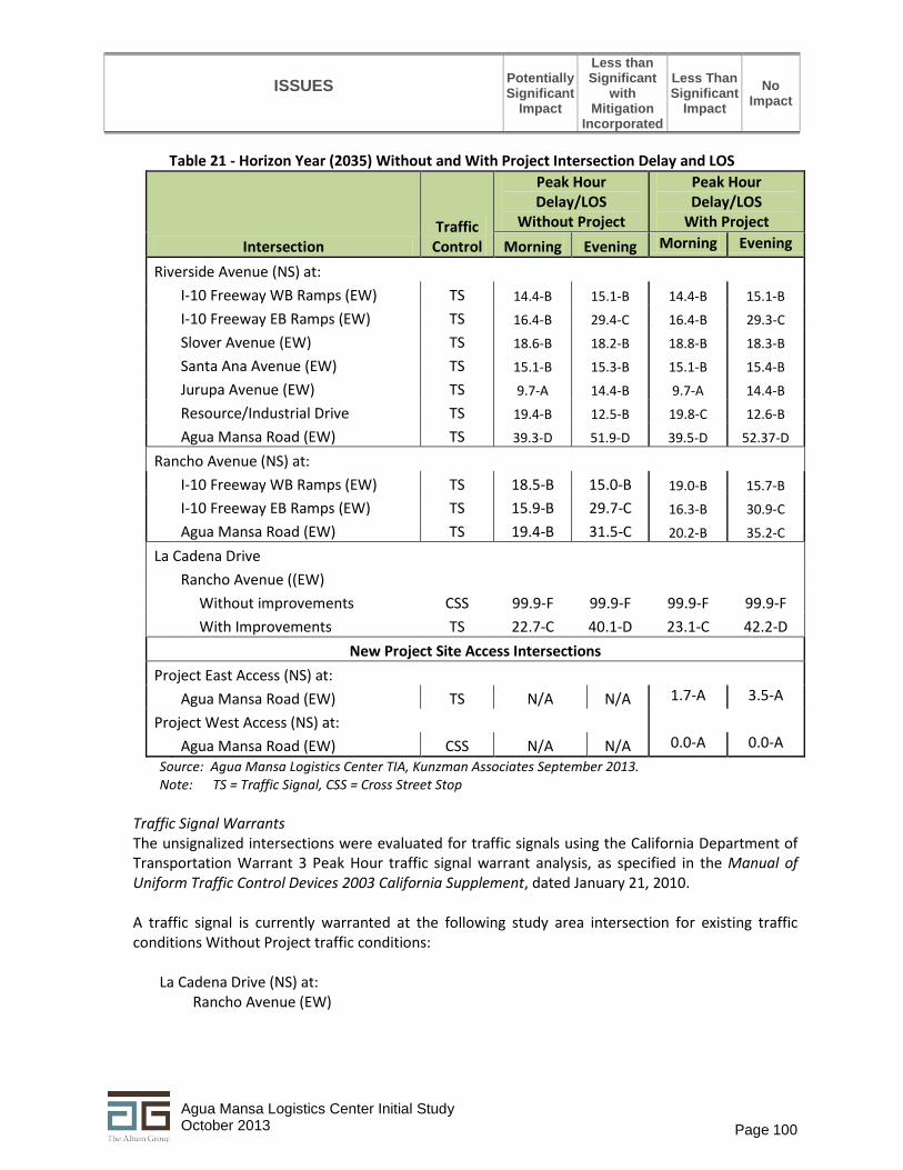
ISSUES
Potentially Significant
Impact
Less than Significant
with Mitigation
Incorporated
Less Than Significant
Impact No
Impact
Page 100 Agua Mansa Logistics Center Initial Study October 2013
Table 21 - Horizon Year (2035) Without and With Project Intersection Delay and LOS
Intersection Traffic
Control
Peak Hour Delay/LOS
Without Project
Peak Hour Delay/LOS
With Project Morning Evening Morning Evening
Riverside Avenue (NS) at: I-10 Freeway WB Ramps (EW) TS 14.4-B 15.1-B 14.4-B 15.1-B I-10 Freeway EB Ramps (EW) TS 16.4-B 29.4-C 16.4-B 29.3-C Slover Avenue (EW) TS 18.6-B 18.2-B 18.8-B 18.3-B Santa Ana Avenue (EW) TS 15.1-B 15.3-B 15.1-B 15.4-B Jurupa Avenue (EW) TS 9.7-A 14.4-B 9.7-A 14.4-B Resource/Industrial Drive TS 19.4-B 12.5-B 19.8-C 12.6-B Agua Mansa Road (EW) TS 39.3-D 51.9-D 39.5-D 52.37-D
Rancho Avenue (NS) at: I-10 Freeway WB Ramps (EW) TS 18.5-B 15.0-B 19.0-B 15.7-B I-10 Freeway EB Ramps (EW) TS 15.9-B 29.7-C 16.3-B 30.9-C Agua Mansa Road (EW) TS 19.4-B 31.5-C 20.2-B 35.2-C
La Cadena Drive
Rancho Avenue ((EW)
Without improvements CSS 99.9-F 99.9-F 99.9-F 99.9-F
With Improvements TS 22.7-C 40.1-D 23.1-C 42.2-D
New Project Site Access Intersections Project East Access (NS) at:
Agua Mansa Road (EW) TS N/A N/A 1.7-A 3.5-A
Project West Access (NS) at:
Agua Mansa Road (EW) CSS N/A N/A 0.0-A 0.0-A
Source: Agua Mansa Logistics Center TIA, Kunzman Associates September 2013. Note: TS = Traffic Signal, CSS = Cross Street Stop
Traffic Signal Warrants The unsignalized intersections were evaluated for traffic signals using the California Department of Transportation Warrant 3 Peak Hour traffic signal warrant analysis, as specified in the Manual of Uniform Traffic Control Devices 2003 California Supplement, dated January 21, 2010. A traffic signal is currently warranted at the following study area intersection for existing traffic conditions Without Project traffic conditions:
La Cadena Drive (NS) at: Rancho Avenue (EW)

ISSUES
Potentially Significant
Impact
Less than Significant
with Mitigation
Incorporated
Less Than Significant
Impact No
Impact
Page 101 Agua Mansa Logistics Center Initial Study October 2013
A traffic signal is projected to be warranted at the following study area intersection for Year 2035 With Project traffic conditions:
Project West Access (NS) at: Agua Mansa Road (EW)
Mitigation Measures
The TIA showed that the study area intersections in the future both for Opening Year (2016) and the Horizon Year (2035) would operate at acceptable levels of service with the proposed project except for the intersection of La Cadena Drive and Rancho Avenue which is currently controlled by stop signs. In addition, a traffic signal is warranted at Agua Mansa Road and the future project access. Mitigation measures have been identified through coordination with City Staff to ensure that project related impacts to the road network would be less than significant. The applicant will be required to make improvements to Agua Mansa Road as follows:
TIA-1 The project proponent shall construct Agua Mansa Road from the west project boundary to
the east project boundary at its ultimate half-section width as a Major Arterial including landscaping and parkway improvements in conjunction with development.
TIA-2 During construction, and prior to issuance of an occupancy permit, the project proponent
shall install a traffic signal at the project’s west access at Agua Mansa Road to the satisfaction of the City Engineer.
TIA-3 Sight distance at each project access shall be reviewed with respect to California
Department of Transportation/City of Colton standards in conjunction with the preparation of final grading, landscaping, and street improvement plans to ensure that sight distance is not compromised by proposed improvements.
In addition, the following mitigation measure is required for the intersection of La Cadena Drive and Rancho Avenue: TIA-4 The project proponent shall pay the fair share contribution to the intersection
improvements at La Cadena Drive and Rancho Avenue which may include signalizing the currently stop-controlled intersection as well as other improvements such as constructing dedicated turn lanes to be determined in consultation with the City Engineer.
b) Less Than Significant Impact With Mitigation Incorporated. See response to 16.a above.
c) No Impact. The project site is located approximately 13 miles east of the Ontario International
airport and approximately 6 miles southwest of the San Bernardino airport (former Norton Air Force Base) and is not located within an Airport Land Use Plan area.
d) Less Than Significant Impact With Mitigation Incorporated. See response to 16.a above with
regard to improvements to Agua Mansa Road and the installation of a traffic signal at the project’s

ISSUES
Potentially Significant
Impact
Less than Significant
with Mitigation
Incorporated
Less Than Significant
Impact No
Impact
Page 102 Agua Mansa Logistics Center Initial Study October 2013
west access as well as the project’s fair share contribution to intersection improvements at the intersection of La Cadena Drive and Rancho Avenue.
e) Less Than Significant Impact. The on-site circulation has been designed so that all vehicles enter the
site, enter through the west access gate, circulate around the site and exit through the same access gate. Emergency access and circulation around the site are shown on the project site plan (Figure 5) A 26-foot wide fire lane will be developed around the site with ingress/egress through both the west and east gates. In order to clearly show this fire lane, it is delineated in red on Figure 5.
f) Less Than Significant Impact With Mitigation Incorporated. The project proponent will implement
mitigation measure AQ-4 which requires that future tenants of the proposed project to institute a ride sharing program that is open to all employees. This is in line with the recently adopted General Plan Update which included a number of policies for alternative transportation options. Specifically, Policy M-3.8 reads as follows:
Policy M-3.8: Require new developments of more than 100 employees (per building or per
tenant/company) to develop Transportation Demand Management (TDM) programs to minimize automobile trips and to encourage use of transit, ridesharing, bicycling, and walking.
Related to this policy are other policies listed below would assist with the implementation of the project’s TDM program
Policies on Bicycling
Policy M-1.3: Require all new nonresidential, mixed-use, and large-scale residential development projects, through the development review process, to include public transit, bicycle, and pedestrian facilities.
Policy M-2.8: Add bicycle amenities and facilities to new projects and at existing activity centers. Policy M-2.9: Condition discretionary projects to require bicycle amenities such as bike racks and
secure storage areas. Policies on Transit Policy M-2.3: Require that private development projects provide transit amenities, including bus
stops that meet Omnitrans’ bus stop design guidelines.
Mitigation Measures Implementation of Mitigation Measure AQ-4 (see Section 3 – Air Quality) which requires that future tenants of the proposed project to institute a ride sharing program that is open to all employees. Implementation of this measure through the adoption of General Plan policies outlined above would ensure that impacts would be less than significant.

ISSUES
Potentially Significant
Impact
Less than Significant
with Mitigation
Incorporated
Less Than Significant
Impact No
Impact
Page 103 Agua Mansa Logistics Center Initial Study October 2013
17. UTILITIES AND SERVICE SYSTEMS - Would the project:
a) Exceed wastewater treatment requirements of the applicable Regional Water Quality Control Board?
b) Require or result in the construction of new water or wastewater treatment facilities or expansion of existing facilities, the construction of which could cause significant environmental effects?
c) Require or result in the construction of new storm water drainage facilities or expansion of existing facilities, the construction of which could cause significant environmental effects?
d) Have sufficient water supplies available to serve the project from existing entitlements and resources, or are new or expanded entitlements needed?
e) Result in a determination by the wastewater treatment provider, which serves or may serve the project that it has adequate capacity to serve the project's projected demand in addition to the provider's existing commitments?
f) Be served by a landfill(s) with sufficient permitted capacity to accommodate the project's solid waste disposal needs?
g) Comply with federal, state, and local statutes and regulations related to solid waste?
The information in this section was gathered from the following sources: • City of Colton Water and Wastewater Department website,
http://www.ci.colton.ca.us/index.aspx?NID=638, accessed September 2013 • City of Colton General Plan Update Draft EIR, January 2013 • City of Colton Refuse and Recycling website, http://www.ci.colton.ca.us/index.aspx?NID=465, accessed
September 2013. Setting/Discussion a) Less than Significant Impact. Wastewater Services - The City of Colton owns and operates a
secondary wastewater treatment plant located at 1201 S. Rancho Ave, in the City of Colton, east of the project site. The Colton water reclamation facility (CWRF) accepts domestic, commercial, and industrial wastewater generated within the cities of Colton, Grand Terrace, and some unincorporated areas of San Bernardino County. The total population discharging to the CWRF is

ISSUES
Potentially Significant
Impact
Less than Significant
with Mitigation
Incorporated
Less Than Significant
Impact No
Impact
Page 104 Agua Mansa Logistics Center Initial Study October 2013
estimated at 65,867 with average daily flows of 5.6 million gallons per day (MGD). The facility treats an average daily flow of 5.6 million gallons per day (MGD). The CWRF is designed to treat a maximum of 10.4 MGD. After treatment, the wastewater is directed west to the Rapid Infiltration-Extraction (RIX) Facility that is jointly owned by the cities of Colton and San Bernardino where the wastewater undergoes additional (tertiary) treatment before being discharged to the Santa Ana River. The discharge is permitted by the State under conditions in the Waste Discharge Requirements set forth in Order No. R8-2006-0052 (NPDES Permit No. CA8000304).
Under extreme “wet weather” conditions the CWRF is permitted to discharge secondary treated wastewater directly to the Santa Ana River by the State under conditions specified in Order No. R8-2005-0075 (NPDES Permit No. CA0105236). The City’s Wastewater Department is also responsible for operating and maintaining over 100 miles of sewer collection system pipelines and the lift stations that pump waste water to the Water Reclamation Facility for treatment. The City of Colton 2009 Sewer System Management Plan describes measures to provide effective management, operation, and maintenance of sanitary sewer systems based on the 1997 Wastewater System Master Plan that evaluated the capability of the City’s wastewater collection system and pumping system to provide service through the year 2015. These plans are base on existing and future land uses in the City as outlined in the General Plan. The project site and vicinity are designated for industrial uses and as such, these projections included buildout of industrial uses. As discussed below in Water Services, using a water use rate of 1,500 gallons per day per acre, the proposed project would use approximately 63,000 gallons per day. Assuming that up to 25 percent of that water usage is for landscape irrigation (15,750 gallons), the wastewater generation rate with the maximum number of employees of 300, the project could generate approximately 47,250 gallons per day. This represents approximately0.008 percent of the total average daily flows to the CWRF. Therefore, the project’s impact on the City’s wastewater treatment system would be less than significant.
b) Less Than Significant Impact. Water Services - The site is currently served by the City's Water Department. The City is situated on one of the largest potable aquifers in the State of California; 100 percent of the City's water comes from deep water wells. The City’s existing potable water system facilities consist of 15 wells, 5 main booster pumping plants, 9 water storage reservoirs, 2 pressure reducing facilities, and over 120 miles of water transmission and distribution pipelines.
The proposed 808,500 square foot high cube warehouse is not a typical industrial use in that by definition, it will be used primarily for the storage and/or consolidation of manufactured goods (and to a lesser extent, raw materials) prior to their distribution to retail locations or other warehouses. Therefore, water usage would be limited to landscape irrigation, restrooms and an employee kitchen. Using a generation rate of 1,500 gallons per day per acre (typical light industrial use with no manufacturing), the proposed project would require 63,000 gallons per day. According to the San Bernardino Valley Regional Urban Water Management Plan, Colton Water District delivered 10,402 acre-feet in 2009 to residential, commercial, and other uses. Total water use in the Water District’s service area in 2015 is estimated to be approximately 12,840 acre feet and 11,555 acre feet, with an assumption of 10 percent savings with the implementation of water conservation measures. The project’s 63,000 gallons per day represents approximately 70 acre feet

ISSUES
Potentially Significant
Impact
Less than Significant
with Mitigation
Incorporated
Less Than Significant
Impact No
Impact
Page 105 Agua Mansa Logistics Center Initial Study October 2013
per year or approximately 0.005 percent of the projected service area needs. Therefore, the project’s impact on the City’s wastewater treatment system would be less than significant. The project proponent has indicated that the building will be a LEED certified building so it is likely that the amount of water usage will be less with the installation of drip irrigation systems, waterwise landscaping, and water efficient restroom and kitchen fixtures.
c) Less Than Significant Impact. Stormwater Services - See discussion in Section 9, Hydrology and Water Quality.
d) Less Than Significant Impact. Sufficient Water Supply – See response to 17.b above.
e) Less Than Significant Impact. Sufficient Wastewater Capacity – See response to 17.a above.
f) Less Than Significant Impact. Landfill Capacity - Solid waste collection and disposal within the City are provided by Colton Disposal, a division of Republic Services. In addition to providing The proposed project will be developed with an on-site storm drain system including a detention/water quality basin to treat and release stormwater that ensures that no increase in runoff from the site occurs. Residential, commercial, and trash hauling and recycling services are provided. Curbside residential services include pickup of non-recyclable, recyclable, and yard wastes. Commercial customers may be provided with a three cubic yard (CY) container or more to handle operational wastes. Colton Disposal also offers 15 CY and 30 CY containers for larger disposal needs, such as those associated with construction projects. Compactors and balers are also available for businesses using large quantities of cardboard, such as supermarkets and large retailers. Commercial solid waste is sorted by Colton Disposal at its processing facility where recyclables are removed from the waste stream prior to being transported to a landfill. In addition, Colton Disposal operates a public disposal center at 2059 E. Steel Road in Colton. These efforts by the Colton Disposal are in response to the State’s source reduction and recycling requirements as mandated in the Integrated Waste Management Act of 1989 (AB 939) mandated that 50 percent of all solid waste be diverted from landfills by 2000. Most jurisdictions, including the City of Colton have met that requirement. Now the State is considering a 75 percent diversion rate by 2020. Projects such as the Agua Mansa Logistics Center will likely generate waste paper and cardboard associated with breaking up large shipments into smaller components for reshipment to retailers or other users. Therefore, the proposed project would be subject to the City’s recycling requirements and the project’s impact on solid waste and landfill capacity would be less than significant.
g) Less Than Significant Impact. Compliance with Solid Waste Regulations – See response to 17.f above.

ISSUES
Potentially Significant
Impact
Less than Significant
with Mitigation
Incorporated
Less Than Significant
Impact No
Impact
Page 106 Agua Mansa Logistics Center Initial Study October 2013
18. MANDATORY FINDINGS OF SIGNIFICANCE:
a) Does the project have the potential to degrade the quality of the environment, substantially reduce the habitat of a fish or wildlife species, cause a fish or wildlife population to drop below self-sustaining levels, threaten to eliminate a plant or animal community, reduce the number or restrict the range of a rare or endangered plant or animal or eliminate important examples of the major periods of California history or prehistory?
b) Does the project have impacts that are individually limited, but cumulatively considerable? (“Cumulatively considerable” means that the incremental effects of a project are considerable when viewed in connection with the effects of past projects, the effects of other current projects, and the effects of probable future projects)?
c) Does the project have environmental effects, which will cause substantial adverse effects on human beings, either directly or indirectly?
a) Less Than Significant With Mitigation Incorporated.
Biological Resources The project has the potential to impact nesting birds that are protected under the federal Migratory Bird Treaty Act (MBTA) of 1918 (16 U.S.C. 703-711) and CDFG Code sections 3503, 3503.5, and 3800 which prohibits take, possession, or destruction of birds, their nests or eggs. Although no nesting birds were incidentally observed during the field survey conducted on the subject site in April 2013, If it were later determined that active nests of any of special-status or native species would be lost or indirectly impacted as a result of grading or construction activities, it could result in adverse impacts and would be in conflict with these regulations. Therefore, mitigation measures are required to ensure that no nesting birds are harmed during development of the project site. Mitigation measures are outlined below. Western burrowing owl (BUOW). No direct observations or BUOW sign (feathers, pellets, fecal material, prey remains, etc.) were recorded during the field survey. However, several California ground squirrel burrows potentially suitable to accommodate BUOW were recorded on site. None of the potential burrows inspected during the survey effort were determined to be currently occupied or recently used by BUOW based on the lack of owl observations and absence of sign around burrow entrances. However, although the site has been exposed to long-standing disturbances, the BUOW (low-moderate occurrence potential outside areas routinely exposed to paintball activities) often occur in less than optimal and/or disturbed conditions. While this species

Page 107 Agua Mansa Logistics Center Initial Study October 2013
is not protected by State or federal endangered species acts, burrowing owls (and other native avian species) are protected under the federal Migratory Bird Treaty Act (MBTA) of 1918 (16 U.S.C. 703-711) and CDFG Code sections 3503, 3503.5, and 3800 which prohibits take, possession, or destruction of birds, their nests or eggs (in particular raptor species such as BUOW). If it were later determined that active nests of BUOW (or other native species) would be lost as a result of site-preparation, it could result in CEQA significant adverse impacts and would be in conflict with these regulations. The following mitigation measures shall be implements prior to any site disturbance activities: Nesting birds - BIO-1 If construction activities (e.g., tree removal, clearing and grubbing, grading) are to be
conducted during the nesting season, a nesting bird survey shall be conducted prior to and site disturbing activities to determine if active nests are present in the construction zone or within an appropriate buffer area as part of project approval. For example, a 500-foot buffer to reduce potential indirect impacts may be required from the Santa Ana River (or other riparian habitat) where least Bell’s vireo may be actively nesting. Often the most effective manner in which to establish these buffer areas is to have a biological monitor present during demolition and grubbing. Development activities performed outside of the avian breeding season (generally September 1 to January 31) usually eliminates the need to conduct pre-activity nesting surveys for most native species known from the site vicinity, and ensure that there were no constraints to construction relative to the MBTA/CDFG code. Compliance with the MBTA/CDFG codes would be necessary prior to development; however no special permit or approval is typically required in most instances.
Burrowing owls - BIO-2 If site preparation activities occur within potential BUOW habitat, a pre-construction
burrowing owl/Initial Take Avoidance Survey conducted no less than 14 days prior to initiating ground disturbance activities using the recommended methods described in the 2012 CDFW Staff Report on Burrowing Owl Mitigation is required by CDFW to determine if active nests of species protected by the MBTA and/or CDFW codes are present in the construction zone for CEQA compliance and to subsequently evaluate appropriate measures that may reduce potential adverse project-related impacts.
BIO-3 If evidence of burrowing owl occupation is found on the project site implementation of
avoidance and minimization measures would be triggered on the site where project activities would occur. The project biologist shall prepare a program that meets the requirements of the CDFW Staff Report and shall include but not be limited to the following elements:
i. The development of avoidance and minimization approaches would be informed by monitoring the burrowing owls. Burrowing owls may re-colonize a site after only a few days. Time lapses (i.e. construction delays) between project activities would trigger subsequent take avoidance surveys including but not limited to a final survey conducted within 24 hours prior to ground disturbance (CDFG 2012).
ii. Avoidance of areas where eggs or fledglings are discovered in any owl burrow or native nest, these resources cannot be disturbed (pursuant to CDFW guidelines) until

Page 108 Agua Mansa Logistics Center Initial Study October 2013
the young have hatched and fledged (matured to a stage that they can leave the nest on their own).
iii. Take of active nests should always be avoided. If owls must be moved away from the disturbance area, passive relocation techniques (where applicable outside of the breeding season before breeding behavior is exhibited and after the burrow is confirmed empty by site surveillance) should be used rather than trapping (2012 CDFG Staff Report). If burrow exclusion and/or burrow closure is implemented, BUOWs should not be excluded from burrows unless or until: (1) a Burrowing Owl Exclusion Plan is developed and approved by the applicable local CDFG office; and (2) permanent loss of occupied burrow(s) and habitat is mitigated in accordance with the Mitigating Impacts (CDFG 2012).
Cultural Resources Sites located on the project site were determined to not sites qualify as historic resources and therefore the proposed project would not adversely impact them. However, the site of the former Agua Mansa village and the Agua Mansa ditch are important local historical resources and the portions of the project site overlapping these recorded sites are considered to be sensitive for subsurface archaeological remains that may be of historic significance. The following mitigation measures are recommended to reduce impacts to archaeological resources to less than significant. CR-1 Due to the heightened sensitivity for possible subsurface deposits of historic-period cultural
remains, earth-moving operations within the boundaries of the Agua Mansa village site and along the course of the Agua Mansa Ditch shall be monitored by a qualified archaeologist. This measure shall appear as notes on any plans that call for site disturbance including but not limited to the grading plan, and any utility plans that would require excavation in the sensitive area.
CR-2 Prior to commencement of any site disturbing activities such as importing and stockpiling
soil, clearing and grubbing, or grading the may occur in the area around the alignment of the Agua Mansa Ditch, trenching across the alignment of the Agua Mansa Ditch should be implemented to ascertain the presence or absence of subsurface remains of the Ditch. Note: this would not preclude site disturbing activities from occurring in other areas of the project site that are not sensitive for archaeological resources.
Paleontological Resources
Appendix I of the Initial Study includes a series of exhibits from the recently certified General Plan EIR (2013). As shown on the City's General Plan EIR Exhibit 4.6-2, the project site is located in an area made up of recent wash deposits (Qw3) and young axial-channel deposits (Qya3). The City's General Plan EIR states that these geologic units have a high potential for containing paleontological resources. The project proponent proposes to grade the entire site and to overexcavate to a depth of five feet below the surface in some areas. In addition, trenching for utilities would also occur in various locations around the site. An underground storm water storage system and storm water basin will also be constructed below ground surface in the southern corner of the site. The project is not likely to encounter paleontological resources over the majority of the site; however, the likelihood to encounter resources during construction of the storm water components and utility trenching of the project site is higher. For this reason and due to the sensitivity of the geologic units found at the site, mitigation measures will be implemented to reduce impacts to less than significant levels.

Page 109 Agua Mansa Logistics Center Initial Study October 2013
CR-3 A qualified paleontologist shall conduct a review of the project site grading plans and submit
a monitoring program to the satisfaction of the Development Services Director, that will outline the measures to be implemented in case any fossils are exposed during grading. Monitors shall be equipped to salvage fossils, if encountered, as they are unearthed, to avoid construction delays, and to remove samples of sediments that are likely to contain the remains of small fossil invertebrates and vertebrates. Monitors shall also be empowered to temporarily halt or divert equipment to allow removal of abundant or large specimens, if they are encountered. Should significant paleontological resources be discovered, paleontological recovery, identification, and curation shall be implemented.
It is unlikely that human remains will be found during construction activities. However, in the event human remains are encountered, the project developer is required to comply with State of California Public Resources Health and Safety Code Section 7050.5-7055. Specifically, Health and Safety Code Section 7050.5 describes the requirements if any human remains are discovered during excavation of a site. CR-4 As required by state law, the requirements and procedures set forth in Section 5097.98 of
the California Public Resources Code shall be implemented, including notification of the County Coroner, notification of the Native American Heritage Commission, and consultation with the individual identified by the Native American Heritage Commission to be the “most likely descendant.” If human remains are found during excavation, excavation must stop in the vicinity of the find and any area that is reasonably suspected to overlie adjacent remains until the County Coroner has been contacted, the remains investigated, and appropriate recommendations made for the treatment and disposition of the remains.
Given required compliance with state regulations that detail the appropriate actions necessary in the event human remains are encountered, impacts associated with the project would be less than significant with implementation of measure CR-4.
b) Less Than Significant Impacts. The proposed project was evaluated for its cumulative contribution
to impacts on the environment for all of the environmental issues outlined in the checklist and the project was found to not contribute to the cumulatively considerable impact.
c) Less Than Significant With Mitigation Incorporated. The findings of the environmental checklist were that the proposed project would not cause substantial adverse effects on human beings, either directly or indirectly that could not be mitigated to less than significant levels. The following mitigation measures, in addition to those outlined in Section 18.a above would ensure that the project’s potential impacts would be reduces to less than significant levels. Aesthetics To ensure that light and glare impacts do not adversely affect drivers on Agua Mansa Road or other adjacent properties the following mitigation measure shall be implemented: AES-1 Prior to issuance of building permits, the project proponent shall conduct a lighting study
that will show that light spillover from proposed parking lot and wall lighting will not leave the property to the satisfaction of the Development Services Director. In addition, the

Page 110 Agua Mansa Logistics Center Initial Study October 2013
project proponent shall provide evidence on construction drawings, that the glass panels to be used in the office areas of the building will be non-glare.
Air Quality Construction-related criteria pollutant emissions for each phase would be less than significant with the implementation of SCAQMD Rule 403 for the application of best available dust control measures (mitigation measures AQ-1 and AQ-2). AQ-1 The project applicant shall require that the demolition, site preparation, and grading
contractors comply with SCAQMD Rule 403 minimum requirements for controlling fugitive dust.
AQ-2 The project applicant shall require that the site preparation and grading contractors limit the
daily disturbed area to 5 acres or less. Operational-related impacts would be less than significant with implementation of the following mitigation measures.
AQ-3 The project applicant shall provide a sidewalk along the property frontage onto Agua Mansa
Road. AQ-4 The project applicant shall require that any future tenants institute a ride sharing program
that is open to all employees and shall consist of a kiosk or board that details information on ride sharing and identifies an employee in charge of the ride sharing program, who is responsible for coordinating employees interested in participating in the program.
AQ-5 The project applicant shall install a compressed natural gas (CNG) filling station on-site (slow
fill or fast fill) and shall require all equipment that is operated exclusively on-site such as yard trucks and forklifts to be powered by CNG or electricity. In addition, the project applicant shall provide information to future tenants about the economic and environmental benefits of using vehicles that operate on CNG.
Geology and Soils The Geotechnical Investigation prepared for the proposed project included a number of recommendations for grading and construction to mitigate impacts associated with liquefaction. These are incorporated into mitigation measure GEO-1 so that all relevant recommendations appear as notes on all grading and construction plans/drawings to be implemented by the appropriate contractors to the satisfaction of the City Engineer.
GEO-1 All grading plans, utility plans, construction and landscape plans shall include the relevant
recommendations as set forth in the Geotechnical Investigation prepared for the project entitled “Geotechnical Investigation and Liquefaction Evaluation, Proposed Agua Mansa Logistics Center, SWC of Agua Mansa Road and West Cartier Lane, Colton, California for Howard Industrial Partners”, prepared by Southern California Geotechnical, Inc, May 2013, unless a subsequent geotechnical evaluation supersedes this report.

Page 111 Agua Mansa Logistics Center Initial Study October 2013
Greenhouse Gas Emissions Mitigation Measures AQ-3, AQ-4, and AQ-5 have been included in the mobile source GHG emissions calculations. Measure AQ-3 requires the applicant to provide sidewalks along the property frontage onto Agua Mansa Road. Measure AQ-4 requires future tenants of the proposed project to institute a ride sharing program that is open to all employees. Measure AQ-5 requires that the applicant install a CNG filling station on the project site and requires that all trucks and equipment that operate exclusively on-site be powered by either electricity or natural gas. Hazards and Hazardous Materials One pole-mounted transformer was observed in the parking lot at the eastern end of the project site. Some transformers are known to contain PCB-contaminated dielectric fluids. Without testing, it is impossible to ascertain whether this particular transformer contains PCBs. Additionally, there was no evidence of any leakage from the transformer. As the project site is developed it will be the responsibility of the Utility to remove the transformer and any fluid spilled during removal, but it will be the responsibility of the project developer to coordinate with the Utility to implement this. HAZ-1 Prior to issuance of an occupancy permit for the project, the project proponent shall
coordinate with the City of Colton to evaluate the condition of the electrical transformer located on the east side of the project site and determine if the transformer should be removed or replaced.
Hydrology and Water Quality Existing requirements under the adopted WDRs for the County of San Bernardino and its co-permittees, and the additional oversight by the City of Colton through its adopted WQMP procedures, for the preparation and implementation of a construction SWPPP and a project specific WQMP, will ensure that the proposed project would not violate any water quality standards or waste discharge requirements. HWQ-1 Construction BMPs outlined in the SWPPP and operational BMPs outlined in the project’s
WQMP will ensure that pollutants associated with construction and operations will be controlled and no further mitigation is required.
Traffic and Circulation The TIA showed that the study area intersections in the future both for Opening Year (2016) and the Horizon Year (2035) would operate at acceptable levels of service with the proposed project. Mitigation measures have been identified to ensure that project related impacts to road network would be less than significant. The applicant will be required to make improvements to Agua Mansa Road as follows: TIA-1 The project proponent shall construct Agua Mansa Road from the west project boundary to
the east project boundary at its ultimate half-section width as a Major Arterial including landscaping and parkway improvements in conjunction with development.
TIA-2 During construction, and prior to issuance of an occupancy permit, the project proponent
shall install a traffic signal at the project’s west access at Agua Mansa Road to the satisfaction of the City Engineer.
Page 112 Agua Mansa Logistics Center Initial Study October 2013
TIA-3 Sight distance at each project access shall be reviewed with respect to California Department of Transportation/City of Colton standards in conjunction with the preparation of final grading, landscaping, and street improvement plans to ensure that sight distance is not compromised by proposed improvements.
TIA-4 The project proponent shall pay the fair share contribution to the intersection
improvements at La Cadena Drive and Rancho Avenue which may include signalizing the currently stop-controlled intersection as well as other improvements such as

Page 113 Agua Mansa Logistics Center Initial Study October 2013
Chapter 4 List of Preparers City of Colton Mark Tomich, Development Services Director Mario Suarez, Senior Planner Dan Coleman, Contract Planner Reggie Torres, Senior Engineer The Altum Group Nancy M. Ferguson, Environmental Planning Manager Cheri Flores, Assistant Project Manager RBF Tom McGill, PhD, Senior Biologist Review of Habitat Assessment Mestre Greve Fred Greve, P.E., Senior Engineer Review of Air Quality, GHG and Health Risk Assessment