atlas wfs recordings service - cyclomedia · pdf fileatlas wfs recordings service version...
TRANSCRIPT

–
Atlas WFS Recordings Service
Version EN160212 1.12
Final
Date: 12 February 2016

Atlas WFS Recordings Service
Atlas WFS Recordings Service API - EN160212.docx
© 2016 CycloMedia Technology B.V.
2
Version history
Version Status Date Details of change Author(s)
1.0 Final 15 Oct 2010
Initial version jdb
1.1 Final 1 Nov 2011 Version 1.1 of schema: support for aeroramas added.
jdb
1.2 Final 9 Jan 2012 Version 1.2 of schema: support for additional images added.
fpo, jdb

Atlas WFS Recordings Service
Atlas WFS Recordings Service API - EN160212.docx
© 2016 CycloMedia Technology B.V.
3 Index
INDEX ...................................................................................................................................................... 3
1. INTRODUCTION.............................................................................................................................. 4
1.1 PURPOSE ................................................................................................................................... 4
1.2 AUDIENCE .................................................................................................................................. 4
1.3 REFERENCES ............................................................................................................................. 4
2. REQUESTS ..................................................................................................................................... 5
2.1 AUTHENTICATION ....................................................................................................................... 5
2.2 REQUEST FORMAT ...................................................................................................................... 5
2.3 FILTER CAPABILITIES ................................................................................................................... 5
3. RESPONSES ................................................................................................................................... 6
3.1 FEATURES ................................................................................................................................. 6
3.2 EXCEPTION REPORTING .............................................................................................................. 8
4. EXAMPLES ..................................................................................................................................... 9
4.1 GET CAPABILITIES AND DESCRIBE FEATURE TYPE ......................................................................... 9
4.2 GET FEATURES........................................................................................................................... 9
4.3 GET FEATURES (POST REQUEST) ............................................................................................. 11
5. GML APPLICATION SCHEMA ..................................................................................................... 12
Atlas WFS Recordings Service
Atlas WFS Recordings Service API - EN160212.docx
© 2016 CycloMedia Technology B.V.
4 1. Introduction
1.1 Purpose
This document describes the Application Programmer’s Interface (API) offered by the Atlas
WFS Recordings service.
1.2 Audience
This document is intended for developers that want to use the Atlas Recordings service.
1.3 References
[1] OGC 04-094, Web Feature Service Implementation Specification, version 1.1.0
[2] OGC 04-095, OpenGIS Filter Encoding Implementation Specification, version 1.1.0
[3] OGC 05-008, OpenGIS Web Services Common Specification, version 1.0.0
[4] OGC 03-105r1, OpenGIS Geography Markup Language Implementation
Specification, version 3.1.1.

Atlas WFS Recordings Service
Atlas WFS Recordings Service API - EN160212.docx
© 2016 CycloMedia Technology B.V.
5 2. Requests
2.1 Authentication
The HTTP Basic Authentication method is used to authenticate requests to the WFS service.
A username and password can be obtained from CycloMedia.
2.2 Request format
The service is available from https://atlas.cyclomedia.com . The HTTPS protocol is used to
provide encrypted communication and secure identification of the web server.
The service is a WFS service as defined in [1] and supports the following operations:
� GetCapabilities
� DescribeFeatureType
� GetFeature
Both HTTP GET request and HTTP POST requests are supported.
2.3 Filter capabilities
The possible filter capabilities are listed below. Filter specifications are encoded as described
in the OGC Filter Encoding Implementation Specification [2].
Geometry operands:
� gml:Point
� gml:Envelope
Spatial operators:
� BBOX
� DWithin
Comparison operators:
� EqualTo
� NotEqualTo
� LessThan
� GreaterThan
� LessThanEqualTo
� GreaterThanEqualTo
� NullCheck
� Between

Atlas WFS Recordings Service
Atlas WFS Recordings Service API - EN160212.docx
© 2016 CycloMedia Technology B.V.
6 3. Responses
3.1 Features
Features are expressed in the GML format version 3.1.1, see [4]. The XML schema for the
GML can be found in Appendix Error! Reference source not found.. There is only one feature
type supported: Recording.
A feature of type Recording has the following properties:
Property name Type Description
imageId string Readable identification of the recording
recordedAt dateTime Timestamp and offset to UTC of the recording.
location gml:pointPropertyType Spatial field that holds the geographic longitude, latitude and height of the recording location in a specified spatial reference system (SRS). The longitude and latitude coordinates are in degrees or in meters (depending on the SRS), the height is in meters.
height float Height of the recording location (in meters). The height system is included in the system attribute.
This property is only included when the specified coordinate system is two dimensional and when a height value is available.
latitudePrecision
float Precision of the latitude coordinate (in meters). If the value is null, this precision is not known.
longitudePrecision
float Precision of the longitude coordinate (in meters). If the value is null, this precision is not known.
heightPrecision
float Precision of the height (in meters). If the value is null, this precision is not known.
orientation
float Orientation of the recording relative to the geographic north (in degrees).
orientationPrecision
float Precision of the orientation (in degrees).
groundLevelOffset float Offset of the camera above the ground level (in meters).
recorderDirection float The direction of the recorder (e.g. the car) relative to the geographic north (in degrees).

Atlas WFS Recordings Service
Atlas WFS Recordings Service API - EN160212.docx
© 2016 CycloMedia Technology B.V.
7
A feature of type ImageType has the following properties (this feature type is added in version
1.2):
Property name Type Description
imageId string Readable identification of the image
location gml:pointPropertyType Spatial field that holds the geographic longitude, latitude and height of the image location in a specified spatial reference system (SRS). The longitude and latitude coordinates are in degrees or in meters (depending on the SRS), the height is in meters.
height float Height of the image location (in meters). The height system is included in the system attribute.
This property is only included when the specified spatial reference system is two dimensional and when a height value is available.
latitudeStDev float The standard deviation of the latitude coordinate (in meters). If the value is null, this standard deviation is not known.
longitudeStDev float The standard deviation of the longitude coordinate (in meters). If the value is null, this standard deviation is not known.
heightStDev float The standard deviation of the height coordinate (in meters). If the value is null, this standard deviation is not known.
expiredAt dateTime Date when the recording is expired.
productType atlas:productType Type of the recording (Cyclorama, Aquarama or Aerorama).
This property is added in version 1.1.
viewerURL xlink:simpleLink
Link to an external viewer to view the image (only filled in when productType is Aerorama).
This property is added in version 1.1.
Images atlas:ImageType List of additional images related to the recording.
This property is added in version 1.2.
isAuthorized Boolean Indicates whether the user is authorized to view this recording.
This property is added in version 1.2.
Atlas WFS Recordings Service
Atlas WFS Recordings Service API - EN160212.docx
© 2016 CycloMedia Technology B.V.
8
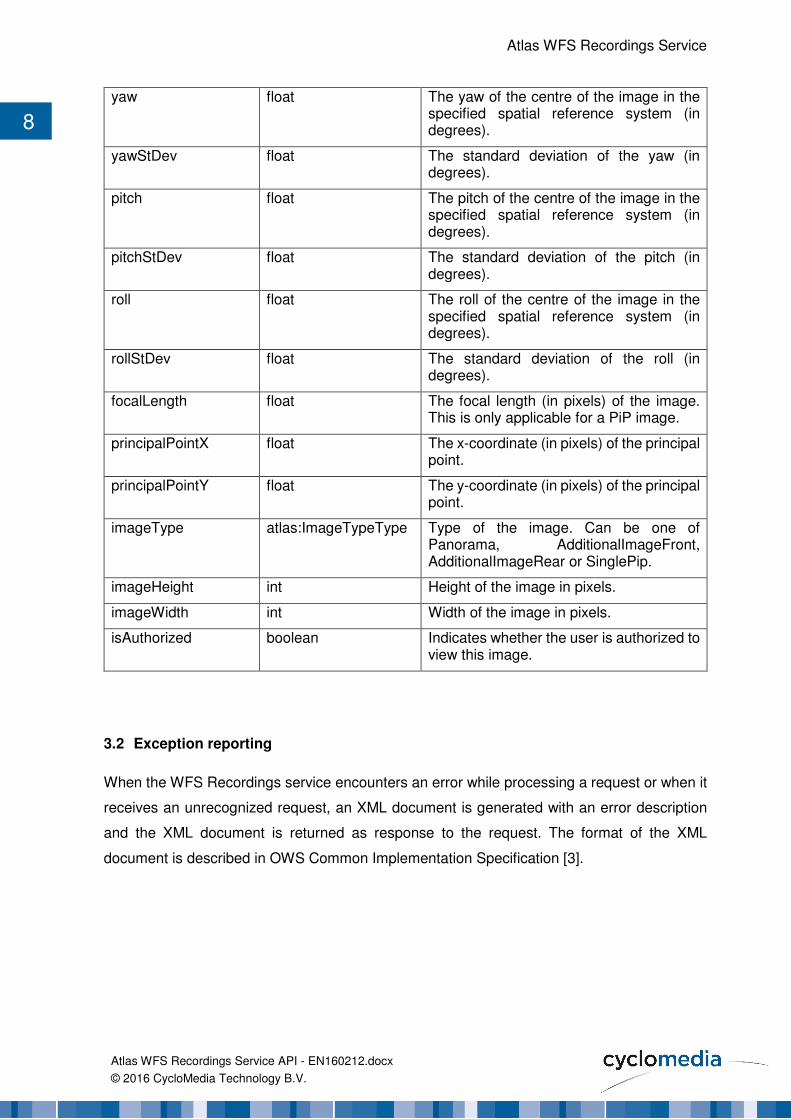
yaw float The yaw of the centre of the image in the specified spatial reference system (in degrees).
yawStDev float The standard deviation of the yaw (in degrees).
pitch float The pitch of the centre of the image in the specified spatial reference system (in degrees).
pitchStDev float The standard deviation of the pitch (in degrees).
roll float The roll of the centre of the image in the specified spatial reference system (in degrees).
rollStDev float The standard deviation of the roll (in degrees).
focalLength float The focal length (in pixels) of the image. This is only applicable for a PiP image.
principalPointX float The x-coordinate (in pixels) of the principal point.
principalPointY float The y-coordinate (in pixels) of the principal point.
imageType atlas:ImageTypeType Type of the image. Can be one of Panorama, AdditionalImageFront, AdditionalImageRear or SinglePip.
imageHeight int Height of the image in pixels.
imageWidth int Width of the image in pixels.
isAuthorized boolean Indicates whether the user is authorized to view this image.
3.2 Exception reporting
When the WFS Recordings service encounters an error while processing a request or when it
receives an unrecognized request, an XML document is generated with an error description
and the XML document is returned as response to the request. The format of the XML
document is described in OWS Common Implementation Specification [3].

Atlas WFS Recordings Service
Atlas WFS Recordings Service API - EN160212.docx
© 2016 CycloMedia Technology B.V.
9 4. Examples
Some example requests are described below.
4.1 Get Capabilities and describe feature type
Returns the capabilities of the WFS service.
https://atlas.cyclomedia.com/recordings/wfs?
service=WFS&version=1.1.0&
request=GetCapabilities
Returns the schema description of feature type atlas:Recording. This schema is listed in
Appendix Error! Reference source not found..
https://atlas.cyclomedia.com/recordings/wfs?
service=WFS&version=1.1.0&
request=DescribeFeatureType&typename=atlas:Recording
4.2 Get features
Returns all recording features that are located within the specified bounding box and that are
actual (not yet expired). The spatial reference system of the bounding box is EPSG:28992,
which is Amersfoort / RD New. The spatial reference system of the coordinates of the returned
recordings is also EPSG:28992.
https://atlas.cyclomedia.com/recordings/wfs?
service=WFS&version=1.1.0&
request=GetFeature&srsname=EPSG:28992&typename=atlas:Recording&
filter=<Filter><And>
<BBOX>
<gml:Envelope srsName='EPSG:28992'>
<gml:lowerCorner>161038.68865966797
441675.2805709839</gml:lowerCorner><gml:upperCorner>161131.4239501953
441742.23804473877</gml:upperCorner>
</gml:Envelope>
</BBOX>
<PropertyIsNull><PropertyName>expiredAt</PropertyName></PropertyIsNull>
</And></Filter>
Atlas WFS Recordings Service
Atlas WFS Recordings Service API - EN160212.docx
© 2016 CycloMedia Technology B.V.
10
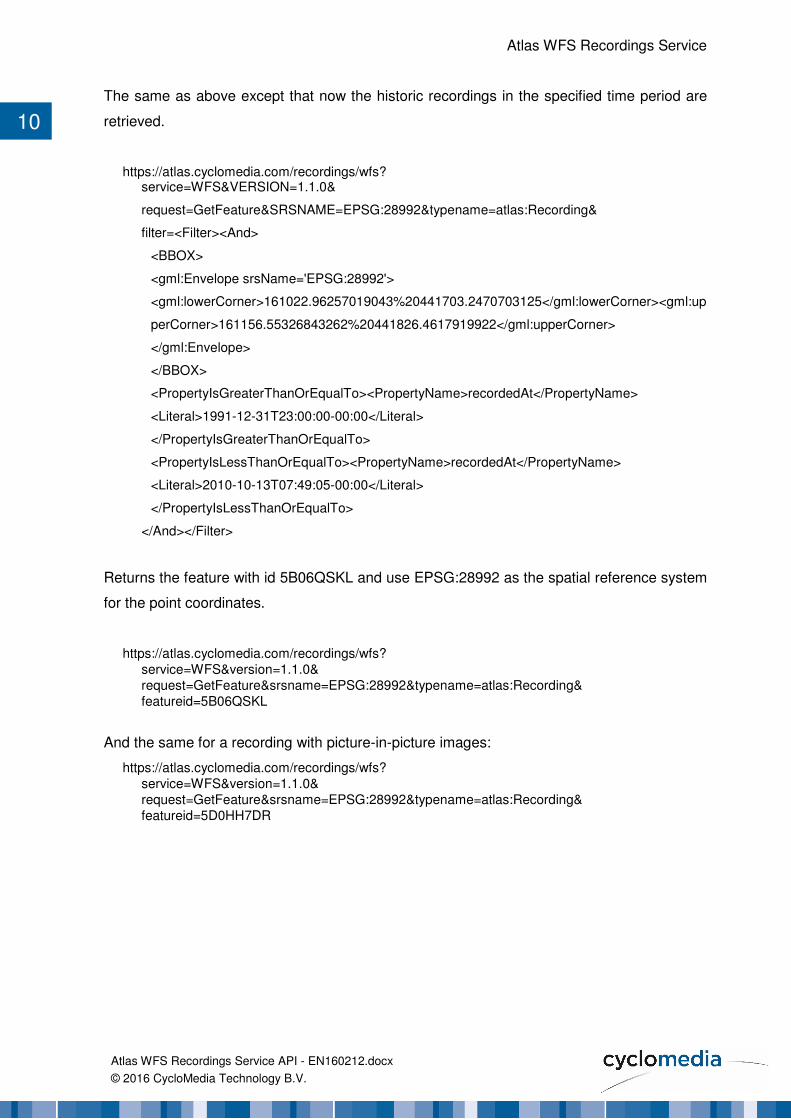
The same as above except that now the historic recordings in the specified time period are
retrieved.
https://atlas.cyclomedia.com/recordings/wfs? service=WFS&VERSION=1.1.0&
request=GetFeature&SRSNAME=EPSG:28992&typename=atlas:Recording&
filter=<Filter><And>
<BBOX>
<gml:Envelope srsName='EPSG:28992'>
<gml:lowerCorner>161022.96257019043%20441703.2470703125</gml:lowerCorner><gml:up
perCorner>161156.55326843262%20441826.4617919922</gml:upperCorner>
</gml:Envelope>
</BBOX>
<PropertyIsGreaterThanOrEqualTo><PropertyName>recordedAt</PropertyName>
<Literal>1991-12-31T23:00:00-00:00</Literal>
</PropertyIsGreaterThanOrEqualTo>
<PropertyIsLessThanOrEqualTo><PropertyName>recordedAt</PropertyName>
<Literal>2010-10-13T07:49:05-00:00</Literal>
</PropertyIsLessThanOrEqualTo>
</And></Filter>
Returns the feature with id 5B06QSKL and use EPSG:28992 as the spatial reference system
for the point coordinates.
https://atlas.cyclomedia.com/recordings/wfs?
service=WFS&version=1.1.0&
request=GetFeature&srsname=EPSG:28992&typename=atlas:Recording&
featureid=5B06QSKL
And the same for a recording with picture-in-picture images:
https://atlas.cyclomedia.com/recordings/wfs?
service=WFS&version=1.1.0&
request=GetFeature&srsname=EPSG:28992&typename=atlas:Recording&
featureid=5D0HH7DR
Atlas WFS Recordings Service
Atlas WFS Recordings Service API - EN160212.docx
© 2016 CycloMedia Technology B.V.
11
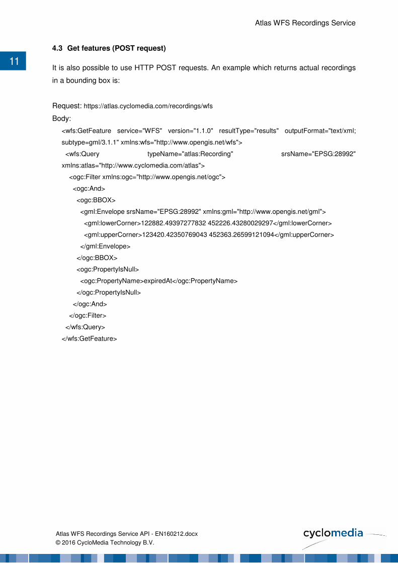
4.3 Get features (POST request)
It is also possible to use HTTP POST requests. An example which returns actual recordings
in a bounding box is:
Request: https://atlas.cyclomedia.com/recordings/wfs
Body:
<wfs:GetFeature service="WFS" version="1.1.0" resultType="results" outputFormat="text/xml;
subtype=gml/3.1.1" xmlns:wfs="http://www.opengis.net/wfs">
<wfs:Query typeName="atlas:Recording" srsName="EPSG:28992"
xmlns:atlas="http://www.cyclomedia.com/atlas">
<ogc:Filter xmlns:ogc="http://www.opengis.net/ogc">
<ogc:And>
<ogc:BBOX>
<gml:Envelope srsName="EPSG:28992" xmlns:gml="http://www.opengis.net/gml">
<gml:lowerCorner>122882.49397277832 452226.43280029297</gml:lowerCorner>
<gml:upperCorner>123420.42350769043 452363.26599121094</gml:upperCorner>
</gml:Envelope>
</ogc:BBOX>
<ogc:PropertyIsNull>
<ogc:PropertyName>expiredAt</ogc:PropertyName>
</ogc:PropertyIsNull>
</ogc:And>
</ogc:Filter>
</wfs:Query>
</wfs:GetFeature>
Atlas WFS Recordings Service
Atlas WFS Recordings Service API - EN160212.docx
© 2016 CycloMedia Technology B.V.
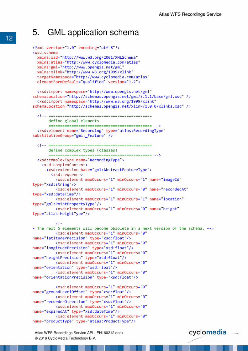
12 5. GML application schema
<?xml version="1.0" encoding="utf-8"?>
<xsd:schema
xmlns:xsd="http://www.w3.org/2001/XMLSchema"
xmlns:atlas="http://www.cyclomedia.com/atlas"
xmlns:gml="http://www.opengis.net/gml"
xmlns:xlink="http://www.w3.org/1999/xlink"
targetNamespace="http://www.cyclomedia.com/atlas"
elementFormDefault="qualified" version="1.2">
<xsd:import namespace="http://www.opengis.net/gml"
schemaLocation="http://schemas.opengis.net/gml/3.1.1/base/gml.xsd" />
<xsd:import namespace="http://www.w3.org/1999/xlink"
schemaLocation="http://schemas.opengis.net/xlink/1.0.0/xlinks.xsd" />
<!-- =============================================
define global elements
============================================= -->
<xsd:element name="Recording" type="atlas:RecordingType"
substitutionGroup="gml:_Feature" />
<!-- =============================================
define complex types (classes)
============================================= -->
<xsd:complexType name="RecordingType">
<xsd:complexContent>
<xsd:extension base="gml:AbstractFeatureType">
<xsd:sequence>
<xsd:element maxOccurs="1" minOccurs="1" name="imageId"
type="xsd:string"/>
<xsd:element maxOccurs="1" minOccurs="0" name="recordedAt"
type="xsd:dateTime"/>
<xsd:element maxOccurs="1" minOccurs="1" name="location"
type="gml:PointPropertyType"/>
<xsd:element maxOccurs="1" minOccurs="0" name="height"
type="atlas:HeightType"/>
<!-
- The next 5 elements will become obsolete in a next version of the schema. -->
<xsd:element maxOccurs="1" minOccurs="0"
name="latitudePrecision" type="xsd:float"/>
<xsd:element maxOccurs="1" minOccurs="0"
name="longitudePrecision" type="xsd:float"/>
<xsd:element maxOccurs="1" minOccurs="0"
name="heightPrecision" type="xsd:float"/>
<xsd:element maxOccurs="1" minOccurs="0"
name="orientation" type="xsd:float"/>
<xsd:element maxOccurs="1" minOccurs="0"
name="orientationPrecision" type="xsd:float"/>
<xsd:element maxOccurs="1" minOccurs="0"
name="groundLevelOffset" type="xsd:float"/>
<xsd:element maxOccurs="1" minOccurs="0"
name="recorderDirection" type="xsd:float"/>
<xsd:element maxOccurs="1" minOccurs="0"
name="expiredAt" type="xsd:dateTime"/>
<xsd:element maxOccurs="1" minOccurs="0"
name="productType" type="atlas:ProductType"/>

Atlas WFS Recordings Service
Atlas WFS Recordings Service API - EN160212.docx
© 2016 CycloMedia Technology B.V.
13
<!-- =============================================
viewerURL is only included for aeroramas
============================================= -->
<xsd:element maxOccurs="1" minOccurs="0" name="viewerURL"
type="atlas:OnlineResourceType"/>
<!-- =============================================
version 1.2
fields added in december 2011 to return the Picture-in-
Picture images of the recording and the authorized flag.
============================================= -->
<xsd:element ref="atlas:Images" minOccurs="0" maxOccurs="1"/>
<xsd:element maxOccurs="1" minOccurs="0" name="isAuthorized"
type="xsd:boolean"/>
</xsd:sequence>
</xsd:extension>
</xsd:complexContent>
</xsd:complexType>
<xsd:element name="Images">
<xsd:complexType>
<xsd:sequence>
<xsd:element minOccurs="0" maxOccurs="unbounded" name="Image"
type="atlas:ImageType"/>
</xsd:sequence>
</xsd:complexType>
</xsd:element>
<xsd:complexType name="ImageType">
<xsd:sequence>
<xsd:element maxOccurs="1" minOccurs="1" name="imageId"
type="xsd:string"/>
<xsd:element maxOccurs="1" minOccurs="1" name="location"
type="gml:PointPropertyType"/>
<xsd:element maxOccurs="1" minOccurs="0" name="height"
type="atlas:HeightType"/>
<xsd:element maxOccurs="1" minOccurs="1" name="latitudeStDev"
type="xsd:float"/>
<xsd:element maxOccurs="1" minOccurs="1" name="longitudeStDev"
type="xsd:float"/>
<xsd:element maxOccurs="1" minOccurs="1" name="heightStDev"
type="xsd:float"/>
<xsd:element maxOccurs="1" minOccurs="1" name="yaw"
type="xsd:float"/>
<xsd:element maxOccurs="1" minOccurs="1" name="yawStDev"
type="xsd:float"/>
<xsd:element maxOccurs="1" minOccurs="1" name="pitch"
type="xsd:float"/>
<xsd:element maxOccurs="1" minOccurs="1" name="pitchStDev"
type="xsd:float"/>
<xsd:element maxOccurs="1" minOccurs="1" name="roll"
type="xsd:float"/>
<xsd:element maxOccurs="1" minOccurs="1" name="rollStDev"
type="xsd:float"/>
<xsd:element maxOccurs="1" minOccurs="0" name="focalLength"
type="xsd:float"/>
<xsd:element maxOccurs="1" minOccurs="0" name="principalPointX"
type="xsd:float"/>

Atlas WFS Recordings Service
Atlas WFS Recordings Service API - EN160212.docx
© 2016 CycloMedia Technology B.V.
14
<xsd:element maxOccurs="1" minOccurs="0" name="principalPointY"
type="xsd:float"/>
<xsd:element maxOccurs="1" minOccurs="1" name="imageType"
type="atlas:ImageTypeType"/>
<xsd:element maxOccurs="1" minOccurs="1" name="imageHeight"
type="xsd:int"/>
<xsd:element maxOccurs="1" minOccurs="1" name="imageWidth"
type="xsd:int"/>
<!-- =============================================
version 1.2
field added in december 2011 to return the authorized flag.
============================================= -->
<xsd:element maxOccurs="1" minOccurs="0" name="isAuthorized"
type="xsd:boolean"/>
</xsd:sequence>
</xsd:complexType>
<xsd:simpleType name="ProductType">
<xsd:restriction base="xsd:string">
<xsd:enumeration value="Cyclorama"/>
<xsd:enumeration value="Aquarama"/>
<xsd:enumeration value="Aerorama"/>
</xsd:restriction>
</xsd:simpleType>
<xsd:simpleType name="ImageTypeType">
<xsd:restriction base="xsd:string">
<xsd:enumeration value="Panorama"/>
<xsd:enumeration value="AdditionalImageFront"/>
<xsd:enumeration value="AdditionalImageRear"/>
<xsd:enumeration value="SinglePip"/>
</xsd:restriction>
</xsd:simpleType>
<xsd:complexType name="HeightType">
<xsd:simpleContent>
<xsd:extension base="xsd:float">
<xsd:attribute name="system" type="xsd:string" use="required" />
</xsd:extension>
</xsd:simpleContent>
</xsd:complexType>
<xsd:complexType name="OnlineResourceType">
<xsd:attributeGroup ref="xlink:simpleLink"/>
</xsd:complexType>
</xsd:schema>